1 A GUIDE FOR LAND JUDGING IN MICHIGAN D. L. Mokma, E. Dersch and D. Kesselring Michigan State University in cooperation with the Michigan Chapter of the Soil and Water Conservation Society The study of land, and its wise use, is becoming more and more important to all citizens. We do not have a surplus of high quality agricultural land or prime farm land. Such land helps the farmer sustain the production of large quantities of high quality food and fiber for a long period of time with low investment in capital and labor and with little or no negative impact on the environment. Prime farm land, when used properly, may also mean lower prices to the consumer. A farmer may risk reducing the value of his land by over-cropping or by leaving fields exposed to erosion. This may be avoided by using land within its capability, protecting it from deterioration, and continually trying to improve its productivity for sustained use. Expanded uses of productive farm land for other purposes present another problem. Fertile soils cannot produce food and fiber when occupied by factories, highways, shopping centers, airports, subdivisions and other residential, industrial and commercial developments. Many soil properties which affect the growth of plants also affect the use of soil for septic system drainage fields, residential development, playgrounds, paths, trails, golf courses, wildlife, streets and roads. The use and management of different soil types varies, depending largely on how the soil was formed by natural processes and by the needs of the individual owner or operator. The natural characteristics may be good or bad depending on the intended use. We need to learn how to take advantage of the good features and overcome or adjust to the unfavorable ones. Judging Land Land is defined as the solid part of the earth’s surface plus water, vegetation, temperature and light. In judging land, we: inventory land conditions. appraise these conditions in terms of long-term, most intensive safe use or sustained use. decide on the management practices needed based upon this use.

Welcome message from author
This document is posted to help you gain knowledge. Please leave a comment to let me know what you think about it! Share it to your friends and learn new things together.
Transcript

1
A GUIDE FOR LAND JUDGING IN MICHIGAN
D. L. Mokma, E. Dersch and D. Kesselring
Michigan State University in cooperation with the
Michigan Chapter of the Soil and Water Conservation Society
The study of land, and its wise use, is becoming more and more important to all citizens.
We do not have a surplus of high quality agricultural land or prime farm land. Such land helps
the farmer sustain the production of large quantities of high quality food and fiber for a long
period of time with low investment in capital and labor and with little or no negative impact on
the environment. Prime farm land, when used properly, may also mean lower prices to the
consumer.
A farmer may risk reducing the value of his land by over-cropping or by leaving fields exposed
to erosion. This may be avoided by using land within its capability, protecting it from
deterioration, and continually trying to improve its productivity for sustained use.
Expanded uses of productive farm land for other purposes present another problem. Fertile soils
cannot produce food and fiber when occupied by factories, highways, shopping centers, airports,
subdivisions and other residential, industrial and commercial developments.
Many soil properties which affect the growth of plants also affect the use of soil for septic
system drainage fields, residential development, playgrounds, paths, trails, golf courses, wildlife,
streets and roads.
The use and management of different soil types varies, depending largely on how the soil was
formed by natural processes and by the needs of the individual owner or operator. The natural
characteristics may be good or bad depending on the intended use. We need to learn how to take
advantage of the good features and overcome or adjust to the unfavorable ones.
Judging Land
Land is defined as the solid part of the earth’s surface plus water, vegetation, temperature and
light.
In judging land, we:
inventory land conditions.
appraise these conditions in terms of long-term, most intensive safe use or sustained use.
decide on the management practices needed based upon this use.
2
evaluate for non-agricultural uses.
Land judging requires close attention to such characteristics as soil properties, degree of erosion,
steepness, type and length of slope and natural drainage. Factors, such as precipitation, length of
growing season, sunshine, humidity and wind are also important, but are not included in land
judging.
Land judging involves appraising the important soil properties. This appraisal is based on
several key factors, some of which are seen in the soil profile, and interpreting them for crop
production and non-agricultural uses. Some key factors are soil texture, soil color, steepness of
slope, amount of erosion, natural drainage and stoniness.
Soil Profile
We need to look both into the soil and at its surface to determine all of the soil’s physical
properties. Part One of the land judging scorecard deals with the physical features evident in
the soil profile, where information about the soil’s strong and weak physical and chemical points
are found. We determine this by examining the texture of the surface and subsoil layers; the
color of the surface and subsoil layers; the steepness and type of slope; and the amount of
erosion.
A soil profile is the vertical cross section of the soil through all its horizons or layers as observed
when you dig a pit, look at a road bank or an excavation for a building. The soil profile (Figure
1) has three main parts:
(1) The surface layer contains most of the organic matter and furnishes the most favorable
conditions for soil organisms and chemical activity. In cropped areas it represents the plow
layer.
(2) The subsoil usually has the most clay and is variable in thickness. It is important from the
standpoint of nutrient and water holding capacity (porosity), water moving capacity
(permeability) and bearing capacity (ability to hold weight).
(3) Parent material is the material from which the soil is formed. This layer is not judged in the
present scorecard but does affect soil characteristics and the range of possible land uses.

3
Figure 1. A soil profile.
PART ONE: PHYSICAL FEATURES OF SOIL
The “Michigan Land Judging Scorecard” has been developed to guide people through the many
considerations needed to determine the most intensive safe use and treatment for an area. Part
One represents the inventory phase of the scorecard.
Soil Texture
Soil texture is very important in land judging. Texture, in combination with soil structure,
affects water holding capacity (porosity), permeability, capacity to hold and furnish nutrients,
tillage operations, bearing capacity and erosion. Only the textures of the surface and subsoil
layers are used on the present scorecard. Texture and structure of underlying parent material are
also important, especially for trees, deep-rooted crops, septic system drainage fields and building
foundations.
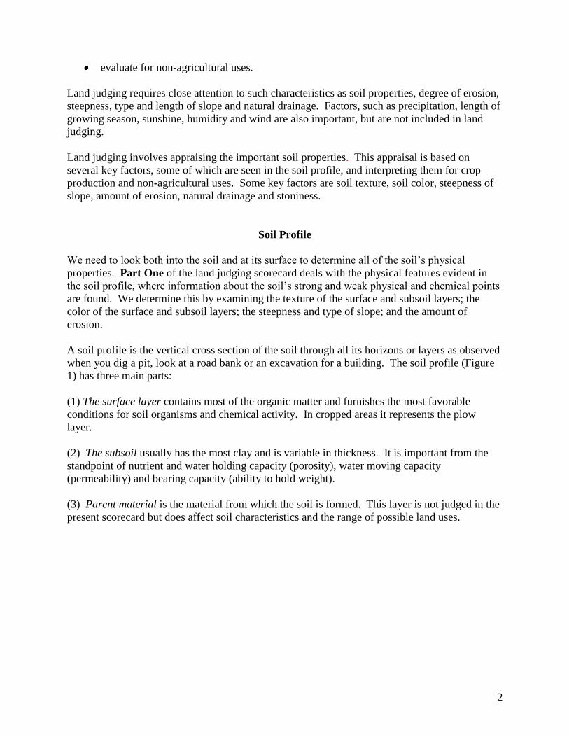
Texture refers to the relative proportions of sand, silt and clay present in a soil sample. The
percentage of these variable sized particles (Figure 2) present determines soil texture (Figure 3).
Available water holding capacity is greatest in silt loam soils, least in sands and intermediate in
clay soils. As the clay content increases, soil permeability decreases and nutrient holding
capacity increases.
4
Figure 2. Soil horizons contain individual particles or grains. Usually soils have different
combinations of the three sizes – sand, silt and clay. The combination of these is referred to as
soil texture. A sand particle may be as much as 625 times larger than a clay particle.
Figure 3. The textural triangle shows the common soil texture classes.

5
Texture is determined by rubbing a small amount of moist soil between the thumb and forefinger
(Figure 4). The soil should be moist, which makes it easier to estimate the clay content. When
moist, clay is sticky and plastic, silt is smooth and floury and sand is gritty.
Figure 4. Soil texture is determined by rubbing a small amount of moist soil between the thumb
and forefinger.
The texture groups used on the present scorecard follow:
Fine-textured soils include clay, clay loam, silty clay loam and sandy clay loam textural classes.
They are made up mostly of clay and silt, but sandy clay and sandy clay loam contain between
45 and 80 percent sand. They are sticky and plastic when moist and can be formed readily into a
ribbon when pressed between the thumb and forefinger. The ribbon is usually over one inch
long. Clay has over 40 percent clay particles, clay loam and silty clay loam have between 27 and
40 percent clay particles, while sandy clay loam has between 20 and 35 percent clay and over 45
percent sand.
Medium-textured soils include silt loam and loam textural classes. Silt loam has more than 50
percent silt particles and feels more smooth than gritty. Loam consists of about equal parts of
sand, silt and clay particles. These textures form a short ribbon, less than one inch long. This
textural group represents a favorable mixture of sand, silt and clay particles, neither too fine nor
too coarse.
6
Moderately coarse textured soils include sandy loam and loamy sand textural classes. They
consist of mostly different sized sand particles with less than 20 percent of clay particles present.
They are difficult to mold when moist and do not readily form a ribbon.
Coarse-textured soils include coarse and medium sands with some gravel. They contain 85
percent sand particles with a harsh, gritty feel even when moist. They will not form a stable
mold when moist.
Organic soils are mucks and peats. They are made up largely of decomposed woody and fibrous
plant materials.
Soil Color
Color is one of the most noticeable characteristics of the soil. Organic matter and iron are the
main coloring agents in Michigan soils. Color should be determined for moist soil since true
color is harder to determine when soil is dry. The colors of surface and subsoil layers are
used in land judging.
Color of Surface Layer
The moist color of the surface layer is determined mainly by the organic matter content.
Dark – Black or very dark brown colors indicate high organic matter content. The darkest
colored surface layers have the highest organic matter content and were usually developed under
native grasses or naturally poorly drained conditions. The dark colors indicate a potential source
of nitrogen, good tilth (soil aggregation) and often good natural fertility.
Medium – Dark gray or dark grayish brown colors indicate a moderate amount of organic matter
present. Most well and somewhat poorly drained soils having fine and medium textures are in
this color group.
Light – Light gray, light grayish brown or pale brown colors indicate soils that are low in organic
matter. Most of the well drained, sandy soils are in this color group.
Color of the Subsoil
The color of the subsoil is determined mainly by the length of time that the subsoil is saturated or
below the water table because it influences iron content and oxidative state of iron (Figure 5).
Soil drainage refers to the depth and duration of the water table. Permeability is the rate at which
water and air move through soil.
Bright – Reds, yellows and browns are the principal colors. These bright solid colors indicate a
soil which has formed under naturally well drained conditions (deep water table). Artificial
drainage is not usually needed for field crops.
Mottled – Mixed yellow and brown colors with some grays and many rust-brown and orange
streaks and spots. This color pattern indicates the soil developed under somewhat poorly drained

7
conditions. Artificial drainage is usually needed for field crops on these soils. The seasonally
high water table also interferes with many non-agricultural uses.
Dull – Mainly gray colors usually with many yellow, rust-brown and orange streaks and spots.
These dull colors indicate that the soil developed under naturally poor drained conditions with
the water table at or near the surface of the ground during part of the year. Under natural
conditions, soils with dull subsoils support hydrophytic vegetation and are approximately
equivalent to wetlands. Artificial drainage is necessary for field crops. The high water table
limits the usefulness of these soils for most non-agricultural uses.
Figure 5. Subsoil color: the soil on the left has a bright subsoil, the soil in the middle has a
mottled subsoil, and the soil on the right has a dull subsoil.
Slope
The slope (lay of the land) is important in determining the best land use. The steepness and
length of the slope influence the speed with which water runs off a field and the amount of soil
carried away in the run-off water. The steepness of the slope also affects the ease of cultivation,
use of farm machinery, and suitability of the site for septic tank disposal fields, homesites,
playgrounds, paths, trails, golf courses, streets and roads.

8
Steepness, length and type of slope must be evaluated to determine the best land use and
conservation practices for an area. Steepness and length are most important from a water erosion
standpoint. Use of some large farm machinery is more difficult and expensive on slopes which
are over 12 percent. Septic system drainage fields are more difficult to construct and maintain
on slopes that are greater than 12 percent. Construction of homes, playgrounds, and roads are
more expensive on slopes which are greater than 12 percent. Paths, trails and golf courses are
more desirable on slopes greater than 6 percent but are more expensive to construct and maintain
on slopes greater than 12 percent.
On the land judging scorecard, only steepness and type of slope are determined. Length of slope,
however, is important in selecting the best land use and soil conservation practices for an area.
Contour tillage and strip cropping may be used on long uniform slopes with up to 18 percent
slopes. Terraces are difficult to maintain on slopes which are steeper than 12 percent. Contour
tillage, strip cropping and terraces are very difficult to use on short, irregular slopes.
Steepness of slope is expressed in percent, which represents the number of feet of rise or fall in a
100-foot distance. With the same crops or vegetation, velocity of run-off water increases with
steepness and length of slope.
SIX DIFFERENT SLOPE CLASSES ARE USED IN LAND JUDGING IN Michigan FFA
Slope Class Percent Slope Steepness
Nearly level (0-2) less than 2 ft. fall in 100 ft.
Gently sloping (2-6) 2 to 6 ft. fall in 100 ft.
Moderately sloping (6-12) 6 to 12 ft. fall in 100 ft.
Strongly sloping (12-18) 12 to 18 ft. fall in 100 ft.
Steep (18-25) 18 to 25 ft. fall in 100 ft.
Very steep (Over 25) more than 25 ft. fall in 100 ft.
Steepness of slope is determined by using a slope finder (next page), clinometer, Abney level or
hand level (Figures 6 and 7). A clinometer, level or slope finder should be used to determine the
percent of slope. Steepness of a slope is easy to misjudge. In most contests, a specific slope is
designated as being representative of the land area. Occasionally, the average of all of slopes of
the land area will be used to determine steepness. Clinometers are used by soil scientists making
detailed soil surveys.

9
10
HOW TO MAKE A SLOPE FINDER
1. Mount the slope finder sheet on a 9 x 12 inch board. Either ½ inch thick plywood or ¾
inch lumber may be used. The thicker board, however, is recommended so the nails can
be securely attached.
2. The surface of the slope finder should be attached firmly to the board. Avoid wrinkles
and air pockets
3. Place three “finishing nails” (small heads) at the points indicated on the slope finder.
Attach a string to which a lead sinker or a similar weight has been tied to the nail at the
top of the slope finder. The string must be of sufficient length so the weight hangs at
least 2 inches below the slope finder board.
HOW TO USE A SLOPE FINDER
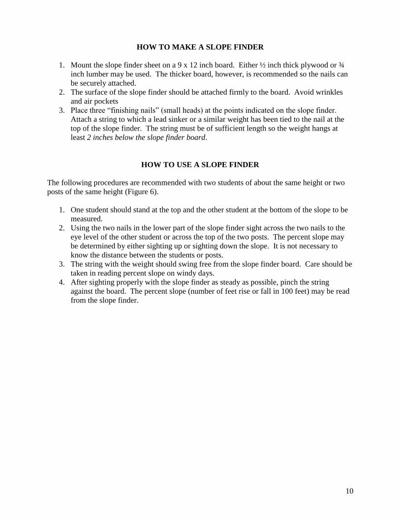
The following procedures are recommended with two students of about the same height or two
posts of the same height (Figure 6).
1. One student should stand at the top and the other student at the bottom of the slope to be
measured.
2. Using the two nails in the lower part of the slope finder sight across the two nails to the
eye level of the other student or across the top of the two posts. The percent slope may
be determined by either sighting up or sighting down the slope. It is not necessary to
know the distance between the students or posts.
3. The string with the weight should swing free from the slope finder board. Care should be
taken in reading percent slope on windy days.
4. After sighting properly with the slope finder as steady as possible, pinch the string
against the board. The percent slope (number of feet rise or fall in 100 feet) may be read
from the slope finder.
11
Figure 6. Two people or two posts may be used to determine slope with a slope finder.
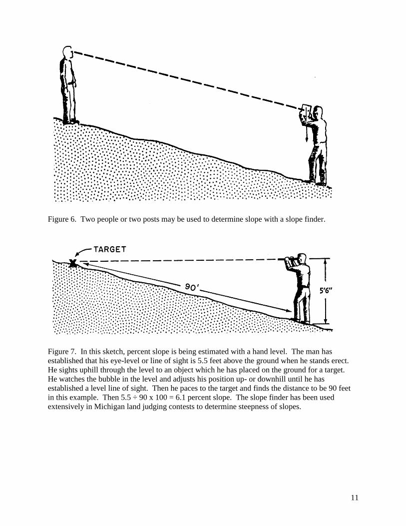
Figure 7. In this sketch, percent slope is being estimated with a hand level. The man has
established that his eye-level or line of sight is 5.5 feet above the ground when he stands erect.
He sights uphill through the level to an object which he has placed on the ground for a target.
He watches the bubble in the level and adjusts his position up- or downhill until he has
established a level line of sight. Then he paces to the target and finds the distance to be 90 feet
in this example. Then 5.5 ÷ 90 x 100 = 6.1 percent slope. The slope finder has been used
extensively in Michigan land judging contests to determine steepness of slopes.

12
Type of Slope
Type of slope is extremely important in selecting crop rotations and soil conservation practices.
On uniform slopes (Figure 8), strip cropping and other soil conservation practices are easy to
use. On slopes that are irregular, establishment and use of terraces, strip cropping, and contour
tillage are more difficult. With steeper, irregular slopes, land use should be selected which will
keep land in permanent vegetation most of the time. Contestants/teams will select either a
regular or irregular slope pattern for each land area.
Figure 8. Slope types: Left is regular-smooth-uniform; Right is irregular-rough-wavy.
Erosion
The amount of soil which has been removed by erosion is important in determining the most
intensive safe use or sustained use for an area. Special care is required in selecting
recommended conservation practices, especially in areas which are classified as having severe or
very severe erosion.
Erosion by wind and water is a gradual process. In earlier erosion stages, a considerable amount
of material can be removed without the loss being detected. This is known as sheet erosion.
Small rills are relatively easy to observe when they start to form. When fields are cultivated,
however, the rills are filled and erased. Erosion is frequently not recognized until the more
productive surface soil is gone or critical gully or blow-out stages are reached.
With a protective grass or tree cover, serious water erosion does not necessarily occur on sloping
areas.
Severe and very severe wind erosion can occur on both level and steep areas.
Erosion may be rather difficult to recognize and classify in many places. In Michigan, where
forest vegetation once existed, the thin original dark colored surface layer and the lighter colored
subsurface layer have been mixed together in plowing. The amount of subsoil material in the
present surface layer is important in determining the erosion class. Careful attention should be
given to the presence of either gullies or blow-outs in the land area which is being judged.
The four erosion classes used on the scorecard are:
Slight – The surface layer consists of all, or nearly all, the original surface soil.
Moderate – The surface layer consists of a mixture of original surface soil and subsoil.

13
Severe – The surface layer consists of mainly subsoil. Gullies or shallow wind blow-outs may be
present.
Very severe – The surface soil has been entirely removed. The land is severely gullied or has
deep wind blow-outs.
PART TWO: PROBLEMS WHICH AFFECT THE USE AND MANAGEMENT OF THE
AREA.
You must know your land to use it wisely and manage it for sustained food production. You
should have some knowledge of the chemical and physical properties of soils. Know the percent
slope, degree of erosion and other characteristics visible at the surface. Study each land area to
determine the most important problems which affect its use and management. The total number
of problems occurring at each test site will be posted.
In land judging, it is important to determine these problems. The important soil properties have
been selected in Part One of the scorecard. For example, a combination of (1) medium textured
surface and subsoil layers; (2) medium or dark colored surface layer; (3) bright or mottled
subsoil; (4) nearly level land; and (5) slight erosion indicates a land area with excellent general
farming possibilities with only a few hazards for sustained intensive land use.
In Part Two, contestant/teams select the most important problems which affect use and
management of each land area from the following list:
1. Soil structure 5. Wet spots 9. Water erosion
2. Droughty 6. Seasonal flooding 10. Organic matter
3. Stony 7. Slope 11. Permeability
4. Drainage 8. Wind erosion
Recognition of major problems is important in determining the most intensive safe use,
recommended management and conservation practices for sustained production, and suitability
for non-agricultural uses.
1. Soil structure is often a problem in fine, medium and moderately coarse textured (such
as loamy sand, sandy loam, loam, silt loam, sandy clay loam, silty clay loam, clay loam
or clay) surface layers that have medium or light colors. In addition soil structure is often
a problem in soils with dull subsoils. Light and medium colored soils are low in organic
matter, which holds particles together in aggregates. Cover and green manure crops,
conservation tillage and returning crop residues help to maintain soil structure. Using
conservation tillage and tilling at the proper soil moisture content help to maintain soil
structure. Subsurface drainage may help improve or maintain soil structure in soils with
mottled or dull subsoils.
2. Soils with moderately coarse or coarse textured (such as sandy loam, loamy sand or sand)
subsoil have a droughty problem.
14
3. Soils with sufficient stones to impede use of most farm equipment or to interfere with
construction or site development are considered to have a stony problem.
4. Soils with poor drainage are “cold,” lack oxygen, have poor micro-organism growth and
are slow in releasing plant nutrients. The pores in these soils are filled with water, which
warms more slowly than soil material and prevents oxygen from entering the soil. These
soils have mottled or dull subsoils. Artificial drainage is required for sustained
agricultural production. Poor drainage interferes with the operation of septic tank
disposal fields, causes wet basements and hinders the use of these soils for playgrounds,
paths, trails, golf courses, streets and roads.
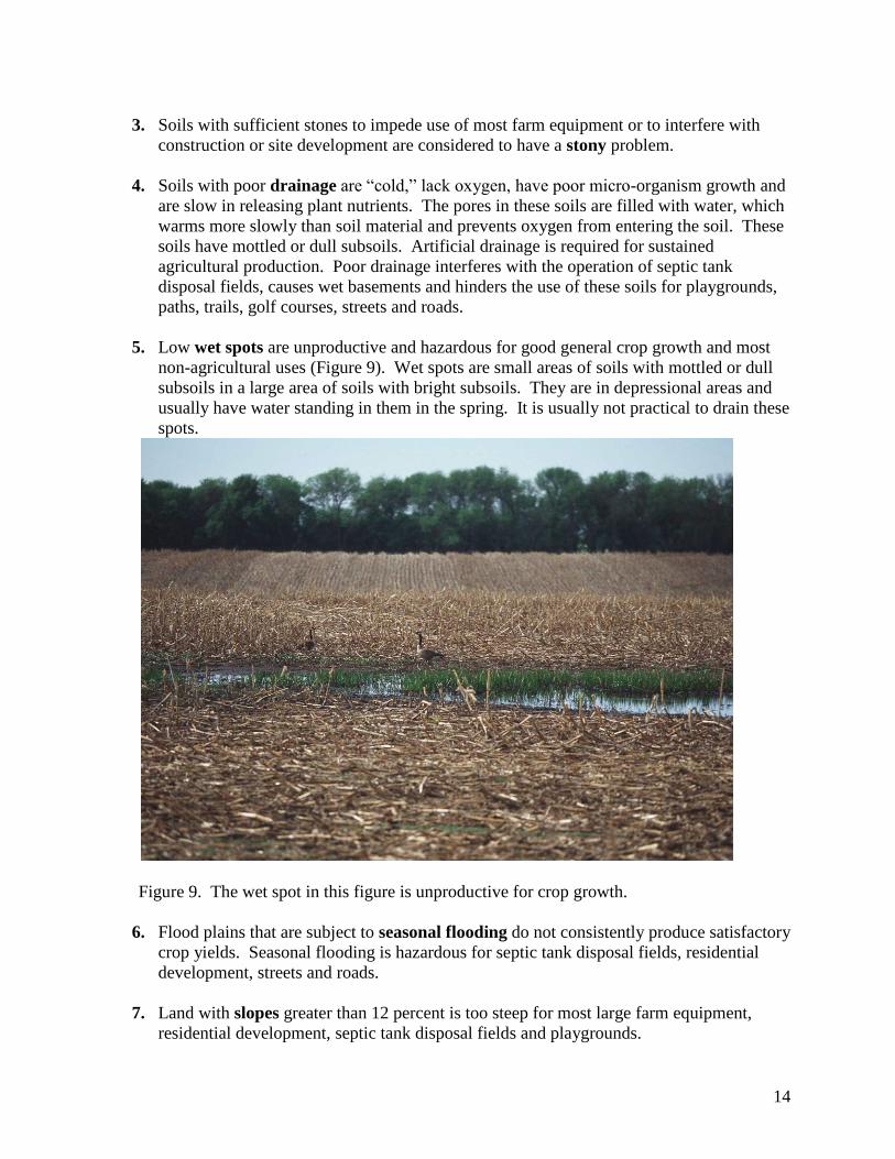
5. Low wet spots are unproductive and hazardous for good general crop growth and most
non-agricultural uses (Figure 9). Wet spots are small areas of soils with mottled or dull
subsoils in a large area of soils with bright subsoils. They are in depressional areas and
usually have water standing in them in the spring. It is usually not practical to drain these
spots.
Figure 9. The wet spot in this figure is unproductive for crop growth.
6. Flood plains that are subject to seasonal flooding do not consistently produce satisfactory
crop yields. Seasonal flooding is hazardous for septic tank disposal fields, residential
development, streets and roads.
7. Land with slopes greater than 12 percent is too steep for most large farm equipment,
residential development, septic tank disposal fields and playgrounds.

15
8. Soils with coarse or moderately coarse textured surface soil (such as sand, loamy sand or
sandy loam) generally have a serious wind erosion problem (Figure 10).
Figure 10. Wind erosion on a soil with a loamy sand surface layer.
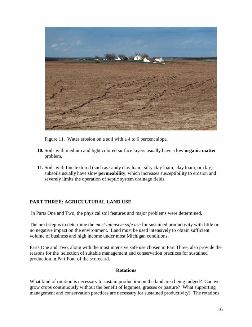
9. Fine, medium and moderately-coarse textured (such as loamy sand, sandy loam, loam,
silt loam, sandy clay loam, silty clay loam, clay loam or clay) soils which have more than
a 2 percent slope are considered to have water erosion problems (Figure 11) when used
for cultivated crops, when closely pastured or when disturbed during construction
activities.
16
Figure 11. Water erosion on a soil with a 4 to 6 percent slope.
10. Soils with medium and light colored surface layers usually have a low organic matter
problem.
11. Soils with fine textured (such as sandy clay loam, silty clay loam, clay loam, or clay)
subsoils usually have slow permeability, which increases susceptibility to erosion and
severely limits the operation of septic system drainage fields.
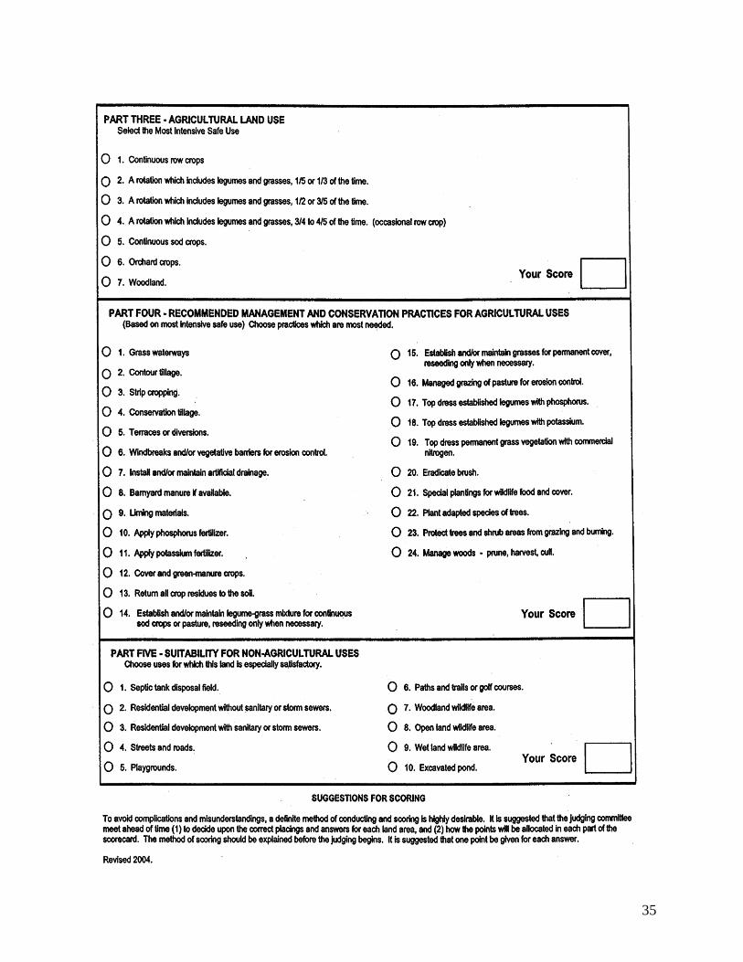
PART THREE: AGRICULTURAL LAND USE
In Parts One and Two, the physical soil features and major problems were determined.
The next step is to determine the most intensive safe use for sustained productivity with little or
no negative impact on the environment. Land must be used intensively to obtain sufficient
volume of business and high income under most Michigan conditions.
Parts One and Two, along with the most intensive safe use chosen in Part Three, also provide the
reasons for the selection of suitable management and conservation practices for sustained
production in Part Four of the scorecard.
Rotations
What kind of rotation is necessary to sustain production on the land area being judged? Can we
grow crops continuously without the benefit of legumes, grasses or pasture? What supporting
management and conservation practices are necessary for sustained productivity? The rotations
17
are based on conventional tillage, not conservation tillage. The total number of most intensive
safe agricultural land uses will be posted at each test site.
In soil and water conservation programs, continuous row cropping is the most intensive use.
Continuous grass or tree cover with nothing harvested, coupled with the complete protection
from fire and grazing, is the least intensive use.
For a general farming program, we can select the most intensive safe use for sustained
productivity from the following choices:
1. Continuous row crops (no legumes and grass crops in rotation). Fine and medium
textured mineral and organic soils, nearly level in topography, well drained or capable of
being drained, may be considered for continuous row crops provided adequate supporting
practices are selected in Part Four. Soil erosion is minimal on these land areas.
2. Rotations that include legumes and grasses 1/5 to 1/3 of the time. (One year of hay crop
every three or four years). Fine and medium textured soils with gentle slopes and
moderately coarse textured soils with nearly level and gentle slopes may be considered
for this rotation. Soil erosion is a problem when using these land areas for sustained crop
production.
3. Rotations that include legumes and grasses 1/2 to 3/5 of the time. (Two years of hay
crops in a four year rotation or three years of hay crops in a five year rotation).
Moderately sloping coarse to fine textured soils and nearly level and gently sloping
coarse textured soils may be considered for this rotation. Soil erosion is a serious
problem when using these land areas for sustained crop production.
4. Rotations that include legumes and grasses 3/4 to 4/5 of the time. (May have an
occasional row crop). Strongly sloping soils may be considered for this rotation. Soil
erosion is a very serious problem when using these land areas for sustained crop
production.
5. Continuous sod crops. Land on which a legume-grass mixture or grass should be
established and/or maintained for hay or pasture. (No row or small grain crop in
rotation). Steep soils and soils not capable of being drained may be considered for this
rotation.
6. Orchard crops. Land on which orchard crops should be planted. Gently sloping to
moderately sloping, moderately coarse-textured soils are best suited for this rotation.
These slopes are necessary to provide adequate air drainage to minimize damage from
cold temperatures.
7. Woodland. Land on which trees should be maintained or planted. Very steep soils may
be considered for this rotation. Past or potential soil erosion prevents the use of these
land areas for sustained crop production.
In Part Four, the necessary conservation practices to support this choice will be selected.
18
PART FOUR: RECOMMENDED MANAGEMENT AND CONSERVATION
PRACTICES FOR AGRICULTURAL USES.
This part of the land judging scorecard lists management and conservation practices that are
required with the most intensive safe land use for sustained productivity selected in Part Three.
The total number of recommended management and conservation practices will be posted at
each site. Select the practices needed for the most intensive safe land use for sustained
productivity of the land area examined in Part Three.
Rules for the selection of management and conservation practices:
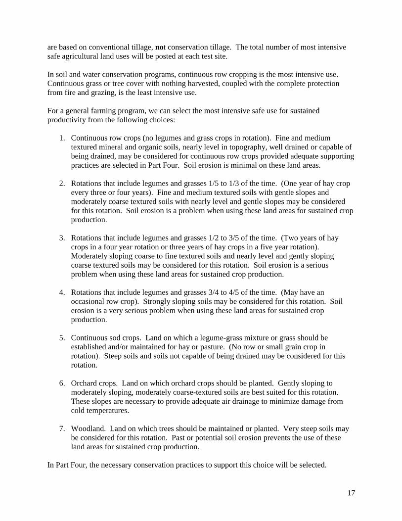
1. Grass waterways are natural or man-made water courses or drainage ways protected
against erosion by a grass cover (Figure 12). They serve as safe outlets for terraces,
diversions and contour rows. They may also serve as safe passageways for surface water
that comes from other farm land.
Figure 12. Grass cover protects the soil in this natural drainage way.
2. Contour tillage is to plow, plant and cultivate on the contour or at right angles to the
natural direction of the slope (Figure 13) to reduce soil erosion by water. The whole field
is usually planted to one crop.

19
Figure 13. Contour tillage to reduce soil erosion by water.
3. Strip cropping is a systematic arrangement of crops to create vegetative barriers to
reduce wind and water erosion (Figure 14). The strips are laid out either across the
slopes or at right angles to the prevailing winds. With contour strip cropping, the strips
are laid out so that that crop rows are on the contour or as near so as practical. With field
strip cropping for water erosion control, the strips are of uniform width laid out across
the slopes.
Figure 14. Crop strips to reduce water erosion.

20
4. Conservation tillage is the least amount of tillage necessary to obtain quick germination
and a good stand. Leave maximum amount of residue on surface. This practice is
effective in reducing soil erosion by wind and water.
Figure 15. Planting soybeans in wheat stubble leave the maximum amount of residue on
the soil surface.
5. Terrace or diversion is an earth ridge or embankment usually constructed on a slight
grade across a slope to control runoff water and reduce erosion (Figure 16). Several
terraces on a slope are called a “terrace system.” A diversion is a channel running across
a slope to intercept water and carry it slowly to a grass waterway.
21
Figure 16. Terraces across the slope reduce water erosion.
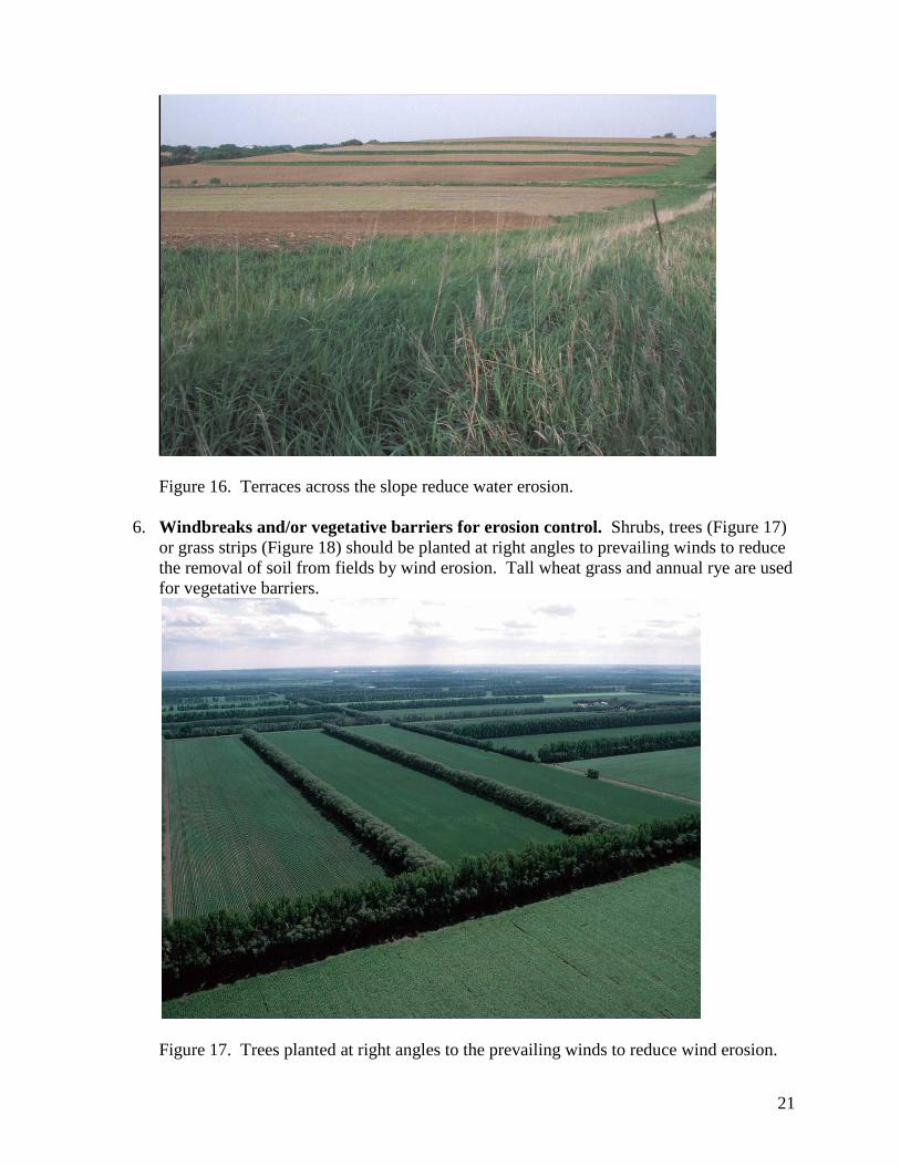
6. Windbreaks and/or vegetative barriers for erosion control. Shrubs, trees (Figure 17)
or grass strips (Figure 18) should be planted at right angles to prevailing winds to reduce
the removal of soil from fields by wind erosion. Tall wheat grass and annual rye are used
for vegetative barriers.
Figure 17. Trees planted at right angles to the prevailing winds to reduce wind erosion.
22
Figure 18. Grass strips planted at right angles to the prevailing winds to reduce wind
erosion.
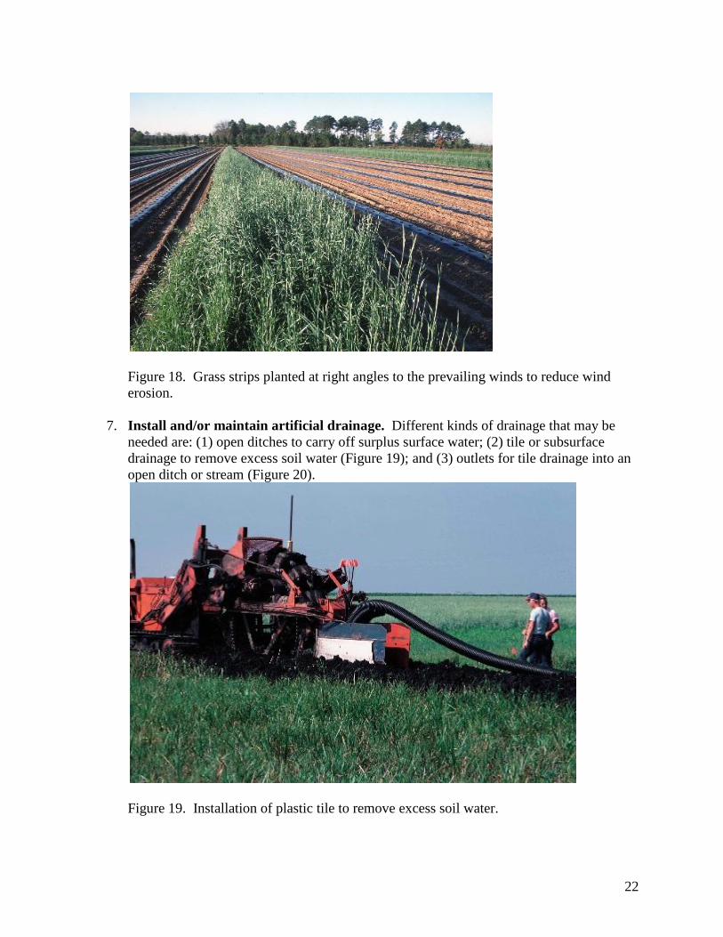
7. Install and/or maintain artificial drainage. Different kinds of drainage that may be
needed are: (1) open ditches to carry off surplus surface water; (2) tile or subsurface
drainage to remove excess soil water (Figure 19); and (3) outlets for tile drainage into an
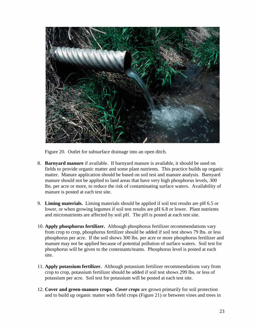
open ditch or stream (Figure 20).
Figure 19. Installation of plastic tile to remove excess soil water.
23
Figure 20. Outlet for subsurface drainage into an open ditch.
8. Barnyard manure if available. If barnyard manure is available, it should be used on
fields to provide organic matter and some plant nutrients. This practice builds up organic
matter. Manure application should be based on soil test and manure analysis. Barnyard
manure should not be applied to land areas that have very high phosphorus levels, 300
lbs. per acre or more, to reduce the risk of contaminating surface waters. Availability of
manure is posted at each test site.
9. Liming materials. Liming materials should be applied if soil test results are pH 6.5 or
lower, or when growing legumes if soil test results are pH 6.8 or lower. Plant nutrients
and micronutrients are affected by soil pH. The pH is posted at each test site.
10. Apply phosphorus fertilizer. Although phosphorus fertilizer recommendations vary
from crop to crop, phosphorus fertilizer should be added if soil test shows 79 lbs. or less
phosphorus per acre. If the soil shows 300 lbs. per acre or more phosphorus fertilizer and
manure may not be applied because of potential pollution of surface waters. Soil test for
phosphorus will be given to the contestants/teams. Phosphorus level is posted at each
site.
11. Apply potassium fertilizer. Although potassium fertilizer recommendations vary from
crop to crop, potassium fertilizer should be added if soil test shows 299 lbs. or less of
potassium per acre. Soil test for potassium will be posted at each test site.
12. Cover and green-manure crops. Cover crops are grown primarily for soil protection
and to build up organic matter with field crops (Figure 21) or between vines and trees in

24
vineyards or orchards. Rye, buckwheat, rye grass and sweet clover are examples of cover
crops.
Figure 21. Rye cover crop to build up organic matter in the soil.
Green-manure crops are plowed under or worked into the soil while either green or soon
after maturity to build up organic matter. Sweet clover, red clover or legume-grass
mixtures are examples of green-manure crops.
13. Return all crop residues to the soil. The portion of the plant or crop left after harvest
should be returned to the soil. This practice helps reduce soil erosion and maintains
organic matter. Crop residues should not be burned or removed from the fields.
14. Establish and/or maintain legume-grass mixture for continuous sod crops, reseeding
only when necessary. This practice is recommended for areas which are used
continuously for hay or pasture because the land area has a very serious erosion problem.
When necessary to re-establish vegetation, the area is prepared using conservation tillage
methods and reseeded, generally with a nurse crop.
15. Establish and/or maintain grasses for permanent cover, reseeding only when
necessary. When reseeding, the area should be prepared for seeding using conservation
tillage. This practice is recommended for uplands and wet land areas where a permanent
grass cover is needed.
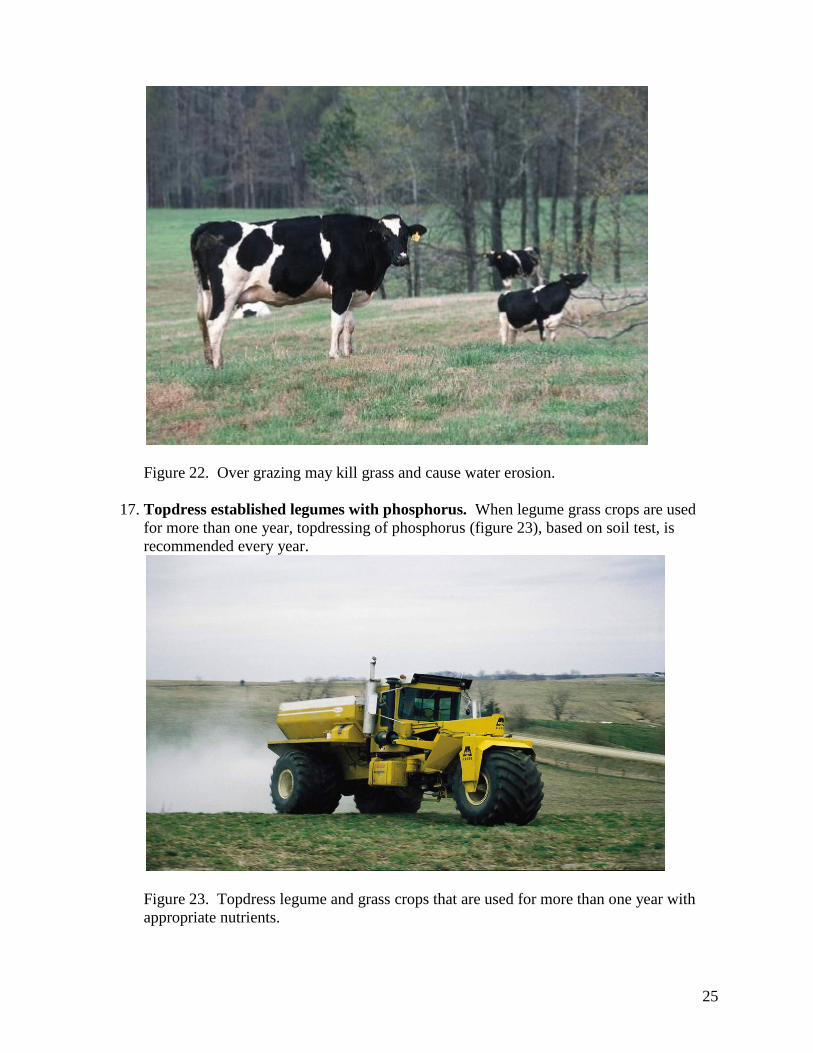
16. Managed grazing of pasture for erosion control. Pastures should be managed to
prevent erosion (Figure 22). Management practices include using a rotation system of
grazing, not grazing too early in the spring, clipping weeds and not over-grazing.
25
Figure 22. Over grazing may kill grass and cause water erosion.
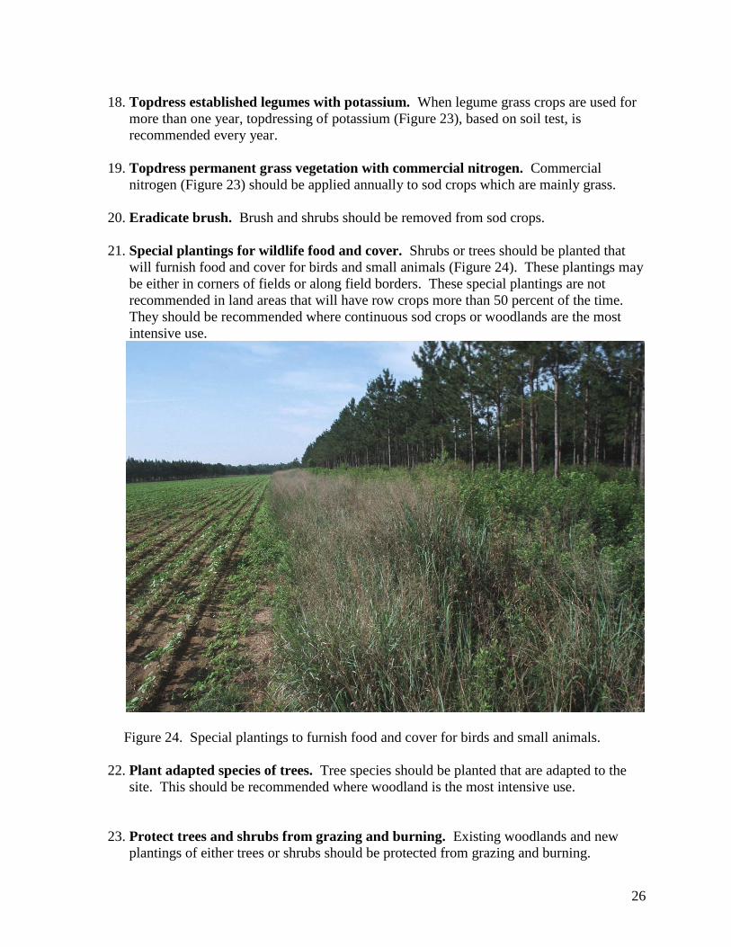
17. Topdress established legumes with phosphorus. When legume grass crops are used
for more than one year, topdressing of phosphorus (figure 23), based on soil test, is
recommended every year.
Figure 23. Topdress legume and grass crops that are used for more than one year with
appropriate nutrients.
26
18. Topdress established legumes with potassium. When legume grass crops are used for
more than one year, topdressing of potassium (Figure 23), based on soil test, is
recommended every year.
19. Topdress permanent grass vegetation with commercial nitrogen. Commercial
nitrogen (Figure 23) should be applied annually to sod crops which are mainly grass.
20. Eradicate brush. Brush and shrubs should be removed from sod crops.
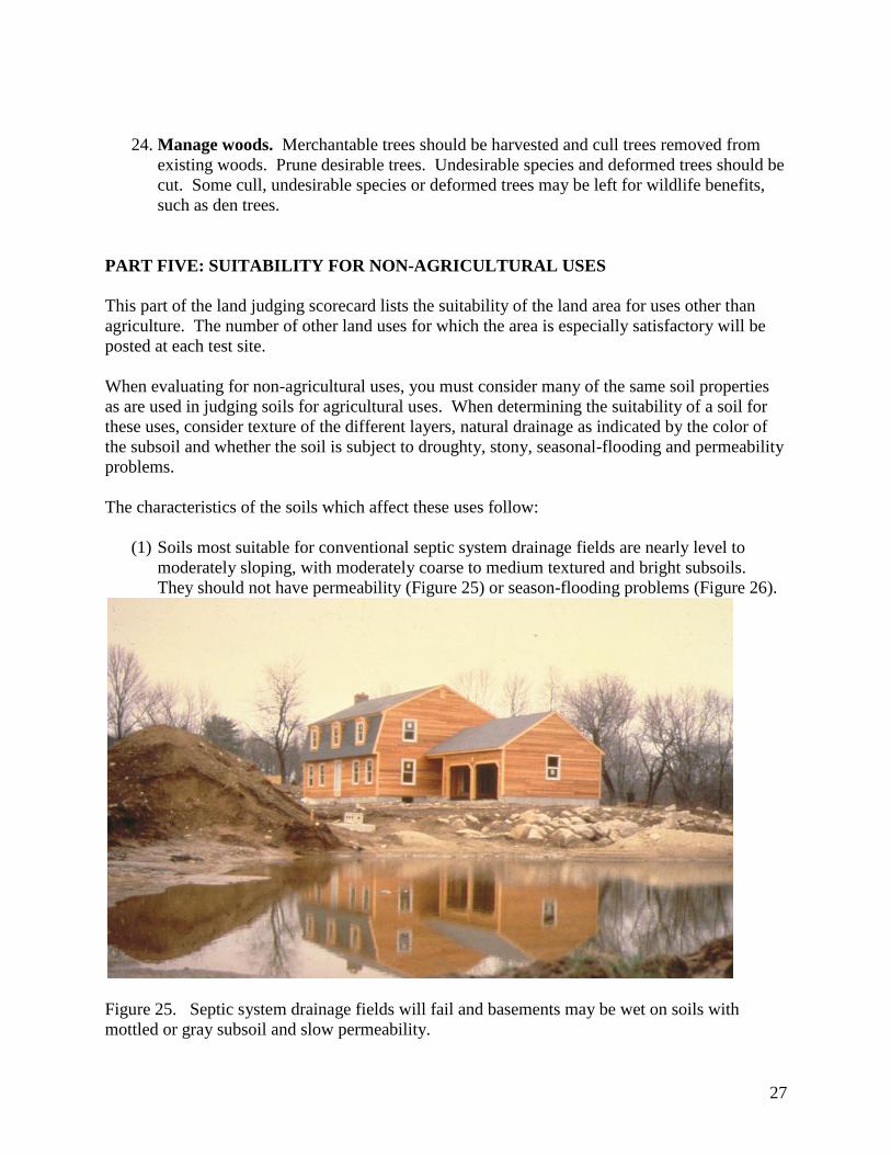
21. Special plantings for wildlife food and cover. Shrubs or trees should be planted that
will furnish food and cover for birds and small animals (Figure 24). These plantings may
be either in corners of fields or along field borders. These special plantings are not
recommended in land areas that will have row crops more than 50 percent of the time.
They should be recommended where continuous sod crops or woodlands are the most
intensive use.
Figure 24. Special plantings to furnish food and cover for birds and small animals.
22. Plant adapted species of trees. Tree species should be planted that are adapted to the
site. This should be recommended where woodland is the most intensive use.
23. Protect trees and shrubs from grazing and burning. Existing woodlands and new
plantings of either trees or shrubs should be protected from grazing and burning.
27
24. Manage woods. Merchantable trees should be harvested and cull trees removed from
existing woods. Prune desirable trees. Undesirable species and deformed trees should be
cut. Some cull, undesirable species or deformed trees may be left for wildlife benefits,
such as den trees.
PART FIVE: SUITABILITY FOR NON-AGRICULTURAL USES
This part of the land judging scorecard lists the suitability of the land area for uses other than
agriculture. The number of other land uses for which the area is especially satisfactory will be
posted at each test site.
When evaluating for non-agricultural uses, you must consider many of the same soil properties
as are used in judging soils for agricultural uses. When determining the suitability of a soil for
these uses, consider texture of the different layers, natural drainage as indicated by the color of
the subsoil and whether the soil is subject to droughty, stony, seasonal-flooding and permeability
problems.
The characteristics of the soils which affect these uses follow:
(1) Soils most suitable for conventional septic system drainage fields are nearly level to
moderately sloping, with moderately coarse to medium textured and bright subsoils.
They should not have permeability (Figure 25) or season-flooding problems (Figure 26).
Figure 25. Septic system drainage fields will fail and basements may be wet on soils with
mottled or gray subsoil and slow permeability.

28
Figure 26. Residential development will fail on soils with seasonal flooding problems.
A conventional septic tank disposal field consists of a septic tank and a disposal field with
distribution lines on the contour.
(2) Soils most suitable for residential development without sanitary or storm sewers are nearly
level to moderately sloping. They should also have moderately coarse or medium textured and
bright subsoils. They should not have seasonal-flooding problems (Figure 26).
(3) Soils most suitable for residential development with sanitary and storm sewers are nearly
level to moderately sloping. They also have coarse to fine textured and bright subsoils. They
should not have seasonal-flooding problems (Figure 26).
(4) Soils most suitable for local streets and roads are nearly level to moderately sloping with
coarse or moderately coarse textured and bright subsoils. They should not have seasonal-
flooding problems (Figure 26).
(5) Soils most suitable for playgrounds have regular slopes which are nearly level or gently
sloping with moderately coarse textured surface layers and medium or moderately coarse
textured, bright subsoils. They should not have stony problems.
(6) Soils most suitable for paths and trails or golf courses are nearly level to strongly sloping,
having moderately coarse to fine textures, bright or mottled subsoils. They may have scattered
stony or drainage problems.
29
(7) Soils most suitable for woodland wildlife areas are nearly level to strongly sloping and have
coarse to fine textured surface layer with bright or mottled subsoils. The areas should currently
be in woodland or woodland is the most intensive safe use.
(8) Soils most suitable for open land wildlife areas are nearly level to strongly sloping with
medium or moderately coarse textured surface layers and bright, mottled or dull subsoils. They
may have seasonal-flooding problems. The areas are used for cropland, pasture, meadow and
former cropland that is overgrown with grasses, herbs, shrubs and vines.
(9) Soils most suitable for wetland wildlife areas have regular, nearly level slopes with organic,
fine, medium or moderately coarse surface layer textures and dull subsoils. They should have
areas of standing water or should be suitable for excavated ponds. They may be subject to
seasonal flooding. They should have no droughty problems. These are not wet spots in soils
with bright or mottled subsoils.
(10) Soils most suitable for excavated ponds are nearly level with dull subsoils.
Land Appreciation Training and Land Judging Contests
Land judging is valuable for young people, farmers, business and professional men and women’s
groups. Land appreciation training may be held indoors or outdoors and at any season of the
year. Land appreciation training and land judging contests go well together. Appreciation
training should come first, followed by judging.
A recommended training technique is to have the participants make all judging arrangements:
stake off the area, expose the soil profile, take samples of surface layer and subsoils and test
samples for pH, phosphorus and potassium requirements in the laboratory. Training should
include slope measurements and determination of erosion classes.
A highly recommended training procedure is to require oral reasons after the scorecard has been
completed. This is time consuming but requires the student to give more careful attention to
judging. Likewise the group as a whole benefits from oral reasons and discussions.
Land judging should be done in the field when weather conditions are suitable. Land judging
may be done by individuals or by teams. The area to be judged should be of such size as to be a
suitable crop management unit. Insofar as possible, the land characteristics of the unit should be
uniform.
In most Michigan contests, four different management units are judged. In local contests or
training sessions, the number of areas judged will depend upon the time available. Sufficient
time for discussion of the areas judged should be allowed.
A suggested procedure for conducting a land judging contest follows:
1. Select an area with a variety of problems.
30
2. Obtain the owner’s permission to hold the contest.
3. Work out parking space areas with the owner.
4. Select the land areas to be judged a sufficient time ahead of the contest to allow ample
time to expose soil profiles, collect soil samples and develop a master scorecard for each
area.
5. In large contests, a committee of agricultural leaders should assist in planning and
conducting the contest.
One or two signs should be placed at each land area to be judged giving the following
information:
1. Land Area No. __________________________________________________________
2. Number of problems in Part Two ____________________________________________
3. Number of practices in Part Four ____________________________________________
4. Number of Land Uses in Part Five ___________________________________________
5. pH ____________________________________________________________________
6. Phosphorus test __________________________________________________________
7. Potassium test ___________________________________________________________
8. Barnyard manure available _________________________________________________

31
Land area for a land judging contest.

32
Sign with information for a land area.
Container with surface soil for a land area.
Container with subsoil for a land area.
33
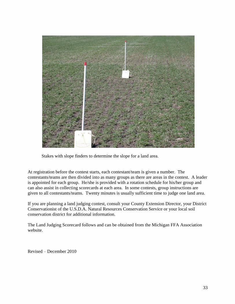
Stakes with slope finders to determine the slope for a land area.
At registration before the contest starts, each contestant/team is given a number. The
contestants/teams are then divided into as many groups as there are areas in the contest. A leader
is appointed for each group. He/she is provided with a rotation schedule for his/her group and
can also assist in collecting scorecards at each area. In some contests, group instructions are
given to all contestants/teams. Twenty minutes is usually sufficient time to judge one land area.
If you are planning a land judging contest, consult your County Extension Director, your District
Conservationist of the U.S.D.A. Natural Resources Conservation Service or your local soil
conservation district for additional information.
The Land Judging Scorecard follows and can be obtained from the Michigan FFA Association
website.
Revised – December 2010

34
35
Related Documents