Citation: Singh, A.P.; Yerudkar, A.; Mariani, V.; Iannelli, L.; Glielmo, L. A Bibliometric Review of the Use of Unmanned Aerial Vehicles in Precision Agriculture and Precision Viticulture for Sensing Applications. Remote Sens. 2022, 14, 1604. https:// doi.org/10.3390/rs14071604 Academic Editors: Javier J Cancela and Rocío Ballesteros González Received: 11 February 2022 Accepted: 22 March 2022 Published: 27 March 2022 Publisher’s Note: MDPI stays neutral with regard to jurisdictional claims in published maps and institutional affil- iations. Copyright: © 2022 by the authors. Licensee MDPI, Basel, Switzerland. This article is an open access article distributed under the terms and conditions of the Creative Commons Attribution (CC BY) license (https:// creativecommons.org/licenses/by/ 4.0/). remote sensing Review A Bibliometric Review of the Use of Unmanned Aerial Vehicles in Precision Agriculture and Precision Viticulture for Sensing Applications Abhaya Pal Singh * ,† , Amol Yerudkar † , Valerio Mariani † , Luigi Iannelli † and Luigi Glielmo † Department of Engineering, University of Sannio, 82100 Benevento, Italy; [email protected] (A.Y.); [email protected] (V.M.); [email protected] (L.I.); [email protected] (L.G.) * Correspondence: [email protected] † These authors contributed equally to this work. Abstract: This review focuses on the use of unmanned aerial vehicles (UAVs) in precision agriculture, and specifically, in precision viticulture (PV), and is intended to present a bibliometric analysis of their developments in the field. To this aim, a bibliometric analysis of research papers published in the last 15 years is presented based on the Scopus database. The analysis shows that the researchers from the United States, China, Italy and Spain lead the precision agriculture through UAV applications. In terms of employing UAVs in PV, researchers from Italy are fast extending their work followed by Spain and finally the United States. Additionally, the paper provides a comprehensive study on popular journals for academicians to submit their work, accessible funding organizations, popular nations, institutions, and authors conducting research on utilizing UAVs for precision agriculture. Finally, this study emphasizes the necessity of using UAVs in PV as well as future possibilities. Keywords: drones; precision agriculture; precision viticulture; unmanned aerial vehicles (UAVs); remote sensing 1. Introduction Precision agriculture (PA) is becoming highly significant in today’s technologically advanced world and has been considered as the farm for the future [1]. This is a modern farming management concept using digital techniques to monitor and optimize agricul- tural production processes by using technological advancements [2]. PA uses modern technology and principles to manage the spatial and temporal variability in all aspects of agricultural production for the goal of improving crop performance [3,4]. Spatial and temporal variability are terms used to describe variability that have significant impacts on agricultural production. Examples of spatial and temporal variability include yield variability [5], field variability [6], soil variability [7], crop variability [8], and management variability [9]. The goal is to reduce economical costs, decrease the impact on the envi- ronment (e.g., by using less water and fertilizers), and increase food production quality at the same time [10]. Typically, unmanned aerial vehicles (UAVs), sensor technologies, satellite navigation and positioning technologies, and the internet of things (IoT) are used to achieve these goals. PA is increasingly aiding farmers with their job as it makes its way into fields across Europe [11]. Larger yields need greater financial investment because a large amount of fertilizers, pesticides, water, and other resources is required. However, by their proper management, growers can achieve considerable saving on the expected expenses [12–14]. Further, in addition to increasing the yield by proper monitoring, the plants’ health and productivity can also increase at the same time, which will allow growers to meet the demand. Figure 1 depicts the last ten years of documents released by scien- tists, researchers, and growers, demonstrating that the practice of PA is expanding day by day. PA has evolved on digital-based farming management approach that monitors and Remote Sens. 2022, 14, 1604. https://doi.org/10.3390/rs14071604 https://www.mdpi.com/journal/remotesensing

Welcome message from author
This document is posted to help you gain knowledge. Please leave a comment to let me know what you think about it! Share it to your friends and learn new things together.
Transcript
�����������������
Citation: Singh, A.P.; Yerudkar, A.;
Mariani, V.; Iannelli, L.; Glielmo, L. A
Bibliometric Review of the Use of
Unmanned Aerial Vehicles in
Precision Agriculture and Precision
Viticulture for Sensing Applications.
Remote Sens. 2022, 14, 1604. https://
doi.org/10.3390/rs14071604
Academic Editors: Javier J Cancela
and Rocío Ballesteros González
Received: 11 February 2022
Accepted: 22 March 2022
Published: 27 March 2022
Publisher’s Note: MDPI stays neutral
with regard to jurisdictional claims in
published maps and institutional affil-
iations.
Copyright: © 2022 by the authors.
Licensee MDPI, Basel, Switzerland.
This article is an open access article
distributed under the terms and
conditions of the Creative Commons
Attribution (CC BY) license (https://
creativecommons.org/licenses/by/
4.0/).
remote sensing
Review
A Bibliometric Review of the Use of Unmanned Aerial Vehiclesin Precision Agriculture and Precision Viticulture forSensing ApplicationsAbhaya Pal Singh *,† , Amol Yerudkar † , Valerio Mariani † , Luigi Iannelli † and Luigi Glielmo †
Department of Engineering, University of Sannio, 82100 Benevento, Italy; [email protected] (A.Y.);[email protected] (V.M.); [email protected] (L.I.); [email protected] (L.G.)* Correspondence: [email protected]† These authors contributed equally to this work.
Abstract: This review focuses on the use of unmanned aerial vehicles (UAVs) in precision agriculture,and specifically, in precision viticulture (PV), and is intended to present a bibliometric analysis of theirdevelopments in the field. To this aim, a bibliometric analysis of research papers published in the last15 years is presented based on the Scopus database. The analysis shows that the researchers fromthe United States, China, Italy and Spain lead the precision agriculture through UAV applications.In terms of employing UAVs in PV, researchers from Italy are fast extending their work followedby Spain and finally the United States. Additionally, the paper provides a comprehensive study onpopular journals for academicians to submit their work, accessible funding organizations, popularnations, institutions, and authors conducting research on utilizing UAVs for precision agriculture.Finally, this study emphasizes the necessity of using UAVs in PV as well as future possibilities.
Keywords: drones; precision agriculture; precision viticulture; unmanned aerial vehicles (UAVs);remote sensing
1. Introduction
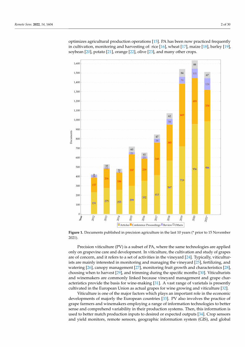
Precision agriculture (PA) is becoming highly significant in today’s technologicallyadvanced world and has been considered as the farm for the future [1]. This is a modernfarming management concept using digital techniques to monitor and optimize agricul-tural production processes by using technological advancements [2]. PA uses moderntechnology and principles to manage the spatial and temporal variability in all aspectsof agricultural production for the goal of improving crop performance [3,4]. Spatial andtemporal variability are terms used to describe variability that have significant impactson agricultural production. Examples of spatial and temporal variability include yieldvariability [5], field variability [6], soil variability [7], crop variability [8], and managementvariability [9]. The goal is to reduce economical costs, decrease the impact on the envi-ronment (e.g., by using less water and fertilizers), and increase food production qualityat the same time [10]. Typically, unmanned aerial vehicles (UAVs), sensor technologies,satellite navigation and positioning technologies, and the internet of things (IoT) are usedto achieve these goals. PA is increasingly aiding farmers with their job as it makes its wayinto fields across Europe [11]. Larger yields need greater financial investment because alarge amount of fertilizers, pesticides, water, and other resources is required. However,by their proper management, growers can achieve considerable saving on the expectedexpenses [12–14]. Further, in addition to increasing the yield by proper monitoring, theplants’ health and productivity can also increase at the same time, which will allow growersto meet the demand. Figure 1 depicts the last ten years of documents released by scien-tists, researchers, and growers, demonstrating that the practice of PA is expanding day byday. PA has evolved on digital-based farming management approach that monitors and
Remote Sens. 2022, 14, 1604. https://doi.org/10.3390/rs14071604 https://www.mdpi.com/journal/remotesensing
Remote Sens. 2022, 14, 1604 2 of 30
optimizes agricultural production operations [15]. PA has been now practiced frequentlyin cultivation, monitoring and harvesting of: rice [16], wheat [17], maize [18], barley [19],soybean [20], potato [21], orange [22], olive [23], and many other crops.
Year
2012
2013
2014
2015
2016
2017
2018
2019
2020
2021
*
0
100
200
300
400
500
600
700
800
900
1,000
1,100
1,200
1,300
1,400
1,500
1,600
9
35
31
60
41
47
62
84
88
67
26
129
21
21
38
58
70
101
124
157
206186
337 239
348
385
669
489
334
231275 255
299352
413
567
719
956 986
Doc
umen
ts
Articles Conference Proceedings Review Others
Figure 1. Documents published in precision agriculture in the last 10 years (* prior to 15 November2021).
Precision viticulture (PV) is a subset of PA, where the same technologies are appliedonly on grapevine care and development. In viticulture, the cultivation and study of grapesare of concern, and it refers to a set of activities in the vineyard [24]. Typically, viticultur-ists are mainly interested in monitoring and managing the vineyard [25], fertilizing, andwatering [26], canopy management [27], monitoring fruit growth and characteristics [28],choosing when to harvest [29], and trimming during the specific months [30]. Viticulturistsand winemakers are commonly linked because vineyard management and grape char-acteristics provide the basis for wine-making [31]. A vast range of varietals is presentlycultivated in the European Union as actual grapes for wine growing and viticulture [32].
Viticulture is one of the major factors which plays an important role in the economicdevelopments of majorly the European countries [33]. PV also involves the practice ofgrape farmers and winemakers employing a range of information technologies to bettersense and comprehend variability in their production systems. Then, this information isused to better match production inputs to desired or expected outputs [34]. Crop sensorsand yield monitors, remote sensors, geographic information system (GIS), and global
Remote Sens. 2022, 14, 1604 3 of 30
navigation satellite systems (GNSS) are some of the components of the PV’s technologicaladvancements. Therefore, they are a rising trend in the wine industry [35]. Furthermore, PVis growing substantially because of the improved and cost-effective sensors, methodologies,and equipment for data acquisition from drones [36].
This bibliometric study presents the analysis on the usage of UAVs in PA and morespecifically in PV, and presents the analyzed results. Readers can find other bibliometricreviews dedicated to PA and PV, such as research evolution on PA [37], advances inprecision coffee growing research [38], wireless sensor networks in agriculture [39], IoTin PA [40], digital agriculture [41,42], an investigation of PV production, impact, andinterdisciplinary collaboration involved in viticulture [43], a bibliometric analysis of PV inItaly [44], Mexican academicians’ contribution to viticulture [45], to gain further informationon PA and PV. Although numerous reviews have been published, to our knowledge, nobibliometric study has explored on the use of UAVs in PV. The current article fills this gapin the literature by identifying the important concerns and potential associated with the useof UAVs in PV. The remaining sections of this manuscript are as follows: Section 2 discussesthe materials and methods used for the bibliometric analysis, Section 3 discusses brieflywhy the UAV is needed in PA, Section 4 discusses why the UAV is needed in PV, Section 5presents the analyzed results, and Section 6 summarizes the findings and future scope.
2. Materials and Methods
The usage of UAVs in PA (UAV-PA) and usage of UAVs in PV (UAV-PV) are undeniablytransforming traditional agricultural operations. The number of contributions is constantlyrising throughout the years. In 2020 alone, the number of publications using the termsUAV-PA and UAV-PV reached 224 and 40, respectively. It is difficult to maintain track ofkey developments in the area at such a rapid rate of publishing. By statistically evaluatingpublished data, bibliometric analytic tools can assist speed up the review process in thiscontext [41]. Authors working in the use of UAVs in PA research field use a variety ofterminologies to refer to the same ideas. In such a fragmented subject, bibliometric analysisbecomes very important. So, to find the most important publications, the most influentialsources, institutions, and nations, we have used bibliometrics tools.
2.1. Materials
In this bibliometric review, the articles from the Scopus database have been considered.Scopus is an online database that contains nearly all significant research publications andhas built-in analytical capabilities for generating representative data. Additionally, thesearch results from Scopus can be exported to other software, for additional post process-ing. For instance, the targeted study used VOSviewer [46] that provides algorithms forbibliometrics-based analysis of publishing datasets. Co-citation, network analysis, collab-oration, coupling, and co-word information fetching are also possible. A publication isindeed the dataset’s base element. Authors, document type, document title, keywords, citedreferences, source, year, author address, times cited, and others are connected with eachpublication. The targeted study also used the science mapping analysis software tool (Sci-MAT). SciMAT has been chosen because it facilitates all stages of scientific mapping, fromdata preparation to the development of field maps [42,47], and also has a comprehensivepreparation module that verifies the quality of the data [42].
The quality and thoroughness of the outcomes in this work may still be hampered byconstraints in the analysis tools and data filtering procedure. To begin with, the retrieveddata could have left out certain publications. Some publications that did not contain thesought keywords in the title, abstract, author keywords may have been excluded from therecords because we used a search strategy presented in Table 1. Some publications may beincorrectly eliminated as a result of manual selection. Finally, we want to express our grati-tude to the VOSviewer tool and SciMAT for offering the data visualization functionalitiesutilized in this study.
Remote Sens. 2022, 14, 1604 4 of 30
2.2. Methods
Research towards the application of UAV-PA and UAV-PV is trending, and furtherknowledge should be obtained to progress in these fields, which is why bibliometricanalysis is vital. As a result, this review is conducted at the appropriate moment to givea comprehensive knowledge of the utilization of UAV-PA and UAV-PV, as well as futureresearch possibilities.
2.2.1. Design of the Study
We defined and explored the following questions in order to correctly gain significantknowledge and conduct a bibliometric study on UAV-PA and UAV-PV:
1. Why are UAVs required in PA? Section 3 of this review study explored the solution tothis question. The purpose of this research question is to examine the developmentsin the use of UAV-PV.
2. What technologies are employed in UAV-PA and UAV-PV? The answer to this question isexplored in further detail in Sections 4 and 5 of this review study.
3. What nations are pioneering research on the use of UAV-PA and UAV-PV? Sections 4.1 and 5.1show the solution with their respective publications.
4. Which journals are chosen by researchers for publication, which funding agencies are accessible,which prominent researchers are active in the field, and which universities/institutions areactive in the field of UAV-PA and UAV-PV? The answers to these concerns can be foundin subsections of Sections 4 and 5, respectively. Section 6 contains information aboutmajor universities/institutions active in the area of UAV-PA and UAV-PV. In addition,the future scope towards the PV’s technological development is also reported inthis section.
2.2.2. Data Collection
To address the questions of Section 2.2.1, we examined the publications between 1January 2006 and 15 November 2021. The most widely utilized publishing databases areWeb of Science (WoS) and Scopus and there were no other options available in the past [48]about what databases to choose for the bibliometric analysis. However, WoS and Scopuscontinue to have the highest data quality and completeness across several categories [49],and as a result, they are the most commonly employed for bibliometric analysis. Scopusdemonstrated that it has a wider coverage than WoS, which justifies our choice to use onlythe first.
The data are accessed on 15 November 2021 with keywords reported in Table 1. Thetable also reports the type of database used, how many documents have been considered,time-span of the data collection, the criteria for inclusion and the software used to analyzethe results.
2.2.3. Data Preparation
The data fetched have not been used directly because of missing values in relevantfields. Thus, a manual checking has been carried out in order to remove the articleswith incomplete information. Then, the filtered data have been uploaded to SciMAT andVOSviewer for generating results.
The strategic diagram, thematic network structure and thematic evolution structurefor the most significant themes have been generated via SciMAT. The evolutionary mapwas constructed using the equivalence index, with solid lines indicating that clusters havea common theme (Figure 2). In comparison, dashed lines indicate a connection betweennon-major terminologies, whereas in some cases, the absence of lines indicates that thetopic gradually ceased to exist from one period to the other [42].
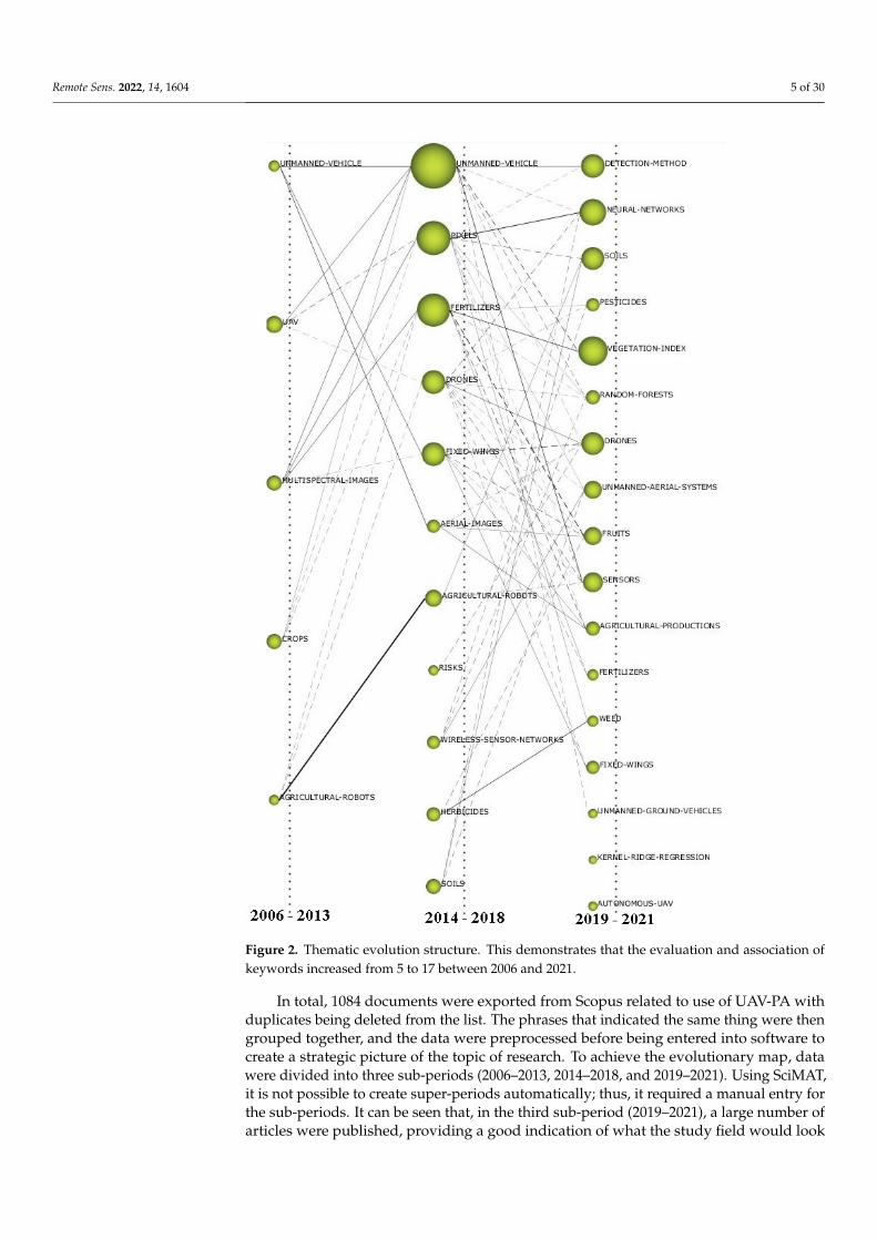
Remote Sens. 2022, 14, 1604 5 of 30
Figure 2. Thematic evolution structure. This demonstrates that the evaluation and association ofkeywords increased from 5 to 17 between 2006 and 2021.
In total, 1084 documents were exported from Scopus related to use of UAV-PA withduplicates being deleted from the list. The phrases that indicated the same thing were thengrouped together, and the data were preprocessed before being entered into software tocreate a strategic picture of the topic of research. To achieve the evolutionary map, datawere divided into three sub-periods (2006–2013, 2014–2018, and 2019–2021). Using SciMAT,it is not possible to create super-periods automatically; thus, it required a manual entry forthe sub-periods. It can be seen that, in the third sub-period (2019–2021), a large number ofarticles were published, providing a good indication of what the study field would look
Remote Sens. 2022, 14, 1604 6 of 30
like in the future (as pictorially shown in Figure 1). To determine which topics were mostessential and which clusters they were in, we used the keyword co-occurrence matrix. Datawere normalized and clustered into groups based on the simple centers algorithm usingthe equivalence index (EI) to create a network of links between the themes. We compressthe data to a frequency resolution of 2 to create the diagrams. We established a maximumand minimum network size of 14 and 3, respectively, when we examined the field of study.In the strategic diagram, the horizontal axis (centrality) depicts the importance of eachsubject and the number of links it has with other themes, while the vertical axis (density)depicts the number of connections between each cluster. This graph depicts the relationshipbetween two or more topics throughout time, for more information about the quadrants,the reader is referred to [42].
Table 1. Search strategy adopted to explore and retrieve relevant publications for the bibliometricanalysis from Scopus database.
Database Scopus
Topic for PA ‘Precision Agriculture’ and ‘UAV’, ‘Precision Agri-culture’ and ‘UAS’
Topic for PV‘Precision Viticulture’ and ‘UAV’, ‘Precision Viti-culture’ and ‘UAS’, ‘Vineyard’ and ‘UAV’, ‘Vine-yard’ and ‘UAS’
Number of relevant documents consideredin PA 1084
Number of relevant documents consideredin PV 182
Time-span 1 January 2006–15 November 2021
Criteria for inclusion Title, abstract, and keywords should containsearch terms. Only English documents.
Bibliometric software SciMAT and VOSviewer
2.2.4. Data Analysis
In this bibliometric review, the strategies for data analysis is divided into the follow-ing categories:
• Worldwide published documents based on year-wise and country-wise on adopting UAV-PAand UAV-PV: Under this analysis, we analyzed the documents published during theconsidered time-span that are fetched from the database, and arranged them accordingto the year of publication and presented in graphical form. We applied the samemethods for country-specific publications.
• Influenced authors world wide on adopting UAV-PA and UAV-PV: The world recognizesexcellent research, and hence, we chose three different categories to identify leadingauthors on adopting UAV-PA and UAV-PV. These are: (i) on the basis of author’scitation count, (ii) on the basis of most cited documents, and (iii) on the basis of thenumber of documents produced by an author, and accordingly, we presented theresults in this manuscript.
• Most preferred journals and popular funding sponsors: To choose most preferred journals, itis obvious to go for the number of articles published in the specific journals on adoptingUAV-PA and UAV-PV, and the same we applied to the popular funding sponsors.
• Leading institutions based on the citation counts on adopting UAV-PA and UAV-PV: Toidentify leading institutions, we again focused on the citation count of the articlespublished by an institute on adopting UAV-PA and UAV-PV.
Remote Sens. 2022, 14, 1604 7 of 30
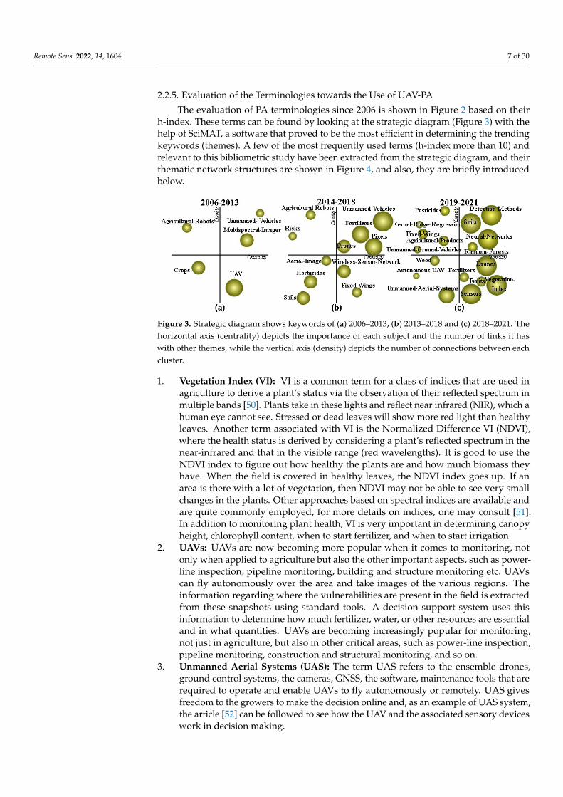
2.2.5. Evaluation of the Terminologies towards the Use of UAV-PA
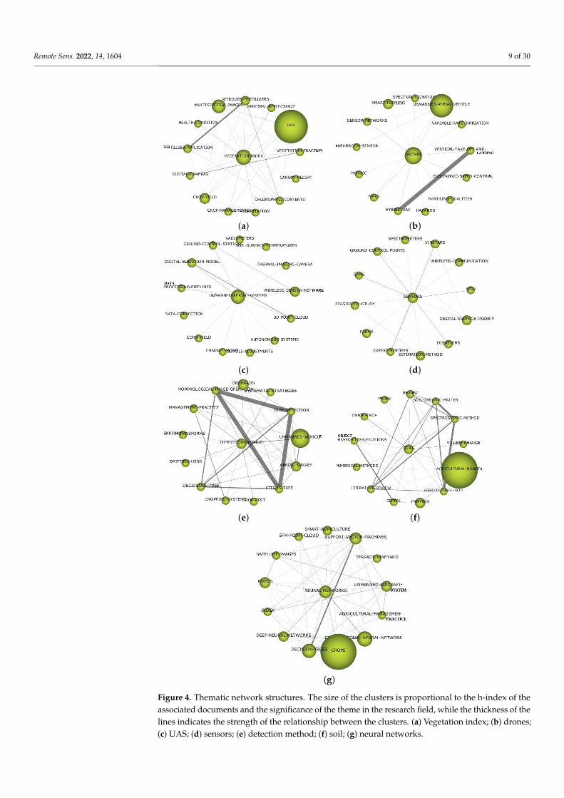
The evaluation of PA terminologies since 2006 is shown in Figure 2 based on theirh-index. These terms can be found by looking at the strategic diagram (Figure 3) with thehelp of SciMAT, a software that proved to be the most efficient in determining the trendingkeywords (themes). A few of the most frequently used terms (h-index more than 10) andrelevant to this bibliometric study have been extracted from the strategic diagram, and theirthematic network structures are shown in Figure 4, and also, they are briefly introducedbelow.
Figure 3. Strategic diagram shows keywords of (a) 2006–2013, (b) 2013–2018 and (c) 2018–2021. Thehorizontal axis (centrality) depicts the importance of each subject and the number of links it haswith other themes, while the vertical axis (density) depicts the number of connections between eachcluster.
1. Vegetation Index (VI): VI is a common term for a class of indices that are used inagriculture to derive a plant’s status via the observation of their reflected spectrum inmultiple bands [50]. Plants take in these lights and reflect near infrared (NIR), which ahuman eye cannot see. Stressed or dead leaves will show more red light than healthyleaves. Another term associated with VI is the Normalized Difference VI (NDVI),where the health status is derived by considering a plant’s reflected spectrum in thenear-infrared and that in the visible range (red wavelengths). It is good to use theNDVI index to figure out how healthy the plants are and how much biomass theyhave. When the field is covered in healthy leaves, the NDVI index goes up. If anarea is there with a lot of vegetation, then NDVI may not be able to see very smallchanges in the plants. Other approaches based on spectral indices are available andare quite commonly employed, for more details on indices, one may consult [51].In addition to monitoring plant health, VI is very important in determining canopyheight, chlorophyll content, when to start fertilizer, and when to start irrigation.
2. UAVs: UAVs are now becoming more popular when it comes to monitoring, notonly when applied to agriculture but also the other important aspects, such as power-line inspection, pipeline monitoring, building and structure monitoring etc. UAVscan fly autonomously over the area and take images of the various regions. Theinformation regarding where the vulnerabilities are present in the field is extractedfrom these snapshots using standard tools. A decision support system uses thisinformation to determine how much fertilizer, water, or other resources are essentialand in what quantities. UAVs are becoming increasingly popular for monitoring,not just in agriculture, but also in other critical areas, such as power-line inspection,pipeline monitoring, construction and structural monitoring, and so on.
3. Unmanned Aerial Systems (UAS): The term UAS refers to the ensemble drones,ground control systems, the cameras, GNSS, the software, maintenance tools that arerequired to operate and enable UAVs to fly autonomously or remotely. UAS givesfreedom to the growers to make the decision online and, as an example of UAS system,the article [52] can be followed to see how the UAV and the associated sensory deviceswork in decision making.
Remote Sens. 2022, 14, 1604 8 of 30
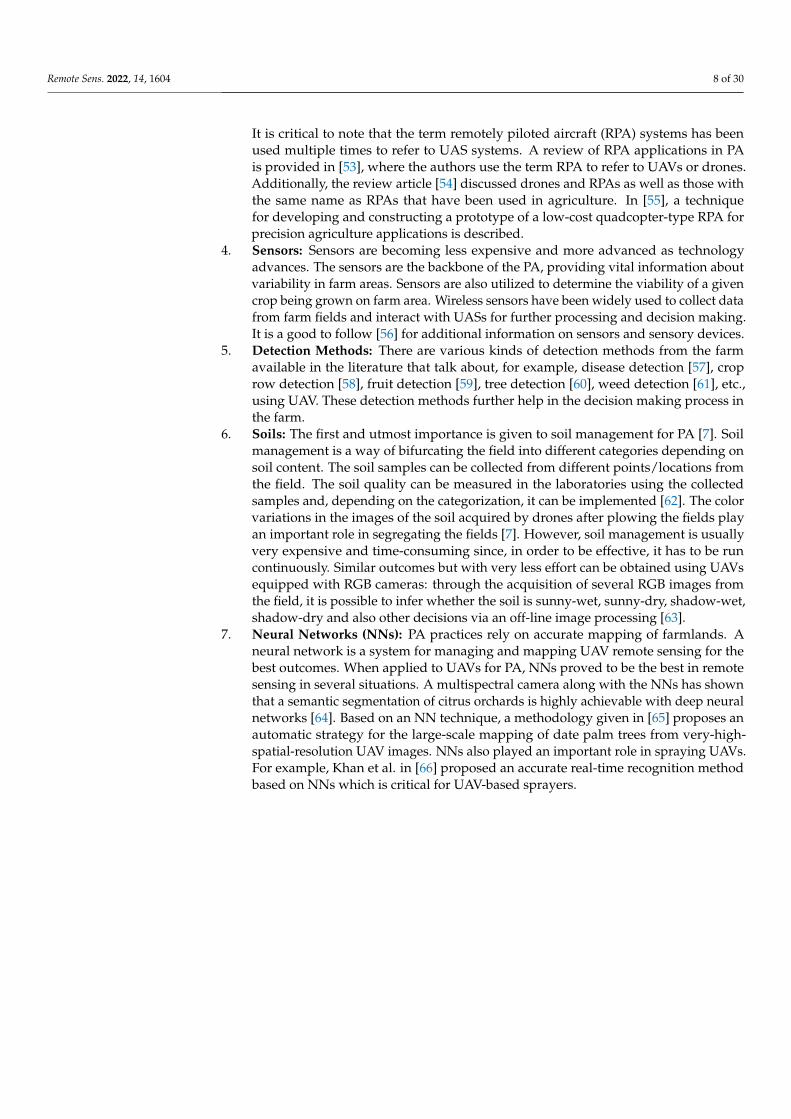
It is critical to note that the term remotely piloted aircraft (RPA) systems has beenused multiple times to refer to UAS systems. A review of RPA applications in PAis provided in [53], where the authors use the term RPA to refer to UAVs or drones.Additionally, the review article [54] discussed drones and RPAs as well as those withthe same name as RPAs that have been used in agriculture. In [55], a techniquefor developing and constructing a prototype of a low-cost quadcopter-type RPA forprecision agriculture applications is described.
4. Sensors: Sensors are becoming less expensive and more advanced as technologyadvances. The sensors are the backbone of the PA, providing vital information aboutvariability in farm areas. Sensors are also utilized to determine the viability of a givencrop being grown on farm area. Wireless sensors have been widely used to collect datafrom farm fields and interact with UASs for further processing and decision making.It is a good to follow [56] for additional information on sensors and sensory devices.
5. Detection Methods: There are various kinds of detection methods from the farmavailable in the literature that talk about, for example, disease detection [57], croprow detection [58], fruit detection [59], tree detection [60], weed detection [61], etc.,using UAV. These detection methods further help in the decision making process inthe farm.
6. Soils: The first and utmost importance is given to soil management for PA [7]. Soilmanagement is a way of bifurcating the field into different categories depending onsoil content. The soil samples can be collected from different points/locations fromthe field. The soil quality can be measured in the laboratories using the collectedsamples and, depending on the categorization, it can be implemented [62]. The colorvariations in the images of the soil acquired by drones after plowing the fields playan important role in segregating the fields [7]. However, soil management is usuallyvery expensive and time-consuming since, in order to be effective, it has to be runcontinuously. Similar outcomes but with very less effort can be obtained using UAVsequipped with RGB cameras: through the acquisition of several RGB images fromthe field, it is possible to infer whether the soil is sunny-wet, sunny-dry, shadow-wet,shadow-dry and also other decisions via an off-line image processing [63].
7. Neural Networks (NNs): PA practices rely on accurate mapping of farmlands. Aneural network is a system for managing and mapping UAV remote sensing for thebest outcomes. When applied to UAVs for PA, NNs proved to be the best in remotesensing in several situations. A multispectral camera along with the NNs has shownthat a semantic segmentation of citrus orchards is highly achievable with deep neuralnetworks [64]. Based on an NN technique, a methodology given in [65] proposes anautomatic strategy for the large-scale mapping of date palm trees from very-high-spatial-resolution UAV images. NNs also played an important role in spraying UAVs.For example, Khan et al. in [66] proposed an accurate real-time recognition methodbased on NNs which is critical for UAV-based sprayers.
Remote Sens. 2022, 14, 1604 9 of 30
(a) (b)
(c) (d)
(e) (f)
(g)
Figure 4. Thematic network structures. The size of the clusters is proportional to the h-index of theassociated documents and the significance of the theme in the research field, while the thickness of thelines indicates the strength of the relationship between the clusters. (a) Vegetation index; (b) drones;(c) UAS; (d) sensors; (e) detection method; (f) soil; (g) neural networks.
Remote Sens. 2022, 14, 1604 10 of 30
3. Why UAV in PA?
It is convincing that as the world’s population grows, there is a need to enhancewhat is done on the farm, and UAVs are a reasonable extension of improving productivityand quality of the crops that will be cultivated [67]. The UAVs should hover over thefield and detect areas that have a significant infestation that cannot be seen from a distantlocation, allowing a range of pesticides to be applied exclusively to smaller regions wherethe infections are present [68]. The objective of these efforts is to achieve productivitygains of 70% by 2050 to satisfy the growing requirements of the Earth’s population whiledecreasing the area under agriculture [69]. UAVs fall under the category of aerial robotics,which is the deployment of devices to perform beneficial tasks, including agriculture whichis the focus of this review study. The designed UAV system should have the requiredpayload capacity [70] and can fly to survey the area being monitored [71]. In addition (butnot limited to), the system may include near-infrared, visible cameras aboard, the potentialto use thermal cameras [72], and multispectral and hyperspectral cameras.
Technologies of UAV in PA
UAVs have recently been employed in agriculture for large-scale inspections as wellas irrigation [73] and fertilization [74]. A drone’s payload is made up of all the sensors andactuators attached to it, i.e., (i) multispectral and hyperspectral cameras, (ii) infrared cam-eras and RGB cameras, (iii) light detection and ranging (LiDAR) systems [75], and globalnavigation satellite system (GNSS). More research into the integration of multi-sensors ona UAV platform, such as RGB cameras, LiDAR, thermal cameras, and multi/hyperspectralcameras, is needed to improve PA estimate accuracy [76]. The necessity for a thermalcamera aboard a UAV can be reduced by using the technique outlined in [77]. Due tothe restricted area available for picture collection, UAV photos seldom catch well-wateredplants or arid areas. The thermal camera is not required in the approach such as the onedescribed in [77], which focuses on certain mapping using just multispectral pictures, mightconsiderably decrease operating and investment expenses. A good quality image can beachieved utilizing the suggested methods and control approaches of [78]. This researchalso shows that the suggested methods can handle various image datasets, such as thoseacquired by frame cameras with variable sensor-to-object distances over some crop fields.
When evapotranspiration is involved, it is sometimes apparent to utilize thermalcameras. The current conventional technique for aligning thermal imaging employs GPSlogger data for the initial imagery spot; however, it does not account for changes inmeteorological conditions during the flight, leading to unsatisfactory outcomes. To improvethis scenario, three alignment and calibration techniques based on RGB image alignmentwere developed in [79]. According to the findings of [80], the suggested thermal calibrationtechnique based on temperature-controlled standards can provide appropriate precisionand accuracy for UAV-based canopy temperature estimates applied to PA.
4. Why UAV in PV?
The key to success for any PV strongly depends on the collection of the maximumamount of geo-referenced information of the whole vineyard and the technologies usedto monitor. Since the late twentieth century, UAVs have advanced quickly. UAV remotesensing has been swiftly put into reality as agricultural remote sensing has improved.Vegetation coverage monitoring, growth tracking, and yield estimates are among the mostcommon types of field growth data collected using UAV platforms [81]. In addition, UAVshave partially solved terrestrial and high-altitude remote sensing shortcomings, offeringsubstantial support for PA crop information monitoring technologies [82].
4.1. Technologies of UAV in PV
The initial phase in the wine-making process is viticulture. The circumstances of thevineyard and human decisions in the vineyard determine the quality of wine [83]. Thehuman decision for PV is based on the data received from the UAV sensors and attached
Remote Sens. 2022, 14, 1604 11 of 30
tools [84]. The location of the vineyard influences the flavor of the grapes grown. Themajority of PV research is focused on vegetation index information [85]. The vegetationindex data may be gathered using multispectral cameras placed on the UAVs [86]. Changesin items that affect our environment, such as water quality and plant cover, are measuredusing these cameras. It is now feasible to build maps of vegetation coverage for the wholeregion under examination using these cameras on UAVs. Using remotely sensed data, theNDVI has been utilized to reveal discrepancies in grapevine performance. The NDVI iscalculated using the formula
NDVI =ρnir − ρredρnir + ρred
, (1)
where ρnir and ρred are the reflectance levels in the near-infrared and in the red spectrum,respectively [87]. In numerous investigations, NDVI readings in vineyards have beenrelated to leaf area index (LAI). The relationship between NDVI and vineyard LAI is wellknown because NDVI is strongly linked to the gross quantity of chlorophyll. Increasingleaf area leads to a higher gross quantity of chlorophyll per unit area of the vineyard. LAIis a major physiological component for characterizing crop growth models and vegetationindices for expressing crop growth status. The NDVI does not have a linear connection withLAI. Using UAV platforms, many studies on spectral data monitoring growth indicatorssuch as LAI [88,89] have been conducted. Authors in [90] describe three models that usea quad-rotor UAV platform with a digital camera to examine the link between LAI andcanopy coverage. A UAV fitted with hyperspectral cameras was deployed to evaluatedifferent cultivars to illustrate the feasibility of LAI monitoring in the context of PA [91].Various methods of calculating vegetation indices have been used throughout history;however, the most often researched vegetation indices are given in [92].
Multispectral cameras collect data from the electromagnetic spectrum across differentbands, or frequency intervals [93]. In particular, they are used for the NIR spectrum,specifically in the range 800–850 nm, since this band is important for determining the healthof plants [94]. In the NIR spectrum, plants emit up to 60% of their total electromagneticradiated energy [95]. For measuring vegetation on the ground, differences in reflectedlight in the NIR part of the spectrum are critical. Multispectral remote sensing datasetsare used to detect light energy reflected from objects on the earth’s surface and estimatevarious physical and chemical characteristics of things that are not visible to the nakedeye. Following that, the measurements provide us with information about what is on theground. For example, vegetation is typically indicated by pixels with a spectrum containingmuch NIR light energy.
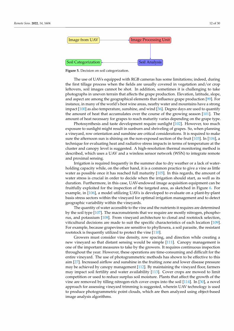
The growers starts with the grape variety, and once that is achieved, understandingthe soil for them becomes important. Figure 5 shows a block diagram of the decisionmaking process for the categorization of the soil (mainly the field of plots on which thegrapevine is cultivated). The acquisition of aerial photographs takes place in the first block.The photographs are used in the second block to create a mosaicked image of the site underconsideration [96]. This mosaicked image is also used to analyze the relationship betweenvarious surface soil properties, such as organic matter, moisture, clay, silt, sand, and othersoil content, and then, the soil is categorized accordingly. When the vegetation indices valuewere utilized as input data in trained techniques, the best performance in the categorizationof vineyard soil RGB pictures was obtained, with overall accuracy values around 0.98 andhigh sensitivity values for the soil [97]. To monitor farmland soil parameters and cropgrowth, the UAV’s remote sensing have been equipped with high-resolution hyperspectralsensors [98].
Remote Sens. 2022, 14, 1604 12 of 30
Image from UAV Image Processing Unit
Soil AnalysisSoil Categorization
Figure 5. Decision on soil categorization.
The use of UAVs equipped with RGB cameras has some limitations; indeed, duringthe first tillage process when the fields are usually covered in vegetation and/or cropleftovers, soil images cannot be shot. In addition, sometimes it is challenging to takephotographs in uneven terrain that affects the grape production. Elevation, latitude, slope,and aspect are among the geographical elements that influence grape production [99]. Forinstance, in many of the world’s best wine areas, nearby water and mountains have a strongimpact [100] as also temperature, sunshine, and wind [36]. Degree days are used to quantifythe amount of heat that accumulates over the course of the growing season [101]. Theamount of heat necessary for grapes to reach maturity varies depending on the grape type.
Photosynthesis and taste development require sunlight [102]. However, too muchexposure to sunlight might result in sunburn and shriveling of grapes. So, when planninga vineyard, row orientation and sunshine are critical considerations. It is required to makesure the afternoon sun is shining on the non-exposed section of the fruit [103]. In [104], atechnique for evaluating heat and radiative stress impacts in terms of temperature at thecluster and canopy level is suggested. A high-resolution thermal monitoring method isdescribed, which uses a UAV and a wireless sensor network (WSN) to integrate remoteand proximal sensing.
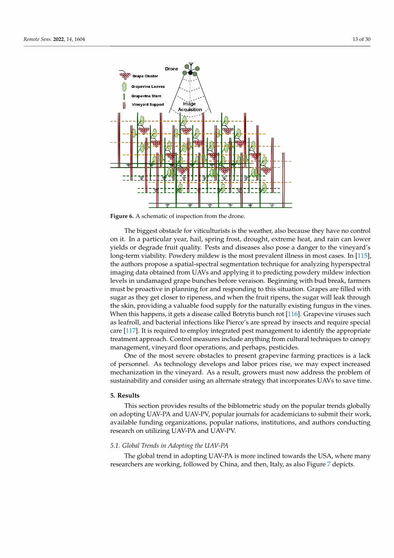
Irrigation is required frequently in the summer due to dry weather or a lack of water-holding capacity while, on the other hand, it is a common practice to give a vine as littlewater as possible once it has reached full maturity [105]. In this regards, the amount ofwater stress is crucial in order to decide when the irrigation should start, as well as itsduration. Furthermore, in this case, UAV-endowed image acquisition equipment can befruitfully exploited for the inspection of the targeted area, as sketched in Figure 6. Forexample, in [106], a model utilizing UAVs is developed to evaluate on a plant-by-plantbasis stress sectors within the vineyard for optimal irrigation management and to detectgeographic variability within the vineyards.
The quantity of water accessible to the vine and the nutrients it requires are determinedby the soil type [107]. The macronutrients that we require are mostly nitrogen, phospho-rus, and potassium [108]. From vineyard architecture to clonal and rootstock selection,viticultural decisions are made to suit the specific characteristics of each location [109].For example, because grapevines are sensitive to phylloxera, a soil parasite, the resistantrootstock is frequently utilized to protect the vine [110].
Growers must consider vine density, row spacing, and direction while creating anew vineyard so that distant sensing would be simple [111]. Canopy management isone of the important measures to take by the growers. It requires continuous inspectionthroughout the year. However, these operations are time-consuming and difficult for theentire vineyard. The use of photogrammetric methods has shown to be effective to thisaim [27]. Increased airflow and sunshine in the fruiting zone and lower disease pressuremay be achieved by canopy management [112]. By maintaining the vineyard floor, farmersmay impact soil fertility and water availability [113]. Cover crops are mowed to limitcompetition or used to reduce surplus soil moisture. Plants that affect the growth of thevine are removed by tilling nitrogen-rich cover crops into the soil [114]. In [30], a novelapproach for assessing vineyard trimming is suggested, wherein UAV technology is usedto produce photogrammetric point clouds, which are then analyzed using object-basedimage analysis algorithms.
Remote Sens. 2022, 14, 1604 13 of 30
Figure 6. A schematic of inspection from the drone.
The biggest obstacle for viticulturists is the weather, also because they have no controlon it. In a particular year, hail, spring frost, drought, extreme heat, and rain can loweryields or degrade fruit quality. Pests and diseases also pose a danger to the vineyard’slong-term viability. Powdery mildew is the most prevalent illness in most cases. In [115],the authors propose a spatial-spectral segmentation technique for analyzing hyperspectralimaging data obtained from UAVs and applying it to predicting powdery mildew infectionlevels in undamaged grape bunches before veraison. Beginning with bud break, farmersmust be proactive in planning for and responding to this situation. Grapes are filled withsugar as they get closer to ripeness, and when the fruit ripens, the sugar will leak throughthe skin, providing a valuable food supply for the naturally existing fungus in the vines.When this happens, it gets a disease called Botrytis bunch rot [116]. Grapevine viruses suchas leafroll, and bacterial infections like Pierce’s are spread by insects and require specialcare [117]. It is required to employ integrated pest management to identify the appropriatetreatment approach. Control measures include anything from cultural techniques to canopymanagement, vineyard floor operations, and perhaps, pesticides.
One of the most severe obstacles to present grapevine farming practices is a lackof personnel. As technology develops and labor prices rise, we may expect increasedmechanization in the vineyard. As a result, growers must now address the problem ofsustainability and consider using an alternate strategy that incorporates UAVs to save time.
5. Results
This section provides results of the biblometric study on the popular trends globallyon adopting UAV-PA and UAV-PV, popular journals for academicians to submit their work,available funding organizations, popular nations, institutions, and authors conductingresearch on utilizing UAV-PA and UAV-PV.
5.1. Global Trends in Adopting the UAV-PA
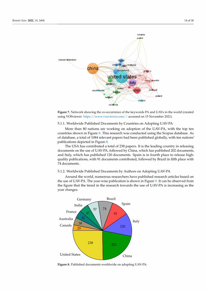
The global trend in adopting UAV-PA is more inclined towards the USA, where manyresearchers are working, followed by China, and then, Italy, as also Figure 7 depicts.
Remote Sens. 2022, 14, 1604 14 of 30
Figure 7. Network showing the co-occurrence of the keywords PA and UAVs in the world (createdusing VOSviewer https://www.vosviewer.com// accessed on 15 November 2021).
5.1.1. Worldwide Published Documents by Countries on Adopting UAV-PA
More than 80 nations are working on adoption of the UAV-PA, with the top tencountries shown in Figure 8. This research was conducted using the Scopus database. Asof database, a total of 1084 relevant papers had been published globally, with ten nations’publications depicted in Figure 8.
The USA has contributed a total of 238 papers. It is the leading country in releasingdocuments on the use of UAV-PA, followed by China, which has published 202 documents,and Italy, which has published 120 documents. Spain is in fourth place to release high-quality publications, with 91 documents contributed, followed by Brazil in fifth place with74 documents.
5.1.2. Worldwide Published Documents by Authors on Adopting UAV-PA
Around the world, numerous researchers have published research articles based onthe use of UAV-PA. The year-wise publication is shown in Figure 9. It can be observed fromthe figure that the trend in the research towards the use of UAV-PA is increasing as theyear changes.
United States
238
China
202
Italy120
Spain
91
Brazil
74
Germany
57India
47France
42Australia38Canada
29
Figure 8. Published documents worldwide on adopting UAV-PA.
Remote Sens. 2022, 14, 1604 15 of 30
Year201+2021
22420202222019
11720181072017
642016672015
252014272013
102012620114201022009220083200732006
0 25 50 75 100 125 150 175 200 225Documents
Figure 9. Year-wise published documents worldwide on adopting UAV-PA (until 15 November 2021).
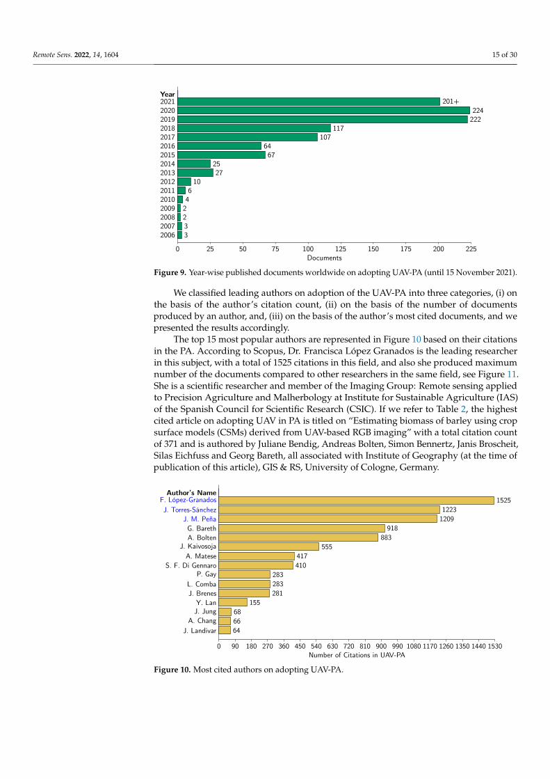
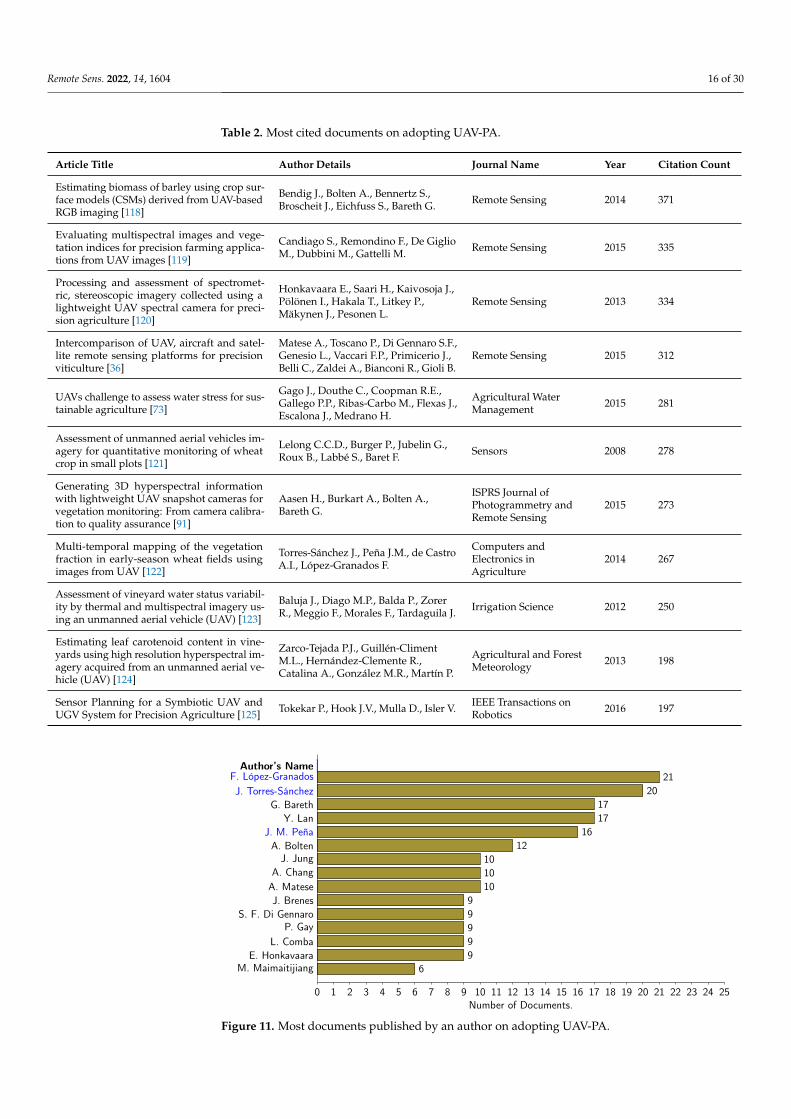
We classified leading authors on adoption of the UAV-PA into three categories, (i) onthe basis of the author’s citation count, (ii) on the basis of the number of documentsproduced by an author, and, (iii) on the basis of the author’s most cited documents, and wepresented the results accordingly.
The top 15 most popular authors are represented in Figure 10 based on their citationsin the PA. According to Scopus, Dr. Francisca López Granados is the leading researcherin this subject, with a total of 1525 citations in this field, and also she produced maximumnumber of the documents compared to other researchers in the same field, see Figure 11.She is a scientific researcher and member of the Imaging Group: Remote sensing appliedto Precision Agriculture and Malherbology at Institute for Sustainable Agriculture (IAS)of the Spanish Council for Scientific Research (CSIC). If we refer to Table 2, the highestcited article on adopting UAV in PA is titled on “Estimating biomass of barley using cropsurface models (CSMs) derived from UAV-based RGB imaging” with a total citation countof 371 and is authored by Juliane Bendig, Andreas Bolten, Simon Bennertz, Janis Broscheit,Silas Eichfuss and Georg Bareth, all associated with Institute of Geography (at the time ofpublication of this article), GIS & RS, University of Cologne, Germany.
Author’s Name1525F. López-Granados
1223J. Torres-Sánchez1209J. M. Peña
918G. Bareth883A. Bolten
555J. Kaivosoja417A. Matese410S. F. Di Gennaro
283P. Gay283L. Comba281J. Brenes
155Y. Lan68J. Jung66A. Chang64J. Landivar
0 90 180 270 360 450 540 630 720 810 900 990 1080 1170 1260 1350 1440 1530Number of Citations in UAV-PA
Figure 10. Most cited authors on adopting UAV-PA.
Remote Sens. 2022, 14, 1604 16 of 30
Table 2. Most cited documents on adopting UAV-PA.
Article Title Author Details Journal Name Year Citation Count
Estimating biomass of barley using crop sur-face models (CSMs) derived from UAV-basedRGB imaging [118]
Bendig J., Bolten A., Bennertz S.,Broscheit J., Eichfuss S., Bareth G. Remote Sensing 2014 371
Evaluating multispectral images and vege-tation indices for precision farming applica-tions from UAV images [119]
Candiago S., Remondino F., De GiglioM., Dubbini M., Gattelli M. Remote Sensing 2015 335
Processing and assessment of spectromet-ric, stereoscopic imagery collected using alightweight UAV spectral camera for preci-sion agriculture [120]
Honkavaara E., Saari H., Kaivosoja J.,Pölönen I., Hakala T., Litkey P.,Mäkynen J., Pesonen L.
Remote Sensing 2013 334
Intercomparison of UAV, aircraft and satel-lite remote sensing platforms for precisionviticulture [36]
Matese A., Toscano P., Di Gennaro S.F.,Genesio L., Vaccari F.P., Primicerio J.,Belli C., Zaldei A., Bianconi R., Gioli B.
Remote Sensing 2015 312
UAVs challenge to assess water stress for sus-tainable agriculture [73]
Gago J., Douthe C., Coopman R.E.,Gallego P.P., Ribas-Carbo M., Flexas J.,Escalona J., Medrano H.
Agricultural WaterManagement 2015 281
Assessment of unmanned aerial vehicles im-agery for quantitative monitoring of wheatcrop in small plots [121]
Lelong C.C.D., Burger P., Jubelin G.,Roux B., Labbé S., Baret F. Sensors 2008 278
Generating 3D hyperspectral informationwith lightweight UAV snapshot cameras forvegetation monitoring: From camera calibra-tion to quality assurance [91]
Aasen H., Burkart A., Bolten A.,Bareth G.
ISPRS Journal ofPhotogrammetry andRemote Sensing
2015 273
Multi-temporal mapping of the vegetationfraction in early-season wheat fields usingimages from UAV [122]
Torres-Sánchez J., Peña J.M., de CastroA.I., López-Granados F.
Computers andElectronics inAgriculture
2014 267
Assessment of vineyard water status variabil-ity by thermal and multispectral imagery us-ing an unmanned aerial vehicle (UAV) [123]
Baluja J., Diago M.P., Balda P., ZorerR., Meggio F., Morales F., Tardaguila J. Irrigation Science 2012 250
Estimating leaf carotenoid content in vine-yards using high resolution hyperspectral im-agery acquired from an unmanned aerial ve-hicle (UAV) [124]
Zarco-Tejada P.J., Guillén-ClimentM.L., Hernández-Clemente R.,Catalina A., González M.R., Martín P.
Agricultural and ForestMeteorology 2013 198
Sensor Planning for a Symbiotic UAV andUGV System for Precision Agriculture [125] Tokekar P., Hook J.V., Mulla D., Isler V. IEEE Transactions on
Robotics 2016 197
Author’s Name21F. López-Granados
20J. Torres-Sánchez17G. Bareth17Y. Lan
16J. M. Peña12A. Bolten
10J. Jung10A. Chang10A. Matese
9J. Brenes9S. F. Di Gennaro9P. Gay9L. Comba9E. Honkavaara
6M. Maimaitijiang
0 1 2 3 4 5 6 7 8 9 10 11 12 13 14 15 16 17 18 19 20 21 22 23 24 25Number of Documents.
Figure 11. Most documents published by an author on adopting UAV-PA.
Remote Sens. 2022, 14, 1604 17 of 30
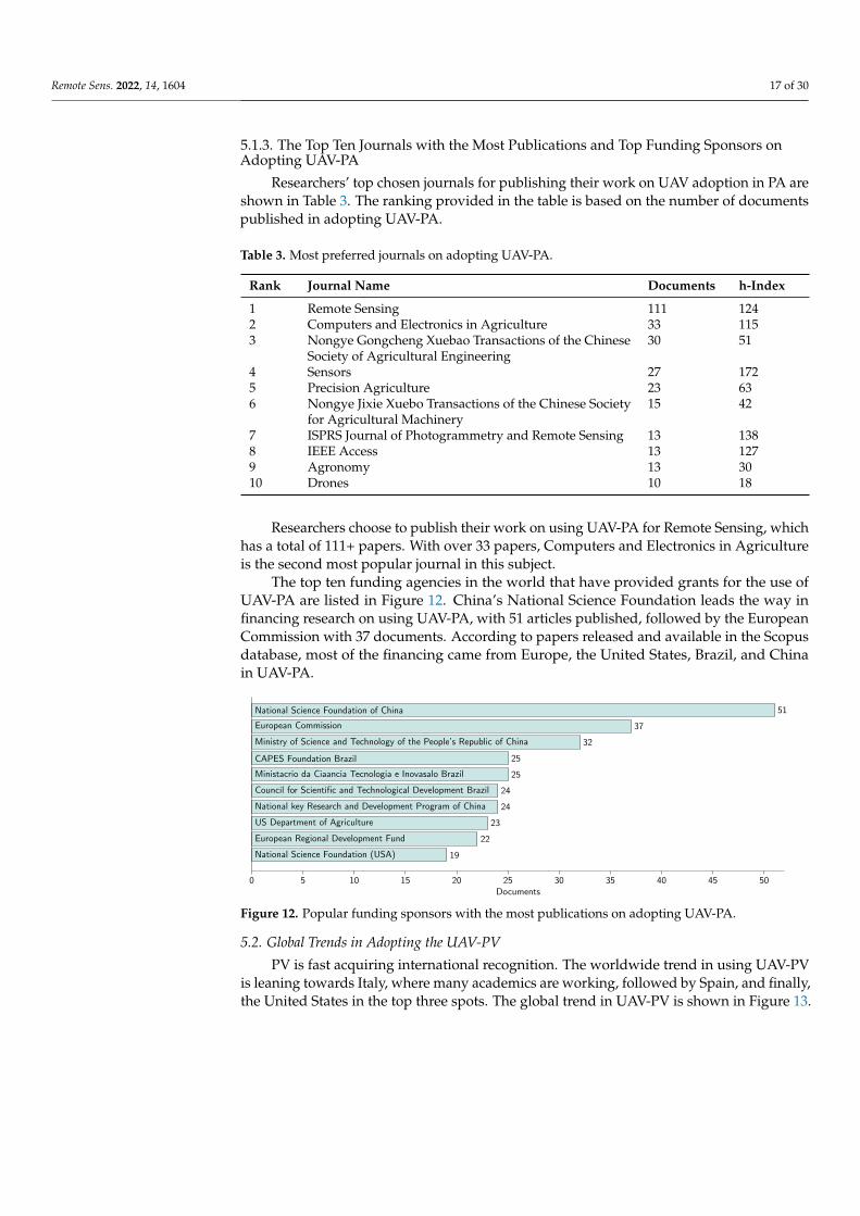
5.1.3. The Top Ten Journals with the Most Publications and Top Funding Sponsors onAdopting UAV-PA
Researchers’ top chosen journals for publishing their work on UAV adoption in PA areshown in Table 3. The ranking provided in the table is based on the number of documentspublished in adopting UAV-PA.
Table 3. Most preferred journals on adopting UAV-PA.
Rank Journal Name Documents h-Index
1 Remote Sensing 111 1242 Computers and Electronics in Agriculture 33 1153 Nongye Gongcheng Xuebao Transactions of the Chinese
Society of Agricultural Engineering30 51
4 Sensors 27 1725 Precision Agriculture 23 636 Nongye Jixie Xuebo Transactions of the Chinese Society
for Agricultural Machinery15 42
7 ISPRS Journal of Photogrammetry and Remote Sensing 13 1388 IEEE Access 13 1279 Agronomy 13 3010 Drones 10 18
Researchers choose to publish their work on using UAV-PA for Remote Sensing, whichhas a total of 111+ papers. With over 33 papers, Computers and Electronics in Agricultureis the second most popular journal in this subject.
The top ten funding agencies in the world that have provided grants for the use ofUAV-PA are listed in Figure 12. China’s National Science Foundation leads the way infinancing research on using UAV-PA, with 51 articles published, followed by the EuropeanCommission with 37 documents. According to papers released and available in the Scopusdatabase, most of the financing came from Europe, the United States, Brazil, and Chinain UAV-PA.
51National Science Foundation of China
37European Commission
32Ministry of Science and Technology of the People’s Republic of China
25CAPES Foundation Brazil
25Ministacrio da Ciaancia Tecnologia e Inovasalo Brazil
24Council for Scientific and Technological Development Brazil
24National key Research and Development Program of China
23US Department of Agriculture
22European Regional Development Fund
19National Science Foundation (USA)
0 5 10 15 20 25 30 35 40 45 50Documents
Figure 12. Popular funding sponsors with the most publications on adopting UAV-PA.
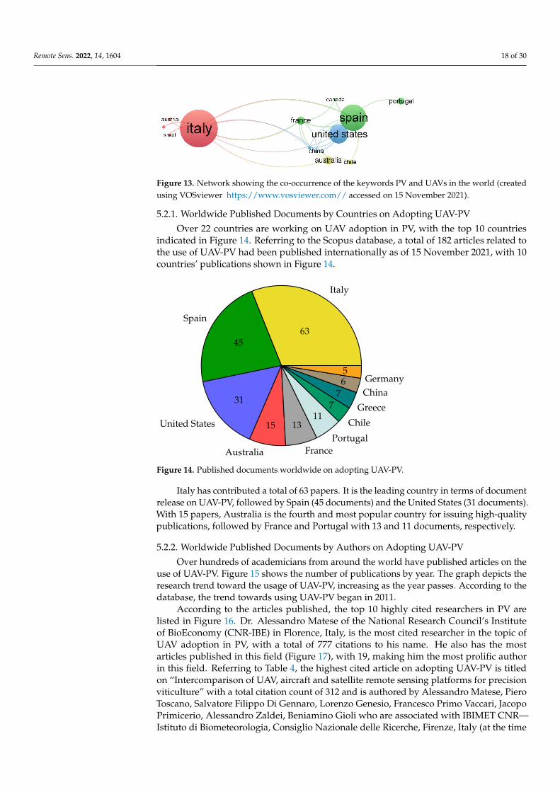
5.2. Global Trends in Adopting the UAV-PV
PV is fast acquiring international recognition. The worldwide trend in using UAV-PVis leaning towards Italy, where many academics are working, followed by Spain, and finally,the United States in the top three spots. The global trend in UAV-PV is shown in Figure 13.
Remote Sens. 2022, 14, 1604 18 of 30
Figure 13. Network showing the co-occurrence of the keywords PV and UAVs in the world (createdusing VOSviewer https://www.vosviewer.com// accessed on 15 November 2021).
5.2.1. Worldwide Published Documents by Countries on Adopting UAV-PV
Over 22 countries are working on UAV adoption in PV, with the top 10 countriesindicated in Figure 14. Referring to the Scopus database, a total of 182 articles related tothe use of UAV-PV had been published internationally as of 15 November 2021, with 10countries’ publications shown in Figure 14.
Italy
63Spain
45
United States
31
Australia
15
France
13Portugal
11Chile
7 Greece7 China
6 Germany5
Figure 14. Published documents worldwide on adopting UAV-PV.
Italy has contributed a total of 63 papers. It is the leading country in terms of documentrelease on UAV-PV, followed by Spain (45 documents) and the United States (31 documents).With 15 papers, Australia is the fourth and most popular country for issuing high-qualitypublications, followed by France and Portugal with 13 and 11 documents, respectively.
5.2.2. Worldwide Published Documents by Authors on Adopting UAV-PV
Over hundreds of academicians from around the world have published articles on theuse of UAV-PV. Figure 15 shows the number of publications by year. The graph depicts theresearch trend toward the usage of UAV-PV, increasing as the year passes. According to thedatabase, the trend towards using UAV-PV began in 2011.
According to the articles published, the top 10 highly cited researchers in PV arelisted in Figure 16. Dr. Alessandro Matese of the National Research Council’s Instituteof BioEconomy (CNR-IBE) in Florence, Italy, is the most cited researcher in the topic ofUAV adoption in PV, with a total of 777 citations to his name. He also has the mostarticles published in this field (Figure 17), with 19, making him the most prolific authorin this field. Referring to Table 4, the highest cited article on adopting UAV-PV is titledon “Intercomparison of UAV, aircraft and satellite remote sensing platforms for precisionviticulture” with a total citation count of 312 and is authored by Alessandro Matese, PieroToscano, Salvatore Filippo Di Gennaro, Lorenzo Genesio, Francesco Primo Vaccari, JacopoPrimicerio, Alessandro Zaldei, Beniamino Gioli who are associated with IBIMET CNR—Istituto di Biometeorologia, Consiglio Nazionale delle Ricerche, Firenze, Italy (at the time
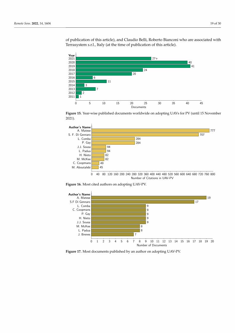
Remote Sens. 2022, 14, 1604 19 of 30
of publication of this article), and Claudio Belli, Roberto Bianconi who are associated withTerrasystem s.r.l., Italy (at the time of publication of this article).
Year27+2021
402020412019
242018202017
62016112015
3201472013
2201212011
0 5 10 15 20 25 30 35 40 45Documents
Figure 15. Year-wise published documents worldwide on adopting UAVs for PV (until 15 November2021).
Author’s Name777A. Matese
707S. F. Di Gennaro284L. Comba284P. Gay
94J.J. Sousa94L. Padua
82H. Nieto82M. McKee
49C. Coopmans45M. Aboutalebi
0 40 80 120 160 200 240 280 320 360 400 440 480 520 560 600 640 680 720 760 800Number of Citations in UAV-PV
Figure 16. Most cited authors on adopting UAV-PV.
Author’s Name19A. Matese
17S.F Di Gennaro9L. Comba9C. Coopmans9P. Gay9H. Nieto9J.J. Sousa
8M. McKee8L. Padua
7J. Brenes
0 1 2 3 4 5 6 7 8 9 10 11 12 13 14 15 16 17 18 19 20Number of Documents
Figure 17. Most documents published by an author on adopting UAV-PV.
Remote Sens. 2022, 14, 1604 20 of 30
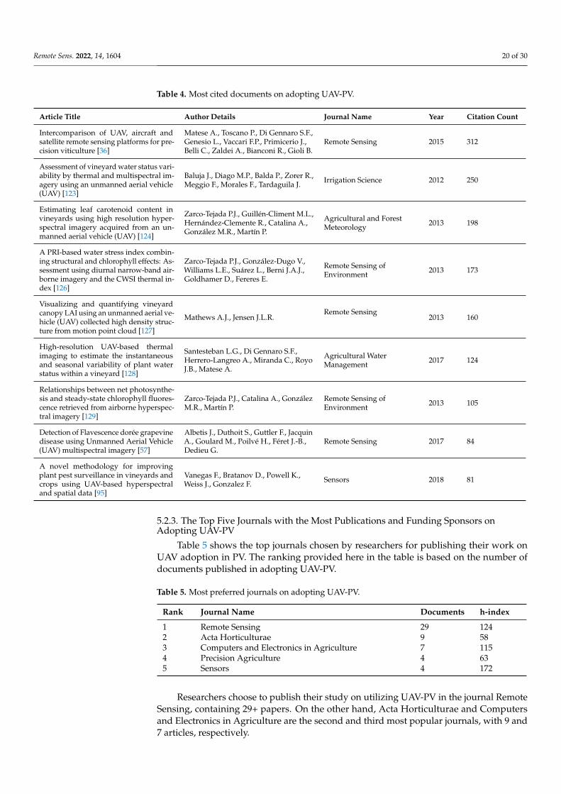
Table 4. Most cited documents on adopting UAV-PV.
Article Title Author Details Journal Name Year Citation Count
Intercomparison of UAV, aircraft andsatellite remote sensing platforms for pre-cision viticulture [36]
Matese A., Toscano P., Di Gennaro S.F.,Genesio L., Vaccari F.P., Primicerio J.,Belli C., Zaldei A., Bianconi R., Gioli B.
Remote Sensing 2015 312
Assessment of vineyard water status vari-ability by thermal and multispectral im-agery using an unmanned aerial vehicle(UAV) [123]
Baluja J., Diago M.P., Balda P., Zorer R.,Meggio F., Morales F., Tardaguila J. Irrigation Science 2012 250
Estimating leaf carotenoid content invineyards using high resolution hyper-spectral imagery acquired from an un-manned aerial vehicle (UAV) [124]
Zarco-Tejada P.J., Guillén-Climent M.L.,Hernández-Clemente R., Catalina A.,González M.R., Martín P.
Agricultural and ForestMeteorology 2013 198
A PRI-based water stress index combin-ing structural and chlorophyll effects: As-sessment using diurnal narrow-band air-borne imagery and the CWSI thermal in-dex [126]
Zarco-Tejada P.J., González-Dugo V.,Williams L.E., Suárez L., Berni J.A.J.,Goldhamer D., Fereres E.
Remote Sensing ofEnvironment 2013 173
Visualizing and quantifying vineyardcanopy LAI using an unmanned aerial ve-hicle (UAV) collected high density struc-ture from motion point cloud [127]
Mathews A.J., Jensen J.L.R.Remote Sensing
2013 160
High-resolution UAV-based thermalimaging to estimate the instantaneousand seasonal variability of plant waterstatus within a vineyard [128]
Santesteban L.G., Di Gennaro S.F.,Herrero-Langreo A., Miranda C., RoyoJ.B., Matese A.
Agricultural WaterManagement 2017 124
Relationships between net photosynthe-sis and steady-state chlorophyll fluores-cence retrieved from airborne hyperspec-tral imagery [129]
Zarco-Tejada P.J., Catalina A., GonzálezM.R., Martín P.
Remote Sensing ofEnvironment 2013 105
Detection of Flavescence dorée grapevinedisease using Unmanned Aerial Vehicle(UAV) multispectral imagery [57]
Albetis J., Duthoit S., Guttler F., JacquinA., Goulard M., Poilvé H., Féret J.-B.,Dedieu G.
Remote Sensing 2017 84
A novel methodology for improvingplant pest surveillance in vineyards andcrops using UAV-based hyperspectraland spatial data [95]
Vanegas F., Bratanov D., Powell K.,Weiss J., Gonzalez F. Sensors 2018 81
5.2.3. The Top Five Journals with the Most Publications and Funding Sponsors onAdopting UAV-PV
Table 5 shows the top journals chosen by researchers for publishing their work onUAV adoption in PV. The ranking provided here in the table is based on the number ofdocuments published in adopting UAV-PV.
Table 5. Most preferred journals on adopting UAV-PV.
Rank Journal Name Documents h-index
1 Remote Sensing 29 1242 Acta Horticulturae 9 583 Computers and Electronics in Agriculture 7 1154 Precision Agriculture 4 635 Sensors 4 172
Researchers choose to publish their study on utilizing UAV-PV in the journal RemoteSensing, containing 29+ papers. On the other hand, Acta Horticulturae and Computersand Electronics in Agriculture are the second and third most popular journals, with 9 and7 articles, respectively.
Remote Sens. 2022, 14, 1604 21 of 30
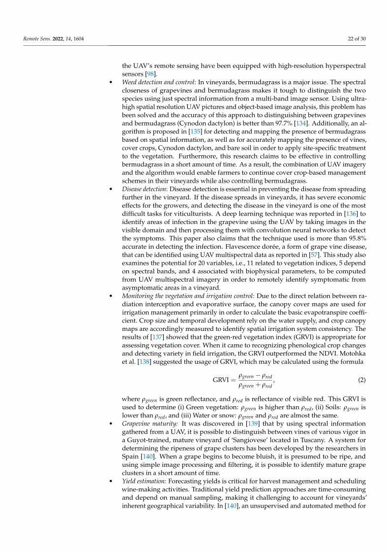
Figure 18 depicts the top five funding agencies on the globe that have given grants forthe use of UAV-PV. With 16 papers, the European Commission leads funding research onthe use of UAV-PV, followed by the European Regional Development Fund with 10 articles.According to articles published and available in the database, the majority of the fundingcame from Europe.
15European Commission
11European Regional Development Fund
7MIUR Italy
6NASA US
5U.S. Department of Agriculture
5Ministry of Economy (Spain)
0 3 6 9 12 15 18Documents
Figure 18. Popular funding sponsors with the most publications on adopting UAV-PV.
6. Findings and Discussion
This bibliometric analysis is intended to provide scholars working in this field withan update on UAV-PA and UAV-PV. This survey also recommended the popular journalfavored by researchers to publish their work, the popular funding agencies accessible,popular nations, and popular authors based on their citations leading the research in usingUAVs for PA. This survey revealed the use of UAV-PA and UAV-PV plays an essentialrole in increasing crop quality and yield by remote sensing the farm’s health and status.This approach greatly reduces labor costs, manpower, and time for growers and vineyardmanagers. Growers increase their production potential by using this approach since itkeeps the plants healthier and longer, allowing them to supply to the world, which isthe primary goal of using UAVs in PA. Viticulture is a key economic element in severalEuropean nations. PV refers to the practice of grape growers and winemakers of usingvarious information technology tools. These tools required to better sense and graspvariability in their production systems and then using that knowledge to better matchproduction inputs to desired or expected outputs. Crop sensors and yield monitors, remotesensors, GIS, and GNSS systems rely on PV technical advances, which is a growing trendin the wine business. The enhanced and cost-effective sensors, methods, and equipment fordata gathering from UAVs are driving significant growth in PV. In a sense, the UAVs areproving to be the backbone of PA. Furthermore, there are many other options of sensors forvineyards available. Especially, the proximal sensors that have proved to be one of the keyelements for the management of treatments and interventions within the vineyards. Forexample, tractors and also unmanned ground vehicles have been designed to be able toperform site-specific tasks without human intervention, credit to sensors that can keep aneye on the plant’s health on-the-go [130]; an experiment was carried out without humanintervention during the night using an all-terrain vehicle developed in [131] to whichvarious sensors were attached to obtain an image of the vine in order to identify the berries;in [132], a technique based on optical sensors is proposed for different irrigation treatmentsto vineyards, allowing a non-invasive evaluation of plant water stress dynamics in a timelymanner; in [133], an experiment is conducted on 21 individual branches under variouscanopy treatments, utilizing the proximal sensor to improve the accuracy of vineyardyield estimation.
In the field of PV, there have been numerous developments in the use of UAV-PV. Afew of these are mentioned here, although there are more throughout the paper.
• Soil categorization: When the vegetation indices values were utilized as input data intrained techniques, the best performance in the categorization of vineyard soil RGBpictures was obtained, with overall accuracy values around 0.98 and high sensitiv-ity values for the soil [97]. To monitor farmland soil parameters and crop growth,
Remote Sens. 2022, 14, 1604 22 of 30
the UAV’s remote sensing have been equipped with high-resolution hyperspectralsensors [98].
• Weed detection and control: In vineyards, bermudagrass is a major issue. The spectralcloseness of grapevines and bermudagrass makes it tough to distinguish the twospecies using just spectral information from a multi-band image sensor. Using ultra-high spatial resolution UAV pictures and object-based image analysis, this problem hasbeen solved and the accuracy of this approach to distinguishing between grapevinesand bermudagrass (Cynodon dactylon) is better than 97.7% [134]. Additionally, an al-gorithm is proposed in [135] for detecting and mapping the presence of bermudagrassbased on spatial information, as well as for accurately mapping the presence of vines,cover crops, Cynodon dactylon, and bare soil in order to apply site-specific treatmentto the vegetation. Furthermore, this research claims to be effective in controllingbermudagrass in a short amount of time. As a result, the combination of UAV imageryand the algorithm would enable farmers to continue cover crop-based managementschemes in their vineyards while also controlling bermudagrass.
• Disease detection: Disease detection is essential in preventing the disease from spreadingfurther in the vineyard. If the disease spreads in vineyards, it has severe economiceffects for the growers, and detecting the disease in the vineyard is one of the mostdifficult tasks for viticulturists. A deep learning technique was reported in [136] toidentify areas of infection in the grapevine using the UAV by taking images in thevisible domain and then processing them with convolution neural networks to detectthe symptoms. This paper also claims that the technique used is more than 95.8%accurate in detecting the infection. Flavescence dorée, a form of grape vine disease,that can be identified using UAV multispectral data as reported in [57]. This study alsoexamines the potential for 20 variables, i.e., 11 related to vegetation indices, 5 dependon spectral bands, and 4 associated with biophysical parameters, to be computedfrom UAV multispectral imagery in order to remotely identify symptomatic fromasymptomatic areas in a vineyard.
• Monitoring the vegetation and irrigation control: Due to the direct relation between ra-diation interception and evaporative surface, the canopy cover maps are used forirrigation management primarily in order to calculate the basic evapotranspire coeffi-cient. Crop size and temporal development rely on the water supply, and crop canopymaps are accordingly measured to identify spatial irrigation system consistency. Theresults of [137] showed that the green-red vegetation index (GRVI) is appropriate forassessing vegetation cover. When it came to recognizing phenological crop changesand detecting variety in field irrigation, the GRVI outperformed the NDVI. Motohkaet al. [138] suggested the usage of GRVI, which may be calculated using the formula
GRVI =ρgreen − ρred
ρgreen + ρred, (2)
where ρgreen is green reflectance, and ρred is reflectance of visible red. This GRVI isused to determine (i) Green vegetation: ρgreen is higher than ρred, (ii) Soils: ρgreen islower than ρred, and (iii) Water or snow: ρgreen and ρred are almost the same.
• Grapevine maturity: It was discovered in [139] that by using spectral informationgathered from a UAV, it is possible to distinguish between vines of various vigor ina Guyot-trained, mature vineyard of ‘Sangiovese’ located in Tuscany. A system fordetermining the ripeness of grape clusters has been developed by the researchers inSpain [140]. When a grape begins to become bluish, it is presumed to be ripe, andusing simple image processing and filtering, it is possible to identify mature grapeclusters in a short amount of time.
• Yield estimation: Forecasting yields is critical for harvest management and schedulingwine-making activities. Traditional yield prediction approaches are time-consumingand depend on manual sampling, making it challenging to account for vineyards’inherent geographical variability. In [140], an unsupervised and automated method for
Remote Sens. 2022, 14, 1604 23 of 30
detecting grape clusters in red grapevine types is established using UAV photogram-metric technique and color indices, with R2 values greater than 0.82. This precisiongained in grape detection opens the door to red grape vineyard production prediction.Every farmer aspires to forecast their vineyard’s yield estimation in advance, andhence yield prediction is an important issue in vineyard management in order toachieve the required grape production and quality. In [141], an automated system isbeing developed that can predict yield estimation (5 weeks before harvest) using high-resolution RGB photos and a UAV platform throughout the vineyard. A techniquehas also been developed in [142] for capturing multispectral imagery through UAV,which is then processed together with artificial neural networks to create a relationshipbetween the vegetation index, vegetated fraction cover, and yield. This techniquedemonstrates that when machine learning is used, the outcomes are significantlymore accurate. Although promising results were obtained earlier in the developmentprocess, more exact yield forecasts were achieved when images were captured nearerto the harvest date.
During the study and utilizing the Scopus database, it was discovered that more than80 countries are working on UAV adoption in PA as of 15 November 2021, with a largenumber of articles relevant to the use of UAVs for PA having been published internationally.The United States have provided the most papers and is the country that has releasedthe most documentation on the use of UAVs for PA, followed by China, Italy, Spain, andBrazil. The top three publications favored by researchers working on UAV adoption forPA are (i) Remote Sensing, (ii) Computers and Electronics in Agriculture, and (iii) NongyeGongcheng Xuebao Transactions of the Chinese Society of Agricultural Engineering. Thereare three major funding agencies in this field: China’s National Science Foundation, theEuropean Commission, and China’s Ministry for Science and Technology.
PV is becoming more popular internationally as well. Globally, the use of UAV-PV istrending towards Italy, where many researchers and academicians are working, followedby Spain, and finally, the United States. Researchers preferred journals on using UAV-PVare (i) Remote Sensing, (ii) Acta Horticulturae, and (iii) Computers and Electronics inAgriculture. Two primary financing agencies for this area are (i) the European Commissionand (ii) the European Regional Development Fund.
The major institutions working in this field are also worth mentioning (based on theircitations), which are included in Table 6.
Table 6. Leading institutions working on adopting UAV-PA and UAV-PV.
Institutions Working on Adopting UAV-PA Citations Institutions Working on Adopting UAV-PV Citations
Instituto de Agricultura Sostenible—CSIC, Spain 2227 Consiglio Nazionale delle Ricerche, Italy 942Universidad de Córdoba, Spain 765 Instituto de Agricultura Sostenible—CSIC, Spain 916Consiglio Nazionale delle Ricerche, Italy 631 Istituto Di Biometeorologia, Florence, Italy 803China Agricultural University, China 565 Università degli Studi di Torino, Italy 685
6.1. Some Lights on Economic Analysis
This section reports some costs that small growers can incur in case they want touse/implement UAV-PA technologies, such that a rough idea of a possible investment canbe inferred. In particular, we briefly discuss the economic analysis in [36], where typicalcosts of service providers are given, and we also add further information regarding thecosts in case an ad hoc custom solution is going to be implemented.
Farmers using UAVs to perform PA are aiming for high-quality images with highprecision, as well as the ability to take measurements from the field at any time they choose.Due to high spatial resolution of imagery, high operational flexibility, and low operationalcosts, UAVs have demonstrated that they can compete with traditional acquisition plat-forms (such as satellites and aircraft). It has been observed that for small landholders withan area of around 5 ha, UAVs appear to be the most cost-effective solution due to their
Remote Sens. 2022, 14, 1604 24 of 30
low cost in data acquisition and use of advanced sensor technologies [36]. In [36], threebroad categories of cost analysis were considered with 100 images of the crop capturedby UAVs, and this service was purchased from a third party, namely data acquisition,georeferencing and orthorectification, and image processing. The cost of data acquisition ise1500, which includes the cost of organizing and carrying out the acquisition campaignto obtain the raw images; the cost of georeferencing and orthorectification is e500; andthe cost of image processing is e200. Depending on where you live, services from UAVproviders can cost anywhere from $12 per hectare for raw image files to $70 per hectarefor an orthomosaic image in the United States [143]. If one does not wish to use a serviceprovider, another viable option is the AgriQ [144], which is a $1400 UAV that is developedfor PA. AgriQ consists of three subsystems: the drone, the multispectral imaging system,and the open-source software that computes useful information for farmers [145]. Theauthors approached the problem from four angles: (1) the drone’s construction; (2) thevision algorithms; (3) the autonomous trajectory taking into account all parameters inorder to properly recover all of the crops’ visual information; and (4) the development of alow-cost multispectral imaging system with multiple bands.
6.2. Future Possibilities
Acquiring and analyzing spectral data requires considerable additional cost andskill sets that are frequently unavailable; therefore, the identification of geometric indicesthat enable the monitoring of spatial variability using low-cost instruments based onphotogrammetry techniques and high-resolution RGB cameras will be critical in future.There is a need for the rapid evolution of a yield forecast methodology based on UAV dataand machine learning techniques in order to avoid routine human engagement. Varioustechniques for irrigation monitoring in a vineyard using UAVs have been developed, butresearch is still lagging, and future research directions could include automated irrigationbased on crop water needs and monitoring of vines based on their physiology, moreprecisely, control of grapevine irrigation based on plant-based models. It is now necessaryto develop a web-based one-stop service for UAV adoption in PV (and PA), which willassist in providing information related to supporting field operations in the vineyard,health monitoring of the vines and grapes, canopy management, and other key areas, aswell as providing online digital content that is accessible from any location. Finally, butcertainly not least, a UAV system with the bare minimal payload required for maximumsurveillance of the vineyards should be designed so as to make it cost effective and that canbe frequently used by the growers.
Author Contributions: Conceptualization, A.P.S. and L.G.; methodology, A.P.S. and A.Y.; formalanalysis, A.P.S.; writing—original draft preparation, A.P.S.; writing—review and editing, V.M., A.Y.,L.I. and L.G.; supervision, L.G.; funding acquisition, L.G. All authors have read and agreed to thepublished version of the manuscript.
Funding: This work received funding from the Italian Ministry of University, Research ProgrammaOperativo Nazionale 2014–2020 (PON “R&I” 2014–2020), project VERITAS, CUP—B64I20000820005.
Institutional Review Board Statement: Not applicable.
Informed Consent Statement: Not applicable.
Data Availability Statement: The data is fetched from the Scopus for the period 1 January 2006 to 15November 2021 from the link https://www.scopus.com//.
Conflicts of Interest: The authors declare no conflict of interest.
Remote Sens. 2022, 14, 1604 25 of 30
AbbreviationsThe following abbreviations are used in this manuscript:
GIS Geographic Information SystemsGPS Global Positioning SystemGRVI Green-Red Vegetation IndexGNSS Global Navigation Satellite SystemIoT Internet of ThingsLAI Leaf Area IndexNIR Near InfraredNDVI Normalised Difference Vegetation IndexPA Precision AgriculturePV Precision ViticultureRGB Red, Green, and BlueRPA Remotely Piloted AircraftUAV Unmanned Aerial VehicleUAV-PA Unmanned Aerial Vehicle in Precision AgricultureUAV-PV Unmanned Aerial Vehicle in Precision ViticultureWSN Wireless Sensor Network
References1. Langemeier, M.; Boehlje, M. What Will Be the Capabilities and Skills Needed to Manage the Farm of the Future? Farmdoc Dly.
2021, 11, 1–4.2. Zangina, U.; Buyamin, S.; Aman, M.N.; Abidin, M.S.Z.; Mahmud, M.S.A. A greedy approach to improve pesticide application for
precision agriculture using model predictive control. Comput. Electron. Agric. 2021, 182, 105984. [CrossRef]3. Hedley, C. The role of precision agriculture for improved nutrient management on farms. J. Sci. Food Agric. 2015, 95, 12–19.
[CrossRef]4. Beyer, M.; Wallner, M.; Bahlmann, L.; Thiemig, V.; Dietrich, J.; Billib, M. Rainfall characteristics and their implications for rain-fed
agriculture: A case study in the Upper Zambezi River Basin. Hydrol. Sci. J. 2016, 61, 321–343. [CrossRef]5. Yang, C.; Everitt, J.H.; Du, Q.; Luo, B.; Chanussot, J. Using high-resolution airborne and satellite imagery to assess crop growth
and yield variability for precision agriculture. Proc. IEEE 2012, 101, 582–592. [CrossRef]6. Maes, W.H.; Steppe, K. Perspectives for remote sensing with unmanned aerial vehicles in precision agriculture. Trends Plant Sci.
2019, 24, 152–164. [CrossRef]7. Huuskonen, J.; Oksanen, T. Soil sampling with drones and augmented reality in precision agriculture. Comput. Electron. Agric.
2018, 154, 25–35. [CrossRef]8. Khanal, S.; Fulton, J.; Shearer, S. An overview of current and potential applications of thermal remote sensing in precision
agriculture. Comput. Electron. Agric. 2017, 139, 22–32. [CrossRef]9. Martínez, J.; Egea, G.; Agüera, J.; Pérez-Ruiz, M. A cost-effective canopy temperature measurement system for precision
agriculture: A case study on sugar beet. Precis. Agric. 2017, 18, 95–110. [CrossRef]10. Onibonoje, M.O.; Nwulu, N. Synergistic Technologies for Precision Agriculture. In Artificial Intelligence and IoT-Based Technologies
for Sustainable Farming and Smart Agriculture; IGI Global: Hershey, PA, USA, 2021; pp. 123–139.11. Lieve, W.V. Precision Agriculture and the Future of Farming in Europe; Scientific Foresight Unit (STOA): Brussels, Belgium, 2016.12. Xu, X.; Fan, L.; Li, Z.; Meng, Y.; Feng, H.; Yang, H.; Xu, B. Estimating Leaf Nitrogen Content in Corn Based on Information Fusion
of Multiple-Sensor Imagery from UAV. Remote Sens. 2021, 13, 340. [CrossRef]13. Zhou, X.; He, J.; Chen, D.; Li, J.; Jiang, C.; Ji, M.; He, M. Human-robot skills transfer interface for UAV-based precision pesticide in
dynamic environments. Assem. Autom. 2021, 41, 345–357. [CrossRef]14. Zhou, Z.; Majeed, Y.; Naranjo, G.D.; Gambacorta, E.M. Assessment for crop water stress with infrared thermal imagery in
precision agriculture: A review and future prospects for deep learning applications. Comput. Electron. Agric. 2021, 182, 106019.[CrossRef]
15. Basso, B.; Antle, J. Digital agriculture to design sustainable agricultural systems. Nat. Sustain. 2020, 3, 254–256. [CrossRef]16. Xiao, K.; Xiao, D.; Luo, X. Smart water-saving irrigation system in precision agriculture based on wireless sensor network. Trans.
Chin. Soc. Agric. Eng. 2010, 26, 170–175.17. Gómez-Candón, D.; De Castro, A.; López-Granados, F. Assessing the accuracy of mosaics from unmanned aerial vehicle (UAV)
imagery for precision agriculture purposes in wheat. Precis. Agric. 2014, 15, 44–56. [CrossRef]18. Bonfante, A.; Monaco, E.; Manna, P.; De Mascellis, R.; Basile, A.; Buonanno, M.; Cantilena, G.; Esposito, A.; Tedeschi, A.;
De Michele, C.; et al. LCIS DSS—An irrigation supporting system for water use efficiency improvement in precision agriculture:A maize case study. Agric. Syst. 2019, 176, 102646. [CrossRef]
19. Burkart, A.; Hecht, V.; Kraska, T.; Rascher, U. Phenological analysis of unmanned aerial vehicle based time series of barleyimagery with high temporal resolution. Precis. Agric. 2018, 19, 134–146. [CrossRef]
Remote Sens. 2022, 14, 1604 26 of 30
20. Brown, R.M.; Dillon, C.R.; Schieffer, J.; Shockley, J.M. The carbon footprint and economic impact of precision agriculturetechnology on a corn and soybean farm. J. Environ. Econ. Policy 2016, 5, 335–348. [CrossRef]
21. Al-Gaadi, K.A.; Hassaballa, A.A.; Tola, E.; Kayad, A.G.; Madugundu, R.; Alblewi, B.; Assiri, F. Prediction of potato crop yieldusing precision agriculture techniques. PLoS ONE 2016, 11, e0162219. [CrossRef]
22. Colaço, A.F.; Molin, J.P.; Rosell-Polo, J.R. Spatial variability in commercial orange groves. Part 1: Canopy volume and height.Precis. Agric. 2019, 20, 788–804. [CrossRef]
23. Álamo, S.; Ramos, M.; Feito, F.; Cañas, A. Precision techniques for improving the management of the olive groves of southernSpain. Span. J. Agric. Res. 2012,10, 583–595. [CrossRef]
24. Winkler, A.J. General Viticulture; University of California Press: Berkeley, CA, USA, 1974.25. Sassu, A.; Gambella, F.; Ghiani, L.; Mercenaro, L.; Caria, M.; Pazzona, A.L. Advances in Unmanned Aerial System Remote
Sensing for Precision Viticulture. Sensors 2021, 21, 956. [CrossRef]26. Spachos, P.; Gregori, S. Integration of wireless sensor networks and smart uavs for precision viticulture. IEEE Internet Comput.
2019, 23, 8–16. [CrossRef]27. López-Granados, F.; Torres-Sánchez, J.; Jiménez-Brenes, F.M.; Oneka, O.; Marín, D.; Loidi, M.; de Castro, A.I.; Santesteban, L.G.
Monitoring vineyard canopy management operations using UAV-acquired photogrammetric point clouds. Remote Sens. 2020,12, 2331. [CrossRef]
28. De Castro, A.I.; Jiménez-Brenes, F.M.; Torres-Sánchez, J.; Peña, J.M.; Borra-Serrano, I.; López-Granados, F. 3-D characterization ofvineyards using a novel UAV imagery-based OBIA procedure for precision viticulture applications. Remote Sens. 2018, 10, 584.[CrossRef]
29. Di Gennaro, S.F.; Dainelli, R.; Palliotti, A.; Toscano, P.; Matese, A. Sentinel-2 validation for spatial variability assessment inoverhead trellis system viticulture versus UAV and agronomic data. Remote Sens. 2019, 11, 2573. [CrossRef]
30. Torres-Sánchez, J.; Marín, D.; De Castro, A.; Oria, I.; Jiménez-Brenes, F.; Miranda, C.; Santesteban, L.; López-Granados, F.Assessment of vineyard trimming and leaf removal using UAV photogrammetry. In Precision Agriculture’19; WageningenAcademic Publishers: Wageningen, The Netherlands, 2019; p. e0130479.
31. Romboli, Y.; Di Gennaro, S.; Mangani, S.; Buscioni, G.; Matese, A.; Genesio, L.; Vincenzini, M. Vine vigour modulates bunchmicroclimate and affects the composition of grape and wine flavonoids: An unmanned aerial vehicle approach in a Sangiovesevineyard in Tuscany. Aust. J. Grape Wine Res. 2017, 23, 368–377. [CrossRef]
32. Mondello, V.; Larignon, P.; Armengol Fortí, J.; Kortekamp, A.; Váczy, K.; Prezman, F.; Serrano, E.; Rego, C.; Mugnai, L.; Fontaine,F. Management of grapevine trunk diseases: Knowledge transfer, current strategies and innovative strategies adopted in Europe.Phytopathol. Mediterr. 2018, 57, 369–383.
33. Santos, J.A.; Fraga, H.; Malheiro, A.C.; Moutinho-Pereira, J.; Dinis, L.T.; Correia, C.; Moriondo, M.; Leolini, L.; Dibari, C.;Costafreda-Aumedes, S.; et al. A review of the potential climate change impacts and adaptation options for European viticulture.Appl. Sci. 2020, 10, 3092. [CrossRef]
34. Bramley, R.; Pearse, B.; Chamberlain, P. Being profitable precisely-a case study of precision viticulture from Margaret River. Aust.N. Z. Grapegrow. Winemak. 2003, 84–87.
35. Arnó Satorra, J.; Martínez Casasnovas, J.A.; Ribes Dasi, M.; Rosell Polo, J.R. Precision viticulture. Research topics, challenges andopportunities in site-specific vineyard management. Span. J. Agric. Res. 2009, 7, 779–790. [CrossRef]
36. Matese, A.; Toscano, P.; Di Gennaro, S.F.; Genesio, L.; Vaccari, F.P.; Primicerio, J.; Belli, C.; Zaldei, A.; Bianconi, R.; Gioli, B.Intercomparison of UAV, aircraft and satellite remote sensing platforms for precision viticulture. Remote Sens. 2015, 7, 2971–2990.[CrossRef]
37. Pallottino, F.; Biocca, M.; Nardi, P.; Figorilli, S.; Menesatti, P.; Costa, C. Science mapping approach to analyze the researchevolution on precision agriculture: World, EU and Italian situation. Precis. Agric. 2018, 19, 1011–1026. [CrossRef]
38. Santana, L.S.; Teodoro, A.J.d.S.; Santana, M.S.; Rossi, G.; Palchetti, E. Advances in Precision Coffee Growing Research: ABibliometric Review. Agronomy 2021, 11, 1557. [CrossRef]
39. Abdollahi, A.; Rejeb, K.; Rejeb, A.; Mostafa, M.M.; Zailani, S. Wireless Sensor Networks in Agriculture: Insights from BibliometricAnalysis. Sustainability 2021, 13, 12011. [CrossRef]
40. Lara, M.d.J.D.; Bernabe, J.G.; Benítez, R.Á.G.; Toxqui, J.M.; Huerta, M.K. Bibliometric Analysis of the Use of the Internet of Thingsin Precision Agriculture. In Proceedings of the 2021 IEEE International Conference on Engineering Veracruz (ICEV), Boca del Rio,Mexico, 25–28 October 2021; pp. 1–5.
41. Bertoglio, R.; Corbo, C.; Renga, F.M.; Matteucci, M. The Digital Agricultural Revolution: A Bibliometric Analysis LiteratureReview. IEEE Access 2021, 9, 134762–134782. [CrossRef]
42. Sott, M.K.; Nascimento, L.d.S.; Foguesatto, C.R.; Furstenau, L.B.; Faccin, K.; Zawislak, P.A.; Mellado, B.; Kong, J.D.; Bragazzi,N.L. A Bibliometric Network Analysis of Recent Publications on Digital Agriculture to Depict Strategic Themes and EvolutionStructure. Sensors 2021, 21, 7889. [CrossRef]
43. Aleixandre-Benavent, R.; Aleixandre-Tudo, J.L.; Ferrer-Sapena, A.; Aleixandre, J.L.; Alcaide, G.G.; Du Toit, W. Bibliometricanalysis of publications by South African viticulture and oenology research centres. S. Afr. J. Sci. 2012, 108, 1–11. [CrossRef]
44. Costa, C.; Biocca, M.; Pallottino, F.; Nardi, P.; Figorilli, S. Structure of the precision agriculture research in Italy from 2000 to 2016:A term mapping approach. Chem. Eng. Trans. 2017, 58, 643–648.
Remote Sens. 2022, 14, 1604 27 of 30
45. Sånchez, G.C.; Castro-López, L.; Méndez, S. Contribution of Mexican scholars to viticultural and oenological research: Where dowe stand? Oeno One 2018, 52, 273–278.
46. Van Eck, N.J.; Waltman, L. Software survey: VOSviewer, a computer program for bibliometric mapping. Scientometrics 2010,84, 523–538. [CrossRef] [PubMed]
47. Cobo, M.J.; López-Herrera, A.G.; Herrera-Viedma, E.; Herrera, F. SciMAT: A new science mapping analysis software tool. J. Am.Soc. Inf. Sci. Technol. 2012, 63, 1609–1630. [CrossRef]
48. Waltman, L.; Larivière, V. Special issue on bibliographic data sources. Quant. Sci. Stud. 2020, 1, 360–362. [CrossRef]49. Visser, M.; van Eck, N.J.; Waltman, L. Large-scale comparison of bibliographic data sources: Scopus, Web of Science, Dimensions,
Crossref, and Microsoft Academic. Quant. Sci. Stud. 2021, 2, 20–41. [CrossRef]50. Pop, S.; Cristea, L.; Luculescu, M.C.; Zamfira, S.C.; Boer, A.L. Vegetation Index Estimation in Precision Farming Using Custom
Multispectral Camera Mounted on Unmanned Aerial Vehicle. In International Conference on Remote Engineering and VirtualInstrumentation; Springer: Cham, Switzerland, 2019; pp. 674–685.
51. Shafi, U.; Mumtaz, R.; García-Nieto, J.; Hassan, S.A.; Zaidi, S.A.R.; Iqbal, N. Precision agriculture techniques and practices: Fromconsiderations to applications. Sensors 2019, 19, 3796. [CrossRef]
52. Ezzy, H.; Charter, M.; Bonfante, A.; Brook, A. How the Small Object Detection via Machine Learning and UAS-Based Remote-Sensing Imagery Can Support the Achievement of SDG2: A Case Study of Vole Burrows. Remote Sens. 2021, 13, 3191. [CrossRef]
53. Santos, L.M.d.; Barbosa, B.D.S.; Andrade, A.D. Use of remotely piloted aircraft in precision agriculture: A review. Dyna 2019,86, 284–291.
54. Ahmad, A.; Ordonez, J.; Cartujo, P.; Martos, V. Remotely piloted aircraft (RPA) in agriculture: A pursuit of sustainability.Agronomy 2020, 11, 7. [CrossRef]
55. Morerira, M.; Ferraz, G.; Barbosa, B.; Iwasaki, E.; Ferraz, P.; Damasceno, F.; Rossi, G. Design and construction of a low-costremotely piloted aircraft for precision agriculture applications. Agron. Res. 2019, 17, 1984–1992.
56. Morais, R.; Mendes, J.; Silva, R.; Silva, N.; Sousa, J.J.; Peres, E. A versatile, low-power and low-cost IoT device for field datagathering in precision agriculture practices. Agriculture 2021, 11, 619. [CrossRef]
57. Albetis, J.; Duthoit, S.; Guttler, F.; Jacquin, A.; Goulard, M.; Poilvé, H.; Féret, J.B.; Dedieu, G. Detection of Flavescence doréegrapevine disease using unmanned aerial vehicle (UAV) multispectral imagery. Remote Sens. 2017, 9, 308. [CrossRef]
58. Bah, M.D.; Hafiane, A.; Canals, R. CRowNet: Deep network for crop row detection in UAV images. IEEE Access 2019, 8, 5189–5200.[CrossRef]
59. Apolo-Apolo, O.; Martínez-Guanter, J.; Egea, G.; Raja, P.; Pérez-Ruiz, M. Deep learning techniques for estimation of the yield andsize of citrus fruits using a UAV. Eur. J. Agron. 2020, 115, 126030. [CrossRef]
60. Mohan, M.; Silva, C.A.; Klauberg, C.; Jat, P.; Catts, G.; Cardil, A.; Hudak, A.T.; Dia, M. Individual tree detection from unmannedaerial vehicle (UAV) derived canopy height model in an open canopy mixed conifer forest. Forests 2017, 8, 340. [CrossRef]
61. Bah, M.D.; Hafiane, A.; Canals, R. Deep learning with unsupervised data labeling for weed detection in line crops in UAV images.Remote Sens. 2018, 10, 1690. [CrossRef]
62. Mouazen, A.M.; De Baerdemaeker, J.; Ramon, H. Towards development of on-line soil moisture content sensor using a fibre-typeNIR spectrophotometer. Soil Tillage Res. 2005, 80, 171–183. [CrossRef]
63. Al-Naji, A.; Fakhri, A.B.; Gharghan, S.K.; Chahl, J. Soil color analysis based on a RGB camera and an artificial neural networktowards smart irrigation: A pilot study. Heliyon 2021, 7, e06078. [CrossRef]
64. Osco, L.P.; Nogueira, K.; Ramos, A.P.M.; Pinheiro, M.M.F.; Furuya, D.E.G.; Gonçalves, W.N.; de Castro Jorge, L.A.; Junior, J.M.;dos Santos, J.A. Semantic segmentation of citrus-orchard using deep neural networks and multispectral UAV-based imagery.Precis. Agric. 2021, 22, 1171–1188. [CrossRef]
65. Gibril, M.B.A.; Shafri, H.Z.M.; Shanableh, A.; Al-Ruzouq, R.; Wayayok, A.; Hashim, S.J. Deep convolutional neural network forlarge-scale date palm tree mapping from UAV-based images. Remote Sens. 2021, 13, 2787. [CrossRef]
66. Khan, S.; Tufail, M.; Khan, M.T.; Khan, Z.A.; Iqbal, J.; Wasim, A. Real-time recognition of spraying area for UAV sprayers using adeep learning approach. PLoS ONE 2021, 16, e0249436. [CrossRef]
67. Das, S.; Chapman, S.; Christopher, J.; Choudhury, M.R.; Menzies, N.W.; Apan, A.; Dang, Y.P. UAV-thermal imaging: Atechnological breakthrough for monitoring and quantifying crop abiotic stress to help sustain productivity on sodic soils—A casereview on wheat. Remote Sens. Appl. Soc. Environ. 2021, 23, 100583. [CrossRef]
68. de Castro, A.I.; Shi, Y.; Maja, J.M.; Peña, J.M. UAVs for Vegetation Monitoring: Overview and Recent Scientific Contributions.Remote Sens. 2021, 13, 2139. [CrossRef]
69. FAO. Declaration of the World Summit on Food Security; FAO: Rome, Italy, 2009.70. Madroñal, D.; Palumbo, F.; Capotondi, A.; Marongiu, A. Unmanned Vehicles in Smart Farming: A Survey and a Glance at Future
Horizons. In Proceedings of the 2021 Drone Systems Engineering and Rapid Simulation and Performance Evaluation: Methodsand Tools Proceedings, 2021 ACM, Budapest, Hungary, 18–20 January 2021; pp. 1–8.
71. Zhang, H.; Wang, L.; Tian, T.; Yin, J. A Review of Unmanned Aerial Vehicle Low-Altitude Remote Sensing (UAV-LARS) Use inAgricultural Monitoring in China. Remote Sens. 2021, 13, 1221. [CrossRef]
72. Awais, M.; Li, W.; Cheema, M.M.; Hussain, S.; Shaheen, A.; Aslam, B.; Liu, C.; Ali, A. Assessment of optimal flying height andtiming using high-resolution unmanned aerial vehicle images in precision agriculture. Int. J. Environ. Sci. Technol. 2021, 19, 1–18.[CrossRef]
Remote Sens. 2022, 14, 1604 28 of 30
73. Gago, J.; Douthe, C.; Coopman, R.E.; Gallego, P.P.; Ribas-Carbo, M.; Flexas, J.; Escalona, J.; Medrano, H. UAVs challenge to assesswater stress for sustainable agriculture. Agric. Water Manag. 2015, 153, 9–19. [CrossRef]
74. Bacco, M.; Ferro, E.; Gotta, A. UAVs in WSNs for agricultural applications: An analysis of the two-ray radio propagation model.In Proceedings of the SENSORS, 2014 IEEE, Valencia, Spain, 2–5 November 2014; pp. 130–133.
75. Daponte, P.; De Vito, L.; Glielmo, L.; Iannelli, L.; Liuzza, D.; Picariello, F.; Silano, G. A review on the use of drones for precisionagriculture. IOP Conf. Ser. Earth Environ. Sci. 2019, 275, 012022. [CrossRef]
76. Shao, G.; Han, W.; Zhang, H.; Liu, S.; Wang, Y.; Zhang, L.; Cui, X. Mapping maize crop coefficient Kc using random forestalgorithm based on leaf area index and UAV-based multispectral vegetation indices. Agric. Water Manag. 2021, 252, 106906.[CrossRef]
77. Mokhtari, A.; Ahmadi, A.; Daccache, A.; Drechsler, K. Actual Evapotranspiration from UAV Images: A Multi-Sensor Data FusionApproach. Remote Sens. 2021, 13, 2315. [CrossRef]
78. Lin, Y.C.; Zhou, T.; Wang, T.; Crawford, M.; Habib, A. New orthophoto generation strategies from UAV and ground remotesensing platforms for high-throughput phenotyping. Remote Sens. 2021, 13, 860. [CrossRef]
79. Maes, W.H.; Huete, A.R.; Steppe, K. Optimizing the processing of UAV-based thermal imagery. Remote Sens. 2017, 9, 476.[CrossRef]
80. Han, X.; Thomasson, J.A.; Swaminathan, V.; Wang, T.; Siegfried, J.; Raman, R.; Rajan, N.; Neely, H. Field-Based Calibration ofUnmanned Aerial Vehicle Thermal Infrared Imagery with Temperature-Controlled References. Sensors 2020, 20, 7098. [CrossRef][PubMed]
81. Wang, L.; Liu, J.; Yang, L.; Chen, Z.; Wang, X.; Ouyang, B. Applications of unmanned aerial vehicle images on agricultural remotesensing monitoring. Trans. Chin. Soc. Agric. Eng. 2013, 29, 136–145.
82. Li, D.; Li, M. Research advance and application prospect of unmanned aerial vehicle remote sensing system. Geomat. Inf. Sci.Wuhan Univ. 2014, 39, 505–513.
83. Matese, A.; Di Gennaro, S.F. Practical applications of a multisensor UAV platform based on multispectral, thermal and RGB highresolution images in precision viticulture. Agriculture 2018, 8, 116. [CrossRef]
84. Karakizi, C.; Oikonomou, M.; Karantzalos, K. Spectral discrimination and reflectance properties of various vine varieties fromsatellite, UAV and proximate sensors. Int. Arch. Photogramm. Remote Sens. Spat. Inf. Sci. 2015, 40, 31. [CrossRef]
85. Giovos, R.; Tassopoulos, D.; Kalivas, D.; Lougkos, N.; Priovolou, A. Remote Sensing Vegetation Indices in Viticulture: A CriticalReview. Agriculture 2021, 11, 457. [CrossRef]
86. Borgogno-Mondino, E.; Lessio, A.; Tarricone, L.; Novello, V.; de Palma, L. A comparison between multispectral aerial and satelliteimagery in precision viticulture. Precis. Agric. 2018, 19, 195–217. [CrossRef]
87. Matese, A.; Di Gennaro, S.F. Beyond the traditional NDVI index as a key factor to mainstream the use of UAV in precisionviticulture. Sci. Rep. 2021, 11, 1–13. [CrossRef]
88. Ata-Ul-Karim, S.T.; Zhu, Y.; Yao, X.; Cao, W. Determination of critical nitrogen dilution curve based on leaf area index in rice.Field Crop. Res. 2014, 167, 76–85. [CrossRef]
89. Turner, D.; Lucieer, A.; Watson, C. Development of an Unmanned Aerial Vehicle (UAV) for hyper resolution vineyard mappingbased on visible, multispectral, and thermal imagery. In Proceedings of the 34th International Symposium on Remote Sensing OfEnvironment, Sydney, Australia, 10–15 April 2011; p. 4.
90. Córcoles, J.I.; Ortega, J.F.; Hernández, D.; Moreno, M.A. Estimation of leaf area index in onion (Allium cepa L.) using an unmannedaerial vehicle. Biosyst. Eng. 2013, 115, 31–42. [CrossRef]
91. Aasen, H.; Burkart, A.; Bolten, A.; Bareth, G. Generating 3D hyperspectral information with lightweight UAV snapshot camerasfor vegetation monitoring: From camera calibration to quality assurance. ISPRS J. Photogramm. Remote Sens. 2015, 108, 245–259.[CrossRef]
92. Zhu, G.; Ju, W.; Chen, J.; Liu, Y. A Novel Moisture Adjusted Vegetation Index (MAVI) to reduce background reflectance andtopographical effects on LAI retrieval. PLoS ONE 2014, 9, e102560. [CrossRef] [PubMed]
93. Samiappan, S.; Turnage, G.; Hathcock, L.; Yao, H.; Kincaid, R.; Moorhead, R.; Ashby, S. Classifying common wetland plants usinghyperspectral data to identify optimal spectral bands for species mapping using a small unmanned aerial systems—A case study.In Proceedings of the 2017 IEEE International Geoscience and Remote Sensing Symposium (IGARSS), Fort Worth, TX, USA, 23–28July 2017; pp. 5924–5927.
94. Blekos, K.; Tsakas, A.; Xouris, C.; Evdokidis, I.; Alexandropoulos, D.; Alexakos, C.; Katakis, S.; Makedonas, A.; Theoharatos, C.;Lalos, A. Analysis, Modeling and Multi-Spectral Sensing for the Predictive Management of Verticillium Wilt in Olive Groves.J. Sens. Actuator Netw. 2021, 10, 15. [CrossRef]
95. Vanegas, F.; Bratanov, D.; Powell, K.; Weiss, J.; Gonzalez, F. A novel methodology for improving plant pest surveillance invineyards and crops using UAV-based hyperspectral and spatial data. Sensors 2018, 18, 260. [CrossRef] [PubMed]
96. Iizuka, K.; Itoh, M.; Shiodera, S.; Matsubara, T.; Dohar, M.; Watanabe, K. Advantages of unmanned aerial vehicle (UAV)photogrammetry for landscape analysis compared with satellite data: A case study of postmining sites in Indonesia. CogentGeosci. 2018, 4, 1498180. [CrossRef]
97. Poblete-Echeverría, C.; Olmedo, G.F.; Ingram, B.; Bardeen, M. Detection and segmentation of vine canopy in ultra-high spatialresolution RGB imagery obtained from unmanned aerial vehicle (UAV): A case study in a commercial vineyard. Remote Sens.2017, 9, 268. [CrossRef]
Remote Sens. 2022, 14, 1604 29 of 30
98. Wang, J.; Wang, S.; Zou, D.; Chen, H.; Zhong, R.; Li, H.; Zhou, W.; Yan, K. Social Network and Bibliometric Analysis of UnmannedAerial Vehicle Remote Sensing Applications from 2010 to 2021. Remote Sens. 2021, 13, 2912. [CrossRef]
99. Pádua, L.; Marques, P.; Hruška, J.; Adão, T.; Bessa, J.; Sousa, A.; Peres, E.; Morais, R.; Sousa, J.J. Vineyard properties extractioncombining UAS-based RGB imagery with elevation data. Int. J. Remote Sens. 2018, 39, 5377–5401. [CrossRef]
100. Zoto, J.; Musci, M.A.; Khaliq, A.; Chiaberge, M.; Aicardi, I. Automatic path planning for unmanned ground vehicle using uavimagery. In International Conference on Robotics in Alpe-Adria Danube Region; Springer: Cham, Switzerland, 2019; pp. 223–230.
101. Cogato, A.; Pagay, V.; Marinello, F.; Meggio, F.; Grace, P.; De Antoni Migliorati, M. Assessing the feasibility of using sentinel-2imagery to quantify the impact of heatwaves on irrigated vineyards. Remote Sens. 2019, 11, 2869. [CrossRef]
102. Kopacková-Strnadová, V.; Koucká, L.; Jelének, J.; Lhotáková, Z.; Oulehle, F. Canopy top, height and photosynthetic pigmentestimation using Parrot Sequoia multispectral imagery and the Unmanned Aerial Vehicle (UAV). Remote Sens. 2021, 13, 705.[CrossRef]
103. Costa, J.; Egipto, R.; Sánchez-Virosta, A.; Lopes, C.; Chaves, M. Canopy and soil thermal patterns to support water and heatstress management in vineyards. Agric. Water Manag. 2019, 216, 484–496. [CrossRef]
104. Di Gennaro, S.F.; Matese, A.; Gioli, B.; Toscano, P.; Zaldei, A.; Palliotti, A.; Genesio, L. Multisensor approach to assess vineyardthermal dynamics combining high-resolution unmanned aerial vehicle (UAV) remote sensing and wireless sensor network (WSN)proximal sensing. Sci. Hortic. 2017, 221, 83–87. [CrossRef]
105. Soubry, I.; Patias, P.; Tsioukas, V. Monitoring Vineyards with UAV and Multi-sensors for the assessment of Water Stress andGrape Maturity. J. Unmanned Veh. Syst. 2017, 5, 37–50. [CrossRef]
106. Romero, M.; Luo, Y.; Su, B.; Fuentes, S. Vineyard water status estimation using multispectral imagery from an UAV platform andmachine learning algorithms for irrigation scheduling management. Comput. Electron. Agric. 2018, 147, 109–117. [CrossRef]
107. Poblete, T.; Ortega-Farías, S.; Moreno, M.A.; Bardeen, M. Artificial neural network to predict vine water status spatial variabilityusing multispectral information obtained from an unmanned aerial vehicle (UAV). Sensors 2017, 17, 2488. [CrossRef]
108. Salam, A. Internet of things in agricultural innovation and security. In Internet of Things for Sustainable Community Development;Springer: Cham, Switzerland, 2020; pp. 71–112.
109. Puig Sirera, À.; Antichi, D.; Warren Raffa, D.; Rallo, G. Application of Remote Sensing Techniques to Discriminate the Effect ofDifferent Soil Management Treatments over Rainfed Vineyards in Chianti Terroir. Remote Sens. 2021, 13, 716. [CrossRef]
110. Reynolds, A. The grapevine, viticulture, and winemaking: A brief introduction. In Grapevine Viruses: Molecular Biology, Diagnosticsand Management; Springer: Cham, Switzerland, 2017; pp. 3–29.
111. Weiss, M.; Baret, F. Using 3D point clouds derived from UAV RGB imagery to describe vineyard 3D macro-structure. Remote Sens.2017, 9, 111. [CrossRef]
112. Volschenk, C.; Hunter, J. Effect of seasonal canopy management on the performance of Chenin blanc/99 Richter grapevines.S. Afr. J. Enol. Vitic. 2001, 22, 36–40. [CrossRef]
113. Vance, A.J.; Reeve, A.L.; Skinkis, P. The role of canopy management in vine balance. In Corvallis, or Extension Service; Oregon StateUniversity: Corvallis, OR, USA, 2013.
114. Cruz, A.; Botelho, M.; Silvestre, J.; Castro, R. Soil management: Introduction of tillage in a vineyard with a long-term naturalcover. Ciênc. Téc. Vitiviníc. 2012, 27, 27–38.
115. Abdulridha, J.; Ampatzidis, Y.; Roberts, P.; Kakarla, S.C. Detecting powdery mildew disease in squash at different stages usingUAV-based hyperspectral imaging and artificial intelligence. Biosyst. Eng. 2020, 197, 135–148. [CrossRef]
116. Mirás-Avalos, J.M.; Araujo, E.S. Optimization of Vineyard Water Management: Challenges, Strategies, and Perspectives. Water2021, 13, 746. [CrossRef]
117. Páscoa, R.N. In situ visible and near-infrared spectroscopy applied to vineyards as a tool for precision viticulture. In ComprehensiveAnalytical Chemistry; Elsevier: Amsterdam, The Netherlands, 2018; Volume 80, pp. 253–279.
118. Bendig, J.; Bolten, A.; Bennertz, S.; Broscheit, J.; Eichfuss, S.; Bareth, G. Estimating biomass of barley using crop surface models(CSMs) derived from UAV-based RGB imaging. Remote Sens. 2014, 6, 10395–10412. [CrossRef]
119. Candiago, S.; Remondino, F.; De Giglio, M.; Dubbini, M.; Gattelli, M. Evaluating multispectral images and vegetation indices forprecision farming applications from UAV images. Remote Sens. 2015, 7, 4026–4047. [CrossRef]
120. Honkavaara, E.; Saari, H.; Kaivosoja, J.; Pölönen, I.; Hakala, T.; Litkey, P.; Mäkynen, J.; Pesonen, L. Processing and assessment ofspectrometric, stereoscopic imagery collected using a lightweight UAV spectral camera for precision agriculture. Remote Sens.2013, 5, 5006–5039. [CrossRef]
121. Lelong, C.C.; Burger, P.; Jubelin, G.; Roux, B.; Labbé, S.; Baret, F. Assessment of unmanned aerial vehicles imagery for quantitativemonitoring of wheat crop in small plots. Sensors 2008, 8, 3557–3585. [CrossRef]
122. Torres-Sánchez, J.; Pena, J.M.; de Castro, A.I.; López-Granados, F. Multi-temporal mapping of the vegetation fraction inearly-season wheat fields using images from UAV. Comput. Electron. Agric. 2014, 103, 104–113. [CrossRef]
123. Baluja, J.; Diago, M.P.; Balda, P.; Zorer, R.; Meggio, F.; Morales, F.; Tardaguila, J. Assessment of vineyard water status variabilityby thermal and multispectral imagery using an unmanned aerial vehicle (UAV). Irrig. Sci. 2012, 30, 511–522. [CrossRef]
124. Zarco-Tejada, P.J.; Guillén-Climent, M.L.; Hernández-Clemente, R.; Catalina, A.; González, M.; Martín, P. Estimating leafcarotenoid content in vineyards using high resolution hyperspectral imagery acquired from an unmanned aerial vehicle (UAV).Agric. For. Meteorol. 2013, 171, 281–294. [CrossRef]
Remote Sens. 2022, 14, 1604 30 of 30
125. Tokekar, P.; Vander Hook, J.; Mulla, D.; Isler, V. Sensor planning for a symbiotic UAV and UGV system for precision agriculture.IEEE Trans. Robot. 2016, 32, 1498–1511. [CrossRef]
126. Zarco-Tejada, P.J.; González-Dugo, V.; Williams, L.; Suarez, L.; Berni, J.A.; Goldhamer, D.; Fereres, E. A PRI-based water stressindex combining structural and chlorophyll effects: Assessment using diurnal narrow-band airborne imagery and the CWSIthermal index. Remote Sens. Environ. 2013, 138, 38–50. [CrossRef]
127. Mathews, A.J.; Jensen, J.L. Visualizing and quantifying vineyard canopy LAI using an unmanned aerial vehicle (UAV) collectedhigh density structure from motion point cloud. Remote Sens. 2013, 5, 2164–2183. [CrossRef]
128. Santesteban, L.; Di Gennaro, S.; Herrero-Langreo, A.; Miranda, C.; Royo, J.; Matese, A. High-resolution UAV-based thermalimaging to estimate the instantaneous and seasonal variability of plant water status within a vineyard. Agric. Water Manag. 2017,183, 49–59. [CrossRef]
129. Zarco-Tejada, P.J.; Catalina, A.; González, M.; Martín, P. Relationships between net photosynthesis and steady-state chlorophyllfluorescence retrieved from airborne hyperspectral imagery. Remote Sens. Environ. 2013, 136, 247–258. [CrossRef]
130. Matese, A.; Di Gennaro, S.F. Technology in precision viticulture: A state of the art review. Int. J. Wine Res. 2015, 7, 69–81.[CrossRef]
131. Aquino, A.; Millan, B.; Diago, M.P.; Tardaguila, J. Automated early yield prediction in vineyards from on-the-go image acquisition.Comput. Electron. Agric. 2018, 144, 26–36. [CrossRef]
132. Matese, A.; Baraldi, R.; Berton, A.; Cesaraccio, C.; Di Gennaro, S.F.; Duce, P.; Facini, O.; Mameli, M.G.; Piga, A.; Zaldei, A.Estimation of water stress in grapevines using proximal and remote sensing methods. Remote Sens. 2018, 10, 114. [CrossRef]
133. Hacking, C.; Poona, N.; Manzan, N.; Poblete-Echeverría, C. Investigating 2-D and 3-D proximal remote sensing techniques forvineyard yield estimation. Sensors 2019, 19, 3652. [CrossRef]
134. Jiménez-Brenes, F.M.; López-Granados, F.; Torres-Sánchez, J.; Peña, J.M.; Ramírez, P.; Castillejo-González, I.L.; de Castro, A.I.Automatic UAV-based detection of Cynodon dactylon for site-specific vineyard management. PLoS ONE 2019, 14, e0218132.[CrossRef]
135. de Castro, A.I.; Peña, J.M.; Torres-Sánchez, J.; Jiménez-Brenes, F.M.; Valencia-Gredilla, F.; Recasens, J.; López-Granados, F.Mapping cynodon dactylon infesting cover crops with an automatic decision tree-OBIA procedure and UAV imagery for precisionviticulture. Remote Sens. 2020, 12, 56. [CrossRef]
136. Kerkech, M.; Hafiane, A.; Canals, R. Deep leaning approach with colorimetric spaces and vegetation indices for vine diseasesdetection in UAV images. Comput. Electron. Agric. 2018, 155, 237–243. [CrossRef]
137. Chen, A.; Orlov-Levin, V.; Meron, M. Applying high-resolution visible-channel aerial scan of crop canopy to precision irrigationmanagement. Multidiscip. Digit. Publ. Inst. Proc. 2018, 2, 335.
138. Motohka, T.; Nasahara, K.N.; Oguma, H.; Tsuchida, S. Applicability of green-red vegetation index for remote sensing of vegetationphenology. Remote Sens. 2010, 2, 2369–2387. [CrossRef]
139. Caruso, G.; Tozzini, L.; Rallo, G.; Primicerio, J.; Moriondo, M.; Palai, G.; Gucci, R. Estimating biophysical and geometricalparameters of grapevine canopies (‘Sangiovese’) by an unmanned aerial vehicle (UAV) and VIS-NIR cameras. Vitis 2017, 56, 63–70.
140. Torres-Sánchez, J.; Mesas-Carrascosa, F.J.; Santesteban, L.G.; Jiménez-Brenes, F.M.; Oneka, O.; Villa-Llop, A.; Loidi, M.; López-Granados, F. Grape Cluster Detection Using UAV Photogrammetric Point Clouds as a Low-Cost Tool for Yield Forecasting inVineyards. Sensors 2021, 21, 3083. [CrossRef]
141. Di Gennaro, S.; Toscano, P.; Cinat, P.; Berton, A.; Matese, A. A precision viticulture UAV-based approach for early yield predictionin vineyard. In Precision Agriculture’19; Wageningen Academic Publishers: Wageningen, The Netherlands, 2019; pp. 370–378.
142. Ballesteros, R.; Intrigliolo, D.S.; Ortega, J.F.; Ramírez-Cuesta, J.M.; Buesa, I.; Moreno, M.A. Vineyard yield estimation by combiningremote sensing, computer vision and artificial neural network techniques. Precis. Agric. 2020, 21, 1242–1262. [CrossRef]
143. Hunt Jr, E.R.; Daughtry, C.S. What good are unmanned aircraft systems for agricultural remote sensing and precision agriculture?Int. J. Remote Sens. 2018, 39, 5345–5376. [CrossRef]
144. de Oca, A.M.; Flores, G. The AgriQ: A low-cost unmanned aerial system for precision agriculture. Expert Syst. Appl. 2021,182, 115163. [CrossRef]
145. Ardupilot. Planning a Mission with Waypoints and Events. 2020. Available online: http://ardupilot.org/copter/docs/common-planning-a-mission-with-waypoints-and-events.html (accessed on 12 March 2022).
Related Documents