2 nd Satellite Navigation Science and Technology for Africa 6 April – 24 April 2010

Welcome message from author
This document is posted to help you gain knowledge. Please leave a comment to let me know what you think about it! Share it to your friends and learn new things together.
Transcript

2nd Satellite Navigation Science and Technology for Africa
6 April – 24 April 2010

GNSS TEC DATA PROCESSING
GOPI SEEMALASUSAN (Bonnie) DELAY
BOSTON COLLEGE
Institute for Scientific Research
Chestnut Hill, MA USA
15 April 2010
2nd Workshop on Satellite Navigation Science and Technology for Africa 6-24 April 2010
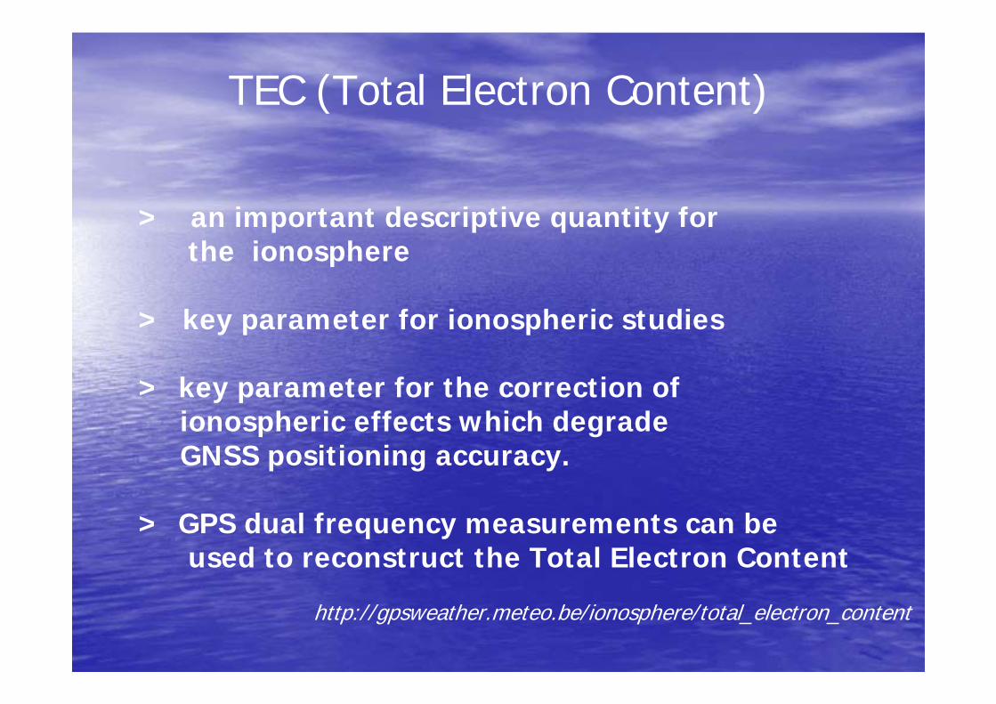
TEC (Total Electron Content)
> an important descriptive quantity for the ionosphere
> key parameter for ionospheric studies
> key parameter for the correction of ionospheric effects which degrade GNSS positioning accuracy.
> GPS dual frequency measurements can be used to reconstruct the Total Electron Content
http://gpsweather.meteo.be/ionosphere/total_electron_content

4
Consists of 3 ASCII file typesConsists of 3 ASCII file types
File TypeFile Type Containing InformationContaining Information
Observation Data File Observation Data File GPS MeasurementsGPS Measurements
GPS Navigation GPS Navigation Message FileMessage File
Ephemeris Ephemeris (Orbit information)(Orbit information)
CODE bias filesCODE bias files Satellite Biases Satellite Biases
•Receiver Independent Exchange Format•Developed by the Astronomical Institute of the University
of Berne in 1989•For the easy exchange of the GPS data •For processing in various software
RINEX

Program Process Program Process
•• Calculate preliminary slant TEC from phase and Calculate preliminary slant TEC from phase and pseudorangepseudorange–– RINEX data files include a header with site information and aRINEX data files include a header with site information and a–– data section including: data section including:
•• 1) phase in cycles of L1 and L2 carriers1) phase in cycles of L1 and L2 carriers•• 2) 2) pseudorangepseudorange in meters using C/A codes on L1 and Pin meters using C/A codes on L1 and P--code code
on L1&L2on L1&L2•• 3) SNR in receiver dependent units for L1 and L2 carriers3) SNR in receiver dependent units for L1 and L2 carriers
•• Cycle Slip Detection and RemovalCycle Slip Detection and Removal•• Leveling the phase to the Leveling the phase to the pseudorangepseudorange to get an to get an absoluteabsolute
measurementmeasurement•• Remove the satellite Remove the satellite TTgdgd biasesbiases•• Apply the mapping function to convert the slant measurements to Apply the mapping function to convert the slant measurements to
equivalent verticalequivalent vertical•• Estimate and remove the hardware biasEstimate and remove the hardware bias•• Identify and remove bad data (local interference, receiver glitcIdentify and remove bad data (local interference, receiver glitches)hes)

DATA
SOURCES
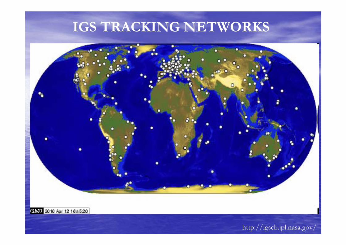
IGS TRACKING NETWORKS
http://igscb.jpl.nasa.gov/
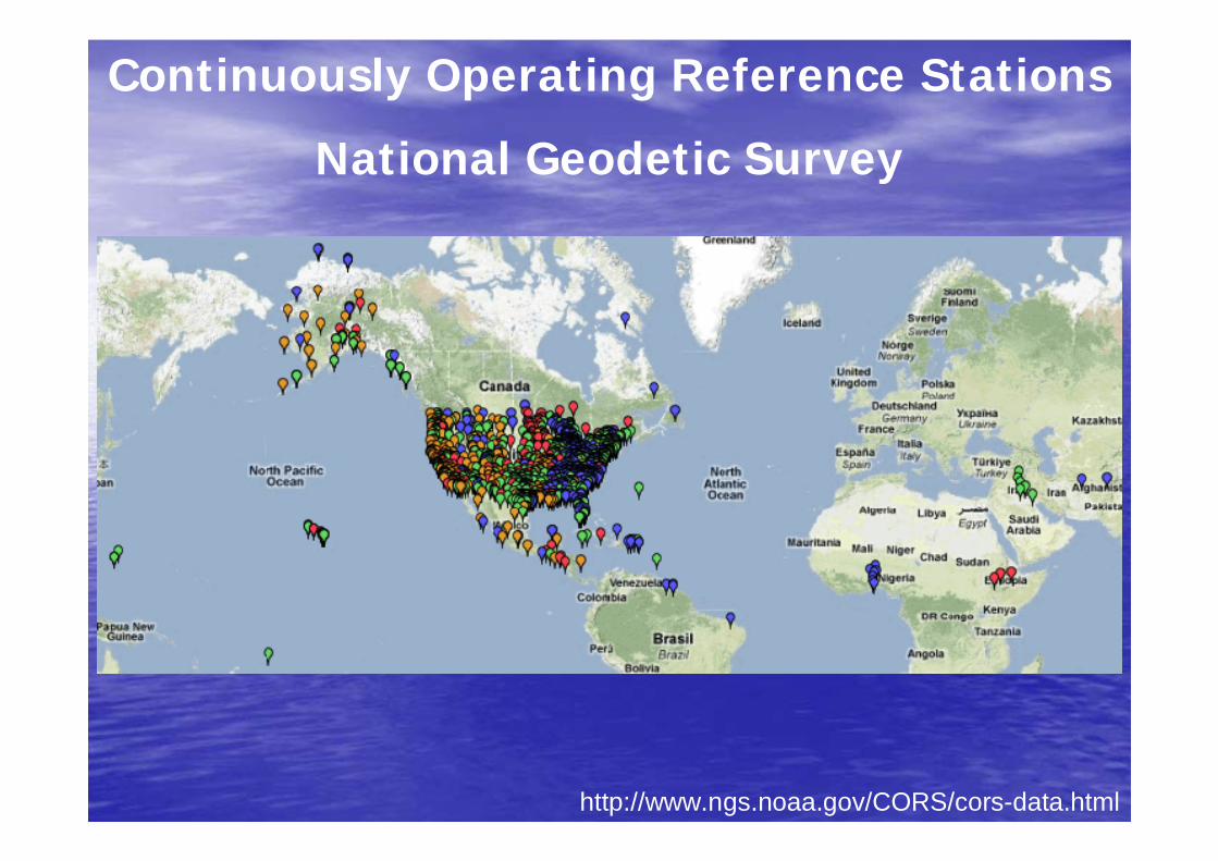
http://www.ngs.noaa.gov/CORS/cors-data.html
Continuously Operating Reference Stations
National Geodetic Survey

Helpful URLS:Helpful URLS:
•• IGS Stations IGS Stations –– http://http://igscb.jpl.nasa.gov/network/netindex.htmligscb.jpl.nasa.gov/network/netindex.html–– global overview of stations; latitude and longitude of stationglobal overview of stations; latitude and longitude of station
•• CODE info CODE info –– http://http://www.aiub.unibe.chwww.aiub.unibe.ch/download/CODE/download/CODE//–– differential code biases differential code biases
•• P1C1yymm.DCB and P1P2yymm.DCB P1C1yymm.DCB and P1P2yymm.DCB –– where where yyyy=year, mm=month=year, mm=month
•• Ap/KpAp/Kp indicesindices–– ftp://ftp://ftp.ngdc.noaa.govftp.ngdc.noaa.gov/STP/GEOMAGNETIC_DATA/INDICES/KP_AP//STP/GEOMAGNETIC_DATA/INDICES/KP_AP/
–– Ap/KpAp/Kp indices indices …… planetary planetary KpKp indices and related indices and related ApAp indices measure worldwide indices measure worldwide geomagnetic activitygeomagnetic activity
•• GPS dataGPS data–– ftp://ftp://cddis.gsfc.nasa.gov/gps/data/dailycddis.gsfc.nasa.gov/gps/data/daily//–– observation filesobservation files

Processing GPS Data
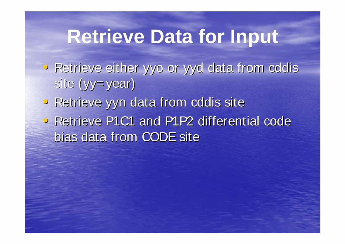
•• Retrieve either Retrieve either yyoyyo or or yydyyd data from data from cddiscddissite (site (yyyy=year)=year)
•• Retrieve Retrieve yynyyn data from data from cddiscddis sitesite•• Retrieve P1C1 and P1P2 differential code Retrieve P1C1 and P1P2 differential code
bias data from CODE sitebias data from CODE site
Retrieve Data for Input

Using ciddis.gsfc.nasa.gov/gps/data/daily to get observable file
Pick Site
Pick Observable
(file ending in o)
Pick DOY
Pick Year
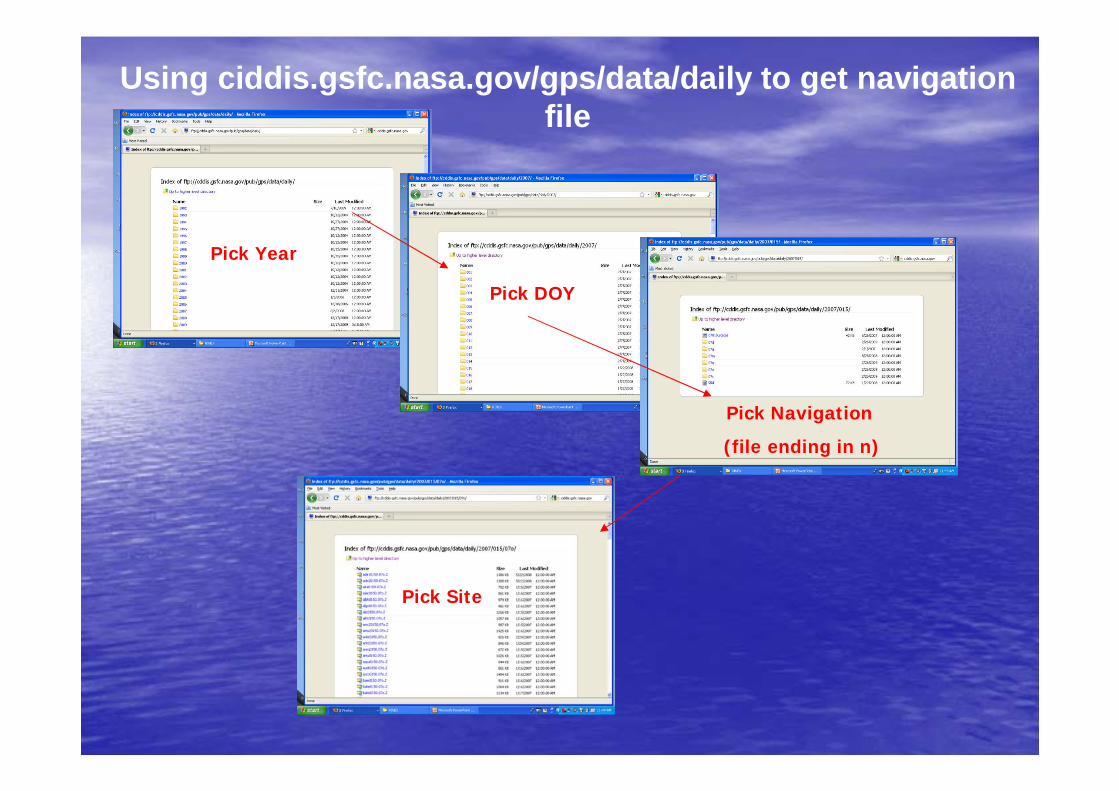
Using ciddis.gsfc.nasa.gov/gps/data/daily to get navigation file
Pick Site
Pick Navigation
(file ending in n)
Pick DOY
Pick Year
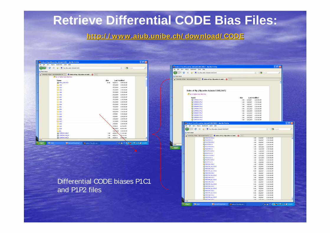
Retrieve Differential CODE Bias Files:http://http://www.aiub.unibe.chwww.aiub.unibe.ch/download/CODE/download/CODE
Differential CODE biases P1C1 and P1P2 files
15
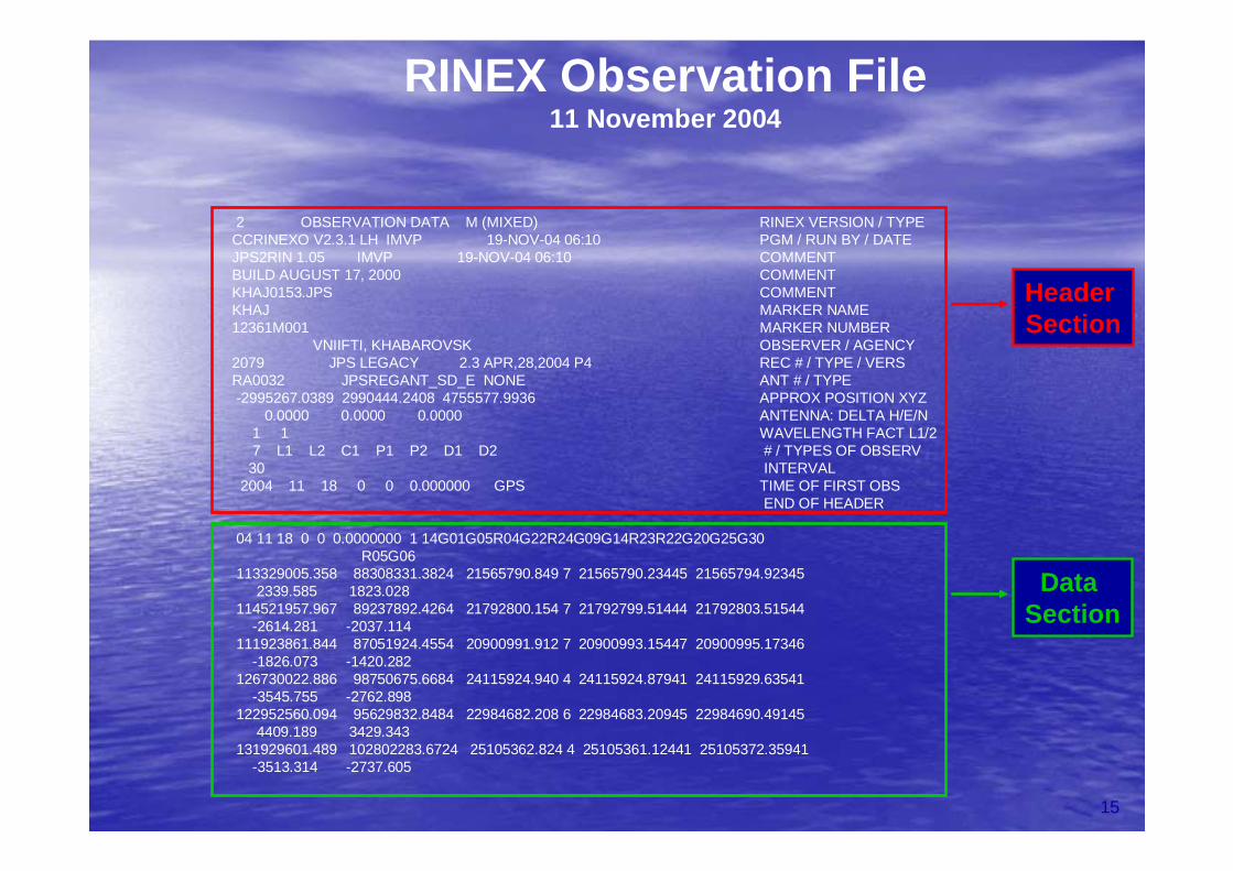
2 OBSERVATION DATA M (MIXED) RINEX VERSION / TYPECCRINEXO V2.3.1 LH IMVP 19-NOV-04 06:10 PGM / RUN BY / DATEJPS2RIN 1.05 IMVP 19-NOV-04 06:10 COMMENTBUILD AUGUST 17, 2000 COMMENTKHAJ0153.JPS COMMENTKHAJ MARKER NAME12361M001 MARKER NUMBER
VNIIFTI, KHABAROVSK OBSERVER / AGENCY2079 JPS LEGACY 2.3 APR,28,2004 P4 REC # / TYPE / VERSRA0032 JPSREGANT_SD_E NONE ANT # / TYPE-2995267.0389 2990444.2408 4755577.9936 APPROX POSITION XYZ
0.0000 0.0000 0.0000 ANTENNA: DELTA H/E/N1 1 WAVELENGTH FACT L1/27 L1 L2 C1 P1 P2 D1 D2 # / TYPES OF OBSERV30 INTERVAL
2004 11 18 0 0 0.000000 GPS TIME OF FIRST OBSEND OF HEADER
04 11 18 0 0 0.0000000 1 14G01G05R04G22R24G09G14R23R22G20G25G30R05G06
113329005.358 88308331.3824 21565790.849 7 21565790.23445 21565794.923452339.585 1823.028
114521957.967 89237892.4264 21792800.154 7 21792799.51444 21792803.51544-2614.281 -2037.114
111923861.844 87051924.4554 20900991.912 7 20900993.15447 20900995.17346-1826.073 -1420.282
126730022.886 98750675.6684 24115924.940 4 24115924.87941 24115929.63541-3545.755 -2762.898
122952560.094 95629832.8484 22984682.208 6 22984683.20945 22984690.491454409.189 3429.343
131929601.489 102802283.6724 25105362.824 4 25105361.12441 25105372.35941-3513.314 -2737.605
DataSection
Header Section
RINEX Observation File11 November 2004
16
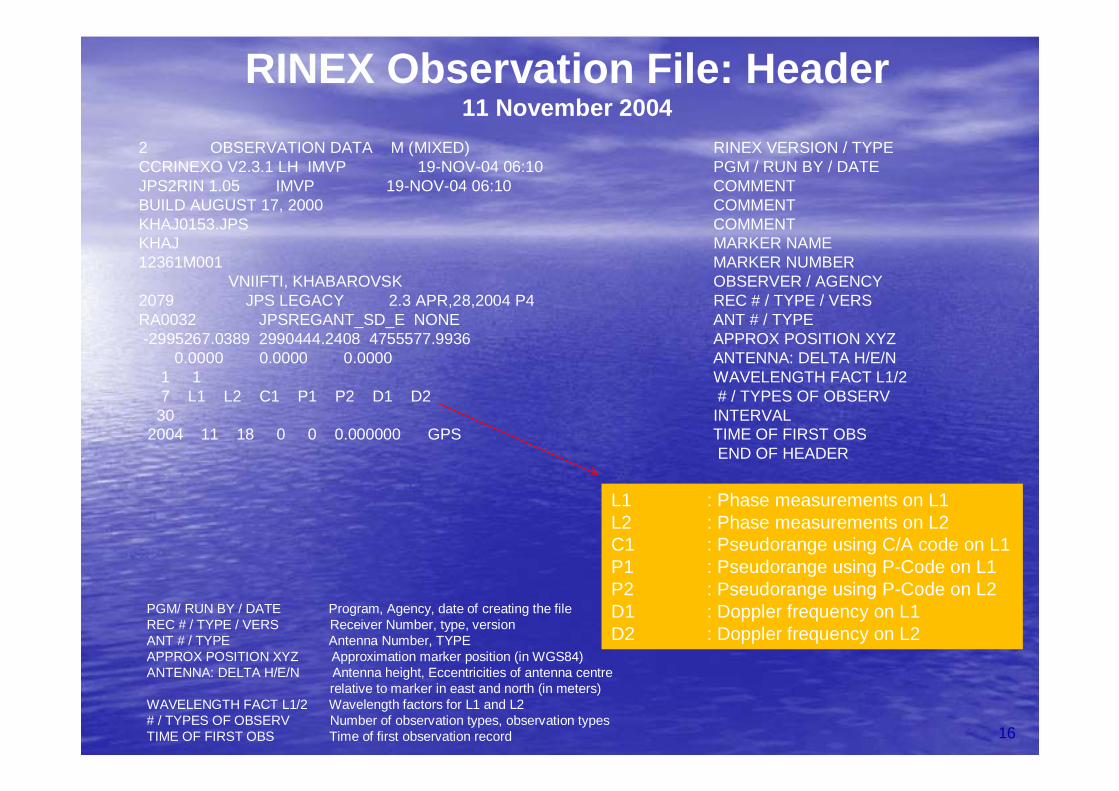
2 OBSERVATION DATA M (MIXED) RINEX VERSION / TYPECCRINEXO V2.3.1 LH IMVP 19-NOV-04 06:10 PGM / RUN BY / DATEJPS2RIN 1.05 IMVP 19-NOV-04 06:10 COMMENTBUILD AUGUST 17, 2000 COMMENTKHAJ0153.JPS COMMENTKHAJ MARKER NAME12361M001 MARKER NUMBER
VNIIFTI, KHABAROVSK OBSERVER / AGENCY2079 JPS LEGACY 2.3 APR,28,2004 P4 REC # / TYPE / VERSRA0032 JPSREGANT_SD_E NONE ANT # / TYPE-2995267.0389 2990444.2408 4755577.9936 APPROX POSITION XYZ
0.0000 0.0000 0.0000 ANTENNA: DELTA H/E/N1 1 WAVELENGTH FACT L1/27 L1 L2 C1 P1 P2 D1 D2 # / TYPES OF OBSERV
30 INTERVAL2004 11 18 0 0 0.000000 GPS TIME OF FIRST OBS
END OF HEADER
L1 : Phase measurements on L1 L2 : Phase measurements on L2C1 : Pseudorange using C/A code on L1P1 : Pseudorange using P-Code on L1P2 : Pseudorange using P-Code on L2D1 : Doppler frequency on L1D2 : Doppler frequency on L2
PGM/ RUN BY / DATE Program, Agency, date of creating the file REC # / TYPE / VERS Receiver Number, type, versionANT # / TYPE Antenna Number, TYPEAPPROX POSITION XYZ Approximation marker position (in WGS84)ANTENNA: DELTA H/E/N Antenna height, Eccentricities of antenna centre
relative to marker in east and north (in meters) WAVELENGTH FACT L1/2 Wavelength factors for L1 and L2# / TYPES OF OBSERV Number of observation types, observation typesTIME OF FIRST OBS Time of first observation record
RINEX Observation File: Header 11 November 2004
17
RINEX Observation File: Data SectionRINEX Observation File: Data Section
04 11 18 0 0 0.0000000 1 14G01G05R04G22R24G09G14R23R22G20G2504 11 18 0 0 0.0000000 1 14G01G05R04G22R24G09G14R23R22G20G25G30G30R05G06R05G06
113329005.358 88308331.3824 21565790.849 7 21565790.23445113329005.358 88308331.3824 21565790.849 7 21565790.23445 21565794.9234521565794.923452339.585 1823.0282339.585 1823.028
114521957.967 89237892.4264 21792800.154 7 21792799.51444114521957.967 89237892.4264 21792800.154 7 21792799.51444 21792803.5154421792803.51544--2614.281 2614.281 --2037.1142037.114
111923861.844 87051924.4554 20900991.912 7 20900993.15447111923861.844 87051924.4554 20900991.912 7 20900993.15447 20900995.1734620900995.17346--1826.073 1826.073 --1420.2821420.282
126730022.886 98750675.6684 24115924.940 4 24115924.87941126730022.886 98750675.6684 24115924.940 4 24115924.87941 24115929.6354124115929.63541--3545.755 3545.755 --2762.8982762.898
122952560.094 95629832.8484 22984682.208 6 22984683.20945122952560.094 95629832.8484 22984682.208 6 22984683.20945 22984690.4914522984690.491454409.189 3429.3434409.189 3429.343
131929601.489 102802283.6724 25105362.824 4 25105361.12441131929601.489 102802283.6724 25105362.824 4 25105361.12441 25105372.3594125105372.35941--3513.314 3513.314 --2737.6052737.605
106887499.711 83288920.8524 20340001.027 8 20340000.29747106887499.711 83288920.8524 20340001.027 8 20340000.29747 20340003.2004720340003.20047--706.717 706.717 --550.701550.701
111622580.227 86817602.4344 20808263.776 8 20808263.45947111622580.227 86817602.4344 20808263.776 8 20808263.45947 20808266.8934620808266.893461903.013 1480.1021903.013 1480.102
Epoch
Number of Satellites Satellite Number
Satellite SystemG…GPSR…Glonass
Observation data for each satellite
113329005.358 88308331.3824 21565790.849 7 21565790.23445 113329005.358 88308331.3824 21565790.849 7 21565790.23445 21565794.9234521565794.92345
D1 D2D1 D2
2339.585 1823.0282339.585 1823.028
18
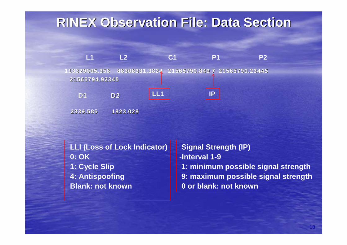
L1 L2 C1 P1 P2
LL1 IP
LLI (Loss of Lock Indicator)0: OK1: Cycle Slip4: AntispoofingBlank: not known
Signal Strength (IP)-Interval 1-91: minimum possible signal strength9: maximum possible signal strength0 or blank: not known
RINEX Observation File: Data SectionRINEX Observation File: Data Section
GPSGPS--TEC data processing from TEC data processing from multiple sourcesmultiple sources
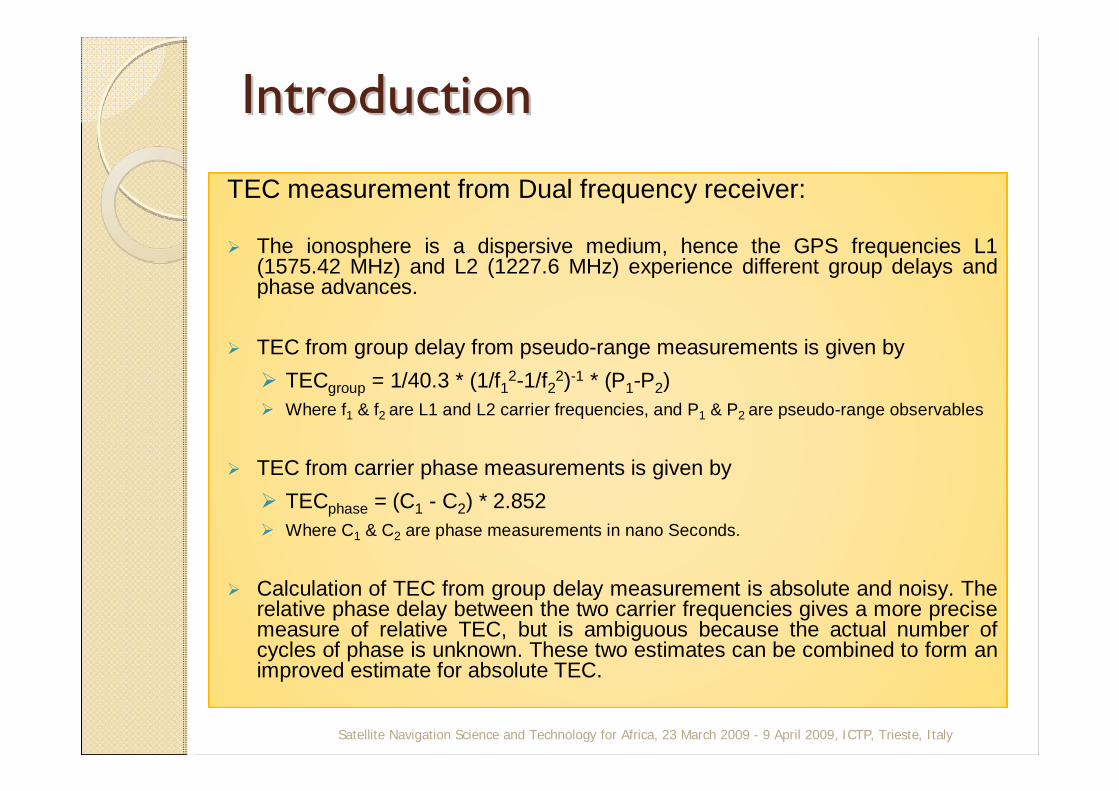
Introduction Introduction TEC measurement from Dual frequency receiver:
The ionosphere is a dispersive medium, hence the GPS frequencies L1 (1575.42 MHz) and L2 (1227.6 MHz) experience different group delays and phase advances.
TEC from group delay from pseudo-range measurements is given byTECgroup = 1/40.3 * (1/f12-1/f22)-1 * (P1-P2) Where f1 & f2 are L1 and L2 carrier frequencies, and P1 & P2 are pseudo-range observables
TEC from carrier phase measurements is given byTECphase = (C1 - C2) * 2.852Where C1 & C2 are phase measurements in nano Seconds.
Calculation of TEC from group delay measurement is absolute and noisy. The relative phase delay between the two carrier frequencies gives a more precise measure of relative TEC, but is ambiguous because the actual number of cycles of phase is unknown. These two estimates can be combined to form an improved estimate for absolute TEC.
Satellite Navigation Science and Technology for Africa, 23 March 2009 - 9 April 2009, ICTP, Trieste, Italy
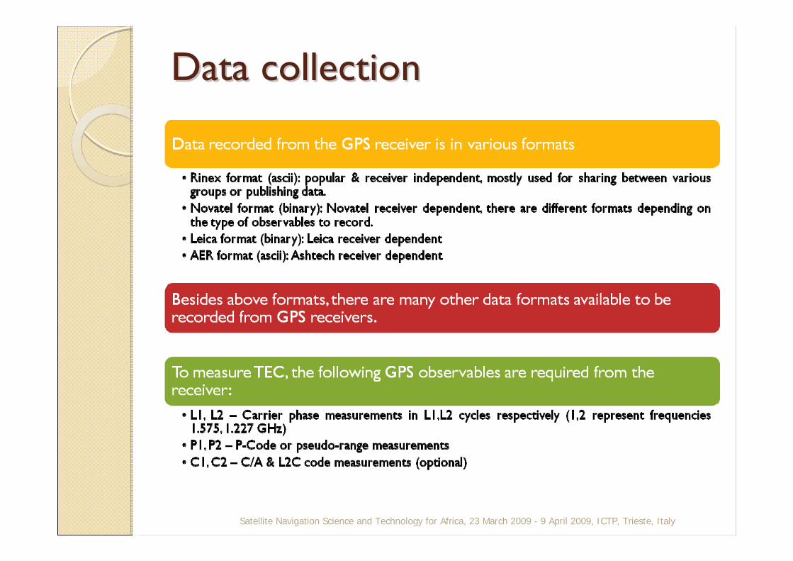
Data collectionData collection
Satellite Navigation Science and Technology for Africa, 23 March 2009 - 9 April 2009, ICTP, Trieste, Italy
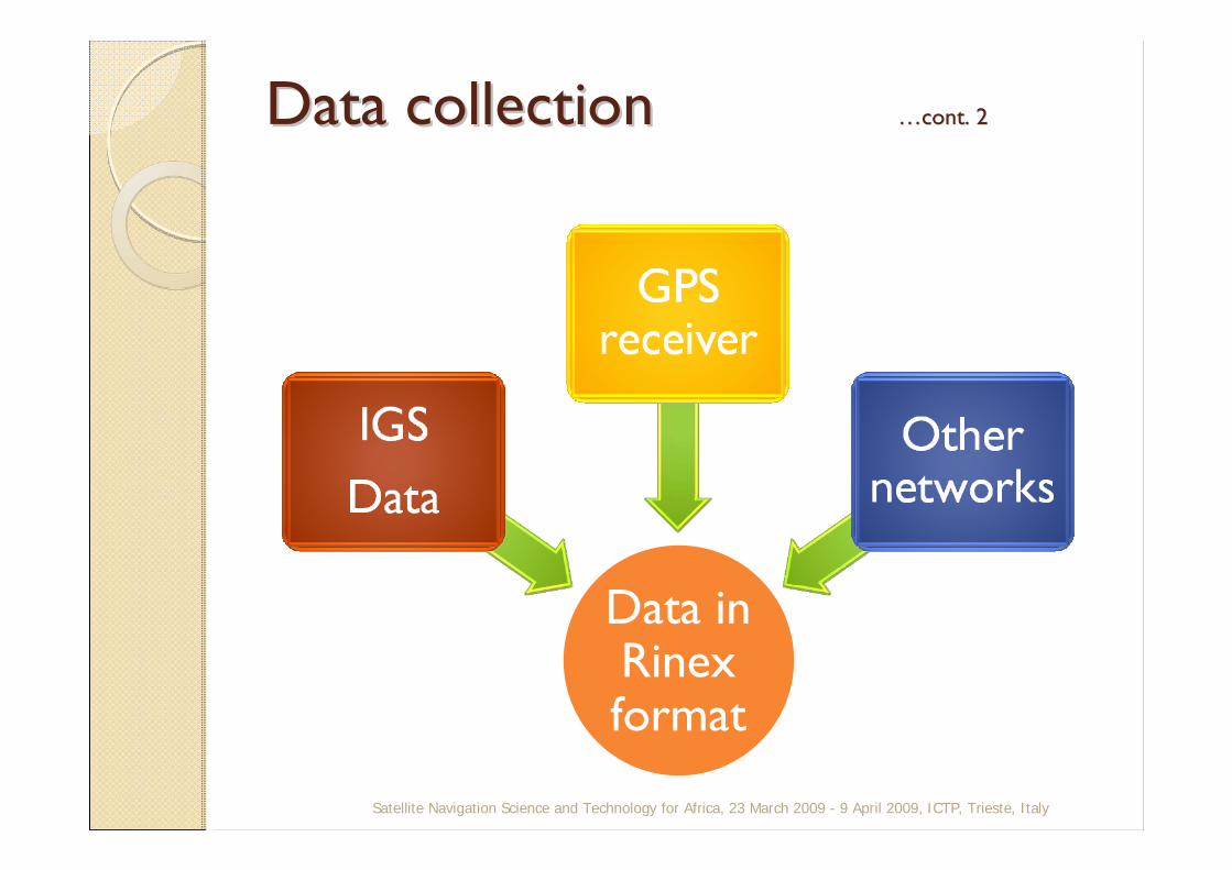
Data collectionData collection ……cont. 2cont. 2
Data in Rinexformat
Satellite Navigation Science and Technology for Africa, 23 March 2009 - 9 April 2009, ICTP, Trieste, Italy
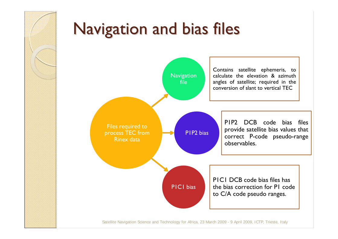
Navigation and bias filesNavigation and bias files
Navigation file
Contains satellite ephemeris, to calculate the elevation & azimuth angles of satellite; required in the conversion of slant to vertical TEC
P1P2 bias
P1P2 DCB code bias files provide satellite bias values that correct P-code pseudo-range observables.
P1C1 biasP1C1 DCB code bias files has the bias correction for P1 code to C/A code pseudo ranges.
Files required to process TEC from
Rinex data
Satellite Navigation Science and Technology for Africa, 23 March 2009 - 9 April 2009, ICTP, Trieste, Italy

Ephemeris analysis
Satellite Navigation Science and Technology for Africa, 23 March 2009 - 9 April 2009, ICTP, Trieste, Italy
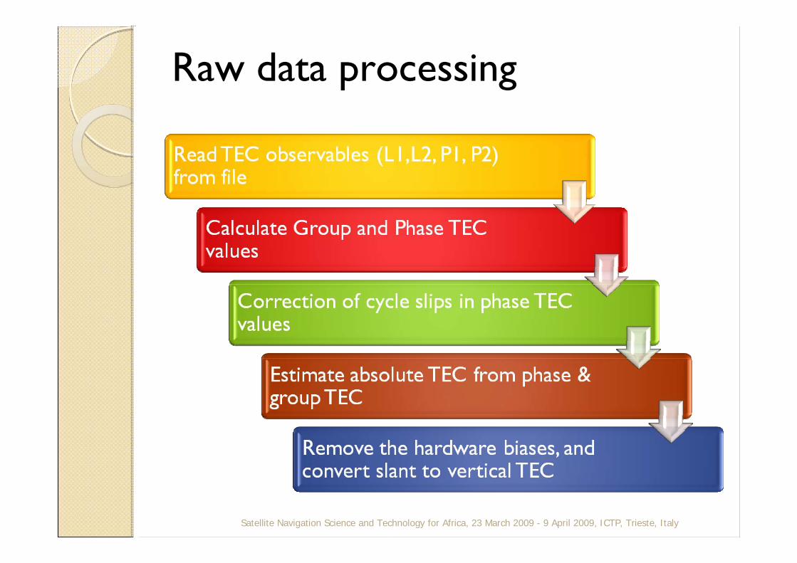
Raw data processing
Satellite Navigation Science and Technology for Africa, 23 March 2009 - 9 April 2009, ICTP, Trieste, Italy

Bias calculationBias calculation
Total BiasSatellite Navigation Science and Technology for Africa, 23 March 2009 - 9 April 2009, ICTP, Trieste, Italy

Bias calculationBias calculation ……cont. 2cont. 2
Satellite Navigation Science and Technology for Africa, 23 March 2009 - 9 April 2009, ICTP, Trieste, Italy
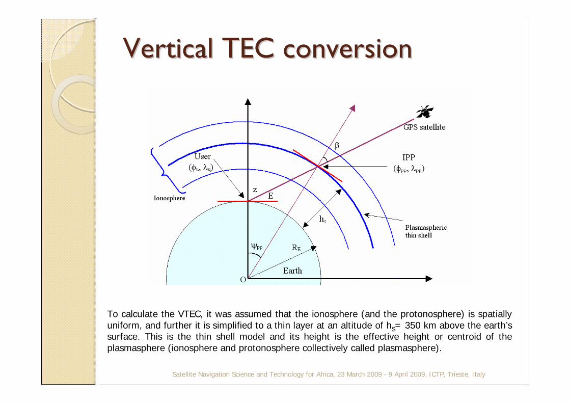
Vertical TEC conversionVertical TEC conversion
Satellite Navigation Science and Technology for Africa, 23 March 2009 - 9 April 2009, ICTP, Trieste, Italy
To calculate the VTEC, it was assumed that the ionosphere (and the protonosphere) is spatially uniform, and further it is simplified to a thin layer at an altitude of hS= 350 km above the earth’s surface. This is the thin shell model and its height is the effective height or centroid of the plasmasphere (ionosphere and protonosphere collectively called plasmasphere).
Satellite Navigation Science and Technology for Africa, 23 March 2009 - 9 April 2009, ICTP, Trieste, Italy
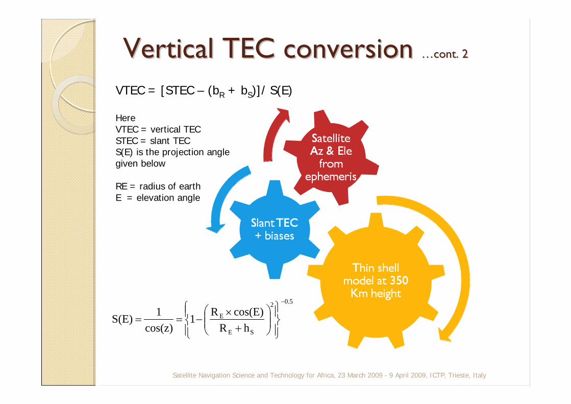
VTEC = [STEC – (bR + bS)]/ S(E)
Here VTEC = vertical TECSTEC = slant TECS(E) is the projection anglegiven below
RE = radius of earthE = elevation angle
5.02
SE
E
hRcos(E)R1
cos(z)1S(E)
−
⎪⎭
⎪⎬⎫
⎪⎩
⎪⎨⎧
⎟⎟⎠
⎞⎜⎜⎝
⎛+
×−==
Vertical TEC conversion Vertical TEC conversion ……cont. 2cont. 2
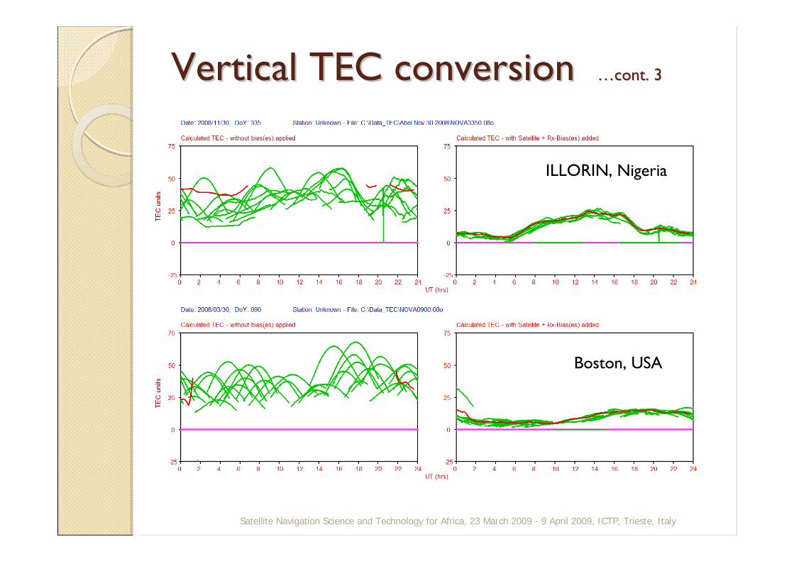
Vertical TEC conversion Vertical TEC conversion ……cont. 3cont. 3
Satellite Navigation Science and Technology for Africa, 23 March 2009 - 9 April 2009, ICTP, Trieste, Italy
ILLORIN, Nigeria
Boston, USA
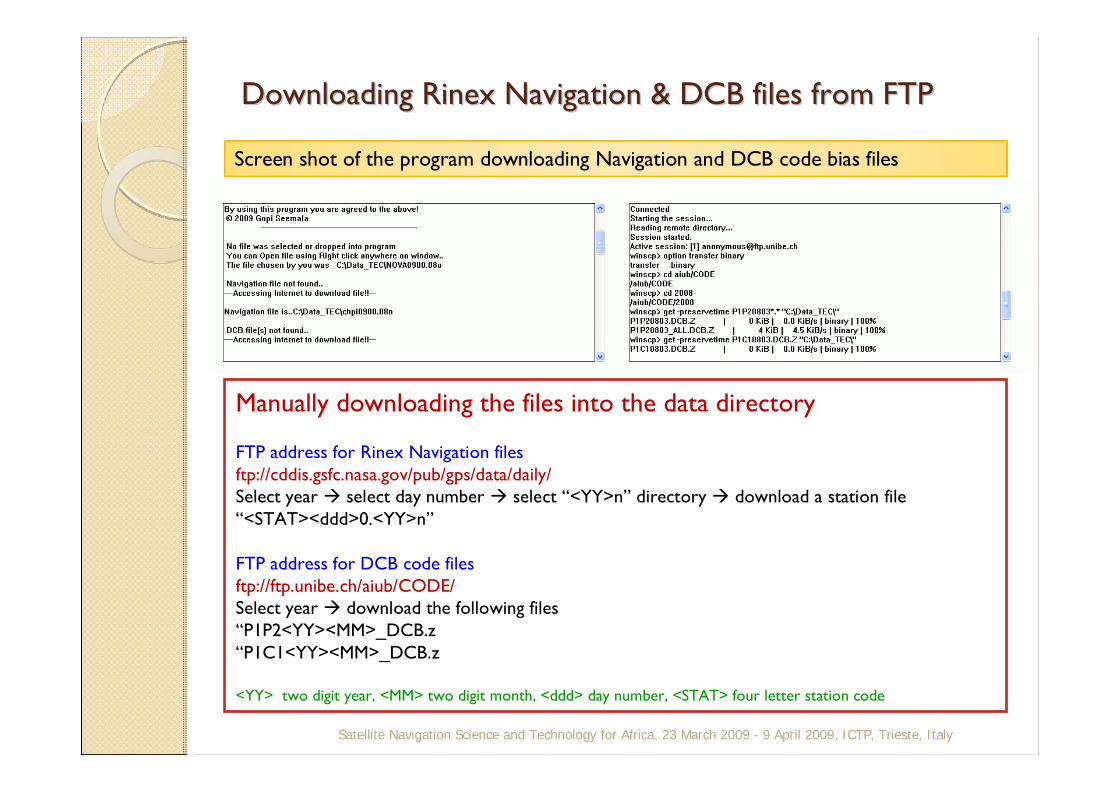
Downloading Downloading RinexRinex Navigation & DCB files from FTPNavigation & DCB files from FTP
Satellite Navigation Science and Technology for Africa, 23 March 2009 - 9 April 2009, ICTP, Trieste, Italy
Manually downloading the files into the data directory
FTP address for Rinex Navigation filesftp://cddis.gsfc.nasa.gov/pub/gps/data/daily/Select year select day number select “<YY>n” directory download a station file “<STAT><ddd>0.<YY>n”
FTP address for DCB code filesftp://ftp.unibe.ch/aiub/CODE/Select year download the following files“P1P2<YY><MM>_DCB.z“P1C1<YY><MM>_DCB.z
<YY> two digit year, <MM> two digit month, <ddd> day number, <STAT> four letter station code
Screen shot of the program downloading Navigation and DCB code bias files
Satellite Navigation Science and Technology for Africa, 23 March 2009 - 9 April 2009, ICTP, Trieste, Italy
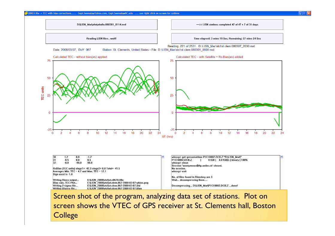
Screen shot of the program, analyzing data set of stations. Plot on screen shows the VTEC of GPS receiver at St. Clements hall, Boston College
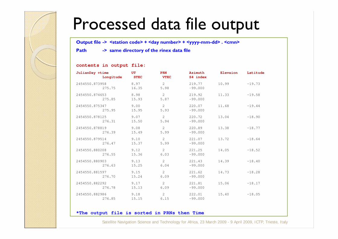
Processed data file outputOutput file -> <station code> + <day number> + <yyyy-mm-dd> . <cmn>
Path -> same directory of the rinex data file
contents in output file:JulianDay +time UT PRN Azimuth Elevaion Latitude
Longitude STEC VTEC S4 index
2454550.873958 8.97 2 219.77 10.99 -19.73275.75 16.35 5.98 -99.000
2454550.874653 8.98 2 219.92 11.33 -19.58275.85 15.93 5.87 -99.000
2454550.875347 9.00 2 220.07 11.68 -19.44275.95 15.95 5.93 -99.000
2454550.878125 9.07 2 220.72 13.04 -18.90276.31 15.50 5.94 -99.000
2454550.878819 9.08 2 220.89 13.38 -18.77276.39 15.49 5.99 -99.000
2454550.879514 9.10 2 221.07 13.72 -18.64276.47 15.37 5.99 -99.000
2454550.880208 9.12 2 221.25 14.05 -18.52276.55 15.36 6.03 -99.000
2454550.880903 9.13 2 221.43 14.39 -18.40276.63 15.25 6.04 -99.000
2454550.881597 9.15 2 221.62 14.73 -18.28276.70 15.24 6.09 -99.000
2454550.882292 9.17 2 221.81 15.06 -18.17276.78 15.13 6.09 -99.000
2454550.882986 9.18 2 222.01 15.40 -18.05276.85 15.15 6.15 -99.000
*The output file is sorted in PRNs then Time
Satellite Navigation Science and Technology for Africa, 23 March 2009 - 9 April 2009, ICTP, Trieste, Italy
SummarySummaryThe program developed eases the GPS-TEC data analysis by taking multiple formats as the input files (Rinex, Novatel, Leica, AER formats)
It applies the necessary receiver, satellite, and inter-channel bias corrections; also shows the applied bias corrections in program for later verification.
It downloads the required navigation file and DCB files from internet automatically if it doesn’t find them in the data directory.
For example: If you download an IGS station rinex observation file and give this as input to the program (no need to give any other files) it does download necessary files (decompresses them) and gives the output files including the plot image.
The output ascii files are easily machine and human readable
Satellite Navigation Science and Technology for Africa, 23 March 2009 - 9 April 2009, ICTP, Trieste, Italy

Thank you..Thank you..
Satellite Navigation Science and Technology for Africa, 23 March 2009 - 9 April 2009, ICTP, Trieste, Italy
Related Documents