24 th & William Urban Village Plan Approved by the City Council on November 19, 2013 Amended by the City Council on December 11, 2018

Welcome message from author
This document is posted to help you gain knowledge. Please leave a comment to let me know what you think about it! Share it to your friends and learn new things together.
Transcript

24th & William Urban Village Plan
Approved by the City Council on November 19, 2013
Amended by the City Council on December 11, 2018

24th & William Urban Village Plan 2
TABLE OF CONTENTS
TABLE OF CONTENTS ................................................................................................................. 2
INTRODUCTION ........................................................................................................................ 4
BACKGROUND AND PLANNING PROCESS ....................................................................................... 5
LAND USE ............................................................................................................................... 7
A. Planned Growth Capacity and Objectives ...................................................................... 8
Employment Growth ............................................................................................................... 8
Housing Growth ....................................................................................................................... 9
B. Phasing of Residential Development ............................................................................. 9
1. Phasing of residential growth on land designated Light Industrial or Combined
Industrial/Commercial .......................................................................................................... 10
2. Phasing of residential growth on lands designated Neighborhood/ Community
Commercial ........................................................................................................................... 10
C. Land Use Diagram ......................................................................................................... 11
1. Existing/Interim Land Use Diagram ................................................................................. 11
2. Future Land Use Diagram ................................................................................................. 12
D. Land Use Designations ........................................................................................................ 15
1. Existing/interim Land Use Designations .......................................................................... 15
2. Land Use Designations added to the Future Land use Diagram ..................................... 19
E. Land Use Policies ................................................................................................................... 20
URBAN DESIGN ...................................................................................................................... 21
A. Building Height ..................................................................................................................... 21
B. Architecture .......................................................................................................................... 25
C. Street Frontage ..................................................................................................................... 25
D. Trail Frontage ....................................................................................................................... 26

24th & William Urban Village Plan 3
E. Setbacks and Building Placement ......................................................................................... 27
PUBLIC ART ........................................................................................................................... 29
STREET AND PEDESTRIAN CIRCULATION SYSTEM ........................................................................... 31
A. Sidewalks .............................................................................................................................. 31
B. Street Trees ........................................................................................................................... 32
C. Roadway/Trail Intersections ................................................................................................ 33
PARKING .............................................................................................................................. 38
FIVE WOUNDS TRAIL .............................................................................................................. 40
IMPLEMENTATION .................................................................................................................. 43
Implementation Priorities ........................................................................................................ 48

24th & William Urban Village Plan 4
INTRODUCTION
The 24th & William Urban Village Plan, together with the Roosevelt Park, Five Wounds,
and Little Portugal Urban Village Plans, are part of the first Urban Village Plans prepared
by the City and the community to further the Urban Village strategy of the new Envision
San José 2040 General Plan (General Plan). As a City Council approved policy document
for the future growth of the 24th & William Urban Village, this Village Plan establishes a
framework for the transition of the 24th and William Street Urban Village into a vibrant
mixed-use and pedestrian-oriented district that supports the surrounding
neighborhoods and is integrated with the planned Five Wounds Trail. This Village Plan
includes goals and policies designed to shape both future public and private
development.

24th & William Urban Village Plan 5
BACKGROUND AND PLANNING PROCESS
The planning process for the 24th & William Urban Village really began with the Five
Wounds/Brookwood Terrace Strong Neighborhoods Initiative (SNI) Plan that was
completed in August of 2002. This SNI Plan outlined the community’s vision and land
use direction for this Village as well as the other three Urban Villages located within its
boundary. While the SNI Plan was accepted by the City Council in 2002 as the
community’s vision and priorities for the Five Wounds Area, the SNI Plan and its Land
Use recommendations for the 24th & William Urban Village area were not approved by
the City Council and did not become official City Policy.
In 2010, the vision and recommendations for the future of the Five Wounds area,
including the 24th & William Urban Village, were further developed as part of the Five
Wounds/Brookwood Terrace Bay Area Rapid Transit (BART) Station Area Community
Concept Plan. This BART Station Area Plan was developed by the community and San
José State University, with support from the City, under the umbrella of
CommUniverCity. Completed in September of 2010, this BART Station Area Plan refined
the land use, urban design, circulation and parks and open space recommendations for
24th & William and the three other Urban Villages in the Five Wounds/Brookwood
Terrace area. The recommendations of this BART Station Area Plan were not, however,
formally approved as City policy by the City Council.
In 2011, at the conclusion of the Envision San José 2040 General Plan (General Plan)
Update process, the City’s first Urban Village planning processes were initiated in the
Five Wounds/Brookwood Terrace area, using the CommUniverCity BART Station Area
Plan as the starting point. The visions, goals, and many of the policy recommendations
of the CommUniverCity BART Station Area Plan were integrated into the 24th & William,
and the three other Village Plans (i.e. Roosevelt Park, Little Portugal, and Five Wounds),
as consistent with the strategies of the Envision San José 2040 General Plan. Unlike the
prior planning processes, these four Village Plans were then approved the City Council
as the City’s policy for the future growth of these Urban Villages.
The planning process for the 24th & William Urban Village Plan was combined with the
Planning process for the Five Wounds, Roosevelt Park and Little Portugal Urban Village
Planning processes. The planning process first consisted of two community outreach
meetings where staff explained the strategies of the recently adopted General Plan’s
Major Strategy and how they would be implemented in the Five Wounds/Brookwood
Terrance area. Following this outreach, two additional community workshops were held

24th & William Urban Village Plan 6
that each attended by approximately 40 to 50 residents, and property and business
owners. At the first workshop, on July 23, 2011, the community provided comments and
direction on a draft Land Use Plan. At the second community workshop, the community
reviewed and provided input on the refined Land Use and Urban Design Plan, as well as
the Circulation, Streetscape, Parks and Trails, and Parking recommendations.
In 2018, additional coordination with community leaders was completed to establish the
Implementation Priorities for this Urban Village plan. These Implementation Priorities
are the same priorities that are identified in the Roosevelt Park, Little Portugal, and Five
Wounds Urban Village Plans.
Urban Village Implementation and Amenities Framework
As part of the preparation of an urban village plan, the General Plan states, “consider
financing mechanisms which may be needed to deliver public improvements, affordable
housing, amenities, and the like envisioned with the Urban Village Plan.” On May 22,
2018, the City Council adopted City Council Resolution No. 78603 for the Urban Village
Implementation and Amenities Framework (Framework), as maybe amended in the
future, to facilitate a rezoning process to allow the conversion of employment lands to
residential or residential mixed-use uses consistent with the Implementation
Framework within adopted urban village plans. The role of the Framework is to:
1. Outline a zoning process that will provide a more streamlined entitlement
process for developments that are consistent with an urban village plan.
2. Provide the community and developers with a mechanism to have residential or
residential mixed-use projects build or contribute towards payment for the
amenities and additional public improvements identified in an urban village plan.
This Implementation Framework was incorporated into an updated Implementation
Chapter for the 24th & William Village Plan, which was approved by Council on
December 11, 2018.

24th & William Urban Village Plan 7
LAND USE
Land Use Goal: Maintain and enhance the 24th & William Urban Village as a complete
community by further integrating a mix of neighborhood serving commercial uses and
employment uses within the Village, while also allowing for the integration of
additional housing.
The 24th & William Urban Village area has an existing land use fabric that is more
common in older more established communities in the United States but is unique for
most of San José. While the community is largely a single-family neighborhood, it also
contains a corner market, a grocery store, a bakery, a coin laundry and a number of
other neighborhood serving retail uses that are within walking distance for many
residents. The area also includes a number of industrial, auto related, small
manufacturing and food processing businesses. While these uses at times contribute to
the gritty character of the area, they also provide employment opportunities for people
within the immediate and surrounding communities.
By containing housing, businesses and neighborhood serving retail, the 24th & William
Urban Village is in many ways a “complete” community, where people can live, shop
and work within a small area. This is one of the key characteristics that define an Urban
Village.
The goal of this Village Plan is to maintain and then expand this mix of land uses to
reinforce the 24th & William Urban Village as a complete mixed-use community. While
light industrial type uses could remain, and expand in identified locations, this Village
Plan does envision a transition to more commercial type uses over time. As part of the
planning process, the community was very supportive of encouraging arts related uses
within this Village, particularly in the area north of San Antonio Street and bisected by
the planned Five Wounds Trail, an area that currently contains a mix of industrial
businesses and single-family homes. The industrial properties and buildings in the area
are of the type that often works well for artists and arts organizations, as the rents are
relatively low.
24th Street, and in particular, the intersection of 24th and William Streets, is intended to
be the primary community hub for both this Village and the adjacent surrounding
neighborhoods. The intersection of 24th and William Street presently contains a number
of neighborhood serving retail uses. This Village Plan intends to retain these types of
uses while allowing for additional neighborhood serving retail and other small scale
24th & William Urban Village Plan 8
commercial or office uses through the intensification of existing commercial properties
or the redevelopment of identified residential and underutilized commercial and
industrial properties.
While, the primary land use emphasis of this Urban Village Plan is to maintain the
existing level of employment and commercial uses, and then facilitate an approximately
18 percent increase in the square footage of employment uses, this Village Plan
ultimately will support mixed-use residential/commercial and fully commercial
development along the 24th Street Corridor between San Antonio Street to just south of
William Street. As discussed below, in the Phasing of Residential Development (Section
B) of this Chapter, new residential uses integrated with employment uses, will be
allowed by this Village Plan when the City Council decides to allocate housing capacity
from Growth Horizon III and the Valley Transportation Authority (VTA) secures a Full
Funding Grant Agreement (FFGA) for the 28th Street BART station. The inclusion of
additional residential development and residents would further support existing
businesses in the area, as well as new businesses desired along 24th Street, and would
contribute to the overall vitality of the area.
New residential development is envisioned in a vertical mixed-use format with
apartments or condominiums located above retail stores or offices; however, on larger
properties, or where properties are aggregated, residential and commercial uses could
be developed side by side in a horizontal mixed-use format. As described under the
description of the Urban Village Land Use designation section below, mixed-use
development would need to maintain and potentially expand upon the existing amount
of commercial space on a given site.
A. PLANNED GROWTH CAPACITY AND OBJECTIVES
This Village Plan establishes a commercial/employment square footage objective and
residential unit planned capacity for the overall Village as described below.
EMPLOYMENT GROWTH
The overall objective for the whole Village is to develop an additional 30,000 square feet
of non-residential/employment square footage over the existing amount of commercial
and industrial square footage. With approximately 167,000 square feet of existing
industrial and commercial space, this objective represents an approximately 18 percent
increase in the amount of employment square footage above existing levels. The Village

24th & William Urban Village Plan 9
employment growth objective is based upon the “jobs first” Envision San José 2040
General Plan planned capacity of 100 new jobs for the 24th & William Urban Village. The
non-residential/employment square footage objective was calculated per the
methodology outlined in the General Plan by assuming that each job requires, on
average, 300 square feet of gross building area, and then multiplying 100 by 300.
HOUSING GROWTH
The planned dwelling unit capacity for the Village overall is 217 new housing units, to be
developed as part of mixed-use development. This residential unit capacity is the
maximum new residential growth planned for the 24th & William Urban Village as
outlined in the Envision San José 2040 General Plan. This Village Plan recognizes that
housing can contribute to creating a vibrant Urban Village; however, because the
Envision San José 2040 General Plan is a jobs-focused Plan, it does not establish a
residential unit objective, but rather a maximum number of housing units that is
planned to be accommodated in this Village.
B. PHASING OF RESIDENTIAL DEVELOPMENT
To achieve San José’s economic and fiscal goals, the San José 2040 General Plan meters
out planned residential growth into three Growth Horizons (Horizon I, II and III), as per
General Plan Implementation Policy IP-2.1. Residential growth is not supported within
an Urban Village until residential growth capacity is allocated from a given Horizon or if
a General Plan Amendment is pursued to modify the Plan Horizon for an Urban Village,
as allowed by General Plan Implementation Policy IP-3.5. The planned residential
growth in the 24th & William Urban Village is in Horizon III. Non-residential or
employment development is not subject to the Growth Horizons and can occur at any
time, consistent with the goals and policies of the General Plan and the applicable Urban
Village Plan.
In addition, the General Plan contains Land Use Policy LU-6.1 which only allows
conversion of Light Industrial, Heavy Industrial or other employment uses to non-
employment uses (i.e. residential uses) in the 24th & William Urban Village, with the
completion of the planned 28th Street BART Station. As a result of both of these policies,
there are two different rules regarding when residential can occur within this Village.
The first rule applies to areas presently designated, and shown in the 24th & William
Existing/Interim Land Use Diagram (Figure 1), as Light Industrial or Combined
Industrial/Commercial. The other rule applies to lands designated

24th & William Urban Village Plan 10
Neighborhood/Community Commercial. Both of these rules are described in the next
section below.
Residential growth on lands designated by this Urban Village Plan as Residential
Neighborhood, Mixed-Use Neighborhood or Mixed-Use Commercial are not subject to
the policies related to the phasing of residential development, and can be approved at
any time, consistent with the given land use designation of the area, and the goals and
policies of the General Plan and this Village Plan.
1. PHASING OF RESIDENTIAL GROWTH ON LAND DESIGNATED LIGHT INDUSTRIAL
OR COMBINED INDUSTRIAL/COMMERCIAL
Lands designated on the 24th & William Existing/Interim Land Use Diagram (Figure 1) as
Light Industrial or Combined Industrial/Commercial do not allow residential uses until
the Valley Transportation Authority secures a Full Funding Grant Agreement for the
planned 28th Street BART station. Consequently, the land use designation of these Light
Industrial or Combined Industrial/Commercial areas will not be changed to Urban Village
(through a General Plan Amendment process), as shown on the 24th & William Future
Land Use Diagram (Figure 2), or another designation that allows housing, until the VTA
secures a Full Funding Grant Agreement (FFGA) for the 28th Street BART station.
General Plan Policy LU-6.1 precludes the allocation of planned residential capacity onto
these employment lands though the use of either the Signature Project policy
(Implementation Policy IP-5.10) or Residential Unit Capacity “Pool” policy
(Implementation Policy IP-2.11) in the General Plan. The Phasing of Residential Growth
on Lands Designation Neighborhood/Community Commercial (Section B.2) below
discusses these policies in more detail.
2. PHASING OF RESIDENTIAL GROWTH ON LANDS DESIGNATED NEIGHBORHOOD/
COMMUNITY COMMERCIAL
The phasing of residential uses on lands designated Neighborhood/Community
Commercial is subject to the General Plan’s Growth Horizons. Given that the 24th &
William Urban Village is in Growth Horizon III, the General Plan does not support
residential growth on lands designated Neighborhood/Community Commercial until the
City Council decides to allocate residential growth capacity to Horizon III. The City
Council can also decide to move this Urban Village into another growth Horizon as part
of an Annual Review of the General Plan, if the City is moving towards achievement of

24th & William Urban Village Plan 11
its employment and fiscal goals, as allowed by General Plan Implementation Policy IP-
3.5.
The General Plan however contains two implementation policies which gives the City
Council some flexibility to approve housing before a residential Growth Horizon is
activated. These two General Plan policies allow flexibility to allow mixed-use
commercial/residential development within areas designated
Neighborhood/Community Commercial prior to the allocation of residential growth
from Horizon III, if this development is consistent with the goals and policies of this
Urban Village Plan. The first policy allows mixed-use residential/commercial projects to
be approved ahead of a Growth Horizon if a project includes a significant jobs
component and meets the other criteria of a Signature Project (for a description of a
Signature Project, see General Plan Implementation Policy IP-5.10). The second
implementation policy provides a “pool” of 5,000 residential units that the Council can
allocate to Signature Projects and/or Urban Villages that are not within a current
Growth Horizon but have a Council-approved Village Plan (General Plan Implementation
Policy IP-2.11).
C. LAND USE DIAGRAM
This Village Plan contains two Land Use diagrams. The first diagram (Figure 1) is the
Existing/Interim Land Use diagram that identifies land uses and intensity of uses that are
supported by this Village Plan, prior to the allocation of Horizon III growth and when the
Valley Transportation Authority (VTA) secures a Full Funding Grant Agreement for the
28th Street BART station. The second diagram (Figure 2) is the Future Land Use diagram
that is proposed with the allocation of Horizon III growth and when the VTA secures a
Full Funding Grant Agreement for the 28th Street BART Station. Both are described in
more detail below.
1. EXISTING/INTERIM LAND USE DIAGRAM
The Existing/Interim Land Use diagram is shown in Figure 1. This diagram is a largely a
continuation of the Land Use diagram in the Envision San José General plan approved by
the City Council on November 1, 2011. To further the achievement of the employment
growth objective for this Village, this diagram includes opportunities for new
commercial and industrial development, however, it does not support new residential

24th & William Urban Village Plan 12
development integrated into these employment areas. These employment areas are
designated on the diagram as Neighborhood/Community Commercial, Combined
Industrial/Commercial, and Light Industrial. The Mixed-Use Commercial Land Use
Designation is also largely an employment designation, but does allow some flexibility to
include housing integrated with commercial uses.
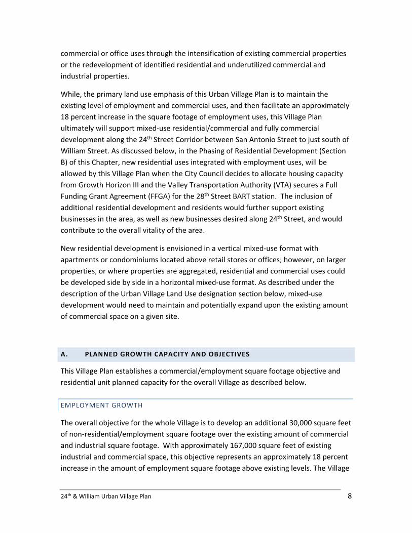
2. FUTURE LAND USE DIAGRAM
The Future Land Use Diagram (Figure 2) is the planned land use diagram that would be
approved by the City Council through a General Plan amendment process once the City
Council allocates residential growth from Horizon III and once the VTA has secured a Full
Funding Grant Agreement for the 28th Street BART station. Because, as described in the
Phasing of Residential Development (Section B) above, there are different policies that
affect the phasing of new residential uses, this Future Land Use Diagram could be
approved in stages. The areas designated Neighborhood/Community Commercial could
be converted to Urban Village Land Use designation through a General Plan amendment
process when the Council decides to allocate growth from Horizon III. Per General Plan
Land Use Policy LU-6.1, the areas currently designated Combined Industrial/Commercial
and Light Industrial might be converted later once BART station is planned and
scheduled for completion.
While it is not anticipated that BART will be completed before allocation of Horizon III
growth, if BART is completed first, the City Council could amend the General Plan
through a General Plan Amendment process to allow residential uses on the Combined
Industrial/Commercial and Light Industrial areas (as shown in Figure 1) prior to Horizon
III allocation.

24th & William Urban Village Plan 13
FIGURE 1 24th & William Existing/Interim Land Use Diagram
24th & William Urban Village Plan 14
FIGURE 2 24th & William Future Land Use Diagram

24th & William Urban Village Plan 15
D. LAND USE DESIGNATIONS
The Land Use Designations section is divided into two sections. The first only discusses
those designations that are included in the Existing/Interim Land Use Diagram (Figure 1).
The second section discusses only those land use designations on the Future Land Use
Diagram (Figure 2) which would be added through a General Plan amendment process.
It should be noted that rezoning may be required for consistency with the land use
designations. Furthermore, any future development proposal requiring rezoning for
residential components (e.g., land use designation of Urban Village, Mixed-Use, and
Urban Residential) will be required to comply with the Implementation Framework.
1. EXISTING/INTERIM LAND USE DESIGNATIONS
Below are descriptions of the land use designations that are applied in the
Existing/Interim Land Use Diagram (Figure 1) that is in place until the City Council
allocates growth from Horizon III and until the VTA secures a Full Funding Grant
Agreement for the 28th Street BART Station.
Mixed-Use Commercial Density: Up to 35 DU/AC; FAR 0.5 to 1.5 (1 to 3 stories) for mixed-use projects that include residential, with a minimum commercial FAR of 0.5; FAR Up to 1.5 (1 to 3 stories) for stand-alone non-residential uses.
The Mixed-Use Commercial designation is intended to accommodate a mix of
commercial and residential uses with an emphasis on commercial activity as the primary
use and residential activity allowed in a secondary role. Two blocks are designated with
this land use designation. These blocks are bounded by Shortridge Avenue, South 28th
Street, Whitton Avenue, and South 26th Street, and presently contain a mix of single-
family homes and industrial uses, with the industrial uses generally clustered around the
former railroad right-of-way/planned Five Wounds Trail. The commercial uses that are
envisioned and supported by this designation include neighborhood serving retail and
small offices. This land use designation also supports art related uses including artist
studios, art education uses, and rehearsal and production uses. Low impact industrial or
light manufacturing uses could be appropriate within this land use designation if they
are compatible with and do not pose a hazard to surrounding residential uses.
The Mixed-Use Commercial land use designation does support residential uses as part of
a mixed-use development, but not as a stand-alone use. New development that includes

24th & William Urban Village Plan 16
residential shall include a minimum commercial FAR of 0.5. The type of residential
envisioned for this area includes live/work uses. New non-residential uses that do not
include residential do not have a minimum FAR.
The area designated Mixed-Use Commercial contains a number of existing single family
homes and some duplexes. The intention of this Village Plan is that these existing
residential only uses can remain indefinitely. Requirements for the inclusion of
commercial or non-residential uses only apply when an existing residential property is
redeveloped.
Neighborhood/Community Commercial Density: Varies The Neighborhood/Community Commercial Land Use Designation supports a broad
range of commercial uses such as neighborhood serving retail stores and services, office
uses and private community gathering facilities including places of worship. Residential
uses are not supported by this Land Use Designation.
The only properties on the Existing/Interim land use diagram that are designated
Neighborhood/Community Commercial are located at or adjacent to the northeast,
southeast and southwest corner of 24th and William Streets. All, but one of these
properties, are ultimately planned to be changed to an Urban Village Land Use
designation with Council allocation Growth Horizon III. This one property that is
intended to remain Neighborhood/Community Commercial is located on the northeast
corner of 24th Street and William Court. This property contains a single-family house
that is estimated to be over 100 years old. A historic analysis has not been conducted
for this property; however, a survey of this property could determine that this property
is eligible for the City’s historic inventory. The goal of this Village Plan is to preserve this
early 20th century single family house, while allowing the structure to be used for
neighborhood serving commercial uses or offices uses. Although the
Neighborhood/Community Commercial designation does not allow the redevelopment
of the site to new residential uses, this Village Plan does support the continued
residential use of this structure.
To encourage preservation of the structure on the northeast corner of 24th and William
Street, the allowed FAR of this property is up to 0.25 (1 to 2 stories). The allowed FAR on
the other Neighborhood/Community Commercial properties, which are located south of
William Street, is an FAR up to 2.0 (1 to 4 stories).

24th & William Urban Village Plan 17
Combined Industrial /Commercial Density: FAR Up to 1.5 (1 to 3 stories)
The Combined Industrial/Commercial Land Use designation allows a significant amount
of flexibility for commercial, office or industrial uses or a compatible mix of these uses.
Most of the properties designated Combined Industrial/Commercial contain existing
industrial and commercial retail uses.
While this designation supports industrial uses, this Village Plan only supports industrial
uses that are compatible with the surrounding residential neighborhood and to do not
detract from the quality of life of surrounding residents either because of noise, air,
operational, aesthetic, or other impacts. Industrial uses adjacent to the Five Wounds
Trail should also not negatively impact the functionally or visual character of the trail.
Light Industrial Density: FAR Up to 1.5 (1 to 3 stories)
The Light Industrial Land Use designation is intended for a wide variety of industrial uses
and excludes uses with unmitigated hazardous or nuisance effects. Warehousing,
wholesaling, and light manufacturing are examples of the type of uses supported under
this designation. The area designated Light Industrial on the Existing/Interim Land Use
Diagram (Figure 1) is generally a triangular area south of San Antonio Street, east of 24th
Street, and north of Peach Court. This area is planned to be changed to an Urban Village
land use designation after the VTA secures a Full Funding Grant Agreement for the 28th
Street BART station, allowing for the conversation of this area to commercial type uses,
and mixed-use residential/commercial developments.
Transportation and Utilities Density: FAR N/A
The former Western Pacific Railroad right-of-way and future planned Five Wounds Trail
corridor is designated Transportation and Utilities. While this designation is applied to
active or inactive railroad lines and high-voltage power line corridors, it also supports
the development of a trail within the 24th & William Urban Village, given that the
railroad is no longer active. This designation also supports the use of the former railroad
right-of-way for staging and other activities needed for the construction of BART.
Residential Neighborhood Density: Typically 8 DU/AC (Match existing neighborhood character); FAR up to 0.7 (1 to 2.5 stories)

24th & William Urban Village Plan 18
A significant portion of the 24th & William Urban Village is designated Residential
Neighborhood. These largely single-family areas were included as part of the Village
Plan for contextual purposes and it is not the intent of this Village Plan to intensify or
change the existing and predominately single-family character of these areas. The
residential density that would be supported under this designation is generally 8
dwelling units to the acre. In areas where there are higher prevailing densities (i.e. more
than 50 percent of the development on both sides of a given block is greater than 8
dwelling units to the acre), higher residential densities could be allowed. For more
information on the type and intensity of uses supported under the Residential
Neighborhood Land Use designation refer to Chapter 5 (Interconnected City) of the
General Plan.
INTERIM LAND USE POLICIES
Interim Land Use Policy 1: Until such time the Valley Transportation Authority (VTA)
secures a Full Funding Grant Agreement for the planned 28th Street BART station, this
Village Plan supports uses consistent with those allowed by the Light Industrial or
Combined Industrial/Commercial General Plan Land Use designations on those
properties designated as Light Industrial or Combined Industrial/Commercial,
respectively, on the Existing/Interim Land Use Diagram (Figure 1).
Interim Land Use Policy 2: Until such time the Valley Transportation Authority (VTA)
secures a Full Funding Grant Agreement for the planned 28th Street BART station, this
Village Plan supports uses consistent with those allowed by the
Neighborhood/Community Commercial General Plan Land Use designation on those
properties designated as Neighborhood/Community Commercial on the Existing/Interim
Land Use Diagram (Figure 1).
Interim Land Use Policy 3: No residential development shall occur on properties that are
designated Light Industrial or Combined Industrial/Commercial on the Existing/Interim
Land Use Diagram within the Village Plan boundary, until the Valley Transpiration
Authority (VTA) secures a Full Funding Grant Agreement for the planned 28th Street BART
Station.
Interim Land Use Policy 4: No residential development may occur on properties that are
designated Neighborhood/Community Commercial on the Existing/Interim Land Use
Diagram within the Village Plan boundary, until the City Council allocates residential

24th & William Urban Village Plan 19
growth from Horizon III and the Valley Transportation Authority (VTA) secures a Full
Funding Grant Agreement for the planned 28th Street BART Station.
2. LAND USE DESIGNATIONS ADDED TO THE FUTURE LAND USE DIAGRAM
Below is a description of the Urban Village Land Use Designation which will be applied
with the City Council allocation of Growth from Horizon III and when the VTA secures a
Full Funding Grant Agreement for the planned BART Station. To identify where this
designation is planned to be applied refer to Figure 2 (24th & William Future Land Use
Diagram).
Urban Village Density: Up to 95 DU/AC; FAR 0.3 to 2.5 (1 to 4 stories) for mixed-use projects that include residential, with a minimum commercial FAR of 0.3; FAR Up to 2.5 (1 to 4 stories) for stand-alone non-residential uses.
The properties in the Future Land Use Diagram planned to be designated Urban Village
are generally located along 24th Street south of San Antonio road, with a cluster at the
intersection of William and 24th Streets. The Urban Village Designation supports a wide
range of commercial uses, including retail sales and services, professional and general
offices, and institutional uses. This land use designation is a commercial designation that
will support residential uses in a mixed-use format. Mixed-use residential/commercial
projects can be vertical mixed-use with ground floor commercial uses with residential
uses above for example, or, where the aggregation of properties creates a larger site,
they can be mixed horizontally, with commercial and residential uses built adjacent to
each other, in one development. To meet the commercial/employment lands objective
for this Village, mixed-use residential/commercial projects shall include a minimum FAR
of 0.3 for commercial uses. Stand-alone residential projects that do not include a
commercial component are not supported by the Urban Village land use designation in
this Village Plan.
Open Space, Parkland and Habitat Density: N/A
This designation allows a broad range of recreation or open space uses, including parks
and trail uses. This designation is planned to be applied to the planned Five Wounds
Trail corridor after the VTA has secured the Full Funding Grant Agreement for the BART
system through the Five Wounds area.

24th & William Urban Village Plan 20
E. LAND USE POLICIES
Land Use Policy 1: Create a mixed-use Urban Village that is pedestrian focused, provides
employment, housing, and shopping opportunities, and enhances the quality of life for
residents in surrounding communities.
Land Use Policy 2: The development of ground floor neighborhood serving retail along
24th Street and along William Street at its intersection with 24th Street, is encouraged on
properties with an Urban Village land use designation.
Land Use Policy 3: Stand-alone residential projects are prohibited in areas with an Urban
Village Land Use designation and residential projects shall include commercial uses at an
FAR of 0.3 or greater.
Land Use Policy 4: New mixed-use residential/commercial projects located in the Mixed-
Use Commercial Land Use designation shall provide a minimum of 0.5 FAR for the
commercial portion.
Land Use Policy 5: Industrial uses that could have health impacts on the surrounding
residential neighborhood or would have significant operational or negative visual
impacts should not be allowed.
Land Use Policy 6: Preservation of the approximately 100-year-old home at the northeast
corner of 24th and William Street is encouraged. Exterior modifications or use of
materials that detract from the historic or architectural integrity of the structure are
discouraged. To further its preservation, this structure could continue to be used as
single-family home, or could be converted to live/work, small office, or neighborhood
serving retail business.
Land Use Policy 7: Drive-through uses shall not be permitted within the 24th & William
Urban Village Plan.
Land Use Policy 8: To achieve the goal that 25% or more of the units built are deed
restricted affordable, with 15% of the units affordable to household with income below
30% of Area Median Income, integrate affordable housing within the 24th & William
Urban Village by prioritizing the application of the City’s affordable housing programs
within this Village, and by encouraging residential development to include deed
restricted affordable units within a given project, as stated in General Plan Policy IP-5.1,
as may be amended in the future.

24th & William Urban Village Plan 21
URBAN DESIGN
Urban Design Goal: Create an attractive Urban Village that contributes to the
economic vitality of the Five Wounds/Brookwood Terrace community, creates a
vibrant pedestrian environment, and contributes towards a strong and positive
community identity through the high-quality and thoughtful design of buildings and
public spaces.
The quality of urban design, from the architecture of new buildings and materials used,
to the massing and placement of the buildings in relationship to the street, each other,
and the surrounding neighborhood, will play a critical role in creating a great place. If
successful, high-quality design in the 24th & William Urban Village will contribute to the
positive identity of the area and set it apart from other areas of the City as place to live,
shop and work.
This Village Plan provides urban design policies intended to achieve the Urban Design
Goal, and to guide the growth of this Village with development that is of high-quality
and lasting design, is pedestrian oriented, and is relatively urban in scale, with building
along key properties along 24th Street envisioned to be between three and four stories.
A. BUILDING HEIGHT
The surrounding community has expressed support for the redevelopment of the
existing, predominately single-story commercial and industrial buildings along 24th and
William Streets with multi-story commercial or mixed-use residential/commercial
development. However, the surrounding neighborhood is largely composed of one-story
single-family homes, and as the area redevelops, it will be critical to ensure that new
development is compatible and in scale and height. To ensure neighborhood
compatibility, this Village Plan establishes the height limit for new commercial and high-
density mixed-use residential/commercial development. Height limits for the
Existing/Interim Land Use Diagram (pre-BART) are shown in Figure 3. Height limits for
the Horizon III and completed BART station land use diagram are shown in Figure 4. The
height limits established in the Village Plan are lower than the illustrative height ranges
established in the Envision San José 2040 General Plan for the Combined
Industrial/Commercial Land Use Designations.

24th & William Urban Village Plan 22
Building Height Policies
Building Height Policy 1: Accommodate relatively higher density and intensity
development in multi-story buildings in locations that are compatible with the
surrounding neighborhoods.
Building Height Policy 2: The height of new development within the 24th & William Urban
Village shall not exceed the height limits shown on the 24th & William Existing/Interim
Height Limits (Figure 3), prior to the City Council opening Horizon III for residential
development and when the Valley Transportation Authority (VTA) secures a Full Funding
Grant Agreement for the planned 28th Street BART Station. The height of new
development within the 24th & William Urban Village shall not exceed the height limits
shown on 24th & William Future Height Limits (Figure 4), until the City Council opens
Horizon III for residential development and when the VTA secures a Full Funding Grant
Agreement for the planned 28th Street BART Station.
Building Height Policy 3: Non-habitable architectural projections, and mechanical and
equipment rooms, and special architectural treatments (e.g., chimneys, weather vanes,
cupolas, pediments, etc.) shall be permitted to project above the maximum height limit
by 10 feet.

24th & William Urban Village Plan 23
FIGURE 3 24th & William Existing/Interim Height Limits (Pre-BART Completion)

24th & William Urban Village Plan 24
FIGURE 4 24th & William Future Height Limits (Post-BART Completion)

24th & William Urban Village Plan 25
B. ARCHITECTURE
Building architecture, when thoughtfully designed, can contribute positively towards the
identity of a district. This Village Plan intends that new buildings are of high-quality
design that contributes to the positive sense of place and contributes to its economic
and social vitality of the community. While the policies below provide a great degree of
flexibility, the community expressed a strong preference for buildings built in a style
that reflect the ethnic as well as architectural heritage of the area. The ethnic heritages
of the area include the Portuguese and Mexican cultures. The architectural heritage
includes styles that reflect these two cultures, as well as the Spanish Revival, Victorian,
and Arts and Craft architectural styles.
Architecture Policies
Architecture Policy 1: The design of new development in the 24th & William Urban Village
should contribute to the positive image and vitality of the area.
Architecture Policy 2: New development within the 24th & William Village is encouraged
to be built in architectural styles that reflect the ethnic and architectural heritage of the
area.
Architecture Policy 3: To create a visually rich and interesting built environment, the
articulation of building façades (including incorporation of high-quality material) and
variations in building planes and roof lines are encouraged in new development. New
buildings should avoid the appearance of monolithic projects.
Architecture Policy 4: New commercial or mixed-use residential/commercial
development should include decorative elements on building façades and entryways. The
integration of unique, artisan, and artist-designed elements into the façade or public
spaces that contribute to the ethnic and architectural heritage of this area is
encouraged.
Architecture Policy 5: New fully commercial and mixed-use residential/commercial
development should use high-quality and durable building materials on the buildings.
C. STREET FRONTAGE

24th & William Urban Village Plan 26
For a pedestrian, the most important element of a building is the design of the ground
floor. This Village Plan establishes the following policies to guide the sidewalk level
design of new buildings along 24th Street/McLaughlin Avenue, William Street, William
Court, San Antonio Street and Peach Court to ensure that this development contributes
to a comfortable and visually engaging walking experience.
Street Frontage Policies
Street Frontage Policy 1: At least 70 percent of the frontage of building(s) containing
ground floor commercial uses should be devoted to windows and entrance areas.
Street Frontage Policy 2: Large blank walls along public sidewalks and the Five Wounds
Trail are discouraged. Where solid walls adjacent to sidewalks are necessary, the walls
should include architectural elements, landscaping, and/or murals to add visual interest
and soften the visual impact.
Street Frontage Policy 3: High visibility between the sidewalk and the interior of retail
shops is encouraged through the abundant use of transparent openings in building
façades.
Street Frontage Policy 4: The installation of awnings and canopies is encouraged in
commercial areas to provide shelter and shade for pedestrians. Bulky awnings that
obscure views of building façades are discouraged.
Street Frontage Policy 5: The use of tinted and overly reflective windows on the ground
floor is discouraged.
Street Frontage Policy 6: Ground floor commercial space should have the primary
building entry adjacent to and fronting the adjacent sidewalk.
Street Frontage Policy 7: New developments adjacent to public sidewalks should be
designed with a strong street orientation, integrating design elements that contribute to
the pedestrian environment.
D. TRAIL FRONTAGE
The development of the Five Wounds Trail is a top priority for the community. The
success of this trail as a public space, where trail users and the surrounding community
feel safe and make frequent use of the trail, will not only be affected by the design of
the trail right-of-way, but will also be affected by the design of surrounding

24th & William Urban Village Plan 27
development and how this development addresses the trail. New development that has
windows and entries on to the trail will help create “eyes on the trail” that discourage
criminal or nuisance activity. In contrast, development that walls or closes itself off from
the trail could create a corridor that feels unsafe and due to the lack of visibility onto
the trail, could encourage nuisance and criminal activity. While this Village Plan does
not require new development to be fully integrated with the trail corridor, without
physical restrictions on public access to adjacent private property, this Village Plan does
include policies to ensure that new development is visually open and connected to the
trail.
Trail Frontage Policies
Trail Frontage Policy 1: New development adjacent to the trail should contribute to an
inviting, attractive, and safe environment for trail users.
Trail Frontage Policy 2: New development should have windows that face or “look on to”
the trail.
Trail Frontage Policy 3: Residential or mixed-use residential/commercial development
adjacent to the trail should provide at least one or more direct entrances to the trail for
residents of the development. New development with residential components that are
adjacent to the Five Wounds trail corridor are encouraged to incorporate stoops and
individual entries directly facing the trail.
Trail Frontage Policy 4: Large blank walls or solid (non-visually permeable) fences along
the Five Wounds Trail are discouraged. Where solid walls adjacent to the trail are
necessary, the walls should include architectural elements, landscaping and/or murals to
add visual interest and soften the visual impact.
E. SETBACKS AND BUILDING PLACEMENT
In addition to the design of building’s façade, the placement of a building on a property
can also significantly contribute towards, or detract from the pedestrian environment.
Building that are set back from the sidewalk with parking in front of the building, are
designed primarily for the automobile and do not contribute to a comfortable and
inviting walking experience. In contrast, building that are located adjacent to the
sidewalk are more intimate and pedestrian scale.
Setback Policies

24th & William Urban Village Plan 28
Setback Policy 1: To establish a consistent street edge that is pedestrian oriented, new
buildings along 24th Street/McLaughlin Avenue, William Street, William Court, Peach
Court, and San Antonio Street should be built up to and adjacent to the sidewalk, with
zero or minimal setbacks for the majority of the street facing building façades.
Setback Policy 2: Parking lots should be located behind buildings or underground, and
surface parking should not be located between the sidewalk and the front façade of
buildings.
Setback Policy 3: Parking located at the side of a building and adjacent to 24th
Street/McLaughlin Avenue and San Antonio Street should not occupy more than 30
percent of a given property’s street frontage and, for corner properties, should not be
located adjacent to an intersection.

24th & William Urban Village Plan 29
PUBLIC ART
Public Art Goal: Create an attractive and culturally rich environment that helps to
establish a unique identity for the Five Wounds Trail and the 24th & William Urban
Village by integrating public art and artist designed elements into both the trail and
new development.
Public art integrated throughout the 24th and William Street Urban Village is key to
reinforcing the visual identity of the area, celebrating its diverse cultural history, and
providing significant added value to both public infrastructure and private development.
Public art could occur as stand-alone art pieces; however public art in the 24th & William
Urban Village is envisioned to be integrated into the streetscape, buildings, and the Five
Wounds Trail, and to play a functional and not just aesthetic role. Examples of
functional public art include street furniture, street or building lighting, paving
treatments, bicycle racks, tree guards and grates, information signs, and gateway
elements such as columns and landscaping. While this Village Plan does not intend to
limit the development of public art pieces to local artists, it does encourage the
consideration of local artists in the selection process and encourages the development
and retention of local talent.
An existing funding mechanism that could fund public art projects is the Percent for Art
Fund. This fund, which only applies to public projects on City property, allocates one
percent of the total cost of a capital project towards the design, fabrication, and
installation of public artworks to enhance the public project’s design and add to the
character of the community served by the capital improvement. The Percent for Art
funds within the City of San José are managed by the Public Art Program/Office of
Cultural Affairs in collaboration with the stakeholders and capital project managers.
Public projects that are developed by outside public agencies could also contribute to
public art; however, a public arts contribution would have to be negotiated on a case by
case basis.
A potential funding source for public art that should be explored is the establishment of
a percentage for art program from new private development projects. The percent for
art for private development would be calculated based on estimated building valuation
calculated at the time of permit issuance. Such a funding tool could potentially be
applied citywide, be applied to the four Five Wounds Urban Villages (i.e. Roosevelt Park,
Little Portugal, Five Wounds, and 24th & William) or could be applied to all Urban
Villages and other growth areas. Regardless of how widely such a funding tool would
apply, the funds collected in a given area would need to be spent within that area.

24th & William Urban Village Plan 30
In addition to requirements for City or private contributions towards public art,
developers can be encouraged, as part of the entitlement process, to integrate unique
and/or artist designed building and site elements into their project. Future
developments that are the Urban Village Implementation and Amenities Framework
have a compliance option under the Framework to provide or contribute towards place
making public art installations or publicly visible private art installations, as well as
onsite privately owned and publicly accessible open spaces (POPOS) such as plazas.
Public Art Policies
Public Art Policy 1: Continue to collect the one percent for art from public projects on City
property and allocate money collected within or in the vicinity of the 24th & William
Urban Village to public arts projects within this Village. This may be coordinated with the
Office of Cultural Affairs.
Public Art Policy 2: Integrate public art and artist designed streetscape elements, such as
street furniture, bicycle racks, tree wells, pavement treatments etc., into the Five
Wounds Trail right-of-way.
Public Art Policy 3: Encourage the integration of unique and artist designed elements
into private development. Examples of such elements could include façade treatments,
building lighting, awnings, roof accents, pavement treatments etc. Private art must be
publicly viewable. This policy could be implemented through the Urban Village
Implementation and Amenity Framework.
Public Art Policy 4: Prioritize public art as a key element of the Five Wounds Trail.
The following action items are contingent upon receipt of future funding.
Public Art Actions
Public Art Action 1: Explore the establishment of a public art fee on new private
development in the 24th & William Urban Village to fund the development of public art in
this area and consider establishing this funding mechanism as a pilot project that could
be expanded to other Urban Villages and growth areas identified in the Envision San José
2040 General Plan.
Public Art Action 2: Integrate public art enhancement funding in all grant dollars
solicited for trail development.

24th & William Urban Village Plan 31
STREET AND PEDESTRIAN CIRCULATION SYSTEM
Street and Pedestrian Circulation Goal: Create a safe, convenient, and inviting
pedestrian circulation system that provides direct and convenient access within the
Urban Village and between the Village and the surrounding neighborhoods.
A key goal of the Envision San José 2040 General Plan, and therefore a key goal of this
Village Plan, is create an urban fabric where walking is viable way to get from one place
to another and the built environment is shifted away from primarily accommodating the
automobile and towards one that also accommodates the pedestrian. This Village Plan
seeks to create an Urban Village where people are encouraged and feel comfortable
walking, and where surrounding community members are encouraged to walk from
their homes to the Village. This Chapter focuses on public right-of-way improvements,
and in a few locations, roadway modifications that will improve walking environment.
In particular, this Village Plan makes recommendations for improvements to the
intersections of the trail and roadway to improve access and convenience for future trail
users.
A. SIDEWALKS
The existing sidewalks along the majority of 24th Street, William Street, San Antonio
Street and the surrounding neighborhood streets are narrow, with typical widths
between 4 and 4.5 feet. The widths of these sidewalks are not wide enough for two
people to walk side-by-side. In addition, these narrow sidewalks do not meet the City’s
minimum sidewalk standard of 6 feet for residential neighborhoods. Unfortunately, it is
not feasible to widen these sidewalks along most streets within this Urban Village; doing
so would require expanding sidewalks onto the front yards of people’s existing homes
and businesses.
There are, however, opportunities to expand the width of sidewalks adjacent to the
larger properties as they redevelop. New development along San Antonio and William
Streets, streets with higher pedestrian volumes and with significant redevelopment
opportunities, should provide a minimum public sidewalk width of at least 6-feet with a
4-foot planter and tree well. Along 24th Street and McLaughlin Avenue new commercial
development or the commercial portion of a mixed-use residential/commercial
development should provide a 10-foot wide sidewalk with an additional 5-feet for tree
wells. To provide for the additional width for either a 10-foot or 15-foot wide combined

24th & William Urban Village Plan 32
sidewalk and planting/tree well strip, new development may need to be setback from
the property line. The setback areas on private property would then need to be paved
to match the sidewalk in the public right-of-way to give the appearance of a single wider
sidewalk.
Sidewalk Policies
Sidewalk Policy 1: As properties redevelop with higher intensity and/or density
development along William and San Antonio Streets and Peach and William Court,
establish minimum 6-foot sidewalks with 4-foot planter strips or tree wells.
Sidewalk Policy 2: Establish minimum 10-foot wide sidewalks with a 5-foot tree well strip
along 24th Street/McLaughlin Avenue as properties redevelop with commercial
development or with mixed-use residential/commercial development.
B. STREET TREES
Street trees provide many benefits to a corridor. Street trees can make an area more
attractive, contributes towards the positive identify of a corridor and thereby
encouraging private investment, increasing customers to businesses and potentially
increasing property values. Street trees create inviting pedestrian areas that encourage
walking by providing shade from the sun and a physical and visual barrier between
pedestrians and the street. In addition, street trees can increase pedestrian safety and
reduce traffic noise by causing motorists to perceive a narrower street and reduce
speed. Trees, and large canopy trees in particular, can also reduce building energy costs
by providing shade which naturally reduces the need for air conditioning. Trees also
improve air quality by filtering pollution from the air.
The installation of street trees and other streetscape improvements along 24th Street/
McLaughlin Avenue has been a top priority for the community. As a result of the
community and the City’s collaborative Strong Neighborhood Initiative (SNI) efforts
many street trees were planted and other improvements installed, such as pedestrian
scale antique street lights. There remains, however, gaps in the street trees along this
corridor, either because planted trees died or were not planted in the first place. The
focus of the Village Plan is to fill in these gaps that do not have street trees and to
maintain the existing street trees. Future developments that are subject to the Urban
Village Implementation and Amenities Framework have a compliance option under the
Framework to provide or contribute towards off-site streetscape amenities such as

24th & William Urban Village Plan 33
enhanced lighting, landscaping including street trees and other plantings, streetscapes,
and connections to public transit.
William and San Antonio Streets, both of which are the primary east-west pedestrian
routes to this Village, also have a significant number of street trees, many of which were
planted in the last 10 years. Like 24th Street/McLaughlin Avenue, the existing street tree
canopy should be maintained and the existing gaps in this canopy should be filled.
Street Tree Policy
Street Tree Policy 1: Establish a consistent rows of street trees, by maintaining, and
expanding the existing street tree canopy throughout the Urban Village, prioritizing the
maintenance of existing and the planting of new infill street trees on 24th
Street//McLaughlin Avenue, San Antonio Street and William Street.
C. ROADWAY/TRAIL INTERSECTIONS
This Village Plan recommends a number of roadway improvements to improve the
connectivity of the planned Five Wounds Trail, making it safe and more convenient for
trail users to cross intersecting streets. The first location of recommend trail
connectivity and access improvements is at the T-intersection of Peach Court and 24th
Street. The abandoned rail line crosses through this intersection at a diagonal creating
an awkward interface and potentially making the intersection a barrier for trail users. To
facilitate bicycle and pedestrian travel through this intersection this Village Plan
recommends exploring the installation of a traffic light that could be activated by both
pedestrians and bicyclists. If pedestrian and trail volumes warrant a traffic light, a
pedestrian scramble traffic light should be installed. A pedestrian scramble signal would
halt all motor vehicle traffic and allow pedestrians to cross in any direction, and could
allow bicycles on the trail to cross 24th Street. To slow traffic and to shorten crossing
distances, curb extensions and bulb outs should also be installed. The trail crossing at
this intersection should then receive a special and distinct paving treatment making
motorists more aware of the trail crossing. Other pedestrian circulation improvements
that should be considered include enhanced crosswalks for pedestrians on the other
legs of the intersection, as well as center roadway medians adjacent to the intersection.
Figure 5 illustrates some of these recommended improvements.

24th & William Urban Village Plan 34
Figure 5 South 24th Street/Peach Court Trail Intersection Concept
To facilitate north-south trail travel across San Antonio Street, this Village Plan also
recommends improvements at San Antonio Street, and 23rd and William Street’s
intersection with the planned Five Wounds Trail. At these intersections, the San
Antonio, 23rd and William Street trail crossing could be narrowed by extending the curbs
into the street to create “trail head bulb-out.” The trail street crossing could also be
paved with a distinctive paving treatment. In addition, raising the pavement of the trail
crossing relative to the roadway could also help improve the visibility of the trail to
motorist and slow down traffic, much like a speed hump. Conceptual plans of these
intersections are shown on Figures 6 and 7. Future developments that are subject to the
Urban Village Implementation and Amenities Framework have a compliance option
under the Framework to provide or contribute towards these types of improvements.

24th & William Urban Village Plan 35
Figure 6 East San Antonio Street Trail Intersection Concept
Figure 7 South 23rd St. Trail Intersection Concept

24th & William Urban Village Plan 36
While the trail’s intersections with William and 23rd Streets, 24th Street and Peach Court,
and San Antonio Street are the locations needing the most attention, improvements
should also be considered at the trail’s intersection with more minor neighborhoods
streets. These streets include: Shortridge Avenue, East San Fernando Street, and
Whitton Avenue. The improvement that could best make the trail feel more continuous
or less broken into short segments by cross streets, include the installation of a raised
trail crossing across these streets that includes a distinct pavement treatment,
consistent with the pavement treatments applied at the other trail and roadway
intersections.
All of the recommended trail and roadway intersection improvements are intended to
be developed in conjunction with the development of the Five Wounds Trail. In addition
to capital or construction money, funding will need to be identified to maintain any
enhanced pavement treatments, given that the City does not currently have a dedicated
funding source for maintaining such non-standard facilities. Future developments that
are subject to the Urban Village Implementation and Amenities Framework have a
compliance option under the Framework to provide or contribute towards providing off-
site streetscape amenities or multi-modal improvements, such as roadway
improvements, enhanced lighting; landscaping, sidewalks, or streetscapes and
connections to public transit.
Roadway/Trail Intersection Policy
Roadway/Trail Intersection Policy 1: Modify and improve identified roadway segments
and intersections that intersect the Five Wounds trail to provide a safe and convenient
experience for trail users.
The following action items are contingent upon receipt of future funding.
Roadway/Trail Intersection Actions
Roadway/Trail Intersection Action 1: As a means to provide a safe and convenient trail
crossing across South 24th Street, consider, and install, if feasible and warranted, a traffic
signal and pedestrian enhancements at the intersection of Peach Court and South 24th
Street. Pedestrian enhancements to be considered should include enhanced crosswalks
and trial crossing, bulb-outs, medians, and a pedestrian scramble traffic signal.
Roadway/Trail Intersection Action 2: Develop an enhanced trail crossing at the
intersection of the Five Wounds Trail and San Antonio Street, 23rd Street, and William
Street. Enhancements to be considered should include curb/sidewalk extensions to

24th & William Urban Village Plan 37
narrow the street and pedestrian crossing distances, and a trail street crossing that is
raised and includes a distinctive paving treatment.
Roadway/Trail Intersection Action 3: Develop enhanced trail crossings at the trail’s
intersection with Shortridge Avenue, East San Fernando Street, and Whitton Avenue.
Enhancements to be considered should include the installation of a raised trail crossing
with a distinctive paving treatment.

24th & William Urban Village Plan 38
PARKING
Parking Goal: Minimize the space demands of parking through the efficient design,
provision, and management of off-street parking in new development.
Accommodating automobiles through the provision of parking spaces consumes a
significant amount of land, land that could be used for new development, landscaping
and open spaces, and pedestrian circulation areas. For example, a typical modern
suburban development in San José often has more than three times as much land
dedicated for surface parking than is occupied by the commercial building the parking is
intended to serve. The space demands from parking can, if not effectively managed and
designed, detract from the goal of creating a walkable and vibrant Urban Village.
Requiring suburban amounts of parking would also make it infeasible to redevelop many
of the properties in the 24th & William Urban Village with more urban and pedestrian-
oriented development. These properties are small, and, even if they are combined with
adjacent properties, accommodating both significant new development and suburban
levels of parking to serve this development would be impossible. The parking policies
included in this Village Plan are intended to reduce the amount of land dedicated to the
parking of motor vehicles and thereby increasing the amount of land available for other
more active uses.
Parking Policies
Parking Policy 1: Encourage new development with residential components, and non-
residential development to provide no more than or close to the minimum parking
spaces required by the Zoning Code, as may be amended.
Parking Policy 2: Encourage new development with residential components, and
commercial office development to unbundle or separate the sale or lease price for
private parking spaces from the sale or lease price of the residential unit or commercial
tenant spaces.
Parking Policy 3: Encourage the sharing of parking between uses that have different
peaks in parking demand within the throughout the Urban Village area within
reasonable walking distance between the use that requires the parking and the off-site
parking arrangement location.

24th & William Urban Village Plan 39
Parking Policy 4: As part of the entitlement process, ensure that new development
provide off-street bicycle parking spaces as required by the City’s Zoning Code, as may be
amended.
Parking Action
Parking Action 1: Continue to explore the reduction of off-street parking requirements
for the 24th & William Village and other Urban Villages in San José.

24th & William Urban Village Plan 40
FIVE WOUNDS TRAIL
Trail Goal: Establish the former Western Pacific Railroad right-of-way through the 24th
& William Urban Village and the Five Wounds/Brookwood Terrance Community as a
multi-purpose Trail that provides both recreational opportunities and improved bicycle
and pedestrian access to the planned 28th Street and Berryessa BART stations and,
with a connection to the Coyote Creek trail, to destinations south of Interstate 280.
The former Western Pacific Railroad’s San José spur line bisects the Five
Wounds/Brookwood Terrace Strong Neighborhoods Initiative (SNI) Area and the 24th &
William Urban Village, providing potential bicycle and pedestrian connections from Five
Wounds/Brookwood Terrace community to the Berryessa BART Station north of US
Highway 101, the planned 28th Street BART station, and Kelley Park in the south. In
addition, the trail will provide connections to the planned Lower Silver Creek Trail, the
planned Three Creeks Trail (also on the former Western Pacific right-of-way) and an
expanded Coyote Creek Trail. This interconnected trail system would be a component of
the City’s planned 100-mile trail network and serve recreational and commute needs.
Completion of the Five Wounds Trail is a priority for the community, and design
concepts for the Trail were developed in the BART Station Area Community Concept
Plan. This BART Station Area Community Concept Plan provides a detailed
understanding of the community’s vision for Trail. This Village Plan incorporates many of
the general recommendations for improvement to planned trail and street
intersections; improvements to these intersections are discussed above in Street and
Pedestrian Circulation System Chapter. This Village Plan also addresses the interface of
new development with the trail; this interface is discussed above in the Urban Design
Chapter.
The BART Station Area Community Concept Plan recommends two “special use” areas
along the portion of the trail that is within the 24th & William Urban Village. The first
special use area is located at the intersection of the Trail and San Antonio Street and the
second area is at the trails intersection with William Street; these special use areas are
shown in Figure 6 and 7, respectively. These areas could be developed as small pocket
parks, open spaces with exercise equipment or as gateways to the trail depending on
the location and identified needs of the community. Creating these areas will require
the need for the acquisition of additional property beyond the railroad right-of-way.
24th & William Urban Village Plan 41
This Village Plan recommends considering the establishment of reserve fund where
Parkland Dedication Ordinance (PDO) monies collected from new development with
residential components within the Five Wounds/Brookwood Terrance community,
which includes the Roosevelt, Little Portugal, Five Wounds, and 24th & William Urban
Village, be earmarked for the future development of the Five Wounds Trail. Upon
evaluation of planned priority park projects that serve or benefit this Five Wounds
Brookwood Terrace community, the Director of Parks Recreation and Neighborhood
Services may recommend the establishment of a Five Wounds Trail reserve within the
Parks Trust Fund with the intent to develop the Five Wounds Trail.
It must be noted that the Five Wounds Trail is presently listed as an unfunded second
level priority in the City’s 2009 Council Adopted Greenprint for Parks, Recreation
Facilities and Trails. The trail is a second level priority in part because of the significant
funding and land purchase requirements of the project and it therefore anticipated that
it will take a number of years to complete project. Future developments that are subject
to the Urban Village Implementation and Amenities Framework have a compliance
option under the Framework to provide or contribute towards providing additional open
space or park amenities and improvements.
The following action items are contingent upon receipt of future funding.
Rail Trail Actions
Rail Trail Action 1: Consider establishing a Five Wounds Trail reserve within the Parks
Trust Fund in which Parkland Dedication Ordinance (PDO) monies from development
occurring in the 24th & William Village and the larger Five Wounds Brookwood Terrace
community could be set aside for the development of the Five Wounds Trail.
Rail Trail Action 2: In the development of the Trail, consider and incorporate, where
feasible an appropriate, the concepts and design recommendations of the Five
Wounds/Brookwood Terrace BART Station Area Community Concept Plan.
Rail Trail Action 3: Explore the development of special use areas along the trail, and if
feasible, work with the community on the design and programming of these spaces.
Rail Trail Action 4: Work with neighborhood residents and surrounding property and
business owners to develop a design for the Five Wounds Trail that meets the
community’s needs.
24th & William Urban Village Plan 42
Rail Trail Action 5: Continue to pursue opportunities with VTA and the County to fund
and develop the Five Wounds Trail from the planned Berryessa BART station to Kelley
Park, building the trail in phases if needed.
Rail Trail Action 6: Work with Santa Clara County to pursue state and federal grants to
fund the development of the Five Wounds Trail, and identify other potential funding
sources such as private foundations.

24th & William Urban Village Plan 43
IMPLEMENTATION
This Chapter provides the framework for the implementation of the 24th & William
Urban Village Plan (Village Plan). The private development community will play a key
role in the implementation of this Village Plan as it relies on development investment
within the Village Plan area to achieve the identified improvements and many of the
Village Plan’s goals. While some sites in the Village Plan may generate early
development interest, others could take significantly longer and implementation of the
entire 24th & William Urban Village (Urban Village) could take many years. Continued
community interest and political will is needed for the Urban Village to become the
engaging, mixed-use, walkable, bikeable, and well-designed neighborhood that creates
the sense of place that is envisioned in the Village Plan.
The City of San José (City) often does not have the level of resources needed to build the
capital improvements and amenities identified in this Village Plan. Nevertheless, the City
has taken steps to implement the Plan, including requirement for the provision of
Village amenities and improvements in the Urban Village Implementation and Amenities
Framework which apply to projects requesting a rezoning from employment uses to
residential use and mixed-use residential/commercial uses. The Framework is intended
to provide partial funding for urban village improvements and amenities.
Implementation topics covered in this Chapter include:
Consistency with the Envision San José 2040 General Plan
Land Use Regulation
Zoning
Affordable Housing
Urban Village Implementation Framework
Implementation Priorities, Policies, and Actions
Consistency with the Envision San José 2040 General Plan
The 24th & William Urban Village Plan is consistent with the Envision San José 2040
General Plan (General Plan), and furthers implementation of the General Plan’s Urban
Village Major Strategy. The Urban Village Major Strategy was established as the policy
framework to focus new job and housing growth to create walkable and bike friendly
urban villages with good access to transit, services, amenities, and other existing
infrastructure and facilities.

24th & William Urban Village Plan 44
The General Plan phases the development of urban village areas into three
development Horizons. The 24th & William Urban Village Plan is part of the first Horizon
of the General Plan to facilitate near-term redevelopment.
This 52-acre area is considered one of the main connections between East San José and
the adjacent East Santa Clara, Roosevelt Park, 24th & William, and Five Wounds Urban
Villages, and the City’s Downtown. East Santa Clara Street is one of seven “Grand
Boulevards,” which stands out as having great potential to connect City neighborhoods
and to contribute to the City’s overall identity through cohesive design. Due to its
importance as a major transportation route, and because of the land uses it supports,
this Grand Boulevard plays an important role in shaping the City’s image for its
residents, workers, and visitors with the potential to act as a major urban design catalyst
at a citywide scale. The Valley Transportation Authority’s (VTA) Bus Rapid Transit (BRT)
service runs down East Santa Clara Street, connecting East San José to Downtown San
José’s Diridon Station, and then continuing northwest along El Camino Real to Palo Alto.
Given this location and access to transit, the 24th & William Urban Village area is
anticipated to experience significant new development and growth in the coming years.
Land Use Regulation
The 24th & William Village Plan is a long-term plan for new development within the
Village Plan area and has the same implementation timeframe as the General Plan. New
development within the boundaries of the Urban Village must conform to the standards
included in this Village Plan, the most important of these standards being land use. The
City of San José has the following two primary land use controls (among others such as
specific plans, area development plans, etc.) that guide future development: 1) General
Plan Land Use Designations, and 2) Zoning Districts found in Title 20 of the Municipal
Code. With the adoption of this Village Plan, the land use designations identified on the
Land Use Diagram of this document are also incorporated into the General Plan Land
Use/Transportation Diagram. Any future changes to the land use designation in the
Village Plan will require an amendment to the General Plan Land Use/Transportation
Diagram.
The General Plan land use designation identifies locations, types, and intensities of
future development. New development is required to conform to the General Plan land
use designation, which may require a rezoning of the property as part of the entitlement
process for a proposed project; this Village Plan does not change the Zoning Districts to
be consistent with the land use designations in this Village Plan and the General Plan.
Zoning

24th & William Urban Village Plan 45
Rezoning may be required for consistency with the land use designations. Furthermore,
any future development proposal requiring rezoning for residential components (e.g.,
land use designation of Urban Village, Mixed-Use, and Urban Residential,) is required to
comply with the Urban Village Implementation and Amenities Framework.
Affordable Housing
Providing more affordable housing is one of the greatest challenges facing San José and
providing affordable housing within the Urban Villages is a major goal of the General
Plan. In addition, the Village Plan also contains a policy to integrate affordable housing
within the Urban Village. Affordable housing developments that meet the criteria stated
in the Urban Village Implementation and Amenities Framework may not be subject to
amenities and other framework requirements.
There are both financing and programmatic tools available to increase the amount of
affordable housing in San José. The financing tools include Tax Exempt Bond Financing,
where developers of mixed-income or 100% affordable rental properties can work with
the City to issue tax-exempt bonds, the proceeds of which are administered as loans by
conventional lenders. Developers that build 100% income-restricted housing can
assemble a variety of funding sources to finance their project, including federal and
State low-income housing tax credits, tax-exempt bond financing, federal project-based
rental vouchers, and low-cost “soft” financing subsidies from the City, County, State,
and the Federal Home Loan Bank. The availability of some tax credits and most subsidy
sources is typically very limited and not predictably available in all locations or at a large
scale.
Two programmatic tools that support the development of affordable housing are the
City’s Inclusionary Housing Ordinance and the Affordable Housing Impact Fee.
Developers may satisfy their Inclusionary Housing requirement for market rate rental or
for-sale units (when building 20 or more units) by providing a percentage of affordable
homes on-site within their projects, or through a variety of developer options including
off-site construction of affordable units, payment of the in-lieu fee, dedication of
qualifying land in lieu of construction, purchasing surplus inclusionary housing credits
from another developer, the acquisition and rehabilitation of existing units, providing
deed-restricted units that are available to lower-income households through agreement
between the developer and the U.S. Department of Housing and Urban Development,
or any combination of these methods that will achieve the requisite amount of
affordable housing. Because of litigation over the validity of this ordinance, the City was
only able to implement this requirement in 2016 after it prevailed in the lawsuit.

24th & William Urban Village Plan 46
With regard to market-rate rental housing, the City Council adopted the Affordable
Housing Impact Fee (AHIF) Program on November 18, 2014, and which took effect on
July 1, 2016. AHIF requires new market-rate rental housing developments with between
three to 19 rental residential units to currently pay a one-time Affordable Housing
Impact Fee as determined by the adopted ordinance, as may be amended in the future.
The City will use collected fees to subsidize the development of restricted affordable
housing in San José for units serving prescribed income levels. While sources of funding
now exist for creating more affordable housing, additional measures are needed to
encourage its production.
Urban Village Implementation Framework
This Village Plan proposes a number of improvements to the Urban Village for which the
City has some existing funding and implementation tools. The City’s established
mechanisms, however, are often not sufficient to implement all of the improvements
identified in this Village Plan. The public projects/ improvements identified in the Village
Plan are listed below with a discussion on existing funding and implementation tools,
including the options for compliance that are required of projects that are subject to the
Framework.
Parks and Plazas
The goal of maintaining, enhancing, and expanding parks and plazas within the Plan area
is discussed in the Parks, Plazas, and Placemaking Chapter of the Village Plan. Public
parks and plazas are overseen by the City’s Department of Parks, Recreation, and
Neighborhood Services (PRNS). PRNS has a number of approaches to the development
and financing of new public parks and plazas, all of which contribute to the PRNS’s
Capital Improvement Program (CIP):
The Parkland Dedication (PDO) and Park Impact (PIO) Ordinances.
Construction and Conveyance Taxes (C&C).
Outside funding sources from grants, gifts, and other agencies like the County and State.
Cooperative and Joint Use Agreements (most often with school districts or other public agencies).
Bond Funding (when available).
The PRNS CIP implements the Parks and Community Facilities component of the City’s
adopted Capital Budget, which is approved by Council each June for the following fiscal
year. The CIP is comprised of park, trail, and recreation facility projects throughout the
City and is planned over a five-year forecast; the most recent 2016-2021 Adopted CIP

24th & William Urban Village Plan 47
includes approximately $309 million in open space and park projects. Projects within the
CIP are financed through a variety of funding mechanisms, described below. The City is,
however, constantly in search of new tools to improve the City’s park, trail, and
recreational facilities, as well as vital services offered through PRNS. One of these
mechanisms is the Implementation Framework whereby development subject to the
Framework must select an option or options under the Framework to provide or
contribute funds toward such improvements.
Streetscape Amenities and Circulation Improvements
Street and public infrastructure projects will need to be financed and implemented
through a combination of public and private funding mechanisms. Through the
entitlement process for new construction, a developer will be required to plant street
trees where they do not exist in front of their development, as well as dedicate right-of-
way as necessary for the widening of the sidewalk. In some instances, private
developers could propose funding identified improvements because these
improvements would add substantial appeal to their projects. Such improvements could
include special pedestrian scale streetlights, sidewalk furniture, corner curb bulb-outs,
enhanced landscaping or public art. Street improvements could also include Green
Infrastructure. Green Infrastructure incorporates stormwater management techniques
into the built environment through enhanced landscaping and pervious surfaces rather
than channeling water and runoff directly to the storm drain system.
Regional, State and federal funds are another potential funding source for the
implementation of streetscape and circulation improvements. These sources do not,
however, typically fund all on-going maintenance costs. To fund maintenance costs, as
well as the capital improvement costs for additional services required by new
development, a Special Financing District could be formed for the 24th & William Urban
Village.
Projects that are subject to the Implementation Framework have a compliance option
under the Framework to provide or contribute funds towards these types of
improvements, in addition to the funding sources mentioned above.
Public Art
The integration of public art within this Urban Village is a placemaking strategy of the
Village Plan. Public art can play a key role in reinforcing the visual identity of the area
and add significant value to both public infrastructure and private development.

24th & William Urban Village Plan 48
The City’s public art program adds one percent of all eligible City of San José capital
project costs towards the design, fabrication and installation of public artwork to
enhance the design and add to the character of the community served by its capital
improvements. Public art funds within the City are managed by the Public Art
Program/Office of Cultural Affairs, and specific projects are implemented in
collaboration with stakeholders and capital project managers. Public art projects that
are developed by outside public agencies could also contribute to public art; however, a
public arts contribution would have to be negotiated on a case by case basis. For
example, VTA funded the public art enhancement program as part of the Bus Rapid
Transit project along the East Santa Clara Street and Alum Rock Avenue corridor.
The inclusion of public art and public art maintenance into private development projects
is highly encouraged, and is a demonstrated benefit for developers. It should be noted
that future developments that are subject to the Urban Village Implementation and
Amenities Framework may consider providing placemaking art installations both public
or private in locations viewable by the public. However, for this Urban Village to meet its
public art goals, additional funding sources or strategies need to be identified.
A Special Financing District, such as a Business Improvement District, which has been
established in Downtown San José and the Willow Glen neighborhoods, could be a
resource for the creation and maintenance of public art and other amenities.
IMPLEMENTATION PRIORITIES
As it is anticipated that there will continue to be strong interest in building new housing
in San José and in the 24th & William Urban Village area, the City Council adopted Urban
Village Implementation and Amenities Framework (Framework) is the mechanism to
require the community’s desired amenities as part of a project. The Framework
establishes an Urban Village Amenity (UVA) program that is a mechanism to acquire
amenities and public improvements from new residential and residential mixed-use
development, beyond what the City typically requires development to provide. The
Framework provides direction for developers to choose amenities that are priorities for
a given Urban Village.
The following is the list of public improvements and amenities that are desired by the
community. The UVA program could be used to provide them as part of development
projects:
Affordable Housing

24th & William Urban Village Plan 49
Market rate projects could provide affordable housing units above and beyond City
ordinance requirements, however, these affordable housing units are not considered
amenities that can be counted towards the Village Amenity Contribution. Projects that
are 100% affordable would not need to provide additional amenities under the
Framework, but would need to be consistent with the goals and policies of this Village
Plan, and provide at least the minimum amount of employment/commercial space
identified for a given area by the Village Plan.
Five Wounds Trail Improvements
Development of the Five Wounds Trail is a high priority Urban Village Amenity for which
there is limited funding. Residential development is encouraged to contribute towards
the design and development of the trail. Through the Framework, new development
could contribute funds or improvements for the development of the trail or special
assistance to the City for acquisition of the trail right-of way, or improve and/or dedicate
land for the trail; any of these efforts that are above and beyond the required Parks
Impact Fee an Urban Village Amenity Framework option.
Urban Plazas
Fully publicly-accessible urban parks, plazas, and paseos for which there is limited
funding are desired in the Village Plan. These spaces are often called Privately-Owned
Public Open Space (POPOS). Types of spaces include dog parks and residential open
spaces. The provision of POPOS is a compliance option for projects that are subject to
the Implementation Framework.
Streetscape Amenities
Development projects may build or contribute to upgrades including attractive
sidewalks, benches, and trees along its project frontage and beyond and are a
compliance option for projects subject to the Implementation Framework. These can
include street furniture, pedestrian scale lighting, drinking fountains, historic placards,
integrated public art, street banners, and attractive trash and recycling receptacles
Circulation Improvements
Development projects may build or contribute to circulation improvements like corner
bulb-outs, enhanced sidewalks, enhanced crosswalks, and the incorporation of green
infrastructure in sidewalks and urban plazas above and beyond standard requirements
as a compliance option for projects subject to the Implementation Framework.
Public Art

24th & William Urban Village Plan 50
To encourage the integration of public art features within the 24th & William Urban
Village, development could incorporate publicly viewable private art within the given
project, or provide public art or money to fund public art elsewhere within the Urban
Village area. The provision of such art is a compliance option for projects subject to the
Implementation Framework.
Commercial Development
Should a residential mixed-use project construct commercial space at 50% or more
above the minimum commercial space requirement under approved Urban Village
Plans, it can be considered as a community amenity that complies or partially complies
with the requirements of the Framework for projects that are subject to the Framework.
Special Financing District
Special Financing Districts are established by local businesses and/or property owners as
a “special benefit assessment” to fund maintenance and capital enhancements in a
District. They can be used for these purposes, and for marketing, small business
assistance, maintenance, security services, public art, streetscape improvement and
special events.
Implementation Policy
Implementation Policy 1: Projects must conform to the City Council Urban Village
Implementation and Amenities Framework, adopted May 22, 2018, as may be amended
in the future.
The following action items are contingent upon receipt of future funding.
Implementation Actions
Implementation Action 1: If, by January 1, 2026, the Federal Transit Administration has
not approved a full funding grant agreement for the construction of "Phase II" of the
Silicon Valley Rapid Transit (BART) extension that includes a station within the Five
Wounds Urban Village Plan area, the City Manager shall place all four of the Five
Wounds Area Village Plans on the Council agenda to re-examine the feasibility of
development according to the plans.
Implementation Action 2: Actively market the 24th & William Urban Village to potential
developers who build urban walkable commercial and mixed-use development.

24th & William Urban Village Plan 51
Implementation Action 3: Develop a Multimodal Transportation and Streetscape Plan for
East Santa Clara Street/Alum Rock Avenue, from Coyote Creek to King Road. This Plan
should identify the design and location of specific streetscape and other transportation
improvements that could be constructed by private development proposals, through
the City’s CIP program or by outside grant funding.
Implementation Action 4: Actively seek external funding to finance and implement
advancement of these Village Plans.
Related Documents