CONFEDERATED TRIBES OF SILETZ INDIANS MULTI-HAZARD MITIGATION PLAN 1 of 224 2020 Tribal Multi-Hazard Mitigation Plan Prepared for The Confederated Tribes of Siletz Indians “Siletz Tribe” Funded by The Confederated Tribes of Siletz Indians Prepared by Ian J. Keene Tribal GIS Analyst and Planner, B.S., M.S., Ph.D. (IP)

Welcome message from author
This document is posted to help you gain knowledge. Please leave a comment to let me know what you think about it! Share it to your friends and learn new things together.
Transcript

CONFEDERATED TRIBES OF SILETZ INDIANS MULTI-HAZARD MITIGATION PLAN 1 of 224
2020 Tribal Multi-Hazard Mitigation Plan
Prepared for
The Confederated Tribes of Siletz Indians
“Siletz Tribe”
Funded by
The Confederated Tribes of Siletz Indians
Prepared by
Ian J. Keene
Tribal GIS Analyst and Planner, B.S., M.S., Ph.D. (IP)

CONFEDERATED TRIBES OF SILETZ INDIANS MULTI-HAZARD MITIGATION PLAN 2 of 224
Cover photo:
Siletz Tribal Members ca. 1912
FEMA-
Each element within this planning document serve to guide through the MHMP
process as it follows FEMA guidelines. The sections in this plan are organized as
follows:
•
Element A: Planning Process
•
Element B: Hazard Identification and Risk Assessment
•
Element C: Mitigation Strategy
•
Element D: Plan Updates
•
Element E: Assurances and Plan Adoption

CONFEDERATED TRIBES OF SILETZ INDIANS MULTI-HAZARD MITIGATION PLAN 3 of 224
Acknowledgements and Executive Summary
This mitigation plan was developed solely by the Confederated Tribes of the Siletz
Indians. The Federal Emergency Management Agency (FEMA) provided no funding for
this document. State of Oregon employees from DOGAMI, State Hazard Mapping, and
Matt Williams, alongside FEMA Region X office provided technical support throughout
the process. Amanda Siok and others at FEMA were instrumental in initial planning
and formation of a Steering Committee and to instruct Tribal Employees in the planning
process. This valuable information helped the Tribe develop a plan that would meet
Federal mandates established by the Stafford Act.
Many people contributed to this plan and to the creation of the following document.
Many community and Tribal Employee hours were given to reach Tribal Membership
and gain an understanding of what the Tribal Communities needs were and are. The
following list is not meant to be entirely inclusive to the many people who helped with
this plan.
The final plan was created primarily by the Confederated Tribes of Siletz Indians
Planning department. The following people had an important role in creation of this
document:
Ian Keene- GIS Analyst/Research Planner – Ian Keene is the primary author and
project manager of this document. Ian Keene performed the research, data, and
document collection and review, map creation, field research, and compilation of the
information for this plan. He also served as the GIS Analyst/DOGAMI and FEMA Point
of Contact/Photographer/and Final Editor for the plan.
Michael Gallagher- Environmental Planner – Michael provided valuable property
information along with contributions to portions of the final document, particularly in
the editing and writing process with important Environmental perspectives on capacity
of the Tribal Planning process and departmental knowledge with NEPA and federal
environmental guidance.
Bonnie Peterson- as Assistant General Manager, Bonnie assembled the Steering
Committee, met initially with personnel to guide the process of the team working with
the FEMA personnel and process, attended meetings, appointed additional members,
and administered some of the Steering Committee meetings.

CONFEDERATED TRIBES OF SILETZ INDIANS MULTI-HAZARD MITIGATION PLAN 4 of 224
Pam Barlow-Lind- Tribal Planner- Pam leads the Planning Department, and provides
endless knowledge and editing expertise in documentation and historical and timely
processes for plan creation and is an endless source of inspiration. Pam helped guide
the authors and the planning process throughout.
Max Hoover- Public Works Supervisor- Max provided expertise on many historical
events, as well as being an active Steering Committee member. Max provided insight in
to past events and instrumental understanding of municipal systems and utilities that
are inherently important to the Tribe.
Eli Grove- Emergency Preparedness Coordinator- Eli provided hours of community
outreach and planning for natural hazards since his hiring in 2018. He was an active
member of the Steering Committee, headed the Emergency Planning Committee, and
contributed greatly to getting Tribal Membership input throughout the planning
process. Eli regularly presented findings to Tribal Council and Department Managers
through his ongoing training in Emergency Preparedness and Response work, and
outreach.
Cherity Bloom-Miller- As a Steering Committee member, Cherity participated in many
meetings providing knowledge of human health issues, public outreach, concerns
regarding families in the hazard areas, and a myriad of additional insights in to the
importance of a community being prepared.
RC Mock- As then Siletz Valley Fire Chief, RC provided emergency preparedness
expertise and first responder insight in to the many issues that surround being prepared
for fire.
April Middaugh- April provided continual administrative support to planning
processes and was an active Steering Committee member. April participated in FEMA
trainings and kept meeting minutes.
Glen Sakamura- IS Department- Glen provided many hours of effort of mitigation
planning for the Tribe. He provided great effort in order to train and implement
emergency protocols for various departments and Tribal personnel. Glen was an active
member of the Steering Committee and was part of the FEMA regional training process
and participated with Region X personnel at FEMA trainings. He provided the steering
committee with many details of the trainings he attended as well.
Brenda Bremner, General Manager – Brenda contributed in the guiding, administrative,
and final editing process.

CONFEDERATED TRIBES OF SILETZ INDIANS MULTI-HAZARD MITIGATION PLAN 5 of 224
ELEMENT A: PLANNING
Overall Intent: A successful planning process involves bringing tribal members, such as
tribal leaders, tribal elders, and other partners together to discuss their knowledge, their
perception of risk, and how to meet their needs as part of the process. This inclusive
process works within the traditions, culture, and methods most suitable to a tribal
government, so that participants better understand the unique vulnerabilities to the
tribal planning area6 and can develop relevant mitigation actions.
FEMA recognizes that public participation may be different for each tribal government.
Leadership (including elders and cultural leaders), staffing, and in-house expertise in
the tribal government may fluctuate over time. The planning process description serves
as a permanent record that explains how decisions were reached. This planning process
description documents that the plan was developed with input from tribal members
and other partners. Leaders can rely on this documentation to continue to make
decisions in a pre-and post-disaster environment to decrease vulnerability to hazards.
Documentation of the current planning process is required for both new and updated
plans. - FEMA
Executive Summary:
The purpose of the Confederated Tribes of the Siletz Indians (CTSI) Multi-Hazard
Mitigation Plan (MHMP) is to guide current and future efforts to effectively and
efficiently mitigate natural hazards on all CTSI Reservation lands, in coordination with
other jurisdictions as appropriate, to mitigate and respond to natural hazards that are
generated off the reservation lands, and tribally owned fee lands, or that cross these
boundaries.
The Confederated Tribes of Siletz Indians finds that natural hazards on the Tribal lands
have a direct, serious, and substantial effect on the political integrity, economic security,
health, and welfare of the Tribal lands, its members, and all persons present on Tribal
lands. Further, CTSI finds that those activities that potentially increase the frequency or
severity of damages from natural hazards, if left unaddressed, could cause such
damages. Accordingly, the Confederated Tribes of Siletz Indians Administration and

CONFEDERATED TRIBES OF SILETZ INDIANS MULTI-HAZARD MITIGATION PLAN 6 of 224
Tribal Council, Planning Department, Human Resources Department (HR), and Natural
Resources Department (NR) helped develop this update to the MHMP for the Siletz
Tribe.
The goals of the CTSI MHMP are to:
1. Increase Tribal and community members’ knowledge of natural hazards;
2. Reduce the threats to public health and safety posed by natural hazards;
3. Reduce structural damages caused by natural hazards;
4. Reduce the environmental impacts of natural hazards, mitigation actions, and
future development activities;
5. Increase the effectiveness of mitigation actions; and
6. Reduce the long term costs resulting from natural hazards and their mitigation.
The objectives of the MHMP are the following:
1. Ensure that development occurs in such a way that the risk is minimized in areas
that are vulnerable to natural hazards;
2. Protect or alter existing development in hazardous areas to make it less
susceptible to damage;
3. Ensure that the solution chosen to protect existing development is the most cost-
effective available; protects or enhances cultural resources, natural resources, and
sensitive terrestrial, riparian, or coastal habitats; and is consistent with applicable land
use plans and regulations, codes, and in general, promotes an economically and
ecologically sound Tribe.
4. Ensure that the benefits of maintaining existing facilities outweigh their costs; if
not, redesign facilities to make them less susceptible to damage or implement some
other type of solution at the site;
5. Redesign existing projects and/or change maintenance practices to protect or
enhance riparian or coastal habitats;
CONFEDERATED TRIBES OF SILETZ INDIANS MULTI-HAZARD MITIGATION PLAN 7 of 224
6. Manage floodplains, rivers, streams, and other water resources for multiple uses,
including flood and erosion hazard reduction, fish and wildlife habitat, finfish and
shellfish harvesting, open space, recreation, water supply, and cultural/traditional
practices;
7. Improve coordination and consistency between CTSI and other jurisdictions, as
appropriate, in management activities for floodplain and coastal areas;
8. Increase public awareness of natural hazards and improve appropriate
preparation for and response to such hazards; and
9. Improve hazard warning and emergency response systems.
Tribal Multi-Hazard Mitigation Plan
Table of Contents
1. Introduction and Executive Summary ...................................................................
Authority to Plan ....................................................................................................
Grant Eligibility ......................................................................................................
Adoption ..................................................................................................................
Assurances ...............................................................................................................
2. Organization of the Plan ........................................................................................
Planning Process ........................................................................................................
Plan Preparation .....................................................................................................
Plan Participation ...................................................................................................

CONFEDERATED TRIBES OF SILETZ INDIANS MULTI-HAZARD MITIGATION PLAN 8 of 224
MHMP Steering Committee ........................................................................................
Tribal Membership Participation ................................................................................
Tribal Council, Local and Regional Participation......................................................
Project Timeline ...........................................................................................................
Program Integration ..................................................................................................
3.Community Profile ......................................................................................................
Introduction to the Siletz Tribe ..................................................................................
Tribal History .........................................................................................................
Governance .................................................................................................................. .
Geography .............................................................................................................
Geology ........................................................................................................................
Siletz River Gorge
Minerals and Soils .......................................................................................................
Rivers ...................................................................................................................... ......
Tribal Lands and Property ........................................................................................
Historic Sites .............................................................................................................. .....
Climate .....................................................................................................................
Demographic .........................................................................................................
Economic ...............................................................................................................
Services and Special Districts .............................................................................
Buildings and Critical Facilities ..................................................................................
Buildings ............................................................................................................................

CONFEDERATED TRIBES OF SILETZ INDIANS MULTI-HAZARD MITIGATION PLAN 9 of 224
Critical Facilities ................................................................................................................
Infrastructure ...........................................................................................................
Transportation ..................................................................................................................
Utilities ................................................................................................................... ............
4. Risk Assessment and GIS and Hazard Mapping Data
...................................................................................
Risk Assessment........................................................................................................
Introduction ................................................................................................................
Hazards Profiled ..................................................................................................................
Cultural and Historic Sites ..................................................................................................
Tribal Critical Facilities, Exposure and Vulnerability .....................................................
Future Land Use ..................................................................................................................
Earthquake ..................................................................................................................
Definitions ............................................................................................................................
General Background ............................................................................................................
Tribal Multi-Hazard Mitigation Plan Natural Hazard Section
5.a Hazard Profile ......................................................................................................................
Vulnerability .............................................................................................................. .........
Flooding .....................................................................................................................
Definitions ..........................................................................................................................
General Background ..........................................................................................................

CONFEDERATED TRIBES OF SILETZ INDIANS MULTI-HAZARD MITIGATION PLAN 10 of 224
Hazard Profile ....................................................................................................................
Vulnerability .......................................................................................................................
Landslide ...................................................................................................................
Definitions ..........................................................................................................................
General Background ..........................................................................................................
Hazard Profile ........................................................................................................... .........
Vulnerability .......................................................................................................................
Severe Weather .........................................................................................................
Definitions ..........................................................................................................................
General Background ............................................................................................. .............
Hazard Profile ....................................................................................................................
Vulnerability .......................................................................................................................
Wildland Fire .............................................................................................................
Definitions ..........................................................................................................................
General Background ..........................................................................................................
Hazard Profile ....................................................................................................................
Vulnerability .......................................................................................................................
Mitigation Strategy .....................................................................................................
Goals and Objectives ...................................................................................................
Identification & Analysis of Tribal Mitigation Actions ..............................................
Review of Local/Regional Mitigation Actions .............................................................
5Implementation of Mitigation Actions ........................................................................
Prioritization ........................................................................................................................

CONFEDERATED TRIBES OF SILETZ INDIANS MULTI-HAZARD MITIGATION PLAN 11 of 224
Implementation ...................................................................................................................
Administration .....................................................................................................................
5.b
Prioritized Mitigation Actions .....................................................................................
Capability Assessment ..........................................................................................
Tribal Capabilities ......................................................................................................... ..
Federal/Regional Capabilities ..........................................................................................
Current and Potential Funding Sources ....................................................................
Current ...............................................................................................................................
Potential .............................................................................................................................
6. Plan Maintenance Process ..........................................................................................
Responsibility for Plan Maintenance ...........................................................................
Monitoring, Evaluating and Updating the Plan ..........................................................
Monitoring Progress of Mitigation Actions .................................................................
Incorporation into Existing Planning Mechanisms .................................................
Continued Public Involvement .....................................................................................
7. Repetitive Loss Strategy .............................................................................................
8. Citation/References (Omitted during Draft Process)
.....................................................................................................
1. Introduction
CONFEDERATED TRIBES OF SILETZ INDIANS MULTI-HAZARD MITIGATION PLAN 12 of 224
The Confederated Tribes of Siletz Indians Tribal Multi-Hazard Mitigation Plan (MHMP)
has been prepared to guide current and future efforts to effectively and efficiently
mitigate natural hazards on the Confederated Tribes of Siletz Indians lands and
properties. The MHMP is for the Siletz Indian Reservation, trust and fee lands and other
areas of Tribal interest including, but not limited to, its 1855 Coast Reservation
Boundary, traditional hunting and fishing areas and all other ceded and non-ceded
lands since the inception of the Tribe.
Hazard mitigation is any sustained action taken to reduce or eliminate the long-term
risk to human life and property from hazards. Mitigation activities may be
implemented prior to, during, or after an incident. However, hazard mitigation is most
effective when based on an inclusive, comprehensive, long-term plan that is developed
before a disaster occurs. The mitigation planning process encourages coordination
among tribal authorities and other governmental agencies, tribal members, local
residents, businesses, academia, and non-profit groups and promotes their participation
in the plan development and implementation process. This broad-based approach
enables the development of mitigation actions that are supported by tribal members
and other stakeholders and that reflect the needs of the Tribal government as a whole.
This Tribal Multi-Hazard Mitigation Plan establishes goals, lists objectives necessary to
achieve the goals, and identifies policies, tools, and actions that will help meet the
objectives. These short- and long-term actions will reduce the potential for losses to the
Tribe due to natural hazards. This plan is intended to help create a disaster-resistant
community by reducing the threat of natural hazards to life, property, emergency
response capacities and capabilities, economic stability, and infrastructure, while
encouraging the protection and restoration of natural and cultural resources.
CONFEDERATED TRIBES OF SILETZ INDIANS MULTI-HAZARD MITIGATION PLAN 13 of 224
The natural hazards that have affected the Confederated Tribes of Siletz Indians in the
past and will affect the Tribe in the future include riverine flooding from the Siletz,
Yaquina, Salmon, and other Rivers and their tributaries on the Mid Oregon Coast,
earthquakes, and severe winter storms including high winds. Landslides and wildfires
are also potential hazards. Winter Storms are the most frequent hazard on the Mid-
Oregon Coast, and may include flooding, high winds, snow flurries, landslides due to
heavy rains, loss of infrastructure and roads due to landslides, and a myriad of effects
on the livelihoods of tribal membership through these deleterious effects.
The Confederated Tribes of Siletz Indians Tribal Government published these following
Constitutional Objectives:
Upon restoration, the Siletz Indians established a membership and adopted the
Constitution of the Confederated Tribes of Siletz Indians. The Constitution symbolizes
the incessant desire of the tribal government to alleviate past hardship endured by the
Siletz Indians, through spiritual, cultural, social, personal, and economic enhancement,
as indicated below:
1. Continue forever, with the help of God, our unique identity as Indians and as the
Confederated Tribes of Siletz Indians of Oregon, and to protect that identity from forces
that threaten to diminish it;
2. Protect our inherent rights as Indians and as a sovereign Indian tribe;
3. Promote our cultural and religious beliefs and to pass them on in our own way to our
children, grandchildren and grandchildren’s children forever;
4. Help our members achieve their highest potentials in education, physical and mental
health and economic development;
5. Maintain good relationships with other Indian tribes, the United States, the State of
Oregon and local governments;
6. Support the Government of the United States and encourage our members to be loyal
citizens;
CONFEDERATED TRIBES OF SILETZ INDIANS MULTI-HAZARD MITIGATION PLAN 14 of 224
7. Acquire, develop and conserve resources to achieve economic and social self-
sufficiency for our tribe;
8. Insure that our people shall live in peace and harmony among themselves and with
all other peoples
Goals & Objectives
The goals and objectives for the Multi-Hazard Mitigation Plan for the Confederated
Tribes of Siletz Indians were identified in short above, and are elaborated upon below
in the form of a planning process and analysis. These goals and objectives were
developed to coordinate with the Tribe’s aforementioned Constitutional Objectives, as
well as coincide from direction of the Administration through the Mission Statement of
Administration which reads as follows:
Confederated Tribes of Siletz Indians
It is the mission of the Administration Department to provide administrative support to
Tribal Programs and Tribal Government for efficient delivery of programs and services
to Tribal Membership and clients.
Responsibilities:
The Administrative Manager oversees Accounting, Fringe Benefits, Information
Systems, Public Works Department, Property and Procurement, Facilities and Fleet, and
Administrative staff. Duties also include serving as plan administrator and trust officer
for the Tribe. The Tribal Government exists to protect its people, property, natural
environment, natural resources and economic vitality. The Tribe intends this while
upholding its sovereignty, identity, and self-governance. Identifying future projects and
programs for the Tribe that, upon implementation, would eliminate, reduce or
otherwise mitigate the vulnerability of the Tribe’s people, property, natural resources

CONFEDERATED TRIBES OF SILETZ INDIANS MULTI-HAZARD MITIGATION PLAN 15 of 224
and economic vitality which may result from impacts of future disasters is the Tribal
Governments duty wherever possible. Future economic planning and development to
include natural hazard risk assessment as a component of future economic planning
and development and helps to promote a disaster resilient community.
Grant Eligibility
Indian Tribal governments with an approved Tribal Mitigation Plan in accordance with
44 CFR 201.7 may apply for assistance from FEMA as a grantee. If the Indian Tribal
government coordinates with the State for review of their Tribal Mitigation Plan, then
the Indian Tribal government also has the option to apply as a sub-grantee through a
State or another tribe. A grantee is an entity such as a State, territory, or Indian Tribal
government to which a grant is awarded and that is accountable for the funds provided.
A sub-grantee is an entity, such as a community, local, or Indian Tribal government;
State-recognized tribe; or a private nonprofit organization to which a sub-grant is
awarded and that is accountable to the grantee for use of the funds provided.
If the Indian Tribal government is eligible as a grantee or sub-grantee because it has an
approved Tribal Mitigation Plan and has coordinated with the State for review, it can
decide which option it wants to take on a case-by-case basis with respect to each
Presidential Disaster Declaration, and for each grant program under a Declaration, but
not on a project-by-project basis within a grant program. For example, an Indian Tribal
government can participate as a sub-grantee for Public Assistance (PA), and also as a
grantee for the Hazard Mitigation Grant Program (HMGP) under the same Declaration.
However, the Indian Tribal government would not be able to request grantee status
under HMGP for one HMGP project, then request sub-grantee status for another
HMGP project under the same Declaration. - FEMA Tribal Multi-Hazard Mitigation
Planning Guidance
CONFEDERATED TRIBES OF SILETZ INDIANS MULTI-HAZARD MITIGATION PLAN 16 of 224
Under the Stafford Act and the National Flood Insurance Act, Indian Tribal
governments must have an approved, adopted Tribal Mitigation Plan to meet the
eligibility requirements types of assistance, which may differ depending on whether the
Indian Tribal government intends to apply as a grantee or sub-grantee, as outlined in
the following table.
Purpose
Mitigation Planning is the process used by tribal, state, and local government leaders to
understand risks from natural hazards and to develop long-term strategies to reduce
the impacts of future events on people, property, and the environment. The purpose of
this Tribal Mitigation Plan Review Guide (or Guide) is to help the Federal Emergency
Management Agency (FEMA) assess tribal governments’ mitigation plans in a fair and
consistent manner and to ensure that approved tribal mitigation plans meet the
requirements of the Stafford Act and Title 44 of the Code of Federal Regulations (CFR).1
Specifically, the Stafford Act requires states, tribes, territories, and local governments to
develop and adopt FEMA-approved hazard mitigation plans as a condition for
receiving certain types of non-emergency disaster assistance. (See Section 1.5, Eligibility
for FEMA Assistance).
Interpreting requirements for enhanced tribal mitigation plans. Enhanced tribal
mitigation plans document a sustained and proven commitment to hazard mitigation
and result in eligibility for increased funding under the Hazard Mitigation Grant
Program. The regulations in 44 CFR Section 201.3 allow for tribal governments to
pursue enhanced mitigation plan status by meeting the state requirements for enhanced
plans established in 44 CFR Section 201.5. The intent of this MHMP is for the
Confederated Tribes of Siletz Indians to obtain FEMA funding for various mitigation
activities.

CONFEDERATED TRIBES OF SILETZ INDIANS MULTI-HAZARD MITIGATION PLAN 17 of 224
-FEMA
Small, impoverished communities are eligible for up to a 90 percent Federal cost share
for their mitigation planning and project sub-applications in accordance with the
Stafford Act. A small, impoverished community must:
Be a community of 3,000 (Siletz is currently shown at 1,278 (American Fact Finder data
2018) with 741 Tribal Members residing in Siletz and 1,242 residing in Lincoln County)
or fewer individuals identified by the State as a rural community that is not a remote
area within the corporate boundaries of a larger city
Be economically disadvantaged, with residents having an average per capita annual
income not exceeding 80 percent of the national per capita income, based on best
available data. For the most current information, go to the Bureau of Economic Analysis
website at https://www.bea.gov
Have a local unemployment rate that exceeds by 1 percentage point or more the most
recently reported, average yearly national unemployment rate. For the most current
information, go to the Bureau of Labor Statistics website at
https://www.bls.gov/eag/eag.us.htm
Meet other criteria required by the Applicant in which the community is located.
Native American Tribal governments meeting the definition of a small, impoverished
community that apply to FEMA directly as Applicants are eligible for a 90 percent
Federal cost share for their planning, project, and management costs subapplications,
which make up their overall PDM grant application. Applicants and subapplicants who

CONFEDERATED TRIBES OF SILETZ INDIANS MULTI-HAZARD MITIGATION PLAN 18 of 224
apply as an impoverished community must request the Federal cost share amount up to
90 percent in the Cost Share section of their planning, project, and management costs
subapplication(s). Applicants must certify small, impoverished community status and
provide documentation with the subapplication(s) to justify up to a 90 percent Federal
cost share. If documentation is not submitted with the subapplication, then FEMA will
provide no more than 75 percent Federal cost share of the total eligible costs. For insular
areas, including American Samoa, Guam, the Northern Mariana Islands, and the U.S.
Virgin Islands, FEMA automatically waives the non-Federal cost share when the non-
Federal cost share for the entire grant is under $200,000. If the non-Federal cost share for
the entire grant is $200,000 or greater, FEMA may waive all or part of the cost share. If
FEMA does not waive the cost share, the insular area must pay the entire non-Federal
cost-share amount, not only the amount over $200,000. More detailed information is
provided in Part III, C, Cost Sharing, of the HMA Guidance, available on the FEMA
website at https://www.fema.gov/media-library/assets/documents/103279.
1. Introduction to Tribal Mitigation Planning
The Confederated Tribes of Siletz Indians Tribal Multi-Hazard Mitigation Plan (MHMP)
has been prepared to guide current and future efforts to effectively and efficiently
mitigate natural hazards on the Confederated Tribes of Siletz Indians lands and
properties. The MHMP is for the Siletz Indian Reservation, trust and fee lands and other
areas of Tribal interest including, but not limited to, it’s 1855 Coast Reservation
Boundary, traditional hunting and fishing areas, and all other ceded and non-ceded
lands since the inception of the Tribe.
Hazard mitigation is any sustained action taken to reduce or eliminate the long-term
risk to human life and property from hazards. Mitigation activities may be
implemented prior to, during, or after an incident. However, hazard mitigation is most

CONFEDERATED TRIBES OF SILETZ INDIANS MULTI-HAZARD MITIGATION PLAN 19 of 224
effective when based on an inclusive, comprehensive, long-term plan that is developed
before a disaster occurs.
The mitigation planning process encourages coordination among tribal authorities and
other governmental agencies, tribal members, local residents, businesses, academia, and
non-profit groups and promotes their participation in the plan development and
implementation process. This broad-based approach enables the development of
mitigation actions that are supported by tribal members and other stakeholders and
that reflect the needs of the Tribal government as a whole.
This Tribal Multi-Hazard Mitigation Plan establishes goals, lists objectives necessary to
achieve the goals, and identifies policies, tools, and actions that will help meet the
objectives. These short- and long-term actions will reduce the potential for losses to the
Tribe due to natural hazards. This plan is intended to help create a disaster-resistant
community by reducing the threat of natural hazards to life, property, emergency
response capacities and capabilities, economic stability, and infrastructure, while
encouraging the protection and restoration of natural and cultural resources.
The natural hazards that have affected the Confederated Tribes of Siletz Indians in the
past and will affect the Tribe in the future include riverine flooding from the Siletz,
Yaquina, Salmon, and other Rivers and their tributaries on the Mid Oregon Coast,
earthquakes, and severe winter storms including high winds. Landslides and wildfires
are also potential hazards. Winter Storms are the most frequent hazard on the Mid-
Oregon Coast, and may include flooding, high winds, snow flurries, landslides due to
heavy rains, loss of infrastructure and roads due to landslides, and a myriad of effects
on the livelihoods of tribal membership through these deleterious effects.
The Confederated Tribes of Siletz Indians Tribal Government published these following
Constitutional Objectives:

CONFEDERATED TRIBES OF SILETZ INDIANS MULTI-HAZARD MITIGATION PLAN 20 of 224
Upon restoration, the Siletz Indians established a membership and adopted the
Constitution of the Confederated Tribes of Siletz Indians. The Constitution symbolizes
the incessant desire of the tribal government to alleviate past hardship endured by the
Siletz Indians, through spiritual, cultural, social, personal, and economic enhancement,
as indicated below:
1. Continue forever, with the help of God, our unique identity as Indians and as the
Confederated Tribes of Siletz Indians of Oregon, and to protect that identity from forces
that threaten to diminish it;
2. Protect our inherent rights as Indians and as a sovereign Indian tribe;
3. Promote our cultural and religious beliefs and to pass them on in our own way to our
children, grandchildren and grandchildren’s children forever;
4. Help our members achieve their highest potentials in education, physical and mental
health and economic development;
5. Maintain good relationships with other Indian tribes, the United States, the State of
Oregon and local governments;
6. Support the Government of the United States and encourage our members to be loyal
citizens;
7. Acquire, develop and conserve resources to achieve economic and social self-
sufficiency for our tribe;
8. Insure that our people shall live in peace and harmony among themselves and with
all other peoples
Goals & Objectives
The goals and objectives for the Multi-Hazard Mitigation Plan for the Confederated
Tribes of Siletz Indians are identified below. These goals and objectives were developed
to coordinate with the Tribe’s aforementioned Constitutional Objectives, as well as
coincide from direction of the Administration through the Mission Statement which
reads as follows:

CONFEDERATED TRIBES OF SILETZ INDIANS MULTI-HAZARD MITIGATION PLAN 21 of 224
Confederated Tribes of Siletz Indians
It is the mission of the Administration Department to provide administrative support to
Tribal Programs and Tribal Government for efficient delivery of programs and services
to Tribal Membership and clients.
Responsibilities:
The Administrative Manager oversees Accounting, Fringe Benefits, Information
Systems, Public Works Department, Property and Procurement, Facilities and Fleet, and
Administrative staff. Duties also include serving as plan administrator and trust officer
for the Tribe. The Tribal Government exists to protect its people, property, natural
environment, natural resources and economic vitality. The Tribe intends this while
upholding its sovereignty, identity, and self-governance. Identifying future projects and
programs for the Tribe that, upon implementation, would eliminate, reduce or
otherwise mitigate the vulnerability of the Tribe’s people, property, natural resources
and economic vitality which may result from impacts of future disasters is the Tribal
Governments duty wherever possible. Future economic planning and development to
include natural hazard risk assessment as a component of future economic planning
and development and helps to promote a disaster resilient community.

CONFEDERATED TRIBES OF SILETZ INDIANS MULTI-HAZARD MITIGATION PLAN 22 of 224
Adoption
The Confederated Tribes of Siletz Tribal Council previously formally adopted the
Confederated Tribes of Siletz Tribal Multi-Hazard Mitigation Plan in 2009 as Resolution
2009- 357.
The Resolution adopting the current plan will be attached to said document and filed in
Tribal Council records and with Legal, Planning, and Central Administration
Departments respectively.
Assurances
The Confederated Tribes of Siletz Indian Tribe assures that it will continue to comply
with all applicable Federal statutes and regulations in effect with respect to the periods
for which it receives grant funding, in compliance with 44 CFR 13.11(c). The Tribe will
amend its plan whenever necessary to reflect changes in Tribal or Federal laws and
statutes as required in 44 CFR 13.11(d).
Organization of the Plan
The Confederated Tribes of Siletz Tribal MHMP is divided into eight sections plus
appendices:
• Section 1 is this introduction and Executive Summary;
• Section 2 describes how the Tribal MHMP was prepared including the planning
process and public involvement;
• Section 3 describes the land use, socioeconomic conditions, and physical
characteristics of the Confederated Tribes of Siletz Tribe’s 1855 Reservation Boundary,
CTSI properties in Lincoln County and the surrounding area;
• Section 4 presents an assessment of hazard risks to Confederated Tribes of Siletz
Tribal Lands;
• Section 5 presents the Confederated Tribes of Siletz Tribe’s mitigation strategy;
• Section 6 describes the Tribal MHMP maintenance process;

CONFEDERATED TRIBES OF SILETZ INDIANS MULTI-HAZARD MITIGATION PLAN 23 of 224
• Section 7 describes the Tribe’s Repetitive Loss Plan (in development).
The references cited in this plan are footnoted and any additional references are listed in
Section 8.
Additional materials, such as Resolutions adopting the plan, meeting notes and survey
results are located in the Appendices.
2. Planning Process
This section will discuss the planning process used to develop the Confederated Tribes
of Siletz Multi-Hazard Mitigation Plan.
The planning process is an extremely important aspect in the development of a hazard
mitigation plan. It is crucial for the success of the plan to have the public ask questions
and comment on the plan. Involving the public in the planning process is necessary and
it increases the public’s awareness of the hazards affecting the Confederated Tribes of
Siletz Tribal Members, buildings and properties, Tribal and Culturally significant areas,
and also informs them about the importance of natural hazard mitigation planning.
Having public involvement in the planning process also allows the plan to reflect the
public’s views and opinions. The Confederated Tribes of Siletz Tribe defines “public” as
its Tribal Membership, Tribal Government and employees. The majority of the
surrounding local communities such as Siletz, Newport, Depoe Bay, Lincoln city, and
Waldport are all a part of CTSI’s community, and vice versa. Lincoln County, and the
State of Oregon both also have hazard mitigation plans. Federal agencies, and relevant
non‐government organizations have adopted the both national, regional, and State of
Oregon mitigation plans. The Tribe maintains final authority on decision making
related to this Plan.
The following sections will detail who was responsible for developing and producing
the plan, and other associated activities such as coordinating the planning process; a

CONFEDERATED TRIBES OF SILETZ INDIANS MULTI-HAZARD MITIGATION PLAN 24 of 224
listing of participating departments and agencies; and a timeline of the plan
development process, dating back to 2004, the Siletz Tribe has had Multi-Hazard
Mitigation Plans approved by FEMA on a continual basis and ending with the adoption
of the Tribal MHMP by the Confederated Tribes of Siletz Tribal Council and Final
FEMA approval. This section will also discuss opportunities the Public was given to
comment and give suggestions on the Plan during development.
Plan Preparation
Plan preparation was led by the Confederated Tribes of Siletz Tribe’s Planning
Department and specifically, Ian Keene, GIS Analyst/Research Planner, Pam Barlow-
Lind, Tribal Planner, General Manager Brenda Bremner and Central Administration,
and the Tribe’s Legal Department with assistance from both a Steering Committee
(CTSI Personnel and Local First Responders including Fire Chief RC Mock and
emergency personnel, and with FEMA experts from National, Regional, and State
offices with experience in developing tribal hazard mitigation plans. The Planning
Department led in the drafting of the Plan and worked with the Tribe in preparing the
different components and meeting FEMA requirements necessary for a successful and
approved Plan.
The Tribe decided to hire an emergency planning coordinator to assist with the
development of the Plan and to do public outreach for the last year in late 2018. The
Tribe selected a trainee in winter of 2018. Planning began in May of 2018 with an initial
completion date of October of 2018. This date was later moved up to October 2019 due
to outreach requirements and other necessary timelines to follow to allow for public
input and for research and planning time. Later this date was extended out to include
more a detailed building inventory and hazard assessment, as well as additional public
comment and to provide the emergency planning coordinator position to attend

CONFEDERATED TRIBES OF SILETZ INDIANS MULTI-HAZARD MITIGATION PLAN 25 of 224
training, conferences, and outreach events, both for the Tribal Administration, and for
Tribal outreach to members and the community.
Internally the Tribe put together a Multi-Hazard Mitigation Plan Steering Committee
(listed below). In addition the Steering Committee, the Tribe selected an Emergency
Planning Committee that met and communicated to discuss various components of the
Plan as well as gather data and planning documents and to review the Plan.
A first draft of the Plan was submitted by Ian Keene for review internally to the Tribal
Planner. A final draft was submitted to both the General Manager Brenda Bremner and
Tribal Council in October 2019.
The Steering Committee met throughout 2018-2019
A Final draft that included most current data on tribal buildings and inventory was
prepared and submitted to the Confederated Tribes of Siletz Multi-Hazard Steering
Committee by the Planning Department and GIS Analyst Ian Keene on October 11th,
2019.
The Plan was distributed internally within the Tribal government for comment with the
comment period ending December 1st 2019. The Steering Committee will meet on
November 5th 2019 to discuss comments and corrections to the draft plan.
The Committee will vote whether to recommend the Plan and chose to move forward
on submitting the Plan to FEMA for review. A public review period was provided
during October-November of 2019, and a 30 day comment period during November
was advertised in the newspaper. After the conclusion of the comment period, the Tribe
moved to have the Tribal Council formally adopt the Plan. Comments and corrections
will be sent to the Planning Department to prepare a final draft for FEMA and Public
review as well as Council adoption.

CONFEDERATED TRIBES OF SILETZ INDIANS MULTI-HAZARD MITIGATION PLAN 26 of 224
GIS and Hazard Mapping Data
The Tribe’s GIS Research Analyst and Planner, Ian Keene, alongside the Tribal Planner,
Pam Barlow-Lind, with effective direction from Tribal Council and the General
Manager, Brenda Bremner, gathered hazards data to better identify exposure and
vulnerability to tribal lands and structures. The data was analyzed for discussion and
maps were created for the Risk Assessment. Flood inundation data from the Tribe’s
administration and reservation areas in and around Siletz and FEMA Floodplain data
was provided by the Tribe. Other hazards data including Wildfire Risk, Past Wildfires,
and Locations of Past Landslides, were gathered online from the Oregon Geospatial
Enterprise Office and the Oregon Department of Forestry. Winter storm data, both
geospatial and tabular, were gathered from Oregon State University, the National
Oceanic and Atmospheric Administration, and more. The Planning Department
updated GIS databases of tribal lands and properties, current to November 2019, and
tribal buildings and infrastructure, are also current to November 2019.
Plan Participation
The planning process was led by the Confederated Tribes of Siletz Tribal Multi-Hazard
Mitigation Planning Steering Committee, Planning Department, Emergency Planning
Committee, FEMA Representative Amanda Siok, and led in the formulation of goals
and objectives through conducting meetings with Tribal Membership and Tribal
Council; identification of hazards and past events; and the identification of Mitigation
Actions from the Tribe’s previous plans, with ultimate approval resting upon the
Confederated Tribes of Siletz Tribal Council and General Manager Brenda Bremner.
Efforts to include broad public participation included the development of community
surveys, formation of an external stakeholder outreach effort, site tours with tribal staff,
meetings with tribal, county and state officials, and informal discussions amongst tribal

CONFEDERATED TRIBES OF SILETZ INDIANS MULTI-HAZARD MITIGATION PLAN 27 of 224
staff and membership. Emergency Management Personnel and Planning Department
personnel attended Tribal Council Meetings, performed public outreach, and attended
conferences. Planning Department personnel attended the Oregon Tsunami annual
conference, Infrastructure and transportation conferences, and participated in FEMA
webinars and trainings. The Emergency Planning Coordinator sent out surveys through
the mail to the entirety of Tribal Membership to inform and ask for feedback on the
MHMP, as well as selecting critical assets for the Tribe. Tribal personnel attended
annual Tribal Enrollment meetings to inform Tribal Membership of the MHMP.
Geospatial and Environmental Planning
Future Land Use and Capacity Building
The Confederated Tribes of Siletz Tribe is committed to expanding its land holdings,
developing affordable housing that is consistent with goals of sustainability, and
government services for its Tribal members. The Siletz Tribe is always pursuing
developing its business enterprises, all done with a consideration of the impact natural
hazards will have on this continued development, and what role the Tribe has
environmentally, always pursuing sustainability, ecological, and social justice.
The Tribe is committed to developing outside of hazard areas. When not possible to
develop outside of hazard areas, the Tribe will implement mitigation measures, such as
building to or exceeding the highest building code standards, or reducing wildfire fuel
loads near structures that will minimize the vulnerability of that development. Where
possible and applicable, each hazard section will discuss future land use in relation to
that hazard. The Siletz Tribe adopted the 2012 International Building Codes and
support Codes for all construction on Sept. 16, 2011. The resolution including the
support codes is listed as Tribal Council Resolution 2011-302. That is a minimum code
requirement. In some cases the State of Oregon Residential Code and State of Oregon
CONFEDERATED TRIBES OF SILETZ INDIANS MULTI-HAZARD MITIGATION PLAN 28 of 224
Structural Code is more specific to higher structural standards then the International
Code. For instance when we have buildings designed, we have to comply with the
seismic zone D2 and wind load of 110 mph in Lincoln County, both are higher than the
valley ratings like Polk, Marion, Yamhill and Linn counties for example.
Environmental Planning
CTSI’s current Environmental Planning and Realty, Environmental Protection, Land
Use –Transportation-Engineering, Natural Resources, Housing, Cultural, and Legal
department specialists are holistically integrated in many practical ways to provide life-
cycle support for Tribal actions involving a wide range of environmental concerns and
programs. The Tribe’s staff is well versed and skilled in the following topics, guidance,
and activities that are important to Emergency Preparedness:
• Long-term to short-term/project specific planning for Tribal housing,
transportation, roads, natural and cultural resources preservation/protection, and
economic development.
• Extensive public and agency engagement, often considering a wide range of
sensitive issues
• Plan development and implementation
• Indian Housing Plan
• Siletz Tribal Transit Services
• Siletz Tribe Comprehensive Plan/Planning
• Several plans related to transportation services (such as the Siletz Tribal Transit
Services, Siletz Reservation Transportation Improvement Program, Indian Reservation
Road Transportation Program, etc.)
CONFEDERATED TRIBES OF SILETZ INDIANS MULTI-HAZARD MITIGATION PLAN 29 of 224
• Forest Resource Management Plan
• Construction and engineering project development, contracting and oversight
contract
• Property (land, structures, infrastructure) acquisition and management
• Environment Management
• National Environmental Policy Act (NEPA)
• Extensive staff experience managing or disciplinary specialist/preparing
successful Categorical Exclusions, Environmental Assessments, Environmental Impact
Statements, and support documents involving, e.g. but not limited to:
• Interagency coordination
• U.S. Entities -Federal Highway Administration U.S. Department of
Transportation (Federal Highways Administration, Federal Transit Administration,
Federal Aviation Administration, Federal Rail Administration), U.S. Army Corps of
Engineers, U.S. Department of Agriculture (U.S. Forest Service, Natural Resources
Conservation Service, Rural Housing Service, Rural Utilities Service), U.S. Department
of Interior (Bureau of Indian Affairs, Bureau of Land Management, Bureau of
Reclamation; U.S. Department of Commerce (National Oceanic and Atmospheric
Administration); U.S. Department of Defense ( Air Force, Army .
• Oregon Entities - Oregon Department of Transportation, Oregon State Historic
Preservation Office, Department of Land Conservation and Development, Military
Department, Department of State Lands, Department of Fish and Wildlife

CONFEDERATED TRIBES OF SILETZ INDIANS MULTI-HAZARD MITIGATION PLAN 30 of 224
• Local jurisdictions: To some level with all jurisdictions within the Tribes
Ancestral Homelands, and extensively within its historic 1855 Siletz Coast Reservation
area.
• Subject Features: Housing, transportation facilities (roads/bridges, railroads),
resource use/harvesting, manufacturing, clean up (small site to large Superfund areas),
power-generation, water reservoirs, stormwater facilities, wastewater treatment
facilities, mineral extraction, timber harvest, conservation areas, etc.
• Environmental Protection Oversight Programs for Specific Topics (Participant
in):
• Pacific Northwest Tribal Climate Change Network
• Portland Harbor Superfund Site Cleanup Stakeholders
• Upper Willamette River Conservation and Recovery Plan For Chinook Salmon
and Steelhead.
• Key Permitting/Compliance Support particularly for projects in Oregon’s
designated Coastal Zone, e.g, (but not limited to):
• Federal Coastal Zone Management Act
• Oregon Land Use Planning Goals (not applicable if Federal (Indian) Trust Land),
especially Goals 1-Citizens Involvement, Goal 7- Areas Subject to Natural Hazards,
Goal 99 – Economic Development, Goal 10 – Housing, Goal 11 Public Facilities and
Services, Goal 12 Transportation, and coastal goals 16 – 19, Estuarine Resources, Coastal
Shorelands, Beaches and Dune, and Ocean Resources.
• Contamination and Toxic Substances
CONFEDERATED TRIBES OF SILETZ INDIANS MULTI-HAZARD MITIGATION PLAN 31 of 224
• Endangered Species Act
• National Historic Preservation Act, Section 106
• Floodplain Management, Executive Order 11988
• Estuarine Areas Executive Order 11190
https://www.archives.gov/federal-register/codification/executive-order/11190.html
• Wetlands – Oregon Removal-Fill Law (ORS 196.795-990); Federal Clean Water
Act Section 404 Permit
Property/Realty Acquisition and Management
Various Tribal departments and associated Tribal entities such as the Siletz Tribe’s
Chinook Winds Casino and Resort, Siletz Tribal Business Council seek property to meet
their land-based, economic and community goals.
Generally, the Tribe’s Environmental Planner (EP) is responsible for conducting the
basic footwork related to the Tribe’s property acquisition process. Nonetheless, the EP
coordinates extensively with other Tribal employees and consultants as needed when
considering the range of each property’s potential uses and the Tribal staff who would
be engaged in realizing those uses should the property be acquired. As the acquisition
study process advances, more close coordination between the Tribe’s Housing, Public
Works, Legal, financial/accounting, planning and administrative staff and Tribal
Council likely occurs.
The Environmental Planner typically leads the process of:
• Monitoring property availability
• Conducting suitability research and reporting
CONFEDERATED TRIBES OF SILETZ INDIANS MULTI-HAZARD MITIGATION PLAN 32 of 224
• Initial property inspection to assess its opportunities and constraints
• Documentary background research and initial field inspections for cultural
resources presence/absence and need for further research by federally and state-
qualified archaeologists and/or historic built-environment professionals
• Developing and overseeing necessary cultural resource contracting; conducting
contract product sufficiency assessments
• Initial online investigations regarding a wide range of environmental concerns
• Seeking, securing, and either overseeing staff support and/or managing needed
contracts regarding, but not limited to:
• Cultural resources
• Land survey
• Title search
• Phase I Environmental Site Assessment
• Natural resource surveys
• Transportation planning support
Basic design schematics of potential uses
The Environmental Planner then Prepares a Property Evaluations to facilitate the
Tribal Council’s review and support their acquisition decisions.
• Facilitating finance packaging as needed
• Property Transfer recordation(s) with the County and if appropriate with the
BIA should the property be proposed for or in federal Trust status.
CONFEDERATED TRIBES OF SILETZ INDIANS MULTI-HAZARD MITIGATION PLAN 33 of 224
Steering Committee/Emergency Planning Committee
The Emergency Planning Committee was composed of representatives from the Legal
Department, Tribal Administration, the Health Clinic, Risk Management, GIS and tribal
membership. See Table 2-1 for a list of members on the Committee.
Table 2-1: Confederated Tribes of Siletz Tribal MHMP Steering Committee
*Name/Title/Department
Ian Keene
GIS Research Analyst and Planner
Planning Department
Pam Barlow-Lind
Tribal Planner
Planning Department
Art Fisher, J.D.
General Legal Counsel
Legal
Max Hoover
Public Works Department Supervisor
April Middaugh
Administrative Assistant
Administration
Eli Grove
Emergency Preparedness Coordinator Trainee
CONFEDERATED TRIBES OF SILETZ INDIANS MULTI-HAZARD MITIGATION PLAN 34 of 224
Administration
Bonnie Peterson
Assistant General Manager
Outside Agency
RC Mock
Past Siletz Valley Fire Chief
Outside Agency
Alison McGrath
Siletz Valley Fire
Emergency Planning Committee
Eli Grove
Max Hoover
Jenifier Leakes
Bonnie Petersen
April Middaugh
Ian Keene
Cherity Bloom-Miller
CONFEDERATED TRIBES OF SILETZ INDIANS MULTI-HAZARD MITIGATION PLAN 35 of 224
The Confederated Tribes of Siletz Indians Tribal Council
Reggie Butler Sr.
Lillie Butler
Alfred “Bud” Lane III
Angela Ramirez
Loraine Butler
Delores Pigsley
Gloria Ingle
Robert Kentta
Tribal Membership Participation
A great effort was made to gain participation and input from the Confederated Tribes of
Siletz Tribal membership. Many tribal staff are also Tribal members, and many were
able to participate in either the Emergency Planning Committee, the Steering
Committee, or in meetings for enrollment, planning, and Tribal Council. Other efforts
include notification about the plan and other emergency preparedness efforts in the
CTSI tribal newsletter, as well as information, the draft plan, mail outs to Tribal
Membership, and the comment period at the Siletz Library, Administration Buildings,
and on the tribal website. http://www.ctsi.nsn.us/
CONFEDERATED TRIBES OF SILETZ INDIANS MULTI-HAZARD MITIGATION PLAN 36 of 224
Local and Regional Participation
The Tribe also invited local and regional partners to participate in the comment period
as well as Tribal Personnel participating in local and regional basecamp and mitigation
planning. This included tribal representatives from the Emergency Planning Committee
as well.
External Stakeholder Participants
Agency
Title
Name
Siletz Valley Fire District
Fire Chief
RC Mock
Region X FEMA Tribal Liason
Erin Ward
Region X FEMA Rep
Amanda Siok
Lincoln County Planning Department
Director
Onno Husing
Oregon Office of Emergency Management
GIS Program Coordinator
Daniel Stoelb

CONFEDERATED TRIBES OF SILETZ INDIANS MULTI-HAZARD MITIGATION PLAN 37 of 224
State of Oregon, DOGAMI
Althea Rizzo
Oregon Office of Emergency Management
GIS Manager
Matt Williams GIS and Remote Sensing Section Supervisor
Oregon Department of Geology and Mineral Industries
Oregon Department of Forestry
Lincoln County Unit Forester
Lincoln County Sheriff’s Office
Emergency Manager
Virginia Demaris
City of Siletz
Mayor
Willy Worman
Newport Samaritan Hospital Personnel
Siletz Health Clinic Representative
Lincoln Co. Health Services
Administrator

CONFEDERATED TRIBES OF SILETZ INDIANS MULTI-HAZARD MITIGATION PLAN 38 of 224
2. Project Timeline
2000-2009: Confederated Tribes of Siletz Tribe finalized our last FEMA MHMP plan in
2009. The first MHMP plan was completed in 2004. The second was completed in 2009
by the Planning Department.
April 2018: Begin project to update previous Siletz Tribal MHMP. Steering Committee
members were appointed based upon experience, training, and education. Steering
Committee members come from varied backgrounds, and some of the members
participated in initial emergency trainings, initial site visits to some locales that had
previous mitigation work completed and/or will need mitigation planning to be
considered. Along with the Tribe’s Assisstant General Manager, Bonnie Peterson,
FEMA personnel and the Steering Committee held initial meetings discussing the
experience each person had with Natural Hazard Mitigation Planning and with FEMA,
and additional relevant information. The group gained insight and met to discuss the
Tribe’s Mitigation Goals, potential hazard areas, critical issues and work at selecting
critical facilities.
Mitigation Activities completed from 2009 Plan include updates to water conservation
planning documents, engaging in water and sewer system upgrades on Tribal
residential and commercial buildings to be up to a more strenuous level of hazard
resilience, land use planning and hazard planning, committing funds to promote hires
for emergency planning, outreach, Tribal Member outreach and education concerning
natural hazards, and much more. The Siletz Tribe continues to strive for planning
excellence and to excel and exceed expectations for hazard resilience and to promote a
safer environment, economy, and infrastructure for all Tribal Members and community
profiles within the communities that CTSI operates within. The Tribe will continue it’s
commitment to excellence in all areas of emergency planning and outreach.
CONFEDERATED TRIBES OF SILETZ INDIANS MULTI-HAZARD MITIGATION PLAN 39 of 224
March 22, 2018: Confederated Tribes of Siletz Administration and department
personnel meet and later form the Steering Committee and Emergency Planning
Committee meets to discuss comments and revisions to Plan.
April-August 2018: Initial data gathering, formation of planning committees,
development of survey, review of local and regional plans for integration and risk
assessment, identification of potential mitigation actions. Identification of critical assets
ongoing and decisions made on what stakeholders were chosen to be a part of the plan.
June/July/August 2018: Workgroup Meeting, discussion of hazard issues, critical
facilities, review and discussion of mitigation actions, mitigation training for multiple
staff members.
April 2018: Draft Plan made available to Public, including External Stakeholders, for
review and comment. Plan also submitted to FEMA for pre-review compliance.
May-November, 2018: Tribal staff engages in FEMA training sessions with Region X
personnel, and begins updating all GIS/geospatial/data related information for MHMP.
DOGAMI, FEMA, and CTSI personnel complete HAZUS analysis of CTSI structures
and properties.
July – August, 2018: Internal review and prioritization of Mitigation Goals, Objectives
and Actions. Selection of Critical Facilities. August 2018: Mitigation Goals, Objectives
and Actions adopted by Tribal Council.
August, 2018: Begin drafting of Plan document.
October, 2019: First draft submitted to Tribe for review. After review, it was determined
that a more detailed inventory (including geo-locations) of Tribal structures was needed
for the risk assessment to better identify and demonstrate vulnerability to hazards,
particularly flooding. Forwarded to Tribal Council for review and adoption.

CONFEDERATED TRIBES OF SILETZ INDIANS MULTI-HAZARD MITIGATION PLAN 40 of 224
October 2019: Insurance statement of values was given to Planning Department Staff
from Accounting, listing all Tribal structures and values according to insurance policies.
The planning department created a GIS database of structures with policy amounts and
through HAZUS for analysis and to be included in the risk assessment.
September/October 2019: Final draft submitted to Tribe for internal review and
comment. The Plan was distributed internally to members of the Emergency Planning
Committee and other Tribal staff for comment.
November 2019- Committee is satisfied with the ongoing Plan and agrees to move
forward on submitting the Plan for FEMA review as well as releasing it for public
comment. The committee will seek formal adoption of the Plan by the Tribal Council.
Comments were due December 1st 2019.
Emergency Preparedness Coordinator
Trainings Attended From 12/3/18-10/8/19
IS 100, IS 200, IS 700, IS 800 Upcoming
ICS 300 Tsunami Resiliency Work Group (3x)
ICS 400 Storm Ready Community Meeting-Siletz
Oregon Prepared Emergency Conference Emergency Preparedness Team Meeting
Tribal Emergency Managers Coalition
Disaster Behavioral Health
Lincoln County Wildfire
Exercise/Simulation
NW Tribal Public Health Emergency
Preparedness Training & Conference
Electricity & Wildfire Conference
Statewide Medical Countermeasures
Exercise
Crisis Communication for the Non-PIO
CTSI Community Clinic Annual Training-
Wildfire preparedness, defensible space,
evacuations. Go bag training/education.
CTSI Summer Safety Kickoff-Fire
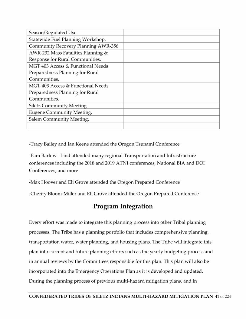
CONFEDERATED TRIBES OF SILETZ INDIANS MULTI-HAZARD MITIGATION PLAN 41 of 224
Season/Regulated Use.
Statewide Fuel Planning Workshop.
Community Recovery Planning AWR-356
AWR-232 Mass Fatalities Planning &
Response for Rural Communities.
MGT 403 Access & Functional Needs
Preparedness Planning for Rural
Communities.
MGT-403 Access & Functional Needs
Preparedness Planning for Rural
Communities.
Siletz Community Meeting
Eugene Community Meeting.
Salem Community Meeting.
-Tracy Bailey and Ian Keene attended the Oregon Tsunami Conference
-Pam Barlow –Lind attended many regional Transportation and Infrastructure
conferences including the 2018 and 2019 ATNI conferences, National BIA and DOI
Conferences, and more
-Max Hoover and Eli Grove attended the Oregon Prepared Conference
-Cherity Bloom-Miller and Eli Grove attended the Oregon Prepared Conference
Program Integration
Every effort was made to integrate this planning process into other Tribal planning
processes. The Tribe has a planning portfolio that includes comprehensive planning,
transportation water, water planning, and housing plans. The Tribe will integrate this
plan into current and future planning efforts such as the yearly budgeting process and
in annual reviews by the Committees responsible for this plan. This plan will also be
incorporated into the Emergency Operations Plan as it is developed and updated.
During the planning process of previous multi-hazard mitigation plans, and in
CONFEDERATED TRIBES OF SILETZ INDIANS MULTI-HAZARD MITIGATION PLAN 42 of 224
conjunction with the Steering Committee, and through tribal departments, it was
agreed that current and future planning efforts will integrate the Tribal Natural Hazard
Mitigation Plan in to the plans that would simultaneously have an effect on one
another. Effort will be made so that this Plan will also be integrated into other FEMA
programs and initiatives that the Tribe is involved in, such as potential participation in
the National Flood Insurance Program or any other mitigation actions that the Tribe
would become a part of.
The plans and documents reviewed for integration include:
Tribal Comprehensive Plan
Emergency Operations Plan
Natural Resources Department Plans (Forestry, WWMP, et al.)
This Plan currently has:
No direct Emergency Action Plan for Residential Developments (Siletz, Lincoln City,
Salem, Eugene, Portland, et al.
• Emergency Response Plan for Tribal Health Clinic; Gwee Shut Rd.
• Evacuation Procedures for CTSI employees from all Administration Buildings; and
• Emergency Response Plan for Departments within the Chinook Winds Casino.
The Mitigation Plan will be incorporated into the Emergency Operations Plan as the
Mitigation component.
The tribal mitigation planning regulations are established in Title 44 Code of Federal
Regulations (CFR) §201.7 Tribal Mitigation Plans. In addition, Title 44 CFR §201.3(e)(3)
indicates that, “In order to be considered for the increased HMGP funding, the Tribal

CONFEDERATED TRIBES OF SILETZ INDIANS MULTI-HAZARD MITIGATION PLAN 43 of 224
Mitigation Plan must meet the Enhanced State Mitigation Plan criteria identified in
§201.5.” Those Enhanced State Regulations can be found in Title 44 CFR §201.5
Enhanced State Mitigation Plans.
Local
Lincoln County Natural Hazards Mitigation Plan, Revised 2017
https://www.co.lincoln.or.us/planning/page/natural-hazards-mitigation-plan
Lincoln County Community Wildfire Protection Plan, latest update, 2018
https://www.co.lincoln.or.us/planning/page/community-wildfire-protection-plan
State or Oregon Multi-Hazard Mitigation Plan
https://www.oregon.gov/lcd/NH/Pages/Mitigation-Planning.aspx
https://oregonhazardmitigationplan.weebly.com/index.html
https://www.oregon.gov/oem/hazardsprep/Pages/Hazard-Mitigation.aspx

CONFEDERATED TRIBES OF SILETZ INDIANS MULTI-HAZARD MITIGATION PLAN 44 of 224
3. Community Profile
Introduction
History and Culture
The Confederated Tribes of Siletz is a federally recognized confederation of 27 bands,
originating from Northern California to Southern Washington. Termination was
imposed upon the Siletz by the United States government in 1955. In November of 1977,
we were the first tribe in the state of Oregon and second in the United States to be fully
restored to federal recognition. In 1992, our tribe achieved self-governance, which
allows us to compact directly with the US Government. This gives us control and
accountability over our tribal programs and funding. We occupy and manage a 3,666
acre reservation located in Lincoln County, Oregon. We manage several resources,
including water, timber and fish.
Artifacts and historical documents are stored and displayed at the Siletz Tribal
Community (Cultural) Center. Our Cultural Specialist is Robert Kentta and the rest of
the Siletz Tribe Culture Department also is housed in the Community Center.
The Confederated Tribes of Siletz Indians is one of nine federally recognized Indian
Tribal Governments in the State of Oregon. The Confederated Tribes of Siletz Indians,
located in western Oregon, has 5,468 members who are governed by an elected nine
member council known as the Tribal Council. The Confederated Tribes of Siletz have a
rich history in Western Oregon that reflects hard work, perseverance and the desire to
be self-reliant. The Tribal Council consists of nine members elected by the General
Council to terms of three years. The Tribal Council shall elect from its membership a
Tribal Chairman, Vice Chairman, Secretary and Treasurer. The Tribal Council is
empowered to exercise all legislative authority, except that vested in the General
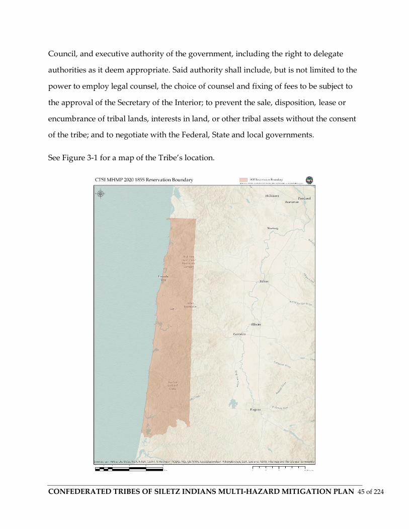
CONFEDERATED TRIBES OF SILETZ INDIANS MULTI-HAZARD MITIGATION PLAN 45 of 224
Council, and executive authority of the government, including the right to delegate
authorities as it deem appropriate. Said authority shall include, but is not limited to the
power to employ legal counsel, the choice of counsel and fixing of fees to be subject to
the approval of the Secretary of the Interior; to prevent the sale, disposition, lease or
encumbrance of tribal lands, interests in land, or other tribal assets without the consent
of the tribe; and to negotiate with the Federal, State and local governments.
See Figure 3-1 for a map of the Tribe’s location.

CONFEDERATED TRIBES OF SILETZ INDIANS MULTI-HAZARD MITIGATION PLAN 46 of 224
Map drawing from BIA Superintendent Joel Palmer ca. 1854

CONFEDERATED TRIBES OF SILETZ INDIANS MULTI-HAZARD MITIGATION PLAN 47 of 224
This section will discuss the geographic and climatic setting of the Tribe’s homeland
and define and discuss its lands, properties, facilities and infrastructure. This section
will also discuss the Tribe’s history, demographics and economy. This background
information is vital to understanding the Tribe’s exposure to natural hazards and its
resiliency in mitigating, preparing, responding and recovering from disasters.
Geographic Areas of Interest Tribal Ordinance- Siletz Tribal Code § 7.2
From the Siletz Tribal Code General Purpose of Interest
Statement of Purpose: The Confederated Tribes of Siletz Indians is a federally
recognized Indian Tribe (referred to as the "Siletz Tribe" for some purposes) which is
comprised of Indian tribes and bands and members of Indian tribes and bands who
were settled by the federal government on the "Siletz" or "Coast" Reservation
(hereinafter "Siletz Reservation"), from 1855 forward. Those tribes, bands, and persons
which were settled on the Siletz Reservation were and are possessed of legal and
customary rights of possession and use to those geographic areas in which they
historically resided and occupied, in addition to legal rights associated with such
tribes’, bands’ and persons’ settlement on the Siletz Reservation. These legal and
customary rights arise from many sources including, but not limited to, Anglo-
American legal principles. The Siletz Tribe is asserting and will assert these legal and
customary rights on behalf of the Tribe and tribal members.
(b) Standard of Interest. The Siletz Tribe has conducted an intensive investigation of the
historical and legal circumstances of the Tribe and of the tribes, bands, and persons who
make up the Siletz Tribe and its membership. The Siletz Tribe declares its interest in
those geographic areas where its investigation has shown a justifiable scientific and/or
legal connection to such areas.
CONFEDERATED TRIBES OF SILETZ INDIANS MULTI-HAZARD MITIGATION PLAN 48 of 224
Definitions
(a) "Ancestral lands" shall mean the traditional historical area of occupation of an Indian
tribe or band, and shall include the terms "ancestral lands," "aboriginal area" or
"aboriginal territory," and "ancient tribal lands" or "ancient tribal boundaries."
(b) "Pre-treaty times" shall mean that period of time pre-dating the negotiation of
treaties by the federal government with tribes, bands, and other groups of Indians
which occupied the lands of western Oregon, northwest California and southwest
Washington. For purposes of this Ordinance, pre-treaty times shall be defined as any
period of time prior to 1851.
(c) "Occupied" or "occupation" shall mean those lands upon which an Indian tribe, band
or group resided upon or used on a permanent, seasonal, or periodic basis. Use of such
lands includes regular or sustained use for any societal purpose, including but not
limited to residence; hunting, fishing, gathering, or other resource utilization; travel or
passage; ecosystem protection or health; culture; religious; and political purposes. It
shall not be a negation of occupation of lands under this section if a geographic area
was used only on an episodic basis or was not used for years at a time. "Occupation"
need not have been exclusive to any specific tribe, band or group of Indians, but must
have been of substantial importance to such tribe, band or group.
Governance
Once the Confederated Tribes of Siletz Tribe regained Tribal sovereignty, the Tribe
established the Constitution of the Confederated Tribes of Siletz Tribe and a structure of
ordinances, charters, and committees to guide their newly regained jurisdiction over
Tribal lands, businesses and community members. A nine member elected Tribal
Council (“Tribal Council” or “Council”) is the governing authority for the Tribe's

CONFEDERATED TRIBES OF SILETZ INDIANS MULTI-HAZARD MITIGATION PLAN 49 of 224
legislative and executive functions. The Board-appointed Chief Judge of the Tribal
Court oversees the Tribe's judicial matters. The Staff Attorney oversees all other legal
matters for the Tribe. The Tribe also has outside legal counsel.
One of the primary responsibilities of the Tribal Council is to ensure that all of the
Tribe's governmental functions are in accordance with Tribal law. Elected by Tribal
members at least 18 years of age, Council members serve staggered three year terms.
Tribal officers include a Tribal Chairperson, a Vice-Chair, a Secretary and a Treasurer,
any of whom can act as a spokesperson for the Tribe and Council. The Tribal Council
has authority to establish directives, committees, and advisory appointments when
appropriate to conduct Tribal functions. The Tribe has a Council appointed Tribal
Administrator (General Manager Brenda Bremner) and appoints this position to run the
Tribe's daily affairs. The positions appointed by Council, however, remain under the
Council’s general authority.
Elected Officials and Special Districts
The Confederated Tribes of Siletz is generally served by local and county services for
schools, police, and fire protection and emergency services. The Tribe utilizes local
utility providers such as Central Oregon Coast PUD for electrical and some water, City
of Siletz for water and sewer services in the City of Siletz, and a myriad of other
providers for additional services.
Elected Representation outside of the Tribal Council and Administration:
State of Oregon Governor
The Honorable Kate Brown - Democrat
Congressional District 5,

CONFEDERATED TRIBES OF SILETZ INDIANS MULTI-HAZARD MITIGATION PLAN 50 of 224
National:
Senior Senator
Ron Wyden
Democrat
Since Jan 1, 1996
Next Election in 2022
Junior Senator
Jeff Merkley
Democrat
Since Jan 6, 2009
Next Election in 2020
United States Representative in Congress, 5th District
Kurt Schrader - Democrat, Independent
Note these are the representatives for the Tribe’s lands within the Siletz, Newport, and
Lincoln County area. The Tribe’s Usual and Accustomed areas may be served by
additional districts and representatives.

CONFEDERATED TRIBES OF SILETZ INDIANS MULTI-HAZARD MITIGATION PLAN 51 of 224
3. Geography
The Confederated Tribes of Siletz Tribe current Reservation is located in present day
Lincoln County, with current tribal lands centered along the main stem of the Siletz
River, with Administration Buildings and Tribal Government also located along the
Siletz River in the City of Siletz as well, and communities existing between Siletz,
Newport, Toledo, Lincoln City, and timberlands within Lincoln County to the north
down to Waldport and beyond in the south and up the Alsea River. Lincoln County is
located in Western Oregon and covers an area of 1,194 square miles. Principal
industries of the county are travel (primarily tourism), trade, health services and
construction. Paper manufacturing and fishing are still important although they
contribute proportionally less to the county's employment than they used to. Newport
is one of the two major fishing ports of Oregon that ranks in the top twenty nationally
of fishing ports by fish landed and processed. Newport has averaged 105 million
pounds (48,000 tons) of fish landed in recent years. Newport is home of Oregon State
University's Hatfield Marine Science Center, as well as the Oregon Coast Aquarium,
and their fleet of ocean-going vessels. It is the federal West Coast hub for NOAA, EPA,
and USFWS Pacific Fleet and marine studies. Of the many protected areas within
Lincoln County, some include Oregon Islands National Wildlife Refuge, Siletz Bay
National Wildlife Refuge, and part of the Siuslaw National Forest. Over 50% of the land
area in Lincoln County is owned by the federal government. The US Forest Service and
the Bureau of Land Management manage most of these lands, alongside the United
States Fish and Wildlife Service managing a significant amount of the Coastal wetland
and estuarine environments, including Siletz Bay.

CONFEDERATED TRIBES OF SILETZ INDIANS MULTI-HAZARD MITIGATION PLAN 52 of 224
Fig. above Confederated Tribes of Siletz Land Ownership within 1855 Boundary
The Confederated Tribes of Siletz Tribal lands are generally defined as its 1855
Reservation Boundary, which includes part of the Tribe’s traditional pre-contact lands,
in addition to its Treaty Ceded lands (including Table Rock and southern Oregon Tribal
Areas at the mouth of the Illinois and Rogue Rivers, which were defined and ceded in
the 1850 era Treaties (including the 1851-1853 treaties, 1855 treaty, et al.) with the
United States, and its current Reservation and lands, which are Trust lands and other
properties, comprised of parcels mainly in Lincoln County.

CONFEDERATED TRIBES OF SILETZ INDIANS MULTI-HAZARD MITIGATION PLAN 53 of 224
Geology
Lincoln County is comprised of five to six major geologic types according to OGDC and
DOGAMI geospatial data. Four of the geological types converge near some of the main
land holdings in and around Siletz, Newport, and the rest of the Reservation lands in
the immediate area. The County wide area shows a larger diversification of geological
and land form, parent material, and soil types. See Figures ________________
Parent material and Soil maps located on CTSI website and maps attached in
appendices. The Natural Resources Conservation Service (NRCS) also provides the Web
Soil Survey (WSS), which was completed for this MHMP, and is also available through
the CTSI website, or at this locale https://websoilsurvey.nrcs.usda.gov/app/

CONFEDERATED TRIBES OF SILETZ INDIANS MULTI-HAZARD MITIGATION PLAN 54 of 224
Minerals and Soils
The soils present in Lincoln County are the acidic and leached products of weathering
in a moist temperate maritime climate under mixed species compositions and
coniferous forest cover. Sedimentary processes with tectonic events over epochs have
formed Siletzia, and other formations along the coastal areas in Lincoln County.
“Siletzia is the massive formation of early to middle Eocene epoch marine basalts and
interbedded sediments in the forearc of the Cascadia subduction zone; this forms the
basement rock under western Oregon and Washington and the southern tip of
Vancouver Island.[1] It is now fragmented into the Siletz and Crescent terranes. Siletzia
corresponds geographically to the Coast Range Volcanic Province (or Coast Range
basalts),but is distinguished from slightly younger basalts that erupted after Siletzia
accreted to the continent and they differ in chemical composition. The Siletzia basalts
are tholeiitic, a characteristic of mantle-derived magma erupted from a spreading ridge
between plates of oceanic crust. The younger basalts are alkalic or calc-alkaline,
characteristic of magmas derived from a subduction zone.This change of composition
reflects a change from marine to continental volcanism that becomes evident around 48
to 42 Ma (millions of years ago), and is attributed to the accretion of Siletzia against the
North American continent.
Various theories have been proposed to account for the volume and diversity of
Siletzian magmatism, as well as the approximately 75° of rotation, but the evidence is
insufficient to determine Siletzia's origin; the question remains open. The accretion of
Siletzia against the North American continent approximately 50 million years ago
(contemporaneous with the initiation of the bend in the Hawaiian-Emperor seamount
chain) was a major tectonic event associated with a reorganization of the earth's tectonic
plates.[8] This is believed to have a caused a shift in the subduction zone, termination of

CONFEDERATED TRIBES OF SILETZ INDIANS MULTI-HAZARD MITIGATION PLAN 55 of 224
the Laramide orogeny that was uplifting the Rocky Mountains, and major changes in
tectonic and volcanic activity across much of western North America. (Wells)
Much of the montaine soil in Lincoln County is characterized by variable thickness of
parent material, moderate to rapid runoff, and moderate to extreme erosion hazard in
some locales. Siletz Volcanics and Tyee soil formation along terraces above the riparian
zone soils have some area of high to moderate runoff and slight to high erosion
potential depending on the steepness of slope and vegetative characteristics. Lowland
soils in the Siletz Valley are the products of ongoing accretion and depositional events,
adfluvial depositional events, and oceanic deposition events on high wind high water
winter storm events. The deep alluvial soils are rich in minerals and Siletz volcanics
from from 50 mya provide some consistency to soil formation and loss along the
riverscape. (NRCS) The soils that are closer to the coastline have hazard qualities that
are far different than inland soils, due to the erosional properties of sand and the
physical characteristics of the parent material (e.g. tensile strength, porosity of coastal
parent material, liquefaction, weathering, etc.)
Potential soil related hazards include; landslides, shallow soils to water table, shallow
soils subject to deterioration and when they are inundated, towards mass erosion and
liquefaction, an earthquake related hazard where sandy silt soils turn from a solid state
to a liquid state as a result of stress and pressure.
Extraction based industrial forest management has created some additional landslide
and liquefaction areas wherein tree plantations have removed parent material
composition that allows for higher sheer and sheet stresses at shallower root
development locations. SLIDO data from the State of Oregon maps are shown in
exhibits ______

CONFEDERATED TRIBES OF SILETZ INDIANS MULTI-HAZARD MITIGATION PLAN 56 of 224
Rivers
Within the boundary of Lincoln County lies the majority of the Siletz River drainage
basin. The basin covers an area of approximately 373 square miles. This is unique for a
county boundary to entirely encompass a major river watershed. See Figure 3-3.
The Siletz Basin has a myriad of minor and major streams. The Siletz River, which
meanders westward and joins the Pacific Ocean near (south of) Lincoln City, Oregon.
The Siletz River flows roughly 67 miles from the headwaters at and above Valsetz . The
River drains an area of approximately 373 square miles. There are many major streams,
and some of the major tributaries include Eagle Creek, Buck Creek, Cedar Creek, Elk
Creek, Sunshine Creek, Palmer Creek, Baker Creek, Mill Creek, Euchre Creek, Big Rock
and Little Rock Creeks, Reed Creek, and many other smaller order streams. Stream size,
depths, discharge, and gradients in the basin vary greatly.
The Siletz River broken down in to sections for gradient, discharge, and classes:
Section: Moonshine Park to Sam Creek Bridge
Class: I II
Station #:14305500
USGS ID #:14305500
NWS ID: SILO3
Latitude: 44.71511720 Longitude:-123.88733480
Length : 7 miles
Gradient: 12 feet/mile

CONFEDERATED TRIBES OF SILETZ INDIANS MULTI-HAZARD MITIGATION PLAN 57 of 224
Elevation Lost: 84feet
Low Flow: 300 CFS
High Flow: 4000 CFS
Section: Elk Creek to Buck Creek
Class: III IV
Length: 4.5 miles
Gradient: 20 feet/mile
Elevation Lost: 100feet
Low Flow: 750 CFS
High Flow: 5000 CFS
Section: Buck Creek to Moonshine Park
Class: III IV V
Length: 6.5 miles
Gradient: 40 feet/mile
Elevation Lost: 260feet
Low Flow: 1000 CFS
High Flow: 6000 CFS

CONFEDERATED TRIBES OF SILETZ INDIANS MULTI-HAZARD MITIGATION PLAN 58 of 224
Section: Sam Creek
Class: I
Length: 10 miles
Gradient: 10 feet/mile
Elevation Lost: 100feet
Low Flow: 400 CFS
High Flow: 2000 CFS
On the Siletz, there is a gentle average gradient from Hee Hee Illahee at Siletz, to the
confluence of the Siletz River and Millport Slough, Drift Creek, and Schooner Creek at
Siletz Bay.
Tribal Lands and Property
The Tribe’s historical, culturally significant, and aboriginal Lands span all of Western
Oregon, parts of Northern California, and beyond. The original Coast Reservation is an
area approximately 1.1 million acres in size, spanning from Cape Lookout in the North
due east to the 8th Township line, and south to the mouth of the Siltcoos River. The
Tribe’s treaty ceded land is generally defined as the 1855 Coast Reservation (or the
Confederated Tribes of Siletz original Reservation, Coast Reservation, et al.) The Siletz
River basin between Siletz and the Salmon and Yaquina Watersheds is about 942 miles
in size (as estimated using georeferenced ESRI data and simple measuring of the
watersheds by CTSI GIS Staff).
Current Tribal Lands & Reservation

CONFEDERATED TRIBES OF SILETZ INDIANS MULTI-HAZARD MITIGATION PLAN 59 of 224
As of 2018-, Confederated Tribes of Siletz Tribal lands total about 15,800 acres
comprising 313 parcels. Properties are located in the towns and unincorporated areas
between Siletz, Lincoln City, Newport, Toledo, rural Lincoln County, Salem, Portland,
Eugene, and Douglas County. Most properties and development are located in the
Lincoln County area. Tribal housing developments are located in Siletz and Lincoln
City. Currently the Tribe has 15,147 acres of forest lands, and an additional 86 acres of
vacant/undeveloped land.
Trust Status
Historic Sites
The Confederated Tribes of Siletz Tribe’s aboriginal areas span all of Western Oregon to
Northern California. The lands have been inhabited since time immemorial, and until
the last several hundred years, the Tribes and Bands were interconnected by a vast and
established system of social and ecological balances with other tribes and trade and
potlatch society was regular with a network of routes joining the Pacific Northwest’s
Indigenous Peoples. For this plan, particular historical cultural locations are not
specifically identified for hazard analysis, although some of them lay within the
boundaries of the 1855 reservation, and also fall in to known critical analysis areas. The
Siletz Tribe and the many bands that makeup the Tribe have been here since time
immemorial, and the waters and land that make up Western Oregon area all sacred to
the Tribe.
Climate
In the Siletz Valley, the maritime influence from the Pacific Ocean creates the localized
climate for seasonal temperatures and rainfall. The precipitation and weather events
blow over the Coast Range, through the inland valleys, and up to the Cascade
CONFEDERATED TRIBES OF SILETZ INDIANS MULTI-HAZARD MITIGATION PLAN 60 of 224
Mountains. The maritime climate provides ample precipitation over the wet season, and
has high variability when considering the El Nino Southern Oscillation (ENSO) and
Pacific Decadal Oscillation (PDO). The coastal areas have the most moderate fluctuality
in between seasons, while the inland areas in Lincoln County have higher temperatures
in summer, and much lower, and often freezing and snowy winters in to the Coast
Range. The inland valleys experience the hottest summer sun, while the Cascades to the
East witness the most extreme winter temperatures and storms.
The ocean winds lose some of their velocity, and much of their moisture as they climb
the Coast Range and enter the inland valleys. Coastal Lincoln County receives the most
rainfall, reporting 100+/- inches per year at Cascade Head Scenic Research Area, and
over 100 inches per year in many locales within the Coast Range. Newport receives on
average 67 +/- inches of rain, and Siletz (as recorded) is near 70 inches per annum.
In summer, the average countywide temperature ranges between 52 and 70 degrees
Fahrenheit. In winter, the average temperature does not drop to far below 40 degrees
Fahrenheit very often, although some winter storms typically bring several inches of
snow every year. This temperature climate is due, in part, to the oceanic and maritime
climate brought by winds from the Eastern Pacific Ocean oscillations including the
(PDO). The protected coastal valleys are home to Elk, Deer, Black Bear, Cougar, Pine
Marten, and many other species. Dominant tree cover type remains Sitka Spruce,
Western Hemlock, Red Alder, Coastal Douglas Fir (including industrial tree plantation),
Western Red Cedar, and Big Leaf Maple. Here rainfall averages 67+ inches annually.
There is a steep gradient of rainfall differences from north to south in Lincoln County,
ranging from 100+ inches at Cascade Head Scenic Research Area in the North, to the
low 60’s south of Newport. This gradient is caused by topography and localized
oscillations off the Pacific Ocean. This maritime rainforest climate is marked with
comfortable winters with regular winter storms and winds reaching 100 mph, followed

CONFEDERATED TRIBES OF SILETZ INDIANS MULTI-HAZARD MITIGATION PLAN 61 of 224
by mild and wet Spring, and temperatures rarely reaching 100 in the Summer. Days
without frost generally occur between April and October. The first hard frost usually
does not arrive until December.
3. Tribal History
Today's members of the Confederated Tribes of Siletz Tribe are descendants of a people
who for thousands of years lived in the watersheds of the entirety of the Oregon Coast,
and areas far north and south of the Siletz River. Siletz Tribal ancestors signed a
number of treaties between 1851 & 1855 with the United States Government. The
earliest of these treaties to become ratified was the Rogue River Treaty of September 10,
1853. Nine days after this Rogue River Treaty was signed, a treaty was concluded with
our ancestors living in the Cow Creek drainage. The two treaties went side by side
through the complete process of being ratified by the U.S. Senate and being proclaimed
law by the President. They were both ratified on April 12, 1854 and proclaimed on the
5th of February 1855.The ancestral territory included more than 1,100,000 acres, which,
as part of their Treaty with the United States, was ratified on November 9th, 1855.
Finally, all of the correspondence and comments on BIA Superintendent Joel Palmer's
original request fell into place, and the Coast Reservation was established by an
Executive Order signed by President Franklin Pierce. This Treaty left the Tribe with the
entirety of the lands that span from Cape Lookout in the North, to the 8th Township line,
and south, to the mouth of the Siltcoos River. Shortly after signing the treaties, the
Confederated Tribes of Siletz people were forced onto already established reservation
lands; the Siletz Indian Reservation and the Grande Ronde Indian Reservation, north of
the Confederated Tribes of Siletz Tribe's traditional territory.
In 1954, the federal government terminated the Confederated Tribes of Siletz Tribe
before it gained official recognition and without prior notice to the Tribe. The

CONFEDERATED TRIBES OF SILETZ INDIANS MULTI-HAZARD MITIGATION PLAN 62 of 224
Confederated Tribes of Siletz Tribe, however, was recognized by the United States for
purposes of involuntary termination by the government. This resulted in the
Confederated Tribes of Siletz Tribe being restored in November 1977 by public law 95-
195. The Confederated Tribes of Siletz Tribe has subsequently made several land
purchases, and today the Tribe owns 15,780 acres of land in Oregon.
The Confederated Tribes of Siletz Indians offers many programs and services to eligible
tribal members. These services include housing, education, health, social and
employment services. Some programs and services have an income and/or residency
requirement to access. Others are provided, regardless of income or residency. Some of
the most common programs are listed in the tabs below. The Confederated Tribes of
Siletz has numerous services to offer our tribal members.
From Confederated Tribes of Siletz Written History: (Robert Kentta) It is difficult to say
who the earliest European was to spot our coastline from the deck of his sailing ship.
Whoever that first European was, it is possible that there had already been significant
changes our people had undergone, because of hemisphere-wide epidemics resulting
from Columbus' contact with native people on the east coast in 1492. Many foreign
governments competed for several centuries to explore & map the surface of the earth,
building vast empires by claiming "discovery rights" to all lands & resources they
encountered which didn't already have a strong, recognized European presence.
There is currently a debate going on about whether Sir Francis Drake's vessels made it
this far north in 1579. There is some pretty compelling evidence (Elizabethan coins
found in this area, etc.) and there are also lots of firsthand accounts & "pioneer folk
tales" of fifteenth century English swords and other paraphernalia being found here
locally. Whatever the earliest provable direct contact with our people was, it is clear that
if the people weren't already impacted by the influences (diseases) that contact on the
CONFEDERATED TRIBES OF SILETZ INDIANS MULTI-HAZARD MITIGATION PLAN 63 of 224
East Coast had transmitted, our ancestors were very soon to experience the ravages of
catastrophic deadly pandemics.
In an epidemic, there is a significant number of the population affected. In a pandemic,
all or nearly all of the population is affected. Beginning by at least the 1770's there were
a good number of direct contacts made between our people on the coast and the trade &
exploration ships. Smallpox was one of several diseases transmitted during these visits.
Our people had no resistance to these diseases, we have all heard this, but I don't know
if any of us can really understand the physical, social, cultural & political devastation
that was the effect. It is estimated that during each of the major pandemic episodes,
from 75% to 90% of the population was killed. In some localized areas, whole large
villages disappeared.
Although most of the trading contacts were in themselves peaceful, the Europeans, did
not consider the fact that they were in a foreign land and subject to local laws and
customs. Being very ethnocentric in their dealings with our people, and communicating
entirely through signs and gestures, misunderstandings quickly arose and the result
was sometimes bloodshed. The often rude manners of the visitors coupled with the fact
that it probably did not take our ancestors long to recognize the source of the
pandemics, probably quickly developed into a building and intense resentment among
many of our people. There are also signs of many of our ancestors being fairly forgiving
and endlessly friendly to the visitors, soon to be invaders. Trade along the coast
continued and intensified at intervals.
The first overland journey into our country was the Lewis & Clark Expedition in 1805.
They made many notes on the locations of major villages along the lower Columbia
River, their populations and other information. They noted that there were villages that
had been totally de-populated by disease. The houses were left standing, with the

CONFEDERATED TRIBES OF SILETZ INDIANS MULTI-HAZARD MITIGATION PLAN 64 of 224
people's bodies scattered about. No one was even left to bury the dead. It is hard to
relate to a disease carrying people off that quickly, but a tribal ancestor Hoxie Simmons
made comments that were recorded that told the story. He said that the people would
begin to feel ill, and would go into the sweathouse to try to break the fever. Then, as
was the custom, they would go jump in the river to cool off. The disease moved so
quickly, that he said many did not even make it back from the river.
The Fur Trade Era is often described as a friendly period of "free trade." That may have
been true in some cases, especially in the earliest phases. But, as soon the trappers got to
know the lay of the land & how to get from one place to another, they began engaging
us in economic warfare by running their own trap lines in our country, instead of
depending upon our people selling them furs. These were some of the early signs of
things to expect of the foreigners - taking without permission or apology.
In the early trade on the coast, the Spanish & Russians (as well as the British, Americans
& others) had been involved to some degree, but by the mid 1820's, the only two
remaining fur trade competitors were the Hudson Bay Co (British) and the Pacific Fur
Co. (USA). Fort Astoria (P.F. Co.) & Fort Vancouver (H.B. Co.) had been built as signs of
the political posturing that was the reality of the day. There were also many smaller
outposts & trap lines that were manned by employees of the fur companies.
While the US Constitution recognized our native people's right to our homelands
(Aboriginal Title), the United States also participated in constitutionally contradictory
political practices & subscribed to the same European concepts that permitted
colonization of foreign lands & peoples and empire building by European nations.
In 1832 there was an attack ordered on the Yaquinas by John McLaughlin, Chief Factor
at the Hudson Bay Co. post at Ft. Vancouver. This attack was brought on because two
HBC trappers were running a trap line in the Yaquina/Alsea territory without
CONFEDERATED TRIBES OF SILETZ INDIANS MULTI-HAZARD MITIGATION PLAN 65 of 224
permission of our local people. The trappers paid for their disrespect with their lives.
When news of their deaths reached Ft. Vancouver, John McLaughlin ordered some HBC
employees to teach the natives of the north central coast a lesson. He wasn't sure who
was even responsible, but thought that a reprisal anywhere in the neighborhood, issued
with sufficient force, would deliver the desired message.
This attack on a village at Yaquina Bay in 1832 (well documented in both HBC records
and our tribal oral histories) was brutal enough that it (combined with the epidemics)
was given as a reason that so few Yaquina people survived into the reservation period.
Some of the fur trappers & traders took Indian wives, such as Jean Baptiste Garnier on
the Umpqua River, and many of the fur company employees who stayed on in the
Willamette Valley. This eased some of the relationships in local areas, but strangers
stomping through our lands with little respect or humility were not welcomed.
As the fur trade era faded, many of the trappers turned farmer, & by the late 1830's
there were various missionary settlements revolving around the main Methodist
Mission at what is now Willamette University (Salem). A mission school for our
children of the valley was one of the first non-Indian structures in that part of the
valley. The relationships between our tribal people & the settlers changed slightly or
radically depending on the rate of population influx, and the main activity of the new
population, as the focus switched in different areas from fur trade to permanent
settlement activities.
It doesn't appear that our ancestors resisted settlement to the point that they thought
that all foreigners needed to be kept out, but instead tried to accommodate settlers who
were respectful. However, each year our people grew weaker in number as the
strangers grew stronger in number and presence. The signing of a treaty between Great
Britain and the United States in 1846, and the subsequent establishment Oregon

CONFEDERATED TRIBES OF SILETZ INDIANS MULTI-HAZARD MITIGATION PLAN 66 of 224
Territory, & a provisional government as a part of the United States would change the
form and direction that all future encroachment on our homelands would take.
– CTSI Historical Text
Tribal Member Population and Area Numbers
There are not accurate historical population counts available for many bands in the
early recorded history of the Tribe, it is however known those interactions with fur
trappers and traders and other Europeans in the 1700 and early 1800’s decimated entire
villages by introducing various diseases. According to a study of the Tribe’s population,
as of 2019, the Tribe included 5,468 members.
Of the 5,468 Tribal Members, the median age was 30. Of the 5,468 Tribal Members,
many resided in Lincoln County, 23% or 1,242 of the total population. A total of 3,187
Tribal Members live within the eleven county service area (Map of 11 county in
appendices) and more Tribal Members live in several other Oregon Counties (which
together with Lincoln County comprise the Tribe’s Service Area include all of Oregon)
as follows:
Clackamas County (188 members)
Multnomah County (299 members)
Washington County (121 members)
Marion County (654 members)
Polk County (74 members)
Yamhill County (61 members)
Benton County (76 members)

CONFEDERATED TRIBES OF SILETZ INDIANS MULTI-HAZARD MITIGATION PLAN 67 of 224
Lane (322 members)
Linn (135 members)
Tillamook (15 members)
Economic
In May of 1995, the Tribe completed the building of Chinook Winds Casino and Resort.
After intense planning and three years of negotiation at the local, state and federal level,
the Siletz Tribe opened a 10,000 square foot temporary facility known affectionately as
“The Tent.” With only 250 slots, 12 card tables and a small deli, “the tent” opened under
the name “Chinook Winds Gaming Center.” Meanwhile, just north of the temporary
facility, construction began on Chinook Winds’ current home. Just over one year later,
the grand opening of Chinook Winds Casino Resort’s permanent facility took place on
June 28, 1996. Later, STGC and STBC were established and created to take the lead in
making the Tribe economically self-sufficient. Working closely with the Tribal Council,
STBC manages and administers the Tribe's business ventures. And CWCR and STGC
are the most financially productive venue and single entity the Tribe owns.
The Confederated Tribes of Siletz Tribe is the largest employer in Lincoln County,
employing over 1,000 people. As of October 2019, about 73% of the Tribe's employees
work at Chinook Winds Casino and Resort (including the Golf Club and CWCR Hotel).
Tribal businesses account for one in every 20 jobs in Lincoln County, according to
census numbers of total jobs within Lincoln County.
Tribal Holdings, Facilities, and Administration Breakdown
Chinook Winds Casino and Resort
Tribal Administration (Buildings I and II in Siletz)
Area Office Buildings (Salem Area, Eugene Area, Portland Area)

CONFEDERATED TRIBES OF SILETZ INDIANS MULTI-HAZARD MITIGATION PLAN 68 of 224
Confederated Tribes of Siletz Health Clinic
Tenas Illahee Child Care Center
Siletz Tribal Headstart-
Chinook Winds Casino Resort
Chinook Winds Hotel
Chinook Winds Golf Resort
CTSI
Lincoln Shores Office Building
Salem Commercial Building (Harbor Freight Bldg)
The following are owned and/or operated by STBC:
Hee Hee Illahee RV Park
Logan Road RV Park
Toledo Mill Property
Depoe Bay Building
Salem Flex Office Building
Eugene Office Building
Gift shop in Lincoln City
Employees by Tribal Agency
CWCR/Golf Club/Hotel- 769
CTSI – 255 (Which includes temps, IAD, and non-employee Tribal Council members)
TICC - 17
STBC - 4
STGC – 11

CONFEDERATED TRIBES OF SILETZ INDIANS MULTI-HAZARD MITIGATION PLAN 69 of 224
A brief on Tribal Oral History and sharing on Hazards in the Tribe’s Aboriginal
Lands
There are lots of stories on natural disasters/phenomena handed down through the
generations of Siletz Tribal Members.
Landslides: Apparently even more recently in history than the devastating Ozette
landslide that suddenly covered and killed part of the Ozette Village in NW
Washington, there is at least one similar incident that covered/killed an entire village at
Whales Head on the SW Oregon Coast. An old woman was the first one up in the
village to the South one morning, and noticed there wasn’t any smoke visible, as should
have/always had been coming from that next village up the coast. She rousted others
and pointed that out. All the men went in canoes up the coast, and found that a
landslide had come down and covered/smooshed out into the creek-bed the entire
village - apparently during the night, as people were asleep - and so suddenly, that
nobody escaped. It was a place avoided afterwards. It was so shocking to the people
who found it - because they did not see an immediate cause - it just happened. The
story teller who passed this down in the 1940’s said: those people thought “perhaps the
Illahee shake, but they did not know it” (maybe there was an earthquake that they
didn’t feel) - in trying to justify the loss of a whole village that way..... when it was not
an overly rainy period, etc. The people in the village to the south became known as
Nalh-Tene-Tun-ne (movement+trail+place+people (of)).... the trail that used to go from
that village to Whales Head Village was discontinued....and the new trail skirted
around that place, avoiding the whole area, instead going to the next village north.
There is another location up the Rogue where an apparently much older village site
deposit is eroding out from under a thick layer of “clay bank” - another apparent
devastating, village-killing landslide episode.

CONFEDERATED TRIBES OF SILETZ INDIANS MULTI-HAZARD MITIGATION PLAN 70 of 224
Floods/Tsunamis- Of course the Siletz People have flood stories - some so bizarrely
epic, that they may refer back to witnessing the Missoula Floods (a series of extreme
Flood events that inundated the Willamette Valley, over a thousand years or so - when
gigantic ice dams broke in what is now Montana, sending millions of acre-feet of water
rushing down the Columbia. Those floods, created the broad, flat, Willamette Valley
floor, dropping an unimaginable combined sediment load - accumulating in-totals of
hundreds of feet in some places. Ice-Age megafauna remains (Mammoth, etc.) are
frequently found deep in these sediments, sometimes appearing to have been deposited
there as dis-articulated (ripped apart) megafauna, who were caught in the flood and
killed, their corpses being shredded by the violence, and body parts washing up, or
sinking to the bottom when waters stilled..... and being trapped in the new sediments -
and hence good preservation - yet of not-complete individual animals.
Stories like “The Inland Whale” - also may harken to extreme flood events.
Many of what are told as “Flood” stories may also be Tsunami remembrances - because
that is how they are usually experienced - as a (seemingly) never-ending incoming
tide.... some Tribal origin stories lay down the foundation of creation - the time of
people being created, and then at some (Later) time period, an epic flood or tide comes
and floods nearly the entire known “world” mountaintops and canoes are the refuge of
a few individuals who come together after this event and form the foundations of all
future generations for those people.
South Wind Woman: Out most violent winds are generally associated with weather
events/storm systems coming out of the South. Tillamook people oral traditions call this
“South Wind Woman” in stories. A character who wreaks havoc.
Wildfires: many wildfires are recorded in our oral histories. Extreme 1846-48 Wildfires
in the Siuslaw/Alsea district, and some of our Alsea people being trapped on the coast -

CONFEDERATED TRIBES OF SILETZ INDIANS MULTI-HAZARD MITIGATION PLAN 71 of 224
nearly roasted alive on the bare rocks at mouth of Cape Creek near (now) Heceta
Lighthouse..... (Lhtowaisk - “the protected place”) are recorded in an (eye witness) oral
history collected at Siletz in the early 1900’s and published in Alsea Texts by Leo J.
Frachtenburg.
Our old people of early settlement period knew wild-fires. Much more of the country
had been maintained with “prescribed burns” used to keep berry picking places
cleaned up and in peak production, hunting areas/forage good, traditional food patches
such a Camas, Tarweed Seed, Acorns (and many others) in peak production. The
epidemics reduced populations so drastically that much of the country was suddenly
not Maintained - became quickly brushy - full of accumulating ladder fuels - that had
been frequently handled with low intensity burns at appropriate seasons before.
Early settlers in the inland valleys caused many of the devastating fires that came in this
period - clearing land, clearing land - was their cause. They set fires at inappropriate
times to create new/better forage for livestock, clear brush and timber for homes and
farms, didn’t care what havoc or loss of life it meant for Tribal peoples in the Coast
Range, or Cascades.
Our people burned for many reasons, at different and appropriate seasons, often setting
low, crawling/scorching fires that were set so frequently (most years annually) and as
the people were leaving mountain berry picking grounds for the year in the Fall (for
instance) - that there were low fuel loads, and wet weather and eventually snow
controlled and put out these fires over the Fall/Winter, even if they crawled into denser
fuels before going out.
Today’s conifer forest oriented - tree farming practices have thrown this whole region
into an unsafe condition. Meadows are non-existent or not maintained as fuel breaks,
mountain ridge berry grounds are not maintained as open fuel breaks, headlands on the

CONFEDERATED TRIBES OF SILETZ INDIANS MULTI-HAZARD MITIGATION PLAN 72 of 224
coast want to have million dollar homes with multi-million dollar views, rather than
leave those as open (maintained by fire) coastal hillside prairies....
Confederated Tribes of Siletz Indians Asset Inventory
ASSET INVENTORY
Developing an asset inventory is the first step of a vulnerability analysis. CTSI assets
that may be affected by hazard events include population, residential and
nonresidential buildings, critical facilities, and infrastructure. Only specific facilities
need insurance due to CTSI's limited infrastructure and widely dispersed locations;
these facilities were identified within each hazard's profile.
The asset inventory delineates the Tribe’s existing building and infrastructure assets
and insured values and are identified in detail. Asset Inventory listed below portrays
the population and residential and non-residential structures numbers and values, and
their potential vulnerability by hazard type (where available).
3. Buildings and Critical Facilities
Buildings
Using the Tribe’s Insurance Statement of Values for 2019, an analysis of tribal buildings
and facilities was conducted by GIS Analyst Ian Keene and DOGAMI/FEMA personnel.
In total, it was determined that the Tribe had 234 buildings valued at approximately $
72,987,378. These 234 buildings, including Chinook Winds Casino and Resort, Toledo
Mill Site, Administration Buildings in Lincoln City and Siletz, HUD-built homes for
tribal members, and other residences and Tribal Buildings are all located in Lincoln
County, and do not include the Siletz Tribe’s Portland, Salem, and Eugene real estate
holdings. Other structures include the Tribal Administration & Health Clinic buildings

CONFEDERATED TRIBES OF SILETZ INDIANS MULTI-HAZARD MITIGATION PLAN 73 of 224
in Siletz, USDA and Fleet Vehicle, Public Works Shops and Buildings, and the Fish
Hatchery Buildings and infrastructure.
The remaining structures are used for tribal businesses, investments and facilities.
These buildings include office buildings in Lincoln City and Depoe Bay, residential
tracts in Siletz, barns and other farm related structures on several properties towards
Logsden, storage facilities at the Dundas Property on Logsden Road, other homes with
garages and sheds, back-up generators and other miscellaneous structures. The most
valuable structure is the $44,990,000 Chinook Winds Casino and Resort, with the
remaining structures worth about $28,600,000 (according to HAZUS analysis of value,
Insurance Values are considerably higher)a.
The Fish Hatchery and associated Timber Lands in Lincoln County were not a part of
the Critical Facilities list, nor are the Timberlands associated with economic losses
within the HAZUS software platform and subsequent analysis performed for
consideration while pursuing FEMA funding for hazard mitigation planning.
Planning and Technical Meetings
The Steering Committee along with FEMA personnel held technical review meetings in
May, June, July, August, September, and October of 2018
As an example of what was reviewed during these workshops below is from July
meeting
From July 17, 2018
FEMA Technical Assistance Workshop #2
Technical Assistance Workshop #1 recap:
Described the hazard mitigation planning process and FEMA requirements

CONFEDERATED TRIBES OF SILETZ INDIANS MULTI-HAZARD MITIGATION PLAN 74 of 224
Defined mitigation
Began to identify critical facilities, essential infrastructure, and locations of
cultural value
Distributed the Capability Assessment Worksheet to be completed by members
of the planning team
Standalone Plan:
It was agreed upon by the planning team and tribal council that the tribe will
update its own, standalone Tribal Hazard Mitigation Plan
It was agreed upon that tribal lands and properties in the Portland, Salem, and
Eugene areas are adequately covered by existing hazard mitigation plans for
those areas and will not be a part of the planning area for this plan
Risk Assessment:
Ian Keene passed out demographic data, a report by CTSI Planning, and an
Oregon State University report on climate change impacts describing potential
hazards to water resources
Ian displayed GIS-based hazard information with the planning team to identify
areas at risk to various hazards. He provided additional materials (maps, data,
reports, etc.) to the planning team via e-mail at the end of the workshop
Analysis for next steps:
The planning team needs to complete the hazard inventory and risk assessment
work:
CONFEDERATED TRIBES OF SILETZ INDIANS MULTI-HAZARD MITIGATION PLAN 75 of 224
o See the Risk Assessment notes taken by Amanda Siok (FEMA, Mitigation
Planner), to support the plan’s update to the risk assessment
Homework:
o Complete and compile the capability assessment discussed during
workshop 1
o Develop “Problem Statements” in advance.
o Determine how/when the public will be engaged in the planning process
(required for FEMA hazard mitigation plan approval). The group
discussed potential public input opportunities as:
Ask the public (via booth at existing event) what hazard/disaster
the tribe should be more resilient to
Ask the public for suggestions on how to reduce the risk to ____
Hazards (planning team chooses 1-3 hazards for public input).
(Bullet 1 and 2 could be combined for one outreach activity)
Ask the public to vote on the top 5-10 mitigation strategies

CONFEDERATED TRIBES OF SILETZ INDIANS MULTI-HAZARD MITIGATION PLAN 76 of 224
Critical Facilities
"Critical facilities" are defined as those structures from which essential services and
functions for victim survival, continuation of public safety actions, and disaster
recovery are performed or provided. Shelters, emergency operation centers, public
health, public drinking water, sewer and wastewater facilities are examples of critical
facilities. Though not explicitly included in the definition, supporting life-line
infrastructure essential to the mission of critical facilities must also be included in the
inventory when appropriate. Some essential economic-generating facilities may also be
considered.

CONFEDERATED TRIBES OF SILETZ INDIANS MULTI-HAZARD MITIGATION PLAN 77 of 224
For this inventory, the Tribe’s critical facilities are shown in the Table below
Critical Assets List for Tribal Council Meeting (5/17/19)
In the table below is a comprehensive list of critical assets that the Multi Hazard
Mitigation Plans’ Steering Committee compiled. These assets were compiled by tribal
member survey responses, steering committee survey responses and previous listed
assets on our previous MHMP.
*Note - Future plan updates can list additional assets if CTSI administration, Tribal
Council, and/or Tribal Staff consider that a critical asset has either been omitted, built,
and/or added to the Tribal list of assets
ASSETS Number of Committee Votes
Chinook Winds Hotel 7
Casino 6
Lincoln Shores (STBC/STGC) 5
Administration Bldg. 1 8
Administration Bldg. 2 5
USDA Bldg. 5
Gas Station 6
Community Center 6
SR 229 6
Siletz Community Health Clinic 12
Tribal Housing Units 6
Water Distribution System 9
Cultural Repository 6
Public Works Bldg. 7
Siletz Charter School & Head Start 9
Child Care Center 5
Siletz Valley Fire Department 7
*Please note that these facilities may include multiple structures.

CONFEDERATED TRIBES OF SILETZ INDIANS MULTI-HAZARD MITIGATION PLAN 78 of 224
4. Risk Assessment
Introduction
This chapter will identify the potential natural hazards that could affect the
Confederated Tribes of Siletz Tribal Members and Administration Area within the
Coastal Counties, namely and mainly Lincoln County, but not to be limited to Coos,
Tillamook, Linn, Benton, Lane, Marion, Polk, and more. The plan is to assess the
vulnerabilities of its people, property and natural environment, simultaneously for
CTSI, Siletz Tribal Business Corporation (STBC), and the Siletz Tribal Gaming
Commission (STGC).
The geographic focus of the Risk Assessment was the Tribe’s Lincoln County holdings,
but also including in this plan is analysis that included areas within the Tribe’s 1855
Coast Reservation boundary. The HAZUS and data analysis is also namely Lincoln
County area land holdings. The Siletz River watershed and the remainder of
watersheds in Lincoln County with attention and analysis focused on the Siletz,
Newport, Toledo, and Lincoln City areas along the Highway 101 corridor, and in the
Township of Siletz, where the majority of Tribe’s facilities and properties are located.
Hazards Profiled
Risk assessments that provide the factual basis for activities proposed in the strategy
portion of the mitigation plan. Statewide risk assessments must characterize and
analyze natural hazards and risks to provide a statewide overview. This overview will
allow the Tribe to compare potential losses throughout the Tribe’s known area, and to
determine our priorities for implementing mitigation measures under the strategy, and
to prioritize jurisdictions for receiving technical and financial support in developing
more detailed local risk and vulnerability assessments. The risk assessment shall
CONFEDERATED TRIBES OF SILETZ INDIANS MULTI-HAZARD MITIGATION PLAN 79 of 224
include the following (Per FEMA CFR [67 FR 8848, Feb. 26, 2002, as amended at 67 FR
61515, Oct. 1, 2002; 69 FR 55096, Sept. 13, 2004; 72 FR 61565, 61738, Oct. 31, 2007; 79 FR
22883, Apr. 25, 2014; 79 FR 76085, Dec. 19, 2014; 80 FR 59551, Oct. 2, 2015]
(i) An overview of the type and location of all natural hazards that can affect the
Tribe, including information on previous occurrences of hazard events, as
well as the probability of future hazard events, using maps where
appropriate;
(ii) An overview and analysis of the State's vulnerability to the hazards described
in this paragraph (c)(2), based on estimates provided in local risk assessments
as well as the Lincoln County risk assessment performed by Matt Williams
and DOGAMI and Oregon State risk assessment. The State shall describe
vulnerability in terms of the jurisdictions most threatened by the identified
hazards, and most vulnerable to damage and loss associated with hazard
events. State owned or operated critical facilities located in the identified
hazard areas shall also be addressed;
(iii) An overview and analysis of potential losses to the identified vulnerable
structures, based on estimates provided in local risk assessments as well as
the State risk assessment (HAZUS performed by CTSI and State employees).
The State shall estimate the potential dollar losses to State owned or operated
buildings, infrastructure, and critical facilities located in the identified hazard
areas.
ASSET INVENTORY
Developing an asset inventory is the first step of a vulnerability analysis. CTSI assets
that may be affected by hazard events include population, residential and
nonresidential buildings, critical facilities, and infrastructure. Only specific facilities
need insurance due to CTSI's limited infrastructure and widely dispersed locations;
these facilities were identified within each hazard's profile.
The asset inventory delineates the Tribe’s existing building and infrastructure assets
and insured values and are identified in detail in Tables ________ portray the
population and residential and non-residential structures numbers and values, and
their potential vulnerability by hazard type (where available).

CONFEDERATED TRIBES OF SILETZ INDIANS MULTI-HAZARD MITIGATION PLAN 80 of 224
Siletz Tribal Business Cooperation (STBC)
Buildings and Critical Facilities
Buildings
Using the Tribe’s Insurance Statement of Values for 2019, an analysis of tribal buildings
and facilities was conducted by GIS Analyst Ian Keene and DOGAMI/FEMA personnel.
In total, it was determined that the Tribe had 234 buildings valued at approximately
$72,987,378. These 234 buildings, including Chinook Winds Casino and Resort, Toledo
Mill Site, Administration Buildings in Lincoln City and Siletz, HUD-built homes for
tribal members, and other residences and Tribal Buildings are all located in Lincoln
County, and do not include the Siletz Tribe’s Portland, Salem, and Eugene real estate
holdings. Other structures include the Tribal Administration & Health Clinic buildings
in Siletz, USDA and Fleet Vehicle, Public Works Shops and Buildings, and the Fish
Hatchery Buildings and infrastructure.
The remaining structures are used for tribal businesses, investments and facilities.
These buildings include office buildings in Lincoln City and Depoe Bay, residential
tracts in Siletz, barns and other farm related structures on several properties towards
Logsden, storage facilities at the Dundas Property on Logsden Road, other homes with
garages and sheds, back-up generators and other miscellaneous structures. The most
valuable structure are the $44,990,000 Chinook Winds Casino and Resort, with the
remaining structures worth about $28,600,000 (according to HAZUS analysis of value,
Insurance Values are considerably higher). The total values listed for the HAZUS data
analysis were mentioned above, and do not reflect the values listed with CTSI insurance
policies, and are not considered to be a valuation of CTSI holdings.
The Fish Hatchery and associated Timber Lands in Lincoln County were not a part of
the Critical Facilities list, nor are the Timberlands associated with economic losses
within the HAZUS software platform and subsequent analysis performed for
consideration while pursuing FEMA funding for hazard mitigation planning.
Below is a list of Property names owned by CTSI: (for further information on individual
properties relating to Mitigation Planning contact the CTSI Planning Department)
Siletz Area

CONFEDERATED TRIBES OF SILETZ INDIANS MULTI-HAZARD MITIGATION PLAN 81 of 224
Aldridge
Bagley
Bishop (part of "BBS")
Briley (part of "BBS"
Burnham
Burnham 2
Collson
Crawford (Buford)
Dickenson (Oak Flats)
Oak Flats Development
Dundas
Eight-Plex
Faulkner
Faulkner House
Gomes
Government Hill
Grimstad
Grooms
Hueth
Hursh
Jebert
Judd
Silatchee Development
CONFEDERATED TRIBES OF SILETZ INDIANS MULTI-HAZARD MITIGATION PLAN 82 of 224
Chetco Playground
Cell Tower
Judd Siding Replacement
Judd Home Wat. Meters Replmnt.
STHD 17 Units
Judd Sidewalks
Silatchee Park & Tootootney Improvements
Mitchell
Metcalf
Miller
Muschamp
Nashif
Paul Washington Cemetery
Seitz (part of "BBS")
Sexton
Trask (Meat Lockers)
Vearl Ray
Wood (Mini Mart)
Lincoln City Area
Chinook Winds Resort
Hemstreet Parking Lots
Lakeside Golf Course
Lakeside Village

CONFEDERATED TRIBES OF SILETZ INDIANS MULTI-HAZARD MITIGATION PLAN 83 of 224
Lincoln Shores (Casino)
Lincoln Shores Offices
Logan Road
Lot 57
Mast
Morris Cemetery (Lincoln City Cemetery)
Otis Cemetery
Teeny
Toledo Area
Toledo Mill
Depoe Bay Area
Neptune's Reserve
Seal Rock Area
Lyford
Portland
Portland Area Office
Salem
Chemawa
Robertson
Wyant
Wyant 2
Eugene
Eugene Area Office

CONFEDERATED TRIBES OF SILETZ INDIANS MULTI-HAZARD MITIGATION PLAN 84 of 224
Timberlands
229 West (Fisher)
Arnold Creek
Arnold II
Camp 12 (Cutsforth)
Coop (Bulls Bag)
Hatchery I & II
Lower 5 Mile
Reed Creek
Tahkenitch A
Tahkenitch B
Tahkenitch C
Tahkenitch D
Tahkenitch E
Timberlands
South Diamond
North Diamond
Blue Jay, Gunn Creek, Lower Gorge, Red Ant
North Fork Falls
South fork,
Sugas Hill
Burbank Creek
Mill Creek

CONFEDERATED TRIBES OF SILETZ INDIANS MULTI-HAZARD MITIGATION PLAN 85 of 224
Cerine Creek
Headwaters
Dry Creek
Brush Creek
Little Rock Creek
Bryant Creek
Sam Creek
Twin Bridges
Section Eight
Northon Hill #1 & #2
Long Sam
Long Prairie #` & #2
Thayer Creek
Thornton Creek
Bale Creek
Yaquina
Long Tom
Twenty Three Creek
Pioneer Mountain
Ollala
Cook Creek
Truman - Calhoun
Other Areas

CONFEDERATED TRIBES OF SILETZ INDIANS MULTI-HAZARD MITIGATION PLAN 86 of 224
Harney/Evans Cemetery
Medicine Rock
Collamer 1/2 Interest
Bishop
Gas Station
The first step in preparing a risk assessment for the Confederated Tribes of Siletz is to
identify which natural hazards affect the Tribe. Numerous documents, including the
Lincoln County Natural Hazards Mitigation Plan, The Fire Planning documents from
Lincoln county and Oregon Department of Forestry, the State of Oregon Natural
Hazard Planning documents, and more were reviewed. The County encompasses most
of the Salmon, Siletz, and Yaquina Rivers and watersheds and thus the County Plan
analyzes Tribal areas within the scope of this plan as well. The jurisdiction of the Siletz
Tribe is not limited to the scope of this mitigation planning document, nor is this
mitigation planning document limiting the area in which the Tribe will choose to
operate in the future. Instead, like all planning documents, this mitigation plan update
is designed to offer a planning framework in which to operate from in the coming few
years.
Natural Hazard Risk Assessment
Fundamental to effective hazard mitigation is general and specific information related
to the nature, distribution, probabilities of occurrence, frequency, and severity of
historic hazard events. When linked to demographic, economic, infrastructure,
structural, and other societal data, risk evaluations and vulnerability assessments can be
performed. The amount, availability, and quality of information about different
hazards vary widely. Limited information for some hazards results in greater
uncertainty in the risk assessment for those hazards. This Multi-Hazard Mitigation
Plan is focused on natural hazard mitigation, and a separate effort to develop spill
prevention and response plan to address human-caused hazards on tribal property is
also needed.
The following assessment of natural hazard risks describes the nature and location of
past and potential natural hazard events, assesses the vulnerability of properties to each

CONFEDERATED TRIBES OF SILETZ INDIANS MULTI-HAZARD MITIGATION PLAN 87 of 224
hazard, estimates the value of structures and/or property in areas that are vulnerable to
hazards, and provides an analysis of the risk to life, property, economic activity, and the
environment that may result from natural hazard events on Tribal property. In the first
subsection, the natural hazards on Tribal property are identified. Each hazard is then
defined; past hazard events are described; the vulnerability of structures and facilities is
assessed; and the potential losses to these structures are estimated. In the final
subsection, the relative vulnerability of tribal property is summarized.
The Pre Disaster Mitigation program rules require tribes that are submitting a plan to
assess hazard risks by jurisdiction. Since the Siletz Tribe only has jurisdiction over land
held in trust by the US Government for the Tribe, this MHMP defines properties that
are currently owned by the Tribe including Reservation and non-reservation lands and
assesses and compares the relative hazard risks with each property. Furthermore, the
lack of other local jurisdictions including Lincoln County, City of Siletz, Lincoln City to
produce a hazard mitigation plan has prompted the Siletz Tribe to include tribally
owned lands under the jurisdiction of local governments in the hazard assessment.
Background information regarding risks to specific natural hazards was obtained from
the Oregon Emergency Management and Local Emergency management officials. These
documents were used to help determine the Tribe’s risk to each hazard.
After a brief description of the methods used to identify hazards in each assessment
area and the methods used to conduct a vulnerability assessment for each hazard, the
remainder of this section addresses each of the natural hazards of concern on all Tribal
properties. Profiles of past events, an assessment of vulnerability, and potential losses
are presented for each of the natural hazards.
Hazard Identification and Vulnerability Assessment Methodologies and Analysis
The Planning Department took the following steps to identify hazards that have
affected the CTSI Properties in the past and/or can be expected to affect CTSI properties
in the future:
Review of past state and federal disaster designations;
Review of regional hazard information and analyses prepared by state, federal,
and reports prepared by university researchers at multiple Universities in the Pacific

CONFEDERATED TRIBES OF SILETZ INDIANS MULTI-HAZARD MITIGATION PLAN 88 of 224
Northwest; including the use of HAZUS and FEMA software coninciding with
DOGAMI/USGS/NOAA/OSU/USFWS/BLM/USFS/et al. Geospatial databases
Review of Internet web sites containing regional hazard information;
Review of the Oregon State Natural Hazards Mitigation Plan 2015, the FEMA
Region X analysis documents and interactive webmaps, and the Lincoln County
Vulnerability Analysis (DOGAMI 2019) and many regional planning documents (as
aforementioned wildfire plans from ODF and Lincoln County Fire, et al.)
Review of the Revised Preliminary 1990 Flood Insurance Rate Maps and Digital
Q3 Data (FEMA 1990); Siletz River Flood History (State of Oregon 2017); Siletz Bay
Conservation Plan 2013, et al.
Information acquired from the materials listed above was also used to estimate the
vulnerability of CTSI properties to each hazard. This information included the
probability of occurrence of hazard events, the types of damage associated with a
hazard, and the relative vulnerability of each property. After compiling this hazard
information, areas vulnerable to the hazards were identified. The estimated relative
levels of vulnerability for each hazard assessment area were based on the following
factors:
• Probability of damage resulting from a large hazard event;
• Types of damage associated with the hazard;
• Historic and/or potential severity of damage;
• Potential damage relative to other hazards; and
• Vulnerability of each property.
The relative probability of hazard occurrence (between hazards) is not reflected in the
vulnerability assessments. For example, although the floodplain assessment area was
rated as having a high vulnerability to both floods and earthquake, it is much more
likely to be affected by floods. The ratings for each hazard therefore reflect the
estimated vulnerability if a large hazard event occurs. In addition, the amount of
development in each assessment area was not factored into the estimated vulnerability
CONFEDERATED TRIBES OF SILETZ INDIANS MULTI-HAZARD MITIGATION PLAN 89 of 224
for an area. Different levels of development are reflected in the estimated potential
losses for each area, highly developed areas have greater potential losses.
The Lincoln County MHMP analyzed hazards to see if they affected the county region.
The Tribe chose to analyze much of the same hazards, as they coincide territorially and
contiguously. CTSI hazards chosen were as follows:
• Flood
• Severe Winter Storms
• Earthquake
• Tsunami
• Windstorm
• Wildfire
• Landslide
• Coastal Erosion (where applicable, and not a full HAZUS analysis was conducted for
this hazard)
State of Oregon NHMP:
https://www.oregon.gov/lcd/nh/pages/mitigation-
planning.aspx?utm_source=LCD&utm_medium=egov_redirect&utm_campaign=https%
3A%2F%2Foregon.gov%2Flcd%2Fhaz%2Fpages%2Fnhmp.aspx
Further analysis was conducted to identify which of these hazards specifically affect the
Confederated Tribes of Siletz Tribe. The study was conducted by analyzing data and
maps from a wide range of sources, including State of Oregon GIS hazard data layers
and FEMA floodplain maps, and by interviewing Tribal, county, and local officials.
The Tribe’s main Administration buildings and Tribal residential areas are located in a
river valley, with some part of the buildings located in the 500 year floodplain. The
administration sits 4 miles inland from the coast and, at Siletz, the majority of the
township is at or above 100 feet elevation above sea level. Severe Winter Weather and
Windstorms, Wildfire, Tsunami, Landslide/Liquefaction, and Flooding all with having

CONFEDERATED TRIBES OF SILETZ INDIANS MULTI-HAZARD MITIGATION PLAN 90 of 224
some sort of potential overlap in both data manipulation depending on the model, and
or in the essence of a winter storm, usually flooding, landslide, and other hazards may
be compounding factors.
Each hazard profile is broken down into the following sections:
Definitions: a primer of some of the key terms used in the study of the hazard, as listed
and analyzed by CTSI, or other federal agencies and defining bodies.
General Background: a general overview of the causes and effects of the hazard,
focusing on the geological and climatological conditions needed to create the hazard.
Hazard Profile: A detailed profile of the hazard as it affects the Tribe. It is broken down
into the following headings:
Location: Where in the study area the hazard could impact people, property and the
natural environment;
Extent: How severe or destructive the event could be to CTSI properties and or
infrastructure, buildings, or other critical facilities to Tribal Members and the
surrounding area.
Past Events: A review of past hazard events in the study area; and
Probability: How often a severe event can occur and the likelihood it will occur in the
future.
Vulnerability Assessment: This section will describe the Tribe’s vulnerability to each
hazard, including its impact on the Tribe’s infrastructure, buildings, houses and critical
facilities. The amount, type and values of structures will be discussed if information is
available. Land use, current and future, within the hazard area will also be discussed.
Cultural and Historic Sites
For MHMP planning, both this Plan and CTSI’s previous plans, specific cultural and
historic sites are not identified specifically or analyzed for hazard exposure and
vulnerability. This is both for reasons of keeping classified and confidential sites still
classified, and also to protect those sites from intrusion. Certain locations, such as
Medicine Rock, cultural fishing sites that are published, family burial grounds and
other known areas, were mentioned by some survey respondents in listing as critical

CONFEDERATED TRIBES OF SILETZ INDIANS MULTI-HAZARD MITIGATION PLAN 91 of 224
assets, during Steering Committee meetings and in additional surveys as areas of
concern or areas that some members would like listed. Those cultural sites and areas of
concern are regardless, held by the Tribe and members to be critical as assets even when
not listed explicitly.
The tribe’s Natural Resource and Culture Department will continue to identify areas
and locations of Tribal cultural and historic value and will identify, internally, any
potential hazards exposure and vulnerability. In general, all historic and cultural sites
are considered exposed and vulnerable to all of the hazards discussed in this Risk
Assessment.
Tribal Critical Facilities, Exposure and Vulnerability
Table ________ discusses the exposure and vulnerability of tribal structures to natural
hazards. Vulnerability was ranked by
High: high probability, high risk to damages from natural events
Moderate: has some risk from natural events, either located in hazard area or has
structural issues
Low: infrequent risk, newer structures and/or located outside of zones
Comments about vulnerability for each structure (if applicable) are also shown in the
Table.

CONFEDERATED TRIBES OF SILETZ INDIANS MULTI-HAZARD MITIGATION PLAN 92 of 224
Tribal Facilities Exposure & Vulnerability Assessment
*The following tabular format will show properties listed under the Tribes
HAZUS and Geospatial analysis conducted by CTSI GIS Anaylst Ian Keene and
DOGAMI Personnel at the State of Oregon *Data analyzed using HAZUS
Earthquake
Definitions
Cascadia Subduction Zone from USGS
Two Contrasting Models of Lithospheric Structure
The subduction of the Juan de Fuca plate beneath North America changes markedly
along the length of the subduction zone, notably in the angle of subduction, distribution
of earthquakes, volcanism, geologic and seismic structure of the upper plate, and
regional horizontal stress. To investigate these characteristics, we conducted detailed
density modeling experiments of the crust and mantle along two transects across the
Cascadia subduction zone. One crosses Vancouver Island and the Canadian margin,
and the other crosses the margin of central Oregon. Both density models were
constructed independently to a depth of approximately 50 km. We gathered all possible
geologic, geophysical, and borehole data to constrain the density calculations. The final
Earthquake Damage from CSZ M9.0
Community
Total Number of
Buildings
Total Estimated
Building Value
Sum of
Economic Loss Loss Ratio
Total
Population
Number of
Displaced
Population
Percent of
Displaced
Population
Depoe Bay 1 193,440 52,352 27% 0 0 0%
Lincoln City 25 44,990,275 8,432,106 19% 60 9 15%
Siletz 167 21,450,304 5,631,692 26% 432 177 41%
Timberlands 3 22,669 2,548 11% 0 0 0%
Toledo 17 868,404 527,822 61% 0 0 0%
Regional Offices 5 5,462,286 N/A N/A 0 0 0%
Total 218 72,987,378 14,646,520 22% 492 186 38%

CONFEDERATED TRIBES OF SILETZ INDIANS MULTI-HAZARD MITIGATION PLAN 93 of 224
densities for the Oregon and Vancouver lithosphere models were obtained from gravity
inversions.
Our results confirm that the downgoing slab of the Cascadia subduction zone dips
significantly steeper beneath Oregon than beneath Vancouver Island, lending support
to the idea that the Juan de Fuca plate is segmented from north to south. In addition,
our gravity models indicate that the mantle wedge beneath western Oregon (i.e., below
the western Cascades) is lighter than the mantle beneath the Canadian continental crust.
This low density agrees with the low mantle velocities observed in the mantle and the
present day extensional regime of the Pacific Northwest.
A gravity low at the deformation front of the Oregon margin, absent along the
Vancouver margin, can be explained by the different bathymetry of the two regions and
by the depth to the top of the subducting Juan de Fuca plate. If the accretionary prisms
along these profiles were modeled with equal densities, a density inhomogeneity in the
lower part of the models would be necessary. Thus that the density of the accretionary
prism for the Vancouver profile must be approximately 0.1-0.2 g/cm3 greater than that
for Oregon. A density difference within the accretionary prisms also agrees with other
data. We note that the volume of accreted sediments is approximately twice as large
along the Vancouver profile than along the Oregon profile, and the prism reaches a
greater depth (approximately 20 km as compared with 12 km for the Oregon profile).
This implies that the sediments within the accretionary prism at Vancouver Island are at
a higher metamorphic grade, and therefore have higher densities.
We find that a substantial part of the coastal gravity maxima for both lines is caused by
increasing density with depth in the subducting plate. In the proposed model, the
maximum possible density of the slab was used to satisfy constraints for the average
density of the near coastal crust for both profiles. If a density increase with depth is not
introduced into the model, very high densities would be required for the near surface
coastal and continental crustal blocks.
Benioff Zone Earthquake: Sometimes called “deep quakes,” or Intraplate, these occur in
the Pacific Northwest when the Juan de Fuca plate breaks up underneath the
continental plate, approximately 30 miles beneath the earth’s surface.
Crustal Earthquake: Crustal quakes occur at a depth of 5 to 10 miles beneath the earth’s
surface and are associated with fault movement within a surface plate.

CONFEDERATED TRIBES OF SILETZ INDIANS MULTI-HAZARD MITIGATION PLAN 94 of 224
Earthquake: An earthquake is the shaking of the ground caused by an abrupt shift of
rock along a fracture in the earth such as a fault or a contact zone between tectonic
plates. Earthquakes are measured in both magnitude and intensity.
Intensity: Intensity is a measure of the effects of an earthquake. It is measured by the
Modified Mercalli scale and is expressed in Roman numerals.
Liquefaction: Liquefaction is the complete failure of soils, occurring when soils lose
shear strength and flow horizontally. It is most likely to occur in fine grain sands and
silts, which behave like viscous fluids when liquefaction occurs. This situation is
extremely hazardous to development on the soils that liquefy, and generally results in
extreme property damage and threats to life and safety.
Magnitude: Magnitude (M) is the measure of the strength of an earthquake, and is
typically measured by the Richter scale. As an estimate of energy, each whole number
step in the magnitude scale corresponds to the release of about 31 times more energy
than the amount associated with the preceding whole number value.
Peak Ground Acceleration: Peak Ground Acceleration (PGA) is a measure of the highest
amplitude of ground shaking that accompanies an earthquake, based on a percentage of
the force of gravity.
Subduction Zone Earthquake:
This type of quake, also called Interplate, occurs along two converging plates, attached
to one another along their interface. When the interfaces between these two plates slips,
a sudden, dramatic release of energy results, propagated along the entire fault line.
General Background
An earthquake is a sudden movement of the Earth, caused by the abrupt release of
strain that has accumulated over a long time. Sometimes the movement is gradual. At
other times, the plates are locked together, unable to release the accumulating energy.
When the accumulated energy grows strong enough, the plates break free. If the
earthquake occurs near populated areas, it may cause many deaths and injuries, and
extensive property damage.
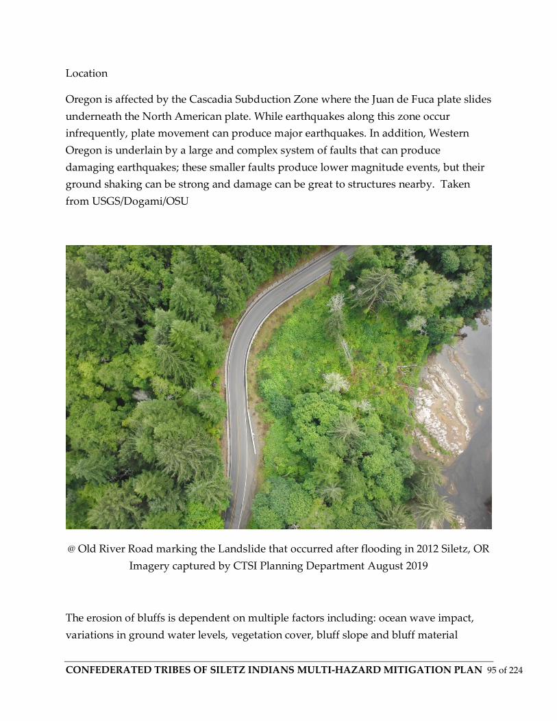
CONFEDERATED TRIBES OF SILETZ INDIANS MULTI-HAZARD MITIGATION PLAN 95 of 224
Location
Oregon is affected by the Cascadia Subduction Zone where the Juan de Fuca plate slides
underneath the North American plate. While earthquakes along this zone occur
infrequently, plate movement can produce major earthquakes. In addition, Western
Oregon is underlain by a large and complex system of faults that can produce
damaging earthquakes; these smaller faults produce lower magnitude events, but their
ground shaking can be strong and damage can be great to structures nearby. Taken
from USGS/Dogami/OSU
@ Old River Road marking the Landslide that occurred after flooding in 2012 Siletz, OR
Imagery captured by CTSI Planning Department August 2019
The erosion of bluffs is dependent on multiple factors including: ocean wave impact,
variations in ground water levels, vegetation cover, bluff slope and bluff material
CONFEDERATED TRIBES OF SILETZ INDIANS MULTI-HAZARD MITIGATION PLAN 96 of 224
properties. When coupled with the varied geologic composition of the Oregon coastline,
this wide range of eroding mechanisms makes the task of estimating how fast the bluffs
are eroding very complicated with large amount of uncertainty. Thus, there is no "one-
size-fits-all" approach that can be applied coast wide and assessments are typically
made on a case by case basis.
Catastrophic Hazards
Catastrophic hazards are associated with earthquakes and related tsunamis. The
eastward-moving Juan de Fuca tectonic plate dives under the westward-moving North
American plate just off the Oregon coast at the Cascadia Subduction Zone. Powerful
earthquakes up to magnitude 7 can take place in either the North American or the Juan
de Fuca plates. The Cascadia Subduction Zone, however, is capable of generating even
larger earthquakes — up to magnitude 9.
From State of Oregon Hazard Publication on Cascadia
The Cascadia Subduction Zone is a 600-mile fault that runs from northern California up
to British Columbia and is about 70-100 miles off the Pacific coast shoreline. There have
been 41 earthquakes in the last 10,000 years within this fault that have occurred as few
as 190 years or as much as 1200 years apart. The last earthquake that occurred in this
fault was on January 26, 1700, with an estimated 9.0 magnitude. This earthquake caused
the coastline to drop several feet and a tsunami to form and crash into the land. What is
most surprising is that evidence for this great earthquake also came from Japan.
Japanese historic records indicate that a destructive distantly-produced tsunami struck
their coast on January 26, 1700. By studying the geological records and the flow of the
Pacific Ocean, scientists have been able to link the tsunami in Japan with the great
earthquake from the Pacific Northwest. Native American legends also support to the
timing of this last event.
Oregon has the potential for a 9.0+ magnitude earthquake caused by the Cascadia
Subduction Zone and a resulting tsunami of up to 100 feet in height that will impact the
coastal area. There is an estimated 2-4 minutes of shaking or rolling that will be felt
along the coast line with the strength and intensity decreasing the further inland you
are.

CONFEDERATED TRIBES OF SILETZ INDIANS MULTI-HAZARD MITIGATION PLAN 97 of 224
The Cascadia Subduction Zone has not produced an earthquake since 1700 and is
building up pressure where the Juan de Fuca Plate is subsiding underneath the North
American plate. Currently, scientists are predicting that there is about a 37 percent
chance that a megathrust earthquake of 7.1+ magnitude in this fault zone will occur in
the next 50 years. This event will be felt throughout the Pacific Northwest.
With the current preparedness levels of Oregon, we can anticipate being without
services and assistance for at least 2 weeks, if not longer, when the Cascadia Subduction
Zone earthquake occurs. While this will be difficult to overcome, our citizens,
businesses, schools, government, and communities as a whole can take steps to get
prepared. Take action now by actively planning and preparing yourself and your
community to be ready for two weeks for disasters. In the event of a Cascadia
Subduction Zone earthquake and tsunami, coastal populations will become isolated
into “islands” due to landslides, liquefaction, and damaged infrastructure like bridges.
The Office of Emergency Management’s “Island Mapping Pilot Project” mapped coastal
populations in relation to likely infrastructure damage after an earthquake and tsunami.
These maps show where transportation infrastructure will be damaged (bridge failure,
landslide, liquefaction) causing populations to be isolated into “islands”. Workshops
were held in coastal communities during the summer of 2016. Our audience for these
workshops were city/county officials, public works, and others able to advise on road
damage and who lives/works/plays in the “islands”. The results of this project are
available for download and through RAPTOR.
For general inquiries about the project, contact Althea Rizzo at [email protected].
For the GIS data, contact Daniel Stoelb at [email protected].
https://earthquake.usgs.gov/hazards/
https://earthquake.usgs.gov/hazards/hazmaps/
Tsunamis
A tsunami is a series of ocean waves most often generated by disturbances of the sea
floor during shallow, undersea earthquakes. Less commonly, landslides and volcanic
eruptions can also trigger these wave events. Although infrequent in occurrence,

CONFEDERATED TRIBES OF SILETZ INDIANS MULTI-HAZARD MITIGATION PLAN 98 of 224
tsunamis are the most dangerous natural hazard affecting the Oregon Coast. In the
deep water of the open ocean, tsunami waves can travel at speeds up to 800 km (500
miles) per hour and are imperceptible to ships because the wave height is typically less
than a few feet.
However, as a tsunami approaches the coast it slows dramatically and its height may
multiply by a factor of 10 or more, having catastrophic consequences to people living at
the coast. As a result, people on the beach, in low-lying areas of the coast, and near
estuary mouths or tidal flats face the greatest danger from tsunamis.
Earthquakes can trigger other geologic and soils failures that contribute to damage.
While surface fault rupture can produce damage to facilities and infrastructure astride
the fault, losses from this are minor compared to those resulting from strong ground
shaking and associated ground failures. These include landslides and slope failures,
lateral spreading and slumping, and liquefaction.
Probability
Although the Confederated Tribes of Siletz Tribe has not had a recorded earthquake
within its traditional lands, it is 100% likely that the Tribe will feel the effects of an
earthquake from regional sources in the future. Evidence shows that Magnitude 9.0
Cascadia Subduction Zone quakes have occurred on average once every 350+/- years
(with major events every 500 to 600 years, with some gaps between events as little as
200 years and as large as 1,000 years Goldfinger OSU)
Vulnerability
Although the Confederated Tribes of Siletz Tribe’s people, property and facilities are
exposed to earthquakes, the vulnerability is low to moderate. The tribe has a limited
amount of facilities and many were built after Seismic Building Codes for Oregon were
strengthened in 1993. The Confederated Tribes of Siletz Tribe’s area is encompassed in
Seismic Zone 3 of the State Building Code map.
The Tribe’s newer structures, such as the Health Clinic Building, are built to highest
seismic standards and would experience minimal structural damage (estimated through
HAZUS). The Tribe’s utility systems that depend upon other outside agencies are not so
unsusceptible. The water and wastewater systems in Siletz are far out of date for
upgrades and are not built to the highest standards and have redundancies for a worst-
CONFEDERATED TRIBES OF SILETZ INDIANS MULTI-HAZARD MITIGATION PLAN 99 of 224
case scenario. After a significant event, all Tribal facilities and infrastructure will be
inspected for damage.
Structures most vulnerable would be its older commercial facilities in Siletz, Newport,
and Lincoln County.
The Tribe’s biggest concern will be the lack of access along the state highways 229, 20,
34, and connecting to either Highway 101 or to the I5 corridor. Many publications
provide that Siletz and many coastal areas will effectively become “island”
communities due to being cut off from damage to local, county and state infrastructure,
such as bridges, roads, etc. due to the earthquake or secondary hazards such as
landslides.
Known models show that regular disruption of critical services will also be an issue for
tribal operations, especially in the immediate aftermath of an Cascadia event and/or
following tsunami/earthquake.
Flooding
Floods
In general, three types of flooding occur in this region: (1) riverine, (2) ocean flooding
from high tides and wind-driven waves, and (3) flooding associated with a tsunami
event. Flooding in riverine systems is a natural occurrence that results when runoff
from rain or snowmelt exceeds the carrying capacity of river channels, ditches, drains,
reservoirs, and other water bodies. There are two distinct periods of riverine flooding in
this region, winter and early spring. The most serious flooding occurs during
November, December, January, and February. The situation is especially severe when
riverine flooding, caused by prolonged rain and melting snow, coincides with high
tides and coastal storm surges. In short, the rivers back up and flood the lowlands.
There are other circumstances, as well. Several coastal rivers carry heavy silt loads that
originated in areas burned during the “Tillamook Burn” fires (1933 to 1951).
Consequently, some rivers may actually be elevated above local floodplains, which
increases flood hazards. The costs and long-term benefits of dredging these rivers have
CONFEDERATED TRIBES OF SILETZ INDIANS MULTI-HAZARD MITIGATION PLAN 100 of 224
not been determined. In this section, past riverine and coastal flood events, flood
vulnerability, and potential flood losses to CTSI properties are described.
Potential Flood Event Areas
Flood events on tribal lands can be divided into 3 broad categories: flooding of the
Siletz River, flooding of the Toledo Mill property along the Yaquina River, and coastal
flooding of the properties on the coast line and near Devils Lake in Lincoln City. The
majority of the damage witnessed in past flood events were primarily along the Siletz
River.
Lincoln County has experienced ten major floods since 1964. Four of these resulted in
presidential declarations. Past flooding occurred on the Alsea, Siletz, Yaquina rivers
between November and March. Flooding also occurs in low-lying areas along the ocean
and Devils Lake during high tides and heavy rain. The county estimates that 10 percent
of the population and 10 percent of the property would be affected by such a flood
event.
Effects of Recent Floods
Siletz River Floods
In February 1996, December 1998, and November 1999 Lincoln County experienced
damaging flood events. The 1996 flood event affected communities throughout western
Oregon, with floodwater exceeding the “100-year” level in a number of locations. In
Lincoln County, however, the 1996 event was of a lower magnitude, with floodwater
reaching a level of 24.5 feet on the Siletz River gage (located upstream from the area
addressed by this plan). The Siletz 100-year event level is 30.5 feet. The Army Corps of
Engineers estimated the recurrence interval of the 1996 Siletz event at 12-15 years,
meaning approximately a six percent to eight percent probability of occurrence in any
year. The December 1998 event, similar to the 1996 flood, was gauged at a level of 24.7
feet. Accounts from property owners indicate that flood levels in 1998 were as much as
one foot higher on the lower Siletz River than in 1996, probably due to the influence of
coinciding high tides in Siletz Bay.
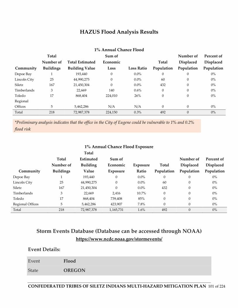
CONFEDERATED TRIBES OF SILETZ INDIANS MULTI-HAZARD MITIGATION PLAN 101 of 224
HAZUS Flood Analysis Results
1% Annual Chance Flood Exposure
Community
Total
Number of
Buildings
Total
Estimated
Building
Value
Sum of
Economic
Exposure
Exposure
Ratio
Total
Population
Number of
Displaced
Population
Percent of
Displaced
Population
Depoe Bay 1 193,440 0 0.0% 0 0 0%
Lincoln City 25 44,990,275 0 0.0% 60 0 0%
Siletz 167 21,450,304 0 0.0% 432 0 0%
Timberlands 3 22,669 2,416 10.7% 0 0 0%
Toledo 17 868,404 739,408 85% 0 0 0%
Regional Offices 5 5,462,286 423,907 7.8% 0 0 0%
Total 218 72,987,378 1,165,731 1.6% 492 0 0%
Storm Events Database (Database can be accessed through NOAA)
https://www.ncdc.noaa.gov/stormevents/
Event Details:
Event Flood
State OREGON
1% Annual Chance Flood
Community
Total
Number of
Buildings
Total Estimated
Building Value
Sum of
Economic
Loss Loss Ratio
Total
Population
Number of
Displaced
Population
Percent of
Displaced
Population
Depoe Bay 1 193,440 0 0.0% 0 0 0%
Lincoln City 25 44,990,275 0 0.0% 60 0 0%
Siletz 167 21,450,304 0 0.0% 432 0 0%
Timberlands 3 22,669 140 0.6% 0 0 0%
Toledo 17 868,404 224,010 26% 0 0 0%
Regional
Offices 5 5,462,286 N/A N/A 0 0 0%
Total 218 72,987,378 224,150 0.3% 492 0 0%
*Preliminary analysis indicates that the office in the City of Eugene could be vulnerable to 1% and 0.2%
flood risk

CONFEDERATED TRIBES OF SILETZ INDIANS MULTI-HAZARD MITIGATION PLAN 102 of 224
County/Area CENTRAL COAST RANGE OF W OREGON
WFO PQR
NCEI Data
Source PDC
Begin Date 1996-02-06 00:00 PST
End Date 1996-02-15 00:00 PST
Deaths
Direct/Indirect 7/0 (fatality details below, when available...)
Injuries
Direct/Indirect 0/0
Property
Damage .4B
Crop Damage
Episode
Narrative
Runoff from heavy rains and melting mountain snow caused major
floods upon many northern Oregon rivers. The first rivers reached
flood stage on the morning of February 6th while the heaviest rain
was still falling. flooding was measured on twenty one rivers in
northwestern Oregon. Six rivers set all time high river stage records,
and 7 people lost their lives as a direct result of flooding. In eastern
Oregon 4 rivers experienced significant flooding. Many smaller un-
gaged streams also left their banks during this period. Statewide
damage was estimated at over 285 million dollars with an estimated
five thousand homes destroyed. Most rivers had receded to below
flood stage by February 14th, however the Lower Willamette river
fluctuated around flood stage and the lower reaches of the Columbia
remained above flood stage until the end of February.
CONFEDERATED TRIBES OF SILETZ INDIANS MULTI-HAZARD MITIGATION PLAN 103 of 224
Definitions
Base Flood Elevation (BFE): The base flood elevation is the elevation of a 100 year flood
event, or a flood which has a 1% chance of occurring in any given year.
Basin: A basin is the area within which all surface water, whether from rainfall,
snowmelt, springs or other sources, flows to a single water body or watercourse. The
boundary of a river basin is defined by natural topography, such as hills, mountains
and ridges. Basins are also referred to as Watersheds or Drainage Basins.
Flood
A general and temporary condition of partial or complete inundation of 2 or more acres
of normally dry land area or of 2 or more properties (at least 1 of which is the
policyholder's property) from:
--Overflow of inland or tidal waters; or
--Unusual and rapid accumulation or runoff of surface waters from any source; or
--Mudflow; or
Collapse or subsidence of land along the shore of a lake or similar body of water as a
result of erosion or undermining caused by waves or currents of water exceeding
anticipated cyclical levels that result in a flood as defined above.
Flood Hazard Boundary Map (FHBM). Official map of a community issued by FEMA,
where the boundaries of the flood, mudflow and related erosion areas having special
hazards have been designated.
Flood In Progress. A flood that is in progress on the earlier of either:
The date the community in which the insured property is located first experiences a
flood as defined in this policy; or
The date and time of an event initiating a flood that directly or indirectly affects areas
downstream or in a floodway and ultimately results in the damage to the insured

CONFEDERATED TRIBES OF SILETZ INDIANS MULTI-HAZARD MITIGATION PLAN 104 of 224
property. Events that may initiate such a flooding event include, but are not limited to,
the following:
a. A spillway is opened;
b. A levee is breached;
c. Water is released from a dam; and
d. Water escapes from the banks of a waterway (stream, river, creek, etc.).
The applicability of this exclusion will be evaluated upon the assertion by a
policyholder of the right to be paid for a loss under this policy.
Channel Migration Zone (CMZ) (FEMA Def. 2012)
https://www.fema.gov/pdf/about/regions/regionx/nfip_esa_faq/faq_channel_migration_
zone_1_11_12.pdf
Channel migration can occur gradually, as a river erodes one bank and deposits
sediment along the other. The natural meander patterns of stream channels are the
result of the dissipation of energy of flowing water and the transportation of sediment.
Channel migration also can occur abruptly, as the river channel shifts (or "avulses") to a
new location. Avulsions are usually unpredictable events that occur during high flood
flows when the existing channel cannot transport all of the water and sediment
supplied to it. The highest rates of channel migration generally occur where steep rivers
flow out of foothills onto flatter floodplains. : Dynamic physical processes of rivers can
cause channels in some areas to move laterally, or "migrate," over time. The area within
which a river channel is likely to move over a period of time is referred to as the
channel migration zone.
Cubic Feet per Second (cfs): Discharge or river flow is commonly measured in cfs. One
cubic foot is about 7.5 gallons of liquid.
Flood Insurance Rate Map (FIRM): FIRMs are the official maps on which the Federal
Emergency Management Agency (FEMA) has delineated the Special Flood Hazard Area
(SFHA).
Floodplain: Floodplains are the land area along the sides of rivers that becomes
inundated with water during a flood. Floodplain can be defined in different ways, but is
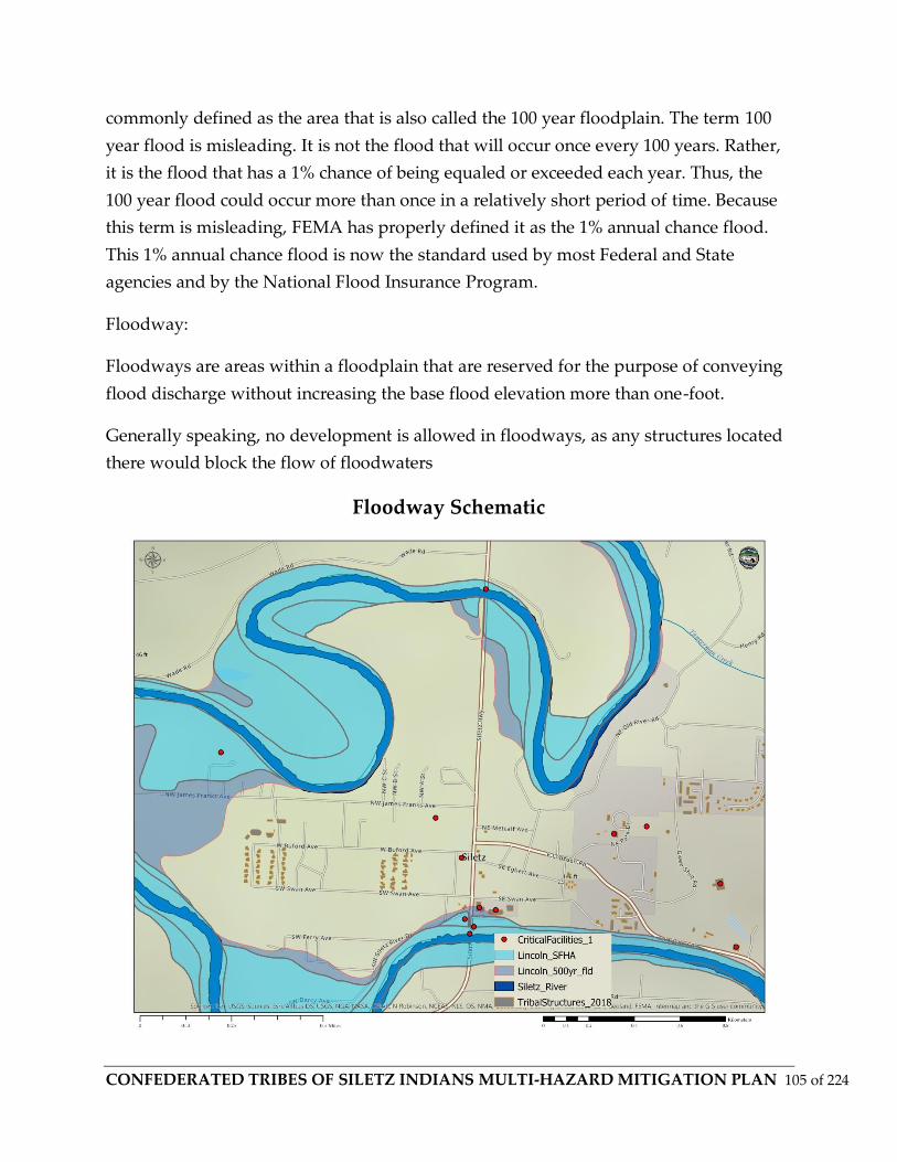
CONFEDERATED TRIBES OF SILETZ INDIANS MULTI-HAZARD MITIGATION PLAN 105 of 224
commonly defined as the area that is also called the 100 year floodplain. The term 100
year flood is misleading. It is not the flood that will occur once every 100 years. Rather,
it is the flood that has a 1% chance of being equaled or exceeded each year. Thus, the
100 year flood could occur more than once in a relatively short period of time. Because
this term is misleading, FEMA has properly defined it as the 1% annual chance flood.
This 1% annual chance flood is now the standard used by most Federal and State
agencies and by the National Flood Insurance Program.
Floodway:
Floodways are areas within a floodplain that are reserved for the purpose of conveying
flood discharge without increasing the base flood elevation more than one-foot.
Generally speaking, no development is allowed in floodways, as any structures located
there would block the flow of floodwaters
Floodway Schematic
CONFEDERATED TRIBES OF SILETZ INDIANS MULTI-HAZARD MITIGATION PLAN 106 of 224
Floodway Fringe: Floodway fringe areas are those lands that are in the floodplain but
outside of the floodway. Some development is generally allowed in these areas with a
variety of different restrictions.
Flood Zone Designations: These are the different flood hazard zones FEMA uses for
FIRMs. These designations may be found on the flood hazard maps for Whitman
County’s communities.
Zone A: An area inundated by 100-year flooding, for which no Base Flood Elevations
(BFEs) have been determined.
Zone AE: An area inundated by 100-year flooding, and which BFEs have been
determined.
Zone ANI: An area that is located within a community or county that is not mapped on
any published FIRM.
Zone X500 (0.2% annual chance): An area inundated by 500-year flooding; an area
inundated by 100-year flooding with average depths of less than 1 foot or with drainage
areas less than 1 square mile; or an area protected by levees from the 100-year flooding.
National Flood Insurance Program: In 1968, Congress created the National Flood
Insurance Program (NFIP) in response to the rising cost of taxpayer funded disaster
relief for flood victims and the increasing amount of damage caused by floods.
The Mitigation Division is a section of the Federal Emergency Management Agency
(FEMA) manages the NFIP, and oversees the floodplain management and mapping
components of the Program. Nearly 20,000 communities across the United States and its
territories participate in the NFIP by adopting and enforcing floodplain management
ordinances to reduce future flood damage. In exchange, the NFIP makes federally
backed flood insurance available to homeowners, renters, and business owners in these
communities.
FEMA contracted the Army Corps of Engineers to map the floodplains, floodways, and
floodway fringes. Figure 4-5 depicts the relationship among the three designations.
Pre and Post FIRM rates: Category of rates published in the National Flood Insurance
Program Manual, applying to buildings located in a community qualifying for the
regular flood program. Post-FIRM rates are used on building construction that started

CONFEDERATED TRIBES OF SILETZ INDIANS MULTI-HAZARD MITIGATION PLAN 107 of 224
after December 31, 1974, or after the community’s initial Flood Insurance Rate Map was
published, whichever is later. These rates are lower than pre-FIRM rates.
Repetitive Loss Properties:
(a) That has at least four NFIP claim payments (including building and contents) over
$5,000 each, and the cumulative amount of such claims payments exceeds $20,000; or A
residential property that is covered under an NFIP flood insurance policy and:
(b) For which at least two separate claims payments (building payments only) have
been made with the cumulative amount of the building portion of such claims
exceeding the market value of the building.
For both (a) and (b) above, at least two of the referenced claims must have occurred
within any ten-year period, and must be greater than 10 days apart.
Special Flood Hazard Area: The base floodplain delineated on a Flood Insurance Rate
Map. The SFHA is mapped as a Zone A in riverine situations and Zone V in coastal
situations. The SFHA may or may not encompass all of a community’s flood problems.
FEMA:
https://www.fema.gov/national-flood-insurance-program/definitions
Stream Bank Erosion:
Generally, stream bank erosion becomes a problem where development has limited the
meandering nature of streams, where streams have been channelized, or where stream
bank structures (like bridges, culverts, etc.) are located in places where they can actually
cause damage to downstream areas. Stabilizing these areas can help protect
watercourses from continued sedimentation, damage to adjacent land uses, control
unwanted meander, and improvement of habitat for fish and wildlife. Stream bank
erosion is common along rivers, streams and drains where banks have been eroded,
sloughed or undercut. However, it is important to remember that a stream is a dynamic
and constantly changing system. It is natural for a stream to want to meander, so not all
eroding banks are “bad” and in need of repair.
Streamgage: A stream gage is a structure located beside a river that contains a device to
measure and record the water level in a river. Generally these measurements occur
CONFEDERATED TRIBES OF SILETZ INDIANS MULTI-HAZARD MITIGATION PLAN 108 of 224
every 15 minutes. The USGS operates a network of about 7,000 streamgages
nationwide, and at about 5,000 of these, the data is sent back via satellite to an USGS
office every 4 hours and more frequently in time of flooding. The flow and gage-height
data are then made available to users over the internet. For the Siletz River the data can
be found at the below links:
http://water.usgs.gov/nwis
https://waterdata.usgs.gov/nwis/uv?site_no=14305500
Subbasin: A subbasin is a tributary basin of a larger basin or watershed.
Zero-Rise Floodway: A ‘zero-rise’ floodway is an area reserved to carry the discharge of
a flood without raising the base flood elevation. Some communities have chosen to
implement zero-rise floodways because they provide greater flood protection than the
floodway described above, which allows a one foot rise in the base flood elevation.
General Background
A flood is the inundation of normally dry land resulting from the rising and
overflowing of a body of water. A natural geologic process that shapes the landscape,
floods provide habitat and create rich agricultural lands. Human activities and
settlements tend to use floodplains, frequently competing with the natural processes
and suffering inconvenience or catastrophe as a result. Human activities encroach upon
floodplains, affecting the distribution and timing of drainage, and thereby increasing
flood problems. The built environment creates often localized flooding problems
outside natural floodplains by altering or confining drainage channels. This increases
flood potential in two ways: 1) it reduces the stream’s capacity to contain flows; and 2)
increases flow rates downstream. Floods also cause erosion and landslides, and can
transport debris and toxic substances that can cause secondary hazards.
Besides Winter Storms (which flooding is often a part of) flooding represents the most
common and best known of the natural hazard threats in Lincoln County and to the
Confederated Tribes of Siletz Tribe’s Coast Reservation Area.
Location

CONFEDERATED TRIBES OF SILETZ INDIANS MULTI-HAZARD MITIGATION PLAN 109 of 224
The Confederated Tribes of Siletz Tribe is generally affected by riverine flooding from
the Siletz River between Siletz and Logsden, and Lincoln County has flood events
nearly every year on one or more rivers depending on climactic conditions. To a lesser
extent, flooding of the Siletz, Yaquina, and Salmon Rivers are by their respective
tributaries. The Tribe can also be affected by urban flooding in areas of the
aforementioned cities and Lincoln County.
Riverine Flooding
Riverine flooding is the overbank flooding of rivers and streams. The natural process of
riverine flooding adds sediment and nutrients to fertile floodplain areas. Flooding in
large river systems typically results from large-scale weather systems that generate
prolonged rainfall over a wide geographic area, causing flooding in hundreds of
smaller streams, which then drain into the major rivers.
Shallow area flooding is a special type of riverine flooding. FEMA defines shallow flood
hazards as areas that are inundated by the 100- year flood with flood depths of only one
to three feet. These areas are generally flooded by low velocity sheet flows of water.
The Tribe’s exposure to riverine flooding is from the Siletz River. The Siletz River may
affect the Tribal Administration building and nearby facilities, especially if combined
with urban flooding. Maps of Tribal exposed lands and structures in the FEMA
floodplain can be seen in Figure ______ .
Urban Flooding
As land is converted from fields or woodlands to roads and parking lots, it loses its
ability to absorb rainfall. Urbanization of a watershed changes the hydrologic systems
of the basin. Heavy rainfall collects and flows faster on impervious concrete and asphalt
surfaces. The water moves from the clouds to the ground, and into streams at a much
faster rate in urban areas. Adding these elements to the hydrological systems can result
in floodwaters that rise very rapidly and peak with violent force. Although most of the
Tribe’s lands are located in rural areas, its government facilities and economic
developments, such as the Seven Feathers Casino and Truck Stop, are located in urban
areas with impermeable surfaces that either collects water, or concentrate the flow of
water. During periods of urban flooding, streets carry water to culverts. Culverts and
storm drains sometimes back up with vegetative debris causing localized flooding.

CONFEDERATED TRIBES OF SILETZ INDIANS MULTI-HAZARD MITIGATION PLAN 110 of 224
The Tribe’s urban flooding risks are in Siletz, Newport, Toledo, Depoe Bay, and other
Lincoln County areas. The area offices located in Eugene, Salem, and Portland all have
adopted local mitigation plans that show flood risk for urban areas.
Severity
Severity of flooding can be determined by the height of the Siletz River and its
tributaries in comparison to flood stages determined for the USGS streamgages located
throughout the area. See https://oregoncoasthistory.org/ and
https://www.co.lincoln.or.us/emergencymanagement/page/hazards-flooding-and-river-
levels for a list of highest flood crests in Lincoln County for major events from 1950-
2019 (up unto October 2019)
Severity can also be measured by past damages from flooding, but because of lack of
specific tribal history and damages from flooding, county-wide figures can only be used
to generalize the severity of flooding that may affect tribal lands and facilities.
The 1964 and 1996 floods are considered the most severe floods in Lincoln County
history. Using information from the Lincoln County Hazard Mitigation Plan, the 1964
flood caused $26 million in damages, while the 1996 flood caused $2 million in reported
damages to county and private property. Correcting for inflation to 1996 dollars, the
1964 flood would have cost $131 million.
Compilation of Hazard Data using both independent databases and Sheldus was used
by CTSI Planning Dept. with National Climatic Data Center (NCDC) storm damage
reports, it was found that the most severe flood event in Lincoln County, adjusted to
2019 dollars, was in 1974, with the November 1996 floods the second most severe. See
for a summary of damages as reported in the SHELDUS database for Lincoln County.
Links to sites used in Data compilation:
https://www.climate.gov/maps-data
https://www7.ncdc.noaa.gov/CDO/cdo
https://www.ncdc.noaa.gov/

CONFEDERATED TRIBES OF SILETZ INDIANS MULTI-HAZARD MITIGATION PLAN 111 of 224
State of Oregon Hazards
https://www.oregon.gov/OEM/hazardsprep/Pages/Hazard-Mitigation.aspx
Spatial Hazard Events and Losses Database for the United States (2019). The Spatial
Hazard Events and Losses Database for the United States. Arizona State University
Available https://cemhs.asu.edu/SHELDUS/
Table ________ Flood Levels in Lincoln County, 1950-2019
https://www.co.lincoln.or.us/planning/page/links
https://www.co.lincoln.or.us/planning/page/floodplain-management
Lincoln Co. River Flood Crest History
Table ____ : Severity of Flooding in Lincoln County, by Monetary Damages, SHELDUS

CONFEDERATED TRIBES OF SILETZ INDIANS MULTI-HAZARD MITIGATION PLAN 112 of 224
River Levels at the Siletz River since ca. 1905 (notice data break at approx. 1916-1927)
Past Events: Floods
Several buildings owned by CTSI in the town of Siletz are close to but not in the
floodplain (administration buildings one and two are both partially in the 500 Year
Floodplain, as is the part of the lot of the gas station, but not Tollala Court subdivision,
USDA, and the clinic). If a 100-year flood event were to occur, these buildings would
not likely be damaged. Due to safety issues, the most of the offices would likely be
closed. The clinic would likely only accept emergency patients during a large flood
event. However, any water level greater than a 100-year event could potentially damage
the administration building II and I. During times of severe flooding of the Siletz River,
the Town of Siletz could potentially become inaccessible by automobile traffic. The
possibility of high water and woody debris could potentially damage both north and
south access to the town of Siletz.
Floods have been a fact of life in the Confederated Tribes of Siletz Area (1855
Reservation Boundary and beyond to ancestral homelands) for thousands of years of

CONFEDERATED TRIBES OF SILETZ INDIANS MULTI-HAZARD MITIGATION PLAN 113 of 224
tribal inhabitation. Years with Established Flood Records are 1861, 1890, 1893, 1907,
1909, 1927, 1931, 1932, 1956, 1958, et al. Although the 1996 floods were devastating to
the entire region, the floods of 1890, and 1964 were larger.
Lincoln County has experienced ten major floods since 1964. Four of these resulted in
presidential declarations. Past flooding occurred on the Alsea, Siletz, and Yaquina
rivers between November and March. Flooding also occurs in low-lying areas along the
ocean and Devils Lake during high tides and heavy rain. The county estimates that ten
percent of the population and ten percent of the property would be affected by such a
flood event.
Effects of Recent Floods
Siletz River Floods In February 1996, December 1998, and November 1999 Lincoln
County experienced damaging flood events. The 1996 flood event affected communities
throughout western Oregon, with floodwater exceeding the “100-year” level in a
number of locations. In Lincoln County, however, the 1996 event was of a lower
magnitude, with floodwater reaching a level of 24.5 feet on the Siletz River gage
(located upstream from the area addressed by this plan). The
Siletz 100-year event level is 30.5 feet. The Army Corps of Engineers estimated the
recurrence interval of the 1996 Siletz event at 12-15 years, meaning approximately a six
percent to eight percent probability of occurrence in any year. The December 1998
event, similar to the 1996 flood, was gauged at a level of 24.7 feet. Accounts from
property owners indicate that flood levels in 1998 were as much as one foot higher on
the lower Siletz River than in 1996, probably due to the influence of coinciding high
tides in Siletz Bay.
Probability/Frequency
The region experiences some flooding at least twice a year, with larger floods occurring
at least once a decade. Based on past events, major flooding seems to occur at least
every 30 -50 years.
Vulnerability
CONFEDERATED TRIBES OF SILETZ INDIANS MULTI-HAZARD MITIGATION PLAN 114 of 224
GIS analysis was used to determine tribal property and structures vulnerable to
flooding. Property and buildings located within the FEMA 100- or 500- year floodplain
are shown in the Siletz Area MHMP Flood Map
Property
The Tribe has many GIS layers related to parcels and property as they relate to utilities,
water supply, tax identification, elevation data, drone imagery, etc. The Planning
Department and GIS Analyst Ian Keene analyzed a myriad of datasets to determine
property as it relates to hazard management and mitigation strategies.
Buildings/Facilities
In Siletz, Newport, and Lincoln County, Tribal property consists of cultural, residential,
industrial, and commercial buildings. Tribal buildings are located within the floodplain
of the Siletz River at the 100 and 500 year flood marks at several locations. HAZUS was
performed that analyzes this flood area significantly.
The Administration buildings at Swan Avenue are both partially located in the 500-year
floodplain. The Siletz Dancehouse at the end of Swan Ave is also partially located
within the floodplain.
The Administration Buildings at Swan Ave. being partially located in the floodplain, are
considered vulnerable due to their proximity to the Siletz River, and potential isolation
and damage or wash-out of the Bridges on SR 229, both towards Kernville and towards
Toledo, could be considered vulnerable to large flood events, both simply by water
level, but also through debris flows during high water events.
The Tribe owns additional lands that adjacent to the Siletz River, including the Men’s
Transitional Living Center (high bluff above the river), The Dundas Property (also high
bluff), the Fish Hatchery (low elevation for all buildings along Little Rock Creek) and
multiple other developments are vulnerable to flooding within Siletz Proper.
GIS analysis of building vulnerability
GIS analysis was conducted with DOGAMI employees and Ian Keene. The GIS analysis
found multiple structures located in the FEMA 100-year floodplain in the Siletz Area.
Both bridges along SR 229 are within the flood zone, as are residential, and Tribal
owned properties. No structures are currently planned on being moved.

CONFEDERATED TRIBES OF SILETZ INDIANS MULTI-HAZARD MITIGATION PLAN 115 of 224
The November 1999 flooding of the Siletz River, significantly larger in magnitude than
either the 1996 or 1998 events, was gauged at a level of 28.5 feet. This was the highest
gage reading in 80 years, yet this event did not reach the 100-year flood level. Again, the
100-year flood elevation projected by the region’s Flood Insurance Rate Map (FIRM)
flood study is approximately 30.5 feet on the Siletz Gage, or roughly two feet higher
than the November 1999 event. The highest recorded event on the Siletz River was in
1921 was estimated at 31.6 on the gage, with an estimated recurrence interval of slightly
more than 100-years or one percent probability of occurrence in any year. This event
was caused by a dam failure at Valsetz Lake and was not directly related to a high
rainfall event. Figure 1-1 illustrates the relative levels attained on the Siletz gage by
recorded flood events. It is notable that floodwaters below the “100-year” level have
caused considerable damage. The level at which flooding begins is 16 feet on the town
of Siletz gage.
Yaquina River Floods
Large floods of the neighboring Yaquina River could also affect tribal property. Due to
its location and watershed similarities, peak events on the Yaquina River tend to
coincide with peak events measured on the Siletz River. The amount of vulnerability
and damage to structures is relatively low when compared to the total number of
vulnerable structures located along the Siletz River.
On December 30, 2005 heavy rainfall for several days occurred at the same time as
abnormally high tides caused the water to overflow the banks causing damage to the
Tribes Mill property. While the rainfall was not substantial, the flood elevation was
estimated to be at around 12.2 feet on the mill property. This was approximately one
foot below a 100 year flood event and possibly the largest flood since the 1974 event.
Figure 22 shows the river levels over ten feet between the years 1973 and 1991. Other
recent flood events were not recorded due to the closure of this monitoring station.

CONFEDERATED TRIBES OF SILETZ INDIANS MULTI-HAZARD MITIGATION PLAN 116 of 224
Landslide
Definitions
Debris Slides: Debris slides consist of unconsolidated rock or soil that have moved
rapidly down slope. They occur on slopes greater than 65%.
Earthflows: Earthflows are slow to rapid down slope movements of saturated clay-rich
soils. This type of landslide typically occurs on gentle to moderate slopes but can occur
on steeper slopes especially after vegetation removal.
Landslide: Landslides can be described as the sliding movement of masses of loosened
rock and soil down a hillside or slope. Fundamentally, slope failures occur when the
strength of the soils forming the slope exceeds the pressure, such as weight or
saturation, acting upon them.

CONFEDERATED TRIBES OF SILETZ INDIANS MULTI-HAZARD MITIGATION PLAN 117 of 224
Mass Movements: A collective term for landslides, mudflows, debris flows, sinkholes
and lahars.
Rock Falls: A type of landslide that typically occurs on rock slopes greater than 40%
near ridge crests, artificially cut slopes and slopes undercut by active erosion.
Rotational-Translational Slides: A type of landslide characterized by the deep failure of
slopes, resulting in the flow of large amounts of soil and rock. In general, they occur in
cohesive slide masses and are usually saturated clayey soils.
Sinkholes: A collapse depression in the ground with no visible outlet. Its drainage is
subterranean, its size typically measured in meters or tens of meters, and it is
commonly vertical-sided or funnel-shaped.
Steep Slope: Different communities and agencies define it differently, depending on
what it is being applied to, but generally a steep slope is a slope in which the percent
slope equals or exceeds 25%.
General Background
Landslides (or more properly, mass movement), are caused by a combination of
geological and climatological conditions. This includes steep topography, as well as the
encroaching influence of urbanization. Figure 4-18 shows landscape features associated
with landslides.
A landslide is a mass of rock, earth or debris moving down a slope. Landslides may be
minor or very large, and can move at slow to very high speeds. They can be initiated by
storms, earthquakes, fires, volcanic eruptions, and by human modification of the land.
HAZUS Analysis of Landslides for CTSI MHMP Area
High and Very High Landslide Susceptibility Exposure
Community
Total
Number
of
Buildings
Total
Estimated
Building
Value
Sum of
Economic
Exposure
Exposure
Ratio
Total
Population
Number of
Displaced
Population
Percent of
Displaced
Population
Depoe Bay 1 193,440 193,440 100% 0 0 0%
Lincoln City 25 44,990,275 3,816,773 8.5% 60 60 100%
Siletz 167 21,450,304 14,649 0.1% 432 0 0%
Timberlands 3 22,669 0 0.0% 0 0 0%

CONFEDERATED TRIBES OF SILETZ INDIANS MULTI-HAZARD MITIGATION PLAN 118 of 224
Toledo 17 868,404 868,404 100% 0 0 0%
Regional
Offices 5 5,462,286 0 0.0% 0 0 0%
Total 218 72,987,378 4,893,266 6.7% 492 60 12%
Landscape Features Associated with Landslides
Mudslides or mudflows (or debris flows) are rivers of rock, earth, organic matter and
other soil materials saturated with water. They develop in the soil overlying bedrock on
sloping surfaces when water rapidly accumulates in the ground, such as during heavy
rainfall or rapid snowmelt. Water pressure in the pore spaces of the material increases
to the point that the internal strength of the soil is drastically weakened. The soil’s
reduced resistance can then easily be overcome by gravity, changing the earth into a
flowing river of mud or “slurry.”
A debris flow or mudflow can move rapidly down slopes or through channels, and can
strike with little or no warning at avalanche speeds. The slurry can travel miles from its
source, growing as it descends, picking up trees, boulders, cars, and anything else in its
path. Although these slides behave as fluids, they pack many times the hydraulic force
of water due to the mass of material included in them. Locally, they can be some of the
most destructive events in nature.
A sinkhole is a collapse depression in the ground with no visible outlet. Its drainage is
subterranean; its size is typically measured in meters or tens of meters, and it is
commonly vertical-sided or funnel-shaped.
Landslides are caused by one or a combination of the following factors: change in slope
gradient, which increases the load the land must bear, shocks and vibrations, change in
water content, ground water movement, frost action, weathering of rocks, and removal
or changing the type of vegetation covering slopes.
In general, landslide hazard areas occur where the land has certain characteristics,
which contribute to the risk of the downhill movement of material. These characteristics
include:
• A slope greater than 15 percent.
• Landslide activity or movement occurred during the last 10,000 years.

CONFEDERATED TRIBES OF SILETZ INDIANS MULTI-HAZARD MITIGATION PLAN 119 of 224
• Stream or wave activity, which has caused erosion, undercut a bank or cut into a bank
to cause the surrounding land to be unstable.
• The presence or potential for silt/sediment/parent material/snow avalanches.
• The presence of an alluvial fan, which indicates vulnerability to the flow of debris or
sediments.
• The presence of impermeable soils, such as silt or clay, which are mixed with granular
soils such as sand and gravel.
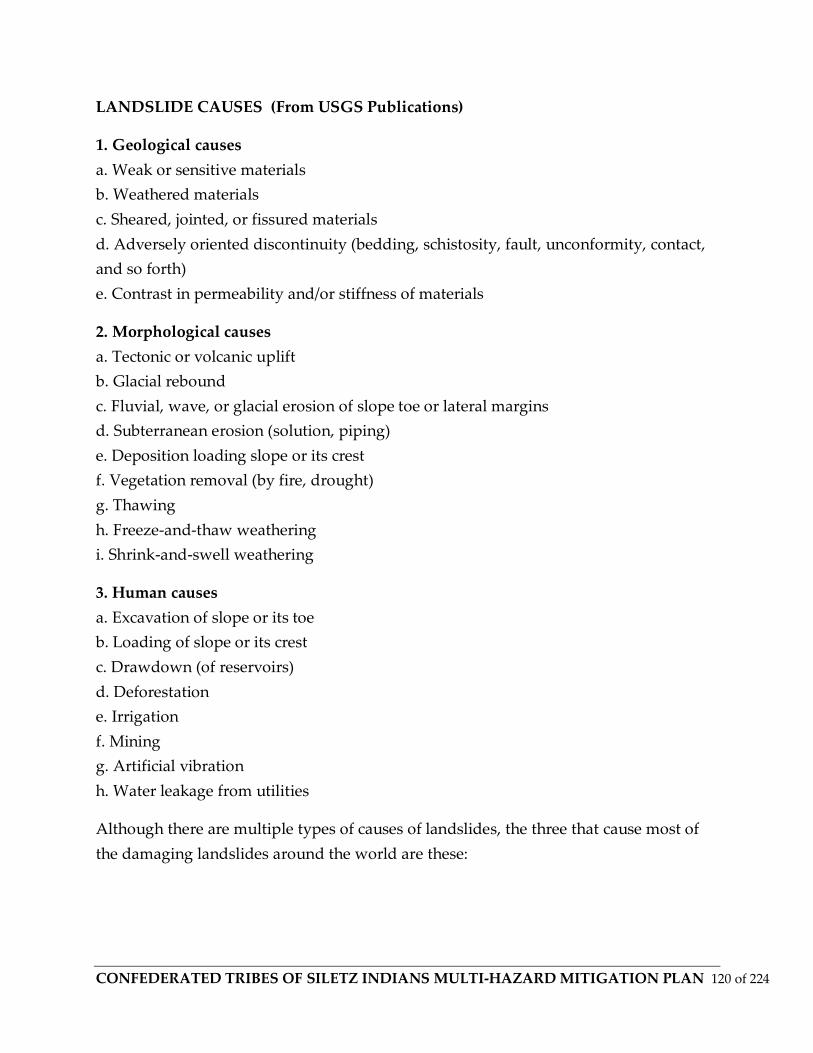
CONFEDERATED TRIBES OF SILETZ INDIANS MULTI-HAZARD MITIGATION PLAN 120 of 224
LANDSLIDE CAUSES (From USGS Publications)
1. Geological causes
a. Weak or sensitive materials
b. Weathered materials
c. Sheared, jointed, or fissured materials
d. Adversely oriented discontinuity (bedding, schistosity, fault, unconformity, contact,
and so forth)
e. Contrast in permeability and/or stiffness of materials
2. Morphological causes
a. Tectonic or volcanic uplift
b. Glacial rebound
c. Fluvial, wave, or glacial erosion of slope toe or lateral margins
d. Subterranean erosion (solution, piping)
e. Deposition loading slope or its crest
f. Vegetation removal (by fire, drought)
g. Thawing
h. Freeze-and-thaw weathering
i. Shrink-and-swell weathering
3. Human causes
a. Excavation of slope or its toe
b. Loading of slope or its crest
c. Drawdown (of reservoirs)
d. Deforestation
e. Irrigation
f. Mining
g. Artificial vibration
h. Water leakage from utilities
Although there are multiple types of causes of landslides, the three that cause most of
the damaging landslides around the world are these:
CONFEDERATED TRIBES OF SILETZ INDIANS MULTI-HAZARD MITIGATION PLAN 121 of 224
Landslides and Water
Slope saturation by water is a primary cause of landslides. This effect can occur in the
form of intense rainfall, snowmelt, changes in ground-water levels, and water-level
changes along coastlines, earth dams, and the banks of lakes, reservoirs, canals, and
rivers.
Landsliding and flooding are closely allied because both are related to precipitation,
runoff, and the saturation of ground by water. In addition, debris flows and mudflows
usually occur in small, steep stream channels and often are mistaken for floods; in fact,
these two events often occur simultaneously in the same area.
Landslides can cause flooding by forming landslide dams that block valleys and stream
channels, allowing large amounts of water to back up. This causes backwater flooding
and, if the dam fails, subsequent downstream flooding. Also, solid landslide debris can
"bulk" or add volume and density to otherwise normal streamflow or cause channel
blockages and diversions creating flood conditions or localized erosion. Landslides can
also cause overtopping of reservoirs and/or reduced capacity of reservoirs to store
water.
Landslides and Seismic Activity
Many mountainous areas that are vulnerable to landslides have also experienced at
least moderate rates of earthquake occurrence in recorded times. The occurrence of
earthquakes in steep landslide-prone areas greatly increases the likelihood that
landslides will occur, due to ground shaking alone or shaking-caused dilation of soil
materials, which allows rapid infiltration of water. The 1964 Great Alaska Earthquake
caused widespread landsliding and other ground failure, which caused most of the
monetary loss due to the earthquake. Other areas of the United States, such as
California and the Puget Sound region in Washington, have experienced slides, lateral
spreading, and other types of ground failure due to moderate to large earthquakes.
Widespread rockfalls also are caused by loosening of rocks as a result of ground
shaking. Worldwide, landslides caused by earthquakes kill people and damage
structures at higher rates than in the United States.
CONFEDERATED TRIBES OF SILETZ INDIANS MULTI-HAZARD MITIGATION PLAN 122 of 224
Landslides and Volcanic Activity
Landslides due to volcanic activity are some of the most devastating types. Volcanic
lava may melt snow at a rapid rate, causing a deluge of rock, soil, ash, and water that
accelerates rapidly on the steep slopes of volcanoes, devastating anything in its path.
These volcanic debris flows (also known as lahars) reach great distances, once they
leave the flanks of the volcano, and can damage structures in flat areas surrounding the
volcanoes. The 1980 eruption of Mount St. Helens, in Washington triggered a massive
landslide on the north flank of the volcano, the largest landslide in recorded times.
Landslides and debris flows always have and always will shape Oregon’s landscape.
Landslides become problematic, however, when people place buildings and
infrastructure in harm’s way. Additionally, development practices can cause or
contribute to the severity of landslides. There are several categories of landslides, based
on configuration (slide mechanism), slide materials, and rate of movement. Some slides
are ancient, deep-seated, and slow moving. Others move rapidly as a mass of rock,
mud, and large woody debris. All can be problematic when in the vicinity of buildings
and infrastructure. Fast-moving landslides, or debris flows, occur throughout Oregon,
but are especially noteworthy in the Cascade and Coast Ranges.
Debris flows (mudslides, mudflows, debris avalanches) are a common type of rapidly
moving landslide that generally occur during intense rainfall on previously saturated
ground. They usually begin on steep hillsides as slumps or slides that liquefy, accelerate
to speeds as great as 35 mph or more, and flow down slopes and channels onto gently
sloping ground. Their consistency ranges from watery mud to thick, rocky, mud-like
wet cement, dense enough to carry boulders, trees, and automobiles. Debris flows from
different sources can combine in canyons and channels, where their destructive power
is greatly increased. In general, slopes that are over 25 percent or have a history of
landslides might signal a landslide problem.
Landslides / debris flows probably accompany every major storm system that impacts
western Oregon. In recent events, particularly noteworthy landslides accompanied
storms in 1964, 1982, 1966, and 1996. Two major landslide producing winter storms
occurred in Oregon during November 1996. Intense rainfall on recently and past logged
land as well as previously unlogged areas triggered over 9,500 landslides and debris
flows that resulted directly or indirectly in eight fatalities. Highways were closed and a

CONFEDERATED TRIBES OF SILETZ INDIANS MULTI-HAZARD MITIGATION PLAN 123 of 224
number of homes were lost. The fatalities and losses resulting from the 1996 landslide
events brought about the passage of Oregon Senate Bill 12, which set site development
standards, authorized the mapping of areas subject to rapidly moving landslides and
the development of model landslide (steep slope) ordinances.
Oregon’s landslide / debris flow warning system primarily involves three state and one
federal agency: the Oregon Department of Forestry (ODF), the Oregon Department of
Geology and Mineral Industries (DOGAMI), the Oregon Department of Transportation
(ODOT), and the National Oceanic and Atmospheric Administration (NOAA). The
warning system is triggered by rainfall and monitored in areas that have been
determined to be hazardous. A landslide is the movement of rock, soil, and/or debris
down a slope that occurs when the materials comprising the slope can no longer resist
gravity. Factors that influence landslides (e.g., soil composition and moisture, slope
steepness, precipitation, land development and zoning practices, and seismic shaking)
generally decrease the shear strength (resistance) of the slope materials and/or increase
the shear stress (loading) to the slope. Saturation of slope materials with water, which
can be caused by heavy or prolonged rainfall and/or where human activity has altered
drainage patterns such that slopes are more likely to become saturated, can decrease
slope stability (shear strength). Undercutting of slopes by streams, waves, or
construction activity can increase the shear stress and the likelihood of slope failure
(landslide). Landslides occur without human influence, but can also be caused or
exacerbated by human activities. Landslides encompass a wide range of slope
movements, from small rock falls to debris flows to the failure of entire mountainsides,
and multiple landslides types can occur within a single event. The spatial extent of
landslides also varies from square feet to square miles. In general, most steep slopes are
at some risk of slope failure, and some soil/geologic formations are particularly
susceptible to landslide activity, even on relatively gentle slopes. For example, when
layers of sand and gravel lie above less permeable silt and clay layers, ground water can
accumulate and zones of weakness can develop. (ONHMP, CCMHMP)
The following characteristics may be indicative of a landslide hazard area (WEMD
2001):
- Bluff retreat caused by erosion and sloughing of bluff sediments, resulting in a
vertical bluff face with little vegetation.

CONFEDERATED TRIBES OF SILETZ INDIANS MULTI-HAZARD MITIGATION PLAN 124 of 224
- Pre-existing landslide area.
- Tension or ground cracks along or near the edge of the top of a bluff.
- Structural damage caused by settling and cracking of building foundations and
separation of steps from the main structure.
- Toppling, bowed or jack-sawed trees.
- Gullying and surface erosion.
- Mid-slope ground water seepage from a bluff face.
- Topographic convergence (especially as slope increases).
SLIDO Mapping and Landslide Types and Processes within Lincoln
County Oregon
CONFEDERATED TRIBES OF SILETZ INDIANS MULTI-HAZARD MITIGATION PLAN 125 of 224
Hazard Profile
Location
In many parts of Lincoln County, weathering and the decomposition of geological
materials produces conditions conducive to landslides. Human activity is believed to
further exacerbate the landslide problem. Landslides can occur all through the Tribe’s
area and on tribal lands. In particular, locations at risk from landslides or debris flows
include areas with one or more of the following conditions:
• On or close to steep hills;
• Steep road-cuts or excavations;
• Existing landslides or places of known historic landslides (such sites often have tilted
power lines, trees tilted in various directions, cracks in the ground, and irregular-
surfaced ground);
• Steep areas where surface runoff is channeled, such as below culverts, V-shaped
valleys, canyon bottoms, and steep stream channels; and
• Fan-shaped areas of sediment and boulder accumulation at the outlets of canyons.
The Oregon Department of Geology and Mineral Industries (DOGAMI) has created a
database of landslide deposits and past events, dating back to 1931. This database is
called Statewide Landslide Information Database of Oregon (SLIDO) Tribal lands on or
containing landslide deposits include the Toledo Mill Site, and some of the Lincoln
County and Tahkenitch area Timberlands. Maps of the SLIDO data will be updated and
uploaded to the CTSI website as time allows, and was last updated using SLIDO State
of Oregon data from DOGAMI online in 2019. Within the Tribe’s 1855 Reservation
Boundary , past events are recorded back to the 1996 Winter Storm event. These areas
were mapped and exposure of tribal lands and facilities was determined.
http://gis.oregon.gov/DAS/EISPD/GEO/docs/metadata/SLIDOr2.htm
https://www.oregon.gov/geo/Pages/sdlibrary.aspx

CONFEDERATED TRIBES OF SILETZ INDIANS MULTI-HAZARD MITIGATION PLAN 126 of 224
Severity
Past events
There have been frequent landslides and mudflows in the Lincoln County/
Confederated Tribes of Siletz area, and are usually associated with severe weather,
flooding and potentially, with earthquakes. The Oregon Dept. of Geology and Minerals
(DOGAMI) has been compiling a GIS database of past landslides and this was used to
analyze past events on Confederated Tribes of Siletz Tribal Lands and the area chosen
for this MHMP. State Highway 229 and Logsden Road provide the only road access to
the town of Siletz. During a major flood, these transportation routes could be inundated
by floodwaters and/or landslides, blocking all land access to the town of Siletz. These
roads have closed for several days during past flood events. Landslides along these
roads are also common during high rainfall events. To the Tribe’s knowledge, all three
routes have never been blocked at the same time. There is a high possibility that high
water and debris could damage one of the bridges that allows access to the town of
Siletz. The only recorded 100-year flood event on the Siletz River occurred in 1921, so
the current bridges have not been subject the forces and danger of a high flood event.
Accompanied by occasional landslides along US Highway 101 during high rainfall
events, the regional transportation routes have been crippled during past events.
Personal accounts from Tribal employees of the 1999 Thanksgiving Day reported that
water rose to within a few feet of the South Bridge Platform but did not make the bridge
inaccessible. FIRM maps indicate that a 500-year event would crest at a level higher
than the bottom support of the south bridge causing the water to back up and flow
around the bridge over the SR 229.
Probability/Frequency
Landslides can occur at any time, but most increase in frequency during and after times
of severe weather, flooding and earthquakes.
Vulnerability
Tribal lands located on hills, in riverine valleys, adjacent to deforestation practices, and
historical landslide vulnerability areas are most vulnerable to landslides, although the
Tribe is not at risk from any catastrophic flows at any given specific location at this
time. As the Tribe increases development in areas along the Central Oregon Coast,
CONFEDERATED TRIBES OF SILETZ INDIANS MULTI-HAZARD MITIGATION PLAN 127 of 224
particularly on steep slopes, its vulnerability will increase. The Tribe is also vulnerable
to landslides that close and block roads as they can prevent access to the Tribes
properties, facilities, and businesses along a myriad of locations on SR 229 and
Highway 101. Although some tribal lands have mapped landslide deposits, they are
located in undeveloped, remote areas.
Future Land Use
Although the Tribe does not have any specific plans to develop in landslide prone
areas, it has purchased lands on steep hills that could be potentially developed,
including for tribal housing, forestry lands, and others that have coastal erosion
problems that coincide with steep topography. The Tribe will ensure that landslide
hazards are mitigated before any development occurs in landslide prone hazard areas.
Data compiled from state, federal, ESRI and Confederated Tribes of Siletz Tribal
Sources. *Additional Mapping data and prints will be available online at a later date **
as prepared by Ian Keene 2018-2019- for Confederated Tribes of Siletz Tribal Multi-
Hazard Mitigation Plan
Severe Weather
Definitions
Blizzard: A storm with considerable falling and/or blowing snow combined with
sustained winds or frequent gusts of 35 mph or greater that frequently reduces visibility
to less than one-quarter mile.
Freezing Rain: This is the result of rain occurring when the temperature is below the
freezing point. When this occurs, the rain will freeze on impact and will result in a layer
of glaze ice over everything it touches. Although the layer of glaze is generally quite
thin it can measure up to one inch in depth. In a severe ice storm an evergreen tree
measuring 20 meters high and 10 meters wide can be burdened with up to six tons of
ice, creating a serious threat to power and telephone lines and transportation routes.
Severe Local Storms: These include what are termed “microscale” atmospheric systems:
tornadoes, thunderstorms, windstorms, ice storms and snowstorms. Typically, major
impacts from a severe storm are to transportation and loss of utilities. The major
characteristic all of these events have in common is that their effects are usually limited
CONFEDERATED TRIBES OF SILETZ INDIANS MULTI-HAZARD MITIGATION PLAN 128 of 224
in scope. Although one of these storms may cause a great deal of destruction and even
death, its impact is generally confined to a small area.
Snowstorms: These are caused by a war between air of different temperatures and
densities. This resultant low pressure system can cover thousands of square miles with
snow. Heavy snow in western Oregon is generally confined to the mountains with
heavy accumulation in the lowlands uncommon.
Thunderstorms: This is the most common of severe weather systems. These are
typically 25 kilometers in diameter and last 30 minutes from birth to growth through
maturity to decay. Thunderstorms are underrated hazards. Lightning, which occurs
with all thunderstorms, is a serious threat to human life nationwide. Heavy rains
dumped in a small area over a very short time can lead to flash flooding. Strong winds,
hail and tornadoes are also dangers associated with thunderstorms.
Tornadoes: Tornadoes are characterized by funnel clouds of varying sizes that generate
winds as fast as 500 miles per hour. They can affect an area of ¼ to ¾ of a mile, with the
path varying in width and length. Tornadoes can come from lines of cumulonimbus
clouds or from a single storm cloud. They are measured using the Fujita Scale ranging
from F0 to F6.
Windstorms: These are storms consisting of violent winds. There are several sources of
windstorms. Southwesterly winds are associated with strong storms moving onto the
coast from the Pacific Ocean. Southern winds parallel to the Cascade Mountains are the
strongest and most destructive winds. Windstorms tend to damage ridgelines that face
into the winds.
General Background
Severe winter storms can produce rain, freezing rain, ice, snow, cold temperatures and
wind. Severe winter storms affecting Lincoln County and the Confederated Tribes of
Siletz Indians originate in the Gulf of Alaska and the central Pacific Ocean and are most
common from October through March. Wind storms are also an issue, but are
diminished in the foothills and towards the Willamette Valley due to its being
surrounded by the Coast Range. The township of Siletz receives greater windbreak
from the surrounding topography than does the immediate coastline and homelands
along highway 101.

CONFEDERATED TRIBES OF SILETZ INDIANS MULTI-HAZARD MITIGATION PLAN 129 of 224
Hazard Profile
Location
All of the Tribe’s properties and buildings can be affected by severe weather, including
snow and ice, in the Siletz River Valley. The tops of hills and mountains, as well as
higher elevations exposed to the prevailing winds, are most exposed to the damaging
effects of severe weather including wind storms in winter.
Severity
Windstorms having sustained winds of at least 50 miles per hour (mph) cause
significant damage and occur frequently. Damage from storms includes loss from
automobile accidents, damage to vegetation and structures, business and school
closure, and power outages. Emergency response may be affected. During La Nina
weather years, severe weather can be more extreme. The worst storm years, such as
1996 flooding, were associated with La Nina climate patterns.
In general though, the Confederated Tribes of Siletz Indians administration buildings
and tribal housing (except for Lincoln City and other area Offices) location in the Siletz
Valley decreases the severity of even the most extreme storms. Nonetheless damages
and power outages can still occur.
Past Events
The Tribe did not report any specific events that caused damages or disruptions from
severe weather and windstorms. Although not as common as in other areas, the Siletz
Valley has been affected by strong winds, ice and snow in the past and will be
discussed below.
Snow
In the past 80 years, there were over 80 days where an inch of snow or greater fell in
Siletz, Newport, and Lincoln County and other areas of the Siletz Valley. All of the
snow events occurred between November and April.
The December 1919 storm was recorded as the third heaviest snow-producing storm in
Oregon. The Columbus Day Windstorm of 196 was the most destructive windstorm
ever recorded in the Pacific Northwest. The severe winter weather and windstorm

CONFEDERATED TRIBES OF SILETZ INDIANS MULTI-HAZARD MITIGATION PLAN 130 of 224
season is typically between October and April and damaging events occur every year.
Large events typically occur about once a decade. Large snow events used to occur
every 20-30 years during the late 19th to mid-20th centuries, but have become less
frequent. This may be attributable to changing climate patterns, ENSO, and the PDO.
The Flood section provides detailed information for all flood events including those
generated by winter storms. We will not duplicate that information here. The majority
of winter storms that affect the region are rain and wind based storms. Snow and ice
events have occurred in the past, but rainstorms are more frequent. High winds can be
expected throughout Lincoln County as experienced during most winter storms on the
Oregon Coast. Destructive windstorms are less frequent, and their pattern is fairly well
known. They form over the North Pacific during the cool months (October through
March), move along the coast and swing inland in a northeasterly direction. Wind
speeds vary with the storms. Gusts exceeding 100 miles per hour have been recorded at
several coastal locations
(Table below) but lessen as the storm moves inland. These storms can be very
destructive as documented in the now infamous Columbus Day Storm of October, 1962.
Less destructive storms usually topple trees, power lines, and cause building damage.
Flooding from these winter storm events causes a large percentage of Oregon’s annual
precipitation.
Historic Windstorm Events Affecting CTSI Property in Lincoln County
Date Location Description Remarks
January 1880 Western Oregon Very high winds 65-50 mph near Portland Flying debris;
fallen trees
January 1921 Oregon Coast/ Lower Columbia
Winds 113 mph at mouth of Columbia. Gusts at Astoria, 130 mph
Widespread damage
April 1931 Western Oregon
Unofficial reports of wind speeds up to 78 mph

CONFEDERATED TRIBES OF SILETZ INDIANS MULTI-HAZARD MITIGATION PLAN 131 of 224
Widespread damage November 1951 Most of Oregon Winds 40-60 mph with
75-80 mph gusts Widespread damage, especially to transmission lines
December 1951 Most of Oregon Winds, 60-100 mph, strongest along coast
Many damaged buildings. Telephone/power lines down
December 1955 Western Oregon Wind gusts at North Bend 90 mph
Significant damage to buildings and farms
January 1956 Western Oregon Heavy rains, high winds, mud slides
Estimated damage: $95,000 (1955 Dollars)
November 1958 Most of Oregon
Wind gusts to 75 mph at Astoria. Gusts to 131 mph at Hebo Damage to buildings and
utility lines
November 1962 Statewide
Wind speeds of 131 mph on the Oregon coast (Columbus Day Windstorms
Oregon's most destructive storm. 23 fatalities. Damage at $170 million
Vulnerability
The Tribe’s primary vulnerability from severe weather and windstorms is from power
outages and isolation from road closures. Business disruption, especially for facilities
without back-up generators, is also a vulnerability. Tribal elders are vulnerable,
especially those that can be trapped in their homes from power failures, heavy snow
and ice, and debris from falling trees and power lines. Some older homes and buildings
(such as barns) may also be affected by heavy wet snow on roofs. The Tribe’s timber
and forest resources may also be affected by wind, although not as common or severe as
forests near the coast.

CONFEDERATED TRIBES OF SILETZ INDIANS MULTI-HAZARD MITIGATION PLAN 132 of 224
Wildland Fire
Definitions
Forest Fire: Forest fires are the uncontrolled destruction of forested lands caused by
natural or human-initiated events. Wildfires occur primarily in undeveloped areas;
these natural lands contain dense vegetation such as forest, grasslands or agricultural
croplands. Because of their distance from firefighting resources and manpower, these
fires can be difficult to contain and can cause a great deal of destruction.
Conflagration: A conflagration is a fire which grows beyond its original source area to
engulf adjoining regions. Wind, extremely dry or hazardous weather conditions,
excessive fuel buildup and explosions are usually the elements behind a wildfire
conflagration.
Firestorm: This term describes a fire that expands to cover a large area, often more than
a square mile. A firestorm usually occurs when many individual fires grow together to
make one huge conflagration. The involved area becomes so hot that all combustible
materials ignite, even if they are not exposed to direct flame. Temperatures may exceed
1000° Celsius as the fire creates its own local weather: superheated air and hot gases of
combustion rise upward over the fire zone, drawing surface winds in from all sides,
often at velocities approaching fifty miles per hour. Although firestorms seldom spread
because of the inward direction of the winds, once started there is no known way of
stopping them. Within the area of the fire, lethal concentrations of carbon monoxide are
present; combined with the intense heat this hazard poses a serious life threat to
responding fire forces. In exceptionally large events, the rising column of heated air and
combustion gases carries enough soot and particulate matter into the upper atmosphere
to cause cloud nucleation, creating a locally intense thunderstorm and the hazard of
lightning strikes.
Wildland/Urban Interface (WUI) Area: The Wildland-Urban Interface (WUI) is an area
within or adjacent to an at-risk community identified in an Oregon Community
Wildfire Protection Plan (CWPP). Some Community Wildfire Protection Plans delineate
WUI boundaries (CWPP WUI). The Wildland-Urban Interface is the area where
structures or human improvement meet or intermingle with wildland vegetation, which
includes timber, grassland and brush fields. Communities with wildland fire risk (and
CONFEDERATED TRIBES OF SILETZ INDIANS MULTI-HAZARD MITIGATION PLAN 133 of 224
their boundaries) are identified by the state through the risk assessment process or
during development of Community Wildfire Protection Plans.
General Background
Wildfires are a common and widespread natural hazard in Oregon. Fire is a critical
component of the forest and rangeland ecosystems found in all portions of the state.
Over 41 million acres of forest and rangeland in Oregon are susceptible to wildfire,
which may occur during any month of the year, but usually occur between July and
October. In addition to wildland/urban interface fires, Oregon experiences wildland
fires that do not threaten structures, and also occasionally has prescribed fires. The
principal type affecting Oregon communities is interface fire, which occurs where
wildland and developed areas intermingle with both vegetation and structures
combining to provide fuel. As more people have moved into wildland interface areas,
the number of large wildfires impacting homes has escalated dramatically. The areas of
highest risk are in central, southwest, and northeast Oregon. Fuel, slope, weather, and
development are key components in wildfire hazard identification. (OSU, CCMHMP,
ODF)
The coastal areas of Oregon have separate fire regions in regards to threats and fire
ecology. Lincoln County and the Confederated Tribes of Siletz are in one of the lower
risk areas for wildfires in Oregon in terms of recurrence, but one of the higher in terms
of fire intensity and stand replacing fires (which many of the large stand replacing fires
in the last decades of been west of the coast range that are greater than 30,000 acres).
Seventy percent of the wildfires suppressed on lands protected by the Oregon
Department of Forestry (ODF) result from human activity. The remaining thirty percent
result from lightning. Typically, large wildfires which threaten WUI communities result
primarily from lightning. (ODF, CCMHMP)
For a more detailed discussion of wildfire issues within the Confederated Tribes of
Siletz Tribe’s Usual and Accustomed areas, including Lincoln County, please see the
Lincoln County Community Protection Plan. Of particular interest is Appendix B, Tiller
Pre-Contact Reference Condition Study, which discusses tribal wildfire and vegetation
management and from which research and findings were used for this hazard profile.
WILDFIRES

CONFEDERATED TRIBES OF SILETZ INDIANS MULTI-HAZARD MITIGATION PLAN 134 of 224
Wildland fires (wildfires), whether naturally occurring or caused by humans, can result
in the uncontrolled destruction of forests, brush, field crops, grasslands, and any
structures found within the landscape. Fire is a natural part of the ecosystem in the
western United States that has been unnaturally reduced in frequency due to fire
suppression efforts over the past century. These fire suppression efforts generally
resulted in an increase in the volume of wood available to feed a fire. The fire season in
Lincoln County typically runs from June through September. Dry periods can extend
the fire season. Factors affecting the vulnerability of an area to wildfire include the type
and density of vegetative fuel, weather conditions, and topography. Factors affecting
potential losses due to wildfire include the number and density of structures, distance
of structures from fuels, and proximity to firefighting resources.
Fire Season Changes over last years (Data from ODF and Lincoln County 2018 Fire
Plan)
Fire season Start Date
Fire Season End Date
Length (days)
2011 July 11th - October 3rd 84
2012 July 11th - October 16th 97
2013 July 2nd - September 25th 85
2014 July 1st - October 14th 105
2015 June 16th - October 26th 132
2016 July 5th - October 4th 91
Wildfires usually are extinguished when less than one acre in size, but can spread to
thousands of acres and may require thousands of firefighters and several weeks to
extinguish. Federal, state, county, city, and private agencies and private timber
companies typically combine to provide fire protection and firefighting services in the
region (WEMD 2001).
Many urban/wildland interface areas are located in some of the most fire-prone fuel
areas. The term interface is often used to describe areas where homes and other
structures have been built on or adjacent to forest and range lands. While the term is in
CONFEDERATED TRIBES OF SILETZ INDIANS MULTI-HAZARD MITIGATION PLAN 135 of 224
common use, the situation is not truly an interface. It is not an identifiable line, but
rather an intermingling of homes and structures with natural cover or forestlands at
various degrees of growth and complexity (Clackamas County 2002). This interface is
not limited to remote areas.
Profiles of Past Wildfire Events
Oregon has a very lengthy history of fire in the undeveloped wildlands and in the
developing wildland/urban interface. In recent years, the cost of fire suppression has
risen dramatically; a large number of homes have been threatened or burned, more fire
fighters have been placed at risk, and fire protection in wildland areas has been
reduced. These factors have prompted the passage of Oregon Senate Bill (SB) 360
(Forestland / Urban Interface Protection Act, 1997). This bill: (1) establishes legislative
policy for fire protection, (2) defines urban/wildland interface areas for regulatory
purposes, (3) establishes standards for locating homes in the urban/wildland interface,
and (4) provides a means for establishing an integrated fire protection system.
Most coastal counties (including Lincoln) are heavily timbered and have a long history
of devastating forest fires. Some of the history is derived from Native Americans who
recall extensive forest fires before the arrival of Euro-Americans. Fires involving the
wildland interface occur in portions of the state where urbanization and natural
vegetation fuels allow a fire to spread rapidly from natural fuels to structures and vice
versa. Especially in the early stage of such fires, structural fire suppression resources
can be quickly overwhelmed increasing the number of structures destroyed. Such fires
are known for the large number of structures that are simultaneously exposed to fire,
increasing the total losses per structure ignited. Nationally, wildland interface fires
commonly produce widespread, extreme losses. Thus far, Oregon has escaped the level
of property losses experienced by neighboring states. Table 9 describes the history of
some of the significant wildland fires experienced on the coast.
Historic Wildfires on the Oregon Coast
Date Name of Fire Location Area Burned Remarks
1846 Yaquina
CONFEDERATED TRIBES OF SILETZ INDIANS MULTI-HAZARD MITIGATION PLAN 136 of 224
Lincoln & Lane counties
Burned over 450,000 acres (estimates show as high as 497K acres)
Event related by Native American hunters.
1853 Nestucca Fire
Burned over 320,000 acres.
1868 Coos Bay Coos
296,000 acres burned
1922 Astoria
Downtown, City of Astoria
Many Buildings (32 city blocks burned)
Early December structural fire most likely not related to wildfire.
1933 Tillamook 240,000 acres burned
The Tillamook Forest burned every
six years between 1933 and 1951. (The complex is attributed with closer to 330,000 acres
total including several other complexes)
1936 Bandon 143,000 acres burned
1939
Saddle
Mountain Clatsop County 207,000 acres burned
1945
Wilson River/
Salmonberry Tillamook County 173,000 acres
1951
North Fork/
Elkhorn Tillamook County 33,000 acres burned
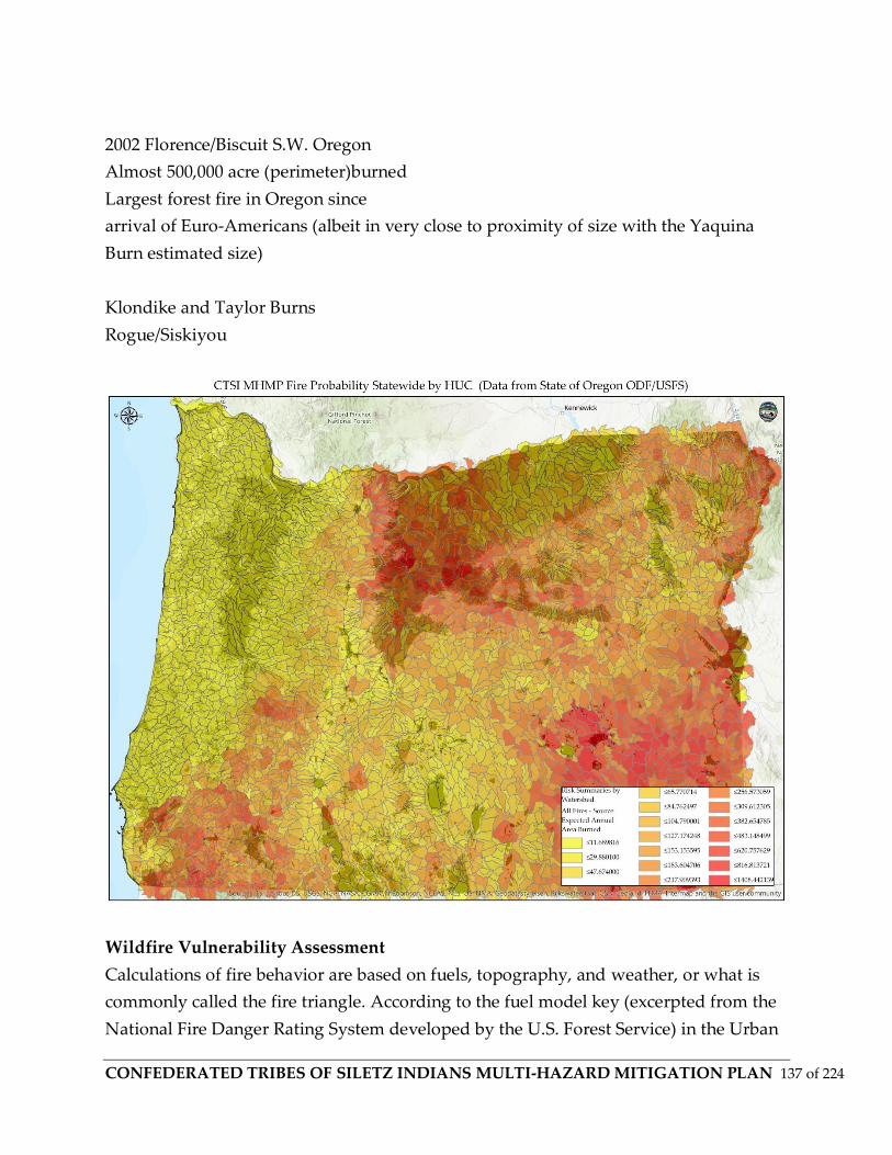
CONFEDERATED TRIBES OF SILETZ INDIANS MULTI-HAZARD MITIGATION PLAN 137 of 224
2002 Florence/Biscuit S.W. Oregon
Almost 500,000 acre (perimeter)burned
Largest forest fire in Oregon since
arrival of Euro-Americans (albeit in very close to proximity of size with the Yaquina
Burn estimated size)
Klondike and Taylor Burns
Rogue/Siskiyou
Wildfire Vulnerability Assessment
Calculations of fire behavior are based on fuels, topography, and weather, or what is
commonly called the fire triangle. According to the fuel model key (excerpted from the
National Fire Danger Rating System developed by the U.S. Forest Service) in the Urban

CONFEDERATED TRIBES OF SILETZ INDIANS MULTI-HAZARD MITIGATION PLAN 138 of 224
Wildland Interface Code (FEMA 2001a), the fire fuels in the forested areas of the
Reservation can be described as light to medium (out of three classifications: light,
medium, and heavy fuels). In the areas where deciduous trees dominate, the fuel classes
are light. In the areas of coniferous trees, fuel classes are mostly medium. Because of the
low critical fire weather frequency and slopes in the forested areas, the wildfire hazard
in these areas is moderate in severity.
Much of the uplands above the floodplains on the Reservation are forested and
therefore vulnerable to large wildfires. However, the relatively cool, humid, maritime
climate, the usually short dry season, the imposition of burning bans, and the close
proximity to firefighting resources combine to make the probability of a damaging
wildfire relatively low throughout. A damaging fire on the Reservation would probably
require a combination of factors: an extended dry period, hot weather to dry fuels, and
winds that are high enough to spread the fire faster than it can be controlled. Although
these conditions evidently occurred in the 1800s when there was no fire suppression
apparatus in the area, this combination of conditions is currently very rare on the
Reservation.
Potential Wildfire Losses
If a wildfire were to occur on or near tribal property the losses would most likely be in
timber resources since most tribal buildings are located away from urban/forest
transition areas.
Table 4.43 shows the total estimated value of woodland owned by the tribe. Such a total
loss is unlikely since a fire probably would not burn the whole area and would not
completely damage all houses in its path. Thus the estimated potential losses represent
a long-term, worst-case scenario. The tribe currently owns 41 parcels totaling
approximately 3600 acres of timberland. According to the Lincoln County Tax
Assessor’s Office the value of these lands is 2.02 million. The timber value of these
properties would be much greater than the County’s assessed value since the assessor
only calculates the value of the land not the resource value of the property.
Timber Revenue from logging on reservation lands supports several tribal programs
without staff. These programs include: Hatchery, Honoree Travel, Investment,

CONFEDERATED TRIBES OF SILETZ INDIANS MULTI-HAZARD MITIGATION PLAN 139 of 224
Contingency, Holiday Fund, Gifts, Tribal Court, Public Works, Security, Election Board,
Tribal Committees, Elders Council, Area Community Meetings, Culture Activities,
Honor/Color Guard, and Funeral Pot Lucks. Programs that include staff funding that
timber revenue supports include: Tribal Council Secretaries, Tribal Court, Security, and
Maintenance.
Drought
Drought Vulnerability Assessment
The entire population on tribal property is directly or indirectly vulnerable to drought
because water availability affects lives in many ways. Residents are directly affected by
a reduced water supply, either because well production may cease or be limited,
because wells can become contaminated by seawater, because water use restrictions
may be implemented, or because water costs may increase. Residents may be indirectly
affected if drought effects on hydroelectric power result in increased electricity rates to
industry, businesses, and private homes, which have ripple effects throughout the
economy. Another economic factor is a lack of irrigation for agriculture, which results in
unemployment and loss of farm production and associated income.
Approximately 80 percent of tribally owned lands are currently forested, and these
lands are a large source of income for the Tribe. During a drought, these forestlands
have an increased risk of fire, which could be devastating with the loss of timber
potentially causing human life losses and affecting recreation, natural and cultural
resources, and wildlife.
The Reservation’s overall vulnerability to drought is low. Prolonged events present a
significant fire, subsistence, and financial risk to tribal population and infrastructure.
However, severe droughts occur infrequently. The historically long duration of
droughts events could directly influence CTSI’s economic structure. The probability of
occurrence is low. While the 2001 drought affected much of the region, severe droughts
that have a large direct effect on the Confederated Tribes of the Siletz Indians are
relatively rare because of the maritime climate of the region. This climate provides
moderate temperatures that minimize the effect of dry periods, and it generally
provides rain-producing weather systems often enough to reduce the duration of a
drought.

CONFEDERATED TRIBES OF SILETZ INDIANS MULTI-HAZARD MITIGATION PLAN 140 of 224
In addition to the effect on the surface water supply used in the Siletz hatchery
property, lower flows in the Siletz River can have a large impact on salmon production
in the river. Salmon are important to the Siletz people both as a food source and
culturally.
Potential Drought Losses
State-wide droughts have historically occurred in Oregon, and as it is a region-wide
phenomenon, all residents are equally at risk. The effects of drought can be large and
far-reaching, quantifying these effects is difficult because droughts vary in severity and
duration and because many of the effects are indirect, complex, and/or diffuse.
Structural damage from drought is not expected; rather the risks are present to humans
and resources. Agriculture, fishing, and timber have historically been impacted, as well
as local and regional economies.
Hazard Profile
To show exposure and vulnerability to wildfires, GIS data created by Oregon
Department of Forestry (ODF) was used to show Wildland Urban Interface Areas which
are also defined as Community Wildfire Protection Plan Boundaries of which the Tribe
falls under numerous Plans in Lincoln County. ODF mapped variables to determine
risk which are shown in the hazard maps that follow.
Location
Lincoln County is +/- 90% covered by forest and thus a wildfire can occur anywhere in
this area if the conditions are met. Fire ecology tells us that all that is needed is climate
and weather conditions, fuels as above ground biomass, and topography to equate to
event.
Community at Risk, Hazard Rating______ The most current ODF fire data was used
https://www.oregon.gov/geo/Pages/geoservices.aspx
https://www.oregon.gov/GEO/Pages/index.aspx

CONFEDERATED TRIBES OF SILETZ INDIANS MULTI-HAZARD MITIGATION PLAN 141 of 224
Severity
GIS analysis of past wildfire events within the Confederated Tribes of Siletz Tribe 1855
Reservation Boundary revealed that near 80%% of all past events were less than an acre
in size, with 95% of all events less than ten (10 ) acres. The risk of large and severe fires
appears much greater today than in any other time in history due to increased living
and dead fuel accumulations, continuity of fuels across the landscape, extended canopy
closures, and prevalence of ladder fuels.
*Past Events of Fires listed above
Other significant fires in Western Oregon Lincoln are listed below
https://www.co.lincoln.or.us/emergencymanagement/page/hazards-wildfire
GIS analysis of past events compiled by the Oregon Department of Forestry
Through analysis of the Oregon Department of Forestry and United States Forests
Service, CTSI found that there were 8,135 wildfires within the Confederated Tribes of
Siletz Tribe 1855 Reservation Boundary area between 1980 and 2010. These events are
shown in and give a good visualization of the amount of wildfires in the area.
Historic Fires GIS data layers from Oregon Department of Forestry and United States
Forest Service
Data can be found at
https://data.fs.usda.gov/geodata/
https://www.oregon.gov/ODF/AboutODF/Pages/MapsData.aspx
Wildfire Causes on Confederated Tribes of Siletz Tribal Lands
Wildfire Causes
The Confederated Tribes of Siletz Indians CTSI has only begun acquiring land in the
last 40 some years with most land located in urban areas or in the Siletz River Valley
and thus has not had any reported large losses from wildfires in the past decades.
CONFEDERATED TRIBES OF SILETZ INDIANS MULTI-HAZARD MITIGATION PLAN 142 of 224
However, as the Tribe increases its land holdings and development, especially into the
coastal regions that encompass the 1855 Reservation boundary, the potential and
likelihood of losses is certain.
Probability/ Frequency
Fire is a natural component of forest and rangeland ecosystems found in all portions of
the state. Many of these ecosystems are dependent upon the existence of frequent fire,
or on a viable substitute, for their continued existence. Even western Oregon forests, in
the "wet" coastal and western portion of the state, depend upon fire.
Factors that influence the occurrence and severity of wildfires include poor forest
health, climate impacts which have extended some drought like conditions in various
years, invasive plant and tree species, high amounts of vegetation arising from long-
term fire exclusion, changes in weather and climate patterns locally and regionally, and
the ever increasing anthropogenic impacts of expanding human development in
Western Oregon. In Oregon, wildfires are inevitable. Although usually thought of as
being a summer occurrence, wildland fires can occur during any month of the year. The
vast majority of wildfires burn from June to October time period. Dry spells during the
winter months, especially when combined with winds and dead fuels, may result in
fires that burn with an intensity and a rate of spread that surprises many people in the
drier sections of our state. The vast majority of wild fires that occur on the Western side
of the Coast Range, are stand replacing and catastrophic in scale when large in size
(greater than 5,000 acres), e.g. Yaquina, Tillamook, Biscuit, et al.
It should be noted that with current forest management policies that focus on
suppression, wildfires have been trending towards increased size and severity and have
become harder to contain. Catastrophic fires, those which burn over 100,000 acres
during a single event or catastrophic fire years, calendar years in which more than
100,000 acres of forestland within a given area are burned by wildfire, whether during
the course of a single event, or as a result of numerous events, have become more
frequent in historic times.
Oregon Department of Forestry – West Oregon District Mobilization Plan The purpose
of the West Oregon District Mobilization Plan is to provide critical information
necessary to direct activities for wildfire and other emergencies. The Mobilization Plan
details the District’s critical information including: lists of personnel, vehicle

CONFEDERATED TRIBES OF SILETZ INDIANS MULTI-HAZARD MITIGATION PLAN 143 of 224
inventories, standard report forms, the District’s fire operations plan, cooperators, and
inventories of available equipment and other resources. The plan also covers the
District’s emergency and support services, details their radio operations, provides an
extended attack plan, and discusses the District’s procedures for dealing with other
incidents that may arise during a fire event. The district mobilization plan is updated
annually before the start of the fire season.
The Lincoln County CWPP Planning Committee supports the West Oregon District’s
efforts to develop formal documentation in advance of fire events to help coordinate its
response as well as the response of other fire service organizations that may be
providing assistance.
Lincoln County Community Wildfire Protection Plan - 2017 Update Page 14
Confederated Tribes of Siletz Indians Fire Mobilization Plan (2016)3 The Confederated
Tribes of Siletz Indians places a maximum emphasis on safety, the promotion of fire
prevention and suppression of all fires occurring on or adjacent to its operations and
timberlands. The Tribe’s 2016 Fire Mobilization Plan details its contact information,
general prevention actions, and fire readiness. The Plan also contains maps and other
graphical information useful for wildland fire planning.
Vulnerability
The Confederated Tribes of Siletz Tribe is located in the Western United States, and
being so, wildfire is both natural on the landscape and we live in one of the most
wildfire prone areas of the country and thus is highly vulnerable to wildfires. The
Klondike Fire complex, Biscuit Fire, and many others in recent years have shown that
Coastal Oregon is both under threat of wildfire regularly in the dry season, but also that
some of these fires, as in our further past, can be catastrophic and life altering for
communities. It is in our best interest to look back, even to the Yaquina Fire only one
hundred and seventy years ago, to see that Lincoln County, and many areas here have
burned in the past, and that they will likely at some point, naturally, burn again.
The vulnerability of a landowner in an area with increasing forest fires essentially will
increase their inherent vulnerability to that hazard. As the Tribe increases its land
holdings, the vulnerability, at least as a probabilistic analysis is concerned, increase. As
the Tribe acquires lands to the south and east, and into the upland ecotones in Lincoln
CONFEDERATED TRIBES OF SILETZ INDIANS MULTI-HAZARD MITIGATION PLAN 144 of 224
County, fire becomes increasingly important to forecast for. Nearly all of the Tribe’s
non-forest lands are within the Wildland -urban interface areas of Lincoln County.
As the Tribe develops more of its lands, the vulnerability of its structures will increase,
especially if effective mitigation efforts are not utilized.
Mitigation Strategy
This section provides the blueprint for the Confederated Tribes of Siletz Tribe to reduce
potential losses from the natural hazards identified in the Risk Assessment found in
Chapter 4. The format of this chapter is as follows:
Section 5.1 will describe the Goals and Objectives the Confederated Tribes of Siletz
Tribe has formulated to guide the selection of mitigation strategies.
Section 5.2 is an assessment of the Tribe’s pre-and post-disaster capabilities.
Section 5.3 identifies, evaluates and prioritizes the mitigation strategies the Tribe is
pursuing.
Section 5.4 identifies current and potential sources of Federal, State, Tribal, local and
private funding to implement mitigation activities.
Goals and Objectives
This section defines the general outcomes that can be expected as a result of successful
implementation of this plan. Plan goals are broad statements describing the principles
that guide the actions suggested in this document. Plan objectives are more targeted
statements that define strategies and implementation steps to attain the goals. The plan
goals and objectives below were developed based on the Tribe’s overall Mission
Statement, the outcome of planning meetings and the results of the Risk Assessment.
Tribal Mission Statement:
“The mission of the Confederated Tribes of Siletz Indians is to uphold Tribal
Government, protect and preserve Tribal history, culture and the general welfare of the
Tribal membership, as well as to provide for the economic needs of the Tribe and its
members through land acquisition and business development. To further fulfill its
mission, the Tribe fosters a “good work ethic” and independence for the membership

CONFEDERATED TRIBES OF SILETZ INDIANS MULTI-HAZARD MITIGATION PLAN 145 of 224
and strongly upholds the “government to government” relationship with local, State
and Federal governments. The Tribe constantly develops strong cooperative
relationships that benefit not only the Tribe, but the local community as well.”
Goals and objectives:
The Tribe intends to stay true to its Mission Statement while accomplishing the
following goals in developing its Plan:
• to protect its people, property, natural environment, natural resources and economic
vitality while upholding its sovereignty, identity and self-governance;
• to identify and recommend future projects and programs for the Tribe that, upon
implementation, would eliminate, reduce or otherwise mitigate the vulnerability of the
Tribe’s people, property, natural resources and economic vitality which may result from
impacts of future disasters;
• to guide future economic planning and development to include natural hazard risk
assessment as a component of future economic planning and development; and
• to promote a disaster resilient community.
The Tribe’s plan objectives include, but are not limited to:
• Focusing on risk assessment to keep future developments outside of known hazard
areas;
• Protecting culturally and historically significant Tribal sites and resources;
• Increasing mitigation and emergency management capabilities for the Tribe; and
• Supporting local and regional mitigation efforts that do not conflict with the Tribe's
Mitigation Goals.
5. Identification & Analysis of Tribal Mitigation Actions
The Mitigations actions proposed for this Tribal Multi-Hazard Mitigation Plan were
identified through the Community Hazards Survey and meetings with Tribal, Federal
and local/state officials. This section identifies the mitigation actions the Confederated

CONFEDERATED TRIBES OF SILETZ INDIANS MULTI-HAZARD MITIGATION PLAN 146 of 224
Tribes of Siletz Indians Tribe will implement as resources and funding become
available.
Mitigation actions can be grouped into six broad categories:27
1. Prevention. Government administrative or regulatory actions or processes that
influence the way land and buildings are developed and built. These actions also
include public activities to reduce hazard losses. Examples include planning and
zoning, building codes, capital improvement programs, open space preservation, and
storm water management regulations.
2. Property Protection. Actions that involve the modification of existing buildings or
structures to protect them from a hazard, or removal from the hazard area. Examples
include acquisition, elevation, relocation, structural retrofits, storm shutters, and
shatter-resistant glass.
3. Public Education and Awareness. Actions to inform and educate citizens, elected
officials, and property owners about the hazards and potential ways to mitigate them.
Such actions include outreach projects, real estate disclosure, hazard information
centers, and school-age and adult education programs.
4. Natural Resource Protection. Actions that, in addition to minimizing hazard losses,
also preserve or restore the functions of natural systems. These actions include sediment
and erosion control, stream corridor restoration, watershed management, forest and
vegetation management, and wetland restoration and preservation.
5. Emergency Services: Actions that protect people and property during and
immediately after a disaster or hazard event. Services include warning systems,
emergency response services, and protection of critical facilities.
6. Structural Projects: Actions that involve the construction of structures to reduce the
impact of a hazard. Such structures include dams, levees, floodwalls, seawalls, retaining
walls, and safe rooms.
7. Review of Local/Regional Mitigation Actions
The Tribe’s process of identifying and prioritizing mitigations actions began by
reviewing local and regional mitigation actions that could potentially affect the Tribe
and its interests. The Mitigation actions reviewed came from:
CONFEDERATED TRIBES OF SILETZ INDIANS MULTI-HAZARD MITIGATION PLAN 147 of 224
Lincoln County Hazard Mitigation Plan and Community Fire Plan – 2018 update
• Actions identified for specific review of tribal support
State of Oregon Natural Hazards Mitigation Plan – 2015 update
The State Interagency Hazard Mitigation Team (State IHMT) consists of staff from state
agencies and universities involved in hazard mitigation. It provides broad oversight
and policy direction for hazard mitigation in Oregon, including updating and
maintaining the Oregon NHMP. The Office of Emergency Management (OEM)
supports the State IHMT and manages some of the disaster mitigation funding that the
state receives from the federal government. Federal funds are generally given to the
state because of a Presidentially-declared natural disaster.
Through meetings and workshops with Tribal officials, the External Stakeholder
Workgroup and staff and community members, the Confederated Tribes of Siletz Tribe
identified 19 mitigation actions for prioritization and implementation in the previous
published mitigation plan.
The criteria used to prioritize included feasibility, costs and need. As the specific
mitigation projects are further defined, the FEMA Benefit-Cost Analysis software will
be used to rank said projects for feasibility.
The initially identified Mitigation Actions include:
Suggested from Steering Committee meeting in May, June, and July of 2018:
• Continued Coordination with City, County and State.
• Continued maintenance - continuing planning process – highest standards.
• Integrate Best Practices & Lessons Learned in to all planning processes
• Community and Public Emergency/Hazard Education & Outreach.
• Hazard awareness & emergency info for tribal members, employees, guests, and
tourists.
• Plan for redundancy of resources & facilities.
• Build structures to highest standards for those in known hazard areas.

CONFEDERATED TRIBES OF SILETZ INDIANS MULTI-HAZARD MITIGATION PLAN 148 of 224
• Develop Updated Emergency Operations Plan.
Hazard Type Hazard Name
Natural Hazards Coastal Erosion
Drought
Earthquake
Flooding
Landslide
Severe Weather and Winter Storms
Tsunami
Wildfire
FEMA Requires Identification of:
Location: geographical area in the tribal planning area that would be affected by
the hazard.
Extent: the magnitude or severity of each potential natural hazard.
Probability: Likelihood of the hazard occurring.
Past occurrences: information on the damages that occurred, the duration of the
event, and level of severity (e.g. flood depth, wind speeds, earthquake shaking
intensity, etc.)
Impacts and Vulnerabilities: The plan should describe vulnerability in terms of
the types and numbers of existing and future buildings, infrastructure, and critical
facilities located in the identified hazard areas.
Things to Consider when assessing impacts:
Geographic Scope: A description of the locations most likely to be impacted by
the hazard.

CONFEDERATED TRIBES OF SILETZ INDIANS MULTI-HAZARD MITIGATION PLAN 149 of 224
Health Impacts: A description of the potential short- and long-term human
health complications related to the hazard.
Displacement: A description of the hazard’s likelihood to cause the displacement
of tribal members or visitors accompanied by an estimate on the anticipated
displacement duration.
Economic Impacts: A description of the potential economic and financial losses
related to the hazard.
Environmental Impacts: A description of the potential impacts that may
adversely affect natural systems.
Structural Impacts: A description of the scale and scope of potential building and
infrastructure damages related to the hazard.
Critical Services: A summary of the tribal departments and functions most likely
to be taxed following the hazard.
Cascading Effects: A brief overview of potential secondary hazards caused by the
onset of the initial hazard in question.
Hazard: Flood
Previous Occurrence/History:
Source:
FEMA Flood Insurance Rate Maps
Potential Impacts from future climate conditions
Flood risk and vulnerability may Increase during King Tide events, especially when the
tide is in; additionally, future sea level rise may increase flooding and erosion at the
tribal properties in Lincoln City.
Location, Extent, and Magnitude
-See FEMA Flood Insurance Rate Maps of 100 year and 500 year flood hazard areas.

CONFEDERATED TRIBES OF SILETZ INDIANS MULTI-HAZARD MITIGATION PLAN 150 of 224
-King Tide Maps may be indicative of future flooding events resulting from future
climate conditions.
Future Probability Trend
It is likely that flood hazards will experienced more frequently in the spring and winter
months as a result of anticipated increases in the duration and frequency of
precipitation events.
Cascading Impacts
-raw sewage into river
-storm drains cause local flooding (undersized)
-undersized bridges may be at risk to high river flows, impacting transportation.
-Terraces?
Vulnerable Infrastructure
-water treatment
-Housing
-Hwy 20
-Hwy 229
-Admin buildings and boat ramps are vulnerable to high flooding events
Hazard: Earthquake
Previous Occurrence/History
-no recent events since the last plan.
Sources
USGS ShakeMap, DOGAMI Cascadia Scenario, Liquefaction Susceptibility and
probability Maps, SLIDO

CONFEDERATED TRIBES OF SILETZ INDIANS MULTI-HAZARD MITIGATION PLAN 151 of 224
Potential Impacts from future climate conditions
While earthquakes probability itself is not impacted by a changing climate, anticipated
intensity, frequency, and duration of precipitation events will likely cause an increase in
earthquake-caused landslides, especially if the earthquake occurs during the wet winter
months.
Location, Extent, Magnitude
-M9.0 –M9.2 Cascadia Event, Fault Map, soil classification maps
-DOGAMI HazVu shows active faults in area
Future Probability Trend
-According to the Oregon State Hazard Mitigation Plan, (PDF page 70 of the 2015 plan)
states that “for Oregon, west of the crest of the Cascades, the Cascadia subduction zone
is responsible for most the [earthquake] hazard… The return period for the largest
earthquakes is 530 years, and the probability of the next such event occurring in the
next 50 years ranges from 7 to 12%.”
Cascading Impacts
-Landslides
-Erosion
-Liquefaction
-Tsunami
-Evacuation
-City’s water storage is susceptible to liquefaction which would cause flooding of the
proposed museum.
-Bridges likely won’t withstand earthquakes, isolating the community. ODOT’s lifeline
plan doesn’t include the 229 bridge for seismic retrofit.
-All of Hwy 229 can be blocked from landslides due to susceptible soils which are prone
to shaking in an earthquake.

CONFEDERATED TRIBES OF SILETZ INDIANS MULTI-HAZARD MITIGATION PLAN 152 of 224
-Clinic and Casino are both very vulnerable to earthquakes and could benefit from
retrofits.
-Study needed of critical infrastructure to identify and determine vulnerability and
retrofit needs
-loss of economic revenue from casino and tourism industries
Vulnerability
-Channel loop
-Hwy 229
Hazard: Severe Weather and Winter Storms
Previous Occurrence/History
Potential Impacts from future climate conditions
Location, Extent, and Magnitude
Future Probability Trend
Cascading Impacts
Vulnerability
Hazard: Coastal Erosion
Previous Occurrence/History
Lincoln City has experienced coastal erosion
Potential Impacts from future climate conditions
Likely increased erosion at the backside of the resort, potentially impacts to casino
Location, Extent, Magnitude, and Probability
-Larger during king tide events

CONFEDERATED TRIBES OF SILETZ INDIANS MULTI-HAZARD MITIGATION PLAN 153 of 224
-If at flood stage, potential impacts exacerbated by erosion, flood, wave action, and
magnitude differences according to river, tide height
Future Probability Trend
Anticipated climate impacts will likely increase the amount of coastal erosion to Siletz
lands in Lincoln City.
Cascading Impacts
Vulnerability
Hazard: Drought
Previous Occurrence/History
Loss of drinking water source
Contamination of drinking water source
Loss of fishery
Drought-Caused Algae Blooms:
In May of 2018, the Salem water supply was compromised by a toxic algae bloom in the
city’s drinking water source, Detroit Lake. The reservoir, east of Salem, is annually
afflicted by algae blooms in late spring and early summer however, water tests revealed
that algal toxin levels were higher than deemed safe by the EPA, prompting the City of
Salem to issue a health advisory, suggesting those vulnerable to cyanotoxins (young
children and those with compromised immune systems) drink water from other
sources.
This health advisory prompted Oregon governor Kate Brown to issue a state of
emergency for Marion and Polk Counties. The emergency announcement prompted
National Guard troops to deploy and truck in fresh water, made available at alternative
water distribution centers.
Upon informing the public of toxins in the water, several supermarkets in the Salem
area ran out of bottled water, with major supermarket chains reporting low inventory

CONFEDERATED TRIBES OF SILETZ INDIANS MULTI-HAZARD MITIGATION PLAN 154 of 224
levels. Additionally, there were many reports of price gouging on bottled water in the
area, prompting State law enforcement to investigate the claims.
Sources
Toxic Algae Bloom Sources:
Zach Urness, Statesman Journal “From bloom to ban: How toxic algae fouled Salem’s
water for the first time”. Published May 30, 2018, Updated June 2, 2018.
https://www.statesmanjournal.com/story/news/2018/05/30/how-toxic-algae-fouled-
salems-water-first-time/656483002/
Bradford Betz, Fox News “Toxins in Salem drinking water prompt Oregon governor’s
emergency declaration”. Published May 31, 2018.
http://www.foxnews.com/us/2018/06/01/toxins-in-salem-drinking-water-prompt-
oregon-governors-emergency-declaration.html
Oregon Health Authority and City of Salem Water Advisory:
https://www.cityofsalem.net/water-advisory
Erin Ross, Oregon Public Broadcast. “As Salem Frets About Toxic Algae, Should The
Rest Of Oregon?” Published June 7, 2018.
Potential Impacts from future climate conditions
The Oregon Health Authority associates the higher than normal toxicity levels from the
2018 toxic algae blooms to be associated with climate change, “hotter and drier
conditions and a rapid snowmelt could definitely increase conditions that cause algae
blooms”.
Extent and probability
Future Probability Trend
Probability will increase during drought years (during late spring and early summer
months) and will likely become a more frequent occurrence as a result of changing
climate conditions. May 2018 was the fourth hottest month in Oregon history, and also
one of the driest. These conditions will likely be seen more frequently in the futre.
CONFEDERATED TRIBES OF SILETZ INDIANS MULTI-HAZARD MITIGATION PLAN 155 of 224
Cascading Impacts
-Drinking water supply may become contain toxic levels of algae
Vulnerability
-infants, young children, pregnant or nursing women, and others with compromised
immune systems (like those with kidney problems) are more vulnerable to the
cyanotoxins released into drinking water from algae blooms.
Hazard: Wildfire
Previous Occurrence/History
-Tillamook (1945 and 1951)
-Biscuit Fire (2002)
-2017 Fire season and resulting smoke
Sources
Potential Impacts from future climate conditions
Warmer and drier conditions anticipated from climate change will likely increase the
probability of future wildfires.
Extent and probability
-WUI, most critical facilities are surrounded by heavy wooded areas, making them
vulnerable to wildfires.
-wildfires can jump from clearcuts and grow quickly. There are several clearcuts in the
Siletz tribal area.
Future Probability Trend
Warmer and drier conditions anticipated from climate change will likely increase the
probability of future wildfires.
CONFEDERATED TRIBES OF SILETZ INDIANS MULTI-HAZARD MITIGATION PLAN 156 of 224
Cascading Impacts
-Closure of highway
-loss of timber
-Loss of tribal harvest lands
-Interruption of tribal cultural practices and berry picking
-loss of economic revenue from casino and tourism industries
Vulnerability
-many tribal lands and buildings are surrounded by heavy wooded areas
-smoke may impact those with asthma and other medical sensitivities.
Hazard: Landslides
Previous Occurrence/History
Between Hwy 229 and Newport several landslides have occurred in the past year alone,
blocking the hwy, the tribes lifeline.
Sources:
Potential Impacts from future climate conditions
Projected climate changes describe longer and wetter winters with an increase in
frequency, intensity, and duration of high precipitation events. This will cause
increased soil saturation of steep slopes that will likely an increased number of
landslides.
Extent and probability
Future Probability Trend
Will likely increase due to anticipated climate changes. Increased precipitation events
will contribute to an increase of future landslides.
Cascading Impacts

CONFEDERATED TRIBES OF SILETZ INDIANS MULTI-HAZARD MITIGATION PLAN 157 of 224
-Isolation
-Hindrance to resource logistics and evacuations (if landslides occur as a result of
earthquakes)
-ODOT plans for seismic retrofits to highways don’t cover hwy 229 which will hinder
evacuations and negatively impact
-loss of economic revenue from casino and tourism industries
Vulnerability
Hwy 229
Hazard: Tsunami
Previous Occurrence/History
Sources:
Potential Impacts from future climate conditions
Extent and probability
Will create a horseshoe effect and come up through “D” river.
See Tsunami Inundation Map from DOGAMI’s Cascadia Scenario
Future Probability Trend
Cascading Impacts
-loss of economic revenue from casino and tourism industries
Vulnerability
-Future expansion and growth of the tribe in Lincoln City is vulnerable to a tsunami
Other suggested actions: (from review of Lincoln County Plan, other tribal plans &
surveys)
CONFEDERATED TRIBES OF SILETZ INDIANS MULTI-HAZARD MITIGATION PLAN 158 of 224
• Become a Firewise Community: http://www.firewise.org/Communities/USA-
Recognition-Program.aspx
• Become a NWS StormReady Community: http://www.stormready.noaa.gov/
• Develop and maintain an Emergency Management Program.
• Join FEMA National Flood Insurance Program.
• Maintain flood & earthquake insurance coverage for tribal facilities and housing.
• Support Lincoln County Hazard Mitigation Actions.
• Develop a system to protect and maintain historical and archival Tribal records.
• Identify elders and other vulnerable populations to prioritize for mitigation and
disaster assistance.
• Implement a program such as Community Emergency Response Training (CERT) to
train Tribal members to respond to an emergency.
• Assure that the Tribal community is informed of the necessity of maintaining a 14-21
day supply of food and water, along with basic first aid and medical supplies.
Implementation of Mitigation Actions
This section will describe how the Confederated Tribes of Siletz Tribe’s mitigation
actions were prioritized, and will be implemented and administrated by the Tribe.
Prioritization
After the initial identification of mitigation actions, the Emergency Planning Committee
reviewed the actions for prioritization. They made internal recommendations that were
submitted to Tribal Council for review and adoption. On August 14, 2011, the
Confederated Tribes of Siletz Tribal Council adopted, via Resolution 2011-31, ten (10)
mitigation actions. This Resolution can be found in Appendix C. Upon additional
discussions and review within the Emergency Planning Committee, it was determined
to add one additional mitigation action, making the total of eleven.

CONFEDERATED TRIBES OF SILETZ INDIANS MULTI-HAZARD MITIGATION PLAN 159 of 224
A formal method of evaluation was not used, but the following considerations were
used during the prioritization process:
• Cost effective: Can this project be implemented within the current budget or with
current available funding?
• Relevancy: Is this project relevant to the Mitigation Goals of the Tribe?
• Political will: Is this a project that the Tribe can implement and see through?
Due to the nature of the mitigation actions identified, especially in regards to a lack of
FEMA PDM eligible projects, a formal benefit-cost analysis (BCA) was not conducted
for each identified action. If certain projects are deemed fundable, a BCA will be
conducted prior to the development of grant applications.
Implementation
The Confederated Tribes of Siletz Tribal Emergency Planning Committee will oversee
the implementation of the mitigation plan and will identify and work with relevant
departments and outside agencies. Each mitigation action also has an implementation
timeline which is as follows:
On-going: Mitigation action will begin short-term and will continue indefinitely.
Short-term: Mitigation action can be implemented within five (5) years.
Long-term: Mitigation action will be implemented in the future. If not begun within five
(5) years, will be re-evaluated in the update
At this time, a detailed implementation strategy for each mitigation action has not been
developed but will be when the Tribe determines it is feasible to implement the specific
action.
Administration
The Confederated Tribes of Siletz Tribe’s Emergency Planning Committee will lead in
the administration of the mitigation actions and direct/oversee relevant departments in
the implementation.
CONFEDERATED TRIBES OF SILETZ INDIANS MULTI-HAZARD MITIGATION PLAN 160 of 224
The Emergency Planning Committee will work to identify funding sources, if
applicable, for the implementation of actions. Many of the mitigation actions identified
can be implemented without major sources of outside funding, and thus can be carried
out within the existing tribal budget.
5.5. Prioritized Mitigation Actions
In keeping with the above listed goals and objectives, the Tribe plans to implement the
following eleven mitigation actions to reduce the effects of natural hazards:
• Plan for redundancy of Tribal resources and facilities;
• Continue to plan and build Tribal structures to highest standards and, if possible, to
keep such structures out of known hazard areas;
• Develop and maintain an Emergency Management Program and overall Tribal
Emergency Operations Plan;
• Become a member community of FEMA’s National Flood Insurance Program (NFIP);
• Maintain flood and earthquake insurance coverage for existing Tribal facilities and
housing which are located within a known hazard area, with future evaluation whether
it remains prudent to maintain said insurance (cost benefit ratio);
• Identify Tribal elders and other vulnerable populations so mitigation and disaster
assistance can be prioritized;
• Educate members of the Tribal community and Tribal employees regarding
importance of personal and/or family preparedness, for natural disasters and/or
terrorism to aid in self-reliance during a disaster or event;
• Develop hazard awareness and emergency information for Tribal employees, guests
and tourists;
• Conduct drills and tests of mitigation and emergency system developed;
• Continue to coordinate with City, County and State in mitigation efforts; and
• Support State and County mitigation actions and exercises
The format and explanation of each mitigation measure is shown below:
CONFEDERATED TRIBES OF SILETZ INDIANS MULTI-HAZARD MITIGATION PLAN 161 of 224
Mitigation Strategy: The mitigation action or activity is shown here. “T” stands for
Tribal. These actions are proposed in the Confederated Tribes of Siletz Tribal Multi-
Hazard Mitigation Plan.
Associated Hazards: Each mitigation strategy is related to one or more of the hazards
that could affect the Confederated Tribes of Siletz.
Timeline: This estimates the amount of time it will take to begin implementation of each
strategy. Under timeline there are three categories, short term, long term and ongoing.
• Ongoing: the mitigation strategy will be implemented in years one to five and will
continue into the future indefinitely.
• Short Term: the mitigation strategy will be implemented in years one to two.
• Long Term: the mitigation strategy will be implemented in years three to five.
Lead Agency: This is the agency or agencies that will organize resources, find
appropriate funding or oversee project implementation, monitoring and evaluation.
Implementation Cost: This is the approximate amount that the strategy will cost to
implement.
Related Goals: Each mitigation strategy is related to a Goal listed in Section
Prioritized Mitigation Strategy 2020-2024
Confederated Tribes of Siletz Tribe Mitigation Strategy 2020-2024
Associated Hazards
Timeline
Lead Agency
Implementation Costs
Plan Goals Addressed
Earthquake

CONFEDERATED TRIBES OF SILETZ INDIANS MULTI-HAZARD MITIGATION PLAN 162 of 224
Flood
Landslide
Severe Weather
Wildland Fire
Goal 1: Protect its people, property, natural environment, natural resources and
economic vitality while upholding its sovereignty, identify and self-governance.
Goal 2: Identify and recommend future projects and programs for the Tribe.
Goal 3: Guide future economic planning and development to include natural hazard
risk assessment as a component of future economic planning and development.
Goal 4: Promote a disaster resilient community.
Plan for redundancy of Tribal resources and facilities
On-going
Emergency Planning Committee
Continue Quarterly Meetings and appointment of new members as old members leave
Continue to plan and build Tribal structures to highest standards and, if possible, to
keep such structures out of known hazard areas
On-going
Emergency Planning Committee
Develop and maintain an Emergency Management Program and overall Tribal
Emergency Operations Plan
On-going
Emergency Planning Committee
Continue to be a member community of FEMA’s National Flood Insurance Program
(NFIP);

CONFEDERATED TRIBES OF SILETZ INDIANS MULTI-HAZARD MITIGATION PLAN 163 of 224
Short-term
Emergency Planning Committee
Maintain flood and earthquake insurance coverage for existing Tribal facilities and
housing which are located within a known hazard area, with future evaluation whether
it remains prudent to maintain said insurance (cost benefit ratio)
This MHMP recommends the following specific priorities for flood and windstorm
mitigation:
1. Make necessary improvements to local water system.
2. Mitigate flood damage to Toledo Mill Property.
3. Protect vulnerable structures and cultural areas in the coastal and riverine
floodplains, outside of the velocity zone and floodway, respectively.
4. Develop ordinances to limit development in the floodplain that comply with the
National Flood Insurance Program.
In addition, the following priorities are recommended for all natural hazards:
1. Pursue funding for the CTSI mitigation priorities and recommendations
described in this MHMP, including funding for needed staff and infrastructure.
2. Improve and sustain public education programs aimed at mitigating natural
hazards.
3. Redirect and/or relocate development away from hazard areas.
4. Encourage seismic strength evaluations of schools, public infrastructure, and
critical facilities in the town of Siletz to identify vulnerabilities and help prioritize
mitigation to meet current seismic standards.
5. Encourage reduction of nonstructural and structural earthquake hazards in
homes, schools, businesses, and government offices.
6. Develop and implement programs to keep trees from threatening lives, property,
and public infrastructure during windstorm events.

CONFEDERATED TRIBES OF SILETZ INDIANS MULTI-HAZARD MITIGATION PLAN 164 of 224
7. Monitor erosion rates on the properties located along the ocean in Lincoln City.
This MHMP recommends the following action plan:
1. Pursue funding for CTSI mitigation priorities and recommendations described
above, including funding for needed staff and infrastructure;
2. Develop strategies to resolve water capacity issues in Siletz, including drought,
flood, allocation, and distribution issues surrounding climate projected impacts related
to natural hazards and water;
3. Coordinate hazard planning with other jurisdictions, as appropriate, and review
any actions proposed for the Siletz River and/or Siletz River watersheds that may affect
flooding in the Siletz area (i.e., all proposed actions);
4. Coordinate Tribal emergency response efforts with other appropriate
jurisdictions and agencies; and
5. Implement a public education effort that will inform residents and customers of
the potential natural hazards on CTSI properties.
This MHMP provides detailed recommendations and an action plan designed to meet
each objective and, ultimately, the goals of the plan.
Authority to Plan
Section 322 of the Robert T. Stafford Disaster Relief and Emergency Assistance Act
(Stafford Act) 42 U.S.C. 5165, as amended by the Disaster Mitigation Act of 2000 (DMA)
(P.L. 106-390), provides for States, Indian Tribal governments, and local governments to
undertake a risk-based approach to reducing risks to natural hazards through
mitigation planning.
The National Flood Insurance Act of 1968, 42 U.S.C. 4001 et seq., as amended, further
reinforces the need and requirement for mitigation plans, linking flood mitigation
assistance programs to State, Tribal, and Local Mitigation Plans.
In recognition of tribal sovereignty and the government-to-government relationship
that FEMA has with Indian Tribal governments, FEMA amended 44 CFR Part 201 at 72

CONFEDERATED TRIBES OF SILETZ INDIANS MULTI-HAZARD MITIGATION PLAN 165 of 224
Fed. Reg. 61720, on October 31, 2007, and again at 74 Fed. Reg. 47471, on September 16,
2009, to consolidate and clarify the requirements for Indian Tribal governments,
establish Tribal Mitigation Plans separately from State and Local Mitigation Plans, and
finalize the Mitigation Planning rule.
Hazard Risk Report from DOGMAI for Lincoln County
• This is the conclusions section from DOGAMI’s report
The purpose of this study is to provide a better understanding of potential impacts from
multiple natural hazards at the community scale. We accomplish this by using the latest
natural hazard mapping and loss estimation tools to quantify expected damage to
buildings and potential displacement of permanent residents. The comprehensive and
fine-grained approach to the analysis provides new context for the county’s risk-
reduction efforts. We note several important findings based on the results of this study:
1. A Cascadia M9 earthquake and tsunami will cause extensive overall damage and
losses - Due to its proximity to the Cascadia subduction zone (CSZ), every community
in Lincoln County will experience significant impact and disruption from a CSZ
magnitude 9.0 earthquake event. Event impacts that were examined are limited to
earthquake (including ground deformation) and tsunami. Results show that a CSZ M9.0
event will cause 30% to 50% building losses across all communities. Some communities
like Newport and Wakonda Beach can expect a high percentage of losses due to
tsunami. Other communities like the City of Toledo have little to no tsunami exposure
but will have high losses from earthquake alone. The high vulnerability of the building
inventory (primarily because of the age of construction), the proximity to the CSZ event,
and the amount of development within tsunami zones all contribute to the estimated
levels of losses expected in the study area.
2. Retrofitting buildings to modern seismic building codes can reduce damages and
losses from earthquake - Seismic building codes have a major influence on earthquake
shaking damage estimated by Hazus-MH, a software tool developed by the Federal
Emergency Management Agency (FEMA) for calculating loss from natural hazards. We
examined potential loss reduction from seismic retrofits (modifications that improve a
building’s seismic resilience) in simulations by using Hazus-MH building code “design

CONFEDERATED TRIBES OF SILETZ INDIANS MULTI-HAZARD MITIGATION PLAN 166 of 224
level” attributes of pre, low, moderate, and high codes (FEMA, 2012b) in CSZ
earthquake scenarios. The simulations were accomplished by upgrading every pre
(non-existent) and low seismic code building to moderate seismic code levels in one
scenario, and then further by upgrading all buildings to high (current) code in another
scenario. We found that retrofitting to at least moderate code was the most cost-
effective mitigation strategy because the additional benefit from retrofitting to high
code was minimal. In our simulation of upgrading buildings to at least moderate code,
the estimated loss for the entire study area went from 23% to 16%. We found further
reduction in estimated loss in our simulation to 13% only by upgrading all buildings to
high code. Some communities would see greater loss reduction than the study area as a
whole due to older building stock constructed at pre or low code seismic building code
standards. An example is the City of Newport, which would see a significant loss
reduction (from 24% to 14%) by retrofitting all buildings to at least moderate code. This
stands in contrast to a community with younger building stock, such as Depoe Bay,
which would see loss reduction go from 20% to 14%. While seismic retrofits are an
effective strategy for reducing earthquake shaking damage, it should be noted that
earthquake-induced landslide and liquefaction hazards will also be present in some
areas, and these hazards require different geotechnical mitigation strategies.
3. Flooding is a recurrent problem for many communities in Lincoln County -
Many buildings within the floodplain are vulnerable to significant damage from
flooding. At first glance, Hazus MH flood loss estimates may give a false impression of
risk because they show fairly low damages for a community relative to other hazards
we examined. This is due to the difference between loss estimation and exposure
results, as well as the limited area impacted by flooding. An average of 12% loss was
calculated for buildings within the 100-year flood zone. Residents and buildings located
near the estuaries and coastal margins are at a greater risk from flood than other
locations within the study area. The areas that are most vulnerable to flood hazard
within the study are residential buildings along the Siletz River and developed portions
of the City of Toledo along the river.
4. Elevating structures in the flood zone can reduce vulnerability - Flood exposure
analysis was used in addition to HAZUS-MH loss estimation to identify buildings that
were not damaged but that were within the area expected to experience a 100-year
flood. By using both analyses in this way, the number of elevated structures within the

CONFEDERATED TRIBES OF SILETZ INDIANS MULTI-HAZARD MITIGATION PLAN 167 of 224
flood zone could be quantified. This showed possible mitigation needs in flood loss
prevention and the effectiveness of past activities. For example, in the community of
Lincoln City nearly half of the buildings exposed to flooding are elevated above the
base flood elevation (BFE). The Cities of Toledo and Siletz would benefit from elevating
buildings, because for the large number of buildings exposed to flooding very few of
them are elevated.
5. New landslide mapping would increase the accuracy of future risk assessments -
Exposure analysis was used to assess the threat from landslide hazard. Landslide is a
widespread hazard and is present for some communities within the county. The
communities of Otis-Rose Lodge, Lincoln City, Toledo, and Yachats all have high levels
of exposure to landslide hazard. The landslide hazard data used in this risk assessment
were created before modern mapping technology; future risk assessments using
LiDAR-derived landslide hazard data would provide more accurate results.
6. Exposure analysis shows that most communities along the open coast are at risk
of coastal erosion hazard - Exposure analysis shows that nearly the entire developed
coastline in Lincoln County is vulnerable to coastal erosion hazard. The communities of
Newport and Otter Rock, for example, have approximately 8% of their total building
value exposed to high coastal erosion hazard.
7. Wildfire hazard is moderate for the overall study area - Exposure analysis shows
that buildings in the eastern part of the county are at high risk of wildfire hazard. High
wildfire hazard is primarily limited to heavily forested rural areas and along both the
Alsea and Yaquina Rivers. However, moderate wildfire hazard is present throughout
the county and so is a potential threat for communities.
8. Most of the study area’s critical facilities are at high risk to a CSZ earthquake and
tsunami - Critical facilities were identified and were specifically examined within this
report. We have estimated that 79% of Lincoln County’s 72 critical facilities will be non-
functioning after a CSZ event. In comparison, 29% (21) of critical facilities are at risk of
landslide hazard. A small number of critical facilities are at risk of flooding (3) and
wildfire (5).
9. The two biggest causes of displacement to population are a CSZ event
(earthquake and tsunami) and landslide - Displacement of permanent residents by
natural hazards was quantified within this report. We estimated that 30% of the

CONFEDERATED TRIBES OF SILETZ INDIANS MULTI-HAZARD MITIGATION PLAN 168 of 224
population in the county would be displaced due to the combination of earthquake and
tsunami. Landslide hazard is a potential threat to 32% of permanent residents, and
flood hazard puts 5% at risk of displacement. A small percentage of residents are at risk
of displacement from wildfire and coastal erosion.
10. Community needs can be prioritized - Each community within the study area
was assessed for natural hazard exposure and loss. This allowed for comparison of risk
between communities and impacts from each natural hazard. In using Hazus-MH and
exposure analysis, these results can assist in developing plans that address the concerns
for those individual communities.
Confederated Tribes of Siletz Tribe Mitigation Strategy 2020-2024
Associated Hazards
Timeline
Lead Agency
Implementation Costs
Plan Goals Addressed
Earthquake
Flood
Landslide
Severe Weather
Wildland Fire
Goal 1: Protect its people, property, natural environment, natural resources and
economic vitality while upholding its sovereignty, identify and self-governance.
Goal 2: Identify and recommend future projects and programs for the Tribe.
Goal 3: Guide future economic planning and development to include natural hazard
risk assessment as a component of future economic planning and development.
Goal 4: Promote a disaster resilient community.

CONFEDERATED TRIBES OF SILETZ INDIANS MULTI-HAZARD MITIGATION PLAN 169 of 224
Identify Tribal elders and other vulnerable populations so mitigation and disaster
assistance can be prioritized
Short-term
Emergency Planning Committee
Educate members of the Tribal community and Tribal employees regarding importance
of personal and/or family preparedness, for natural disasters and/or terrorism to aid in
self-reliance during a disaster or event
Emergency Planning Committee
Develop hazard awareness and emergency information for Tribal employees, guests
and tourists
On-going
Emergency Planning Committee
Conduct drills and tests of mitigation and emergency system developed
On-going
Emergency Planning Committee
Continue to coordinate with City, County and State in mitigation efforts
On-going
Emergency Planning Committee
Continuously meet and help update mitigation strategy and goals
Support State and County mitigation actions and exercises
On-going
Emergency Planning Committee
Integration by Plan Element (Elements from FEMA)

CONFEDERATED TRIBES OF SILETZ INDIANS MULTI-HAZARD MITIGATION PLAN 170 of 224
Natural hazard mitigation can be integrated into the comprehensive plan through the
incorporation of information and or mitigation strategies into each plan element or as a
separate stand-alone element. Possible methods of integration are described below for
each of the elements found in a typical comprehensive plan.
Community
History, Existing Conditions, and Physical Features
Include a description of past natural disasters and their effects on the community as
well as the geographical extent, severity, and probability of potential natural hazards.
Include hazard maps to identify the location of hazardous areas within the community.
Future Land Use
Analyze hazard exposure and vulnerability as part of the development of the future
land use map and policies.
Identify hazard areas and include policies to establish standards to control development
and reduce vulnerability.
Identify potential problems that may arise from various densities of development in
hazard-prone areas, determine what densities are appropriate, and establish standards
to direct development away from high-hazard areas.
Use easements and acquisition, when possible, to prevent inappropriate or unsafe uses
of land
Conservation/Natural Resources
Protect and restore natural protective features, such as floodplains, wetlands, marshes,
and dunes.
Protect wildlife migration corridors along rivers and streams to serve as habitat and
environmental protection.
Limit development in flood prone areas
Preserve natural vegetation and woodlands on steep slopes to reduce the likelihood of
landslides.

CONFEDERATED TRIBES OF SILETZ INDIANS MULTI-HAZARD MITIGATION PLAN 171 of 224
Conserve natural woodlands without development to reduce building exposure to
wildfires.
Public Facilities/Services
Include policies that limit public expenditure for infrastructure and public facilities in
high-hazard areas.
Use capital improvement policies to steer development away from hazardous areas.
Link water treatment facilities, stormwater management, and sewerage and solid waste
policies to natural hazard mitigation.
Interconnect service networks, such as roads, pipelines, and cables, and allow more
than one route to any point so that they are less vulnerable to local failures because
individual sections can be isolated as necessary.
Locate critical public facilities, such as police and fire stations or emergency operation
centers, in safe locations that are not likely to be affected by hazards.
Locate other major public facilities in safe areas to double as emergency shelters.
Transportation
Determine if transportation facilities are adequate in the event of an evacuation. Plan for
contingencies if there is structural failure of bridges or other infrastructure.
Correct any known deficiencies of potential weakness in infrastructure.
Use transportation projects to determine the location and density patterns of future
growth (projects most likely to be involved directly with capital improvements
planning).
Use transportation policies to guide growth to safe locations and limit access to natural
hazard areas.
Housing
Acquire older housing stock in floodplains or other hazardous areas.
CONFEDERATED TRIBES OF SILETZ INDIANS MULTI-HAZARD MITIGATION PLAN 172 of 224
Address issues of how housing demand is influenced by the desire for siting near
natural amenities, which can produce attractions to hazardous locations.
Retrofit or replace public and publicly-subsidized affordable housing to reduce damage
to inhabitants during a natural disaster.
Be aware that manufactured homes pose particular problems of vulnerability
especially to high winds.
Historic Preservation
Protect historic resources from hazards, specifically floods or earthquakes, with
appropriate retrofitting techniques.
Economic Development
Develop policies to aid economic recovery post disaster, such as undergrounding
utilities within a business district. Provide technical assistance to support natural
hazard mitigation for vulnerable small businesses.
Use the community’s safety to attract potential new businesses to the area.
Recreation and Open Space
Convert vulnerable floodplain land, steep slopes, and areas vulnerable to wildfire or
other hazards into open space or recreational areas to help avert or minimize disaster by
sacrificing park land in the short term instead of allowing floods, landslides, wildfires,
and other natural hazards to ruin homes or businesses.
Use natural hazard mitigation objectives to protect and provide public access to areas
that are also deemed potentially hazardous for development (i.e., riverfronts and
beaches) to guide land acquisition choices for open space.
Environment
Couple mitigation goals like floodplain management with clean air and clean water
goals.
Designate critical and sensitive areas to focus planning for specific areas that have an
especially high priority for protection of natural features.

CONFEDERATED TRIBES OF SILETZ INDIANS MULTI-HAZARD MITIGATION PLAN 173 of 224
Establish good floodplain management practices that protect endangered species
habitat as well as help reduce and prevent flood damage.
Link the goals and objectives of watershed management (i.e., pollution runoff control,
Total Maximum Daily Loads implementation) with hazard mitigation efforts. Prevent
the conflict of natural forces and hazardous materials by mitigating the potential
destructive combination of natural hazards and industrial development that could
otherwise exacerbate losses, such as the contamination of floodwaters. Link wildfire
safety with environmental protection strategies (i.e., improving forest ecology, wildlife
habitat, etc.).
Protect and restore natural vegetation and other natural resources that provide
floodplain protection, minimize erosion, stabilize slopes, or provide other ecosystem
services.
Public Safety Hazards
▪. Reduce the risk of public exposure to natural hazards.
▪. Protect the community from the risk of natural hazard events.
▪. Develop emergency response plans for natural hazard events.
▪. Incorporate all or most of the content and findings of the natural hazard
mitigation plan by reference in a stand-alone natural hazards element, and
preferably the two documents will differ little, if at all, in overall content.
Use transportation projects to determine the location and density patterns of future
growth (projects most likely to be involved directly with capital improvements
planning). Use transportation policies to guide growth to safe locations and limit access
to natural hazard areas.
Housing-
Acquire older housing stock in floodplains or other hazardous areas.
Address issues of how housing demand is influenced by the desire for siting near
natural amenities, which can produce attractions to hazardous locations.
CONFEDERATED TRIBES OF SILETZ INDIANS MULTI-HAZARD MITIGATION PLAN 174 of 224
Retrofit or replace public and publicly-subsidized affordable housing to reduce damage
to inhabitants during a natural disaster. Be aware that manufactured homes pose
particular problems of vulnerability especially to high winds.
Capability Assessment
This section will discuss the pre- and post-disaster hazard management policies,
programs, and mitigation capabilities of the Confederated Tribes of Siletz Tribe. This
discussion will include an evaluation of Tribal laws, regulations, policies, and programs
that are relevant to hazard mitigation and to development activity in hazard-prone
areas.
Tribal Capabilities
Currently the Confederated Tribes of Siletz Tribe’s capabilities to deal with disaster
events are quite limited. Nonetheless, a framework is in place to develop and expand
Tribal pre- and post-disaster hazard management policies, programs, and mitigation
capabilities. This mitigation plan and the actions identified in it are the first step that
will help to ensure a disaster resilient community in the future. The Tribe has some
funding capabilities for hazard mitigation planning and projects. The Tribe is
committed to supporting its post-disaster recovery efforts and will supplement its
recovery efforts with federal support and programs.
Planning
Apart from this Mitigation Plan, the Tribe does not have any other formal planning
capabilities related to hazard mitigation. This Plan will be included in the Tribe’s
overall Emergency Operation Plan (also under development) as the pre-disaster
mitigation component.
Forest Management Planning
Forestry
The Natural Resources Department currently employs Foresters, Engineers, Crew
Members and Administrative Staff. They are responsible for ensuring and overseeing
day to day operations related to the mission and objectives of the Natural Resource
Department. This includes management of the Tribe's 15,000+ acres of timberlands in
CONFEDERATED TRIBES OF SILETZ INDIANS MULTI-HAZARD MITIGATION PLAN 175 of 224
accordance with the Tribe's approved Forest Resource Management Plan. Wood
permits are issued to enrolled tribal members to access firewood for personal use only
at approved tribal firewood sites.
The Natural Resources Department currently conducts forest inventory projects, forest
health management, with the support of the Bureau of Indian Affairs. This work will be
informative for developing a forest management plan for Tribal lands. Such a plan,
along with the environmental assessment required by the National Environmental
Policy Act (NEPA) have been conducted on all of the recent developments, building
and construction projects, and modifications on Tribal lands.
Fish & Wildlife
Natural Resources is responsible for the maintenance and issuance of hunting, fishing
and shellfish tags to enrolled tribal members. Natural Resources also maintains the
tribal hatchery grounds and tribal fishing sites. Annually the tribe is provided an
allocation of subsistence salmon which is distributed to the membership, typically in
late spring or early summer. The tribe also receives illegal game from the Oregon State
Police to process and distribute to tribal members in need.
Ordinances & Regulations
The Tribe does not have any adopted ordinances or regulations in regards to hazard
mitigation, but the Tribe contracts with the following outside agencies as follows to
ensure that the Tribe is protected against the effects of natural hazards:
Lincoln County, a County in Western Oregon adopted building code as reflected
below. This is for building inspections to insure the Tribe is meeting all building codes
when constructing a new building to the effect of the county. There is no resolution
adopting the County’s or State’s building codes; however, the agreement itself specifies
that the County will review for compliance with standards specified in the Uniform
Structural Code, Uniform Plumbing Code, Uniform Mechanical Code and related codes
nationally recognized and publications including the Lincoln County Code Chapter
15.25 solely as related to building safety and structural specifications. The County
Building Code for Lincoln County Oregon .
TRIBAL HOUSING ORDINANCE Siletz Tribal Code § 13.200

CONFEDERATED TRIBES OF SILETZ INDIANS MULTI-HAZARD MITIGATION PLAN 176 of 224
http://www.ctsi.nsn.us/warm-springs-umpqua-tillamook-siletz-government/tribal-
ordinances
https://www.co.lincoln.or.us/sites/default/files/fileattachments/county_counsel/page/38
4/2018-lcc-chapter-01_final.pdf
https://www.narf.org/nill/codes/confederated_siletz/
Communications
The Tribe does not currently maintain communications assets or equipment beyond our
internal list of Information Technologies (IS Department), Emergency Personnel have
satellite phones and two way radio system, and in the past have had several HAM radio
trained personnel, The Tribe is working closely with Lincoln County Emergency
Management to identify equipment that is interoperable with county/state equipment
and is developing agreements to use emergency frequencies for events. The Tribe is
identifying funding sources to purchase communications equipment.
Agencies and Programs
The following list is not meant to be comprehensive nor is this an agreement towards
any specific action, only to create emergency management/hazard mitigation planning
and efforts as it aims to reduce the Tribe’s contribution to forest management and to
help in guide forest fire hazard review and synthesis.
Wildland fire protection for our trust timber lands is provided by the Oregon
Department of Forestry (ODF) via a contract with the Bureau of Indian Affairs
Lincoln County fee timber lands, Oregon Department of Forestry has fire protection
responsibility via their mission. That is paid for via our property taxes
For the Tribe’s Tahkenitch Timber properties, Coos Forest Protection Association
provides fire protection via a tax assessment
Each town within Lincoln County has their own fire protection service
Outside of those boundaries aforementioned, the Wildland fires are Oregon
Department Forestry’s responsibility. Structure fires are a no man’s land outside rural
fire protection districts.
CONFEDERATED TRIBES OF SILETZ INDIANS MULTI-HAZARD MITIGATION PLAN 177 of 224
• Siletz Valley Fire Protection District for fire suppression services on the Reservation
lands.
• City of Siletz for building plan review and inspection services, water and storm drain
services, and fire and police services. No particular codes are mentioned, nor have any
been officially adopted by the Tribe.
As part of its mitigation strategy, the Tribe intends to continue partnering with Lincoln
County Sheriff’s Office Personnel, Lincoln County Fire, Siletz Valley Fire District
Personnel, City of Siletz, City of Lincoln City, City of Newport, as well as increase its
efforts at fuel reduction.
National Flood Insurance Program (NFIP)
The Confederated Tribes of Siletz Indians does not currently belong to the National
Flood Insurance Program but as part of its mitigation strategy intends to do so in the
short-term. However, the Tribe does purchase flood insurance for its flood vulnerable
properties.
Training
The Tribe is active in having key staff trained in emergency management. The Tribe
continually has staff attend County and State training sessions and hopes at some point
to conduct emergency training internally for Tribal staff, tenants and members.
National Incident Management System (NIMS) compliance training
The Confederated Tribes of Siletz has trained key staff for NIMS compliance as part of
its effort to increase emergency management capabilities. Trained staff include:
• Tribal Planner Pam Barlow-Lind
• General Manager of the Casino Mike Fisher
• Geographic Information Systems Analyst and Research Planner Ian Keene
• Staff Attorney Arthur Fisher
• Construction Management Engineer Tracy Bailey
• Executive Administrative Assistant April Middaugh
CONFEDERATED TRIBES OF SILETZ INDIANS MULTI-HAZARD MITIGATION PLAN 178 of 224
• Construction Management Engineer Tracy Bailey
• Emergency Preparedness Coordinator Trainee Eli Grove
• Public Works Supervisor Max Hoover
• Housing Department Specialist Isaac Deanda
The Tribe’s Administration, Planning, and Legal Department maintain training records.
As the Tribe continues to build its safety team and Emergency Planning Committee,
additional staff and Tribal members will be trained to NIMS standards.
Northwest Tribal Emergency Management Council
The Confederated Tribes of Siletz Tribe is a member of the Northwest Tribal Emergency
Management Council (NWTEMC), which was formed to address homeland security
and emergency management issues each tribe faces.
The development of the Northwest Tribal Emergency Management Council not only
better prepares Tribal entities for emergency incidents, but will also provide more
opportunities for the tribes to work collaboratively to assist one another in meeting the
mandates of related emergency management programs and foster partnerships with
their neighboring counties and municipalities. The Department of Homeland Security’s
guidance identifies tribal entities as key stakeholders in partnerships with state, local
and private sectors.
Projects
There are currently no identified projects that the Tribe has or is engaging in that
strengthens the capabilities of the Tribe to deal with disasters.
Federal/Regional Capabilities
If the Governor of Oregon asks for a Presidential Disaster Declaration, federal aid and
assets will become available. All requests for a declaration by the President that a major
disaster exists shall be made by the Governor. Such a request shall be based on a
finding that the disaster is of such severity and magnitude that effective response is
beyond the capabilities of the state and the affected tribal governments and that federal
assistance is necessary.

CONFEDERATED TRIBES OF SILETZ INDIANS MULTI-HAZARD MITIGATION PLAN 179 of 224
Oregon Emergency Management (OEM) will include impacted Tribal Governments
when processing requests for disaster assistance automatically when processing
adjacent county or city requests. OEM will also offer Tribal Governments technical
assistance to assure that their damage and impact assessments provides the necessary
justification for the declaration request. OEM will also serve as a conduit if necessary to
relay tribal disaster concerns with Federal Government agencies.
It is important to note though that the State of Oregon does not pass disaster funding
through to the Tribes. The Confederated Tribes of Siletz Tribe needs to apply directly to
FEMA for disaster aid and assistance, including mitigation funding, once a declaration
is made.
Support following a Presidential Declaration
There is considerable support for risk reduction measures following a Federal disaster
declaration. Often these programs and their implications are not taken advantage of
before permanent repairs are made. Some of the more significant ones include:
• The Hazard Mitigation Grant Program (HMGP) offers assistance for a wide range of
mitigation projects following a presidential declaration. Eligibility is restricted to
projects that have gone through a comprehensive hazard mitigation planning process.
• Minimal Repair Program often funds risk reduction such as the anchoring of mobile
homes.
• The Small Business Administration will fund eligible mitigation measures to qualified
owners of damaged homes.
• Outreach is available through Disaster Reconstruction Assistance Centers (DRACs),
Recovery Information Centers or Hazard Mitigation Teams.
• Benefit/Cost Mitigation support is available from FEMA on infrastructure repair. To
break the damage-rebuild-damage cycle, FEMA Region X (also known as Region 10) is
encouraging communities to:
Institute mitigation betterments taking advantage of multi-hazard, multi-objective
approaches whenever possible;

CONFEDERATED TRIBES OF SILETZ INDIANS MULTI-HAZARD MITIGATION PLAN 180 of 224
Strengthen existing infrastructure and facilities to more effectively withstand the next
disaster; and
Ensure that communities address natural hazards through comprehensive planning.
Following a federal disaster declaration, FEMA can support cost effective mitigation on
infrastructure and have published a manual on the subject.
Current and Potential Funding Sources
This section identifies current and potential sources of federal, tribal, state, local and
private funding to implement the mitigation actions and activities identified. Due to the
Confederated Tribes of Siletz’s Tribe’s position as a sovereign Indian Nation with a
limited revenue base, most funding to implement mitigation measures will come from
the federal government through grant programs. With this in mind, the mitigation
actions identified in this Plan can be implemented within the normal Tribal operating
budget and without considerable resources in terms of time and money.
Current
The Confederated Tribes of Siletz Tribes does not currently receive or allocate any
funding to mitigation planning apart from the funds to develop this plan, and the
funding to provide the position of Emergency Planning Coordinator Trainee position.
The Tribe allocates staff time to work towards its mitigation goals and objectives in
accordance with this plan, and from within the Planning Department, multiple Tribal
Employees have spent innumerable hours working towards this update and to further
the mitigation goals of the Tribe.
Potential Funding
Federal
Below is a list of the primary federal programs and agencies that can potentially fund
mitigation actions and planning.
Pre-Disaster Mitigation Program (PDM), which provides funds to develop mitigation
plans and implement mitigation projects, is administered by FEMA (by submitting a
tribal level plan, the Confederated Tribes of Siletz Tribe will qualify as a direct grantee);

CONFEDERATED TRIBES OF SILETZ INDIANS MULTI-HAZARD MITIGATION PLAN 181 of 224
Hazard Mitigation Grant Program, which provides post-disaster funds for hazard
reduction projects (e.g., elevation, relocation, or buyout of structures), is administered
by FEMA and Oregon Emergency Management;
Flood Control Assistance Account Program, which provides funds for developing flood
hazard management plans, for flood damage reduction projects and studies, and for
emergency flood projects (e.g., repair of levees);
Flood Mitigation Assistance Program, which provides funds for flood mitigation on
buildings that carry flood insurance and have been damaged by floods, is administered
by FEMA;
Department of Homeland Security Funding, in addition to FEMA programs;
U.S. Fire Administration, which provides wildfire program funds;
Environmental Protection Agency, which could provide funds for projects with dual
hazard mitigation and environmental protection goals as well as updates to this MHMP
and related planning efforts such as spill prevention and response planning;
Indian Health Service, which could provide funds for hazard mitigation projects that
address public health and safety;
Rural Development Agency, USDA, which provides loan and grant funds for housing
assistance, business assistance, community development, and emergency community
water and wastewater assistance in areas covered by a federal disaster declaration;
Community Development Block Grant, which provides funds for a variety of
community development projects, is administered by the Department of Housing and
Urban Development;
Small Business Administration Loans, which help businesses recover from disaster
damages, is administered by the Small Business Administration;
Bureau of Indian Affairs, which provides funds to support tribal activities; and
U.S. Army Corps of Engineers, which provides funding for coastal and waterway
projects.
CONFEDERATED TRIBES OF SILETZ INDIANS MULTI-HAZARD MITIGATION PLAN 182 of 224
Tribal
The Confederated Tribes of Siletz Indians Tribe is fully committed to the public safety
and welfare of its residents and Tribal members and to the goals of the Tribal Natural
Hazard Mitigation Plan. The Tribe has only limited resources, though, to devote to
mitigation planning. Nonetheless, the Tribe may be willing to match grant funding,
either through direct monies or through the allocation of resources, such as labor and
expertise, in order to implement the actions discussed in this plan. Funding from the
Tribe’s economic development capabilities may also be utilized.
State/Local
In some cases, funding may be available from the State of Oregon and/or Lincoln
County, especially on mitigation actions that overlap jurisdictions, such as road and
flood mitigation projects. The Confederated Tribes of Siletz has continuously been
committed to building relationships with the State of Oregon, Lincoln County, local
cities and municipalities, as well as rural local communities. The cities of Siletz,
Newport, and the rest of Lincoln County are known as a cooperative area. The Tribe is
committed to insuring that the most efficient and effective partnerships are formed,
fostered, and to help implement mitigation measures that are regional in scope.
Private
No potential funding from the private sector is currently identified. Nonetheless, local
businesses and residents will be encouraged to participate and contribute to the
mitigation effort.
The Tribe will consistently pursue funds from FEMA and other federal agencies in
regards to this plan in order to help fund projects that reduce the effects of natural
hazards on all of our communities.
Confederated Tribes of Siletz Indians
Mitigation Strategy 2009 Plan to 2020 – Mitigation Goals Continued
The following section defines mitigation goals and actions’ identification and analysis
as stipulated in the Tribal Mitigation Plan Guide, and in 44 CFR 201.7 and its
implementing regulations. Establishing benchmarks for mitigation and preparedness
will help maintain focus on the goal of developing a disaster-resistant community.
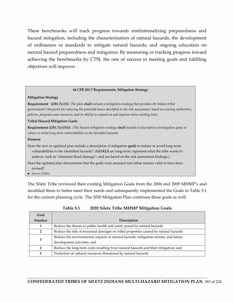
CONFEDERATED TRIBES OF SILETZ INDIANS MULTI-HAZARD MITIGATION PLAN 183 of 224
These benchmarks will track progress towards institutionalizing preparedness and
hazard mitigation, including the characterization of natural hazards; the development
of ordinances or standards to mitigate natural hazards; and ongoing education on
natural hazard preparedness and mitigation. By measuring or tracking progress toward
achieving the benchmarks by CTSI, the rate of success in meeting goals and fulfilling
objectives will improve.
44 CFR 201.7 Requirements: Mitigation Strategy
Mitigation Strategy
Requirement §201.7(c)(3): The plan shall include a mitigation strategy that provides the Indian tribal
government’s blueprint for reducing the potential losses identified in the risk assessment, based on existing authorities,
policies, programs and resources, and its ability to expand on and improve these existing tools.
Tribal Hazard Mitigation Goals
Requirement §201.7(c)(3)(i): [The hazard mitigation strategy shall include a] description of mitigation goals to
reduce or avoid long-term vulnerabilities to the identified hazards.
Element
Does the new or updated plan include a description of mitigation goals to reduce or avoid long-term
vulnerabilities to the identified hazards? (GOALS are long-term; represent what the tribe wants to
achieve, such as “eliminate flood damage”; and are based on the risk assessment findings.)
Does the updated plan demonstrate that the goals were assessed and either remain valid or have been
revised?
Source: FEMA
The Siletz Tribe reviewed their existing Mitigation Goals from the 2006 and 2009 MHMP’s and
modified them to better meet their needs and subsequently implemented the Goals in Table 5.1
for the current planning cycle. The 2020 Mitigation Plan continues these goals as well.
Table 5.1 2020 Siletz Tribe MHMP Mitigation Goals
Goal
Number Description
1 Reduce the threats to public health and safety posed by natural hazards
2 Reduce the risk of structural damages on tribal properties caused by natural hazards
3 Reduce the environmental impacts of natural hazards, mitigation actions, and future
development activities; and
4 Reduce the long-term costs resulting from natural hazards and their mitigation; and
5 Protection of cultural resources threatened by natural hazards

CONFEDERATED TRIBES OF SILETZ INDIANS MULTI-HAZARD MITIGATION PLAN 184 of 224
Table 5.2 list the “Considered” and “Implemented” Mitigation Objectives for the current
planning cycle.
Table 5.2 2009 MHMP Siletz Tribal Mitigation Objectives - Considered and
Implemented- As reflected in 2020 Mitigation Plan
Objective
Number Description
1 Limit new development or acquisition of lands in areas that are vulnerable to hazards or promote
development to occur in a way that risk is minimized
2 Protect or alter existing development in hazardous areas to make it less susceptible to damage
3
Ensure that the solution chosen to protect existing development is the most cost-effective
available; protects or enhances cultural resources, natural resources, and sensitive terrestrial,
riparian, or coastal habitats; and is consistent with all applicable land use plans and regulations
4
Ensure that the benefits of maintaining existing facilities outweigh their costs; if not, redesign
facilities to make them less susceptible to damage or implement some other type of solution at the
site
5 Redesign existing projects and/or change maintenance practices to protect or enhance riparian or
coastal habitats
6
Manage floodplains, rivers, streams, and other water resources for multiple uses, including flood-
and erosion-hazard reduction, fish and wildlife habitat, open space, recreation, water supply, and
cultural/traditional practices
7 Improve coordination and consistency between the Siletz Tribe and other jurisdictions, as
appropriate, in management activities for floodplain and coastal areas
8 Increase public awareness of natural hazards and improve appropriate preparation for and
response to such hazards
9 Improve hazard warning and emergency response systems in tsunami hazard areas
NATIONAL FLOOD INSURANCE PROGRAM COMPLIANCE
44 CFR 201.6 Requirements: Mitigation Strategy - National Flood Insurance Program (NFIP) Compliance
National Flood Insurance Program (NFIP) Compliance
Requirement §201.6(c)(3)(ii): [The mitigation strategy] must also address the jurisdiction’s participation in the
National Flood Insurance Program (NFIP), and continued compliance with NFIP requirements, as appropriate.
Element
Does the new or updated plan describe the jurisdiction(s) participation in the NFIP?
Does the mitigation strategy identify, analyze and prioritize actions related to continued compliance with the NFIP?
Source: FEMA
The Confederated Tribe of the Siletz Indians does not actively participate in FEMA’s NFIP.
However, CTSI has purchased building and location specific flood insurance policies and
CONFEDERATED TRIBES OF SILETZ INDIANS MULTI-HAZARD MITIGATION PLAN 185 of 224
implemented floodplain policies, regulations, and ordinances to protect their threatened
population and infrastructure.
CTSI’s Mitigation Strategy identified and analyzed potential flood mitigation actions that
would fulfill NFIP initiatives, specifically addressing repetitive loss (RL) properties to assure an
effective flood mitigation program.
Tribal Capability Assessment
This section will discuss the pre- and post-disaster hazard management policies, programs, and
mitigation capabilities of CTSI and the other jurisdictions that provide support services to CTSI
during disasters on Tribal property.
44 CFR 201.7 Requirements: Tribal Capability Assessment
Tribal Capability Assessment
Requirement §201.7(c)(3)(iv): The Tribal mitigation strategy shall include a] discussion of the Tribe’s pre-and
post-disaster hazard management policies, programs, and capabilities to mitigate the hazards in the area, including:
an evaluation of Tribal laws, regulations, policies, and programs related to hazard mitigation as well as to
development in hazard-prone areas [and] a discussion of Tribal funding capabilities for hazard mitigation projects.
Element
Does the new or updated plan include an evaluation of the Tribe’s pre-disaster hazard management policies,
programs, and capabilities?
Does the new or updated plan include an evaluation of the Tribe’s post-disaster hazard management policies,
programs, and capabilities?
Does the new or updated plan include an evaluation of the Tribe’s policies related to development in hazard prone
areas?
Does the new or updated plan include a discussion of Tribal funding capabilities for hazard mitigation projects?
Does the updated plan address any hazard management capabilities of the Tribe that have changed since approval of
the previous plan? Source: FEMA
This section identifies information and programs that are related to hazard mitigation and to
development activity in hazard-prone areas; hazard mitigation project funding capabilities; and
a general description and analysis of the mitigation policies, programs, and capabilities of local
organizations related to CTSI.
Table 5.3 lists legal and regulatory resources that directly support or impacts all mitigation
activities for CTSI. These resources will be used to implement mitigation goals and actions
identified within this planning cycle.

CONFEDERATED TRIBES OF SILETZ INDIANS MULTI-HAZARD MITIGATION PLAN 186 of 224
Table 5.3 CTSI Legal and Regulatory Resources Available for Hazard Mitigation
Regulatory
Tool Name Effect on Hazard Mitigation
Plans
Comprehensive Plan
The Comprehensive Plan Map, goals and policies are
intended to serve as a guide for land use planning and
development for CTSI.
2006 Hazard Mitigation Plan Directed mitigation activities for the planning cycle
Administrative Procedures 09-1605 Defines the role of staff in making decisions
Constitution 05-16-08 Enforces ordinance authority
Cultural Resource Lands 09-16-05 Identifies that cultural resources outside of ownership should
be protected for future generations
Forest Management 09-16-05
Ensures the Tribe uses best management practices that
include the protection of soil and water resources on
forestlands
Geographic Areas of Tribal Interest
09-16-05
Defines area were tribal interest are located historically.
Identifies that the Tribe has areas of interest outside of the
current reservation.
STBC Charter 02-16-07 Supports constitution
Timber Use Permits 04-14-06 Guides timber management to mitigate future loss and
damage from fire, erosion, and landslides
Tribal Plans of Operations 09-16-05
Transportation Systems Plan Identifies priorities for future funding.
2005 Toledo Master Plan Identifies limitations and sets requirements for development
of mill property in Toledo.
Programs Housing Ordinance 06-16-05 Guides development
Policies
(Municipal
Codes)
Land Use Ordinance 09-16-05 Defines administrative procedures to be used in reviewing
development proposals
COORDINATION
In the event of a disaster, the Tribe would respond with its limited resources and enlist
the assistance of neighboring jurisdiction’s public safety officials to provide services.
The Siletz Tribal Police respond to incidents in cooperation with Lincoln County and
the City of Toledo. Incidents that occur in the City of Siletz are forwarded to Toledo
Police. At this time there is no agreement for how the Tribe will coordinate efforts with
local governments in the event there is a natural disaster. The Siletz Planning
Department has been building relationships with Lincoln County Division of
Emergency Management both on and off Reservation lands. Coordination issues were
addressed when the Tribe developed a CTSI Emergency Operations Plan in 2007.
CONFEDERATED TRIBES OF SILETZ INDIANS MULTI-HAZARD MITIGATION PLAN 187 of 224
However, intergovernmental coordination could provide an important role by
providing the emergency responders with the Siletz Tribe’s perspective on possible
responses to a disaster and helps ensure an effective response.
Ordinances
At this time, the Tribe currently has no ordinances that pertain to development in
hazard prone areas or to mitigating potential hazardous situations during development
reviews, other than the adoption of local building codes, which do often pertain to flood
management areas and FEMA flood insurance zones. However, the Siletz Tribe has a
Forest Management Ordinance (7.100) that ensures the Tribe uses best management
practices that include the protection of soil and water resources on forestlands. These
best management practices in return likely reduce the risk of specific hazards on tribal
forestlands.
Tribal Operations
The field where staff is currently knowledgeable includes planning and design, forestry,
Geographic Information Systems (GIS), and environmental issues. The Public Works
department and Forestry crew maintain Tribal properties. The Planning department
provides information regarding potential issues during development. The Siletz Tribe
has no person directly responsible for hazard mitigation on Tribal lands. Currently, the
GIS Planner has taken the responsibility of managing publications related to hazard
mitigation issues, and the Tribe has employed a trainee for Emergency Preparedness.
Public Services
In the town of Siletz and Lincoln City, the respective city manages water resources and
sewer services. The Tribe monitors and manages water systems for Tribal housing and
operations. However, the Tribe has limited experience managing or assessing utility
problems as they pertain to the Tribe. Currently the Tribe relies on the city for
information regarding capacity issues. Other public utilities are managed and
maintained by local providers. Electricity is provided through Central Lincoln PUD. For
internet and communications services, Wave Broadband and Century Link are the two
main providers located in Siletz, Newport, and Lincoln County, Oregon.
Grants Management
The Tribe has established a highly effective fiscal and administrative management
program since Restoration in 1977. Program management capability is documented by
CONFEDERATED TRIBES OF SILETZ INDIANS MULTI-HAZARD MITIGATION PLAN 188 of 224
tribal staff successfully carrying out annual grant and contract work plans’ objectives.
This section describes the Siletz Tribe’s capability to manage grants.
Compliance with Future Statutes
The Tribe will comply with all applicable Federal statutes and regulations during the
periods for which it receives grant funding, in compliance with 44 CFR 13.11(c), and
will amend its plan whenever necessary to reflect changes in Tribal or Federal laws and
statutes as required in 44 CFR 13.11(d).
Government Oversight
The Tribe is governed by a nine member Tribal Council that is assisted by seven
Standing Committees. The Standing committees are: Health, Education, Housing,
Cultural Heritage, Natural Resources, Powwow, and Budget. In Addition, members are
appointed to project specific ad-hoc committees as needed.
Organization
Tribal Administration departments which provide services are: Administration,
Finance, Planning, Natural Resources, Legal, Personnel, Facilities and Maintenance,
Health, Human Services, and Education Services.
Fiscal Management
No significant changes have been made since initial plan approval to the fiscal
management of funds. The Tribe’s financial records are prepared in conformity with
general accepted accounting principles (GAAP) as applied to government units. The
Tribe’s general fund budget is prepared in accordance with the established Tribal
Budget Procedures Ordinance. The Tribe’s financial records are audited on an annual
basis.
The Tribe’s accounting department utilizes a SQL based, computerized integrated
accounting system called MIP. The accounting for each of the grants is maintained so
that all grant revenues, expenditures and cost allocations can be reported separately.
The 13 staff accounting department has 95 years combined federal, state, and local grant
accounting experience and operates with an approved accounting policies and
procedures manual that adheres to GASB34 and A87 regulations. The Accounting
Department is responsible for grants reporting and preparation of 269s and draws. The
Chief Financial Officer is responsible for accounting oversight. An annual A133 audit is
performed by an outside audit firm

CONFEDERATED TRIBES OF SILETZ INDIANS MULTI-HAZARD MITIGATION PLAN 189 of 224
GRANTS MANAGEMENT PROCESS
1. Program or project design prepared and grant researched
2. Scope of Work and Budget prepared by Grant Writer and submitted to
Clearinghouse and ultimately to the Tribal Council for approval to submit
3. Grant Submitted to funding agency
4. Grant Awarded
5. Project Budget submitted to Accounting for input into system
6. Funds drawn from funding agency utilizing agency’s required format adhering
to requirement that no more than three days cash on hand except where grant or
compact can be drawn in its entirety per funding agency.
7. Grant award booked in general ledger as Debit to Grants Receivable
And Credit to Deferred Revenue.
8. Draws booked as Credit to Grants Receivable and Debit to Cash.
9. Accrual accounting method of recording expenditures against each grant.
10. Administration costs are consolidated and an indirect rate is negotiated.
11. Monthly financial statements prepared and distributed to program managers for
monitoring of projects.
12. Policies and procedures are in place for budget modification process.
13. Each program has its own approved set of policies and procedures that adheres
to funding agencies requirements.
14. The financial closeout documents are prepared by the Accounting Technician
and the quarterly and semi-annual program performance reports and closeout
documents are prepared by the program managers.
MITIGATION MEASURES
This section will identify, evaluate, and prioritize, feasible and environmentally sound
mitigation actions currently in use or under consideration by CTSI. This discussion will
include an explanation of how each activity contributes to the overall mitigation
strategy for CTSI. Where pertinent, links to local organizations or responsible agencies
will be identified.
CONFEDERATED TRIBES OF SILETZ INDIANS MULTI-HAZARD MITIGATION PLAN 190 of 224
DMA 2000 Requirements: Identification and Analysis of Mitigation Actions
Identification and Analysis of Mitigation Actions
CFR Requirement 44 §201.7(c)(3)(ii): [The mitigation strategy shall include a] section that identifies and analyzes a
comprehensive range of specific mitigation actions and projects being considered to reduce the effects of each hazard, with
particular emphasis on new and existing buildings and infrastructure.
Element
Does the new or updated plan identify and analyze a comprehensive range of specific mitigation actions and
projects for each hazard?
Do the identified actions and projects address reducing the effects of hazards on new buildings and infrastructure?
Do the identified actions and projects address reducing the effects of hazards on existing buildings and
infrastructure?
Source: FEMA DMA 2000 (Public Law 106-390)
For the purposes of this MHMP, short-term actions are those actions that CTSI is
capable of implementing within its existing resources and authorities over the next two
years. Long term actions are those actions that will require new or additional resources
or authorities to implement and that cannot occur or be completed over the next two-
year period.
Proposed Mitigation Actions
Many post-disaster reports note the need to strengthen and sustain public information,
education, and training efforts by providing additional resources (Oregon 2000a).
Although it is commonly recognized that interest in reducing losses increases during
and after events, there is an ongoing need to provide residents with hazard mitigation
information. Post-disaster assessment reports cite the need to have timely seasonal
information available, have better methods to inform residents where they can obtain
hazard mitigation information, use improved electronic methods (e.g., web sites), and
have materials oriented toward the intended users. This helps keep awareness levels
higher, will stimulate actions by some, and reminds users to consider and include
hazard mitigation measures in the contexts of regular activities, such as building a new
home, relocating an office, or repairing a business.
The Steering Committee met on November 5, 2019 to evaluate and prioritize each of the
proposed mitigation actions to determine which considered actions would be included
in the MHMP update.
Table 5.2 identifies the status of CTSI’s existing Mitigation Actions from the prior
planning cycle and provided comments for each action that incurred a status change

CONFEDERATED TRIBES OF SILETZ INDIANS MULTI-HAZARD MITIGATION PLAN 191 of 224
(completed, deleted, deferred, or ongoing). New mitigation action items were also
identified and considered for implementation during this session. CTSI considered
existing and future growth needs as they reviewed action items or activities that would
potentially protect existing and any anticipated future facilities or structures.

CONFEDERATED TRIBES OF SILETZ INDIANS MULTI-HAZARD MITIGATION PLAN 192 of 224

CONFEDERATED TRIBES OF SILETZ INDIANS MULTI-HAZARD MITIGATION PLAN 193 of 224

CONFEDERATED TRIBES OF SILETZ INDIANS MULTI-HAZARD MITIGATION PLAN 194 of 224
MITIGATION ACTION PLAN
The committee members reviewed and discussed each item. The Committee then determined
the priority order by committee member consensus.
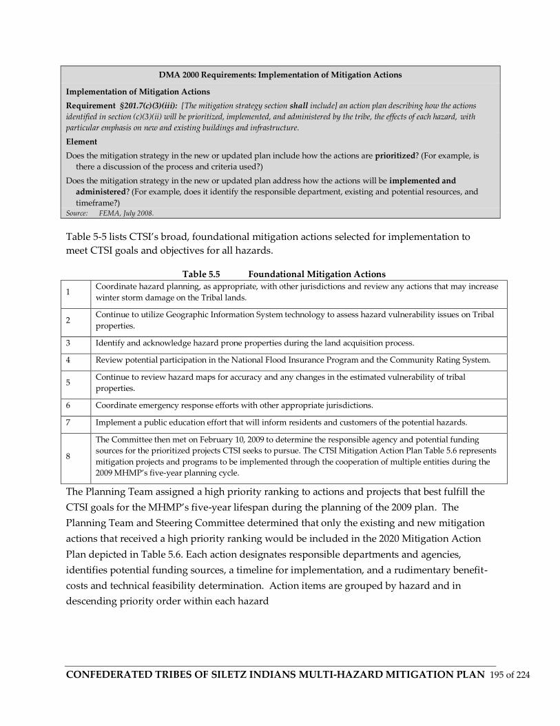
CONFEDERATED TRIBES OF SILETZ INDIANS MULTI-HAZARD MITIGATION PLAN 195 of 224
DMA 2000 Requirements: Implementation of Mitigation Actions
Implementation of Mitigation Actions
Requirement §201.7(c)(3)(iii): [The mitigation strategy section shall include] an action plan describing how the actions
identified in section (c)(3)(ii) will be prioritized, implemented, and administered by the tribe, the effects of each hazard, with
particular emphasis on new and existing buildings and infrastructure.
Element
Does the mitigation strategy in the new or updated plan include how the actions are prioritized? (For example, is
there a discussion of the process and criteria used?)
Does the mitigation strategy in the new or updated plan address how the actions will be implemented and
administered? (For example, does it identify the responsible department, existing and potential resources, and
timeframe?) Source: FEMA, July 2008.
Table 5-5 lists CTSI’s broad, foundational mitigation actions selected for implementation to
meet CTSI goals and objectives for all hazards.
Table 5.5 Foundational Mitigation Actions
1 Coordinate hazard planning, as appropriate, with other jurisdictions and review any actions that may increase
winter storm damage on the Tribal lands.
2 Continue to utilize Geographic Information System technology to assess hazard vulnerability issues on Tribal
properties.
3 Identify and acknowledge hazard prone properties during the land acquisition process.
4 Review potential participation in the National Flood Insurance Program and the Community Rating System.
5 Continue to review hazard maps for accuracy and any changes in the estimated vulnerability of tribal
properties.
6 Coordinate emergency response efforts with other appropriate jurisdictions.
7 Implement a public education effort that will inform residents and customers of the potential hazards.
8
The Committee then met on February 10, 2009 to determine the responsible agency and potential funding
sources for the prioritized projects CTSI seeks to pursue. The CTSI Mitigation Action Plan Table 5.6 represents
mitigation projects and programs to be implemented through the cooperation of multiple entities during the
2009 MHMP’s five-year planning cycle.
The Planning Team assigned a high priority ranking to actions and projects that best fulfill the
CTSI goals for the MHMP’s five-year lifespan during the planning of the 2009 plan. The
Planning Team and Steering Committee determined that only the existing and new mitigation
actions that received a high priority ranking would be included in the 2020 Mitigation Action
Plan depicted in Table 5.6. Each action designates responsible departments and agencies,
identifies potential funding sources, a timeline for implementation, and a rudimentary benefit-
costs and technical feasibility determination. Action items are grouped by hazard and in
descending priority order within each hazard
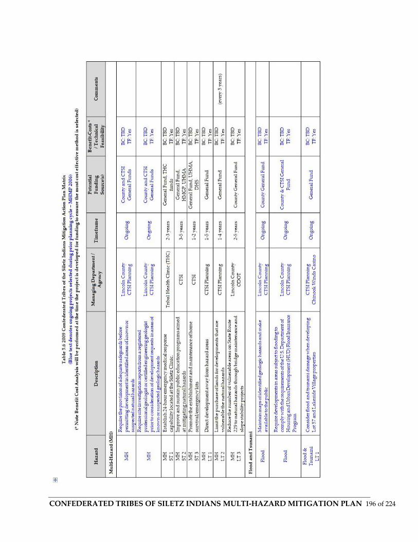
CONFEDERATED TRIBES OF SILETZ INDIANS MULTI-HAZARD MITIGATION PLAN 196 of 224

CONFEDERATED TRIBES OF SILETZ INDIANS MULTI-HAZARD MITIGATION PLAN 197 of 224

CONFEDERATED TRIBES OF SILETZ INDIANS MULTI-HAZARD MITIGATION PLAN 198 of 224

CONFEDERATED TRIBES OF SILETZ INDIANS MULTI-HAZARD MITIGATION PLAN 199 of 224
Plan Maintenance Process
The Confederated Tribes of Siletz Tribal Natural Hazard Mitigation Plan is a living
document that is intended to provide a guide for hazard mitigation to the Confederated
Tribes of Siletz Indians. A formal plan maintenance process is required to ensure that
the Tribal Mitigation Plan remains an active and relevant document. The plan
maintenance process includes a method and schedule for monitoring, evaluating, and
updating the plan at least every five years. This section also includes an explanation of
how the Confederated Tribes of Siletz Tribe intends to incorporate the mitigation
strategies into existing planning mechanisms. Lastly, a strategy to ensure continued
participation throughout the plan maintenance process by the “public,” as defined by
the Confederated Tribes of Siletz, is essential.
The Confederated Tribes of Siletz Tribal Council has final authority and responsibility
over the Tribal Multi-Hazard Mitigation Plan. Responsibility for plan maintenance and
coordinating implementation of mitigation measures will be overseen by the Tribe’s
Central Administration and General Manager Brenda Bremner, along with Steering
Committee Members for this MHMP, Planning Department Personnel, the Emergency
Planning Committee, which is composed of representatives from the Administration,
Legal, Risk Management and Health Clinic Departments, et al. The Confederated Tribes
of Siletz Tribe’s Emergency Planning Committee will also be responsible for annual
progress reports to Tribal Council and for the five-year updates to be submitted to the
Board and subsequently to FEMA for approval.
The federal hazard mitigation planning regulations (44 CFR 201.4) require state-level
plans such as this MHMP to be reviewed, revised, and submitted for approval to the
FEMA Regional Director every three years. Tribal Mitigation Plans differ in that the
CFR to be followed is listed as (44 CFR 201.7 (d)(3)
The regulations require a plan maintenance process that includes the following, and
both are in accordance with each the State or Tribe having an update process that
includes the following: an established method and schedule for monitoring, evaluating,
and updating the plan; a system for monitoring implementation of mitigation measures
and project closeouts; and a system for reviewing progress on achieving goals as well as
specific activities and projects identified in the mitigation plan. This MHMP is a living
document that is intended to provide a guide for hazard mitigation to the Confederated

CONFEDERATED TRIBES OF SILETZ INDIANS MULTI-HAZARD MITIGATION PLAN 200 of 224
Tribes of Siletz Indians. The MHMP can be revised more frequently than three years if
the conditions under which it was developed change significantly (e.g., a major disaster
occurs or funding availability changes). This section details CTSI’s method and
schedule for monitoring, evaluating, and updating the MHMP and for monitoring the
progress of mitigation actions.
The CTSI Planning department is responsible for coordinating the maintenance of the
MHMP. The Steering Committee is responsible for conducting meetings to account for
plan maintenance and to have planning personnel provide updates to ongoing annual
maintenance. Other departments also will have responsibilities to update portions of
the plan. These departments include Natural Resources, Accounting, Housing, Human
Resources, Siletz Tribal Business Corp, and Chinook Winds Casino Resort.
MONITORING, EVALUATING, AND UPDATING THE PLAN
The Planning Department will review this MHMP annually and will update and submit
the updates for adoption every three years. Annual reviews will identify progress made
on the implementation of mitigation measures and projects and any new regulations.
The Siletz tribe understands that Federal laws change over time. For this reason, the
Hazard Mitigation Plan will be amended prior to the submission of any Hazard
Mitigation Grant applications to reflect changes as required in 44 CFR 13.11(c)
http://federal.elaws.us/cfr/title44.part13 . This procedure will ensure that the tribe will
be compliant during years in which grant funding is received. The effectiveness of
projects and other actions will be evaluated at appropriate, project specific intervals or,
at a minimum, when the MHMP is updated every three years as required for state-level
plans submitted directly to FEMA. The process of updating the MHMP will include a
review of hazard assessments, vulnerability assessments, potential losses, tribal
capability, coordination with other planning efforts, funding sources, and
recommended and potential new mitigation measures. In support of the three-year
update, the MHMT will:
• Examine and revise the Hazard Risk Assessment (Section 4) as necessary to ensure
that it
describes the current understanding of hazard risks;
• Examine progress on and determine the effectiveness of the mitigation actions and

CONFEDERATED TRIBES OF SILETZ INDIANS MULTI-HAZARD MITIGATION PLAN 201 of 224
projects recommended in this MHMP;
• Identify implementation problems (technical, political, legal, and financial) and
develop
recommendations to overcome them;
• Recommend ways to increase participation by CTSI departments and to improve
coordination with other jurisdictions and agencies; and
• Review and, if desirable, revise the MHMP Action Plan.
MONITORING PROGRESS OF MITIGATION ACTIONS
Mitigation action identified within this plan will be monitored and updated by the CTSI
Planner on a Yearly basis. The plan will be revised every 3 years or when new
information becomes available. Such information could include new vulnerability
studies by the State or new property acquisitions by the Siletz Tribe.
Monitoring, Evaluating and Updating the Plan
The Confederated Tribes of Siletz Tribe’s Emergency Planning Committee will review
this MHMP annually and will update the MHMP every five years. Annual reviews will:
• Identify progress made on the implementation of mitigation measures and projects;
• Assess the impacts of disasters to the Tribe’s people, property and natural
environment to determine whether the MHMP should be revised based on the new
information;
• Examine and ensure that the Mitigation Plan requirements, as well as goals, objectives
and mitigation actions are incorporated into current and future Tribal planning
processes.
The annual review will occur during the first quarter of each calendar year to coincide
with the tribal fiscal year and to prepare for PDM grant deadlines.
The effectiveness of projects and other actions will be evaluated at appropriate, project
specific intervals or, at a minimum, when the MHMP is updated every five years as
required for Tribal plans submitted to FEMA. The process of updating the MHMP will

CONFEDERATED TRIBES OF SILETZ INDIANS MULTI-HAZARD MITIGATION PLAN 202 of 224
include a review of hazard assessments, vulnerability assessments, potential losses, the
addition of repetitive and severe repetitive loss properties, tribal capability, and
coordination with other planning efforts, funding sources, and recommended and
potential new mitigation measures.
In support of the five-year update, the Confederated Tribes of Siletz Tribe’s Emergency
Planning Committee will:
• Examine and revise the Hazard Risk Assessment as necessary to ensure that it
describes the current understanding of hazard risks;
• Examine progress on and determine the effectiveness of the mitigation actions and
projects recommended in this MHMP;
• Examine and ensure that the Mitigation Plan requirements, as well as goals, objectives
and actions, are incorporated into current and future Tribal planning processes;
• Identify implementation problems (technical, political, legal, and financial) and
develop recommendations to overcome them; and
• Recommend ways to increase participation by Tribal government departments and
businesses and to improve coordination with other jurisdictions and agencies.
The updated MHMP will be presented to the Confederated Tribes of Siletz Tribal Board
of Directors for approval and adoption before it is submitted to FEMA for re-approval.
Monitoring Progress of Mitigation Actions
The Confederated Tribes of Siletz Tribe’s Emergency Planning Committee will
frequently review progress on the implementation of mitigation actions. The
Emergency Planning Committee will also meet with representatives from Tribal
Departments to discuss progress of mitigation activities.
The implementation of all short-term mitigation actions will be monitored by the
Emergency Planning Committee, on an ongoing basis until implementation is complete.
Long-term actions being actively implemented will be monitored on an ongoing basis,
or at least annually as needed. Long-term actions planned for the future will be
reviewed during plan updates every five years.

CONFEDERATED TRIBES OF SILETZ INDIANS MULTI-HAZARD MITIGATION PLAN 203 of 224
The system for reviewing progress on achieving goals, objectives, and specific actions
included in the mitigation strategy will be based on a checklist of all goals, objectives
and actions. This checklist will be reviewed annually by the Emergency Planning
Committee. As described in the previous section, progress on mitigation actions will be
described in an annual report to Confederated Tribes of Siletz Tribal Board of Directors
and in the five-year update of the Tribal Natural Hazard Mitigation Plan.
Incorporation into Existing Planning Mechanisms
The Confederated Tribes of Siletz Tribe currently has formal planning mechanisms in
place to insure that the Comprehensive Plan, and that additional planning documents
from all departments are consistent with one another. The Planning Department is
insuring and completing a plan at developing and expanding its capacity, capabilities.
and processes to encompass Planning Department goals and objectives across the Tribal
Administration. This Multi-Hazard Mitigation Plan will serve as the basis of all
Confederated Tribes of Siletz Tribal emergency management planning pre-disaster.
This plan’s vulnerability results and mitigation actions will be incorporated into the
Tribe’s Emergency Operations Plan, other Tribal emergency plans as well as land use
and development plans as they are developed.
A Plan Summary will be added to relevant supporting documents and future plans.
Development projects are currently reviewed for natural hazards exposure, such as
landslides, floods and seismic risk. In the future, the Plan and its supporting data, such
as hazard maps, will also be reviewed during development projects for potential hazard
exposure.
As the Tribe develops and enhances its mitigation capabilities as part of its overall
emergency management planning efforts, formal processes, i.e. resolutions, ordinances
and polices, will be implemented to better incorporate mitigation planning into other
tribal planning mechanisms as they are developed concurrently.
Continued Public Involvement
In order to continue public participation in the Plan Maintenance and Update process,
the Confederated Tribes of Siletz Tribal Natural Hazard Mitigation Plan will be
available online on the Tribe’s website. The Plan will also be available in hardcopy at
the Tribal Administration Building. Comments may be submitted via e‐mail, telephone

CONFEDERATED TRIBES OF SILETZ INDIANS MULTI-HAZARD MITIGATION PLAN 204 of 224
or in person at the Administration Building, or during Tribal Board meetings relating to
the Plan. Results and information from the Plan will also be incorporated into related
emergency preparedness training as applicable as well as be used for disaster
preparedness articles in the tribal newsletter and website. Hazard maps and
presentations created for the Plan will be used for public outreach opportunities,
trainings and other tribal events.
7. Repetitive Loss Strategy
The Confederated Tribes of Siletz does not currently own or lease any properties or
structures defined as Repetitive Loss or Severe Repetitive Loss properties. Nonetheless
FEMA encourages Tribes to identify repetitive flood loss structures as part of the risk
assessment and include a repetitive loss strategy in their plans. Definition from FEMA:
Repetitive Loss Structure. An NFIP-insured structure that has had at least 2 paid flood
losses of more than $1,000 each in any 10-year period since 1978. A Severe Repetitive
Loss Property is defined as : Either a severe repetitive loss building or the contents
within a severe repetitive loss building, or both.
The Severe Repetitive Loss (SRL) grant program provides funding to states, territories,
and local and federally-recognized Indian tribal governments to reduce or eliminate the
long-term risk of flood damage to severe repetitive loss (SRL) of structures insured
under the National Flood Insurance Program (NFIP). Eligible activities under this
program include: acquisition and relocation of at-risk structures and the conversion of
property to open space; elevation of existing structures to the Base Flood Elevation
(BFE) or an ABFE Advisory Base Flood Elevation (ABFE) or higher (for the SRL
program Mitigation Reconstruction is only permitted when traditional elevation cannot
be implemented); minor physical localized flood control projects; and dry-flood
proofing (historic properties only).
The definition of severe repetitive loss as applied to this program was established in
section 1361A of the National Flood Insurance Act, as amended, 42 U.S.C. 4102a
A repetitive loss structure means any residential or commercial structure insured under
the National Flood Insurance Program (NFIP) with two or more claim payments of
more than $1,000 within ten (10) years. In addition, the NFIP defines Severe Repetitive
Loss (SRL) structures as single or multifamily residential properties covered under an
NFIP flood insurance policy and:

CONFEDERATED TRIBES OF SILETZ INDIANS MULTI-HAZARD MITIGATION PLAN 205 of 224
1. That have incurred flood-related damage for which four or more separate claims
payments have been made, with the amount of each claim (including building and
contents payments) exceeding $5,000, and with the cumulative amount of such claims
payments exceeding $20,000; or
2. For which at least two separate claims payments (building payments only) have been
made under such coverage, with cumulative amount of such claims exceeding the
market value of the property.
3. In both instances, at least two of the claims must be within ten years of each other,
and claims made within ten days of each other will be counted as one claim.
In addition, an approved Tribal Mitigation Plan with a repetitive loss strategy that
addresses SRL properties makes the Confederated Tribes of Siletz Tribe eligible under
44 CFR 201.7(c)(3)(vi) for a reduced non-Federal cost share under the Flood Mitigation
Assistance (FMA) and SRL hazard mitigation assistance programs when the Tribe
applies directly to FEMA as a grantee. The reduced cost share option would only apply
to SRL properties. If the Tribe applies as a subgrantee, their eligibility for receiving a
reduced Federal cost share is based on the eligibility of the grantee (such as the State of
Oregon or Lincoln County), regardless of whether the Tribe has a Repetitive Loss
Strategy.
In the Plan update, if the Tribe identifies Repetitive Loss properties, it will expand and
develop the Repetitive Loss Strategy.

CONFEDERATED TRIBES OF SILETZ INDIANS MULTI-HAZARD MITIGATION PLAN 206 of 224
Weblinks/References/Citation
https://www.co.lincoln.or.us/sites/default/files/fileattachments/planning_amp_develop
ment/page/4709/2018_lincoln_co_cwpp_final.pdf
State and Local Mitigation Planning How-to Guide,
http://www.fema.gov/library/viewRecord.do?id=1886
http://www.fema.gov/government/grant/government.shtm
FEMA Tribal Multi-Hazard Mitigation Plan guidance November 30th 2018
http://www.fema.gov/library/viewRecord.do?id=4135
GIS Data Sources:
WildFire Historic Fires, 1900 – 2016, Oregon Dept. of Forestry
http://www.oregon.gov/ODF/GIS/gisdata.shtml
metadata: http://www.oregon.gov/ODF/GIS/pdf/historicFires.pdf
Landslide
SLIDO
Statewide Landslide Information Database of Oregon (SLIDO)
Data: http://navigator.state.or.us/sdl/data/mdb/k24/SLIDO_r2_ORLAM.zip
metadata: http://gis.oregon.gov/DAS/EISPD/GEO/docs/metadata/SLIDOr2.htm
https://webserver.lcd.state.or.us/Uploads/Inbound/20191017113405_Lincoln%20County
%20Future%20Projections%20Report_09262019.pdf
https://biamaps.doi.gov/tribalresilience/resourceguide/funding/index.html
https://tribalclimateguide.uoregon.edu/tribal-profiles?page=1
https://www.epa.gov/tribal/indian-environmental-general-assistance-program-gap
https://www.epa.gov/tribal/region-10-tribal-programs#gap
https://www.epa.gov/tribal/indian-environmental-general-assistance-program-gap

CONFEDERATED TRIBES OF SILETZ INDIANS MULTI-HAZARD MITIGATION PLAN 207 of 224
https://www.epa.gov/tribal/region-10-tribal-programs#gap
https://www.epa.gov/grants/specific-epa-grant-programs
https://www.bia.gov/as-ia/ieed/division-energy-and-mineral-development/tedcp
https://www.bia.gov/gis
https://www.epa.gov/exchangenetwork/fiscal-year-2019-national-environmental-
information-exchange-network-grant-0
https://www.epa.gov/exchangenetwork/exchange-network-grant-program
Oregon Department of Forestry Fire Records Database
https://apps.odf.oregon.gov/DIVISIONS/protection/fire_protection/fires/FIRESlist.asp
https://www.co.lincoln.or.us/emergencymanagement/page/hazards-wildfire
https://spatialdata.oregonexplorer.info/geoportal/
https://www.fema.gov/faq-details/GIS-Data/
https://library.uoregon.edu/map/map_section/map_librarydata
http://www.nwmapsco.com/ZybachB/DRAFT/PhD_Thesis/Chapter_4.htm#Fig_4_05
http://www.nwmapsco.com/ZybachB/DRAFT/PhD_Thesis/Chapter_4.htm#Fig_4_04
http://www.nwmapsco.com/ZybachB/DRAFT/PhD_Thesis/Contents.htm#Maps_Refere
nces
http://www.nwmapsco.com/ZybachB/DRAFT/PhD_Thesis/Contents.htm#Maps_Refere
nces
https://apps.odf.oregon.gov/DIVISIONS/protection/fire_protection/fires/FIRESlist.asp
https://www.ncdc.noaa.gov/stormevents/eventdetails.jsp?id=5558048
https://www.ncdc.noaa.gov/stormevents/eventdetails.jsp?id=72396
Storm Events Database

CONFEDERATED TRIBES OF SILETZ INDIANS MULTI-HAZARD MITIGATION PLAN 208 of 224
https://www.ncdc.noaa.gov/stormevents/listevents.jsp?eventType=%28Z%29+Flood&be
ginDate_mm=05&beginDate_dd=01&beginDate_yyyy=1950&endDate_mm=05&endDat
e_dd=31&endDate_yyyy=2019&county=LINCOLN%3A41&hailfilter=0.00&tornfilter=0&
windfilter=000&sort=DT&submitbutton=Search&statefips=41%2COREGON
https://www.oregongeology.org/pubs/ims/ims-028/resources.htm
https://pubs.geoscienceworld.org/gsa/geosphere/article/10/4/692/132166/Geologic-
history-of-Siletzia-a-large-igneous
https://ngmdb.usgs.gov/ngm-bin/ngm_search_dbi.pl?bc_ul=45.408269%2C-
125.306833&bc_lr=44.114393%2C-121.883219
https://www.oregongeology.org/Coastal/beach-basics.htm
https://pnsn.org/earthquakes/recent
https://www.oregongeology.org/default.htm
https://www.usgs.gov/centers/or-water/data-tools
https://oregonexplorer.info/content/oregon-spatial-data-library-
0?topic=4129&ptopic=98&qt-subtopic_quicktab=6
https://oregonexplorer.info/content/coastal-hazards-and-resilience-
research?topic=4129&ptopic=98
https://oregonexplorer.info/topics/imagery?ptopic=98
References
Atwater, B.F., and A.L. Moore. 1992. A tsunami about 1000 years ago in Puget Sound,
Washington. Science. 258 (5088): 1614-1617.
Bates and Jackson. 1980. Glossary of Geology. Second Edition. American Geologic
Institution.
Clackamas County. 2002. Clackamas County Natural Hazards Mitigation Plan.
Prepared by Resource Assistance for Rural Environments/Oregon Natural Hazards
Workgroup for the Clackamas County Emergency Management Department,
Clackamas County, Oregon.
CONFEDERATED TRIBES OF SILETZ INDIANS MULTI-HAZARD MITIGATION PLAN 209 of 224
Confederated Tribes of the Siletz Indians. Emergency Preparedness and Response Plan.
2006. Confederated Tribes of the Siletz Indians Planning Department and Ecology and
Environment, Siletz, Oregon.
Confederated Tribes of the Siletz Indians. January 2002. Siletz Highway Road
Assessment, Safety Analysis and Report. Lancaster Engineering.
Confederated Tribes of the Siletz Indians. 2003. Siletz Reservation Transportation
Improvement Program. Cascade Design Professionals, LLC Planning and Engineering.
Confederated Tribes of the Siletz Indians, Planning Department. 2005. Land Acquisition
Plan.
Confederated Tribes of the Siletz Indians, Planning Department. 2005. Toledo Mill
Property Master Plan.
Confederated Tribes of the Siletz Indians, Planning Department. 2005. 10 Year
Comprehensive Plan.
Federal Emergency Management Agency (FEMA). 2001a. Understanding Your Risks:
Identifying Hazards and Estimating Losses. FEMA Publication No. 386-2.
Federal Emergency Management Agency (FEMA). 2002a. State and Local Plan Interim
Criteria Under the Disaster Mitigation Act of 2000.
Federal Emergency Management Agency (FEMA). 2002b. Getting Started: Building
Support for Mitigation Planning. FEMA Publication No. 386-1.
Federal Emergency Management Agency (FEMA). 2003a. Developing the Mitigation
Plan: Identifying Mitigation Actions and Implementation Strategies. FEMA Publication
No. 386-3.
Federal Emergency Management Agency (FEMA). 2003d. Talking About Disaster:
Guide for Standard Messages. Tsunami chapter. National Disaster Education
Coalition: American Red Cross, FEMA, IAEM, IBHS, NFPA, NWS, USDA/CSREES, and
USGS. http://www.fema.gov/rrr/talkdiz/tsunami.shtm
Garcia, A. W. and Houston, J. R. 1975. Type 16 flood insurance study: Tsunami
predictions for Monterey and San Francisco Bays and Puget Sound. Technical Report H-
75-17. U.S. Army Corps of Engineers Waterways Experiment Station.

CONFEDERATED TRIBES OF SILETZ INDIANS MULTI-HAZARD MITIGATION PLAN 210 of 224
Gardner, C.A., K.M. Scott, C.D. Miller, B. Myers, W. Hildreth, and P.T. Pringle. 1995.
Potential Volcanic Hazards from Future Activity of Mount Baker, Washington. Open-
File Report 95-498. U.S. Geological Survey.
Gonzalez, F.I. 1999. Tsunami!. Scientific American. May 18, 1999.
(http://www.sciam.com).
Lincoln County. 2002. Draft Hazard Identification and Vulnerability Analysis. Lincoln
County Department of Emergency Management. Newport, Oregon.
Mitsch, W.J. and J.G. Gosselink. 1993. Wetlands. Van Nostrand Reinhold, New York,
NY.
National Assessment Synthesis Team (NAST). 2000. Climate Change Impacts on the
United States: The Potential Consequences of Climate Variability and Change
(Overview: Coastal Areas and Marine Resources). US Global Change Research
Program.
http://www.usgcrp.gov/usgcrp/Library/nationalassessment/overviewcoastal.htm
Updated July 20, 2001.
National Drought Mitigation Center. 2003. What is Drought? Historical Maps of the
Palmer Drought Index. National Drought Mitigation Center, University of Nebraska –
Lincoln. http://www.drought.unl.edu/whatis/palmer/pdsihist.htm
National Oceanic and Atmospheric Administration. 1991. Winter Storms: A Guide To
Survival. In cooperation with the American Red Cross and the Federal Emergency
Management Agency. Washington, D.C. November.
Oregon State. 2000a. Oregon Natural Hazards Mitigation Plan. Part of Volume I,
Preparedness and Mitigation, of the State of Oregon Emergency Management Plan.
Oregon State. 2000b. Planning for Natural Hazards: Oregon Technical Resource
Guide.
Pacific Northwest Seismograph Network. 2003. Map and list of selected significant
quakes in Washington and Oregon.
http://www.geophys.washington.edu/SEIS/PNSN/INFO_GENERAL/hist.html
CONFEDERATED TRIBES OF SILETZ INDIANS MULTI-HAZARD MITIGATION PLAN 211 of 224
Portland Metro. 1999. Regional Hazard Mitigation Planning and Policy Guide:
Reducing Disaster Losses.
Tillamook County. 1996. Tillamook County: Flood Hazard Mitigation Plan. Tillamook
County, Tillamook, Oregon. November.
U.S. Bureau of Indian Affairs. 1999. Indian Service Population and Labor Force
Estimates. U.S. Department of the Interior, Bureau of Indian Affairs.
U.S. Department of Agriculture-Soil Conservation Service (USDA). 1970. National
Engineering Handbook, Section 4, Hydrology. USGPO, Washington.
U.S. Department of Agriculture- Natural Resource Conservation Service (USDA). 1997.
Soil Survey of Lincoln County Area, Oregon.
U.S. Fish and Wildlife Service (USFWS). 1987. National Wetlands Inventory.
U.S. Geological Survey (USGS). 2001b. 1996 Deaggregation Information.
http://geohazards.cr.usgs.gov/eq/deagg/bellingham.htm. National Seismic Hazard
Mapping Project, Earthquake Hazards Program.
U.S. Geological Survey (USGS). 2002. Magnitude / Intensity Comparison.
http://neic.usgs.gov/neis/general/handouts/mag_vs_int.html. National Earthquake
Information Center, Earthquake Hazards Program.
U.S. Geological Survey (USGS). 2003a. Frequently Asked Questions: Measuring
Earthquakes. http://earthquake.usgs.gov/faq/meas.html#1. Earthquake Hazards
Program.
U.S. Geological Survey (USGS). 2003b. National Seismic Hazard Mapping Project.
http://geohazards.cr.usgs.gov/eq/ . Earthquake Hazards Program.
U.S. Geological Survey (Usgs). 2009. Preliminary Analysis Of Sedimentary Deposits
From The 1998 Papua New Guinea (Png) Tsunami.
Http://Walrus.Wr.Usgs.Gov/Tsunami/Itst.Html Accessed 2009)

CONFEDERATED TRIBES OF SILETZ INDIANS MULTI-HAZARD MITIGATION PLAN 212 of 224
*Public Participation Process
After a draft of the document was completed and the Planning Department personnel
and General Manager reviewed the Document, a copy was submitted for review to
*Tribal Council, and released for public comment period on November 1st 2019 to see
how to proceed with completion of the document. While waiting for further
information on how to proceed with the document, the MHMP was reviewed again by
staff of the Planning Department, Natural Resources Department, and Human
Recourses. After the internal review was finished, the plan was sent to The City of Siletz
and the Siletz Rural Fire Department for comments.
FEMA Region X will be sent a final draft copy to check for compliance with federal
requirements after the public comment period ended on December 1st 2019. Once the
plan meets the requirements, the document will be reviewed by the Core Managers
prior to being presented to council again for final approval. The final document will be
sent to community groups and governments including: Lincoln County, the City of
Lincoln City, City of Siletz, City of Toledo, City of Newport, City of Waldport, and the
State of Oregon Emergency Preparedness Office and Emergency Management.

CONFEDERATED TRIBES OF SILETZ INDIANS MULTI-HAZARD MITIGATION PLAN 213 of 224
Appendices:
Map Index for 2020MHMP Strategy and Hazard Analysis (Data restrictions and size permitting)

CONFEDERATED TRIBES OF SILETZ INDIANS MULTI-HAZARD MITIGATION PLAN 214 of 224

CONFEDERATED TRIBES OF SILETZ INDIANS MULTI-HAZARD MITIGATION PLAN 215 of 224
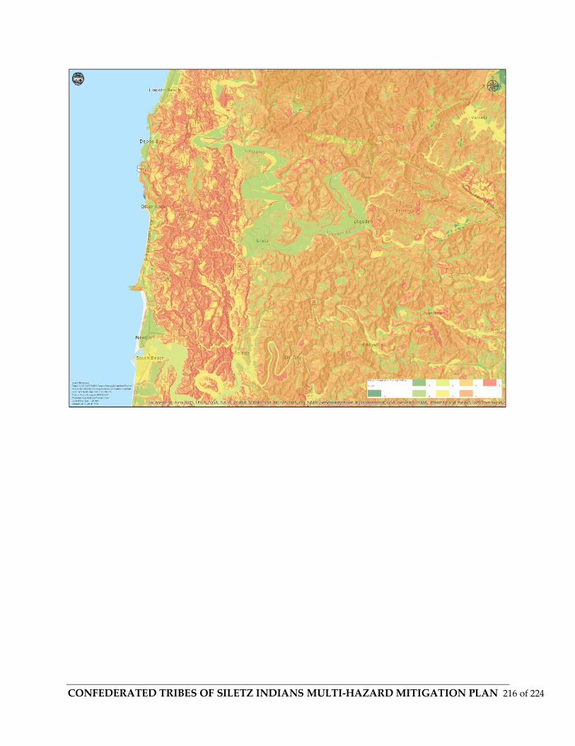
CONFEDERATED TRIBES OF SILETZ INDIANS MULTI-HAZARD MITIGATION PLAN 216 of 224

CONFEDERATED TRIBES OF SILETZ INDIANS MULTI-HAZARD MITIGATION PLAN 217 of 224

CONFEDERATED TRIBES OF SILETZ INDIANS MULTI-HAZARD MITIGATION PLAN 218 of 224

CONFEDERATED TRIBES OF SILETZ INDIANS MULTI-HAZARD MITIGATION PLAN 219 of 224

CONFEDERATED TRIBES OF SILETZ INDIANS MULTI-HAZARD MITIGATION PLAN 220 of 224
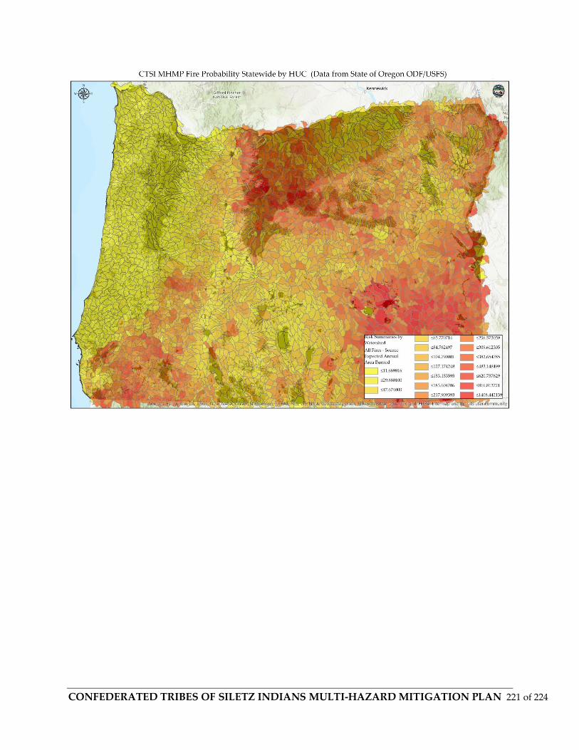
CONFEDERATED TRIBES OF SILETZ INDIANS MULTI-HAZARD MITIGATION PLAN 221 of 224
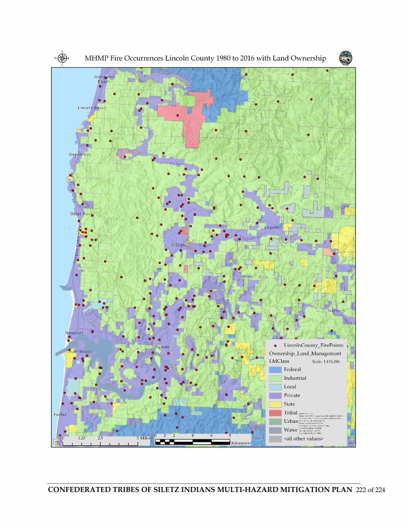
CONFEDERATED TRIBES OF SILETZ INDIANS MULTI-HAZARD MITIGATION PLAN 222 of 224

CONFEDERATED TRIBES OF SILETZ INDIANS MULTI-HAZARD MITIGATION PLAN 223 of 224

CONFEDERATED TRIBES OF SILETZ INDIANS MULTI-HAZARD MITIGATION PLAN 224 of 224
Related Documents