Welcome message from author
This document is posted to help you gain knowledge. Please leave a comment to let me know what you think about it! Share it to your friends and learn new things together.
Transcript


2018 Gem County Hazard Mitigation Plan—Volume 2: Planning Partner Annexes January 2019
PREPARED FOR PREPARED BY
Gem County Emergency Management Tetra Tech 415 E. Main Street Emmett ID 83617
90 South Blackwood Avenue Eagle, ID 83616
Tetra Tech Project #103S5447
J:\EMCR_Projects\Idaho\GemCounty\HMP_2018_103S5447\Plan Documents\2019-01_SubmittalDraft\GemCoHazMitPlanVol2_Submittal Draft_2019-01-
10.docx

2018 Gem County Hazard Mitigation Plan—Volume 2: Planning Partner Annexes Contents
v
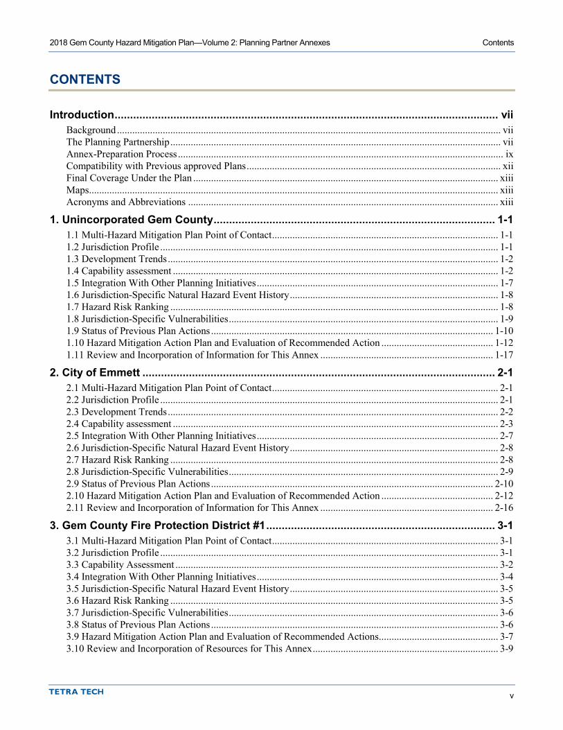
CONTENTS
Introduction ............................................................................................................................ vii Background ....................................................................................................................................................... vii The Planning Partnership .................................................................................................................................. vii Annex-Preparation Process ................................................................................................................................ ix Compatibility with Previous approved Plans .................................................................................................... xii Final Coverage Under the Plan ........................................................................................................................ xiii Maps ................................................................................................................................................................. xiii Acronyms and Abbreviations .......................................................................................................................... xiii
1. Unincorporated Gem County ........................................................................................... 1-1 1.1 Multi-Hazard Mitigation Plan Point of Contact ......................................................................................... 1-1 1.2 Jurisdiction Profile ..................................................................................................................................... 1-1 1.3 Development Trends .................................................................................................................................. 1-2 1.4 Capability assessment ................................................................................................................................ 1-2 1.5 Integration With Other Planning Initiatives ............................................................................................... 1-7 1.6 Jurisdiction-Specific Natural Hazard Event History .................................................................................. 1-8 1.7 Hazard Risk Ranking ................................................................................................................................. 1-8 1.8 Jurisdiction-Specific Vulnerabilities .......................................................................................................... 1-9 1.9 Status of Previous Plan Actions ............................................................................................................... 1-10 1.10 Hazard Mitigation Action Plan and Evaluation of Recommended Action ............................................ 1-12 1.11 Review and Incorporation of Information for This Annex .................................................................... 1-17
2. City of Emmett .................................................................................................................. 2-1 2.1 Multi-Hazard Mitigation Plan Point of Contact ......................................................................................... 2-1 2.2 Jurisdiction Profile ..................................................................................................................................... 2-1 2.3 Development Trends .................................................................................................................................. 2-2 2.4 Capability assessment ................................................................................................................................ 2-3 2.5 Integration With Other Planning Initiatives ............................................................................................... 2-7 2.6 Jurisdiction-Specific Natural Hazard Event History .................................................................................. 2-8 2.7 Hazard Risk Ranking ................................................................................................................................. 2-8 2.8 Jurisdiction-Specific Vulnerabilities .......................................................................................................... 2-9 2.9 Status of Previous Plan Actions ............................................................................................................... 2-10 2.10 Hazard Mitigation Action Plan and Evaluation of Recommended Action ............................................ 2-12 2.11 Review and Incorporation of Information for This Annex .................................................................... 2-16
3. Gem County Fire Protection District #1 .......................................................................... 3-1 3.1 Multi-Hazard Mitigation Plan Point of Contact ......................................................................................... 3-1 3.2 Jurisdiction Profile ..................................................................................................................................... 3-1 3.3 Capability Assessment ............................................................................................................................... 3-2 3.4 Integration With Other Planning Initiatives ............................................................................................... 3-4 3.5 Jurisdiction-Specific Natural Hazard Event History .................................................................................. 3-5 3.6 Hazard Risk Ranking ................................................................................................................................. 3-5 3.7 Jurisdiction-Specific Vulnerabilities .......................................................................................................... 3-6 3.8 Status of Previous Plan Actions ................................................................................................................. 3-6 3.9 Hazard Mitigation Action Plan and Evaluation of Recommended Actions ............................................... 3-7 3.10 Review and Incorporation of Resources for This Annex ......................................................................... 3-9

2018 Gem County Hazard Mitigation Plan—Volume 2: Planning Partner Annexes Contents
vi
4. Gem County Fire Protection District #2 .......................................................................... 4-1 4.1 Multi-Hazard Mitigation Plan Point of Contact ......................................................................................... 4-1 4.2 Jurisdiction Profile ..................................................................................................................................... 4-1 4.3 Capability Assessment ............................................................................................................................... 4-2 4.4 Integration With Other Planning Initiatives ............................................................................................... 4-4 4.5 Jurisdiction-Specific Natural Hazard Event History .................................................................................. 4-5 4.6 Hazard Risk Ranking ................................................................................................................................. 4-5 4.7 Jurisdiction-Specific Vulnerabilities .......................................................................................................... 4-6 4.8 Status of Previous Plan Actions ................................................................................................................. 4-6 4.9 Hazard Mitigation Action Plan and Evaluation of Recommended Actions ............................................... 4-6 4.10 Review and Incorporation of Resources for This Annex ......................................................................... 4-9
5. Emmett School District #221 ........................................................................................... 5-1 5.1 Multi-Hazard Mitigation Plan Point of Contact ......................................................................................... 5-1 5.2 Jurisdiction Profile ..................................................................................................................................... 5-1 5.3 Capability Assessment ............................................................................................................................... 5-2 5.4 Integration With Other Planning Initiatives ............................................................................................... 5-4 5.5 Jurisdiction-Specific Natural Hazard Event History .................................................................................. 5-5 5.6 Hazard Risk Ranking ................................................................................................................................. 5-5 5.7 Jurisdiction-Specific Vulnerabilities .......................................................................................................... 5-5 5.8 Status of Previous Plan Actions ................................................................................................................. 5-6 5.9 Hazard Mitigation Action Plan and Evaluation of Recommended Actions ............................................... 5-6 5.10 Review and Incorporation of Resources for This Annex ......................................................................... 5-8
Appendices
Appendix A. Planning Partner Expectations Appendix B. Procedures for Linking to This Plan Appendix C. Annex Instructions and Templates

vii
INTRODUCTION
BACKGROUND The Federal Emergency Management Agency (FEMA) encourages multi-jurisdictional planning for hazard mitigation. All participating jurisdictions must meet the requirements of Chapter 44 of the Code of Federal Regulations (44 CFR):
“Multi-jurisdictional plans (e.g. watershed plans) may be accepted, as appropriate, as long as each jurisdiction has participated in the process and has officially adopted the plan.” (Section 201.6.a(4))
For the 2018 Gem County Hazard Mitigation Plan, a planning partnership was formed to leverage resources and to meet requirements of the federal Disaster Mitigation Act (DMA) for eligible local governments in Gem County. The DMA defines a local government as follows:
“Any county, municipality, city, town, township, public authority, school district, special district, intrastate district, council of governments (regardless of whether the council of governments is incorporated as a nonprofit corporation under State law), regional or interstate government entity, or agency or instrumentality of a local government; any Indian tribe or authorized tribal organization, or Alaska Native village or organization; and any rural community, unincorporated town or village, or other public entity.”
There are two types of Planning Partners that participated in this process, with distinct needs and capabilities:
• Incorporated municipalities (cities and the County) • Special purpose districts.
Each participating planning partner has prepared a jurisdiction-specific annex to this plan. These annexes, as well as information on the process by which they were created, are contained in this volume.
THE PLANNING PARTNERSHIP
Initial Solicitation and Letters of Intent The planning team solicited the participation of the County and all County-recognized special purpose districts at the outset of this project. A kickoff meeting was held on November 29, 2017 to confirm potential stakeholders and planning partners for this process. The purpose of the meeting was to introduce the plan update process to jurisdictions in the County that could have a stake in the outcome of the planning effort. All eligible local governments within the planning area were invited to attend. Various agency and citizen stakeholders were also invited to this meeting. The goals of the meeting were as follows:
• Provide an overview of the Disaster Mitigation Act. • Provide an update on the planning process to date. • Outline the Gem County plan update work plan.

2018 Gem County Hazard Mitigation Plan—Volume 2: Planning Partner Annexes Unincorporated Gem County
viii
• Describe the benefits of multi-jurisdictional planning. • Outline planning partner expectations. • Solicit planning partners.
All interested local governments were provided with a list of planning partner expectations developed by the planning team and were informed of the obligations required for participation. Local governments wishing to join the planning effort were asked to provide the planning team with a “notice of intent to participate” that agreed to the planning partner expectations (see Appendix A) and designated a point of contact for their jurisdiction. In all, formal commitment was received from five planning partners by the planning team, and the Gem County Planning Partnership was formed. The letters of intent to participate are on file with Gem County and are available for review upon request.
Groups Involved in The Planning Process One of the goals of the multi-jurisdictional approach to natural hazard mitigation planning is to efficiently achieve compliance with the Disaster Mitigation Act (DMA) for all participating members in the planning effort. Several groups were involved in this process at different levels:
• Planning Team—The Tetra Tech team and Gem County staff responsible for the facilitation of the planning process and the development of the plan document.
• Steering Committee—Representative members from the planning partnership and stakeholders that serve as the oversight body. They are responsible for many of the planning milestones and decisions prescribed for this process to help reduce the burden of time required by each planning partner.
• Planning Partners—Jurisdictions or special purpose districts that are developing an annex to the regional plan.
• Planning Stakeholders—The individuals, groups, businesses, academia, etc., from which the planning team gains information to support the various elements of the plan. This group may also be referred to as coordinating stakeholders.
Planning Partner Expectations The planning team developed the following list of planning partner expectations, which were confirmed at the kickoff meeting on November 29, 2017:
• Each partner will provide a “Letter of Intent to Participate.” • Each partner will support and participate in the selection and function of the Steering Committee
overseeing the development of the update. Support includes allowing this body to make decisions regarding plan development and scope on behalf of the partnership.
• Each partner will provide support for the public involvement strategy developed by the Steering Committee in the form of mailing lists, possible meeting space, and media outreach such as newsletters, newspapers or direct-mailed brochures.
• Each partner will participate in plan update development activities such as:
Steering Committee meetings Public meetings or open houses Workshops and planning partner training sessions Public review and comment periods prior to adoption.
Attendance will be tracked at such activities, and attendance records will be used to track and document participation for each planning partner. No minimum level of participation will be established, but each planning partner should attempt to attend all such activities.

2018 Gem County Hazard Mitigation Plan—Volume 2: Planning Partner Annexes Introduction
ix
• Each partner will be expected to perform a “consistency review” of all technical studies, plans, and ordinances specific to hazards identified within the planning area to determine the existence of plans, studies or ordinances not consistent with the equivalent documents reviewed in preparation of the County plan. For example: if a planning partner has a floodplain management plan that makes recommendations that are not consistent with any of the County’s basin plans, that plan will need to be reviewed for probable incorporation into the plan for the partner’s area.
• Each partner will be expected to review the risk assessment and identify hazards and vulnerabilities specific to its jurisdiction. Contract resources will provide jurisdiction-specific mapping and technical consultation to aid in this task, but the determination of risk and vulnerability will be up to each partner.
• Each partner will be expected to review the mitigation recommendations chosen for the overall county and determine if they will meet the needs of its jurisdiction. Projects within each jurisdiction consistent with the overall plan recommendations will need to be identified, prioritized and reviewed to determine their benefits and costs.
• Each partner will be required to create its own action plan that identifies each project, who will oversee the task, how it will be financed and when it is estimated to occur.
• Each partner will be required to complete its normal pre-adoption process prior to submitting the plan to its governing body for adoption. For example, if it is the community’s normal process to submit a planning document to a Planning Commission prior to submittal to council for adoption, then that process must be followed for the adoption of this plan.
• Each partner will be required to formally adopt the plan.
By adopting this plan, each planning partner also agrees to the plan implementation and maintenance protocol established in Volume 1. Failure to meet these criteria may result in a partner being dropped from the partnership by the Steering Committee, and thus losing eligibility under the scope of this plan.
Linkage Procedures Eligible local jurisdictions that did not participate in development of this regional plan update may comply with DMA requirements by linking to this plan following the procedures outlined in Appendix B.
ANNEX-PREPARATION PROCESS
Templates Templates were created to help the Planning Partners prepare their jurisdiction-specific annexes. Since special purpose districts operate differently from incorporated municipalities, separate templates were created for the two types of jurisdictions. The templates were created so that all criteria of Section 201.6 of 44 CFR would be met, based on the partners’ capabilities and mode of operation. Templates available for the planning partners’ use were specific as to whether the partner is a municipality or a special purpose district and whether the annex is an update to a previous hazard mitigation plan or a first-time hazard plan. Each partner was asked to participate in a technical assistance workshop, during which key elements of the template were completed by a designated point of contact for each partner and a member of the planning team. The templates were set up to lead each partner through a series of steps that would generate the DMA-required elements that are specific for each partner. The templates and their instructions can be found in Appendix C to this volume of the Multi-Hazard Mitigation Plan.
Workshop Workshops were held for Planning Partners to learn about the templates and the overall planning process. Topics included the following:

2018 Gem County Hazard Mitigation Plan—Volume 2: Planning Partner Annexes Unincorporated Gem County
x
• DMA • Gem County plan background • The templates • Risk ranking • Developing your action plan • Cost/benefit review.
Separate sessions were held for special purpose districts and municipalities, in order to better address each type of partner’s needs. The sessions provided technical assistance and an overview of the template completion process. Attendance at this workshop was mandatory under the planning partner expectations established by the Steering Committee. There was 83-percent attendance of the partnership at these sessions.
In the risk-ranking exercise, each planning partner was asked to rank each risk specifically for its jurisdiction, based on the impact on its population or facilities. Cities were asked to base this ranking on probability of occurrence and the potential impact on people, property and the economy. Special purpose districts were asked to base this ranking on probability of occurrence and the potential impact on their constituency, their vital facilities and the facilities’ functionality after an event. The methodology followed that used for the countywide risk ranking presented in Volume 1. A principal objective of this exercise was to familiarize the partnership with how to use the risk assessment as a tool to support other planning and hazard mitigation processes. Tools utilized during these sessions included the following:
• The risk assessment results developed for this plan • Hazard maps for all hazards of concern • Special district boundary maps that illustrated the sphere of influence for each special purpose district
partner • Hazard mitigation catalogs • Federal funding and technical assistance catalogs • Copies of partners’ prior annexes, if applicable.
Prioritization 44 CFR requires actions identified in the action plan to be prioritized (Section 201.c.3.iii). The planning team and steering committee developed a methodology for prioritizing the action plans that meets the needs of the partnership and the requirements of 44 CFR. The actions were prioritized according to the following criteria:
• High Priority—An action that meets multiple objectives, has benefits that exceed cost, has funding secured or is an ongoing action and meets eligibility requirements for a grant program. High priority actions can be completed in the short term (1 to 5 years). The key factors for high priority actions are that they have funding secured and can be completed in the short term.
• Medium Priority—An action that meets multiple objectives, that has benefits that exceed costs, and for which funding has not yet been secured, but is eligible for funding. Action can be completed in the short term once funding is secured. Medium priority actions will become high priority actions once funding is secured. The key factors for medium priority actions are that they are eligible for funding, but do not yet have funding secured, and they can be completed within the short term.
• Low Priority—An action that will mitigate the risk of a hazard, that has benefits that do not exceed the costs or are difficult to quantify, for which funding has not been secured, that is not eligible for grant funding, and for which the time line for completion is long term (1 to 10 years). Low priority actions may be eligible for grant funding from other programs that have not yet been identified. Low priority actions are generally “blue-sky” or “wish-list.” actions. Financing is unknown, and they can be completed over a long term.

2018 Gem County Hazard Mitigation Plan—Volume 2: Planning Partner Annexes Introduction
xi
Grant pursuit priorities were established using the following considerations:
• High Priority—An action that has been identified as meeting grant eligibility requirements, assessed to have high benefits, is listed as high or medium priority, and where local funding options are unavailable or where dedicated funds could be utilized for actions that are not eligible for grant funding.
• Medium Priority—An action that has been identified as meeting grant eligibility requirements, assessed to have medium or low benefits, is listed as medium or low priority, and where local funding options are unavailable.
• Low Priority—An action that has not been identified as meeting grant eligibility requirements or that has low benefits.
Benefit/Cost Review 44 CFR requires the prioritization of the action plan to emphasize a benefit/cost analysis of the proposed actions. Because some actions may not be implemented for up to 10 years, benefit/cost analysis was qualitative and not of the detail required by FEMA for project grant eligibility under relevant grant programs. A review of the apparent benefits versus the apparent cost of each project was performed. Parameters were established for assigning subjective ratings (high, medium, and low) to costs and benefits as follows:
Benefit ratings were defined as follows:
• High—Action will have an immediate impact on the reduction of risk exposure to life and property. • Medium—Action will have a long-term impact on the reduction of risk exposure to life and property, or
action will provide an immediate reduction in the risk exposure to property. • Low—Long-term benefits of the action are difficult to quantify in the short term.
Cost ratings were defined as follows:
• High—Requires an increase in revenue via an alternative source (i.e., bonds, grants, fee increases) to implement. Existing funding levels are not adequate to cover the costs of the proposed action.
• Medium—Could budget for under existing work-plan but would require a reapportionment of the budget or a budget amendment, or the cost of the action would have to be spread over multiple years.
• Low—Possible to fund under existing budget. Action is or can be part of an existing ongoing program.
Using this approach, actions with positive benefit versus cost ratios (such as high over high, high over medium, medium over low, etc.) are considered cost-beneficial. For many of the strategies identified in this action plan, the partners may seek financial assistance under the Hazard Mitigation Grant Program (HMGP) or Pre-Disaster Mitigation (PDM) Program, both of which require detailed benefit/cost analyses. These analyses will be performed on actions at the time of application using the FEMA benefit-cost model. For actions not seeking financial assistance from grant programs that require detailed analysis, the partners reserve the right to define “benefits” according to parameters that meet the goals and objectives of this plan.
Analysis of Mitigation Initiatives Each planning partner reviewed its recommended initiatives to classify each initiative based on the hazard it addresses and the type of mitigation it involves. Mitigation types used for this categorization are as follows:
• Prevention—Government, administrative or regulatory actions that influence the way land and buildings are developed to reduce hazard losses. Includes planning and zoning, floodplain laws, capital improvement programs, open space preservation, and stormwater management regulations.

2018 Gem County Hazard Mitigation Plan—Volume 2: Planning Partner Annexes Unincorporated Gem County
xii
• Property Protection—Modification of buildings or structures to protect them from a hazard or removal of structures from a hazard area. Includes acquisition, elevation, relocation, structural retrofit, storm shutters, and shatter-resistant glass.
• Public Education and Awareness—Actions to inform citizens and elected officials about hazards and ways to mitigate them. Includes outreach projects, real estate disclosure, hazard information centers, and school-age and adult education.
• Natural Resource Protection—Actions that minimize hazard loss and preserve or restore the functions of natural systems. Includes sediment and erosion control, stream corridor restoration, watershed management, forest and vegetation management, and wetland restoration and preservation.
• Emergency Services—Actions that protect people and property during and immediately after a hazard event. Includes warning systems, emergency response services, and the protection of essential facilities.
• Structural Projects—Actions that involve the construction of structures to reduce the impact of a hazard. Includes dams, setback levees, floodwalls, retaining walls, and safe rooms.
COMPATIBILITY WITH PREVIOUS APPROVED PLANS The jurisdictions listed in Table 1 participated in the 2012 Gem County mitigation planning effort. The table lists the dates that each of these jurisdictions adopted the previous hazard mitigation plan.
Table 1. Jurisdictions that Participated in Previous Hazard Plan Jurisdiction Previous Annex Adoption Date Gem County 9/4/2012 City of Emmett 9/25/2012 Gem County Fire District #1 10/11/2012 Gem County Fire District #2 10/10/2012 Emmett School District #221 10/11/2012 Gem County Mosquito Abatement District 9/17/2012
Gem County used the plan update process to comprehensively revise the original hazard mitigation plan. The updated plan differs from the initial plan for a variety of reasons:
• Better guidance now exists on what is required to meet the intent of the DMA. • The scope of the plan has been expanded by including special-purpose district planning partners not
involved in the initial planning effort. These district planning partners are true stakeholders in mitigation within the planning area.
• Newly available data and tools provide for a more detailed and accurate risk assessment. The initial plan did not use tools such as FEMA’s Hazards U.S. Multi-Hazard (Hazus-MH) computer model or new geographic information system (GIS) data available from the County.
• The risk assessment has been prepared to better support future grant applications by providing risk and vulnerability information that will directly support the measurement of “cost-effectiveness” required under FEMA mitigation grant programs.
• Science and technology have improved since the development of the initial plan. • The plan meets program requirements of the Community Rating System, thus reducing flood insurance
premiums in participating jurisdictions. • There was a strong desire on the part of Gem County for this plan to be a user-friendly document that is
understandable to the general public and not overly technical. • The plan identifies actions rather than strategies. Strategies provide direction, but actions are fundable
under grant programs. This plan replaces strategies with a guiding principal, goals and objectives. The

2018 Gem County Hazard Mitigation Plan—Volume 2: Planning Partner Annexes Introduction
xiii
identified actions meet multiple objectives that are measurable, so that all planning partners can measure the effectiveness of their mitigation actions.
FINAL COVERAGE UNDER THE PLAN Table 2 lists the jurisdictions that submitted letters of intent and their ultimate status in this plan update. All five committed planning partners fully met the participation requirements specified by the Steering Committee.
Table 2. Planning Partner Status
Letter of
Intent Date Attended
Workshop? Completed Template?
Covered by This Plan?
Gem County 11/29/2017 Yes Yes Yes City of Emmett 11/29/2017 Yes Yes Yes Gem County Fire District #1 11/29/2017 Yes Yes Yes Gem County Fire District #2 11/29/2017 Yes Yes Yes Emmett School District #221 11/29/2017 Yes Yes Yes Gem County Mosquito Abatement District 11/29/2017 No No No
MAPS Maps showing the hazard areas in Gem County are provided in Volume 1 of this hazard mitigation plan. Hazard-area maps for the City of Emmett are provided at the end of the Emmett annex in this volume. A map showing the location of participating special purpose districts by district type are provided at the end of this introduction.
ACRONYMS AND ABBREVIATIONS The following terms are used in the planning partner annexes:
• AFG—Assistance to Firefighters Grants • CWPP—Community Wildfire Protection Plan • EMPG—Emergency Management Performance Grant • ESD221—Emmett School District #221 • FEMA—Federal Emergency Management Agency • FMA—USDA Flood Mitigation Assistance • FMAG—Fire Management Assistance Grants • GCFD#1—Gem County Fire District #1 • GCFD#2—Gem County Fire District #2 • HMA—Hazard Mitigation Assistance • HMGP—Hazard Mitigation Grant Program • HSGP—Homeland Security Grant Program • IDL—Idaho Department of Lands • IOEM—Idaho Office of Emergency Management • LEPC—Local emergency planning committee • NFIP—National Flood Insurance Program • OEM—Office of Emergency Management • PDM—Pre-Disaster Mitigation grant program • POC—Point of Contact • USGS—U.S. Geological Survey • WWTP—Wastewater Treatment Plant

/
Special Districts
Gem County
Map Data Sources: NationalGeographic, Gem County, State
of Idaho
Emmett SchoolDistrict #221(Whole County)Gem County FireProtection District#1Gem County FireProtection District#2Gem CountyMosquitoAbatement DistrictSquaw Creek DitchCompany
This map is for informational purposes only.
0 4 82Miles

1-1
1. UNINCORPORATED GEM COUNTY
1.1 MULTI-HAZARD MITIGATION PLAN POINT OF CONTACT
Primary Point of Contact Alternate Point of Contact Laurie Boston, Gem County Emergency Manager 330 E Main Street Emmett, ID 83617 Telephone: 208-365-3684 e-mail Address: [email protected]
Jennifer Kharrl, Planning Director 109 South McKinley Ave. Emmett, ID 83617 Telephone: 208-365-5144 e-mail Address: [email protected]
1.2 JURISDICTION PROFILE The following is a summary of key information about the jurisdiction and its history:
• Date of Incorporation— May 19, 1915 • Current Population—17,184 (Idaho “Blue Book” https://sos.idaho.gov/elect/bluebook/index.html ) • Population Growth— From 2010 to 2016, Gem County’s population grew by 2.78 percent. The County
has averaged 2.02 percent growth per year since 1970. Most of the growth within the County has occurred in 2 principle time frames, 1970 to 1980 (+27.5%) and 1990 to 2000 (+28%).
• Location and Description— Gem County is in the West Central Highlands of Idaho 30 miles northwest of Boise, with the Payette River cutting through its heartland. The valley of the Payette is 35 miles long and averages 6 miles wide in Gem County. Elevations range from 2,225 feet above sea level to 8,329 feet in the northern end of the county. The Squaw Butte at the north end of the valley rises to an elevation of 5,906 feet. The City of Emmett is at 2,373 feet above sea level. Ownership is mixed between federal (mainly Bureau of Land Management and U.S. Forest Service), state and private owners.
• Brief History— In the early 1900s, fruit packers adopted the label of “Valley of Plenty” for the Payette River Valley because of its fertility. During the mining era, the Payette Valley was known as the garden for the mining regions. Permanent settlement began in the early 1860s after gold discoveries in the Boise Basin brought people over established stage and pack train routes. Two of these trails joined at the Payette River north of the present river bridge. It was here that in 1863 Nathaniel Martin and Jonathan Smith decided to build a ferry to cross the river that swelled to over a mile wide each spring. The community of Martinsville, later named Emmett, grew up around this ferry site, which handled not only local trade, but also heavy traffic from the Basin Trail.
• Climate— Gem County has a high desert climate with four distinct seasons. Temperatures range from an average winter low of 22ºF to an average high in summer of 87ºF. Average precipitation is about 11 to 12 inches per year.
• Governing Body Format Gem County is headed by the elected, three-member Board of Gem County Commissioners. The Board directly oversees departments, as there is no County Manager position. Other county elected offices include a County Clerk, Treasurer, Assessor, Prosecutor, Coroner, and Sheriff. The Board of Gem County Commissioners assumes responsibility for the adoption of this plan; Office of Emergency Management will oversee its implementation.

2018 Gem County Hazard Mitigation Plan—Volume 2: Planning Partner Annexes Unincorporated Gem County
1-2
1.3 DEVELOPMENT TRENDS Since the completion of the last plan in 2012, development trends have remained very flat, until 2017, where the trends began to climb. In 2018, there seems to be no signs of slowing down.
Table 1-1 summarizes development trends in the performance period since development of the previous hazard mitigation plan and expected future development trends.
Table 1-1. Recent and Expected Future Development Trends Criterion Response Has your jurisdiction annexed any land since the development of the previous hazard mitigation plan?
No
• If yes, give the estimated area annexed and estimated number of parcels or structures.
N/A
Is your jurisdiction expected to annex any areas during the performance period of this plan?
No
• If yes, please describe land areas and dominant uses.
N/A
• If yes, who currently has permitting authority over these areas?
N/A
Are any areas targeted for development or major redevelopment in the next five years?
No
• If yes, please briefly describe, including whether any of the areas are in known hazard risk areas
N/A
How many permits for new construction were issued in your jurisdiction since the development of the previous hazard mitigation plan?
2013 2014 2015 2016 2017 Single Family 16 27 37 45 59 Multi-Family 0 0 0 0 0
Other (commercial, mixed use, etc.) 1 3 6 10 11 Please provide the number of new-construction permits for each hazard area or provide a qualitative description of where development has occurred.
• Special Flood Hazard Areas: 4 • Landslide: 0 • High Liquefaction Areas: 0 • Tsunami Inundation Area: 0 • Wildfire Risk Areas: 0
Please describe the level of buildout in the jurisdiction, based on your jurisdiction’s buildable lands inventory. If no such inventory exists, provide a qualitative description.
There are 2,149 developable parcels within Gem County as of this planning period.
1.4 CAPABILITY ASSESSMENT Gem County has performed an inventory and analysis of existing capabilities, plans, programs and policies that enhance its ability to implement mitigation strategies. The introduction at the beginning of this volume of the hazard mitigation plan describes the components included in the capability assessment and their significance for hazard mitigation planning. This section summarizes the following findings of the assessment:
• An assessment of legal and regulatory capabilities is presented in Table 1-2. • Development and permitting capabilities are presented in Table 1-3. • An assessment of fiscal capabilities is presented in Table 1-4.

2018 Gem County Hazard Mitigation Plan—Volume 2: Planning Partner Annexes Unincorporated Gem County
1-3
• An assessment of administrative and technical capabilities is presented in Table 1-5. • An assessment of education and outreach capabilities is presented in Table 1-6. • Information on National Flood Insurance Program (NFIP) compliance is presented in Table 1-7. • Classifications under various community mitigation programs are presented in Table 1-8.
The capability assessment was reviewed in order to identify opportunities to expand, initiate or integrate capabilities to further hazard mitigation goals and objectives. Where such opportunities were identified and determined to be feasible, they are included in the action plan and are identified as Community Capacity Building mitigation actions in the Analysis of Mitigation Actions table in Section 1.10.
Table 1-2. Legal and Regulatory Capability
Local
Authority Other Jurisdiction
Authority State
Mandated Integration
Opportunity? Codes, Ordinances, & Requirements Building Code Yes No Yes No Comment: Title IX of the GCC adopts the International Building Code (IBC) and the International Residential Code (IRC), 8-12-2003 Zoning Code Yes No Yes No Comment: Title XI of the GCC is entitled as the GEM COUNTY ZONING ORDINANCE, and may be so cited and pleaded. (Ord. 2009-
05, 9-28-2009) Subdivisions Yes No Yes No Comment: Title XII of the GCC referred to as the SUBDIVISION ORDINANCE OF GEM COUNTY, IDAHO. (Ord. 2009-06, 9-28-2009) Stormwater Management No No No Yes Comment: Since this is a current lack of regulatory capability for the County, it could be considered as an action for this plan if
determined to be feasible by the County Post-Disaster Recovery No No No Yes Comment: Since this is a current lack of regulatory capability for the County, it could be considered as an action for this plan if
determined to be feasible by the County Real Estate Disclosure No No No No Comment: Since this is a current lack of regulatory capability for the County, it could be considered as an action for this plan if
determined to be feasible by the County Growth Management Yes No No Yes Comment: Growth is managed in Gem County by its Comprehensive Plan. Board of County Commissioners Resolution No. 2007-05 / 6-
12-2007 (joint adoption w/City of Emmett). Site Plan Review Yes No Yes No Comment: Title XII, Chapter 4, section 6 of the GCC. (Ord. 2009-06, 9-28-2009) Environmental Protection Yes No No No Comment: Title IV of the GCC, Chapter 1 regulates solid waste, Chapter 2 regulates Orchard Pests, and Chapter 3 regulates weed
control Flood Damage Prevention Yes Yes Yes No Comment: Title XIII of the GCC, (Ord. 2017-02, 3-6-2017) Emergency Management Yes Yes No Yes Comment: Comprehensive Emergency Management Plan, 2013 Climate Change No No No Yes Comment: Since this is a current lack of regulatory capability for the County, it could be considered as an action for this plan if
determined to be feasible by the County

2018 Gem County Hazard Mitigation Plan—Volume 2: Planning Partner Annexes Unincorporated Gem County
1-4
Local
Authority Other Jurisdiction
Authority State
Mandated Integration
Opportunity? Planning Documents General Plan Yes No Yes Yes Comment: Board of County Commissioners Resolution No. 2007-05 / 6-12-2007 (joint adoption w/City of Emmett). Last updated
February, 2014 Capital Improvement Program Yes No Yes Yes How often is the plan updated? Enacted in 2007, last updated in 2013. Currently no set update cycle. Comment: CIP for roads only. Floodplain or Watershed Plan No No No Yes Comment: Since this is a current lack of regulatory capability for the County, it could be considered as an action for this plan if
determined to be feasible by the County Stormwater Plan No No No No Comment: Urban Water Management Plan No No No No Comment: Habitat Conservation Plan No No No No Comment: Economic Development Plan Yes No No No Comment: Chapter 4 of the Gem Community Joint Comprehensive Plan includes an economic development component. Shoreline Management Plan No No No No Comment: Community Wildfire Protection Plan Yes No No Yes Comment: Forest Management Plan Yes No No Yes Comment: Considered as part of the CWPP Climate Action Plan No No No No Comment: Comprehensive Emergency Management Plan Yes No No No Comment: Last updated in 2013 Threat & Hazard Identification & Risk Assessment No No No No Comment: Post-Disaster Recovery Plan No No No No Comment: Continuity of Operations Plan No No No No Comment: Disaster Debris Management Plan No No No No Comment: Public Health Plan No Yes No No Comment: Southwest District Health has an infectious disease plan, and a point of distribution plan

2018 Gem County Hazard Mitigation Plan—Volume 2: Planning Partner Annexes Unincorporated Gem County
1-5
Table 1-3. Development and Permitting Capability Criterion Response Does your jurisdiction issue development permits? Yes • If no, who does? If yes, which department? Development Services Does your jurisdiction have the ability to track permits by hazard area? Yes, for flood only Does your jurisdiction have a buildable lands inventory? Yes
Table 1-4. Fiscal Capability Financial Resource Accessible or Eligible to Use? Community Development Block Grants Yes Capital Improvements Project Funding Yes Authority to Levy Taxes for Specific Purposes Yes User Fees for Water, Sewer, Gas or Electric Service No Incur Debt through General Obligation Bonds Yes Incur Debt through Special Tax Bonds Yes Incur Debt through Private Activity Bonds No Withhold Public Expenditures in Hazard-Prone Areas Yes State-Sponsored Grant Programs Yes Development Impact Fees for Homebuyers or Developers No Other N/A
Table 1-5. Administrative and Technical Capability Staff/Personnel Resource Available? Department/Agency/Position Planners or engineers with knowledge of land development and land management practices
Yes Gem County Development Services/ Planning Director
Engineers or professionals trained in building or infrastructure construction practices
Yes Gem County Development Services/Building Official and Keller
Associates/Structural Engineer (contracted)
Planners or engineers with an understanding of natural hazards Yes Keller Associates/Civil Engineer (contracted)
Staff with training in benefit/cost analysis Yes Can contract for this service Surveyors Yes Keller Associates/County Surveyor
(contracted) Personnel skilled or trained in GIS applications Yes Gem County Assessor’s Office Scientist familiar with natural hazards in local area Yes Planning Partners available through
universities and Idaho Department of Homeland Security
Emergency Manager Yes Gem County Emergency Medical Services/ Emergency Manager
Grant writers Yes Can contract for this service Other Yes/No Insert appropriate information

2018 Gem County Hazard Mitigation Plan—Volume 2: Planning Partner Annexes Unincorporated Gem County
1-6
Table 1-6. Education and Outreach Capability Criterion Response Do you have a Public Information Officer or Communications Office? Yes Do you have personnel skilled or trained in website development? Yes Do you have hazard mitigation information available on your website? Yes • If yes, please briefly describe. http://www.gemcounty.org/disaster-services/ahmp/ Do you utilize social media for hazard mitigation education and outreach? Yes • If yes, please briefly describe. Facebook, Twitter, Nextdoor Do you have any citizen boards or commissions that address issues related to hazard mitigation?
Yes
• If yes, please briefly describe. LEPC Do you have any other programs already in place that could be used to communicate hazard-related information?
Yes
• If yes, please briefly describe. LEPC, Sheriff’s Posse Do you have any established warning systems for hazard events? Yes • If yes, please briefly describe. National Weather Service warning for severe weather
events. USGS stream flow gauges on the Payette River.
Table 1-7. National Flood Insurance Program Compliance Criterion Response What local department is responsible for floodplain management? Development Services Department Who is your floodplain administrator? (department/position) Development Services Department/
Planning Director Are any certified floodplain managers on staff in your jurisdiction? No What is the date that your flood damage prevention ordinance was last amended? 3/7/17 Does your floodplain management program meet or exceed minimum requirements? Meets • If exceeds, in what ways? Insert appropriate information When was the most recent Community Assistance Visit or Community Assistance Contact? 2012 Does your jurisdiction have any outstanding NFIP compliance violations that need to be addressed?
Yes
• If so, please state what they are. Fill/debris in the Floodway Do your flood hazard maps adequately address the flood risk within your jurisdiction? No • If no, please state why. They are outdated Does your floodplain management staff need any assistance or training to support its floodplain management program?
Yes
• If so, what type of assistance/training is needed? Training every year Does your jurisdiction participate in the Community Rating System (CRS)? Yes • If yes, is your jurisdiction interested in improving CRS Classification? No • Is your jurisdiction interested in joining the CRS program? Yes/No How many flood insurance policies are in force in your jurisdiction?a 29 • What is the insurance in force? $ 7,777,800 • What is the premium in force? $ 16,629 How many total loss claims have been filed in your jurisdiction?a 3 • How many claims are still open/were closed without payment? 0 • What were the total payments for losses? $13,823.01 a. According to FEMA statistics as of December 31, 2017

2018 Gem County Hazard Mitigation Plan—Volume 2: Planning Partner Annexes Unincorporated Gem County
1-7
Table 1-8. Community Classifications Participating? Classification Date Classified Community Rating System Yes 9 5/1/2008 Building Code Effectiveness Grading Schedule No 99 N/A Public Protection Yes See Fire District Annexes Storm Ready Yes 5/9/2005 Firewise No
1.5 INTEGRATION WITH OTHER PLANNING INITIATIVES The information on hazards, risk, vulnerability and mitigation contained in this hazard mitigation plan is based on the best available data. Plan integration is the incorporation of this information into other relevant planning mechanisms, such as general planning and capital facilities planning. It includes the integration of natural hazard information and mitigation policies, principles and actions into local planning mechanisms and vice versa. Additionally, plan integration is achieved though the involvement of key staff and community officials in collaboratively planning for hazard mitigation.
1.5.1 Existing Integration In the performance period since adoption of the previous hazard mitigation plan, Gem County made progress on integrating hazard mitigation goals, objectives and actions into other planning initiatives. The following plans and programs currently integrate components of the hazard mitigation strategy:
• None at this time
Resources listed in Section 1.11 were used to provide information for this annex on hazard events and local capabilities within the jurisdiction.
1.5.2 Opportunities for Future Integration As this hazard mitigation plan is implemented, Gem County will use information from the plan as the best available science and data on natural hazards. The capability assessment presented in this annex identifies codes, plans and programs that provide opportunities for integration. The area-wide and local action plans developed for this hazard mitigation plan in actions related to plan integration, and progress on these actions will be reported through the progress reporting process described in Volume 1. New opportunities for integration also will be identified as part of the annual progress report. The capability assessment identified the following plans and programs that do not currently integrate goals or recommendations of the hazard mitigation plan but provide opportunities to do so in the future:
• The Emergency Operations Plan—The Emergency Operations Plan will be updated within the next performance period.
• Community Wildfire Protection Plan—Has been targeted as a mitigation action by the Fire Districts • County Zoning Ordinance—Scheduled for update with the next performance period • Integration of the Hazard Mitigation plan in the health and safety element of the Gem Community Joint
Comprehensive Plan • Future updates of the County Capital Improvement Plan (CIP)

2018 Gem County Hazard Mitigation Plan—Volume 2: Planning Partner Annexes Unincorporated Gem County
1-8
1.6 JURISDICTION-SPECIFIC NATURAL HAZARD EVENT HISTORY Table 1-9 lists past occurrences of natural hazards for which specific damage was recorded in Unincorporated Gem County. Other hazard events that broadly affected the entire planning area, including Unincorporated Gem County, are listed in the risk assessments in Volume 1 of this hazard mitigation plan. Countywide hazard maps are also included in Volume 1.
Table 1-9. Past Natural Hazard Events
Type of Event FEMA Disaster #
(if applicable) Date Damage Assessment Winter storms N/A 2016/2017 Data not available Flooding N/A 05/07/2017 Spring snow melt flooding occurred across much of Southwest
Idaho as a result of an above normal snow pack for the winter of 2016 to 2017. The Payette River at Emmett reached minor food stage due to snow melt.
Hail N/A 8/07/2016 A vigorous short-wave trough embedded in southwest flow aloft initiating strong to severe convection across parts of Southwest Idaho.
Strong Winds N/A 2/21/2013 A strong cold front moving in from the northwest late in the afternoon on the 21st caused wind damage to parts of Southwest Idaho.
Flood Event-Levee damage N/A 2013 Data not available Flooding N/A 4/26/2012 A National Weather Service employee surveyed the Payette
River near Emmett and observed the river was out of bank and flooding areas on the north side of the city.
Frost/Freeze N/A 10/04/2012 Cold Dry air moved into SW Idaho behind a cold front. This combined with clear skies and calm winds allowed temperatures to drop below freezing. This freeze marked the end of the growing season.
Severe Storms and Flooding
DR 1927 07/27/2010 Data not available
Severe Storms/Flooding DR-1154 01/04/1997 Data not available
1.7 HAZARD RISK RANKING Table 1-10 presents a local ranking of all hazards of concern for which Volume 1 of this hazard mitigation plan provides complete risk assessments. This ranking summarizes how hazards vary for this jurisdiction. As described in detail in Volume 1, the ranking process involves an assessment of the likelihood of occurrence for each hazard, along with its potential impacts on people, property and the economy. Mitigation action development targets those hazards with high and medium rankings.

2018 Gem County Hazard Mitigation Plan—Volume 2: Planning Partner Annexes Unincorporated Gem County
1-9
Table 1-10. Hazard Risk Ranking Rank Hazard Type Risk Rating Score (Probability x Impact) Category
1 Wildfire a (3x15) = 45 High 2 Earthquake b (2x20) = 40 High 3 Flood c (3x12) = 36 High 3 Dam Failure d (2x16) = 32 High 4 Severe Weather e (3x9) = 27 Medium 5 Landslide f (3x6) = 18 Medium 7 Drought g (3x3) = 9 Low
a. Based on High and Moderate-High Fire Severity Zones b. Based on the Squaw Creek M7.0 scenario c. Based on 100 year or 1 percent annual chance hazard results used for risk ranking d. Based on the Black Canyon Dam Failure scenario e. Severe weather is assessed more qualitatively than other hazards. Assumptions for risk ranking include high probability, medium
impact on people, low impact on property and low impact on economy. f. Slope greater than 30% and slope 15% to 30% areas were utilized for risk ranking g. Drought is assessed more qualitatively than other hazards. Generally, drought does not cause injury or death to people or result in
property damage. Assumptions for risk ranking include high probability, no impact on people, low impact on property and medium impact on economy.
1.8 JURISDICTION-SPECIFIC VULNERABILITIES Volume 1 of this hazard mitigation plan provides complete risk assessments for each identified hazard of concern. Available mapping of hazard areas is included in Volume 1 as well. This section provides information on a few key vulnerabilities for the jurisdiction.
Repetitive Loss Properties Repetitive loss records are as follows:
• Number of FEMA-identified Repetitive-Loss Properties: None • Number of FEMA-identified Severe-Repetitive-Loss Properties: None • Number of Repetitive-Loss Properties or Severe-Repetitive-Loss Properties that have been mitigated:
None Other Noted Vulnerabilities The following issues have been identified based on a review of the results of the risk assessment, public involvement strategy, and other available resources:
• Irrigation canals- The true risk associated with hazards associated with canals is not known for the unincorporated County.
• Urban Stormwater flooding • Residual risk associated with levee breach/over-topping • Dam Failure risk from Sage Hen reservoir
Mitigation actions addressing these issues were prioritized for consideration in the action plan presented in Section 1.10.
2018 Gem County Hazard Mitigation Plan—Volume 2: Planning Partner Annexes Unincorporated Gem County
1-10
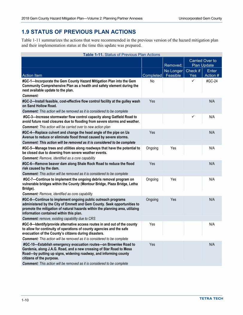
1.9 STATUS OF PREVIOUS PLAN ACTIONS Table 1-11 summarizes the actions that were recommended in the previous version of the hazard mitigation plan and their implementation status at the time this update was prepared.
Table 1-11. Status of Previous Plan Actions
Removed; Carried Over to
Plan Update
Action Item Completed No Longer Feasible
Check if Yes
Enter Action #
#GC-1—Incorporate the Gem County Hazard Mitigation Plan into the Gem Community Comprehensive Plan as a health and safety element during the next available update to the plan.
No #GC-24
Comment: #GC-2—Install feasible, cost-effective flow control facility at the gulley wash on Sand Hollow Road.
Yes N/A
Comment: This action will be removed as it is considered to be complete #GC-3—Increase stormwater flow control capacity along Gatfield Road to avoid future road closures due to flooding from severe storms and weather.
N/A
Comment: This action will be carried over to new action plan #GC-4—Replace culvert and change the head angle of the pipe on Ua Avenue to reduce or eliminate flood threat caused by severe storms.
Yes N/A
Comment: This action will be removed as it is considered to be complete #GC-5—Manage trees and utilities along roadways that have the potential to be closed due to downing from severe weather events.
Ongoing Yes N/A
Comment: Remove, identified as a core capability #GC-6—Remove beaver dam along Shale Rock Road to reduce the flood risk caused by the dam.
Yes N/A
Comment: This action will be removed as it is considered to be complete #GC-7—Continue to implement the ongoing debris removal program on vulnerable bridges within the County (Montour Bridge, Plaza Bridge, Letha Bridge).
Ongoing Yes N/A
Comment: Remove, identified as core capability #GC-8—Continue to implement ongoing public outreach programs administered by the City of Emmett and Gem County. Seek opportunities to promote the mitigation of natural hazards within the planning area, utilizing information contained within this plan.
Ongoing Yes N/A
Comment: remove, existing capability due to CRS #GC-9—Identify/provide alternative access routes in and out of the county to allow for continuity of operations of county agencies and the safe evacuation of the County’s citizens during disasters.
Yes N/A
Comment: This action will be removed as it is considered to be complete #GC-10—Establish emergency evacuation routes—on Brownlee Road to Gardenia, along J.A.G. Road, and a new crossing of Star Road to Mesa Road—by putting up signs, widening roadway, and informing county citizens of the purpose.
Yes N/A
Comment: This action will be removed as it is considered to be complete

2018 Gem County Hazard Mitigation Plan—Volume 2: Planning Partner Annexes Unincorporated Gem County
1-11
Removed; Carried Over to
Plan Update
Action Item Completed No Longer Feasible
Check if Yes
Enter Action #
Initiative #GC-11—Where appropriate, support retrofitting, purchase or relocation of structures located in hazard-prone areas to protect them from future damage and ensure continuity of operations. Seek opportunities to leverage partnerships within the planning area in these pursuits.
No #GC-17
Comment: #GC-12—Maintain compliance and good standing under the National Flood Insurance Program.
Ongoing #GC-18
Comment: #GC-13—Continue to participate in FEMA’s Community Rating System and the National Weather Service Storm Ready program. Consider participation in the Firewise program by promoting projects supported by this program. Seek ways to improve classifications under these incentive-based programs.
Yes #GC19
Comment: This action will be carried over to this plan update #GC-14—Work with the Idaho Survey and Rating Bureau to establish a Building Code Effectiveness Grading classification for the county.
No #GC-20
Comment: #GC-15—Identify and assess all dams and canals in Gem County and implement a study to determine the impacts of a breach. This study should look at impacts of differing scenarios associated with the design, construction and maintenance of the facility.
No #GC-21
Comment: #GC-16—Create defensible space around communication towers/repeater towers in wildfire exposure areas in Gem County Fire Districts #1 and #2, Emmett, Sweet, Ola and Pearl.
Ongoing N/A
Comment: Removed, identified as core capability #GC-17—Conduct site-specific analysis and potentially design mitigation measures for communication towers/repeater towers exposed to high winds and severe weather to ensure structural integrity of towers under a maximum wind load event.
Ongoing N/A
Comment: Removed. This Is taken in to account with the design of these facilities #GC-18—Identify private, buildable lands in areas of landslide risk (focused in unincorporated Gem County) and draft an ordinance amendment to establish minimum building setbacks from risk-prone embankments and other areas at risk. Include a public education component to address soil types and risks of building in landslide areas.
No N/A
Comment: Remove, no longer feasible #GC-19—Identify communication dead-zones within Gem County to determine and acquire additional repeaters as needed.
Partial #GC-7
Comment: dead zones have been identified. This action will be redefined as an action to address the dead zones. #GC-20—Implement a study to determine which tributaries and creeks would benefit from detention ponds to reduce flooding during high water flow.
No N/A
Comment: Removed, No longer feasible #GC-21—Maintain and acquire equipment for snow and debris removal. Yes N/A Comment: Done

2018 Gem County Hazard Mitigation Plan—Volume 2: Planning Partner Annexes Unincorporated Gem County
1-12
Removed; Carried Over to
Plan Update
Action Item Completed No Longer Feasible
Check if Yes
Enter Action #
#GC-22—Reduce wildfire risk factors by creating defensible spaces through proactive brush clearing in wildland fire interface areas.
Yes N/A
Comment: Removed. Identified as and existing Fire Dept capability #GC-23—Support the countywide initiatives identified in Volume 1 of this plan.
Yes N/A
Comment: This action will be removed as it is considered to be an existing core capability #GC-24—Continue to support the implementation, monitoring, maintenance, and updating of this plan, as defined in Volume 1.
Yes N/A
Comment: This action will be removed as it is considered to be an existing core capability #GC-25—Consider appropriate higher regulatory standards that prevent or reduce risk to the built environment from the known hazards of concern.
Yes N/A
Comment: This action has been removed as it is considered to be an existing core capability #GC-26—Maintain an active dialogue with all the partners involved in the release rates of water from Black Canyon Dam. Continue to seek a balance in the regulated flows that meets the needs of agricultural water users, flood control for urban areas and river recreationists.
Ongoing #GC-22
Comment: #GC-27—Standby fire protection water available: evaluate the need for rapid access to water sources and find solutions such as dry/wet hydrants, concrete cisterns, etc.
Yes N/A
Comment: This action is removed as it is considered to be an existing Fire Department core capability #GC-28—Develop a continuity of operations plan and a post-disaster recovery framework for the County.
No #CG-23
Comment:
1.10 HAZARD MITIGATION ACTION PLAN AND EVALUATION OF RECOMMENDED ACTION Table 1-12 lists the actions that make up the Unincorporated Gem County hazard mitigation action plan. Table 1-13 identifies the priority for each action. Table 1-14 summarizes the mitigation actions by hazard of concern and mitigation type.
Table 1-12. Hazard Mitigation Action Plan Matrix Applies to new or existing assets
Objectives Met Lead Agency Support Agency Estimated Cost Sources of Funding Timeline
#GC-1: Update the Gem County Emergency Operations Plan. Hazards Mitigated: All Hazards New and Existing 5, 9, 10, 11 Gem County OEM All Planning partners Medium EMPG, HSGP, General
fund Short-term
#GC-2: Study the Letha flood risk areas to Identify feasible, cost effective solution(s) for the Letha flood problem areas. Hazards Mitigated: Flood and Dam Failure New and Existing 1, 2, 4, 8 Development Services Road and Bridge, OEM High FEMA HMA Grants,
Corps of Engineers 205, County CIP, General
Fund
Long -term

2018 Gem County Hazard Mitigation Plan—Volume 2: Planning Partner Annexes Unincorporated Gem County
1-13
Applies to new or existing assets
Objectives Met Lead Agency Support Agency Estimated Cost Sources of Funding Timeline
#GC-3: Obtain “Certified Floodplain Manager” certification for County staff that play a principle role in floodplain management for the County. Hazards Mitigated: Flood and Dam Failure New and Existing 2, 5, 6, 7,
10, 11 Development Services Road and Bridge, OEM Low General Fund Short-term
#GC-4: Update the Gem County Capital Improvement Plan (CIP) to create a greater synergy between projects identified in the CIP and projects identified in the Gem County Hazard Mitigation Plan. Hazards Mitigated: Dam Failure, Earthquake, Flood, severe weather and wildfire New 3, 4, 5, 9 Development Services Road & Bridge Medium General Fund Short-
Term #GC-5: Coordinate with Squaw Creek Ditch company on the identification and implementation of feasible and cost-effective flood and dam failure (Sage Hen Reservoir) resilience measures. As a private-non-profit entity, Squaw Creek Ditch Company’s eligibility for FEMA HMA grant funding will be via sponsorship by Gem County. Hazards Mitigated: Flood and Dam Failure Existing 1, 3, 4, 5,
9, 10 Gem County OEM High FEMA HMA Grant
Funding, Squaw Creek Ditch Co. Operations
funding
Long-Term
#GC-6: Complete a detailed flood study that meets FEMA’s “Guidelines and Specifications for Flood Hazard Mapping” on Squaw Creek in the Ola area above Sweet. Hazards Mitigated: Flood and Dam Failure (Sage Hen) New and Existing 1, 2, 7, 8 Development Services Road and Bridge, OEM High FEMA’s RiskMAP
program, FMA, Corps of Engineers 205, General
Fund
Short-term
#GC-7: Place a Cell Tower and Repeater in the Ola vicinity to address “dead zones” in inter-operable communications within the County. Hazards Mitigated: All Hazards New and Existing 1, 5, 9, 11 OEM Gem County High HSGP, EMPG, General
Fund Short-term
#GC-8: Replace the Sweet/Ola Highway Bridge over Squaw Creek at Ola such that it will increase the flood conveyance at that location and provide seismic resilience for the bridge. Hazards Mitigated: Dam Failure, Earthquake and Flood Existing 1, 3, 4, 5, 9 Road and Bridge OEM High FEMA HMA Grant
programs, General Fund Short-term
#GC-9: Retrofit the Farmers Coop head gate such this it will mitigate the impacts from an earthquake, dam failure of a flood. The appropriate retrofit technique to be identified by a feasibility study packaged in the complete project. Hazards Mitigated: Dam failure, Earthquake and flood Existing 1, 3, 4, 5, 9 Road & Bridge Farmers Coop Irrigation
District High FEMA HMA Grant
programs, General Fund Short-term
#GC-10: Enhance the viability of Shale Rock Road near Montour as an important evacuation route within the County by elevating the road above the possible flood and dam failure impacts for that area. Hazards Mitigated: Dam failure and flood Existing 1, 3, 4, 5, 9 Road and Bridge OEM High FEMA HMA Grant
programs, General Fund Short- term

2018 Gem County Hazard Mitigation Plan—Volume 2: Planning Partner Annexes Unincorporated Gem County
1-14
Applies to new or existing assets
Objectives Met Lead Agency Support Agency Estimated Cost Sources of Funding Timeline
#GC-11: Enhance the viability of Jag road as an important evacuation Route (For Emmett) within the County improving the road (paving and drainage infrastructure). Hazards Mitigated: Dam Failure, Earthquake, flood, landslide and wildfire. Existing 1, 3, 4, 5, 9 Road and Bridge OEM High FEMA HMA Grant
programs, General Fund Short-term
#GC-12: Retrofit the Letha Bridge by raising the bridge to increase flow conveyance of the Payette River, and reinforcing the bridge for possible impacts from an earthquake. Hazards Mitigated: Dam failure, earthquake and flood. Existing 1, 3, 4, 5, 9 Road and Bridge ORS High FEMA HMA Grant
programs, General Fund Short-term
#GC-13: Retrofit the Montour Bridge by raising the bridge to increase flow conveyance of the Payette River, and reinforcing the bridge for possible impacts from an earthquake. Hazards Mitigated: Dam failure, earthquake and flood. Existing 1, 3, 4, 5, 9 Road and Bridge ORS High FEMA HMA Grant
programs, General Fund Short-term
#GC-14: Improve Old Freezeout Road to enhance its viability as an evacuation Route for the City of Emmett Hazards Mitigated: Dam Failure, Earthquake, flood, landslide and wildfire Existing 1, 3, 4, 5, 9 Road and Bridge ORS High FEMA HMA Grant
programs, General Fund Short-term
#GC-15: Amend Building Code to apply Seismic zone IV standards to known seismic risk areas based on best available data on seismic risk. Hazards Mitigated: Earthquake and landslide New 5, 6, 8 Development Services Gem County
Commissioners Low General fund Short-term
#GC-16: Coordinate with the City of Emmett on the development of a comprehensive flood risk management plan that identifies alternatives and cost-effective, feasible solutions for the City to address the economic consequence of decertification of the levee. Hazards Mitigated: Dam Failure and Flood New and Existing 2, 3, 4, 8,
11 Development Services City of Emmett High FEMA grant funding,
Economic Development Administration (EDA)
mitigation grant funding, Local Funds (CIP)
Long-term
#GC-17: Where appropriate, support retrofitting, purchase or relocation of structures located in hazard-prone areas to protect them from future damage and ensure continuity of operations. Seek opportunities to leverage partnerships within the planning area in these pursuits. Hazards Mitigated: Dam Failure, Earthquake, flood, landslide, severe weather and wildfire Existing 3, 4, 10 Development Services OEM High FEMA Hazard Mitigation
Grant funding, Private sector funding for local
match
Long-term
2018 Gem County Hazard Mitigation Plan—Volume 2: Planning Partner Annexes Unincorporated Gem County
1-15
Applies to new or existing assets
Objectives Met Lead Agency Support Agency Estimated Cost Sources of Funding Timeline
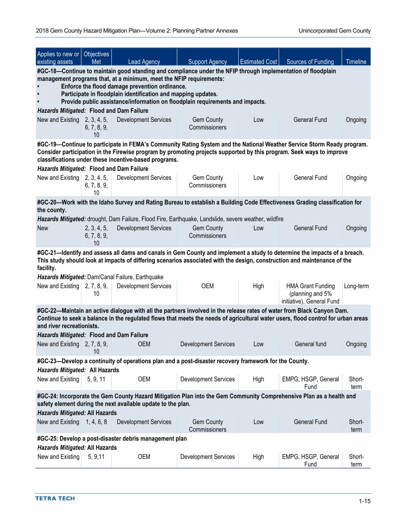
#GC-18—Continue to maintain good standing and compliance under the NFIP through implementation of floodplain management programs that, at a minimum, meet the NFIP requirements: • Enforce the flood damage prevention ordinance. • Participate in floodplain identification and mapping updates. • Provide public assistance/information on floodplain requirements and impacts. Hazards Mitigated: Flood and Dam Failure New and Existing 2, 3, 4, 5,
6, 7, 8, 9, 10
Development Services Gem County Commissioners
Low General Fund Ongoing
#GC-19—Continue to participate in FEMA’s Community Rating System and the National Weather Service Storm Ready program. Consider participation in the Firewise program by promoting projects supported by this program. Seek ways to improve classifications under these incentive-based programs. Hazards Mitigated: Flood and Dam Failure New and Existing 2, 3, 4, 5,
6, 7, 8, 9, 10
Development Services Gem County Commissioners
Low General Fund Ongoing
#GC-20—Work with the Idaho Survey and Rating Bureau to establish a Building Code Effectiveness Grading classification for the county. Hazards Mitigated: drought, Dam Failure, Flood Fire, Earthquake, Landslide, severe weather, wildfire New 2, 3, 4, 5,
6, 7, 8, 9, 10
Development Services Gem County Commissioners
Low General Fund Ongoing
#GC-21—Identify and assess all dams and canals in Gem County and implement a study to determine the impacts of a breach. This study should look at impacts of differing scenarios associated with the design, construction and maintenance of the facility. Hazards Mitigated: Dam/Canal Failure, Earthquake New and Existing 2, 7, 8, 9,
10 Development Services OEM High HMA Grant Funding
(planning and 5% initiative), General Fund
Long-term
#GC-22—Maintain an active dialogue with all the partners involved in the release rates of water from Black Canyon Dam. Continue to seek a balance in the regulated flows that meets the needs of agricultural water users, flood control for urban areas and river recreationists. Hazards Mitigated: Flood and Dam Failure New and Existing 2, 7, 8, 9,
10 OEM Development Services Low General fund Ongoing
#GC-23—Develop a continuity of operations plan and a post-disaster recovery framework for the County. Hazards Mitigated: All Hazards New and Existing 5, 9, 11 OEM Development Services High EMPG, HSGP, General
Fund Short-term
#GC-24: Incorporate the Gem County Hazard Mitigation Plan into the Gem Community Comprehensive Plan as a health and safety element during the next available update to the plan. Hazards Mitigated: All Hazards New and Existing 1, 4, 6, 8 Development Services Gem County
Commissioners Low General Fund Short-
term #GC-25: Develop a post-disaster debris management plan Hazards Mitigated: All Hazards New and Existing 5, 9,11 OEM Development Services High EMPG, HSGP, General
Fund Short- term

2018 Gem County Hazard Mitigation Plan—Volume 2: Planning Partner Annexes Unincorporated Gem County
1-16
Table 1-13. Mitigation Action Priority
Action #
# of Objectives
Met Benefits Costs
Do Benefits Equal or Exceed Costs?
Is Project Grant-
Eligible?
Can Project Be Funded
Under Existing Programs/ Budgets?
Implementation Prioritya
Grant Pursuit Prioritya
GC-1 4 High Medium Yes Yes No Medium High GC-2 4 High High Yes Yes No Medium High GC-3 6 Medium Low Yes No Yes High N/A GC-4 4 High Medium Yes No Yes High N/A GC-5 6 High High Yes Yes No Medium High GC-6 4 High High Yes Yes No Medium High GC-7 4 High High Yes Yes No Medium High GC-8 5 High High Yes Yes No Medium High GC-9 5 High High Yes Yes No Medium High
GC-10 5 High High Yes Yes No Medium High GC-11 5 High High Yes Yes No Medium High GC-12 5 High High Yes Yes No Medium High GC-13 5 High High Yes Yes No Medium High GC-14 5 High High Yes Yes No Medium High GC-15 3 Medium Low Yes No Yes High N/A GC-16 5 High High Yes Yes No Medium High GC-17 3 High High Yes Yes No Medium Medium GC-18 9 Medium Low Yes No Yes High N/A GC-19 9 Medium Low Yes No Yes High N/A GC-20 9 Medium Low Yes No Yes High N/A GC-21 5 High High Yes Yes No Medium High GC-22 5 High Low Yes No Yes High N/A GC-23 3 High High Yes Yes No Medium High GC-24 4 Medium Low Yes No Yes High N/A GC-25 3 High High Yes Yes No Medium High
a. See the introduction to this volume for explanation of priorities. b. Although this action may not be able to be completed within the performance period of the plan, it has been identified as a high
priority for implementation.
2018 Gem County Hazard Mitigation Plan—Volume 2: Planning Partner Annexes Unincorporated Gem County
1-17
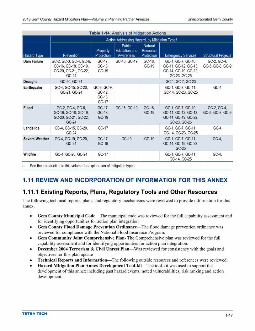
Table 1-14. Analysis of Mitigation Actions Action Addressing Hazard, by Mitigation Typea
Hazard Type Prevention Property
Protection
Public Education and
Awareness
Natural Resource Protection Emergency Services Structural Projects
Dam Failure GC-2, GC-3, GC-4, GC-6, GC-16, GC-18, GC-19, GC-20, GC-21, GC-22,
GC-24
GC-17, GC-18, GC-19
GC-18, GC-19 GC-18, GC-19
GC-1, GC-7, GC-10, GC-11, GC-12, GC-13, GC-14, GC-19, GC-22,
GC-23, GC-25
GC-2, GC-4, GC-5, GC-8, GC-9
Drought GC-20, GC-24 GC-1, GC-7, GC-23 Earthquake GC-4, GC-15, GC-20,
GC-21, GC-24 GC-8, GC-9,
GC-12, GC-13, GC-17
GC-1, GC-7, GC-11, GC-14, GC-23, GC-25
GC-4
Flood GC-2, GC-4, GC-6, GC-16, GC-18, GC-19, GC-20, GC-21, GC-22,
GC-24
GC-17, GC-18, GC-19
GC-18, GC-19 GC-18, GC-19
GC-1, GC-7, GC-10, GC-11, GC-12, GC-13, GC-14, GC-19, GC-22,
GC-23, GC-25
GC-2, GC-4, GC-5, GC-8, GC-9
Landslide GC-4, GC-15, GC-20, GC-24
GC-17 GC-1, GC-7, GC-11, GC-14, GC-23, GC-25
GC-4
Severe Weather GC-4, GC-19, GC-20, GC-24
GC-17, GC-19
GC-19 GC-19 GC-1, GC-7, GC-11, GC-14, GC-19, GC-23,
GC-25
GC-4,
Wildfire GC-4, GC-20, GC-24 GC-17 GC-1, GC-7, GC-11, GC-14, GC-25
GC-4,
a. See the introduction to this volume for explanation of mitigation types.
1.11 REVIEW AND INCORPORATION OF INFORMATION FOR THIS ANNEX
1.11.1 Existing Reports, Plans, Regulatory Tools and Other Resources The following technical reports, plans, and regulatory mechanisms were reviewed to provide information for this annex.
• Gem County Municipal Code—The municipal code was reviewed for the full capability assessment and for identifying opportunities for action plan integration.
• Gem County Flood Damage Prevention Ordinance—The flood damage prevention ordinance was reviewed for compliance with the National Flood Insurance Program.
• Gem Community Joint Comprehensive Plan- The Comprehensive plan was reviewed for the full capability assessment and for identifying opportunities for action plan integration.
• December 2004 Terrorism & Civil Unrest Plan—Was reviewed for consistency with the goals and objectives for this plan update
• Technical Reports and Information—The following outside resources and references were reviewed: • Hazard Mitigation Plan Annex Development Tool-kit—The tool-kit was used to support the
development of this annex including past hazard events, noted vulnerabilities, risk ranking and action development.

2018 Gem County Hazard Mitigation Plan—Volume 2: Planning Partner Annexes Unincorporated Gem County
1-18
1.11.2 Staff and Local Stakeholder Involvement in Annex Development The following personnel from Gem County were coordinated with and were the principle stakeholders in the development of this annex:
• Lauri Boston, Emergency Manager, Gem County Emergency Management • Jennifer Kharrl, Planning Director, Gem County Development Services • Michelle Barron, Gem County Development Services • Neal Capps, Gem County Road and Bridge • Chuck Rolland, Gem County Sheriff • Rob Flaner, Technical Consultant, Tetra Tech, Inc.

2-1
2. CITY OF EMMETT
2.1 MULTI-HAZARD MITIGATION PLAN POINT OF CONTACT
Primary Point of Contact Alternate Point of Contact Bruce Evans 601 E. 3rd Emmett, Idaho, 83617 Telephone: 208-365-9569 e mail Address: [email protected]
Brian Sullivan, Building Official/Zoning Administrator 601 E. 3rd Emmett, Idaho, 83617 Telephone: 208-365-9569 e mail Address: [email protected]
2.2 JURISDICTION PROFILE The following is a summary of key information about the jurisdiction and its history:
• Date of Incorporation— 1900 • Current Population— 6,590 (https://factfinder.census.gov ) • Population Growth— Between 2010 and 2016, Emmett’s population increased by 77—1.18 percent.
The largest recorded 10-year growth occurred between 1900 and 1910 when the population went from 508 to 1,351.
• Location and Description— According to the United States Census Bureau, Emmett has a total area of 2.8 all-land square miles. It is located south of the Payette River and is 2,362 feet above sea level. Squaw Butte, located at the north end of the Emmett Valley, rises to an elevation of 5,906 feet. Emmett is a rural community that is accessible by State Highways 52 and 16. It is host to the state’s longest, continuous-running festival—the Emmett Cherry Festival—that takes place in June of each year. Residents enjoy access to diverse recreation, including boating, rafting, hunting, fishing, fruit picking, hiking and bicycling. The community is also home to “Emmett Valley Swap Meet & Classic Car Show,” which was hosted on “My Classic Car TV” with host, Dennis Gage which is on cable & satellite stations.
• Brief History— Originally called “Emmettville,” the city was primarily a post office that was named after Emmett Cahalan, the son of early settler Tom Cahalan. Permanent settlement began in the early 1860s, and in 1883 James Wardwell platted the town. After incorporation in 1900, Emmett saw the arrival of the Idaho Northern Railroad as well as power lines and a series of irrigation projects that paved the way for growth. The town became a major service center for farming and fruit growing and packing. The fertility of the area led to the name “Valley of Plenty,” a label still used today. Mining and lumber also helped define the city that, until recently, was home to a Boise Cascade lumber manufacturing facility, whose production began tapering off in 2000 with closure of its mill. The mill was later purchased and retooled by Woodgrain Millwork and reopened to supply all of their other plants’ needs. Many residents travel out of the city to work in the Boise, Meridian, Nampa, and Caldwell areas.
• Climate— Emmett has a semi-arid climate with frigid winters and hot, dry summers. July is the warmest month of the year with an average maximum temperature of 89.9 degrees. The coldest month is January with an average minimum temperature of 23 degrees. The annual average precipitation is 13.81 inches and is evenly distributed throughout the year. The wettest months of the year are January and November,

2018 Gem County Hazard Mitigation Plan—Volume 2: Planning Partner Annexes City of Emmett
2-2
each with an average rainfall of 1.72 inches. The driest months of the year are July and August, with 0.30 and 0.33 inches of rainfall, respectively.
• Governing Body Format— Emmett is governed by a mayor and six-member council, all of whom are elected. City Council meetings take place inside Council Chambers at City Hall on the second and fourth Tuesdays of each month, beginning at 7 p.m. The City of Emmett City Council assumes responsibility for the adoption of this plan; the Public Works Department will oversee its implementation.
2.3 DEVELOPMENT TRENDS Idaho has historically lagged behind the national economy, and in light of the current economic climate nationwide, Emmett is not expecting significant development in the next 5 to 10 years. According to the Idaho Department of labor, they estimate an annual growth rate of 1.8% for sub-region 3 (southwest) for the time frame from 2016 to 2025. Completion of the extension of Highway 16 to Interstate 84, scheduled for 2014, is expected to have an impact on local development.
Table 2-1 summarizes development trends in the performance period since development of the previous hazard mitigation plan and expected future development trends.
Table 2-1. Recent and Expected Future Development Trends Criterion Response Has your jurisdiction annexed any land since the development of the previous hazard mitigation plan?
No
• If yes, give the estimated area annexed and estimated number of parcels or structures.
N/A
Is your jurisdiction expected to annex any areas during the performance period of this plan?
No
• If yes, please describe land areas and dominant uses.
N/A
• If yes, who currently has permitting authority over these areas?
N/A
Are any areas targeted for development or major redevelopment in the next five years?
No
• If yes, please briefly describe, including whether any of the areas are in known hazard risk areas
N/A
How many permits for new construction were issued in your jurisdiction since the development of the previous hazard mitigation plan?
2013 2014 2015 2016 2017 Single Family 9 11 11 25 12 Multi-Family 0 0 0 37 0
Other (commercial, mixed use, etc.) 11 9 9 6 1 Please provide the number of new-construction permits for each hazard area or provide a qualitative description of where development has occurred.
• Special Flood Hazard Areas: None • Landslide: Unknown • Wildfire Risk Areas: Unknown
Please describe the level of buildout in the jurisdiction, based on your jurisdiction’s buildable lands inventory. If no such inventory exists, provide a qualitative description.
The buildable land located within the current city limits of the City of Emmett is built out to approximately 85 % capacity.
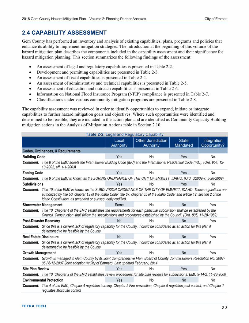
2018 Gem County Hazard Mitigation Plan—Volume 2: Planning Partner Annexes City of Emmett
2-3
2.4 CAPABILITY ASSESSMENT Gem County has performed an inventory and analysis of existing capabilities, plans, programs and policies that enhance its ability to implement mitigation strategies. The introduction at the beginning of this volume of the hazard mitigation plan describes the components included in the capability assessment and their significance for hazard mitigation planning. This section summarizes the following findings of the assessment:
• An assessment of legal and regulatory capabilities is presented in Table 2-2. • Development and permitting capabilities are presented in Table 2-3. • An assessment of fiscal capabilities is presented in Table 2-4. • An assessment of administrative and technical capabilities is presented in Table 2-5. • An assessment of education and outreach capabilities is presented in Table 2-6. • Information on National Flood Insurance Program (NFIP) compliance is presented in Table 2-7. • Classifications under various community mitigation programs are presented in Table 2-8.
The capability assessment was reviewed in order to identify opportunities to expand, initiate or integrate capabilities to further hazard mitigation goals and objectives. Where such opportunities were identified and determined to be feasible, they are included in the action plan and are identified as Community Capacity Building mitigation actions in the Analysis of Mitigation Actions table in Section 2.10.
Table 2-2. Legal and Regulatory Capability
Local
Authority Other Jurisdiction
Authority State
Mandated Integration
Opportunity? Codes, Ordinances, & Requirements Building Code Yes No Yes No Comment: Title 8 of the EMC adopts the International Building Code (IBC) and the International Residential Code (IRC), (Ord. 954, 12-
10-2002, eff. 1-1-2003) Zoning Code Yes No Yes No Comment: Title 9 of the EMC is known as the ZONING ORDINANCE OF THE CITY OF EMMETT, IDAHO. (Ord. O2009-7, 5-26-2009) Subdivisions Yes No Yes No Comment: Title 10 of the EMC is known as the SUBDIVISION ORDINANCE OF THE CITY OF EMMETT, IDAHO. These regulations are
authorized by title 50, chapter 13 of the Idaho Code; title 67, chapter 65 of the Idaho Code; and article 12, section 2 of the Idaho Constitution, as amended or subsequently codified.
Stormwater Management Some No No Yes Comment: Title 10, Chapter 4 of the EMC establishes the requirements for each particular subdivision shall be established by the
Council. Construction shall follow the specifications and procedures established by the Council. (Ord. 805, 11-28-1989) Post-Disaster Recovery No No No Yes Comment: Since this is a current lack of regulatory capability for the County, it could be considered as an action for this plan if
determined to be feasible by the County Real Estate Disclosure No No No Yes Comment: Since this is a current lack of regulatory capability for the County, it could be considered as an action for this plan if
determined to be feasible by the County Growth Management Yes No No Yes Comment: Growth is managed in Gem County by its Joint Comprehensive Plan. Board of County Commissioners Resolution No. 2007-
05 / 6-12-2007 (joint adoption w/City of Emmett). Last updated February, 2014 Site Plan Review Yes No Yes No Comment: Title 10, Chapter 2 of the EMC establishes review procedures for site plan reviews for subdivisions. EMC 9-14-2, 11-28-2000 Environmental Protection Yes No No No Comment: Title 4 of the EMC, Chapter 4 regulates burning, Chapter 5 Fire prevention, Chapter 6 regulates pest control, and Chapter 7
regulates Mosquito control

2018 Gem County Hazard Mitigation Plan—Volume 2: Planning Partner Annexes City of Emmett
2-4
Local
Authority Other Jurisdiction
Authority State
Mandated Integration
Opportunity? Flood Damage Prevention Yes Yes Yes Yes Comment: Title 10, Chapter 5, section 7 of the EMC addresses subdivision within a floodplain. Emergency Management Yes Yes No Yes Comment: Comprehensive Emergency Management Plan, last updated in 2013 Climate Change No No No Yes Comment: Since this is a current lack of regulatory capability for the County, it could be considered as an action for this plan if
determined to be feasible by the County Planning Documents General Plan Yes No Yes Yes Comment: Board of County Commissioners Resolution No. 2007-05 / 6-12-2007 (joint adoption w/City of Emmett). Last updated
February, 2014 Capital Improvement Plan Yes No Yes Yes How often is the plan updated? Streets 2018, Water/Sewer 2017 Comment: 5-year CIP for water, sewer, garbage and streets Floodplain or Watershed Plan No No No Yes Comment: Since this is a current lack of regulatory capability for the County, it could be considered as an action for this plan if
determined to be feasible by the County Stormwater Plan No No No No Comment: Since this is a current lack of regulatory capability for the County, it could be considered as an action for this plan if
determined to be feasible by the County. The City is concerned what has happened with City of Lewiston regarding their Storm Water Ordinance. Awaiting to see what other Cities will do so, we are monitoring this area.
Urban Water Management Plan No No No No Comment: Habitat Conservation Plan No No No No Comment: Economic Development Plan Yes No No No Comment: Chapter 4 of the Gem Community Joint Comprehensive Plan includes an economic development component. Managed by
County. Shoreline Management Plan No No No No Comment: Community Wildfire Protection Plan Yes No No No Comment: Last updated in 2009 Forest Management Plan No No No No Comment: Climate Action Plan No No No No Comment: Comprehensive Emergency Management Plan Yes No No No Comment: Last updated in 2013 Threat & Hazard Identification & Risk Assessment No No No No Comment: Post-Disaster Recovery Plan No No No No Comment: Continuity of Operations Plan No No No No Comment:

2018 Gem County Hazard Mitigation Plan—Volume 2: Planning Partner Annexes City of Emmett
2-5
Local
Authority Other Jurisdiction
Authority State
Mandated Integration
Opportunity? Disaster Debris Management Plan No No No No Comment: None locally developed by the City of Emmett. The Solid Waste authority may have one. Public Health Plan No No No No Comment: Other: Yes No No Yes Comment: Local Improvement Districts
Table 2-3. Development and Permitting Capability Criterion Response Does your jurisdiction issue development permits? Yes • If no, who does? If yes, which department? Building and Planning Services Does your jurisdiction have the ability to track permits by hazard area? Yes, can search building permits issued in the floodplain. Does your jurisdiction have a buildable lands inventory? No
Table 2-4. Fiscal Capability Financial Resource Accessible or Eligible to Use? Community Development Block Grants Yes Capital Improvements Project Funding Yes Authority to Levy Taxes for Specific Purposes Yes User Fees for Water, Sewer, Gas or Electric Service No Incur Debt through General Obligation Bonds Yes Incur Debt through Special Tax Bonds Yes Incur Debt through Private Activity Bonds No Withhold Public Expenditures in Hazard-Prone Areas Yes State-Sponsored Grant Programs Yes Development Impact Fees for Homebuyers or Developers No Other N/A

2018 Gem County Hazard Mitigation Plan—Volume 2: Planning Partner Annexes City of Emmett
2-6
Table 2-5. Administrative and Technical Capability Staff/Personnel Resource Available? Department/Agency/Position Planners or engineers with knowledge of land development and land management practices
Yes Gem County Development Services/ Planning Director
Engineers or professionals trained in building or infrastructure construction practices
Yes Building Department, City of Emmett Building Official
Planners or engineers with an understanding of natural hazards Yes City can contract for these services Staff with training in benefit/cost analysis Yes Can contract for this service Surveyors Yes City can contract for these services Personnel skilled or trained in GIS applications Yes Gem County Development Services,
Gem County Assessor’s Office Scientist familiar with natural hazards in local area Yes Planning Partners available through
universities and Idaho Department of Homeland Security
Emergency Manager Yes Gem County Emergency Medical Services/ Emergency Manager
Grant writers Yes Can contract for this service Other Yes/No Insert appropriate information
Table 2-6. Education and Outreach Capability Criterion Response Do you have a Public Information Officer or Communications Office? Yes Do you have personnel skilled or trained in website development? Yes Do you have hazard mitigation information available on your website? Yes • If yes, please briefly describe. http://www.gemcounty.org/disaster-services/ahmp/ Do you utilize social media for hazard mitigation education and outreach? Yes • If yes, please briefly describe. Facebook, Twitter, Nextdoor Do you have any citizen boards or commissions that address issues related to hazard mitigation?
Yes
• If yes, please briefly describe. LEPC Do you have any other programs already in place that could be used to communicate hazard-related information?
Yes
• If yes, please briefly describe. LEPC, Sheriff’s Posse Do you have any established warning systems for hazard events? Yes • If yes, please briefly describe. USGS maintains and monitors stream flow gauges
on the Payette River
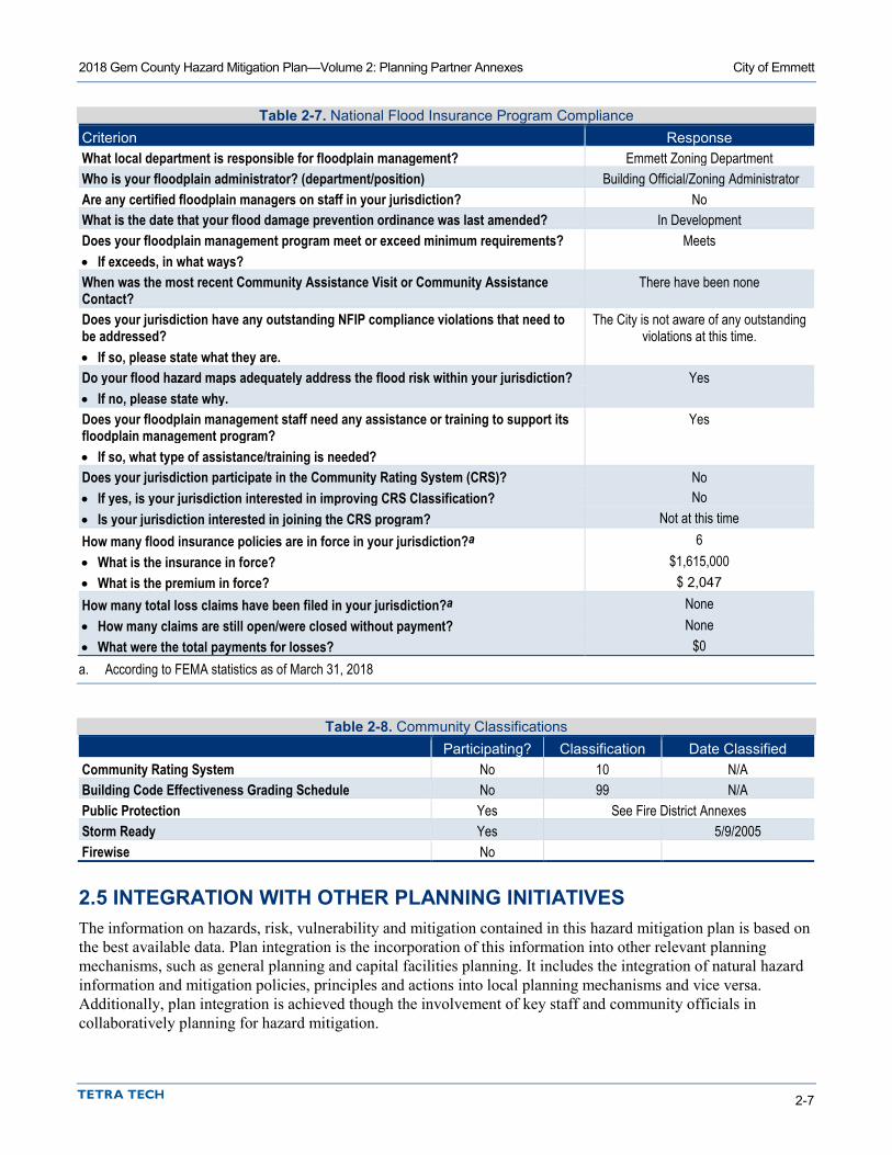
2018 Gem County Hazard Mitigation Plan—Volume 2: Planning Partner Annexes City of Emmett
2-7
Table 2-7. National Flood Insurance Program Compliance Criterion Response What local department is responsible for floodplain management? Emmett Zoning Department Who is your floodplain administrator? (department/position) Building Official/Zoning Administrator Are any certified floodplain managers on staff in your jurisdiction? No What is the date that your flood damage prevention ordinance was last amended? In Development Does your floodplain management program meet or exceed minimum requirements? Meets • If exceeds, in what ways? When was the most recent Community Assistance Visit or Community Assistance Contact?
There have been none
Does your jurisdiction have any outstanding NFIP compliance violations that need to be addressed?
The City is not aware of any outstanding violations at this time.
• If so, please state what they are. Do your flood hazard maps adequately address the flood risk within your jurisdiction? Yes • If no, please state why. Does your floodplain management staff need any assistance or training to support its floodplain management program?
Yes
• If so, what type of assistance/training is needed? Does your jurisdiction participate in the Community Rating System (CRS)? No • If yes, is your jurisdiction interested in improving CRS Classification? No • Is your jurisdiction interested in joining the CRS program? Not at this time How many flood insurance policies are in force in your jurisdiction?a 6 • What is the insurance in force? $1,615,000 • What is the premium in force? $ 2,047 How many total loss claims have been filed in your jurisdiction?a None • How many claims are still open/were closed without payment? None • What were the total payments for losses? $0 a. According to FEMA statistics as of March 31, 2018
Table 2-8. Community Classifications Participating? Classification Date Classified Community Rating System No 10 N/A Building Code Effectiveness Grading Schedule No 99 N/A Public Protection Yes See Fire District Annexes Storm Ready Yes 5/9/2005 Firewise No
2.5 INTEGRATION WITH OTHER PLANNING INITIATIVES The information on hazards, risk, vulnerability and mitigation contained in this hazard mitigation plan is based on the best available data. Plan integration is the incorporation of this information into other relevant planning mechanisms, such as general planning and capital facilities planning. It includes the integration of natural hazard information and mitigation policies, principles and actions into local planning mechanisms and vice versa. Additionally, plan integration is achieved though the involvement of key staff and community officials in collaboratively planning for hazard mitigation.

2018 Gem County Hazard Mitigation Plan—Volume 2: Planning Partner Annexes City of Emmett
2-8
2.5.1 Existing Integration In the performance period since adoption of the previous hazard mitigation plan, the City of Emmett made progress on integrating hazard mitigation goals, objectives and actions into other planning initiatives. The following plans and programs currently integrate components of the hazard mitigation strategy:
• None
Resources listed in Section 2.11 were used to provide information for this annex on hazard events and local capabilities within the jurisdiction.
2.5.2 Opportunities for Future Integration As this hazard mitigation plan is implemented, the City of Emmett will use information from the plan as the best available science and data on natural hazards. The capability assessment presented in this annex identifies codes, plans and programs that provide opportunities for integration. The area-wide and local action plans developed for this hazard mitigation plan in actions related to plan integration, and progress on these actions will be reported through the progress reporting process described in Volume 1. New opportunities for integration also will be identified as part of the annual progress report. The capability assessment identified the following plans and programs that do not currently integrate goals or recommendations of the hazard mitigation plan but provide opportunities to do so in the future:
• Integrate the mitigation plan in to the General Plan • Update/Integration with the CWPP • Update of the Emergency Operations Plan • Local Improvement District planning
2.6 JURISDICTION-SPECIFIC NATURAL HAZARD EVENT HISTORY Table 2-9 lists past occurrences of natural hazards for which specific damage was recorded in the City of Emmett. Other hazard events that broadly affected the entire planning area, including the City of Emmett, are listed in the risk assessments in Volume 1 of this hazard mitigation plan.
2.7 HAZARD RISK RANKING Table 2-10 presents a local ranking for the City of Emmett of all hazards of concern for which Volume 1 of this hazard mitigation plan provides complete risk assessments. This ranking summarizes how hazards vary for this jurisdiction. As described in detail in Volume 1, the ranking process involves an assessment of the likelihood of occurrence for each hazard, along with its potential impacts on people, property and the economy. Mitigation action development targets those hazards with high and medium rankings.

2018 Gem County Hazard Mitigation Plan—Volume 2: Planning Partner Annexes City of Emmett
2-9
Table 2-9. Past Natural Hazard Events
Type of Event FEMA
Disaster # Date Damage Assessment Winter storms N/A 2016/2017 Data not available Flooding N/A 05/07/2017 Spring snow melt flooding occurred across much of Southwest Idaho as a
result of an above normal snow pack for the winter of 2016 to 2017. The Payette River at Emmett reached minor food stage due to snow melt.
Hail N/A 8/07/2016 A vigorous short-wave trough embedded in southwest flow aloft initiating strong to severe convection across parts of Southwest Idaho.
Strong Winds N/A 2/21/2013 A strong cold front moving in from the northwest late in the afternoon on the 21st caused wind damage to parts of Southwest Idaho.
Flood Event-Levee damage N/A 2013 Data not available Flooding N/A 4/26/2012 A National Weather Service employee surveyed the Payette River near
Emmett and observed the river was out of bank and flooding areas on the north side of the city.
Frost/Freeze N/A 10/04/2012 Cold Dry air moved into SW Idaho behind a cold front. This combined with clear skies and calm winds allowed temperatures to drop below freezing. This
freeze marked the end of the growing season. Severe Storms and Flooding DR 1927 07/27/2010 Severe Storms/Flooding DR-1154 01/04/1997
Table 2-10. Hazard Risk Ranking Rank Hazard Type Risk Rating Score (Probability x Impact) Category
1 Flood c (3x18) = 54 High 2 Earthquake b (2x20) = 40 High 3 Dam Failure d (2x16) = 32 High 3 Severe Weather e (3x9) = 27 Medium 4 Wildfire a (3x9) = 27 Medium 5 Drought g (3x2) = 6 Low 7 Landslide f (3x0) = Low
a. Based on High and Moderate-High Fire Severity Zones b. Based on the Squaw Creek M7.0 scenario c. Based on 100 year or 1 percent annual chance hazard results used for risk ranking d. Based on the Black Canyon Dam Failure scenario e. Severe weather is assessed more qualitatively than other hazards. Assumptions for risk ranking include high probability, medium
impact on people, low impact on property and low impact on economy. f. Slope greater than 30% and slope 15% to 30% areas were utilized for risk ranking g. Drought is assessed more qualitatively than other hazards. Generally, drought does not cause injury or death to people or result in
property damage. Assumptions for risk ranking include high probability, no impact on people, low impact on property and medium impact on economy.
2.8 JURISDICTION-SPECIFIC VULNERABILITIES Volume 1 of this hazard mitigation plan provides complete risk assessments for each identified hazard of concern. This section provides information on a few key vulnerabilities for the jurisdiction. Jurisdiction-specific hazard maps are provided at the end of this annex.
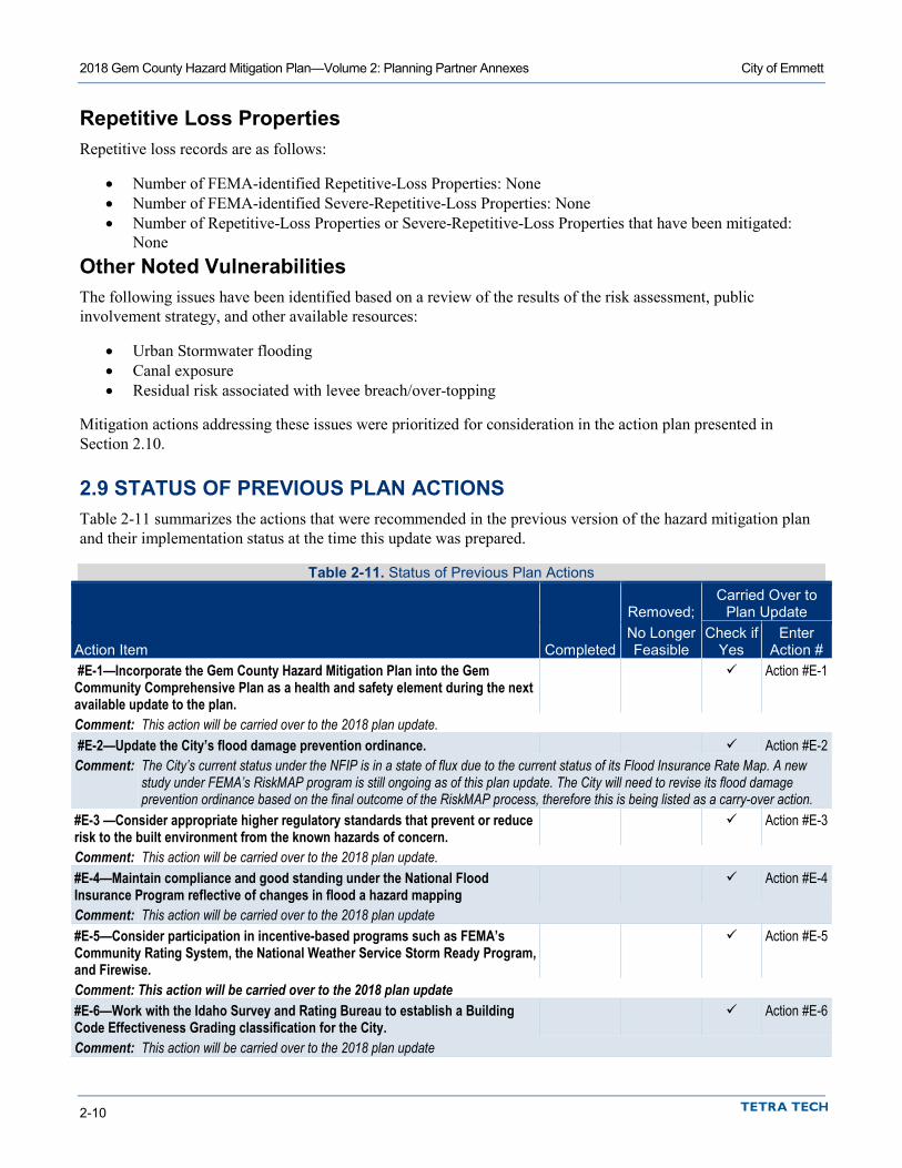
2018 Gem County Hazard Mitigation Plan—Volume 2: Planning Partner Annexes City of Emmett
2-10
Repetitive Loss Properties Repetitive loss records are as follows:
• Number of FEMA-identified Repetitive-Loss Properties: None • Number of FEMA-identified Severe-Repetitive-Loss Properties: None • Number of Repetitive-Loss Properties or Severe-Repetitive-Loss Properties that have been mitigated:
None Other Noted Vulnerabilities The following issues have been identified based on a review of the results of the risk assessment, public involvement strategy, and other available resources:
• Urban Stormwater flooding • Canal exposure • Residual risk associated with levee breach/over-topping
Mitigation actions addressing these issues were prioritized for consideration in the action plan presented in Section 2.10.
2.9 STATUS OF PREVIOUS PLAN ACTIONS Table 2-11 summarizes the actions that were recommended in the previous version of the hazard mitigation plan and their implementation status at the time this update was prepared.
Table 2-11. Status of Previous Plan Actions
Removed; Carried Over to
Plan Update
Action Item Completed No Longer Feasible
Check if Yes
Enter Action #
#E-1—Incorporate the Gem County Hazard Mitigation Plan into the Gem Community Comprehensive Plan as a health and safety element during the next available update to the plan.
Action #E-1
Comment: This action will be carried over to the 2018 plan update. #E-2—Update the City’s flood damage prevention ordinance. Action #E-2 Comment: The City’s current status under the NFIP is in a state of flux due to the current status of its Flood Insurance Rate Map. A new
study under FEMA’s RiskMAP program is still ongoing as of this plan update. The City will need to revise its flood damage prevention ordinance based on the final outcome of the RiskMAP process, therefore this is being listed as a carry-over action.
#E-3 —Consider appropriate higher regulatory standards that prevent or reduce risk to the built environment from the known hazards of concern.
Action #E-3
Comment: This action will be carried over to the 2018 plan update. #E-4—Maintain compliance and good standing under the National Flood Insurance Program reflective of changes in flood a hazard mapping
Action #E-4
Comment: This action will be carried over to the 2018 plan update #E-5—Consider participation in incentive-based programs such as FEMA’s Community Rating System, the National Weather Service Storm Ready Program, and Firewise.
Action #E-5
Comment: This action will be carried over to the 2018 plan update #E-6—Work with the Idaho Survey and Rating Bureau to establish a Building Code Effectiveness Grading classification for the City.
Action #E-6
Comment: This action will be carried over to the 2018 plan update
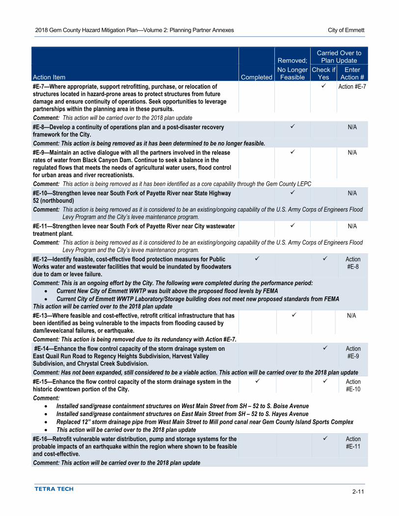
2018 Gem County Hazard Mitigation Plan—Volume 2: Planning Partner Annexes City of Emmett
2-11
Removed; Carried Over to
Plan Update
Action Item Completed No Longer Feasible
Check if Yes
Enter Action #
#E-7—Where appropriate, support retrofitting, purchase, or relocation of structures located in hazard-prone areas to protect structures from future damage and ensure continuity of operations. Seek opportunities to leverage partnerships within the planning area in these pursuits.
Action #E-7
Comment: This action will be carried over to the 2018 plan update #E-8—Develop a continuity of operations plan and a post-disaster recovery framework for the City.
N/A
Comment: This action is being removed as it has been determined to be no longer feasible. #E-9—Maintain an active dialogue with all the partners involved in the release rates of water from Black Canyon Dam. Continue to seek a balance in the regulated flows that meets the needs of agricultural water users, flood control for urban areas and river recreationists.
N/A
Comment: This action is being removed as it has been identified as a core capability through the Gem County LEPC #E-10—Strengthen levee near South Fork of Payette River near State Highway 52 (northbound)
N/A
Comment: This action is being removed as it is considered to be an existing/ongoing capability of the U.S. Army Corps of Engineers Flood Levy Program and the City’s levee maintenance program.
#E-11—Strengthen levee near South Fork of Payette River near City wastewater treatment plant.
N/A
Comment: This action is being removed as it is considered to be an existing/ongoing capability of the U.S. Army Corps of Engineers Flood Levy Program and the City’s levee maintenance program.
#E-12—Identify feasible, cost-effective flood protection measures for Public Works water and wastewater facilities that would be inundated by floodwaters due to dam or levee failure.
Action #E-8
Comment: This is an ongoing effort by the City. The following were completed during the performance period: • Current New City of Emmett WWTP was built above the proposed flood levels by FEMA • Current City of Emmett WWTP Laboratory/Storage building does not meet new proposed standards from FEMA
This action will be carried over to the 2018 plan update #E-13—Where feasible and cost-effective, retrofit critical infrastructure that has been identified as being vulnerable to the impacts from flooding caused by dam/levee/canal failures, or earthquake.
N/A
Comment: This action is being removed due to its redundancy with Action #E-7. #E-14—Enhance the flow control capacity of the storm drainage system on East Quail Run Road to Regency Heights Subdivision, Harvest Valley Subdivision, and Chrystal Creek Subdivision.
Action #E-9
Comment: Has not been expanded, still considered to be a viable action. This action will be carried over to the 2018 plan update #E-15—Enhance the flow control capacity of the storm drainage system in the historic downtown portion of the City.
Action #E-10
Comment: • Installed sand/grease containment structures on West Main Street from SH – 52 to S. Boise Avenue • Installed sand/grease containment structures on East Main Street from SH – 52 to S. Hayes Avenue • Replaced 12” storm drainage pipe from West Main Street to Mill pond canal near Gem County Island Sports Complex • This action will be carried over to the 2018 plan update
#E-16—Retrofit vulnerable water distribution, pump and storage systems for the probable impacts of an earthquake within the region where shown to be feasible and cost-effective.
Action #E-11
Comment: This action will be carried over to the 2018 plan update
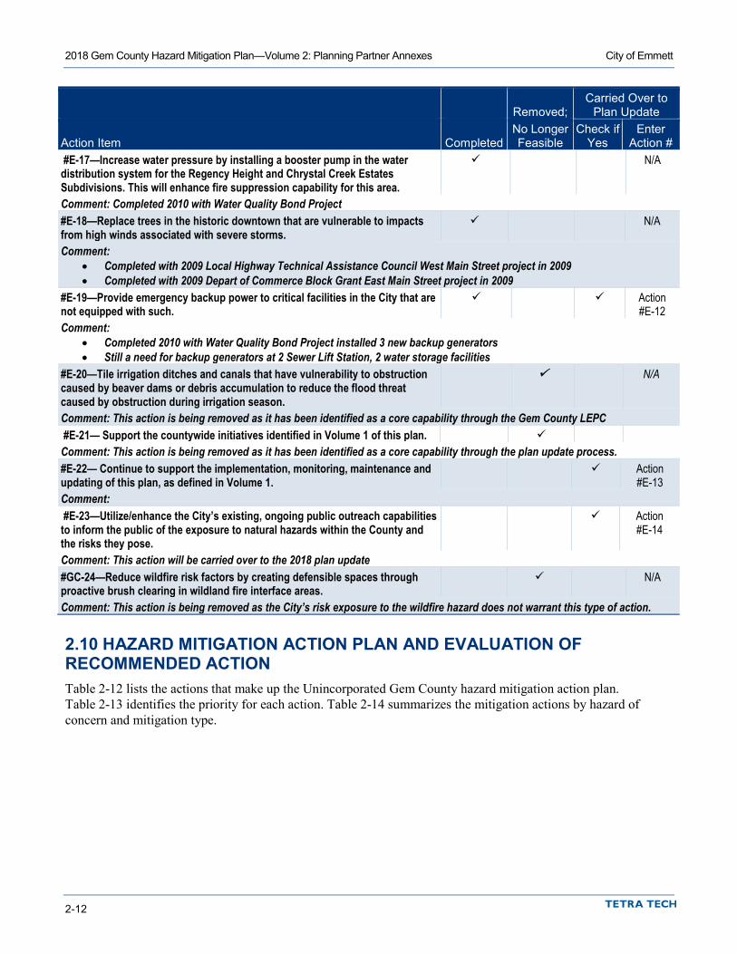
2018 Gem County Hazard Mitigation Plan—Volume 2: Planning Partner Annexes City of Emmett
2-12
Removed; Carried Over to
Plan Update
Action Item Completed No Longer Feasible
Check if Yes
Enter Action #
#E-17—Increase water pressure by installing a booster pump in the water distribution system for the Regency Height and Chrystal Creek Estates Subdivisions. This will enhance fire suppression capability for this area.
N/A
Comment: Completed 2010 with Water Quality Bond Project #E-18—Replace trees in the historic downtown that are vulnerable to impacts from high winds associated with severe storms.
N/A
Comment: • Completed with 2009 Local Highway Technical Assistance Council West Main Street project in 2009 • Completed with 2009 Depart of Commerce Block Grant East Main Street project in 2009
#E-19—Provide emergency backup power to critical facilities in the City that are not equipped with such.
Action #E-12
Comment: • Completed 2010 with Water Quality Bond Project installed 3 new backup generators • Still a need for backup generators at 2 Sewer Lift Station, 2 water storage facilities
#E-20—Tile irrigation ditches and canals that have vulnerability to obstruction caused by beaver dams or debris accumulation to reduce the flood threat caused by obstruction during irrigation season.
N/A
Comment: This action is being removed as it has been identified as a core capability through the Gem County LEPC #E-21— Support the countywide initiatives identified in Volume 1 of this plan. Comment: This action is being removed as it has been identified as a core capability through the plan update process. #E-22— Continue to support the implementation, monitoring, maintenance and updating of this plan, as defined in Volume 1.
Action #E-13
Comment: #E-23—Utilize/enhance the City’s existing, ongoing public outreach capabilities to inform the public of the exposure to natural hazards within the County and the risks they pose.
Action #E-14
Comment: This action will be carried over to the 2018 plan update #GC-24—Reduce wildfire risk factors by creating defensible spaces through proactive brush clearing in wildland fire interface areas.
N/A
Comment: This action is being removed as the City’s risk exposure to the wildfire hazard does not warrant this type of action.
2.10 HAZARD MITIGATION ACTION PLAN AND EVALUATION OF RECOMMENDED ACTION Table 2-12 lists the actions that make up the Unincorporated Gem County hazard mitigation action plan. Table 2-13 identifies the priority for each action. Table 2-14 summarizes the mitigation actions by hazard of concern and mitigation type.
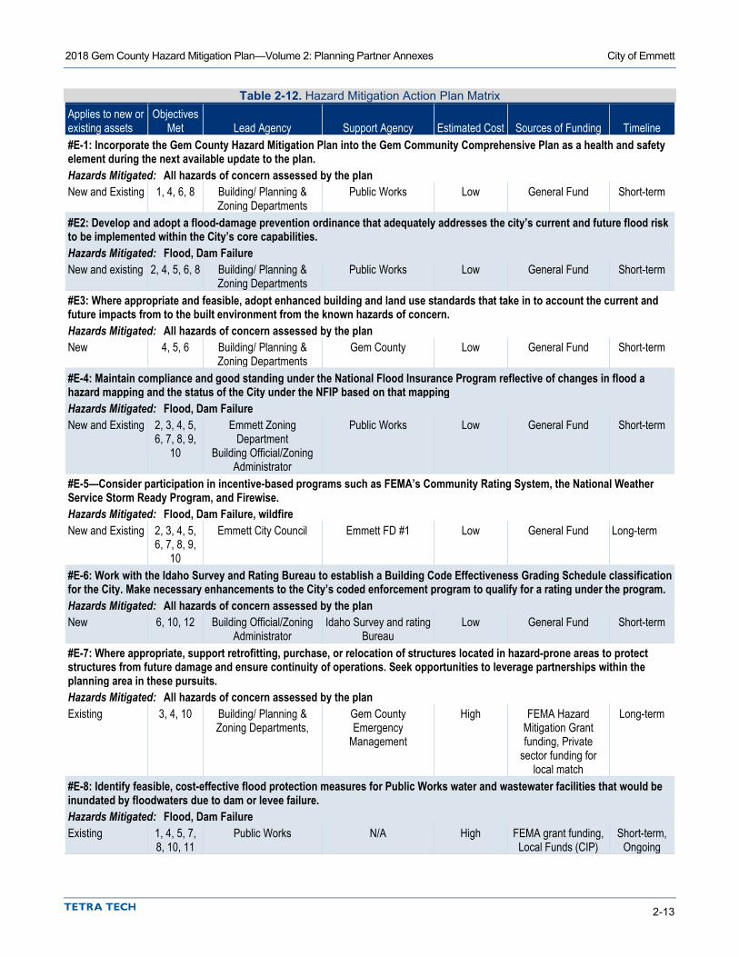
2018 Gem County Hazard Mitigation Plan—Volume 2: Planning Partner Annexes City of Emmett
2-13
Table 2-12. Hazard Mitigation Action Plan Matrix Applies to new or existing assets
Objectives Met Lead Agency Support Agency Estimated Cost Sources of Funding Timeline
#E-1: Incorporate the Gem County Hazard Mitigation Plan into the Gem Community Comprehensive Plan as a health and safety element during the next available update to the plan. Hazards Mitigated: All hazards of concern assessed by the plan New and Existing 1, 4, 6, 8 Building/ Planning &
Zoning Departments Public Works Low General Fund Short-term
#E2: Develop and adopt a flood-damage prevention ordinance that adequately addresses the city’s current and future flood risk to be implemented within the City’s core capabilities. Hazards Mitigated: Flood, Dam Failure New and existing 2, 4, 5, 6, 8 Building/ Planning &
Zoning Departments Public Works Low General Fund Short-term
#E3: Where appropriate and feasible, adopt enhanced building and land use standards that take in to account the current and future impacts from to the built environment from the known hazards of concern. Hazards Mitigated: All hazards of concern assessed by the plan New 4, 5, 6 Building/ Planning &
Zoning Departments Gem County Low General Fund Short-term
#E-4: Maintain compliance and good standing under the National Flood Insurance Program reflective of changes in flood a hazard mapping and the status of the City under the NFIP based on that mapping Hazards Mitigated: Flood, Dam Failure New and Existing 2, 3, 4, 5,
6, 7, 8, 9, 10
Emmett Zoning Department
Building Official/Zoning Administrator
Public Works Low General Fund Short-term
#E-5—Consider participation in incentive-based programs such as FEMA’s Community Rating System, the National Weather Service Storm Ready Program, and Firewise. Hazards Mitigated: Flood, Dam Failure, wildfire New and Existing 2, 3, 4, 5,
6, 7, 8, 9, 10
Emmett City Council Emmett FD #1 Low General Fund Long-term
#E-6: Work with the Idaho Survey and Rating Bureau to establish a Building Code Effectiveness Grading Schedule classification for the City. Make necessary enhancements to the City’s coded enforcement program to qualify for a rating under the program. Hazards Mitigated: All hazards of concern assessed by the plan New 6, 10, 12 Building Official/Zoning
Administrator Idaho Survey and rating
Bureau Low General Fund Short-term
#E-7: Where appropriate, support retrofitting, purchase, or relocation of structures located in hazard-prone areas to protect structures from future damage and ensure continuity of operations. Seek opportunities to leverage partnerships within the planning area in these pursuits. Hazards Mitigated: All hazards of concern assessed by the plan Existing 3, 4, 10 Building/ Planning &
Zoning Departments, Gem County Emergency
Management
High FEMA Hazard Mitigation Grant funding, Private
sector funding for local match
Long-term
#E-8: Identify feasible, cost-effective flood protection measures for Public Works water and wastewater facilities that would be inundated by floodwaters due to dam or levee failure. Hazards Mitigated: Flood, Dam Failure Existing 1, 4, 5, 7,
8, 10, 11 Public Works N/A High FEMA grant funding,
Local Funds (CIP) Short-term,
Ongoing

2018 Gem County Hazard Mitigation Plan—Volume 2: Planning Partner Annexes City of Emmett
2-14
Applies to new or existing assets
Objectives Met Lead Agency Support Agency Estimated Cost Sources of Funding Timeline
#E-9: Enhance the flow control capacity of the storm drainage system on East Quail Run Road to Regency Heights Subdivision, Harvest Valley Subdivision, and Chrystal Creek Subdivision. Hazards Mitigated: Flood, Dam Failure, Severe Weather Existing 1, 4, 5, 7,
8, 10, 11 Public Works N/A Medium FEMA grant funding,
Local Funds(CIP) Long-term
#E-10: Enhance the flow control capacity of the storm drainage system in the historic downtown portion of the City. Hazards Mitigated: Flood, Dam Failure, Severe Weather Existing 1, 4, 5, 7,
8, 10, 11 Public Works N/A High FEMA grant funding,
Local Funds (CIP) Long-term
#E-11: Retrofit vulnerable water distribution, pump and storage systems for the probable impacts of an earthquake within the region where shown to be feasible and cost-effective. Hazards Mitigated: Earthquake Existing 1, 4, 5, 7,
8, 10, 11 Public Works N/A High FEMA grant funding,
Local Funds (CIP) Long-term
#E-12: Provide emergency backup power to critical facilities in the City that are not or are inadequately equipped with such. Hazards Mitigated: All hazards of concern assessed by the plan New and existing 5, 9, 11 Public Works Gem County
Emergency Management
High FEMA grant funding, Local Funds (CIP)
Long-term
#E-13: Continue to support the implementation, monitoring, maintenance and updating of this plan, as defined in Volume 1. Hazards Mitigated: All hazards of concern assessed by the plan New and Existing 2, 4, 10 Emmett City Council Gem County
Emergency Management
Low General Fund Short-term, Ongoing
#E-14: Utilize/enhance the City’s existing, ongoing public outreach capabilities to inform the public of the exposure to natural hazards within the County and the risks they pose. Hazards Mitigated: All hazards of concern assessed by the plan New and Existing 1, 2, 7, 10 Emmett City Council Gem County
Emergency Management
Low General Fund Short-term, Ongoing
#E-15: Restrict access to levee and place signage that notifies citizens of the access restrictions and consequence for violating those restrictions Hazards Mitigated: Flood, Dam Failure New and Existing 2, 7, 10 Public Works Gem County
Emergency Management
Medium Homeland Security Grant program (HSGP), City of
Emmett CIP
Short-term
#E-16: design and construct a flood protection berm for the Industrial Park Hazards Mitigated: Flood, Dam Failure Existing 3, 5, 9 Public Works Gem County
Emergency Management
High FEMA grant funding, Local Funds (CIP)
Long-term
#E-17: Coordinate with the Idaho Department of Transportation on a feasible, cost-effective solution to elevate Payette River Bridge. Hazards Mitigated: Flood, Dam Failure, earthquake Existing 3, 5, 9 Public Works Gem County
Emergency Management
High FEMA grant funding, Local Funds (CIP)
Long-term

2018 Gem County Hazard Mitigation Plan—Volume 2: Planning Partner Annexes City of Emmett
2-15
Applies to new or existing assets
Objectives Met Lead Agency Support Agency Estimated Cost Sources of Funding Timeline
#E-18: Develop comprehensive stormwater master plan that identifies the quantity control drainage needs for both existing and future conditions. Hazards Mitigated: Severe weather, flood, dam failure New 3, 4, 5, 9 Public Works N/A Medium FEMA grant funding,
Local Funds (CIP) Long-term
#E-19: Develop a comprehensive flood risk management plan that identifies alternatives and cost-effective, feasible solutions for the City to address the economic consequence of decertification of the levee. Hazards Mitigated: Flood, Dam Failure New and Existing 2, 3, 4, 8,
11 Building/ Planning & Zoning Departments,
Public Works, Gem County Emergency
management
High FEMA grant funding, Economic
Development Administration (EDA)
mitigation grant funding, Local Funds
(CIP)
Long-term
Table 2-13. Mitigation Action Priority
Action #
# of Objectives
Met Benefits Costs
Do Benefits Equal or Exceed Costs?
Is Project Grant-
Eligible?
Can Project Be Funded
Under Existing Programs/ Budgets?
Implementation Prioritya
Grant Pursuit Prioritya
#E-1 4 Medium Low Yes No Yes High Low #E-2 5 Medium Low Yes No Yes High Low #E-3 3 Medium Low Yes No Yes High Low #E-4 9 Medium Low Yes No Yes High Low #E-5 9 Medium Low Yes No Yes Medium Low #E-6 3 Medium Low Yes No Yes High Low #E-7 3 High High Yes Yes No Medium High #E-8 7 High High Yes Yes No Medium High #E-9 7 High Medium Yes Yes Yes High High
#E-10 7 High High Yes Yes No Medium High #E-11 7 High High Yes Yes No Medium High #E-12 3 High High Yes Yes No Medium High #E-13 3 Medium Low Yes No Yes High Low #E-14 4 Low Low Yes No Yes High Low #E-15 3 High Medium Yes Yes No Medium High #E-16 3 High High Yes Yes No Medium High #E-17 4 High High Yes Yes No Medium High #E-18 5 Medium Medium Yes Yes Yes High High #E-19 4 High High Yes Yes No Medium High
a. See the introduction to this volume for explanation of priorities. b. Although this action may not be able to be completed within the performance period of the plan, it has been identified as a high
priority for implementation.

2018 Gem County Hazard Mitigation Plan—Volume 2: Planning Partner Annexes City of Emmett
2-16
Table 2-14. Analysis of Mitigation Actions Action Addressing Hazard, by Mitigation Typea
Hazard Type Prevention Property Protection Public Education and Awareness
Natural Resource Protection
Emergency Services
Structural Projects
Dam Failure E-1, E-2, E-3, E-4, E-5, E-13, E-18, E-19
E-4, E-5, E-6, E-7, E-8, E-16, E-17
E-4, E-5, E-14, E-15
E-4, E-5 E-5, E-12 E-4, E-5, E-8, E-9, E-10, E-16
Drought E-1, E-3, E-13 E-6, E-7 E-14 E-12 Earthquake E-1, E-3, E-13 E-6, E-7, E-11, E-17 E-14 E-12 E-11 Flood E-1, E-2, E-3, E-4, E-5,
E-13, E-18, E-19 E-4, E-5, E-6, E-7,
E-8, E-16, E-17 E-4, E-5, E-14,
E-15 E-4, E-5 E-5, E-12 E-4, E-8, E-9,
E-10, E-16 Landslide E-, 1, E-3, E-13 E-6, E-7 E-14 E-12 Severe Weather E-1, E-3, E-13, E-18 E-6, E-7 E-14 E-12 E-9, E-10 Wildfire E-1, E-3, E-13 E-5, E-6, E-7 E-14 E-12
a. See the introduction to this volume for explanation of mitigation types.
2.11 REVIEW AND INCORPORATION OF INFORMATION FOR THIS ANNEX
2.11.1 Existing Reports, Plans, Regulatory Tools and Other Resources The following technical reports, plans, and regulatory mechanisms were reviewed to provide information for this annex.
• The City of Emmett Municipal Code—The municipal code was reviewed for the full capability assessment and for identifying opportunities for action plan integration.
• The City of Emmett Flood Damage Prevention Ordinance—The flood damage prevention ordinance was reviewed for compliance with the National Flood Insurance Program.
• Gem Community Joint Comprehensive Plan—The Comprehensive plan was reviewed for the full capability assessment and for identifying opportunities for action plan integration.
• Technical Reports and Information—The following outside resources and references were reviewed: • Hazard Mitigation Plan Annex Development Tool-kit—The tool-kit was used to support the
development of this annex including past hazard events, noted vulnerabilities, risk ranking and action development.
2.11.2 Staff and Local Stakeholder Involvement in Annex Development • Bruce Evans, City of Emmet Department of Public Works • Brian Sullivan, City of Emmett Building Official • Clint Seamons, City of Emmett Department of Public Works • Laurie Boston, Gem County Office of Emergency Services • Curt Christensen, Emmett City Fire • Gordon Petrie, Mayor, City of Emmett • Emmet City Council

Planning Area
City of Emmett
Map Data Sources: NationalGeographic, Gem County, State
of Idaho
Gem CountyBoundaryCity of Emmett
/
This map is for informational purposes only.
0 0.8 1.60.4Miles

XY
nmnm
nmnm
nm
nm
nm
íí"'
"'
"'"'"'
"'
"'
"'
"'
"'
¬«¬«"N"N
Critical Facilities
City of Emmett
Map Data Sources: NationalGeographic, Gem County, State
of Idaho
"N EmergencyOperations Center
¬« Fire Stations
"'Medical CareFacilities
í Police Stationsnm School Facilities
XY
Mass Gathering /GovernmentFacilitiesGem CountyBoundaryCity of Emmett
/
This map is for informational purposes only.
0 0.8 1.60.4Miles

Critical Infrastructure
City of Emmett
Map Data Sources: NationalGeographic, Gem County, State
of Idaho
CommunicationFacilities
dElectric PowerFacilities
ú Highway Bridges
/Natural GasFacilities
poPotable WaterFacilities
! (
Waste WaterFacilitiesGem CountyBoundaryCity of Emmett
/
This map is for informational purposes only.
0 0.8 1.60.4Miles

Dam Inundation -Black Canyon Dam
City of Emmett
Map Data Sources: NationalGeographic, Gem County, State
of Idaho
Dam FailureInundation AreaGem CountyBoundaryCity of Emmett
Inundation area representsthe sudden failure of theBlack Canyon Dam asshown on the U.S. Bureau ofReclamation's Black CanyonDam Inundation Map datedAugust 2011. Indundationarea digitized from the mapby Tetra Tech for the 2012Gem County HazardMitigation Plan.
/
This map is for informational purposes only.
0 0.8 1.60.4Miles

Emmett
/
Earthquake Hazard -Big Flat-Jakes Creek
M6.8 Scenario
City of Emmett
Map Data Sources: NationalGeographic, Gem County, State
of Idaho, USGS
Gem CountyBoundaryCity of Emmett
Peak GroundAcceleration (PGA)Instrumental IntensityScale (PotentialDamage/PerceivedShaking)
V (Very Light /Moderate)VI (Light / Strong)VII (Moderate / VeryStrong)
This map is for informational purposes only.
0 0.8 1.60.4Miles

Earthquake Hazard -Squaw Creek M7.0
Scenario
City of Emmett
Map Data Sources: NationalGeographic, Gem County, State
of Idaho, USGS
Gem CountyBoundaryCity of Emmett
Peak GroundAcceleration (PGA)Instrumental IntensityScale (PotentialDamage/PerceivedShaking)
VI (Light / Strong)VII (Moderate / VeryStrong)VIII (Moderate /Heavy-Severe)
/
This map is for informational purposes only.
0 0.8 1.60.4Miles

/
Flood HazardBoundaries
City of Emmett
Map Data Sources: NationalGeographic, Gem County, State
of Idaho, Tetra Tech, FEMARegion X
Gem CountyBoundaryCity of Emmett1% AnnualChance Flood(Hazus H&H)1% AnnualChance Flood(FEMA 100-yr)0.2% AnnualChance Flood(FEMA 500-yr)
Flood zones as shown are acombination of the effectiveFEMA Flood Insurance RateMap (FIRM) for Gem County,dated April 17, 1978 and 1%Annual Chance Flood zonegenerated for the 2012 GemCounty HMP using the HazusHydraulics and Hydrologymodule.
This map is for informational purposes only.
0 0.8 1.60.4Miles

/
Landslide Hazard -Percent Slope
City of Emmett
Map Data Sources: NationalGeographic, Gem County, State
of Idaho, USGS
Slope GreaterThan 30 PercentSlope 15 to 30PercentGem CountyBoundaryCity of Emmett
Percent slope calculated usingU.S. Geological Survey 10mDigital Elevation Model (DEM)data.
This map is for informational purposes only.
0 0.8 1.60.4Miles

/0 0.8 1.60.4
Miles
Wildfire Hazard - WildlandFire Communities at
Relative Risk
City of Emmett
Map Data Sources: NationalGeographic, Gem County, State
of Idaho, USBLM
Gem CountyBoundaryCity of Emmett
Risk CategoryLowLow-ModerateModerateModerate-HighHigh
This map is for informational purposes only.


3-1
3. GEM COUNTY FIRE PROTECTION DISTRICT #1
3.1 MULTI-HAZARD MITIGATION PLAN POINT OF CONTACT
Primary Point of Contact Alternate Point of Contact Rick Welch, Fire Chief 115 W. 3rd St, Emmett, ID 83617 Telephone: 208-365-2012 e-mail Address: [email protected]
Mike Welch. Assistant Fire Chief 115 W. 3rd St Emmett, ID 83617 Telephone: 208-365-2012 e-mail Address: [email protected]
3.2 JURISDICTION PROFILE
3.2.1 Overview Gem County Fire District #1 (GCFD#1) provides fire suppression for the south end of Gem County and EMS services for the entire County. The fire service area covers 420 square miles with an approximate population of 16,500. The District operates three fire stations with 41 volunteer firefighters and two full-time fire personnel and five full-time EMS personnel working from 1 station in Emmett. The stations are 7 miles apart, at the following locations: 115 West 3 Road in Emmett, 7860 West Idaho Blvd. in Letha, and 6850 Van Deusen Road in Emmett. The District’s primary area of concern is structural fire protection, but due to the nature of the service area the majority of its responses are to wildfires.
The District is capable of handling most Type 4 wildland fire incidents. Because of overlapping areas of responsibilities, the District has mutual aid agreements with the Idaho Department of Lands and through them with the U.S. Bureau of Land Management and the U.S. Forest Service to handle larger and more complex wildland incidents. Through the Snake River Valley Chiefs Association, the District has mutual aid agreements with 24 fire departments.
The District is governed by a 3-member board of commissioners that are elected by the citizens within the service area to 4-year terms. This commission assumes responsibility for the adoption of this plan; the Fire Chief will oversee its implementation.
The District has been rated by the Idaho Survey and Rating Bureau under its Public Protection Rating program and currently has a rating of 5/8/9.
3.2.2 Service Area and Trends The district serves a population of 17,184 as of 2011. Its service area covers an area of 420 square miles. The estimated value of the area served by the jurisdiction is $3,296,599,383

2018 Gem County Hazard Mitigation Plan—Volume 2: Planning Partner Annexes Gem County Fire Protection District #1
3-2
According to the Idaho Department of labor, they estimate an annual growth rate of 1.8% for sub-region 3 (southwest) for the time frame from 2016 to 2025. Completion of the extension of Highway 16 to Interstate 84, scheduled for 2014, is expected to have an impact on local development.
3.2.3 Assets Table 3-1 summarizes the critical assets of the district and their value.
Table 3-1. Special Purpose District Assets Asset Value Property Land Area Owned—6.0 Acres $4,548,546 Critical Infrastructure and Equipment 2009 Ford Expedition/Command Vehicle $32,000 2009 Kenworth Water Tender 3,000-gallon $165,000 2004 Ford F-450 4x4 350-gallon Brush Truck $85,000 2001 Pierce International 830-gallon Heavy Brush Truck 4x4 $185,000 2002 Ford F-350 4x4 Utility / Extrication $35,000 1989 Chevy CK 3500 4x4 Brush Truck 300-gallon $65,000 1998 Pierce International Class A Structure Truck 1000-gallon $230,000 1985 Hahn 75-foot Ladder Truck $150,000 1993 Freightliner Water Tender 2500-gallon $120,000 2001 Dodge 1-Ton 4x4 Light Brush 300-gallon $65,000 2006 Pierce International Class A CAFA pumper 4x4 750-gallon $236,000 2018 Ford F-550, Brush Truck, 400-gallon $157,000 1993 Pierce International Class A Pumper 750-gallon $185,000 1981 International 4x4 500-gallon Heavy Brush $85,000 1993 Freightliner Water Tender 2500-gallon $120,000 1985 Ford F-700 Brush Truck 1200-gallon $85,000 2001 Freightliner, 4x4 heavy Engine, 750-Gallon $130,000 Air Packs, Turn Outs, Radios, Misc. Equipment $469,842 EMS Equipment and support Vehicles $50,000 Total: $2,649,842 Critical Facilities Station #1 Emmett $285,000 Station #2 Letha $350,000 Station #3 Van Deusen Road $90,000 Station #4, 330 E. Main $200,000 Freeze-out Repeater Building & Tower $120,000 Total: $1,045,000
3.3 CAPABILITY ASSESSMENT Upon completion, the capability assessment was reviewed to identify opportunities to expand, initiate or integrate capabilities to further hazard mitigation goals and objectives. Where such opportunities were identified and determined to be feasible, they are included in the action plan and are identified as Community Capacity Building mitigation actions in the Analysis of Mitigation Actions table in Section 3.9.

2018 Gem County Hazard Mitigation Plan—Volume 2: Planning Partner Annexes Gem County Fire Protection District #1
3-3
3.3.1 Planning and Regulatory Capabilities Jurisdictions develop plans and programs and implement rules and regulations to protect and serve residents. When effectively prepared and administered, these plans, programs and regulations can support the implementation of mitigation actions. Table 3-2 summarizes existing codes, ordinances, policies, programs or plans that are applicable to this hazard mitigation plan.
Table 3-2. Planning and Regulatory Capability
Date of Most
Recent Update Comment GCFD#1 Standard Operation Policy Guide 2014 Adopted by the Board Gem County Community Wildfire Protection Plan (CWPP) 2009 Future integration with Hazard Mitigation Plan Idaho State Code—Title 31, Chapter 14 2018 Reviewed and updated annually National Fire Protection Association Codes 2018 Automatic updates when the State updates International Wildland Urban Interface Code 2009 Intermountain Gas Safety Response Manual. 2018 Updated yearly Gem County Hazard Mitigation Plan 2018 Gem County Comprehensive Emergency Management Plan (CEMP) 2013 “5-Year Plan” 2014 Facilities and equipment projection plan
3.3.2 Fiscal, Administrative and Technical Capabilities Fiscal capability is an indicator of a jurisdiction’s ability to fulfill the financial needs associated with hazard mitigation projects. An assessment of fiscal capabilities is presented in Table 3-3. Administrative and technical capabilities represent a jurisdiction’s staffing resources for carrying out the mitigation strategy. An assessment of administrative and technical capabilities is presented in Table 3-4.
Table 3-3. Fiscal Capability Financial Resource Accessible or Eligible to Use? Capital Improvements Project Funding No Authority to Levy Taxes for Specific Purposes Yes User Fees for Water, Sewer, Gas or Electric Service No Incur Debt through General Obligation Bonds Yes Incur Debt through Special Tax Bonds No Incur Debt through Private Activity Bonds No State-Sponsored Grant Programs Yes Development Impact Fees for Homebuyers or Developers Yes Federal Grant Programs Yes Other Yes, local fund raisers
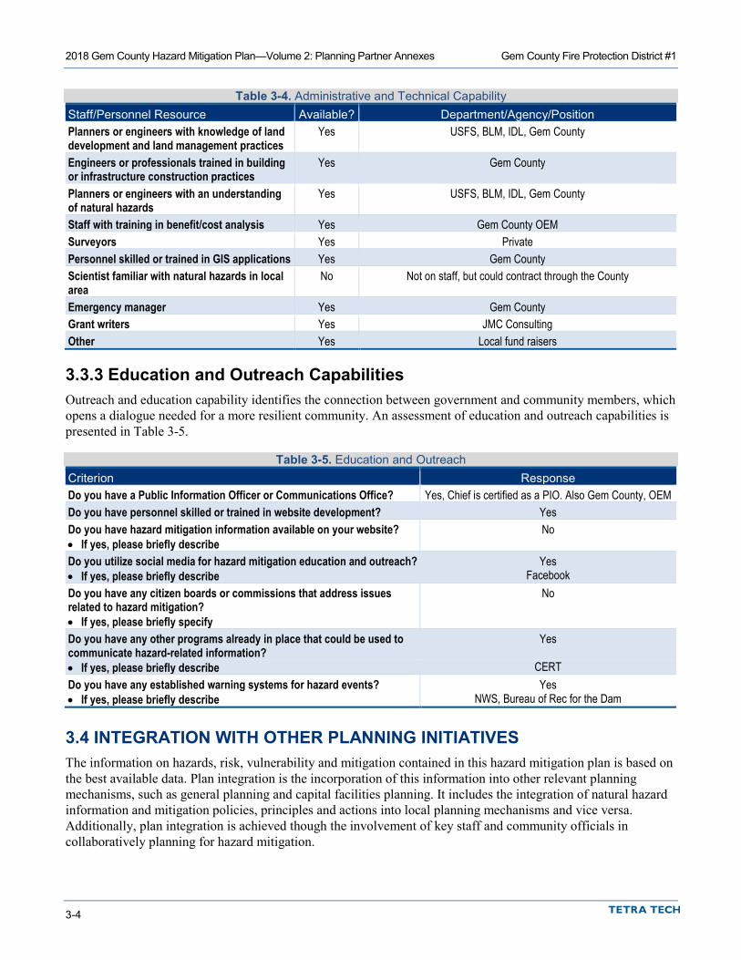
2018 Gem County Hazard Mitigation Plan—Volume 2: Planning Partner Annexes Gem County Fire Protection District #1
3-4
Table 3-4. Administrative and Technical Capability Staff/Personnel Resource Available? Department/Agency/Position Planners or engineers with knowledge of land development and land management practices
Yes USFS, BLM, IDL, Gem County
Engineers or professionals trained in building or infrastructure construction practices
Yes Gem County
Planners or engineers with an understanding of natural hazards
Yes USFS, BLM, IDL, Gem County
Staff with training in benefit/cost analysis Yes Gem County OEM Surveyors Yes Private Personnel skilled or trained in GIS applications Yes Gem County Scientist familiar with natural hazards in local area
No Not on staff, but could contract through the County
Emergency manager Yes Gem County Grant writers Yes JMC Consulting Other Yes Local fund raisers
3.3.3 Education and Outreach Capabilities Outreach and education capability identifies the connection between government and community members, which opens a dialogue needed for a more resilient community. An assessment of education and outreach capabilities is presented in Table 3-5.
Table 3-5. Education and Outreach Criterion Response Do you have a Public Information Officer or Communications Office? Yes, Chief is certified as a PIO. Also Gem County, OEM Do you have personnel skilled or trained in website development? Yes Do you have hazard mitigation information available on your website? No • If yes, please briefly describe Do you utilize social media for hazard mitigation education and outreach? Yes • If yes, please briefly describe Facebook Do you have any citizen boards or commissions that address issues related to hazard mitigation?
No
• If yes, please briefly specify Do you have any other programs already in place that could be used to communicate hazard-related information?
Yes
• If yes, please briefly describe CERT Do you have any established warning systems for hazard events? Yes • If yes, please briefly describe NWS, Bureau of Rec for the Dam
3.4 INTEGRATION WITH OTHER PLANNING INITIATIVES The information on hazards, risk, vulnerability and mitigation contained in this hazard mitigation plan is based on the best available data. Plan integration is the incorporation of this information into other relevant planning mechanisms, such as general planning and capital facilities planning. It includes the integration of natural hazard information and mitigation policies, principles and actions into local planning mechanisms and vice versa. Additionally, plan integration is achieved though the involvement of key staff and community officials in collaboratively planning for hazard mitigation.

2018 Gem County Hazard Mitigation Plan—Volume 2: Planning Partner Annexes Gem County Fire Protection District #1
3-5
3.4.1 Existing Integration In the performance period since adoption of the previous hazard mitigation plan, GCFD#1 capabilities for plan integration were very limited. This is due the small rural nature of the District, and that its planning capabilities are limited to those that the County can provide in a support role. GCFD#1 is an active participant in the Gem County Local Emergency Planning Committee (LEPC) and has actively supported and participated in any integration initiatives led by the LEPC.
3.4.2 Opportunities for Future Integration As this hazard mitigation plan is implemented, GCFD#1 will use information from the plan as the best available science and data on natural hazards. The capability assessment presented in this annex identifies codes, plans and programs that provide opportunities for integration. The area-wide and local action plans developed for this hazard mitigation plan include actions related to plan integration, and progress on these actions will be reported through the progress reporting process described in Volume 1. New opportunities for integration also will be identified as part of the annual progress report. The capability assessment identified the following plans and programs that do not currently integrate goals or recommendations of the hazard mitigation plan but provide opportunities to do so in the future:
• GCFD#1 will actively participate in any future update to the Gem County Community Wildfire Protection Plan (CWPP)
• GCFD#1 will continue to actively participate in the Gem County LEPC and support any integration initiatives endorsed or initiated by the LEPC
3.5 JURISDICTION-SPECIFIC NATURAL HAZARD EVENT HISTORY Table 3-6 lists past occurrences of natural hazards for which specific damage was recorded in GCFD#1. Other hazard events that broadly affected the entire planning area, including GCFD#1, are listed in the risk assessments in Volume 1 of this hazard mitigation plan.
Table 3-6. Natural Hazard Events Type of Event FEMA Disaster # Date Damage Assessment Ola Complex Fire N/A 2006 Information not available Ola Fire 86 N/A 1986 Information not available Church Fire N/A 2009 Information not available Gun Range Fire N/A 2009 Information not available Freeze-out Fire N/A 2011 Information not available Ola Complex Fire N/A 2015 Less than $10,000 2017 Snow year N/A 2017 Information not available Freezeout Hill-Fire N/A 2017 $30,000 to $35,000
3.6 HAZARD RISK RANKING Table 3-7 presents a local ranking for GCFD#1 of all hazards of concern for which Volume 1 of this hazard mitigation plan provides complete risk assessments. This ranking summarizes how hazards vary for this jurisdiction. As described in detail in Volume 1, the ranking process involves an assessment of the likelihood of occurrence for each hazard, along with its potential impacts on people, property and the economy. Mitigation action development targets those hazards with high and medium rankings.

2018 Gem County Hazard Mitigation Plan—Volume 2: Planning Partner Annexes Gem County Fire Protection District #1
3-6
Table 3-7. Hazard Risk Ranking Rank Hazard Type Risk Rating Score (Probability x Impact) Category
1 Wildfire a (3x13) =39 High 2 Severe Weather e (3x12) = 36 High 3 Earthquake b (2x16) = 32 High 3 Flood c (3 x 6) = 18 Medium 4 Landslide f (3x3) = 9 Low 5 Drought g (3x2) = 6 Low 7 Dam Failure d (2x0) = 0 Low
a. Based on High and Moderate-High Fire Severity Zones b. Based on the Squaw Creek M7.0 scenario c. Based on 100 year or 1 percent annual chance hazard results used for risk ranking d. Based on the Black Canyon Dam Failure scenario e. Severe weather is assessed more qualitatively than other hazards. Assumptions for risk ranking include high probability, medium
impact on people, low impact on property and low impact on economy. f. Slope greater than 30% and slope 15% to 30% areas were utilized for risk ranking g. Drought is assessed more qualitatively than other hazards. Generally, drought does not cause injury or death to people or result in
property damage. Assumptions for risk ranking include high probability, no impact on people, low impact on property and medium impact on economy.
3.7 JURISDICTION-SPECIFIC VULNERABILITIES Volume 1 of this hazard mitigation plan provides complete risk assessments for each identified hazard of concern. This section provides information on a few key vulnerabilities for the jurisdiction. The following issues have been identified based on a review of the results of the risk assessment, public involvement strategy, and other available resources:
No specific issues as they pertain to GCFD#1 have been identified at this time.
3.8 STATUS OF PREVIOUS PLAN ACTIONS Table 3-8 summarizes the actions that were recommended in the previous version of the hazard mitigation plan and their implementation status at the time this update was prepared.
Table 3-8. Status of Previous Plan Actions
Removed; Carried Over to
Plan Update
Action Item Completed No Longer Feasible
Check if Yes
Enter Action #
GCFD#1-1—Identify/establish both static and non-static water supply sources to support the suppression of wildfire within the District.
N/A
Comment: This action is being removed as it is no longer feasible GCFD#1-2—Enhance fire suppression capability of the District by updating or replacing fire suppression apparatus.
Yes GCFD#1-5
Comment: GCFD#1 is constantly replacing equipment that is beyond its useful life. This action will be carried over. GCFD#1-3—Reduce wildfire risk factors by creating defensible spaces through proactive brush clearing in wildland fire interface areas.
Yes GCFD#1-6
Comment: Progress has been made with this action, but there are still areas that need attention. This action will be carried over.

2018 Gem County Hazard Mitigation Plan—Volume 2: Planning Partner Annexes Gem County Fire Protection District #1
3-7
Removed; Carried Over to
Plan Update
Action Item Completed No Longer Feasible
Check if Yes
Enter Action #
GCFD#1-4—Increase training and capabilities of firefighters for the District using annual or periodic countywide training opportunities to facilitate standardized level of training and cross-district familiarization of people and resources.
Ongoing N/A
Comment: This action is being removed as it has been identified as a core capability GCFD#1-5—Enhance radio communication capability by using narrow band radio frequency capacity radios.
Yes N/A
Comment: This action was completed with the performance period. GCFD#1-6—Continue to promote livestock grazing in areas with fine fuels as a method of creating defensible spaces within the district.
No GCFD#1-7
Comment: No action on this initiative. This action will be carried over. GCFD#1-7—Provide access improvements for private property with one-way-in and one-way-out. Identify key private roads that access larger areas.
Ongoing N/A
Comment: This action has been removed as it has been identified as a core capability. GCFD#1-8—Support Countywide initiatives identified in Volume 1 of this plan. Ongoing N/A Comment: This action has been removed because it has been identified as a core capability GCFD#1-9— Continue to support the implementation, monitoring, maintenance and updating of this plan, as defined in Volume 1.
N/A
Comment: This action has been removed because it has been identified as a core capability GCFD#1-10—Comply with all applicable building and fire codes, as well as other regulations when constructing or significantly remodeling infrastructure facilities.
N/A
Comment: This action has been removed as it has been identified as a core capability GCFD#1-11—Structural facilities for existing districts or new one, expansion of a district or increasing storage of existing facilities.
Yes N/A
Comment: This action was completed during the performance period.
3.9 HAZARD MITIGATION ACTION PLAN AND EVALUATION OF RECOMMENDED ACTIONS Table 3-9 lists the actions that make up the Gem County Fire District #1 hazard mitigation action plan. Table 3-10 identifies the priority for each action. Table 3-11 summarizes the mitigation actions by hazard of concern and mitigation type.

2018 Gem County Hazard Mitigation Plan—Volume 2: Planning Partner Annexes Gem County Fire Protection District #1
3-8
Table 3-9. Hazard Mitigation Action Plan Matrix Applies to new or existing assets
Objectives Met Lead Agency Support Agency
Estimated Cost Sources of Funding Timeline
#GCFD#1-1: Purchase and Emergency Generator for Fire Station # 1, 115 W. 3rd St, Emmett Hazards Mitigated: All Hazards Existing 5, 9, 11 GCFD#1 Board None High FEMA HMA Grant, District Funds Short term #GCFD#1-2: Create a link to the Hazard Mitigation Plan website on the GCFD#1 website Hazards Mitigated: All Hazards New and Existing 2, 7, 10 GCFD#1 Gem County OEM Low District Funds Short #GCFD#1-3: Purchase and Locate a cell-tower for enhanced inter-operable communication in the Ola Area Hazards Mitigated: All Hazards New and Existing 1, 5, 9, 11 GCFD#1 GCFD#1, Gem County
OEM, Gem County High Grant Funds Long-
Term #GCFD#1-4: Participate in the comprehensive update to the Gem County Community Wildfire Protection Plan (CWPP) Hazards Mitigated: Wildfire New and Existing 2, 5, 7, 8,
10 GCFD#1 Gem County OEM High FEMA HMA Grant funding Long-term
GCFD#1-5—Enhance fire suppression capability of the District by updating or replacing fire suppression apparatus. Hazards Mitigated: All Hazards New 5, 9, 11 GCFD#1 OEM High District Funds, AFG, SAFER Grants Ongoing GCFD#1-6—Reduce wildfire risk factors by creating defensible spaces through proactive brush clearing in wildland fire interface areas. Hazards Mitigated: Wildfire New and Existing 1, 4, 7, 10,
12 GCFD#1 OEM Medium FEMA HMA Grants, District Funds,
FMAG, AFG Ongoing
GCFD#1-7—Continue to promote livestock grazing in areas with fine fuels as a method of creating defensible spaces within the district. Hazards Mitigated: Wildfire New and Existing 1, 4, 7, 10,
12 GCFD#1 OEM Medium FEMA HMA Grants, District Funds,
FMAG, AFG Short-term
Table 3-10. Mitigation Action Priority
Action #
# of Objective
s Met Benefits Costs
Do Benefits Equal or Exceed Costs?
Is Project Grant-
Eligible?
Can Project Be Funded
Under Existing Programs/ Budgets?
Implementation Prioritya
Grant Pursuit Prioritya
GCFD#1-1 3 High High Yes Yes No Medium, High GCFD#1-2 3 Medium Low Yes No Yes High N/A GCFD#1-3 4 High High Yes Yes No Medium High GCFD#1-4 5 High High Yes Yes Yes High Medium GCFD#1-5 3 High High Yes Yes Yes High Medium GCFD#1-6 5 High Medium Yes Yes No Medium High GCFD#1-7 5 High Medium Yes Yes No Medium High
a. See the introduction to this volume for explanation of priorities. b. Although this action may not be able to be completed within the performance period of the plan, it has been identified as a high
priority for implementation.

2018 Gem County Hazard Mitigation Plan—Volume 2: Planning Partner Annexes Gem County Fire Protection District #1
3-9
Table 3-11. Analysis of Mitigation Actions Action Addressing Hazard, by Mitigation Typea
Hazard Type Prevention Property
Protection Public Education and Awareness
Natural Resource Protection
Emergency Services
Structural Projects
Dam Failure 2 1, 3, 5 Drought 2 1, 3, 5 Earthquake 2 1, 3, 5 Flood 2 1, 3, 5 Landslide 2 1, 3, 5 Severe Weather 2 1, 3, 5 Wildfire 4 4, 6, 7 2, 4 4, 6 1, 3, 5 a. See the introduction to this volume for explanation of mitigation types.
3.10 REVIEW AND INCORPORATION OF RESOURCES FOR THIS ANNEX
1.7.1 Existing Reports, Plans, Regulatory Tools and Other Resources The following technical reports, plans, and regulatory mechanisms were reviewed to provide information for this annex.
• 2012 Gem County Hazard Mitigation Plan • Hazard Mitigation Plan Annex Development Tool-kit—The tool-kit was used to support the
development of this annex including past hazard events, noted vulnerabilities, risk ranking and action development.
1.7.2 Staff and Local Stakeholder Involvement in Annex Development Plan was created by 2 Fire Personal and reviewed by Fire Commissioners and Fire Chief. Support for this process was provided by the Gem County Emergency Manager and the County’s contract consultant.


4-1
4. GEM COUNTY FIRE PROTECTION DISTRICT #2
4.1 MULTI-HAZARD MITIGATION PLAN POINT OF CONTACT
Primary Point of Contact Alternate Point of Contact Bev Martin, Commissioner 29950 Third Fork Rd. Ola, Idaho 83657 Telephone: 208-584-3494 e-mail Address: [email protected]
Jim Heikes, Fire Chief 10600 Sweet Ola Hwy Sweet, Idaho 83670 Telephone: 208-866-7255 e-mail Address: [email protected]
4.2 JURISDICTION PROFILE
4.2.1 Overview Gem County Fire District #2 (GCFD#2) provides fire suppression to the north end of Gem County, covering 320 square miles with approximate population of 2000 people. The service area is 10 to 12 miles wide and 40 miles long. The District operates two fire stations, 18 miles apart, with 36 volunteer firefighters. One station is in the south end of Sweet and the other is in Ola. The District’s primary area of concern is structural fires protection, but due to the nature of the service area, the majority of its responses are to wildland fires in either grassland or timber environments. The District is capable of handling most Type 4 wildland incidents.
Because of overlapping areas of responsibilities, the District has mutual aid agreements with the Idaho Department of Lands and through them with the U.S. Bureau of Land Management and the U.S. Forest Service to handle larger and more complex wildland incidents. Through the Snake River Valley Chiefs Association, the District has mutual aid agreements with 24 fire departments to the West; and through the Boise County Fire Fighters Association the District has mutual aid agreements with 12 departments to the East. The District is governed by a board of three fire commissioners that are elected by the citizens within the district service area to 3-year terms. The GCFD#2 Board of Fire Commissioners assumes responsibility for the adoption of this plan; the Fire Chief will oversee its implementation.
The District has been rated by the Idaho Survey and Rating Bureau under its Public Protection Rating program and currently has the following ratings:
• 5 miles–Class 8 • Under 10 miles–Class 9 • 10 miles–Class 10.
4.2.2 Service Area and Trends The district serves a population of 2000 as of 2018. Its service area covers an area of 320 square miles. The estimated value of the area served by the jurisdiction is $39,601,020. There is an estimated 5-percent growth rate

2018 Gem County Hazard Mitigation Plan—Volume 2: Planning Partner Annexes Gem County Fire Protection District #2
4-2
in Gem County, and most of this growth is anticipated to occur within the GCFD#1 service area and not significantly impact GCFD#2).
4.2.3 Assets Table 4-1 summarizes the critical assets of the district and their value. Table 4-1. Special Purpose District Assets
Asset Value Property Land Area Owned—2.0 acres $735,000 Critical Infrastructure and Equipment ##926 Tender 1983 Mack $15,000 T#927 Tender GI $5,000 S#969 T4 HB GI $15,000 T#970 Type 6 Ford 2014 $5,000 T#968 Type 4 Brush $5,000 T#901 $15,000 T#909 Tender 1974 Kenworth $15,000 P#902 $25,000 T#961 Type 6 Brush Truck 1997 Ford $25,000 T#967 Type 6 Brush Truck 1998 Ford $25,000 E#950 Expedition 1997 Ford $15,000 T#966 Type 6 Brush 1988 Chevrolet • #905 • #912 • #921 • #951 Command • #952 Command • #960 • #962 • #963 • #965 Hummer
$55,000
Total: $220,000.00 Critical Facilities Sweet Fire Station $400,000 Sweet Bunker $10,000 Sweet (Old Fire Station) $20,000 Ola Fire Station $305,000 Total: $735,000.00
4.3 CAPABILITY ASSESSMENT Upon completion, the capability assessment was reviewed to identify opportunities to expand, initiate or integrate capabilities to further hazard mitigation goals and objectives. Where such opportunities were identified and determined to be feasible, they are included in the action plan and are identified as Community Capacity Building mitigation actions in the Analysis of Mitigation Actions table in Section 4.9.

2018 Gem County Hazard Mitigation Plan—Volume 2: Planning Partner Annexes Gem County Fire Protection District #2
4-3
4.3.1 Planning and Regulatory Capabilities Jurisdictions develop plans and programs and implement rules and regulations to protect and serve residents. When effectively prepared and administered, these plans, programs and regulations can support the implementation of mitigation actions. Table 4-2 summarizes existing codes, ordinances, policies, programs or plans that are applicable to this hazard mitigation plan.
Table 4-2. Planning and Regulatory Capability
Date of Most
Recent Update Comment GCFD#2 Standard Operation Policy Guide 2014 Adopted by the Board Gem County Community Wildfire Protection Plan (CWPP) 2009 Future integration with Hazard Mitigation
Plan Idaho State Code—Title 31, Chapter 14 2018 Reviewed and updated annually National Fire Protection Association Codes 2018 Automatic updates when the State updates International Wildland Urban Interface Code 2009 Intermountain Gas Safety Response Manual. 2018 Updated yearly Gem County Hazard Mitigation Plan 2018 Gem County Comprehensive Emergency Management Plan (CEMP) 2013
4.3.2 Fiscal, Administrative and Technical Capabilities Fiscal capability is an indicator of a jurisdiction’s ability to fulfill the financial needs associated with hazard mitigation projects. An assessment of fiscal capabilities is presented in Table 4-3. Administrative and technical capabilities represent a jurisdiction’s staffing resources for carrying out the mitigation strategy. An assessment of administrative and technical capabilities is presented in Table 4-4.
Table 4-3. Fiscal Capability Financial Resource Accessible or Eligible to Use? Capital Improvements Project Funding No Authority to Levy Taxes for Specific Purposes No User Fees for Water, Sewer, Gas or Electric Service No Incur Debt through General Obligation Bonds No Incur Debt through Special Tax Bonds No Incur Debt through Private Activity Bonds No State-Sponsored Grant Programs Yes Development Impact Fees for Homebuyers or Developers Yes Federal Grant Programs Yes Other Yes, local fund raisers

2018 Gem County Hazard Mitigation Plan—Volume 2: Planning Partner Annexes Gem County Fire Protection District #2
4-4
Table 4-4. Administrative and Technical Capability Staff/Personnel Resource Available? Department/Agency/Position Planners or engineers with knowledge of land development and land management practices
Yes USFS, BLM, IDL, Gem County
Engineers or professionals trained in building or infrastructure construction practices
Yes Gem County
Planners or engineers with an understanding of natural hazards
Yes USFS, BLM, IDL, Gem County
Staff with training in benefit/cost analysis No Could contract for service Surveyors Yes Private Personnel skilled or trained in GIS applications No Not on staff, but could utilize Gem County Development Services Scientist familiar with natural hazards in local area
No
Emergency Manager Yes Fire Chief acts a principle emergency manager for the District. Also support the Gem County OEM through the LEPC process
Grant writers Yes Private, Gem County OEM Other Yes Local fund raisers
4.3.3 Education and Outreach Capabilities Outreach and education capability identifies the connection between government and community members, which opens a dialogue needed for a more resilient community. An assessment of education and outreach capabilities is presented in Table 4-5.
Table 4-5. Education and Outreach Criterion Response Do you have a Public Information Officer or Communications Office? No Do you have personnel skilled or trained in website development? No Do you have hazard mitigation information available on your website? Yes • If yes, please briefly describe Gem County OEM website Do you utilize social media for hazard mitigation education and outreach? Indirectly • If yes, please briefly describe Gem County OEM/LEPC Do you have any citizen boards or commissions that address issues related to hazard mitigation?
No
• If yes, please briefly specify Do you have any other programs already in place that could be used to communicate hazard-related information?
No
• If yes, please briefly describe Do you have any established warning systems for hazard events? No • If yes, please briefly describe
4.4 INTEGRATION WITH OTHER PLANNING INITIATIVES The information on hazards, risk, vulnerability and mitigation contained in this hazard mitigation plan is based on the best available data. Plan integration is the incorporation of this information into other relevant planning mechanisms, such as general planning and capital facilities planning. It includes the integration of natural hazard information and mitigation policies, principles and actions into local planning mechanisms and vice versa. Additionally, plan integration is achieved though the involvement of key staff and community officials in collaboratively planning for hazard mitigation.

2018 Gem County Hazard Mitigation Plan—Volume 2: Planning Partner Annexes Gem County Fire Protection District #2
4-5
4.4.1 Existing Integration In the performance period since adoption of the previous hazard mitigation plan, GCFD#2 capabilities for plan integration were very limited. This is due the small rural nature of the District, and that its planning capabilities are limited to those that the County can provide in a support role. GCFD#2 is an active participant in the Gem County Local Emergency Planning Committee (LEPC) and has actively supported and participated in any integration initiatives led by the LEPC. The Fire District has very few if any direct planning documents suitable for plan integration.
4.4.2 Opportunities for Future Integration As this hazard mitigation plan is implemented, GCFD#2 will use information from the plan as the best available science and data on natural hazards. The capability assessment presented in this annex identifies codes, plans and programs that provide opportunities for integration. The area-wide and local action plans developed for this hazard mitigation plan include actions related to plan integration, and progress on these actions will be reported through the progress reporting process described in Volume 1. New opportunities for integration also will be identified as part of the annual progress report. The capability assessment identified the following plans and programs that do not currently integrate goals or recommendations of the hazard mitigation plan but provide opportunities to do so in the future:
• GCFD#2 will actively participate in any future update to the Gem County Community Wildfire Protection Plan (CWPP)
• GCFD#2 will continue to actively participate in the Gem County LEPC and support any integration initiatives endorsed or initiated by the LEPC
4.5 JURISDICTION-SPECIFIC NATURAL HAZARD EVENT HISTORY Table 4-6 lists past occurrences of natural hazards for which specific damage was recorded in GCFD#2. Other hazard events that broadly affected the entire planning area, including GCFD#2, are listed in the risk assessments in Volume 1 of this hazard mitigation plan.
Table 4-6. Natural Hazard Events
Type of Event FEMA
Disaster # Date Damage Assessment 2017 Snow year N/A 2017 Information not available Freezeout Hill-Fire N/A 2017 $30,000 to $35,000 Ola Complex Fire N/A 2015 Less than $10,000 Freeze-out Fire N/A 2011 Information not available Church Fire N/A 2009 Information not available Gun Range Fire N/A 2009 Information not available Ola Complex Fire N/A 2006 Information not available Ola Fire 86 N/A 1986 Information not available
4.6 HAZARD RISK RANKING Table 4-7 presents a local ranking for GCFD#2 of all hazards of concern for which Volume 1 of this hazard mitigation plan provides complete risk assessments. This ranking summarizes how hazards vary for this jurisdiction. As described in detail in Volume 1, the ranking process involves an assessment of the likelihood of occurrence for each hazard, along with its potential impacts on people, property and the economy. Mitigation action development targets those hazards with high and medium rankings.

2018 Gem County Hazard Mitigation Plan—Volume 2: Planning Partner Annexes Gem County Fire Protection District #2
4-6
Table 4-7. Hazard Risk Ranking Rank Hazard Type Risk Rating Score (Probability x Impact) Category
1 Wildfire a (3x13) =39 High 2 Severe Weather e (3x12) = 36 High 3 Earthquake b (2x16) = 32 High 3 Flood c (3 x 6) = 18 Medium 4 Landslide f (3x3) = 9 Low 5 Drought g (3x2) = 6 Low 7 Dam Failure d (2x0) = 0 Low
a. Based on High and Moderate-High Fire Severity Zones b. Based on the Squaw Creek M7.0 scenario c. Based on 100 year or 1 percent annual chance hazard results used for risk ranking d. Based on the Black Canyon Dam Failure scenario e. Severe weather is assessed more qualitatively than other hazards. Assumptions for risk ranking include high probability, medium
impact on people, low impact on property and low impact on economy. f. Slope greater than 30% and slope 15% to 30% areas were utilized for risk ranking g. Drought is assessed more qualitatively than other hazards. Generally, drought does not cause injury or death to people or result in
property damage. Assumptions for risk ranking include high probability, no impact on people, low impact on property and medium impact on economy.
4.7 JURISDICTION-SPECIFIC VULNERABILITIES Volume 1 of this hazard mitigation plan provides complete risk assessments for each identified hazard of concern. This section provides information on a few key vulnerabilities for the jurisdiction. The following issues have been identified based on a review of the results of the risk assessment, public involvement strategy, and other available resources:
• Flood risk in the Ola Vicinity is not really known due to the lack of mapping. • The risk to Ola from a Dam Failure from Sage Hen Reservoir is not known • Interoperable communication dead zone in the Sweet-Ola corridor
4.8 STATUS OF PREVIOUS PLAN ACTIONS Table 4-8 summarizes the actions that were recommended in the previous version of the hazard mitigation plan and their implementation status at the time this update was prepared.
4.9 HAZARD MITIGATION ACTION PLAN AND EVALUATION OF RECOMMENDED ACTIONS Table 4-9 lists the actions that make up the Gem County Fire District #2 (GCFD#2) hazard mitigation action plan. Table 4-10 identifies the priority for each action. Table 4-11 summarizes the mitigation actions by hazard of concern and mitigation type.
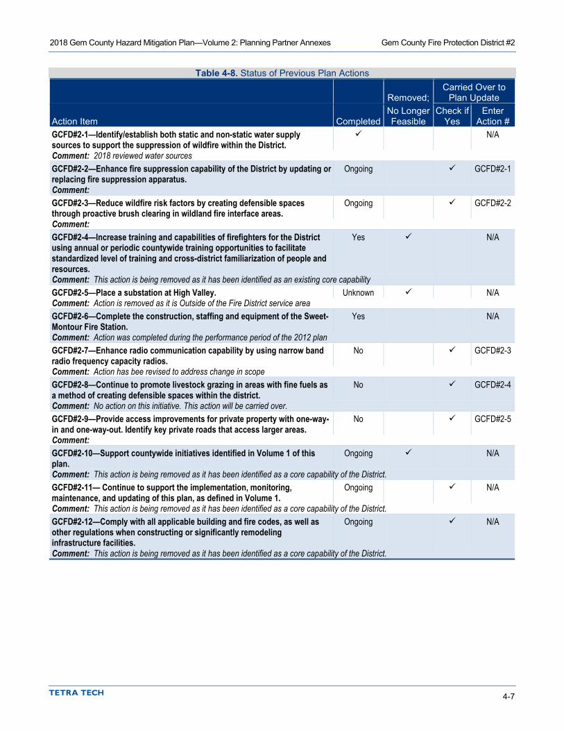
2018 Gem County Hazard Mitigation Plan—Volume 2: Planning Partner Annexes Gem County Fire Protection District #2
4-7
Table 4-8. Status of Previous Plan Actions
Removed; Carried Over to
Plan Update
Action Item Completed No Longer Feasible
Check if Yes
Enter Action #
GCFD#2-1—Identify/establish both static and non-static water supply sources to support the suppression of wildfire within the District.
N/A
Comment: 2018 reviewed water sources GCFD#2-2—Enhance fire suppression capability of the District by updating or replacing fire suppression apparatus.
Ongoing GCFD#2-1
Comment: GCFD#2-3—Reduce wildfire risk factors by creating defensible spaces through proactive brush clearing in wildland fire interface areas.
Ongoing GCFD#2-2
Comment: GCFD#2-4—Increase training and capabilities of firefighters for the District using annual or periodic countywide training opportunities to facilitate standardized level of training and cross-district familiarization of people and resources.
Yes N/A
Comment: This action is being removed as it has been identified as an existing core capability GCFD#2-5—Place a substation at High Valley. Unknown N/A Comment: Action is removed as it is Outside of the Fire District service area GCFD#2-6—Complete the construction, staffing and equipment of the Sweet-Montour Fire Station.
Yes N/A
Comment: Action was completed during the performance period of the 2012 plan GCFD#2-7—Enhance radio communication capability by using narrow band radio frequency capacity radios.
No GCFD#2-3
Comment: Action has bee revised to address change in scope GCFD#2-8—Continue to promote livestock grazing in areas with fine fuels as a method of creating defensible spaces within the district.
No GCFD#2-4
Comment: No action on this initiative. This action will be carried over. GCFD#2-9—Provide access improvements for private property with one-way-in and one-way-out. Identify key private roads that access larger areas.
No GCFD#2-5
Comment: GCFD#2-10—Support countywide initiatives identified in Volume 1 of this plan.
Ongoing N/A
Comment: This action is being removed as it has been identified as a core capability of the District. GCFD#2-11— Continue to support the implementation, monitoring, maintenance, and updating of this plan, as defined in Volume 1.
Ongoing N/A
Comment: This action is being removed as it has been identified as a core capability of the District. GCFD#2-12—Comply with all applicable building and fire codes, as well as other regulations when constructing or significantly remodeling infrastructure facilities.
Ongoing N/A
Comment: This action is being removed as it has been identified as a core capability of the District.

2018 Gem County Hazard Mitigation Plan—Volume 2: Planning Partner Annexes Gem County Fire Protection District #2
4-8
Table 4-9. Hazard Mitigation Action Plan Matrix Applies to new or
existing assets Objectives
Met Lead Agency Support Agency Estimated Cost Sources of Funding Timeline GCFD#2-1: Enhance fire suppression capability of the District by updating or replacing fire suppression apparatus. Hazards Mitigated: All Hazards New and Existing 5, 9, 11 GCFD#2 OEM High District Funds, AFG,
SAFER Grants Ongoing
GCFD#2-2: Reduce wildfire risk factors by creating defensible spaces through proactive brush clearing in wildland fire interface areas. Hazards Mitigated: Wildfire New and Existing 1, 4, 7, 10,
12 GCFD#1 OEM Medium FEMA HMA Grants,
District Funds, FMAG, AFG
Ongoing
GCFD#2-3: #GC-7: Place a Cell Tower and Repeater in the Ola vicinity to address “dead zones” in inter-operable communications within the County. Hazards Mitigated: All Hazards New and Existing 1, 5, 9, 11 OEM GCFD#2 High HSGP, EMPG, General
Fund Short-term
GCFD#2-4: Continue to promote livestock grazing in areas with fine fuels as a method of creating defensible spaces within the district. Hazards Mitigated: Wildfire New and Existing 1, 4, 7, 10,
12 GCFD#2 OEM Medium FEMA HMA Grants,
District Funds, FMAG, AFG
Short-term
GCFD#2-5: Provide access improvements for private property with one-way-in and one-way-out. Identify key private roads that access larger areas. Hazards Mitigated: Dam Failure. Earthquake, Flood, Landslide, Severe Weather and wildfire
Existing 1, 7, 10, 11 GCFD#2 OEM Medium District Funds, AFG, EMPG, HSGP
Short-term
GCFD#2-6: Participate in the comprehensive update to the Gem County Community Wildfire Protection Plan (CWPP) Hazards Mitigated: Wildfire New and Existing 2, 5, 7, 8,
10 OEM GCFD#2 Medium USDA National Fire Plan
Grants, FEMA HMA Grant funding
Long-term
GCFD#2-7—Reduce wildfire risk factors by creating defensible spaces through proactive brush clearing in wildland fire interface areas. Hazards Mitigated: Wildfire New and Existing 1, 4, 7, 10,
12 GCFD#1 OEM Medium FEMA HMA Grants,
District Funds, FMAG, AFG
Ongoing
GCFD#2-8: Evacuation routes, map and mark evacuation options from southern portion of District. Provide public education in regards to evacuations. Hazards Mitigated: All Hazards New and Existing 1, 7, 10, 11 GCFD#2 OEM Low District Funds Short-term

2018 Gem County Hazard Mitigation Plan—Volume 2: Planning Partner Annexes Gem County Fire Protection District #2
4-9
Table 4-10. Mitigation Action Priority
Action #
# of Objectives
Met Benefits Costs
Do Benefits Equal or Exceed Costs?
Is Project Grant-
Eligible?
Can Project Be Funded
Under Existing Programs/ Budgets?
Implementation Prioritya
Grant Pursuit Prioritya
GCFD#2-1 4 High High Yes Yes No Medium High GCFD#2-2 5 Medium Medium Yes Yes No Medium High GCFD#2-3 4 High High Yes Yes No Medium High GCFD#2-4 5 Medium Medium Yes Yes Yes High High GCFD#2-5 4 High Medium Yes No Yes High N/A GCFD#2-6 5 High Medium Yes Yes Yes High Medium GCFD#2-7 5 Medium Medium Yes Yes Yes High High GCFD#2-8 4 Medium Low Yes No Yes High N/A
a. See the introduction to this volume for explanation of priorities.
Table 4-11. Analysis of Mitigation Actions Action Addressing Hazard, by Mitigation Typea
Hazard Type Prevention Property
Protection
Public Education
and Awareness
Natural Resource Protection
Emergency Services
Structural Projects
Dam Failure 8 1, 3, 5, 8 Drought 1, 3 Earthquake 8 1, 3, 5, 8 Flood 8 1, 3, 5, 8 Landslide 8 1, 3, 5, 8 Severe Weather 8 1, 3, 5, 8 Wildfire 6, 7 2, 4, 6 6, 8 1, 3, 5, 8 a. See the introduction to this volume for explanation of mitigation types.
4.10 REVIEW AND INCORPORATION OF RESOURCES FOR THIS ANNEX
4.10.1 Existing Reports, Plans, Regulatory Tools and Other Resources The following technical reports, plans, and regulatory mechanisms were reviewed to provide information for this annex.
• 2012 Gem County Hazard Mitigation Plan • Hazard Mitigation Plan Annex Development Tool-kit—The tool-kit was used to support the
development of this annex including past hazard events, noted vulnerabilities, risk ranking and action development.
4.10.2 Staff and Local Stakeholder Involvement in Annex Development The following Staff and Stakeholders participated in the development of this annex:
2018 Gem County Hazard Mitigation Plan—Volume 2: Planning Partner Annexes Gem County Fire Protection District #2
4-10
• Bev Martin, GCFD#2 Commissioner • Jim Heikes, GCFD#2 Fire Chief • Dennis Weaver, Station Chief Ola • Laurie Boston, Emergency Manager, Gem County Office of Emergency Services • Rob Flaner, Technical Consultant to gem County, Tetra Tech, Inc.

5-1
5. EMMETT SCHOOL DISTRICT #221
5.1 MULTI-HAZARD MITIGATION PLAN POINT OF CONTACT
Primary Point of Contact Alternate Point of Contact Jay Hummel 400 S. Pine St. Emmett, ID 83617 Telephone: 208-365-6301 e-mail Address: [email protected]
Wayne Rush 400 S. Pine St. Emmett, ID 83617 Telephone: 208-365-6301 e-mail Address: [email protected]
5.2 JURISDICTION PROFILE
5.2.1 Overview Emmett School District No. 221 is one of three charter school districts in the State of Idaho and comprises Gem County and small portion of Boise County. The community of Emmett, where most students attend, is located in the heart of Gem County, approximately 26 miles northwest of Boise.
Each Idaho school district is a political subdivision of the State of Idaho. Governing authority under Idaho Code 33-501 resides in a six-member board of trustees. As provided by Idaho law, the board of trustees of each school district has the power to levy taxes for school purposes. The board of trustees will assume the responsibility for the adoption and implementation of this plan. The majority of the District’s funding is supplied by the State of Idaho, based on student average daily attendance. The school district is the largest employer in Gem County, which is basically a bedroom community to Boise and the Nampa/Caldwell areas.
5.2.2 Service Area and Trends The district serves a population of 2,566 students and a county population of 16,852. Its service area covers an area of 563 square miles. The estimated value of the area served by the jurisdiction is $970,987,464.
Enrollment for Emmett School District #221 has leveled out in the past several years, and even increased slightly. However, the current enrollment is down from approximately 3,000 students 15 year ago. A lot of the student decline was due to economic issues. Market values in the district decreased during this time, and the district received less money from the state due to budget cuts. Funding continues to be a vital issue and has started to increase.
5.2.3 Assets Table 5-1 summarizes the critical assets of the district and their value.

2018 Gem County Hazard Mitigation Plan—Volume 2: Planning Partner Annexes Emmett School District #221
5-2
Table 5-1. Special Purpose District Assets Asset Value Property Land Area Owned—94.1 acres $1,155.288 Critical Infrastructure and Equipment 3 Maintenance and Operations Vehicles $39,000 1 Tractor $7,500 3 Transportation Vehicles $10,000 33 School Buses $600,499 Total: $656,999.00 Critical Facilities Emmett High School $17,872,516 Emmett Middle School $13,699,871 Butte View Complex $7,975,430 Carberry Elementary School $10,174,980 Shadow Butte Elementary School $9,878,033 Sweet/Montour Elementary $2,150,026 Ola Elementary School $355,903 Transportation Facility $1,084,960 Maintenance Facility $821,418 Total: $64,013,137
5.3 CAPABILITY ASSESSMENT Upon completion, the capability assessment was reviewed to identify opportunities to expand, initiate or integrate capabilities to further hazard mitigation goals and objectives. Where such opportunities were identified and determined to be feasible, they are included in the action plan and are identified as Community Capacity Building mitigation actions in the Analysis of Mitigation Actions table in Section 5.9.
5.3.1 Planning and Regulatory Capabilities Jurisdictions develop plans and programs and implement rules and regulations to protect and serve residents. When effectively prepared and administered, these plans, programs and regulations can support the implementation of mitigation actions. Table 5-2 summarizes existing codes, ordinances, policies, programs or plans that are applicable to this hazard mitigation plan.
Table 5-2. Planning and Regulatory Capability Date of Most Recent Update Comment District Design Plan; Pre-Bond 2017 The Bond did not pass Capital Improvement Program; 5 Year Annually Emergency Operations Plan 2015 Presently under review and update Independent School District #221 Strategic Plan 2017-2018 State of Idaho Hazard Mitigation Plan 2018 Idaho Department of Building Safety-School Safety and Security
2016 The 2016 Idaho Legislature created the Idaho Office of School Safety and Security to support the efforts of Idaho public schools as they work to create safer learning environments.

2018 Gem County Hazard Mitigation Plan—Volume 2: Planning Partner Annexes Emmett School District #221
5-3
5.3.2 Fiscal, Administrative and Technical Capabilities Fiscal capability is an indicator of a jurisdiction’s ability to fulfill the financial needs associated with hazard mitigation projects. An assessment of fiscal capabilities is presented in Table 5-3. Administrative and technical capabilities represent a jurisdiction’s staffing resources for carrying out the mitigation strategy. An assessment of administrative and technical capabilities is presented in Table 5-4.
Table 5-3. Fiscal Capability Financial Resource Accessible or Eligible to Use? Capital Improvements Project Funding Yes Authority to Levy Taxes for Specific Purposes No User Fees for Water, Sewer, Gas or Electric Service No Incur Debt through General Obligation Bonds Yes Incur Debt through Special Tax Bonds Yes Incur Debt through Private Activity Bonds No State-Sponsored Grant Programs Yes Development Impact Fees for Homebuyers or Developers No Federal Grant Programs Yes Other No
Table 5-4. Administrative and Technical Capability Staff/Personnel Resource Available? Department/Agency/Position Planners or engineers with knowledge of land development and land management practices
No Would defer to Gem County Development Services
Engineers or professionals trained in building or infrastructure construction practices
No Could Contract for these services
Planners or engineers with an understanding of natural hazards
No Would defer to Gem County Development Services
Staff with training in benefit/cost analysis Yes District Office Admin and Director of Business Surveyors No Could Contract for these services if needed Personnel skilled or trained in GIS applications No Would defer to Gem County Development Services Scientist familiar with natural hazards in local area No Emergency manager Yes Director of Facilities as well as Gem County OEM Grant writers Yes Director of Curriculum Other No
5.3.3 Education and Outreach Capabilities Outreach and education capability identifies the connection between government and community members, which opens a dialogue needed for a more resilient community. An assessment of education and outreach capabilities is presented in Table 5-5.
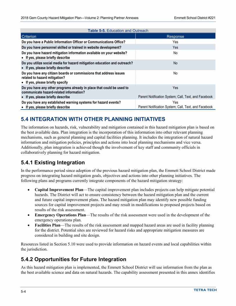
2018 Gem County Hazard Mitigation Plan—Volume 2: Planning Partner Annexes Emmett School District #221
5-4
Table 5-5. Education and Outreach Criterion Response Do you have a Public Information Officer or Communications Office? Yes Do you have personnel skilled or trained in website development? Yes Do you have hazard mitigation information available on your website? No • If yes, please briefly describe Do you utilize social media for hazard mitigation education and outreach? No • If yes, please briefly describe Do you have any citizen boards or commissions that address issues related to hazard mitigation?
No
• If yes, please briefly specify Do you have any other programs already in place that could be used to communicate hazard-related information?
Yes
• If yes, please briefly describe Parent Notification System; Call, Text, and Facebook Do you have any established warning systems for hazard events? Yes • If yes, please briefly describe Parent Notification System; Call, Text, and Facebook
5.4 INTEGRATION WITH OTHER PLANNING INITIATIVES The information on hazards, risk, vulnerability and mitigation contained in this hazard mitigation plan is based on the best available data. Plan integration is the incorporation of this information into other relevant planning mechanisms, such as general planning and capital facilities planning. It includes the integration of natural hazard information and mitigation policies, principles and actions into local planning mechanisms and vice versa. Additionally, plan integration is achieved though the involvement of key staff and community officials in collaboratively planning for hazard mitigation.
5.4.1 Existing Integration In the performance period since adoption of the previous hazard mitigation plan, the Emmett School District made progress on integrating hazard mitigation goals, objectives and actions into other planning initiatives. The following plans and programs currently integrate components of the hazard mitigation strategy:
• Capital Improvement Plan—The capital improvement plan includes projects can help mitigate potential hazards. The District will act to ensure consistency between the hazard mitigation plan and the current and future capital improvement plans. The hazard mitigation plan may identify new possible funding sources for capital improvement projects and may result in modifications to proposed projects based on results of the risk assessment.
• Emergency Operations Plan—The results of the risk assessment were used in the development of the emergency operations plan.
• Facilities Plan—The results of the risk assessment and mapped hazard areas are used in facility planning for the district. Potential sites are reviewed for hazard risks and appropriate mitigation measures are considered in building and site design.
Resources listed in Section 5.10 were used to provide information on hazard events and local capabilities within the jurisdiction.
5.4.2 Opportunities for Future Integration As this hazard mitigation plan is implemented, the Emmett School District will use information from the plan as the best available science and data on natural hazards. The capability assessment presented in this annex identifies
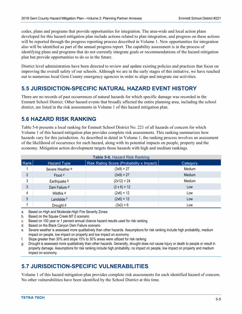
2018 Gem County Hazard Mitigation Plan—Volume 2: Planning Partner Annexes Emmett School District #221
5-5
codes, plans and programs that provide opportunities for integration. The area-wide and local action plans developed for this hazard mitigation plan include actions related to plan integration, and progress on these actions will be reported through the progress reporting process described in Volume 1. New opportunities for integration also will be identified as part of the annual progress report. The capability assessment is in the process of identifying plans and programs that do not currently integrate goals or recommendations of the hazard mitigation plan but provide opportunities to do so in the future.
District level administration have been directed to review and update existing policies and practices that focus on improving the overall safety of our schools. Although we are in the early stages of this initiative, we have reached out to numerous local Gem County emergency agencies in order to align and integrate our activities.
5.5 JURISDICTION-SPECIFIC NATURAL HAZARD EVENT HISTORY There are no records of past occurrences of natural hazards for which specific damage was recorded in the Emmett School District. Other hazard events that broadly affected the entire planning area, including the school district, are listed in the risk assessments in Volume 1 of this hazard mitigation plan.
5.6 HAZARD RISK RANKING Table 5-6 presents a local ranking for Emmett School District No. 221 of all hazards of concern for which Volume 1 of this hazard mitigation plan provides complete risk assessments. This ranking summarizes how hazards vary for this jurisdiction. As described in detail in Volume 1, the ranking process involves an assessment of the likelihood of occurrence for each hazard, along with its potential impacts on people, property and the economy. Mitigation action development targets those hazards with high and medium rankings.
Table 5-6. Hazard Risk Ranking Rank Hazard Type Risk Rating Score (Probability x Impact) Category
1 Severe Weather e (3x9) = 27 Medium 2 Flood c (3x9) = 27 Medium 3 Earthquake b (2x12) = 24 Medium 3 Dam Failure d (2 x 6) = 12 Low 4 Wildfire a (2x6) = 12 Low 5 Landslide f (2x6) = 12 Low 7 Drought g (3x2) = 6 Low
a. Based on High and Moderate-High Fire Severity Zones b. Based on the Squaw Creek M7.0 scenario c. Based on 100 year or 1 percent annual chance hazard results used for risk ranking d. Based on the Black Canyon Dam Failure scenario e. Severe weather is assessed more qualitatively than other hazards. Assumptions for risk ranking include high probability, medium
impact on people, low impact on property and low impact on economy. f. Slope greater than 30% and slope 15% to 30% areas were utilized for risk ranking g. Drought is assessed more qualitatively than other hazards. Generally, drought does not cause injury or death to people or result in
property damage. Assumptions for risk ranking include high probability, no impact on people, low impact on property and medium impact on economy.
5.7 JURISDICTION-SPECIFIC VULNERABILITIES Volume 1 of this hazard mitigation plan provides complete risk assessments for each identified hazard of concern. No other vulnerabilities have been identified by the School District at this time.
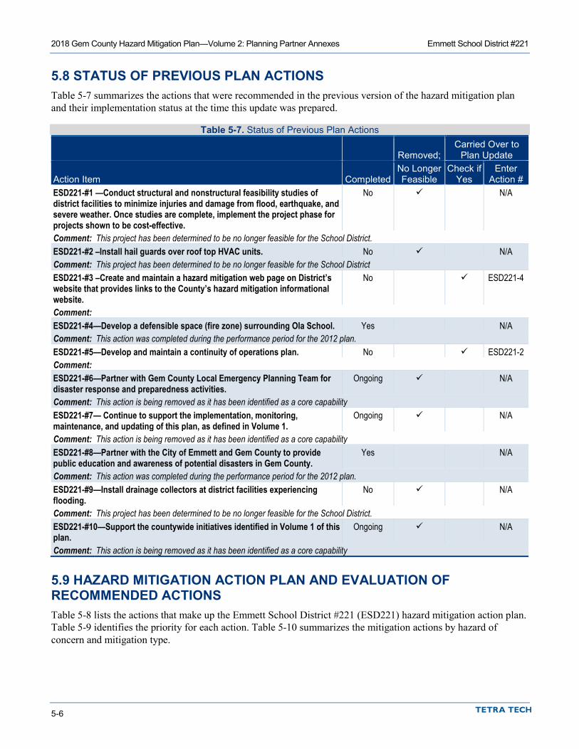
2018 Gem County Hazard Mitigation Plan—Volume 2: Planning Partner Annexes Emmett School District #221
5-6
5.8 STATUS OF PREVIOUS PLAN ACTIONS Table 5-7 summarizes the actions that were recommended in the previous version of the hazard mitigation plan and their implementation status at the time this update was prepared.
Table 5-7. Status of Previous Plan Actions
Removed; Carried Over to
Plan Update
Action Item Completed No Longer Feasible
Check if Yes
Enter Action #
ESD221-#1 —Conduct structural and nonstructural feasibility studies of district facilities to minimize injuries and damage from flood, earthquake, and severe weather. Once studies are complete, implement the project phase for projects shown to be cost-effective.
No N/A
Comment: This project has been determined to be no longer feasible for the School District. ESD221-#2 –Install hail guards over roof top HVAC units. No N/A Comment: This project has been determined to be no longer feasible for the School District ESD221-#3 –Create and maintain a hazard mitigation web page on District’s website that provides links to the County’s hazard mitigation informational website.
No ESD221-4
Comment: ESD221-#4—Develop a defensible space (fire zone) surrounding Ola School. Yes N/A Comment: This action was completed during the performance period for the 2012 plan. ESD221-#5—Develop and maintain a continuity of operations plan. No ESD221-2 Comment: ESD221-#6—Partner with Gem County Local Emergency Planning Team for disaster response and preparedness activities.
Ongoing N/A
Comment: This action is being removed as it has been identified as a core capability ESD221-#7— Continue to support the implementation, monitoring, maintenance, and updating of this plan, as defined in Volume 1.
Ongoing N/A
Comment: This action is being removed as it has been identified as a core capability ESD221-#8—Partner with the City of Emmett and Gem County to provide public education and awareness of potential disasters in Gem County.
Yes N/A
Comment: This action was completed during the performance period for the 2012 plan. ESD221-#9—Install drainage collectors at district facilities experiencing flooding.
No N/A
Comment: This project has been determined to be no longer feasible for the School District. ESD221-#10—Support the countywide initiatives identified in Volume 1 of this plan.
Ongoing N/A
Comment: This action is being removed as it has been identified as a core capability
5.9 HAZARD MITIGATION ACTION PLAN AND EVALUATION OF RECOMMENDED ACTIONS Table 5-8 lists the actions that make up the Emmett School District #221 (ESD221) hazard mitigation action plan. Table 5-9 identifies the priority for each action. Table 5-10 summarizes the mitigation actions by hazard of concern and mitigation type.

2018 Gem County Hazard Mitigation Plan—Volume 2: Planning Partner Annexes Emmett School District #221
5-7
Table 5-8. Hazard Mitigation Action Plan Matrix Applies to new or
existing assets Objectives
Met Lead Agency Support Agency Estimated Cost Sources of Funding Timeline #ESD221-1: Mobile Generators for Shelter Facilities Hazards Mitigated: All Hazards
Existing 5, 9, 11 ESD221 OEM High FEMA HMA Grants, District Funds
Short-term
#ESD221-2: develop and Maintain a Continuity of Operations Plan (COOP) that takes in to account the impacts from Hazards assessed by this plan. Hazards Mitigated: All Hazards New and Existing 5, 9, 11 ESD221 OEM High EMPG, HSGP, District
Funds Short-term
#ESD221-3: Leverage the District’s facilities master planning program (CIP) to target structures vulnerable to the hazards assessed by this plan for hazard mitigation projects eligible for funding under FEMA Hazard Mitigation Assistance (HMA) grant programs. Hazards Mitigated: Severe Weather, Earthquake, Flood and Dam Failure
Existing 3, 4, 5, 9 ESD221 OEM Low District Funds Short-term #ESD221-4: Create and maintain a hazard mitigation web page on District’s website that provides links to the County’s hazard mitigation informational website. Hazards Mitigated: All Hazards New and Existing 2, 7, 10 ESD221 OEM Low District Funds Short-term #ESD221-5—Develop and implement a program to capture perishable data after significant events (e.g. high-water marks, preliminary damage estimates, damage photos) to support future mitigation efforts including the implementation and maintenance of the hazard mitigation plan. Hazards Mitigated: All Hazards New and Existing 2, 7, 8, 9 ESD221 OEM Low District Funds, Public
Assistance (Post-Disaster)
Short-term
Table 5-9. Mitigation Action Priority
Action #
# of Objectives
Met Benefits Costs
Do Benefits Equal or Exceed Costs?
Is Project Grant-
Eligible?
Can Project Be Funded
Under Existing Programs/ Budgets?
Implementation Prioritya
Grant Pursuit Prioritya
1 3 High High Yes Yes No Medium High 2 3 High High Yes Yes No Medium High 3 4 High Low Yes No Yes High N/A 4 3 Medium Low Yes No Yes High N/A 5 4 Medium Low Yes Yes Yes High Medium
a. See the introduction to this volume for explanation of priorities.

2018 Gem County Hazard Mitigation Plan—Volume 2: Planning Partner Annexes Emmett School District #221
5-8
Table 5-10. Analysis of Mitigation Actions Action Addressing Hazard, by Mitigation Typea
Hazard Type Prevention Property
Protection Public Education and Awareness
Natural Resource Protection
Emergency Services
Structural Projects
Dam Failure 2 3 4 1, 5 Drought 2 4 1, 5 Earthquake 2 3 4 1, 5 Flood 2 3 4 1, 5 Landslide 2 3 4 1, 5 Severe Weather 2 3 4 1, 5 Wildfire 2 3 4 1, 5 a. See the introduction to this volume for explanation of mitigation types.
5.10 REVIEW AND INCORPORATION OF RESOURCES FOR THIS ANNEX
5.10.1 Existing Reports, Plans, Regulatory Tools and Other Resources The following technical reports, plans, and regulatory mechanisms were reviewed to provide information for this annex.
• Hazard Mitigation Plan Annex Development Tool-kit—The tool-kit was used to support the development of this annex including past hazard events, noted vulnerabilities, risk ranking and action development.
5.10.2 Staff and Local Stakeholder Involvement in Annex Development The following staff and planning partnership stakeholders collaborated on the development of this annex:
• Jay Hummel, ESD221 • Wayne Rush, ESD221 • Laurie Boston, Emergency Manager, Gem County Office of Emergency Services • Rob Flaner, Technical Consultant to Gem County, Tetra Tech, Inc.
2018 Gem County Hazard Mitigation Plan—Volume 2: Planning Partner Annexes
Appendix A. Planning Partner Expectations


A-1
A. PLANNING PARTNER EXPECTATIONS
ACHIEVING DMA COMPLIANCE FOR ALL PLANNING PARTNERS One of the goals of the multi-jurisdictional approach to hazard mitigation planning is to achieve compliance with the Disaster Mitigation Act (DMA) for all participating members in the planning effort. DMA compliance must be certified for each member in order to maintain eligibility for the benefits under the DMA. Whether our planning process generates ten individual plans or one large plan that has a chapter for each partner jurisdiction, the following items must be addressed by each planning partner to achieve DMA compliance:
• Participate in the process. It must be documented in the plan that each planning partner “participated” in the process that generated the plan. There is flexibility in defining “participation.” Participation can vary based on the type of planning partner (i.e., city or county vs. special purpose district). However, the level of participation must be defined and the extent for which this level of participation has been met for each partner must be contained in the plan context.
• Consistency Review. Review of existing documents pertinent to each jurisdiction to identify policies or recommendations that are not consistent with those documents reviewed in producing the “parent” plan or have policies and recommendations that complement the hazard mitigation initiatives selected (i.e.: comp plans, basin plans or hazard specific plans).
• Action Review. For Plan updates, a review of the strategies from your prior action plan to determine those that have been accomplished and how they were accomplished; and why those that have not been accomplished were not completed.
• Update Localized Risk Assessment. Personalize the Risk Assessment for each jurisdiction by removing hazards not associated with the defined jurisdictional area or redefining vulnerability based on a hazard’s impact to a jurisdiction. This phase will include:
A ranking of the risk A description of the number and type of structures at risk An estimate of the potential dollar losses to vulnerable structures A general description of land uses and development trends within the community, so that mitigation
options can be considered in future land use decisions.
• Capability assessment. Each planning partner must identify and review their individual regulatory, technical and financial capabilities with regards to the implementation of hazard mitigation actions.
• Personalize mitigation recommendations. Identify and prioritize mitigation recommendations specific to each jurisdiction’s defined area.
• Create an Action Plan. • Incorporate Public Participation. Each jurisdiction must present the Plan to the public for comment at
least once, within two weeks prior to adoption. • Plan must be adopted by each jurisdiction.
One of the benefits to multi-jurisdictional planning is the ability to pool resources. This means more than monetary resources. Resources such as staff time, meeting locations, media resources, technical expertise will all

2018 Gem County Hazard Mitigation Plan—Volume 2: Planning Partner Annexes 0BPlanning Partner Expectations
A-2
need to be utilized to generate a successful plan. In addition, these resources can be pooled such that decisions can be made by a peer group applying to the whole and thus reducing the individual level of effort of each planning partner. This will be accomplished by the formation of a steering committee made up of planning partners and other “stakeholders” within the planning area. The size and makeup of this steering committee will be determined by the planning partnership. This body will assume the decision-making responsibilities on behalf of the entire partnership. This will streamline the planning process by reducing the number of meetings that will need to be attended by each planning partner. The assembled Steering Committee for this effort will meet monthly on an as-needed basis as determined by the planning team, and will provide guidance and decision making during all phases of the plan’s development.
With the above participation requirements in mind, each partner is expected to aid this process by being prepared to develop its section of the plan. To be an eligible planning partner in this effort, each Planning Partner shall provide the following:
1. A “Letter of Intent to participate” or Resolution to participate to the Planning Team (see exhibit A). 2. Designate a lead point of contact for this effort. This designee will be listed as the hazard mitigation point
of contact for your jurisdiction in the plan. 3. Support and participate in the selection and function of the Steering Committee selected to oversee the
development of this plan. 4. Provide support in the form of mailing list, possible meeting space, and public information materials,
such as newsletters, newspapers or direct mailed brochures, required to implement the public involvement strategy developed by the Steering Committee.
5. Participate in the process. There will be many opportunities as this plan evolves to participate. Opportunities such as:
a. Steering Committee meetings b. Public meetings or open houses c. Workshops/ Planning Partner specific training sessions d. Public review and comment periods prior to adoption
At each and every one of these opportunities, attendance will be recorded. Attendance records will be used to document participation for each planning partner. No thresholds will be established as minimum levels of participation. However, each planning partner should attempt to attend all possible meetings and events.
1. There will be one mandatory workshop that all planning partners will be required to attend. This workshop will cover the proper completion of the jurisdictional annex template which is the basis for each partner’s jurisdictional chapter in the plan. Failure to have a representative at this workshop will disqualify the planning partner from participation in this effort. The schedule for this workshop will be such that all committed planning partners will be able to attend.
2. After participation in the mandatory template workshop, each partner will be required to complete their template and provide it to the planning team in the time frame established by the Steering Committee. Failure to complete your template in the required time frame may lead to disqualification from the partnership.
3. Each partner will be expected to perform a “consistency review” of all technical studies, plans, ordinances specific to hazards to determine the existence of any not consistent with the same such documents reviewed in the preparation of the County (parent) Plan. For example, if your community has a floodplain management plan that makes recommendations that are not consistent with any of the County’s Basin Plans, that plan will need to be reviewed for probable incorporation into the plan for your area.
4. Each partner will be expected to review the Risk Assessment and identify hazards and vulnerabilities specific to its jurisdiction. Contract resources will provide the jurisdiction specific mapping and technical consultation to aid in this task, but the determination of risk and vulnerability will be up to each partner.

2018 Gem County Hazard Mitigation Plan—Volume 2: Planning Partner Annexes 0BPlanning Partner Expectations
A-3
5. Each partner will be expected to review and determine if the mitigation recommendations chosen in the parent plan will meet the needs of its jurisdiction. Projects within each jurisdiction consistent with the parent plan recommendations will need to be identified, prioritized, and reviewed to determine their benefits vs. costs.
6. Each partner will be required to create its own action plan that identifies each project, who will oversee the task, how it will be financed and when it is estimated to occur.
7. Each partner will be required to sponsor at least one public meeting to present the draft plan to its constituents at least 2 weeks prior to adoption.
8. Each partner will be required to formally adopt the plan.
Templates and instructions to aid in the compilation of this information will be provided to all committed planning partners. Each partner will be expected to complete their templates in a timely manner and according to the timeline specified by the Steering Committee.
** Note**: Once this plan is completed, and DMA compliance has been determined for each partner, maintaining that eligibility will be dependent upon each partner implementing the plan implementation-maintenance protocol identified in the plan. At a minimum, this means completing the ongoing plan maintenance protocol identified in the plan. Partners that do not participate in this plan maintenance strategy may be deemed ineligible by the partnership, and thus lose their DMA eligibility.
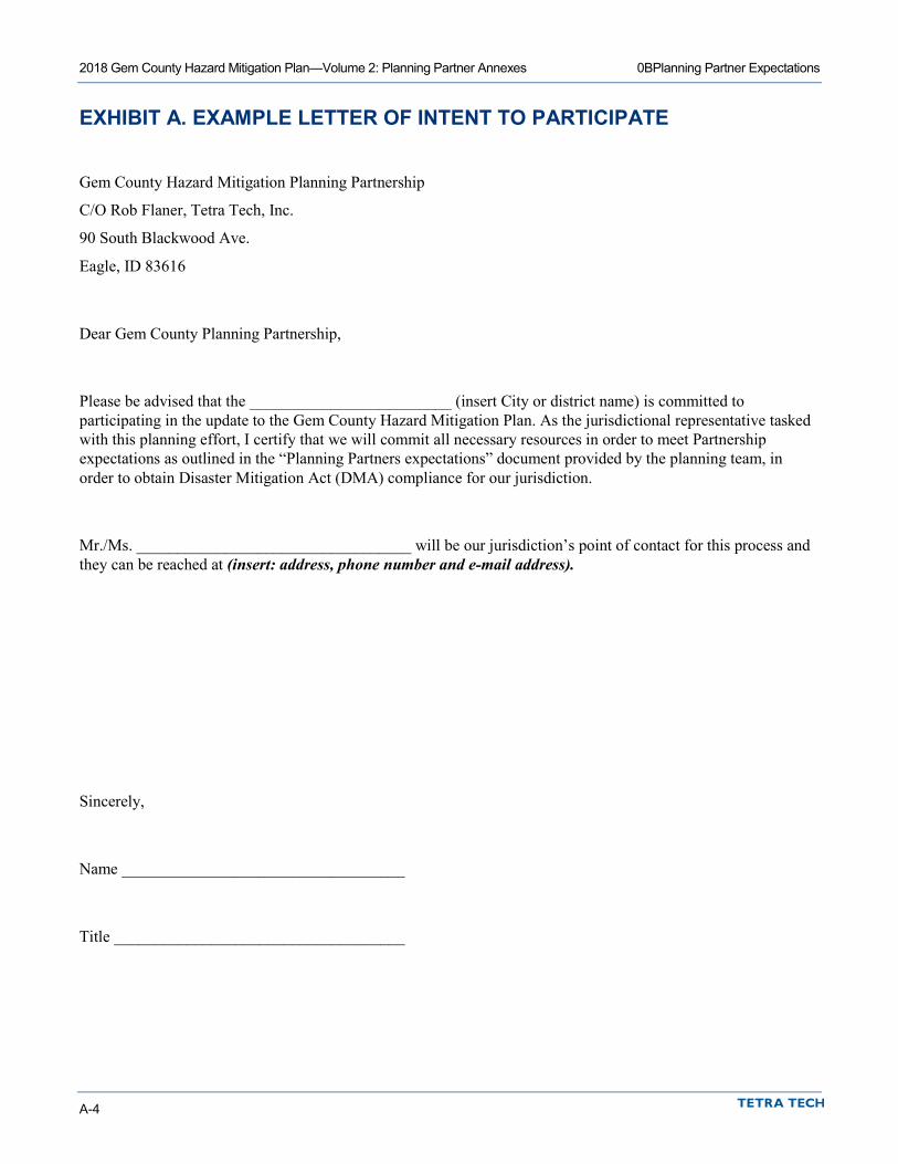
2018 Gem County Hazard Mitigation Plan—Volume 2: Planning Partner Annexes 0BPlanning Partner Expectations
A-4
EXHIBIT A. EXAMPLE LETTER OF INTENT TO PARTICIPATE
Gem County Hazard Mitigation Planning Partnership
C/O Rob Flaner, Tetra Tech, Inc.
90 South Blackwood Ave.
Eagle, ID 83616
Dear Gem County Planning Partnership,
Please be advised that the _________________________ (insert City or district name) is committed to participating in the update to the Gem County Hazard Mitigation Plan. As the jurisdictional representative tasked with this planning effort, I certify that we will commit all necessary resources in order to meet Partnership expectations as outlined in the “Planning Partners expectations” document provided by the planning team, in order to obtain Disaster Mitigation Act (DMA) compliance for our jurisdiction.
Mr./Ms. __________________________________ will be our jurisdiction’s point of contact for this process and they can be reached at (insert: address, phone number and e-mail address).
Sincerely,
Name ___________________________________
Title ____________________________________
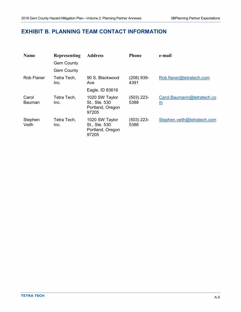
2018 Gem County Hazard Mitigation Plan—Volume 2: Planning Partner Annexes 0BPlanning Partner Expectations
A-5
EXHIBIT B. PLANNING TEAM CONTACT INFORMATION
Name Representing Address Phone e-mail Gem County
Gem County
Rob Flaner Tetra Tech, Inc.
90 S. Blackwood Ave
Eagle, ID 83616
(208) 939-4391
Carol Bauman
Tetra Tech, Inc.
1020 SW Taylor St., Ste. 530 Portland, Oregon 97205
(503) 223-5388
Stephen Veith
Tetra Tech, Inc.
1020 SW Taylor St., Ste. 530 Portland, Oregon 97205
(503) 223-5388

2018 Gem County Hazard Mitigation Plan—Volume 2: Planning Partner Annexes 0BPlanning Partner Expectations
A-6
EXHIBIT C. OVERVIEW OF HAZUS
Overview of Hazus
http://www.fema.gov/hazus/dl_mhpres.shtm
Hazus is a nationally applicable standardized methodology and software program that contains models for estimating potential losses from earthquakes, floods, and hurricane winds. Hazus was developed by the Federal Emergency Management Agency (FEMA) under contract with the National Institute of Building Sciences (NIBS). NIBS maintains committees of wind, flood, earthquake and software experts to provide technical oversight and guidance to Hazus development. Loss estimates produced by Hazus are based on current scientific and engineering knowledge of the effects of
hurricane winds, floods, and earthquakes. Estimating losses is essential to decision-making at all levels of government, providing a basis for developing mitigation plans and policies, emergency preparedness, and response and recovery planning.
Hazus uses state-of-the-art geographic information system (GIS) software to map and display hazard data and the results of damage and economic loss estimates for buildings and infrastructure. It also allows users to estimate the impacts of hurricane winds, floods, and earthquakes on populations. The latest release incorporates new features that improve both the speed and functionality of the models. For information on software and hardware requirements, see Hazus Hardware and Software Requirements.
Hazus Analysis Levels Hazus provides for three levels of analysis:
• A Level 1 analysis yields a rough estimate based on the nationwide database and is a great way to begin the risk assessment process and prioritize high-risk communities.
• A Level 2 analysis requires the input of additional or refined data and hazard maps that will produce more accurate risk and loss estimates. Assistance from local emergency management personnel, city planners, GIS professionals, and others may be necessary for this level of analysis.
• A Level 3 analysis yields the most accurate estimate of loss and typically requires the involvement of technical experts such as structural and geotechnical engineers who can modify loss parameters based on to the specific conditions of a community. This level analysis will allow users to supply their own techniques to study special conditions such as dam breaks and tsunamis. Engineering and other expertise is needed at this level.
2018 Gem County Hazard Mitigation Plan—Volume 2: Planning Partner Annexes 0BPlanning Partner Expectations
A-7
Three data input tools have been developed to support data collection. The Inventory Collection Tool (InCAST) helps users collect and manage local building data for more refined analyses than are possible with the national level data sets that come with Hazus . InCAST has expanded capabilities for multi-hazard data collection. Hazus includes an enhanced Building Inventory Tool (BIT) allows users to import building data and is most useful when handling large datasets, such as tax assessor records. The Flood Information Tool (FIT) helps users manipulate flood data into the format required by the Hazus flood model. All Three tools are included in the Hazus Application DVD.
Hazus Models The Hazus Hurricane Wind Model gives users in the Atlantic and Gulf Coast regions and Hawaii the ability to estimate potential damage and loss to residential, commercial, and industrial buildings. It also allows users to estimate direct economic loss, post-storm shelter needs and building debris. In the future, the model will include the capability to estimate wind effects in island territories, storm surge, indirect economic losses, casualties, and impacts to utility and transportation lifelines and agriculture. Loss models for other severe wind hazards will be included in the future. Details about the Hurricane Wind Model.
The Hazus Flood Model is capable of assessing riverine and coastal flooding. It estimates potential damage to all classes of buildings, essential facilities, transportation and utility lifelines, vehicles, and agricultural crops. The model addresses building debris generation and shelter requirements. Direct losses are estimated based on physical damage to
structures, contents, and building interiors. The effects of flood warning are taken into account, as are flow velocity effects. Details about the Flood Model.
The Hazus Earthquake Model, The HAZUS earthquake model provides loss estimates of damage and loss to buildings, essential facilities, transportation and utility lifelines, and population based on scenario or probabilistic earthquakes. The model addresses debris generation, fire-following, casualties, and shelter requirements. Direct losses are estimated based on physical damage to structures, contents, inventory, and building interiors. The earthquake model also includes the Advanced Engineering Building Module for single- and group-building mitigation analysis. Details about the Earthquake Model.
The updated earthquake model released with Hazus includes:
• The (September 2002) National Hazard Maps • Project ‘02 attenuation functions • Updated historical earthquake catalog (magnitude 5 or greater) • Advanced Engineering Building Module for single and group building mitigation analysis
Additionally, Hazus can perform multi-hazard analysis by providing access to the average annualized loss and probabilistic results from the hurricane wind, flood, and earthquake models and combining them to provide integrated multi-hazard reports and graphs. Hazus also contains a third-party model integration capability that provides access and operational capability to a wide range of natural, man-made, and technological hazard models (nuclear and conventional blast, radiological, chemical, and biological) that will supplement the natural hazard loss estimation capability (hurricane wind, flood, and earthquake) in Hazus.


2018 Gem County Hazard Mitigation Plan—Volume 2: Planning Partner Annexes
Appendix B. Procedures for Linking to This Plan


B-1
B. PROCEDURES FOR LINKING TO THIS PLAN
Not all eligible local governments within Gem County are included in the Gem County Hazard Mitigation Plan Update. It is assumed that some or all of these non-participating local governments may choose to “link” to the Plan at some point to gain eligibility for programs under the federal Disaster Mitigation Act. In addition, some of the current partnership may not continue to meet eligibility requirements due to a lack of participation as prescribed by the plan. The following “linkage” procedures define the requirements established by the Plan’s Steering Committee and all planning partners for dealing with an increase or decrease in the number of planning partners linked to this plan. It should be noted that a currently non-participating jurisdiction within the defined planning area is not obligated to link to this plan. These jurisdictions can choose to do their own “complete” plan that addresses all required elements of section 201.6 of 44 CFR.
INCREASING THE PARTNERSHIP THROUGH LINKAGE The annual time period for the linkage process will be from January to May during any year. Eligible linking jurisdictions are instructed to complete all of the following procedures during this time frame:
• The eligible jurisdiction requests a “Linkage Package” by contacting the Point of Contact (POC) for the plan:
Name
Title
Address
City, State ZIP
Phone
The POC will provide a linkage packages that includes:
Copy of Volume 1 and 2 of the plan Planning partner’s expectations package. A sample “letter of intent” to link to the Multi-Hazard Mitigation Plan. A Special Purpose District or City template and instructions. Catalog of Hazard Mitigation Alternatives A “request for technical assistance” form. A copy of Section 201.6 of Chapter 44, the Code of Federal Regulations, which defines the federal
requirements for a local hazard mitigation plan.
• The new jurisdiction will be required to review both volumes of the Multi-Hazard Mitigation Plan, which includes the following key components for the planning area:

2018 Gem County Hazard Mitigation Plan—Volume 2: Planning Partner Annexes Procedures for Linking to This Plan
B-2
The planning area risk assessment Goals and objectives Plan implementation and maintenance procedures Comprehensive review of alternatives County-wide initiatives.
Once this review is complete, the jurisdiction will complete its specific annex using the template and instructions provided by the POC. Technical assistance can be provided upon request by completing the request for technical assistance (TA) form provided in the linkage package. This TA may be provided by the POC or any other resource within the Planning Partnership such as a member of the Steering Committee or a currently participating City or Special Purposes District partner. The POC will determine who will provide the TA and the possible level of TA based on resources available at the time of the request.
• The new jurisdiction will be required to develop a public involvement strategy that ensures the public’s ability to participate in the plan development process. At a minimum, the new jurisdiction must make an attempt to solicit public opinion on hazard mitigation at the onset of this linkage process and a minimum of one public meeting to present their draft jurisdiction specific annex for comment, prior to adoption by the governing body. The Planning Partnership will have resources available to aid in the public involvement strategy such as the Plan website. However, it will be the new jurisdiction’s responsibility to implement and document this strategy for incorporation into its annex. It should be noted that the Jurisdictional Annex templates do not include a section for the description of the public process. This is because the original partnership was covered under a uniform public involvement strategy that covered the planning area described in Volume 1 of the plan. Since new partners were not addressed by that strategy, they will have to initiate a new strategy, and add a description of that strategy to their annex. For consistency, new partners are encouraged to follow the public involvement format utilized by the initial planning effort as described in Volume 1 of the plan.
• Once their public involvement strategy is completed and they have completed their template, the new jurisdiction will submit the completed package to the POC for a pre-adoption review to ensure conformance with the Regional plan format.
• The POC will review for the following:
Documentation of Public Involvement strategy Conformance of template entries with guidelines outlined in instructions Chosen initiatives are consistent with goals, objectives and mitigation catalog of the Multi-Hazard
Mitigation Plan Update A Designated point of contact A ranking of risk specific to the jurisdiction.
The POC may utilize members of the Steering Committee or other resources to complete this review. All proposed linked annexes will be submitted to the Steering Committee for review and comment prior to submittal to the Idaho Office of Emergency Management (IOEM).
• Plans approved and accepted by the Steering Committee will be forwarded to IOEM for review with a cover letter stating the forwarded plan meets local approved plan standards and whether the plan is submitted with local adoption or for criteria met/plan not adopted review.
• IOEM will reviews plans for federal compliance. Non-Compliant plans are returned to the Lead agency for correction. Compliant plans are forwarded to FEMA for review with annotation as to the adoption status.
2018 Gem County Hazard Mitigation Plan—Volume 2: Planning Partner Annexes Procedures for Linking to This Plan
B-3
• FEMA reviews the new jurisdiction’s plan in association with the approved plan to ensure DMA compliance. FEMA notifies new jurisdiction of results of review with copies to IOEM and approved planning authority.
• New jurisdiction corrects plan shortfalls (if necessary) and resubmits to IOEM through the approved plan lead agency.
• For plans with no shortfalls from the FEMA review that have not been adopted, the new jurisdiction governing authority adopts the plan (if not already accomplished) and forwards adoption resolution to FEMA with copies to lead agency and IOEM.
• FEMA regional director notifies new jurisdiction governing authority of plan approval.
The new jurisdiction plan is then included with the regional plan with the commitment from the new jurisdiction to participate in the ongoing plan implementation and maintenance.
DECREASING THE PARTNERSHIP The eligibility afforded under this process to the planning partnership can be rescinded in two ways. First, a participating planning partner can ask to be removed from the partnership. This may be done because the partner has decided to develop its own plan or has identified a different planning process for which it can gain eligibility. A partner that wishes to voluntarily leave the partnership shall inform the POC of this desire in writing. This notification can occur any time during the calendar year. A jurisdiction wishing to pursue this avenue is advised to make sure that it is eligible under the new planning effort, to avoid any period of being out of compliance with the Disaster Mitigation Act.
After receiving this notification, the POC shall immediately notify both IOEM and FEMA in writing that the partner in question is no longer covered by the Multi-Hazard Mitigation Plan, and that the eligibility afforded that partner under this plan should be rescinded based on this notification.
The second way a partner can be removed from the partnership is by failure to meet the participation requirements specified in the “Planning Partner Expectations” package provided to each partner at the beginning of the process, or the plan maintenance and implementation procedures specified in Volume 1 of the plan. Each partner agreed to these terms by adopting the plan.
Eligibility status of the planning partnership will be monitored by the POC. The determination of whether a partner is meeting its participation requirements will be based on the following parameters:
• Are progress reports being submitted annually by the specified time frames? • Are partners notifying the POC of changes in designated points of contact? • Are the partners supporting the Steering Committee by attending designated meetings or responding to
needs identified by the body? • Are the partners continuing to be supportive as specified in the Planning Partners expectations package
provided to them at the beginning of the process?
Participation in the plan does not end with plan approval. This partnership was formed on the premise that a group of planning partners would pool resources and work together to strive to reduce risk within the planning area. Failure to support this premise lessens the effectiveness of this effort. The following procedures will be followed to remove a partner due to the lack of participation:
• The POC will advise the Steering Committee of this pending action and provide evidence or justification for the action. Justification may include: multiple failures to submit annual progress reports, failure to attend meetings determined to be mandatory by the Steering Committee, failure to act on the partner’s action plan, or inability to reach designated point of contact after a minimum of five attempts.
2018 Gem County Hazard Mitigation Plan—Volume 2: Planning Partner Annexes Procedures for Linking to This Plan
B-4
• The Steering Committee will review information provided by POC and determine action by a vote. The Steering Committee will invoke the voting process established in the ground rules established during the formation of this body.
• Once the Steering Committee has approved an action, the POC will notify the planning partner of the pending action in writing via certified mail. This notification will outline the grounds for the action and ask the partner if it is their desire to remain as a partner. This notification shall also clearly identify the ramifications of removal from the partnership. The partner will be given 30 days to respond to the notification.
• Confirmation by the partner that they no longer wish to participate or failure to respond to the notification shall trigger the procedures for voluntary removal discussed above.
• Should the partner respond that they would like to continue participation in the partnership, they must clearly articulate an action plan to address the deficiencies identified by the POC. This action plan shall be reviewed by the Steering Committee to determine whether the actions are appropriate to rescind the action. Those partners that satisfy the Steering Committee’s review will remain in the partnership, and no further action is required.
• Automatic removal from the partnership will be implemented for partners where these actions have to be initiated more than once in a 5-year planning cycle.

2018 Gem County Hazard Mitigation Plan—Volume 2: Planning Partner Annexes
Appendix C. Annex Instructions and Templates

INSTRUCTIONS FOR MUNICIPAL ANNEX COMPLETION


1
INSTRUCTIONS FOR COMPLETING MUNICIPAL/UNINCORPORATED COUNTY ANNEX TEMPLATE
The jurisdictional annex templates for the 2018 Gem County Hazard Mitigation Plan update will be completed in three phases. This document provides instructions for completing all phases of the template for municipalities / unincorporated county areas. If your jurisdiction completed and submitted Phase 1 and/or Phase 2, Phase 3 has been added to the end of your document. Any planning team comments, questions or suggestions have been included as blue highlighted notes and/or comments. Any text edits were made with changes tracked for review. Any yellow highlights indicate areas where missing information should be filled in. If your jurisdiction did not complete Phase 1 or Phase 2, please complete all phases at this time.
The target timeline for phase completion is as follows:
• Phase 1 – Jurisdictional profile - Deployed: Mid-March, 2018 - Due: April 20, 2018
• Phase 2 – Capability assessment - Deployed: Mid-April, 2018 - Due: May 18, 2018
• Phase 3 – Risk ranking and action plan development - Deployed: July 6, 2018 - Due: Monday, August 20, 2018
Any questions on completing the template should be directed to:
Rob Flaner Tetra Tech, Inc. (208)939-4391 or (208) 830-3844 E-mail: [email protected]
Municipality Annex:
This document provides instructions for completing all phases of the jurisdictional annex template for
municipalities. Templates should be completed by August 20, 2018. Your completed template should be
submitted to: Rob Flaner
Tetra Tech, Inc. (208) 939-4391 or (208) 830-3844 E-mail: [email protected]
A Note About Formatting:
The template for the annex is a Microsoft Word document in a format that will be used in the final plan. Partners are asked to use this template so that a uniform product will be completed for each partner.
Content should be entered within the yellow, highlighted text that is currently in the template, rather than creating text in another document and pasting it into the template. Text from another source will alter the style and formatting of the document.
The numbering in the document will be updated when completed annexes are combined into the final document. Please do not adjust any of this numbering.
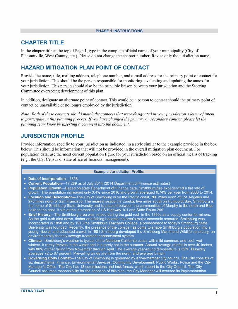
1
PHASE 1 INSTRUCTIONS
CHAPTER TITLE In the chapter title at the top of Page 1, type in the complete official name of your municipality (City of Pleasantville, West County, etc.). Please do not change the chapter number. Revise only the jurisdiction name.
HAZARD MITIGATION PLAN POINT OF CONTACT Provide the name, title, mailing address, telephone number, and e-mail address for the primary point of contact for your jurisdiction. This should be the person responsible for monitoring, evaluating and updating the annex for your jurisdiction. This person should also be the principle liaison between your jurisdiction and the Steering Committee overseeing development of this plan.
In addition, designate an alternate point of contact. This would be a person to contact should the primary point of contact be unavailable or no longer employed by the jurisdiction.
Note: Both of these contacts should match the contacts that were designated in your jurisdiction’s letter of intent to participate in this planning process. If you have changed the primary or secondary contact, please let the planning team know by inserting a comment into the document.
JURISDICTION PROFILE Provide information specific to your jurisdiction as indicated, in a style similar to the example provided in the box below. This should be information that will not be provided in the overall mitigation plan document. For population data, use the most current population figure for your jurisdiction based on an official means of tracking (e.g., the U.S. Census or state office of financial management).
Example Jurisdiction Profile:
• Date of Incorporation—1858 • Current Population—17,289 as of July 2014 (2014 Department of Finance estimates) • Population Growth—Based on state Department of Finance data, Smithburg has experienced a flat rate of
growth. The population increased only 3.4% since 2010 and growth averaged 0.74% per year from 2000 to 2014. • Location and Description—The City of Smithburg is on the Pacific coast, 760 miles north of Los Angeles and
275 miles north of San Francisco. The nearest seaport is Eureka, five miles south on Humboldt Bay. Smithburg is the home of Smithburg State University and is situated between the communities of Murphy to the north and Blue Lake to the east. It sits at the intersection of US Highway 101 and State Route 299.
• Brief History—The Smithburg area was settled during the gold rush in the 1850s as a supply center for miners. As the gold rush died down, timber and fishing became the area’s major economic resource. Smithburg was incorporated in 1858 and by 1913 the Smithburg Teachers College, a predecessor to today’s Smithburg State University was founded. Recently, the presence of the college has come to shape Smithburg’s population into a young, liberal, and educated crowd. In 1981 Smithburg developed the Smithburg Marsh and Wildlife sanctuary, an environmentally friendly sewage treatment enhancement system.
• Climate—Smithburg’s weather is typical of the Northern California coast, with mild summers and cool, wet winters. It rarely freezes in the winter and it is rarely hot in the summer. Annual average rainfall is over 40 inches, with 80% of that falling from November through April. The average year-round temperature is 59ºF. Humidity averages 72 to 87 percent. Prevailing winds are from the north, and average 5 mph.
• Governing Body Format—The City of Smithburg is governed by a five-member city council. The City consists of six departments: Finance, Environmental Services, Community Development, Public Works, Police and the City Manager’s Office. The City has 13 commissions and task forces, which report to the City Council. The City Council assumes responsibility for the adoption of this plan; the City Manager will oversee its implementation.

Gem County HMP Update Instructions for Completing Municipal/Unincorporated County Annex Template
2
Phase 2 Instructions
If your jurisdiction participated in a previously approved hazard mitigation plan, we have transferred relevant content to the Phase 2 portion of your annex. All pre-populated content should be reviewed for accuracy and completeness.
DEVELOPMENT TRENDS In the yellow-highlighted text that says “Describe trends in general,” provide a brief description of your jurisdiction’s recent development trends similar to the following example:
Anticipated development levels for Smithburg are low to moderate, consisting primarily of residential development. The majority of recent development has been infill. Residentially, there has been a focus on affordable housing and a push for more secondary mother-in-law units on properties. The City of Smithburg adopted its general plan in July 2000. The plan focuses on issues of the greatest concern to the community. City actions, such as those relating to land use allocations, annexations, zoning, subdivision and design review, redevelopment, and capital improvements, must be consistent with the plan. Future growth and development in the City will be managed as identified in the general plan.
Complete the table titled “Recent and Expected Future Development Trends” to demonstrate the development that occurred during the past 5 years, including a description of any development which may be located within a hazard zone. Provide additional information on any anticipated development. Please note that we are specifically looking for development permits for new construction. If your jurisdiction does not have the ability to differentiate between permit types, please list the total number of permits and include a note or comment in the document indicating what you have provided.
If your jurisdiction does not have the ability to track the number of permits for each hazard area, please insert a qualitative description of where development has occurred.
CAPABILITY ASSESSMENT Please note that it is unlikely that you will be able to complete all sections of the capability assessment on your own. You will likely need to reach out to other departments within your local government, such as planning, finance, public works, etc. It may be beneficial to provide these individuals with background information about this planning process, as you will want input from them again during Phase 3 of your annex development.
Legal and Regulatory Capability In the table titled “Legal and Regulatory Capability,” indicate “Yes” or “No” for each listed code, ordinance, requirement or planning document in each of the following columns:
• Local Authority—Enter “Yes” if your jurisdiction has prepared or adopted the identified item; otherwise, enter “No.” If yes, then enter the code, ordinance number, or plan name and its date of adoption in the comments column. Note: If you are entering yes, please be sure that you are providing a comment with the appropriate code, ordinance or plan.
• Other Jurisdiction Authority—Enter “Yes” if there are any regulations that may impact your jurisdiction that are enforced or administered by another agency (e.g., a state agency or special purpose district) or if you know that there are any state or federal regulations or laws that would prohibit local implementation of the identified item; otherwise, enter “No.” Note: If you answer yes, please indicate the other agency in the comments.
Gem County HMP Update Instructions for Completing Municipal/Unincorporated County Annex Template
3
• State Mandated—Enter “Yes” if state laws or other requirements enable or require the listed item to be implemented at the local level; otherwise, enter “No.” Note: If you are entering yes, please be sure that you are providing a comment.
• Integration Opportunity—Enter “Yes” if your jurisdiction has opportunities for integration of the code, ordinance or plan with the hazard mitigation plan. Consider entering “Yes” in the Integration Opportunity column if you answer “yes” to any of the following:
If you answered “Yes” in the Local Authority column for this code, ordinance or plan:
Does the code, ordinance or plan already address hazards and their potential impacts? o If so, should it be updated or revised to reflect new information about risk? o If not, will (or should) the code, ordinance or plan be updated over the performance
period of the hazard mitigation plan (5 years)? Does the code, ordinance or plan include specific projects that should be reviewed to
incorporate hazard mitigation goals? Does the code, ordinance or plan include specific projects that should be included as action
items in the hazard mitigation action plan?
If you answered “No” in the Local Authority column for this code, ordinance or plan:
Will your jurisdiction develop the code, ordinance or plan during the performance period of the hazard mitigation plan?
Note: Each capability with a “Yes” answer to Integration Opportunity will be discussed in more detail later in the annex. You may wish to keep notes when assessing the Integration Opportunity or review the “Integration with Other Planning Initiatives” section below.
• Comments—Enter the code number and adoption date for any local code indicated as being in place; provide other comments as appropriate to describe capabilities for each entry.
• For the categories “General Plan” and “Capital Improvement Plan,” answer the specific questions shown, in addition to completing the four columns indicating level of capability.
Development and Permit Capabilities Complete the table titled “Development and Permitting Capabilities.” Examples of qualitative descriptions of buildout in the jurisdiction are as follows:
• The Town is close to being built out. Most new projects involve the demolition of an existing residence and construction of a new replacement residence. A few subdivisions are processed each year.
• There are five parcels of underdeveloped land within the city limits. According to the General Plan, the total potential units for these parcels is 33 units.
Fiscal Capability Complete the table titled “Fiscal Capability” by indicating whether each of the listed financial resources is accessible to your jurisdiction. Enter “Yes” if the resource is fully accessible to your jurisdiction. Enter “No” if there are limitations or prerequisites that may hinder your eligibility for this resource.
Administrative and Technical Capability Complete the table titled “Administrative and Technical Capability” by indicating whether your jurisdiction has access to each of the listed personnel resources. Enter “Yes” or “No” in the column labeled “Available?”. If yes,
Gem County HMP Update Instructions for Completing Municipal/Unincorporated County Annex Template
4
then enter the department and position title in the right-hand column. If you have contract support staff with these capabilities, you can still answer “Yes.” Indicate in the department column that this resource is provided through contract support.
Education and Outreach Capabilities Complete the table titled “Education and Outreach” to indicate your jurisdiction’s capabilities and existing efforts regarding natural hazard mitigation education and outreach.
National Flood Insurance Program Compliance Complete the table titled “National Flood Insurance Program Compliance” by indicating your jurisdiction’s capabilities related to each question in the table.
Classification in Hazard Mitigation Programs Complete the table titled “Community Classifications” to indicate your jurisdiction’s participation in various national programs related to natural hazard mitigation. For each program enter “Yes” or “No” in the second column to indicate whether your jurisdiction participates. If yes, then enter the classification that your jurisdiction has earned under the program in the third column and the date on which that classification was issued in the fourth column; enter “N/A” in the third and fourth columns if your jurisdiction is not participating.
Tetra Tech has completed this table for classification programs that have classification information available online:
• Community Rating System— https://www.fema.gov/media-library/assets/documents/15846 • Storm Ready— https://www.weather.gov/stormready/communities • Firewise— http://www.firewise.org/usa-recognition-program/map-of-active-participants.aspx
For two of the programs, we are not able to access information pertaining to your jurisdiction. If you are unfamiliar with the programs, please visit the websites below:
• Building Code Effectiveness Grading Schedule (BCEGS)— https://www.isomitigation.com/bcegs/iso-s-building-code-effectiveness-grading-schedule-bcegs.html
• Public Protection Classification— https://firechief.iso.com/FCWWeb/mitigation/ppc0001.jsp
INTEGRATION WITH OTHER PLANNING INITIATIVES The goal of plan integration is to ensure that the potential impact of hazards is considered in planning for future development. FEMA recommends integration as follows:
• Integrate hazard mitigation plan goals with community objectives (e.g. incorporate the goals for risk reduction and safety into the policies of other plans).
• Use the risk assessment to inform plans and policies (e.g. incorporate risk assessment findings into land use plans, site plan review, emergency operations plans).
• Implement mitigation actions through existing mechanisms (e.g. include mitigation projects in the capital improvement plan).
• Think about mitigation before and after a disaster (e.g. build recovery planning on existing mitigation plans and goals).
After reviewing the plans, programs and ordinances identified in the capability assessment tables, identify all plans and programs that have already been integrated with the goals and recommendations of the hazard

Gem County HMP Update Instructions for Completing Municipal/Unincorporated County Annex Template
5
mitigation plan, and those that offer opportunities for future integration. The simplest way to do this is to review the Legal and Regulatory Capabilities table to see which items were marked as “Yes” under the Integration Opportunity column.
Existing Integration List the items for which you entered “Yes” under the Integration Opportunity column because the plan or ordinance already addresses potential impacts or includes specific projects that should be included as action items in the mitigation action plan. Provide a brief description of how the plan or ordinance is integrated. Examples are as follows:
• Capital Improvement Plan—The capital improvement plan includes projects can help mitigate potential hazards. The City will act to ensure consistency between the hazard mitigation plan and the current and future capital improvement plans. The hazard mitigation plan may identify new possible funding sources for capital improvement projects and may result in modifications to proposed projects based on results of the risk assessment.
• Building Code and Fire Code—The City’s adoption of the 2016 California Building and Fire codes incorporated local modifications to account for the climatic, topographic and geographic conditions that exist in the City.
• General Plan 2030—The general plan includes a “Safety, Services, and Infrastructure” element to protect the community from unreasonable risk by establishing policies and actions to avoid or minimize the following hazards:
Geologic and seismic hazards Fire hazards Hazardous materials Flood control Impacts from climate change.
• Climate Action Plan—The City’s Climate Action Plan includes projects for reducing greenhouse gas emissions and adapting to likely impacts of climate change. These projects were reviewed to identify cross-planning initiates that serve both adaptation and mitigation objectives. Note: Any plans that fall into this category should be reviewed during the development of the mitigation strategy in Phase 3 and included as appropriate.
Opportunities for Future Integration List any remaining items that say “Yes” in the Integration Opportunity column in the Legal and Regulatory Capabilities and explain the process by which integration will occur. Examples follow:
• Zoning Code—The City of Smithburg is conducting a comprehensive update to its zoning code. The opportunity to incorporate additional mitigation and abatement measures will be contemplated for inclusion into the Code.
• Capital Improvement Projects—Capital improvement project proposals may take into consideration hazard mitigation potential as a means of evaluating project prioritization.
• Post-Disaster Recovery Plan—Smithburg does not have a recovery plan and intends to develop one as a mitigation planning action during the next five years. The plan will build on the mitigation goals and objectives identified in the mitigation plan.
After you have accounted for all items marked as “Yes” under the Integration Opportunity column, consider other programs you may have in place in your jurisdiction that include routine consideration and management of hazard
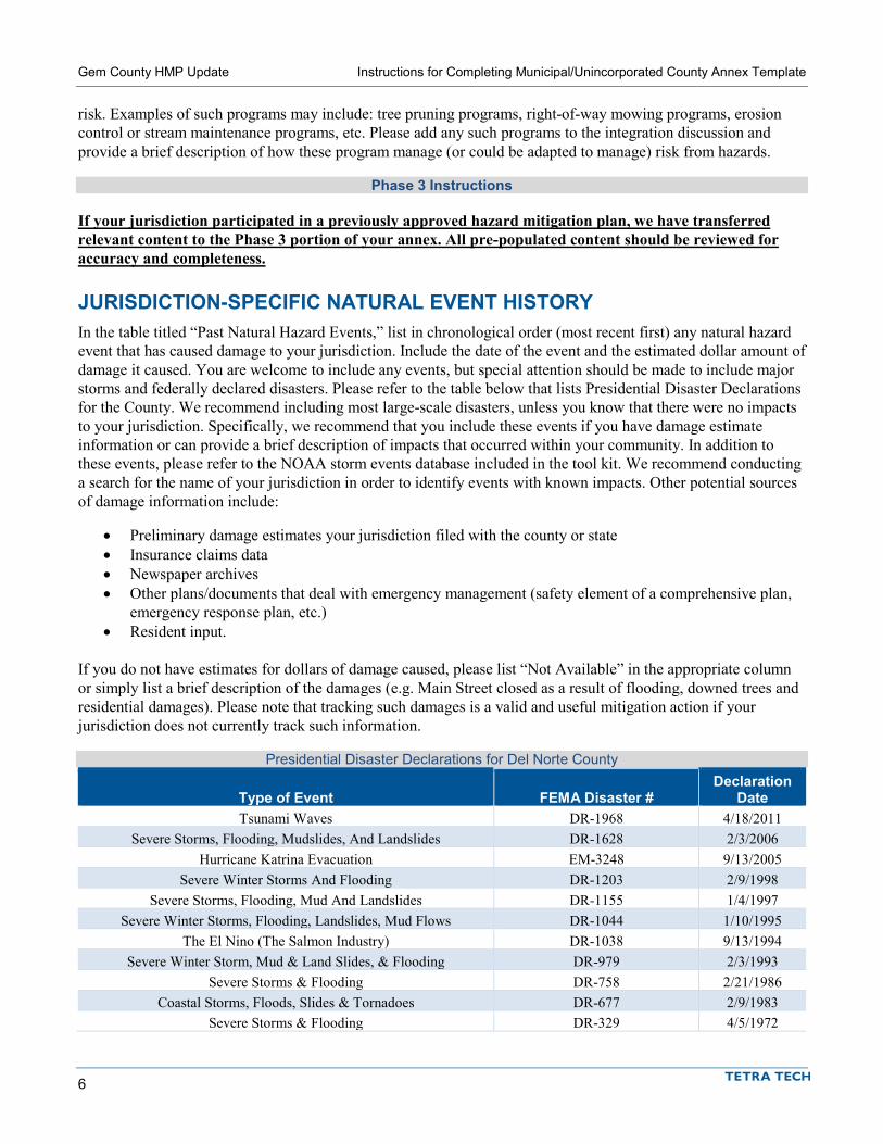
Gem County HMP Update Instructions for Completing Municipal/Unincorporated County Annex Template
6
risk. Examples of such programs may include: tree pruning programs, right-of-way mowing programs, erosion control or stream maintenance programs, etc. Please add any such programs to the integration discussion and provide a brief description of how these program manage (or could be adapted to manage) risk from hazards.
Phase 3 Instructions
If your jurisdiction participated in a previously approved hazard mitigation plan, we have transferred relevant content to the Phase 3 portion of your annex. All pre-populated content should be reviewed for accuracy and completeness.
JURISDICTION-SPECIFIC NATURAL EVENT HISTORY In the table titled “Past Natural Hazard Events,” list in chronological order (most recent first) any natural hazard event that has caused damage to your jurisdiction. Include the date of the event and the estimated dollar amount of damage it caused. You are welcome to include any events, but special attention should be made to include major storms and federally declared disasters. Please refer to the table below that lists Presidential Disaster Declarations for the County. We recommend including most large-scale disasters, unless you know that there were no impacts to your jurisdiction. Specifically, we recommend that you include these events if you have damage estimate information or can provide a brief description of impacts that occurred within your community. In addition to these events, please refer to the NOAA storm events database included in the tool kit. We recommend conducting a search for the name of your jurisdiction in order to identify events with known impacts. Other potential sources of damage information include:
• Preliminary damage estimates your jurisdiction filed with the county or state • Insurance claims data • Newspaper archives • Other plans/documents that deal with emergency management (safety element of a comprehensive plan,
emergency response plan, etc.) • Resident input.
If you do not have estimates for dollars of damage caused, please list “Not Available” in the appropriate column or simply list a brief description of the damages (e.g. Main Street closed as a result of flooding, downed trees and residential damages). Please note that tracking such damages is a valid and useful mitigation action if your jurisdiction does not currently track such information.
Presidential Disaster Declarations for Del Norte County
Type of Event FEMA Disaster # Declaration
Date Tsunami Waves DR-1968 4/18/2011
Severe Storms, Flooding, Mudslides, And Landslides DR-1628 2/3/2006 Hurricane Katrina Evacuation EM-3248 9/13/2005
Severe Winter Storms And Flooding DR-1203 2/9/1998 Severe Storms, Flooding, Mud And Landslides DR-1155 1/4/1997
Severe Winter Storms, Flooding, Landslides, Mud Flows DR-1044 1/10/1995 The El Nino (The Salmon Industry) DR-1038 9/13/1994
Severe Winter Storm, Mud & Land Slides, & Flooding DR-979 2/3/1993 Severe Storms & Flooding DR-758 2/21/1986
Coastal Storms, Floods, Slides & Tornadoes DR-677 2/9/1983 Severe Storms & Flooding DR-329 4/5/1972
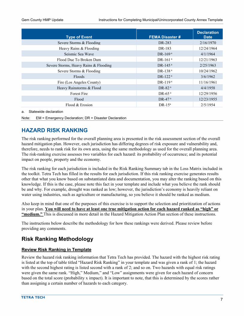
Gem County HMP Update Instructions for Completing Municipal/Unincorporated County Annex Template
7
Type of Event FEMA Disaster # Declaration
Date Severe Storms & Flooding DR-283 2/16/1970 Heavy Rains & Flooding DR-183 12/24/1964
Seismic Sea Wave DR-169 a 4/1/1964 Flood Due To Broken Dam DR-161 a 12/21/1963
Severe Storms, Heavy Rains & Flooding DR-145 a 2/25/1963 Severe Storms & Flooding DR-138 a 10/24/1962
Floods DR-122 a 3/6/1962 Fire (Los Angeles County) DR-119 a 11/16/1961 Heavy Rainstorms & Flood DR-82 a 4/4/1958
Forest Fire DR-65 a 12/29/1956 Flood DR-47 a 12/23/1955
Flood & Erosion DR-15a 2/5/1954
a. Statewide declaration
Note: EM = Emergency Declaration; DR = Disaster Declaration
HAZARD RISK RANKING The risk ranking performed for the overall planning area is presented in the risk assessment section of the overall hazard mitigation plan. However, each jurisdiction has differing degrees of risk exposure and vulnerability and, therefore, needs to rank risk for its own area, using the same methodology as used for the overall planning area. The risk-ranking exercise assesses two variables for each hazard: its probability of occurrence; and its potential impact on people, property and the economy.
The risk ranking for each jurisdiction is included in the Risk Ranking Summary tab in the Loss Matrix included in the toolkit. Tetra Tech has filled in the results for each jurisdiction. If this risk ranking exercise generates results other that what you know based on substantiated data and documentation, you may alter the ranking based on this knowledge. If this is the case, please note this fact in your template and include what you believe the rank should be and why. For example, drought was ranked as low; however, the jurisdiction’s economy is heavily reliant on water using industries, such as agriculture or manufacturing, so you believe it should be ranked as medium.
Also keep in mind that one of the purposes of this exercise is to support the selection and prioritization of actions in your plan. You will need to have at least one true mitigation action for each hazard ranked as “high” or “medium.” This is discussed in more detail in the Hazard Mitigation Action Plan section of these instructions.
The instructions below describe the methodology for how these rankings were derived. Please review before providing any comments.
Risk Ranking Methodology
Review Risk Ranking in Template Review the hazard risk ranking information that Tetra Tech has provided. The hazard with the highest risk rating is listed at the top of table titled “Hazard Risk Ranking” in your template and was given a rank of 1; the hazard with the second highest rating is listed second with a rank of 2; and so on. Two hazards with equal risk ratings were given the same rank. “High,” Medium,” and “Low” assignments were given for each hazard of concern based on the total score (probability x impact). It is important to note, that this is determined by the scores rather than assigning a certain number of hazards to each category.

Gem County HMP Update Instructions for Completing Municipal/Unincorporated County Annex Template
8
When reviewing the risk ranking results, it is important to remember that this exercise is about categorizing hazards into broad levels of risk (e.g. high, medium, low). It is not an exercise in precision.
Review Risk Ranking in Loss Matrix The following sections discuss the methodology used to develop the results included in your template. Please refer to the Loss Matrix provided in your tool kit in order to follow along.
Probability of Occurrence for Each Hazard A probability factor is assigned based on how often a hazard is likely to occur. The probability of occurrence of a hazard event is generally based on past hazard events in an area, although weight can be given to expected future probability of occurrence based on established return intervals and changing climate conditions. For example, if your jurisdiction has experienced two damaging floods in the last 25 years, the probability of occurrence is high for flooding and scores a 3 under this category. If your jurisdiction has experienced no damage from landslides in the last 100 years, your probability of occurrence for landslide is low, and scores a 1 under this category. Each hazard was assigned a probability factor as follows:
• High—Hazard event is likely to occur within 25 years (Probability Factor = 3) • Medium—Hazard event is likely to occur within 100 years (Probability Factor = 2) • Low—Hazard event is not likely to occur within 100 years (Probability Factor = 1) • None—If there is no exposure to a hazard, there is no probability of occurrence (Probability Factor = 0)
Potential Impacts of Each Hazard The impact of each hazard is divided into three categories: impacts on people, impacts on property, and impacts on the economy. These categories are also assigned weighted values. Impact on people was assigned a weighting factor of 3, impact on property was assigned a weighting factor of 2 and impact on the economy was assigned a weighting factor of 1.
Impact factors for each category (people, property, economy) are described below:
• People—Values are assigned based on the percentage of the total population exposed to the hazard event. The degree of impact on individuals will vary and is not measurable, so the calculation assumes for simplicity and consistency that all people exposed to a hazard because they live in a hazard zone will be equally impacted when a hazard event occurs. Impact factors were assigned as follows:
High—25 percent or more of the population is exposed to a hazard (Impact Factor = 3) Medium—10 percent to 24 percent of the population is exposed to a hazard (Impact Factor = 2) Low—9 percent or less of the population is exposed to the hazard (Impact Factor = 1) No impact—None of the population is exposed to a hazard (Impact Factor = 0)
• Property—Values are assigned based on the percentage of the total property value exposed to the hazard event:
High—25 percent or more of the total replacement value is exposed to a hazard (Impact Factor = 3) Medium—10 percent to 24 percent of the total replacement value is exposed to a hazard (Impact
Factor = 2) Low—9 percent or less of the total replacement value is exposed to the hazard (Impact Factor = 1) No impact—None of the total replacement value is exposed to a hazard (Impact Factor = 0)
• Economy—Values were assigned based on the percentage of the total property value vulnerable to the hazard event. Values represent estimates of the loss from a major event of each hazard in comparison to

Gem County HMP Update Instructions for Completing Municipal/Unincorporated County Annex Template
9
the total replacement value of the property exposed to the hazard. For some hazards, such as wildland fire and landslide, vulnerability may be considered to be the same or a portion of exposure due to the lack of loss estimation tools specific to those hazards.
High—Estimated loss from the hazard is 10 percent or more of the total replacement value (Impact Factor = 3)
Medium—Estimated loss from the hazard is 5 percent to 9 percent of the total replacement value (Impact Factor = 2)
Low—Estimated loss from the hazard is 4 percent or less of the total replacement value (Impact Factor = 1)
No impact—No loss is estimated from the hazard (Impact Factor = 0).
Impacts on People The percent of the total population exposed to each hazard of concern with a defined extent and location (e.g. floodplain) can be found in the loss estimate matrix in the green highlighted column. For those hazards that do not have a defined extent and location the entire population or a portion of the population is considered to be exposed, depending on the hazard. For the drought hazard, it is common for jurisdictions to list “low” or “none,” because all people in the planning area would be exposed to drought, but impacts to the health and safety of individuals are expected to be minimal.
Impacts on Property The percent of the total value exposed to each hazard of concern with a defined extent and location (e.g. floodplain) can be found in the loss estimate matrix in the blue highlighted column. For those hazards that do not have a defined extent and location (e.g. severe weather) the entire building stock is generally considered to be exposed. For the drought hazard, it is common for jurisdictions to list “low” or “none,” because all structures in the planning area would be exposed to drought, but impacts to structures are expected to be minimal.
Impacts on the Economy The loss estimates for each hazard of concern that was modeled (i.e. dam failure, flood, earthquake) can be found in the loss estimate matrix in the purple highlighted column. For those hazards that have a defined extent and location, but do not have modelled loss results, loss estimates can be the same as exposure or a portion thereof. For example, a large percentage of the building stock may be exposed to landslide or wildland fire risk, but it would not be expected that one event that resulted in loss to all exposed structures would occur. For those hazards that do not have a defined extent and location, exposure is based on the hazard type.
Risk Rating for Each Hazard A risk rating for each hazard was determined by multiplying the assigned probability factor by the sum of the weighted impact factors for people, property and the economy:
Risk Rating = Probability Factor x Weighted Impact Factor {people + property + economy} This is the number that is shown in the risk ranking table in your template. Generally, score of 30 or greater receive a “high” rating, score between 15 and 30 receive a “medium” rating, and score of less than 15 receives a “low” rating.

Gem County HMP Update Instructions for Completing Municipal/Unincorporated County Annex Template
10
JURISDICTION-SPECIFIC VULNERABILITIES
Repetitive Loss Properties A repetitive loss property is any property for which FEMA has paid two or more flood insurance claims in excess of $1,000 in any rolling 10-year period since 1978. In the space provided, Tetra Tech has inserted the following information based on data provided by FEMA:
• The number of any FEMA-identified repetitive-loss properties in your jurisdiction. • The number of any FEMA-identified severe-repetitive-loss properties in your jurisdiction. • The number (if any) of repetitive-loss or severe-repetitive-loss properties in your jurisdiction that have
been mitigated. Mitigated for this exercise means that flood protection has been provided to the structure. Please note that if your jurisdiction has any repetitive loss properties, we would strongly encourage you to include a mitigation action that addresses mitigating these properties.
Other Vulnerabilities We would strongly encourage you to review the results of the risk assessment included in the tool kit, your jurisdiction’s natural events history, and any relevant public comments/input and develop a few sentences that discuss specific risks. You do not need to develop a sentence for every single parameter, but review the results and identify a few issues you would like to highlight. For example:
• Only about 2 percent of the jurisdiction’s population is estimated to reside in the 1 percent annual chance flood hazard area; however, 45 percent of the population is estimated to reside in the 0.2 percent annual chance flood hazard area where flood insurance is generally not required.
• A magnitude 7.5 earthquake on the Smithburg Fault may produce nearly 1 million tons of structure debris.
• Over the past 10 years, the jurisdiction has experienced more than $6 million in estimated damages from severe storm events.
• More than 50 buildings are located in areas that will be permanently inundated with 12 inches of sea level rise.
• The results of the public survey indicated that 40 percent of Smithburg residents would not be able to be self-sufficient for 5 days following a major event.
In addition, please list any noted vulnerabilities in your jurisdiction related to hazard mitigation that may not be apparent from the risk assessment and other information provided. This may include things such as the following:
• An urban drainage issue that results in localized flooding every time it rains. • An area of the community that frequently loses power due to a lack of tree maintenance. • A critical facility, such as a police station, that is not equipped with a generator. • A neighborhood that has the potential to have ingress and egress cut off as the result of a hazard event,
such as a flood or earthquake (e.g. bridge only access). • Substantial number of buildings in one area of the community are unreinforced masonry or soft-story
construction. • An area along the river is eroding and threatening public and/or private property. • A large visitor population that may not be aware of tsunami risk.
Spending some time thinking about the results of the risk assessment and other noted vulnerabilities will be a big help in the development of your mitigation strategy. Tetra Tech has inserted a few items in this section to get you started. In addition, two examples are shown in the table below.

Gem County HMP Update Instructions for Completing Municipal/Unincorporated County Annex Template
11
Noted Vulnerability Example Mitigation Action Only about 2 percent of the jurisdiction’s population is estimated to reside in the 1 percent annual chance flood hazard area; however, 45 percent of the population is estimated to reside in the 0.2 percent annual chance flood hazard area where flood insurance is generally not required.
Develop and implement an annual public information initiative that targets residents in the 0.2 percent annual chance flood hazard area. Provide information on the availability of relatively low cost flood insurance policies.
An urban drainage issue that results in localized flooding every time it rains.
Replace undersized culverts that are contributing to localized flooding. Priority areas include: • The corner of Main Street and 1st Street • Old Oak subdivision.
STATUS OF PREVIOUS PLAN ACTIONS Please note that this section only applies to jurisdictions that are conducting updates to previously approved hazard mitigation plans. If your jurisdiction has not previously participated in an approved plan, this section will not appear in your annex template. Also, please note that a handout with this information was distributed at the February Steering Committee meeting so work may have already begun on this portion of phase 3.
All action items identified in prior mitigation planning efforts must be reconciled in this plan update. Action items must all be marked as ONE of the following; check the appropriate box (place an X) and provide the following information:
• Completed—If an action was completed during the performance period of the prior plan, please check the appropriate box and provide a date of completion in the comment section. If an action has been initiated and is an ongoing program (e.g. annual outreach event), you may mark it as completed and note that it is ongoing in the comments. When removing such actions from your action plan, please consider including them in the existing integration section above. If you have an action that addresses an ongoing program you would like to continue to include it in your action plan, please see the Carried Over to Plan Update section below.
• Removed—If action items are to be removed because they are no longer feasible, a reason must be given. Lack of funding does not mean that it is no longer feasible, unless the sole source of funding for an action is no longer available. Place a comment in the comment section explaining why the action is no longer feasible or barriers that prevented the action from being implemented (e.g., “Action no longer considered feasible due to lack of political support.”). If the wording and/or intent of a previously identified action is unclear, this can be a reason for removal. A change in community priorities may also be a reason for removal and should be discussed in the comments.
• Carried Over to Plan Update—If an action is in progress, ongoing or has not been initiated and you would like to carry it over to the plan update, please check the “Check if Yes” column under “Carried Over to Plan Update.” Selecting this option indicates that the action will be included in the mitigation action plan for the 2018 plan. If you are carrying over an action to the plan update, please include a comment describing any action that has been taken or why action was not taken (specifically, any barriers or obstacles that prevented the action from moving forward or slowed progress) The last column “Enter Action #” will be addressed when you develop your actions plan in the following sections. You will need to revisit it after completing the updated action plan in phase 3.
Please ensure that you have provided a status and a comment for each action.
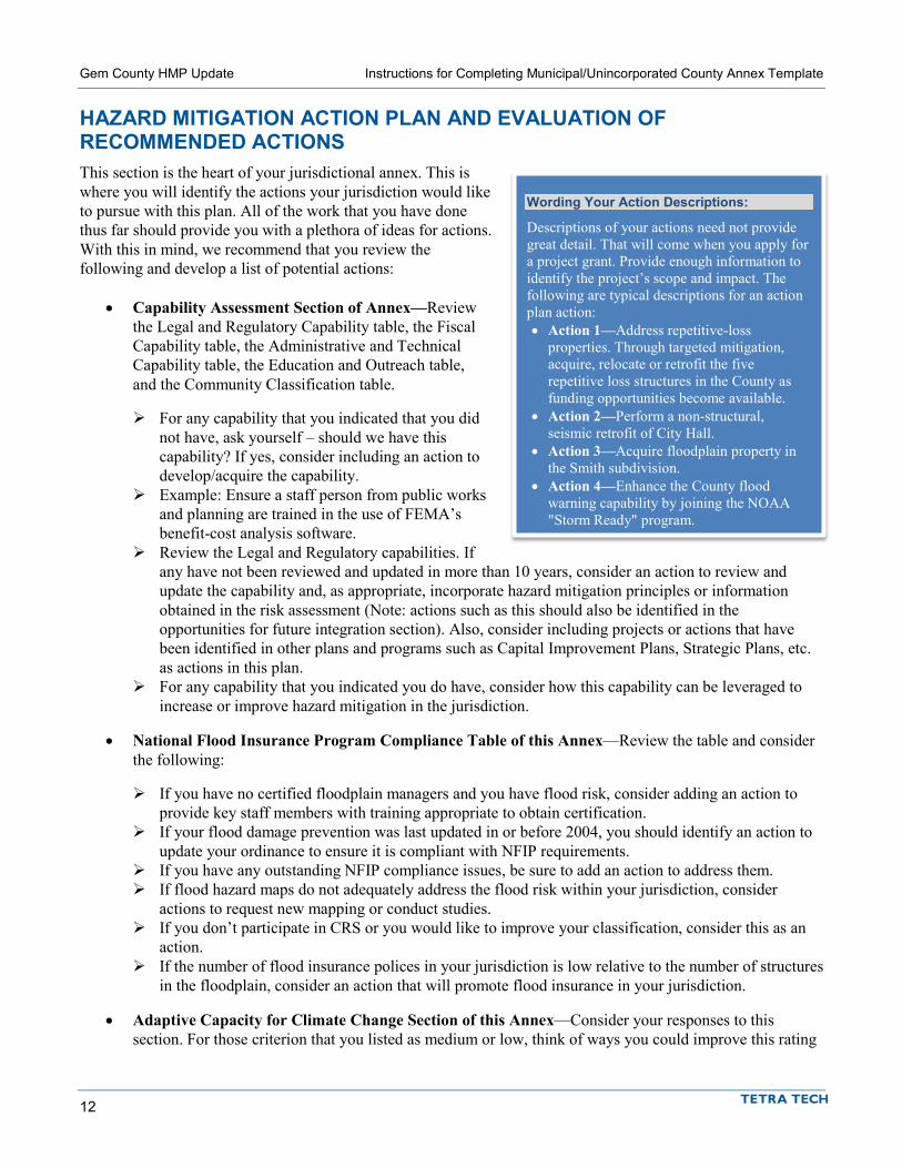
Gem County HMP Update Instructions for Completing Municipal/Unincorporated County Annex Template
12
HAZARD MITIGATION ACTION PLAN AND EVALUATION OF RECOMMENDED ACTIONS This section is the heart of your jurisdictional annex. This is where you will identify the actions your jurisdiction would like to pursue with this plan. All of the work that you have done thus far should provide you with a plethora of ideas for actions. With this in mind, we recommend that you review the following and develop a list of potential actions:
• Capability Assessment Section of Annex—Review the Legal and Regulatory Capability table, the Fiscal Capability table, the Administrative and Technical Capability table, the Education and Outreach table, and the Community Classification table.
For any capability that you indicated that you did not have, ask yourself – should we have this capability? If yes, consider including an action to develop/acquire the capability.
Example: Ensure a staff person from public works and planning are trained in the use of FEMA’s benefit-cost analysis software.
Review the Legal and Regulatory capabilities. If any have not been reviewed and updated in more than 10 years, consider an action to review and update the capability and, as appropriate, incorporate hazard mitigation principles or information obtained in the risk assessment (Note: actions such as this should also be identified in the opportunities for future integration section). Also, consider including projects or actions that have been identified in other plans and programs such as Capital Improvement Plans, Strategic Plans, etc. as actions in this plan.
For any capability that you indicated you do have, consider how this capability can be leveraged to increase or improve hazard mitigation in the jurisdiction.
• National Flood Insurance Program Compliance Table of this Annex—Review the table and consider the following:
If you have no certified floodplain managers and you have flood risk, consider adding an action to provide key staff members with training appropriate to obtain certification.
If your flood damage prevention was last updated in or before 2004, you should identify an action to update your ordinance to ensure it is compliant with NFIP requirements.
If you have any outstanding NFIP compliance issues, be sure to add an action to address them. If flood hazard maps do not adequately address the flood risk within your jurisdiction, consider
actions to request new mapping or conduct studies. If you don’t participate in CRS or you would like to improve your classification, consider this as an
action. If the number of flood insurance polices in your jurisdiction is low relative to the number of structures
in the floodplain, consider an action that will promote flood insurance in your jurisdiction.
• Adaptive Capacity for Climate Change Section of this Annex—Consider your responses to this section. For those criterion that you listed as medium or low, think of ways you could improve this rating
Wording Your Action Descriptions:
Descriptions of your actions need not provide great detail. That will come when you apply for a project grant. Provide enough information to identify the project’s scope and impact. The following are typical descriptions for an action plan action: • Action 1—Address repetitive-loss
properties. Through targeted mitigation, acquire, relocate or retrofit the five repetitive loss structures in the County as funding opportunities become available.
• Action 2—Perform a non-structural, seismic retrofit of City Hall.
• Action 3—Acquire floodplain property in the Smith subdivision.
• Action 4—Enhance the County flood warning capability by joining the NOAA "Storm Ready" program.

Gem County HMP Update Instructions for Completing Municipal/Unincorporated County Annex Template
13
(see adaptive capacity portion of the mitigation best practices catalog). For those criterion you listed as high, think about how you can leverage this capacity to improve or enhance mitigation or continue to improve this capacity. For those criterion that you were unable to provide responses for, consider ways you could improve your understanding of this capacity (see mitigation best practices and adaptive capacity catalog).
• Opportunities for Future Integration Section in this Annex—Review the items you identified in this section. For those items that address land use include them in the prepopulated Action in your template that reads as follows: Integrate the hazard mitigation plan into other plans, ordinances and programs that dictate land use decisions in the community, including ______________. For other items listed in this section, consider an action that specifically says what the plan, code, ordinance etc. is and how it will be integrated.
• Jurisdiction-Specific Vulnerabilities Section in this Annex—Review the items that you have identified in this section and consider actions that will help reduce these vulnerabilities (see mitigation best practices catalog).
• Mitigation Best Practices Catalog—A catalog that includes FEMA and other agency identified best practices, steering committee and other stakeholder recommendations was developed as part of the plan development process and included in your tool kit. Review the catalog and identify those actions that your jurisdiction should consider including in its action plan.
• Public Input—Review input received during the process, specifically the public survey results included in your toolkit.
• Prior Mitigation Planning Efforts—If your jurisdiction participated in a previous hazard mitigation plan, please be sure to remember to include any actions that were identified as “carry over” actions. Once you have carried them over, return to the Status of Previous Actions table and record the new action number (see discussion below).
Be sure to consider the following factors in your selection of actions:
• Select actions that are consistent with the overall purpose, goals, and objectives of the hazard mitigation plan.
• Identify actions where benefits exceed costs. • Include any action that your jurisdiction has committed to pursuing regardless of grant eligibility. • Know what is and is not grant-eligible under the Hazard Mitigation Grant Program (HMGP), Pre-Disaster
Mitigation (PDM) and Flood Mitigation Assistance (FMA) grants (see fact sheet provided in toolkit). If you have actions that are not HMGP, PDM or FMA grant eligible, but do mitigate part or all of the hazard and may be eligible for other grant programs sponsored by other agencies, include them in this section.
• You must identify at least one true mitigation action (i.e. not a preparedness or response action) that is clearly defined and actionable for hazards ranked as “high” or “medium.”
Recommended Actions We recommend that every planning partner strongly consider the following actions. The specifics of these actions should be adjusted as needed for the particulars of each community. You will note that six of these actions have been prepopulated in your annex template. These six actions should be included in every annex and should not be removed.
• Where appropriate, support retro-fitting, purchase or relocation of structures located in high hazard areas, prioritizing those structures that have experienced repetitive losses and/or are located in high or medium ranked hazard.
• Integrate the hazard mitigation plan into other plans, ordinances and programs that dictate land use decisions within the community.
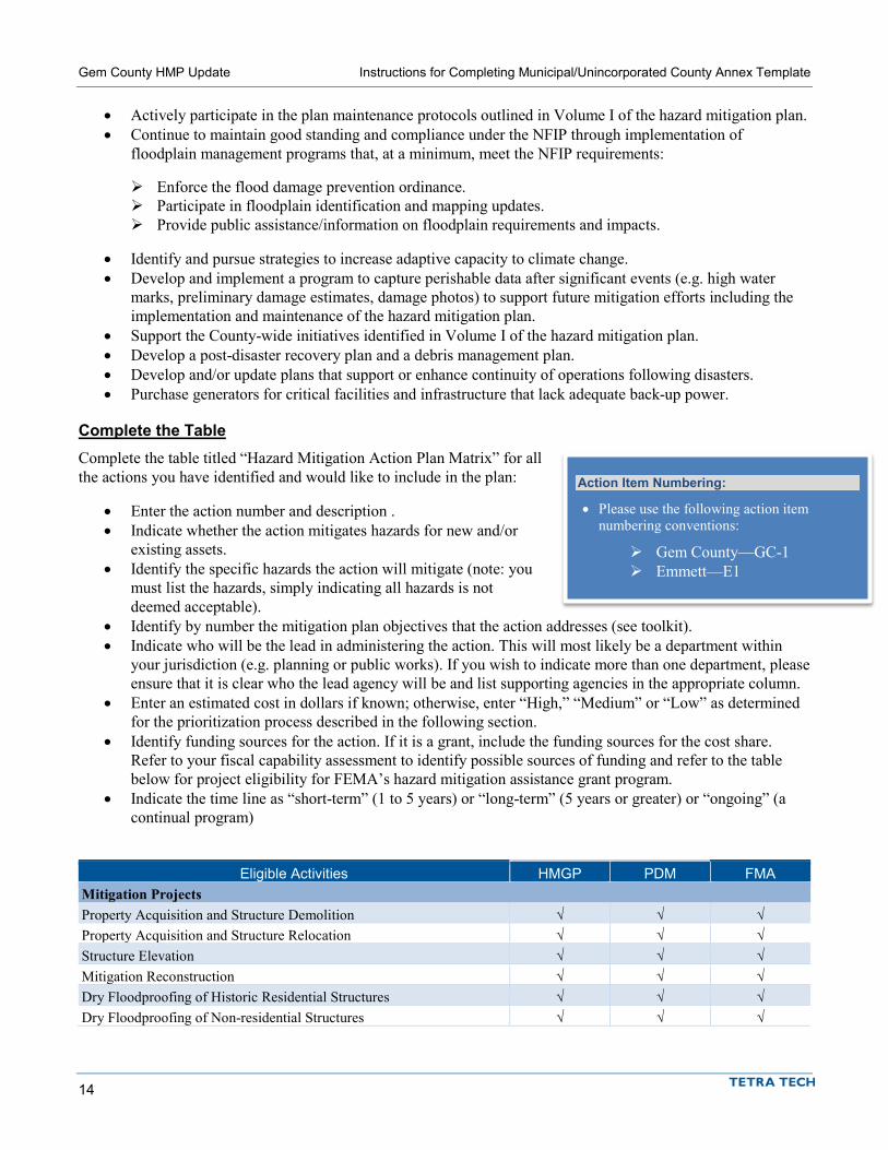
Gem County HMP Update Instructions for Completing Municipal/Unincorporated County Annex Template
14
• Actively participate in the plan maintenance protocols outlined in Volume I of the hazard mitigation plan. • Continue to maintain good standing and compliance under the NFIP through implementation of
floodplain management programs that, at a minimum, meet the NFIP requirements:
Enforce the flood damage prevention ordinance. Participate in floodplain identification and mapping updates. Provide public assistance/information on floodplain requirements and impacts.
• Identify and pursue strategies to increase adaptive capacity to climate change. • Develop and implement a program to capture perishable data after significant events (e.g. high water
marks, preliminary damage estimates, damage photos) to support future mitigation efforts including the implementation and maintenance of the hazard mitigation plan.
• Support the County-wide initiatives identified in Volume I of the hazard mitigation plan. • Develop a post-disaster recovery plan and a debris management plan. • Develop and/or update plans that support or enhance continuity of operations following disasters. • Purchase generators for critical facilities and infrastructure that lack adequate back-up power.
Complete the Table Complete the table titled “Hazard Mitigation Action Plan Matrix” for all the actions you have identified and would like to include in the plan:
• Enter the action number and description . • Indicate whether the action mitigates hazards for new and/or
existing assets. • Identify the specific hazards the action will mitigate (note: you
must list the hazards, simply indicating all hazards is not deemed acceptable).
• Identify by number the mitigation plan objectives that the action addresses (see toolkit). • Indicate who will be the lead in administering the action. This will most likely be a department within
your jurisdiction (e.g. planning or public works). If you wish to indicate more than one department, please ensure that it is clear who the lead agency will be and list supporting agencies in the appropriate column.
• Enter an estimated cost in dollars if known; otherwise, enter “High,” “Medium” or “Low” as determined for the prioritization process described in the following section.
• Identify funding sources for the action. If it is a grant, include the funding sources for the cost share. Refer to your fiscal capability assessment to identify possible sources of funding and refer to the table below for project eligibility for FEMA’s hazard mitigation assistance grant program.
• Indicate the time line as “short-term” (1 to 5 years) or “long-term” (5 years or greater) or “ongoing” (a continual program)
Eligible Activities HMGP PDM FMA Mitigation Projects Property Acquisition and Structure Demolition √ √ √ Property Acquisition and Structure Relocation √ √ √ Structure Elevation √ √ √ Mitigation Reconstruction √ √ √ Dry Floodproofing of Historic Residential Structures √ √ √ Dry Floodproofing of Non-residential Structures √ √ √
Action Item Numbering:
• Please use the following action item numbering conventions:
Gem County—GC-1 Emmett—E1

Gem County HMP Update Instructions for Completing Municipal/Unincorporated County Annex Template
15
Generators √ √ Localized Flood Risk Reduction Projects √ √ √ Non-Localized Flood Risk Reduction Projects √ √ Structural Retrofitting of Existing Buildings √ √ √ Non-structural Retrofitting of Existing Buildings and Facilities √ √ √ Safe Room Construction √ √ Wind Retrofit for One- and Two-Family Residences √ √ Infrastructure Retrofit √ √ √ Soil Stabilization √ √ √ Wildland fire Mitigation √ √ Post-Disaster Code Enforcement √ Advance Assistance √ 5 Percent Initiative Projects* √ Aquifer and Storage Recovery** √ √ √ Flood Diversion and Storage** √ √ √ Floodplain and Stream Restoration** √ √ √ Green Infrastructure** √ √ √ Miscellaneous/Other** √ √ √ Hazard Mitigation Planning √ √ √ Technical Assistance √ Management Costs √ √ √
Notes: HMGP = Hazard Mitigation Grant Program; PDM = Pre-Disaster Mitigation; FMA = Flood Mitigation Assistance
* FEMA allows increasing the 5% Initiative amount up to 10% for a Presidential major disaster declaration under HMGP. The additional 5% Initiative funding can be used for activities that promote disaster-resistant codes for all hazards. As a condition of the award, either a disaster-resistant building code must be adopted or an improved Building Code Effectiveness Grading Schedule is required.
**Indicates that any proposed action will be evaluated on its own merit against program requirements. Eligible projects will be approved provided funding is available.
Source: https://www.fema.gov/hazard-mitigation-assistance-mitigation-activity-chart
Please see the table below for examples of some of the recommended actions above:
Example Action Plan Matrix Applies
to new or existing assets
Hazards Mitigated
Objectives Met Lead Agency
Support Agency
Estimated Cost
Sources of Funding Timeline
EX-1—Where appropriate, support retro-fitting, purchase or relocation of structures located in high hazard areas, prioritizing those structures that have experienced repetitive losses and/or are located in high or medium ranked hazard areas.
Existing Dam failure, Earthquake, Flooding,
Landslide, Severe weather, Wildland
fire
3, 4, 10 Planning High HMGP, PDM, FMA
Short-term
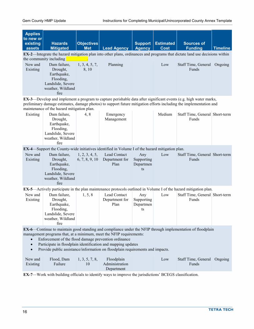
Gem County HMP Update Instructions for Completing Municipal/Unincorporated County Annex Template
16
Applies to new or existing assets
Hazards Mitigated
Objectives Met Lead Agency
Support Agency
Estimated Cost
Sources of Funding Timeline
EX-2—Integrate the hazard mitigation plan into other plans, ordinances and programs that dictate land use decisions within the community including __________. New and Existing
Dam failure, Drought,
Earthquake, Flooding,
Landslide, Severe weather, Wildland
fire
1, 3, 4, 5, 7, 8, 10
Planning Low Staff Time, General Funds
Ongoing
EX-3—Develop and implement a program to capture perishable data after significant events (e.g. high water marks, preliminary damage estimates, damage photos) to support future mitigation efforts including the implementation and maintenance of the hazard mitigation plan.
Existing Dam failure, Drought,
Earthquake, Flooding,
Landslide, Severe weather, Wildland
fire
4, 8 Emergency Management
Medium Staff Time, General Funds
Short-term
EX-4—Support the County-wide initiatives identified in Volume I of the hazard mitigation plan. New and Existing
Dam failure, Drought,
Earthquake, Flooding,
Landslide, Severe weather, Wildland
fire
1, 2, 3, 4, 5, 6, 7, 8, 9, 10
Lead Contact Department for
Plan
Any Supporting Departmen
ts
Low Staff Time, General Funds
Short-term
EX-5—Actively participate in the plan maintenance protocols outlined in Volume I of the hazard mitigation plan. New and Existing
Dam failure, Drought,
Earthquake, Flooding,
Landslide, Severe weather, Wildland
fire
1, 5, 8 Lead Contact Department for
Plan
Any Supporting Departmen
ts
Low Staff Time, General Funds
Short-term
EX-6—Continue to maintain good standing and compliance under the NFIP through implementation of floodplain management programs that, at a minimum, meet the NFIP requirements:
• Enforcement of the flood damage prevention ordinance • Participate in floodplain identification and mapping updates • Provide public assistance/information on floodplain requirements and impacts.
New and Existing
Flood, Dam Failure
1, 3, 5, 7, 8, 10
Floodplain Administration
Department
Low Staff Time, General Funds
Ongoing
EX-7—Work with building officials to identify ways to improve the jurisdictions’ BCEGS classification.
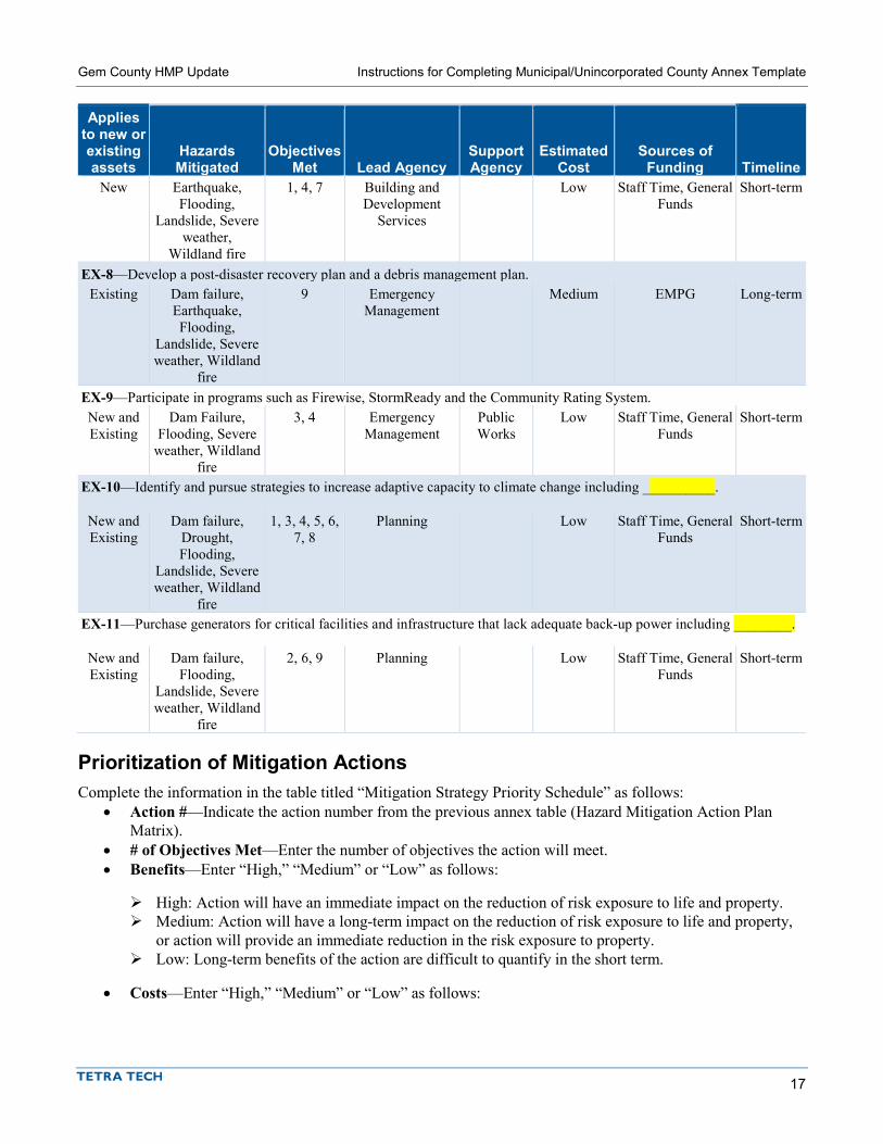
Gem County HMP Update Instructions for Completing Municipal/Unincorporated County Annex Template
17
Applies to new or existing assets
Hazards Mitigated
Objectives Met Lead Agency
Support Agency
Estimated Cost
Sources of Funding Timeline
New Earthquake, Flooding,
Landslide, Severe weather,
Wildland fire
1, 4, 7 Building and Development
Services
Low Staff Time, General Funds
Short-term
EX-8—Develop a post-disaster recovery plan and a debris management plan. Existing Dam failure,
Earthquake, Flooding,
Landslide, Severe weather, Wildland
fire
9 Emergency Management
Medium EMPG Long-term
EX-9—Participate in programs such as Firewise, StormReady and the Community Rating System. New and Existing
Dam Failure, Flooding, Severe
weather, Wildland fire
3, 4 Emergency Management
Public Works
Low Staff Time, General Funds
Short-term
EX-10—Identify and pursue strategies to increase adaptive capacity to climate change including __________.
New and Existing
Dam failure, Drought, Flooding,
Landslide, Severe weather, Wildland
fire
1, 3, 4, 5, 6, 7, 8
Planning Low Staff Time, General Funds
Short-term
EX-11—Purchase generators for critical facilities and infrastructure that lack adequate back-up power including ________.
New and Existing
Dam failure, Flooding,
Landslide, Severe weather, Wildland
fire
2, 6, 9 Planning Low Staff Time, General Funds
Short-term
Prioritization of Mitigation Actions Complete the information in the table titled “Mitigation Strategy Priority Schedule” as follows:
• Action #—Indicate the action number from the previous annex table (Hazard Mitigation Action Plan Matrix).
• # of Objectives Met—Enter the number of objectives the action will meet. • Benefits—Enter “High,” “Medium” or “Low” as follows:
High: Action will have an immediate impact on the reduction of risk exposure to life and property. Medium: Action will have a long-term impact on the reduction of risk exposure to life and property,
or action will provide an immediate reduction in the risk exposure to property. Low: Long-term benefits of the action are difficult to quantify in the short term.
• Costs—Enter “High,” “Medium” or “Low” as follows:

Gem County HMP Update Instructions for Completing Municipal/Unincorporated County Annex Template
18
High: Would require an increase in revenue via an alternative source (i.e., bonds, grants, fee increases) to implement. Existing funding levels are not adequate to cover the costs of the proposed action.
Medium: Could budget for under existing work-plan, but would require a reapportionment of the budget or a budget amendment, or the cost of the action would have to be spread over multiple years.
Low: Possible to fund under existing budget. Action is or can be part of an existing ongoing program. If you know the estimated cost of an action because it is part of an existing, ongoing program,
indicate the amount.
• Do Benefits Exceed the Cost?—Enter “Yes” or “No.” This is a qualitative assessment. Enter “Yes” if the benefit rating (high, medium or low) is the same as or higher than the cost rating (high benefit/high cost; high benefit/medium cost; medium benefit/low cost; etc.). Enter “No” if the benefit rating is lower than the cost rating (medium benefit/high cost, low benefit/medium cost; etc.)
• Is the Action Grant-Eligible?—Enter “Yes” or “No.” Refer to the fact sheet on HMGP, PDM and FMA and the table above.
• Can Action Be Funded Under Existing Program Budgets?—Enter “Yes” or “No.” In other words, is this action currently budgeted for, or would it require a new budget authorization or funding from another source such as grants?
• Implementation Priority— Enter “High,” “Medium” or “Low” as follows:
High Priority—An action that meets multiple objectives, has benefits that exceed costs, and has a secured source of funding. Action can be completed in the short term (1 to 5 years).
Medium Priority—An action that meets multiple objectives, has benefits that exceed costs, and is eligible for funding though no funding has yet been secured for it. Action can be completed in the short term (1 to 5 years), once funding is secured. Medium-priority actions become high-priority actions once funding is secured.
Low Priority—An action that will mitigate the risk of a hazard, has benefits that do not exceed the costs or are difficult to quantify, has no secured source of funding, and is not eligible for any known grant funding. Action can be completed in the long term (1 to 10 years). Low-priority actions are generally “wish-list” actions. They may be eligible for grant funding from programs that have not yet been identified.
• Grant Pursuit Priority— Enter “High,” “Medium” or “Low” as follows:
High Priority—An action that meets identified grant eligibility requirements, has high benefits, and is listed as high or medium implementation priority; local funding options are unavailable or available local funds could be used instead for actions that are not eligible for grant funding.
Medium Priority—An action that meets identified grant eligibility requirements, has medium or low benefits, and is listed as medium or low implementation priority; local funding options are unavailable.
Low Priority—An action that has not been identified as meeting any grant eligibility requirements.
This prioritization is a simple way to determine that your identified actions meet one of the primary objectives of the Disaster Mitigation Act. It is not the detailed benefit/cost analysis required for HMGP/PDM /FMA action grants. The prioritization will identify any actions whose probable benefits will not exceed the probable costs. Those actions identified as high-priority grant funding actions should be closely reviewed for consideration when grant funding opportunities arise.
Note: If a jurisdiction wishes to identify an action as high priority that is outside of the prioritization scheme for high priorities. A note indicating so should be inserted and a rationale should be provided.

Gem County HMP Update Instructions for Completing Municipal/Unincorporated County Annex Template
19
Please see the example below based off the recommended actions:
Table 0-9. Mitigation Strategy Priority Schedule
Action #
# of Objectives
Met Benefits Costs
Do Benefits Equal or Exceed Costs?
Is Action Grant-
Eligible?
Can Action Be Funded
Under Existing
Programs/ Budgets?
Implementation Prioritya
Grant Pursuit
Prioritya EX-1 3 High High Yes Yes No Medium High EX-2 7 Medium Low Yes No Yes High Low EX-3 2 Low Medium No No Maybe Low Low EX-4 10 Low Low Yes No Yes High Low EX-5 3 Low Low Yes No Yes High Low EX-6 6 Medium Low Yes No Yes High Low EX-7 3 Medium Low Yes No Yes High Low EX-8 1 Medium Medium Yes Yes No Medium High EX-9 2 Medium Low Yes No Yes High Low
EX-10 7 Medium Low Yes No Yes High Medium EX-11 3 High Medium Yes Yes No Medium High
Analysis of Mitigation Actions Complete the table titled “Analysis of Mitigation Actions” summarizing the mitigation actions by hazard of concern and the following eight mitigation types. Please note that an action can be more than one mitigation type:
• Prevention—Government, administrative or regulatory actions that influence the way land and buildings are developed to reduce hazard losses. Includes planning and zoning, floodplain laws, capital improvement programs, open space preservation, and stormwater management regulations.
• Property Protection—Modification of buildings or structures to protect them from a hazard or removal of structures from a hazard area. Includes acquisition, elevation, relocation, structural retrofit, storm shutters, and shatter-resistant glass.
• Public Education and Awareness—Actions to inform residents and elected officials about hazards and ways to mitigate them. Includes outreach projects, real estate disclosure, hazard information centers, and school-age and adult education.
• Natural Resource Protection—Actions that minimize hazard loss and preserve or restore the functions of natural systems. Includes sediment and erosion control, stream corridor restoration, watershed management, forest and vegetation management, wetland restoration and preservation, and green infrastructure.
• Emergency Services—Actions that protect people and property during and immediately after a hazard event. Includes warning systems, emergency response services, and the protection of essential facilities.
• Structural Projects—Actions that involve the construction of structures to reduce the impact of a hazard. Includes dams, setback levees, floodwalls, retaining walls, and safe rooms.
This exercise demonstrates that the jurisdiction has selected a comprehensive range of actions.
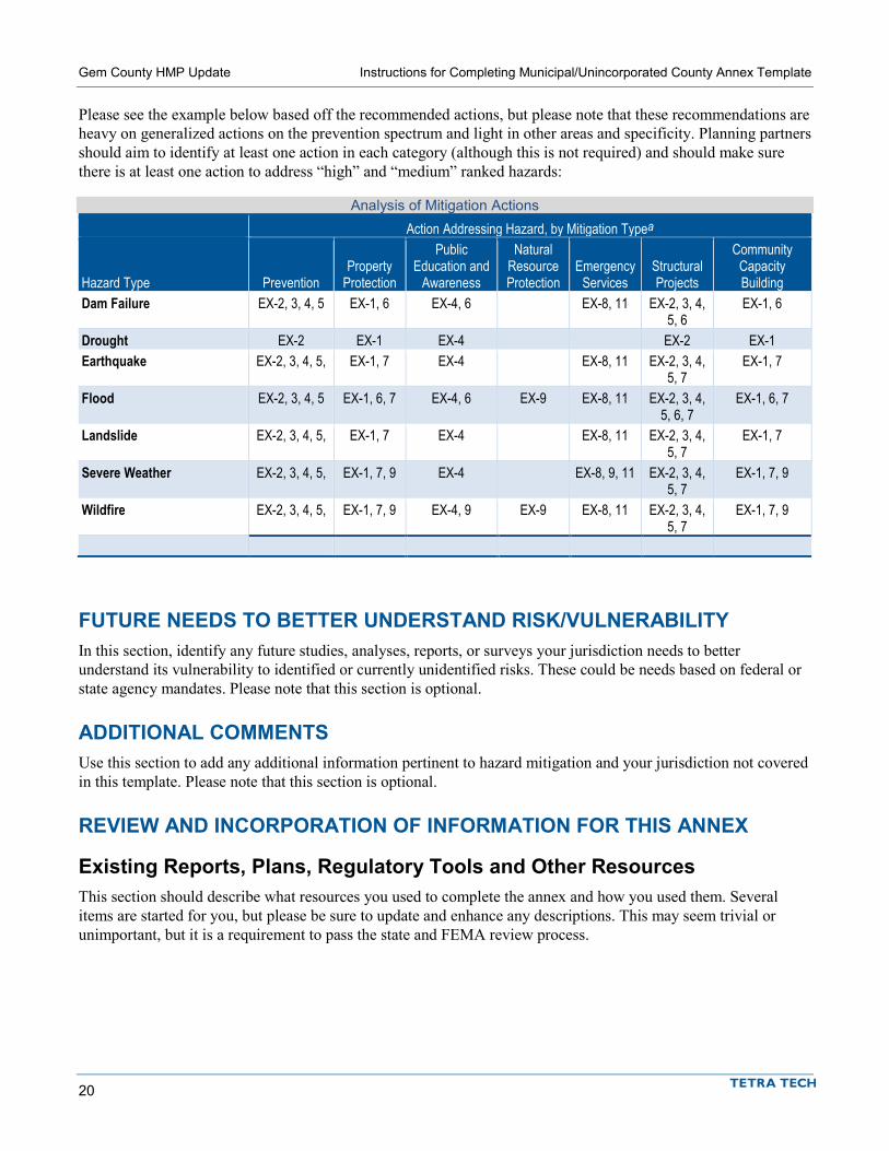
Gem County HMP Update Instructions for Completing Municipal/Unincorporated County Annex Template
20
Please see the example below based off the recommended actions, but please note that these recommendations are heavy on generalized actions on the prevention spectrum and light in other areas and specificity. Planning partners should aim to identify at least one action in each category (although this is not required) and should make sure there is at least one action to address “high” and “medium” ranked hazards:
Analysis of Mitigation Actions Action Addressing Hazard, by Mitigation Typea
Hazard Type Prevention Property
Protection
Public Education and
Awareness
Natural Resource Protection
Emergency Services
Structural Projects
Community Capacity Building
Dam Failure EX-2, 3, 4, 5 EX-1, 6 EX-4, 6 EX-8, 11 EX-2, 3, 4, 5, 6
EX-1, 6
Drought EX-2 EX-1 EX-4 EX-2 EX-1 Earthquake EX-2, 3, 4, 5, EX-1, 7 EX-4 EX-8, 11 EX-2, 3, 4,
5, 7 EX-1, 7
Flood EX-2, 3, 4, 5 EX-1, 6, 7 EX-4, 6 EX-9 EX-8, 11 EX-2, 3, 4, 5, 6, 7
EX-1, 6, 7
Landslide EX-2, 3, 4, 5, EX-1, 7 EX-4 EX-8, 11 EX-2, 3, 4, 5, 7
EX-1, 7
Severe Weather EX-2, 3, 4, 5, EX-1, 7, 9 EX-4 EX-8, 9, 11 EX-2, 3, 4, 5, 7
EX-1, 7, 9
Wildfire EX-2, 3, 4, 5, EX-1, 7, 9 EX-4, 9 EX-9 EX-8, 11 EX-2, 3, 4, 5, 7
EX-1, 7, 9
FUTURE NEEDS TO BETTER UNDERSTAND RISK/VULNERABILITY In this section, identify any future studies, analyses, reports, or surveys your jurisdiction needs to better understand its vulnerability to identified or currently unidentified risks. These could be needs based on federal or state agency mandates. Please note that this section is optional.
ADDITIONAL COMMENTS Use this section to add any additional information pertinent to hazard mitigation and your jurisdiction not covered in this template. Please note that this section is optional.
REVIEW AND INCORPORATION OF INFORMATION FOR THIS ANNEX
Existing Reports, Plans, Regulatory Tools and Other Resources This section should describe what resources you used to complete the annex and how you used them. Several items are started for you, but please be sure to update and enhance any descriptions. This may seem trivial or unimportant, but it is a requirement to pass the state and FEMA review process.

Gem County HMP Update Instructions for Completing Municipal/Unincorporated County Annex Template
21
Staff and Local Stakeholder Involvement in Annex Development This section should describe in general terms the process by which the annex was developed. Please include general discussion with a focus on who was involved and how the action plan was developed. An example is included below.
This annex was developed over the course of several months with input from many city departments including public works, public safety, planning, budget and finance, and parks and recreation. All departments were asked to contribute to the annex development through reviewing and contributing to the capability assessment, reporting on the status of previously identified actions, and participating in action identification and prioritization. A action development meeting was held on February 20, 2018 and was attended by representatives from all previously listed department as well as the City Manager’s office. Once actions had been identified and compiled in the annex, a draft was internally circulated for comment.
NEXT STEPS After all jurisdictions have submitted their annexes, the draft plan will be submitted for public comment. Following the public comment period and any revisions responsive to public comment, the plan will be submitted to the Idaho Office of Emergency Management (IOEM) for review. After their review and approval, IOEM will submit the plan to FEMA Region X for plan review and approval. At that point planning partners will be asked to begin making preparations to formally adopt the plan. Each participating planning partner must have the governing board of their jurisdiction adopt via resolution or ordinance. Once FEMA has reviewed the plan and issued an approved pending adoption (APA) notice, planning partners will be asked to go forth and adopt the plan. Once adopted, planning partners will submit adoption information to Tetra Tech, who will submit the proof of adoption to FEMA. Once such adoption has been received, FEMA will issue final approval via a letter for those planning partners who have adopted the plan. It is very important to understand that approval is not final until proof of adoption has been received by FEMA and they have issued a letter specifically naming your jurisdiction. More information on the review and approval process, along with adoption support materials, will be provided at a later date.
INSTRUCTIONS FOR DISTRICT ANNEX COMPLETION


1
INSTRUCTIONS FOR COMPLETING SPECIAL PURPOSE DISTRICT ANNEX TEMPLATE
The jurisdictional annex templates for the 2018 Del Norte County Hazard Mitigation Plan update will be completed in three phases. This document provides instructions for completing the all phases of the template for special purpose districts.
If your jurisdiction completed and submitted Phase 1 and/or Phase 2, Phase 3 has been added to the end of your document. Any planning team comments, questions or suggestions have been included as blue highlighted notes and/or comments. Any text edits were made with changes tracked for review. Any yellow highlights indicate areas where missing information should be filled in. If your jurisdiction did not complete Phase 1 or Phase 2, please complete all phases at this time.
The target timeline for phase completion is as follows:
• Phase 1 – Jurisdictional profile - Deployed: Mid-March, 2018 - Due: April 20, 2018
• Phase 2 – Capability assessment - Deployed: Mid-April, 2018 - Due: May 18, 2018
• Phase 3 – Risk ranking and action plan development - Deployed: July 6, 2018 - Due: Monday, August 20, 2018
Any questions on completing the template should be directed to:
Rob Flaner Tetra Tech, Inc. (208) 939-4391 or (208) 830-3844 E-mail: [email protected]
Special Purpose District Annex:
This document provides instructions for completing all Phases of the jurisdictional annex template for special purpose districts. Templates should be
completed by August 20, 2018. Your completed template should be submitted to:
Rob Flaner Tetra Tech, Inc.
(208) 939-4391 or (208) 830-3844 E-mail: [email protected]
A Note About Formatting:
The template for the annex is a Microsoft Word document in a format that will be used in the final plan. Partners are asked to use this template so that a uniform product will be completed for each partner.
Content should be entered within the yellow, highlighted text that is currently in the template, rather than creating text in another document and pasting it into the template. Text from another source will alter the style and formatting of the document.
The numbering in the document will be updated when completed annexes are combined into the final document. Please do not adjust any of this numbering.

Gem County HMP Update Instructions for Completing Special Purpose District Annex Template
2
Phase 1 Instructions
CHAPTER TITLE In the chapter title at the top of Page 1, type in the complete official name of your district (e.g. West County Fire Protection District #1, Johnsonville Flood Protection District, etc.). Please do not change the chapter number. Revise only the jurisdiction name.
HAZARD MITIGATION PLAN POINT OF CONTACT Please provide the name, title, mailing address, telephone number, and e-mail address for the primary point of contact for your jurisdiction. This should be the person responsible for monitoring, evaluating and updating the annex for your jurisdiction. This person should also be the principle liaison between your jurisdiction and the Steering Committee overseeing development of this plan.
In addition, designate an alternate point of contact. This would be a person to contact should the primary point of contact be unavailable or no longer employed by the jurisdiction.
Note: Both of these contacts should match the contacts that were designated in your jurisdiction’s letter of intent to participate in this planning process. If you have changed the primary or secondary contact, please let the planning team know by inserting a comment into the document.
JURISDICTION PROFILE
Overview Please provide a brief summary description of your jurisdiction. Please be sure to include:
• the purpose of the jurisdiction, • the date of inception, • the type of organization, • the number of employees, • the mode of operation (i.e., how operations
are funded), • a description of who the district’s customers
are, • an overview of current service area trends,
including an approximation of current users/subscribers,
• a summary description of previous growth trends in service area, and anticipated future increase/decrease in services (if applicable),
• an approximation of area served in square miles, • a geographical decription of the service area, and • the type of governing body, and who has adoptive authority.
Provide information similar to the example provided in the box above. This should be information that is specific to your jurisdiction and will not be provided in the overall, planning area-wide mitigation plan document.
Example Jurisdiction Narrative Profile:
The Johnsonville Community Services District is a special district created in 1952 to provide water and sewer service to the unincorporated area east of the City of Smithburg known as Johnsonville. The District’s designated service area expanded throughout the years to include other unincorporated areas of Jones County: Creeks Corner, Jones Hill, Fields Landing, King Salmon, and Freshwater. A five-member elected Board of Directors governs the District. The Board assumes responsibility for the adoption of this plan; the General Manager will oversee its implementation. As of April 30, 2016, the District serves 7,305 water connections and 6,108 sewer connections, with a current staff of 21. Funding comes primarily through rates and revenue bonds.

Gem County HMP Update Instructions for Completing Special Purpose District Annex Template
3
ASSETS Please provide an approximate value for the noted areas within the table. Include the sum total value for identified assets for each section in the “Total” line for the section.
Property Provide an approximate value for the land owned by the District.
Critical Infrastructure and Equipment List types of equipment an infrastructure owned by the District that are used in times of emergency or, if incapacitated, has the potential to severely impact the service area. Provide an approximate aggregate replacement value for each type. For water and sewer, include mileage of pipeline under this category.
Critical Facilities List types of district structures vital to maintain services to the designated service area. Provide an approximate aggregate replacement value for each line. The Steering Committee has decided upon the following definition of Critical Facilities for this planning process:
• A local (not state or federal) facility in either the public or private sector that is critical to the health and welfare of the population and that is especially important following hazard events, including but not limited to the following:
– Structures or facilities that produce, use, or store highly volatile, flammable, explosive, toxic and/or water-reactive materials
– Hospitals, nursing homes, and housing facilities likely to contain occupants who may not be sufficiently mobile to avoid death or injury during a natural hazard event
– Mass gathering facilities that may be utilized as evacuation shelters
– Infrastructure such as roads, bridges and airports that provide sources for evacuation before, during and after natural hazard events
– Police stations, fire stations, government facilities, vehicle equipment and storage facilities, hardware stores and emergency operation centers that are needed for response activities before, during and after a natural hazard event
– Public and private utility facilities that are vital to maintaining and restoring normal services to damaged areas before, during and after natural hazard events.
Please use this definition as a guideline when selecting critical facilities the District owns.
SAMPLE COMPLETED TABLE – SPECIAL DISTRICT ASSETS Asset Value Property 11.5 Acres $5,750,000 Critical Infrastructure and Equipment Total length of pipe 40 miles ( $1.32 million per mile X 40 miles) $52,800,000 4 Emergency Generators $250,000 Total: $53,050,000
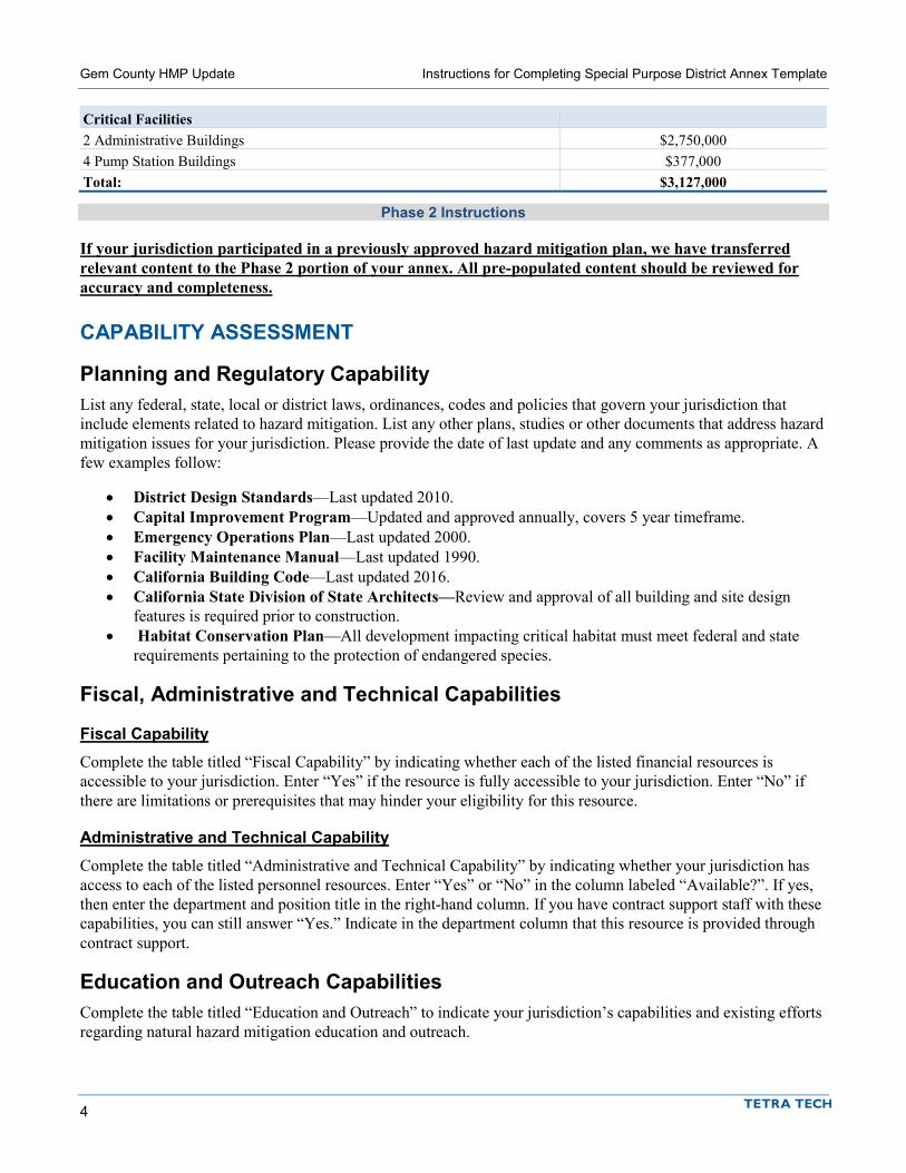
Gem County HMP Update Instructions for Completing Special Purpose District Annex Template
4
Critical Facilities 2 Administrative Buildings $2,750,000 4 Pump Station Buildings $377,000 Total: $3,127,000
Phase 2 Instructions
If your jurisdiction participated in a previously approved hazard mitigation plan, we have transferred relevant content to the Phase 2 portion of your annex. All pre-populated content should be reviewed for accuracy and completeness.
CAPABILITY ASSESSMENT
Planning and Regulatory Capability List any federal, state, local or district laws, ordinances, codes and policies that govern your jurisdiction that include elements related to hazard mitigation. List any other plans, studies or other documents that address hazard mitigation issues for your jurisdiction. Please provide the date of last update and any comments as appropriate. A few examples follow:
• District Design Standards—Last updated 2010. • Capital Improvement Program—Updated and approved annually, covers 5 year timeframe. • Emergency Operations Plan—Last updated 2000. • Facility Maintenance Manual—Last updated 1990. • California Building Code—Last updated 2016. • California State Division of State Architects—Review and approval of all building and site design
features is required prior to construction. • Habitat Conservation Plan—All development impacting critical habitat must meet federal and state
requirements pertaining to the protection of endangered species.
Fiscal, Administrative and Technical Capabilities
Fiscal Capability Complete the table titled “Fiscal Capability” by indicating whether each of the listed financial resources is accessible to your jurisdiction. Enter “Yes” if the resource is fully accessible to your jurisdiction. Enter “No” if there are limitations or prerequisites that may hinder your eligibility for this resource.
Administrative and Technical Capability Complete the table titled “Administrative and Technical Capability” by indicating whether your jurisdiction has access to each of the listed personnel resources. Enter “Yes” or “No” in the column labeled “Available?”. If yes, then enter the department and position title in the right-hand column. If you have contract support staff with these capabilities, you can still answer “Yes.” Indicate in the department column that this resource is provided through contract support.
Education and Outreach Capabilities Complete the table titled “Education and Outreach” to indicate your jurisdiction’s capabilities and existing efforts regarding natural hazard mitigation education and outreach.

Gem County HMP Update Instructions for Completing Special Purpose District Annex Template
5
INTEGRATION WITH OTHER PLANNING INITIATIVES The goal of plan integration is to ensure that the potential impact of hazards is considered in planning for future development. FEMA recommends integration as follows:
• Integrate hazard mitigation plan goals with community objectives (e.g. incorporate the goals for risk reduction and safety into the policies of other plans).
• Use the risk assessment to inform plans and policies (e.g. incorporate risk assessment findings into land use plans, site plan review, emergency operations plans).
• Implement mitigation actions through existing mechanisms (e.g. include mitigation projects in the capital improvement plan).
• Think about mitigation before and after a disaster (e.g. build recovery planning on existing mitigation plans and goals).
After reviewing the plans, programs and ordinances identified in the capability assessment, identify all plans and programs that have already been integrated with the goals and recommendations of the hazard mitigation plan, and those that offer opportunities for future integration.
Existing Integration Provide a brief description of how the plan or ordinance is integrated. Examples are as follows:
• Capital Improvement Plan—The capital improvement plan includes projects can help mitigate potential hazards. The District will act to ensure consistency between the hazard mitigation plan and the current and future capital improvement plans. The hazard mitigation plan may identify new possible funding sources for capital improvement projects and may result in modifications to proposed projects based on results of the risk assessment.
• Emergency Operations Plan—The results of the risk assessment were used in the development of the emergency operations plan.
• Facilities Plan—The results of the risk assessment and mapped hazard areas are used in facility planning for the district. Potential sites are reviewed for hazard risks and appropriate mitigation measures are considered in building and site design.
Opportunities for Future Integration List any plans or program that offer the potential for future integration and describe the process by which integration will occur. Examples follow:
• Capital Improvement Projects—Capital improvement project proposals may take into consideration hazard mitigation potential as a means of evaluating project prioritization.
• Post-Disaster Recovery Plan—The District does not have a recovery plan and intends to develop one as a mitigation planning action during the next five years. The plan will build on the mitigation goals and objectives identified in the mitigation plan.
Consider other programs you may have in place in your jurisdiction that include routine consideration and management of hazard risk. Examples of such programs may include: tree pruning programs, right-of-way mowing programs, erosion control or stream maintenance programs, etc. Please add any such programs to the integration discussion and provide a brief description of how these program manage (or could be adapted to manage) risk from hazards.

Gem County HMP Update Instructions for Completing Special Purpose District Annex Template
6
Phase 3 Instructions
If your jurisdiction participated in a previously approved hazard mitigation plan, we have transferred relevant content to the Phase 3 portion of your annex. All pre-populated content should be reviewed for accuracy and completeness.
JURISDICTION-SPECIFIC NATURAL EVENT HISTORY In the table titled “Past Natural Hazard Events,” list in chronological order (most recent first) any natural hazard event that has caused damage to your jurisdiction. Include the date of the event and the estimated dollar amount of damage it caused. You are welcome to include any events, but special attention should be made to include major storms and federally declared disasters. Please refer to the table below that lists Presidential Disaster Declarations for the County. We recommend including most large-scale disasters, unless you know that there were no impacts to your jurisdiction. Specifically, we recommend that you include these events if you have damage estimate information or can provide a brief description of impacts that occurred within your community. In addition to these events, please refer to the NOAA storm events database included in the tool kit. We recommend conducting a search for the name of your jurisdiction or those jurisdictions in your service area in order to identify events with known impacts. Other potential sources of damage information include:
• Preliminary damage estimates your jurisdiction filed with the county or state • Insurance claims data • Newspaper archives • Other plans/documents that deal with emergency management (safety element of a comprehensive plan,
emergency response plan, etc.) • Resident input.
If you do not have estimates for dollars of damage caused, please list “Not Available” in the appropriate column or simply list a brief description of the damages (e.g. Power out to 35,000 customers for 24 hours). Please note that tracking such damages, is a valid and useful mitigation action if your jurisdiction does not currently track such information.
Presidential Disaster Declarations for Del Norte County
Type of Event FEMA Disaster # Declaration
Date Tsunami Waves DR-1968 4/18/2011
Severe Storms, Flooding, Mudslides, And Landslides DR-1628 2/3/2006 Hurricane Katrina Evacuation EM-3248 9/13/2005
Severe Winter Storms And Flooding DR-1203 2/9/1998 Severe Storms, Flooding, Mud And Landslides DR-1155 1/4/1997
Severe Winter Storms, Flooding, Landslides, Mud Flows DR-1044 1/10/1995 The El Nino (The Salmon Industry) DR-1038 9/13/1994
Severe Winter Storm, Mud & Land Slides, & Flooding DR-979 2/3/1993 Severe Storms & Flooding DR-758 2/21/1986
Coastal Storms, Floods, Slides & Tornadoes DR-677 2/9/1983 Severe Storms & Flooding DR-329 4/5/1972 Severe Storms & Flooding DR-283 2/16/1970 Heavy Rains & Flooding DR-183 12/24/1964
Seismic Sea Wave DR-169 a 4/1/1964

Gem County HMP Update Instructions for Completing Special Purpose District Annex Template
7
Type of Event FEMA Disaster # Declaration
Date Flood Due To Broken Dam DR-161 a 12/21/1963
Severe Storms, Heavy Rains & Flooding DR-145 a 2/25/1963 Severe Storms & Flooding DR-138 a 10/24/1962
Floods DR-122 a 3/6/1962 Fire (Los Angeles County) DR-119 a 11/16/1961 Heavy Rainstorms & Flood DR-82 a 4/4/1958
Forest Fire DR-65 a 12/29/1956 Flood DR-47 a 12/23/1955
Flood & Erosion DR-15a 2/5/1954
a. Statewide declaration
Note: EM = Emergency Declaration; DR = Disaster Declaration
HAZARD RISK RANKING The risk ranking performed for the overall planning area is presented in the risk assessment section of the overall hazard mitigation plan. However, each jurisdiction has differing degrees of risk exposure and vulnerability and, therefore, needs to rank risk for its own area, using the same methodology as used for the overall planning area. The risk-ranking exercise assesses two variables for each hazard: its probability of occurrence; and its potential impact on people, property and the economy.
Tetra Tech has developed a draft risk ranking using the parameters outlined below and based in part on risk ranking in the previous plan (if applicable) for each planning partner. If this risk ranking exercise generates results other that what you know based on substantiated data and documentation, you may alter the ranking based on this knowledge. If this is the case, please note this fact in your template and include what you believe the rank should be and why. For example, drought was ranked as low; however, the jurisdiction is a water supply district, so you believe it should be ranked as high.
Also keep in mind that one of the purposes of this exercise is to support the selection and prioritization of actions in your plan. You will need to have at least one true mitigation action for each hazard ranked as “high” or “medium.”
The instructions below describe the methodology for how these rankings were derived. Please review before providing any comments.
Risk Ranking Methodology
Review Risk Ranking in Template Review the hazard risk ranking information that Tetra Tech has provided. The hazard with the highest risk rating is listed at the top of table titled “Hazard Risk Ranking” in your template and was given a rank of 1; the hazard with the second highest rating is listed second with a rank of 2; and so on. Two hazards with equal risk ratings were given the same rank. “High,” Medium,” and “Low” assignments were given for each hazard of concern based on the total score (probability x impact). It is important to note, that this is determined by the scores rather than assigning a certain number of hazards to each category.
When reviewing the risk ranking results, it is important to remember that this exercise is about categorizing hazards into broad levels of risk (e.g. high, medium, low). It is not an exercise in precision.

Gem County HMP Update Instructions for Completing Special Purpose District Annex Template
8
Review Risk Ranking in Loss Matrix The following sections discuss the methodology used to develop the results included in your template. Please refer to the risk assessment results provided for more information.
Probability of Occurrence for Each Hazard A probability factor is assigned based on how often a hazard is likely to occur. The probability of occurrence of a hazard event is generally based on past hazard events in an area, although weight can be given to expected future probability of occurrence based on established return intervals and changing climate conditions. For example, if your jurisdiction has experienced two damaging floods in the last 25 years, the probability of occurrence is high for flooding and scores a 3 under this category. If your jurisdiction has experienced no damage from landslides in the last 100 years, your probability of occurrence for landslide is low, and scores a 1 under this category. Each hazard was assigned a probability factor as follows:
• High—Hazard event is likely to occur within 25 years (Probability Factor = 3) • Medium—Hazard event is likely to occur within 100 years (Probability Factor = 2) • Low—Hazard event is not likely to occur within 100 years (Probability Factor = 1) • None—If there is no exposure to a hazard, there is no probability of occurrence (Probability Factor = 0)
Potential Impacts of Each Hazard The impact of each hazard is divided into three categories: impacts on people, impacts on property, and impacts on the economy. These categories are also assigned weighted values. Impact on people was assigned a weighting factor of 3, impact on property was assigned a weighting factor of 2 and impact on the economy was assigned a weighting factor of 1.
Impact factors for each category (people, property, economy) are described below:
• People—Values are assigned based on the percentage of the total population exposed in your service area to the hazard event. The degree of impact on individuals will vary and is not measurable, so the calculation assumes for simplicity and consistency that all people exposed to a hazard because they live in a hazard zone will be equally impacted when a hazard event occurs. Impact factors were assigned as follows:
High—25 percent or more of the population is exposed to a hazard (Impact Factor = 3) Medium—10 percent to 24 percent of the population is exposed to a hazard (Impact Factor = 2) Low—9 percent or less of the population is exposed to the hazard (Impact Factor = 1) No impact—None of the population is exposed to a hazard (Impact Factor = 0)
• Property—Values are assigned based on the percentage of the total district assets exposed to the hazard event:
High—25 percent or more of the total replacement value of assets is exposed to a hazard (Impact Factor = 3)
Medium—10 percent to 24 percent of the total replacement value of assets is exposed to a hazard (Impact Factor = 2)
Low—9 percent or less of the total replacement value of assets is exposed to the hazard (Impact Factor = 1)
No impact—None of the total replacement value is exposed to a hazard (Impact Factor = 0)

Gem County HMP Update Instructions for Completing Special Purpose District Annex Template
9
• Operations—Impact on operations is assessed based on estimates of how long it will take your jurisdiction to become 100-percent operable after a hazard event. The estimated functional downtime for critical facilities has been subjectively assigned an impact as follows:
High—Functional downtime of 365 days or more (Impact Factor = 3) Medium—Functional downtime of 180 to 364 days (Impact Factor = 2) Low—Functional downtime of 180 days or less (Impact Factor = 1) No impact—No functional downtime is estimated from the hazard (Impact Factor = 0).
Risk Rating for Each Hazard A risk rating for each hazard was determined by multiplying the assigned probability factor by the sum of the weighted impact factors for people, property and the economy:
Risk Rating = Probability Factor x Weighted Impact Factor {people + property + economy} This is the number that is shown in the risk ranking table in your template. Generally, score of 30 or greater receive a “high” rating, score between 15 and 30 receive a “medium” rating, and score of less than 15 receives a “low” rating.
JURISDICTION-SPECIFIC VULNERABILITIES We would strongly encourage you to review the results of the risk assessment included in the tool kit, your jurisdiction’s natural events history, and any relevant public comments/input and develop a few sentences that discuss specific risks. You do not need to develop a sentence for every single parameter, but review the results and identify a few issues you would like to highlight. For example:
• One of the District’s wastewater treatment plants is located in an area likely to be permanently inundated by sea level rise by 2030.
• Three of the District’s five fire stations are located in very high landslide risk areas. • The vast majority of the service area for the district is located on high liquefaction potential soils, which
has the potential to severely disrupt service for an extended period following even a moderate earthquake event.
• The District headquarters is more likely than not to be extensively damaged during a Smithburg fault M7.0 event.
In addition, please list any noted vulnerabilities in your jurisdiction related to hazard mitigation that may not be apparent from the risk assessment and other information provided. This may include things such as the following:
• An area of the community that frequently loses power due to a lack of tree maintenance. • A critical facility, such as a police station, that is not equipped with a generator. • A neighborhood that has the potential to have ingress and egress cut off as the result of a hazard event,
such as a flood or earthquake (e.g. bridge only access).
Spending some time thinking about the results of the risk assessment and other noted vulnerabilities will be a big help in the development of your mitigation strategy. The items you list in this section should cross-walk back to the mitigation action that you have selected. Tetra Tech has inserted a few items in this section to get you started. In addition, two examples are shown in the table below.

Gem County HMP Update Instructions for Completing Special Purpose District Annex Template
10
Noted Vulnerability Example Mitigation Action One of the District’s wastewater treatment plants is located in an area likely to be permanently inundated by sea level rise by 2030.
Conduct a detailed assessment of the wastewater treatment plant vulnerability to sea level rise. Determine adaptation actions that can be implemented in the near- and long-term.
A critical facility, such as a police station, that is not equipped with a generator.
Unsure all critical facilities within the District have backup power generation capabilities. Priority facilities include:
• Main street pump station • Old Oak subdivision pump station.
STATUS OF PREVIOUS PLAN ACTIONS Please note that this section only applies to jurisdictions that are conducting updates to previously approved hazard mitigation plans. If your jurisdiction has not previously participated in an approved plan, this section will not appear in your annex template. Also, please note that a handout with this information was distributed at the February Steering Committee meeting so work may have already begun on this portion of phase 3.
All action items identified in prior mitigation planning efforts must be reconciled in this plan update. Action items must all be marked as ONE of the following; check the appropriate box (place an X) and provide the following information:
• Completed—If an action was completed during the performance period of the prior plan, please check the appropriate box and provide a date of completion in the comment section. If an action has been initiated and is an ongoing program (e.g. annual outreach event), you may mark it as completed and note that it is ongoing in the comments. When removing such actions from your action plan, please consider including them in the existing integration section above. If you have an action that addresses an ongoing program you would like to continue to include it in your action plan, please see the Carried Over to Plan Update section below.
• Removed—If action items are to be removed because they are no longer feasible, a reason must be given. Lack of funding does not mean that it is no longer feasible, unless the sole source of funding for an action is no longer available. Place a comment in the comment section explaining why the action is no longer feasible or barriers that prevented the action from being implemented (e.g., “Action no longer considered feasible due to lack of political support.”). If the wording and/or intent of a previously identified action is unclear, this can be a reason for removal. A change in community priorities may also be a reason for removal and should be discussed in the comments.
• Carried Over to Plan Update—If an action is in progress, ongoing or has not been initiated and you would like to carry it over to the plan update, please check the “Check if Yes” column under “Carried Over to Plan Update.” Selecting this option indicates that the action will be included in the mitigation action plan for the 2018 plan. If you are carrying over an action to the plan update, please include a comment describing any action that has been taken or why action was not taken (specifically, any barriers or obstacles that prevented the action from moving forward or slowed progress) The last column “Enter Action #” will be addressed when you develop your actions plan in the following sections. You will need to revisit it after completing the updated action plan in phase 3.
Please ensure that you have provided a status and a comment for each action.

Gem County HMP Update Instructions for Completing Special Purpose District Annex Template
11
HAZARD MITIGATION ACTION PLAN AND EVALUATION OF RECOMMENDED ACTIONS This section is the heart of your jurisdictional annex. This is where you will identify the actions your jurisdiction would like to pursue with this plan. All of the work that you have done thus far should provide you with a plethora of ideas for actions. With this in mind, we recommend that you review the following and develop a list of potential actions:
• Capability Assessment Section of Annex—Review the Planning and Regulatory Capability table, the Fiscal Capability table, the Administrative and Technical Capability table, and the Education and Outreach table.
For any capability that you indicated that you did not have, ask yourself – should we have this capability? If yes, consider including an action to develop/acquire the capability.
Example: Ensure a staff person is trained in the use of FEMA’s benefit-cost analysis software.
Review the Legal and Regulatory capabilities. If you have not reviewed and updated a capability in more than 10 years, consider an action to review and update the capability and, as appropriate, incorporate hazard mitigation principles or information obtained in the risk assessment (Note: actions such as this should also be identified in the opportunities for future integration section). Also, consider including projects or actions that have been identified in other plans and programs such as Capital Improvement Plans, Strategic Plans, etc. as actions in this plan.
For any capability that you indicated you do have, consider how this capability can be leveraged to increase or improve hazard mitigation in the jurisdiction.
• Adaptive Capacity for Climate Change Section of this Annex—Consider your responses to this section. For those criterion that you listed as medium or low, think of ways you could improve this rating (see adaptive capacity portion of the mitigation best practices catalog). For those criterion you listed as high, think about how you can leverage this capacity to improve or enhance mitigation or continue to improve this capacity. For those criterion that you were unable to provide responses for, consider ways you could improve your understanding of this capacity (see mitigation best practices).
• Opportunities for Future Integration Section in this Annex—Review the items you identified in this section. Consider an action that specifically says what the plan, code, ordinance etc. is and how it will be integrated.
• Jurisdiction-Specific Vulnerabilities Section in this Annex—Review the items that you have identified in this section and consider actions that will help reduce these vulnerabilities (see mitigation best practices catalog).
• Mitigation Best Practices Catalog—A catalog that includes FEMA and other agency identified best practices, steering committee and other stakeholder recommendations was developed as part of the plan development process and included in your tool kit. Review the catalog and identify those actions that your jurisdiction should consider including in its action plan.
• Public Input—Review input received during the process, specifically the public survey results included in your toolkit.
Wording Your Action Descriptions:
Descriptions of your actions need not provide great detail. That will come when you apply for a project grant. Provide enough information to identify the action’s scope and impact. The following are typical descriptions for an action plan action: • Action 1—Address repetitive-loss issues.
Through targeted mitigation, acquire, relocate or retrofit the nine pump stations that have been repetitively damaged.
• Action 2—Perform a non-structural, seismic retrofit of the administrative building.
• Action 3—Develop a schedule to underground overhead powerlines.

Gem County HMP Update Instructions for Completing Special Purpose District Annex Template
12
• Prior Mitigation Planning Efforts—If your jurisdiction participated in a previous hazard mitigation plan, please be sure to remember to include any actions that were identified as “carry over” actions. Once you have carried them over, return to the Status of Previous Actions table and record the new action number (see discussion below).
Be sure to consider the following factors in your selection of actions:
• Select actions that are consistent with the overall purpose, goals, and objectives of the hazard mitigation plan.
• Identify actions where benefits exceed costs. • Include any action that your jurisdiction has committed to pursuing regardless of grant eligibility. • Know what is and is not grant-eligible under the Hazard Mitigation Grant Program (HMGP), Pre-Disaster
Mitigation (PDM) and Flood Mitigation Assistance (FMA) grants (see fact sheet provided in toolkit). If you have actions that are not HMGP, PDM or FMA grant eligible, but do mitigate part or all of the hazard and may be eligible for other grant programs sponsored by other agencies, include them in this section.
• You must identify at least one true mitigation action (i.e. not a preparedness or response action) that is clearly defined and actionable for hazards ranked as “high” or medium.”
Recommended Actions We recommend that every planning partner strongly consider the following actions. The specifics of these actions should be adjusted as needed for the particulars of each jurisdiction. You will note that three of these actions have been prepopulated in your annex template. These three actions should be included in every annex and should not be removed.
• Where appropriate, support retro-fitting, purchase or relocation of structures located in high hazard areas, prioritizing those structures that have experienced repetitive losses and/or are located in high or medium ranked hazard areas.
• Integrate the hazard mitigation plan into other plans, ordinances and programs within the community. • Actively participate in the plan maintenance protocols outlined in Volume I of the hazard mitigation plan. • Develop and implement a program to capture perishable data after significant events (e.g. high water
marks, preliminary damage estimates, damage photos) to support future mitigation efforts including the implementation and maintenance of the hazard mitigation plan.
• Support the County-wide initiatives identified in Volume I of the hazard mitigation plan. • Develop a post-disaster recovery plan and a debris management plan. • Develop and/or update plans that support or enhance continuity of operations following disasters. • Identify and pursue strategies to increase adaptive capacity to climate change. • Purchase generators for critical facilities and infrastructure that lack adequate back-up power.
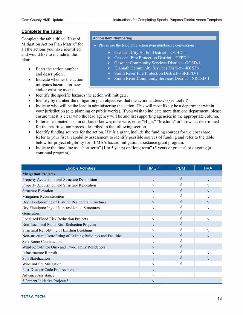
Gem County HMP Update Instructions for Completing Special Purpose District Annex Template
13
Complete the Table Complete the table titled “Hazard Mitigation Action Plan Matrix” for all the actions you have identified and would like to include in the plan:
• Enter the action number and description .
• Indicate whether the action mitigates hazards for new and/or existing assets.
• Identify the specific hazards the action will mitigate. • Identify by number the mitigation plan objectives that the action addresses (see toolkit). • Indicate who will be the lead in administering the action. This will most likely be a department within
your jurisdiction (e.g. planning or public works). If you wish to indicate more than one department, please ensure that it is clear who the lead agency will be and list supporting agencies in the appropriate column.
• Enter an estimated cost in dollars if known; otherwise, enter “High,” “Medium” or “Low” as determined for the prioritization process described in the following section.
• Identify funding sources for the action. If it is a grant, include the funding sources for the cost share. Refer to your fiscal capability assessment to identify possible sources of funding and refer to the table below for project eligibility for FEMA’s hazard mitigation assistance grant program.
• Indicate the time line as “short-term” (1 to 5 years) or “long-term” (5 years or greater) or ongoing (a continual program)
Eligible Activities HMGP PDM FMA Mitigation Projects Property Acquisition and Structure Demolition √ √ √ Property Acquisition and Structure Relocation √ √ √ Structure Elevation √ √ √ Mitigation Reconstruction √ √ √ Dry Floodproofing of Historic Residential Structures √ √ √ Dry Floodproofing of Non-residential Structures √ √ √ Generators √ √ Localized Flood Risk Reduction Projects √ √ √ Non-Localized Flood Risk Reduction Projects √ √ Structural Retrofitting of Existing Buildings √ √ √ Non-structural Retrofitting of Existing Buildings and Facilities √ √ √ Safe Room Construction √ √ Wind Retrofit for One- and Two-Family Residences √ √ Infrastructure Retrofit √ √ √ Soil Stabilization √ √ √ Wildland fire Mitigation √ √ Post-Disaster Code Enforcement √ Advance Assistance √ 5 Percent Initiative Projects* √
Action Item Numbering:
• Please use the following action item numbering conventions:
Crescent City Harbor District—CCHD-1 Crescent Fire Protection District—CFPD-1 Gasquet Community Services District—GCSD-1 Klamath Community Services District—KCSD-1 Smith River Fire Protection District—SRFPD-1 Smith River Community Services District—SRCSD-1
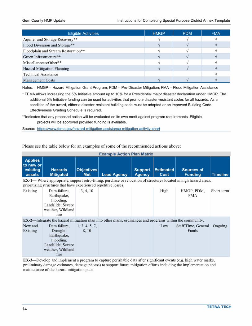
Gem County HMP Update Instructions for Completing Special Purpose District Annex Template
14
Eligible Activities HMGP PDM FMA Aquifer and Storage Recovery** √ √ √ Flood Diversion and Storage** √ √ √ Floodplain and Stream Restoration** √ √ √ Green Infrastructure** √ √ √ Miscellaneous/Other** √ √ √ Hazard Mitigation Planning √ √ √ Technical Assistance √ Management Costs √ √ √
Notes: HMGP = Hazard Mitigation Grant Program; PDM = Pre-Disaster Mitigation; FMA = Flood Mitigation Assistance
* FEMA allows increasing the 5% Initiative amount up to 10% for a Presidential major disaster declaration under HMGP. The additional 5% Initiative funding can be used for activities that promote disaster-resistant codes for all hazards. As a condition of the award, either a disaster-resistant building code must be adopted or an improved Building Code Effectiveness Grading Schedule is required.
**Indicates that any proposed action will be evaluated on its own merit against program requirements. Eligible projects will be approved provided funding is available.
Source: https://www.fema.gov/hazard-mitigation-assistance-mitigation-activity-chart
Please see the table below for an examples of some of the recommended actions above:
Example Action Plan Matrix Applies
to new or existing assets
Hazards Mitigated
Objectives Met Lead Agency
Support Agency
Estimated Cost
Sources of Funding Timeline
EX-1— Where appropriate, support retro-fitting, purchase or relocation of structures located in high hazard areas, prioritizing structures that have experienced repetitive losses. Existing Dam failure,
Earthquake, Flooding,
Landslide, Severe weather, Wildland
fire
3, 4, 10 High HMGP, PDM, FMA
Short-term
EX-2—Integrate the hazard mitigation plan into other plans, ordinances and programs within the community. New and Existing
Dam failure, Drought,
Earthquake, Flooding,
Landslide, Severe weather, Wildland
fire
1, 3, 4, 5, 7, 8, 10
Low Staff Time, General Funds
Ongoing
EX-3—Develop and implement a program to capture perishable data after significant events (e.g. high water marks, preliminary damage estimates, damage photos) to support future mitigation efforts including the implementation and maintenance of the hazard mitigation plan.

Gem County HMP Update Instructions for Completing Special Purpose District Annex Template
15
Applies to new or existing assets
Hazards Mitigated
Objectives Met Lead Agency
Support Agency
Estimated Cost
Sources of Funding Timeline
Existing Dam failure, Drought,
Earthquake, Flooding,
Landslide, Severe weather, Wildland
fire
4, 8 Emergency Management
Medium Staff Time, General Funds
Short-term
EX-4—Support the County-wide initiatives identified in Volume I of the hazard mitigation plan. New and Existing
Dam failure, Drought,
Earthquake, Flooding,
Landslide, Severe weather, Wildland
fire
1, 2, 3, 4, 5, 6, 7, 8, 9, 10
Lead Contact Department for
Plan
Any Supporting Department
s
Low Staff Time, General Funds
Short-term
EX-5—Actively participate in the plan maintenance protocols outlined in Volume I of the hazard mitigation plan. New and Existing
Dam failure, Drought,
Earthquake, Flooding,
Landslide, Severe weather, Wildland
fire
1, 5, 8 Lead Contact Department for
Plan
Any Supporting Department
s
Low Staff Time, General Funds
Short-term
EX-6—Develop a post-disaster recovery plan and a debris management plan. Existing All Hazards 9 Emergency
Management Medium EMPG Long-term
EX-7—Purchase generators for critical facilities and infrastructure that lack adequate back-up power including ________.
Existing Dam failure, Flooding,
Landslide, Severe weather, Wildland
fire
2, 6, 9 Operations Medium HMGP, PDM Short-term
Prioritization of Mitigation Actions Complete the information in the table titled “Mitigation Strategy Priority Schedule” as follows:
• Action #—Indicate the action number from the previous annex table (Hazard Mitigation Action Plan Matrix).
• # of Objectives Met—Enter the number of objectives the action will meet. • Benefits—Enter “High,” “Medium” or “Low” as follows:
High: Action will have an immediate impact on the reduction of risk exposure to life and property. Medium: Action will have a long-term impact on the reduction of risk exposure to life and property,
or action will provide an immediate reduction in the risk exposure to property. Low: Long-term benefits of the action are difficult to quantify in the short term.
• Costs—Enter “High,” “Medium” or “Low” as follows:

Gem County HMP Update Instructions for Completing Special Purpose District Annex Template
16
High: Would require an increase in revenue via an alternative source (i.e., bonds, grants, fee increases) to implement. Existing funding levels are not adequate to cover the costs of the proposed action.
Medium: Could budget for under existing work-plan, but would require a reapportionment of the budget or a budget amendment, or the cost of the action would have to be spread over multiple years.
Low: Possible to fund under existing budget. Action is or can be part of an existing ongoing program.
If you know the estimated cost of a action because it is part of an existing, ongoing program, indicate the amount.
• Do Benefits Exceed the Cost?—Enter “Yes” or “No.” This is a qualitative assessment. Enter “Yes” if the benefit rating (high, medium or low) is the same as or higher than the cost rating (high benefit/high cost; high benefit/medium cost; medium benefit/low cost; etc.). Enter “No” if the benefit rating is lower than the cost rating (medium benefit/high cost, low benefit/medium cost; etc.)
• Is the Action Grant-Eligible?—Enter “Yes” or “No.” Refer to the fact sheet on HMGP, PDM and FMA. • Can Action Be Funded Under Existing Program Budgets?—Enter “Yes” or “No.” In other words, is
this action currently budgeted for, or would it require a new budget authorization or funding from another source such as grants?
• Implementation Priority— Enter “High,” “Medium” or “Low” as follows:
High Priority—An action that meets multiple objectives, has benefits that exceed costs, and has a secured source of funding. Action can be completed in the short term (1 to 5 years).
Medium Priority—An action that meets multiple objectives, has benefits that exceed costs, and is eligible for funding though no funding has yet been secured for it. Action can be completed in the short term (1 to 5 years), once funding is secured. Medium-priority actions become high-priority actions once funding is secured.
Low Priority—An action that will mitigate the risk of a hazard, has benefits that do not exceed the costs or are difficult to quantify, has no secured source of funding, and is not eligible for any known grant funding. Action can be completed in the long term (1 to 10 years). Low-priority actions are generally “wish-list” actions. They may be eligible for grant funding from programs that have not yet been identified.
• Grant Pursuit Priority— Enter “High,” “Medium” or “Low” as follows:
High Priority—An action that meets identified grant eligibility requirements, has high benefits, and is listed as high or medium implementation priority; local funding options are unavailable or available local funds could be used instead for actions that are not eligible for grant funding.
Medium Priority—An action that meets identified grant eligibility requirements, has medium or low benefits, and is listed as medium or low implementation priority; local funding options are unavailable.
Low Priority—An action that has not been identified as meeting any grant eligibility requirements.
This prioritization is a simple way to determine that your identified actions meet one of the primary objectives of the Disaster Mitigation Act. It is not the detailed benefit/cost analysis required for HMGP/PDM /FMA action grants. The prioritization will identify any actions whose probable benefits will not exceed the probable costs. Those actions identified as high-priority grant funding actions should be closely reviewed for consideration when grant funding opportunities arise.
Note: If a jurisdiction wishes to identify an action as high priority that is outside of the prioritization scheme for high priorities. A note indicting so should be inserted and a rationale should be provided.

Gem County HMP Update Instructions for Completing Special Purpose District Annex Template
17
Please see the example below based off the recommended actions:
Table 0-9. Mitigation Strategy Priority Schedule
Action #
# of Objectives
Met Benefits Costs
Do Benefits Equal or Exceed Costs?
Is Action Grant-
Eligible?
Can Action Be Funded
Under Existing
Programs/ Budgets?
Implementation Prioritya
Grant Pursuit
Prioritya EX-1 3 High High Yes Yes No Medium High EX-2 7 Medium Low Yes No Yes High Low EX-3 2 Low Medium No No Maybe Low Low EX-4 10 Low Low Yes No Yes High Low EX-5 3 Low Low Yes No Yes High Low EX-6 1 Medium Medium Yes Yes No Medium High EX-7 3 High Medium Yes Yes No Medium High
Analysis of Mitigation Actions Complete the table titled “Analysis of Mitigation Actions” summarizing the mitigation actions by hazard of concern and the following eight mitigation types. Please note that an action can be more than one mitigation type:
• Prevention—Government, administrative or regulatory actions that influence the way land and buildings are developed to reduce hazard losses. Includes planning and zoning, floodplain laws, capital improvement programs, open space preservation, and stormwater management regulations.
• Property Protection—Modification of buildings or structures to protect them from a hazard or removal of structures from a hazard area. Includes acquisition, elevation, relocation, structural retrofit, storm shutters, and shatter-resistant glass.
• Public Education and Awareness—Actions to inform residents and elected officials about hazards and ways to mitigate them. Includes outreach projects, real estate disclosure, hazard information centers, and school-age and adult education.
• Natural Resource Protection—Actions that minimize hazard loss and preserve or restore the functions of natural systems. Includes sediment and erosion control, stream corridor restoration, watershed management, forest and vegetation management, wetland restoration and preservation, and green infrastructure.
• Emergency Services—Actions that protect people and property during and immediately after a hazard event. Includes warning systems, emergency response services, and the protection of essential facilities.
• Structural Projects—Actions that involve the construction of structures to reduce the impact of a hazard. Includes dams, setback levees, floodwalls, retaining walls, and safe rooms.
This exercise demonstrates that the jurisdiction has selected a comprehensive range of actions.
Please see the example below based off the recommended actions, but please note that these recommendations are heavy on generalized actions on the prevention spectrum and light in other areas and specificity. Planning partners should aim to identify at least one action in each category (although this is not required) and should make sure there is at least one action to address “high” and “medium” ranked hazards:

Gem County HMP Update Instructions for Completing Special Purpose District Annex Template
18
Analysis of Mitigation Actions Action Addressing Hazard, by Mitigation Typea
Hazard Type Prevention Property
Protection
Public Education and
Awareness
Natural Resource Protection
Emergency Services
Structural Projects
Community Capacity Building
Dam Failure EX-2, 3, 4, 5 EX-1, 6 EX-4, 6 EX-8, 11 EX-2, 3, 4, 5, 6
EX-1, 6
Drought EX-2 EX-1 EX-4 EX-2 EX-1 Earthquake EX-2, 3, 4, 5, EX-1, 7 EX-4 EX-8, 11 EX-2, 3, 4,
5, 7 EX-1, 7
Flood EX-2, 3, 4, 5 EX-1, 6, 7 EX-4, 6 EX-9 EX-8, 11 EX-2, 3, 4, 5, 6, 7
EX-1, 6, 7
Landslide EX-2, 3, 4, 5, EX-1, 7 EX-4 EX-8, 11 EX-2, 3, 4, 5, 7
EX-1, 7
Severe Weather EX-2, 3, 4, 5, EX-1, 7, 9 EX-4 EX-8, 9, 11 EX-2, 3, 4, 5, 7
EX-1, 7, 9
Wildfire EX-2, 3, 4, 5, EX-1, 7, 9 EX-4, 9 EX-9 EX-8, 11 EX-2, 3, 4, 5, 7
EX-1, 7, 9
FUTURE NEEDS TO BETTER UNDERSTAND RISK/VULNERABILITY In this section, identify any future studies, analyses, reports, or surveys your jurisdiction needs to better understand its vulnerability to identified or currently unidentified risks. These could be needs based on federal or state agency mandates. Please note that this section is optional.
ADDITIONAL COMMENTS Use this section to add any additional information pertinent to hazard mitigation and your jurisdiction not covered in this template. Please note that this section is optional.
REVIEW AND INCORPORATION OF RESOURCES FOR THIS ANNEX
Existing Reports, Plans, Regulatory Tools and Other Resources This section should describe what resources you used to complete the annex and how you used them. Several items are started for you, but please be sure to update and enhance any descriptions. This may seem trivial or unimportant, but it is a requirement to pass the state and FEMA review process.
Staff and Local Stakeholder Involvement in Annex Development This section should describe in general terms the process by which the annex was developed. Please include general discussion with a focus on who was involved and how the action plan was developed. An example is included below.
This annex was developed over the course of several months with input from many district departments including operations, finance, and capital planning. All departments were asked to contribute to the annex development through reviewing and contributing to the capability assessment, reporting on the status of

Gem County HMP Update Instructions for Completing Special Purpose District Annex Template
19
previously identified actions, and participating in action identification and prioritization. A action development meeting was held on February 20, 2018 and was attended by representatives from all previously listed department as well as the General Manager and representatives from the Board of Directors. Once actions had been identified and compiled in the annex, a draft was internally circulated for comment.
NEXT STEPS After all jurisdictions have submitted their annexes, the draft plan will be submitted for public comment. Following the public comment period and any revisions responsive to public comment, the plan will be submitted to the Idaho Office of Emergency Management (IOEM) for review. After their review and approval, IOEM will submit the plan to FEMA Region X for plan review and approval. At that point planning partners will be asked to begin making preparations to formally adopt the plan. Each participating planning partner must have the governing board of their jurisdiction adopt via resolution or ordinance. Once FEMA has reviewed the plan and issued an approved pending adoption (APA) notice, planning partners will be asked to go forth and adopt the plan. Once adopted, planning partners will submit adoption information to Tetra Tech, who will submit the proof of adoption to FEMA. Once such adoption has been received, FEMA will issue final approval via a letter for those planning partners who have adopted the plan. It is very important to understand that approval is not final until proof of adoption has been received by FEMA and they have issued a letter specifically naming your jurisdiction. More information on the review and approval process, along with adoption support materials, will be provided at a later date.


MUNICIPAL ANNEX PHASE 1 TEMPLATE


1-1
1. JURISDICTION NAME
1.1 HAZARD MITIGATION PLAN POINT OF CONTACT
Primary Point of Contact Alternate Point of Contact Name, Title Street Address City, State ZIP Telephone: xxx-xxx-xxxx e-mail Address: [email protected]
Name, Title Street Address City, State ZIP Telephone: xxx-xxx-xxxx e-mail Address: [email protected]
1.2 JURISDICTION PROFILE The following is a summary of key information about the jurisdiction and its history:
• Date of Incorporation— • Current Population— • Population Growth— • Location and Description— • Brief History— • Climate— • Governing Body Format—___[general description]___. The __[name of adopting body]___ assumes
responsibility for the adoption of this plan; __[name of oversight agency]__ will oversee its implementation.
1.3 DEVELOPMENT TRENDS _DESCRIBE TRENDS IN GENERAL__.
Table 1-1 summarizes development trends in the performance period since development of the previous hazard mitigation plan and expected future development trends.

Report Title Jurisdiction Name
1-2
Table 1-1. Recent and Expected Future Development Trends Criterion Response Has your jurisdiction annexed any land since the development of the previous hazard mitigation plan?
Yes/No
• If yes, give the estimated area annexed and estimated number of parcels or structures.
____________
Is your jurisdiction expected to annex any areas during the performance period of this plan?
Yes/No
• If yes, please describe land areas and dominant uses.
____________
• If yes, who currently has permitting authority over these areas?
____________
Are any areas targeted for development or major redevelopment in the next five years?
Yes/No
• If yes, please briefly describe, including whether any of the areas are in known hazard risk areas
____________
How many permits for new construction were issued in your jurisdiction since the development of the previous hazard mitigation plan?
2011 2012 2013 2014 2015 Single Family __ __ __ __ __ Multi-Family __ __ __ __ __ Other (commercial, mixed use, etc.) __ __ __ __ __
Please provide the number of new-construction permits for each hazard area or provide a qualitative description of where development has occurred.
• Special Flood Hazard Areas: # • Landslide: # • High Liquefaction Areas: # • Tsunami Inundation Area: # • Wildfire Risk Areas: #
Please describe the level of buildout in the jurisdiction, based on your jurisdiction’s buildable lands inventory. If no such inventory exists, provide a qualitative description.
____________
1.4 STATUS OF PREVIOUS PLAN ACTIONS Table 1-12 summarizes the actions that were recommended in the previous version of the hazard mitigation plan and their implementation status at the time this update was prepared.
Table 1-12. Status of Previous Plan Actions
Removed; Carried Over to
Plan Update
Action Item Completed No Longer Feasible
Check if Yes
Enter Action #
Insert Action Text Action# Comment: Insert Action Text Action# Comment: Insert Action Text Action# Comment:

Report Title Jurisdiction Name
1-3
Removed; Carried Over to
Plan Update
Action Item Completed No Longer Feasible
Check if Yes
Enter Action #
Insert Action Text Action# Comment: Insert Action Text Action# Comment: Insert Action Text Action# Comment: Insert Action Text Action# Comment: Insert Action Text Action# Comment: Insert Action Text Action# Comment: Insert Action Text Action# Comment: Insert Action Text Action# Comment: Insert Action Text Action# Comment:
1.5 REVIEW AND INCORPORATION OF INFORMATION FOR THIS ANNEX
1.5.1 Existing Reports, Plans, Regulatory Tools and Other Resources The following technical reports, plans, and regulatory mechanisms were reviewed to provide information for this annex.
• Jurisdiction Name Municipal Code—The municipal code was reviewed for the full capability assessment and for identifying opportunities for action plan integration.
• Jurisdiction Name Flood Damage Prevention Ordinance—The flood damage prevention ordinance was reviewed for compliance with the National Flood Insurance Program.
• <INSERT PLAN/PROGRAM AND DESCRIPTION OF HOW IT WAS USED> • <INSERT PLAN/PROGRAM AND DESCRIPTION OF HOW IT WAS USED> • <INSERT PLAN/PROGRAM AND DESCRIPTION OF HOW IT WAS USED> • <INSERT PLAN/PROGRAM AND DESCRIPTION OF HOW IT WAS USED> • Technical Reports and Information—The following outside resources and references were reviewed:
Hazard Mitigation Plan Annex Development Tool-kit—The tool-kit was used to support the development of this annex including past hazard events, noted vulnerabilities, risk ranking and action development.
<INSERT DOCUMENT AND DESCRIPTION OF HOW IT WAS USED>
1.5.2 Staff and Local Stakeholder Involvement in Annex Development Insert discussion per instructions.


DISTRICT ANNEX PHASE 1 TEMPLATE


1-1
1. DISTRICT NAME
1.1 HAZARD MITIGATION PLAN POINT OF CONTACT
Primary Point of Contact Alternate Point of Contact Name, Title Street Address City, State ZIP Telephone: xxx-xxx-xxxx e-mail Address: [email protected]
Name, Title Street Address City, State ZIP Telephone: xxx-xxx-xxxx e-mail Address: [email protected]
1.2 JURISDICTION PROFILE
1.2.1 Overview Insert Narrative Profile Information, per Instructions. The __[name of adopting body]___ assumes responsibility for the adoption of this plan; __[name of oversight agency]__ will oversee its implementation.
For fire districts please be sure to include the following sentence (Non-fire Special Purpose Districts may delete the sentence):
The District participates/does not participate in the Public Protection Class Rating System and currently has a rating of #.
1.2.2 Service Area and Trends The district serves a population of _ population_. Its service area covers an area of _area_.
Insert summary description of service trends.
1.2.3 Assets Table 1-1 summarizes the critical assets of the district and their value.
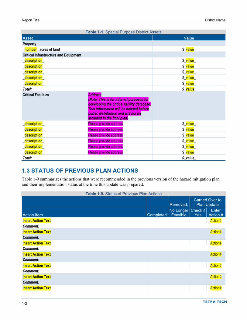
Report Title District Name
1-2
Table 1-1. Special Purpose District Assets Asset Value Property _number_ acres of land $_value_ Critical Infrastructure and Equipment _description_ $_value_ _description_ $_value_ _description_ $_value_ _description_ $_value_ _description_ $_value_ Total: $_value_ Critical Facilities Address
(Note: This is for internal purposes for developing the critical facility database. This information will be deleted before public distribution and will not be included in the final plan)
_description_ Please provide address $_value_ _description_ Please provide address $_value_ _description_ Please provide address $_value_ _description_ Please provide address $_value_ _description_ Please provide address $_value_ _description_ Please provide address $_value_ Total: $_value_
1.3 STATUS OF PREVIOUS PLAN ACTIONS Table 1-9 summarizes the actions that were recommended in the previous version of the hazard mitigation plan and their implementation status at the time this update was prepared.
Table 1-9. Status of Previous Plan Actions
Removed; Carried Over to
Plan Update
Action Item Completed No Longer Feasible
Check if Yes
Enter Action #
Insert Action Text Action# Comment: Insert Action Text Action# Comment: Insert Action Text Action# Comment: Insert Action Text Action# Comment: Insert Action Text Action# Comment: Insert Action Text Action# Comment: Insert Action Text Action#

Report Title District Name
1-3
Removed; Carried Over to
Plan Update
Action Item Completed No Longer Feasible
Check if Yes
Enter Action #
Comment: Insert Action Text Action# Comment: Insert Action Text Action# Comment: Insert Action Text Action# Comment: Insert Action Text Action# Comment: Insert Action Text Action# Comment:
1.4 REVIEW AND INCORPORATION OF RESOURCES FOR THIS ANNEX
1.4.1 Existing Reports, Plans, Regulatory Tools and Other Resources The following technical reports, plans, and regulatory mechanisms were reviewed to provide information for this annex.
• <INSERT PLAN/PROGRAM AND DESCRIPTION OF HOW IT WAS USED> • <INSERT PLAN/PROGRAM AND DESCRIPTION OF HOW IT WAS USED> • <INSERT PLAN/PROGRAM AND DESCRIPTION OF HOW IT WAS USED> • Hazard Mitigation Plan Annex Development Tool-kit—The tool-kit was used to support the
development of this annex including past hazard events, noted vulnerabilities, risk ranking and action development.
1.4.2 Staff and Local Stakeholder Involvement in Annex Development Insert discussion per instructions.

MUNICIPAL ANNEX PHASE 2 TEMPLATE


1-1
1. JURISDICTION NAME
1.1 CAPABILITY ASSESSMENT Jurisdiction Name has performed an inventory and analysis of existing capabilities, plans, programs and policies that enhance its ability to implement mitigation strategies. The introduction at the beginning of this volume of the hazard mitigation plan describes the components included in the capability assessment and their significance for hazard mitigation planning. This section summarizes the following findings of the assessment:
• An assessment of legal and regulatory capabilities is presented in Table 1-2. • Development and permitting capabilities are presented in Table 1-3. • An assessment of fiscal capabilities is presented in Table 1-4. • An assessment of administrative and technical capabilities is presented in Table 1-5. • An assessment of education and outreach capabilities is presented in Table 1-6. • Information on National Flood Insurance Program (NFIP) compliance is presented in Table 1-7. • Classifications under various community mitigation programs are presented in Table 1-8.
The capability assessment was reviewed in order to identify opportunities to expand, initiate or integrate capabilities to further hazard mitigation goals and objectives. Where such opportunities were identified and determined to be feasible, they are included in the action plan and are identified as Community Capacity Building mitigation actions in the Analysis of Mitigation Actions table in Section 1.10.

Report Title Jurisdiction Name
1-2
Table 1-2. Legal and Regulatory Capability
Local
Authority Other Jurisdiction
Authority State
Mandated Integration
Opportunity? Codes, Ordinances, & Requirements Building Code Yes/No Yes/No Yes/No Yes/No Comment: Zoning Code Yes/No Yes/No Yes/No Yes/No Comment: Subdivisions Yes/No Yes/No Yes/No Yes/No Comment: Stormwater Management Yes/No Yes/No Yes/No Yes/No Comment: Post-Disaster Recovery Yes/No Yes/No Yes/No Yes/No Comment: Real Estate Disclosure Yes/No Yes/No Yes/No Yes/No Comment: Growth Management Yes/No Yes/No Yes/No Yes/No Comment: Site Plan Review Yes/No Yes/No Yes/No Yes/No Comment: Environmental Protection Yes/No Yes/No Yes/No Yes/No Comment: Flood Damage Prevention Yes/No Yes/No Yes/No Yes/No Comment: Emergency Management Yes/No Yes/No Yes/No Yes/No Comment: Climate Change Yes/No Yes/No Yes/No Yes/No Comment: Other: Yes/No Yes/No Yes/No Yes/No Comment: Planning Documents General Plan Yes/No Yes/No Yes/No Yes/No Comment: Capital Improvement Plan Yes/No Yes/No Yes/No Yes/No How often is the plan updated? ____________ Comment: Floodplain or Watershed Plan Yes/No Yes/No Yes/No Yes/No Comment: Stormwater Plan Yes/No Yes/No Yes/No Yes/No Comment: Urban Water Management Plan Yes/No Yes/No Yes/No Yes/No Comment: Habitat Conservation Plan Yes/No Yes/No Yes/No Yes/No Comment: Economic Development Plan Yes/No Yes/No Yes/No Yes/No Comment: Shoreline Management Plan Yes/No Yes/No Yes/No Yes/No Comment:

Report Title Jurisdiction Name
1-3
Local
Authority Other Jurisdiction
Authority State
Mandated Integration
Opportunity? Community Wildfire Protection Plan Yes/No Yes/No Yes/No Yes/No Comment: Forest Management Plan Yes/No Yes/No Yes/No Yes/No Comment: Climate Action Plan Yes/No Yes/No Yes/No Yes/No Comment: Comprehensive Emergency Management Plan Yes/No Yes/No Yes/No Yes/No Comment: Threat & Hazard Identification & Risk Assessment Yes/No Yes/No Yes/No Yes/No Comment: Post-Disaster Recovery Plan Yes/No Yes/No Yes/No Yes/No Comment: Continuity of Operations Plan Yes/No Yes/No Yes/No Yes/No Comment: Disaster Debris Management Plan Yes/No Yes/No Yes/No Yes/No Comment: Public Health Plan Yes/No Yes/No Yes/No Yes/No Comment: Other: Yes/No Yes/No Yes/No Yes/No Comment:
Table 1-3. Development and Permitting Capability Criterion Response Does your jurisdiction issue development permits? Yes/No • If no, who does? If yes, which department? ____________ Does your jurisdiction have the ability to track permits by hazard area? Yes/No Does your jurisdiction have a buildable lands inventory? Yes/No
Table 1-4. Fiscal Capability Financial Resource Accessible or Eligible to Use? Community Development Block Grants Yes/No Capital Improvements Project Funding Yes/No Authority to Levy Taxes for Specific Purposes Yes/No User Fees for Water, Sewer, Gas or Electric Service Yes/No- If yes, please specify Incur Debt through General Obligation Bonds Yes/No Incur Debt through Special Tax Bonds Yes/No Incur Debt through Private Activity Bonds Yes/No Withhold Public Expenditures in Hazard-Prone Areas Yes/No State-Sponsored Grant Programs Yes/No Development Impact Fees for Homebuyers or Developers Yes/No Other Yes/No (if yes, please specify)

Report Title Jurisdiction Name
1-4
Table 1-5. Administrative and Technical Capability Staff/Personnel Resource Available? Department/Agency/Position Planners or engineers with knowledge of land development and land management practices
Yes/No Insert appropriate information
Engineers or professionals trained in building or infrastructure construction practices
Yes/No Insert appropriate information
Planners or engineers with an understanding of natural hazards Yes/No Insert appropriate information Staff with training in benefit/cost analysis Yes/No Insert appropriate information Surveyors Yes/No Insert appropriate information Personnel skilled or trained in GIS applications Yes/No Insert appropriate information Scientist familiar with natural hazards in local area Yes/No Insert appropriate information Emergency Manager Yes/No Insert appropriate information Grant writers Yes/No Insert appropriate information Other Yes/No Insert appropriate information
Table 1-6. Education and Outreach Capability Criterion Response Do you have a Public Information Officer or Communications Office? Yes/No Do you have personnel skilled or trained in website development? Yes/No Do you have hazard mitigation information available on your website? Yes/No • If yes, please briefly describe. Insert appropriate information Do you utilize social media for hazard mitigation education and outreach? Yes/No • If yes, please briefly describe. Insert appropriate information Do you have any citizen boards or commissions that address issues related to hazard mitigation?
Yes/No
• If yes, please briefly describe. Insert appropriate information Do you have any other programs already in place that could be used to communicate hazard-related information?
Yes/No
• If yes, please briefly describe. Insert appropriate information Do you have any established warning systems for hazard events? Yes/No • If yes, please briefly describe. Insert appropriate information
Table 1-7. National Flood Insurance Program Compliance Criterion Response What local department is responsible for floodplain management? Insert appropriate information Who is your floodplain administrator? (department/position) Insert appropriate information Are any certified floodplain managers on staff in your jurisdiction? Yes/No What is the date that your flood damage prevention ordinance was last amended? Insert appropriate information Does your floodplain management program meet or exceed minimum requirements? Meets/Exceeds • If exceeds, in what ways? Insert appropriate information When was the most recent Community Assistance Visit or Community Assistance Contact?
Insert appropriate information
Does your jurisdiction have any outstanding NFIP compliance violations that need to be addressed?
Yes/No
• If so, please state what they are. Insert appropriate information Do your flood hazard maps adequately address the flood risk within your jurisdiction? Yes/No • If no, please state why. Insert appropriate information
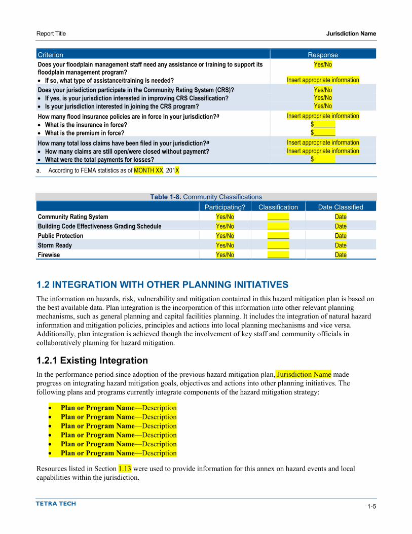
Report Title Jurisdiction Name
1-5
Criterion Response Does your floodplain management staff need any assistance or training to support its floodplain management program?
Yes/No
• If so, what type of assistance/training is needed? Insert appropriate information Does your jurisdiction participate in the Community Rating System (CRS)? Yes/No • If yes, is your jurisdiction interested in improving CRS Classification? Yes/No • Is your jurisdiction interested in joining the CRS program? Yes/No How many flood insurance policies are in force in your jurisdiction?a Insert appropriate information • What is the insurance in force? $_______ • What is the premium in force? $_______ How many total loss claims have been filed in your jurisdiction?a Insert appropriate information • How many claims are still open/were closed without payment? Insert appropriate information • What were the total payments for losses? $_______ a. According to FEMA statistics as of MONTH XX, 201X
Table 1-8. Community Classifications Participating? Classification Date Classified Community Rating System Yes/No _______ Date Building Code Effectiveness Grading Schedule Yes/No _______ Date Public Protection Yes/No _______ Date Storm Ready Yes/No _______ Date Firewise Yes/No _______ Date
1.2 INTEGRATION WITH OTHER PLANNING INITIATIVES The information on hazards, risk, vulnerability and mitigation contained in this hazard mitigation plan is based on the best available data. Plan integration is the incorporation of this information into other relevant planning mechanisms, such as general planning and capital facilities planning. It includes the integration of natural hazard information and mitigation policies, principles and actions into local planning mechanisms and vice versa. Additionally, plan integration is achieved though the involvement of key staff and community officials in collaboratively planning for hazard mitigation.
1.2.1 Existing Integration In the performance period since adoption of the previous hazard mitigation plan, Jurisdiction Name made progress on integrating hazard mitigation goals, objectives and actions into other planning initiatives. The following plans and programs currently integrate components of the hazard mitigation strategy:
• Plan or Program Name—Description • Plan or Program Name—Description • Plan or Program Name—Description • Plan or Program Name—Description • Plan or Program Name—Description • Plan or Program Name—Description
Resources listed in Section 1.13 were used to provide information for this annex on hazard events and local capabilities within the jurisdiction.

Report Title Jurisdiction Name
1-6
1.2.2 Opportunities for Future Integration As this hazard mitigation plan is implemented, Jurisdiction Name will use information from the plan as the best available science and data on natural hazards. The capability assessment presented in this annex identifies codes, plans and programs that provide opportunities for integration. The area-wide and local action plans developed for this hazard mitigation plan in actions related to plan integration, and progress on these actions will be reported through the progress reporting process described in Volume 1. New opportunities for integration also will be identified as part of the annual progress report. The capability assessment identified the following plans and programs that do not currently integrate goals or recommendations of the hazard mitigation plan but provide opportunities to do so in the future:
• Plan or Program Name—Description • Plan or Program Name—Description • Plan or Program Name—Description • Plan or Program Name—Description • Plan or Program Name—Description • Plan or Program Name—Description
1.3 REVIEW AND INCORPORATION OF INFORMATION FOR THIS ANNEX
1.3.1 Existing Reports, Plans, Regulatory Tools and Other Resources The following technical reports, plans, and regulatory mechanisms were reviewed to provide information for this annex.
• Jurisdiction Name Municipal Code—The municipal code was reviewed for the full capability assessment and for identifying opportunities for action plan integration.
• Jurisdiction Name Flood Damage Prevention Ordinance—The flood damage prevention ordinance was reviewed for compliance with the National Flood Insurance Program.
• <INSERT PLAN/PROGRAM AND DESCRIPTION OF HOW IT WAS USED> • <INSERT PLAN/PROGRAM AND DESCRIPTION OF HOW IT WAS USED> • <INSERT PLAN/PROGRAM AND DESCRIPTION OF HOW IT WAS USED> • <INSERT PLAN/PROGRAM AND DESCRIPTION OF HOW IT WAS USED> • Technical Reports and Information—The following outside resources and references were reviewed:
Hazard Mitigation Plan Annex Development Tool-kit—The tool-kit was used to support the development of this annex including past hazard events, noted vulnerabilities, risk ranking and action development.
<INSERT DOCUMENT AND DESCRIPTION OF HOW IT WAS USED>
1.3.2 Staff and Local Stakeholder Involvement in Annex Development Insert discussion per instructions.

DISTRICT ANNEX PHASE 2 TEMPLATE

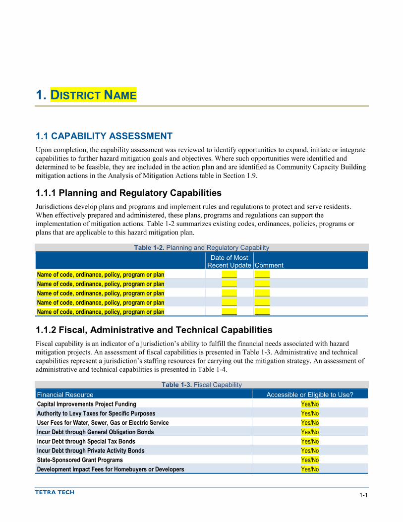
1-1
1. DISTRICT NAME
1.1 CAPABILITY ASSESSMENT Upon completion, the capability assessment was reviewed to identify opportunities to expand, initiate or integrate capabilities to further hazard mitigation goals and objectives. Where such opportunities were identified and determined to be feasible, they are included in the action plan and are identified as Community Capacity Building mitigation actions in the Analysis of Mitigation Actions table in Section 1.9.
1.1.1 Planning and Regulatory Capabilities Jurisdictions develop plans and programs and implement rules and regulations to protect and serve residents. When effectively prepared and administered, these plans, programs and regulations can support the implementation of mitigation actions. Table 1-2 summarizes existing codes, ordinances, policies, programs or plans that are applicable to this hazard mitigation plan.
Table 1-2. Planning and Regulatory Capability
Date of Most
Recent Update Comment Name of code, ordinance, policy, program or plan _____ _____ Name of code, ordinance, policy, program or plan _____ _____ Name of code, ordinance, policy, program or plan _____ _____ Name of code, ordinance, policy, program or plan _____ _____ Name of code, ordinance, policy, program or plan _____ _____
1.1.2 Fiscal, Administrative and Technical Capabilities Fiscal capability is an indicator of a jurisdiction’s ability to fulfill the financial needs associated with hazard mitigation projects. An assessment of fiscal capabilities is presented in Table 1-3. Administrative and technical capabilities represent a jurisdiction’s staffing resources for carrying out the mitigation strategy. An assessment of administrative and technical capabilities is presented in Table 1-4.
Table 1-3. Fiscal Capability Financial Resource Accessible or Eligible to Use? Capital Improvements Project Funding Yes/No Authority to Levy Taxes for Specific Purposes Yes/No User Fees for Water, Sewer, Gas or Electric Service Yes/No Incur Debt through General Obligation Bonds Yes/No Incur Debt through Special Tax Bonds Yes/No Incur Debt through Private Activity Bonds Yes/No State-Sponsored Grant Programs Yes/No Development Impact Fees for Homebuyers or Developers Yes/No
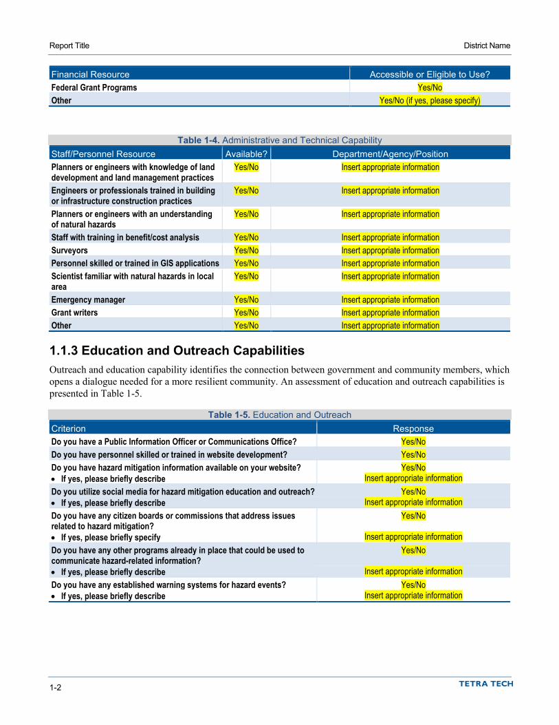
Report Title District Name
1-2
Financial Resource Accessible or Eligible to Use? Federal Grant Programs Yes/No Other Yes/No (if yes, please specify)
Table 1-4. Administrative and Technical Capability Staff/Personnel Resource Available? Department/Agency/Position Planners or engineers with knowledge of land development and land management practices
Yes/No Insert appropriate information
Engineers or professionals trained in building or infrastructure construction practices
Yes/No Insert appropriate information
Planners or engineers with an understanding of natural hazards
Yes/No Insert appropriate information
Staff with training in benefit/cost analysis Yes/No Insert appropriate information Surveyors Yes/No Insert appropriate information Personnel skilled or trained in GIS applications Yes/No Insert appropriate information Scientist familiar with natural hazards in local area
Yes/No Insert appropriate information
Emergency manager Yes/No Insert appropriate information Grant writers Yes/No Insert appropriate information Other Yes/No Insert appropriate information
1.1.3 Education and Outreach Capabilities Outreach and education capability identifies the connection between government and community members, which opens a dialogue needed for a more resilient community. An assessment of education and outreach capabilities is presented in Table 1-5.
Table 1-5. Education and Outreach Criterion Response Do you have a Public Information Officer or Communications Office? Yes/No Do you have personnel skilled or trained in website development? Yes/No Do you have hazard mitigation information available on your website? Yes/No • If yes, please briefly describe Insert appropriate information Do you utilize social media for hazard mitigation education and outreach? Yes/No • If yes, please briefly describe Insert appropriate information Do you have any citizen boards or commissions that address issues related to hazard mitigation?
Yes/No
• If yes, please briefly specify Insert appropriate information Do you have any other programs already in place that could be used to communicate hazard-related information?
Yes/No
• If yes, please briefly describe Insert appropriate information Do you have any established warning systems for hazard events? Yes/No • If yes, please briefly describe Insert appropriate information

Report Title District Name
1-3
1.2 INTEGRATION WITH OTHER PLANNING INITIATIVES The information on hazards, risk, vulnerability and mitigation contained in this hazard mitigation plan is based on the best available data. Plan integration is the incorporation of this information into other relevant planning mechanisms, such as general planning and capital facilities planning. It includes the integration of natural hazard information and mitigation policies, principles and actions into local planning mechanisms and vice versa. Additionally, plan integration is achieved though the involvement of key staff and community officials in collaboratively planning for hazard mitigation.
1.2.1 Existing Integration In the performance period since adoption of the previous hazard mitigation plan, District Name made progress on integrating hazard mitigation goals, objectives and actions into other planning initiatives. The following plans and programs currently integrate components of the hazard mitigation strategy:
• Plan or Program Name—Description • Plan or Program Name—Description • Plan or Program Name—Description • Plan or Program Name—Description • Plan or Program Name—Description
Resources listed in Section 1.12 were used to provide information on hazard events and local capabilities within the jurisdiction.
1.2.2 Opportunities for Future Integration As this hazard mitigation plan is implemented, District Name will use information from the plan as the best available science and data on natural hazards. The capability assessment presented in this annex identifies codes, plans and programs that provide opportunities for integration. The area-wide and local action plans developed for this hazard mitigation plan include actions related to plan integration, and progress on these actions will be reported through the progress reporting process described in Volume 1. New opportunities for integration also will be identified as part of the annual progress report. The capability assessment identified the following plans and programs that do not currently integrate goals or recommendations of the hazard mitigation plan but provide opportunities to do so in the future:
• Plan or Program Name—Description • Plan or Program Name—Description • Plan or Program Name—Description • Plan or Program Name—Description • Plan or Program Name—Description
1.3 REVIEW AND INCORPORATION OF RESOURCES FOR THIS ANNEX
1.3.1 Existing Reports, Plans, Regulatory Tools and Other Resources The following technical reports, plans, and regulatory mechanisms were reviewed to provide information for this annex.
• <INSERT PLAN/PROGRAM AND DESCRIPTION OF HOW IT WAS USED> • <INSERT PLAN/PROGRAM AND DESCRIPTION OF HOW IT WAS USED> • <INSERT PLAN/PROGRAM AND DESCRIPTION OF HOW IT WAS USED>

Report Title District Name
1-4
• Hazard Mitigation Plan Annex Development Tool-kit—The tool-kit was used to support the development of this annex including past hazard events, noted vulnerabilities, risk ranking and action development.
1.3.2 Staff and Local Stakeholder Involvement in Annex Development Insert discussion per instructions.

MUNICIPAL ANNEX PHASE 3 TEMPLATE


1-1
1. JURISDICTION NAME
1.1 HAZARD MITIGATION PLAN POINT OF CONTACT
Primary Point of Contact Alternate Point of Contact Name, Title Street Address City, State ZIP Telephone: xxx-xxx-xxxx e-mail Address: [email protected]
Name, Title Street Address City, State ZIP Telephone: xxx-xxx-xxxx e-mail Address: [email protected]
1.2 JURISDICTION PROFILE The following is a summary of key information about the jurisdiction and its history:
• Date of Incorporation— • Current Population— • Population Growth— • Location and Description— • Brief History— • Climate— • Governing Body Format—___[general description]___. The __[name of adopting body]___ assumes
responsibility for the adoption of this plan; __[name of oversight agency]__ will oversee its implementation.
1.3 DEVELOPMENT TRENDS _DESCRIBE TRENDS IN GENERAL__.
Table 1-1 summarizes development trends in the performance period since development of the previous hazard mitigation plan and expected future development trends.

Report Title Jurisdiction Name
1-2
Table 1-1. Recent and Expected Future Development Trends Criterion Response Has your jurisdiction annexed any land since the development of the previous hazard mitigation plan?
Yes/No
• If yes, give the estimated area annexed and estimated number of parcels or structures.
____________
Is your jurisdiction expected to annex any areas during the performance period of this plan?
Yes/No
• If yes, please describe land areas and dominant uses.
____________
• If yes, who currently has permitting authority over these areas?
____________
Are any areas targeted for development or major redevelopment in the next five years?
Yes/No
• If yes, please briefly describe, including whether any of the areas are in known hazard risk areas
____________
How many permits for new construction were issued in your jurisdiction since the development of the previous hazard mitigation plan?
2011 2012 2013 2014 2015 Single Family __ __ __ __ __ Multi-Family __ __ __ __ __ Other (commercial, mixed use, etc.) __ __ __ __ __
Please provide the number of new-construction permits for each hazard area or provide a qualitative description of where development has occurred.
• Special Flood Hazard Areas: # • Landslide: # • High Liquefaction Areas: # • Tsunami Inundation Area: # • Wildfire Risk Areas: #
Please describe the level of buildout in the jurisdiction, based on your jurisdiction’s buildable lands inventory. If no such inventory exists, provide a qualitative description.
____________
1.4 CAPABILITY ASSESSMENT Jurisdiction Name has performed an inventory and analysis of existing capabilities, plans, programs and policies that enhance its ability to implement mitigation strategies. The introduction at the beginning of this volume of the hazard mitigation plan describes the components included in the capability assessment and their significance for hazard mitigation planning. This section summarizes the following findings of the assessment:
• An assessment of legal and regulatory capabilities is presented in Table 1-2. • Development and permitting capabilities are presented in Table 1-3. • An assessment of fiscal capabilities is presented in Table 1-4. • An assessment of administrative and technical capabilities is presented in Table 1-5. • An assessment of education and outreach capabilities is presented in Table 1-6. • Information on National Flood Insurance Program (NFIP) compliance is presented in Table 1-7. • Classifications under various community mitigation programs are presented in Table 1-8.
The capability assessment was reviewed in order to identify opportunities to expand, initiate or integrate capabilities to further hazard mitigation goals and objectives. Where such opportunities were identified and

Report Title Jurisdiction Name
1-3
determined to be feasible, they are included in the action plan and are identified as Community Capacity Building mitigation actions in the Analysis of Mitigation Actions table in Section 1.10.

Report Title Jurisdiction Name
1-4
Table 1-2. Legal and Regulatory Capability
Local Authority Other Jurisdiction
Authority State Mandated Integration
Opportunity? Codes, Ordinances, & Requirements Building Code Yes/No Yes/No Yes/No Yes/No Comment: Zoning Code Yes/No Yes/No Yes/No Yes/No Comment: Subdivisions Yes/No Yes/No Yes/No Yes/No Comment: Stormwater Management Yes/No Yes/No Yes/No Yes/No Comment: Post-Disaster Recovery Yes/No Yes/No Yes/No Yes/No Comment: Real Estate Disclosure Yes/No Yes/No Yes/No Yes/No Comment: Growth Management Yes/No Yes/No Yes/No Yes/No Comment: Site Plan Review Yes/No Yes/No Yes/No Yes/No Comment: Environmental Protection Yes/No Yes/No Yes/No Yes/No Comment: Flood Damage Prevention Yes/No Yes/No Yes/No Yes/No Comment: Emergency Management Yes/No Yes/No Yes/No Yes/No Comment: Climate Change Yes/No Yes/No Yes/No Yes/No Comment: Other: Yes/No Yes/No Yes/No Yes/No Comment: Planning Documents General Plan Yes/No Yes/No Yes/No Yes/No Is the plan compliant with Assembly Bill 2140? Yes/No Comment: Capital Improvement Plan Yes/No Yes/No Yes/No Yes/No How often is the plan updated? ____________ Comment: Floodplain or Watershed Plan Yes/No Yes/No Yes/No Yes/No Comment: Stormwater Plan Yes/No Yes/No Yes/No Yes/No Comment: Urban Water Management Plan Yes/No Yes/No Yes/No Yes/No Comment: Habitat Conservation Plan Yes/No Yes/No Yes/No Yes/No Comment: Economic Development Plan Yes/No Yes/No Yes/No Yes/No Comment: Shoreline Management Plan Yes/No Yes/No Yes/No Yes/No Comment:

Report Title Jurisdiction Name
1-5
Local Authority Other Jurisdiction
Authority State Mandated Integration
Opportunity? Community Wildfire Protection Plan Yes/No Yes/No Yes/No Yes/No Comment: Forest Management Plan Yes/No Yes/No Yes/No Yes/No Comment: Climate Action Plan Yes/No Yes/No Yes/No Yes/No Comment: Comprehensive Emergency Management Plan Yes/No Yes/No Yes/No Yes/No Comment: Threat & Hazard Identification & Risk Assessment (THIRA)
Yes/No Yes/No Yes/No Yes/No
Comment: Post-Disaster Recovery Plan Yes/No Yes/No Yes/No Yes/No Comment: Continuity of Operations Plan Yes/No Yes/No Yes/No Yes/No Comment: Public Health Plan Yes/No Yes/No Yes/No Yes/No Comment: Other: Yes/No Yes/No Yes/No Yes/No Comment:
Table 1-3. Development and Permitting Capability Criterion Response Does your jurisdiction issue development permits? Yes/No • If no, who does? If yes, which department? ____________ Does your jurisdiction have the ability to track permits by hazard area? Yes/No Does your jurisdiction have a buildable lands inventory? Yes/No
Table 1-4. Fiscal Capability Financial Resource Accessible or Eligible to Use? Community Development Block Grants Yes/No Capital Improvements Project Funding Yes/No Authority to Levy Taxes for Specific Purposes Yes/No User Fees for Water, Sewer, Gas or Electric Service Yes/No- If yes, please specify Incur Debt through General Obligation Bonds Yes/No Incur Debt through Special Tax Bonds Yes/No Incur Debt through Private Activity Bonds Yes/No Withhold Public Expenditures in Hazard-Prone Areas Yes/No State-Sponsored Grant Programs Yes/No Development Impact Fees for Homebuyers or Developers Yes/No Other Yes/No (if yes, please specify)

Report Title Jurisdiction Name
1-6
Table 1-5. Administrative and Technical Capability Staff/Personnel Resource Available? Department/Agency/Position Planners or engineers with knowledge of land development and land management practices
Yes/No Insert appropriate information
Engineers or professionals trained in building or infrastructure construction practices
Yes/No Insert appropriate information
Planners or engineers with an understanding of natural hazards Yes/No Insert appropriate information Staff with training in benefit/cost analysis Yes/No Insert appropriate information Surveyors Yes/No Insert appropriate information Personnel skilled or trained in GIS applications Yes/No Insert appropriate information Scientist familiar with natural hazards in local area Yes/No Insert appropriate information Emergency Manager Yes/No Insert appropriate information Grant writers Yes/No Insert appropriate information Other Yes/No Insert appropriate information
Table 1-6. Education and Outreach Capability Criterion Response Do you have a Public Information Officer or Communications Office? Yes/No Do you have personnel skilled or trained in website development? Yes/No Do you have hazard mitigation information available on your website? Yes/No • If yes, please briefly describe. Insert appropriate information Do you utilize social media for hazard mitigation education and outreach? Yes/No • If yes, please briefly describe. Insert appropriate information Do you have any citizen boards or commissions that address issues related to hazard mitigation?
Yes/No
• If yes, please briefly describe. Insert appropriate information Do you have any other programs already in place that could be used to communicate hazard-related information?
Yes/No
• If yes, please briefly describe. Insert appropriate information Do you have any established warning systems for hazard events? Yes/No • If yes, please briefly describe. Insert appropriate information
Table 1-7. National Flood Insurance Program Compliance Criterion Response What local department is responsible for floodplain management? Insert appropriate information Who is your floodplain administrator? (department/position) Insert appropriate information Are any certified floodplain managers on staff in your jurisdiction? Yes/No What is the date that your flood damage prevention ordinance was last amended? Insert appropriate information Does your floodplain management program meet or exceed minimum requirements? Meets/Exceeds • If exceeds, in what ways? Insert appropriate information When was the most recent Community Assistance Visit or Community Assistance Contact?
Insert appropriate information
Does your jurisdiction have any outstanding NFIP compliance violations that need to be addressed?
Yes/No
• If so, please state what they are. Insert appropriate information Do your flood hazard maps adequately address the flood risk within your jurisdiction? Yes/No • If no, please state why. Insert appropriate information

Report Title Jurisdiction Name
1-7
Criterion Response Does your floodplain management staff need any assistance or training to support its floodplain management program?
Yes/No
• If so, what type of assistance/training is needed? Insert appropriate information Does your jurisdiction participate in the Community Rating System (CRS)? Yes/No • If yes, is your jurisdiction interested in improving CRS Classification? Yes/No • Is your jurisdiction interested in joining the CRS program? Yes/No How many flood insurance policies are in force in your jurisdiction?a Insert appropriate information • What is the insurance in force? $_______ • What is the premium in force? $_______ How many total loss claims have been filed in your jurisdiction?a Insert appropriate information • How many claims are still open/were closed without payment? Insert appropriate information • What were the total payments for losses? $_______ a. According to FEMA statistics as of MONTH XX, 201X
Table 1-8. Community Classifications Participating? Classification Date Classified Community Rating System Yes/No _______ Date Building Code Effectiveness Grading Schedule Yes/No _______ Date Public Protection Yes/No _______ Date Storm Ready Yes/No _______ Date Firewise Yes/No _______ Date
1.5 INTEGRATION WITH OTHER PLANNING INITIATIVES The information on hazards, risk, vulnerability and mitigation contained in this hazard mitigation plan is based on the best available data. Plan integration is the incorporation of this information into other relevant planning mechanisms, such as general planning and capital facilities planning. It includes the integration of natural hazard information and mitigation policies, principles and actions into local planning mechanisms and vice versa. Additionally, plan integration is achieved though the involvement of key staff and community officials in collaboratively planning for hazard mitigation.
1.5.1 Existing Integration In the performance period since adoption of the previous hazard mitigation plan, Jurisdiction Name made progress on integrating hazard mitigation goals, objectives and actions into other planning initiatives. The following plans and programs currently integrate components of the hazard mitigation strategy:
• Plan or Program Name—Description • Plan or Program Name—Description • Plan or Program Name—Description • Plan or Program Name—Description • Plan or Program Name—Description • Plan or Program Name—Description
Resources listed in Section 1.13 were used to provide information for this annex on hazard events and local capabilities within the jurisdiction.

Report Title Jurisdiction Name
1-8
1.5.2 Opportunities for Future Integration As this hazard mitigation plan is implemented, Jurisdiction Name will use information from the plan as the best available science and data on natural hazards. The capability assessment presented in this annex identifies codes, plans and programs that provide opportunities for integration. The area-wide and local action plans developed for this hazard mitigation plan in actions related to plan integration, and progress on these actions will be reported through the progress reporting process described in Volume 1. New opportunities for integration also will be identified as part of the annual progress report. The capability assessment identified the following plans and programs that do not currently integrate goals or recommendations of the hazard mitigation plan but provide opportunities to do so in the future:
• Plan or Program Name—Description • Plan or Program Name—Description • Plan or Program Name—Description • Plan or Program Name—Description • Plan or Program Name—Description • Plan or Program Name—Description
1.6 JURISDICTION-SPECIFIC NATURAL HAZARD EVENT HISTORY Table 1-10 lists past occurrences of natural hazards for which specific damage was recorded in Jurisdiction Name. Other hazard events that broadly affected the entire planning area, including Jurisdiction Name, are listed in the risk assessments in Volume 1 of this hazard mitigation plan.
Table 1-10. Past Natural Hazard Events
Type of Event FEMA Disaster #
(if applicable) Date Damage Assessment Insert event type _______ Date $______ Insert event type _______ Date $______ Insert event type _______ Date $______ Insert event type _______ Date $______ Insert event type _______ Date $______ Insert event type _______ Date $______ Insert event type _______ Date $______ Insert event type _______ Date $______ Insert event type _______ Date $______ Insert event type _______ Date $______ Insert event type _______ Date $______ Insert event type _______ Date $______ Insert event type _______ Date $______ Insert event type _______ Date $______ Insert event type _______ Date $______
1.7 HAZARD RISK RANKING Table 1-11 presents a local ranking for Jurisdiction Name of all hazards of concern for which Volume 1 of this hazard mitigation plan provides complete risk assessments. This ranking summarizes how hazards vary for this jurisdiction. As described in detail in Volume 1, the ranking process involves an assessment of the likelihood of
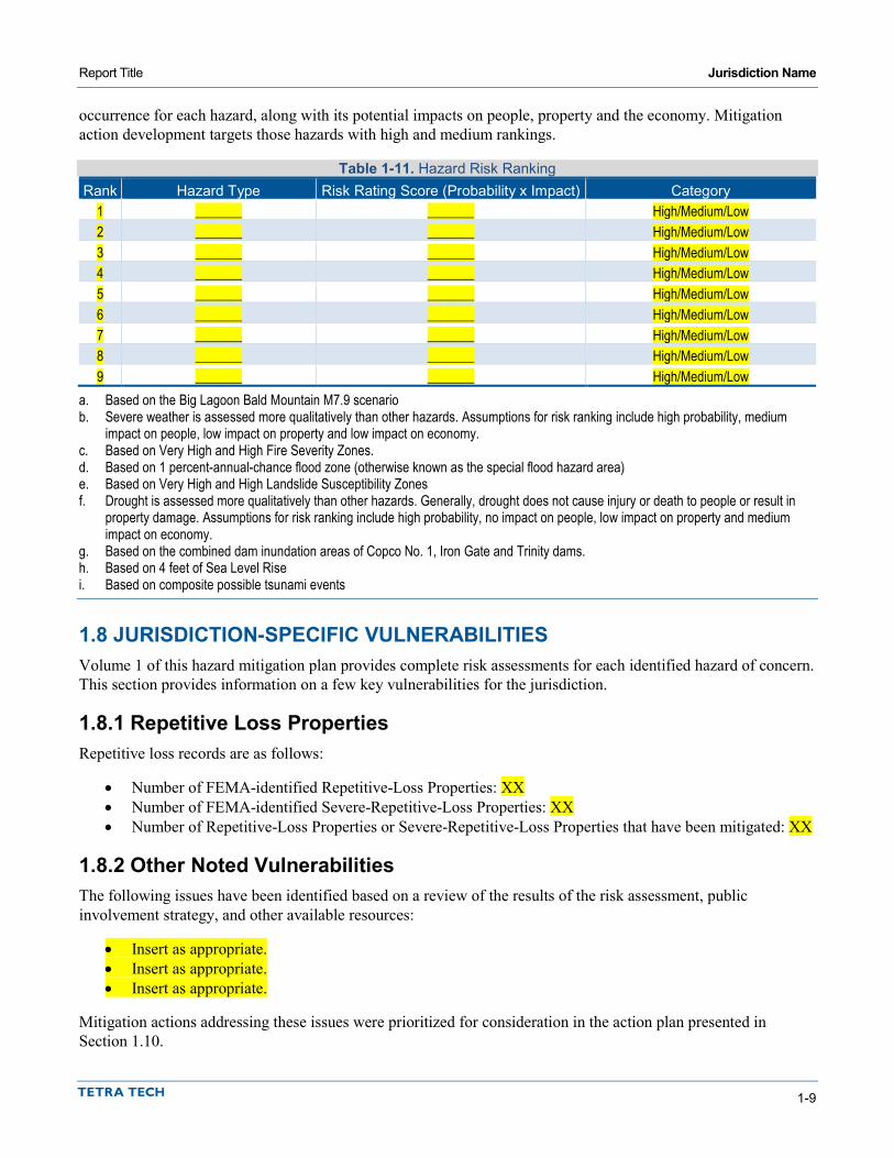
Report Title Jurisdiction Name
1-9
occurrence for each hazard, along with its potential impacts on people, property and the economy. Mitigation action development targets those hazards with high and medium rankings.
Table 1-11. Hazard Risk Ranking Rank Hazard Type Risk Rating Score (Probability x Impact) Category
1 _______ _______ High/Medium/Low 2 _______ _______ High/Medium/Low 3 _______ _______ High/Medium/Low 4 _______ _______ High/Medium/Low 5 _______ _______ High/Medium/Low 6 _______ _______ High/Medium/Low 7 _______ _______ High/Medium/Low 8 _______ _______ High/Medium/Low 9 _______ _______ High/Medium/Low
a. Based on the Big Lagoon Bald Mountain M7.9 scenario b. Severe weather is assessed more qualitatively than other hazards. Assumptions for risk ranking include high probability, medium
impact on people, low impact on property and low impact on economy. c. Based on Very High and High Fire Severity Zones. d. Based on 1 percent-annual-chance flood zone (otherwise known as the special flood hazard area) e. Based on Very High and High Landslide Susceptibility Zones f. Drought is assessed more qualitatively than other hazards. Generally, drought does not cause injury or death to people or result in
property damage. Assumptions for risk ranking include high probability, no impact on people, low impact on property and medium impact on economy.
g. Based on the combined dam inundation areas of Copco No. 1, Iron Gate and Trinity dams. h. Based on 4 feet of Sea Level Rise i. Based on composite possible tsunami events
1.8 JURISDICTION-SPECIFIC VULNERABILITIES Volume 1 of this hazard mitigation plan provides complete risk assessments for each identified hazard of concern. This section provides information on a few key vulnerabilities for the jurisdiction.
1.8.1 Repetitive Loss Properties Repetitive loss records are as follows:
• Number of FEMA-identified Repetitive-Loss Properties: XX • Number of FEMA-identified Severe-Repetitive-Loss Properties: XX • Number of Repetitive-Loss Properties or Severe-Repetitive-Loss Properties that have been mitigated: XX
1.8.2 Other Noted Vulnerabilities The following issues have been identified based on a review of the results of the risk assessment, public involvement strategy, and other available resources:
• Insert as appropriate. • Insert as appropriate. • Insert as appropriate.
Mitigation actions addressing these issues were prioritized for consideration in the action plan presented in Section 1.10.

Report Title Jurisdiction Name
1-10
1.9 STATUS OF PREVIOUS PLAN ACTIONS Table 1-12 summarizes the actions that were recommended in the previous version of the hazard mitigation plan and their implementation status at the time this update was prepared.
Table 1-12. Status of Previous Plan Actions
Removed; Carried Over to
Plan Update
Action Item Completed No Longer Feasible
Check if Yes
Enter Action #
Insert Action Text Action# Comment: Insert Action Text Action# Comment: Insert Action Text Action# Comment: Insert Action Text Action# Comment: Insert Action Text Action# Comment: Insert Action Text Action# Comment: Insert Action Text Action# Comment: Insert Action Text Action# Comment: Insert Action Text Action# Comment: Insert Action Text Action# Comment: Insert Action Text Action# Comment: Insert Action Text Action# Comment:
1.10 HAZARD MITIGATION ACTION PLAN AND EVALUATION OF RECOMMENDED ACTIONS Table 1-13 lists the actions that make up the Jurisdiction Name hazard mitigation action plan. Table 1-14 identifies the priority for each action. Table 1-15 summarizes the mitigation actions by hazard of concern and mitigation type.
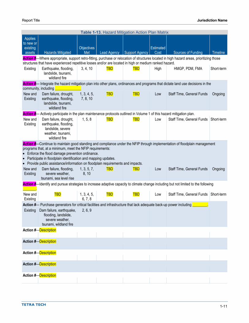
Report Title Jurisdiction Name
1-11
Table 1-13. Hazard Mitigation Action Plan Matrix Applies
to new or existing assets Hazards Mitigated
Objectives Met Lead Agency Support Agency
Estimated Cost Sources of Funding Timeline
Action #—Where appropriate, support retro-fitting, purchase or relocation of structures located in high hazard areas, prioritizing those structures that have experienced repetitive losses and/or are located in high or medium ranked hazard. Existing Earthquake, flooding,
landslide, tsunami, wildland fire
3, 4, 10 TBD TBD High HMGP, PDM, FMA Short-term
Action #— Integrate the hazard mitigation plan into other plans, ordinances and programs that dictate land use decisions in the community, including ______________ New and Existing
Dam failure, drought, earthquake, flooding, landslide, tsunami,
wildland fire
1, 3, 4, 5, 7, 8, 10
TBD TBD Low Staff Time, General Funds Ongoing
Action #— Actively participate in the plan maintenance protocols outlined in Volume 1 of this hazard mitigation plan. New and Existing
Dam failure, drought, earthquake, flooding,
landslide, severe weather, tsunami,
wildland fire
1, 5, 8 TBD TBD Low Staff Time, General Funds Short-term
Action #—Continue to maintain good standing and compliance under the NFIP through implementation of floodplain management programs that, at a minimum, meet the NFIP requirements: • Enforce the flood damage prevention ordinance. • Participate in floodplain identification and mapping updates. • Provide public assistance/information on floodplain requirements and impacts. New and Existing
Dam failure, flooding, severe weather,
tsunami, sea level rise
1, 3, 5, 7, 8, 10
TBD TBD Low Staff Time, General Funds Ongoing
Action #—Identify and pursue strategies to increase adaptive capacity to climate change including but not limited to the following _______. New and Existing
TBD 1, 3, 4, 5, 6, 7, 8
TBD TBD Low Staff Time, General Funds Short-term
Action #— Purchase generators for critical facilities and infrastructure that lack adequate back-up power including ________. Existing Dam failure, earthquake,
flooding, landslide, severe weather,
tsunami, wildland fire
2, 6, 9
Action #—Description
Action #—Description
Action #—Description
Action #—Description
Action #—Description
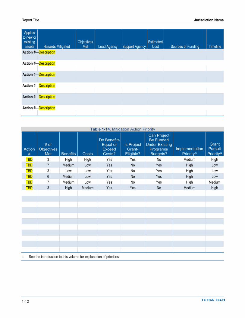
Report Title Jurisdiction Name
1-12
Applies to new or existing assets Hazards Mitigated
Objectives Met Lead Agency Support Agency
Estimated Cost Sources of Funding Timeline
Action #—Description
Action #—Description
Action #—Description
Action #—Description
Action #—Description
Action #—Description
Table 1-14. Mitigation Action Priority
Action #
# of Objectives
Met Benefits Costs
Do Benefits Equal or Exceed Costs?
Is Project Grant-
Eligible?
Can Project Be Funded
Under Existing Programs/ Budgets?
Implementation Prioritya
Grant Pursuit Prioritya
TBD 3 High High Yes Yes No Medium High TBD 7 Medium Low Yes No Yes High Low TBD 3 Low Low Yes No Yes High Low TBD 6 Medium Low Yes No Yes High Low TBD 7 Medium Low Yes No Yes High Medium TBD 3 High Medium Yes Yes No Medium High
a. See the introduction to this volume for explanation of priorities.

Report Title Jurisdiction Name
1-13
Table 1-15. Analysis of Mitigation Actions Action Addressing Hazard, by Mitigation Typea
Hazard Type Prevention Property
Protection
Public Education and
Awareness
Natural Resource Protection
Emergency Services
Structural Projects
Community Capacity Building
____________ ____________ ____________ ____________ ____________ ____________ ____________ ____________ ____________ a. See the introduction to this volume for explanation of mitigation types.
1.11 FUTURE NEEDS TO BETTER UNDERSTAND RISK/VULNERABILITY Insert text, if any; otherwise, delete section
1.12 ADDITIONAL COMMENTS Insert text, if any; otherwise, delete section
1.13 REVIEW AND INCORPORATION OF INFORMATION FOR THIS ANNEX
1.13.1 Existing Reports, Plans, Regulatory Tools and Other Resources The following technical reports, plans, and regulatory mechanisms were reviewed to provide information for this annex.
• Jurisdiction Name Municipal Code—The municipal code was reviewed for the full capability assessment and for identifying opportunities for action plan integration.
• Jurisdiction Name Flood Damage Prevention Ordinance—The flood damage prevention ordinance was reviewed for compliance with the National Flood Insurance Program.
• <INSERT PLAN/PROGRAM AND DESCRIPTION OF HOW IT WAS USED> • <INSERT PLAN/PROGRAM AND DESCRIPTION OF HOW IT WAS USED> • <INSERT PLAN/PROGRAM AND DESCRIPTION OF HOW IT WAS USED> • <INSERT PLAN/PROGRAM AND DESCRIPTION OF HOW IT WAS USED> • Technical Reports and Information—The following outside resources and references were reviewed:
Hazard Mitigation Plan Annex Development Tool-kit—The tool-kit was used to support the development of this annex including past hazard events, noted vulnerabilities, risk ranking and action development.
<INSERT DOCUMENT AND DESCRIPTION OF HOW IT WAS USED>
1.13.2 Staff and Local Stakeholder Involvement in Annex Development Insert discussion per instructions.


DISTRICT ANNEX PHASE 3 TEMPLATE


1-1
1. DISTRICT NAME
1.1 HAZARD MITIGATION PLAN POINT OF CONTACT
Primary Point of Contact Alternate Point of Contact Name, Title Street Address City, State ZIP Telephone: xxx-xxx-xxxx e-mail Address: [email protected]
Name, Title Street Address City, State ZIP Telephone: xxx-xxx-xxxx e-mail Address: [email protected]
1.2 JURISDICTION PROFILE
1.2.1 Overview Insert Narrative Profile Information, per Instructions. The __[name of adopting body]___ assumes responsibility for the adoption of this plan; __[name of oversight agency]__ will oversee its implementation.
For fire districts please be sure to include the following sentence (Non-fire Special Purpose Districts may delete the sentence):
The District participates/does not participate in the Public Protection Class Rating System and currently has a rating of #.
1.2.2 Service Area and Trends The district serves a population of _ population_. Its service area covers an area of _area_.
Insert summary description of service trends.
1.2.3 Assets Table 1-1 summarizes the critical assets of the district and their value.

Report Title District Name
1-2
Table 1-1. Special Purpose District Assets Asset Value Property _number_ acres of land $_value_ Critical Infrastructure and Equipment _description_ $_value_ _description_ $_value_ _description_ $_value_ _description_ $_value_ _description_ $_value_ Total: $_value_ Critical Facilities _description_ $_value_ _description_ $_value_ _description_ $_value_ _description_ $_value_ _description_ $_value_ _description_ $_value_ Total: $_value_
1.3 CAPABILITY ASSESSMENT Upon completion, the capability assessment was reviewed to identify opportunities to expand, initiate or integrate capabilities to further hazard mitigation goals and objectives. Where such opportunities were identified and determined to be feasible, they are included in the action plan and are identified as Community Capacity Building mitigation actions in the Analysis of Mitigation Actions table in Section 1.9.
1.3.1 Planning and Regulatory Capabilities Jurisdictions develop plans and programs and implement rules and regulations to protect and serve residents. When effectively prepared and administered, these plans, programs and regulations can support the implementation of mitigation actions. Table 1-2 summarizes existing codes, ordinances, policies, programs or plans that are applicable to this hazard mitigation plan.
Table 1-2. Planning and Regulatory Capability
Date of Most
Recent Update Comment Name of code, ordinance, policy, program or plan _____ _____ Name of code, ordinance, policy, program or plan _____ _____ Name of code, ordinance, policy, program or plan _____ _____ Name of code, ordinance, policy, program or plan _____ _____ Name of code, ordinance, policy, program or plan _____ _____
1.3.2 Fiscal, Administrative and Technical Capabilities Fiscal capability is an indicator of a jurisdiction’s ability to fulfill the financial needs associated with hazard mitigation projects. An assessment of fiscal capabilities is presented in Table 1-3. Administrative and technical
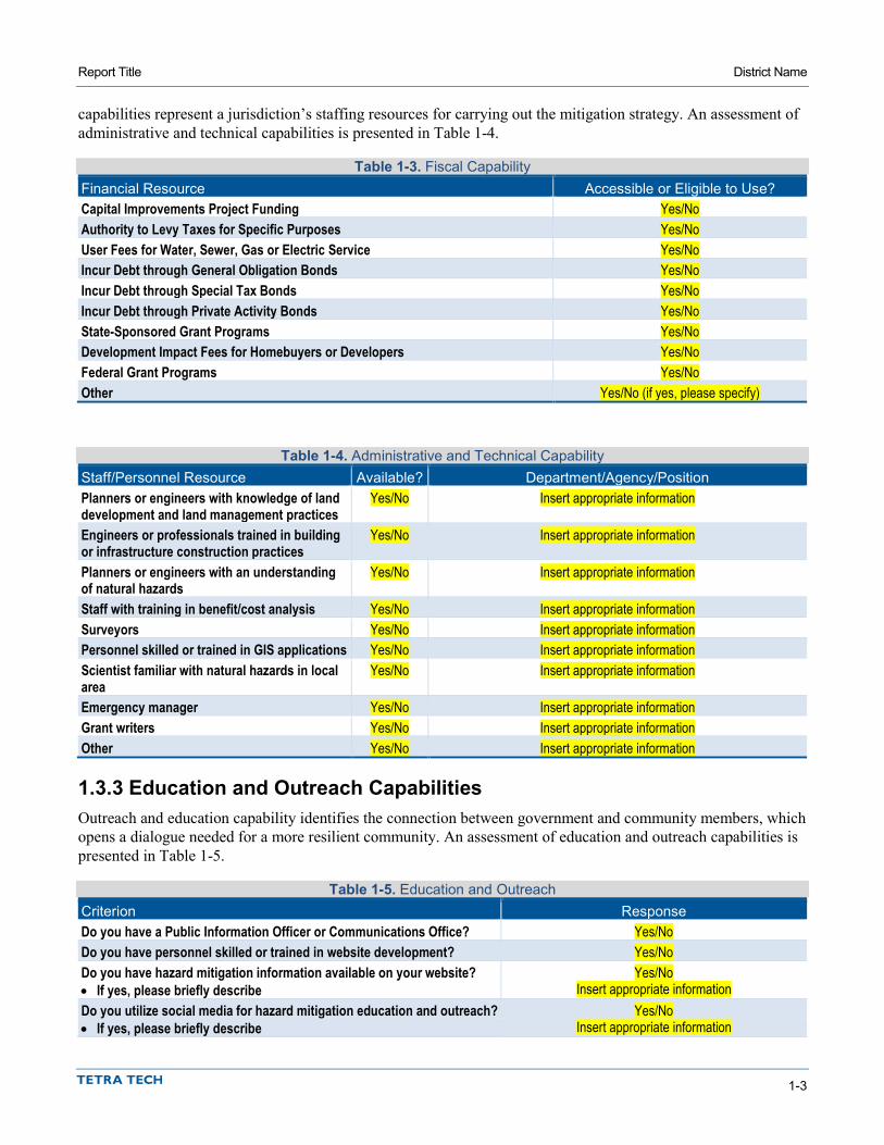
Report Title District Name
1-3
capabilities represent a jurisdiction’s staffing resources for carrying out the mitigation strategy. An assessment of administrative and technical capabilities is presented in Table 1-4.
Table 1-3. Fiscal Capability Financial Resource Accessible or Eligible to Use? Capital Improvements Project Funding Yes/No Authority to Levy Taxes for Specific Purposes Yes/No User Fees for Water, Sewer, Gas or Electric Service Yes/No Incur Debt through General Obligation Bonds Yes/No Incur Debt through Special Tax Bonds Yes/No Incur Debt through Private Activity Bonds Yes/No State-Sponsored Grant Programs Yes/No Development Impact Fees for Homebuyers or Developers Yes/No Federal Grant Programs Yes/No Other Yes/No (if yes, please specify)
Table 1-4. Administrative and Technical Capability Staff/Personnel Resource Available? Department/Agency/Position Planners or engineers with knowledge of land development and land management practices
Yes/No Insert appropriate information
Engineers or professionals trained in building or infrastructure construction practices
Yes/No Insert appropriate information
Planners or engineers with an understanding of natural hazards
Yes/No Insert appropriate information
Staff with training in benefit/cost analysis Yes/No Insert appropriate information Surveyors Yes/No Insert appropriate information Personnel skilled or trained in GIS applications Yes/No Insert appropriate information Scientist familiar with natural hazards in local area
Yes/No Insert appropriate information
Emergency manager Yes/No Insert appropriate information Grant writers Yes/No Insert appropriate information Other Yes/No Insert appropriate information
1.3.3 Education and Outreach Capabilities Outreach and education capability identifies the connection between government and community members, which opens a dialogue needed for a more resilient community. An assessment of education and outreach capabilities is presented in Table 1-5.
Table 1-5. Education and Outreach Criterion Response Do you have a Public Information Officer or Communications Office? Yes/No Do you have personnel skilled or trained in website development? Yes/No Do you have hazard mitigation information available on your website? Yes/No • If yes, please briefly describe Insert appropriate information Do you utilize social media for hazard mitigation education and outreach? Yes/No • If yes, please briefly describe Insert appropriate information

Report Title District Name
1-4
Criterion Response Do you have any citizen boards or commissions that address issues related to hazard mitigation?
Yes/No
• If yes, please briefly specify Insert appropriate information Do you have any other programs already in place that could be used to communicate hazard-related information?
Yes/No
• If yes, please briefly describe Insert appropriate information Do you have any established warning systems for hazard events? Yes/No • If yes, please briefly describe Insert appropriate information
1.3.4 Adaptive Capacity for Climate Change Given the uncertainties associated with how hazard risk may change with a changing climate, a jurisdiction’s ability to track such changes and adapt as needed is an important component of the mitigation strategy. Table 1-6 summarizes the District’s adaptive capacity for climate change.
Table 1-6. Adaptive Capacity for Climate Change Criterion Jurisdiction Ratinga
Technical Capacity Jurisdiction-level understanding of potential climate change impacts High/Medium/Low Comment: Jurisdiction-level monitoring of climate change impacts High/Medium/Low Comment: Technical resources to assess proposed strategies for feasibility and externalities High/Medium/Low Comment: Jurisdiction-level capacity for development of greenhouse gas emissions inventory High/Medium/Low Comment: Capital planning and land use decisions informed by potential climate impacts High/Medium/Low Comment: Participation in regional groups addressing climate risks High/Medium/Low Comment: Implementation Capacity Clear authority/mandate to consider climate change impacts during public decision-making processes High/Medium/Low Comment: Identified strategies for greenhouse gas mitigation efforts High/Medium/Low Comment: Identified strategies for adaptation to impacts High/Medium/Low Comment: Champions for climate action in local government departments High/Medium/Low Comment: Political support for implementing climate change adaptation strategies High/Medium/Low Comment: Financial resources devoted to climate change adaptation High/Medium/Low Comment: Local authority over sectors likely to be negative impacted High/Medium/Low Comment:

Report Title District Name
1-5
Criterion Jurisdiction Ratinga
Public Capacity Local residents knowledge of and understanding of climate risk High/Medium/Low Comment: Local residents support of adaptation efforts High/Medium/Low Comment: Local residents’ capacity to adapt to climate impacts High/Medium/Low Comment: Local economy current capacity to adapt to climate impacts High/Medium/Low Comment: Local ecosystems capacity to adapt to climate impacts High/Medium/Low Comment: a. High = Capacity exists and is in use; Medium = Capacity may exist, but is not used or could use some improvement;
Low = Capacity does not exist or could use substantial improvement; Unsure= Not enough information is known to assign a rating.
1.4 INTEGRATION WITH OTHER PLANNING INITIATIVES The information on hazards, risk, vulnerability and mitigation contained in this hazard mitigation plan is based on the best available data. Plan integration is the incorporation of this information into other relevant planning mechanisms, such as general planning and capital facilities planning. It includes the integration of natural hazard information and mitigation policies, principles and actions into local planning mechanisms and vice versa. Additionally, plan integration is achieved though the involvement of key staff and community officials in collaboratively planning for hazard mitigation.
1.4.1 Existing Integration In the performance period since adoption of the previous hazard mitigation plan, District Name made progress on integrating hazard mitigation goals, objectives and actions into other planning initiatives. The following plans and programs currently integrate components of the hazard mitigation strategy:
• Plan or Program Name—Description • Plan or Program Name—Description • Plan or Program Name—Description • Plan or Program Name—Description • Plan or Program Name—Description
Resources listed in Section 1.12 were used to provide information on hazard events and local capabilities within the jurisdiction.
1.4.2 Opportunities for Future Integration As this hazard mitigation plan is implemented, District Name will use information from the plan as the best available science and data on natural hazards. The capability assessment presented in this annex identifies codes, plans and programs that provide opportunities for integration. The area-wide and local action plans developed for this hazard mitigation plan include actions related to plan integration, and progress on these actions will be reported through the progress reporting process described in Volume 1. New opportunities for integration also will be identified as part of the annual progress report. The capability assessment identified the following plans and programs that do not currently integrate goals or recommendations of the hazard mitigation plan but provide opportunities to do so in the future:

Report Title District Name
1-6
• Plan or Program Name—Description • Plan or Program Name—Description • Plan or Program Name—Description • Plan or Program Name—Description • Plan or Program Name—Description
1.5 JURISDICTION-SPECIFIC NATURAL HAZARD EVENT HISTORY Table 1-7 lists past occurrences of natural hazards for which specific damage was recorded in District Name. Other hazard events that broadly affected the entire planning area, including District Name, are listed in the risk assessments in Volume 1 of this hazard mitigation plan.
Table 1-7. Natural Hazard Events
Type of Event FEMA Disaster #
(if applicable) Date Damage Assessment Insert event type _______ Date $______ Insert event type _______ Date $______ Insert event type _______ Date $______ Insert event type _______ Date $______ Insert event type _______ Date $______ Insert event type _______ Date $______ Insert event type _______ Date $______ Insert event type _______ Date $______ Insert event type _______ Date $______ Insert event type _______ Date $______ Insert event type _______ Date $______ Insert event type _______ Date $______ Insert event type _______ Date $______ Insert event type _______ Date $______ Insert event type _______ Date $______
1.6 HAZARD RISK RANKING Table 1-8 presents a local ranking for District Name of all hazards of concern for which Volume 1 of this hazard mitigation plan provides complete risk assessments. This ranking summarizes how hazards vary for this jurisdiction. As described in detail in Volume 1, the ranking process involves an assessment of the likelihood of occurrence for each hazard, along with its potential impacts on people, property and the economy. Mitigation action development targets those hazards with high and medium rankings.
Table 1-8. Hazard Risk Ranking Rank Hazard Type Risk Rating Score (Probability x Impact) Category
1 _______ _______ High/Medium/Low 2 _______ _______ High/Medium/Low 3 _______ _______ High/Medium/Low 4 _______ _______ High/Medium/Low 5 _______ _______ High/Medium/Low 6 _______ _______ High/Medium/Low

Report Title District Name
1-7
Rank Hazard Type Risk Rating Score (Probability x Impact) Category 7 _______ _______ High/Medium/Low 8 _______ _______ High/Medium/Low 9 _______ _______ High/Medium/Low
a. Based on the Big Lagoon Bald Mountain M7.9 scenario b. Severe weather is assessed more qualitatively than other hazards. Assumptions for risk ranking include high probability, medium
impact on people, low impact on property and low impact on economy. c. Based on Very High and High Fire Severity Zones. d. Based on 1 percent-annual-chance flood zone (otherwise known as the special flood hazard area) e. Based on Very High and High Landslide Susceptibility Zones f. Drought is assessed more qualitatively than other hazards. Generally, drought does not cause injury or death to people or result in
property damage. Assumptions for risk ranking include high probability, no impact on people, low impact on property and medium impact on economy.
g. Based on the combined dam inundation areas of Copco No. 1, Iron Gate and Trinity dams. h. Based on 4 feet of Sea Level Rise i. Based on composite possible tsunami events
1.7 JURISDICTION-SPECIFIC VULNERABILITIES Volume 1 of this hazard mitigation plan provides complete risk assessments for each identified hazard of concern. This section provides information on a few key vulnerabilities for the jurisdiction. The following issues have been identified based on a review of the results of the risk assessment, public involvement strategy, and other available resources:
• Insert as appropriate. • Insert as appropriate. • Insert as appropriate.
Mitigation actions addressing these issues were prioritized for consideration in the action plan presented in Section 1.9.
1.8 STATUS OF PREVIOUS PLAN ACTIONS Table 1-9 summarizes the actions that were recommended in the previous version of the hazard mitigation plan and their implementation status at the time this update was prepared.
Table 1-9. Status of Previous Plan Actions
Removed; Carried Over to
Plan Update
Action Item Completed No Longer Feasible
Check if Yes
Enter Action #
Insert Action Text Action# Comment: Insert Action Text Action# Comment: Insert Action Text Action# Comment: Insert Action Text Action# Comment: Insert Action Text Action#

Report Title District Name
1-8
Removed; Carried Over to
Plan Update
Action Item Completed No Longer Feasible
Check if Yes
Enter Action #
Comment: Insert Action Text Action# Comment: Insert Action Text Action# Comment: Insert Action Text Action# Comment: Insert Action Text Action# Comment: Insert Action Text Action# Comment: Insert Action Text Action# Comment: Insert Action Text Action# Comment:
1.9 HAZARD MITIGATION ACTION PLAN AND EVALUATION OF RECOMMENDED ACTIONS Table 1-10 lists the actions that make up the District Name hazard mitigation action plan. Table 1-11 identifies the priority for each action. Table 1-12 summarizes the mitigation actions by hazard of concern and mitigation type.
Table 1-10. Hazard Mitigation Action Plan Matrix Applies
to new or existing assets Hazards Mitigated
Objectives Met Lead Agency Support Agency
Estimated Cost Sources of Funding Timeline
Action #—Where appropriate, support retro-fitting, purchase or relocation of structures located in high hazard areas, prioritizing those structures that have experienced repetitive losses and/or are located in high or medium ranked hazard. Existing Earthquake, flooding,
landslide, tsunami, wildland fire
3, 4, 10 TBD TBD High HMGP, PDM, FMA Short-term
Action #—Actively participate in the plan maintenance protocols outlined in Volume 1 of this hazard mitigation plan. New and Existing
Dam failure, drought, earthquake, flooding,
landslide, severe weather, tsunami,
wildland fire
1, 5, 8 TBD TBD Low Staff Time, General Funds Short-term
Action #—Purchase generators for critical facilities and infrastructure that lack adequate back-up power including ________. Existing Dam failure,
earthquake, flooding, landslide, severe weather, tsunami,
wildland fire
2, 6, 9 TBD Medium HMGP, PDM Short-term
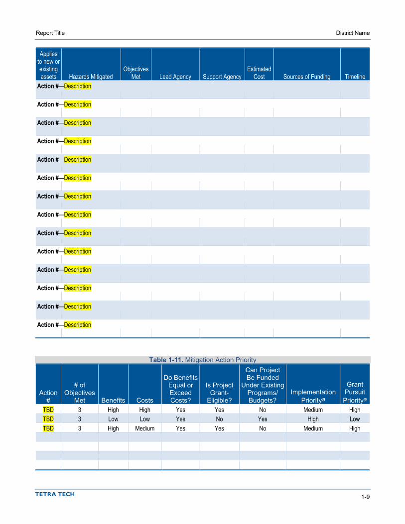
Report Title District Name
1-9
Applies to new or existing assets Hazards Mitigated
Objectives Met Lead Agency Support Agency
Estimated Cost Sources of Funding Timeline
Action #—Description
Action #—Description
Action #—Description
Action #—Description
Action #—Description
Action #—Description
Action #—Description
Action #—Description
Action #—Description
Action #—Description
Action #—Description
Action #—Description
Action #—Description
Action #—Description
Table 1-11. Mitigation Action Priority
Action #
# of Objectives
Met Benefits Costs
Do Benefits Equal or Exceed Costs?
Is Project Grant-
Eligible?
Can Project Be Funded
Under Existing Programs/ Budgets?
Implementation Prioritya
Grant Pursuit Prioritya
TBD 3 High High Yes Yes No Medium High TBD 3 Low Low Yes No Yes High Low TBD 3 High Medium Yes Yes No Medium High
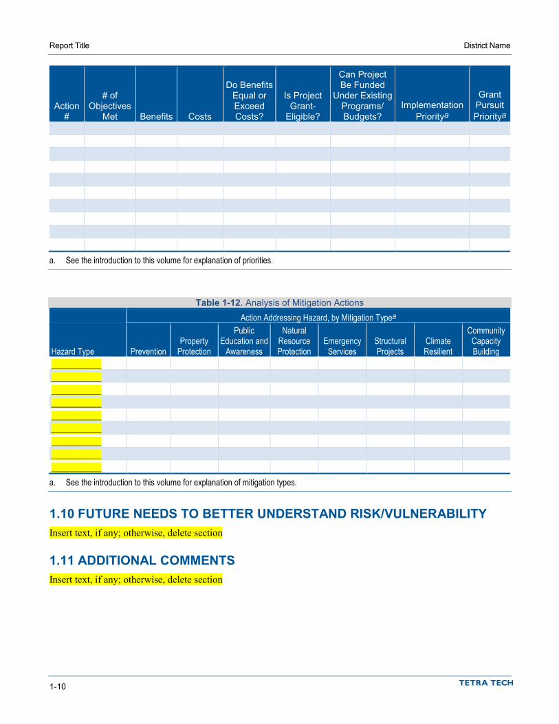
Report Title District Name
1-10
Action #
# of Objectives
Met Benefits Costs
Do Benefits Equal or Exceed Costs?
Is Project Grant-
Eligible?
Can Project Be Funded
Under Existing Programs/ Budgets?
Implementation Prioritya
Grant Pursuit Prioritya
a. See the introduction to this volume for explanation of priorities.
Table 1-12. Analysis of Mitigation Actions Action Addressing Hazard, by Mitigation Typea
Hazard Type Prevention Property
Protection
Public Education and
Awareness
Natural Resource Protection
Emergency Services
Structural Projects
Climate Resilient
Community Capacity Building
____________ ____________ ____________ ____________ ____________ ____________ ____________ ____________ ____________ a. See the introduction to this volume for explanation of mitigation types.
1.10 FUTURE NEEDS TO BETTER UNDERSTAND RISK/VULNERABILITY Insert text, if any; otherwise, delete section
1.11 ADDITIONAL COMMENTS Insert text, if any; otherwise, delete section
Report Title District Name
1-11
1.12 REVIEW AND INCORPORATION OF RESOURCES FOR THIS ANNEX
1.12.1 Existing Reports, Plans, Regulatory Tools and Other Resources The following technical reports, plans, and regulatory mechanisms were reviewed to provide information for this annex.
• <INSERT PLAN/PROGRAM AND DESCRIPTION OF HOW IT WAS USED> • <INSERT PLAN/PROGRAM AND DESCRIPTION OF HOW IT WAS USED> • <INSERT PLAN/PROGRAM AND DESCRIPTION OF HOW IT WAS USED> • Hazard Mitigation Plan Annex Development Tool-kit—The tool-kit was used to support the
development of this annex including past hazard events, noted vulnerabilities, risk ranking and action development.
1.12.2 Staff and Local Stakeholder Involvement in Annex Development Insert discussion per instructions.

Related Documents