U S C E N S U S B U R E A U Helping You Make Informed Decisions U.S. Department of Commerce Economics and Statistics Administration U.S. CENSUS BUREAU 2010 Census of Population and Housing PL/10-2 (RV) Issued January 2011 2010 Census Redistricting Data (Public Law 94-171) Summary File Technical Documentation

Welcome message from author
This document is posted to help you gain knowledge. Please leave a comment to let me know what you think about it! Share it to your friends and learn new things together.
Transcript
U S C E N S U S B U R E A UHelping You Make Informed Decisions
U.S. Department of CommerceEconomics and Statistics Administration
U.S. CENSUS BUREAU
2010 Census of Population and HousingPL/10-2 (RV)
Issued January 2011
2010 Census Redistricting Data (Public Law 94-171)Summary File
Technical Documentation

For additional information concerning the Census Redistricting Data Program, contact the Census Redistricting Data Office, U.S. Census Bureau, Washington, DC 20233, or phone 301-763-4039.
For additional information concerning the DVD and software issues, contact the Administrative and Customer Services Division, Electronic Products Development Branch, U.S. Census Bureau, Washington, DC 20233, or phone 301-763-7710.
For additional information concerning the files, contact the Customer Liaison and Marketing Services Office, Customer Services Center, U.S. Census Bureau, Washington, DC 20233, or phone 301-763-INFO (4636).
For additional information concerning the technical documentation, contact the Administrative and Customer Services Division, Electronic Products Development Branch, U.S. Census Bureau, Washington, DC 20233, or phone 301-763-8004.

Gary Locke,Secretary
Rebecca M. Blank,Acting Deputy Secretary
Rebecca M. Blank,Under Secretary
for Economic Affairs
Robert M. Groves,Director
U.S. Department of Commerce
Economics and Statistics Administration
U.S. CENSUS BUREAU
PL/10-2 (RV)
2010 Census RedistrictingData (Public Law 94-171)
Summary File2010 Census of Population and Housing
Issued January 2011
Technical Documentation

ECONOMICS
AND STATISTICS
ADMINISTRATION
Economics and Statistics Administration
Rebecca M. Blank,Under Secretary for Economic Affairs
U.S. CENSUS BUREAU
Robert M. Groves,Director
Thomas L. Mesenbourg, Deputy Director and Chief Operating Officer
Arnold A. Jackson,Associate Director for Decennial Census
Howard R. Hogan,Associate Director for Demographic Programs
Marilia A. Matos,Associate Director for Field Operations
Daniel H. Weinberg,Assistant Director for ACS and Decennial Census
SUGGESTED CITATION
FILES: 2010 Census Redistricting Data
(Public Law 94-171) Summary File— (name of state) [machine-readable
data files]/prepared by the U.S. Census Bureau, 2011.
TECHNICAL DOCUMENTATION:
2010 Census Redistricting Data (Public Law 94-171) Summary File—
Technical Documentation/prepared by the U.S. Census Bureau, 2011.

CONTENTS
CHAPTERS
1. Abstract . . . . . . . . . . . . . . . . . . . . . . . . . . . . . . . . . . . . . . . . . . . . . . . 1-1
2. How to Use This Product . . . . . . . . . . . . . . . . . . . . . . . . . . . . . . . . . . . 2-1
3. Subject Locator . . . . . . . . . . . . . . . . . . . . . . . . . . . . . . . . . . . . . . . . . . 3-1
4. Summary Level Sequence Chart . . . . . . . . . . . . . . . . . . . . . . . . . . . . . . 4-1
5. List of Tables (Matrices) . . . . . . . . . . . . . . . . . . . . . . . . . . . . . . . . . . . . 5-1
6. Data Dictionary . . . . . . . . . . . . . . . . . . . . . . . . . . . . . . . . . . . . . . . . . . 6-1
7. 2010 Census: Operational Overview and Accuracy of the Data . . . . . . 7-1
8. User Updates . . . . . . . . . . . . . . . . . . . . . . . . . . . . . . . . . . . . . . . . . . . . 8-1
APPENDIXES
A. Geographic Terms and Concepts . . . . . . . . . . . . . . . . . . . . . . . . . . . . . A-1
B. Definitions of Subject Characteristics . . . . . . . . . . . . . . . . . . . . . . . . . . B-1
C. Data Collection and Processing Procedures . . . . . . . . . . . . . . . . . . . . . C-1
D. Questionnaire . . . . . . . . . . . . . . . . . . . . . . . . . . . . . . . . . . . . . . . . . . . D-1
E. Maps . . . . . . . . . . . . . . . . . . . . . . . . . . . . . . . . . . . . . . . . . . . . . . . . . . E-1
F. Code Lists . . . . . . . . . . . . . . . . . . . . . . . . . . . . . . . . . . . . . . . . . . . . . . F-1
G. Residence Rule and Residence Situations for the 2010 Census of the United States . . . . . . . . . . . . . . . . . . . . . . . . . . . . . . . . . . . . . . . G-1
v

Abstract 1-1
U.S. Census Bureau, 2010 Census Redistricting Data (Public Law 94-171) Summary File
Chapter 1. Abstract
CONTENTS Citation . . . . . . . . . . . . . . . . . . . . . . . . . . . . . . . . . . . . . . . . . . . . . . . . . . . . . . . . . . . . . . . . . . . . . 1-1Type of File . . . . . . . . . . . . . . . . . . . . . . . . . . . . . . . . . . . . . . . . . . . . . . . . . . . . . . . . . . . . . . . . . . . 1-1Public Law 94-171 and the 2010 Census Redistricting Data Program . . . . . . . . . . . . . . . . . . . . . . . 1-1Subject Content . . . . . . . . . . . . . . . . . . . . . . . . . . . . . . . . . . . . . . . . . . . . . . . . . . . . . . . . . . . . . . . 1-1Geographic Content . . . . . . . . . . . . . . . . . . . . . . . . . . . . . . . . . . . . . . . . . . . . . . . . . . . . . . . . . . . . 1-2User Updates . . . . . . . . . . . . . . . . . . . . . . . . . . . . . . . . . . . . . . . . . . . . . . . . . . . . . . . . . . . . . . . . . 1-2Related Products . . . . . . . . . . . . . . . . . . . . . . . . . . . . . . . . . . . . . . . . . . . . . . . . . . . . . . . . . . . . . . . 1-2
CITATION
2010 Census Redistricting Data (Public Law (P.L.) 94-171) Summary File—[name of state1] [machine- readable data files]/prepared by the U.S. Census Bureau, 2011.
TYPE OF FILE
Summary statistics.
PUBLIC LAW 94-171 AND THE 2010 CENSUS REDISTRICTING DATA PROGRAM
Public Law 94-171, enacted in 1975, directs the Census Bureau to make special preparations to provide redistricting data needed by the 50 states.1 It specifies that within a year following Census Day, the Census Bureau must send the governor and legislative leadership in each state the data they need to redraw districts for the United States Congress and state legislature.
To meet this legal requirement, the Census Bureau set up a program that affords state officials an opportunity before each decennial census to define the small areas for which they wish to receive census population totals for redistricting purposes. Officials may receive data for voting districts (e.g., election precincts, wards) and state house and senate districts, in addition to standard census geographic areas such as counties, cities, census tracts, and tabulation blocks. State participation in defining areas is voluntary and nonpartisan.
For further information on P.L. 94-171 and the 2010 Census Redistricting Data Program, see <www.census.gov/rdo/about_the_program/>.
SUBJECT CONTENT
This product contains summary statistics on population and housing subjects derived from questions on the 2010 Census questionnaire. Population counts for the total population and for the population 18 years and over are presented in four tables:
• Acountofall persons by race.
• Acountofthepopulation18yearsandoverbyrace.
• AcountofHispanicorLatinoandacountofnotHispanicorLatinobyraceforallpersons.
• AcountofHispanicorLatinoandacountofnotHispanicorLatinobyraceforthepopulation18yearsand over.
1 For the 2010 Census, the Census Bureau will provide redistricting data for the 50 states, the District of Columbia, and the Commonwealth of Puerto Rico.
1-2 Abstract
U.S. Census Bureau, 2010 Census Redistricting Data (Public Law 94-171) Summary File
The product also includes one housing table showing occupancy status (the number of housing units that are occupied or vacant). The official titles of the five tables are listed in Chapter 5, “List of Tables (Matrices).”
For a list of subjects in this file, see Chapter 3, “Subject Locator.” The Subject Locator can be used to determine which tables provide the information needed. Chapter 6, “Data Dictionary,” provides information on the table numbers and titles, applicable universes, the detailed contents, field length, and so forth, for each table.
GEOGRAPHIC CONTENT
This file provides data in a hierarchical sequence down to the block level. A hierarchical presentation shows the geographic areas in a superior/subordinate structure and is depicted by indenting the lines. For example:
State2
County3
Voting district/Remainder County subdivision4 Place/Remainder Census tract Block group Block
“Voting district” is the generic name for areas, such as precincts and wards, that are established by state and local governments for purposes of elections. States participating in the 2010 Census Redistricting Data Program provided the Census Bureau with boundaries, codes, and optional names for their voting districts.
This file also provides data in an inventory format for areas such as county subdivisions, places, school districts, and state legislative districts.
See Appendix A, “Geographic Terms and Concepts,” for a more detailed description of the census geography contained in this summary file.
USER UPDATES
User updates supply data users with additional or corrected information that becomes available after the technical documentation and files are prepared. They are issued as Data Notes, Geography Notes, and Technical Documentation Notes in a numbered series. User updates issued after the release of this documentation are available on the Census Bureau’s Internet site <www.census.gov>.
RELATED PRODUCTS
The 2010 Census Redistricting Data (P.L. 94-171) Summary File is available on DVD and on the Internet in American FactFinder and as downloadable files from the Census Bureau’s File Transfer Protocol (FTP) site. One quick table and two geographic comparison tables, which collapse the race detail shown in the summary file (see the chapter “Data Dictionary” for the table outlines), also are available in American FactFinder and on DVD.
2 State, District of Columbia, or the Commonwealth of Puerto Rico.3 Parish in Louisiana; borough, census area, city and borough, or municipality in Puerto Rico. In Maryland, Missouri, Nevada, and
Virginia, one or more cities are independent of counties and are treated as statistical equivalents of counties. The entire District of Columbia, which has no counties, is treated as a county equivalent.
4 In Puerto Rico, some subdivisions (barrios-pueblos and barrios) are divided into subminor civil divisions (subbarrios).

How to Use This Product 2-1
U.S. Census Bureau, 2010 Census Redistricting Data (Public Law 94-171) Summary File
Chapter 2. How to Use This Product
CONTENTS
Introduction . . . . . . . . . . . . . . . . . . . . . . . . . . . . . . . . . . . . . . . . . . . . . . . . . . . . . . . . . . . . . . . . . . 2-1Data Format and Access Tools . . . . . . . . . . . . . . . . . . . . . . . . . . . . . . . . . . . . . . . . . . . . . . . . . . . . 2-1 Geographic Hierarchy Primer . . . . . . . . . . . . . . . . . . . . . . . . . . . . . . . . . . . . . . . . . . . . . . . . . . . . . 2-1Geographic Header Record . . . . . . . . . . . . . . . . . . . . . . . . . . . . . . . . . . . . . . . . . . . . . . . . . . . . . . . 2-2 New ANSI Codes . . . . . . . . . . . . . . . . . . . . . . . . . . . . . . . . . . . . . . . . . . . . . . . . . . . . . . . . . . . . . 2-2Summary Level Sequence Chart . . . . . . . . . . . . . . . . . . . . . . . . . . . . . . . . . . . . . . . . . . . . . . . . . . . 2-3Voting Districts . . . . . . . . . . . . . . . . . . . . . . . . . . . . . . . . . . . . . . . . . . . . . . . . . . . . . . . . . . . . . . . . 2-3 Voting District Indicator . . . . . . . . . . . . . . . . . . . . . . . . . . . . . . . . . . . . . . . . . . . . . . . . . . . . . . . 2-3Data Structure and Segmentation . . . . . . . . . . . . . . . . . . . . . . . . . . . . . . . . . . . . . . . . . . . . . . . . . . 2-4 Note to Users of Microsoft Access . . . . . . . . . . . . . . . . . . . . . . . . . . . . . . . . . . . . . . . . . . . . . . . . 2-4Figures: 2-1. File Set Structure Schematic . . . . . . . . . . . . . . . . . . . . . . . . . . . . . . . . . . . . . . . . . . . . . . . . 2-5 2-2. Standard Hierarchy of Census Geographic Entities . . . . . . . . . . . . . . . . . . . . . . . . . . . . . . . 2-6 2-3. Hierarchy of American Indian, Alaska Native, and Native Hawaiian Areas . . . . . . . . . . . . . . 2-7 2-4. Geographic Header Record . . . . . . . . . . . . . . . . . . . . . . . . . . . . . . . . . . . . . . . . . . . . . . . . . 2-8
INTRODUCTION
This chapter serves as a guide for data users to both the file and the technical documentation. Novice users trying to understand how to use the documentation and the file should read this chapter first.
DATA FORMAT AND ACCESS TOOLS
Users of the DVD can access the file information in two ways. The DVD contains simple software that provides an html presentation of the tables. The appearance of the tables is very similar to the Quick Tables generated through American FactFinder on the U.S. Census Bureau’s Web site <www.census.gov>. This is simply presentation software. There can be no manipulation of the tables in this format.
Users also can utilize their standard software packages to manipulate the data. The data on the DVD are presented in both fixed-length ASCII and comma-separated ASCII formats, which can be easily imported into other software packages.
Flat ASCII files by state are available for download via File Transfer Protocol (FTP) from American FactFinder. They also are available as an on-demand DVD product.
GEOGRAPHIC HIERARCHY PRIMER
The smallest component for all census geography is the block. Figure 2-2 at the end of this chapter provides an example of the various geographic hierarchies used, building from the block. Take some time to review this chart to become familiar with the different hierarchies. Begin reading the schematic from the bottom at the blocks entry. By following the lines, you can see the hierarchy very quickly. For example, follow blocks to block groups to census tracts to counties. This path indicates that census tracts and their sublevels in the hierarchy are uniquely identified within a county and do not cross county boundaries. Follow blocks to the school district hierarchy. This path tells you that school districts can cross jurisdictional boundaries but do not cross state lines. Figure 2-3 at the end of this chapter presents similar information for the American Indian area/Alaska Native area/Hawaiian home land hierarchy. Again, read the schematic from the bottom, beginning with the lowest level of geography, i.e., census blocks.

2-2 How to Use This Product
U.S. Census Bureau, 2010 Census Redistricting Data (Public Law 94-171) Summary File
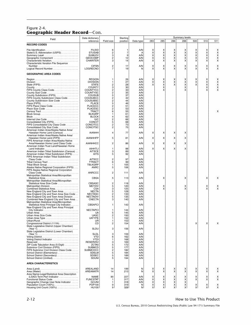
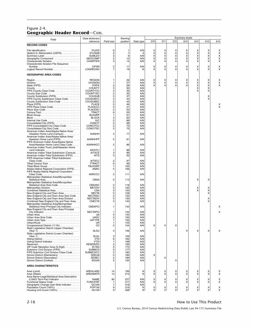
GEOGRAPHIC HEADER RECORD
The geographic header record, Figure 2-4 at the end of this chapter, defines each field and provides its data dictionary reference name, field size, starting position, and data type. In addition, the presence or absence of an “X” in each summary level column is a guide to the presence or absence of geographic information for that particular summary level. For example, on the column for summary level 040, we see “X” for the first 10 fields, indicating that there will be information for those fields. In the county field, there is no “X,” indicating that there is no information for county in summary level 040. Since 040 is the summary level for state, this is perfectly logical.
New ANSI Codes
The geographic header record includes, for the first time, space reserved to accommodate the transition from the Federal Information Processing Standards (FIPS) 55 Code Series to the American National Standards Institute (ANSI) Code Series for the identification of selected geographic entities. Each of nine fields has eight character spaces reserved for an eight-digit Geographic Names Information System (GNIS) identifier code that has been adopted as part of a new national standard. The GNIS is the nation’s official geographic names repository database and has been designated by the U.S. Board on Geographic Names as the official source of geographic names for use by the federal government and its contractors. Federal agencies are expected to adopt the GNIS ID as a standard code for public and federal data exchange. The fields identified in the geographic header record are:
Field length Field name
8 State (ANSI)
8 County (ANSI)
8 County Subdivision (ANSI)
8 Place (ANSI)
8 Consolidated City (ANSI)
8 American Indian Area/Alaska Native Area/Hawaiian Home Land (ANSI)
8 American Indian Tribal Subdivision (ANSI)
8 Alaska Native Regional Corporation (ANSI)
8 Subminor Civil Division (ANSI)
The GNIS identifier for states, counties, and equivalent areas are supplemental codes that do not replace the federal standard two-digit state and three-digit county codes also appearing in the header. The Census Bureau will continue to maintain and use in its unique geographic identifiers the existing five-digit codes for place, county subdivision, consolidated city, Alaska Native Regional Corporation, and subminor civil division and will assign and issue codes for new entities to meet customer needs, although these codes are not “official” or part of the new ANSI standards. The Census Bureau also will continue to maintain the existing four-digit codes for American Indian area/Alaska Native area/Hawaiian home land and three-digit codes for American Indian tribal subdivision.

How to Use This Product 2-3
U.S. Census Bureau, 2010 Census Redistricting Data (Public Law 94-171) Summary File
SUMMARY LEVEL SEQUENCE CHART
The summary level sequence chart (Chapter 4) identifies each geographic level and provides the code that is in the SUMLEV field. The last geographic area type listed in the sequence identifies the geography of the summary level; the prior codes simply identify the geographic hierarchy. See two examples below:
• 140State-County-CensusTract
• 730State-County-VotingDistrict/Remainder-CountySubdivision-Place/Remainder-CensusTract
In summary level 140, the record contains data for a census tract, within a county, within a state. Census tracts are uniquely numbered within a county and do not cross county boundaries. Since counties do not cross state boundaries, this is a simple application. Thus, summary level 140 provides data for a complete census tract.
In summary level 730, the geography is more complex. The key is to work backward through the hierarchy. Thus, summary level 730 is a record for the portion of a census tract, within a specific place/remainder portion of a specific county subdivision portion, within a specific voting district/remainder portion, within a county, within a state.
When reading the summary level sequence chart, it is important to recognize that hyphens (-) separate the individual hierarchies, while slashes separate different types of geography (such as place/remainder) within the same hierarchy.
VOTING DISTRICTS
Voting district is the generic name for areas, such as precincts and wards, that are established by state and local governments for purposes of elections. States participating in the 2010 Census Redistricting Data Program provided the Census Bureau with boundaries, codes, and optional names for their voting districts. The voting district code is a six-character field (position 162) that may contain any ASCII character.
Voting District Indicator
States participating in the 2010 Census Redistricting Data Program have the option to indicate whether the voting district boundaries they submitted to the Census Bureau are “pseudo” or “actual.” Pseudo voting districts are those that were approximated. These approximated voting districts are represented in the voting district indicator field (position 168) as a “P.” Actual voting districts represent ground truth and are shown represented in this field as an “A.” Actual voting districts are additionally identified by an asterisk (*) appended to the voting district name in the Area Name-Legal/Statistical Area Description (LSAD) Term-Part Indicator (position 227). If a state did not provide voting districts for a county, this field will be blank.

2-4 How to Use This Product
U.S. Census Bureau, 2010 Census Redistricting Data (Public Law 94-171) Summary File
DATA STRUCTURE AND SEGMENTATION
The data in the redistricting files and other 2010 Census summary files are segmented. This is done so that individual files will not have more than 255 fields, facilitating exporting into spreadsheet or database software. The segmentation information discussed here applies to the DVD files. The redistricting data and the corresponding geographic information for an individual state is known as the file set. This is the package that the DVD for a state will contain. Because of the large size of the tables, the file set will be broken into three files. These files will contain:
• GeographicHeaderRecordfile
• File01(TablesP1andP2)
• File02(Tables P3, P4, and H1)
To get the complete data set for the redistricting files, users must download all three files.
It is easiest to think of the file set as a logical file. However, this logical file consists of three physical files: the geographic header record file, file01, and file02. This file design is comparable to that used in Census 2000. If downloading the 2010 Census redistricting data directly from the DVD or from the FTP site, users must select all three files.
A unique logical record number (LOGRECNO in the geographic header) is assigned to all files for a specific geographic entity. This is done so all records for that specific entity can be linked together across files. Besides the logical record number, other identifying fields also are carried over from the geographic header file to the table files. These are file identification (FILEID), state/U.S. abbreviation (STUSAB), characteristic iteration (CHARITER), and characteristic iteration file sequence number (CIFSN). See Figure 2-1 on the next page for an example.
The geographic header record is standard across all electronic data products from the 2010 Census. Since the 2010 Census redistricting data files are quite simple, many of the fields, including some header fields that appear in all three files (geographic header, file01, and file02), are not used. For example, CHARITER field will be used in the 2010 Census Summary File 2. In the 2010 Census redistricting data files, it is always coded as 000.
Note to Users of Microsoft Access
Due to the FieldSize property limitations within Microsoft Access, modifications to field types are required when importing the Geographic Header Record file, File01 and File02:
• Allfieldsclassifiedasnumeric(N)shouldbeimportedaslongintegers.
• AREALANDandAREAWATRshouldbeimportedastext.
Failure to make these changes may result in missing data upon import. Please call the Census Redistricting Office at 301-763-4039 if you have questions.

How to Use This Product 2-5
U.S. Census Bureau, 2010 Census Redistricting Data (Public Law 94-171) Summary File
Figure 2-1. File Set Structure Schematic
Geographic header file File01 File02
Record 1FILEID STUSAB CHARITER CIFSN LOGRECNO (Record 1) Remainder of geographic header record for geographic area x
Record 2FILEID STUSAB CHARITER CIFSN LOGRECNO (Record 2) Remainder of geographic header record for geographic area y
Record 3FILEID STUSAB CHARITER CIFSN LOGRECNO (Record 3) Remainder of geographic header record for geographic area z
FILEID STUSAB CHARITER CIFSN LOGRECNO (Record 1) Table 1 (71 cells) Table 2 (73 cells) FILEID STUSAB CHARITER CIFSN LOGRECNO (Record 2) Table 1 (71 cells) Table 2 (73 cells) FILEID STUSAB CHARITER CIFSN LOGRECNO (Record 3) Table 1 (71 cells) Table 2 (73 cells)
FILEID STUSAB CHARITER CIFSN LOGRECNO (Record 1) Table 3 (71 cells) Table 4 (73 cells) Table 5 (3 cells) FILEID STUSAB CHARITER CIFSN LOGRECNO (Record 2) Table 3 (71 cells) Table 4 (73 cells) Table 5 (3 cells) FILEID STUSAB CHARITER CIFSN LOGRECNO (Record 3) Table 3 (71 cells) Table 4 (73 cells) Table 5 (3 cells)

2-6 How to Use This Product
U.S. Census Bureau, 2010 Census Redistricting Data (Public Law 94-171) Summary File
Figure 2-2.Standard Hierarchy of Census Geographic Entities

How to Use This Product 2-7
U.S. Census Bureau, 2010 Census Redistricting Data (Public Law 94-171) Summary File
Figure 2-3.Hierarchy of American Indian, Alaska Native, and Native Hawaiian Areas
American Indian Areas (Federal)/Off-Reservation Trust Lands
States Tribal Designated Statistical Areas
Hierarchy of American Indian, Alaska Native, and Native Hawaiian Areas
Tribal Census Tracts Oklahoma TribalStatistical Areas
Alaska Native Regional Corporations /Alaska Native Village Statistical Areas /
Hawaiian Home Lands
American Indian Reservations (state) /State Designated Tribal Statistical Areas
Tribal SubdivisionsTribal Block Groups
C E N S U S B L O C K S

2-8 How to Use This Product
U.S. Census Bureau, 2010 Census Redistricting Data (Public Law 94-171) Summary File
Figure 2-4.Geographic Header Record—Con.
Field Data dictionary reference Field size
Starting position Data type
Summary levels
040 050 060 067 140 150 155
RECORD CODES File Identification . . . . . . . . . . . . . . . . . . . . . . . . FILEID 6 1 A/N X X X X X X XState/U .S . Abbreviation (USPS) . . . . . . . . . . . . . STUSAB 2 7 A X X X X X X XSummary Level . . . . . . . . . . . . . . . . . . . . . . . . . SUMLEV 3 9 A/N X X X X X X XGeographic Component . . . . . . . . . . . . . . . . . . GEOCOMP 2 12 A/N X X X X X X XCharacteristic Iteration . . . . . . . . . . . . . . . . . . . . CHARITER 3 14 A/N X X X X X X XCharacteristic Iteration File Sequence
Number . . . . . . . . . . . . . . . . . . . . . . . . . . . . . . CIFSN 2 17 A/N X X X X X X XLogical Record Number . . . . . . . . . . . . . . . . . . . LOGRECNO 7 19 N X X X X X X X GEOGRAPHIC AREA CODES Region . . . . . . . . . . . . . . . . . . . . . . . . . . . . . . . . REGION 1 26 A/N X X X X X X XDivision . . . . . . . . . . . . . . . . . . . . . . . . . . . . . . . DIVISION 1 27 A/N X X X X X X XState (FIPS) . . . . . . . . . . . . . . . . . . . . . . . . . . . . STATE 2 28 A/N X X X X X X XCounty . . . . . . . . . . . . . . . . . . . . . . . . . . . . . . . . COUNTY 3 30 A/N X X X X X XFIPS County Class Code . . . . . . . . . . . . . . . . . . COUNTYCC 2 33 A/N X X X X X XCounty Size Code . . . . . . . . . . . . . . . . . . . . . . . COUNTYSC 2 35 A/N County Subdivision (FIPS) . . . . . . . . . . . . . . . . COUSUB 5 37 A/N X X FIPS County Subdivision Class Code . . . . . . . . COUSUBCC 2 42 A/N X X County Subdivision Size Code . . . . . . . . . . . . . COUSUBSC 2 44 A/N Place (FIPS) . . . . . . . . . . . . . . . . . . . . . . . . . . . PLACE 5 46 A/N XFIPS Place Class Code . . . . . . . . . . . . . . . . . . . PLACECC 2 51 A/N XPlace Size Code . . . . . . . . . . . . . . . . . . . . . . . . PLACESC 2 53 A/N Census Tract . . . . . . . . . . . . . . . . . . . . . . . . . . . TRACT 6 55 A/N X X Block Group . . . . . . . . . . . . . . . . . . . . . . . . . . . . BLKGRP 1 61 A/N X Block . . . . . . . . . . . . . . . . . . . . . . . . . . . . . . . . . BLOCK 4 62 A/N Internal Use Code . . . . . . . . . . . . . . . . . . . . . . . IUC 2 66 A/N Consolidated City (FIPS) . . . . . . . . . . . . . . . . . . CONCIT 5 68 A/N FIPS Consolidated City Class Code . . . . . . . . . CONCITCC 2 73 A/N Consolidated City Size Code . . . . . . . . . . . . . . . CONCITSC 2 75 A/N American Indian Area/Alaska Native Area/
Hawaiian Home Land (Census) . . . . . . . . . . . AIANHH 4 77 A/N American Indian Area/Alaska Native Area/
Hawaiian Home Land (FIPS) . . . . . . . . . . . . . AIANHHFP 5 81 A/N FIPS American Indian Area/Alaska Native
Area/Hawaiian Home Land Class Code . . . . . AIANHHCC 2 86 A/N American Indian Trust Land/Hawaiian Home
Land Indicator . . . . . . . . . . . . . . . . . . . . . . . . . AIHHTLI 1 88 A/N American Indian Tribal Subdivision (Census) . . AITSCE 3 89 A/N American Indian Tribal Subdivision (FIPS) . . . . AITS 5 92 A/N FIPS American Indian Tribal Subdivision
Class Code . . . . . . . . . . . . . . . . . . . . . . . . . . . AITSCC 2 97 A/N Tribal Census Tract . . . . . . . . . . . . . . . . . . . . . . TTRACT 6 99 A/N Tribal Block Group . . . . . . . . . . . . . . . . . . . . . . . TBLKGRP 1 105 A/N Alaska Native Regional Corporation (FIPS) . . . ANRC 5 106 A/N FIPS Alaska Native Regional Corporation
Class Code . . . . . . . . . . . . . . . . . . . . . . . . . . . ANRCCC 2 111 A/N Metropolitan Statistical Area/Micropolitan
Statistical Area . . . . . . . . . . . . . . . . . . . . . . . . CBSA 5 113 A/N X X X X X XMetropolitan Statistical Area/Micropolitan
Statistical Area Size Code . . . . . . . . . . . . . . . CBSASC 2 118 A/N Metropolitan Division . . . . . . . . . . . . . . . . . . . . . METDIV 5 120 A/N X X X X X XCombined Statistical Area . . . . . . . . . . . . . . . . . CSA 3 125 A/N X X X X X XNew England City and Town Area . . . . . . . . . . . NECTA 5 128 A/N X New England City and Town Area Size Code . . NECTASC 2 133 A/N New England City and Town Area Division . . . . NECTADIV 5 135 A/N X Combined New England City and Town Area . . CNECTA 3 140 A/N X Metropolitan Statistical Area/Micropolitan
Statistical Area Principal City Indicator . . . . . . CBSAPCI 1 143 A/N XNew England City and Town Area Principal
City Indicator . . . . . . . . . . . . . . . . . . . . . . . . . . NECTAPCI 1 144 A/N XUrban Area . . . . . . . . . . . . . . . . . . . . . . . . . . . . UA 5 145 A/N Urban Area Size Code . . . . . . . . . . . . . . . . . . . . UASC 2 150 A/N Urban Area Type . . . . . . . . . . . . . . . . . . . . . . . . UATYPE 1 152 A/N Urban/Rural . . . . . . . . . . . . . . . . . . . . . . . . . . . . UR 1 153 A/N Congressional District (111th) . . . . . . . . . . . . . . CD 2 154 A/N State Legislative District (Upper Chamber)
(Year 1) . . . . . . . . . . . . . . . . . . . . . . . . . . . . . . SLDU 3 156 A/N State Legislative District (Lower Chamber)
(Year 1) . . . . . . . . . . . . . . . . . . . . . . . . . . . . . . SLDL 3 159 A/N Voting District . . . . . . . . . . . . . . . . . . . . . . . . . . . VTD 6 162 A/N Voting District Indicator . . . . . . . . . . . . . . . . . . . VTDI 1 168 A/N Reserved . . . . . . . . . . . . . . . . . . . . . . . . . . . . . . RESERVE2 3 169 A/N ZIP Code Tabulation Area (5-Digit) . . . . . . . . . . ZCTA5 5 172 A/N Subminor Civil Division (FIPS) . . . . . . . . . . . . . SUBMCD 5 177 A/N X FIPS Subminor Civil Division Class Code . . . . . SUBMCDCC 2 182 A/N X School District (Elementary) . . . . . . . . . . . . . . . SDELM 5 184 A/N School District (Secondary) . . . . . . . . . . . . . . . . SDSEC 5 189 A/N School District (Unified) . . . . . . . . . . . . . . . . . . . SDUNI 5 194 A/N AREA CHARACTERISTICS Area (Land) . . . . . . . . . . . . . . . . . . . . . . . . . . . . AREALAND 14 199 N X X X X X X XArea (Water) . . . . . . . . . . . . . . . . . . . . . . . . . . . AREAWATR 14 213 N X X X X X X XArea Name-Legal/Statistical Area Description
(LSAD) Term-Part Indicator . . . . . . . . . . . . . . NAME 90 227 A/N X X X X X X XFunctional Status Code . . . . . . . . . . . . . . . . . . . FUNCSTAT 1 317 A/N X X X X X X XGeographic Change User Note Indicator . . . . . GCUNI 1 318 A/N X X X X X XPopulation Count (100%) . . . . . . . . . . . . . . . . . . POP100 9 319 N X X X X X X XHousing Unit Count (100%) . . . . . . . . . . . . . . . . HU100 9 328 N X X X X X X X

How to Use This Product 2-9
U.S. Census Bureau, 2010 Census Redistricting Data (Public Law 94-171) Summary File
Figure 2-4.Geographic Header Record—Con.
Field Data dictionary reference Field size
Starting position Data type
Summary levels
040 050 060 067 140 150 155
AREA CHARACTERISTICS—Con .
Internal Point (Latitude) . . . . . . . . . . . . . . . . . . . INTPTLAT 11 337 A/N X X X X X X XInternal Point (Longitude) . . . . . . . . . . . . . . . . . INTPTLON 12 348 A/N X X X X X X XLegal/Statistical Area Description Code . . . . . . LSADC 2 360 A/N X X X X X X XPart Flag . . . . . . . . . . . . . . . . . . . . . . . . . . . . . . PARTFLAG 1 362 A/N X SPECIAL AREA CODES Reserved . . . . . . . . . . . . . . . . . . . . . . . . . . . . . . RESERVE3 6 363 A/N Urban Growth Area . . . . . . . . . . . . . . . . . . . . . . UGA 5 369 A/N State (ANSI) . . . . . . . . . . . . . . . . . . . . . . . . . . . STATENS 8 374 A/N X X X X X X XCounty (ANSI) . . . . . . . . . . . . . . . . . . . . . . . . . . COUNTYNS 8 382 A/N X X X X X XCounty Subdivision (ANSI) . . . . . . . . . . . . . . . . COUSUBNS 8 390 A/N X X Place (ANSI) . . . . . . . . . . . . . . . . . . . . . . . . . . . PLACENS 8 398 A/N XConsolidated City (ANSI) . . . . . . . . . . . . . . . . . . CONCITNS 8 406 A/N American Indian Area/Alaska Native Area/
Hawaiian Home Land (ANSI) . . . . . . . . . . . . . AIANHHNS 8 414 A/N American Indian Tribal Subdivision (ANSI) . . . . AITSNS 8 422 A/N Alaska Native Regional Corporation (ANSI) . . . ANRCNS 8 430 A/N Subminor Civil Division (ANSI) . . . . . . . . . . . . . SUBMCDNS 8 438 A/N X Congressional District (113th) . . . . . . . . . . . . . . CD113 2 446 A/N Congressional District (114th) . . . . . . . . . . . . . . CD114 2 448 A/N Congressional District (115th) . . . . . . . . . . . . . . CD115 2 450 A/N State Legislative District (Upper Chamber)
(Year 2) . . . . . . . . . . . . . . . . . . . . . . . . . . . . . . SLDU2 3 452 A/N State Legislative District (Upper Chamber)
(Year 3) . . . . . . . . . . . . . . . . . . . . . . . . . . . . . . SLDU3 3 455 A/N State Legislative District (Upper Chamber)
(Year 4) . . . . . . . . . . . . . . . . . . . . . . . . . . . . . . SLDU4 3 458 A/N State Legislative District (Lower Chamber)
(Year 2) . . . . . . . . . . . . . . . . . . . . . . . . . . . . . . SLDL2 3 461 A/N State Legislative District (Lower Chamber)
(Year 3) . . . . . . . . . . . . . . . . . . . . . . . . . . . . . . SLDL3 3 464 A/N State Legislative District (Lower Chamber)
(Year 4) . . . . . . . . . . . . . . . . . . . . . . . . . . . . . . SLDL4 3 467 A/N American Indian Area/Alaska Native Area/
Hawaiian Home Land Size Code . . . . . . . . . . AIANHHSC 2 470 A/N Combined Statistical Area Size Code . . . . . . . . CSASC 2 472 A/N Combined NECTA Size Code . . . . . . . . . . . . . . CNECTASC 2 474 A/N Metropolitan/Micropolitan Indicator . . . . . . . . . . MEMI 1 476 A/N X X X X X XNECTA Metropolitan/Micropolitan Indicator . . . . NMEMI 1 477 A/N X Public Use Microdata Area . . . . . . . . . . . . . . . . PUMA 5 478 A/N Reserved . . . . . . . . . . . . . . . . . . . . . . . . . . . . . . RESERVED 18 483 A/N

2-10 How to Use This Product
U.S. Census Bureau, 2010 Census Redistricting Data (Public Law 94-171) Summary File
Figure 2-4.Geographic Header Record—Con.
Field Data dictionary reference Field size
Starting position Data type
Summary levels
160 170 172 230 280 281 282
RECORD CODES File Identification . . . . . . . . . . . . . . . . . . . . . . . . FILEID 6 1 A/N X X X X X X XState/U .S . Abbreviation (USPS) . . . . . . . . . . . . . STUSAB 2 7 A X X X X X X XSummary Level . . . . . . . . . . . . . . . . . . . . . . . . . SUMLEV 3 9 A/N X X X X X X XGeographic Component . . . . . . . . . . . . . . . . . . GEOCOMP 2 12 A/N X X X X X X XCharacteristic Iteration . . . . . . . . . . . . . . . . . . . . CHARITER 3 14 A/N X X X X X X XCharacteristic Iteration File Sequence
Number . . . . . . . . . . . . . . . . . . . . . . . . . . . . . . CIFSN 2 17 A/N X X X X X X XLogical Record Number . . . . . . . . . . . . . . . . . . . LOGRECNO 7 19 N X X X X X X X GEOGRAPHIC AREA CODES Region . . . . . . . . . . . . . . . . . . . . . . . . . . . . . . . . REGION 1 26 A/N X X X X X X XDivision . . . . . . . . . . . . . . . . . . . . . . . . . . . . . . . DIVISION 1 27 A/N X X X X X X XState (FIPS) . . . . . . . . . . . . . . . . . . . . . . . . . . . . STATE 2 28 A/N X X X X X X XCounty . . . . . . . . . . . . . . . . . . . . . . . . . . . . . . . . COUNTY 3 30 A/N XFIPS County Class Code . . . . . . . . . . . . . . . . . . COUNTYCC 2 33 A/N XCounty Size Code . . . . . . . . . . . . . . . . . . . . . . . COUNTYSC 2 35 A/N County Subdivision (FIPS) . . . . . . . . . . . . . . . . COUSUB 5 37 A/N FIPS County Subdivision Class Code . . . . . . . . COUSUBCC 2 42 A/N County Subdivision Size Code . . . . . . . . . . . . . COUSUBSC 2 44 A/N Place (FIPS) . . . . . . . . . . . . . . . . . . . . . . . . . . . PLACE 5 46 A/N X X FIPS Place Class Code . . . . . . . . . . . . . . . . . . . PLACECC 2 51 A/N X X Place Size Code . . . . . . . . . . . . . . . . . . . . . . . . PLACESC 2 53 A/N Census Tract . . . . . . . . . . . . . . . . . . . . . . . . . . . TRACT 6 55 A/N Block Group . . . . . . . . . . . . . . . . . . . . . . . . . . . . BLKGRP 1 61 A/N Block . . . . . . . . . . . . . . . . . . . . . . . . . . . . . . . . . BLOCK 4 62 A/N Internal Use Code . . . . . . . . . . . . . . . . . . . . . . . IUC 2 66 A/N Consolidated City (FIPS) . . . . . . . . . . . . . . . . . . CONCIT 5 68 A/N X X FIPS Consolidated City Class Code . . . . . . . . . CONCITCC 2 73 A/N X X Consolidated City Size Code . . . . . . . . . . . . . . . CONCITSC 2 75 A/N American Indian Area/Alaska Native Area/
Hawaiian Home Land (Census) . . . . . . . . . . . AIANHH 4 77 A/N X X XAmerican Indian Area/Alaska Native Area/
Hawaiian Home Land (FIPS) . . . . . . . . . . . . . AIANHHFP 5 81 A/N X X XFIPS American Indian Area/Alaska Native
Area/Hawaiian Home Land Class Code . . . . . AIANHHCC 2 86 A/N X X XAmerican Indian Trust Land/Hawaiian Home
Land Indicator . . . . . . . . . . . . . . . . . . . . . . . . . AIHHTLI 1 88 A/N X X XAmerican Indian Tribal Subdivision (Census) . . AITSCE 3 89 A/N X American Indian Tribal Subdivision (FIPS) . . . . AITS 5 92 A/N X FIPS American Indian Tribal Subdivision
Class Code . . . . . . . . . . . . . . . . . . . . . . . . . . . AITSCC 2 97 A/N X Tribal Census Tract . . . . . . . . . . . . . . . . . . . . . . TTRACT 6 99 A/N Tribal Block Group . . . . . . . . . . . . . . . . . . . . . . . TBLKGRP 1 105 A/N Alaska Native Regional Corporation (FIPS) . . . ANRC 5 106 A/N X FIPS Alaska Native Regional Corporation
Class Code . . . . . . . . . . . . . . . . . . . . . . . . . . . ANRCCC 2 111 A/N X Metropolitan Statistical Area/Micropolitan
Statistical Area . . . . . . . . . . . . . . . . . . . . . . . . CBSA 5 113 A/N XMetropolitan Statistical Area/Micropolitan
Statistical Area Size Code . . . . . . . . . . . . . . . CBSASC 2 118 A/N Metropolitan Division . . . . . . . . . . . . . . . . . . . . . METDIV 5 120 A/N XCombined Statistical Area . . . . . . . . . . . . . . . . . CSA 3 125 A/N XNew England City and Town Area . . . . . . . . . . . NECTA 5 128 A/N New England City and Town Area Size Code . . NECTASC 2 133 A/N New England City and Town Area Division . . . . NECTADIV 5 135 A/N Combined New England City and Town Area . . CNECTA 3 140 A/N Metropolitan Statistical Area/Micropolitan
Statistical Area Principal City Indicator . . . . . . CBSAPCI 1 143 A/N X X New England City and Town Area Principal
City Indicator . . . . . . . . . . . . . . . . . . . . . . . . . . NECTAPCI 1 144 A/N X X Urban Area . . . . . . . . . . . . . . . . . . . . . . . . . . . . UA 5 145 A/N Urban Area Size Code . . . . . . . . . . . . . . . . . . . . UASC 2 150 A/N Urban Area Type . . . . . . . . . . . . . . . . . . . . . . . . UATYPE 1 152 A/N Urban/Rural . . . . . . . . . . . . . . . . . . . . . . . . . . . . UR 1 153 A/N Congressional District (111th) . . . . . . . . . . . . . . CD 2 154 A/N State Legislative District (Upper Chamber)
(Year 1) . . . . . . . . . . . . . . . . . . . . . . . . . . . . . . SLDU 3 156 A/N State Legislative District (Lower Chamber)
(Year 1) . . . . . . . . . . . . . . . . . . . . . . . . . . . . . . SLDL 3 159 A/N Voting District . . . . . . . . . . . . . . . . . . . . . . . . . . . VTD 6 162 A/N Voting District Indicator . . . . . . . . . . . . . . . . . . . VTDI 1 168 A/N Reserved . . . . . . . . . . . . . . . . . . . . . . . . . . . . . . RESERVE2 3 169 A/N ZIP Code Tabulation Area (5-Digit) . . . . . . . . . . ZCTA5 5 172 A/N Subminor Civil Division (FIPS) . . . . . . . . . . . . . SUBMCD 5 177 A/N FIPS Subminor Civil Division Class Code . . . . . SUBMCDCC 2 182 A/N School District (Elementary) . . . . . . . . . . . . . . . SDELM 5 184 A/N School District (Secondary) . . . . . . . . . . . . . . . . SDSEC 5 189 A/N School District (Unified) . . . . . . . . . . . . . . . . . . . SDUNI 5 194 A/N AREA CHARACTERISTICS Area (Land) . . . . . . . . . . . . . . . . . . . . . . . . . . . . AREALAND 14 199 N X X X X X X XArea (Water) . . . . . . . . . . . . . . . . . . . . . . . . . . . AREAWATR 14 213 N X X X X X X XArea Name-Legal/Statistical Area Description
(LSAD) Term-Part Indicator . . . . . . . . . . . . . . NAME 90 227 A/N X X X X X X XFunctional Status Code . . . . . . . . . . . . . . . . . . . FUNCSTAT 1 317 A/N X X X X X X XGeographic Change User Note Indicator . . . . . GCUNI 1 318 A/N X X X X X X XPopulation Count (100%) . . . . . . . . . . . . . . . . . . POP100 9 319 N X X X X X X XHousing Unit Count (100%) . . . . . . . . . . . . . . . . HU100 9 328 N X X X X X X X

How to Use This Product 2-11
U.S. Census Bureau, 2010 Census Redistricting Data (Public Law 94-171) Summary File
Figure 2-4.Geographic Header Record—Con.
Field Data dictionary reference Field size
Starting position Data type
Summary levels
160 170 172 230 280 281 282
AREA CHARACTERISTICS—Con .
Internal Point (Latitude) . . . . . . . . . . . . . . . . . . . INTPTLAT 11 337 A/N X X X X X X XInternal Point (Longitude) . . . . . . . . . . . . . . . . . INTPTLON 12 348 A/N X X X X X X XLegal/Statistical Area Description Code . . . . . . LSADC 2 360 A/N X X X X X X XPart Flag . . . . . . . . . . . . . . . . . . . . . . . . . . . . . . PARTFLAG 1 362 A/N X X X X SPECIAL AREA CODES Reserved . . . . . . . . . . . . . . . . . . . . . . . . . . . . . . RESERVE3 6 363 A/N Urban Growth Area . . . . . . . . . . . . . . . . . . . . . . UGA 5 369 A/N State (ANSI) . . . . . . . . . . . . . . . . . . . . . . . . . . . STATENS 8 374 A/N X X X X X X XCounty (ANSI) . . . . . . . . . . . . . . . . . . . . . . . . . . COUNTYNS 8 382 A/N XCounty Subdivision (ANSI) . . . . . . . . . . . . . . . . COUSUBNS 8 390 A/N Place (ANSI) . . . . . . . . . . . . . . . . . . . . . . . . . . . PLACENS 8 398 A/N X X Consolidated City (ANSI) . . . . . . . . . . . . . . . . . . CONCITNS 8 406 A/N X X American Indian Area/Alaska Native Area/
Hawaiian Home Land (ANSI) . . . . . . . . . . . . . AIANHHNS 8 414 A/N X X XAmerican Indian Tribal Subdivision (ANSI) . . . . AITSNS 8 422 A/N X Alaska Native Regional Corporation (ANSI) . . . ANRCNS 8 430 A/N X Subminor Civil Division (ANSI) . . . . . . . . . . . . . SUBMCDNS 8 438 A/N Congressional District (113th) . . . . . . . . . . . . . . CD113 2 446 A/N Congressional District (114th) . . . . . . . . . . . . . . CD114 2 448 A/N Congressional District (115th) . . . . . . . . . . . . . . CD115 2 450 A/N State Legislative District (Upper Chamber)
(Year 2) . . . . . . . . . . . . . . . . . . . . . . . . . . . . . . SLDU2 3 452 A/N State Legislative District (Upper Chamber)
(Year 3) . . . . . . . . . . . . . . . . . . . . . . . . . . . . . . SLDU3 3 455 A/N State Legislative District (Upper Chamber)
(Year 4) . . . . . . . . . . . . . . . . . . . . . . . . . . . . . . SLDU4 3 458 A/N State Legislative District (Lower Chamber)
(Year 2) . . . . . . . . . . . . . . . . . . . . . . . . . . . . . . SLDL2 3 461 A/N State Legislative District (Lower Chamber)
(Year 3) . . . . . . . . . . . . . . . . . . . . . . . . . . . . . . SLDL3 3 464 A/N State Legislative District (Lower Chamber)
(Year 4) . . . . . . . . . . . . . . . . . . . . . . . . . . . . . . SLDL4 3 467 A/N American Indian Area/Alaska Native Area/
Hawaiian Home Land Size Code . . . . . . . . . . AIANHHSC 2 470 A/N Combined Statistical Area Size Code . . . . . . . . CSASC 2 472 A/N Combined NECTA Size Code . . . . . . . . . . . . . . CNECTASC 2 474 A/N Metropolitan/Micropolitan Indicator . . . . . . . . . . MEMI 1 476 A/N XNECTA Metropolitan/Micropolitan Indicator . . . . NMEMI 1 477 A/N Public Use Microdata Area . . . . . . . . . . . . . . . . PUMA 5 478 A/N Reserved . . . . . . . . . . . . . . . . . . . . . . . . . . . . . . RESERVED 18 483 A/N
2-12 How to Use This Product
U.S. Census Bureau, 2010 Census Redistricting Data (Public Law 94-171) Summary File
Figure 2-4.Geographic Header Record—Con.
Field Data dictionary reference Field size
Starting position Data type
Summary levels
283 285 286 288 500 510 511
RECORD CODES File Identification . . . . . . . . . . . . . . . . . . . . . . . . FILEID 6 1 A/N X X X X X X XState/U .S . Abbreviation (USPS) . . . . . . . . . . . . . STUSAB 2 7 A X X X X X X XSummary Level . . . . . . . . . . . . . . . . . . . . . . . . . SUMLEV 3 9 A/N X X X X X X XGeographic Component . . . . . . . . . . . . . . . . . . GEOCOMP 2 12 A/N X X X X X X XCharacteristic Iteration . . . . . . . . . . . . . . . . . . . . CHARITER 3 14 A/N X X X X X X XCharacteristic Iteration File Sequence
Number . . . . . . . . . . . . . . . . . . . . . . . . . . . . . . CIFSN 2 17 A/N X X X X X X XLogical Record Number . . . . . . . . . . . . . . . . . . . LOGRECNO 7 19 N X X X X X X X GEOGRAPHIC AREA CODES Region . . . . . . . . . . . . . . . . . . . . . . . . . . . . . . . . REGION 1 26 A/N X X X X X X XDivision . . . . . . . . . . . . . . . . . . . . . . . . . . . . . . . DIVISION 1 27 A/N X X X X X X XState (FIPS) . . . . . . . . . . . . . . . . . . . . . . . . . . . . STATE 2 28 A/N X X X X X X XCounty . . . . . . . . . . . . . . . . . . . . . . . . . . . . . . . . COUNTY 3 30 A/N X X X XFIPS County Class Code . . . . . . . . . . . . . . . . . . COUNTYCC 2 33 A/N X X X XCounty Size Code . . . . . . . . . . . . . . . . . . . . . . . COUNTYSC 2 35 A/N County Subdivision (FIPS) . . . . . . . . . . . . . . . . COUSUB 5 37 A/N FIPS County Subdivision Class Code . . . . . . . . COUSUBCC 2 42 A/N County Subdivision Size Code . . . . . . . . . . . . . COUSUBSC 2 44 A/N Place (FIPS) . . . . . . . . . . . . . . . . . . . . . . . . . . . PLACE 5 46 A/N FIPS Place Class Code . . . . . . . . . . . . . . . . . . . PLACECC 2 51 A/N Place Size Code . . . . . . . . . . . . . . . . . . . . . . . . PLACESC 2 53 A/N Census Tract . . . . . . . . . . . . . . . . . . . . . . . . . . . TRACT 6 55 A/N XBlock Group . . . . . . . . . . . . . . . . . . . . . . . . . . . . BLKGRP 1 61 A/N Block . . . . . . . . . . . . . . . . . . . . . . . . . . . . . . . . . BLOCK 4 62 A/N Internal Use Code . . . . . . . . . . . . . . . . . . . . . . . IUC 2 66 A/N Consolidated City (FIPS) . . . . . . . . . . . . . . . . . . CONCIT 5 68 A/N FIPS Consolidated City Class Code . . . . . . . . . CONCITCC 2 73 A/N Consolidated City Size Code . . . . . . . . . . . . . . . CONCITSC 2 75 A/N American Indian Area/Alaska Native Area/
Hawaiian Home Land (Census) . . . . . . . . . . . AIANHH 4 77 A/N X X X X American Indian Area/Alaska Native Area/
Hawaiian Home Land (FIPS) . . . . . . . . . . . . . AIANHHFP 5 81 A/N X X X X FIPS American Indian Area/Alaska Native
Area/Hawaiian Home Land Class Code . . . . . AIANHHCC 2 86 A/N X X X X American Indian Trust Land/Hawaiian Home
Land Indicator . . . . . . . . . . . . . . . . . . . . . . . . . AIHHTLI 1 88 A/N X X X X American Indian Tribal Subdivision (Census) . . AITSCE 3 89 A/N American Indian Tribal Subdivision (FIPS) . . . . AITS 5 92 A/N FIPS American Indian Tribal Subdivision
Class Code . . . . . . . . . . . . . . . . . . . . . . . . . . . AITSCC 2 97 A/N Tribal Census Tract . . . . . . . . . . . . . . . . . . . . . . TTRACT 6 99 A/N Tribal Block Group . . . . . . . . . . . . . . . . . . . . . . . TBLKGRP 1 105 A/N Alaska Native Regional Corporation (FIPS) . . . ANRC 5 106 A/N FIPS Alaska Native Regional Corporation
Class Code . . . . . . . . . . . . . . . . . . . . . . . . . . . ANRCCC 2 111 A/N Metropolitan Statistical Area/Micropolitan
Statistical Area . . . . . . . . . . . . . . . . . . . . . . . . CBSA 5 113 A/N X X X XMetropolitan Statistical Area/Micropolitan
Statistical Area Size Code . . . . . . . . . . . . . . . CBSASC 2 118 A/N Metropolitan Division . . . . . . . . . . . . . . . . . . . . . METDIV 5 120 A/N X X X XCombined Statistical Area . . . . . . . . . . . . . . . . . CSA 3 125 A/N X X X XNew England City and Town Area . . . . . . . . . . . NECTA 5 128 A/N New England City and Town Area Size Code . . NECTASC 2 133 A/N New England City and Town Area Division . . . . NECTADIV 5 135 A/N Combined New England City and Town Area . . CNECTA 3 140 A/N Metropolitan Statistical Area/Micropolitan
Statistical Area Principal City Indicator . . . . . . CBSAPCI 1 143 A/N New England City and Town Area Principal
City Indicator . . . . . . . . . . . . . . . . . . . . . . . . . . NECTAPCI 1 144 A/N Urban Area . . . . . . . . . . . . . . . . . . . . . . . . . . . . UA 5 145 A/N Urban Area Size Code . . . . . . . . . . . . . . . . . . . . UASC 2 150 A/N Urban Area Type . . . . . . . . . . . . . . . . . . . . . . . . UATYPE 1 152 A/N Urban/Rural . . . . . . . . . . . . . . . . . . . . . . . . . . . . UR 1 153 A/N Congressional District (111th) . . . . . . . . . . . . . . CD 2 154 A/N X X XState Legislative District (Upper Chamber)
(Year 1) . . . . . . . . . . . . . . . . . . . . . . . . . . . . . . SLDU 3 156 A/N State Legislative District (Lower Chamber)
(Year 1) . . . . . . . . . . . . . . . . . . . . . . . . . . . . . . SLDL 3 159 A/N Voting District . . . . . . . . . . . . . . . . . . . . . . . . . . . VTD 6 162 A/N Voting District Indicator . . . . . . . . . . . . . . . . . . . VTDI 1 168 A/N Reserved . . . . . . . . . . . . . . . . . . . . . . . . . . . . . . RESERVE2 3 169 A/N ZIP Code Tabulation Area (5-Digit) . . . . . . . . . . ZCTA5 5 172 A/N Subminor Civil Division (FIPS) . . . . . . . . . . . . . SUBMCD 5 177 A/N FIPS Subminor Civil Division Class Code . . . . . SUBMCDCC 2 182 A/N School District (Elementary) . . . . . . . . . . . . . . . SDELM 5 184 A/N School District (Secondary) . . . . . . . . . . . . . . . . SDSEC 5 189 A/N School District (Unified) . . . . . . . . . . . . . . . . . . . SDUNI 5 194 A/N AREA CHARACTERISTICS Area (Land) . . . . . . . . . . . . . . . . . . . . . . . . . . . . AREALAND 14 199 N X X X X X X XArea (Water) . . . . . . . . . . . . . . . . . . . . . . . . . . . AREAWATR 14 213 N X X X X X X XArea Name-Legal/Statistical Area Description
(LSAD) Term-Part Indicator . . . . . . . . . . . . . . NAME 90 227 A/N X X X X X X XFunctional Status Code . . . . . . . . . . . . . . . . . . . FUNCSTAT 1 317 A/N X X X X X X XGeographic Change User Note Indicator . . . . . GCUNI 1 318 A/N X X X X Population Count (100%) . . . . . . . . . . . . . . . . . . POP100 9 319 N X X X X X X XHousing Unit Count (100%) . . . . . . . . . . . . . . . . HU100 9 328 N X X X X X X X

How to Use This Product 2-13
U.S. Census Bureau, 2010 Census Redistricting Data (Public Law 94-171) Summary File
Figure 2-4.Geographic Header Record—Con.
Field Data dictionary reference Field size
Starting position Data type
Summary levels
283 285 286 288 500 510 511
AREA CHARACTERISTICS—Con .
Internal Point (Latitude) . . . . . . . . . . . . . . . . . . . INTPTLAT 11 337 A/N X X X X X X XInternal Point (Longitude) . . . . . . . . . . . . . . . . . INTPTLON 12 348 A/N X X X X X X XLegal/Statistical Area Description Code . . . . . . LSADC 2 360 A/N X X X X X X XPart Flag . . . . . . . . . . . . . . . . . . . . . . . . . . . . . . PARTFLAG 1 362 A/N X X X X X X SPECIAL AREA CODES Reserved . . . . . . . . . . . . . . . . . . . . . . . . . . . . . . RESERVE3 6 363 A/N Urban Growth Area . . . . . . . . . . . . . . . . . . . . . . UGA 5 369 A/N State (ANSI) . . . . . . . . . . . . . . . . . . . . . . . . . . . STATENS 8 374 A/N X X X X X X XCounty (ANSI) . . . . . . . . . . . . . . . . . . . . . . . . . . COUNTYNS 8 382 A/N X X X XCounty Subdivision (ANSI) . . . . . . . . . . . . . . . . COUSUBNS 8 390 A/N Place (ANSI) . . . . . . . . . . . . . . . . . . . . . . . . . . . PLACENS 8 398 A/N Consolidated City (ANSI) . . . . . . . . . . . . . . . . . . CONCITNS 8 406 A/N American Indian Area/Alaska Native Area/
Hawaiian Home Land (ANSI) . . . . . . . . . . . . . AIANHHNS 8 414 A/N X X X X American Indian Tribal Subdivision (ANSI) . . . . AITSNS 8 422 A/N Alaska Native Regional Corporation (ANSI) . . . ANRCNS 8 430 A/N Subminor Civil Division (ANSI) . . . . . . . . . . . . . SUBMCDNS 8 438 A/N Congressional District (113th) . . . . . . . . . . . . . . CD113 2 446 A/N Congressional District (114th) . . . . . . . . . . . . . . CD114 2 448 A/N Congressional District (115th) . . . . . . . . . . . . . . CD115 2 450 A/N State Legislative District (Upper Chamber)
(Year 2) . . . . . . . . . . . . . . . . . . . . . . . . . . . . . . SLDU2 3 452 A/N State Legislative District (Upper Chamber)
(Year 3) . . . . . . . . . . . . . . . . . . . . . . . . . . . . . . SLDU3 3 455 A/N State Legislative District (Upper Chamber)
(Year 4) . . . . . . . . . . . . . . . . . . . . . . . . . . . . . . SLDU4 3 458 A/N State Legislative District (Lower Chamber)
(Year 2) . . . . . . . . . . . . . . . . . . . . . . . . . . . . . . SLDL2 3 461 A/N State Legislative District (Lower Chamber)
(Year 3) . . . . . . . . . . . . . . . . . . . . . . . . . . . . . . SLDL3 3 464 A/N State Legislative District (Lower Chamber)
(Year 4) . . . . . . . . . . . . . . . . . . . . . . . . . . . . . . SLDL4 3 467 A/N American Indian Area/Alaska Native Area/
Hawaiian Home Land Size Code . . . . . . . . . . AIANHHSC 2 470 A/N Combined Statistical Area Size Code . . . . . . . . CSASC 2 472 A/N Combined NECTA Size Code . . . . . . . . . . . . . . CNECTASC 2 474 A/N Metropolitan/Micropolitan Indicator . . . . . . . . . . MEMI 1 476 A/N X X X XNECTA Metropolitan/Micropolitan Indicator . . . . NMEMI 1 477 A/N Public Use Microdata Area . . . . . . . . . . . . . . . . PUMA 5 478 A/N Reserved . . . . . . . . . . . . . . . . . . . . . . . . . . . . . . RESERVED 18 483 A/N

2-14 How to Use This Product
U.S. Census Bureau, 2010 Census Redistricting Data (Public Law 94-171) Summary File
Figure 2-4.Geographic Header Record—Con.
Field Data dictionary reference Field size
Starting position Data type
Summary levels
512 521 531 532 541 550 553
RECORD CODES File Identification . . . . . . . . . . . . . . . . . . . . . . . . FILEID 6 1 A/N X X X X X X XState/U .S . Abbreviation (USPS) . . . . . . . . . . . . . STUSAB 2 7 A X X X X X X XSummary Level . . . . . . . . . . . . . . . . . . . . . . . . . SUMLEV 3 9 A/N X X X X X X XGeographic Component . . . . . . . . . . . . . . . . . . GEOCOMP 2 12 A/N X X X X X X XCharacteristic Iteration . . . . . . . . . . . . . . . . . . . . CHARITER 3 14 A/N X X X X X X XCharacteristic Iteration File Sequence
Number . . . . . . . . . . . . . . . . . . . . . . . . . . . . . . CIFSN 2 17 A/N X X X X X X XLogical Record Number . . . . . . . . . . . . . . . . . . . LOGRECNO 7 19 N X X X X X X X GEOGRAPHIC AREA CODES Region . . . . . . . . . . . . . . . . . . . . . . . . . . . . . . . . REGION 1 26 A/N X X X X X X XDivision . . . . . . . . . . . . . . . . . . . . . . . . . . . . . . . DIVISION 1 27 A/N X X X X X X XState (FIPS) . . . . . . . . . . . . . . . . . . . . . . . . . . . . STATE 2 28 A/N X X X X X X XCounty . . . . . . . . . . . . . . . . . . . . . . . . . . . . . . . . COUNTY 3 30 A/N X X FIPS County Class Code . . . . . . . . . . . . . . . . . . COUNTYCC 2 33 A/N X X County Size Code . . . . . . . . . . . . . . . . . . . . . . . COUNTYSC 2 35 A/N County Subdivision (FIPS) . . . . . . . . . . . . . . . . COUSUB 5 37 A/N X FIPS County Subdivision Class Code . . . . . . . . COUSUBCC 2 42 A/N X County Subdivision Size Code . . . . . . . . . . . . . COUSUBSC 2 44 A/N Place (FIPS) . . . . . . . . . . . . . . . . . . . . . . . . . . . PLACE 5 46 A/N X X FIPS Place Class Code . . . . . . . . . . . . . . . . . . . PLACECC 2 51 A/N X X Place Size Code . . . . . . . . . . . . . . . . . . . . . . . . PLACESC 2 53 A/N Census Tract . . . . . . . . . . . . . . . . . . . . . . . . . . . TRACT 6 55 A/N Block Group . . . . . . . . . . . . . . . . . . . . . . . . . . . . BLKGRP 1 61 A/N Block . . . . . . . . . . . . . . . . . . . . . . . . . . . . . . . . . BLOCK 4 62 A/N Internal Use Code . . . . . . . . . . . . . . . . . . . . . . . IUC 2 66 A/N Consolidated City (FIPS) . . . . . . . . . . . . . . . . . . CONCIT 5 68 A/N X FIPS Consolidated City Class Code . . . . . . . . . CONCITCC 2 73 A/N X Consolidated City Size Code . . . . . . . . . . . . . . . CONCITSC 2 75 A/N American Indian Area/Alaska Native Area/
Hawaiian Home Land (Census) . . . . . . . . . . . AIANHH 4 77 A/N X XAmerican Indian Area/Alaska Native Area/
Hawaiian Home Land (FIPS) . . . . . . . . . . . . . AIANHHFP 5 81 A/N X XFIPS American Indian Area/Alaska Native
Area/Hawaiian Home Land Class Code . . . . . AIANHHCC 2 86 A/N X XAmerican Indian Trust Land/Hawaiian Home
Land Indicator . . . . . . . . . . . . . . . . . . . . . . . . . AIHHTLI 1 88 A/N X XAmerican Indian Tribal Subdivision (Census) . . AITSCE 3 89 A/N XAmerican Indian Tribal Subdivision (FIPS) . . . . AITS 5 92 A/N XFIPS American Indian Tribal Subdivision
Class Code . . . . . . . . . . . . . . . . . . . . . . . . . . . AITSCC 2 97 A/N XTribal Census Tract . . . . . . . . . . . . . . . . . . . . . . TTRACT 6 99 A/N Tribal Block Group . . . . . . . . . . . . . . . . . . . . . . . TBLKGRP 1 105 A/N Alaska Native Regional Corporation (FIPS) . . . ANRC 5 106 A/N FIPS Alaska Native Regional Corporation
Class Code . . . . . . . . . . . . . . . . . . . . . . . . . . . ANRCCC 2 111 A/N Metropolitan Statistical Area/Micropolitan
Statistical Area . . . . . . . . . . . . . . . . . . . . . . . . CBSA 5 113 A/N X X Metropolitan Statistical Area/Micropolitan
Statistical Area Size Code . . . . . . . . . . . . . . . CBSASC 2 118 A/N Metropolitan Division . . . . . . . . . . . . . . . . . . . . . METDIV 5 120 A/N X X Combined Statistical Area . . . . . . . . . . . . . . . . . CSA 3 125 A/N X X New England City and Town Area . . . . . . . . . . . NECTA 5 128 A/N X New England City and Town Area Size Code . . NECTASC 2 133 A/N New England City and Town Area Division . . . . NECTADIV 5 135 A/N X Combined New England City and Town Area . . CNECTA 3 140 A/N X Metropolitan Statistical Area/Micropolitan
Statistical Area Principal City Indicator . . . . . . CBSAPCI 1 143 A/N X X New England City and Town Area Principal
City Indicator . . . . . . . . . . . . . . . . . . . . . . . . . . NECTAPCI 1 144 A/N X X Urban Area . . . . . . . . . . . . . . . . . . . . . . . . . . . . UA 5 145 A/N Urban Area Size Code . . . . . . . . . . . . . . . . . . . . UASC 2 150 A/N Urban Area Type . . . . . . . . . . . . . . . . . . . . . . . . UATYPE 1 152 A/N Urban/Rural . . . . . . . . . . . . . . . . . . . . . . . . . . . . UR 1 153 A/N Congressional District (111th) . . . . . . . . . . . . . . CD 2 154 A/N X X X X X X XState Legislative District (Upper Chamber)
(Year 1) . . . . . . . . . . . . . . . . . . . . . . . . . . . . . . SLDU 3 156 A/N State Legislative District (Lower Chamber)
(Year 1) . . . . . . . . . . . . . . . . . . . . . . . . . . . . . . SLDL 3 159 A/N Voting District . . . . . . . . . . . . . . . . . . . . . . . . . . . VTD 6 162 A/N Voting District Indicator . . . . . . . . . . . . . . . . . . . VTDI 1 168 A/N Reserved . . . . . . . . . . . . . . . . . . . . . . . . . . . . . . RESERVE2 3 169 A/N ZIP Code Tabulation Area (5-Digit) . . . . . . . . . . ZCTA5 5 172 A/N Subminor Civil Division (FIPS) . . . . . . . . . . . . . SUBMCD 5 177 A/N FIPS Subminor Civil Division Class Code . . . . . SUBMCDCC 2 182 A/N School District (Elementary) . . . . . . . . . . . . . . . SDELM 5 184 A/N School District (Secondary) . . . . . . . . . . . . . . . . SDSEC 5 189 A/N School District (Unified) . . . . . . . . . . . . . . . . . . . SDUNI 5 194 A/N AREA CHARACTERISTICS Area (Land) . . . . . . . . . . . . . . . . . . . . . . . . . . . . AREALAND 14 199 N X X X X X X XArea (Water) . . . . . . . . . . . . . . . . . . . . . . . . . . . AREAWATR 14 213 N X X X X X X XArea Name-Legal/Statistical Area Description
(LSAD) Term-Part Indicator . . . . . . . . . . . . . . NAME 90 227 A/N X X X X X X XFunctional Status Code . . . . . . . . . . . . . . . . . . . FUNCSTAT 1 317 A/N X X X X X X XGeographic Change User Note Indicator . . . . . GCUNI 1 318 A/N Population Count (100%) . . . . . . . . . . . . . . . . . . POP100 9 319 N X X X X X X XHousing Unit Count (100%) . . . . . . . . . . . . . . . . HU100 9 328 N X X X X X X X

How to Use This Product 2-15
U.S. Census Bureau, 2010 Census Redistricting Data (Public Law 94-171) Summary File
Figure 2-4.Geographic Header Record—Con.
Field Data dictionary reference Field size
Starting position Data type
Summary levels
512 521 531 532 541 550 553
AREA CHARACTERISTICS—Con .
Internal Point (Latitude) . . . . . . . . . . . . . . . . . . . INTPTLAT 11 337 A/N X X X X X X XInternal Point (Longitude) . . . . . . . . . . . . . . . . . INTPTLON 12 348 A/N X X X X X X XLegal/Statistical Area Description Code . . . . . . LSADC 2 360 A/N X X X X X X XPart Flag . . . . . . . . . . . . . . . . . . . . . . . . . . . . . . PARTFLAG 1 362 A/N X X X X X X X SPECIAL AREA CODES Reserved . . . . . . . . . . . . . . . . . . . . . . . . . . . . . . RESERVE3 6 363 A/N Urban Growth Area . . . . . . . . . . . . . . . . . . . . . . UGA 5 369 A/N State (ANSI) . . . . . . . . . . . . . . . . . . . . . . . . . . . STATENS 8 374 A/N X X X X X X XCounty (ANSI) . . . . . . . . . . . . . . . . . . . . . . . . . . COUNTYNS 8 382 A/N X X County Subdivision (ANSI) . . . . . . . . . . . . . . . . COUSUBNS 8 390 A/N X Place (ANSI) . . . . . . . . . . . . . . . . . . . . . . . . . . . PLACENS 8 398 A/N X X Consolidated City (ANSI) . . . . . . . . . . . . . . . . . . CONCITNS 8 406 A/N X American Indian Area/Alaska Native Area/
Hawaiian Home Land (ANSI) . . . . . . . . . . . . . AIANHHNS 8 414 A/N X XAmerican Indian Tribal Subdivision (ANSI) . . . . AITSNS 8 422 A/N XAlaska Native Regional Corporation (ANSI) . . . ANRCNS 8 430 A/N Subminor Civil Division (ANSI) . . . . . . . . . . . . . SUBMCDNS 8 438 A/N Congressional District (113th) . . . . . . . . . . . . . . CD113 2 446 A/N Congressional District (114th) . . . . . . . . . . . . . . CD114 2 448 A/N Congressional District (115th) . . . . . . . . . . . . . . CD115 2 450 A/N State Legislative District (Upper Chamber)
(Year 2) . . . . . . . . . . . . . . . . . . . . . . . . . . . . . . SLDU2 3 452 A/N State Legislative District (Upper Chamber)
(Year 3) . . . . . . . . . . . . . . . . . . . . . . . . . . . . . . SLDU3 3 455 A/N State Legislative District (Upper Chamber)
(Year 4) . . . . . . . . . . . . . . . . . . . . . . . . . . . . . . SLDU4 3 458 A/N State Legislative District (Lower Chamber)
(Year 2) . . . . . . . . . . . . . . . . . . . . . . . . . . . . . . SLDL2 3 461 A/N State Legislative District (Lower Chamber)
(Year 3) . . . . . . . . . . . . . . . . . . . . . . . . . . . . . . SLDL3 3 464 A/N State Legislative District (Lower Chamber)
(Year 4) . . . . . . . . . . . . . . . . . . . . . . . . . . . . . . SLDL4 3 467 A/N American Indian Area/Alaska Native Area/
Hawaiian Home Land Size Code . . . . . . . . . . AIANHHSC 2 470 A/N Combined Statistical Area Size Code . . . . . . . . CSASC 2 472 A/N Combined NECTA Size Code . . . . . . . . . . . . . . CNECTASC 2 474 A/N Metropolitan/Micropolitan Indicator . . . . . . . . . . MEMI 1 476 A/N X X NECTA Metropolitan/Micropolitan Indicator . . . . NMEMI 1 477 A/N X Public Use Microdata Area . . . . . . . . . . . . . . . . PUMA 5 478 A/N Reserved . . . . . . . . . . . . . . . . . . . . . . . . . . . . . . RESERVED 18 483 A/N
2-16 How to Use This Product
U.S. Census Bureau, 2010 Census Redistricting Data (Public Law 94-171) Summary File
Figure 2-4.Geographic Header Record—Con.
Field Data dictionary reference Field size
Starting position Data type
Summary levels
570 571 572 610 612 613 614
RECORD CODES File Identification . . . . . . . . . . . . . . . . . . . . . . . . FILEID 6 1 A/N X X X X X X XState/U .S . Abbreviation (USPS) . . . . . . . . . . . . . STUSAB 2 7 A X X X X X X XSummary Level . . . . . . . . . . . . . . . . . . . . . . . . . SUMLEV 3 9 A/N X X X X X X XGeographic Component . . . . . . . . . . . . . . . . . . GEOCOMP 2 12 A/N X X X X X X XCharacteristic Iteration . . . . . . . . . . . . . . . . . . . . CHARITER 3 14 A/N X X X X X X XCharacteristic Iteration File Sequence
Number . . . . . . . . . . . . . . . . . . . . . . . . . . . . . . CIFSN 2 17 A/N X X X X X X XLogical Record Number . . . . . . . . . . . . . . . . . . . LOGRECNO 7 19 N X X X X X X X GEOGRAPHIC AREA CODES Region . . . . . . . . . . . . . . . . . . . . . . . . . . . . . . . . REGION 1 26 A/N X X X X X X XDivision . . . . . . . . . . . . . . . . . . . . . . . . . . . . . . . DIVISION 1 27 A/N X X X X X X XState (FIPS) . . . . . . . . . . . . . . . . . . . . . . . . . . . . STATE 2 28 A/N X X X X X X XCounty . . . . . . . . . . . . . . . . . . . . . . . . . . . . . . . . COUNTY 3 30 A/N X X FIPS County Class Code . . . . . . . . . . . . . . . . . . COUNTYCC 2 33 A/N X X County Size Code . . . . . . . . . . . . . . . . . . . . . . . COUNTYSC 2 35 A/N County Subdivision (FIPS) . . . . . . . . . . . . . . . . COUSUB 5 37 A/N X FIPS County Subdivision Class Code . . . . . . . . COUSUBCC 2 42 A/N X County Subdivision Size Code . . . . . . . . . . . . . COUSUBSC 2 44 A/N Place (FIPS) . . . . . . . . . . . . . . . . . . . . . . . . . . . PLACE 5 46 A/N XFIPS Place Class Code . . . . . . . . . . . . . . . . . . . PLACECC 2 51 A/N XPlace Size Code . . . . . . . . . . . . . . . . . . . . . . . . PLACESC 2 53 A/N Census Tract . . . . . . . . . . . . . . . . . . . . . . . . . . . TRACT 6 55 A/N Block Group . . . . . . . . . . . . . . . . . . . . . . . . . . . . BLKGRP 1 61 A/N Block . . . . . . . . . . . . . . . . . . . . . . . . . . . . . . . . . BLOCK 4 62 A/N Internal Use Code . . . . . . . . . . . . . . . . . . . . . . . IUC 2 66 A/N Consolidated City (FIPS) . . . . . . . . . . . . . . . . . . CONCIT 5 68 A/N FIPS Consolidated City Class Code . . . . . . . . . CONCITCC 2 73 A/N Consolidated City Size Code . . . . . . . . . . . . . . . CONCITSC 2 75 A/N American Indian Area/Alaska Native Area/
Hawaiian Home Land (Census) . . . . . . . . . . . AIANHH 4 77 A/N American Indian Area/Alaska Native Area/
Hawaiian Home Land (FIPS) . . . . . . . . . . . . . AIANHHFP 5 81 A/N FIPS American Indian Area/Alaska Native
Area/Hawaiian Home Land Class Code . . . . . AIANHHCC 2 86 A/N American Indian Trust Land/Hawaiian Home
Land Indicator . . . . . . . . . . . . . . . . . . . . . . . . . AIHHTLI 1 88 A/N American Indian Tribal Subdivision (Census) . . AITSCE 3 89 A/N American Indian Tribal Subdivision (FIPS) . . . . AITS 5 92 A/N FIPS American Indian Tribal Subdivision
Class Code . . . . . . . . . . . . . . . . . . . . . . . . . . . AITSCC 2 97 A/N Tribal Census Tract . . . . . . . . . . . . . . . . . . . . . . TTRACT 6 99 A/N Tribal Block Group . . . . . . . . . . . . . . . . . . . . . . . TBLKGRP 1 105 A/N Alaska Native Regional Corporation (FIPS) . . . ANRC 5 106 A/N FIPS Alaska Native Regional Corporation
Class Code . . . . . . . . . . . . . . . . . . . . . . . . . . . ANRCCC 2 111 A/N Metropolitan Statistical Area/Micropolitan
Statistical Area . . . . . . . . . . . . . . . . . . . . . . . . CBSA 5 113 A/N X X Metropolitan Statistical Area/Micropolitan
Statistical Area Size Code . . . . . . . . . . . . . . . CBSASC 2 118 A/N Metropolitan Division . . . . . . . . . . . . . . . . . . . . . METDIV 5 120 A/N X X Combined Statistical Area . . . . . . . . . . . . . . . . . CSA 3 125 A/N X X New England City and Town Area . . . . . . . . . . . NECTA 5 128 A/N X New England City and Town Area Size Code . . NECTASC 2 133 A/N New England City and Town Area Division . . . . NECTADIV 5 135 A/N X Combined New England City and Town Area . . CNECTA 3 140 A/N X Metropolitan Statistical Area/Micropolitan
Statistical Area Principal City Indicator . . . . . . CBSAPCI 1 143 A/N XNew England City and Town Area Principal
City Indicator . . . . . . . . . . . . . . . . . . . . . . . . . . NECTAPCI 1 144 A/N XUrban Area . . . . . . . . . . . . . . . . . . . . . . . . . . . . UA 5 145 A/N Urban Area Size Code . . . . . . . . . . . . . . . . . . . . UASC 2 150 A/N Urban Area Type . . . . . . . . . . . . . . . . . . . . . . . . UATYPE 1 152 A/N Urban/Rural . . . . . . . . . . . . . . . . . . . . . . . . . . . . UR 1 153 A/N Congressional District (111th) . . . . . . . . . . . . . . CD 2 154 A/N X X X State Legislative District (Upper Chamber)
(Year 1) . . . . . . . . . . . . . . . . . . . . . . . . . . . . . . SLDU 3 156 A/N X X X XState Legislative District (Lower Chamber)
(Year 1) . . . . . . . . . . . . . . . . . . . . . . . . . . . . . . SLDL 3 159 A/N Voting District . . . . . . . . . . . . . . . . . . . . . . . . . . . VTD 6 162 A/N Voting District Indicator . . . . . . . . . . . . . . . . . . . VTDI 1 168 A/N Reserved . . . . . . . . . . . . . . . . . . . . . . . . . . . . . . RESERVE2 3 169 A/N ZIP Code Tabulation Area (5-Digit) . . . . . . . . . . ZCTA5 5 172 A/N Subminor Civil Division (FIPS) . . . . . . . . . . . . . SUBMCD 5 177 A/N FIPS Subminor Civil Division Class Code . . . . . SUBMCDCC 2 182 A/N School District (Elementary) . . . . . . . . . . . . . . . SDELM 5 184 A/N X School District (Secondary) . . . . . . . . . . . . . . . . SDSEC 5 189 A/N X School District (Unified) . . . . . . . . . . . . . . . . . . . SDUNI 5 194 A/N X AREA CHARACTERISTICS Area (Land) . . . . . . . . . . . . . . . . . . . . . . . . . . . . AREALAND 14 199 N X X X X X X XArea (Water) . . . . . . . . . . . . . . . . . . . . . . . . . . . AREAWATR 14 213 N X X X X X X XArea Name-Legal/Statistical Area Description
(LSAD) Term-Part Indicator . . . . . . . . . . . . . . NAME 90 227 A/N X X X X X X XFunctional Status Code . . . . . . . . . . . . . . . . . . . FUNCSTAT 1 317 A/N X X X X X X XGeographic Change User Note Indicator . . . . . GCUNI 1 318 A/N Population Count (100%) . . . . . . . . . . . . . . . . . . POP100 9 319 N X X X X X X XHousing Unit Count (100%) . . . . . . . . . . . . . . . . HU100 9 328 N X X X X X X X

How to Use This Product 2-17
U.S. Census Bureau, 2010 Census Redistricting Data (Public Law 94-171) Summary File
Figure 2-4.Geographic Header Record—Con.
Field Data dictionary reference Field size
Starting position Data type
Summary levels
570 571 572 610 612 613 614
AREA CHARACTERISTICS—Con .
Internal Point (Latitude) . . . . . . . . . . . . . . . . . . . INTPTLAT 11 337 A/N X X X X X X XInternal Point (Longitude) . . . . . . . . . . . . . . . . . INTPTLON 12 348 A/N X X X X X X XLegal/Statistical Area Description Code . . . . . . LSADC 2 360 A/N X X X X X X XPart Flag . . . . . . . . . . . . . . . . . . . . . . . . . . . . . . PARTFLAG 1 362 A/N X X X X X X SPECIAL AREA CODES Reserved . . . . . . . . . . . . . . . . . . . . . . . . . . . . . . RESERVE3 6 363 A/N Urban Growth Area . . . . . . . . . . . . . . . . . . . . . . UGA 5 369 A/N State (ANSI) . . . . . . . . . . . . . . . . . . . . . . . . . . . STATENS 8 374 A/N X X X X X X XCounty (ANSI) . . . . . . . . . . . . . . . . . . . . . . . . . . COUNTYNS 8 382 A/N X X County Subdivision (ANSI) . . . . . . . . . . . . . . . . COUSUBNS 8 390 A/N X Place (ANSI) . . . . . . . . . . . . . . . . . . . . . . . . . . . PLACENS 8 398 A/N XConsolidated City (ANSI) . . . . . . . . . . . . . . . . . . CONCITNS 8 406 A/N American Indian Area/Alaska Native Area/
Hawaiian Home Land (ANSI) . . . . . . . . . . . . . AIANHHNS 8 414 A/N American Indian Tribal Subdivision (ANSI) . . . . AITSNS 8 422 A/N Alaska Native Regional Corporation (ANSI) . . . ANRCNS 8 430 A/N Subminor Civil Division (ANSI) . . . . . . . . . . . . . SUBMCDNS 8 438 A/N Congressional District (113th) . . . . . . . . . . . . . . CD113 2 446 A/N Congressional District (114th) . . . . . . . . . . . . . . CD114 2 448 A/N Congressional District (115th) . . . . . . . . . . . . . . CD115 2 450 A/N State Legislative District (Upper Chamber)
(Year 2) . . . . . . . . . . . . . . . . . . . . . . . . . . . . . . SLDU2 3 452 A/N State Legislative District (Upper Chamber)
(Year 3) . . . . . . . . . . . . . . . . . . . . . . . . . . . . . . SLDU3 3 455 A/N State Legislative District (Upper Chamber)
(Year 4) . . . . . . . . . . . . . . . . . . . . . . . . . . . . . . SLDU4 3 458 A/N State Legislative District (Lower Chamber)
(Year 2) . . . . . . . . . . . . . . . . . . . . . . . . . . . . . . SLDL2 3 461 A/N State Legislative District (Lower Chamber)
(Year 3) . . . . . . . . . . . . . . . . . . . . . . . . . . . . . . SLDL3 3 464 A/N State Legislative District (Lower Chamber)
(Year 4) . . . . . . . . . . . . . . . . . . . . . . . . . . . . . . SLDL4 3 467 A/N American Indian Area/Alaska Native Area/
Hawaiian Home Land Size Code . . . . . . . . . . AIANHHSC 2 470 A/N Combined Statistical Area Size Code . . . . . . . . CSASC 2 472 A/N Combined NECTA Size Code . . . . . . . . . . . . . . CNECTASC 2 474 A/N Metropolitan/Micropolitan Indicator . . . . . . . . . . MEMI 1 476 A/N X X NECTA Metropolitan/Micropolitan Indicator . . . . NMEMI 1 477 A/N X Public Use Microdata Area . . . . . . . . . . . . . . . . PUMA 5 478 A/N Reserved . . . . . . . . . . . . . . . . . . . . . . . . . . . . . . RESERVED 18 483 A/N

2-18 How to Use This Product
U.S. Census Bureau, 2010 Census Redistricting Data (Public Law 94-171) Summary File
Figure 2-4.Geographic Header Record—Con.
Field Data dictionary reference Field size
Starting position Data type
Summary levels
615 616 617 618 619 620 622
RECORD CODES File Identification . . . . . . . . . . . . . . . . . . . . . . . . FILEID 6 1 A/N X X X X X X XState/U .S . Abbreviation (USPS) . . . . . . . . . . . . . STUSAB 2 7 A X X X X X X XSummary Level . . . . . . . . . . . . . . . . . . . . . . . . . SUMLEV 3 9 A/N X X X X X X XGeographic Component . . . . . . . . . . . . . . . . . . GEOCOMP 2 12 A/N X X X X X X XCharacteristic Iteration . . . . . . . . . . . . . . . . . . . . CHARITER 3 14 A/N X X X X X X XCharacteristic Iteration File Sequence
Number . . . . . . . . . . . . . . . . . . . . . . . . . . . . . . CIFSN 2 17 A/N X X X X X X XLogical Record Number . . . . . . . . . . . . . . . . . . . LOGRECNO 7 19 N X X X X X X X GEOGRAPHIC AREA CODES Region . . . . . . . . . . . . . . . . . . . . . . . . . . . . . . . . REGION 1 26 A/N X X X X X X XDivision . . . . . . . . . . . . . . . . . . . . . . . . . . . . . . . DIVISION 1 27 A/N X X X X X X XState (FIPS) . . . . . . . . . . . . . . . . . . . . . . . . . . . . STATE 2 28 A/N X X X X X X XCounty . . . . . . . . . . . . . . . . . . . . . . . . . . . . . . . . COUNTY 3 30 A/N XFIPS County Class Code . . . . . . . . . . . . . . . . . . COUNTYCC 2 33 A/N XCounty Size Code . . . . . . . . . . . . . . . . . . . . . . . COUNTYSC 2 35 A/N County Subdivision (FIPS) . . . . . . . . . . . . . . . . COUSUB 5 37 A/N FIPS County Subdivision Class Code . . . . . . . . COUSUBCC 2 42 A/N County Subdivision Size Code . . . . . . . . . . . . . COUSUBSC 2 44 A/N Place (FIPS) . . . . . . . . . . . . . . . . . . . . . . . . . . . PLACE 5 46 A/N FIPS Place Class Code . . . . . . . . . . . . . . . . . . . PLACECC 2 51 A/N Place Size Code . . . . . . . . . . . . . . . . . . . . . . . . PLACESC 2 53 A/N Census Tract . . . . . . . . . . . . . . . . . . . . . . . . . . . TRACT 6 55 A/N Block Group . . . . . . . . . . . . . . . . . . . . . . . . . . . . BLKGRP 1 61 A/N Block . . . . . . . . . . . . . . . . . . . . . . . . . . . . . . . . . BLOCK 4 62 A/N Internal Use Code . . . . . . . . . . . . . . . . . . . . . . . IUC 2 66 A/N Consolidated City (FIPS) . . . . . . . . . . . . . . . . . . CONCIT 5 68 A/N X FIPS Consolidated City Class Code . . . . . . . . . CONCITCC 2 73 A/N X Consolidated City Size Code . . . . . . . . . . . . . . . CONCITSC 2 75 A/N American Indian Area/Alaska Native Area/
Hawaiian Home Land (Census) . . . . . . . . . . . AIANHH 4 77 A/N X American Indian Area/Alaska Native Area/
Hawaiian Home Land (FIPS) . . . . . . . . . . . . . AIANHHFP 5 81 A/N X FIPS American Indian Area/Alaska Native
Area/Hawaiian Home Land Class Code . . . . . AIANHHCC 2 86 A/N X American Indian Trust Land/Hawaiian Home
Land Indicator . . . . . . . . . . . . . . . . . . . . . . . . . AIHHTLI 1 88 A/N X American Indian Tribal Subdivision (Census) . . AITSCE 3 89 A/N American Indian Tribal Subdivision (FIPS) . . . . AITS 5 92 A/N FIPS American Indian Tribal Subdivision
Class Code . . . . . . . . . . . . . . . . . . . . . . . . . . . AITSCC 2 97 A/N Tribal Census Tract . . . . . . . . . . . . . . . . . . . . . . TTRACT 6 99 A/N Tribal Block Group . . . . . . . . . . . . . . . . . . . . . . . TBLKGRP 1 105 A/N Alaska Native Regional Corporation (FIPS) . . . ANRC 5 106 A/N FIPS Alaska Native Regional Corporation
Class Code . . . . . . . . . . . . . . . . . . . . . . . . . . . ANRCCC 2 111 A/N Metropolitan Statistical Area/Micropolitan
Statistical Area . . . . . . . . . . . . . . . . . . . . . . . . CBSA 5 113 A/N XMetropolitan Statistical Area/Micropolitan
Statistical Area Size Code . . . . . . . . . . . . . . . CBSASC 2 118 A/N Metropolitan Division . . . . . . . . . . . . . . . . . . . . . METDIV 5 120 A/N XCombined Statistical Area . . . . . . . . . . . . . . . . . CSA 3 125 A/N XNew England City and Town Area . . . . . . . . . . . NECTA 5 128 A/N New England City and Town Area Size Code . . NECTASC 2 133 A/N New England City and Town Area Division . . . . NECTADIV 5 135 A/N Combined New England City and Town Area . . CNECTA 3 140 A/N Metropolitan Statistical Area/Micropolitan
Statistical Area Principal City Indicator . . . . . . CBSAPCI 1 143 A/N New England City and Town Area Principal
City Indicator . . . . . . . . . . . . . . . . . . . . . . . . . . NECTAPCI 1 144 A/N Urban Area . . . . . . . . . . . . . . . . . . . . . . . . . . . . UA 5 145 A/N Urban Area Size Code . . . . . . . . . . . . . . . . . . . . UASC 2 150 A/N Urban Area Type . . . . . . . . . . . . . . . . . . . . . . . . UATYPE 1 152 A/N Urban/Rural . . . . . . . . . . . . . . . . . . . . . . . . . . . . UR 1 153 A/N Congressional District (111th) . . . . . . . . . . . . . . CD 2 154 A/N State Legislative District (Upper Chamber)
(Year 1) . . . . . . . . . . . . . . . . . . . . . . . . . . . . . . SLDU 3 156 A/N X X X X X State Legislative District (Lower Chamber)
(Year 1) . . . . . . . . . . . . . . . . . . . . . . . . . . . . . . SLDL 3 159 A/N X XVoting District . . . . . . . . . . . . . . . . . . . . . . . . . . . VTD 6 162 A/N Voting District Indicator . . . . . . . . . . . . . . . . . . . VTDI 1 168 A/N Reserved . . . . . . . . . . . . . . . . . . . . . . . . . . . . . . RESERVE2 3 169 A/N ZIP Code Tabulation Area (5-Digit) . . . . . . . . . . ZCTA5 5 172 A/N Subminor Civil Division (FIPS) . . . . . . . . . . . . . SUBMCD 5 177 A/N FIPS Subminor Civil Division Class Code . . . . . SUBMCDCC 2 182 A/N School District (Elementary) . . . . . . . . . . . . . . . SDELM 5 184 A/N X School District (Secondary) . . . . . . . . . . . . . . . . SDSEC 5 189 A/N X School District (Unified) . . . . . . . . . . . . . . . . . . . SDUNI 5 194 A/N X AREA CHARACTERISTICS Area (Land) . . . . . . . . . . . . . . . . . . . . . . . . . . . . AREALAND 14 199 N X X X X X X XArea (Water) . . . . . . . . . . . . . . . . . . . . . . . . . . . AREAWATR 14 213 N X X X X X X XArea Name-Legal/Statistical Area Description
(LSAD) Term-Part Indicator . . . . . . . . . . . . . . NAME 90 227 A/N X X X X X X XFunctional Status Code . . . . . . . . . . . . . . . . . . . FUNCSTAT 1 317 A/N X X X X X X XGeographic Change User Note Indicator . . . . . GCUNI 1 318 A/N Population Count (100%) . . . . . . . . . . . . . . . . . . POP100 9 319 N X X X X X X XHousing Unit Count (100%) . . . . . . . . . . . . . . . . HU100 9 328 N X X X X X X X
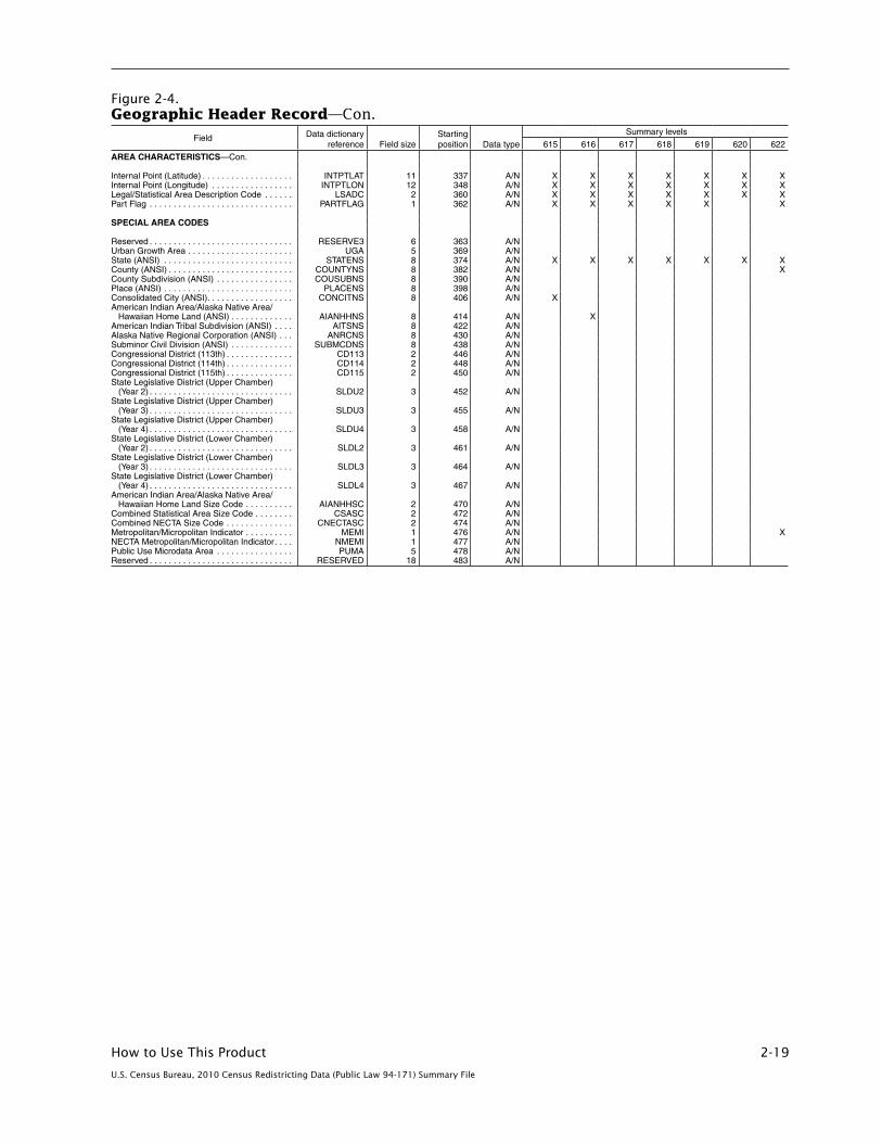
How to Use This Product 2-19
U.S. Census Bureau, 2010 Census Redistricting Data (Public Law 94-171) Summary File
Figure 2-4.Geographic Header Record—Con.
Field Data dictionary reference Field size
Starting position Data type
Summary levels
615 616 617 618 619 620 622
AREA CHARACTERISTICS—Con .
Internal Point (Latitude) . . . . . . . . . . . . . . . . . . . INTPTLAT 11 337 A/N X X X X X X XInternal Point (Longitude) . . . . . . . . . . . . . . . . . INTPTLON 12 348 A/N X X X X X X XLegal/Statistical Area Description Code . . . . . . LSADC 2 360 A/N X X X X X X XPart Flag . . . . . . . . . . . . . . . . . . . . . . . . . . . . . . PARTFLAG 1 362 A/N X X X X X X SPECIAL AREA CODES Reserved . . . . . . . . . . . . . . . . . . . . . . . . . . . . . . RESERVE3 6 363 A/N Urban Growth Area . . . . . . . . . . . . . . . . . . . . . . UGA 5 369 A/N State (ANSI) . . . . . . . . . . . . . . . . . . . . . . . . . . . STATENS 8 374 A/N X X X X X X XCounty (ANSI) . . . . . . . . . . . . . . . . . . . . . . . . . . COUNTYNS 8 382 A/N XCounty Subdivision (ANSI) . . . . . . . . . . . . . . . . COUSUBNS 8 390 A/N Place (ANSI) . . . . . . . . . . . . . . . . . . . . . . . . . . . PLACENS 8 398 A/N Consolidated City (ANSI) . . . . . . . . . . . . . . . . . . CONCITNS 8 406 A/N X American Indian Area/Alaska Native Area/
Hawaiian Home Land (ANSI) . . . . . . . . . . . . . AIANHHNS 8 414 A/N X American Indian Tribal Subdivision (ANSI) . . . . AITSNS 8 422 A/N Alaska Native Regional Corporation (ANSI) . . . ANRCNS 8 430 A/N Subminor Civil Division (ANSI) . . . . . . . . . . . . . SUBMCDNS 8 438 A/N Congressional District (113th) . . . . . . . . . . . . . . CD113 2 446 A/N Congressional District (114th) . . . . . . . . . . . . . . CD114 2 448 A/N Congressional District (115th) . . . . . . . . . . . . . . CD115 2 450 A/N State Legislative District (Upper Chamber)
(Year 2) . . . . . . . . . . . . . . . . . . . . . . . . . . . . . . SLDU2 3 452 A/N State Legislative District (Upper Chamber)
(Year 3) . . . . . . . . . . . . . . . . . . . . . . . . . . . . . . SLDU3 3 455 A/N State Legislative District (Upper Chamber)
(Year 4) . . . . . . . . . . . . . . . . . . . . . . . . . . . . . . SLDU4 3 458 A/N State Legislative District (Lower Chamber)
(Year 2) . . . . . . . . . . . . . . . . . . . . . . . . . . . . . . SLDL2 3 461 A/N State Legislative District (Lower Chamber)
(Year 3) . . . . . . . . . . . . . . . . . . . . . . . . . . . . . . SLDL3 3 464 A/N State Legislative District (Lower Chamber)
(Year 4) . . . . . . . . . . . . . . . . . . . . . . . . . . . . . . SLDL4 3 467 A/N American Indian Area/Alaska Native Area/
Hawaiian Home Land Size Code . . . . . . . . . . AIANHHSC 2 470 A/N Combined Statistical Area Size Code . . . . . . . . CSASC 2 472 A/N Combined NECTA Size Code . . . . . . . . . . . . . . CNECTASC 2 474 A/N Metropolitan/Micropolitan Indicator . . . . . . . . . . MEMI 1 476 A/N XNECTA Metropolitan/Micropolitan Indicator . . . . NMEMI 1 477 A/N Public Use Microdata Area . . . . . . . . . . . . . . . . PUMA 5 478 A/N Reserved . . . . . . . . . . . . . . . . . . . . . . . . . . . . . . RESERVED 18 483 A/N

2-20 How to Use This Product
U.S. Census Bureau, 2010 Census Redistricting Data (Public Law 94-171) Summary File
Figure 2-4.Geographic Header Record—Con.
Field Data dictionary reference Field size
Starting position Data type
Summary levels
623 624 625 626 627 628 629
RECORD CODES File Identification . . . . . . . . . . . . . . . . . . . . . . . . FILEID 6 1 A/N X X X X X X XState/U .S . Abbreviation (USPS) . . . . . . . . . . . . . STUSAB 2 7 A X X X X X X XSummary Level . . . . . . . . . . . . . . . . . . . . . . . . . SUMLEV 3 9 A/N X X X X X X XGeographic Component . . . . . . . . . . . . . . . . . . GEOCOMP 2 12 A/N X X X X X X XCharacteristic Iteration . . . . . . . . . . . . . . . . . . . . CHARITER 3 14 A/N X X X X X X XCharacteristic Iteration File Sequence
Number . . . . . . . . . . . . . . . . . . . . . . . . . . . . . . CIFSN 2 17 A/N X X X X X X XLogical Record Number . . . . . . . . . . . . . . . . . . . LOGRECNO 7 19 N X X X X X X X GEOGRAPHIC AREA CODES Region . . . . . . . . . . . . . . . . . . . . . . . . . . . . . . . . REGION 1 26 A/N X X X X X X XDivision . . . . . . . . . . . . . . . . . . . . . . . . . . . . . . . DIVISION 1 27 A/N X X X X X X XState (FIPS) . . . . . . . . . . . . . . . . . . . . . . . . . . . . STATE 2 28 A/N X X X X X X XCounty . . . . . . . . . . . . . . . . . . . . . . . . . . . . . . . . COUNTY 3 30 A/N X FIPS County Class Code . . . . . . . . . . . . . . . . . . COUNTYCC 2 33 A/N X County Size Code . . . . . . . . . . . . . . . . . . . . . . . COUNTYSC 2 35 A/N County Subdivision (FIPS) . . . . . . . . . . . . . . . . COUSUB 5 37 A/N X FIPS County Subdivision Class Code . . . . . . . . COUSUBCC 2 42 A/N X County Subdivision Size Code . . . . . . . . . . . . . COUSUBSC 2 44 A/N Place (FIPS) . . . . . . . . . . . . . . . . . . . . . . . . . . . PLACE 5 46 A/N X FIPS Place Class Code . . . . . . . . . . . . . . . . . . . PLACECC 2 51 A/N X Place Size Code . . . . . . . . . . . . . . . . . . . . . . . . PLACESC 2 53 A/N Census Tract . . . . . . . . . . . . . . . . . . . . . . . . . . . TRACT 6 55 A/N Block Group . . . . . . . . . . . . . . . . . . . . . . . . . . . . BLKGRP 1 61 A/N Block . . . . . . . . . . . . . . . . . . . . . . . . . . . . . . . . . BLOCK 4 62 A/N Internal Use Code . . . . . . . . . . . . . . . . . . . . . . . IUC 2 66 A/N Consolidated City (FIPS) . . . . . . . . . . . . . . . . . . CONCIT 5 68 A/N X FIPS Consolidated City Class Code . . . . . . . . . CONCITCC 2 73 A/N X Consolidated City Size Code . . . . . . . . . . . . . . . CONCITSC 2 75 A/N American Indian Area/Alaska Native Area/
Hawaiian Home Land (Census) . . . . . . . . . . . AIANHH 4 77 A/N X American Indian Area/Alaska Native Area/
Hawaiian Home Land (FIPS) . . . . . . . . . . . . . AIANHHFP 5 81 A/N X FIPS American Indian Area/Alaska Native
Area/Hawaiian Home Land Class Code . . . . . AIANHHCC 2 86 A/N X American Indian Trust Land/Hawaiian Home
Land Indicator . . . . . . . . . . . . . . . . . . . . . . . . . AIHHTLI 1 88 A/N X American Indian Tribal Subdivision (Census) . . AITSCE 3 89 A/N American Indian Tribal Subdivision (FIPS) . . . . AITS 5 92 A/N FIPS American Indian Tribal Subdivision
Class Code . . . . . . . . . . . . . . . . . . . . . . . . . . . AITSCC 2 97 A/N Tribal Census Tract . . . . . . . . . . . . . . . . . . . . . . TTRACT 6 99 A/N Tribal Block Group . . . . . . . . . . . . . . . . . . . . . . . TBLKGRP 1 105 A/N Alaska Native Regional Corporation (FIPS) . . . ANRC 5 106 A/N FIPS Alaska Native Regional Corporation
Class Code . . . . . . . . . . . . . . . . . . . . . . . . . . . ANRCCC 2 111 A/N Metropolitan Statistical Area/Micropolitan
Statistical Area . . . . . . . . . . . . . . . . . . . . . . . . CBSA 5 113 A/N X Metropolitan Statistical Area/Micropolitan
Statistical Area Size Code . . . . . . . . . . . . . . . CBSASC 2 118 A/N Metropolitan Division . . . . . . . . . . . . . . . . . . . . . METDIV 5 120 A/N X Combined Statistical Area . . . . . . . . . . . . . . . . . CSA 3 125 A/N X New England City and Town Area . . . . . . . . . . . NECTA 5 128 A/N X New England City and Town Area Size Code . . NECTASC 2 133 A/N New England City and Town Area Division . . . . NECTADIV 5 135 A/N X Combined New England City and Town Area . . CNECTA 3 140 A/N X Metropolitan Statistical Area/Micropolitan
Statistical Area Principal City Indicator . . . . . . CBSAPCI 1 143 A/N X New England City and Town Area Principal
City Indicator . . . . . . . . . . . . . . . . . . . . . . . . . . NECTAPCI 1 144 A/N X Urban Area . . . . . . . . . . . . . . . . . . . . . . . . . . . . UA 5 145 A/N Urban Area Size Code . . . . . . . . . . . . . . . . . . . . UASC 2 150 A/N Urban Area Type . . . . . . . . . . . . . . . . . . . . . . . . UATYPE 1 152 A/N Urban/Rural . . . . . . . . . . . . . . . . . . . . . . . . . . . . UR 1 153 A/N Congressional District (111th) . . . . . . . . . . . . . . CD 2 154 A/N State Legislative District (Upper Chamber)
(Year 1) . . . . . . . . . . . . . . . . . . . . . . . . . . . . . . SLDU 3 156 A/N State Legislative District (Lower Chamber)
(Year 1) . . . . . . . . . . . . . . . . . . . . . . . . . . . . . . SLDL 3 159 A/N X X X X X X XVoting District . . . . . . . . . . . . . . . . . . . . . . . . . . . VTD 6 162 A/N Voting District Indicator . . . . . . . . . . . . . . . . . . . VTDI 1 168 A/N Reserved . . . . . . . . . . . . . . . . . . . . . . . . . . . . . . RESERVE2 3 169 A/N ZIP Code Tabulation Area (5-Digit) . . . . . . . . . . ZCTA5 5 172 A/N Subminor Civil Division (FIPS) . . . . . . . . . . . . . SUBMCD 5 177 A/N FIPS Subminor Civil Division Class Code . . . . . SUBMCDCC 2 182 A/N School District (Elementary) . . . . . . . . . . . . . . . SDELM 5 184 A/N X School District (Secondary) . . . . . . . . . . . . . . . . SDSEC 5 189 A/N X School District (Unified) . . . . . . . . . . . . . . . . . . . SDUNI 5 194 A/N X AREA CHARACTERISTICS Area (Land) . . . . . . . . . . . . . . . . . . . . . . . . . . . . AREALAND 14 199 N X X X X X X XArea (Water) . . . . . . . . . . . . . . . . . . . . . . . . . . . AREAWATR 14 213 N X X X X X X XArea Name-Legal/Statistical Area Description
(LSAD) Term-Part Indicator . . . . . . . . . . . . . . NAME 90 227 A/N X X X X X X XFunctional Status Code . . . . . . . . . . . . . . . . . . . FUNCSTAT 1 317 A/N X X X X X X XGeographic Change User Note Indicator . . . . . GCUNI 1 318 A/N Population Count (100%) . . . . . . . . . . . . . . . . . . POP100 9 319 N X X X X X X XHousing Unit Count (100%) . . . . . . . . . . . . . . . . HU100 9 328 N X X X X X X X

How to Use This Product 2-21
U.S. Census Bureau, 2010 Census Redistricting Data (Public Law 94-171) Summary File
Figure 2-4.Geographic Header Record—Con.
Field Data dictionary reference Field size
Starting position Data type
Summary levels
623 624 625 626 627 628 629
AREA CHARACTERISTICS—Con .
Internal Point (Latitude) . . . . . . . . . . . . . . . . . . . INTPTLAT 11 337 A/N X X X X X X XInternal Point (Longitude) . . . . . . . . . . . . . . . . . INTPTLON 12 348 A/N X X X X X X XLegal/Statistical Area Description Code . . . . . . LSADC 2 360 A/N X X X X X X XPart Flag . . . . . . . . . . . . . . . . . . . . . . . . . . . . . . PARTFLAG 1 362 A/N X X X X X X X SPECIAL AREA CODES Reserved . . . . . . . . . . . . . . . . . . . . . . . . . . . . . . RESERVE3 6 363 A/N Urban Growth Area . . . . . . . . . . . . . . . . . . . . . . UGA 5 369 A/N State (ANSI) . . . . . . . . . . . . . . . . . . . . . . . . . . . STATENS 8 374 A/N X X X X X X XCounty (ANSI) . . . . . . . . . . . . . . . . . . . . . . . . . . COUNTYNS 8 382 A/N X County Subdivision (ANSI) . . . . . . . . . . . . . . . . COUSUBNS 8 390 A/N X Place (ANSI) . . . . . . . . . . . . . . . . . . . . . . . . . . . PLACENS 8 398 A/N X Consolidated City (ANSI) . . . . . . . . . . . . . . . . . . CONCITNS 8 406 A/N X American Indian Area/Alaska Native Area/
Hawaiian Home Land (ANSI) . . . . . . . . . . . . . AIANHHNS 8 414 A/N X American Indian Tribal Subdivision (ANSI) . . . . AITSNS 8 422 A/N Alaska Native Regional Corporation (ANSI) . . . ANRCNS 8 430 A/N Subminor Civil Division (ANSI) . . . . . . . . . . . . . SUBMCDNS 8 438 A/N Congressional District (113th) . . . . . . . . . . . . . . CD113 2 446 A/N Congressional District (114th) . . . . . . . . . . . . . . CD114 2 448 A/N Congressional District (115th) . . . . . . . . . . . . . . CD115 2 450 A/N State Legislative District (Upper Chamber)
(Year 2) . . . . . . . . . . . . . . . . . . . . . . . . . . . . . . SLDU2 3 452 A/N State Legislative District (Upper Chamber)
(Year 3) . . . . . . . . . . . . . . . . . . . . . . . . . . . . . . SLDU3 3 455 A/N State Legislative District (Upper Chamber)
(Year 4) . . . . . . . . . . . . . . . . . . . . . . . . . . . . . . SLDU4 3 458 A/N State Legislative District (Lower Chamber)
(Year 2) . . . . . . . . . . . . . . . . . . . . . . . . . . . . . . SLDL2 3 461 A/N State Legislative District (Lower Chamber)
(Year 3) . . . . . . . . . . . . . . . . . . . . . . . . . . . . . . SLDL3 3 464 A/N State Legislative District (Lower Chamber)
(Year 4) . . . . . . . . . . . . . . . . . . . . . . . . . . . . . . SLDL4 3 467 A/N American Indian Area/Alaska Native Area/
Hawaiian Home Land Size Code . . . . . . . . . . AIANHHSC 2 470 A/N Combined Statistical Area Size Code . . . . . . . . CSASC 2 472 A/N Combined NECTA Size Code . . . . . . . . . . . . . . CNECTASC 2 474 A/N Metropolitan/Micropolitan Indicator . . . . . . . . . . MEMI 1 476 A/N X NECTA Metropolitan/Micropolitan Indicator . . . . NMEMI 1 477 A/N X Public Use Microdata Area . . . . . . . . . . . . . . . . PUMA 5 478 A/N Reserved . . . . . . . . . . . . . . . . . . . . . . . . . . . . . . RESERVED 18 483 A/N

2-22 How to Use This Product
U.S. Census Bureau, 2010 Census Redistricting Data (Public Law 94-171) Summary File
Figure 2-4.Geographic Header Record—Con.
Field Data dictionary reference Field size
Starting position Data type
Summary levels
630 631 632 633 634 635 636
RECORD CODES File Identification . . . . . . . . . . . . . . . . . . . . . . . . FILEID 6 1 A/N X X X X X X XState/U .S . Abbreviation (USPS) . . . . . . . . . . . . . STUSAB 2 7 A X X X X X X XSummary Level . . . . . . . . . . . . . . . . . . . . . . . . . SUMLEV 3 9 A/N X X X X X X XGeographic Component . . . . . . . . . . . . . . . . . . GEOCOMP 2 12 A/N X X X X X X XCharacteristic Iteration . . . . . . . . . . . . . . . . . . . . CHARITER 3 14 A/N X X X X X X XCharacteristic Iteration File Sequence
Number . . . . . . . . . . . . . . . . . . . . . . . . . . . . . . CIFSN 2 17 A/N X X X X X X XLogical Record Number . . . . . . . . . . . . . . . . . . . LOGRECNO 7 19 N X X X X X X X GEOGRAPHIC AREA CODES Region . . . . . . . . . . . . . . . . . . . . . . . . . . . . . . . . REGION 1 26 A/N X X X X X X XDivision . . . . . . . . . . . . . . . . . . . . . . . . . . . . . . . DIVISION 1 27 A/N X X X X X X XState (FIPS) . . . . . . . . . . . . . . . . . . . . . . . . . . . . STATE 2 28 A/N X X X X X X XCounty . . . . . . . . . . . . . . . . . . . . . . . . . . . . . . . . COUNTY 3 30 A/N X X X X XFIPS County Class Code . . . . . . . . . . . . . . . . . . COUNTYCC 2 33 A/N X X X X XCounty Size Code . . . . . . . . . . . . . . . . . . . . . . . COUNTYSC 2 35 A/N County Subdivision (FIPS) . . . . . . . . . . . . . . . . COUSUB 5 37 A/N X FIPS County Subdivision Class Code . . . . . . . . COUSUBCC 2 42 A/N X County Subdivision Size Code . . . . . . . . . . . . . COUSUBSC 2 44 A/N Place (FIPS) . . . . . . . . . . . . . . . . . . . . . . . . . . . PLACE 5 46 A/N FIPS Place Class Code . . . . . . . . . . . . . . . . . . . PLACECC 2 51 A/N Place Size Code . . . . . . . . . . . . . . . . . . . . . . . . PLACESC 2 53 A/N Census Tract . . . . . . . . . . . . . . . . . . . . . . . . . . . TRACT 6 55 A/N X XBlock Group . . . . . . . . . . . . . . . . . . . . . . . . . . . . BLKGRP 1 61 A/N Block . . . . . . . . . . . . . . . . . . . . . . . . . . . . . . . . . BLOCK 4 62 A/N Internal Use Code . . . . . . . . . . . . . . . . . . . . . . . IUC 2 66 A/N Consolidated City (FIPS) . . . . . . . . . . . . . . . . . . CONCIT 5 68 A/N FIPS Consolidated City Class Code . . . . . . . . . CONCITCC 2 73 A/N Consolidated City Size Code . . . . . . . . . . . . . . . CONCITSC 2 75 A/N American Indian Area/Alaska Native Area/
Hawaiian Home Land (Census) . . . . . . . . . . . AIANHH 4 77 A/N X American Indian Area/Alaska Native Area/
Hawaiian Home Land (FIPS) . . . . . . . . . . . . . AIANHHFP 5 81 A/N X FIPS American Indian Area/Alaska Native
Area/Hawaiian Home Land Class Code . . . . . AIANHHCC 2 86 A/N X American Indian Trust Land/Hawaiian Home
Land Indicator . . . . . . . . . . . . . . . . . . . . . . . . . AIHHTLI 1 88 A/N X American Indian Tribal Subdivision (Census) . . AITSCE 3 89 A/N X American Indian Tribal Subdivision (FIPS) . . . . AITS 5 92 A/N X FIPS American Indian Tribal Subdivision
Class Code . . . . . . . . . . . . . . . . . . . . . . . . . . . AITSCC 2 97 A/N X Tribal Census Tract . . . . . . . . . . . . . . . . . . . . . . TTRACT 6 99 A/N Tribal Block Group . . . . . . . . . . . . . . . . . . . . . . . TBLKGRP 1 105 A/N Alaska Native Regional Corporation (FIPS) . . . ANRC 5 106 A/N X FIPS Alaska Native Regional Corporation
Class Code . . . . . . . . . . . . . . . . . . . . . . . . . . . ANRCCC 2 111 A/N X Metropolitan Statistical Area/Micropolitan
Statistical Area . . . . . . . . . . . . . . . . . . . . . . . . CBSA 5 113 A/N X X X X XMetropolitan Statistical Area/Micropolitan
Statistical Area Size Code . . . . . . . . . . . . . . . CBSASC 2 118 A/N Metropolitan Division . . . . . . . . . . . . . . . . . . . . . METDIV 5 120 A/N X X X X XCombined Statistical Area . . . . . . . . . . . . . . . . . CSA 3 125 A/N X X X X XNew England City and Town Area . . . . . . . . . . . NECTA 5 128 A/N New England City and Town Area Size Code . . NECTASC 2 133 A/N New England City and Town Area Division . . . . NECTADIV 5 135 A/N Combined New England City and Town Area . . CNECTA 3 140 A/N Metropolitan Statistical Area/Micropolitan
Statistical Area Principal City Indicator . . . . . . CBSAPCI 1 143 A/N New England City and Town Area Principal
City Indicator . . . . . . . . . . . . . . . . . . . . . . . . . . NECTAPCI 1 144 A/N Urban Area . . . . . . . . . . . . . . . . . . . . . . . . . . . . UA 5 145 A/N Urban Area Size Code . . . . . . . . . . . . . . . . . . . . UASC 2 150 A/N Urban Area Type . . . . . . . . . . . . . . . . . . . . . . . . UATYPE 1 152 A/N Urban/Rural . . . . . . . . . . . . . . . . . . . . . . . . . . . . UR 1 153 A/N Congressional District (111th) . . . . . . . . . . . . . . CD 2 154 A/N State Legislative District (Upper Chamber)
(Year 1) . . . . . . . . . . . . . . . . . . . . . . . . . . . . . . SLDU 3 156 A/N X X X X X State Legislative District (Lower Chamber)
(Year 1) . . . . . . . . . . . . . . . . . . . . . . . . . . . . . . SLDL 3 159 A/N X XVoting District . . . . . . . . . . . . . . . . . . . . . . . . . . . VTD 6 162 A/N X X Voting District Indicator . . . . . . . . . . . . . . . . . . . VTDI 1 168 A/N X X Reserved . . . . . . . . . . . . . . . . . . . . . . . . . . . . . . RESERVE2 3 169 A/N ZIP Code Tabulation Area (5-Digit) . . . . . . . . . . ZCTA5 5 172 A/N Subminor Civil Division (FIPS) . . . . . . . . . . . . . SUBMCD 5 177 A/N X FIPS Subminor Civil Division Class Code . . . . . SUBMCDCC 2 182 A/N X School District (Elementary) . . . . . . . . . . . . . . . SDELM 5 184 A/N School District (Secondary) . . . . . . . . . . . . . . . . SDSEC 5 189 A/N School District (Unified) . . . . . . . . . . . . . . . . . . . SDUNI 5 194 A/N AREA CHARACTERISTICS Area (Land) . . . . . . . . . . . . . . . . . . . . . . . . . . . . AREALAND 14 199 N X X X X X X XArea (Water) . . . . . . . . . . . . . . . . . . . . . . . . . . . AREAWATR 14 213 N X X X X X X XArea Name-Legal/Statistical Area Description
(LSAD) Term-Part Indicator . . . . . . . . . . . . . . NAME 90 227 A/N X X X X X X XFunctional Status Code . . . . . . . . . . . . . . . . . . . FUNCSTAT 1 317 A/N X X X X X X XGeographic Change User Note Indicator . . . . . GCUNI 1 318 A/N Population Count (100%) . . . . . . . . . . . . . . . . . . POP100 9 319 N X X X X X X XHousing Unit Count (100%) . . . . . . . . . . . . . . . . HU100 9 328 N X X X X X X X

How to Use This Product 2-23
U.S. Census Bureau, 2010 Census Redistricting Data (Public Law 94-171) Summary File
Figure 2-4.Geographic Header Record—Con.
Field Data dictionary reference Field size
Starting position Data type
Summary levels
630 631 632 633 634 635 636
AREA CHARACTERISTICS—Con .
Internal Point (Latitude) . . . . . . . . . . . . . . . . . . . INTPTLAT 11 337 A/N X X X X X X XInternal Point (Longitude) . . . . . . . . . . . . . . . . . INTPTLON 12 348 A/N X X X X X X XLegal/Statistical Area Description Code . . . . . . LSADC 2 360 A/N X X X X X X XPart Flag . . . . . . . . . . . . . . . . . . . . . . . . . . . . . . PARTFLAG 1 362 A/N X X X X X X X SPECIAL AREA CODES Reserved . . . . . . . . . . . . . . . . . . . . . . . . . . . . . . RESERVE3 6 363 A/N Urban Growth Area . . . . . . . . . . . . . . . . . . . . . . UGA 5 369 A/N State (ANSI) . . . . . . . . . . . . . . . . . . . . . . . . . . . STATENS 8 374 A/N X X X X X X XCounty (ANSI) . . . . . . . . . . . . . . . . . . . . . . . . . . COUNTYNS 8 382 A/N X X X X XCounty Subdivision (ANSI) . . . . . . . . . . . . . . . . COUSUBNS 8 390 A/N X Place (ANSI) . . . . . . . . . . . . . . . . . . . . . . . . . . . PLACENS 8 398 A/N Consolidated City (ANSI) . . . . . . . . . . . . . . . . . . CONCITNS 8 406 A/N American Indian Area/Alaska Native Area/
Hawaiian Home Land (ANSI) . . . . . . . . . . . . . AIANHHNS 8 414 A/N X American Indian Tribal Subdivision (ANSI) . . . . AITSNS 8 422 A/N X Alaska Native Regional Corporation (ANSI) . . . ANRCNS 8 430 A/N X Subminor Civil Division (ANSI) . . . . . . . . . . . . . SUBMCDNS 8 438 A/N X Congressional District (113th) . . . . . . . . . . . . . . CD113 2 446 A/N Congressional District (114th) . . . . . . . . . . . . . . CD114 2 448 A/N Congressional District (115th) . . . . . . . . . . . . . . CD115 2 450 A/N State Legislative District (Upper Chamber)
(Year 2) . . . . . . . . . . . . . . . . . . . . . . . . . . . . . . SLDU2 3 452 A/N State Legislative District (Upper Chamber)
(Year 3) . . . . . . . . . . . . . . . . . . . . . . . . . . . . . . SLDU3 3 455 A/N State Legislative District (Upper Chamber)
(Year 4) . . . . . . . . . . . . . . . . . . . . . . . . . . . . . . SLDU4 3 458 A/N State Legislative District (Lower Chamber)
(Year 2) . . . . . . . . . . . . . . . . . . . . . . . . . . . . . . SLDL2 3 461 A/N State Legislative District (Lower Chamber)
(Year 3) . . . . . . . . . . . . . . . . . . . . . . . . . . . . . . SLDL3 3 464 A/N State Legislative District (Lower Chamber)
(Year 4) . . . . . . . . . . . . . . . . . . . . . . . . . . . . . . SLDL4 3 467 A/N American Indian Area/Alaska Native Area/
Hawaiian Home Land Size Code . . . . . . . . . . AIANHHSC 2 470 A/N Combined Statistical Area Size Code . . . . . . . . CSASC 2 472 A/N Combined NECTA Size Code . . . . . . . . . . . . . . CNECTASC 2 474 A/N Metropolitan/Micropolitan Indicator . . . . . . . . . . MEMI 1 476 A/N X X X X XNECTA Metropolitan/Micropolitan Indicator . . . . NMEMI 1 477 A/N Public Use Microdata Area . . . . . . . . . . . . . . . . PUMA 5 478 A/N Reserved . . . . . . . . . . . . . . . . . . . . . . . . . . . . . . RESERVED 18 483 A/N
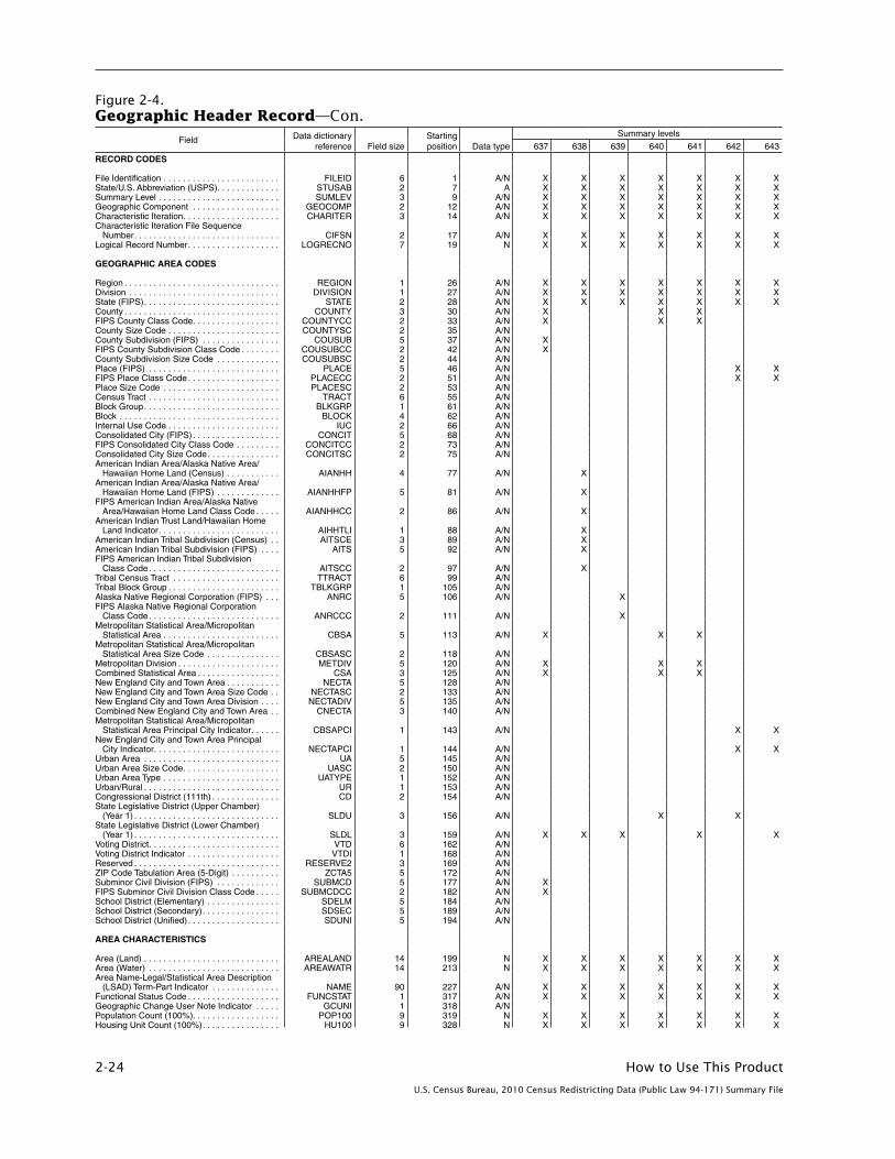
2-24 How to Use This Product
U.S. Census Bureau, 2010 Census Redistricting Data (Public Law 94-171) Summary File
Figure 2-4.Geographic Header Record—Con.
Field Data dictionary reference Field size
Starting position Data type
Summary levels
637 638 639 640 641 642 643
RECORD CODES File Identification . . . . . . . . . . . . . . . . . . . . . . . . FILEID 6 1 A/N X X X X X X XState/U .S . Abbreviation (USPS) . . . . . . . . . . . . . STUSAB 2 7 A X X X X X X XSummary Level . . . . . . . . . . . . . . . . . . . . . . . . . SUMLEV 3 9 A/N X X X X X X XGeographic Component . . . . . . . . . . . . . . . . . . GEOCOMP 2 12 A/N X X X X X X XCharacteristic Iteration . . . . . . . . . . . . . . . . . . . . CHARITER 3 14 A/N X X X X X X XCharacteristic Iteration File Sequence
Number . . . . . . . . . . . . . . . . . . . . . . . . . . . . . . CIFSN 2 17 A/N X X X X X X XLogical Record Number . . . . . . . . . . . . . . . . . . . LOGRECNO 7 19 N X X X X X X X GEOGRAPHIC AREA CODES Region . . . . . . . . . . . . . . . . . . . . . . . . . . . . . . . . REGION 1 26 A/N X X X X X X XDivision . . . . . . . . . . . . . . . . . . . . . . . . . . . . . . . DIVISION 1 27 A/N X X X X X X XState (FIPS) . . . . . . . . . . . . . . . . . . . . . . . . . . . . STATE 2 28 A/N X X X X X X XCounty . . . . . . . . . . . . . . . . . . . . . . . . . . . . . . . . COUNTY 3 30 A/N X X X FIPS County Class Code . . . . . . . . . . . . . . . . . . COUNTYCC 2 33 A/N X X X County Size Code . . . . . . . . . . . . . . . . . . . . . . . COUNTYSC 2 35 A/N County Subdivision (FIPS) . . . . . . . . . . . . . . . . COUSUB 5 37 A/N X FIPS County Subdivision Class Code . . . . . . . . COUSUBCC 2 42 A/N X County Subdivision Size Code . . . . . . . . . . . . . COUSUBSC 2 44 A/N Place (FIPS) . . . . . . . . . . . . . . . . . . . . . . . . . . . PLACE 5 46 A/N X XFIPS Place Class Code . . . . . . . . . . . . . . . . . . . PLACECC 2 51 A/N X XPlace Size Code . . . . . . . . . . . . . . . . . . . . . . . . PLACESC 2 53 A/N Census Tract . . . . . . . . . . . . . . . . . . . . . . . . . . . TRACT 6 55 A/N Block Group . . . . . . . . . . . . . . . . . . . . . . . . . . . . BLKGRP 1 61 A/N Block . . . . . . . . . . . . . . . . . . . . . . . . . . . . . . . . . BLOCK 4 62 A/N Internal Use Code . . . . . . . . . . . . . . . . . . . . . . . IUC 2 66 A/N Consolidated City (FIPS) . . . . . . . . . . . . . . . . . . CONCIT 5 68 A/N FIPS Consolidated City Class Code . . . . . . . . . CONCITCC 2 73 A/N Consolidated City Size Code . . . . . . . . . . . . . . . CONCITSC 2 75 A/N American Indian Area/Alaska Native Area/
Hawaiian Home Land (Census) . . . . . . . . . . . AIANHH 4 77 A/N X American Indian Area/Alaska Native Area/
Hawaiian Home Land (FIPS) . . . . . . . . . . . . . AIANHHFP 5 81 A/N X FIPS American Indian Area/Alaska Native
Area/Hawaiian Home Land Class Code . . . . . AIANHHCC 2 86 A/N X American Indian Trust Land/Hawaiian Home
Land Indicator . . . . . . . . . . . . . . . . . . . . . . . . . AIHHTLI 1 88 A/N X American Indian Tribal Subdivision (Census) . . AITSCE 3 89 A/N X American Indian Tribal Subdivision (FIPS) . . . . AITS 5 92 A/N X FIPS American Indian Tribal Subdivision
Class Code . . . . . . . . . . . . . . . . . . . . . . . . . . . AITSCC 2 97 A/N X Tribal Census Tract . . . . . . . . . . . . . . . . . . . . . . TTRACT 6 99 A/N Tribal Block Group . . . . . . . . . . . . . . . . . . . . . . . TBLKGRP 1 105 A/N Alaska Native Regional Corporation (FIPS) . . . ANRC 5 106 A/N X FIPS Alaska Native Regional Corporation
Class Code . . . . . . . . . . . . . . . . . . . . . . . . . . . ANRCCC 2 111 A/N X Metropolitan Statistical Area/Micropolitan
Statistical Area . . . . . . . . . . . . . . . . . . . . . . . . CBSA 5 113 A/N X X X Metropolitan Statistical Area/Micropolitan
Statistical Area Size Code . . . . . . . . . . . . . . . CBSASC 2 118 A/N Metropolitan Division . . . . . . . . . . . . . . . . . . . . . METDIV 5 120 A/N X X X Combined Statistical Area . . . . . . . . . . . . . . . . . CSA 3 125 A/N X X X New England City and Town Area . . . . . . . . . . . NECTA 5 128 A/N New England City and Town Area Size Code . . NECTASC 2 133 A/N New England City and Town Area Division . . . . NECTADIV 5 135 A/N Combined New England City and Town Area . . CNECTA 3 140 A/N Metropolitan Statistical Area/Micropolitan
Statistical Area Principal City Indicator . . . . . . CBSAPCI 1 143 A/N X XNew England City and Town Area Principal
City Indicator . . . . . . . . . . . . . . . . . . . . . . . . . . NECTAPCI 1 144 A/N X XUrban Area . . . . . . . . . . . . . . . . . . . . . . . . . . . . UA 5 145 A/N Urban Area Size Code . . . . . . . . . . . . . . . . . . . . UASC 2 150 A/N Urban Area Type . . . . . . . . . . . . . . . . . . . . . . . . UATYPE 1 152 A/N Urban/Rural . . . . . . . . . . . . . . . . . . . . . . . . . . . . UR 1 153 A/N Congressional District (111th) . . . . . . . . . . . . . . CD 2 154 A/N State Legislative District (Upper Chamber)
(Year 1) . . . . . . . . . . . . . . . . . . . . . . . . . . . . . . SLDU 3 156 A/N X X State Legislative District (Lower Chamber)
(Year 1) . . . . . . . . . . . . . . . . . . . . . . . . . . . . . . SLDL 3 159 A/N X X X X XVoting District . . . . . . . . . . . . . . . . . . . . . . . . . . . VTD 6 162 A/N Voting District Indicator . . . . . . . . . . . . . . . . . . . VTDI 1 168 A/N Reserved . . . . . . . . . . . . . . . . . . . . . . . . . . . . . . RESERVE2 3 169 A/N ZIP Code Tabulation Area (5-Digit) . . . . . . . . . . ZCTA5 5 172 A/N Subminor Civil Division (FIPS) . . . . . . . . . . . . . SUBMCD 5 177 A/N X FIPS Subminor Civil Division Class Code . . . . . SUBMCDCC 2 182 A/N X School District (Elementary) . . . . . . . . . . . . . . . SDELM 5 184 A/N School District (Secondary) . . . . . . . . . . . . . . . . SDSEC 5 189 A/N School District (Unified) . . . . . . . . . . . . . . . . . . . SDUNI 5 194 A/N AREA CHARACTERISTICS Area (Land) . . . . . . . . . . . . . . . . . . . . . . . . . . . . AREALAND 14 199 N X X X X X X XArea (Water) . . . . . . . . . . . . . . . . . . . . . . . . . . . AREAWATR 14 213 N X X X X X X XArea Name-Legal/Statistical Area Description
(LSAD) Term-Part Indicator . . . . . . . . . . . . . . NAME 90 227 A/N X X X X X X XFunctional Status Code . . . . . . . . . . . . . . . . . . . FUNCSTAT 1 317 A/N X X X X X X XGeographic Change User Note Indicator . . . . . GCUNI 1 318 A/N Population Count (100%) . . . . . . . . . . . . . . . . . . POP100 9 319 N X X X X X X XHousing Unit Count (100%) . . . . . . . . . . . . . . . . HU100 9 328 N X X X X X X X

How to Use This Product 2-25
U.S. Census Bureau, 2010 Census Redistricting Data (Public Law 94-171) Summary File
Figure 2-4.Geographic Header Record—Con.
Field Data dictionary reference Field size
Starting position Data type
Summary levels
637 638 639 640 641 642 643
AREA CHARACTERISTICS—Con .
Internal Point (Latitude) . . . . . . . . . . . . . . . . . . . INTPTLAT 11 337 A/N X X X X X X XInternal Point (Longitude) . . . . . . . . . . . . . . . . . INTPTLON 12 348 A/N X X X X X X XLegal/Statistical Area Description Code . . . . . . LSADC 2 360 A/N X X X X X X XPart Flag . . . . . . . . . . . . . . . . . . . . . . . . . . . . . . PARTFLAG 1 362 A/N X X X X X X X SPECIAL AREA CODES Reserved . . . . . . . . . . . . . . . . . . . . . . . . . . . . . . RESERVE3 6 363 A/N Urban Growth Area . . . . . . . . . . . . . . . . . . . . . . UGA 5 369 A/N State (ANSI) . . . . . . . . . . . . . . . . . . . . . . . . . . . STATENS 8 374 A/N X X X X X X XCounty (ANSI) . . . . . . . . . . . . . . . . . . . . . . . . . . COUNTYNS 8 382 A/N X X X County Subdivision (ANSI) . . . . . . . . . . . . . . . . COUSUBNS 8 390 A/N X Place (ANSI) . . . . . . . . . . . . . . . . . . . . . . . . . . . PLACENS 8 398 A/N X XConsolidated City (ANSI) . . . . . . . . . . . . . . . . . . CONCITNS 8 406 A/N American Indian Area/Alaska Native Area/
Hawaiian Home Land (ANSI) . . . . . . . . . . . . . AIANHHNS 8 414 A/N X American Indian Tribal Subdivision (ANSI) . . . . AITSNS 8 422 A/N X Alaska Native Regional Corporation (ANSI) . . . ANRCNS 8 430 A/N X Subminor Civil Division (ANSI) . . . . . . . . . . . . . SUBMCDNS 8 438 A/N X Congressional District (113th) . . . . . . . . . . . . . . CD113 2 446 A/N Congressional District (114th) . . . . . . . . . . . . . . CD114 2 448 A/N Congressional District (115th) . . . . . . . . . . . . . . CD115 2 450 A/N State Legislative District (Upper Chamber)
(Year 2) . . . . . . . . . . . . . . . . . . . . . . . . . . . . . . SLDU2 3 452 A/N State Legislative District (Upper Chamber)
(Year 3) . . . . . . . . . . . . . . . . . . . . . . . . . . . . . . SLDU3 3 455 A/N State Legislative District (Upper Chamber)
(Year 4) . . . . . . . . . . . . . . . . . . . . . . . . . . . . . . SLDU4 3 458 A/N State Legislative District (Lower Chamber)
(Year 2) . . . . . . . . . . . . . . . . . . . . . . . . . . . . . . SLDL2 3 461 A/N State Legislative District (Lower Chamber)
(Year 3) . . . . . . . . . . . . . . . . . . . . . . . . . . . . . . SLDL3 3 464 A/N State Legislative District (Lower Chamber)
(Year 4) . . . . . . . . . . . . . . . . . . . . . . . . . . . . . . SLDL4 3 467 A/N American Indian Area/Alaska Native Area/
Hawaiian Home Land Size Code . . . . . . . . . . AIANHHSC 2 470 A/N Combined Statistical Area Size Code . . . . . . . . CSASC 2 472 A/N Combined NECTA Size Code . . . . . . . . . . . . . . CNECTASC 2 474 A/N Metropolitan/Micropolitan Indicator . . . . . . . . . . MEMI 1 476 A/N X X X NECTA Metropolitan/Micropolitan Indicator . . . . NMEMI 1 477 A/N Public Use Microdata Area . . . . . . . . . . . . . . . . PUMA 5 478 A/N Reserved . . . . . . . . . . . . . . . . . . . . . . . . . . . . . . RESERVED 18 483 A/N

2-26 How to Use This Product
U.S. Census Bureau, 2010 Census Redistricting Data (Public Law 94-171) Summary File
Figure 2-4.Geographic Header Record—Con.
Field Data dictionary reference Field size
Starting position Data type
Summary levels
700 701 702 703 704 705 706
RECORD CODES File Identification . . . . . . . . . . . . . . . . . . . . . . . . FILEID 6 1 A/N X X X X X X XState/U .S . Abbreviation (USPS) . . . . . . . . . . . . . STUSAB 2 7 A X X X X X X XSummary Level . . . . . . . . . . . . . . . . . . . . . . . . . SUMLEV 3 9 A/N X X X X X X XGeographic Component . . . . . . . . . . . . . . . . . . GEOCOMP 2 12 A/N X X X X X X XCharacteristic Iteration . . . . . . . . . . . . . . . . . . . . CHARITER 3 14 A/N X X X X X X XCharacteristic Iteration File Sequence
Number . . . . . . . . . . . . . . . . . . . . . . . . . . . . . . CIFSN 2 17 A/N X X X X X X XLogical Record Number . . . . . . . . . . . . . . . . . . . LOGRECNO 7 19 N X X X X X X X GEOGRAPHIC AREA CODES Region . . . . . . . . . . . . . . . . . . . . . . . . . . . . . . . . REGION 1 26 A/N X X X X X X XDivision . . . . . . . . . . . . . . . . . . . . . . . . . . . . . . . DIVISION 1 27 A/N X X X X X X XState (FIPS) . . . . . . . . . . . . . . . . . . . . . . . . . . . . STATE 2 28 A/N X X X X X X XCounty . . . . . . . . . . . . . . . . . . . . . . . . . . . . . . . . COUNTY 3 30 A/N X X X X X X XFIPS County Class Code . . . . . . . . . . . . . . . . . . COUNTYCC 2 33 A/N X X X X X X XCounty Size Code . . . . . . . . . . . . . . . . . . . . . . . COUNTYSC 2 35 A/N County Subdivision (FIPS) . . . . . . . . . . . . . . . . COUSUB 5 37 A/N FIPS County Subdivision Class Code . . . . . . . . COUSUBCC 2 42 A/N County Subdivision Size Code . . . . . . . . . . . . . COUSUBSC 2 44 A/N Place (FIPS) . . . . . . . . . . . . . . . . . . . . . . . . . . . PLACE 5 46 A/N X FIPS Place Class Code . . . . . . . . . . . . . . . . . . . PLACECC 2 51 A/N X Place Size Code . . . . . . . . . . . . . . . . . . . . . . . . PLACESC 2 53 A/N Census Tract . . . . . . . . . . . . . . . . . . . . . . . . . . . TRACT 6 55 A/N Block Group . . . . . . . . . . . . . . . . . . . . . . . . . . . . BLKGRP 1 61 A/N Block . . . . . . . . . . . . . . . . . . . . . . . . . . . . . . . . . BLOCK 4 62 A/N Internal Use Code . . . . . . . . . . . . . . . . . . . . . . . IUC 2 66 A/N Consolidated City (FIPS) . . . . . . . . . . . . . . . . . . CONCIT 5 68 A/N X FIPS Consolidated City Class Code . . . . . . . . . CONCITCC 2 73 A/N X Consolidated City Size Code . . . . . . . . . . . . . . . CONCITSC 2 75 A/N American Indian Area/Alaska Native Area/
Hawaiian Home Land (Census) . . . . . . . . . . . AIANHH 4 77 A/N X X American Indian Area/Alaska Native Area/
Hawaiian Home Land (FIPS) . . . . . . . . . . . . . AIANHHFP 5 81 A/N X X FIPS American Indian Area/Alaska Native
Area/Hawaiian Home Land Class Code . . . . . AIANHHCC 2 86 A/N X X American Indian Trust Land/Hawaiian Home
Land Indicator . . . . . . . . . . . . . . . . . . . . . . . . . AIHHTLI 1 88 A/N X X American Indian Tribal Subdivision (Census) . . AITSCE 3 89 A/N X American Indian Tribal Subdivision (FIPS) . . . . AITS 5 92 A/N X FIPS American Indian Tribal Subdivision
Class Code . . . . . . . . . . . . . . . . . . . . . . . . . . . AITSCC 2 97 A/N X Tribal Census Tract . . . . . . . . . . . . . . . . . . . . . . TTRACT 6 99 A/N Tribal Block Group . . . . . . . . . . . . . . . . . . . . . . . TBLKGRP 1 105 A/N Alaska Native Regional Corporation (FIPS) . . . ANRC 5 106 A/N X FIPS Alaska Native Regional Corporation
Class Code . . . . . . . . . . . . . . . . . . . . . . . . . . . ANRCCC 2 111 A/N X Metropolitan Statistical Area/Micropolitan
Statistical Area . . . . . . . . . . . . . . . . . . . . . . . . CBSA 5 113 A/N X X X X X X XMetropolitan Statistical Area/Micropolitan
Statistical Area Size Code . . . . . . . . . . . . . . . CBSASC 2 118 A/N Metropolitan Division . . . . . . . . . . . . . . . . . . . . . METDIV 5 120 A/N X X X X X X XCombined Statistical Area . . . . . . . . . . . . . . . . . CSA 3 125 A/N X X X X X X XNew England City and Town Area . . . . . . . . . . . NECTA 5 128 A/N New England City and Town Area Size Code . . NECTASC 2 133 A/N New England City and Town Area Division . . . . NECTADIV 5 135 A/N Combined New England City and Town Area . . CNECTA 3 140 A/N Metropolitan Statistical Area/Micropolitan
Statistical Area Principal City Indicator . . . . . . CBSAPCI 1 143 A/N X New England City and Town Area Principal
City Indicator . . . . . . . . . . . . . . . . . . . . . . . . . . NECTAPCI 1 144 A/N X Urban Area . . . . . . . . . . . . . . . . . . . . . . . . . . . . UA 5 145 A/N Urban Area Size Code . . . . . . . . . . . . . . . . . . . . UASC 2 150 A/N Urban Area Type . . . . . . . . . . . . . . . . . . . . . . . . UATYPE 1 152 A/N Urban/Rural . . . . . . . . . . . . . . . . . . . . . . . . . . . . UR 1 153 A/N Congressional District (111th) . . . . . . . . . . . . . . CD 2 154 A/N State Legislative District (Upper Chamber)
(Year 1) . . . . . . . . . . . . . . . . . . . . . . . . . . . . . . SLDU 3 156 A/N State Legislative District (Lower Chamber)
(Year 1) . . . . . . . . . . . . . . . . . . . . . . . . . . . . . . SLDL 3 159 A/N Voting District . . . . . . . . . . . . . . . . . . . . . . . . . . . VTD 6 162 A/N X X X X X X XVoting District Indicator . . . . . . . . . . . . . . . . . . . VTDI 1 168 A/N X X X X X X XReserved . . . . . . . . . . . . . . . . . . . . . . . . . . . . . . RESERVE2 3 169 A/N ZIP Code Tabulation Area (5-Digit) . . . . . . . . . . ZCTA5 5 172 A/N Subminor Civil Division (FIPS) . . . . . . . . . . . . . SUBMCD 5 177 A/N FIPS Subminor Civil Division Class Code . . . . . SUBMCDCC 2 182 A/N School District (Elementary) . . . . . . . . . . . . . . . SDELM 5 184 A/N XSchool District (Secondary) . . . . . . . . . . . . . . . . SDSEC 5 189 A/N School District (Unified) . . . . . . . . . . . . . . . . . . . SDUNI 5 194 A/N AREA CHARACTERISTICS Area (Land) . . . . . . . . . . . . . . . . . . . . . . . . . . . . AREALAND 14 199 N X X X X X X XArea (Water) . . . . . . . . . . . . . . . . . . . . . . . . . . . AREAWATR 14 213 N X X X X X X XArea Name-Legal/Statistical Area Description
(LSAD) Term-Part Indicator . . . . . . . . . . . . . . NAME 90 227 A/N X X X X X X XFunctional Status Code . . . . . . . . . . . . . . . . . . . FUNCSTAT 1 317 A/N X X X X X X XGeographic Change User Note Indicator . . . . . GCUNI 1 318 A/N Population Count (100%) . . . . . . . . . . . . . . . . . . POP100 9 319 N X X X X X X XHousing Unit Count (100%) . . . . . . . . . . . . . . . . HU100 9 328 N X X X X X X X

How to Use This Product 2-27
U.S. Census Bureau, 2010 Census Redistricting Data (Public Law 94-171) Summary File
Figure 2-4.Geographic Header Record—Con.
Field Data dictionary reference Field size
Starting position Data type
Summary levels
700 701 702 703 704 705 706
AREA CHARACTERISTICS—Con .
Internal Point (Latitude) . . . . . . . . . . . . . . . . . . . INTPTLAT 11 337 A/N X X X X X X XInternal Point (Longitude) . . . . . . . . . . . . . . . . . INTPTLON 12 348 A/N X X X X X X XLegal/Statistical Area Description Code . . . . . . LSADC 2 360 A/N X X X X X X XPart Flag . . . . . . . . . . . . . . . . . . . . . . . . . . . . . . PARTFLAG 1 362 A/N X X X X X X SPECIAL AREA CODES Reserved . . . . . . . . . . . . . . . . . . . . . . . . . . . . . . RESERVE3 6 363 A/N Urban Growth Area . . . . . . . . . . . . . . . . . . . . . . UGA 5 369 A/N State (ANSI) . . . . . . . . . . . . . . . . . . . . . . . . . . . STATENS 8 374 A/N X X X X X X XCounty (ANSI) . . . . . . . . . . . . . . . . . . . . . . . . . . COUNTYNS 8 382 A/N X X X X X X XCounty Subdivision (ANSI) . . . . . . . . . . . . . . . . COUSUBNS 8 390 A/N Place (ANSI) . . . . . . . . . . . . . . . . . . . . . . . . . . . PLACENS 8 398 A/N X Consolidated City (ANSI) . . . . . . . . . . . . . . . . . . CONCITNS 8 406 A/N X American Indian Area/Alaska Native Area/
Hawaiian Home Land (ANSI) . . . . . . . . . . . . . AIANHHNS 8 414 A/N X X American Indian Tribal Subdivision (ANSI) . . . . AITSNS 8 422 A/N X Alaska Native Regional Corporation (ANSI) . . . ANRCNS 8 430 A/N X Subminor Civil Division (ANSI) . . . . . . . . . . . . . SUBMCDNS 8 438 A/N Congressional District (113th) . . . . . . . . . . . . . . CD113 2 446 A/N Congressional District (114th) . . . . . . . . . . . . . . CD114 2 448 A/N Congressional District (115th) . . . . . . . . . . . . . . CD115 2 450 A/N State Legislative District (Upper Chamber)
(Year 2) . . . . . . . . . . . . . . . . . . . . . . . . . . . . . . SLDU2 3 452 A/N State Legislative District (Upper Chamber)
(Year 3) . . . . . . . . . . . . . . . . . . . . . . . . . . . . . . SLDU3 3 455 A/N State Legislative District (Upper Chamber)
(Year 4) . . . . . . . . . . . . . . . . . . . . . . . . . . . . . . SLDU4 3 458 A/N State Legislative District (Lower Chamber)
(Year 2) . . . . . . . . . . . . . . . . . . . . . . . . . . . . . . SLDL2 3 461 A/N State Legislative District (Lower Chamber)
(Year 3) . . . . . . . . . . . . . . . . . . . . . . . . . . . . . . SLDL3 3 464 A/N State Legislative District (Lower Chamber)
(Year 4) . . . . . . . . . . . . . . . . . . . . . . . . . . . . . . SLDL4 3 467 A/N American Indian Area/Alaska Native Area/
Hawaiian Home Land Size Code . . . . . . . . . . AIANHHSC 2 470 A/N Combined Statistical Area Size Code . . . . . . . . CSASC 2 472 A/N Combined NECTA Size Code . . . . . . . . . . . . . . CNECTASC 2 474 A/N Metropolitan/Micropolitan Indicator . . . . . . . . . . MEMI 1 476 A/N X X X X X X XNECTA Metropolitan/Micropolitan Indicator . . . . NMEMI 1 477 A/N Public Use Microdata Area . . . . . . . . . . . . . . . . PUMA 5 478 A/N Reserved . . . . . . . . . . . . . . . . . . . . . . . . . . . . . . RESERVED 18 483 A/N

2-28 How to Use This Product
U.S. Census Bureau, 2010 Census Redistricting Data (Public Law 94-171) Summary File
Figure 2-4.Geographic Header Record—Con.
Field Data dictionary reference Field size
Starting position Data type
Summary levels
707 708 709 710 715 720 730
RECORD CODES File Identification . . . . . . . . . . . . . . . . . . . . . . . . FILEID 6 1 A/N X X X X X X XState/U .S . Abbreviation (USPS) . . . . . . . . . . . . . STUSAB 2 7 A X X X X X X XSummary Level . . . . . . . . . . . . . . . . . . . . . . . . . SUMLEV 3 9 A/N X X X X X X XGeographic Component . . . . . . . . . . . . . . . . . . GEOCOMP 2 12 A/N X X X X X X XCharacteristic Iteration . . . . . . . . . . . . . . . . . . . . CHARITER 3 14 A/N X X X X X X XCharacteristic Iteration File Sequence
Number . . . . . . . . . . . . . . . . . . . . . . . . . . . . . . CIFSN 2 17 A/N X X X X X X XLogical Record Number . . . . . . . . . . . . . . . . . . . LOGRECNO 7 19 N X X X X X X X GEOGRAPHIC AREA CODES Region . . . . . . . . . . . . . . . . . . . . . . . . . . . . . . . . REGION 1 26 A/N X X X X X X XDivision . . . . . . . . . . . . . . . . . . . . . . . . . . . . . . . DIVISION 1 27 A/N X X X X X X XState (FIPS) . . . . . . . . . . . . . . . . . . . . . . . . . . . . STATE 2 28 A/N X X X X X X XCounty . . . . . . . . . . . . . . . . . . . . . . . . . . . . . . . . COUNTY 3 30 A/N X X X X X X XFIPS County Class Code . . . . . . . . . . . . . . . . . . COUNTYCC 2 33 A/N X X X X X X XCounty Size Code . . . . . . . . . . . . . . . . . . . . . . . COUNTYSC 2 35 A/N County Subdivision (FIPS) . . . . . . . . . . . . . . . . COUSUB 5 37 A/N X X X XFIPS County Subdivision Class Code . . . . . . . . COUSUBCC 2 42 A/N X X X XCounty Subdivision Size Code . . . . . . . . . . . . . COUSUBSC 2 44 A/N Place (FIPS) . . . . . . . . . . . . . . . . . . . . . . . . . . . PLACE 5 46 A/N X XFIPS Place Class Code . . . . . . . . . . . . . . . . . . . PLACECC 2 51 A/N X XPlace Size Code . . . . . . . . . . . . . . . . . . . . . . . . PLACESC 2 53 A/N Census Tract . . . . . . . . . . . . . . . . . . . . . . . . . . . TRACT 6 55 A/N X XBlock Group . . . . . . . . . . . . . . . . . . . . . . . . . . . . BLKGRP 1 61 A/N Block . . . . . . . . . . . . . . . . . . . . . . . . . . . . . . . . . BLOCK 4 62 A/N Internal Use Code . . . . . . . . . . . . . . . . . . . . . . . IUC 2 66 A/N Consolidated City (FIPS) . . . . . . . . . . . . . . . . . . CONCIT 5 68 A/N FIPS Consolidated City Class Code . . . . . . . . . CONCITCC 2 73 A/N Consolidated City Size Code . . . . . . . . . . . . . . . CONCITSC 2 75 A/N American Indian Area/Alaska Native Area/
Hawaiian Home Land (Census) . . . . . . . . . . . AIANHH 4 77 A/N American Indian Area/Alaska Native Area/
Hawaiian Home Land (FIPS) . . . . . . . . . . . . . AIANHHFP 5 81 A/N FIPS American Indian Area/Alaska Native
Area/Hawaiian Home Land Class Code . . . . . AIANHHCC 2 86 A/N American Indian Trust Land/Hawaiian Home
Land Indicator . . . . . . . . . . . . . . . . . . . . . . . . . AIHHTLI 1 88 A/N American Indian Tribal Subdivision (Census) . . AITSCE 3 89 A/N American Indian Tribal Subdivision (FIPS) . . . . AITS 5 92 A/N FIPS American Indian Tribal Subdivision
Class Code . . . . . . . . . . . . . . . . . . . . . . . . . . . AITSCC 2 97 A/N Tribal Census Tract . . . . . . . . . . . . . . . . . . . . . . TTRACT 6 99 A/N Tribal Block Group . . . . . . . . . . . . . . . . . . . . . . . TBLKGRP 1 105 A/N Alaska Native Regional Corporation (FIPS) . . . ANRC 5 106 A/N FIPS Alaska Native Regional Corporation
Class Code . . . . . . . . . . . . . . . . . . . . . . . . . . . ANRCCC 2 111 A/N Metropolitan Statistical Area/Micropolitan
Statistical Area . . . . . . . . . . . . . . . . . . . . . . . . CBSA 5 113 A/N X X X X X X XMetropolitan Statistical Area/Micropolitan
Statistical Area Size Code . . . . . . . . . . . . . . . CBSASC 2 118 A/N Metropolitan Division . . . . . . . . . . . . . . . . . . . . . METDIV 5 120 A/N X X X X X X XCombined Statistical Area . . . . . . . . . . . . . . . . . CSA 3 125 A/N X X X X X X XNew England City and Town Area . . . . . . . . . . . NECTA 5 128 A/N X X XNew England City and Town Area Size Code . . NECTASC 2 133 A/N New England City and Town Area Division . . . . NECTADIV 5 135 A/N X X XCombined New England City and Town Area . . CNECTA 3 140 A/N X X XMetropolitan Statistical Area/Micropolitan
Statistical Area Principal City Indicator . . . . . . CBSAPCI 1 143 A/N X XNew England City and Town Area Principal
City Indicator . . . . . . . . . . . . . . . . . . . . . . . . . . NECTAPCI 1 144 A/N X XUrban Area . . . . . . . . . . . . . . . . . . . . . . . . . . . . UA 5 145 A/N Urban Area Size Code . . . . . . . . . . . . . . . . . . . . UASC 2 150 A/N Urban Area Type . . . . . . . . . . . . . . . . . . . . . . . . UATYPE 1 152 A/N Urban/Rural . . . . . . . . . . . . . . . . . . . . . . . . . . . . UR 1 153 A/N Congressional District (111th) . . . . . . . . . . . . . . CD 2 154 A/N State Legislative District (Upper Chamber)
(Year 1) . . . . . . . . . . . . . . . . . . . . . . . . . . . . . . SLDU 3 156 A/N State Legislative District (Lower Chamber)
(Year 1) . . . . . . . . . . . . . . . . . . . . . . . . . . . . . . SLDL 3 159 A/N Voting District . . . . . . . . . . . . . . . . . . . . . . . . . . . VTD 6 162 A/N X X X X X X XVoting District Indicator . . . . . . . . . . . . . . . . . . . VTDI 1 168 A/N X X X X X X XReserved . . . . . . . . . . . . . . . . . . . . . . . . . . . . . . RESERVE2 3 169 A/N ZIP Code Tabulation Area (5-Digit) . . . . . . . . . . ZCTA5 5 172 A/N Subminor Civil Division (FIPS) . . . . . . . . . . . . . SUBMCD 5 177 A/N X FIPS Subminor Civil Division Class Code . . . . . SUBMCDCC 2 182 A/N X School District (Elementary) . . . . . . . . . . . . . . . SDELM 5 184 A/N School District (Secondary) . . . . . . . . . . . . . . . . SDSEC 5 189 A/N X School District (Unified) . . . . . . . . . . . . . . . . . . . SDUNI 5 194 A/N X AREA CHARACTERISTICS Area (Land) . . . . . . . . . . . . . . . . . . . . . . . . . . . . AREALAND 14 199 N X X X X X X XArea (Water) . . . . . . . . . . . . . . . . . . . . . . . . . . . AREAWATR 14 213 N X X X X X X XArea Name-Legal/Statistical Area Description
(LSAD) Term-Part Indicator . . . . . . . . . . . . . . NAME 90 227 A/N X X X X X X XFunctional Status Code . . . . . . . . . . . . . . . . . . . FUNCSTAT 1 317 A/N X X X X X X XGeographic Change User Note Indicator . . . . . GCUNI 1 318 A/N Population Count (100%) . . . . . . . . . . . . . . . . . . POP100 9 319 N X X X X X X XHousing Unit Count (100%) . . . . . . . . . . . . . . . . HU100 9 328 N X X X X X X X

How to Use This Product 2-29
U.S. Census Bureau, 2010 Census Redistricting Data (Public Law 94-171) Summary File
Figure 2-4.Geographic Header Record—Con.
Field Data dictionary reference Field size
Starting position Data type
Summary levels
707 708 709 710 715 720 730
AREA CHARACTERISTICS—Con .
Internal Point (Latitude) . . . . . . . . . . . . . . . . . . . INTPTLAT 11 337 A/N X X X X X X XInternal Point (Longitude) . . . . . . . . . . . . . . . . . INTPTLON 12 348 A/N X X X X X X XLegal/Statistical Area Description Code . . . . . . LSADC 2 360 A/N X X X X X X XPart Flag . . . . . . . . . . . . . . . . . . . . . . . . . . . . . . PARTFLAG 1 362 A/N X X X X X X X SPECIAL AREA CODES Reserved . . . . . . . . . . . . . . . . . . . . . . . . . . . . . . RESERVE3 6 363 A/N Urban Growth Area . . . . . . . . . . . . . . . . . . . . . . UGA 5 369 A/N State (ANSI) . . . . . . . . . . . . . . . . . . . . . . . . . . . STATENS 8 374 A/N X X X X X X XCounty (ANSI) . . . . . . . . . . . . . . . . . . . . . . . . . . COUNTYNS 8 382 A/N X X X X X X XCounty Subdivision (ANSI) . . . . . . . . . . . . . . . . COUSUBNS 8 390 A/N X X X XPlace (ANSI) . . . . . . . . . . . . . . . . . . . . . . . . . . . PLACENS 8 398 A/N X XConsolidated City (ANSI) . . . . . . . . . . . . . . . . . . CONCITNS 8 406 A/N American Indian Area/Alaska Native Area/
Hawaiian Home Land (ANSI) . . . . . . . . . . . . . AIANHHNS 8 414 A/N American Indian Tribal Subdivision (ANSI) . . . . AITSNS 8 422 A/N Alaska Native Regional Corporation (ANSI) . . . ANRCNS 8 430 A/N Subminor Civil Division (ANSI) . . . . . . . . . . . . . SUBMCDNS 8 438 A/N X Congressional District (113th) . . . . . . . . . . . . . . CD113 2 446 A/N Congressional District (114th) . . . . . . . . . . . . . . CD114 2 448 A/N Congressional District (115th) . . . . . . . . . . . . . . CD115 2 450 A/N State Legislative District (Upper Chamber)
(Year 2) . . . . . . . . . . . . . . . . . . . . . . . . . . . . . . SLDU2 3 452 A/N State Legislative District (Upper Chamber)
(Year 3) . . . . . . . . . . . . . . . . . . . . . . . . . . . . . . SLDU3 3 455 A/N State Legislative District (Upper Chamber)
(Year 4) . . . . . . . . . . . . . . . . . . . . . . . . . . . . . . SLDU4 3 458 A/N State Legislative District (Lower Chamber)
(Year 2) . . . . . . . . . . . . . . . . . . . . . . . . . . . . . . SLDL2 3 461 A/N State Legislative District (Lower Chamber)
(Year 3) . . . . . . . . . . . . . . . . . . . . . . . . . . . . . . SLDL3 3 464 A/N State Legislative District (Lower Chamber)
(Year 4) . . . . . . . . . . . . . . . . . . . . . . . . . . . . . . SLDL4 3 467 A/N American Indian Area/Alaska Native Area/
Hawaiian Home Land Size Code . . . . . . . . . . AIANHHSC 2 470 A/N Combined Statistical Area Size Code . . . . . . . . CSASC 2 472 A/N Combined NECTA Size Code . . . . . . . . . . . . . . CNECTASC 2 474 A/N Metropolitan/Micropolitan Indicator . . . . . . . . . . MEMI 1 476 A/N X X X X X X XNECTA Metropolitan/Micropolitan Indicator . . . . NMEMI 1 477 A/N X X XPublic Use Microdata Area . . . . . . . . . . . . . . . . PUMA 5 478 A/N Reserved . . . . . . . . . . . . . . . . . . . . . . . . . . . . . . RESERVED 18 483 A/N

2-30 How to Use This Product
U.S. Census Bureau, 2010 Census Redistricting Data (Public Law 94-171) Summary File
Figure 2-4.Geographic Header Record—Con.
Field Data dictionary reference Field size
Starting position Data type
Summary levels
735 740 745 750 755 950 960 970
RECORD CODES File Identification . . . . . . . . . . . . . . . . . . . . . . . . FILEID 6 1 A/N X X X X X X X XState/U .S . Abbreviation (USPS) . . . . . . . . . . . . . STUSAB 2 7 A X X X X X X X XSummary Level . . . . . . . . . . . . . . . . . . . . . . . . . SUMLEV 3 9 A/N X X X X X X X XGeographic Component . . . . . . . . . . . . . . . . . . GEOCOMP 2 12 A/N X X X X X X X XCharacteristic Iteration . . . . . . . . . . . . . . . . . . . . CHARITER 3 14 A/N X X X X X X X XCharacteristic Iteration File Sequence
Number . . . . . . . . . . . . . . . . . . . . . . . . . . . . . . CIFSN 2 17 A/N X X X X X X X XLogical Record Number . . . . . . . . . . . . . . . . . . . LOGRECNO 7 19 N X X X X X X X X GEOGRAPHIC AREA CODES Region . . . . . . . . . . . . . . . . . . . . . . . . . . . . . . . . REGION 1 26 A/N X X X X X X X XDivision . . . . . . . . . . . . . . . . . . . . . . . . . . . . . . . DIVISION 1 27 A/N X X X X X X X XState (FIPS) . . . . . . . . . . . . . . . . . . . . . . . . . . . . STATE 2 28 A/N X X X X X X X XCounty . . . . . . . . . . . . . . . . . . . . . . . . . . . . . . . . COUNTY 3 30 A/N X X X X X FIPS County Class Code . . . . . . . . . . . . . . . . . . COUNTYCC 2 33 A/N X X X X X County Size Code . . . . . . . . . . . . . . . . . . . . . . . COUNTYSC 2 35 A/N County Subdivision (FIPS) . . . . . . . . . . . . . . . . COUSUB 5 37 A/N X X X X X FIPS County Subdivision Class Code . . . . . . . . COUSUBCC 2 42 A/N X X X X X County Subdivision Size Code . . . . . . . . . . . . . COUSUBSC 2 44 A/N Place (FIPS) . . . . . . . . . . . . . . . . . . . . . . . . . . . PLACE 5 46 A/N X X X FIPS Place Class Code . . . . . . . . . . . . . . . . . . . PLACECC 2 51 A/N X X X Place Size Code . . . . . . . . . . . . . . . . . . . . . . . . PLACESC 2 53 A/N Census Tract . . . . . . . . . . . . . . . . . . . . . . . . . . . TRACT 6 55 A/N X X X X X Block Group . . . . . . . . . . . . . . . . . . . . . . . . . . . . BLKGRP 1 61 A/N X X X X Block . . . . . . . . . . . . . . . . . . . . . . . . . . . . . . . . . BLOCK 4 62 A/N X X Internal Use Code . . . . . . . . . . . . . . . . . . . . . . . IUC 2 66 A/N Consolidated City (FIPS) . . . . . . . . . . . . . . . . . . CONCIT 5 68 A/N X FIPS Consolidated City Class Code . . . . . . . . . CONCITCC 2 73 A/N X Consolidated City Size Code . . . . . . . . . . . . . . . CONCITSC 2 75 A/N American Indian Area/Alaska Native Area/
Hawaiian Home Land (Census) . . . . . . . . . . . AIANHH 4 77 A/N X American Indian Area/Alaska Native Area/
Hawaiian Home Land (FIPS) . . . . . . . . . . . . . AIANHHFP 5 81 A/N X FIPS American Indian Area/Alaska Native
Area/Hawaiian Home Land Class Code . . . . . AIANHHCC 2 86 A/N X American Indian Trust Land/Hawaiian Home
Land Indicator . . . . . . . . . . . . . . . . . . . . . . . . . AIHHTLI 1 88 A/N X American Indian Tribal Subdivision (Census) . . AITSCE 3 89 A/N X American Indian Tribal Subdivision (FIPS) . . . . AITS 5 92 A/N X FIPS American Indian Tribal Subdivision
Class Code . . . . . . . . . . . . . . . . . . . . . . . . . . . AITSCC 2 97 A/N X Tribal Census Tract . . . . . . . . . . . . . . . . . . . . . . TTRACT 6 99 A/N X Tribal Block Group . . . . . . . . . . . . . . . . . . . . . . . TBLKGRP 1 105 A/N X Alaska Native Regional Corporation (FIPS) . . . ANRC 5 106 A/N X FIPS Alaska Native Regional Corporation
Class Code . . . . . . . . . . . . . . . . . . . . . . . . . . . ANRCCC 2 111 A/N X Metropolitan Statistical Area/Micropolitan
Statistical Area . . . . . . . . . . . . . . . . . . . . . . . . CBSA 5 113 A/N X X X X X Metropolitan Statistical Area/Micropolitan
Statistical Area Size Code . . . . . . . . . . . . . . . CBSASC 2 118 A/N Metropolitan Division . . . . . . . . . . . . . . . . . . . . . METDIV 5 120 A/N X X X X X Combined Statistical Area . . . . . . . . . . . . . . . . . CSA 3 125 A/N X X X X X New England City and Town Area . . . . . . . . . . . NECTA 5 128 A/N X X New England City and Town Area Size Code . . NECTASC 2 133 A/N New England City and Town Area Division . . . . NECTADIV 5 135 A/N X X Combined New England City and Town Area . . CNECTA 3 140 A/N X X Metropolitan Statistical Area/Micropolitan
Statistical Area Principal City Indicator . . . . . . CBSAPCI 1 143 A/N X X X New England City and Town Area Principal
City Indicator . . . . . . . . . . . . . . . . . . . . . . . . . . NECTAPCI 1 144 A/N X X Urban Area . . . . . . . . . . . . . . . . . . . . . . . . . . . . UA 5 145 A/N Urban Area Size Code . . . . . . . . . . . . . . . . . . . . UASC 2 150 A/N Urban Area Type . . . . . . . . . . . . . . . . . . . . . . . . UATYPE 1 152 A/N Urban/Rural . . . . . . . . . . . . . . . . . . . . . . . . . . . . UR 1 153 A/N Congressional District (111th) . . . . . . . . . . . . . . CD 2 154 A/N X X State Legislative District (Upper Chamber)
(Year 1) . . . . . . . . . . . . . . . . . . . . . . . . . . . . . . SLDU 3 156 A/N X X State Legislative District (Lower Chamber)
(Year 1) . . . . . . . . . . . . . . . . . . . . . . . . . . . . . . SLDL 3 159 A/N X X Voting District . . . . . . . . . . . . . . . . . . . . . . . . . . . VTD 6 162 A/N X X X X X Voting District Indicator . . . . . . . . . . . . . . . . . . . VTDI 1 168 A/N X X X X X Reserved . . . . . . . . . . . . . . . . . . . . . . . . . . . . . . RESERVE2 3 169 A/N ZIP Code Tabulation Area (5-Digit) . . . . . . . . . . ZCTA5 5 172 A/N Subminor Civil Division (FIPS) . . . . . . . . . . . . . SUBMCD 5 177 A/N X X X FIPS Subminor Civil Division Class Code . . . . . SUBMCDCC 2 182 A/N X X X School District (Elementary) . . . . . . . . . . . . . . . SDELM 5 184 A/N X X X School District (Secondary) . . . . . . . . . . . . . . . . SDSEC 5 189 A/N X X X School District (Unified) . . . . . . . . . . . . . . . . . . . SDUNI 5 194 A/N X X X AREA CHARACTERISTICS Area (Land) . . . . . . . . . . . . . . . . . . . . . . . . . . . . AREALAND 14 199 N X X X X X X X XArea (Water) . . . . . . . . . . . . . . . . . . . . . . . . . . . AREAWATR 14 213 N X X X X X X X XArea Name-Legal/Statistical Area Description
(LSAD) Term-Part Indicator . . . . . . . . . . . . . . NAME 90 227 A/N X X X X X X X XFunctional Status Code . . . . . . . . . . . . . . . . . . . FUNCSTAT 1 317 A/N X X X X X X X XGeographic Change User Note Indicator . . . . . GCUNI 1 318 A/N X X XPopulation Count (100%) . . . . . . . . . . . . . . . . . . POP100 9 319 N X X X X X X X XHousing Unit Count (100%) . . . . . . . . . . . . . . . . HU100 9 328 N X X X X X X X X

How to Use This Product 2-31
U.S. Census Bureau, 2010 Census Redistricting Data (Public Law 94-171) Summary File
Figure 2-4.Geographic Header Record—Con.
Field Data dictionary reference Field size
Starting position Data type
Summary levels
735 740 745 750 755 950 960 970
AREA CHARACTERISTICS—Con .
Internal Point (Latitude) . . . . . . . . . . . . . . . . . . . INTPTLAT 11 337 A/N X X X X X X X XInternal Point (Longitude) . . . . . . . . . . . . . . . . . INTPTLON 12 348 A/N X X X X X X X XLegal/Statistical Area Description Code . . . . . . LSADC 2 360 A/N X X X X X X X XPart Flag . . . . . . . . . . . . . . . . . . . . . . . . . . . . . . PARTFLAG 1 362 A/N X X X SPECIAL AREA CODES Reserved . . . . . . . . . . . . . . . . . . . . . . . . . . . . . . RESERVE3 6 363 A/N Urban Growth Area . . . . . . . . . . . . . . . . . . . . . . UGA 5 369 A/N X State (ANSI) . . . . . . . . . . . . . . . . . . . . . . . . . . . STATENS 8 374 A/N X X X X X X X XCounty (ANSI) . . . . . . . . . . . . . . . . . . . . . . . . . . COUNTYNS 8 382 A/N X X X X X County Subdivision (ANSI) . . . . . . . . . . . . . . . . COUSUBNS 8 390 A/N X X X X X Place (ANSI) . . . . . . . . . . . . . . . . . . . . . . . . . . . PLACENS 8 398 A/N X X X Consolidated City (ANSI) . . . . . . . . . . . . . . . . . . CONCITNS 8 406 A/N X American Indian Area/Alaska Native Area/
Hawaiian Home Land (ANSI) . . . . . . . . . . . . . AIANHHNS 8 414 A/N X American Indian Tribal Subdivision (ANSI) . . . . AITSNS 8 422 A/N X Alaska Native Regional Corporation (ANSI) . . . ANRCNS 8 430 A/N X Subminor Civil Division (ANSI) . . . . . . . . . . . . . SUBMCDNS 8 438 A/N X X X Congressional District (113th) . . . . . . . . . . . . . . CD113 2 446 A/N Congressional District (114th) . . . . . . . . . . . . . . CD114 2 448 A/N Congressional District (115th) . . . . . . . . . . . . . . CD115 2 450 A/N State Legislative District (Upper Chamber)
(Year 2) . . . . . . . . . . . . . . . . . . . . . . . . . . . . . . SLDU2 3 452 A/N State Legislative District (Upper Chamber)
(Year 3) . . . . . . . . . . . . . . . . . . . . . . . . . . . . . . SLDU3 3 455 A/N State Legislative District (Upper Chamber)
(Year 4) . . . . . . . . . . . . . . . . . . . . . . . . . . . . . . SLDU4 3 458 A/N State Legislative District (Lower Chamber)
(Year 2) . . . . . . . . . . . . . . . . . . . . . . . . . . . . . . SLDL2 3 461 A/N State Legislative District (Lower Chamber)
(Year 3) . . . . . . . . . . . . . . . . . . . . . . . . . . . . . . SLDL3 3 464 A/N State Legislative District (Lower Chamber)
(Year 4) . . . . . . . . . . . . . . . . . . . . . . . . . . . . . . SLDL4 3 467 A/N American Indian Area/Alaska Native Area/
Hawaiian Home Land Size Code . . . . . . . . . . AIANHHSC 2 470 A/N Combined Statistical Area Size Code . . . . . . . . CSASC 2 472 A/N Combined NECTA Size Code . . . . . . . . . . . . . . CNECTASC 2 474 A/N Metropolitan/Micropolitan Indicator . . . . . . . . . . MEMI 1 476 A/N X X X X X NECTA Metropolitan/Micropolitan Indicator . . . . NMEMI 1 477 A/N X X Public Use Microdata Area . . . . . . . . . . . . . . . . PUMA 5 478 A/N Reserved . . . . . . . . . . . . . . . . . . . . . . . . . . . . . . RESERVED 18 483 A/N

Subject Locator 3-1
U.S. Census Bureau, 2010 Census Redistricting Data (Public Law 94-171) Summary File
ContentsChapter 3. Subject Locator 1CONTENTS 1
GENERAL INFORMATION 1
SUBJECT LOCATOR 1
HISPANIC OR LATINO, AND NOT HISPANIC OR LATINO BY RACE 1
HISPANIC OR LATINO, AND NOT HISPANIC OR LATINO BY RACE FOR THE POPULATION 18 YEARS AND OVER 1
OCCUPANCY STATUS 1
RACE 1
RACE FOR THE POPULATION 18 YEARS AND OVER 1
Chapter 3. Subject Locator
CONTENTS
General Information . . . . . . . . . . . . . . . . . . . . . . . . . . . . . . . . . . . . . . . . . . . . . . . . . . . . . . . . . . . . 3-1Subject Locator . . . . . . . . . . . . . . . . . . . . . . . . . . . . . . . . . . . . . . . . . . . . . . . . . . . . . . . . . . . . . . . . 3-1
GENERAL INFORMATION
The subject locator is an index designed to quickly identify the tables (matrices) in the 2010 Census Redistricting Data (Public Law 94-171) Summary File. This index is arranged in alphabetical order by the name of a subject. Under each subject heading, the universe or the type of entry being tabulated (shown in italics) and the relevant table number appear.
SUBJECT LOCATOR
SubjectsTable
number
HISPANIC OR LATINO, AND NOT HISPANIC OR LATINO BY RACE Total population . . . . . . . . . . . . . . . . . . . . . . . . . . . . . . . . . . . . . . . . . . . . . . . . . . . . . . . . . . . P2
HISPANIC OR LATINO, AND NOT HISPANIC OR LATINO BY RACE FOR THE POPULATION 18 YEARS AND OVER Total population 18 years and over . . . . . . . . . . . . . . . . . . . . . . . . . . . . . . . . . . . . . . . . . . . . P4
OCCUPANCY STATUS Housing units . . . . . . . . . . . . . . . . . . . . . . . . . . . . . . . . . . . . . . . . . . . . . . . . . . . . . . . . . . . . H1
RACE Total population . . . . . . . . . . . . . . . . . . . . . . . . . . . . . . . . . . . . . . . . . . . . . . . . . . . . . . . . . . . P1
RACE FOR THE POPULATION 18 YEARS AND OVER Total population 18 years and over . . . . . . . . . . . . . . . . . . . . . . . . . . . . . . . . . . . . . . . . . . . . P3

Summary Level Sequence Chart 4-1
U.S. Census Bureau, 2010 Census Redistricting Data (Public Law 94-171) Summary File
Geographic component Summary level
00 040 State1
00 500 State-Congressional District2
00 510 State-Congressional District-County3
00 511 State-Congressional District-County-Census Tract00 521 State-Congressional District-County-County Subdivision00 531 State-Congressional District-Place/Remainder00 541 State-Congressional District-Consolidated City00 550 State-Congressional District-American Indian Area/Alaska Native Area/Hawaiian
Home Land00 553 State-Congressional District-American Indian Area-Tribal Subdivision/
Remainder4
00 570 State-Congressional District-School District (Elementary)/Remainder00 571 State-Congressional District-School District (Secondary)/Remainder00 572 State-Congressional District-School District (Unified)/Remainder00 610 State-State Legislative District (Upper Chamber)00 612 State-State Legislative District (Upper Chamber)-County00 613 State-State Legislative District (Upper Chamber)-County-County Subdivision00 632 State-State Legislative District (Upper Chamber)-County-County
Subdivision-Subminor Civil Division5
00 630 State-State Legislative District (Upper Chamber)-County-Voting District/ Remainder
00 631 State-State Legislative District (Upper Chamber)-County-Census Tract00 614 State-State Legislative District (Upper Chamber)-Place/Remainder00 615 State-State Legislative District (Upper Chamber)-Consolidated City00 616 State-State Legislative District (Upper Chamber)-American Indian Area/Alaska
Native Area/Hawaiian Home Land
Chapter 4. Summary Level Sequence Chart
Summary levels specify the content and hierarchical relationships of the geographic elements that are required to tabulate and summarize data. In the Summary Level Sequence Chart that follows, the summary level code precedes the summary level area, and symbols are used with special meaning for summary levels:
Hyphen “-” separates the elements of a hierarchy. Slash “/” denotes equivalent elements that have different names. Parentheses “( )” are not used in the specification for summary levels, but are used occasionally in the usual and customary manner in statements of clarification.
See footnotes at end of table .
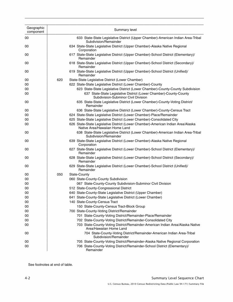
4-2 Summary Level Sequence Chart
U.S. Census Bureau, 2010 Census Redistricting Data (Public Law 94-171) Summary File
Geographic component Summary level
00 633 State-State Legislative District (Upper Chamber)-American Indian Area-Tribal Subdivision/Remainder
00 634 State-State Legislative District (Upper Chamber)-Alaska Native Regional Corporation
00 617 State-State Legislative District (Upper Chamber)-School District (Elementary)/ Remainder
00 618 State-State Legislative District (Upper Chamber)-School District (Secondary)/ Remainder
00 619 State-State Legislative District (Upper Chamber)-School District (Unified)/ Remainder
00 620 State-State Legislative District (Lower Chamber)00 622 State-State Legislative District (Lower Chamber)-County00 623 State-State Legislative District (Lower Chamber)-County-County Subdivision00 637 State-State Legislative District (Lower Chamber)-County-County
Subdivision-Subminor Civil Division00 635 State-State Legislative District (Lower Chamber)-County-Voting District/
Remainder00 636 State-State Legislative District (Lower Chamber)-County-Census Tract00 624 State-State Legislative District (Lower Chamber)-Place/Remainder00 625 State-State Legislative District (Lower Chamber)-Consolidated City00 626 State-State Legislative District (Lower Chamber)-American Indian Area/Alaska
Native Area/Hawaiian Home Land00 638 State-State Legislative District (Lower Chamber)-American Indian Area-Tribal
Subdivision/Remainder00 639 State-State Legislative District (Lower Chamber)-Alaska Native Regional
Corporation00 627 State-State Legislative District (Lower Chamber)-School District (Elementary)/
Remainder00 628 State-State Legislative District (Lower Chamber)-School District (Secondary)/
Remainder00 629 State-State Legislative District (Lower Chamber)-School District (Unified)/
Remainder00 050 State-County00 060 State-County-County Subdivision00 067 State-County-County Subdivision-Subminor Civil Division00 512 State-County-Congressional District00 640 State-County-State Legislative District (Upper Chamber)00 641 State-County-State Legislative District (Lower Chamber)00 140 State-County-Census Tract00 150 State-County-Census Tract-Block Group00 700 State-County-Voting District/Remainder00 701 State-County-Voting District/Remainder-Place/Remainder00 702 State-County-Voting District/Remainder-Consolidated City00 703 State-County-Voting District/Remainder-American Indian Area/Alaska Native
Area/Hawaiian Home Land00 704 State-County-Voting District/Remainder-American Indian Area-Tribal
Subdivision/Remainder00 705 State-County-Voting District/Remainder-Alaska Native Regional Corporation00 706 State-County-Voting District/Remainder-School District (Elementary)/
Remainder
See footnotes at end of table .
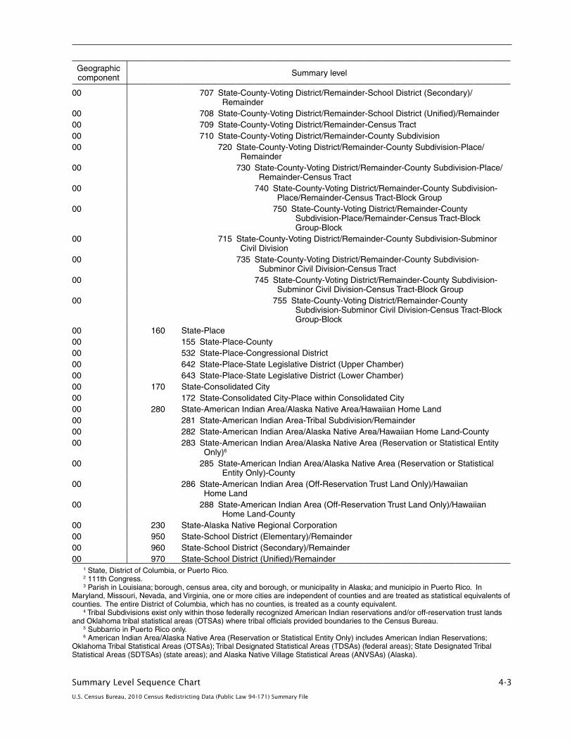
Summary Level Sequence Chart 4-3
U.S. Census Bureau, 2010 Census Redistricting Data (Public Law 94-171) Summary File
Geographic component Summary level
00 707 State-County-Voting District/Remainder-School District (Secondary)/ Remainder
00 708 State-County-Voting District/Remainder-School District (Unified)/Remainder00 709 State-County-Voting District/Remainder-Census Tract00 710 State-County-Voting District/Remainder-County Subdivision00 720 State-County-Voting District/Remainder-County Subdivision-Place/
Remainder00 730 State-County-Voting District/Remainder-County Subdivision-Place/
Remainder-Census Tract00 740 State-County-Voting District/Remainder-County Subdivision-
Place/Remainder-Census Tract-Block Group00 750 State-County-Voting District/Remainder-County
Subdivision-Place/Remainder-Census Tract-Block Group-Block
00 715 State-County-Voting District/Remainder-County Subdivision-Subminor Civil Division
00 735 State-County-Voting District/Remainder-County Subdivision- Subminor Civil Division-Census Tract
00 745 State-County-Voting District/Remainder-County Subdivision- Subminor Civil Division-Census Tract-Block Group
00 755 State-County-Voting District/Remainder-County Subdivision-Subminor Civil Division-Census Tract-Block Group-Block
00 160 State-Place00 155 State-Place-County00 532 State-Place-Congressional District00 642 State-Place-State Legislative District (Upper Chamber)00 643 State-Place-State Legislative District (Lower Chamber)00 170 State-Consolidated City00 172 State-Consolidated City-Place within Consolidated City00 280 State-American Indian Area/Alaska Native Area/Hawaiian Home Land00 281 State-American Indian Area-Tribal Subdivision/Remainder00 282 State-American Indian Area/Alaska Native Area/Hawaiian Home Land-County00 283 State-American Indian Area/Alaska Native Area (Reservation or Statistical Entity
Only)6
00 285 State-American Indian Area/Alaska Native Area (Reservation or Statistical Entity Only)-County
00 286 State-American Indian Area (Off-Reservation Trust Land Only)/Hawaiian Home Land
00 288 State-American Indian Area (Off-Reservation Trust Land Only)/Hawaiian Home Land-County
00 230 State-Alaska Native Regional Corporation00 950 State-School District (Elementary)/Remainder00 960 State-School District (Secondary)/Remainder00 970 State-School District (Unified)/Remainder
1 State, District of Columbia, or Puerto Rico .2 111th Congress .3 Parish in Louisiana; borough, census area, city and borough, or municipality in Alaska; and municipio in Puerto Rico . In
Maryland, Missouri, Nevada, and Virginia, one or more cities are independent of counties and are treated as statistical equivalents of counties . The entire District of Columbia, which has no counties, is treated as a county equivalent .
4 Tribal Subdivisions exist only within those federally recognized American Indian reservations and/or off-reservation trust lands and Oklahoma tribal statistical areas (OTSAs) where tribal officials provided boundaries to the Census Bureau .
5 Subbarrio in Puerto Rico only .6 American Indian Area/Alaska Native Area (Reservation or Statistical Entity Only) includes American Indian Reservations;
Oklahoma Tribal Statistical Areas (OTSAs); Tribal Designated Statistical Areas (TDSAs) (federal areas); State Designated Tribal Statistical Areas (SDTSAs) (state areas); and Alaska Native Village Statistical Areas (ANVSAs) (Alaska) .
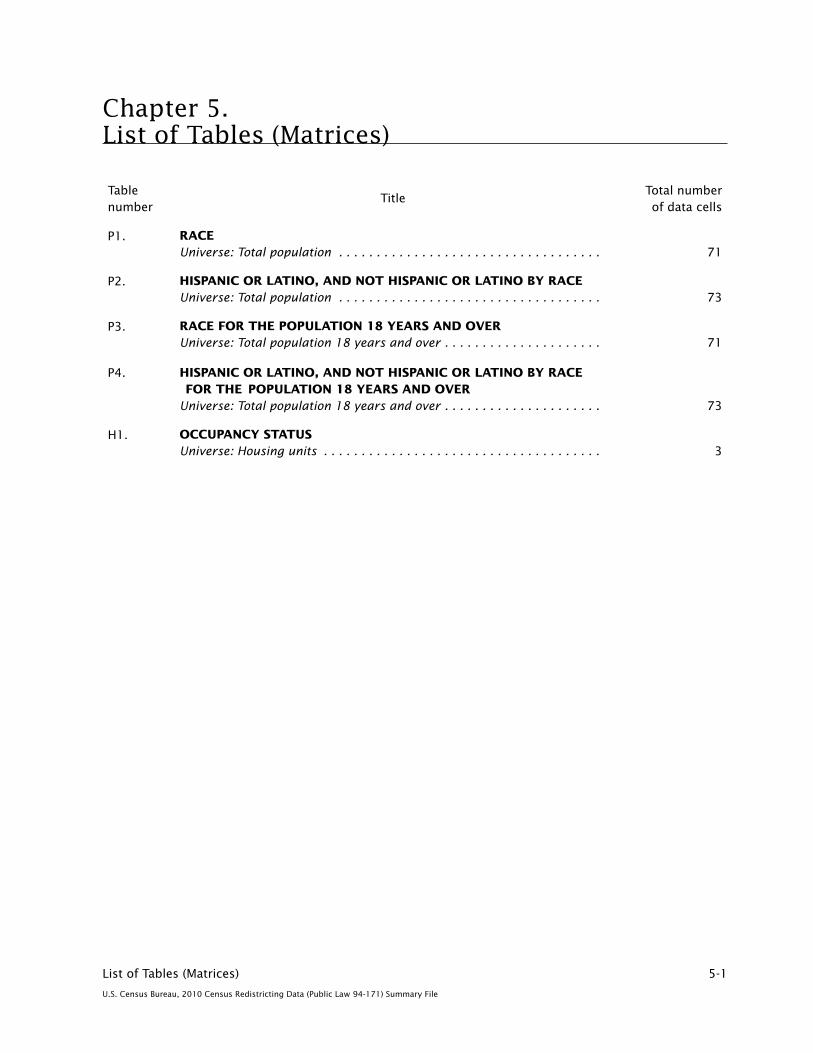
List of Tables (Matrices) 5-1
U.S. Census Bureau, 2010 Census Redistricting Data (Public Law 94-171) Summary File
Table number
TitleTotal number of data cells
P1. RACE Universe: Total population � � � � � � � � � � � � � � � � � � � � � � � � � � � � � � � � � � � 71
P2. HISPANIC OR LATINO, AND NOT HISPANIC OR LATINO BY RACE Universe: Total population � � � � � � � � � � � � � � � � � � � � � � � � � � � � � � � � � � � 73
P3. RACE FOR THE POPULATION 18 YEARS AND OVER Universe: Total population 18 years and over � � � � � � � � � � � � � � � � � � � � � 71
P4. HISPANIC OR LATINO, AND NOT HISPANIC OR LATINO BY RACE FOR THE POPULATION 18 YEARS AND OVER Universe: Total population 18 years and over � � � � � � � � � � � � � � � � � � � � � 73
H1. OCCUPANCY STATUS Universe: Housing units � � � � � � � � � � � � � � � � � � � � � � � � � � � � � � � � � � � � � 3
Chapter 5. List of Tables (Matrices)

Data Dictionary 6-1
U.S. Census Bureau, 2010 Census Redistricting Data (Public Law 94-171) Summary File
Chapter 6. Data DictionaryCONTENTS
Identification Section . . . . . . . . . . . . . . . . . . . . . . . . . . . . . . . . . . . . . . . . . . . . . . . . . . . . . . . . . . . 6-1 Record Codes . . . . . . . . . . . . . . . . . . . . . . . . . . . . . . . . . . . . . . . . . . . . . . . . . . . . . . . . . . . . . . . 6-1 Geographic Area Codes . . . . . . . . . . . . . . . . . . . . . . . . . . . . . . . . . . . . . . . . . . . . . . . . . . . . . . . 6-2 Area Characteristics . . . . . . . . . . . . . . . . . . . . . . . . . . . . . . . . . . . . . . . . . . . . . . . . . . . . . . . . . . 6-8 Special Area Codes . . . . . . . . . . . . . . . . . . . . . . . . . . . . . . . . . . . . . . . . . . . . . . . . . . . . . . . . . . . 6-13Endnotes . . . . . . . . . . . . . . . . . . . . . . . . . . . . . . . . . . . . . . . . . . . . . . . . . . . . . . . . . . . . . . . . . . . . 6-15Table (Matrix) Section . . . . . . . . . . . . . . . . . . . . . . . . . . . . . . . . . . . . . . . . . . . . . . . . . . . . . . . . . . . 6-21
IDENTIFICATION SECTION
Field nameData dictionary reference name Field size
Starting position
Data type
NOTE: The filling of codes and data attributes in the files is specific to summary level; not all fields are filled for every summary level. Where a code or attribute is specified, the actual value is assigned to the field except for the use of three special codes:
Assignment of codes of nine (9) indicates a balance record or that the entity or attribute does not exist for this record.
Assignment of pound signs (#) indicates that more than one value exists for this field and, thus, no specific value can be assigned.
Assignment of exclamation marks (!) indicates that the data are not yet available for this product.
Record Codes
File Identification1 FILEID 6 1 A/N
PLST 2010 Census Redistricting Data (P.L. 94-171) Summary File
State/U.S. Abbreviation (USPS) STUSAB 2 7 A
AK Alaska IL Illinois NC North Carolina RI Rhode IslandAL Alabama IN Indiana ND North Dakota SC South CarolinaAR Arkansas KS Kansas NE Nebraska SD South DakotaAZ Arizona KY Kentucky NH New Hampshire TN TennesseeCA California LA Louisiana NJ New Jersey TX TexasCO Colorado MA Massachusetts NM New Mexico US United StatesCT Connecticut MD Maryland NV Nevada UT UtahDC District of Columbia ME Maine NY New York VA VirginiaDE Delaware MI Michigan OH Ohio VT VermontFL Florida MN Minnesota OK Oklahoma WA WashingtonGA Georgia MO Missouri OR Oregon WI WisconsinHI Hawaii MS Mississippi PA Pennsylvania WV West VirginiaIA Iowa MT Montana PR Puerto Rico WY WyomingID Idaho
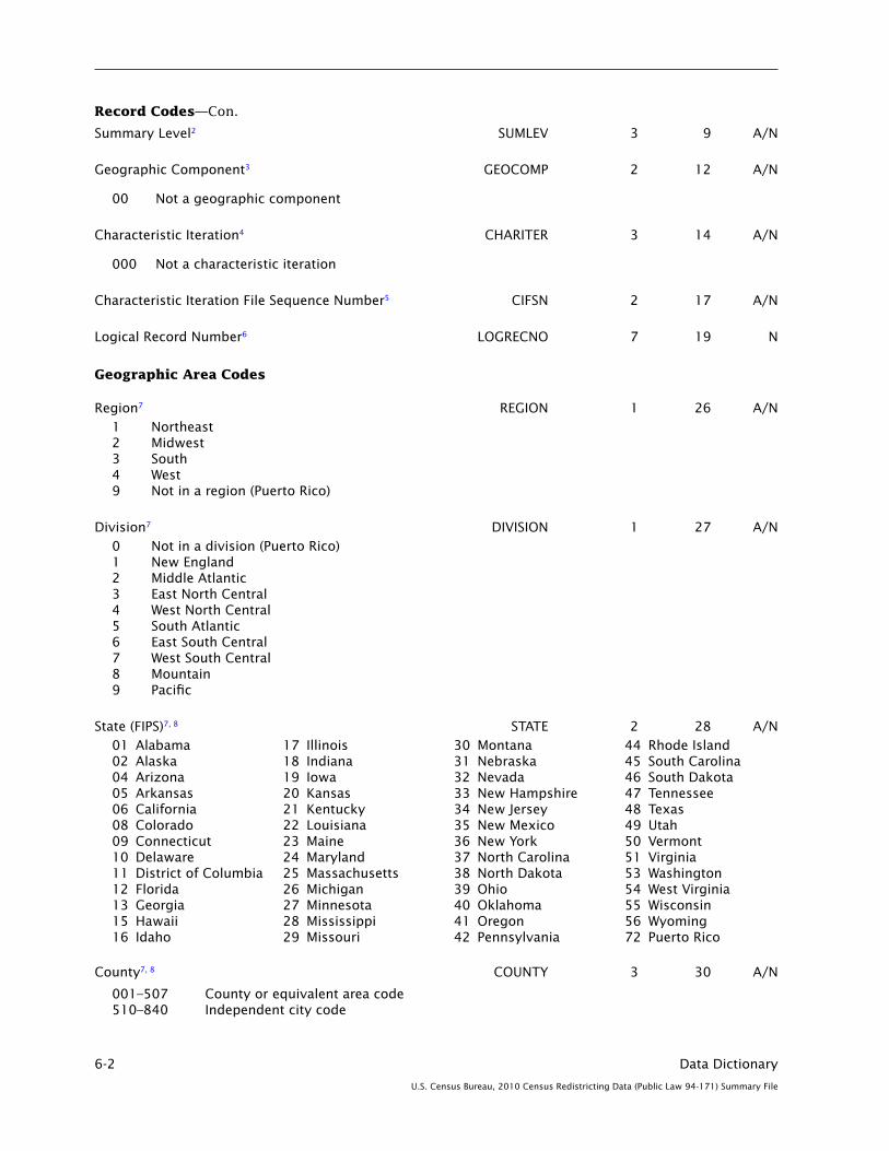
6-2 Data Dictionary
U.S. Census Bureau, 2010 Census Redistricting Data (Public Law 94-171) Summary File
Record Codes—Con.
Summary Level2 SUMLEV 3 9 A/N
Geographic Component3 GEOCOMP 2 12 A/N
00 Not a geographic component
Characteristic Iteration4 CHARITER 3 14 A/N
000 Not a characteristic iteration
Characteristic Iteration File Sequence Number5 CIFSN 2 17 A/N
Logical Record Number6 LOGRECNO 7 19 N
Geographic Area Codes
Region7 REGION 1 26 A/N1 Northeast2 Midwest3 South4 West9 Not in a region (Puerto Rico)
Division7 DIVISION 1 27 A/N0 Not in a division (Puerto Rico)1 New England2 Middle Atlantic3 East North Central4 West North Central 5 South Atlantic6 East South Central7 West South Central8 Mountain9 Pacific
State (FIPS)7, 8 STATE 2 28 A/N01 Alabama 17 Illinois 30 Montana 44 Rhode Island02 Alaska 18 Indiana 31 Nebraska 45 South Carolina04 Arizona 19 Iowa 32 Nevada 46 South Dakota05 Arkansas 20 Kansas 33 New Hampshire 47 Tennessee06 California 21 Kentucky 34 New Jersey 48 Texas08 Colorado 22 Louisiana 35 New Mexico 49 Utah09 Connecticut 23 Maine 36 New York 50 Vermont10 Delaware 24 Maryland 37 North Carolina 51 Virginia11 District of Columbia 25 Massachusetts 38 North Dakota 53 Washington12 Florida 26 Michigan 39 Ohio 54 West Virginia13 Georgia 27 Minnesota 40 Oklahoma 55 Wisconsin15 Hawaii 28 Mississippi 41 Oregon 56 Wyoming16 Idaho 29 Missouri 42 Pennsylvania 72 Puerto Rico
County7, 8 COUNTY 3 30 A/N
001–507 County or equivalent area code 510–840 Independent city code

Data Dictionary 6-3
U.S. Census Bureau, 2010 Census Redistricting Data (Public Law 94-171) Summary File
Geographic Area Codes—Con.
FIPS County Class Code8 COUNTYCC 2 33 A/N
C7 An incorporated place that is independent of any county H1 An active county or equivalent area H4 An inactive county or equivalent areaH5 A statistical county equivalent area H6 A county or equivalent feature that has consolidated its government with an incorporated place
County Size Code9 COUNTYSC 2 35 A/N
County Subdivision (FIPS)7, 8 COUSUB 5 37 A/N
00000 Water area not assigned to a county subdivision
00001–89999 County subdivision in a state-level entity with governmental entities and in Alaska and Puerto Rico
90000–98999 County subdivision in a state with administrative or statistical entities (excluding Alaska and Puerto Rico)
FIPS County Subdivision Class Code8 COUSUBCC 2 42 A/N
C2 An active incorporated place that is legally coextensive with a county subdivision but treated as independent of any county subdivision (an independent place)
C5 An active incorporated place that is independent of any county subdivision and serves as a county subdivision equivalent (an independent place)
C7 An incorporated place that is independent of any county (an independent city)
T1 An active county subdivision that is not coextensive with an incorporated place
T2 An active county subdivision that is coextensive with a census designated place
T5 An active county subdivision that is coextensive with an incorporated place
T9 An inactive county subdivision
Z1 A nonfunctioning county subdivision
Z2 A county subdivision that is coextensive with or wholly contained within a legal American Indian, Alaska Native, or Native Hawaiian area and is independent of any other county subdivision
Z3 A county subdivision defined as a statistical unorganized territory
Z5 A statistical census county division (CCD) or census subarea (Alaska only)
Z7 An active incorporated place that is legally coextensive with or independent of any county subdivision in a state with only nonfunctioning county subdivisions (an independent place)
Z9 Water area not assigned to a county subdivision
County Subdivision Size Code9 COUSUBSC 2 44 A/N
Place (FIPS)7, 8 PLACE 5 46 A/N
00001–89999 Incorporated place or census designated place (CDP)
FIPS Place Class Code8 PLACECC 2 51 A/N
C1 An active incorporated place that does not serve as a county subdivision equivalent
C2 An active incorporated place that is legally coextensive with a county subdivision but treated as independent of any county subdivision (an independent place)
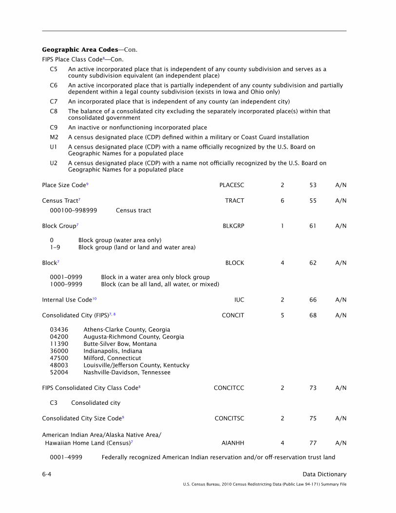
6-4 Data Dictionary
U.S. Census Bureau, 2010 Census Redistricting Data (Public Law 94-171) Summary File
Geographic Area Codes—Con.
FIPS Place Class Code8—Con.
C5 An active incorporated place that is independent of any county subdivision and serves as a county subdivision equivalent (an independent place)
C6 An active incorporated place that is partially independent of any county subdivision and partially dependent within a legal county subdivision (exists in Iowa and Ohio only)
C7 An incorporated place that is independent of any county (an independent city)
C8 The balance of a consolidated city excluding the separately incorporated place(s) within that consolidated government
C9 An inactive or nonfunctioning incorporated place
M2 A census designated place (CDP) defined within a military or Coast Guard installation
U1 A census designated place (CDP) with a name officially recognized by the U.S. Board on Geographic Names for a populated place
U2 A census designated place (CDP) with a name not officially recognized by the U.S. Board on Geographic Names for a populated place
Place Size Code9 PLACESC 2 53 A/N
Census Tract7 TRACT 6 55 A/N
000100–998999 Census tract
Block Group7 BLKGRP 1 61 A/N
0 Block group (water area only)1–9 Block group (land or land and water area)
Block7 BLOCK 4 62 A/N
0001–0999 Block in a water area only block group1000–9999 Block (can be all land, all water, or mixed)
Internal Use Code10 IUC 2 66 A/N
Consolidated City (FIPS)7, 8 CONCIT 5 68 A/N
03436 Athens-Clarke County, Georgia04200 Augusta-Richmond County, Georgia11390 Butte-Silver Bow, Montana36000 Indianapolis, Indiana47500 Milford, Connecticut48003 Louisville/Jefferson County, Kentucky52004 Nashville-Davidson, Tennessee
FIPS Consolidated City Class Code8 CONCITCC 2 73 A/N
C3 Consolidated city
Consolidated City Size Code9 CONCITSC 2 75 A/N
American Indian Area/Alaska Native Area/ Hawaiian Home Land (Census)7 AIANHH 4 77 A/N
0001–4999 Federally recognized American Indian reservation and/or off-reservation trust land

Data Dictionary 6-5
U.S. Census Bureau, 2010 Census Redistricting Data (Public Law 94-171) Summary File
Geographic Area Codes—Con.
American Indian Area/Alaska Native Area/Hawaiian Home Land (Census)7—Con.
5000–5499 Hawaiian home land 5500–5999 Oklahoma tribal statistical area 6000–7999 Alaska Native village statistical area 8000–8999 Tribal designated statistical area 9000–9499 State-recognized American Indian reservation 9500–9998 State designated tribal statistical area
American Indian Area/Alaska Native Area/ Hawaiian Home Land (FIPS)7, 8, 11 AIANHHFP 5 81 A/N
00001–89999 American Indian area, Alaska Native area, or Hawaiian home land
FIPS American Indian Area/Alaska Native Area/ Hawaiian Home Land Class Code8 AIANHHCC 2 86 A/N
D0 Statistical or legal area administered and/or claimed by two or more American Indian tribes D1 Legal federally recognized American Indian area consisting of reservation and associated
off-reservation trust land D2 Legal federally recognized American Indian area consisting of reservation only D3 Legal federally recognized American Indian area consisting of off-reservation trust land only D4 Legal state-recognized American Indian reservation D5 The off-reservation trust land portion of an American Indian area with both a reservation and
off-reservation trust land D6 Statistical American Indian area defined for a federally recognized tribe that does not have a
reservation or off-reservation trust land, specifically a tribal designated statistical area (TDSA) or Oklahoma tribal statistical area (OTSA)
D8 The reservation portion of an American Indian area with both a reservation and off-reservation trust land
D9 Statistical American Indian area defined for a state-recognized tribe that does not have a reservation or off-reservation trust land, specifically a state designated tribal statistical area
E1 Alaska Native village statistical area F1 Hawaiian home land
American Indian Trust Land/Hawaiian Home Land Indicator AIHHTLI 1 88 A/N
R American Indian reservation or statistical entity only T American Indian off-reservation trust land only or Hawaiian home land M American Indian reservation and off-reservation trust land 9 Not in an American Indian area or Hawaiian home land
American Indian Tribal Subdivision (Census)7 AITSCE 3 89 A/N
001–998 American Indian tribal subdivision
American Indian Tribal Subdivision (FIPS)7, 8, 11 AITS 5 92 A/N
00001–89999 American Indian tribal subdivision
FIPS American Indian Tribal Subdivision Class Code8 AITSCC 2 97 A/N
D7 American Indian tribal subdivision
Tribal Census Tract TTRACT 6 99 A/N
T00100–T98999 Tribal census tract
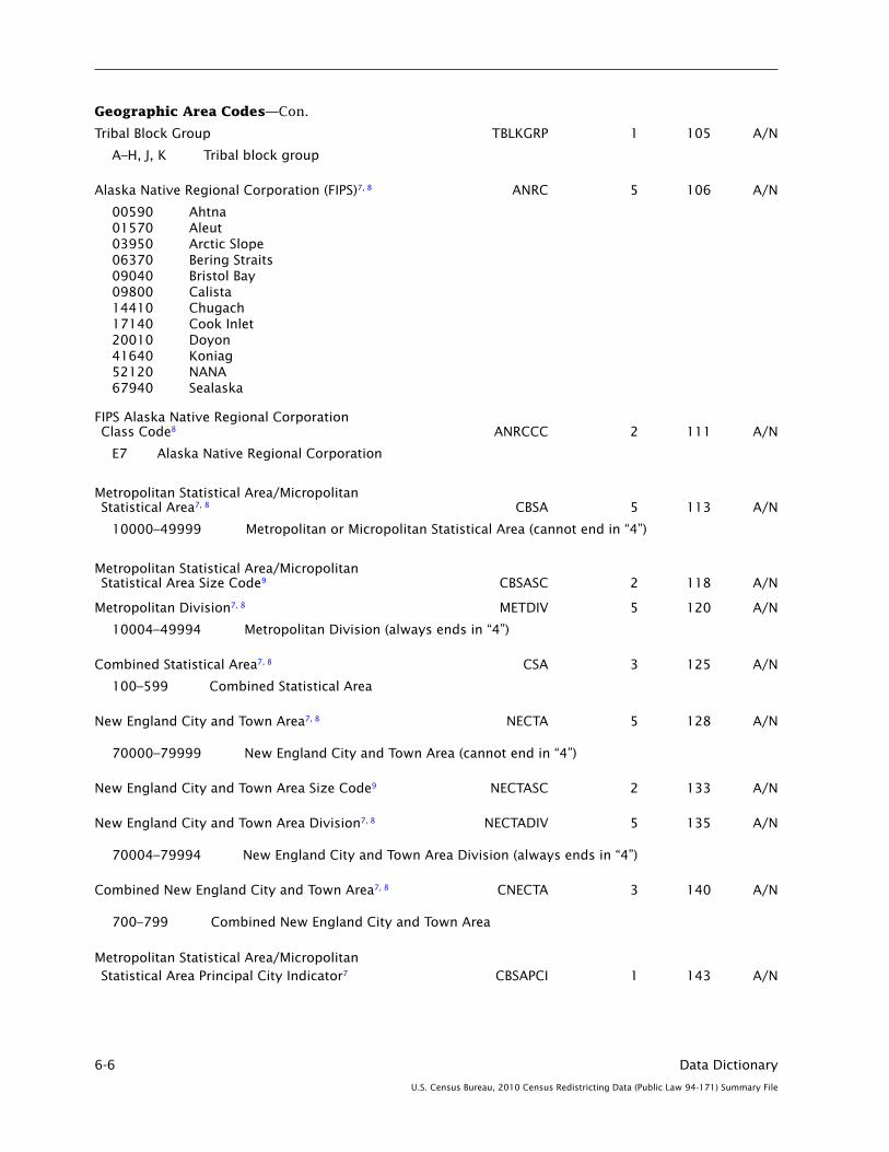
6-6 Data Dictionary
U.S. Census Bureau, 2010 Census Redistricting Data (Public Law 94-171) Summary File
Geographic Area Codes—Con.
Tribal Block Group TBLKGRP 1 105 A/N
A–H, J, K Tribal block group
Alaska Native Regional Corporation (FIPS)7, 8 ANRC 5 106 A/N
00590 Ahtna01570 Aleut03950 Arctic Slope06370 Bering Straits09040 Bristol Bay09800 Calista14410 Chugach17140 Cook Inlet20010 Doyon41640 Koniag52120 NANA67940 Sealaska
FIPS Alaska Native Regional Corporation Class Code8 ANRCCC 2 111 A/N
E7 Alaska Native Regional Corporation
Metropolitan Statistical Area/Micropolitan Statistical Area7, 8 CBSA 5 113 A/N
10000–49999 Metropolitan or Micropolitan Statistical Area (cannot end in “4”)
Metropolitan Statistical Area/Micropolitan Statistical Area Size Code9 CBSASC 2 118 A/N
Metropolitan Division7, 8 METDIV 5 120 A/N
10004–49994 Metropolitan Division (always ends in “4”)
Combined Statistical Area7, 8 CSA 3 125 A/N
100–599 Combined Statistical Area
New England City and Town Area7, 8 NECTA 5 128 A/N
70000–79999 New England City and Town Area (cannot end in “4”)
New England City and Town Area Size Code9 NECTASC 2 133 A/N
New England City and Town Area Division7, 8 NECTADIV 5 135 A/N
70004–79994 New England City and Town Area Division (always ends in “4”)
Combined New England City and Town Area7, 8 CNECTA 3 140 A/N
700–799 Combined New England City and Town Area
Metropolitan Statistical Area/Micropolitan Statistical Area Principal City Indicator7 CBSAPCI 1 143 A/N

Data Dictionary 6-7
U.S. Census Bureau, 2010 Census Redistricting Data (Public Law 94-171) Summary File
Geographic Area Codes—Con.
Metropolitan Statistical Area/Micropolitan Statistical Area Principal City Indicator7—Con.
Y Place is a principal city of a metropolitan or micropolitan statistical areaN Place is not a principal city of a metropolitan or micropolitan statistical area 9 Not in a place
New England City and Town Area Principal City Indicator7 NECTAPCI 1 144 A/N
Y Place is a principal city of a New England city and town area N Place is not a principal city of a New England city and town area 9 Not in a place
Urban Area7, 12 UA 5 145 A/N
00001–98999 Urbanized area or urban cluster
Urban Area Size Code9, 12 UASC 2 150 A/N
Urban Area Type7, 12 UATYPE 1 152 A/N
U Urbanized area C Urban cluster9 Not in an urban area
Urban/Rural7, 12 UR 1 153 A/N
U Area is classified as urban R Area is classified as rural M Mixed–part is classified as urban and part is classified as rural
Congressional District (111th)7, 8, 13 CD 2 154 A/N
01–53 The actual Congressional District number 00 Applies to states whose representative is elected “at large”; the state has only one
Representative in the United States House of Representatives98 Applies to areas that have an “at large” nonvoting delegate or resident commissioner in
the United States House of Representatives
State Legislative District (Upper Chamber) (Year 1)7, 14 SLDU 3 156 A/N
State Legislative District (Lower Chamber) (Year 1)7, 14 SLDL 3 159 A/N
Voting District7, 15 VTD 6 162 A/N
Voting District Indicator7 VTDI 1 168 A/N
A ActualP Pseudo (adjusted) Blank Voting districts not defined
Reserved RESERVE2 3 169 A/N
ZIP Code Tabulation Area (5-digit)7, 12 ZCTA5 5 172 A/N

6-8 Data Dictionary
U.S. Census Bureau, 2010 Census Redistricting Data (Public Law 94-171) Summary File
Geographic Area Codes—Con.
Subminor Civil Division (FIPS)7, 8 SUBMCD 5 177 A/N
00001–89999 Subbarrio (Puerto Rico only)
FIPS Subminor Civil Division Class Code8 SUBMCDCC 2 182 A/N
Z6 Subbarrio (Puerto Rico only)
School District (Elementary)7 SDELM 5 184 A/N
00001–99996 School district
School District (Secondary)7 SDSEC 5 189 A/N
00001–99996 School district
School District (Unified)7 SDUNI 5 194 A/N
00001–99996 School district99997 School district not defined (land area) 99998 School district not defined (water area only)
Area Characteristics
Area (Land)16 AREALAND 14 199 N
Area (Water)17 AREAWATR 14 213 N
Area Name-Legal/Statistical Area Description (LSAD) Term-Part Indicator18 NAME 90 227 A/N
Functional Status Code FUNCSTAT 1 317 A/N
A Active governmental unit providing primary general-purpose functions B Active governmental unit that is partially consolidated with another government but with separate
officials, providing primary general-purpose functions C Active governmental unit consolidated with another government with a single set of officials,
providing general-purpose functions E Active governmental unit providing special-purpose functions F Fictitious entity created to fill the Census Bureau’s geographic hierarchy G Active governmental unit that is subordinate to another unit of government; not classified as a
government by the Census Bureau’s Governments Division I Inactive governmental unit that has the ability to activate and provide primary special-purpose
functions N Nonfunctioning legal entity (not a governmental unit) S Statistical entity
Geographic Change User Note Indicator GCUNI 1 318 A/N
Y Geographic change user note exists for this entity N No geographic change user note exists for this entity
Population Count (100%)19 POP100 9 319 N
Housing Unit Count (100%)20 HU100 9 328 N
Internal Point (Latitude)21 INTPTLAT 11 337 A/N
Internal Point (Longitude)22 INTPTLON 12 348 A/N
Legal/Statistical Area Description Code LSADC 2 360 A/N

Data Dictionary 6-9
U.S. Census Bureau, 2010 Census Redistricting Data (Public Law 94-171) Summary File
Area Characteristics—Con.
Legal/Statistical Area Description Code—Con.
00 None—no legal/statistical area description exists; no text is appended to the name of the entity
03 City and borough—legal county equivalent in Alaska (Juneau, Sitka, Wrangell, and Yakutat); “City and Borough” is appended to the name of the entity
04 Borough—county equivalent in Alaska; “Borough” is appended to the name of the entity
05 Census area—statistical county equivalent in Alaska; “Census Area” is appended to the name of the entity
06 County—legal division of 48 states; “County” is appended to the name of the entity
07 District—1) legal tribal subdivision in Arizona, Minnesota, Montana, Nebraska, North Dakota, and South Dakota; 2) state legislative district (upper chamber) in Massachusetts; and 3) state legislative district (lower chamber) in Massachusetts; “District” is appended to the name of the entity
12 Municipality—legal county equivalent in Alaska (Anchorage and Skagway); “Municipality” is appended to the name of the entity
13 Municipio—legal county equivalent in Puerto Rico; “Municipio” is appended to the name of the entity
15 Parish—legal county equivalent in Louisiana; “Parish” is appended to the name of the entity
20 Barrio—minor civil division (MCD) in Puerto Rico; “barrio” is appended to the name of the entity
21 Borough—1) minor civil division (MCD) in New York; 2) MCD equivalent (independent place) in New Jersey and Pennsylvania; 3) incorporated place in Connecticut, New Jersey, and Pennsylvania; “borough” is appended to the name of the entity
22 Census county division (CCD)—statistical county subdivision in 20 states; “CCD” is appended to the name of the entity
23 Census subarea—statistical county subdivision in Alaska; “census subarea” is appended to the name of the entity
25 City—1) legal county equivalent in Maryland, Missouri, and Virginia (independent city); 2) minor civil division (MCD) equivalent in 23 states and the District of Columbia (independent place); 3) incorporated place in 49 states and the District of Columbia; 4) consolidated city in Connecticut (Milford) and Indiana (Indianapolis); “city” is appended to the name of the entity
27 District (election, magisterial)—minor civil division (MCD) in Virginia and West Virginia; “district” is appended to the name of the entity
28 District (commissioner, election, magisterial, supervisors’, or parish governing authority)—1) minor civil division (MCD) in Louisiana, Maryland, Mississippi, Nebraska, Tennessee, Virginia, and West Virginia; 2) tribal subdivision in Arizona and South Dakota; “District” is added before the name of the entity
29 Election precinct—minor civil division (MCD) in Illinois and Nebraska; “precinct” is appended to the name of the entity
30 Election precinct—minor civil division (MCD) in Illinois and Nebraska; “Precinct” is added before the name of the entity
31 Gore—minor civil division (MCD) in Maine and Vermont; “gore” is appended to the name of the entity
32 Grant—minor civil division (MCD) in New Hampshire and Vermont; “grant” is appended to the name of the entity
36 Location—minor civil division (MCD) in New Hampshire; “location” is appended to the name of the entity
37 Municipality—1) minor civil division (MCD) equivalent in Pennsylvania (independent place); 2) incorporated place in Alaska (Anchorage) and Pennsylvania; “municipality” is appended to the name of the entity
39 Plantation—minor civil division (MCD) in Maine; “plantation” is appended to the name of the entity
41 Barrio-pueblo—minor civil division (MCD) in Puerto Rico; “barrio-pueblo” is appended to the name of the entity
Geographic Area Codes—Con.
Subminor Civil Division (FIPS)7, 8 SUBMCD 5 177 A/N
00001–89999 Subbarrio (Puerto Rico only)
FIPS Subminor Civil Division Class Code8 SUBMCDCC 2 182 A/N
Z6 Subbarrio (Puerto Rico only)
School District (Elementary)7 SDELM 5 184 A/N
00001–99996 School district
School District (Secondary)7 SDSEC 5 189 A/N
00001–99996 School district
School District (Unified)7 SDUNI 5 194 A/N
00001–99996 School district99997 School district not defined (land area) 99998 School district not defined (water area only)
Area Characteristics
Area (Land)16 AREALAND 14 199 N
Area (Water)17 AREAWATR 14 213 N
Area Name-Legal/Statistical Area Description (LSAD) Term-Part Indicator18 NAME 90 227 A/N
Functional Status Code FUNCSTAT 1 317 A/N
A Active governmental unit providing primary general-purpose functions B Active governmental unit that is partially consolidated with another government but with separate
officials, providing primary general-purpose functions C Active governmental unit consolidated with another government with a single set of officials,
providing general-purpose functions E Active governmental unit providing special-purpose functions F Fictitious entity created to fill the Census Bureau’s geographic hierarchy G Active governmental unit that is subordinate to another unit of government; not classified as a
government by the Census Bureau’s Governments Division I Inactive governmental unit that has the ability to activate and provide primary special-purpose
functions N Nonfunctioning legal entity (not a governmental unit) S Statistical entity
Geographic Change User Note Indicator GCUNI 1 318 A/N
Y Geographic change user note exists for this entity N No geographic change user note exists for this entity
Population Count (100%)19 POP100 9 319 N
Housing Unit Count (100%)20 HU100 9 328 N
Internal Point (Latitude)21 INTPTLAT 11 337 A/N
Internal Point (Longitude)22 INTPTLON 12 348 A/N
Legal/Statistical Area Description Code LSADC 2 360 A/N
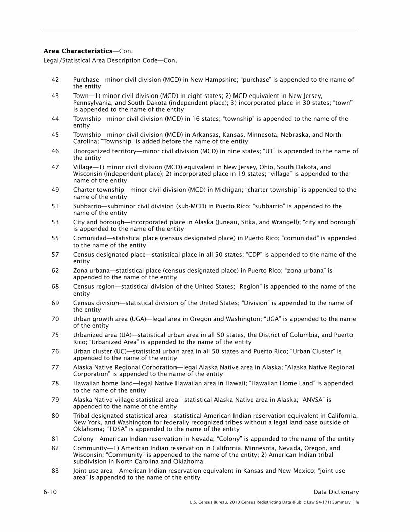
6-10 Data Dictionary
U.S. Census Bureau, 2010 Census Redistricting Data (Public Law 94-171) Summary File
Area Characteristics—Con.
Legal/Statistical Area Description Code—Con.
42 Purchase—minor civil division (MCD) in New Hampshire; “purchase” is appended to the name of the entity
43 Town—1) minor civil division (MCD) in eight states; 2) MCD equivalent in New Jersey, Pennsylvania, and South Dakota (independent place); 3) incorporated place in 30 states; “town” is appended to the name of the entity
44 Township—minor civil division (MCD) in 16 states; “township” is appended to the name of the entity
45 Township—minor civil division (MCD) in Arkansas, Kansas, Minnesota, Nebraska, and North Carolina; “Township” is added before the name of the entity
46 Unorganized territory—minor civil division (MCD) in nine states; “UT” is appended to the name of the entity
47 Village—1) minor civil division (MCD) equivalent in New Jersey, Ohio, South Dakota, and Wisconsin (independent place); 2) incorporated place in 19 states; “village” is appended to the name of the entity
49 Charter township—minor civil division (MCD) in Michigan; “charter township” is appended to the name of the entity
51 Subbarrio—subminor civil division (sub-MCD) in Puerto Rico; “subbarrio” is appended to the name of the entity
53 City and borough—incorporated place in Alaska (Juneau, Sitka, and Wrangell); “city and borough” is appended to the name of the entity
55 Comunidad—statistical place (census designated place) in Puerto Rico; “comunidad” is appended to the name of the entity
57 Census designated place—statistical place in all 50 states; “CDP” is appended to the name of the entity
62 Zona urbana—statistical place (census designated place) in Puerto Rico; “zona urbana” is appended to the name of the entity
68 Census region—statistical division of the United States; “Region” is appended to the name of the entity
69 Census division—statistical division of the United States; “Division” is appended to the name of the entity
70 Urban growth area (UGA)—legal area in Oregon and Washington; “UGA” is appended to the name of the entity
75 Urbanized area (UA)—statistical urban area in all 50 states, the District of Columbia, and Puerto Rico; “Urbanized Area” is appended to the name of the entity
76 Urban cluster (UC)—statistical urban area in all 50 states and Puerto Rico; “Urban Cluster” is appended to the name of the entity
77 Alaska Native Regional Corporation—legal Alaska Native area in Alaska; “Alaska Native Regional Corporation” is appended to the name of the entity
78 Hawaiian home land—legal Native Hawaiian area in Hawaii; “Hawaiian Home Land” is appended to the name of the entity
79 Alaska Native village statistical area—statistical Alaska Native area in Alaska; “ANVSA” is appended to the name of the entity
80 Tribal designated statistical area—statistical American Indian reservation equivalent in California, New York, and Washington for federally recognized tribes without a legal land base outside of Oklahoma; “TDSA” is appended to the name of the entity
81 Colony—American Indian reservation in Nevada; “Colony” is appended to the name of the entity
82 Community—1) American Indian reservation in California, Minnesota, Nevada, Oregon, and Wisconsin; “Community” is appended to the name of the entity; 2) American Indian tribal subdivision in North Carolina and Oklahoma
83 Joint-use area—American Indian reservation equivalent in Kansas and New Mexico; “joint-use area” is appended to the name of the entity

Data Dictionary 6-11
U.S. Census Bureau, 2010 Census Redistricting Data (Public Law 94-171) Summary File
Area Characteristics—Con.
Legal/Statistical Area Description Code—Con.
84 Pueblo—American Indian reservation in New Mexico and Texas; “Pueblo” is appended to the name of the entity
85 Rancheria—American Indian reservation in California; “Rancheria” is appended to the name of the entity
86 Reservation—1) American Indian reservation in 34 states; 2) minor civil division (MCD) equivalent in Maine and New York; “Reservation” is appended to the name of the entity
87 Reserve—American Indian reservation in Alaska; “Reserve” is appended to the name of the entity
88 Oklahoma tribal statistical area—statistical American Indian reservation equivalent in Oklahoma; “OTSA” is appended to the name of the entity
89 Trust land—legal American Indian reservation equivalent in nine states; “Trust Land” is appended to the name of the entity
90 Joint-use Oklahoma tribal statistical area—statistical American Indian reservation equivalent in Oklahoma; “joint-use OTSA” is appended to the name of the entity
91 Ranch—American Indian reservation in Nevada; “Ranch” is appended to the name of the entity
92 State designated tribal statistical area—statistical American Indian reservation equivalent in Alabama, Delaware, Louisiana, New Jersey, North Carolina, South Carolina, and Virginia; “SDTSA” is appended to the name of the entity
93 Indian village—American Indian reservation in California; “Indian Village” is appended to the name of the entity
94 Village—American Indian reservation in California and Oregon; “Village” is appended to the name of the entity
95 Indian community—American Indian reservation in Michigan and Minnesota; “Indian Community” is appended to the name of the entity
96 Indian reservation—American Indian reservation in Arizona, California, Montana, Nevada, Oregon, South Dakota, and Washington; “Indian Reservation” is appended to the name of the entity
97 Indian rancheria—American Indian reservation in California; “Indian Rancheria” is appended to the name of the entity
98 Indian colony—American Indian reservation in Nevada and Oregon; “Indian Colony” is appended to the name of the entity
99 Pueblo de—American Indian reservation in New Mexico; “Pueblo de” is added before the name of the entity
9C Pueblo of—American Indian reservation in New Mexico; “Pueblo of” is added before the name of the entity
9D Settlement—American Indian reservation in Iowa; “Settlement” is appended to the name of the entity
BG Block group—statistical area in the United States and Puerto Rico; “Block Group” is added before the name (code) of the entity
BK Block—statistical area in the United States and Puerto Rico; “Block” is added before the name (code) of the entity
C1 Congressional district (at large)—congressional district in a single-district state (Alaska, Delaware, Montana, North Dakota, South Dakota, Vermont, and Wyoming); “Congressional District (at Large)” appears as the name of the entity
C2 Congressional district—congressional district in a state with more than one district (43 states); “Congressional District” is added before the name (code) of the entity
C3 Resident commissioner district (at large)—congressional district equivalent in Puerto Rico; “Resident Commissioner District (at Large)” appears as the name of the entity
C4 Delegate district (at large)—congressional district equivalent in the District of Columbia; “Delegate District (at Large)” appears as the name of the entity

6-12 Data Dictionary
U.S. Census Bureau, 2010 Census Redistricting Data (Public Law 94-171) Summary File
Area Characteristics—Con.
Legal/Statistical Area Description Code—Con.
CG Consolidated government—consolidated city in Georgia (Augusta-Richmond County); “consolidated government” is appended to the name of the entity
CN Corporation—incorporated place in West Virginia (Ranson); “corporation” is appended to the name of the entity
CT Census tract—statistical area in the United States and Puerto Rico; “Census Tract” is added before the name (modified code) of the entity
IB Tribal block group—statistical area within specified legal American Indian areas; “Tribal Block Group” is added before the name (code) of the entity
IT Tribal census tract—statistical area within specified legal American Indian areas; “Tribal Census Tract” is added before the name (modified code) of the entity
L1 Ward—state legislative district (upper chamber) equivalent in the District of Columbia; “Ward” is added before the name of the entity
L2 Senatorial district—state legislative district (upper chamber) in Nevada; “Senatorial District” is appended to the name of the entity
L3 Assembly district—state legislative district (lower chamber) in California, Nevada, New York, and Wisconsin; “Assembly District” is added before the name of the entity
L4 General assembly district—state legislative district (lower chamber) in New Jersey; “General Assembly District” is added before the name of the entity
L5 State legislative district—state legislative district (lower chamber) in Maryland; “State Legislative District” is added before the name of the entity
L6 State legislative subdistrict—state legislative district (lower chamber) in Maryland; “State Legislative Subdistrict” is added before the name of the entity
L8 State senate district—state legislative district (upper chamber) in Vermont; “State Senate District” is appended to the name of the entity
L9 State house district—state legislative district (lower chamber) in Vermont; “State House District” is appended to the name of the entity
LL State house district—state legislative district (lower chamber) in 41 states and Puerto Rico; “State House District” is added before the name of the entity
LU State senate district—state legislative district (upper chamber) in 47 states and Puerto Rico; “State Senate District” is added before the name of the entity
M0 Combined statistical area—statistical area in 45 states, the District of Columbia, and Puerto Rico; “CSA” is appended to the name of the entity
M1 Metropolitan statistical area—statistical area in all 50 states, the District of Columbia, and Puerto Rico; “Metro Area” is appended to the name of the entity
M2 Micropolitan statistical area—statistical area in 47 states and Puerto Rico; “Micro Area” is appended to the name of the entity
M3 Metropolitan division—statistical area in 17 states and the District of Columbia; “Metro Division” is appended to the name of the entity
M4 Combined New England city and town area—statistical area in Connecticut, Maine, Massachusetts, New Hampshire, Rhode Island, and Vermont; “Combined NECTA” is appended to the name of the entity
M5 Metropolitan New England city and town area—statistical area in Connecticut, Maine, Massachusetts, New Hampshire, Rhode Island, and Vermont; “Metropolitan NECTA” is appended to the name of the entity
M6 Micropolitan New England city and town area—statistical area in Connecticut, Maine, Massachusetts, New Hampshire, and Vermont; “Micropolitan NECTA” is appended to the name of the entity
M7 New England city and town area division—statistical area in Massachusetts and New Hampshire; “NECTA Division” is appended to the name of the entity

Data Dictionary 6-13
U.S. Census Bureau, 2010 Census Redistricting Data (Public Law 94-171) Summary File
Area Characteristics—Con.
Legal/Statistical Area Description Code—Con.
MG Metropolitan government—1) incorporated place in Tennessee (Lynchburg, Moore County); 2) consolidated city in Tennessee (Nashville-Davidson); “metropolitan government” is appended to the name of the entity
MT Metro government—consolidated city in Kentucky (Louisville/Jefferson County); “metro government” is appended to the name of the entity
OT Off-reservation trust land—trust land component of an American Indian reservation with associated trust land in 23 states; “Off-Reservation Trust Land” is appended to the name of the entity
P5 Public use microdata area (PUMA)—statistical area in all 50 states, the District of Columbia, and Puerto Rico; “PUMA” is added before the name (code) of the entity
T1 Area—American Indian tribal subdivision in Arizona and Utah; “Area” is appended to the name of the entity
T2 Chapter—American Indian tribal subdivision in Arizona, New Mexico, and Utah; “Chapter” is appended to the name of the entity
T3 Segment—American Indian tribal subdivision in Minnesota, North Dakota, and South Dakota; “Segment” is appended to the name of the entity
TA Administrative area—American Indian tribal subdivision in Arizona; “Administrative Area” is appended to the name of the entity
TB Addition—American Indian tribal subdivision in Wisconsin; “Addition” is appended to the name of the entity
TC County district—statistical American Indian tribal subdivision in Oklahoma; “County District” is added before the name of the entity
UC Urban county—incorporated place in Kentucky (Lexington-Fayette); “urban county” is appended to the name of the entity
UG Unified government—1) incorporated place in Georgia (Cusseta-Chattahoochee County, Georgetown-Quitman County, and Webster County); 2) consolidated city in Georgia (Athens-Clarke County); “unified government” is appended to the name of the entity
V1 Voting district (VTD)—legal voting district in 32 states and Puerto Rico; “VTD” is added before the name of the entity
V2 Voting district (VTD)—legal voting district in 32 states; “VTD” is appended to the name of the entity
Z5 ZIP code tabulation area (5-digit)—statistical area in all 50 states, the District of Columbia, and Puerto Rico; “ZCTA5” is added before the name of the entity
Part Flag PARTFLAG 1 362 A/N
W Not a part P Part
Special Area Codes
Reserved RESERVE3 6 363 A/N
Urban Growth Area7 UGA 5 369 A/N
State (ANSI)8 STATENS 8 374 A/N
County (ANSI)8 COUNTYNS 8 382 A/N
County Subdivision (ANSI)8 COUSUBNS 8 390 A/N
Place (ANSI)8 PLACENS 8 398 A/N
Consolidated City (ANSI)8 CONCITNS 8 406 A/N

6-14 Data Dictionary
U.S. Census Bureau, 2010 Census Redistricting Data (Public Law 94-171) Summary File
Special Area Codes—Con.
American Indian Area/Alaska Native Area/ Hawaiian Home Land (ANSI)8 AIANHHNS 8 414 A/N
American Indian Tribal Subdivision (ANSI)8 AITSNS 8 422 A/N
Alaska Native Regional Corporation (ANSI)8 ANRCNS 8 430 A/N
Subminor Civil Division (ANSI)8 SUBMCDNS 8 438 A/N
Congressional District (113th)7, 8, 23 CD113 2 446 A/N
01–53 The actual congressional district number
00 Applies to states whose representative is elected “at large”; the state has only one representative in the U.S. House of Representatives
98 Applies to areas that have an “at large” nonvoting delegate or resident commissioner in the U.S. House of Representatives
Congressional District (114th)7, 8, 23 CD114 2 448 A/N
01–53 The actual congressional district number
00 Applies to states whose representative is elected “at large”; the state has only one representative in the U.S. House of Representatives
98 Applies to areas that have an “at large” nonvoting delegate or resident commissioner in the U.S. House of Representatives
Congressional District (115th)7, 8, 23 CD115 2 450 A/N
01–53 The actual congressional district number
00 Applies to states whose representative is elected “at large”; the state has only one representative in the U.S. House of Representatives
98 Applies to areas that have an “at large” nonvoting delegate or resident commissioner in the U.S. House of Representatives
State Legislative District (Upper Chamber) (Year 2)7, 24 SLDU2 3 452 A/N
State Legislative District (Upper Chamber) (Year 3)7, 24 SLDU3 3 455 A/N
State Legislative District (Upper Chamber) (Year 4)7, 24 SLDU4 3 458 A/N
State Legislative District (Lower Chamber) (Year 2)7, 24 SLDL2 3 461 A/N
State Legislative District (Lower Chamber) (Year 3)7, 24 SLDL3 3 464 A/N
State Legislative District (Lower Chamber) (Year 4)7, 24 SLDL4 3 467 A/N
American Indian Area/Alaska Native Area/ Hawaiian Home Land Size Code9 AIANHHSC 2 470 A/N
Combined Statistical Area Size Code9 CSASC 2 472 A/N
Combined NECTA Size Code9 CNECTASC 2 474 A/N

Data Dictionary 6-15
U.S. Census Bureau, 2010 Census Redistricting Data (Public Law 94-171) Summary File
Special Area Codes—Con.
Metropolitan/Micropolitan Indicator MEMI 1 476 A/N
1 Metropolitan Statistical Area2 Micropolitan Statistical Area9 Not in a Metropolitan or Micropolitan Statistical Area
NECTA Metropolitan/Micropolitan Indicator NMEMI 1 477 A/N
1 Metropolitan New England City and Town Area2 Micropolitan New England City and Town Area9 Not in a New England City and Town Area
Public Use Microdata Area12 PUMA 5 478 A/N
00001–99998 Census PUMA Code
Reserved RESERVED 18 483 A/N
ENDNOTES
1. A unique, six-character identifier for each file series. See “How to Use This Product” for further information.
2. Identifies the geographic level for which the data matrices on the summary file have been summarized. The summary level sequence chart describes the hierarchical arrangement of the specified geographic areas with other geographic areas, if any. The summary level must be used in combination with the geographic area codes to identify a specific geographic area (for example, summary level 050 and a specific state and county code must be used together to locate the data for a particular county). See “How to Use This Product” for further information.
3. Indicates an iteration (repetition), for the specified summary level, of the data matrices on the summary file for the geographic components listed in the Geographic Component field. The Redistricting Data Summary File products contain no components. See “How to Use This Product” for further information.
Geographic Component Description
00 Not a geographic component
01 Urban
04 Urban—in urbanized area
05 Urban—in urbanized area of 5,000,000 or more population
06 Urban—in urbanized area of 2,500,000 to 4,999,999 population
07 Urban—in urbanized area of 1,000,000 to 2,499,999 population
08 Urban—in urbanized area of 500,000 to 999,999 population
09 Urban—in urbanized area of 250,000 to 499,999 population
10 Urban—in urbanized area of 100,000 to 249,999 population
11 Urban—in urbanized area of 50,000 to 99,999 population
28 Urban—in urban cluster
29 Urban—in urban cluster of 25,000 to 49,999 population
30 Urban—in urban cluster of 10,000 to 24,999 population
31 Urban—in urban cluster of 5,000 to 9,999 population
32 Urban—in urban cluster of 2,500 to 4,999 population
43 Rural
44 Rural—place

6-16 Data Dictionary
U.S. Census Bureau, 2010 Census Redistricting Data (Public Law 94-171) Summary File
ENDNOTES—Con.
Geographic Component Description—Con.
45 Rural—place of 2,500 or more population
46 Rural—place of 1,000 to 2,499 population
47 Rural—place of less than 1,000 population
48 Rural—not in place
49 Rural—farm
50 Urban portion of extended place
51 Rural portion of extended place
89 American Indian Reservation and Trust Land—Federal
90 American Indian Reservation and Trust Land—State
91 Oklahoma Tribal Statistical Area
92 Tribal Designated Statistical Area
93 Alaska Native Village Statistical Area
94 State Designated Tribal Statistical Area
95 Hawaiian Home Land
A0 In metropolitan or micropolitan statistical area
A1 In metropolitan or micropolitan statistical area—in principal city
A2 In metropolitan or micropolitan statistical area—not in principal city
A3 In metropolitan or micropolitan statistical area—urban
A4 In metropolitan or micropolitan statistical area—urban—in urbanized area
A5 In metropolitan or micropolitan statistical area—urban—in urban cluster
A6 In metropolitan or micropolitan statistical area—rural
A7 In metropolitan or micropolitan statistical area of 5,000,000 or more population
A8 In metropolitan or micropolitan statistical area of 2,500,000 to 4,999,999 population
A9 In metropolitan or micropolitan statistical area of 1,000,000 to 2,499,999 population
AA In metropolitan or micropolitan statistical area of 500,000 to 999,999 population
AB In metropolitan or micropolitan statistical area of 250,000 to 499,999 population
AC In metropolitan or micropolitan statistical area of 100,000 to 249,999 population
AD In metropolitan or micropolitan statistical area of 50,000 to 99,999 population
AE In metropolitan or micropolitan statistical area of 25,000 to 49,999 population
AF In metropolitan or micropolitan statistical area of less than 25,000 population
C0 In metropolitan statistical area
C1 In metropolitan statistical area—in principal city
C2 In metropolitan statistical area—not in principal city
C3 In metropolitan statistical area—urban
C4 In metropolitan statistical area—urban—in urbanized area
C5 In metropolitan statistical area—urban—in urban cluster
C6 In metropolitan statistical area—rural
C7 In metropolitan statistical area of 5,000,000 or more population
C8 In metropolitan statistical area of 2,500,000 to 4,999,999 population
C9 In metropolitan statistical area of 1,000,000 to 2,499,999 population
CA In metropolitan statistical area of 500,000 to 999,999 population
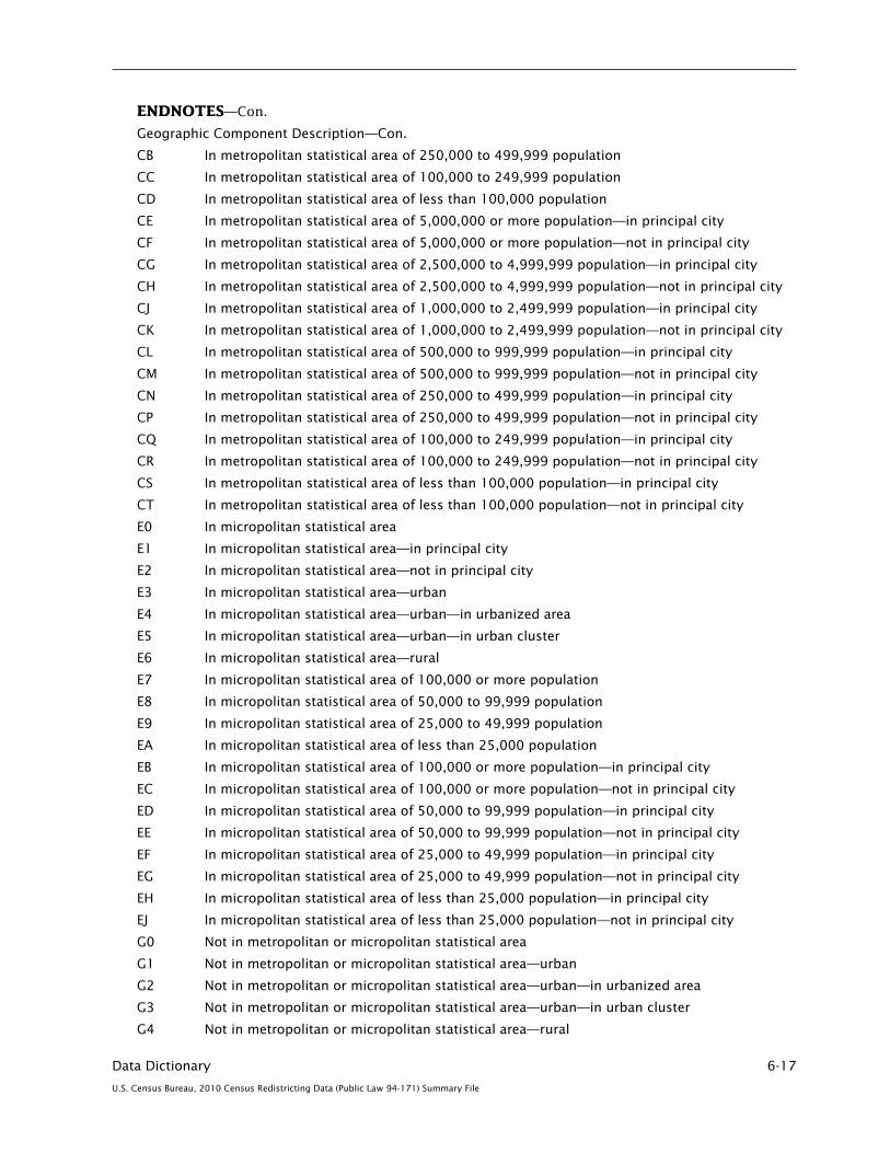
Data Dictionary 6-17
U.S. Census Bureau, 2010 Census Redistricting Data (Public Law 94-171) Summary File
ENDNOTES—Con.
Geographic Component Description—Con.
CB In metropolitan statistical area of 250,000 to 499,999 population
CC In metropolitan statistical area of 100,000 to 249,999 population
CD In metropolitan statistical area of less than 100,000 population
CE In metropolitan statistical area of 5,000,000 or more population—in principal city
CF In metropolitan statistical area of 5,000,000 or more population—not in principal city
CG In metropolitan statistical area of 2,500,000 to 4,999,999 population—in principal city
CH In metropolitan statistical area of 2,500,000 to 4,999,999 population—not in principal city
CJ In metropolitan statistical area of 1,000,000 to 2,499,999 population—in principal city
CK In metropolitan statistical area of 1,000,000 to 2,499,999 population—not in principal city
CL In metropolitan statistical area of 500,000 to 999,999 population—in principal city
CM In metropolitan statistical area of 500,000 to 999,999 population—not in principal city
CN In metropolitan statistical area of 250,000 to 499,999 population—in principal city
CP In metropolitan statistical area of 250,000 to 499,999 population—not in principal city
CQ In metropolitan statistical area of 100,000 to 249,999 population—in principal city
CR In metropolitan statistical area of 100,000 to 249,999 population—not in principal city
CS In metropolitan statistical area of less than 100,000 population—in principal city
CT In metropolitan statistical area of less than 100,000 population—not in principal city
E0 In micropolitan statistical area
E1 In micropolitan statistical area—in principal city
E2 In micropolitan statistical area—not in principal city
E3 In micropolitan statistical area—urban
E4 In micropolitan statistical area—urban—in urbanized area
E5 In micropolitan statistical area—urban—in urban cluster
E6 In micropolitan statistical area—rural
E7 In micropolitan statistical area of 100,000 or more population
E8 In micropolitan statistical area of 50,000 to 99,999 population
E9 In micropolitan statistical area of 25,000 to 49,999 population
EA In micropolitan statistical area of less than 25,000 population
EB In micropolitan statistical area of 100,000 or more population—in principal city
EC In micropolitan statistical area of 100,000 or more population—not in principal city
ED In micropolitan statistical area of 50,000 to 99,999 population—in principal city
EE In micropolitan statistical area of 50,000 to 99,999 population—not in principal city
EF In micropolitan statistical area of 25,000 to 49,999 population—in principal city
EG In micropolitan statistical area of 25,000 to 49,999 population—not in principal city
EH In micropolitan statistical area of less than 25,000 population—in principal city
EJ In micropolitan statistical area of less than 25,000 population—not in principal city
G0 Not in metropolitan or micropolitan statistical area
G1 Not in metropolitan or micropolitan statistical area—urban
G2 Not in metropolitan or micropolitan statistical area—urban—in urbanized area
G3 Not in metropolitan or micropolitan statistical area—urban—in urban cluster
G4 Not in metropolitan or micropolitan statistical area—rural

6-18 Data Dictionary
U.S. Census Bureau, 2010 Census Redistricting Data (Public Law 94-171) Summary File
ENDNOTES—Con.
Geographic Component Description—Con.
H0 Not in metropolitan statistical areaH1 Not in metropolitan statistical area—urbanH2 Not in metropolitan statistical area—urban—in urbanized areaH3 Not in metropolitan statistical area—urban—in urban clusterH4 Not in metropolitan statistical area—ruralJ0 In combined statistical areaL0 Not in combined statistical areaM0 In New England city and town areaM1 In New England city and town area—in principal cityM2 In New England city and town area—not in principal cityM3 In New England city and town area—urbanM4 In New England city and town area—urban—in urbanized areaM5 In New England city and town area—urban—in urban clusterM6 In New England city and town area—ruralP0 In combined New England city and town area
4. Indicates an iteration (repetition), for the specified summary level, of the data matrices on the summary file for a population or housing characteristic. These iteration fields apply to Summary File 2 (SF 2) and the American Indian and Alaska Native Summary File only.
5. The sequence number of the table file within the set of physical files for the state (i.e., the geographic header record file and one or more table files). See How to Use This Product for more information.
6. The logical record is the complete record for a geographic entity defined by the summary level, but exclusive of the characteristic iteration. A logical record may have one or more parts (or segments). Each logical record has an assigned sequential integer number within the file. See How to Use This Product for further information.
7. See Appendix A, “Geographic Terms and Concepts,” for definition of this field.
8. The Federal Information Processing Standards (FIPS) codes were withdrawn as a standard in 2005. The Census Bureau, however, has renamed these codes as Federal Information Processing Series codes and retained the acronym. The two-digit state and congressional district and three-digit county FIPS codes (former FIPS 5, 9, and 6, respectively) are unchanged, but with oversight transferred to the American National Standards Institute (ANSI). The five-digit FIPS 55 codes are no longer a federal code standard; however they are retained in Census Bureau files as administrative codes and used as primary key codes for many geographic entity types. The U.S. Geological Survey has received ANSI oversight for a code standard that uses the Geographic Names Information System identifier (GNIS ID).
The new ANSI standard using the GNIS ID as the official codes for Named Physical and Cultural Geographic Features of the United States and Puerto Rico also is included in Census Bureau files for state, county, county subdivision, place, consolidated city, American Indian area, Alaska Native area, Hawaiian home land, American Indian tribal subdivision, and subminor civil division or equivalent features. The Census Bureau references these fields in the geoheader as ANSI codes and using the term National Standard code. The codes represent the official numeric GNIS ID as an eight-digit character field with leading zeroes. The Census Bureau treats the state and county or equivalent area ANSI codes as supplemental standard codes.
The following lists the published code standards used for the 2010 Census (with its associated Census 2000 standard):
• INCITS.38-200x(R2004),CodesfortheIdentificationoftheStates,theDistrictofColumbia,Puerto Rico, and the Insular Areas of the United States (Formerly FIPS 5-2)
• INCITS.31-200x(R2007),CodesfortheIdentificationofCountiesandEquivalentAreasofthe United States, Puerto Rico, and the Insular Areas of the United States (Formerly FIPS 6-4)

Data Dictionary 6-19
U.S. Census Bureau, 2010 Census Redistricting Data (Public Law 94-171) Summary File
ENDNOTES—Con.
• INCITS.454-200x,CodesfortheIdentificationofMetropolitanandMicropolitanStatisticalAreas and Related Areas of the United States and Puerto Rico (Formerly FIPS 8-6)
• INCITS455-200x,CodesfortheIdentificationofCongressionalDistrictsandEquivalentAreasof the United States, Puerto Rico, and the Insular Areas (Formerly FIPS 9-1)
• INCITS446-2008,(GNIS)IdentifyingAttributesforNamedPhysicalandCulturalGeographic Features (Except Roads and Highways) of the United States, Its Territories, Outlying Areas, and Freely Associated Areas, and the Waters of the Same to the Limit of the Twelve-Mile Statutory Zone (Formerly FIPS 55-4).
Note: INCITS refers to InterNational Committee for Information Technology Standards.
9. Identifies areas within predetermined population ranges. The actual codes and ranges are common to all entities with a size code field. The complete list of size codes follows:
00 Not in universe 01 0 02 1–24 03 25–99 04 100–199 05 200–249 06 250–299 07 300–499 08 500–999 09 1,000–1,499 10 1,500–1,999 11 2,000–2,499 12 2,500–4,999 13 5,000–9,999 14 10,000–19,999 15 20,000–24,999 16 25,000–49,999 17 50,000–99,999 18 100,000–249,999 19 250,000–499,999 20 500,000–999,999 21 1,000,000–2,499,999 22 2,500,000–4,999,999 23 5,000,000 or more
The size code fields are not filled for the Redistricting Data Summary File products.
10. Codes in unspecified arrangement for U.S. Census Bureau use.
11. Federal Information Processing Series (FIPS) 55 codes are assigned by state. Because American Indian areas and tribal subdivisions can exist in more than one state, multiple FIPS 55 codes can exist for the entity.
12. Urban Areas, Urban/Rural classification, ZIP Code Tabulation Areas, and Public Use Microdata Areas are not available in the Redistricting Data products.
13. Blank values in the Congressional District (111th) field indicate areas where no congressional district was assigned by state redistricting officials.
14. State legislative district codes have three characters and can include a hyphen (-). The code ZZZ indicates state legislative districts not defined. In the District of Columbia and Nebraska, both of which have a single legislative body, the state legislative districts are reported as upper chamber districts, and the lower chamber districts are coded as 999.

6-20 Data Dictionary
U.S. Census Bureau, 2010 Census Redistricting Data (Public Law 94-171) Summary File
ENDNOTES—Con.
15. Voting district codes can have one to six characters including special characters of a hyphen (-), dot (.), and forward slash (/). If the code contains less than six characters, the field is right-justified with leading blanks. The code ZZZZZZ indicates voting district not defined in a county or equivalent area containing one or more defined voting districts.
16. Land area measurement in square meters. The accuracy of the area measurement is limited by the inaccuracy inherent in the mapping of the various boundary features in the Census Bureau’s geographic database. Land area includes areas classified as intermittent water, swamps, and glaciers, which appear on census maps and in the Census Bureau’s geographic database as hydrographic features. Square miles can be derived by dividing square meters by 2,589,988. See Appendix A, “Geographic Terms and Concepts,” for definition of this field.
17. Water area measurement in square meters. The accuracy of the area measurement is limited by the inaccuracy inherent in the mapping of the various boundary features in the Census Bureau’s geographic database. Water area excludes areas classified as intermittent water, swamps, and glaciers, which are treated as land even though they appear on census maps and in the Census Bureau’s geographic database as hydrographic features. Square miles can be derived by dividing square meters by 2,589,988. See Appendix A, “Geographic Terms and Concepts,” for definition of this field.
18. Name of the lowest-level entity represented by the summary level. In addition to the name of the entity, the name field contains the legal/statistical area description (LSAD), when appropriate, and sometimes contains the state abbreviation. For legal entities, the name is the one reported to the U.S. Census Bureau in the Boundary and Annexation Survey or by other appropriate sources, such as state education officials for school districts. For statistical entities, the name is determined by the Office of Management and Budget for metropolitan and micropolitan areas. The remaining statistical area names usually are supplied by tribal, state, or local sources according to published criteria. For redistricting data entities, names are reported by the state redistricting data liaison. For other areas, the name is determined by the local officials, usually in cooperation with the U.S. Census Bureau. When the summary level data represent only part of the area specified in the name, the name usually will have “(part)” appended to the name/code terminology to designate that this entry for the entity represents only a part of the total entity.
19. The total number of persons enumerated in the specified geographic entity as determined in the 100 percent processing.
20. The total number of housing units enumerated in the specified geographic entity as determined in the 100 percent processing.
21. Latitude in degrees, to seven decimal places, of a point within the geographic area represented by the summary level. The character immediately preceding the first digit of the latitude of an internal point identifies the direction (hemisphere): a plus sign (+) indicates the Northern Hemisphere; a minus sign (–) indicates the Southern Hemisphere. See Appendix A, “Geographic Terms and Concepts,” for definition of this field.
22. Longitude in degrees, to seven decimal places, of a point within the geographic area represented by the summary level. The character immediately preceding the first digit of the longitude of an internal point identifies the direction (hemisphere): a plus sign (+) indicates the Eastern hemisphere; a minus sign (–) indicates the Western Hemisphere. A point on the 180th meridian is assigned to the Western Hemisphere (–180.0000000). See Appendix A, “Geographic Terms and Concepts,” for definition of this field.
23. Congressional District (113th), Congressional District (114th), and Congressional District (115th) are reserved for areas established after reapportionment and redistricting.
24. State Legislative District—Upper and Lower Chamber—for Year 2, 3, and 4 are reserved for areas established after redistricting.

Data Dictionary 6-21
U.S. Census Bureau, 2010 Census Redistricting Data (Public Law 94-171) Summary File
TABLE (MATRIX) SECTION
The 2010 Census Redistricting Data (Public Law 94-171) Summary File is provided as a set, including one geographic header file and two data files. The data files are presented in the table (matrix) section and are ASCII format with variable length fields delimited by commas. The data fields are numeric with the maximum size shown in MAX SIZE. Each data file begins with a subset of fields from the geographic header file. They are file identification (FILEID), state/U.S. abbreviation (STUSAB), characteristic iteration (CHARITER), two-character file sequence number (CIFSN), and a logical record number (LOGRECNO).
TABLE (MATRIX) SECTION—Con.
Table number Table contents
Data dictionary reference name
Seg-ment
Max size
File 01—File Linking Fields (comma delimited). These fields link File 01 with the geographic header and other files in the data set.
Field name
Data dictionary reference name
Max size
Data type
File Identification FILEID 6 A/NState/U.S. Abbreviation (USPS) STUSAB 2 ACharacteristic Iteration CHARITER 3 A/NCharacteristic Iteration File Sequence Number CIFSN 2 A/NLogical Record Number LOGRECNO 7 N
P1. RACE [71]Universe: Total population Total: P0010001 01 9
Population of one race: P0010002 01 9White alone P0010003 01 9Black or African American alone P0010004 01 9American Indian and Alaska Native alone P0010005 01 9Asian alone P0010006 01 9Native Hawaiian and Other Pacific Islander alone P0010007 01 9Some Other Race alone P0010008 01 9
Two or More Races: P0010009 01 9Population of two races: P0010010 01 9
White; Black or African American P0010011 01 9White; American Indian and Alaska Native P0010012 01 9White; Asian P0010013 01 9White; Native Hawaiian and Other Pacific Islander P0010014 01 9White; Some Other Race P0010015 01 9Black or African American; American Indian and Alaska Native P0010016 01 9Black or African American; Asian P0010017 01 9Black or African American; Native Hawaiian and Other Pacific Islander P0010018 01 9Black or African American; Some Other Race P0010019 01 9American Indian and Alaska Native; Asian P0010020 01 9American Indian and Alaska Native; Native Hawaiian and Other Pacific Islander P0010021 01 9American Indian and Alaska Native; Some Other Race P0010022 01 9Asian; Native Hawaiian and Other Pacific Islander P0010023 01 9Asian; Some Other Race P0010024 01 9Native Hawaiian and Other Pacific Islander; Some Other Race P0010025 01 9

6-22 Data Dictionary
U.S. Census Bureau, 2010 Census Redistricting Data (Public Law 94-171) Summary File
TABLE (MATRIX) SECTION—Con.
Table number Table contents
Data dictionary reference name
Seg-ment
Max size
P1. RACE [71]—Con.Total—Con.
Two or More Races—Con.Population of three races: P0010026 01 9
White; Black or African American; American Indian and Alaska Native P0010027 01 9White; Black or African American; Asian P0010028 01 9White; Black or African American; Native Hawaiian and Other Pacific Islander P0010029 01 9White; Black or African American; Some Other Race P0010030 01 9White; American Indian and Alaska Native; Asian P0010031 01 9White; American Indian and Alaska Native; Native Hawaiian and Other Pacific Islander P0010032 01 9White; American Indian and Alaska Native; Some Other Race P0010033 01 9White; Asian; Native Hawaiian and Other Pacific Islander P0010034 01 9White; Asian; Some Other Race P0010035 01 9White; Native Hawaiian and Other Pacific Islander; Some Other Race P0010036 01 9Black or African American; American Indian and Alaska Native; Asian P0010037 01 9Black or African American; American Indian and Alaska Native; Native Hawaiian and Other Pacific Islander P0010038 01 9Black or African American; American Indian and Alaska Native; Some Other Race P0010039 01 9Black or African American; Asian; Native Hawaiian and Other Pacific Islander P0010040 01 9Black or African American; Asian; Some Other Race P0010041 01 9Black or African American; Native Hawaiian and Other Pacific Islander; Some Other Race P0010042 01 9American Indian and Alaska Native; Asian; Native Hawaiian and Other Pacific Islander P0010043 01 9American Indian and Alaska Native; Asian; Some Other Race P0010044 01 9American Indian and Alaska Native; Native Hawaiian and Other Pacific Islander; Some Other Race P0010045 01 9Asian; Native Hawaiian and Other Pacific Islander; Some Other Race P0010046 01 9
Population of four races: P0010047 01 9White; Black or African American; American Indian and Alaska Native; Asian P0010048 01 9White; Black or African American; American Indian and Alaska Native; Native Hawaiian and Other Pacific Islander P0010049 01 9White; Black or African American; American Indian and Alaska Native; Some Other Race P0010050 01 9White; Black or African American; Asian; Native Hawaiian and Other Pacific Islander P0010051 01 9White; Black or African American; Asian; Some Other Race P0010052 01 9White; Black or African American; Native Hawaiian and Other Pacific Islander; Some Other Race P0010053 01 9White; American Indian and Alaska Native; Asian; Native Hawaiian and Other Pacific Islander P0010054 01 9White; American Indian and Alaska Native; Asian; Some Other Race P0010055 01 9
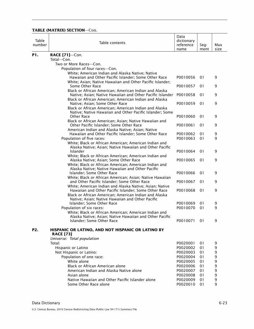
Data Dictionary 6-23
U.S. Census Bureau, 2010 Census Redistricting Data (Public Law 94-171) Summary File
TABLE (MATRIX) SECTION—Con.
Table number Table contents
Data dictionary reference name
Seg-ment
Max size
P1. RACE [71]—Con.Total—Con.
Two or More Races—Con.Population of four races—Con.
White; American Indian and Alaska Native; Native Hawaiian and Other Pacific Islander; Some Other Race P0010056 01 9White; Asian; Native Hawaiian and Other Pacific Islander; Some Other Race P0010057 01 9Black or African American; American Indian and Alaska Native; Asian; Native Hawaiian and Other Pacific Islander P0010058 01 9Black or African American; American Indian and Alaska Native; Asian; Some Other Race P0010059 01 9Black or African American; American Indian and Alaska Native; Native Hawaiian and Other Pacific Islander; Some Other Race P0010060 01 9Black or African American; Asian; Native Hawaiian and Other Pacific Islander; Some Other Race P0010061 01 9American Indian and Alaska Native; Asian; Native Hawaiian and Other Pacific Islander; Some Other Race P0010062 01 9
Population of five races: P0010063 01 9White; Black or African American; American Indian and Alaska Native; Asian; Native Hawaiian and Other Pacific Islander P0010064 01 9White; Black or African American; American Indian and Alaska Native; Asian; Some Other Race P0010065 01 9White; Black or African American; American Indian and Alaska Native; Native Hawaiian and Other Pacific Islander; Some Other Race P0010066 01 9White; Black or African American; Asian; Native Hawaiian and Other Pacific Islander; Some Other Race P0010067 01 9White; American Indian and Alaska Native; Asian; Native Hawaiian and Other Pacific Islander; Some Other Race P0010068 01 9Black or African American; American Indian and Alaska Native; Asian; Native Hawaiian and Other Pacific Islander; Some Other Race P0010069 01 9
Population of six races: P0010070 01 9White; Black or African American; American Indian and Alaska Native; Asian; Native Hawaiian and Other Pacific Islander; Some Other Race P0010071 01 9
P2. HISPANIC OR LATINO, AND NOT HISPANIC OR LATINO BY
RACE [73]Universe: Total population Total: P0020001 01 9
Hispanic or Latino P0020002 01 9Not Hispanic or Latino: P0020003 01 9
Population of one race: P0020004 01 9White alone P0020005 01 9Black or African American alone P0020006 01 9American Indian and Alaska Native alone P0020007 01 9Asian alone P0020008 01 9Native Hawaiian and Other Pacific Islander alone P0020009 01 9Some Other Race alone P0020010 01 9

6-24 Data Dictionary
U.S. Census Bureau, 2010 Census Redistricting Data (Public Law 94-171) Summary File
TABLE (MATRIX) SECTION—Con.
Table number Table contents
Data dictionary reference name
Seg-ment
Max size
P2. HISPANIC OR LATINO, AND NOT HISPANIC OR LATINO BY RACE [73]—Con.Total—Con.
Not Hispanic or Latino—Con.Two or More Races: P0020011 01 9
Population of two races: P0020012 01 9White; Black or African American P0020013 01 9White; American Indian and Alaska Native P0020014 01 9White; Asian P0020015 01 9White; Native Hawaiian and Other Pacific Islander P0020016 01 9White; Some Other Race P0020017 01 9Black or African American; American Indian and Alaska Native P0020018 01 9Black or African American; Asian P0020019 01 9Black or African American; Native Hawaiian and Other Pacific Islander P0020020 01 9Black or African American; Some Other Race P0020021 01 9American Indian and Alaska Native; Asian P0020022 01 9American Indian and Alaska Native; Native Hawaiian and Other Pacific Islander P0020023 01 9American Indian and Alaska Native; Some Other Race P0020024 01 9Asian; Native Hawaiian and Other Pacific Islander P0020025 01 9Asian; Some Other Race P0020026 01 9Native Hawaiian and Other Pacific Islander; Some Other Race P0020027 01 9
Population of three races: P0020028 01 9White; Black or African American; American Indian and Alaska Native P0020029 01 9White; Black or African American; Asian P0020030 01 9White; Black or African American; Native Hawaiian and Other Pacific Islander P0020031 01 9White; Black or African American; Some Other Race P0020032 01 9White; American Indian and Alaska Native; Asian P0020033 01 9White; American Indian and Alaska Native; Native Hawaiian and Other Pacific Islander P0020034 01 9White; American Indian and Alaska Native; Some Other Race P0020035 01 9White; Asian; Native Hawaiian and Other Pacific Islander P0020036 01 9White; Asian; Some Other Race P0020037 01 9White; Native Hawaiian and Other Pacific Islander; Some Other Race P0020038 01 9Black or African American; American Indian and Alaska Native; Asian P0020039 01 9Black or African American; American Indian and Alaska Native; Native Hawaiian and Other Pacific Islander P0020040 01 9Black or African American; American Indian and Alaska Native; Some Other Race P0020041 01 9Black or African American; Asian; Native Hawaiian and Other Pacific Islander P0020042 01 9Black or African American; Asian; Some Other Race P0020043 01 9Black or African American; Native Hawaiian and Other Pacific Islander; Some Other Race P0020044 01 9

Data Dictionary 6-25
U.S. Census Bureau, 2010 Census Redistricting Data (Public Law 94-171) Summary File
TABLE (MATRIX) SECTION—Con.
Table number Table contents
Data dictionary reference name
Seg-ment
Max size
P2. HISPANIC OR LATINO, AND NOT HISPANIC OR LATINO BY RACE [73]—Con.Total—Con.
Not Hispanic or Latino—Con.Two or More Races—Con.
Population of three races—Con.American Indian and Alaska Native; Asian; Native Hawaiian and Other Pacific Islander P0020045 01 9American Indian and Alaska Native; Asian; Some Other Race P0020046 01 9American Indian and Alaska Native; Native Hawaiian and Other Pacific Islander; Some Other Race P0020047 01 9Asian; Native Hawaiian and Other Pacific Islander; Some Other Race P0020048 01 9
Population of four races: P0020049 01 9White; Black or African American; American Indian and Alaska Native; Asian P0020050 01 9White; Black or African American; American Indian and Alaska Native; Native Hawaiian and Other Pacific Islander P0020051 01 9White; Black or African American; American Indian and Alaska Native; Some Other Race P0020052 01 9White; Black or African American; Asian; Native
Hawaiian and Other Pacific Islander P0020053 01 9White; Black or African American; Asian; Some Other
Race P0020054 01 9White; Black or African American; Native Hawaiian and
Other Pacific Islander; Some Other Race P0020055 01 9White; American Indian and Alaska Native; Asian;
Native Hawaiian and Other Pacific Islander P0020056 01 9White; American Indian and Alaska Native; Asian;
Some Other Race P0020057 01 9White; American Indian and Alaska Native; Native
Hawaiian and Other Pacific Islander; Some Other Race P0020058 01 9
White; Asian; Native Hawaiian and Other Pacific Islander, Some Other Race P0020059 01 9
Black or African American; American Indian and Alaska Native; Asian; Native Hawaiian and Other Pacific Islander P0020060 01 9
Black or African American; American Indian and Alaska Native; Asian; Some Other Race P0020061 01 9
Black or African American; American Indian and Alaska Native; Native Hawaiian and Other Pacific Islander; Some Other Race P0020062 01 9
Black or African American; Asian; Native Hawaiian and Other Pacific Islander; Some Other Race P0020063 01 9
American Indian and Alaska Native; Asian; Native Hawaiian and Other Pacific Islander; Some Other Race P0020064 01 9
Population of five races: P0020065 01 9White; Black or African American; American Indian
and Alaska Native; Asian; Native Hawaiian and Other Pacific Islander P0020066 01 9
White; Black or African American; American Indian and Alaska Native; Asian; Some Other Race P0020067 01 9
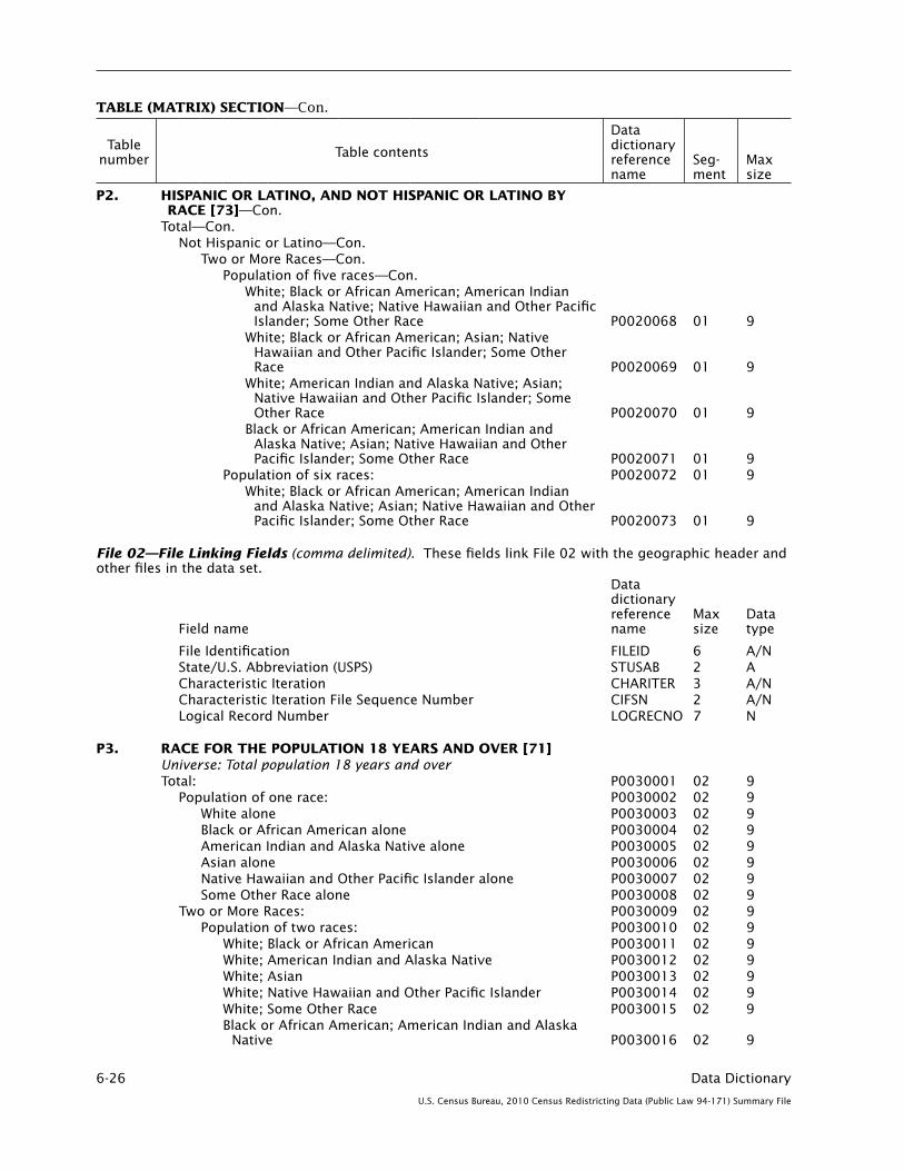
6-26 Data Dictionary
U.S. Census Bureau, 2010 Census Redistricting Data (Public Law 94-171) Summary File
TABLE (MATRIX) SECTION—Con.
Table number Table contents
Data dictionary reference name
Seg-ment
Max size
P2. HISPANIC OR LATINO, AND NOT HISPANIC OR LATINO BY RACE [73]—Con.Total—Con.
Not Hispanic or Latino—Con.Two or More Races—Con.
Population of five races—Con.White; Black or African American; American Indian
and Alaska Native; Native Hawaiian and Other Pacific Islander; Some Other Race P0020068 01 9
White; Black or African American; Asian; Native Hawaiian and Other Pacific Islander; Some Other Race P0020069 01 9
White; American Indian and Alaska Native; Asian; Native Hawaiian and Other Pacific Islander; Some Other Race P0020070 01 9
Black or African American; American Indian and Alaska Native; Asian; Native Hawaiian and Other Pacific Islander; Some Other Race P0020071 01 9
Population of six races: P0020072 01 9White; Black or African American; American Indian
and Alaska Native; Asian; Native Hawaiian and Other Pacific Islander; Some Other Race P0020073 01 9
File 02—File Linking Fields (comma delimited). These fields link File 02 with the geographic header and other files in the data set.
Field name
Data dictionary reference name
Max size
Data type
File Identification FILEID 6 A/NState/U.S. Abbreviation (USPS) STUSAB 2 ACharacteristic Iteration CHARITER 3 A/NCharacteristic Iteration File Sequence Number CIFSN 2 A/NLogical Record Number LOGRECNO 7 N
P3. RACE FOR THE POPULATION 18 YEARS AND OVER [71]Universe: Total population 18 years and overTotal: P0030001 02 9
Population of one race: P0030002 02 9White alone P0030003 02 9Black or African American alone P0030004 02 9American Indian and Alaska Native alone P0030005 02 9Asian alone P0030006 02 9Native Hawaiian and Other Pacific Islander alone P0030007 02 9Some Other Race alone P0030008 02 9
Two or More Races: P0030009 02 9Population of two races: P0030010 02 9
White; Black or African American P0030011 02 9White; American Indian and Alaska Native P0030012 02 9White; Asian P0030013 02 9White; Native Hawaiian and Other Pacific Islander P0030014 02 9White; Some Other Race P0030015 02 9Black or African American; American Indian and Alaska
Native P0030016 02 9

Data Dictionary 6-27
U.S. Census Bureau, 2010 Census Redistricting Data (Public Law 94-171) Summary File
TABLE (MATRIX) SECTION—Con.
Table number Table contents
Data dictionary reference name
Seg-ment
Max size
P3. RACE FOR THE POPULATION 18 YEARS AND OVER [71]—Con.Total—Con.
Two or More Races—Con.Population of two races—Con.
Black or African American; Asian P0030017 02 9Black or African American; Native Hawaiian and Other
Pacific Islander P0030018 02 9Black or African American; Some Other Race P0030019 02 9American Indian and Alaska Native; Asian P0030020 02 9American Indian and Alaska Native; Native Hawaiian and
Other Pacific Islander P0030021 02 9American Indian and Alaska Native; Some Other Race P0030022 02 9Asian; Native Hawaiian and Other Pacific Islander P0030023 02 9Asian; Some Other Race P0030024 02 9Native Hawaiian and Other Pacific Islander; Some Other
Race P0030025 02 9Population of three races: P0030026 02 9
White; Black or African American; American Indian and Alaska Native P0030027 02 9
White; Black or African American; Asian P0030028 02 9White; Black or African American; Native Hawaiian and
Other Pacific Islander P0030029 02 9White; Black or African American; Some Other Race P0030030 02 9White; American Indian and Alaska Native; Asian P0030031 02 9White; American Indian and Alaska Native; Native
Hawaiian and Other Pacific Islander P0030032 02 9White; American Indian and Alaska Native; Some Other
Race P0030033 02 9White; Asian; Native Hawaiian and Other Pacific Islander P0030034 02 9White; Asian; Some Other Race P0030035 02 9White; Native Hawaiian and Other Pacific Islander; Some
Other Race P0030036 02 9Black or African American; American Indian and Alaska
Native; Asian P0030037 02 9Black or African American; American Indian and Alaska
Native; Native Hawaiian and Other Pacific Islander P0030038 02 9Black or African American; American Indian and Alaska
Native; Some Other Race P0030039 02 9Black or African American; Asian; Native Hawaiian and
Other Pacific Islander P0030040 02 9Black or African American; Asian; Some Other Race P0030041 02 9Black or African American; Native Hawaiian and Other
Pacific Islander; Some Other Race P0030042 02 9American Indian and Alaska Native; Asian; Native
Hawaiian and Other Pacific Islander P0030043 02 9American Indian and Alaska Native; Asian; Some Other
Race P0030044 02 9American Indian and Alaska Native; Native Hawaiian and
Other Pacific Islander; Some Other Race P0030045 02 9Asian; Native Hawaiian and Other Pacific Islander; Some
Other Race P0030046 02 9Population of four races: P0030047 02 9
White; Black or African American; American Indian and Alaska Native; Asian P0030048 02 9

6-28 Data Dictionary
U.S. Census Bureau, 2010 Census Redistricting Data (Public Law 94-171) Summary File
TABLE (MATRIX) SECTION—Con.
Table number Table contents
Data dictionary reference name
Seg-ment
Max size
P3. RACE FOR THE POPULATION 18 YEARS AND OVER [71]—Con.Total—Con.
Two or More Races—Con.Population of four races—Con.
White; Black or African American; American Indian and Alaska Native; Native Hawaiian and Other Pacific Islander P0030049 02 9
White; Black or African American; American Indian and Alaska Native; Some Other Race P0030050 02 9
White; Black or African American; Asian; Native Hawaiian and Other Pacific Islander P0030051 02 9
White; Black or African American; Asian; Some Other Race P0030052 02 9White; Black or African American; Native Hawaiian and
Other Pacific Islander; Some Other Race P0030053 02 9White; American Indian and Alaska Native; Asian; Native
Hawaiian and Other Pacific Islander P0030054 02 9White; American Indian and Alaska Native; Asian; Some
Other Race P0030055 02 9White; American Indian and Alaska Native; Native
Hawaiian and Other Pacific Islander; Some Other Race P0030056 02 9White; Asian; Native Hawaiian and Other Pacific Islander;
Some Other Race P0030057 02 9Black or African American; American Indian and Alaska
Native; Asian; Native Hawaiian and Other Pacific Islander P0030058 02 9Black or African American; American Indian and Alaska
Native; Asian; Some Other Race P0030059 02 9Black or African American; American Indian and Alaska
Native; Native Hawaiian and Other Pacific Islander; Some Other Race P0030060 02 9
Black or African American; Asian; Native Hawaiian and Other Pacific Islander; Some Other Race P0030061 02 9
American Indian and Alaska Native; Asian; Native Hawaiian and Other Pacific Islander; Some Other Race P0030062 02 9
Population of five races: P0030063 02 9White; Black or African American; American Indian and
Alaska Native; Asian; Native Hawaiian and Other Pacific Islander P0030064 02 9
White; Black or African American; American Indian and Alaska Native; Asian; Some Other Race P0030065 02 9
White; Black or African American; American Indian and Alaska Native; Native Hawaiian and Other Pacific Islander; Some Other Race P0030066 02 9
White; Black or African American; Asian; Native Hawaiian and Other Pacific Islander; Some Other Race P0030067 02 9
White; American Indian and Alaska Native; Asian; Native Hawaiian and Other Pacific Islander; Some Other Race P0030068 02 9
Black or African American; American Indian and Alaska Native; Asian; Native Hawaiian and Other Pacific Islander; Some Other Race P0030069 02 9
Population of six races: P0030070 02 9White; Black or African American; American Indian and
Alaska Native; Asian; Native Hawaiian and Other Pacific Islander; Some Other Race P0030071 02 9

Data Dictionary 6-29
U.S. Census Bureau, 2010 Census Redistricting Data (Public Law 94-171) Summary File
TABLE (MATRIX) SECTION—Con.
Table number Table contents
Data dictionary reference name
Seg-ment
Max size
P4. HISPANIC OR LATINO, AND NOT HISPANIC OR LATINO BY RACE FOR THE POPULATION 18 YEARS AND OVER [73]Universe: Total population 18 years and overTotal: P0040001 02 9
Hispanic or Latino P0040002 02 9Not Hispanic or Latino: P0040003 02 9
Population of one race: P0040004 02 9White alone P0040005 02 9Black or African American alone P0040006 02 9American Indian and Alaska Native alone P0040007 02 9Asian alone P0040008 02 9Native Hawaiian and Other Pacific Islander alone P0040009 02 9Some Other Race alone P0040010 02 9
Two or More Races: P0040011 02 9Population of two races: P0040012 02 9
White; Black or African American P0040013 02 9White; American Indian and Alaska Native P0040014 02 9White; Asian P0040015 02 9White; Native Hawaiian and Other Pacific Islander P0040016 02 9White; Some Other Race P0040017 02 9Black or African American; American Indian and
Alaska Native P0040018 02 9Black or African American; Asian P0040019 02 9Black or African American; Native Hawaiian and Other
Pacific Islander P0040020 02 9Black or African American; Some Other Race P0040021 02 9American Indian and Alaska Native; Asian P0040022 02 9American Indian and Alaska Native; Native Hawaiian
and Other Pacific Islander P0040023 02 9American Indian and Alaska Native; Some Other Race P0040024 02 9Asian; Native Hawaiian and Other Pacific Islander P0040025 02 9Asian; Some Other Race P0040026 02 9Native Hawaiian and Other Pacific Islander; Some
Other Race P0040027 02 9Population of three races: P0040028 02 9
White; Black or African American; American Indian and Alaska Native P0040029 02 9
White; Black or African American; Asian P0040030 02 9White; Black or African American; Native Hawaiian and
Other Pacific Islander P0040031 02 9White; Black or African American; Some Other Race P0040032 02 9White; American Indian and Alaska Native; Asian P0040033 02 9White; American Indian and Alaska Native; Native
Hawaiian and Other Pacific Islander P0040034 02 9White; American Indian and Alaska Native; Some Other
Race P0040035 02 9White; Asian; Native Hawaiian and Other Pacific
Islander P0040036 02 9White; Asian; Some Other Race P0040037 02 9White; Native Hawaiian and Other Pacific Islander;
Some Other Race P0040038 02 9Black or African American; American Indian and
Alaska Native; Asian P0040039 02 9

6-30 Data Dictionary
U.S. Census Bureau, 2010 Census Redistricting Data (Public Law 94-171) Summary File
TABLE (MATRIX) SECTION—Con.
Table number Table contents
Data dictionary reference name
Seg-ment
Max size
P4. HISPANIC OR LATINO, AND NOT HISPANIC OR LATINO BY RACE FOR THE POPULATION 18 YEARS AND OVER [73]—Con.Total—Con.
Not Hispanic or Latino—Con.Two or More Races—Con.
Population of three races—Con.Black or African American; American Indian and
Alaska Native; Native Hawaiian and Other Pacific Islander P0040040 02 9
Black or African American; American Indian and Alaska Native; Some Other Race P0040041 02 9
Black or African American; Asian; Native Hawaiian and Other Pacific Islander P0040042 02 9
Black or African American; Asian; Some Other Race P0040043 02 9Black or African American; Native Hawaiian and Other
Pacific Islander; Some Other Race P0040044 02 9American Indian and Alaska Native; Asian; Native
Hawaiian and Other Pacific Islander P0040045 02 9American Indian and Alaska Native; Asian; Some Other
Race P0040046 02 9American Indian and Alaska Native; Native Hawaiian
and Other Pacific Islander; Some Other Race P0040047 02 9Asian; Native Hawaiian and Other Pacific Islander;
Some Other Race P0040048 02 9Population of four races: P0040049 02 9
White; Black or African American; American Indian and Alaska Native; Asian P0040050 02 9
White; Black or African American; American Indian and Alaska Native; Native Hawaiian and Other Pacific Islander P0040051 02 9
White; Black or African American; American Indian and Alaska Native; Some Other Race P0040052 02 9
White; Black or African American; Asian; Native Hawaiian and Other Pacific Islander P0040053 02 9
White; Black or African American; Asian; Some Other Race P0040054 02 9
White; Black or African American; Native Hawaiian and Other Pacific Islander; Some Other Race P0040055 02 9
White; American Indian and Alaska Native; Asian; Native Hawaiian and Other Pacific Islander P0040056 02 9
White; American Indian and Alaska Native; Asian; Some Other Race P0040057 02 9
White; American Indian and Alaska Native; Native Hawaiian and Other Pacific Islander; Some Other Race P0040058 02 9
White; Asian; Native Hawaiian and Other Pacific Islander, Some Other Race P0040059 02 9
Black or African American; American Indian and Alaska Native; Asian; Native Hawaiian and Other Pacific Islander P0040060 02 9
Black or African American; American Indian and Alaska Native; Asian; Some Other Race P0040061 02 9
Black or African American; American Indian and Alaska Native; Native Hawaiian and Other Pacific Islander; Some Other Race P0040062 02 9

Data Dictionary 6-31
U.S. Census Bureau, 2010 Census Redistricting Data (Public Law 94-171) Summary File
TABLE (MATRIX) SECTION—Con.
Table number Table contents
Data dictionary reference name
Seg-ment
Max size
P4. HISPANIC OR LATINO, AND NOT HISPANIC OR LATINO BY RACE FOR THE POPULATION 18 YEARS AND OVER [73]—Con.Total—Con.
Not Hispanic or Latino—Con.Two or More Races—Con.
Population of four races—Con.Black or African American; Asian; Native Hawaiian and
Other Pacific Islander; Some Other Race P0040063 02 9American Indian and Alaska Native; Asian; Native
Hawaiian and Other Pacific Islander; Some Other Race P0040064 02 9
Population of five races: P0040065 02 9White; Black or African American; American Indian
and Alaska Native; Asian; Native Hawaiian and Other Pacific Islander P0040066 02 9
White; Black or African American; American Indian and Alaska Native; Asian; Some Other Race P0040067 02 9
White; Black or African American; American Indian and Alaska Native; Native Hawaiian and Other Pacific Islander; Some Other Race P0040068 02 9
White; Black or African American; Asian; Native Hawaiian and Other Pacific Islander; Some Other Race P0040069 02 9
White; American Indian and Alaska Native; Asian; Native Hawaiian and Other Pacific Islander; Some Other Race P0040070 02 9
Black or African American; American Indian and Alaska Native; Asian; Native Hawaiian and Other Pacific Islander; Some Other Race P0040071 02 9
Population of six races: P0040072 02 9White; Black or African American; American Indian
and Alaska Native; Asian; Native Hawaiian and Other Pacific Islander; Some Other Race P0040073 02 9
H1. OCCUPANCY STATUS [3]Universe: Housing unitsTotal: H0010001 02 9
Occupied H0010002 02 9Vacant H0010003 02 9
2010 Census: Operational Overview and Accuracy of the Data 7-1
U.S. Census Bureau, 2010 Census Redistricting Data (Public Law 94-171) Summary File
Chapter 7. 2010 Census: Operational Overview and Accuracy of the Data
CONTENTS
Master Address File Development . . . . . . . . . . . . . . . . . . . . . . . . . . . . . . . . . . . . . . . . . . . . . . . . . . 7-1 Local Update of Census Addresses . . . . . . . . . . . . . . . . . . . . . . . . . . . . . . . . . . . . . . . . . . . . . . . . 7-2 Address Canvassing . . . . . . . . . . . . . . . . . . . . . . . . . . . . . . . . . . . . . . . . . . . . . . . . . . . . . . . . . . 7-2 Group Quarters . . . . . . . . . . . . . . . . . . . . . . . . . . . . . . . . . . . . . . . . . . . . . . . . . . . . . . . . . . . . . . 7-2 Update/Leave . . . . . . . . . . . . . . . . . . . . . . . . . . . . . . . . . . . . . . . . . . . . . . . . . . . . . . . . . . . . . . . 7-3 Nonresponse Followup . . . . . . . . . . . . . . . . . . . . . . . . . . . . . . . . . . . . . . . . . . . . . . . . . . . . . . . . 7-3 Other Address and Geocoding Operations . . . . . . . . . . . . . . . . . . . . . . . . . . . . . . . . . . . . . . . . . . 7-3 Vacant/Delete Check . . . . . . . . . . . . . . . . . . . . . . . . . . . . . . . . . . . . . . . . . . . . . . . . . . . . . . . . . . 7-4 Field Verification . . . . . . . . . . . . . . . . . . . . . . . . . . . . . . . . . . . . . . . . . . . . . . . . . . . . . . . . . . . . . 7-4 Remote Areas . . . . . . . . . . . . . . . . . . . . . . . . . . . . . . . . . . . . . . . . . . . . . . . . . . . . . . . . . . . . . . . 7-5Group Quarters Enumeration . . . . . . . . . . . . . . . . . . . . . . . . . . . . . . . . . . . . . . . . . . . . . . . . . . . . . 7-5Service-Based Enumeration and Enumeration at Transitory Locations . . . . . . . . . . . . . . . . . . . . . . . 7-5Confidentiality of the Data . . . . . . . . . . . . . . . . . . . . . . . . . . . . . . . . . . . . . . . . . . . . . . . . . . . . . . . 7-6 Title 13 U.S. Code . . . . . . . . . . . . . . . . . . . . . . . . . . . . . . . . . . . . . . . . . . . . . . . . . . . . . . . . . . . . 7-6 Disclosure Avoidance. . . . . . . . . . . . . . . . . . . . . . . . . . . . . . . . . . . . . . . . . . . . . . . . . . . . . . . . . . 7-6 Data Swapping . . . . . . . . . . . . . . . . . . . . . . . . . . . . . . . . . . . . . . . . . . . . . . . . . . . . . . . . . . . . . . 7-6Nonsampling Error . . . . . . . . . . . . . . . . . . . . . . . . . . . . . . . . . . . . . . . . . . . . . . . . . . . . . . . . . . . . . 7-6 Types of Nonsampling Error . . . . . . . . . . . . . . . . . . . . . . . . . . . . . . . . . . . . . . . . . . . . . . . . . . . . . 7-7 Reduction of Nonsampling Error . . . . . . . . . . . . . . . . . . . . . . . . . . . . . . . . . . . . . . . . . . . . . . . . . 7-7 Resolving Multiple Responses . . . . . . . . . . . . . . . . . . . . . . . . . . . . . . . . . . . . . . . . . . . . . . . . . . . 7-8Data Editing . . . . . . . . . . . . . . . . . . . . . . . . . . . . . . . . . . . . . . . . . . . . . . . . . . . . . . . . . . . . . . . . . . 7-8 Count Imputation . . . . . . . . . . . . . . . . . . . . . . . . . . . . . . . . . . . . . . . . . . . . . . . . . . . . . . . . . . . . 7-9 General Imputation Rules . . . . . . . . . . . . . . . . . . . . . . . . . . . . . . . . . . . . . . . . . . . . . . . . . . . . . . . 7-9
MASTER ADDRESS FILE DEVELOPMENT
As in Census 2000, the base for the address list for the 2010 Census was the address list from the previous census. Various updates were made to the address list during the intervening decade. The primary source of new addresses after Census 2000 was the Delivery Sequence File (DSF) from the U.S. Postal Service (USPS). The U.S. Census Bureau acquired this file of all mailing addresses in the United States and updated the Master Address File (MAF) twice a year (March and October) until February 2010. Addresses must be associated with a block to be included in the census. The process of associating these addresses with a block is called geocoding. For the Census Bureau, the file where geographic information is contained is the Topologically Integrated Geographic Encoding and Referencing System (TIGER®). During this decade, the MAF and TIGER have been integrated into the MAF/TIGER® database (MTdb).
For the processing of the DSF records, city-style addresses (containing a house number and street name) of residential units were applied to the MAF in those blocks that, in general terms, had been found to have a majority of city-style addresses in order that duplication would not result from the addition of these addresses. Another file from the USPS, the Locatable Address Conversion System (LACS), contained linkages for addresses that had been changed. Use of this file by the Census Bureau allowed for old and new addresses to be linked in the MTdb. This was especially desirable for linking the non-city-style addresses that had been converted to city-style addresses.

7-2 2010 Census: Operational Overview and Accuracy of the Data
U.S. Census Bureau, 2010 Census Redistricting Data (Public Law 94-171) Summary File
Various field operations, such as census tests and the update of rural area addresses for the American Community Survey, led to localized updates or updates in specific types of areas. In particular, updating addresses with post office box type addresses in the rural area was meant to balance the updating of the MTdb with city-style addresses from the DSF.
Local Update of Census Addresses
The first large-scale update of addresses for the decennial census was the Local Update of Census Addresses (LUCA) program. In this program, governmental units (GUs) were allowed to participate in updating the address list in three different ways. One option allowed for review of the Census Bureau’s address list, while the other options allowed only for the GUs to submit a list of addresses to the Census Bureau. Under any of these options, new addresses submitted by the GUs were included on the subsequent address list. These addresses could be for housing units (HUs) or for group quarters (GQs). The submitted addresses were then included in the universe for validation in the next major address list development operation, Address Canvassing, which occurred between April and July 2009.
Address Canvassing
Address Canvassing was conducted in all areas of the United States and Puerto Rico except in the areas that were designated for Remote Alaska or Remote Update Enumerate in the census. Address Canvassing was a dependent check of the list of addresses, as well as of the maps. The Address Canvassing operation was performed using automation, which allowed for the integration of address and map updates, as well as the imposition of rules on what constitutes a minimum allowable address and the collection of particular geographic fields. The allowable actions on the addresses in Address Canvassing were validate, nonresidential, delete, duplicate, address correction, and an action for designating possible GQs. Adds to the list were also allowed. All deletes and duplicates were validated during the next phase of the operation, called delete verification. The results from Address Canvassing were incorporated into the MTdb. One of the first uses of these results was for creating feedback to the GUs participating in LUCA. The results from processing the Address Canvassing updates were also used for the creation of the initial census address list starting in July 2009, the initial Universe Control and Management (UC&M) file. Printing of the questionnaires used this address list.
Group Quarters
The results of Address Canvassing also contributed to the universe for the next operation, which was Group Quarters Validation (GQV). The procedures for creating the address list of GQs were significantly different for the 2010 Census as opposed to previous censuses. In order to reduce duplication and geographic data errors, the address lists of HUs and GQs were integrated in the MTdb. The list of potential GQs going into GQV was the accumulation of GQ addresses from Census 2000, GQ addresses acquired from various sources, and addresses listed as Other Living Quarters (potential GQs) in Address Canvassing. Cases designated as GQs through other sources were intended to be sent to GQV regardless of the Address Canvassing status. However, it was discovered during processing of the LUCA updates that GUs often listed apartment buildings or commercial units as GQs. The schedule for completing GQV, in October 2009, was one of the riskiest in the census. For these units to remain on the list of units to be checked in GQV put timely completion of the operation at risk, and thus, the entire census schedule. Therefore, from the LUCA updates making their way to GQV, only the units with facility names that included special key names known to be associated with group quarters were designated for follow-up in GQV unless they were also designated as possible GQs in Address Canvassing. The addresses in GQV could receive an action of GQ—along with the type of GQ, HU, nonresidential, vacant, transient (meaning the location was connected to a geographic area that should be enumerated in the Enumeration at Transitory Locations operation), delete, or duplicate.
The results from GQV were processed in November 2009. Updates were made to the initial UC&M, resulting in the enumeration UC&M, or the full census universe. Units that were marked as housing units

2010 Census: Operational Overview and Accuracy of the Data 7-3
U.S. Census Bureau, 2010 Census Redistricting Data (Public Law 94-171) Summary File
in GQV were designated as adds to the initial UC&M universe. Other adds to this universe resulted from DSF updates that had occurred between the creation of the Address List for Address Canvassing and the creation of the enumeration UC&M. There were three DSFs contributing new adds to this UC&M file. A supplemental printing of addressed questionnaires resulted from this updated file. These questionnaires were either added to the mail stream at the point that questionnaires were delivered by the USPS or sent to the Local Census Offices in those areas where the added addresses occurred in Update/Leave areas.
Update/Leave
Update/Leave (U/L) is an operation in which questionnaires are hand-delivered due to potential problems with postal delivery of addresses. The presence of staff in the field for this delivery allows the simultaneous updating of the address lists and maps. Addresses on the address list in U/L areas received the actions of verify, correction, nonresidential, delete, or duplicate. Maps could also receive updates. The operation occurred between March 1 and April 2, 2010. There were approximately 12 million housing units in stateside U/L areas, and Puerto Rico (about 1.6 million addresses) was entirely U/L. There was no check on the deletes and duplicates designated in this operation because the operation was performed on paper and there was a timing issue with processing. The status of nonresponding units that were in the enumeration universe was checked in the later Nonresponse Followup operation.
Nonresponse Followup
Nonresponse Followup (NRFU) is the operation in which nonresponding households from both mailout/mailback and U/L areas are followed up and enumerated, if possible. Other options within NRFU are to mark the unit vacant (either a regular vacant or seasonal), delete, or duplicate. It is also possible to add units and perform the enumeration on them. The maps also may be updated. The status of regular vacants and deletes is checked in the subsequent operation, the Vacant/Delete Check.
Other Address and Geocoding Operations
No additional updates were made to the enumeration universe in the UC&M before the start of NRFU. However, there were still operations and processes adding addresses to the MTdb, or in some cases, adding geographic data that allowed the addresses to be included in the census. These were: (1) LUCA Appeals; (2) New Construction; (3) HU Address Review; (4) Count Review; (5) Spring 2010 DSF; (6) newly geocoded addresses; (7) addresses resulting from a follow-up of INFO-COMMs (standardized forms used to document problems, issues, and unusual situations or to ask questions about procedures and other work-related matters by field staff) submitted during Address Canvassing; and (8) U/L added addresses.
LUCA Appeals was a process where a GU that participated in LUCA submitted challenges to the outputs from Address Canvassing. The challenged addresses were reviewed, and those that were approved were accepted back onto the census list.
New Construction was an effort similar to LUCA in which the participating GU submitted addresses that represented newly constructed and livable housing.
The HU Address Review was a headquarters review of addresses coming from a variety of sources. In general, these were people who reported situations, such as large apartment buildings missing from the census universe, where the report made it to headquarters personnel. Staff in the Geography division researched these address submissions to determine if they were truly missing from the census address list and, if so, why. When it was found that addresses should be included on the census address list and did not duplicate other addresses already on the census address list, they were submitted for processing in the same format as files from the New Construction and Count Review programs.
Count Review was another effort undertaken with governmental representatives with an eye toward identifying housing that was missing from the list.

7-4 2010 Census: Operational Overview and Accuracy of the Data
U.S. Census Bureau, 2010 Census Redistricting Data (Public Law 94-171) Summary File
The Spring 2010 DSF contained mailable addresses as of February 2010. Residential addresses appearing on this list that were not already included in the MTdb were assumed to represent mostly newly constructed units. For the next source of addresses on this update, there were a few million addresses residing on the MTdb that had not yet been geocoded. It was assumed that these addresses would be added in Address Canvassing if they truly existed.
However, when Address Canvassing was completed and only about half of the addresses had been added in the operation, and at the same time there were some concerns about the coverage of the list, the Census Bureau undertook an independent effort in early 2010 to find geocodes for these units after first checking that the addresses were not represented on the list in another form.
The next addition of addresses resulted from Address Canvassing INFO-COMMs. The design of the automated instrument did not allow for units to be added during the Quality Control (QC) phase of the operation if the assignment had passed QC. Nevertheless, in some areas QC staff found large numbers of missing addresses that were not picked up within the QC sample. They filled out an INFO-COMM to apprise the local office staff of the situation. In early 2010, there was an effort to identify which of these cases were really missing units and where they should be added to the list. An input file that mimicked the inputs of the other operations adding addresses was created for these units to be added to the census list in this process, as well.
The final source of new addresses listed here was U/L adds. These are units that did not appear on the list used for U/L but that were identified as valid in the field. Questionnaires were delivered to these units, and updates were made to the MTdb based on the results of this operation. However, the processing of U/L actions could not be completed in time to update the NRFU universe without automation. Thus, in order to perform enumeration on U/L adds for households that did not return the form, the units needed to be included in the subsequent updated universe.
Vacant/Delete Check
These addresses just described made it into the enumeration universe for the first time for the Vacant/Delete Check (VDC). Not all of these addresses required a visit for enumeration during the VDC. In particular, if a householder at an address added during U/L mailed in the form in time, no additional visit was required. In addition, an operation dubbed the Late Add Mailing resulted in many of these addresses being mailed forms earlier than enumeration would have occurred. In particular, the LUCA Appeals addresses, the addresses from the most recent DSF that were geocoded to a block, and the addresses that were newly geocoded during the geocoding research were placed on a file for which questionnaires were printed and mailed. A unique processing ID was printed on each of these questionnaires, which enabled the questionnaires to be linked up to the census ID that was used when the units were added to the VDC universe. This also allowed for the information about receipt of a questionnaire to be passed back to the universe file and removed from the universe of follow-up cases. Therefore, the final list of units requiring follow-up and potential enumeration in VDC were the regular vacants and deletes as designated in NRFU and the new units added from the seven sources listed above for which no questionnaire was received by the time of universe creation. The universe of addresses printed within the address registers were all units that appeared in the enumeration universe plus the units added from the seven sources listed. One category of new address that did not appear on the VDC listing pages, due to timing, were the units that were added during NRFU.
Field Verification
There was one final check of particular addresses in the field. This operation is called Field Verification, and it was performed in the 2010 Census much as it was in Census 2000. Only specific addresses within the entire universe of addresses were acted on during this status check. Units designated for follow-up in this operation received a status of valid (or verify), delete, or duplicate. The addresses in the universe for this check in the 2010 Census included two categories of cases. The first was a check of new addresses that resulted from Be Counted forms or calls to the Telephone Questionnaire Assistance line that did not

2010 Census: Operational Overview and Accuracy of the Data 7-5
U.S. Census Bureau, 2010 Census Redistricting Data (Public Law 94-171) Summary File
have a related census ID. These addresses needed to be verified in the field before they were added to the census. They must be associated with a particular block before they could be sent for field work. The second category of cases was units that potentially needed to be removed from the universe based on the identification of duplicated persons in those units. Person duplication occurs for many reasons, one of which is duplication of housing units on the address list. Units linked by person matching that are within a close geographic area have been found in testing to be highly associated with housing-level problems. However, there are other situations that can lead to such person duplication that are not housing unit duplication, so these units identified as potential duplicates needed to be field checked before they could be safely removed from the census address list. For those units that were designated as duplicates, an indicator of which unit on the list that unit duplicated was collected.
Remote Areas
The descriptions above cover the vast majority of housing units in the United States and in all of Puerto Rico. However, there are some particularly remote or problematic areas that were designated for other types of enumeration. The first of these to start was Remote Alaska. In this operation, enumeration was scheduled to occur in fishing and hunting villages before the ice broke and the villagers scattered from their winter homes. Other areas in Alaska that were remote but where the population is stationary were designated for Remote Update/Enumerate. The methodology is the same for these two operations. The incoming address list was based on what was there during Census 2000. Updates were made to the address list and maps, and the households were enumerated at the same time. An area of Maine was also designated for Remote Update/Enumerate.
Some areas of the country (covering about 1.5 million addresses) were designated for Update/Enumerate. In these areas, Address Canvassing was completed, but it was felt that enumeration by Mailout/Mailback or U/L would have been problematic. These areas could be seasonal housing, federally designated tribal areas, or areas with particularly low predicted response rates based on various demographic factors. In Update/Enumerate, as in Remote Update/Enumerate and Remote Alaska, updates were made to the address list and maps at the same time that enumeration was completed. In general, this is the last operation that occurs in these areas, although it is possible for units in the Field Verification universe to be in these areas.
GROUP QUARTERS ENUMERATION
A list of nonstandard housing, such as college dormitories and group homes, was tracked in the MTdb in conjunction with the housing unit list. The list of these GQs was compiled from various sources, including the Census 2000 list of GQs, LUCA participants, the Federal-State Cooperative for Population Estimates, and Address Canvassing. GQV of these addresses occurred in October 2009, as described above. The units that remained GQs after this check were included in Group Quarters Advance Visit (GQAV), and then Group Quarters Enumeration (GQE). In GQE, individual census questionnaires—meaning individual questionnaires for each person—were distributed at the GQs and collected by the field staff. A count of persons associated with a particular GQ resulted from this operation.
SERVICE-BASED ENUMERATION AND ENUMERATION AT TRANSITORY LOCATIONS
Service-Based Enumeration (SBE) was designed to account for the enumeration of persons without a usual residence that use service facilities (i.e., shelters, soup kitchens, and mobile food vans). In the 2010 Census, 3 days (March 29–31) were designated for these enumeration activities. Different types of facilities were designated for different days. Only persons using the service facility on the interview day were enumerated at that location. It was possible for people to be counted in more than one location due to use of different facilities on subsequent days. There is an unduplication of SBE persons for the purpose of minimizing this duplication.

7-6 2010 Census: Operational Overview and Accuracy of the Data
U.S. Census Bureau, 2010 Census Redistricting Data (Public Law 94-171) Summary File
People experiencing homelessness could also complete a Be Counted form and check the box indicating this status. To the extent that such persons could be associated with a state and county based on the information provided on the form, they will be counted at a Group Quarters within that state and county.
Certain areas were designated for Enumeration at Transitory Locations (ETL). These included RV parks and marinas where people were living as of Census Day if people living in these locations had no other permanent place to stay. The locations where ETL took place were designated in GQAV. When people were enumerated in ETL, the particular location was considered a housing unit.
CONFIDENTIALITY OF THE DATA
The Census Bureau has modified some data in this data release to protect confidentiality. Title 13 U.S. Code, Section 9, prohibits the Census Bureau from publishing results in which an individual’s data can be identified.
The Census Bureau’s internal Disclosure Review Board monitors the disclosure review process and sets the confidentiality rules for all data releases. A checklist approach is used to ensure that all potential risks are considered and addressed. A list of possible concerns is created and the Disclosure Review Board makes sure that the appropriate steps are taken to assure the confidentiality of the data.
Title 13 U.S. Code
Title 13 of the U.S. Code authorizes the Census Bureau to conduct surveys and censuses and mandates that any information obtained from private individuals and establishments remains confidential. Section 9 of Title 13 prohibits the Census Bureau from releasing “any publication whereby the data furnished by any particular establishment or individual under this title can be identified.” Section 214 of Title 13, as modified by the Federal Sentencing Reform Act, imposes a fine of not more than $250,000 and/or imprisonment of not more than 5 years for publication or communication in violation of Section 9.
Disclosure Avoidance
Disclosure avoidance is the process of disguising data to protect confidentiality. A disclosure of data occurs when someone can use published statistical information to identify an individual who provided information under a pledge of confidentiality. Using disclosure avoidance, the Census Bureau modifies or removes all of the characteristics that put confidential information at risk for disclosure. Although it may appear that a table shows information about a specific individual, the Census Bureau has taken steps (such as data swapping) to disguise the original data while making sure the results are useful.
Data Swapping
Data swapping is a method of disclosure avoidance designed to protect confidentiality in tables of frequency data (the number or percentage of the population with certain characteristics). Data swapping is done by editing the source data or exchanging records for a sample of cases. A sample of households is selected and matched on a set of selected key variables with households in neighboring geographic areas (geographic areas with a small population) that have similar characteristics (same number of adults, same number of children, etc.). Because the swap often occurs within a geographic area with a small population, there is no effect on the marginal totals for the geographic area with a small population or for totals that include data from multiple geographic areas with small populations. Because of data swapping, users should not assume that tables with cells having a value of one or two reveal information about specific individuals.
NONSAMPLING ERROR
In any large-scale statistical operation, such as the 2010 Census, human- and computer-related errors occur. These errors are commonly referred to as nonsampling errors. Such errors include not enumerating every household or every person in the population, not obtaining all required information from the respondents, obtaining incorrect or inconsistent information, and recording information incorrectly. In

2010 Census: Operational Overview and Accuracy of the Data 7-7
U.S. Census Bureau, 2010 Census Redistricting Data (Public Law 94-171) Summary File
addition, errors can occur during the field review of the enumerators’ work, during clerical handling of the census questionnaires, or during the electronic processing of the questionnaires.
While it is impossible to completely eliminate nonsampling error from an operation as large and complex as the decennial census, the Census Bureau attempts to control the sources of such error during the collection and processing operations. Described below are the primary sources of nonsampling error and the programs instituted to control this error in the 2010 Census. The success of these programs, however, was contingent upon how well the instructions actually were carried out during the census.
Types of Nonsampling Error
Nonresponse
Nonresponse to particular questions on the census questionnaire or the failure to obtain any information for a housing unit allows for the introduction of bias into the data because the characteristics of the nonrespondents have not been observed and may differ from those reported by respondents. As a result, any imputation procedure using respondent data may not completely reflect these differences either at the elemental level (individual person or housing unit) or on the average. Some protection against the introduction of large biases is afforded by minimizing nonresponse. Characteristics for the nonresponses were imputed by using reported data for a person or housing unit with similar characteristics.
Respondent and Enumerator Error
The person answering the mail questionnaire for a household or responding to the questions posed by an enumerator could serve as a source of error, although the question wording was extensively tested in several experimental studies prior to the census. The mail respondent may overlook or misunderstand a question or answer a question in a way that cannot be interpreted correctly by the data capture system. The enumerator may also misinterpret or otherwise incorrectly record information given by a respondent or may fail to collect some of the information for a person or household. To control problems such as these with the field enumeration, the work of enumerators was monitored carefully. Field staff were prepared for their tasks by using standardized training packages that included hands-on experience in using census materials. A sample of the households interviewed by each enumerator were reinterviewed to control for the possibility of fabricated data being submitted by enumerators.
Processing Error
The many phases involved in processing the census data represent potential sources for the introduction of nonsampling error. The processing of the census questionnaires completed by enumerators included field review by the crew leader, check-in, and transmittal of completed questionnaires. No field reviews were done on the mail return questionnaires for this census.
Error may also be introduced by the misinterpretation of data by the data capture system or the failure to capture all the information that the respondents or enumerators provided on the forms. Write-in entries go through coding operations, which may also be a source of processing error in the data. Many of the various field, coding, and computer operations undergo a number of quality control checks to help ensure their accurate application.
Reduction of Nonsampling Error
To reduce various types of nonsampling errors, a number of techniques were implemented during the planning, development of the mailing address list, data collection, and data processing activities. Quality assurance methods were used throughout the data collection and processing phases of the census to improve the quality of the data. A reinterview program was implemented to minimize the errors in the data collection phase for enumerator-filled questionnaires.

7-8 2010 Census: Operational Overview and Accuracy of the Data
U.S. Census Bureau, 2010 Census Redistricting Data (Public Law 94-171) Summary File
Several coverage improvement programs were implemented during the development of the census address list and census enumeration and processing to minimize undercoverage of the population and housing units. These programs were developed based on experience from previous decennial censuses and results from the 2010 Census testing cycle.
• BeCountedquestionnaires,unaddressedformsrequestingallquestionnaireitemsplusafewadditionalitems, were available in public locations for people who believed they were not otherwise counted.
•Anintroductoryletterwassenttoallmailout/mailbackaddressesandmanyaddressesinupdate/leaveareas prior to the mailing of the census form. A reminder postcard was also sent to these addresses.
•Areplacementquestionnairewassenttononrespondingaddressesinselectedareas.
•BilingualEnglish/Spanishquestionnairesweresenttoalladdressesinselectedareas.
• FormsinSpanish,Chinese(simplified),Korean,Russian,andVietnameseweremailedtothosewhorequested them and Language Assistance Guides were available in 59 languages.
• Awell-publicizedtoll-freephonenumberwasavailabletoanswerquestionsabouttheforms,andresponses could be taken over the phone.
• UndertheLUCAprogram,localofficialshadtheopportunitytoaddressspecificconcernsabouttheaccuracy and completeness of the address list.
• ACoverageFollowup(CFU)telephoneinterviewoperationwasimplementedwiththeexpresspurposeof improving within household coverage. Cases were telephoned when there was a discrepancy between the number in the count of persons box and the number of persons with data. A household-level undercoverage question was added to the questionnaire, and person-level overcoverage questions were also added. Certain categories of households checking these boxes were also selected for CFU for roster clarification. In addition, large households, or those with more than six household members, were selected for inclusion in CFU for the purpose of collecting full demographic data for persons beyond the first six.
Resolving Multiple Responses
With multiple ways for people to initiate or complete their enumeration, as well as the field follow-up operations, it was very likely that some households would be enumerated more than once. A special computer process was implemented to control the extent of this type of nonsampling error by resolving situations where more than one form was received from an address. The process consisted of several steps. Addresses that had more than one viable return were analyzed. Household data from one form were chosen as the household data to use in subsequent census processing. There are situations in which persons can then be added to the household roster if they are not already represented there. These are the cases in which a Be Counted form for a partial household was submitted for the same address, and when an enumeration operation discovers a person who should be counted at a different address (a Usual Home Elsewhere) from the address being enumerated.
DATA EDITING
The objective of the processing operation was to produce a set of data that describes the population as accurately and clearly as possible. As with Census 2000, information on 2010 Census questionnaires generally was not edited for consistency, completeness, and acceptability during field data collection nor during data capture operations. Enumerator-filled questionnaires were reviewed by census crew leaders and local office clerks for adherence to specified procedures. No clerical review of mail return questionnaires was done to ensure that the information on the form could be data captured, nor were households contacted to collect data that were missing from census returns as in previous censuses.
2010 Census: Operational Overview and Accuracy of the Data 7-9
U.S. Census Bureau, 2010 Census Redistricting Data (Public Law 94-171) Summary File
Most census questionnaires received by mail from respondents as well as those filled by enumerators were processed through a new contractor-built image scanning system that used optical mark and character recognition to convert the responses into computer files. The optical character recognition, or OCR, process used several pattern and context checks to estimate accuracy thresholds for each write-in field. The system also used edits on interpreted write-in responses to decide whether the field values read by the machine interpretation were acceptable. If the value read had a lower than acceptable accuracy threshold or was outside of the edit range, the image of the item was displayed to a keyer, who then entered the response.
To control the creation of possibly erroneous persons from questionnaires completed incorrectly or containing stray marks, an edit on the number of persons indicated on each mail return and enumerator-filled questionnaire was implemented as part of the data capture system. In addition, a new edit identified questionnaires with information written outside of the response boxes. Detection of either of these conditions by the edits subsystem resulted in the review of the questionnaire image at a workstation by an operator who ensured that the person data were captured fully and correctly.
At Census Bureau headquarters, the data records were subjected to a computer edit that identified households exhibiting a possible coverage problem and those with more than six household members. Attempts were made to contact these households on the telephone to correct the count inconsistency and to collect the census data for those people for whom there was no room on the questionnaire.
Count Imputation
Once census processing is completed, each address included in the census data collection has to be classified as a nonexistent unit, a vacant unit, or an occupied housing unit. Records that are classified as an occupied unit also need a reported number of residents. This information is necessary to have a complete count of the population and housing units in the United States as of Census Day. Because of the complexity of census operations, there are records that do not have such information by the end of the follow-up activities and data processing. To fill in this missing information, the Census Bureau conducted count imputation, which assigns a unit status and household size to records without such information. This process also included assigning household size to occupied units without household size information. Count imputation processing did not include group quarters.
In count imputation, all the records in the enumeration universe were partitioned within a designated geographical area into small groups based on certain characteristics. For each small group, a probability distribution of unit status and size from the records that had this information was created. Then, the distribution was used to impute for the missing data status and/or household size.
General Imputation Rules
The final automated edit and imputation processes determined the final values of questionnaire data items for records with missing or invalid values in collected data. Imputations, which were needed most often when an entry for a given item was missing, included three general procedures known as assignments, allocations, and substitution. Assignments and allocations were imputations of characteristic items on an item-by-item basis, whereas the substitution process imputed data for up to six persons in a household at one time. Each of these procedures ensured the completeness and consistency of the data by providing acceptable codes for missing or unacceptable entries.
The first step in the edit process was to assign acceptable codes in place of unacceptable entries or blanks when acceptable data were found for that same person. When one characteristic item reported for a person was inconsistent with other information provided for that same person, acceptable codes or values that were consistent with one item of reported information were assigned. The edit procedures also assigned race or Hispanic origin from a matched person record in Census 2000 or in the American Community Survey (2000–2009) when these fields were missing. These assignment steps strove to ensure consistency across characteristic data.
7-10 2010 Census: Operational Overview and Accuracy of the Data
U.S. Census Bureau, 2010 Census Redistricting Data (Public Law 94-171) Summary File
The next step in the edit process, known as allocation, was to impute responses for missing person or housing-unit characteristic data. The general procedure for changing unacceptable entries through allocation was to derive an entry for a person (or housing unit) that was consistent with entries for another person (or housing unit) with similar characteristics. Allocation rates for census items were made available with the published census data.
Another way corrections are made during the edit and imputation process was through substitution; that is, the replication of a full set of characteristics for people in a household. When there was an indication that a household was occupied by a specified number of people but the questionnaire record contained no information for the people within the household or the occupants were not listed on the questionnaire, a previously accepted household of the same size was selected as a substitute. The full set of characteristics of the substitute was duplicated. Counts of substituted persons and the occupied housing units containing substituted persons were made available with the published census data.
User Updates 8-1
U.S. Census Bureau, 2010 Census Redistricting Data (Public Law 94-171) Summary File
Chapter 8. User Updates .
User updates supply data users with additional or corrected information that becomes available after the technical documentation or files are prepared. They are issued in a numbered series and are available in portable document format (PDF) on our Web site at <www.census.gov>. Please file the user updates cover sheet behind this notice. If there are technical documentation replacement pages, they should be filed in their proper location and the original pages should be destroyed.
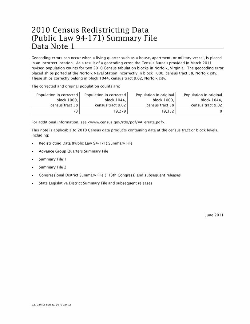
U.S. Census Bureau, 2010 Census
2010 Census Redistricting Data (Public Law 94-171) Summary File Data Note 1 .Geocoding errors can occur when a living quarter such as a house, apartment, or military vessel, is placed in an incorrect location. As a result of a geocoding error, the Census Bureau provided in March 2011 revised population counts for two 2010 Census tabulation blocks in Norfolk, Virginia. The geocoding error placed ships ported at the Norfolk Naval Station incorrectly in block 1000, census tract 38, Norfolk city. These ships correctly belong in block 1044, census tract 9.02, Norfolk city.
The corrected and original population counts are:
Population in corrected block 1000,
census tract 38
Population in corrected block 1044,
census tract 9.02
Population in original block 1000,
census tract 38
Population in original block 1044,
census tract 9.02
73 19,279 19,352 0
For additional information, see <www.census.gov/rdo/pdf/VA_errata.pdf>.
This note is applicable to 2010 Census data products containing data at the census tract or block levels, including:
• Redistricting Data (Public Law 94-171) Summary File
• Advance Group Quarters Summary File
• Summary File 1
• Summary File 2
• Congressional District Summary File (113th Congress) and subsequent releases
• State Legislative District Summary File and subsequent releases
June 2011

U.S. Census Bureau, 2010 Census
2010 Census Redistricting Data (Public Law 94-171) Summary File Data Note 2 .Geocoding errors can occur when a living quarter such as a house, apartment, or military vessel, is placed in an incorrect location. We discovered a systematic error in the manner in which a few military vessels were geocoded, including an error involving Coronado city and San Diego city, California. As a result, the Census Bureau provided in March 2011 revised population counts for two 2010 Census tabulation blocks.
The corrected and original population counts are:
Population in corrected block 1029,
census tract 113, San Diego city, CA
Population in corrected block 1000,
census tract 113, Coronado city, CA
Population in original block 1029,
census tract 113, San Diego city, CA
Population in original block 1000,
census tract 113, Coronado city, CA
0 5,785 5,785 0
For additional information, see <www.census.gov/rdo/pdf/CA_errata.pdf>.
This note is applicable to 2010 Census data products containing data at the place, census tract, or block levels, including:
• Redistricting Data (Public Law 94-171) Summary File
• Advance Group Quarters Summary File
• Demographic Profile
• Summary File 1
• Summary File 2
• Congressional District Summary File (113th Congress) and subsequent releases
• State Legislative District Summary File and subsequent releases
June 2011

U.S. Census Bureau, 2010 Census
2010 Census Redistricting Data (Public Law 94-171) Summary File Data Note 3 .Geocoding errors can occur when a living quarter such as a house, apartment, or military vessel, is placed in an incorrect location. We discovered a systematic error in the manner in which a few military vessels were geocoded, including an error involving Groton city and Conning Towers Nautilus Park census designated place (CDP), both of which are located in Groton town, New London County, Connecticut. As a result, the Census Bureau provided in March 2011 revised population counts for two 2010 Census tabulation blocks.
The corrected and original population counts are:
Population in corrected block 1001,
census tract 7026, Groton city, CT
Population in corrected block 1020,
census tract 9800, Conning Towers
Nautilus Park CDP, CT
Population in original block 1001,
census tract 7026, Groton city, CT
Population in original block 1020,
census tract 9800, Conning Towers
Nautilus Park CDP, CT
32 994 1,026 0
For additional information, see <www.census.gov/rdo/pdf/CT_errata.pdf>.
This note is applicable to 2010 Census data products containing data at the place, census tract, or block levels, including:
• Redistricting Data (Public Law 94-171) Summary File
• Advance Group Quarters Summary File
• Demographic Profile
• Summary File 1
• Summary File 2
• Congressional District Summary File (113th Congress) and subsequent releases
• State Legislative District Summary File and subsequent releases
June 2011

U.S. Census Bureau, 2010 Census
2010 Census Redistricting Data (Public Law 94-171) Summary File Data Note 4 .Geocoding errors can occur when a living quarter such as a house, apartment, or military vessel, is placed in an incorrect location. We discovered a systematic error in the manner in which a few military vessels were geocoded, including an error involving Pascagoula city, Mississippi. As a result, the Census Bureau provided in March 2011 revised population counts for two 2010 Census tabulation blocks.
The corrected and original population counts are:
Population in corrected block 1305,
census tract 429, Pascagoula city, MS
Population in corrected block 1278,
census tract 429, Pascagoula city, MS
Population in original block 1305,
census tract 429, Pascagoula city, MS
Population in original block 1278,
census tract 429, Pascagoula city, MS
0 32 32 0
For additional information, see <www.census.gov/rdo/pdf/MS_errata.pdf>.
This note is applicable to 2010 Census data products containing data at the census tract or block levels, including:
• Redistricting Data (Public Law 94-171) Summary File
• Advance Group Quarters Summary File
• Demographic Profile
• Summary File 1
• Summary File 2
• Congressional District Summary File (113th Congress) and subsequent releases
• State Legislative District Summary File and subsequent releases
June 2011

U.S. Census Bureau, 2010 Census
2010 Census Redistricting Data (Public Law 94-171) Summary File Data Note 5 .Geocoding errors can occur when a living quarter such as a house, apartment, or military vessel, is placed in an incorrect location. We discovered a systematic error in the manner in which a few military vessels were geocoded, including an error involving Portsmouth city and Hampton town, in Rockingham County, New Hampshire. As a result, the Census Bureau provided in March 2011 revised population counts for two 2010 Census tabulation blocks.
The corrected and original population counts are:
Population in corrected block 1013,
census tract 650.07, Hampton town, NH
Population in corrected block 1001,
census tract 691, Portsmouth city, NH
Population in original block 1013,
census tract 650.07, Hampton town, NH
Population in original block 1001,
census tract 691, Portsmouth city, NH
22 514 476 60
For additional information, see <www.census.gov/rdo/pdf/NH_errata.pdf>.
This note is applicable to 2010 Census data products containing data at the place, minor civil division, census tract, or block levels, including:
• Redistricting Data (Public Law 94-171) Summary File
• Advance Group Quarters Summary File
• Demographic Profile
• Summary File 1
• Summary File 2
• Congressional District Summary File (113th Congress) and subsequent releases
• State Legislative District Summary File and subsequent releases
June 2011

U.S. Census Bureau, 2010 Census
2010 Census Redistricting Data (Public Law 94-171) Summary File Data Note 6 .Geocoding errors can occur when a living quarter such as a house, apartment, or military vessel, is placed in an incorrect location. We discovered a systematic error in the manner in which a few military vessels were geocoded, including an error involving Everett city, Washington. As a result, the Census Bureau provided in March 2011 revised population counts for two 2010 Census tabulation blocks.
The corrected and original population counts are:
Population in corrected block 4014,
census tract 401, Everett city, WA
Population in corrected block 3026,
census tract 404, Everett city, WA
Population in original block 4014,
census tract 401, Everett city, WA
Population in original block 3026,
census tract 404, Everett city, WA
0 683 683 0
For additional information, see <.census.gov/rdo/pdf/WA_errata.pdf>.
This note is applicable to 2010 Census data products containing data at the census tract or block levels, including:
• Redistricting Data (Public Law 94-171) Summary File
• Advance Group Quarters Summary File
• Demographic Profile
• Summary File 1
• Summary File 2
• Congressional District Summary File (113th Congress) and subsequent releases
• State Legislative District Summary File and subsequent releases
June 2011

Geographic Terms and Concepts A-1
U.S. Census Bureau, 2010 Census Redistricting Data (Public Law 94-171) Summary File
Appendix A.Geographic Terms and ConceptsAlaska Native Regional Corporation (ANRC) (see American Indian, Alaska Native,
and Native Hawaiian Area) . . . . . . . . . . . . . . . . . . . . . . . . . . . . . . . . . . . . . . . . . . . . . . . . . . . . . . A-5
Alaska Native Village (ANV) (see American Indian, Alaska Native, and Native Hawaiian Area) . . . . . A-5
Alaska Native Village Statistical Area (ANVSA) (see American Indian, Alaska Native, and Native Hawaiian Area) . . . . . . . . . . . . . . . . . . . . . . . . . . . . . . . . . . . . . . . . . . . . . . . . . . . . . . A-8
American Indian, Alaska Native, and Native Hawaiian Area . . . . . . . . . . . . . . . . . . . . . . . . . . . . . . A-5
American Indian Off-Reservation Trust Land (see American Indian, Alaska Native, and Native Hawaiian Area) . . . . . . . . . . . . . . . . . . . . . . . . . . . . . . . . . . . . . . . . . . . . . . . . . . . . . . A-7
American Indian Reservation (see American Indian, Alaska Native, and Native Hawaiian Area) . . . . . . . . . . . . . . . . . . . . . . . . . . . . . . . . . . . . . . . . . . . . . . . . . . . . . . A-6
American Indian Tribal Subdivision (see American Indian, Alaska Native, and Native Hawaiian Area) . . . . . . . . . . . . . . . . . . . . . . . . . . . . . . . . . . . . . . . . . . . . . . . . . . . . . . A-6
American National Standards Institute (ANSI) Codes (see Codes for Geographic Entities) . . . . . . . . . A-13
American Samoa (see Island Areas of the United States) . . . . . . . . . . . . . . . . . . . . . . . . . . . . . . . . . A-20
Area Measurement . . . . . . . . . . . . . . . . . . . . . . . . . . . . . . . . . . . . . . . . . . . . . . . . . . . . . . . . . . . . . A-9
Barrio (see Puerto Rico) . . . . . . . . . . . . . . . . . . . . . . . . . . . . . . . . . . . . . . . . . . . . . . . . . . . . . . . . . A-22
Barrio-Pueblo (see Puerto Rico) . . . . . . . . . . . . . . . . . . . . . . . . . . . . . . . . . . . . . . . . . . . . . . . . . . . . A-22
Block . . . . . . . . . . . . . . . . . . . . . . . . . . . . . . . . . . . . . . . . . . . . . . . . . . . . . . . . . . . . . . . . . . . . . . . A-10
Block Group . . . . . . . . . . . . . . . . . . . . . . . . . . . . . . . . . . . . . . . . . . . . . . . . . . . . . . . . . . . . . . . . . . A-10
Borough (see County or Statistically Equivalent Entity; see County Subdivision; see Place) . . . . . . . A-16
Boundary Changes . . . . . . . . . . . . . . . . . . . . . . . . . . . . . . . . . . . . . . . . . . . . . . . . . . . . . . . . . . . . . A-11
Census Area (see County or Statistically Equivalent Entity) . . . . . . . . . . . . . . . . . . . . . . . . . . . . . . . A-16
Census Block (see Block) . . . . . . . . . . . . . . . . . . . . . . . . . . . . . . . . . . . . . . . . . . . . . . . . . . . . . . . . . A-10
Census Bureau Codes (see Codes for Geographic Entities) . . . . . . . . . . . . . . . . . . . . . . . . . . . . . . . . A-14
Census County Division (CCD) (see County Subdivision) . . . . . . . . . . . . . . . . . . . . . . . . . . . . . . . . A-18
Census Designated Place (CDP) (see Place) . . . . . . . . . . . . . . . . . . . . . . . . . . . . . . . . . . . . . . . . . . . A-21
Census Division (see also Census Region) . . . . . . . . . . . . . . . . . . . . . . . . . . . . . . . . . . . . . . . . . . . A-12
Census Region (see also Census Division) . . . . . . . . . . . . . . . . . . . . . . . . . . . . . . . . . . . . . . . . . . . A-12
Census Subarea (see County Subdivision) . . . . . . . . . . . . . . . . . . . . . . . . . . . . . . . . . . . . . . . . . . . . A-18
Census Tract . . . . . . . . . . . . . . . . . . . . . . . . . . . . . . . . . . . . . . . . . . . . . . . . . . . . . . . . . . . . . . . . . . A-12
Central Place (see Urban and Rural) . . . . . . . . . . . . . . . . . . . . . . . . . . . . . . . . . . . . . . . . . . . . . . . . A-25
City (see Place) . . . . . . . . . . . . . . . . . . . . . . . . . . . . . . . . . . . . . . . . . . . . . . . . . . . . . . . . . . . . . . . . A-21
City and Borough (see County or Statistically Equivalent Entity; see Place) . . . . . . . . . . . . . . . . . . . A-16
Codes for Geographic Entities . . . . . . . . . . . . . . . . . . . . . . . . . . . . . . . . . . . . . . . . . . . . . . . . . . . . . A-13
Combined New England City and Town Area (see Core Based Statistical Area) . . . . . . . . . . . . . . . . . A-15
Combined Statistical Area (CSA) (see Core Based Statistical Area) . . . . . . . . . . . . . . . . . . . . . . . . . . A-15
Commonwealth of the Northern Mariana Islands (see Island Areas of the United States) . . . . . . . . . A-20
Comparability (see Boundary Changes) . . . . . . . . . . . . . . . . . . . . . . . . . . . . . . . . . . . . . . . . . . . . . A-11
Comunidad (see Puerto Rico) . . . . . . . . . . . . . . . . . . . . . . . . . . . . . . . . . . . . . . . . . . . . . . . . . . . . . A-22
Congressional District (CD) . . . . . . . . . . . . . . . . . . . . . . . . . . . . . . . . . . . . . . . . . . . . . . . . . . . . . . A-14
Consolidated City . . . . . . . . . . . . . . . . . . . . . . . . . . . . . . . . . . . . . . . . . . . . . . . . . . . . . . . . . . . . . . A-14
Core Based Statistical Area . . . . . . . . . . . . . . . . . . . . . . . . . . . . . . . . . . . . . . . . . . . . . . . . . . . . . . . A-15
County or Statistically Equivalent Entity . . . . . . . . . . . . . . . . . . . . . . . . . . . . . . . . . . . . . . . . . . . . . A-16
County Subdivision . . . . . . . . . . . . . . . . . . . . . . . . . . . . . . . . . . . . . . . . . . . . . . . . . . . . . . . . . . . . . A-17

A-2 Geographic Terms and Concepts
U.S. Census Bureau, 2010 Census Redistricting Data (Public Law 94-171) Summary File
Density (see Population and Housing Unit Density) . . . . . . . . . . . . . . . . . . . . . . . . . . . . . . . . . . . . . A-22
District (see County or Statistically Equivalent Entity) . . . . . . . . . . . . . . . . . . . . . . . . . . . . . . . . . . . A-16
Division (see Census Division) . . . . . . . . . . . . . . . . . . . . . . . . . . . . . . . . . . . . . . . . . . . . . . . . . . . . A-12
Extended Place (see Urban and Rural) . . . . . . . . . . . . . . . . . . . . . . . . . . . . . . . . . . . . . . . . . . . . . . A-25
FIPS Class Codes (see Geographic Area Attributes) . . . . . . . . . . . . . . . . . . . . . . . . . . . . . . . . . . . . . A-19
FIPS Codes (see Codes for Geographic Entities) . . . . . . . . . . . . . . . . . . . . . . . . . . . . . . . . . . . . . . . . A-13
Functional Status (see Geographic Area Attributes) . . . . . . . . . . . . . . . . . . . . . . . . . . . . . . . . . . . . . A-19
Geographic Area Attributes . . . . . . . . . . . . . . . . . . . . . . . . . . . . . . . . . . . . . . . . . . . . . . . . . . . . . . . A-18
Geographic Hierarchy (see Introduction—Geographic Presentation of Data) . . . . . . . . . . . . . . . . . . A-4
Geographic Names Information System (GNIS) . . . . . . . . . . . . . . . . . . . . . . . . . . . . . . . . . . . . . . . . A-20
Geographic Names Information System Identifier (GNIS ID) (see Codes for Geographic Entities) . . . . . . . . . . . . . . . . . . . . . . . . . . . . . . . . . . . . . . . . . . . . . . . . . . . . . . . . . . . A-20
Geographic Presentation (see Introduction—Geographic Presentation of Data) . . . . . . . . . . . . . . . . A-4
Guam (see Island Areas of the United States) . . . . . . . . . . . . . . . . . . . . . . . . . . . . . . . . . . . . . . . . . A-20
Hawaiian Home Land (HHL) (see American Indian, Alaska Native, and Native Hawaiian Area) . . . . . A-7
Hierarchical Presentation (see Introduction—Geographic Presentation of Data) . . . . . . . . . . . . . . . . A-4
Incorporated Place (see Place; see County Subdivision) . . . . . . . . . . . . . . . . . . . . . . . . . . . . . . . . . A-21
Independent City (see County or Statistically Equivalent Entity; see Place) . . . . . . . . . . . . . . . . . . . A-16
Independent Place (see County Subdivision; see Place) . . . . . . . . . . . . . . . . . . . . . . . . . . . . . . . . . . A-17
Internal Point (see Geographic Area Attributes) . . . . . . . . . . . . . . . . . . . . . . . . . . . . . . . . . . . . . . . . A-19
Introduction—Geographic Presentation of Data . . . . . . . . . . . . . . . . . . . . . . . . . . . . . . . . . . . . . . . A-3
Inventory Presentation (see Introduction—Geographic Presentation of Data) . . . . . . . . . . . . . . . . . A-4
Island (see County or Statistically Equivalent Entity) . . . . . . . . . . . . . . . . . . . . . . . . . . . . . . . . . . . . A-16
Island Areas of the United States . . . . . . . . . . . . . . . . . . . . . . . . . . . . . . . . . . . . . . . . . . . . . . . . . . A-20
Joint-Use Areas (see American Indian Area, Alaska Native Area, and Hawaiian Home Land) . . . . . . . A-7
Land Area (see Area Measurement) . . . . . . . . . . . . . . . . . . . . . . . . . . . . . . . . . . . . . . . . . . . . . . . . A-9
Legal/Statistical Area Description (see Geographic Area Attributes) . . . . . . . . . . . . . . . . . . . . . . . . . A-19
MAF/TIGER (Master Address File/Topologically Integrated Geographic Encoding and Referencing) Database . . . . . . . . . . . . . . . . . . . . . . . . . . . . . . . . . . . . . . . . . . . . . . . . . . . . . . . . . A-20
Metropolitan Division (see Core Based Statistical Area) . . . . . . . . . . . . . . . . . . . . . . . . . . . . . . . . . . A-15
Metropolitan Statistical Area (see Core Based Statistical Area) . . . . . . . . . . . . . . . . . . . . . . . . . . . . . A-15
Micropolitan Statistical Area (see Core Based Statistical Area) . . . . . . . . . . . . . . . . . . . . . . . . . . . . . A-15
Minor Civil Division (MCD) (see County Subdivision) . . . . . . . . . . . . . . . . . . . . . . . . . . . . . . . . . . . A-17
Municipality (see County or Statistically Equivalent Entity; see Place) . . . . . . . . . . . . . . . . . . . . . . . A-16
Municipio (see Puerto Rico; see County or Statistically Equivalent Entity) . . . . . . . . . . . . . . . . . . . . A-22
Names of Geographic Entities (see Geographic Area Attributes) . . . . . . . . . . . . . . . . . . . . . . . . . . . A-19
National Standard Feature Identifier (see Codes for Geographic Entities; see Geographic Names Information System [GNIS ID]) . . . . . . . . . . . . . . . . . . . . . . . . . . . . . . . . . . . . . . . . . . . . . . A-13
New England City and Town Area (NECTA) (see Core Based Statistical Area). . . . . . . . . . . . . . . . . . . A-16
New England City and Town Area Division (see Core Based Statistical Area) . . . . . . . . . . . . . . . . . . A-16
Northern Mariana Islands (see Island Areas of the United States) . . . . . . . . . . . . . . . . . . . . . . . . . . . A-20
Off-Reservation Trust Land (see American Indian, Alaska Native, and Native Hawaiian Area) . . . . . . A-7
Oklahoma Tribal Statistical Area (OTSA) (see American Indian, Alaska Native, and Native Hawaiian Area) . . . . . . . . . . . . . . . . . . . . . . . . . . . . . . . . . . . . . . . . . . . . . . . . . . . . . . . . . A-8
Oklahoma Tribal Statistical Area (OTSA) Joint-Use Area (see American Indian, Alaska Native, and Native Hawaiian Area) . . . . . . . . . . . . . . . . . . . . . . . . . . . . . . . . . . . . . . . . . . . . . . . . . . . . . . A-8
Outlying Areas (see Island Areas of the United States) . . . . . . . . . . . . . . . . . . . . . . . . . . . . . . . . . . . A-20
Parish (see County or Statistically Equivalent Entity) . . . . . . . . . . . . . . . . . . . . . . . . . . . . . . . . . . . . A-16

Geographic Terms and Concepts A-3
U.S. Census Bureau, 2010 Census Redistricting Data (Public Law 94-171) Summary File
Place . . . . . . . . . . . . . . . . . . . . . . . . . . . . . . . . . . . . . . . . . . . . . . . . . . . . . . . . . . . . . . . . . . . . . . . . A-21
Place Within Consolidated City (see Place) . . . . . . . . . . . . . . . . . . . . . . . . . . . . . . . . . . . . . . . . . . . A-21
Population and Housing Unit Density . . . . . . . . . . . . . . . . . . . . . . . . . . . . . . . . . . . . . . . . . . . . . . . A-22
Principal City (see Core Based Statistical Area) . . . . . . . . . . . . . . . . . . . . . . . . . . . . . . . . . . . . . . . . A-16
Public Use Microdata Area . . . . . . . . . . . . . . . . . . . . . . . . . . . . . . . . . . . . . . . . . . . . . . . . . . . . . . . . A-22
Puerto Rico . . . . . . . . . . . . . . . . . . . . . . . . . . . . . . . . . . . . . . . . . . . . . . . . . . . . . . . . . . . . . . . . . . A-22
Region (see Census Region) . . . . . . . . . . . . . . . . . . . . . . . . . . . . . . . . . . . . . . . . . . . . . . . . . . . . . . A-12
Rural (see Urban and Rural) . . . . . . . . . . . . . . . . . . . . . . . . . . . . . . . . . . . . . . . . . . . . . . . . . . . . . . A-25
School District (Elementary, Secondary, and Unified) . . . . . . . . . . . . . . . . . . . . . . . . . . . . . . . . . . . . A-23
State or Statistically Equivalent Entity . . . . . . . . . . . . . . . . . . . . . . . . . . . . . . . . . . . . . . . . . . . . . . . A-23
State Designated American Indian Statistical Area (SDAISA) (see American Indian, Alaska Native, and Native Hawaiian Area) . . . . . . . . . . . . . . . . . . . . . . . . . . . . . . . . . . . . . . . . . . A-5
State Designated Tribal Statistical Area (SDTSA) (see American Indian, Alaska Native, and Native Hawaiian Area) . . . . . . . . . . . . . . . . . . . . . . . . . . . . . . . . . . . . . . . . . . . . . . . . . . . . . . A-8
State Legislative District (Upper and Lower Chambers) . . . . . . . . . . . . . . . . . . . . . . . . . . . . . . . . . . A-23
Subbarrio (see Puerto Rico) . . . . . . . . . . . . . . . . . . . . . . . . . . . . . . . . . . . . . . . . . . . . . . . . . . . . . . A-22
Subminor Civil Division . . . . . . . . . . . . . . . . . . . . . . . . . . . . . . . . . . . . . . . . . . . . . . . . . . . . . . . . . . A-13
Town (see County Subdivision; see Place) . . . . . . . . . . . . . . . . . . . . . . . . . . . . . . . . . . . . . . . . . . . A-17
Township (see County Subdivision) . . . . . . . . . . . . . . . . . . . . . . . . . . . . . . . . . . . . . . . . . . . . . . . . A-17
Tract (see Census Tract) . . . . . . . . . . . . . . . . . . . . . . . . . . . . . . . . . . . . . . . . . . . . . . . . . . . . . . . . . A-12
Tribal Block Group (see Block Group) . . . . . . . . . . . . . . . . . . . . . . . . . . . . . . . . . . . . . . . . . . . . . . . . A-24
Tribal Census Tract (see Census Tract) . . . . . . . . . . . . . . . . . . . . . . . . . . . . . . . . . . . . . . . . . . . . . . . A-24
Tribal Designated Statistical Area (TDSA) (see American Indian, Alaska Native, and Native Hawaiian Area) . . . . . . . . . . . . . . . . . . . . . . . . . . . . . . . . . . . . . . . . . . . . . . . . . . . . . . A-9
Trust Land (see American Indian, Alaska Native, and Native Hawaiian Area) . . . . . . . . . . . . . . . . . . A-5
United States . . . . . . . . . . . . . . . . . . . . . . . . . . . . . . . . . . . . . . . . . . . . . . . . . . . . . . . . . . . . . . . . . A-25
United States Minor Outlying Islands (see Island Areas of the United States) . . . . . . . . . . . . . . . . . . A-20
United States Virgin Islands (see Island Areas of the United States) . . . . . . . . . . . . . . . . . . . . . . . . . A-20
Unorganized Territory (see County Subdivision) . . . . . . . . . . . . . . . . . . . . . . . . . . . . . . . . . . . . . . . A-18
Urban (see Urban and Rural) . . . . . . . . . . . . . . . . . . . . . . . . . . . . . . . . . . . . . . . . . . . . . . . . . . . . . . A-25
Urban and Rural . . . . . . . . . . . . . . . . . . . . . . . . . . . . . . . . . . . . . . . . . . . . . . . . . . . . . . . . . . . . . . . A-25
Urban Cluster (UC) (see Urban and Rural) . . . . . . . . . . . . . . . . . . . . . . . . . . . . . . . . . . . . . . . . . . . . A-25
Urban Growth Area (UGA) . . . . . . . . . . . . . . . . . . . . . . . . . . . . . . . . . . . . . . . . . . . . . . . . . . . . . . . . A-26
Urbanized Area (UA) (see Urban and Rural) . . . . . . . . . . . . . . . . . . . . . . . . . . . . . . . . . . . . . . . . . . A-25
Village (see Place) . . . . . . . . . . . . . . . . . . . . . . . . . . . . . . . . . . . . . . . . . . . . . . . . . . . . . . . . . . . . . . A-21
Voting District . . . . . . . . . . . . . . . . . . . . . . . . . . . . . . . . . . . . . . . . . . . . . . . . . . . . . . . . . . . . . . . . . A-26
Water Area (see Area Measurement) . . . . . . . . . . . . . . . . . . . . . . . . . . . . . . . . . . . . . . . . . . . . . . . . A-9
ZIP Code (see ZIP Code Tabulation Area) . . . . . . . . . . . . . . . . . . . . . . . . . . . . . . . . . . . . . . . . . . . . . A-26
ZIP Code Tabulation Area (ZCTA) . . . . . . . . . . . . . . . . . . . . . . . . . . . . . . . . . . . . . . . . . . . . . . . . . . . A-26
Zona Urbana (see Puerto Rico) . . . . . . . . . . . . . . . . . . . . . . . . . . . . . . . . . . . . . . . . . . . . . . . . . . . . A-22
INTRODUCTION
This document provides definitions of geographic terms and concepts as well as a description of the different methods used to present information for geographic entities in U.S. Census Bureau data products. This document contains definitions for all geographic area terms and concepts recognized by the Census Bureau and that may appear in any Census Bureau product presenting demographic and housing data (geographic terms and concepts unique to the economic census and other specialized surveys and censuses are not included in this document). The inclusion of a particular term or concept in this

A-4 Geographic Terms and Concepts
U.S. Census Bureau, 2010 Census Redistricting Data (Public Law 94-171) Summary File
document does not imply that data for that geographic entity or attribute appear in each data product. For instance, data for tribal census tracts and tribal block groups will appear only in products providing data according to the American Indian Nation-based geographic hierarchy (see Figure A-2). As another example, because urban areas are defined on the basis of decennial census population counts, data for urban areas do not appear in initial decennial census data products. In addition, the description of both the hierarchical and inventory approaches to presenting data for geographic entities does not imply that both formats are used in each data product.
GEOGRAPHIC PRESENTATION OF DATA
In Census Bureau data products, geographic entities usually are presented in a hierarchical arrangement or as an inventory listing.
Hierarchical Presentation
A hierarchical geographic presentation shows the geographic entities in a superior/subordinate structure. This structure is derived from the legal, administrative, or areal relationships of the entities. The hierarchical structure is depicted in report tables by means of indentation. For computer-readable media, the hierarchy is shown in the descriptive name applied to a summary level, with the hierarchy in order separated by hyphens. An example of hierarchical presentation is the census geographic hierarchy consisting of census block, within block group, within census tract, within place, within county subdivision, within county, within state. Graphically, this is shown as:
State County County subdivision Place (or part) Census tract (or part) Block group (or part) Block
Figure A–1, which is a diagram of the geographic hierarchy, presents this information as a series of nesting relationships. For example, a line joining the lower-level entity place and the higher-level entity state means that a place cannot cross a state boundary; a line linking census tract and county means that a census tract cannot cross a county line; and so forth. There is no implied hierarchy between different line tracks; for example, census tract nests within county, but it may cross a county subdivision boundary even though county subdivision also nests within county.
Inventory Presentation
An inventory presentation of geographic entities is one in which all entities of the same type are shown in alphabetical, code, or geographic sequence, without reference to their hierarchical relationships. Generally, an inventory presentation shows totals for entities that may be split in a hierarchical presentation, such as place, census tract, or block group. An example of a series of inventory presentations is state, followed by all the counties in that state, followed by all the places in that state. Graphically, this is shown as:
State
County A County B County C
Place X Place Y Place Z

Geographic Terms and Concepts A-5
U.S. Census Bureau, 2010 Census Redistricting Data (Public Law 94-171) Summary File
Nation-Based Hierarchies
Exceptions to the standard hierarchical presentation occur for entities that do not necessarily nest within states, most notably American Indian, Alaska Native, and Native Hawaiian areas and core based statistical areas.
American Indian, Alaska Native, and Native Hawaiian Area (AIANNHA) Hierarchy
Because federally recognized American Indian areas can cross state lines, a separate American Indian, Alaska Native, and Native Hawaiian area (AIANNHA) hierarchy exists for these areas. For instance, the following American Indian entities can cross state lines: federally recognized American Indian reservations and/or off-reservation trust lands, tribal subdivisions, tribal designated statistical areas, tribal census tracts, and tribal block groups. National summary data for American Indian reservations or statistical areas may be presented as an alphabetical listing of names followed by the state portions of each area. Also, a tribal census tract or tribal block group may be located in more than one state or county. Data for tribal census tracts and tribal block groups are presented only in Census Bureau products utilizing the AIANNHA hierarchy and are not present in products utilizing the standard census geographic hierarchy.
The diagram in Figure A–2 shows geographic relationships among geographic entities in the AIANNHA hierarchy. It does not show the geographic levels county, county subdivision, and place, among others, because AIANNHAs do not necessarily nest within them.
DEFINITIONS OF GEOGRAPHIC ENTITIES, TERMS, AND CONCEPTS
The definitions below are for geographic entities and concepts that the Census Bureau includes in its standard data products. Not all entities, terms, and concepts are shown in any one data product.
AMERICAN INDIAN, ALASKA NATIVE, AND NATIVE HAWAIIAN AREA
There are both legal and statistical American Indian, Alaska Native, and Native Hawaiian areas (AIANNHAs) for which the Census Bureau provides data. The legal entities consist of federally recognized American Indian reservations and off-reservation trust land areas, the tribal subdivisions that can divide these entities, state-recognized American Indian reservations, Alaska Native regional corporations, and Hawaiian home lands. The statistical entities are Alaska Native village statistical areas, Oklahoma tribal statistical areas, tribal designated statistical areas, and state designated tribal statistical areas. Statistical tribal subdivisions can exist within Oklahoma tribal statistical areas. In all cases, these areas are mutually exclusive in that no AIANNHA can overlap another tribal entity, except for tribal subdivisions, which by definition subdivide some American Indian entities, and Alaska Native village statistical areas, which exist within Alaska Native regional corporations. In cases where more than one tribe claims jurisdiction over an area, the Census Bureau creates a joint-use area as a separate entity to define this area of dual claims. The following provides more detail about each of the various AIANNHAs.
Legal Entities
Alaska Native regional corporations (ANRCs) were created pursuant to the Alaska Native Claims Settlement Act (ANCSA) (Pub. L. 92–203, 85 Stat. 688 [1971]; 43 U.S.C. 1602 et seq. [2000]), enacted in 1971 as a ‘‘Regional Corporation’’ and organized under the laws of the state of Alaska to conduct both the for-profit and non-profit affairs of Alaska Natives within a defined region of Alaska. For the Census Bureau, ANRCs are considered legal geographic entities. Twelve ANRCs cover the entire state of Alaska except for the area within the Annette Island Reserve (a federally recognized American Indian reservation under the governmental authority of the Metlakatla Indian Community). A thirteenth ANRC represents Alaska Natives who do not live in Alaska and do not identify with any of the twelve corporations. The Census Bureau does not provide data for this thirteenth ANRC because it has no defined geographic extent and thus, it does not appear in the TIGER/Line® shapefiles. The Census Bureau offers representatives of the 12 nonprofit ANRCs in Alaska the opportunity to review and update the ANRC boundaries before each decennial census.

A-6 Geographic Terms and Concepts
U.S. Census Bureau, 2010 Census Redistricting Data (Public Law 94-171) Summary File
Each ANRC is assigned a five-digit numeric Federal Information Processing Series (FIPS) code and an eight-digit National Standard (ANSI) code.
American Indian reservations—Federal (federal AIRs) are areas that have been set aside by the United States for the use of tribes, the exterior boundaries of which are more particularly defined in the final tribal treaties, agreements, executive orders, federal statutes, secretarial orders, or judicial determinations. The Bureau of Indian Affairs maintains a list of all federally recognized tribal governments and makes final determination of the inventory of federal AIRs. The Census Bureau recognizes federal reservations (and associated off-reservation trust lands) as territory over which American Indian tribes have primary governmental authority. American Indian reservations can be legally described as colonies, communities, Indian colonies, Indian communities, Indian rancherias, Indian reservations, Indian villages, pueblos, rancherias, ranches, reservations, reserves, settlements, or villages. The Census Bureau contacts representatives of American Indian tribal governments to identify the boundaries for federal reservations through its annual Boundary and Annexation Survey. Federal reservations may cross state and all other area boundaries.
Each federal AIR is assigned a four-digit census code ranging from 0001 through 4799 in alphabetical order of AIR names nationwide. This nation-based census code is the primary unique identifier for the AIR. Each federal AIR also is assigned a five-digit Federal Information Processing Series (FIPS) code and an eight-digit National Standard (ANSI) code. Because FIPS codes are assigned in alphabetical sequence within each state, the FIPS code will be different in each state for reservations that include territory in more than one state.
American Indian reservations—State (state AIRs) are reservations established by some state governments for tribes recognized by the state. A governor-appointed state liaison provides the names and boundaries for state-recognized American Indian reservations to the Census Bureau. State reservations must be defined within a single state but may cross county and other types of boundaries. Each state AIR is assigned a four-digit census code ranging from 9000 through 9499. Each state AIR also is assigned a five-digit Federal Information Processing Series (FIPS) code and an eight-digit National Standard (ANSI) code. To further identify and differentiate state-recognized American Indian areas from those that are federally recognized, the text “(state)” is appended to the AIR name.
American Indian tribal subdivisions, described as additions, administrative areas, areas, chapters, county districts, communities, districts, or segments, are legal administrative subdivisions of federally recognized American Indian reservations and off-reservation trust lands or are statistical subdivisions of Oklahoma tribal statistical areas (OTSAs). These entities are internal units of self-government or administration that serve social, cultural, and/or economic purposes for the American Indians on the reservations, off-reservation trust lands, or OTSAs. The Census Bureau obtains the boundary and name information for tribal subdivisions from tribal governments. Each American Indian tribal subdivision is assigned a three-digit census code that is alphabetically in order and unique within each American Indian area, a five-digit Federal Information Processing Series (FIPS) code assigned alphabetically within state, and an eight-digit National Standard (ANSI) code. Because FIPS codes are assigned in alphabetical sequence within each state, the FIPS code will be different in each state for tribal subdivisions that include territory in more than one state. All the summary levels that include tribal subdivisions in the presentation hierarchy will only have records for the 24 American Indian areas and two OTSAs that actually have tribal subdivisions. The list of areas and four-digit census codes is:
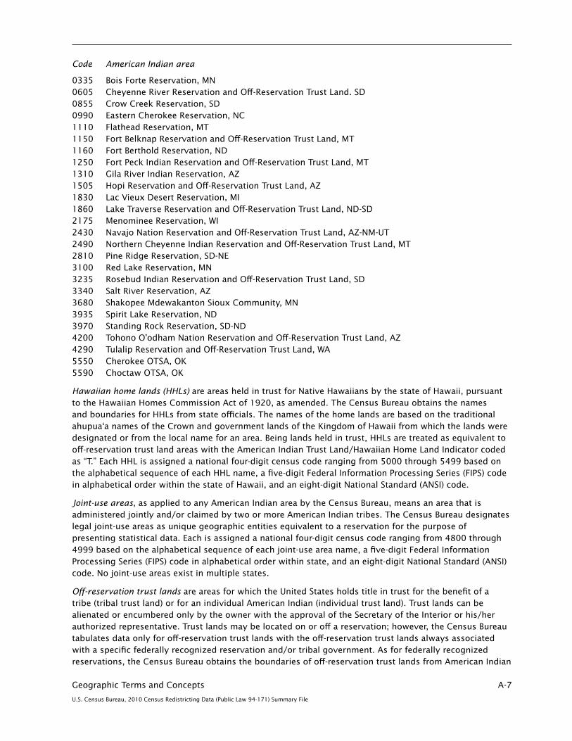
Geographic Terms and Concepts A-7
U.S. Census Bureau, 2010 Census Redistricting Data (Public Law 94-171) Summary File
Code American Indian area
0335 Bois Forte Reservation, MN 0605 Cheyenne River Reservation and Off-Reservation Trust Land. SD 0855 Crow Creek Reservation, SD 0990 Eastern Cherokee Reservation, NC 1110 Flathead Reservation, MT 1150 Fort Belknap Reservation and Off-Reservation Trust Land, MT 1160 Fort Berthold Reservation, ND 1250 Fort Peck Indian Reservation and Off-Reservation Trust Land, MT 1310 Gila River Indian Reservation, AZ 1505 Hopi Reservation and Off-Reservation Trust Land, AZ 1830 Lac Vieux Desert Reservation, MI 1860 Lake Traverse Reservation and Off-Reservation Trust Land, ND-SD 2175 Menominee Reservation, WI 2430 Navajo Nation Reservation and Off-Reservation Trust Land, AZ-NM-UT 2490 Northern Cheyenne Indian Reservation and Off-Reservation Trust Land, MT 2810 Pine Ridge Reservation, SD-NE 3100 Red Lake Reservation, MN 3235 Rosebud Indian Reservation and Off-Reservation Trust Land, SD 3340 Salt River Reservation, AZ 3680 Shakopee Mdewakanton Sioux Community, MN 3935 Spirit Lake Reservation, ND 3970 Standing Rock Reservation, SD-ND 4200 Tohono O’odham Nation Reservation and Off-Reservation Trust Land, AZ 4290 Tulalip Reservation and Off-Reservation Trust Land, WA 5550 Cherokee OTSA, OK 5590 Choctaw OTSA, OK
Hawaiian home lands (HHLs) are areas held in trust for Native Hawaiians by the state of Hawaii, pursuant to the Hawaiian Homes Commission Act of 1920, as amended. The Census Bureau obtains the names and boundaries for HHLs from state officials. The names of the home lands are based on the traditional ahupua‘a names of the Crown and government lands of the Kingdom of Hawaii from which the lands were designated or from the local name for an area. Being lands held in trust, HHLs are treated as equivalent to off-reservation trust land areas with the American Indian Trust Land/Hawaiian Home Land Indicator coded as “T.” Each HHL is assigned a national four-digit census code ranging from 5000 through 5499 based on the alphabetical sequence of each HHL name, a five-digit Federal Information Processing Series (FIPS) code in alphabetical order within the state of Hawaii, and an eight-digit National Standard (ANSI) code.
Joint-use areas, as applied to any American Indian area by the Census Bureau, means an area that is administered jointly and/or claimed by two or more American Indian tribes. The Census Bureau designates legal joint-use areas as unique geographic entities equivalent to a reservation for the purpose of presenting statistical data. Each is assigned a national four-digit census code ranging from 4800 through 4999 based on the alphabetical sequence of each joint-use area name, a five-digit Federal Information Processing Series (FIPS) code in alphabetical order within state, and an eight-digit National Standard (ANSI) code. No joint-use areas exist in multiple states.
Off-reservation trust lands are areas for which the United States holds title in trust for the benefit of a tribe (tribal trust land) or for an individual American Indian (individual trust land). Trust lands can be alienated or encumbered only by the owner with the approval of the Secretary of the Interior or his/her authorized representative. Trust lands may be located on or off a reservation; however, the Census Bureau tabulates data only for off-reservation trust lands with the off-reservation trust lands always associated with a specific federally recognized reservation and/or tribal government. As for federally recognized reservations, the Census Bureau obtains the boundaries of off-reservation trust lands from American Indian

A-8 Geographic Terms and Concepts
U.S. Census Bureau, 2010 Census Redistricting Data (Public Law 94-171) Summary File
tribal governments through its annual Boundary and Annexation Survey. The Census Bureau recognizes and tabulates data for reservations and off-reservation trust lands because American Indian tribes have primary governmental authority over these lands. The Census Bureau does not identify fee land (or land in fee simple status) or restricted fee lands as specific geographic areas.
Off-reservation trust lands are assigned a four-digit census code, a five-digit Federal Information Processing Series (FIPS) code, and an eight-digit National Standard (ANSI) code that is the same as that for the reservation with which they are associated. Trust lands associated with tribes that do not have a reservation are assigned unique codes. The census code is assigned by tribal name within the range 0001 through 4799, interspersed alphabetically among the reservation names. Because FIPS codes are assigned in alphabetical sequence within each state, the FIPS code will be different in each state for off-reservation trust lands that include territory in more than one state. In decennial census data tabulations, the American Indian Trust Land/Hawaiian Home Land Indicator uniquely identifies off-reservation trust lands, as well as reservation or statistical area only portions, Hawaiian home lands, and records that consist of the combination of reservation and off-reservation trust land territory.
Statistical Entities
Alaska Native village statistical areas (ANVSAs) represent the more densely settled portion of Alaska Native villages (ANVs). The ANVs constitute associations, bands, clans, communities, groups, tribes, or villages recognized pursuant to the Alaska Native Claims Settlement Act of 1971 (Public Law 92-203). Because ANVs do not have boundaries that are easy to locate, the Census Bureau does not delimit ANVs. Instead, the Census Bureau presents statistical data for ANVSAs that represent the settled portion of ANVs. In addition, each ANVSA should include only an area where Alaska Natives, especially members of the defining ANV, represent a substantial proportion of the population during at least one season of the year. ANVSAs are delineated or reviewed by officials of the ANV or, if no ANV official chose to participate in the delineation process, officials of the Alaska Native Regional Corporation (ANRC) in which the ANV is located. An ANVSA may not overlap the boundary of another ANVSA or an American Indian reservation. Each ANVSA is alphabetically assigned a national four-digit census code ranging from 6000 through 7999, an alphabetically assigned state-based five-digit Federal Information Processing Series (FIPS) code, and an eight-digit National Standard (ANSI) code.
Oklahoma tribal statistical areas (OTSAs) are statistical entities identified and delineated by the Census Bureau in consultation with federally recognized American Indian tribes that had a former reservation in Oklahoma. The boundary of an OTSA will be that of the former reservation in Oklahoma, except where modified by agreements with neighboring tribes for statistical data presentation purposes. Each OTSA is alphabetically assigned a national four-digit census code ranging from 5500 through 5899, an alphabetically assigned state-based five-digit Federal Information Processing Series (FIPS) code, and an eight-digit National Standard (ANSI) code. Tribal subdivisions are allowed within OTSAs and exist for the 2010 Census in the Cherokee and Choctaw OTSAs.
Oklahoma tribal statistical area (OTSA) Joint-Use Areas, as applied to OTSAs by the Census Bureau, means an area that is administered jointly and/or claimed by two or more American Indian tribes that have a delineated OTSA. The Census Bureau designates statistical joint-use areas as unique geographic entities for the purpose of presenting statistical data. Only Oklahoma tribal statistical areas have statistical joint-use areas. Each Oklahoma tribal joint-use area is alphabetically assigned a national four-digit census code ranging from 5900 through 5999, an alphabetically assigned state-based five-digit Federal Information Processing Series (FIPS) code, and an eight-digit National Standard (ANSI) code.
State designated tribal statistical areas (SDTSAs—referred to as State Designated American Indian Statistical Areas for Census 2000) are statistical entities for state-recognized American Indian tribes that do not have a state-recognized land base (reservation). SDTSAs are identified and delineated for the Census Bureau by a state liaison identified by the governor’s office in each state. SDTSAs generally encompass a compact and contiguous area that contains a concentration of people who identify with a
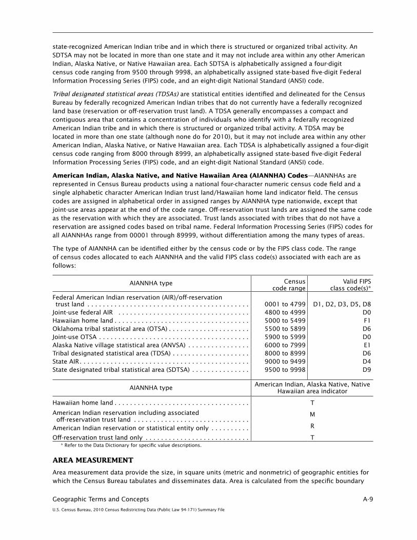
Geographic Terms and Concepts A-9
U.S. Census Bureau, 2010 Census Redistricting Data (Public Law 94-171) Summary File
state-recognized American Indian tribe and in which there is structured or organized tribal activity. An SDTSA may not be located in more than one state and it may not include area within any other American Indian, Alaska Native, or Native Hawaiian area. Each SDTSA is alphabetically assigned a four-digit census code ranging from 9500 through 9998, an alphabetically assigned state-based five-digit Federal Information Processing Series (FIPS) code, and an eight-digit National Standard (ANSI) code.
Tribal designated statistical areas (TDSAs) are statistical entities identified and delineated for the Census Bureau by federally recognized American Indian tribes that do not currently have a federally recognized land base (reservation or off-reservation trust land). A TDSA generally encompasses a compact and contiguous area that contains a concentration of individuals who identify with a federally recognized American Indian tribe and in which there is structured or organized tribal activity. A TDSA may be located in more than one state (although none do for 2010), but it may not include area within any other American Indian, Alaska Native, or Native Hawaiian area. Each TDSA is alphabetically assigned a four-digit census code ranging from 8000 through 8999, an alphabetically assigned state-based five-digit Federal Information Processing Series (FIPS) code, and an eight-digit National Standard (ANSI) code.
American Indian, Alaska Native, and Native Hawaiian Area (AIANNHA) Codes—AIANNHAs are represented in Census Bureau products using a national four-character numeric census code field and a single alphabetic character American Indian trust land/Hawaiian home land indicator field. The census codes are assigned in alphabetical order in assigned ranges by AIANNHA type nationwide, except that joint-use areas appear at the end of the code range. Off-reservation trust lands are assigned the same code as the reservation with which they are associated. Trust lands associated with tribes that do not have a reservation are assigned codes based on tribal name. Federal Information Processing Series (FIPS) codes for all AIANNHAs range from 00001 through 89999, without differentiation among the many types of areas.
The type of AIANNHA can be identified either by the census code or by the FIPS class code. The range of census codes allocated to each AIANNHA and the valid FIPS class code(s) associated with each are as follows:
AIANNHA type Census code range
Valid FIPS class code(s)*
Federal American Indian reservation (AIR)/off-reservation trust land . . . . . . . . . . . . . . . . . . . . . . . . . . . . . . . . . . . . . . . . . . 0001 to 4799 D1, D2, D3, D5, D8Joint-use federal AIR . . . . . . . . . . . . . . . . . . . . . . . . . . . . . . . . . . 4800 to 4999 D0Hawaiian home land . . . . . . . . . . . . . . . . . . . . . . . . . . . . . . . . . . . 5000 to 5499 F1Oklahoma tribal statistical area (OTSA) . . . . . . . . . . . . . . . . . . . . . 5500 to 5899 D6Joint-use OTSA . . . . . . . . . . . . . . . . . . . . . . . . . . . . . . . . . . . . . . . 5900 to 5999 D0Alaska Native village statistical area (ANVSA) . . . . . . . . . . . . . . . . 6000 to 7999 E1Tribal designated statistical area (TDSA) . . . . . . . . . . . . . . . . . . . . 8000 to 8999 D6State AIR . . . . . . . . . . . . . . . . . . . . . . . . . . . . . . . . . . . . . . . . . . . . 9000 to 9499 D4State designated tribal statistical area (SDTSA) . . . . . . . . . . . . . . . 9500 to 9998 D9
AIANNHA type American Indian, Alaska Native, Native Hawaiian area indicator
Hawaiian home land . . . . . . . . . . . . . . . . . . . . . . . . . . . . . . . . . . . T
M
R
T
American Indian reservation including associated off-reservation trust land . . . . . . . . . . . . . . . . . . . . . . . . . . . . . .American Indian reservation or statistical entity only . . . . . . . . . .
Off-reservation trust land only . . . . . . . . . . . . . . . . . . . . . . . . . . .* Refer to the Data Dictionary for specific value descriptions.
AREA MEASUREMENT
Area measurement data provide the size, in square units (metric and nonmetric) of geographic entities for which the Census Bureau tabulates and disseminates data. Area is calculated from the specific boundary

A-10 Geographic Terms and Concepts
U.S. Census Bureau, 2010 Census Redistricting Data (Public Law 94-171) Summary File
recorded for each entity in the Census Bureau’s geographic database (see “MAF/TIGER Database”). The Census Bureau provides area measurement data for both land area and water area. The water area figures include inland, coastal, Great Lakes, and territorial sea water. Inland water consists of any lake, reservoir, pond, or similar body of water that is recorded in the Census Bureau’s geographic database. It also includes any river, creek, canal, stream, or similar feature that is recorded in that database as a two-dimensional feature (rather than as a single line). The portions of the oceans and related large embayments (such as Chesapeake Bay and Puget Sound), the Gulf of Mexico, and the Caribbean Sea that belong to the United States and its territories are classified as coastal and territorial waters; the Great Lakes are treated as a separate water entity. Rivers and bays that empty into these bodies of water are treated as inland water from the point beyond which they are narrower than 1 nautical mile across. Identification of land and inland, coastal, territorial, and Great Lakes waters is for data presentation purposes only and does not necessarily reflect their legal definitions.
Land and water area measurements may disagree with the information displayed on Census Bureau maps and in the MAF/TIGER database because, for area measurement purposes, hydrologic features identified as intermittent water, glacier, or swamp are reported as land area. The water area measurement reported for some geographic entities includes water that is not included in any lower-level geographic entity. Therefore, because water is contained only in a higher-level geographic entity, summing the water measurements for all the component lower-level geographic entities will not yield the water area of that higher-level entity. This occurs, for example, where water is associated with a county but is not within the legal boundary of any county subdivision. The accuracy of any area measurement data is limited by the accuracy inherent in (1) the location and shape of the various boundary information in the MAF/TIGER database, (2) the identification, and classification of water bodies coupled with the location and shapes of the shorelines of water bodies in that database, and (3) rounding affecting the last digit in all operations that compute and/or sum the area measurements.
BLOCK
Blocks (Census Blocks) are statistical areas bounded by visible features, such as streets, roads, streams, and railroad tracks, and by nonvisible boundaries, such as selected property lines and city, township, school district, and county limits and short line-of-sight extensions of streets and roads. Generally, census blocks are small in area; for example, a block in a city bounded on all sides by streets. Census blocks in suburban and rural areas may be large, irregular, and bounded by a variety of features, such as roads, streams, and transmission lines. In remote areas, census blocks may encompass hundreds of square miles. Census blocks cover the entire territory of the United States, Puerto Rico, and the Island Areas. Census blocks nest within all other tabulated census geographic entities and are the basis for all tabulated data.
Census Block Numbers—Census blocks are numbered uniquely with a four-digit census block number from 0000 to 9999 within census tract, which nest within state and county. The first digit of the census block number identifies the block group. Block numbers beginning with a zero (in Block Group 0) are only associated with water-only areas.
BLOCK GROUP
Block Groups (BGs) are statistical divisions of census tracts, are generally defined to contain between 600 and 3,000 people, and are used to present data and control block numbering. A block group consists of clusters of blocks within the same census tract that have the same first digit of their four-digit census block number. For example, blocks 3001, 3002, 3003, . . ., 3999 in census tract 1210.02 belong to BG 3 in that census tract. Most BGs were delineated by local participants in the Census Bureau’s Participant Statistical Areas Program. The Census Bureau delineated BGs only where a local or tribal government declined to participate, and a regional organization or State Data Center was not available to participate.
A BG usually covers a contiguous area. Each census tract contains at least one BG, and BGs are uniquely numbered within the census tract. Within the standard census geographic hierarchy, BGs never cross state, county, or census tract boundaries but may cross the boundaries of any other geographic entity. Tribal

Geographic Terms and Concepts A-11
U.S. Census Bureau, 2010 Census Redistricting Data (Public Law 94-171) Summary File
census tracts and tribal BGs are separate and unique geographic areas defined within federally recognized American Indian reservations and can cross state and county boundaries (see “Tribal Census Tract” and “Tribal Block Group”). The tribal census tracts and tribal block groups may be completely different from the census tracts and block groups defined by state and county.
Block Group Codes—BGs have a valid code range of 0 through 9. BGs beginning with a zero only contain water area and are generally in coastal and Great Lakes water and territorial seas, but also in larger inland water bodies. For the 2010 Census, a block group 0 for the water portion can be delineated in any census tract and not just those census tracts also defined to only include water area. This is a change from Census 2000, when block groups coded 0 only existed in census tracts with a code of 0. To differentiate between county-based block groups and tribal block groups, the codes for tribal block groups use an alphabetic character (see “Tribal Block Group”).
BOUNDARY CHANGES
Many of the legal and statistical entities for which the Census Bureau tabulates decennial census data have had boundary changes between Census 2000 and the 2010 Census; that is, between January 1, 2000, and January 1, 2010. Boundary changes to legal entities result from:
1. Annexations to or detachments from legally established governmental units.
2. Mergers or consolidations of two or more governmental units.
3. Establishment of new governmental units.
4. Disincorporations or disorganizations of existing governmental units.
5. Changes in treaties or executive orders and governmental action placing additional lands in trust.
6. Decisions by federal, state, and local courts.
7. Redistricting for congressional districts and state legislative districts.
8. Ancillary changes to legal or statistical areas as a result of annexations and detachments; for example, reduction of territory for a census designated place as the result of an annexation by an adjacent incorporated place.
9. Changes to correct errors or more accurately place boundaries relative to visible features.
10. Changes to statistical areas as the result of concept or criteria changes.
All legal boundaries used for the 2010 Census are those reported to the Census Bureau to be in effect as of January 1, 2010. The statistical area boundaries also reflect a January 1, 2010, date for delineation. The legal boundaries are collected through various surveys and programs: the Boundary and Annexation Survey, Redistricting Data Program, and the School District Review Program. There is a Geographic Change User Note Indicator in data files that identifies entities for which there have been changes to boundaries or data attributes (for example, legal/statistical area description or code) between the two censuses.
Statistical entity boundaries generally are reviewed by local, state, or tribal governments and can have changes to adjust boundaries to visible features to better define the geographic area each encompasses or to account for shifts and changes in the population distribution within an area. Where statistical areas have a relationship to legal area boundaries, complementary updates occur; for example, removing territory from a census designated place if annexed to an incorporated place or contracting a tribal designated statistical area if the area is added to an American Indian reservation.
The historical counts shown for states, counties, county subdivisions, places, American Indian, Alaska Native, and Native Hawaiian areas, and other areas are not updated for boundary changes and thus, reflect the population and housing units in each entity as delineated at the time of each decennial census.

A-12 Geographic Terms and Concepts
U.S. Census Bureau, 2010 Census Redistricting Data (Public Law 94-171) Summary File
CENSUS DIVISION
Census Divisions are groupings of states and the District of Columbia that are subdivisions of the four census regions (see “Census Region”). There are nine census divisions, and each is identified by a single-digit census code. Puerto Rico and the Island Areas are not part of any census region or census division. For a list of all census regions, census divisions, and their constituent states, see Figure A–3.
CENSUS REGION
Census Regions are groupings of states and the District of Columbia that subdivide the United States for the presentation of census data. There are four census regions—Northeast, Midwest, South, and West. Each of the four census regions is divided into two or more census divisions (see “Census Division”). Each census region is identified by a single-digit census code. Puerto Rico and the Island Areas are not part of any census region or census division. For a list of all census regions, census divisions, and their constituent states, see Figure A–3.
CENSUS TRACT
Census Tracts are small, relatively permanent statistical subdivisions of a county or equivalent entity that are updated by local participants prior to each decennial census as part of the Census Bureau’s Participant Statistical Areas Program. The Census Bureau delineates census tracts in situations where no local participant existed or where state, local, or tribal governments declined to participate. The primary purpose of census tracts is to provide a stable set of geographic units for the presentation of statistical data.
Census tracts generally have a population size between 1,200 and 8,000 people, with an optimum size of 4,000 people. A census tract usually covers a contiguous area; however, the spatial size of census tracts varies widely depending on the density of settlement. Census tract boundaries are delineated with the intention of being maintained over a long time so that statistical comparisons can be made from census to census. Census tracts occasionally are split due to population growth or merged as a result of substantial population decline.
Census tract boundaries generally follow visible and identifiable features. They may follow nonvisible legal boundaries, such as minor civil division (MCD) or incorporated place boundaries in some states and situations, to allow for census-tract-to-governmental-unit relationships where the governmental boundaries tend to remain unchanged between censuses. State and county boundaries always are census tract boundaries in the standard census geographic hierarchy. Tribal census tracts are a unique geographic entity defined within federally recognized American Indian reservations and off-reservation trust lands and can cross state and county boundaries. Tribal census tracts may be completely different from the census tracts and block groups defined by state and county (see “Tribal Census Tract”).
Census Tract Codes and Numbers—Census tracts are identified by an up to four-digit integer number and may have an optional two-digit suffix; for example 1457.02 or 23. The census tract codes consist of six digits with an implied decimal between the fourth and fifth digit corresponding to the basic census tract number but with leading zeroes and trailing zeroes for census tracts without a suffix. The tract number examples above would have codes of 145702 and 002300, respectively.
Some ranges of census tract numbers in the 2010 Census are used to identify distinctive types of census tracts. The code range in the 9400s is used for those census tracts with a majority of population, housing, or land area associated with an American Indian area and matches the numbering used in Census 2000. The code range in the 9800s is new for 2010 and is used to specifically identify special land-use census tracts; that is, census tracts defined to encompass a large area with little or no residential population with special characteristics, such as large parks or employment areas. The range of census tracts in the 9900s represents census tracts delineated specifically to cover large bodies of water. This is different from Census 2000 when water-only census tracts were assigned codes of all zeroes (000000); 000000 is no longer used as a census tract code for the 2010 Census.

Geographic Terms and Concepts A-13
U.S. Census Bureau, 2010 Census Redistricting Data (Public Law 94-171) Summary File
The Census Bureau uses suffixes to help identify census tract changes for comparison purposes. Census tract suffixes may range from .01 to .98. As part of local review of existing census tracts before each census, some census tracts may have grown enough in population size to qualify as more than one census tract. When a census tract is split, the split parts usually retain the basic number but receive different suffixes. For example, if census tract 14 is split, the new tract numbers would be 14.01 and 14.02. In a few counties, local participants request major changes to, and renumbering of, the census tracts; however, this is generally discouraged. Changes to individual census tract boundaries usually do not result in census tract numbering changes.
Tribal Census Tracts in American Indian Areas—The Census Bureau introduced the concept of tribal census tracts for the first time for Census 2000. Tribal census tracts for that census consisted of the standard county-based census tracts tabulated within American Indian areas, thus allowing for the tracts to ignore state and county boundaries for tabulation. The Census Bureau assigned the 9400 range of numbers to identify specific tribal census tracts; however, not all tribal census tracts used this numbering scheme. For the 2010 Census, tribal census tracts no longer are tied to or numbered in the same way as the county-based census tracts (see “Tribal Census Tract”).
CODES FOR GEOGRAPHIC ENTITIES
The Census Bureau and other federal agencies assign codes to geographic entities to facilitate the organization, presentation, and exchange of statistical data and other information. Geographic entity codes allow for the unambiguous identification of individual entities, generally within a specific, higher-level geographic entity (for example, county codes are assigned uniquely within each state). For geographic entities that have names (such as states, counties, places, county subdivisions, urban areas, and metropolitan and micropolitan statistical areas), codes generally are assigned alphabetically based on name.
Census Bureau data products contain several types of geographic entity codes: Federal Information Processing Series (FIPS), American National Standards Institute (ANSI), and Census Bureau codes.
Federal Information Processing Series (FIPS)—These are codes formerly known as Federal Information Processing Standards codes, until the National Institute of Standards and Technology (NIST) announced its decision in 2005 to remove geographic entity codes from its oversight. The Census Bureau continues to maintain and issue codes for geographic entities covered under FIPS oversight, albeit with a revised meaning for the FIPS acronym. Geographic entities covered under FIPS include states, counties, congressional districts, core based statistical areas, places, county subdivisions, subminor civil divisions, consolidated cities, and all types of American Indian, Alaska Native, and Native Hawaiian areas. FIPS codes are assigned alphabetically according to the name of the geographic entity and may change to maintain alphabetic sort when new entities are created or names change. FIPS codes for specific geographic entity types are usually unique within the next highest level of geographic entity with which a nesting relationship exists. For example, FIPS state, congressional district, and core based statistical area codes are unique within nation; FIPS county, place, county subdivision, and subminor civil division codes are unique within state. The codes for American Indian, Alaska Native, and Native Hawaiian areas also are unique within state; those areas in multiple states will have different codes for each state.
American National Standards Institute (ANSI)—With the removal of geographic entities from Federal Information Processing Standards oversight, the Census Bureau and other federal agencies have sought American National Standards Institute (ANSI) oversight authority for geographic entity codes. These codes are referred to as “National Standard” codes in some Census Bureau products. Geographic entities covered under ANSI include states, counties, congressional districts, core based statistical areas and related statistical areas, places, county subdivisions, consolidated cities, subminor civil divisions, and all types of American Indian, Alaska Native, and Native Hawaiian areas—Alaska Native regional corporations, Alaska Native village statistical areas, American Indian reservation and off-reservation trust lands, American Indian tribal subdivisions, Hawaiian home lands, Oklahoma tribal statistical areas, state designated tribal statistical areas, and tribal designated statistical areas.

A-14 Geographic Terms and Concepts
U.S. Census Bureau, 2010 Census Redistricting Data (Public Law 94-171) Summary File
Relationship between FIPS and ANSI codes—Geographic entities for which NIST formerly provided Federal Information Processing Standards oversight will continue to be referred to as FIPS (Federal Information Processing Series) codes in some Census Bureau data products, despite the Census Bureau having sought ANSI oversight authority. These geographic entities include states, counties, congressional districts, and core based statistical areas and related statistical areas. The Census Bureau continues to maintain and issue codes for these entities following the same structure and without change to existing codes, except when necessary to maintain alphabetic sorting based on names of entities. The Census Bureau also continues to maintain and issue five-digit FIPS codes (formerly FIPS 55) for places, county subdivisions, consolidated cities, subminor civil divisions, Alaska Native Regional Corporations, and all types of American Indian, Alaska Native, and Native Hawaiian areas but is not seeking ANSI oversight authority for these entity codes. The U.S. Geological Survey has ANSI oversight authority for its Geographic Names Information System identifier (GNIS ID), which has been adopted as a National Standard (NS) code for states, counties, places, county subdivisions, subminor civil divisions, consolidated cities, Alaska Native Regional Corporations, and all types of American Indian, Alaska Native, and Native Hawaiian areas. The Census Bureau will include the GNIS ID for these entities in its data products, portrayed as an eight-digit character numeric code and identified as “ANSI.” NS codes (GNIS IDs) will not sort geographic entities in alphabetical order based on name or title, as is the case with FIPS codes.
Census Bureau codes—The Census Bureau assigns and issues codes for a number of geographic entities for which FIPS or ANSI codes are not available, and sometimes in addition to FIPS and ANSI codes. Geographic entities for which census codes are assigned and issued in Census Bureau data products include regions, divisions, census tracts, block groups, census blocks, urban areas, and all types of American Indian, Alaska Native, and Native Hawaiian areas. Some codes—voting district, state legislative district, and school district—use standards established by the states—or for school districts, the U.S. Department of Education.
CONGRESSIONAL DISTRICT
Congressional Districts are the 435 areas from which people are elected to the U.S. House of Representatives. After the apportionment of congressional seats among the states based on decennial census population counts, each state with multiple seats is responsible for establishing congressional districts for the purpose of electing representatives. Each congressional district is to be as equal in population to all other congressional districts in a state as practicable. For the District of Columbia, Puerto Rico, and each Island Area, a separate code is used to identify the entire areas of these state-equivalent entities as having a single nonvoting delegate.
Congressional District Codes—Congressional districts are identified by a two-character numeric Federal Information Processing Series (FIPS) code numbered uniquely within state. The District of Columbia, Puerto Rico, and the Island Areas have code 98 assigned identifying their nonvoting delegate status with respect to representation in Congress:
01 to 53—Congressional district codes 00—At large (single district for state) 98—Nonvoting delegate
CONSOLIDATED CITY
Consolidated City—A consolidated government is a unit of local government for which the functions of an incorporated place and its county or minor civil division (MCD) have merged. This action results in both the primary incorporated place and the county or MCD continuing to exist as legal entities, even though the county or MCD performs few or no governmental functions and has few or no elected officials. Where this occurs—and where one or more other incorporated places in the county or MCD continue to function as separate governments, even though they have been included in the consolidated government—the primary incorporated place is referred to as a consolidated city. The Census Bureau classifies the

Geographic Terms and Concepts A-15
U.S. Census Bureau, 2010 Census Redistricting Data (Public Law 94-171) Summary File
separately incorporated places within the consolidated city as place entities and creates a separate place (balance) record for the portion of the consolidated city not within any other place.
Consolidated City (Balance) Portions refer to the areas of a consolidated city not included in another separately incorporated place. For example, Butte-Silver Bow, MT, is a consolidated city (former Butte city and Silver Bow County) that includes the separately incorporated municipality of Walkerville city. The area of the consolidated city that is not in Walkerville city is assigned to Butte-Silver Bow (balance). The name always includes the “(balance)” identifier (see “Place”).
CORE BASED STATISTICAL AREAS AND RELATED STATISTICAL AREAS
Core Based Statistical Areas (CBSAs) consist of the county or counties or equivalent entities associated with at least one core (urbanized area or urban cluster) of at least 10,000 population, plus adjacent counties having a high degree of social and economic integration with the core as measured through commuting ties with the counties associated with the core. The general concept of a CBSA is that of a core area containing a substantial population nucleus, together with adjacent communities having a high degree of economic and social integration with that core. The term “core based statistical area” became effective in 2003 and refers collectively to metropolitan statistical areas and micropolitan statistical areas. The U.S. Office of Management and Budget (OMB) defines CBSAs to provide a nationally consistent set of geographic entities for the United States and Puerto Rico for use in tabulating and presenting statistical data. Current CBSAs are based on application of the 2000 standards (published in the Federal Register of December 27, 2000) with Census 2000 data. The first set of areas defined based on the 2000 standards were announced on June 6, 2003; subsequent updates have been made to the universe of CBSAs and related statistical areas. No CBSAs are defined in the Island Areas. Statistical areas related to CBSAs include metropolitan divisions, combined statistical areas (CSAs), New England city and town areas (NECTAs), NECTA divisions, and combined NECTAs.
Combined New England City and Town Areas (Combined NECTAs) consist of two or more adjacent New England city and town areas (NECTAs) that have substantial employment interchange. The NECTAs that combine to create a combined NECTA retain separate identities within the larger combined NECTA. Because combined NECTAs represent groupings of NECTAs, they should not be ranked or compared with individual NECTAs.
Combined Statistical Areas (CSAs) consist of two or more adjacent CBSAs that have substantial employment interchange. The CBSAs that combine to create a CSA retain separate identities within the larger CSA. Because CSAs represent groupings of metropolitan and/or micropolitan statistical areas, they should not be ranked or compared with individual metropolitan and micropolitan statistical areas.
Metropolitan Divisions are smaller groupings of counties or equivalent entities defined within a metropolitan statistical area containing a single core with a population of at least 2.5 million. Not all metropolitan statistical areas with urbanized areas of this size will contain metropolitan divisions. A metropolitan division consists of one or more main/secondary counties that represent an employment center or centers, plus adjacent counties associated with the main/secondary county or counties through commuting ties. Because metropolitan divisions represent subdivisions of larger metropolitan statistical areas, it is not appropriate to rank or compare metropolitan divisions with metropolitan and micropolitan statistical areas. It would be appropriate to rank and compare metropolitan divisions.
Metropolitan Statistical Areas are CBSAs associated with at least one urbanized area that has a population of at least 50,000. The metropolitan statistical area comprises the central county or counties or equivalent entities containing the core, plus adjacent outlying counties having a high degree of social and economic integration with the central county or counties as measured through commuting.
Micropolitan Statistical Areas are CBSAs associated with at least one urban cluster that has a population of at least 10,000 but less than 50,000. The micropolitan statistical area comprises the central county or counties or equivalent entities containing the core, plus adjacent outlying counties having a

A-16 Geographic Terms and Concepts
U.S. Census Bureau, 2010 Census Redistricting Data (Public Law 94-171) Summary File
high degree of social and economic integration with the central county or counties as measured through commuting.
New England City and Town Areas (NECTAs) are an alternative set of geographic entities, similar in concept to the county-based CBSAs defined nationwide, that OMB defines in New England based on county subdivisions—usually cities and towns. NECTAs are defined using the same criteria as county-based CBSAs, and, similar to CBSAs, NECTAs are categorized as metropolitan or micropolitan.
New England City and Town Area (NECTA) Divisions are smaller groupings of cities and towns defined within a NECTA containing a single core with a population of at least 2.5 million. A NECTA division consists of a main city or town that represents an employment center, plus adjacent cities and towns associated with the main city or town through commuting ties. Each NECTA division must contain a total population of 100,000 or more. Because NECTA divisions represent subdivisions of larger NECTAs, it is not appropriate to rank or compare NECTA divisions with NECTAs. It would be appropriate to rank and compare NECTA divisions.
Principal Cities of a CBSA (or NECTA) include the largest incorporated place with a population of at least 10,000 in the CBSA, or if no incorporated place of at least 10,000 population is present in the CBSA, the largest incorporated place or census designated place (CDP) in the CBSA. Principal cities also include any additional incorporated place or CDP with a population of at least 250,000 or in which 100,000 or more persons work; any additional incorporated place or CDP with a population of at least 50,000 and in which the number of jobs meets or exceeds the number of employed residents; and any additional incorporated place or CDP with a population of at least 10,000 but less than 50,000 and at least one-third the population size of the largest place and in which the number of jobs meets or exceeds the number of employed residents. Note that there are some places designated as principal cities of NECTAs that are not principal cities of a CBSA.
Core Based Statistical Area Codes—Metropolitan statistical areas, micropolitan statistical areas, NECTAs, metropolitan divisions, and NECTA divisions are identified using a five-digit numeric code that is assigned alphabetically based on title and is unique within the nation. The combined statistical area and combined NECTAs are identified using a three-digit numeric code, also assigned alphabetically based on title and unique within the nation. Codes, length, and ranges are:
CBSA entity Length Range*
Metropolitan statistical area . . . . . . . . . . . . . . . . . . . . . . . . . . . . . Five digits 10000–49999Micropolitan statistical area . . . . . . . . . . . . . . . . . . . . . . . . . . . . . Five digits 10000–49999Metropolitan division . . . . . . . . . . . . . . . . . . . . . . . . . . . . . . . . . . Five digits 10004–49994 New England city and town area (NECTA) . . . . . . . . . . . . . . . . . . . Five digits 70000–79999NECTA division . . . . . . . . . . . . . . . . . . . . . . . . . . . . . . . . . . . . . . . Five digits 70004–79994Combined statistical area . . . . . . . . . . . . . . . . . . . . . . . . . . . . . . . Three digits 100–599Combined NECTA . . . . . . . . . . . . . . . . . . . . . . . . . . . . . . . . . . . . . Three digits 700–799
* Metropolitan divisions and NECTA divisions are distinguished from metropolitan and micropolitan statistical areas and NECTAs by codes that end in “4.” Metropolitan and micropolitan statistical areas and NECTAs cannot end in “4.”
COUNTY OR STATISTICALLY EQUIVALENT ENTITY
The primary legal divisions of most states are termed counties. In Louisiana, these divisions are known as parishes. In Alaska, which has no counties, the equivalent entities are the organized boroughs, city and boroughs, municipalities, and census areas; the latter of which are delineated cooperatively for statistical purposes by the state of Alaska and the Census Bureau. In four states (Maryland, Missouri, Nevada, and Virginia), there are one or more incorporated places that are independent of any county organization and thus constitute primary divisions of their states. These incorporated places are known as independent cities and are treated as equivalent entities for purposes of data presentation. The District of Columbia and Guam have no primary divisions, and each area is considered an equivalent entity for purposes of

Geographic Terms and Concepts A-17
U.S. Census Bureau, 2010 Census Redistricting Data (Public Law 94-171) Summary File
data presentation. All of the counties in Connecticut and Rhode Island and nine counties in Massachusetts were dissolved as functioning governmental entities; however, the Census Bureau continues to present data for these historical entities in order to provide comparable geographic units at the county level of the geographic hierarchy for these states and represents them as nonfunctioning legal entities in data products. The Census Bureau treats the following entities as equivalents of counties for purposes of data presentation: municipios in Puerto Rico, districts and islands in American Samoa, municipalities in the Commonwealth of the Northern Mariana Islands, and islands in the U.S. Virgin Islands. Each county or statistically equivalent entity is assigned a three-character numeric Federal Information Processing Series (FIPS) code based on alphabetical sequence that is unique within state and an eight-digit National Standard feature identifier.
COUNTY SUBDIVISION
County Subdivisions are the primary divisions of counties and equivalent entities. They include census county divisions, census subareas, minor civil divisions, and unorganized territories and can be classified as either legal or statistical. Each county subdivision is assigned a five-character numeric Federal Information Processing Series (FIPS) code based on alphabetical sequence within state and an eight-digit National Standard feature identifier.
Legal Entities
Minor civil divisions (MCDs) are the primary governmental or administrative divisions of a county in many states (parishes in Louisiana) and the county equivalents in Puerto Rico and the Island Areas. MCDs in the United States, Puerto Rico, and the Island Areas represent many different kinds of legal entities with a wide variety of governmental and/or administrative functions. MCDs include areas variously designated as barrios, barrios-pueblo, boroughs, charter townships, commissioner districts, election districts, election precincts, gores, grants, locations, magisterial districts, parish governing authority districts, plantations, purchases, reservations, supervisor’s districts, towns, and townships. The Census Bureau recognizes MCDs in 29 states, Puerto Rico, and the Island Areas. The District of Columbia has no primary divisions and is considered equivalent to an MCD for statistical purposes. (It is also considered a state equivalent and a county equivalent.) The 29* states in which MCDs are recognized are:
Arkansas Michigan OhioConnecticut Minnesota PennsylvaniaIllinois Mississippi Rhode IslandIndiana Missouri South DakotaIowa Nebraska TennesseeKansas New Hampshire VermontLouisiana New Jersey VirginiaMaine New York West VirginiaMaryland North Carolina WisconsinMassachusetts North Dakota
* Tennessee, a state with statistical census county divisions (CCDs) in 2000, reverted to MCDs in 2008.
In some states, all or some incorporated places are not part of any MCD; these places are termed independent places. Independent places also serve as primary legal subdivisions and have a Federal Information Processing Series (FIPS) county subdivision code and National Standard (ANSI) code that is the same as the FIPS and ANSI place code. In nine states—Maine, Massachusetts, New Hampshire, New Jersey, North Dakota, Pennsylvania, Rhode Island, South Dakota, and Wisconsin—all incorporated places are independent places. In other states, incorporated places are part of, or dependent within, the MCDs in which they are located, or the pattern is mixed—some incorporated places are independent of MCDs and others are included within one or more MCDs.
The MCDs in 12 states (Connecticut, Maine, Massachusetts, Michigan, Minnesota, New Hampshire, New Jersey, New York, Pennsylvania, Rhode Island, Vermont, and Wisconsin) also serve as general-purpose

A-18 Geographic Terms and Concepts
U.S. Census Bureau, 2010 Census Redistricting Data (Public Law 94-171) Summary File
local governments that can perform the same governmental functions as incorporated places. The Census Bureau presents data for these MCDs in all data products for which place data are provided.
In New York and Maine, American Indian reservations (AIRs) generally exist outside the jurisdiction of any town (MCD) and thus also serve as the equivalent of MCDs for purposes of data presentation.
In states with MCDs, the Census Bureau assigns a default FIPS county subdivision code of 00000 and ANSI code of eight zeroes in some coastal, territorial sea, and Great Lakes water where county subdivisions do not legally extend into the Great Lakes or out to the 3-mile limit.
Statistical Entities
Census county divisions (CCDs) are areas delineated by the Census Bureau in cooperation with state, tribal, and local officials for statistical purposes. CCDs have no legal function and are not governmental units. CCD boundaries usually follow visible features and usually coincide with census tract boundaries. The name of each CCD is based on a place, county, or well-known local name that identifies its location. CCDs exist where:
1. There are no legally established MCDs.
2. The legally established MCDs do not have governmental or administrative purposes.
3. The boundaries of the MCDs change frequently.
4. The MCDs are not generally known to the public.
CCDs exist within the following 20* states:
Alabama Hawaii OregonArizona Idaho South CarolinaCalifornia Kentucky TexasColorado Montana UtahDelaware Nevada WashingtonFlorida New Mexico WyomingGeorgia Oklahoma
* Tennessee, a CCD state in 2000, reverted to a MCD state in 2008.
Census subareas are statistical subdivisions of boroughs, city and boroughs, municipalities, and census areas, all of which are statistical equivalent entities for counties in Alaska. The state of Alaska and the Census Bureau cooperatively delineate the census subareas to serve as the statistical equivalents of MCDs.
Unorganized territories (UTs) are defined by the Census Bureau in nine MCD states where portions of counties or equivalent entities are not included in any legally established MCD or incorporated place. The Census Bureau recognizes such separate pieces of territory as one or more separate county subdivisions for census purposes. It assigns each unorganized territory a descriptive name, followed by the designation “UT” and a county subdivision FIPS and ANSI code. The following states have unorganized territories:
Arkansas Maine North CarolinaIndiana Minnesota North DakotaIowa New York South Dakota
GEOGRAPHIC AREA ATTRIBUTES
The Census Bureau collects and maintains information describing selected attributes and characteristics of geographic areas. These attributes are Federal Information Processing Series (FIPS) class code, functional status, legal/statistical area description, internal point, and name of geographic entities.
FIPS class codes describe the general characteristics of a geographic area related to its legal or statistical status, governmental status, and in some cases relationship to other geographic entities. Class codes

Geographic Terms and Concepts A-19
U.S. Census Bureau, 2010 Census Redistricting Data (Public Law 94-171) Summary File
exist for counties; county subdivisions; subminor civil divisions; places; consolidated cities; Alaska Native Regional Corporations; American Indian, Alaska Native, and Native Hawaiian areas; and American Indian tribal subdivisions.
Functional status describes whether a geographic entity is a functioning governmental unit, has an inactive government, is an administrative area without a functioning government, or is a statistical area identified and defined solely for tabulation and presentation of statistical data. Functional status codes are:
A Active government providing primary general-purpose functions.
B Active government that is partially consolidated with another government but with separate officials providing primary general-purpose functions.
C Active government consolidated with another government with a single set of officials.
E Active government providing special-purpose functions.
F Fictitious entity created to fill the Census Bureau’s geographic hierarchy.
G Active government that is subordinate to another unit of government and thus, not considered a functioning government.
I Inactive governmental unit that has the power to provide primary special-purpose functions.
N Nonfunctioning legal entity.
S Statistical entity.
Internal point—The Census Bureau calculates an internal point (latitude and longitude coordinates) for each geographic entity. For many geographic entities, the internal point is at or near the geographic center of the entity. For some irregularly shaped entities (such as those shaped like a crescent), the calculated geographic center may be located outside the boundaries of the entity. In such instances, the internal point is identified as a point inside the entity boundaries nearest to the calculated geographic center and, if possible, within a land polygon.
Legal/statistical area description (LSAD)—The LSAD describes the particular typology for each geographic entity; that is, whether the entity is a borough, city, county, town, or township, among others. For legal entities, the LSAD reflects the term that appears in legal documentation pertaining to the entity, such as a treaty, charter, legislation, resolution, or ordinance. For statistical entities, the LSAD is the term assigned by the Census Bureau or other agency defining the entity. The LSAD code is a two-character field that corresponds to a description of the legal or statistical type of entity and identifies whether the LSAD term should be capitalized and should precede or follow the name of the geographic entity. Note that the same LSAD code is assigned to entities at different levels of the geographic hierarchy when they share the same LSAD. For example, the Census Bureau assigns the same LSAD code (“21”) to boroughs in New York and Connecticut, although they are county subdivisions in the former and incorporated places in the latter.
Name—Each geographic entity included in Census Bureau products has a name. For most geographic entities, the name is derived from the official legally recognized name, is assigned by local officials participating in Census Bureau statistical area programs, or is based on component entities and determined according to specified criteria. For legal entities, the name appearing in Census Bureau products may be the more commonly used name rather than the name as it appears in legal documents. For example, “Virginia” instead of “the Commonwealth of Virginia”; “Baltimore” instead of “City of Baltimore.” In some instances, the name for an entity in Census Bureau products will reflect the official name as well as a more commonly used name listed parenthetically; i.e., San Buenaventura (Ventura), CA, or Bath (Berkeley Springs), WV. For some types of geographic entities, the name reflected in Census Bureau products may be the geographic entity code assigned by local officials. For example, a census tract’s name is the actual number assigned by local officials, such as 1.01, whereas the census tract code would reflect a full four-digit base code and two-digit suffix (for example, for the preceding tract named 1.01, 000101).

A-20 Geographic Terms and Concepts
U.S. Census Bureau, 2010 Census Redistricting Data (Public Law 94-171) Summary File
GEOGRAPHIC NAMES INFORMATION SYSTEM
The Geographic Names Information System (GNIS) is the federal standard for geographic nomenclature. The U.S. Geological Survey (USGS) developed the GNIS for the U.S. Board on Geographic Names as the official repository of domestic geographic names data; the official vehicle for geographic names use by all departments of the federal government; and the source for applying geographic names to federal electronic and printed products. The GNIS contains information about physical and cultural geographic features of all types in the United States and its territories, current and historical, but not including roads and highways. The database holds the federally recognized name of each feature and defines the feature location by state, county, USGS topographic map, and geographic coordinates. Other attributes include names or spellings other than the official name, feature designations, feature classification, historical and descriptive information, and, for some categories, the geometric boundaries.
GEOGRAPHIC NAMES INFORMATION SYSTEM IDENTIFIER
The Geographic Names Information System Identifier (GNIS ID) is a variable length, permanent, numeric identifier of up to ten digits in length that identifies each entity uniquely within the nation. The GNIS is the new American National Standards Institute (ANSI) national standard code for several entity types. Because each entity’s GNIS ID is permanent, it will not change if the entity changes its name or if creation of a new entity changes the alphabetic sort. (Federal Information Processing Series codes are assigned based on the alphabetic sorting of entity names within a state and occasionally require changing codes to maintain the alphabetic sort.) The GNIS IDs are assigned sequentially and stored in a right-justified, variable-length, numeric field without leading zeroes. The GNIS now contains more than 2.6 million sequential records, thus no GNIS ID currently exceeds seven digits. The Census Bureau portrays the GNIS ID in its data products as a fixed-width eight-character field with leading zeroes.
ISLAND AREAS OF THE UNITED STATES
The Island Areas of the United States are American Samoa, Guam, the Commonwealth of the Northern Mariana Islands (Northern Mariana Islands), and the United States Virgin Islands.
The Census Bureau treats the Island Areas as entities that are statistically equivalent to states for data presentation purposes; data for the Island Areas, however, are presented separately from data for the United States and Puerto Rico. Geographic definitions specific to the Island Areas are shown in the appropriate publications and documentation that accompany the data products for the Island Areas. Sometimes the Island Areas are referred to as “Island Territories” or “Insular Areas.” For the 1990 and previous censuses, the U.S. Census Bureau referred to the entities as “Outlying Areas.”
Separate from the Island Areas is the term “U.S. Minor Outlying Islands.” The U.S. Minor Outlying Islands refers to certain small islands under U.S. jurisdiction in the Caribbean and Pacific: Baker Island, Howland Island, Jarvis Island, Johnston Atoll, Kingman Reef, Midway Islands, Navassa Island, Palmyra Atoll, and Wake Island. These areas usually are not part of standard data products.
MAF/TIGER DATABASE
MAF/TIGER is an acronym for the Master Address File/Topologically Integrated Geographic Encoding and Referencing system or database. It is a digital (computer-readable) geographic database that automates the mapping and related geographic activities required to support the Census Bureau’s census and survey programs. The Census Bureau developed the TIGER® system to automate the geographic support processes needed to meet the major geographic needs of the 1990 census: producing cartographic products to support data collection and map presentations, providing geographic structure for tabulation and dissemination of the collected statistical data, assigning residential and employer addresses to the correct geographic location and relating those locations to the geographic entities used for data tabulation, and so forth. During the 1990s, the Census Bureau developed an independent Master Address File (MAF) to support field operations and allocation of housing units for tabulations. After Census 2000, both the

Geographic Terms and Concepts A-21
U.S. Census Bureau, 2010 Census Redistricting Data (Public Law 94-171) Summary File
address-based MAF and geographic TIGER® databases merged to form MAF/TIGER. The content of the MAF/TIGER database is undergoing continuous updates and is made available to the public through a variety of TIGER/Line® shapefiles.
PLACE
Incorporated Places are those reported to the Census Bureau as legally in existence as of January 1, 2010, as reported in the latest Boundary and Annexation Survey (BAS), under the laws of their respective states. An incorporated place is established to provide governmental functions for a concentration of people as opposed to a minor civil division, which generally is created to provide services or administer an area without regard, necessarily, to population. Places always are within a single state or equivalent entity, but may extend across county and county subdivision boundaries. An incorporated place usually is a city, town, village, or borough, but can have other legal descriptions. For Census Bureau data tabulation and presentation purposes, incorporated places exclude:
• BoroughsinAlaska(treatedasstatisticalequivalentsofcounties).
• TownsintheNewEnglandstates,NewYork,andWisconsin(treatedasMCDs).
• BoroughsinNewYork(treatedasMCDs).
Census Designated Places (CDPs) are the statistical counterparts of incorporated places, and are delineated to provide data for settled concentrations of population that are identifiable by name but are not legally incorporated under the laws of the state in which they are located. The boundaries usually are defined in cooperation with local or tribal officials and generally updated prior to each decennial census. These boundaries, which usually coincide with visible features or the boundary of an adjacent incorporated place or another legal entity boundary, have no legal status, nor do these places have officials elected to serve traditional municipal functions. CDP boundaries may change from one decennial census to the next with changes in the settlement pattern; a CDP with the same name as in an earlier census does not necessarily have the same boundary. CDPs must be contained within a single state and may not extend into an incorporated place. There are no population size requirements for CDPs.
Hawaii is the only state that has no incorporated places recognized by the Census Bureau. All places shown in decennial census data products for Hawaii are CDPs. By agreement with the state of Hawaii, the Census Bureau does not show data separately for the city of Honolulu, which is coextensive with Honolulu County. In Puerto Rico, which also does not have incorporated places, the Census Bureau recognizes only CDPs and refers to them as comunidades or zonas urbanas. Guam also has only CDPs.
Place Codes are of two types. The five-digit Federal Information Processing Series (FIPS) place code is assigned based on alphabetical sequence within a state. If place names are duplicated within a state and they represent distinctly different areas, a separate code is assigned to each place name alphabetically by the primary county in which each place is located, or if both places are in the same county, they are assigned alphabetically by their legal descriptions (for example, “city” before “village”). Places also are assigned an eight-digit National Standard (ANSI) code.
Dependent and Independent Places refers to the relationship of places to the county subdivisions. Depending on the state, incorporated places are either dependent within, or independent of, county subdivisions, or there is a mixture of dependent and independent places in the state and in a county. Dependent places are part of the county subdivision; the county subdivision code of the place is the same as that of the underlying county subdivision(s) but is different from the place code. Independent places are not part of any minor civil division (MCD) and serve as primary county subdivisions. The independent place FIPS code usually is the same as that used for the MCD for the place. The only exception is if the place is independent of the MCDs in a state (Iowa, Louisiana, Maryland, Nebraska, North Carolina, and Virginia) in which the FIPS MCD codes are in the 90000 range. Then, the FIPS MCD and FIPS place codes will differ. CDPs always are dependent within county subdivisions and all places are dependent within statistical county subdivisions.
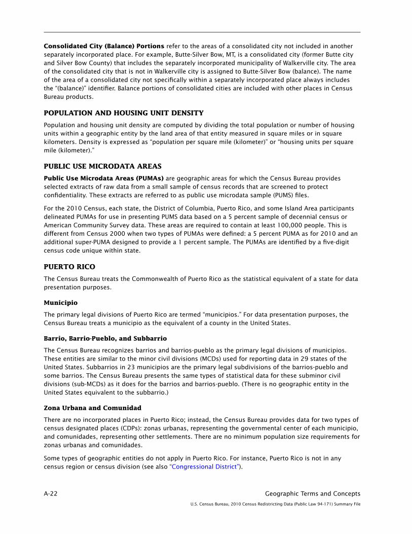
A-22 Geographic Terms and Concepts
U.S. Census Bureau, 2010 Census Redistricting Data (Public Law 94-171) Summary File
Consolidated City (Balance) Portions refer to the areas of a consolidated city not included in another separately incorporated place. For example, Butte-Silver Bow, MT, is a consolidated city (former Butte city and Silver Bow County) that includes the separately incorporated municipality of Walkerville city. The area of the consolidated city that is not in Walkerville city is assigned to Butte-Silver Bow (balance). The name of the area of a consolidated city not specifically within a separately incorporated place always includes the “(balance)” identifier. Balance portions of consolidated cities are included with other places in Census Bureau products.
POPULATION AND HOUSING UNIT DENSITY
Population and housing unit density are computed by dividing the total population or number of housing units within a geographic entity by the land area of that entity measured in square miles or in square kilometers. Density is expressed as “population per square mile (kilometer)” or “housing units per square mile (kilometer).”
PUBLIC USE MICRODATA AREAS
Public Use Microdata Areas (PUMAs) are geographic areas for which the Census Bureau provides selected extracts of raw data from a small sample of census records that are screened to protect confidentiality. These extracts are referred to as public use microdata sample (PUMS) files.
For the 2010 Census, each state, the District of Columbia, Puerto Rico, and some Island Area participants delineated PUMAs for use in presenting PUMS data based on a 5 percent sample of decennial census or American Community Survey data. These areas are required to contain at least 100,000 people. This is different from Census 2000 when two types of PUMAs were defined: a 5 percent PUMA as for 2010 and an additional super-PUMA designed to provide a 1 percent sample. The PUMAs are identified by a five-digit census code unique within state.
PUERTO RICO
The Census Bureau treats the Commonwealth of Puerto Rico as the statistical equivalent of a state for data presentation purposes.
Municipio
The primary legal divisions of Puerto Rico are termed “municipios.” For data presentation purposes, the Census Bureau treats a municipio as the equivalent of a county in the United States.
Barrio, Barrio-Pueblo, and Subbarrio
The Census Bureau recognizes barrios and barrios-pueblo as the primary legal divisions of municipios. These entities are similar to the minor civil divisions (MCDs) used for reporting data in 29 states of the United States. Subbarrios in 23 municipios are the primary legal subdivisions of the barrios-pueblo and some barrios. The Census Bureau presents the same types of statistical data for these subminor civil divisions (sub-MCDs) as it does for the barrios and barrios-pueblo. (There is no geographic entity in the United States equivalent to the subbarrio.)
Zona Urbana and Comunidad
There are no incorporated places in Puerto Rico; instead, the Census Bureau provides data for two types of census designated places (CDPs): zonas urbanas, representing the governmental center of each municipio, and comunidades, representing other settlements. There are no minimum population size requirements for zonas urbanas and comunidades.
Some types of geographic entities do not apply in Puerto Rico. For instance, Puerto Rico is not in any census region or census division (see also “Congressional District”).

Geographic Terms and Concepts A-23
U.S. Census Bureau, 2010 Census Redistricting Data (Public Law 94-171) Summary File
SCHOOL DISTRICTS (ELEMENTARY, SECONDARY, AND UNIFIED)
School Districts are geographic entities within which state, county, local officials, the Bureau of Indian Affairs, or the U.S. Department of Defense provide public educational services for the area’s residents. The Census Bureau obtains the boundaries, names, local education agency codes, and school district levels for school districts from state and local school officials for the primary purpose of providing the U.S. Department of Education with estimates of the number of children “at risk” within each school district, county, and state. This information serves as the basis for the Department of Education to determine the annual allocation of Title I funding to states and school districts.
The Census Bureau tabulates data for three types of school districts: elementary, secondary, and unified. Each school district is assigned a five-digit code that is unique within state. School district codes are the local education agency number assigned by the Department of Education and are not necessarily in alphabetical order by school district name.
The elementary school districts provide education to the lower grade/age levels and the secondary school districts provide education to the upper grade/age levels. Unified school districts provide education to children of all school ages in their service areas. In general, where there is a unified school district, no elementary or secondary school district exists; and where there is an elementary school district, the secondary school district may or may not exist.
The Census Bureau’s representation of school districts in various data products is based both on the grade range that a school district operates and also the grade range for which the school district is financially responsible. For example, a school district is defined as an elementary school district if its operational grade range is less than the full kindergarten through 12 or prekindergarten through 12 grade range (for example, K–6 or pre-K–8). These elementary school districts do not provide direct educational services for grades 7–12, 9–12, or similar ranges. Some elementary school districts are financially responsible for the education of all school-aged children within their service areas and rely on other school districts to provide service for those grade ranges that are not operated by these elementary school districts. In these situations, in order to allocate all school-aged children to these school districts, the secondary school district code field is blank. For elementary school districts where the operational grade range and financially responsible grade range are the same, the secondary school district code field will contain a secondary school district code. There are no situations where an elementary school district does not exist and a secondary school district exists in Census Bureau records.
STATE OR STATISTICALLY EQUIVALENT ENTITY
States and Equivalent Entities are the primary governmental divisions of the United States. In addition to the 50 states, the Census Bureau treats the District of Columbia, Puerto Rico, American Samoa, the Commonwealth of the Northern Mariana Islands, Guam, and the U.S. Virgin Islands as the statistical equivalents of states for the purpose of data presentation.
STATE LEGISLATIVE DISTRICTS (UPPER AND LOWER CHAMBERS)
State Legislative Districts (SLDs) are the areas from which members are elected to state legislatures. The Census Bureau first reported data for SLDs as part of the 2000 Public Law (P.L.) 94-171 Redistricting Data File.
Current SLDs (2010 Election Cycle)—States participating in Phase 1 of the 2010 Census Redistricting Data Program voluntarily provided the Census Bureau with the 2006 election cycle boundaries, codes, and, in some cases, names for their SLDs. All 50 states, plus the District of Columbia and Puerto Rico, participated in Phase 1, State Legislative District Project (SLDP) of the 2010 Census Redistricting Data Program. States subsequently provided legal changes to those plans through the Redistricting Data Office and/or corrections as part of Phase 2 of the 2010 Census Redistricting Data Program, as needed.

A-24 Geographic Terms and Concepts
U.S. Census Bureau, 2010 Census Redistricting Data (Public Law 94-171) Summary File
The SLDs embody the upper (senate—SLDU) and lower (house—SLDL) chambers of the state legislature. Nebraska has a unicameral legislature and the District of Columbia has a single council, both of which the Census Bureau treats as upper-chamber legislative areas for the purpose of data presentation. A unique three-character census code, identified by state participants, is assigned to each SLD within a state. In Connecticut, Hawaii, Illinois, Louisiana, Maine, Massachusetts, New Jersey, Ohio, and Puerto Rico, state officials did not define the SLDs to cover all of the state or state equivalent area (usually bodies of water). In these areas with no SLDs defined, the code “ZZZ” has been assigned, which is treated within state as a single SLD for purposes of data presentation. Maryland also has areas with no SLDs defined; in Maryland, these areas are coded with an initial “Z” by county or equivalent and treated as a unique SLD by county or equivalent. In Nebraska and the District of Columbia, the Census Bureau assigned the code 999 to represent a single SLDL where legally none exist.
SLD Names—The Census Bureau first reported names for SLDs as part of Phase 1 of the 2010 Census Redistricting Data Program. The SLD names with their translated legal/statistical area description are associated only with the current SLDs. Not all states provided names for their SLDs, therefore the code (or number) also serves as the name.
TRIBAL BLOCK GROUP
The 2010 tribal block group concept and criteria are completely different from those used in 2000. For the Census 2000, tribal block groups were the standard state-county-census tract-block group areas retabulated under an American Indian area hierarchy; that is, American Indian area-tribal census tract-tribal block group. Tribal block groups only were applicable to legal federally recognized American Indian reservation and off-reservation trust land areas. Tribal block groups were defined to provide statistically significant sample data for small areas within American Indian areas, particularly those American Indian areas that crossed state or county boundaries where these boundaries were not meaningful for statistical purposes. The 2000 tribal block groups used the block group numbers and comprised all blocks beginning with a single number.
The 2010 tribal block groups are defined independently of the standard county-based block group delineation. For federally recognized American Indian tribes with reservations or off-reservation trust land and a population less than 1,200, a single tribal block group is defined. Tribal participants in qualifying areas with a population greater than 1,200 could define additional block groups within their reservation and/or off-reservation trust land without regard to the standard block group configuration.
Tribal block groups will contain blocks beginning with the same number as the standard county-based block group and could contain seemingly duplicate block numbers. To better identify and differentiate tribal block groups from county-based block groups, tribal block groups use the letter range A through K (except “I,” which could be confused with a number “1”) to identify and code the tribal block group. Tribal block groups nest within tribal census tract.
TRIBAL CENSUS TRACT
The 2010 tribal census tract concept and criteria are completely different from those used in 2000. Tribal census tracts (also known as tribal tracts) in 2000 were the standard state-county-census tract areas retabulated under an American Indian area hierarchy; that is, American Indian area-tribal census tract. Federally recognized tribes with a reservation or off-reservation trust land delineated tribal census tracts working with local census tract participants to produce a single census tract plan. Tribal census tracts were designed to be permanent statistical divisions of American Indian areas for the presentation of comparable data between censuses, particularly for those American Indian areas that crossed state or county boundaries where these boundaries were not meaningful for statistical purposes.
For 2010, tribal census tracts are defined independently of the standard county-based tract delineation. For federally recognized American Indian tribes with reservations or off-reservation trust land and a

Geographic Terms and Concepts A-25
U.S. Census Bureau, 2010 Census Redistricting Data (Public Law 94-171) Summary File
population less than 2,400, a single tribal census tract is defined. Qualifying areas with a population greater than 2,400 could define additional tribal census tracts within their area.
In 2000, the tract number range of 9400 through 9499 was reserved for tribal census tracts and was required for those tribal census tracts that crossed state or county boundaries. Not all tribal census tracts in 2000, however, used this range. For 2010, tribal census tract codes will be six characters long with a leading “T” alphabetic character followed by five numeric codes having an implied decimal between the fourth and fifth character; for example, T01000, which translates as tribal census tract 10. Tribal block groups will nest within tribal census tract. Since individual blocks are defined within the standard state-county-census tract hierarchy, a tribal census tract can contain seemingly duplicate block numbers, thus tribal census tracts cannot be used to uniquely identify census blocks.
UNITED STATES
The United States consists of the 50 states and the District of Columbia.
URBAN AND RURAL
For the 2010 Census, the Census Bureau classified as urban all territory, population, and housing units located within urbanized areas (UAs) and urban clusters (UCs), both defined using the same criteria. The Census Bureau delineates UA and UC boundaries that represent densely developed territory, encompassing residential, commercial, and other nonresidential urban land uses. In general, this territory consists of areas of high population density and urban land use resulting in a representation of the “urban footprint.” Rural consists of all territory, population, and housing units located outside UAs and UCs.
For the 2010 Census, the urban and rural classification was applied to the 50 states, the District of Columbia, Puerto Rico, American Samoa, Guam, the Commonwealth of the Northern Mariana Islands, and the U.S. Virgin Islands.
Urbanized Areas (UAs)—An urbanized area consists of densely developed territory that contains 50,000 or more people. The Census Bureau delineates UAs to provide a better separation of urban and rural territory, population, and housing in the vicinity of large places.
Urban Clusters (UCs)—An urban cluster consists of densely developed territory that has at least 2,500 people but fewer than 50,000 people. The Census Bureau first introduced the UC concept for Census 2000 to provide a more consistent and accurate measure of urban population, housing, and territory throughout the United States, Puerto Rico, and the Island Areas.
Urban Area Titles and Codes—The title of each UA and UC may contain up to three incorporated place or census designated place (CDP) names and will include the two-letter U.S. Postal Service abbreviation for each state or statistically equivalent entity into which the UA or UC extends. However, if the UA or UC does not contain an incorporated place or CDP, the urban area title will include the single name of a minor civil division or populated place recognized by the U.S. Geological Survey’s Geographic Names Information System.
Each UC and UA is assigned a five-digit numeric census code based on a national alphabetical sequence of all urban area names. A separate flag is included in data tabulation files to differentiate between UAs and UCs. In printed reports, this differentiation is included in the name.
Central Place—The 2010 Census urban areas will no longer include one or more designated central places. In preceding censuses, the central place included all incorporated or census designated places included in the urban area title, plus additional incorporated areas that met a population size criterion. The concept of central place for urban areas no longer is being applied.
Relationship to Other Geographic Entities—Geographic entities, such as metropolitan areas, counties, minor civil divisions, places, and census tracts, often contain both urban and rural territory, population, and housing units.

A-26 Geographic Terms and Concepts
U.S. Census Bureau, 2010 Census Redistricting Data (Public Law 94-171) Summary File
URBAN GROWTH AREAS
Urban Growth Areas (UGAs) are legally defined entities in Oregon and Washington that the Census Bureau includes in the MAF/TIGER database in agreement with the states. UGAs, which are defined around incorporated places, are used to regulate urban growth. UGA boundaries, which need not follow visible features, are delineated cooperatively by state and local officials and then confirmed in state law. UGAs are a pilot project first defined only in Oregon for Census 2000. Each UGA is identified by a five-digit numeric census code, usually the same as the five-digit Federal Information Processing Series (FIPS) code associated with the incorporated place for which the UGA is named.
VOTING DISTRICTS
Voting Districts (VTDs) refer to the generic name for geographic entities, such as precincts, wards, and election districts, established by state governments for the purpose of conducting elections. States voluntarily participating in Phase 2 of the 2010 Census Redistricting Data Program provided the Census Bureau with boundaries, codes, and names for their VTDs. Each VTD is identified by a one-to-six-character alphanumeric census code that is unique within county. The code “ZZZZZZ” identifies a portion of counties (usually bodies of water) for which no VTDs were identified. For the 2010 Census, only Rhode Island did not participate in Phase 2 (the Voting District/Block Boundary Suggestion Project) of the 2010 Census Redistricting Data Program. Kentucky chose not to provide VTDs as part of their participation in Phase 2, and the states of Montana and Oregon provided VTDs for some counties. Therefore, for 2010 Census data products, no VTDs exist in select counties in Montana and Oregon or for the states of Rhode Island and Kentucky in their entirety. Participating states often submitted VTDs conforming to the feature network in the MAF/TIGER database rather than the complete legal boundary of the VTD. If requested by the participating state, the Census Bureau identified the VTDs that represent an actual voting district with an “A” in the voting district indicator field. Where a participating state indicated that the VTD has been modified to follow existing features, the VTD is a pseudo-VTD, and the voting district indicator contains “P.”
ZIP CODE TABULATION AREAS
ZIP Code Tabulation Areas (ZCTAs) are approximate area representations of U.S. Postal Service (USPS) five-digit ZIP Code service areas that the Census Bureau creates using whole blocks to present statistical data from censuses and surveys. The Census Bureau defines ZCTAs by allocating each block that contains addresses to a single ZCTA, usually to the ZCTA that reflects the most frequently occurring ZIP Code for the addresses within that tabulation block. Blocks that do not contain addresses but are completely surrounded by a single ZCTA (enclaves) are assigned to the surrounding ZCTA; those surrounded by multiple ZCTAs will be added to a single ZCTA based on limited buffering performed between multiple ZCTAs. The Census Bureau identifies five-digit ZCTAs using a five-character numeric code that represents the most frequently occurring USPS ZIP Code within that ZCTA, and this code may contain leading zeros.
There are significant changes to the 2010 ZCTA delineation from that used in 2000. Coverage was extended to include the Island Areas for 2010 so that the United States, Puerto Rico, and the Island Areas have ZCTAs. Unlike 2000, when areas that could not be assigned to a ZCTA were given a generic code ending in “XX” (land area) or “HH” (water area), for 2010 there is no universal coverage by ZCTAs, and only legitimate five-digit areas are defined. The 2010 ZCTAs will better represent the actual Zip Code service areas because the Census Bureau initiated a process before creation of 2010 blocks to add block boundaries that split polygons with large numbers of addresses using different Zip Codes.
Data users should not use ZCTAs to identify the official USPS ZIP Code for mail delivery. The USPS makes periodic changes to ZIP Codes to support more efficient mail delivery. The ZCTAs process used primarily residential addresses and was biased towards Zip Codes used for city-style mail delivery, thus there may be Zip Codes that are primarily nonresidential or boxes only that may not have a corresponding ZCTA.

Geographic Terms and Concepts A-27
U.S. Census Bureau, 2010 Census Redistricting Data (Public Law 94-171) Summary File
Figure A–1.
Standard Hierarchy of Census Geographic Entities
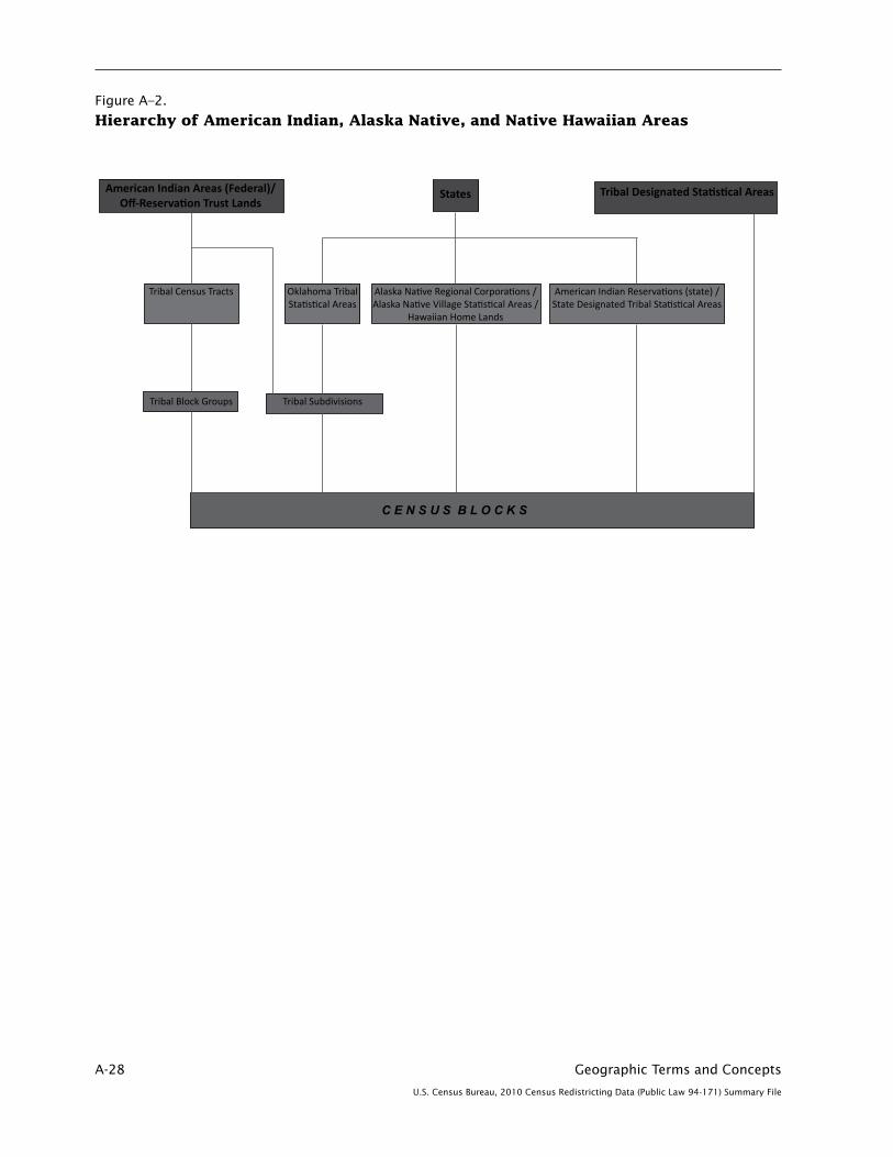
A-28 Geographic Terms and Concepts
U.S. Census Bureau, 2010 Census Redistricting Data (Public Law 94-171) Summary File
Figure A–2.
Hierarchy of American Indian, Alaska Native, and Native Hawaiian Areas
American Indian Areas (Federal)/Off-Reservation Trust Lands
States Tribal Designated Statistical Areas
Hierarchy of American Indian, Alaska Native, and Native Hawaiian Areas
Tribal Census Tracts Oklahoma TribalStatistical Areas
Alaska Native Regional Corporations /Alaska Native Village Statistical Areas /
Hawaiian Home Lands
American Indian Reservations (state) /State Designated Tribal Statistical Areas
Tribal SubdivisionsTribal Block Groups
C E N S U S B L O C K S

Geographic Terms and Concepts A-29
U.S. Census Bureau, 2010 Census Redistricting Data (Public Law 94-171) Summary File
Figure A–3.
Census Regions, Census Divisions, and Their Constituent States
Northeast Region
New England Division: Maine, New Hampshire, Vermont, Massachusetts, Rhode Island, Connecticut
Middle Atlantic Division:New York, New Jersey, Pennsylvania
Midwest Region
East North Central Division: Ohio, Indiana, Illinois, Michigan, Wisconsin
West North Central Division: Minnesota, Iowa, Missouri, North Dakota, South Dakota, Nebraska, Kansas
South Region
South Atlantic Division: Delaware, Maryland, District of Columbia, Virginia, West Virginia, North Carolina, South Carolina, Georgia, Florida
East South Central Division: Kentucky, Tennessee, Alabama, Mississippi
West South Central Division: Arkansas, Louisiana, Oklahoma, Texas
West Region
Mountain Division: Montana, Idaho, Wyoming, Colorado, New Mexico, Arizona, Utah, Nevada
Pacific Division: Washington, Oregon, California, Alaska, Hawaii
Definitions of Subject Characteristics B-1
U.S. Census Bureau, 2010 Census Redistricting Data (Public Law 94-171) Summary File
Appendix B. Definitions of Subject Characteristics
CONTENTS
Population Characteristics. . . . . . . . . . . . . . . . . . . . . . . . . . . . . . . . . . . . . . . . . . . . . . . . . . . . . . . . B-1 Age . . . . . . . . . . . . . . . . . . . . . . . . . . . . . . . . . . . . . . . . . . . . . . . . . . . . . . . . . . . . . . . . . . . . . . . B-1 Hispanic or Latino Origin . . . . . . . . . . . . . . . . . . . . . . . . . . . . . . . . . . . . . . . . . . . . . . . . . . . . . . . B-2 Race . . . . . . . . . . . . . . . . . . . . . . . . . . . . . . . . . . . . . . . . . . . . . . . . . . . . . . . . . . . . . . . . . . . . . . B-3
Living Quarters . . . . . . . . . . . . . . . . . . . . . . . . . . . . . . . . . . . . . . . . . . . . . . . . . . . . . . . . . . . . . . . . B-7 Housing Units . . . . . . . . . . . . . . . . . . . . . . . . . . . . . . . . . . . . . . . . . . . . . . . . . . . . . . . . . . . . . . . B-8 Occupied Housing Unit . . . . . . . . . . . . . . . . . . . . . . . . . . . . . . . . . . . . . . . . . . . . . . . . . . . . . . . B-8 Vacant Housing Unit . . . . . . . . . . . . . . . . . . . . . . . . . . . . . . . . . . . . . . . . . . . . . . . . . . . . . . . . . B-8 Housing for the Older Population . . . . . . . . . . . . . . . . . . . . . . . . . . . . . . . . . . . . . . . . . . . . . . . B-9 Group Quarters . . . . . . . . . . . . . . . . . . . . . . . . . . . . . . . . . . . . . . . . . . . . . . . . . . . . . . . . . . . . . . B-9
POPULATION CHARACTERISTICS
Age
The data on age were derived from answers to a two-part question (i.e., age and date of birth). The age classification for a person in census tabulations is the age of the person in completed years as of April 1, 2010, the census reference date. Both age and date of birth responses are used in combination to determine the most accurate age for the person as of the census reference date. Inconsistently reported and missing values are assigned or allocated based on the values of other variables for that person, from other people in the household or from people in other households (i.e., hot deck imputation).
Age data are tabulated in age groupings and single years of age. Data on age also are used to classify other characteristics in census tabulations.
Median age. This measure divides the age distribution into two equal parts: one-half of the cases falling below the median value and one-half above the value. Median age is computed on the basis of a single-year-of-age distribution using a linear interpolation method.
Limitation of the data� There is some tendency for respondents to provide their age as of the date they completed the census questionnaire or interview, not their age as of the census reference date. The two-part question and editing procedures have attempted to minimize the effect of this reporting problem on tabulations. Additionally, the current census age question displays the census reference date prominently, and interviewer training emphasizes the importance of collecting age as of the reference date.
Respondents sometimes round a person’s age up if they were close to having a birthday. For most single years of age, the misstatements are largely offsetting. The problem is most pronounced at age 0. Also, there may have been more rounding up to age 1 to avoid reporting age as 0 years. (Age in completed months was not collected for infants under age 1). Editing procedures correct this problem.
There is some respondent resistance to reporting the ages of babies in completed years (i.e., 0 years old when the baby is under 1 year old). Instead, babies’ ages are sometimes reported in months. The two-part question along with enhanced editing and data capture procedures intend to correct much of this problem before the age data are finalized in tabulations. Additionally, the current census age question includes an instruction for babies’ ages to be answered as “0” years old when they are under 1 year old.
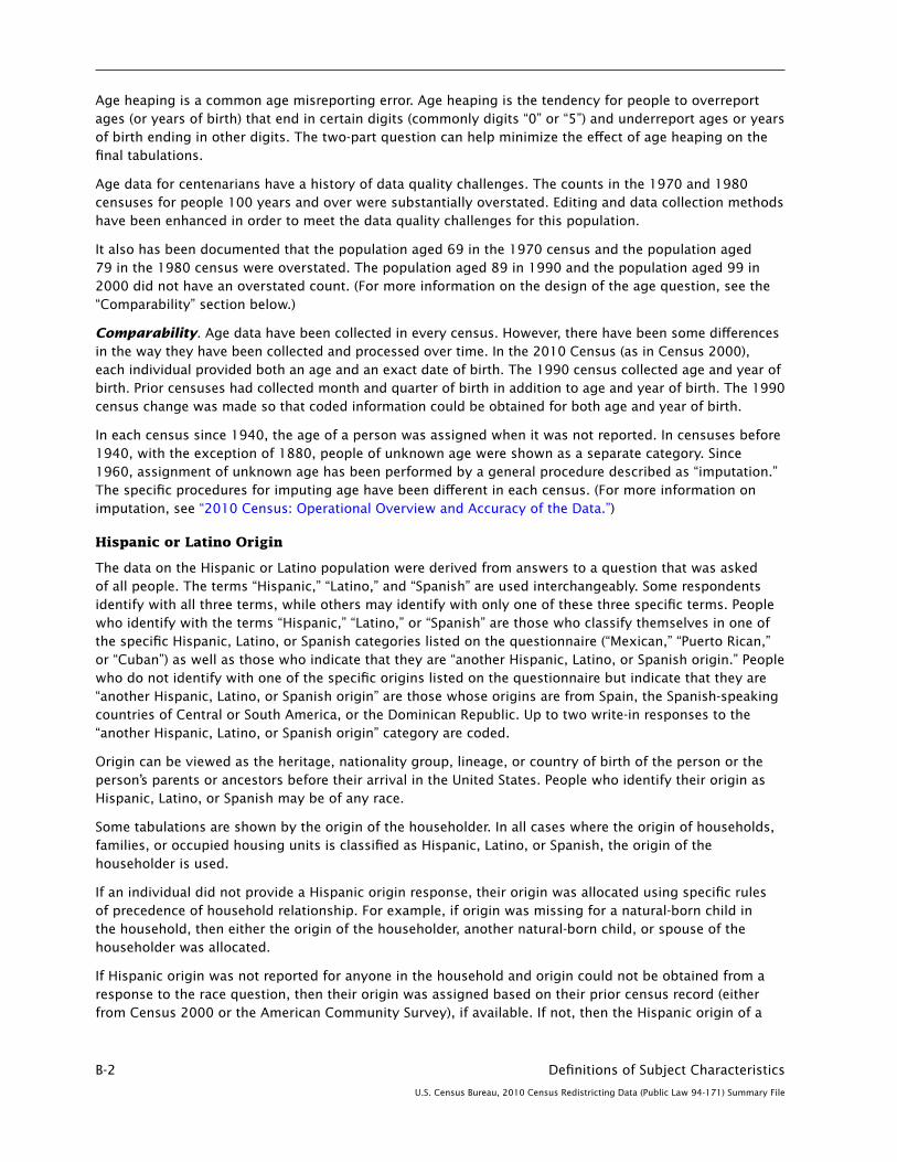
B-2 Definitions of Subject Characteristics
U.S. Census Bureau, 2010 Census Redistricting Data (Public Law 94-171) Summary File
Age heaping is a common age misreporting error. Age heaping is the tendency for people to overreport ages (or years of birth) that end in certain digits (commonly digits “0” or “5”) and underreport ages or years of birth ending in other digits. The two-part question can help minimize the effect of age heaping on the final tabulations.
Age data for centenarians have a history of data quality challenges. The counts in the 1970 and 1980 censuses for people 100 years and over were substantially overstated. Editing and data collection methods have been enhanced in order to meet the data quality challenges for this population.
It also has been documented that the population aged 69 in the 1970 census and the population aged 79 in the 1980 census were overstated. The population aged 89 in 1990 and the population aged 99 in 2000 did not have an overstated count. (For more information on the design of the age question, see the “Comparability” section below.)
Comparability. Age data have been collected in every census. However, there have been some differences in the way they have been collected and processed over time. In the 2010 Census (as in Census 2000), each individual provided both an age and an exact date of birth. The 1990 census collected age and year of birth. Prior censuses had collected month and quarter of birth in addition to age and year of birth. The 1990 census change was made so that coded information could be obtained for both age and year of birth.
In each census since 1940, the age of a person was assigned when it was not reported. In censuses before 1940, with the exception of 1880, people of unknown age were shown as a separate category. Since 1960, assignment of unknown age has been performed by a general procedure described as “imputation.” The specific procedures for imputing age have been different in each census. (For more information on imputation, see “2010 Census: Operational Overview and Accuracy of the Data.”)
Hispanic or Latino Origin
The data on the Hispanic or Latino population were derived from answers to a question that was asked of all people. The terms “Hispanic,” “Latino,” and “Spanish” are used interchangeably. Some respondents identify with all three terms, while others may identify with only one of these three specific terms. People who identify with the terms “Hispanic,” “Latino,” or “Spanish” are those who classify themselves in one of the specific Hispanic, Latino, or Spanish categories listed on the questionnaire (“Mexican,” “Puerto Rican,” or “Cuban”) as well as those who indicate that they are “another Hispanic, Latino, or Spanish origin.” People who do not identify with one of the specific origins listed on the questionnaire but indicate that they are “another Hispanic, Latino, or Spanish origin” are those whose origins are from Spain, the Spanish-speaking countries of Central or South America, or the Dominican Republic. Up to two write-in responses to the “another Hispanic, Latino, or Spanish origin” category are coded.
Origin can be viewed as the heritage, nationality group, lineage, or country of birth of the person or the person’s parents or ancestors before their arrival in the United States. People who identify their origin as Hispanic, Latino, or Spanish may be of any race.
Some tabulations are shown by the origin of the householder. In all cases where the origin of households, families, or occupied housing units is classified as Hispanic, Latino, or Spanish, the origin of the householder is used.
If an individual did not provide a Hispanic origin response, their origin was allocated using specific rules of precedence of household relationship. For example, if origin was missing for a natural-born child in the household, then either the origin of the householder, another natural-born child, or spouse of the householder was allocated.
If Hispanic origin was not reported for anyone in the household and origin could not be obtained from a response to the race question, then their origin was assigned based on their prior census record (either from Census 2000 or the American Community Survey), if available. If not, then the Hispanic origin of a

Definitions of Subject Characteristics B-3
U.S. Census Bureau, 2010 Census Redistricting Data (Public Law 94-171) Summary File
householder in a previously processed household with the same race was allocated. As in Census 2000, surnames (Spanish and non-Spanish) were used to assist in allocating an origin or race.
Comparability� There are four changes to the Hispanic origin question for the 2010 Census. First, the wording of the question differs from that in 2000. In 2000, the question asked if the person was “Spanish/Hispanic/Latino.” In 2010, the question asks if the person is “of Hispanic, Latino, or Spanish origin.” Second, in 2000, the question provided an instruction, “Mark the ‘No’ box if not Spanish/Hispanic/Latino.” The 2010 Census question provided no specific instruction for non-Hispanics. Third, in 2010, the “Yes, another Hispanic, Latino, or Spanish origin” category provided examples of six Hispanic origin groups (Argentinean, Colombian, Dominican, Nicaraguan, Salvadoran, Spaniard, and so on) and instructed respondents to “print origin.” In 2000, no Hispanic origin examples were given. Finally, the fourth change was the addition of a new instruction in the 2010 Census that was not used in Census 2000. The instruction is stated as follows: “NOTE: Please answer BOTH Question 8 about Hispanic origin and Question 9 about race. For this census, Hispanic origins are not races.”
There were two changes to the Hispanic origin question for Census 2000. First, the sequence of the race and Hispanic origin questions for Census 2000 differed from that in 1990; in 1990, the race question preceded the Hispanic origin question. Testing prior to Census 2000 indicated that response to the Hispanic origin question could be improved by placing it before the race question without affecting the response to the race question. Second, there was an instruction preceding the Hispanic origin question indicating that respondents should answer both the Hispanic origin and the race questions. This instruction was added to give emphasis to the distinct concepts of the Hispanic origin and race questions, and emphasized the need for both pieces of information.
Furthermore, there was a change in the processing of the Hispanic origin and race responses. In the 1990 census, respondents provided Hispanic origin responses in the race question and race responses in the Hispanic origin question. In 1990, the Hispanic origin question and the race question had separate edits; therefore, although information may have been present on the questionnaire, it was not fully utilized due to the discrete nature of the edits. However, for Census 2000, there was a joint race and Hispanic origin edit that utilized Hispanic origin and race information, regardless of the location.
Race
The data on race were derived from answers to the question on race that was asked of all people. The U.S. Census Bureau collects race data in accordance with guidelines provided by the U.S. Office of Management and Budget (OMB), and these data are based on self-identification. The racial categories included in the census questionnaire generally reflect a social definition of race recognized in this country and not an attempt to define race biologically, anthropologically, or genetically. In addition, it is recognized that the categories of the race item include racial and national origin or sociocultural groups. People may choose to report more than one race to indicate their racial mixture, such as “American Indian” and “White.” People who identify their origin as Hispanic, Latino, or Spanish may be of any race.
The racial classifications used by the Census Bureau adhere to the October 30, 1997, Federal Register notice entitled, “Revisions to the Standards for the Classification of Federal Data on Race and Ethnicity” issued by OMB. These standards govern the categories used to collect and present federal data on race and ethnicity. OMB requires five minimum categories (White, Black or African American, American Indian or Alaska Native, Asian, and Native Hawaiian or Other Pacific Islander) for race. The race categories are described below with a sixth category, “Some Other Race,” added with OMB approval. In addition to the five race groups, OMB also states that respondents should be offered the option of selecting one or more races.
If an individual did not provide a race response, the race or races of the householder or other household members were allocated using specific rules of precedence of household relationship. For example, if race was missing for a natural-born child in the household, then either the race or races of the householder, another natural-born child, or spouse of the householder were allocated.

B-4 Definitions of Subject Characteristics
U.S. Census Bureau, 2010 Census Redistricting Data (Public Law 94-171) Summary File
If race was not reported for anyone in the household, then their race was assigned based on their prior Census record (either from Census 2000 or the American Community Survey), if available. If not, then the race or races of a householder in a previously processed household were allocated.
Definitions from OMB guide the Census Bureau in classifying written responses to the race question:
White. A person having origins in any of the original peoples of Europe, the Middle East, or North Africa. It includes people who indicate their race as “White” or report entries such as Irish, German, Italian, Lebanese, Arab, Moroccan, or Caucasian.
Black or African American. A person having origins in any of the Black racial groups of Africa. It includes people who indicate their race as “Black, African Am., or Negro” or report entries such as African American, Kenyan, Nigerian, or Haitian.
American Indian or Alaska Native. A person having origins in any of the original peoples of North and South America (including Central America) and who maintains tribal affiliation or community attachment. This category includes people who indicate their race as “American Indian or Alaska Native” or report entries such as Navajo, Blackfeet, Inupiat, Yup’ik, or Central American Indian groups or South American Indian groups.
Respondents who identified themselves as “American Indian or Alaska Native” were asked to report their enrolled or principal tribe. Therefore, tribal data in tabulations reflect the written entries reported on the questionnaires. Some of the entries (for example, Metlakatla Indian Community and Umatilla) represent reservations or a confederation of tribes on a reservation. The information on tribe is based on self-identification and therefore does not reflect any designation of federally or state-recognized tribe. The information for the 2010 Census was derived from the American Indian and Alaska Native Tribal Classification List for Census 2000 and updated from 2002 to 2009 based on the annual Federal Register notice entitled “Indian Entities Recognized and Eligible to Receive Services From the United States Bureau of Indian Affairs,” Department of the Interior, Bureau of Indian Affairs, issued by OMB, and through consultation with American Indian and Alaska Native communities and leaders.
Asian. A person having origins in any of the original peoples of the Far East, Southeast Asia, or the Indian subcontinent including, for example, Cambodia, China, India, Japan, Korea, Malaysia, Pakistan, the Philippine Islands, Thailand, and Vietnam. It includes people who indicate their race as “Asian Indian,” “Chinese,” “Filipino,” “Korean,” “Japanese,” “Vietnamese,” and “Other Asian” or provide other detailed Asian responses.
Native Hawaiian or Other Pacific Islander. A person having origins in any of the original peoples of Hawaii, Guam, Samoa, or other Pacific Islands. It includes people who indicate their race as “Native Hawaiian,” “Guamanian or Chamorro,” “Samoan,” and “Other Pacific Islander” or provide other detailed Pacific Islander responses.
Some Other Race. Includes all other responses not included in the “White,” “Black or African American,” “American Indian or Alaska Native,” “Asian,” and “Native Hawaiian or Other Pacific Islander” race categories described above. Respondents reporting entries such as multiracial, mixed, interracial, or a Hispanic, Latino, or Spanish group (for example, Mexican, Puerto Rican, Cuban, or Spanish) in response to the race question are included in this category.
Two or More Races. People may chose to provide two or more races either by checking two or more race response check boxes, by providing multiple responses, or by some combination of check boxes and other responses. The race response categories shown on the questionnaire are collapsed into the five minimum race groups identified by OMB and the Census Bureau’s “Some Other Race” category. For data product purposes, “Two or More Races” refers to combinations of two or more of the following race categories:
1. White 2. Black or African American 3. American Indian or Alaska Native

Definitions of Subject Characteristics B-5
U.S. Census Bureau, 2010 Census Redistricting Data (Public Law 94-171) Summary File
4. Asian 5. Native Hawaiian or Other Pacific Islander 6. Some Other Race
There are 57 possible combinations (see Figure B-1) involving the race categories shown above. Thus, according to this approach, a response of “White” and “Asian” was tallied as Two or More Races, while a response of “Japanese” and “Chinese” was not because “Japanese” and “Chinese” are both Asian responses. Selected tabulations of responses involving reporting of two or more groups within the American Indian and Alaska Native, Asian, or Native Hawaiian and Other Pacific Islander categories are available in other data products (e.g., 2010 Census Briefs).
Figure B-1. Two or More Races (57 Possible Specified Combinations)
1. White; Black or African American
2. White; American Indian and Alaska Native
3. White; Asian
4. White; Native Hawaiian and Other Pacific Islander
5. White; Some Other Race
6. Black or African American; American Indian and Alaska Native
7. Black or African American; Asian
8. Black or African American; Native Hawaiian and Other Pacific Islander
9. Black or African American; Some Other Race
10. American Indian and Alaska Native; Asian
11. American Indian and Alaska Native; Native Hawaiian and Other Pacific Islander
12. American Indian and Alaska Native; Some Other Race
13. Asian; Native Hawaiian and Other Pacific Islander
14. Asian; Some Other Race
15. Native Hawaiian and Other Pacific Islander; Some Other Race
16. White; Black or African American; American Indian and Alaska Native
17. White; Black or African American; Asian
18. White; Black or African American; Native Hawaiian and Other Pacific Islander
19. White; Black or African American; Some Other Race
20. White; American Indian and Alaska Native; Asian
21. White; American Indian and Alaska Native; Native Hawaiian and Other Pacific Islander
22. White; American Indian and Alaska Native; Some Other Race
23. White; Asian; Native Hawaiian and Other Pacific Islander
24. White; Asian; Some Other Race
25. White; Native Hawaiian and Other Pacific Islander; Some Other Race
26. Black or African American; American Indian and Alaska Native; Asian
27. Black or African American; American Indian and Alaska Native; Native Hawaiian and Other Pacific Islander
28. Black or African American; American Indian and Alaska Native; Some Other Race
29. Black or African American; Asian; Native Hawaiian and Other Pacific Islander
30. Black or African American; Asian; Some Other Race
31. Black or African American; Native Hawaiian and Other Pacific Islander; Some Other Race
32. American Indian and Alaska Native; Asian; Native Hawaiian and Other Pacific Islander
33. American Indian and Alaska Native; Asian; Some Other Race
34. American Indian and Alaska Native; Native Hawaiian and Other Pacific Islander; Some Other Race
35. Asian; Native Hawaiian and Other Pacific Islander; Some Other Race

B-6 Definitions of Subject Characteristics
U.S. Census Bureau, 2010 Census Redistricting Data (Public Law 94-171) Summary File
36. White; Black or African American; American Indian and Alaska Native; Asian
37. White; Black or African American; American Indian and Alaska Native; Native Hawaiian and Other Pacific Islander
38. White; Black or African American; American Indian and Alaska Native; Some Other Race
39. White; Black or African American; Asian; Native Hawaiian and Other Pacific Islander
40. White; Black or African American; Asian; Some Other Race
41. White; Black or African American; Native Hawaiian and Other Pacific Islander; Some Other Race
42. White; American Indian and Alaska Native; Asian; Native Hawaiian and Other Pacific Islander
43. White; American Indian and Alaska Native; Asian; Some Other Race
44. White; American Indian and Alaska Native; Native Hawaiian and Other Pacific Islander; Some Other Race
45. White; Asian; Native Hawaiian and Other Pacific Islander; Some Other Race
46. Black or African American; American Indian and Alaska Native; Asian; Native Hawaiian and Other Pacific Islander
47. Black or African American; American Indian and Alaska Native; Asian; Some Other Race
48. Black or African American; American Indian and Alaska Native; Native Hawaiian and Other Pacific Islander; Some Other Race
49. Black or African American; Asian; Native Hawaiian and Other Pacific Islander; Some Other Race
50. American Indian and Alaska Native; Asian; Native Hawaiian and Other Pacific Islander; Some Other Race
51. White; Black or African American; American Indian and Alaska Native; Asian; Native Hawaiian and Other Pacific Islander
52. White; Black or African American; American Indian and Alaska Native; Asian; Some Other Race
53. White; Black or African American; American Indian and Alaska Native; Native Hawaiian and Other Pacific Islander; Some Other Race
54. White; Black or African American; Asian; Native Hawaiian and Other Pacific Islander; Some Other Race
55. White; American Indian and Alaska Native; Asian; Native Hawaiian and Other Pacific Islander; Some Other Race
56. Black or African American; American Indian and Alaska Native; Asian; Native Hawaiian and Other Pacific Islander; Some Other Race
57. White; Black or African American; American Indian and Alaska Native; Asian; Native Hawaiian and Other Pacific Islander; Some Other Race
Given the many possible ways of displaying data on two or more races, data products will provide varying levels of detail. The most common presentation shows a single line indicating “Two or More Races.” Some data products provide totals of all 57 possible combinations of two or more races, as well as subtotals of people reporting a specific number of races, such as people reporting two races and people reporting three races.
In other presentations on race, data are shown for the total number of people who reported one of the six categories alone or in combination with one or more other race categories. For example, the category “Asian alone or in combination with one or more other races” includes people who reported Asian alone and people who reported Asian in combination with one or more of the other race groups (i.e., White, Black or African American, American Indian or Alaska Native, Native Hawaiian and Other Pacific Islander, and Some Other Race). This number, therefore, represents the maximum number of people who reported as Asian in the question on race. When this data presentation is used, the individual race categories will add to more than the total population because people may be included in more than one category.
Coding of write-in entries. The 2010 Census included an automated review, computer edit, and coding operation on a 100 percent basis for the write-in responses to the race question, similar to that used in Census 2000. There were two types of coding operations: (1) automated coding where a write-in response was automatically coded if it matched a write-in response already contained in a database known as the
Figure B-1. Two or More Races (57 Possible Specified Combinations)—Con.

Definitions of Subject Characteristics B-7
U.S. Census Bureau, 2010 Census Redistricting Data (Public Law 94-171) Summary File
“master file” and (2) expert coding, which took place when a write-in response did not match an entry already on the master file and was sent to expert coders familiar with the subject matter. During the coding process, subject-matter specialists reviewed and coded written entries from the response areas on the race question: American Indian or Alaska Native, Other Asian, Other Pacific Islander, and Some Other Race. Up to 30 text characters were collected from each write-in area, and up to two responses were coded and tabulated from each separate race write-in area.
Comparability. There are three changes to the race question for the 2010 Census. First, the note to respondents was changed to read, “Please answer BOTH Question 8 about Hispanic origin and Question 9 about race. For this census, Hispanic origins are not races.” Second, the wording of the race question was changed from “What is this person’s race? Mark one or more races to indicate what this person considers himself/herself to be” to “What is Person 1’s race? Mark one or more boxes.” Third, examples were added to the “Other Asian” response category (Hmong, Laotian, Thai, Pakistani, Cambodian, and so on) and the “Other Pacific Islander” response category (Fijian, Tongan, and so on).
The treatment of ethnic or national origin write-in responses to the race question also was different. For Census 2000, data on single ancestry by race from the 1990 census were used to help make decisions about how to code ethnic or national origin responses into one or more race categories. Essentially, if 90 percent or more of people who reported a single, specific ancestry reported in a specific race category in 1990 (e.g., more than 90 percent of people indicating Haitian ancestry reported as Black in the question on race), then that race was used as the Census 2000 response. This 90 percent rule was not applied to write-in responses of American Indian and Alaska Native tribes, Asian groups, or Pacific Islander groups because the question on race was designed explicitly to obtain these types of responses. For example, a write-in response of “Haitian and Moroccan” was coded as “Black” and “Some Other Race.” “Moroccan” was coded as “Some Other Race” because less than 90 percent of people indicating Moroccan ancestry reported in one specific race category in the question on race.
For the 2010 Census, ethnic or national origin write-in responses to the race question were coded into one or more of the five OMB race categories, according to the 1997 OMB definitions of race. For example, a 2010 Census write-in response of “Haitian and Moroccan” was coded as “Black” and “White” following OMB’s definitions. If it was not possible to determine which OMB race category the ethnic group or national origin should be coded into, it was included in the “Some Other Race” category.
For more information about comparability to data collected in previous censuses, see Census 2000 Summary File 1 Technical Documentation prepared by the U.S. Census Bureau, 2001, <www.census.gov/prod/cen2000/doc/sf1.pdf>.
LIVING QUARTERS
All living quarters are classified as either housing units or group quarters. Living quarters are usually found in structures that are intended for residential use, but also may be found in structures intended for nonresidential use. Any place where someone lives is considered to be a living quarters, such as an apartment, a dormitory, a shelter for people experiencing homelessness, a barracks, or a nursing facility. Even tents, old railroad cars, and boats are considered to be living quarters if someone claims them as his or her residence. Note that structures that do not meet the definition of a living quarters at the time of listing may meet the definition at the time of enumeration. Some types of structures, such as those cited in items 1 and 2 below, are included in address canvassing operations as placeholders, with the final decision on their living quarters’ status made during enumeration. Other types of structures, such as those cited in items 3 and 4 below, are not included in the address canvassing operation.
The following examples are not considered living quarters.
1. Structures, such as houses and apartments, that resemble living quarters but are being used entirely for nonresidential purposes, such as a store or an office, or used for the storage of business supplies or inventory, machinery, or agricultural products are not enumerated.

B-8 Definitions of Subject Characteristics
U.S. Census Bureau, 2010 Census Redistricting Data (Public Law 94-171) Summary File
2. Single units as well as units in multiunit residential structures under construction in which no one is living or staying are not considered living quarters until construction has reached the point where all exterior windows and doors are installed and final usable floors are in place. Units that do not meet these criteria are not enumerated.
3. Structures in which no one is living or staying that are open to the elements—that is, the roof, walls, windows, and/or doors no longer protect the interior from the elements—are not enumerated. Also, vacant structures with a posted sign indicating that they are condemned or they are to be demolished are not enumerated.
4. Boats, recreational vehicles (RVs), tents, caves, and similar types of shelter that no one is using as a usual residence are not considered living quarters and are not enumerated.
Housing Units
A housing unit is a living quarters in which the occupant or occupants live separately from any other individuals in the building and have direct access to their living quarters from outside the building or through a common hall. Housing units are usually houses, apartments, mobile homes, groups of rooms, or single rooms that are occupied as separate living quarters. They are residences for single individuals, for groups of individuals, or for families who live together. A single individual or a group living in a housing unit is defined to be a household. Additional details about housing for the elderly population and group homes are provided in the section “Housing for the Older Population.”
For vacant housing units, the criteria of separateness and direct access are applied to the intended occupants whenever possible. Nontraditional living quarters, such as boats, RVs, and tents, are considered to be housing units ONLY if someone is living in them and they are either the occupant’s usual residence or the occupant has no usual residence elsewhere. These nontraditional living arrangements are not considered to be housing units if they are vacant.
Housing units are classified as being either occupied or vacant.
Occupied Housing Unit—A housing unit is classified as occupied if it is the usual place of residence of the individual or group of individuals living in it on Census Day, or if the occupants are only temporarily absent, such as away on vacation, in the hospital for a short stay, or on a business trip, and will be returning.
The occupants may be one individual, a single family, two or more families living together, or any other group of related or unrelated individuals who share living arrangements.
Occupied rooms or suites of rooms in hotels, motels, and similar places are classified as housing units only when occupied by permanent residents; that is, occupied by individuals who consider the hotel their usual place of residence or who have no usual place of residence elsewhere. However, when rooms in hotels and motels are used to provide shelter for people experiencing homelessness, they are not housing units. Rooms used in this way are considered group quarters.
Vacant Housing Unit—A housing unit is classified as vacant if no one is living in it on Census Day, unless its occupant or occupants are only temporarily absent—such as away on vacation, in the hospital for a short stay, or on a business trip—and will be returning.
Housing units temporarily occupied at the time of enumeration entirely by individuals who have a usual residence elsewhere are classified as vacant. When housing units are vacant, the criteria of separateness and direct access are applied to the intended occupants whenever possible. If that information cannot be obtained, the criteria are applied to the previous occupants.
Boats, RVs, tents, caves, and similar shelter that no one is using as a usual residence are not considered living quarters and, therefore, are not enumerated at all.

Definitions of Subject Characteristics B-9
U.S. Census Bureau, 2010 Census Redistricting Data (Public Law 94-171) Summary File
Housing for the Older Population—Housing specifically for the older population has become more and more prevalent and is being identified by many different names. Living quarters in these facilities, unless they meet the definition of skilled nursing facilities, are housing units, with each resident’s living quarters considered a separate housing unit if it meets the housing unit definition of direct access. These residential facilities may be referred to as senior apartments, active adult communities, congregate care, continuing care retirement communities, independent living, board and care, or assisted living. People may have to meet certain criteria to be able to live in these facilities, but once accepted as residents, they have unrestricted access to and from their units to the outside.
Housing units and group quarters may coexist under the same entity or organization and in some situations actually share the same structure. An assisted living facility complex may have a skilled nursing floor or wing that meets the definition of a nursing facility and is, therefore, a group quarters, while the rest of the living quarters in the facility are considered to be housing units. Congregate care facilities and continuing care retirement communities often consist of several different types of living quarters, with varying services and levels of care. Some of the living quarters in these facilities and communities are considered to be housing units, and some are considered to be group quarters, depending on which definition they meet.
Comparability. The first Census of Housing in 1940 established the “dwelling unit” concept. Although the term became “housing unit” and the definition was modified slightly in succeeding censuses, the housing unit definition remained essentially comparable between 1940 and 1990. Since 1990, two changes were made to the housing unit definition.
The first change eliminated the concept of “eating separately.” The elimination of the eating criterion is more in keeping with the United Nations’ definition of a housing unit that stresses the entire concept of separateness rather than the specific “eating” element. Although the “eating separately” criterion previously was included in the definition of a housing unit, the data needed to distinguish whether the occupants ate separately from any other people in the building were not collected. (Questions that asked households about their eating arrangements have not been included in the census since 1970.) Therefore, the current definition better reflects the information that is used in the determination of a housing unit.
The second change for Census 2000 and the 2010 Census eliminated the “number of nonrelatives” criterion; that is, “9 or more people unrelated to the householder,” which caused a conversion of housing units to group quarters. This change was prompted by the following considerations: (1) there were relatively few such conversions made as a result of this rule in 1990; (2) household relationship and housing data were lost by converting these units to group quarters; and (3) there was no empirical support for establishing a particular number of nonrelatives as a threshold for these conversions.
In 1960, 1970, and 1980, vacant rooms in hotels, motels, and other similar places where 75 percent or more of the accommodations were occupied by permanent residents were counted as part of the housing inventory. However, an evaluation of the data collection procedures prior to the 1990 census indicated that the concept of permanency was a difficult and confusing procedure for enumerators to apply correctly. Consequently, in the 1990 census, vacant rooms in hotels, motels, and similar places were not counted as housing units. In Census 2000 and the 2010 Census, we continued the procedure adopted in 1990.
Group Quarters
Group quarters are places where people live or stay in a group living arrangement that are owned or managed by an entity or organization providing housing and/or services for the residents. This is not a typical household-type living arrangement. These services may include custodial or medical care as well as other types of assistance, and residency is commonly restricted to those receiving these services. People living in group quarters are usually not related to each other.
Group quarters include such places as college residence halls, residential treatment centers, skilled-nursing facilities, group homes, military barracks, correctional facilities, and workers’ dormitories.

Data Collection and Processing Procedures C-1
U.S. Census Bureau, 2010 Census Redistricting Data (Public Law 94-171) Summary File
Appendix C. Data Collection and Processing Procedures
CONTENTS
2010 Census Mission and Scope . . . . . . . . . . . . . . . . . . . . . . . . . . . . . . . . . . . . . . . . . . . . . . . . . . . C-1
Six Operational Planning Categories . . . . . . . . . . . . . . . . . . . . . . . . . . . . . . . . . . . . . . . . . . . . . . . . C-2
1. Provide Support . . . . . . . . . . . . . . . . . . . . . . . . . . . . . . . . . . . . . . . . . . . . . . . . . . . . . . . . . . . C-2
2. Establish Where to Count . . . . . . . . . . . . . . . . . . . . . . . . . . . . . . . . . . . . . . . . . . . . . . . . . . . . C-3
3. Collect and Integrate Respondent Information . . . . . . . . . . . . . . . . . . . . . . . . . . . . . . . . . . . . C-4
4. Provide Census Results . . . . . . . . . . . . . . . . . . . . . . . . . . . . . . . . . . . . . . . . . . . . . . . . . . . . . C-5
5. Measure Census Coverage . . . . . . . . . . . . . . . . . . . . . . . . . . . . . . . . . . . . . . . . . . . . . . . . . . . C-5
6. Analyze and Research the Census . . . . . . . . . . . . . . . . . . . . . . . . . . . . . . . . . . . . . . . . . . . . . C-6
Thumbnail Descriptions of 2010 Census Operations . . . . . . . . . . . . . . . . . . . . . . . . . . . . . . . . . . . . C-7
Timeline of 2010 Census Operations . . . . . . . . . . . . . . . . . . . . . . . . . . . . . . . . . . . . . . . . . . . . . . . C-9
Lists of States’ Services by Each Regional Office . . . . . . . . . . . . . . . . . . . . . . . . . . . . . . . . . . . . . . . C-10
2010 CENSUS MISSION AND SCOPE
Beginning with the Congressional Act of March 6, 1902, the U.S. Census Bureau was legally established as the “official” data collector for the United States of America. The Census Bureau routinely conducts multiple national, large-scale household surveys and censuses to provide the Administration; Congress; state, local, and tribal planners; the business community; trade associations; academicians; and other data users with a vast array of essential information. Most notable is the every 10-year (decennial) census of population and housing.
This section provides an overview of operations and systems in the 2010 Census of Population and Housing. To assist in understanding terms in the descriptions of many operations or to learn more about the 2010 Census, please refer to <www.2010census.gov> or the official 2010 Census glossary of acronyms, where detailed definitions of terms and acronyms can be found at <www.census.gov/dmd /www/glossary.html>. Thumbnail descriptions are found in this section as well as the operational timeline for the operations and the contact information for the 12 regional offices.
The mission, upon which we define the requirements and build the systems, is “the 2010 Census will conduct a census of population and housing, and disseminate the data to the President, the States, and to the American people.” The scope of the 2010 Census is as follows:
• The2010Censusshallcoverthe50states,theDistrictofColumbia,PuertoRico,theU.S.VirginIslands, the Commonwealth of the Northern Mariana Islands, Guam, the Pacific Island Area of American Samoa, and Federally Affiliated Americans overseas.
• TheCensusDayforthe2010CensusshallbeApril1,2010;haveaboundaryreferencedateofJanuary1, 2010; and deliver apportionment counts to the President by December 31, 2010, and redistricting counts to the states by April 1, 2011.
• The2010Censusconcludesupondeliveryofallproductsandthesubsequentheadquarterscloseoutactivities ending September 30, 2013.
The focus of this section is the 2010 Census. It does not include descriptions of the American Community Survey or the Master Address File/Topographically Integrated Geographic Encoding and Referencing (MAF/TIGER®) database Enhancement Program. It should also be noted that from a strategy and
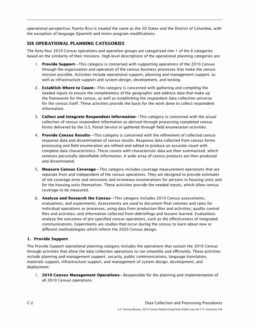
C-2 Data Collection and Processing Procedures
U.S. Census Bureau, 2010 Census Redistricting Data (Public Law 94-171) Summary File
operational perspective, Puerto Rico is treated the same as the 50 States and the District of Columbia, with the exception of language (Spanish) and minor program modifications.
SIX OPERATIONAL PLANNING CATEGORIES
The forty-four 2010 Census operations and operation groups are categorized into 1 of the 6 categories based on the similarity of their missions. High-level descriptions of the operational planning categories are:
1. Provide Support—This category is concerned with supporting operations of the 2010 Census through the organization and operation of the census business processes that make the census mission possible. Activities include operational support, planning and management support, as well as infrastructure support and system design, development, and testing.
2. Establish Where to Count—This category is concerned with gathering and compiling the needed inputs to ensure the completeness of the geographic and address data that make up the framework for the census, as well as establishing the respondent data collection universe for the census itself. These activities provide the basis for the work done to collect respondent information.
3. Collect and Integrate Respondent Information—This category is concerned with the actual collection of census respondent information as derived through processing completed census forms delivered by the U.S. Postal Service or gathered through field enumeration activities.
4. Provide Census Results—This category is concerned with the refinement of collected census response data and dissemination of census results. Response data collected from census forms processing and field enumeration are refined and edited to produce an accurate count with complete data characteristics. These counts with characteristic data are then summarized, which removes personally identifiable information. A wide array of census products are then produced and disseminated.
5. Measure Census Coverage—This category includes coverage measurement operations that are separate from and independent of the census operations. They are designed to provide estimates of net coverage error and omissions and erroneous enumerations for persons in housing units and for the housing units themselves. These activities provide the needed inputs, which allow census coverage to be measured.
6. Analyze and Research the Census—This category includes 2010 Census assessments, evaluations, and experiments. Assessments are used to document final volumes and rates for individual operations or processes, using data from production files and activities; quality control files and activities; and information collected from debriefings and lessons learned. Evaluations analyze the outcomes of pre-specified census operations, such as the effectiveness of integrated communications. Experiments are studies that occur during the census to learn about new or different methodologies which inform the 2020 Census design.
1. Provide Support
The Provide Support operational planning category includes the operations that sustain the 2010 Census through activities that allow the data collection operations to run smoothly and efficiently. These activities include planning and management support, security, public communications, language translation, materials support, infrastructure support, and management of system design, development, and deployment.
1. 2010 Census Management Operations—Responsible for the planning and implementation of all 2010 Census operations.

Data Collection and Processing Procedures C-3
U.S. Census Bureau, 2010 Census Redistricting Data (Public Law 94-171) Summary File
2. Content and Forms Design Operation—Responsible for the design and content of questionnaires and other materials in order to generate high and consistent response rates across all 2010 Census operations.
3. Security, Privacy, and Confidentiality Operations—Ensures that all 2010 Census operations adhere to the appropriate security, privacy, and confidentiality policies and regulations.
4. Field Infrastructure Support Operations—Supports all 2010 field data collection operations through staffing, office space and computing infrastructure deployment and support, and supply and material distribution.
5. Language Services Operations—Supports the language needs of the 2010 operations by translating materials to the over 40 languages targeted for 2010 Census.
6. Integrated Communications Services Operation—Responsible for educating, creating awareness and motivating persons to participate by responding to the 2010 Census.
2. Establish Where to Count
The Establish Where to Count operational planning category includes the operations that perform activities to gather and compile the geographic and address data that make up the framework for the 2010 Census. This includes activities that create and manage the respondent data collection universes for the census data collection operations.
7. Geographic Updating and Delineation Operation—Determines, delineates, and updates the geographic area boundaries for data collection.
8. Administrative Records Updating Operation—Uses administrative records sources from the U.S. Postal Service (USPS), local governments, and independent organizations to ensure the address list is as complete as possible.
9. Local Update of Census Addresses (LUCA) Operation—Provides the opportunity for tribal, state, and local governments to review and comment on the Census Bureau’s address list to ensure an accurate and complete enumeration of their communities.
10. New Construction Operation—Provides the opportunity for tribal and local governments to report newly constructed living quarters in the enumeration areas where the Census Bureau delivers questionnaires using the USPS.
11. Address Canvassing Field Operation—Collects updated living quarters addresses, geographic features, and spatial information, including the verified LUCA updates.
12. Group Quarters Validation Field Operation—Classifies “Other Living Quarters” as a group quarters or non-group quarters, then assigns a group quarters type code which will be utilized by other operations.
13. Update/Leave Operation—For geographic areas where mail delivery problems are anticipated, Update/Leave field operations hand deliver questionnaires to housing units and update address lists and maps if inconsistencies are found.
14. Field Verification Field Operation—Verifies the existence of respondent-provided housing unit addresses that have not been confirmed by a Census Bureau employee and also verifies potential duplicate housing units identified in Response Processing.
15. Non-ID Processing Operation—Associates census identification numbers with completed respondent-generated questionnaires that do not have a preassigned census identification number but have a respondent-provided address.

C-4 Data Collection and Processing Procedures
U.S. Census Bureau, 2010 Census Redistricting Data (Public Law 94-171) Summary File
16. Geographic Data Processing Production (GDP) Operation—Maintains the MAF/TIGER® system, which is the repository for spatial and address data, and provides spatial and address products for 2010 Census operations.
17. Universe Control and Management Production Operation—Creates and manages the respondent data collection universes for census data collection operations using a database of GDP-provided census addresses and related information.
3. Collect and Integrate Respondent Information
The Collect and Integrate Respondent Information operational planning category includes the operations that collect census respondent information through processing completed census forms delivered by the USPS or gathered through field enumeration activities.
18. Forms Printing and Distribution Operation—Prints all public-use forms and other materials to support the 2010 Census, including the 2010 Census questionnaire mailed to housing units on March 15, 2010.
19. Update Enumerate Operation—Updates the address list and enumerates the housing units in certain designated geographic areas with special enumeration needs. This group includes the Remote Update Enumeration and Remote Alaska operations.
20. Enumeration at Transitory Locations Field Operation—Enumerates individuals that do not have a usual home elsewhere (UHE) at housing units at transitory locations.
21. Be Counted/Questionnaire Assistance Center Operation—Provides community outreach in hard to enumerate (HTE) areas to assist persons in completing their census questionnaire.
22. Invalid Return Detection Operation—Detects potentially fraudulent returns.
23. Nonreponse Operation—Enumerates all housing units that did not respond to the mailed out census questionnaire.
24. Coverage Follow-Up Operation—A telephone operation that resolves erroneous enumerations and omissions detected from other enumeration operations.
25. Group Quarters Operation—Establishes contacts and enumerates individuals at Group Quarters locations. This operation group includes both Group Quarters Advance Visit and Group Quarters Enumeration (which itself includes Service-Based Enumeration, Military Group Enumeration, and Domestic Military/Maritime Vessels Enumeration operations).
26. Island Areas Enumeration Operation—Lists all residential and other living quarters and enumerates these units in American Samoa, the Commonwealth of the Northern Mariana Islands, Guam, and the U.S. Virgin Islands.
27. Federally Affiliated Americans Overseas Count Operation—Obtains counts of U.S. military and federal civilian employees stationed overseas and their dependents living with them that can be allocated to a home state for the purposes of reapportioning seats in the U.S. House of Representatives.
28. Telephone Questionnaire Assistance and Fulfillment Operation—Provides assistance over the phone to 2010 Census callers.
29. Data Capture and Integration (DCI) Operation—Provides a means to capture both questionnaire data and geographic data from data collection operations and integrates them into a common set of formats for further processing.
Data Collection and Processing Procedures C-5
U.S. Census Bureau, 2010 Census Redistricting Data (Public Law 94-171) Summary File
4. Provide Census Results
The Provide Census Results operational planning category is concerned with the refinement of the collected census response data and dissemination of census results. Response data collected from census forms processing and field enumeration are refined and edited to produce an accurate count with complete data characteristics. These counts with characteristic data are then summarized, which removes personally identifiable information. A wide array of census products are then produced and disseminated.
30. Geographic Boundary and Districting Operation—Determines and updates the geographic area boundaries for districting and tabulation.
31. Response Processing Production Operation—Processes integrated response data provided by the DCI operation to unduplicate responses, ensure that complete information is collected, conduct statistical methods, and format data files used to produce census results.
32. Count Review Operation—Designed to enhance the accuracy of the census and provides the Federal-State Cooperative Program for Population Estimates (FSCPE) with the opportunity to review and provide feedback on count tabulations prior to the release of Public Law 94-171 data.
33. Data Products and Dissemination Production (DPD) Operation—Tabulates and disseminates 2010 Census products, including apportionment counts and Public Law 94-171 redistricting data. The DPD produces many data products, including state and national summary files, tabulated informational files, and data comparison tables. The DPD is responsible for printed and electronic informational products that include population and housing unit tabulations, geographical maps, and a number of data products that specifically pertain to the island areas.
The Data Access and Dissemination System (DADS) program is the primary provider of dissemination services via the Internet through the American FactFinder (AFF) system. This system was redesigned and enhanced for the 2010 Census and for dissemination of other Census Bureau data products. The DADS program is also the provider of tabulation services for the decennial census. Tabulation services refer to the activities related to aggregating data collected on individual responses to a survey or census into summarized statistical data suitable for public release. Dissemination services refer to the activities related to the internal staging and release of approved statistics for posting on the Internet. These services include the provision of interim results or output so that other areas of the Census Bureau can process and release data in different media and formats, (e.g. CD-ROM, DVD, File Transfer Protocol [FTP], Adobe Acrobat Portable Document Format [PDF] for printed publications).
34. Archiving Operation—Provides 2010 Census records to the National Archives and Records Administration (NARA).
5. Measure Census Coverage
The Measure Census Coverage operational planning category includes coverage measurement operations that are separate from and independent of the census operations. They are designed to provide estimates of net coverage error and omissions and erroneous enumerations for persons in housing units and for the housing units themselves. These activities provide the needed inputs that allow census coverage to be measured. This planning category consists of the Census Coverage Measurement (CCM) program and the Demographic Analysis operation.
The focus of the CCM program is to measure the coverage error in the 2010 Census with the goal of improving future census operations. CCM produces estimates of net coverage error and estimates of the coverage error components for both housing units and persons living in housing units. Components of coverage error include omissions and erroneous enumerations (including duplicates). Measuring the coverage error of persons in group quarters and of group quarters facilities is not within the scope of the

C-6 Data Collection and Processing Procedures
U.S. Census Bureau, 2010 Census Redistricting Data (Public Law 94-171) Summary File
CCM program. The CCM is a sample survey and, as is typical, is conducted separately and independently of the census operations to ensure that the coverage error estimates are unbiased.
35. CCM Sample Design Operation—Designs and implements the sample to support the estimation of coverage errors in the 2010 Census for the United States and Puerto Rico, excluding remote Alaska.
36. CCM Independent Listing Field Operation—Creates the list of CCM addresses by canvassing the selected sample block cluster areas using a paper instrument called the CCM Independent Listing Book (ILB).
37. CCM Initial Housing Unit Matching and Follow-Up Operation—Determines the reasons for differences between the housing unit addresses in the CCM sample and the initial census address list using automated computer matching, clerical matching, and in-person follow-up techniques.
38. CCM Person Interview Field Operation—Collects person and housing unit information for selected housing units in each sample block cluster by performing in-person interviews using a computer-assisted data collection instrument.
39. CCM Person Matching and Follow-Up Operation—Determines the reasons for the differences between the persons in the CCM sample and the persons in the 2010 Census using automated computer matching, clerical matching, telephone and in-person follow-up techniques.
40. CCM Final Housing Unit Matching and Follow-Up Operation—Determines the reasons for the differences between the housing unit addresses in the CCM sample and the final 2010 Census address list using automated computer matching, clerical matching, and in-person follow-up techniques.
41. CCM Estimation Operation—Produces estimates of net coverage error and the components of coverage error for housing units and persons living in housing units in the United States and Puerto Rico, excluding remote Alaska.
42. Demographic Analysis Operation—Produces independent assessments of census coverage using population and housing unit benchmarks in support of the 2010 Census and the evaluation of 2010 Census results.
6. Analyze and Research the Census
The Analyze and Research the Census operational planning category includes 2010 Census assessments, evaluations, and experiments. Assessments are used to document final volumes and rates for individual operations or processes, using data from production files and activities; quality control files and activities; and information collected from debriefings and lessons learned. Evaluations analyze the outcomes of prespecified census operations, such as the effectiveness of integrated communications. Experiments are studies that occur during the census to learn about new or different methodologies, which inform the 2020 Census design.
43. Evaluations, Experiments, and Assessments Operation—Includes all of the analyses of the design and operations of the 2010 Census, as well as experimental design changes that could inform the 2020 Census. Evaluations and assessments are performed and experiments are conducted to analyze the 2010 Census and to inform early research in the 2020 Census test cycle.
44. Count Question Resolution Operation—Conducts an administrative review to handle external challenges to official 2010 Census counts of housing units and group quarters and their associated population.

Data Collection and Processing Procedures C-7
U.S. Census Bureau, 2010 Census Redistricting Data (Public Law 94-171) Summary File
THUMBNAIL DESCRIPTIONS OF 2010 CENSUS OPERATIONS
Address Canvassing—A field operation where census workers systematically canvass all census blocks looking for living quarters and updating the address and map information on a hand-held computer.
Be Counted Program—A program designed for persons who believe they were not counted in the 2010 Census. The Census Bureau will place unaddressed census questionnaires at selected public sites so that individuals that did not receive one in the mail can complete the census.
Census Coverage Follow-Up—A census operation designed to ensure that no person is left out or counted in more than one place in the census and to clarify responses previously collected to improve the accuracy of the census.
Census Coverage Measurement (CCM) Final Housing Unit Follow-Up—A coverage measurement field operation designed to gather additional information to determine reasons for differences between the Independent Listing operation and census records.
Census Coverage Measurement (CCM) Independent Listing Operation—A coverage measurement field operation to construct a list of all housing units, independent of the census, contained within select CCM block clusters.
Census Coverage Measurement (CCM) Initial Housing Unit Follow-Up—A coverage measurement field operation designed to gather information to determine reasons for differences between the Independent Listing operation results and the preliminary census address file.
Census Coverage Measurement (CCM) Person Follow-Up—A coverage measurement field operation designed to collect additional information about persons or households to determine reasons for differences between the CCM Person Interview and the census enumeration.
Census Coverage Measurement (CCM) Person Interview—A coverage measurement field operation designed to collect information about the current resident(s) of each sample housing unit and certain persons who had moved out of the sample address between Census Day and the time of the CCM Person Interview.
Enumeration at Transitory Locations—A census operation where census workers conduct a personal interview with individuals who do not have a usual home elsewhere.
Field Verification—A census operation where census workers verify the existence of units that had been geocoded to a census block but did not match an address in the Master Address File.
Group Quarters Advance Visit—A census operation designed to inform the group quarters contact person of the upcoming enumeration.
Group Quarters Enumeration—A census operation designed to count people living or staying in places such as college residence halls, skilled-nursing facilities, group homes, military barracks, and correctional facilities.
Group Quarters Validation—A census operation designed to determine the correct classification of addresses identified as “other living quarters” during the address canvassing operation.
Mailout/Mailback—A census operation where most households in the United States will be mailed a census questionnaire by the U.S. Postal Service. Household respondents will be asked to fill out the questionnaires and mail them back to data capture centers.
C-8 Data Collection and Processing Procedures
U.S. Census Bureau, 2010 Census Redistricting Data (Public Law 94-171) Summary File
Military Group Quarters Enumeration—A part of the Group Quarters Enumeration operation conducted on military bases and carried out in coordination with the military base point of contact to count military personnel.
Military/Maritime Vessel Enumeration—A part of the Group Quarters operation conducted to enumerate persons on U.S. owned and operated flagged military and maritime vessels.
Nonresponse Follow-Up—A census operation where census workers visit housing units that did not return a completed questionnaire by mail to conduct a personal interview to obtain the required information.
Nonresponse Follow-Up Reinterview—A quality check operation designed to ensure that the production enumerator followed field procedures and to identify enumerators who intentionally or unintentionally produced data errors so that work can be redone.
Questionnaire Assistance Center—A center established by a local census office to assist people with completing their questionnaires. The centers were established in community centers, large apartment buildings, childcare and educational centers, and so forth. The centers are staffed by volunteers and Census Bureau employees; also called walk-in questionnaire assistance centers.
Remote Alaska—A method of data collection used to enumerate the most sparsely settled, isolated parts of Alaska—areas accessible only by small plane, boat, snowmobile, 4-wheel-drive vehicle, dog sled, or a combination of these.
Remote Update/Enumerate—A method of data collection conducted with a “team enumeration” method in sparsely inhabited areas of Maine and Alaska, where all enumeration is completed in just one visit.
Service-Based Enumeration—A group quarters operation designed to enumerate persons receiving services at shelters, soup kitchens, regularly scheduled mobile food vans, and those staying at preidentified nonsheltered outdoor locations.
Telephone Questionnaire Assistance—A customer service operation assisting respondents who call in to inquire about census activities going on in their neighborhood or who want to obtain clarification to questions on the census questionnaire or who request to fill out the form through an interview over the phone.
Update/Enumerate—A method of data collection conducted only in communities determined by local census officials where continually low response rates have be=en established from previous censuses or ongoing survey efforts, and mailing or hand-delivering forms is not cost beneficial. Enumeration is done by census takers who personally interview each household to collect information and update census address lists and maps at the same time.
Update/Leave—A census operation where census workers update paper versions of census address lists and maps and leave questionnaires at housing units in mainly rural areas without street names and/or house numbers. Household respondents are expected to fill out the questionnaires and mail them to data capture centers.
Vacant Delete Check—A census operation where census workers visit addresses that workers recorded in Nonresponse Follow-Up as either vacant or not a housing unit on Census Day, April 1.

Data Collection and Processing Procedures C-9
U.S. Census Bureau, 2010 Census Redistricting Data (Public Law 94-171) Summary File
TIMELINE OF 2010 CENSUS OPERATIONS
Operation Conducted
Address Canvassing April 6, 2009–July 19, 2009
CCM Independent Listing Operation August 28, 2009–December 5, 2009
Group Quarters Validation September 28, 2009–October 23, 2009
Remote Alaska January 22, 2010–May 5, 2010
Group Quarters Advance Visit February 1, 2010–March 19, 2010
Telephone Questionnaire Assistance February 25, 2010–July 30, 2010
Questionnaire Assistance Centers February 26, 2010–April 19, 2010
Update/Leave March 1, 2010– April 2, 2010
CCM Initial Housing Unit Follow-Up March 4, 2010–April 23, 2010
Mailout/Mailback March 15, 2010–September 30, 2010
Be Counted Program March 19, 2010–April 19, 2010
Update/ Enumerate March 22, 2010– May 29, 2010
Enumeration at Transitory Locations March 22, 2010–April 16, 2010
Remote Update Enumerate March 22, 2010–May 29, 2010
Service-Based Enumeration March 29, 2010–March 31, 2010
Military Group Quarters Enumeration March 30, 2010–May 14, 2010
Group Quarters Enumeration April 1, 2010–May 14, 2010
Military/Maritime Vessel Enumeration April 1, 2010–May 14, 2010
Second Questionnaire Mailing in Mailout/Mailback Areas (either targeted or blanket delivery) April 1, 2010–April 10, 2010
Coverage Follow-Up April 26, 2010–August 13, 2010
Nonresponse Follow-Up May 1, 2010–July 10, 2010
Nonresponse Follow-Up Reinterview May 7, 2010–July 17, 2010
Vacant Delete Check July 24, 2010–Aug 25, 2010
Field Verification August 6, 2010–September 3, 2010
CCM Person Interview August 14, 2010–October 2, 2010
CCM Person Follow-Up January 28, 2011–March 19, 2011
CCM Final Housing Unit Follow-Up May 5, 2011–June 15, 2011

C-10 Data Collection and Processing Procedures
U.S. Census Bureau, 2010 Census Redistricting Data (Public Law 94-171) Summary File
LIST OF STATES’ SERVICES BY EACH REGIONAL OFFICE
Atlanta Alabama, Florida, Georgia
Boston Connecticut, Massachusetts, New Hampshire, New York (all counties except those covered by the New York regional office listed below), Rhode Island, Maine, Puerto Rico, Vermont,
Charlotte Kentucky, North Carolina, South Carolina, Tennessee, Virginia
Chicago Illinois, Indiana, Wisconsin
Dallas Louisiana, Mississippi, Texas
Denver Arizona, Colorado, Montana, Nebraska, Nevada, New Mexico, North Dakota, South Dakota, Utah, Wyoming
Detroit Michigan, Ohio, West Virginia
Kansas City Arkansas, Iowa, Kansas, Minnesota, Missouri, Oklahoma
Los Angeles Hawaii, Southern California (counties of Fresno, Imperial, Inyo, Kern, Kings, Los Angeles, Madera, Mariposa, Merced, Monterey, Orange, Riverside, San Benito, San Bernardino, San Diego, San Luis Obispo, Santa Barbara, Tulare, and Ventura)
New York New Jersey (counties of Bergen, Essex, Hudson, Middlesex, Morris, Passaic, Somerset, Sussex, Union, and Warren), New York (counties of Bronx, Kings, Nassau, New York, Queens, Richmond, Rockland, Suffolk, and Westchester)
Philadelphia Delaware, District of Columbia, Maryland, New Jersey (all counties except those covered by the New York regional office listed above), Pennsylvania
Seattle Alaska, Idaho, Northern California (all counties except those covered by the Los Angeles regional office listed above), Oregon, Washington
<www.census.gov/regions>

Questionnaire D-1
U.S. Census Bureau, 2010 Census Redistricting Data (Public Law 94-171) Summary File
Appendix D. Questionnaire

D-2 Questionnaire
U.S. Census Bureau, 2010 Census Redistricting Data (Public Law 94-171) Summary File

Questionnaire D-3
U.S. Census Bureau, 2010 Census Redistricting Data (Public Law 94-171) Summary File

D-4 Questionnaire
U.S. Census Bureau, 2010 Census Redistricting Data (Public Law 94-171) Summary File

Questionnaire D-5
U.S. Census Bureau, 2010 Census Redistricting Data (Public Law 94-171) Summary File

D-6 Questionnaire
U.S. Census Bureau, 2010 Census Redistricting Data (Public Law 94-171) Summary File

Maps E-1
U.S. Census Bureau, 2010 Census Redistricting Data (Public Law 94-171) Summary File
Appendix E.Maps CONTENTS
Introduction . . . . . . . . . . . . . . . . . . . . . . . . . . . . . . . . . . . . . . . . . . . . . . . . . . . . . . . . . . . . . . . . . . E-1Map Descriptions . . . . . . . . . . . . . . . . . . . . . . . . . . . . . . . . . . . . . . . . . . . . . . . . . . . . . . . . . . . . . . E-1 P.L. 94–171 County Block Map (2010 Census) . . . . . . . . . . . . . . . . . . . . . . . . . . . . . . . . . . . . . . . E-1 P.L. 94–171 Voting District/State Legislative District (VTD/SLD) Reference Map (2010 Census) . . . . . . . . . . . . . . . . . . . . . . . . . . . . . . . . . . . . . . . . . . . . . . . . . . E-1 2010 Census—Census Tract Reference Map . . . . . . . . . . . . . . . . . . . . . . . . . . . . . . . . . . . . . . . . . E-2 2010 Census—School District Reference Map . . . . . . . . . . . . . . . . . . . . . . . . . . . . . . . . . . . . . . . E-2 INTRODUCTION
There are four map types that support the 2010 Census Redistricting Data (Public Law [P.L.] 94-171) program. Each of these large format map types are produced in Adobe’s portable document format (PDF). These georeferenced PDF files are available through the U.S. Census Bureau’s Map Products Web site, linked through American FactFinder, and as state-based DVD products. In addition to the maps, other geographic products include the State Redistricting Data (P.L.94-171) Shapefiles and the 2010 Census Block Assignment Files, which provide census block relationships to voting districts, state legislative districts, school districts, and congressional districts.
MAP DESCRIPTIONS
P.L. 94-171 County Block Map (2010 Census)
These large-scale maps show the boundaries and numbers for all census blocks within a county. In addition to state and county, these maps show the boundaries, names, and codes for American Indian areas, Alaska Native areas, Hawaiian home lands, county subdivisions, places, and census tracts. These maps also show and label state legislative districts and voting districts, the geographic entities that the states submitted during their participation in the early phases of the Census Redistricting Data Program. The P.L. 94-171 county block maps also show and label base features, such as roads, railroads, and hydrography. The intent of this series is to map each county on the fewest number of map sheets possible and at the maximum practical scale, depending on the size and shape of the county and the density of the tabulation census blocks. Census block density affects the display of census block numbers and feature identifiers. Each county will be covered by one or more parent map sheets at a single scale. Inset map sheets at larger scales are created as required to show the map content described above. An index map showing the sheet configuration is created for all counties requiring more than one parent map sheet. The map sheet size is 36 by 32 inches.
P.L. 94-171 Voting District/State Legislative District (VTD/SLD) Reference Map (2010 Census)
These county-based reference maps show and label the state legislative districts and/or voting districts, the geographic entities that the states submitted during their participation in the early phases of the Census Redistricting Data Program. The maps also show the boundaries and names of American Indian areas, Alaska Native areas, Hawaiian home lands, counties, county subdivisions, and places. Additionally, these maps display a base feature network including roads, railroads, and water bodies. These features are labeled as map scale permits. The map sheet configuration is optimized to keep the number of map sheets for each county to a minimum. Each county will be covered by one or more parent map sheets at a single scale. Inset map sheets at larger scales are created where there are clusters of voting districts and/or state

E-2 Maps
U.S. Census Bureau, 2010 Census Redistricting Data (Public Law 94-171) Summary File
legislative districts that cannot be identified at the parent map scale. An index map showing the sheet configuration is created for all counties requiring more than one parent map sheet. The map sheet size is 36 by 32 inches.
2010 Census—Census Tract Reference Map
These county-based reference maps show and label the census tracts as delineated to support 2010 Census data dissemination. These maps also show the boundaries and names of American Indian areas, Alaska Native areas, Hawaiian home lands, counties, county subdivisions, and places. Additionally, these maps display a base feature network including roads, railroads, and water bodies. These features are labeled as map scale permits. The map sheet configuration is optimized to keep the number of map sheets for each county to a minimum. Each county will be covered by one or more parent map sheets at a single scale. Inset map sheets at larger scales are created where there are clusters of census tracts that cannot be identified at the parent map scale. An index map showing the sheet configuration is created for all counties requiring more than one parent map sheet. The map sheet size is 36 by 32 inches.
2010 Census—School District Reference Map
These reference maps show and label the unified, secondary, and elementary school districts as delineated by the state participants of the School District Review Program. These county-based maps also show and label states, counties, and places. Additionally, these maps display a base feature network including roads and water bodies. Major highways and selected water bodies are labeled. Each county will be covered by one or more parent map sheets at a single scale. Inset map sheets at larger scales are created where there are clusters of school districts that cannot be identified at the parent map scale. An index map showing the sheet configuration is created for all counties requiring more than one parent map sheet. For states and state-equivalents, including the District of Columbia, Florida, Hawaii, Maryland, Nevada, and West Virginia, where school districts are coextensive with counties, a state-based map identifying the counties and corresponding school districts is produced. The map sheet size is 36 by 32 inches.

Code Lists F-1
U.S. Census Bureau, 2010 Census Redistricting Data (Public Law 94-171) Summary File
HISPANIC OR LATINO ORIGIN
001–199 NOT HISPANIC/SPANISH
001–099 Not Used100 Not Hispanic/Spanish (Checkbox)101 Not Hispanic/Spanish102–109 Not Used110–112 Not Hispanic/Spanish113–115 Not Used116–121 Not Hispanic/Spanish122–129 Not Used130 Not Hispanic/Spanish131–134 Not Used135 Not Hispanic/Spanish136–144 Not Used145–146 Not Hispanic/Spanish147–149 Not Used150–156 Not Hispanic/Spanish157–159 Not Used160 Not Hispanic/Spanish161–165 Not Used166–168 Not Hispanic/Spanish169–199 Not Used
200–209 SPANIARD
200 Spaniard201 Andalusian202 Asturian203 Castillian204 Catalonian205 Balearic Islander206 Gallego207 Valencian208 Canarian209 Spanish Basque
210–220 MEXICAN
210 Mexican (Checkbox)211 Mexican212 Mexican American
Appendix F. Code Lists
CONTENTS
Hispanic or Latino Origin . . . . . . . . . . . . . . . . . . . . . . . . . . . . . . . . . . . . . . . . . . . . . . . . . . . . . . . . F-1Race . . . . . . . . . . . . . . . . . . . . . . . . . . . . . . . . . . . . . . . . . . . . . . . . . . . . . . . . . . . . . . . . . . . . . . . . F-3

F-2 Code Lists
U.S. Census Bureau, 2010 Census Redistricting Data (Public Law 94-171) Summary File
HISPANIC OR LATINO ORIGIN—Con.
210–220 MEXICAN—Con.213 Mexicano214 Chicano215 La Raza216 Mexican American Indian217 Not Used218 Mexico219 Mexican Indian220 Not Used
221–230 CENTRAL AMERICAN
221 Costa Rican222 Guatemalan223 Honduran224 Nicaraguan225 Panamanian226 Salvadoran227 Central American228 Central American Indian229 Canal Zone230 Not Used
231–249 SOUTH AMERICAN
231 Argentinean232 Bolivian233 Chilean234 Colombian235 Ecuadorian236 Paraguayan237 Peruvian238 Uruguayan239 Venezuelan240 South American Indian241 Criollo242 South American243–249 Not Used
250–259 LATIN AMERICAN
250 Latin American251 Latin252 Latino253–259 Not Used
260–269 PUERTO RICAN
260 Puerto Rican (Checkbox)261 Puerto Rican262–269 Not Used
Code Lists F-3
U.S. Census Bureau, 2010 Census Redistricting Data (Public Law 94-171) Summary File
HISPANIC OR LATINO ORIGIN—Con.
270–274 CUBAN
270 Cuban (Checkbox)271 Cuban272–274 Not Used
275–279 DOMINICAN
275 Dominican276–279 Not Used
280–299 OTHER HISPANIC/SPANISH
280 Other Hispanic/Spanish (Checkbox)281 Hispanic282 Spanish283 Californio284 Tejano285 Nuevo Mexicano286 Spanish American287 Spanish American Indian288 Meso American Indian289 Mestizo290 Caribbean291–298 Not Used299 Other Hispanic/Spanish, not elsewhere classified
300–999 NOT USED
RACE
100–199 WHITE
100 White (Checkbox)101 White ethnic group, not elsewhere classified 102 Arab103 English104 French105 German106 Irish107 Italian108 Near Easterner109 Polish110 Scottish111 Armenian112 Assyrian113 Egyptian114 Iranian115 Iraqi116 Lebanese117 Middle East118 Palestinian
HISPANIC OR LATINO ORIGIN—Con.
210–220 MEXICAN—Con.213 Mexicano214 Chicano215 La Raza216 Mexican American Indian217 Not Used218 Mexico219 Mexican Indian220 Not Used
221–230 CENTRAL AMERICAN
221 Costa Rican222 Guatemalan223 Honduran224 Nicaraguan225 Panamanian226 Salvadoran227 Central American228 Central American Indian229 Canal Zone230 Not Used
231–249 SOUTH AMERICAN
231 Argentinean232 Bolivian233 Chilean234 Colombian235 Ecuadorian236 Paraguayan237 Peruvian238 Uruguayan239 Venezuelan240 South American Indian241 Criollo242 South American243–249 Not Used
250–259 LATIN AMERICAN
250 Latin American251 Latin252 Latino253–259 Not Used
260–269 PUERTO RICAN
260 Puerto Rican (Checkbox)261 Puerto Rican262–269 Not Used

F-4 Code Lists
U.S. Census Bureau, 2010 Census Redistricting Data (Public Law 94-171) Summary File
RACE—Con.
100–199 WHITE—Con.
119 Syrian120 Other Arab121 Afghanistani122 Israeli123 Not Used124 Cajun125 Moroccan126 North African127 United Arab Emirates128 Azerbaijani129 Aryan130–139 Not Used140 Multiple WHITE responses141–149 Not Used150 White151 Caucasian152–199 Not Used
200–299 BLACK OR AFRICAN AMERICAN
200 Black, African Am., or Negro (Checkbox)201 Black ethnic group, not elsewhere classified 202 African203 African American204 Afro-American205 Nigritian206 Negro207 Bahamian208 Barbadian209 Batswana (Botswana) 210–212 Not Used213 Ethiopian214 Haitian215 Jamaican216 Liberian217 Not Used 218 Namibian219 Nigerian220 Other African221–222 Not Used223 Trinidad and Tobago224 West Indies225 Zaire226 Not Used227 Not Used228 South African229 Not Used230 Dominica Islander231–233 Not Used234 Cayenne

Code Lists F-5
U.S. Census Bureau, 2010 Census Redistricting Data (Public Law 94-171) Summary File
RACE—Con.
200–299 BLACK OR AFRICAN AMERICAN—Con.
235–239 Not Used240 Multiple BLACK OR AFRICAN AMERICAN responses241–249 Not Used250 Black251–299 Not Used
300–399, A01–Z99 AMERICAN INDIAN AND ALASKA NATIVE
AMERICAN INDIAN TRIBES
300 American Indian or Alaska Native (Checkbox)301–399 Not Used
AbenakiA01 Abenaki Nation of MissisquoiA02 Koasek (Cowasuck) Traditional Band of the Sovereign Abenaki NationA03–A04 Not Used
AlgonquianA05 AlgonquianA06–A08 Not Used
ApacheA09 ApacheA10 Not UsedA11 Fort Sill Apache (Chiricahua)A12 Jicarilla Apache NationA13 Lipan ApacheA14 Mescalero Apache Tribe of the Mescalero Reservation, New MexicoA15 Apache Tribe of OklahomaA16 Tonto Apache Tribe of ArizonaA17 San Carlos Apache Tribe of the San Carlos ReservationA18 White Mountain Apache Tribe of the Fort Apache Reservation, ArizonaA19–A23 Not Used
ArapahoA24 ArapahoA25 Northern ArapahoA26 Southern ArapahoA27 Arapaho Tribe of the Wind River Reservation, Wyoming A28–A33 Not Used
AssiniboineA34 AssiniboineA35–A37 Not Used
Assiniboine SiouxA38 Assiniboine SiouxA39 Fort Peck Assiniboine and Sioux Tribes of the Fort Peck Indian ReservationA40 Fort Peck Assiniboine

F-6 Code Lists
U.S. Census Bureau, 2010 Census Redistricting Data (Public Law 94-171) Summary File
RACE—Con.
300–399, A01–Z99 AMERICAN INDIAN AND ALASKA NATIVE—Con.
AMERICAN INDIAN TRIBES—Con.
Assiniboine Sioux—Con.A41 Fort Peck Sioux A42–A44 Not Used
BlackfeetA45 Blackfeet Tribe of the Blackfeet Indian Reservation of MontanaA46–A50 Not Used
BrothertonA51 BrothertonA52 Not Used
Burt Lake A53 Burt Lake ChippewaA54 Burt Lake Band of Ottawa and Chippewa IndiansA55 Burt Lake Ottawa
CaddoA56 CaddoA57 Caddo Nation of OklahomaA58 Caddo Adais Indians A59–A60 Not Used
CahuillaA61 Agua Caliente Band of Cahuilla IndiansA62 Augustine Band of Cahuilla Indians A63 Cabazon Band of Mission IndiansA64 CahuillaA65 Los Coyotes Band of Cahuilla and Cupeno IndiansA66 Morongo Band of Cahuilla Mission IndiansA67 Santa Rosa Band of Cahuilla Indians A68 Torres-Martinez Desert Cahuilla IndiansA69 Ramona Band or Village of CahuillaA70–A74 Not Used
California TribesA75 Cahto Indian Tribe of the Laytonville RancheriaA76 ChimarikoA77–A78 Not UsedA79 KawaiisuA80 Kern River Paiute CouncilA81 MattoleA82 Red WoodA83 Santa Rosa Indian CommunityA84 TakelmaA85 WappoA86 YanaA87 YukiA88 Bear River Band of Rohnerville RancheriaA89 California Valley Miwok Tribe
Code Lists F-7
U.S. Census Bureau, 2010 Census Redistricting Data (Public Law 94-171) Summary File
RACE—Con.
300–399, A01–Z99 AMERICAN INDIAN AND ALASKA NATIVE—Con.
AMERICAN INDIAN TRIBES—Con.
California Tribes—Con.A90 Redding Rancheria, CaliforniaA91 (see under Tolowa)A92 Cher-Ae Heights Indian Community of the Trinidad Rancheria A93–A99 Not UsedB01–B03 Not Used
CatawbaB04 Catawba Indian NationB05–B06 Not Used
CayuseB07 CayuseB08–B10 Not Used
ChehalisB11 Confederated Tribes of the Chehalis Reservation, WashingtonB12–B13 Not Used
ChemakuanB14 ChemakuanB15 Hoh Indian Tribe of the Hoh Reservation, WashingtonB16 Quileute Tribe of the Quileute Reservation, WashingtonB17–B18 Not Used
ChemehueviB19 Chemehuevi Indian Tribe B20 Not Used
CherokeeB21 CherokeeB22 Cherokee AlabamaB23 Cherokee Tribe of Northeast AlabamaB24 Cher-O-Creek Intratribal IndiansB25 Eastern Band of Cherokees B26 Echota Cherokee Tribe of AlabamaB27 Georgia Eastern Cherokee B28 Northern Cherokee Nation of Missouri and ArkansasB29 TuscolaB30 United Keetoowah Band of CherokeeB31 Cherokee Nation of Oklahoma (Western Cherokee)B32 Southeastern Cherokee CouncilB33 Sac River Band of the Chickamauga-CherokeeB34 White River Band of the Chickamauga-CherokeeB35 Four Winds CherokeeB36 Cherokee of GeorgiaB37 Piedmont American Indian Association-Lower Eastern Cherokee Nation SC (PAIA) B38 United Cherokee Ani-Yun-Wiya NationB39 Cherokee Bear Clan of South Carolina

F-8 Code Lists
U.S. Census Bureau, 2010 Census Redistricting Data (Public Law 94-171) Summary File
RACE—Con.
300–399, A01–Z99 AMERICAN INDIAN AND ALASKA NATIVE—Con.
AMERICAN INDIAN TRIBES—Con.
CheyenneB40 CheyenneB41 Northern Cheyenne Tribe of the Northern Cheyenne Reservation, MontanaB42 Southern CheyenneB43–B45 Not Used
Cheyenne-ArapahoB46 Cheyenne and Arapaho Tribes, OklahomaB47–B48 Not Used
ChickahominyB49 Chickahominy Indian TribeB50 Chickahominy Eastern BandB51–B52 Not Used
ChickasawB53 Chickasaw NationB54 Chaloklowa ChickasawB55–B56 Not Used
ChinookB57 ChinookB58 ClatsopB59 Columbia River ChinookB60 KathlametB61 Upper ChinookB62 Wakiakum ChinookB63 Willapa ChinookB64 WishramB65–B66 Not Used
ChippewaB67 Bad River Band of the Lake Superior TribeB68 Bay Mills Indian CommunityB69 Bois Forte Band of ChippewaB70 Not UsedB71 ChippewaB72 Fond du LacB73 Grand PortageB74 Grand Traverse Band of Ottawa and Chippewa IndiansB75 Keweenaw Bay Indian Community B76 Lac Court Oreilles Band of Lake Superior ChippewaB77 Lac du FlambeauB78 Lac Vieux Desert Band of Lake Superior Chippewa IndiansB79 Lake Superior Chippewa B80 Leech LakeB81 Little Shell Tribe of Chippewa Indians of Montana

Code Lists F-9
U.S. Census Bureau, 2010 Census Redistricting Data (Public Law 94-171) Summary File
RACE—Con.
300–399, A01–Z99 AMERICAN INDIAN AND ALASKA NATIVE—Con.
AMERICAN INDIAN TRIBES—Con.
Chippewa—Con.B82 Mille LacsB83 Minnesota ChippewaB84 Not Used B85 Red Cliff Band of Lake Superior ChippewaB86 Red Lake Band of Chippewa IndiansB87 Saginaw Chippewa Indian TribeB88 St. Croix ChippewaB89 Sault Ste. Marie Tribe of Chippewa IndiansB90 Sokaogon Chippewa CommunityB91 Turtle Mountain Band of Chippewa Indians of North Dakota B92 White EarthB93 Swan Creek Black River Confederate TribeB94–B99 Not Used
Chippewa CreeC01 Not UsedC02 Chippewa-Cree Indians of the Rocky Boy’s Reservation C03–C04 Not Used
ChitimachaC05 Chitimacha Tribe of LouisianaC06 Pointe Au-Chien Indian Tribe C07 Not Used
ChoctawC08 ChoctawC09 Clifton ChoctawC10 Jena Band of ChoctawC11 Mississippi Band of Choctaw IndiansC12 MOWA Band of Choctaw IndiansC13 Choctaw Nation of Oklahoma C14–C16 Not Used
Choctaw-ApacheC17 Choctaw-Apache Community of EbarbC18–C19 Not Used
ChumashC20 ChumashC21 Santa Ynez Band of Chumash Mission Indians C22 San Luis Rey Mission IndianC23–C24 Not Used
Clear LakeC25 Clear Lake

F-10 Code Lists
U.S. Census Bureau, 2010 Census Redistricting Data (Public Law 94-171) Summary File
RACE—Con.
300–399, A01–Z99 AMERICAN INDIAN AND ALASKA NATIVE—Con.
AMERICAN INDIAN TRIBES—Con.
Coeur D’AleneC26 Coeur D’Alene TribeC27–C28 Not UsedC29 Coharie Indian TribeC30–C31 Not Used
Colorado River IndianC32 Colorado River Indian TribesC33–C34 Not Used
ColvilleC35 Confederated Tribes of the Colville Reservation C36–C38 Not Used
ComancheC39 Comanche Nation, Oklahoma C40–C43 Not Used
Coos, Lower Umpqua, and SiuslawC44 Confederated Tribes of Coos, Lower Umpqua, and Siuslaw IndiansC45 Not Used
CoosC46 Coos
CoquilleC47 Coquille Indian TribeC48 Not Used
CostanoanC49 CostanoanC50–C51 Not Used
CoushattaC52 Alabama-Coushatta Tribe of TexasC53 CoushattaC54–C55 Not Used
CowlitzC56 Cowlitz Indian TribeC57–C58 Not Used
CreeC59 CreeC60–C63 Not Used
CreekC64 Alabama CreekC65 Alabama Quassarte Tribal TownC66 Muscogee (Creek) Nation

Code Lists F-11
U.S. Census Bureau, 2010 Census Redistricting Data (Public Law 94-171) Summary File
RACE—Con.
300–399, A01–Z99 AMERICAN INDIAN AND ALASKA NATIVE—Con.
AMERICAN INDIAN TRIBES—Con.
Creek—Con.C67 Eastern CreekC68 Eastern MuscogeeC69 Kialegee Tribal TownC70 Lower Muscogee Creek Tama Tribal TownC71 MaChis Lower Creek Indian TribeC72 Poarch Band of Creek IndiansC73 Principal Creek Indian NationC74 Lower Creek Muscogee Tribe East, Star ClanC75 Thlopthlocco Tribal TownC76 TuckabacheeC77–C80 Not Used
CroatanC81 CroatanC82 Not Used
CrowC83 Crow Tribe of MontanaC84–C86 Not Used
Cumberland C87 Cumberland County Association for Indian PeopleC88 Not Used
CupenoC89 Agua CalienteC90 CupenoC91–C92 Not Used
DelawareC93 Delaware (Lenni-Lenape) C94 Delaware Tribe of Indians, Oklahoma C95 Not UsedC96 MunseeC97 Delaware Nation C98 Ramapough Lenape Nation (Ramapough Mountain)C99 New Jersey Sand Hill Band of Indians, Inc D01 Allegheny LenapeD02–D04 Not Used
Diegueno (Kumeyaay)D05 Barona Group of Capitan Grande BandD06 Campo Band of Diegueno Mission IndiansD07 Capitan Grande Band of Diegueno Mission IndiansD08 Ewiiaapaayp Band of Kumeyaay Indians D09 Diegueno (Kumeyaay) D10 La Posta Band of Diegueno Mission IndiansD11 Manzanita Band of Diegueno Mission IndiansD12 Mesa Grande Band of Diegueno Mission Indians

F-12 Code Lists
U.S. Census Bureau, 2010 Census Redistricting Data (Public Law 94-171) Summary File
RACE—Con.
300–399, A01–Z99 AMERICAN INDIAN AND ALASKA NATIVE—Con.
AMERICAN INDIAN TRIBES—Con.
Diegueno (Kumeyaay)—Con.D13 San Pasqual Band of Diegueno Mission IndiansD14 Iipay Nation of Santa Ysabel D15 Sycuan Band of the Kumeyaay Nation D16 Viejas (Baron Long) Group of Capitan Grande BandD17 Inaja Band of Diegueno Mission Indians of the Inaja and Cosmit ReservationD18 Jamul Indian VillageD19 Not Used
Eastern TribesD20 AttacapaD21 BiloxiD22 GeorgetownD23 MoorD24 Nansemond Indian TribeD25 Natchez Indian Tribe of South Carolina (Kusso-Natchez; Edisto)D26 Nausu WaiwashD27 (see under Nipmuc)D28 Golden Hill PaugussettD29 Pocomoke AcohonockD30 Southeastern IndiansD31 SusquehanockD32 Biloxi-Chitimacha-Choctaw ConfederationD33 Tunica Biloxi Indian Tribe of LouisianaD34 Waccamaw Siouan Indian TribeD35 Beaver Creek Indians D36 WicomicoD37 Meherrin Indian TribeD38 Santee Indian OrganizationD39 Santee Indian Nation of South CarolinaD40 Pee Dee Indian Tribe of South Carolina D41 Pee Dee Indian Nation of Upper South Carolina
EsselenD42 EsselenD43 Not Used
Fort BelknapD44 Fort Belknap Indian Community of the Fort Belknap Reservation
Three Affiliated Tribes of North DakotaD45 Three Affiliated Tribes of Ft. Berthold Reservation, North Dakota D46 MandanD47 HidatsaD48 Arikara (Sahnish)
Fort McDowellD49 Fort McDowell Yavapai Nation D50 Not Used

Code Lists F-13
U.S. Census Bureau, 2010 Census Redistricting Data (Public Law 94-171) Summary File
RACE—Con.
300–399, A01–Z99 AMERICAN INDIAN AND ALASKA NATIVE—Con.
AMERICAN INDIAN TRIBES—Con.
Fort HallD51 Shoshone-Bannock Tribes of the Fort Hall ReservationD52 Lemhi-ShoshoneD53 BannockD54 Not Used
GabrielenoD55 Gabrieleno
Fernandeno Tataviam Band of Mission IndiansD56 Fernandeno Tataviam Band of Mission Indians
Grand RondeD57 Confederated Tribes of the Grand Ronde Community of Oregon
GuilfordD58 Guilford Native American AssociationD59 Not Used
Gros VentresD60 AtsinaD61 Gros VentresD62–D63 Not Used
Haliwa-SaponiD64 Haliwa-Saponi Indian TribeD65–D67 Not Used
Ho-Chunk Nation D68 Ho-Chunk Nation D69 Not Used
HoopaD70 Hoopa Valley TribeD71 TrinityD72 WhilkutD73 Not Used
HopiD74 Hopi Tribe of ArizonaD75 Arizona Tewa
Hoopa ExtensionD76 Hoopa ExtensionD77 Not Used
HoumaD78 United Houma NationD79–D86 Not Used

F-14 Code Lists
U.S. Census Bureau, 2010 Census Redistricting Data (Public Law 94-171) Summary File
RACE—Con.
300–399, A01–Z99 AMERICAN INDIAN AND ALASKA NATIVE—Con.
AMERICAN INDIAN TRIBES—Con.
IowaD87 IowaD88 Iowa Tribe of Kansas and NebraskaD89 Iowa Tribe of OklahomaD90 Not Used
Sappony (Indians of Person County)D91 Sappony D92 Not Used
IroquoisD93 Cayuga NationD94 IroquoisD95 MohawkD96 OneidaD97 Onondaga NationD98 SenecaD99 Seneca NationE01 Seneca-Cayuga Tribe of OklahomaE02 Tonawanda Band of Seneca Indians E03 Tuscarora NationE04 Wyandotte Nation, OklahomaE05 Oneida Nation of New YorkE06–E09 Not Used
Juaneno (Acjachemem)E10 Juaneno (Acjachemem)E11–E12 Not Used
KalispelE13 Kalispel Indian CommunityE14–E16 Not Used
KarukE17 Karuk Tribe of CaliforniaE18–E20 Not Used
KawE21 Kaw NationE22–E23 Not Used
KickapooE24 KickapooE25 Kickapoo Tribe of OklahomaE26 Kickapoo Traditional Tribe of TexasE27 Kickapoo Tribe of Indians in Kansas E28–E29 Not Used

Code Lists F-15
U.S. Census Bureau, 2010 Census Redistricting Data (Public Law 94-171) Summary File
RACE—Con.
300–399, A01–Z99 AMERICAN INDIAN AND ALASKA NATIVE—Con.
AMERICAN INDIAN TRIBES—Con.
KiowaE30 KiowaE31 Kiowa Indian Tribe of OklahomaE32–E36 Not Used
S’KlallamE37 Jamestown S’Klallam Tribe of WashingtonE38 KlallamE39 Lower Elwha Tribal Community of the Lower Elwha Reservation, WashingtonE40 Port Gamble S’Klallam Tribe E41–E43 Not Used
KlamathE44 Klamath Indian Tribe of OregonE45–E47 Not Used
KonkowE48 KonkowE49 Not Used
KootenaiE50 Kootenai E51 Kootenai Tribe of Idaho E52 Not Used
LassikE53 LassikE54–E58 Not Used
Long IslandE59 MatinecockE60 MontaukE61 PoospatuckE62 SetauketE63–E65 Not Used
LuisenoE66 La Jolla Band of Luiseno Mission IndiansE67 LuisenoE68 Pala Band of Luiseno Mission IndiansE69 Pauma Band of Luiseno Mission IndiansE70 Pechanga Band of Luiseno Mission IndiansE71 Soboba Band of Luiseno IndiansE72 Twenty-Nine Palms Band of Luiseno Mission IndiansE73 TemeculaE74 Rincon Band of Luiseno Mission IndiansE75–E77 Not Used
LumbeeE78 Lumbee Indian TribeE79–E83 Not Used

F-16 Code Lists
U.S. Census Bureau, 2010 Census Redistricting Data (Public Law 94-171) Summary File
RACE—Con.
300–399, A01–Z99 AMERICAN INDIAN AND ALASKA NATIVE—Con.
AMERICAN INDIAN TRIBES—Con.
LummiE84 Lummi TribeE85 Not Used
MaiduE86 United Auburn Indian Community E87 Mooretown Rancheria of Maidu IndiansE88 MaiduE89 Mountain MaiduE90 Nisenen (Nishinam) E91 Mechoopda Indian Tribe of Chico RancheriaE92 Berry Creek Rancheria of Maidu IndiansE93 Enterprise Rancheria of Maidu IndiansE94 Greenville Rancheria of Maidu Indians
MakahE95 Makah Indian TribeE96–E99 Not Used
MaliseetF01 MaliseetF02 Houlton Band of Maliseet IndiansF03–F08 Not Used
MattaponiF09 Mattaponi Indian TribeF10 Upper Mattaponi Tribe
MenomineeF11 Menominee Indian TribeF12–F14 Not Used
MetrolinaF15 Metrolina Native American AssociationF16 Not Used
MiamiF17 Illinois MiamiF18 Indiana MiamiF19 MiamiF20 Miami Tribe of OklahomaF21–F23 Not Used
MiccosukeeF24 Miccosukee Tribe of Indians of Florida F25–F26 Not Used

Code Lists F-17
U.S. Census Bureau, 2010 Census Redistricting Data (Public Law 94-171) Summary File
RACE—Con.
300–399, A01–Z99 AMERICAN INDIAN AND ALASKA NATIVE—Con.
AMERICAN INDIAN TRIBES—Con.
MicmacF27 Aroostook Band of Micmac IndiansF28 MicmacF29–F30 Not Used
Mission IndiansF31 Mission IndiansF32 Cahuilla Band of Mission IndiansF33 Not Used
Miwok/Me-WukF34 Ione Band of Miwok IndiansF35 Shingle Springs Band of Miwok IndiansF36 Miwok/Me-Wuk F37 Jackson Rancheria of Me-Wuk Indians of CaliforniaF38 Tuolumne Band of Me-Wuk Indians of CaliforniaF39 Buena Vista Rancheria of Me-Wuk Indians of CaliforniaF40 Chicken Ranch Rancheria of Me-Wuk IndiansF41 Not Used
ModocF42 ModocF43 Modoc Tribe of Oklahoma F44–F45 Not Used
MoheganF46 Mohegan Indian Tribe F47 Not Used
MonacanF48 Monacan Indian Nation
MonoF49 MonoF50 North Fork Rancheria of Mono IndiansF51 Cold Springs Rancheria of Mono IndiansF52 Big Sandy Band of Western Mono Indians
NanticokeF53 NanticokeF54–F55 Not Used
Nanticoke Lenni-LenapeF56 Nanticoke Lenni-Lenape
NarragansettF57 Narragansett Indian Tribe F58–F61 Not Used

F-18 Code Lists
U.S. Census Bureau, 2010 Census Redistricting Data (Public Law 94-171) Summary File
RACE—Con.
300–399, A01–Z99 AMERICAN INDIAN AND ALASKA NATIVE—Con.
AMERICAN INDIAN TRIBES—Con.
NavajoF62–F63 Not Used F64 Navajo NationF65–F70 Not Used
Nez PerceF71 Nez Perce Tribe of Idaho (Nimiipuu)F72–F74 Not Used
NipmucF75 Hassanamisco Band of the Nipmuc NationF76 Chaubunagungamaug NipmuckD27 Nipmuc
NomlakiF77 NomlakiF78 Paskenta Band of Nomlaki IndiansF79 Not Used
Northwest TribesF80 AlseaF81 CeliloF82 ColumbiaF83 KalapuyaF84 MolallaF85 TalakamishF86 TeninoF87 TillamookF88 WenatcheeF89–F94 Not Used
OmahaF95 Omaha Tribe of NebraskaF96–F98 Not Used
Oneida TribeF99 Oneida Tribe of Indians of Wisconsin
Oregon AthabascanG01 Oregon AthabascanG02–G03 Not Used
OsageG04 Osage Tribe, OklahomaG05–G09 Not Used
Otoe-MissouriaG10 Otoe-Missouria Tribe of Indians G11–G13 Not Used

Code Lists F-19
U.S. Census Bureau, 2010 Census Redistricting Data (Public Law 94-171) Summary File
RACE—Con.
300–399, A01–Z99 AMERICAN INDIAN AND ALASKA NATIVE—Con.
AMERICAN INDIAN TRIBES—Con.
OttawaG14 Not Used G15 Little River Band of Ottawa Indians of MichiganG16 Ottawa Tribe of Oklahoma G17 OttawaG18 Little Traverse Bay Bands of Odawa IndiansG19 Grand River Band of Ottawa IndiansG20–G22 Not Used
PaiuteG23 Big Pine Paiute Tribe of the Owens Valley G24 Bridgeport Paiute Indian ColonyG25 Burns Paiute TribeG26 Cedarville RancheriaG27 Fort Bidwell Indian Community G28 Fort Independence Indian Community G29 Kaibab Band of Paiute Indians of the Kaibab Indian ReservationG30 Las Vegas Tribe of Paiute Indians of the Las Vegas Indian ColonyG31 Not UsedG32 Lovelock Paiute Tribe of the Lovelock Indian Colony, NevadaG33 Malheur PaiuteG34 Moapa Band of Paiute Indians of the Moapa River Indian Reservation, Nevada G35 Northern PaiuteG36 Not UsedG37 PaiuteG38 Pyramid Lake Paiute Tribe of the Pyramid Lake Reservation, NevadaG39 San Juan Southern Paiute Tribe of ArizonaG40 Paiute Indian Tribe of Utah (Southern Paiute)G41 Summit Lake Paiute Tribe of NevadaG42 Utu Utu Gwaitu Paiute Tribe of the Benton Paiute Reservation, California G43 Walker River Paiute Tribe of the Walker River Reservation, NevadaG44 Yerington Paiute Tribe of the Yerington Colony and Campbell Ranch, NevadaG45 Yahooskin Band of SnakeG46 Not UsedG47 Susanville Indian Rancheria, CaliforniaG48 Winnemucca Indian Colony of NevadaG49 Not Used
PamunkeyG50 Pamunkey Indian TribeG51–G52 Not Used
PassamaquoddyG53 Indian TownshipG54 Passamaquoddy Tribe of Maine G55 Pleasant Point PassamaquoddyG56–G60 Not Used

F-20 Code Lists
U.S. Census Bureau, 2010 Census Redistricting Data (Public Law 94-171) Summary File
RACE—Con.
300–399, A01–Z99 AMERICAN INDIAN AND ALASKA NATIVE—Con.
AMERICAN INDIAN TRIBES—Con.
PawneeG61 Pawnee Nation of Oklahoma G62 PawneeG63–G67 Not Used
PenobscotG68 Penobscot Tribe of Maine G69–G71 Not Used
PeoriaG72 Peoria Tribe of Indians of OklahomaG73 PeoriaG74–G76 Not Used
PequotG77 Mashantucket Pequot Tribe of Connecticut G78 PequotG79 Paucatuck Eastern PequotG80 Eastern PequotG81–G83 Not Used
PimaG84 Gila River Indian Community of the Gila River Indian Reservation G85 PimaG86 Salt River Pima-Maricopa Indian CommunityG87 PeeposhG88–G91 Not Used
PiscatawayG92 PiscatawayG93–G95 Not Used
Pit RiverG96 Pit River Tribe of CaliforniaG97 Alturas Indian Rancheria G98 Not Used
PomoG99 Big Valley Band of Pomo Indians of the Big Valley RancheriaH01 Central PomoH02 Dry Creek Rancheria of Pomo Indians H03 Eastern PomoH04 Kashia Band of Pomo Indians of the Stewarts Point RancheriaH05 Northern PomoH06 PomoH07 Scotts Valley Band of Pomo Indians of California H08 StonyfordH09 Elem Indian Colony of the Sulphur Bank Rancheria H10 Sherwood Valley Rancheria of Pomo Indians of CaliforniaH11 Guidiville Rancheria of California

Code Lists F-21
U.S. Census Bureau, 2010 Census Redistricting Data (Public Law 94-171) Summary File
RACE—Con.
300–399, A01–Z99 AMERICAN INDIAN AND ALASKA NATIVE—Con.
AMERICAN INDIAN TRIBES—Con.
Pomo—Con.H12 Lytton Rancheria of CaliforniaH13 Cloverdale Rancheria of Pomo Indians of California H14 Coyote Valley Band of Pomo Indians of California H15–H20 (see under Ponca)H21–H33 (see under Potawatomi)H34–H37 (see under Powhatan)H38–H65 (see under Pueblo)H66 Hopland Band of Pomo IndiansH67 Manchester Band of Pomo Indians of the Manchester-Point Arena RancheriaH68 Middletown Rancheria of Pomo IndiansH69 Pinoleville Pomo NationH70–H92 (see under Puget Sound Salish)H93 Potter Valley Tribe H94 Redwood Valley Rancheria of Pomo IndiansH95 Robinson Rancheria of Pomo IndiansH96 Habematolel Pomo of Upper Lake (Upper Lake Band of Pomo Indians of Upper
Lake Rancheria)H97 Federated Indians of Graton RancheriaH98 Lower Lake Rancheria Koi Nation
PoncaH15 Ponca Tribe of Nebraska H16 Ponca Tribe of Indians of Oklahoma H17 PoncaH18–H20 Not Used
PotawatomiH21 Citizen Potawatomi Nation, Oklahoma H22 Forest County Potawatomi Community, Wisconsin H23 Hannahville Potawatomi Indian Tribe, Michigan H24 Nottawaseppi Huron Band of the Potawatomi, MichiganH25 Pokagon Band of Potawatomi IndiansH26 PotawatomiH27 Prairie Band of Potawatomi Nation, Kansas H28 Wisconsin PotawatomiH29 Match-e-be-nash-she-wish Band of Pottawatomi Indians H30–H33 Not Used
PowhatanH34 PowhatanH35–H37 Not Used
PuebloH38 Pueblo of AcomaH39 Not Used H40 Pueblo of CochitiH41 Not Used H42 Pueblo of Isleta H43 Pueblo of JemezH44 Not Used

F-22 Code Lists
U.S. Census Bureau, 2010 Census Redistricting Data (Public Law 94-171) Summary File
RACE—Con.
300–399, A01–Z99 AMERICAN INDIAN AND ALASKA NATIVE—Con.
AMERICAN INDIAN TRIBES—Con.
Pueblo—Con.H45 Pueblo of LagunaH46 Pueblo of NambeH47 Pueblo of PicurisH48 Piro Manso Tiwa TribeH49 Pueblo of PojoaqueH50 Pueblo H51 Pueblo of San FelipeH52 Pueblo of San IldefonsoH53 Ohkay Owingeh, New Mexico H54 Not UsedH55 San Juan H56 Pueblo of SandiaH57 Pueblo of Santa AnaH58 Pueblo of Santa ClaraH59 Pueblo of Santo DomingoH60 Pueblo of TaosH61 Pueblo of TesuqueH62 Not Used H63 Ysleta Del Sur Pueblo of TexasH64 Pueblo of ZiaH65 Zuni Tribe of the Zuni ReservationH66–H69 (see under Pomo)
Puget Sound SalishH70 Marietta Band of Nooksack H71 DuwamishH72 KikiallusH73 Lower SkagitH74 Muckleshoot Indian Tribe H75 Nisqually Indian Tribe H76 Nooksack Indian Tribe H77 Not UsedH78 Puget Sound SalishH79 Puyallup Tribe H80 Samish Indian Tribe H81 Sauk-Suiattle Indian Tribe H82 Skokomish Indian Tribe of the Skokomish Indian Reservation, WashingtonH83 SkykomishH84 SnohomishH85 Snoqualmie Tribe H86 Squaxin Island Tribe of the Squaxin Island Reservation, WashingtonH87 SteilacoomH88 StillaguamishH89 The Suquamish TribeH90 Swinomish Indian Tribal Community H91 Tulalip Tribes H92 Upper Skagit Indian Tribe H93–H98 (see under Pomo)

Code Lists F-23
U.S. Census Bureau, 2010 Census Redistricting Data (Public Law 94-171) Summary File
RACE—Con.
300–399, A01–Z99 AMERICAN INDIAN AND ALASKA NATIVE—Con.
AMERICAN INDIAN TRIBES—Con.
QuapawH99 Quapaw Tribe of Indians, Oklahoma I01–I99 Not Used
QuinaultJ01 Quinault Tribe J02–J04 Not Used
RappahannockJ05 Rappahannock Indian TribeJ06 Not Used
Reno-SparksJ07 Reno-Sparks Indian Colony, NevadaJ08–J13 Not Used
Round ValleyJ14 Round Valley Indian Tribes J15–J18 Not Used
Sac and FoxJ19 Sac and Fox Tribe of the Mississippi in IowaJ20 Sac and Fox Nation of Missouri in Kansas and NebraskaJ21 Sac and Fox Nation, OklahomaJ22 Sac and FoxJ23–J27 Not Used
SalinanJ28 SalinanJ29–J30 Not Used
Salish J31 SalishJ32–J34 Not Used
Salish and KootenaiJ35 Confederated Salish and Kootenai Tribes of the Flathead Nation J36–J37 Not Used
SaponiJ38 Saponi
SchaghticokeJ39 SchaghticokeJ40–J46 Not Used
SeminoleJ47 Big Cypress ReservationJ48 Brighton Reservation

F-24 Code Lists
U.S. Census Bureau, 2010 Census Redistricting Data (Public Law 94-171) Summary File
RACE—Con.
300–399, A01–Z99 AMERICAN INDIAN AND ALASKA NATIVE—Con.
AMERICAN INDIAN TRIBES—Con.
Seminole—Con.J49 Seminole Tribe of Florida J50 Hollywood Reservation (Dania) J51 Seminole Nation of Oklahoma J52 SeminoleJ53 Not UsedJ54 Tampa Reservation J55–J57 Not Used
SerranoJ58 San Manuel Band of Serrano Mission Indians J59 SerranoJ60–J61 Not Used
ShastaJ62 ShastaJ63 Quartz Valley Indian Reservation J64–J65 Not Used
ShawneeJ66 Absentee Shawnee Tribe of Indians of OklahomaJ67 Eastern ShawneeJ68 ShawneeJ69 Piqua Shawnee Tribe J70 Shawnee Tribe, OklahomaJ71 Shawnee Nation United Remnant BandJ72 East of the River Shawnee J73 Not Used
ShinnecockJ74 ShinnecockJ75–J77 Not Used
Shoalwater BayJ78 Shoalwater Bay Tribe of the Shoalwater Bay Reservation, WashingtonJ79–J80 Not Used
ShoshoneJ81 Duckwater Shoshone TribeJ82 Ely Shoshone TribeJ83 Confederated Tribes of the Goshute Reservation J84 Not UsedJ85 ShoshoneJ86 Skull Valley Band of Goshute Indians of UtahJ87 Not UsedJ88 Death Valley Timbi-Sha Shoshone J89 Northwestern Band of Shoshone Nation of Utah (Washakie)

Code Lists F-25
U.S. Census Bureau, 2010 Census Redistricting Data (Public Law 94-171) Summary File
RACE—Con.
300–399, A01–Z99 AMERICAN INDIAN AND ALASKA NATIVE—Con.
AMERICAN INDIAN TRIBES—Con.
Shoshone—Con.J90 Eastern Shoshone (Wind River)J91 Yomba Shoshone Tribe of the Yomba Reservation, NevadaJ92 Not Used
Te-Moak Tribes of Western Shoshone Indians of NevadaJ93 Te-Moak Tribes of Western Shoshone Indians of Nevada J94 Battle Mountain BandJ95 Elko BandJ96 South Fork BandJ97 Wells BandJ98–J99 Not Used
Paiute-ShoshoneK01 Shoshone-Paiute Tribes of the Duck Valley ReservationK02 Paiute-Shoshone Tribe of the Fallon Reservation and Colony, Nevada K03 Fort McDermitt Paiute and Shoshone Tribe of Nevada and OregonK04 Shoshone PaiuteK05 Bishop Paiute TribeK06 Lone PineK07–K09 Not Used
SiletzK10 Confederated Tribes of Siletz Indians of OregonK11–K15 Not Used
SiouxK16 Not Used K17 Brule SiouxK18 Cheyenne River Sioux Tribe of the Cheyenne River Reservation, South Dakota K19 Crow Creek Sioux Tribe of the Crow Creek Reservation, South DakotaK20 Dakota SiouxK21 Flandreau Santee Sioux Tribe of South DakotaK22–K23 Not Used K24 Lower Brule Sioux Tribe of the Lower Brule Reservation, South DakotaK25 Lower Sioux Indian Community in the State of MinnesotaK26 Mdewakanton SiouxK27 Not Used K28 Oglala Sioux Tribe of the Pine Ridge Reservation, South Dakota K29 Not Used K30 Pipestone SiouxK31 Prairie Island Indian CommunityK32 Shakopee Mdewakanton Sioux Community (Prior Lake)K33 Rosebud Sioux Tribe of the Rosebud Indian Reservation, South DakotaK34 Not Used K35 Santee Sioux Nation, NebraskaK36 SiouxK37 Sisseton-Wahpeton Oyate of the Lake Traverse Reservation, South DakotaK38 Not Used K39 Spirit Lake Tribe

F-26 Code Lists
U.S. Census Bureau, 2010 Census Redistricting Data (Public Law 94-171) Summary File
RACE—Con.
300–399, A01–Z99 AMERICAN INDIAN AND ALASKA NATIVE—Con.
AMERICAN INDIAN TRIBES—Con.
Sioux—Con.K40 Standing Rock Sioux TribeK41 Teton SiouxK42 Not Used K43 Upper Sioux CommunityK44 Wahpekute SiouxK45 Not Used K46 Wazhaza SiouxK47 Yankton Sioux Tribe of South Dakota K48 Yanktonai SiouxK49–K53 Not Used
SiuslawK54 SiuslawK55–K58 Not Used
SpokaneK59 Spokane Tribe K60–K66 Not Used
Stockbridge-MunseeK67 Stockbridge-Munsee CommunityK68–K76 Not Used
Ak-Chin K77 Ak-Chin Indian Community of the Maricopa Indian Reservation
Tohono O’OdhamK78 Gila BendK79 San XavierK80 SellsK81 Tohono O’Odham Nation of ArizonaK82–K86 Not Used
TolowaK87 TolowaK88 Big Lagoon RancheriaK89 Elk Valley RancheriaA91 Smith River Rancheria
TonkawaK90 Tonkawa Tribe of Indians of Oklahoma K91–K93 Not Used
TyghK94 TyghK95–K96 Not Used

Code Lists F-27
U.S. Census Bureau, 2010 Census Redistricting Data (Public Law 94-171) Summary File
RACE—Con.
300–399, A01–Z99 AMERICAN INDIAN AND ALASKA NATIVE—Con.
AMERICAN INDIAN TRIBES—Con.
UmatillaK97 Confederated Tribes of the Umatilla Indian ReservationK98–K99 Not Used
UmpquaL01 Cow Creek Band of Umpqua Indians of OregonL02 UmpquaL03–L05 Not Used
UteL06 Not Used L07 Ute Indian Tribe of the Uintah and Ouray Reservation, UtahL08 Ute Mountain Ute Tribe L09 UteL10 Southern Ute Indian Tribe of the Southern Ute Reservation L11–L14 Not Used
WailakiL15 WailakiL16–L18 Not Used
Walla Walla L19 Walla Walla L20–L21 Not Used
WampanoagL22 Wampanoag Tribe of Gay Head (Aquinnah)L23 Mashpee Wampanoag Tribe L24 WampanoagL25 Seaconeke WampanoagL26 Pocasset WampanoagL27 Herring Pond Wampanoag TribeL28 Pokanoket (Royal House of Pokanoket)L29 Ponkapoag L30 Chappaquiddick Tribe of the Wampanoag Indian NationL31 Assonet Band of the Wampanoag NationL32 Not Used
Warm SpringsL33 Confederated Tribes of Warm Springs
WascopumL34 WascopumL35–L37 Not Used

F-28 Code Lists
U.S. Census Bureau, 2010 Census Redistricting Data (Public Law 94-171) Summary File
RACE—Con.
300–399, A01–Z99 AMERICAN INDIAN AND ALASKA NATIVE—Con.
AMERICAN INDIAN TRIBES—Con.
WashoeL38 AlpineL39–L40 Not Used L41 Washoe Tribe of Nevada and CaliforniaL42–L46 Not Used
Wichita and Affiliated Tribes, OklahomaL47 WichitaL48 KeechiL49 WacoL50 TawakonieL51 Not Used
Wind RiverL52 Wind RiverL53–L54 Not Used
WinnebagoL55 Not Used L56 Winnebago Tribe of Nebraska L57 WinnebagoL58–L65 Not Used
WintunL66 WintunL67 Cachil Dehe Band of Wintun Indians of the Colusa RancheriaL68 Cortina Indian Rancheria of Wintun IndiansL69 Rumsey Indian Rancheria of Wintun IndiansL70 Not Used
Wintun-WailakiL71 Grindstone Indian Rancheria of Wintun-Wailaki Indians
WiyotL72 Wiyot Tribe, California L73 Not Used L74 Blue Lake RancheriaL75–L78 Not Used
YakamaL79 Confederated Tribes and Bands of the Yakama NationL80–L84 Not Used
Yakama CowlitzL85 Yakama CowlitzL86–L90 Not Used
YaquiL91 Not UsedL92 Pascua Yaqui Tribe of Arizona

Code Lists F-29
U.S. Census Bureau, 2010 Census Redistricting Data (Public Law 94-171) Summary File
RACE—Con.
300–399, A01–Z99 AMERICAN INDIAN AND ALASKA NATIVE—Con.
AMERICAN INDIAN TRIBES—Con.
Yaqui—Con.L93 YaquiL94–L99 Not Used
Yavapai ApacheM01 Yavapai Apache Nation of the Camp Verde Indian ReservationM02–M06 Not Used
YokutsM07 Picayune Rancheria of Chukchansi IndiansM08 TachiM09 Tule River Indian Tribe M10 YokutsM11 Table Mountain RancheriaM12–M15 Not Used
YuchiM16 YuchiM17 TlaM18 Tla WilanoM19 Ani-stohini/UnamiM20–M21 Not Used
YumanM22 Cocopah Tribe of ArizonaM23 Havasupai Tribe of the Havasupai ReservationM24 Hualapai Indian Tribe of the Hualapai Indian ReservationM25 MaricopaM26 Fort Mojave Indian Tribe of Arizona, California, and NevadaM27 Quechan Tribe of the Fort Yuma Indian Reservation M28 Yavapai-Prescott Tribe of the Yavapai ReservationM29–M33 Not Used
YurokM34 Resighini Rancheria M35 Yurok Tribe M36–M38 Not Used
M39 Multiple AMERICAN INDIAN and ALASKA NATIVE responses M40 Multiple AMERICAN INDIAN responses
Tribe Not SpecifiedM41 American IndianM42 Tribal responses, not elsewhere classified M43 Not Used

F-30 Code Lists
U.S. Census Bureau, 2010 Census Redistricting Data (Public Law 94-171) Summary File
RACE—Con.
300–399, A01–Z99 AMERICAN INDIAN AND ALASKA NATIVE—Con.
ALASKA NATIVE
Alaska Native Not SpecifiedM44 Alaska IndianM45–M46 Not UsedM47 Alaska NativeM48–M51 Not Used
Alaskan AthabascanM52 Ahtna, Inc. Corporation M53 Alaskan AthabascanM54 Alatna VillageM55 AlexanderM56 Allakaket VillageM57 Alanvik M58 Anvik VillageM59 Arctic VillageM60 Beaver VillageM61 Birch Creek TribeM62 Native Village of CantwellM63 Chalkyitsik VillageM64 Chickaloon Native VillageM65 Cheesh-Na Tribe (Chistochina)M66 Native Village of ChitinaM67 Circle Native CommunityM68 Cook Inlet M69 Not UsedM70 Copper RiverM71 Village of Dot LakeM72 DoyonM73 Native Village of EagleM74 Eklutna Native VillageM75 Evansville Village (Bettles Field)M76 Native Village of Fort YukonM77 Native Village of GakonaM78 Galena Village (Louden Village) M79 Organized Village of Grayling (Holikachuk) M80 Gulkana VillageM81 Healy Lake VillageM82 Holy Cross VillageM83 Hughes VillageM84 Huslia VillageM85 Village of IliamnaM86 Village of KaltagM87 Native Village of Kluti Kaah (Copper Center)M88 Knik TribeM89 Koyukuk Native VillageM90 Lake MinchuminaM91 Lime VillageM92 McGrath Native Village
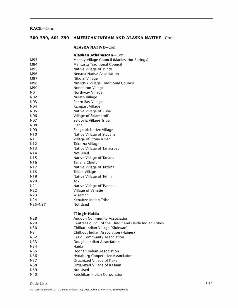
Code Lists F-31
U.S. Census Bureau, 2010 Census Redistricting Data (Public Law 94-171) Summary File
RACE—Con.
300–399, A01–Z99 AMERICAN INDIAN AND ALASKA NATIVE—Con.
ALASKA NATIVE—Con.
Alaskan Athabascan—Con.M93 Manley Village Council (Manley Hot Springs)M94 Mentasta Traditional CouncilM95 Native Village of MintoM96 Nenana Native AssociationM97 Nikolai VillageM98 Ninilchik Village Traditional CouncilM99 Nondalton VillageN01 Northway VillageN02 Nulato VillageN03 Pedro Bay VillageN04 Rampart VillageN05 Native Village of RubyN06 Village of SalamatoffN07 Seldovia Village TribeN08 SlanaN09 Shageluk Native VillageN10 Native Village of StevensN11 Village of Stony RiverN12 Takotna VillageN13 Native Village of TanacrossN14 Not Used N15 Native Village of TananaN16 Tanana ChiefsN17 Native Village of TazlinaN18 Telida VillageN19 Native Village of TetlinN20 TokN21 Native Village of TyonekN22 Village of VenetieN23 WisemanN24 Kenaitze Indian Tribe N25–N27 Not Used
Tlingit-HaidaN28 Angoon Community AssociationN29 Central Council of the Tlingit and Haida Indian TribesN30 Chilkat Indian Village (Klukwan)N31 Chilkoot Indian Association (Haines)N32 Craig Community AssociationN33 Douglas Indian AssociationN34 HaidaN35 Hoonah Indian AssociationN36 Hydaburg Cooperative AssociationN37 Organized Village of KakeN38 Organized Village of KasaanN39 Not UsedN40 Ketchikan Indian Corporation

F-32 Code Lists
U.S. Census Bureau, 2010 Census Redistricting Data (Public Law 94-171) Summary File
RACE—Con.
300–399, A01–Z99 AMERICAN INDIAN AND ALASKA NATIVE—Con.
ALASKA NATIVE—Con.
Tlingit-Haida—Con.N41 Klawock Cooperative AssociationN42 Not UsedN43 PelicanN44 Petersburg Indian AssociationN45 Organized Village of SaxmanN46 Sitka Tribe of Alaska N47 Tenakee SpringsN48 Tlingit N49 Wrangell Cooperative AssociationN50 Yakutat Tlingit Tribe N51–N55 Not UsedN56–N58 (see under Tsimshian) N59 Not UsedN60 Sealaska Corporation (Southeast Alaska)N61–N64 Not UsedN65 Skagway VillageN66 Not Used
TsimshianN56 Metlakatla Indian Community, Annette Island Reserve N57 TsimshianN58 Not Used
Inupiat N67 American EskimoN68 EskimoN69 Greenland EskimoN70–N74 Not UsedN75 InuitN76–N78 Not UsedN79 Native Village of AmblerN80 Not UsedN81 Village of Anaktuvuk PassN82 Inupiat Community of the Arctic SlopeN83 Arctic Slope CorporationN84 Atqasuk Village (Atkasook)N85 Native Village of Barrow Inupiat Traditional GovernmentN86 Bering Straits InupiatN87 Native Village of Brevig MissionN88 Native Village of BucklandN89 Chinik Eskimo Community (Golovin)N90 Native Village of CouncilN91 Native Village of Deering N92 Native Village of ElimN93 Not UsedN94 Native Village of Diomede (Inalik)

Code Lists F-33
U.S. Census Bureau, 2010 Census Redistricting Data (Public Law 94-171) Summary File
RACE—Con.
300–399, A01–Z99 AMERICAN INDIAN AND ALASKA NATIVE—Con.
ALASKA NATIVE—Con.
Inupiat—Con.N95 Not UsedN96 Inupiat (Inupiaq)N97 Kaktovik Village (Barter Island)N98 KawerakN99 Native Village of KianaO01–O99 Not UsedP01 Native Village of KivalinaP02 Native Village of KobukP03 Native Village of KotzebueP04 Native Village of KoyukP05–P06 Not UsedP07 Nana InupiatP08 Native Village of NoatakP09 Nome Eskimo CommunityP10 Noorvik Native CommunityP11 Native Village of Nuiqsut (Nooiksut)P12 Native Village of Point HopeP13 Native Village of Point LayP14 Native Village of SelawikP15 Native Village of ShaktoolikP16 Native Village of ShishmarefP17 Native Village of ShungnakP18 Village of SolomonP19 Native Village of TellerP20 Native Village of UnalakleetP21 Village of WainwrightP22 Native Village of WalesP23 Native Village of White MountainP24 Not Used P25 Native Village of Mary’s IglooP26 King Island Native CommunityP27–P29 Not UsedP30–P32 (see under Yup’ik)P33–P35 Not UsedP36 Chevak Native VillageP37 Native Village of Mekoryuk
Yup’ikP30 Native Village of GambellP31 Native Village of SavoongaP32 Siberian Yupik P33–P37 (see under Inupiat)P38 Akiachak Native CommunityP39 Akiak Native CommunityP40 Village of AlakanukP41 Native Village of AleknagikP42 Yupiit of Andreafski

F-34 Code Lists
U.S. Census Bureau, 2010 Census Redistricting Data (Public Law 94-171) Summary File
RACE—Con.
300–399, A01–Z99 AMERICAN INDIAN AND ALASKA NATIVE—Con.
ALASKA NATIVE—Con.
Yup’ik—Con.P43 Village of AniakP44 Village of Atmautluak P45 Orutsararmiut Native Village (Bethel)P46 Village of Bill Moore’s SloughP47 Bristol BayP48 CalistaP49 Village of ChefornakP50 Native Village of Hamilton P51 Native Village of ChuathbalukP52 Village of Clark’s PointP53 Village of Crooked CreekP54 Curyung Tribal Council (Native Village of Dillingham)P55 Native Village of EekP56 Native Village of EkukP57 Ekwok VillageP58 Emmonak VillageP59 Native Village of Goodnews BayP60 Native Village of Hooper Bay (Naparagamiut)P61 Iqurmuit Traditional CouncilP62 Village of KalskagP63 Native Village of KasiglukP64 Native Village of KipnukP65 New Koliganek Village CouncilP66 Native Village of KongiganakP67 Village of KotlikP68 Organized Village of KwethlukP69 Native Village of KwigillingokP70 Levelock Village P71 Village of Lower KalskagP72 Manokotak VillageP73 Native Village of Marshall (Fortuna Ledge)P74 Village of OhogamiutP75 Asa’carsarmiut TribeP76 Naknek Native VillageP77 Native Village of NapaimuteP78 Native Village of NapakiakP79 Native Village of NapaskiakP80 Newhalen VillageP81 New Stuyahok VillageP82 Newtok VillageP83 Native Village of NightmuteP84 Native Village of NunapitchukP85 Oscarville Traditional VillageP86 Pilot Station Traditional VillageP87 Native Village of Pitka’s PointP88 Platinum Traditional VillageP89 Portage Creek Village (Ohgsenakale)
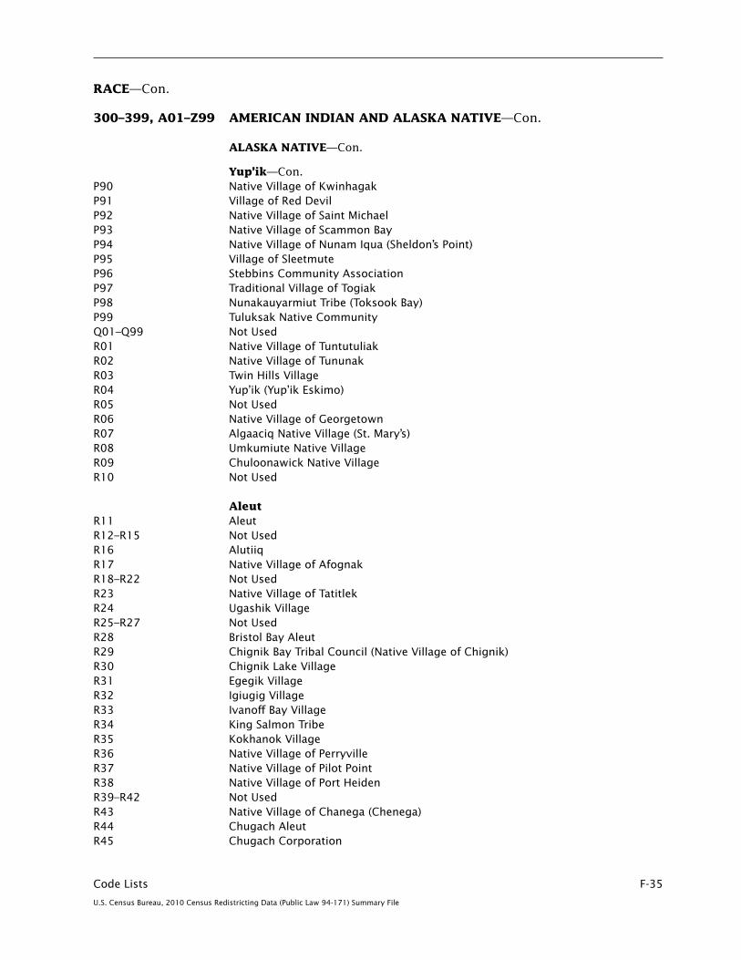
Code Lists F-35
U.S. Census Bureau, 2010 Census Redistricting Data (Public Law 94-171) Summary File
RACE—Con.
300–399, A01–Z99 AMERICAN INDIAN AND ALASKA NATIVE—Con.
ALASKA NATIVE—Con.
Yup’ik—Con.P90 Native Village of KwinhagakP91 Village of Red DevilP92 Native Village of Saint MichaelP93 Native Village of Scammon BayP94 Native Village of Nunam Iqua (Sheldon’s Point)P95 Village of SleetmuteP96 Stebbins Community AssociationP97 Traditional Village of TogiakP98 Nunakauyarmiut Tribe (Toksook Bay)P99 Tuluksak Native CommunityQ01–Q99 Not UsedR01 Native Village of TuntutuliakR02 Native Village of TununakR03 Twin Hills VillageR04 Yup’ik (Yup’ik Eskimo)R05 Not Used R06 Native Village of GeorgetownR07 Algaaciq Native Village (St. Mary’s)R08 Umkumiute Native VillageR09 Chuloonawick Native VillageR10 Not Used
Aleut R11 AleutR12–R15 Not UsedR16 AlutiiqR17 Native Village of AfognakR18–R22 Not UsedR23 Native Village of TatitlekR24 Ugashik VillageR25–R27 Not UsedR28 Bristol Bay AleutR29 Chignik Bay Tribal Council (Native Village of Chignik)R30 Chignik Lake VillageR31 Egegik VillageR32 Igiugig VillageR33 Ivanoff Bay VillageR34 King Salmon TribeR35 Kokhanok VillageR36 Native Village of PerryvilleR37 Native Village of Pilot PointR38 Native Village of Port HeidenR39–R42 Not UsedR43 Native Village of Chanega (Chenega)R44 Chugach AleutR45 Chugach Corporation

F-36 Code Lists
U.S. Census Bureau, 2010 Census Redistricting Data (Public Law 94-171) Summary File
RACE—Con.
300–399, A01–Z99 AMERICAN INDIAN AND ALASKA NATIVE—Con.
ALASKA NATIVE—Con.
Aleut—Con.R46 Native Village of Nanwalek (English Bay)R47 Native Village of Port GrahamR48–R50 Not UsedR51 Native Village of Eyak (Cordova)R52–R54 Not UsedR55 Native Village of AkhiokR56 Agdaagux Tribe of King CoveR57 Native Village of KarlukR58 Native Village of KanatakR59 Kodiak R60 Koniag AleutR61 Native Village of Larsen BayR62 Village of Old HarborR63 Native Village of OuzinkieR64 Native Village of Port LionsR65 Lesnoi Village (Woody Island)R66 Sun’aq Tribe of KodiakR67 Sugpiaq R68–R74 Not Used R75 Native Village of AkutanR76 Aleut CorporationR77–R78 Not UsedR79 Native Village of AtkaR80 Native Village of BelkofskiR81 Native Village of Chignik LagoonR82 King CoveR83 Native Village of False PassR84 Native Village of Nelson LagoonR85 Native Village of NikolskiR86 Pauloff Harbor VillageR87 Qagan Tayagungin Tribe of Sand Point Village R88 Qawalangin Tribe of UnalaskaR89 Saint George IslandR90 Saint Paul IslandR91 Not Used R92 South Naknek VillageR93 Unangan (Unalaska)R94 Not UsedR95 Native Village of UngaR96 Kaguyak Village R97–R98 Not UsedR99 Multiple ALASKA NATIVE responses
S01–S99 Not Used
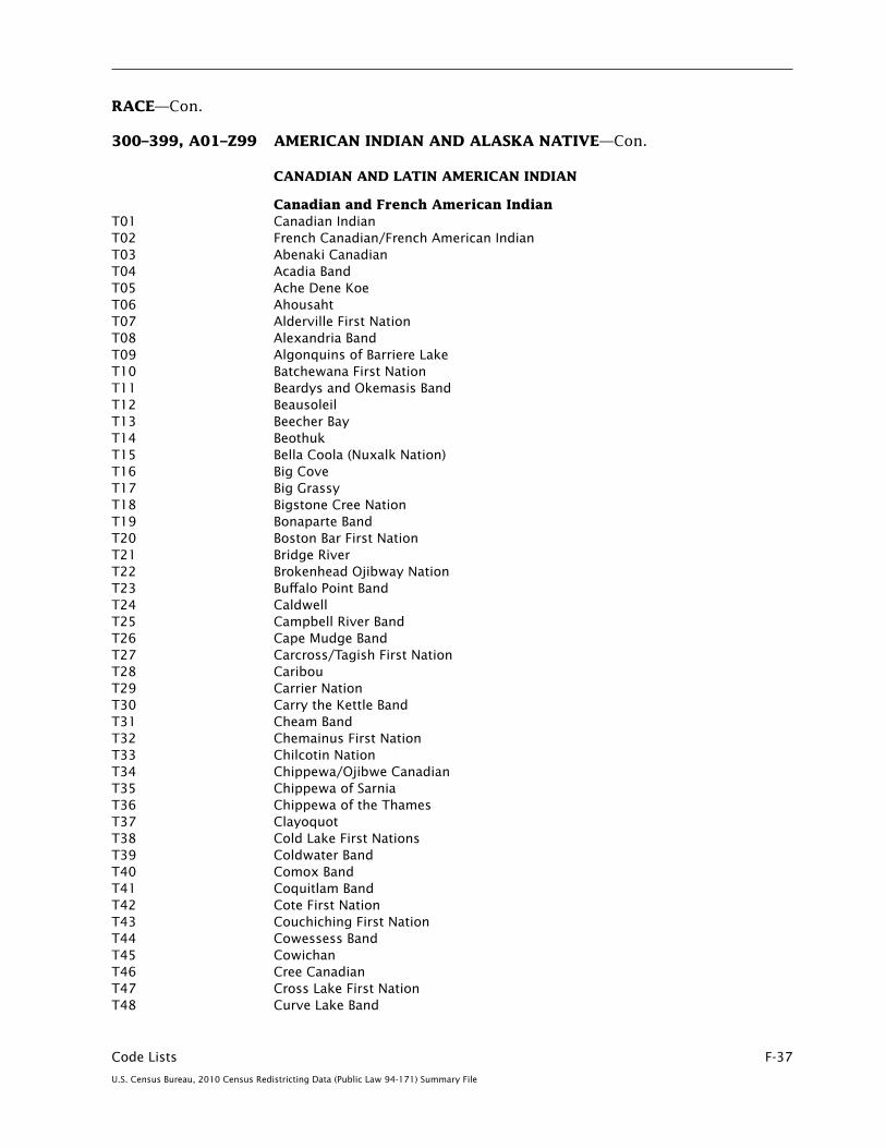
Code Lists F-37
U.S. Census Bureau, 2010 Census Redistricting Data (Public Law 94-171) Summary File
RACE—Con.
300–399, A01–Z99 AMERICAN INDIAN AND ALASKA NATIVE—Con.
CANADIAN AND LATIN AMERICAN INDIAN
Canadian and French American IndianT01 Canadian IndianT02 French Canadian/French American Indian T03 Abenaki Canadian T04 Acadia BandT05 Ache Dene KoeT06 AhousahtT07 Alderville First NationT08 Alexandria BandT09 Algonquins of Barriere LakeT10 Batchewana First NationT11 Beardys and Okemasis BandT12 BeausoleilT13 Beecher BayT14 BeothukT15 Bella Coola (Nuxalk Nation)T16 Big CoveT17 Big GrassyT18 Bigstone Cree NationT19 Bonaparte BandT20 Boston Bar First NationT21 Bridge RiverT22 Brokenhead Ojibway Nation T23 Buffalo Point BandT24 CaldwellT25 Campbell River BandT26 Cape Mudge BandT27 Carcross/Tagish First NationT28 CaribouT29 Carrier NationT30 Carry the Kettle BandT31 Cheam BandT32 Chemainus First NationT33 Chilcotin NationT34 Chippewa/Ojibwe Canadian T35 Chippewa of SarniaT36 Chippewa of the ThamesT37 ClayoquotT38 Cold Lake First Nations T39 Coldwater BandT40 Comox BandT41 Coquitlam BandT42 Cote First NationT43 Couchiching First NationT44 Cowessess BandT45 CowichanT46 Cree CanadianT47 Cross Lake First NationT48 Curve Lake Band

F-38 Code Lists
U.S. Census Bureau, 2010 Census Redistricting Data (Public Law 94-171) Summary File
RACE—Con.
300–399, A01–Z99 AMERICAN INDIAN AND ALASKA NATIVE—Con.
CANADIAN AND LATIN AMERICAN INDIAN—Con.
Canadian and French American Indian—Con.T49 Dene CanadianT50 Dene Band Nwt (Nw Terr.)T51 Ditidaht BandT52 DogribT53 Eagle Lake BandT54 Eastern CreeT55 Ebb and Flow BandT56 English River First NationT57 EskasoniT58 EsquimaltT59 Fisher RiverT60 Five NationsT61 Fort Alexander BandT62 Garden River NationT63 Gibson BandT64 GitksanT65 Gitlakdamix BandT66 Grassy Narrows First NationT67 Gull Bay BandT68 Gwichya Gwich’in T69 Heiltsuk BandT70 Hesquiaht BandT71 Hiawatha First NationT72 Hope Band (Chawathill Nation)T73 HuronT74 Huron of LorrettevilleT75 Innu (Montagnais)T76 Interior SalishT77 James Bay CreeT78 James Smith Cree NationT79 Kahkewistahaw First NationT80 Kamloops BandT81 Kanaka BarT82 Kanesatake BandT83 Kaska DenaT84 Keeseekoose BandT85 Kincolith BandT86 Kingsclear BandT87 KitamaatT88 Kitigan Zibi AnishinabegT89 Klahoose First NationT90 KwakiutlT91 Kyuquot BandT92 Lakahahmen BandT93 Lake Manitoba BandT94 Lake St. Martin BandT95 Lennox Island BandT96 Liard River First Nation

Code Lists F-39
U.S. Census Bureau, 2010 Census Redistricting Data (Public Law 94-171) Summary File
RACE—Con.
300–399, A01–Z99 AMERICAN INDIAN AND ALASKA NATIVE—Con.
CANADIAN AND LATIN AMERICAN INDIAN—Con.
Canadian and French American Indian—Con.T97 LillooetT98 Little Shuswap BandT99 Long Plain First NationU01 Lower Nicola Indian BandU02 Malahat First NationU03 Matachewan BandU04 Mcleod LakeU05 MetisU06 Millbrook First NationU07 Mississaugas of the CreditU08 Mohawk Bay of QuinteU09 Mohawk CanadianU10 Mohawk KahnawakeU11 Mohican CanadianU12 Musqueam BandU13 Namgis First Nation (Nimpkish)U14 Nanaimo (Snuneymuxw)U15 Nanoose First NationU16 NaskapiU17 Nation Huronne WendatU18 Nipissing First NationU19 North Thompson Band (Simpcw First Nation)U20 N’Quatqua (Anderson Lake)U21 Nuu-chah-nulth (Nootka)U22 OdanakU23 Ohiaht BandU24 Oneida Nation of the Thames U25 Opaskwayak Cree NationU26 Osoyoos Band U27 Pacheedaht First NationU28 PauquachinU29 PeepeekisisU30 PeguisU31 PenelakutU32 Penticton U33 Pine CreekU34 Plains CreeU35 Rainy River First NationsU36 Red Earth BandU37 Restigouche (Listugaj First Nation)U38 Roseau River U39 Saddle LakeU40 Sakimay First NationsU41 Sandy Bay BandU42 Sarcee (Sarci)U43 SaugeenU44 Saulteau First NationsU45 Saulteaux

F-40 Code Lists
U.S. Census Bureau, 2010 Census Redistricting Data (Public Law 94-171) Summary File
RACE—Con.
300–399, A01–Z99 AMERICAN INDIAN AND ALASKA NATIVE—Con.
CANADIAN AND LATIN AMERICAN INDIAN—Con.
Canadian and French American Indian—Con.U46 Seabird IslandU47 Sechelt U48 Seine River First NationU49 Serpent RiverU50 Seton LakeU51 Shoal Lake Cree NationU52 ShuswapU53 SimilkameenU54 Siksika CanadianU55 Six Nation CanadianU56 Six Nations of the Grand RiverU57 Skawahlook First NationU58 Skeetchestn Indian BandU59 Skookum Chuck BandU60 SkowkaleU61 SkuppahU62 Skwah First NationU63 Skway First NationU64 Songhees First NationU65 Soowahlie First NationU66 Spuzzum First NationU67 Squamish NationU68 Stanjikoming First NationU69 Sto:lo NationU70 Stone U71 Sucker Creek First NationU72 Swampy CreeU73 TahltanU74 Taku River TlingitU75 Tete De Boule (Attikamek)U76 ThompsonU77 Tobacco Plains BandU78 Tobique First NationU79 ToquahtU80 TsartlipU81 Tsawout First NationU82 TseycumU83 UchucklesahtU84 Ucluelet First NationU85 Vuntut Gwitchin First NationU86 Wabauskang First NationU87 Walpole IslandU88 Wasauksing First NationU89 Waywayseecappo First NationU90 West Bay BandU91 White Bear BandU92 Whitefish Lake BandU93 Wikwemikong

Code Lists F-41
U.S. Census Bureau, 2010 Census Redistricting Data (Public Law 94-171) Summary File
RACE—Con.
300–399, A01–Z99 AMERICAN INDIAN AND ALASKA NATIVE—Con.
CANADIAN AND LATIN AMERICAN INDIAN—Con.
Canadian and French American Indian—Con.U94 Wolf Lake BandU95 Woodland Cree First NationU96 Woodstock First Nation U97 Xaxli’p First Nation (Fountain Band) U98 Canadian Indian, not elsewhere classifiedU99–V23 Not Used
Central American IndianV24 Central American IndianV25 CakchiquelV26 CaribV27 ChocoV28 GarifunaV29 GuaymiV30 KanjobalV31 KekchiV32 Kuna IndianV33 LencaV34 Maya Central American V35 MiskitoV36 PipilV37 QuicheV38 RamaV39 SumoV40 Belize IndianV41 Costa Rica IndianV42 Dominican IndianV43 El Salvador IndianV44 Guatemala IndianV45 Honduras IndianV46 Nicaragua IndianV47 Panama IndianV48 Puerto Rican IndianV49–V83 Not Used
Mexican American Indian V84 Mexican American IndianV85 AmuzgoV86 AuracaV87 AztecV88 ChatinoV89 ChinantecV90 ChochoV91 ConchoV92 CoraV93 CouhimiV94 CuicatecV95 Huastec
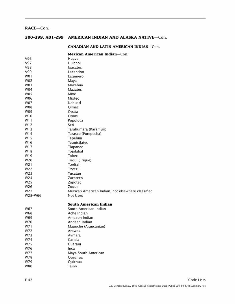
F-42 Code Lists
U.S. Census Bureau, 2010 Census Redistricting Data (Public Law 94-171) Summary File
RACE—Con.
300–399, A01–Z99 AMERICAN INDIAN AND ALASKA NATIVE—Con.
CANADIAN AND LATIN AMERICAN INDIAN—Con.
Mexican American Indian—Con.V96 HuaveV97 HuicholV98 IxacatecV99 LacandonW01 LaguneroW02 MayaW03 MazahuaW04 MazatecW05 MixeW06 MixtecW07 NahuatlW08 OlmecW09 OpataW10 OtomiW11 PopolucaW12 SeriW13 Tarahumara (Raramuri)W14 Tarasco (Purepecha)W15 TepehuaW16 TequistlatecW17 TlapanecW18 TojolabalW19 ToltecW20 Triqui (Trique)W21 TzeltalW22 TzotzilW23 YucatanW24 ZacatecoW25 ZapotecW26 ZoqueW27 Mexican American Indian, not elsewhere classified W28–W66 Not Used
South American Indian W67 South American IndianW68 Ache IndianW69 Amazon IndianW70 Andean IndianW71 Mapuche (Araucanian)W72 ArawakW73 AymaraW74 CanelaW75 GuaraniW76 IncaW77 Maya South American W78 QuechuaW79 QuichuaW80 Taino
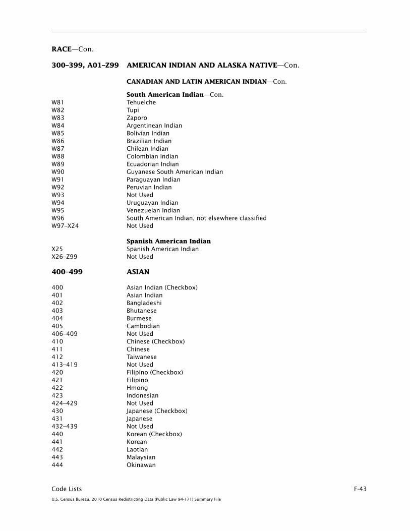
Code Lists F-43
U.S. Census Bureau, 2010 Census Redistricting Data (Public Law 94-171) Summary File
RACE—Con.
300–399, A01–Z99 AMERICAN INDIAN AND ALASKA NATIVE—Con.
CANADIAN AND LATIN AMERICAN INDIAN—Con.
South American Indian—Con.W81 TehuelcheW82 TupiW83 ZaporoW84 Argentinean Indian W85 Bolivian IndianW86 Brazilian Indian W87 Chilean IndianW88 Colombian IndianW89 Ecuadorian IndianW90 Guyanese South American IndianW91 Paraguayan Indian W92 Peruvian IndianW93 Not UsedW94 Uruguayan IndianW95 Venezuelan IndianW96 South American Indian, not elsewhere classified W97–X24 Not Used
Spanish American IndianX25 Spanish American IndianX26–Z99 Not Used
400–499 ASIAN
400 Asian Indian (Checkbox)401 Asian Indian402 Bangladeshi403 Bhutanese404 Burmese405 Cambodian406–409 Not Used410 Chinese (Checkbox)411 Chinese412 Taiwanese413–419 Not Used420 Filipino (Checkbox)421 Filipino422 Hmong423 Indonesian424–429 Not Used430 Japanese (Checkbox)431 Japanese432–439 Not Used440 Korean (Checkbox)441 Korean442 Laotian443 Malaysian444 Okinawan

F-44 Code Lists
U.S. Census Bureau, 2010 Census Redistricting Data (Public Law 94-171) Summary File
RACE—Con.
400–499 ASIAN—Con.
445 Pakistani446 Sri Lankan447 Thai448–449 Not Used450 Vietnamese (Checkbox)451 Vietnamese452–459 Not Used460 Other Asian (Checkbox)461 Not Used462 Asian463 Asiatic464 Not Used465 Mongolian466 Oriental467 Whello468 Yellow 469 Indo-Chinese470 Iwo Jiman471 Maldivian472 Nepalese473 Singaporean474–479 Not Used480 Multiple ASIAN responses481–499 Not Used
500–599 NATIVE HAWAIIAN AND OTHER PACIFIC ISLANDER
Polynesian500 Native Hawaiian (Checkbox)501 Native Hawaiian502 Hawaiian503 Part Hawaiian504–509 Not Used510 Samoan (Checkbox)511 Samoan512 Tahitian513 Tongan514 Polynesian515 Tokelauan516–519 Not Used
Micronesian520 Guamanian or Chamorro (Checkbox)521 Guamanian522 Chamorro523–529 Not Used530 (see under Other Pacific Islander)531 Mariana Islander532 Marshallese533 Palauan534 Carolinian

Code Lists F-45
U.S. Census Bureau, 2010 Census Redistricting Data (Public Law 94-171) Summary File
RACE—Con.
500–599 NATIVE HAWAIIAN AND OTHER PACIFIC ISLANDER—Con.
Micronesian—Con.535 Kosraean536 Micronesian537 Pohnpeian538 Saipanese539 I-Kiribati 540 Chuukese541 Yapese
Melanesian 542 Fijian543 Melanesian544 Papua New Guinean545 Solomon Islander546 Ni-Vanuatu (New Hebrides Islander)
Other Pacific Islander 530 Other Pacific Islander (Checkbox)547 Pacific Islander548–549 Not Used550 Multiple NATIVE HAWAIIAN and OTHER PACIFIC ISLANDER responses 551–599 Not Used
600–999 SOME OTHER RACE
600 Some Other Race (Checkbox)601 Argentinean 602 Bolivian603 Californio 604 Central American605 Chicano606 Chilean607 Colombian608 Costa Rican609 Cuban610 Ecuadorian611 Salvadoran612 Guatemalan613 Hispanic614 Honduran615 Latin American616 Mestizo617 Mexican618 Nicaraguan619 Panamanian620 Paraguayan621 Peruvian622 Puerto Rican623 Morena624 South American625 Spanish626 Spanish-American

F-46 Code Lists
U.S. Census Bureau, 2010 Census Redistricting Data (Public Law 94-171) Summary File
RACE—Con.
600–999 SOME OTHER RACE—Con.
627 Sudamericano628 Uruguayan629 Venezuelan630 Spaniard631 Tejano632 Cayman Islander633–639 Not Used640 Dominican/Dominican Republic641 Not Used 642 Belizean643 Bermudan644 Aruba Islander645 Not Used 646 Guyanese647 Surinamer 648 Sudanese649 Amerasian650 Eurasian651 Brazilian652 Brown653 Bushwacker654 Not Used655 Cape Verdean656 Chocolate657 Coe Clan658 Coffee659 Cosmopolitan660 Issues661 Jackson White662 Melungeon663 Mixed664 Ramp665 Wesort666 Mulatto667 Moor668 Biracial669 Creole670 Indian671 Turk672 Half-Breed673 Rainbow674 Octoroon675 Quadroon676 Multiracial677 Interracial678 Multiethnic679 Multinational680–689 Not Used690 Multiple SOME OTHER RACE responses691–698 Not Used699 Other race, not elsewhere classified 700–999 Not Used

Residence Rule & Residence Situations for the 2010 Census of the United States G-1
U.S. Census Bureau, 2010 Census Redistricting Data (Public Law 94-171) Summary File
Appendix G. Residence Rule and Residence Situations for the 2010 Census of the United States
CONTENTS
Where You Are Counted Is Important . . . . . . . . . . . . . . . . . . . . . . . . . . . . . . . . . . . . . . . . . . . . . . . . G-1
The Concept of Usual Residence . . . . . . . . . . . . . . . . . . . . . . . . . . . . . . . . . . . . . . . . . . . . . . . . . . . G-1
The Residence Rule . . . . . . . . . . . . . . . . . . . . . . . . . . . . . . . . . . . . . . . . . . . . . . . . . . . . . . . . . . . . . G-2
People Away From Their Usual Residence on Census Day . . . . . . . . . . . . . . . . . . . . . . . . . . . . . . . . G-2
Visitors on Census Day . . . . . . . . . . . . . . . . . . . . . . . . . . . . . . . . . . . . . . . . . . . . . . . . . . . . . . . . . . G-2
People Who Live in More Than One Place . . . . . . . . . . . . . . . . . . . . . . . . . . . . . . . . . . . . . . . . . . . . G-2
People Without a Usual Residence . . . . . . . . . . . . . . . . . . . . . . . . . . . . . . . . . . . . . . . . . . . . . . . . . . G-3
Students . . . . . . . . . . . . . . . . . . . . . . . . . . . . . . . . . . . . . . . . . . . . . . . . . . . . . . . . . . . . . . . . . . . . . G-3
Movers on Census Day . . . . . . . . . . . . . . . . . . . . . . . . . . . . . . . . . . . . . . . . . . . . . . . . . . . . . . . . . . G-3
People Who Are Born or Die on Census Day . . . . . . . . . . . . . . . . . . . . . . . . . . . . . . . . . . . . . . . . . . G-3
Nonrelatives of the Householder . . . . . . . . . . . . . . . . . . . . . . . . . . . . . . . . . . . . . . . . . . . . . . . . . . . G-4
U.S. Military Personnel . . . . . . . . . . . . . . . . . . . . . . . . . . . . . . . . . . . . . . . . . . . . . . . . . . . . . . . . . . G-4
Merchant Marine Personnel on U.S. Flag Maritime/Merchant Vessels . . . . . . . . . . . . . . . . . . . . . . . . G-4
Foreign Citizens in the United States . . . . . . . . . . . . . . . . . . . . . . . . . . . . . . . . . . . . . . . . . . . . . . . . G-4
U.S. Citizens and Their Dependents Living Outside the United States . . . . . . . . . . . . . . . . . . . . . . . G-5
People in Correctional Facilities for Adults . . . . . . . . . . . . . . . . . . . . . . . . . . . . . . . . . . . . . . . . . . . G-5
People in Group Homes and Residential Treatment Centers for Adults . . . . . . . . . . . . . . . . . . . . . . . G-5
People in Health Care Facilities . . . . . . . . . . . . . . . . . . . . . . . . . . . . . . . . . . . . . . . . . . . . . . . . . . . . G-5
People in Juvenile Facilities . . . . . . . . . . . . . . . . . . . . . . . . . . . . . . . . . . . . . . . . . . . . . . . . . . . . . . . G-6
People in Residential School-Related Facilities . . . . . . . . . . . . . . . . . . . . . . . . . . . . . . . . . . . . . . . . . G-6
People in Shelters . . . . . . . . . . . . . . . . . . . . . . . . . . . . . . . . . . . . . . . . . . . . . . . . . . . . . . . . . . . . . . G-6
People in Transitory Locations. . . . . . . . . . . . . . . . . . . . . . . . . . . . . . . . . . . . . . . . . . . . . . . . . . . . . G-6
People in Religious-Related Residential Facilities . . . . . . . . . . . . . . . . . . . . . . . . . . . . . . . . . . . . . . . G-6
People in Workers’ Residential Facilities . . . . . . . . . . . . . . . . . . . . . . . . . . . . . . . . . . . . . . . . . . . . . G-6
WHERE YOU ARE COUNTED IS IMPORTANT
For the 2010 Census, the U.S. Census Bureau is committed to counting every person. Just as important, however, is the Census Bureau’s commitment to counting every person in the correct place. The fundamental reason the decennial census is conducted is to fulfill the Constitutional requirement (Article I, Section 2) to apportion the seats in the U.S. House of Representatives among the states. Thus, for a fair and equitable apportionment, it is crucial that people are counted in the right place during the 2010 Census.
THE CONCEPT OF USUAL RESIDENCE
Planners of the first U.S. decennial census in 1790 established the concept of “usual residence” as the main principle in determining where people were to be counted. This concept has been followed in all subsequent censuses and is the guiding principle for the 2010 Census. Usual residence is defined as the place where a person lives and sleeps most of the time. This place is not necessarily the same as the person’s voting residence or legal residence.

G-2 Residence Rule & Residence Situations for the 2010 Census of the United States
U.S. Census Bureau, 2010 Census Redistricting Data (Public Law 94-171) Summary File
Determining usual residence is easy for most people. Given our nation’s wide diversity in types of living arrangements, however, the usual residence for some people is not as apparent. A few examples are people experiencing homelessness, snowbirds, children in shared custody arrangements, college students, live-in employees, military personnel, and people who live in workers’ dormitories.
Applying the usual residence concept to real living situations means that people will not always be counted at the place where they happen to be staying on Thursday, April 1, 2010 (Census Day). For example, people who are away from their usual residence while on vacation or on a business trip on Census Day should be counted at their usual residence. People who live at more than one residence during the week, month, or year should be counted at the place where they live most of the time. People without a usual residence, however, should be counted where they are staying on Census Day.
THE RESIDENCE RULE
The residence rule is used to determine where people should be counted in the United States during the 2010 Census. The rule says:
▪ Count people at their usual residence, which is the place where they live and sleep most of the time.
▪ People in certain types of facilities or shelters (i.e., places where groups of people live together) on Census Day should be counted at the facility or shelter.
▪ People who do not have a usual residence, or cannot determine a usual residence, should be counted where they are on Census Day.
This residence rule also is used to determine where people are counted in the 2010 Census of Puerto Rico.
The following sections describe how the residence rule applies for people in various living situations.
PEOPLE AWAY FROM THEIR USUAL RESIDENCE ON CENSUS DAY
People away from their usual residence on Thursday, April 1, 2010 (Census Day), such as on a vacation or a business trip, visiting, traveling outside the United States, or working elsewhere without a usual residence there (for example, as a truck driver or traveling salesperson)—Counted at the residence where they live and sleep most of the time.
VISITORS ON CENSUS DAY
Visitors on Thursday, April 1, 2010 (Census Day) who will return to their usual residence—Counted at the residence where they live and sleep most of the time.
Citizens of foreign countries who are visiting the United States on Thursday, April 1, 2010 (Census Day), such as on a vacation or a business trip—Not counted in the census.
PEOPLE WHO LIVE IN MORE THAN ONE PLACE
People living away most of the time while working, such as people who live at a residence close to where they work and return regularly to another residence—Counted at the residence where they live and sleep most of the time. If there is no residence where they live and sleep most of the time, they are counted where they live and sleep more than anywhere else. If time is equally divided, or if usual residence cannot be determined, they are counted at the residence where they are staying on Thursday, April 1, 2010 (Census Day).
People who live at two or more residences (during the week, month, or year), such as people who travel seasonally between residences (for example, snowbirds)—Counted at the residence where they live and sleep most of the time. If there is no residence where they live and sleep most of the time, they are counted where they live and sleep more than anywhere else. If time is equally divided, or if usual residence cannot be determined, they are counted at the residence where they are staying on Thursday, April 1, 2010 (Census Day).

Residence Rule & Residence Situations for the 2010 Census of the United States G-3
U.S. Census Bureau, 2010 Census Redistricting Data (Public Law 94-171) Summary File
Children in shared custody or other arrangements who live at more than one residence—Counted at the residence where they live and sleep most of the time. If time is equally divided, they are counted at the residence where they are staying on Thursday, April 1, 2010 (Census Day).
PEOPLE WITHOUT A USUAL RESIDENCE
People who cannot determine a usual residence—Counted where they are staying on Thursday, April 1, 2010 (Census Day).
People at soup kitchens and regularly scheduled mobile food vans—Counted at the residence where they live and sleep most of the time. If they do not have a place they live and sleep most of the time, they are counted at the soup kitchen or mobile food van location where they are on Thursday, April 1, 2010 (Census Day).
People at targeted non-sheltered outdoor locations—Counted at the outdoor location where people experiencing homelessness stay without paying.
STUDENTS
Boarding school students living away from their parental home while attending boarding school below the college level, including Bureau of Indian Affairs boarding schools—Counted at their parental home rather than at the boarding school.
College students living at their parental home while attending college—Counted at their parental home.
College students living away from their parental home while attending college in the United States (living either on-campus or off-campus)—Counted at the on-campus or off-campus residence where they live and sleep most of the time.
College students living away from their parental home while attending college in the United States (living either on-campus or off-campus) but staying at their parental home while on break or vacation—Counted at the on-campus or off-campus residence where they live and sleep most of the time.
U�S� college students living outside the United States while attending college outside the United States—Not counted in the census.
Foreign students living in the United States while attending college in the United States (living either on-campus or off-campus)—Counted at the on-campus or off-campus residence where they live and sleep most of the time.
MOVERS ON CENSUS DAY
People who move into a residence on Thursday, April 1, 2010 (Census Day) who have not been listed on a questionnaire for any residence—Counted at the residence they move into on Census Day.
People who move out of a residence on Thursday, April 1, 2010 (Census Day) and have not moved into a new residence on Thursday, April 1, 2010 (Census Day) and who have not been listed on a questionnaire for any residence—Counted at the residence from which they moved.
People who move out of a residence or move into a residence on Thursday, April 1, 2010 (Census Day) who have already been listed on a questionnaire for any residence—If they have already been listed on one questionnaire, do not list them on any other questionnaire.
PEOPLE WHO ARE BORN OR DIE ON CENSUS DAY
Babies born on or before 11:59:59 p�m� on Thursday, April 1, 2010 (Census Day)—Counted at the residence where they will live and sleep most of the time, even if they are still in the hospital on April 1, 2010 (Census Day).
Babies born after 11:59:59 p�m� on Thursday, April 1, 2010 (Census Day)—Not counted in the census.

G-4 Residence Rule & Residence Situations for the 2010 Census of the United States
U.S. Census Bureau, 2010 Census Redistricting Data (Public Law 94-171) Summary File
People who die before Thursday, April 1, 2010 (Census Day)—Not counted in the census.
People who die on Thursday, April 1, 2010 (Census Day)—Counted in the census if they are alive at any time on April 1, 2010.
NONRELATIVES OF THE HOUSEHOLDER
Roomers or boarders—Counted at the residence where they live and sleep most of the time.
Housemates or roommates—Counted at the residence where they live and sleep most of the time.
Unmarried partners—Counted at the residence where they live and sleep most of the time.
Foster children or foster adults—Counted at the residence where they live and sleep most of the time.
Live-in employees, such as caregivers or domestic workers—Counted at the residence where they live and sleep most of the time.
U.S. MILITARY PERSONNEL
U�S� military personnel living in military barracks in the United States—Counted at the military barracks.
U�S� military personnel living in the United States (living either on base or off base) but not in barracks—Counted at the residence where they live and sleep most of the time.
U�S� military personnel on U�S� military vessels with a U�S� homeport—Counted at the onshore U.S. residence where they live and sleep most of the time. If they have no onshore U.S. residence, they are counted at their vessel’s homeport.
People in military disciplinary barracks and jails in the United States—Counted at the facility.
People in military treatment facilities with assigned active duty patients in the United States—Counted at the facility if they are assigned there.
U�S� military personnel living on or off a military installation outside the United States, including dependents living with them—Counted as part of the U.S. overseas population. They should not be included on any U.S. census questionnaire.
U�S� military personnel on U�S� military vessels with a homeport outside the United States—Counted as part of the U.S. overseas population. They should not be included on any U.S. census questionnaire.
MERCHANT MARINE PERSONNEL ON U.S. FLAG MARITIME/MERCHANT VESSELS
Crews of U�S� flag maritime/merchant vessels docked in a U�S� port or sailing from one U�S� port to another U�S� port on Thursday, April 1, 2010 (Census Day)—Counted at the onshore U.S. residence where they live and sleep most of the time. If they have no onshore U.S. residence, they are counted at their vessel. If the vessel is docked in a U.S. port, crewmembers with no onshore U.S. residence are counted at the port. If the vessel is sailing from one U.S. port to another U.S. port, crewmembers with no onshore U.S. residence are counted at the port of departure.
Crews of U�S� flag maritime/merchant vessels engaged in U�S� inland waterway transportation on Thursday, April 1, 2010 (Census Day)—Counted at the onshore residence where they live and sleep most of the time.
Crews of U�S� flag maritime/merchant vessels docked in a foreign port, sailing from one foreign port to another foreign port, sailing from a U�S� port to a foreign port, or sailing from a foreign port to a U�S� port on Thursday, April 1, 2010 (Census Day)—Not counted in the census.
FOREIGN CITIZENS IN THE UNITED STATES
Citizens of foreign countries living in the United States—Counted at the U.S. residence where they live and sleep most of the time.

Residence Rule & Residence Situations for the 2010 Census of the United States G-5
U.S. Census Bureau, 2010 Census Redistricting Data (Public Law 94-171) Summary File
Citizens of foreign countries living in the United States who are members of the diplomatic community—Counted at the embassy, consulate, United Nations’ facility, or other residences where diplomats live.
Citizens of foreign countries visiting the United States, such as on a vacation or business trip—Not counted in the census.
U.S. CITIZENS AND THEIR DEPENDENTS LIVING OUTSIDE THE UNITED STATES
U�S� citizens living outside the United States who are employed as civilians by the U�S� government, including dependents living with them—Counted as part of the U.S. overseas population. They should not be included on any U.S. census questionnaire.
U�S� citizens living outside the United States who are not employed by the U�S� government, including dependents living with them—Not counted in the census.
U�S� military personnel living on or off a military installation outside the United States, including dependents living with them—Counted as part of the U.S. overseas population. They should not be included on any U.S. census questionnaire.
U�S� military personnel on U�S� military vessels with a homeport outside the United States—Counted as part of the U.S. overseas population. They should not be included on any U.S. census questionnaire.
PEOPLE IN CORRECTIONAL FACILITIES FOR ADULTS
People in correctional residential facilities on Thursday, April 1, 2010 (Census Day)—Counted at the facility.
People in federal detention centers on Thursday, April 1, 2010 (Census Day) —Counted at the facility.
People in federal and state prisons on Thursday, April 1, 2010 (Census Day)—Counted at the facility.
People in local jails and other municipal confinement facilities on Thursday, April 1, 2010 (Census Day)—Counted at the facility.
PEOPLE IN GROUP HOMES AND RESIDENTIAL TREATMENT CENTERS FOR ADULTS
People in group homes intended for adults (non-correctional)—Counted at the facility.
People in residential treatment centers for adults (non-correctional)—Counted at the residence where they live and sleep most of the time. If they do not have a residence where they live and sleep most of the time, they are counted at the facility.
PEOPLE IN HEALTH CARE FACILITIES
Patients in general or Veterans Affairs hospitals (except psychiatric units) on Thursday, April 1, 2010 (Census Day), including newborn babies still in the hospital on Census Day—Counted at the residence where they live and sleep most of the time. Newborn babies should be counted at the residence where they will live and sleep most of the time.
People in hospitals on Thursday, April 1, 2010 (Census Day) who have no usual home elsewhere—Counted at the facility.
People staying in in-patient hospice facilities on Thursday, April 1, 2010 (Census Day)—Counted at the residence where they live and sleep most of the time. If they do not have a residence where they live and sleep most of the time, they are counted at the facility.
People in mental (psychiatric) hospitals and psychiatric units for long-term non-acute care in other hospitals on Thursday, April 1, 2010 (Census Day)—Counted at the facility.
People in nursing facilities/skilled nursing facilities on Thursday, April 1, 2010 (Census Day)—Counted at the facility.

G-6 Residence Rule & Residence Situations for the 2010 Census of the United States
U.S. Census Bureau, 2010 Census Redistricting Data (Public Law 94-171) Summary File
PEOPLE IN JUVENILE FACILITIES
People in correctional facilities intended for juveniles on Thursday, April 1, 2010 (Census Day)—Counted at the facility.
People in group homes for juveniles (non-correctional) on Thursday, April 1, 2010 (Census Day)—Counted at the facility.
People in residential treatment centers for juveniles (non-correctional) on Thursday, April 1, 2010 (Census Day)—Counted at the facility.
PEOPLE IN RESIDENTIAL SCHOOL-RELATED FACILITIES
People in college/university student housing—Counted at the college/university student housing.
Boarding school students living away from their parental home while attending boarding school below the college level, including Bureau of Indian Affairs boarding schools—Counted at their parental home rather than at the boarding school.
People in residential schools for people with disabilities on Thursday, April 1, 2010 (Census Day)—Counted at the school.
PEOPLE IN SHELTERS
People in emergency and transitional shelters (with sleeping facilities) on Thursday, April 1, 2010 (Census Day) for people experiencing homelessness—Counted at the shelter.
People in living quarters for victims of natural disasters—Counted at the residence where they live and sleep most of the time. If they do not have a residence where they live and sleep most of the time, they are counted at the facility.
People in domestic violence shelters on Thursday, April 1, 2010 (Census Day)—Counted at the shelter.
PEOPLE IN TRANSITORY LOCATIONS
People at transitory locations, such as recreational vehicle (RV) parks, campgrounds, hotels and motels (including those on military sites), hostels, marinas, racetracks, circuses, or carnivals—Counted at the residence where they live and sleep most of the time. If there is no residence where they live and sleep most of the time, they are counted where they live and sleep more than anywhere else. If time is equally divided, or if usual residence cannot be determined, they are counted at the place where they are staying on Thursday, April 1, 2010 (Census Day).
PEOPLE IN RELIGIOUS-RELATED RESIDENTIAL FACILITIES
People in religious group quarters, such as convents and monasteries—Counted at the residence where they live and sleep most of the time. If they do not have a residence where they live and sleep most of the time, they are counted at the facility.
PEOPLE IN WORKERS’ RESIDENTIAL FACILITIES
People in workers’ group living quarters and Job Corps Centers—Counted at the residence where they live and sleep most of the time. If they do not have a residence where they live and sleep most of the time, they are counted at the facility.
Related Documents