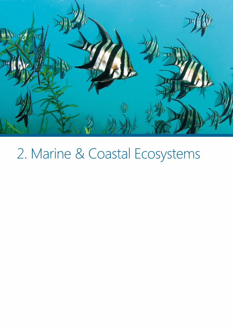
2. Marine & Coastal Ecosystems

Welcome message from author
This document is posted to help you gain knowledge. Please leave a comment to let me know what you think about it! Share it to your friends and learn new things together.
Transcript
2. Marine & Coastal Ecosystems
26 MARINE AND COASTAL ECOSYSTEMS
Victorian National Parks Association | Nature Conservation Review 2014
Guide to chapter 2
This chapter focuses on marine and coastal environments in recognition of
their tight ecological links and the need for integrated management. The
area of focus is waters under the jurisdiction of the Victorian government,
which extend 5.5 kilometres seaward from the high water mark, and land
within 500 metres of the shoreline. Some issues relevant to the coast are
covered in chapters 3 and 4 on terrestrial and freshwater ecosystems.
Section 2.1 describes the high natural, social and economic values of
Victoria’s marine and coastal ecosystems and the major habitat types.
Section 2.2 outlines the status of biodiversity and protected areas, and the
condition of bays, inlets and estuaries. Major threats to marine and coastal
nature – particularly climate change, coastal development, invasive species
and fishing – are described in section 2.3. Section 2.4 is a summary of a
gap analysis of Victoria’s marine protected areas, which identifies
bioregional priorities for new and expanded marine national parks and
sanctuaries. Similarly, for coastal subregions, section 2.5 summarises an
analysis of values, threats and priorities for upgrading the national park
and conservation system. Finally, in sections 2.6 and 2.7, policy gaps and
high priority reforms are identified in three major areas: improving
knowledge, creating a comprehensive, adequate and representative
national park and conservation system, and integrating and strengthening
management of marine and coastal environments.
Topics covered
2.1 Values
2.2 State of marine and coastal ecosystems
• Biodiversity
• National park and conservation system
• Bays, inlets and estuaries
2.3 Major threats
• Climate change
• Dysfunction of biological interactions
• Habitat loss and degradation
• Over-exploitation
2.4 Marine bioregional values and priorities
2.5 Coastal bioregional values and priorities
2.6 Conservation gaps and priorities
• Knowledge gaps
• National park and conservation system
• Bays, inlets and estuaries
• Marine and coastal management
• Governance structures and processes
• Fishing
2.7 Future directions
2.8 Sources

MARINE AND COASTAL ECOSYSTEMS 27
2.1 Values
he wild beauty of Victoria’s southern edge draws
millions of visitors each year – to stroll on beaches
and peer into rock pools, to watch seabirds riding
coastal breezes and shorebirds probing sand and mud
for prey to fuel up for their flight to the northern
hemisphere, to surf and paddle, to explore underwater
reefs and sponge gardens. The multiple attractions
reflect the great diversity of habitats – sandy and
muddy flats, estuaries, saltmarshes, cliffs, rocky reefs,
seagrass meadows, kelp forests, among the many –
inhabited by a multitude of life forms, many unique to
Victoria.
Although less celebrated than tropical reefs,
Australia’s southern waters host many more unique
species, and have the world's greatest diversity of red
and brown seaweeds, sea mosses, crabs, shrimps and
sea squirts.1
Victoria’s coastline winds and wriggles for more
than 2000 kilometres – about 1900 kilometres along the
mainland and 600 kilometres around islands.2 The
terrestrial coastal ribbon (to 500 metres inland) covers
about 1100 square kilometres and state waters (to 5.5
kilometres seaward) cover almost 7000 square
kilometres, in combination close to 4% of Victoria’s
land-sea surface area.
Because of the many physical, climatic and
biological factors overlapping where land and
waterways merge into ocean, coastal habitats are
inherently dynamic. Twenty thousand years ago, as the
last ice age was drawing to a close, Bass Strait did not
exist, Port Phillip Bay was part of the Yarra River
floodplain and the sea level was about 100 metres
lower. The shoreline has been fairly stable for about
6000 years.
The natural dynamism of these environments is
both intensified and undermined by human activity: the
rate of change has accelerated but coastal resilience has
been compromised, reducing the capacity of natural
systems to adapt to change. Victoria’s marine and
coastal environments are straining under the pressure
of unsustainable human development, biological
dysfunction due to species introductions, over-
exploitation and climate change. Much of what lures
people to the coast is at risk.
2.1.1 Biodiversity
Our southern marine communities are as distinctively Australian as our terrestrial marsupials and other
flora and fauna. Environment Conservation Council, 20003
The biological richness and uniqueness of Victoria’s
marine environments derive from 80 million years of
geological isolation restricting gene flow from other
geographical regions, a lack of mass extinction events,
and regional variability in geology, topography,
oceanography and climate fashioning multiple habitats
over a relatively small area. 4 Several currents and
oceanic influences intersect in Victorian waters – the
warm East Australian Current, the temperate South
Australia Current, and northern Bass Strait and cold
subantarctic surface waters. They place Victoria at the
confluence of three marine biogeographic provinces,
reflected in the mix of species shared with western,
eastern and southern areas.5
The coarsest measure of Victorian diversity is at the
bioregional level, each bioregion ‘a cluster of interacting
ecosystems that are repeated in similar form
throughout’ sharing similarities in physical and
biological features.6 Under a national classification
scheme, there are six marine bioregions around Victoria:
five in state waters (out to 5.5 kilometres) – four along
the open coast and one grouping bays and inlets – and
one outside state jurisdiction (Central Bass Strait).7
Although Victoria’s state waters account for less than
0.1% of Australia’s exclusive economic zone, 8% of
bioregions are represented there, a reflection of its
habitat diversity. In this report, the five state bioregions
have been further divided into 20 biounits to represent
finer scale regional diversity, based on work by
Australian Marine Ecology (see section 2.4).8
Victoria’s coast also has high habitat diversity
featuring parts of six terrestrial bioregions and 10
subregions, based on a national classification scheme.9
At a finer scale, the coast (the area within 500 metres of
T

28 MARINE AND COASTAL ECOSYSTEMS
Victorian National Parks Association | Nature Conservation Review 2014
the shoreline) features 95 vegetation types, known as
ecological vegetation classes, almost one-third of
Victoria’s total (at the bioregional level) (Box 2.1). They
include scrubs, shrublands, heathlands, forests,
woodlands, grasslands, lagoons, wetlands and marshes.
Thirty-four vegetation classes (more than 10% of
Victoria’s total) are unique to the coast. The wetlands,
sandflats and mudflats merging with beaches, sand
dunes, cliffs and shore platforms on Victoria’s coastline
provide many different habitats for plants and animals,
including strongholds for shorebirds. Some of the three
dozen migratory shorebird species that spend part of
the year in Victoria and travel thousands of kilometres
to the northern hemisphere to breed undertake ‘the
longest known journeys in the natural world’.10
Australia’s southern waters, particularly in the
southeast, are more species-rich than most other
temperate seas worldwide and host many more unique
species than the more celebrated Great Barrier Reef.
The level of endemicity (uniqueness) in many marine
groups is close to 90%.11 Victoria’s marine diversity is
particularly high in:12
• seaweeds (large marine algae),
• marine sediment infauna (animals living in soft
sediments on the sea bottom, usually in tubes or
burrows),
• hydroids (plant-like animals related to jellyfish, sea
anemones and corals, usually living in colonies
attached to rocks or plants),
• sea mosses (bryozoans – small colonial animals),
and
• sponges (animals that lack true tissues and organs,
with bodies full of pores and channels).
Southern Australia has the highest level of seaweed
endemism (62%) of any region globally, as well as the
highest species richness, with more than 1150 species.13
The exceptional endemism of southern seaweeds is due
to long stability and isolation of the Australian
continent – 30 million years from Antarctica and 80
million years from other land masses – because
seaweeds rarely disperse across ocean basins. It is also
due to the extent and diversity of rocky habitats in
southern Australia (seaweeds need something firm to
attach to). Seaweeds have additional high value
because, along with seagrasses, they are the main
primary producers in marine waters – ‘in some areas
producing far more plant material than the richest
agricultural land’ – and they serve as food, habitat and
predator protection for many animals.14
Sponge diversity and endemism is also exceptional,
with Victorian waters hosting 523 of Australia’s 1416
described species.15 Port Phillip Heads Marine National
Park has at least 115 sponges endemic to the park,16
and the bay is rich in many other species as well: a
combination of seagrass meadows, sponge gardens,
wetlands, sandflats, mudflats and subtidal and intertidal
reefs provide habitats for about 300 fish species and
hundreds of species of molluscs, crustaceans, seaweeds,
bristle worms and cnidarians.17
One vertebrate marine mammal is endemic to
southern Australian waters, the Burrunan dolphin,
described as a species in 2011 and known primarily
from Port Phillip Bay and Gippsland Lakes.18 It is
endangered (according to the Victorian government’s
advisory list), although not formally listed.
Much marine and coastal biodiversity has become
rarer due to human impacts (section 2.2.1): more than
180 species on the state government’s advisory lists are
considered threatened (Table 2.3, Table 2.4) as are
about two-thirds of coastal ecological vegetation
classes (Table 2.5). Two marine ecological communities
and three coastal communities are formally listed as
threatened. But the conservation status of most
biodiversity, particularly in the marine environment and
particularly marine invertebrates, is unknown.

MARINE AND COASTAL ECOSYSTEMS 29
2.1.2 Social and economic values
[The] value of Victoria’s non-commercial coastal ecosystem services ($8.4 billion per year) is similar to the
value of commercial coastal activities ($9.8 billion per year). … The results demonstrate the need for
decision makers to consider the tradeoffs between the benefits of healthy functioning ecosystems and
those associated with expanding use and development. WorleyParsons, 201319
The coast is extremely popular with Victorians. A 2012
survey found that 84% had made at least one trip to the
coast in the previous year, and the average was 23
trips.20 The most common activities were walking or
hiking (63% spent time doing this), swimming (52%)
and nature-based activities/appreciation (31%). The
survey found that the top three things contributing to a
good coastal or marine experience for respondents
were clean water, a lack of rubbish, and an
unspoilt/undeveloped natural environment.
There is increasing recognition of the extremely
high value of ecosystem services (benefits for humans
and other species due to natural functions of ecological
systems) provided by marine and coastal environments.
There has long been appreciation of the value of natural
products, such as fish, but only very recently has there
been any attempt to identify and value other services
by nature, which include the following for coastal
habitats: 21
Provisioning services: raw materials for agriculture,
food (such as fish), oil and gas, wind and wave power,
and tourism and recreational sites
Regulatory services: flood control, carbon storage,
water treatment, erosion control and protection from
extreme weather events, nutrient cycling
Habitat services: places for animals and plants to
live, fish nurseries, and a diverse genetic pool that may
provide the raw materials for developments in
provisioning services such as food
Cultural services: places for recreation, aesthetic
appreciation and spiritual experiences.
A 2013 evaluation commissioned by the Victorian
Coastal Council found that the value of Victoria’s
coastal commercial activities arising from ‘provisioning
ecosystem services’ is about $9.9 billion a year, due
mainly to petroleum, tourism and commercial ports. A
subset of non-commercial coastal services, including
storm protection, flood and disease control, habitat,
biodiversity, recreation and passive enjoyment, were
valued at $8.4 billion per year, with the highest value
services provided by beaches (for recreation),
estuaries/rivers and seagrass (Table 2.1).22
Table 2.1 Estimated values of some non-
commercial ecosystem services provided by
Victoria’s coastal habitats, 201323
Habitat type Area
(ha)
Unit value ($/ha/yr)
Value/year
($ million)
Beaches (recreation) 2,385
Forest 252,627 1,518 383
Grassland/heathland 65,844 363 24
Wetlands/marshes 48,422 4,265 207
Estuaries/rivers 71,264 35,768 2,549
Mangrove 71,264 38,750 320
Seagrass 61,961 29,771 1,845
Other marine 806,141 904 729
Total 8,441
Source: WorleyParsons
2.1.3 Important places
National park and conservation system
The 5.3% of Victoria’s marine waters formally and
securely protected for nature conservation include sites
with exceptional natural values. In 2002, following a
decade of campaigning led by the Victorian National
Parks Association and the Marine and Coastal
Community Network, Victoria became the first place in
the world to seek to implement a biologically
representative system of marine protected areas,
declaring 13 marine national parks and 11 marine
sanctuaries (the marine national park estate), covering
about 54,000 hectares. A greater although less
representative proportion of the coast is also securely
protected, with about 37% of the coastal zone (to 500
metres inland) included in the ‘national park and
30 MARINE AND COASTAL ECOSYSTEMS
Victorian National Parks Association | Nature Conservation Review 2014
conservation system’ (see section 1.4 for an explanation
of this term and the protected area criteria).
Ramsar wetlands
Of 11 Victorian wetland sites of global significance
recognised under the Ramsar Convention, five are
found on or near the coast.24
Corner Inlet is a marine embayment and tidal
mudflat that supports more than 390 native plant
species and 160 native animal species. It is
internationally significant for migratory wading birds
and its barrier islands are nationally significant for the
botanical biogeography and geomorphology.
Gippsland Lakes support more than 540 plant
species and 300 native animal species including more
than 60 that are rare or threatened. They include sites of
international and national geological and zoological
significance. Lake Reeve is one of the five most
important areas for shorebirds in Victoria.
Port Phillip Bay (Western Shoreline) and
Bellarine Peninsula support more than 330 native
plant species and 285 native animal species, including
50% of the world population of the critically
endangered orange-bellied parrot. They support large
numbers of migratory shorebirds and are an important
drought refuge for waterbirds.
Western Port is a large bay supporting more than
350 native plant species and 330 native animal species.
It is nationally significant for migratory shorebirds and
for extensive saltmarsh communities. It has sites of
international and national geomorphological
significance.
Edithvale-Seaford Wetlands are the last remnants
of the once extensive Carrum Carrum Swamp, which
was drained in the nineteenth century. They have 41
regionally significant plant taxa and regularly support
more than 1% of the world population of sharp-tailed
sandpipers as well as many other migratory birds.
Important bird and biodiversity areas
Twenty ‘important bird areas’ (IBAs) – sites that are
globally significant for bird conservation – have been
identified in coastal Victoria.25 (These areas are now also
known as ‘important bird and biodiversity areas’ in
recognition of their importance to other species as
well.) They provide critical non-breeding habitat for
large numbers of migratory shorebirds each year.
Although the designations have no legal status, they are
a reminder to land managers and planners that these
areas have high conservation values and they can help
guide conservation priorities. BirdLife Australia is
establishing a monitoring program for Victorian sites.
Box 2.1 Criteria for important bird areas
Each area meets one of the following three criteria:
• it regularly supports threshold numbers of a
threatened species
• it forms one of a set protecting 'restricted-range
species' (birds with a global range of less than 5
million hectares)
• it supports greater than 1% of the world population
of a waterbird (similar to the Ramsar Convention
criteria) or seabird.
Anderson Inlet IBA has intertidal mudflats that
attract internationally significant numbers of red-
necked stints, and may also regularly support critically
endangered orange-bellied parrots.
Bellarine Wetlands IBA supports orange-bellied
parrots, endangered Australasian bitterns and more
than 1% of the world populations of chestnut teal, red-
necked stints, sharp-tailed sandpipers and banded stilts.
Carrum Wetlands IBA regularly supports more
than 1% of the world populations of sharp-tailed
sandpipers, blue-billed ducks and chestnut teal, and is
an important refuge for Australasian bitterns.
Cheetham and Altona IBA regularly supports
more than 1% of the world populations of chestnut teal,
red-necked stints and Pacific gulls.
Corner Inlet IBA contains the most extensive
intertidal mudflats in Victoria and supports more than
1% of the world populations of red-necked stints,
eastern curlews, chestnut teal, pied and sooty
oystercatchers and threatened hooded plovers. It may
regularly support orange-bellied parrots.
Discovery Bay to Piccaninnie Ponds IBA provides
habitat for orange-bellied parrots, breeding habitat for
Australasian bitterns, and supports populations of
hooded plovers, restricted-range rufous bristlebirds and
striated fieldwrens.
Gabo and Tullaberga Islands IBA supports more
than 1% of the world population of little penguins and
white-faced storm-petrels.

MARINE AND COASTAL ECOSYSTEMS 31
Gippsland Lakes IBA regularly supports more than
1% of the world population of black swans, chestnut
teal and musk ducks, and substantial numbers of
vulnerable fairy terns.
Lawrence Rocks IBA supports more than 10% of
the world population of Australasian gannets.
Lower Brodribb River IBA supports a small
breeding population of Australasian bitterns.
Nadgee to Mallacoota Inlet IBA supports an
isolated southern sub-population of endangered
eastern bristlebirds and a population of restricted-range
pilotbirds.
Otway Ranges IBA supports populations of rufous
bristlebirds as well as striated fieldwrens and pink
robins.
Phillip Island IBA supports more than 1% of the
world populations of little penguins, short-tailed
shearwaters and Pacific gulls and small numbers of
orange-bellied parrots.
Port Fairy to Warrnambool IBA regularly supports
orange-bellied parrots and a breeding population of
hooded plovers.
Shallow Inlet IBA supports more than 1% of the
world's double-banded plovers and red-necked stints.
Swan Bay and Port Phillip Bay Islands IBA
supports significant numbers of orange-bellied parrots
and fairy terns, and more than 1% of the world
populations of blue-billed ducks, chestnut teal,
Australian white ibis, straw-necked ibis, red-necked
stints and silver gulls.
Werribee and Avalon IBA supports orange-bellied
parrots, and more than 1% of the world populations of
blue-billed ducks, Australian shelducks, freckled ducks,
Australasian shovelers, chestnut teal, musk ducks, pink-
eared ducks, hoary-headed grebes, red-necked stints
and sharp-tailed sandpipers.
Western Port IBA regularly supports small
numbers of orange-bellied parrots, fairy terns, and
more than 1% of the world populations of eastern
curlews, red-necked stints and pied oystercatchers.
Wilsons Promontory Islands IBA supports more
than 1% of the world populations of short-tailed
shearwaters and Pacific gulls, and possibly also of black-
faced cormorants.
Yambuk IBA supports orange-bellied parrots,
Australasian bitterns, and a breeding population of
hooded plovers.

32 MARINE AND COASTAL ECOSYSTEMS
Victorian National Parks Association | Nature Conservation Review 2014
2.1.4 Major habitat types
The typology of marine and coastal habitats in Table 2.2 and their description below is a summary of work by
Australian Marine Ecology. 26
Table 2.2 Marine and coastal habitats
Habitat Level 1 Habitat
Level 2
Habitat
Level 3
Habitat
Level 4
Coastal Coastal
Coastal sand Dune
Coastal vegetation
Grasses
Heaths
Moonah
Woodland
Structural habitat/processes Islands
Artificial Structural habitat/processes Artificial habitats (wood/rock)
Intertidal
Sheltered littoral (estuaries and wetlands)
Coastal vegetation Saltmarsh
Marine sediment Mudflats
Sandflats
Marine vegetation communities
Mangrove
Ruppia/estuarine grass
Seagrass
Structural habitat/processes Bird roosts
Exposed littoral Coastal sand
Beach
Dune
Reefs Intertidal reef
Subtidal shallow
Sheltered subtidal (bays and estuaries)
Marine non-vegetation communities
Pyura
Sponge clump
Marine sediment Sediment beds
Marine vegetation communities
Caulerpa
Drift weed
Seagrass
Reefs Subtidal reef
Structural habitat/processes Channels
Exposed subtidal
Marine sediment Sediment beds
Reefs Subtidal reef
Subtidal Subtidal to state limit
Marine non-vegetation communities
Pelagic fauna aggregations
Plankton and nekton
Sponge clump
Marine sediment Sediment beds
Marine vegetation communities Seagrass
Reefs
Deep reef
Intermediate reef
Subtidal reef
Structural habitat/processes Pinnacle/Canyon
Upwellings
Non specific Non specific Marine non-vegetation communities
Pelagic fauna aggregations
Plankton and nekton
Sponge clump
MARINE AND COASTAL ECOSYSTEMS 33
Coastal and exposed supralittoral dunes: Wind-
blown sand often accumulates as dunes between the
high tide line and established coastal vegetation.
Colonisation by hardy grasses can stabilise dunes,
allowing other vegetation to take hold. Many estuaries
and wetlands are protected from storm surge flooding
by coastal dune systems.
Coastal dune grasses, heaths, moonah, scrub
and woodland: With sandy, infertile soils and exposed
to strong, salt-laden winds and sea spray, coasts are
tough environments for plants. Coastal vegetation
usually occurs in bands parallel to the shore: foredunes
inhabited by dune grasses and succulents grade to low,
salt affected scrub, with a ground layer of sedges,
grasses and herbs, and then to taller shrubs behind the
primary dunes, where there is some protection from
wind, and then to low woodland. In swales between
dunes and behind primary dunes, the tea-tree moonah
(Melaleuca lanceolata) may occur as a scrub or low
forest. Highly diverse heath communities often grow on
headlands. Coastal habitats are foraging, breeding and
roosting habitat for birds, small mammals and reptiles,
many of conservation importance. They are under
increasing pressure from urban sprawl, coast
development, weed invasion, disease, recreational
activities and changing fire regimes. Many habitats have
become highly fragmented and some, such as coastal
moonah woodland, exist only in a small portion of their
pre-settlement range.
Coastal islands: Island communities are often
unique, and their relative isolation has helped to
conserve more pristine habitats than on the mainland.
Many function as sanctuaries, free from introduced
predators and competitors, such as cats, foxes, rabbits
and rodents. Coastal islands are home to breeding
colonies of fur seals and seabirds, including Australasian
gannets, little penguins and short-tailed shearwaters.
Saltmarsh and mangrove communities: These
communities often inhabit the intertidal sand and
mudflats of protected bays and estuaries in parallel
zones, with saltmarsh growing inshore of mangroves.
Saltmarsh vegetation includes succulent shrubs and
herbs, grasses and sedges, and in Victoria is often
dominated by a few plant species, particularly
glassworts. Mangroves are at the southern limit of their
range and just one species, grey mangrove, grows in
Victoria. Saltmarshes and mangroves are foraging and
nursery habitat for diverse marine and estuarine fauna.
The endangered orange-bellied parrot is dependent on
saltmarshes for winter food. Mangrove and saltmarsh
habitats trap and stablise coastal sediments and protect
against coastal erosion, as they form a barrier against
the effects of flooding, currents, waves and storms.
Victoria has suffered extensive loss of saltmarsh and
mangrove habitats. Weeds have invaded saltmarshes,
and mangroves were cleared for land reclamation and
port development. Swamp drainage for agriculture has
caused decline in these communities by increasing
freshwater runoff and reducing salinity.
Seagrass and estuary grass: Seagrasses (flowering
plants) grow in shallow coastal waters, some as
meadows in bays and estuaries and others in sheltered
areas along the open coast. In Victoria, the main
seagrasses are eelgrasses (Heterozostera tasmanica, H.
nigricaulis and Zostera muelleri), sea-nymph (Amphibolis
antarctica), paddlegrass (Halophila australis) and
strapweed (Posidonia australis). Estuary grass (Ruppia
megacarpa) is related to seagrass and provides similar
habitat in shallow estuaries, coastal lagoons and salt
lakes. Seagrass communities are important to ecological
processes, including primary productivity, nutrient
cycling and trophic pathways. They provide surfaces for
the attachment of algae and sessile invertebrates, and
refuge for mobile invertebrates. Seagrass beds are
primary habitat for many pipefishes, seahorses and sea
dragons, and important fish nurseries. There have been
dramatic declines in seagrass habitat stemming from
population pressures in the coastal zone.
Estuaries: Estuary habitats are subject to influences
from both marine and riverine environments. Estuaries
provide a wide variety of sheltered habitat types,
including intertidal and subtidal reef, channels,
seagrass, Ruppia, mangroves and saltmarshes. They are
dominated by intertidal sandflats and mudflats, and
subtidal sediment beds, which have diverse and
productive infaunal invertebrate communities that
provide productive feeding grounds for local and
migratory shorebirds. They also serve as fish nurseries.
Exposed littoral beach: As the interface between
ocean and coast, beaches are mobile and unstable.
Beach organisms must survive wave action, sand
deposition, erosion, high and low temperatures, regular
inundation with sea water and exposure to desiccation.
They have an important role in cycling nutrients
between coastal and near-shore environments.
Accumulations of deposited marine algae support
34 MARINE AND COASTAL ECOSYSTEMS
Victorian National Parks Association | Nature Conservation Review 2014
diverse microbes and invertebrate fauna, an important
food source for many fish. Beaches are important
foraging and breeding habitat for shorebirds, some of
high conservation status, such as hooded plover.
Intertidal reefs: Occurring mostly around
headlands and points, and often isolated from each
other by stretches of beach, intertidal reefs are
inhabited by specialist intertidal species adapted to
extreme environmental variability due to alternate tidal
inundation and exposure. A thin layer of microscopic
algae growing on rock surfaces is an important food
source for grazing molluscs. Larger algae such as the
mat-forming Neptune’s necklace provide food and
refuge at low tide. Gastropod molluscs are the
dominant fauna, and there are also small crustaceans
such as barnacles and crabs, the seastar Parvulastra
exigua and tubeworm Galeolaria caespitosa. They are
important foraging habitats for shorebirds at low tide
and for fish at high tide. Because of their accessibility,
intertidal reefs are vulnerable to human pressures,
including collection of animals for fishing bait and food,
trampling and pollution.
Pyura and sponge clumps: Pyura stolonifera is a
seasquirt that inhabits hard and soft surfaces in
intertidal and subtidal habitats and provides a surface
for attachment by many other organisms. In subtidal
soft sediment habitats, Pyura beds are important
habitat for sponges, other sessile invertebrates and
algae, which in turn provide surfaces for further
attachment, forming large clumps of biogenic reef
(generated by living organisms). Pyura beds also
provide habitat for mobile invertebrates such as
brittlestars, seastars and sea urchins. Species richness is
often higher in Pyura bed habitats than in comparable
seagrass or bare sediment habitats. The recovery of
Pyura beds after disturbance is slow or non-existent, so
they are a high priority for protection.
Caulerpa: This diverse genus of green algae grow
on shallow and intermediate reefs and in sediments.
They are fast growing and can quickly spread into
adjacent areas by vegetative growth. They can form
dense meadows that exclude other algae. Caulerpa are
important to ecological processes, including habitat
provision, primary productivity, nutrient cycling and
trophic pathways. Caulerpa taxifolia is an invasive
species from the Mediterranean Sea, now widespread
along the Australian coast.
Drift weed: Many large algae do not need to be
attached to the sea bottom to survive and, carried by
tides and currents, they can form vast mats. In Port
Phillip Bay, drift algae sometimes cover up to 90% of
the seabed along the northwest shore, probably
benefiting from discharge from the Western Treatment
Plant. Drift algae are important to local ecological
processes, including primary productivity, nutrient
cycling, trophic pathways and biogenic habitat.
Channels: Soft sediment channels are prevalent in
sheltered bays and inlets. Major Victorian embayments,
including Port Phillip Bay, Corner Inlet, Nooramunga
and especially Western Port, are dominated by intertidal
and subtidal sand and mud flats interwoven with
deeper channels. The tidal currents that create channels
also carry food particles. Many species occur only in
channel habitats and species assemblages are often
unique. Brachiopods and some molluscs are locally
abundant within Western Port channel habitats but
have very restricted ranges, so these populations are of
particular conservation importance.
Subtidal reefs: Kelp and other seaweeds provide
the dominant habitat structure on subtidal reefs. The
robust bull kelp dominates on reefs that are most
exposed to wave and swell, and large brown algae, such
as the common kelp and crayweed form a canopy 0.5-2
metres high in less exposed reefs. Smaller kelps and
filter-feeding sessile invertebrates (sponges, corals,
bryozoans, hydroids and ascidians) form an understory
5-30 centimetres high. A hard layer of pink crustose
coralline algae encrusts the rocks of most subtidal reefs.
As depth increases, kelps become less dominant and
other algae and sessile invertebrates make up a greater
proportion of the cover. Seaweeds and sessile
invertebrates provide important habitat structure for
other organisms on the reef. Gastropods, crustaceans,
echinoderms and fishes inhabit these communities.
Shallow reefs have high biological complexity, species
diversity, biomass and productivity. Dense seaweed
beds are among the most productive habitats in the
world.
Intermediate depth reefs (15-30 metres depth):
Kelps become less dominant as depth increases and
other algae, particularly thallose red algae make up a
greater proportion of the cover. Sessile invertebrates,
including bryozoans, ascidians and sponges also
become more abundant. There have been few surveys
of intermediate depth communities in Victoria.

MARINE AND COASTAL ECOSYSTEMS 35
Deep reefs: The difficulties of working at depth
have limited the ecological study of deep reef habitats.
Recent technological advances have made this
environment somewhat more accessible and there are
currently numerous Victorian deep reef studies in
progress. The biota is dominated by sessile
invertebrates, particularly sponges, cnidarians, ascidians
and bryozoans. Most of the invertebrate species on the
reefs are suspension feeders, capturing small plankton
and detritus from the water. They may filter up to
hundreds of litres of ocean water per square metre of
reef every day, and are therefore a potentially vital link
for the cycling of nutrients and energy in the marine
ecosystem. Small crustaceans, echinoderms and
molluscs are commonly found in the spaces created by
the sessile invertebrates. Fishes are also abundant in
deep reef areas, taking refuge within the reef structure
or feeding on the wide range of organisms. The
importance of deep reef biota in supporting high
trophic-level carnivores is unknown.
Pinnacles and canyons: Pinnacles (steep-sided
peaks) and canyons (steep-sided gorges) provide
vertical and overhanging surfaces inhabited by highly
diverse, filter-feeding, sessile invertebrate communities,
typically dominated by sponges, and supporting a high
diversity of mobile invertebrates, including molluscs,
crustaceans, polychaetes and echinoderms, as well as
fish. They are associated with high density aggregations
of seabirds, whales and dolphins and often have high
fish densities. Pinnacle and canyon communities are
often small in area and endemic, having evolved in
isolation from other such habitats. It means they are
particularly vulnerable to disturbance, as an entire patch
is likely to be affected and there will be little potential
for recolonisation and recovery.
Upwellings: Important upwellings occur in
Discovery Bay (Bonney Upwelling) and along east
Gippsland (Bass Canyon Upwelling). Seasonal winds
drive warm, nutrient-depleted surface water away from
the coast, which draws deeper, colder, nutrient-rich
water to the sunlit surface, where it sustains high rates
of phytoplankton growth.
Plankton: Organisms that drift in the water column,
plankton are important in carbon, nitrogen and other
nutrient cycles. Photosynthetic plankton, such as
diatoms and dinoflagellates, are highly productive –
they are responsible in Port Phillip Bay for at least two-
thirds of primary production. Concentrations are often
highest in estuaries and river mouths, where there are
nutrient inputs from terrestrial runoff. Phytoplankton
are preyed on by zooplankton, small floating animals
including amoeboids, crustaceans, jellyfish, invertebrate
larvae and fish larvae.
Nekton: In Victoria, actively swimming pelagic
(open sea) organisms, nekton, are mostly fish and
cephalopods (eg. octopuses, squid, cuttlefish), but also
include mammals, penguins and crustaceans (e.g. krill).
Nekton play an important role in trophic pathways,
facilitating the transfer of energy from plankton,
through lower trophic levels, to higher order predators.
High abundances are often associated with areas of
high phytoplankton productivity, such as upwellings.
Pelagic fauna aggregations: Many pelagic (open
sea) fish school for protection against predators or
converge in favourable habitats. Orange roughy, for
example, aggregate around seamounts, pinnacles and
canyons. Seabirds, predatory fish and marine mammals
congregate where there is a reliable food supply, such
as nutrient-rich upwellings. Aggregations provide
opportunities for courtship and breeding for species
that are normally scattered. Blue whales congregating
along the Bonney coast to feed also engage in
courtship. Species that aggregate are more vulnerable
to recreational and commercial fishing pressures,
diseases and localised environmental disturbances.
Artificial habitats: Although artificial habitats are
less ecologically complex than natural systems they can
be ecologically important if their primary purpose is for
conservation. Popes Eye and South Channel Fort,
artificial islands in Port Phillip Bay, provide reef habitat
for a diverse fish fauna, as do shipwrecks, particularly in
the Ships’ Graveyard area between Port Phillip Heads
and Torquay, with about 50 wrecks. White-faced storm
petrels nest on South Channel Fort, Australian fur seals
haul out regularly at the purpose-built Chinaman’s Hat,
and little penguins breed on the breakwater built at St
Kilda. The largest winter-breeding population of pied
cormorants in Victoria nests in and around Lake Borrie
at Melbourne Water’s Western Treatment Plant, which is
the primary source of nutrients into Port Phillip Bay and
the Geelong Arm in winter.
36 MARINE AND COASTAL ECOSYSTEMS
Victorian National Parks Association | Nature Conservation Review 2014
2.2 State of marine and coastal ecosystems
Even in the face of skepticism about climate change, there is overwhelming evidence of rapid physical
changes in the environment and that habitats are having to adapt, resetting an ecological balance that
has been mostly stable for thousands of years. Australian Marine Ecology, 201027
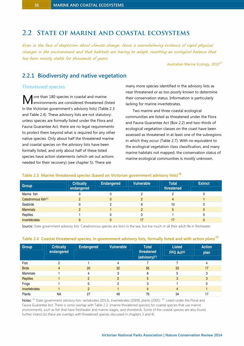
2.2.1 Biodiversity and native vegetation
Threatened species
ore than 180 species in coastal and marine
environments are considered threatened (listed
in the Victorian government’s advisory lists) (Table 2.3
and Table 2.4). These advisory lists are not statutory:
unless species are formally listed under the Flora and
Fauna Guarantee Act, there are no legal requirements
to protect them beyond what is required for any other
native species. Only about half the threatened marine
and coastal species on the advisory lists have been
formally listed, and only about half of these listed
species have action statements (which set out actions
needed for their recovery) (see chapter 5). There are
many more species identified in the advisory lists as
near threatened or as too poorly known to determine
their conservation status. Information is particularly
lacking for marine invertebrates.
Two marine and three coastal ecological
communities are listed as threatened under the Flora
and Fauna Guarantee Act (Box 2.2) and two-thirds of
ecological vegetation classes on the coast have been
assessed as threatened in at least one of the subregions
in which they occur (Table 2.7). With no equivalent to
the ecological vegetation class classification, and many
marine habitats not mapped, the conservation status of
marine ecological communities is mostly unknown.
Table 2.3 Marine threatened species (based on Victorian government advisory lists)28
Group Critically
endangered Endangered Vulnerable Total
threatened Extinct
Marine fish 0 0 2 2 0
Catadromous fish(1) 2 0 2 4 1
Seabirds 0 2 8 10 0
Mammals 2 1 2 5 0
Reptiles 1 0 0 1 0
Invertebrates 0 0 17 17 0
Source: State government advisory lists. Catadromous species are born in the sea, but live much or all their adult life in freshwater.
Table 2.4 Coastal threatened species, in government advisory lists, formally listed and with action plans29
Group Critically endangered
Endangered Vulnerable Total threatened
(advisory)(1)
Listed
FFG Act(2)
Action
plan
Fish 2 1 4 7 7 4
Birds 4 20 32 56 33 17
Mammals 1 4 3 8 5 3
Reptiles 1 2 2 5 3 3
Frogs 1 0 2 3 1 0
Invertebrates 1 2 1 4 4 1
Plants NA 27 49 76 34 17
Notes: (1) State government advisory lists: vertebrates (2013), invertebrates (2009), plants (2005). (2) Listed under the Floral and
Fauna Guarantee Act. There is some overlap with Table 2.3 (marine threatened species) for coastal species that use marine
environments, such as fish that have freshwater and marine stages, and shorebirds. Some of the coastal species are also found
further inland (so there are overlaps with threatened species discussed in chapters 3 and 4).
M

MARINE AND COASTAL ECOSYSTEMS 37
Box 2.2 Threatened marine and coastal ecological communities
The San Remo marine community, at the eastern entrance to Western Port, occurs over a nine hectare area of
patchy basalt, sand and mud, and is dominated by opisthobranch molluscs (marine slugs) and bryozoans (moss
animals). It is subject to potential threats from dredging, invasive species and coastal development.30
The Port Phillip Bay entrance deep canyon marine community is highly diverse, with many endemic
species. It is restricted to the 120 hectare canyon between the Port Phillip Heads, and subject to threats from rock
dredging and invasive species, as well as potential shipping accidents and sub-sea infrastructure developments.31
Coastal moonah woodland is a scattered forest, woodland or shrubland community occurring on calcareous
dune systems in central southern Victoria in the Gippsland and Otway Plains bioregions. More than 90% has been
cleared or highly fragmented, and weeds and recreational activities threaten what is left. It usually occurs on hind
dunes, and is important for preventing erosion and as habitat for several threatened species.32
Warm temperate rainforest (coastal East Gippsland) occurs on relatively dry coastal sites, usually in shallow
gullies and on abandoned sea cliffs, on or near the Gippsland Lakes (especially Lakes King and Tyers) and at the
mouth of the Snowy River near Marlo. It has been severely depleted by clearing for agriculture and grazing, and is
threatened by weed invasion and fires of high intensity and frequency.33
Plains grassland (South Gippsland) ranges from closed tussock grassland to seasonal wetlands on the South
Gippsland coastal plain between Seaspray and Welshpool and the head of Western Port, on grey, often seasonally
waterlogged soils.34 More than 99% has been lost to clearing and degradation, and what remains is threatened by
weed invasion and inappropriate fire regimes.
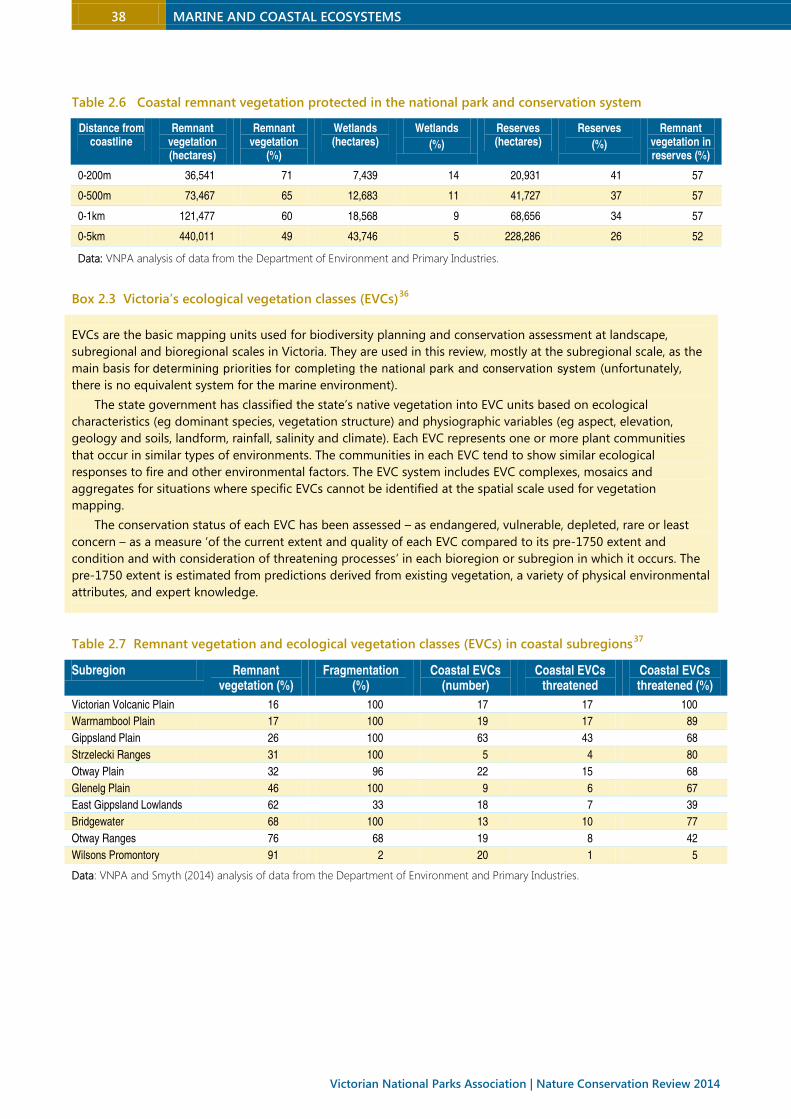
Coastal native vegetation
Close to two-thirds of the coast (to 500 metres inland)
still has remnant vegetation, 57% of which is protected
(Table 2.6). Vegetation loss increases with distance from
the coast. Within the zone out to five kilometres from
the coastline, half the vegetation has been cleared and
52% of what remains is protected (Table 2.6).
Victoria’s plants communities have been mapped as
ecological vegetation classes based on their structure,
ecology and floristic and environmental associations.
Their conservation status has been assessed within each
bioregion and subregion, based on a comparison with
their estimated pre-1750 extent (Box 2.3). Of 300
ecological vegetation classes described for Victoria’s
bioregions, 95 occur within 500 metres of the state’s
shoreline (Table 2.7). Thirty-four are found only on the
coast, while the other 61 have largely inland ranges.35
Almost two-thirds (62%) of ecological vegetation
classes within 500 metres of the shoreline are
threatened within at least one subregion in which they
occur (Table 2.7). The losses have been greatest for
hinterland vegetation in the Warrnambool Plains, Otway
Plains, Victorian Volcanic Plains and Gippsland Plains
subregions, for they were settled early in Victoria’s
colonial history to graze sheep because of their
relatively fertile soils and ease of clearing. Other
vegetation losses have resulted from forestry and urban
settlements. Table 2.7 shows the extent of remnant
vegetation, fragmentation and threatened ecological
vegetation classes found within 500 metres of the
shoreline in each of the 10 coastal subregions. Swamp
and coastal scrubs, grassy woodlands, herb-rich
woodlands and forests, estuarine wetlands and
saltmarshes are the most consistently threatened
vegetation types across the ten subregions (Table 2.5).
Table 2.5 Threatened ecological vegetation classes
(EVCs) in coastal subregions
EVC Number of subregions
E(1) V(2) NT(3)
Coastal EVCs
Estuarine wetland 4 0 3
Coastal headland scrub 0 6 2
Coastal tussock grassland 0 5 1
Coastal alkaline scrub 2 1 2
Hinterland EVCs
Damp sands herb-rich woodland 1 6 0
Herb-rich foothill forest 0 5 1
Swamp scrub 5 1 0
Damp heath scrub 2 1 0
Plains grassy woodland 3 0 0
Plains grassland 3 0 0
Shallow freshwater marsh 3 0 0
Grassy woodland 4 0 0
Data source: Trust for Nature. Notes: (1) Endangered. (2)Vulnerable. (3) Non-threatened, including least concern, rare
or data deficient.
38 MARINE AND COASTAL ECOSYSTEMS
Victorian National Parks Association | Nature Conservation Review 2014
Table 2.6 Coastal remnant vegetation protected in the national park and conservation system
Distance from coastline
Remnant vegetation (hectares)
Remnant vegetation
(%)
Wetlands (hectares)
Wetlands
(%)
Reserves (hectares)
Reserves
(%)
Remnant vegetation in reserves (%)
0-200m 36,541 71 7,439 14 20,931 41 57
0-500m 73,467 65 12,683 11 41,727 37 57
0-1km 121,477 60 18,568 9 68,656 34 57
0-5km 440,011 49 43,746 5 228,286 26 52
Data: VNPA analysis of data from the Department of Environment and Primary Industries.
Box 2.3 Victoria’s ecological vegetation classes (EVCs)36
EVCs are the basic mapping units used for biodiversity planning and conservation assessment at landscape,
subregional and bioregional scales in Victoria. They are used in this review, mostly at the subregional scale, as the
main basis for determining priorities for completing the national park and conservation system (unfortunately,
there is no equivalent system for the marine environment).
The state government has classified the state’s native vegetation into EVC units based on ecological
characteristics (eg dominant species, vegetation structure) and physiographic variables (eg aspect, elevation,
geology and soils, landform, rainfall, salinity and climate). Each EVC represents one or more plant communities
that occur in similar types of environments. The communities in each EVC tend to show similar ecological
responses to fire and other environmental factors. The EVC system includes EVC complexes, mosaics and
aggregates for situations where specific EVCs cannot be identified at the spatial scale used for vegetation
mapping.
The conservation status of each EVC has been assessed – as endangered, vulnerable, depleted, rare or least
concern – as a measure ‘of the current extent and quality of each EVC compared to its pre-1750 extent and
condition and with consideration of threatening processes’ in each bioregion or subregion in which it occurs. The
pre-1750 extent is estimated from predictions derived from existing vegetation, a variety of physical environmental
attributes, and expert knowledge.
Table 2.7 Remnant vegetation and ecological vegetation classes (EVCs) in coastal subregions37
Subregion Remnant vegetation (%)
Fragmentation (%)
Coastal EVCs (number)
Coastal EVCs threatened
Coastal EVCs threatened (%)
Victorian Volcanic Plain 16 100 17 17 100
Warrnambool Plain 17 100 19 17 89
Gippsland Plain 26 100 63 43 68
Strzelecki Ranges 31 100 5 4 80
Otway Plain 32 96 22 15 68
Glenelg Plain 46 100 9 6 67
East Gippsland Lowlands 62 33 18 7 39
Bridgewater 68 100 13 10 77
Otway Ranges 76 68 19 8 42
Wilsons Promontory 91 2 20 1 5
Data: VNPA and Smyth (2014) analysis of data from the Department of Environment and Primary Industries.
MARINE AND COASTAL ECOSYSTEMS 39
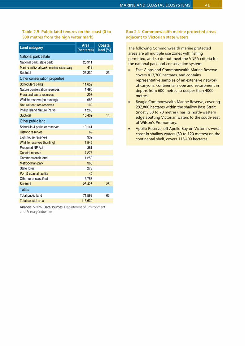
2.2.2 National park and conservation system
Victoria’s marine and coastal national park and
conservation system includes 5% of state waters and
37% of coastal land (to 500 metres inland) (Table 2.8).
The marine national parks and sanctuaries were all
declared in 2002 following a statewide investigation by
the Land Conservation Council initiated in 1991. They
include the near-shore environment, seabed and marine
waters out to 5.5 kilometres (the state limit), islands,
and the foreshore up to 200 metres inland from the
high water mark. Extractive and damaging activities
such as dredging, waste disposal, aquaculture, mining,
and commercial and recreational fishing are prohibited,
but a loophole allows petroleum exploration.38
Close to a quarter of coastal land (23%) is in the
national park estate (mainly national and state parks)
and 14% is in other securely protected conservation
properties (eg coastal parks and nature conservation
reserves). The area of private land protected under
perpetual conservation covenants is very small, just
0.2% of the coastal area.
Coastal protection has been greatly assisted by an
1881 decision by the Victorian government to reserve
all unalienated land within one-and-a-half chains [30
metres] of the colony’s ‘rivers, rivulets, creeks, channels,
aqueducts, lakes, reservoirs, swamps, inlets, loughs and
straits’.39 All but 4% of land abutting the high water
mark is still in public ownership, although under
multiple management arrangements, some
incompatible with conservation. Many stream and river
frontages are also in public ownership (chapter 4). The
privatised proportion of land increases with distance
from the shoreline: three-quarters of the land area to
200 metres from the shoreline is in public ownership
but only half of the land from 200 to 500 metres is.40
Squeezed between sea and development, many
conservation properties and other public lands are
exceedingly narrow, and set to be further squeezed as
sea levels continue to rise. Their shape makes
conservation management very challenging, for they
are subject to severe edge effects and impacts from
adjoining land uses.41
Other marine sites and many dozens of coastal
properties called protected areas or reserves are not
sufficiently secure or managed for conservation to meet
the VNPA criteria for the national park and conservation
system (section 1.4). These insufficiently protected
tenures include marine parks, marine reserves, and
marine and coastal parks in which various forms of
exploitation (eg fishing) are allowed and which do not
require a strong focus on conservation management. As
noted by the Victorian Environmental Assessment
Council, the environmental management required in
multiple-use marine parks ‘is generally the same as that
of the surrounding marine environment’.42 There are
also marine protected areas in Commonwealth waters
adjacent to Victorian waters, all of them multiple use
reserves that permit fishing, so not part of the national
park and conservation system (Box 2.4).
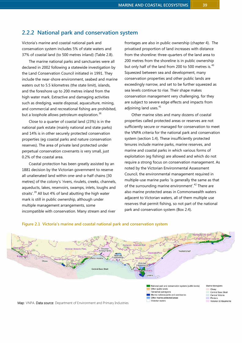
Figure 2.1 Victoria’s marine and coastal national park and conservation system
Map: VNPA. Data source: Department of Environment and Primary Industries

40 MARINE AND COASTAL ECOSYSTEMS
Victorian National Parks Association | Nature Conservation Review 2014
Table 2.8 Victoria’s marine and coastal national park and conservation system
Marine national park estate Marine bioregion Area (hectare)
Twelve Apostles Marine National Park Otway 7,500
The Arches Marine Sanctuary Otway 45
Merri Marine Sanctuary Otway 25
Discovery Bay Marine National Park Otway 2,770
Mushroom Reef Marine Sanctuary Central Victoria 80
Bunurong Marine National Park Central Victoria 2,100
Barwon Bluff Marine Sanctuary Central Victoria 17
Point Danger Marine Sanctuary Central Victoria 25
Point Addis Marine National Park Central Victoria 4,600
Eagle Rock Marine Sanctuary Central Victoria 17
Marengo Reefs Marine Sanctuary Central Victoria 12
Wilsons Promontory Marine National Park Flinders 15,550
Cape Howe Marine National Park Twofold Shelf 4,050
Point Hicks Marine National Park Twofold Shelf 4,000
Beware Reef Marine Sanctuary Twofold Shelf 220
Ninety Mile Beach Marine National Park Twofold Shelf 2,750
Corner Inlet Marine National Park Victorian Bays and Inlets 1,550
Yaringa Marine National Park Victorian Bays and Inlets 980
French Island Marine National Park Victorian Bays and Inlets 2,800
Churchill Island Marine National Park Victorian Bays and Inlets 670
Point Cooke Marine Sanctuary Victorian Bays and Inlets 290
Jawbone Marine Sanctuary Victorian Bays and Inlets 30
Ricketts Point Marine Sanctuary Victorian Bays and Inlets 115
Port Phillip Heads Marine National Park Victorian Bays and Inlets 3,580
Total area (marine) 53,776
Coastal national park estate Subregion
Port Campbell National Park Warrnambool Plain 1,069
Point Nepean National Park Gippsland Plain 357
Mornington Peninsula National Park Gippsland Plain 1,110
French Island National Park Gippsland Plain 2,235
Great Otway National Park Otway Ranges Warrnambool Plain
3,712
Wilsons Promontory National Park Wilsons Promontory 7,619
Croajingolong National Park East Gippsland Lowlands 9,697
Cape Nelson State Park Glenelg 112
Subtotal 25,910
Other coastal conservation properties Area
Nature conservation reserves etc (tenures identified in Table 1.3) All 15,402
Trust for Nature covenants All 261
Subtotal 15,633
Total area (coastal) 41,543
MARINE AND COASTAL ECOSYSTEMS 41
Table 2.9 Public land tenures on the coast (0 to
500 metres from the high water mark)
Land category Area
(hectares) Coastal land (%)
National park estate
National park, state park 25,911
Marine national park, marine sanctuary 419
Subtotal 26,330 23
Other conservation properties
Schedule 3 parks 11,652
Nature conservation reserves 1,490
Flora and fauna reserves 203
Wildlife reserve (no hunting) 688
Natural features reserves 109
Phillip Island Nature Parks 1,260
Subtotal 15,402 14
Other public land
Schedule 4 parks or reserves 10,141
Historic reserves 62
Lighthouse reserves 332
Wildlife reserves (hunting) 1,545
Proposed NP Act 381
Coastal reserve 7,277
Commonwealth land 1,250
Metropolitan park 363
State forest 278
Port & coastal facility 40
Other or unclassified 6,757
Subtotal 28,426 25
Totals
Total public land 71,599 63
Total coastal area 113,639
Analysis: VNPA. Data sources: Department of Environment
and Primary Industries.
Box 2.4 Commonwealth marine protected areas
adjacent to Victorian state waters
The following Commonwealth marine protected
areas are all multiple use zones with fishing
permitted, and so do not meet the VNPA criteria for
the national park and conservation system:
• East Gippsland Commonwealth Marine Reserve
covers 413,700 hectares, and contains
representative samples of an extensive network
of canyons, continental slope and escarpment in
depths from 600 metres to deeper than 4000
metres.
• Beagle Commonwealth Marine Reserve, covering
292,800 hectares within the shallow Bass Strait
(mostly 50 to 70 metres), has its north-western
edge abutting Victorian waters to the south-east
of Wilson’s Promontory.
• Apollo Reserve, off Apollo Bay on Victoria's west
coast in shallow waters (80 to 120 metres) on the
continental shelf, covers 118,400 hectares.

42 MARINE AND COASTAL ECOSYSTEMS
Victorian National Parks Association | Nature Conservation Review 2014
2.2.3 Bays, inlets and estuaries
‘There remains little data available on the ecological condition of estuaries, although it is evident that
most of Victoria’s estuaries have been degraded. It is estimated that as many as half of Victoria’s major
estuaries are significantly modified.’ State of the Environment Victoria 2013
The many wriggles in its coastline and a high density of
coastal waterways have endowed Victoria with a
multitude of diverse bays, inlets and estuaries of
immense value to both humans and wildlife. There are
more than 123 bays and inlets greater than one square
kilometre in area.
At the intersection of freshwater and sea water,
estuaries are a dynamic transitional environment,
linking catchments to marine environments and
affected by conditions both in local catchments and far
upstream. Biological information has been collected for
very few Victorian estuaries, and usually only over a
short time. A 2008 assessment of threats noted that
data of ‘sufficient quality or spatial and temporal extent
to measure the condition of Victoria’s estuaries’ is
lacking.43 The majority of Victoria’s estuaries have been
modified and degraded by human activity (Table 2.10)
due to:44
• land uses and degradation of catchments
• changes to freshwater inflows
• coastal urbanisation (including increased
recreational and commercial use and physical
modification of waterways)
• modification of estuary entrances or opening of
estuary mouths.
Victoria’s only ‘near-pristine’ estuaries are located in
the far east, and ‘largely unmodified’ estuaries occur
around South Gippsland, along the Great Ocean Road
and along the south-west coast.
More than half of Victoria’s estuaries are naturally
closed by sand bars from time to time, the frequency
and duration of which is affected by altered land uses
and water flows. Closure may render them more
vulnerable to human threats because flooding around
closed estuaries can lead to pressure for artificial
opening, the consequences of which (such as large fish
kills) can be ‘catastrophic’.45
Table 2.10 Condition of Victoria’s estuaries46
Subregion Estuary condition
Bridgewater Glenelg River
Warrnambool Plain Merri River Fitzroy River Moyne River Port Campbell River Surry River
Hopkins River Curdies Inlet Gellibrand River Sherbrook River Lake Yambuk
Otway Plain
Aire River Barham River Port Phillip Skeleton Creek Aireys Inlet
Anglesea River Spring Creek Thompson Creek Barwon River Anderson Creek
Swan Bay Limeburners Bay Little River Werribee River Wild Dog Creek
Otway Ranges Skenes Creek Grey River Kennett River
Erskine River Jamieson River St George River
Victorian Volcanic Plain Kororoit Creek Laverton Creek Port Phillip
Gippsland Plain Gippsland Lakes Western Port Anderson Inlet Corner Inlet Merriman Creek
Patterson River Port Phillip Powlett River Shallow Inlet Jack Smith Lake
Wilsons Promontory Tidal River Darby River
East Gippsland Lowlands
Snowy River Sydenham Inlet Yeerung River Thurra River
Lake Tyers Basby Creek Red River Betka River
Tamboon Inlet Mallacoota Shipwreck Creek Benedore River
Source: Barton et al (2008)
Near pristine Largely unmodified Modified Extensively modified
MARINE AND COASTAL ECOSYSTEMS 43
Port Phillip Bay
Victoria’s largest embayment is the extraordinarily
diverse Port Phillip Bay (1950 square kilometres, with
250 kilometres of shoreline). It has a multitude of
habitats - deep muds, sandy shores, Pyura beds,
shallow reefs and sheltered reefs, seagrass, drift algae
and estuarine habitats – and great biodiversity values,
including many unique to the bay. Of more than 270
sponge species at the Heads, at least 115 are endemic
to that site.47 The bay’s wildlife include about 300 fish
species, and several hundred species each of molluscs,
crustaceans, bristle worms and cnidarians. The west
coast has internationally significant bird habitats
recognised in the declaration of the Port Phillip Bay
(Western Shoreline) and Bellarine Peninsula Ramsar site,
which annually supports more than 40,000 waterbirds.
As well as extremely high conservation values, and
in tension with those values, Port Phillip Bay has
Australia’s most densely populated catchment and one
of the most urbanised coastlines in the world.48 It has
Australia’s busiest port, and supports commercial and
recreational fisheries and aquaculture. It is also
immensely popular for recreation – swimming, beach
activities, sightseeing, diving, sailing, boating and
recreational fishing.49 The bay’s ecosystems are
therefore under great and increasing pressure from
urban and agricultural runoff, fishing and the spread of
introduced marine species – it is one of the most
invaded marine sites globally (section 2.3.2).50
Western Port
Victoria’s second largest embayment, Western Port (680
square kilometres) is semi-enclosed with two large
islands. Its internationally significant values have been
recognised by its listing as a Ramsar wetland and
designation as an important bird area. At low tide about
40% of the bay is exposed as mudflats, which are highly
productive habitats for crustaceans and shorebirds.51 It
regularly supports more than 10,000 migratory
shorebirds and 10,000 waterbirds.52 Other important
wildlife habitats include deep channels, seagrass
meadows, mangroves and saltmarsh.53 This diversity of
habitats supports an abundant fish fauna.
But Western Port also hosts a major commercial
port, with most ships carrying liquid fuel, and is popular
for recreational fishing. Extensive vegetation clearing
within the catchment (leaving less than one-quarter of
the catchment with native vegetation), draining of the
large Koo Wee Rup swamp and the growth of
agriculture, industry and urban areas have wrought
major ecological changes.54 From 1971 to 1984, about
70% of Western Port’s seagrass meadows were lost
(from 250 to 72 square kilometres) due to physical
smothering of the leaves and reduced light levels. There
has been some recovery since then, to about 154
square kilometres in 2000. The losses and limited
recovery are ‘symptomatic of nutrient and sediment
loads exceeding the system’s capacity to process and
assimilate them’, and the bay is susceptible to further
losses due to increased sedimentation or nutrients
resulting from urbanisation, catchment and coastal
development or climate change.55 Of 38 species of
aquatic birds that have been regularly counted over
about four decades, 25 have declined, as have the total
numbers of aquatic birds.56
The cessation of commercial netting has reduced
the risk of overfishing in Western Port but recreational
effort has been increasing with a growing human
population and more sophisticated technology (echo
sounders and GPS navigation systems).57 The impacts
may be particularly serious for elephant fish, due to
intense targeting of breeding aggregations (the
recreational catch is equivalent to the entire commercial
catch of south-eastern Australia), and for gummy sharks
and school sharks, for which Western Port is an
important breeding area.
The Victorian government is proposing to expand
the Port of Hastings to make it an international
container port. This would increase shipping traffic from
fewer than 100 ships a year to more than 3000 annually.
This will increase the risk of oil spills and the spread of
marine invasive species. It will require extensive
dredging and some land clearing. According to a series
of expert reports commissioned by VNPA, even a
moderate-sized oil spill could reach shorelines within
minutes and most high conservation value areas would
be reached in less than six hours. This would be virtually
impossible to stop.58 A single oil spill could have severe
and long-lasting impacts on internationally significant
populations of migratory shorebirds and damage large
areas of seagrass, mangrove and saltmarsh, depending
on tidal and weather conditions.59

44 MARINE AND COASTAL ECOSYSTEMS
Victorian National Parks Association | Nature Conservation Review 2014
Gippsland Lakes
The Gippsland Lakes are under enormous pressure
from catchment inputs, with nutrient levels and
sediments threatening the ecological health of the
Lakes by maintaining it at an eutrophic level. Environment Protection Authority, 2013
The third-largest embayment is the Gippsland Lakes
(600 square kilometres), an internationally significant
(Ramsar-listed) system of coastal lagoons and marshes
separated from the sea by a barrier system of sand
dunes fringed by Ninety Mile Beach. Once an
intermittently open system of brackish (primarily
freshwater) lagoons, the Gippsland Lakes have been
extensively modified. The entrance has been
permanently opened and deepened, and combined
with reduced freshwater inflows (due to dams and water
extraction in the catchment) has made the lakes a much
more saline environment. Clearing in the catchment and
land use practices have caused serious degradation,
reflected in losses of fringing wetlands, bank erosion,
high nutrient and sediment loads and recurring algal
blooms.60
Coastal lagoons and seagrass, estuarine grass and
saltmarsh habitats are among many different wetland
habitats in the lakes system. They regularly support
more than 20,000 waterbirds, and are important as a
drought refuge. With about 179 fish species, the lakes
provide important feeding, dispersal and spawning sites
for numerous fish species.61
Corner Inlet
The fourth-largest embayment, Corner Inlet (600 square
kilometres), is also a Ramsar wetland. It has large
intertidal sand and mud flats, seagrass beds, a network
of incised channels connected to Bass Strait and large
sand islands. Due to the diversity of relatively
undisturbed habitats, Corner Inlet supports
internationally significant populations of several aquatic
and semi-aquatic species. At times it hosts more than
40,000 shorebirds. The seagrass beds are highly
productive for many fish and invertebrates. The fish
fauna is diverse, with more than 170 species. About 390
indigenous plant species and 160 species of indigenous
terrestrial animals have been recorded.
Corner Inlet has four ports servicing commercial
fishers, offshore oil and gas production and boating
visitors. It is one of only three estuaries or bays where
commercial fishing is allowed in Victoria and is popular
for recreational fishing. Threats assessed as medium to
high risk include recreational boating (eg boat wash,
anchor damage), modified flow regimes, sediment and
nutrient pollution, future infrastructure development, oil
spills, habitat loss due to seawalls and urban
development and climate change.62
The proposed expansion of Port Anthony to cater
for coal exports from Latrobe Valley is a potential threat
to Corner Inlet. It would involve construction of a one-
kilometre conveyor belt and channel dredging to allow
the entry of larger ships.
MARINE AND COASTAL ECOSYSTEMS 45
2.3 Major threats
ictoria’s marine and coastal ecosystems are under
pressure from a multitude of human-driven
extinction processes. Listed under the Flora and Fauna
Guarantee Act, for example, are seven ‘potentially
threatening processes’ specific to marine and estuarine
habitats and another 30 or so directly affecting coastal
habitats or their catchments. Following is an outline of
threats in four major categories: climate change, habitat
loss and degradation (eg coastal development),
dysfunction of biological interactions (eg invasive
species and algal blooms) and overexploitation
(fishing). 63 Threats in a fifth major category, changes to
disturbance regimes (eg fire and hydrological regimes),
are covered in chapters 3 and 4. Most threats discussed
in chapters 3 and 4 are relevant to coastal habitats, and
many are also relevant to marine habitats, with
catchment degradation typically compromising the
condition of coastal marine habitats.
Many long-term threats – coastal development and
invasive species, for example – are undiminished or
intensifying as the potentially overwhelming threat of
climate change builds. Information about many threats
is inadequate, particularly those involving biological
interactions, such as the loss of top predators and
impacts of introduced species, and there is uncertainty
about region-specific climate change predictions.
As well as directly affecting specific sites and
species, major marine and coastal threats disrupt
natural ecological processes, ‘all the physical processes
and the plant and animal activities which influence the
state of ecosystems and contribute to the maintenance
of their integrity and genetic diversity, and thereby their
evolutionary potential’. 64 There are seven categories of
ecological processes (described in section 3.3), all
relevant to marine and coastal ecosystems:65
• climate, eg storm frequency, light climate, seasonal
changes in water temperatures
• primary productivity, eg benthic nutrient cycling
• hydrological processes, eg tides, river flows
• formation of biophysical habitats, eg the formation
of biogenic habitats such as Pyura and sponge
clumps
• interactions between organisms, eg predation,
competition between species
• movements of organisms, eg migration from
marine to freshwater habitats
• natural disturbance regimes, eg fire regimes, storm
frequency
Actions to protect particular species, habitats, sites
or communities are unlikely to be effective unless the
ecological processes sustaining them are also
maintained.66 So, to protect a fish species on which a
fishery depends is likely to require measures to protect
its habitat, its prey and their habitats, and all associated
components of a healthy ecosystem, which may require
management of impacts far away, including on land.
2.3.1 Climate change
A major question for several coastal ecosystems is whether they are likely to face a threshold with modest
climate change beyond which they will flip into a less desirable state. Climate Change Risks to Australia’s Coast, 200967
Human interference with the global climate system
will inevitably bring dramatic change. For good
reason, most accounts of climate change start off by
emphasising the immense complexity of potential
impacts, for the effects of accumulating greenhouse
gases are driving multiple changes – in temperatures,
rainfall, storms, currents, sea levels, sea chemistry
etcetera – which in turn drive multiple cumulative and
synergistic changes at many different scales of space
and time. Many climatic changes are inevitable, but
their extent and consequences will depend on
whether human actions over the next few years
increase or decrease the potential for species and
ecosystem to adapt.
Victorian waters have been rapidly warming in
recent decades. The greatest warming measured in
Australia's oceans has been in the western Tasman
Sea, where increases in sea surface temperatures have
been more than 0.2°C per decade, much higher than
the global average (due to the shifting East
V
46 MARINE AND COASTAL ECOSYSTEMS
Victorian National Parks Association | Nature Conservation Review 2014
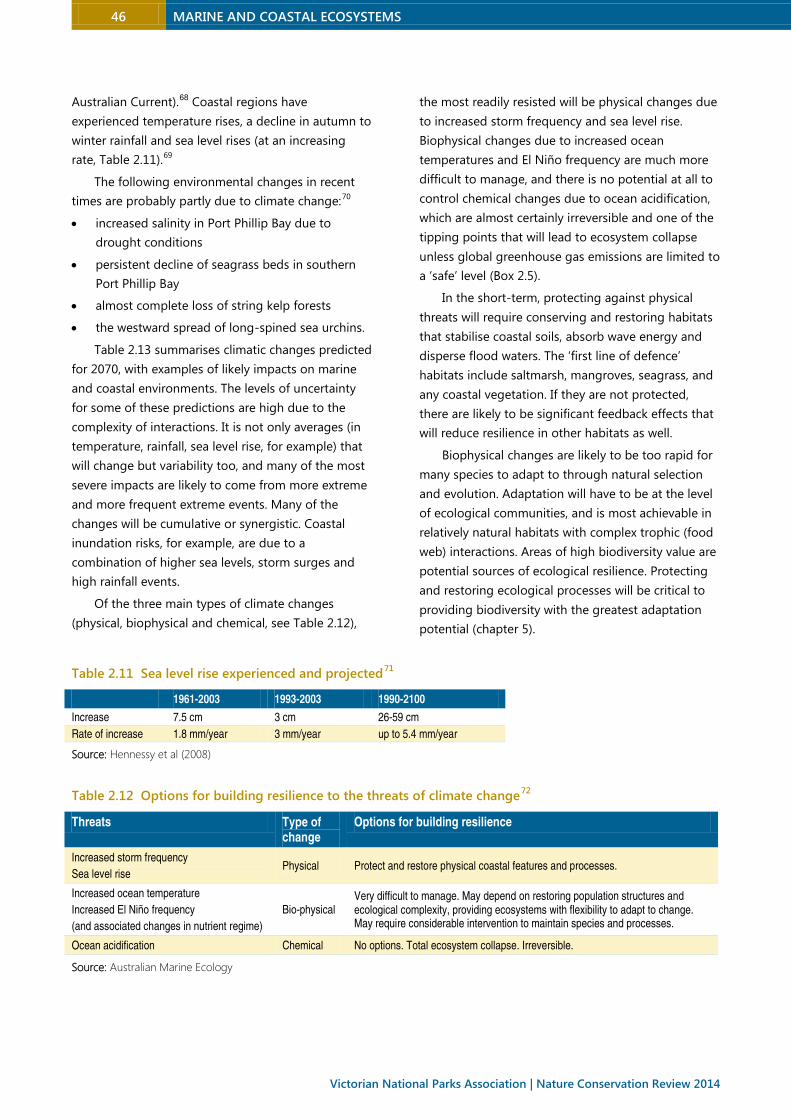
Australian Current).68 Coastal regions have
experienced temperature rises, a decline in autumn to
winter rainfall and sea level rises (at an increasing
rate, Table 2.11).69
The following environmental changes in recent
times are probably partly due to climate change:70
• increased salinity in Port Phillip Bay due to
drought conditions
• persistent decline of seagrass beds in southern
Port Phillip Bay
• almost complete loss of string kelp forests
• the westward spread of long-spined sea urchins.
Table 2.13 summarises climatic changes predicted
for 2070, with examples of likely impacts on marine
and coastal environments. The levels of uncertainty
for some of these predictions are high due to the
complexity of interactions. It is not only averages (in
temperature, rainfall, sea level rise, for example) that
will change but variability too, and many of the most
severe impacts are likely to come from more extreme
and more frequent extreme events. Many of the
changes will be cumulative or synergistic. Coastal
inundation risks, for example, are due to a
combination of higher sea levels, storm surges and
high rainfall events.
Of the three main types of climate changes
(physical, biophysical and chemical, see Table 2.12),
the most readily resisted will be physical changes due
to increased storm frequency and sea level rise.
Biophysical changes due to increased ocean
temperatures and El Niño frequency are much more
difficult to manage, and there is no potential at all to
control chemical changes due to ocean acidification,
which are almost certainly irreversible and one of the
tipping points that will lead to ecosystem collapse
unless global greenhouse gas emissions are limited to
a ‘safe’ level (Box 2.5).
In the short-term, protecting against physical
threats will require conserving and restoring habitats
that stabilise coastal soils, absorb wave energy and
disperse flood waters. The ‘first line of defence’
habitats include saltmarsh, mangroves, seagrass, and
any coastal vegetation. If they are not protected,
there are likely to be significant feedback effects that
will reduce resilience in other habitats as well.
Biophysical changes are likely to be too rapid for
many species to adapt to through natural selection
and evolution. Adaptation will have to be at the level
of ecological communities, and is most achievable in
relatively natural habitats with complex trophic (food
web) interactions. Areas of high biodiversity value are
potential sources of ecological resilience. Protecting
and restoring ecological processes will be critical to
providing biodiversity with the greatest adaptation
potential (chapter 5).
Table 2.11 Sea level rise experienced and projected71
1961-2003 1993-2003 1990-2100
Increase 7.5 cm 3 cm 26-59 cm
Rate of increase 1.8 mm/year 3 mm/year up to 5.4 mm/year
Source: Hennessy et al (2008)
Table 2.12 Options for building resilience to the threats of climate change72
Threats Type of change
Options for building resilience
Increased storm frequency
Sea level rise Physical Protect and restore physical coastal features and processes.
Increased ocean temperature
Increased El Niño frequency
(and associated changes in nutrient regime)
Bio-physical Very difficult to manage. May depend on restoring population structures and ecological complexity, providing ecosystems with flexibility to adapt to change. May require considerable intervention to maintain species and processes.
Ocean acidification Chemical No options. Total ecosystem collapse. Irreversible.
Source: Australian Marine Ecology
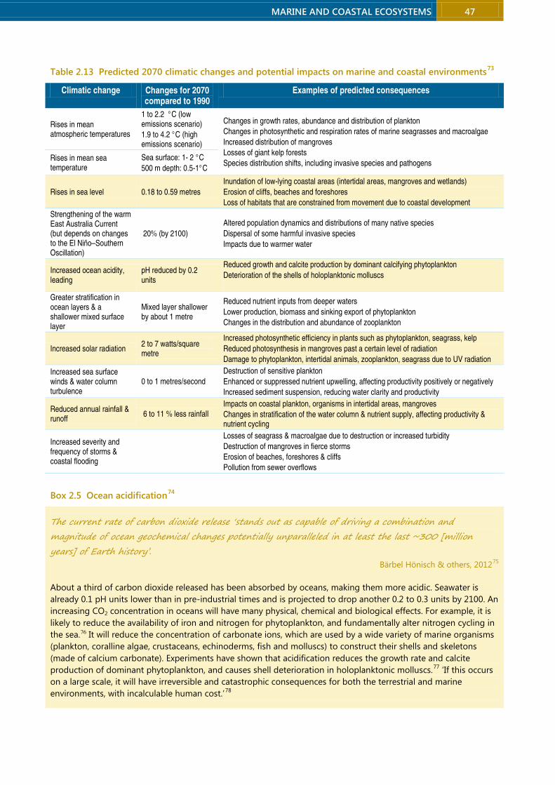
MARINE AND COASTAL ECOSYSTEMS 47
Table 2.13 Predicted 2070 climatic changes and potential impacts on marine and coastal environments73
Climatic change Changes for 2070 compared to 1990
Examples of predicted consequences
Rises in mean atmospheric temperatures
1 to 2.2 °C (low emissions scenario)
1.9 to 4.2 °C (high emissions scenario)
Changes in growth rates, abundance and distribution of plankton
Changes in photosynthetic and respiration rates of marine seagrasses and macroalgae
Increased distribution of mangroves
Losses of giant kelp forests
Species distribution shifts, including invasive species and pathogens Rises in mean sea temperature
Sea surface: 1- 2 °C
500 m depth: 0.5-1°C
Rises in sea level 0.18 to 0.59 metres
Inundation of low-lying coastal areas (intertidal areas, mangroves and wetlands)
Erosion of cliffs, beaches and foreshores
Loss of habitats that are constrained from movement due to coastal development
Strengthening of the warm East Australia Current (but depends on changes to the El Niño–Southern Oscillation)
20% (by 2100)
Altered population dynamics and distributions of many native species
Dispersal of some harmful invasive species
Impacts due to warmer water
Increased ocean acidity, leading
pH reduced by 0.2 units
Reduced growth and calcite production by dominant calcifying phytoplankton
Deterioration of the shells of holoplanktonic molluscs
Greater stratification in ocean layers & a shallower mixed surface layer
Mixed layer shallower by about 1 metre
Reduced nutrient inputs from deeper waters
Lower production, biomass and sinking export of phytoplankton
Changes in the distribution and abundance of zooplankton
Increased solar radiation 2 to 7 watts/square metre
Increased photosynthetic efficiency in plants such as phytoplankton, seagrass, kelp
Reduced photosynthesis in mangroves past a certain level of radiation
Damage to phytoplankton, intertidal animals, zooplankton, seagrass due to UV radiation
Increased sea surface winds & water column turbulence
0 to 1 metres/second
Destruction of sensitive plankton
Enhanced or suppressed nutrient upwelling, affecting productivity positively or negatively
Increased sediment suspension, reducing water clarity and productivity
Reduced annual rainfall & runoff
6 to 11 % less rainfall
Impacts on coastal plankton, organisms in intertidal areas, mangroves
Changes in stratification of the water column & nutrient supply, affecting productivity & nutrient cycling
Increased severity and frequency of storms & coastal flooding
Losses of seagrass & macroalgae due to destruction or increased turbidity
Destruction of mangroves in fierce storms
Erosion of beaches, foreshores & cliffs
Pollution from sewer overflows
Box 2.5 Ocean acidification74
The current rate of carbon dioxide release ‘stands out as capable of driving a combination and
magnitude of ocean geochemical changes potentially unparalleled in at least the last ~300 [million
years] of Earth history’. Bärbel Hönisch & others, 201275
About a third of carbon dioxide released has been absorbed by oceans, making them more acidic. Seawater is
already 0.1 pH units lower than in pre-industrial times and is projected to drop another 0.2 to 0.3 units by 2100. An
increasing CO2 concentration in oceans will have many physical, chemical and biological effects. For example, it is
likely to reduce the availability of iron and nitrogen for phytoplankton, and fundamentally alter nitrogen cycling in
the sea.76 It will reduce the concentration of carbonate ions, which are used by a wide variety of marine organisms
(plankton, coralline algae, crustaceans, echinoderms, fish and molluscs) to construct their shells and skeletons
(made of calcium carbonate). Experiments have shown that acidification reduces the growth rate and calcite
production of dominant phytoplankton, and causes shell deterioration in holoplanktonic molluscs.77 ‘If this occurs
on a large scale, it will have irreversible and catastrophic consequences for both the terrestrial and marine
environments, with incalculable human cost.’78

48 MARINE AND COASTAL ECOSYSTEMS
Victorian National Parks Association | Nature Conservation Review 2014
Box 2.6 Shores and shorebirds under climate change
By the end of the century, according to recent projections, sea levels could rise by an average 75 to 190
centimetres relative to 1990 levels.79 South-eastern Australia is projected to experience greater sea-level rises than
the global average because the warming East Australian Current is moving further south.
One-in-100 year events are used as a benchmark for assessing extreme risk. Even if sea levels rise just 0.5
metres in the 21st century, current 1-in-100 year events could occur several times a year and 1-in-10 year events
would happen about every 10 days.80
Rising sea levels in combination with extreme events will inundate and erode coastal ecosystems. About three-
quarters of the Victorian coastline is sandy or soft, so is vulnerable to erosion. One simple approximation is that
each centimetre rise in sea level is likely to cause sandy shoreline recession of 50 to 100 centimetres (for a 1 metre
sea rise, this implies 50 to 100 metres recession).81 This will put at risk billions of dollars of coastal housing and
infrastructure. A 2009 first-pass assessment of the risks to Victoria’s coastal infrastructure under a 2100 climate
change scenario of a 1.1 metre rise in sea level and a 1-in-100 storm-tide predicted that from 27,600 to 44,600
residential buildings (current replacement value $6.5 billion to $10.3 billion) could be at risk of inundation. It
estimated that there are 4700 residential buildings within 110 metres of erodible shorelines.82
To survive, coastal ecosystems such as seagrasses, mangroves and saltmarshes will need to shift landward but
coastal infrastructure will prevent natural movement in many areas. Saltmarshes in particular will be trapped by a
coastal squeeze, between urban development on the land side and migration of mangroves on the sea side. Loss
of saltmarsh would not only compromise the future of dependent wildlife but could liberate a huge pool of carbon
stored in wetland sediments. Beaches too will be lost to coastal squeeze unless buffers are created to
accommodate landward migration.
The loss of saltmarsh and beach habitats will deprive many shorebirds of important habitat. Other climate
change impacts on shorebirds include increased mortality and reduced breeding success due to heat stress, and
alterations to the synchronised timing of shorebird migration and the abundance of food species.
2.3.2 Dysfunction of biological interactions
Processes that change interactions between species,
reducing their functionality or disrupting life-cycle
processes, threaten many species. The most obvious are
invasions of introduced species – new predators (foxes
and cats) eliminating native animals, new pathogens
(myrtle rust) inflicting heavy losses on immunologically
naïve species and rampant weeds outcompeting native
plants. They also include native species benefiting from
anthropogenic changes – altered fire regimes, climate
change or assisted spread – that detrimentally affect
other species. Examples are long-spined urchins
spreading to new areas via the strengthening East
Australia Current, and noisy miners dominating
fragmented woodlands (section 3.4.2). Another major
cause of dysfunction less well recognised (and not
covered here) is the decline or loss of a key partner in
multispecies relationships – for examples, declines of
top predators (sharks and dingoes), pollinators and
seed dispersers (honeyeaters, parrots, flying-foxes).
The Victorian government has listed more than 16
threatening processes, mostly invasive species, that fall
into this category and affect coastal and marine
environments.
Invasive species
Port Phillip Bay is one of the most invaded marine
ecosystems globally, with at least 100 to 160 introduced
species, representing 8 to 13% of all species, and
including half of the 10 most abundant species in the
bay. The number of introduced and cryptogenic species
found there is higher than reported ‘for a comparable
body of water anywhere else in the world’.83 The current
invasion rate could be as high as three or more new
benthic species yearly. Sources include hull fouling,
ballast water and mariculture. The extent to which the
ecological resistance of the bay has been altered by
invaders is unknown, but an ‘invasional meltdown’ may
be occurring, whereby invasions become mutually
reinforcing with established species facilitating
additional invasions. 84 Other sites are vulnerable to
invasion from Port Phillip Bay – by natural or human
means. Japanese kelp (recently found in Apollo Bay)
and Pacific seastars can spread on fishing gear and
boats.85 Recreational fishers are permitted to transport
live European shore crabs across the state. Although
MARINE AND COASTAL ECOSYSTEMS 49
they are not allowed to be used as live bait, there is a
risk that crabs will escape or will be carrying eggs.86
Coastal terrestrial ecosystems have been severely
damaged by invasive species, with weeds invading
vegetation remnants (Box 2.7), foxes and cats preying
on wildlife, and rabbits, goats and other herbivores
degrading habitats (chapter 3).
Native species can also be harmful if they are
introduced or move to new areas, or become more
abundant due to human-caused changes, a problem
that will grow under climate change, exemplified by the
native long-spined sea urchin denuding coastal reefs.
Box 2.7 Weeds destroying coastal saltmarsh87
About half the plant species in Victoria’s coastal saltmarshes are exotic (118 species). Weeds have caused major
degradation, shifts in the composition of saltmarshes and changes in ecosystem function. Tall wheat grass,
introduced and promoted by the Victorian government for grazing on saline lands, ‘is unquestionably the most
serious invader because of its very broad ecological amplitude and robust life form’. A 2001 risk assessment found
that it could ‘destroy most upper saltmarsh in western Victoria’ and it has been listed as a potentially threatening
process by the government.88 Yet, it is still promoted by the government as a pasture species and there are no
restrictions on its sale or planting.
Another deliberately introduced plant of saltmarshes, also listed as a potentially threatening process, is the
‘ferocious weed’ cord grass (Spartina species), which can grow in tidal locations, including amongst mangroves.
Spartina can colonise mudflats, destroying the feeding grounds of shorebirds and invertebrates.89
Feral animals too have substantially degraded saltmarshes, with rabbits having so profoundly affected the
composition and structure of upper saltmarsh that ‘we are unaware of the full extent and nature of their impacts’.
Aquaculture
Land-based aquaculture facilities involving seawater
exchange are sited around Geelong Arm, Phillip Island
and Port Fairy. The greatest risks are genetic alteration
of wild animals, and the introduction or amplification of
disease. An abalone disease outbreak at a Port Fairy
facility in 2007 has caused substantial declines in wild
abalone in the Otway bioregion (Box 2.8).
Sea-based aquaculture occurs mostly in leases
within Geelong Arm, southern Port Phillip Bay, and at
Flinders, Western Port, focused mostly on passive
rearing of molluscs. The main risk is the accidental
release of invasive species when transferring stock
between farms. Other risks include organic enrichment,
release of antibiotics and growth stimulants and
harvesting pressure on wild species to produce food for
cultivated species.
Wild ‘stock enhancements’
In February 2013, 300,000 eastern king prawns bred in
an aquaculture facility were released into Lake Tyers for
recreational fishers to catch later in the year. Focused
just on benefits for fishers, it was done without an
environmental impact assessment. There are substantial
risks associated with stock enhancements, including
impacts on genetic diversity, trophic interactions and
the translocation of disease.90
Box 2.8 Abalone disease outbreak
In 2006, wild abalone in Victorian waters became infected with a severe disease caused by the herpes-like abalone
ganglioneuritis virus, thought to have originated from an abalone farm at Taylor Bay which discharged untreated
effluent into coastal waters. The virus has spread more than 200 kilometres along Victoria’s coast, causing up to
90% mortality in infected abalone populations and major economic losses in the wild abalone fishery.91 The quota
in the western region dropped from 280 tonnes in 2001-02 to 20 tonnes in 2011-12. In eastern Victoria the
abalone fishery has also suffered declines due to the proliferation of long-spined sea urchins, which have denuded
some reefs of vegetation creating ‘barrens’. Their spread into cooler near shore waters of Victoria’s eastern Bass
Strait coastline is most likely due to a strengthening of the East Australian Current.92
50 MARINE AND COASTAL ECOSYSTEMS
Victorian National Parks Association | Nature Conservation Review 2014
Algal blooms
Phytoplankton blooms occur naturally but their
frequency and severity is increased by nutrients,
introduction of new species and through compromised
nutrient cycling by marine plants such as seagrasses.
Blooms of conservation concern occur in northern Port
Phillip Bay and Western Port, particularly of toxic
dinoflagellates. Algal blooms can persist for months in
Gippsland Lakes, severely affecting water quality.
2.3.3 Habitat loss and degradation
Victorians do indeed love their coast— on average they visit it more than 20 times each year—but love
can be lethal. Each poor planning and management decision adds to the pressure from previous ones—
death by a thousand cuts. Chris Smyth, 201493
At broad scales, habitat loss results from clearing of
native vegetation or dredging of the sea bottom, but it
also occurs at smaller scales by the loss of habitat
elements such as hollow-bearing trees, woody debris
and rocks. Degradation, caused by erosion,
sedimentation, eutrophication, pollution, overgrazing
and weed invasion, reduces the productivity of habitats,
while fragmentation limits interactions between and
within species, constrains species movements across the
landscape, interrupting gene flow and recolonisation,
and exacerbates degradation.94
The Victorian government has listed at least a
dozen potentially threatening processes under the Flora
and Fauna Guarantee Act that contribute to loss and
degradation of coastal and marine environments,
including the degradation of riparian vegetation,
habitat fragmentation, input of organotoxins, petroleum
and related products to marine and estuarine waters,
input of toxicants to rivers and streams, loss of coarse
woody debris and hollow-bearing trees, removal of
woody debris from streams, discharge of human-
generated marine debris and wetland loss and
degradation.
Coastal development
The Victorian coastline has already suffered much
damage from urbanisation, industrialisation and
visitation. Much remnant habitat exists in a narrow strip,
hemmed in by roads, car parks, caravan parks and
buildings, and vulnerable to fragmentation, weeds,
vandalism and dieback. The pressures are increasing,
with the number of applications for development under
the Coastal Management Act increasing by about one-
third between 2003-04 and 2009.95 Between 1980 and
2004 urban areas increased by 15%, extending from 270
to 311 kilometres, 17% of the coastline.96 This trend will
continue as Victoria’s population grows. About 16% of
the population lives within five kilometres of the coast,
and in the decade from 2001 the coastal population
grew an average 1.3% a year to 840,000.97
Other development pressures come from high rates
of visitation, an estimated 13 million visits a year by
Victorians.98 A 2012 survey found that four of five (84%)
Victorians had made at least one trip to the coast in the
previous year, and the average was 23.4 trips a year. 99
Box 2.9 Inappropriate coastal development100
In January 2013, the Victorian environment minister gave consent for a breakwater, boat ramp and beach road on
crown land at Bastion Point, Mallacoota. In so doing, he approved the burial by concrete and asphalt of a
significant landscape, the town’s only safe swimming beach, archaeological sites and a rare surfing break.
Under the Coastal Management Act, ministerial consent is to be given only to proposals proven to be
appropriate, and consistent with the Victorian Coastal Strategy 2008, the relevant coastal action plans and the
purposes for which the land was reserved. There had been overwhelming opposition to it in the local community,
and a safe and less costly alternative with far fewer impacts was proposed.
An independent planning panel in 2009 found that the project would have ‘considerable impact on the
wilderness and landscape values of Bastion Point and an overall net detriment to tourism’, that the economic case
for it was ‘very weak’, that it would impact in cultural heritage values and that it would have ‘no overall societal
MARINE AND COASTAL ECOSYSTEMS 51
benefit’. The panel recommended a small-scale upgrade of the existing ramp.
The then ALP environment minister rejected the panel’s advice. A Supreme Court judicial review of the
planning minister’s decision, mounted by the Friends of Mallacoota, found that the minister’s decision was
‘surprising’ and the panel report was ‘a careful, fair, and balanced evaluation.’101
Box 2.10 Climatically irresponsible development102
Development of the coast along the Dutton Way and out to Narrawong is fraught with great risk, for this region is
highly prone to erosion. For many years a special use zone froze development on land at greatest risk of erosion.
In 2007 the Shire of Glenelg introduced an assessment process for house construction in this zone, which required
extensive documentation by applicants. In 2008 the then planning minister, Justin Madden, gave the go-ahead for
construction on 24 blocks, leaving another 525 in limbo. At the November 2010 state election the Coalition
committed to removing the local government impediments to development in this zone.
This decision could be costly for Victorian taxpayers. A study commissioned by the Glenelg Shire Council in
2010 estimated that sea-level rise, shoreline erosion and increased storm intensity would result in the following:
• by 2030: shoreline recession of 43 to 63 metres and damage worth $101 million
• by 2070: shoreline recession of 124 to 146 metres by 2070, and damage worth $158 million
• by 2100: shoreline recession of 183 to 211 metres and damage worth $168 million.
The study assessed four adaptation options ranging from doing nothing to reconstructing and extending rock
walls, with additional groynes, to the mouth of the Surry River at an estimated cost of $125 million. It considered
four planning options that ranged from doing nothing to prohibiting further development. In response, the shire
developed a decision matrix that measured the level of risk to property access and the risk of flood and erosion to
guide decisions on applications for subdivision and house construction.
In 2012 the state planning minister overturned the Glenelg Shire’s rejection of a rezoning application for
houses on freehold coastal land west of the Surry River’s mouth. The 2010 erosion study indicated this land could
be partially eroded by 2070 and completely gone by 2100 due to sea level rises.
In July 2013 the Shire of Glenelg and the planning minister struck a deal to allow future coastal development
between Portland and Narrawong, which would ‘exclude council’s liability for the area and enforce a build-at-your-
own-risk policy’.103 This will create an incentive for future construction of a seawall. The development will also
facilitate weed and feral animal invasion of the narrow coastal crown land reserve, stymie movement of plants and
animals as the sea rises, and prevent revegetation to improve habitats for coastal wildlife.
Ports, harbours and shipping
There is also industrial development on the coast in the
form of ports and harbours. Threats include dredging,
oil spills, land reclamation and modification of estuarine
habitats, pollution, establishment of marine pests and
recreational fishing. Shipping threats include oil spills,
groundings, litter/rubbish and effluent dumping at sea,
translocation of marine pests and release of toxic
antifouling substances. Shipping is increasing as
population and trade increase.
In April 2013, the state government announced
funding for the design and environmental assessment
of a fast-tracked expansion of Port of Hastings as a
major container port, which would involve channel
dredging, land reclamation and upgrading road and rail
corridors. Shipping traffic is predicted to increase from
100 to 3000 ships per year, which could expose Western
Port to damaging spills of heavy fuel oil and diesel from
container ships and port support vessels, with terrible
consequences for the sensitive habitats of the Ramsar
listed wetland and internationally significant
populations of shorebirds. 104 It will add to the growing
pressure on the bay from the spread of Melbourne into
its catchment (the city of Casey’s population has been
growing at 3.3% a year.
Dredging and channel deepening
Maintenance dredging occurs at most of Victoria’s
major ports, causing suspension of sediments, which
reduces water clarity and smothers plants and
animals.105 Most ports have seagrass habitats, which are
highly sensitive to turbidity. Due to a lack of studies, the
specific consequences of past and present dredging
activities are largely unknown. Channel deepening on
52 MARINE AND COASTAL ECOSYSTEMS
Victorian National Parks Association | Nature Conservation Review 2014
the rocky seabed at the entrance to Port Phillip Bay has
occurred since the late 19th century. Blasting and
dredging in 2008 resulted in rubble being moved by
swells and currents into adjacent canyon habitats of
high conservation value.
Subsea infrastructure and discharges
Subsea structures in Victoria are mostly pipelines for
effluent discharge, gas and oil transfer, and water intake
and discharge (for the desalination plant), and
electricity and telecommunications cables. There are
also three 50 square metre reef ball style artificial reefs
in Port Phillip Bay for recreational fishers, and plans for
more along the Victorian Coast. They alter seabed
habitat and attract aggregations of fish, some species of
which are vulnerable to fishing pressure. Renewable
energy projects are another emerging source of subsea
infrastructure. A proposed demonstration offshore wave
power station near Portland will require buoys,
undersea pods and a submarine power cable. Offshore
wind farms, which require subsea infrastructure to
anchor turbines and connect to the electricity grid, are
being built overseas and are likely to be proposed in
future. Polluting discharges into coastal waters include
sewage at Boags Rocks (Gunnamatta) and Black Rock
(Barwon Heads) and industrial waste at Corio Bay
(Geelong) and Seaspray (Latrobe Valley). When
operating, the desalination plant at Wonthaggi will
discharge up to 280 billion litres of brine annually.
There have been substantial oil leaks in the Otway
basin, with unknown impacts.
Oil and gas mining
Victoria’s seas are mined for oil and gas: substantial
amounts of both are extracted from the Gippsland
Basin and there is a smaller but expanding gas industry
in the Otway Basin. Oil production peaked in 1985 and
annual production is declining, but gas production is
increasing. There are considerable undiscovered gas
reserves in the Gippsland and Otway Basins. Origin
Energy conducted seismic testing offshore from the
Bays of Islands Coastal Park in 2011 and in
Commonwealth waters off the Otway coast in
2013. Other companies are also exploring for gas. Oil
and gas exploration and mining causes hydrocarbon
pollution from leaks, accidents and chronic discharges
from process water. Seismic testing can affect sensitive
marine mammals and potentially other species such as
rock lobsters and abalone.106 Often, the construction of
artificial features is necessary for resource extraction,
with impacts on the seabed or the coast.
Catchment activities107
Inherent to integrated coastal zone management is
recognition that catchment activities have
consequences for coastal health. The poor health of
many of Victoria’s catchments is highly detrimental for
coastal processes. A 2005 assessment found that fewer
than half of Victoria’s coastal river basins had more than
a third of their stream lengths in good health (Table
2.14).108 A 2012 assessment found that rivers and
streams were in poor or poor to moderate condition in
three of five coastal catchments (explained in chapter
4).109 Catchment-related threats include erosion and
sedimentation due to land clearing, forestry and
burning; contamination by agricultural nutrients and
chemicals, and urban-derived chemicals, nutrients, litter
and bacteria; the reduction of freshwater flows; and the
disturbance of acid sulphate soils. There is a legacy of
pesticides, heavy metals and other contaminants within
the sediments of Victorian bays and inlets due to past
activities. The siltation of waters flowing into Western
Port has caused extensive seagrass loss (section 2.2.3).
Table 2.14 Percentage of stream lengths in good or excellent condition in coastal river basins, 2004110
<10% 11-30% 31-60% 61-70% >70%
Glenelg Weribee Otway Coast Tambo River Mitchell
Portland Coast Yarra Latrobe Snowy River East Gippsland
Hopkins South Gippsland
Barwon Thomson
Moorabool
Maribyrnong
Bunyip
MARINE AND COASTAL ECOSYSTEMS 53
2.3.4 Overexploitation
[While] modern-day fishing practices are generally much improved over practices used as recently as 30
years ago, the legacy effects from the intense fishdown phase of virgin stocks… are a dominant feature of
the population structure of most fishable species. Australia State of the Environment 2011111
Fishing, both commercial and recreational, is the major
form of exploitation affecting coastal and marine
ecosystems. In addition to depletion of targeted
species, fishing can affect species caught for bait or
incidentally (bycatch), and damage habitats.
Commercial fishing112
All large edible species in Victoria have suffered
dramatic reductions in biomass and abundance due to
historically high levels of commercial exploitation. An
initial ‘fish down’ caused some population collapses, for
example of barracouta and elephant seals, which were
harvested to commercial extinction. Other species have
since been maintained at or below the estimated
maximum sustainable fishery production, which has
probably led to other collapses – of flat oysters,
scallops, pilchards and greenlip abalone.113 Other
fisheries, such as that for school shark, remain tenuous,
and declines of white sharks, grey nurse sharks and blue
fin tuna are also fishing related. Fishing pressure occurs
at or above ecologically sustainable levels throughout
all marine habitats, except for the larger marine national
parks.
In addition to removal of biomass, fishing can
damage habitats. Demersal and scallop trawling,
operating out of Portland and Lakes Entrance, cause
great damage to bottom communities.
In 2009-10, Victorian commercial wild-caught
fisheries production was 4638 live tonnes based on
more than 120 species: molluscs (abalone, scallops,
pipis, periwinkles), crustaceans (rock lobster, crabs,
prawns), cephalopods (squid, octopus, cuttlefish),
echinoderms (sea urchins, sea cucumber), polychaetes
(sand worms), teleosts (scale fish, more than 75 species)
and elasmobranchs (sharks, chimeras, skates, rays).
The Victorian government has assessed wild catch
commercial fisheries in Victoria as, ‘in general, at or near
capacity in terms of fishing effort’, with most targeted
species classified as ‘fully exploited’ (defined as
sustainable levels of fishing and satisfactory abundance
of fished species) or ‘environmentally limited’ (non-
fishing issues are influencing productivity) (Table
2.15).114 Such stock assessments are typically based on a
target biomass of only about 40% of undepleted levels;
they mostly do not account for recreational fishing, and
a lack of data constrains the capacity to assess
ecosystem impacts.115
However, improvements have been made in
commercial fishing practices in Victorian marine waters
in recent years. The Australian Conservation
Foundation’s Sustainable Australian Seafood
Assessment Program assessed several Victorian wild
caught fisheries as sustainable in 2011 (Table 2.16).
Table 2.15 Victorian fisheries assessments 2010116
Fishery Stock status Recreational effort
Rock lobster Fully exploited Moderate (eastern)
Minor (western)
Giant crab Fully exploited Negligible
Abalone Fully exploited Minor
Scallop Fully exploited Minor
Snapper Environmentally limited Large
Black bream Environmentally limited Large
King George whiting Environmentally limited Large
Sea urchin Underexploited Minor
Calamari Environmentally limited Large
Garfish Fully exploited Large
Rock flathead Environmentally limited Minor
Sand flathead Environmentally limited Large
Dusky flathead Unknown Large
Australian salmon Unknown Moderate
Source: Adapted from Department of Primary Industries by
Ford & Gilmour (2013). The status of some species was
deduced from stock assessment reports. Definitions of terms:
Underexploited: The fishery could potentially tolerate
additional harvest pressure. Fully exploited: There are
sustainable levels of fishing and satisfactory abundance of
fishery stocks. Over exploited: Stock abundance is not
satisfactory or overfishing is occurring. Environmentally limited:
Significant non-fishing (ecosystem) issues are influencing
productivity in the fishery and considered to be driving stock
status.

54 MARINE AND COASTAL ECOSYSTEMS
Victorian National Parks Association | Nature Conservation Review 2014
Table 2.16 Wild-caught fisheries assessed as
‘sustainable’ (Sustainable Australian Seafood
Assessment Program)117
Species Location
Southern calamari Corner Inlet, Port Phillip Bay
King george whiting Corner Inlet, Port Phillip Bay
Snapper Port Phillip Bay
Rock flathead Corner Inlet
Silver trevally Corner Inlet, Port Phillip Bay
Black bream Gippsland Lakes
Recreational fishing118
So many people, so many places, so many
methods, so many species – this is the challenge
that fisheries and environment agencies face when
attempting to evaluate the extent and impact of
recreational fishing. John Ford and Patrick Gilmour, 2013119
According to surveys in 2000 and 2009, about one in
eight Victorians goes fishing for recreation each year.
Because of a lack of monitoring there is little
information about the environmental impacts of
recreational fishing but the substantial fishing effort –
combined with that from commercial fishing – implies
far from benign impacts.
Whether commercial or recreational, fishing has
three types of impacts: (1) direct impacts on targeted
species, (2) direct impacts on non-target species
(bycatch, discards, bait), and (3) general ecosystem
impacts.
Fishing pressure: The main data on recreational
catch from a national survey more than a decade ago
(1999–2000) showed that the recreational catch of
several species is similar to or exceeds the commercial
catch. For example, the recreational catch of snapper
was an estimated 332 tonnes, more than seven times
the commercial catch (see Table 2.17 for other
examples). It is likely that recreational effort has
increased since then. But fisheries assessments,
including for species considered ‘fully exploited’, do not
include recreational fishing effort, and the combined
commercial and recreational catch for some species
may be unsustainable – Elephant Fish, for example.120
Because recreational fishing pressure tends to be highly
localised and correlated with population centres and
access points, local populations may become depleted.
As much as 88% of the recreational catch from Victorian
bays and inlets may come from Port Phillip Bay.
Recreational pressure may be maintained even when
catch rates are low, which prevents recovery, whereas
commercial fishers abandon unprofitable sites.
Table 2.17 Estimated recreational and commercial catch 1999–2000 of some target recreational species in
Victorian marine and estuarine waters121
Species/group Estimated recreational catch
(millions)
Estimated recreational catch
(tonnes)
Commercial catch (tonnes)
Estimated % of commercial catch
Flathead 3.32 597 151 395%
Snapper 0.47 332 47 706%
Australian salmon 0.54 271 803 34%
King George whiting 0.98 215 213 101%
Black bream 0.51 203 196 104%
Rock lobster 0.05 61 543 11%
Mullet 0.30 60 >51 <115%
Leatherjacket 0.17 50 17 294%
Trevally 0.11 38 42 90%
Garfish 0.25 26 >118 <225%
Tailor 0.06 14 13 108%
Morwong 0.03 4 >4 <100%
Abalone 0.01 3 1418 <1%
Australian herring 0.01 1 1 100%
Whiting 0.004 1 8 13%

MARINE AND COASTAL ECOSYSTEMS 55
Table 2.18 Other recreationally caught species,
estimated 1999-2000 catch
Species/group Estimated catch
Pipi 640,000
Mussels 620,000
Pike 260,000
Squid/cuttlefish 200,000
Wrasse 120,000
Barracouta 110,000
Sharks/rays 90,000
Scallops 80,000
Prawns 70,000
Bycatch/non-target catch: Recreational fishers,
mostly using fishing lines, typically catch a wide range
of species while targeting a few favoured species. The
survival of fish returned to the water as discards or
returns is variable, and discard impacts could be
substantial given the magnitude of the recreational
catch of some fish, particularly for low-productivity,
low-abundance species vulnerable to even low levels of
catch. Dive surveys of grey nurse sharks off Australia’s
east coast between 1991 and 2001 found that the
number with embedded fishing hooks and line
increased from 2% to 12%.122
Bait collection: Impacts on species collected as bait
can be similar to those targeted for sport or
consumption.
Trophic effects: Fishing of single species can have
flow-on ecosystem impacts – for example by favouring
competitors, reducing predator abundance, altering
benthic habitat or reducing mean trophic levels.
Entanglements: Birds, turtles, fish and marine
mammals become entangled in discarded hooks, lines,
pots and ropes. Of 537 pelicans rescued in the
Richmond River, New South Wales over nine years
(1993–2002), 94% were entangled in fishing line and
hooks.
Habitat impacts: Fragile habitats can be damaged
by anchors or propellers (in shallow water). The use of
four-wheel-drive vehicles on sandy beaches and dunes
– for launching boats or for shore-based fishing – may
contribute to erosion and harm nesting shorebirds.
Invasive species: Fishers can contribute to the
spread of invasive species attached to their boats or in
fishing gear (see above). Victorian legislation allows
recreational fishers to transport live European shore
crabs.
Pollution: Fishers contribute to air pollution and
greenhouse gas emissions through the use of
motorboats and to water pollution by waste (eg bait
bags, lead sinkers, discarded or lost fishing line and
nets).
2.3.5 Changes to disturbance regimes
Changes to disturbance regimes – such as fire regimes
and water flows - can interrupt species’ life cycles or
reduce the availability of food, shelter and breeding
sites. Harmful fire regimes threaten remnant coastal
vegetation (see chapter 3) and changes to water flows
by dams and water extractions (see chapter 4) harm
coastal and marine ecosystems, for example due to
higher salinity levels. Alteration to the natural flow
regimes and natural temperature regimes of rivers and
streams, inappropriate fire regimes and high frequency
fires that disrupt life cycles and compromise vegetation
structure and composition are listed as potentially
threatening processes.
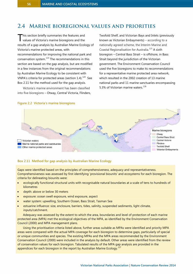
56 MARINE AND COASTAL ECOSYSTEMS
Victorian National Parks Association | Nature Conservation Review 2014
2.4 Marine bioregional values and priorities
his section briefly summaries the features and
values of Victoria’s marine bioregions and the
results of a gap analysis by Australian Marine Ecology of
Victoria’s marine protected areas, with
recommendations for improving the national park and
conservation system.123 The recommendations in this
section are based on the gap analysis, but are modified
in a few instances from the original recommendations
by Australian Marine Ecology to be consistent with
VNPA’s criteria for protected areas (section 1.4).124 See
Box 2.11 for the method used for the gap analysis.
Victoria’s marine environment has been classified
into five bioregions – Otway, Central Victoria, Flinders,
Twofold Shelf, and Victorian Bays and Inlets (previously
known as Victorian Embayments) – according to a
nationally agreed scheme, the Interim Marine and
Coastal Regionalisation for Australia.125 A sixth
bioregion – Central Bass Strait – is offshore, in Bass
Strait beyond the jurisdiction of the Victorian
government. The Environment Conservation Council
used the five bioregions to make its recommendations
for a representative marine protected area network,
which resulted in the 2002 creation of 13 marine
national parks and 11 marine sanctuaries encompassing
5.3% of Victorian marine waters.126
Figure 2.2 Victoria’s marine bioregions
Box 2.11 Method for gap analysis by Australian Marine Ecology
Gaps were identified based on the principles of comprehensiveness, adequacy and representativeness.
Comprehensiveness was assessed by first identifying ‘provisional biounits’ and ecosystems for each bioregion. The
criteria for delineating biounits were:
• ecologically functional structural units with recognisable natural boundaries at a scale of tens to hundreds of
kilometres
• depth: above or below 30 meters
• exposure: ocean swell exposure, wind exposure, aspect
• water system: upwelling, Southern Ocean, Bass Strait, Tasman Sea
• estuarine influence: size, enclosure, barriers, tides, salinity, suspended sediments, light climate,
inputs/catchment.
Adequacy was assessed by the extent to which the area, boundaries and level of protection of each marine
protected area (MPA) met the ecological objectives of the MPA, as identified by the Environment Conservation
Council (2000) and MPA management plans.
Using the prioritisation criteria listed above, further areas suitable as MPAs were identified and priority MPA
areas were compared with the actual MPA coverage for each bioregion to determine gaps, particularly of special
or unique communities and species. The existing MPAs and the MPA areas recommended by the Environment
Conservation Council (2000) were included in the analysis by default. Other areas were identified from the review
of conservation values for each bioregion. Tabulated results of the MPA gap analysis are provided in the
appendices for each bioregion in the report by Australian Marine Ecology.127
T
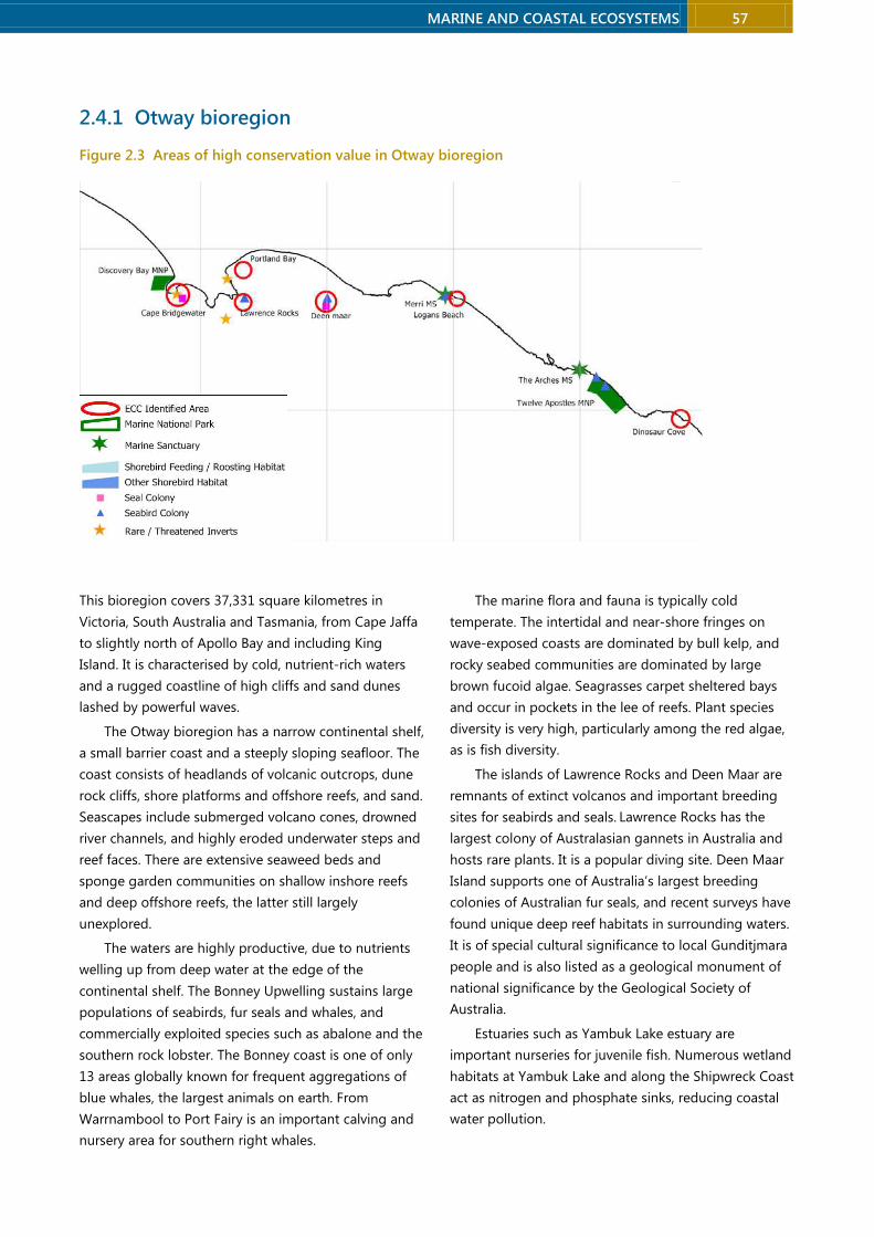
MARINE AND COASTAL ECOSYSTEMS 57
2.4.1 Otway bioregion
Figure 2.3 Areas of high conservation value in Otway bioregion
This bioregion covers 37,331 square kilometres in
Victoria, South Australia and Tasmania, from Cape Jaffa
to slightly north of Apollo Bay and including King
Island. It is characterised by cold, nutrient-rich waters
and a rugged coastline of high cliffs and sand dunes
lashed by powerful waves.
The Otway bioregion has a narrow continental shelf,
a small barrier coast and a steeply sloping seafloor. The
coast consists of headlands of volcanic outcrops, dune
rock cliffs, shore platforms and offshore reefs, and sand.
Seascapes include submerged volcano cones, drowned
river channels, and highly eroded underwater steps and
reef faces. There are extensive seaweed beds and
sponge garden communities on shallow inshore reefs
and deep offshore reefs, the latter still largely
unexplored.
The waters are highly productive, due to nutrients
welling up from deep water at the edge of the
continental shelf. The Bonney Upwelling sustains large
populations of seabirds, fur seals and whales, and
commercially exploited species such as abalone and the
southern rock lobster. The Bonney coast is one of only
13 areas globally known for frequent aggregations of
blue whales, the largest animals on earth. From
Warrnambool to Port Fairy is an important calving and
nursery area for southern right whales.
The marine flora and fauna is typically cold
temperate. The intertidal and near-shore fringes on
wave-exposed coasts are dominated by bull kelp, and
rocky seabed communities are dominated by large
brown fucoid algae. Seagrasses carpet sheltered bays
and occur in pockets in the lee of reefs. Plant species
diversity is very high, particularly among the red algae,
as is fish diversity.
The islands of Lawrence Rocks and Deen Maar are
remnants of extinct volcanos and important breeding
sites for seabirds and seals. Lawrence Rocks has the
largest colony of Australasian gannets in Australia and
hosts rare plants. It is a popular diving site. Deen Maar
Island supports one of Australia’s largest breeding
colonies of Australian fur seals, and recent surveys have
found unique deep reef habitats in surrounding waters.
It is of special cultural significance to local Gunditjmara
people and is also listed as a geological monument of
national significance by the Geological Society of
Australia.
Estuaries such as Yambuk Lake estuary are
important nurseries for juvenile fish. Numerous wetland
habitats at Yambuk Lake and along the Shipwreck Coast
act as nitrogen and phosphate sinks, reducing coastal
water pollution.
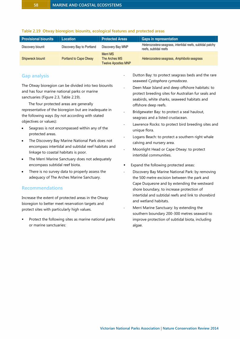
58 MARINE AND COASTAL ECOSYSTEMS
Victorian National Parks Association | Nature Conservation Review 2014
Table 2.19 Otway bioregion: biounits, ecological features and protected areas
Provisional biounits Location Protected Areas Gaps in representation
Discovery biounit Discovery Bay to Portland Discovery Bay MNP Heterozostera seagrass, intertidal reefs, subtidal patchy reefs, subtidal reefs
Shipwreck biounit Portland to Cape Otway
Merri MS
The Arches MS
Twelve Apostles MNP
Heterozostera seagrass, Amphibolis seagrass
Gap analysis
The Otway bioregion can be divided into two biounits
and has four marine national parks or marine
sanctuaries (Figure 2.3, Table 2.19).
The four protected areas are generally
representative of the bioregion but are inadequate in
the following ways (by not according with stated
objectives or values):
• Seagrass is not encompassed within any of the
protected areas.
• The Discovery Bay Marine National Park does not
encompass intertidal and subtidal reef habitats and
linkage to coastal habitats is poor.
• The Merri Marine Sanctuary does not adequately
encompass subtidal reef biota.
• There is no survey data to properly assess the
adequacy of The Arches Marine Sanctuary.
Recommendations
Increase the extent of protected areas in the Otway
bioregion to better meet reservation targets and
protect sites with particularly high values.
Protect the following sites as marine national parks
or marine sanctuaries:
- Dutton Bay: to protect seagrass beds and the rare
seaweed Cystophora cymodocea.
- Deen Maar Island and deep offshore habitats: to
protect breeding sites for Australian fur seals and
seabirds, white sharks, seaweed habitats and
offshore deep reefs.
- Bridgewater Bay: to protect a seal haulout,
seagrass and a listed crustacean.
- Lawrence Rocks: to protect bird breeding sites and
unique flora.
- Logans Beach: to protect a southern right whale
calving and nursery area.
- Moonlight Head or Cape Otway: to protect
intertidal communities.
Expand the following protected areas:
- Discovery Bay Marine National Park: by removing
the 500 metre excision between the park and
Cape Duquesne and by extending the westward
shore boundary, to increase protection of
intertidal and subtidal reefs and link to shorebird
and wetland habitats.
- Merri Marine Sanctuary: by extending the
southern boundary 200-300 metres seaward to
improve protection of subtidal biota, including
algae.
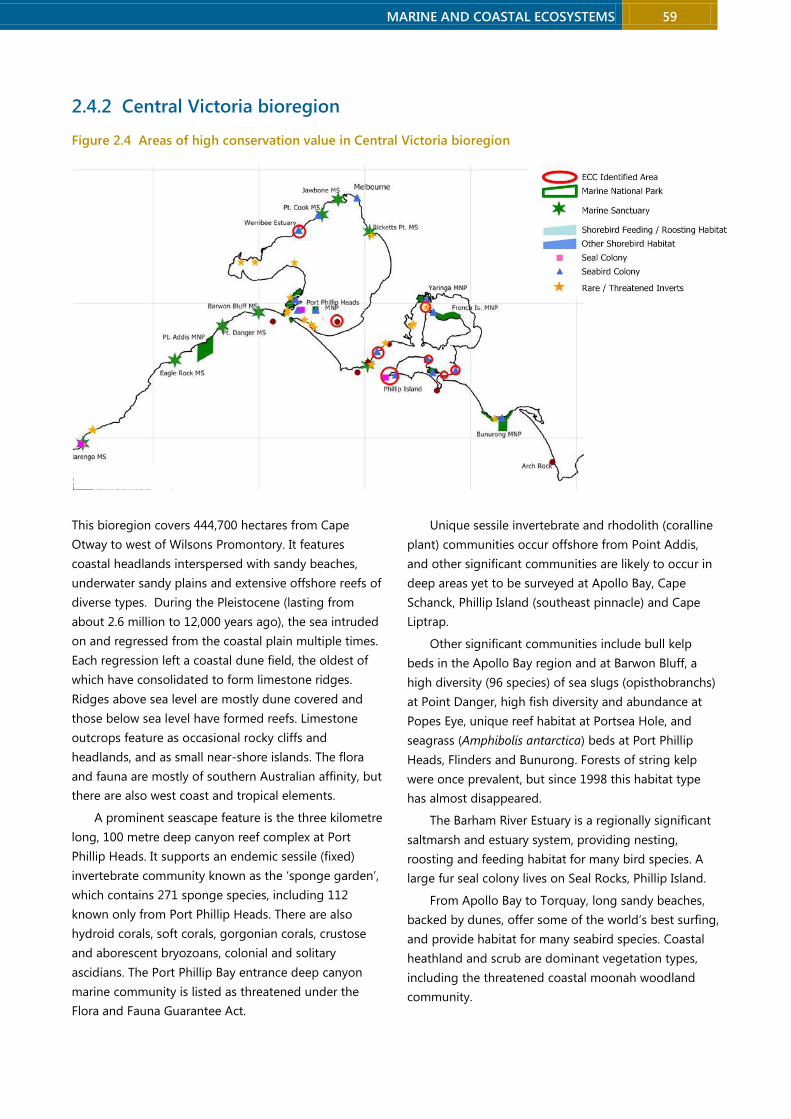
MARINE AND COASTAL ECOSYSTEMS 59
2.4.2 Central Victoria bioregion
Figure 2.4 Areas of high conservation value in Central Victoria bioregion
This bioregion covers 444,700 hectares from Cape
Otway to west of Wilsons Promontory. It features
coastal headlands interspersed with sandy beaches,
underwater sandy plains and extensive offshore reefs of
diverse types. During the Pleistocene (lasting from
about 2.6 million to 12,000 years ago), the sea intruded
on and regressed from the coastal plain multiple times.
Each regression left a coastal dune field, the oldest of
which have consolidated to form limestone ridges.
Ridges above sea level are mostly dune covered and
those below sea level have formed reefs. Limestone
outcrops feature as occasional rocky cliffs and
headlands, and as small near-shore islands. The flora
and fauna are mostly of southern Australian affinity, but
there are also west coast and tropical elements.
A prominent seascape feature is the three kilometre
long, 100 metre deep canyon reef complex at Port
Phillip Heads. It supports an endemic sessile (fixed)
invertebrate community known as the ‘sponge garden’,
which contains 271 sponge species, including 112
known only from Port Phillip Heads. There are also
hydroid corals, soft corals, gorgonian corals, crustose
and aborescent bryozoans, colonial and solitary
ascidians. The Port Phillip Bay entrance deep canyon
marine community is listed as threatened under the
Flora and Fauna Guarantee Act.
Unique sessile invertebrate and rhodolith (coralline
plant) communities occur offshore from Point Addis,
and other significant communities are likely to occur in
deep areas yet to be surveyed at Apollo Bay, Cape
Schanck, Phillip Island (southeast pinnacle) and Cape
Liptrap.
Other significant communities include bull kelp
beds in the Apollo Bay region and at Barwon Bluff, a
high diversity (96 species) of sea slugs (opisthobranchs)
at Point Danger, high fish diversity and abundance at
Popes Eye, unique reef habitat at Portsea Hole, and
seagrass (Amphibolis antarctica) beds at Port Phillip
Heads, Flinders and Bunurong. Forests of string kelp
were once prevalent, but since 1998 this habitat type
has almost disappeared.
The Barham River Estuary is a regionally significant
saltmarsh and estuary system, providing nesting,
roosting and feeding habitat for many bird species. A
large fur seal colony lives on Seal Rocks, Phillip Island.
From Apollo Bay to Torquay, long sandy beaches,
backed by dunes, offer some of the world’s best surfing,
and provide habitat for many seabird species. Coastal
heathland and scrub are dominant vegetation types,
including the threatened coastal moonah woodland
community.

60 MARINE AND COASTAL ECOSYSTEMS
Victorian National Parks Association | Nature Conservation Review 2014
Table 2.20 Central Victoria bioregion: biounits, protected areas and gaps
Provisional biounits Location Protected areas Gaps in representation
Surf Coast biounit
Cape Otway to Barwon Heads
Marengo MS
Eagle Rock MS
Point Addis MNP
Point Danger MS
Mornington biounit Barwon Heads to Coal Point
Barwon Bluff MS
Port Phillip Heads MNP
Mushroom Reef MS
Offshore sediments, intermediate reefs, deep reefs
Canyon biounit Port Phillip Heads Canyon Port Phillip Heads MNP
Heads biounit Port Phillip Heads and
Western Port entrances
Port Phillip Heads MNP
Bunurong biounit Coal Point to Sandy Point Bunurong MNP
Gap analysis
The Central Victoria bioregion can be divided into five
biounits and has 10 marine national parks or
sanctuaries (Figure 2.4, Table 2.20).
The 10 marine protected areas are considered
representative of the bioregion but are inadequate in
the following ways (by not according with stated
objectives or values):
• The protected areas in the Mornington biounit do
not adequately encompass deeper and offshore
communities, in particular intermediate and deep
reefs.
• Eagle Rock Marine Sanctuary only patchily
encompasses subtidal reef habitat.
• Barwon Bluff Marine Sanctuary only encompasses a
small area of bull kelp habitat.
• The Point Nepean section of the Port Phillip Heads
Marine National Park only partially encompasses
Amphibolis seagrass habitat, which is not
adequately encompassed within any Victorian
protected areas.
• Mushroom Reef Marine Sanctuary does not
adequately protect fish and most other subtidal
biota.
• Bunurong Marine National Park does not
adequately encompass deep reef habitat or include
the listed holothurian Pentocnus bursatus.
• The boundaries of Marengo Marine Sanctuary do
not provide an adequate buffer to protect subtidal
habitats.
Several areas outside protected areas warrant
protection, including:
• Port Phillip Heads coastal, seagrass, subtidal reef,
deep reef and canyon habitats
• Flinders intertidal reef, subtidal reef and subtidal
seagrass
• Phillip Island deep reef/pinnacle habitat
• Bunurong seagrass and subtidal reef
• Western Port moderately exposed entrance
habitats.
Recommendations
Increase the extent of protected areas in the Central
Victoria bioregion to better meet reservation targets
and protect sites with particularly high values.
Protect the following sites as marine national parks
or marine sanctuaries:
- Summerlands Peninsula and Seal Rocks: to protect
the seal breeding colony, the penguin colony,
white sharks, the muttonbird rookery, Macrocystis
kelp habitat and areas of high productivity.
- Flinders/Honeysuckle/Merricks: to protect listed
species, Amphibolis seagrass and sea dragon
colonies.
- Cape Schanck and Phillip Island Pinnacles, to
protect deep reef and offshore sediment habitat
and sessile invertebrate diversity.
- Bunurong Marine Conservation Park: to protect
listed species, Amphibolis seagrass habitat and
crevice fauna.
Expand the following protected areas:
- Port Phillip Heads Marine National Park: by
extending it in the north to encompass the full
extent of Amphibolis seagrass and including
Tricondera Bay as a dolphin refuge.
MARINE AND COASTAL ECOSYSTEMS 61
- Marengo Marine Sanctuary: by extending it to the
natural reef-sand boundaries to better protect
subtidal reefs.
- Eagle Rock Marine Sanctuary: by extending the
northeastern boundary to encompass continuous
reef (subject to a review of the objectives of the
protected area).
- Barwon Heads Marine Sanctuary: to provide a
buffer for protection of bull kelp habitat (subject
to a review of the objectives).
2.4.3 Flinders bioregion
Figure 2.5 Areas of high conservation value in Flinders bioregion
This bioregion covers 2.1 million hectares in Victoria
and Tasmania, from Eastern Entrance to Bass Strait,
including Wilsons Promontory, Flinders Island and other
islands. It features long sandy beaches separated by
rocky headlands and promontories, seagrass beds and
diverse granitic reef communities.
The geology is mostly granite (Wilsons Promontory,
Flinders and other islands) and sediments. In the south
are low offshore slopes and extensive reefs while in the
north around Wilsons Promontory the shores plunge
steeply onto a sandy sea floor. Wilsons Promontory is
the southernmost part of the mainland, part of a chain
of granite mountains extending across Bass Strait, most
underwater.
The waters off Wilsons Promontory are under the
influence of the South Australia Current, East Australia
Current, and Northern Bass Strait and subantarctic
surface waters, and host many species at the edge of
their ranges. The bioregion has high fish and plant
diversity, mostly of cold temperate species but with a
few warm temperate species more common in NSW
waters like Eastern Blue Gropers.
The reefs are densely covered in seaweeds,
particularly coralline seaweeds, while deeper reefs have
diverse communities of sponges, sea whips and soft
corals.
Small estuaries at Shallow Inlet and Tidal River and
seagrass beds at Shellback Island, Glennie Island and

62 MARINE AND COASTAL ECOSYSTEMS
Victorian National Parks Association | Nature Conservation Review 2014
some bays (Norman Bay, Oberon Bay, Waterloo Bay and
Refuge Cove) provide important nursery areas for
juvenile fish and invertebrates. Offshore islands support
colonies of Australian fur seals.
The Flinders bioregion is popular for recreation – its
sandy beaches, coastal and estuarine waters for
recreational fishing, and its reefs for scuba diving and
snorkelling.
Table 2.21 Flinders bioregion: biounits, protected areas and gaps
Provisional biounits Location Protected Areas Gaps in representation
Wilson Exposed biounit Sandy Point to Cape Wellington
Wilsons Promontory MNP Subtidal sediments (gravel/pebble), Amphibolis seagrass
Wilson Moderate biounit Cape Wellington to McLoughlins Entrance
Intertidal sediments: bare sand, subtidal sediments (beach-surf zone, inshore sand, shelly sand), Heterozostera seagrass, intertidal reef, subtidal reef, intermediate reef, deep reef
Flinders Offshore biounit Seal Islands, Forty Foot Rocks
Offshore sediment, subtidal reef, intermediate reef, deep reef
Gap analysis
The Victorian component of the Flinders Bioregion can
be divided into three biounits and has just one
protected area (Figure 2.5, Table 2.21).
With no marine national parks or marine
sanctuaries in the Wilson Moderate biounit and Flinders
Offshore biounit, there are substantial gaps in
representation. In the third biounit, most community
types are encompassed by Wilsons Promontory Marine
National Park, with the exception of Amphibolis
seagrass and mixed brown algal communities, and it
adequately encompasses the stated values and
objectives for protection. Some high-value island
habitats, such Norman Island, the Glennie Group and
the Cliffy Group, warrant protection.
Recommendations
Increase the extent of protected areas in the Flinders
bioregion to better meet reservation targets and
protect sites with particularly high values.
Protect the following sites as marine national parks
or marine sanctuaries:
- Sites in the Wilsons Moderate biounit: to protect
intertidal and subtidal sediments, Heterozostera
seagrass, and intertidal, subtidal, intermediate and
deep reefs.
- Sites in the Flinders Offshore biounit: to protect
offshore sediment and subtidal, intermediate and
deep reefs (review protected area possibilities in
conjunction with the Tasmanian strategy).
- Various islands (eg Norman Island, the Glennie
group and the Cliffy Group): to protect
representative areas of high value island habitats.
Expand the following protected area:
- Wilsons Promontory Marine National Park: to
encompass and upgrade protection for Wilsons
Promontory Marine Reserve, Marine Park and
marine protected zones, and to protect subtidal
sediments and Amphibolis seagrass beds.
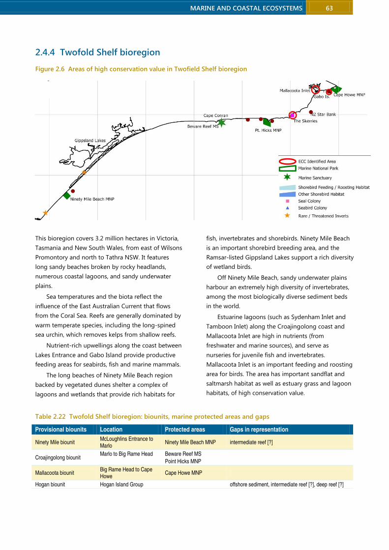
MARINE AND COASTAL ECOSYSTEMS 63
2.4.4 Twofold Shelf bioregion
Figure 2.6 Areas of high conservation value in Twofield Shelf bioregion
This bioregion covers 3.2 million hectares in Victoria,
Tasmania and New South Wales, from east of Wilsons
Promontory and north to Tathra NSW. It features
long sandy beaches broken by rocky headlands,
numerous coastal lagoons, and sandy underwater
plains.
Sea temperatures and the biota reflect the
influence of the East Australian Current that flows
from the Coral Sea. Reefs are generally dominated by
warm temperate species, including the long-spined
sea urchin, which removes kelps from shallow reefs.
Nutrient-rich upwellings along the coast between
Lakes Entrance and Gabo Island provide productive
feeding areas for seabirds, fish and marine mammals.
The long beaches of Ninety Mile Beach region
backed by vegetated dunes shelter a complex of
lagoons and wetlands that provide rich habitats for
fish, invertebrates and shorebirds. Ninety Mile Beach
is an important shorebird breeding area, and the
Ramsar-listed Gippsland Lakes support a rich diversity
of wetland birds.
Off Ninety Mile Beach, sandy underwater plains
harbour an extremely high diversity of invertebrates,
among the most biologically diverse sediment beds
in the world.
Estuarine lagoons (such as Sydenham Inlet and
Tamboon Inlet) along the Croajingolong coast and
Mallacoota Inlet are high in nutrients (from
freshwater and marine sources), and serve as
nurseries for juvenile fish and invertebrates.
Mallacoota Inlet is an important feeding and roosting
area for birds. The area has important sandflat and
saltmarsh habitat as well as estuary grass and lagoon
habitats, of high conservation value.
Table 2.22 Twofold Shelf bioregion: biounits, marine protected areas and gaps
Provisional biounits Location Protected areas Gaps in representation
Ninety Mile biounit McLoughlins Entrance to Marlo
Ninety Mile Beach MNP intermediate reef [?]
Croajingolong biounit Marlo to Big Rame Head
Beware Reef MS
Point Hicks MNP
Mallacoota biounit Big Rame Head to Cape Howe
Cape Howe MNP
Hogan biounit Hogan Island Group offshore sediment, intermediate reef [?], deep reef [?]
64 MARINE AND COASTAL ECOSYSTEMS
Victorian National Parks Association | Nature Conservation Review 2014
Gap analysis
The Twofold Shelf Bioregion can be divided into four
biounits and has four marine protected areas (Figure
2.6, Table 2.22).
Australian Marine Ecology identified the following
main gaps:
• Ninety Mile Beach Marine National Park has not
been surveyed, so its adequacy is unknown. It
probably does not encompass any reefs, and may
be inadequate to conserve shorebird breeding
sites.
• The Cape Howe Marine National Park excludes an
area with high richness and diversity of reef fishes
that was recommended for protection by the
Environment Conservation Council.
Additional areas and habitats warranting protection
include:
• the Gabo Island Harbour area
• Durvillaea habitat
• areas containing rare seaweeds and with unique
community structure such as at Bemm Reef
• probably unique communities in the vicinity of New
Zealand Star Banks, which are unsurveyed.
Conservation priorities include the dune and coastal
habitat of Ninety Mile Beach and Lakes Entrance region,
and Croajingalong subtidal reef (upwelling area).
Recommendations
Increase the extent of protected areas in the Twofold
Shelf bioregion to better meet reservation targets and
protect sites with particularly high values.
Protect the following sites as marine national parks
or marine sanctuaries:
- Gabo Island and harbour: to the extent necessary
to protect representative areas of urchin barren
habitat, fish diversity and little penguins.
- East Hicks (Durvillaea Flats): to protect bull kelp
and red algae diversity.
- Rame Head, Skerries and Wingan Inlet: to protect
an Australian fur seal breeding colony, crested
tern breeding site, white sharks and an upwelling
region.
- New Zealand Star Bank: to protect offshore deep
habitats and upwelling region (if these values are
confirmed by a survey)
- Bemm Reef: to protect areas of upwelling and
high productivity, filter feeding assemblages and
Seaweed biodiversity, including rare species.
Expand the following protected area:
- Ninety Mile Beach Marine National Park: survey
the park, including for reef, sediment invertebrate
diversity and shorebird breeding habitat, and
expand it to include representative areas of these
habitats, including intermediate depth low profile
reef.
Improve management in Cape Howe Marine
National Park by fostering interstate cooperation.
2.4.5 Victorian Bays and Inlets
This bioregion encompasses more than 120 confined
bodies of water that range in size from 195,000 hectares
to less than 100 hectares, covering more than 300,000
hectares in total. Some are drowned river valleys, others
are drainage areas impounded by dune barrier systems.
They are mostly basin-shaped, less than 25 metres
deep, sheltered and with muddy or silty bottoms.
Western Port has a bed of lamp shells (brachiopods),
which arose in the Cambrian Period (490 to 545 million
years ago).
The bays are diverse, with habitats including
saltmarsh, seagrass, mangroves, swamps and beaches.
The largest, Port Phillip Bay, is a marine embayment
fringed by seagrass beds, rocky reefs and sandy
beaches, with a muddy central region and sandy in the
west and east. Western Port and Corner Inlet are large
muddy estuaries with extensive mudflats and seagrass
beds.
Extensive diverse salt marsh communities can be
found at Port Phillip Bay, Corner Inlet, Gippsland Lakes
and Western Port – habitat for orange-bellied parrots
and many other species, and important for nutrient
cycling, trapping of pollutants and sediments and
stabilisation of the shoreline. Large seagrass beds occur

MARINE AND COASTAL ECOSYSTEMS 65
in the Geelong Arm, southern Port Phillip Bay, Corner
Inlet, Western Port, Nooramunga and Gippsland Lakes.
They are nursery areas for juvenile fish and
invertebrates, and stabilise and trap sediments.
Mangroves, important habitats for aquatic life and for
nutrient cycling and pollutant trapping, are found in
parts of Port Phillip Bay, Corner Inlet, Western Port and
Nooramunga. Swamp areas, which trap sediments and
provide habitats for waterbirds, fish and crustaceans,
are present in Gippsland Lakes and at Yallock Creek in
Western Port. Sandy beaches, popular for recreation,
occur in southern Port Phillip Bay, Western Port, Corner
Inlet and Nooramunga.
Figure 2.7 Areas of high conservation value in Victorian Bays and Inlets bioregion
Table 2.23 Victorian Bays and Inlets bioregion: biounits, protected areas and gaps
Provisional biounits Location Protected areas Gaps in representation
Geelong Arm biounit Geelong Arm and Corio Bay
Point Cooke MS
Port Phillip Heads MNP
Halophila and Heterozostera seagrasses, drift weed mats, Pyura clumps
Port Phillip biounit Port Phillip Bay
Port Phillip Heads MNP
Jawbone MS
Ricketts Point MS
subtidal sediments (channels), Pyura clumps, sponge clumps
Western Port biounit Western Port
Yaringa MNP
French Island MNP
Churchill Is MNP
subtidal sediments (channels)
Nooramunga biounit
Corner Inlet and Nooramunga
Corner Inlet MNP mangroves, intertidal seagrass, Halophila and Heterozostera seagrasses, Pyura clumps [?], sponge clumps [?]
King Lake Victoria, Lake King Ruppia, intertidal seagrass, subtidal channels, subtidal inshore sand, subtidal silts, Heterozostera seagrass
Minor Inlets
Anderson Inlet, Shallow Inlet, Lake Tyers, Sydenham Inlet, Tamboon Inlet, Mallacoota Inlet
Ruppia, intertidal seagrass, subtidal channels, subtidal inshore sands, Heterozostera seagrass
66 MARINE AND COASTAL ECOSYSTEMS
Victorian National Parks Association | Nature Conservation Review 2014
Gap analysis
The Victorian Bays and Inlets Bioregion can be divided
into six biounits and has eight marine protected areas
(Figure 2.7, Table 2.23).
The protected areas are generally representative
but have several gaps, particularly for drift weed mats
and Pyura clumps (which are not encompassed in any
protected area), channel habitats and seagrass
meadows. Other areas warranting protection include:
• some of the nine areas recommended by the
Environment Conservation Council for special
management zones, including Clifton Springs,
Crawfish Rock, San Remo listed community and
Mallacoota Inlet areas
• North Arm of Western Port, which supports rare
and listed ghost shrimp species
• sediment channel communities of seapens
Virgularia mirabilis and the ‘fossil’ shells species of
Neotrigonia margaritacea, Anadara tripezia and
Magellania flavescens, which are presently
unmapped
• sections of Gippsland lakes, consistent with
managing the Ramsar wetland values of the area.
Recommendations
Increase the extent of protected areas in the Victorian
Bays and Inlets bioregion to better meet reservation
targets and protect sites with particularly high values.
Protect the following sites as marine national parks
or marine sanctuaries (to the extent necessary to
protect representative areas or particular values):
- San Remo: to protect a threatened marine
community and high invertebrate diversity.
- Mallacoota Inlet: to protect Ruppia and enclosed
lagoon habitats and bird feeding and roosting
sites.
- Clifton Springs: to protect intertidal and subtidal
seagrass beds and areas of high productivity.
- Capel Sound: to protect Virgularia seapens, hard
corals, fish aggregations and a sheltered brown
seaweed community.
- Rhyll Mud Banks and Observation Point: to protect
bird foraging and roosting sites.
- Werribee River Estuary: to protect the estuary,
wetland and bird feeding and roosting sites.
- Bass River Delta: to protect bird foraging and
roosting sites, intertidal flats and algal beds.
- Gippsland Lakes (parts): to better protect Ramsar
wetland values.
- West Channels, Symmonds Channel or Pinnace
Channel: to protect sponge clump communities
- Shallow Inlet Marine Conservation Park: to more
adequately protect its values.
Expand the following protected areas:
- French Island Marine National Park: to include
Crawfish Rock, Barrellier Island and channel
habitat to protect a threatened ecological
community, high diversity of sessile invertebrates,
listed hydroid species, channel habitat, Barrellier
Island bird roost and mangrove and saltmarsh
habitats. (Otherwise, a new marine sanctuary could
be created to protect these sites.) Channel biota
needs to be surveyed.
- Corner Inlet Marine National Park: expand
northern boundary to Middle Channel to
encompass all Posidonia seagrass, expand western
boundary of the northern section to encompass
Heterozostera seagrass and channel habitat and
protect a threatened holothurian. Include Corner
Inlet Marine Conservation Park to more
adequately protect its values.
- Yaringa Marine National Park: to protect channel
habitat, subject to a survey of channel biota and a
review of adequacy in conjunction with other
protected areas in Western Port.
- Churchill Island Marine National Park: move the
southern boundary to encompass saltmarsh
habitats and potentially expand the park to
include channel habitat subject to a survey and
review of the adequacy of protection within all
Western Port marine protected areas.
2.4.6 Twenty bioregional priorities
Table 2.24 lists the 20 highest priorities identified by
Australian Marine Ecology to improve Victoria’s marine
protected area network.
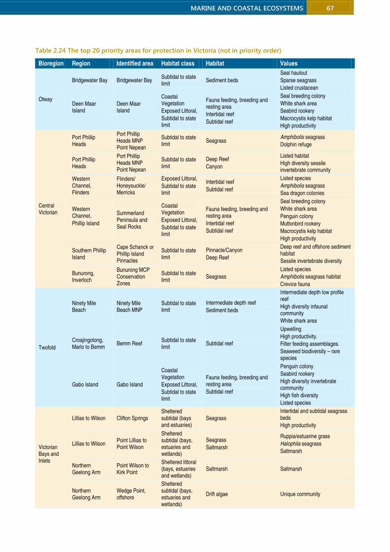
MARINE AND COASTAL ECOSYSTEMS 67
Table 2.24 The top 20 priority areas for protection in Victoria (not in priority order)
Bioregion Region Identified area Habitat class Habitat Values
Otway
Bridgewater Bay Bridgewater Bay Subtidal to state limit
Sediment beds
Seal haulout
Sparse seagrass
Listed crustacean
Deen Maar Island
Deen Maar Island
Coastal Vegetation
Exposed Littoral,
Subtidal to state limit
Fauna feeding, breeding and resting area
Intertidal reef
Subtidal reef
Seal breeding colony
White shark area
Seabird rookery
Macrocystis kelp habitat
High productivity
Central Victorian
Port Phillip Heads
Port Phillip Heads MNP Point Nepean
Subtidal to state limit
Seagrass Amphibolis seagrass
Dolphin refuge
Port Phillip Heads
Port Phillip Heads MNP Point Nepean
Subtidal to state limit
Deep Reef
Canyon
Listed habitat
High diversity sessile invertebrate community
Western Channel, Flinders
Flinders/ Honeysuckle/ Merricks
Exposed Littoral,
Subtidal to state limit
Intertidal reef
Subtidal reef
Listed species
Amphibolis seagrass
Sea dragon colonies
Western Channel,
Phillip Island
Summerland Peninsula and Seal Rocks
Coastal Vegetation
Exposed Littoral,
Subtidal to state limit
Fauna feeding, breeding and resting area
Intertidal reef
Subtidal reef
Seal breeding colony
White shark area
Penguin colony
Muttonbird rookery
Macrocystis kelp habitat
High productivity
Southern Phillip Island
Cape Schanck or Phillip Island Pinnacles
Subtidal to state limit
Pinnacle/Canyon
Deep Reef
Deep reef and offshore sediment habitat
Sessile invertebrate diversity
Bunurong, Inverloch
Bunurong MCP Conservation Zones
Subtidal to state limit
Seagrass
Listed species
Amphibolis seagrass habitat
Crevice fauna
Twofold
Ninety Mile Beach
Ninety Mile Beach MNP
Subtidal to state limit
Intermediate depth reef
Sediment beds
Intermediate depth low profile reef
High diversity infaunal community
White shark area
Croajingolong, Marlo to Bemm
Bemm Reef Subtidal to state limit
Subtidal reef
Upwelling
High productivity.
Filter feeding assemblages.
Seaweed biodiversity – rare species
Gabo Island Gabo Island
Coastal Vegetation
Exposed Littoral,
Subtidal to state limit
Fauna feeding, breeding and resting area
Subtidal reef
Penguin colony
Seabird rookery
High diversity invertebrate community
High fish diversity
Listed species
Victorian Bays and Inlets
Lillias to Wilson Clifton Springs Sheltered subtidal (bays and estuaries)
Seagrass
Intertidal and subtidal seagrass beds
High productivity
Lillias to Wilson Point Lillias to Point Wilson
Sheltered subtidal (bays, estuaries and wetlands)
Seagrass
Saltmarsh
Ruppia/estuarine grass
Halophila seagrass
Saltmarsh
Northern Geelong Arm
Point Wilson to Kirk Point
Sheltered littoral (bays, estuaries and wetlands)
Saltmarsh Saltmarsh
Northern Geelong Arm
Wedge Point, offshore
Sheltered subtidal (bays, estuaries and wetlands)
Drift algae Unique community

68 MARINE AND COASTAL ECOSYSTEMS
Victorian National Parks Association | Nature Conservation Review 2014
Bioregion Region Identified area Habitat class Habitat Values
North Arm, Western Port
French Island MNP
Yaringa MNP
Churchill Island MNP
Sheltered subtidal (bays, estuaries and wetlands)
Channels,
Seagrass
Mangrove and saltmarsh habitats
Channel habitat
Barrellier Is bird roost
Mangrove and saltmarsh habitats
North Arm, Western Port
Crawfish Rock
Sheltered subtidal (bays, estuaries and wetlands)
Pinnacle/Canyon
Deep Reef
Channels
Unique community
High invertebrate diversity
Listed species
Lakes Entrance Gippsland Lakes
Sheltered littoral (bays, estuaries and wetlands),
Coastal/Dune,
Exposed littoral
Seagrass
Fauna feeding, breeding and resting area
Ruppia/estuarine grass
Grasses
Heaths
Dune
Biodiversity – Ramsar wetland values
Anderson Inlet Anderson Inlet Sheltered littoral (estuaries and wetlands)
Sandflats,
Fauna feeding, breeding and resting area,
Saltmarsh
Ruppia and enclosed lagoon habitats
Bird feeding and roosting.
Mallacoota Inlet Mallacoota Inlet Sheltered littoral (estuaries and wetlands)
Sandflats,
Fauna feeding, breeding and resting area,
Saltmarsh
Ruppia and enclosed lagoon habitats
Bird feeding and roosting.

MARINE AND COASTAL ECOSYSTEMS 69
2.5 Coastal bioregional values and priorities
ike the marine environment, Australia’s terrestrial
environment has been classified into bioregions
based on physical and biological features. The Interim
Biogeographic Regionalisation of Australia identified 89
bioregions and 419 subregions, of which six bioregions
and 10 subregions intersect with the 2000 kilometre
Victorian coastline: 128
• Narracorte Coastal Plain: Bridgewater and the
Glenelg Plain
• South-east Coastal Plain: Warrnambool Plain, Otway
Plain, Gippsland Plain
• Southern Volcanic Plain: Victorian Volcanic Plain
• South-eastern Highlands: Otway Ranges, Strzelecki
Ranges
• Furneaux: Wilsons Promontory
• South-east Corner: East Gippsland Lowlands.
This section summarises an evaluation by Chris
Smyth of values, threats and recommended
conservation measures in the 10 coastal subregions.129
The recommendations focus on four main strategies:
• A coastal private land conservation program to
secure the permanent protection of remnants of
coastal vegetation on private land by (a) purchase
through the Trust for Nature revolving fund and a
government coastal land acquisition fund and (b)
covenanting projects involving local councils, the
state government and interested landholders.
• Establishment of new coastal reserves or expansion
or merging of existing reserves, with improved
management.
• Restoration of cleared, fragmented or degraded
coastal vegetation with priority for threatened
ecological vegetation classes or habitat of
threatened species.
• Improved regulation and planning to prohibit or
reverse inappropriate development on the coast.
For a few subregions, recommendations are made
to merge community committees of management.
These committees help manage much of the coastal
land reserved under the Crown Land (Reserves) Act and
have worked with the environment department, local
municipalities and environmental consultants to
develop coastal management plans that have improved
reserve management. Reducing and reorganising some
of these committees will ‘reduce duplication, enable the
pooling of resources, minimise the preparation and
implementation costs currently spent on separate
strategies and management plans, and improve the
opportunities for consistent and integrated day-to-day
management along the coast.’130
Figure 2.8 Victoria’s coastal subregions from Bridgewater to Otway Ranges
L
Map: VNPA. Data source: Department of Environment and
Primary Industries
70 MARINE AND COASTAL ECOSYSTEMS
Victorian National Parks Association | Nature Conservation Review 2014
2.5.1 Bridgewater subregion
This small 18,000 hectare region between the South
Australian Border and Cape Nelson (Figure 2.8) is a
volcanic plain overlaid by Victoria’s largest active dune
system. Much of it consists of bare sand and freshwater
lagoons. With the highest coastal cliffs in Victoria, Cape
Bridgewater is one of the state’s most scenic coastlines.
Most of the public land is in the Discovery Bay Coastal
Park. On private land, which has 20% of remnant native
vegetation, plantation forestry and livestock grazing are
the main land uses. Drainage of saltmarsh for cattle
grazing is a major threat on private land behind the
coastal park. The coastline from Discovery Bay to
Piccaninnie Ponds is a designated important bird area,
and the area encompassing Discovery Bay Coastal Park,
Lower Glenelg National Park and the Crawford River
Regional Park was assessed nationally as a ‘critical
aquatic system’.131
The conservation and scenic values of Cape
Bridgewater have been undermined by the installation
of 29 wind turbines on its western side (as part of the
Portland Wind Project). The turbines were built within
remnants of coastal alkaline scrub and are associated
with a network of new access roads. Their placement in
this sensitive location has been detrimental both for
coastal values and for the important cause of renewable
energy, with resistance from coastal communities to
industrialisation providing impetus to those opposed to
climate change action to push for draconian statewide
planning regulations for new wind turbine projects.
Development in the coastal alkaline scrub was
previously opposed by the environment department
because of its ‘significant ecological values’.
Current threats for coastal biodiversity in this
subregion include the following.132
Habitat loss and degradation:
- edge effects in narrow strips of coastal vegetation,
especially around Cape Bridgewater, and the
presence of inliers of private land within the
Discovery Bay section of the coastal park
- off-road driving and riding causing erosion,
damage to vegetation and archaeological sites, and
disturbing ground-nesting birds and other fauna
- pedestrian access to sensitive areas along cliff tops
and through dunes, and unregulated and informal
paths.
Dysfunction of biological interactions:
- weeds, horses, cattle and rabbits degrading
vegetation
- illegal and licensed grazing in conservation reserves
- encroachment of pine plantations and spread of
pine wildings into Discovery Bay Coastal Park
- predation of native wildlife by cats and foxes.
Recommendations
Expansion of protected areas
Expand Discovery Bay Coastal Park through the
proposed coastal private land conservation
program by securing and restoring the following
areas:
- the inlying private land north of Long Swamp and
east of Lake Minibeong
- the small parcels of private land along the western
shores of the Bridgewater Lakes with coastal
alkaline scrub, coastal dune scrub and swamp
scrub ecological vegetation classes
- the large triangle of privately owned coastal
alkaline scrub ecological vegetation class behind
the Bridgewater Bay settlement
- any other adjacent private land, as it becomes
available.
Management and regulatory measures
Cancel grazing licences for Discovery Bay Coastal
Park and fence the boundaries with private land.
Provide sufficient resources to park managers and
adjoining landholders to fence and restore
degraded sites, control illegal stock entry, manage
invasive species, horse riding and disturbance of
ground nesting animals, and establish wildlife
corridors (especially on the largely cleared dunes of
Cape Bridgewater) within and adjacent to the
Discovery Bay Coastal Park.
Through the proposed coastal private land
conservation program develop a collaborative
coastal nature stewardship project between the
Victorian government, the Shire of Glenelg, private
landholders, the local community and Trust for
Nature to create a fenced vegetation buffer of 100
MARINE AND COASTAL ECOSYSTEMS 71
metres on private land abutting the narrow Cape
Bridgewater section of the Discovery Bay Coastal
Park, with the state government covering the cost
to landholders of establishment and maintenance.
Amend the Rural Conservation Zone 1, which
applies to Cape Bridgewater, to prohibit any more
wind turbines in that area. Ensure that the existing
wind turbines are removed at the end of their
commercial life and the site is restored.
2.5.2 Glenelg Plain subregion
This 399,000 hectare region consists of a series of low
parallel dune limestone ridges that intersect the coast
between Cape Nelson and Portland (Figure 2.8). About
one-quarter of remnant vegetation is on private land,
where the main uses are pine and blue gum plantations
and sheep grazing. Flora of state significance occurs in
Cape Nelson State Park and at Point Danger. Current
threats for coastal nature in this subregion include the
following.
Habitat loss and degradation:
- edge effects in narrow strips of coastal vegetation,
and the inlier of private land in Cape Nelson State
Park
- future expansion of industry in the Point Danger-
Cape Sir William Grant area
- future industrial development in the Coastal
Headland Scrub at Cape Sir William Grant, including
the approved construction of wind turbines.
Dysfunction of biological interactions:
- Weeds, horses, cattle and rabbits degrading
vegetation.
- Predation by cats, foxes and dogs.
Recommendations
Expansion of protected areas
Expand Cape Nelson State Park:
- secure the freehold inlier (through the proposed
coastal private land conservation program) to
protect the endangered coastal mallee scrub
ecological vegetation class.
Expand Discovery Bay Coastal Park by adding the
following:
- crown land from the east of She-oak Road (in
Nelson Bay Coastal Reserve), to protect the rare
coastal sand heathland and endangered coastal
headland scrub ecological vegetation classes
- coastal heathland/heathy woodland/damp heathy
woodland/damp heathland mosaic ecological
vegetation classes from Bald Hill Recreation
Reserve
- crown land from the Point Danger-Cape Sir
William Grant area with coastal heathland/heathy
woodland/damp heathy woodland/hamp
heathland mosaic and damp heathland/sand
heathland mosaic ecological vegetation classes, to
protect Mellblom’s spider-orchid and the nation’s
only mainland Australasian gannet colony.
Management and regulatory measures
Prohibit any further expansion of industry into the
Point Danger-Cape Sir William Grant area.
Enter into an arrangement with Pacific Hydro and
landholders involved in the Portland Wind Energy
Project IV to ensure that the wind turbines are
removed at the end of their commercial life and the
land restored. At that time the coastal headland
scrub ecological vegetation class in the north-
western corner of Cape Sir William Grant, currently
zoned Industrial Zone 2, should be purchased and
added to the Discovery Bay Coastal Park.

72 MARINE AND COASTAL ECOSYSTEMS
Victorian National Parks Association | Nature Conservation Review 2014
2.5.3 Warrnambool Plain subregion
Stretching from Portland to Moonlight Head near
Princetown, this 264,000 hectare region has been more
than 80% cleared for livestock grazing and dairy
farming, and once-vast wetlands have been drained.
Almost half of the remnant vegetation is on private land
and a high proportion of the coast has private land
abutting high water mark.
Yambuk Lake and Princetown Wetlands are
recognised as nationally important, and the estuary and
dunes at the mouth of Yambuk Lake and the Port Fairy-
Warrnambool coastline are designated important bird
areas. Of state significance for fauna are Griffiths Island,
the site of a former whaling station, with colonies of
little penguins and short-tailed shearwaters, and the
Belfast Coastal Reserve, which has breeding sites for
crested terns, silver gulls and hooded plovers. Port
Campbell National Park, internationally famous for its
spectacular coastline of sheer limestone cliffs, rocks
stacks and gorges, has flora and fauna of state
significance. The area is at increasing risk from tourism
development.
The region includes Australia’s first indigenous
protected area, declared in 1997 over 453 hectares of
rolling sand dunes, limestone ridges and farmland to
the west of Yambuk Lake. The Framlingham Aboriginal
Trust has revegetated the land, and 12 wind turbines
have been installed to generate income. The Kooyang
Sea Country Plan (2004), prepared by members of the
Framlingham Aboriginal Trust and Winda Mara
Aboriginal Corporation, was the first of its kind in
Australia. It covers land within the Glenelg Hopkins and
Corangamite catchments and out to the edge of the
continental shelf.
Current threats for nature in this subregion include
the following.
Habitat loss and degradation:
- loss, severe fragmentation or degradation of
coastal vegetation in many places
- the potential for land subdivision and
intensification of land use on private land that
abuts high water mark on a high proportion of this
coastline
- habitat impacts from tourism developments within
or adjacent to conservation reserves
- degradation of coastal habitats due to
indiscriminate access tracks, grazing, clearing and
burning
- the proposed coastal road between Warrnambool
and Bay of Islands Coastal Park
- drainage of wetlands and livestock access to
riparian habitats
- traffic hazards for native fauna along coastal roads
- vegetation removal and degradation due to road
realignments, access roads, car parks, gravel
stockpiles, and on disused road alignments.
Climate change:
- sea level rise, erosion and inundation associated
with climate change leading to dune and beach
erosion.
Changes to disturbance regimes:
- coastal defence works leading to changed coastal
processes and the loss of beach and sand dune
habitats
- unauthorised openings of estuaries
- compromised estuarine water quality, including
algal blooms and increased salinity, due to high
sediment and nutrient loads and declining
freshwater flows.
Dysfunction of biological interactions:
- weed invasion
- predation of small animals by cats and foxes
- degradation and damage to revegetation projects
by rabbits
- disturbance of nesting birds by horses, dogs and
beach users.
Over-exploitation:
- illegal removal of orchids (Port Campbell)
- shooting and disturbance of birds by duck
shooters.
Recommendations
Expansion of protected areas
Create Yambuk Lake Coastal Park, to be co-
managed by the Framlingham Aboriginal Trust and
Parks Victoria:
MARINE AND COASTAL ECOSYSTEMS 73
- include Yambuk Lake Flora and Fauna Reserve,
Yambuk Lake, and Yambuk Wetlands Nature
Conservation Reserve
- secure (through the proposed coastal private land
conservation program) coastal dune scrub
remnants and cleared land between the remnants.
Create Belfast Coastal Park, to be managed by
Parks Victoria:
- include crown land and Belfast Lough in the
existing Belfast Coastal Reserve (excluding the
coastal strip between Port Fairy and the Port Fairy
Golf Course)
- include crown land at Griffiths Island, Shelly Cove,
Levy Point and Thunder Point
- investigate relocation of the Port Fairy Golf Course
and Port Fairy Airstrip, which would be followed
by restoration of the land and its inclusion in the
coastal park.
Expand the Bay of Islands Coastal Park:
- add Lake Gillear to the coastal park, to protect
endangered remnants of aquatic herbland, swamp
scrub and damp sands herb-rich woodland
- secure (through the proposed coastal private land
conservation program) private land between Lake
Gillear and the Bay of Islands Coastal Park, and
establish a planted and fenced wildlife corridor to
the threatened coastal headland scrub/coastal
tussock grassland mosaic found on the coast
- secure (through the proposed coastal private land
conservation program) the land above the
Starlight Cave (a maternity bat cave), and fence
and revegetate it
- secure (through the proposed coastal private land
conservation program) private land abutting the
cliff edge between the Starlight Cave and the
western end of the park, to a width of 100 m from
the cliff, and revegetate the coastal headland
scrub/coastal tussock grassland mosaic and damp
sands herb-rich woodland.
Expand the Port Campbell National Park:
- add crown land reserves adjoining or near the
national park, including the public purposes
reserve and public park reserve on Port Campbell
Point, the water reserve (and crown land) east of
Port Campbell north of the Great Ocean Road
alignment, the small, undeveloped areas of public
land between the Great Ocean Road and the park
within the township of Port Campbell, west of the
Port Campbell Creek, including allotments 2 and 3,
and the Loch Ard Public Cemetery
- add the Commonwealth-owned rifle range near
Two Mile Bay and restore the land
- secure (through the proposed coastal private land
conservation program) private undeveloped land
on the Port Campbell headland to protect the
southern brown bandicoot
- purchase (through the proposed coastal private
land conservation program) private land to the
north of the park for the purpose of realigning the
Great Ocean Road, and add the land between the
new road and the current park boundary to the
national park, with restoration of the threatened
coastal headland scrub and coastal tussock
grassland ecological vegetation classes.
Management and regulatory measures
Merge the committees of management from
Narrawong to Port Fairy into a single committee.
Create a new West Coast Shire by amalgamating
the coastal section of the Corangamite Shire,
Moyne Shire and the City of Warrnambool,
combine South Gippsland and Bass Coast shires
and Wellington and East Gippsland shires, and
merge the Borough of Queenscliffe with the City of
Greater Geelong.
Ensure there are no further housing subdivisions
along the Old Coach Road at Narrawong, so as to
reduce pressure on the very narrow coastal crown
land reserve with threatened coastal dune scrub.
Close the Old Coach Road reserve, add it to the
existing coastal crown land reserve, and fence and
revegetate it. Provide a walking track only for
anglers to access the beach. Apply a vegetation
restoration overlay in the planning scheme of the
Shire of Glenelg to create a 50 metre buffer from
the road to the adjoining freehold land to prevent
development, and restore the area.
Amend land-use zones in the planning schemes of
the Shire of Glenelg, Shire of Moyne, the City of
Warrnambool and the Shire of Corangamite to

74 MARINE AND COASTAL ECOSYSTEMS
Victorian National Parks Association | Nature Conservation Review 2014
prohibit wind turbines on private land abutting
coastal crown land or the high water mark.
Reject any proposals to build a coast road between
the Bay of Islands Coastal Park and Warrnambool.
Establish a collaborative coastal nature stewardship
project between the Victorian government, the
Shire of Moyne, Warrnambool City Council, private
landholders, Landcare groups, the community and
the Trust for Nature to reconnect coastal and
hinterland nature on the Warrnambool Plain.
Provide sufficient resources to establish wildlife
corridors, rationalise access tracks, erect and
maintain boundary fences, and eradicate and
manage invasive plants and animals. Focus on re-
establishing connections along the coast and the
banks of coastal rivers and their estuaries.
Figure 2.9 Victoria’s coastal subregions from Otway Ranges to Gippsland Plain
2.5.4 Otway Ranges subregion
This 150,000 hectare subregion (Figure 2.9) was shaped
30 million years ago by the uplift of freshwater
sandstones and siltstones. Native vegetation remains
on just over three-quarters of the bioregion, most of it
in Great Otway National Park and the Otway Forest
Park. About one-quarter of remnant vegetation is on
private land, where the main uses are sheep and dairy
cattle grazing and softwood plantations.
The Great Ocean Road is a dramatic drawcard for
tourists. The most famous section, between Eastern
View and Kennett River, was carved from the steep
slopes of the Otway Ranges by unemployed workers
during the great depression. It is beset with
maintenance and safety problems and regular
landslides.
Of state significance are excellent examples of
western Victoria’s coastal scrub and heathland
communities at The Gables, intact woodland, forest and
scrub from Point Franklin to Shelly Beach, and forest
and coastal scrub communities from Cape Patton to
Lorne, where fauna is also of state significance,
including swamp antechinus, rufous bristlebirds, and a
southern bent-wing bat roosting cave. The Otway
Ranges bioregion has been designated an important
bird area.
The threats to coastal nature in this subregion
include the following.
Habitat loss and degradation:
- poor condition of vegetation close to the Great
Ocean Road and townships due to visitor pressure,
pests and altered fire regimes
- fragmentation of vegetation and accentuation of
edge effects
- increased infrastructure and developments in
response to growing visitor numbers
Map: VNPA. Data source: Department of Environment and Primary Industries
MARINE AND COASTAL ECOSYSTEMS 75
- changing land use within or adjacent to the Great
Otway National Park and along the Great Ocean
Road
- unauthorised roads and tracks and informal walking
tracks
- Great Ocean Road upgrades, realignments and
landslips.
Dysfunction of biological interactions:
- fox and cat predation of wildlife
- disturbance of habitats and wildlife by feral goats
and pigs
- rabbits preventing regeneration, causing erosion
and facilitating weed spread
- plant dieback at several coastal heathland and
woodland sites due to the pathogen Phytopthora
cinnamomi
- weeds such as blackberry, boneseed, bridal creeper,
sweet pittosporum, ragwort and sea spurge
- horse-riding on beaches disturbing nesting birds
such as the hooded plover.
Recommendations
Management and regulatory measures
Merge the committees of management from
Breamlea to Clifton Springs to create a single
committee, the Bellarine Peninsula Committee.
Conduct an independent, transparent and rigorous
environmental assessment of the proposed
upgrade of the Great Ocean Road, including a
comprehensive analysis of the impacts on coastal
nature, and robust public consultation processes.
Maintain existing planning scheme provisions that
limit the growth of coastal townships along the
Great Ocean Road between Eastern View and
Marengo. Do not allow any new coastal
subdivisions between Eastern View and Kennett
River, and between Princetown and Marengo.
Provide park managers and adjoining rural
landholders with sufficient ongoing resources to
manage invasive species in the Great Otway
National Park and Otway Forest Park, including in
coastal areas.
Ensure that the easing of restrictions on land
development and land-use change in the Rural
Conservation Zone does not allow resort and hotel
developments or the installation of wind turbines
on private land between existing townships on the
Great Ocean Road.
Do not permit commercial developments such as
hotels and resorts within the Great Otway National
Park. Confine tourist developments to the existing
main settlements along the Great Ocean Road at
heights and spatial extents appropriate for the
landscape.
2.5.5 Otway Plain subregion
A small proportion of the Otway Plain’s 237,000
hectares is on the coast (Figure 2.9), and very little is
conserved within coastal protected areas. Less than a
third of the subregion still has native vegetation, almost
two-thirds of it on private land, where major land uses
are grazing, cropping and dairying.
Dinosaur Cove, part of the Great Otway National
Park, is an internationally significant fossil site. Bells
Beach is an internationally famous surfing mecca and
was the world’s first declared surfing reserve but is
suffering from the pressure of 1 million visitors a year.
The Aire River is a listed heritage river, and it and
the Lower Aire River Wetlands are in the national
directory of important wetlands. Rich in small mammals,
Urquhart Bluff is of national significance for both flora
and fauna. The large and relatively undisturbed estuary
and coastal lagoon at Lake Connewarre and the Barwon
River have one of the most diverse saltmarsh areas in
Australia and a flora of national significance. The Reedy
Lake–Lake Connewarre complex and Swan Bay, both
part of the Port Phillip and Bellarine Peninsula Ramsar
site are internationally significant for shorebirds,
waterbirds and other fauna. The fauna of the disturbed
saltmarsh at the Geelong Saltworks is nationally
significant. Flora of state significance is found between
Rotten Point and Point Franklin, at the mouth of
Painkalac Creek, on cliffs between Anglesea and Bells
Beach and at Swan Bay. The fauna of the dry saltmarsh
and moonah dune scrub at Lonsdale Lakes is of state

76 MARINE AND COASTAL ECOSYSTEMS
Victorian National Parks Association | Nature Conservation Review 2014
significance. The islands of Swan Bay and Port Philip Bay
and Bellarine wetlands are designated important bird
areas. However, the Bellarine Peninsula is now seen as
an area to accommodate much of the population
growth of Geelong.
Threats to coastal nature in this subregion include
the following.
Habitat loss and degradation:
- coastal development and urban expansion
including at Apollo Bay, Torquay and towns of the
Bellarine Peninsula, Geelong and western shoreline
of Port Phillip Bay
- roads and tracks leading to habitat fragmentation
and decline
- edge effects due to extreme fragmentation of most
coastal and hinterland vegetation, and narrow
strips of vegetation between coastal roads and the
shore
- urban encroachment on wetlands such as Lake
Connewarre, Murtnaghurt Lagoon, Lonsdale Lakes
and Geelong Saltworks, and on sand dunes such as
at Buckley Park
- drainage and reconfiguration of wetlands, and
landfill on the margins of wetlands
- car parks and other infrastructure in fragile areas
such as Bells Beach due to visitor pressure
- coastal engineering works.
Changes to disturbance regimes:
- artificial opening of estuaries
- alteration of wetland hydrology
- water extraction from estuarine catchments
- landfill and altered coastal process by ports and
marinas, eg Bay West project and Wyndham Cove.
Dysfunction of biological interactions:
- spread of serious weeds, such as blackberry and
sweet pittosporum, and of the pathogen
Phytophthora cinnamomi
- invasive marine organisms such as Japanese kelp at
Apollo Bay
- rabbits and carp degrading habitats
- foxes and cats preying on small animals
- livestock access to riparian zones
- disturbance of shorebirds and waterbirds by
shooters, boat users, anglers, off-road vehicles.
Recommendations
Expansion of protected areas
Create a new Geelong and Bellarine Wetlands State
Park managed by Parks Victoria, to protect wetland
remnants of the Bellarine Peninsula:
- include Lake Connewarre (the game reserve would
be degazetted), Reedy Lake, Hospital Swamp and
Murtnaghurt Lagoon
- include Salt Lake, Edwards Point, the Barwon River
estuary, Sand Island, Buckley Park Foreshore
Reserve, Lonsdale Lakes Nature Reserve, Lakers
Cutting, south-western shores of Swan Bay,
Freshwater Lagoon, Thompson Creek and Karaaf
Wetlands at Breamlea, the coastal reserves at
Black Rocks, Thirteenth Beach, Barwon Heads and
Ocean Grove
- secure (through the proposed coastal private land
conservation program) the Geelong Saltworks at
Moolap (preventing its development), to protect
endangered coastal saltmarsh/mangrove
shrubland mosaic
- secure (through the proposed coastal private land
conservation program) land zoned Rural
Conservation Zone and Farming Zone abutting
Murtnaghurt, some of the land between the
lagoon and Thirteenth Beach Road currently
zoned Comprehensive Development Zone, and
part of the Thirteenth Beach Golf Resort (construct
a trail and boardwalk to allow golfers to pass
between fairways)
- secure (through the proposed coastal private land
conservation program) Rural Conservation Zone II
land between the western end of the Lonsdale
Golf Course and the Collendina Caravan Park, and
south of Lake Victoria, and close and rehabilitate
the quarry
- secure (through the proposed coastal private land
conservation program) unsold allotments on The
Point development in the Lonsdale Lakes
- secure land (through the proposed coastal private
land conservation program) in the Farming Zone
around the Lake Connewarre reserve with
remnants of endangered ecological vegetation
classes and restore them.

MARINE AND COASTAL ECOSYSTEMS 77
Expand the Great Otway National Park:
- degazette the Aire River State Game Reserve and
add it to the national park
- add heathland at Anglesea currently leased by
Alcoa (but outside the mine pit) to the national
park (Box 2.12).
Management and regulatory measures
Transfer the management of the Bells Beach
Recreational Surfing Reserve to a new committee of
management comprising Parks Victoria, the
Traditional Owners and the recreational surfing
community, with Parks Victoria responsible for day-
to-day management. Prepare and implement a new
management plan for the reserve to protect the
natural, Indigenous and recreational surfing
heritage of Bells Beach, and which is consistent with
the vision developed by local surfing recreational
groups, in collaboration with Traditional Owners, to
create the Bells Beach Surf Sanctuary.
Secure (through the proposed coastal private land
conservation program) land along the Aire River
between the bridge and the river mouth, to begin
the rehabilitation of natural flows within the
wetlands.
Amend the Rural Conservation Zone applying to
private and cleared land in the Johanna and Horden
Vale areas, and between Marengo and Skenes
Creek, to prohibit wind turbines and other
development projects within view of the coast.
Ensure the continuation of existing planning
scheme provisions that limit the growth of coastal
townships in the Otway Plain Bioregion. No new
coastal subdivisions should be allowed from
Eastern View to Geelong, and from Geelong to
Altona.
Do not permit the Spring Creek housing
development to proceed.
Ensure the long-term protection of the Ramsar-
listed wetlands in the Western Treatment Plant by
placing a covenant on the land that allows the
operation of the plant but not its conversion to
more intensive industrial or urban uses, and
requires the land to become a nature conservation
reserve or be added to the proposed Corio Bay
Coastal Park if the plant closes.
Prohibit any replication of the artificial beaches of
the Wyndham Cove harbour development
elsewhere along Port Phillip Bay’s Ramsar-listed
western shoreline.
Box 2.12 Mining in the Anglesea heathlands
‘Anglesea Heath is the richest and most diverse vegetation community in Victoria. Amazingly, about a
quarter of Victoria's plant species can be found here including over 80 different types of orchids.’ Parks Victoria133
The 7000 hectare Anglesea heathlands are a botanical treasure trove with more than 700 plants species, including
more than 80 orchids, four plants endemic to the site – Anglesea grevillea, Anglesea leek orchid, large bearded
greenhood (Anglesea) and the Anglesea grey-gum – and dozens of threatened species.134 The heathlands are
important also for native animals, including the critically endangered New Holland mouse.
Since 1968, Alcoa has operated an open-cut coal mine and power station in a 300 hectare portion of the
heathland, having been granted a 50-year lease over more than 7000 hectares in 1961 to build a power station for
the Point Henry aluminium smelter in Geelong. Recently, Alcoa was granted a new 50-year lease and permission to
extend the mine.
In view of the extremely high values of the site, local and state environment groups have proposed that all
heathland outside the current mine site be added to the adjacent Great Otway National Park.135 Alcoa announced
in 2014 that it is closing its operations, which should open up opportunities for a new arrangement.
78 MARINE AND COASTAL ECOSYSTEMS
Victorian National Parks Association | Nature Conservation Review 2014
2.5.6 Victorian Volcanic Plain subregion
This vast 2,356,000 hectare bioregion meets the coast
only for a short stretch (Figure 2.9) and has few coastal
protected areas. The bioregion formed from volcano
eruptions, which began about 5 million years ago and
continued intermittently until a few thousand years ago.
Its flat grasslands and fertile soils attracted sheep
graziers and just 16% of the original vegetation
remains, almost two-thirds on private land. Its eastern
edge, where it reaches Port Phillip Bay, is subject to
increasing urban encroachment.
Limeburners Bay supports large numbers of
shorebirds and is nationally significant for fauna. This
stretch of coast is also part of the designated Werribee
to Avalon important bird area. Between the Avalon
Saltworks and the Western Treatment Plant is one of
Australia’s richest saltmarshes, with flora of national
significance and fauna of international significance. It is
part of the Port Phillip Bay (Western Shoreline) and
Bellarine Peninsula Ramsar site. The wet and dry
saltmarsh and dune vegetation at Point Cook and the
Cheetham Wetlands is of state significance, while the
fauna at this Ramsar site is internationally significant.
The Cheetham Wetlands were part of a complex of
evaporation ponds and channels created in saltmarshes
by Cheetham Salt Pty Ltd in the 1920s. Seawater from
Port Phillip Bay was fed into the ponds, where it
evaporated. The saltworks closed in the 1990s, but
Parks Victoria maintains the channels and ponds for
birdlife. From Altona to Williamstown the flora is of
state significance and the fauna is nationally significant.
Part of the Ramsar site, the area is an important feeding
and roosting site for large numbers of shorebirds.
Threats to coastal nature in this subregion include
the following.
Habitat loss and degradation:
- large losses of coastal and hinterland vegetation
leaving fragmented patches suffering from edge
effects
- urban encroachment of wetlands
- continuing loss of saltmarsh
- proposals for port and marina expansions
- stormwater and urban runoff, drainage and rubbish
impacting on water quality.
Dysfunction of biological interactions:
- degradation by rabbits
- predation of small animals by foxes and cats
- numerous serious weeds
- disturbance of shorebirds and waterbirds by boat
users, anglers, off-road vehicles.
Recommendations
Expansion of protected areas
Create a new Corio Bay Coastal Park to give
stronger protection to Ramsar sites between
Limeburners Bay and Lake Borrie:
- include Limeburners Lagoon (Hovells Creek) Flora
and Fauna Reserve, The Spit Wildlife Reserve,
Point Lillias, Point Wilson and the Avalon
Saltworks
- include Avalon Coastal Reserve and other coastal
crown land reserves along that coastal strip
- negotiate with the federal government to transfer
Point Wilson for inclusion.
Create the Fawthrop Lagoon Nature Conservation
Reserve:
- through the proposed coastal private land
conservation program, establish a collaborative
coastal nature stewardship project between the
Shire of Glenelg, the Glenelg Hopkins Catchment
Management Authority and the local community
to manage invasive species and reinstate more
natural water flows to conserve the estuarine
wetland and threatened swamp scrub and herb-
rich foothill forest ecological vegetation classes
along and north of Wattle Hill Creek.
Management and regulatory measures
Provide sufficient ongoing resources to rehabilitate
and maintain the threatened coastal tussock
grassland ecological vegetation class along the
coastal reserve at Black Rocks near Breamlea (for
land not included in the proposed Geelong and
Bellarine Wetlands State Park).
Reject the Bay West port project. Any expansion of
port infrastructure should focus on consolidating
port operations in Port Phillip Bay, including
Geelong, and Portland, not the Ramsar-listed
MARINE AND COASTAL ECOSYSTEMS 79
western shorelines of Port Phillip Bay or Western
Port.
Provide sufficient personnel and other resources to
continue the environmental enhancement
programs focusing on water quality, invasive
species and conservation of threatened ecological
vegetation classes at Point Cooke Coastal Park and
Cheetham Wetlands.
Establish a collaborative coastal nature stewardship
project between The City of Hobsons Bay, the Port
Phillip and Western Port Catchment Authority,
Parks Victoria and nearby landholders and local
friends groups to further improve the water and
habitat quality of Kororoit Creek, and restore and
protect coastal saltmarsh, coastal alkaline scrub,
mangrove shrubland and plains grassland in the
Altona Coastal Park and the Jawbone Flora and
Fauna Reserve.
2.5.7 Gippsland Plain subregion
The Gippsland Plain is a vast 1.2 million hectare coastal
and alluvial plain (Figure 2.9, Figure 2.11) dominated by
barrier dunes, swamps and floodplains. It encompasses
27 river systems, 30 municipalities and a rapidly
growing Melbourne expanding into its western edge.
Only a quarter of the bioregion has native vegetation,
almost half on private land.
This subregion features four Ramsar wetlands –
Edithvale-Seaford Wetlands, Western Port, Corner Inlet
and Gippsland Lakes – which also include designated
important bird areas. The large expanse of saltmarsh,
mangroves and relatively undisturbed vegetation at
Corner Inlet are Victoria’s most extensive intertidal
mudflats, the world’s most southern mangrove, and
Victoria’s largest stand of Posidonia seagrass. Corner
Inlet is ideal habitat for shorebirds and up to 50% of
Victoria’s migratory shorebirds can be found there.
Western Port is the third-most important overwintering
site for shorebirds in Victoria.
Other areas designated as important bird areas are
Anderson Inlet, Shallow Inlet and Phillip Island. The little
penguins on Phillip Island attract nearly 2 million
visitors a year. Seal Rocks has national significance, with
the world’s largest breeding colony of Australian fur
seals. French Island National Park is of national
significance for its flora, with more than 400 plant
species, and Gippsland Lakes are nationally significant
for their fauna. Point Nepean and Mornington Peninsula
national parks are strongholds for threatened coastal
moonah woodland, an ecological community with more
than 90% of its former extent cleared from the
Mornington Peninsula. For thousands of years, Point
Nepean was used by Boonwerrung women as a
mothering place.
There are many sites with flora or fauna of state
significance. Of state significance for fauna are the
artificial freshwater wetlands of Coolart, Point Nepean
and Sorrento Coastline, the western and northern
shores of Western Port, Phillip Island’s south and west
coasts and Conservation Hill Wildlife Reserve, French
Island National Park, the Bunurong coastline, Anderson
Inlet, Shallow Inlet, Jack Smith Lake, and Gippsland
Lakes. Of state significance for flora are Sandy Point at
Cerberus, from Crib Point to Hastings, Point Nepean
and Sorrento Coastline, the western and northern
shores of Western Port, Corner Inlet, Quail and
Chinaman islands, Phillip Island’s south and west coasts,
French Island National Park, and Gippsland Lakes.
Threats to coastal nature in this subregion include
the following.
Habitat loss and degradation:
- increasing pressure and edge effects on the narrow
strip of coastal vegetation
- urbanisation, industrialisation and roads leading to
fragmentation and loss of vegetation
- recreational pressures within and adjacent to
conservation and coastal crown land reserves
- removal of vegetation, both authorised and illegal,
to ‘improve’ views
- loss of vegetation on private land and increased
land use intensity due to rezonings
- land-based pollution
- boat traffic disturbing shoreline vegetation and
causing erosion
- illegal off-road vehicle use eroding soil and
damaging vegetation.
Dysfunction of biological interactions:
- numerous serious weeds

80 MARINE AND COASTAL ECOSYSTEMS
Victorian National Parks Association | Nature Conservation Review 2014
- cats, foxes and dogs preying on small animals
- feral pigs and goats degrading habitats
- rabbits causing erosion and hampering
revegetation
- horses, dogs and walkers disturbing nesting sites
for hooded plovers
- livestock trampling vegetation and spreading weeds
- dieback of vegetation in seabird roosting sites.
Changes to disturbance regimes:
- damaging fire regimes
- dune destabilisation due to inappropriate access,
ad-hoc tracks and off-track access and horse riding
- increasing salinity of the Gippsland Lakes leading to
loss of bank vegetation and erosion.
Recommendations
Expansion of protected areas
Create a new San Remo-Cape Paterson Coastal
Park comprising:
- Punchbowl Coastal Reserve
- Kilcunda-Harmers Haven Coastal Reserve
- Kilcunda Nature Conservation Reserve
- Bunurong Coastal Reserve
- Wonthaggi Heathlands Nature Conservation Reserve
- Cape Paterson Nature Conservation Reserve.
Create a Safety Beach-Portsea Coastal Reserve:
- merge the existing foreshore reserves between
Safety Beach and Portsea
- place the reserve under the management of one
community committee of management.
Management and regulatory measures
Merge the committees of management along the
following stretches of coast into single
management committees:
- Mt Eliza to Mt Martha
- Safety Beach to Portsea
- Flinders to Hastings
- Cannons Creek to Tooradin
- Lang Lang to Coronet Bay
- Seaspray to Loch Sport Gippsland Plain
- San Remo to Inverloch GP
- Walkerville to Sandy Point GP
- Port Franklin to Woodside Beach
- Gippsland Lakes
Reconfigure the boundaries of the catchment
management authorities and municipalities in the
Gippsland Lakes area, by establishing the Gippsland
Lakes Catchment Management Authority and the
Shire of Gippsland Lakes, both with their
boundaries encompassing the catchment of the
Gippsland Lakes. The current East Gippsland Shire
Council should return to the boundaries of the
Shire of Orbost, and the East Gippsland Catchment
Management Authority should have the same
boundary. The Shire of Wellington would be
smaller and abut the western boundary of the
Gippsland Lakes shire.
Transfer the Phillip Island Nature Parks from the
Crown Land (Reserves) Act to a new schedule
(similar to that recommended by the Victorian
Environment Assessment Council in its Yellingbo
Investigation) in the National Parks Act, and
support continued management by the Phillip
Island Nature Parks.
Abandon the construction of the proposed
Rosebud Aquatic Centre on the coastal reserve at
Rosebud.
Reject plans to expand the Port of Hastings.
Reject any further expansion of Port Anthony.
Encourage and enable the Shire of Bass Coast to
apply an environmental significance overlay on the
private land abutting the high water mark between
Tooradin and San Remo. The overlay would
establish a 100-200 m buffer zone where no
development is allowed and where landholders are
provided with the necessary resources to
rehabilitate the land with indigenous vegetation.
Fund the Shire of Bass Coast to conduct an
environmental audit of the sea walls along the
north-eastern shoreline of Western Port to
determine the environmental, social and economic
costs and benefits of their removal or retention.
Fund the Shire of Wellington to conduct an
environmental audit of the sea walls along the
shorelines of Corner Inlet to determine the
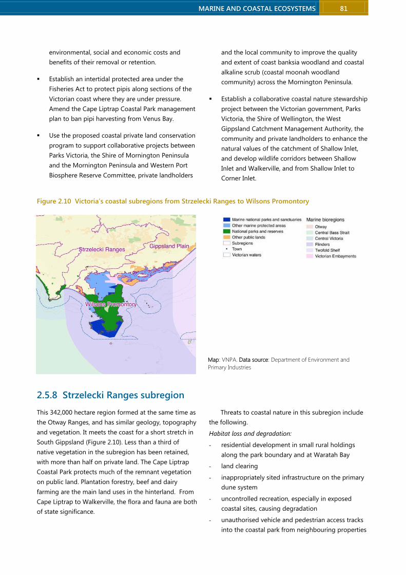
MARINE AND COASTAL ECOSYSTEMS 81
environmental, social and economic costs and
benefits of their removal or retention.
Establish an intertidal protected area under the
Fisheries Act to protect pipis along sections of the
Victorian coast where they are under pressure.
Amend the Cape Liptrap Coastal Park management
plan to ban pipi harvesting from Venus Bay.
Use the proposed coastal private land conservation
program to support collaborative projects between
Parks Victoria, the Shire of Mornington Peninsula
and the Mornington Peninsula and Western Port
Biosphere Reserve Committee, private landholders
and the local community to improve the quality
and extent of coast banksia woodland and coastal
alkaline scrub (coastal moonah woodland
community) across the Mornington Peninsula.
Establish a collaborative coastal nature stewardship
project between the Victorian government, Parks
Victoria, the Shire of Wellington, the West
Gippsland Catchment Management Authority, the
community and private landholders to enhance the
natural values of the catchment of Shallow Inlet,
and develop wildlife corridors between Shallow
Inlet and Walkerville, and from Shallow Inlet to
Corner Inlet.
Figure 2.10 Victoria’s coastal subregions from Strzelecki Ranges to Wilsons Promontory
2.5.8 Strzelecki Ranges subregion
This 342,000 hectare region formed at the same time as
the Otway Ranges, and has similar geology, topography
and vegetation. It meets the coast for a short stretch in
South Gippsland (Figure 2.10). Less than a third of
native vegetation in the subregion has been retained,
with more than half on private land. The Cape Liptrap
Coastal Park protects much of the remnant vegetation
on public land. Plantation forestry, beef and dairy
farming are the main land uses in the hinterland. From
Cape Liptrap to Walkerville, the flora and fauna are both
of state significance.
Threats to coastal nature in this subregion include
the following.
Habitat loss and degradation:
- residential development in small rural holdings
along the park boundary and at Waratah Bay
- land clearing
- inappropriately sited infrastructure on the primary
dune system
- uncontrolled recreation, especially in exposed
coastal sites, causing degradation
- unauthorised vehicle and pedestrian access tracks
into the coastal park from neighbouring properties
Map: VNPA. Data source: Department of Environment and
Primary Industries
82 MARINE AND COASTAL ECOSYSTEMS
Victorian National Parks Association | Nature Conservation Review 2014
- edge effects in narrow vegetation strips around
Cape Liptrap
- degradation from livestock grazing.
Changes to disturbance regimes:
- harmful fire regimes.
Dysfunction of biological interactions
- invasive species.
Recommendations
Expansion of protected areas
Expand Cape Liptrap Coastal Park:
- secure adjacent land through the proposed
coastal private land conservation program, with
priority given to land with remnants of the
endangered damp forest ecological vegetation
class, and restore this land.
Create Walkerville-Waratah Bay-Sandy Point
Foreshore Reserve:
- merge the foreshore reserves at Walkerville,
Waratah Bay and Sandy Point and place under the
management of one community committee of
management.
Management measures
Fund Parks Victoria and adjoining landholders
to fence Cape Liptrap Coastal Park to minimise
encroachment and impacts of adjoining land use,
and to manage invasive plants and animals.
2.5.9 Wilsons Promontory subregion
This 40,000 hectare region is a spectacular area of rocky
hills and granite headlands, with 91% retention of
native vegetation. It is connected to the mainland by
the Yanakie Isthmus (Figure 2.10). The entire bioregion
is contained within the Wilsons Promontory National
Park, which attracts close to half a million visitors a year.
The coastal flora is of national significance, and the
fauna is of state significance.
Threats to coastal nature in this subregion include
the following.
Habitat loss and degradation:
- use of roads and tracks leading to soil compaction
and soil erosion
- development proposals for the national park.
Dysfunction of biological interactions:
- degradation from native and introduced animals,
including rabbits
- weeds, including ragwort, fleabane, sea spurge and
thistles
- foxes preying on small animals.
Recommendations
Regulatory measure
Prohibit any further commercial development
within Wilsons Promontory National Park.

MARINE AND COASTAL ECOSYSTEMS 83
Figure 2.11 Victoria’s coastal subregions from Gippsland Plain to East Gippsland Lowland
2.5.10 East Gippsland Lowlands subregion
This 531,000 hectare subregion of gently undulating
terraces, coastal plains, dunefields and inlets extends
from Lakes Entrance to the New South Wales border
(Figure 2.11). One of the more intact coastal bioregions,
it has 62% native vegetation cover, 40% of it on private
land. Clearing has mainly occurred on the western edge,
due to forestry and farming. Of national significance for
both flora and fauna are coastal stretches from Wingan
Inlet to Mallacoota, with species-rich and largely
undisturbed vegetation, and the dunes from Mallacoota
to Cape Howe, which are part of the Nadgee to
Mallacoota important bird area.
The threats to coastal nature in this subregion
include the following.
Habitat loss and degradation:
- harbour development at Bastion Point, Mallacoota
- increasing intensity of land-uses on coastal land
and within catchments
- increasing traffic on coastal walking trails, use of
wood for camp fires, and recreational uses in
general putting further pressure on sensitive
coastal environments
- boating activity degrading shorelines and
disturbing breeding seabirds.
Changes to disturbance regimes:
- harmful fire regimes.
Dysfunction of biological interactions:
- serious weeds, including bridal creeper, cape ivy
and dolichos pea, and the pathogen Phytophthora
cinnamomi, especially between Mallacoota and
Shipwreck Creek
- dog and fox predation on little terns and hooded
plovers
- pigs and goats degrading habitats.
Recommendations
Management and regulatory measures
Establish a collaborative coastal nature stewardship
project between the East Gippsland Catchment
Management Authority, Parks Victoria, the Lake
Tyers Aboriginal Trust, the community and private
landholders in the catchment of Lake Tyers to
improve the water and habitat quality of the lake by
fencing off lake shorelines and vegetation on
private land, managing invasive species, and
rehabilitating shoreline and catchment habitats.
Amend the environmental significance overlay
applying to private land abutting the coastal crown
land reserve and the shoreline of Lake Tyers in the
Shire of East Gippsland to establish a 100 metre
buffer zone where development is prohibited and
restoration is required. The Victorian government
should ensure that private landholders have access
to sufficient resources to achieve that rehabilitation.
Map: VNPA. Data source: Department of Environment and Primary Industries

84 MARINE AND COASTAL ECOSYSTEMS
Victorian National Parks Association | Nature Conservation Review 2014
Abandon the option 3b Bastion Point harbour
development at Mallacoota and initiate a process
that establishes a lower cost and sustainable
alternative that will have community support.
Repair any damage caused by the initial
construction works.
2.5.11 Summary – subregional recommendations
Table 2.25 summarises the subregional recommendations for protected areas.
Table 2.25 Summary of proposed new, expanded or upgraded coastal protected areas
New, expanded or upgraded protected area
Areas for inclusion in proposed protected area
Discovery Bay – Three Capes State Park
Discovery Bay Coastal Park
Cape Nelson State Park
Cape Nelson Lighthouse Reserve
Nelson Bay Coastal Reserve
Point Danger Coastal Reserve
Yambuk Coastal Park
Yambuk Lake
Yambuk Flora and Fauna Reserve
Yambuk Wetlands Nature Conservation Reserve
The Crags Coastal Reserve
Yambuk Coastal Reserve
Belfast Coastal Park
Belfast Coastal Reserve
Griffith Island
Shelly Cove
Thunder Point Coastal Reserve
Part Campbell – Bay of Islands National Park
Bay of Islands Coastal Park
Port Campbell National Park
Port Campbell Rifle Range
Public Purposes Reserve & Public Park Reserve on Point Campbell Point
Undeveloped areas of public land between the great Ocean Road & the park within Port Campbell, including allotments 2 & 3, and Loch Ard Public Cemetery
Geelong & Bellarine Wetlands State Park
Lake Connewarre Wildlife Reserve
Salt Lagoon-St Leonards Wildlife Reserve
Swan Bay-Edwards Point Wildlife Reserve
Barwon River estuary
Sand Island
Swan Island
Lonsdale Lakes Wildlife Reserve
Lakers Cutting
Southwestern shores of Swan Bay
Freshwater Lake
Thompson Creek and Karaaf Wetlands at Breamlea
Port Phillip Wetlands State Park
Limeburners Lagoon (Hovells Creek) Flora and Fauna Reserve
Avalon Coastal Reserve
Avalon Saltworks
Point Lillias
Point Wilson
The Spit Wildlife Reserve
Point Cook Coastal Park & Cheetham Wetlands
Altona Coastal Park
Jawbone Flora and Fauna Reserve
North Western Port Coastal Park North Western Port Nature Conservation Reserve
Reef Island-Bass River Mouth Coastal Park Reef Island-Bass River Mouth Nature Conservation Reserve
San Remo – Cape Paterson Coastal Park Punchbowl Coastal Reserve

MARINE AND COASTAL ECOSYSTEMS 85
New, expanded or upgraded protected area
Areas for inclusion in proposed protected area
Kilcunda-Harmers Haven Coastal Reserve
Kilcunda Coastal Reserve
Kilcunda Nature Conservation Reserve
Bunurong Coastal Reserve
Wonthaggi Heathlands Nature Conservation Reserve
Cape Paterson Nature Conservation Reserve
Bunurong Marine Park
Shallow Inlet Coastal Park Shallow Inlet Marine and Coastal Park
Corner Inlet – Nooramunga Coastal Park
Corner Inlet Marine and Coastal Park
Nooramunga Marine and Coastal Park
Wilsons Promontory Marine Park
Wilsons Promontory Marine Reserve
Coastal crown land with conservation value along the margins of Corner Inlet
Gippsland Lakes Coastal Park
Gippsland Lakes Coastal Park
Lake Coleman Wildlife/Game Reserve
Lake Coleman West Wildlife/Game Reserve
Victoria Lagoon Wildlife Reserve
Clydebank Morass Wildlife/Game Reserve
Heart Morass Wildlife/Game Reserve
Dowd Morass Wildlife/Game Reserve
Blond Bay Wildlife/Game Reserve
McLeods Wildlife/Game Reserve
Jones Bay Wildlife/Game Reserve
Avon River Wildlife/Game Reserve
Tucker Swamp Gippsland Lakes Reserve
Poddy Bay Gippsland Lakes Reserve
The Dardanelles Gippsland Lakes Reserve
Sale Camping Gippsland Lakes Reserve
Andrew Bay – Grebe Bay Gippsland Lakes Reserve
Lake Kakydra Gippsland Lakes Reserve
Lake Melyandra Gippsland Lakes Reserve
Clydebank Frontage Gippsland Lakes Reserve
Avon-Perry River Delta Gippsland Lakes Reserve
Swell Point – Roseneath Point Gippsland Lakes Reserve
Salt Lake – Backwater Morass Gippsland Lakes Reserve
Roseneath Point (1) Gippsland Lakes Reserve
Roseneath Point (2) Gippsland Lakes Reserve
Morley Swamp Gippsland Lakes Reserve
Victoria Lagoon Gippsland Lakes Reserve
Backwater Morass Gippsland Lakes Reserve
Steel Bay – Newland Backwater Gippsland Lakes Reserve
Blond Bay Gippsland Lakes Reserve
Red Morass Gippsland Lakes Reserve
Wattle Point Gippsland Lakes Reserve
Raymond Island Gippsland Lakes Reserve
Hollands Landing Gippsland Lakes Reserve
Point Fullarton Gippsland Lakes Reserve
Eagle Point Gippsland Lakes Reserve
Mitchell River Silt Jetties Gippsland Lakes Reserve
Eagle Point Gippsland Lakes Reserve
Mitchell River Silt Jetties Gippsland Lakes Reserve
Jones Bay Gippsland Lakes Reserve
Nicholson Floodplain Gippsland Lakes Reserve
Slaughterhouse Creek Gippsland Lakes Reserve
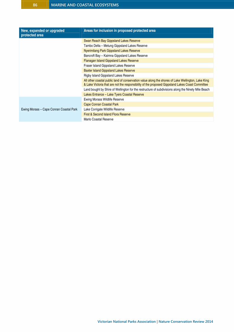
86 MARINE AND COASTAL ECOSYSTEMS
Victorian National Parks Association | Nature Conservation Review 2014
New, expanded or upgraded protected area
Areas for inclusion in proposed protected area
Swan Reach Bay Gippsland Lakes Reserve
Tambo Delta – Metung Gippsland Lakes Reserve
Nyerimilang Park Gippsland Lakes Reserve
Bancroft Bay – Kaimna Gippsland Lakes Reserve
Flanagan Island Gippsland Lakes Reserve
Fraser Island Gippsland Lakes Reserve
Baxter Island Gippsland Lakes Reserve
Rigby Island Gippsland Lakes Reserve
All other coastal public land of conservation value along the shores of Lake Wellington, Lake King & Lake Victoria that are not the responsibility of the proposed Gippsland Lakes Coast Committee
Land bought by Shire of Wellington for the restructure of subdivisions along the Ninety Mile Beach
Lakes Entrance – Lake Tyers Coastal Reserve
Ewing Morass – Cape Conran Coastal Park
Ewing Morass Wildlife Reserve
Cape Conran Coastal Park
Lake Corrigale Wildlife Reserve
First & Second Island Flora Reserve
Marlo Coastal Reserve
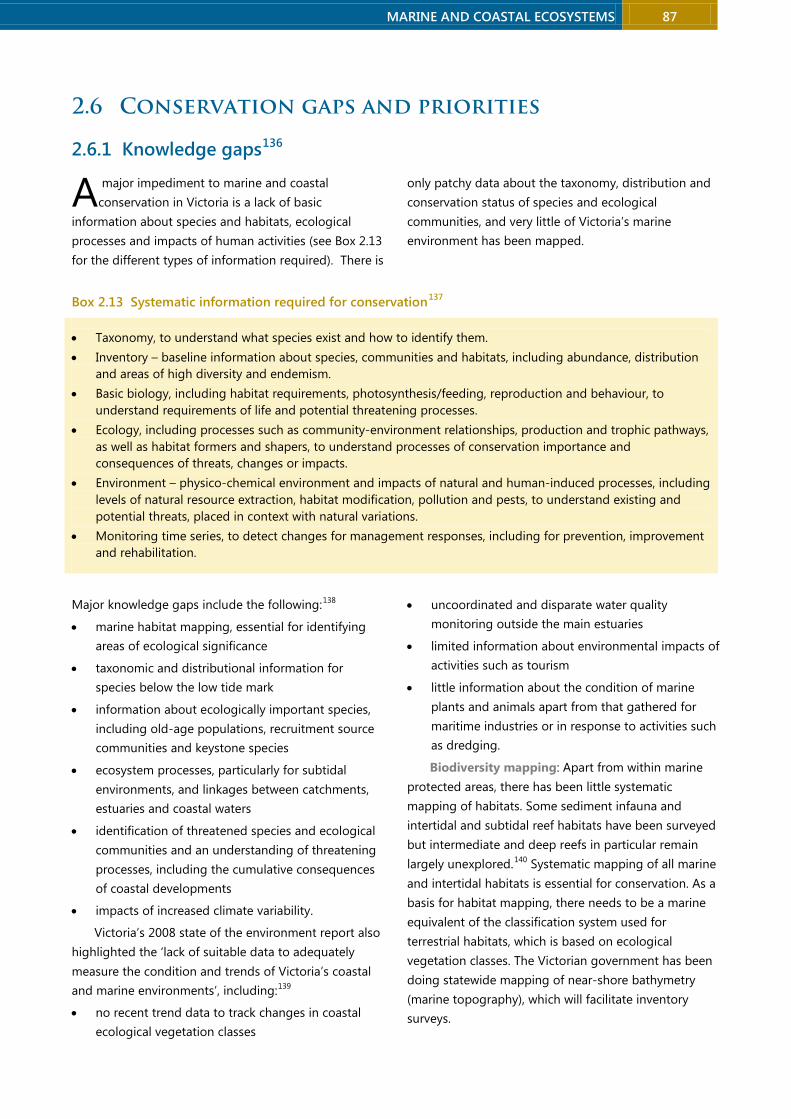
MARINE AND COASTAL ECOSYSTEMS 87
2.6 Conservation gaps and priorities
2.6.1 Knowledge gaps136
major impediment to marine and coastal
conservation in Victoria is a lack of basic
information about species and habitats, ecological
processes and impacts of human activities (see Box 2.13
for the different types of information required). There is
only patchy data about the taxonomy, distribution and
conservation status of species and ecological
communities, and very little of Victoria’s marine
environment has been mapped.
Box 2.13 Systematic information required for conservation137
• Taxonomy, to understand what species exist and how to identify them.
• Inventory – baseline information about species, communities and habitats, including abundance, distribution
and areas of high diversity and endemism.
• Basic biology, including habitat requirements, photosynthesis/feeding, reproduction and behaviour, to
understand requirements of life and potential threatening processes.
• Ecology, including processes such as community-environment relationships, production and trophic pathways,
as well as habitat formers and shapers, to understand processes of conservation importance and
consequences of threats, changes or impacts.
• Environment – physico-chemical environment and impacts of natural and human-induced processes, including
levels of natural resource extraction, habitat modification, pollution and pests, to understand existing and
potential threats, placed in context with natural variations.
• Monitoring time series, to detect changes for management responses, including for prevention, improvement
and rehabilitation.
Major knowledge gaps include the following:138
• marine habitat mapping, essential for identifying
areas of ecological significance
• taxonomic and distributional information for
species below the low tide mark
• information about ecologically important species,
including old-age populations, recruitment source
communities and keystone species
• ecosystem processes, particularly for subtidal
environments, and linkages between catchments,
estuaries and coastal waters
• identification of threatened species and ecological
communities and an understanding of threatening
processes, including the cumulative consequences
of coastal developments
• impacts of increased climate variability.
Victoria’s 2008 state of the environment report also
highlighted the ‘lack of suitable data to adequately
measure the condition and trends of Victoria’s coastal
and marine environments’, including:139
• no recent trend data to track changes in coastal
ecological vegetation classes
• uncoordinated and disparate water quality
monitoring outside the main estuaries
• limited information about environmental impacts of
activities such as tourism
• little information about the condition of marine
plants and animals apart from that gathered for
maritime industries or in response to activities such
as dredging.
Biodiversity mapping: Apart from within marine
protected areas, there has been little systematic
mapping of habitats. Some sediment infauna and
intertidal and subtidal reef habitats have been surveyed
but intermediate and deep reefs in particular remain
largely unexplored.140 Systematic mapping of all marine
and intertidal habitats is essential for conservation. As a
basis for habitat mapping, there needs to be a marine
equivalent of the classification system used for
terrestrial habitats, which is based on ecological
vegetation classes. The Victorian government has been
doing statewide mapping of near-shore bathymetry
(marine topography), which will facilitate inventory
surveys.
A

88 MARINE AND COASTAL ECOSYSTEMS
Victorian National Parks Association | Nature Conservation Review 2014
Taxonomy: With much of Victoria’s marine
biodiversity yet to be described (and some yet to be
discovered) marine taxonomy requires a considerable
boost. At the current level of taxonomic investment, it
will take many decades to acquire a comprehensive
inventory of Victorian marine species. Victorian waters
host an astounding diversity of sponges but fewer than
a third of the estimated total have been described, and
only a small proportion of sponge collections have been
sorted and identified.141 Recent surveys in Victoria have
revealed new seaweeds and echinoderms, and future
surveys will undoubtedly find more.142 There are far too
few taxonomists, particularly relative to the high
number of endemic species, and a lack of identification
guides to assist with ecological surveys and
monitoring.143 Species could be in decline or lost before
they are even identified.
Biology and ecology: Victorian marine
conservation requires investment in long-term research
and monitoring programs. Apart from species exploited
for fishing and aquaculture, little is known about the
basic biology and ecology of most Victorian marine life,
including which populations are unique or rare, which
habitats and areas are critical for particular life phases
(such as nursery habitats), and their ecophysiological
requirements (such as light levels needed for healthy
seagrass, kelp and seaweed beds).
Identifying and managing threats requires a much
better understanding of ecological processes such as
energy and matter (trophic) flows between species,
rates of primary and secondary production, nutrient
cycling, competitive and predator/prey interactions.
Long-term monitoring is essential to detect changes
over time and understand threatening processes.
Monitoring programs have been limited to a few
community types and sentinel stations. The only state-
wide monitoring programs are for fished species,
seagrass habitats and marine protected area
management. Apart from a few beach water quality
monitoring programs for human health purposes,
Victoria has just three stations to monitor water quality,
all in Port Phillip.144
The state of knowledge is too rudimentary to be
able to predict with certainty the ecological implications
of many changes occurring in the marine environment,
including recent abalone population declines from viral
disease, fisheries management changes, and species
shifts with climate change.
Conservation status: Protecting rare or threatened
biodiversity is fundamental to conservation but there is
too little information about Victoria’s marine
environment to know which species and ecological
communities need extra protection. Apart from
mammals, birds, reptiles and syngnathids (seahorses,
pipefishes and seadragons), few threatened marine
species or communities have been listed. Just 14 marine
invertebrates, three fully marine fishes and two marine
ecological communities have been formally listed,
reflecting the lack of survey effort rather than a realistic
conservation status. The process for nominating and
assessing threatened marine biodiversity is mostly ad
hoc, with just one systematic assessment completed –
for molluscs, echinoderms and decapod crustaceans.145
A program of systematic data collection, with field
sampling and taxonomic support, to identify rare and
threatened biodiversity, is needed.
Listing is no guarantee of conservation action. Most
action statements for marine species do not explicate
how recovery will be achieved – only those for the
humpback whale and blue whale provide targets and
performance assessment of management success – and
there are no action statements at all for marine
invertebrates, although they were drafted and
presented for public comment. Action statements
should be prepared or revised for all listed species and
communities, to outline measures required for recovery,
and fully implemented.
Because comprehensive listings and recovery
actions are unlikely to occur in the near-term, the
conservation of rare and threatened biodiversity relies
in the interim on achieving a sufficiently comprehensive,
adequate and representative marine national park
estate.
Table 2.25 outlines actions required to address
knowledge gaps about Victoria’s marine environment,
as recommended by Australian Marine Ecology.
A systematic approach through the development of
a Marine and Coastal Research Strategy and Action Plan
is needed to address knowledge gaps and improve the
linkages between research and management priorities.
Long-term researching and monitoring programs,
including in the national park estate, are needed to
establish the extent and state of marine biodiversity.
More effective dissemination of information is essential
to improve marine and coastal protection, planning and
management.

MARINE AND COASTAL ECOSYSTEMS 89
Table 2.26 Actions to address knowledge gaps146
Knowledge Gaps Recommendations
Lack of taxonomic and distributional information for marine species below the low tide mark, including levels of local and regional endemism and rarity.
More and better biodiversity surveys, sampling a wider array of habitats. Standardise methods across projects to provide complimentary data.
Lack of strategic information on marine-dependent species, including the ecological values old-age populations, recruitment source communities and keystone species.
Workshops, review and collation of knowledge about ecosystem processes. Identification of critical knowledge gaps and streamlining of research efforts into an integrated plan for Victoria. Lack of information on ecosystem linkages and processes, particularly
subtidal.
Most marine habitats not mapped. Lack of consistent approach to community description and mapping.
Hierarchical system of community characterisation based on physical and biological parameters. Initial coarse resolution surveys, then adapted and augmented to finer resolution over time. Complete coverage of fine-resolution bathymetry mapping. Develop predictive models to fill gaps until all areas have been surveyed.
Inadequate listing process for marine threatened species and communities.
More systematic and rapid listing of marine species and, in particular, communities.
Lack of long-term monitoring and time-series information – limited to a few community types and sentinel stations.
Review, standardise and integrate existing programs where possible, with data sharing between organisations. Develop and implement long-term sentinel monitoring across the state.
2.6.2 Marine national park estate
Gaps in the marine national park estate
At the time of their declaration, Victoria’s marine
reserves were a world-first representative marine
network, and were largely based on the best available
science outlined in Marine, Coastal and Estuarine
Investigation by the Environment Conservation Council
in 2000.147 However, accumulating evidence about the
biodiversity values of Victorian waters and about the
benefits of highly protected marine areas provide
strong reason to substantially expand Victoria’s marine
national park estate.
Many biodiversity values in Victorian waters are
poorly or not protected in the existing national park
estate. The 2000 assessment by the Environment
Conservation Council suffered from a lack of
information about many habitats, a situation that has
only been partially rectified (section 2.6.1). The gap
analysis by Australian Marine Ecology (summarised in
section 2.4) found that Victoria’s marine national park
estate does not meet current government goals based
on the accepted CAR (comprehensive, adequate and
representative) principles.148 Limited documentation of
objectives, purposes and levels of protection makes it
difficult to assess the extent to which Victoria’s marine
protected areas meet their objectives. There are
considerable discrepancies between boundary locations
and the stated or presumed conservation objectives of
many of the marine national parks. For example, the
Ninety Mile Beach Marine National Park does not
include low profile reef habitat despite it being of high
acknowledged value in that bioregion. The boundaries
of most marine sanctuaries are poorly placed or their
area is too small to provide adequate protection. Simply
adjusting the boundaries of existing reserves will go
some way to improving the protected area network,
although surveys are needed to fill substantial
knowledge gaps about many marine habitats that are
poorly protected. Table 2.24 lists the top 20 priorities
for additions to the national park estate as assessed by
Australian Marine Ecology.
Other marine areas designated by the Victorian
government as protected – various marine and coastal
parks that existed prior to the 2002 declarations – lack
management plans and conservation objectives
altogether, and are not protected from exploitation by
recreational and commercial fishers. In addition, areas
designated as special management zones have not
resulted in any increased protection, and there is little
security for them, for the designation can be overturned
without a parliamentary process.
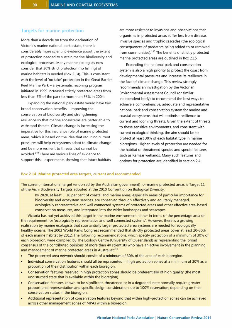
90 MARINE AND COASTAL ECOSYSTEMS
Victorian National Parks Association | Nature Conservation Review 2014
Targets for marine protection
More than a decade on from the declaration of
Victoria’s marine national park estate, there is
considerably more scientific evidence about the extent
of protection needed to sustain marine biodiversity and
ecological processes. Many marine ecologists now
consider that 30% strict protection (no fishing) of
marine habitats is needed (Box 2.14). This is consistent
with the level of ‘no take’ protection in the Great Barrier
Reef Marine Park – a systematic rezoning program
initiated in 1999 increased strictly protected areas from
less than 5% of the park to more than 33% in 2004.
Expanding the national park estate would have two
broad conservation benefits – improving the
conservation of biodiversity and strengthening
resilience so that marine ecosystems are better able to
withstand threats. Climate change is increasing the
imperative for this insurance role of marine protected
areas, which is based on the idea that reducing current
pressures will help ecosystems adapt to climate change
and be more resilient to threats that cannot be
avoided.149 There are various lines of evidence to
support this – experiments showing that intact habitats
are more resistant to invasions and observations that
organisms in protected areas suffer less from disease,
invasive species and trophic cascades (the ecological
consequences of predators being added to or removed
from communities).150 The benefits of strictly protected
marine protected areas are outlined in Box 2.15.
Expanding the national park and conservation
system is also a high priority to protect the coast from
developmental pressures and increase its resilience in
the face of climate change. This review strongly
recommends an investigation by the Victorian
Environmental Assessment Council (or similar
independent body) to recommend the best ways to
achieve a comprehensive, adequate and representative
national park and conservation system for marine and
coastal ecosystems that will optimise resilience to
current and looming threats. Given the extent of threats
to these sensitive environments, and consistent with
current ecological thinking, the aim should be to
protect at least 30% of each habitat type in marine
bioregions. Higher levels of protection are needed for
the habitat of threatened species and special features,
such as Ramsar wetlands. Many such features and
options for protection are identified in section 2.4.
Box 2.14 Marine protected area targets, current and recommended
The current international target (endorsed by the Australian government) for marine protected areas is Target 11
of the Aichi Biodiversity Targets adopted at the 2010 Convention on Biological Diversity:
By 2020, at least … 10 per cent of coastal and marine areas, especially areas of particular importance for
biodiversity and ecosystem services, are conserved through effectively and equitably managed,
ecologically representative and well connected systems of protected areas and other effective area-based
conservation measures, and integrated into the wider landscapes and seascapes.
Victoria has not yet achieved this target in the marine environment, either in terms of the percentage area or
the requirement for ‘ecologically representative and well connected systems’. However, there is a growing
realisation by marine ecologists that substantially larger protected area systems are needed for ecologically
healthy oceans. The 2003 World Parks Congress recommended that strictly protected areas cover at least 20-30%
of each marine habitat by 2012. The following recommendations, which specify protection of a minimum of 30% of
each bioregion, were compiled by The Ecology Centre (University of Queensland) as representing the ‘broad
consensus of the contributed opinions of more than 40 scientists who have an active involvement in the planning
and management of marine protected areas in Australia’:151
• The protected area network should consist of a minimum of 30% of the area of each bioregion.
• Individual conservation features should all be represented in high protection zones at a minimum of 30% as a
proportion of their distribution within each bioregion.
• Conservation features reserved in high protection zones should be preferentially of high quality (the most
undisturbed state that is available within the bioregion).
• Conservation features known to be significant, threatened or in a degraded state normally require greater
proportional representation and specific design consideration, up to 100% reservation, depending on their
conservation status in the bioregion.
• Additional representation of conservation features beyond that within high-protection zones can be achieved
across other management zones of MPAs within a bioregion.

MARINE AND COASTAL ECOSYSTEMS 91
• Where a physical structure/feature is incorporated into the MPA, the whole feature should be included.
These recommendations have largely been achieved for the Great Barrier Reef Marine Park, with 33% of the
park in highly protected no take zones.
The Australian Marine Sciences Association, a professional association of marine scientists with over 1000
members nationally, also recommends higher levels of strict protection.152
• No-take protection of 10% ‘would slow but not prevent loss of biodiversity’, whereas the 33% no-take level in the
Great Barrier Marine Park is ‘more likely to achieve substantial and sustained biodiversity conservation benefits’.
• ‘Rare and vulnerable ecosystems, communities or populations should be provided with greater than 10%
protection’, and 100% of critically endangered species, ecosystems, or habitat types should be protected in
no-take areas.
• Breeding aggregations, migration choke points, and threatened or unique critical habitats should all be
carefully considered for inclusion in no-take protected areas.
Box 2.15 The benefits of marine protected areas
Over the last few years, there have been hundreds of peer-reviewed scientific articles confirming the
beneficial effects of marine protected areas.
154 marine scientists, 2010153
The Australian Marine Sciences Association has identified six main functions for marine protected areas:154
• to protect biodiversity and ecosystem functions, including ecological processes
• to assist in maintaining ecosystem services
• to provide scientific benchmarks against which anthropogenic modifications to ecosystems and environments
can be monitored and evaluated
• to protect cultural, recreational, spiritual, educational and scientific values
• to protect from disturbance into the future, representative habitats and species for both their intrinsic value
and intergenerational equity
• to enhance fisheries production outside reserve boundaries.
Evidence for three main conservation and commercial benefits of highly protected (no-take) marine parks is
extensive and growing:155
• Well-planned, managed and enforced no take protected areas ‘generally harbour denser populations, larger
individuals, and higher biomass of previously exploited species’.
• Recovery of exploited predatory and/or herbivorous species often results, over time, in striking differences in
the community ecology of protected areas compared to surrounding areas.
• Fisheries benefits can include enhanced larval transport out of reserves, spill-over of adults from reserves, and
increased catches adjacent to reserves.
A 2009 meta-analysis of 149 peer-reviewed studies in 124 no-take marine protected areas in 20 countries
found they resulted in significant average increases in density, biomass, organism size, and species richness of the
communities within reserve boundaries.156 This applied both to tropical and temperate regions. Organism biomass
increased by an average 446% and density by an average of 166% across these studies. The 2012 scientific audit of
marine parks in NSW concluded there is ‘a very significant body of research’ in support of the finding that most
marine species (particularly exploited species) increase in size and abundance when fishing ceases.157 For exploited
species this is the case even for ‘well-managed’ fisheries.
It can take many years for the benefits of protection to peak. Monitoring of marine protected areas in
Tasmania found that changes in protected reef communities had steadily manifested over 16 years and were still
underway. 158 The reef communities were changed markedly as the effects of fishing – decline of large predators,
increased grazing invertebrates, changes in algal communities and other ripples through the food web – were
reversed. ‘Once fishing ceases, each of these trophic steps adds time lags of many years before the ecosystem can
be considered fully recovered.’ After 16 years, the biomass of large fishes and rock lobsters had increased by an
order of magnitude.
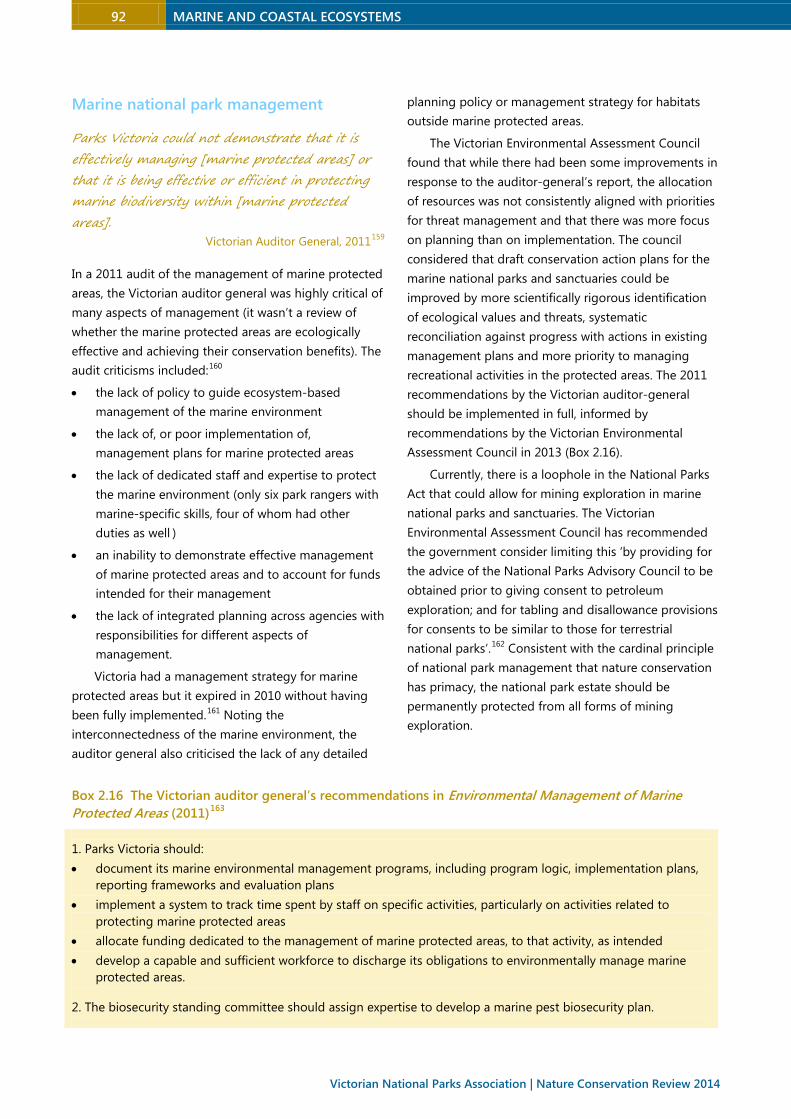
92 MARINE AND COASTAL ECOSYSTEMS
Victorian National Parks Association | Nature Conservation Review 2014
Marine national park management
Parks Victoria could not demonstrate that it is
effectively managing [marine protected areas] or
that it is being effective or efficient in protecting
marine biodiversity within [marine protected
areas]. Victorian Auditor General, 2011159
In a 2011 audit of the management of marine protected
areas, the Victorian auditor general was highly critical of
many aspects of management (it wasn’t a review of
whether the marine protected areas are ecologically
effective and achieving their conservation benefits). The
audit criticisms included:160
• the lack of policy to guide ecosystem-based
management of the marine environment
• the lack of, or poor implementation of,
management plans for marine protected areas
• the lack of dedicated staff and expertise to protect
the marine environment (only six park rangers with
marine-specific skills, four of whom had other
duties as well )
• an inability to demonstrate effective management
of marine protected areas and to account for funds
intended for their management
• the lack of integrated planning across agencies with
responsibilities for different aspects of
management.
Victoria had a management strategy for marine
protected areas but it expired in 2010 without having
been fully implemented.161 Noting the
interconnectedness of the marine environment, the
auditor general also criticised the lack of any detailed
planning policy or management strategy for habitats
outside marine protected areas.
The Victorian Environmental Assessment Council
found that while there had been some improvements in
response to the auditor-general’s report, the allocation
of resources was not consistently aligned with priorities
for threat management and that there was more focus
on planning than on implementation. The council
considered that draft conservation action plans for the
marine national parks and sanctuaries could be
improved by more scientifically rigorous identification
of ecological values and threats, systematic
reconciliation against progress with actions in existing
management plans and more priority to managing
recreational activities in the protected areas. The 2011
recommendations by the Victorian auditor-general
should be implemented in full, informed by
recommendations by the Victorian Environmental
Assessment Council in 2013 (Box 2.16).
Currently, there is a loophole in the National Parks
Act that could allow for mining exploration in marine
national parks and sanctuaries. The Victorian
Environmental Assessment Council has recommended
the government consider limiting this ‘by providing for
the advice of the National Parks Advisory Council to be
obtained prior to giving consent to petroleum
exploration; and for tabling and disallowance provisions
for consents to be similar to those for terrestrial
national parks’.162 Consistent with the cardinal principle
of national park management that nature conservation
has primacy, the national park estate should be
permanently protected from all forms of mining
exploration.
Box 2.16 The Victorian auditor general’s recommendations in Environmental Management of Marine
Protected Areas (2011)163
1. Parks Victoria should:
• document its marine environmental management programs, including program logic, implementation plans,
reporting frameworks and evaluation plans
• implement a system to track time spent by staff on specific activities, particularly on activities related to
protecting marine protected areas
• allocate funding dedicated to the management of marine protected areas, to that activity, as intended
• develop a capable and sufficient workforce to discharge its obligations to environmentally manage marine
protected areas.
2. The biosecurity standing committee should assign expertise to develop a marine pest biosecurity plan.
MARINE AND COASTAL ECOSYSTEMS 93
3. Parks Victoria should:
• develop park management plans for all marine protected areas with supporting plans that specify actions,
targets, performance indicators, accountabilities and time frames for delivery
• develop management reporting that enables the assessment of performance against park management plans
• regularly and routinely review its risk assessments, including prioritisation, for marine protected areas
• as park manager, develop and lead collaboration with other agencies to better inform its planning
• review, for effectiveness, Victoria’s System of Marine National Parks and Marine Sanctuaries: Management
Strategy 2003–2010, to inform the development of a new strategy.
4. The Department of Sustainability and Environment should implement a new services agreement with Parks
Victoria that clearly specifies the responsibilities of both agencies, performance standards and indicators, funding
levels and reporting requirements.
2.6.3 Coastal national park and conservation system
Expanding the national park and conservation system
should be a high priority to better protect Victoria’s
coast from developmental pressures and foster
resilience and adaptation to climate change. As noted
above, this review strongly recommends an
investigation by the Victorian Environmental
Assessment Council (or similar independent body) to
recommend the best ways to achieve comprehensive,
adequate and representative protection of coastal and
marine ecosystems.
The aim should be to securely protect 100% of
remnant coastal vegetation. This is important because it
has unique and exceptionally high environmental, social
and economic values (the latter due to tourism and
ecosystem services) that are under extreme
pressures. The coastal zone is the land’s first line of
defence, forming a critical buffer against winds, storms
and seawater, forces that will increase with climate
change. About two-thirds of the coast (within 500
metres of the shoreline) has remnant vegetation, and
about 57% of it is in the national park and conservation
system (Table 2.6). An additional 27% is in some form of
other reserve (eg a coastal reserve), which may not be
secure or well managed (Table 2.9). This leaves about
16% (less than 12,000 hectares) not in some form of
conservation tenure, most of which is public land.
Secure protection can be achieved for much of the
remaining remnant coastal vegetation by upgrading the
level of protection for crown land reserves, by acquiring
or leasing private land for the national park and
conservation system, and by protecting private land
through perpetual covenants. Section 2.5 has identified
coastal areas of high conservation value that warrant
protection within the national park and conservation
system.
About 42,000 hectares (37%) of coastal land are
privately owned. This review recommends the
establishment of a coastal private land conservation
program to secure the future of high priority remnant
vegetation. It would fund acquisitions or leases of
private land with a focus on properties near reserves or
abutting the high water mark. Initial priorities should be
private land inliers and land next to coastal
conservation reserves. A public acquisition overlay
should be applied to protect high priority private land
from development and give the government first option
to buy when properties are offered for sale.
In addition to the specific additions to the national
park and conservation system recommended in section
2.5, coastal public lands should be more securely
protected for conservation and other public purposes
by applying more appropriate tenure and zoning
arrangements for reserves currently managed under the
Crown Land (Reserves) Act. To better recognise the
values of coastal nature conservation reserves and
integrate their management within the national park
and conservation system, they should be transferred
from the Crown Land (Reserves) Act into a new
schedule of the National Parks Act (see section 3.5.1).
For other coastal crown land reserves, changes to the
state planning policy framework are needed to
strengthen protection for conservation and public
purposes. Currently, the most common planning zones
applied to coastal crown land are Public Conservation
and Resource Zone (PCRZ) and Public Park and
Recreation Zone (PPRZ). The PCRZ is usually applied to
national parks, coastal parks, conservation reserves and
94 MARINE AND COASTAL ECOSYSTEMS
Victorian National Parks Association | Nature Conservation Review 2014
less developed coastal sections, and the PPRZ is
generally applied to recreation and settlement nodes.
The zones prohibit some activities but allow others
under permit (eg renewable energy facilities and
emergency service facilities) and others without a
permit (eg boat launching facilities, camping and
caravan parks, car parks). The two elements of the
PCRZ, conservation and resource use, are in conflict.
This should be addressed by splitting them into
separate zones. Conservation reserves should be
excluded from the application of statutory planning
zones but the new zones should be applied to coastal
reserves (consistent with the 1978 recommendations of
the Land Conservation Council), with the Victorian
Coastal Council determining the location of the zones.
When coastal reserves were recommended by the Land
Conservation Council and the Environment
Conservation Council, the intention was to provide
permanent protection for coastal crown land located
between coastal conservation reserves for the purposes
of public recreation, education and inspiration. Another
recommended tenure change is to incorporate
lighthouse reserves within adjoining national or state
parks.
Improved tenure arrangements for coastal lands
need to be supplemented by more effective
management. Because coastal conservation reserves are
mostly small and narrow, they are highly vulnerable to
edge effects of weed and feral animal invasion, bushfire,
livestock intrusion and impacts of adjacent land uses.
Effective management planning and implementation
are essential for specifying management actions and
informing the community about the values at stake.
All protected areas should have management plans
and, as noted, coastal protected areas have particularly
challenging management issues arising from edge
effects and high visitation pressures. Each national, state
and coastal park has a management plan but most are
more than a decade old and need reviewing.164 Most
coastal reserves and nature conservation reserves lack
management plans (the exception being where they are
included in plans for other protected areas). This is
despite the Crown Land (Reserves) Act requiring a
management plan for each nature conservation reserve.
The agencies jointly responsible for park planning –
Parks Victoria and the Department of Environment and
Primary Industries – are taking a new approach to
planning by developing a series of landscape-wide
management plans to encompass multiple protected
areas. While this approach is sensible in theory, it has
mostly been poorly implemented (see section 3.5.1),
and there is a risk that the prime objective of protected
areas to protect natural and cultural heritage will be
compromised by the elevation of tourism and economic
goals as major drivers of day-to-day management.
The Victorian government has passed legislation to
allow developers to hold leases for up to 99 years in
national parks, and has invited applications for
developments in two-thirds of Victoria’s national park
estate. Several iconic national parks on the coast are
likely to be impacted: Port Campbell, Great Otway,
Point Nepean and Wilsons Promontory national parks.
Problems with the state government’s push for
commercial tourism developments, discussed in chapter
3, include that they are likely to undermine the primary
aim of park management of protecting natural values,
diverting focus and resources from conservation.
History shows that they tend to expand over time, and
that developers, rather than most visitors and protected
areas, are the beneficiaries
2.6.4 Bays, inlets and estuaries
Although greatly appreciated by the community for
their natural, aesthetic and recreational values, many of
Victoria’s bays, inlets and estuaries also host industries
and settlements that threaten those values, and they
are sensitive to polluting and degrading activities in
their catchments both near and far upstream. Sea level
rise and other aspects of climate change will bring
many more pressures. A special conservation focus on
bays and inlets is warranted because both values and
threats are high. Currently, divided agency
responsibilities and a lack of strategic direction and
formal protection are undermining Victoria’s capacity to
effectively manage these areas.
An independent authority is needed to oversee the
health of Victoria’s two largest bays – Port Phillip Bay
and Western Port – and their catchments
(amalgamating the catchment management functions
of Melbourne Water, Central Coastal Board and the Port
Phillip Westernport Catchment Management Authority).
Other measures to foster more effective
management of bays and inlets are five-yearly reports
MARINE AND COASTAL ECOSYSTEMS 95
on their environmental condition, and clear
improvement targets for water quality, ecosystem
health and social values (recreation and open space). To
assess progress, monitoring programs are needed to
establish both baseline condition and chart changes
over time. A 2008 analysis of Victoria’s estuaries
concluded there was a lack of data on water quality and
biota, estuarine condition, the number and size of
estuaries, how they function and the threats they
face.165 The 2013 state of the environment report also
noted there ‘remains little data available on the
ecological condition of estuaries’.166
New planning measures are needed to ensure that
future developments and land use changes are
compatible with achieving improvement targets for bays
and inlets. One vital instrument is a state environment
protection policy for estuaries to provide clear statutory
objectives and controls to protect estuaries.
Protecting shorebirds
Few birds inspire birdwatchers more than the
shorebirds: a diverse group of elegant, active,
predominantly wetland dwelling species which
carry out some of the most amazing migrations in
the natural world. Julie Oldland & others, 2009167
As reflected in the listed values of five coastal Ramsar
wetlands and the many sites designated as ‘important
bird areas’, coastal Victoria has immensely important
habitats for shorebirds (also known as waders). At least
half of the 20 important bird areas support more than
1% of the world populations of certain migratory
shorebirds (eg red-necked stints and sharp-tailed
sandpipers) which travel up to 25,000 kilometres a year
between Victorian shores and breeding grounds in the
high Arctic.168 Many are also important for resident
shorebirds like hooded plovers.
All over the world shorebirds are declining, mainly due
to loss of habitat. In coastal Victoria, they are under
pressure from this, and also from human recreation, and
predation by cats, foxes and black rats. Disturbance from
human recreation (walking, dogs, horse-riding) can reduce
the birds’ feeding and resting time, and undermine their
ability to put on enough weight to migrate. Proposed
developments such as port expansions are likely to cost
shorebirds even more habitat.169
A substantial proportion of the eastern subspecies
of hooded plovers, endemic to southeastern Australia
and assessed as threatened in the recent action plan for
Australian birds, occur on Victorian beaches.170 Victorian
populations declined by about one-third between 1980
and 2008 (from 600 to 400 individuals) due to threats
such as coastal development, disturbance and egg and
chick trampling by humans, dogs and illegal vehicles,
predation, and weeds.171 There has been considerable
work in Victoria by BirdLife Australia to monitor
populations and raise public awareness about safe
recreation.
This review recommends the development of a
shorebird protection strategy to promote measures to
address the major threats to shorebirds.
2.6.5 Marine and coastal management
It is necessary to build the full consideration of ecological processes into legislative and institutional
frameworks, policy and planning processes, and on-ground management of Victoria’s marine and coastal
environment. This requires a network approach rather than exclusive management of the marine
environment as a series of isolated protected areas. Australian Marine Ecology, 2010172
Marine management is plagued by shortcomings
arising from a predominant focus on single sectors and
single species. The complex interconnectedness of
marine environments requires a holistic focus on
ecosystems and ecological processes (see Table 2.25 for
the differences), including for sustainable exploitation
of commercial species: ‘A single commercially valuable
fish species, for example, may depend on a range of
widely separated habitats over its life, depending on
whether it is young or adult, feeding, spawning, or
migrating. It needs access to each habitat at the right
time, as well as ample food, clean water, and shelter.’173
Australia’s Oceans Policy outlines the aims of
ecosystem-based management as being to maintain:
96 MARINE AND COASTAL ECOSYSTEMS
Victorian National Parks Association | Nature Conservation Review 2014
• ecological processes in all ocean areas, including,
for example, water and nutrient flows, community
structures and food webs, and ecosystem links
• marine biological diversity, including the capacity
for evolutionary change
• viable populations of all native marine species in
functioning biological communities.
In essence, it requires maintaining (or restoring)
environmental ‘structure, function and composition’ in a
holistic network approach rather than a piecemeal focus
on protected areas.174
Table 2.27 Contrasting single-issue focused management with ecosystem-based management175
Single issue focus Ecosystem-based management
Manage individual species Manage entire ecosystems
Manage single sectors (eg fisheries) Integrate management of all sectors affecting the ecosystem
Focus management at a local scale Coordinate management at all levels relevant to the ecosystem
Take a short-term perspective: what do we need from the ecosystem this year?
Take a long term perspective: what will the ecosystem be like in 20 years?
Although governments have accepted that an
ecosystem approach is essential, there are few examples
of implementation. Ecosystem-based management is
challenging due to incompatible goals of different
stakeholders and ‘perceptions that it is too complicated
and has prohibitive information requirements’.176
Australian Marine Ecology emphasised the
importance of placing ‘absolute limits’ (setting
thresholds) on changes to important ecosystem
components or processes.177 One example is protection
of marine benthic vegetation in Western Australia,
where limits are placed on the cumulative loss of
marine plant habitats.178 Thresholds range from none in
highly impacted areas to 1% in highly protected areas
and 10% in development areas. Examples of ecosystem
components or processes that could be protected with
this approach include primary carbon production rates
(linked to light availability), denitrification (removal of
nitrogen) efficiencies in sediments, and abundance of
functional species (such a predators).
One of the main goals of ecosystem-based
management is to build ecological resilience – to
sustain or restore the capacity of ecosystems to ‘resist,
buffer or recover from changes caused by increased
environmental pressures, at lower disturbance levels’.179
This is vital in the face of climate change.
Building resilience can require multiple approaches:
• restore ecosystem components or processes, such
as large predators (most Victorian reefs are missing
large predators)
• provide a buffer above minimum sustainable limits
of exploitation
• reduce controllable perturbations to increase
capacity for response to uncontrollable or
unforeseen disturbances
• maintain redundancy of functional components or
species and areas (such that multiple species are
present to fulfil ecological roles and there are
multiple sources of recruitment)
• have a representative and comprehensive system of
highly protected marine areas, including areas with
minimal human disturbance to maximise the
potential for rebuilding fully functional systems and
areas that act as biogeographical buffers.
Coastal protection and restoration
Where land, sea and air merge is naturally a place of
high energy and natural dynamism. Victoria’s coast is
also the interface between multiple, often conflicting
human agendas – for recreation, industry, habitation
and conservation – which greatly accelerate the scale
and rapidity of change.
With climate change already impacting coastal
nature and much more change seemingly inevitable,
‘resilience’ and climate ‘adaptation’ need to become
much more than buzzwords. Easing existing pressures
on coastal habitats (due to development, invasive
species, bushfires among others) and restoring natural
habitats are the most effective ways of fostering the
capacity of coastal nature to absorb or adapt to
climatically induced changes. As a starting point,
objectives to foster resilience and adaptation should be
included in Victorian planning provisions and the state
planning framework, complemented by changes to
MARINE AND COASTAL ECOSYSTEMS 97
coastal statutory zoning and overlays to provide for in
situ protection of coastal nature for as long as possible
and assist inland retreat as sea levels rise. Planning is
needed to identify how coastal settlements and
biodiversity will be accommodated as sea level rises and
the priority areas that should be protected to permit
species movement
With developmental and other threats to coastal
habitats mounting, stewardship programs (such as
BushBroker and CoastalTender) to support landholders
to protect and restore remnant vegetation on private
land should be expanded. Protection and restoration of
native vegetation is fundamental to coastal health. A
new vegetation restoration overlay in the Victorian
planning provisions is recommended to protect a 100-
200 metre buffer around vegetated coastal public lands,
including estuaries and wetlands, within which
development is prohibited and management of invasive
species and other threats is required. Any changes in
land use zones for the coast should be referred by the
planning minister to the environment minister (the
Planning and Environment Act will need to be amended
to require this).
Because they are so attractive to people, coastal
habitats are being burdened by an accumulation of
infrastructure – roads, tracks, car parks, buildings and
utilities – that compromise natural, scenic and
recreational values. Much of this infrastructure is
unnecessary or could be sited elsewhere. An
independent review of infrastructure adjacent to the
coastal national park and conservation system should
be commissioned with the aim of relocating, removing
or better managing it to minimise impacts on natural
values. Commercial tourism developments in national,
state and coastal parks should be prohibited, and any
construction or upgrade of boat ramps, and the impacts
of fishing enabled by such development, should be
rigorously assessed.
In addition to compromising coastal values, much
infrastructure on the coast is at risk from eventual
inundation under climate change. An initial assessment
by the Australian government (in 2009) predicted that
by 2100, under a scenario of a 1.1 metre rise in sea level
with a 1-in-100 storm tide, from 27,600 to 44,600
residential buildings in Victoria would be at risk of
inundation.180 Much other infrastructure (commercial
buildings, roads, sea walls, bridges, groynes, power lines
water and sewer mains, septic tanks, gas pipelines,
stormwater drains, jetties) would also be at risk. It
makes economic, social and environmental sense to
ensure that coastal infrastructure is assessed, designed,
constructed and maintained taking future climate
change into account, as is consistent with the principles
of ecologically sustainable development. Priority areas
for defence (eg by sea walls) and retreat will have to be
identified, and the issue of coastal dependency (which
infrastructure is reliant on a coastal location) will have
to be addressed. It would be wasteful of public
resources and unnecessarily environmentally damaging
to build defensive structures for infrastructure that need
not be located on the coast.181 A coastal infrastructure
unit (modelled on the Victorian Ports and Harbours
Division of some years ago) should be established to
assess and manage boating infrastructure, coastal
defensive works, artificial reefs and the planned retreat
of coastal infrastructure for all coastal locations except
for the major ports (Portland, Geelong, Melbourne and
Hastings).
Boating infrastructure
Victoria has extensive boating infrastructure but there is
pressure to build even more access points and upgrade
existing facilities. In boating coastal action plans, the
environmental impacts of such infrastructure have been
considered in terms of site impacts and the effect on
coastal currents and sand movement but no
consideration has been given to environmental impacts
of the activities (boating and fishing) facilitated by new
infrastructure. Limits on boating infrastructure should
be set based on an assessment of the boat ‘carrying
capacity’ of Victoria’s estuaries.
Managing oil spills
Oil spills can have catastrophic impacts on wildlife and
marine and coastal habitats. Planning and management
systems are needed to minimise the risk of spills –
prevention should be the first goal – and to maintain
response preparedness. Planning should be shaped by
risk assessment of current and projected shipping traffic
from each Victorian port and high priority given to
protecting the national park estate (Parks Victoria has
emergency response plans for parks and reserves that
include oil spills).182 Decisions about port expansions
such as at the Port of Hastings should take into account
the heightened risk of oil spills.
98 MARINE AND COASTAL ECOSYSTEMS
Victorian National Parks Association | Nature Conservation Review 2014
Managing invasive species
Current approaches to invasive species tend to be the
opposite of ecosystem-based management – more
reactive than proactive, mostly focused on just a few
harmful species, and prioritising short-term commercial
benefit from use of invasive species over long-term
ecological health. The well-accepted prevention-first
hierarchy has not been comprehensively implemented –
exotic plants, in particular, are generally permitted into
Victoria without the most basic precaution of assessing
their invasion risks. For some widespread invasive
species, control to protect particular habitats or species
may be all that is feasible. But ecosystem-based
management requires a broader focus, including
management or restoration to bolster resilience to
invasive species impacts (eg. by restoring predators or
reducing nutrient enrichment) and integration with
management of interacting threats – such as harmful
fire and water flow regimes, over-fishing, and
disturbance. There also needs to be a strong focus on
preventing new invasions by requiring risk assessment
of all introductions and responding quickly to new
incursions.
In a 2011 audit of marine protected area
management, the auditor general found that the then
Department of Sustainability and Environment was ill-
prepared to respond to new incursions of invasive
marine species. Deficiencies included a lack of detailed
planning to assign roles and responsibilities to prepare
for, detect and respond to incursions, poor integration
between departments, and a lack of resources. There
was no marine pest monitoring system (no systematic
or routine monitoring occurs in any Victorian port). The
auditor general recommended that the cross-agency
biosecurity standing committee develop a marine pest
biosecurity plan. This is essential, and it should have a
strong prevention focus.
2.6.6 Governance structures and processes
Ecosystem-based management – in contrast to species-
based, industry-based or site-based management –has
not been incorporated into state laws and institutions.
Victoria’s governance structures and processes are too
disparate and unfocused to achieve the state’s goals for
marine and coastal management. Recommendations
specific to the coast and seas include new legislation to
implement ecosystem-based management and
ecologically sustainable development (a Marine and
Coastal Planning and Management Act) and a marine
and coastal strategy to provide an over-arching
framework. The specific measures and targets for each
region would be set out in regional marine and coastal
plans, encompassing the current multiple action plans
for coasts, estuaries and boating, and including
strategies to prepare for climate change.
To provide the necessary oversight and integration,
an independent authority – a proposed Victorian
Marine and Coastal Authority – should be established to
absorb and expand on the functions of the existing
Victorian Coastal Council, with regional marine and
coastal boards to replace the existing coastal boards.
Integration with catchment management would be
facilitated by aligning the boundaries of coastal regions
with those for catchment management authorities
(splitting the three coastal regions into five regions) and
by establishing close links between the relevant policies
and plans.
2.6.7 Commercial and recreational fishing
Ecosystem-based management
Victoria’s Fisheries Act includes the following objective
relevant to ecosystem-based management: ‘to protect
and conserve fisheries resources, habitats and
ecosystems including the maintenance of aquatic
ecological processes and genetic diversity’. Although a
requirement for ecosystem-based management is
recognised in some Victorian fisheries (such as for
southern rock lobster, giant crab and abalone) there has
been no rigorous evaluation of their ecosystem effects
and knowledge of ecosystem processes on which to
base evaluations is largely lacking.183 Criteria to assess
the ecological sustainability of all fisheries, whether
commercial or recreational, and site-specific ecological
risk assessments are needed. The introduction of
ecosystem-based limits – such as the abundance of
particular functional species in fished ecosystems – is ‘a

MARINE AND COASTAL ECOSYSTEMS 99
partial solution’ to the difficulties of insufficient
ecosystem knowledge,184 and a precautionary approach
where information is lacking is essential.
One of the goals of ecosystem-based management
is to maintain or build resilience (discussed above). This
will require reducing fishing pressure on some targeted
populations, which are maintained at very low
proportions of virgin biomass, to buffer communities
against other disturbances. For example, maintaining
healthy populations of large adult rock lobsters can
help prevent the destruction of giant kelp marine
forests by long-spined sea urchins, as demonstrated in
Tasmanian marine protected areas.185 Rock lobsters are
efficient sea urchin predators but are currently fished
down to low densities.
Ecosystem-based management also requires better
protection of habitats critical to targeted species (such
as fish nurseries and important feeding grounds) and
whole-of-catchment programs to improve water quality
and protect coastal habitats.
Recreational fishing
While commercial fishing pressure in Victoria has
declined or stayed stable, recreational fishing has
surged in popularity. For several species the recreational
catch is similar to or exceeds the commercial catch and
pressures on some species and ecosystems are
substantial (Table 2.17). Participation rates, where
fishing occurs and total catches of target and non-
target species are basic information required to manage
recreational fishing but there is no program to collect
such data. The most recent survey was about eight
years ago and focused only on the catch of snapper in
Port Phillip Bay and Western Port.186 It should be a high
priority to assess recreational fishing catch and impacts
by a range of methods, including regular large-scale
surveys of participation and catch, licencing all
recreational fishers with endorsements for particular
coastal regions, expanding the angler diary program,
monitoring the main targeted species and conducting
annual trawl surveys of Port Phillip Bay. Recreational
fishers typically catch a wide range of species and
discard most, retaining a few favoured species. The
impacts of this on discarded species could be
substantial, particularly for rare or declining species
(such as grey nurse sharks), and need to be
investigated.
Enforcement
With about 570,000 participants in recreational fishing,
enforcement is difficult – ‘governments experienced in
managing commercial fisheries are finding unique
challenges in the recreational sector and experiencing
the failure of traditional monitoring, evaluation and
enforcement methods’.187 Enforcement is also
hamstrung by the typical problems of too few resources
and low priority (for there is little ‘political reward’ in
rigorous enforcement of this sector).188 Parks Victoria is
accountable for compliance in the national park estate
but mostly relies on Fisheries Victoria for
implementation. This has resulted in a blurring of
accountability, and there is widespread concern that the
values of marine protected areas are being
compromised by poaching.189 Education, surveillance
and rigorous enforcement are needed to better protect
marine national parks and sanctuaries from illegal take.
The Victorian Environmental Assessment Council has
recommended a review of cross-agency coordination to
clarify roles and accountabilities, sufficient funding and
education and interpretation programs.190
Indirect fishing impacts
There is need for ‘a better-defined and more
collaborative system of identifying and addressing’
fishing-related impacts that are of high or moderate risk
such as bird and mammal entanglements with lost
fishing gear, death or injury of marine animals due to
boat strikes, the spread of invasive species and fish
‘stock enhancement’. Risks can be reduced by measures
that include phasing in the use of biodegradable hooks
and fishing lines, requiring all stock enhancement
proposals to be subject to risk assessment and public
environmental impact assessment and prohibiting the
transport of live invasive species (such as European
green shore crabs) as bait.
Licence sales
Several million dollars ($5.9 million in 2010-11) are
collected annually from sales of recreational fishing
licences. A small proportion is spent on habitat
management, about one-quarter is spent on
compliance, and most of it goes to promote
recreational fishing opportunities, including stocking
invasive fish species. A much more substantial
proportion should go to habitat management.

100 MARINE AND COASTAL ECOSYSTEMS
Victorian National Parks Association | Nature Conservation Review 2014
2.7 Future directions
ustralia’s southern seas are a natural treasure
trove, with dazzling diversity and uniqueness
unmatched globally for seaweeds, sea mosses and
several other groups. The level of endemicity in many
groups is close to 90%. But Victoria’s marine habitats
are under-studied, under-appreciated and under-
protected, for the land lubber bias applies in Victoria
as elsewhere. Little more than 5% of state waters are
protected in the national park estate.
As the interface between land and sea, where
many different landforms and oceanic influences
meet, Victoria’s coast is naturally a dynamic and
diverse environment. As the most popular zone for
living and recreating, Victoria’s coast is certainly
appreciated but is under much pressure from
development, harmful catchment changes and
invasive species.
Marine and coastal habitats are among the most
vulnerable to climate change. Strengthening
protection is essential not only to protect biodiversity
from multiple existing current threats but to foster
their resilience and adaptation to future changes.
Knowledge of biodiversity and ecology is
essential for management of any environment but is
particularly lacking for Victoria’s marine habitats. Even
for the national park estate, one of the serious threats
highlighted in government assessments is ‘limited
ecological knowledge of important processes’.191
Knowledge gaps need to be addressed systematically
with long-term research and monitoring and detailed
mapping of ecological communities.
It is more than a decade since a network of highly
protected areas was established in 5.3% of Victorian
waters. A gap analysis (summarised in section 2.4)
shows they are inadequate to protect the values they
were established for and to achieve a comprehensive,
adequate and representative network. The past
decade has also brought compelling evidence that a
substantially larger network is needed to protect
biodiversity and ecological processes and to foster
ecosystem resilience.
Although more than a third of the coast (to 500
metres inland) is in the national park and
conservation system, many endangered coastal
vegetation communities are scantly protected and
coastal habitats are at great risk from development
and poor management. Bioregional priorities for
increased protection have been identified in section
2.5, which can be achieved by upgrading protection
for public lands and buying, leasing or covenanting
private land.
As a high priority, Victoria needs a
comprehensive independent inquiry into marine and
coastal biodiversity to recommend new areas for
protection based on targets that will foster resilience
to climate change and multiple other threats.
With very high values and threats, Victoria’s bays,
inlets and estuaries warrant a special conservation
focus – an independent authority to manage the two
largest, the internationally significant Port Phillip Bay
and Western Port, and a program with clear
measurable improvement targets, monitoring and
public reporting.
The complex interconnectedness of marine and
coastal environments requires a holistic management
focus on ecosystems. But current governance
arrangements, laws and policies lack integration and
perpetuate sector-, site- or species-focused
management. An essential basis for ecosystem-based
management is a new overarching legal and policy
framework and a marine and coastal authority with
the mandate to achieve this outcome.
To restore ecological health to many marine and
coastal habitats will also require better management
of fisheries, invasive species, coastal vegetation and
water quality.
Following is a summary of reforms recommended
as high priorities over the next decade to make
substantial progress on the protection and
restoration of Victoria’s marine and coastal
ecosystems.
A
MARINE AND COASTAL ECOSYSTEMS 101
Research and information sharing
M1 Prepare and implement a marine and coastal
research strategy and action plan, and establish
a website to provide public access to all
information relevant to marine and coastal
protection, planning and management.
M2 Establish a long-term scientific research and
monitoring program for marine national parks
and sanctuaries and other coastal and marine
environments, which includes:
- completion of a systematic biodiversity
assessment program across Victorian waters to
map all marine and intertidal habitats at a fine
scale
- a state-wide 1:10,000 scale map showing
predominant community types for reef and
sediment areas and locations for seagrass beds,
produced within two years.
M3 Establish a marine and coastal research and
information service to address high priority
knowledge gaps, promote the value of research,
and function as a clearing house for information
and advice.
National park and conservation
system
M4 Commission the Victorian Environmental
Assessment Council (or other independent
credible body) to conduct an inquiry into
biodiversity across all Victorian marine and
coastal ecosystems with the purpose of
recommending new targets and new protected
areas to achieve a comprehensive, adequate
and representative national park and
conservation system and to foster resilience to
climate change. The latest science and expert
opinions, taking into account the threats to
Victorian ecosystems, suggest the following
targets are warranted:
- protection for at least 30% of each habitat type
in each marine bioregion
- protection of 100% of remnant coastal
vegetation
- protection of additional areas that will assist in
protecting biodiversity from the future impacts
of climate change
- greater levels of protection for the habitat of
threatened species and special features,
including Ramsar wetlands and sites identified
in the nature conservation review gap analyses
(in sections 2.4 and 2.5)
- configuration to provide connectivity and secure
movement pathways.
M5 Implement all outstanding recommendations
from the 2011 inquiry by the Victorian auditor
general into the environmental management of
marine protected areas.
M6 Prohibit mining exploration in the marine
national park estate.
M7 Establish a coastal private land conservation
program with a fund to buy, lease or covenant
private land abutting coastal conservation
reserves, coastal crown land reserves or the high
water mark for restoration and inclusion in
reserves or, in the case of leases and covenants,
to be managed consistently with such reserves.
M8 Strengthen protection of coastal crown land
reserves for conservation and public purposes
by:
- developing regulations and coastal
management plans specific to their purpose
- applying a zoning scheme to coastal reserves
consistent with the recommendations of the
Land Conservation Council (1978), with the
location of the zones to be identified by the
Victorian Coastal Council through a project
similar to the Coastal Spaces Initiative
- progressively removing from coastal reserves
infrastructure that is not dependent on a coastal
location, and restoring the land with indigenous
vegetation.
M9 Improve protection for lighthouse reserves by
incorporating them within adjoining national or
state parks.
102 MARINE AND COASTAL ECOSYSTEMS
Victorian National Parks Association | Nature Conservation Review 2014
Iconic bays and inlets
M10 Establish a Two Bays Board for strategic
oversight of the health of Port Phillip and
Western Port and their catchments. The board
should be an independent authority and
amalgamate the catchment management
functions of Melbourne Water, Central Coastal
Board and the Port Phillip Westernport
Catchment Management Authority.
M11 Produce standalone 5-yearly State of the Bays
reports covering the four main bays and inlets
(Port Phillip, Western Port, Corner Inlet and
Gippsland Lakes) and the smaller bays. The first
report should include a detailed condition study,
comprehensively review all pressures and
describe existing and planned responses.
M12 Develop improvement targets for bays and
inlets with water quality, ecosystem health and
open space and recreation criteria that are easy
to measure and include some highly visible
outcomes (for example the return of whales and
other flagship species to the bays and the
recovery of threatened terrestrial fauna). Link
the improvement targets to statutory planning
instruments and controls on future development
through local environmental improvement plans
or similar instruments.
M13 Set up a scientific monitoring program to assess
and publicly report every two years on progress
made towards meeting the bays and inlets
improvement targets.
M14 Establish an ongoing educational program to
build awareness of and support for conservation
measures proposed for the iconic bays and
inlets.
M15 Prepare and implement a state environment
protection policy for estuaries.
M16 Determine the boat carrying capacity of Port
Phillip Bay, Western Port and other bays and
estuaries in Victoria, and set limits on boat
numbers consistent with carrying capacity.
M17 Develop a shorebird protection strategy.
Marine and coastal management
Legislation and institutions
M18 Develop a Victorian Marine and Coastal
Planning and Management Act with objectives
and strategies to implement ecosystem-based
and ecologically sustainable management of all
marine and coastal waters.
M19 Establish a Victorian Marine and Coastal
Authority (absorbing and expanding the
functions of the existing Victorian Coastal
Council) and regional marine and coastal boards
(replacing the existing coastal boards).
M20 Mandate processes that guarantee transparency
and community participation in marine and
coastal planning and decision-making.
M21 Require that all coastal catchment management
authorities have at least one-third of their board
members with coastal or marine expertise.
M22 Merge the many small committees of
management along the following sections of
coast into combined community committees of
management:
- Narrawong to Port Fairy
- Breamlea to Clifton Springs (Barwon Coast and
Bellarine Bayside committees)
- Mt Eliza to Mt Martha
- Safety Beach to Portsea
- Flinders to Hastings
- Cannons Creek to Tooradin
- Lang Lang to Coronet Bay
- Seaspray to Loch Sport
- San Remo to Inverloch
- Walkerville to Sandy Point
- Port Franklin to Woodside Beach
- Gippsland Lakes.
Strategies and plans
M23 Develop a Victorian marine and coastal strategy,
coordinated by the proposed Victorian Marine
and Coastal Authority, to provide an over-
arching framework for ecologically sustainable,
ecosystem-based management of all human
MARINE AND COASTAL ECOSYSTEMS 103
uses and impacts affecting Victoria’s oceans and
coast. This strategy should take precedence over
and inform regional catchment strategies and
local planning policies for coastal areas.
M24 In the longer-term, seek inter-governmental
agreement for an over-arching national
framework consisting of an Australian Oceans
Act and National Oceans Commission
established through a joint agreement between
the federal government and state and territory
governments. The commission would develop
and coordinate a strong regional plan for
Victorian oceans that incorporates the Victorian
marine and coastal strategy.
M25 Prepare and implement regional marine and
coastal plans (which encompass the current
multiple coastal action, estuary and boating
action plans). Include strategies to prepare for
the impacts of climate change on coastal and
marine ecosystems by identifying areas at risk
and measures to limit damage and promote
adaptation.
M26 Better integrate marine, coastal and catchment
management by aligning the boundaries of
coastal regions with those for catchment
management authorities (splitting the three
coastal regions into five regions) and by
establishing close links between policies and
plans for marine, coastal and terrestrial
environments.
M27 Develop ecosystem-based management plans
for marine and coastal invasive species threats,
including a strong focus on prevention and
rapid responses to new incursions, and
integration with management of other
processes and threats (fire, nutrient enrichment,
fishing, disturbance, hydrology included).
M28 Ensure that protection of the environment and
the marine and coastal national park estate are
high priorities in oil spill prevention and
response plans.
Coastal protection and restoration
Stewardship programs
M29 Expand and strengthen the BushBroker,
CoastalTender and saltmarsh protection
projects, with an emphasis on protection and
restoration of vegetation on private land
abutting the high water mark and coastal
conservation and crown land reserves.
Coastal infrastructure
M30 Commission an independent review of
infrastructure (including access tracks, car parks,
roads, buildings and utilities) within and
adjacent to the coastal national park estate and
crown land reserves with the aim of relocating
or removing infrastructure or better managing it
to minimise impacts on natural values.
M31 Amend the National Parks Act to rule out 99
year leases that allow commercial tourism
development within national, state and coastal
parks along the Victorian coast.
M32 Establish a coastal infrastructure unit with an
objective of ensuring that coastal infrastructure
is assessed, designed, constructed and
maintained within the principles of ecologically
sustainable development and ecosystem-based
management. The unit would carry out works,
assess and manage boating infrastructure,
coastal defensive/protection works, artificial
reefs and the planned retreat of coastal
infrastructure for all coastal locations except for
the major ports of Portland, Geelong,
Melbourne and Hastings.
M33 Require rigorous environmental impact
assessments of proposed development or
upgrade of boat ramps, including the impacts of
any recreational fishing enabled by the
infrastructure.
104 MARINE AND COASTAL ECOSYSTEMS
Victorian National Parks Association | Nature Conservation Review 2014
Climate change adaptation
M34 Foster the capacity of coastal nature to adapt to
sea level rise and other impacts of climate
change by:
- mapping current settlements, priority areas for
coastal nature protection and enhancement,
and predicted sea level rises
- identifying where coastal settlements and
nature can move to as a result of sea level rise
- reviewing the zoning and conservation status of
all identified priority areas for coastal nature
protection and enhancement to determine
whether they will adequately protect coastal
nature.
M35 Include in the Victorian planning provisions and
the state planning framework an objective to
protect coastal nature to help adaptation and
retreat in response to sea level rise and other
climate change impacts. Amend coastal
statutory zoning and overlays to aim for in situ
protection of coastal nature for as long as
possible and assist inland retreat as sea levels
rise.
Vegetation
M36 Introduce a vegetation restoration overlay to
the Victorian planning provisions, to protect a
100-200 metre buffer around vegetated coastal
public land, including estuaries and wetlands.
Within that buffer:
- prohibit development
- require management of harmful invasive species
and encourage vegetation maintenance and
restoration
- identify and progressively remove infrastructure
at risk of erosion and inundation from sea level
rises (rather than build defensive structures)
- encourage fencing of buffers and boundaries
between private and public land to encourage
vegetation restoration.
M37 Amend the Planning and Environment Act to
require the planning minister to refer any
changes in land use zones for coastal lands to
the environment minister.
Fishing
M38 Implement ecosystem-based management of
commercial and recreational fisheries by:
- establishing a program to identify and declare
‘key fishery habitat’ to become part of marine
and coastal planning and protection
- implementing whole-of-catchment plans to
maintain coastal habitat and water quality
- establishing criteria to assess the ecological
sustainability of individual commercial and
recreational fisheries
- conducting location-specific ecological risk
assessments of recreational and commercial
fisheries, mitigating identified risks and taking a
precautionary approach where information is
lacking
- developing a policy framework to follow up and
manage important risks uncovered in
environmental risk assessments
- monitoring the community ecology of
important benthic and pelagic ecosystems.
M39 Assess the recreational fishing catch and
impacts by:
- conducting large-scale surveys of participation
and catch every 3 to 5 years
- requiring all recreational fishers to be licenced,
with no licence fees for current exempt groups,
and with licences endorsed for particular coastal
regions (to enable measurement of participation
and catch levels)
- conducting onsite surveys at all major boat
ramps
- expanding the angler diary program to focus on
key species and major recreational estuaries
- implementing fisheries-independent monitoring
for key recreational species
- re-establishing annual trawl surveys of Port
Phillip Bay
- investigating the impacts of fishing discards on
declining target species (eg sand flathead, dusky
flathead) and non-target species of low
abundance (eg rare rays and sharks).
M40 Improve enforcement of fishing laws, with a
strong focus on protecting marine national
parks and sanctuaries from illegal fishing.

MARINE AND COASTAL ECOSYSTEMS 105
M41 Reduce risks associated with stocking,
movement of invasive species and fishing gear
by:
- requiring all stock enhancement proposals to be
subject to a public environmental impact
assessment supported by a comprehensive,
independent risk assessment
- prohibiting the transport of live invasive species
(eg European green shore crabs) as bait
- phasing in over five years the use of
biodegradable hooks and fishing lines.
M42 Allocate a substantial proportion of fishing
licensing fees to support long-term fish habitat
recovery projects.
106 MARINE AND COASTAL ECOSYSTEMS
Victorian National Parks Association | Nature Conservation Review 2014
2.8 Sources
Endnotes
1 Environment Conservation Council (2000) 2 Geoscience Australia (2010) 3 Environment Conservation Council (2000) 4 Veevers (1991) 5 Edmunds et al (2000). The three provinces are the western warm-
temperate Flindersian Province; the eastern warm-temperate Peronian Province; and the southern cool-temperate Maugean Province.
6 Environment Australia (1998) 7 Environment Australia (1998). There is a more recent version, which
differs in some respects. 8 Edmunds et al (2010) 9 Australian Government (2012) 10 Oldland et al (2009) 11 Wilson & Allen (1987); Poore (1995) 12 Edmunds et al (2010) citing the following. For seaweed: Womersley
(1990); Phillips (2001). For marine sediment infauna: Poore and Wilson (1993); Coleman et al (2007). For hydroids: Watson (1982). For bryozoans: Bock (1982). For sponges: Wiedenmayer (1989).
13 Phillips (2001) 14 Phillips (2013) 15 Hooper (2005) 16 Edmunds (2007) 17 Department of Environment and Primary Industries (2014) 18 Charlton-Robb et al (2011) 19 WorleyParsons (2013) 20 Ipsos (2012) 21 URS (2007) 22 Worley Parsons (2013) 23 WorleyParsons (2013) 24 Descriptions can be found in the following. Corner Inlet: Department
of Sustainability Environment Water Populations and Communities (2011). Gippsland Lakes: BMT WBM (2011). Port Phillip Bay (Western Shoreline) and Bellarine Peninsula: Department of Sustainability and Environment (2003b). Edithvale-Seaford Wetlands: Department of Sustainability and Environment (2011). Western Port: Kellogg Brown & Root (2010)
25 Dutson et al (2009) 26 Edmunds et al (2010) 27 Edmunds et al (2010) 28 Department of Sustainability and Environment (2009b); Department
of Sustainability and Environment (2013) 29 Department of Sustainability and Environment (2005); Department of
Sustainability and Environment (2009b); Department of Sustainability and Environment (2013)
30 Edmunds et al (2010) 31 Edmunds et al (2010) 32 Moxham et al (2010) 33 Department of Sustainability and Environment (2009a) 34 Department of Sustainability and Environment (2003a) 35 Smyth (2014) 36 VicRFASC (1999); Department of Sustainability and Environment
(2007) 37 Victorian Environmental Assessment Council (2010)
38 Victorian Environmental Assessment Council (2013) 39 Public Record Office of Victoria (2005)
40 Analysis of intersection of DEPI public land management spatial data (PLM25) with areas 200m and 500m inland from the intertidal zone as at Jun 2011.
41 Smyth (2014) 42 Victorian Environmental Assessment Council (2013) 43 Barton et al (2008) 44 Barton et al (2008) 45 Barton et al (2008) 46 Barton et al (2008) 47 Edmunds (2007) 48 Environment Conservation Council (2000) 49 Environment Conservation Council (2000) 50 Hewitt et al (2004) 51 Melbourne Water (2011) 52 Lau (2014) 53 Environment Conservation Council (2000) 54 Kellogg Brown & Root (2010); Melbourne Water (2011) 55 Melbourne Water (2011) 56 Hansen et al (2011) 57 Melbourne Water (2011) 58 Asia-Pacific Applied Science Associates (2013) 59 Kirkman (2014); Lau (2014) 60 Environment Protection Authority Victoria (2013) 61 BMT WBM (2011) 62 BMT WBM (2011) 63 Auld & Keith (2009) 64 Ricklefs et al (1984); McGregor et al (2008). The quote is from
Ricklefs et al. 65 McGregor et al (2008); Bennett et al (2009) 66 McGregor et al (2008); Bennett et al (2009) 67 Department of Climate Change (2009) 68 Thompson et al (2009) 69 Victorian Coastal Council Science Panel (2011) 70 Edmunds et al (2010)
71 Hennessy et al (2008) 72 Edmunds et al (2010) 73 Edmunds et al (2010); Victorian Coastal Council (2013).
Temperatures: CSIRO & Bureau of Meteorology (2007). Sea levels: Bates et al (2008). East Australia Current: Cai et al (2005). Acidity: Hobday et al (2006a). Stratification: Hobday et al (2006a). Solar radiation: Hobday et al (2006a). Sea surface winds: Hobday et al (2006a). Rainfall: CSIRO & Bureau of Meteorology (2007). The changes to the East Australia Current will depend on changes to the El Niño–Southern Oscillation (ENSO). Collins et al (2010) explain that ENSO variability is controlled by a delicate balance of feedbacks, and one or more of the processes responsible for determining the characteristics of ENSO will probably be modified by climate change. It is not yet possible to say whether ENSO activity will be enhanced or damped, or if the frequency of events will change.
74 Edmunds et al (2010); Victorian Coastal Council (2013) 75 Hönisch et al (2012) 76 Shi et al (2010); Beman et al (2011) 77 Riebesell et al (2000); Hinga (2002); Engel et al (2005); Orr et al
(2005); 78 Edmunds et al (2010) 79 Vermeer & Rahmstorf (2009)
MARINE AND COASTAL ECOSYSTEMS 107
80 Department of Climate Change (2009) 81 Bruun (1962); Gippsland Coastal Board (2008) 82 Department of Climate Change (2009) 83 Hewitt et al (2004) 84 Hewitt et al (2004) 85 Dommisse & Hough (2004); Ford & Gilmour (2013) 86 Ford & Gilmour (2013) 87 Boon et al (2011) 88 Booth et al (2009) 89 Boon et al (2011) 90 Ford & Gilmour (2013) 91 Fisheries Victoria (2012) 92 Fisheries Victoria (2012)
93 Smyth (2014) 94 Auld & Keith (2009) 95 Commissioner for Environmental Sustainability (2008) 96 Commissioner for Environmental Sustainability (2008) 97 Victorian Coastal Council (2013), citing Australian Bureau of Statistics 98 WorleyParsons (2013) 99 Ipsos (2012) 100 Smyth (2014) 101 Save Bastion Point Campaign (2010) 102 Smyth (2014) 103 McComish (2013) 104 Asia-Pacific Applied Science Associates (2013); Kirkman (2014);
Lau (2014) 105 Edmunds et al (2010) 106 McCauley et al (2000) 107 Edmunds et al (2010); Smyth (2014) 108 Department of Sustainability and Enviroment (2005) 109 Department of Environment and Primary Industries (2013) 110 Department of Sustainability and Enviroment (2005) 111 State of the Environment 2011 Committee (2011) 112 Edmunds et al (2010) 113 Edmunds et al (2010) 114 Department of Primary Industries (2010) 115 State of the Environment 2011 Committee (2011); Ford & Gilmour
(2013) 116 Ford & Gilmour (2013), adapted from Department of Primary
Industries (2010) 117 Sustainable Australian Seafood Assessment Program (2012) 118 This section is based on Ford & Gilmour (2013)
119 Ford & Gilmour (2013) 120 Braccini et al (2008) 121 Ford & Gilmour (2013) 122 Otway et al (2003) 123 The major source of information is Edmunds et al (2010). Some
information for the bioregional descriptions comes from Environment Australia (1998) and VNPA (nd).
124 Edmunds et al (2010). There are a few modifications to the analysis due to the exclusion of marine conservation parks, marine reserves and other tenures that VNPA regards as insufficiently protected to count as genuine protected areas.
125 Environment Australia (1998). Based largely on physical features such as bathymetry, coastal geomorphology, sediments, currents, water chemistry and water temperature, which are used as surrogates of biological variability.
126 Environment Conservation Council (2000) 127 Edmunds et al (2010) 128 Australian Government (2012) 129 Smyth (2014) 130 Smyth (2014) 131 ‘Critical aquatic systems’ have environmental values critical to the
Australian lifestyle and economy, and are internationally important sites for flora, fauna and cultural heritage. Unfortunately, the Victorian government no longer recognises the validity of the critical aquatic system assessment process.
132 The threats are classified according to the taxonomy by Auld & Keith (2009).
133 Parks Victoria (nd) 134 Parks Victoria (2002); Geelong Environment Council (2013) 135 Smyth (2014) 136 Most of this section is based on Edmunds et al (2010) 137 Edmunds et al (2010) 138 Edmunds et al (2010); Victorian Coastal Council Science Panel
(2011) 139 Commissioner for Environmental Sustainability (2008) 140 Edmunds et al (2010). Surveys have included the following: intertidal
reef biodiversity (O’Hara, Museum Victoria unpublished data); sediment infauna biodiversity (Coleman et al. 1997, 2007); and habitat structures (Roob 2000 – and also unpublished observations by Roob and Currie), and subtidal reef biodiversity (eg Wilson et al. 1983; O’Hara 2000, Edmunds et al. 2000a, 2000b).
141 Hooper (2005) 142 Kraft (2001); Edmunds et al (2003); O’Loughlin (2007) 143 Edmunds et al (2010) 144 Matt Edmunds (pers. comm.) June 2012. 145 O’Hara & Barmby (2000) 146 Edmunds et al (2010) 147 Environment Conservation Council (2000) 148 Edmunds et al (2010) 149 Hobday et al (2006b) 150 Beeton et al (2012), citing Stachowicz et al (1999), Stachowicz et al
(2002), Byers 2002, Occhipinti-Ambrogi & Savini (2003), Clark & Johnston (2009), Clark & Johnston (2011), Piola & Johnston (2008) (for experimental evidence on invasions); Behrens & Lafferty (2004), Freeman & MacDiarmid (2009) (for diseases); Edgar et al (2004) (for invasions)’ Pederson & Johnson (2006), Sweatman (2008) and McCook et al (2010) (for trophic cascades).
151 The Ecology Centre (2009) 152 Australian Marine Sciences Association (2012) 153 Possingham et al (2009) 154 Australian Marine Sciences Association (2012) 155 Australian Marine Sciences Association (2012) 156 Lester et al (2009) 157 Beeton et al (2012) 158 Edgar et al (2009) 159 Victorian Auditor General (2011) 160 Victorian Auditor General (2011) 161 Parks Victoria (2003) 162 Victorian Environmental Assessment Council (2013),
Recommendation R9. 163 Victorian Auditor General (2011) 164 Smyth (2014) 165 Barton et al (2008)

108 MARINE AND COASTAL ECOSYSTEMS
Victorian National Parks Association | Nature Conservation Review 2014
166 Commissioner for Environmental Sustainability (2013) 167 Oldland et al (2009) 168 Oldland et al (2009) 169 Lau (2014) 170 Garnett et al (2011) 171 BirdLife Australia (2013) 172 Edmunds et al (2010) 173 United Nations Environment Program (2011) 174 Edmunds et al (2010) 175 United Nations Environment Program (2011) 176 Tallis et al (2010) 177 Edmunds et al (2010) 178 Edmunds et al (2010), citing (WAEPA 2004) 179 Edmunds et al (2010) 180 Department of Climate Change (2009) 181 Smyth (2014) 182 Victorian Environmental Assessment Council (2013) 183 Edmunds et al (2010) 184 Edmunds et al (2010) 185 Ling et al (2009) 186 Ryan et al (2009) 187 Ford & Gilmour (2013) 188 Ford & Gilmour (2013) 189 Victorian Environmental Assessment Council (2013) 190 Victorian Environmental Assessment Council (2013) 191 Barton et al (2012)
References
Asia-Pacific Applied Science Associates (2013) Quantitative Assessment of Exposure Risks Due to Oil Spills from Shipping in Western Port Bay. Asia-Pacific Applied Science Associates, East Perth
Auld TD, Keith DA (2009) Dealing with threats: integrating science and management. Ecological Management & Restoration 10: S79-S87
Australian Government (2012) Interim Biogeographic Regionalisation of Australia Version 7. Department of Sustainability, Environment, Water, Population and Communities,
Australian Marine Sciences Association (2012) Position Statement on Marine Protected Areas. Australian Marine Sciences Association
Barton J, Pope A, Howe S (2012) Marine Natural Values Study Vol 2: Marine Protected Areas of the Victorian Embayments Bioregion, Part 1 Port Phillip Bay. Victorian Government Parks Victoria
Barton J, Pope A, Quinn G, Sherwood J (2008) Identifying Threats to the Ecological Condition of Victorian estuaries. Victorian Government Department of Sustainability and Environment
Bates B, Kundzewicz Z, Wu S, Palutikof J (2008) Climate Change and Water. Technical Paper of the Intergovernmental Panel on Climate Change. IPCC Secretariat, Geneva
Beeton R, Buxton C, Cutbush G, Fairweather P, Johnston E, Ryan R (2012) Report of the Independent Scientific Audit of Marine Parks in New South Wales. NSW Department of Primary Industries and Office of Environment and Heritage
Beman JM, Chow C-E, King AL, Feng Y, Fuhrman JA, et al (2011) Global declines in oceanic nitrification rates as a consequence of ocean acidification. Proceedings of the National Academy of Science 108: 208-13
Bennett AF, Haslem A, Cheal DC, Clarke MF, Jones RN, et al (2009) Ecological processes: a key element in strategies for nature conservation. Ecological Management & Restoration 10: 192–99
BirdLife Australia (2013) Threatened Species Nomination for Hooded Plover (Eastern) (Thinornis rubricollis rubricollis). BirdLife Australia
BMT WBM (2011) Ecological Character Description of the Gippsland Lakes Ramsar Site. Australian Government Department of Sustainability, Environment, Water, Population and Communities
Boon P, Allen T, Brook J, Carr G, Frood D, et al (2011) Mangroves and Coastal Saltmarsh of Victoria: Distribution, Condition, Threats and Management
Booth C, Carr G, Low T (2009) Weedy Pasture Plants for Salinity Control: Sowing the Seeds of Destruction. Invasive Species Council
Braccini J, Walker T, Conron S (2008) Evaluation of Effects of Targeting Breeding Elephant Fish by Fecreational Fishers in Western Port. Victorian Government Department of Primary Industries
Bruun P (1962) Sea level rise as a cause of shore erosion. Journal Waterways and Harbours Division, 88: 117-30
Cai W, Shi G, Cowan T, Bi D, Ribbe J (2005) The response of the Southern Annular Mode, the East Australian Current, and the southern mid-latitude ocean circulation to global warming. Geophysical Research Letters 32: L23706
Charlton-Robb K, Gershwin L, Thompson R, Austin J, Owen K, McKechnie S (2011) A new dolphin species, the Burrunan Dolphin Tursiops australis sp. nov., endemic to southern Australian coastal waters. . PLoS ONE 6: e24047
Collins M, An S-I, Cai W, Ganachaud A, Guilyardi E, et al (2010) The impact of global warming on the tropical Pacific Ocean and El Niño. Nature Geoscience 3: 391–97
Commissioner for Environmental Sustainability (2008) State of the Environment Victoria 2008. Commissioner for Environmental Sustainability, Melbourne, Victoria

MARINE AND COASTAL ECOSYSTEMS 109
Commissioner for Environmental Sustainability (2013) State of the Environment Victoria 2013. Commissioner for Environmental Sustainability Victoria
CSIRO, Bureau of Meteorology (2007) Climate change in Australia. Technical Report. CSIRO, Bureau of Meteorology
Department of Climate Change (2009) Risks to Australia’s Coast: A First Pass National Assessment. Australian Government Department of Climate Change
Department of Environment and Primary Industries (2013) Index of Stream Condition: The Third Benchmark of Victorian River Condition. Victorian Department of Environment and Primary Industries
Department of Environment and Primary Industries (2014) Port Philip Bay. http://www.depi.vic.gov.au/forestry-and-land-use/coasts/marine/bays-inlets-estuaries-and-lakes/port-phillip-bay. Accessed February 2014
Department of Primary Industries (2010) Fishery Status Report 2010. Victorian Government Department of Primary Industries
Department of Sustainability and Enviroment (2005) Index of Stream Condition: The Second Benchmark of Victorian River Condition Victorian Department of Sustainability and Environment
Department of Sustainability and Environment (2003a) Action Statement, Flora and Fauna Guarantee Act. Central Gippsland Plains Grassland; Forest Red Gum Grassy Woodland; Northern Plains Grassland; South Gippsland Plains Grassland; Western (Basalt) Plains Grassland. Victorian Government Department of Sustainability and Enviroment
Department of Sustainability and Environment (2003b) Port Phillip Bay (Western Shoreline) & Bellarine Peninsula Ramsar Site Strategic Management Plan. Victorian Government Department of Sustainability and Environment
Department of Sustainability and Environment (2005) Advisory List of Rare or Threatened Plants in Victoria - 2005. Victorian Department of Sustainability and Environment
Department of Sustainability and Environment (2007) Native Vegetation Information: Overview of native vegetation spatial datasets. Victorian Government Department of Sustainability and Environment
Department of Sustainability and Environment (2009a) Action Statement, Flora and Fauna Guarantee Act 1988. Cool Temperate Rainforest Dry Rainforest (Limestone); Warm Temperate Rainforest (Coastal East Gippsland); Warm Temperate Rainforest (Cool Temperate Overlap, Howe Range); Warm Temperate Rainforest (East Gippsland Alluvial Terraces); Warm Temperate Rainforest (Far East Gippsland); Human activity which results in artificially elevated or epidemic levels of Myrtle Wilt within Nothofagus dominated Cool Temperate Rainforest. Victorian Government Department of Sustainability and Environment
Department of Sustainability and Environment (2009b) Advisory List of Threatened Invertebrate Fauna in Victoria - 2009. Victorian Department of Sustainability and Environment
Department of Sustainability and Environment (2011) Description of the Ecological Character of the Edithvale-Seaford Wetlands Ramsar Site. Victorian Government Department of Sustainability and Environment
Department of Sustainability and Environment (2013) Advisory List of Threatened Vertebrate Fauna in Victoria 2013. Victorian Department of Sustainability and Environment
Department of Sustainability Environment Water Populations and Communities (2011) Corner Inlet Ramsar Site: Ecological Character Description. Australian Government Department of Sustainability, Environment, Water, Populations and Communities
Dommisse M, Hough D (2004) Controlling the northern Pacific seastar (Asterias amurensis) in Australia. Victorian Government Department of Sustainability and Environment
Dutson G, Garnett S, Gole C (2009) Australia's Important Bird Areas: Key Sites for Bird Conservation. Birds Australia
Edgar G, Barrett N, Stuart-Smith R (2009) Exploited reefs protected from fishing transform over decades into conservation features otherwise absent from seascapes. Ecological Applications 19: 1967–74
Edmunds M (2007) Port Phillip Channel Deepening Project Supplementary Environmental Effects Statement Panel Hearing: Expert Witness Statement of Matt Edmunds. Prepared for Port of Melbourne Corporation, Melbourne.
Edmunds M, Hart S, Elias J, Power B (2003) Victorian Subtidal Reef Monitoring Program: The Reef Biota at Bunurong Marine National Park and Surrounding Coast. Parks Victoria
Edmunds M, Mustoe S, Stewart K, Sheedy E, Ong J (2010) VNPA Nature Conservation Review: Marine Conservation Priorities and Issues for Victoria. Australian Marine Ecology
Edmunds M, Roob R, Ferns L (2000) Marine biogeography of Central Victoria and Flinders Bioregions – a preliminary analysis of reef flora and fauna In Environmental Inventory of Victoria’s Marine Ecosystems Stage 3 ed. LW Ferns, D Hough: Victorian Government Department of Natural Resources and Environment
Engel A, Zondervan I, Aerts K, Beaufort L, Benthien A, et al (2005) Testing the direct effect of CO2 concentration on a bloom of the coccolithophorid Emiliania huxleyi in mesocosm experiments. Limnology and Oceanography 50: 493-507
Environment Australia (1998) Interim Marine and Coastal Regionalisation of Australia Version 3.3. An Ecosystem-based Classification for Marine and Coastal Environments. Australian Government Environment Australia
Environment Conservation Council (2000) Marine, Coastal and Estuarine Investigation: Final Report. Gill Miller Press Pty Ltd, East Melbourne
Environment Protection Authority Victoria (2013) Gippsland Lakes Condition Report 1990-2011. Environment Protection Authority Victoria
Fisheries Victoria (2012) A Review of Rebuilding Options for the Victorian Abalone Fishery. Victorian Government Department of Primary Industries
Ford J, Gilmour P (2013) The State of Recreational Fishing in Victoria. A review of Ecological Sustainability and Management Options. Victorian National Parks Association
Garnett S, Szabo J, Dutson G (2011) The Action Plan for Australian Birds 2010 CSIRO Publishing
Geelong Environment Council (2013) Anglesea Heathlands - A coal mine for 50 years or protected forever? http://geelongenvironment.org.au/Main.asp?_=Anglesea%20Heathlands&FormID=5. Accessed November 2013
Geoscience Australia (2010) Coastline Lengths http://www.ga.gov.au/education/geoscience-basics/dimensions/coastline-lengths.html. Accessed June 2013
Gippsland Coastal Board (2008) Climate change, sea level rise and coastal subsidence along the Gippsland coast. Gippsland Coastal Board
Hansen B, Menkhorst P, Loyn R (2011) Western Port Welcomes Waterbirds: Waterbird Usage of Western Port. Victorian Government Department of Sustainability and Environment
Hennessy K, Fawcett R, Kironoa D, Mpelasoka F, Jones D, et al (2008) An Assessment of the Impact of Climate Change on the Nature and
110 MARINE AND COASTAL ECOSYSTEMS
Victorian National Parks Association | Nature Conservation Review 2014
Frequency of Exceptional Climatic Events. Australian Government Bureau of Meteorology and CSIRO
Hewitt C, Campbell M, Thresher R, Martin R, Boyd S, et al (2004) Introduced and cryptogenic species in Port Phillip Bay, Victoria, Australia. Marine Biology 144: 183-202
Hinga K (2002) Effects of pH on coastal marine phytoplankton. Marine Ecology Progress Series 238: 281-300
Hobday A, Okey T, Poloczanska E, Kunz T, Richardson A (2006a) Impacts of Climate Change on Australian Marine Life. Part B. Technical Report. Australian Government Australian Greenhouse Office
Hobday AJ, Okey TA, Poloczanska ES, Kunz TJ, Richardson AJ (2006b) Impacts of Climate Change on Australia Marine Life, Part A: Executive Summary, Report to the Australian Greenhouse Office. CSIRO
Hönisch B, Ridgwell A, Schmidt DN, Thomas E, Gibbs SJ, et al (2012) The geological record of ocean acidification. Science 335: 1058-63
Hooper J (2005) Phylum Porifera Grant, 1836. Australian Faunal Directory, Australian Biological Resources Study. Australian Government Department for the Environment, Water, Heritage and the Arts
Ipsos (2012) Executive Summary Coastal and Marine Environment Community Attitudes and Behaviour, (Wave Four) Report, prepared for Victorian Coastal Council. Ipsos Australia, Richmond
Kellogg Brown & Root (2010) Western Port Ramsar Wetland Ecological Character Description. Australian Government Department of Sustainability, Environment, Water, Population and Communities
Kirkman H (2014) Impact of Proposed Port of Hastings Expansion on Seagrass, Mangroves and Salt Marsh. Report to Victorian National Parks Association.
Kraft G (2001) A survey of Subtidal Marine Benthic Algae from the Point Hicks Region of East Gippsland. Report to the Abalone Fishermens Cooperative Limited, Mallacoota.
Lau J (2014) Impact of Proposed Port of Hastings Expansion on the Birdlife of Western Port. BirdLife Australia
Lester SE, Halpern BS, Grorud-Colvert K, Lubchenco J, Ruttenberg BI, et al (2009) Biological effects within no-take marine reserves: a global synthesis. Marine Ecology Progress Series 384: 33-46
Ling S, Johnson C, Frusher S, Ridgway K (2009) Overfishing reduces resilience of kelp beds to climate-driven catastrophic phase shift. Proceedings of the National Academy of Science 52: 22341-45
McCauley RD, Fewtrell J, Duncan AJ, Jenner C, Jenner M-N, et al (2000) Marine Seismic Surveys: Analysis and Propagation of Air-gun Signals; and Effect of Air-Gun Exposure on Humpback Whales, Sea Turtles, Fishes and Squid. Prepared for Australian Petroleum Exploration Association. Curtin University of Technology,
McComish S (2013) Guy helps free up Narrawong property for development. The Standard, 9 July 2013:
McGregor A, Coffey B, Deutsch C, Westcott G, Robinson J (2008) Ecological Processes in Victoria: Policy Priorities for Sustaining Biodiversity. Discussion Paper Rep.
Melbourne Water (2011) Understanding the Western Port Environment: A Summary of Current Knowledge and Priorities for Future Research. Melbourne Water
Moxham C, Turner V, Walker G, Douglas I (2010) A Field Guide to Coastal Moonah Woodland in Victoria. Arthur Rylah Institute for Environmental Research, Department of Sustainability and Environment.
O’Hara T, Barmby V (2000) Victorian Marine Species of Conservation Concern: Molluscs, Echinoderms and Decapod Crustaceans. Victorian Government Department of Natural Resources and Environment
O’Loughlin P (2007) New cucumariid species from southern Australia (Echinodermata: Holothuroidea: Dentrochirotida: Cucumariidae). Memoirs of Museum Victoria 64: 23-34
Oldland J, Rogers D, Clemens R, y LB, Maguire G, Gosbell K (2009) Shorebird Conservation in Australia. Birds Australia
Orr J, Fabry V, Aumont O, Bopp L, Doney S, et al (2005) Anthropogenic ocean acidification over the twenty-first century and its impacts on calcifying organisms. Nature 437: 681-86
Otway N, Burke A, Morrison N, Parker P (2003) Monitoring and Identification of NSW Critical Habitat Sites for Conservation of Grey Nurse Sharks. NSW Fisheries Office
Parks Victoria (2002) Anglesea Heath Management Plan. Parks Victoria and Alcoa World Alumina Australia
Parks Victoria (2003) Victoria’s System of Marine National Parks and Sanctuaries: Management Strategy 2003–2010. Victorian Government Parks Victoria
Parks Victoria (nd) Anglesea Heath. http://parkweb.vic.gov.au/explore/parks/anglesea-heath. Accessed March 2014
Phillips J (2001) Marine macroalgal biodiversity hotspots: why is there high species richness and endemism in southern Australian marine benthic flora? Biodiversity and Conservation 10: 1555-77
Phillips J (2013) Seaweed celebration. Wildlife Australia 50: 9-13
Poore G (1995) Biogeography and diversity of Australia's marine biota In The State of the Marine Environment Report for Australia Technical Annex: 1 The Marine Environment, ed. L Zann, P Kailola, pp. 75-84: Australian Government Department of Environment, Sports and Territories
Possingham H, Nevill J, 154 signatories (2009) Science Supporting Marine Protected Areas: Open Letter to the Prime Minister and Leader of the Opposition.
Public Record Office of Victoria (2005) Function VF 236, Coastal Management. http://www.access.prov.vic.gov.au/public/component/daPublicBaseContainer?component=daViewFunction&breadcrumbPath=Home/Access%20the%20Collection/Browse%20The%20Collection/Function%20Details&entityId=236.
Ricklefs RE, Naveh Z, Turner RE (1984) Conservation of ecological processes. The Environmentalist 4: 6-16
Riebesell U, Zondervan I, Rost B, Tortell P, Zeebe R, Morel F (2000) Reduced calcification of marine plankton in response to increased atmospheric CO2. Nature 407: 364-67
Ryan K, Morison A, Conron S (2009) Evaluating Methods of Obtaining Total Catch Estimates for Individual Victorian Bay and Inlet Recreational Fisheries. Fisheries Research and Development Corporation
Save Bastion Point Campaign (2010) Save Bastion Point, Mallacoota, Victoria. savebastionpoint.org
Shi D, Xu Y, Hopkinson BM, Morel FMM (2010) Effect of ocean acidification on iron availability to marine phytoplankton. Science 327: 676-80
Smyth C (2014) The Coast is Unclear: An Uncertain Future for Nature Along the Victorian Coast. VNPA
State of the Environment 2011 Committee (2011) Australia State of the Environment 2011. Australian Government Department of Sustainability, Environment, Water, Population and Communities
Sustainable Australian Seafood Assessment Program (2012) Overview. Australian Conservation Foundation; Univerisity of Technology Sydney
Tallis H, Levin PS, Ruckelshaus M, E.Lester S, L.McLeod K, et al (2010) The many faces of ecosystem-based management: Making the process work today in real places. Marine Policy 34: 340–48
MARINE AND COASTAL ECOSYSTEMS 111
The Ecology Centre (2009) Scientific Principles for Design of Marine Protected Areas in Australia: A Guidance Statement. The Ecology Centre, University of Queensland
Thompson PA, Baird ME, Ingleton T, Doblin MA (2009) Long-term changes in temperate Australian coastal waters: Implications for phytoplankton. Marine Ecology – Progress Series 394: 1-19
United Nations Environment Program (2011) Taking Steps toward Marine and Coastal Ecosystem-Based Management - An Introductory Guide. United Nations Environment Program
URS (2007) Assessing the Value of the Coast to Victoria. URS, Melbourne
Veevers J (1991) Phanerozoic Australia in the changing configuration of Proto-Pangea through Gondwanaland and Pangea to the present. Australian Systematic Botany 4: 1-11
Vermeer M, Rahmstorf S (2009) Global sea level linked to global temperature. Proceedings of the National Academy of Science 106: 21527–32
VicRFASC (1999) Gippsland: Comprehensive Regional Assessment Report Joint Commonwealth and Victorian Regional Forest Agreement Steering Committee
Victorian Auditor General (2011) Environmental Management of Marine Protected Areas. Victorian Auditor-General's Office
Victorian Coastal Council (2013) Draft Victorian Coastal Strategy 2013. Victorian Government Department of Environment and Primary Industries
Victorian Coastal Council Science Panel (2011) Emerging Scientific Issues on Victoria’s Coast: 2011 Update. Victorian Coastal Council
Victorian Environmental Assessment Council (2010) Remnant Native Vegetation Investigation Discussion Paper. Victorian Environmental Assessment Council
Victorian Environmental Assessment Council (2013) Marine Investigation Draft Proposals Paper. Victorian Environmental Assessment Council
VNPA (nd) Explore Underwater Victoria. http://www.exploreunderwatervictoria.org.au/. Accessed March 2013
Wilson B, Allen G (1987) Major components and distribution of marine fauna In Fauna of Australia Vol 1A: General Articles, ed. G Dyne, D Walton. Canberra: ABRS
WorleyParsons (2013) Assessing the Value of the Coast to Victoria. Worley Parsons
Related Documents