EAS SHORT FORM PAGE 1 City Environmental Quality Review ENVIRONMENTAL ASSESSMENT STATEMENT (EAS) SHORT FORM FOR UNLISTED ACTIONS ONLY Please fill out and submit to the appropriate agency (see instructions) Part I: GENERAL INFORMATION 1. Does the Action Exceed Any Type I Threshold in 6 NYCRR Part 617.4 or 43 RCNY §6‐15(A) (Executive Order 91 of 1977, as amended)? YES NO If “yes,” STOP and complete the FULL EAS FORM. 2. Project Name 50 Nevins Street Zoning Map Amendment 3. Reference Numbers CEQR REFERENCE NUMBER (to be assigned by lead agency) 17DCP117K BSA REFERENCE NUMBER (if applicable) ULURP REFERENCE NUMBER (if applicable) 170029ZMK; 170030ZRK OTHER REFERENCE NUMBER(S) (if applicable) (e.g., legislative intro, CAPA) 4a. Lead Agency Information NAME OF LEAD AGENCY NYC Department of City Planning 4b. Applicant Information NAME OF APPLICANT Institute for Community Living NAME OF LEAD AGENCY CONTACT PERSON Robert Dobruskin, AICP NAME OF APPLICANT’S REPRESENTATIVE OR CONTACT PERSON Merry Barrieres, Equity Environmental Engineering LLC ADDRESS 120 Broadway, 31st floor ADDRESS 500 International Drive, Suite 150 CITY New York STATE NY ZIP 10271 CITY Mount Olive STATE NJ ZIP 07828 TELEPHONE 212‐720‐3300 EMAIL [email protected] TELEPHONE 973‐527‐ 7451 EMAIL merry.barrieres@equityenvi ronmental.com 5. Project Description The applicant, the Institute for Community Living (ICL), seeks a zoning map amendment from a C6‐1 district (R7 residential equivalent) to a C6‐4 district (R10 residential equivalent) affecting portions of Block 172, Lots 37 (the ‘Development Site’), 43, 44, and 45, and a zoning text amendment establishing a Mandatory Inclusionary Housing Area covering the applicant's property within and adjacent to the proposed rezoning area .The proposed action would facilitate an enlargement including a new 10‐story addition on an open parking lot and a 3‐story addition to the existing building on an “L” shaped corner lot on the southwest corner of Nevins and Schermerhorn Streets (Block 172, Lot 37). The proposed development would receive construction and operational funding from the NYC Department of Housing Preservation and Development, New York State Office of Mental Health, Homes and Community Renewal, and Housing Finance Agency. Project Location BOROUGH Brooklyn COMMUNITY DISTRICT(S) 2 STREET ADDRESS 50 Nevins Street TAX BLOCK(S) AND LOT(S) Block 172, Lot 37 ZIP CODE 11217 DESCRIPTION OF PROPERTY BY BOUNDING OR CROSS STREETS the southwest corner of the intersection of Nevins Street and Schermerhorn Street EXISTING ZONING DISTRICT, INCLUDING SPECIAL ZONING DISTRICT DESIGNATION, IF ANY Special Downtown Brooklyn District ZONING SECTIONAL MAP NUMBER 16c 6. Required Actions or Approvals (check all that apply) City Planning Commission: YES NO UNIFORM LAND USE REVIEW PROCEDURE (ULURP) CITY MAP AMENDMENT ZONING CERTIFICATION CONCESSION ZONING MAP AMENDMENT ZONING AUTHORIZATION UDAAP ZONING TEXT AMENDMENT ACQUISITION—REAL PROPERTY REVOCABLE CONSENT SITE SELECTION—PUBLIC FACILITY DISPOSITION—REAL PROPERTY FRANCHISE HOUSING PLAN & PROJECT OTHER, explain: SPECIAL PERMIT (if appropriate, specify type: modification; renewal; other); EXPIRATION DATE:

Welcome message from author
This document is posted to help you gain knowledge. Please leave a comment to let me know what you think about it! Share it to your friends and learn new things together.
Transcript
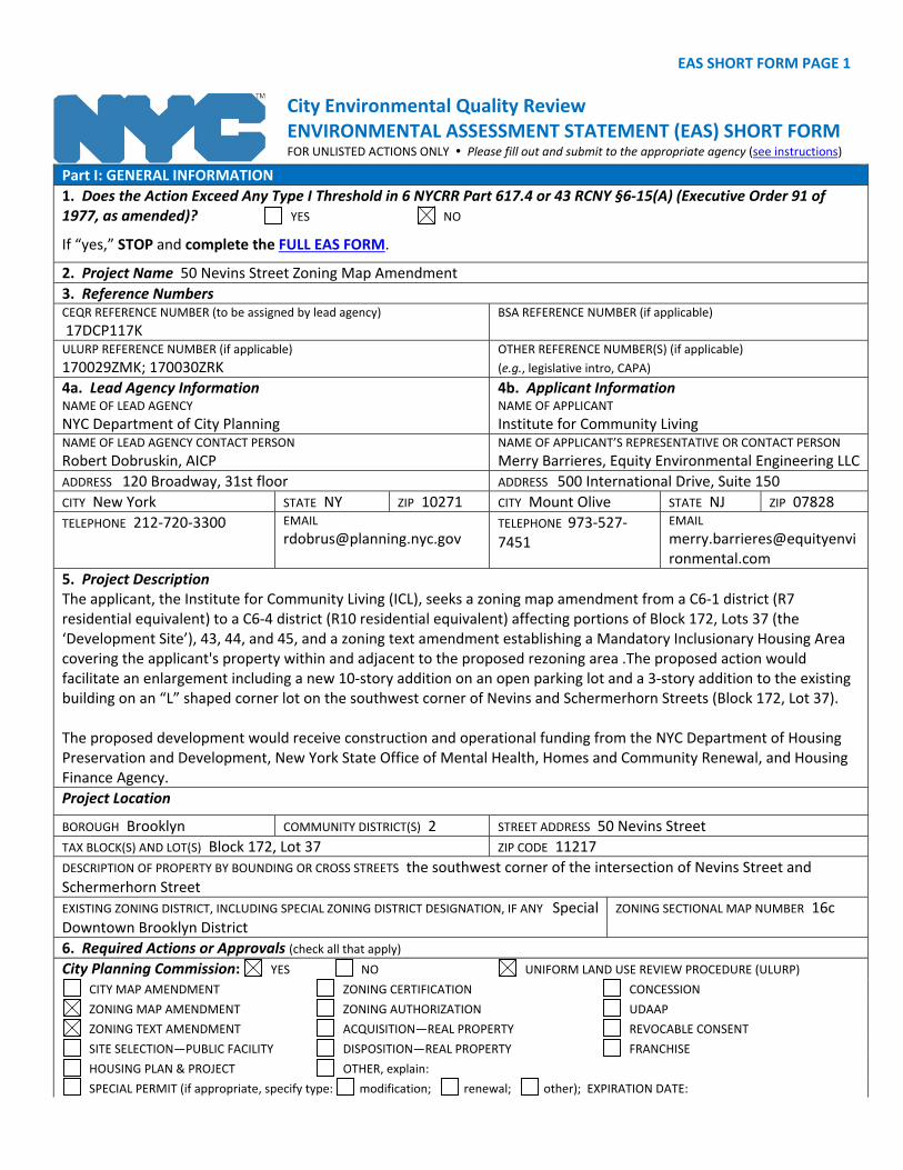
EAS SHORT FORM PAGE 1
City Environmental Quality Review ENVIRONMENTAL ASSESSMENT STATEMENT (EAS) SHORT FORM FOR UNLISTED ACTIONS ONLY Please fill out and submit to the appropriate agency (see instructions)
Part I: GENERAL INFORMATION
1. Does the Action Exceed Any Type I Threshold in 6 NYCRR Part 617.4 or 43 RCNY §6‐15(A) (Executive Order 91 of 1977, as amended)? YES NO
If “yes,” STOP and complete the FULL EAS FORM.
2. Project Name 50 Nevins Street Zoning Map Amendment
3. Reference Numbers CEQR REFERENCE NUMBER (to be assigned by lead agency)
17DCP117K BSA REFERENCE NUMBER (if applicable)
ULURP REFERENCE NUMBER (if applicable)
170029ZMK; 170030ZRK OTHER REFERENCE NUMBER(S) (if applicable)
(e.g., legislative intro, CAPA)
4a. Lead Agency Information NAME OF LEAD AGENCY
NYC Department of City Planning
4b. Applicant Information NAME OF APPLICANT
Institute for Community Living NAME OF LEAD AGENCY CONTACT PERSON
Robert Dobruskin, AICP NAME OF APPLICANT’S REPRESENTATIVE OR CONTACT PERSON
Merry Barrieres, Equity Environmental Engineering LLC
ADDRESS 120 Broadway, 31st floor ADDRESS 500 International Drive, Suite 150
CITY New York STATE NY ZIP 10271 CITY Mount Olive STATE NJ ZIP 07828
TELEPHONE 212‐720‐3300 EMAIL [email protected]
TELEPHONE 973‐527‐7451
5. Project Description The applicant, the Institute for Community Living (ICL), seeks a zoning map amendment from a C6‐1 district (R7 residential equivalent) to a C6‐4 district (R10 residential equivalent) affecting portions of Block 172, Lots 37 (the ‘Development Site’), 43, 44, and 45, and a zoning text amendment establishing a Mandatory Inclusionary Housing Area covering the applicant's property within and adjacent to the proposed rezoning area .The proposed action would facilitate an enlargement including a new 10‐story addition on an open parking lot and a 3‐story addition to the existing building on an “L” shaped corner lot on the southwest corner of Nevins and Schermerhorn Streets (Block 172, Lot 37). The proposed development would receive construction and operational funding from the NYC Department of Housing Preservation and Development, New York State Office of Mental Health, Homes and Community Renewal, and Housing Finance Agency.
Project Location
BOROUGH Brooklyn COMMUNITY DISTRICT(S) 2 STREET ADDRESS 50 Nevins Street
TAX BLOCK(S) AND LOT(S) Block 172, Lot 37 ZIP CODE 11217
DESCRIPTION OF PROPERTY BY BOUNDING OR CROSS STREETS the southwest corner of the intersection of Nevins Street and Schermerhorn Street
EXISTING ZONING DISTRICT, INCLUDING SPECIAL ZONING DISTRICT DESIGNATION, IF ANY Special Downtown Brooklyn District
ZONING SECTIONAL MAP NUMBER 16c
6. Required Actions or Approvals (check all that apply)
City Planning Commission: YES NO UNIFORM LAND USE REVIEW PROCEDURE (ULURP) CITY MAP AMENDMENT ZONING CERTIFICATION CONCESSION ZONING MAP AMENDMENT ZONING AUTHORIZATION UDAAP ZONING TEXT AMENDMENT ACQUISITION—REAL PROPERTY REVOCABLE CONSENT SITE SELECTION—PUBLIC FACILITY DISPOSITION—REAL PROPERTY FRANCHISE HOUSING PLAN & PROJECT OTHER, explain: SPECIAL PERMIT (if appropriate, specify type: modification; renewal; other); EXPIRATION DATE:
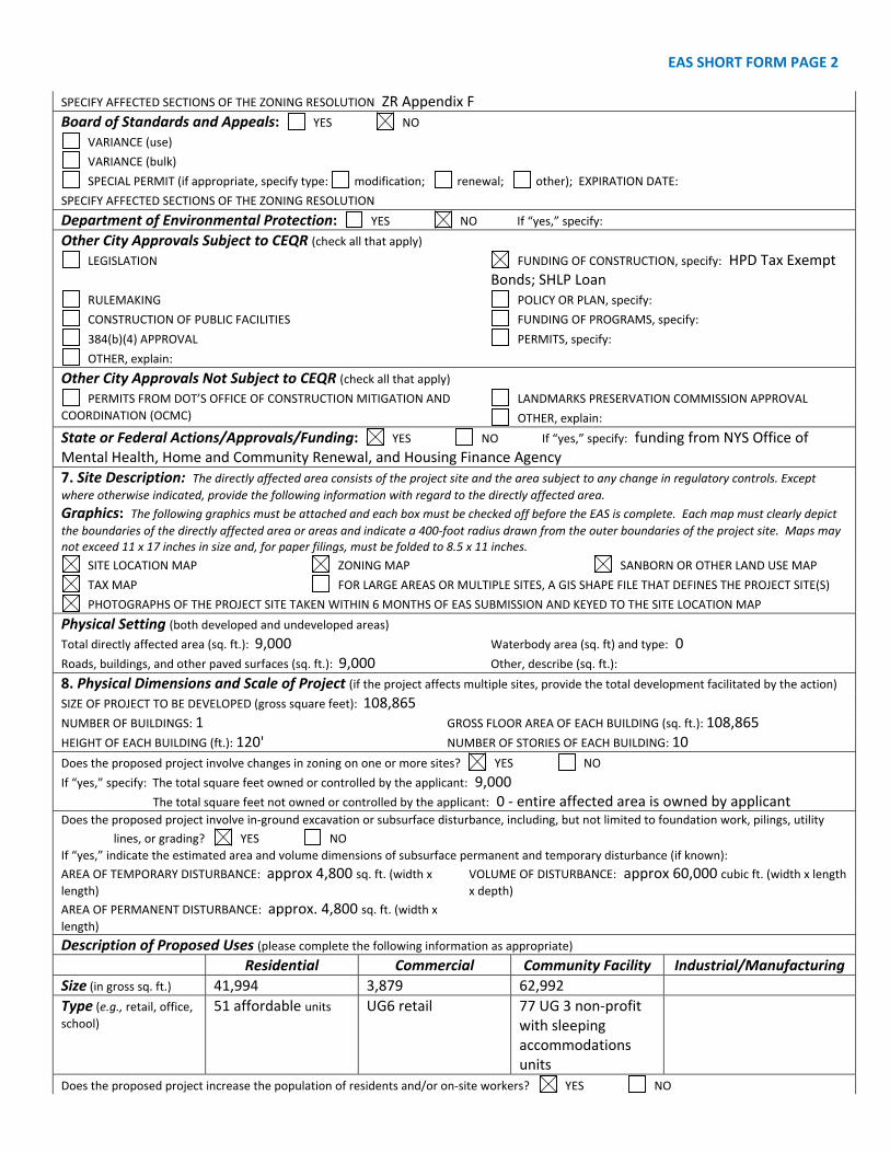
EAS SHORT FORM PAGE 2 SPECIFY AFFECTED SECTIONS OF THE ZONING RESOLUTION ZR Appendix F
Board of Standards and Appeals: YES NO VARIANCE (use) VARIANCE (bulk) SPECIAL PERMIT (if appropriate, specify type: modification; renewal; other); EXPIRATION DATE:
SPECIFY AFFECTED SECTIONS OF THE ZONING RESOLUTION
Department of Environmental Protection: YES NO If “yes,” specify:
Other City Approvals Subject to CEQR (check all that apply) LEGISLATION FUNDING OF CONSTRUCTION, specify: HPD Tax Exempt
Bonds; SHLP Loan RULEMAKING POLICY OR PLAN, specify: CONSTRUCTION OF PUBLIC FACILITIES FUNDING OF PROGRAMS, specify: 384(b)(4) APPROVAL PERMITS, specify: OTHER, explain:
Other City Approvals Not Subject to CEQR (check all that apply) PERMITS FROM DOT’S OFFICE OF CONSTRUCTION MITIGATION AND
COORDINATION (OCMC) LANDMARKS PRESERVATION COMMISSION APPROVAL
OTHER, explain:
State or Federal Actions/Approvals/Funding: YES NO If “yes,” specify: funding from NYS Office of Mental Health, Home and Community Renewal, and Housing Finance Agency
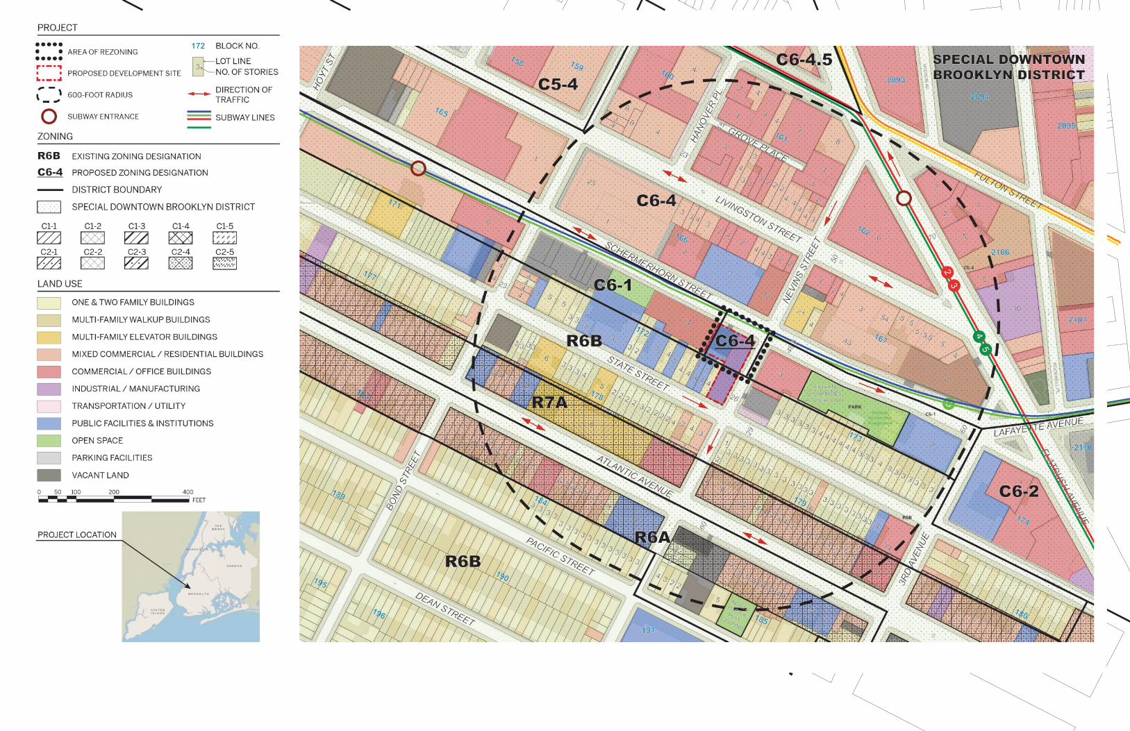
7. Site Description: The directly affected area consists of the project site and the area subject to any change in regulatory controls. Except where otherwise indicated, provide the following information with regard to the directly affected area. Graphics: The following graphics must be attached and each box must be checked off before the EAS is complete. Each map must clearly depict
the boundaries of the directly affected area or areas and indicate a 400‐foot radius drawn from the outer boundaries of the project site. Maps may not exceed 11 x 17 inches in size and, for paper filings, must be folded to 8.5 x 11 inches.
SITE LOCATION MAP ZONING MAP SANBORN OR OTHER LAND USE MAP TAX MAP FOR LARGE AREAS OR MULTIPLE SITES, A GIS SHAPE FILE THAT DEFINES THE PROJECT SITE(S)
PHOTOGRAPHS OF THE PROJECT SITE TAKEN WITHIN 6 MONTHS OF EAS SUBMISSION AND KEYED TO THE SITE LOCATION MAP
Physical Setting (both developed and undeveloped areas) Total directly affected area (sq. ft.): 9,000 Waterbody area (sq. ft) and type: 0 Roads, buildings, and other paved surfaces (sq. ft.): 9,000 Other, describe (sq. ft.):
8. Physical Dimensions and Scale of Project (if the project affects multiple sites, provide the total development facilitated by the action) SIZE OF PROJECT TO BE DEVELOPED (gross square feet): 108,865 NUMBER OF BUILDINGS: 1 GROSS FLOOR AREA OF EACH BUILDING (sq. ft.): 108,865 HEIGHT OF EACH BUILDING (ft.): 120' NUMBER OF STORIES OF EACH BUILDING: 10
Does the proposed project involve changes in zoning on one or more sites? YES NO If “yes,” specify: The total square feet owned or controlled by the applicant: 9,000 The total square feet not owned or controlled by the applicant: 0 ‐ entire affected area is owned by applicant Does the proposed project involve in‐ground excavation or subsurface disturbance, including, but not limited to foundation work, pilings, utility
lines, or grading? YES NO If “yes,” indicate the estimated area and volume dimensions of subsurface permanent and temporary disturbance (if known):
AREA OF TEMPORARY DISTURBANCE: approx 4,800 sq. ft. (width x length)
VOLUME OF DISTURBANCE: approx 60,000 cubic ft. (width x length x depth)
AREA OF PERMANENT DISTURBANCE: approx. 4,800 sq. ft. (width x length)
Description of Proposed Uses (please complete the following information as appropriate) Residential Commercial Community Facility Industrial/Manufacturing
Size (in gross sq. ft.) 41,994 3,879 62,992
Type (e.g., retail, office, school)
51 affordable units UG6 retail 77 UG 3 non‐profit with sleeping accommodations units
Does the proposed project increase the population of residents and/or on‐site workers? YES NO
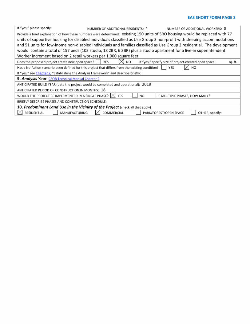
EAS SHORT FORM PAGE 3 If “yes,” please specify: NUMBER OF ADDITIONAL RESIDENTS: 4 NUMBER OF ADDITIONAL WORKERS: 8 Provide a brief explanation of how these numbers were determined: existing 150 units of SRO housing would be replaced with 77 units of supportive housing for disabled individuals classified as Use Group 3 non‐profit with sleeping accommodations and 51 units for low‐inome non‐disabled individuals and families classified as Use Group 2 residential. The development would contain a total of 157 beds (103 studio, 18 2BR, 6 3BR) plus a studio apartment for a live‐in superintendent. Worker increment based on 2 retail workers per 1,000 square feet
Does the proposed project create new open space? YES NO If “yes,” specify size of project‐created open space: sq. ft.
Has a No‐Action scenario been defined for this project that differs from the existing condition? YES NO If “yes,” see Chapter 2, “Establishing the Analysis Framework” and describe briefly:
9. Analysis Year CEQR Technical Manual Chapter 2
ANTICIPATED BUILD YEAR (date the project would be completed and operational): 2019
ANTICIPATED PERIOD OF CONSTRUCTION IN MONTHS: 18
WOULD THE PROJECT BE IMPLEMENTED IN A SINGLE PHASE? YES NO IF MULTIPLE PHASES, HOW MANY?
BRIEFLY DESCRIBE PHASES AND CONSTRUCTION SCHEDULE:
10. Predominant Land Use in the Vicinity of the Project (check all that apply) RESIDENTIAL MANUFACTURING COMMERCIAL PARK/FOREST/OPEN SPACE OTHER, specify:
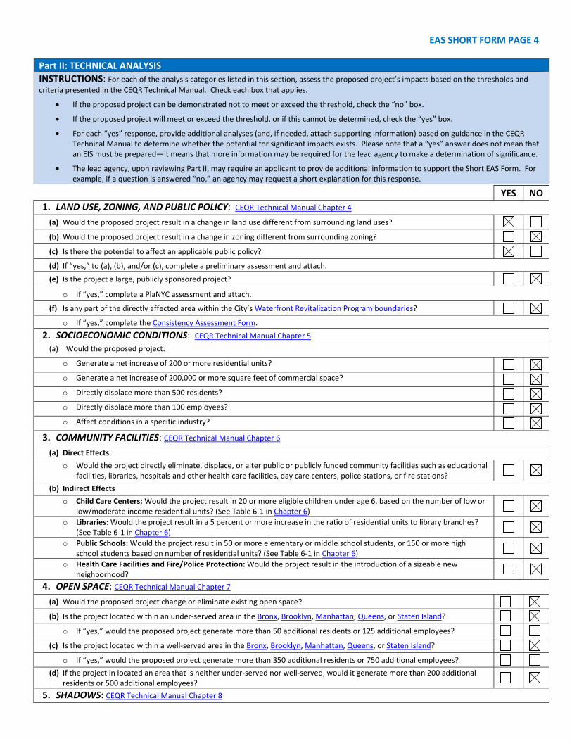
EAS SHORT FORM PAGE 4
Part II: TECHNICAL ANALYSIS
INSTRUCTIONS: For each of the analysis categories listed in this section, assess the proposed project’s impacts based on the thresholds and
criteria presented in the CEQR Technical Manual. Check each box that applies.
If the proposed project can be demonstrated not to meet or exceed the threshold, check the “no” box.
If the proposed project will meet or exceed the threshold, or if this cannot be determined, check the “yes” box.
For each “yes” response, provide additional analyses (and, if needed, attach supporting information) based on guidance in the CEQRTechnical Manual to determine whether the potential for significant impacts exists. Please note that a “yes” answer does not mean thatan EIS must be prepared—it means that more information may be required for the lead agency to make a determination of significance.
The lead agency, upon reviewing Part II, may require an applicant to provide additional information to support the Short EAS Form. Forexample, if a question is answered “no,” an agency may request a short explanation for this response.
YES NO
1. LAND USE, ZONING, AND PUBLIC POLICY: CEQR Technical Manual Chapter 4
(a) Would the proposed project result in a change in land use different from surrounding land uses?
(b) Would the proposed project result in a change in zoning different from surrounding zoning?
(c) Is there the potential to affect an applicable public policy?
(d) If “yes,” to (a), (b), and/or (c), complete a preliminary assessment and attach.
(e) Is the project a large, publicly sponsored project?
o If “yes,” complete a PlaNYC assessment and attach.
(f) Is any part of the directly affected area within the City’s Waterfront Revitalization Program boundaries?
o If “yes,” complete the Consistency Assessment Form.
2. SOCIOECONOMIC CONDITIONS: CEQR Technical Manual Chapter 5
(a) Would the proposed project:
o Generate a net increase of 200 or more residential units?
o Generate a net increase of 200,000 or more square feet of commercial space?
o Directly displace more than 500 residents?
o Directly displace more than 100 employees?
o Affect conditions in a specific industry?
3. COMMUNITY FACILITIES: CEQR Technical Manual Chapter 6
(a) Direct Effects
o Would the project directly eliminate, displace, or alter public or publicly funded community facilities such as educationalfacilities, libraries, hospitals and other health care facilities, day care centers, police stations, or fire stations?
(b) Indirect Effects
o Child Care Centers: Would the project result in 20 or more eligible children under age 6, based on the number of low orlow/moderate income residential units? (See Table 6‐1 in Chapter 6)
o Libraries: Would the project result in a 5 percent or more increase in the ratio of residential units to library branches?(See Table 6‐1 in Chapter 6)
o Public Schools: Would the project result in 50 or more elementary or middle school students, or 150 or more highschool students based on number of residential units? (See Table 6‐1 in Chapter 6)
o Health Care Facilities and Fire/Police Protection: Would the project result in the introduction of a sizeable newneighborhood?
4. OPEN SPACE: CEQR Technical Manual Chapter 7
(a) Would the proposed project change or eliminate existing open space?
(b) Is the project located within an under‐served area in the Bronx, Brooklyn, Manhattan, Queens, or Staten Island?
o If “yes,” would the proposed project generate more than 50 additional residents or 125 additional employees?
(c) Is the project located within a well‐served area in the Bronx, Brooklyn, Manhattan, Queens, or Staten Island?
o If “yes,” would the proposed project generate more than 350 additional residents or 750 additional employees?
(d) If the project in located an area that is neither under‐served nor well‐served, would it generate more than 200 additional residents or 500 additional employees?
5. SHADOWS: CEQR Technical Manual Chapter 8
EAS SHORT FORM PAGE 5
YES NO (a) Would the proposed project result in a net height increase of any structure of 50 feet or more? (b) Would the proposed project result in any increase in structure height and be located adjacent to or across the street from a
sunlight‐sensitive resource?
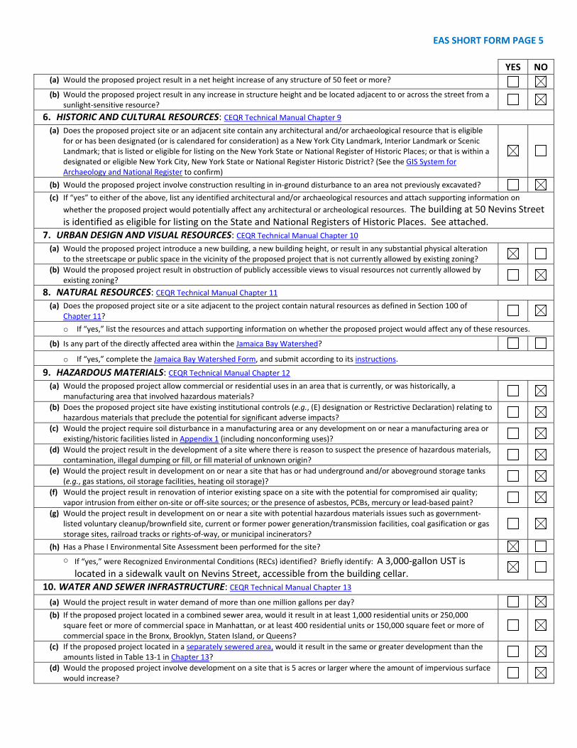
6. HISTORIC AND CULTURAL RESOURCES: CEQR Technical Manual Chapter 9
(a) Does the proposed project site or an adjacent site contain any architectural and/or archaeological resource that is eligible for or has been designated (or is calendared for consideration) as a New York City Landmark, Interior Landmark or Scenic Landmark; that is listed or eligible for listing on the New York State or National Register of Historic Places; or that is within a designated or eligible New York City, New York State or National Register Historic District? (See the GIS System for Archaeology and National Register to confirm)
(b) Would the proposed project involve construction resulting in in‐ground disturbance to an area not previously excavated? (c) If “yes” to either of the above, list any identified architectural and/or archaeological resources and attach supporting information on
whether the proposed project would potentially affect any architectural or archeological resources. The building at 50 Nevins Street is identified as eligible for listing on the State and National Registers of Historic Places. See attached.
7. URBAN DESIGN AND VISUAL RESOURCES: CEQR Technical Manual Chapter 10
(a) Would the proposed project introduce a new building, a new building height, or result in any substantial physical alteration to the streetscape or public space in the vicinity of the proposed project that is not currently allowed by existing zoning?
(b) Would the proposed project result in obstruction of publicly accessible views to visual resources not currently allowed by existing zoning?
8. NATURAL RESOURCES: CEQR Technical Manual Chapter 11
(a) Does the proposed project site or a site adjacent to the project contain natural resources as defined in Section 100 of Chapter 11?
o If “yes,” list the resources and attach supporting information on whether the proposed project would affect any of these resources.
(b) Is any part of the directly affected area within the Jamaica Bay Watershed?
o If “yes,” complete the Jamaica Bay Watershed Form, and submit according to its instructions.
9. HAZARDOUS MATERIALS: CEQR Technical Manual Chapter 12
(a) Would the proposed project allow commercial or residential uses in an area that is currently, or was historically, a manufacturing area that involved hazardous materials?
(b) Does the proposed project site have existing institutional controls (e.g., (E) designation or Restrictive Declaration) relating to hazardous materials that preclude the potential for significant adverse impacts?
(c) Would the project require soil disturbance in a manufacturing area or any development on or near a manufacturing area or existing/historic facilities listed in Appendix 1 (including nonconforming uses)?
(d) Would the project result in the development of a site where there is reason to suspect the presence of hazardous materials, contamination, illegal dumping or fill, or fill material of unknown origin?
(e) Would the project result in development on or near a site that has or had underground and/or aboveground storage tanks (e.g., gas stations, oil storage facilities, heating oil storage)?
(f) Would the project result in renovation of interior existing space on a site with the potential for compromised air quality; vapor intrusion from either on‐site or off‐site sources; or the presence of asbestos, PCBs, mercury or lead‐based paint?
(g) Would the project result in development on or near a site with potential hazardous materials issues such as government‐listed voluntary cleanup/brownfield site, current or former power generation/transmission facilities, coal gasification or gas storage sites, railroad tracks or rights‐of‐way, or municipal incinerators?
(h) Has a Phase I Environmental Site Assessment been performed for the site? o If “yes,” were Recognized Environmental Conditions (RECs) identified? Briefly identify: A 3,000‐gallon UST is
located in a sidewalk vault on Nevins Street, accessible from the building cellar.
10. WATER AND SEWER INFRASTRUCTURE: CEQR Technical Manual Chapter 13
(a) Would the project result in water demand of more than one million gallons per day? (b) If the proposed project located in a combined sewer area, would it result in at least 1,000 residential units or 250,000
square feet or more of commercial space in Manhattan, or at least 400 residential units or 150,000 square feet or more of commercial space in the Bronx, Brooklyn, Staten Island, or Queens?
(c) If the proposed project located in a separately sewered area, would it result in the same or greater development than the amounts listed in Table 13‐1 in Chapter 13?
(d) Would the proposed project involve development on a site that is 5 acres or larger where the amount of impervious surface would increase?
EAS SHORT FORM PAGE 6
YES NO (e) If the project is located within the Jamaica Bay Watershed or in certain specific drainage areas, including Bronx River, Coney
Island Creek, Flushing Bay and Creek, Gowanus Canal, Hutchinson River, Newtown Creek, or Westchester Creek, would it involve development on a site that is 1 acre or larger where the amount of impervious surface would increase?
(f) Would the proposed project be located in an area that is partially sewered or currently unsewered? (g) Is the project proposing an industrial facility or activity that would contribute industrial discharges to a Wastewater
Treatment Plant and/or generate contaminated stormwater in a separate storm sewer system?
(h) Would the project involve construction of a new stormwater outfall that requires federal and/or state permits?
11. SOLID WASTE AND SANITATION SERVICES: CEQR Technical Manual Chapter 14
(a) Using Table 14‐1 in Chapter 14, the project’s projected operational solid waste generation is estimated to be (pounds per week): 3,145
o Would the proposed project have the potential to generate 100,000 pounds (50 tons) or more of solid waste per week? (b) Would the proposed project involve a reduction in capacity at a solid waste management facility used for refuse or
recyclables generated within the City?
12. ENERGY: CEQR Technical Manual Chapter 15
(a) Using energy modeling or Table 15‐1 in Chapter 15, the project’s projected energy use is estimated to be (annual BTUs): 23,805,112.8
(b) Would the proposed project affect the transmission or generation of energy?
13. TRANSPORTATION: CEQR Technical Manual Chapter 16
(a) Would the proposed project exceed any threshold identified in Table 16‐1 in Chapter 16?
(b) If “yes,” conduct the screening analyses, attach appropriate back up data as needed for each stage and answer the following questions:
o Would the proposed project result in 50 or more Passenger Car Equivalents (PCEs) per project peak hour?
If “yes,” would the proposed project result in 50 or more vehicle trips per project peak hour at any given intersection? **It should be noted that the lead agency may require further analysis of intersections of concern even when a project generates fewer than 50 vehicles in the peak hour. See Subsection 313 of Chapter 16 for more information.
o Would the proposed project result in more than 200 subway/rail or bus trips per project peak hour?
If “yes,” would the proposed project result, per project peak hour, in 50 or more bus trips on a single line (in one direction) or 200 subway trips per station or line?
o Would the proposed project result in more than 200 pedestrian trips per project peak hour?
If “yes,” would the proposed project result in more than 200 pedestrian trips per project peak hour to any given pedestrian or transit element, crosswalk, subway stair, or bus stop?
14. AIR QUALITY: CEQR Technical Manual Chapter 17
(a) Mobile Sources: Would the proposed project result in the conditions outlined in Section 210 in Chapter 17?
(b) Stationary Sources: Would the proposed project result in the conditions outlined in Section 220 in Chapter 17? o If “yes,” would the proposed project exceed the thresholds in Figure 17‐3, Stationary Source Screen Graph in Chapter
17? (Attach graph as needed)
(c) Does the proposed project involve multiple buildings on the project site?
(d) Does the proposed project require federal approvals, support, licensing, or permits subject to conformity requirements? (e) Does the proposed project site have existing institutional controls (e.g., (E) designation or Restrictive Declaration) relating to
air quality that preclude the potential for significant adverse impacts?
15. GREENHOUSE GAS EMISSIONS: CEQR Technical Manual Chapter 18
(a) Is the proposed project a city capital project or a power generation plant?
(b) Would the proposed project fundamentally change the City’s solid waste management system?
(c) If “yes” to any of the above, would the project require a GHG emissions assessment based on the guidance in Chapter 18?
16. NOISE: CEQR Technical Manual Chapter 19
(a) Would the proposed project generate or reroute vehicular traffic? (b) Would the proposed project introduce new or additional receptors (see Section 124 in Chapter 19) near heavily trafficked
roadways, within one horizontal mile of an existing or proposed flight path, or within 1,500 feet of an existing or proposed rail line with a direct line of site to that rail line?
(c) Would the proposed project cause a stationary noise source to operate within 1,500 feet of a receptor with a direct line of sight to that receptor or introduce receptors into an area with high ambient stationary noise?
(d) Does the proposed project site have existing institutional controls (e.g., (E) designation or Restrictive Declaration) relating to noise that preclude the potential for significant adverse impacts?
EAS SHORT FORM PAGE 7
YES NO
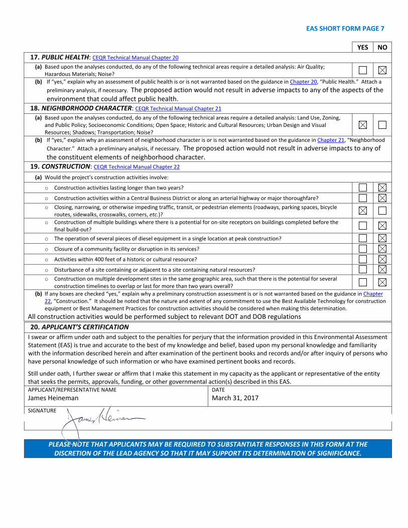
17. PUBLIC HEALTH: CEQR Technical Manual Chapter 20
(a) Based upon the analyses conducted, do any of the following technical areas require a detailed analysis: Air Quality; Hazardous Materials; Noise?
(b) If “yes,” explain why an assessment of public health is or is not warranted based on the guidance in Chapter 20, “Public Health.” Attach a
preliminary analysis, if necessary. The proposed action would not result in adverse impacts to any of the aspects of the environment that could affect public health.
18. NEIGHBORHOOD CHARACTER: CEQR Technical Manual Chapter 21
(a) Based upon the analyses conducted, do any of the following technical areas require a detailed analysis: Land Use, Zoning, and Public Policy; Socioeconomic Conditions; Open Space; Historic and Cultural Resources; Urban Design and Visual Resources; Shadows; Transportation; Noise?
(b) If “yes,” explain why an assessment of neighborhood character is or is not warranted based on the guidance in Chapter 21, “Neighborhood
Character.” Attach a preliminary analysis, if necessary. The proposed action would not result in adverse impacts to any of the constituent elements of neighborhood character.
19. CONSTRUCTION: CEQR Technical Manual Chapter 22
(a) Would the project’s construction activities involve:
o Construction activities lasting longer than two years?
o Construction activities within a Central Business District or along an arterial highway or major thoroughfare?
o Closing, narrowing, or otherwise impeding traffic, transit, or pedestrian elements (roadways, parking spaces, bicycleroutes, sidewalks, crosswalks, corners, etc.)?
o Construction of multiple buildings where there is a potential for on‐site receptors on buildings completed before thefinal build‐out?
o The operation of several pieces of diesel equipment in a single location at peak construction?
o Closure of a community facility or disruption in its services?
o Activities within 400 feet of a historic or cultural resource?
o Disturbance of a site containing or adjacent to a site containing natural resources?
o Construction on multiple development sites in the same geographic area, such that there is the potential for several construction timelines to overlap or last for more than two years overall?
(b) If any boxes are checked “yes,” explain why a preliminary construction assessment is or is not warranted based on the guidance in Chapter 22, “Construction.” It should be noted that the nature and extent of any commitment to use the Best Available Technology for construction equipment or Best Management Practices for construction activities should be considered when making this determination.
All construction activities would be performed subject to relevant DOT and DOB regulations
20. APPLICANT’S CERTIFICATION
I swear or affirm under oath and subject to the penalties for perjury that the information provided in this Environmental Assessment Statement (EAS) is true and accurate to the best of my knowledge and belief, based upon my personal knowledge and familiarity with the information described herein and after examination of the pertinent books and records and/or after inquiry of persons who have personal knowledge of such information or who have examined pertinent books and records.
Still under oath, I further swear or affirm that I make this statement in my capacity as the applicant or representative of the entity that seeks the permits, approvals, funding, or other governmental action(s) described in this EAS. APPLICANT/REPRESENTATIVE NAME
James Heineman DATE
March 31, 2017
SIGNATURE
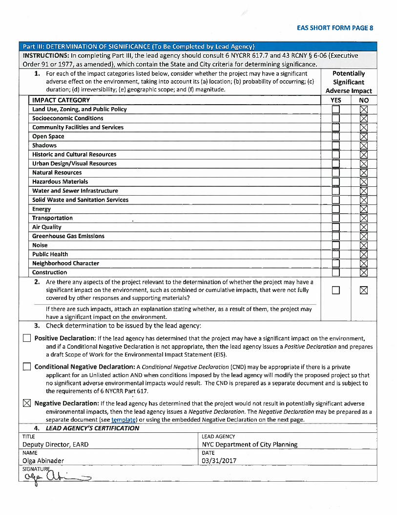
PLEASE NOTE THAT APPLICANTS MAY BE REQUIRED TO SUBSTANTIATE RESPONSES IN THIS FORM AT THE DISCRETION OF THE LEAD AGENCY SO THAT IT MAY SUPPORT ITS DETERMINATION OF SIGNIFICANCE.
PROPOSED PROJECT AREA
Proposed Project Area
ZONING CHANGE MAP
C6-1
C6-1
CURRENT ZONING MAP PROPOSED ZONING MAP - Area being rezoned is outlined with dotted lines.
Changing a C6-1 district to a C6-4 district.
100’
C6-4
R7AR7A
C6-4C6-1
N
PROPOSED MANDATORY INCLUSIONARY HOUSING AREA
C
CC
CC
C
1
172
178
166
171
173
180
NA
91
129
118 80
114
75
100
187.29
66
117.
5
50
139.29
124.12
121.42
42
113.
58
40
41
67.1
103.58
70.1
7
69.2
5
68.7
9
66.4
2
66.8
1
67.5
2
49.5
25
57.67
51+/
-
21
23
44.87
20
41.33
18
9
35+/
-
25.5
19.62
18.6
519.83
17.67
16.8
316
.67
14.67
13.5
8
11.6
7
NA
50
20
NA
68.7
9
21
NA
51+/
-
NA
100
17.67
100
66.8
1
80
50
NA
16.8
3
25
50
100
100
16.8
3
20
139.29
NA
21
100
100
100
66.4
2
NA
67.1
25
100
50
129
100
25118
41
NA
75
21
50
NA
16.6
7
16.8
3
21
67.5
2
14.67
25
NA
19.62
75
25
25
20
100
100
18.6
5
20
NA
100
41.33
100
117.
5
25
NA
100
NA
NA
NA
100
50
21
NA
100
100
50
50
21
100
100
42
100
100
25
NA
25
25.5
55
24
37
10
18
50
7
5
66
64
53
48
1
49
47
62
54
44
46
45
43
68
63
3
2
4
15
13
109
14
R
R
R
R R
R
R
R
STATE ST
SCHERMERHORN STBO
ND S
T
NEVI
NS S
T
REUC
REUC
REUCREUC
NYC Digital Tax Map.
0 10 20 30 405Feet
Legend
StreetsMiscellaneous Text
C Possession HooksBoundary Lines
C Lot Face Possession HooksRegular
UnderwaterTax Lot PolygonCondo NumberTax Block Polygon
Brooklyn Block: 172
Effective Date : 12-09-2008 17:28:51End Date : Current
C6-4
C6-1
DEVELOPMENT SITE
ZONING DISTRICT LINE
AREA OF REZONING
EXISTING ZONING DISTRICT
EXISTING C2-4 DISTRICT
PROPOSED ZONING DISTRICT 180
C6-4
C6-1
R7A
C6-4
100’
172
C6-1
90’
C2-4
R6B
SPECIAL DOWNTOWN BROOKLYN DISTRICT (DB)
BLOCK 172 TAX MAP
Jim
Typewritten Text
Jim
Typewritten Text
AREA LAND USE MAP
2
1
April 18, 2016
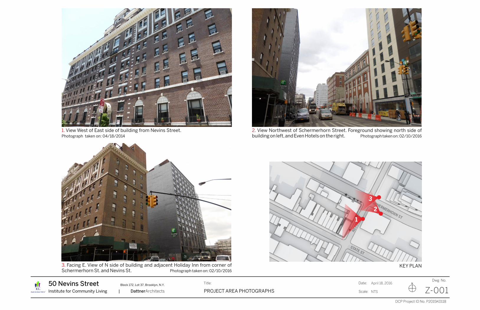
Z-001NTSPROJECT AREA PHOTOGRAPHS
KEY PLAN
1. View West of East side of building from Nevins Street.Photograph taken on: 04/18/2014
2. View Northwest of Schermerhorn Street. Foreground showing north side ofbuilding on left, and Even Hotels on the right. Photograph taken on: 02/10/2016
3. Facing E. View of N side of building and adjacent Holiday Inn from corner ofSchermerhorn St. and Nevins St. Photograph taken on: 02/10/2016
3
Jim
Text Box
April 18, 2016
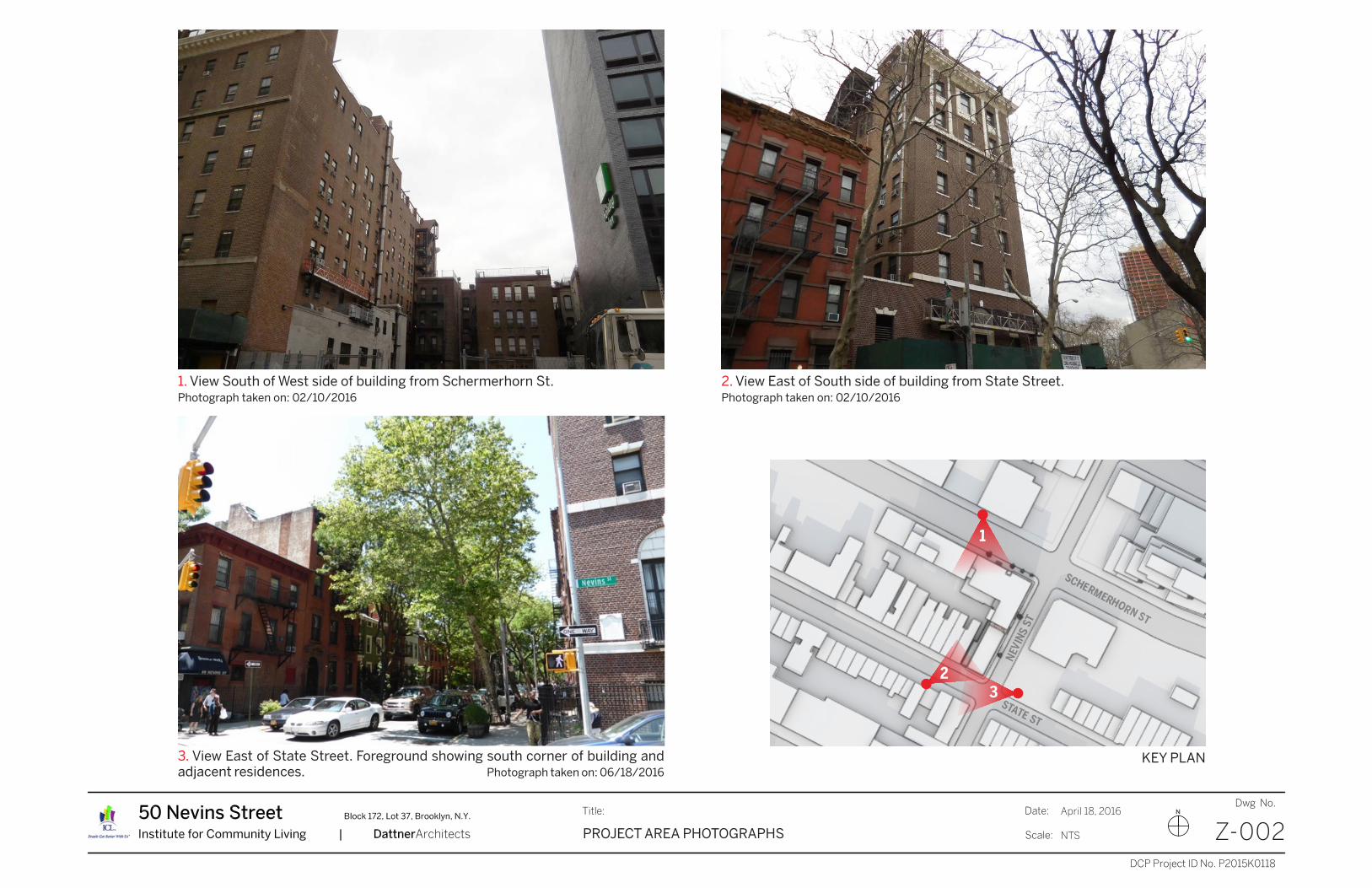
Z-002NTSPROJECT AREA PHOTOGRAPHS
3
1. View South of West side of building from Schermerhorn St.Photograph taken on: 02/10/2016
2. View East of South side of building from State Street.Photograph taken on: 02/10/2016
3. View East of State Street. Foreground showing south corner of building andadjacent residences. Photograph taken on: 06/18/2016
2
1
KEY PLAN
Jim
Text Box
April 18, 2016
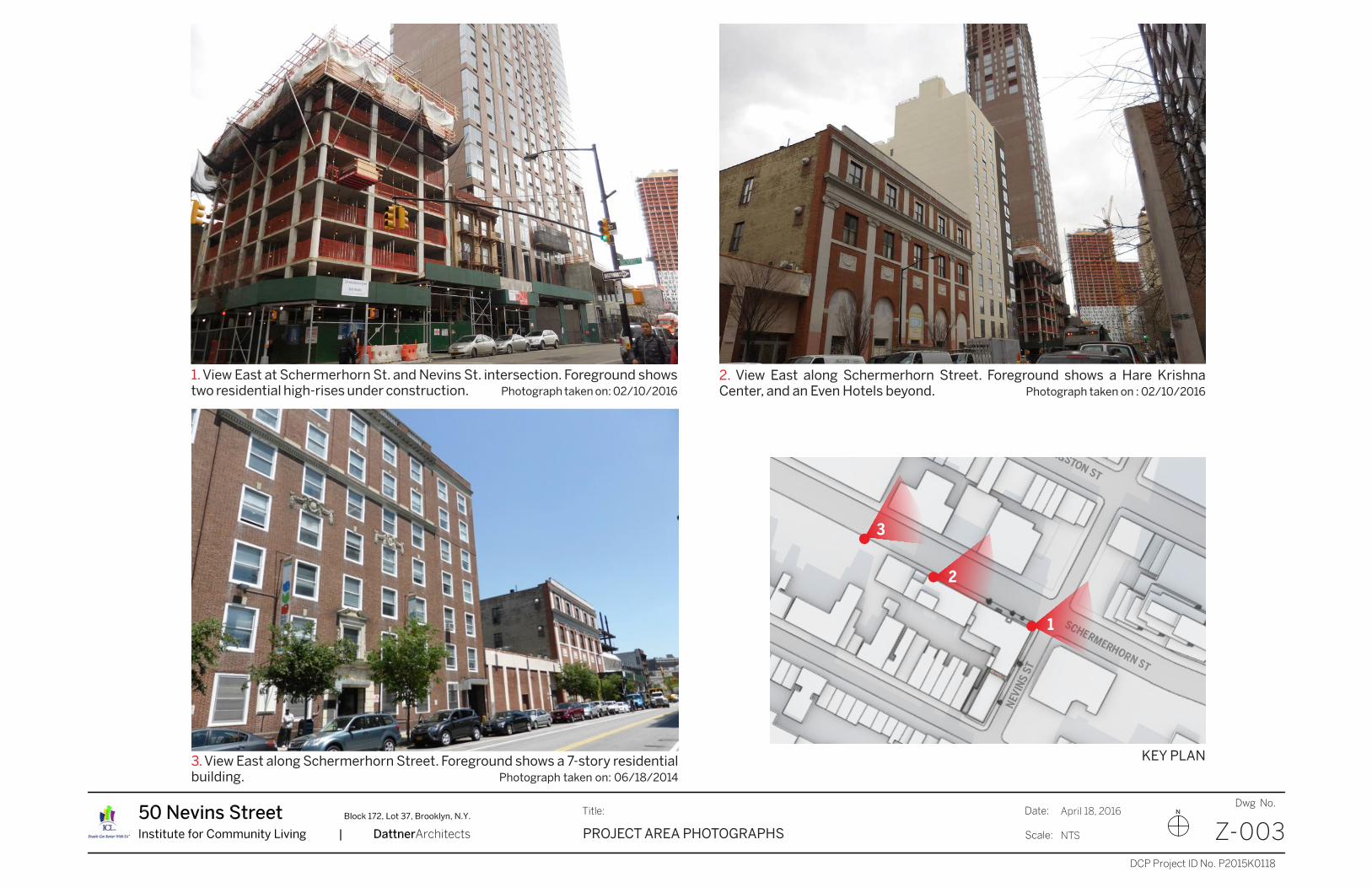
Z-003NTSPROJECT AREA PHOTOGRAPHS
1
1. View East at Schermerhorn St. and Nevins St. intersection. Foreground showstwo residential high-rises under construction. Photograph taken on: 02/10/2016
2
3
3. View East along Schermerhorn Street. Foreground shows a 7-story residentialbuilding. Photograph taken on: 06/18/2014
2. View East along Schermerhorn Street. Foreground shows a Hare KrishnaCenter, and an Even Hotels beyond. Photograph taken on : 02/10/2016
KEY PLAN
Jim
Text Box
April 18, 2016
Z-004NTSPROJECT AREA PHOTOGRAPHS
1
32
KEY PLAN
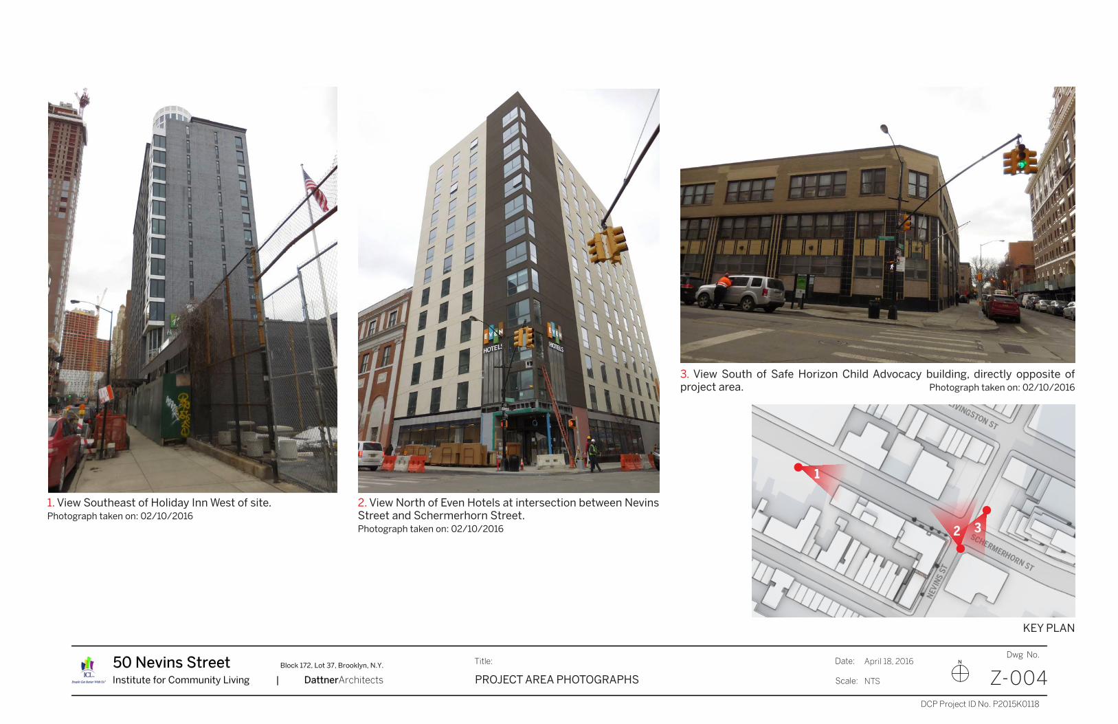
2. View North of Even Hotels at intersection between NevinsStreet and Schermerhorn Street. Photograph taken on: 02/10/2016
1. View Southeast of Holiday Inn West of site.Photograph taken on: 02/10/2016
3. View South of Safe Horizon Child Advocacy building, directly opposite ofproject area. Photograph taken on: 02/10/2016
Jim
Text Box
50 Nevins Street Zoning Map Amendment Environmental Assessment Statement 1
equity environmental engineering March 2017
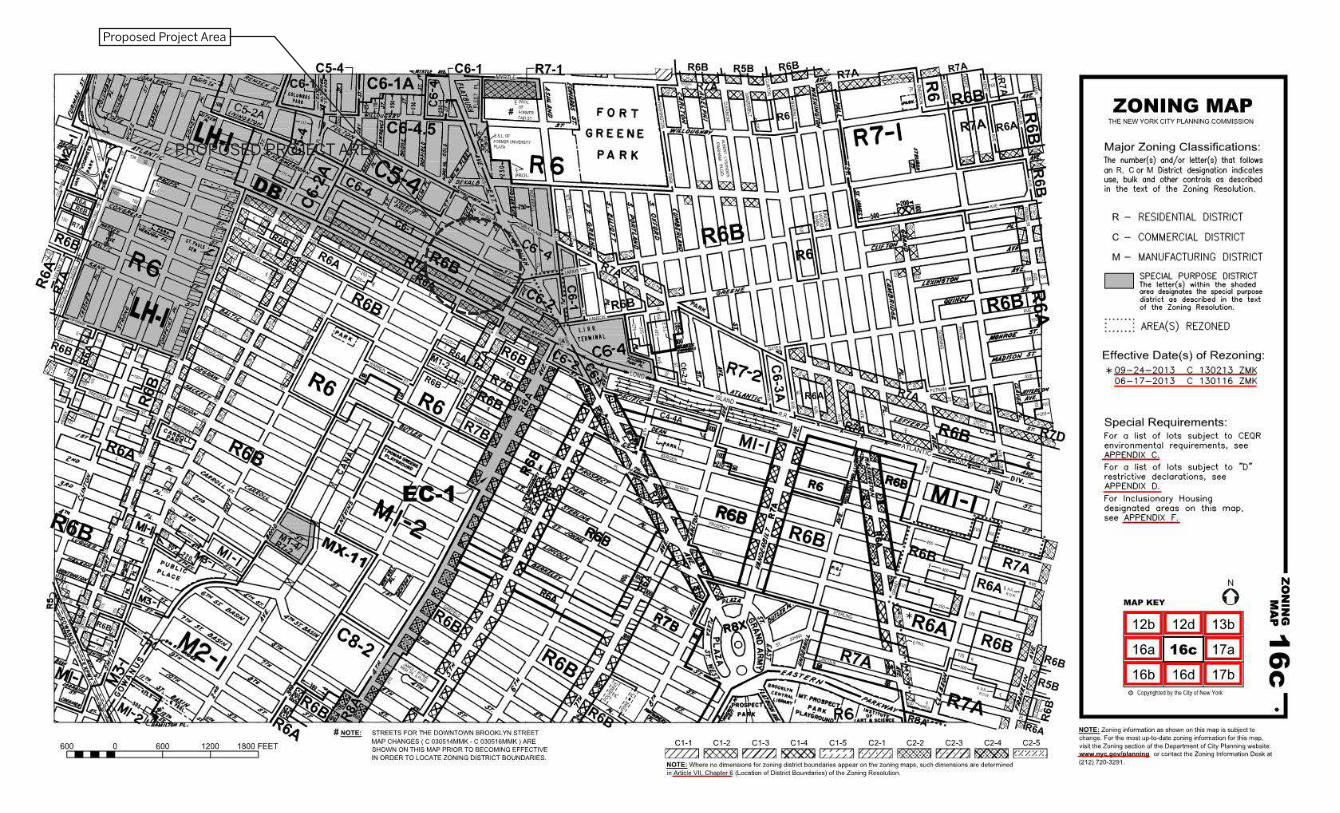
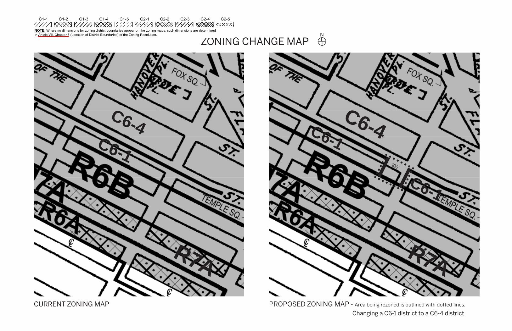
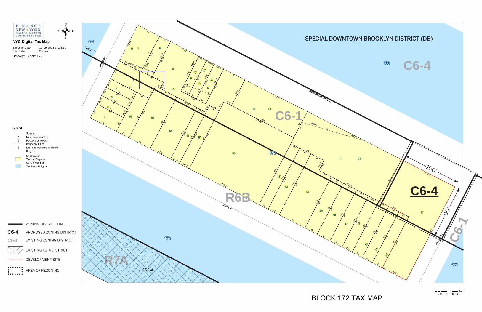
Introduction Introduction The applicant, the Institute for Community Living (ICL), seeks a zoning map amendment from a C6-1 district (R7 residential equivalent) to a C6-4 district (R10 residential equivalent) affecting portions of Block 172, Lots 37 (the ‘Project Site’), 43, 44, and 45 (collectively the “Rezoning Area”) at the southwest corner of the intersection of Nevins Street and Schermerhorn Street, in the Downtown Brooklyn section of Community District 2. The affected area extends to a depth of 100 feet west of Nevins Street and 90 feet south of Schermerhorn Street, with a total area of 9,000 square feet, and is currently within a C6-1 district within the Special Downtown Brooklyn District (SDBD). The actions requested are as follows:
Zoning Map amendment to Sectional 16c to rezone an area to a depth of 100 feet west of Nevins Street and 90 feet south of Schemerhorn Street (Block 172, parts of Lots 37, 43, 44, and 45) from C6-1 to C6-4
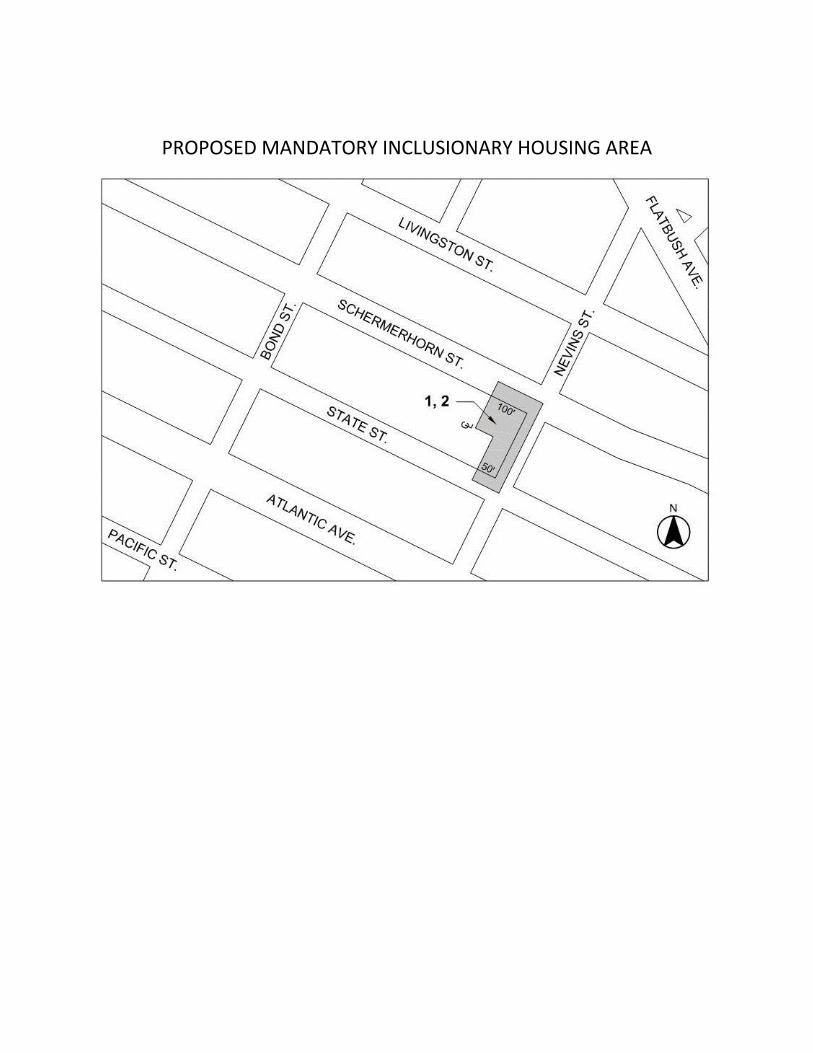
Zoning Text amendment to Appendix F to establish a Mandatory Inclusionary Housing Area (MIHA) on the Project Site mapping Option 1 (25% of residential floor area affordable at 60% of AMI) and Option 2 (30% of residential floor area affordable at 80% of AMI).
In addition to the proposed zoning map and text amendments, the applicant seeks funding from multiple state and city sources for construction and operational funding of the proposed affordable and supportive housing development as described below. The funding action requires environmental assessment under State Environmental Quality Review (SEQR). A coordinated review under City Environmental Quality Review (CEQR) and State Environmental Quality Review (SEQR) will be conducted to address both the zoning actions and state funding action. Potential funding sources for the project include: Construction Financing NYS Housing Finance Agency (HFA) Tax-exempt Bonds NYS Office of Mental Health (OMH) STIP Loan NYC Housing Preservation and Development (HPD) SHLP Loan Low Income Housing Tax Credit NYS Attorney General/NYC Housing Fund (HPD Loan) Deferred Developer's Fee NYS Homes and Community Renewal (HCR) SHOP Loan Permanent Financing HFA Tax-exempt Bonds (not including OMH debt service) HFA Tax-exempt Bonds (including OMH debt service) HPD SHLP Loan LIHTC NYS Attorney General/NYC Housing Fund (HPD Loan) Deferred Developers Fee HCR SHOP Loan
50 Nevins Street Zoning Map Amendment Environmental Assessment Statement 2
equity environmental engineering March 2017
Build Year: Factoring the CPC authorization process and an 18-month construction schedule, the projected build year will be 2019.
Purpose and Need: If approved, the proposed action would facilitate a greater bulk and density for the applicant to enlarge their capacity to provide affordable/supportive housing and a small ground-floor retail component on an underutilized parking lot that they own and to upgrade their existing facility from Single Room Occupancy (SRO) units to conventional apartments. The affected area’s current C6-1 zoning allows community facility development at 6.5 FAR, while the proposed C6-4 district allows 10.0 FAR. In both cases, a 20% increase in FAR is achievable for provision of Mandatory Inclusionary Housing. The proposed development will be integrated with affordable housing and supportive housing units on each floor. By expanding on an existing underutilized portion of the lot, they can extend their ability to provide sorely needed housing and services in a neighborhood with scarce affordable housing and extremely high land costs. Description of Surrounding Area Within the Surrounding Area, there are two distinct neighborhoods, separated by Schermerhorn Street: Boerum Hill, to the south, and downtown Brooklyn, to the north. (The Development Site is located at the southwest corner of the intersection of Nevins Street and Schermerhorn Street and is completely within Boerum Hill.) In the Boerum Hill portion of the Surrounding Area, there is a wide diversity of building types, scales, and uses. State Street, a narrow street, is predominantly residential with two- and three- story brownstones and row-houses, with a few five- and six-story pre-war elevator buildings. Along Atlantic Avenue, a wide street, there are three-, four-, and five-story residential walk-up buildings and a few six- and eight-story elevator residential buildings. Most of the residential buildings along Atlantic Avenue have ground floor retail use including restaurants, boutique retail, clothing, and drug stores. Larger buildings on Atlantic Avenue have wholesale carpet and home furnishing establishments. There are multiple community facility buildings, varying in size, including the Raices Times Plaza Senior Citizen Center, the Recovery House of Worship, and PS 369 Coy. L. Cox School and exterior playground. Directly across Nevins Street from the Project Site is the City of New York’s Safe Horizon for Child Advocacy. There is one public park, Sixteen Sycamores Playground, and three vacant lots used for parking at grade. In the downtown Brooklyn portion of the Surrounding Area, there is also a large diversity of building typologies, scales, and uses. Schermerhorn Street and Livingston Street, both wide streets, are developed predominantly with two- to four-story commercial buildings, some containing one or more residential floors above. Livingston Street is on the fringe of the Fulton Street Mall area, a large and highly trafficked commercial retail corridor. There are some community facility buildings that vary in size, including the Brooklyn Community Service Center and the Hare Krishna Temple, directly across Schermerhorn Street to the north of the Project Site. There is a large five-story municipal parking garage to the west that supports the Fulton Street Mall and other local commercial parking demands.
50 Nevins Street Zoning Map Amendment Environmental Assessment Statement 3
equity environmental engineering March 2017
Description of the Project Site The Project Site is located on the west side of Nevins Street between State and Schermerhorn Streets. The official City Map of the City of New York shows that Nevins Street has a width of 50 feet and State Street has a width of 60 feet; therefore, both are considered narrow streets under the Zoning Resolution (“ZR”). Schermerhorn Street is mapped 80 feet in width and, therefore, is considered a wide street. The Project Site, is an “L” shaped corner lot. A 180-foot x 44 foot portion of the Development Site, along Nevins Street, is improved with the Existing Building, an eight-story building, with a cellar, basement, and a two-story penthouse on the northern portion of the Existing Building. This building houses 150 single-room occupancy units for single adults with mental illness. The Existing Building contains 68,659 gross square feet (58,024 zoning square feet) of floor area. Under the current C6-1 and R6B zoning, the Project Site is permitted up to 64,631 zoning square feet of community facility space. The balance of the Development Site, facing Schermerhorn Street, is an accessory parking lot for facility staff and visitors. Currently, residents live in single rooms that are about 120 square feet (as originally designed for the YWCA), and shared hallway and bathrooms per floor. A congregate dining program that includes three meals per day is offered on the 8th floor. On-site supportive services, located on ground cellar floor, are provided to residents.
50 Nevins Street Zoning Map Amendment Environmental Assessment Statement 4
equity environmental engineering March 2017
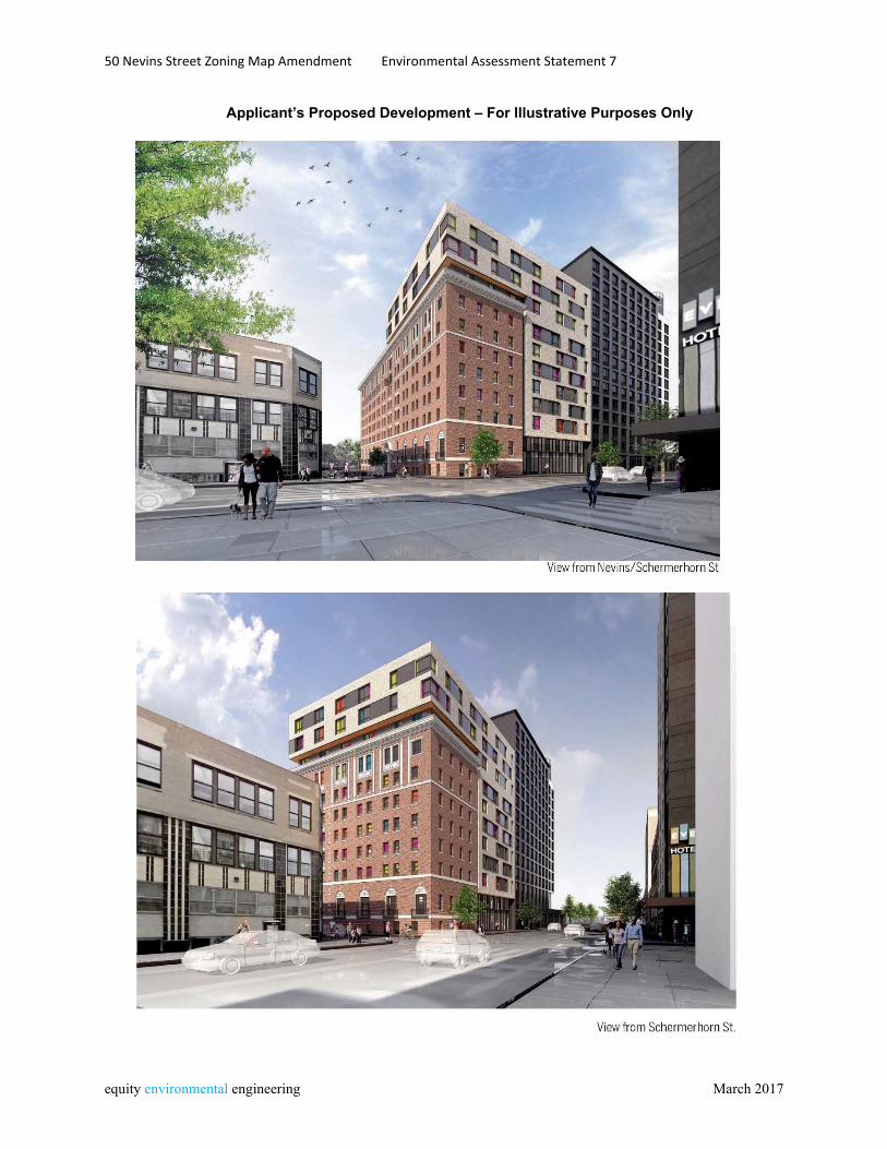
Description of the Proposed Development The proposed action would facilitate the applicant’s intention to reconstruct and enlarge the existing building located on an “L” shaped corner lot on the corner of Nevins and Schermerhorn Streets (Block 172, Lot 37). The enlargement would only occur within the portion of the Project Site within the area proposed for rezoning from C6-1 to C6-4. The renovation and enlargement would convert an existing 150-unit SRO facility with shared hallway bathrooms and congregate dining facilities to a 128-unit facility. Approximately 61% of the tenants will be disabled individuals and 39% of the tenants will be low-income single adults and families who are not disabled, a mix that reflects new modalities for treatment and main-streaming people with mental illness. In addition to the self-contained studio, two-bedroom, and three-bedroom apartments serving disabled individuals and non-disabled individual and families the development would include a ground floor retail component facing on Schermerhorn Street. The enlarged building would contain 108,865 gross square feet of floor area, or 95,012 zoning square feet. There would be 3,879 gross square feet (3,801 zoning square feet) of ground floor commercial space, 41,994 gross square feet (35,572.3 zsf) of residential space and 62,992 gross square feet (55,638.7 zsf) of community facility space. However, the Proposed Development, minus the retail portion, shall be considered Use Group 3 pursuant to the DOB Building Bulletin 2011-003. The 128 housing units could consist of 104 studio units (inclusive of super’s unit), 18 two-bedroom, and 6 three-bedroom. The proposed project would receive funding from multiple state and city sources as identified previously, and would require a zoning map amendment from C6-1 to C6-4, establishment of an MIHA over the Project Site, and state and city funding. The enlargement of the existing building would consist of a horizontal enlargement and a vertical enlargement. The horizontal enlargement would be constructed on the parking lot portion of the Project Site, abutting and integrated with the Existing Building. It would be ten-stories tall (120 feet above grade). The vertical enlargement will be a three- story addition to the northern portion of the Existing Building after removal of the existing partial 8th floor, resulting in that portion of the Existing Building being 10-stories tall, entirely within the proposed C6-4 portion of the lot. The portion of the Existing Building beyond the Affected Area, and within the R6B portion of the site, would not be enlarged. There are no height and setback waivers sought under this Application. The Proposed Building height of 120 feet will be under the maximum height restriction of 140 feet within the Schermerhorn Street Height Limit Area B. The Proposed Development would be a mixed-use building with approximately 128 affordable and supportive housing units inclusive of a superintendent’s unit and 3,879 gross square feet of ground floor retail space. The Rezoning Area includes part of the Project Site (Lot 37) as well as a small 10-foot deep portion of the rear of Lots 43, 44, and 45, which are developed with attached residences. Lots 43, 44, and 45 are owned by the applicant but are used and occupied by a different program than the Project Site, and are not part of the proposed development. The remainder of the applicant’s property on Lot 37, as well as the balance of lots 43, 44, and 45, are within an R6B district that would not be affected by the proposed zoning map action. However the proposed MIHA would be established over the entirety of the Project Site, including that portion that is currently, and would remain, zoned R6B, as well as the 10-foot strip at the rear of lots 43, 44, and 45 that would be rezoned from C6-1 to C6-4. Due to the small portion of Lots 43, 44, and 45 that would be affected, they are not proposed to be redeveloped as a result of the proposed action. The establishment of the MIHA within the R6B-zoned portion of the Project Site would increase the
50 Nevins Street Zoning Map Amendment Environmental Assessment Statement 5
equity environmental engineering March 2017
allowable residential FAR from 2.0 to 2.2 (with provision of MIH). This increase of allowable floor area would reduce the extent of non-compliance within the R6B-zoned portion of the Project Site. Analysis Framework The project as described above represents the applicant’s intended development of the site and will be considered as the With-Action Scenario for analysis in the EAS. However, because the proposed action would also increase allowable residential density and make the Mandatory Inclusionary Housing program applicable in the area proposed for rezoning, a second development scenario will be considered. In this scenario, the open parking lot portion of the applicant’s property would be redeveloped for a residential building subject to the provisions of the proposed C6-4 zoning and the Mandatory Inclusionary Housing program. This scenario is presented in an appendix to this Environmental Assessment Statement. Summary of Environmental Assessment Based on the answers to the questions contained in the attached Environmental Assessment Statement (EAS) Form, the following issues were found to require additional information and analysis:
Land Use, Zoning, and Public Policy: Approval of the proposed action would not create a significant adverse impact. The zoning map amendment would permit greater bulk and density for the applicant to enlarge their capacity of affordable/supportive housing on an underutilized parking lot but would not introduce a new land use to the area. Because building height is capped at 140 feet by the Special Downtown Brooklyn District (SDBD), the zoning map amendment would not allow increased height. The surrounding blocks are within the SDBD with a range of high density mixed use, residential and community facility uses. Continuation and enhancement of the applicant’s affordable and supportive housing program would be consistent with established land use patterns in the area, and with public policy regarding the provision of such housing. Establishment of the MIHA would ensure that any new residential development under the proposed rezoning provides permanent affordable housing as required under Mandatory Inclusionary Housing.
Urban Design and Visual Resources: Approval of the proposed action would not create a significant adverse impact. Building height and would be within the existing range of building heights in the area. Maximum building height would remain capped at 140 feet due to the provisions of the Special Downtown Brooklyn District. The proposed development would not encroach on public streets or sidewalks and no publicly accessible views to significant visual resources in the area would be affected. There would be no negative impact related to Urban Design or Visual Resources.
Historic and Cultural Resources: The Project Site contains a building that has been identified as being eligible for listing on the State and National registers of Historic Places. Development of the applicant’s proposed project would involve State funding through the New York State Office of Mental Health and possible use of Federal Section 8 vouchers and therefore would be subject to review by the State
50 Nevins Street Zoning Map Amendment Environmental Assessment Statement 6
equity environmental engineering March 2017
Historic Preservation Officer (SHPO) under Article 106 of the National Historic Preservation Act. This review process would ensure that no adverse effects on historic and cultural resources would occur. A Memorandum of Agreement (MOA) will be entered into by the applicant, SHPO, and the City of New York stipulating that the existing building be photographically documented prior to alteration, creation of a Historic Interpretive Display, and requiring retention of certain interior and exterior elements and preparation and implementation of a Construction Improvement Plan.
Hazardous Materials: The Project Site was the subject of a Phase I Environmental Site Assessment conducted in November 2015 by GZA GeoEnvironmental, Inc. that determined that a 3,000-gallon located in a sidewalk vault adjacent to the site constitutes a Recognized Environmental Condition (REC). To ensure that further investigation will be performed to determine the need for remediation to ensure there would be no significant adverse impacts from hazardous materials, an [E] designation E-421 would be placed on the Project Site.
Air Quality: A screening analysis conducted using Figure 17-7 of the 2014 CEQR Technical Manual demonstrates that development under the proposed action would not create significant impacts related to HVAC emissions. In addition, the proposed action would not result in significant increases in tailpipe emissions from vehicular traffic and there are no nearby emissions sources that would adversely affect project occupants. To ensure that the proposed project would have no significant adverse impacts on air quality, an [E] designation E-421 specifying fuel type and stack location would be placed on the Project Site.
Noise: The proposed action would allow residential, community facility, and commercial development at greater density than is currently permitted. Based on noise monitoring conducted at the Project Site, in order to ensure an acceptable interior noise environment, the proposed building must provide a closed window condition with a minimum of 31 dBA window/wall attenuation in all facades in order to maintain an interior noise level of 45 dBA. In order to maintain a closed-window condition, an alternate means of ventilation must also be provided. To ensure provision of adequate noise attenuation, an [E] designation E-421 requiring the necessary window-wall attenuation would be placed on the site. With these measures in place, the proposed project would not result in any significant adverse noise impacts.
Neighborhood Character: The proposed action would not create significant impacts to any of the aspects of the environment that contribute to Neighborhood Character such that, alone or cumulatively, they would result in significant adverse impacts to Neighborhood Character.
Public Health: The proposed action would not create significant impacts to any of the aspects of the environment that could affect Public Health such that, alone or cumulatively, they would result in significant adverse impacts to Public Health.
Construction: Construction resulting from the proposed action would not last longer than two years or occur in a Central Business District or on a major arterial. All construction activity would be performed subject to relevant DOT and DOB regulations. No significant adverse impacts would result from the approval of the proposed project.
50 Nevins Street Zoning Map Amendment Environmental Assessment Statement 7
equity environmental engineering March 2017
Applicant’s Proposed Development – For Illustrative Purposes Only
50 Nevins Street Zoning Map Amendment Environmental Assessment Statement 9
equity environmental engineering March 2017
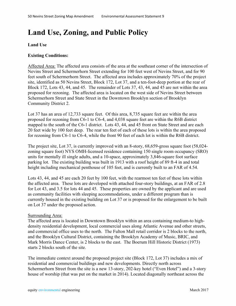
Land Use, Zoning, and Public Policy Land Use Existing Conditions: Affected Area: The affected area consists of the area at the southeast corner of the intersection of Nevins Street and Schermerhorn Street extending for 100 feet west of Nevins Street, and for 90 feet south of Schermerhorn Street. The affected area includes approximately 70% of the project site, identified as 50 Nevins Street, Block 172, Lot 37, and a ten-foot-deep portion at the rear of Block 172, Lots 43, 44, and 45. The remainder of Lots 37, 43, 44, and 45 are not within the area proposed for rezoning. The affected area is located on the west side of Nevins Street between Schermerhorn Street and State Street in the Downtown Brooklyn section of Brooklyn Community District 2. Lot 37 has an area of 12,733 square feet. Of this area, 8,735 square feet are within the area proposed for rezoning from C6-1 to C6-4, and 4,038 square feet are within the R6B district mapped to the south of the C6-1 district. Lots 43, 44, and 45 front on State Street and are each 20 feet wide by 100 feet deep. The rear ten feet of each of these lots is within the area proposed for rezoning from C6-1 to C6-4, while the front 90 feet of each lot is within the R6B district. The project site, Lot 37, is currently improved with an 8-story, 68,659-gross square foot (58,024-zoning square foot) NYS OMH-licensed residence containing 150 single room occupancy (SRO) units for mentally ill single adults, and a 10-space, approximately 3,846-square foot surface parking lot. The existing building was built in 1913 with a roof height of 89 ft-4 in and total height including mechanical penthouse of 105 feet, and is currently built to an FAR of 4.54. Lots 43, 44, and 45 are each 20 feet by 100 feet, with the rearmost ten feet of these lots within the affected area. These lots are developed with attached four-story buildings, at an FAR of 2.8 for Lot 43, and 3.5 for lots 44 and 45. These properties are owned by the applicant and are used as community facilities with sleeping accommodations, under a different program than is currently housed in the existing building on Lot 37 or is proposed for the enlargement to be built on Lot 37 under the proposed action. Surrounding Area: The affected area is located in Downtown Brooklyn within an area containing medium-to high-density residential development, local commercial uses along Atlantic Avenue and other streets, and commercial office uses to the north. The Fulton Mall retail corridor is 2 blocks to the north, and the Brooklyn Cultural District, containing the Brooklyn Academy of Music, BRIC, and Mark Morris Dance Center, is 2 blocks to the east. The Boerum Hill Historic District (1973) starts 2 blocks south of the site. The immediate context around the proposed project site (Block 172, Lot 37) includes a mix of residential and commercial buildings and new developments. Directly north across Schermerhorn Street from the site is a new 13-story, 202-key hotel (“Even Hotel”) and a 3-story house of worship (that was put on the market in 2014). Located diagonally northeast across the
50 Nevins Street Zoning Map Amendment Environmental Assessment Statement 10
equity environmental engineering March 2017
street from the site is a new 21-story residential condominium project and directly east across the street in a 3-story building are the New York City Human Resources Administration Field Office and the Jane Barker Brooklyn Child Advocacy Center, further east ½ a block is a new 53-story mixed-use tower (“The Hub”) and a mapped park. The area south of the site is primarily residential, containing 3-to 5-story row houses and brownstones. Located adjacent, to the west of the site, is a new 15-story, 246-key hotel (“Holiday Inn Brooklyn”). The immediate area is well-served by transit, including access to subway lines at the Nevins Street 2,3,4,5 station two blocks north, the Hoyt Street 2,3 station three blocks west and Atlantic Ave/ Barclays Center B,Q,2,3,4,5-LIRR lines three blocks southeast. The B 25, 26, 38, 52, 63, 65, 41, 45, 67, and 103 bus routes run along Fulton Street, Livingston Street and Atlantic Avenue. No-Action Condition: Affected Area: In order to provide a conservative basis for the assessment of potential environmental impacts resulting from the proposed action, it is assumed that existing conditions on the site would remain under a no-action scenario. The project site is currently improved with an 8-story, 68,659-gross square foot (58,024-zoning square foot) NYS OMH-licensed residence containing 150 single room occupancy (SRO) units for mentally ill single adults, and a 10-space, approximately 3,846-square foot surface parking lot. The existing building was built in 1913 with a height of 89 ft-4 in and is currently built to an FAR of 4.54. The portion of the project site within the affected area has a lot area of 8,735 square feet, and contains 31,486 zoning square feet of floor area, for an FAR of 3.6, which is within the 6.5 FAR permitted for a community facility use within the C6-1 district. The 10-foot deep portion at the rear of zoning lots 43, 44, and 45 included within the Rezoning Area is marginal and it is not expected that any changes to these lots would occur in the No-Action condition. Surrounding Area: In the future without the proposed action, land uses and trends in the surrounding area are expected to maintain their current pattern. Existing trends of new residential and commercial hotel development are likely to continue on suitable sites.
50 Nevins Street Zoning Map Amendment Environmental Assessment Statement 11
equity environmental engineering March 2017
With-Action Condition: Affected Area: Under the proposed action, the applicant would renovate and enlarge the existing building on the Project Site. The enlargement would consist of a three-story vertical enlargement over the existing building (after removal of the existing partial eighth floor) and a new ten-story horizontal enlargement/addition abutting the existing building to be built on the portion of the Project Site currently containing an open parking lot. Additionally, the existing building on the project site would be renovated. The resulting facility would contain 128 affordable and supportive housing units occupying 104,986 gross square feet of floor area and 3,879 gross square feet of ground floor local retail space. The building height would be 120 feet, and the enlarged building would contain a total of 108,865 gross square feet (95,011 zoning square feet or 7.44 FAR). Under the proposed C6-4 district which would be established over the portion of the Project Site currently zoned C6-1 and the MIHA established over the entire Project Site, allowable FAR for a community facility building would be 7.5, and allowable zoning floor area would be 96,234.6 square feet. This project would be funded by NYS Department of Mental Health, which would approve both the building’s physical characteristics as well as the program that the applicant would operate. Other potential funding sources include Housing Finance Agency tax-exempt bonds, HPD supportive housing loan program, low-income housing tax credits, Homes and Community Renewal supportive housing opportunity program, and deferred developer fee. Surrounding Area: In the future without the proposed action, land uses and trends in the surrounding area are expected to maintain their current pattern. Existing trends of new residential and commercial hotel development are likely to continue on suitable sites. Approval of the proposed action and enlargement of the supportive and affordable housing facility occupying the Project Site would not affect development activity in the surrounding area.
50 Nevins Street Zoning Map Amendment Environmental Assessment Statement 12
equity environmental engineering March 2017
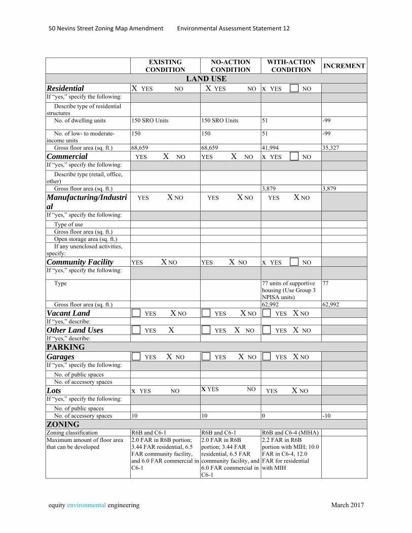
EXISTING
CONDITION NO-ACTION CONDITION
WITH-ACTION CONDITION
INCREMENT
LAND USE Residential X YES NO X YES NO x YES NO If “yes,” specify the following: Describe type of residential structures
No. of dwelling units 150 SRO Units 150 SRO Units 51 -99
No. of low- to moderate-income units
150 150 51 -99
Gross floor area (sq. ft.) 68,659 68,659 41,994 35,327
Commercial YES X NO YES X NO x YES NO If “yes,” specify the following: Describe type (retail, office, other)
Gross floor area (sq. ft.) 3,879 3,879
Manufacturing/Industrial
YES X NO YES X NO YES X NO
If “yes,” specify the following: Type of use Gross floor area (sq. ft.) Open storage area (sq. ft.) If any unenclosed activities, specify:
Community Facility YES X NO YES X NO x YES NO If “yes,” specify the following: Type 77 units of supportive
housing (Use Group 3 NPISA units)
77
Gross floor area (sq. ft.) 62,992 62,992
Vacant Land YES X NO YES X NO YES X NO If “yes,” describe:
Other Land Uses YES X YES X NO YES X NO If “yes,” describe:
PARKING Garages YES X NO YES X NO YES X NO If “yes,” specify the following: No. of public spaces No. of accessory spaces
Lots x YES NO X YES NO YES X NO If “yes,” specify the following: No. of public spaces No. of accessory spaces 10 10 0 -10
ZONING Zoning classification R6B and C6-1 R6B and C6-1 R6B and C6-4 (MIHA) Maximum amount of floor area that can be developed
2.0 FAR in R6B portion; 3.44 FAR residential, 6.5 FAR community facility, and 6.0 FAR commercial in C6-1
2.0 FAR in R6B portion; 3.44 FAR residential, 6.5 FAR community facility, and 6.0 FAR commercial in C6-1
2.2 FAR in R6B portion with MIH; 10.0 FAR in C6-4, 12.0 FAR for residential with MIH

50 Nevins Street Zoning Map Amendment Environmental Assessment Statement 13
equity environmental engineering March 2017
EXISTING CONDITION
NO-ACTION CONDITION
WITH-ACTION CONDITION
INCREMENT
Predominant land use and zoning classifications within land use study area(s) or a 400 ft. radius of proposed project
R6B, C6-1, C6-4, R7A, R6A, C2-4; mix of residential, commercial, community facility
R6B, C6-1, C6-4, R7A, R6A, C2-4; mix of residential, commercial, community facility
R6B, C6-1, C6-4, R7A, R6A, C2-4; mix of residential, commercial, community facility
50 Nevins Street Zoning Map Amendment Environmental Assessment Statement 14
equity environmental engineering March 2017
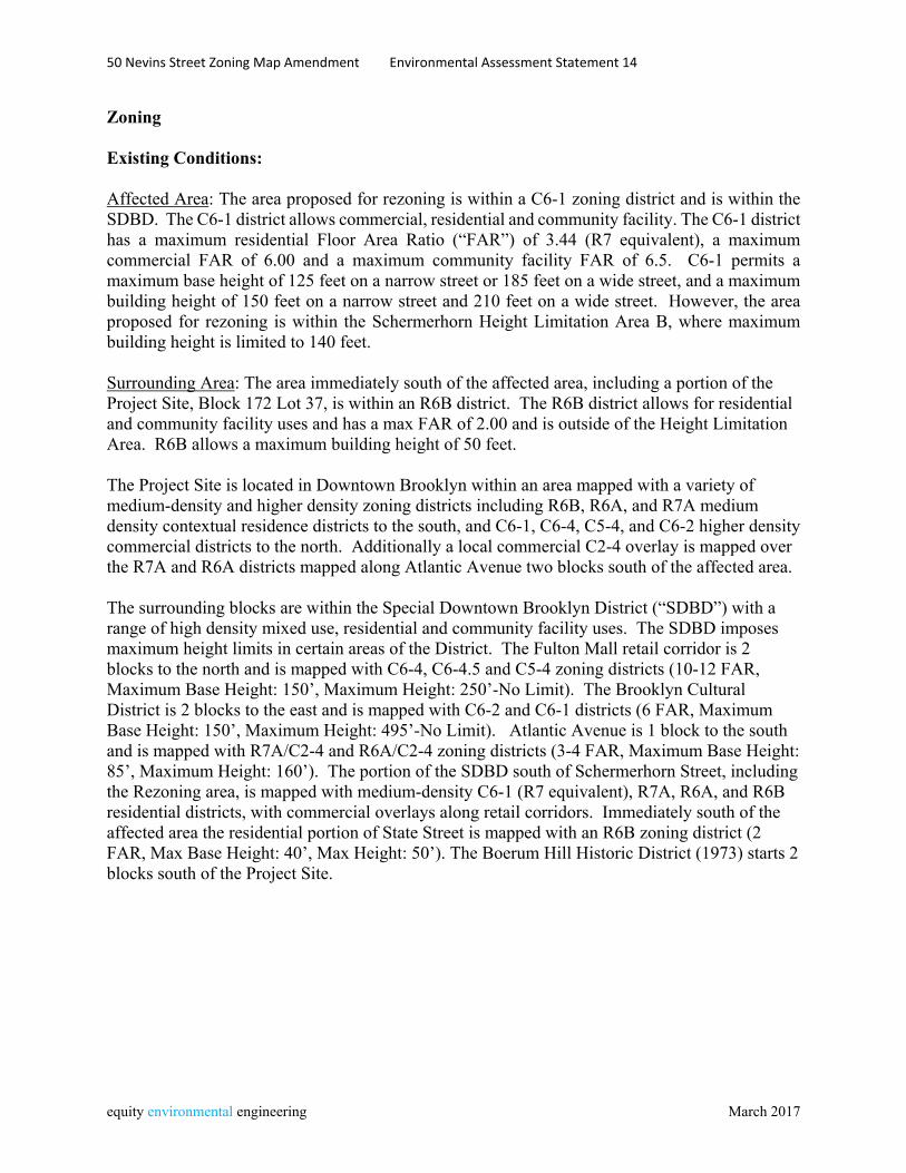
Zoning Existing Conditions: Affected Area: The area proposed for rezoning is within a C6-1 zoning district and is within the SDBD. The C6-1 district allows commercial, residential and community facility. The C6-1 district has a maximum residential Floor Area Ratio (“FAR”) of 3.44 (R7 equivalent), a maximum commercial FAR of 6.00 and a maximum community facility FAR of 6.5. C6-1 permits a maximum base height of 125 feet on a narrow street or 185 feet on a wide street, and a maximum building height of 150 feet on a narrow street and 210 feet on a wide street. However, the area proposed for rezoning is within the Schermerhorn Height Limitation Area B, where maximum building height is limited to 140 feet. Surrounding Area: The area immediately south of the affected area, including a portion of the Project Site, Block 172 Lot 37, is within an R6B district. The R6B district allows for residential and community facility uses and has a max FAR of 2.00 and is outside of the Height Limitation Area. R6B allows a maximum building height of 50 feet. The Project Site is located in Downtown Brooklyn within an area mapped with a variety of medium-density and higher density zoning districts including R6B, R6A, and R7A medium density contextual residence districts to the south, and C6-1, C6-4, C5-4, and C6-2 higher density commercial districts to the north. Additionally a local commercial C2-4 overlay is mapped over the R7A and R6A districts mapped along Atlantic Avenue two blocks south of the affected area. The surrounding blocks are within the Special Downtown Brooklyn District (“SDBD”) with a range of high density mixed use, residential and community facility uses. The SDBD imposes maximum height limits in certain areas of the District. The Fulton Mall retail corridor is 2 blocks to the north and is mapped with C6-4, C6-4.5 and C5-4 zoning districts (10-12 FAR, Maximum Base Height: 150’, Maximum Height: 250’-No Limit). The Brooklyn Cultural District is 2 blocks to the east and is mapped with C6-2 and C6-1 districts (6 FAR, Maximum Base Height: 150’, Maximum Height: 495’-No Limit). Atlantic Avenue is 1 block to the south and is mapped with R7A/C2-4 and R6A/C2-4 zoning districts (3-4 FAR, Maximum Base Height: 85’, Maximum Height: 160’). The portion of the SDBD south of Schermerhorn Street, including the Rezoning area, is mapped with medium-density C6-1 (R7 equivalent), R7A, R6A, and R6B residential districts, with commercial overlays along retail corridors. Immediately south of the affected area the residential portion of State Street is mapped with an R6B zoning district (2 FAR, Max Base Height: 40’, Max Height: 50’). The Boerum Hill Historic District (1973) starts 2 blocks south of the Project Site.
50 Nevins Street Zoning Map Amendment Environmental Assessment Statement 15
equity environmental engineering March 2017
No-Action Condition:
No changes to zoning within the affected area or surrounding area are anticipated in the future without the proposed action.
With-Action Conditions:
The proposed action would result in the rezoning of the affected area from C6-1 to C6-4, and the establishment of a Mandatory Inclusionary Housing Area (MIHA) affecting the Project Site.1 Under the recently approved Mandatory Inclusionary Housing (MIH) text amendment, C6-4 allows residential development at an FAR of 12.0 (R10 equivalent). Under MIH, developers would need to select one of the following options:
- Option One: 25 percent of the residential floor area shall be provided as housing affordable to households at an average of 60 percent of the Income Index (AMI), with no unit targeted at a level exceeding 130 percent of AMI. ($46,620 per year for a family of three), including 10% of residential floor area affordable to households at an average of 40 percent of AMI, or - Option Two: 30 percent of the residential floor area shall be provided as housing affordable to households at an average of 80 percent of the Income Index (AMI), with no unit targeted at a level exceeding 130 percent of AMI. ($62,150 per year for a family of three). In addition to one or both of the options above, the City Council and the City Planning Commission may determine that either the Deep Affordability Option or the Workforce Option or both would also apply to the Project Area. The project sponsor does not intend to build a residential development within the affected area. However, both Options One and Two would be allocated to the Mandatory Inclusionary Housing Area to be established over the Project Site. The proposed C6-4 district would allow commercial or community facility development at 10.0 FAR. Other than FAR, the bulk controls of the proposed C6-4 district are the same as those of the existing C6-1 district. These bulk controls permit a maximum base height of 125 feet for a narrow street and 185 feet for a wide street and a maximum building height of 155 feet and a maximum building height of 230 feet, or 235 feet is a qualifying ground floor is provided.
1 The proposed action includes a zoning text amendment to establish an MIHA that covers the entire Project Site. Within this MIHA, all developments, enlargements and conversions that provide residential floor area will have to comply with the MIH program requirements of either option one or two, described below: • Option One: 25 percent of the residential floor area shall be provided as housing affordable to households at an average of 60 percent of the Income Index (AMI), with no unit targeted at a level exceeding 130 percent of AMI. As part of the 25 percent set-aside, 10 percent of residential floor area shall be provided for households at 40 percent AMI. • Option Two: 30 percent of the residential floor area shall be provided as housing affordable to households at an average of 80 percent of the Income Index (AMI), with no unit targeted at a level exceeding 130 percent of AMI.
50 Nevins Street Zoning Map Amendment Environmental Assessment Statement 16
equity environmental engineering March 2017
However, the zoning lot would still be subject to the Schermerhorn Height Limitation Area B, where maximum building height is 140 ft. The establishment of an MIHA affecting the portion of the Project Site zoned R6B would change allowable residential floor area to 2.2, with the provision of MIH residential space. For both the existing C6-1 district and the proposed C6-4 district, accessory parking is required for 20% of UG 2 residential (as modified within the Special Downtown Brooklyn District per ZR 101-50). Because the Project Site is within the Transit Zone, no accessory parking is required for affordable housing built pursuant to MIH, or for Income Restricted Housing. Both the existing C6-1 district and the proposed C6-4 district have no parking requirement for commercial uses including general retail space and commercial hotels, or for Use Group 3 community facilities with sleeping accommodations. Public Policy Existing Conditions Public policy for land use in the area is established by the area’s zoning, as described above. NYC zoning includes the ability to establish Mandatory Inclusionary Housing Areas where provision of meaningful amounts of permanent affordable housing is required in order to achieve maximum allowable residential floor area. Relevant public policy statements regarding the City’s goals for affordable housing are spelled out in Housing New York: A Five Borough, Ten Year Plan and One New York: The Plan for a Strong and Just City. This public policy includes a commitment to increasing housing opportunities for all income levels and supportive needs, throughout the City. No-Action Conditions Under the no-action condition, the existing building occupying the project site could not be enlarged. It would remain an outmoded SRO building with shared hallway, bathroom, and dining facilities. No changes to public policy would occur. With-Action Conditions The proposed zoning map amendment would extend a higher-density C6-4 zoning district that is mapped to the north of the affected area, and the proposed zoning text amendment would establish the affected area as a Mandatory Inclusionary Housing Area, ensuring that any new residential development includes a meaningful amount of permanently affordable housing. The proposed action would allow the project sponsor to modernize and upgrade their facility serving a vulnerable population in an area with commercial and community facility services as well as transportation infrastructure. Creation of the MIHA would ensure that any new residential development would provide a significant amount of permanent affordable housing, consistent with city policy. The proposed action would be supportive of public policy goals calling for the provision of affordable and supportive residential uses in areas where the development would be integrated into an established community and building occupants would have access to surrounding services. No significant adverse impacts are anticipated for public policy.
50 Nevins Street Zoning Map Amendment Environmental Assessment Statement 17
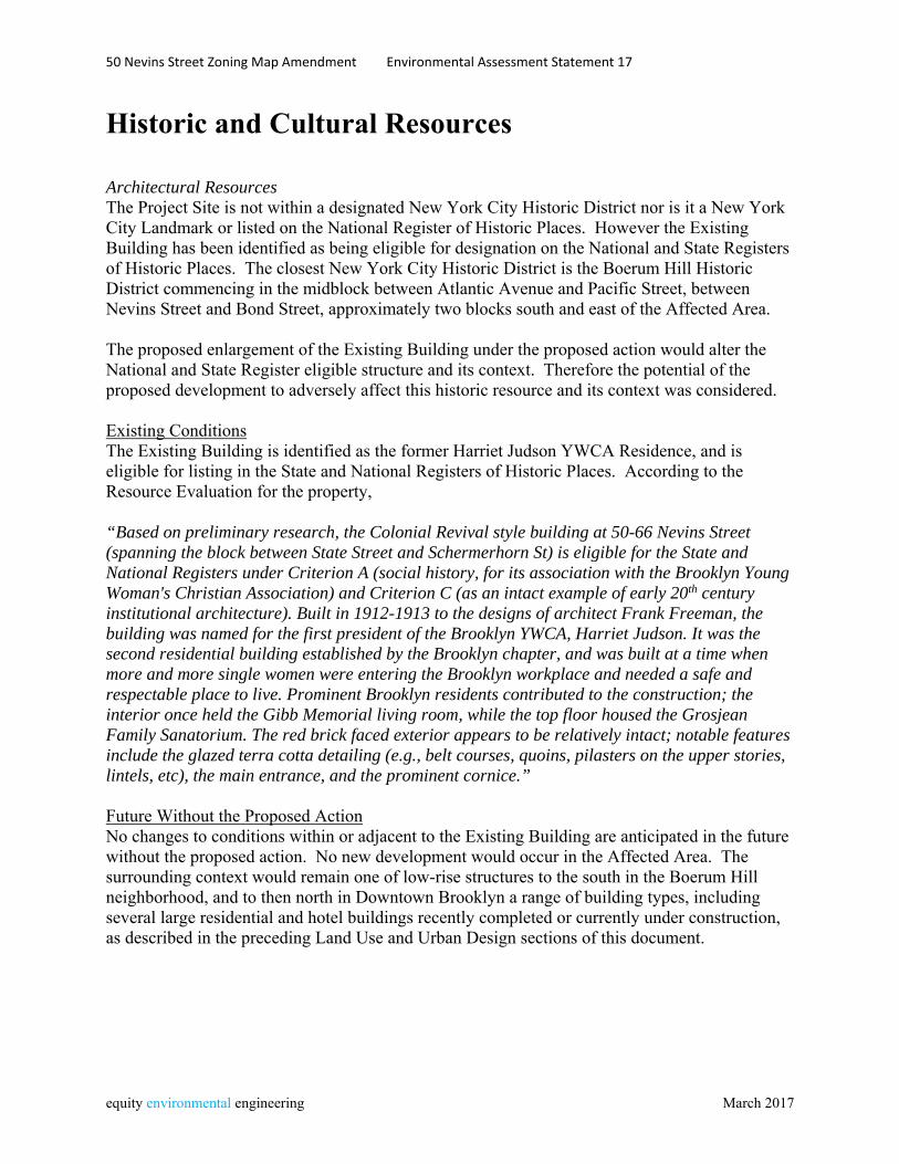
equity environmental engineering March 2017
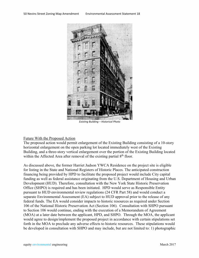
Historic and Cultural Resources Architectural Resources The Project Site is not within a designated New York City Historic District nor is it a New York City Landmark or listed on the National Register of Historic Places. However the Existing Building has been identified as being eligible for designation on the National and State Registers of Historic Places. The closest New York City Historic District is the Boerum Hill Historic District commencing in the midblock between Atlantic Avenue and Pacific Street, between Nevins Street and Bond Street, approximately two blocks south and east of the Affected Area. The proposed enlargement of the Existing Building under the proposed action would alter the National and State Register eligible structure and its context. Therefore the potential of the proposed development to adversely affect this historic resource and its context was considered. Existing Conditions The Existing Building is identified as the former Harriet Judson YWCA Residence, and is eligible for listing in the State and National Registers of Historic Places. According to the Resource Evaluation for the property, “Based on preliminary research, the Colonial Revival style building at 50-66 Nevins Street (spanning the block between State Street and Schermerhorn St) is eligible for the State and National Registers under Criterion A (social history, for its association with the Brooklyn Young Woman's Christian Association) and Criterion C (as an intact example of early 20th century institutional architecture). Built in 1912-1913 to the designs of architect Frank Freeman, the building was named for the first president of the Brooklyn YWCA, Harriet Judson. It was the second residential building established by the Brooklyn chapter, and was built at a time when more and more single women were entering the Brooklyn workplace and needed a safe and respectable place to live. Prominent Brooklyn residents contributed to the construction; the interior once held the Gibb Memorial living room, while the top floor housed the Grosjean Family Sanatorium. The red brick faced exterior appears to be relatively intact; notable features include the glazed terra cotta detailing (e.g., belt courses, quoins, pilasters on the upper stories, lintels, etc), the main entrance, and the prominent cornice.” Future Without the Proposed Action No changes to conditions within or adjacent to the Existing Building are anticipated in the future without the proposed action. No new development would occur in the Affected Area. The surrounding context would remain one of low-rise structures to the south in the Boerum Hill neighborhood, and to then north in Downtown Brooklyn a range of building types, including several large residential and hotel buildings recently completed or currently under construction, as described in the preceding Land Use and Urban Design sections of this document.
50 Nevins Street Zoning Map Amendment Environmental Assessment Statement 18
equity environmental engineering March 2017
Existing Building – Historical Photo
Future With the Proposed Action The proposed action would permit enlargement of the Existing Building consisting of a 10-story horizontal enlargement on the open parking lot located immediately west of the Existing Building, and a three-story vertical enlargement over the portion of the Existing Building located within the Affected Area after removal of the existing partial 8th floor. As discussed above, the former Harriet Judson YWCA Residence on the project site is eligible for listing in the State and National Registers of Historic Places. The anticipated construction financing being provided by HPD to facilitate the proposed project would include City capital funding as well as federal assistance originating from the U.S. Department of Housing and Urban Development (HUD). Therefore, consultation with the New York State Historic Preservation Office (SHPO) is required and has been initiated. HPD would serve as Responsible Entity pursuant to HUD environmental review regulations (24 CFR Part 58) and would conduct a separate Environmental Assessment (EA) subject to HUD approval prior to the release of any federal funds. The EA would consider impacts to historic resources as required under Section 106 of the National Historic Preservation Act (Section 106). Consultation with SHPO pursuant to Section 106 would continue, ending with the execution of a Memorandum of Agreement (MOA) at a later date between the applicant, HPD, and SHPO. Through the MOA, the applicant would agree to design/implement the proposed project in accordance with certain stipulations set forth in the MOA to preclude any adverse effects to historic resources. These stipulations would be developed in consultation with SHPO and may include, but are not limited to: 1) photographic
50 Nevins Street Zoning Map Amendment Environmental Assessment Statement 19
equity environmental engineering March 2017
documentation of building conditions prior to the proposed disturbance; 2) salvage of certain building components or decorative elements to be incorporated into a historical interpretive display on-site within the new building, and 3) continued consultation with SHPO as the new building is designed, as per the SHPO letter of 1/10/17 included as an appendix to the EAS. Compliance with the MOA would also be enforced through the applicable funding agreements between the applicant and HPD. Continuing consultation with SHPO under Section 106 and the implementation of the requirements set forth in the MOA as part of the proposed project would ensure no significant adverse impacts to historic resources would result from the proposed actions.
50 Nevins Street Zoning Map Amendment Environmental Assessment Statement 20
equity environmental engineering March 2017
Urban Design and Visual Resources Pursuant to the 2014 CEQR Technical Manual, an assessment of Urban Design may be warranted when a proposed action may affect one or more of the elements that contribute to the pedestrian experience of an area, specifically the arrangement, appearance, and functionality of the built environment. The applicant proposes to renovate and enlarge the existing eight-story structure occupying the Project Site. This enlargement would consist of the three-story vertical enlargement over the existing building (after removal of the existing partial 8th floor) and a new ten-story structure to be built on a portion of the Project Site currently occupied by an open parking lot. Total building height would be 120 feet for the vertical enlargement over the existing building and for the new ten-story structure. The portion of the existing building that is beyond the affected area and would remain zoned R6B would not be enlarged and would remain an eight-story, 85’ structure. The proposed enlargement would be within the height limits of the Schermerhorn Height Limitation Area B. Existing Conditions Project Site The Project Site is located in Downtown Brooklyn within an area mapped with a variety of medium-density and higher-density commercial and residential districts. The Project Site is located on the west side of Nevins Street between State and Schermerhorn Streets. The official City Map of the City of New York shows that Nevins Street has a width of 50 feet and State Street has a width of 60 feet; therefore, both are considered narrow streets under the Zoning Resolution (“ZR”). Schermerhorn Street is mapped 80 feet in width and, therefore, is considered a wide street. The Project Site is an “L” shaped corner lot with 103.58 feet of frontage on the south side of Schermerhorn Street and 180 feet of frontage on the west side of Nevins Street. A 180-foot x 44 foot portion of the Project Site, along Nevins Street, is improved with the Existing Building, a 7-story building, with a cellar, basement, and a 2-story penthouse on the northern portion of the Existing Building. A 59-foot x 80-foot portion of the Project Site, along Schermerhorn Street, is an accessory parking lot for facility staff and visitors. There are two non-conforming aspects of the Existing Building within the R6B district portion of the Project Site. At 85 feet tall, the Existing Buildings rises without setbacks and exceeds the R6B district’s maximum building height permitted of 50 feet. The portion of the existing building within the R6B district contains 26,538 zsf of floor area, resulting in an FAR of 6.57 for the portion of the Project Site within the R6B district, which exceeds the allowable 2.0 FAR in R6B. However, the entire Project Site is built to an FAR of 4.54, which is within the applicable Adjusted Floor Area Ratio (“Adjusted FAR”) of 5.08 FAR for the entire Project Site. The balance of the Development Site, facing Schermerhorn Street, is an accessory parking lot for facility staff and visitors.
50 Nevins Street Zoning Map Amendment Environmental Assessment Statement 21
equity environmental engineering March 2017
A small portion of the area proposed for rezoning consists of the rearmost ten feet of three lots fronting on State Street and developed with four-story attached buildings. The Project Site, a corner lot, is located within a C6-1 District and R6B Districts; the C6-1 District portion is conterminous with the Schermerhorn Street Height Limitation Area “B” (“SHLA”). The C6-1 District permits residential, community facility, and commercial FAR as follows: 3.44 , 6.50, and 6.00 FAR. The SHLA “B” modifies the underlying height and setback regulations, imposing a maximum building height of 140 feet. The R6B District permits both residential and community facility at 2.00 FAR; commercial uses are not permitted. The R6B is not located within the SHLA “B” and therefore the underlying maximum building height of 50 feet remains. Street-level renderings of existing conditions at the project site are included at the end of this section. Surrounding Area The area’s street system is regular and rectilinear, with the exception of Flatbush Avenue which runs diagonally from southeast to northwest. Most streets in the area are one-way. Atlantic Avenue, located one and a half blocks south of the Project Site, is a major east-west street carrying two moving lanes in each direction. Flatbush Avenue, located two blocks to the east, runs diagonally through the area. It also carries two moving lanes in each direction in this area. The surrounding blocks are within the Special Downtown Brooklyn District (“SDBD”) with a range of high density mixed use, residential and community facility uses. The area to the north of the Project Site, north of Schermerhorn Street, are part of the Downtown Brooklyn neighborhood, while the area to the south of Schermerhorn Street, including the affected area, is within the Boerum Hill neighborhood. In the Boerum Hill portion of the Surrounding Area, there is a wide diversity of building typologies, scales, and uses. State Street, a narrow street, is predominantly residential with two- and three- story brownstones and row-houses, with a few five- and six-story pre-war elevator buildings. Along Atlantic Avenue, a wide street, there are three-, four-, and five-story residential walk-up buildings and a few six- and eight-story elevator residential buildings. Most of the residential buildings along Atlantic Avenue have ground floor retail use including restaurants, boutique retail, clothing, and drug stores. Larger existing buildings have wholesale carpet and home furnishing establishments. In the Downtown Brooklyn portion of the Surrounding Area, there is also a large diversity of building typologies, scales, and uses. Schermerhorn Street and Livingston Street, both wide streets, are improved predominantly with two- to four-story commercial buildings, some contain one or more residential floors above. Livingston Street is on the fringe of the Fulton Street Mall area, a large and highly trafficked commercial retail corridor. There has been significant higher-density commercial and residential development in the Downtown Brooklyn portion of the Surrounding Area. 300 Schermerhorn Street (Block 172, Lot 24), adjacent to the west of the Project Site, is currently under construction, and will be a 14-story (140 feet tall), 245 key hotel.
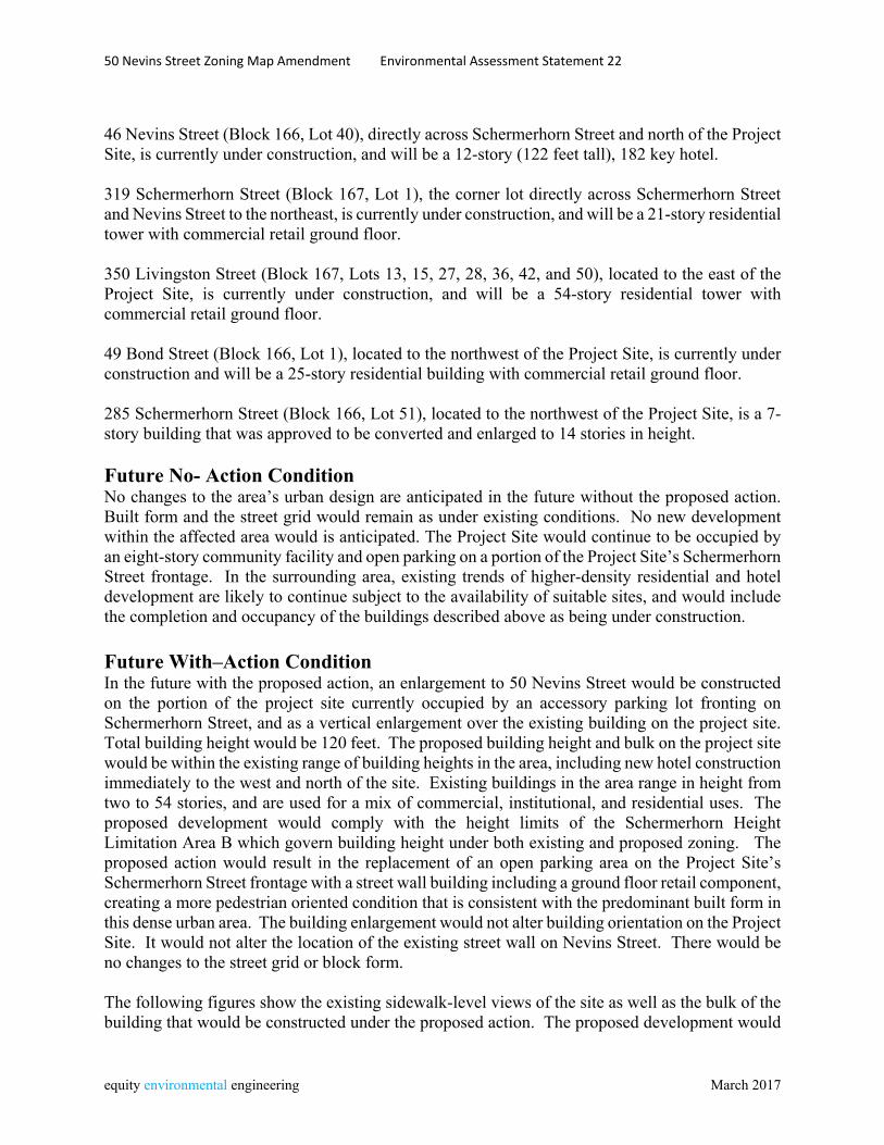
50 Nevins Street Zoning Map Amendment Environmental Assessment Statement 22
equity environmental engineering March 2017
46 Nevins Street (Block 166, Lot 40), directly across Schermerhorn Street and north of the Project Site, is currently under construction, and will be a 12-story (122 feet tall), 182 key hotel. 319 Schermerhorn Street (Block 167, Lot 1), the corner lot directly across Schermerhorn Street and Nevins Street to the northeast, is currently under construction, and will be a 21-story residential tower with commercial retail ground floor. 350 Livingston Street (Block 167, Lots 13, 15, 27, 28, 36, 42, and 50), located to the east of the Project Site, is currently under construction, and will be a 54-story residential tower with commercial retail ground floor. 49 Bond Street (Block 166, Lot 1), located to the northwest of the Project Site, is currently under construction and will be a 25-story residential building with commercial retail ground floor. 285 Schermerhorn Street (Block 166, Lot 51), located to the northwest of the Project Site, is a 7-story building that was approved to be converted and enlarged to 14 stories in height. Future No- Action Condition No changes to the area’s urban design are anticipated in the future without the proposed action. Built form and the street grid would remain as under existing conditions. No new development within the affected area would is anticipated. The Project Site would continue to be occupied by an eight-story community facility and open parking on a portion of the Project Site’s Schermerhorn Street frontage. In the surrounding area, existing trends of higher-density residential and hotel development are likely to continue subject to the availability of suitable sites, and would include the completion and occupancy of the buildings described above as being under construction. Future With–Action Condition In the future with the proposed action, an enlargement to 50 Nevins Street would be constructed on the portion of the project site currently occupied by an accessory parking lot fronting on Schermerhorn Street, and as a vertical enlargement over the existing building on the project site. Total building height would be 120 feet. The proposed building height and bulk on the project site would be within the existing range of building heights in the area, including new hotel construction immediately to the west and north of the site. Existing buildings in the area range in height from two to 54 stories, and are used for a mix of commercial, institutional, and residential uses. The proposed development would comply with the height limits of the Schermerhorn Height Limitation Area B which govern building height under both existing and proposed zoning. The proposed action would result in the replacement of an open parking area on the Project Site’s Schermerhorn Street frontage with a street wall building including a ground floor retail component, creating a more pedestrian oriented condition that is consistent with the predominant built form in this dense urban area. The building enlargement would not alter building orientation on the Project Site. It would not alter the location of the existing street wall on Nevins Street. There would be no changes to the street grid or block form. The following figures show the existing sidewalk-level views of the site as well as the bulk of the building that would be constructed under the proposed action. The proposed development would
50 Nevins Street Zoning Map Amendment Environmental Assessment Statement 23
equity environmental engineering March 2017
not encroach on public streets or sidewalks and no publicly accessible views to significant visual resources in the area would be affected. There would be no negative impact on Urban Design. Street level renderings of the future with-action condition at the project site are provided at the end of this section. Visual Resources An assessment of visual resources is concerned with whether a proposed development has the potential to block publicly accessible views of significant features such as view corridors or historic structures. Development under the proposed action would not encroach on public streets or sidewalks, and would be within the range of building heights in the area. There are no significant visual resources in the area. Therefore no further assessment of visual resources is needed.
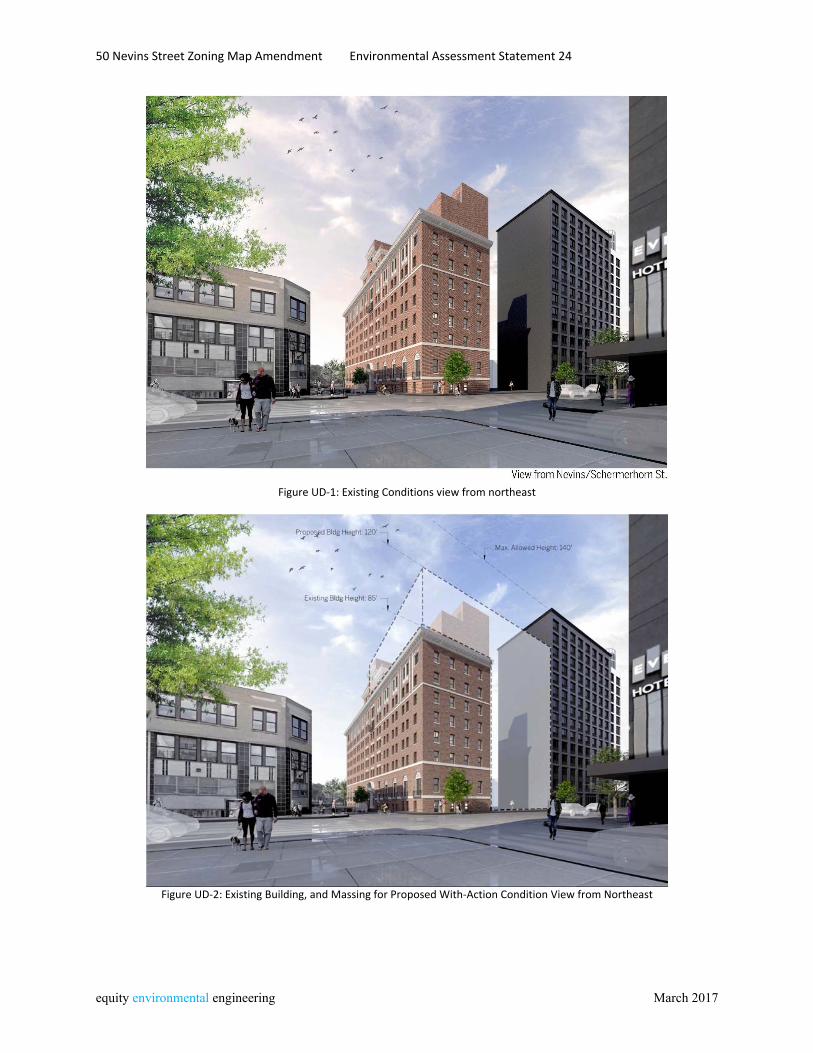
50 Nevins Street Zoning Map Amendment Environmental Assessment Statement 24
equity environmental engineering March 2017
Figure UD‐1: Existing Conditions view from northeast
Figure UD‐2: Existing Building, and Massing for Proposed With‐Action Condition View from Northeast
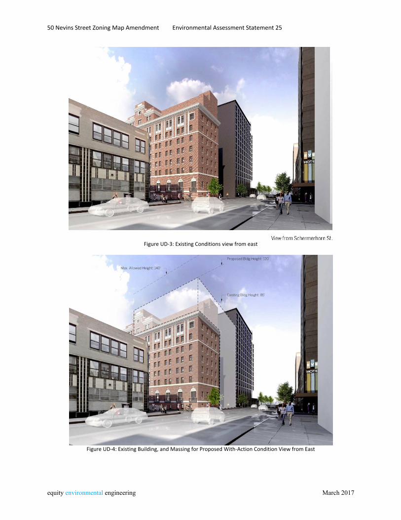
50 Nevins Street Zoning Map Amendment Environmental Assessment Statement 25
equity environmental engineering March 2017
Figure UD‐3: Existing Conditions view from east
Figure UD‐4: Existing Building, and Massing for Proposed With‐Action Condition View from East
50 Nevins Street Zoning Map Amendment Environmental Assessment Statement 26
equity environmental engineering March 2017
Hazardous Materials Pursuant to CEQR Technical Manual methodology, actions that would result in ground disturbance in an area where current or past uses on or near the site raise the potential for the presence of hazardous materials should be assessed for hazardous materials. The proposed action would allow enlargement of the Existing Building that would involve in-ground construction and soil disturbance as well as interior renovation of the Existing Building. Accordingly, a Phase I Environmental Site Assessment was conducted for the Development Site. This document has been submitted separately and is under review by the New York City Department of Environmental Protection (DEP). Project Site A Phase I Environmental Site Assessment (Phase I) was prepared by GZA Geoenvironmental, Inc. in November 2015. This Phase I identified the current use of the site as a multi-story building with adjacent parking lot. Based on a review of Fire Insurance Maps, the Project Site was developed prior to 1887 with three-story dwellings in the northern portion and the southern portion as part of a ‘coal and wood yard,’ The 1915 Fire Insurance Map shows the Existing Building, which was built in 1912, and three-story dwellings where the parking lot now is. By 1938 the Project Site was in its current configuration with the Existing Building, and open parking. The cellar of the Existing Building contains a 250-gallon above-ground storage tank (AST) containing fuel oil that serves an emergency generator located in the cellar. A 3,000-gallon underground storage tank (UST) is locate within a sidewalk vault on the Nevins Street side of the Existing Building. The Phase I identified the 3,000-gallon UST as a Recognized Environmental Conditions (REC). It also noted that soil to be excavated for property development could be impacted due to long-term exposure to the urban environment, and that if dewatering is required for construction, groundwater sampling and testing in conformance with NYCDEP will be required. With appropriate management of these construction-related concerns, development under the proposed action would not result in adverse impacts related to hazardous materials. In order to ensure that appropriate investigation and, if warranted, remediation is conducted as a condition of site redevelopment an [E] Designation is proposed. The language of the [E] designation to be placed on Block 172, Lot 32 (the Project Site) is as follows:
E-421 Task 1-Sampling Protocol The applicant submits to OER, for review and approval, a Phase I of the site along with a soil, groundwater and soil vapor testing protocol, including a description of methods and a site map with all sampling locations clearly and precisely represented. If site sampling is necessary, no sampling should begin until written approval of a protocol is received from
50 Nevins Street Zoning Map Amendment Environmental Assessment Statement 27
equity environmental engineering March 2017
OER. The number and location of samples should be selected to adequately characterize the site, specific sources of suspected contamination (i.e., petroleum based contamination and non-petroleum based contamination), and the remainder of the site's condition. The characterization should be complete enough to determine what remediation strategy (if any) is necessary after review of sampling data. Guidelines and criteria for selecting sampling locations and collecting samples are provided by OER upon request. Task 2-Remediation Determination and Protocol A written report with findings and a summary of the data must he submitted to OER after completion of the testing phase and laboratory analysis for review and approval. After receiving such results, a determination is made by OER if the results indicate that remediation is necessary. If OER determines that no remediation is necessary, written notice shall be given by OER. If remediation is indicated from test results, a proposed remediation plan must be submitted to OER for review and approval. The applicant must complete such remediation as determined necessary by OER. The applicant should then provide proper documentation that the work has been satisfactorily completed. A construction-related health and safety plan should be submitted to OER and would be implemented during excavation and construction activities to protect workers and the community from potentially significant adverse impacts associated with contaminated soil, groundwater and/or soil vapor. This plan would be submitted to OER prior to implementation.
With this (E) designation in place, no significant adverse impacts related to hazardous materials are expected, and no further analysis is warranted.
50 Nevins Street Zoning Map Amendment Environmental Assessment Statement 28
equity environmental engineering March 2017
Air Quality Air quality impacts can be either direct or indirect. Direct impacts are impacts that result from emissions generated by stationary sources at a development site, or emissions from parking garage ventilation systems. Indirect impacts are caused by emissions from nearby existing stationary sources or from on-road vehicle trips generate by an action or other changes to future traffic conditions due to the action. The approval of the proposed action would allow for new residential or community facility development on a portion of the project site currently used as accessory parking, as well as a vertical extension over the existing building on the site. The proposed development would introduce a new residential population to the site. Therefore, the potential that nearby emission sources could adversely affect the incremental difference between the No-Action condition and With-Action condition must be considered. Additionally, the proposed project would result in the development of a new building that would have an HVAC system that would be an emission source. Potential impacts on existing buildings must also be evaluated. Mobile Source (Tailpipe) Projects may result in significant mobile source air quality impacts when they increase or cause a redistribution of traffic, create any other mobile sources of pollutants or add new uses near mobile sources. The proposed development would not be located within 200 feet of an atypical vehicular pollutants source, nor would it result in a covered roadway. The proposed development would introduce new residential or community facility development that could potentially create a change in local traffic patterns. Based on the size thresholds for new development contained in the CEQR Technical Manual, action-induced development would be well below the threshold of 170 hourly trips as identified in the CEQR Technical Manual and therefore would not result in mobile-source air quality impacts. HVAC The proposed action would allow horizontal and vertical enlargement of the Existing Building, consisting of a ten-story component built on the existing open parking area in the northwestern portion of the Project Site fronting on Schermerhorn Street, and a three-story vertical enlargement over the existing building after removal of the existing partial 8th floor. The enlarged building would have a height of 120 feet and a total gross floor area of 108,865 square feet, including existing floor area to remain, and new floor area to be constructed. The HVAC vent would be three feet above this maximum building height, or 123 feet. The closest building that would have air intakes or operable windows at a similar or greater height would be 300 Schermerhorn Street, a hotel that was recently completed. This development is located adjacent to the west of the Project Site. The Existing Building’s HVAC vent, which would be extended through the vertical enlargement under the proposed action and would serve both existing and new floor area, is at a distance of 70 feet from the adjacent building. The rooftop bulkhead housing the HVAC stack is at a distance of 64 feet from the adjacent building at 300 Schermerhorn Street. The proposed roof plan, with stack location highlighted, is presented in the following figure AQ-1. Using Figure 17-7 of the CEQR Technical Manual, a screening analysis was performed. Based on this analysis, the proposed development would have no impact on buildings in the surrounding uses.
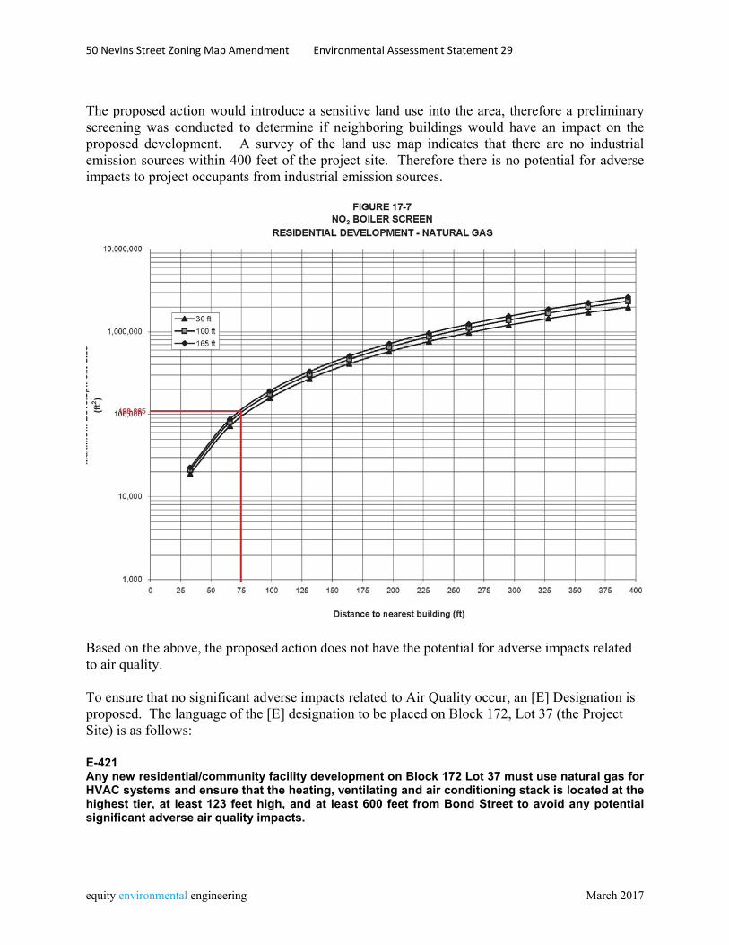
50 Nevins Street Zoning Map Amendment Environmental Assessment Statement 29
equity environmental engineering March 2017
The proposed action would introduce a sensitive land use into the area, therefore a preliminary screening was conducted to determine if neighboring buildings would have an impact on the proposed development. A survey of the land use map indicates that there are no industrial emission sources within 400 feet of the project site. Therefore there is no potential for adverse impacts to project occupants from industrial emission sources.
Based on the above, the proposed action does not have the potential for adverse impacts related to air quality. To ensure that no significant adverse impacts related to Air Quality occur, an [E] Designation is proposed. The language of the [E] designation to be placed on Block 172, Lot 37 (the Project Site) is as follows: E-421 Any new residential/community facility development on Block 172 Lot 37 must use natural gas for HVAC systems and ensure that the heating, ventilating and air conditioning stack is located at the highest tier, at least 123 feet high, and at least 600 feet from Bond Street to avoid any potential significant adverse air quality impacts.
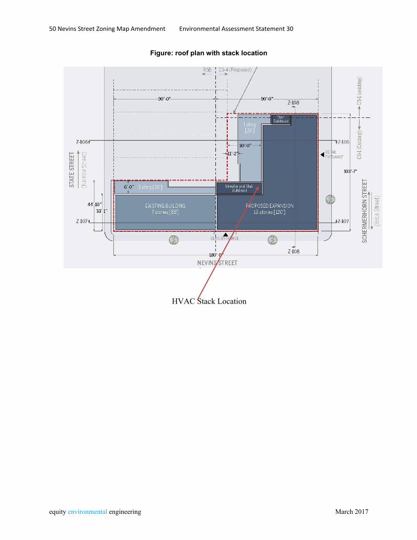
50 Nevins Street Zoning Map Amendment Environmental Assessment Statement 30
equity environmental engineering March 2017
Figure: roof plan with stack location
HVAC Stack Location
50 Nevins Street Zoning Map Amendment Environmental Assessment Statement 31
equity environmental engineering March 2017
Noise Introduction The proposed action would allow for the enlargement of a supportive and affordable housing facility located at 50 Nevins Street in Brooklyn, New York. Development would occur on an open portion of the Project Site currently used for accessory parking, as well as over the Existing Building on the site. Vehicular traffic is the predominant source of noise in the vicinity, and therefore the proposed development warrants an assessment of the potential for adverse effects on project occupants from ambient noise. The proposed development of the building would not create a significant noise generator. Additionally, project-generated traffic would not double vehicular traffic on nearby roadways, and therefore would not result in a perceptible increase in vehicular noise. This noise assessment is limited to an assessment of ambient noise that could adversely affect occupants of the development. The project site is identified as Tax Block 172, Lot 37 and is bounded by Nevins Street to the east, Schermerhorn Street to the north and State Street to the south. Nevins Street is a one-way south-bound street with intersections controlled by street lights. Schermerhorn Street is a two-way east/westbound street with intersections controlled by street lights. The area in which the subject property is located contains residential and commercial uses as well as institutional properties. Framework of Noise Analysis Noise is defined as any unwanted sound, and sound is defined as any pressure variation that the human ear can detect. Humans can detect a large range of sound pressures, from 20 to 20 million micropascals, but only those air pressure variations occurring within a particular set of frequencies are experienced as sound. Air pressure changes that occur between 20 and 20,000 times a second, stated as units of Hertz (Hz), are registered as sound.
Because the human ear can detect such a wide range of sound pressures, sound pressure is converted to sound pressure level (SPL), which is measured in units called decibels (dB). The decibel is a relative measure of the sound pressure with respect to a standardized reference quantity. Because the dB scale is logarithmic, a relative increase of 10 dB represents a sound pressure that is 10 times higher. However, humans do not perceive a 10-dB increase as 10 times louder. Instead, they perceive it as twice as loud. The following Table Noise-1 lists some noise levels for typical daily activities.
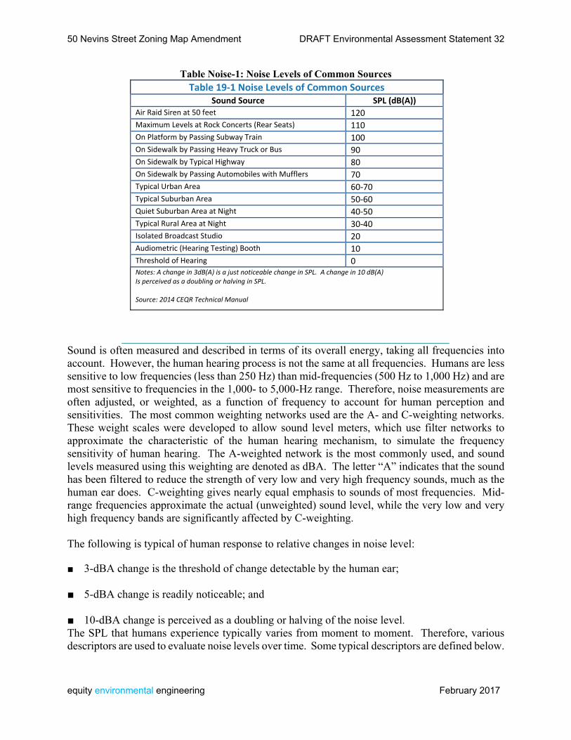
50 Nevins Street Zoning Map Amendment DRAFT Environmental Assessment Statement 32
equity environmental engineering February 2017
Table Noise-1: Noise Levels of Common Sources Table 19‐1 Noise Levels of Common Sources
Sound Source SPL (dB(A)) Air Raid Siren at 50 feet 120 Maximum Levels at Rock Concerts (Rear Seats) 110 On Platform by Passing Subway Train 100 On Sidewalk by Passing Heavy Truck or Bus 90 On Sidewalk by Typical Highway 80 On Sidewalk by Passing Automobiles with Mufflers 70 Typical Urban Area 60‐70 Typical Suburban Area 50‐60 Quiet Suburban Area at Night 40‐50 Typical Rural Area at Night 30‐40 Isolated Broadcast Studio 20 Audiometric (Hearing Testing) Booth 10 Threshold of Hearing 0 Notes: A change in 3dB(A) is a just noticeable change in SPL. A change in 10 dB(A)Is perceived as a doubling or halving in SPL. Source: 2014 CEQR Technical Manual
Sound is often measured and described in terms of its overall energy, taking all frequencies into account. However, the human hearing process is not the same at all frequencies. Humans are less sensitive to low frequencies (less than 250 Hz) than mid-frequencies (500 Hz to 1,000 Hz) and are most sensitive to frequencies in the 1,000- to 5,000-Hz range. Therefore, noise measurements are often adjusted, or weighted, as a function of frequency to account for human perception and sensitivities. The most common weighting networks used are the A- and C-weighting networks. These weight scales were developed to allow sound level meters, which use filter networks to approximate the characteristic of the human hearing mechanism, to simulate the frequency sensitivity of human hearing. The A-weighted network is the most commonly used, and sound levels measured using this weighting are denoted as dBA. The letter “A” indicates that the sound has been filtered to reduce the strength of very low and very high frequency sounds, much as the human ear does. C-weighting gives nearly equal emphasis to sounds of most frequencies. Mid-range frequencies approximate the actual (unweighted) sound level, while the very low and very high frequency bands are significantly affected by C-weighting.
The following is typical of human response to relative changes in noise level:
■ 3-dBA change is the threshold of change detectable by the human ear;
■ 5-dBA change is readily noticeable; and
■ 10-dBA change is perceived as a doubling or halving of the noise level. The SPL that humans experience typically varies from moment to moment. Therefore, various descriptors are used to evaluate noise levels over time. Some typical descriptors are defined below.
50 Nevins Street Zoning Map Amendment DRAFT Environmental Assessment Statement 33
equity environmental engineering February 2017
■ Leq is the continuous equivalent sound level. The sound energy from the fluctuating SPLs is averaged over time to create a single number to describe the mean energy, or intensity, level. High noise levels during a measurement period will have a greater effect on the Leq than low noise levels. Leq has an advantage over other descriptors because Leq values from various noise sources can be added and subtracted to determine cumulative noise levels.
■ Leq(24) is the continuous equivalent sound level over a 24-hour time period. The sound level exceeded during a given percentage of a measurement period is the percentile-exceeded sound level (LX). Examples include L10, L50, and L90. L10 is the A-weighted sound level that is exceeded 10% of the measurement period. The decrease in sound level caused by the distance from any single noise source normally follows the inverse square law (i.e., the SPL changes in inverse proportion to the square of the distance from the sound source). In a large open area with no obstructive or reflective surfaces, it is a general rule that at distances greater than 50 feet, the SPL from a point source of noise drops off at a rate of 6 dB with each doubling of distance away from the source. For “line” sources, such as vehicles on a street, the SPL drops off at a rate of 3 dBA with each doubling of the distance from the source. Sound energy is absorbed in the air as a function of temperature, humidity, and the frequency of the sound. This attenuation can be up to 2 dB over 1,000 feet. The drop-off rate also will vary with both terrain conditions and the presence of obstructions in the sound propagation path.
Measurement Location and Equipment Because the predominant noise source in the area of the proposed project is vehicular traffic, noise monitoring was conducted during peak vehicular travel periods, 7:00-8:00 am, 12:00 pm-1:00 pm, and 5:00-6:00 pm. Pursuant to CEQR Technical Manual methodology, readings were conducted on the Nevins Street frontage and the Schermerhorn Street frontage for 20-minute periods during each peak hour. Noise monitoring was conducted using a Type 1 Casella CEL-633C1 sound meter, with wind screen. The monitor was placed on a tripod at a height of approximately three feet above the ground, away from any other surfaces. The monitor was calibrated prior to and following each monitoring session.
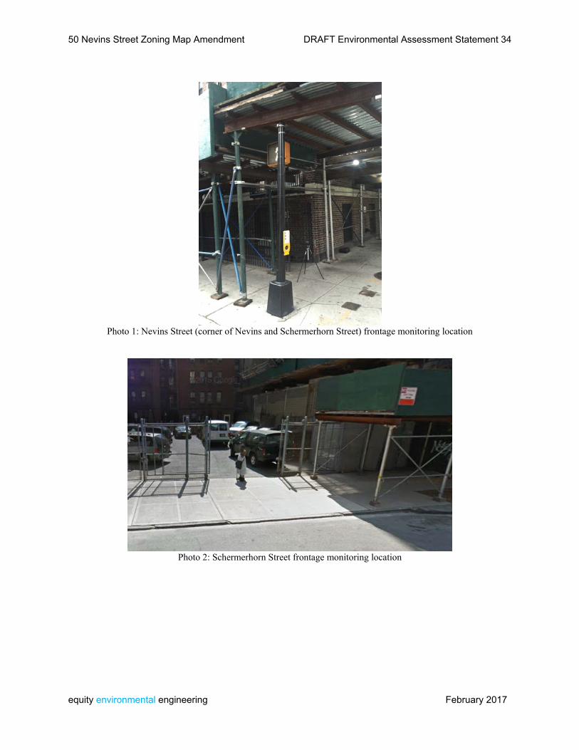
50 Nevins Street Zoning Map Amendment DRAFT Environmental Assessment Statement 34
equity environmental engineering February 2017
Photo 1: Nevins Street (corner of Nevins and Schermerhorn Street) frontage monitoring location
Photo 2: Schermerhorn Street frontage monitoring location
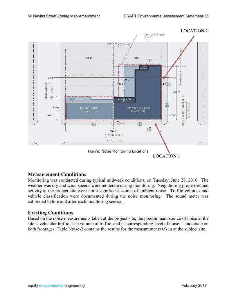
50 Nevins Street Zoning Map Amendment DRAFT Environmental Assessment Statement 35
equity environmental engineering February 2017
LOCATION 2
Figure: Noise Monitoring Locations LOCATION 1 Measurement Conditions Monitoring was conducted during typical midweek conditions, on Tuesday, June 28, 2016. The weather was dry and wind speeds were moderate during monitoring. Neighboring properties and activity at the project site were not a significant source of ambient noise. Traffic volumes and vehicle classification were documented during the noise monitoring. The sound meter was calibrated before and after each monitoring session. Existing Conditions Based on the noise measurements taken at the project site, the predominant source of noise at the site is vehicular traffic. The volume of traffic, and its corresponding level of noise, is moderate on both frontages. Table Noise-2 contains the results for the measurements taken at the subject site.
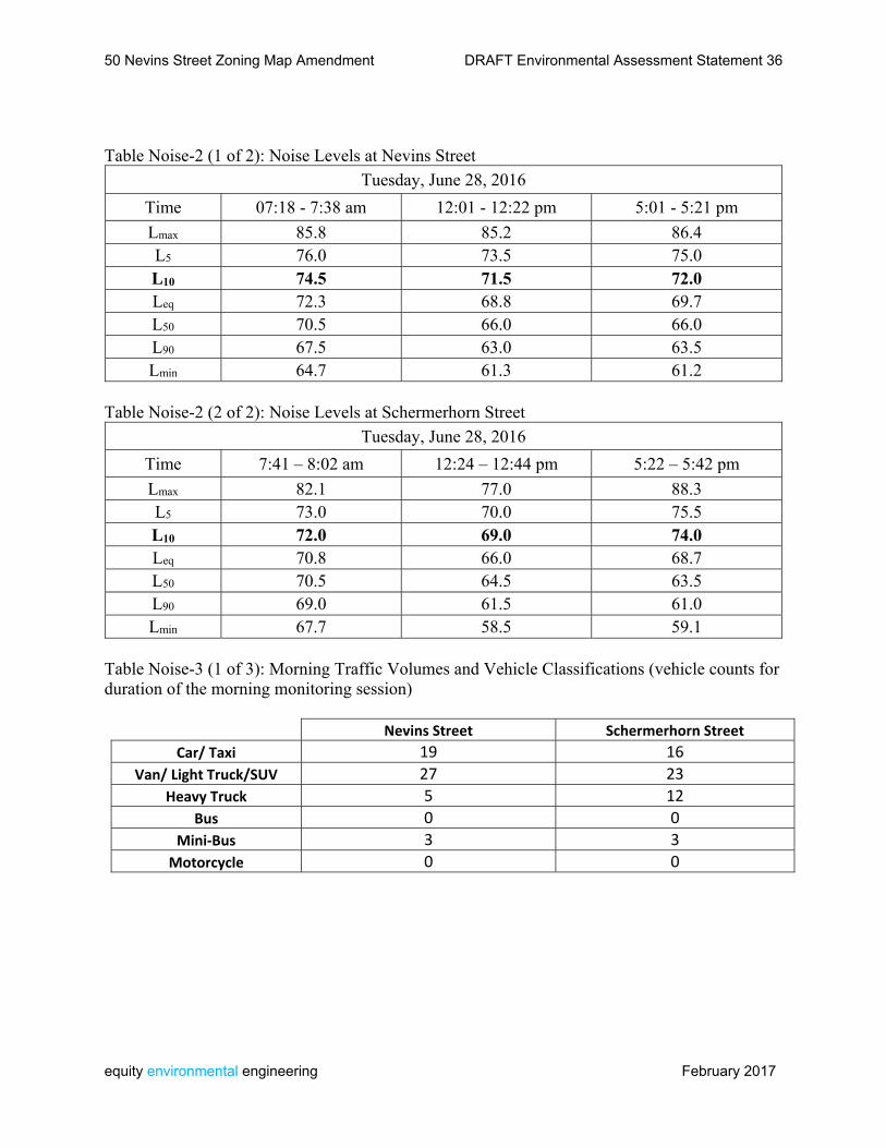
50 Nevins Street Zoning Map Amendment DRAFT Environmental Assessment Statement 36
equity environmental engineering February 2017
Table Noise-2 (1 of 2): Noise Levels at Nevins Street
Tuesday, June 28, 2016
Time 07:18 - 7:38 am 12:01 - 12:22 pm 5:01 - 5:21 pm
Lmax 85.8 85.2 86.4 L5 76.0 73.5 75.0 L10 74.5 71.5 72.0 Leq 72.3 68.8 69.7 L50 70.5 66.0 66.0 L90 67.5 63.0 63.5 Lmin 64.7 61.3 61.2
Table Noise-2 (2 of 2): Noise Levels at Schermerhorn Street
Tuesday, June 28, 2016
Time 7:41 – 8:02 am 12:24 – 12:44 pm 5:22 – 5:42 pm
Lmax 82.1 77.0 88.3 L5 73.0 70.0 75.5 L10 72.0 69.0 74.0 Leq 70.8 66.0 68.7 L50 70.5 64.5 63.5 L90 69.0 61.5 61.0 Lmin 67.7 58.5 59.1
Table Noise-3 (1 of 3): Morning Traffic Volumes and Vehicle Classifications (vehicle counts for duration of the morning monitoring session)
Nevins Street Schermerhorn Street
Car/ Taxi 19 16
Van/ Light Truck/SUV 27 23
Heavy Truck 5 12
Bus 0 0
Mini‐Bus 3 3
Motorcycle 0 0
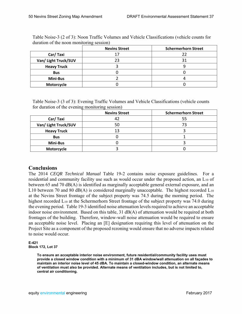
50 Nevins Street Zoning Map Amendment DRAFT Environmental Assessment Statement 37
equity environmental engineering February 2017
Table Noise-3 (2 of 3): Noon Traffic Volumes and Vehicle Classifications (vehicle counts for duration of the noon monitoring session) Nevins Street Schermerhorn Street
Car/ Taxi 17 22
Van/ Light Truck/SUV 23 31
Heavy Truck 3 9
Bus 0 0
Mini‐Bus 2 4
Motorcycle 0 0
Table Noise-3 (3 of 3): Evening Traffic Volumes and Vehicle Classifications (vehicle counts for duration of the evening monitoring session) Nevins Street Schermerhorn Street
Car/ Taxi 42 55
Van/ Light Truck/SUV 50 73
Heavy Truck 13 3
Bus 0 1
Mini‐Bus 0 3
Motorcycle 3 0
Conclusions The 2014 CEQR Technical Manual Table 19-2 contains noise exposure guidelines. For a residential and community facility use such as would occur under the proposed action, an L10 of between 65 and 70 dB(A) is identified as marginally acceptable general external exposure, and an L10 between 70 and 80 dB(A) is considered marginally unacceptable. The highest recorded L10 at the Nevins Street frontage of the subject property was 74.5 during the morning period. The highest recorded L10 at the Schermerhorn Street frontage of the subject property was 74.0 during the evening period. Table 19-3 identified noise attenuation levels required to achieve an acceptable indoor noise environment. Based on this table, 31 dB(A) of attenuation would be required at both frontages of the building. Therefore, window-wall noise attenuation would be required to ensure an acceptable noise level. Placing an [E] designation requiring this level of attenuation on the Project Site as a component of the proposed rezoning would ensure that no adverse impacts related to noise would occur. E-421 Block 172, Lot 37
To ensure an acceptable interior noise environment, future residential/community facility uses must provide a closed window condition with a minimum of 31 dBA window/wall attenuation on all façades to maintain an interior noise level of 45 dBA. To maintain a closed-window condition, an alternate means of ventilation must also be provided. Alternate means of ventilation includes, but is not limited to, central air conditioning.
50 Nevins Street Zoning Map Amendment DRAFT Environmental Assessment Statement 38
equity environmental engineering February 2017
Neighborhood Character According to the 2014 CEQR Technical Manual, in a neighborhood character assessment under CEQR, one considers how elements of the environment combine to create the context and feeling of a neighborhood and how a project may affect that context and feeling. An assessment of neighborhood character is generally needed when a proposed project has the potential to result in significant adverse impacts in any technical area presented below, or when the project may have moderate effects on several of the elements that define a neighborhood’s character. A Neighborhood Character assessment is appropriate when a project has the potential to result in any significant impacts in the following areas: A. Land Use, Zoning, and Public Policy; B. Socioeconomic Conditions; C. Open Space; D. Historic and Cultural Resources; E. Urban Design and Visual Resources; F. Shadows; G. Transportation; or H. Noise. Based on the analyses conducted previously, the proposed action, including SHPO review and approval of building design, and placement of an ‘E’ designation for noise, would not result in significant impacts to any of the constituent elements of neighborhood character. Therefore no further analysis is warranted and no impacts related to neighborhood character are anticipated.
50 Nevins Street Zoning Map Amendment DRAFT Environmental Assessment Statement 39
equity environmental engineering February 2017
Public Health According to the 2014 CEQR Technical Manual, Public health is the organized effort of society to protect and improve the health and well-being of the population through monitoring; assessment and surveillance; health promotion; prevention of disease, injury, disorder, disability and premature death; and reducing inequalities in health status. The goal of CEQR with respect to public health is to determine whether adverse impacts on public health may occur as a result of a proposed project, and if so, to identify measures to mitigate such effects. Pursuant to 2014 CEQR Technical Manual methodology, for most proposed projects, a public health analysis is not necessary. Where no significant unmitigated adverse impact is found in other CEQR analysis areas, such as air quality, water quality, hazardous materials, or noise, no public health analysis is warranted. If, however, an unmitigated significant adverse impact is identified in other CEQR analysis areas, such as air quality, water quality, hazardous materials, or noise, the lead agency may determine that a public health assessment is warranted for that specific technical area. Based on the analyses presented in this report, the proposed action, including an [E] Designation imposing a 31 dB noise attenuation requirement for new community facility or residential use, and regulating the fuel source and stack location for the Project Site’s HVAC system, does not have the potential for significant unmitigated impacts to any of the constituent elements of public health. Therefore no further analysis of public health is warranted.
50 Nevins Street Zoning Map Amendment DRAFT Environmental Assessment Statement 40
equity environmental engineering February 2017
Construction According to the 2014 CEQR Technical Manual, construction activities, although temporary in nature, can sometimes result in significant adverse impacts. A project’s construction activities may affect a number of technical areas analyzed for the operational period, such as air quality, noise, and traffic; therefore, a construction assessment relies to a significant extent on the methodologies and resulting information gathered in the analyses of these technical areas. The following considerations are used to determine whether further analysis of a project’s construction activities is needed for any technical area. TRANSPORTATION A transportation analysis of construction activities is predicated upon the duration, intensity, complexity, and/or location of construction activity. Analysis of the effects of construction activities on transportation is often not required, as many projects do not generate enough construction traffic to warrant such analysis. An analysis should consider a number of factors before determining whether a preliminary assessment of the effect of construction on transportation is needed. These factors include whether the construction would be located in a Central Business District or along an arterial or major thoroughfare, whether any closures or narrowing of moving or parking lanes or pedestrian facilities would be located in an area with high pedestrian activity or near sensitive land uses such as schools, hospitals, or parks, and whether the project would involve construction on multiple development sites in the same geographic area such that there is the potential for several construction timelines to overlap, and last for more than two years overall. The proposed development would affect a site at the southwest corner of Nevins Street and Schermerhorn Street with frontage on both streets. There would be no construction activity within a Central Business District or on an arterial or major thoroughfare. The proposed development would occur in an area that experiences moderate pedestrian activity, and does not contain sensitive land uses such as schools, hospitals or parks. Development on the site is not expected to last for more than two years overall. AIR QUALITY AND NOISE According to the CEQR Technical Manual, an assessment of air quality and noise for construction activities is likely not warranted if the project’s construction activities: • Are considered short-term (less than two years); • Are not located near sensitive receptors; and • Do not involve construction of multiple buildings where there is a potential for on-site receptors on buildings to be completed before the final build-out. The proposed action would not result in construction activities lasting longer than two years, and would not result in construction near sensitive receptors. HISTORIC AND CULTURAL RESOURCES As discussed elsewhere in this document, SHPO review and approval of the Proposed Development as a condition of State funding would ensure that no adverse impacts related to
50 Nevins Street Zoning Map Amendment DRAFT Environmental Assessment Statement 41
equity environmental engineering February 2017
Historic and Cultural Resources would occur. The Project Site is not considered sensitive for archaeological resources. Therefore construction activity does not have the potential for adverse impacts to Historic and Cultural Resources. HAZARDOUS MATERIALS As discussed elsewhere in this document, a Phase I Environmental Site Assessment has been prepared for the Project Site. This ESA is under review by the Department of Environmental Protection. Based on the potential for site contamination, further investigation may be warranted. NATURAL RESOURCES The proposed action would result in redevelopment within a fully urbanized area that does not provide habitat for any rare or endangered plant or animal species. Construction activities would not have the potential for adverse impacts to natural resources. OPEN SPACE, SOCIOECONOMIC CONDITIONS, COMMUNITY FACILITIES, LAND USE AND PUBLIC POLICY, NEIGHBORHOOD CHARACTER, AND INFRASTRUCTURE According to the CEQR Technical Manual, a preliminary construction assessment is generally not needed for these technical areas unless the following are true: • The construction activities are considered “long-term” (more than 2 years); or • Short-term construction activities would directly affect a technical area, such as impeding the operation of a community facility (e.g., result in the closing of a community health clinic for a period of a month(s)). Since none of these situations would occur, the proposed action does not have the potential for significant adverse impacts related to construction activity.

50 Nevins Street Zoning Map Amendment
equity environmental engineering February 2017
APPENDIX: Agency Correspondence
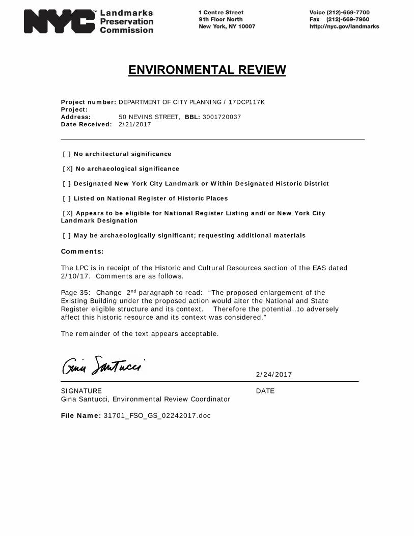
ENVIRONMENTAL REVIEW
Project number: DEPARTMENT OF CITY PLANNING / 17DCP117K Project: Address: 50 NEVINS STREET, BBL: 3001720037 Date Received: 2/21/2017 [ ] No architectural significance [X] No archaeological significance [ ] Designated New York City Landmark or Within Designated Historic District [ ] Listed on National Register of Historic Places [X] Appears to be eligible for National Register Listing and/or New York City Landmark Designation [ ] May be archaeologically significant; requesting additional materials Comments: The LPC is in receipt of the Historic and Cultural Resources section of the EAS dated 2/10/17. Comments are as follows. Page 35: Change 2nd paragraph to read: “The proposed enlargement of the Existing Building under the proposed action would alter the National and State Register eligible structure and its context. Therefore the potential…to adversely affect this historic resource and its context was considered.” The remainder of the text appears acceptable.
2/24/2017 SIGNATURE DATE Gina Santucci, Environmental Review Coordinator File Name: 31701_FSO_GS_02242017.doc
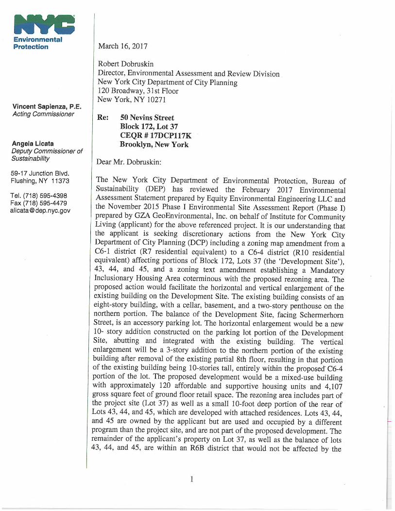
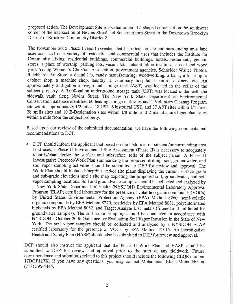
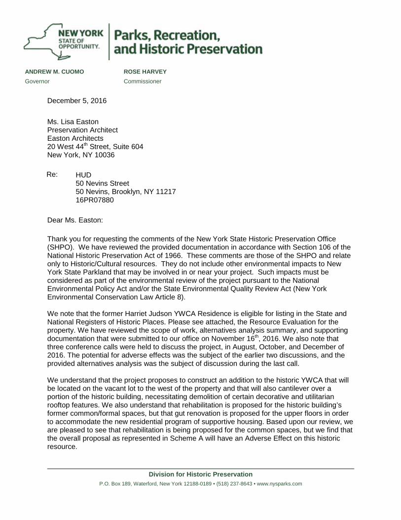
Division for Historic PreservationP.O. Box 189, Waterford, New York 12188-0189 • (518) 237-8643 • www.nysparks.com
ANDREW M. CUOMO ROSE HARVEYGovernor Commissioner
December 5, 2016
Ms. Lisa EastonPreservation ArchitectEaston Architects20 West 44th Street, Suite 604New York, NY 10036
Re: HUD50 Nevins Street50 Nevins, Brooklyn, NY 1121716PR07880
Dear Ms. Easton:
Thank you for requesting the comments of the New York State Historic Preservation Office (SHPO). We have reviewed the provided documentation in accordance with Section 106 of the National Historic Preservation Act of 1966. These comments are those of the SHPO and relate only to Historic/Cultural resources. They do not include other environmental impacts to New York State Parkland that may be involved in or near your project. Such impacts must be considered as part of the environmental review of the project pursuant to the National Environmental Policy Act and/or the State Environmental Quality Review Act (New York Environmental Conservation Law Article 8).
We note that the former Harriet Judson YWCA Residence is eligible for listing in the State and National Registers of Historic Places. Please see attached, the Resource Evaluation for the property. We have reviewed the scope of work, alternatives analysis summary, and supporting documentation that were submitted to our office on November 16th, 2016. We also note that three conference calls were held to discuss the project, in August, October, and December of2016. The potential for adverse effects was the subject of the earlier two discussions, and the provided alternatives analysis was the subject of discussion during the last call.
We understand that the project proposes to construct an addition to the historic YWCA that will be located on the vacant lot to the west of the property and that will also cantilever over a portion of the historic building, necessitating demolition of certain decorative and utilitarianrooftop features. We also understand that rehabilitation is proposed for the historic building’sformer common/formal spaces, but that gut renovation is proposed for the upper floors in order to accommodate the new residential program of supportive housing. Based upon our review, we are pleased to see that rehabilitation is being proposed for the common spaces, but we find that the overall proposal as represented in Scheme A will have an Adverse Effect on this historic resource.
Division for Historic PreservationP.O. Box 189, Waterford, New York 12188-0189 • (518) 237-8643 • www.nysparks.com
The Secretary of the Interior’s Standards (see Standards, 2, 9, and 10) are clear that proposed additions shall not destroy historic materials that characterize a property, and shall be compatible with the historic building’s massing, size, scale and architectural features in order to protect the historic integrity of the property and its environment. Furthermore, the Standards warn against the removal of historic material and the alteration of features and spaces that characterize a property. With this guidance in mind, it is SHPO’s opinion that the proposed new construction will overwhelm the building, in addition to causing the removal of the character-defining rooftop pavilion feature; and that the gut renovation will erase the original double-loaded corridor floor plan that characterized the property’s historic Single-Room Occupancy (SRO) use.
We have reviewed the provided Alternatives Analysis, and we concur with your determination that Schemes B and C do not appear to be financially feasible and also present many programmatic challenges. It is our opinion that Scheme D appears comparable to the preferredScheme A, but has the potential for fewer adverse effects on the historic building to the extent that the rooftop pavilion feature would be left intact and the volume of the new constructionwould not be placed fully over the historic building. Therefore, we request further development of this alternative, in particular with regard to the financial aspects.
In order to continue our review, at this time we request the following items:1. Further discussion of Scheme D, as noted above2. Please provide color photos showing representative conditions at the upper floors of
the building. We would like to understand what the conditions and level(s) of historicintegrity are at these floors.
3. Please provide detailed demolition and construction drawings as they becomeavailable.
4. Please provide more information detailing the proposed rehabilitation of the formercommon/formal spaces on the first floor of the building
We are particularly concerned with the potential effects on the building’s historic interiors, and we would encourage the project to retain as much as possible of the building’s intact spaces while still incorporating the required changes.
We would appreciate if the requested information could be provided via our Cultural Resource Information System (CRIS) at www.nysparks.com/shpo/online-tools/ Once on the CRIS site, you can log in as a guest and choose "submit" at the very top menu. Next choose "submit new information for an existing project". You will need this project number and your e-mail address.If you have any questions, I can be reached at (518) 268-2182.
Sincerely,
Olivia BrazeeHistoric Preservation Technical [email protected] via e-mail only
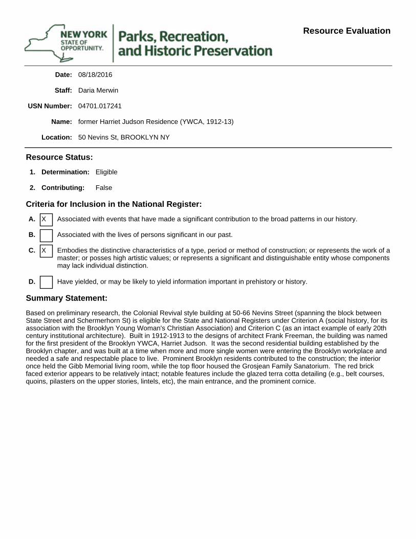
Date:
Location:
Name:
USN Number:
Staff:
08/18/2016
Daria Merwin
04701.017241
former Harriet Judson Residence (YWCA, 1912-13)
50 Nevins St, BROOKLYN NY
Resource Status:
Summary Statement:
Criteria for Inclusion in the National Register:
1.
2.
D.
C.
B.
A.
Determination:
Contributing:
Eligible
False
X
X
Associated with events that have made a significant contribution to the broad patterns in our history.
Associated with the lives of persons significant in our past.
Embodies the distinctive characteristics of a type, period or method of construction; or represents the work of a master; or posses high artistic values; or represents a significant and distinguishable entity whose components may lack individual distinction.
Have yielded, or may be likely to yield information important in prehistory or history.
Based on preliminary research, the Colonial Revival style building at 50-66 Nevins Street (spanning the block between State Street and Schermerhorn St) is eligible for the State and National Registers under Criterion A (social history, for its association with the Brooklyn Young Woman's Christian Association) and Criterion C (as an intact example of early 20th century institutional architecture). Built in 1912-1913 to the designs of architect Frank Freeman, the building was named for the first president of the Brooklyn YWCA, Harriet Judson. It was the second residential building established by the Brooklyn chapter, and was built at a time when more and more single women were entering the Brooklyn workplace and needed a safe and respectable place to live. Prominent Brooklyn residents contributed to the construction; the interior once held the Gibb Memorial living room, while the top floor housed the Grosjean Family Sanatorium. The red brick faced exterior appears to be relatively intact; notable features include the glazed terra cotta detailing (e.g., belt courses, quoins, pilasters on the upper stories, lintels, etc), the main entrance, and the prominent cornice.
Resource Evaluation
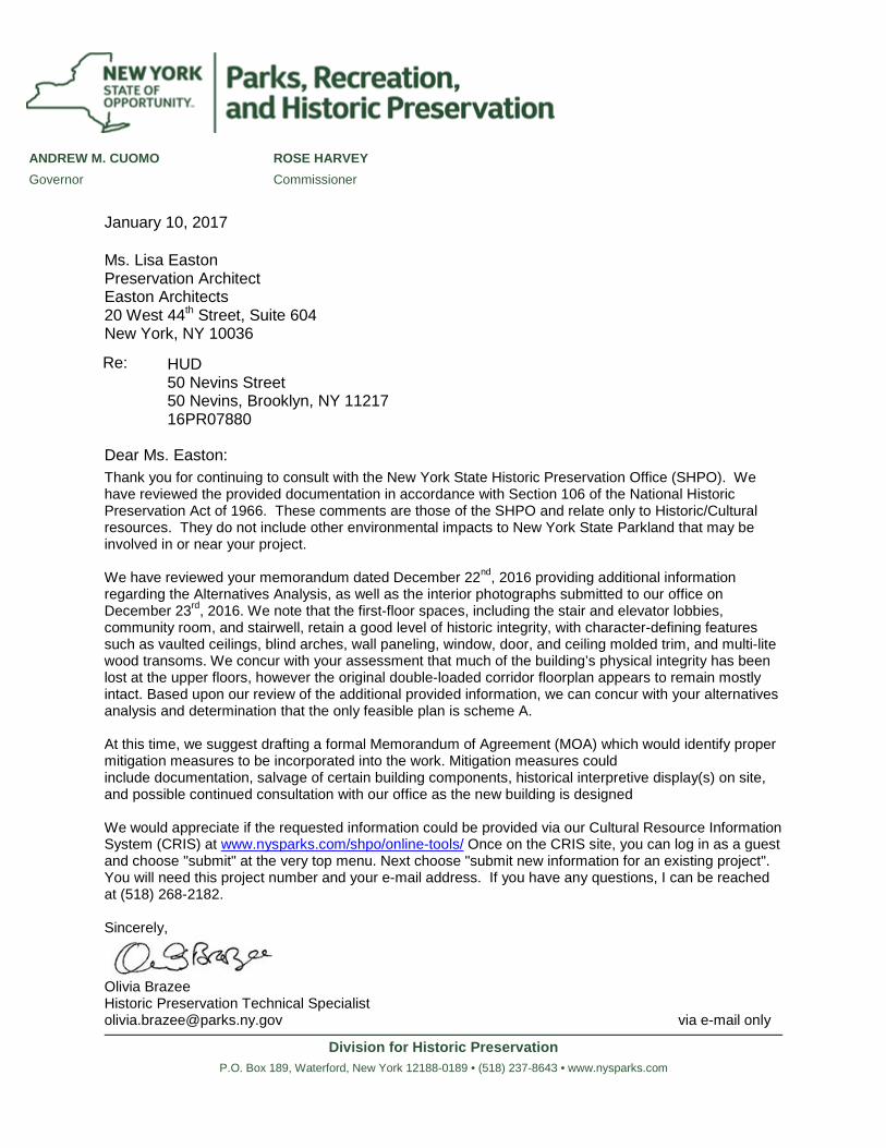
Division for Historic Preservation P.O. Box 189, Waterford, New York 12188-0189 • (518) 237-8643 • www.nysparks.com
ANDREW M. CUOMO ROSE HARVEY Governor Commissioner
January 10, 2017
Ms. Lisa Easton Preservation Architect Easton Architects 20 West 44th Street, Suite 604 New York, NY 10036
Re: HUD 50 Nevins Street 50 Nevins, Brooklyn, NY 11217 16PR07880
Dear Ms. Easton: Thank you for continuing to consult with the New York State Historic Preservation Office (SHPO). We have reviewed the provided documentation in accordance with Section 106 of the National Historic Preservation Act of 1966. These comments are those of the SHPO and relate only to Historic/Cultural resources. They do not include other environmental impacts to New York State Parkland that may be involved in or near your project.
We have reviewed your memorandum dated December 22nd, 2016 providing additional information regarding the Alternatives Analysis, as well as the interior photographs submitted to our office on December 23rd, 2016. We note that the first-floor spaces, including the stair and elevator lobbies, community room, and stairwell, retain a good level of historic integrity, with character-defining features such as vaulted ceilings, blind arches, wall paneling, window, door, and ceiling molded trim, and multi-lite wood transoms. We concur with your assessment that much of the building’s physical integrity has been lost at the upper floors, however the original double-loaded corridor floorplan appears to remain mostly intact. Based upon our review of the additional provided information, we can concur with your alternatives analysis and determination that the only feasible plan is scheme A.
At this time, we suggest drafting a formal Memorandum of Agreement (MOA) which would identify proper mitigation measures to be incorporated into the work. Mitigation measures could include documentation, salvage of certain building components, historical interpretive display(s) on site, and possible continued consultation with our office as the new building is designed
We would appreciate if the requested information could be provided via our Cultural Resource Information System (CRIS) at www.nysparks.com/shpo/online-tools/ Once on the CRIS site, you can log in as a guest and choose "submit" at the very top menu. Next choose "submit new information for an existing project". You will need this project number and your e-mail address. If you have any questions, I can be reached at (518) 268-2182.
Sincerely,
Olivia Brazee Historic Preservation Technical Specialist [email protected] via e-mail only
50 Nevins Street Zoning Map Amendment Residential Appendix p. 1
equity environmental engineering March 2017
APPENDIX: Residential Development Scenario
The proposed Zoning Map and Text Amendments are expected to facilitate the enlargement of the Existing Building for use as a 128-unit supportive housing facility. This development would rely on State funding from the Office of Mental Health and Housing Finance Agency. However, the proposed rezoning from C6-1 to C6-4, and the establishment of an MIHA over both the area proposed for rezoning and the part of the Project Site which would remain within an R6B district, would also increase allowable residential development. Therefore, to provide a conservative assessment of the potential for environmental impacts, this section will consider the potential impacts resulting from residential development under the proposed action. The potential for adverse impacts from the Residential Development Scenario will be compared to those that were disclosed for the Proposed Development in this document.
Project Description
The proposed C6-4 district within an MIHA would permit residential development at an FAR of 12.0, with provision of MIH units. The proposed establishment of an MIHA over the portion of the Project Site that would remain zoned R6B would permit residential development at an FAR of 2.2. The adjusted FAR for the entire site is 8.864 under the proposed action. Therefore the 12,773 square foot lot could accommodate up to 113,220 square feet of residential floor area.
Under the residential scenario, a new 14-story residential building could be constructed on the portion of the Project Site currently used for parking that is located within the area proposed for rezoning, as well as within a two-story expansion above the existing building. Building height would be 134’3” for the new 14-story building, and 132’2” for the expansion above the existing building. For CEQR analysis purposes, a building height of 140 feet, the maximum allowed in Schermerhorn Height Limitation Area B, would be assessed. The existing building on the site would remain in its existing use and configuration.
The existing building has a zoning floor area of 58,024 square feet. Therefore there would be additional development capacity of 55,196 zoning square feet (approximately 59,060 gross square feet). The new residential development would contain approximately 59 new residential units. Up to eighteen of these units would be affordable housing under MIH, and would be exempt from an accessory parking requirement. The 31 market rate units would generate an accessory parking requirement of six spaces, which can be waived pursuant to ZR 25-261. Therefore it is assumed that no parking would be provided. The existing community facility building within the Project Site, containing 150 SRO units, would remain. This development scenario maximizes allowable floor area under the proposed C6-4 district and establishment of the MIHA over the Project Site.
50 Nevins Street Zoning Map Amendment Residential Appendix p. 2
equity environmental engineering March 2017
The following table presents the incremental development associated with the Residential Scenario. The incremental residential development that would occur under this scenario does not trigger any new analysis as previously considered in the EAS (Socioeconomic Conditions; Community Facilities; Open Space; Transportation). The qualitative analyses in this appendix will include only sections previously considered in the EAS.
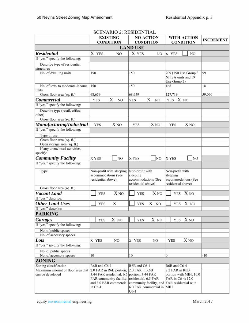
50 Nevins Street Zoning Map Amendment Residential Appendix p. 3
equity environmental engineering March 2017
SCENARIO 2: RESIDENTIAL EXISTING
CONDITION NO-ACTION CONDITION
WITH-ACTION CONDITION
INCREMENT
LAND USE Residential X YES NO X YES NO x YES NO If “yes,” specify the following:
Describe type of residential structures No. of dwelling units 150 150 209 (150 Use Group 3
NPISA units and 59 Use Group 2)
59
No. of low- to moderate-income units
150 150 168 18
Gross floor area (sq. ft.) 68,659 68,659 127,719 59,060
Commercial YES X NO YES X NO YES X NOIf “yes,” specify the following:
Describe type (retail, office, other)
Gross floor area (sq. ft.)
Manufacturing/Industrial YES X NO YES X NO YES X NOIf “yes,” specify the following:
Type of use Gross floor area (sq. ft.) Open storage area (sq. ft.)
If any unenclosed activities, specify:
Community Facility X YES NO X YES NO X YES NO If “yes,” specify the following:
Type Non-profit with sleeping accommodations (See residential above)
Non-profit with sleeping accommodations (See residential above)
Non-profit with sleeping accommodations (See residential above)
Gross floor area (sq. ft.)
Vacant Land YES X NO YES X NO YES X NOIf “yes,” describe:
Other Land Uses YES X YES X NO YES X NOIf “yes,” describe:
PARKING Garages YES X NO YES X NO YES X NOIf “yes,” specify the following:
No. of public spaces No. of accessory spaces
Lots x YES NO x YES NO YES X NOIf “yes,” specify the following:
No. of public spaces No. of accessory spaces 10 10 0 -10
ZONING Zoning classification R6B and C6-1 R6B and C6-1 R6B and C6-4 Maximum amount of floor area that can be developed
2.0 FAR in R6B portion; 3.44 FAR residential, 6.5 FAR community facility, and 6.0 FAR commercial in C6-1
2.0 FAR in R6B portion; 3.44 FAR residential, 6.5 FAR community facility, and 6.0 FAR commercial in C6-1
2.2 FAR in R6B portion with MIH; 10.0 FAR in C6-4; 12.0 FAR residential with MIH
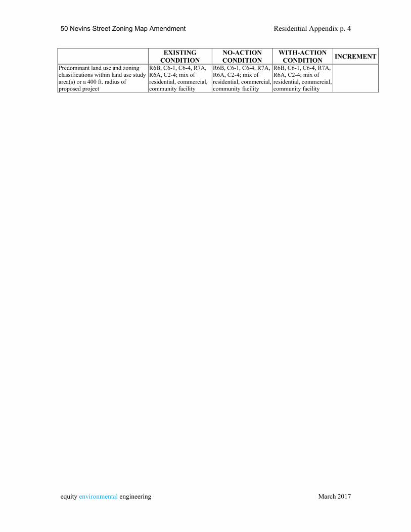
50 Nevins Street Zoning Map Amendment Residential Appendix p. 4
equity environmental engineering March 2017
EXISTING CONDITION
NO-ACTION CONDITION
WITH-ACTION CONDITION
INCREMENT
Predominant land use and zoning classifications within land use study area(s) or a 400 ft. radius of proposed project
R6B, C6-1, C6-4, R7A, R6A, C2-4; mix of residential, commercial, community facility
R6B, C6-1, C6-4, R7A, R6A, C2-4; mix of residential, commercial, community facility
R6B, C6-1, C6-4, R7A, R6A, C2-4; mix of residential, commercial, community facility
50 Nevins Street Zoning Map Amendment Residential Appendix p. 5
equity environmental engineering March 2017
Land Use
As described in the Land Use section of this EAS, the area surrounding the Project Site is developed with a range of medium- and higher-density residential developments, as well as commercial uses including ground floor retail uses and hotels, as well as public institutions. Recent and ongoing development patterns in the area include higher-density residential developments on sites north of the Project Site. A residential development scenario would be compatible with the surrounding land use pattern and would not introduce any land use conflicts to the area.
Zoning and Public Policy
The proposed action would result in the rezoning of the affected area from C6-1 to C6-4, and the establishment of a Mandatory Inclusionary Housing Area (MIHA) coterminous with the area proposed for rezoning. Under Mandatory Inclusionary Housing (MIH), C6-4 allows residential development at an FAR of 12.0 (R10 equivalent). Under MIH, developers would need to select one of the following options:
- Option One: 25 percent of the residential floor area shall be provided as housing affordable to households at an average of 60 percent of the Income Index (AMI), with no unit targeted at a level exceeding 130 percent of AMI. ($46,620 per year for a family of three), including 10% of residential floor area affordable to households at an average of 40 percent of AMI, or - Option Two: 30 percent of the residential floor area shall be provided as housing affordable to households at an average of 80 percent of the Income Index (AMI), with no unit targeted at a level exceeding 130 percent of AMI. ($62,150 per year for a family of three).
In addition to one or both of the options above, the City Council and the City Planning Commission may determine that either the Deep Affordability Option or the Workforce Option or both would also apply to the Project Area.
The project sponsor does not intend to build a residential development within the affected area. However, both Options One and Two would be allocated to the Mandatory Inclusionary Housing Area to be established affecting the Project Site.
The proposed C6-4 district would allow commercial or community facility development at 10.0 FAR. Other than FAR, the bulk controls of the proposed C6-4 district are the same as those of the existing C6-1 district. These bulk controls permit a maximum base height of 125 feet for a narrow street and 185 feet for a wide street and a maximum building height of 155 feet and a maximum building height of 230 feet, or 235 feet is a qualifying ground floor is provided. However, as under existing zoning the zoning lot would be subject to the Schermerhorn Height Limitation Area B, where maximum building height is 140 ft. The establishment of an MIHA over the portion of the Project Site that is, and would remain, zoned R6B would increase residential floor area from 2.0 to 2.2 for a development that provides affordable housing pursuant to MIH.
50 Nevins Street Zoning Map Amendment Residential Appendix p. 6
equity environmental engineering March 2017
For both the existing C6-1 district and the proposed C6-4 district, accessory parking is required for 20% of UG 2 residential (as modified within the Special Downtown Brooklyn District per ZR 101-50). Because the Project Site is within the Transit Zone, no accessory parking is required for affordable housing built pursuant to MIH, or for Income Restricted Housing. Both the existing C6-1 district and the proposed C6-4 district have no parking requirement for commercial uses including general retail space and commercial hotels, or for Use Group 3 community facilities with sleeping accommodations. The 26 market rate units that would be developed under the Residential Scenario would generate a parking requirement of five spaces, and therefore the accessory parking requirement would be waived. Public policy for land use in the area is established by the area’s zoning. The proposed zoning map amendment would extend a higher-density C6-4 zoning district that is mapped to the north of the affected area, and would establish the affected area as a Mandatory Inclusionary Housing Area. Creation of the MIHA would ensure that any new residential development would provide a significant amount of permanent affordable housing consistent with city policy. No significant adverse impacts are anticipated for public policy. Historic and Cultural Resources Under the Residential Development Scenario new building elements would be constructed adjacent to the Existing Building. The Existing Building is not a New York City Landmark, is not within a New York City Historic District, and is not listed on the State/National Register of Historic Places. The Existing Building has been identified as eligible for listing on the State/National Register. Development of the Residential Development Scenario would not rely on state funding and therefore would not be subject to review by SHPO. Because the Existing Building is not a New York City Landmark, as-of-right, privately financed development would not be subject to the New York City Landmark Law. Urban Design and Visual Resources The urban design characteristics of the Residential Development Scenario would be similar to those of the proposed development. The same height and other bulk regulations that apply to Community Facility development under the proposed C6-4 district within the maximum height restriction of 140 feet within the Schermerhorn Street Height Limit Area B. Development would be within the scale of buildings in the surrounding area, and would replace an open parking lot on Schermerhorn with a street line building element that would reinforce the pedestrian context of the street. No significant adverse impacts are anticpated for Urban Design and Visual Resources
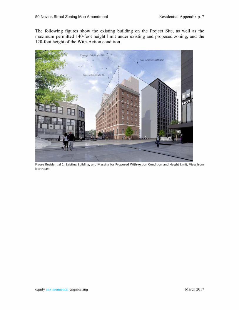
50 Nevins Street Zoning Map Amendment Residential Appendix p. 7
equity environmental engineering March 2017
The following figures show the existing building on the Project Site, as well as the maximum permitted 140-foot height limit under existing and proposed zoning, and the 120-foot height of the With-Action condition.
Figure Residential 1: Existing Building, and Massing for Proposed With‐Action Condition and Height Limit, View from Northeast
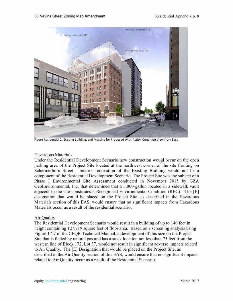
50 Nevins Street Zoning Map Amendment Residential Appendix p. 8
equity environmental engineering March 2017
Figure Residential 2: Existing Building, and Massing for Proposed With‐Action Condition View from East Hazardous Materials Under the Residential Development Scenario new construction would occur on the open parking area of the Project Site located at the northwest corner of the site fronting on Schermerhorn Street. Interior renovation of the Existing Building would not be a component of the Residential Development Scenario. The Project Site was the subject of a Phase I Environmental Site Assessment conducted in November 2015 by GZA GeoEnvironmental, Inc. that determined that a 3,000-gallon located in a sidewalk vault adjacent to the site constitutes a Recognized Environmental Condition (REC). The [E] designation that would be placed on the Project Site, as described in the Hazardous Materials section of this EAS, would ensure that no significant impacts from Hazardous Materials occur as a result of the residential scenario. Air Quality The Residential Development Scenario would result in a building of up to 140 feet in height containing 127,719 square feet of floor area. Based on a screening analysis using Figure 17-7 of the CEQR Technical Manual, a development of this size on the Project Site that is fueled by natural gas and has a stack location not less than 75 feet from the western line of Block 172, Lot 37, would not result in significant adverse impacts related to Air Quality. The [E] Designation that would be placed on the Project Site, as described in the Air Quality section of this EAS, would ensure that no significant impacts related to Air Quality occur as a result of the Residential Scenario.
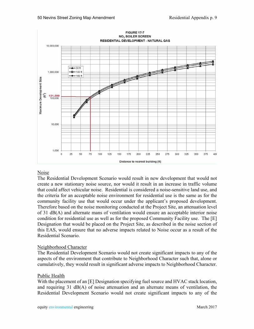
50 Nevins Street Zoning Map Amendment Residential Appendix p. 9
equity environmental engineering March 2017
Noise The Residential Development Scenario would result in new development that would not create a new stationary noise source, nor would it result in an increase in traffic volume that could affect vehicular noise. Residential is considered a noise-sensitive land use, and the criteria for an acceptable noise environment for residential use is the same as for the community facility use that would occur under the applicant’s proposed development. Therefore based on the noise monitoring conducted at the Project Site, an attenuation level of 31 dB(A) and alternate mans of ventilation would ensure an acceptable interior noise condition for residential use as well as for the proposed Community Facility use. The [E] Designation that would be placed on the Project Site, as described in the noise section of this EAS, would ensure that no adverse impacts related to Noise occur as a result of the Residential Scenario.
Neighborhood Character The Residential Development Scenario would not create significant impacts to any of the aspects of the environment that contribute to Neighborhood Character such that, alone or cumulatively, they would result in significant adverse impacts to Neighborhood Character.
Public Health With the placement of an [E] Designation specifying fuel source and HVAC stack location, and requiring 31 dB(A) of noise attenuation and an alternate means of ventilation, the Residential Development Scenario would not create significant impacts to any of the
Jim
Text Box
50 Nevins Street Zoning Map Amendment Residential Appendix p. 10
equity environmental engineering March 2017
aspects of the environment that could affect Public Health such that, alone or cumulatively, they would result in significant adverse impacts to Public Health.
Construction Construction of the Residential Development Scenario would not last longer than two years or occur in a Central Business District or on a major arterial. All construction activity would be performed subject to relevant DOT and DOB regulations. No significant adverse impacts would result from the approval of the proposed project.
Related Documents