1 Eurosion GIS data in the EEA Andrus Meiner, EEA Expert meeting Methods and tools for assessing coastal vulnerability to climate change at the European scale EEA, Copenhagen, 8-9 June 2011

1 Eurosion GIS data in the EEA Andrus Meiner, EEA Expert meeting Methods and tools for assessing coastal vulnerability to climate change at the European.
Jan 11, 2016
Welcome message from author
This document is posted to help you gain knowledge. Please leave a comment to let me know what you think about it! Share it to your friends and learn new things together.
Transcript

1
Eurosion GIS data in the EEA
Andrus Meiner, EEA
Expert meetingMethods and tools for assessing coastal vulnerability to climate
change at the European scale EEA, Copenhagen, 8-9 June 2011

2
Eurosion project 2002-2004A European initiative for sustainable coastal erosion management
• Final report – Eurosion vision, 4 key recommendations– Findings and technical results
• Shoreline Management Guide– Coastal erosion management solutions in Europe, 60
case studies
• GIS database– Update of 1985-1990 CORINE Coastal Erosion data– 14 data layers for Europe
Brochure “Living with coastal erosion in Europe”

3
www.eurosion.org
4
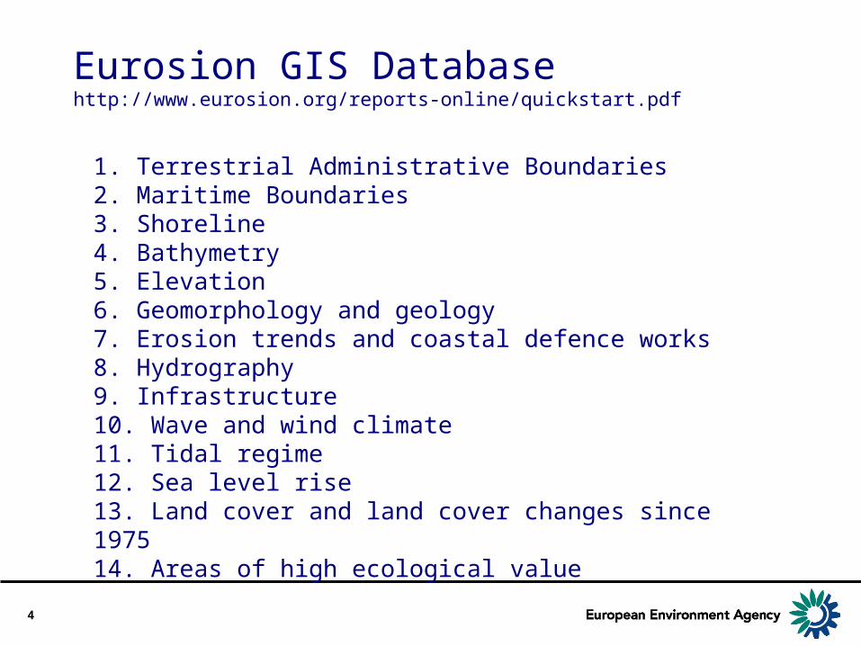
Eurosion GIS Databasehttp://www.eurosion.org/reports-online/quickstart.pdf
1. Terrestrial Administrative Boundaries 2. Maritime Boundaries 3. Shoreline 4. Bathymetry 5. Elevation 6. Geomorphology and geology 7. Erosion trends and coastal defence works 8. Hydrography 9. Infrastructure 10. Wave and wind climate 11. Tidal regime 12. Sea level rise 13. Land cover and land cover changes since 1975 14. Areas of high ecological value

5
Eurosion GIS data/maps in the EEASearch ’eurosion’ from http://dataservice.eea.europa.eu
1. Terrestrial Administrative Boundaries 2. Maritime Boundaries 3. Shoreline (Eurosion compilation)4. Bathymetry 5. Elevation 6. Geomorphology and geology (Eurosion, vector polyline)7. Erosion trends and coastal defence works (Eurosion)8. Hydrography 9. Infrastructure 10. Wave and wind climate (as statistics, copyright)11. Tidal regime (as statistics, copyright)12. Sea level rise (Eurosion)13. Land cover and land cover changes since 1975 14. Areas of high ecological value

6
3. Eurosion: Shoreline

7
6. Geomorphology and geologyBoth a geomorphological and a geological code is assigned to each segment

8
7A. Coastal erosion patterns

9
7B. Protected and defended coastline

10
11 & 12. Mean tidal amplitude and relative sea level riseStatistics from 237 locations

11
Lessons learned
• Several data sets are outdated – acquisition time 2000-2003 or older– newer GIS data available (e.g. Landsat vs IMAGE2000)– data compilations not INSPIRE compliant
• Highest value: compilations of thematic data by the Eurosion project
– coastal geology, erosion trends and sea regimes? (i.e. EMODnet)– European coverage, that is still unique for these layers
• EEA has used and published this data in 2006– Coastal vulnerability could be a new customer for Eurosion

Related Documents