Current use of spatial Current use of spatial reference grids in European reference grids in European Environment Agency Environment Agency Andrus Meiner, EEA

Welcome message from author
This document is posted to help you gain knowledge. Please leave a comment to let me know what you think about it! Share it to your friends and learn new things together.
Transcript

Current use of spatial reference grids in Current use of spatial reference grids in European Environment Agency European Environment Agency
Andrus Meiner, EEA

Direct and indirect spatial reference Direct and indirect spatial reference (position)(position)
Source: Source: httphttp://://crscrs..ifagifag.de/.de/crscrs__contentcontent..phpphp (Bundesamt für Kartographie und (Bundesamt für Kartographie und Geodäsie)Geodäsie)

Environmental issues and use of Environmental issues and use of reference grids (1)reference grids (1)
• Air pollution, ozone and UV– emissions– deposition– concentrations – exposure– calculated critical loads, exceedances
• Biodiversity assessment– species distribution (atlases)

Environmental issues and use of Environmental issues and use of reference grids (2)reference grids (2)
• Climate change and hydrology– temperature change– average annual runoff
• Land cover– land cover distribution– fragmentation
• Soil– erosion risk
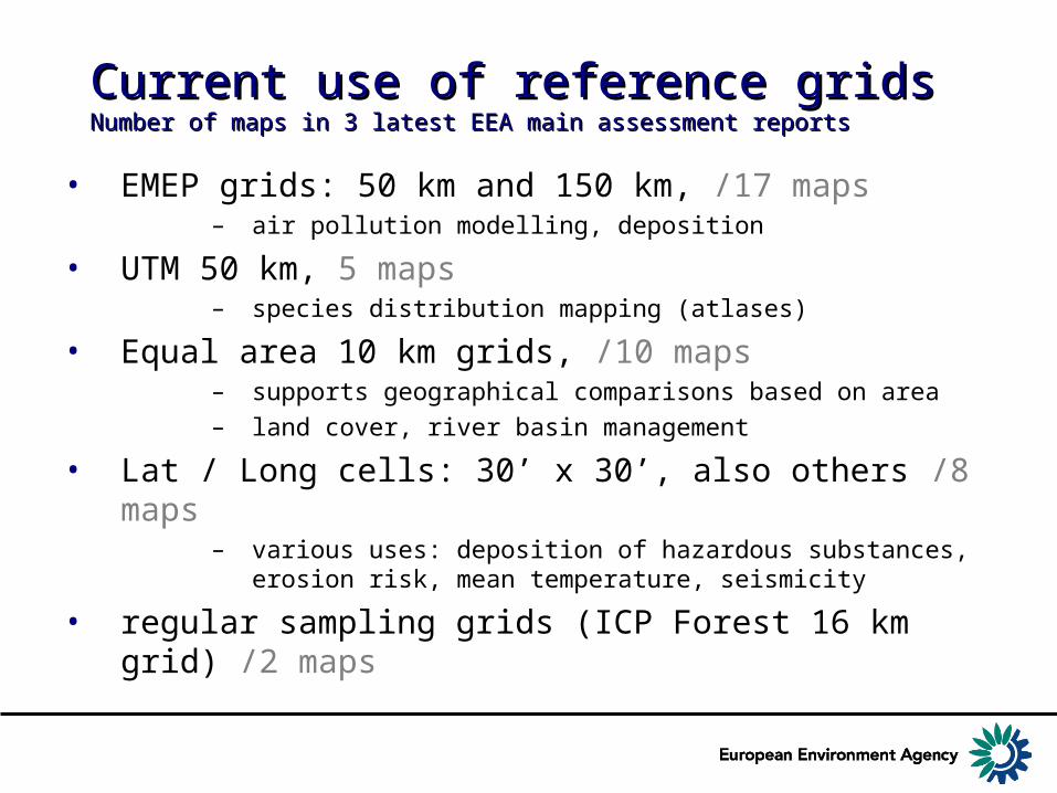
Current use of reference gridsCurrent use of reference gridsNumber of maps in 3 latest EEA main assessment reportsNumber of maps in 3 latest EEA main assessment reports
• EMEP grids: 50 km and 150 km, /17 maps– air pollution modelling, deposition
• UTM 50 km, 5 maps– species distribution mapping (atlases)
• Equal area 10 km grids, /10 maps– supports geographical comparisons based on area
– land cover, river basin management
• Lat / Long cells: 30’ x 30’, also others /8 maps– various uses: deposition of hazardous substances, erosion
risk, mean temperature, seismicity
• regular sampling grids (ICP Forest 16 km grid) /2 maps

EMEP grid EMEP grid
• Monitoring for CLRTAP• Projection: Polar Stereographic• Resolution
– Original 50 x 50 km (on project plane)– Derived 150 x 150 km and 1˚x 1˚– Cell area on earth vary 1750 – 2850 km2
• Conversion to geographical (lat/long) coordinates supported

EMEP 50 x 50 km gridEMEP 50 x 50 km grid
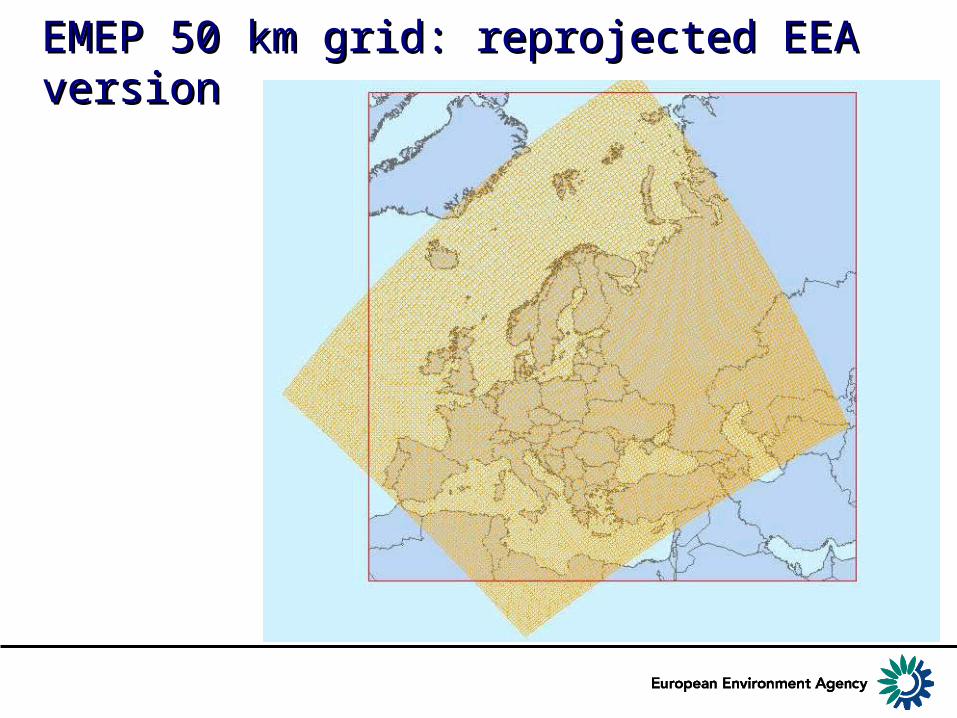
EMEP 50 km grid: reprojected EEA EMEP 50 km grid: reprojected EEA versionversion

Example of EMEP 50 km grid: Example of EMEP 50 km grid: ecosystems protected against acidificationecosystems protected against acidification

Example of EMEP 150 km grid: Example of EMEP 150 km grid: HCB concentration in soilHCB concentration in soil

UTM grid by CGRS/AFEUTM grid by CGRS/AFEChorological Grid Reference System/Atlas Florae EuropaeaeChorological Grid Reference System/Atlas Florae Europaeae
• Widely used in species distribution mapping
• Spatial reference system:– UTM (and UPS)– WGS84 datum – grid is based on Military Grid Reference
System
• Resolution – standard 50 x 50 km– irregular cell size on the UTM zone
boundaries
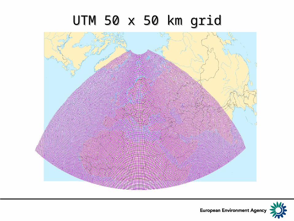
UTM 50 x 50 km gridUTM 50 x 50 km grid
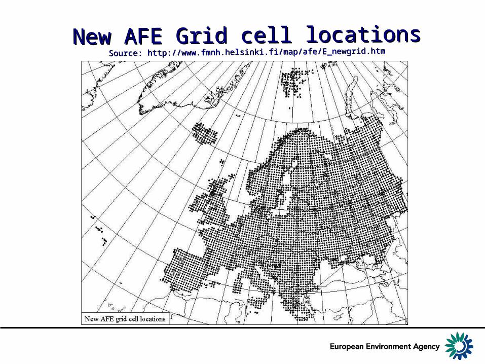
New AFE Grid cell locationsNew AFE Grid cell locationsSource: Source: http://www.fmnh.helsinki.fi/map/afe/E_newgrid.htmhttp://www.fmnh.helsinki.fi/map/afe/E_newgrid.htm

Example of UTM 50 gridExample of UTM 50 grid

Other gridsOther grids
• 10 km equal area grid – Lambert Azimuthal Equal Area projection and
WGS84– Centerpoint 52˚N 20˚E– Used in land cover mapping and analysis
• Lat/long grids– Different resolution (30’ x 30’ etc)– Variety of applications

Example Example of 10 km of 10 km grid: grid: CORINE CORINE Land Land CoverCover
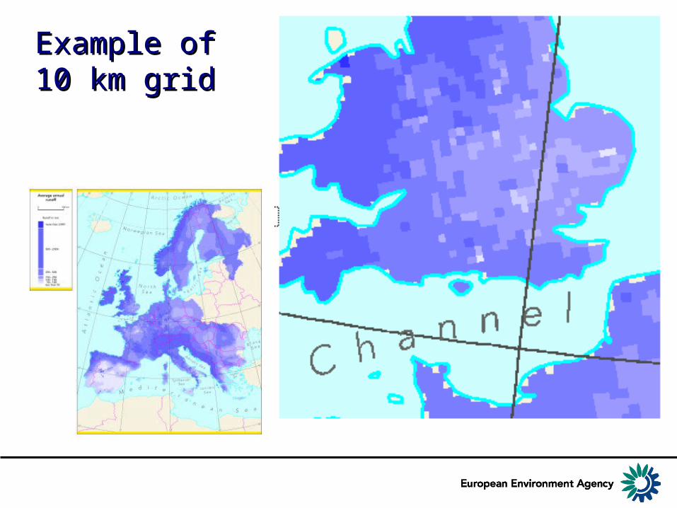
Example of Example of 10 km grid10 km grid

Example of Example of lat/long grid lat/long grid cells cells

Example of lat/long grid Example of lat/long grid (water erosion vulnerability 1990, IMAGE 2 by (water erosion vulnerability 1990, IMAGE 2 by RIVMRIVM))
ConclusionsConclusions
• EEA is not a grid developer, but is interested in European common grid
• EEA priorities :• Compatibility through clear relation to
ETRS89» use WGS84 datum» agreed projections LAEA, TMzn and LCC
• Convertability to geographical lat/long coordinates
• Efficiency for data storage and access, like quadtree hierarchical data structure
Related Documents