Scanned by CamScanner 11'!, . ... , • ,.. , . Cl ,ARHWAL MANDAL VIKAS NIGAM LTO. 74/1 RAJPUR ROAD, DEHRADUN To, Till' J) i n' l't 0 r l ( t\ _ II ), ol'"FI\ \ irOlllllcllt, FOrt'st & Climate Change, IlId".1 I .11 :Ir;rn Bhawan, l.odhi Ho:td, ./111' N l'\\ Dcl II i-I 1000J Ph:-0135-2746817,2749308 Fax: - 2746847 Date _l'-/-P-l!/J6..-------- Suh: Sllhlll is sion rcganling Environmental Clearance of the proposed River Tons Lot No. 3/13 S;rnd, Ba.iri S.: Boulder Milling Project (8S,OOO TPA) located at Village: Banshiwala, Tchsil: So: District: Ih'lIradulI, lJttaraldland (6.0 Jln) under Mis Garhwal Mandai ViI<as I.td. lJll:traldlalld net': Slllnm : 11'\ rC l'I lrd I ll' .nlh Mceting of the Reconstituted Expert Appraisal Committee for Environmental !\ ppr: li,, ; \1 p i' Project s (Non-Coal) of the Ministry of Environment, Forest and Climate l hcl d dmi l lg August 25 111 _27 Ih , 20lS DcaI' "i r. Wit h lu : l1c ;I hu \'l' mcnti oncd subject, we herewith submit revised EIA report of said project with pres( : il ll: d .ll lt l IL' tj uisitc doclIm ent s and reports as per the queries raised in the 37 1h Meeting of the Re CUIl Sl illllL' " h p :1 : l\pp r: li sal C01l1mittee for Environmental Appraisal of Mining Projects (Non-Coal) of th e 1 11' 1. 11 i!U1111 1C nl. I:o n:st and Climate Change was held during August 2S lh _27 1h , 2015. Now :I S jll'l ;I, ll ilicat io ll {S.O. 14 1(E)} issued on IS lh January, 2016 by MoEF&CC, the said project ullde r l 1\ (( '/usler silualion: Cluster mine leases area <50 hectares ). Map showing cluster situ al il lil ;llt;l ckd 1l" IT with . 1 rl' I: ll cq \ .1 11 III kim ll )' cO ll sider th e case for the Environmental Clearance. Thanking You Yours truly . ..... ,.. , ' . G ;4 a ,ARHWAL MANDAL VIKAS NIGAM L TO. 74/1 RAJPUR ROAD, DEHRADUN To, Till' J) i n'l't 0 r (I t\ - II) , (d' FIII'ironlllcnt, Forl'st & Climate Change Indira :I ran Bhawan, , l.odhi Hoad. ,),,1' Bal-!h, Nl'" lklhi-II OOOJ Ph:-0135-2746817,2749308 Fax: - 2746847 Date _l'-!-P-l1!J6..-------- Suh: slIhlll issioll regarding Environmental Cleanlllce of the proposed River Tons Lot No. 3/13 Salld. Bajri S.; Boulder Mining Projcct (85,000 TPA) located at Village: Banshiwala, Tchsil: Vil,a , ';lIagar District: lh'hradun, lJUaraldlaml (6.0 lin) under Mis Garhwal Mandai Vil<as Ltd . l: llaraldrand net': SlIlllm :ll'\ rel',l rc! ui' .nlh Meeting of the Reconstitut ed Expe rt Appraisal Committee for Environmental II :' :\ 'l inint!- Project s (Non·Coa l) of the Ministry of Environment, Forest and Climate l he ld d lll'l llt!- August 25 1 "_27 Ih , 2015 DcaI' :-: ir. With I II : l1e :illl l\' e mentioned s ubj ec t, we herewith submit revised EIA report of said project with ilk'" . Im l rL' qui sitc docliments and reports as per the queries raised in the 37 th Meeting of the RC C ll llSlil lll l'L! 1':\1':1: I\ppr :lisal Comm ittee for Environmental Appraisal of Mining Projects (Non-Coal) of th e 1 11 ' 1.11 ill ll1 lllCll 1. Forest and Climate Change was held during August 25 th _27th, 2015 . No\\ :1\ pl'r ,Il lril icari o ll {S .O. 14 1( E)} issued on 15 th Janua ry , 2016 by MoEF&CC, the said project COllll 'I, 1I 11d l'l' l 1\ (C '/lls/ er si /ll alion: Cluster mine leases area <50 hectares). Map showing cluster situal i,11 1 ;\l l<l cl ,' L! 1i"IT lV ith. 1 hU l11hl) rl',III l.'''1 \ .1 1I III kim ll y cO l1 sider the case for the Environmental Clearance. Thanking You Yours truly

Welcome message from author
This document is posted to help you gain knowledge. Please leave a comment to let me know what you think about it! Share it to your friends and learn new things together.
Transcript
Scanned by CamScanner
11'!, .... , • ,.., . Cl ~.' ,ARHWAL MANDAL VIKAS NIGAM L TO.
74/1 RAJPUR ROAD, DEHRADUN
To,
Till' J) i n' l't 0 r l ( t\ _II ),
I\lil~i~tr .: ·. ol'"FI\ \ irOlllllcllt, FOrt'st & Climate Change, IlId".1 I .11 ~.I\ :Ir;rn Bhawan, l.odhi Ho:td, ./111' B:t~h, N l'\\ Dcl II i-I 1000J
Ph:-0135-2746817,2749308 Fax: - 2746847
Date _l'-/-P-l!/J6..--------
Suh: l~l'JlI~ Sllhlll is sion rcganling Environmental Clearance of the proposed River Tons Lot No. 3/13
S;rnd, Ba.ir i S.: Boulder Milling Project (8S,OOO TPA) located at Village: Banshiwala, Tchsil:
Vil\a~l\:tgar So: District: Ih'lIradulI, lJttaraldland (6.0 Jln) under Mis Garhwal Mandai ViI<as ~igalll I.td . l Jll:traldlalld
net': Slllnm:11'\ rCl'I lrd Ill' .nlh Mceting of the Reconstituted Expert Appraisal Committee for Environmental
!\ ppr: li,, ;\1 p i' :\ l i llin~ Project s (Non-Coal) of the Ministry of Environment, Forest and Climate
l ' h~ 1I1 ;~ l' . hcl d dmi llg August 25 111 _27 Ih, 20lS
DcaI' "i r.
Wit h I l'I~Tl' ll " ~ lu :l1c ;Ihu \'l' mcnti oncd subject, we herewith submit revised EIA report of said project with
pres( : illl:d (IlIl n ~:1 .lllt l IL' tj uisitc doclIments and reports as per the queries raised in the 371h Meeting of the ReCUIl Sl illllL'" h p :1: l\ppr:li sal C01l1mittee for Environmental Appraisal of Mining Projects (Non-Coal) of th e ;\" I ill i :-. l r ~ 111' 1.11 i!U11111Cnl. I:on:st and Climate Change was held during August 2S lh _271h
, 2015.
Now :IS jll'l 1 ~ ll c s l ;I,ll ilicatio ll {S.O. 14 1(E)} issued on IS lh January, 2016 by MoEF&CC, the said project COll1 l'~ ullde r l 'alL' ~ c l)r ~ 1\ (( '/usler silualion: Cluster mine leases area <50 hectares ). Map showing cluster situal illil ha ~ ;llt;lckd 1l" IT with .
1 hU lll h l ~ rl'I: ll cq \ .111 III kimll )' cOll sider the case for the Environmental Clearance.
Thanking You
Yours truly
~, ...... ,.., ' . G ;4 a ,ARHWAL MANDAL VIKAS NIGAM L TO.
74/1 RAJPUR ROAD, DEHRADUN
To,
Till' J) i n'l't 0 r (I t\ - II),
I\lil~i,tJ"\' (d' FIII 'ironlllcnt, Forl'st & Climate Change Indira Par~' a\ :I ran Bhawan, , l.odhi Hoad. ,),,1' Bal-!h, Nl'" lklhi-II OOOJ
Ph:-0135-2746817,2749308 Fax: - 2746847
Date _l'-!-P-l1!J6..--------
Suh: l~l'JlI~ slIhlll issioll regarding Environmental Cleanlllce of the proposed River Tons Lot No. 3/13
Salld. Bajri S.; Boulder Mining Projcct (85,000 TPA) located at Village: Banshiwala, Tchsil:
Vil,a ,';lIagar ,~ District: lh'hradun, lJUaraldlaml (6.0 lin) under Mis Garhwal Mandai Vil<as ~igalll Ltd . l :llaraldrand
net': SlIlllm:ll'\ rel',l rc! ui' .nlh Meeting of the Reconstituted Expert Appraisal Committee for Environmental
!\ppr : l i~ : tI II :' :\'l inint!- Project s (Non·Coal) of the Ministry of Environment, Forest and Climate
l ' h ~ II1 :2 l' . he ld dlll'l llt!- August 25 1"_27Ih, 2015
DcaI' :-: ir.
With Il'I ~'1'l' ll l': III :l1e :illl l\' e mentioned subj ect, we herewith submit revised EIA report of said project with
prc~l' l ilk'" !" lI ll1 ~ ! 1 .Iml rL' qui sitc docliments and reports as per the queries raised in the 37th Meeting of the
RCCll llSlil lll l'L! 1':\1':1: I\ ppr:lisal Comm ittee for Environmental Appraisal of Mining Projects (Non-Coal) of
the I\/ lill i :-. lr ~ 111 ' 1.11 ill ll1 lllCll 1. Forest and Climate Change was held during August 25 th _27th, 2015 .
No\\ :1\ pl'r 1~lr l' s r ,Illril icarioll {S .O. 14 1( E)} issued on 15 th January, 2016 by MoEF&CC, the said project COllll'I, 1I 11dl'l' l 'a1L' \':' ll r~ 1\ (C '/lls/ er si/llalion: Cluster mine leases area <50 hectares). Map showing cluster situal i,11 1 h a ~ ;\l l<l cl ,'L! 1i"ITlV ith.
1 hU l11hl) rl',IIIl.'''1 \ .11I III kimll y cO l1 sider the case for the Environmental Clearance.
Thanking You
Yours truly
EEENNNVVVIIIRRROOONNNMMMEEENNNTTTAAALLL IIIMMMPPPAAACCCTTT AAASSSSSSEEESSSSSSMMMEEENNNTTT
AAANNNDDD
EEENNNVVVIIIRRROOONNNMMMEEENNNTTTAAALLL MMMAAANNNAAAGGGEEEMMMEEENNNTTT PPPLLLAAANNN RRREEEPPPOOORRRTTT
OOOFFF
RRRIIIVVVEEERRR TTTOOONNNSSS LLLOOOTTT NNNOOO... 333///111333 SSSAAANNNDDD,,, BBBAAAJJJRRRIII &&& BBBOOOUUULLLDDDEEERRR MMMIIINNNIIINNNGGG PPPRRROOOJJJEEECCCTTT
Village: Banshiwala, Tehsil: Vikasnagar, District: Dehradun, State: Uttarakhand
Area: 6.0 Ha, Proposed Capacity: 85,000 TPA
AAAPPPPPPLLLIIICCCAAANNNTTT
GARHWAL MANDAL VIKAS NIGAM LTD. 74/1 RAJPUR ROAD, DEHRADUN
PPPrrreeepppaaarrreeeddd BBByyy
GRASS ROOTS RESEARCH & CREATION INDIA (P) LTD. (An ISO 9001:2008 Certified Co.: Accredited by QCI / NABET: Approved by MoEF, GoI)
F-374-375, Sector-63, Noida, U.P. Ph.: 0120- 4044630, Telefax: 0120- 2406519
Email: [email protected], [email protected] Website: http://www.grc-india.com
GRC INDIA TRAINING & ANALYTICAL LABORATORY
(Accredited by NABL &Recognized by MoEF, GoI) A unit of GRC India

INDEX Serial No. CONTENTS
Page No.
1 LIST OF TABLES
2 ABBREVIATIONS
3 TERMS OF REFERENCE
INTRODUCTION:CAHPTER-1
1.0 PURPOSE OF THE REPORT 2
1.1 IDENTIFICATION OF PROJECT & PROJECT PROPONENT 2
1.2 BRIEF DESCRIPTION OF PROJECT 3
1.3 SCOPE OF THE STUDY 4
PROJECT DESCRIPTION:CAHPTER-2
2.0 TYPE OF PROJECT 25
2.1 NEED FOR THE PROJECT 25
2.2 LOCATION DETAILS 25
2.3 MINING 33
2.4 RESERVE (AVAILABLE QUANTUM) AND PRODUCTION (EXTRACTABLE QUANTUM)
34
2.5 SITE FACILITIES AND UTILITIES 38
2.6 STATUTORY REQUIREMENTS 39
DESCRIPTION OF ENVIRONMENT:CAHPTER-3
3.0 INTRODUCTION 41
3.1 BASELINE DATA 41
3.1.1 LAND ENVIRONMENT 41
3.1.2 AIR ENVIRONMENT 41
3.1.3 WATER ENVIRONMENT 47
3.1.4 SOIL ENVIRONMENT 56
3.1.5 NOISE ENVIRONMENT 58
3.1.6 BIOLOGICAL ENVIRONMENT 59
3.1.7 SOCIO-ECONOMIC STATUS & BASELINE DATA 78
ANTICIPATED ENVIRONMENTAL IMPACT AND MITIGATION MEASURES:CAHPTER-4
4.0 GENERAL 87
4.1 LAND ENVIRONMENT 87
4.2 WATER ENVIRONMENT 89
4.3 AIR ENVIRONMENT 90
4.4 NOISE ENVIRONMENT 93
4.5 BIOLOGICAL ENVIRONMENT 95
4.6 TRAFFIC ANALYSIS 96
ENVIRONMENTAL MONITORING PROGRAMME:CAHPTER-5
5.0 INTRODUCTION 101
5.1 ENVIRONMENTAL MONITORING AND REPORTING PROCEDURE 101
5.2 MONITORING METHODOLOGIES AND PARAMETERS 102
5.3 MONITORING SCHEDULE 103
5.4 MONITORING SCHEDULE- IMPLEMENTATION 104
5.5 BUDGET ALLOCATION FOR MONITORING 105
5.6 REPORTING SCHEDULE OF THE MONITORING DATA 105
ADDITIONAL STUDIES:CAHPTER-6
6.0 PUBLIC CONSULTATION 107
6.1 HAZARD IDENTIFICATION AND RISK ASSESSMENT METHOLODOGY
108
6.2 RISK ASSESMENT 109
6.3 DISASTERS & ITS MANAGEMENT 114
6.4 SOCIO-ECONOMIC IMPACT OF THE PROJECT & SAFETY MEASURES
116
PROJECT BENEFITS:CAHPTER-7
7.0 GENERAL 122
7.1 PHYSICAL BENIFITS 122
7.2 SOCIAL BENIFITS 122
7.3 ENVIRONMENTAL BENIFITS 123
7.4 CORPORATE SOCIAL RESPONSIBILITY 123
ENVIRONMENTAL MANAGEMENT PLAN:CAHPTER-8
8.0 INTRODUCTION 126
8.1 ENVIRONMENTAL MANAGEMENT CELL (EMC) 126
8.2 ENVIRONMENTAL MANAGEMENT PLAN (EMP) & IMPLEMENTATION
128
8.3 BUDGET ALLOCATION FOR EMP IMPLEMENTATION 132
EXECUTIVE SUMMARY:CAHPTER-9
9.0 INTRODUCTION 134
9.1 LOCATION 134
9.2 MINING 134
9.3 RESERVE (AVAILABLE QUANTUM) AND PRODUCTION (EXTRACTABLE QUANTUM)
135
9.4 SITE FACILITIES AND UTILITIES 135
9.5 BASE LINE DATA 136
9.6 ENVIRONMENTAL MANAGEMENT PLAN & ITS IMPLEMENTATION
137
9.7 BUDGET ALLOCATION FOR EMP IMPLEMENTATION 138
9.8 BENEFITS OF MINING 138
DISCLOSURE OF CONSULTANTS ENGAGED:CAHPTER-10
10 DISCLOSURE OF CONSULTANTS ENGAGED 140-143
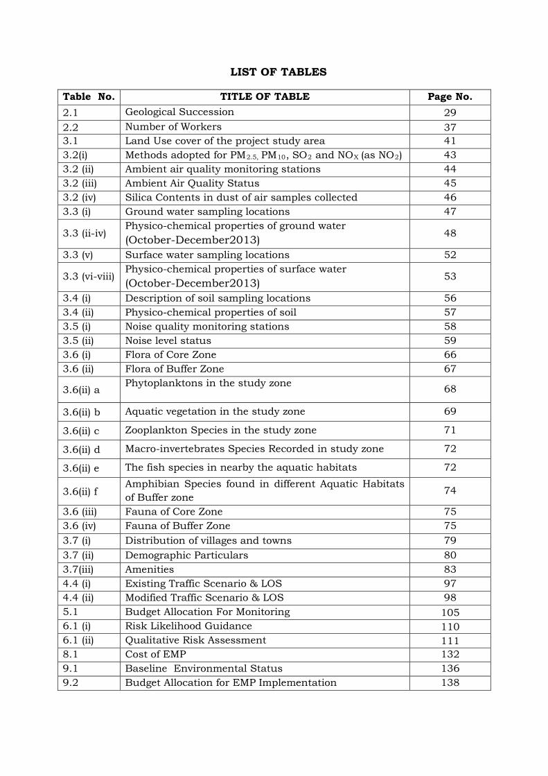
LIST OF TABLES
Table No. TITLE OF TABLE Page No. 2.1 Geological Succession 29 2.2 Number of Workers 37 3.1 Land Use cover of the project study area 41 3.2(i) Methods adopted for PM2.5, PM10, SO2 and NOX (as NO2 43 ) 3.2 (ii) Ambient air quality monitoring stations 44 3.2 (iii) Ambient Air Quality Status 45 3.2 (iv) Silica Contents in dust of air samples collected 46 3.3 (i) Ground water sampling locations 47
3.3 (ii-iv) Physico-chemical properties of ground water (October-December2013) 48
3.3 (v) Surface water sampling locations 52
3.3 (vi-viii) Physico-chemical properties of surface water (October-December2013) 53
3.4 (i) Description of soil sampling locations 56 3.4 (ii) Physico-chemical properties of soil 57 3.5 (i) Noise quality monitoring stations 58 3.5 (ii) Noise level status 59 3.6 (i) Flora of Core Zone 66 3.6 (ii) Flora of Buffer Zone 67
3.6(ii) a Phytoplanktons in the study zone
68
3.6(ii) b Aquatic vegetation in the study zone 69
3.6(ii) c Zooplankton Species in the study zone 71
3.6(ii) d Macro-invertebrates Species Recorded in study zone 72
3.6(ii) e The fish species in nearby the aquatic habitats 72
3.6(ii) f Amphibian Species found in different Aquatic Habitats of Buffer zone
74
3.6 (iii) Fauna of Core Zone 75 3.6 (iv) Fauna of Buffer Zone 75 3.7 (i) Distribution of villages and towns 79 3.7 (ii) Demographic Particulars 80 3.7(iii) Amenities 83 4.4 (i) Existing Traffic Scenario & LOS 97 4.4 (ii) Modified Traffic Scenario & LOS 98 5.1 Budget Allocation For Monitoring 105 6.1 (i) Risk Likelihood Guidance 110 6.1 (ii) Qualitative Risk Assessment 111 8.1 Cost of EMP 132 9.1 Baseline Environmental Status 136 9.2 Budget Allocation for EMP Implementation 138
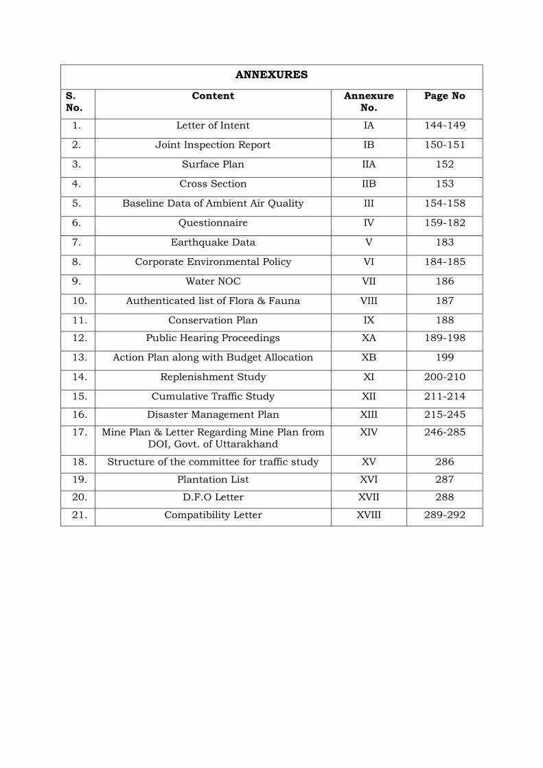
ANNEXURES
S. No.
Content Annexure No.
Page No
1. Letter of Intent IA 144-149
2. Joint Inspection Report IB 150-151
3. Surface Plan IIA 152
4. Cross Section IIB 153
5. Baseline Data of Ambient Air Quality III 154-158
6. Questionnaire IV 159-182
7. Earthquake Data V 183
8. Corporate Environmental Policy VI 184-185
9. Water NOC VII 186
10. Authenticated list of Flora & Fauna VIII 187
11. Conservation Plan IX 188
12. Public Hearing Proceedings XA 189-198
13. Action Plan along with Budget Allocation XB 199
14. Replenishment Study XI 200-210
15. Cumulative Traffic Study XII 211-214
16. Disaster Management Plan XIII 215-245
17. Mine Plan & Letter Regarding Mine Plan from DOI, Govt. of Uttarakhand
XIV 246-285
18. Structure of the committee for traffic study XV 286
19. Plantation List XVI 287
20. D.F.O Letter XVII 288
21. Compatibility Letter XVIII 289-292
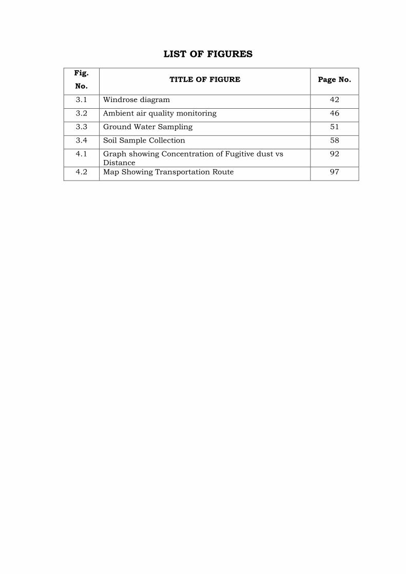
LIST OF FIGURES
Fig.
No. TITLE OF FIGURE Page No.
3.1 Windrose diagram 42
3.2 Ambient air quality monitoring 46
3.3 Ground Water Sampling 51
3.4 Soil Sample Collection 58
4.1 Graph showing Concentration of Fugitive dust vs Distance
92
4.2 Map Showing Transportation Route 97
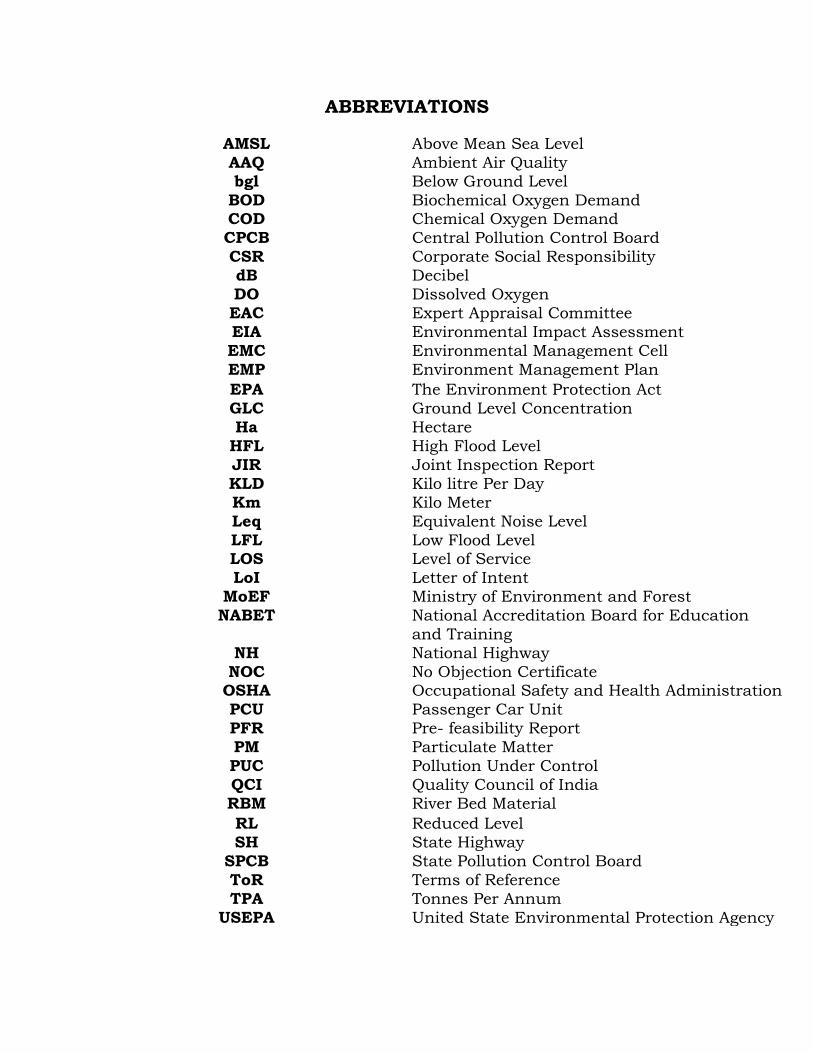
ABBREVIATIONS
AMSL Above Mean Sea Level AAQ Ambient Air Quality bgl Below Ground Level
BOD Biochemical Oxygen Demand COD Chemical Oxygen Demand CPCB Central Pollution Control Board CSR Corporate Social Responsibility dB Decibel DO Dissolved Oxygen EAC Expert Appraisal Committee EIA Environmental Impact Assessment EMC Environmental Management Cell EMP Environment Management Plan EPA The Environment Protection Act GLC Ground Level Concentration Ha Hectare
HFL High Flood Level JIR Joint Inspection Report KLD Kilo litre Per Day Km Kilo Meter Leq Equivalent Noise Level LFL Low Flood Level LOS Level of Service LoI Letter of Intent
MoEF Ministry of Environment and Forest NABET National Accreditation Board for Education
and Training NH National Highway
NOC No Objection Certificate OSHA Occupational Safety and Health Administration PCU Passenger Car Unit PFR Pre- feasibility Report PM Particulate Matter PUC Pollution Under Control QCI Quality Council of India RBM River Bed Material RL Reduced Level SH State Highway
SPCB State Pollution Control Board ToR Terms of Reference TPA Tonnes Per Annum
USEPA United State Environmental Protection Agency
/
To
By Speed Post No . .Jf-1101.5/88/201:~-IA.II 1M)
Govern.menll: of India Ministry 011' Envl.ronment & lrorests
Mis Garhwal Mm.nc1al Vilmll l'lIigaJ!lll ltd. '74 j 1, Rajpur Road Dehradun, Uttarakhand
Paryavaran Bhavan, C.G.O. Complex, Lodi Road,
New Delhi-110 003 JDated the 16th July, 201.3
Subject: Collection. of Sand, liJajri and BCl"l.llders iIl. River Tons of MIs Garhwal Mandlill Vikas Nigam It:d. Located. at Vill-Banshiwala, Teh:sil-Vikas Nagar, DisU-Dehradun, Utta.rakhand (6.0 ha, 85,000 TF'A) - ~rl!nl. regardbllg"
The Proposal was received in the Ministry on 12.03.2013. The Proposal is to determine the Terms of Reference for which the proponent had submitted information in the prescribed format (Form-I) along with Pre-feasibility report.
2. The Mine Lease area is located at Village Banshiwala, Tehsil Vikasnagar, District Dehradun, Uttarakhand .. The lease area lies on River Tons. The Mine Lease area is between 30 0 20'29.19''N to'77°53'33.35"E. The Project is located in seismic zone-IV. It is 'A' category project as the project site lies within the Doon Valley ('11; Interstate boundary between Uttrakhand & Uttar Pradesh lies within 10 Km radius of the lei?-se area. The proposed project is an open-cast mining project, confined to extraction of sand, bajri and boulder from the proposed site. The operation will be manual with use of hand tools like shovel, pan, sieves, etc. Sand will be separated from bajri and boulders by sieving process. Excavation will be carried out up to a maximum depth of 1.5 meters. Total material handling in a year would be 85,000 TPA and the total reserve is calculated as 1.6 lakhs tonnes .. Extraction of sand, bajri and boulder material will be done only dUling the day time and completely stopped during the monsoon season. State Government has issued Letter of Intent No. 589jBhu. Khani.E./2012-13 dated 23.01.2013. Total water requirement will be 2.0 KLD. This water will be supplied from the bore well from nearby villages through tankers as well as from surface water sources for dust suppression with proper permission, Additional water will also be required for plantation purpose. :Silt/Clay (6-12% of sand excavated) will be generated as waste, to be disposed off as filling in low-lying area, for plantation & as spreading in agricultural fields, It is reported by the project proponent that there is no court case/litigation is pending against the project. The total cost of project would be around Rs, 11,70,000 'which includes Rs. 3,00,000 for EMP implementation.
Page 1 of7
2. The proposal was placed before Expert Appraisal Committee in its meeting held during May 15th -17th, 2013, the Committee prescribed the following TORs for undertaking detailed ErA study:
1. Year-wise production details since 1994 should be given, clearly stating the highest production achieved in anyone year prior to 1994. It may also be categorically informed whether there had been any increase in production after the l~IA Notification, 1994 came into force w.r.t. the highest production achieved prior to 1994.
2. A copy of the document in support of the fact that the Proponent is the rightful lessee of the mine should be given.
3. All documents including approved mine plan, mil. and public hearing should be compatible with one another in terms of the mine lease area, production levels, waste generation and its management and mining technology and should be in the name of the lessee.
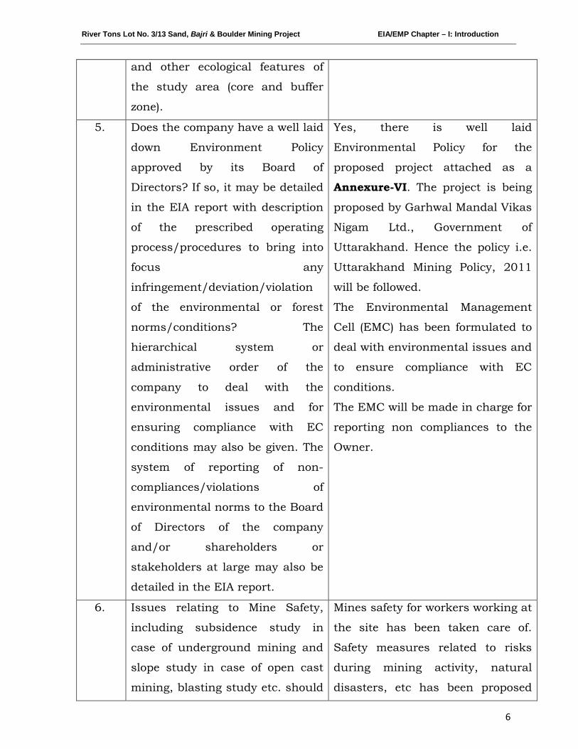
4. All corner coordinates of the mine lease area, superimposed on a High Resolution Imagery/toposheet should be provided. Such an Imagery of the proposed area should clearly show the land use and other ecological features of the study area (core and buffer zone).
5. Does the company have a well laid down Environment Policy approved by its Board of Directors? If so, it may be spelt out in the EIA report with description of the prescribed operating process/procedures to bring into focus any infringement/ deviatilon/violation of the environmental or forest norms/ conditions? The hierarchical system or administrative order of the Company to deal with the environmental issues and for ensuring compliance with the EC conditions may also be given. The system of reporting of non-compliances / violations of environmental norms to the Board of Directors of the Company and/ or shareholders or stakeholders at large may also be detailed in the EIA report.
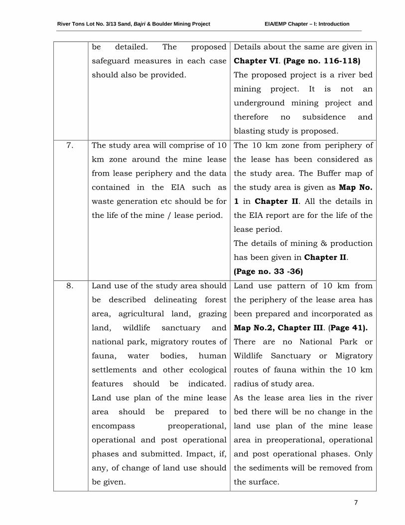
6. Issues relating to Mine Safety, including subsidence study in case of underground mining and slope study in case of open cast mining, blasting study etc. should be detailed. The proposed safeguard measures in each case should also be provided.
7. The study area will comprise of 10 km zone around the mine lease from lease periphery and the data contained in the EIA such as waste generation etc should be for the life of the mine / lease period.
8. Land use of the study area delineating forest area, agricultural land, grazing land, wildlife sanctuary, national park, migratory routes of fauna, water bodies, human settlements and other ecological features should be indicated. Land use plan of the mine lease area should be prepared to encompass preoperational, operational and post operational phases and submitted. Impact, if any, of change of land use should be given.
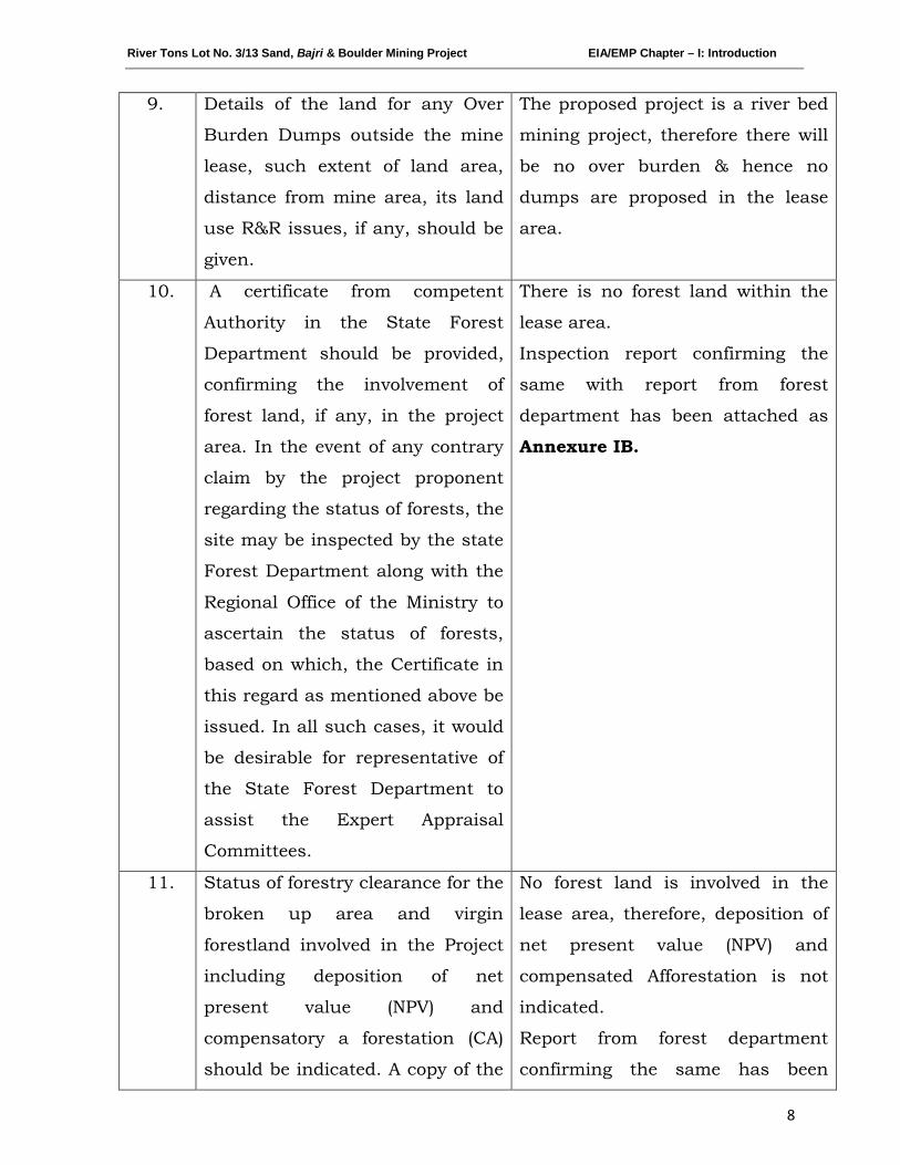
9. Details of the land for any Over Burden Dumps outside the mine lease, such as extent of land area, distance from mine lease, its land use, R&R issues, if any, should be given.
10. A Certificate from the Competent Authority in the State Forest Department should be provided, confirming the involvement of forest
Page 2 of7
\
1' •.
land, if any, in the project area. In the event of any contrary claim by the Project Proponent regarding the status of forests, the site may be inspected by the State Forest Department along with the Regional Otlice of the Ministry to ascertain the status of forests, based on which, the Certificate in this regard as mentioned above be issued. In all such cases, it would be desirable for representative of the State Forest Department to assist the E:xpert: Appraisal Committees.
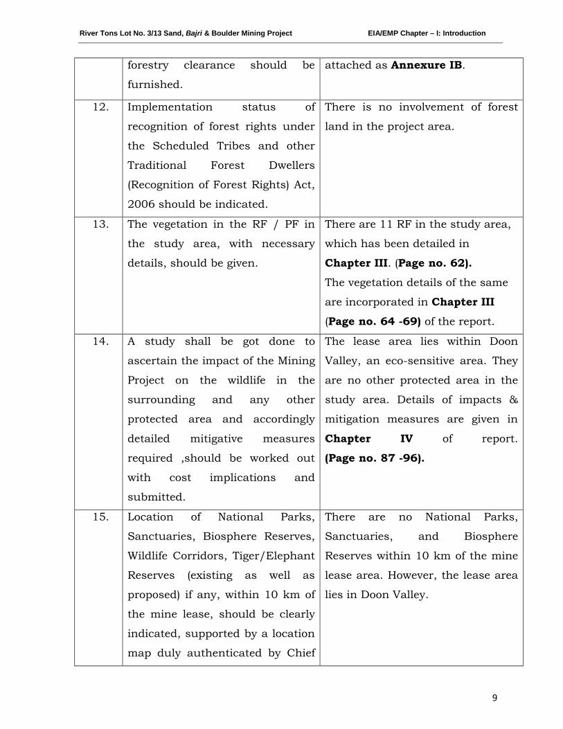
11. Status of forestry clearance for the broken up area and virgin forestland involved in the Project including deposition of net present value (NPV) and compensatory afforestation (CA) should be indicated. A copy of the forestry clearance should also be furnished.
12. Implementation status of recognition of forest rights under the Scheduled Tribes and other Traditional Forest Dwellers (Recognition of Forest Rights) Act, 2006 should be indicated.
13. The vegetation in the :RF / PF areas in the study area, with necessary details, should be given.
14. A study shaH be got done to ascertain the impact of the Mining Project on wildlife of the study area and details furnished. Impact of the project on the wildlife in the surrounding and any other protected area and accordingly detailed mitigative measures required, should be worked out with cost implications and submitted.
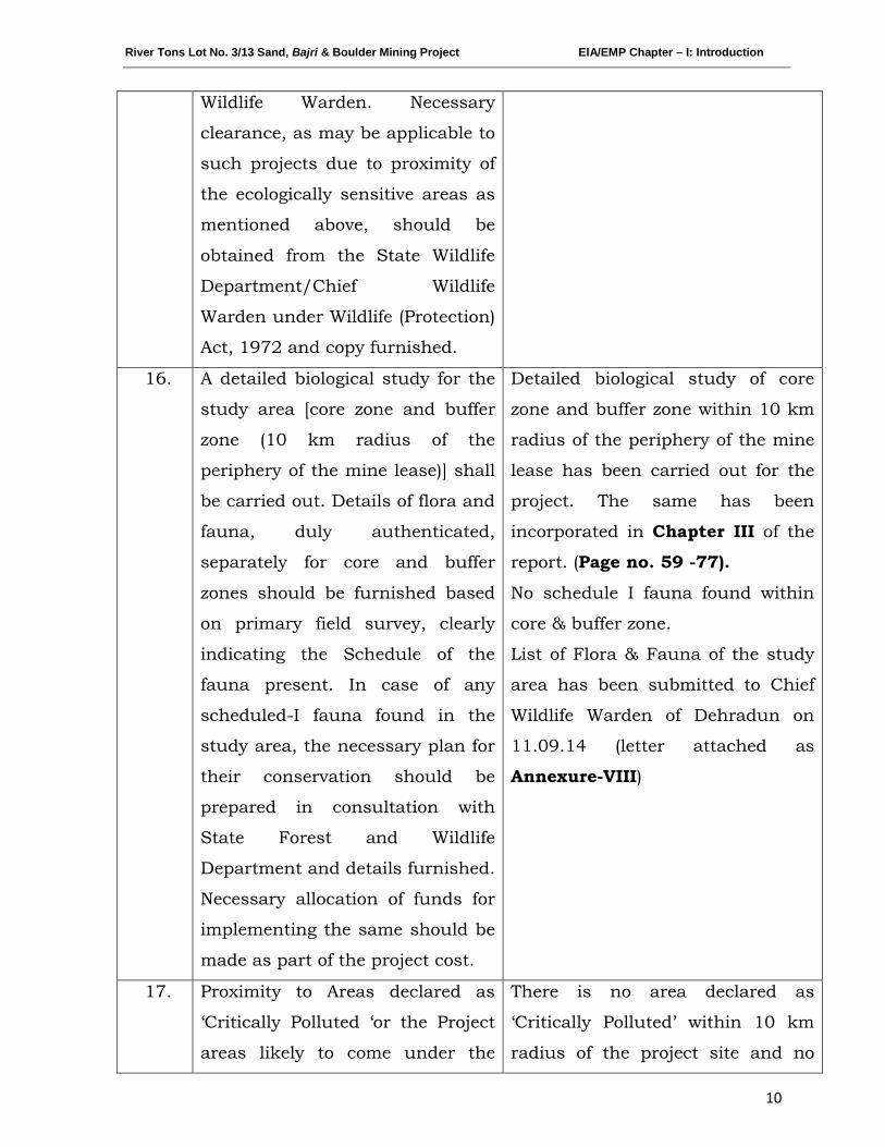
15. Location of National Parks, Sanctuaries, Biosphere :Reserves, Wildlife Corridors, Tiger/E:lephant Resenres/(existing as well as proposed), if any, within 10 km of the mine lease should be clearly indicated, supported by a location Illap duly authenticated by Chief Wildlife Warden. Necessary clearance, as may be applicable to such projects due to proximity of the ecologically sensitive areas as mentioned above, should be obtained from ilie State Wildlife Department/Chief Wildlife Warden under the Wildlife (Protection) Act, 1972 and copy furnished.
16. A detailed biological study of the study area [core zone and buffer zone (10 km radius of the periphery of the rnine lease)] shall be carried out. Details of flora and fa.una, duly authenticated, separately for core and buffer zone should be furnished based on such primary field survey, clearly indicating the Schedule of the fauna present. In case of any scheduled-I fauna found in the study area, the necessary plan for their conservation should be prepared in consultation with State Forest and Wildlifie Department and details furnished. Necessary allocation of funds for implementing the same should be made as part of the project cost.
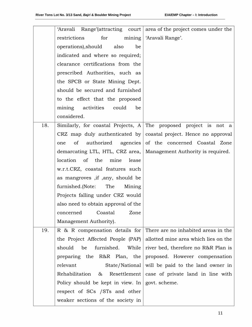
17. Proximity to Areas declared as 'Critically Polluted' or the Project areas likely to come under the 'AravaJ.i Range', (attracting court restrictions for mining operations), should also be indicated and where so required, clearance certifications from the prescribed Authorities, such as the SpeB or State Mining Dept. Should be secured and furnished to the effect that the proposed mining activities could be considered.
18. Similarly, for coastal Projects, A CRZ map duly authenticated by one of the authorized agencies demarcating LTL. HTL, CRZ area, location of the mine lease w.r.t CRZ, coastal features such as mangroves, if any, should be furnished. (Note: The Mining Projects falling under CRZ
Page 3 of7
would also need to obtain approval of the concerned Coastal Zone Management Authority).
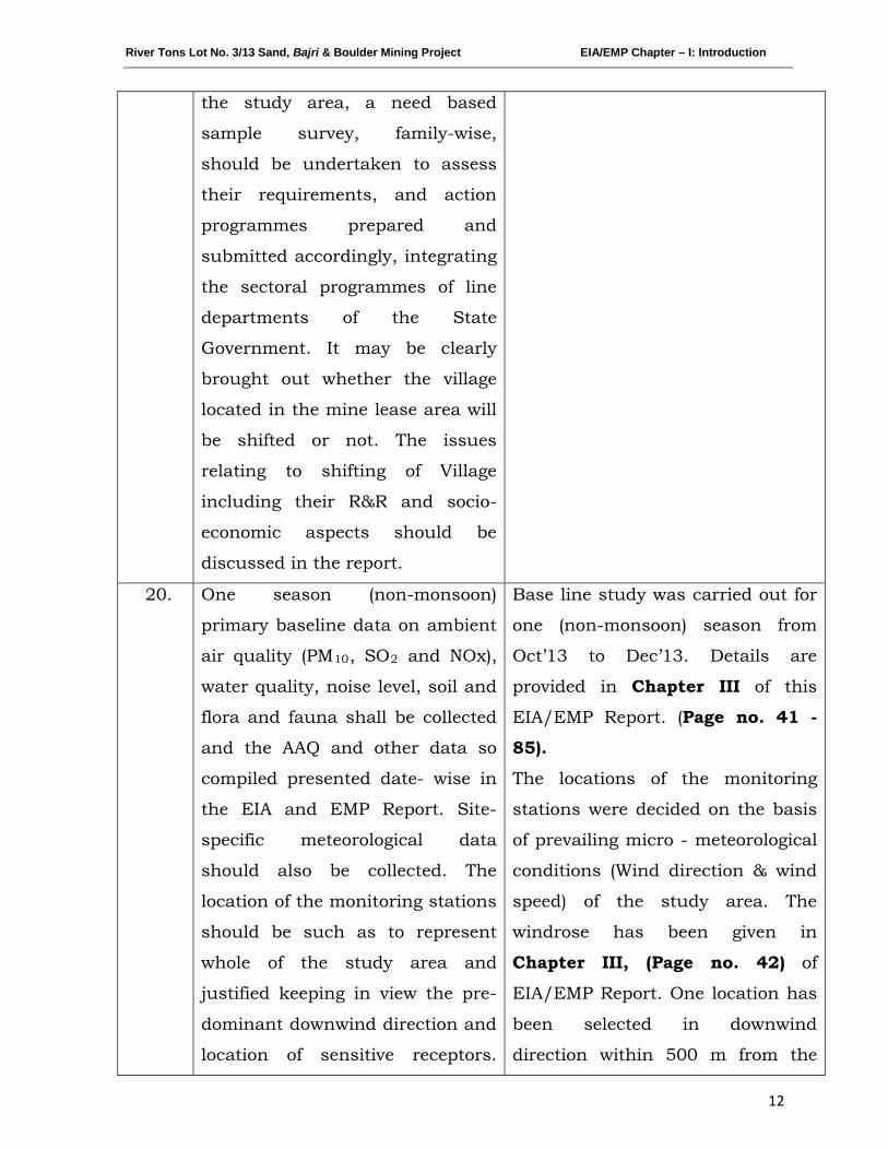
19. R&R Plan/compensation details for the Project Affected People (PAP) should be furnished. While preparing the R&R Plan, the relevant State/National Rehabilitation & l~esettlement Policy should be kept in view. In respect of SCs /STs and other weaker sections of the society in the study area, a need based sample survey, family-wise, should be undertaken to assess their requirements, and action programmes prepared and submitted accordingly, integrating the sectoral programmes of line departments of the State Government. It may be clearly brought out whether the village located in the mine lease area will be shifted or not. The issues relating to shifting of Village including their 1~&R and sodo-economic aspects should be discussed in the report.
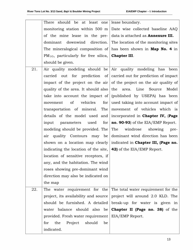
20. One season (non-monsoon) primary baseline data on ambient air quality (PMlO, S02 and NOx), water quality, noise level, soil and flora and fauna shall be collected and the AAQ and other data so compiled presented date-wise in the EIA and EMP Report. Site-specific meteorological data should also be collected. The location of the monitoring stations should be such as to represent whole of the study area and justified keeping in view the pre-dominant downwind direction and location of sensitive receptors. There should be at least one monitoring station within 500 m of the mine lease in the predominant downwind direction. The mineralogical composition of PM 10, particularly for free silica, should be given.
21. Air quality modelling should be carried out for prediction of impact of the project on the air quality of the area. It should also take into account the impact of movement of vehicles for transportation of mineral. The details of the model used and input parameters used for modelling should be provided. The air quality contours may be shown on a location map clearly indicating the location of the site, location of sensitive receptors, if any, and the habitation. The wind roses showing pre-dominant wind direction may also be indicated on the map.
22. The water requirement for the Project, its availability and source should be furnished. A detailed water balance should also be provided. Fresh water requirement for the Project should be indicated.
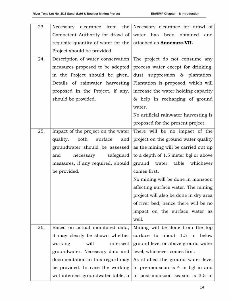
23. Necessary clearance from the Competent Authority for drawl of requisite quantity of water for the Project should be provided.
24. Description of water conservation measures proposed to be adopted in the Project should be given. Details of rainwater harvesting proposed in the Project, if any" should be provided.
25. Impact of the project on the water quality, both surface and groundwater should be assessed and necessary safeguard measures, if any required, should be provided.
26. Based on actual monitored data, it may clearly be shown whether working will intersect groundwater. Necessary data and documentation in this regard may be provided. In case the working will intersect groundwater table, a detailed Hydro Geological Study should be
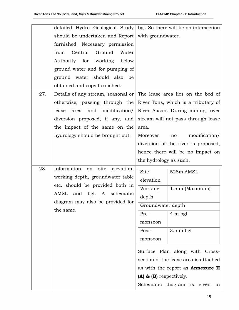
Page 4 of7
undertaken and Report furnished. Necessary permission from Central Ground Water Authority for working below ground water and for pumping of ground water should also be obtained and copy furnished.
27. Details of any stream, seasonal or otherwise, passing through the lease area and modification / diversion proposed, if any, and the impact of the same on the hydrology should be brought out.
28. Information on site elevation, working depth, groundwater table etc. Should be provided both in AMSL and bgl. A schematic diagram may also be provided for the same.
29. A time bound Progressive Greenbelt Development Plan shall be prepared in a tabular form (indicating the linear and quantitative coverage, plant species and time frame) and submitted, keeping in mind, the same will have to be execl:tted up front on commencement of the proj ect.
30. Impact on local transport infrastructure due to the Project should be indicated. Projected increase in truck traffic as a result of the Project in the present road network (including those outside the Project area) should be worked out:, indicating whether it is capable of handling the incremental load. Arrangement for improving the infrastructure, if contemplated (including action to be taken by other agencies such as State Government) should be covered.
31. Details of the onsite shelter 8Xld facilities to be provided to the mine workers should be included in the EIA report.
32. Conceptual post miming land use and Reclamation and Restoration of mined out areas (with plans and with adequate number of sections) should be given in the EIA report.
33. A time bound Progressive Greenbelt Development Plan shall be prepared in a tabular form (indicating the linear and quantitative coverage, plant species and time frame) and submitted, keeping in mind, the saIne will have to be executed up front on commencement of the project. Phase-wise plan of plantation and compensatory afforestation should be charted clearly indicating the area to be covered under plantation and the species to be planted. The details of plantation already done should be given.
34. Occupational Health. impacts of the Project should be anticipated and the proposed preventive measures spelt out in detail. Details of preplacement medical examination and periodical medical examination schedules should be incorporated in the EMP.
35. Public health implications of the Prqject and related activities for the population in the impact zone should be systematically evaluated and the proposed remedial measures should be detailed along with budgetary allocations.
36. Measures of socio economic significance and influence to the local comrnuni1y proposed to be provided by the Project Proponent should be indicated. As far as possible, quantitative dimensions may be given with time frames f'Dr implernentation.
37. Detailed environrn.ental management plan to mitigate the environmental impacts which, should inter-alia include the impacts of change of land use, loss of agricultural and grazing land, if any,
Page 5 of7
occupational health impacts besides other impacts specific to the proposed Project.
38. Public hearing points raised and commitment of the project proponent on the same along with time bound action plan to implement the same should be provided and also incorporated in the final EIA/EMP Report of the Project.
39. Details of litigation pending against the project, if any, with direction / order passed by any Court of Law against the project should be given.
40. The cost of the project (capital cost and recurring cost) as well as the cost towards implementation of EMP should clearly be spelt out.
41. Details of sand replenishment studies. 42. Details of Transportation of mined materials as per the Indian Road
Congress for both the ways with loaded as well as unloaded traffic load and its impact on Environment.
43. Study on cumulative impact due to sand mining shall be carried out. 44. Study of impact of mining on plankton. 45. Cluster approach to be followed for collection of baseline data. 46. Appropriate Disaster Management safeguards in view of the high
seismicity of the area and 47. Clearance under the Wildlife (Protection) Act, 1972 from the Standing
Committee of National Board for Wildlife shall be obtained.
4. Besides the above, the below mentioned general points are also to be followed:-
a) All documents to be properly referenced with index and continuous page numbering.
b) Where data are presented in the report especiaUy in tables, the period in which the data were collected and the sources should be indicated.
c) Where the documents provided are in a language other than English, an English translation should be provided.
d) The Questionnaire for environmental appraisal of industrial projects as devised earlier by the Ministry shall also be filled and submitted.
e) While preparing the EIA report, the instructions for the proponents and instructions for the consultants issued by MoEF vide O.M. No. J-11013/41/2006-IA.II(I) dated 4th August, 2009, which are available on the website of this Ministry, should also be followed.
f) Changes, if any made in the basic scope and project parameters (as submitted in Form-I and the F.R for securing the TOR) should be brought to the attention of MoEF Witll reasons for such changes and permission should be sought, as the TOR may also have to be altered. Post Public Hearing changes in structure and content of the draft EIA/EMP (other than modifications arising out of the P.H. process) will entail conducting the PH again with the revised documentation.
g) A:,: per the circular no. J-llOll/618/2010-IA.II(I) dated 30.5.2012, you are requested to submit certified report of the status of compliance of the conditions stipulated in the environment clearance for the existing operations of the project by the Regional Office of Ministry of Environment & Forests, if applicable.
Page 6 of7
5. The EIA report should also include (i) surface plan of the area indicating contours of main topographic features, drainage and mining area, (ii) geological maps and sections and (iii) sections of the mine pit and external dumps, if any, clearly showing the land features of the adjoining area.
6. After preparing the draft ErA (as per the generic structure prescribed in Appendix--lII of the ETA Notification, 2006) covering the above mentioned issues, the proponent will get the public hearing conducted and take further necessary action for obtaining environmental clearance in accordance with the procedure prescribed under the EIA Notification, 2006.
~t'rOj) ~~tor
Copy tel: (i)
(ii)
(iii)
(iv)
The Secretary, I\lIinistry of Mines, Government of India, Shastri Bhawan, New Delhi The Secretary, Department of Mines & Geology, Government of Uttarakhand, Secretariat, Dehradun. The Secretary, Department of Environment, Government of Uttarakhand, Secretariat, Dehradun. Chief Wildlife Warden, Government of Uttarakhand, Secretariat, Dehradun.
(v) Secretary, SCMC, Dehradun. (vi) The Chief Conservator of Forests, Central Region, Ministry of
Envi.ronment and Forests, B-1/,72, Sector-A, Aliganj, Lucknow-226020.
(vii) The Chairman, Central Pollution Control Board, Parivesh Bhavan, CBD-cum-Office complex, East Arjun Nagar, New Delhi-1100032.
(viii) The Member Secretary, Central GrOlmd Water Authority, A-2, W3, Curzon Road Barracks, K.G. Marg, New De1hi-110001.
(ix) The Chainnan, Uttarakhand Environment Protection & Pollution Control Board, E:-115, Nehru Colony, Hardwar Road, Dehradun, U ttarakhand.
(x) The Controller General, Indian Bureau of Mines, Indira Civil Lines, Nagpur--440 00 l.
(xi) The District Collector, Dehradun District, Uttarakhand.
Bhavan,
(xiv) Guard File.
)~Ojl D~tor
Page 7 of7

River Tons Lot No. 3/13 Sand, Bajri & Boulder Mining Project EIA/EMP Chapter – I: Introduction
1
CHAPTER-I
INTRODUCTION
INDEX
S. No. CONTENTS Page No.
1.0 PURPOSE OF THE REPORT 2
1.1 IDENTIFICATION OF PROJECT & PROJECT
PROPONENT
2
1.2 BRIEF DESCRIPTION OF PROJECT 3
1.3 SCOPE OF THE STUDY 4
River Tons Lot No. 3/13 Sand, Bajri & Boulder Mining Project EIA/EMP Chapter – I: Introduction
2
1.0 PURPOSE OF THE REPORT
Environmental Impact Assessment (EIA) is one of the proven management
tools for integrating environmental concerns in development process and for
improved decision making as there is a need to harmonize the developmental
activities with the environmental concerns into the larger interest of the
society. The growing awareness, over the years, on environmental protection
and sustainable development, has given further emphasis to the
implementation of sound environmental management practices for
mitigating adverse impacts from developmental activities. EIA study plays a
vital role in sustainable development of a country. Recognizing its
importance, the Ministry of Environment, Forest and Climate Change,
Government of India had formulated policies and procedures governing the
industrial and other developmental activities to prevent indiscriminate
exploitation of natural resources and to promote integration of
environmental concern in project development.
The present Environmental Impact Assessment report is prepared to comply
with the Terms of Reference (TOR) received from EAC MoEF&CC, New Delhi
under EIA notification of the MoEF&CC dated 14th September, 2006 as
amended and also the Technical Guidance Manual for Mining of Minerals
(Feb, 2010) of MoEF&CC, Govt. of India, for seeking environmental clearance
for mining of sand, bajri & boulder in the applied mining lease area.
1.1 IDENTIFICATION OF PROJECT & PROJECT PROPONENT
The project is being proposed by Garhwal Mandal Vikas Nigam (GMVN)
Limited.
The address of the proponent is given below:
Garhwal Mandal Vikas Nigam Limited,
74/1 Rajpur Road, Dehradun
Uttarakhand
Ph: - 0135-2746817, 2749308
River Tons Lot No. 3/13 Sand, Bajri & Boulder Mining Project EIA/EMP Chapter – I: Introduction
3
The proponent has applied for mining lease in the name of River Tons Lot
No. 3/13 Sand, Bajri & Boulder Mining Project over an area of 6 ha near
Village: Banshiwala, Tehsil: Vikasnagar & District: Dehradun, Uttarakhand.
The Environmental clearance has been applied for the allotted lease area,
decided as per the Letter of Intent vide (Letter No. 589/Bhu. Khani.E./2012-
13 dated 23-01-2013 issued by Geology & Mining Unit, Directorate of
Industries, Govt. of Uttarakhand. The LOI is attached as Annexure IA.
1.2 BRIEF DESCRIPTION OF PROJECT
The proposed project is to mine sand, bajri & boulder from bed of River Tons,
over an area of 6.0 Ha near Village: Banshiwala, Tehsil: Vikasnagar &
District: Dehradun, Uttarakhand.
It has been proposed to mine around 85,000 Tonnes per annum of minerals.
The estimated project cost for the proposed project is Rs.11.70 Lakhs.
As per MoEF&CC, New Delhi Gazette dated 14th
The proposed mining lease area falls in Survey of India Toposheet 53F15.
The mine lease co-ordinates and connectivity details are listed below:
September 2006 and
amended thereof, the proposed mining project is categorized as Category ‘A’
project as the project lies within Doon Valley, an eco-sensitive area and
Interstate Boundary between Uttarakhand & Uttar Pradesh lies within 10
km radius of the lease area.
Latitude 30°20'29.19"N to 30°20'20.58"N
Longitude 77°53'33.35"E to 77°53'49.23"E
River Tons Lot No. 3/13 Sand, Bajri & Boulder Mining Project EIA/EMP Chapter – I: Introduction
4
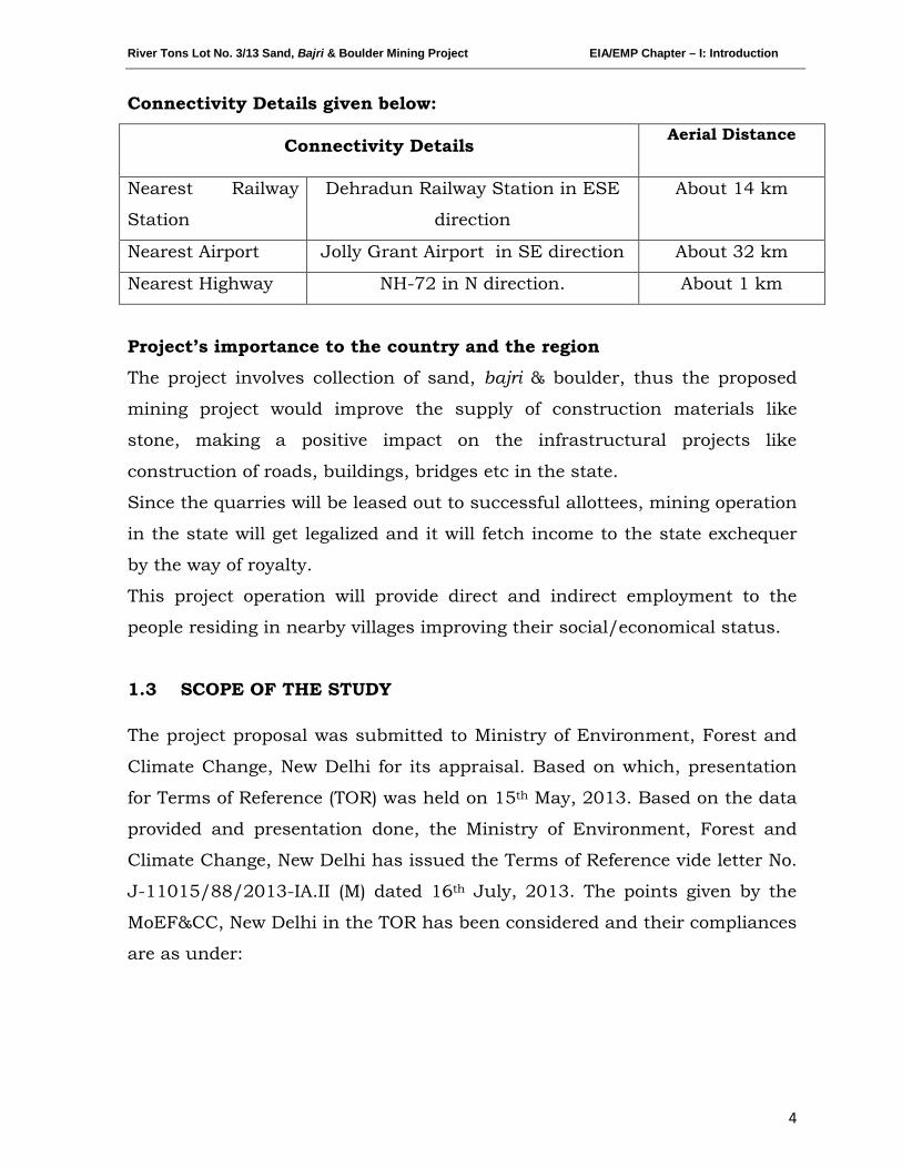
Connectivity Details given below:
Connectivity Details Aerial Distance
Nearest Railway
Station
Dehradun Railway Station in ESE
direction
About 14 km
Nearest Airport Jolly Grant Airport in SE direction About 32 km
Nearest Highway NH-72 in N direction. About 1 km
Project’s importance to the country and the region
The project involves collection of sand, bajri & boulder, thus the proposed
mining project would improve the supply of construction materials like
stone, making a positive impact on the infrastructural projects like
construction of roads, buildings, bridges etc in the state.
Since the quarries will be leased out to successful allottees, mining operation
in the state will get legalized and it will fetch income to the state exchequer
by the way of royalty.
This project operation will provide direct and indirect employment to the
people residing in nearby villages improving their social/economical status.
1.3 SCOPE OF THE STUDY
The project proposal was submitted to Ministry of Environment, Forest and
Climate Change, New Delhi for its appraisal. Based on which, presentation
for Terms of Reference (TOR) was held on 15th May, 2013. Based on the data
provided and presentation done, the Ministry of Environment, Forest and
Climate Change, New Delhi has issued the Terms of Reference vide letter No.
J-11015/88/2013-IA.II (M) dated 16th July, 2013. The points given by the
MoEF&CC, New Delhi in the TOR has been considered and their compliances
are as under:
River Tons Lot No. 3/13 Sand, Bajri & Boulder Mining Project EIA/EMP Chapter – I: Introduction
5
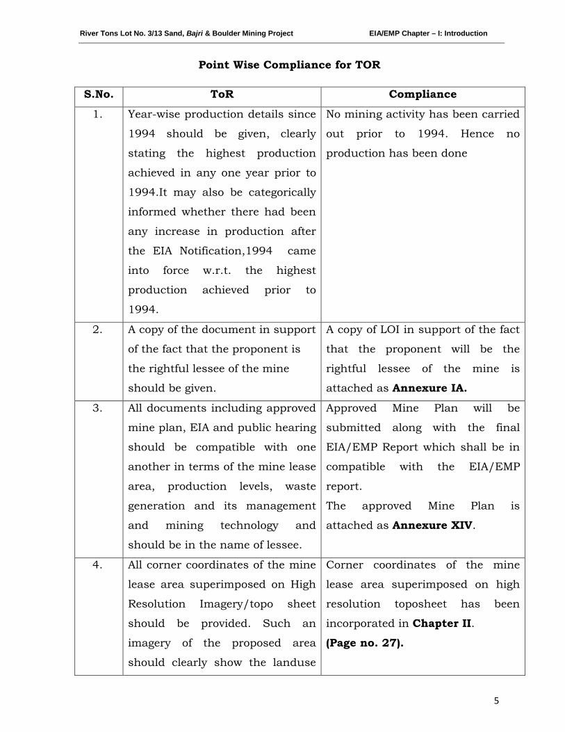
Point Wise Compliance for TOR
S.No. ToR Compliance
1. Year-wise production details since
1994 should be given, clearly
stating the highest production
achieved in any one year prior to
1994.It may also be categorically
informed whether there had been
any increase in production after
the EIA Notification,1994 came
into force w.r.t. the highest
production achieved prior to
1994.
No mining activity has been carried
out prior to 1994. Hence no
production has been done
2. A copy of the document in support
of the fact that the proponent is
the rightful lessee of the mine
should be given.
A copy of LOI in support of the fact
that the proponent will be the
rightful lessee of the mine is
attached as Annexure IA.
3. All documents including approved
mine plan, EIA and public hearing
should be compatible with one
another in terms of the mine lease
area, production levels, waste
generation and its management
and mining technology and
should be in the name of lessee.
Approved Mine Plan will be
submitted along with the final
EIA/EMP Report which shall be in
compatible with the EIA/EMP
report.
The approved Mine Plan is
attached as Annexure XIV.
4. All corner coordinates of the mine
lease area superimposed on High
Resolution Imagery/topo sheet
should be provided. Such an
imagery of the proposed area
should clearly show the landuse
Corner coordinates of the mine
lease area superimposed on high
resolution toposheet has been
incorporated in Chapter II.
(Page no. 27).
River Tons Lot No. 3/13 Sand, Bajri & Boulder Mining Project EIA/EMP Chapter – I: Introduction
6
and other ecological features of
the study area (core and buffer
zone).
5. Does the company have a well laid
down Environment Policy
approved by its Board of
Directors? If so, it may be detailed
in the EIA report with description
of the prescribed operating
process/procedures to bring into
focus any
infringement/deviation/violation
of the environmental or forest
norms/conditions? The
hierarchical system or
administrative order of the
company to deal with the
environmental issues and for
ensuring compliance with EC
conditions may also be given. The
system of reporting of non-
compliances/violations of
environmental norms to the Board
of Directors of the company
and/or shareholders or
stakeholders at large may also be
detailed in the EIA report.
Yes, there is well laid
Environmental Policy for the
proposed project attached as a
Annexure-VI. The project is being
proposed by Garhwal Mandal Vikas
Nigam Ltd., Government of
Uttarakhand. Hence the policy i.e.
Uttarakhand Mining Policy, 2011
will be followed.
The Environmental Management
Cell (EMC) has been formulated to
deal with environmental issues and
to ensure compliance with EC
conditions.
The EMC will be made in charge for
reporting non compliances to the
Owner.
6. Issues relating to Mine Safety,
including subsidence study in
case of underground mining and
slope study in case of open cast
mining, blasting study etc. should
Mines safety for workers working at
the site has been taken care of.
Safety measures related to risks
during mining activity, natural
disasters, etc has been proposed
River Tons Lot No. 3/13 Sand, Bajri & Boulder Mining Project EIA/EMP Chapter – I: Introduction
7
be detailed. The proposed
safeguard measures in each case
should also be provided.
Details about the same are given in
Chapter VI. (Page no. 116-118)
The proposed project is a river bed
mining project. It is not an
underground mining project and
therefore no subsidence and
blasting study is proposed.
7. The study area will comprise of 10
km zone around the mine lease
from lease periphery and the data
contained in the EIA such as
waste generation etc should be for
the life of the mine / lease period.
The 10 km zone from periphery of
the lease has been considered as
the study area. The Buffer map of
the study area is given as Map No.
1 in Chapter II. All the details in
the EIA report are for the life of the
lease period.
The details of mining & production
has been given in Chapter II.
(Page no. 33 -36)
8. Land use of the study area should
be described delineating forest
area, agricultural land, grazing
land, wildlife sanctuary and
national park, migratory routes of
fauna, water bodies, human
settlements and other ecological
features should be indicated.
Land use plan of the mine lease
area should be prepared to
encompass preoperational,
operational and post operational
phases and submitted. Impact, if,
any, of change of land use should
be given.
Land use pattern of 10 km from
the periphery of the lease area has
been prepared and incorporated as
Map No.2, Chapter III. (Page 41).
There are no National Park or
Wildlife Sanctuary or Migratory
routes of fauna within the 10 km
radius of study area.
As the lease area lies in the river
bed there will be no change in the
land use plan of the mine lease
area in preoperational, operational
and post operational phases. Only
the sediments will be removed from
the surface.
River Tons Lot No. 3/13 Sand, Bajri & Boulder Mining Project EIA/EMP Chapter – I: Introduction
8
9. Details of the land for any Over
Burden Dumps outside the mine
lease, such extent of land area,
distance from mine area, its land
use R&R issues, if any, should be
given.
The proposed project is a river bed
mining project, therefore there will
be no over burden & hence no
dumps are proposed in the lease
area.
10. A certificate from competent
Authority in the State Forest
Department should be provided,
confirming the involvement of
forest land, if any, in the project
area. In the event of any contrary
claim by the project proponent
regarding the status of forests, the
site may be inspected by the state
Forest Department along with the
Regional Office of the Ministry to
ascertain the status of forests,
based on which, the Certificate in
this regard as mentioned above be
issued. In all such cases, it would
be desirable for representative of
the State Forest Department to
assist the Expert Appraisal
Committees.
There is no forest land within the
lease area.
Inspection report confirming the
same with report from forest
department has been attached as
Annexure IB.
11. Status of forestry clearance for the
broken up area and virgin
forestland involved in the Project
including deposition of net
present value (NPV) and
compensatory a forestation (CA)
should be indicated. A copy of the
No forest land is involved in the
lease area, therefore, deposition of
net present value (NPV) and
compensated Afforestation is not
indicated.
Report from forest department
confirming the same has been
River Tons Lot No. 3/13 Sand, Bajri & Boulder Mining Project EIA/EMP Chapter – I: Introduction
9
forestry clearance should be
furnished.
attached as Annexure IB.
12. Implementation status of
recognition of forest rights under
the Scheduled Tribes and other
Traditional Forest Dwellers
(Recognition of Forest Rights) Act,
2006 should be indicated.
There is no involvement of forest
land in the project area.
13. The vegetation in the RF / PF in
the study area, with necessary
details, should be given.
There are 11 RF in the study area,
which has been detailed in
Chapter III. (Page no. 62).
The vegetation details of the same
are incorporated in Chapter III
(Page no. 64 -69) of the report.
14. A study shall be got done to
ascertain the impact of the Mining
Project on the wildlife in the
surrounding and any other
protected area and accordingly
detailed mitigative measures
required ,should be worked out
with cost implications and
submitted.
The lease area lies within Doon
Valley, an eco-sensitive area. They
are no other protected area in the
study area. Details of impacts &
mitigation measures are given in
Chapter IV of report.
(Page no. 87 -96).
15. Location of National Parks,
Sanctuaries, Biosphere Reserves,
Wildlife Corridors, Tiger/Elephant
Reserves (existing as well as
proposed) if any, within 10 km of
the mine lease, should be clearly
indicated, supported by a location
map duly authenticated by Chief
There are no National Parks,
Sanctuaries, and Biosphere
Reserves within 10 km of the mine
lease area. However, the lease area
lies in Doon Valley.
River Tons Lot No. 3/13 Sand, Bajri & Boulder Mining Project EIA/EMP Chapter – I: Introduction
10
Wildlife Warden. Necessary
clearance, as may be applicable to
such projects due to proximity of
the ecologically sensitive areas as
mentioned above, should be
obtained from the State Wildlife
Department/Chief Wildlife
Warden under Wildlife (Protection)
Act, 1972 and copy furnished.
16. A detailed biological study for the
study area [core zone and buffer
zone (10 km radius of the
periphery of the mine lease)] shall
be carried out. Details of flora and
fauna, duly authenticated,
separately for core and buffer
zones should be furnished based
on primary field survey, clearly
indicating the Schedule of the
fauna present. In case of any
scheduled-I fauna found in the
study area, the necessary plan for
their conservation should be
prepared in consultation with
State Forest and Wildlife
Department and details furnished.
Necessary allocation of funds for
implementing the same should be
made as part of the project cost.
Detailed biological study of core
zone and buffer zone within 10 km
radius of the periphery of the mine
lease has been carried out for the
project. The same has been
incorporated in Chapter III of the
report. (Page no. 59 -77).
No schedule I fauna found within
core & buffer zone.
List of Flora & Fauna of the study
area has been submitted to Chief
Wildlife Warden of Dehradun on
11.09.14 (letter attached as
Annexure-VIII)
17. Proximity to Areas declared as
‘Critically Polluted ‘or the Project
areas likely to come under the
There is no area declared as
‘Critically Polluted’ within 10 km
radius of the project site and no
River Tons Lot No. 3/13 Sand, Bajri & Boulder Mining Project EIA/EMP Chapter – I: Introduction
11
‘Aravali Range’(attracting court
restrictions for mining
operations),should also be
indicated and where so required;
clearance certifications from the
prescribed Authorities, such as
the SPCB or State Mining Dept.
should be secured and furnished
to the effect that the proposed
mining activities could be
considered.
area of the project comes under the
‘Aravali Range’.
18. Similarly, for coastal Projects, A
CRZ map duly authenticated by
one of authorized agencies
demarcating LTL, HTL, CRZ area,
location of the mine lease
w.r.t.CRZ, coastal features such
as mangroves ,if ,any, should be
furnished.(Note: The Mining
Projects falling under CRZ would
also need to obtain approval of the
concerned Coastal Zone
Management Authority).
The proposed project is not a
coastal project. Hence no approval
of the concerned Coastal Zone
Management Authority is required.
19. R & R compensation details for
the Project Affected People (PAP)
should be furnished. While
preparing the R&R Plan, the
relevant State/National
Rehabilitation & Resettlement
Policy should be kept in view. In
respect of SCs /STs and other
weaker sections of the society in
There are no inhabited areas in the
allotted mine area which lies on the
river bed, therefore no R&R Plan is
proposed. However compensation
will be paid to the land owner in
case of private land in line with
govt. scheme.
River Tons Lot No. 3/13 Sand, Bajri & Boulder Mining Project EIA/EMP Chapter – I: Introduction
12
the study area, a need based
sample survey, family-wise,
should be undertaken to assess
their requirements, and action
programmes prepared and
submitted accordingly, integrating
the sectoral programmes of line
departments of the State
Government. It may be clearly
brought out whether the village
located in the mine lease area will
be shifted or not. The issues
relating to shifting of Village
including their R&R and socio-
economic aspects should be
discussed in the report.
20. One season (non-monsoon)
primary baseline data on ambient
air quality (PM10, SO2
Base line study was carried out for
one (non-monsoon) season from
Oct’13 to Dec’13. Details are
provided in Chapter III of this
EIA/EMP Report. (Page no. 41 -
85).
and NOx),
water quality, noise level, soil and
flora and fauna shall be collected
and the AAQ and other data so
compiled presented date- wise in
the EIA and EMP Report. Site-
specific meteorological data
should also be collected. The
location of the monitoring stations
should be such as to represent
whole of the study area and
justified keeping in view the pre-
dominant downwind direction and
location of sensitive receptors.
The locations of the monitoring
stations were decided on the basis
of prevailing micro - meteorological
conditions (Wind direction & wind
speed) of the study area. The
windrose has been given in
Chapter III, (Page no. 42) of
EIA/EMP Report. One location has
been selected in downwind
direction within 500 m from the
River Tons Lot No. 3/13 Sand, Bajri & Boulder Mining Project EIA/EMP Chapter – I: Introduction
13
There should be at least one
monitoring station within 500 m
of the mine lease in the pre-
dominant downwind direction.
The mineralogical composition of
PM1O
lease boundary.
, particularly for free silica,
should be given.
Date wise collected baseline AAQ
data is attached as Annexure III.
The location of the monitoring sites
has been shown in Map No. 4 in
Chapter III.
21. Air quality modeling should be
carried out for prediction of
impact of the project on the air
quality of the area. It should also
take into account the impact of
movement of vehicles for
transportation of mineral. The
details of the model used and
input parameters used for
modeling should be provided. The
air quality Contours may be
shown on a location map clearly
indicating the location of the site,
location of sensitive receptors, if
any, and the habitation. The wind
roses showing pre-dominant wind
direction may also be indicated on
the map
Air quality modeling has been
carried out for prediction of impact
of the project on the air quality of
the area. Line Source Model
(published by USEPA) has been
used taking into account impact of
movement of vehicles which is
incorporated in Chapter IV, (Page
no. 90-93) of the EIA/EMP Report.
The windrose showing pre-
dominant wind direction has been
indicated in Chapter III, (Page no.
42) of the EIA/EMP Report.
22. The water requirement for the
project, its availability and source
should be furnished. A detailed
water balance should also be
provided. Fresh water requirement
for the Project should be
indicated.
The total water requirement for the
project will around 2.0 KLD. The
break-up for water is given in
Chapter II (Page no. 38) of the
EIA/EMP Report.
River Tons Lot No. 3/13 Sand, Bajri & Boulder Mining Project EIA/EMP Chapter – I: Introduction
14
23. Necessary clearance from the
Competent Authority for drawl of
requisite quantity of water for the
Project should be provided.
Necessary clearance for drawl of
water has been obtained and
attached as Annexure-VII.
24. Description of water conservation
measures proposed to be adopted
in the Project should be given.
Details of rainwater harvesting
proposed in the Project, if any,
should be provided.
The project do not consume any
process water except for drinking,
dust suppression & plantation.
Plantation is proposed, which will
increase the water holding capacity
& help in recharging of ground
water.
No artificial rainwater harvesting is
proposed for the present project.
25. Impact of the project on the water
quality, both surface and
groundwater should be assessed
and necessary safeguard
measures, if any required, should
be provided.
There will be no impact of the
project on the ground water quality
as the mining will be carried out up
to a depth of 1.5 meter bgl or above
ground water table whichever
comes first.
No mining will be done in monsoon
affecting surface water. The mining
project will also be done in dry area
of river bed; hence there will be no
impact on the surface water as
well.
26. Based on actual monitored data,
it may clearly be shown whether
working will intersect
groundwater. Necessary data and
documentation in this regard may
be provided. In case the working
will intersect groundwater table, a
Mining will be done from the top
surface to about 1.5 m below
ground level or above ground water
level; whichever comes first.
As studied the ground water level
in pre-monsoon is 4 m bgl in and
in post-monsoon season is 3.5 m
River Tons Lot No. 3/13 Sand, Bajri & Boulder Mining Project EIA/EMP Chapter – I: Introduction
15
detailed Hydro Geological Study
should be undertaken and Report
furnished. Necessary permission
from Central Ground Water
Authority for working below
ground water and for pumping of
ground water should also be
obtained and copy furnished.
bgl. So there will be no intersection
with groundwater.
27. Details of any stream, seasonal or
otherwise, passing through the
lease area and modification/
diversion proposed, if any, and
the impact of the same on the
hydrology should be brought out.
The lease area lies on the bed of
River Tons, which is a tributary of
River Aasan. During mining, river
stream will not pass through lease
area.
Moreover no modification/
diversion of the river is proposed,
hence there will be no impact on
the hydrology as such.
28. Information on site elevation,
working depth, groundwater table
etc. should be provided both in
AMSL and bgl. A schematic
diagram may also be provided for
the same.
Surface Plan along with Cross-
section of the lease area is attached
as with the report as Annexure II
(A) & (B) respectively.
Schematic diagram is given in
Site
elevation
528m AMSL
Working
depth
1.5 m (Maximum)
Groundwater depth
Pre-
monsoon
4 m bgl
Post-
monsoon
3.5 m bgl
River Tons Lot No. 3/13 Sand, Bajri & Boulder Mining Project EIA/EMP Chapter – I: Introduction
16
Chapter II. (Page no. 34)
29. A time bound Progressive
Greenbelt Development Plan shall
be prepared in a tabular form
(indicating the linear and
quantitative coverage, plant
species and time frame) and
submitted, keeping in mind, the
same will have to be executed up
front on commencement of the
project.
Plantation will be carried along the
river banks or along the road sides
or near the civic amenities in
consultation with local authority or
govt. body
List of species to be planted is
attached as Annexure XVI.
30. Impact on local transport
infrastructure due to the Project
should be indicated. Projected
increase in truck traffic as a
result of the Project in the present
road network (including those
outside the Project area) should
be worked out, indicating whether
it is capable of handling the
incremental load. Arrangement for
improving the infrastructure, if
contemplated (including action to
be taken by other agencies such
as State Government) should be
covered.
There will be an increase of 40
trucks carrying the minerals per
day. The impact due to this has
been detailed in Chapter IV of the
EIA/EMP Report. (Page no. 96-98)
31. Details of the onsite shelter and
facilities to be provided to the
mine workers should be included
in the EIA report.
A temporary rest shelter will be
provided for the workers near to
the site with provisions of water,
first aid facility, protective
equipments, etc. Details are given
in Chapter II (Page no. 38) of the
River Tons Lot No. 3/13 Sand, Bajri & Boulder Mining Project EIA/EMP Chapter – I: Introduction
17
EIA/EMP Report.
32. Conceptual post mining land use
and Reclamation and Restoration
of mined out areas (with plans
and with adequate number of
sections) should be given in the
EIA report.
As the mine area lies on the river
bed, the area will be reclaimed
naturally with sediments, gradually
during monsoon seasons.
There will be construction of
ramps, temporary rest shelters
during operational phase; However
these will be removed and the
banks will be restored at the time
of mine closure.
33. A time bound Progressive
Greenbelt Development Plan shall
be prepared in a tabular form
(indicating the linear and
quantitative coverage, plant
species and time frame) and
submitted, keeping in mind, the
same will have to be executed up
front on commencement of the
project. Phase-wise plan of
plantation and compensatory
afforestation should be charted
clearly indicating the area to be
covered under plantation and the
species to be planted. The details
of plantation already done should
be given.
Plantation will be carried along the
river banks or along the road sides
or near the civic amenities in
consultation with local authority or
govt. body.
List of species to be planted is
attached as Annexure XVI.
As the proposed project is new, no
plantation has been done earlier
34. Occupational Health impacts of
the Project should be anticipated
and the proposed preventive
measures spelt out in detail.
Occupational health impact mainly
is expected due air pollution due to
fugitive dust emission because of
movement of vehicles. However
River Tons Lot No. 3/13 Sand, Bajri & Boulder Mining Project EIA/EMP Chapter – I: Introduction
18
Details of pre-placement medical
examination and periodical
medical examination schedules
should be incorporated in the
EMP.
appropriate mitigation measures
for air pollution control has been
proposed (given in Chapter IV of
the report). (Page no. 90 -93).
Each labour will undergo pre-
placement medical examination.
Thereafter periodical heath check
up will be arranged as stated in the
Chapter VII (Page no. 122 -123)
of the report.
35. Public health implications of the
Project and related activities for
the population in the impact zone
should be systematically
evaluated and the proposed
remedial measures should be
detailed along with budgetary
allocations.
The proposed project being a small
scale manual mining project, there
will be hardly any process related
to health implication on the
population of the nearby villages
except fugitive dust emissions due
to transportation of minerals by
trucks. However health camps &
awareness programs will be
arranged for them. Details are
given in Chapter VII (Page no.
122) of the report.
36. Measures of socio economic
significance and influence to the
local community proposed to be
provided by the Project Proponent
should be indicated. As far as
possible, quantitative dimensions
may be given with time frames for
implementation.
Socio-economic significance
provided to the local community
i.e. to the nearby villagers is given
in Chapter VII, (Page no. 122 -
124) of the EIA/EMP Report.
37. Detailed environmental
management plan to mitigate the
The detailed environmental
management plan to mitigate the
River Tons Lot No. 3/13 Sand, Bajri & Boulder Mining Project EIA/EMP Chapter – I: Introduction
19
environmental impacts which,
should inter-alia include the
impacts of change of land use,
loss of agricultural and grazing
land, if any, occupational health
impacts besides other impacts
specific to the proposed Project.
environmental impacts has been
mentioned in Chapter VIII (Page
no. 128 -131) of the EIA/EMP
Report.
38. Public hearing points raised and
commitment of the project
proponent on the same along with
time bound action plan to
Implement the same should be
provided and also incorporated In
the final EIA/EMP Report of the
Project.
Details of public hearing are given
in Chapter VI. (Page no. 103 -
104) Public hearing proceedings of
the project along with action plan
& budget allocation has been
attached as Annexure-X A & B.
39. Details of litigation pending
against the project, if any, with
direction /order passed by any
Court of Law against the project
should be given.
There is no litigation pending
against the project. The LoI has
been issued by the Dept. of Geology
& Mining Unit, Govt. of
Uttarakhand to carry out mining
operation in the proposed area.
40. The cost of the project (capital
cost and recurring cost) as well as
the cost towards implementation
of EMP should clearly be spelt
out.
The capital cost of the project is Rs.
11.70 Lakhs. The recurring costs
like for project monitoring & EMP
have been given in Chapter V
(Page no. 105) & VIII (Page
no.132) respectively.
41. Details of sand replenishment
studies.
The mining project being on river
bed the replenishment will be
natural. Of the quantum of
minerals which will be excavated,
only sand & bajri is replenishable
River Tons Lot No. 3/13 Sand, Bajri & Boulder Mining Project EIA/EMP Chapter – I: Introduction
20
and sometimes, the boulders which
may roll or come down into the
lease area.
The project proposal for
replenishment study from FRI is
attached as Annexure-XI
42. Details of Transportation of mined
materials as per Indian Road
Congress for both the ways with
loaded as well unloaded traffic
load and its impact on
Environment.
The details of transportation for
loaded as well as unloaded trucks
with anticipated impacts due to
transportation & its mitigation
measures are given in Chapter IV
(Page no.96-98) of the EIA/EMP
Report.
43. Studies on Cumulative impact
due to sand mining shall be
carried out
There will be cumulative increase
in traffic load due to the adjoining
projects sharing the same highway
for transportation of minerals. The
detailed cumulative analysis is
attached as Annexure XII.
44. Study of impact of mining on
plankton.
As the mining will be carried out
on the dry part of the allotted area,
as such there will be no impact on
the planktons.
45. Cluster approach to be followed
for collection of baseline data
Cluster approach has been
followed for collection of baseline
data.
46. Appropriate Disaster Management
safeguards in view of the high
seismicity of the area.
The project area lies in Seismic
Zone IV, which implies that this is
highly prone to earth quakes.
However there are no built in
structures or permanent
River Tons Lot No. 3/13 Sand, Bajri & Boulder Mining Project EIA/EMP Chapter – I: Introduction
21
constructional activity for the
project which would get affected.
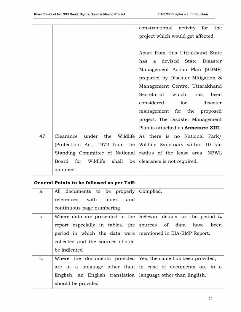
Apart from this Uttrakhand State
has a devised State Disaster
Management Action Plan (SDMP)
prepared by Disaster Mitigation &
Management Centre, Uttarakhand
Secretariat which has been
considered for disaster
management for the proposed
project. The Disaster Management
Plan is attached as Annexure XIII.
47. Clearance under the Wildlife
(Protection) Act, 1972 from the
Standing Committee of National
Board for Wildlife shall be
obtained.
As there is no National Park/
Wildlife Sanctuary within 10 km
radius of the lease area, NBWL
clearance is not required.
General Points to be followed as per ToR:
a. All documents to be properly
referenced with index and
continuous page numbering
Complied.
b. Where data are presented in the
report especially in tables, the
period in which the data were
collected and the sources should
be indicated
Relevant details i.e. the period &
sources of data have been
mentioned in EIA-EMP Report.
c. Where the documents provided
are in a language other than
English, an English translation
should be provided
Yes, the same has been provided,
in case of documents are in a
language other than English.
River Tons Lot No. 3/13 Sand, Bajri & Boulder Mining Project EIA/EMP Chapter – I: Introduction
22
d. The Questionnaire for
environmental appraisal of mining
projects as prescribed by the
ministry shall also be filled and
submitted
The questionnaire for
environmental appraisal of the
project is attached in the report as
Annexure IV.
e. While preparing the EIA report,
the instructions for the
proponents and instructions for
the consultants issued by MoEF
vide O.M No. J-11013/41/2006-
IA.II(I) dated 4th
Instructions for the proponents
and consultants issued by
MoEF&CC from time to time have
been taken into consideration while
preparing the EIA report.
August, 2009
should be followed
f. Changes, if any made in the basic
scope and project parameters (as
submitted in Form I and PFR for
securing TOR) should be brought
to the attention of MoEF with
reasons for such changes and
permission should be sought, the
as TOR may also have to be
altered. Post public hearing
changes in structure and content
of the draft EIA/EMP (other than
modifications arising out of P.H
process) will entail conducting the
PH again with revised
documentation.
No changes have been done in the
basic scope and project parameters
as submitted in Form I and PFR.
g. As per the circular no. J-
11011/618/2010-IA.II(I) dated
30.2.2012, you are requested to
submit certified report of the
status of compliance of the
Not applicable as this is a new
mine for which Environmental
clearance is yet to be received.
River Tons Lot No. 3/13 Sand, Bajri & Boulder Mining Project EIA/EMP Chapter – I: Introduction
23
conditions stipulated in the
environmental clearance for the
existing operations of the project
by the Regional Office of Ministry
of Environment & Forests, if
applicable.
***********
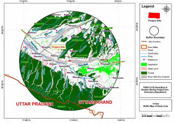
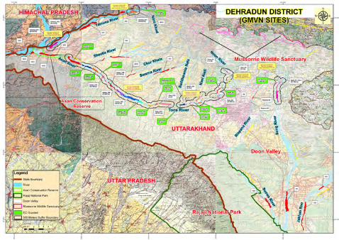
Legend
-Project Site
o Buffer Boundary
-- State Boundary
Cl Ooon Valley
-- Road
-- Distributary
-- River
• Settelment
_ Vegetation
Open Land
_ Forest
_ River With Dry Channel
TONS (3/13) Sand,Bajri & Boulder Mining Project,Dist:
Dehradun,Uttarakhand
10 Km Buffer Map of Study Area
River Tons Lot No. 3/13 Sand, Bajri & Boulder Mining Project EIA/EMP Chapter –II: Project Description
24
CHAPTER-II
PROJECT DESCRIPTION
INDEX
S. No. CONTENTS Page No.
2.0 TYPE OF PROJECT 25
2.1 NEED FOR THE PROJECT 25
2.2 LOCATION DETAILS 25
2.3 MINING 33
2.4 RESERVE (AVAILABLE QUANTUM) AND
PRODUCTION (EXTRACTABLE QUANTUM)
34
2.5 SITE FACILITIES AND UTILITIES 38
2.6 STATUTORY REQUIREMENTS 39
River Tons Lot No. 3/13 Sand, Bajri & Boulder Mining Project EIA/EMP Chapter –II: Project Description
25
2.0 TYPE OF PROJECT
The project is proposed for the excavation of Sand, Bajri & Boulder from
the bed of River Tons. It is an opencast mining project where the entire
activity will be done manually.
2.1 NEED FOR THE PROJECT
The project site lies on river Tons which is a tributary of Aasan river.
These rivers get recharged by the rain water and carries with it sediments,
consisting of sand, bajri, silt, clay, etc during every monsoon season. As
the river beds are filled with sediments, hence it is quite necessary to
clear the excessive sediment load from the rivers at the earliest, which
otherwise will damage large tracts of land lying on both the banks of the
river. Hence the mining activity will channelize the river.
Apart from this the project will generate various employment
opportunities especially to the local people hosting the mining project.
2.2 LOCATION DETAILS
The River Tons Lot No. 3/13 Sand, Bajri & Boulder Mining Project is
located in Village: Banshiwala, Tehsil: Vikasnagar, District: Dehradun,
Uttarakhand. The lease area falls in Survey of India Toposheet
53F15.The lease co-ordinates and connectivity details are listed below:
The lease area is connected to NH-72 by an un-metalled road which is
approx 1 km from the lease mine.
Latitude 30°20'29.19"N to 30°20'20.58"N
Longitude 77°53'33.35"E to 77°53'49.23"E
River Tons Lot No. 3/13 Sand, Bajri & Boulder Mining Project EIA/EMP Chapter –II: Project Description
26
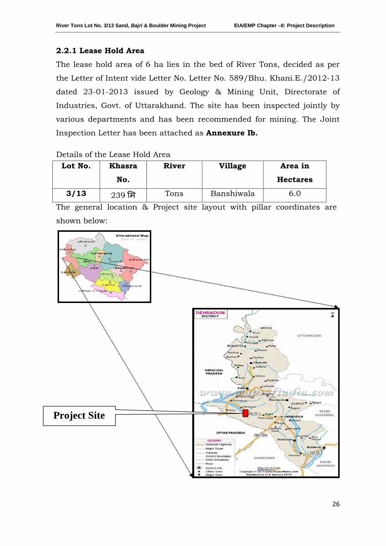
2.2.1 Lease Hold Area
The lease hold area of 6 ha lies in the bed of River Tons, decided as per
the Letter of Intent vide Letter No. Letter No. 589/Bhu. Khani.E./2012-13
dated 23-01-2013 issued by Geology & Mining Unit, Directorate of
Industries, Govt. of Uttarakhand. The site has been inspected jointly by
various departments and has been recommended for mining. The Joint
Inspection Letter has been attached as Annexure Ib.
Details of the Lease Hold Area Lot No. Khasra
No.
River Village Area in
Hectares
3/13 239 �म Tons Banshiwala 6.0
The general location & Project site layout with pillar coordinates are
shown below:
Project Site
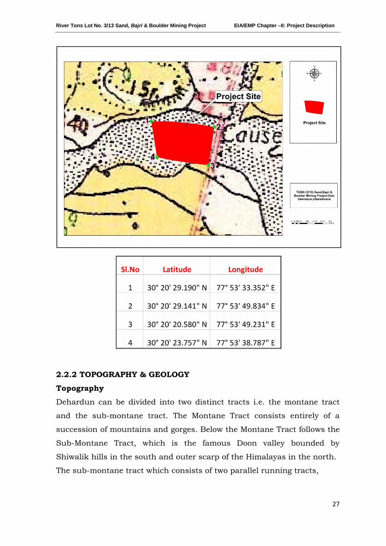
River Tons Lot No. 3/13 Sand, Bajri & Boulder Mining Project EIA/EMP Chapter –II: Project Description
27
2.2.2 TOPOGRAPHY & GEOLOGY
Topography
Dehardun can be divided into two distinct tracts i.e. the montane tract
and the sub-montane tract. The Montane Tract consists entirely of a
succession of mountains and gorges. Below the Montane Tract follows the
Sub-Montane Tract, which is the famous Doon valley bounded by
Shiwalik hills in the south and outer scarp of the Himalayas in the north.
The sub-montane tract which consists of two parallel running tracts,
River Tons Lot No. 3/13 Sand, Bajri & Boulder Mining Project EIA/EMP Chapter –II: Project Description
28
i.e. (a) Bhangar; and (b) Terai
(a) Bhangar: It extends upto 30 km in the west and narrows towards
east. It is just below Himalayas. This tract has little surface
drainage.
(b) Terai: It is low marshy area with tall grasses and scrubs. Rainfall is
heavy and streams are numerous.
The Sub-Montane Tract is situated in foothills of Himalayas. The Sub-
Montane exhibits a general fall of slope from the foothills region. The slope
gradually decreases and becomes almost flat at the Doon area, where the
site lies.
Geology
Dehradun valley was formed as an intermontane valley between lesser
Himalaya in the north and the Siwaliks in the south. The present Doon
valley is developed in two phases. In the first phase, around 18 million
years ago there was an upliftment in the Himalaya around the Main
Boundary Thrust (MBT) that raised the Mussorie Range and the Lower
Himalaya. It resulted in the formation of a synclinal depression known as
Doon Syncline, in which the eroded sediments of the up-lifted part were
deposited and this continued for the long period. In the second phase,
around 0.5 million years ago another tectonic event uplifted the Siwalik
Range strata along the Himalayan Frontal Thrust (HFT) and the Doon
valley came into existence (Thakur, 1995).
(Source: Seismic response analysis of Dehradun_pdf)
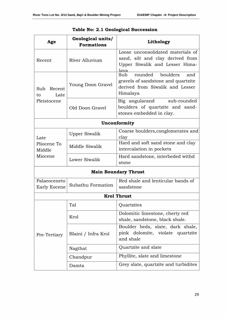
River Tons Lot No. 3/13 Sand, Bajri & Boulder Mining Project EIA/EMP Chapter –II: Project Description
29
Table No: 2.1 Geological Succession
Age Geological units/ Formations Lithology
Recent River Alluvium
Loose unconsolidated materials of sand, silt and clay derived from Upper Siwalik and Lesser Hima-laya
Sub Recent to Late Pleistocene
Young Doon Gravel
Sub rounded boulders and gravels of sandstone and quartzite derived from Siwalik and Lesser Himalaya
Old Doon Gravel Big angularand sub-rounded boulders of quartzite and sand-stones embedded in clay.
Unconformity
Late Pliocene To Middle Miocene
Upper Siwalik Coarse boulders,conglomerates and clay
Middle Siwalik Hard and soft sand stone and clay intercalation in pockets
Lower Siwalik Hard sandstone, interbeded withd stone
Main Boundary Thrust
Palaeoceneto Early Eocene Subathu Formation
Red shale and lenticular bands of sandstone
Krol Thrust
Pre-Tertiary
Tal Quartzites
Krol Dolomitic limestone, cherty red shale, sandstone, black shale.
Blaini / Infra Krol Boulder beds, slate, dark shale, pink dolomite, violate quartzite and shale
Nagthat Quartzite and slate
Chandpur Phyllite, slate and limestone
Damta Grey slate, quartzite and turbidites
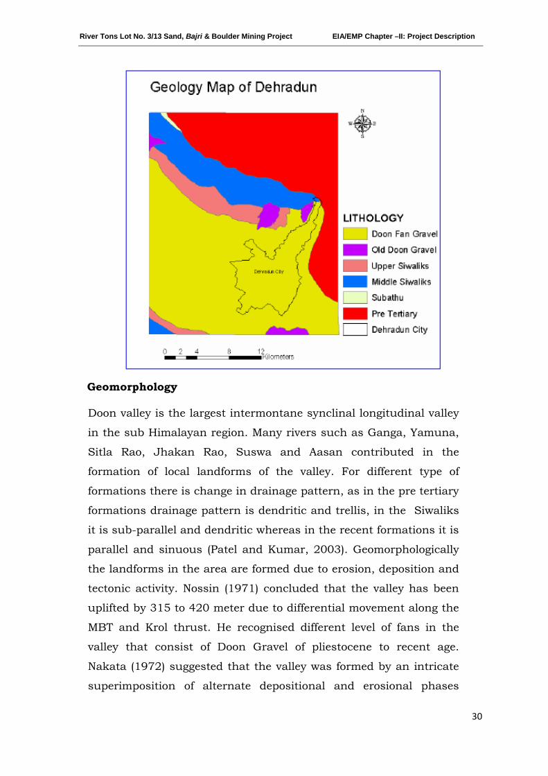
River Tons Lot No. 3/13 Sand, Bajri & Boulder Mining Project EIA/EMP Chapter –II: Project Description
30
Geomorphology
Doon valley is the largest intermontane synclinal longitudinal valley
in the sub Himalayan region. Many rivers such as Ganga, Yamuna,
Sitla Rao, Jhakan Rao, Suswa and Aasan contributed in the
formation of local landforms of the valley. For different type of
formations there is change in drainage pattern, as in the pre tertiary
formations drainage pattern is dendritic and trellis, in the Siwaliks
it is sub-parallel and dendritic whereas in the recent formations it is
parallel and sinuous (Patel and Kumar, 2003). Geomorphologically
the landforms in the area are formed due to erosion, deposition and
tectonic activity. Nossin (1971) concluded that the valley has been
uplifted by 315 to 420 meter due to differential movement along the
MBT and Krol thrust. He recognised different level of fans in the
valley that consist of Doon Gravel of pliestocene to recent age.
Nakata (1972) suggested that the valley was formed by an intricate
superimposition of alternate depositional and erosional phases
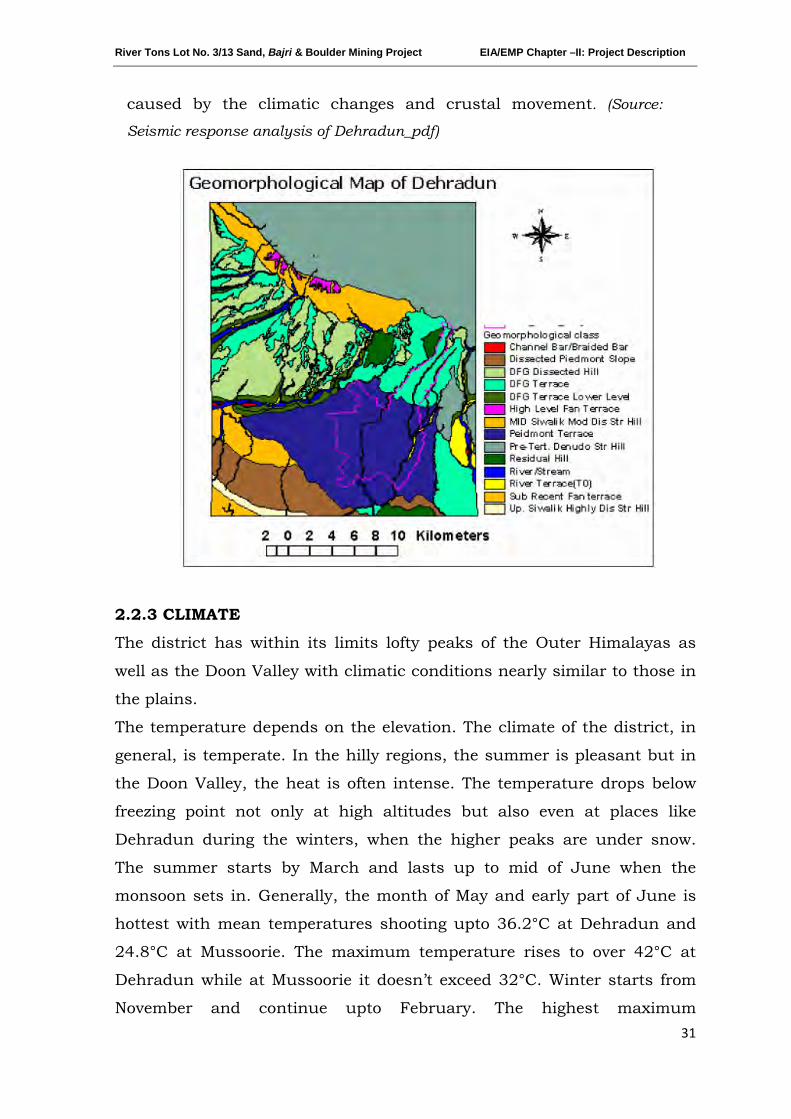
River Tons Lot No. 3/13 Sand, Bajri & Boulder Mining Project EIA/EMP Chapter –II: Project Description
31
caused by the climatic changes and crustal movement. (Source:
Seismic response analysis of Dehradun_pdf)
2.2.3 CLIMATE
The district has within its limits lofty peaks of the Outer Himalayas as
well as the Doon Valley with climatic conditions nearly similar to those in
the plains.
The temperature depends on the elevation. The climate of the district, in
general, is temperate. In the hilly regions, the summer is pleasant but in
the Doon Valley, the heat is often intense. The temperature drops below
freezing point not only at high altitudes but also even at places like
Dehradun during the winters, when the higher peaks are under snow.
The summer starts by March and lasts up to mid of June when the
monsoon sets in. Generally, the month of May and early part of June is
hottest with mean temperatures shooting upto 36.2°C at Dehradun and
24.8°C at Mussoorie. The maximum temperature rises to over 42°C at
Dehradun while at Mussoorie it doesn’t exceed 32°C. Winter starts from
November and continue upto February. The highest maximum
River Tons Lot No. 3/13 Sand, Bajri & Boulder Mining Project EIA/EMP Chapter –II: Project Description
32
temperature recorded at Dehradun was 43.9°C on June 4, 1902 and that
at Mussoorie was 34.4°C, on May 24th 1949. The mean daily maximum
temperature during winter is 19.1°C at Dehradun and 10.2°C at
Mussoorie. The mean daily minimum temperature in January is 6.1°C at
Dehradun and 2.5°C at Mussoorie. In Mussoorie the temperature drops to
about -6°C to -7°C when snow fall occurs. The lowest minimum
temperature at Dehradun during winter was - 1.1°C, on February 1st,
1905 and January 1945 while at Mussoorie it was -6.7°C, on February
10th
. The district receives an average annual rainfall of 2073.3 mm. Most
of the rainfall is received during the period from June to September, July
and August being the wettest months. The region around Raipur gets the
maximum rainfall, while the southern part receives the least rainfall in
the district. About 87% of the annual rainfall is received during the period
June to September. (Source: CGWB Dehradun_pdf)
2.2.4 SURFACE DRAINAGE PATTERN
The project site lies on the bed of Tons River which is a tributary of Aasan
River. It is a rain fed seasonal river which mainly drains water during
monsoon. The Asan drainage flows towards North-West forming a
catchment with Aasan as a major stream. It is a prominent catchment
area in Doon valley at foot hills of Siwalik ranges in the Dehradun District
of Uttarakhand. The catchment area has a length of about 40 km and
width 18 km. consists of smaller watersheds and the area is bestowed
with number of small streams around the major streams. (Source:
International Journal of Geology, Earth and Environmental Sciences ISSN: 2277-
2081)
Tributaries joining the river on its course are Darer Nadi, Ghulaita Nadi,
Nimmi Nadi, Noon Nadi, Rani Rao, Bhul Rao, Sukh Rao & other Rao
Rivers, Ram Khala, Paudi Khala, Chor Khala, Swarna Nadi.
The surface drainage pattern map is attached as Map No. 2.
The catchment area of entire Aasan River along with the drainage pattern is shown below:
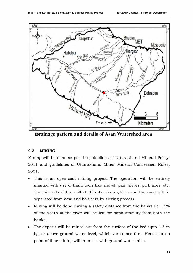
River Tons Lot No. 3/13 Sand, Bajri & Boulder Mining Project EIA/EMP Chapter –II: Project Description
33
2.3 MINING
Mining will be done as per the guidelines of Uttarakhand Mineral Policy,
2011 and guidelines of Uttarakhand Minor Mineral Concession Rules,
2001.
• This is an open-cast mining project. The operation will be entirely
manual with use of hand tools like shovel, pan, sieves, pick axes, etc.
The minerals will be collected in its existing form and the sand will be
separated from bajri and boulders by sieving process.
• Mining will be done leaving a safety distance from the banks i.e. 15%
of the width of the river will be left for bank stability from both the
banks.
• The deposit will be mined out from the surface of the bed upto 1.5 m
bgl or above ground water level, whichever comes first. Hence, at no
point of time mining will intersect with ground water table.
Project Site
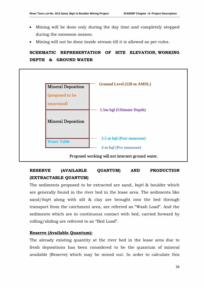
River Tons Lot No. 3/13 Sand, Bajri & Boulder Mining Project EIA/EMP Chapter –II: Project Description
34
• Mining will be done only during the day time and completely stopped
during the monsoon season.
• Mining will not be done inside stream till it is allowed as per rules.
SCHEMATIC REPRESENTATION OF SITE ELEVATION, WORKING
DEPTH & GROUND WATER
Proposed working will not intersect ground water .
RESERVE (AVAILABLE QUANTUM) AND PRODUCTION
(EXTRACTABLE QUANTUM)
The sediments proposed to be extracted are sand, bajri & boulder which
are generally found in the river bed in the lease area. The sediments like
sand/bajri along with silt & clay are brought into the bed through
transport from the catchment area, are referred as “Wash Load”. And the
sediments which are in continuous contact with bed, carried forward by
rolling/sliding are referred to as “Bed Load”.
The already existing quantity at the river bed in the lease area due to
fresh depositions has been considered to be the quantum of mineral
available (Reserve) which may be mined out. In order to calculate this
Reserve (Available Quantum):
Mineral Deposition
(proposed to be
excavated)
Mineral Deposition
Water Table
1.5m bgl (Ultimate Depth)
3.5 m bgl (Post monsoon) 4 m bgl (Pre monsoon)
Ground Level (528 m AMSL)
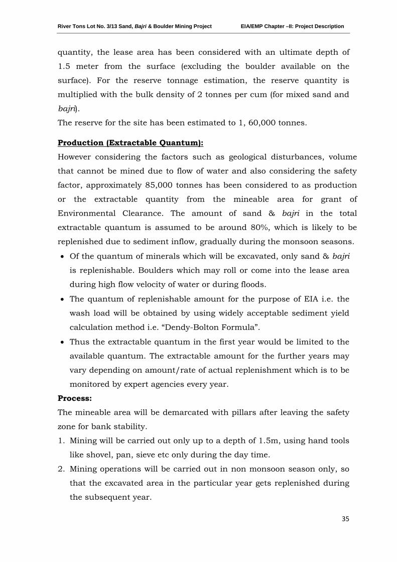
River Tons Lot No. 3/13 Sand, Bajri & Boulder Mining Project EIA/EMP Chapter –II: Project Description
35
quantity, the lease area has been considered with an ultimate depth of
1.5 meter from the surface (excluding the boulder available on the
surface). For the reserve tonnage estimation, the reserve quantity is
multiplied with the bulk density of 2 tonnes per cum (for mixed sand and
bajri).
The reserve for the site has been estimated to 1, 60,000 tonnes.
However considering the factors such as geological disturbances, volume
that cannot be mined due to flow of water and also considering the safety
factor, approximately 85,000 tonnes has been considered to as production
or the extractable quantity from the mineable area for grant of
Environmental Clearance. The amount of sand & bajri in the total
extractable quantum is assumed to be around 80%, which is likely to be
replenished due to sediment inflow, gradually during the monsoon seasons.
Production (Extractable Quantum):
• Of the quantum of minerals which will be excavated, only sand & bajri
is replenishable. Boulders which may roll or come into the lease area
during high flow velocity of water or during floods.
• The quantum of replenishable amount for the purpose of EIA i.e. the
wash load will be obtained by using widely acceptable sediment yield
calculation method i.e. “Dendy-Bolton Formula”.
• Thus the extractable quantum in the first year would be limited to the
available quantum. The extractable amount for the further years may
vary depending on amount/rate of actual replenishment which is to be
monitored by expert agencies every year.
Process:
The mineable area will be demarcated with pillars after leaving the safety
zone for bank stability.
1. Mining will be carried out only up to a depth of 1.5m, using hand tools
like shovel, pan, sieve etc only during the day time.
2. Mining operations will be carried out in non monsoon season only, so
that the excavated area in the particular year gets replenished during
the subsequent year.
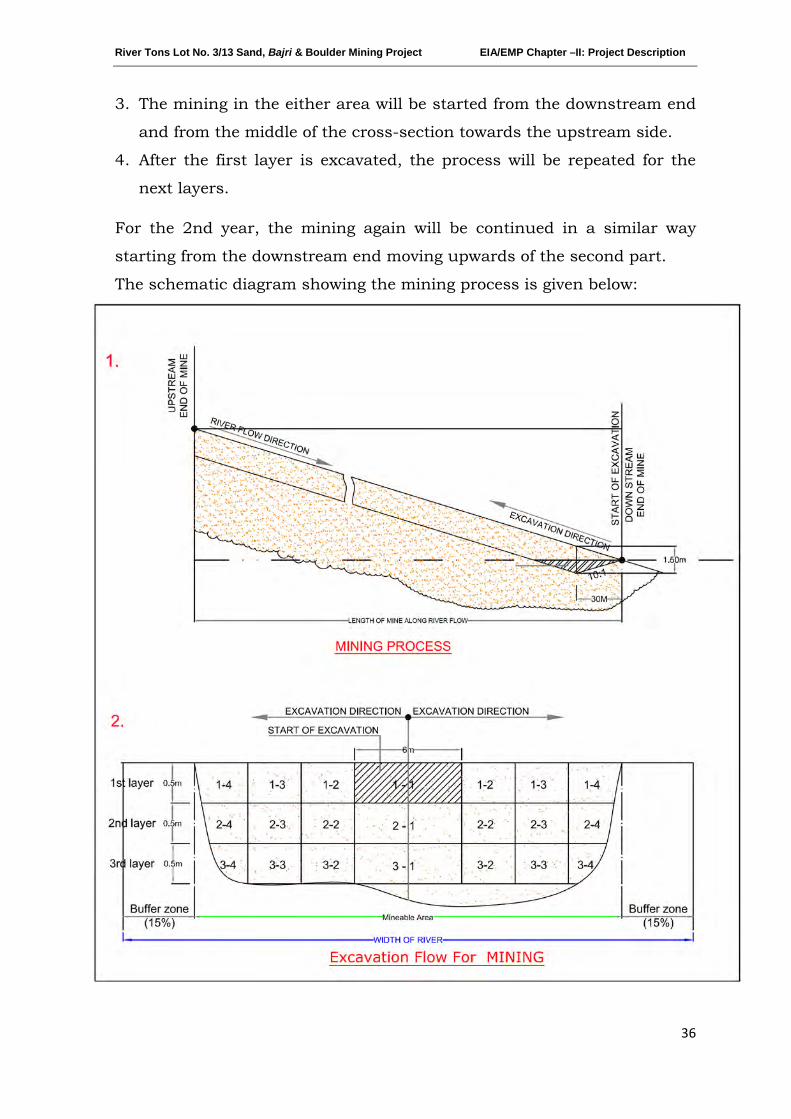
River Tons Lot No. 3/13 Sand, Bajri & Boulder Mining Project EIA/EMP Chapter –II: Project Description
36
3. The mining in the either area will be started from the downstream end
and from the middle of the cross-section towards the upstream side.
4. After the first layer is excavated, the process will be repeated for the
next layers.
For the 2nd year, the mining again will be continued in a similar way
starting from the downstream end moving upwards of the second part.
The schematic diagram showing the mining process is given below:
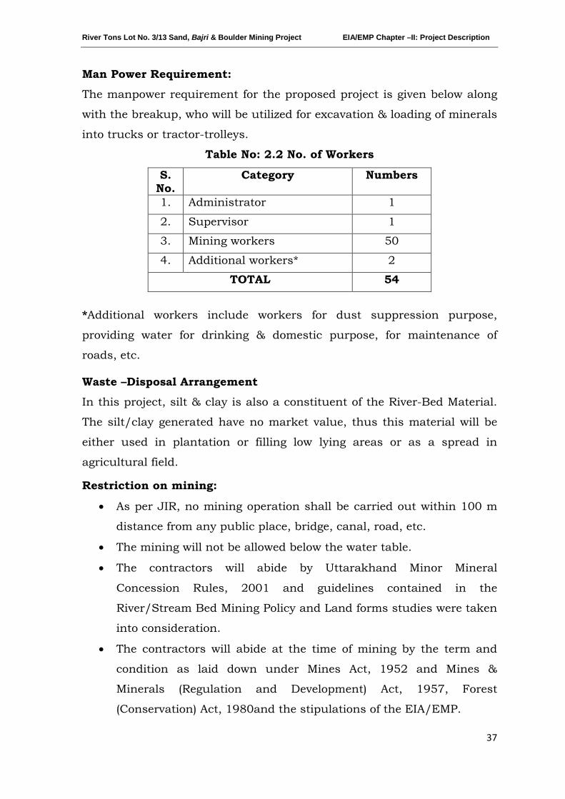
River Tons Lot No. 3/13 Sand, Bajri & Boulder Mining Project EIA/EMP Chapter –II: Project Description
37
Man Power Requirement:
The manpower requirement for the proposed project is given below along
with the breakup, who will be utilized for excavation & loading of minerals
into trucks or tractor-trolleys.
Table No: 2.2 No. of Workers
*Additional workers include workers for dust suppression purpose,
providing water for drinking & domestic purpose, for maintenance of
roads, etc.
Waste –Disposal Arrangement
In this project, silt & clay is also a constituent of the River-Bed Material.
The silt/clay generated have no market value, thus this material will be
either used in plantation or filling low lying areas or as a spread in
agricultural field.
Restriction on mining:
• As per JIR, no mining operation shall be carried out within 100 m
distance from any public place, bridge, canal, road, etc.
• The mining will not be allowed below the water table.
• The contractors will abide by Uttarakhand Minor Mineral
Concession Rules, 2001 and guidelines contained in the
River/Stream Bed Mining Policy and Land forms studies were taken
into consideration.
• The contractors will abide at the time of mining by the term and
condition as laid down under Mines Act, 1952 and Mines &
Minerals (Regulation and Development) Act, 1957, Forest
(Conservation) Act, 1980and the stipulations of the EIA/EMP.
S. No.
Category Numbers
1. Administrator 1
2. Supervisor 1
3. Mining workers 50
4. Additional workers* 2
TOTAL 54
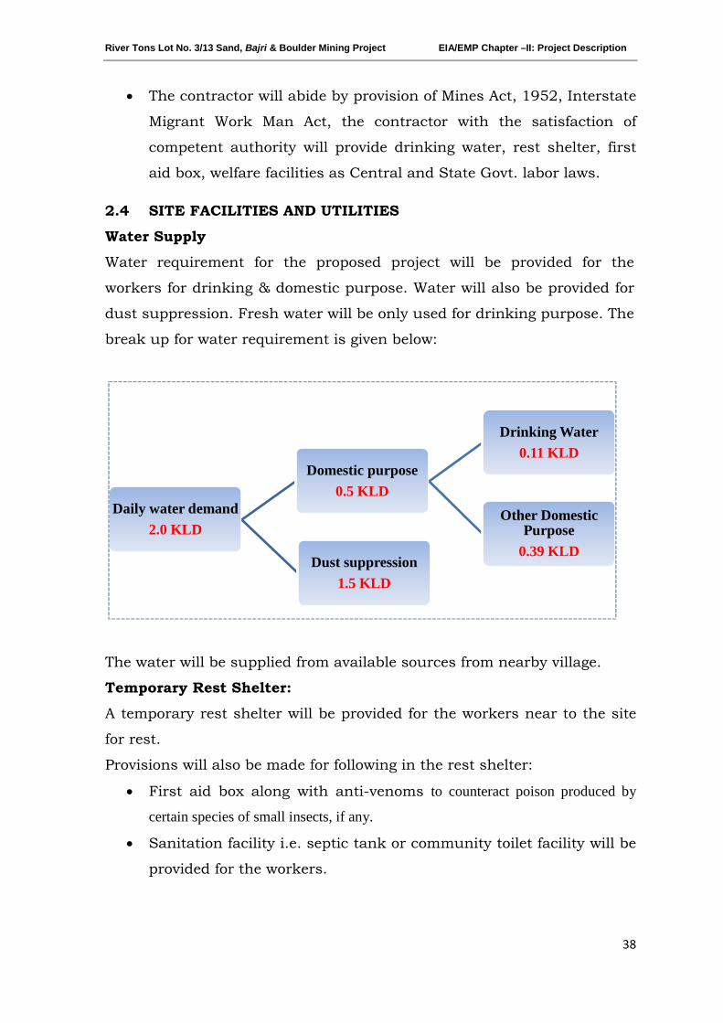
River Tons Lot No. 3/13 Sand, Bajri & Boulder Mining Project EIA/EMP Chapter –II: Project Description
38
• The contractor will abide by provision of Mines Act, 1952, Interstate
Migrant Work Man Act, the contractor with the satisfaction of
competent authority will provide drinking water, rest shelter, first
aid box, welfare facilities as Central and State Govt. labor laws.
2.4 SITE FACILITIES AND UTILITIES
Water Supply
Water requirement for the proposed project will be provided for the
workers for drinking & domestic purpose. Water will also be provided for
dust suppression. Fresh water will be only used for drinking purpose. The
break up for water requirement is given below:
The water will be supplied from available sources from nearby village.
Temporary Rest Shelter:
A temporary rest shelter will be provided for the workers near to the site
for rest.
Provisions will also be made for following in the rest shelter:
• First aid box along with anti-venoms to counteract poison produced by
certain species of small insects, if any.
• Sanitation facility i.e. septic tank or community toilet facility will be
provided for the workers.
Daily water demand2.0 KLD
Domestic purpose0.5 KLD
Drinking Water0.11 KLD
Other Domestic Purpose
0.39 KLDDust suppression
1.5 KLD
River Tons Lot No. 3/13 Sand, Bajri & Boulder Mining Project EIA/EMP Chapter –II: Project Description
39
2.5 STATUTORY
It is accepted that effective resource management cannot be done in
isolation. The proponent therefore vigorously pursues approaches towards
coordination and integration where possible, so as to lead to coordinated
regulatory systems.
REQUIREMENTS
Various acts dealing with matters relating to the conservation and
protection of the environment and which a holder of a mining
authorization must also take cognizance of, include inter alia, the
following:
• Uttarakhand Mineral Policy, 2011
• Uttarakhand Minor Mineral Concession Rules, 2001
• The Mines Act, 1952
• The Mines and Mineral (Development and Regulation) Act, 1957
• Mines Rules, 1955
• Mineral Concession Rules, 1960
• Mineral Conservation and Development Rules, 1988
• The Water (Prevention and Control of Pollution) Act, 1974
• The Air (Prevention and Control of Pollution) Act, 1981
• The Environment (Protection) Act, 1986
• The Forest (Conservation) Act, 1980
********
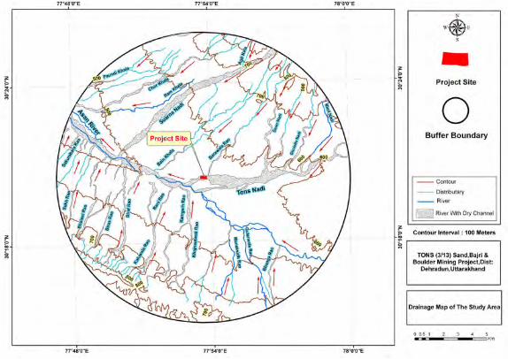
77°48'O"E 77°S4'O"E 78°0'O"E
77°48'O"E 77°S4'O"E 78°0'O"E
-Project Site
o Buffer Boundary
-- Contour
-- Distributary __ River
River With Dry Channel
Contour Interval : 100 Meters
TONS (3/13) Sand,Bajri & Boulder Mining Project,Dist:
Dehradun,Uttarakhand
Drainage Map of The Study Area
River Tons Lot No. 3/13 Sand, Bajri & Boulder Mining Project EIA/EMP -Chapter – III Description of Environment
40
CHAPTER-III
DESCRIPTION OF ENVIRONMENT
INDEX
S. No. CONTENTS Page No.
3.0 INTRODUCTION 41
3.1 BASELINE DATA 41
3.1.1 LAND ENVIRONMENT 41
3.1.2 AIR ENVIRONMENT 41
3.1.3 WATER ENVIRONMENT 47
3.1.4 SOIL ENVIRONNENT 56
3.1.5 NOISE ENVIRONNENT 58
3.1.6 BIOLOGICAL ENVIRONMENT 59
3.1.7 SOCIO-ECONOMIC STATUS & BASELINE DATA 78
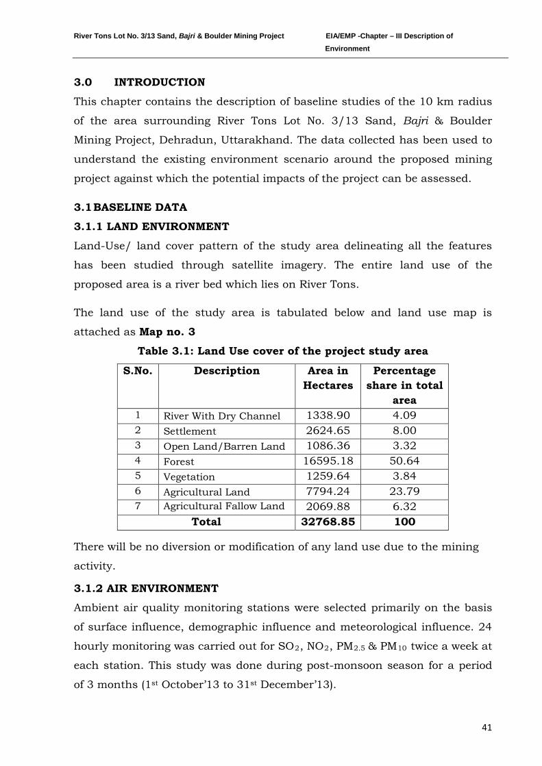
River Tons Lot No. 3/13 Sand, Bajri & Boulder Mining Project EIA/EMP -Chapter – III Description of Environment
41
3.0 INTRODUCTION
This chapter contains the description of baseline studies of the 10 km radius
of the area surrounding River Tons Lot No. 3/13 Sand, Bajri & Boulder
Mining Project, Dehradun, Uttarakhand. The data collected has been used to
understand the existing environment scenario around the proposed mining
project against which the potential impacts of the project can be assessed.
3.1 BASELINE DATA
3.1.1 LAND ENVIRONMENT
Land-Use/ land cover pattern of the study area delineating all the features
has been studied through satellite imagery. The entire land use of the
proposed area is a river bed which lies on River Tons.
The land use of the study area is tabulated below and land use map is
attached as Map no. 3
Table 3.1: Land Use cover of the project study area
S.No. Description Area in Hectares
Percentage share in total
area 1 River With Dry Channel 1338.90 4.09 2 Settlement 2624.65 8.00 3 Open Land/Barren Land 1086.36 3.32 4 Forest 16595.18 50.64 5 Vegetation 1259.64 3.84 6 Agricultural Land 7794.24 23.79 7 Agricultural Fallow Land 2069.88 6.32
Total 32768.85 100
There will be no diversion or modification of any land use due to the mining
activity.
3.1.2 AIR ENVIRONMENT
Ambient air quality monitoring stations were selected primarily on the basis
of surface influence, demographic influence and meteorological influence. 24
hourly monitoring was carried out for SO2, NO2, PM2.5 & PM10 twice a week at
each station. This study was done during post-monsoon season for a period
of 3 months (1st October’13 to 31st December’13).
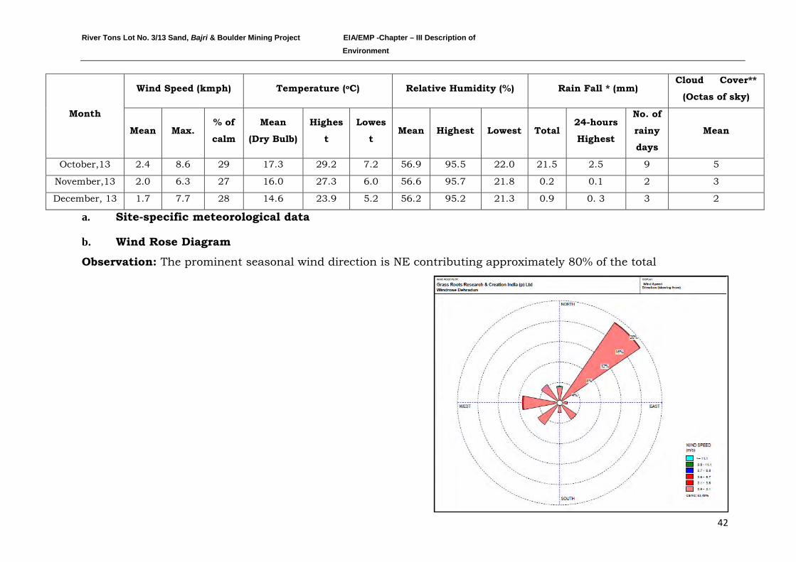
River Tons Lot No. 3/13 Sand, Bajri & Boulder Mining Project EIA/EMP -Chapter – III Description of Environment
42
a. Site-specific meteorological data
b. Wind Rose Diagram
Observation: The prominent seasonal wind direction is NE contributing approximately 80% of the total
Month
Wind Speed (kmph) Temperature (o Relative Humidity (%) C) Rain Fall * (mm) Cloud Cover**
(Octas of sky)
Mean Max. % of
calm
Mean
(Dry Bulb)
Highes
t
Lowes
t Mean Highest Lowest Total
24-hours
Highest
No. of
rainy
days
Mean
October,13 2.4 8.6 29 17.3 29.2 7.2 56.9 95.5 22.0 21.5 2.5 9 5
November,13 2.0 6.3 27 16.0 27.3 6.0 56.6 95.7 21.8 0.2 0.1 2 3
December, 13 1.7 7.7 28 14.6 23.9 5.2 56.2 95.2 21.3 0.9 0. 3 3 2
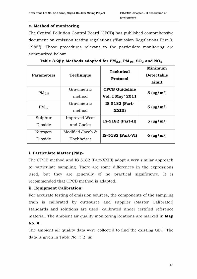
River Tons Lot No. 3/13 Sand, Bajri & Boulder Mining Project EIA/EMP -Chapter – III Description of Environment
43
c. Method of monitoring
The Central Pollution Control Board (CPCB) has published comprehensive
document on emission testing regulations (“Emission Regulations Part-3,
1985”). Those procedures relevant to the particulate monitoring are
summarized below:
Table 3.2(i): Methods adopted for PM2.5, PM10, SO2 and NO
Parameters
2
Technique Technical
Protocol
Minimum
Detectable
Limit
PMGravimetric
method 2.5
CPCB Guideline
Vol. I May’ 2011 5 (µg/m3)
PMGravimetric
method 10
IS 5182 (Part-
XXIII) 5 (µg/m3)
Sulphur
Dioxide
Improved West
and Gaeke IS-5182 (Part-II) 5 (µg/m3)
Nitrogen
Dioxide
Modified Jacob &
Hochheiser IS-5182 (Part-VI) 6 (µg/m3)
i. Particulate Matter (PM):-
The CPCB method and IS 5182 (Part-XXIII) adopt a very similar approach
to particulate sampling. There are some differences in the expressions
used, but they are generally of no practical significance. It is
recommended that CPCB method is adapted.
ii. Equipment Calibration:
For accurate testing of emission sources, the components of the sampling
train is calibrated by outsource and supplier (Master Calibrator)
standards and solutions are used, calibrated under certified reference
material. The Ambient air quality monitoring locations are marked in Map
No. 4.
The ambient air quality data were collected to find the existing GLC. The
data is given in Table No. 3.2 (iii).

River Tons Lot No. 3/13 Sand, Bajri & Boulder Mining Project EIA/EMP -Chapter – III Description of Environment
44
Table 3.2 (ii) Ambient air quality monitoring stations
S.No. Location Station name
Distance (approx.) and
direction from the lease area
(km)
Zone (Core/ Buffer)
1. AQ1 Hasanpur 4 W Buffer zone
2. AQ2 Sheesambada 2 SW Buffer zone
3. AQ3 Project Site - - Core Zone
4. AQ4 Thakurpur Tarla 4 ESE Buffer zone
5. AQ5 Dhul Kot 2 N Buffer zone
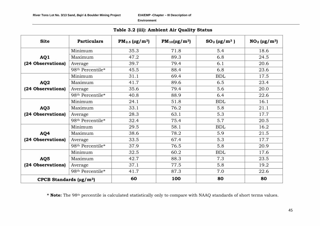
River Tons Lot No. 3/13 Sand, Bajri & Boulder Mining Project EIA/EMP -Chapter – III Description of Environment
45
Table 3.2 (iii): Ambient Air Quality Status
Site Particulars PM2.5 (µg/m3 PM) 10(µg/m3 SO) 2 (µg/m3 NO) 2 (µg/m3)
AQ1 (24 Observations)
Minimum 35.3 71.8 5.4 18.6 Maximum 47.2 89.3 6.8 24.5 Average 39.7 79.4 6.1 20.6 98th 45.5 Percentile* 88.4 6.8 23.6
AQ2 (24 Observations)
Minimum 31.1 69.4 BDL 17.5 Maximum 41.7 89.6 6.5 23.4 Average 35.6 79.4 5.6 20.0 98th 40.8 Percentile* 88.9 6.4 22.6
AQ3 (24 Observations)
Minimum 24.1 51.8 BDL 16.1 Maximum 33.1 76.2 5.8 21.1 Average 28.3 63.1 5.3 17.7 98th 32.4 Percentile* 75.4 5.7 20.5
AQ4 (24 Observations)
Minimum 29.5 58.1 BDL 16.2 Maximum 38.6 78.2 5.9 21.5 Average 33.5 67.4 5.3 17.7 98th 37.9 Percentile* 76.5 5.8 20.9
AQ5 (24 Observations)
Minimum 32.5 60.2 BDL 17.6 Maximum 42.7 88.3 7.3 23.5 Average 37.1 77.5 5.8 19.2 98th 41.7 Percentile* 87.3 7.0 22.6
CPCB Standards (µg/m3 60 ) 100 80 80
* Note: The 98th percentile is calculated statistically only to compare with NAAQ standards of short terms values.
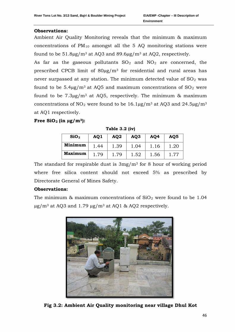
River Tons Lot No. 3/13 Sand, Bajri & Boulder Mining Project EIA/EMP -Chapter – III Description of Environment
46
Observations: Ambient Air Quality Monitoring reveals that the minimum & maximum
concentrations of PM10 amongst all the 5 AQ monitoring stations were
found to be 51.8µg/m3 at AQ3 and 89.6µg/m3
As far as the gaseous pollutants SO
at AQ2, respectively.
2 and NO2 are concerned, the
prescribed CPCB limit of 80µg/m3 for residential and rural areas has
never surpassed at any station. The minimum detected value of SO2 was
found to be 5.4µg/m3 at AQ5 and maximum concentrations of SO2 were
found to be 7.3µg/m3 at AQ5, respectively. The minimum & maximum
concentrations of NO2 were found to be 16.1µg/m3 at AQ3 and 24.5µg/m3
Free SiO
at AQ1 respectively.
2 (in µg/m3
Table 3.2 (iv)
):
SiO AQ1 2 AQ2 AQ3 AQ4 AQ5
Minimum 1.44 1.39 1.04 1.16 1.20 Maximum 1.79 1.79 1.52 1.56 1.77
The standard for respirable dust is 3mg/m3
Observations:
for 8 hour of working period
where free silica content should not exceed 5% as prescribed by
Directorate General of Mines Safety.
The minimum & maximum concentrations of SiO2 were found to be 1.04
µg/m3 at AQ3 and 1.79 µg/m3
at AQ1 & AQ2 respectively.
Fig 3.2: Ambient Air Quality monitoring near village Dhul Kot
River Tons Lot No. 3/13 Sand, Bajri & Boulder Mining Project EIA/EMP -Chapter – III Description of Environment
47
3.1.3 WATER ENVIRONMENT
a) Ground water
Three water samples were collected from the study area. The physico-
chemical analysis of the water samples is given in the Table 3.3 (ii).
The Ground water sampling locations are marked in Map No. 4.
Table 3.3 (i)
Ground water sampling locations
Station
No. Location Direction
Approx.
Distance (km)
Core zone/
buffer zone
GW1 Sheesambada 2 km SW Buffer zone
GW2 Parwal Nawa 1 km SE Buffer zone
GW3 Dhul Kot 2 km N Buffer zone
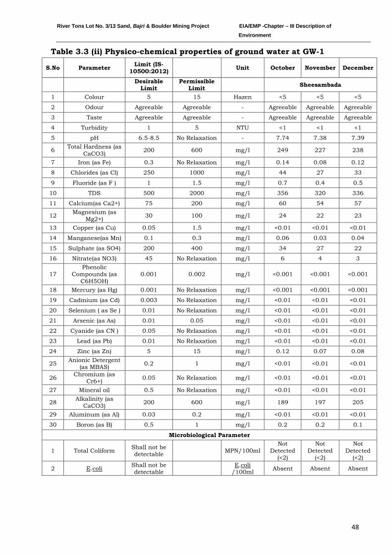
River Tons Lot No. 3/13 Sand, Bajri & Boulder Mining Project EIA/EMP -Chapter – III Description of Environment
48
Table 3.3 (ii) Physico-chemical properties of ground water at GW-1
S.No Parameter Limit (IS-10500:2012) Unit October November December
Desirable
Limit Permissible
Limit Sheesambada
1 Colour 5 15 Hazen <5 <5 <5
2 Odour Agreeable Agreeable - Agreeable Agreeable Agreeable
3 Taste Agreeable Agreeable - Agreeable Agreeable Agreeable
4 Turbidity 1 5 NTU <1 <1 <1
5 pH 6.5-8.5 No Relaxation - 7.74 7.38 7.39
6 Total Hardness (as CaCO3) 200 600 mg/l 249 227 238
7 Iron (as Fe) 0.3 No Relaxation mg/l 0.14 0.08 0.12
8 Chlorides (as Cl) 250 1000 mg/l 44 27 33
9 Fluoride (as F ) 1 1.5 mg/l 0.7 0.4 0.5
10 TDS 500 2000 mg/l 356 320 336
11 Calcium(as Ca2+) 75 200 mg/l 60 54 57
12 Magnesium (as Mg2+) 30 100 mg/l 24 22 23
13 Copper (as Cu) 0.05 1.5 mg/l <0.01 <0.01 <0.01
14 Manganese(as Mn) 0.1 0.3 mg/l 0.06 0.03 0.04
15 Sulphate (as SO4) 200 400 mg/l 34 27 22
16 Nitrate(as NO3) 45 No Relaxation mg/l 6 4 3
17 Phenolic
Compounds (as C6H5OH)
0.001 0.002 mg/l <0.001 <0.001 <0.001
18 Mercury (as Hg) 0.001 No Relaxation mg/l <0.001 <0.001 <0.001
19 Cadmium (as Cd) 0.003 No Relaxation mg/l <0.01 <0.01 <0.01
20 Selenium ( as Se ) 0.01 No Relaxation mg/l <0.01 <0.01 <0.01
21 Arsenic (as As) 0.01 0.05 mg/l <0.01 <0.01 <0.01
22 Cyanide (as CN ) 0.05 No Relaxation mg/l <0.01 <0.01 <0.01
23 Lead (as Pb) 0.01 No Relaxation mg/l <0.01 <0.01 <0.01
24 Zinc (as Zn) 5 15 mg/l 0.12 0.07 0.08
25 Anionic Detergent (as MBAS) 0.2 1 mg/l <0.01 <0.01 <0.01
26 Chromium (as Cr6+) 0.05 No Relaxation mg/l <0.01 <0.01 <0.01
27 Mineral oil 0.5 No Relaxation mg/l <0.01 <0.01 <0.01
28 Alkalinity (as CaCO3) 200 600 mg/l 189 197 205
29 Aluminum (as Al) 0.03 0.2 mg/l <0.01 <0.01 <0.01
30 Boron (as B) 0.5 1 mg/l 0.2 0.2 0.1
Microbiological Parameter
1 Total Coliform Shall not be detectable MPN/100ml
Not Detected
(<2)
Not Detected
(<2)
Not Detected
(<2)
2 E.coli Shall not be detectable
E.coli /100ml Absent Absent Absent
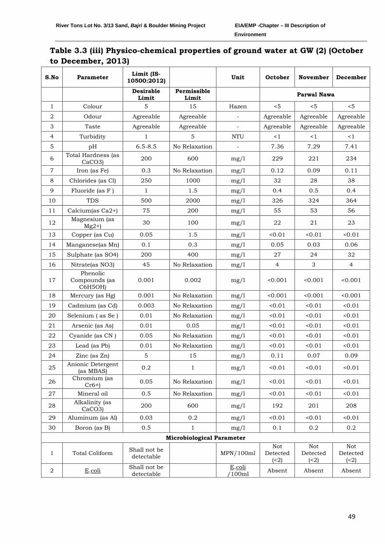
River Tons Lot No. 3/13 Sand, Bajri & Boulder Mining Project EIA/EMP -Chapter – III Description of Environment
49
Table 3.3 (iii) Physico-chemical properties of ground water at GW (2) (October to December, 2013)
S.No Parameter Limit (IS-10500:2012) Unit October November December
Desirable
Limit Permissible
Limit Parwal Nawa
1 Colour 5 15 Hazen <5 <5 <5
2 Odour Agreeable Agreeable - Agreeable Agreeable Agreeable
3 Taste Agreeable Agreeable - Agreeable Agreeable Agreeable
4 Turbidity 1 5 NTU <1 <1 <1
5 pH 6.5-8.5 No Relaxation - 7.36 7.29 7.41
6 Total Hardness (as CaCO3) 200 600 mg/l 229 221 234
7 Iron (as Fe) 0.3 No Relaxation mg/l 0.12 0.09 0.11
8 Chlorides (as Cl) 250 1000 mg/l 32 28 38
9 Fluoride (as F ) 1 1.5 mg/l 0.4 0.5 0.4
10 TDS 500 2000 mg/l 326 324 364
11 Calcium(as Ca2+) 75 200 mg/l 55 53 56
12 Magnesium (as Mg2+) 30 100 mg/l 22 21 23
13 Copper (as Cu) 0.05 1.5 mg/l <0.01 <0.01 <0.01
14 Manganese(as Mn) 0.1 0.3 mg/l 0.05 0.03 0.06
15 Sulphate (as SO4) 200 400 mg/l 27 24 32
16 Nitrate(as NO3) 45 No Relaxation mg/l 4 3 4
17 Phenolic
Compounds (as C6H5OH)
0.001 0.002 mg/l <0.001 <0.001 <0.001
18 Mercury (as Hg) 0.001 No Relaxation mg/l <0.001 <0.001 <0.001
19 Cadmium (as Cd) 0.003 No Relaxation mg/l <0.01 <0.01 <0.01
20 Selenium ( as Se ) 0.01 No Relaxation mg/l <0.01 <0.01 <0.01
21 Arsenic (as As) 0.01 0.05 mg/l <0.01 <0.01 <0.01
22 Cyanide (as CN ) 0.05 No Relaxation mg/l <0.01 <0.01 <0.01
23 Lead (as Pb) 0.01 No Relaxation mg/l <0.01 <0.01 <0.01
24 Zinc (as Zn) 5 15 mg/l 0.11 0.07 0.09
25 Anionic Detergent (as MBAS) 0.2 1 mg/l <0.01 <0.01 <0.01
26 Chromium (as Cr6+) 0.05 No Relaxation mg/l <0.01 <0.01 <0.01
27 Mineral oil 0.5 No Relaxation mg/l <0.01 <0.01 <0.01
28 Alkalinity (as CaCO3) 200 600 mg/l 192 201 208
29 Aluminum (as Al) 0.03 0.2 mg/l <0.01 <0.01 <0.01
30 Boron (as B) 0.5 1 mg/l 0.1 0.2 0.2
Microbiological Parameter
1 Total Coliform Shall not be detectable MPN/100ml
Not Detected
(<2)
Not Detected
(<2)
Not Detected
(<2)
2 E.coli Shall not be detectable
E.coli /100ml Absent Absent Absent
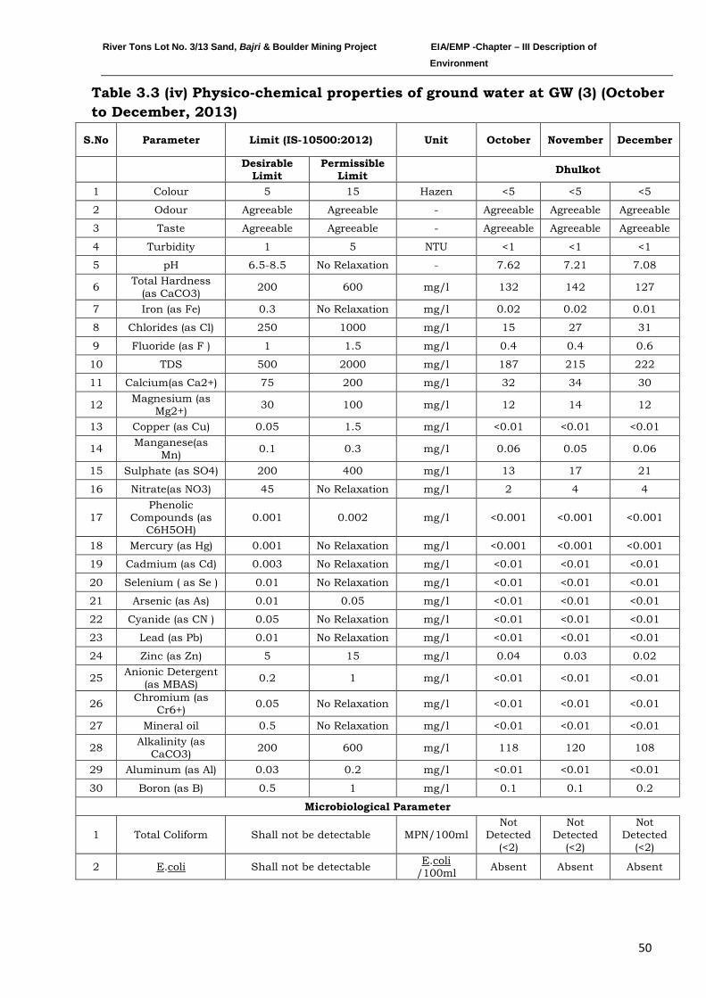
River Tons Lot No. 3/13 Sand, Bajri & Boulder Mining Project EIA/EMP -Chapter – III Description of Environment
50
Table 3.3 (iv) Physico-chemical properties of ground water at GW (3) (October to December, 2013)
S.No Parameter Limit (IS-10500:2012) Unit October November December
Desirable
Limit Permissible
Limit Dhulkot
1 Colour 5 15 Hazen <5 <5 <5
2 Odour Agreeable Agreeable - Agreeable Agreeable Agreeable
3 Taste Agreeable Agreeable - Agreeable Agreeable Agreeable
4 Turbidity 1 5 NTU <1 <1 <1
5 pH 6.5-8.5 No Relaxation - 7.62 7.21 7.08
6 Total Hardness (as CaCO3) 200 600 mg/l 132 142 127
7 Iron (as Fe) 0.3 No Relaxation mg/l 0.02 0.02 0.01
8 Chlorides (as Cl) 250 1000 mg/l 15 27 31
9 Fluoride (as F ) 1 1.5 mg/l 0.4 0.4 0.6
10 TDS 500 2000 mg/l 187 215 222
11 Calcium(as Ca2+) 75 200 mg/l 32 34 30
12 Magnesium (as Mg2+) 30 100 mg/l 12 14 12
13 Copper (as Cu) 0.05 1.5 mg/l <0.01 <0.01 <0.01
14 Manganese(as Mn) 0.1 0.3 mg/l 0.06 0.05 0.06
15 Sulphate (as SO4) 200 400 mg/l 13 17 21
16 Nitrate(as NO3) 45 No Relaxation mg/l 2 4 4
17 Phenolic
Compounds (as C6H5OH)
0.001 0.002 mg/l <0.001 <0.001 <0.001
18 Mercury (as Hg) 0.001 No Relaxation mg/l <0.001 <0.001 <0.001
19 Cadmium (as Cd) 0.003 No Relaxation mg/l <0.01 <0.01 <0.01
20 Selenium ( as Se ) 0.01 No Relaxation mg/l <0.01 <0.01 <0.01
21 Arsenic (as As) 0.01 0.05 mg/l <0.01 <0.01 <0.01
22 Cyanide (as CN ) 0.05 No Relaxation mg/l <0.01 <0.01 <0.01
23 Lead (as Pb) 0.01 No Relaxation mg/l <0.01 <0.01 <0.01
24 Zinc (as Zn) 5 15 mg/l 0.04 0.03 0.02
25 Anionic Detergent (as MBAS) 0.2 1 mg/l <0.01 <0.01 <0.01
26 Chromium (as Cr6+) 0.05 No Relaxation mg/l <0.01 <0.01 <0.01
27 Mineral oil 0.5 No Relaxation mg/l <0.01 <0.01 <0.01
28 Alkalinity (as CaCO3) 200 600 mg/l 118 120 108
29 Aluminum (as Al) 0.03 0.2 mg/l <0.01 <0.01 <0.01
30 Boron (as B) 0.5 1 mg/l 0.1 0.1 0.2
Microbiological Parameter
1 Total Coliform Shall not be detectable MPN/100ml Not
Detected (<2)
Not Detected
(<2)
Not Detected
(<2)
2 E.coli Shall not be detectable E.coli /100ml Absent Absent Absent
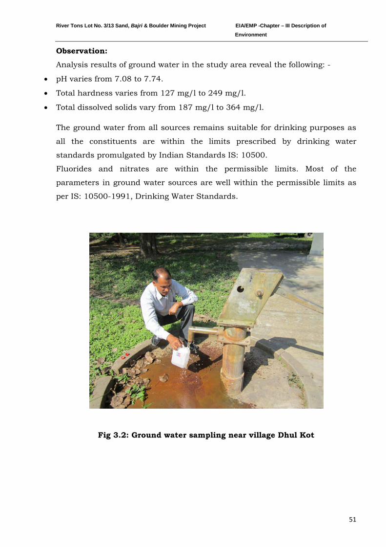
River Tons Lot No. 3/13 Sand, Bajri & Boulder Mining Project EIA/EMP -Chapter – III Description of Environment
51
Observation:
Analysis results of ground water in the study area reveal the following: -
• pH varies from 7.08 to 7.74.
• Total hardness varies from 127 mg/l to 249 mg/l.
• Total dissolved solids vary from 187 mg/l to 364 mg/l.
The ground water from all sources remains suitable for drinking purposes as
all the constituents are within the limits prescribed by drinking water
standards promulgated by Indian Standards IS: 10500.
Fluorides and nitrates are within the permissible limits. Most of the
parameters in ground water sources are well within the permissible limits as
per IS: 10500-1991, Drinking Water Standards.
Fig 3.2: Ground water sampling near village Dhul Kot
River Tons Lot No. 3/13 Sand, Bajri & Boulder Mining Project EIA/EMP -Chapter – III Description of Environment
52
b) Surface water
Three water samples were collected from the study area. The Surface water
sampling locations are marked in Map No. 4. The physico-chemical analysis
of the water samples is given in the Table 3.3 (vi).
In the month of November & December water was not found in the SW1 and
SW2 sites.
Table 3.3 (v) Surface water sampling locations
Station
No. Location Direction
Distance
(km)
Core
Zone/Buffer
Zone
SW1 Upstream
(near Jhajra) E 2 Buffer Zone
SW2 Project Site Centre - Core Zone
SW3 Downstream(near
Shinghniwala) W 3 Buffer Zone
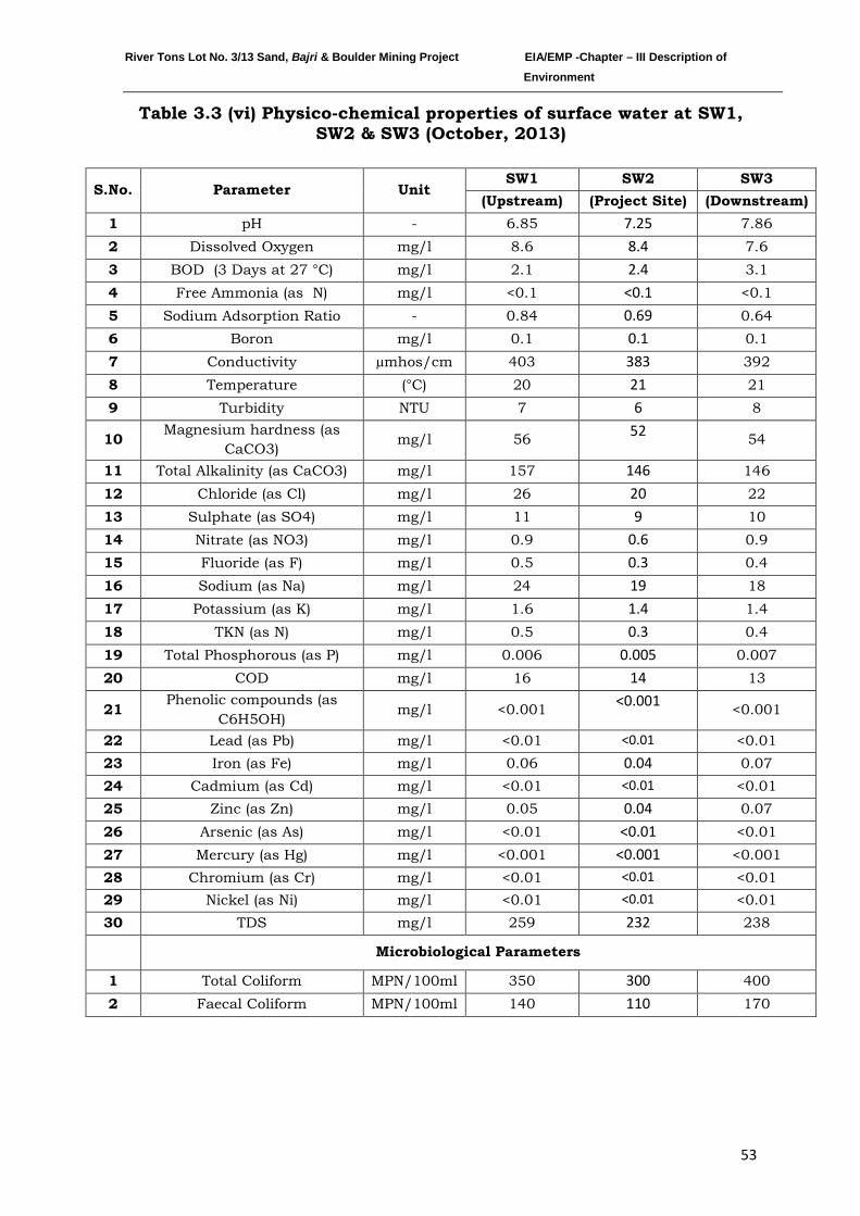
River Tons Lot No. 3/13 Sand, Bajri & Boulder Mining Project EIA/EMP -Chapter – III Description of Environment
53
Table 3.3 (vi) Physico-chemical properties of surface water at SW1, SW2 & SW3 (October, 2013)
S.No. Parameter Unit SW1 SW2 SW3
(Upstream) (Project Site) (Downstream) 1 pH - 6.85 7.25 7.86 2 Dissolved Oxygen mg/l 8.6 8.4 7.6 3 BOD (3 Days at 27 °C) mg/l 2.1 2.4 3.1 4 Free Ammonia (as N) mg/l <0.1 <0.1 <0.1 5 Sodium Adsorption Ratio - 0.84 0.69 0.64 6 Boron mg/l 0.1 0.1 0.1 7 Conductivity µmhos/cm 403 383 392 8 Temperature (°C) 20 21 21 9 Turbidity NTU 7 6 8
10 Magnesium hardness (as CaCO3)
mg/l 56 52 54
11 Total Alkalinity (as CaCO3) mg/l 157 146 146 12 Chloride (as Cl) mg/l 26 20 22 13 Sulphate (as SO4) mg/l 11 9 10 14 Nitrate (as NO3) mg/l 0.9 0.6 0.9 15 Fluoride (as F) mg/l 0.5 0.3 0.4 16 Sodium (as Na) mg/l 24 19 18 17 Potassium (as K) mg/l 1.6 1.4 1.4 18 TKN (as N) mg/l 0.5 0.3 0.4 19 Total Phosphorous (as P) mg/l 0.006 0.005 0.007 20 COD mg/l 16 14 13
21 Phenolic compounds (as
C6H5OH) mg/l <0.001 <0.001 <0.001
22 Lead (as Pb) mg/l <0.01 <0.01 <0.01 23 Iron (as Fe) mg/l 0.06 0.04 0.07 24 Cadmium (as Cd) mg/l <0.01 <0.01 <0.01 25 Zinc (as Zn) mg/l 0.05 0.04 0.07 26 Arsenic (as As) mg/l <0.01 <0.01 <0.01 27 Mercury (as Hg) mg/l <0.001 <0.001 <0.001 28 Chromium (as Cr) mg/l <0.01 <0.01 <0.01 29 Nickel (as Ni) mg/l <0.01 <0.01 <0.01 30 TDS mg/l 259 232 238
Microbiological Parameters
1 Total Coliform MPN/100ml 350 300 400 2 Faecal Coliform MPN/100ml 140 110 170
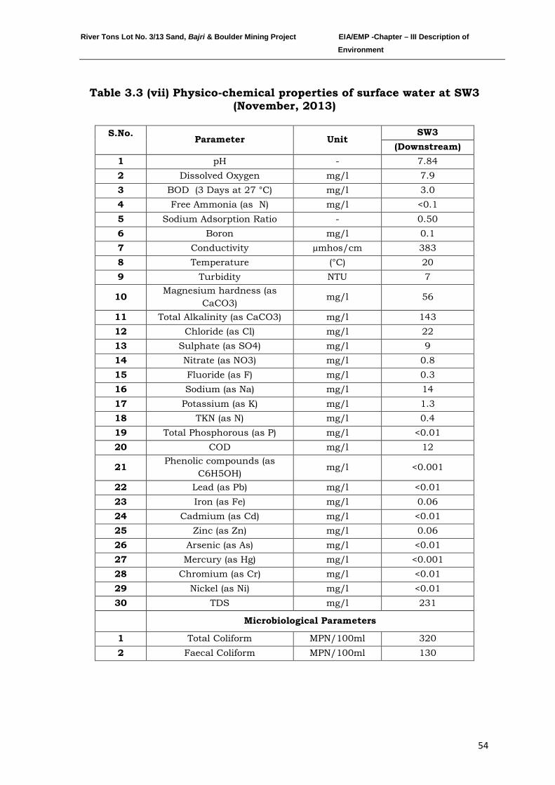
River Tons Lot No. 3/13 Sand, Bajri & Boulder Mining Project EIA/EMP -Chapter – III Description of Environment
54
Table 3.3 (vii) Physico-chemical properties of surface water at SW3 (November, 2013)
S.No. Parameter Unit
SW3 (Downstream)
1 pH - 7.84 2 Dissolved Oxygen mg/l 7.9 3 BOD (3 Days at 27 °C) mg/l 3.0 4 Free Ammonia (as N) mg/l <0.1 5 Sodium Adsorption Ratio - 0.50 6 Boron mg/l 0.1 7 Conductivity µmhos/cm 383 8 Temperature (°C) 20 9 Turbidity NTU 7
10 Magnesium hardness (as CaCO3)
mg/l 56
11 Total Alkalinity (as CaCO3) mg/l 143 12 Chloride (as Cl) mg/l 22 13 Sulphate (as SO4) mg/l 9 14 Nitrate (as NO3) mg/l 0.8 15 Fluoride (as F) mg/l 0.3 16 Sodium (as Na) mg/l 14 17 Potassium (as K) mg/l 1.3 18 TKN (as N) mg/l 0.4 19 Total Phosphorous (as P) mg/l <0.01 20 COD mg/l 12
21 Phenolic compounds (as C6H5OH)
mg/l <0.001
22 Lead (as Pb) mg/l <0.01 23 Iron (as Fe) mg/l 0.06 24 Cadmium (as Cd) mg/l <0.01 25 Zinc (as Zn) mg/l 0.06 26 Arsenic (as As) mg/l <0.01 27 Mercury (as Hg) mg/l <0.001 28 Chromium (as Cr) mg/l <0.01 29 Nickel (as Ni) mg/l <0.01 30 TDS mg/l 231
Microbiological Parameters
1 Total Coliform MPN/100ml 320 2 Faecal Coliform MPN/100ml 130
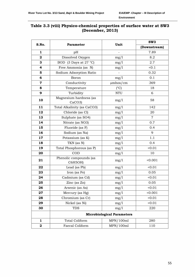
River Tons Lot No. 3/13 Sand, Bajri & Boulder Mining Project EIA/EMP -Chapter – III Description of Environment
55
Table 3.3 (viii) Physico-chemical properties of surface water at SW3 (December, 2013)
S.No. Parameter Unit SW3
(Downstream) 1 pH - 7.89 2 Dissolved Oxygen mg/l 8.2 3 BOD (3 Days at 27 °C) mg/l 2.7 4 Free Ammonia (as N) mg/l <0.1 5 Sodium Adsorption Ratio - 0.32 6 Boron mg/l 0.1 7 Conductivity µmhos/cm 369 8 Temperature (°C) 18 9 Turbidity NTU 6
10 Magnesium hardness (as CaCO3)
mg/l 58
11 Total Alkalinity (as CaCO3) mg/l 142 12 Chloride (as Cl) mg/l 20 13 Sulphate (as SO4) mg/l 7 14 Nitrate (as NO3) mg/l 0.7 15 Fluoride (as F) mg/l 0.4 16 Sodium (as Na) mg/l 9 17 Potassium (as K) mg/l 1.1 18 TKN (as N) mg/l 0.4 19 Total Phosphorous (as P) mg/l <0.01 20 COD mg/l 10
21 Phenolic compounds (as C6H5OH)
mg/l <0.001
22 Lead (as Pb) mg/l <0.01 23 Iron (as Fe) mg/l 0.05 24 Cadmium (as Cd) mg/l <0.01 25 Zinc (as Zn) mg/l 0.05 26 Arsenic (as As) mg/l <0.01 27 Mercury (as Hg) mg/l <0.001 28 Chromium (as Cr) mg/l <0.01 29 Nickel (as Ni) mg/l <0.01 30 TDS mg/l 220
Microbiological Parameters
1 Total Coliform MPN/100ml 280 2 Faecal Coliform MPN/100ml 110
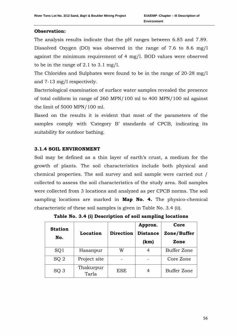
River Tons Lot No. 3/13 Sand, Bajri & Boulder Mining Project EIA/EMP -Chapter – III Description of Environment
56
Observation:
The analysis results indicate that the pH ranges between 6.85 and 7.89.
Dissolved Oxygen (DO) was observed in the range of 7.6 to 8.6 mg/l
against the minimum requirement of 4 mg/l. BOD values were observed
to be in the range of 2.1 to 3.1 mg/l.
The Chlorides and Sulphates were found to be in the range of 20-28 mg/l
and 7-13 mg/l respectively.
Bacteriological examination of surface water samples revealed the presence
of total coliform in range of 260 MPN/100 ml to 400 MPN/100 ml against
the limit of 5000 MPN/100 ml.
Based on the results it is evident that most of the parameters of the
samples comply with ‘Category B’ standards of CPCB, indicating its
suitability for outdoor bathing.
3.1.4 SOIL ENVIRONMENT
Soil may be defined as a thin layer of earth’s crust, a medium for the
growth of plants. The soil characteristics include both physical and
chemical properties. The soil survey and soil sample were carried out /
collected to assess the soil characteristics of the study area. Soil samples
were collected from 3 locations and analyzed as per CPCB norms. The soil
sampling locations are marked in Map No. 4. The physico-chemical
characteristic of these soil samples is given in Table No. 3.4 (ii).
Table No. 3.4 (i) Description of soil sampling locations
Station
No. Location Direction
Approx.
Distance
(km)
Core
Zone/Buffer
Zone
SQ1 Hasanpur W 4 Buffer Zone
SQ 2 Project site - - Core Zone
SQ 3 Thakurpur
Tarla ESE 4 Buffer Zone
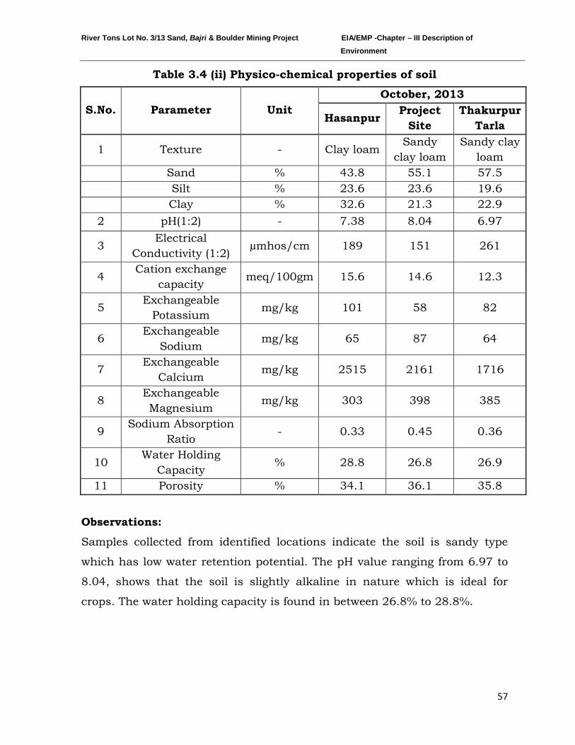
River Tons Lot No. 3/13 Sand, Bajri & Boulder Mining Project EIA/EMP -Chapter – III Description of Environment
57
Table 3.4 (ii) Physico-chemical properties of soil
S.No. Parameter Unit October, 2013
Hasanpur Project Site
Thakurpur Tarla
1 Texture - Clay loam Sandy
clay loam Sandy clay
loam
Sand % 43.8 55.1 57.5
Silt % 23.6 23.6 19.6
Clay % 32.6 21.3 22.9
2 pH(1:2) - 7.38 8.04 6.97
3 Electrical
Conductivity (1:2) µmhos/cm 189 151 261
4 Cation exchange
capacity meq/100gm 15.6 14.6 12.3
5 Exchangeable
Potassium mg/kg 101 58 82
6 Exchangeable
Sodium mg/kg 65 87 64
7 Exchangeable
Calcium mg/kg 2515 2161 1716
8 Exchangeable Magnesium
mg/kg 303 398 385
9 Sodium Absorption
Ratio - 0.33 0.45 0.36
10 Water Holding
Capacity % 28.8 26.8 26.9
11 Porosity % 34.1 36.1 35.8
Observations:
Samples collected from identified locations indicate the soil is sandy type
which has low water retention potential. The pH value ranging from 6.97 to
8.04, shows that the soil is slightly alkaline in nature which is ideal for
crops. The water holding capacity is found in between 26.8% to 28.8%.
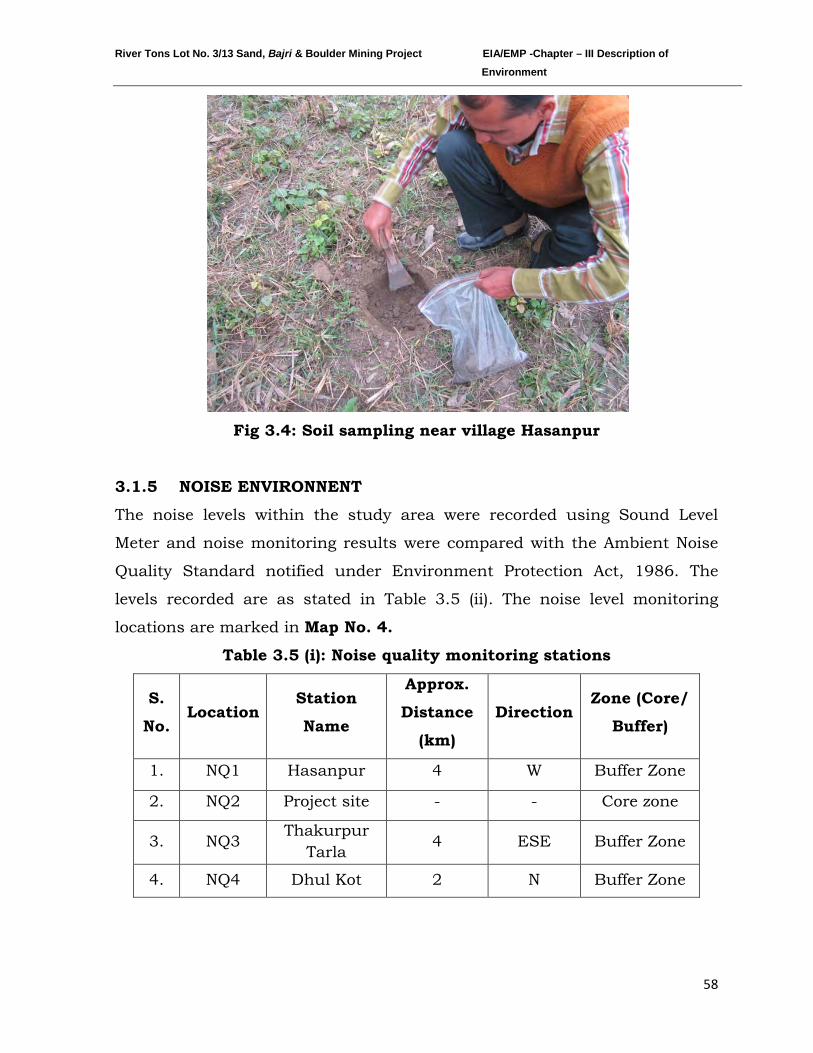
River Tons Lot No. 3/13 Sand, Bajri & Boulder Mining Project EIA/EMP -Chapter – III Description of Environment
58
Fig 3.4: Soil sampling near village Hasanpur
3.1.5 NOISE ENVIRONNENT
The noise levels within the study area were recorded using Sound Level
Meter and noise monitoring results were compared with the Ambient Noise
Quality Standard notified under Environment Protection Act, 1986. The
levels recorded are as stated in Table 3.5 (ii). The noise level monitoring
locations are marked in Map No. 4.
Table 3.5 (i): Noise quality monitoring stations
S.
No. Location
Station
Name
Approx.
Distance
(km)
Direction Zone (Core/
Buffer)
1. NQ1 Hasanpur 4 W Buffer Zone
2. NQ2 Project site - - Core zone
3. NQ3 Thakurpur
Tarla 4 ESE Buffer Zone
4. NQ4 Dhul Kot 2 N Buffer Zone
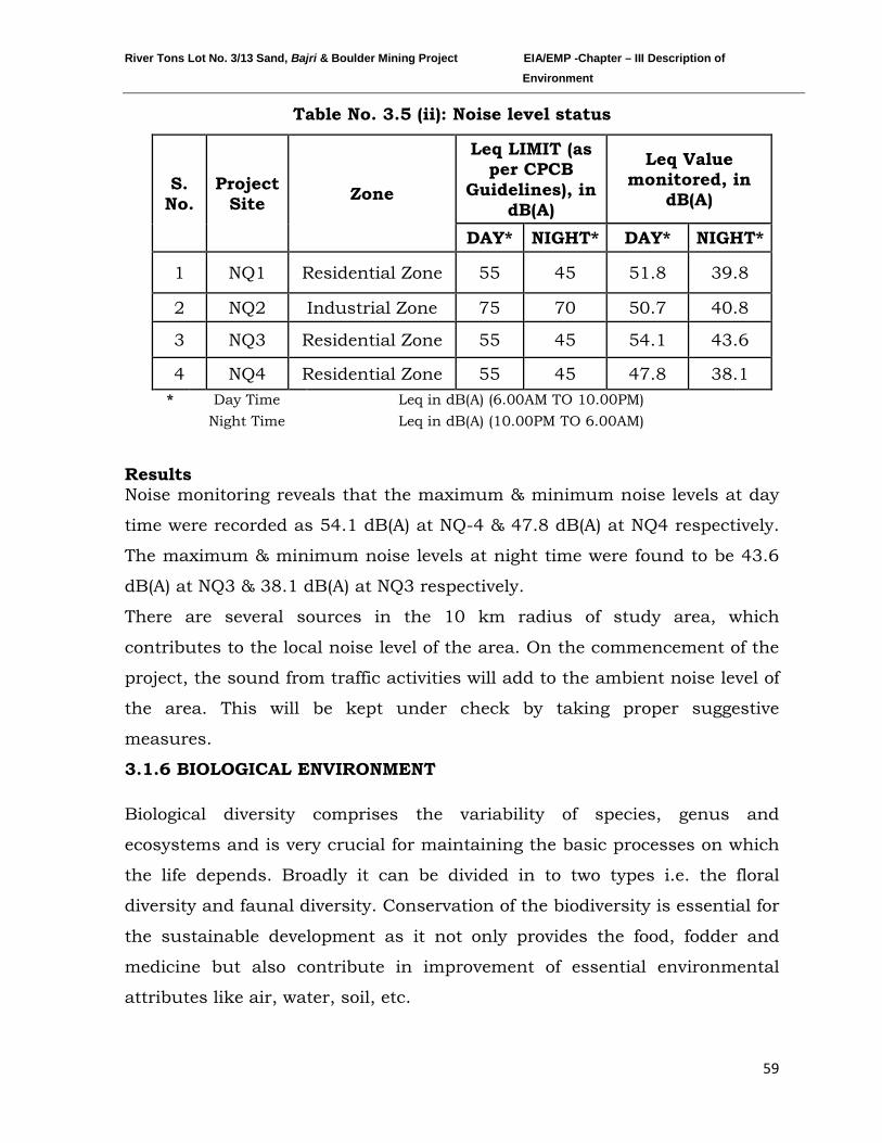
River Tons Lot No. 3/13 Sand, Bajri & Boulder Mining Project EIA/EMP -Chapter – III Description of Environment
59
Table No. 3.5 (ii): Noise level status
S. No.
Project Site Zone
Leq LIMIT (as per CPCB
Guidelines), in dB(A)
Leq Value monitored, in
dB(A)
DAY* NIGHT* DAY* NIGHT*
1 NQ1 Residential Zone 55 45 51.8 39.8
2 NQ2 Industrial Zone 75 70 50.7 40.8
3 NQ3 Residential Zone 55 45 54.1 43.6
4 NQ4 Residential Zone 55 45 47.8 38.1 * Day Time Leq in dB(A) (6.00AM TO 10.00PM)
Night Time Leq in dB(A) (10.00PM TO 6.00AM)
Results Noise monitoring reveals that the maximum & minimum noise levels at day
time were recorded as 54.1 dB(A) at NQ-4 & 47.8 dB(A) at NQ4 respectively.
The maximum & minimum noise levels at night time were found to be 43.6
dB(A) at NQ3 & 38.1 dB(A) at NQ3 respectively.
There are several sources in the 10 km radius of study area, which
contributes to the local noise level of the area. On the commencement of the
project, the sound from traffic activities will add to the ambient noise level of
the area. This will be kept under check by taking proper suggestive
measures.
3.1.6 BIOLOGICAL ENVIRONMENT
Biological diversity comprises the variability of species, genus and
ecosystems and is very crucial for maintaining the basic processes on which
the life depends. Broadly it can be divided in to two types i.e. the floral
diversity and faunal diversity. Conservation of the biodiversity is essential for
the sustainable development as it not only provides the food, fodder and
medicine but also contribute in improvement of essential environmental
attributes like air, water, soil, etc.
River Tons Lot No. 3/13 Sand, Bajri & Boulder Mining Project EIA/EMP -Chapter – III Description of Environment
60
Before starting any Environmental Impact Assessment study, it is necessary
to identify the baseline of relevant environmental parameters which are likely
to be affected as a result of operation of the proposed project. A similar
approach has been adopted for conducting the study on Biological
Environment for this Project. Both terrestrial and aquatic ecosystems have
been studied to understand the biological environment.
Physical Environment of the study area:
The proposed “River Tons Lot No. 3/13 Sand, Bajri & Boulder Mining
Project” is located in broad Doon Valley within the Shivalik Hills of Lower
Himalayan range. Administratively this area falls in district Dehradun of
Uttarakhand. Tons a seasonal tributary of river Aasan, where mining is
proposed.
District Dehradun is situated in NW corner of Uttarakhand state and
extends from N Latitude 29058’ to 31002’ 30" and E Longitude 77034’ 45” to
780
The total area of Dehradun district is 3088 km
18’ 30”. It falls in Survey of India Toposheets Nos. 53E, F, G, J and K.
The district is bounded by Uttarkashi district on the north, Tehri Garhwal
and Pauri Garhwal districts on the east and Saharanpur district (UP) on the
south. Its western boundary adjoins Sirmour district of Himachal Pradesh
separated by Rivers Tons and Yamuna. 2
Soil:
with an average altitude of
640 m above MSL. The district comprises of six tehsils, namely Dehradun,
Chakrata, Vikasnagar, Kalsi, Tiuni and Rishikesh. Further, it is divided into
six developmental blocks, viz: Chakrata, Kalsi, Vikasnagar, Sahaspur,
Raipur and Doiwala.
The nature and soil type play an important role in agriculture and have
direct relation with groundwater recharge. Physiography, climate, drainage
and geology of the area are the factors responsible for the nature and type of
soil and soil cover. The soil type also depends upon the slope and rate of
erosion. The soils of the Doon Siwalik were developed on the deep alluvial
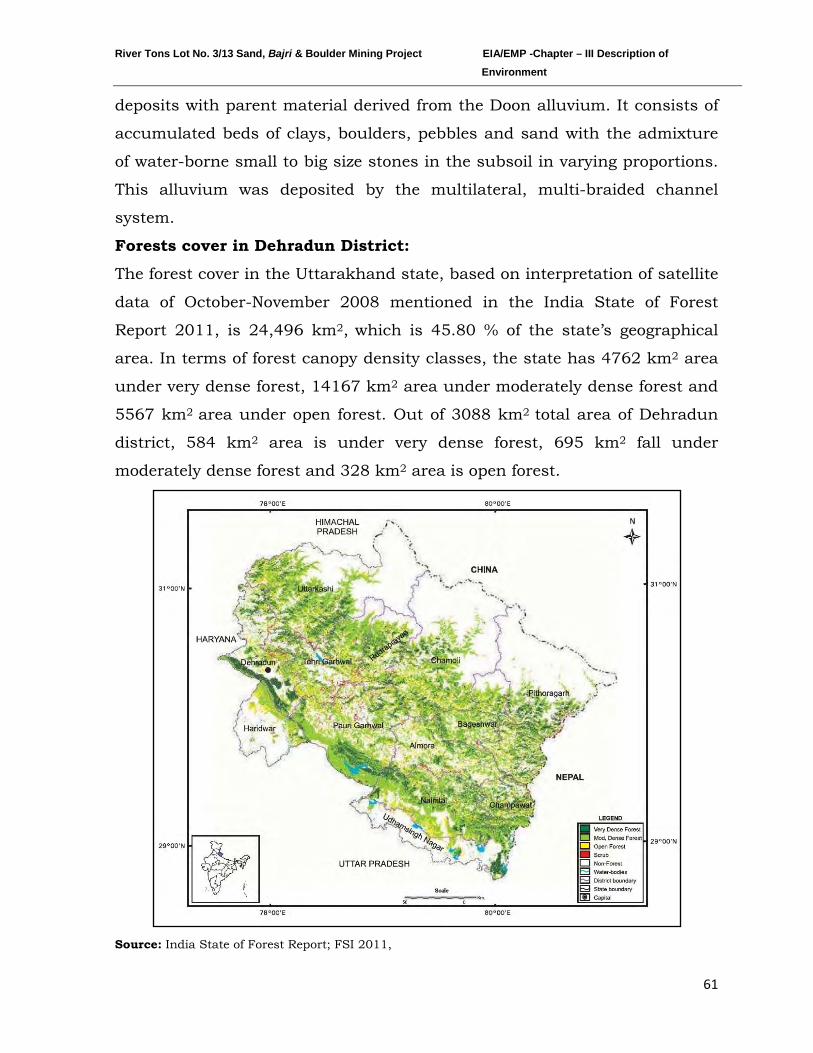
River Tons Lot No. 3/13 Sand, Bajri & Boulder Mining Project EIA/EMP -Chapter – III Description of Environment
61
deposits with parent material derived from the Doon alluvium. It consists of
accumulated beds of clays, boulders, pebbles and sand with the admixture
of water-borne small to big size stones in the subsoil in varying proportions.
This alluvium was deposited by the multilateral, multi-braided channel
system.
Forests cover in Dehradun District:
The forest cover in the Uttarakhand state, based on interpretation of satellite
data of October-November 2008 mentioned in the India State of Forest
Report 2011, is 24,496 km2, which is 45.80 % of the state’s geographical
area. In terms of forest canopy density classes, the state has 4762 km2 area
under very dense forest, 14167 km2 area under moderately dense forest and
5567 km2 area under open forest. Out of 3088 km2 total area of Dehradun
district, 584 km2 area is under very dense forest, 695 km2 fall under
moderately dense forest and 328 km2
area is open forest.
Source: India State of Forest Report; FSI 2011,
River Tons Lot No. 3/13 Sand, Bajri & Boulder Mining Project EIA/EMP -Chapter – III Description of Environment
62
Major forest types occurring in the state are Tropical Moist Deciduous,
Tropical Dry Deciduous, Sub Tropical Pine, Himalayan Moist Temperate,
Sub Alpine and Alpine Forests. Forests are largely distributed throughout
the state with conifers and Sal being major forest formation. Following ten
forest sub-types are present in Dehradun district as per Champion and Seth
1968.
1. Moist Siwalik Sal Forest (3C/C2a)
2. Northern Dry Mixed Deciduous Forest (5B/C2)
3. Dry Deciduous Scrub (5/DS1)
4. Subtropical Euphorbia Scrub (9/C1/DS2)
5. Mohru Oak Forest (12/C1b)
6. Moist Deodar Forest (12/C1c)
7. Western Mixed Coniferous Forest (Spruce, Blue Pine, Silver Fir)
(12/C1d)
8. Himalayan Temperate Secondary Scrub (12/C1/DS2)
9. Low Level Blue Pine Forest (12/2S1)
10. Khair-Sissu Forest (5/152)
Major part of study area falls under Northern Dry Mixed Deciduous Forest
(5B/C2) forest subtype.
The state has six National Parks, six Wildlife Sanctuaries and two
Conservation Reserves covering cumulative area of 7376 km2
The forest found in the study area are Kaluwala RF, Malhan RF, Karwapani
RF, Donga RF, Horawala RF, Agatpur RF, Chandpur RF, Chuharpur RF,
Khandoli RF, Jhajar RF, and Binkahala RF.
which
constitutes 13.79% of its geographical area. Aasan Conservation Reserve is
present at a distance of 19 km from proposed project which is an eco-
sensitive area.
River Tons Lot No. 3/13 Sand, Bajri & Boulder Mining Project EIA/EMP -Chapter – III Description of Environment
63
Study period and methodology
Detailed survey was conducted to evaluate floral and faunal composition of
the study area. Primary data on floral and faunal composition was recorded
during site visit and secondary data was collected from the Forest
department and published relevant literature. Inventory of flora and fauna
has been prepared on the basis of collected data.
Field study period: The ecological survey has been conducted for one
season. All data were collected in post-monsoon period in order to reduce
metrological biasness. The details are given as below:
Core zone : At the project site along Tons river Buffer zone : Around the project site in 10 km radius
Methodology: Mode of data collection & parameters considered during the
survey
Aspect Data Mode of data collection Parameters monitored
Terrestrial Ecology
Primary data collection
By conducting field survey Floral and Faunal diversity
Secondary data collection
From authentic sources like Forests Department of Dehradun and Forest Department of Dehradun and available published literatures
Floral and Faunal diversity and study of vegetation, forest type, importance etc.
Aquatic Ecology
Primary data collection
By conducting field survey Floral and Faunal diversity
Secondary data collection
From authentic sources like Forests Department of Dehradun and Forest Department of Dehradun and available published literatures
Floral and Faunal diversity and study of vegetation, forest type, importance etc.
River Tons Lot No. 3/13 Sand, Bajri & Boulder Mining Project EIA/EMP -Chapter – III Description of Environment
64
General Vegetation Study of the area:
Area supports moderately healthy vegetation, the main forest species are
along the Shivalik foothills. These Terai plains support the species of Sisam,
Arjuna, Kanji, Khair, Saagaun, Subabul, Neem, Eucalyptus, Babul etc.
Ground vegetation mainly consists of grasses and small shrubs. Useful
fodder grasses, Cynodon dactylon, Eleusine indica, Trifolium alexandrinum,
etc. can be seen growing in the area. The large weeds which infest
uncultivated tracts are Aak (Calotropis procera), castor (Ricinus communis),
Dhatura (Datura metel) and thorn (Opuntia stricta). Other noxious weeds and
those which appear in crops are Pohli or Thistle (Carthamus oxyacantha),
Shial Kanta (Argemone mexicana), kandyari (Solanum xanthocarpum),
Parthenium hysterophorus and Bhang (Cannabis sativa).
Flora of the Core zone
The core zone comprises of Tons river bed, where mining operation is
proposed. This area consists of riparian vegetation in which aquatic and
marshland plants are the main component. Most among them are weeds. No
ecologically sensitive plant species has been reported from this area.
Riparian vegetation is found along the river side. In stagnant water growth of
hydrophytes likes Hydrolea zeylanica, Ipomoea carnea, Ludwigia
adscendens, Sagittaria sagittifolia, Spilanthes paniculata, Typha latifolia, etc.
can be commonly observed.
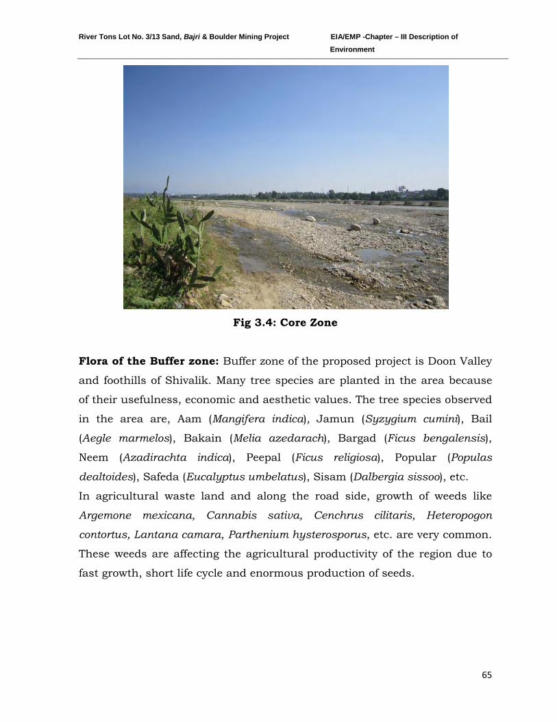
River Tons Lot No. 3/13 Sand, Bajri & Boulder Mining Project EIA/EMP -Chapter – III Description of Environment
65
Fig 3.4: Core Zone
Flora of the Buffer zone: Buffer zone of the proposed project is Doon Valley
and foothills of Shivalik. Many tree species are planted in the area because
of their usefulness, economic and aesthetic values. The tree species observed
in the area are, Aam (Mangifera indica), Jamun (Syzygium cumini), Bail
(Aegle marmelos), Bakain (Melia azedarach), Bargad (Ficus bengalensis),
Neem (Azadirachta indica), Peepal (Ficus religiosa), Popular (Populas
dealtoides), Safeda (Eucalyptus umbelatus), Sisam (Dalbergia sissoo), etc.
In agricultural waste land and along the road side, growth of weeds like
Argemone mexicana, Cannabis sativa, Cenchrus cilitaris, Heteropogon
contortus, Lantana camara, Parthenium hysterosporus, etc. are very common.
These weeds are affecting the agricultural productivity of the region due to
fast growth, short life cycle and enormous production of seeds.
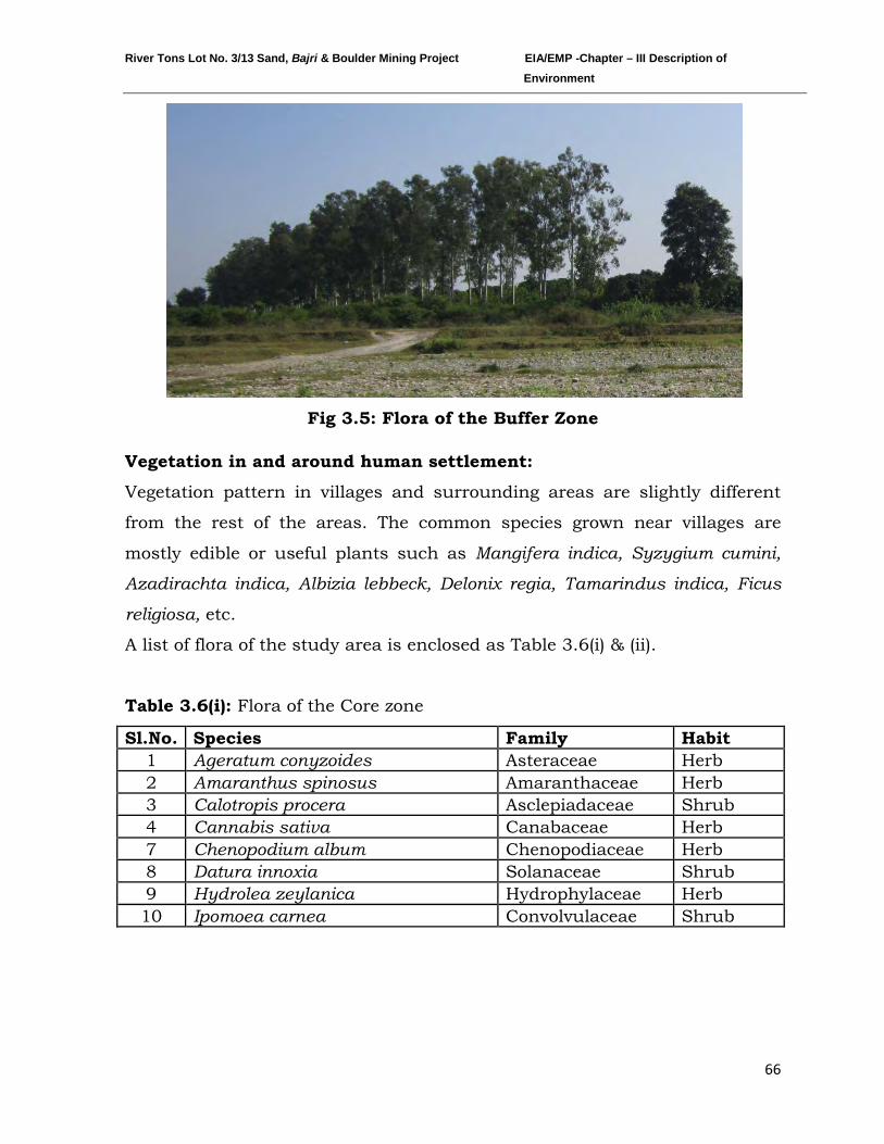
River Tons Lot No. 3/13 Sand, Bajri & Boulder Mining Project EIA/EMP -Chapter – III Description of Environment
66
Fig 3.5: Flora of the Buffer Zone
Vegetation in and around human settlement:
Vegetation pattern in villages and surrounding areas are slightly different
from the rest of the areas. The common species grown near villages are
mostly edible or useful plants such as Mangifera indica, Syzygium cumini,
Azadirachta indica, Albizia lebbeck, Delonix regia, Tamarindus indica, Ficus
religiosa, etc.
A list of flora of the study area is enclosed as Table 3.6(i) & (ii).
Table 3.6(i): Flora of the Core zone
Sl.No. Species Family Habit 1 Ageratum conyzoides Asteraceae Herb 2 Amaranthus spinosus Amaranthaceae Herb 3 Calotropis procera Asclepiadaceae Shrub 4 Cannabis sativa Canabaceae Herb 7 Chenopodium album Chenopodiaceae Herb 8 Datura innoxia Solanaceae Shrub 9 Hydrolea zeylanica Hydrophylaceae Herb 10 Ipomoea carnea Convolvulaceae Shrub
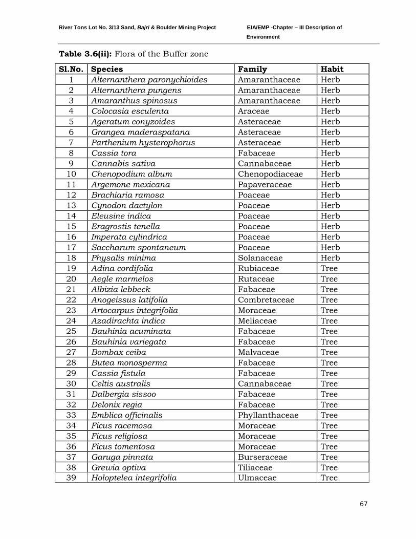
River Tons Lot No. 3/13 Sand, Bajri & Boulder Mining Project EIA/EMP -Chapter – III Description of Environment
67
Table 3.6(ii): Flora of the Buffer zone
Sl.No. Species Family Habit 1 Alternanthera paronychioides Amaranthaceae Herb 2 Alternanthera pungens Amaranthaceae Herb 3 Amaranthus spinosus Amaranthaceae Herb 4 Colocasia esculenta Araceae Herb 5 Ageratum conyzoides Asteraceae Herb 6 Grangea maderaspatana Asteraceae Herb 7 Parthenium hysterophorus Asteraceae Herb 8 Cassia tora Fabaceae Herb 9 Cannabis sativa Cannabaceae Herb 10 Chenopodium album Chenopodiaceae Herb 11 Argemone mexicana Papaveraceae Herb 12 Brachiaria ramosa Poaceae Herb 13 Cynodon dactylon Poaceae Herb 14 Eleusine indica Poaceae Herb 15 Eragrostis tenella Poaceae Herb 16 Imperata cylindrica Poaceae Herb 17 Saccharum spontaneum Poaceae Herb 18 Physalis minima Solanaceae Herb 19 Adina cordifolia Rubiaceae Tree 20 Aegle marmelos Rutaceae Tree 21 Albizia lebbeck Fabaceae Tree 22 Anogeissus latifolia Combretaceae Tree 23 Artocarpus integrifolia Moraceae Tree 24 Azadirachta indica Meliaceae Tree 25 Bauhinia acuminata Fabaceae Tree 26 Bauhinia variegata Fabaceae Tree 27 Bombax ceiba Malvaceae Tree 28 Butea monosperma Fabaceae Tree 29 Cassia fistula Fabaceae Tree 30 Celtis australis Cannabaceae Tree 31 Dalbergia sissoo Fabaceae Tree 32 Delonix regia Fabaceae Tree 33 Emblica officinalis Phyllanthaceae Tree 34 Ficus racemosa Moraceae Tree 35 Ficus religiosa Moraceae Tree 36 Ficus tomentosa Moraceae Tree 37 Garuga pinnata Burseraceae Tree 38 Grewia optiva Tiliaceae Tree 39 Holoptelea integrifolia Ulmaceae Tree
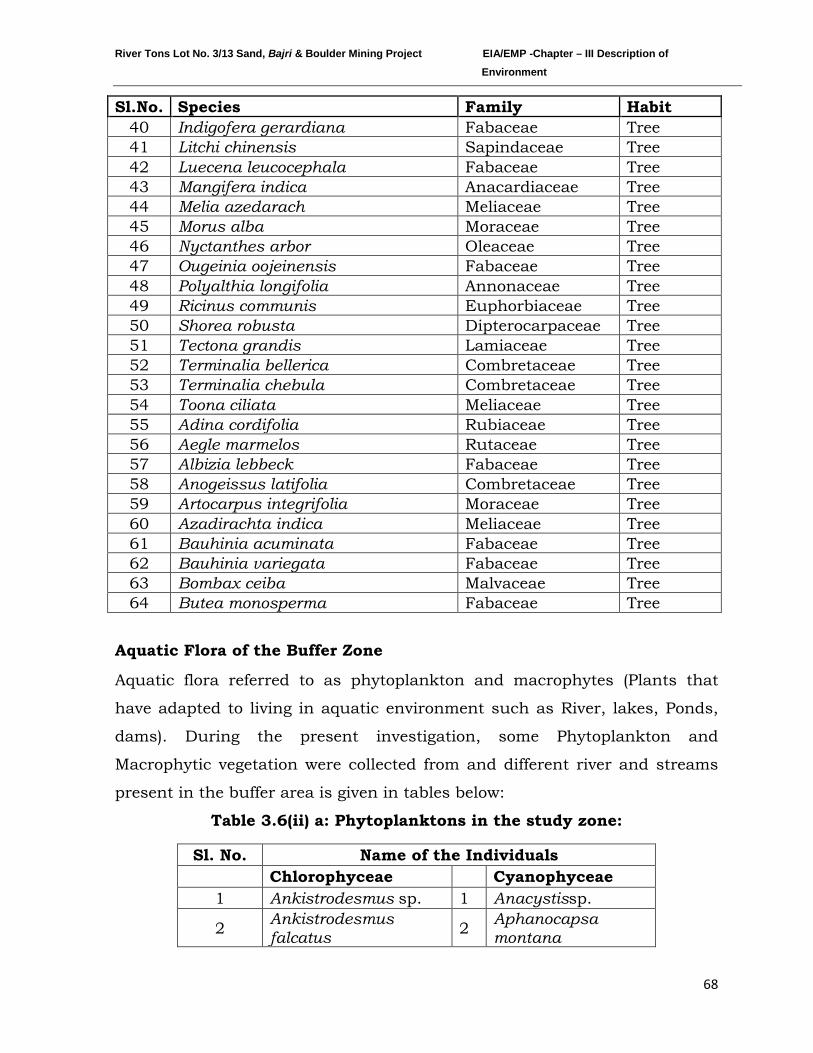
River Tons Lot No. 3/13 Sand, Bajri & Boulder Mining Project EIA/EMP -Chapter – III Description of Environment
68
Sl.No. Species Family Habit 40 Indigofera gerardiana Fabaceae Tree 41 Litchi chinensis Sapindaceae Tree 42 Luecena leucocephala Fabaceae Tree 43 Mangifera indica Anacardiaceae Tree 44 Melia azedarach Meliaceae Tree 45 Morus alba Moraceae Tree 46 Nyctanthes arbor Oleaceae Tree 47 Ougeinia oojeinensis Fabaceae Tree 48 Polyalthia longifolia Annonaceae Tree 49 Ricinus communis Euphorbiaceae Tree 50 Shorea robusta Dipterocarpaceae Tree 51 Tectona grandis Lamiaceae Tree 52 Terminalia bellerica Combretaceae Tree 53 Terminalia chebula Combretaceae Tree 54 Toona ciliata Meliaceae Tree 55 Adina cordifolia Rubiaceae Tree 56 Aegle marmelos Rutaceae Tree 57 Albizia lebbeck Fabaceae Tree 58 Anogeissus latifolia Combretaceae Tree 59 Artocarpus integrifolia Moraceae Tree 60 Azadirachta indica Meliaceae Tree 61 Bauhinia acuminata Fabaceae Tree 62 Bauhinia variegata Fabaceae Tree 63 Bombax ceiba Malvaceae Tree 64 Butea monosperma Fabaceae Tree
Aquatic Flora of the Buffer Zone
Aquatic flora referred to as phytoplankton and macrophytes (Plants that
have adapted to living in aquatic environment such as River, lakes, Ponds,
dams). During the present investigation, some Phytoplankton and
Macrophytic vegetation were collected from and different river and streams
present in the buffer area is given in tables below:
Table 3.6(ii) a: Phytoplanktons in the study zone:
Sl. No. Name of the Individuals
Chlorophyceae Cyanophyceae 1 Ankistrodesmus sp. 1 Anacystissp.
2 Ankistrodesmus falcatus 2 Aphanocapsa
montana
River Tons Lot No. 3/13 Sand, Bajri & Boulder Mining Project EIA/EMP -Chapter – III Description of Environment
69
Table 3.6(ii) b: Aquatic vegetation in the study zone:
Sl. No. Name of the Taxa Sl. No. Name of the Taxa
1 Azolla pinnata 10 Ludwigia repens 2 Ceratophyllum demersum 11 Ludwigia sp. 3 Cyperus alopecuroides 12 Najas graminea 4 Cryptocoryne sp. 13 Ottelia alismoids 5 Eichhornia crassipes 14 Phragmites australis 6 Hydrilla verticillata 15 Potamogeton nodosus 7 Ipomoea aquatica 16 Spirodela polyrhiza 8 Ipomea obscura 17 Typha angustata 9 Lemna minor
Source :GRC Survey Data
Wild life and avifauna of the study area:
Buffer zone of project area comprises of Doon Valley, and does not support
3 Cosmarium sp. 3 Aphanothece sp.
4 Coelastrum sp. 4 Arthrospira massartiia
5 Oocystis sp. 5 Chroococcus sp. 6 Scenedesmus sp. 6 Gloeocapsasp.
7 Scenedesmus dimorphos 7 Lyngbyasp.
8 Scenedesmus armatus 8 Merismopedia sp.
9 Spirogyra sp. 9 Microcystis flos-aquae
10 Tetraedron sp. 10 Nostocsp. 11 Westella sp. 11 Oscillatoria sp.
Bacillariophyceae 12 Spirulina sp. 1 Achnanthes sp. Euglenophyceae 2 Amphora ovalis 1 Euglena sp. 3 Ceratonies arcus 2 Euglena acus 4 Cyclotella sp. 3 Trachelomonas sp. 5 Cymbellatumida Dinophyceae 6 Fragillaria sp. 1 Ceratiumsp. 7 Melosira granulata Xanthophyceae 8 Navicula grimmii 1 Tribonemasp. 9 Nitzschia sp.
Source: GRC Survey Data
River Tons Lot No. 3/13 Sand, Bajri & Boulder Mining Project EIA/EMP -Chapter – III Description of Environment
70
any significant wild mammalian species. No wild mammalian species
encountered during the field visit to study area, while livestock of local
people are significantly using the area.
There are many river channels present in the buffer zone of study area which
are the major attraction sites for avifauna. As far as the reptile community
was concerned, rat snake and house lizard are reported from the study area.
Area does not support any healthy wild mammalian species and after a
potential search, neither any direct sighting nor the indirect evidences were
found in whole study area. A list of wild fauna of the study area has been
prepared on the basis of local inquiry from the village people and from the
available published literatures. The conservation value at regional level of
identified fauna was gathered from the Wildlife protection Act, 1972
moreover, global conservation status of species was estimated from Red data
book of IUCN was used. No established habitats of any mammals or birds
are noticed in river bed and along the banks.
The fauna of study area can be grouped in to aquatic and terrestrial as the
core area mostly comprises of aquatic fauna and the buffer area provides
shelter to the terrestrial animals.
Aquatic fauna:
Aquatic fauna mostly comprises of Avifauna, Amphibians & Fish which
cannot survive without water. Detail list of aquatic birds is shown in tabular
form.
Zooplankton
Zooplankton is commonly found in all types of aquatic habitats. These are
recognized as secondary producers and considered as one of the best tools
for environmental monitoring programme. During the present survey
zooplankton diversity of different habitats was assessed. List of zooplankton
species recorded from water bodies present in the buffer zone is given in the
tables below:
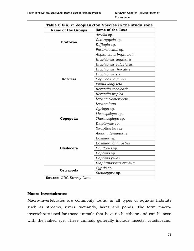
River Tons Lot No. 3/13 Sand, Bajri & Boulder Mining Project EIA/EMP -Chapter – III Description of Environment
71
Table 3.6(ii) c: Zooplankton Species in the study zone Name of the Groups Name of the Taxa
Protozoa
Arcella sp. Centropyxis sp. Difflugia sp. Paramoecium sp.
Rotifera
Asplanchna brightwelli Brachionus angularis Brachionus calciflorus Brachionus falcatus Brachionus sp. Cephlodella gibba Filinia longiseta Keratella cochlearis Keratella tropica Lecane closterocera Lecane luna
Copepoda
Cyclops sp. Mesocyclops sp. Thermocylops sp. Diaptomus sp. Nauplius larvae
Cladocera
Alona intermediate Bosmina sp. Bosmina longirostris Chydorus sp. Daphnia sp. Daphnia pulex Diaphanosoma excisum
Ostracoda Cypris sp. Stenocypris sp.
Source: GRC Survey Data
Macro-invertebrates
Macro-invertebrates are commonly found in all types of aquatic habitats
such as streams, rivers, wetlands, lakes and ponds. The term macro-
invertebrate used for those animals that have no backbone and can be seen
with the naked eye. These animals generally include insects, crustaceans,
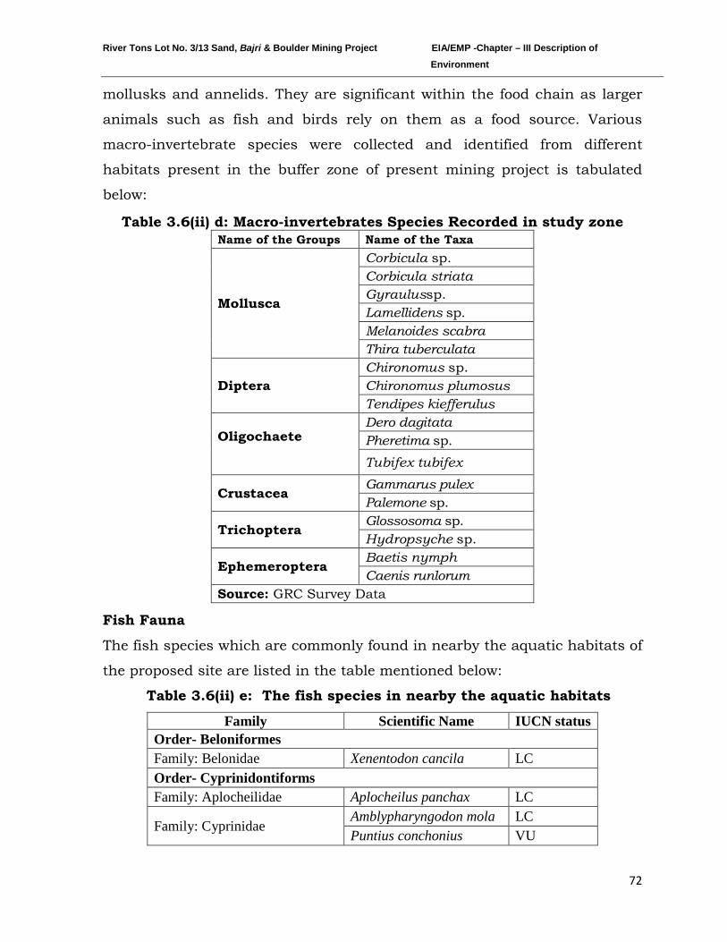
River Tons Lot No. 3/13 Sand, Bajri & Boulder Mining Project EIA/EMP -Chapter – III Description of Environment
72
mollusks and annelids. They are significant within the food chain as larger
animals such as fish and birds rely on them as a food source. Various
macro-invertebrate species were collected and identified from different
habitats present in the buffer zone of present mining project is tabulated
below:
Table 3.6(ii) d: Macro-invertebrates Species Recorded in study zone
Name of the Groups Name of the Taxa
Mollusca
Corbicula sp. Corbicula striata Gyraulussp. Lamellidens sp. Melanoides scabra Thira tuberculata
Diptera Chironomus sp. Chironomus plumosus Tendipes kiefferulus
Oligochaete
Dero dagitata Pheretima sp. Tubifex tubifex
Crustacea Gammarus pulex Palemone sp.
Trichoptera Glossosoma sp. Hydropsyche sp.
Ephemeroptera Baetis nymph Caenis runlorum
Source: GRC Survey Data
Fish Fauna
The fish species which are commonly found in nearby the aquatic habitats of
the proposed site are listed in the table mentioned below:
Table 3.6(ii) e: The fish species in nearby the aquatic habitats
Family Scientific Name IUCN status Order- Beloniformes Family: Belonidae Xenentodon cancila LC Order- Cyprinidontiforms Family: Aplocheilidae Aplocheilus panchax LC
Family: Cyprinidae Amblypharyngodon mola LC Puntius conchonius VU
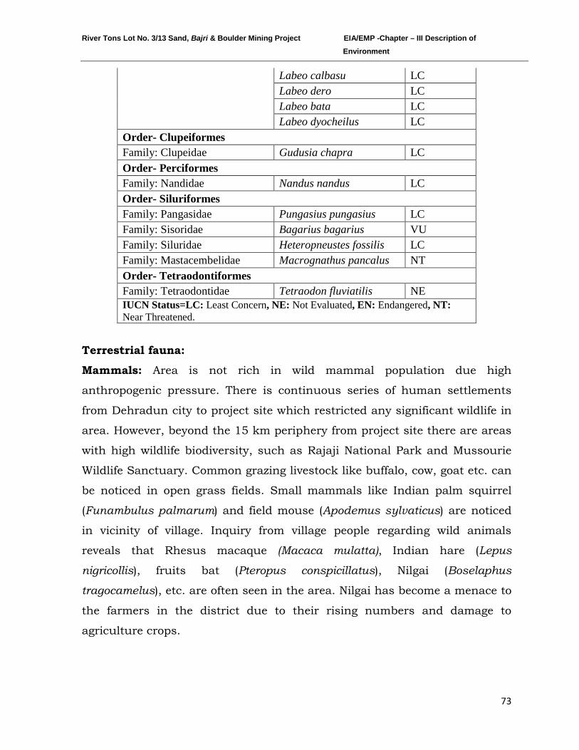
River Tons Lot No. 3/13 Sand, Bajri & Boulder Mining Project EIA/EMP -Chapter – III Description of Environment
73
Labeo calbasu LC Labeo dero LC Labeo bata LC Labeo dyocheilus LC
Order- Clupeiformes Family: Clupeidae Gudusia chapra LC Order- Perciformes Family: Nandidae Nandus nandus LC Order- Siluriformes Family: Pangasidae Pungasius pungasius LC Family: Sisoridae Bagarius bagarius VU Family: Siluridae Heteropneustes fossilis LC Family: Mastacembelidae Macrognathus pancalus NT Order- Tetraodontiformes Family: Tetraodontidae Tetraodon fluviatilis NE IUCN Status=LC: Least Concern, NE: Not Evaluated, EN: Endangered, NT: Near Threatened.
Terrestrial fauna:
Mammals: Area is not rich in wild mammal population due high
anthropogenic pressure. There is continuous series of human settlements
from Dehradun city to project site which restricted any significant wildlife in
area. However, beyond the 15 km periphery from project site there are areas
with high wildlife biodiversity, such as Rajaji National Park and Mussourie
Wildlife Sanctuary. Common grazing livestock like buffalo, cow, goat etc. can
be noticed in open grass fields. Small mammals like Indian palm squirrel
(Funambulus palmarum) and field mouse (Apodemus sylvaticus) are noticed
in vicinity of village. Inquiry from village people regarding wild animals
reveals that Rhesus macaque (Macaca mulatta), Indian hare (Lepus
nigricollis), fruits bat (Pteropus conspicillatus), Nilgai (Boselaphus
tragocamelus), etc. are often seen in the area. Nilgai has become a menace to
the farmers in the district due to their rising numbers and damage to
agriculture crops.
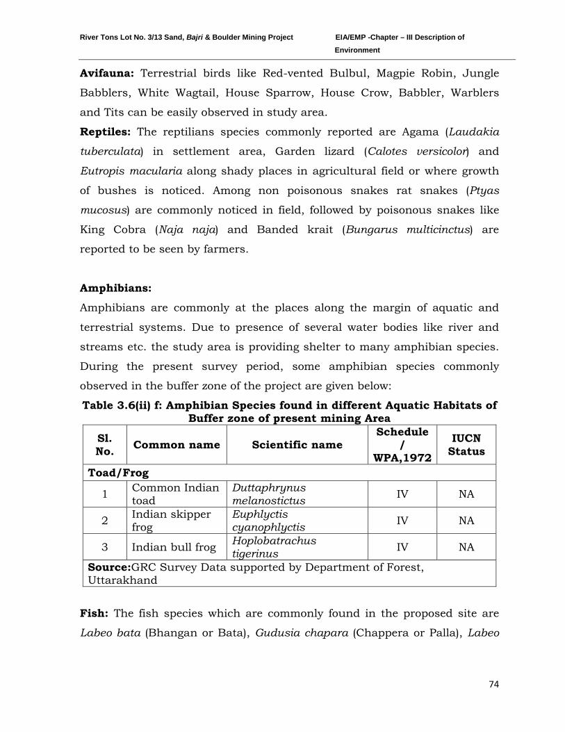
River Tons Lot No. 3/13 Sand, Bajri & Boulder Mining Project EIA/EMP -Chapter – III Description of Environment
74
Avifauna:
Reptiles: The reptilians species commonly reported are Agama (
Terrestrial birds like Red-vented Bulbul, Magpie Robin, Jungle
Babblers, White Wagtail, House Sparrow, House Crow, Babbler, Warblers
and Tits can be easily observed in study area.
Laudakia
tuberculata) in settlement area, Garden lizard (Calotes versicolor) and
Eutropis macularia along shady places
in agricultural field or where growth
of bushes is noticed. Among non poisonous snakes rat snakes (Ptyas
mucosus) are commonly noticed in field, followed by poisonous snakes like
King Cobra (Naja naja) and Banded krait (Bungarus multicinctus) are
reported to be seen by farmers.
Amphibians:
Amphibians are commonly at the places along the margin of aquatic and
terrestrial systems. Due to presence of several water bodies like river and
streams etc. the study area is providing shelter to many amphibian species.
During the present survey period, some amphibian species commonly
observed in the buffer zone of the project are given below:
Table 3.6(ii) f: Amphibian Species found in different Aquatic Habitats of Buffer zone of present mining Area
Sl. No. Common name Scientific name
Schedule /
WPA,1972
IUCN Status
Toad/Frog
1 Common Indian toad
Duttaphrynus melanostictus IV NA
2 Indian skipper frog
Euphlyctis cyanophlyctis IV NA
3 Indian bull frog Hoplobatrachus tigerinus IV NA
Source:GRC Survey Data supported by Department of Forest, Uttarakhand
Fish: The fish species which are commonly found in the proposed site are
Labeo bata (Bhangan or Bata), Gudusia chapara (Chappera or Palla), Labeo
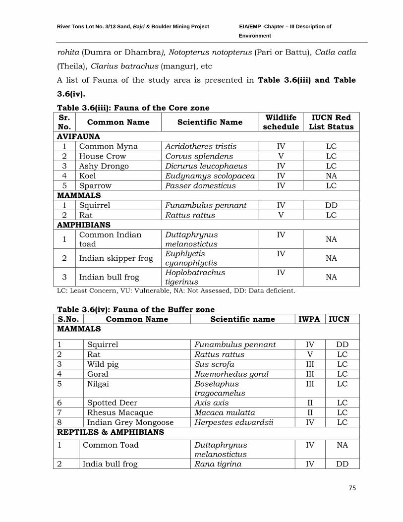
River Tons Lot No. 3/13 Sand, Bajri & Boulder Mining Project EIA/EMP -Chapter – III Description of Environment
75
rohita (Dumra or Dhambra), Notopterus notopterus (Pari or Battu), Catla catla
(Theila), Clarius batrachus (mangur), etc
A list of Fauna of the study area is presented in Table 3.6(iii) and Table
3.6(iv).
Table 3.6(iii): Fauna of the Core zone Sr. No. Common Name Scientific Name Wildlife
schedule IUCN Red
List Status AVIFAUNA
1 Common Myna Acridotheres tristis IV LC 2 House Crow Corvus splendens V LC 3 Ashy Drongo Dicrurus leucophaeus IV LC 4 Koel Eudynamys scolopacea IV NA 5 Sparrow Passer domesticus IV LC
MAMMALS 1 Squirrel Funambulus pennant IV DD 2 Rat Rattus rattus V LC
AMPHIBIANS
1 Common Indian toad
Duttaphrynus melanostictus
IV NA
2 Indian skipper frog Euphlyctis cyanophlyctis
IV NA
3 Indian bull frog Hoplobatrachus tigerinus
IV NA
LC: Least Concern, VU: Vulnerable, NA: Not Assessed, DD: Data deficient.
Table 3.6(iv): Fauna of the Buffer zone S.No. Common Name Scientific name IWPA IUCN MAMMALS
1 Squirrel Funambulus pennant IV DD 2 Rat Rattus rattus V LC 3 Wild pig Sus scrofa III LC 4 Goral Naemorhedus goral III LC 5 Nilgai Boselaphus
tragocamelus III LC
6 Spotted Deer Axis axis II LC 7 Rhesus Macaque Macaca mulatta II LC 8 Indian Grey Mongoose Herpestes edwardsii IV LC REPTILES & AMPHIBIANS 1 Common Toad Duttaphrynus
melanostictus IV NA
2 India bull frog Rana tigrina IV DD
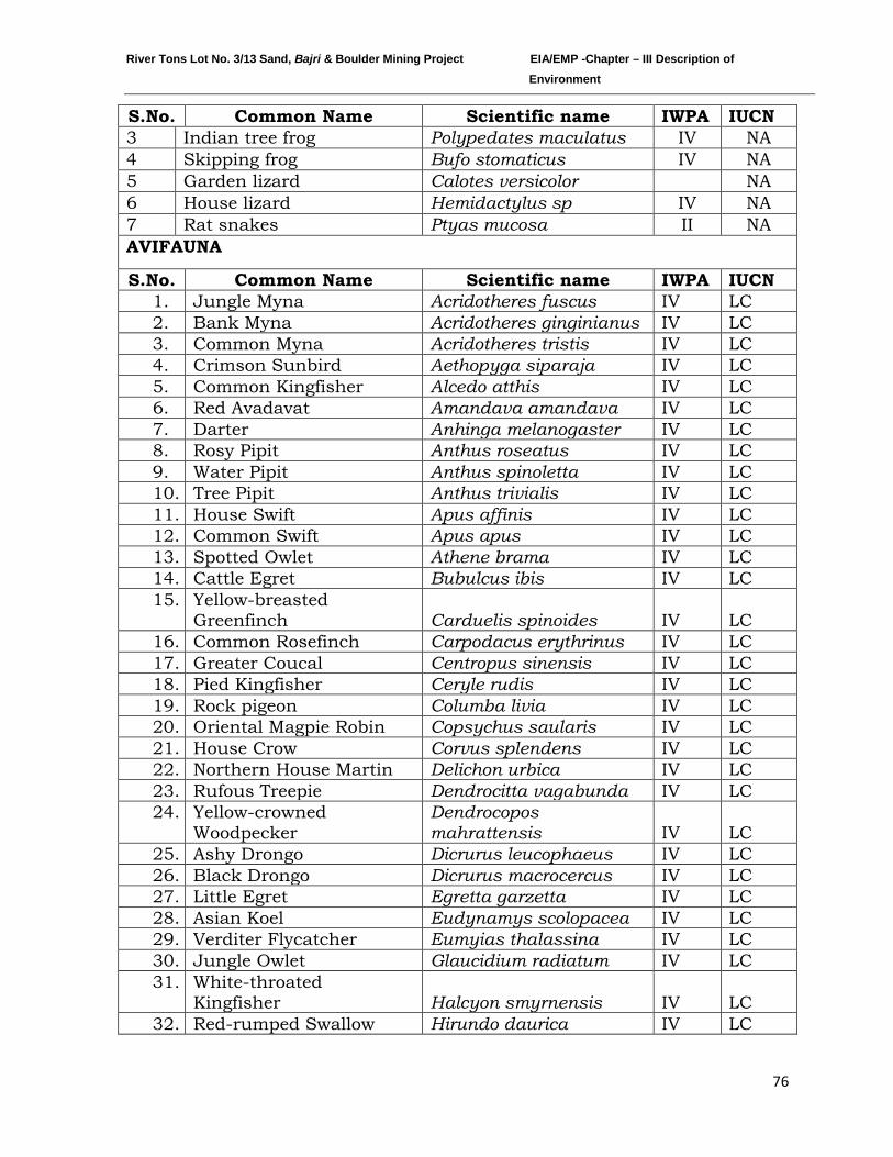
River Tons Lot No. 3/13 Sand, Bajri & Boulder Mining Project EIA/EMP -Chapter – III Description of Environment
76
S.No. Common Name Scientific name IWPA IUCN 3 Indian tree frog Polypedates maculatus IV NA 4 Skipping frog Bufo stomaticus IV NA 5 Garden lizard Calotes versicolor NA 6 House lizard Hemidactylus sp IV NA 7 Rat snakes Ptyas mucosa II NA AVIFAUNA
S.No. Common Name Scientific name IWPA IUCN 1. Jungle Myna Acridotheres fuscus IV LC 2. Bank Myna Acridotheres ginginianus IV LC 3. Common Myna Acridotheres tristis IV LC 4. Crimson Sunbird Aethopyga siparaja IV LC 5. Common Kingfisher Alcedo atthis IV LC 6. Red Avadavat Amandava amandava IV LC 7. Darter Anhinga melanogaster IV LC 8. Rosy Pipit Anthus roseatus IV LC 9. Water Pipit Anthus spinoletta IV LC 10. Tree Pipit Anthus trivialis IV LC 11. House Swift Apus affinis IV LC 12. Common Swift Apus apus IV LC 13. Spotted Owlet Athene brama IV LC 14. Cattle Egret Bubulcus ibis IV LC 15. Yellow-breasted
Greenfinch Carduelis spinoides IV LC 16. Common Rosefinch Carpodacus erythrinus IV LC 17. Greater Coucal Centropus sinensis IV LC 18. Pied Kingfisher Ceryle rudis IV LC 19. Rock pigeon Columba livia IV LC 20. Oriental Magpie Robin Copsychus saularis IV LC 21. House Crow Corvus splendens IV LC 22. Northern House Martin Delichon urbica IV LC 23. Rufous Treepie Dendrocitta vagabunda IV LC 24. Yellow-crowned
Woodpecker Dendrocopos mahrattensis IV LC
25. Ashy Drongo Dicrurus leucophaeus IV LC 26. Black Drongo Dicrurus macrocercus IV LC 27. Little Egret Egretta garzetta IV LC 28. Asian Koel Eudynamys scolopacea IV LC 29. Verditer Flycatcher Eumyias thalassina IV LC 30. Jungle Owlet Glaucidium radiatum IV LC 31. White-throated
Kingfisher Halcyon smyrnensis IV LC 32. Red-rumped Swallow Hirundo daurica IV LC
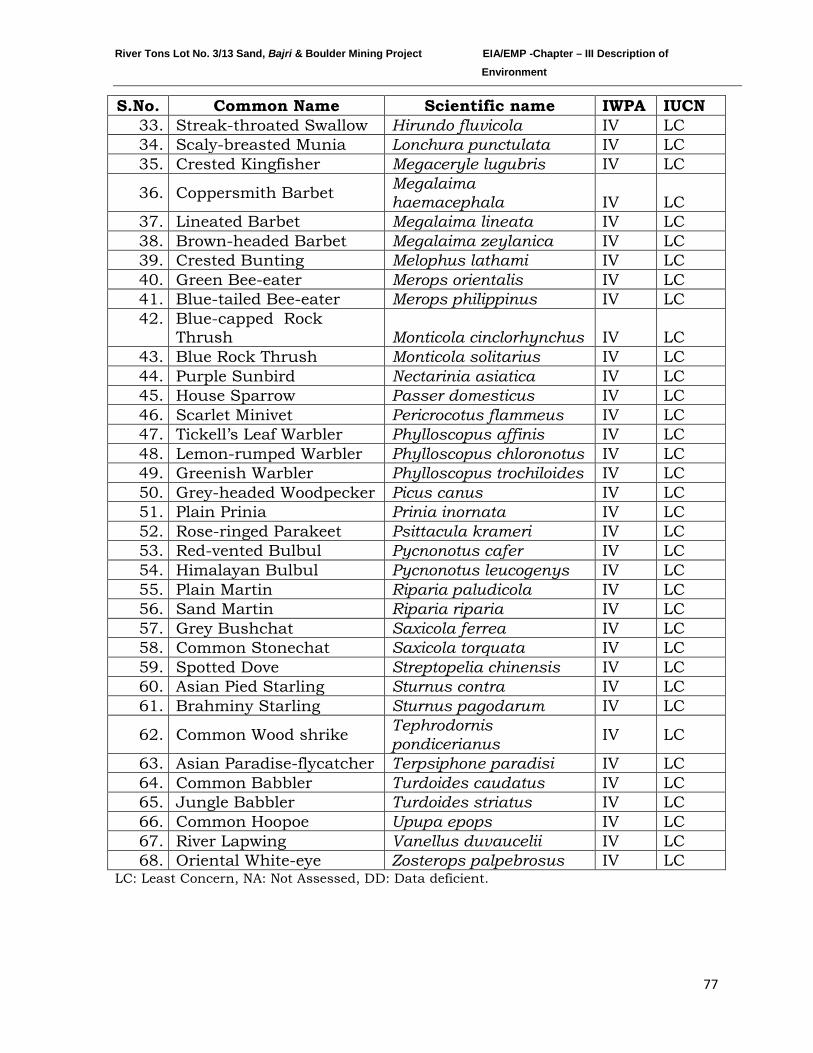
River Tons Lot No. 3/13 Sand, Bajri & Boulder Mining Project EIA/EMP -Chapter – III Description of Environment
77
S.No. Common Name Scientific name IWPA IUCN 33. Streak-throated Swallow Hirundo fluvicola IV LC 34. Scaly-breasted Munia Lonchura punctulata IV LC 35. Crested Kingfisher Megaceryle lugubris IV LC
36. Coppersmith Barbet Megalaima haemacephala IV LC
37. Lineated Barbet Megalaima lineata IV LC 38. Brown-headed Barbet Megalaima zeylanica IV LC 39. Crested Bunting Melophus lathami IV LC 40. Green Bee-eater Merops orientalis IV LC 41. Blue-tailed Bee-eater Merops philippinus IV LC 42. Blue-capped Rock
Thrush Monticola cinclorhynchus IV LC 43. Blue Rock Thrush Monticola solitarius IV LC 44. Purple Sunbird Nectarinia asiatica IV LC 45. House Sparrow Passer domesticus IV LC 46. Scarlet Minivet Pericrocotus flammeus IV LC 47. Tickell’s Leaf Warbler Phylloscopus affinis IV LC 48. Lemon-rumped Warbler Phylloscopus chloronotus IV LC 49. Greenish Warbler Phylloscopus trochiloides IV LC 50. Grey-headed Woodpecker Picus canus IV LC 51. Plain Prinia Prinia inornata IV LC 52. Rose-ringed Parakeet Psittacula krameri IV LC 53. Red-vented Bulbul Pycnonotus cafer IV LC 54. Himalayan Bulbul Pycnonotus leucogenys IV LC 55. Plain Martin Riparia paludicola IV LC 56. Sand Martin Riparia riparia IV LC 57. Grey Bushchat Saxicola ferrea IV LC 58. Common Stonechat Saxicola torquata IV LC 59. Spotted Dove Streptopelia chinensis IV LC 60. Asian Pied Starling Sturnus contra IV LC 61. Brahminy Starling Sturnus pagodarum IV LC
62. Common Wood shrike Tephrodornis pondicerianus IV LC
63. Asian Paradise-flycatcher Terpsiphone paradisi IV LC 64. Common Babbler Turdoides caudatus IV LC 65. Jungle Babbler Turdoides striatus IV LC 66. Common Hoopoe Upupa epops IV LC 67. River Lapwing Vanellus duvaucelii IV LC 68. Oriental White-eye Zosterops palpebrosus IV LC
LC: Least Concern, NA: Not Assessed, DD: Data deficient.
River Tons Lot No. 3/13 Sand, Bajri & Boulder Mining Project EIA/EMP -Chapter – III Description of Environment
78
3.1.7 SOCIO ECONOMIC STATUS:
INTRODUCTION
Socio-Economic Impact Assessment (SEIA) refers to systematic analysis of
various social and economic characteristics of human being living in a given
geographical area during a given period. The geographical area is often called
Study Area or Impact Area. SEIA is carried out separately but concurrently
with Environment Impact Assessment (EIA). The study area consists of core
area where the project is located and a buffer area encircling the project area
with a radius of 10 kilometers from the periphery of the core area. For every
new project or existing project under expansion or tied for modernization or
change in product mix, Socio-economic Impact Assessment is mandatory.
The Socio-economic impact assessment focuses the effect of the project on
social and economic well-being of the community. The impact may be direct
or indirect. Further, the impact may be positive or negative.
OBJECTIVES OF SEIA
The prime objective of the current study is to assess the impact of the
proposed Sand, Bajri & Boulder mining Project on socio-economic
characteristics of people living in the neighborhoods. Further, it is to be
established whether the impending impact would be direct or indirect.
Furthermore, it is to be examined whether the said impact would be positive
or negative. Lastly, it is to be comprehended if the impact is positive how
long it would sustain or if it is negative how soon the same could be eased.
SCOPE
The Scope of the study is as follows:
a) To collect baseline data of the study area
b) To comprehend socio-economic status of the people living in the study
area.
River Tons Lot No. 3/13 Sand, Bajri & Boulder Mining Project EIA/EMP -Chapter – III Description of Environment
79
c) To assess probable impact of the project on social and economic aspects
in the study area.
d) To measure the impact of the project on Quality of life of the people living
in the study area.
e) To ensure sustainability of positive impact.
f) To suggest mitigation measures and agency responsible for taking action
in case of adverse impact.
METHODOLOGY
For assessment of Socio-Economic Impact of the proposed Sand, Bajri &
Boulder mining project on River Tons, Village Banshiwala, Tehsil Vikasnagar,
District Dehradun, Uttarakhand systematic analysis of various Socio-
Economic characteristics, both in terms of quality and quantity has been
done. Accordingly, both qualitative and quantitative data was collected from
secondary sources. For collection of secondary data GRC approached the
Census Authority in the state for published data/information, visited state
and district portal and referred to administrative records of the state and
district administration. The qualitative data deals with description; they can
be observed but not measured. Hence, codes were extensively used during
collection of qualitative data. They were decoded after data processing to
facilitate data analysis and report writing.
STUDY AREA
The study area consists of lease area and buffer area. There is no vegetation
in the leased out area excepting few small bushes. There are 56 villages and
2 towns in the study area. All the habitations are located in Uttarakhand
only as the area lying in Uttar Pradesh is mostly forest/vegetation.
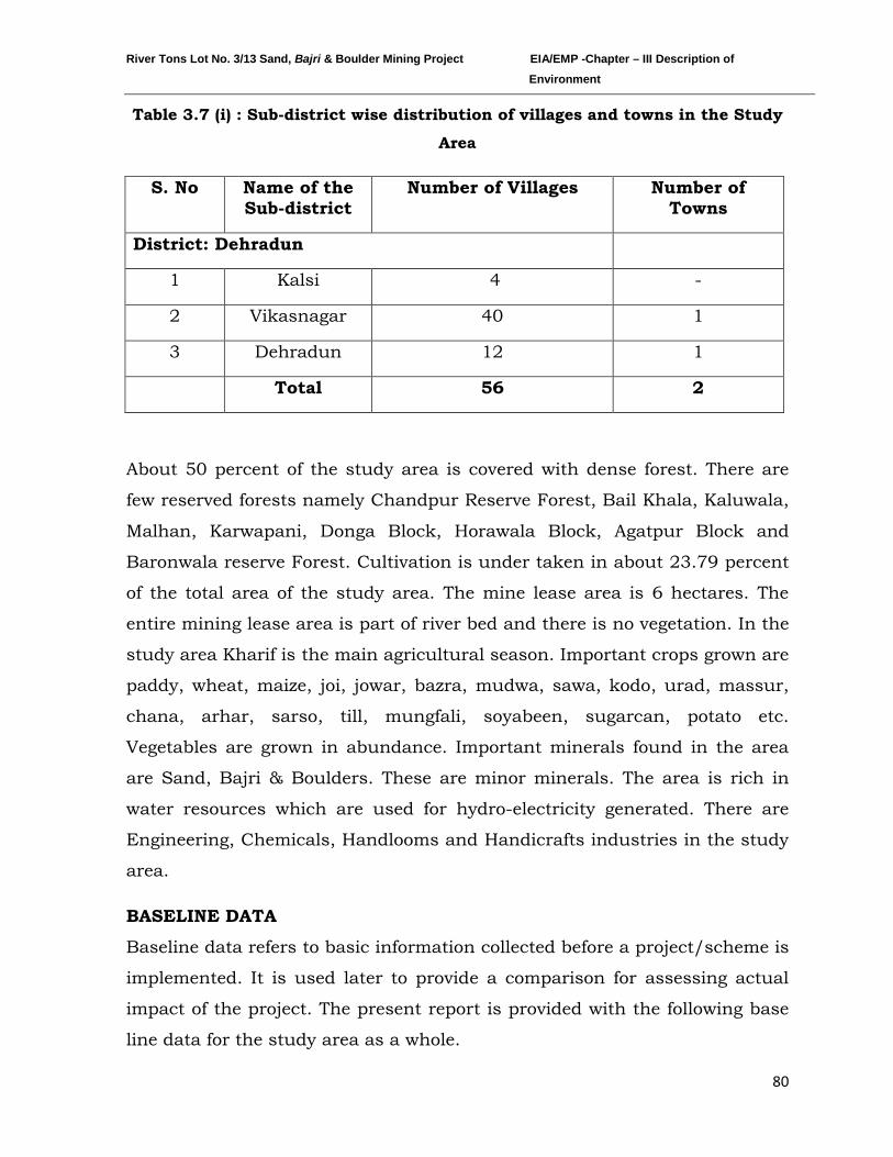
River Tons Lot No. 3/13 Sand, Bajri & Boulder Mining Project EIA/EMP -Chapter – III Description of Environment
80
Table 3.7 (i) : Sub-district wise distribution of villages and towns in the Study
Area
S. No Name of the Sub-district
Number of Villages Number of Towns
District: Dehradun
1 Kalsi 4 -
2 Vikasnagar 40 1
3 Dehradun 12 1
Total 56 2
About 50 percent of the study area is covered with dense forest. There are
few reserved forests namely Chandpur Reserve Forest, Bail Khala, Kaluwala,
Malhan, Karwapani, Donga Block, Horawala Block, Agatpur Block and
Baronwala reserve Forest. Cultivation is under taken in about 23.79 percent
of the total area of the study area. The mine lease area is 6 hectares. The
entire mining lease area is part of river bed and there is no vegetation. In the
study area Kharif is the main agricultural season. Important crops grown are
paddy, wheat, maize, joi, jowar, bazra, mudwa, sawa, kodo, urad, massur,
chana, arhar, sarso, till, mungfali, soyabeen, sugarcan, potato etc.
Vegetables are grown in abundance. Important minerals found in the area
are Sand, Bajri & Boulders. These are minor minerals. The area is rich in
water resources which are used for hydro-electricity generated. There are
Engineering, Chemicals, Handlooms and Handicrafts industries in the study
area.
BASELINE DATA
Baseline data refers to basic information collected before a project/scheme is
implemented. It is used later to provide a comparison for assessing actual
impact of the project. The present report is provided with the following base
line data for the study area as a whole.
River Tons Lot No. 3/13 Sand, Bajri & Boulder Mining Project EIA/EMP -Chapter – III Description of Environment
81
Table 3.7(ii): Demographic Particulars of the Study Area of Sand, Bajri & Boulder Mining Project on river Tons at Village Banshiwala in Sub-
district Vikasnagar District Dehradun
S.N. Description Number Percentage to Respective
total 1 Gender wise total Population of the
Study area 159653 100
Male 83534 52.3 Female 76119 47.7 Sex Ratio (No. of females per 1000 males) 911
2 Sector wise total Population of the Study area
159653 100
Rural 129298 81 Urban 30355 19
3 Gender wise total Population (0-6 age group)
21721 100
Male 11342 52.2 Female 10379 47.8 Sex Ratio of 0-6 age group population (No. of females per 1000 males)
915
4 Number of Households and household size
32012
Average House Hold size for the study area as a whole
5.1
Highest Household size in the study area 9.2
Lowest Household size in the study area 3.8 5 Total Population of Schedule Caste
Community in the study area 18324 100
Male 9636 52.6 Female 8688 47.4 Sex Ratio (No. of females per 1000 males) 902
6 Total Population of Schedule Tribe Community
8334 100
Male 4462 53.5 Female 3872 46.5 Sex Ratio (No. of females per 1000 males 868
7 Total population of General Community (including OBC)
132995 100
Male 69436 52.2
River Tons Lot No. 3/13 Sand, Bajri & Boulder Mining Project EIA/EMP -Chapter – III Description of Environment
82
Female 63559 47.8 Sex Ratio of General Community population (including OBC) (No. of females per 1000 males
915
8 Total Literates in the study area 109572 100 Male 61870 56.5 Female 47702 43.5 Over all literacy rate in the study area 79.4 Male 85.7 Female 72.6 Gender gap in literacy rate 13.1
9 Total Workers in the study area 49451 100 Male 41389 83.7 Female 8062 16.3 Overall Gender Gap in work participation rate
67.4
Overall Dependency Rate of Non-workers over workers
223
10 Total Main Workers in the study area 39811 100 Male 34107 85.7 Female 5704 14.3 Over all gender gap in work participation rate of main workers
71.3
11 Total Marginal Workers in the study area
9640 100
Male 7282 75.5 Female 2358 32.4 Over all gender gap in work participation rate of Marginal workers
43.2
12 Total Household Industrial Workers in the Study Area
2121 100
Male 1535 72.4 Female 586 27.6
13 Total Agricultural Workers in the study Area
12523 100
Male 10097 80.6 Female 2426 19.4
14 Total Cultivators in the Study Area 5758 100 Male 4273 74.2 Female 1485 25.8
15 Total Agricultural Labour in the Study Area
6765 100
River Tons Lot No. 3/13 Sand, Bajri & Boulder Mining Project EIA/EMP -Chapter – III Description of Environment
83
Male 5824 86.1 Female 941 13.9
16 Total ‘Other Workers’ in the Study Area
34807 100
Male 29757 85.5 Female 5050 14.5
Source: Census 2011
Table 3.7(iii): Various amenities in the study area are tabulated below:
S. N. Amenities Type of Facilities Rural Urban No. of
villages Number of institutions
No. of Towns
Number of institutions
1 Educational Institutions
Primary School 47 85 2 16 Middle school 26 33 2 4 Secondary School 11 13 2 2 Senior Secondary School 5 7 2 9 Adult Literacy Center 8 13 1 3
Other School 6 17 - - 2 Health
facilities Allopathic Hospital 6 9 2 2
Ayurvadic Hospital 1 1 - - Allopathic Dispensary 7 10 2 2 Ayurvadic Dispensary 1 1 1 1 Maternity Home 1 1 - - Health Centre 1 1 1 1 Primary Health Centre
5 5 1 1
Nursing Home 1 1 - - Dispensary - - - -
TB Clinic 1 1 - - Child Welfare Center 2 2 1 1
River Tons Lot No. 3/13 Sand, Bajri & Boulder Mining Project EIA/EMP -Chapter – III Description of Environment
84
Registered Medical Practicenors
12 45 2 7
Family Welfare Center
2 2 - -
Community Health Workers
33 35 1 1
3 Drinking Water*
Well 19 - 1 - Canal 16 - - - Tank 5 - 1 - River 13 - 1 - Spring 9 - - - Tap 48 - 2 - Lake - - - - Other sources of drinking water
- - - -
4 Electricity Power for domestic uses
31 - - -
Power for Agriculture uses
4 - - -
Power for Road Light
- - - -
Power for Commercial uses
- - - -
Power for Industries - - - - Power for Other 3 - - - All purpose 17 - 2 -
5 Approach Road
Only Paved Roads 36 - 2 - Only Mud Roads 39 - 2 - Both paved and Mud Roads
34 - 2 -
Only Foot Road (Pagdandi)
24 - 1 -
Paved, Mud and Foot Road
15 - 1 -
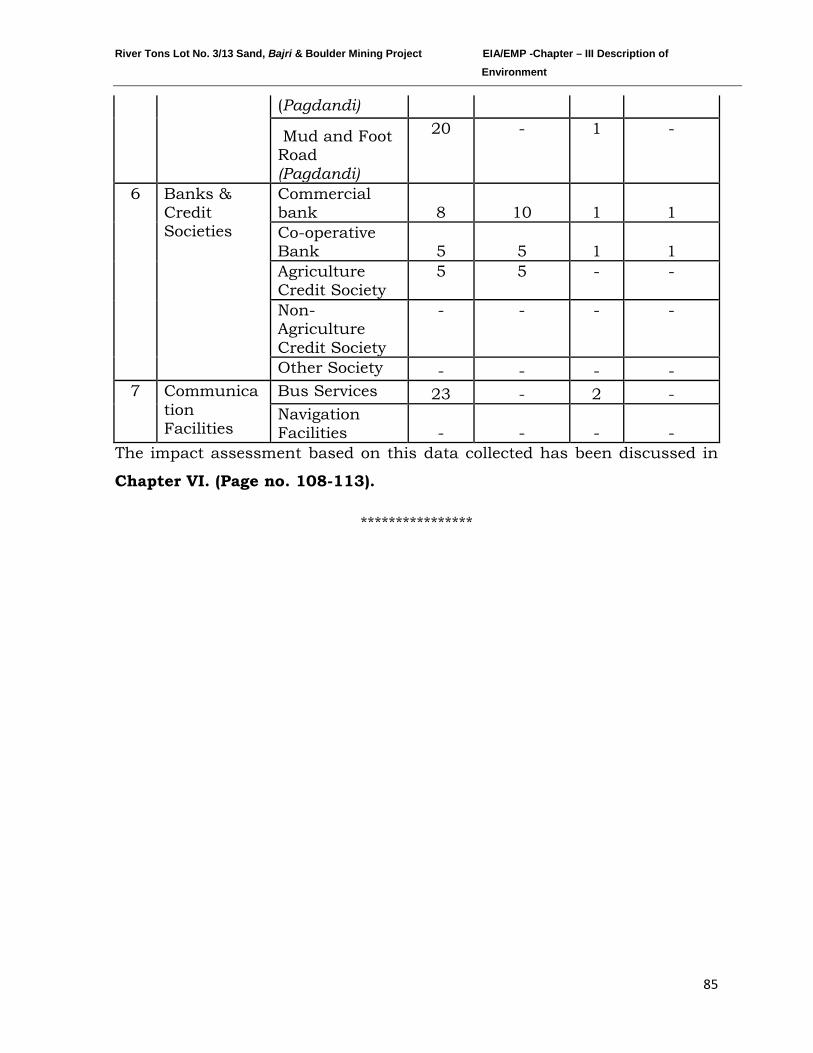
River Tons Lot No. 3/13 Sand, Bajri & Boulder Mining Project EIA/EMP -Chapter – III Description of Environment
85
(Pagdandi)
Mud and Foot Road (Pagdandi)
20 - 1 -
6 Banks & Credit Societies
Commercial bank 8 10 1 1 Co-operative Bank 5 5 1 1 Agriculture Credit Society
5 5 - -
Non-Agriculture Credit Society
- - - -
Other Society - - - - 7 Communica
tion Facilities
Bus Services 23 - 2 - Navigation Facilities - - - -
The impact assessment based on this data collected has been discussed in
Chapter VI. (Page no. 108-113).
****************
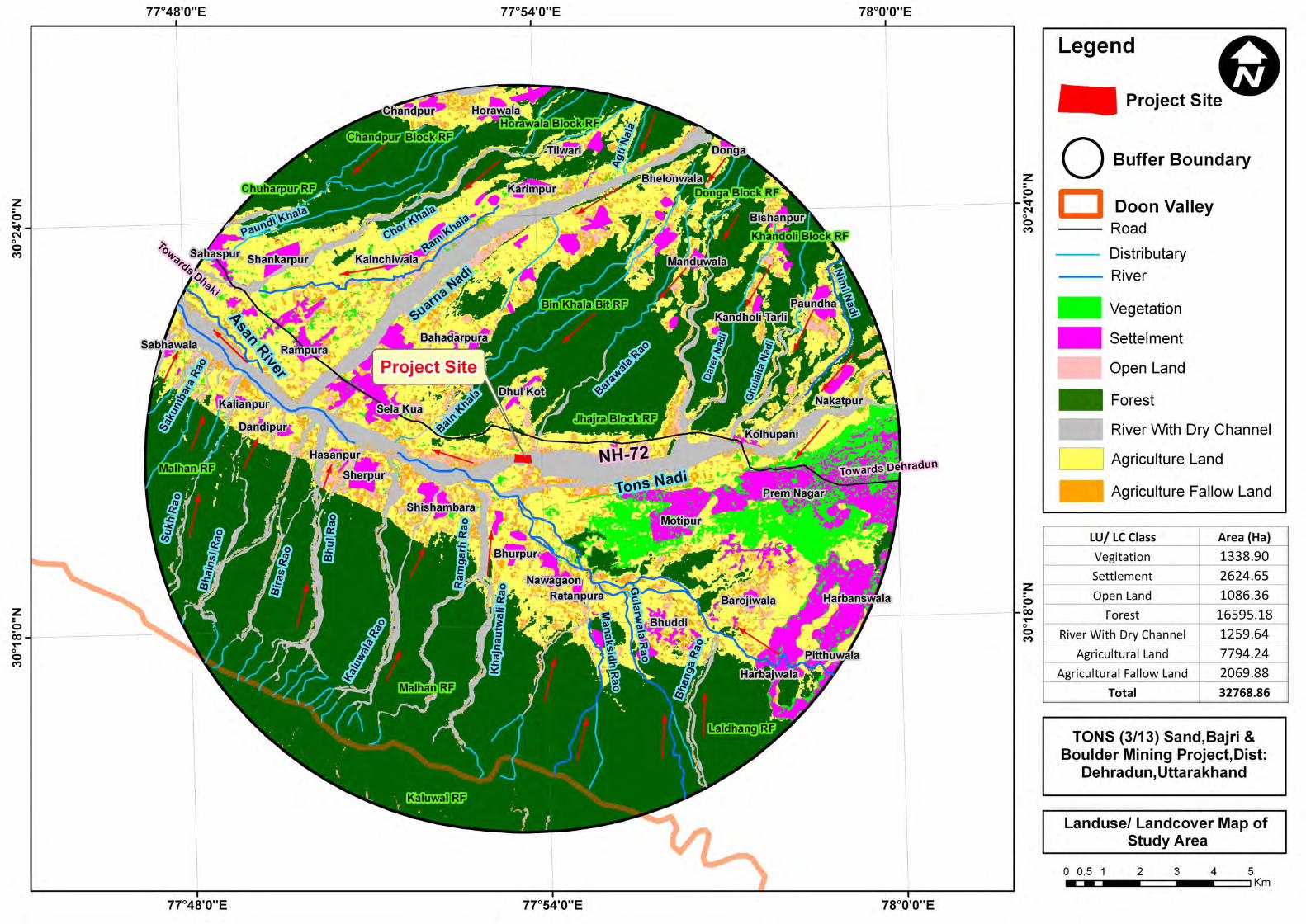
Z 0 Co 0r-o 0 M
z o
-----+------ -----~ N o o M
z 0 Co 0r-o 0 M
Legend ~
Project Site
o Buffer Boundary
D Ooon Valley --- Road
Distributary
River
Vegetation
SeUelment
Open Land
Forest
River With Dry Channel
c=J Agriculture Land
Agriculture Fallow Land
LUI LC Class Area (Ha)
Vegitation 1338.90
Settlement 2624.65
Open Land 1086.36
Forest 16595.18
River With Dry Channel 1259.64
Agricultural Land 7794.24
Agricultural Fallow Land 2069.88
Total 32768.86
TONS (3/13) Sand,Bajri & Boulder Mining Project,Dist:
Dehradun,Uttarakhand
Landusel Landcover Map of Study Area
o 0.5 1 5 .-c.-c. .. .c===-.. .c==~IKm 2 3 4
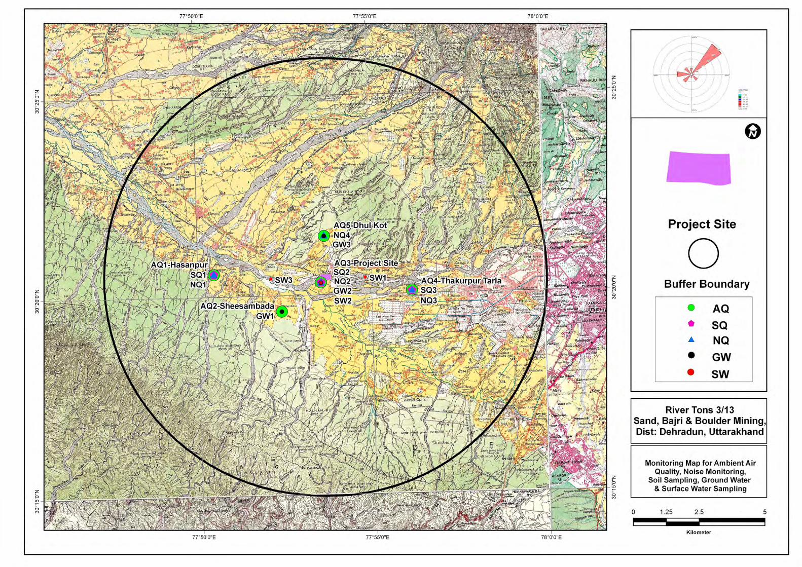
~ a ~~~~ a ('")
~ a a ~ 0 ('")
~ a In
a ('")
77°50'O"E
77°50'O"E
7r55'O"E
~ a a ('J
a ('")
~ a In
a ('")
7r55'O"E
Project Site
0
(m .... 1
D >- '11 . .. .. _ " oM . .... . ..
Buffer Boundary
0 AQ
• SQ ... NQ
• GW
• SW
River Tons 3/13 Sand, Bajri & Boulder Mining, Dist: Dehradun, Uttarakhand
Monitoring Map for Ambient Air Quality, Noise Monitoring,
Soil Sampling, Ground Water & Surface Water Sam piing
o 1.25 2.5 5
i I I I Kilometer
River Tons Lot No. 3/13 Sand, Bajri & Boulder Mining Project EIA/EMP-Chapter–IV Anticipated Environmental Impact and Mitigation Measure
86
CHAPTER-IV
ANTICIPATED ENVIRONMENTAL IMPACT AND MITIGATION MEASURES
INDEX
S. No. CONTENTS Page No.
4.0 GENERAL 87
4.1 LAND ENVIRONMENT 87
4.2 WATER ENVIRONMENT 89
4.3 AIR ENVIRONMENT 90
4.4 NOISE ENVIRONMENT 93
4.5 BIOLOGICAL ENVIRONMENT 95
4.6 TRAFFIC ANALYSIS 96
River Tons Lot No. 3/13 Sand, Bajri & Boulder Mining Project EIA/EMP-Chapter–IV Anticipated Environmental Impact and Mitigation Measure
87
4.0 GENERAL
All industrial and/or development projects are likely to have an impact on the
natural set up of the environment. This impact may be beneficial or adverse,
depending on the improvement or the deterioration it brings, about change in
the status of air, water, land, ecology, natural systems, socio-cultural life styles
and economics of the population. Depending on the nature of activities and
baseline environment status, the impacts are assessed for their importance. On
the basis of the impact analysis, the mitigating action and future monitoring
requirement are paid attention to in the Environmental Management Plan for
countering or minimizing the impacts.
Keeping in mind, the environmental baseline scenario as detailed in Chapter
III (Page no. 41 -85) and the proposed mining activity described in Chapter II,
(Page no. 33-36) it is attempted to assess the likely impact and its extent on
various environmental parameters and likely mitigation measures to be
adopted.
4.1 LAND ENVIRONMENT
The proposed extraction of streambed materials, mining below the existing
streambed, and alteration of channel-bed form and shape may lead to several
impacts such as erosion of channel bed and banks, increase in channel slope,
and change in channel morphology if, the operations are not carried out
systematically.
The mining and allied activities involved in river bed mining result in creation
of temporary haul roads and formation of mined pits inside river, etc. affecting
the landuse pattern. In this project, silt and clay are also produced as a
constituent of the River-Bed Material, which are considered to be waste.
Anticipated Impacts:
• Undercutting and collapse of river banks.
River Tons Lot No. 3/13 Sand, Bajri & Boulder Mining Project EIA/EMP-Chapter–IV Anticipated Environmental Impact and Mitigation Measure
88
• Excessive and unscientific riverbed material mining is a threat to bridges,
dams and nearby structures.
• River bank cutting and erosion.
• Upstream erosion as a result of an increase in channel slope and changes
in flow velocity.
• Downstream erosion due to increased carrying capacity of the stream
• Downstream changes in patterns of deposition.
• Changes in channel bed and habitat type.
Mitigation measures:
• Since the project is mainly for sand, bajri and boulder excavation (soil
deficient), no loss of top soil is involved.
• The silt and clay generated as waste will be used for plantation or filling up
low lying area elsewhere.
• Mining will be done leaving a safety distance of 100m from the bridge/dam.
• Mining will be done leaving a safety distance from the banks i.e. 15% of the
width of the river will be left for bank stability from both the banks.
• In this activity, the work is proposed to be done manually which will avoid
adverse effects associated with heavy machinery and their functioning.
• The mining is planned in non monsoon seasons only, so that the excavated
area gets replenished during the monsoon each year.
• Grasses and bushes which have fibrous roots at the first instance are
proposed to grown along the banks which enhances the binding properties
of the soil. Hence protecting the banks.
• The systematic and scientific removal of sand, bajri and boulder will not
cause bed degradation.
• Restoration of bank will be ensured at the end of mine closure every year.
River Tons Lot No. 3/13 Sand, Bajri & Boulder Mining Project EIA/EMP-Chapter–IV Anticipated Environmental Impact and Mitigation Measure
89
4.2 WATER ENVIRONMENT
Anticipated Impacts:
Mining of sand from within or near a river bed has a direct impact on the
physico-chemical habitat characteristics. These characteristics include in
stream roughness elements, depth, velocity, turbidity, sediment transport and
stream discharge. Altering these habitat characteristics can have deleterious
impacts on both in-stream biota and associated riparian habitat.
The detrimental effects, if any, to biota resulting from bed material mining are
caused by following:
i. Alteration of flow patterns resulting from modification of the river bed.
ii. An excess of suspended sediment.
iii. Damage to riparian vegetation and in-stream habitat.
The disturbance activities can also disrupt the ecological diversity in many
ways.
Mitigation measures
Project activity will be carried out only in the dry part of the river bed. Hence,
none of the project activities affect the water environment directly. In the
project, it is not proposed to divert or truncate any stream. No proposal is
envisaged for pumping of water either from the river or tapping the ground
water.
In the lean months, the proposed sand mining will not expose the base flow of
the river and hence, there will not be any adverse impact on surface hydrology.
The deposit will be mined out from the top surface up to a maximum depth of
1.5m below ground level or above the ground water table whichever comes first.
Hence mining will not affect the ground water regime as well.
Further mining will be completely stopped during the monsoon seasons to
allow the excavated area to regain its natural profile.
River Tons Lot No. 3/13 Sand, Bajri & Boulder Mining Project EIA/EMP-Chapter–IV Anticipated Environmental Impact and Mitigation Measure
90
4.3 AIR ENVIRONMENT
Anticipated Impacts:
Emission of fugitive dust is envisaged due to:
i. Mining Activities includes excavation and lifting of minerals. The whole
process will be done manually. Therefore the dust generated is likely to be
insignificant as compared to mining processes involving drilling, blasting,
mechanized loading etc.
ii. Transportation of minerals will be done by road using trucks. Fugitive dust
emission is expected from the transportation of trucks on the haul roads.
Evaluation of fugitive dust emission has been done by using line source
model as given below:
Air Modeling
A detailed study on emission sources and quantification of pollutant
concentration by means of dispersion modeling is required to access the
environmental impact of a mine. On the basis of the predicted increments to air
pollutant concentrations, an effective mitigation and environmental plan can be
devised for sensitive areas. In case of river bed sand, stone & bajri mining, as
there is no blasting and drilling activities, the impacts may only be caused by
material handling and transportation activities. The material is mostly wet, and
therefore effect is minimal.
FUGITIVE DUST- MODELING
Air quality modeling was done using line source model as published by USEPA
“Emission Factor Documentation for AP-42”, in Chapter 13.2.2, for
transportation though unpaved roads. Emission factors to be used in Line
source dispersion equation is adopted from formula as given below:
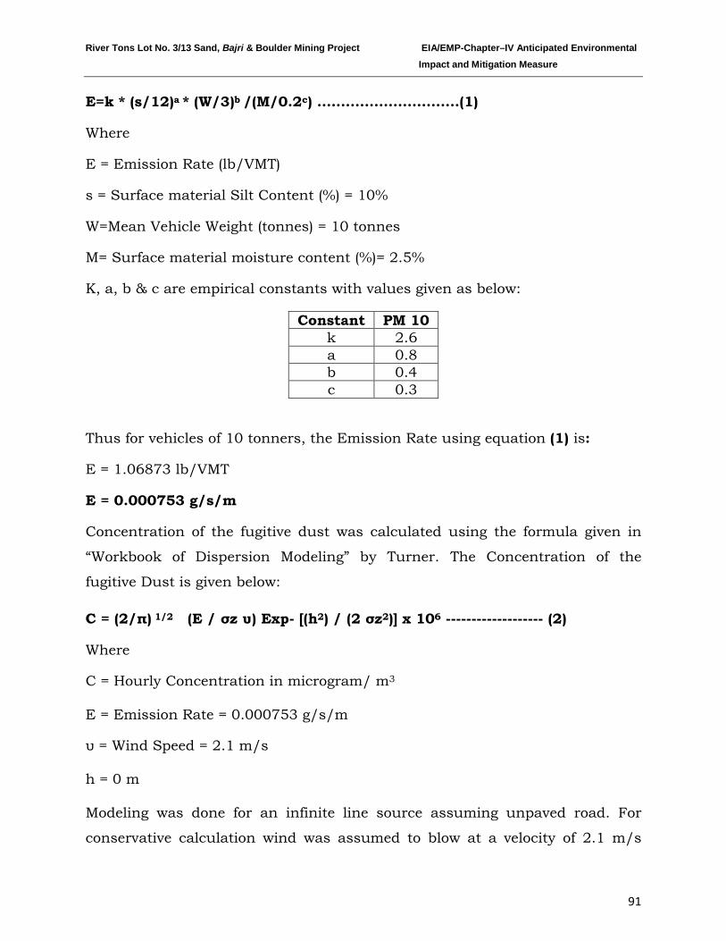
River Tons Lot No. 3/13 Sand, Bajri & Boulder Mining Project EIA/EMP-Chapter–IV Anticipated Environmental Impact and Mitigation Measure
91
E=k * (s/12)a * (W/3)b /(M/0.2c
Constant
) …………………………(1)
Where
E = Emission Rate (lb/VMT)
s = Surface material Silt Content (%) = 10%
W=Mean Vehicle Weight (tonnes) = 10 tonnes
M= Surface material moisture content (%)= 2.5%
K, a, b & c are empirical constants with values given as below:
PM 10 k 2.6 a 0.8 b 0.4 c 0.3
Thus for vehicles of 10 tonners, the Emission Rate using equation (1) is:
E = 1.06873 lb/VMT
E = 0.000753 g/s/m
Concentration of the fugitive dust was calculated using the formula given in
“Workbook of Dispersion Modeling” by Turner. The Concentration of the
fugitive Dust is given below:
C = (2/π) 1/2 (E / σz υ) Exp- [(h2) / (2 σz2)] x 106 ------------------- (2)
Where
C = Hourly Concentration in microgram/ m
Modeling was done for an infinite line source assuming unpaved road. For
conservative calculation wind was assumed to blow at a velocity of 2.1 m/s
3
E = Emission Rate = 0.000753 g/s/m
υ = Wind Speed = 2.1 m/s
h = 0 m
River Tons Lot No. 3/13 Sand, Bajri & Boulder Mining Project EIA/EMP-Chapter–IV Anticipated Environmental Impact and Mitigation Measure
92
perpendicular to the road. The results for 24 hourly concentration values are
given in the Fig. 4.1:
Fig.4.1 Graph showing Concentration of Fugitive dust vs Distance in 24 hr average un-controlled and controlled way
It is observed that the ground level concentration (GLC) decreases from 23.67
µg/m3 at 25 m to 2.23 µg/m3 at 500 m from the centre line of the road. These
values have been predicted for a dry unpaved road in an uncontrolled scenario.
However, the GLC at 25 m will further reduce down to 6.16µg/m3 and
0.58µg/m3 at 500 m in a controlled scenario i.e. through water sprinkling.
Mitigation measures
The collection and lifting of minerals will be done manually. Therefore the dust
generated is likely to be insignificant as there will be no drilling & blasting. The
only air pollution sources are the road transport network of the trucks. The
mitigation measures like the following will be resorted:
23.67
17.07
10.54
5.713.81
2.83 2.236.16
4.442.74
1.48 0.99 0.74 0.580.00
5.00
10.00
15.00
20.00
25.00
0 100 200 300 400 500 600
Con
cntr
atio
n in
µg/
m3
Downwind Distance in m
Concentration of Fugitive Dust vs Distance
24 hr avgUncontrolled
24 hr avgControlled
River Tons Lot No. 3/13 Sand, Bajri & Boulder Mining Project EIA/EMP-Chapter–IV Anticipated Environmental Impact and Mitigation Measure
93
• Water sprinkling will be done on the haul roads twice in a day. This will
reduce dust emission further by 74% (Ref. Haul road dust control by WR REED & JA
Organiscak).
• Speed limits (i.e. 20 km/hour) will be enforced to reduce airborne fugitive
dust from vehicular traffic.
• Spillage from the trucks will be prevented by covering tarpaulin over the
trucks.
• Deploying PUC certified vehicles to reduce their emissions.
• Proper tuning of vehicles to keep the gas emissions under check.
• Monitoring to ensure compliance with emission limits would be carried out
during operation.
4.4 NOISE
The proposed mining activity is manual in nature. No drilling & blasting is
envisaged for the mining activity. Hence the only impact is anticipated is due to
movement of vehicles deployed for transportation of minerals.
Anticipated Impacts:
• Mental disturbance, stress & impaired hearing.
• Decrease in speech reception & communication.
• Distraction and diminished concentration affecting job performance
efficiency
The noise level in the working environment are compared with the standards
prescribed by Occupational Safety and Health Administration (OSHA-USA)
which has been adopted and enforced by the Govt. of India through model
rules framed under Factories Act, 1980 and CPCB 2000 norms. The summary
of the permissible exposures in cases of continuous noise as per above rules is
given below:
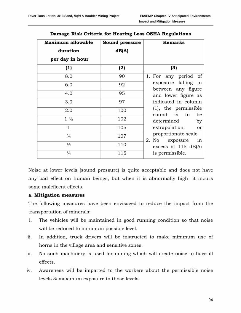
River Tons Lot No. 3/13 Sand, Bajri & Boulder Mining Project EIA/EMP-Chapter–IV Anticipated Environmental Impact and Mitigation Measure
94
Damage Risk Criteria for Hearing Loss OSHA Regulations
Maximum allowable
duration
per day in hour
Sound pressure
dB(A)
Remarks
(1) (2) (3)
8.0 90 1. For any period of exposure falling in between any figure and lower figure as indicated in column (1), the permissible sound is to be determined by extrapolation or proportionate scale.
2. No exposure in excess of 115 dB(A) is permissible.
6.0 92
4.0 95
3.0 97
2.0 100
1 ½ 102
1 105
¾ 107
½ 110
¼ 115
Noise at lower levels (sound pressure) is quite acceptable and does not have
any bad effect on human beings, but when it is abnormally high- it incurs
some maleficent effects.
a. Mitigation measures
The following measures have been envisaged to reduce the impact from the
transportation of minerals:
i. The vehicles will be maintained in good running condition so that noise
will be reduced to minimum possible level.
ii. In addition, truck drivers will be instructed to make minimum use of
horns in the village area and sensitive zones.
iii. No such machinery is used for mining which will create noise to have ill
effects.
iv. Awareness will be imparted to the workers about the permissible noise
levels & maximum exposure to those levels
River Tons Lot No. 3/13 Sand, Bajri & Boulder Mining Project EIA/EMP-Chapter–IV Anticipated Environmental Impact and Mitigation Measure
95
4.5 BIOLOGICAL ENVIRONMENT
Mining which leads to the removal of channel substrate, re-suspension of
streambed sediment and stockpiling on the streambed, will have ecological
impacts. These impacts may have an effect on the direct loss of stream reserve
habitat, disturbances of species attached to streambed deposits, reduced light
penetration, reduced primary production, and reduced feeding opportunities.
Sand mining generates additional traffic, which negatively impairs the
environment.
Anticipated Impacts:
• Excessive and unscientific riverbed sand mining results in the destruction
of aquatic and riparian habitat through large changes in the channel
morphology.
• Access roads crossing the riparian areas will have impact on the species
disturbing the ecosystem.
• Mining may drive away the wild life from their habitat, and significantly
affect wildlife and nearby residents.
• Diminution of the quality and quantity of habitat essential for aquatic and
riparian species.
• Reduction in the yield of agriculture due to deposition of dust on the leaves,
etc. of the crops.
• Fragmentation of wildlife habitat and blocking of migratory paths/corridors.
Isolation may lead to local decline of species, or genetic.
• Mining on the streambed, braided flow or subsurface inter-sand flow may
hinder the movement of fishes between pools.
River Tons Lot No. 3/13 Sand, Bajri & Boulder Mining Project EIA/EMP-Chapter–IV Anticipated Environmental Impact and Mitigation Measure
96
Mitigation measures
As the proposed mining will be carried out in a scientific manner, not much
significant impact is anticipated, however, the following mitigation measures
will be taken to further minimize it:
1. No mining will be carried out during the monsoon season to minimize
impact on aquatic life which is mainly breeding season for many of the
species.
2. As the mining site has no vegetation, no clearance of vegetation will be done.
3. Prior to closure of mining operations the ramps shall be removed to protect
the embankment from collapsing.
4. Haul roads will be sprinkled with water which would reduce the dust
emission, thus avoiding damage to the crops.
5. Mining will be carried out on the dry part of the lease area to avoid
disturbance to the aquatic habitat and movement of fish species.
6. No discard of food, polythene waste etc will be allowed in the lease area
which would distract/attract the wildlife.
7. No night time mining will be allowed which may catch the attention of wild
life.
8. If wildlife are noticed crossing the area, they will not be disturbed at all.
9. Workers will be made aware of the importance o the wildlife and signage will
be displayed at the sensitive areas to caution the workers & other passerby.
10. Access roads will not encroach into the riparian zones and if any riparian
vegetation cleared off for the mining activity will be restored at the end of
closure of mine.
4.6 TRAFFIC ANALYSIS
Transportation Route:
The sand, bajri & boulder excavated will be loaded directly into trucks and
transported to the concerned market thereafter. The evacuation route is shown
in the map as given below:
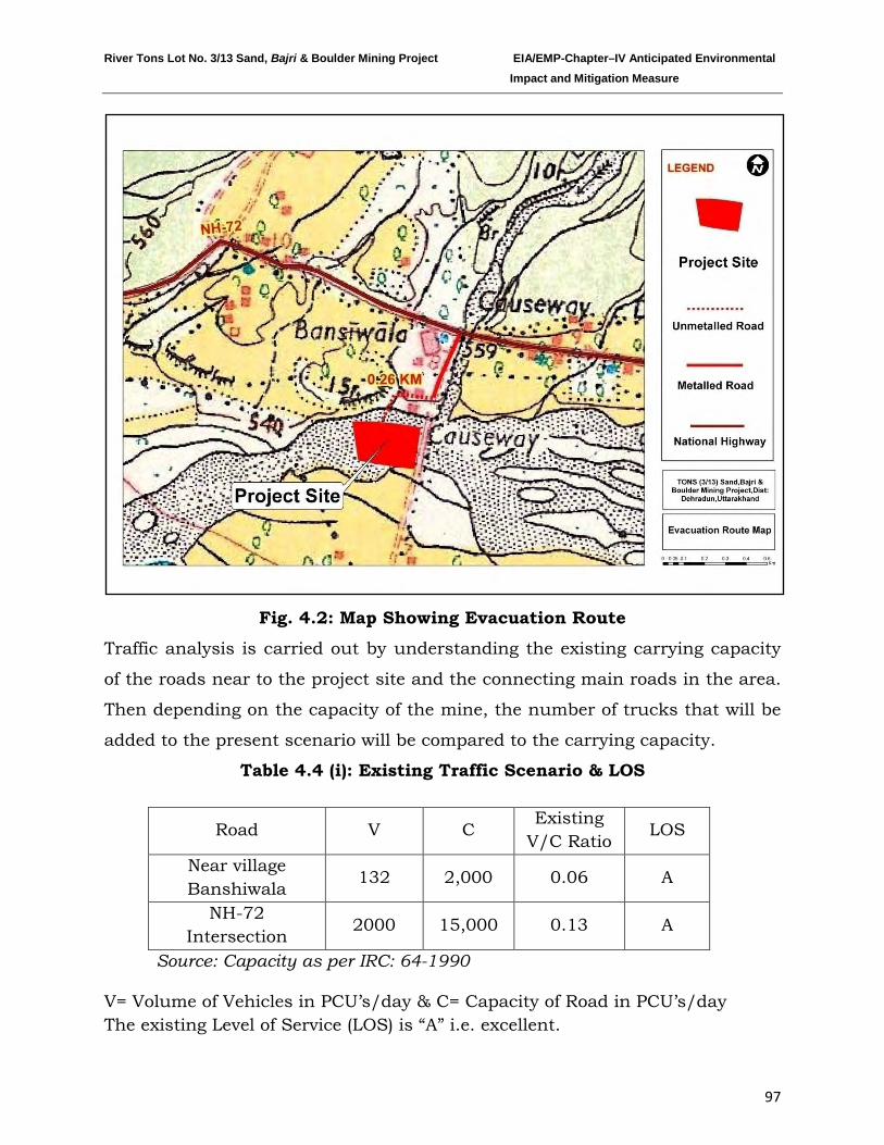
River Tons Lot No. 3/13 Sand, Bajri & Boulder Mining Project EIA/EMP-Chapter–IV Anticipated Environmental Impact and Mitigation Measure
97
Fig. 4.2: Map Showing Evacuation Route
Traffic analysis is carried out by understanding the existing carrying capacity
of the roads near to the project site and the connecting main roads in the area.
Then depending on the capacity of the mine, the number of trucks that will be
added to the present scenario will be compared to the carrying capacity.
Table 4.4 (i): Existing Traffic Scenario & LOS
Road V C Existing
V/C Ratio LOS
Near village Banshiwala
132 2,000 0.06 A
NH-72 Intersection
2000 15,000 0.13 A
Source: Capacity as per IRC: 64-1990
V= Volume of Vehicles in PCU’s/day & C= Capacity of Road in PCU’s/day The existing Level of Service (LOS) is “A” i.e. excellent.
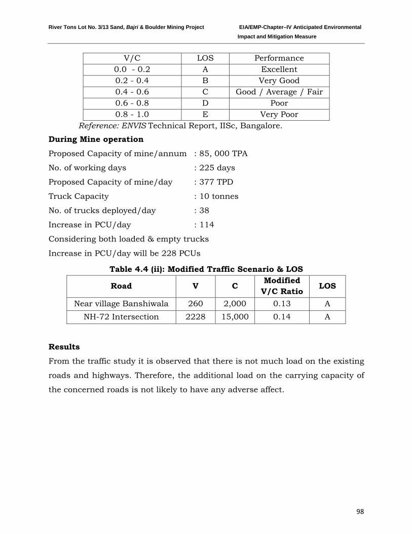
River Tons Lot No. 3/13 Sand, Bajri & Boulder Mining Project EIA/EMP-Chapter–IV Anticipated Environmental Impact and Mitigation Measure
98
V/C LOS Performance 0.0 - 0.2 A Excellent 0.2 - 0.4 B Very Good 0.4 - 0.6 C Good / Average / Fair 0.6 - 0.8 D Poor 0.8 - 1.0 E Very Poor
Reference: ENVIS Technical Report, IISc, Bangalore.
During Mine operation
Proposed Capacity of mine/annum : 85, 000 TPA
No. of working days : 225 days
Proposed Capacity of mine/day : 377 TPD
Truck Capacity : 10 tonnes
No. of trucks deployed/day : 38
Increase in PCU/day : 114
Considering both loaded & empty trucks
Increase in PCU/day will be 228 PCUs
Table 4.4 (ii): Modified Traffic Scenario & LOS
Road V C Modified V/C Ratio LOS
Near village Banshiwala 260 2,000 0.13 A NH-72 Intersection 2228 15,000 0.14 A
Results
From the traffic study it is observed that there is not much load on the existing
roads and highways. Therefore, the additional load on the carrying capacity of
the concerned roads is not likely to have any adverse affect.
River Tons Lot No. 3/13 Sand, Bajri & Boulder Mining Project EIA/EMP-Chapter–IV Anticipated Environmental Impact and Mitigation Measure
99
Traffic Management:
1. Roads will be repaired regularly and maintained in good conditions
2. A supervisor will be appointed to regulate the traffic movement near the site.
3. Speed breakers will be constructed in accident prone areas to calm the
traffic and its speed.
4. Signage will be erected at the sensitive & precarious places to caution or
provide information to road users.
5. A Committee has been formed for traffic study. The letter regarding the
same is attached as Annexure –XV.
*************
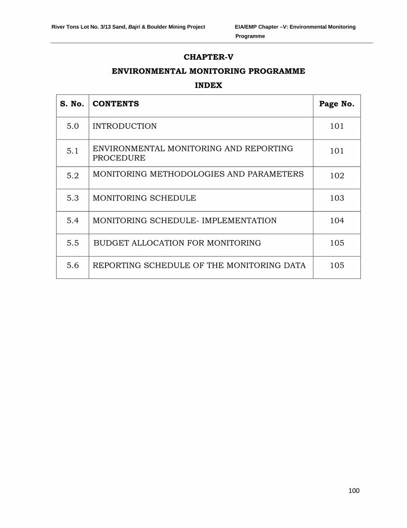
River Tons Lot No. 3/13 Sand, Bajri & Boulder Mining Project EIA/EMP Chapter –V: Environmental Monitoring Programme
100
CHAPTER-V
ENVIRONMENTAL MONITORING PROGRAMME
INDEX
S. No. CONTENTS Page No.
5.0 INTRODUCTION 101
5.1 ENVIRONMENTAL MONITORING AND REPORTING PROCEDURE
101
5.2 MONITORING METHODOLOGIES AND PARAMETERS 102
5.3 MONITORING SCHEDULE 103
5.4 MONITORING SCHEDULE- IMPLEMENTATION 104
5.5 BUDGET ALLOCATION FOR MONITORING 105
5.6 REPORTING SCHEDULE OF THE MONITORING DATA 105
River Tons Lot No. 3/13 Sand, Bajri & Boulder Mining Project EIA/EMP Chapter –V: Environmental Monitoring Programme
101
5.0 INTRODUCTION
Regular monitoring of the various environmental parameters is necessary to
evaluate the effectiveness of the management programme so that the
necessary corrective measures may be taken in case there are some
drawbacks in the proposed programme. Since environmental quality
parameters at work zone and surrounding areas are important for
maintaining sound operating practices of the project in conformity with
environmental regulations, the post project monitoring work forms part of
Environmental Monitoring Program.
Environmental Monitoring Program will be implemented once the project
activity commences. Environmental monitoring program includes (i)
environmental surveillance, (ii) analysis & interpretation of data, (iii)
preparation of reports to support environmental management system and (iv)
organizational set up responsible for the implementation of the programme.
5.1 ENVIRONMENTAL MONITORING AND REPORTING PROCEDURE
Monitoring shall confirm that commitments are being met. This may take the
form of direct measurement and recording of quantitative information, such
as amounts and concentrations of discharges and wastes, for measurement
against corporate or statutory standards, consent limits or targets. It may
also require measurement of ambient environmental quality in the vicinity of
a site using ecological/biological, physical and chemical indicators.
Monitoring may include socio-economic interaction, through local liaison
activities or even assessment of complaints.
The preventive approach to environment management may also require
monitoring of process inputs, for example, type and method used, resource
consumption, equipment and pollution control performance etc.
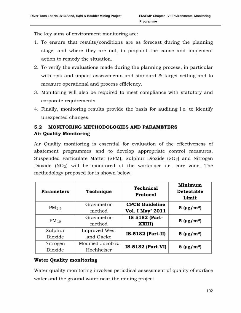
River Tons Lot No. 3/13 Sand, Bajri & Boulder Mining Project EIA/EMP Chapter –V: Environmental Monitoring Programme
102
The key aims of environment monitoring are:
1. To ensure that results/conditions are as forecast during the planning
stage, and where they are not, to pinpoint the cause and implement
action to remedy the situation.
2. To verify the evaluations made during the planning process, in particular
with risk and impact assessments and standard & target setting and to
measure operational and process efficiency.
3. Monitoring will also be required to meet compliance with statutory and
corporate requirements.
4. Finally, monitoring results provide the basis for auditing i.e. to identify
unexpected changes.
5.2 MONITORING METHODOLOGIES AND PARAMETERS Air Quality Monitoring
Air Quality monitoring is essential for evaluation of the effectiveness of abatement programmes and to develop appropriate control measures. Suspended Particulate Matter (SPM), Sulphur Dioxide (SO2) and Nitrogen Dioxide (NO2
Parameters
) will be monitored at the workplace i.e. core zone. The methodology proposed for is shown below:
Technique Technical Protocol
Minimum Detectable
Limit
PMGravimetric
method 2.5 CPCB Guideline Vol. I May’ 2011 5 (µg/m3)
PMGravimetric
method 10 IS 5182 (Part-
XXIII) 5 (µg/m3)
Sulphur Dioxide
Improved West and Gaeke
IS-5182 (Part-II) 5 (µg/m3)
Nitrogen Dioxide
Modified Jacob & Hochheiser
IS-5182 (Part-VI) 6 (µg/m3)
Water Quality monitoring
Water quality monitoring involves periodical assessment of quality of surface
water and the ground water near the mining project.
River Tons Lot No. 3/13 Sand, Bajri & Boulder Mining Project EIA/EMP Chapter –V: Environmental Monitoring Programme
103
• Surface water samples will be analyzed for all the parameters as per
EPA, 1986
• Ground water samples will be analyzed for all the parameters as per
IS-10500.
Soil Quality monitoring The soil quality monitoring is carried out to assess the soil characteristic.
The soil quality will be analyzed as per CPCB norms.
Noise Level Monitoring
Noise level monitoring will be done for achieving the following objectives:
a) To compare sound levels with the values specified in noise regulations
b) To determine the need and extent of noise control of various noise
generating sources
Noise level monitoring will be done at the work zone to assess the
occupational noise exposure levels. Noise levels will also be monitored at the
noise generating sources like mineral handling arrangements, vehicle
movements and also at the nearest village for studying the impact due to
higher noise levels for taking necessary control measures at the source.
Socio-economic Survey
Socio economic condition will be monitored to assess the demographic
particulars of the area including the impacts on the social & economical
condition on the residents nearby.
Plantation monitoring programme
Plantation monitoring will be done to ensure survival & growth rate of
plantations.
5.3 MONITORING SCHEDULE
The schedule has been shown below for the parameters proposed for
monitoring.
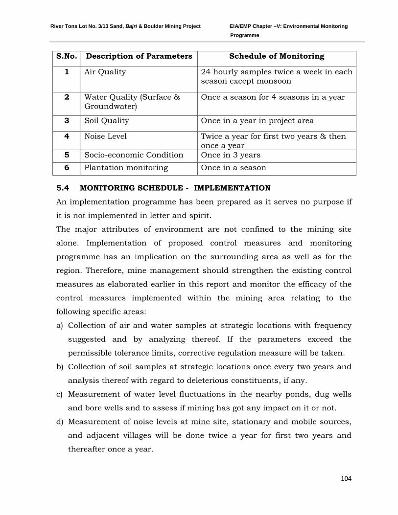
River Tons Lot No. 3/13 Sand, Bajri & Boulder Mining Project EIA/EMP Chapter –V: Environmental Monitoring Programme
104
S.No. Description of Parameters Schedule of Monitoring
1 Air Quality
24 hourly samples twice a week in each season except monsoon
2 Water Quality (Surface & Groundwater)
Once a season for 4 seasons in a year
3 Soil Quality Once in a year in project area
4 Noise Level Twice a year for first two years & then once a year
5 Socio-economic Condition Once in 3 years 6 Plantation monitoring Once in a season
5.4 MONITORING SCHEDULE - IMPLEMENTATION
An implementation programme has been prepared as it serves no purpose if
it is not implemented in letter and spirit.
The major attributes of environment are not confined to the mining site
alone. Implementation of proposed control measures and monitoring
programme has an implication on the surrounding area as well as for the
region. Therefore, mine management should strengthen the existing control
measures as elaborated earlier in this report and monitor the efficacy of the
control measures implemented within the mining area relating to the
following specific areas:
a) Collection of air and water samples at strategic locations with frequency
suggested and by analyzing thereof. If the parameters exceed the
permissible tolerance limits, corrective regulation measure will be taken.
b) Collection of soil samples at strategic locations once every two years and
analysis thereof with regard to deleterious constituents, if any.
c) Measurement of water level fluctuations in the nearby ponds, dug wells
and bore wells and to assess if mining has got any impact on it or not.
d) Measurement of noise levels at mine site, stationary and mobile sources,
and adjacent villages will be done twice a year for first two years and
thereafter once a year.
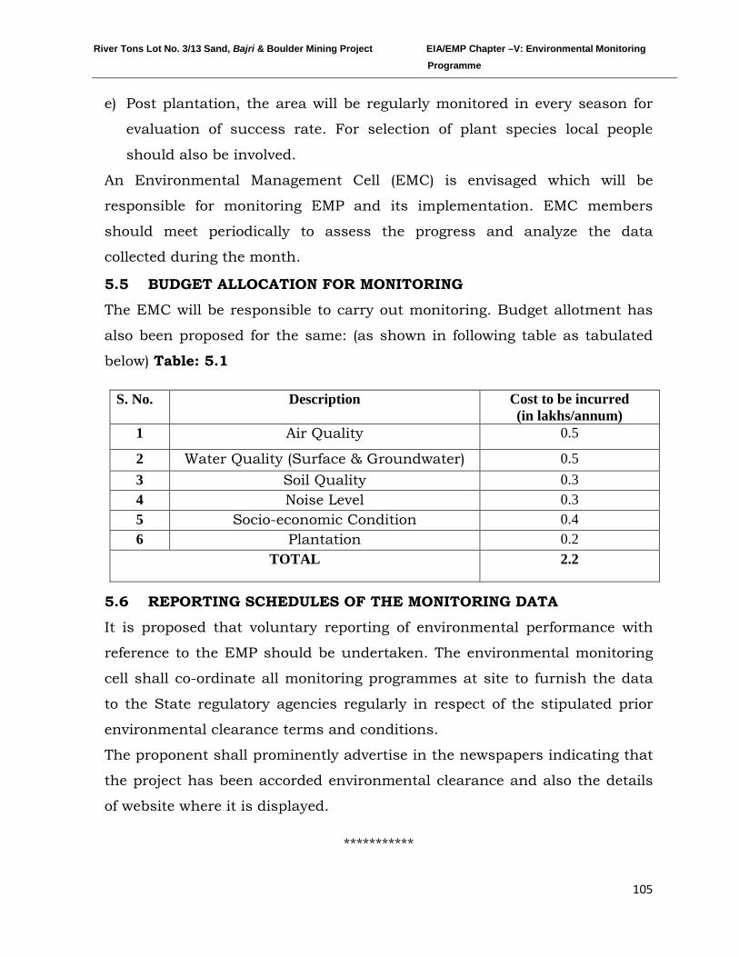
River Tons Lot No. 3/13 Sand, Bajri & Boulder Mining Project EIA/EMP Chapter –V: Environmental Monitoring Programme
105
e) Post plantation, the area will be regularly monitored in every season for
evaluation of success rate. For selection of plant species local people
should also be involved.
An Environmental Management Cell (EMC) is envisaged which will be
responsible for monitoring EMP and its implementation. EMC members
should meet periodically to assess the progress and analyze the data
collected during the month.
5.5 BUDGET ALLOCATION FOR MONITORING
The EMC will be responsible to carry out monitoring. Budget allotment has
also been proposed for the same: (as shown in following table as tabulated
below) Table: 5.1
S. No. Description Cost to be incurred (in lakhs/annum)
1 Air Quality 0.5
2 Water Quality (Surface & Groundwater) 0.5 3 Soil Quality 0.3 4 Noise Level 0.3 5 Socio-economic Condition 0.4 6 Plantation 0.2
TOTAL 2.2
5.6 REPORTING SCHEDULES OF THE MONITORING DATA
It is proposed that voluntary reporting of environmental performance with
reference to the EMP should be undertaken. The environmental monitoring
cell shall co-ordinate all monitoring programmes at site to furnish the data
to the State regulatory agencies regularly in respect of the stipulated prior
environmental clearance terms and conditions.
The proponent shall prominently advertise in the newspapers indicating that
the project has been accorded environmental clearance and also the details
of website where it is displayed.
***********
River Tons Lot No. 3/13 Sand, Bajri & Boulder Mining Project EIA/EMP Chapter –VI Additional Studies
106
CHAPTER-VI
ADDITIONAL STUDIES
INDEX
S. No. CONTENTS Page
No.
6.0 PUBLIC CONSULTATION 107
6.1 HAZARD IDENTIFICATION AND RISK ASSESSMENT METHOLODOGY
108
6.2 RISK ASSESSMENT 109
6.3 DISASTERS & ITS MANAGEMENT 114
6.4 SOCIO-ECONOMIC IMPACT OF THE PROJECT & SAFETY MEASURES
116
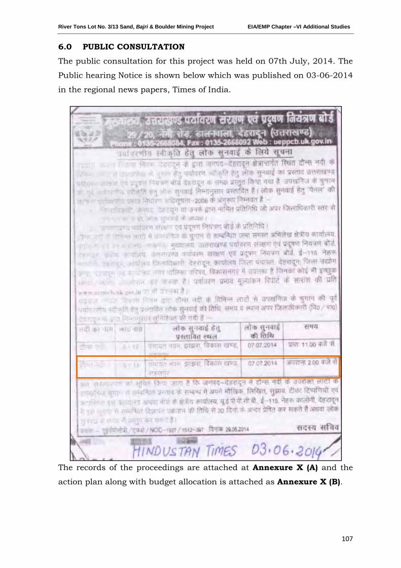
River Tons Lot No. 3/13 Sand, Bajri & Boulder Mining Project EIA/EMP Chapter –VI Additional Studies
107
6.0 PUBLIC CONSULTATION
The public consultation for this project was held on 07th July, 2014. The
Public hearing Notice is shown below which was published on 03-06-2014
in the regional news papers, Times of India.
The records of the proceedings are attached at Annexure X (A) and the
action plan along with budget allocation is attached as Annexure X (B).
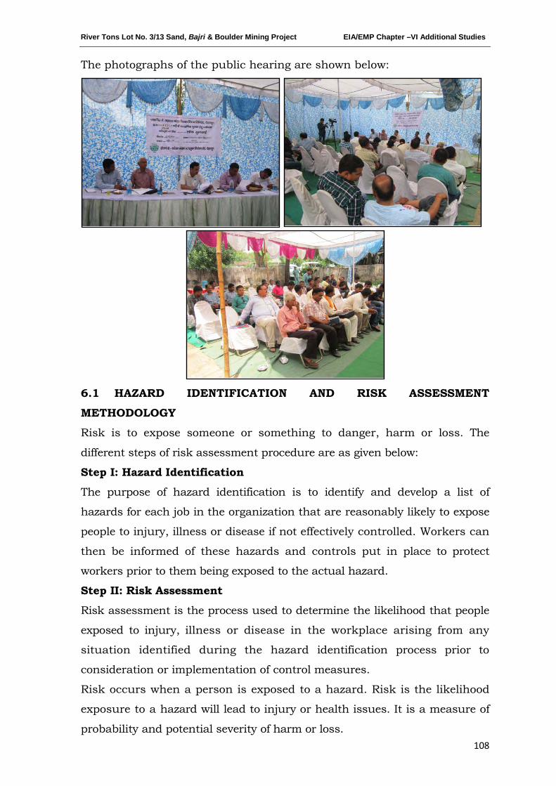
River Tons Lot No. 3/13 Sand, Bajri & Boulder Mining Project EIA/EMP Chapter –VI Additional Studies
108
The photographs of the public hearing are shown below:
6.1 HAZARD IDENTIFICATION AND RISK ASSESSMENT
METHODOLOGY
Risk is to expose someone or something to danger, harm or loss. The
different steps of risk assessment procedure are as given below:
Step I: Hazard Identification
The purpose of hazard identification is to identify and develop a list of
hazards for each job in the organization that are reasonably likely to expose
people to injury, illness or disease if not effectively controlled. Workers can
then be informed of these hazards and controls put in place to protect
workers prior to them being exposed to the actual hazard.
Step II: Risk Assessment
Risk assessment is the process used to determine the likelihood that people
exposed to injury, illness or disease in the workplace arising from any
situation identified during the hazard identification process prior to
consideration or implementation of control measures.
Risk occurs when a person is exposed to a hazard. Risk is the likelihood
exposure to a hazard will lead to injury or health issues. It is a measure of
probability and potential severity of harm or loss.
River Tons Lot No. 3/13 Sand, Bajri & Boulder Mining Project EIA/EMP Chapter –VI Additional Studies
109
Step III: Risk Control
Risk control is the process used to identify, develop, implement and
continually review all practicable measures for eliminating or reducing
the likelihood of an injury, illness or diseases in the workplace.
Step IV: Implementation of risk controls
All hazards that have been assessed should be dealt in order of priority in
one or more of the following hierarchy of controls
The most effective methods of control are:
i. Elimination of hazards
ii. Substitute something safer
iii. Use engineering/design controls
iv. Use administrative controls such as safe work procedures
v. Protect the workers i.e. by ensuring competence through supervision and
training, etc.
Each measure must have a designated person assigned for the
implementation of controls. This ensures that all required safety measures
will be completed.
Step V: Monitor and Review
Hazard identification, risk assessment and control are an on-going
processes. Therefore regularly review the effectiveness of your hazard
assessment and control measures. Make sure that you undertake a
hazard and risk assessment when there is change to the workplace
including when work systems, tools, machinery or equipment changes.
Provide additional supervision when the new employees with reduced skill
levels or knowledge are introduced to the workplace.
A) RISK ANALYSIS
The risk assessment portion of the process involves three levels of site
evaluation:
a) Initial Site Evaluation,
b) Detailed Site Evaluation,
c) Priority Site Investigations and Recommendations.
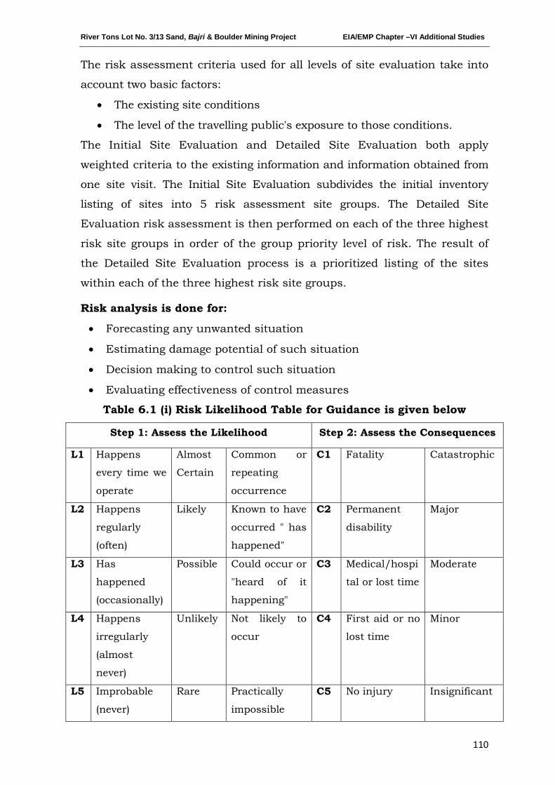
River Tons Lot No. 3/13 Sand, Bajri & Boulder Mining Project EIA/EMP Chapter –VI Additional Studies
110
The risk assessment criteria used for all levels of site evaluation take into
account two basic factors:
• The existing site conditions
• The level of the travelling public's exposure to those conditions.
The Initial Site Evaluation and Detailed Site Evaluation both apply
weighted criteria to the existing information and information obtained from
one site visit. The Initial Site Evaluation subdivides the initial inventory
listing of sites into 5 risk assessment site groups. The Detailed Site
Evaluation risk assessment is then performed on each of the three highest
risk site groups in order of the group priority level of risk. The result of
the Detailed Site Evaluation process is a prioritized listing of the sites
within each of the three highest risk site groups.
Risk analysis is done for:
• Forecasting any unwanted situation
• Estimating damage potential of such situation
• Decision making to control such situation
• Evaluating effectiveness of control measures
Table 6.1 (i) Risk Likelihood Table for Guidance is given below
Step 1: Assess the Likelihood Step 2: Assess the Consequences
L1 Happens
every time we
operate
Almost
Certain
Common or
repeating
occurrence
C1 Fatality Catastrophic
L2 Happens
regularly
(often)
Likely Known to have
occurred " has
happened"
C2 Permanent
disability
Major
L3 Has
happened
(occasionally)
Possible Could occur or
"heard of it
happening"
C3 Medical/hospi
tal or lost time
Moderate
L4 Happens
irregularly
(almost
never)
Unlikely Not likely to
occur
C4 First aid or no
lost time
Minor
L5 Improbable
(never)
Rare Practically
impossible
C5 No injury Insignificant
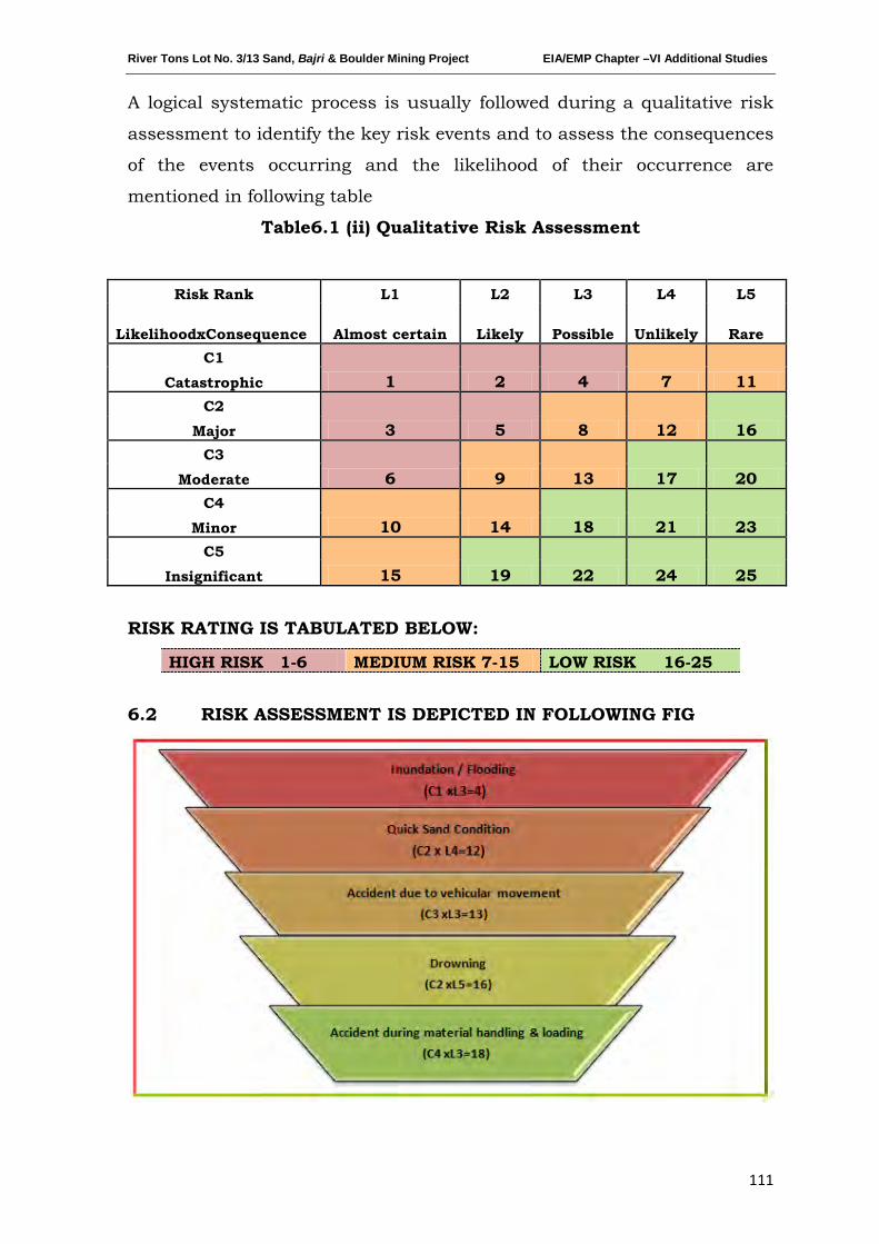
River Tons Lot No. 3/13 Sand, Bajri & Boulder Mining Project EIA/EMP Chapter –VI Additional Studies
111
A logical systematic process is usually followed during a qualitative risk
assessment to identify the key risk events and to assess the consequences
of the events occurring and the likelihood of their occurrence are
mentioned in following table
Table6.1 (ii) Qualitative Risk Assessment
Risk Rank L1 L2 L3 L4 L5
LikelihoodxConsequence Almost certain Likely Possible Unlikely Rare C1
1 2 4 7 11 Catastrophic C2
3 5 8 12 16 Major C3
6 9 13 17 20 Moderate C4
10 14 18 21 23 Minor C5
15 19 22 24 25 Insignificant
RISK RATING IS TABULATED BELOW:
HIGH RISK 1-6 MEDIUM RISK 7-15 LOW RISK 16-25
6.2 RISK ASSESSMENT IS DEPICTED IN FOLLOWING FIG
River Tons Lot No. 3/13 Sand, Bajri & Boulder Mining Project EIA/EMP Chapter –VI Additional Studies
112
There are various factors, which can create unsafe working
conditions/hazards in mining of minor minerals from river bed.
The key risk (hazard x probability) event rating
6.2.1 INUNDATION/FLOODING
associated with sand bed
mining and to assess its consequences of such events occurring and the
likelihood based on above Table-2 are as:-
The Risk rating of such hazards is as follows:
The risk rating assigned to this activity is assigned as ‘4’ i.e., it is possible
and will have catastrophic with major consequences, if work started
without assessment of the river bed condition especially during monsoon
season.
Inundation or flooding is expected and beneficial for these mines as
during this time only the mineral reserve gets replenished.
Measures to prevent consequences of Inundation/Flooding
Inundation of flooding is expected and beneficial for these mines as
during this time only the mineral reserve gets replenished.
1. During monsoon months and heavy rains the mining operations are
ceased.
2. There should be mechanism/warning system of heavy rains and
discharges from the upstream dams.
6.2.2 Quick Sand Condition
The risk rating assigned to this activity is assigned as ‘12’ i.e., it is an
unlikely event with major consequences as frequency of this risk is less
likely to occur.
Two things may create the conditions to form quicksand. Underground
water may seep-up and saturate the sand, thereby reducing the friction
between the sand grains and giving the sand a liquid nature. Or, sand or
another soil may be sifted by the force of an earthquake so that friction is
lessened and the earth becomes unsteady.
This creates danger condition to the trucks plying near the river bed and
banks for transportation of minerals.
River Tons Lot No. 3/13 Sand, Bajri & Boulder Mining Project EIA/EMP Chapter –VI Additional Studies
113
Measures to Prevent Quick Sand Condition
1. The only way to avoid quick sand condition is by avoiding mineral
lifting below water table.
2. Mining will be done in layers rather than going for maximum depth at
one time.
6.2.3 ACCIDENT DUE TO VEHICULAR MOVEMENT
The risk rating assigned to this activity is assigned as ‘13’ i.e., it is
possible event with moderate consequences as frequency of this operation
is more but the predicted/assumed intensity is less like minor cuts,
bodily injury. The possibilities of road accidents are due to reckless or
untrained driver or overloading of trucks or in case pathway is not
compacted suitably, etc.
Measures to Prevent Accidents during Transportation
1. All transportation within the main working should be carried out
directly under the supervision and control of the management.
2. The Vehicles will be maintained/repaired and checked thoroughly by
the competent person.
3. A statutory provision of constant education, training etc. will go a
long way in reducing the incidents of such accidents.
4. Overloading will not be permitted and will be covered with tarpaulin.
5. The maximum permissible speed limit will be ensured.
6. The truck drivers will have valid driving license.
6.2.4 DROWNING
The risk rating assigned to this activity is assigned as ‘16’ i.e., it is a rare
accident but will have major consequences, if occurred. This may occur
due to flash floods etc due to which the workers at the site may get
seriously injured or drowned.
Measure to Prevent Drowning
1. The mining will be done under strict supervision and only in the dry
part of the river.
2. Mining will be completely stopped in monsoon season to avoid such
accidents.
3. Deep water areas will be identified and ‘No Go Zones’ will be clearly
marked and made aware to the mine workers.
River Tons Lot No. 3/13 Sand, Bajri & Boulder Mining Project EIA/EMP Chapter –VI Additional Studies
114
6.2.5 ACCIDENT DURING MATERIAL HANDLING & LOADING
The risk rating assigned to this activity is assigned as ‘18’ i.e. it is possible
event with minor consequences”, as frequency of this operation is more
but the predicted/assumed intensity is less like minor cuts, abrasion, etc.
may be due to river bank collapse, over thrown boulders/pebbles, injuries
due to carelessness use of hand tools, etc.
Measures to Prevent Accidents during material handling & loading
1. The truck should be brought to a lower level so that the loading
operation suits to the ergonomic condition of the workers.
2. The loading should be done from one side of the truck only to avoid
over throw of materials.
3. The workers should be provided with gloves and safety shoes during
loading.
All the activities will be done under strict supervision/control to avoid
anticipated accidents so that the risk is reduced to a level considered As
Low As Reasonably Practicable (ALARP) conditions which are
adequately safe and healthy
6.3 DISASTERS & ITS MANAGEMENT
6.3.1 Anticipated Disasters
1. Floods: The area is not highly prone to floods but however cloud
bursts may cause floods & flashflood near the proposed site.
Precautionary measures will be taken and in disaster management,
it will be considered to avoid the impending effects on the workers
at the site if the disaster happens to occur.
2. Earth Quake: The lease area falls in seismic zone IV which is prone
to earthquakes as shown below.
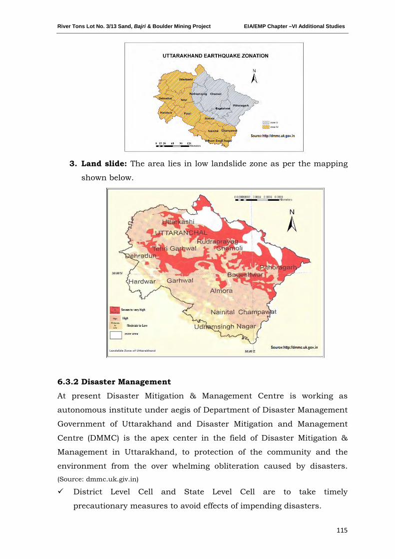
River Tons Lot No. 3/13 Sand, Bajri & Boulder Mining Project EIA/EMP Chapter –VI Additional Studies
115
3. Land slide: The area lies in low landslide zone as per the mapping
shown below.
6.3.2 Disaster Management
At present Disaster Mitigation & Management Centre is working as
autonomous institute under aegis of Department of Disaster Management
Government of Uttarakhand and Disaster Mitigation and Management
Centre (DMMC) is the apex center in the field of Disaster Mitigation &
Management in Uttarakhand, to protection of the community and the
environment from the over whelming obliteration caused by disasters. (Source: dmmc.uk.giv.in)
District Level Cell and State Level Cell are to take timely
precautionary measures to avoid effects of impending disasters.
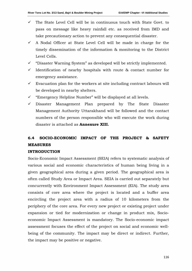
River Tons Lot No. 3/13 Sand, Bajri & Boulder Mining Project EIA/EMP Chapter –VI Additional Studies
116
The State Level Cell will be in continuous touch with State Govt. to
pass on message like heavy rainfall etc. as received from IMD and
take precautionary action to prevent any consequential disaster.
A Nodal Officer at State Level Cell will be made in charge for the
timely dissemination of the information & monitoring to the District
Level Cells.
“Disaster Warning System” as developed will be strictly implemented.
Identification of nearby hospitals with route & contact number for
emergency assistance.
Evacuation plan for the workers at site including contract labours will
be developed in nearby shelters.
“Emergency Helpline Number” will be displayed at all levels.
Disaster Management Plan prepared by The State Disaster
Management Authority Uttarakhand will be followed and the contact
numbers of the person responsible who will execute the work during
disaster is attached as Annexure XIII.
6.4 SOCIO-ECONOMIC IMPACT OF THE PROJECT & SAFETY
MEASURES
INTRODUCTION
Socio-Economic Impact Assessment (SEIA) refers to systematic analysis of
various social and economic characteristics of human being living in a
given geographical area during a given period. The geographical area is
often called Study Area or Impact Area. SEIA is carried out separately but
concurrently with Environment Impact Assessment (EIA). The study area
consists of core area where the project is located and a buffer area
encircling the project area with a radius of 10 kilometers from the
periphery of the core area. For every new project or existing project under
expansion or tied for modernization or change in product mix, Socio-
economic Impact Assessment is mandatory. The Socio-economic impact
assessment focuses the effect of the project on social and economic well-
being of the community. The impact may be direct or indirect. Further,
the impact may be positive or negative.
River Tons Lot No. 3/13 Sand, Bajri & Boulder Mining Project EIA/EMP Chapter –VI Additional Studies
117
SOCIO-ECONOMIC IMPACT OF THE PROJECT
Impact on Demographic Composition
The proposed project will hardly make any difference in the demographic
composition of the study area as the additional employment it envisages
to create will be met locally to the maximum extent. Hence, the chances of
in-migration of people from outside the study area are remote.
Accordingly, there will be no variation in the total population of the study
area including that of sex ratio, when the mine starts operating.
Employment Opportunities
The proposed project will provide employment to local people. The number
of workers to be deployed in the mining project will depend upon the
quantity of minerals to be extracted from the mine by the lease holder.
Both the miners and the unskilled workers will be recruited locally. It is
estimated that 54 people will get direct employment in this mining project
for a period of nine months in a year. Besides the above the project is
expected to generate indirect employment to the extent of 50 persons in
the informal sector. It is a positive impact of the project since it is
providing employment opportunities to the local people. The project will
not affect the vulnerable groups of people.
Increased Supply of minerals in the market
Sand, bajri and boulders has many uses. Mixed with cement and lime it is
used in masonry construction. It is a critical component of concrete
mixture. Both Government departments and private developers have
taken up construction of roads, bridges and buildings in a big way.
Hence, the demand for sand, bajri and boulder is ever increasing with the
growth of the infrastructure development in our country. The requirement
for the building materials is always high and there is already an acute
shortage of sand in the market and the construction industry is the main
sufferer. With the commencement of the proposed mining project the
supply of minerals will increase and the gap between demand and supply
will decrease to some extent, if not fully.
Impact on Agriculture
The entire mining area is part of river bed and the entire land is
Government Revenue Land. It is non-forest land and the proposed activity
River Tons Lot No. 3/13 Sand, Bajri & Boulder Mining Project EIA/EMP Chapter –VI Additional Studies
118
is to take place in the bed of the River Tons. There will be no negative
impact on agriculture as no cultivation is taking place on the proposed
mining area. Since, scientific mining will be adopted in the proposed
mining project the area will not face flood due to mining, which destroy
standing crops and land & property. This is a positive impact of the
proposed mining project.
Impact on Road Development
Movement of trucks/tractors and other vehicles to and fro the mining site
is expected to increase, when mining will start. The existing roads
connecting the quarry with the national highways are connected by
metalled and un-metalled roads. Hence, there is need for road
maintenance and repairing regularly in the mining area. Further, there
are risks of accidents during loading of extracted minerals into trucks and
transportation to markets for sells. However, accidents can be avoided by
taking due care and precautions.
Income to Government
The proposed mining activity will benefit the State in the form of royalty,
dead rent, fees and earnings from taxes.
Impact on Law & Order
As most of the workers to be employed in the proposed mining project are
local residents no law & order problem is envisaged. It is expected that
the workers will attend to their duties from their residence and return to
their homes after the day’s work. There would have been law & order
problem if the workers were migrants and lived in shanties closed to the
mining area. However, to meet any untoward incident one police post may
be set up closed to the mining site.
Impact on Health
There are no chances of occurring diseases, due to manual mining of
sand, bajri and boulder. Sand is non-toxic. However, sand-using activities
require precautions since it create respiratory problems among mine
workers. Excessive inhalation of sand is a serious health concern. To
avoid respiratory problem from sand necessary protection shall be taken.

River Tons Lot No. 3/13 Sand, Bajri & Boulder Mining Project EIA/EMP Chapter –VI Additional Studies
119
Few safety measures are outlined below:
a) Safe Working Environment: The project proponent shall ensure
health and safety of all the employees at work. Efforts will be made to
provide and maintain a safe work environment and ensure that the
machinery and equipment in use is safe for employees. Further, it will
be ensured that working arrangements are not hazardous to
employees.
b) Provision of First Aid: The first aid treatment reflects the hazards
associated with the mining of Sand, Bajri & Boulder. The first-aiders
will be well trained in handling patients working in the above Mining
Project.
c) Regular Health Examination: For all mine workers regular health
examination will be made compulsory. It will cover treatment of serious
back injury; existing asthma or respiratory diseases, existing skin
diseases, lung function test (pre and post ventolin), Audiograms, Chest
X- ray etc.
d) No work for Temporal Disabilities: The workers having temporary
disability will be asked to stop doing the job till he/she recovers from
disabilities.
e) Health Education: Adequate health education and information related
to the job will be provided to the workers. Baseline health information
will be recorded for future references.
f) Tie-up with the Nearest Hospital for Medical Assistance: To meet
the medical needs of the mine workers tie-up with nearest hospitals
will be made. Efforts will be made to reserve few beds in the above
hospitals for the workers of the mining project. This will ensure timely
medical aid to the affected persons.
g) Supply of Mask and Gloves: The workers in the Sand, Bajri & Boulder
mining project are subject to respiratory diseases. For protection from
dust it will be made compulsory for all workers to wear masks and
gloves, while working in the mine.
h) Administration of Anti-venom Injections: Provision of Anti-venom
therapy will be made available for administration to the workers in
case of snake, spider and insect bites, while working in the mine.
River Tons Lot No. 3/13 Sand, Bajri & Boulder Mining Project EIA/EMP Chapter –VI Additional Studies
120
i) Special Telephone Number: A special telephone number will be made
available to the workers in case of emergency so that they can dial the
same for–medical assistances. Further, efforts will be made to provide
vehicles to the patients in short duration for shifting to a hospital.
j) Special Group Insurance Scheme: All the mine workers will be
covered under a Group Insurance Scheme of LIC or any other
Insurance company.
CONCLUSION
The commissioning of Sand, Bajri & Boulder Mining Project will provide
employment to local people who are in search of the same. The granting of
environment clearance to M/S Garhwal Mandal Vikas Nigam Ltd will
make mining of Sand, Bajri & Boulder legally valid and it will generate
revenue for the state. With the implementation of the project the
occupational pattern of the people in the area will change making more
people engaged in mining, industrial and business activities rather in
agriculture only. It is expected that mineral resource, employment and
other community facilities will improve to a great extent with the opening
of the project and associated industrial and business activities.
*************
River Tons Lot No. 3/13 Sand, Bajri & Boulder Mining Project EIA/EMP Chapter - VII Project benefits
121
CHAPTER-VII
PROJECT BENEFITS
INDEX
S.
No.
CONTENTS Page
No.
7.0 GENERAL 122
7.1 PHYSICAL BENIFITS 122
7.2 SOCIAL BENIFITS 122
7.3 ENVIRONMENTAL BENIFITS 123
7.4 CORPORATE SOCIAL RESPONSIBILITY 123
River Tons Lot No. 3/13 Sand, Bajri & Boulder Mining Project EIA/EMP Chapter - VII Project benefits
122
7.0 GENERAL
The execution of the project, bring overall improvement in the locality,
neighborhood and the State by bringing industry, roads, employment and
hence improving living standard and economic growth.
7.1 PHYSICAL BENIFITS
The opening of the proposed project will enhance the following physical
infrastructure facilities in the adjoining areas.
a. Road Transport: There will be improved road communication due to
the proposed project and maintenance will also be done time to time.
b. Market: Generating useful economic resource for construction.
Excavated mineral will provide a good market opportunity.
c. Enhancement of green cover: As a part of reclamation plan,
plantation will be carried along the river banks or along the road sides
or near the civic amenities.
a. Creation of community assets (infrastructure) like provision for
drinking water, construction of school buildings, village roads/ linked
roads, dispensary & health centre, community centre, market place
etc, as a part of corporate social responsibility.
7.2 SOCIAL BENEFITS
a) Increase in Employment Potential due to the project activity.
Employment opportunities will increase both directly as well indirectly.
b) Contribution to the Exchequer as the saleable minerals will be given
royalty. Since the quarries will be leased out to successful allottees,
mining operation in the state will get legalized and it will fetch income
to the state exchequer.
c) Increased Health related activities: Healthcare promotional activities
will be undertaken. Pre-placement & and Periodic medical checkups
will be done, which will lift the general health status of the residents of
the area. Health camps, medical aids, family welfare programs,
immunization camp sports will be arranged.
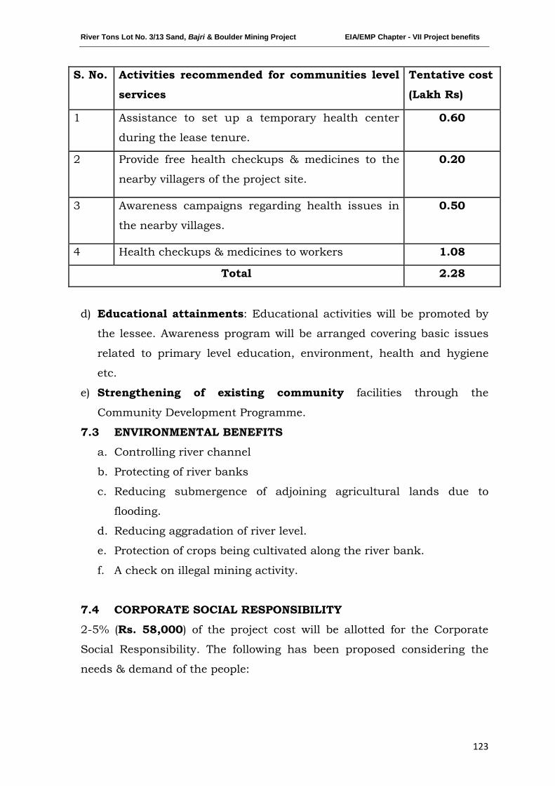
River Tons Lot No. 3/13 Sand, Bajri & Boulder Mining Project EIA/EMP Chapter - VII Project benefits
123
S. No. Activities recommended for communities level
services
Tentative cost
(Lakh Rs)
1 Assistance to set up a temporary health center
during the lease tenure.
0.60
2 Provide free health checkups & medicines to the
nearby villagers of the project site.
0.20
3 Awareness campaigns regarding health issues in
the nearby villages.
0.50
4 Health checkups & medicines to workers 1.08
Total 2.28
d) Educational attainments: Educational activities will be promoted by
the lessee. Awareness program will be arranged covering basic issues
related to primary level education, environment, health and hygiene
etc.
e) Strengthening of existing community facilities through the
Community Development Programme.
7.3 ENVIRONMENTAL BENEFITS
a. Controlling river channel
b. Protecting of river banks
c. Reducing submergence of adjoining agricultural lands due to
flooding.
d. Reducing aggradation of river level.
e. Protection of crops being cultivated along the river bank.
f. A check on illegal mining activity.
7.4 CORPORATE SOCIAL RESPONSIBILITY
2-5% (Rs. 58,000) of the project cost will be allotted for the Corporate
Social Responsibility. The following has been proposed considering the
needs & demand of the people:
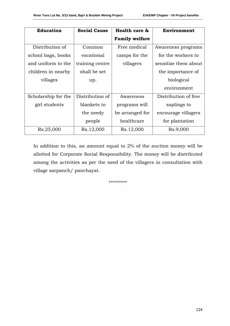
River Tons Lot No. 3/13 Sand, Bajri & Boulder Mining Project EIA/EMP Chapter - VII Project benefits
124
Education Social Cause Health care &
Family welfare
Environment
Distribution of
school bags, books
and uniform to the
children in nearby
villages
Common
vocational
training centre
shall be set
up.
Free medical
camps for the
villagers
Awareness programs
for the workers to
sensitize them about
the importance of
biological
environment
Scholarship for the
girl students
Distribution of
blankets to
the needy
people
Awareness
programs will
be arranged for
healthcare
Distribution of free
saplings to
encourage villagers
for plantation
Rs.25,000 Rs.12,000 Rs.12,000 Rs.9,000
In addition to this, an amount equal to 2% of the auction money will be
allotted for Corporate Social Responsibility. The money will be distributed
among the activities as per the need of the villagers in consultation with
village sarpanch/ panchayat.
*********
River Tons Lot No. 3/13 Sand, Bajri & Boulder Mining Project EIA/EMP Chapter - VIII Environmental Management Plan
125
CHAPTER-VIII
ENVIRONMENTAL MANAGEMENT PLAN
INDEX
S. No. CONTENTS Page No.
8.0 INTRODUCTION 126
8.1 ENVIRONMENTAL MANAGEMENT CELL (EMC) 126
8.2 ENVIRONMENTAL MANAGEMENT PLAN (EMP) & IMPLEMENTATION 128
8.3 BUDGET ALLOCATION FOR EMP IMPLEMENTATION 132

River Tons Lot No. 3/13 Sand, Bajri & Boulder Mining Project EIA/EMP Chapter - VIII Environmental Management Plan
126
8.0 INTRODUCTION
To mitigate the adverse impact which is likely to be caused due to the mining
operation and overall scientific development of local habitat, Environmental
Management Plan (EMP) has been formulated and integrated with the mine
planning. The details of the anticipated impacts and mitigative measures
have been discussed in Chapter IV (Page no. 87-96) of this report, based on
the results of present environmental conditions and environmental impact
assessment. The EMP has therefore been made considering implementation
and monitoring of environmental protection measures during and after
mining operations.
The mitigation measures which reduce the impact have already been
identified earlier in this report in Chapter IV (Page no. 87-96). To minimize
the adverse impact, certain additional EMP measures are enumerated below
for implementation.
8.1 ENVIRONMENTAL MANAGEMENT CELL (EMC)
It is imperative to establish an effective organization to implement, maintain,
monitor and control the environmental management system. A separate
Environmental Management Cell (EMC) will be formed to look after the
environment related matter of the mine. The structure of EMC is as follows:
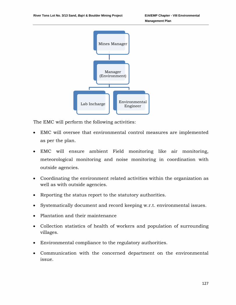
River Tons Lot No. 3/13 Sand, Bajri & Boulder Mining Project EIA/EMP Chapter - VIII Environmental Management Plan
127
The EMC will perform the following activities:
• EMC will oversee that environmental control measures are implemented
as per the plan.
• EMC will ensure ambient Field monitoring like air monitoring,
meteorological monitoring and noise monitoring in coordination with
outside agencies.
• Coordinating the environment related activities within the organization as well as with outside agencies.
• Reporting the status report to the statutory authorities.
• Systematically document and record keeping w.r.t. environmental issues.
• Plantation and their maintenance
• Collection statistics of health of workers and population of surrounding villages.
• Environmental compliance to the regulatory authorities.
• Communication with the concerned department on the environmental issue.
Mines Manager
Manager (Environment)
Lab Incharge Environmental Engineer
River Tons Lot No. 3/13 Sand, Bajri & Boulder Mining Project EIA/EMP Chapter - VIII Environmental Management Plan
128
• Monitoring the progress of implementation of environmental management programme.
8.2 ENVIRONMENTAL MANAGEMENT PLAN (EMP) AND
IMPLEMEMNTATION
Environmental Management Plan involves functions that determines the
objectives, adoption of appropriate mitigation measures, protection of
ecosystems, enhancement of the quality of life for those affected, and
minimization of environmental costs (Barrow, 1999).
Environmental Management Plan (EMP) has been formulated with an
objective to mitigate the adverse impacts of any proposed project. This
includes an environmental policy on protection of environment and public
safety.
1. Extraction will be done from the river bed leaving safety zone from bank & stream: • Mining will be done in scientific and systematic manner.
• Mineral will be mined out leaving sufficient safety barrier of 15 percent of
width of the river for bank stability.
• A maximum of 10m from the stream will also be left to avoid interface of
mining activity with surface water.
2. The maximum working depth will remain above ground water table of the area:
Excavation above the water table will be done i.e. up to a maximum depth
of 1.5m from the surface, which will provide a depression that would get
filled in with sediments gradually in the monsoons. Further it will not
disturb the ground water quality of the area as there will be no
intersection with the water table.
3. Provide health facilities to the workers & surrounding people in the impact area to reduce the health impacts:
River Tons Lot No. 3/13 Sand, Bajri & Boulder Mining Project EIA/EMP Chapter - VIII Environmental Management Plan
129
• Provision of dust filters / mask to workers working at dust prone and
affected areas.
• Conducting periodical medical checkup of all workers for occupation
related health problems.
• Awareness program for workers to make them aware of way of working
and various precautions to be taken while at work.
4. Ensuring wildlife protection & arranging awareness campaigns
for the same.
• No wildlife will be disturbed or chased away
• Also Wildlife Movement Route (Animal Corridors) will not be disturbed.
• To avoid disturbance to the movement of the wild animals through the
transport route near the project area, sign boards will be placed detailing
the dangers caused and the location of corridors.
5. Minimize activities that release fine sediment to the river:
No washing, crushing, screening, stockpiling, or plant operations will be
done at or near the streams. These and similar activities have the potential
to release fine sediments into the stream, making aquatic habitat conditions
harmful to local aquatic species.
6. Check on traffic load due to transportation & maintenance of
evacuation route:
• To the extent possible, evacuation route will not be through residential
areas so as to reduce the effect of dust emission and noise pollution from
vehicular movement.
• Alternate evacuation route by using the existing roads will be proposed to
avoid traffic congestion.
• A Monitoring Committee including Local Panchayat member may be
established to control traffic on evacuation route.
River Tons Lot No. 3/13 Sand, Bajri & Boulder Mining Project EIA/EMP Chapter - VIII Environmental Management Plan
130
7. Effective mitigation measures will be adopted to minimize
disturbance during transportation & handling of minerals:
• The haul road will be kept wide, leveled, compacted and water will be
sprayed regularly to suppress fugitive dust.
• Evacuation routes will be repaired & maintained regularly.
• Utmost care will be taken to prevent spillage of minerals from the trucks
by checking overloading and covering it by tarpaulin sheets
• It will be ensured that all transportation vehicles will carry a valid PUC
certificate.
8. Establishment of reclamation program with plantation of local/native & fast growing species: • Plantation will be done along the road sides / near civic amenities in
consultation with the local authority/ Govt. bodies.
• It has also been proposed to plant along the river banks with plant
species which will hold the soil and check on erosion of the banks. Eg.
Vetiveria zizanioides, Saccharum spontaneum, Pennisetum pupureum, etc.
• For plantation purpose, native/local plant species are proposed along the
road sides/civic amenities.
9. Establishment of restoration plan during the closure of mine at
the onset of monsoon season:
• Restoration of banks will be done.
• Ramps & temporary rest shelters will be removed prior to the closure of
mine.
• Restructuring/reconstruction of the natural bunds if damaged, so that
over flow of water can be controlled and flooding can be avoided
• Maintenance of check dams & retention walls which will prevent erosion
of banks during monsoon.
River Tons Lot No. 3/13 Sand, Bajri & Boulder Mining Project EIA/EMP Chapter - VIII Environmental Management Plan
131
10. Establishment of effective Disaster Management Plan to take
timely precautionary measures to avoid effects of impending
disasters:
Being a project on the river bed and though mining will not be done during
monsoon, yet disaster may be caused due to earth quake, release of water
from upstream dams or dam burst.
• District Level Cell and State Level Cell along with a nodal officer will be
set up. The State Level Cell will be in continuous touch with State Govt.
to pass on message so as to take precautionary action to prevent any
consequential disaster.
• “Disaster Warning System” as developed will be strictly implemented.
• Identification of nearby hospitals with route & contact number for
emergency assistance prior to the commencement of projects.
• Evacuation plan for the workers at site including contract labours will be
developed in nearby shelters.
• “Emergency Helpline Number” will be displayed at all levels.
11. Establishment of effective Monitoring Program monitored by
Environment Management Cell:
A monitoring program will be provided illustrating any impacts to river
stability, riparian vegetation, ground & surface water, air, noise, soil
quality and post project sedimentation studies by expert bodies. Monitoring
schedule and budget allocation has been detailed Chapter-V (Page no. 104
-105).
The monitoring program will also assess & scrutinize the EMP proposed &
its implementation by the Environmental Management Cell (EMC).
Other precautionary measures like no cooking, no uprooting or chopping of
plants/trees, no throwing of wastes into the stream will also be checked
upon by the EMC.
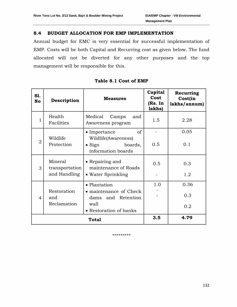
River Tons Lot No. 3/13 Sand, Bajri & Boulder Mining Project EIA/EMP Chapter - VIII Environmental Management Plan
132
8.4 BUDGET ALLOCATION FOR EMP IMPLEMENTATION
Annual budget for EMC is very essential for successful implementation of
EMP. Costs will be both Capital and Recurring cost as given below. The fund
allocated will not be diverted for any other purposes and the top
management will be responsible for this.
Table 8.1 Cost of EMP
Sl. No Description Measures
Capital Cost
(Rs. In lakhs)
Recurring Cost(in
lakhs/annum)
1 Health Facilities
Medical Camps and Awareness program 1.5 2.28
2 Wildlife Protection
• Importance of Wildlife(Awareness)
• Sign boards, information boards
-
0.5
0.05
0.1
3 Mineral transportation and Handling
• Repairing and maintenance of Roads
• Water Sprinkling
0.5
-
0.3
1.2
4 Restoration and Reclamation
• Plantation • maintenance of Check
dams and Retention wall
• Restoration of banks
1.0 - -
0.36
0.3
0.2
Total 3.5 4.79
*********
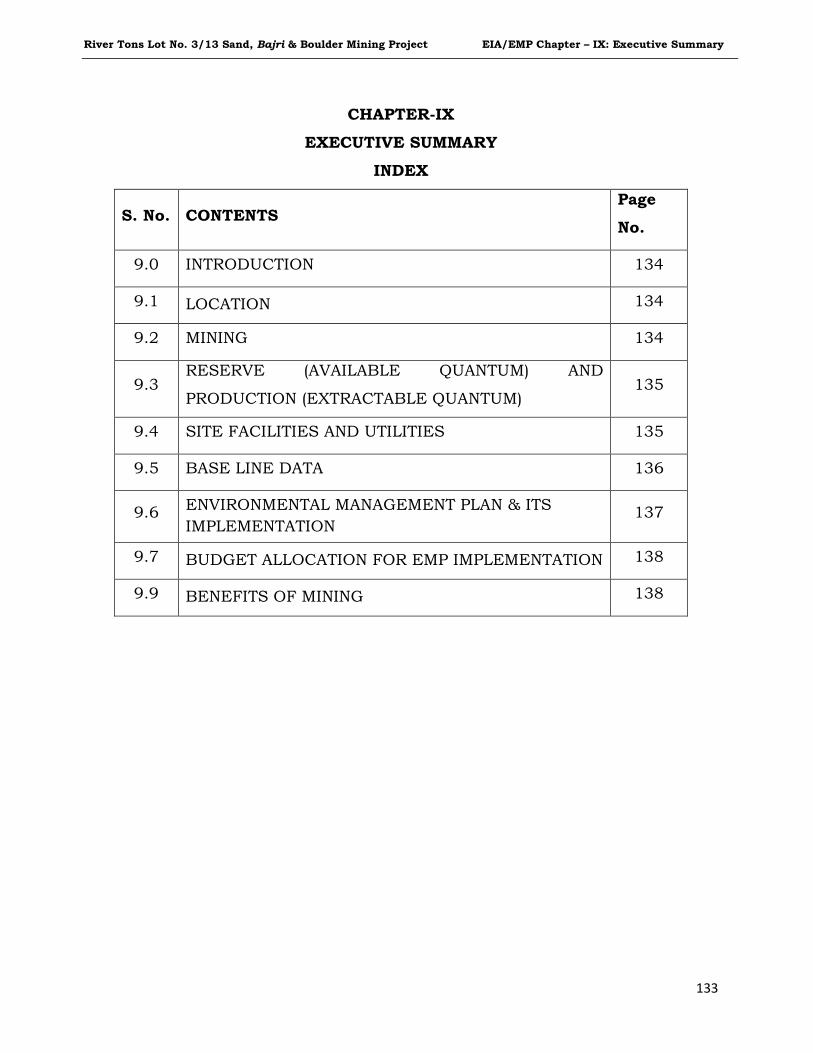
River Tons Lot No. 3/13 Sand, Bajri & Boulder Mining Project EIA/EMP Chapter – IX: Executive Summary
133
CHAPTER-IX
EXECUTIVE SUMMARY
INDEX
S. No. CONTENTS Page
No.
9.0 INTRODUCTION 134
9.1 LOCATION 134
9.2 MINING 134
9.3 RESERVE (AVAILABLE QUANTUM) AND
PRODUCTION (EXTRACTABLE QUANTUM) 135
9.4 SITE FACILITIES AND UTILITIES 135
9.5 BASE LINE DATA 136
9.6 ENVIRONMENTAL MANAGEMENT PLAN & ITS IMPLEMENTATION
137
9.7 BUDGET ALLOCATION FOR EMP IMPLEMENTATION 138
9.9 BENEFITS OF MINING 138
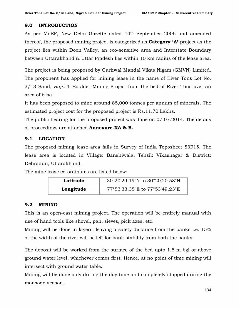
River Tons Lot No. 3/13 Sand, Bajri & Boulder Mining Project EIA/EMP Chapter – IX: Executive Summary
134
9.0 INTRODUCTION
As per MoEF, New Delhi Gazette dated 14th
9.1 LOCATION
September 2006 and amended
thereof, the proposed mining project is categorized as Category ‘A’ project as the
project lies within Doon Valley, an eco-sensitive area and Interstate Boundary
between Uttarakhand & Uttar Pradesh lies within 10 km radius of the lease area.
The project is being proposed by Garhwal Mandal Vikas Nigam (GMVN) Limited.
The proponent has applied for mining lease in the name of River Tons Lot No.
3/13 Sand, Bajri & Boulder Mining Project from the bed of River Tons over an
area of 6 ha.
It has been proposed to mine around 85,000 tonnes per annum of minerals. The
estimated project cost for the proposed project is Rs.11.70 Lakhs.
The public hearing for the proposed project was done on 07.07.2014. The details
of proceedings are attached Annexure-XA & B.
The proposed mining lease area falls in Survey of India Toposheet 53F15. The
lease area is located in Village: Banshiwala, Tehsil: Vikasnagar & District:
Dehradun, Uttarakhand.
The mine lease co-ordinates are listed below:
9.2 MINING
This is an open-cast mining project. The operation will be entirely manual with
use of hand tools like shovel, pan, sieves, pick axes, etc.
Mining will be done in layers, leaving a safety distance from the banks i.e. 15%
of the width of the river will be left for bank stability from both the banks.
The deposit will be worked from the surface of the bed upto 1.5 m bgl or above
ground water level, whichever comes first. Hence, at no point of time mining will
intersect with ground water table.
Mining will be done only during the day time and completely stopped during the
monsoon season.
Latitude 30°20'29.19"N to 30°20'20.58"N
Longitude 77°53'33.35"E to 77°53'49.23"E
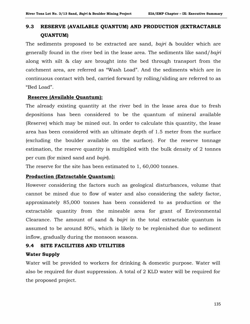
River Tons Lot No. 3/13 Sand, Bajri & Boulder Mining Project EIA/EMP Chapter – IX: Executive Summary
135
9.3 RESERVE (AVAILABLE QUANTUM) AND PRODUCTION (EXTRACTABLE
QUANTUM)
The sediments proposed to be extracted are sand, bajri & boulder which are
generally found in the river bed in the lease area. The sediments like sand/bajri
along with silt & clay are brought into the bed through transport from the
catchment area, are referred as “Wash Load”. And the sediments which are in
continuous contact with bed, carried forward by rolling/sliding are referred to as
“Bed Load”.
Reserve (Available Quantum):
The already existing quantity at the river bed in the lease area due to fresh
depositions has been considered to be the quantum of mineral available
(Reserve) which may be mined out. In order to calculate this quantity, the lease
area has been considered with an ultimate depth of 1.5 meter from the surface
(excluding the boulder available on the surface). For the reserve tonnage
estimation, the reserve quantity is multiplied with the bulk density of 2 tonnes
per cum (for mixed sand and bajri).
The reserve for the site has been estimated to 1, 60,000 tonnes.
9.4 SITE FACILITIES AND UTILITIES
Production (Extractable Quantum):
However considering the factors such as geological disturbances, volume that
cannot be mined due to flow of water and also considering the safety factor,
approximately 85,000 tonnes has been considered to as production or the
extractable quantity from the mineable area for grant of Environmental
Clearance. The amount of sand & bajri in the total extractable quantum is
assumed to be around 80%, which is likely to be replenished due to sediment
inflow, gradually during the monsoon seasons.
Water Supply
Water will be provided to workers for drinking & domestic purpose. Water will
also be required for dust suppression. A total of 2 KLD water will be required for
the proposed project.
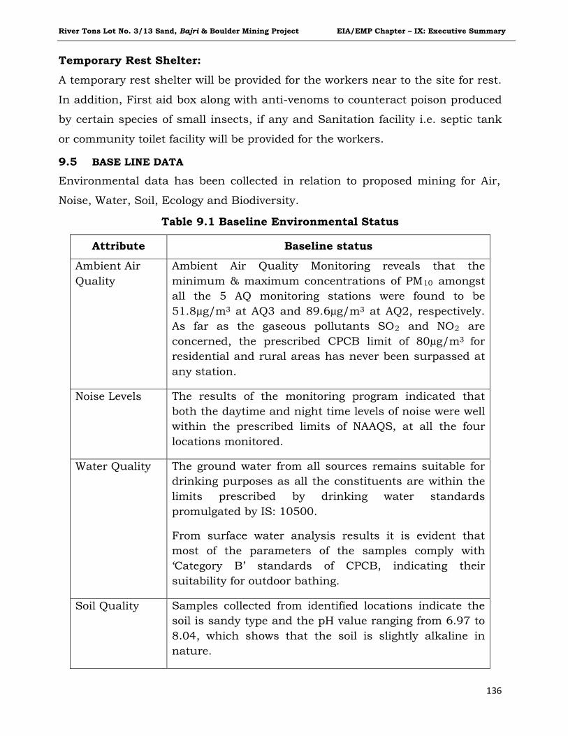
River Tons Lot No. 3/13 Sand, Bajri & Boulder Mining Project EIA/EMP Chapter – IX: Executive Summary
136
Temporary Rest Shelter:
A temporary rest shelter will be provided for the workers near to the site for rest.
In addition, First aid box along with anti-venoms to counteract poison produced
by certain species of small insects, if any and Sanitation facility i.e. septic tank
or community toilet facility will be provided for the workers.
9.5 BASE LINE DATA
Environmental data has been collected in relation to proposed mining for Air,
Noise, Water, Soil, Ecology and Biodiversity.
Table 9.1 Baseline Environmental Status
Attribute Baseline status
Ambient Air Quality
Ambient Air Quality Monitoring reveals that the minimum & maximum concentrations of PM10 amongst all the 5 AQ monitoring stations were found to be 51.8µg/m3 at AQ3 and 89.6µg/m3 at AQ2, respectively. As far as the gaseous pollutants SO2 and NO2 are concerned, the prescribed CPCB limit of 80µg/m3 for residential and rural areas has never been surpassed at any station.
Noise Levels
The results of the monitoring program indicated that both the daytime and night time levels of noise were well within the prescribed limits of NAAQS, at all the four locations monitored.
Water Quality
The ground water from all sources remains suitable for drinking purposes as all the constituents are within the limits prescribed by drinking water standards promulgated by IS: 10500.
From surface water analysis results it is evident that most of the parameters of the samples comply with ‘Category B’ standards of CPCB, indicating their suitability for outdoor bathing.
Soil Quality
Samples collected from identified locations indicate the soil is sandy type and the pH value ranging from 6.97 to 8.04, which shows that the soil is slightly alkaline in nature.
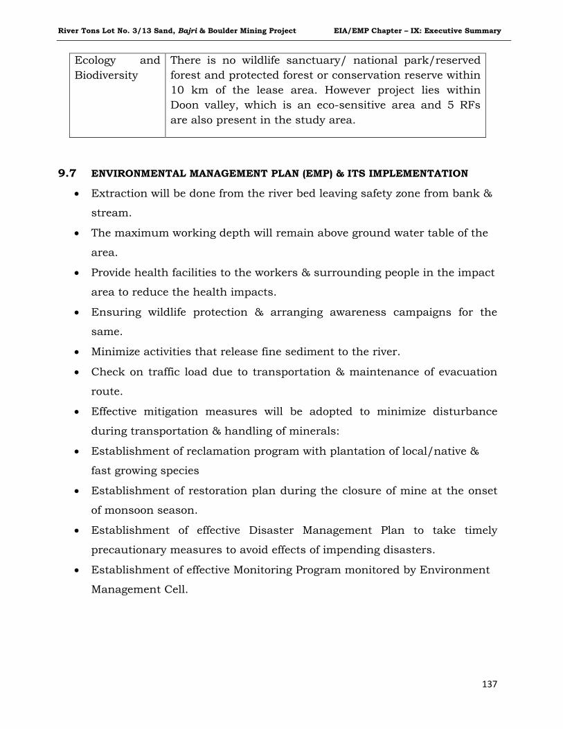
River Tons Lot No. 3/13 Sand, Bajri & Boulder Mining Project EIA/EMP Chapter – IX: Executive Summary
137
Ecology and Biodiversity
There is no wildlife sanctuary/ national park/reserved forest and protected forest or conservation reserve within 10 km of the lease area. However project lies within Doon valley, which is an eco-sensitive area and 5 RFs are also present in the study area.
9.7 ENVIRONMENTAL MANAGEMENT PLAN (EMP) & ITS IMPLEMENTATION • Extraction will be done from the river bed leaving safety zone from bank &
stream.
• The maximum working depth will remain above ground water table of the
area.
• Provide health facilities to the workers & surrounding people in the impact
area to reduce the health impacts.
• Ensuring wildlife protection & arranging awareness campaigns for the
same.
• Minimize activities that release fine sediment to the river.
• Check on traffic load due to transportation & maintenance of evacuation
route.
• Effective mitigation measures will be adopted to minimize disturbance
during transportation & handling of minerals:
• Establishment of reclamation program with plantation of local/native &
fast growing species
• Establishment of restoration plan during the closure of mine at the onset
of monsoon season.
• Establishment of effective Disaster Management Plan to take timely
precautionary measures to avoid effects of impending disasters.
• Establishment of effective Monitoring Program monitored by Environment
Management Cell.
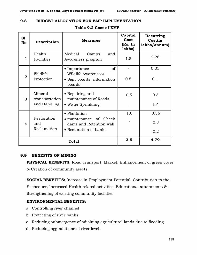
River Tons Lot No. 3/13 Sand, Bajri & Boulder Mining Project EIA/EMP Chapter – IX: Executive Summary
138
9.8 BUDGET ALLOCATION FOR EMP IMPLEMENTATION
Table 9.2 Cost of EMP
Sl. No Description Measures
Capital Cost
(Rs. In lakhs)
Recurring Cost(in
lakhs/annum)
1 Health Facilities
Medical Camps and Awareness program 1.5 2.28
2 Wildlife Protection
• Importance of Wildlife(Awareness)
• Sign boards, information boards
-
0.5
0.05
0.1
3 Mineral transportation and Handling
• Repairing and maintenance of Roads
• Water Sprinkling
0.5
-
0.3
1.2
4 Restoration and Reclamation
• Plantation • maintenance of Check
dams and Retention wall • Restoration of banks
1.0
-
-
0.36
0.3
0.2
Total 3.5 4.79
9.9 BENEFITS OF MINING
PHYSICAL BENEFITS: Road Transport, Market, Enhancement of green cover
& Creation of community assets.
SOCIAL BENEFITS: Increase in Employment Potential, Contribution to the
Exchequer, Increased Health related activities, Educational attainments &
Strengthening of existing community facilities.
ENVIRONMENTAL BENEFITS:
a. Controlling river channel
b. Protecting of river banks
c. Reducing submergence of adjoining agricultural lands due to flooding.
d. Reducing aggradations of river level.
River Tons Lot No. 3/13 Sand, Bajri & Boulder Mining Project EIA/EMP Chapter – IX: Executive Summary
139
e. Protection of crops being cultivated along the river bank.
f. A check on illegal mining activity.
CORPORATE SOCIAL RESPONSIBILITY
A percentage of the project cost will be allotted for the Corporate Social
Responsibility for activities related to education, social causes, healthcare &
environmental.
*************
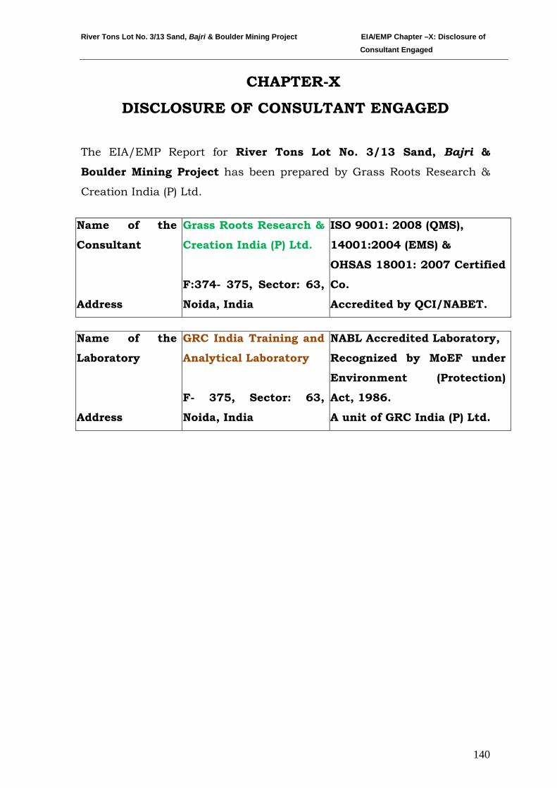
River Tons Lot No. 3/13 Sand, Bajri & Boulder Mining Project EIA/EMP Chapter –X: Disclosure of Consultant Engaged
140
CHAPTER-X
DISCLOSURE OF CONSULTANT ENGAGED
The EIA/EMP Report for River Tons Lot No. 3/13 Sand, Bajri &
Boulder Mining Project has been prepared by Grass Roots Research &
Creation India (P) Ltd.
Name of the
Consultant
Address
Grass Roots Research &
Creation India (P) Ltd.
F:374- 375, Sector: 63,
Noida, India
ISO 9001: 2008 (QMS),
14001:2004 (EMS) &
OHSAS 18001: 2007 Certified
Co.
Accredited by QCI/NABET.
Name of the
Laboratory
Address
GRC India Training and
Analytical Laboratory
F- 375, Sector: 63,
Noida, India
NABL Accredited Laboratory,
Recognized by MoEF under
Environment (Protection)
Act, 1986.
A unit of GRC India (P) Ltd.
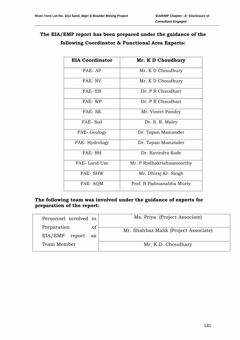
River Tons Lot No. 3/13 Sand, Bajri & Boulder Mining Project EIA/EMP Chapter –X: Disclosure of Consultant Engaged
141
The EIA/EMP report has been prepared under the guidance of the
following Coordinator & Functional Area Experts:
EIA Coordinator Mr. K D Choudhury
FAE- AP Mr. K D Choudhury
FAE- NV Mr. K D Choudhury
FAE- EB Dr. P R Chaudhari
FAE- WP Dr. P R Chaudhari
FAE- SE Mr. Vineet Pandey
FAE- Soil Dr. S. R. Maley
FAE- Geology Dr. Tapan Mazumder
FAE- Hydrology Dr. Tapan Mazumder
FAE- RH Dr. Ravindra Kode
FAE- Land Use Mr. P Radhakrishnamoorthy
FAE- SHW Mr. Dhiraj Kr. Singh
FAE- AQM Prof. B Padmanabha Murty
The following team was involved under the guidance of experts for preparation of the report:
Personnel involved in
Preparation of
EIA/EMP report as
Team Member
Ms. Priya (Project Associate)
Mr. Shahbaz Malik (Project Associate)
Mr. K.D. Choudhary
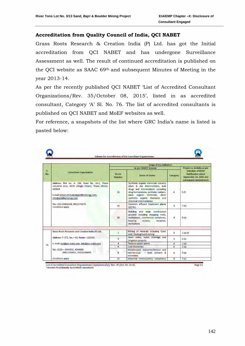
River Tons Lot No. 3/13 Sand, Bajri & Boulder Mining Project EIA/EMP Chapter –X: Disclosure of Consultant Engaged
142
Accreditation from Quality Council of India, QCI NABET
Grass Roots Research & Creation India (P) Ltd. has got the Initial
accreditation from QCI NABET and has undergone Surveillance
Assessment as well. The result of continued accreditation is published on
the QCI website as SAAC 69th and subsequent Minutes of Meeting in the
year 2013-14.
As per the recently published QCI NABET ‘List of Accredited Consultant
Organizations/Rev. 35/October 08, 2015’, listed in as accredited
consultant, Category ‘A’ Sl. No. 76. The list of accredited consultants is
published on QCI NABET and MoEF websites as well.
For reference, a snapshots of the list where GRC India’s name is listed is
pasted below:
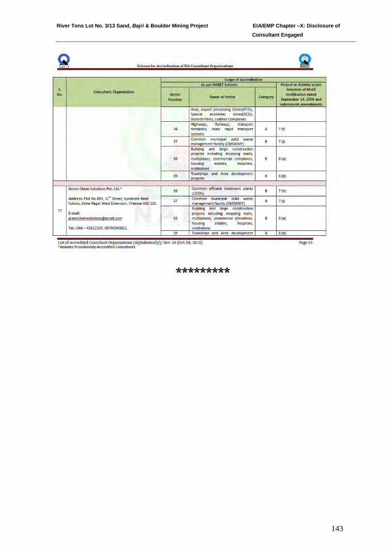
River Tons Lot No. 3/13 Sand, Bajri & Boulder Mining Project EIA/EMP Chapter –X: Disclosure of Consultant Engaged
143
*********
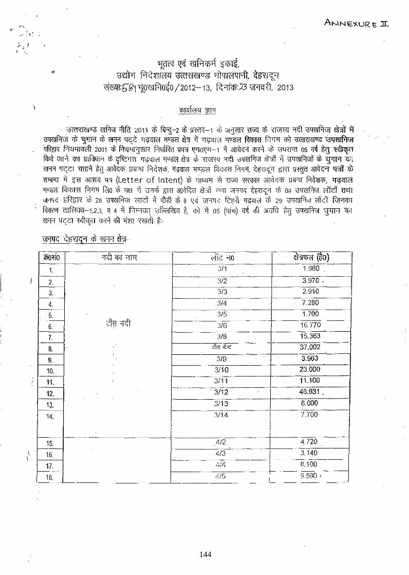
.--. " • t ~
;. .) J , .
~ ~ ~f.1Cf)4 ~, ~ R~~IIC'l<l 13«1'<I~u-s q{jQIC'l41;ft, ~i5~I1:'i
m:bi?j'lfP~O~O/2012-13, ~:23 \Ji<lqX'l 2013
ANNE'J<.URE :rr..
.' \jrn'<I~";S ~ ~ 2011 ct f<I:;-2 ct >ffiR-1 <Ii 3l]1lR XfiR! ct ~ ;pf) .\:J4~Pi\ij eDiT if =\:Jq='{!)P-rf.l=\ij <f; ~ ct 'I!l'fl ~ TJCPll('! ~ W:! -i'i lWqT<'f ,~ .fl\q;m f.ilJl1 <nT \jct1'<I,{!)"<; W&f.'I\ij
~ Pill'llQc1'i 2001 <I; f.lWlljffl'i f.m\fur lIlR' \[,!0'f'j-1 Ii ~ m if; '3lRRI 05 CJl! ~ ~ f<pi) iJIR Cj)f mfcmA cf;~f&:ll('1 TJCPll('! ~ W:! ct ~ 1Cft \j4,{!)f.l"1 !!hT -i'i \j4«lPi"11 'if; ~<t'i «R'f ~ l'!Tlf'l %TI ~ Wl.£.T ~, l[~ ~ Fcrcnrn f.'rr!, ~15"'t:'1 1rRlll1Wl ~ <BIT <f; Wir.£T ij ~ 3lm!l. lR (Letter of Intent) cf; 1JlUll1 it TI'i'Il ffi<lJR ~ q<j.£T ~, If<PlTC'f ~ fir<BTfl f.rlJ1l ~Ocf; 1]1;1 -i'i ~ GRl ~ !!hT IlOj] ~ ~ ct 8a \j4,{!)f.'i"1 cTfit am ~ ~ ct 28 \:J4'1!lPi"1 01lit -i'i 'l'Ml cf; 8 \"i ~ ~. ~ <Ii 29 \j4«lPi"1 illct ~ fitcRur ('11 frl 'Ii 1 1,2,3, q 4 -i'i f:l hi CI '! \j fA>! R!t d %. <nT -i'i 05 (1li<J) crf tr ;wrfij tx \j 4 '(!) f.'i 'JI ~ Cj)f
«R'f crc:cr ~ m tr >im ~ l(-
~ ~6~1'1:1 * X'R'l ~-
I W~~O I 'l~ '1j)f ~ (>fie ~o ob (to) ,"' . - -
311 1.960 I .
2. I 312 3,970, -
3, 313 2_910 f-----
4_ 314 7.280
5_ 315 1.700 c:rn ;rcf\ - -- --~-~16no 6_ 316
7_ 318 I 15_363·
trn<bc I 37_002 8. 9, 319 3,963
10_ 3i10 23,000
1t 3/1 'I 11_100 I
12, . 3112
I 46,931 ,
13. 3113 6,000
14_ 3114 1.7'00
I 1
15, 412 4.720
16, <13 ~
3,140
17, L'~/4 I 8,100 I
£;./[; I 8.590, 18, I -
144
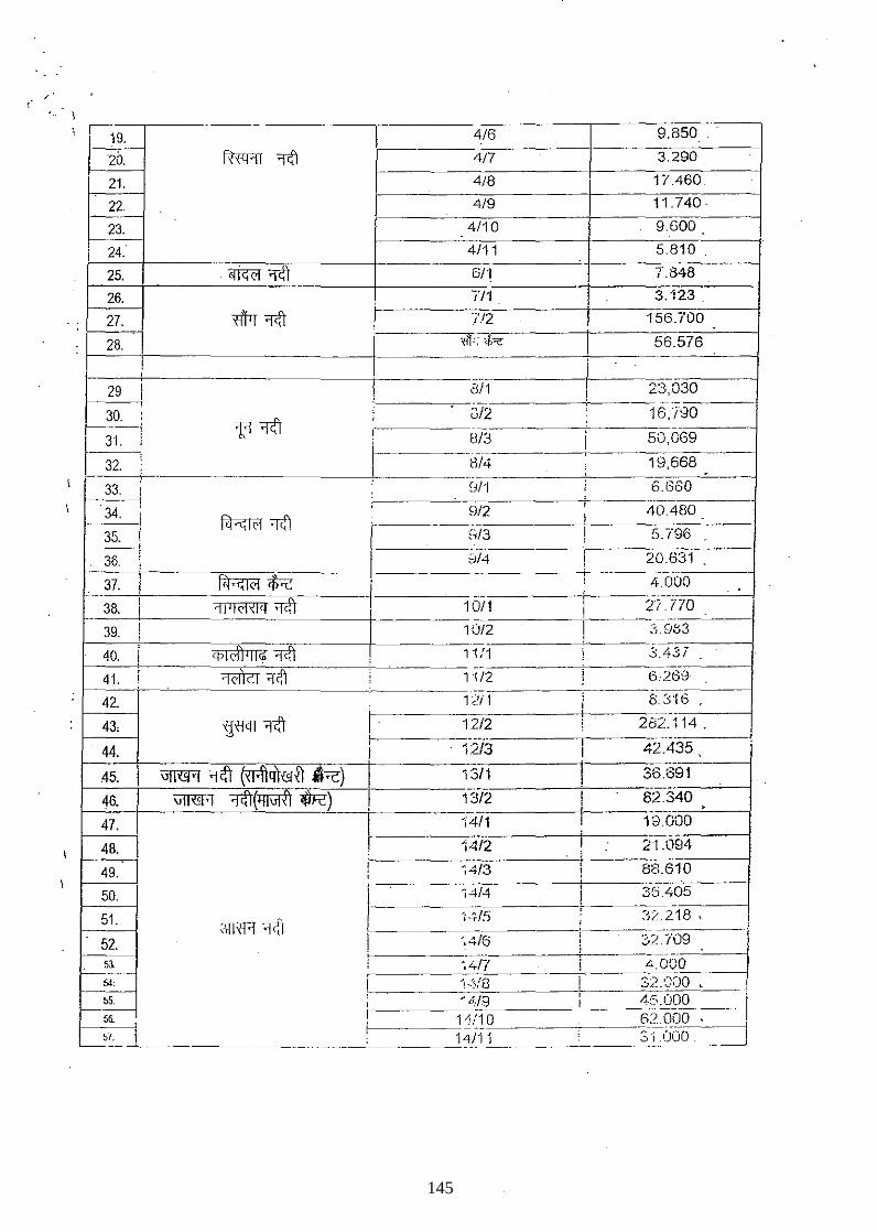
19. 4/6 9.850
20. m"AT ~ 4/7 3.290
21. 4/8 17.460.
22. 4/9 11.740
23. 4/10 9.600
24. 4/11 5.810
25. ~~ 611 7.848
26. n1
I 3.123
27. Wr~ //2 156.700
28. m': ',f,", I 56.576
! I ,
29 i El/l 23,030 I ! .
30. : ~
, 3/2 16,/80
31. i 1:1 f fJ/3 50,069 I ,
r I r32: .. ,
fJ/4 19,668 I . , .. .
33. ! ,J/l i 6.660
34. ;
9/2 i 40.480
1 ~ 'ltI I
I .-.
35. 0/3 , 5.1'96
36. i ~)14 ! 20.631 I
J ~<Fc: '.
j --~--.
37. i 4.000 ,
i 'ltr I j -----
38. ~JlIC'l,I~ I 1011 ! 2? .770
! ,
! -_._.
39. I 10/2 3.983 I
qilC'l1 'I lijl ~ I .-
40. i 11:1 j 3.431 I
41. ,
~'ltr 1'1/2 ; 6.269 I : ~ .-.------
42. 12f 1 i 8.316
~XiClT 'l<fr I I
43, 12/2 282.114. , .----, - 42.435
45. ,,!ruff 'l<ft 81.fl41l3li] ~) 13/1 36.691
46. \JlRlR 1<fr(lJfiJlfr llR) f::JI'2 82.340
47. V-I/1 19.000
48. ~14/2 21.094
49. -'i4/3 88.610
50. ,4/4 35.405
51, 3TRR'ltI 'i.!'r/5 32.218 I
. _.__ .J
52. ';4/6 'rb ...._.r 51 ~4Ii' .4,OCO 54,
. "!·:.;./S 32:000 ~ !
55. , ' 6·19 4:5.000 56. I 14/10 62.000 57. i--
14/11 31.000. ---- - _. - _. -------
145
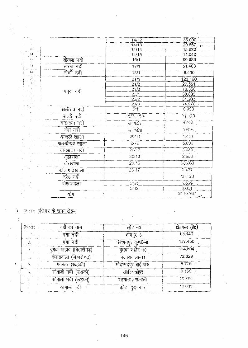
, '
14/12 35.000 , 14/13 20.667 "
,-;. 14114 15.622 1,1
, , l ~ Tfi:fl I
1A/17'5 ____ +--__ -;1:_:;1~.O;:_:;4:_;;O--___j 16/1 60.983
--
:"':1 ! X1TFlT Tfi:fl i
i ,~ I M Tfi:fl 1/11 51.463
-~~~~----+---~1~8:~I1----~---8~.~40~O~---~ " ---I
--,
I" , i' L1/1 123.190
i 21/')=------0----'::27.55'1 , ~2j/3, - - 1~:fJ~0=-~.-----l
L3/1 30.03,-=5 __ --1 23/2 :; l.L03
/. 23/3 14.SCOCq-=-O-----4
i
:0 i 11:)
i 2·'10.?'37
----~--- --"./'-----'
~CfiT YfTIi ! 'coiit" 10 , -~qr<1 ~O) !
----
2. _ I
1J'1n' ~ l $J:f.-6 . , fj3.1·~/J
..
<frrr ~ '~-8 j 167A;SO . f<l~I'lg~ ., ' ,
~tjC[[ ~!tl~ (~) ~t[CIT ~!~'rHO i 104.504 , , .-_.
~\ij"!q!,"1 (fiH;! i1 'I i» ~\ij!X!q!C1! 11 I n.329 .---
TJlFffiX ('{q~) ! '11 g '"1 G. ',.' y .. , mqrn 5.776 ,
~ ~ (~) ,
TIIlPI:f1'irgx 9 if-a i "{i'l1!d't 1cft ('Cl~) I
~/~ 1:::.2'~O i , WIT'iJ) 1if) , CfJlcT -~I":l~ <?.(";-;0 . ,
-
146
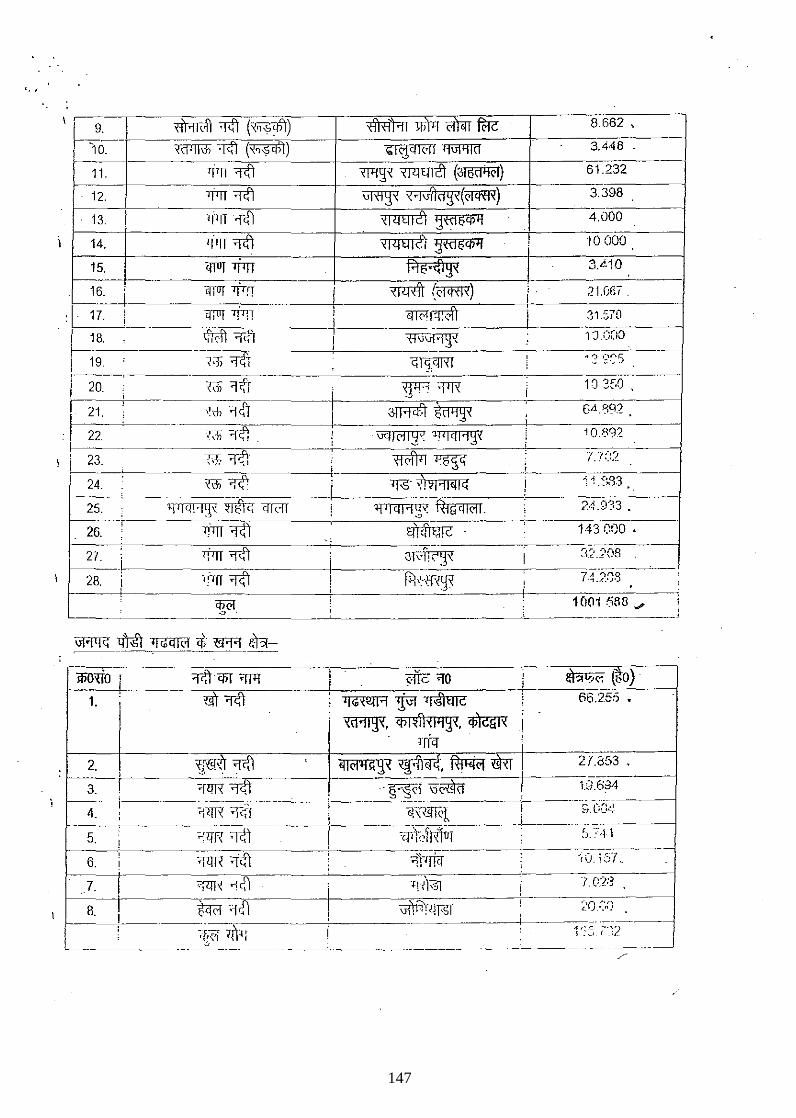
'. ;
~
mrcfr 1ift (~) '<1'1 <i'I '11 ~ C'!lorr fuc 8.662 , , ~_9
10. TcfIll\31 1<iI (~) \:I~r l1WI1TI 3.448
11. -q'll -;pf] ~ XPTEIliT (~) 61.232
12. >Mr-;pf] ~ ~(>fifffi) 3.398
13. I -ri'll-;pf] '<1/lElI'?i ~«1i>q;1J 4.000
14. 1jln-;pf] 0 ~«15q;1J 10000 '<1/lEllc! i
15. "i.JTOT1JlTr f.1iO·;{l g" ! 3.4.10
16. ,
"i.JTOT <]TfT ~ (QffiR) i i I ;?LOl;! .
: I 17. ; TITUT 7fTl1 , 'l10f'rl'r I :11.~70 ! I , 1S. lfR;ft ~<il ,("Nvf'l1' 1:J.O(lO
! 1 , , i 19. "/:]; 'l'f1 C;l~;(mi
, .. 2.'?·'~'5 , i
i '1?T ".
1'J 350 20. M 1 XfF '"fllX i ! j
I 21. hl'fCfJ 3lWf.r mrw 6". '592
I : 22. ~ 'l0 ,
vq1C'l 12" 11l1(WI~X ; 10.892 I i i
""
~. , ~
;
i 23. -Gr. ~ l.?:~:') ,
i i I X\li.,,-?'<
, , ; ';il3 24 1f'S Vl 1 ,
:4.:;-r33
43 eoo .';:'.)08 --_. , '1;'.
, --'"-"~"--------~~'------------'-~~--~~'----------~----m--G"--~~~)--~ wo~o 1 '1''; 'i:j)T ~fTTI "lk ~o ." .'''' (t>D
1. m 'fCfJ ~ ~ '1,S'IElIC 66.255 •
"d'1lg( il>1!/iHllJg", q;)q;N i . In'q i
2. , 3. I
4. i
~"
5.
6.
7.
B.
X:j~ ~ ~ ~<r<f, ~ ~ I
"bR'fCfJ '---~j'(i ql 1[
21.353 •
19.634
~:O.(;:')
..-"---"~
1':~, ;"~2 ~ _________ .•. _0 _._ .. __ . ____ ~ _________ . __ • _______ . __ . ___ "_"
147
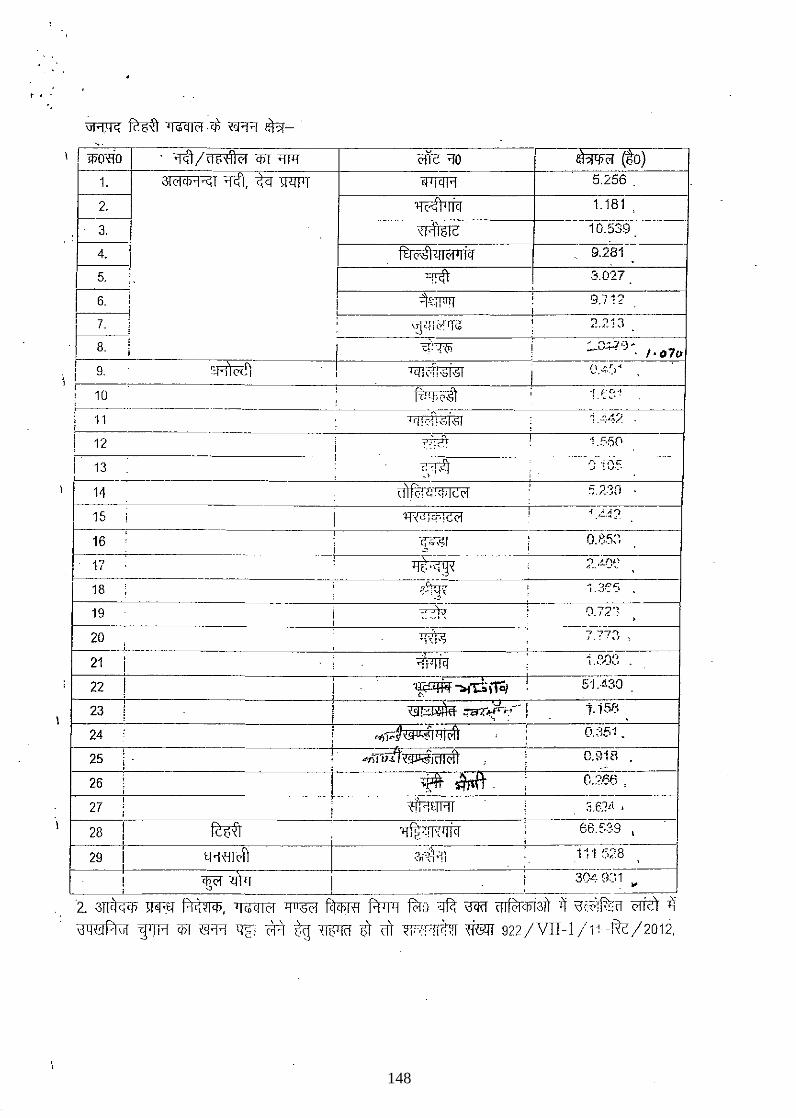
t -~ .
'.
I I
I woxoio 1.
2.
3.
4. I 5.
6. I
~ . 8. i I 9. , ! ,
10
11
12 I'
1 13 I
1 I 14
15
I 16
17
18
19
20
21
22
23
24
25 : 26
27
. ~ / ct 5 'i11 C1 <PI '1T'f
JI C1 iJ)'1 <i; 1 ~, tel WlJlT
'~'{I«1
('11-('; '10 ~ • .:...(t-,-(O)_--I fflfCJT'l 5.256 .
~--------o-~------~----~ 1fC~ri<r 1. 181
1-------~\~14~15~I~c-------t----~1·nO~.5·3~9~--~
ffjC'"illJl<'JIliCJ 9.281
O'~ ,·':"1,1:·, .>
3.02f
9.712
r .. ; "e; oJ :'j" ..
O.B.5:~ .
'It.~' ----·---------c----------~~~~--------------~,·~3"~~C.~"------1
--------~----------::~;~~--------~----~0.~7~2·~?-----4
"777'"1 I "- ~J ~
148
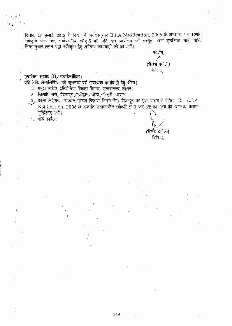
. ..' "
~ 26 WC'frt 2012 .'i ftI) 'TlT f;1~~lljfll'< E.LA Notification, 2006 cf; 3Rf'm qlJ\i.i~uftlJ ,.q;~fcI 9.1«f 'fi,\, 1:f<ITcr,ufr:T ~fi q-\'r >lfd If'f! ~(1'1 <it "!nWl 'R"'IT 'fl1t-<r<r <R. cnfir; f.'!ri'lljflIX N'R ~ +q~i.iiRl tg 3fl!"m, cbl4i1lgt c#t \if[ m I
~~ "fffim (1) /If<(R''1ifCt>\11 q~: ~lffi1 'f;l- 'l~:r'Wf 'Fi ~rct> ifi1<fi.ir1ft UlX ~fim I
1. ~~. ~11'11fi'1(jJ ~ fcl'lwr. ~~ mfAl 2. ~m, ~~/~/t/Ml/ftbfr~! ~/wr.£T~. ~ ~ frIim f.'rTl:r lMo. t;\I'i,'1 cvT ~ WW111 ~ fc(; E.LA
;'.)otiiication. 2006 cf; 3Rf'fcr cr..:rTcRufi<11<fr!if:f \fiT(! ~ CBnVc'f1l ~(7:'0[~ 'ifJXT'IT . , '~Hf~'iRJ cp1 i
4. ~ tJJT:.{<:">i r
149
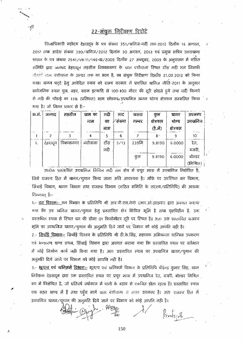
~ ~ ~HIC'l:'1 in q-,[ <i=r 351/~-"i<lT ffi'f-2012 ~ 16 3f>]"@", "
2012 {fm .m?;QI <i=r 390/~)2012·~ 30 3f>]"@", 2012 Q<[ ~ <JfiIq 5iHI<;iIug
QTR1cT it;- q-,[ <i=r 2541/VII-11/146-<S!/2009 ~ 27 3~, 2009 in Jl,:]>ql(>lC"l <If ~ ~ GRT ~ ~~{I"""I ~ fc'i4iIfWI{ in J]TJl <iQIt<:rr<'IT lBri1 tR1 "ItT ffi'f ~
d,,:;f;::,li 7ii~\icnon in ~ {l4i 'liT awr ~, 4iT <i¥ fo'rt'r1fTUT ~ 21.09.2012 4i't fc'Ii<rr
"T'lT I 15ICl'1 q¢ ~ ~ <=~ 4i't ~ m'4iR <If ~ ~ <1rfc't -2011 in 3i":J>'lR
W~ <=~ '¥T, ~, fl54i ~ <t 100-100 ~ <fir c;:.fI ~ ~ {fm ~ fc1;;;nt
;fl' OTc\'T <fir ~ 4iT 15% (mQ[{l) awr ~<~ .15ICl'1 ~ ~ fj<hHF.kl fc'Ii<rr . " ,;>-
"T'lT ~ I JiT fct<F<I' J;[4iT{ <t ~:-
"',., <!iT 'ff~ ~ ~ ~ w.~~ -~I ~- oJ== ~ ~ <>ri -m ~
~,ni'<~' ,,?;,,~"~ i,~:, ~ ,,;fR ~:;:o ~-.~-oo-o-+-----:-~·,·-I II "ItT ~
I ':l'i'f 9.8190 6.0000 .. , <"0'
(~)
~ -QiC;I~\i-··';;5q~<iI~fo'I~"I;;;-· f.Rl);ifc'i~(>I <'1<,)-'-. ffi'f---m..L~-~ .. '&ITiIT <If 3q~f~i;-fo't-~~-~:
m l.IvI'R ~{f <If ~ I~ fc'Ii<rr "'ITiiT m 3fjC:fQ<T4i ~ I ~ lR ~ Cfil fuawr,
~ fcr~TrJ'T, ~ fuawr {f~TT m'RT fuawr (;rrf3;1 ~ in ~ I~) <fir 3-IWTI
~~:-
1. - Cfilfcrawr: - Cfil fcr:FITJT in ~ ~ 3fR. m.w. otfrr (3fR. 3fT.;;;m;;m) GRT 3m'R1 4iWIT .
"T'lT fc1;- W ~ ~/~ ~ Q'f('IIfc'irl m Rifui;r a1fR ~ nm 'I~ t 3rt.
" u-@lfil{f 'f~ <tlBri1 Cfil <fir :Btm 01 \4i(>l'I<fi'16( c;:.fIlR lBri1 ~I 31(1: 3rt. Q'f('IIfc'irl ,,~
a1fR lR 5Q<ilfo'l"l ~/~ <fir ~ Wt ~ lR fcr:FITJT 4i't ~ 3lTi:m1 iit.'r ~I 2.- d fu:FITJT:-~ fc'I'nm in ~ ~ tr.in.fW;, ~ ~ ~'" 3Q'h,ul
ll'i :J1U5RUf '<i!U5 q~Jf, ~ fcr:FITJT GRT .3{CfJ'T'(i 4iWIT "T'lT fop QMfc'irl <=~ lR ~l'1
<If 4il$ f.1a:ITur 4iI<T ~ f1r;<rr ;rr<lT ~I 3f'(i': Q'frllfc'irl <=~ lR 5qlilfo'l"llil'ii'l/~ <fir
~ Wt ~ lR fcr:FITJT 4i't ~ 3ffL© iit.'r ~ I 3.- W£CI<!Cf 'l!!f.14i;A fu:FITJT:-~ Q<[ liIf.1'h<R fcr3WT in ~ <flM'; ~ fm;, <l[]"
fo'tft&l'li ~\'>{I",C"I GRT 3rt. Q'f('I Ifc'irl ~ lR ~ 'J1n'T <if 5Q«Ifo'I"I 8, ~, ~ ~if .
~ <if fo't~ ~, ;it ~ Cl~\'hl(>l <if qro:fJ in <f\'>TCl <t ~ tJcrr {'('>(1T ~I Qf(ilfc'iif 'f~
11'1> {ita 1£[U5 <If ~ nm ~ JlT'T ;um <i~nqTOlI :(-' >'1'1l1: ~'<:[ ~I 3f'(i': ~ f?;n ii
5 Q <iI f.1;jj ~ I"f'TIi1 <fir ~ Wt ~ lR fuawr 4i't onl$ 3ffL© iit.'r t I
~~ (jJ): ~" (2P~:A / 1) r·" '~~t1 ,1.0 /' rC(0o~T.1l'. __ .
150
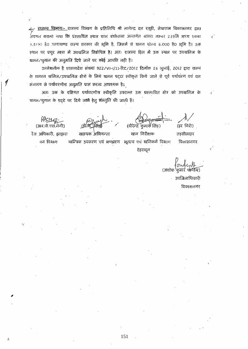
,
"
~ {@IFf fl:tiffidT: -~ fl:tiffidT $ ~ fc"I 1<1 R1- 'lft ~ c:;n "l$l, o1lJ1 q I (>l fc1 i.fi I B'i J I { ilRT r '. "....--.-J...... 31<1'1<1 i.fiWlT 'r>IT fc1;- \H-iilfc1ii <,:tr(>l' ;m;F[ <r~ftm<;rr 310(1'1(1 «RRT ~ 239fi'r JT'L<[ ~. ','
Y8!9G *0 :OiHllJlUS ~ ffi'I'R <iii ~ ~, ~. fr ~ <itrrr 6.000 ~O ~ ~I 3cti'
<,:tr(>l' (['{ ~ d'II'IT <# 3Q<Sl1<1J1 fc'ra'll'l<-r ~I 3f(1: ~ ~ <# 3cti' <':tr(>l' (['{ 3qlJl1<1J1 $
~/~ <iii ~ ~ ar#t q{' i.fiT$' ~ ~ ~ I ~c\)<:f ~ ~~~r ~ 9221VII-l/ll-!tc12012 ~ 26 ~; 2012 ilRT '<1Jl[
$ 'Wf@ ~/3q<Sl1<1J1' atIT'$ ~ ~ ~ ~ ~ ar#t* "!p q"1\ci,UI ll'i <r<i
~ * Q"1\~{Un"1 ~ W'I1 'i.fi'{C!T 3!lCfQ= ~I ,
3f(1: 3cti'$ ~ Q"1\cn uA"1 <,q"I'l!fc"I 3Q{loii 3cti' ~<'dlfc1ii $r qit 3Q"'l1<1," $
pp~ (31R . >fr. '(!11.;;fJfr)
tJI'~,~
~/ (B' f.iltI)
o ",J'0Ar--~ (31~it<n ~ CJir®:r)
~
ft:ri.fiR1CfJTI
151
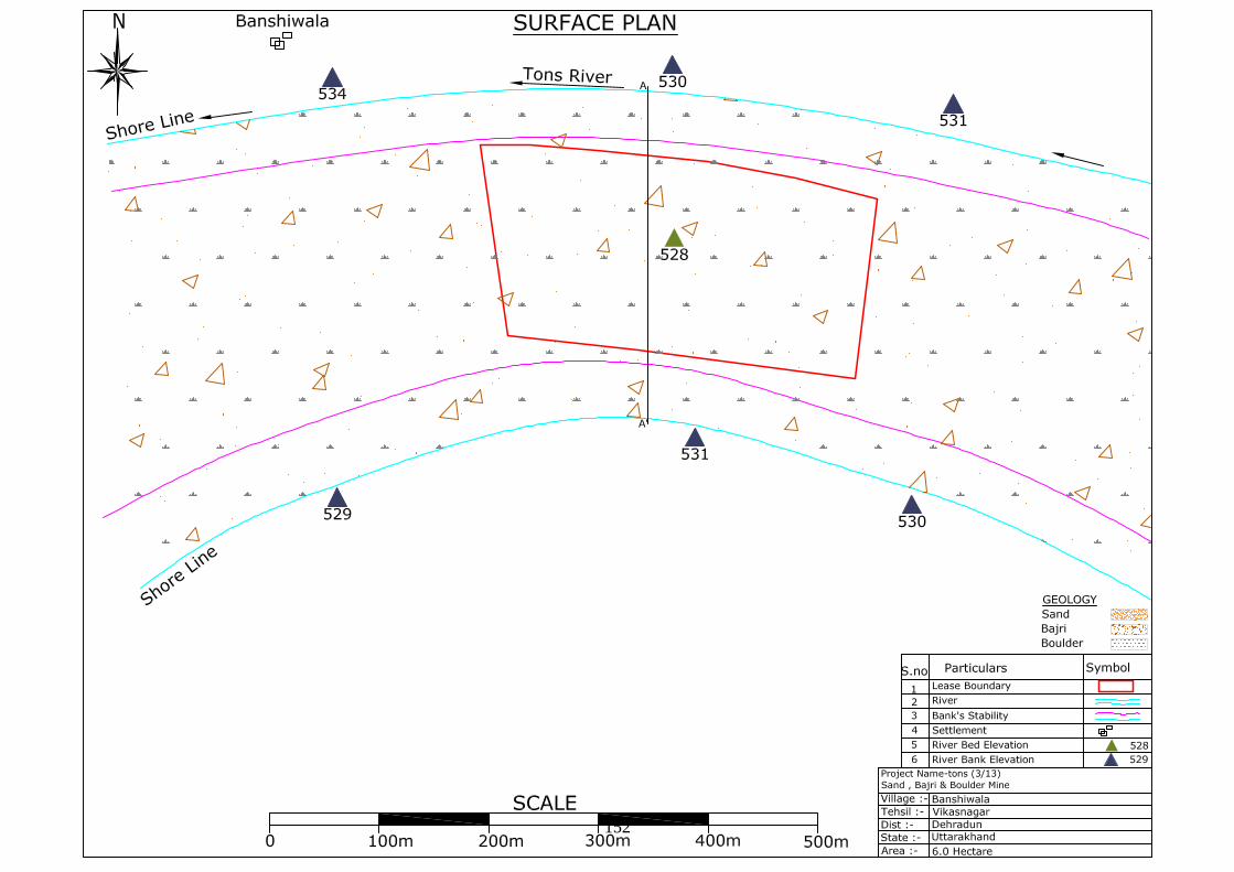
152
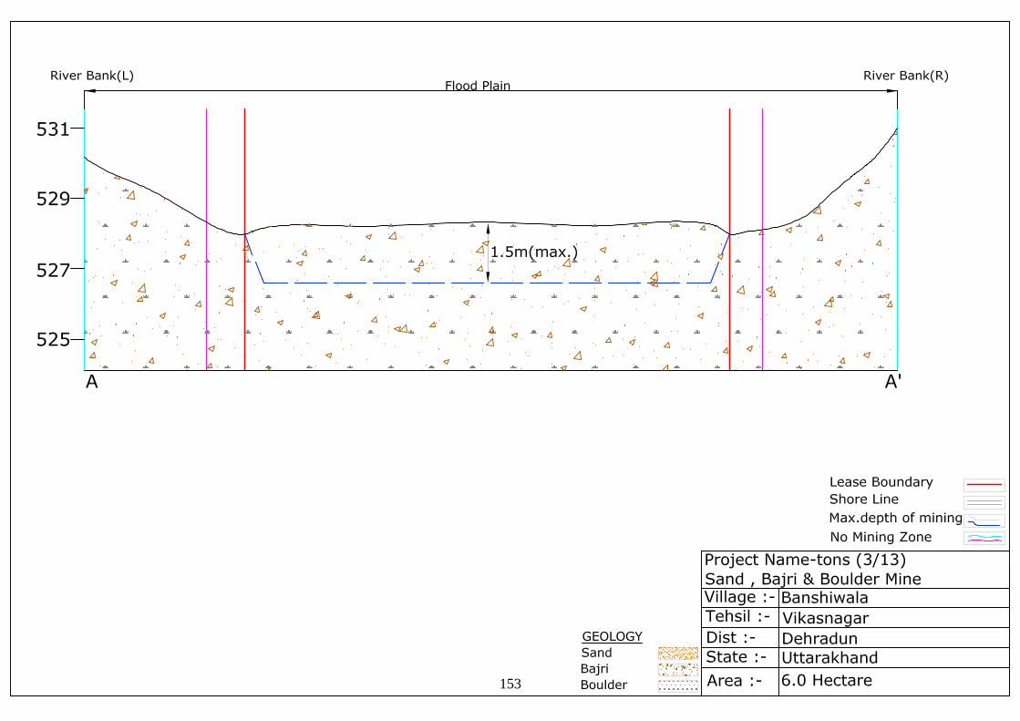
153
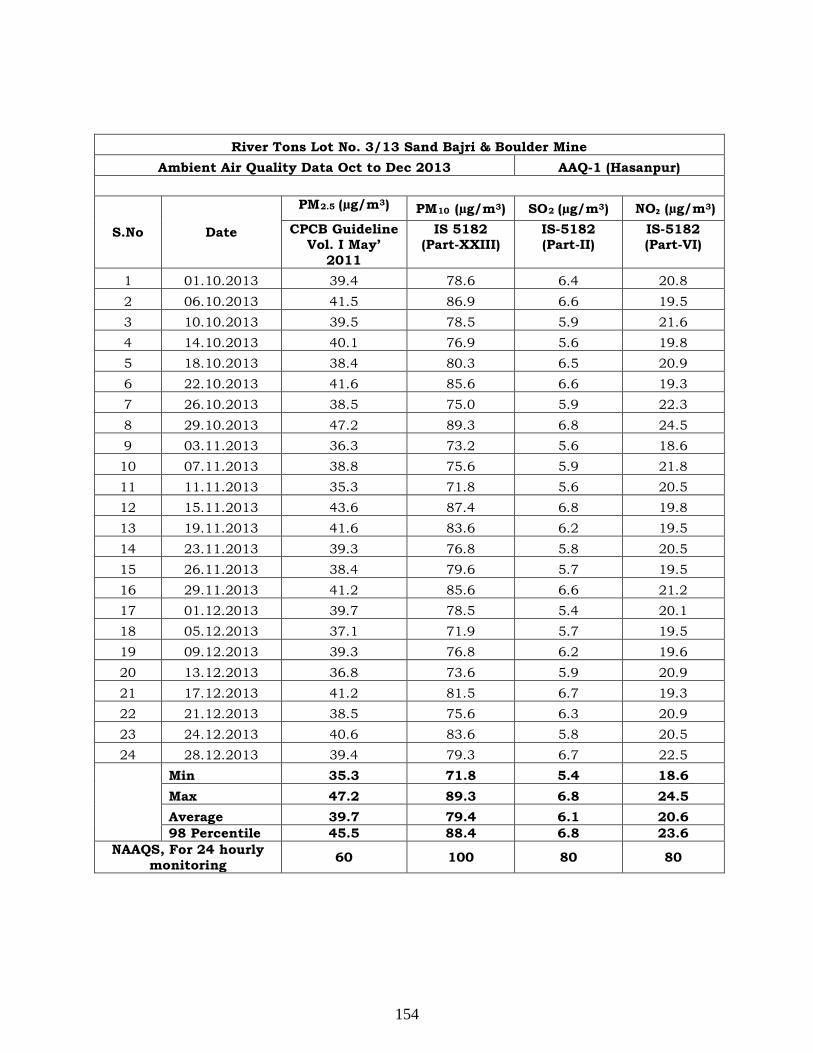
River Tons Lot No. 3/13 Sand Bajri & Boulder Mine Ambient Air Quality Data Oct to Dec 2013 AAQ-1 (Hasanpur)
S.No Date
PM2.5 (µg/m3 PM) 10 (µg/m3 SO) 2 (µg/m3 NO₂ (µg/m) 3) CPCB Guideline
Vol. I May’ 2011
IS 5182 (Part-XXIII)
IS-5182 (Part-II)
IS-5182 (Part-VI)
1 01.10.2013 39.4 78.6 6.4 20.8 2 06.10.2013 41.5 86.9 6.6 19.5 3 10.10.2013 39.5 78.5 5.9 21.6 4 14.10.2013 40.1 76.9 5.6 19.8 5 18.10.2013 38.4 80.3 6.5 20.9 6 22.10.2013 41.6 85.6 6.6 19.3 7 26.10.2013 38.5 75.0 5.9 22.3 8 29.10.2013 47.2 89.3 6.8 24.5 9 03.11.2013 36.3 73.2 5.6 18.6 10 07.11.2013 38.8 75.6 5.9 21.8 11 11.11.2013 35.3 71.8 5.6 20.5 12 15.11.2013 43.6 87.4 6.8 19.8 13 19.11.2013 41.6 83.6 6.2 19.5 14 23.11.2013 39.3 76.8 5.8 20.5 15 26.11.2013 38.4 79.6 5.7 19.5 16 29.11.2013 41.2 85.6 6.6 21.2 17 01.12.2013 39.7 78.5 5.4 20.1 18 05.12.2013 37.1 71.9 5.7 19.5 19 09.12.2013 39.3 76.8 6.2 19.6 20 13.12.2013 36.8 73.6 5.9 20.9 21 17.12.2013 41.2 81.5 6.7 19.3 22 21.12.2013 38.5 75.6 6.3 20.9 23 24.12.2013 40.6 83.6 5.8 20.5 24 28.12.2013 39.4 79.3 6.7 22.5
Min 35.3 71.8 5.4 18.6 Max 47.2 89.3 6.8 24.5 Average 39.7 79.4 6.1 20.6 98 Percentile 45.5 88.4 6.8 23.6
NAAQS, For 24 hourly monitoring 60 100 80 80
154
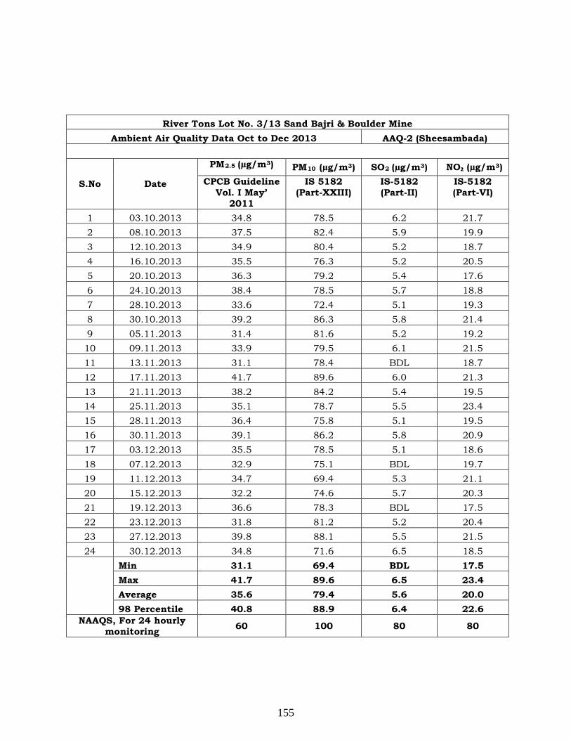
River Tons Lot No. 3/13 Sand Bajri & Boulder Mine Ambient Air Quality Data Oct to Dec 2013 AAQ-2 (Sheesambada)
S.No Date
PM2.5 (µg/m3 PM) 10 (µg/m3 SO) 2 (µg/m3 NO₂ (µg/m) 3) CPCB Guideline
Vol. I May’ 2011
IS 5182 (Part-XXIII)
IS-5182 (Part-II)
IS-5182 (Part-VI)
1 03.10.2013 34.8 78.5 6.2 21.7 2 08.10.2013 37.5 82.4 5.9 19.9 3 12.10.2013 34.9 80.4 5.2 18.7 4 16.10.2013 35.5 76.3 5.2 20.5 5 20.10.2013 36.3 79.2 5.4 17.6 6 24.10.2013 38.4 78.5 5.7 18.8 7 28.10.2013 33.6 72.4 5.1 19.3 8 30.10.2013 39.2 86.3 5.8 21.4 9 05.11.2013 31.4 81.6 5.2 19.2 10 09.11.2013 33.9 79.5 6.1 21.5 11 13.11.2013 31.1 78.4 BDL 18.7 12 17.11.2013 41.7 89.6 6.0 21.3 13 21.11.2013 38.2 84.2 5.4 19.5 14 25.11.2013 35.1 78.7 5.5 23.4 15 28.11.2013 36.4 75.8 5.1 19.5 16 30.11.2013 39.1 86.2 5.8 20.9 17 03.12.2013 35.5 78.5 5.1 18.6 18 07.12.2013 32.9 75.1 BDL 19.7 19 11.12.2013 34.7 69.4 5.3 21.1 20 15.12.2013 32.2 74.6 5.7 20.3 21 19.12.2013 36.6 78.3 BDL 17.5 22 23.12.2013 31.8 81.2 5.2 20.4 23 27.12.2013 39.8 88.1 5.5 21.5 24 30.12.2013 34.8 71.6 6.5 18.5
Min 31.1 69.4 BDL 17.5 Max 41.7 89.6 6.5 23.4 Average 35.6 79.4 5.6 20.0 98 Percentile 40.8 88.9 6.4 22.6
NAAQS, For 24 hourly monitoring 60 100 80 80
155

River Tons Lot No. 3/13 Sand Bajri & Boulder Mine Ambient Air Quality Data Oct to Dec 2013 AAQ-3 (Project site)
S.No Date
PM2.5 (µg/m3 PM) 10 (µg/m3 SO) 2 (µg/m3 NO₂ (µg/m) 3) CPCB Guideline
Vol. I May’ 2011
IS 5182 (Part-XXIII)
IS-5182 (Part-II)
IS-5182 (Part-VI)
1 01.10.2013 26.6 58.3 BDL 16.1 2 06.10.2013 29.7 65.7 5.1 17.3 3 10.10.2013 27.6 60.3 BDL 16.8 4 14.10.2013 25.8 55.6 BDL 17.1 5 18.10.2013 27.1 62.1 5.0 17.8 6 22.10.2013 29.1 63.8 5.1 18.1 7 26.10.2013 30.8 68.5 5.2 18.6 8 29.10.2013 33.1 76.2 5.8 21.1 9 03.11.2013 31.6 73.3 5.2 19.8 10 07.11.2013 28.4 69.3 BDL 17.3 11 11.11.2013 29.5 72.1 5.5 18.5 12 15.11.2013 26.7 64.8 BDL 16.8 13 19.11.2013 28.3 67.1 5.1 17.8 14 23.11.2013 27.9 58.2 BDL 17.1 15 26.11.2013 24.1 51.8 BDL 16.8 16 29.11.2013 28.3 63.4 BDL 17.2 17 01.12.2013 30.2 74.5 5.5 18.1 18 05.12.2013 27.6 58.3 BDL 17.4 19 09.12.2013 26.8 56.1 BDL 16.3 20 13.12.2013 28.0 60.2 5.2 18.5 21 17.12.2013 27.4 57.3 BDL 17.1 22 21.12.2013 29.1 61.9 5.1 17.8 23 24.12.2013 27.2 55.5 BDL 16.7 24 28.12.2013 28.6 59.2 BDL 18.1
Min 24.1 51.8 BDL 16.1 Max 33.1 76.2 5.8 21.1 Average 28.3 63.1 5.3 17.7 98 Percentile 32.4 75.4 5.7 20.5
NAAQS, For 24 hourly monitoring 60 100 80 80
156
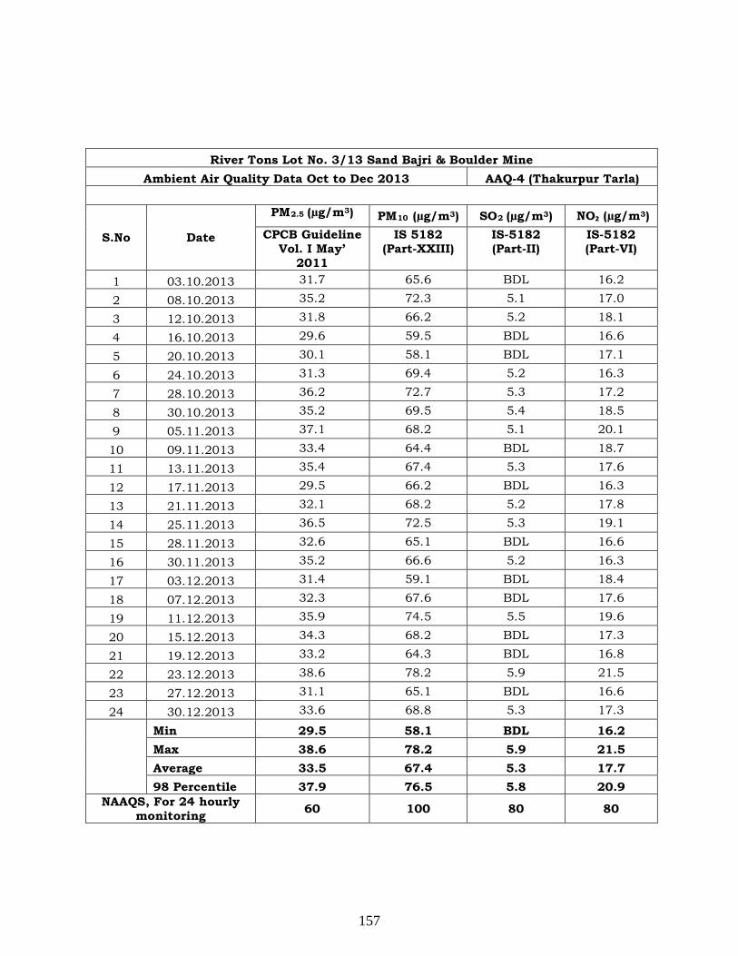
River Tons Lot No. 3/13 Sand Bajri & Boulder Mine Ambient Air Quality Data Oct to Dec 2013 AAQ-4 (Thakurpur Tarla)
S.No Date
PM2.5 (µg/m3 PM) 10 (µg/m3 SO) 2 (µg/m3 NO₂ (µg/m) 3) CPCB Guideline
Vol. I May’ 2011
IS 5182 (Part-XXIII)
IS-5182 (Part-II)
IS-5182 (Part-VI)
1 03.10.2013 31.7 65.6 BDL 16.2
2 08.10.2013 35.2 72.3 5.1 17.0
3 12.10.2013 31.8 66.2 5.2 18.1
4 16.10.2013 29.6 59.5 BDL 16.6
5 20.10.2013 30.1 58.1 BDL 17.1
6 24.10.2013 31.3 69.4 5.2 16.3
7 28.10.2013 36.2 72.7 5.3 17.2
8 30.10.2013 35.2 69.5 5.4 18.5
9 05.11.2013 37.1 68.2 5.1 20.1
10 09.11.2013 33.4 64.4 BDL 18.7
11 13.11.2013 35.4 67.4 5.3 17.6
12 17.11.2013 29.5 66.2 BDL 16.3
13 21.11.2013 32.1 68.2 5.2 17.8
14 25.11.2013 36.5 72.5 5.3 19.1
15 28.11.2013 32.6 65.1 BDL 16.6
16 30.11.2013 35.2 66.6 5.2 16.3
17 03.12.2013 31.4 59.1 BDL 18.4
18 07.12.2013 32.3 67.6 BDL 17.6
19 11.12.2013 35.9 74.5 5.5 19.6
20 15.12.2013 34.3 68.2 BDL 17.3
21 19.12.2013 33.2 64.3 BDL 16.8
22 23.12.2013 38.6 78.2 5.9 21.5
23 27.12.2013 31.1 65.1 BDL 16.6
24 30.12.2013 33.6 68.8 5.3 17.3
Min 29.5 58.1 BDL 16.2 Max 38.6 78.2 5.9 21.5 Average 33.5 67.4 5.3 17.7 98 Percentile 37.9 76.5 5.8 20.9
NAAQS, For 24 hourly monitoring 60 100 80 80
157
River Tons Lot No. 3/13 Sand Bajri & Boulder Mine Ambient Air Quality Data Oct to Dec 2013 AAQ-5 (Dhul Kot)
S.No Date
PM2.5 (µg/m3 PM) 10 (µg/m3 SO) 2 (µg/m3 NO₂ (µg/m) 3) CPCB Guideline
Vol. I May’ 2011
IS 5182 (Part-XXIII)
IS-5182 (Part-II)
IS-5182 (Part-VI)
1 01.10.2013 32.5 60.2 BDL 17.6 2 06.10.2013 40.5 73.2 5.9 19.2 3 10.10.2013 36.5 69.1 BDL 17.8 4 14.10.2013 37.3 76.3 BDL 18.1 5 18.10.2013 34.5 71.8 5.3 18.8 6 22.10.2013 36.9 79.6 5.7 17.8 7 26.10.2013 38.2 80.3 6.5 19.8 8 29.10.2013 42.7 88.3 7.3 23.5 9 03.11.2013 40.5 86.2 6.1 21.6 10 07.11.2013 37.1 81.1 5.8 18.8 11 11.11.2013 39.8 84.2 5.2 19.3 12 15.11.2013 34.2 74.1 BDL 17.8 13 19.11.2013 38.2 80.2 5.8 19.1 14 23.11.2013 36.8 78.1 5.1 18.5 15 26.11.2013 37.1 82.8 6.2 19.2 16 29.11.2013 35.9 75.3 5.5 17.9 17 01.12.2013 34.2 71.2 5.2 18.2 18 05.12.2013 34.9 73.8 5.6 18.8 19 09.12.2013 38.5 85.2 6.2 20.2 20 13.12.2013 36.9 79.2 6.0 19.5 21 17.12.2013 35.8 75.6 5.8 19.1 22 21.12.2013 38.0 80.8 6.1 20.8 23 24.12.2013 35.8 75.3 5.5 19.4 24 28.12.2013 36.5 77.2 5.4 20.3
Min 32.5 60.2 BDL 17.6 Max 42.7 88.3 7.3 23.5 Average 37.1 77.5 5.8 19.2 98 Percentile 41.7 87.3 7.0 22.6
NAAQS, For 24 hourly monitoring 60 100 80 80
158
PROFORMA FOR ENVIRONMENTAL APPRAISAL OF MINING PROJECTS
(MINING SECTOR PROJECTS)
1. General Information
1. General information
a Name of the project River Tons Lot No. 3/13 Sand, Bajri &
Boulder Mining Project
I Name of the proponent Garhwal Mandal Vikas Nigam Limited
ii Mailing Address Garhwal Mandal Vikas Nigam Limited,
74/1 Rajpur Road, Dehradun
Uttarakhand
E-mail [email protected]
Telephone 0135-2746817, 2749308
Fax No. -
b Objective of the project River Bed Mining of Sand, Bajri and Boulder
c Location of mine
Village Banshiwala
Taluka Vikasnagar
District Dehradun
State Uttarakhand
Note 1: All information to be given in the form of Annex/s should be properly
numbered and form part of reply to this proforma.
Note 2: Please enter √ in appropriate box where answer is Yes / No
Note 3: No abbreviation to be used - Not available or Not applicable should
be clearly mentioned.
Note 4: Core zone is the mining lease area.
Buffer zone in case of ML area up to 25 ha is to be considered as 5
km all around the periphery of the core zone and for ML area above
25 ha an area 10 km all around the periphery of the core zone.
Note 5: Adopt Scoping process in carrying out EIA study.
159
d Does the proposal relate to Yes No i New mine √ - ii Expansion - √ iii Increase in ML area - √ iv Increase in annual production - √ v Renewal of ML √ - vi Modernization - √ e Site Information i Geographical Location Co-ordinates Latitude: 30°20'29.19"N to
30°20'20.58"N Longitude:77°53'33.35"E to 77°53'49.23"E
Survey of India Topo sheet number
53F15
Elevation above Mean Sea Level 528 m AMSL
Total mining lease area (in ha.) 6 ha ii Dominant nature of terrain Yes No Flat √ - Undulated - √ Hilly - √
2. Land usage of the mining lease area (in ha.) a Agricultural - b Forest - c Waste land - d Grazing - e Surface water bodies - f Others (River bed of Tons) 6.0 ha Total 6.0 ha
3. Indicate the seismic zone in which ML area falls. In case of zone IV & V, details of earth quakes in last 10 years.
The lease area lies in Seismic Zone IV (Details attached as Annexure V)
a Severity (Richter Scale) b Impact i.e. Damage to Yes No Life - √ Property - √ Existing mine - √
160
4. Break-up of mining lease area (in ha.) as per approved conceptual plan:
Purpose
Mining Lease Area
Total
Area acquired Area to be acquired
Government Private Government Private Government Private
Forest Others Agri. Others Fores
t
Other
s Agri.
Other
s Forest
Other
s Agri. Others
1. Area to be excavated - 6.0 - - 6.0 - 6.0 - - - - - -
2. Storage for top soil - - - - - - - - - - - - -
3. Overburden / Dumps - - - - - - - - - - - - -
4. Mineral storage - - - - - - - - - - - - -
5. Infrastructure - - - - - - - - - - - - -
6. Roads - - - - - - - - - - - - -
7. Railways - - - - - - - - - - - - -
8. Green Belt - - - - - - - - - - - - -
9.Tailings pond - - - - - - - - - - - - -
10.Effluent treatment
plant
- - - - - - - - - - - - -
11.Coal handling plant /
mineral separation
plant
- - - - - - - - - - - - -
12. Township area - - - - - - - - - - - - -
13.Other - - - - - - - - - - - - -
TOTAL - 6.0 - - 6.0 - 6.0 - - - - - -
161
5 Township (outside mining lease) Not Applicable a Total area (in ha) - b No. of dwelling units - c Distance from mine site - 6 Distance of water bodies (in km)
Distance from
River Bank * Other Water bodies * Sea / creek / lake /
nalla etc. (specify)
Mining lease boundary
It is a river bed mining -
Ancillary facilities
- -
[* From highest flood line/high tide line]
7 For projects falling within the Coastal Regulation Zone (CRZ) Whether the mineral to be mined is
of rare nature and not available outside CRZ?
Yes - No
√
if yes, annex a scaled location map showing low tide line (LTL), high tide line (HTL) duly demarcated by one of the authorized agencies* [ *Director, Space Application Centre, Ahmedabad: Centre for Earth Sciences Studies, Thiruvananthapuram: Institute of Remote Sensing, Anna University, Chennai: Institute of Wetland Management & Ecological Designs, Kolkata: Naval Hydrographers’s Office, Dehradun: National Institute of Oceanography, Panjim, Goa: and National Institute of Ocean Technology, Chennai], boundary of mining lease area, distance of ML area from LTL and HTL CRZ boundary and CRZ classification of the project area as per the approved Coastal Zone Management Plan, and settlements, sand dunes, mangroves, forest land/patches, turtles breeding and nesting sites etc., if any, in the project area.
8 Indicate aerial distance from the periphery of core zone / area from the periphery of the buffer zone to the boundary of following (up to 10 km):
S. No. Area Name
Aerial distance from (in km.)
Core Zone* Buffer Zone*
1. National Park / Sanctuary Nil - -
2. Biosphere Reserve / Tiger Reserve / Elephant Reserve / any other Reserve
Nil - -
3. Forest (RF / PF / unclassified)
Bail Khala -
162
RF
Malhan RF
Baronwala RF
About 4 Km in NE direction. About 5 Km in SW direction. About 5 Km in SE direction.
4. Habitat for migratory birds Nil -
5. Corridor for animals of schedule I & II of the Wildlife (Protection) Act, 1972
Nil - -
6. Archaeological sites * Notified
* Others Nil - -
7.
Defence Installation Nil - -
8. Industries / Thermal Power Plants
Nil - -
9. Other Mines River Tons Lot No. 3/12
River Tons
Lot No. 3/14
River Aasan
Lot No. 14/1
Adjacent to the site
About 500m in W
direction
About 2 km in W
direction
-
10. Airport Nil - - 11. Railway Lines Nil - - 12. National / State
Highways NH-72 About 1 km
in N direction
-
[* Buffer zone in case of ML area up to 25 ha. is to be considered as 5 km all around the periphery of the core zone and for ML area above 25 ha. an area 10 km all around the periphery of the core zone]. 9. Description of flora & fauna separately in the core and buffer zones.* [* Consult the Wildlife (Protection) Act, 1972 as amended subsequently and list species with (1) Common name (2) Scientific name and (3) under which schedule of the Wildlife (Protection) Act the identified species fall. Get the list authenticated by an Expert in the field / credible scientific institute / University / Chief Wildlife Warden Office. Information to be based on field survey.] List of Flora & Fauna is given in Chapter III (Page no. 66-77) of EIA report.
163
10 Details of mineral reserves (as per
approved Mining Plan) Quantity (in tonnes)
a Proved - b Indicated - c Inferred - d Mineable reserves 1.6 lakh tonnes 11 Major geological formation /
disturbances in the mining lease area Yes No
a Geological maps submitted - √ b Geological sections submitted - - c Contour map submitted - - d Whether the presence, if any, noted of I Faults - √ Ii Dykes - √ Iii Shear Zone - √ Iv Folds - √ V Other weak zones - √ e Source of data (Indicate) -
12 Production of mineral(s) and life of mine
a Rated capacity of mine mineral wise (Tonnes / annum)
85,000 tonnes
b Life of mine at proposed capacity (Years) Not applicable as the mineral (Sand or Bajri)
is replenishable c Lease period (Years) Lease is yet to be
granted d Date of expiry of lease (D /M /Y) - e Indicate in case of existing mines
i Date of opening of mine - ii Production in the last 5 years 1st year
5th-
year from year……… to year ……… in million tonnes.
iii Projected production for the next 6th to 10th
year 5 years from year ……… to
year ………..in million tonnes.
iv Whether mining was suspended after opening of the mine?
-
v If yes, details thereof including last production figure and reason for the same.
-
f Whether plans & sections provided? - 13 Type and method of mining operations
TYPE METHOD Opencast √ Manual √ Underground - - -
164
Both - - - 14 Details of ancillary operations for mineral processing a Existing Not applicable b Additional Not applicable
15 Mine details a Opencast mine i Stripping ratio (mineral in tonnes to over
burden in m3-
) ii Ultimate working depth (in m bgl) 1.5 m bgl or above
ground water table whichever comes first
iii Indicate present working depth in case of existing mine (in m bgl)
-
iv Thickness of top soil (in m.) - a Minimum - b Maximum -
c Average - v Thickness of overburden (in m.) - a Minimum - b Maximum -
c Average - vi Mining Plan a Height and width of the bench in
overburden / waste. -
b Height & width of the bench in ore body / coal seam.
-
c Proposed inclination / slope of the sides of the opencast mine (separately for overburden, coal / ore and overall slope of the pit sides) both while operating the mine as well as at the time of closure of the mine.
-
d Whether transverse sections across the open cast mine at the end of fifth year and at the end of the life of the mine have been submitted?
-
vii Type of blasting, if any, to be adopted - b Underground mine Not Applicable i Seam / Ore body
Min. Depth (m) - Max. Depth (m) - Avg. thickness (m) - Rate of dip - Direction of dip in degree -
ii Mode of entry into the mine
165
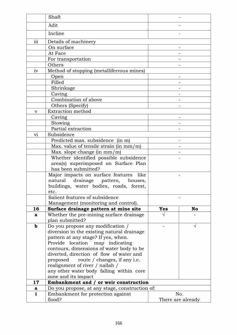
Shaft -
Adit -
Incline -
iii Details of machinery On surface - At Face - For transportation - Others -
iv Method of stopping (metalliferrous mines) Open - Filled - Shrinkage - Caving - Combination of above - Others (Specify) - v Extraction method Caving - Stowing - Partial extraction -
vi Subsidence Predicted max. subsidence (in m) - Max. value of tensile strain (in mm/m) - Max. slope change (in mm/m) - Whether identified possible subsidence
area(s) superimposed on Surface Plan has been submitted?
-
Major impacts on surface features like natural drainage pattern, houses, buildings, water bodies, roads, forest, etc.
-
Salient features of subsidence Management (monitoring and control).
-
16 Surface drainage pattern at mine site Yes No a Whether the pre-mining surface drainage
plan submitted? √
-
b Do you propose any modification / diversion in the existing natural drainage pattern at any stage? If yes, when. Provide location map indicating contours, dimensions of water body to be diverted, direction of flow of water and proposed route / changes, if any i.e. realignment of river / nallah / any other water body falling within core zone and its impact
- √
17 Embankment and / or weir construction a Do you propose, at any stage, construction of: i Embankment for protection against
flood? No.
There are already
166
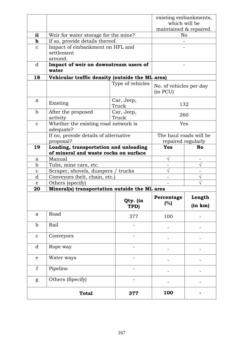
existing embankments, which will be
maintained & repaired. ii Weir for water storage for the mine? No b If so, provide details thereof. - c Impact of embankment on HFL and
settlement around.
-
d Impact of weir on downstream users of water
-
18 Vehicular traffic density (outside the ML area) Type of vehicles No. of vehicles per day
(in PCU)
a Existing Car, Jeep, Truck 132
b After the proposed activity
Car, Jeep, Truck 260
c Whether the existing road network is adequate?
Yes
If no, provide details of alternative proposal?
The haul roads will be repaired regularly
19 Loading, transportation and unloading of mineral and waste rocks on surface
Yes No
a Manual √ - b Tubs, mine cars, etc. - √ c Scraper, shovels, dumpers / trucks √ - d Conveyors (belt, chain, etc.) - √ e Others (specify) - √
20 Mineral(s) transportation outside the ML area
Qty. (in TPD)
Percentage (%)
Length (in km)
a Road 377 100 -
b Rail - - -
c Conveyors - - -
d Rope way - - -
e Water ways - - -
f Pipeline - - -
g Others (Specify) - - -
Total 377 100 -
167
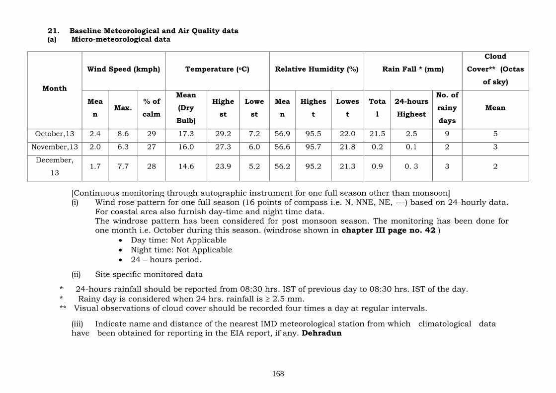
21. Baseline Meteorological and Air Quality data (a) Micro-meteorological data
[Continuous monitoring through autographic instrument for one full season other than monsoon] (i) Wind rose pattern for one full season (16 points of compass i.e. N, NNE, NE, ---) based on 24-hourly data.
For coastal area also furnish day-time and night time data. The windrose pattern has been considered for post monsoon season. The monitoring has been done for one month i.e. October during this season. (windrose shown in chapter III page no. 42 )
• Day time: Not Applicable • Night time: Not Applicable • 24 – hours period.
(ii) Site specific monitored data
* 24-hours rainfall should be reported from 08:30 hrs. IST of previous day to 08:30 hrs. IST of the day. * Rainy day is considered when 24 hrs. rainfall is ≥ 2.5 mm. ** Visual observations of cloud cover should be recorded four times a day at regular intervals.
(iii) Indicate name and distance of the nearest IMD meteorological station from which climatological data have been obtained for reporting in the EIA report, if any. Dehradun
Month
Wind Speed (kmph) Temperature (o Relative Humidity (%) C) Rain Fall * (mm)
Cloud
Cover** (Octas
of sky)
Mea
n Max.
% of
calm
Mean
(Dry
Bulb)
Highe
st
Lowe
st
Mea
n
Highes
t
Lowes
t
Tota
l
24-hours
Highest
No. of
rainy
days
Mean
October,13 2.4 8.6 29 17.3 29.2 7.2 56.9 95.5 22.0 21.5 2.5 9 5
November,13 2.0 6.3 27 16.0 27.3 6.0 56.6 95.7 21.8 0.2 0.1 2 3
December,
13 1.7 7.7 28 14.6 23.9 5.2 56.2 95.2 21.3 0.9 0. 3 3 2
168
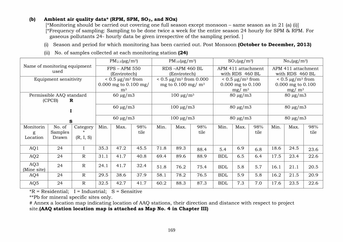
(b) Ambient air quality data* (RPM, SPM, SO2 [*Monitoring should be carried out covering one full season except monsoon – same season as in 21 (a) (i)]
, and NOx)
[*Frequency of sampling: Sampling to be done twice a week for the entire season 24 hourly for SPM & RPM. For gaseous pollutants 24- hourly data be given irrespective of the sampling period. ]
(i) Season and period for which monitoring has been carried out. Post Monsoon (October to December, 2013) (ii) No. of samples collected at each monitoring station (24)
Name of monitoring equipment
used
PM2.5(µg/m3 PM) 10(µg/m3 SO) 2(µg/m3 No) x(µg/m3)
FPS – APM 550 (Envirotech)
RDS –APM 460 BL (Envirotech)
APM 411 attachment with RDS 460 BL
APM 411 attachment with RDS 460 BL
Equipment sensitivity
< 0.5 µg/m3 from 0.000 mg to 0.100 mg/
m
< 0.5 µg/m
3
3 from 0.000 mg to 0.100 mg/ m
< 0.5 µg/m3
3 from 0.000 mg to 0.100
mg/ m
< 0.5 µg/m
3
3 from 0.000 mg to 0.100
mg/ m3 Permissible AAQ standard
(CPCB) R
I
S
60 µg/m3 100 µg/m 80 µg/m3 3 80 µg/m3
60 µg/m3 100 µg/m3 80 µg/m3 80 µg/m3
60 µg/m3 100 µg/m3 80 µg/m3 80 µg/m3
Monitoring
Location
No. of Samples Drawn
Category*
(R, I, S)
Min. Max. 98% tile
Min. Max. 98% tile
Min. Max. 98% tile
Min. Max. 98% tile
AQ1 24 I 35.3 47.2 45.5 71.8 89.3 88.4 5.4 6.9 6.8 18.6 24.5 23.6 AQ2 24 R 31.1 41.7 40.8 69.4 89.6 88.9 BDL 6.5 6.4 17.5 23.4 22.6
AQ3 (Mine site)
24 R 24.1 41.7 32.4 51.8 76.2 75.4 BDL 5.8 5.7 16.1 21.1 20.5
AQ4 24 R 29.5 38.6 37.9 58.1 78.2 76.5 BDL 5.9 5.8 16.2 21.5 20.9
AQ5 24 R 32.5 42.7 41.7 60.2 88.3 87.3 BDL 7.3 7.0 17.6 23.5 22.6
*R = Residential; I = Industrial; S = Sensitive **Pb for mineral specific sites only. # Annex a location map indicating location of AAQ stations, their direction and distance with respect to project site.(AAQ station location map is attached as Map No. 4 in Chapter III)
169
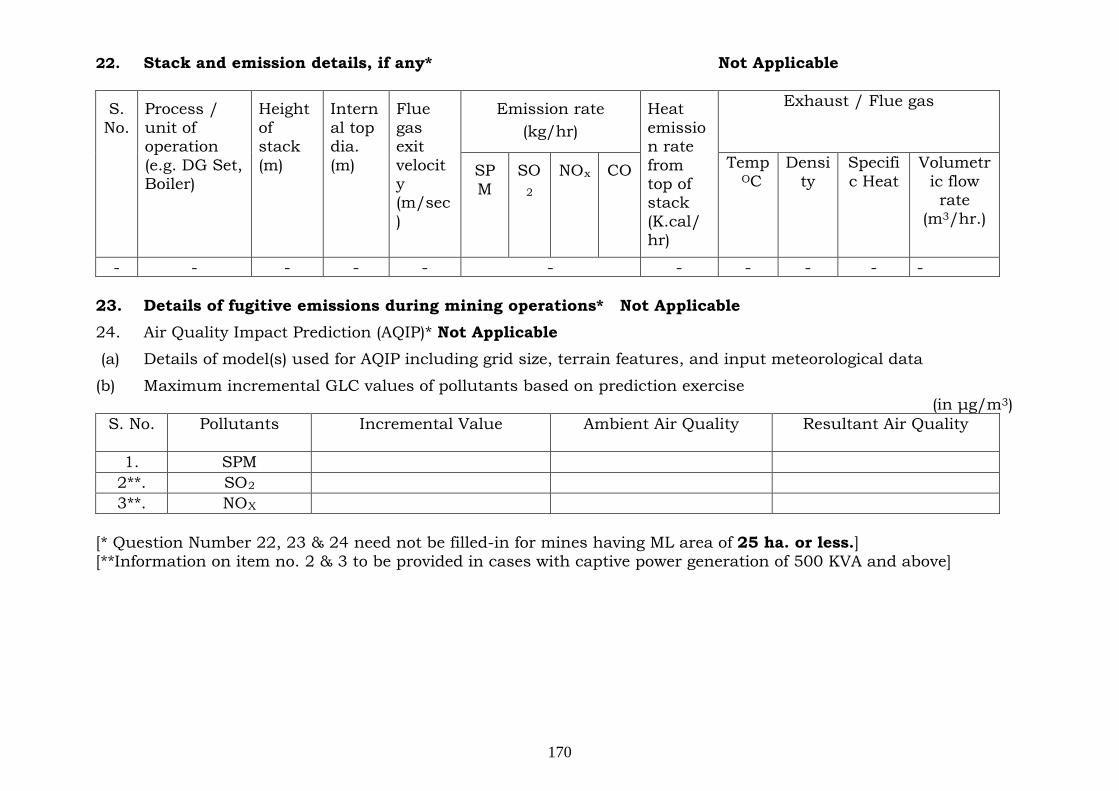
22. Stack and emission details, if any* Not Applicable
S. No.
Process / unit of operation (e.g. DG Set, Boiler)
Height of stack (m)
Internal top dia. (m)
Flue gas exit velocity (m/sec)
Emission rate (kg/hr)
Heat emission rate from top of stack (K.cal/hr)
Exhaust / Flue gas
SPM
SO NO2
CO x Temp O
Density C
Specific Heat
Volumetric flow rate
(m3/hr.)
- - - - - - - - - - - 23. Details of fugitive emissions during mining operations* Not Applicable 24. Air Quality Impact Prediction (AQIP)* Not Applicable (a) Details of model(s) used for AQIP including grid size, terrain features, and input meteorological data
(b) Maximum incremental GLC values of pollutants based on prediction exercise (in μg/m3
S. No. )
Pollutants
Incremental Value Ambient Air Quality Resultant Air Quality
1. SPM 2**. SO 2 3**. NO X
[* Question Number 22, 23 & 24 need not be filled-in for mines having ML area of 25 ha. or less.] [**Information on item no. 2 & 3 to be provided in cases with captive power generation of 500 KVA and above]
170
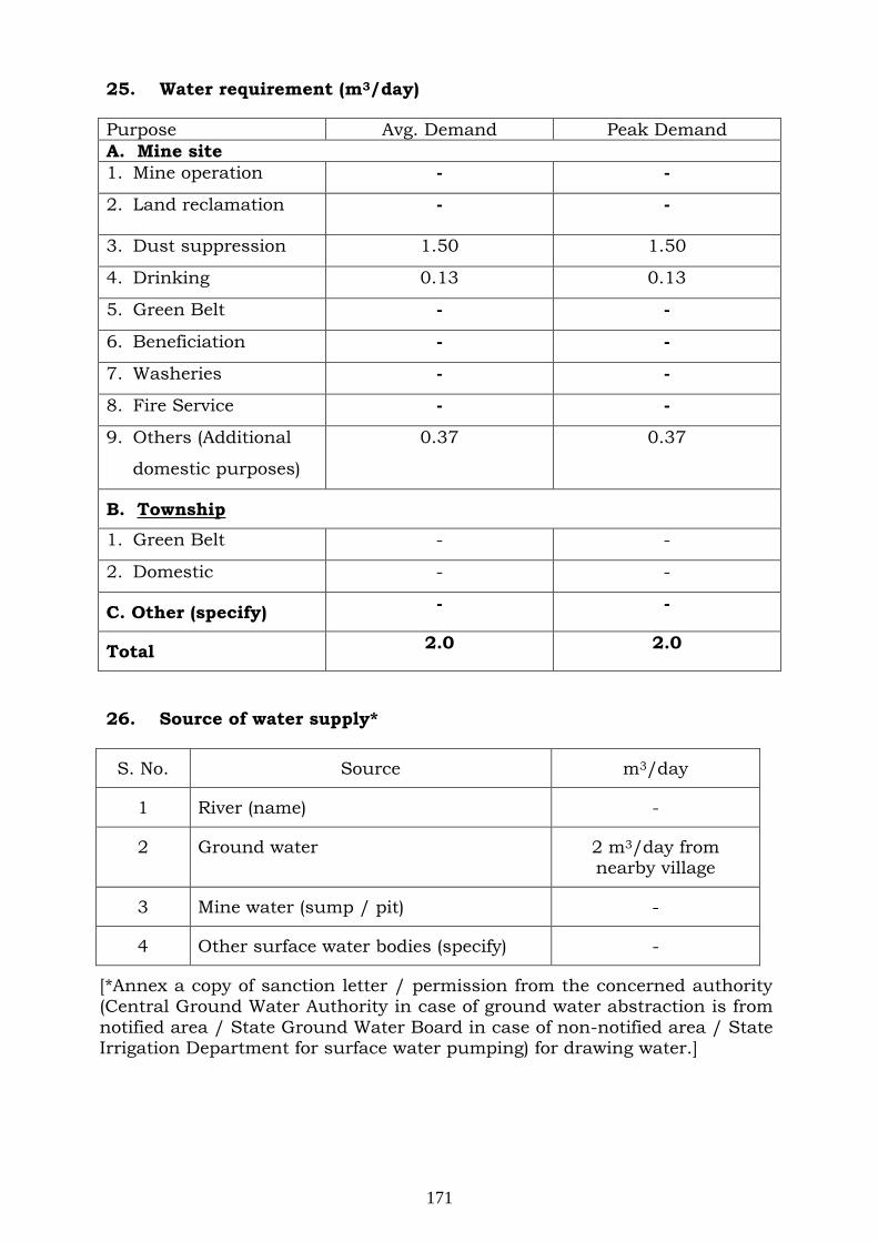
25. Water requirement (m3
Purpose
/day)
Avg. Demand Peak Demand A. Mine site 1. Mine operation - -
2. Land reclamation - -
3. Dust suppression 1.50 1.50
4. Drinking 0.13 0.13
5. Green Belt - -
6. Beneficiation - -
7. Washeries - -
8. Fire Service - -
9. Others (Additional
domestic purposes)
0.37 0.37
B. Township
1. Green Belt - -
2. Domestic - -
C. Other (specify) - -
Total 2.0 2.0
26. Source of water supply*
S. No. Source m3/day
1 River (name) -
2 Ground water 2 m3/day from nearby village
3 Mine water (sump / pit) -
4 Other surface water bodies (specify) -
[*Annex a copy of sanction letter / permission from the concerned authority (Central Ground Water Authority in case of ground water abstraction is from notified area / State Ground Water Board in case of non-notified area / State Irrigation Department for surface water pumping) for drawing water.]
171
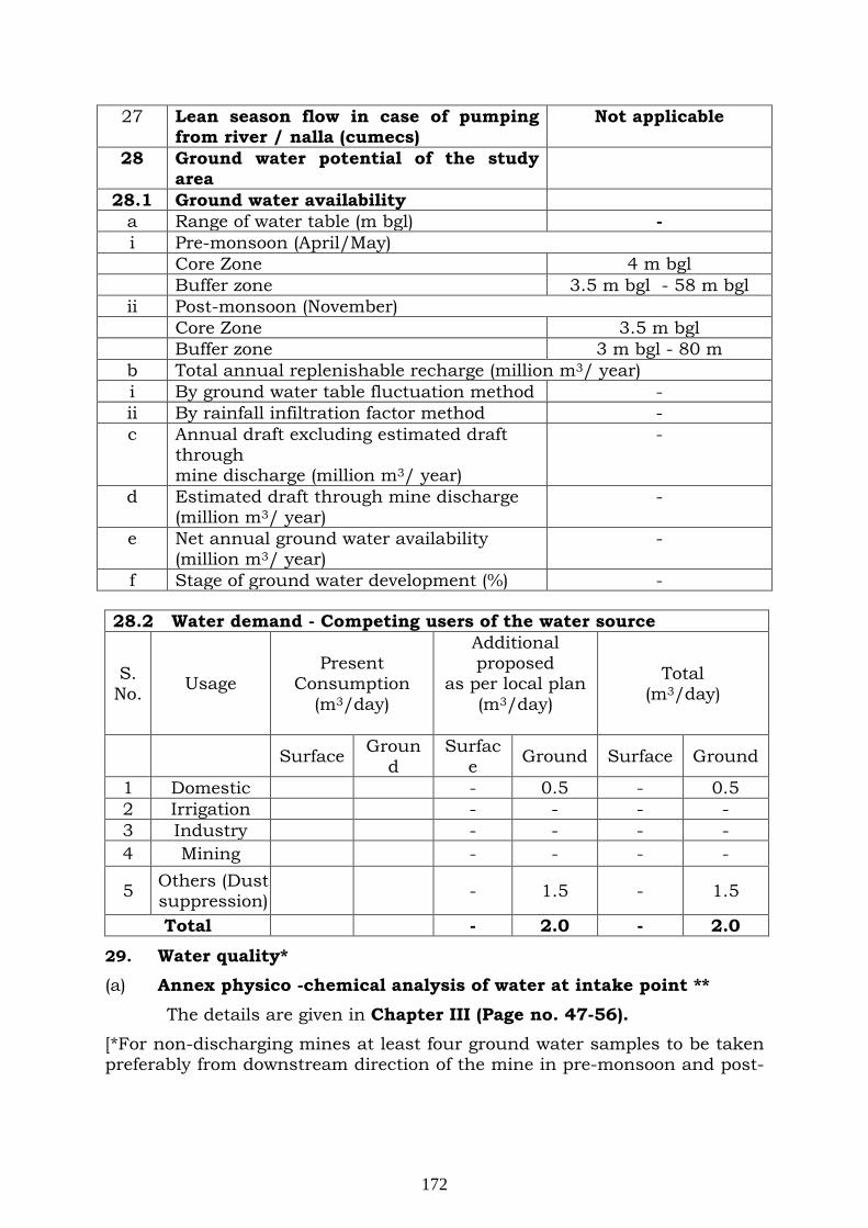
27 Lean season flow in case of pumping from river / nalla (cumecs)
Not applicable
28 Ground water potential of the study area
28.1 Ground water availability a Range of water table (m bgl) - i Pre-monsoon (April/May) Core Zone 4 m bgl Buffer zone 3.5 m bgl - 58 m bgl ii Post-monsoon (November) Core Zone 3.5 m bgl Buffer zone 3 m bgl - 80 m b Total annual replenishable recharge (million m3/ year) i By ground water table fluctuation method - ii By rainfall infiltration factor method - c Annual draft excluding estimated draft
through mine discharge (million m3
-
/ year) d Estimated draft through mine discharge
(million m3-
/ year) e Net annual ground water availability
(million m3-
/ year) f Stage of ground water development (%) -
28.2 Water demand - Competing users of the water source
S. No. Usage
Present Consumption
(m3
Additional proposed
as per local plan (m/day) 3
Total (m/day)
3/day)
Surface Ground
Surface Ground Surface Ground
1 Domestic - 0.5 - 0.5 2 Irrigation - - - - 3 Industry - - - - 4 Mining - - - -
5 Others (Dust suppression) - 1.5 - 1.5
Total - 2.0 - 2.0
29. Water quality* (a) Annex physico -chemical analysis of water at intake point ** The details are given in Chapter III (Page no. 47-56). [*For non-discharging mines at least four ground water samples to be taken preferably from downstream direction of the mine in pre-monsoon and post-
172
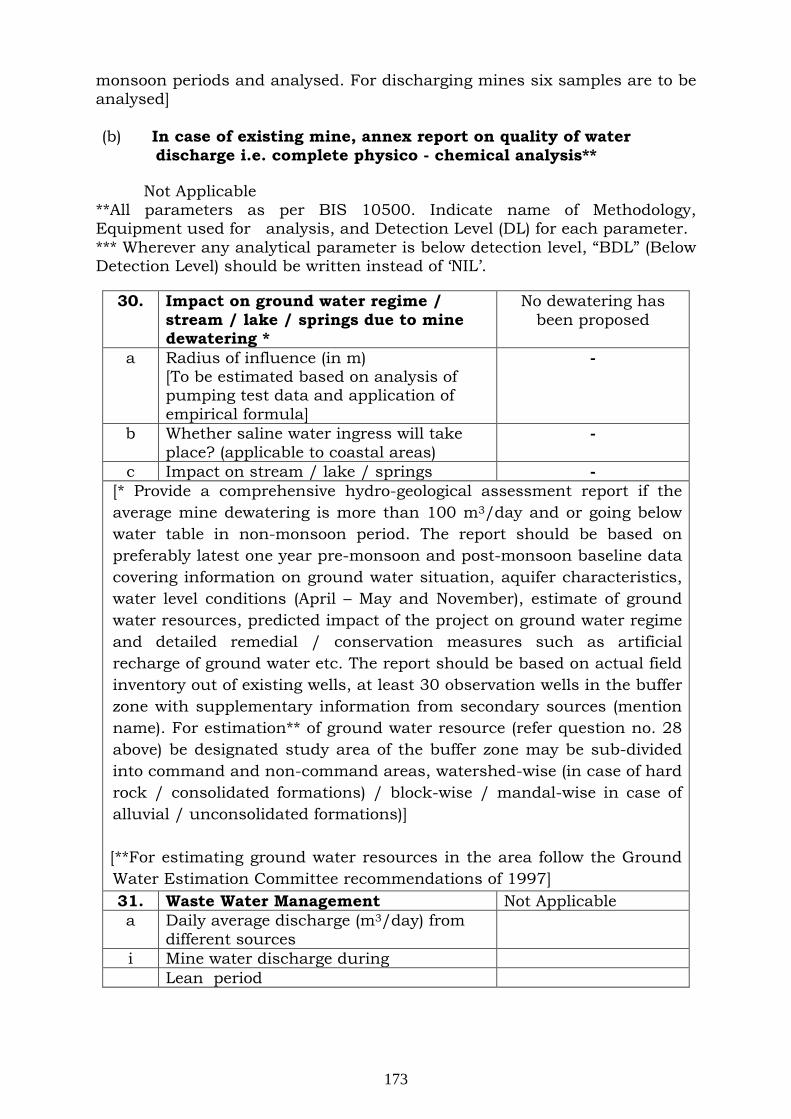
monsoon periods and analysed. For discharging mines six samples are to be analysed] (b) In case of existing mine, annex report on quality of water
discharge i.e. complete physico - chemical analysis** Not Applicable
**All parameters as per BIS 10500. Indicate name of Methodology, Equipment used for analysis, and Detection Level (DL) for each parameter. *** Wherever any analytical parameter is below detection level, “BDL” (Below Detection Level) should be written instead of ‘NIL’.
30. Impact on ground water regime / stream / lake / springs due to mine dewatering *
No dewatering has been proposed
a Radius of influence (in m) [To be estimated based on analysis of pumping test data and application of empirical formula]
-
b Whether saline water ingress will take place? (applicable to coastal areas)
-
c Impact on stream / lake / springs - [* Provide a comprehensive hydro-geological assessment report if the average mine dewatering is more than 100 m3/day and or going below water table in non-monsoon period. The report should be based on preferably latest one year pre-monsoon and post-monsoon baseline data covering information on ground water situation, aquifer characteristics, water level conditions (April – May and November), estimate of ground water resources, predicted impact of the project on ground water regime and detailed remedial / conservation measures such as artificial recharge of ground water etc. The report should be based on actual field inventory out of existing wells, at least 30 observation wells in the buffer zone with supplementary information from secondary sources (mention name). For estimation** of ground water resource (refer question no. 28 above) be designated study area of the buffer zone may be sub-divided into command and non-command areas, watershed-wise (in case of hard rock / consolidated formations) / block-wise / mandal-wise in case of alluvial / unconsolidated formations)]
[**For estimating ground water resources in the area follow the Ground Water Estimation Committee recommendations of 1997] 31. Waste Water Management Not Applicable a Daily average discharge (m3 /day) from
different sources i Mine water discharge during Lean period
173
Monsoon period ii Workshop iii Domestic (mine site) iv Beneficiation / Washeries v Coal Handling Plant vi Tailings pond vii Others (Specify) Total b Waste water treatment plant; flow sheet
for treatment process attached.
c Quantity of water recycled / reused / to be recycled in
i Percentage ii m3 /day d Point of final discharge Final Point Quantity discharged
(in m3/day) 1 Surface i Agricultural land ii Waste land iii Forest land iv Green belt 2 River / nallah 3 Lake 4 Sea
5 Others (specify) Total e Users of discharge water Yes No i Human
ii Livestock iii Irrigation iv Industry v Others (specify)
F Details of the river / nalla, if final effluent is / will be discharged (cumecs)
i Average flow rate ii Lean season flow rate iii Aquatic life iv Analysis of river water 100 meters
upstream and 100 meters downstream of discharge point submitted.
g Township
174
a Waste water generation from township (m3/day)
b Are you planning to provide sewage treatment plant?
c Usage of treated water
32. Attach water balance statement in the form of a flow diagram indicating source (s), consumption (Section-wise) and output.
Purpose Demand Domestic 0.5 KLD Dust suppression 1.5 KLD
Total 2.0 KLD
33 Ambient noise level leq dB(A)
Location Zone
Leq LIMIT (as per CPCB
Guidelines), in dB(A)
Leq Value monitored, in
dB(A)
DAY* NIGHT* DAY* NIGHT*
NQ1 Residential Zone 55 45 51.8 39.8
NQ2 Industrial Zone 75 70 50.7 40.8
NQ3 Residential Zone 55 45 54.1 43.6
NQ4 Residential Zone 55 45 47.8 38.1
34 Solid Waste Not Applicable a Top soil and Solid waste quantity and quality
Name (Lump/fines/slur
ry/ Sludge/others)
Composition Quantity (m3
Method of disposal /month)
Mining activity* a. Top Soil b. Over burden c. Others (specify)
Effluent Treatment Plant
(sludge)
Total [* Annex layout plan indicating the dump sites.]
175
b (i) Does waste (s) contain any hazardous/toxic substance/radioactive materials or heavy metals?
(ii) If yes, whether details and precautionary measures provided?
c Recovery and recycling possibilities. d Possible user(s) of the solid waste.
e (i) Is the solid waste suitable for backfilling? (ii) If yes, when do you propose to start
backfilling?
Solid waste (s)
Already accumulated
(A)
To be generated
(B)
% of A & B to be backfilled
A B Over burden
Others (specify)
Land reclamation Plan Not Applicable f In case waste is to be dumped on the
ground, indicate
i Associated environmental problems ii Number & type of waste dumps No. of external dumps Max. projected height of dumps (in m) No. of terraces and height of each stage Overall slope of the dump (degree) Proposed reclamation measures
iii Section of the waste dump in relation to the adjacent ground profile attached
35 Fuel / Energy requirements* [*To be furnished for mines having ML are more than 25 ha. or captive power genera of 500KVA and above]
Not Applicable
a Total power requirement (in MW) S. No.
Mine Site Township Others (specify)
Total
1 Present 2 Proposed /
additional
Total b Source of power (in MW)
S. No. SEB/Grid* Captive power plant
DG Sets
1 Present 2 Proposed
/
176
additional Total
[* Annex a copy of the sanction letter from the concerned authority] c Details of fuels
S.No.
Fuel Daily Consumption (TPD)
Calorific value
(Kcals/kg)
% Ash % Sulphur
Existing Proposed
1 HSD 2 LSHS 3 Other
(specify)
36 Storage of inflammable / explosive materials
Not Applicable
S. No.
Name Number of Storages
Consumption (in TPD)
Maximum Quantity at any point of time
1 Fuels 2 Explosives
37 Human Settlement Core Zone Buffer Zone Population* - Details given in
Chapter III (Page no. 81-83).
No. of villages - Number of households village-wise
-
[* As per 2001 census record or actual survey] 38. Rehabilitation & Resettlement (R&R) Pla
[*Provide a comprehensive rehabilitation plan, if more than 1000 people are likely to be displaced, other-wise a summary plan]
Not Applicable
a Villages falling within the study area Villages Numbe
r Name
Core zone 500 m from the blasting site (s)
Buffer zone Township site
b Details of village(s) in the core zone S. No.
Village name
Population* Average Annual Income
Tribal Others 1
[*As per 2001 census / actual survey] c Population to be displaced and / or Land
177
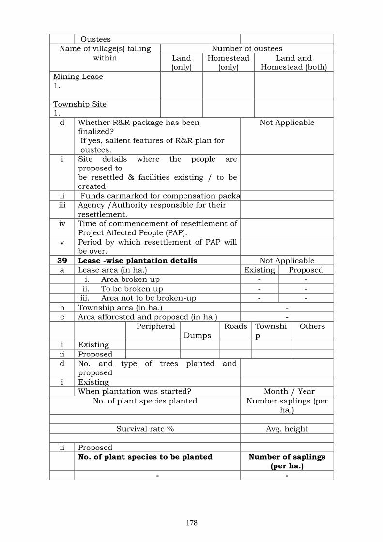
Oustees Name of village(s) falling
within Number of oustees
Land (only)
Homestead (only)
Land and Homestead (both)
Mining Lease 1.
Township Site 1.
d Whether R&R package has been finalized? If yes, salient features of R&R plan for oustees.
Not Applicable
i Site details where the people are proposed to be resettled & facilities existing / to be created.
ii Funds earmarked for compensation packa iii Agency /Authority responsible for their
resettlement.
iv Time of commencement of resettlement of Project Affected People (PAP).
v Period by which resettlement of PAP will be over.
39 Lease -wise plantation details Not Applicable a Lease area (in ha.) Existing Proposed i. Area broken up - - ii. To be broken up - - iii. Area not to be broken-up - - b Township area (in ha.) - c Area afforested and proposed (in ha.) - Peripheral
Dumps Roads Townshi
p Others
i Existing ii Proposed d No. and type of trees planted and
proposed
i Existing When plantation was started? Month / Year
No. of plant species planted Number saplings (per ha.)
Survival rate % Avg. height
ii Proposed No. of plant species to be planted Number of saplings
(per ha.) - -
178
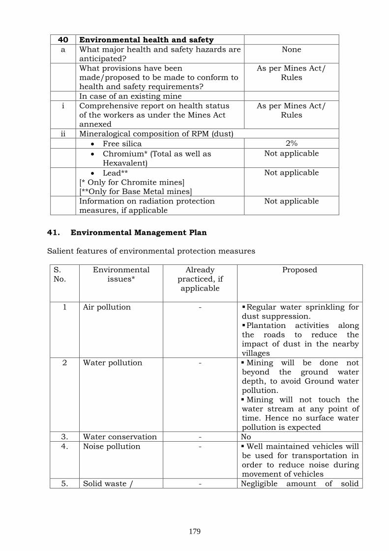
40 Environmental health and safety a What major health and safety hazards are
anticipated? None
What provisions have been made/proposed to be made to conform to health and safety requirements?
As per Mines Act/ Rules
In case of an existing mine i Comprehensive report on health status
of the workers as under the Mines Act annexed
As per Mines Act/ Rules
ii Mineralogical composition of RPM (dust) • Free silica 2% • Chromium* (Total as well as
Hexavalent) Not applicable
• Lead** [* Only for Chromite mines] [**Only for Base Metal mines]
Not applicable
Information on radiation protection measures, if applicable
Not applicable
41. Environmental Management Plan Salient features of environmental protection measures
S. No.
Environmental issues*
Already practiced, if applicable
Proposed
1 Air pollution
- Regular water sprinkling for dust suppression. Plantation activities along the roads to reduce the impact of dust in the nearby villages
2 Water pollution - Mining will be done not beyond the ground water depth, to avoid Ground water pollution. Mining will not touch the water stream at any point of time. Hence no surface water pollution is expected
3. Water conservation - No 4. Noise pollution - Well maintained vehicles will
be used for transportation in order to reduce noise during movement of vehicles
5. Solid waste / - Negligible amount of solid
179
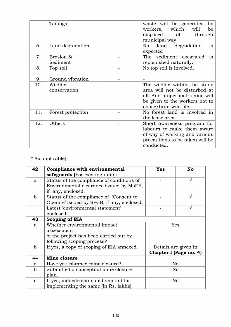
Tailings waste will be generated by workers, which will be disposed off through municipal way.
6. Land degradation - No land degradation is expected
7. Erosion & Sediment
- The sediment excavated is replenished naturally.
8. Top soil - No top soil is involved.
9. Ground vibration - - 10. Wildlife
conservation - The wildlife within the study
area will not be disturbed at all. And proper instruction will be given to the workers not to chase/hunt wild life.
11. Forest protection - No forest land is involved in the lease area.
12. Others
- Short awareness program for labours to make them aware of way of working and various precautions to be taken will be conducted.
[* As applicable]
42 Compliance with environmental safeguards (For existing units)
Yes No
a Status of the compliance of conditions of Environmental clearance issued by MoEF, if any, enclosed.
- √
b Status of the compliance of ‘Consent to Operate’ issued by SPCB, if any, enclosed.
- √
Latest 'environmental statement' enclosed.
- √
43 Scoping of EIA a Whether environmental impact
assessment of the project has been carried out by following scoping process?
Yes
b If yes, a copy of scoping of EIA annexed. Details are given in Chapter I (Page no. 4)
44 Mine closure a Have you planned mine closure? No b Submitted a conceptual mine closure
plan. No
c If yes, indicate estimated amount for implementing the same (in Rs. lakhs)
No
180
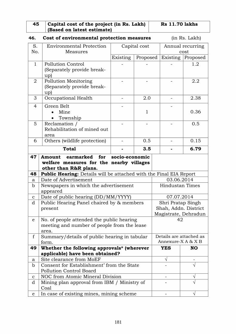
45 Capital cost of the project (in Rs. Lakh) (Based on latest estimate)
Rs 11.70 lakhs
46. Cost of environmental protection measures (in Rs. Lakh)
S. No.
Environmental Protection Measures
Capital cost Annual recurring cost
Existing Proposed Existing Proposed 1 Pollution Control
(Separately provide break-up)
- - - 1.2
2 Pollution Monitoring (Separately provide break-up)
- - - 2.2
3 Occupational Health - 2.0 - 2.38
4 Green Belt • Mine • Township
- 1
- 0.36
5 Reclamation /
Rehabilitation of mined out area
- - - 0.5
6 Others (wildlife protection) - 0.5 - 0.15
Total - 3.5 - 6.79
47 Amount earmarked for socio-economic welfare measures for the nearby villages other than R&R plans.
48 Public Hearing: Details will be attached with the Final EIA Report a Date of Advertisement 03.06.2014 b Newspapers in which the advertisement
appeared Hindustan Times
c Date of public hearing (DD/MM/YYYY) 07.07.2014 d Public Hearing Panel chaired by & members
present Shri Pratap Singh
Shah, Addn. District Magistrate, Dehradun
e No. of people attended the public hearing meeting and number of people from the lease area.
42
f Summary/details of public hearing in tabular form.
Details are attached as Annexure-X A & X B
49 Whether the following approvals* (wherever applicable) have been obtained?
YES NO
a Site clearance from MoEF √ - b Consent for Establishment’ from the State
Pollution Control Board - √
c NOC from Atomic Mineral Division - √ d Mining plan approval from IBM / Ministry of
Coal - √
e In case of existing mines, mining scheme - √
181

approval from IBM f Forestry clearance under FCA, 1980 - √ g NOC from Chief Controller of Explosives - √ h Commitment regarding availability / pumping
of water from the concerned Authorities - √
i In case of ML area falling in notified areas of the Central Ground Water Authority, NOC from them.
- √
[* Annex copies of approvals and number them]
50 Was / is there any court case relating to the project or related activities? If so, provide details present status.
No
182
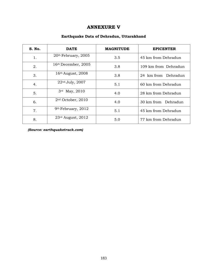
ANNEXURE V
Earthquake Data of Dehradun, Uttarakhand
(Source: earthquaketrack.com)
S. No. DATE MAGNITUDE EPICENTER
1. 20th
February, 2005 3.5 45 km from Dehradun
2. 16th
December, 2005 3.8 109 km from Dehradun
3. 16th
August, 2008 3.8 24 km from Dehradun
4. 22nd
July, 2007 5.1 60 km from Dehradun
5. 3rd4.0 May, 2010 28 km from Dehradun
6. 2nd
October, 2010 4.0 30 km from Dehradun
7. 9th 5.1 February, 2012 45 km from Dehradun
8. 23rd5.0 August, 2012 77 km from Dehradun
183
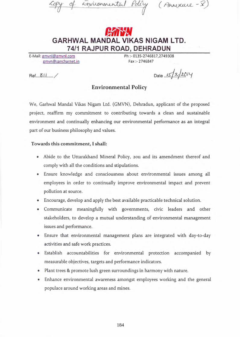
GRlD GARHWAL MANOAL VIKAS NIGAM L TO.
74/1 RAJPUR ROAD, DEHRADUN E-Mail: [email protected]
Ref .... fHi. ...... /
Ph :- 0135-2746817,2749308 Fax:-2746847
Environmental Policy
We, Garhwal Mandai Vikas Nigam Ltd. (GMVN), Dehradun, applicant of the proposed
project, reaffirm my commitment to contributing towards a clean and sustainable
environment and continually enhancing our environmental performance as an integral
part of our business philosophy and values.
Towards this commitment, I shall:
• Abide to the Uttarakhand Mineral Policy, 20U and its amendment thereof and
comply with all the conditions and stipulations.
• Ensure knowledge and consciousness about environmental issues among all
employees in order to continually improve environmental impact and prevent
pollution at source.
• Encourage, develop and apply the best available practicable technical solution.
• Communicate meaningfully with governments, civic leaders and other
stalceholders, to develop a mutual understanding of environmental management
issues and performance.
• Ensure that environmental management plans are integrated with day-to-day
activities and safe work practices.
• Establish accountabilities for environmental protection accompanied by
measurable objectives, targets and performance indicators.
• Plant trees & promote lush green surroundings in harmony with nature.
• Enhance environmental awareness amongst employees working and the general
populace around working areas and mines.
184
• Report on our environmental management performance and progress regularly
and appropriately to the concern authority.
• Involve the public in decision making and make this policy available to them.
WORKERS RESPONSIBILITY
All workers and contractors will be made to comply with and support the Environment
Policy and to ensure that they:
• Follow established operational procedures, guidelines and instructions.
• Report and respond to environmental incidents and hazards in a timely fashion.
• Abide by the applicable laws and regulations of the mineral policy.
• Evaluate and respond to risks related to the mining activity which could adversely
impact people or the environment.
• Ask questions of their supervisor when unsure about environmental issues to
comply/ ensure them
(Authori ed ' ory
For Garhwal MandaI Vikas Nigam Ltd.
185
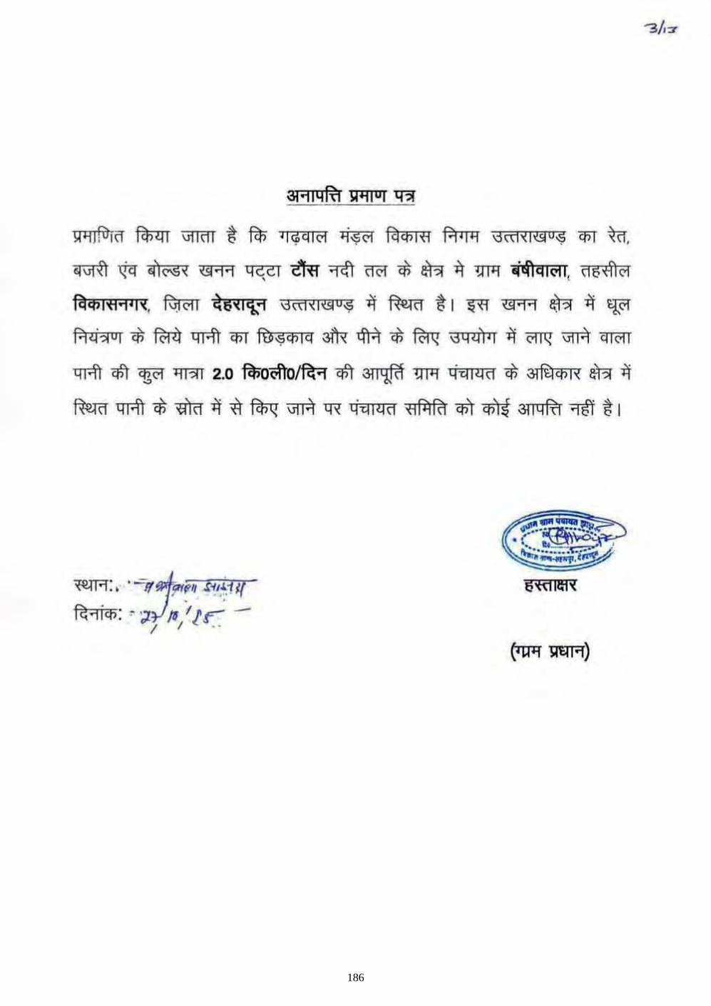
!;P""lJ~lff ftn<:rr \111<11 t Fcn ~ I¢qlcl 4'$<'1 fclq')lfI PP II""l 13ct1"{I,&O'$ Cf5T ~,
«,,{I ~ .1<"5' "'.,., 40;'" i'f<r 1<ft \WI <f; aR i\ 1JTIl "~.'OI'. ".;ffi0i
f,l."<1.,'''. Ri)0I1 ~6"'k1 ''''''''''"9 i\ ~ ~ I ~ "'.,., aR ij 'l:'" R <i ~ "I <f; fW) 'IT'l\ <PT fU 9 ,," " 3lR <ftiI <f; fu<I "4 .n ' I ij <'!T'i ""I"A q lOll
'IT'l\ qfr '!iR '1 1?11 2.0 ~oofuJfu qfr • 1JTIl 'h"~" <f; ~ aR ij
~ 'IT'l\ <f; -roo ij -,'\ ~ ""I"A 11< <iii I ~ " <1 fjl fi1 qi\ ~ 3114 If! 'lfj ~ I
186
~m"'W GARHWAL MANDAL VIKAS NIGAM LTD.
7411 RAJPUR ROAD, DEHRADUN E-Mail: [email protected]
emvn @S~ ncharnel! i n
ReL .. k<t. .~ ... / {9?1
To ,
The Chief Wildlife Warde n, Oovernmen t of Uttaral<hand . Wild life Institute 5, Chandrabhani, Mohil.~wa1a, D(,!hrudun-248001
Ph :· 0135-2746817,2749308 Fax:- 2746847
Dat e : J/~~' W/'.
Subject: Authentication of tIte data for proposed sites- River 1'ooe& Lot no. 3/6. 3 / 8, 3 / 10, 3 / 11, 3 / 1"2, 3 / 13, and 3 / 14 a t Dis t;rict: Dehradun, Stat!;: Utturakh~lld by Garhtval Manda! Vilcas Nigrun for rIver bed mining in the allotted area.
This is for your kind information that the above men tioned p roject for mining of
Boulder, BaJri and Sand lies in Dchradun d istrict, State Uttarakhnnd has b~.en
applied for Enviror..mcn tal Clearance, for which relevant jnformation of the study o...-ea
is required to be authcnticnted:
./ List of F lom & Pauna prescnt in the study a rea (Enclosed).
Kindly authenticate tile above inforDlation at your earliest for th e fi.n..q}ization and
submission of ELAj EMP report to the regulatoty bodies for obtaining Environmental
Clearance.
·Th ankingyou. Yours truly,"
' ''*rnifector
187
GaffIN GARHWAL MANDAL VIKAS NIGAM LTD.
74/1 RAJPUR ROAD, DEHRADUN E-Mail: [email protected]
To.
peeF & ChiefWildllfe Warden,
Govt. of Uttrnkhand,
Wildlife [nsitute 5,
Chandrabhani Mohadewla,
Dehrachm-248001
Ph :- 0135-2746817,2749308 Fax:- 2745847
Date ... ~J.\~.J.L1-
Sub: Authentication of Conservation Plan for Mining Projects of Garhwal Mandai Vikas Nigam
Ltd.
Dear Sir,
As per the Tenns of Reference (ToR) awarded by the MoEF, EIAIEMP reports has been prepared as per the EIA Notification, 2006.
1 am here by submitting the conservation plan for Schedule-! & JI species as desired by ministry for granting Environmental Clearance of GM VN Ltd. Mining projects . .
Hope you will be find this in order. I kindly request you to process expeditiously our application.
Thanking you.
Yours truly,
Managing Director
lid: As Above
188
I-Iead Office UHarakhand Environment Protection & Pollution Control Board
""eo, 29/20, Nemi Road, Ualanwala, Dehradlln (Uitarakhand)
UEI'PCB/HO! NOC-193712014/l\'j U ...... Date:r:~:t"hg, Ml ! Y l Sneed Post >, "~,, ,c""'''''''" "'f" ~_~ ___ \ _ J/ J .~~~' i/'''' " .. "-"
III;; '( F~ ~.r'l ') .
!\r,,~ i,~' '-~)~4'> ':; The Secretary, '-, !~ IU~ J l4 " Minisiry of Envirunment & Forests, \ v; .> "
.. ", Paryavanm Blunvan, eGO Complex, "" . ~"'"
Lllahi Road, New Delhi-ll0003. ~~!~};! .. :"./
To,
Sllbicc~:- Minutes of Public Hearing of Mis Garbwal Mandai Vikas Nigam Ltd. for Collection of Sand, Sajr! & SimMers from Lot No. 3/13 of River Tons, VikasNagar, Dehradnn~- reg.
Sir, This is to inform that Uttarakhand Envrionment Protection and Pollution
Control Board has conducted the Public Hearing of Mis Garbwal Mandai Vikas Nig;un Ltd for Collection of Sand, Rajri & Boulders from Lot No. 3/13 of Rivl:r Tons, VikasNag>lf, Dehradun on dated 07.07.2014 at Panchayat Bhawan, Jhanjra., Vikaskhand, Sahaspur, Dehradun. lbe copy of the minutes of Public Hearing along with video recording, photography of entire Public Heairng and copy of attendence sheets are enclosed herewith for your kind persual and necessary action please. Enclosed :- as above.
Copy to :-
/tbfuilY
(Vinod Singhal), Member Secretary
1. District Magistrate, Uehradun for kind information and with request to display the minutes of respective public hearing at your office for general information please.
2. The Additi.onal District Magistrate, Distt- Dehradun for kind iniormation please,
3. Regional Officer (lIC) UEPPCB, Dehradllll with direction to display the minutes of respective public hearing at your office for general information please.
\4.Mallagin g Director, Mis Garhwal Mandai Vikas Nigam Ltd. 74/1, Rajpur ( Road, Dehradun for kind information and with request to display the minutes
of public hearing to the office of the p,mchayatllUrban Local Bodies, whose jurisdiction the project is located for general information plea.se.
S. Asst Programmer, UHarakhand Environment l)rotectJioll and Pollution Control Board, Dehradun with request to upload of minutes of public hearing to Board's web site on priority basis.
189

190
"40 'Iq;qlcl "lo;S<?\ FclCfil'fl ~ (GMVN) fRo &ii'<I~'1 &Rf iR=r "l<fr <>ik ol-3 / 13 -#"<?I1J -wrui't * ~!J6 OJ ~ q 4\ CI '< 0 1 '&1"1 Cfl R1 ~ 'ffiq; 'tj;'i Cli ~ R"IiCl5 01.01.2014 (~q'<l<i5 2.00 6f\il) ~ cj'Clllld 'lfCT'i", FclCl5Itl'BI O;S fl6f1~'<,
iJl'1Q<: ~6'!1~'1 CI>T iflI4c.!R1 I
1'\0 'I <i> CJ I C'I ~ fc! Cfj I fl f.'r<D:r, 4!,; ~ \ '& 'i 1:lffl i'R:r .,-cfr me ~-3 / 1 3 Ti c;rq C1cfUi't cf; 'fi lW I ~ q <4lq ~ 0 I t<I~ CJZ Ri. cf; fuit ~ '{1'i q 14 "Cf>T 311 dl iJl 'i fclurr l1<TI I
ql:jfq~o\ll:j «IlCJZRi ~ \3ct1~I'iSiu;g 4<jfq~vl "ffl"efDT I(Ci ~ Pvi'5l OI <iii, 4!,;,(1<&'i
i'i >ffiITCf ~ "§;3lT I \3Cf\l >ffiITCf q <4 [q q 0 I I(Ci C["'i" s:j '511 C'l'q ~ «H Cfj I ~ cBT q<4fq~u\I<4 >J1ITCT 'IC'<liCfj'i, 3liit!'<iil'1l 2006 cf; 3-Rflfu" <IIliUl~d ~ I \3Cf\l qR4IiJl'1l
'c#r q<1fq~u\I<j >J1ITCT 'i,cY<ljcn'1 Jm5<IT, Y<jjqqu\I<1 wncr 3lfu'<iil'1l 1994 "I1121T~ cf; ~ \'I<nx cBT 7f<1t % ~m "f!1cp. '{1'iqI4 Y<4TCJ,{o\l<1 >J1ITCT 'i,C'<liCfj'1
~-2009 cf; .31jflR cBT 'T<fr ~ I
~ 30.06.2014 iN ~ '1(;'\<;<4 &RT ~ 3fCR ~ (fcRd" I(Ci ~), ~!,;~I,&'i m J;fdTCf f$ ~, cBT 3'lRiamf i'i 4ill<4d 'l1Cf'i", ~, fc!Cfjlfl'iSiu;g
fi!';fig"!, iJl'14c; ~6"1,&'i i:i "f!1cp '{1'iql~ 31141itJd cBT 'T<fr I ~ <iii cf; I'lRif.'lftr cf; X'i1:f it m ~.11'crN (;>;10 ~) q m ~ ;g<l~IC'I (-31:!0 wro) ~"-Tff ~ I
31R1a1 '151<;<1 cBT ~. it· \3Cf\l "f!1cp '{1'iClI~ \fc{J tTx;mrr LR ir't cf; CJ1RUT
x~ f.'lqiffP:i'i cBT 11M LR md": 12.00 ~ cBT 7f<1t I
OO~ \-\ct1~I'iSiU'9 Y<4fq~ul mefDT I(Ci ~ f.1<4·'5I U! ~ cf; I'lRlf.'lRr m 'PWf ..:fcrR (<110 ~) &RT "f!1cp '{1'iClI~ cf; <IIlll'liJl'1 cf; ~~ cf; 'fR i'i ~"-Tff ~ fi~C;Ii:! iN ~. ~. -.rm am CJ%f l1<TI fcp. \3ct1~I'iQu;S qi:!\CI~ul ma'fUl I(Ci
~ f.14'51 ul <iii, ~!,;~I,&'i iN 1'\0 II<i>ClIC'I ~ fclCfjlfl0
f.1rr:r, ~5ql,&'i &RT i'R:r "'l<fl i'i ~ 'C'fCfU1T cf; tiMul / ~Cfj'5lul ~ >ffiITCf ~ "§;3lT ~ I 'l1ffil fj~cnl,{ qfT
;>;I~ RId4j~ 2006 "11m ~ cf; ~ qf~liliJl'il i'i qi:!rCl~u\)<4 '("Cl"ICJZR'I
~ \rf'1 '{1'1qI4 "Cf>T .~ ~ I Irfl .~. illcP '(1'1 cIl4 cBT futQ:r it f.'l<1'1ljfil~ 30 fu<r wi ~ fl'1I'i1I~ "4?l tf.icp. iJll'l,{ul q [%'1'«11'1 ~ cf; ~
03.06.2014 cf; 3icP i:i ~ 3llWl cBT ~ !>lCfjI~ld ~ 'T<fr m I fc!$1fih cf; '1IRfIf
it \if'[ "fllt1RUT 8m ~ q R l1'l iJl '11 cf; fil> <41 rq <4 '1 it ~ -wncr ~, iTq Fe; d:j u\)
3Tfl'ta1 ~ Tf<l ~ I "11ft x~ <?\'rTiT cBT qR"lIWlIcf> ~ i'i cp){ ~ <IT ~ . '& :ill ~ ~ "fiTq; '{1'iqI4 cf; '1IRfIf it 4<1fCl,{Uf I(Ci C["'i"s:j'5lIC'li:!, 'l1ffil fj"CfjI"! em
JWKr fcIRrr iJl 1 ~'II, ~ ID'<f ~ fi ~<; 1<4 -fr ~ fcpi:jT l1<TI fcp fcr'ClT{ ~. q R III \J1 'i I cf; lTa1 -tt ;>;Ie:rcrr fcrtmr i'i Irfl "rfq cf; '1Wl11 -fr <III s:jPm ,&, ftJ '1 c#r ~d <l1fMI "R"cPTf'Jrr I(Ci q;lcl~lq\) "lfl cBT iJll~Jft I "rfq cf; ~ -fr ;>;[N ~ cf;
1
191
'i!')t<l'ia{ fc:rtrrx ~ qR£ll\J1'"11 ~f¢£lI<'C/£I'1 ~ 'fCf) Pioll"lCfJ ~ qj'r 3lfi'JCljfCR1 NrfII
ctc;lqo'1I"<1 "fficp 'ti'iCjI~ ~ ~3'[S[fa:r m ],1('ffCf fuo W5, 3ffi ~ (fctrn ~ ~) &m "fficp 'ti'iCjI~ # \3""4ft~ Wf -f1j~I"l -fr Cfi1)T <n:IT fu; qR£lllJl'il ~
~.£T # "\JlT ~ ~ -c:ci ~ t ~ li~ Rsl CfJ <IT ~ Rsl ct XilQ# ClICKf ~, Rn'iCj)'1 tl4PtC(fI -if flfi'<:1~<:/CfR q£ljq"l°l -c:ci CFf l'j:;jIi51"l cnT ~ fu;m 1Jl1~'"1
~ ~ # ifo 'lcpClIi51 ~- FclCfJlfI f.'rj-l:f ~ q"llli"!Ti mm ~ l'IfrlPt~ '>fr -~O-qrO fuo &m qR 4 'I WI! -fr ~ ~ IJl I'i CfJ I {J eft 7f'lt -c:ci 3'fCIlT<:'f
CfRl<lT 7fm- fu; qR4)1Jl'i1 "Cf)l cgc;r ~ 6_931 ~O ~ I "\JlT fu; ml'f cdnCl1i51I,
ct!')t1~Ii51 FclCfJlfI'i'I'1 lJl'iqc; ~!,)"II'i:'1 -if ~ ~ I \3C!<:l QR4'11Jl'11 ~: fI"ICfJI{J ~
-qx wh11Fcl ct ~ I ftR'r ~ fI "I CfJ I "I &m 'I it> q I i51 ~ Fcl CfJ I fI f.-'rr:r cnT c>ll\if -qx
WIT 7fm -~ I qR411Jl'i1 ~ fiR:1T ~ qj'r f."rGft ~ "Cf)l ~ ~ fu;m \YfTffi ~ I ~ qR411Jl'i1 "Cf)l ~ \3,\~~'"I ~, ~cr ~ Cf)f ~/~ fu;m \3'Il'TI ~ Rn 'i CfJ I \3 q lj)' I ~ f.'r:rfur cpp::jf -if fu;m IJl I ~ 'II I .,-cfr -if ~ c;rcruTI- ~ li CfJ C( d _~ ~ CJ\i1"O -fr .,-cfr 3l'AT +JTIf ~ t<:fr ~, -c:ci ~ '1 ~ -fr 0/"1+11<:1 -if ~ CJJCfCfm ~, fGJ+lfI fu; qzft ___ -<W<:i ~ ~ WQ:f-WQ:f ~/lfT7if cnT jCfJ+lI'1
q §i1 <:11 ~ I ~ ~ cnT ~ $1 Pt CfJ ~ -fr -FcPit ~ -qx ~ CJJCfCf q5T -x'rcnl1Wf ~ "fITQ:f--'-:~ -X-ew1m PtClIFf!lj'j cnT ~)\Jjlll"l ~ TWr -c:ci '(5IPtIJt ~ c;-p:ff- -if ~ "CfJl'lT
3!l<Pfi 1 q R"l) IJl 'i I -fr cWIT ~ WII Rn CfJ -c:ci ~ ft-l2lfu -if ~'CfR ~ -c:ci Xf\Tlj"
+I "I CfJ I "I cnT ~ "I I IJl '{'q >IT'<:I ~ 1 ~ <:IT;" ~ Cfi1)T fu; ~ q R"l) IJl 'i I -fr '<1 1Jl' 11"1
cnT Gi<jITCIT ~ 1Jt1~'" I ~ qR411Jl'11 -if .,-cfr ~ C'fCJ -fr 15 l'IfrI~l<:1 'llPT cnT e'I'$CfJ"I
~ c;rcroTt "Cf)l ti % ° I fu;m IJl I ~ 'II, ~ &m ;w:R't l'I *1\11 CfJ"I ° I -if <:IT;" ~ 0f<:1TllT
'flIT fcI;-- 1.5 -4'Icx '115,(I~ CJ'CI> ~; ~, ~ Cf)f till!') 01 fu;m 1Jl1~'" 3ffi ti%OI
cwf 'Q;4TC:"l -fr "illltct cf; <fti1" fu;m 1Jl1~'" oQ:fT ti%OI ~ 'i0j<:1 IH ifj31c'f fu;m
1Jl1~'" ~ ~ tcfr li~fJ'1{J Cf)f \jqljl'l ~fu;m 1Jl1~'1I1 <:IT;" qR411Jl'i1 ~ Xi14
-fr ~$IPiCfJ ~ -fr q5T 1Jl1~'f/ 1 m ~O-qrO -~ &m ~ l'I*1c11CfJ"IOI -if <:IT;" ~ 31CflT<:1 CfRl<lT <n:IT fu; ~ cwf -fr ~ ~ ~ ~ Pilj:;j0l ~ 4"l\CI"I0f/lj
l'IO/"4'i lj)IJt'i1 ('ifC1liQ)) <ATIfI- 7f'lt t ~ crrg; ~ Ptlj:;j°l ~ -~ "4X iSIC'f
fU'$CfJICI -c:ci W1/l-W1/l "4X crrg; 101 cl<:<:1 I Cf)f 311'>fC[Uf CfR ctc;lj+llx "Cf'"ljCl"l0f/"l
-W-Pil'1" lj)IJl'i1 <ATIfI- 1Jt1~,f/ _I qljjCl"l°f/'"I ~.£T'l lj)IJl'11 ~ 311-'>[C[Uf ~ q"ljCl,<of/'"I
~a-TT c;c;r Cf)f TfCi'i" fu;m 1Jl1~'111 q'"ljCl"l°f/'"I ~ dllJt'il ~ 3fB1T-fr <MC Cf)f
mfcttwr fu;mTmT ~, Ri"lflCfJI \3qljl'l iSIC'f ~lcr, ~ q5T '1"11+1<:1 -c:ci <[1;1IX1Q ol
~ CflTlTI -if fu;m IJl I ~ 'II I
2
192
\N~C1~ICflxOI cf; -.rrc; qRlil\Jj'i1 cf; ~ -if \iF[ 'iijcWl £:RT ~ '<j!!"l/q'j -qci
3llQR'ctlil em Fclqqol f.'I'""'ilj'(1l~ ~-
1. .>J.ft fctR '!r'fR ~ "!Il11 q"ocll<'ltl). PiClloffl ti"1fiQIC'l1 8m \{'iCf'Rf "CflWIT l"fm
fcp B<Rl me -if '{fi9 ~ ~-e.rRm Pi ell ffi li 'j c#I #r -A-fuo t ILk B<Rl ~ If<
'B'r ~ cwf fcnm \Jjlll'1I7 "G2:iT ~I<kcl c#I ~ qm ~7 ~ £:RT (j-g- #r "W9f l"fm fcp ~ CfJl<f -if ~~ dlFchili'i c#I ~ qm NJfl7
2 . .>J.ft ~ CI\'fCllcl. f.'jCllfil ~ £:RT 1J:BiT l"fmfcp ~ ~ -if ~ CfJl<f ~ ~ 3Tem ~ 8m fcn<l I:rIT"t 1'f'{ qm >rrfcltrR ~7
3. .>J.ft ~ fm> (~ "ImR) f.'!Cllfil ~ ~ CfiTIl'f -if wfr m~ 8m ~ ~ 1'f'{ ~ cpp:f fclxIT \JIT XN ~ I B<Rl 3tcft[ ~ ~ ~ qm
mfclm;f / <ll \Jj 'i 1 %7 ..
3Tlf< ~ 8RT 3TCrTc1 C!JWlT l"fm fcp .Wffil ~ cwf ~ fI~CflI~ c#I ~ 1'f'{ fcnm \iJFIT ~ I Xf\Yll '{NCflI ~ c#I ~ 1'f'{ 3T<f MJ W'i'l c#I ~ <n?i ffR;:R. cf; "CflRUf f.'"r\;fr ~ 8m fI ~$ I ~ "ff"r 1'f'{#r -WIt[ W'i'l fclxIT \!!mT
t \iJ'r fcp ~ ~ LR". "nff it ~ I ~ JICl)R 3tcft[ ~ 1'f'{ ircf; cf;
W~--':fIT~ 'i£lf.'I\Jji * GT1if -if #r Cfi1TT ~ I ~ ~ l'i ~~ f.'Ienffi4'i cnT <¥R -c:rer ~ I:rIT"t ~ m~~Cflfll 'I?T mFclm'i % I ~1<lC"il c#I <it ~ '(1"($1"( £:RT f.1trffW c#I umf)- ~ I ~ fI'< $1'< c#I ~ ~ cf; ~ 'i£I'R
cwf ~ ];!TC(f ~ cf; 5 >l f?J ~ I¢j "lWT cnT 'i£If.'r\J1 fctcpTff AA ci? l1fUI11 ~
~~ >11 if! 0 i'i ci? Fcl $ I fI "C!>T<iT "f CZf7.l fcnm \Jj I 1I J II I ~ 31 R1 RCfC1 -c:rer 'CfRCfj
~m 8RT i/51"ql~c fjl~<lcl Rx:q'iff<ifc:lt1 (CSR) ci? ~ ~ ~ em . ~ "1fIT ~~ fli 'i I Rrt $ -qci Fcl $ I xi CfiTIl'f -if ClfIT fcnm \Jj Ii), II I
3Rl l'i B<Rl 3TlqR'ct<ll· ci? ~ -if \Jj~Il('i~ ci? qR'if.'lfq 8m \jq'llCR1 '<j~lql ci? ~ l'i 3TCrTc1 C!JWlT Tj<:fT fcp <¥R cwf ci? ~ lJTc'f Cffi.ii/5 cm0f ci? q Rq 6'1
~ ~$~$ >ffIf c#I ~ c#I \Jjli),~ -qci ~ f.iti'01"1 ~ qI:1Tq"ull<l ~ <l'1 \ij 'i I cf; ~ cwf fclxIT \Jj J i) J II I ~ 3T R1 R cfct ~ 8m 31cfllCf "CflWIT Tj<:fT
fcp ~~ l'Il'ilUii ci? Fcli/5If1 ~i/5I,<ql~c fjl~<lcl Rx:ql·ff<iGit1 (CSR) ci? 3Rf'fo 'i£I'Ff cwf ~ >IT1{f ~ 'I?T ~ "lWT ~ fj Pi I Rrt i/5 Fcl i/51 'Ii cpp:f l'i ClfIT fcn<l \ilT-'i em 'B'r mfi1tIA ~ I ~-e.rRm ~ 1'f'{<¥R cwf l'?Pt ~ ~~ ~'I\JjJ",< ~ mrrr ·FIl11Tfcrq;~ I ~ 31 R1 R CfC1 ~ £:RT 0ffiTlIT Tj<:fT fcp W"A cwf -;r l'?Pt ci? Cf)Rl1f rrcfI 'I?T CJ I «I Fcl i/5 ~ 'f0f \Jj I il, II 3fR ~ ~ -qci ~ ~ CfiT CJ>C]q
3
193
~ ~ ~ Ci?T.'TJl'l ~$fIPiCJ) ~ ~ Cl?ffi .:31""fu ;}lIq,(i:jCJ) ~ I QR<i'1\il91 ~
GRf1"h1 ~ ~ qjT ~ cpr '4T ~'V:!R~ \il1~JIII <n3" '4T "1Pi~i/t1 fil;m \il1~Jil fct; ~ ~$fif.1CJ) ~ ~ fctm \jj"p) fuRffi q<lfq~u\l<l arfu· ., if I 3RT it x:r+rr it 13"Yft-e:.ro &j Fcffi <i'i &RT Nl2:f ~ ClR" ~ cw:\ -gg. fI to '1 R'I ~ qjT
11<11 I
\1 <;'1 q ~ I 't\ C1'fcp "1"1'11 ~ ~ CJ) 14 elltil 31S!:faf 'i <i I G i:j ~ ~ ~ &RT xi 'i I q 'i CI:>"r
"Efrq-urr qjT 11<11 ~ I \If"'! "19ql~ qjT CJ)14q16i qjT q;'icl"-1l4\l 'fCi ql~l1l!:llqjj qjT ~
~I
1. cp)cf. 2. ~ocfto"tto 3. ~ qTGiCJ)1
.~~2: 3f1R ~ (fcI0/~O)
~tO~lt'1
4
194
, ---'-" .. --.--.-"'-'-~--~--'-"-
, j t -'--,--" _. _' - "', r--"'''~''''~'---'''---~'',,, .,,- -',
I~'~ '! Ii i ie:>,:;t;: L¢:Zl ~iQJLI~:L;
c~~~ti:J~~:;~;'!!:~~~};~~~!<;:~~l:;: =-~~~~l;;:t~~~fo-$;-;'-~u, u_ ~~::= ~;,f
--~-"'''t''~'3vr1i?tj;;--iE7:1.l};c..r;;;· <if-'3't1 ;..~rW'1'(':6 J .~
=~;+~;:=;;i~=~= -l;;~~~_=(~;~~;;'~ , 1."i"~~'~J 4 "f;$i''!lJ!£tJ&-,''Ifir ~..J1.;r} I-H ,J rilr1~:7:I br?i=~ -_.,-'",''''' ',-- --- F----~ ------ --- -------------,---- c----- -- ---
,,' !)..'-~ 3$714. t)mz:L~7:-:~;;di:;ry, ~~0jD~~'"~41~qfif~7" ~'\' ''''1''-''''---'''- -'-;-' , ._ ... ,......, ... ".-,,,,,"'----' .. -, -'",""'",-"-''''''''-''-''''''"",,,,,,,,,,,,,,,,-,,-,'',,, "",,-'~
_~;--~L '" (; ~ ~QI'(' );:;iC.~~f)7«if.Y' FSf;'~~'<iV ~-i'~9 e,7fJ-::;i~ '~-'--'- ."'-""'-'---'--:----'--""''''''----.'-'''-'''''--'-'''''' ... --'"""'."""" 'T'''''-''--'''--- ~'--."~
--1'1':-- r't'",P.'f-:1J<lr;c-It.-,-tte.I"t",_,n" -efct::-=c ";t)''Vi'!7 "." b-QCfT37so ]5.' 'T
:=~=lV~i~~:--=-__ ~~f~=~J=~i i.~~a-~'";;: ,-'-{-~1!::!~~i-,g~-:6Y'."·."."·.·'., .,.~E.u!..~~, __ ,. :4''i'~-'~Zi¥J_ .-,~---:
==-_~_I."".~~~:~=g~;;~~~,~.~.·.~·~ •• ~~~~~~',~ -?J..~,~?j,~,~~,~ ,'",,¥:,! --f%~= _~-.Jh-;~= :=~_~==~u ----. ;-; ",~.:,;,,; ~ -- 7,-14('?- "3."';-'- - u ---4~"""T :: !'1OTj:'1~"':":~
= -~~~:'~~i!=-n-= ::~~ ,,~_~ :~~~::~ ._~~ ••• -,,,,,r'_"'"'''''T''' '"'''''''''' '''''' "' .. ' .'''" ''-'' . ,,' ,,,,' ...... _,,,,,,.,
~-,c,jc-\-G'\b, ...................... , ............. ~..............'.. .. ' , .. ~ .~,_,1k.~,~~;sr:L~~ ................. ,,,,C:f.~,,~I=I.... . . .. I' r
-"'- / 1 '-1- ~loi I G' (J ~q . -r 'r ~;y #1'7:(fD (fu if, . '[1 iL"Cq t5 ~ ~, . ,2.'1 "., , " ... ,- ., ' "-
! ' ,I
! :'-:/~,.,}--J,\l '!-,h..()i 195
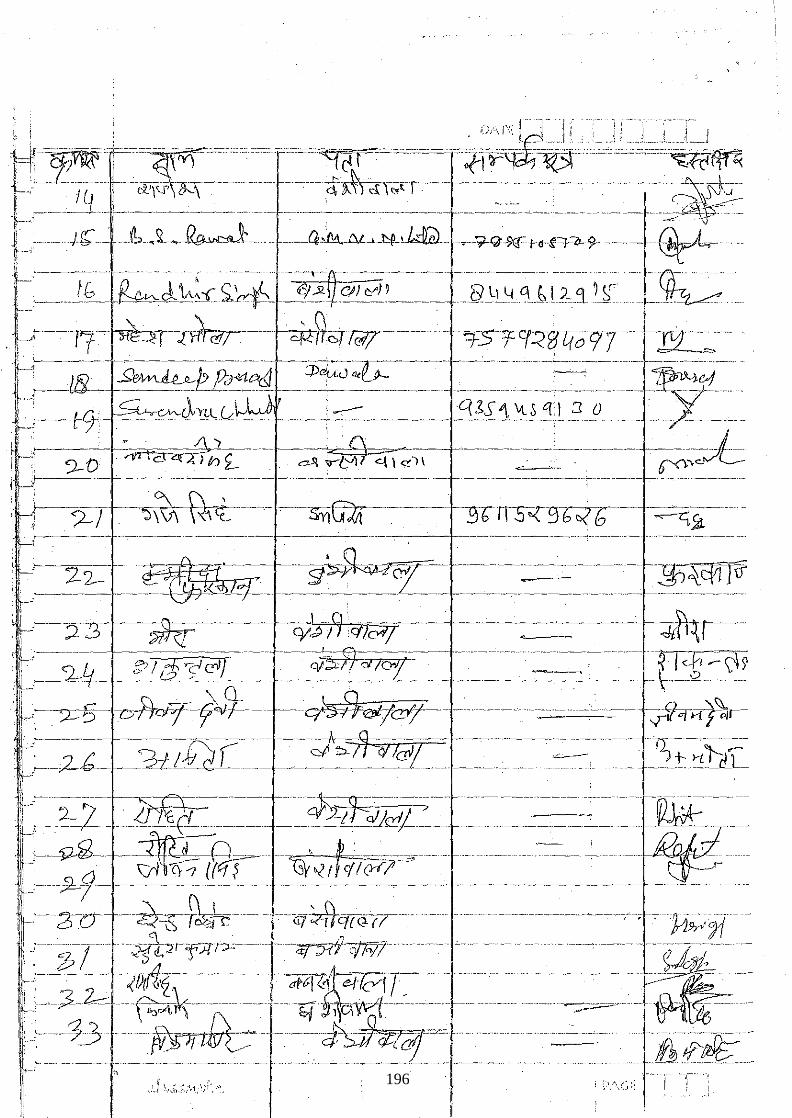
- "i ,- "--- ,--'"---,
_1_i_J "'''''_'.c.'c;-''c''.'~~
. -: '--:-lt~ - ~r-~-~---- -cfJtcrw------- -:f5Tcr~_g[(()9T--Isr ____ -
. f-~~=~-- ?~;l!.f;!~_ =~~~:~~?~ -~~-=--~~~~-~~~~-----~~-~--~~~--~-E~-~_ f----t-Ij-~J,_~0___ _____ ' -===-__________ .9~X1_~§_~_L~ __ 0_ ___~-"C ,r' '. . ) · {\ · ± i;~.:________----- - -~I\..)--.----- -------=---, =--"--- ,---.-----------.--------- .. --------- ----------------I', 9-'0' ~co:lh Z- .. c---'\ '<1--L0)l "-\ \ ~,\ c .' ()<l-"> j;, ~ .~- "-------~---,---- -_ .. _----------------_._- --------.'----.-----.. "---.-"'~-.. '-.-------- .- ---.... _-_._-.'---... "_.---.-, 1 ,; r-?--J ~---- ~-5JYiG21 --. -- -§brr:S--<3b-~-- ~1---
._._-- ,-,-----,-,---_.--,--------_.. ---_.-... _--- -----_._-"._,--.-_. __ .-. __ . __ .-._ .. -----.. -_. -. -.-._----'"--.-.--- ---,.
i: ~:_2:2-, ~_ !Wt£z:r~ -g~«:r_ ---_-=~=~=~ ____ -~$'"Cj1yr I~~.?--:T -. ~.------ -cy~/9mCY1--- ------'--:---~-------- -~"J-- .. -
I !~-~~- i~~-!il~cC!lii=~ -~-~-~~~c:'f __ == ~~~=~~-~_~=_~=~-_----_~L~t==\~ . :i_,---,?=-§--D~V-~f---- --.--~eY'/-----.- .. --.----" ..... ---------.---- -- ~lcfjTf~r-, :__________________ ______ _____+~----- ._____ ____ ,_._ .. _ _ __ .. __ ____ c~-.-------
'I --2"L __ ?d_Lf2 C ___ ~ c-:I' ~ __ "?IICIJL----------c-:-- __ ~_t'!liL_ I;
t-2l'U- ,-~S'-+kLc-- -... 'if7~q{(,>~( (-- . ..........-------"---~;."-; .. ; ....... ~ ir-,f,-;b-r uJjt::>ff'Jl1:O-:- _u ... u-;q;5(7 ,71"17'" c_.. . .•. - .• -...---. -.([1. :---~ :~c-~----Z1}tf1'? ----·af"CI·~ .'&/' cvr r u
....... u. ..__n____.~__ .. f_-;3~-~~-u--.-- .... -- .'q -~C\~:t-:·-······ ...... -~-.- .~~--. 'lj>--'33--~ ··-----cf;shlafcc= ..-- .._.L 'iI1i-~_ . f-: ___ . __ .______'_:; .. __ u __ • ___ u._u ___ .____ --- ••••.•• ,.-- - ----~ ____ ._u· __ ,____ .,---- .• -- .-.---.--------
, i :" .,' " r \-,Sl.:·~;',·I. . "'. .., !.,.:
196
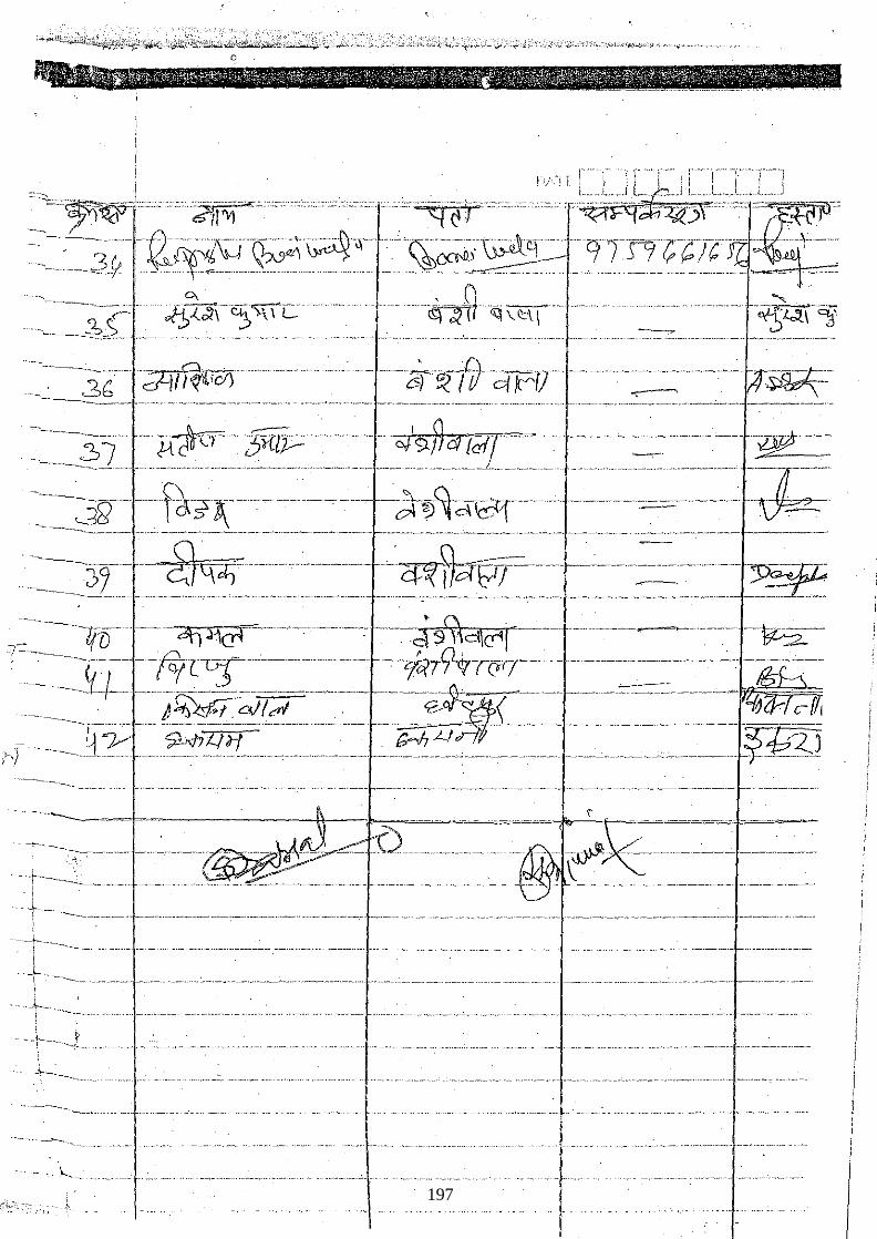
"--.,_~ ___ . ~-___ • ____ '._·_"_· ___ ;._I ___ ~' .. ___ --'-"-_'_--'-"_ ----.--••• --~.,-.• -._ .. ~ • ___ .; ~.c·_.-_,._._., __ , __
i
-. .!t--. ____ _ .. __ _
"" .-----
-'._-... ------'"-.,.-
··k .. 197

·,:"
.. i[J
198
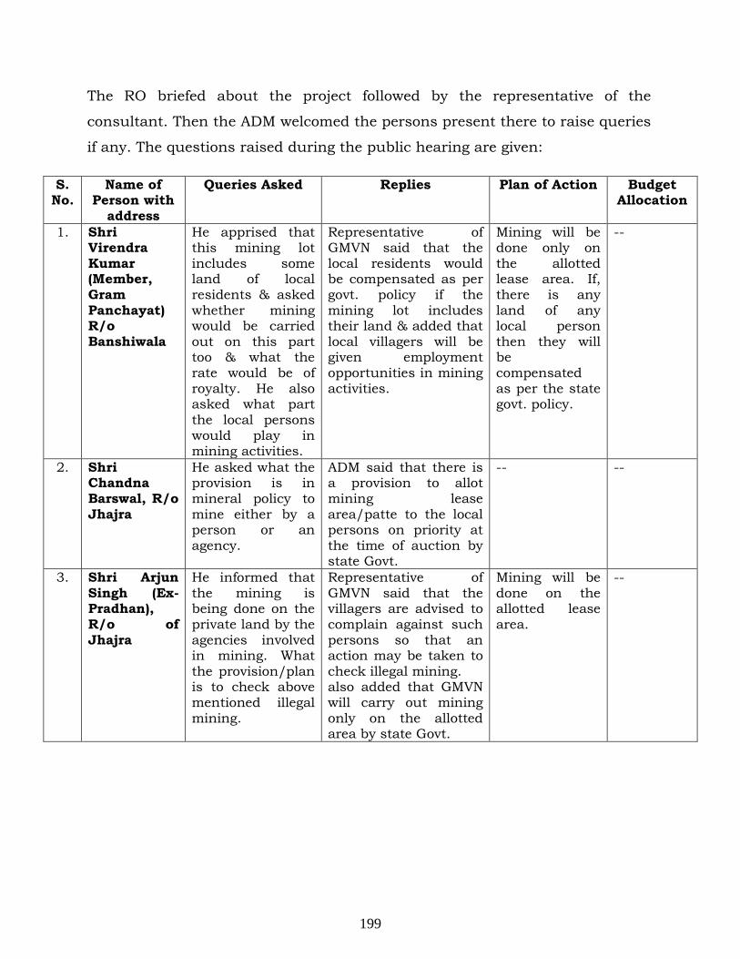
S. No.
The RO briefed about the project followed by the representative of the
consultant. Then the ADM welcomed the persons present there to raise queries
if any. The questions raised during the public hearing are given:
Name of Person with
address
Queries Asked Replies Plan of Action Budget Allocation
1. Shri Virendra Kumar (Member, Gram Panchayat) R/o Banshiwala
He apprised that this mining lot includes some land of local residents & asked whether mining would be carried out on this part too & what the rate would be of royalty. He also asked what part the local persons would play in mining activities.
Representative of GMVN said that the local residents would be compensated as per govt. policy if the mining lot includes their land & added that local villagers will be given employment opportunities in mining activities.
Mining will be done only on the allotted lease area. If, there is any land of any local person then they will be compensated as per the state govt. policy.
--
2. Shri Chandna Barswal, R/o Jhajra
He asked what the provision is in mineral policy to mine either by a person or an agency.
ADM said that there is a provision to allot mining lease area/patte to the local persons on priority at the time of auction by state Govt.
-- --
3. Shri Arjun Singh (Ex-Pradhan), R/o of Jhajra
He informed that the mining is being done on the private land by the agencies involved in mining. What the provision/plan is to check above mentioned illegal mining.
Representative of GMVN said that the villagers are advised to complain against such persons so that an action may be taken to check illegal mining. also added that GMVN will carry out mining only on the allotted area by state Govt.
Mining will be done on the allotted lease area.
--
199
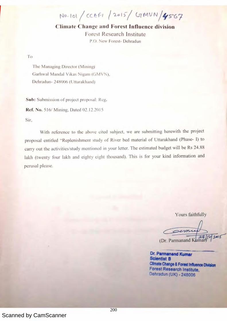
Scanned by CamScanner
'10
'Jj Ja " 'ha g' an J
J • (, (';S J (';seard I ~ ti tu te P ,C) , • cw I'ore t- f ehradun
" 11 • Milll:1J.d ll g J)i r 'CII" (MIIIJl lg)
jaJ'l1w;t! Malldal Vika~ i g W11 ( J\tlV , 'J,
I 'llI'(l( IUIl - 24X()()(, ( u' raklwlld)
S u I> : Submission orp!' )j l.!Cl prop""" l: I I.!g,
n ' f. () . 51 )/ Mining. I a\l.!d )2, 12.2015
Sir,
cl iv i 'ion
With rl.! ((;rl.! l1 c~ to thl: Clb )Vl: ~il(:d subject, we are submitting herewith the project
prop, 'al CI titled " f{<.:plcni shml:l1l study of Ri ver bed material of ttarakhand (Pha e- J) to
carry out the activi[il.! '/study mcnti ll1l.!d in your letter. The estimated budget wi ll be Rs 24.88
lakh (twen ty four lak h and eighty cight th u 'and), Thi i for your kind information and
peru!'aJ please.
Yours faithfull y
=--==-=t=:~~~:-:-Jo-(Dr. Pannanand
Dr. PItmanMd Ku Sc tilt B C8mate Change & Forett InbnoI DIVIIi/an Fore t Re earch Institute,
ehradun (UK) - 248006
I t)
'J' I hang ' an J.{) (; ~ l J (;~(;' reh J ~ it t(;
J1 (J . 'w J ore t- ehradun
' /11 ' Mill) :1 ling /)11 ' (.; [0.1 (Mllll1lg)
ia,'l wil l M.mda l Vlk:l''t i / (111 ) ((J \I1V ).
I '1"',,dul1 - 2 X()()() (lJtLw aklwl1 I)
Sil l>: Submiss ion orp!' )j~c l prop"o.,a l : I ~g.
Ref. (). 51 )1 Mining, I atl:(/ '2.12.201 5
Sir,
, divi 'ion
Wilh rc(i.:r~ncc lo (h (; "hove tile I subject, we are subm itting heTewith the project
pr )1" ) 'al entille 1 "RepJcnishl11l.:nl study of River bed material of Uttarakhand (Phase- J) to
carry out the (lcl ivi li es/study mcntiOlll:d in your letter, The c timated budget wi ll be Rs 24.88
lakh (twcnty four lakh and eighty ei ght thou ·and). Thi i for your kind information and
perusal plca <.; c.
Yours faithfully
Dr. Parmanenct Kumar Sclentl.t B ClImate Change & FOf'IIIInfUInce DlVlllIan Forest Re earch Institute.
ehradun (UK) - 248006
I ..
1'l° · l o\ I ca(-/ 1'2.·1>/ I.J{f.IIVN/IyS-67
Clim:o lc Ch an~c and Forcst Innu cncc divi sion I ' o"~'l R~scarch Institute
P.O, 'ew J· orC:~ I · Dchnldun
" he Manag ing /J1J'cctllr (MlIlIrlg )
(j~lrhwaJ Mandai V.k 'l' Nlg.lI J1 «( ,V1 V'\ ).
Ddlradun· 24>(00(, (UttulaklliJlld,
Suh : Suhlll i s~ itll1 tlfproJccl propI" .. I: Reg.
I{C(. Nn. 5 161 Mining.. Dated 02 .12 201 5
Sir.
With reference 10 the ahove cited subject. we arc submitting herewith the project
pro posal en tit led " Replenishment study of Ri ver bed material of Uttarakhand (Phase- l) to
carry out the <Icti vitics/study I11cntionc..:d in your Ictlcr. The estimated budget will be Rs 24.88
lukh (twenty four lakh JlHJ eighty ei ght thou~and). This is for your kind infonnation and
pcrusuJ please.
Yours faithfully
c:~~~~~~~~.~ {Dr. Pannanand
Dr·~KumerSclentlat 8 CImaIo ChqI & F .... fnIWa IlIoIIIon Forelt R"earch Inltllute. Oehradun (UK) - 248006
200
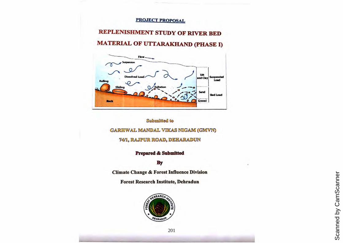
Sca
nned
by
Cam
Sca
nner
PROJECT PROPOSAL
REPLENISHMENT STUDY OF RIVER BED
MATERIAL OF UT-TARAKIIAND (pHASE I)
___ FIo_w-----
GAIRUHIW AIL OOANlIDAJL VJIJKA§ NlI<GAMI {<GMVN}
i dJ/n, mAJJ1P'1IJlFi IF?~AJD), JD) IElHrAIR?AI1)) 1UN
Prepared & Submitted
By
Climate Change & Forest Influence Division
Forest Research Institute, Dehradun
PROJECT PROPOSAL
REPLENISHMENT STUDY OF RIVER BED
MATERIAL OF UTTARAKHAND (pHASE I)
_________ Flaw ____
GAIRilliIW AlL MIANIDlAlL VJIIKA§ NlIGAOO (GMVN)
i IJ/n, mAJffiD~ IF?~AJD), JD)IEIHrAIR?AIIJ)1[JN
Prepared & Submitted
By
Climate Change & Forest Influence Division
Forest Research Institute, Dehradun
PROJECT PROPQSAL
REPLENISHMENT STUDY OF RIVER BED
MATERIAL OF UTTARAKHAND (pHASE I)
§lIllomll11!e<l ¢G
GAJruHIW IiJL 00Amll1iJL Vlll
Scanned by CamScanner
GENERAL INFORMATION
1. Project Title
2. Name of the Institute
4. Designation of the Executive Authority of the Institute forwarding the application
7. Duration
8. Total Cost (Rs.)
9. Name & Designation of Principle Investigator
10. Name and Designation of Co-Principal Investigator
11. Project Coordinator
12. Address
Replenishment study of river bed material of . Uttarakhand (Phase I)
Forest Research Institute, Dehradun
Director, Forest Research Institute, Dehradun
1 year and 3 Months (from beginning of the project)
24.881akh
Dr. Parmanand Kumar, Scientist-B, FRI, Dehradun
Dr Arvind Kumar, Scientist-D, FRI, Dehradun
Dr. Hukum Singh, Research Officer, FRI, Dehradun
Head, Climate Change & Forest Influence
Division Forest Research institute, Dehradun
Climate Change & Forest Influence Division Forest Research institute, P.O. New Forest, Dehradun- 246008
Email: [email protected]
Phone: 0135-2224332
GENERAL INFORMATION
1. Project Title
2. Name of the Institute
4. Designation of the Executive Authority of the Institute forwarding the application
7. Duration
8. Total Cost (Rs,)
9. Name & Designation of Principle Investigator
10. Name and Designation of Co-Principal Investigator
11 . Project Coordinator
12. Address
Replenishment study of Uttarakhand (Phase I)
river bed material of
Forest Research Institute, Dehradun
Director, Forest Research Institute, Dehradun
1 year and 3 Months (from beginning of the project)
24.881akh
Dr. Parmanand Kumar, Scientist-B, FRI, Dehradun
Dr Arvind Kumar, Scientist-D, FRI, Dehradun
Dr. Hukum Singh, Research Officer, FRI, Dehradun
Head, Climate Change & Forest Influence Division Forest Research institute, Dehradun
Climate Change & Forest Influence Division Forest Research institute, P.O. New Forest, Dehradun- 246008
Email : [email protected]
Phone: 0135-2224332
-.
202
Scanned by CamScanner
, , Project Summ:u'Y Ulld Objective 1 he bed/scdllllcnt load or. .' "
,I IIVl:1 ~Olllll1only \.:01 " I I , , . ,. ,', , lSlt cnx to be a POllutant that is aesthctically
dlSpk,lSIIl).! ,mel envII'Olll11 'Ill' II I ' '-' l: ,I Y t cgracilllg C . " . . onvcl sely, part 01 the sediment load (sand and
gravel) may rcpresent a natural I'~Sllun;e for usc ' . by socIety, The potential usefulness of the
sediment lond is enhanced whcn il i. " s composed 01 pal11c\e sizes found in deposits on the
riverbed that would be rcpleni ' I'd b I S 11.: Y ncw y Iranspol1ed sediment aner mining, As such, river
deposits become renew'lbl . r -'s . J' ' .. \;; e. oun.:es, PCl'loCilcally replaced by sediment transport in the river.
Many factors sueh as topography, soil Iype, bedrock type, climate and vegetation cover
influence input, output and transport or scdiment and water in a drainage basin (Charlton,
2008). These factors also inf'luence the natural pattern of water bodies (Twidale, 2004). As a
consequence. drainage pattern can reflect geographical characteristics of a rivers network to a
cel1ain extent. There are severnl types of drainage pattern. At present, much research has been
done on the description of drainage pattems in geography and hydrology (e.g. Howard, 1967;
Lambel1, 1998; Twidale, 2004; Pidwimy, 2006). Sediment transp0l1 knowledge is important
in river restoration, ecosystem protection, navigation, watershed studies and reservoir
management. Bed load represents the lower p0l1ion of sediment load in natural rivers.
Fluvial sediment load materials are transp0l1ed by rivers. Sediment load can be
divided into bed load and suspended load based on the mode of transp0l1. Bed load is
transp0l1ed close to the bed where particles moved by rolling, sliding, or jumping (Adegbola,
2012). Xlaoqing (2003) explailH.:d that beel load transpol1 in natural rivers is a complicated
. , ' b tl tl e tl'aI1svel'se 'll1d longitudinal directions. phenomenon . Its movement IS qUltc uncven 111 0 1 1 (
which vary considerably.
. . PI·oice .. SUnllllury and Objective 1 he bed/seulIllent load or, .' ,.
,1 IIV~I ~Olllll1only consider' I . . et to be a POllutant that is aesthetically
dlspkaslllg and environnl 'Ilt' II I . ~ ,\ Y (cgr'ldll\g C I
· ,Ollvel'Sc y, part 0(' the sediment load (sand and gravd) Illay represent tI natural resoun.:c r. .. .
01 usc by socIety. The potential usefulness of the sediment lond is enhanccd wI, . ' . '.
len 11 IS composed 01 pa111cle sizes found in deposits on the
riverbed that would be repl' . I I ~ enls ICC )y ncwly transpol1ed sediment after mining. As such, river
deposits becolll~ renew'lble r ~so '" .' d' , e 1Ilces. pello Ically replaced by sediment transport in the river.
Many I~lctors such as topography. soil type, bedrock type, climate and vegetation cover
influence input, output and transport or sediment and water in a drainage basin (Charlton,
2008). These factors also influence the natural pattern of water bodies (Twidale, 2004). As a
consequence. drainage pattern can reflect geographical characteristics of a rivers network to a
cel1ain extent. There are several types of drainage pattern. At present, much research has been
done on the description of drainage pattems in geography and hydrology (e.g. Howard, 1967;
Lambel1, 1998; Twidale, 2004; Pidwirny, 2006). Sediment transp0l1 knowledge is important
in river restoration, ecosystem protection, navigation, watershed studies and reservoir
management. Bed load represents the lower p0l1ion of sediment load in natural rivers.
Fluvial sediment load materials are transp0l1ed by rivers. Sediment load can be
divided into bed load and suspended load based on the mode of transpol1. Bed load is
transp0l1ed close to the bed where particles moved by rolling, sliding, or jumping (Adegbola.
2012). Xlaoqing (2003) cxplaim:d that bed load transpol1 in natural rivers is a complicated
phcnomcnon. Its movcmcnt is quite uneven in both the transversc and longitudinal directions.
which vary considcrably.
Project SUl1Il1IIIrv 1111<.\ Ob' . '1'11 . t_t,ft
Ie )cd/ :-;cdllllCI11 In'lll 0 1'. " , .1 liVe r "')1\\ I ... mon Y considcrcd b
, . . to c" pollut.mt th;u is aesthetically lh:o:ph:aslltg :l11d envirOllmentally d .. . , I'
egl,tt IIlg Convers -.J y I' I • I,; • Pill1 0 t Ie sediment load (sand and
g,nlvd) mny repreSellt 11 IlHtural I'CSllUn.:C luI' ' . . lI SI,,: by society. The potential usefulness or the
s(.'(limclll load is enhanced when ' '. . Il IS composed 01 pal1iclc sizes found in deposits on the
riverbed that would b· r ' I ' " 1 II c cp ellis le( )y Ih!wly transpol1cd sediment after mining. As such. river
deposits become rcnc..:w',bl· .•.. . I' I C ICSOll ICC.s, pl.!no( lcally replaced by sediment transport in the river.
Many "Ictors such as topography. soi l type. bedrock type. climate and vegetation cover
inllucnce input outl)ut and t ··· I' I' . • l.lIlSP0l1 0 set lI11ent and water In a drainage basin (Chariton.
2008). These factors also inlluence the natural pallem of water bodies (Twidale, 2004). As a
const!qut!ncc. drninage pnttcl'l1 can rdlcct geographical characteristics or a rivers network to a
cCI1ain extent. There arc several types of drainage pallem. At present, much research has been
done o n the description of drainage pallems in geography and hydrology (e.g. Howard, 1967;
Lambel1. 1998; Twidale, 2004: Pidwimy. 2006). Sediment transport knowledge is important
in ri ver restoration. ecosystem protection. navigation, watershed studies and resetvoir
management. Bed load represents the lower p0l1ion of sediment load in natural rivers.
Fluvia l sediment load material s arc transp0l1ed by rivers. Sediment load can be
divided into bed load and suspended load based on the mode of transp0l1. Bed load is
tnlllsp0l1ed close to the bed where partic les moved by rolling, sliding. or jumping (Adegbola.
20 12). Xlaoqing (2003) explained that bed load transp0l1 in natural rivers is a complicated
pheno menon. Its movemenl is quite: uneven in bolh the lransverse and longitudinal directions.
whidt vary considerably.
203
Scanned by CamScanner
The state of Uttar(lkh(lnd h <1 '; great in-))("1 . . I l! <lnee In [hc k.C<lf.. r"':'l.:.-.n:i. ,. If :II. I',rt:li ' I \ I ~,
international perspectives due tn It , (I" ~ t" t I ' . . I. inC P iy. I(lgraphlc crmdit i(,!i-': c.c. ~fod Hal~i.ji:i'; ._ ,h l .!:il \ '
nnd planes having altitudinal variation l"ang' « f' J( ( ( !Il g rom J) re, 3 O(j 1~~Cf~:: .. [:. 1:: ~I~A·.'.\' . .... \ . ,:'!(:
diverse vegetation types ranr, r r r . ' ~ ~ - , olnb rom Iloplca l to . uhtmplcar,. Cempcrarc: an. ;:i r, /1l;; i \n~udlfl..'
riverine, grasslands and wetlands Th ( c. "47 ° ~ . , . , c . <He nas \J .. <) 1(, 0 f n. rnta r g:Y)~'aphi-Cd ((r,;:>-i~ ~~:o fh· "':il
area against rndia's forest and t· , f' 23 4°/ f F ' .' . . I ec cover 0 . / (\ () r 1C (tita I gentrrarl--:-rC<11 ar.!<:i . fhl .... ::' .; ' .... ~
arc generated from Himalyan and Shivalik regi(ll1s wr1rcft supp[y a er- fTr &" " t'" , . l~r..!aI::!},. 1T'\~
rivers of the Uttarakhand play an important rofe for the nati'(>!1 fly pnw'i(fi.::'
various sectors such as irriga t'iol1 . drinking, recreation and Indus !:'fan
Besides, mining activities arc also hcing: can'red out rn the: rivers. r(Hr c.1'e: Cb-idb~'a';:""rai1
process.
Di-siltation (removal of excess sand and stone from rever hed)' of r:-.t!: rri:v.c:r E:e::"~ u:o
Further, continuous flow of ri ver IS essentral for ccofo'X!ca[ and ecorror.c-2c r..e:ecu ~o:tJ ~ ....
irrigation and biodiversity etc. Theref(>r(;, n:'1')fenlshment ~tucfy of the: civ~1.'" Eicl t& c:::d~.rd
potential carrying capacity of water during monsoon season wfrrch f.<; ~~:-~ frrma rrc'-"-:. .}
in the watershed and quantity of di-slltatron of nv~-rg undc:..1.'" mim~ abTe:r':cl1 ~<.:a~
Additionally, Grain/particle size di slrihutron analysl~ of fled road scan pl,-" ~- Ere dti":~
define the size composition of the ma terial in transit.
The o/?ieclives (~ll"e propo,l. .. ed .... It/dy are:
I. To estimate the area or ri ver' s !elts hy linea r su.rvey at differr'n! ~c..L~ J.
2. To mcaslIn; the grain size di strihution of ri ver bed mat,,-na s,
J. To study the repleni shment heha vior of the ri ve . hy morphomttri_ ?~j ts Cl''- ~-~ '~~
watershed wi th the help or Arc (f fS,
The state o f Itar(l khand h(l ''; grea t im . . pon'lncc In [~ I.:; k.C<1!., r 'R:l,n:, " 11'rll .",!I:11 1\ , C,
international pt.:rspt.:ctivcs due tn It. ck tinct phy, i(lgraphic CrHldit i'·,!i ·; C,I.:;. G II l;jl ~i.' ,.,. , .; \' ; "\ '.
• '- .). (. ' , - ,., . U :(
and planes having altitudinal variation rangil1 lY f,·o! ...... J (J() 6 " n 3 ()(j 'Ylct'~.~ " n ~ 1:: ~I~~ ·.'.\', .,. \ , ' :it:
diverse vegetation types, ran ging from trollica l to . uhtrrlpl'ca!',. . em pcraCe' ~ I t air, lie;; i1lt.: Lr~i I ~
riverine, grass lands and wctl<lnd -rl ( h c47 Il -. ., 1e . <He as () _ C) Yn ofa. rn ta f'IY)!n" I ' hi~"'~ " 0#'>-< ~ •. , 1·· ' . ... ·1
'-' -- J ~. _I 'Ao 1. . ... 1. 10 '
area against India 's forest and tree cover or 23.4% of tf1e r()tal ger"j<Yjar; .i:C<1
are generated from Himalyan and Shi va lik regions wl1fcn; sUFpLy ater- rr: &" . ~~ .. t';'"~t:n •.. -U 'h~
rivers of the Uttarakhand play an important role for the nati'ol1 Fly pJ"(j"/fdi~g:. "(~r ~~ii "~ ?)'
various sectors such as irriga tion. drinkin g. recreation and ' "Jdu:q d~
Besides, mining activities arc al. 0 hcing ca rrIed out en e[lc: rivers.. fcnr C-te: f!:'l"[q;.r"J:~;:'
process.
Di-siltation (removal of excess sand and stone: from river hecf), of &..l!: ro:.cz-~, - 1')
maintain the carrying capacity and prov ides protection. fi"om fIoo<icng. duvIT-L@; r:-..t1'lr.!i'iT.t5' __ ~,')).:L
Further, continuous flow of ri ver is essential for ecofoz!caJ and ecorror!."6: r::e:::;& _o:f:::l ....
irrigation and biodiversity etc. Thert.:fore, n .. 11k'nlshment study oftfte: riVi X' E-4 It') ~..r-Cl
potential carrying capacity of water during monsoon Se3:\on which ~ r.:!~7~ nmrr!:J ~~. I
in the watershed and quantity of di-~ lltation of rive..-r~ u:nder- en-I. -.g a §;,- ':@ "'~,;:: __
Additionally, Grain/particle size dislrihutlon analysis of bed road ~amp - ~ fue dl :~
define the size composition of the mat(.; rial in transit.
The o/~ieclives (~llhe propo ..... ed sludy {lfe:
I. To estimate th(.; area of ri ver's !elts hy linea r . urv -:y at diffcn'n
2. To measure the grain size distrihution of ri ver n·d m~tcria[g: .
J. To study the replenishment heha vior of the ri ve . hy m()rph()m~:tri _ 2 "!y ts (1 .- ri1)a:-~s
watcrsh(.;d with the heir of Arc (i fS.
ri verine. grass lands and wetl ands T I . Ii < -< " l C stille M n4 .. 79% of I ~ r,jfar 2':.;rlgyaphh,:..1r at2;""a::- , ".t:.!7.11
.area against India' s fo rest and Ircc t'23 4" f Ii , . . cover () . / 1'1 0 { e rClt'al ~erjgrapbc.1 C a l:.,:;}\. ~nll1:.:r ~J).~1,
are generated from ~r I 1" 1' I'k ' .. Ima yan an< .") l l Va J regions which suppl.y water i't"~. clb.\1r.r~t'r .. a ill:·!'h ... 1J ih~
rivers or the Uttarakhand play an i mportanr ro le for the na(lon hy pmW-/ldtn:g; £l(a a;.r:J.lii:!:'!l b~Y'
various secto rs such as irrigatj on. drinking. recrea tion and' m-dbu:rfafl ~u;~';4r;C:::Cb <!!,,"'::p
Besides. mining ac ti vities arc also hci ng carried ()Ur i:n the- met'~ fOlf c!1e- &-rdh~~:w
process.
Di ·siltation (removal or excess sand and' stone from river-ned) of rte- tT-~a ~~ ilO
maintain the carrying capacity and provides protection from fl(Joorng dbmr..g: r.:nt::~o1.,",rJ!<!::'l!!r.t:L
Further. continuous fl ow of ri ver is c!>sentiai for ecofoaicaf and econnr~':.c r~1t; :rr.:ci::I 1l."ii
irrigation and hiodi versity etc. Therdorc. replen ishment study of me river rn..:f;m w c::: ... :i~
potential ca rrying capacity of water duri ng monsoon seas.t::10 wITien r.'\ ::·::r:.e:ora-~ fno-'C'l ~~,.J']
in the watershed and quantity of di ·siilation of river~ urTaer rrITcirr~ C!Jf",,:-:,,~3 a:ra!:'"
Additionall y, Grai n/r anic le size di str ihution analysis of hed foad sartr;l[<$ =!Sl! "" ocr"" C..,.
(iI; fin c the sizc composition of the mah;rial in transit ..
Tile ohjel.'lives r~llll(! proposer/ .'tlutiy are:
I. To cst imalc I he area o f ri ver' s lots hy I int:a r sur..',-y at cit ffer(.'fIt !e-.:tt,Jn.~ 0: nr;e:3.
2. To measure rhe gra in size dif\ lrihul inn of ri v,,. bt:d matt:.-nats.
3. To study the rerlen ishment heha vinc of the ri vcrs hy morphom.<:tru: a",,!~si> of ai_ ",,-s
watershed with the heir of Arc ( iIS.
204
Scanned by CamScanner
JVI ethodo logy:
I. Location and Descriptiun of Study: The n.: pl ~ l1i ~! llIlll: nl tl llIdy, locati uns lind
description study of' twenty lot s or l'iVl.:I'·~l ill D~hl'lI I)uOI1 diKtricl will he carri ed out 1\ :-\
detailed below:
Defail.\' (~ll'ia'el' ·.,· lol.\' '0 he 111/(1'11 '"I1It!1' 1'l!J1/t!"/.\'/""CII' .\"III~.'
SI.No. Name of the lot Area (ha) Name of the River - - .-1 Tons 3/8 15.363
2 Tons 3/10 23.000
3 Tons 3/11 11.100 Tons River
4 Tons 3/13 6.000
5 Tons 3/14 6.700
6 Non 8/1 7.500 Non River
7 Non 8/2 7.600
8 Asan 14/1 18.400
9 Asan 14/2 21.094
10 Asan 14/4 35.405
11 Asan 14/6 32.709 Asan River
12 Asan 14/8 32.000
13 Asan 14/9 45.000
14 Asan 14/10 62.000
15 Jakhan 13/2 92.652
16 Jakhan 13/1 18.000 Jakhan River
17 Yamuna 23/3 14.970
18 Song 7/2 135.856 - . .
19 Suman nagar 10.350 Pathri Row
20 Garhroshnabad 11.883
JVI ethocio logy:
I. Location and DeSCription of Stuely: The l'I,; pI C lli ~{ llIlll: llt tl ludy, IOCllliulIH lind
descripti on study of' twent y lots or ri vcr' s ill DeliI'll D(1oll di. l ric l will he curri ed oul iI ~ detail ed hdow:
Defllils (~lri"el"s loIs 10 he IlIla'lI III1t1el' 1" !J1It!llislll" t:III sllll~.'
SI.No. Name of the lot Area (ha) Ni1me of the River - ----1 Tons 3/8 15.363
2 Tons 3/10 23.000
3 Tons 3/11 11.100 Tons River
4 Tons 3/13 6.000
5 Tons 3/14 6.700
6 Non 8/1 7.500 Non River
7 Non 8/2 7.600
8 Asan 14/1 18.400
9 Asan 14/2 21.094
10 Asan 14/4 35.405
11 Asan 14/6 32.709 Asan River
12 Asan 14/8 32.000
13 Asan 14/9 45.000
14 Asan 14/10 62.000
15 Jakhan 13/2 92.652
16 Jakhan 13/1 18.000 Jakhan River
17 Yamuna 23/3 14.970
18 Song 7/2 135.856 , -
19 Suman nagar 10.350 Pathri Row
20 Garhroshnabad 11.883 -
/VI cthudu IIII.:Y:
I. LIICalill1l 111111 DCSCl'ipliUII uf SllIdy: The l'eplcll i, IIIIICIII !l llIdy. I"Clll i,," s II"d
dcsl:l'iplion !'iludy or twent y Itll s or l'ivCI" :-l in IJdll'll (Julin disll'il!1 will he I.!anictl Clut a ~ detlliled helow:
/Jetllil.\' (~l ,.;" el' ',,- IOI.\' 10 he! fa k t'" IIl1llel' ,.~!"'t! II /.\'/,,,, e ll I ,\'IlIIly
51. No. Nome of the lot Area (hal Name of the River
1 Tons 3/8 15,363
2 Tons 3/10 23,000
3 Tons 3/11 11.100 Tons RIver
4 TOils 3/13 6,000
5 Tons 3/14 6.700
6 Non 8/1 7,500 Non River
7 Non 8/2 7,600
8 Asan 14/ 1 18.400
9 Asa n 14/ 2 21.094
10 Asa n 14/4 35.405
11 Asan 14/6 32,709 Asan River
12 Asa n 14/8 32.000
13 Asan 14/9 45.000
14 Asan 14/ 10 62 ,000
15 Jakhan 13/ 2 92,652
16 Jakhan 13/ 1 18,000 Jakhan River
17 Yamuna 23/3 14,970
18 Song 7/2 135,856 -
19 Suman nagar 10,350 Pathri Row
20 Garhroshnabad 11,883
205
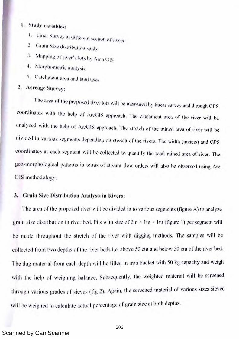
Scanned by CamScanner
~t"d.\' "l,r(l,hh ' ~
I , Lin,>\" ',I f" ')' Z ~~ \.Hlr ~ ~'nt . \. "\ \'t' \It" ,
(lnlhl ' izv ~J, ' ~dl'\\l ~ ,'\ . l\\, \
. 1, t\hpp ln~ "l'd\\'r'" t,,\. t .y :\ \d\ H~
-L 1\1,)rptwm"td \ ~I\\ zd~\' l .. '
~, C\\ld\\\\, 1\\ ~Il\'{ \ \'I\,l t~\\\,l ~\ \\
Thv iI\\\ \ \)l'llw P\\\~\,\~ ~l d \\.'l' t\\l~ wilt l\ \ \\\l~I~\I\~\.l by HI\~ ' I\' ~ \I\'\'~y t\1\\! \I\\\.\U ,1\ GP ~
~()()rdinHI~~ wllh lh" h ' ll \\(\ ,'\\'~U l~ ~II\I\\\\ 1\.'\\, Til\' \.'nld\\\\~t\l t\\~ \ ,r \I\\.' \'1\ "\' w\\t l\.'
~mnl)'z\.'<1 with lh" twit' "r (\I\'Ul~ UI\l\\\\~I\.'h , Th~ ~l\~l 'll "l' Ill\' \\\\\\~l ~\~,\ "r rh~r wiH be
Thl: nr~u (\1' th \ PI\)pl)~td 1'''\,'1' \\'illl) '\I\\'I\I,-\.\ \1\ ll \ \'nrilm~ $cgl\\cnt · ~ligur'C :\) to analyze
~raill si z ' dbtributi\)1\ ill I'I\'\.'\' h'd, !'ils wilh si 4", ,,1' ... 1\\ ' 1m , I \\\ (ngUl~ I) pel' segment will
b~ m \(I~' litn)lI: IH)UI Ih\.' ~II\\ I '1\ \)1' Ih~ r,,' '\' wllh digging mcthods, The samples will be
~()Ih: 'I'd lh)lll IWl) d~pths I.'rth\.' 1''' ~ I ' h ' Is I, '. nh,)\' , ~O \:1\\ and below 50 CI\\ of the ri\'cr bed.
The dlH~ milt 'rilll l'I'PIll 'I ~ h d 'I'tl\ will h~ till ~d III il'\'" huckct with 50 kg capacity and wdgh
I I "
', I ' I I \ \ " 1.:'\II,~ \t\lclltlv th' wcluhtcd malcrial will be ~crecned with til l: W P l) '" '1 .... ' ling )\1 I ,~~ , ' ... \ '-
. , \ ' tl" ,t~cllcd I\\'ltcrial of various ~izcs :;icved IhrPlIgh \,llI' ipll~ t~ r Hk~ 01 ~il'\ l'S (1111 ), ,' ra m, ,~~ \
., I ", \' I' ,\' \ll"\\n si l e at both (kpth~, will Ill: Wl'I!'h 'd to ~(Iklllt'll' 1Il'l\HI I'U l:Il ,Ibl, \. , _ .
S'I\d." \' l" ' ~l,hh ~ (
Lin r, \1 '\, \\'" l ' l'r , ~ \,~ t .
~ ~\,
. 1 . 1\hl' l'\\\~ \\ l'rh'Yf\.' l,I\. ~~ :\\\' ~ U l~
·L M\\fplwm\ lrk ' m ~\l~\' \ ,-'
5. Cnl,'hm 'I\l '\l\'{\ '\\\,l h.m,l n,\
:\('''\'l\~(\ S'H'\' \'~'~
Tlw il\\',\ \\t'll'w P\\\\'\ s~\1 \ \\' "l l ' , \1 \ ' ,\ \\ ~ \\ \ \ \ \ \\\\",{I~\I\~~ll Y h\\~ 1\' : \Ir\' ~~ \\\\U \ht\'u~h GP ~
\!()ordinHl \~ with lh~ h II ,t' '\ ,I ' IS \ ' \ \. , \~\ \ \ 1\'\'\\1 I\' \, \ h~ ' \\dum.'lIl t\ 1~t\ r lh~ n\ "I' will b~
nnalyz\.'(\ with th, hdl' \\t' (\\'\'Ut~ nt\t\\\\ ~\\'II , Til\.' ~t\'~ld\ "t'th\.' 1\\\\\C\l t\\~\\ ,-,t' rh "I' \\"iH be
d IV id",d i n \'"ri,)\\~ ~\: ~I\WI\t~ d 'I) 'mHI\ 1 ,\1\ ~ l\ 'td\ ,-,\' til ' \'" ~I~, Th~ w\Jlh (\\\~\~I~ ~\I\d G PS
CO l'dillnt"'\~ nt Q(I",h ~,'gt\\"'t\l "'Ill b' ",'lk'\'t\..\\ l' 'I\H\\\lH~' lh\.' hlal I\\\tK'\l m~\.\ or \ " \"~r. The
The <l1I 1' IlHlh::rilil 1'1\ '1ll \' 1 ,It d 'IHIt \\'ill h\' lillL\1 il\ 11\'1\ hueket with 50 kg capacity and weigh
with tit· Iwlp or \\' 'i !-t hil\~~ hnlll\' " S\lh~ \lU\,l\tly, th' wdght~d material ,,,,ill be ~el'ecned , • • , I
I I ' . , ') \ . tl" , ." '\\ ' I '\\'It·,,,,· "I " 1 vunous sizes sleve(\ t lI'Oll g ) \ ' III'1PlI!' t' r\(k~ 01 ~tl'\\"~ (ltp ', ,' ~ n\l\, \\: ~ I,-l: l:( ''"' v
I , Lltlvr ~ \\\ \\:'s ,\l ,l,lf\'l\'\\\ '\\.\\l\'H \'\'H\,\l'
" (i nl i~1 Si.~,> \li ' lr i~"l'\'t\ "m.l.\
.1. ~ 1 ' ll'l' lH!: ''1\il\'\'" h'I' t-; ' \I,'iI (I i~
:'. CHI\'IUH\.l1l1 il\\'(1 ~' n\l h\\\d \\~\\\
2. :\\·I'(·u~,. SIU"' \I, '! ,
Tlw UI\'II 1'1' 11\1' i'I\'I'I"I\1 Ih' " 1'1' 'Hii ' \ \ , ~ \\ I~ m\.~\~ \\\ \.'\t h~ n\\l. .. ~lr :O: l\\'\'\!y ~ Ihl \h,,'ugh (iPS
CONdi'I<IIO' lI' ill\ Ih" h ,I, ,t' '\ ,( 'i ' , \: I ' , \\: \ ~ U\,,'\\ \t\I..'h, I h~ 1..'::\ \\.': 111\\1..'1\1 :\\\.';\ 1..1 1' \h~ \"\\'w will be
nnnl.l'zl'd willi Ihv kll' "t' '\I\' \:t~ HI'I'I\'\lcll, 'l'h,' , 11"1, 11 ,.1' Ille IIIln\,1 ""',, " I' ti,,, .. will k
dividl.'d in VUl'i\ I\lS sq.~.\\\I.'tH~ I..h,,'p\'\\\!il\t.l ,\1\ ~"\.' \\'I\ ,-,t' Ihl..': 1'1".'11'" Th~ width ( H\~I~'~) and GPS
CO(lI'diIlHI\':~ HI ~i:H: h SI.'B-H'\.' UI Wi ll 11\, 1.'\ , 11 1..'\.' \\.\ \ I,' q\l:u\\H~· lhlt.:' hlt:.\\ 1\\11\\.,\' '1\\.'a \J t' ri\'~r. The
gl.-"u-uhH'pIHII('B-h:,,1 Pillt l.'l'1I~ in \ I.'t'\\,~ \,t' ~ I\\.':\\l\ Ih\\\' 1..11\kr:o: \\' \11 :tl ~\' be ()bs~IY\.'(\ usin\! ~\~ -'
he II I1Hk IIII'\\II ~ I\\ \ III Ill\' , 11\'ldl ,,1'111, liwl' 1I'1 1h di gging m'lhods, Tile sampks lI'ili b,
The dll~ II\lIle'rilil 1'1\ '111 ,1I\;h ,kl'lh wi ll h,' lilll\ 1 ill il\\11 hll~k~1 wilh 50 kg ~"p"cily :llId w,igh
wilh the Ill'll' "I' 'wi ghill~, h"IIII"':, ~lIh"'IIl\'lIll y, Ih~ weigllle'" tlI:lI~ .. i,,1 will I" "I,,,"ed
206
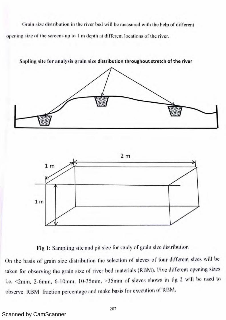
Scanned by CamScanner
(ir till ') ii' • di tdllutiull ill tilt.: river hed will be mcasured with the help of differcnt
IIJl ° ll i /1l ~ :. ii't.: o/' the :-; ~ n.!t.: ll r) lip III I III (h.:plh at different locations of the river.
Snpllll~ ~Itc fur llnlllysis ~ralll size distribution throughout stretch of the river
2m
1m
1m
Fig 1: Sampling sill: and pit si/.l: ror study or graill l:l il c di~\l'ib\\\iu\\
On the basis of grain sizl: distribution till: scledion or Hleve~ ui' I~'ll'\ dilrC\~1\l ~h~~ \\'\\\ b'
taken for obsl:rving the grain siZl: or rivl:r bl:d 1l1lltcrialH tRl3~v') . FI ve dm~l'c"\ '" "i,,~ s\{, '~
i.e. <2I11m, 2-6mrn. 6-IOmm. 10-]5 111111. 151ll1ll l)1' Hleves Hht1\V~ III " l\ 2 w\\l h·' \\~. , H'
observe R13M fraction percentage ami makl: basis ror execu\llillul RlH"L
(; ",1" ... i" ' d i Iri huli\)11 ill III \.: ri er hed will he mcasured with Ihe help of different
lip ' lI i ll l' :dl'c 1)1' III . /> ..: n :\.: 11 lip h ) I 111 (h.:plh at diffcrent Im:atiulls o f the river.
Sllpllll~ ~ltc rur anulysis ~rilin size distribution throughout stretch of the river
2m
1m
1m
Fig 1: Sampling site alld pit si/.e 1'0 1' study or grail\ ~ i 7.~ di ~ \l'ih\\\io"
On the basis or grain size di strihution the scle~tion or HieVeH ur I ~\lll' dilYc\ ' \\l ~ht.Q~ w\\\ b '
taken for observing the grain size or river bed \1ltll~rinI H t1U3tv\), Five d\lYc\ " \H ,',\ n i"~ ~il, ~:-\
i.c. <2mm, 2-6mrn. 6-1 o III Ill . IO-35 1J1111 . ]5111111 or Hieves Hhll\V~ \Il lil! :.. will h \ \\ ~ d '"
observe RI3M fraction percentage illltl make husts 1'01' exc~ lIt1 t1 1l t)l tUHv\.
(1 111 111 'i i'l l! dil'l ldhul illll ill 111 -.: river h-.:d will he measureu with Ihe help of different
\ tP-': lI illl : :.iI' C orlile M.:r-,:cIIN up In I III d-.:plh at dilTcrcnllocatiul1s of the river.
S"I'III1~ 'lIe rCII' 1IIIIIIysiN ~nlill Nlze distribution throughout stretch of the river
2m
1m
1m
FiJ.l I: Sampling site and pit size I,"' stud y of gnoin s i/,~ lli strihlltil\l\
On the basi s or grain size di strihulion the scledion of sieves ,If 1"111' llin<:t~n! Si1~S will "',
taken liJr ohserving the grain size of ri ver bed nHlt~rial s (RUM). Five ,lIncl;':l\! "l'cllin\\ si J.~s
i.c. <2mm, 2-(lInm, (,-IOmm. IO-3 5mm, >:15mm "f sieves Shll\V~ in lil! :,\ w\ \1 hI' \lscd tl'
ohserve RJ3M rraction percentage and make hilSis r\Jl' CXcclltillnl)I' 1\\Jl\o\.
207
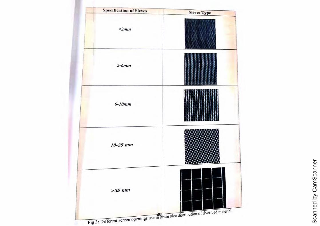
Sca
nned
by
Cam
Sca
nner
~
2nl1n
2-6mm
6-10mm
10-35 mm
>35mm
Fig 2: Different screen openings use in grain size distribution of river bed material.
<2nlln
2-6mnl
6-10mm
10-35 mm
>35mm
Fig 2: 0 i rfcrent screen openings use in grain size distribution of river bed material.
<2111111
2 -6111111
6-10mlll
10-35 ",m
>35 mm
; I
2: screen usc 208
Scanned by CamScanner
H10rk pia,,:
Project Activities I Quarter I Quart er Quart er III -Q l.la rt ~ r IV {;1i., aft l1 f
Rccrujlm~m of the I II
V projc.cl stafT
J - -
Sill-OS _ urvcy and data I collection j
-- - - - -
Purchasin" . 0 of j --equipment and othcr I experiment relevant . malerials 1
1 .\lJap generation and I
-
analysis ofrivcrs Data analysis. interpretation and compi lat ion of report
REFERE NCES
Adcgbola. A. A. and Olaniya n. O. S .. 20 12. Estimation of Bed Load Transport in Ri ver a mi,
South \Vestem Nigeria using Grain Size Distribution Data, Illlernalional JOllrnal of
Eng illeering (Iud Technology. 2 (9). 1587-1 592.
Charlton. R .. 2008. FlIl1dal1lel1/{1l~- oIFlul'ial Geol1l 01 plIO logy . Routledge, N. Y., pp. 1-20.
Hmvard. A.D .. 1967. Drainag.e analysis in g.eologic interpretation: a summation. American
Association of Petroleum Geologists Bulletin. 51. pp. 2246-2259.
Lambcl1. D .. 1998. nre Field Guide to Geolog)l.Checkmark Books. pp. 130-1 3 1.
O /ani yan, O.S. and Adegbola. A. A .. 20 12. Ri ver Geometry Computation On River omi
South-\Vestem Nigeri a. LAP Publi sher. Gemlany.
Pidwirny, M .. 2006.The Drainage Basin Concept. Fundamentals of Physical Geography. 2nd
Edition http://www.physicalgeography. net/fundamentals/ I Oaa.html (22 Dec. 20 II ) Twidale, C. R. , 2004. Ri ver patt erns and their meaning.Earth-Science Revie\\·s. 67(3-4). pp.
J59-2 /8. US Army Corps of Engineers. 1995.Scdimcnt Measurement Techniques (Em 1110-2- -WOO:
Ch 8).www.usaccann y.m il. Xlaoqing, Y.. 2003. Ma nual 0 11 S..:dimcnt Managcm~nl
Hydro logica l Rcpol1 No 47 . WMO·c)4S. Sccn.:tannt
Organization-GcncvaSwit z..:r land .
and Measurement.Opcrati(mal or the \\ orld Mct ~ . .'orological
Illork pia,,:
Project Activit ies I Qua rt er I Quarter Quart e r III Q l.la rt ~' IV gUMti1f R(..~ru i tm",,·m of the t
II V
projecl s taLl I -
Si(~. " " urvev and data j ,J
collection - -
Purchasing of -- -equipment and other experiment relevant " materials j
.\llap r
generation and I -
analysis of ri vcrs Data analysis. interpretation and compilation of report
REFERE NCES
Adegbola. A. A. and Olaniyan. O. S .. 20 12.Estimation of Bed Load Transport in Ri ver Omi, South \Vestern Nigeria using. Grain Size Distribution Data, illlernational JOlll71al of
Eng ineering (Llld Technology. 2 (9). 1587-1592. Charlton. R .. 2008. FUlldame/1wl," o/Flul'ial Geol1lOlpllOlogy . Routledge, N.Y., pp. 1-20. Howard. A.D .. 1967. Drainage analysis in geologic interpretation: a summation. American
AssociatioN of PetroleuJII Geologists Bul/elin. 51. pp. 2246-2259. Lambcl1. D. , 1998. nre Field Guide: t(J Ge:ology.Checkmark Books. pp. 130-131. Olaniyan, O.S. and Adegbola. A. 1\ .. 2012. Ri ver Geometry Computation On River omi
South- \Vestem Nigeri a. LAP Publisher. Gemlany. Pidwimy, M .. 2006. The Drainage Bas in Concept. Fundamentals of Physical Geography. 2nd
Edition http://www.physicalgL:ography.net/fundamentals/ IOaa.html (22 Dec. 20 II )
Twidale, C.R. , 2004. Ri ver patt erns and their meaning.Earth-Science Revie\\'s. 67(3-4). pp.
159-21 8. US Army Corps of Engineers. 1995.Scdiment Measurement Techniql1~s (Em 1110-2- -WOO:
Ch 8).www.usaccarm y. mil. Xlaoqing, Y.. 2003. Manual 0 11 S..:dilllL:l1t Mallagctn~llt
Hyd ro logica l Rcp0l1 No 47. \VMO-94S. Sccrdannt
Organization-GcncvaSwit zL:r land.
and lVkasl1n;!m~nt.Op~rati()nnl
or the \-\ orld ~ltctt.'ol\)logiL'a l
II/ork plllll:
PrOject Activitie-s; Quarter I Quarter Quarter III Quart ~ r IV gUiirl~'
HI...'CruilnHtJl{ of II
the V proiect staO' Sites surVe v and data l • collc-ction •
rurchasin~ of . -equIpment and other cxperimcnt relevant materials ."Iap generation and analvsis o f rivers Data analysis. interpretation and compilation of reoon
REFERENCES
Adegbola. A. A. and Olaniyan. O. S .. 2012.Estimation of Bed Load Transpon in River ami.
South Western Nigeria using Grain Size Distribution Data. International Jml/7wl oj
Eng ineering and Teellllalag ... 2 (9). 1587· 1592.
Charlton. R .. 2008. Flllldallll!lItals ofFllIl 'ial Geollloll'iJOlogy. Routl edge. N.Y .. pp. 1·20.
HO\\lard. A.D .. 1967. Drainage analysis in geologic interpretation: a summation. Americllll
Associatillll of Petrolelllll GClllllgisrs /JIII/crin. 51. pp. 2246·2259.
Lambcl1. 0 .. 1998. The Field Gllide til Gelllogv.Chec kmark Books. pp. 130·131.
Olaniyan. O.s. and Adegbola. A. A .. 20 12. River Geometry Computation On Ri\'er omi
South· Western Nigeria. LAP Pub lisher. Germany.
Pidwirny. M .. 2006.Toe Drainage Basin Concept. Fundamentals of Physical Geography. 2nd
Edition hllp:llwww.physicalgcography.net/ fundame ntnlsIl Oaa.html(22 Dec. 20 II )
Twidale. C.R .. 2004. River pallcrns and their mcan ing.Earth·Science RevicH·s. 67(3-4). pp.
159·2 18. US Army Corps or Engineers. 1995.Sediment Measurement Techniques (Em 11 10·2· -1000:
C h 8) .www. usaccanny. mil.
X laoging. Y.. 2(0). Manual 0 11 Sediment Managell1~nt Hydrological Repol1 No 47. WM O·94H. Secrctanat
Orga n i za t ion· Geneva S wit zerl a , I( I.
and Measul'cll1ent.Opcmtil'nal
('If the World i"klc'()I\,lllt!ic-al
209
Scanned by CamScanner
neel·,., .. " · - '. I()n -I " I' ~' t·, \.,~rtir\' thnt T \1:- ,~ , •
Th~ ",,,)I'k i~ hdl~g. P~·t)P\'Sl.:d "II the rcqucst or (iMvN Ii: 1:- , . "I' I\nrakh,l\\d I'I V~ I' s {PhIlSI.:-I), 1'01' til l; n,; rlclli ~lllIncn l Jl wdy or 2(J
Th~ Pl\,p\)~\.'d blldg.~t It)1' this studv is Rs ')4 XX 1 kl I ' " • • , '" .( \ ~ 1I 1 UI\( er lollowillg major hcadH
• ' alar)' \)1' ~ol\trm;tul\l stllrr Rs. ~.16 I .. kh.
• thl.:r ~XPI.:l\s\"·s Rs. 12 .57 lakh
• Institlliinnal charg.l..:s Rs. ·\.15 IlIkh
Th~ institutl..: ngrcl..:S that thl..: I.:qUipllll.:llt. othl.!r busic facilities and Stich other administrative f:l~ilitk~ will be cxtel\ckd to invesligator(s) thrnugholltthe duration or the project.
The Institutc ndministratillll aSSUllll.!S to ulllkrtakc the linancial and other managcmLl1t re~ponsibililies of the pro.kct.
~~ :&:> \\ <y\ ---===t:r'~~'1'j~1S7
I t " t r Sh!naturc of Co-II vcstigator S" tlln~ of Co- l1VCS Ign 0 ~ H?,na (Dr i-\rvind Kumar) ~ (Dr Hukulll Singh)
Signature of PI (Dr Parmanand Kumar)
d f the Institution with seal " f Hea 0 Signahll eO
ne f.'.,., •• , ••
- "-" , • IOn -' \ ' , ' I' ~' I" \.'~rlirv Ihlll 'I \IS ,~ , ,
Tit\.' w,,)I'k i~ hdl~)'! p~'oP~'s~d "I, Ih\.! n.:qu\.:st or CiMVN I- (~l,r Hnra ' H\\\l I'IYl:r s las\.: . ), kl I . (Ill I I'or lilt.: rt.:plellhlhmel1l 1l llltly or 2(J
Thl: PI\'IH)~,-'d blldgl:t I~)r Ihis stud v is Rs ')4 XX I kl I . • ' • , ' ... ( \ 411 lUll( cr \ollowilllj major heat\!
• • •
salm,)' llf ~ol\trn~tunl sturr Rs , ~.I () lakh, Oth\.'r ~xp~nsl.'~ Rs. I ?..~7 laklt
Institlltinnal chargl:s Rs. ,L I::; lakh
Thl: inslilutl: ngrl:l:S that till: l:quiplllt.:l\t, olht.:\' bash; facilities and such other administrative r:ldlitk~ will be l:xtcllckd to invcstigiltnr(s) thrnugholltthe duration of' the project.
Th«: Institute administration aSSlllllt.:S tn Ulldt.:\'lake the linancial and other managcml.'11t n:~ponsibilitics of the projl:l:1.
l;.t loS Signature of Co-lJ vcsligntor
(Dr Arvind Kumar) Signature of PI
(Dr Parmanand Kumar)
d f tile I nstitution with seal f Hea () Signature 0 '
D~cll\\"lt' • IUn -Th\.' ,,\'rk i ~ bd l\ ~ PI\lPllSl.:d llll 1\ • ' .
' U ' - kl ' I '" I\; h,;qU\,;'~ 1 or C' M I ~) I :' 1.,1 H.It., h Hll II \,~I':.; t Phll:';l'. I) I VN fur II . ' . I . . , Ie lel' c ll wlll llCl1I IItull y III' 2fJ
Th L' 1'1\1!lll:'l'd budl.!ct Itll' th is "I I ' ... . . la Y IS \{ s. 24 ~x L
~ , .• ukh under followin g, mil'or he ' I • Sn lary llll' 1..111lrnctu:1i slaITI>· l' I( I ~ M il
, :.;, ('I. ) :lkh. • Olh ... ,!' I..'x lh:ns\.'s Rs. I ::!.57 lakh
• In:,t itutillnal chargl..'s Rs. ·1 .1:'> IlIk l1
Th..: inslittltt: ag.n:..:s that the \,;i.luil'lll 'Itt II I ' , l: .0 le1' lU SH; h cililil.:S' I I I d f:l..:ilitks will bl! cxtt.:1l(kd ttl in V!';slicllIO"(s) I . . • . ,til( Slic \ III H.:r a rninistrativc
..... \ . t uoughout the durHlioll or the project.
The Institute uciministnlthln l"\.~p\msi hilitiI.!S of the projl'C t.
aSSltlllt.!s 10 UIHkrtilkc Ih.· '-111 ', lllel','11 , , .... ant 0\ lcr m;ma~cml."t1t
?Y'~ ;ob\\<)'\ ~=fs;;~~
Signatun.~ of Co-ln\'(~stigntor SignatuI"C of Co·1 ~~~tigator (Dr HukulII Singh) (Dr An'intl Kumar)
~ t> vIS Si~m'ture of PI
(Dr I'armanand Kumar)
f 1'\c'ld of the Institntion with seal Signature 0 •
210
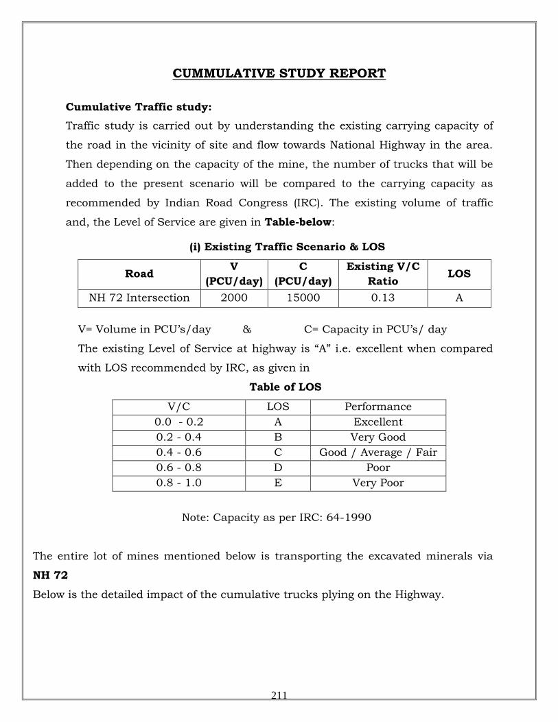
CUMMULATIVE STUDY REPORT
Cumulative Traffic study:
Traffic study is carried out by understanding the existing carrying capacity of
the road in the vicinity of site and flow towards National Highway in the area.
Then depending on the capacity of the mine, the number of trucks that will be
added to the present scenario will be compared to the carrying capacity as
recommended by Indian Road Congress (IRC). The existing volume of traffic
and, the Level of Service are given in Table-below:
(i) Existing Traffic Scenario & LOS
Road V (PCU/day)
C (PCU/day)
Existing V/C Ratio LOS
NH 72 Intersection 2000 15000 0.13 A
V= Volume in PCU’s/day & C= Capacity in PCU’s/ day
The existing Level of Service at highway is “A” i.e. excellent when compared
with LOS recommended by IRC, as given in
Table of LOS
Note: Capacity as per IRC: 64-1990
The entire lot of mines mentioned below is transporting the excavated minerals via
NH 72
Below is the detailed impact of the cumulative trucks plying on the Highway.
V/C LOS Performance 0.0 - 0.2 A Excellent 0.2 - 0.4 B Very Good 0.4 - 0.6 C Good / Average / Fair 0.6 - 0.8 D Poor 0.8 - 1.0 E Very Poor
211
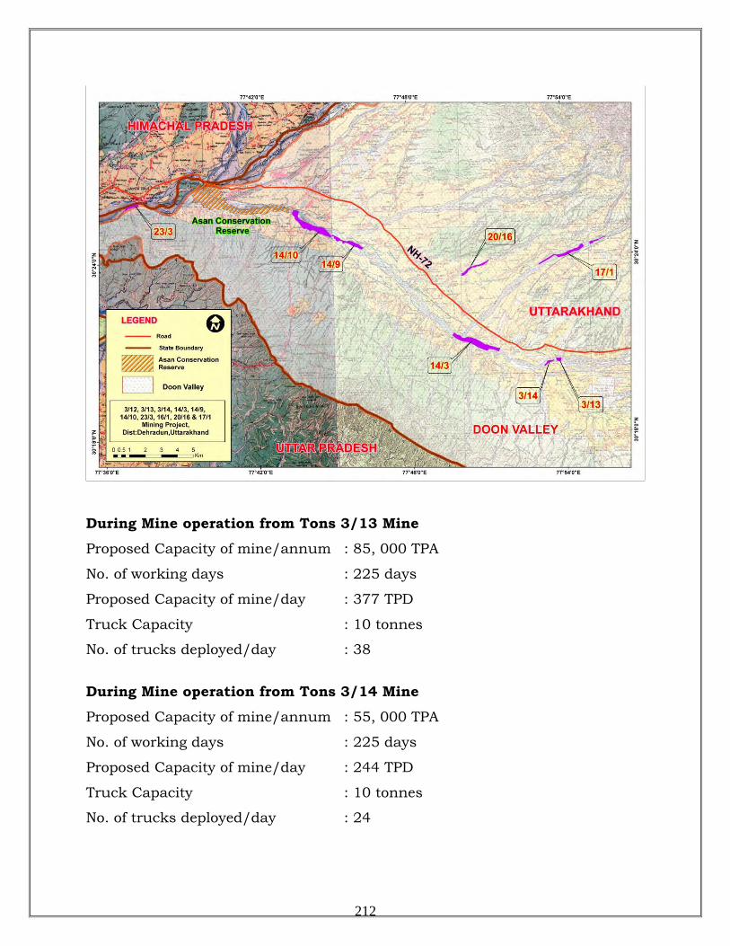
During Mine operation from Tons 3/13 Mine
Proposed Capacity of mine/annum : 85, 000 TPA
No. of working days : 225 days
Proposed Capacity of mine/day : 377 TPD
Truck Capacity : 10 tonnes
No. of trucks deployed/day : 38
During Mine operation from Tons 3/14 Mine
Proposed Capacity of mine/annum : 55, 000 TPA
No. of working days : 225 days
Proposed Capacity of mine/day : 244 TPD
Truck Capacity : 10 tonnes
No. of trucks deployed/day : 24
212
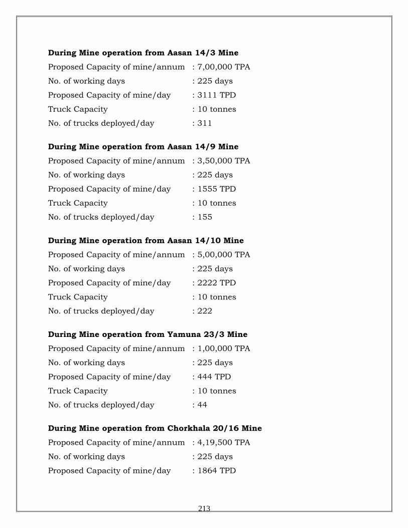
During Mine operation from Aasan 14/3 Mine
Proposed Capacity of mine/annum : 7,00,000 TPA
No. of working days : 225 days
Proposed Capacity of mine/day : 3111 TPD
Truck Capacity : 10 tonnes
No. of trucks deployed/day : 311
During Mine operation from Aasan 14/9 Mine
Proposed Capacity of mine/annum : 3,50,000 TPA
No. of working days : 225 days
Proposed Capacity of mine/day : 1555 TPD
Truck Capacity : 10 tonnes
No. of trucks deployed/day : 155
During Mine operation from Aasan 14/10 Mine
Proposed Capacity of mine/annum : 5,00,000 TPA
No. of working days : 225 days
Proposed Capacity of mine/day : 2222 TPD
Truck Capacity : 10 tonnes
No. of trucks deployed/day : 222
During Mine operation from Yamuna 23/3 Mine
Proposed Capacity of mine/annum : 1,00,000 TPA
No. of working days : 225 days
Proposed Capacity of mine/day : 444 TPD
Truck Capacity : 10 tonnes
No. of trucks deployed/day : 44
During Mine operation from Chorkhala 20/16 Mine
Proposed Capacity of mine/annum : 4,19,500 TPA
No. of working days : 225 days
Proposed Capacity of mine/day : 1864 TPD
213
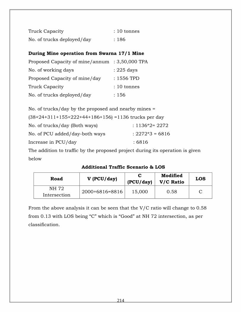
Truck Capacity : 10 tonnes
No. of trucks deployed/day : 186
During Mine operation from Swarna 17/1 Mine
Proposed Capacity of mine/annum : 3,50,000 TPA
No. of working days : 225 days
Proposed Capacity of mine/day : 1556 TPD
Truck Capacity : 10 tonnes
No. of trucks deployed/day : 156
No. of trucks/day by the proposed and nearby mines =
(38+24+311+155+222+44+186+156) =1136 trucks per day
No. of trucks/day (Both ways) : 1136*2= 2272
No. of PCU added/day-both ways : 2272*3 = 6816
Increase in PCU/day : 6816
The addition to traffic by the proposed project during its operation is given
below
Additional Traffic Scenario & LOS
Road V (PCU/day) C (PCU/day)
Modified V/C Ratio LOS
NH 72 Intersection
2000+6816=8816 15,000 0.58 C
From the above analysis it can be seen that the V/C ratio will change to 0.58
from 0.13 with LOS being “C” which is “Good” at NH 72 intersection, as per
classification.
214
DISASTER MANAGEMENT PLAN
River Bed Mining has impending dangers or risk which need be addressed for which a disaster
management plan has been formulated with an aim of taking precautionary steps to avert
disasters and also to take such action after the disaster which limits the damage to the minimum. As per proposal made under the mining plan, during proposed working, the area will be
developed by means of semi-mechanized opencast mining method.
• Possible Risks Due To Inundation & Its Control
Mining will be done during the non-monsoon periods; therefore problem of inundation is not
likely to happen. However, sudden uninformed release of water from upstream reservoirs, if any,
or during dam bursts cannot be ruled out
• Dewatering
Depth of mine is limited to 3m depth or ground water level, whichever comes first. Hence no
dewatering is required.
• Possible Risks Due To Failure of Pit Slope & Its Control
Pit will be created of limited depth only i.e. 3m with bench heights not exceeding 1m and a slope
of 450
• Possible Risks Due To Failure of Waste Dump & Its Control
. Thus the chance of failure of pit slope does not exist.
No waste dump is created therefore the question of failure of waste dump does not exist.
• Possible Risks Due To Explosion, Fire & Its Control
The operation does not need blasting and electricity and hence does not anticipate any fire
disaster.
• Measures to Prevent Accidents Due to Trucks/Dumpers
i. All transportation within applied mining lease working shall be carried out directly under
the supervision and control of the management.
ii. The vehicles will be maintained in good condition and checked thoroughly and vehicles
without fitness certificate or PUC Certificate will not be allowed. In case of doubt,
vehicles will be inspected by a competent person authorized for the purpose by the
management.
215
iii. Road signs will be provided along the evacuation route showing maximum speed limit,
school sites, market places, hospital sites or any other sites where crowds are anticipated
en route and at each and every turning point up to the main road (wherever required).
iv. To avoid danger while reversing the equipment’s/ vehicles especially at the working
place / loading points, stopper shall be posted to properly guide reversing/ spotting
operating, otherwise no person shall be allowed within 10 m radius of machine except
operators.
v. A statutory provision of the fences around deep pits, warning signs near quick sand
conditions, constant education, training etc. about risk and hazards expected from the
project shall be provided for reducing the incidents of such accidents.
Other Possible Measures to Avoid Risks/ Disaster Due to River Bed Mining.
i. Unwanted material including mineral or spillage (if any) shall not be stacked on the
banks as it will hinder the flow of water in monsoon season causing water logging and
damaging evacuation routes and nearby structures.
ii. Mining of minerals / working shall be started from the center line of lease area starting
from dip to rise to avoid ponding and then laterally in 3 numbers of 1 meter high benches
to avoid side collapsing.
iii. River banks will not be excavated to from access ramps.
iv. Only excavated and unsalable river gravel shall be used to deposit against the river bank
to form access ramps with allowable slope.
Maintenance and monitoring of housekeeping:
The area will be monitored every week by competent person and if maintenance is needed will
be done as per requirement.
Occupational Health Hazards:
Dry- pit mining by open cast method involves dust generation by excavation, loading and
transportation of mineral. At site, during excavation and loading activity, dust is main pollutant
which affects the health of workers whereas environmental and climatic conditions also generate
the health problems.
Addressing the occupational health hazard means gaining an understanding of the source (its
location and magnitude or concentration), identifying an exposure pathway (e.g. a means to get it
216
in contact with someone), and determination of likely a receptor (someone receiving the stuff
that is migrating).
Occupational hazard due to sand mining mainly comes under the physical hazards.
• Physical Hazards due to Mining Operations:
Following health related hazards were indentified due to riverbed sand mining operations to the
workers:-
1. Light: - The workers may be exposed to the risk of poor illumination during evening hours or
excessive brightness during day times. The effects are eye strain, headache, eye pain and
lachrymation, congestion around the cornea and eye fatigue.
2. Heat and Humidity: - The most common physical hazard is heat as working is done in open
sun light without any shed. The direct effects of excessive heat exposure in summer season areas
are burns, heat exhaustion, heat stroke and heat cramps; the indirect effects are decreased
efficiency, increased fatigue and enhanced accident rates. Heat and humidity are encountered in
hot and humid condition when temperatures and air temperatures may exceed 480
3. Eye Irritation: - During the high windy days in summer the sandstorms could be the problems
for eyes like itching and watering of eyes.
C in the river
bed mining area.
4. Respiratory Problems: - Large amounts of dust in air with possibility to have free crystalline
quartz can be a health hazard, exacerbating respiratory disorders such as asthma and irritating the
lungs and bronchial passages. However, as the sand at river beds are having high moisture, the
emission from excavation and loading are not significant and in case of dry sand, this can be
easily controlled by water sprinkling.
5. Noise Induced Hearing Loss: - Vehicles and Machinery is the main source of noise pollution
at the mine site, though they are not significant
6. Insect and snake bites are possible as their habitations below boulders may be disturbed during
mining.
7. Approaching areas having quick sand conditions unknowingly.
Medical Examination Schedule:
To minimize the health impacts PPE like dust masks, ear plugs/ muffs, goggles for protection
against sunlight and other equipments will be provided for use by the work personnel. Rest
217
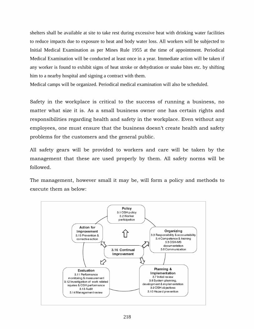
shelters shall be available at site to take rest during excessive heat with drinking water facilities
to reduce impacts due to exposure to heat and body water loss. All workers will be subjected to
Initial Medical Examination as per Mines Rule 1955 at the time of appointment. Periodical
Medical Examination will be conducted at least once in a year. Immediate action will be taken if
any worker is found to exhibit signs of heat stroke or dehydration or snake bites etc. by shifting
him to a nearby hospital and signing a contract with them.
Medical camps will be organized. Periodical medical examination will also be scheduled.
Safety in the workplace is critical to the success of running a business, no
matter what size it is. As a small business owner one has certain rights and
responsibilities regarding health and safety in the workplace. Even without any
employees, one must ensure that the business doesn’t create health and safety
problems for the customers and the general public.
All safety gears will be provided to workers and care will be taken by the
management that these are used properly by them. All safety norms will be
followed.
The management, however small it may be, will form a policy and methods to
execute them as below:
218
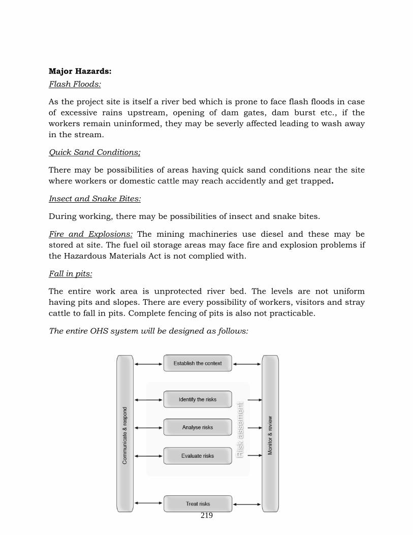
Major Hazards:
As the project site is itself a river bed which is prone to face flash floods in case of excessive rains upstream, opening of dam gates, dam burst etc., if the workers remain uninformed, they may be severly affected leading to wash away in the stream.
Flash Floods:
There may be possibilities of areas having quick sand conditions near the site where workers or domestic cattle may reach accidently and get trapped.
Quick Sand Conditions;
During working, there may be possibilities of insect and snake bites.
Insect and Snake Bites:
Fire and Explosions: The mining machineries use diesel and these may be stored at site. The fuel oil storage areas may face fire and explosion problems if the Hazardous Materials Act is not complied with.
The entire work area is unprotected river bed. The levels are not uniform having pits and slopes. There are every possibility of workers, visitors and stray cattle to fall in pits. Complete fencing of pits is also not practicable.
Fall in pits:
The entire OHS system will be designed as follows:
219
Personal Protective Equipment (PPE)
General Provisions
As a supplementary protection against exposure to hazardous conditions in the RBM projects where the safety of workers cannot be ensured by other means, such as eliminating the hazard, controlling the risk at source or minimizing the risk, suitable and sufficient PPE, having regard to the type of work and risks, and in consultation with workers and their representatives, shall be procured and used by the workers and provided and maintained by the employer, without cost to the workers. PE)
• PPE shall be examined periodically to ensure that it is in good condition.
• Different PPE & their components shall be compatible with each other when worn together.
• It shall be ensured that the procured PPEs are ergonomically designed and, to the extent practicable, should not restrict the user’s mobility or field of vision, hearing or other sensory functions.
• Employer shall ensure that the workers who are required to wear PPE are fully informed of the requirements and of the reasons for them, and are given adequate training in the selection, wearing, maintenance and storage of this equipment.
• When workers have been informed accordingly, they shall use the equipment provided throughout the time they may be exposed to the risk that requires the use of PPE for protection.
• The PPE shall not be used for longer than the time indicated by the manufacturer.
• Workers shall make proper use of the PPE provided, and maintain it in good condition, consistent with their training and be provided with the proper means for doing so.
• PPE procured shall not contain hazardous substances, such as asbestos.
220
Head Protection
• Helmets intended for use in industry shall be subjected to a test for resistance to falling objects while loading.
• Any helmet that has been submitted to a heavy blow, even if there are no evident signs of damage, shall be discarded.
• Helmets for persons working overhead shall be so procured that they shall be provided with chin straps.
• In addition to safety, consideration shall also be given to the physiological aspects of comfort for the wearer.
• The helmets shall be so procured that they shall be as light as possible, the harness should be flexible and should not irritate or injure the wearer and a sweatband should be incorporated.
• All protective headgear shall be cleaned and checked regularly.
Face & Eye Protection
• Face shields or eye protectors shall be used to protect against flying particles and dust storms.
• Goggles, helmets or shields that give maximum eye protection shall be worn by operators and their helpers.
• The protectors shall be fitted and adjusted by a person who has received training in this task.
Respiratory Protective Equipment
• When effective engineering controls are not feasible, or while they are being implemented or evaluated, masks, appropriate to the hazard and risk in question, shall be used to protect the health of the worker working in dusty conditions.
221
Hearing Protection
Noise pollution is not a major issue in the project. However, the following measures shall be taken if anybody is to work in a noisy area:
• When effective engineering controls are not feasible or while they are being implemented or evaluated, hearing protection shall be used to protect the health of workers.
• Hearing loss of speech frequencies may occur with elevated long-term exposure to noise. The use of hearing protectors gives the best results to users who are well informed of the risks and trained in their use. If earplugs are used, special attention shall be paid to the proper fitting technique.
• Hearing protectors shall be so procured that they are comfortable, and the users shall be trained to use them properly. Special attention shall be paid to possible increased risk of accidents due to the use of hearing protectors. Earmuffs reduce the capacity to locate sound sources and prevent warning signals from being heard. This is especially true for workers with considerable hearing loss.
Protection from Falls
• In RBM projects, workers are exposed to working at uneven sites with pits and slopes not properly designed.
• Devices like fencings and warning signboards shall be provided to prevent workers from falling to the extent possible.
• Appropriate and timely rescue shall be provided when using fall-arrest equipment to prevent suspension trauma.
Plan of evaluation of health of workers
• By pre designed format during pre placement and periodical examinations.
• Proper schedule will be devised and followed with help of occupational health experts and doctors.
222
Schedule of medical check-up during operational phase
• Comprehensive Pre-employment medical checkup for all employees
• General check up of all employees once every year.
• Local hospitals and Govt. health monitoring system will be engaged.
• Dispensary and ESI facility will be provided to all workers as applicable
• All safety gears will be provided to workers and care will be taken by the management that these are used properly by them. All safety norms will be followed
Disaster Management Plan
Introduction
Even with all precautions, disasters may take place. As such, an Emergency
Plan has been formulated to take care of any disaster in the project and
surrounding areas and is detailed as under:
In order to prevent occurrence of any disaster, the project will be
provided with various safety measures as described. However, in case of
failure of safety measures or due to natural calamity or sabotage, disaster may
happen. Therefore, it is necessary to provide disaster control facilities to
minimize losses due to disaster. Normally, in the project, no major disaster
affecting nearby population areas are foreseen. However, accidents inside
the project affecting workplace in vicinity cannot be ruled out.
Definition of disasters
A situation will be called a `Disaster' if it entails any one or more of the
following factors:
• Risks of loss of human lives - ten or more in one single situation.
223
• Loss of property as a consequence of the incident is over Rs.1 Crore
and/or bears a potential to the above.
• A situation which goes beyond the control of the available resource of the
project.
• A situation apparently may not have much loss but its long-term severity
can affect loss of life, production and property.
The types of possible disaster are given below:
Type of disasters
i) Disaster due to failure of safety measures on account of:
- Fire and explosion
- Toxic gas release
- Pressure wave transmission due to blasting or explosion
- Collapse of mine wall and dump slope
- Accidents due to mining equipment and trucks/dumpers
ii) Disaster due to natural calamity on account of:
- Flood
- Earth quake / cyclone / Storm / Cloud burst / Lightning
iii) Disaster due to external factors on account of:
- Food poisoning / Water poisoning
- Sabotage - Quick sand conditions
Objectives
Objectives of the disaster control/management plan for the proposed project
are:
1. To identify type of major disasters this may occur in the project.
2. To collect data on type of disasters which has happened already in other
RBM projects.
3. An action plan to handle disaster.
224
1. Identification of Hazardous Process/Area
Level of Accident
If there is any disaster in any part of the project /work place due to any reason,
the area which may be affected can be classified in the following four classes.
1. Level I - Operator level 2. Level II - Local/community level
3. Level III - Regional/ national level
4. Level IV - International level
Level I class of accidents have been considered for the project.
Level I
Under this level, disasters may happen due to fire and explosion, accidents due
to traffic, falls on uneven areas and pits, toxic gas release, pressure wave
transmission due to blasting or explosion, flash floods, inundation, cyclones,
cloud burst, quick sand conditions and earthquake. This level has probability
of occurrence affecting persons inside the project site-may be workers or any
visitor including stray animals who have strayed into the site as the site has no
protective boundary of its own due to its nature unlike an industrial plant.
Moreover, as the project has no source of fire, explosion, toxic gas release or
pressure wave transmission due to blasting, the effect will not reach nearby
community.
225
Major Hazards and their Control:
Flash Floods:
As the project site is itself a river bed which is prone to face flash floods in case of excessive rains upstream, opening of dam gates, dam burst etc., if the workers remain uninformed, they may be severly affected leading to wash away in the stream.
Inundation
Mining will be done during the non-monsoon periods; therefore problem of
inundation is not likely to happen. However, sudden uninformed release of
water from upstream reservoirs, if any, or during dam bursts cannot be ruled
out
Alarm System – an effective control system:
In case of RBM projects, where maximum chances of disaster are due to flash
floods and inundation due to anthropogenic or natural activities up stream, a
proper communication and alarm system is the first requirement. The alarm
system can be activated only if the Safety Officer is communicated the same
from upstream sources on time. There is a time lag between the occurrence of
the situation at source and it’s reaching the site, which are some distance
away. If the source is due to anthropogenic reasons, the information must be
communicated to downstream areas so that they can take preventive measures
on time. In case the source is due to natural disasters, then also its effect will
take some time to reach the project site and there is sufficient time to take
preventive actions. To develop and operate such a communication system is
the responsibility of the state government. The responsibility of the project is to
develop links with state government, specially the irrigation department, so
that they can receive such communications on time and translate into actions.
The project shall develop its own communication and alarm system which will
work as follows:
226
On receiving the message of `Disaster’ from upstream sources, the Safety
Executive, will instruct Commanding Officer Security services to sound
SIREN WAILING TYPE FOR 5 MINUTES. On receiving the message of
“Emergency Over” from Safety Executive All Clear Signal by Sounding Siren
straight for two minutes will be given. The features of the alarm system will be
explained to one and all to avoid panic or misunderstanding during disaster.
Quick Sand Conditions;
There may be possibilities of areas having quick sand conditions near the site where workers or domestic cattle may reach accidently and get trapped. A proper identification of the area will be done and sign boards will be placed at vernerable places to warn people from reaching quick sand areas.
Insect and Snake Bites:
The area of RBM is river beds having good habitation of benthic organisms, insects and snakes. During working, they may feel disturbed and there are possibilities of insect and snake bites. Anti venom injections will be kept at site and at contracted hospitals nearby and this will be admininstered only by a qualified doctor as mentioned in the Disaster Control Team responsibilities.
Fire and Explosions: The mining machineries use diesel and these may be stored at site. The fuel oil storage areas may face fire and explosion problems if the Hazardous Materials Act is not complied with.fire protection facilities will be provided as mentioned under Disaster Control Team responsibilities to handle fire Fire and explosion.
Fall in pits:
The entire work area is unprotected river bed. The levels are not uniform having pits and slopes. There are every possibility of workers, visitors and stray cattle to fall in pits. Fencing will be provided wherever is practicable as complete fencing of pits is not practicable.
227
Failure of Pit Slope
Pit will be created of limited depth only upto 3m with bench heights not
exceeding 1m and a slope of 450
Failure of Waste Dump
. Thus the chance disaster during collapse of
pits or failure of pit slope does not exist.
No waste dump is created therefore the question of failure of waste dump does
not exist.
Explosion, Fire
The operation does not need blasting and electricity and hence any fire or
explosion disaster is not anticipated.
Accidents from Trucks/Dumpers
Movement of trucks and dumpers inside the lease area accident during loading
and transportation of sand/ boulders may cause accidents.
I. Disaster Preventive Measures
It is not easy to control a disaster in absence of a contingency plans. For
effective control of disaster, adequate manpower, technical know-how,
alertness and internal help are necessary. In the proposed project, following
prevention measures will be taken to prevent disaster.
Measures to Prevent Accidents Due to Trucks/Dumpers:
• All transportation within applied mining lease working shall be carried
out directly under the supervision and control of the management.
• The vehicles will be maintained in good condition and checked
thoroughly and vehicles without fitness certificate or PUC Certificate will
not be allowed. In case of doubt, vehicles will be inspected by a
competent person authorized for the purpose by the management.
• Road signs will be provided along the evacuation route showing
maximum speed limit, school sites, market places, hospital sites or any
other sites where crowds are anticipated en route and at each and every
turning point up to the main road (wherever required).
228
• To avoid danger while reversing the equipment’s/ vehicles especially at
the working place / loading points, stopper shall be posted to properly
guide reversing/ spotting operating, otherwise no person shall be allowed
within 10 m radius of machine except operators.
• A statutory provision of the fences around deep pits, warning signs near
quick sand conditions, constant education, training etc. about risk and
hazards expected from the project shall be provided for reducing the
incidents of such accidents.
i. Project layout:
• Provision of adequate access ways for the movement of equipment and
personnel are kept.
• Minimum two numbers of escape routes for escape during disaster to be
provided.
• Siting of fuel oil storage for mining machineries, if any, shall be in
protected fenced area inside tank bund located on the shore and not in
river bed.
ii. Fire Fighting
The proposed project will be provided with a Foam generator at the fuel oil
storage site.
However, prior to installation of fire station & safety equipment, an
experienced and qualified Fire Officer as per Factories Act will be engaged to
carry out in-depth study and advise on the selection of equipment.
iii. Safety
The proposed project will have a Safety Executive who will be an experienced
and qualified staff whose main job will be to bring about safety consciousness
amongst the work force in the project. The Safety Executive will conduct
regular safety awareness courses/drills by organizing training of the personnel
229
among the various working levels.
Safety awareness will also be created by the various posters highlighting the
safe working practices in working area, public places and roads etc. Report will
be given to Management for corrective measures to improve the safety
conditions.
iv. Training
Management will arrange training on safety accident prevention, first aid,
hazard control, housekeeping and environmental management. Special
emphasis with mock drills in disaster control will also be planned.
v. Communication
In the proposed project, there will be up-to-date communication facilities with
telecommunication and mobile phones, walkie-talkies, loud speakers to warn
workers in case of an accident.
Other Possible Measures to Avoid Risks/ Disaster Due to River Bed
Mining.
• Unwanted material including mineral or spillage (if any) shall not be
stacked on the banks as it will hinder the flow of water in monsoon
season causing water logging and damaging evacuation routes and
nearby structures.
• Mining of minerals / working shall be started from the center line of
lease area starting from dip to rise to avoid ponding and then laterally
in 3 numbers of 1 meter high benches to avoid side collapsing.
• River banks will not be excavated to from access ramps. Only
excavated and unsalable river gravel shall be used to form access
ramps with allowable slope.
• Maintenance and monitoring of housekeeping: The area will be
monitored every week by competent person and if maintenance is
needed will be done as per requirement.
230
II. Contingency Plan and formation of Disaster Control Team
The contingency plan has been prepared from the experiences of accidents that
have occurred in various other river side projects. The contingency plan being a
dynamic plan will need periodical reviews and modifications with new
experiences. Even with all precautionary measures taken to avoid disaster,
disaster may occur. To tackle situations during and after disaster, a well-
defined contingency plan and persons responsible to execute it is a must. The
management will form a Disaster Control Team which will be headed by a
Safety Executive, who is a senior full time employee of the company well
qualified in Risk Management and Safety. The Safety Executive will be made
responsible to handle disaster. On getting information about any accident, the
officer will perform the following tasks:
• verify from the affected project site
• Inform the Management or other nominated coordinators immediately.
• To be responsible for planning and provisions of assistance from local
authorities.
• To keep higher authorities informed about the situation.
• The decision of the Safety Executive on any matter to meet the objective
of disaster control plan will be final.
• To identify persons from within the organization or outside local persons
and form a Disaster Control Team.
• To convey message to his Disaster Control Team after consulting
Management.
• Disaster Control Team will report to the Safety Executive and will
consists of members from Casualty services, Rescue services, Fire
fighting services, Traffic control, Training services, Depot and Transport
231
services, Supply Services, Salvage service, Welfare services, Security
services and Public Relation Service.
• All the services will be headed by respective Commanding Officers.
• To consult between themselves on matters related to more than one
service and to decide on the action to be taken.
Activities on Warning and Alert (As proposed in SDMP) On the receipt of a warning or alert received from any such agency which is
competent to issue such a warning, or on the basis of reports from District
Magistrate/SP on the occurrence of a disaster, all community preparedness
including counter-disaster measures will be put into operation.
• On the basis of reports from the possible disaster site.
• On the receipt of warning or alert from EOC.
Coordination Coordination involves the bringing together of agencies and elements to ensure
effective response to emergencies. The district level will ensure co-ordination of
resources to support operations which cannot be resourced locally, or which
extend over more than one location. The highest level of operational co-
ordination and support takes place at the State level. It is at this level that
resource support from other States, Central Government and/or other agencies
is assessed and requested. The response plan has been subdivided into the
following sections:
232
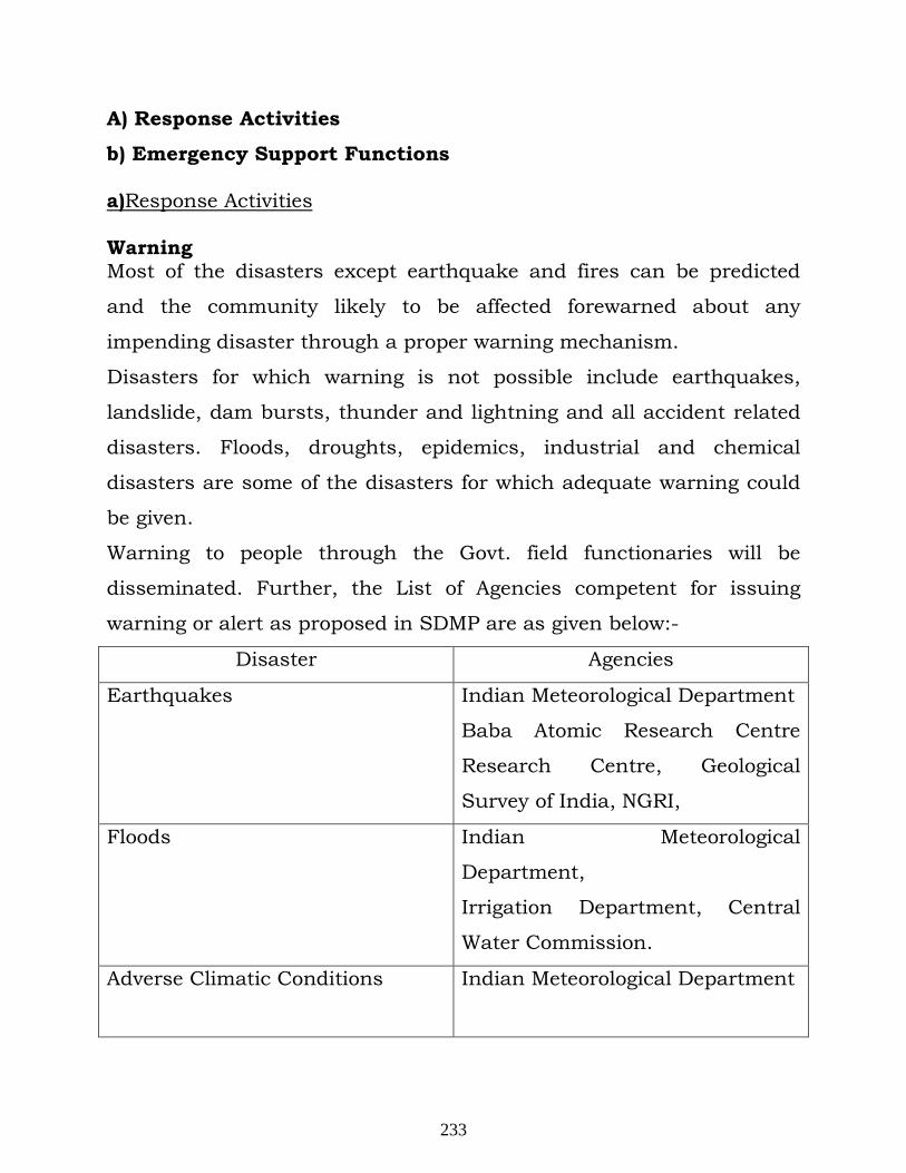
A) Response Activities
b) Emergency Support Functions a)Response Activities Warning Most of the disasters except earthquake and fires can be predicted
and the community likely to be affected forewarned about any
impending disaster through a proper warning mechanism.
Disasters for which warning is not possible include earthquakes,
landslide, dam bursts, thunder and lightning and all accident related
disasters. Floods, droughts, epidemics, industrial and chemical
disasters are some of the disasters for which adequate warning could
be given.
Warning to people through the Govt. field functionaries will be
disseminated. Further, the List of Agencies competent for issuing
warning or alert as proposed in SDMP are as given below:-
Disaster Agencies
Earthquakes Indian Meteorological Department
Baba Atomic Research Centre
Research Centre, Geological
Survey of India, NGRI,
Floods Indian Meteorological
Department,
Irrigation Department, Central
Water Commission.
Adverse Climatic Conditions Indian Meteorological Department
233
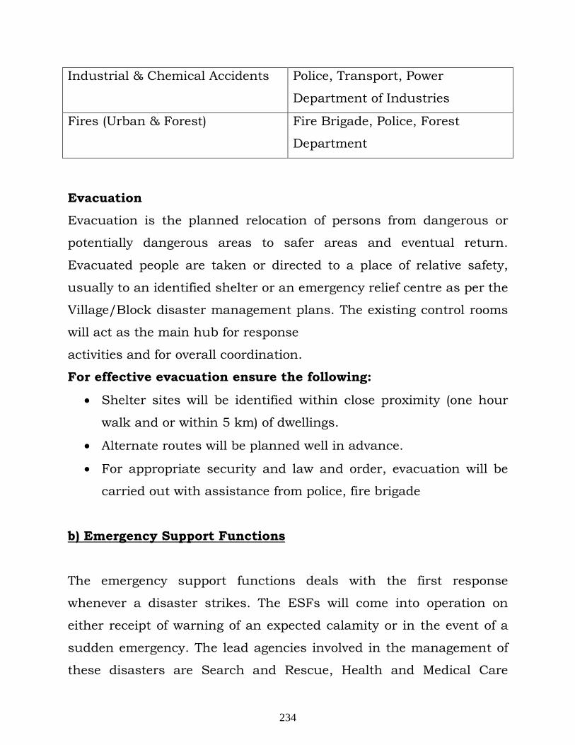
Industrial & Chemical Accidents Police, Transport, Power
Department of Industries
Fires (Urban & Forest) Fire Brigade, Police, Forest
Department
Evacuation
Evacuation is the planned relocation of persons from dangerous or
potentially dangerous areas to safer areas and eventual return.
Evacuated people are taken or directed to a place of relative safety,
usually to an identified shelter or an emergency relief centre as per the
Village/Block disaster management plans. The existing control rooms
will act as the main hub for response
activities and for overall coordination.
For effective evacuation ensure the following:
• Shelter sites will be identified within close proximity (one hour
walk and or within 5 km) of dwellings.
• Alternate routes will be planned well in advance.
• For appropriate security and law and order, evacuation will be
carried out with assistance from police, fire brigade
b) Emergency Support Functions
The emergency support functions deals with the first response
whenever a disaster strikes. The ESFs will come into operation on
either receipt of warning of an expected calamity or in the event of a
sudden emergency. The lead agencies involved in the management of
these disasters are Search and Rescue, Health and Medical Care
234
(Mobile hospitals), Communication, Food & Civil supplies, PWD,
Transport, Jal Sansthan, Power, Police, Fire etc. These lead agencies
could be supported by a number of other department/agencies.
• Early Warning • Evacuation • Search and Rescue • Medical aid • Shelter Management • Emergency Relief • Water Supply and Sanitation • Infrastructure Restoration
III. The responsibility of the members of the Disaster Control Team
i. Alarm System
In case of RBM projects, where maximum chances of disaster are due to flash
floods and inundation due to anthropogenic or natural activities up stream, a
proper communication and alarm system is the first requirement. The alarm
system can be activated only if the Safety Officer is communicated the same
from upstream sources on time. There is a time lag between the occurrence of
the situation at source and its reaching the site, which are some distance
away. If the source is due to anthropogenic reasons, the information must be
communicated to downstream areas so that they can take preventive measures
on time. In case the source is due to natural disasters, then also its effect will
take some time to reach the project site and there is sufficient time to take
preventive actions. To develop and operate such a communication system, it
will be done in consultation with the state government. The responsibility of
the project is to have facilities to receive such communications and translate
into actions. The project shall develop its own communication and alarm
system which will work as follows:
On receiving the message of `Disaster’ from upstream sources, the Safety
235
Executive, will instruct Commanding Officer Security services to sound
SIREN WAILING TYPE FOR 5 MINUTES. On receiving the message of
“Emergency Over” from Safety Executive All Clear Signal by Sounding Siren
straight for two minutes will be given. The features of the alarm system will be
explained to one and all to avoid panic or misunderstanding during disaster.
ii. Casualty services
Casualty Services will be manned by a local Medical Officer or an appointed Medical Officer nominated as a member of Disaster Control Team. His functions will include:
• First aid service by first aid parties on the spot.
• Ambulance service for transport of casualties from the spot to
nearest hospital.
Procedure for treatment
On getting a signal from the Safety Executive or information on telephone or
hearing siren, the Member of the Casualty service and first aid personnel will
report to Safety Executive. The Ambulance with the driver will report to site.
First aid parties will render first aid to casualties at the place of occurrence and
those requiring further treatment would be transported to the nearest hospital
by ambulance. In case of extra help being required from outside Safety
Executive will initiate for help in:
• Evacuating the casualties
• Essential assistance in first aid.
• Extra medical helps from neighboring hospital.
First Aid It is necessary to give first aid to the persons injured in disaster. First aid post
will be set up. At the post 1 first aid personnel shall be kept.
Equipment
236
Each member of the first aid will be provided with the personal
equipments like Helmet, Water bottle, Torch, First aid box with Anti Venom.
Rescue services
The responsibility of effective working of Rescue Services shall be with Member
of the Casualty service as follows:
Rescue services • To hand over injured persons to first aid parties
• To extricate persons from the debris and save human lives
Each rescue party will be provided with the following equipment:
• PETRONAS lamp, Torches
• Axes/hand saw
• Ropes
• Ladders
• Blankets
• Rubber shoes
Repair services
• To take up repair of damaged buildings, roads and culverts.
• To maintain essential public utility services
• To take up quick repairs of the damaged machinery.
Fire fighting services
The functions of the fire fighting group will be:
• To enforce all regulations for prevention of fire.
• To co-ordinate fire fighting activities
• To request neighboring industries and District Authority for rendering
services of their fire fighting crew under mutual aid schemes, if
necessary.
Traffic control
The free movement of the fire vehicles and ambulance at the scene of
fire/emergency is very important and therefore the security personnel on duty
237
must ensure that all the roads at the scene of fire/emergency are kept clear
and fire/emergency must not park their vehicles within 100 meters of fire, at
road junction and at access roads. The ignition key should be left in the
vehicles.
Training services
The responsibilities of the training department in the context of disaster
management shall be as given below.
• The faculty will consist of Safety Executive and all members of the
Disaster Control Team
• To arrange training of volunteers/employees nominated by Safety
Executive.
• To arrange refresher training courses once in a year.
• To arrange mock drills, twice in a year.
• To make a list of employees trained in various specialized disasters so
that they can be easily contacted to handle a particular type of disaster.
The person concerned will immediately report to Safety Executive.
Transport services
The responsibilities of the transport department in the context of disaster
management shall be as follows:
• Arranging vehicles from market and dispatch of vehicle to the place of
incident as per orders from the Safety Executive.
• To return the vehicle as soon as the work is completed.
• The vehicles should be available at a short notice
Fuel: The Transport services will contact Supply Services for arrangement of
fuel for vehicles during fuel crisis and stop supplying fuel to vehicles other than
those, which are in use for disaster control.
Supply Services
A senior person will head supply service from stores department. The
238
responsibilities include:
• Planning, organizing and procuring, of necessary equipment/materials.
• Storage of equipment/materials at accessible location and quick
distribution on demand.
• To obtain the requirement of equipment/ materials from Commanding
Officers of various services for their respective services.
Salvage service
Their responsibilities will be:
• To salvage properties from debris
• To take care of such properties
• To co-ordinate patrolling with the help of police and security personnel
for the safeguard of valuable properties till the same are removed to a
safe place.
Welfare services
Management of proposed project will nominate one person from administration
side as the Commanding Officer of welfare services.
Emergency camps will be set up only in exceptional cases on available area.
For this purpose necessary materials will be brought from nearby market. The
function of the welfare officer will include:
• To provide shelters to affected persons.
• To arrange enough stock of essential commodities
• To arrange clothing and medicines to affected persons.
• To arrange drinking water, if supply is disrupted, with the help of
District Authorities.
Security services
Chief Security Officer will be Commanding Officer, Security Services. Security
239
services will be primarily responsible for the security of the project. His
functions will include:
• To control the vehicular traffic inside the project.
• To help local police in patrolling the area of project and outside the
battery area, if necessary.
• To assist various services in removing people from inundated areas,
areas which have faced disaster and fighting fires.
• To assist in transporting injured persons.
• One jeep and one motor cycle will always be kept as reserve to cope with
emergency demand and immediate mobility of security personnel.
Public Relation Service
A senior officer from the organization will look after Public Relation Services as
PRO. His responsibilities are:
• To consult Management before communication, if required with outside
agencies.
• PRO will be the official spokesman for the proposed project with outside
agencies.
• PRO will arrange for photography and filming of the whole disaster as
photography and filming of such incidents are of immense value for the
purpose of investigation, training and education.
IV. Fire and Explosion
Chances of fire and explosion from the project are insignificant. However,
following contingency plans have been made:
• Safety Executive along with Commanding Officers takes overall charge of
the situation
• Safety Executive will assess the situation for possible after effects of the
fire in the project and the surrounding areas likely to get affected
240
• Safety Executive will inform local authorities to send fire tenders, if
necessary
• Safety Executive will inform the nearby people of likely affected areas
through communication system to leave the area and move to other
areas earmarked, if necessary
• Safety Executive will inform coordinator, external services to inform the
District authorities of the disaster and request them for help.
• To evacuate people from the affected areas outside the project.
• To control the traffic and maintain law and order.
• To arrange medical aid for the affected people.
• Safety Executive will arrange inspection of affected areas to get firsthand
knowledge of damages occurred.
V. Food poisoning
In case of food poisoning the following actions will be taken:
• SAFETY EXECUTIVE will contact District Authorities and seek their help,
if necessary.
• Security Personnel and employees will help in transporting the affected
people to nearby health centres/ hospitals.
VI. Disaster due to Natural Calamity and External Factors
Most of the measures and processes shall be same as given under in-house
disaster except that the Safety Executive will contact the State/ District
authorities for necessary instructions to co-ordinate with them.
VII. Cloud burst/lightning
Cloud burst/lightning may lead to a situation which can lead to minor to major
emergency in RBM projects due to flash flood and submergence. In such
emergency, actions indicated under Disaster due to Natural Calamity and
241
External Factors will be initiated
Conclusion: In view of the imperative need to meet the gigantic challenge posed by natural
hazards, the successes achieved, the experience garnered and the onerous task
ahead to secure safety and Disaster-free functioning of the project, whether
small or big, in the larger interests of the society and the people envisages an
entire gamut of issues connected with mainstreaming disaster management
concerns in the developmental efforts at all levels and across a spectrum of
sectors. The main themes to be addressed are
• Ensuring proper siting of the project considering hazard parameters.
• Making mining processes inherently safe.
• Development of on-site and off-site DM plans in association with the
District Administration.
• Conducting mock-drills at regular intervals to determine the efficacy of
the DM plans.
• Preparation of inventory of corporate resources and uploading them on
the IDRN – India Disaster Resource Network.
• Large-scale association with awareness generation initiatives aimed at
building the knowledge, attitude and skills of the common people for a
safer habitat.
• Mainstreaming private sector participation in disaster management.
• Establishing linkages between private sector and the community.
• Networking knowledge on best practices and tools for effective disaster
management.
• Development and implementation of appropriate risk transfer
mechanisms.
Contact Personnel:
242
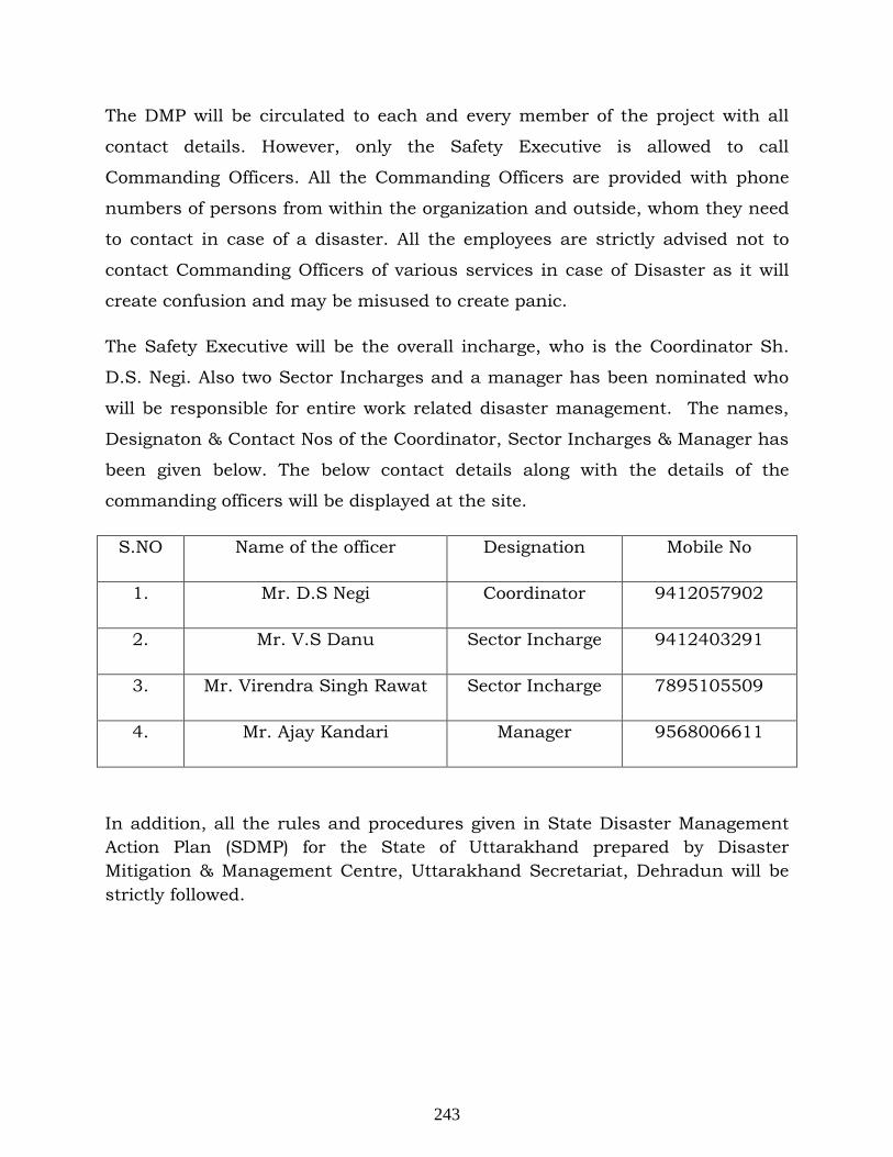
The DMP will be circulated to each and every member of the project with all
contact details. However, only the Safety Executive is allowed to call
Commanding Officers. All the Commanding Officers are provided with phone
numbers of persons from within the organization and outside, whom they need
to contact in case of a disaster. All the employees are strictly advised not to
contact Commanding Officers of various services in case of Disaster as it will
create confusion and may be misused to create panic.
The Safety Executive will be the overall incharge, who is the Coordinator Sh.
D.S. Negi. Also two Sector Incharges and a manager has been nominated who
will be responsible for entire work related disaster management. The names,
Designaton & Contact Nos of the Coordinator, Sector Incharges & Manager has
been given below. The below contact details along with the details of the
commanding officers will be displayed at the site.
S.NO Name of the officer Designation Mobile No
1. Mr. D.S Negi Coordinator 9412057902
2. Mr. V.S Danu Sector Incharge 9412403291
3. Mr. Virendra Singh Rawat Sector Incharge 7895105509
4. Mr. Ajay Kandari Manager 9568006611
In addition, all the rules and procedures given in State Disaster Management Action Plan (SDMP) for the State of Uttarakhand prepared by Disaster Mitigation & Management Centre, Uttarakhand Secretariat, Dehradun will be strictly followed.
243
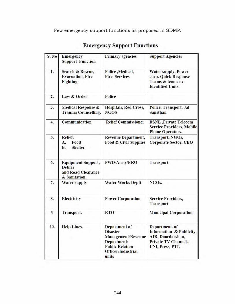
Few emergency support functions as proposed in SDMP:
Emergency Support Functions
S. No Emergency Primary agencies Support Agrnrirs Support Function
l. Search & Resene, Police ,;VIrdiral, 'Vater supply, Power Evacuation, Firt' Fin Senices forp. Quirk Response Fighting Trams & trams ex
Identified Units.
2. Law & Order Polict'
3. Medical Response & Hospitals, Red Cross, Polin" Transport, Jal Trauma COllnselling. NGOS Sansthan
4. Communication Relief Co mmissionel' BSNL ,Private Telecom Servin' Providers, Mobil PhoDe Opt'l'ators.
5. Relief. Rt'wunr Department, Transport, NGOs, A. Food Food & Civil Supplies Corporate St'ctOI', CBO B. Shrlft'l'
6. Equipmellt Support, PWD/AnnylBRO Transport Debris and Road Clearance & Sanitation.
7. Water supply Watrr Works Deptt NGOs.
8. Electricity Power Corporation Servin' Providers, Transport
9 Transport. RTO Municipal Corporation
10. Help Lines. Departmt'nt of Department. of Disaster Information & Publicity, ;\'Ia na ge men f/Revt'n u AIR, Doordarshan, Departmt'ntl Private TV Channels, Public Relation UNI, Press, PTI, Offic er lInd lIsfrial units
244
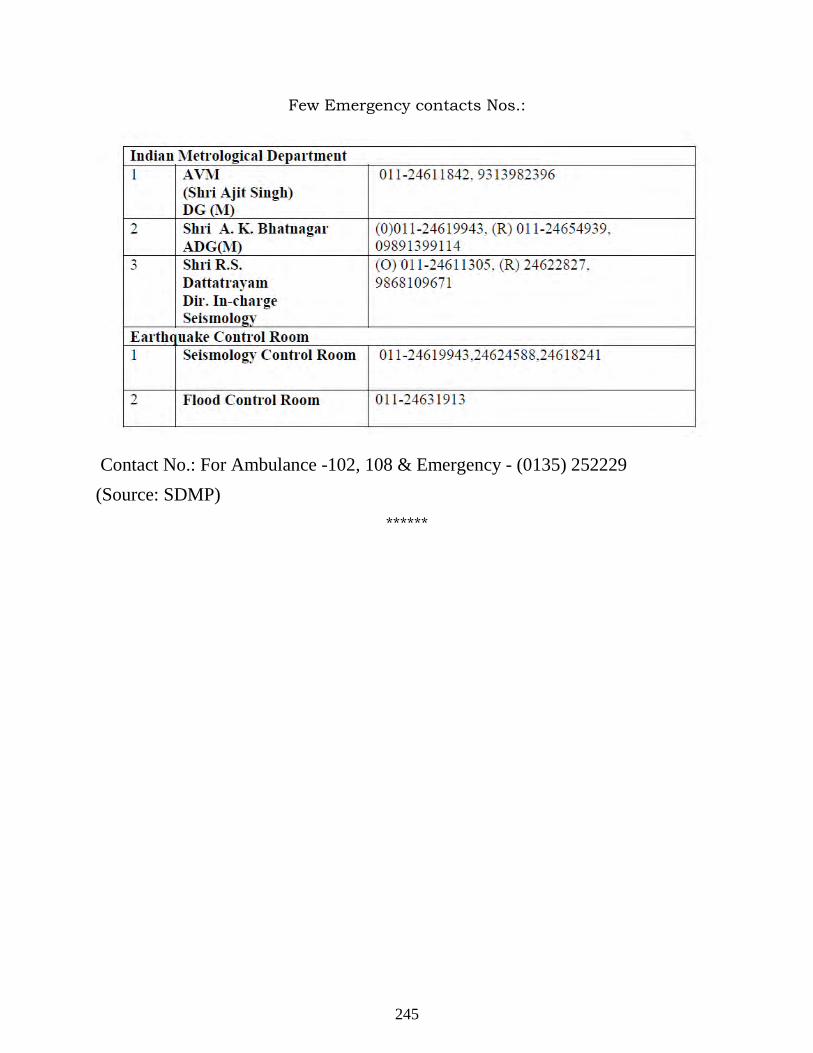
Few Emergency contacts Nos.:
Contact No.: For Ambulance -102, 108 & Emergency - (0135) 252229 (Source: SDMP)
******
245
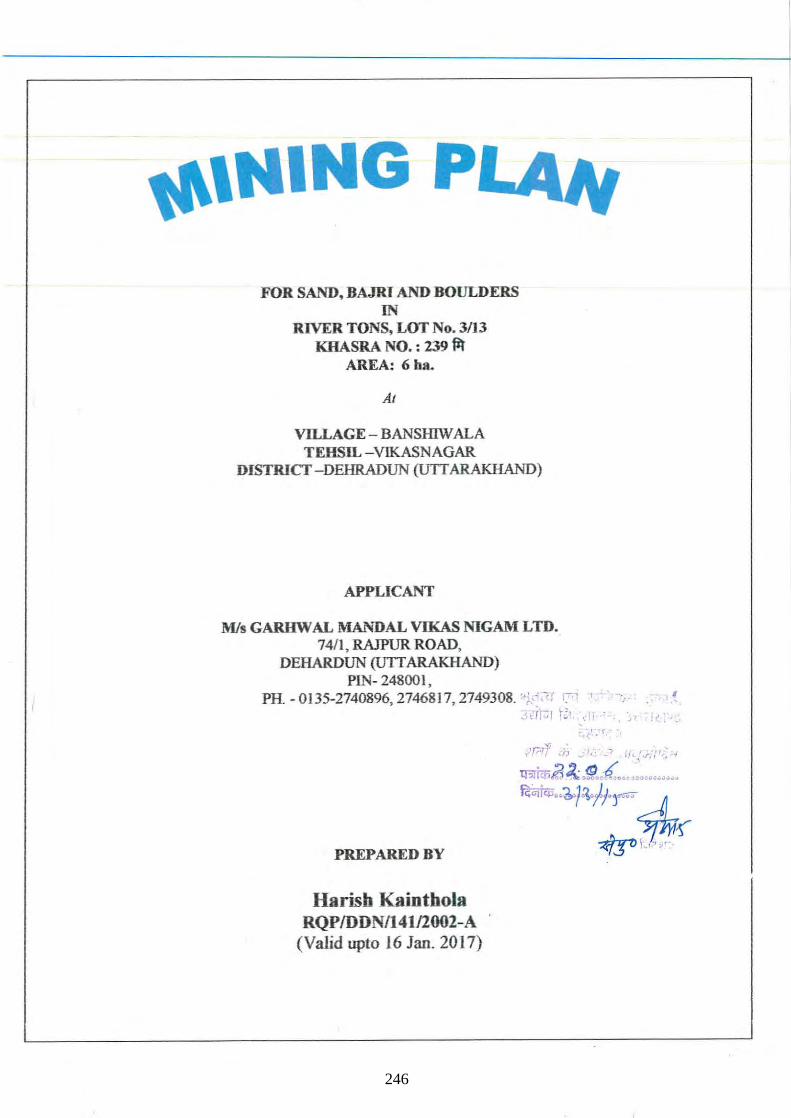
",HING PL4lt FOR SAND, BAJRI AND BOULDERS
IN RIVER TONS, LOT No. 3/13
KRASRA NO. : 239 ~ AREA: 6ha.
AI
VILLAGE - BANSHIW ALA TEHSIL -VIKASNAGAR
DISTRICT -DEHRADUN (UTI ARAKHAND)
APPLICANT
Mis GARHW AL MANDAL VIKAS NIGAM LTD. 74/1, RAJPUR ROAD,
DEHARDUN (UTI ARAKHAND) PIN- 24800 1,
PH. -0135-2740896,2746817, 2749308. "~","ir n ,,j{ir::;r r~' ~'-rl :
PREPARED BY
Harisb Kaintbola RQPIDDN/14112002-A
(Valid upto 16 Jan. 2017)
~. ~:'.: r,
. ;-( i( >.
246
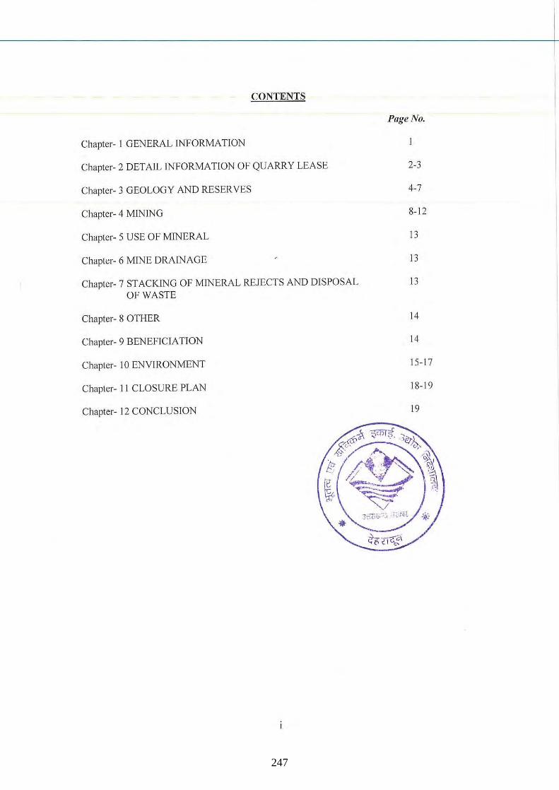
CONTENTS
Chapter- I GENERAL INFORMATION
Chapter- 2 DETAIL INFORMATION OF QUARRY LEASE
Chapter- 3 GEOLOGY AND RESERVES
Chapter- 4 MINING
Chapter- 5 USE OF MINERAL
Chapter- 6 MINE DRAINAGE
Chapter- 7 STACKING OF MINERAL REJECTS AND DISPOSAL OF WASTE
Chapter- 8 OTHER
Chapter- 9 BENEFICIATION
Chapter- 10 ENVIRONMENT
Chapter- II CLOSURE PLAN
Chapter- 12 CONCLUSION
Page No.
2-3
4-7
8-12
13
13
13
14
14
15-17
18-19
19
247
Title
LOJ for ML
Khasra Map
Joint Inspection Report
RQP Certificate
Authorization Letter
Title Location plan
Surface geological map
Geological sections
Pit layout plan at the end of! year
Pit layout plan at the end of II year
Pit layout plan at the end of III year
Pit layout plan at the end of IV year
Pit layout plan at the end of V year
Pit sections
Ultimate Pit Plan
Slice Plan
LIST OF ANNEXURE
LIST OF PLATES
11
Annexure No.
I
2 3 4
5
PLATE. No. I 2
3 4
5 6 7
8 9 10 II
248
CHAPTER-l
GENERAL INFORMATION
Mis Garhwal Mandai Vikas Nigam (GMVN) Ltd. has got Letter ofIntent in Village _ Banshiwala, Tehsil- Vikasnagar, Distt. - Dehradun (Uttarakhand) for preparation of mining plan for Mining License (ML) from Government of Uttaranchal over an area of 6 ha. at (Lot No. 3113) for sand, bajri & boulder in single block in Tons River for the period of 05 year (Annexure No.-I). Demarcated Cadastral (Khasra) Map (Annexure No.-2) is provided by the GMVN. The applied area is jointly inspected by different state Govt.
authorities (Annexure No.3). The mining plan of the area is prepared by Harish Kainthola (RQP), Lane No.- 8,
Indraprashtha, Upper Nathanpur, Ring road, Dehradun, Regd. No.: RQP/DDNII41 /2002-A,
for estimating the reserve of mineral (sand, bajri, boulder). Mis Garhwal Mandai Vikas Nigam Ltd. has authorised Shri Harish Kainthola,
RQP No. RQP/DDNII4112002-A to prepare the Mining Plan in respect of - Banshiwala,
area over an area of 6 ha for minor mineral, having the khasra No. 239 fit, falls under Nap
land in Village- Banshiwala, Tehsil- Vikasnagar, Distt. Dehradun, Uttarakhand (Annexure
No.5).
HAR'S~ KAINTHOLA p ." - ' ~"'''' 1-i 11'}f)O'l . A
249
CHAPTER-2
DETAIL INFORMATION OF QUARRY LEASE
Name & Address of the Applicant: Mis Garhwal MandaI Vikash Nigam Ltd., 74/1, Rajpur Road, Dehradun (Uttarakhand) 248001, Ph.- 0135-2740896, 2746817, 2749308.
Status of the Applicant: Govt. Body. Applicant has 10 year experience in mining activities.
Minerals which are occurring in the area and which the applicant intends to mine: Sand, bajri and boulder (RBM)
Status of the area: Mis Garhwal MandaI Vikash Nigam Ltd has applied for an area of 6 ha having the khasra No. 239 fl1, fall s under Nap land in Banshiwala, Tehsil- Vikashnagar, Distt. Dehradun, Uttarakhand.
Period for which the mining lease is granted I renewed I proposed to be applied: 5 years
Name, Address & Registration No. of the recognized person, whu prepared the Mining Plan:
Shri Harish Kainthola, Lane No.8, Indraprastha, Mussoorie by pass road, Upper Nathanpur, Dehra Dun- 248008 (Uttarakhand) Telephone (Cell): 09412028745, 09412058990 (Office), 0135-27349 es -"
- ~u S ' E-mail - [email protected]. kain _geotech2147@rediffmail. ~·. 0C';_.:", __ ':":":ji'~l.
Registration No. - RQPIDDN/1 4112002-A i" \'i'/,.~:I''':q.' ''~'' :,\i '" ( .. 1 , p.'~:) , , -\ '
Valid up to - 16 Jan 2017 (Annexure No - 4) ' - I / . . '.:-,1" . >. ' ~(
'.'m.''''tu" "ciliti~ _ \ \ :~.. ) .. ' Yi<~ ",. .. ,
Power & Electricity: i1-:;;:;: The lease area falls in village - Banshiwala, which is electrified by 2:m-~lfsJ.ij)j!"I'Y
nearly 80% area fall 5 km periphery of the area is electrified.
Water Supply: Water table of this area is about 60-90 ft below the ground. Dug wells and spring
water are used for drinking water purposes. For irrigation, small canal are made on the
perennial nalas and water supply for drinking purpose through pipe~ by Uttarakhand Jal
Sasthan. . ~
HARISIf KAINTHOlA 2 RQP/DDN /141/2002-A 250
Post office & Telegraph: Post Office is situated at Suddowala, which is about 2.5 km away from lease hold
area.
Education institute: Primary School and are available in the Banshiwala, which is about 1.5 km away
from lease hold area. Senior Sec. School and Intermediate Collage are available in the Premnagar,
which is about 5 km away from lease hold area. For getting higher studies, people are going to Delu'adun which is about 15 km from
the lease area.
Health facility: In Jhajra a Govt. hospital is available, which is about 1.5km from lease area.
District hospital is situated at Dehradun, which is 15 km away from the lease area in SE
direction.
Police station: The nearest police station is at Jhajra, which is about 1.5km from applied area.
Bank: There are number of banks available at Premnagar, which is about 5 km from the
applied area.
HARI~I' I( AINTHOLA " .I '1 il l/ )f)02_ A
3 251
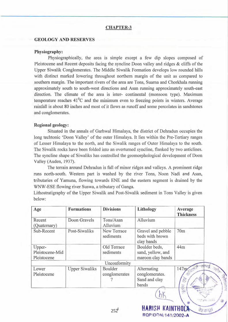
CHAPTER-3
GEOLOGY AND RESERVES
Physiography: Physiographically, the area is simple except a few dip slopes composed of
Pleistocene and Recent deposits facing the syncline Ooon valley and ridges & cliffs of the
Upper Siwalik Conglomerates. The Middle Siwalik Formation develops low rounded hills
with distinct marked lowering throughout northern margin of the unit as compared to
southern margin. The important rivers of the area are Tons, Suarna and Chorkhala running
approximately south to south-west directions and Asan running approximately south-east
direction. The climate of the area is inter- continental (monsoon type). Maximum
temperature reaches 41°C and the minimum even to freezing points in winters. Average
rainfall is about 80 inches and most of it flows as runoff and some percolates in sandstones
and conglomerates.
Regional geology:
Situated in the annals of Garhwal Himalaya, the di strict of Oebradun occupies the
long techtonic ' Ooon Valley' of the outer Himalaya. It lies within the Pre-Tertiary ranges
of Lesser Himalaya to the north, and the Siwalik ranges of Outer Himalaya to the south.
The Siwalik rocks have been folded into an overturned syncline, flanked by two anticlines.
The syncline shape of Siwaliks has controlled the geomorphological development of Ooon Valley (Au den, 1937).
The terrain around Oehradun is fall of minor ridges and valleys. A prominent ridge
runs north-south. Western part is washed by the river Tons, Noon Nadi and Asan,
tributaries of Yamuna, flowing towards ENE and the eastern segment is drained by the
WNW-ESE flowing river Suswa, a tributary of Ganga.
Lithostratigraphy of the Upper Siwalik and Post-Siwalik sediment in Tons Valley is given
below:
Age Formations
Recent Ooon Gravels (Quaternary) Sub-Recent Post-Siwaliks
Upper-Pleistocene-Mid Pleistocene
Lower Upper Siwaliks Pleistocene
Divisions
Tons/Asan Alluvium New Terrace sediments
Old Terrace sediments
Unconformity Boulder conglomerates
?
4
Lithology
Alluvium
Average Thickness
Gravel and pebble 70m beds with brown clay bands Boulder beds, 44m sand, yellow, and maroon clay bands
Alternating conglomerates. Sand and clay bands
RQP/OI)N /141/2002-A 252
The Upper Siwalik partly ranges into Pleistocene which is probably represented by the Boulder Conglomerate Stage here. These are overlain by Post-Siwalik sediments with a pronounced unconformity. The Siwalik rocks constitute low ranges in this area, whereas the Post- Siwalik constitutes the older and newer terraces of the river Tons/Asan.The Quaternary part of the Upper Siwalik consists mainly of conglomerates with alternating sand and clay beds. The conglomerates contain pebble mainly of quartzite, slate, limestone,
sandstone etc. embedded in a sandy matrix. The Old Terrace sediments contain boulder and gravel beds with smooth, but often cracked boulders mainly of quartzite, phyllite, schist,
sandstone etc. embedded in coarse sandy matrix. There are some bands of yellow and maroon clay along with some sandy and sandy clay horizon. These sediments generally lie horizontally, but occasionally show gentle southerly dips. The New Terrace sediments contain pebble and gravel horizons with unconsolidated material composed mainly of limestone, quartzite etc. There are some brown coloured clay bends, which appear to be older Alluvium. These are usually placed horizontally, unconformably overlying the Old Terrace sediments. Sometimes, these even overlap the Old Terrace, and directly overlie the Siwalik and other formation. These Post- Siwalik sediments exhibit variable thicknesses.
Tube well data shows a gradual increase in their thickness from west to east. In the western part of the area the Old Terrace is 12m and New Terrace is 36 m thick.
In Lesser Himalayan Zone steeply sloping n011hern flank of the valley comprising rocks of the Lesser Himalayan formations, such as qUaI1zite, schist, slates, phyllites, hard sandstone, limestone and dolomite of the Chandpur, Nagthat, Blaini, Krol and Tal Formations and having secondary porosity and permeability and are characterised by springs and seepages. Though sedimentary in nature the rocks have very low intergranular
porosity and are characterized by fissures, fracture and joints. The zones of lineament, faults and the Main Boundary Thrust show pockets of high secondary porosity. The
groundwater/sub-surface water in this zone occurs largely as discol111ected local bodies in favourably perched aquifers under both confined and unconfined conditions and also in zones of jointing, fracturing and faulting. Relatively flat areas and gently sloping grounds
characterized by deep weathering, such as hill-tops, ridges, saddles, spurs and bulges of old landsl ide-debris, river terraces and fluvial fans from the recharge area while steeper hillslopes, 1st or 2nd order stream at slope breaks and scraps of fans are sites of discharges.
The upper portions of the catchment areas are saucer-shaped. The springs in the rocks of
the secondary porosity show great variability in yield even within short distances. The
limestone and dolomite of the Krol Formation is characterized by cavities and solution chalmels oriented along WNW-ESE and NW-SE trending joints. The sand-gravel deposits
of fluvial and colluvial origin in the Lesser Himalayan Zone lying in the lower reaches of the stream or near the confluence of two streams in the form of fan and terraces are highly
porous and permeable aIld therefore, hold sufficient quantities of water. In Synclinal central zone classified under piedmont zone occupied by the Doon
gravels, having primary porosity and permeability, is forming the main aquifer in the area.
The groundwater is present in aquifers Ul fined and confined conditions. The
course and gravels underlain by clay .&.¥~.!nai~~ater bearing strata. The zone is characterized by high infiltration . te.:foe.·Si»,~-iik. Zo~ the water is present under
confined conditions and the water t ble/~ })-~~~l~ d~ep' '. 'oJ ~ \ \ ~:~~~:: .,., . .
\ . . ~ *",Y., .. </ ... HARISH KAINTHOlA .. ~ RQP/OI)N /141/2002-A
'~~;r~_ 253
Geology of the Area The synclinal trough shaped Doon Valley bounded by the rocks of the Lesser
Himalayan formations in nOl1h and Siwalik in south, forms a part of the sub-montane region of the Garhwal Himalaya. Geologically the valley is divided into: The Lesser Himalaya: Mussoorie mountain range in northwest and northeastern pal1s. It comprises rocks of the Jaunsar (Chandpur phyllites and Nagthat quartzites) and Mussoorie
Group (shales, sandstone, greywacks, calcareous slates, dolomite and limestone of BlainiKml_ Tal sequence) of Proterozoic-Cambrian age.
A synclinal structural depression: filled with coarse c1astic/ River Borne Material (REM) consisting fan deposits of late Pleistocene and Holocene age known as the Doon Gravels. The Doon Gravels have been further subdivided into Oldest, Younger and Youngest Doon Gravels (Nossion, 1971; Meijerink; 1974). The Oldest Doon Gravesls resting over the Upper and Middle Siwalik beds and at places directly over Chand pur phyllites are consist of poorly sorted pebbles and gravels set in sandy matrix and red clays. The Oldest Doon Gravels consist partly of crushed Upper Siwaliks cobbles, angular pebbles of quartzites,
slates and shales from the Nagthat, Chandpur and Tal Formations and limestone pebbles
from the Krol Limestone alternating with clay beds. The Younger Doon Gravels, resting unconformably over the Oldest Doon Gravels in northern part, are characterized by very large boulders present in debris flow and braided river deposits. The unit consist of poorly
sOl1ed mixture of clay, sands, gravels and large bounders. The major part of the valley is occupied by Younger Doon Gravels occurring in the form of large fans , formed by
reworking of Oldest Doon Gravels, and are called as Principal Doon fans . The Youngest Doon Gravels are braided river deposits and sub-recent terrace deposit along Asan and Song River. A number of coalesced fan have also descend down from the Siwalik range forming "Piedmont zone", are al so part of youngest Doon Gravels.
The Siwalik range in the south comprises the middle and Upper Siwalik. The rocks of the middle Siwalik have the characteristic facies of continental deposits of large low land rivers and consist of friable medium grained grey coloured sandstone rich in micaceous minerals with mudstone. The rocks of the Upper Siwalik indicate a change in
the region of the large braided rivers and are characterized by alternate polymictic conglomerate and subordinate grey micaceous sandstone (Tandon e/ ai., 1988). The
conglomerate consists of well rounded to subrounded clasts of white, pink and grey
quartzite, granite, phyllites and rare limestone.
Exploration: No, exploration was carried out as the minerals are abundant in the proposed lease area.
Estimation and Categories of reserve: The method of cross section has been adopted for computing the geological reserve.
The mining lease boundary & mining limits are marked on the plans. The intersectional volume between two section lines has been d .' ed by the following maimer:
V= (SI+S2)12 x L wher " ",iI ~<J5T~f , .(:(~(}, ' dh-. I
V= volume .. ~,.~,, ~, 6L S I & S2~ Sectional ea/;t~~"b1¥fiitt? s& t L=Stnke mfluence ( ,I (~'::::"._"".# " 2\\ Ii ,
. ' 1 ~::: ..... t. ! " \ \ ~a;,. .
\ ,\ Jifm""':;"'" //~. . HARISH KAINTHOlA . ~ /' .. ,. ~ ~.~ ", . RQPIOi)I\l/141/2002-A 254
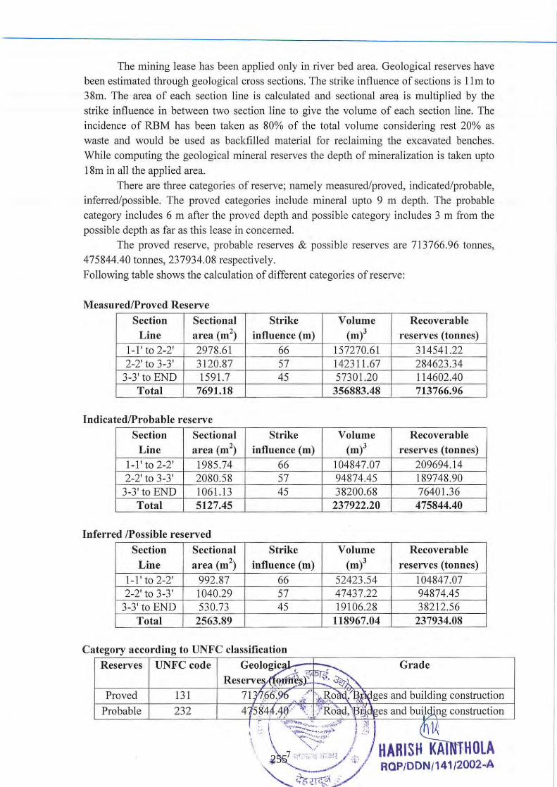
The mining lease has been applied only in river bed area. Geological reserves have been estimated through geological cross sections. The strike influence of sections is 11m to 38m. The area of each section line is calculated and sectional area is multiplied by the strike influence in between two section line to give the volume of each section line. The incidence of RBM has been taken as 80% of the total volume considering rest 20% as waste and would be used as backfilled material for reclaiming the excavated benches. While computing the geological mineral reserves the depth of mineralization is taken upto 18m in all the applied area.
There are three categories of reserve; namely measured/proved, indicated/probable, inferred/possible. The proved categories include mineral upto 9 m depth. The probable category includes 6 m after the proved depth and poss ible category includes 3 m from the possible depth as far as this lease in concerned.
The proved reserve, probable reserves & poss ible reserves are 713766.96 tonnes, 475844.40 tormes, 237934.08 respectively. Following table shows the calculation of different categories of reserve:
Measured/Proved Reserve
Section Sectional Strike Volume Recoverable Line area (m2
) influence (m) (m)3 reserves (tonnes) I-I' to 2-2' 2978.61 66 157270.61 314541.22 2-2' to 3-3' 3120.87 57 142311.67 284623.34
3-3' to END 1591.7 45 57301.20 114602.40 Total 7691.18 356883.48 713766.96
Indicated!Probable reserve
Section Sectional Strike Volume Recoverable Line area (m2
) influence (m) (m)3 reserves (tonnes) 1-1' to 2-2' 1985.74 66 104847.07 209694.14 2-2' to 3-3' 2080.58 57 94874.45 189748.90
3-3' to END 1061.13 45 38200.68 76401.36 Total 5127.45 237922.20 475844.40
Inferred !Possible reserved
Section Sectional Strike Volume Recoverable
Line area (m2) influence (m) (m)3 reserves (tonnes)
1-1' to 2-2' 992.87 66 52423.54 104847.07 2-2' to 3-3' 1040.29 57 47437.22 94874.45
3-3' to END 530.73 45 19106.28 38212.56 Total 2563.89 118967.04 237934.08
Category according to UNFC classification
Reserves UNFC code Grade
Proved 131
Probable 232
255
CHAPTER - 4
MINING
Mining (Past) The present topography shows some depositional and erosion or mining activity
during past years. Infect mining pits if any are replenished every year during the rainy
season. The lease area has gentle slope towards west. Highest point is at 529.5 m RL in the
east corner of the area where as lowest point 526.5m RL is in the west corner of the area.
Proposed Method of Mining
Applied area is a part of a river bed and mining will be done manually in open cast
method in quite a systematic manner by forming benches of 1.5m high, However, there
may be variation in the width which the lessee will keep on mending. About 85,000 Tonnes
mineral will be exploited per year. From first year to fifth year total 425,000 Tonnes
mineral will be produced. The proposed area is within river bed and mined out area wi ll be
replenished gradually during succeeding rainy season. The sandy soi l to be scrapped
manually with the help of pickaxe, spade & crowbar and will be stacked separately in
dump yard located near the working pit. About 20% of the total production is considered as
a waste material and will be used for reclaiming the bank slope. Backfilling wil l be done
simultaneously in each year.
Prior to any actual mining being done at the site, it is necessary to remove overburden from the top of the RBM. Overburden is sandy soi l or subso il that is mainly
composed of silty sand. Sandy soi l will be kept separate and used on top of the berms once
they have reached their final elevation. The berms have Ill ultip le purposes; they provide
storageJor overburden until the mine is reclaimed, they provide a visual barri er between the active mine and roads or adj oining properties, they screen light position should the
mine be operated after dark and they act as a noise barrier.
Once the overburden has been removed the sand, bajri and boulder is excavated
depending upon the lithological vari ation, no bl asting may be used to make the sand
containing material more amenable to excavation. Excavation is typically performed by
manual means. Hand operated tools like spade; tasla etc wi ll be used to collect the sand.
The excavated material may be directly loaded into trucks, dUlllpers. tippers and tractors
trolleys' and send to the destination wherever it is required for construction and other
purposes.
Transportation of sand, bajri and boulder from the mine IS a process to deliver
mined out material to the location where it is going to be co ll ected. Mined out sand, bajri
and boulder will manually be loaded into truck and transported to its destination where it
will ultimately be used. Sufficient space will be left for loading of trucks, Excavation of
river bed minerals will commence from the 1 s c', ' , .s the area and commence towards
down removing the minerals manuall y . ~5\hl'l" ~~ic~s,:tJ;lt late depth of a bench will be
1, 5m. Mining wi ll be restricted upto k1~al1(~lw*:'d~~t~ O'(I @"ll on ly. The entire area does
not require excavati ng at once. Per y ir ~Q,:iL8,5',:o,,9b ~~:'~le\ ~.; duction of river sand, bajri and boulder have been proposed to n e • he In1Jr.k.et:,(~ql\i ren ~\l .. ~~ .•. : ... -,~ , - ]
'<::7' ~
Harish Kainthola ROPIDDNI1 4112002-A
256
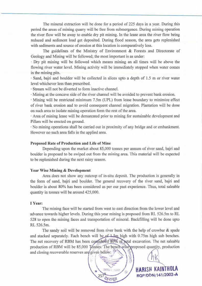
The mineral extraction will be done for a period of 225 days in a year. During this period the areas of mining quarry will be free from submergence. During mining operation the river flow will be away to enable dry pit mining. In the lease area the river flow being reduced and sediment load get deposited. During flood season, the area gets replenished
with sediments and source of erosion at this location is comparatively less. The guidelines of the Ministry of Environment & Forests and Directorate of
Geology and Mining will be followed; the most important is as under:
· Dry pit mining will be followed which means mining an all times will be above the flowing river water level. Mining activity will be immediately stopped when water comes
in the mining pits. · Sand, bajri and boulder will be collected in slices upto a depth of 1.5 m or river water
level whichever less than prescribed. · Stream will not be diverted to form inactive channel. · Mining at the concave side of the river channel will be avoided to prevent bank erosion. · Mining will be restricted minimum 7.5m (UPL) from lease boundary to minimize effect
of river bank erosion and to avoid consequent chatmel migration. Plantation will be done on such area to isolate mining operation form the rest of the area. · Area of mining lease will be demarcated prior to mining for sustainable development and Pillars will be erected on ground.
· No mining operations shall be carried out in proximity of any bridge and or embankment. However no such area fall s in the applied area.
Proposed Rate of Production and Life of Mine Depending upon the market about 85,000 tonnes per annum of river sand, bajri and
boulder is proposed to be swiped out from the mining area. This material will be expected to be replenished during the next rainy season.
Year Wise Mining & Development Area does not show any outcrop of in-situ deposit. The production is generally in
the form of sand, bajri and boulder. The general recovery of the river sand, bajri and
boulder is about 80% has been considered as per our past experience. Thus, total saleable
quantity in tonnes will be around 425,000.
I Year: The mining face wi ll be started from west to east direction from the lower level and
advance towards higher levels. During this year mining is proposed from RL 526.5m to RL 528 to open the mining faces and transportation of mineral. Backfilling will be done upto
RL 526.5m. The sandy soil will be removed from river bank with the help of crowbar & spade
and stacked separately. Each bench will be high with 0.75m high sub benches.
The net recovery of RBM has been co ld~d lSo-"i 0 tal excavation. The net saleable '" ,' ......... --...., "'-"
production of RBM will be 85,000 .',~l~'S~:I;,;.'b~~l~lt~' 'fS~' roposed quantity, production and closing recoverable reserves ar g lv~h~~elO,\v,: ,/""'~ c.~ lhl
! ";:~~ . ' ." ,,1 j". \ '(,: .... .... ' ... . . .. ,,', ':, ) .. ~ :~~:i 1'0':1 HARISH KAINTHOlA
~ ';-/ " RaP/DDN/141/2002~A ~(i~
257
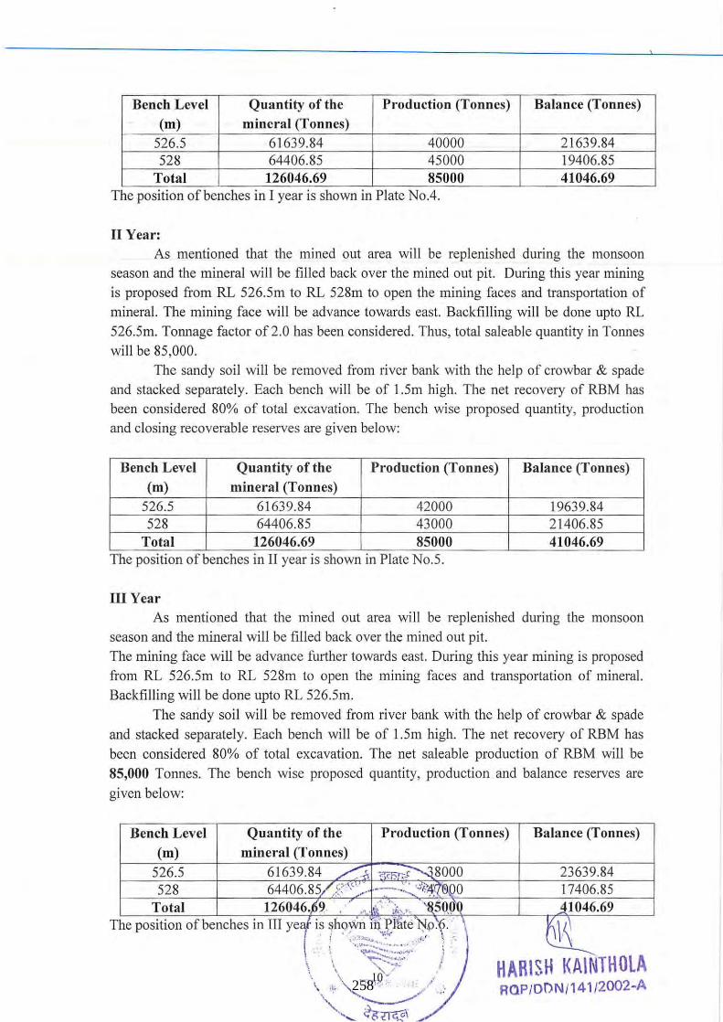
Bench Level Quantity of the Production (Tonnes) Balance (Tonnes) (m) mineral (Tonnes)
526.5 61639.84 40000 21639.84 528 64406.85 45000 19406.85
Total 126046.69 85000 41046.69 .. The pOSItion of benches In I year IS shown In Plate No.4.
II Year: As mentioned that the mined out area will be replenished during the monsoon
season and the mineral will be filled back over the mined out pit. During this year mining is proposed from RL 526.5m to RL 528m to open the mining faces and transportation of mineral. The mining face will be advance towards east. Backfilling will be done up to RL 526.5m. Tonnage factor of 2.0 has been considered. Thus, total saleable quantity in Tonnes wi ll be 85,000.
The sandy soi l will be removed from river bank with the help of crowbar & spade and stacked separately. Each bench will be of 1.5m high. The net recovery of RBM has been considered 80% of total excavation. The bench wise proposed quantity, production and closing recoverable reserves are given below:
Bench Level Quantity of the Production (Tonnes) Balance (Tonnes) (m) mineral (Tonnes)
526.5 61639.84 42000 19639.84 528 64406.85 43000 21406.85
Total 126046.69 85000 41046.69 .. The posItion of benches In II year IS shown In Plate No.5.
III Year As mentioned that the mined out area wi ll be replenished during the monsoon
season and the mineral will be filled back over the mined out pit. The mining face will be advance further towards east. During this year mining is proposed from RL 526.5m to RL 528m to open the mining faces and transportation of mineral. Backfilling will be done upto RL 526.5m.
The sandy soil will be removed from river bank with the help of crowbar & spade and stacked separately. Each bench wi ll be of 1.5m high. The net recovery of RBM has been considered 80% of total excavation. The net saleable production of RBM will be 85,000 Tonnes. The bench wise proposed quantity, production and balance reserves are
given below:
Bench Level Quantity of the Production (Tonnes) Balance (Tonnes) (m) mineral (Tonnes)
526.5 61639.84 /~ ;;;rnr,~8000 23639.84 528 64406.85/ ,8"' ,· '-. - . .: ".<'II!Z000 17406.85
Total 126046.,69 .... ,. i- ;,;". '8.50.(f0 .:11046.69
.~. HARI SH I(AINTHOLA ROP/ODN /141l2002-A 258
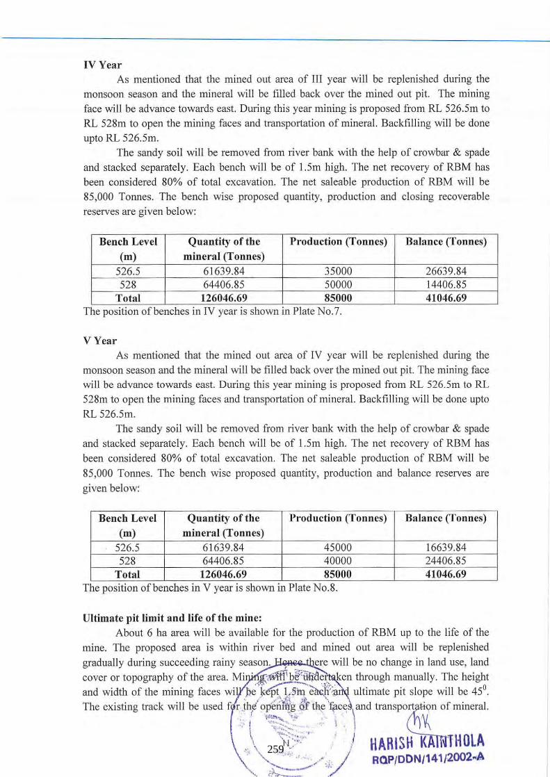
IV Year As mentioned that the mined out area of JII year will be replenished during the
monsoon season and the mineral will be filled back over the mined out pit. The mining face will be advance towards east. During this year mining is proposed from RL 526.5m to RL 528m to open the mining faces and transportation of mineral. Backfilling will be done upto RL 526.5m.
The sandy soil will be removed from river bank with the help of crowbar & spade and stacked separately. Each bench will be of 1.5m high. The net recovery of RBM has been considered 80% of total excavation. The net saleable production of RBM will be 85,000 Tonnes. The bench wise proposed quantity, production and closing recoverable reserves are given below:
Bench Level Quantity of the Production (Tonnes) Balance (Tonnes)
(m) mineral (Tonnes) 526.5 61639.84 35000 26639.84 528 64406.85 50000 14406.85
Total 126046.69 85000 41046.69 . .
The pOSitIOn of benches 111 IV year IS shown 111 Plate No.7 .
V Year As mentioned that the mined out area of IV year will be replenished during the
monsoon season and the mineral will be filled back over the mined out pit. The mining face will be advance towards east. During this year mining is proposed from RL 526.5m to RL 528m to open the mining faces and transp011ation of mineral. Backfilling will be done upto RL 526.5m.
The sandy soil will be removed from river bank with the help of crowbar & spade and stacked separately. Each bench will be of 1.5m high. The net recovery of RBM has been considered 80% of total excavation. The net saleable production of RBM will be 85,000 Tonnes. The bench wise proposed quantity, production and balance reserves are given below:
Bench Level Quantity of the Production (Tonnes) Balance (Tonnes) (m) mineral (Tonnes)
526.5 61639.84 45000 16639.84 528 64406.85 40000 24406.85
Total 126046.69 85000 41046.69 .. The posItIon of benches 111 V year IS shown 111 Plate No.8.
Ultimate pit limit and life of the mine: About 6 ha area will be available for the production of RBM up to the life of the
mine. The proposed area is within river bed and mined out area will be replenished gradually during succeeding rainy season. , ere will be no change in land use, land
cover ?r topography of the area. Mil · ~,@il'b.~-::"/!~;).. ken through ~anually. The heig~t and Width of the m1l1111g faces WI pe }:~5h:) e1lG~· ·:a ultimate pit slope Will be 45 .
The existing track will be used fi r.:Jh,¢·· o~~~.\g; ?f .. ~ ',,~, md """''''ir;l; m'",,] ,". I~m t\ '1 . .,.- ,~. I ~
X.\ ':~~tf:;": ; "":" j HARISH K fHOlA ., " .~, " ·'··./ i: I RQP/DDN/14112OO2 .. A "" " ~:::-..... "/
259
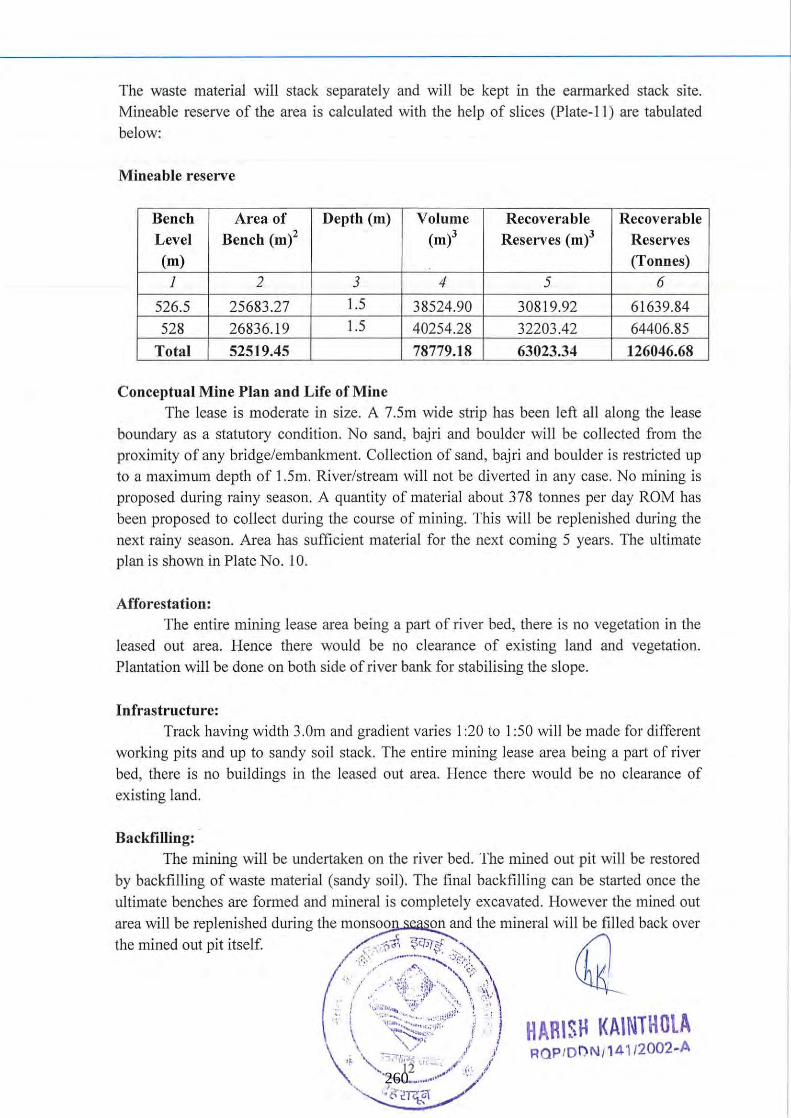
The waste material will stack separately and will be kept in the earmarked stack site. Mineable reserve of the area is calculated with the help of slices (Plate-II) are tabulated
below:
Mineable reserve
Bench Area of Depth (m) Volume Recoverable Recoverable Level Bench (m)2 (m)3 Reserves (m)3 Reserves (m) (Tonnes)
1 2 3 4 5 6
526.5 25683.27 1.5 38524.90 30819.92 61639.84
528 26836.19 1.5 40254.28 32203.42 64406.85
Total 52519.45 78779.18 63023.34 126046.68
Conceptual Mine Plan and Life of Mine The lease is moderate in size. A 7.5m wide strip has been left all along the lease
boundary as a statutory condition. No sand, bajri and boulder will be collected from the proximity of any bridge/embankment. Collection of sand, bajri and boulder is restricted up to a maximum depth of 1.5m. River/stream will not be diverted in any case. No mining is
proposed during rainy season. A quantity of material about 378 tonnes per day ROM has been proposed to collect during the course of mining. This will be replenished during the
next rainy season. Area has sufficient material for the next coming 5 years. The ultimate plan is shown in Plate No. 10.
Afforestation: The entire mining lease area being a part of river bed, there is no vegetation in the
leased out area. Hence there would be no clearance of existing land and vegetation.
Plantation will be done on both side of river bank for stabilising the slope.
Infrastructure: Track having width 3.Om and grad ient varies I :20 to 1 :50 will be made for different
working pits and up to sandy soil stack. The entire mining lease area being a part of river
bed, there is no buildings in the leased out area. Hence there would be no clearance of
existing land.
Backfilling: .
The mining will be undertaken on the river bed. The mined out pit will be restored
by backfilling of waste material (sandy soi l). The final backfilling can be started once the
ultimate benches are formed and mineral is completely excavated. However the mined out area will be replenished during the monsoo on and the mineral will be filled back over
the mined out pit itself. . ';';:::~~:!~!~:;'~~:~> (1, . ,: / /'1:1i,' :i~I,'· ". '\ " ~
~~ (:': 7.~~.:,??' .. ,:;:;:' \t . \ '\~~':;> / " ) HAHISH KAINTHOtA "\ '501>':,:" i .' I i' RQP /O I)N/141/2002-A . " I oj .' '''' ,1 . .
~. 260
CHAPTER-S USE OF MINERAL:
The REM containing sand bajri & boulders of quartzite mineral is an important material for construction. The REM wi ll be used in road, bridge and building constructions.
CHAPTER-6
MINE DRAINAGE:
The deposit is situated in the river bed in Doon valley and has a moderate to heavy
rainfall. The maximum highest RL is about 529.5 m on the east part of the area, while the lowest RL recorded on the west pal1 of the area is about 526.5m and general slope is towards western direction. There are no water bodies within the applied area.
CHAPTER-7
STACKING OF MINERAL REJECTS AND DISPOSAL OF WASTE:
The top REM containing sandy soil wi ll be removed with the help of pickaxe, spade & crowbar and stacked separately. Part of these rejects will be utilized in construction and maintenance of retaining walls.
HARISH KAINTHOLA ROP/DI"\N /141/2002 -A
13 261
CHAPTER-8 OTHER
Site Services The following site services will be provided:
(i) Office (ii) Store (iii) First Aid Centre (iv) Drinking water shed
( v) Rest shelter
Employment Potential The mine manager should be a graduate engineer holding at least second class manager's
certificate. The category-wise employments are given as below:
Manager/F oreman
Skilled Supervisor Time Keeper
Office Assistant/Dispatch Supervisor
Un-skilled Daily wages/mining workers
Total
1
1
1
50
54
The services of following persons/agencies may be retained on part time basis.
(i) Environment consultancy agency (ii) Consultant Mining Engineer (Pari-time) degree in Mining
(iii) Mining Geologist
(iv) Mines Surveyor CHAPTER-9
BENEFICIATION:
No beneficiation of mineral processing will required for sand, bajri and boulders.
There for no such investigations have been conducted.
HARISf~ J(A INTHOlA Rnr""":-'I\J 1t11!?I)O? · A
14 262
CHAPTER-tO
ENVIRONMENT:
Land use: Land degradation and ecological disturbances generally occurs in open cast mining.
In preparation of mining plan of River Tons, Lot No. 3/13 for sand, bajri & boulders mining to Mis Garhwal MandaI Vikash Nigam Ltd., emphasis on environmental protection
has been given to minimize the adverse impact on the present environmental status. Opencast method of mining causes some land degradation and disturbs the ecology of the area. While preparing the Envirorunent Management Plan (EMP) emphasis has been laid on restoring the ecology of the area as much as is possible. Applied area is almost barren but at places covered with thin grasses. This has been made possible by planning the mine
workings in the most systematic, safe and scientific manner with due regard to
conservation of mineral.
Water regime: The ground water table in this valley region is at shallow depth below ground
surface and hence ground water may interfere in opencast mining belowl.5m depth.
Flora and fauna Area supports moderately healthy vegetation, the main forest species are along the
Shiwalik foothills. These Terai plains support the species of Sisam, Arjuna, Kanji, Khair, Sagaun, Neem, Eucalyptus, Babul etc. Ground vegetation mainly cunsists of grasses and small shrubs. Useful fodder grasses, Cynodon dactylon, Eleusine indca, Trifolium alexandrinum etc. can be seen growing in the area. The large weeds which infest uncultivated tracts are Aak (Calotropis procera), Castor (Ricinus communis), Dhatura
(Datura mete/) and thorn (Opuntia stricta). Other noxious weeds and those which appear in crops are Pohli or Thistle (Carthamus oxyacantha), Shial Kanta (Argemone Mexicana), Kandyari (Solanum xanthocarpum) , Parthenium hysterophorus and Bhag (Cannabis sativa).
The core Zone of Tons River where mining operation is proposed consists of riparian vegetation in which aquatic and marshland plants are the main component. Most
among them are weeds. No ecologically sensitive plant species has been reported from this
area. Riparian vegetation is found along the river side. In stagnant water growth of
hydrophytes like Hydrolea zeylanica, Ipomoea carnea, Ludwigia adscendens, Sagiltaria sagittifola, Spilanthes paniculata, Typha lotifoli, etc can be commonly observed. Buffer zone of the applied area is Doon Valley and foothi lls of Siwalik and tree species observed
in the area are, Aam, Jamun, Bail, Bakain, Bargad, Neem, Peepal , Popular, Safeda and
Sisam etc.
, -Shrubs~ Calotropis procera, wi . fo~e~1J. ,~~~ ~~\ ia and Ipomoea carnea etc. occurs in
the depressIOns. 1, / ..... \,~~~ " . chl / .,1 " \~<!~I~V'~ .. \:
0 •• I . ...·· \.2 , \ , ! ' . "" " '. ''tfl'' ', ,,- \ . ;: \' . ' ~ ' . : '~ ""-_"'IHI !!l." · ~ , " -.:-,:; ~~:-:..~' ~.
\ ···.,.)11.. / \ ._-.' -, .
. 't". \.,. '. "J. ~ ~h·~;"~' , " ... ~ ... ~ .. ' .
:,,~
HARIS~ KAINTHOlA W )P · Of"lN . 141 /~()02-A 263
Herbs: Ageratum conyzoides, Amaranthus spmosus, Cannabis savita and Hydrolea zeylanica.
Quality of air, ambient noise level and water Mining activities includes excavation and lifting of minerals . The proposed mining
activity is manual in nature. No drilling and blasting is envisaged for the mining activity. Hence the only impact anticipated is due to movement of vehicles deployment for transportation of minerals. The location of the monitoring stations will be selected based on predominant wind direction and sensitive locations within the study area.
Water quality: The surface drainage system in the area is almost seasonal. The flow in the natural
drain is observed only immediately after the rainfall and then these nala become entirely dry. Drinking water quality wi ll not deteriorate by mining and allied activities.
Climatic condition :
Rainfall: Dehradun valley is characterized by humid climate with moderate temperature, rainfall and luxuriant vegetation. The total annual rainfall in the area varies fromAo73 .~mm
to 2876 l11l11. Maximum rainfall seems during July and August. On an average there are about 48 rainy days in a year.
Temperature: Mean Maximum temperature varies from 2>&'2to 42° and the mean minimum temperatures &,- ,6 to 19.! 'c. In association with the cold waves arising in the wake of the western disturbance which travels East wards, the minimum temperature goes down to about 3° and at times leads to frosts. Humidity recorded maximum during July (85"%).
Socio-Economics:
Social and demographic profile: The scale of operation is medium to small. It is expected that 90% employment will
be local. Therefore there will be positive impact on socio-economic status of people.
Historical monuments etc There is no historical building in and around the lease area.
Programme of afforestation: Plantation is proposed along the slope on both bank of the river. Rehabilitation of
extracted land has to be designed skilfully in order to restore it to its formal use, or to an alternative use that is compatible with the surroundings. Plantation with grasses, herbs, shrubs and trees is an important means for restoring such areas. Stabilizing and re-vegetate the de-vegeta iz. debris, dumps and slopes which get
degraded due to vehicle movement ~ 91l:~~es<? " are important for conservation of
soil, regulation of surface and und rgroufJ.d~~~'tOf\ habilitation 0(h(n . ,d life habitat. / ," 'l\ ' \~~~~~:, ~ \)
( " /~' L.\, t ~, ' ~ " , I " " , '- ~,
l"~! ~,
\ \i~~~~~fjl ,) HARISH KAINTHOlA \\ " .'~i" RQP/DDN/14112002-A
" iI-,....\
264
These generally are extracting operations and need planting in various phases by select
species. Protective engineering measures, in conjunction, become necessary. Top layer of RBM having some sandy soil is considered as an overburden and will
be stacked separately and nature of this dump will be temporary. Mining pits will be backfilled from first year onwards in the proposed pit. Soil will be spread over the benches.
HARISI-f KAINTHOLA ~vw lO r> ~,I 1.1. 1 (1)0:> A
17 265
CHAPTER-ll
CLOSURE PLAN:
Mined Out land: Plantation is proposed along the slope on both bank of the river. The mining will
commence from the lower levels and will advance towards higher levels. Intermittent backfilling will commence from the lower levels and subsequently advance, towards the
higher elevations. The year wise proposal for reclamation is shown in Plate No. - 4 to 8.
Water Quality Management: The mineral as well as soil are non-toxic and mining is also proposed at medium
to small scale. Hence no proposal has been provided for the surface and ground water bodies. The expected depth of water table in applied area likely to be more than the exploitation depth.
Air Quality Management: The lease area is situated in the river bed. The manual mining without drilling and blasting
has been proposed. Therefore the impact on air environment will be negligible. Mining and allied activities are going on a comparatively small scale; the existing air is absolutely
clean.
Waste Management: The RBM containing sandy soil will be stacked separately and these dumps are
temporary in nature. The dumping will be undel1aken manually. The toe wall having width l.5m and height LOrn will be made along the side and slope of the so il and width & height
1.5m each retaining wall for protecting RBM dump to avoid the wash off material during
intermittent rains.
Infrastructure: In river bed sand, bajri and boulders is manual open cast mining. No mechanization
is required. The tracks having width of 3.0m and gradient 1 :20 to 1 :50 will be made for the
advancement of mining faces and for the transportation of RBM and waste material. There
will not be any changed in existing infrastructure.
Disposal of Mining Machinery: The sand, bajri and boulders mine is manual open cast. Hence di sposal of mining
machineries are not required.
Safety and Security: Each worker employed i e:mtn~1 provided helmets and shoes. Safety belts
will be used for working in th tqp 9f·~1?4 . Therefore protective works Ig !~~.ap,~i }I~.:fl'~~ drains shall be provided before the
mme/plt IS abandoned. IF, i ',~.~ .... '~.:._ .... '.\?;- \ ~\ (Q ~~, ';~J HARI~THOlA '~ ,/ ROP/DDN/141 /2002-A 266
Disaster management and risk assessment: At present the mining is proposed in a mild sloping nap land in river bed. When the
mining will reach up to the optimum economical depth then backfilling will commence to restore the topography of the area. The mining faces shall be dressed properly because any hanging boulders/loose material may create fatal accidents to the labourers while working in the pit. The mine shall be critically examined for its proneness to any natural hazard and
assessment regarding danger of hazard and precautions to be taken and should be reviewed so that chances of slope failures wi ll be minimized.
CHAPTER-12
CONCLUSION:
This applied area IS suitable for producing material for making road, bridge, buildings and other constructional work. This is a pal1 of Govt. of India's policy to develop
maximum infrastructure facility in India. This making of road or bridge will generate direct & indirect employment to the local people. GMVN Ltd. will undertake mining activity as
per the plan indicated in the above chapters with proper taking care of environmental aspects i.e. without disturbing the ambient condition.
HARIS .. KAlNTHOlA R ~, !"' · ""' ...... 1\ 1 1 t1 i I'..,,,r." A
19 267
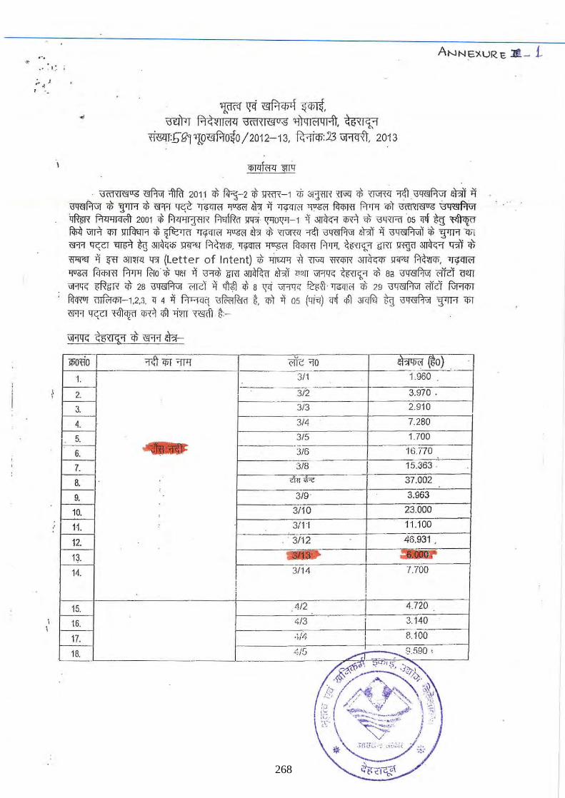
.".
;. J ). , .
~ ~ (\j f.'I ClJ!{ ~, \JWl fT1~~1I('l4 '3IT1,<I(\j°;S ~ql('l ql'1l ~i:5 '< I ~"1
I'm4T:bgpI9<S1f.10~O/2012- 13 , ~:23 \iR<liI, 2013
~wr
. ' \jIT1'< I ~O;S <!Ifu;r ;jlf<'J 201.1 <i> ~-2 <f; >Ri'R-l <i; <lI1'ffi ~ q\ ~ 'I1l1 \jQ"'f.'jV1 eh!l ij "'\jq""",P.tPi"'V1 <i> 'TfR qi l!f'f'I ~ Tfil1ll"OI ~ ~ it 'W[fOI ,~ .~ frrrrl <n't \jctHl",o;S Gq~f.'j\ij ~ f.'l ll'M"I) 2001 ;j; Pi ll'1 lj'l1 lx ~ lfll'i' 1['101['1-1 it ~ iliB <i> \31RRIOS 'l'f ~ ~ ~ VIR lI>T ~ qi ~ 'WTfOI ~ ~ <i> ~ ~ \j q",AV! eh!l it \jQ(!lPiV!l <i> ~ l!li <!I'!'I ~ ~ ~ ~ >flf'tr ~. Tf.pm;! ~ Fc!<nm f.rrrTf, ~ GR1 Iffij<l ~ <fit ciJ 'ff"r"! ij ~ 3lW! 4?1 (Letter of Intent) q\ ~ <l ~ <lNR ~ lIT"! ~, ~ ~ fu<mI f-rT'l ~o * 'lar B ;:r:,q; Gm ~ eh!l mn Uf'I1R ~ ciJ Ba i3 q '" AV! C'iiit om iiR'iG mm <i> 28 \jq",f.'!VI Wc:l B ~ <i; B ~ iJRTR ~. ~ <i> 29 \jQ(!lPiV! oilit ~ fircRur ~-1,2,3 q 4 it ~ \jf{;(;jRlid t <n't it 05 (lfiT1) <rl ~ Jrq0 %g \j q",f.j 'Ji ~ lI>T
<!I'!'I 'f0'1 ~ iliB ~ >im ffi(ft . ~ -
~ ~6'<1C;;1 ciJ <ffl .:8-
ifiotio 'f.ft 'liT ~ <'ifc ~o ~(50) .
1. 3/1 1.960 .
2. 3/2 3.970 .
3. 3/3 2.910
4. 3/4 7.280
5. 315 1.700 . -.--~j6170
6. 316
7. 318 I 15.363 ·
8. WliR 37.002
9. 319' 3.963
10. 3/10 23.000 ,
11. 3/1 'I 11 .100
12. . 3/12 46.931 .
13.
14. 3/14 I 1.1'00
I i ! ,
15. 4/2 4.720
16. ~/3 +-- 3. 140
17. ·~/4 8.100 I .
8.580 . 13. t;15
tf~OO')~ .- .. ..
§~'I) . ~ '0· io- ' .:: .. {'I ~~ '"(~~~ , \J ~ +.t .!>. ....
i~~. \ .~~~~ ) :',
~~/ .... 'J::
"- [G-;~ ~tiZ ~ 268
. , .. ,' .) .' .. ,
fG;Wp 26 ~rt 2012 l'i ~ ']1) f;1~Qrrj'(1l,( E.I.A Notification, 2006 «; 3Rf'm qlJ\q'(o~ll ~"1f(f 9.l«T q>'<. -qqfq-,ujJq ~ <r7t >lfu "-'" <l'T'D,'l'i <r?r ffiWl 'lWIl ~,r <R. crrfip
f.'!1i'llj~il,( XlR'l '@ ~ ~ .-, CJJT<Iqr?r <#l \ill tr<# I
~~ fR;zrr: (1)/<fC(f4'1if<r>a I ll~: ~R!ru 'fir 'l~:r-w.f -qci 3lJlW:r<P ctil<fqrtlt i;g; 1flm I
1. ~~. 3!'I(JlfTl{jJ filcr>rxi fcrmrr. i3\ffifflll"S mfAl 2. mmR\. ~~/~/~/~~ Tfitcfm! ,2;/wr.q~. ~ ~ f'rf;m ~ f<\fO. Gt;\I?&'l q;) ~ ;]ffi(I1,ll1Wo fcli E.l.A
;'1ot: fi c a.tiOll, :2 006 ct 3RPffl cr..:ITcR1I\1<J t<lJilii:r Sfj'cl <5X crrllTc'P1 cf;j;:i:""i~ <RT'lT
~'=m~' "::;!'1IX ''1f! q ,I
4. 1JTi 'liT~'" f
269
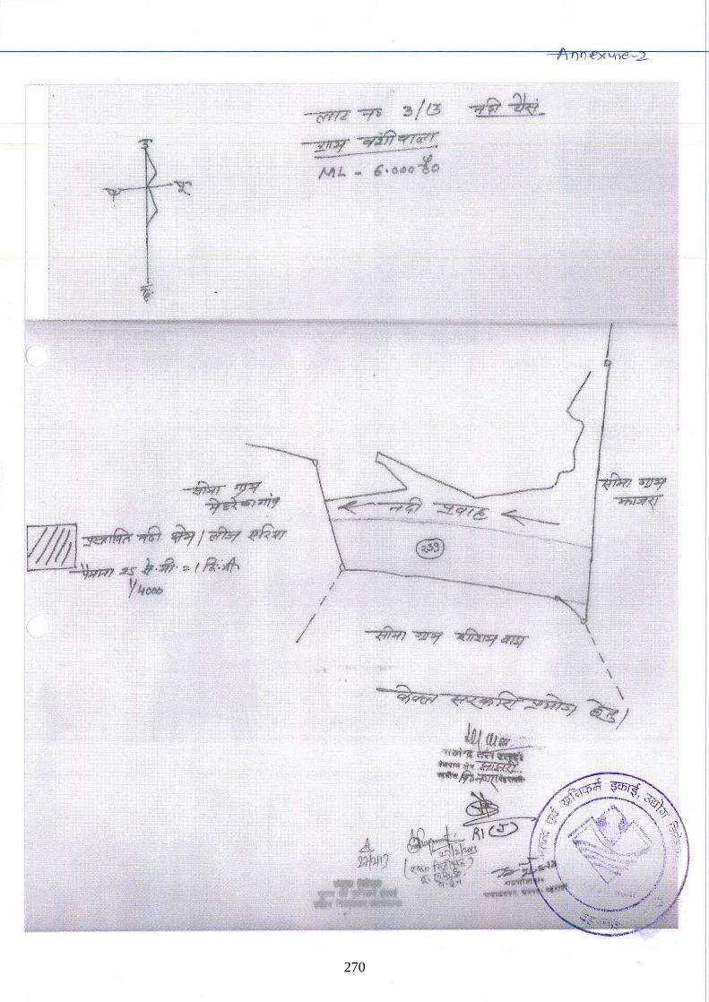
(
C1"17'2 -:::rs ~ / t3
..iii"" 'iii';'f( ",., (ill -
/
/JI /.. - 6· 0.0 Jlo
I I
•
I
\ \
\ \
\
~/
270
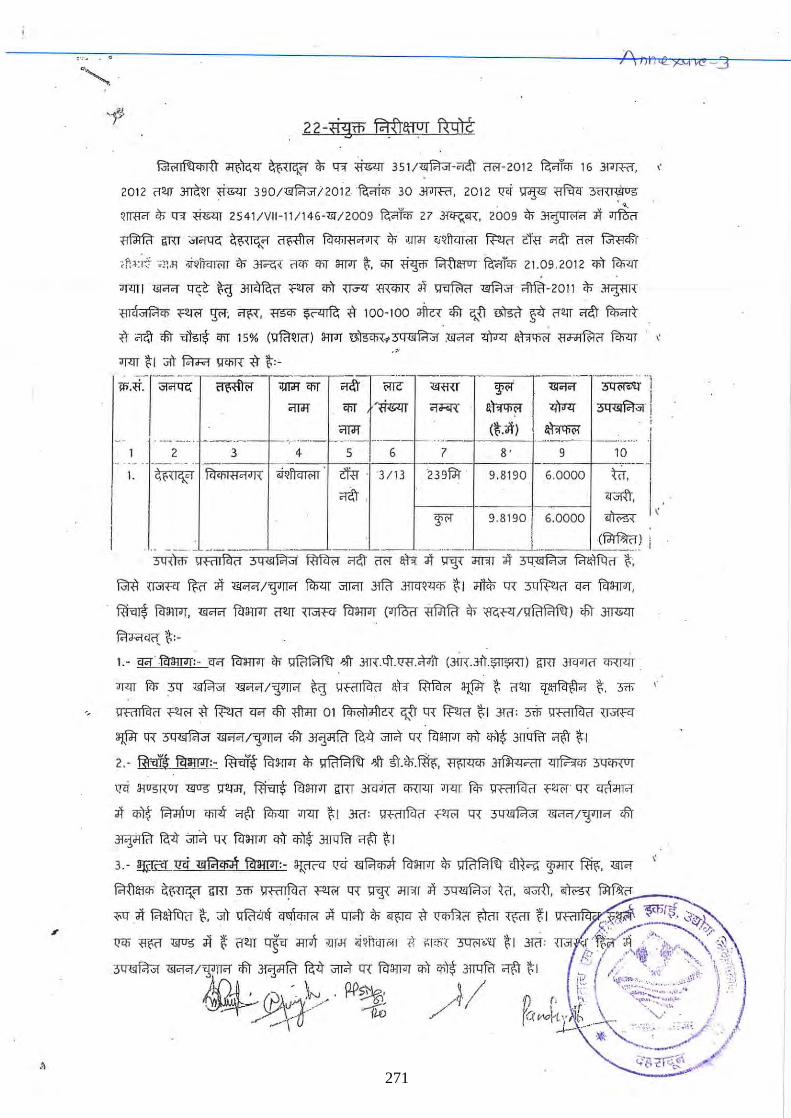
.~
• 0
~ ~ ~ $" q-;[ ~ 351/liIf.'r;;r-<ic\'r (101- 2012 ~ 16 J!"Jffi1. "
2012 (1"m ~~r ~ 390/~i201 2 '~ 30 wmr. 2012 11'i Ildf'! ~ 3H{ I?,U5
qrmcr '" q-;[ ~ 25 41 /V II -11/146-"lJi"12009 ~ 27 3~. 2009 $" ~ ;It ~ ~ om ~ ~ ~ kl'limOl'" $" >JTdi ';Q!iur.rr ~ em Cfitr (1"(.! ~ .
;~~:f; ';!! .~ o;j-~li<n<'lT to ~ rm> 'liT :I1rJT (;. 'liT ~ F.Ii'Iarur fu<ii'q; 21.09 .2012 q;'r fll;<:rr
m:rr l 1JI"O!<f 'f¢ ~ ~ <'!!f&I" q;'r ~ <WI'R it ~ ~ ;f@-2011 '" .:tqm'i
<ll~,,"fi'l'li pm '¥'. ~. <1SiI> ~ tl 100- 100 ~ <!iT c;,n ~ s<l" '(1"m O!c\'r fil;cffi"
~. <T~ <!iT ~ 'liT 15% (IfRlQJct) 3lfJI ~.~ .~ "$<r ~ <lJ'Jifo:i" fll;<:rr . " .,.
m:rr (; 1 ;;it fcr"<F<! \f'liT'( tl (;:-,--------~J~--. - .. _---_ ..
-:r'~'~ ~,~ r ~: 'f01' <lr.I<f ~
~ >W>< 3 Q <lI fi'l "I
(~.;It) ~ .. ~ .. -.
8' 9 10 2 -
I. ~ RhhlfklJI{ oPill<rri>rr . em "3113 '239jJ!r . 9.8190 6 .0000 ~.
Cfitr .-;#t. -
~ 9.8190 6.0000 ~
(f.iWtn)
3"lIUm "-I-<1 IF<i<1 ;)"",F.!", ~ Cfitr (!(>f att ;It "W <fIT'!T ;It ;)y",F.!", fcr~n t - -_.- ------ -:::.- -:--=-= ---
. _ _ .. ______ L ... _ __ - -.- .•... , .. ,
~ ~f2! ~n ;It ~ I~ fll;<:rr <iITC!T 3ffi1 Jl1(:[~<rili I\" 1 ~ Q""{ ~"i'f <l'1 foriflT<lT .
'1 I
I ! ,
. ~ forand"[. ~ foriflT<lT "i'fm m'Rl' foriflT<lT (~ ~ $" ~/~) <lit .JnmIT
~I\":-
1. - c:r.r ' f<ralJ"J[:- <l'1 ~ '" ~ J!lT 3!R.<ft.IR1.<MT (3iR.J!~.~) GRT .wfJ1i1 <OWIT .
m:rr fit; :w ~ ~/~ ~ 1ffi11F<i" an- ~ :!JPi I\" "m 'l:~ 1\". 3m '
" I:rf<lTf<l(1" <'~ tl ~ c:r.r <!iT <lim 0 1 f<hOl)J,1<A c;,n Q""{ ~ 1\"1 3!(1': 3"ii; QfillF<i" \r"fR[
3@r 1R Sqlllfi'l ,," ~/"".fTl'1 <lit ~ ~ ~ Q""{ for:l1rJT q;'r 'lilt .mi:m1 '1(;'r 1\" 1
2.-~ 19mm:-~ for~ITd1 $" ~ J!lT ;!).$"ffi-<;. ~ ~ ~<ll ~
,!Ii 3'fU5RUf ~ IfmT. ~ foriflT<lT lmT 3-I"C!irrf <OWIT m:rr fit; Q fill kl " <,:m>r Q""{ <rfrJllCf
;It 'li'l$" f.t;JTIur <IiT4 ~ fll;<:rr m:rr 1\"1 J!(1: 1f<'''lkl" f:m>r Q""{ 3qlllF.!,," ~/":J"'IT'1 <lit
~ ~ ~ 1R for:l1rJT q;'r 'lilt 3fT1!frr ~ I\" 1
3.-~. 1l1i IlI Glg;al f?rnm:-~ 1l1i llIF.!'li<A for:l1rJT $" ~ ~ 'li'fR ffir;. mer
F.Ii'Im ~ lmT 3m 1ffi1lkl" ~ Q""{ "W 1l"T'!r it 3Qlll1?i,," ~"(1. 0NrtT. ~ f.iWt::.:":-' ___ _
~it fcr~ct 1\". ;;it ~ ~ it qr.fr $" ~ tl ~ ~ ~ f, 1 Qfi1 lkl f.." ~ _~'r;f. "q),~, 11'li <l~ "IUS ;It t "i'fm mfu <IIT'T >:IIJi <i~n-<Ir(.!l {l, ;;I'li'i 3"OC'fi:'q 1\"1 J!(1: ' ., . ii .," <::::-'<,' ,,"!
o . ~J . . "~ ~"' ",, "~; 3Qlllfi'l,," ~/'.P.T'" <!iT ~ ~ ~ 1R itr:l1rJT q;'r ih~ 3fT1!frr ~ (;1 "J /' . -.,.; ' .~;' \ ;;.
~ ". '<t ... , .. 1 ~., ':11' :~}" -' w%. /1 / ~ (. ~ ~, .. ~;:.~;t: ; cj. , r; v ./ ~ J I rf "i.?
, x - fro ./ ((""h,· h _ __ V _ j. - \ J,:.- -' *' ... , 7' '/
_ ~_ .... _ , l
'-."f. "2'rr\.~· ~ .• '" 271
If I
"
,
t '[@IF! fl:r~~ l<rilWT q;-~ 'lit ~ c;n "ftr. ~ fiI'liI'H<iJI{ ;:;m
Jl<l"'0 '!iWlT "r<!! flo ~filifilM 'f'!lOr <JJm 'l~1'I:i:rrorr ~ = ~ 23 9fi1 ;F[1.<! '<'fi'I1' . "
9.8190 ?;O 3iHl"'us 'iv'J m<!iR o!i'r a@t %. '~ :R &<iCI 'lln1 6.000 %0 a@t %1 3il'
'f'!lOr en: W¥ d1TiIT ;it 3Q""fo'IiiI f.ra\l1rM %1 3fif: ~ ~ ;it 3il' 'f'!lOr en: 3Q",Fo'1ii1 q;
&<iCI/":l'I"l o!i'r ~ fu<T ~ en: <!iIt JlTC!fff <Itr % 1
~<fi<:f ~ ~~~r B= 922/VII-I!1l-!tc/2012 ~ 26 ~; 20\2 ;:;m T1J'!
in 'fid1@ ~/3qlilfo'liil ' lffiITin f<:l<T ~ ~ ~ ~ ~:H ~ Q'1'ld,ul '!1i 'l<i
~ :R Q'l',q,Un'l ~ I:rTR <n{C1T :lT1<fQ'l'P % I . . 31M: 3il' in ~ Q '1\ ,I{ un '1 ~ 31RT<i'i1' 3il' q 'I'd 1 filM ffi 'liT 3 Q liIFo'1 iii q;-
~~ (:l1Tv:fr. w . <'l<Tl1)
tiT~.~
~/ (~f.llfr) .
&",~-0N-~ (.mftq;~~)
~
~<f'Jrt
272
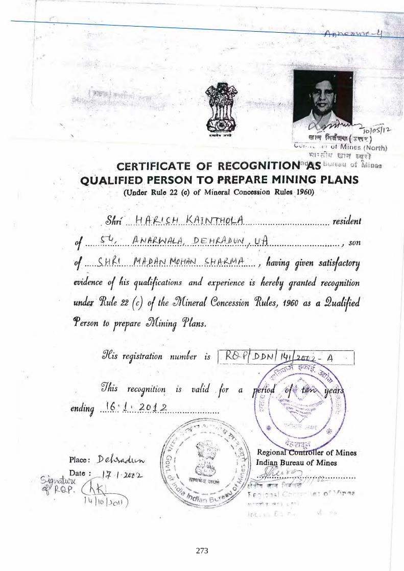
r
j 0
~.
, ---. It>$J l1--; _ __ Iff ilI'i~f 0,"": )
,
L,,, . . ,,. "utfVl1nes (Nor~h)
. . ""F fi1" tIt"f cl;f~) CERTIFICATE OF RECOGNITloNn~s bUl~a~ of ~lin~
QUALIFIED PERSON TO PREPARE MINING PLANS . ' . (lJnd~r Rulo 22 (c) of Minoral Concession Rules '.1960) .
. $~n · ... . H.ftf:.:- 'J,.!J .. K.A: J. NTHRf::/l ........ ... ........ ... ... ... ...... residen,
0/ ...... r!-!:~ .. ... A !':~ !!-f::1;.-1 (!~;1t. .. .P..~ .~!f.A-p. .v0'..;. .!-J.:-/L ... .. .. .... .... .. .... .. ... , son
of ..... .sJ:f. r.., .... ..!\;f/rlfh:!.M~i:1tl.N. ... ~.I:-! .~~/+ ...... J ~aving given sa'isfactoT~
evidence 0/ ~is 1ualrf'catiotls and eXferience is ~eretv (;ranted recognition
under ' "Rute 22 (c) o/tlte :Jr[inerat C30ncession Gflutes, 1960 as a §2uati/ied '
1>erson to refare :Jr[inin9 'ftans.
Place : j) "A:vWlvtv C. • ~Date: 1+ ·1' .2Wl-
~ f2-G-~ (hl,,"-! _ 1 \j )10 1)1:'11
9
273
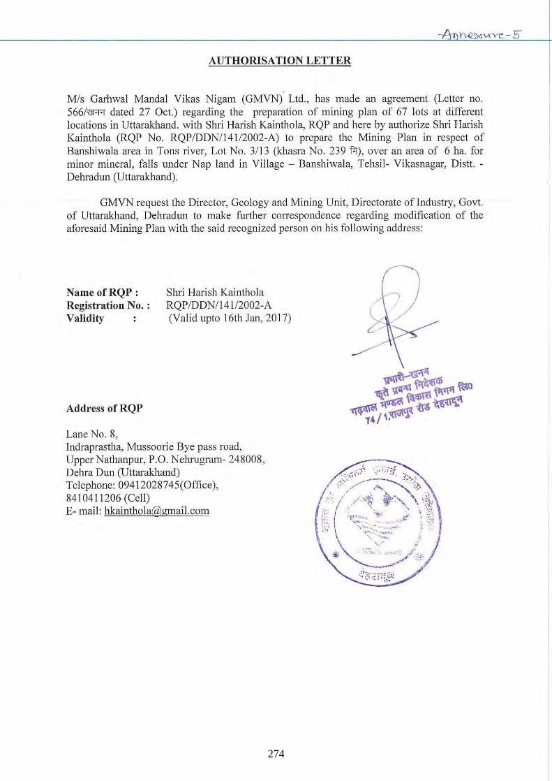
AUTHORISATION LETTER
Mis Garhwal MandaI Vikas Nigam (GMVN) Ltd., has made an agreement (Letter no. 566/~ dated 27 Oct.) regarding the preparation of mining plan of 67 lots at different locations in Uttarakhand. with Shri Harish Kainthola, RQP and here by authorize Shri Harish Kainthola (RQP No . RQP/DDNIl4112002-A) to prepare the Mining Plan in respect of Banshiwala area in Tons river, Lot No. 3/13 (khasra No. 239 fii), over an area of 6 ha. for minor mineral, falls under Nap land in Village - Banshiwala, Tehsil- Vikasnagar, Distt. -Dehradun (Uttarakhand).
GMVN request the Director, Geology and Mining Unit, Directorate of Industry, Govt. of Uttarakhand, Dehradun to make further correspondence regarding modification of the aforesaid Mining Plan with the said recognized person on his following address:
Name ofRQP: Registration No. : Validity
Address of RQP
Lane No.8,
Shri Harish Kainthola RQPIDDN1141 /2002-A (Valid upto 16th Jan, 2017)
Indraprastha, Mussoorie Bye pass road, Upper Nathanpur, P.O. Nehrugram- 248008, Dehra Dun (Uttarakhand) Telephone: 09412028745(Office), 8410411206 (Cell) E-mail: [email protected]
" ~ /
274
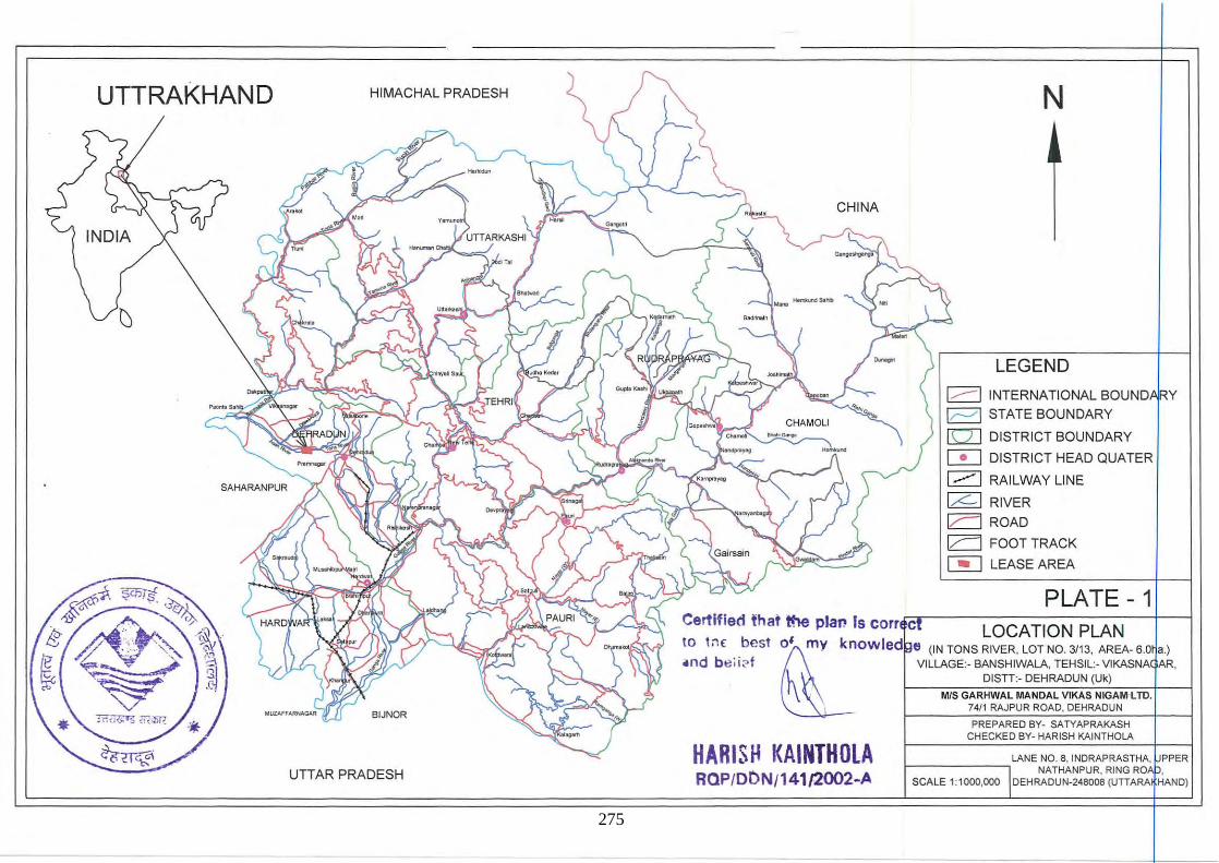
UTTRAKHAND HIMACHAL PRADESH
INDIA
BIJNQR
UTIAR PRADESH
CHINA
N
LEGEND
1.-----1 INTERNATIONAL BOUND RY
k--'I STATE BOUNDARY
[QJ DISTRICT BOUNDARY
C!:J DISTRICT HEAD QUATER
1---1 RAILWAY LINE
Ir:::.- I RIVER
I,r--I ROAD
I,r--I FOOT TRACK
~ LEASE AREA
PLATE 1 Certified that tru! pIal! Is corr.<:ca----L-O-C-A-T-IO-N-P-L-A-N--+---1
,. ", be" ~ k,.wl.d • ,,'m",.~,W''"~' ,,~'",' .nd b e i i2f VILLAGE:· BANSHIWALA, TEHSIL:· VIKASNA AR,
h OISTT:· OEHRAOUN (Uk) 1\ ~--7.W~S~G~A~R~HW~A~L~M~A~N~D7AL~V~I~KA~S~N~IG~A~M~·LTTnD,+---1
\ ~ ____ ~74='='R~A~JP~U~R~R~O~A~D,~D7.E~HR~A~D~U~N~-+ __ -1 PREPARED BY- SATYAPRAKASH
CHECKED BY- HARISH KAINTHOLA
HARISI-I KAINTH OlA RClP/O(')N/141/2002-A
LANE NO.8, INDRAPRASTHA, PPER r------------, NATHANPUR, RING RO •
SCALE 1:1000,000 DEHRAOUN-24B008(UTTARA HAND)
275
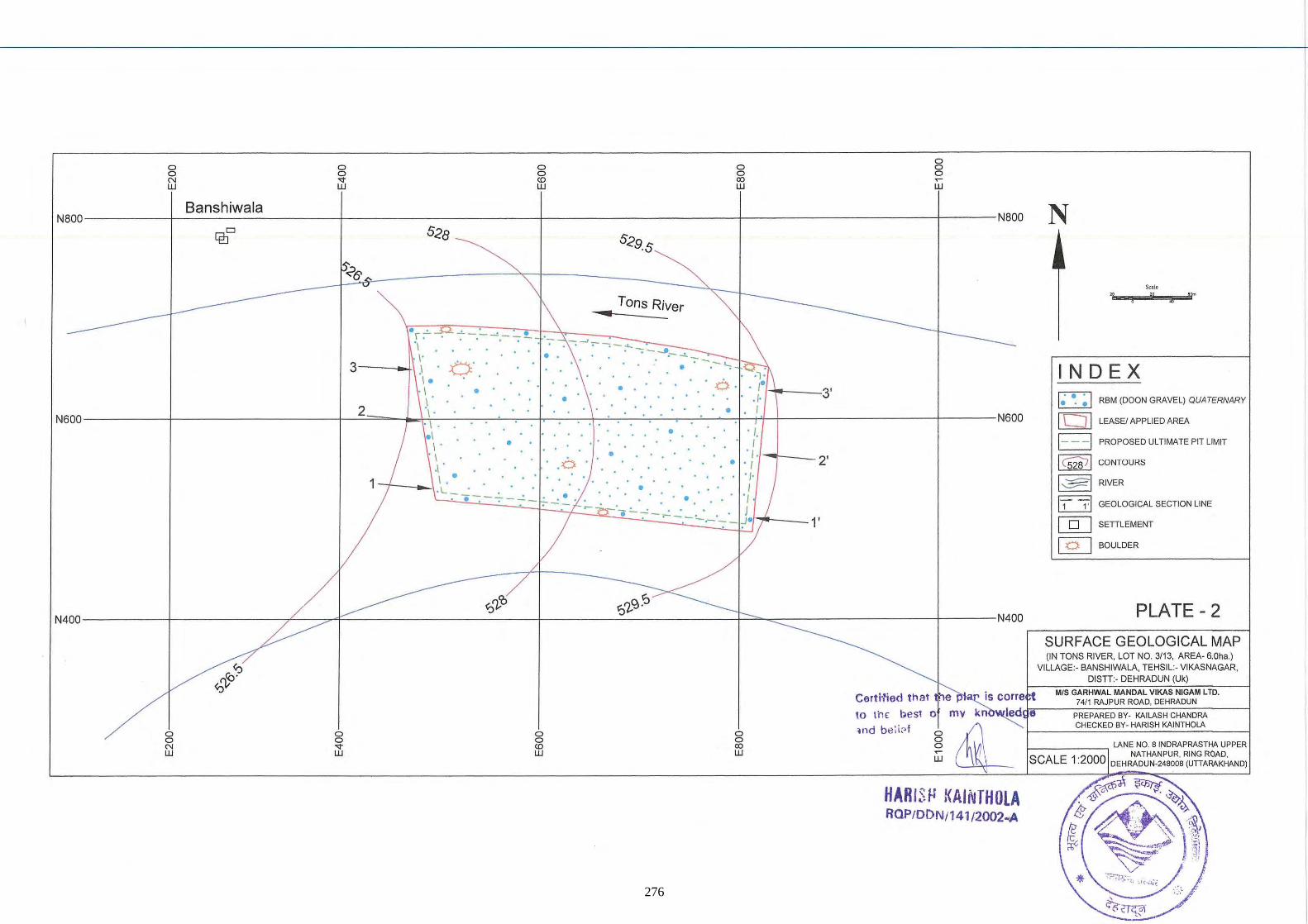
o o N W
o o <t W
o g w
o o ro W
o is ~
w
Banshiwala N800----------+-------------------~----------------------~----------------------~----------------------4-------N800
Cf!JD
· r : ·~ : '1 I'
3---.41 .� O ' . . '. .• . "" -. 'l :~ I . .' 1\
· 1 . . ' . 6 · . ,. 3' . • . . .1. 1"""r'1---
2 \ . • I N600------------+-----------------------~~~=-~_4.~I-.----~~~·~--~~~~~. -.~~~~~~~--~~_T4_+_--------------------~-------N600
. 1 •. I. I ' • I I . • · , ·,-~--2' .1 .0 ·' 1 I . • ' 1'
'\:L_ -': _ .
'--.L..~. -'-----.:::-~..::.-F,f=~~~~~d~. """,/ 1---1'
•
1/
/~ "~/ ~'-
N
I I
Scale
"
IN DE X I ~ ~ ~ I RBM (DOON GRAVEL) QUATERNARY
LEASEI APPLIED AREA
PROPOSED ULTIMATE PIT LIMIT
1 C528J 1 CONTOURS
I~I RIVER
11 1,1 GEOLOGICAL SECTION LINE
@] SETILEMENT
~ BOULDER
PLATE - 2 N400----------+-------------~--~4r----------------------_r--------~------------_r~~~----------------~------N400
~ '-S-U-R-F-A-C-E-G-E-O-L-O-G-IC-A-L-M-A-P-i
(IN TONS RIVER, LOT NO. 3/13, AREA· 6.0ha.) VILLAGE:· BANSHIWALA, TEHSIL:· VIKASNAGAR,
DISTI:· DEHRADUN (Uk)
Certi'lied that ~iS corre t MIS GARHWALMANDALVIKAS NIGAM LTD.
is <t W
o o ts
o o ro W
f ·.... 74/1 RAJPUR ROAD, DEHRADUN
HARIS~ KAINTHOLA RQPfDDN/14112002.oA
276
•
• ·1 •
• • •
Certified that the plat' is "n"'''Cl 10 tiw best of my and belief.
HAftlSH KAINTHOlA 20 ROPIODNI141 12()02A ... -.,
• •
• •
• •
IN 0 EX RBM (DOON GRAVEL) QUATERNARY
LEASE BOUNDARY
ULT)MATE PIT LIMIT
MEASURED MINERAL CONTACT
INDICATED MINERAL CONTACT
INFERRED MINERAL CONTACT
PLATE - 3
GEOLOGICAL SECTIONS (IN TONS RIVER, LOT NO. 3113, AREA· 6Oho.)
VILLAGE:· BANSHIWALA, TEHSIl.:· VIKASNAGAR, DISTI :· DEHRADUN
, I
277
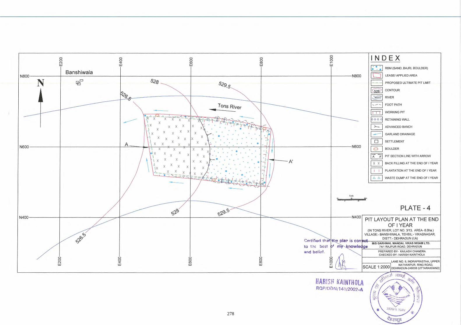
o g
g o ~
IN 0 EX w W
~ RBM (SANO, BAJRI, BOULDER) • •• ----------+-------------------~----------------------~----------------------~----------------------~------NBOO [bJ] LEASE! APPLIED AREA
• lie-'- -:..~,,- - ... _I x x x -x--x
x I x x x x ,\ x I x x x x x I x x x x ) x
x x
x x
x
x
Tons River ill
•
E3 PROPOSED ULTIMATE PIT LIMIT
1<52871 CONTOUR
~ RIVER
B FOOT PATH
I n l l WORKING PIT
EJ RETAIN ING WALL
G ADVANCED BANCH
B GARLAND DRAINAGE
@] SETILEMENT \ x x x x x
- I x x x x A •. I
N600----------+-------------------~~===-__ ~--~~~~~~~~~~~~~~~~~~~H4------------------~------N600 @] BOULDER
. 1 x x x I x x
\ I x x x x x .1 x x x x IX x . L __ X X x
e -: '= 7 .:===.::::,- X
-
x x x • x x
X
• • . I . .. .. I
' I 'I-t---A' . .' ~ ' ~'I . . .. . . ~
/ . ' -1 ' . , -;i . :e . . e- -l. &-' • ... -
So., w
i
I A A' I
§ 0 B
PIT SECTION LINE WITH ARROW
BACK FILLING AT THE END OF I YEAR
PLANTATION AT THE END OF I YEAR
WASTE DUMP AT THE END OF I YEAR
~~9JY6 N400----------+-------------~--~4F----------------------~--------~------------~~~~-----------------r------N400
PLATE - 4
PIT LAYOUT PLAN AT THE END OF I YEAR
o o N W
o o ..,. W
g CD W
o o <Xl W
Ce,ti'1iec1 th a
to t;1( best and belief.
(IN TONS RIVER, LOT NO. 3/13, AREA- 6.0ha.) VILLAGE :- BANSHIWALA, TEHSIL:- VIKASNAGAR,
DISTI:- DEHRADUN (Uk) e pia" is C orrlllG'l-=-C-C====-:-:C=::-:-C7:-:==---{ MIS GARHWAL MANDAL VlKA5 NIGAM LTD.
nowle-r9.::8 __ -::7-::4:::"::cRA'::::JP::'U:::Rc'R;.':O:-:A-=::O,':'O:::E-;-HRA= O-::U-::N::::-__ ----i PREPARED BY- KAILASH CHANDRA CHECKED BY- HARISH KAINTHOlA
r-____ -,LANE NO. 8, INDRAPRASTHA, UPPER NATHANPUR, RING ROAD.
SCALE 1 :2000 OEHRAOUN-248008 (UTTARAKHANO)
HARISH I(AINTHOLA RQP!DDN/141/2002~A
278
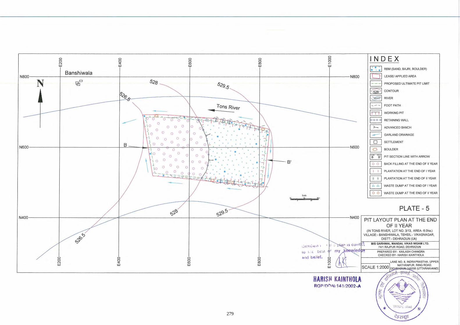
0 IN 0 EX 0 0 0 0 0 0 0 0 0 0 N <t <0 <Xl ~
W W W W W
~ RBM (SAND, BAJRI, BOULDER) . '. Banshiwala [:l] N800 N800 LEASEI APPLIED AREA
N lPJD 528 529,5 E3 PROPOSED ULTIMATE PIT LIMIT
I csw l CONTOUR
% ~ RIVER
Tons River B FOOTPATH
, • 11...,, 1 WORKING PIT
• '0'"- -=- ~-- .... - 8 ---------
' \ 0 o 0 0 --0 - RETAINING WALL 0
\ 0 0 0 0 0 G ADVANCED BANCH ,\ 0 \ 0 0 0 0 0 0 B GARLAND DRAINAGE \ 0 0 • 0 0 0 .\ 0 0 0 0 ' J [QJ SETTLEMENT
8 \ 0 0 0 • N600 , I 0 0 0
N600 [§J BOULDER 0 • 10 0 0 • ' J,
0 \ 0 0 0 0 "1 I B B'I PIT SECTION LINE WITH ARROW
\ \ 0 0 0 • ' J, 0 0 0 0 ' • ' ''1 8' ~ ,I 0 BACK FILLING AT THE END OF II YEAR
0 0 0 ' J, \0 0 0
~ , L __ 2. 0 0 ( • "1 PLANTATION AT THE END OF I YEAR 0 ' J • • • ~ -;- .:: .=:: .:::: • [iGiJ
, ,...I, ~ ,L "" ' PLANTATION AT THE END OF II YEAR - B " WASTE DUMP AT THE END OF I YEAR -
~ WASTE DUMP AT THE END OF II YEAR Sea!.
'? '?
Z ... PLATE - 5
~'1-'O ~i?;~ N400 N400 PIT LAYOUT PLAN AT THE END
OF II YEAR (IN TONS RIVER, LOT NO. 3/13, AREA,6.0ha.)
ro"? VILLAGE:- BANSHIWALA, TEHSIL:- VIKASNAGAR,
~rp DISTT:- DEHRADUN (Uk)
P IS COfl ~ MIS GARHWAL MANDAL VtKAS NIGAM LTD. ~e: \I :It:;d ; to
74/1 RAJPUR ROAD, DEHRADUN
lO \ .'.( t;eSt I (hC' PREPARED BY· KAILASH CHANDRA
and bei iet. CHECKED BY· HARtSH KAINTHOLA
0 0 0 0 0 0 0 0 0 0 LANE NO.8, INDRAPRASTHA, UPPER N <t <0 CO 0 W W W W ~ NATHANPUR, RING ROAD,
W SCALE 1 :2000 D BOOB (UTT ARAKHAND)
HARtSH KAtNTHOLA RQPIOl"\N I1 4112002-A
279
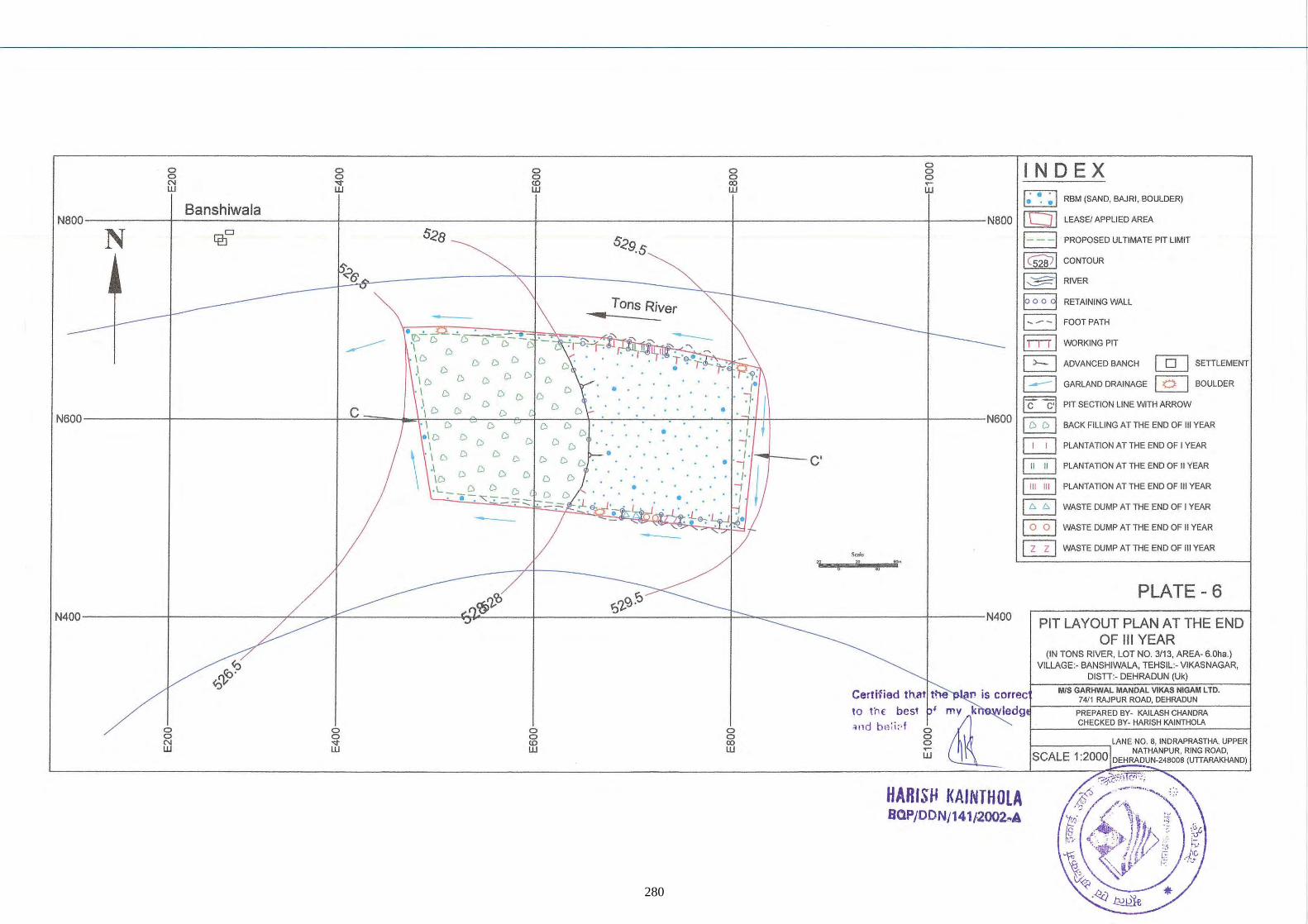
a IN DE X a a a a a a a a a a N .... <0 00 ~
W W W W w I ~ ~ ~ I RBM (SAND, BAJRI, BOULDER)
Banshiwala NaOO NBOO o:5J LEASE! APPLIED AREA
N EEJD 528 529,5 D PROPOSED ULTIMATE PIT LIMIT
Icswl CONTOUR
<'6 ~ RIVER
Tons River B RETAINING WALL
- 4 B FOOTPATH
• 1()-'- -'- ~- .... IITTI -------
'I D D D 0 --D WORKING PIT D
I D D D D D G ADVANCED BANCH [QJ SETTLEMENT ,I D D
D D I D D D D B GARLAND DRAINAGE @] BOULDER
, I D D • D D D I C c'l \ D D D , PIT SECTION LINE WITH ARROW
C D D D ' • N600 N600 §] , I D D D D BACK FILLING AT THE END OF III YEAR
. I D D D • ' " D B I D D D D ,
PLANTATION AT THE END OF I YEAR
\ D D • " ,
I D D D D D ' . " C' ~ ,I D PLANTATION AT THE END OF II YEAR
ID D D D D D " ,
~ ,L __ D D D • , PLANTATION AT THE END OF III YEAR
.• -: ""' 7 .:::=::::::- • "
~ . === WASTE DUMP AT THE END OF I YEAR .,{ , - • • &; §] WASTE DUMP AT THE END OF II YEAR - G2J WASTE DUMP AT THE END OF III YEAR ,,," • • • T
~'7,.'O PLATE - 6
N400 N400 PIT LAYOUT PLAN AT THE END
OF III YEAR (IN TONS RIVER, LOT NO. 3/13, AREA· 6.0ha.)
ro<';> VILlLAGE:· BANSHIWALA, TEHSIL:- VIKASNAGAR, DISTT:- DEHRADUN (Uk) ~'j;
MIS GARHWAL MANOAL VIKAS NIGAM LTD. 74/1 RAJPUR ROAD, DEHRADUN
10 1C1( bes1 • L'" PREPARED BY· KAILASH CHANDRA
:.nd bH: i ;;; f CHECKED BY· HARt$H KAINTHOLA a a a a a a a a a a LANE NO. 8, INDRAPRASTHA UPPER N .... <0 00 a w w w w ~ NATHANPUR, RING ROAD,
W SCALE 1 :2000 DEHRADUN-248008 (UTTARAKHAND)
HARISIi KAINTHOlA BQP/DDN/14112002..A
280
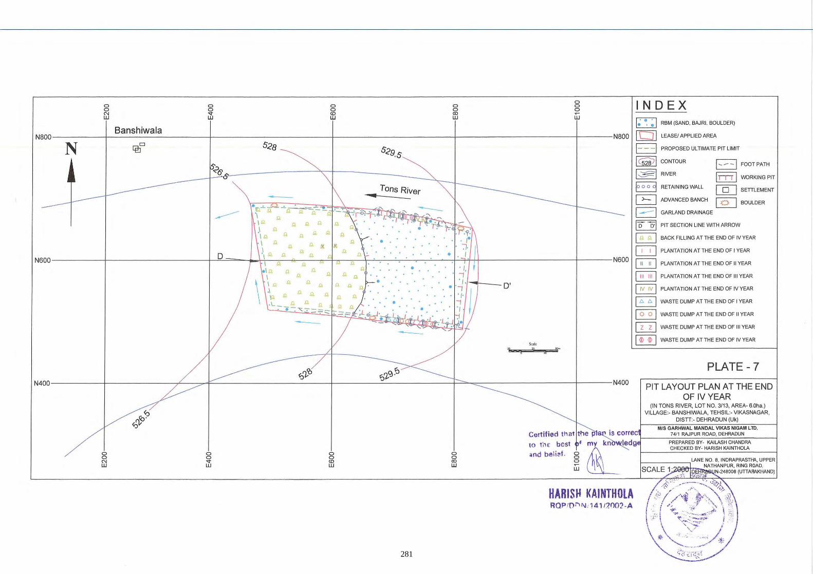
o o <Xl W
o o o ~
W
IN 0 EX
D o '0 RBM (SAND, BAJRI, BOULDER)
----------+-------------------+-----------------------t---------------------~r---------------------_+-------N800 [bj] LEASEI APPLIED AREA
o ' IQ- ,Q, -!.~-- ""
,Q, ,Q,
,Q, ,Q,
,Q, ,Q,
,Q, ,Q,
,Q, ,Q, ,Q,
,Q, ,Q,
,Q,
o l ,Q, ,Q, ,Q,
I ,Q, ,Q,
\ I ,Q, ,Q, ,Q,
,Q,
,I ,Q, ,Q, ,Q, \Q ,Q,
, L_ ,Q, ,Q, ,Q, (
- -; -.:;;;: -:- .==:::::"
Tons River II
o
0
0
0
-
0
' /, '1 ' / '
0' , 0' ' /, '1 ' /
Scale
" !i ~
E3 PROPOSED ULTIMATE PIT LIMIT
I csw l CONTOUR EJ FOOTPATH
~ RIVER I I- n l WORKING PIT
B RETAINING WALL @] SETTLEMENT
G ADVANCED BANCH [QJ BOULDER
EJ GARLAND DRAINAGE
I D D' I PIT SECTION LINE WITH ARROW
~ BACK FILLING AT THE END OF IV YEAR
~ PLANTATION AT THE END OF I YEAR
~ PLANTATION AT THE END OF II YEAR
~ PLANTATION AT THE END OF III YEAR
~ PLANTATION AT THE END OF IV YEAR
B WASTE DUMP AT THE END OF I YEAR
~ WASTE DUMP AT THE END OF II YEAR
ITlJ WASTE DUMP AT THE END OF III YEAR
[BJ WASTE DUMP AT THE END OF IV YEAR
~
";)~9::' N400----------t-------------~--~~----------------------t_------~~----------~~~~-----------------t-------N400
PLATE -7
PIT LAYOUT PLAN AT THE END OF IV YEAR
o o &'j
o o
" W
o o CD W
o o <Xl W
to thE best md beli~f.
(IN TONS RIVER, LOT NO. 3113, AREA- 6.0ha.) VILLAGE:- BANSHIWALA, TEHSIL:- VIKASNAGAR,
DISTT:- DEHRADUN (Uk)
MIS GARHWAL MANDAL VIKAS NIGAM L TO. is correc 7411 RAJPUR ROAD, DEHRADUN
• my kn ledg f-----,:P=R=EP='A:':R:::E=D'=8'"'Y.=KAc::,'-LA==S::'H"=C:cHA""'ND:C:RA:-:-----j
L CHECKED BY· HARISH KA1NTHOLA
§w ~;CAL£!)~~~LA~N~E~N~O~. 8, INDRAPRASTHA, UPPER NATHANPUR, RING ROAD, N-24800B (UTIAAAKHAND)
- ) , ';
HARISH KAINTHOLA RQP/Dr, 1\1 , 141/]OO2· A
281
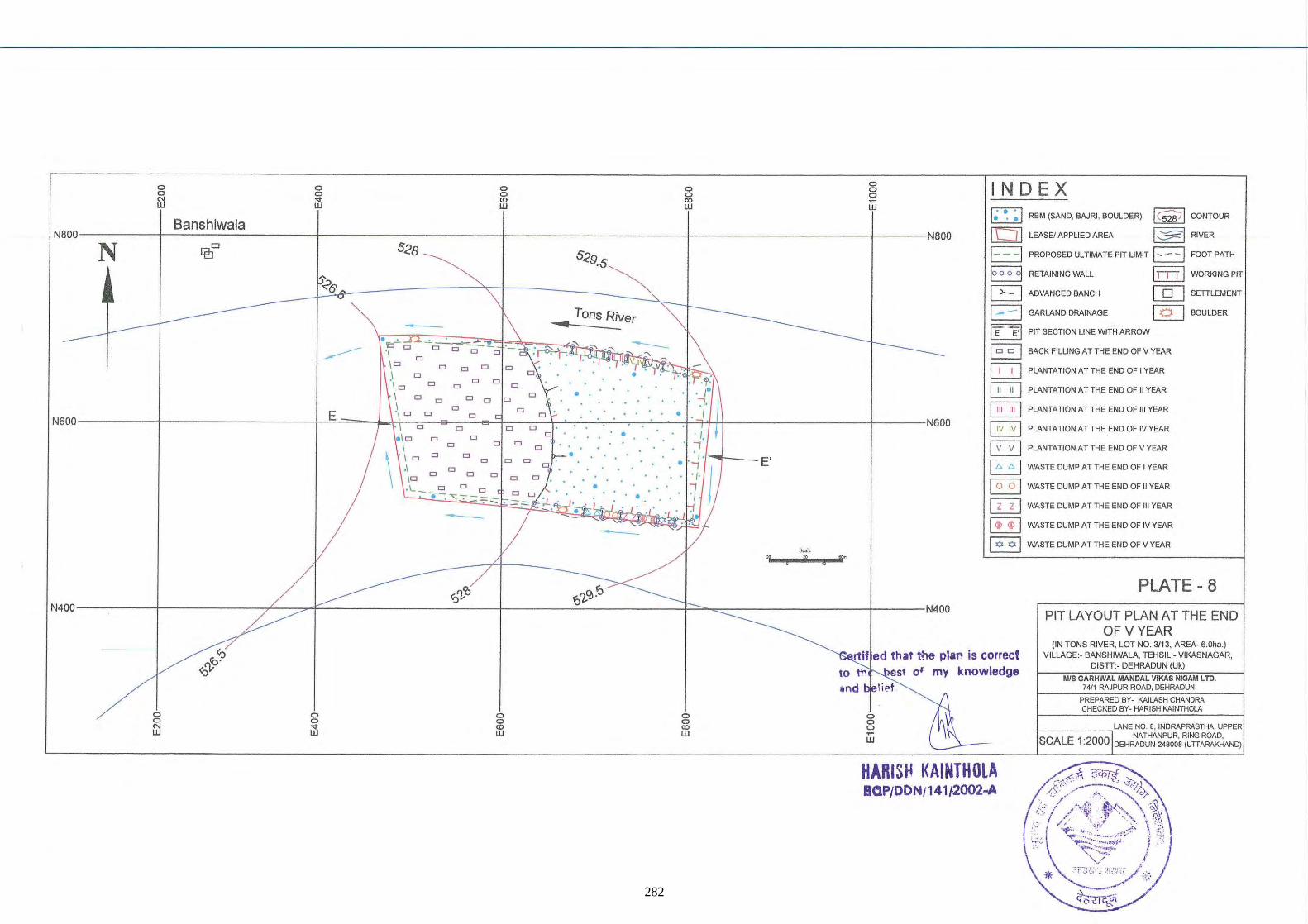
0 0 0 0 0 0 0 0 N ... <D 00 W W W W
Banshiwala Naoo
N [f!]D 528 529.5
!'?6'
0 0 0 ~
w
Naoo
&>l,
"! f ,.. •
IN D EX I ~ ~ ~ I RBM (SAND. BAJRI . BOULDER) I C5W I CONTOUR
[D lEASEIAPPUEDAREA I~I RIVER
1- - -I PROPOSED ULTIMATE PIT LIMIT I .... - -) FOOT PATH
B RETAINING WALL II I I I WORKING PIT
G ADVANCED BANCH cg:] SETILEMENT
1---1 GARLAND DRAINAGE @] BCULDER
I E E·I PIT SECTION LINE WITH ARROW
EJ BACK FILliNG AT THE END OF V YEAR
G PlANTATION ATTHE END OF I YEAR
B PLANTATIONATTHE END OF II YEAR
~ PLANTATION AT THE END Of III YEAR
~ PLANTATION AT THE END OF IV YEAR
~ PLANTATIONATTHEENDOFVYEAR
~ WASTE DUMPATTHE END OF I YEAR
§] WASTE DUMP AT THE END OF II YEAR
~ WASTE DUMP AT THE END OF ttl YEAR
~ WASTE DUMP AT THE END OF IV YEAR
~ WASTEOUMPATTHEENDOFVYEAR
PLATE - 8 ~'l,'O ?~<;l ~ N400----------+-------------~--~~--------------------_4--------~------------_F~~~----------------+------N400
PIT LAYOUT PLAN AT THE END OF V YEAR
o ~ w
o o U'j
o o 00 W
rtif ed that h'le piaI' is correct 10 th est 0' my knowledge ind l ip!
o o o ~
W
HARISH KAINTHOLA BOP/DON/141l2002...A
(IN TONS RIVER, LOT NO. 3/13, AREA- S.Oha.) VILLAGE:- BANSHIWALA, TEHSIL:- VlKASNAGAR,
DISTI:- DEHRADUN (Uk)
MIS GARHWAl MANOAL VIKAS NIGAM L TO. 74/1 RAJPUR ROAD, DEHRADUN
PREPARED BY- KAJLASH CHANDRA CHECKED BY - HARJSH KAJNTHOlA
I-_____ ~ LANE NO.8, lNORAPRASTHA. UPPER NA THANPUR, RING ROAD,
SCALE 1 :2000 DEHRADUN.246006 (UTTARAKHAND)
282
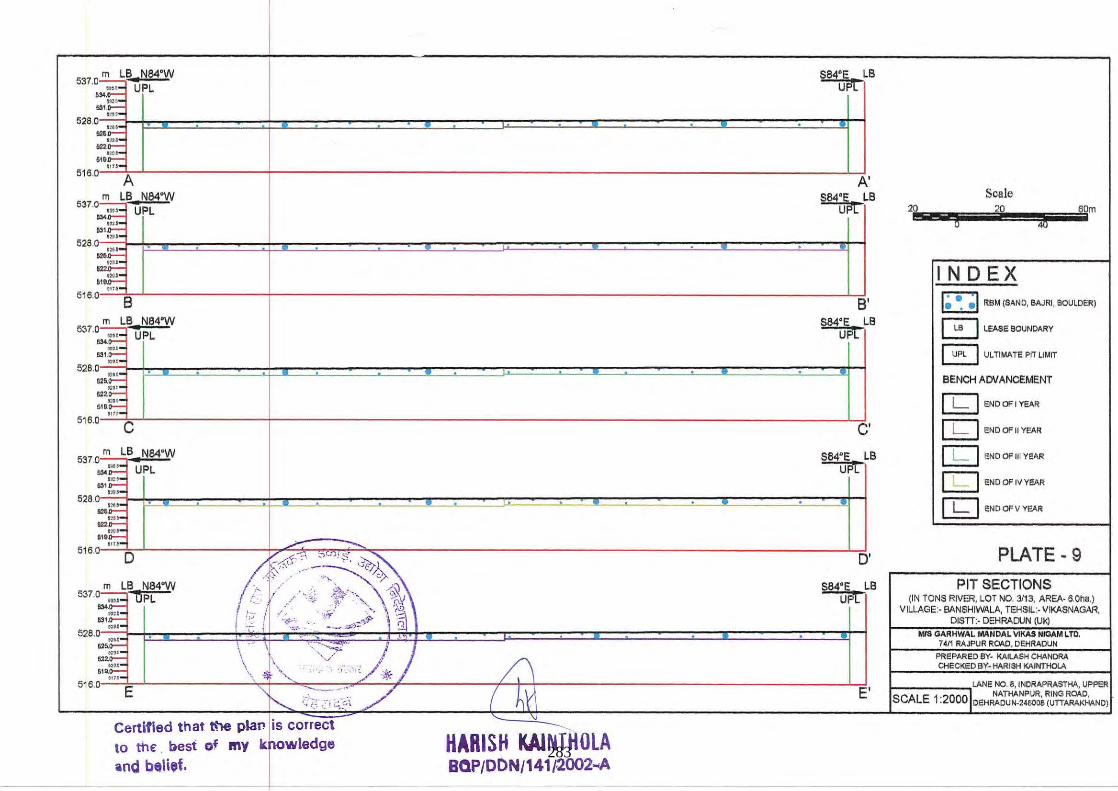
537.0 m LB. N84°W
"olE UPL
"IE 528.0 n'~
.. ~ ::~
S84'E LB uPt
6HIE
'~'''~' ~J----------------t---------------------------------------------------------------------------L~ ~M A ~ m LB N84'W
537.0 ,,_ UPL ... I~ ~;,~ "':f.::
628.0 121~
•E"' ...
,.~
S84' E LB uPt
622.do~
~-~'~"=' ~~---------------r--------------------------------------------------------------------------~~ 51M 8 8' m LB N84' W
537.0 m.- UPL
~E lIS\w_._ 528.0 121~
,.E:;" ...
S84' E LB U~L
, .. ~ ''':,..-51"'~
516.0"':':::;'''=:C~L-------------+--------------------------------------------------------------------l'--Cd,
m LB N84'W 537 .~ ... ~ OPL
-;-~ 531 ;;'1-
528.0 ....
w~ "';;;.;.... ,~~ 518;;;-;-~
516.0 E
Certified that ~ plan is correct
10 the . besl of l'IIy krWl8dge lind belief.
HARISH KAl NTHOlA BOP/DDN/141/,2002 ... A
S84' E LB U~L
D'
S84'E LB UPl
E'
20
Scale
g 20 4b 60m
INDEX I ~ ~ ~ I ReM (SAND, BAJRI, BOULDER)
o LEASE BOUNDARY
~ ULTIMATE PIT LIMIT
BENCH ADVANCEMENT
[kJ ENDOFIYEAR
[kJ ENDOf'IIYEAR
[kJ END OF III YEAR
[kJ ENOOFIV YeAR
[kJ ENDCF V YEAR
PLATE - 9 PIT SECTIONS
(IN TONS RIVER. lOT NO. 3/13, AREA· 6.0ha,) VILLAGE:- BANSHIWALA, TEHSIL :. VIKASNAGAR,
DISTT:· DEHRAClJN (UI<) MfS GARHWAL MANDAL VlKAS NIGAM LTD,
7411 RAJPUR ROAD, DEHRADUN
PREPARED BY- KAILASH CHANDRA CHECKED BY· HARISH KAINTHOLA
I-________ .,LANE NO.8, INDRAPRASTHA, UPPER
SCALE 1 0 ,I. NATHANPUR, RING ROAO, :2 OOIDEHRAOU N-2480DB (UTTARAKHANO)
283
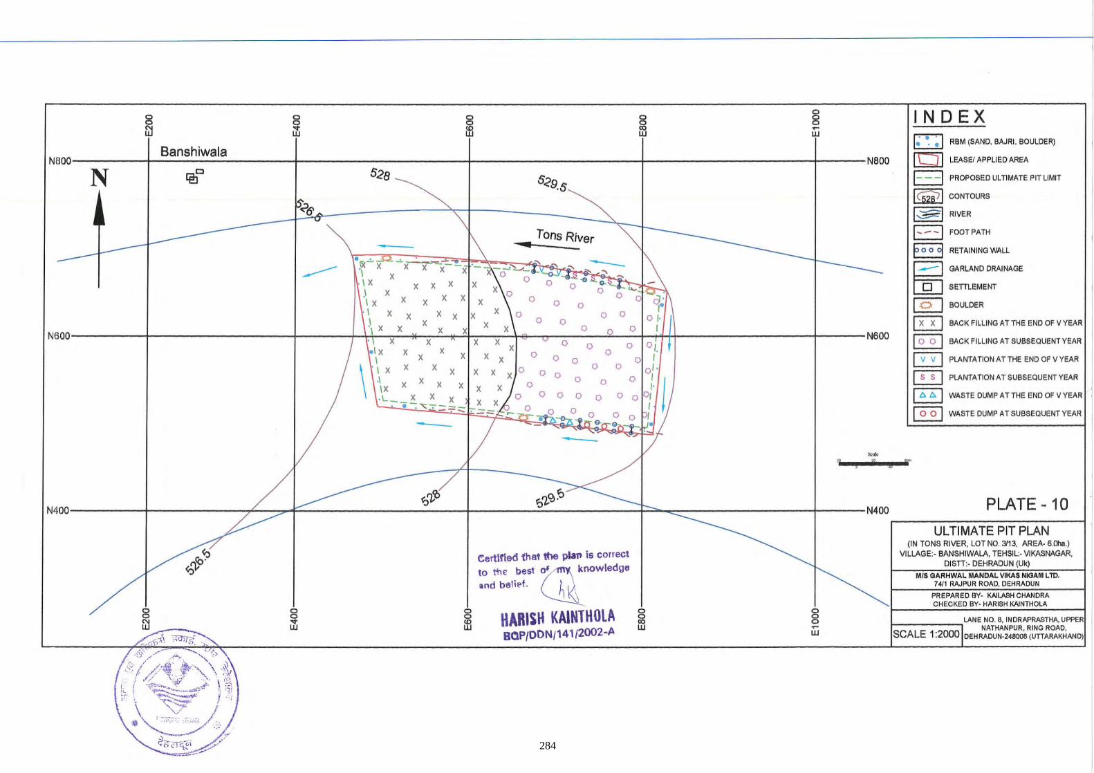
Banshiwala N8oo----------r------------------+----------------------~--------------------4_--------------------_4------Naoo
N IEJc
• \ Tons River ~ "·~f~·~· Ptx ~::z. ~x=x~-~~iP~~.~~~~~.i'S"L<~~~~O"~~ ~,,~,,~~~~:;-~. \ ~ . I X x x x x x 0 0 0 ..., .... .;"'s:-:q:....., ._\
.1 x x x x 0 0 0 0 0 .... ,; .Q: : I x x x x x 0 0 " ~. I x x x x x x 0 0 0 0 0 0 ,. \ x x x x x x 0 0 0 ,
N600----------t-------------------1-------4-+.+~~~~~~,,~~~~~~C~T -O--~~~~+-~~------------------~-----N600 . I x x x x x ~ 0 0 0', . 1 x x x 0 I x xxx 000 0 '
\
I x x x 0 0 0 x x x x 0 0 "\ x x x x x x :j 0 0 0 t L __ ~ X X X X 0 0 0 0 0 0 .. """ .
___ -.1-----j.---
-" .. T
IN 0 EX I ~ ~ ~ 1 RBM (SAND, BAJRI, BOULDER)
[hJ] LEASEI APPLIED AREA
1- - -I PROPOSED ULTIMATE PIT LIMIT
~ CONTOURS
I~I RIVER
1---1 FOOTPATH
8 RETAINING WALL 1- : GARLAND DRAINAGE
o SETIlEMENT
[2J BOULDER
§ BACKFILLINGATTHEENDOFVVEAR I ~ BACK FilLING AT SUBSEQUENT VEAR
EJ PLANTATION AT THE END OF V VEAR
B PLANTATION AT SUBSEQUENT VEAR
8 WASTE DUMP A TTHE END OF V VEAR •
~ WASTE DUMP AT SUBSEQUENT VEAR I
/ 1 n £
/~ ~7-:r ~7-~~- ____ __ N400--------~r-----------~~~~~--------------------~------~~----------_F~~----------------_4-------N400
Certified that ttle plan is correct 10 rt,€ best ~ knowledge
and belief. ~
HARISH KAlNTHOlA BOP/ODN/141/2002-A
8
PLATE - 10
UL TI MATE PIT PLAN (IN TONS RIVER, LOT NO. 3113, AREA- Mha.)
VILLAGE:· BANSHIWALA, TEHSIL:- V1KASNAGAR, DISTI:- DEHRADUN (Uk)
MIS GARHWAL MANDAL VlKAS NIGAM L 10. 7411 RAJPUR ROAD, DEHRADUN
PREPARED BV- KAILASH CHANDRA CHECKED BY· HARISH KAlNTHOLA
I-____ .,LANE NO. 8, INDRAPRASTHA, UPPER d. NATHANPUR, RING ROAD,
SCALE 1 :2000 IDEHRADUN-248008 (UTIARAKHAND)
284
r .- -;- -:- -: - -: - -:- - __ \ . . \. . \ \ . \ \ \ . \ . \ \ . \ \
•
• \ , ,
•
L_,:, __ ,_
•
-----RL 526.5
eertlfted that ItIe plan Is corrFcI to the best Of my knowledge ~nd belief.
HARISH KAINTHOLA IOP/DDN/141/·2()()2..A
•
•
.--~--
•
•
•
-,--:']
• 1 , I
• • 1 1
• 1
1 , 1
• ' I ' I
" , . "
-.!..-=_-.: ' ' I --'--'--...1
RL 528
s,'"' '" " ... -.... - -"!
I N D EX
I ~ ~ ~ 1 RBM (SAND, BAJRI, BOULDER )
1- -I PROPOSED ULTIMATE PIT LIMIT
1 C52'67 1 CONTOUR
PLATE - 11
SLICE PLAN ON TONS RIVER, LOT NO. 3/13, AREA· 6.0118.)
VILLAGE:· BANSHIWALA. TEHSIL:· VIKASNAGAR, DISTT:· DEHRADUN (Uk)
MIS OAAHWAL MANDAL VIKM NIOAM LTD. 7411 RAJPUR ROAD, DEHRADUN
PREPARED BY· KAILASH CHANDRA CiEa<EDBY· HARISH KAINTHOLA
I-____ -,LANE NO. B. INDRAPRASTHA. UPPER
NATHANPUR, RING ROAD, SCALE 1 :2000 DEHRADUN-248008IUTTARAKHAfID)
285
286
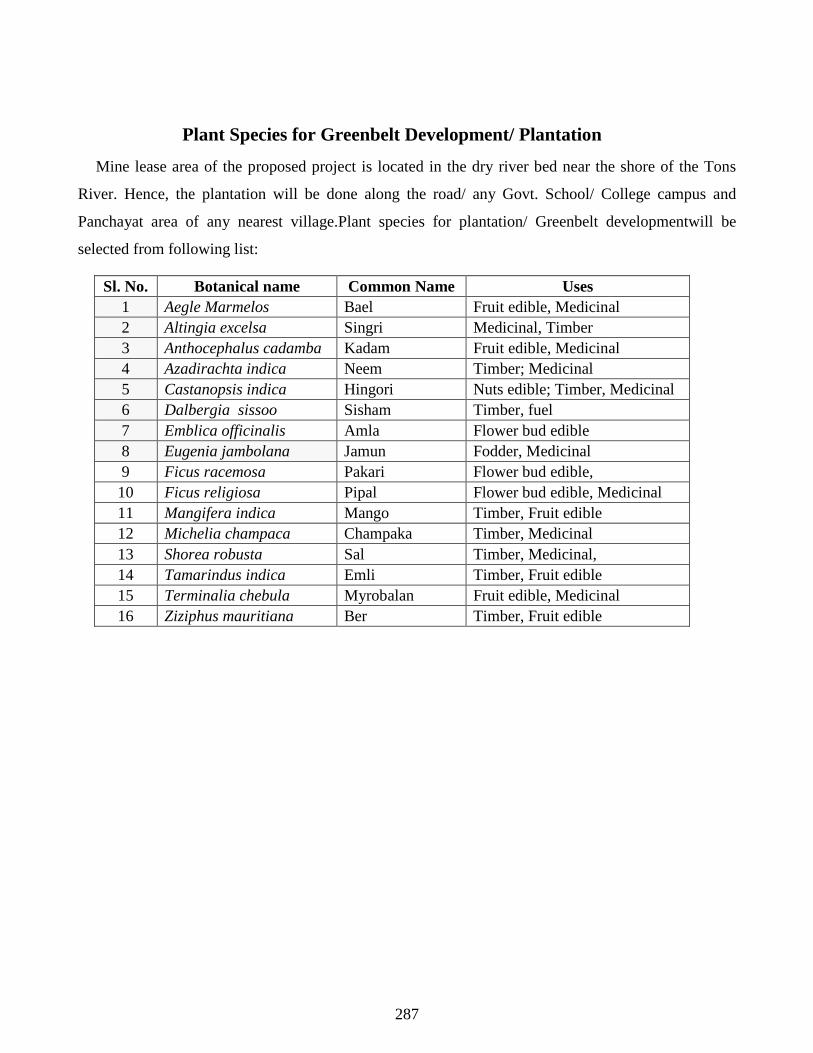
Plant Species for Greenbelt Development/ Plantation
Mine lease area of the proposed project is located in the dry river bed near the shore of the Tons
River. Hence, the plantation will be done along the road/ any Govt. School/ College campus and
Panchayat area of any nearest village.Plant species for plantation/ Greenbelt developmentwill be
selected from following list:
Sl. No. Botanical name Common Name Uses 1 Aegle Marmelos Bael Fruit edible, Medicinal 2 Altingia excelsa Singri Medicinal, Timber 3 Anthocephalus cadamba Kadam Fruit edible, Medicinal 4 Azadirachta indica Neem Timber; Medicinal 5 Castanopsis indica Hingori Nuts edible; Timber, Medicinal 6 Dalbergia sissoo Sisham Timber, fuel 7 Emblica officinalis Amla Flower bud edible 8 Eugenia jambolana Jamun Fodder, Medicinal 9 Ficus racemosa Pakari Flower bud edible, 10 Ficus religiosa Pipal Flower bud edible, Medicinal 11 Mangifera indica Mango Timber, Fruit edible 12 Michelia champaca Champaka Timber, Medicinal 13 Shorea robusta Sal Timber, Medicinal, 14 Tamarindus indica Emli Timber, Fruit edible 15 Terminalia chebula Myrobalan Fruit edible, Medicinal 16 Ziziphus mauritiana Ber Timber, Fruit edible
287
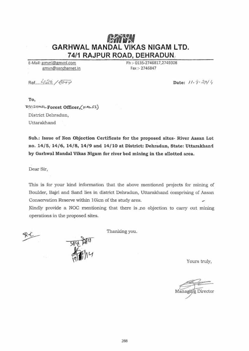
fNM.\fI GARHWAL MANDAL VIKAS NIGAM LTD.
74/1 RAJPUR ROAD, DEHRADUN, E-Mail: gmvnl@gmvol,(om
gmvn@sanch<Jfnet.in
Ref ...... ~i.¥.7.9.. / (c;:;:;.
To.
'J)!'{I Sro~AL- Forest Officer,( r:. III,Sl.)
Diat-rict Dehradun,
Uttarakhand
Ph :- 0135·2746817,2749308 Fa~ ;- 2745847
Sub.: Issue of Non Objection Certificate for the proposed sites- River Ansnn Lot
no. 14/ 5 , 14 / 6, 14/ 8, 14/9 and 14/ 10 at District: Dehradun, State: Utta.rakhan4
by Garhw~l MandaI Vikas Nigam for river bed mining In the allotted area.
Dear Sir,
This is for your kind information that the above mentioned projects for mining of
Boulder, Bajri and Sand lies in district Dehradun, Uttarakhand oomprising of Aasan
Conservation Reserve v.'ithin 10km of the srody area.
,Kindly provide a NOC mentioning that there is .110 objection to carry out mining
operations in the proposed sites.
Thanking you.
Yours truly,
288
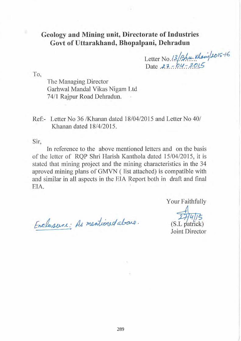
i
To,
Geology and Mining unit, Directorate of Industries Govt of Uttarakhand, Bhopalpani, Dehradun
The Managing Director Garhwal MandaI Vikas Nigam Ltd 7411 Rajpur Road Dehradun.
Letter NO. rJ(i3?4. .. ~/,/tJ ,r;-16 Date .. ,,2, 1 .. -: .c?.tI. -: .~1S
Ref:- Letter No 36 IKhanan dated 18/04/2015 and Letter No 401 Khanan dated 18/4/2015 .
Sir , In reference to the above mentioned letters and on the basis
of the letter of RQP Shri Harish Kanthola dated 15/0412015 , it is stated that mining project and the mining characteristics in the 34 aproved mining plans of GMVN ( list attached) is compatible with and similar in all aspects in the EIA Report both in draft and final EIA.
Your Faithfully
~ (S.L patrick) Joint Director
289
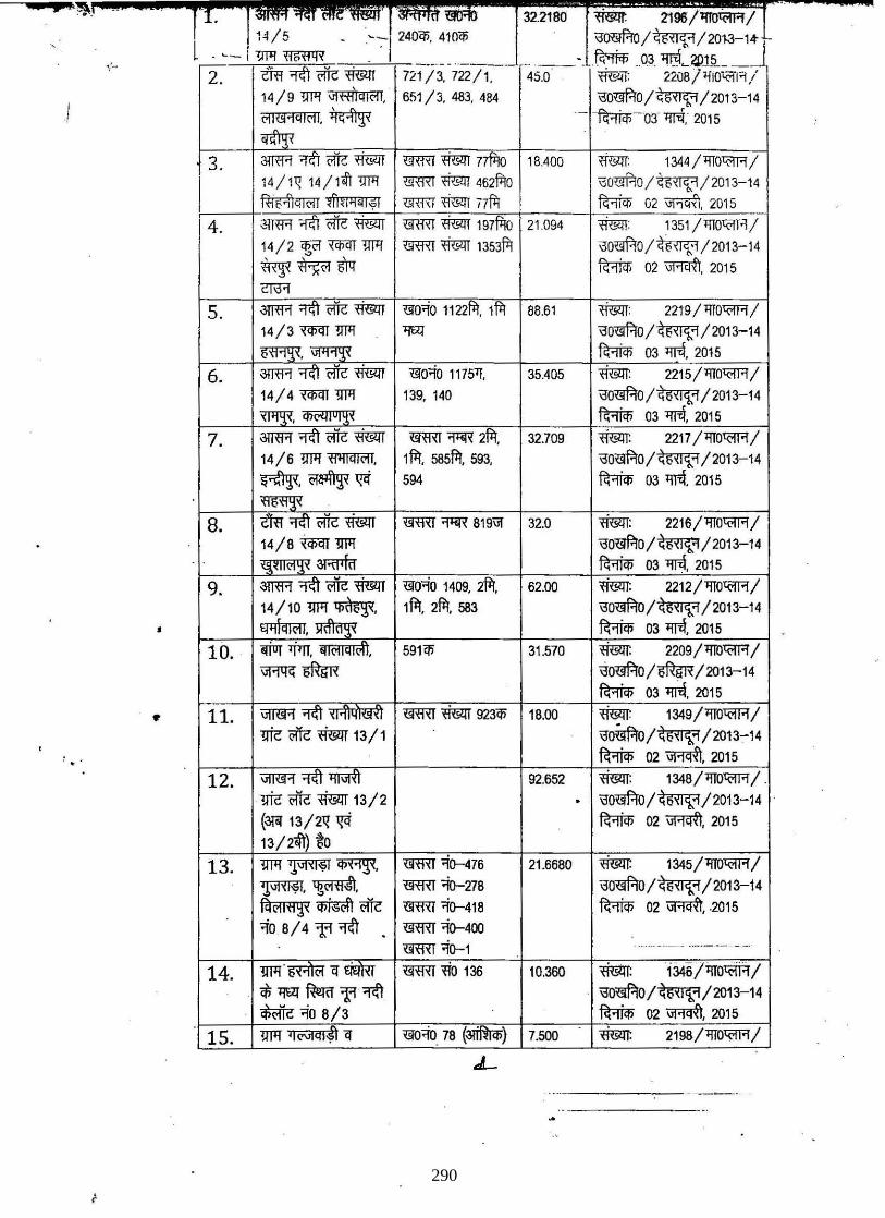
.... '~,
2. 721 /3. 722/1 . 45.0
I 651/3. 483. 484
.,
3. 1344 /'fl0'<'!R /
\30'(iJ HO/~/201 3-14 ~ 02 ", ~q.(1 . 2015
4. 1351 /'flO'<'!R/
\30<#-lO/~/2013-1 4 ~ 02 wmT. 2015
S. 88.61 ffi!1!I:
13'0<#-10 /~ / 2013-14
~ 03 'IlfiI. 2015
6. 35.405
4
7. mm~ 32.709
14 / 6 '!IJl!~. 1 fTI. 585fT1. 593.
~.OI~~ 594
8. mm ~ 819ii1 32.0 2216/ 'fl0'<'!R /
14 / 8 ~ '!Ill! 2013-14
3RI1fff 9. 3mR 62.00
14/10 '!Ill!~ • •
10. <rJUT I 591C!i 31 .570
iiJ'll!G ~
11. iiIlW! 923C!i 18.00
'!lie roc .mm 13/1 , .
12. iiIlW! 92.652
'!lie roc .mm 13/2
(3llI 13/211 ~ to
13. '!IJl!~~. mm 21.6680 1345 /'flOl{>JR /
~. p. mm "io-278 13'0m.'tO /~ / 2013-14
FciC1If1~x ~ roc mm -i()-418 ~ 02 wmT . .2015
-io B / 4 1:1 'Il1\ mm "io-400 ..... __ ._ ---- --_ ... -
14. '!IJl! 136 10.360
. ct; ~ ~ 1:1 '11ft ~-io
15. '!IJl! 78 7.500
.L
290
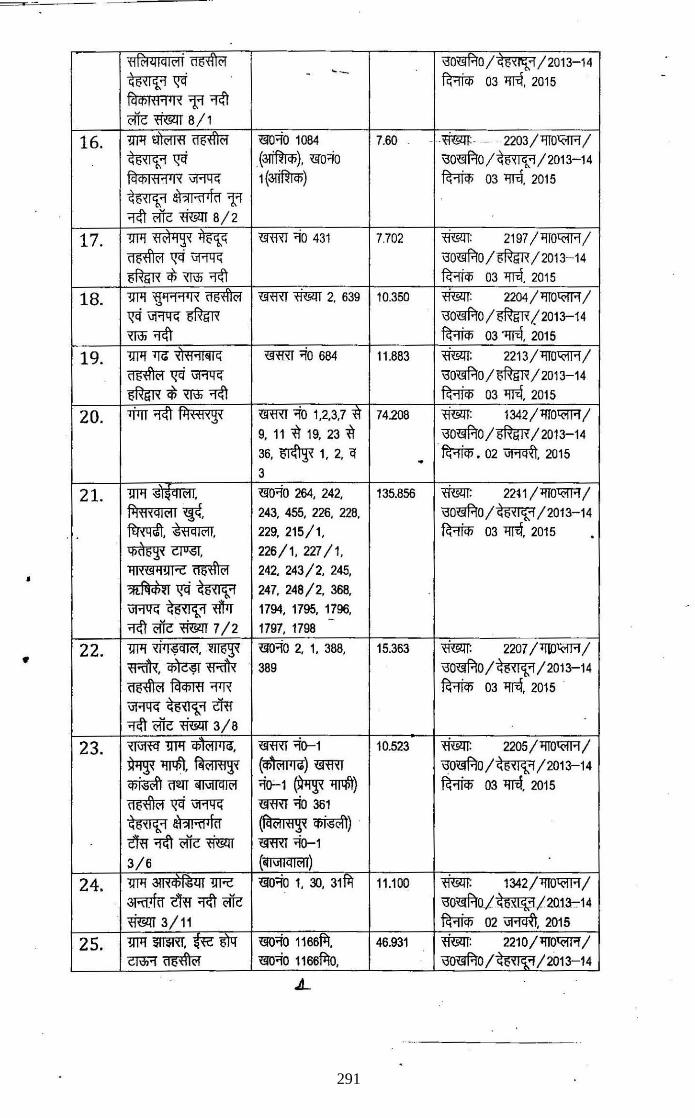
'HfcllllQI('li ~ \j0~0/ GO",'l-'l/2013 14
~~ - -- ~ 03"111'l, 2015
fcl it> I'H'W "'fI "ItI i'1lc tffim 8/ 1
16. 1WI~~ <!lO;to 1084 7.60 _ . .mm:.- . 2203/llTO'<-lT'l/
~~ (3l'i1W<t», ~o;to \j0~0/~/2013-14 fcl i!> 1'i1'1 ' I '< \iRllG 1 (3l'i1W<t» ~ 03 "I1I'l, 2015
~ 1iI~I~jf~"'fI "ItI i'1lc <ffim 8/2
17. 1WI~~ mRT ;to 431 7.702 m:lm: 2197/l!10'<-lT'l/
~~\iRllG \j0~0/~/2013-14 ~ ~ XTili "ItI ~ 03 "I1I'l. 2015
18. 1WI 'tj'11'l' I '< ~ mRT <ffim 2. 639 10.350 <ffim: 2204 / l!1O'<-lT'l/
~~~ \j0~0/~!2013-14 XTili"ltl ~ 03 'llT<f, 2016
19. 1WI1JG x'I'i1'1I~IG m:m;to 684 11.883 <ffim: 2213 /llTO'<-lT'l /
~~~ \j0~0/~/2013-14 ~ ~ XTili "ItI ~ 03 "I1I'l, 2015
20. 1firr "ItI I1I'H1'<go< mRT;to 1,2.3,7 xl' 74.208 <ffim: 1342 / llTO'<-lT'l /
9, 11 ~ 19, 23 "i\ \j0~0 /~/ 2013-14
36. ~ 1, 2. q . ~.02~. 2015
3
21. 1WI" . ~o<io 264. 242. 135.856 <ffim: 22t 1 /llTO'<-lT'l/
11I'i1'<QI('l1 ~, 243, 455. 226, 228, \j0~0/~/2013-14 , . ~. ,g'HQI01I, 229. 215/1, ~ 03 "I1I'l. 2015 . ~ CJlI6T, 226/1, 227/1.
• ~I'<t!l~!wt ~ 242. 243/2. 245 •
*~<5~I~~ 247. 248/2, 368.
\iRllG ~ <l'f1r 1794. 1795. 1796.
"ItI i'1lc <ffim 7/2 -
1797. 1798
22. 1WI '<i'l¥ql('l. ~ ~O~O 2. 1. 388. 15.363 ~ 2207 /'lID'<-lT'l /
wffR. ~wffR 389 \j0~0/~/2013-14 ~ fctq;m ""I"R ~ 03 "I1I'l. 2015
\iRllG ~ iffi "ItI <'lit <ffim 3/8
23. ~ 1WI CP~01""!. m:m <i(}-1 10.523 ~ 2205/ l!1O'<-lT'l /
~ ~. ~('IHlgo< (if)~01ljl<!) m:m \j0~0/~/2013-14 ~ TI2IT ~l\lMI01 ;t(}-1 ~ lJl1l\'t) ~ 03"111'l. 2015
~~\iRllG m:m;to 381
~ a)"I~,rd (fil('lI'H go< ~) tm "ItI ffic <ffim mm <i(}-1
3/6 (~I\1lIQI01I)
24. 1WI '!IR ~o;to 1. 30. 31111 11 .100 ~ 1342 /llTO'<-lT'l /
3Rrhf tm "ItI i'1lc \j0<l!f.'!QI~/2Q13-::-14 tffim 3/11 ~ 02~.2015
25. 1WI~.~6N <ilO<io 1166fi'r. 46.931 <ffim: 2210 /llTO'<-lT'l /
cmi'!~ 't!l'o<io 1166fi'rO. \jO~0/~/z013-14
291
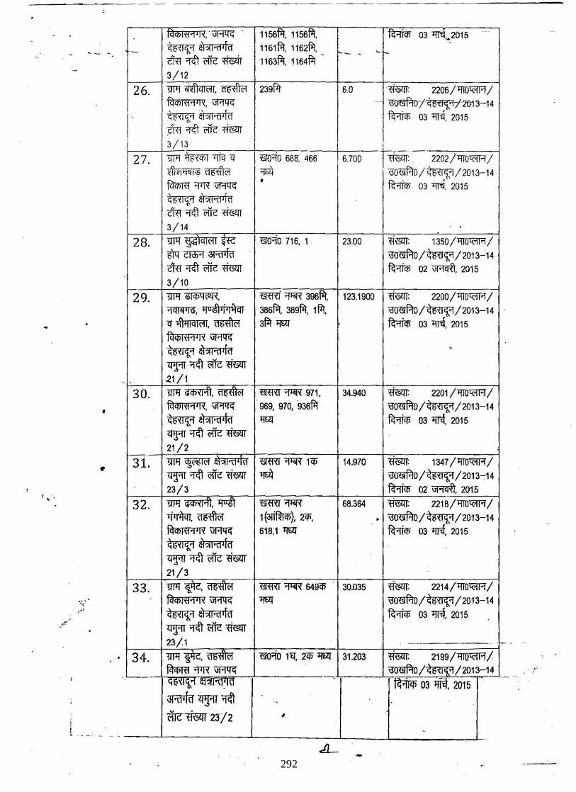
'1~,·\iRI!G . 1156fil, 1156fil, ~ 03 lmt2015
'- - - ~ lfI?lI'fI'[d 1161fil, 1162fil, - - ' I-tffi ~ <'lie mmr 1163fil, 1164fil -
3/12
26. 'WI ~\'fIql<'fl. ~ 239fil 6.0 <ffi;:rr: 2206/ 1Il0'<1Fl /
Fci ctJl <'I 'i ' I " \iRI!G ._ .- \'Joo:f.!Oi~i·2013-14
~ i?i?lI"ll 'ld ~ ,
03 lffiI. 2015
iffi ~ oiic mmr I 3/13
r 27. m'!~Wiq '-'10'10 688; 466 6.700 <mm: 2202/ 1Il0'<1Fl /
l?'~I~~I.,; ~ "til \jOmO/~/2013-14 I fcrctJm "f1l' \iRI!G • ~
, 03 lffiI. 2015
~ 1l1?l1'fl'\d
tffi ~ oiic mmr 3/ 14
28. m'! '(j<i;'lql<'f1 ~ '-'10'10 716, 1 23.00 N: 1350 /1Il0'<1Fl / 61q C1\li'1 3Rllfu' "0l:#IO/~/2013-14 tffi ~ oiic ~ ~ 02~, 2015
3/10
29. 'WI~~, mm '1'iR 396fil, 123.1900 <mm: 2200 / 'll0'<1Fl / 'filIi{ll'G, 'lo~N'I~ 386fi:1, 389fil. 1 fil, \'!0~0/~/2013-14 q '4'\'lIQlcll, ~ 3fil 'WI ~ 03 llfi'l, 2015
Fci ctJl<'I'i '" \iRI!G ~ ~?lI'fI'[d -<fTlT 'ltI oiic ~
". " 21/1
30. m'!~.~ mffi '1'iR 971 , 34.940 ~ 2201/'ll0'<1Fl/
Fci ctJl <'1'1 ' I '1. \iRI!G . 969, 970, 936fil "0~0/~/2013-14 ~ iIl?lI'fl'ld 'WI ~ 03 llfi'l, 2015
<fTlT 'ltI <'ifc N 21/2
3i. m'!~ mffi '1'iR 1tl> 14.970 N: 1347/'ll0'<1Fl/
<fTlT ~ <'ifc ~ llt4 \'!0~0/~/2013-:14
t .... , 23/3 ~ 02~, 2015
32. 'WI~,~ mffi'1'iR 68.364 ~: 2218 /'llO'<1Fl /
~,~ 1(~), 2tl>, . "0'-'1f.'J0 /~ /2013-14
til "'Itt '1 'I, \iRI!G 61B.1 'WI ~ 03 llfi'l, 2015
~ 1l1?l1'fl'!11
<fTlT 'ltI <'ifc ~ 21/3
33. 'WI~,~ .mro~ 649tl> 30.035 N: 2214/'ll0'<1Fl/
Fci '" Itt'i'" \iRI!G 'WI i>0'-'1f.'J0 /~ / 2013-14
~ ~?II'fI,rl1 ~ 03 llfi'l, 2015
<fTlT 'ltI <'lie ~ .
23/1 .. .
34. . 'WI-¥e,~ '-'10;(0 1 'q, 2tl> 'WI 31.203 msm: 2199/lIlQ'<1Flj
.'----~ oJ"IR \iRI!G ~0'-'1f.'J0/~/2013-1_'!. _ <;Q~l1..'1
~
,':'" tf.ifili 03 -, 2015 I .
3RfIkr . ~ . ~ --mc~23/2 , ..
..
-292
Related Documents