GOVERNMENT OF ANDlfRA PRADESB DEPARTMENT OJ' ML 'IES & GEOLOGY From To P. RaJa Uabu, M.S.: {Tech), Sri D. SbyUJbabu Noidu, D.No:C-46. KammavaripaUi, Cbinnas•nipa lli (V). Director of Mines& GeoloiiY, I(UR.'IOOL. Sir. Amadagur ( M) , Annntapununu Disl. Letter No. 4058/MP- TDP/2018, d t: -ll-2018 Suh:· Mines & Quarries - Approval of Mining Plan (includina Progn:s.sive Milo< closure plan) for Dolomlle over an extent of 2.000 Hcctan:s in Sy.No.:!W ,>f Chinlalaclleruvu Villa&<. Pedda•...tuguru Mandol, Anantop<nmu Dismct in Cavour of Sri D. Shyambabo Naidu, prepored by Sri C. Eswar Reddy, R.Q.I' • Mining Plan - Appnn·ed - Rcpzding. Ref:· I) G.O.M•.No: 56. Ind. & Comm. (MJI) Dept ., doted: 30.04.2016. 2) Prodgs.No: 2B594!P. RQrl2001. dt: 13.05.20 16 of d1e Director of Mines and Geology.llydcmb<ld. 3) Notice No: 9942/ R4·112018, dt: 24.10.2018 of the DireetO r of Mines and Geology, lbmhimpmnnm addressed to t he lessee. 4) Letter dated: 09. 11 .20 18 . alongwitn drull Mining Plan from me applicaut n!leeivcd in this office on 13.11 . 2018. 5) Lr. No.40581MP·TDP/l01S, dt: 19.11.2018 of the D.:puty DirtctorofMincs & Geology. Kumoolto the R.Q.P. / AppliCIIIlL 6) Letter dated; 24. 11 .2018, aloog with !he sets offair copies of Mining Plao from the appUcant received in this office oo 03.12.2018. **** In exercise of the powe111 c041ferred "' pet" amended Rule 7 A (1), (II). (lll) and (IV) M APMMC Rules, 1966 rc•d with tio: 28594/P.RQP/2001. dt: 13.05.20 16 of d.e Director of Mines Wld Goology. GoAl', ll ydcrabod and G.O.Ms.No: 56 , Ind. & Comm. (M.II) Dc1>1., dutcd: 30.04.2016, I hereby appro"" the Pion (lndudlna Proarcssive Mi n.< closure pi a•) fo r D olomit'e over ••• extent of 2.000 Httflrts in Sy.No.290 uf Cbintalacberuvu Village. Pl-"ddavntlugun• M11ndal, Anant.apuramu Di strict ia favour of Sri D. Shyamba bu Naidu. This approval is subject to the follo..,ing cooditions. I. This Mining Plan includUI& Mine cloSUK plan i5 apprO\ed "ithoot prejudice 10 any otha laws applicable to the mine area from lime to time wbelhcr made by the Central Government, Slate Go\lcmme:m or any Other authority or any order I dirccticn fmm any coun of oompctent jurisdiction. 2. This approval or the aforesaid Min i ng Plan including Progressive Mioe closure pl an nul in Any way imply lhc ap proval of the Oovenunent in tcrrns of nny other provision ,,f the Mines and Minerals (Dcv<lopmcnt and Regulntions) Act. 1957, or the Mineral Concession RuJcs.. 1960 or the other Rules framed the re un der and any other laY·S includ ing {Cooservation) Act. 1980, Fore<t Conservation Rules, 2003 and Olber rrle-vant onkn and guidelines as may be applicable to the: lease area fi'UI11time !0 rime. · 3. l be Mining Pian is -'Cd subject to suiclly adhering to tile Relevant Regulations of MMR. 1961, provisions of tbe Mmes Act, 1952 and othc Rules and made there under including submission of notice of opening appointmenl of M anager and othr.r statutory official.$ as r equired under d1< Mines Act, 1952 shall be complied with. 4. P rio r pem1 ission rrom tho Ui reccor of Mi nes Safely whenever a nd wh erever il lS r«JII ircd. S. Clearance I Consent I No objection from Minisuy of En vironment Md Foresr. Ccnt rJl Pollution Control Boord. State Pollution Cootrolled Boord IS applicable in this ._ should be obtain. A copy of the same should be submined to this office within a period of one mooth from me date of approval, failing whic:h the approval shall be deemed to witbdra\\u. Cootd ... l

Welcome message from author
This document is posted to help you gain knowledge. Please leave a comment to let me know what you think about it! Share it to your friends and learn new things together.
Transcript

GOVERNMENT OF ANDlfRA PRADESB DEPARTMENT OJ' ML'IES & GEOLOGY
From To P. RaJa Uabu, M.S.: {Tech), Sri D. SbyUJbabu Noidu,
D.No:C-46. KammavaripaUi, Cbinnas•nipalli (V).
~puty Director of Mines& GeoloiiY, I(UR.'IOOL.
Sir.
Amadagur (M), Annntapununu Disl.
Letter No. 4058/MP-TDP/2018, d t: -ll-2018
Suh:· Mines & Quarries - Approval of Mining Plan (includina Progn:s.sive Milo< closure plan) for Dolomlle over an extent of 2.000 Hcctan:s in Sy.No.:!W ,>f Chinlalaclleruvu Villa&<. Pedda•...tuguru Mandol, Anantop<nmu Dismct in Cavour of Sri D. Shyambabo Naidu, prepored by Sri C. Eswar Reddy, R.Q.I' • Mining Plan - Appnn·ed - Rcpzding.
Ref:· I) G.O.M•.No: 56. Ind. & Comm. (MJI) Dept., doted: 30.04.2016. 2) Prodgs.No: 2B594!P.RQrl2001. dt: 13.05.2016 of d1e Director of Mines and
Geology.llydcmb<ld. 3) Notice No: 9942/R4·112018, dt: 24.10.2018 of the DireetOr of Mines and
Geology, lbmhimpmnnm addressed to the lessee. 4) Letter dated: 09. 11 .2018. alongwitn drull Mining Plan from me applicaut
n!leeivcd in this office on 13.11.2018. 5) Lr. No.40581MP·TDP/l01S, dt: 19.11.2018 of the D.:puty DirtctorofMincs
& Geology. Kumoolto the R.Q.P. / AppliCIIIlL 6) Letter dated; 24.11 .2018, aloog with !he sets offair copies of Mining Plao
from the appUcant received in this office oo 03.12.2018.
**** In exercise of the powe111 c041ferred "' pet" amended Rule 7 A (1), (II). (lll) and (IV) M
APMMC Rules, 1966 rc•d with ~roceeding,• tio: 28594/P.RQP/2001. dt: 13.05.2016 of d.e Director of Mines Wld Goology. GoAl', llydcrabod and G.O.Ms.No: 56, Ind. & Comm. (M.II)
Dc1>1., dutcd: 30.04.2016, I hereby appro"" the ~linin~ Pion (lndudlna Proarcssive Min.< closure pia•) for Dolomit'e over ••• extent of 2.000 Httflrts in Sy.No.290 uf Cbintalacberuvu Village. Pl-"ddavntlugun• M11ndal, Anant.apuramu District ia favour of Sri D. Shyambabu Naidu.
This approval is subject to the follo..,ing cooditions. I. This Mining Plan includUI& J>rotrcssi~ Mine cloSUK plan i5 apprO\ed "ithoot prejudice
10 any otha laws applicable to the mine area from lime to time wbelhcr made by the Central Government, Slate Go\lcmme:m or any Other authority or any order I dirccticn fmm any coun of oompctent jurisdiction.
2. This approval or the aforesaid Mining Plan including Progressive Mioe closure plan dol~ nul in Any way imply lhc approval of the Oovenunent in tcrrns of nny other provision ,,f the Mines and Minerals (Dcv<lopmcnt and Regulntions) Act. 1957, or the Mineral Concession RuJcs.. 1960 or the other Rules framed there under and any other laY·S including FortS~ {Cooservation) Act. 1980, Fore<t Conservation Rules, 2003 and Olber rrle-vant ~tus. onkn and guidelines as may be applicable to the: lease area fi'UI11time !0 rime. ·
3. lbe Mining Pian is -'Cd subject to suiclly adhering to tile Relevant Regulations of MMR. 1961, provisions of tbe Mmes Act, 1952 and othc Rules and Re~ulations made there under including submission of notice of opening appointmenl of Manager and othr.r statutory official.$ as required under d1< Mines Act, 1952 shall be complied with.
4. Prior pem1ission rrom tho Uireccor Oc.-~ral of Mines Safely whenever and wherever il lS r«JIIircd.
S. Clearance I Consent I No objection from Minisuy of Environment Md Foresr. CcntrJl Pollution Control Boord. State Pollution Cootrolled Boord IS applicable in this ._ should be obtain. A copy of the same should be submined to this office within a period of one mooth from me date of approval, failing whic:h the approval shall be deemed to ha~ witbdra\\u.
Cootd ... l

-2-
6. A oopy of BIA I EMP report. approved by MOEF, New Delhi, should be submitted to this office withi o one month of approval lcuer.
7. The validity period of the fmancial assurance should be renewed before the expiry of the same and should be submitted to AssL Director of Mines and Geology concerned.
8. Tite execution of approved Mining· Plan shall be subjected to vacation of prohibitory orders I notices, if any issued by competent authority.
9. The. Mi.n.ing PJan is approved for proposals contained therein and a.o; applicable for the mining activities lO be carried out wiJhjn the mining lease bold for 5 years or part period offive years block.
10. If anything is found to be conceaJed as required by Lhe Mines Act in the contents of approved Mining Plan {including Progressive Mine closure plan) and the proposal for rectification hils not been made or if m later stage the information fumisbed in the document is fow1d to be incorrect or misrcprcscntat:ion of facts, lhe approvoJ shall be revoked with immediate effect.
I 1. This Mining P lru1 \lt1lS approved as per the t )llarry lease executive skecch of the subject arc..<L. Any deviation found laler, approval au1hority docs not owe responsibility.
12. The approval authority docs not owe responsibility ""irh regard to erroneous certification made by the R.Q.P. i f any and approval is tentative subject to modification on new findings at a later date •• per the provisions of(23 B & 23 D) ofM.C.D.R., 1988.
Yours fait ully, t:nd: (2 copie• of A.M.P.)
Deputy ir /f"or~o91Jf:::::~ & ~~~ 0 umool
Copy submitted to tJte Direetor of Mines & Geology. Vijayawada along llh A. M.P. Copy to Sri G. Eswnr Reddy, RQP/Gcologist. D.No.IJ-2-155-1, Shirdi Nagar,
Anantapuramu - 515001 ror infonnafion. Copy subtnit!ed to Ule Regionol Conn·ollerof Mines.IBM, Sultan Bazar, Hyderabad for
favour of information .. Copy submitted to the Director of Mines Safety, Bellary for favoui of intbm1ation. Copy submined to the Zonal Joint Olleclor of Mines and GeohY&, K.OOapa for t':'lvour of infonnation. \.Qpy to the A~i:. Director of Minc.s & Geology. Tadipatl'i along with A.M.P wilb a
request to obtain valid Bank Ouaranl~ (Financ-ial Ass.umnce) from the applicant.

(
• •
Mines & Minerals (Development & Regulation) Act, 1957
(Under Rule 7(A) or M.M.C.R., 1966 and as per tbe G.O. M.s. No. 56, Industries and Commm~ (Mines - II) 30'b April, 2016)
lAPPROVEr
For
Sri.D.Shyambabu Naidu, O.No.C-46,
kammavaripalli, Chinnaganipalli Village,
Amadagur Mandai, Anantapuram District.
Contact No. 8971867888
Prepared by
G.E5WAR REDDY ~l.Sc .. 8 L .. Ph D .. RQP/GEOLOGIST,
RQP/DMG/HYD/075/2004, RQP /IBM/HYD/302/20 13/ A,
O.No.J3·2· 155· l. Shirdi Nagar~
ANANTAPURAMU 5 15001. A.P.STATE. Mobile: 09849132789. Phone No: 08554 222737.
Email:[email protected].
NOVEMBER-2018
• • • • • • • 0
G
G
0
0
0
n
-.•"')'/ ···,
~~~l·~.f-,:~~·-t \T- ,, .• ·; . .,: .. , fi)) ~ ;...' ' I. "'' ~ • f • fJ
\..'·;:·\·~.. :. DECo··•RATION ''""'··- • . \ . '<"' . . , .. ~ .. ( ... ~, ./
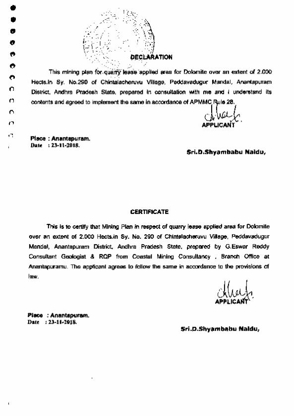
This mining plan fO<,qua.~leas9'8pplled area for Dolomite over an extent of 2.000 . ·. ~ ·" Hects.ln Sy. No.290 of Chintalacheruvu Village. Peddavadugur Mandai. Anantapuram
District. Andhra Pradesh State. prepared In consultation with me and 1 understand its
contents and agreed to implement the same in accO<dance of APMj ~.
Place : Anantapuram. Date : 23-11-20.18.
CERTIFICATE
APPLICANT
Sri.D.Shyambabu Naldu,
This is to certify that Mining Plan in respect of qua.rry lease applied area for Dolomite
over an extent of 2.000 Hects.ln Sy. No. 290 of Chlntalacheruvu Village. Peddavadugur
Mandai. Anantapuram District. Andhra Pradesh State. prepared by G.Eswar Reddy
Consultant Geologist & ROP from Coastal Mining Consultancy • Branct> Office at
Anantapuramu. Th9 applicant agrees to follow the same in accordance to the provisions of
law.
Place : Anantapuram. Date : 23-11-2018.
Sri.D.Shyambabu Naldu,

• • • • • 0 0
0
" 0 , 0 0
0
CERTIFICATE
The provisions of APMMC Rule 7 (A) observed in preparation of Mining Plan for quarry
lease applied area for Dolomite over an extent of 2.000 H-.in Sy. No. 290 of
Chintalacllef1Nu Village, Peddavadugur Mandai, Anantapuram District, Andhra Pradesh
State.
Wherever specific permissions are required the applicant will approach the concerned
authorities.
Certified that the Information provided In the mining plan is correct to the best of my
knowledge.
Place : Anantapuram. Oate : 23-11-1018.
Signature of RQP
~ (G.Eswar Reddy)
G. £SWAR R£DDI: llS..B.L. ,.J> Reeogmsed Geotogtst
IBM/ROP/HYOIJ02/20l0/A ROPIOMGIP.P/0712014
• • • • • • • c CJ
n 0
0
0
0
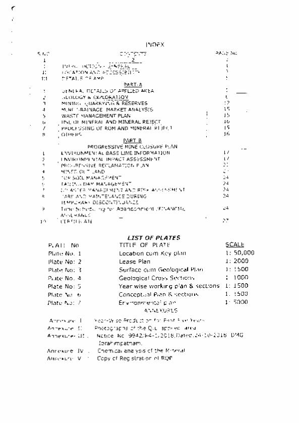
PLATE No. Plate No: 1 Plate No: 2 Plate No: 3 Plate No: 4 Plate No: 5 Plate No: 6 Plate No: 7
Annexure· I : Annexure- II : Annexure· Ill :
Annexure~ IV Annexure· V
PAGE No .
LIST OF PLATES TITLE OF PLATE Location cum Key plan Lease Plan Surface cum Geological Plan Geological Cross Sections Year wise working plan &. sections Conceptual Plan &. sections Environmental plan
~EXURES
Year·Wise Production for Rf"St Five Yean;. Photographs of the Q.L apphed area.
J __
s
~ 1: 50,000 1 : 2000 1 : 1500 1: 1000 1: 1500 1: 1500 1: 5000
Notice No. 9942/R4· 112018,0ated :24·10·2018 DMG, lbrahimpatnam.
Chemical analysis of the Mineral Copy of Registration of RQP.
• • • • • • • C)
0
0
" 0
0
(')
(')
0
--#- ti ,-,,. .. ~ ...
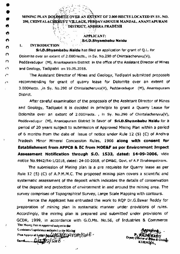
MINING PLAN ooi~tr:~ ~:~;fNT OF 2.000 HECTS LOCATED IN SY. NO .
290, CUINT ALACtJJ>m\~L'AqFJ. .P~D~~A V ADUGUR MANDAL, AN ANT APIJRAJ\1 \\'· ~~.< ~. ~~TIU~; f,.tlfrRA PRADESH \ _\;//t', . 1 ' '·;
.,, , ': 1 ." ·. APPLICANT: \"- • ·': 'I I . :-_•
-~< · "'.~' 7.~5-ri.D.Shyambabu Naidu ~~. . '
I. INTRODUCTIOJ'( -. -·: "·-'· Sri.D.Shyambabu Naidu has filed an applicat ion for grant of Q.L. for
Dolomite over an extent of 2.000Hects., in Sy. No.290 of Chlntalacheruvu(V),
Peddavadugur (M), Anantapuram District In the office of the Assistant Director of Mines
and Geology, Tadipatri on 19.05.2018.
The Assistant Director of Mines and Geology, Tadipatri submitted proposa ls
recommending for grant of quarry lease for Dolomite over an extent of
3.000Hects. ,in Sy. No.290 of Chintalacheruvu(V), Peddavadugur (M), Anantapuram
District.
After careful examination of the proposals of the Assistant Director of Mines
and Geology, Tadipatri it is decided in principle to grant a Quarry Lease for
Dolomite over an extent of 2.000Hects. , in Sy. No.290 of Chintalacheruvu(V),
Peddavadugur (M), Anantapuram District In favor of Sri.D.Shyambabu Naidu for a
period of 20 years subject to submission of Approved Mining Plan within a period
of 6 months from the date of Issue of notice under Rule 12 (5) (C) of Andhra
Pradesh Minor Mineral Concession Rules, 1966 along w ith consent for
Establishment from APPCB & EC from MOE&F as per Environment Impact
Assessment Notification through S.O. 1533, dated: 14-09-2006, vide
notice No.9942/R4· 1/2018, dated : 24· 10·2018, of DM&G, Govt. of A.P lbrahlmpatnam.
The submission of Mining plan Is a pre requisite for Quarry lease as per
Rule 12 (5) (C) of A.P.M.M.C. The proposed mining plan covers a scientific and
systematic assessment of the deposit which ind icates the details of conservation
of the deposit and protection of environment In and around the mining area. The
survey comprises of Topographical Survey, Large Scale Mapping with contours.
Hence the Applicant has entrusted the work to RQP Dr.G.Eswar Reddy for
preparation of mining plan in systematic manner under provisions of rules.
Accordingly, the mining plan is prepared and submitted under provisions of
GCDR, 1999, in accordance with G.O.Ms. No.56, of Industries & Commerce Thl5 Mamn: Plan ISApprovtdJllbJ«< tG tk
(•u,dlllf!M'I.'St.,-Oia1loocls •fulf'd w U~~r M.in.iDf PtaoAppro>~ 'f"~/.J~f)p/8 ' o. .......... ~t:l)gpS ·
• • • • • • 0 0
0
" t)
0
Q
0
0
n
.. . ' . ---. ... ,,~)· • :_I~>: )~ ,./·- ........ ( (}.,
r-.J • . ,,,.'-\;, (': ~~e.. . . .. ~.,.l -
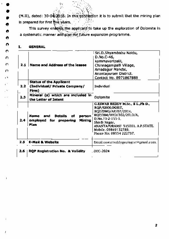
(M.Il), dated: 30-0~~?;~~; !n t~l.s '!c;;P~ [) Jon It Is to submit that the mining plan
IS prepared for first U\I,~'Yf.·~rs. : :.~' } ~-- i
This survey enii~B~~.~!?)Jsa&~sfo take up the exploration of Dolomite In
a systematic manner ai'ilt::P.@q,'[()fJuture expansion programme .
I. GENERAL
Sri.D.Shyambabu Naidu, D.No.C·46, kammavarlpalll,
2 .1 Name and Address of the lessee Chinnaganipalll Village, Amadagur Mandai, Anantapuram District. Contact No. 8971867888
Status of the Applicant 2.2 (Individual/ Private Company/ Individual
Firm)
2.3 Mineral (s) which are included in Dolomite the Letter of Intent G.ESWAR REDDY M.Sc .. B L,Ph D .. RQP / GEOLOGIST, RQP/DMG/AP/07/2014.
Name and Details of person RQP/IBM/HYD/302/2013/A. 2.4 employed for preparing Mining D.No.l3·2· I 55·1.
Shirdi Nagar, Plan ANANTAPURAMU 51500!. A.P.STATE.
Mobile: 09849 132789. Phone No: 08554 222737.
2.5 E-Mail &. Website Email:[email protected].
2.6 RQP Registration No. lk Validity DEC-2024
2

• • • • • • 0 Q
n (}
0
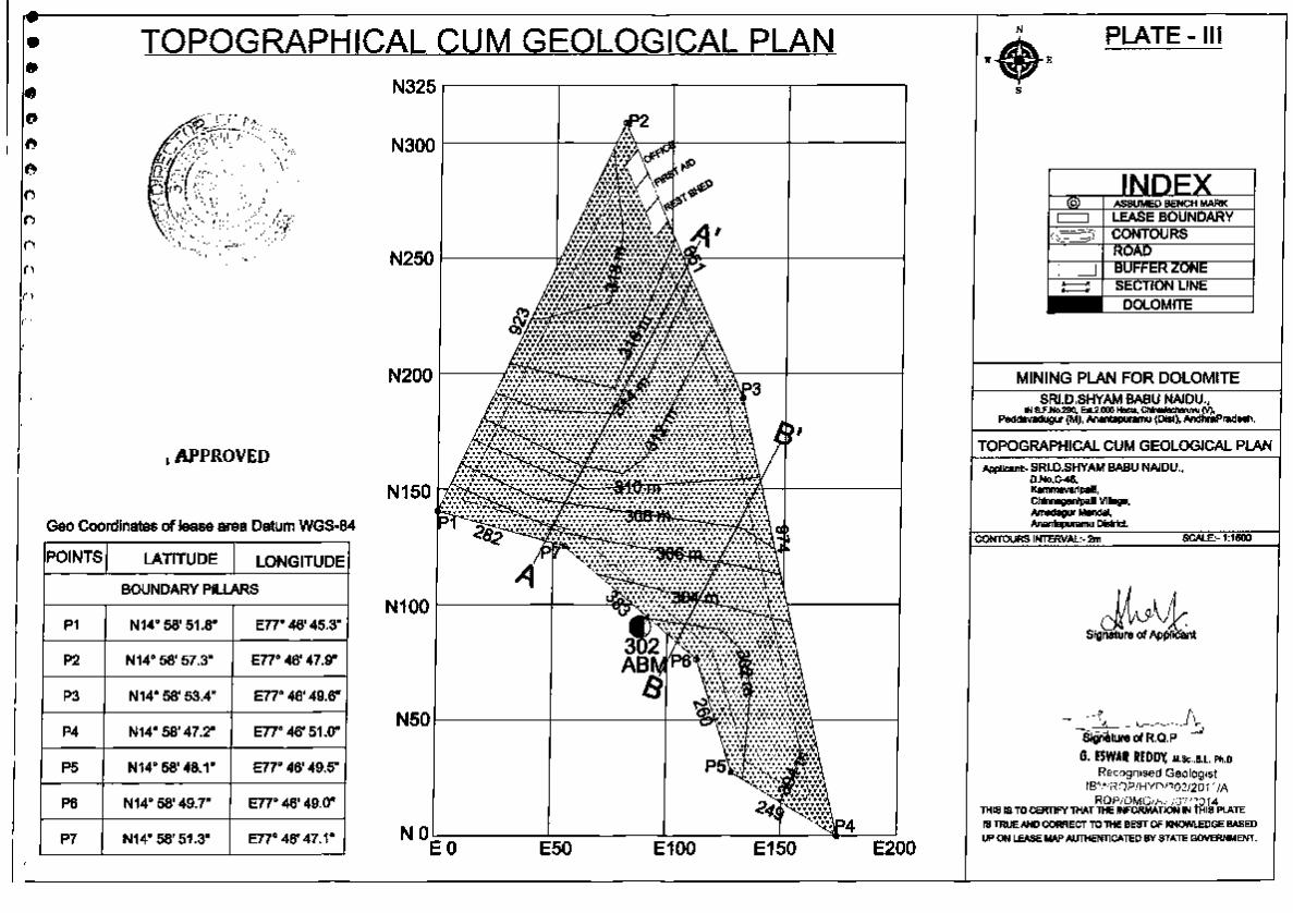
GCP
P1
P2
P3
P4
P5
P6
P7
. .. _ ...... -... -. . LA"i'ri'UDtv LONGITUDE
14o 58' 47.3"N 770 46' 49.6"E
14o 58' 52.8"N 770 46' 52.2"E
140 58' 48.9"N 770 46' 53.9"E
140 58' 42. 7"N no 46' 55.3"E
140 58' 43.6"N 770 46' 53.8"E
140 58' 45.2"N n• 46' 53.3"E
140 58' 46.8"N no 46' 51.4"E
0 (i) The subject area is marked on Survey of India Toposheet No: 57 F/09 and It
0 is enclosed as "Location Cum Key Plan" (Plate - 1). The village map, showing the
0 Sy. No.290 of the recommended for Quarry lease area Is enclosed as Plate - II.
n The QL applied area is easily accessible through Peddavadugur· Bethamcherla
B.T.Road. The lease applied area has good accessibility from Chintalacheruvu
wh ich Is situated on that the B.T road between Peddavadugur· Bethamcheria
Village. The lease applied area Is about l.Skm from Kamalapu ramu village
towards SE and 4.5km from Chintalacheruvu village towards West and nearest
Railway Station is Chinta lacheruvu RS. Majority of workers and staff will come
from Peddavadugur v illage. Peddavadugur Is the mandai headquarters which are
about 12 km from the lease area and having facilities like high school, health
center, postal, telegraph & Bank facilities. The regular APSRTC bus services and
Private services from Peddavadugur· Bethamcheria towns. Power Is available at
mines and there Is water sources excepting bore wells within the lease applied
area.
(ii) Existing Public Roads: Apart from the Tadipatri • Gooty road which connects the
Chintalacheruvu road on the North and the village of Royalacheruvu Is on East, no
other metal road or asphalt road exist in the applied area. The village of
Royalacheruvu is on SH which connects NH·44 Hyderabad and Bangalore cities
connecting at Gooty. Thus It Is seen that the area is well connected by good
roads from Quarry applied site.
The details of the area are tabulated below:
3

• • • • • • • n 0 Q
()
0
0
n 0
0
\ t- /' "(-..;. ·I •" ~ ~~T~ . ,...,. '>J;
-"~.~~·1: p:,;yrt " '" ·.· ''> !.i;~ . ' Sy. Owne rahlp of
District State -T: y~l~ge.,.'.', ~--'""ra~ 1 No. Extent Occupancy I "· r ••
Anantapuram, '\!t~~~iilch...;;;.. R«~ctavadu9 290 2.000 Hects Govt. L>nd Andhra Pradesh J:J:· ' ·, ' y ' ~<:;.lfr
~.' ···e''' ,y ..... ~,..t··· · • .
The Sketch approved by the ADM&G Mines & Geology, Tadlpatrl, in favor of Sri.O.Shyambabu Naidu. is given as Plate No. n . . ( Chlntalacheruvu village Area Pin code:51545 5).
2.7 Period of Mine lease granted = 20 years 2 8 Infrastructure and Communication
Availability of Water is available at the nearby Mine site In Bore Well
Water fitted with Submersible Pump. Power connections are available up to QL applied area
Availability of Electricity Is available in the village and also using Electricity Elect.ricity in the nearby agricultural lands.
Tele communication facility Is available at
Communication Chintalacheruvu(V), which is at a distance of about 4.50 Network km all cell networks can function In the site area.
State Transport Bus Services ply from Peddavadugur-Road Network Bethamcherfa Village frequently; Private Transport is also
available on this road network.
The nearest Railway station Is located at Nearest Rail Head Chlntalacheruvu RS at a distance of 3.5 Km from the QL
area on South Central Railway line.
Port Facility Nearest Port facilities are at Chennal, Krishnapatnam, and Mangalore at about 350km. High school is present In the Chlntalacheruvu village,
School Junior College and Degree level Educational facilities exist at Peddavadugur which is 12.0 km.
Medical Facility Hospital facility (PHC) Is available at Malkapuam which is 4.5 km from the Mine site.
4

• • • • • 0
• ft
0 0
0
0
0
0
0
0
Boundaries ~ . . .~' \ .. ~' ,.--.. .
' '• \ ' ' ' /
North ./ ·.~" Go~~~reye~lh:! Land _, The area surrounding 500 m
South , ,~,, .:,;au.;,Land Is llct:lve with cultivation. The existing Mine lease area was
Eut Sri.O.Shyam Sabu N.aidu .ascertained from the Office of the Asst. Director or Mines &
I Geology, Anantapuram. W est Patta.Lllnd
-Further good potential exists for the employment of unskilled labour In the
existing Quarries and allied Small-Scale Industries, The area experiences
Tropical Climatic Conditions, General Monsoons are SW & NE with an average
normal annual rainfall is 418,2mm and 364,5 mm in 2015-16, The local day
temperature vanes from 25,0' C (Minimum In Winter) to 47,0'C (Maximum In
Summer) In the Month, Total Population of this Chintalacheruvu Village iS around
1200 (Source :Census of India - 2011),
III. Details of Approved Mining Plan, If any
I t Is a newly applied area. No Mining plan was prepared and approved
earlier. The Present document Is for assessment of the Mine activity, Reserve
Estimation, Proposed Method of Mining, Environment Management Plan Including
Reclamation and Rehabilitation measures to be adopted. The Lessee will
approach ADMG for necessary Permissions to Start Mine Operations.
PART- A
1. General Details of the applied area 1 Mining Lease:
1.1 Topography
The QL area Is a part of low-level flat topped plateau with gentle slope due
North & East. There Is a maximum relief In middle portion of 16 Mts from South
& East to the area. There is no perennial water course in and around the QL
area , The surface rain water flows th rough the slope of the area and then joins to
the seasonal nala, which is flowing In South side of the QL area. There is no
vegetation In the QL area because it is not used for agriculture but scattered
trees are located along the boundary of the QL area, there are no public places or
5

• • • • • • 0
0 ., 0
0
0 I)
0
0
0
(
(
i (l·:;,·.> ·~ ...... . ' .... '!:,
~-. :\\ ,.~~~)'
Important monuments~trd -;ti·~~;~M\~- ~he lease area. There is one mining
lease m ine around the1qJ.area:{·,; .;')\:.,~·: t\ \ ' ' '
Topographical Survey \~·~· ~-~--·. ·, ..... /,~ ·
The baseline Is considered ~n'i 'lite -~~r(adlng in oo-relatlon with Toposheet contours, •' ..... ·.~ .· . ' ..
the levels were taken using totai' Statloli of LEICA with 5 em accuracy ooverfng the total
area.
The geo co-ordinates were fixed using the 12 channel handheld GPS, GARMIN make with
MAP DATUM: WGS- 84 PositJon Format hddd - mm - ss.s
Map Datum WGS- 84
Units Metric
North Reference Magnetic
Variance 001° w Angle Degrees
2. Geology and Exploratoon. Topographically the applied area proposed for grant is a plain land gently
slopes towards SE direction. Generally it is low lying pla in land with an average
alt itude of 302 to 318 m above M.S.L. and dendritic to sub dendritic drainage iS
observed. The area Is elevated towards centre of the ped iment and sloping
towards SE direction. The area is devoid of any forest or tree cover. It comprises
shrubs only.
There are no prominent natural d rainage channels In the area. In general
the area Is plain land.
(a) Regional Geology : By the ground observation the litho logical sequences is
found as under :
Surface soil here and there it's having negligible thickness up to 0.5 to l.Om.
After that Dolomite is fanned up to 25mts depth which is observed in existing Pits.
Dolomite thickness is about 25m. Below 10m ie., from 25 to 35mts depth from the
surface there is deposit is obseiVed in pit samples. The rock units exposed in this region
of the subject area belong to vempally formation of Cuddaph super group. The Vempalll
fonmatlon oomprlses of shale, Dolomite, Steatite & Igneous Instructive. The Following
table shows the stratigraphy of the region. Table - 1.
-----------------------unconfonmlty-------------------------------Papaghnl series ----Vempally formation ------dolomite Steatite Shale
and igneous intrusive/Dyke Gulcheru Quartzite.
6
• • • • • • • 0 ., t)
0 1.)
()
0 (')
0
")
'5~·~/-.",.,_ :?(Jr"..;-(r ):,.
X z -----<!.·.< :0:; ----------------- ------un DtfR!'~"Y,:-;r.'i-:;.. --<.•{"(:-- -------------
CY. "'( ; •' <"i''> :\ \ ~-\ ,. C·; . \ ·~ ' "': ~ l . , .. ' · l_.c ., ...... ·,__, .• , ·,' . . . '. '\. ,, . ' .
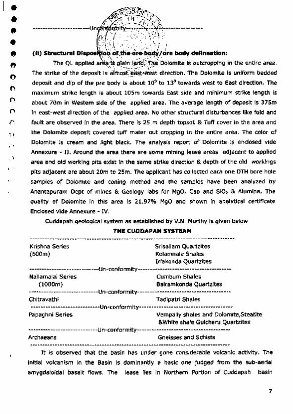
(II) Structural Dispos Lo~\~!-.!"~:o~!':~~~/ore body dellnutlon: The QL applied ar '"'I~Pl~~j_~Jt'~~· Dolomite Is outcropping in the entire area .
The stri ke of the deposit i~O.sf;~$J:":<Mi~t direction. The Dolomite is uniform bedded
deposit and dip of the pre body is about 10° to 13° towards west to East direction. The
maximum strike length is about 105m towards East side and mJnimum strike length Is
about 70m in Western side of the applied area. The average length of deposit Is 375m
In east-west direction of the applied area. No other structural disturbances like fold and
fault are observed in the area. There Is 25 m depth topsoil & Tuff cover in the area and
the Dolomite deposit covered tuff mater out cropping in the entire area. The color of
Dolomite is cream and Jlght black. The analysis report of Dolomite is endosed vide
Annexure - II. Around the area there are some mining lease areas adjacent to applied
area and old working pits exist in the same strike direction & depth of the old workings
pits adjacent are about 20m to 25m. The applicant has collected each one DTH bore hole
samples of Dolomite and coning method and the samples have been analyzed by
Anantapuram Dept of mines & Geology labs for MgO, Cao and SiO: & Alumina. The
quality of Dolomite in this area Is 21.97% MgO and shown In analytical certificate
enclosed vide Annexure - IV.
Cuddapah geological system as established by V.N. Murthy Is given below
THE CUDDAPAH SYSTEAM
Krishna Series (600m)
Srisailam Quartzites Kolamnala Shales lrlakonda Quartzites
····~---------------- -------un-conformity-------------·~----------------~~-----
Nallamalai Series Cumbum Shales ( lOOOm) Balramkonda Quartzites
------------- ---------------un-conformity--------------------------------------Chitravathl Tadipatri Shales ----------------------------un-conformity--------------------------------------
Papaghni Series Vempally shales and Dolomlte,Steatlte &White shale Gulcheru Quartzites
-------··--------------------un-conform;ty---------------------- ----------------Archaeans Gneisses and Schists
It is observed that the basin has under gone considerable volcanic activity. The
initial volcanism in the Basin is dominantly a basic one judged from the sub-aerial
amygdaloldal basalt flows. The lease lies In Northern Portion of Cuddapah basin
7
• • • • • • • .. 0 0 0 (,1
I)
0
0
0
0
(
4}!;- ~::; ~,, (;.<[;.;~:~~-\'~_ ''-(>('~}
consisting of doloma~,~~st~~.j~ Ill stage of Cuddapah system of rocks, inter
bedded with hard .rr~~,ou; ';ha~~;l{bJ!~~ nd red colour. The general strike of these
formation Is NE·S~M dip ls;tow,a:di>_i 7st bec<~use of Dolomite, steatite out crops .
These formations at 'Pl~ce_s are. intru~ by sills of basic volcanic mineral during
Vempalll and Tadlpatri ~~a~e§: Th~··fo~atlons In this area fairly uniform, devoid of any . ---·- .. structural disturbances.
(b) Geoi011V of the Lease area: The Subject area falls with in the vempally
Dolomite rocks included under the Cuddapahs. Within the lease area rock
formations exposed are dolomite shale having NW-SW strike and dip Is towards
easting. These formations are devoid of any structural disturbances. The chop
mark surface weathering typical of dolomite lime stone Is prominent feature of
these rocks. Top soil mixed with, is available here and there is Dolomite located
in the applied area is having trend of NE·SW direction. The strike length of
Dolomite zone In the lease area is 460m In EW direction and width of the zone is
observed about 110m, In the Dolomite zone the recovery is observed only 95%
and balance 5% will be Intercalated waste.
(I) Origin of Dolomite:
The mineral steatite is seen to occur as a Hydrothermal altered Product of
the Dolomite. The Hydrothermal alteration was sequel to the volcanic activi ty
observed In the lower Cuddapah period, about which mention has been made
under regional Geology. The alteration of Dolomite has resulted in forming
mineral like Steatite and white Clay etc.
It is already started above the dolomite is subjected to volcanic and hydro
thermal activity durlng Vempally and Tadlpatri stages of Indian, Geological
classification of rocks. There is no evidence within the lease applied area or in the
immediate surroundings of any volcanic activity. The formation of steatite is
attributed to hydro thermal solutions having acted on Dolomite limestone
through the existing jointing planes giving rise to formation of steatite. The
dolomites of the area have impurities of MgO and 510,. Due to hydro-thermal • action the Mg C03 Is broken In to MgO and Co2• The C02 escaped while silica
Impuri ty combined with MgO to form magnesium silicate and with combination of
hydrous molecules It develop Into hydrated magnesium silicate which is precisely
the composition of steatite present in the area. The color of is gray and steatite is
8

• • • • • • • 0
0 0
~
.0
0
0
0
0
(
t'·· :;,: .... --:"'~ .
,;c"-;,.'*'tfi;J.:J . ~: .. : J.:" ~/ ..... , ., . ~() '{:_,. (' .. ·:.~~:·-:~ ..... ' '· ;~
light cream. No @!. ~~~~1;.~;j\~_~~-~r~rnces like fold & fault are observed in the
lease area. Ther\ !\7ery .~ttle top sqf cover In the lease area. The lessee has
collected the Dolo~~'
• • • • • • • • • 0
0
0
0
0
0
0
~f-1'-?ii'C~,:>,
,~~'X'"'·,~'r' (d) Details o{;.;:6(~;C!~~\t~f~d out : Recommended area for grant of
~!(,I,,.,\\-:, " .•. \
mining lease ~r,~,~t~~~.t~d/ O?;jlle ground with reference to Boundary pillar
(No.1) later e,\, tQ~gra.~l'lrGal · s~ey of the area was carried out by the 'I '>.\\'\" .. f • • I /
theodolite. The North.', 1Wester-n ooundary pillar of the subject area is taken as
ABM 294m. One 'Ord ·,J;~(~p;fu;'~t Pit were identified in this applied area. The
size of the pit is The size and l ithology of these old pit are given below In Table -
1. The locations of these are shown on plate - Ill .
2.2 MINING CARRIED OUT Details of Mining Operations As the Dolomite deposit is forming due to sedimentary activity, raised 0 .5-1.0 M
below ground level of the Mine lease applied area. There Is one sample pits in
South Eastem side of the QL applied area. The size of Pit is 104 sq.mts, with
depth of 12m. Only samples of Dolomite are collected from th is pit.
2.3 RESERVES
Geological traverses In the Mine and the study exposures In the vicinity of
quarries facilitated to access the shape and size of the deposit in the area. It Is a
ground Deposit rising 1-3 M below ground level within the Mine lease area. The
surface iS wavy and irregular covered with soil.
2.4 Method of Estimation of Reserves
The deposit is found to be scanty irregular In shape, the deposit Is being worked
out to a maximum depth up to 30m in few nearby quarries and the deposit
seems to be occurring still below as per the information gathered from the Mine
owners and drilled bore well data . In this lease area Dolomite 95%, and 5%
Waste material.
Three Cross Sections (A-A'} & (B-B') Is drawn perpendicular to the slope
direction for profile purpose.
Section Area (Sq. m) x Section lnnuence (m) = Volume of Geological Reserve (Cu. m)
Volume of Geological Reserve (Cu. m) x Bulk Density (t/Cu. m) = Tonnage of Reserves
10

• • • • • • • • • ., 0
0
0
t)
0
0
., ' Oepo,si t
Hight in m
Volume m'
RESERVES Of
DOLOMITE q;, 95% TN m'
The recovery of the Dolomite, from the Mine Is 95% hence 5% waste Is generated.
b) Mineable Reserves TOTAL MINEABLE RESERVES(Oolomlte )
GEOLIGICAL RECOVERABLE IN TONNS CATEGORY RESERVES IN
TONS DOLOMITE@ WASTE@ S% 95%
TOTAL MINABLE 1300246 419632 22086 RESERVES
c) Life of the Mine:
MINERAL NET AVAILABLE AVERAGE/ LIFE OF MINERAl YEAR THE MINE
DOLOMITE 1300246 45624 20.00
11
• • • • • 0
• ft
0
0
0
0
0
0 n 0
·f·'FMTiV;,~~ \~·( ri:J}~~'.
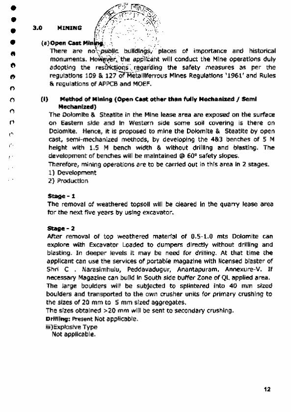
y ... "/)-'>""... -~ r~~;\ 3 0 MINING ur· ( -. ·~ '<'\, • U' • .'·' •• ;:· . . ,_ ... ~_, •
·' ., il. ; ' - ~)- ., .. - •
fT!· ' :'/. •, :; .. •·,'"':J . (a) Open cast Min · a " ,1 ·,. - ,· ·.:· I ·, ~
..!"', ~ ' I c' ~·-~- •
There are no .. p~el'E: btJHC!Ing~/ ' places of importance and historical monuments. HoV<i~ver .._the .apj)ll'caht will conduct the Mine operations duly
:-..\ . ·-- _.,.. adopting the resttfctjOQh.~garding the safety measures as per the regulations 109 & 127 Of"Me"talliferrous Mines Regulations '1961' and Rules & regulations of APPCB and MOEF.
(i) Method of Mining (Open Cast other than fully Mechanized I Semi Mechaniud)
The Dolomite & Steatite In the Mine lease area are exposed on the surface on Eastern side and In Western side some soil covering is there on Dolomite. Hence, it is proposed to mine the Dolomite & Steati te by open cast, semi-mechanized methods, by developing the 4&3 benches of 5 M height with 1.5 M bench width & without drilling and blasting. The development of benches will be maintained @ 60° safety slopes. Therefore, mining operations are to be carried out in this area In 2 stages. 1) Development 2) Production
Stage- 1 The removal of weathered topsoil will be cleared In the quarry lease area tor the next five years by using excavator.
Stage- 2
After removal of top weathered material of 0.5-1.0 mts Dolomite can explore with Excavator Loaded to dumpers directly without drilling and blasting. In deeper levels It may be need for dri lling. At that time the applicant can use the services of portable magazine with licensed blaster of Shri C . Narasimhulu, Peddavadugur, Anantapuram. Annexure-V. If necessary Magazine can build in South side buffer Zone of QL applied area. The large boulders will be subjected to splintered Into 40 mm sized boulders and transported to the own crusher units for primary crushing to the sizes of 20 mm to 5 mm sized aggregates. The sizes obtained >20 mm will be sent to secondary crushing. Drilling: Present Not applicable. iii )Explosive Type
Not applicable.
12

• • • (ii)
• • 0
• 0
0
0 0
0
0
0
0
0
.l3:.:.:_1.,: r! ;:-!~,~\ ,r. ..... ~ .-·- ..... ? ~~\
r <? . . .· (~(i;; . ,1/ ·; :,\ \I
.I ·{ i : ..... -~, . ' · i Production p~· PS!!d .forthe nextffive years
In the : .es~l'(t'a'rea. iHe(e · ~nly one quarry in this area. As recent rules and reg ~-~~ipn)_ Qf:l:iM.<;i -_!1{-:;hca & APPMC, all Mines should follow Mining Plan, EC;,qfE-:82C·fQ, als_q-;be noted that DMG issuing the permission based up on above~gulre"CI'Papers.
It Is proposed to produce 2,28,119 Tons of Dolomite during next five years plan period with an average annual production of 45,624 Tons from an area of 10,253 m 2 • 2 benches of 5 m height and l.Sm width will be developed during the plan period In depth of previous year workings successively.
The 5% Waste is generating In general in Dolomite Mine@ 4803 m3•
The lessee proposes to take up Mining operations in entire Mine lease area between the grids The excavation activity will be taken up in North of the Mine lease area and then continue moves to South side. lttYear In the first year mining will be carried out in the North of the Mine lease applied area covering an area of 2034 m2 2 benches of 5 m depth will be formed. The mining advances South wards. An area of 2034 m2 will be excavated producing 45113 Tons Dolomite, 950m3 waste of Market Grade aggregates. 2'"' Year In the second year the mining will continue South side of 1"' year workings with an area of 2045 m2 2 benches of 5 m depth will be formed. The mining advances South wards. An area of 2045 m2 will be excavated
producing 45374 Tons Dolomite, 955m3 waste of Market Grade aggregates
3rd Year In the third year the mining will continue South side of 2' " year workings with an area of 2061m' 2 benches of 5 m depth will be formed. The mining advances South wards. An area of 2061 m' will be excavated producing 45743 Tons Dolomite, 963m3 waste of Market Grade aggregates. 4u. Year In the fourth year the mining will continue South side of 3"' year workings with an area of 2046 m2 2 benches of 5 m depth will be formed. The mining advances South wards. An area of 2046 m' will be excavated producing 45505 Tons Dolomite, 958m3 waste of Market Grade aggregates. sttt Year In the fifth year the mining will continue South side of 4"' year workings with an area of 2067 m' 2 benches of 5 m depth will be formed.
The mining advances South wards. An area of 2067 m' will be excavated producing 46384 Tons Dolomite, 977m3 waste of Market Grade aggregates. An area of 10253 m2 will be excavated produdng 228119 Tons of Market Grade
13

• • • • • • 0 f)
• 0 (I
0
0
n 0
0
~ z)~~-:.:: . , . YE liv{{J~ PR~DU~O~ F0R NEXT FIVE YEARS - TABLE-2
I t~ ·•1\' PRODUCTION . \ - ,, ~ • Worki~, ~och · .i(onJme
RESERVES RESERVES Rock Year areas \ . height<· OF OF waste@ mt ....._ ... m' OOLOMJTE DOLOMITE
5% in "''~- ..ffi"- ~ @95% IN @ 2.5/ m3
''-· ':. ,_,• m' in Tons m' -.
2034 5 10170 9662 24154 509 1st. year
44 1 1765 5 8825 8384 20959
18995 18045 45113 950
2nc1 year 2045 5 10225 9714 24284 511 1776 5 8880 8436 21090 444
19105 18150 45374 955
2061 5 10305 9790 24474 515 3rd year
1791 5 8955 8507 21268 448
19260 18297 45743 963
2046 5 10230 9719 24296 5,1_2_ 4th year
1786 5 8930 8484 21209 447
19160 18202 45505 958
5th 2067 5 10335 9818 24546 517
year 1839 5 9195 8735 21838 4RQ
10253 19530 18554 46384 977
GRAND TOTAL 96050 91248 228119 4803 AVERAGE TOTAL 19210 18250 45624 961
Plate- v shows the Mine Layout Plan & Sections of Mine lease area. Quantum of Excavation: A total of 228119 Tons of Dolomite is being excavated which is 95o/o recovery of the mineral. 5% waste Is generated @4803cbmin this plan period.
a) Production Schedule The production of Dolomite Is continuous throughout year except during monsoon. That is 10 working months, 25 working days per month are considered. The average production of 228119 Tons per year (250 days@ 912.476 Tons per day) can be easily achieved In a single shift with sufficient men and machinery.
b) Magazine Type and Capacity The client does not need any explosive magazine. Lessee can utilize normal Explosive Detonators with permissions.
c) Stack Yard Temporary stocks will be maintained on day to day basis; entire ROM (Run of Mine) will be cleared within days (i.e. 4 to 5 days).
14

• • • • 0
0
0
0
0
0
0
t)
0
0
0
d)
e)
4.0
s.o 5.1
5 .2
5.4
.. ,.__ t'1 1f\ • . · \~--. t•.,·~~
/~~~'"':..~ ! -;- ~-:-~.~}~ r ~x - - ·~·~ • r-... ,_ . -· • ·' ,~· ~.{{.,.\····' .,
Handling~~~.( t(~~t-W.i~bi.ri }~~~~ -. ine Minerals ii\~~ arated fro{!> .motA,•• rock by excavator and the slope of the ramp
'"" \1: \\ 'V"" 1, J.,'7f i s gentle. \.·. . :\. "· r~,· . '·.t(:J)/. Transportai:i~.!1'~-':r:!tnerlti)~~'Y Nine t o yard and to Destination The rough Ml~41~al)n 't!l" ~e area will be handled by using excavator and transported to dlStldat!ons by trvcks. MINE DRAINAGE The general direction of ground water flow is towards SE. The areas of Chlntalachervvu form a part of the Penna River Basin. The height of water table ranges from 65 - 90 m below BGL. Ground water table Is 90 m bgl In the surrounding areas. The mine lease is on little elevated area maximum mining depth Is 25 m I. Hence ground water table will not have any Impact due to the mining operations. WASTE MANAGEMENT P LAN (SOUD &. UQUID) Solid waste for the first five years 5% Solid waste of dust powder 4562 t is generated in this Dolomite Mine. Dumping Site Particulars 5% Solid waste of dust powder is generated can be used for the development of Internal roads, So that dumping site is not proposed in the quarry area. Uquid Waste Mine Drainage: The drainage system of mine In this area consists of surface run off generated
( from rain fall and seepage. The water that will generated In the mine pits will be pumped out for the benefit for agriculture fields existing around.
a) Run off from waste dumps and measures proposed to arrest run off: Rainfall over the Mine lease applied area affected different by waste dumps, mine pits roads etc. The rain cuts the dumps to small rallies and there by a lot of runoff is generated wllf cumulate in the pits. Some cases The following measure proposed to arrest surface run off.
• Garland drains around pit and waste dump • Retention wall at the foot of the dump • Check dam construction against drainage channels to arrest silt. • Growing vegetation on the slopes of the dumps. b) Excavation drainage ditches all around the Mine to direct surface drainage:
Garland drains p roposed around pit to divert the run off In to natural drainage channels.
c) Utilization of run off for general surface use or discharge in to surface drainage networks only after meeting with prescribed discharge standards and further the agricultural purposes on the surface.
d) Surface run off general during rainfall event cannot be utilized for the general use, hence through the garland drains proposed run off will be diverted In to drainage network. Napa slabs mines or dumps have no pollutants or toxic substances; hence, no contamination is expected, except siltation.
e) Treating waste water to obtain the desired quality for industrial use as may be required :
15

• • • • • 0
• 0
0
e 0
0
0
0
0
0
6 .0
7.
8.
. . . ·"" ·- ~· :, It;;,_""::-,..
No industries ex1s ~~ -:~1r1~~ty, ~f;\t~e Mine lease area. Hence, no treatment is I~ fi. ~~··.,-·,s,-,.
required for the ~ .1 ,., 1,,., ,~ • •
USE OF MINE 11 Np'i;'IN.ER.A~ RtlE~ The district has s r._\ificant _resourcei'9~~Qplomite. Th•s mineral can be used as raw material In Paint .. .-&, Chemical IQcfustrfes In this Anantapuram Distnct more number of crushin uriik·so.'that .tfiis mineral can be supplied to t11e local units and it also export to o'tlii!~::~t~fof.ielangana, Tamllanadu and Kamataka States . Processing of ROM and Mlne·ral Reject No processing Is required. Only dressing of the Mineral and screening to the required sizes as per the market demand will be produced. Others (a) Site Services The Lessee Is well established In this Mine Operations since long , So Permanent Office, Rest Rooms, First Aid Room, Shelters and Water for drinking will be provided in the Mine premises on make shift arrangement. (b) Employment Potential A total of 14 persons shall be engaged to carry out the various operations at the QL area. The man power required For the mining operations shall be as per Table given below.
s. Category
No. of No. Persons 1. Foreman 1 2. Supervisors 1
3. Excavator and Tipper
2 Operators
4. Helpers 4 5. Dumper Operators 2 6. Unskilled Labor 4
Total 14
16
• • • • • • 0
8 C)
tJ
0 ()
0
0
0
0
r
1 .
I)
ii)
Ill)
Jf .•( '•,,;_!l.l.'·>_f -·. 1~
ENVIRONMENTJ'~AS~; I,.I~E .1~~ :.Ftl.A TION
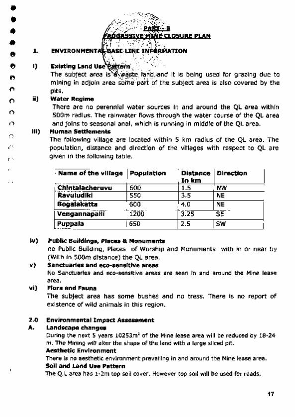
Existing Land uJl~e'in· ·. · ' <~~ ·. · The subject area i~!J~~: ~-~~:and it is being used for grazing due to mining in adjoin area some part of the subject area Is also covered by the pits. Water Regime There are no perennial water sources in and around the QL area within 500m radius. The rainwater flows through the water course of the QL area and joins to seasonal anal, which is running in middle of the QL area.
Human Settlements The following village are located within 5 km radius of the QL area. The population, distance and direction of the villages with respect to QL are given in the following table.
Name of the village- Population I Distance Direction In km
Chlntalac.heruvu 600 1.5 NW Ravuludlki 550 3.5 NE Bogalakatta 600 4.0 NE Vengannapalli 1200 3.25 SE Puppala 650 2.5 sw
iv) Public Buildings, Places & Monuments no Public Building, Places of Worship and Monuments with in or near by (With In 500m distance) the QL area.
v) Sanctuaries and eco-sensltive areas No Sanctuaries and eco·sensitive areas are seen In and around the Mine lease area.
vi) Flora and Fauna The subject area has some bushes and no tress. There Is no report of existence of wild animals in this region.
2.0 Environmental Impact Assessment A. Landscape changes
During the next 5 years 10253m2 of the Mine lease area will be reduced by !8·24 m. The Mining will alter the shape of the land with a large sliced pit . Aesthetic Environment There Is no aesthetic environment prevailing in and around the Mine lease area. Soil and Land Use Pattern The Q.L area has 1·2m top soil cover. However top soil will be used for roads.
17
• • • • • • • 0 C')
l')
0
I')
0
0
0
0
-"B~f rv;~~ .,...;-:--~.~~
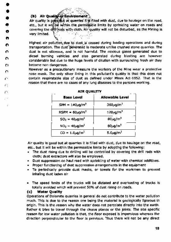
(b) A ir Quail • nylro'nmene~ . Air quality Is g 9 · ·at qOarrfes'·it'\~'·'fllled with dust, due to haulage on the road, etc., but it wll Lp. vi1thln t~·e pen:n( ~Bie limits by sprinkling water on roads and covering the d l !t\'oct,s ·Witl] cloth. 'Air g1,1ality will not be disturbed, as the Mining is very llmlted. ,_ .. ··.,· ... ··.· ~~ - </J.·.~ - .• .·
~ >. • -- •\ ' Highest air pollutton,.due to dust )s caused during loading operations and during transportation. The dustgeilerated Is moderate unlike crushed stone quarries. The dust Is not siliceous, and Is not harmful. The noxious gases generated due to diesel burning vehicles and also generated during blasting are however considerable but due to the huge levels of dilution with surrounding fresh air they become non-dangerous. However as a precautionary measure the workers of the Mine wear a protective nose mask. The only silver lining in this pollutant's quality is that this does not contain resplratable size of dust as deftned under Mines Act-1952. That is the reason that there are no cases of any lung diseases to the persons working.
AIR QUALITY
Base Level Allowable Level
SPM = 140)J9/m3 360,.g/m3
RSPM = 60Jig/m3 120,.g/m'
502 = 40JJ9/m3 80J19/m3
~ N01 = 40JI9fm' 80J19/m3
co = t.o1.g/m3 S.OJ19/m3
Air quality is good but at quarries it is filled with dust, due to haulage on the road, etc., but It will be within the permissible limits by adopting the following: • The dust rising due to drilling will be controlled by covering the drill rods with
cloth; dust extractors will also be employed. • Dust StJppression on haul road with sprinkling of water with chemical additives. • Proper functioning of dust suppression arrangements in the equipment • To periodically provide dust masks, or towels for the workmen to prevent
lnhaling dust laden air
• The speed limits of the trucks will be dictated and overloading of trucks Is totally avoided which will prevent SO% of dust rising on roads.
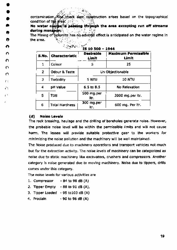
(c) Water Quality Operations of Dolomite quarries in general do not contribute to the water pollution much. This is due to the reason one being the material is geologically I gneous In origin. This is the reason why the water does not percolat.e directly Into the earth. Rather it trie-s to travel through the cleave planes or the joints. The site specific reason for low water pollution Is that, the ftoor exposed Is Impervious whereas the direction perpendicular to the ftoor is pervious. Thus there will not be any direct
18
• • • • • 0
0
0
0
0
0
I)
0
0
0
0
h( ---~---;·_? ~~>·~ #~:" ~!'\, I ',:-::--.'•:,~
contaminatio~. <l.:S.~eek ·d~~~ ~ction arises based on the topographical condition oft (t re . . :;: ~:··· \ \~ No water c ~ ~~?pa~S.i.qg th'"rcit.gh the area excepting run off streams during mon~r:·\ '•.: ·.,'"' ; ! I[Ji The Min ing of -:· ,~n:llt~ iha;·~~ ~d"V_~rj~ effect is anticipated on the water regime ln th ) ~"f',' ~ .). ..... ;/ e area. ".4 . •. , (-~- ''/ · .. ·~'· -..... '·;.·_ . .
-..!.:N.r-..." >v "'"'-- . - IS 10 500 - 1944
S.No. Characteristic Desirable Maximum Permissible
limit Umit
1 Colour 5 25
2 Odour & Taste Un Objectionable
3 Tumidity 5 NTU 10 NTU
4 I pH Value 6.5 to 8.5 No Relaxation
5 TDS 500 mg.per
2000 mg. per ltr. ltr.
6 Total Hardness 300 mg.per
600 mg. Per ltr. ltr.
(d) Noise Levels The rock breaking, haulage and the drilling of boreholes generate noise. However,
the probable noise level will be within me penmlsslble limits and will not cause
harm . The lessee will provide suitable protective gear to the workers for
minimizing the noise pollution and the machinery will be well maintained.
The Noise produced due to machinery operations and transport vehicles not much
but for t he extraction activity. The noise levels of machinery can be categorized as
noise due to static machinery like excavators, crushers and compressors. Another
category Is noise generated due to moving machinery. Noise due to tippers, d rills
comes under this category,
The noise levels for various activities are
1. Compressor • 84 to 98 dB {A)
2. Tipper Empty • 88 to 91 dB {A),
3. Tipper Loaded • 95 to103 dB (A)
4. Proclaln • 90 to 96 dB {A}
19

• • • • • • 0 0
0 0
11
0
0
0
('I
0
PE F TIME IS
·,) ·~ ·---¥ ·- . . ,-:·.:;·, (1 !/ / ..-~ · . ·- ..... . \ ;(_\
RMI.SS B~ -NOISE• EXPOSURE FOR DIFFERENT PERIOD 0 tdr I '·. :c :: ,. , :GI,VEN BELOW .... ~,... • ~ • _..,...I .~-, 1~."· i 1'?_
Dur'ati~~Rer.Oay· ( Hr5) ' sound l evel Dba -~ · • .
80 ::: t-6 __ ,__, ./ . • · ' .,. . -t ;S ·.~. 85
4 90
2 gs 1 100
y, 105
Y• 110
1/8 115
The rock breaking, haulage, machinery and the drilling of drill holes generate noise. However, the probable noise level will be within the permissible limits with in 100 d B (A) and will not cause harm.
The machinery will be maintained properly to reduce the noise • The protective noise redudng gear like earmuffs, the company will provide
earplugs. • Proper maintenance of equipment by regularly lubricating all moving parts. • Rotat ion of job of the persons to reduce the average dosage that they are
exposed • Usage of Hlgh ·Carbon grease for the moving metallic contacts Instead of
ordinary grease will reduce the noise by 20 to 30%. The proponent intends to use this method.
• All personnel must wear PPE (Hard Helmet, Shoes, Gloves, Ear Plugs) In the Mine area.
(e) Vibration Levels There will not be much vibration due to jackhammer holes b lasting of 3m depth. (f) Water Regime The area Is not a hill. The Mine operations extend below ground level . The water
that is due to rains settles below the Mine. In most of the cases the quarries do
not operate during rainy seasons. This is due to accumulation of water. Most of
the water slowly seeps below the ground and enters the water table. This Is the
reason that the local bore wells have full of water during all the seasons. On the
other hand the areas devoid of quarries are found to have low ground water
levels. In particular no additional steps are needed to arrest any water pollution.
(g) Acid Mine Drainage Not Applicable (h) Surface subsidence Not Applicable
20

• • • • • • .. ~
Ill , ~ ., t. 0 0
0
0
" ' J
, ... -n1 f•r,•i-.... ;;.. \ ' -,. ·•. ''/;:.'
i>:Z.·' L _.;;·~ (I} Soclo E~P.'JOII)ic. E~.>vlronrn~t\ The main occ P.afioril o~ .l(ilfagers ls,\19r;culture , Mine Workers and sheep raring.
I 1 ,, . . • • 'I' \ The commenc~· nl ,d("Mir;>lng ~ctiYrR n this area 1m proved the socio-economic
.\...- \ "·"\.. • .Ji.. ... j status of the )~~pie· by _cr~~bon of employment and paying taxes to
grampanchayath. &~'\ ·'~-:--: ... ---;_,.;; .... It was observed th~'ihost-:Of'l~cal inmates of villages within an area of 10 km
around the project site are Involved either In cultivation, or in petty jobs. Most of
their children are college going or school going. Some of them are in business in
nearby towns. Most of the persons are connected directly or indirectly with the
local cultivation of paddy, It was explained that some p-ersons have business. The
prese-nt Mine activities will have some positive and some negative Impacts on the
local social regime. They are as under .
Positive effects:
1. The locals get the employment. Some persons are found to be buying trucks
and renting to the Mine owners.
2. The locals get some job opportunities and especially the skill levels increase
due to their exposure to the machine environment.
3. Due to higher earnings their general status of living improves.
Negative effects:
1 . The dust if not oontrolled can harm the inmates.
2. The worst problem is due to dust generated during transport and the main
roads can be seen with this menace.
3. The rate of truck transport has Increased the rate of accidents to locals and the
area Is found to have Increased number of accidents due to careless driving.
4. Although the higher Noise levels may not harm persons working in Mine, they
will face the problem on a longer run.
(j) Occupation Health and Safety The quarrying in this area does not involve any hazardous methods. The
Quarrying Is simple and open cast mining method. In this, the possibilities of
small Inj uries are anticipated. The lessee is providing First Aid facilities at Mine
site and Office room.
This also consists of Issuing PPE (Personal Protective Equlpments) to all tile
persons working, and those that are needed for the site specific operations. The
following PPE are proposed to be distributed.
• Helmets once in three years as needed under Mines Act
• Safety shoe to all the employees twice a year as per the same statute.
21

• • • • • • • 0
0 ., 0
0
0
0
0
0
. ....... ··~
0.. ~-- ~".!_'\{~ C)· y ,.<· I ~~.•~ • Safety go g~! ~o'the Drill ~pe1!tors and Crusher operators which is a site
~ '·. ' . . ' ~.,. speci .. c r. ;?: ~~").e~~- :< : ~· ·;--~·" t
• Nose m s-onq\' two,nionths.{Actually these are the cotton thin towels) \··· ' . . ., ' ' .'
• Other ste~t~,in:!P:~~e,'!iajety ~~ditlons Is to Inculcate the safety culture
among the l(er:Sons:Wo.rklng. ··
(k) Historical M~n'u·~~¥•· /
No historical monuments are located in and around the lease area.
(I) Bio-Diversity
Agriculture
The Mine lease area is an operating mine and far away from agricultural lands.
Therefore, there Is no adverse effect on agriculture.
Forest
The Mine lease area Is not falling under forest zone. (However, the lessee Is
proposing to undertake afforestation in the area).
Vegetation
The Mine lease area has operating mines, with an exception that, small shrubs,
herbs and thomy bushes have grown along the boundary of lease area where
some soil exists.
3. Progressive reclamation plan
The Mine lease area is just elevated 280 m above MSL. Reclamation is required,
in the life of the Mine. During next five years the progressive redamatlon plan is
given in table below.
At th• beglnnJng of the At the end of the plan Durlng
Type of land use Conceptu•l plan period (ha.) period (ha.)
period (h•)
,.Unlng 0.0000 1.0253 1.0253
Roads 0.0150 0.0150 0 .0150
Green B<:lt Area 0.1125 0.1125
Total Land 0.0000 1.1528 1.1528
Degradation
Al'ea whkh will 2.0000 1.9990 1.9990
Remain Untouched I
22
• • • • • • • 0
• ., ()
()
0
0
0
0
.• , r ~
:::;._ .... ..:.~· ;$·
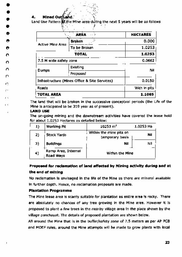
j'· ·. - : ::·-~~ 4. Mined Ou,/{j,/.~ ' • .,. • '. \" . Land Use Pattern ,,ffi. e Mine are-a\dur'ing the next 5 years will be as follows
··\·· . I ;.., \,_ \ .. . .
' \ .': AREA
4•. ~-·''/ · . . ' HECTARES . )
0.000 Broken · ... ~~.7 Active Mine Area
To be Broken 1.0253 TOTAL 1.0253
7.5 M wide safety zone 0.0662
Oumps Exist ing
Nil Proposed
Infrastructure (Mines Office & Site Services) 0,0150 -
Roads With in pits
TOTAL AREA 1.1065
The land that will be broken In the successive conceptual periods (the Ufe of the Mine Is anticipated to be 319 year as of present). LAND USE The on-going mining and the downstream activities have covered the lease hold for about 1 0253 Hectares as detailed below·
1) Working Pit 10253 m 2 1.0253 Ha
2) Stock Yards Within the mine pits on
Nil temporary basis
3) Buildings Nil Nil -
4) Ramp Area, Internal
Within the Mine Road Ways
Proposed for reclamation of land affected by Mining activity during and at
the end of mining
No reclamation Is envisaged In the life of the Mine as there are mineral available
In further depth. Hence, no reclamation proposals are made.
Plantation Programme
The Mine lease area Is scanty suitable for plantation as entire area Is rocky. There
are absolutely no chances of any tree growing In t he Mine area. However It is
proposed to plant a few trees in the nearby village area in the place shown by the
village panchayat. The details of proposed plantation are shown below.
All around the Mine that is in the buffer/safety zone of 7.5 meters as per AP PCB
and MOEF rules, around the Mine attempts will be made to g row plants with local
23

• • • • • • 0
0
0
0
0
0
0
0
0
5.
,.:-~- ' .
arrangeme~~~~.~~ud. Thus It Is envisaged that around 10 plants will
be plante rft,d:i~k_e!)~}i~.ty_~f~_l~ ?"e year. Thus the area available around the
periphery i\1\'b~ sulflclel\t for: ar?"nd 5 years.
Although ~ ~~~i ... ~~""~:~~~' ls;~re the location where the Mine is situated is
partially rocky. :S¥pe<\(Jor ·some medium sized plants that grow in the cracks of \ .' .::~ .... ~' -7
boulders; there are 'ho :notable species in the area. However trees like Neem,
Ashoka, Mango, and local species Peepal are found In and around. Therefore these
three species are planned for plantation. Maintenance of these plants that are
grown in the buffer zone will be taken care by the Mine management. The plants
that will be grown In the village will be taken care by the management, In
coordination with the Village panchayat members.
Top soil Management
Topsoil will be stacked separately In 7.5 mts buffer zone and grass & plants
will be grown on soli dumps. Finally the soli will be spread on reclamated
portion of the pit at the end of the mining and the reclamated portion will
be used for plantation.
6. Tailing Dam Management No dams are available in this area.
7. Disaster Management and Risk Assessment Since It Is a small and shallow open cast mine there are no chances for disaster. If any disaster occurs the mines manager and mine owner will take all statutory actions.
8. Care and Maintenance during temporary discontinuance Safety & Security will be provided during temporary non-working of the mine.
9. Time Scheduling for Abandonment As the Mining in the lease hold is acti ve proposal of abandonment is proposed in next 5 years period.
24

• • • • • 0
• 0
0 t)
t)
0
0 (')
()
0
(
9 . 1 Abandonmlf~r"'.'ffs,.,, . ·,~ 1- \~! #, , i;_ ;,T OR TH,i;..F.I ST FIVE YEARS
16~ :··.' ; A~c~·., Quantity Expendtture
Items . ~· ~- ' ' • I (Rs)
~ '" ·: 1: .IPI'Op~ Proposed Propo5H ''· _... . : · .. '1·~- ., : .·;..·
., \ t ' .. .. Yes N.A Baddilllng" .... ~-~~. "' :- , .
Afl'orestauon & - Nil l'itlod A~o
""'"" (Erecting ""' 6arbe0 Wi~ ,..,.,. Nll ... .... ReclamatiOn a. ~round the QL aru) RehabUitbtion of miMdout ~o..fture Nil
fond
converting inlo water Yes ... _ PiCI'Iie- Spot Nil
Terrodng "'' Piltc;hlng Nil
Construction cJ recarnir.g wall at Toe cJ Yes ClumP'
StabiliZation & Con5b\lction of RMabllltatlon Check dams Yes
of D1.1mp$ (within lease) C<lnt:trvd.ion of giJrf~nd
drains Yes
Des!ltlng Ol "'"""" y .. ponds, ctlannets
Morestobon on dvmp$ N.A
Oll'lel"$ (please Specify)
RH~abii.JU!tion Green&elt 0. 1125 l12S m' Rs. 15,000 of blln"Cr• &rca wtehin LC;)5e Others (Please Speofv)
Ambient air quality
envlrot~menral Water Quality
Rs 30 ,000 pt(
Monitoring rtotse Le~ surv~ per Annum) (Core zone &. (For 5 Yt-'01'$ eu~ -zone} Grouno Vlbrt~tiOI'I R..s. 1,50,000}
Ottlers (Please Speclty)
Total I 0.1125 Rs 1,65, 000
-litem ark•
Batio:filllng will not be done dwing the lir$t
fNe ve¥ p!fn cerlocf. So cost is not •ndUded.
.......
No cost Is Involved for converting thoe Mine pit into a water HarvesUng Sti"UCtvret PISciOJiture tenk. At thl!! pits g~ts
filled during r1lny periods <:Jnd rise In tnc
wat@l' table It any In the ., ..
25

• • • • • • • e 0 0
0
0
0
0
0
0
,..~::.:. -. J3.J;:>,. ~'--' .. -("·1· ! /'··1 · ~ . ..... -~., ,".- 2:.\
9.3 Financial As l).f~; , _ \>: ·.<z; The financial assuc is noN 11at.ldato\r to minor minerals. If it is necessary the
financial assurance ~9\~s. -s,p!J,~9~;~s~f~ld be submitted to the Asst. Director of
Mines & Geology A >:.nrapurain'.~-The fr&ih financial assurance for the minimum '1!..;1.... • .J
amount of Rs.S,OO,OOO/{(J~upees one i ack rupees only) submitted at the time of w,f....J ~ j/
execution of quarry lease deed. By the end of this plan period about 1.8553 hect
Is going to be covered by the mining and allied activities as details are given
below. At the rate of Rs.2,00,000/ - per hect (B-category) the expected
abandonment cost will be around Rs. 3,71,060/- (Three lack seventy one
thousand and sixty rupees only} as details are given below as per MCDR· 2017.
The financial assurance calculated as per CCOM Circular No.4/2006
Dt.17.02.2006.
9.4. Financial Assurance Break up of Areas In the Mine Lease
s . No. He~d Aroaput Additional Total Area Net area on use at requirement area COIIJidtred conlld.ered Hart of during plan (ha) •• tully for scheme period (ha) reclaimed • alculatJon
of Mining rthabilttated (ha) (ha) (he)
1 Area under Mining 0 .000 1.0253 1.0253 . 1.0253
2 Storage for . . -top soil
3 waste d ump· . . -·~· 4 r-Unerat . . Storage
s Infrastructure • - 0.0150 0.0150
I ·--· o.ouo
Workstlop etc.
6 Roads 0.0 150 0 .0000 0 .0 150 0.0150 7 Tailing Pond - - - -8 Emucnt . - - . -
Treatment Plant
9 Mineral - . . -separatiOn plant
10 Others (to - O. U 25 0.1125 - 0.1 125 spe<lfv) GAEENBELT
Grand Total 0.0150 1.1528 1.1678 1.1678
26
• • • • • • • • 0 0
0
0
0
0
0
n
,.--·_:.:. ~':'r~ __ r.::.~ .. ·.'/.c: .. :..._, v . ·' ·~,: IJ - . ·.C,'\
{.: '"~) .. ··: .. :··,,.:: ~·q; . 10. certificate: tu.:.r ·~ ,. ... : .. \-·:. ·,:.
Certified tha 'r1~b~~~ .. ~~~t~~- .~ will be taken care in the Mine Closure
Plan oolomlt G}~r ~~:r1 · .-e~~(' of 2.000Hects In Sy. No.290 of
Chintalacheruvu l/i~age~::.Pedcl~~clugur Mandai, Anantapuram District, ,,..:(,i. -./ Andhra Pradesh State-:- · .. ·
All statutory organizations, courts etc. have been taken into consideration
and wherever any specific permission Is required, the lessee only will
approach the concerned authorities.
All the measures proposed In this closure plan will be Implemented In a
time bound manner as proposed.
10.1 PLANS & SECTIONS
The plans and sections are enclosed.
SIGNA lUrE.~J~PPLICANT
(Sri . D~~u N aldu)
SIGNATURE f FRQP ~
·~~~
r
( G.ESWAR REDDY)
RQP/GEOLOGIST, G. ESWAR REDDY, M.Sc..B.L. Ph.D
Recogn~sad Geologist IBM•ROPIHVI'll1021201 "JA
RQP/OMG/AF'/07/2014
27
• • • • • • • 0 , 0
0
0 , 0 0
0
I
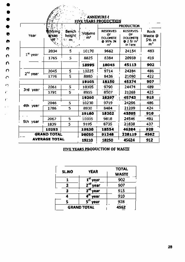
~~1:; .· ; ·~ ·~·:' '0 V · ' ., ~·\ ANNEXURE·!
/j ' '> FIVE ~EARS ROPU :..: ~:.;; ... ''· PRODUCTION
"l, {f'\ \: •' _ I I
~ j<irrg Bench , · . • RESERVES RESERVES
Year ll(e•s ·' heigh~ . ··Y<>.IJ'!"e OF OF
·~·· ' m DOLOMITE OOLOMJTE ' ~ ... •\.:f'r-m.. . . • @95% IN 0 2 .5/ m' .. •.-·' ·•, -::.... ~-:-.• m> in Tons
2034 5 10170 9662 24154 ln year
20959 1765 5 8825 8384
18995 18045 45113
2""' year 2045 5 10225 9714 24284 1776 5 8880 8436 21090
19105 18150 45374
3rcl year 2061 5 10305 9790 24474 1791 5 8955 8507 21268
19260 18297 45743
4th year 2046 5 10230 9719 24296 1786 5 8930 8484 21209
19160 18202 45505
5th 2067 5 10335 9818 24546
year 1839 5 9195 8735 21838
10253 19530 18554 46384 GRAND TOTAL 96050 91248 228119
AVERAGE TOTAL 19210 18250 45624
flYE YEARS PRODUCTION O.f.W~Sll'
SL.NO YEAR TOTAL
WASTE
1 1" year 902 2 2"" ye ar 907 3 3'" year 915 4 41
" year 910
5 s'" year 928 GRANO TOTAL 4562
Rock Waste@
5% ln m>
483
419
902
486 422 907 489 425 915 486 424 910 491 437 928
4562
912
28
• • • • • • • 0
0
0
0
()
0
0
0
0
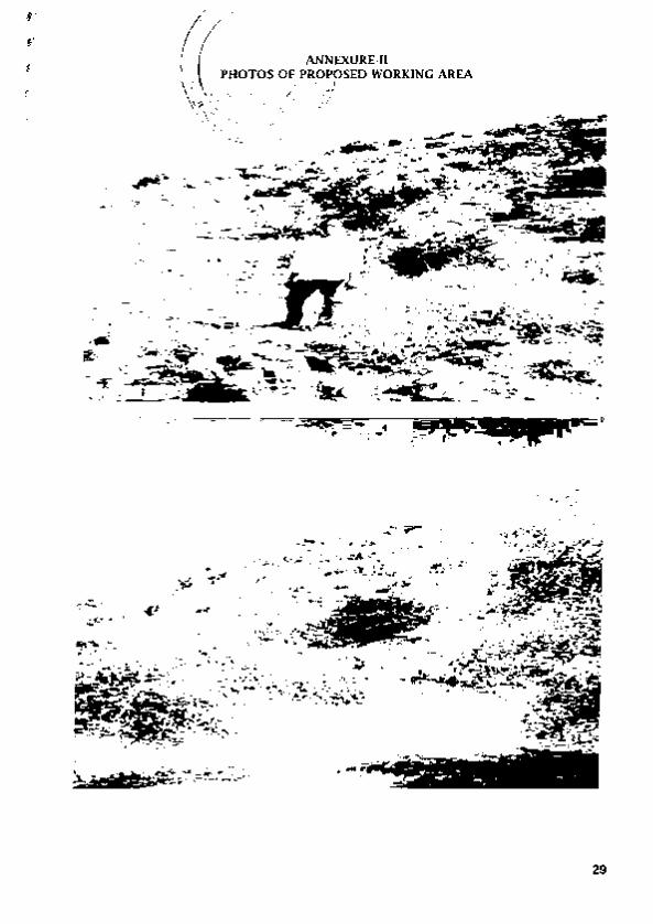
29
• • • • • • • 0
0 ('I
0
0
0
0
0
0
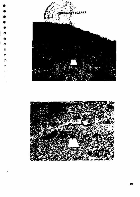
30
• • • • • • 0
0
0 ()
0
0 0
0
0
0
0 (
31
• • • • • 0
• n f)
0
0
0
0
n 0
0
;~tt
i:; ~E-m fy +· COVCRHH~NT OF ANDHRA PRADII.SH
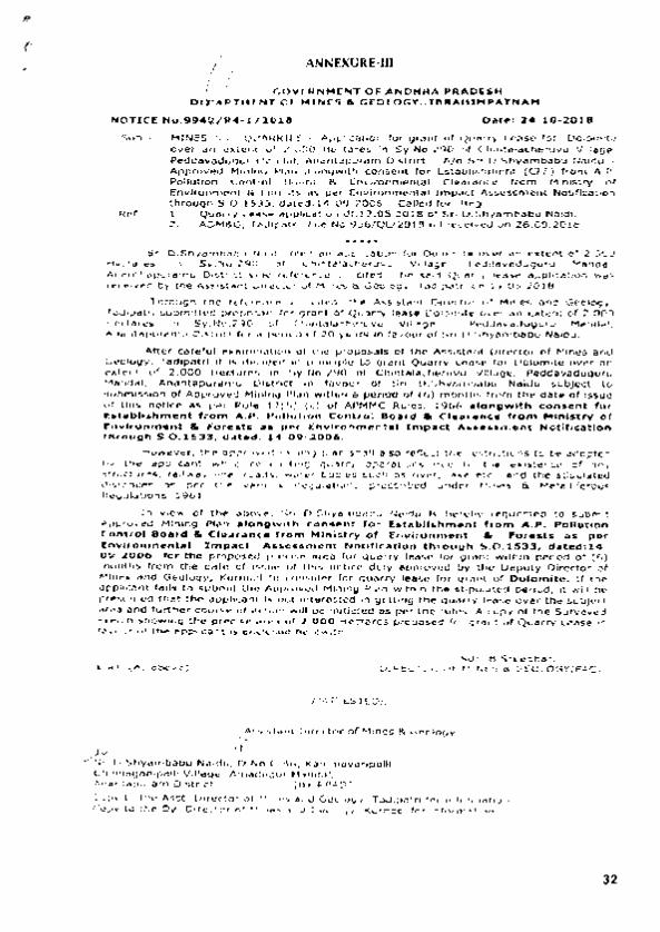
0 I.HT Q .. MIN~ a G£0LOGY;:U"-AHJN .. ATNAM t
HOTlCir N o.9M /2-0la • • D•te: .2:4•1.0•201e .
SuD:- MINES ' P. ~ARJilU~S - Ad~Ucn tor orant or QOany Lease tol Do1omlte ovw an iJJ(t~ ~ 2.000 HQCtares In Sy.No.290 of C~lntaJ.chenNU Vlll..g•, Pcddov"dvoUr t4•ndat; An~upuram Ol~tr1<t - A/0 5J" 0 Shyambabu No.idu -Approved "1•n1~ Pt.u Wdort9wlth consent 'or ~tabllollhmont (Cf'E) from A.P . Polh.ttton Conlm"r Doorct $. EnvJronment..l Clearenc;w from Mlnt~try ol Environment & ,..oroats •• &M~r envlronmenlal amp.oc:t Mc.eumcmt NotifiQtJcm through S.0.1SJ3, dol.-ct: 14...()9·2006 .. Celfed for~ A.ea.
R~:· t. Qt.~arry L••~4 .fil)lte•Uofl dt.l-7.05.1:018 of Sr'l O.fthyamOattu N&Uctu Z:. AOMI!kG, Taeftpotrl l'•lc. No.9S6/QCJ2018 1\ll NC .. Wd on 26.09.201.8.
Srt O.Shy&tr\'beb\.1 N••dU Al..o al'l •PP&i<.atJ:>n to. DoJomlt• OYfH an e'Ctent 01 2.000 HIKt-.res 1n Sy.N0.290 01 Cftu\taJJIC'II..-uvu Y.tlas~e, Aldct•w.duvuru H...-.del. AtMnttt.puf'e:tnu Otst.ttct vfoo rctorence 1*'- otut. lbe Nt4 Qu•NY lealoe application w•s ,-ec;etvtd try the~~ Ohec\Ot' ol Mines a. Geocogy, Tadlpt;tn eft 19 05.2018.
Through tttr rel.rf"tnu , ... o~, u~ Assi~t DintetOf" o1 MH"te&: and Geolc>OY. T~lpatrt sutwnftlcd p,-opouiJ: tor granr of Quarry, .... Ootom;le ovw •o 8Jd:ant of 2..000 Hectarn .n Sy.No.2510 o1 C~ntalac:heruvu Vllte-gc# ~•v•dvouru M•nda•. Anantapurernu O l•t•lc::t fot • Pll'-oG ol 2.0 yea,..- tn revour or Sn O.Shy•mbebu Naidu.
After c:ar•.tul •••mlnaUOII or che pr·opo.s3ts of t11o Al.sWtlmt Oirec:cor cf Mtnes and G•otocw. TadtP4t'' It •s d.c:•ct•ll In principle to orant Querry e...s• ror Qok)mne OVC"' an exl.nl of 2 .000 Hec:.t~H'ttS 1ft Sy.NIJ.290 Of Clltnt•laC:htUVV'-1 Vlll~e, Podei~Vild4JQIUI'U M~tnd•l, An011ntap1.u·•mu Olct"a tn rov~r Oi Sn D.Shy•u'nb•bl.' Naidu wbJect Lo tubtnl$~ttOM of Appl'oved Hint no pton wrthl.n a periOd of (G) tnontntc trom the oet.e of fssue ot t:hls noUc;;e as pet Ru.l4 J2(S) (c) ot APMMC R.utcs, 1t66 •to"gwfth consent for art•blbhment fro"' A..P. PoHutlo~ Conuot aoarel a Cl-n.ftc. ff'om Mln'-try of Cnvl.-ot.,n-.nt • Po,...ts a• per anvlf'onm..,tal 1mp.acc ......... ...,...1\t Notlna.UOft througr. S..0.1S3.3, d•t411fl :14_.,0.,.~00-&.
Howeve-r. the •pprOvtCJ mining pan sr_..B arso re.nect the rKtncuons to De adoptc<' by the ap.pOcant wh .. concf;.~cttno ~ o:;Me...UC~~ra ctu. to the ulsten.ee of iN'lY .JCA.!Ctura, r.llto"ay ,,., toed .. ~•' bodies such •• niii'IH", lak41 • tc •• a nd tiM: s-Upulated dtaenoas • per tn.e v•rtou. lltO"Qu:latk>t's prescribed undtr Hines a. Hetallif~~ "-ou&<t~s. 1961.
In view or the: •bov•• Srl 0 ,$hyornbo.bu Hotelu Ia Mr•bV l'ltQUI!Sted to .ubn\rt Approved Mlning Pt•n ••ongwlth eonM.nt. fOf' IE•tabll• hment hom A.#. Pollution Cont rol 808rd a C .. 41r~nc• f ro"" ,..lnlsuy of hvL-o:nrn•nt • Por ••t.s as p•r lnvlronm•nbl lnlpac.l A••"•m•nt N ot.Jt'Jcatlon through •.o • .t•''' datedr14 .. o•· 2 00fi tor ttle pf'OP0$4d pr•clac• area for qu&F'f"Y teeM fOf 01'8t'lt wUhln Pll!l'lod of (6) tnOr\ths (fOI'O the dbh: Qf 1St.l•41 Of Lhl• notice duly approved bV ,.,. Depvly Otre.ctor of Mlnt.J end Geology. Kumool to COIIJkk::r ror Quany leas• ror oranL or Do&omlt~. It the op~Hk:ant UJ•It to subn,ll «•• API)n)Yifild MlnilloQ Plo~M"~ wlthJn th• U1puftttd Pt~rlod. it wiH bO presumed that the ap~KAI1t I• not lnt•rested •n gett•ng t.h• queny I«•M ov.,- the sub)eel .,... •nd tuf"ther oounl• of action w~n be ln.ltleted os ptr the ""~· A copy at the SUI'Ve'yed '*ctdt ~w•rtG the- prectw arH of 2.000 .._a.,.cs prc~H for,,..,, ~ Qvony &A:•s. •n 'bVOUt' of.,.. appt~nt .. e.-KkHfolf Mf'ewl:th.
Sdl· B-51"'tedn.t". U.uttC'lOK V .. M1HU • GEOLOGY(FAC)
//An£$TEO// ,, As;~t"t.tn~ O~rector .oi'Mlnes & Geology
i( ,.;~I O,ShyarnNbu N;aldu, O. No.C•-46• KammavMiJM~III,
Chtnf'\b90ntpaf1! Vlllet.gc, Ar'n.CfiQur M•ndor. Artan,apu,am O:strtct.-···· .... 4·-·" a:ev lltPAD] COpy lO Uw Asst. Oltectot Of MtnOI • nd G.o!ogy, TodiPftn rCK tnformet~on. Copy to tf'l.o 0y Olreet~ af Jtot,,.. •.,Cf Geotogy. Kwrnac4 fOI' Jnfor,.,.tfor'l
32

• • • • • • • 0 0 0
~
()
'()
0 CJ
0
11 J'
General In _ection ~Survey Co., {lndia)Pvt. Ltd., Reg. Offica : 8/tC, Diamond HarbOur· Road, KOU<ATA • 700 027. CABLE : INSPECTA PHONE : 4483000
4398524/26.
PVT fl702/S 11/ 16702 Rei. No :
Branch Ollie. : K.S. Quarters, Kottapet•, DHONE • 581 222 Oist : KumOOI (A.P.) CABLE : GISCOL PHONE : 222262
Data : .~:.1. !:~!.~ ............. . TEST CERTIFICATE
We hereby certify tha!OO< oample o( Dolomite (as declared) sent to u< on S.l1.2018 by MIS.Sh~ Babu.AJuutapur, has been anai)~Cd in our laboratory with the following results:
Sy.No. 290 CXlelll2 HeetO<J, Cblntalachervuv,(V). Pedduvoduguru (M)
RESULTS ON TilE SAMPUi L>1U1ID AT !05oC.
Sample Mart: Pit· 1
SiliCa (So02) 3.40% Alum.ina (AI203) ... 0.91%
lron Oxide (Fc203) ... 0.96% CaJcium Oxido (CaO) 30.7S% Magnesium Oxide (MsQ) 18.76% Loss on Ignition 44.rn>
SAMPLE NOT DRAWN BY US •
OEI'II!RAL lrtSPBCTIOI'! et SURVEY CO.(li'IDIAJ PVT. LTD •• ( ~*·r. .,r. n; t.ltd.
33

• • • • • • 0 ., 0
0
0
()
lJ
0
n
n
PVT /l70:1/SIIIJ6703 Ref. No :
ey Co., (lndia)P'vt. Ltd., lltonch O'fa : K.S. QuartOfS,
KcCt-... ~NE·581 m Dill : Kurnool (A.P.) CABLE : GISCOL PHONE ; W262
Date : .. ~:.11:.2~!.'. ............ . TEST CERTIFICATE
We neroby certify thalone $3J1\ple of Oolomhe (ll< doolorod) 11<1ltlo us on S.ll.2018 by MIS Shyam Babu,Anamapur. has been anaJyscd in ow laboraJory wnh the foJJowi.ngresults::
It£SUll'S ON'IH6SAMPLEDRIEDM JOSoC.
s-pe Marr Pit·l
SJhca Alununa
lrMOlcide C.lclum Oxide Magnesium <hide Loss on Jgnition
CSIOl) (AI203) ••
(Fel03) (C.O) (MI!P)
SAMPLE NOT DRAWN BY US :
310lo
010% OSO%
3MS'l4 19 36% 4s .m~
O~I'IERAL INSP~91'18t SURVEY CO.fii'IOIA) I'VT. LID ••
(~ . I'.~~= ·~1\r.!l!c!..
34

• • • • • • • 0
C't
0
0
0 ()
0
0
0
,,
-GOVERNMENT OF ANDHRA PRADESH
DEPARTMENT OF MINES AND GEOLOGY
CERTIFI CATE OF R EG IS T RATION
AS Q UALIFIED P ERSON TO PREPARE MINING P LAN
(Under Rule 14(2) of G'*nlte Conservation and Dov•lopm•nt Rul~s J999}
Sri C'! I:."SUI.41( UH01))~ S/o G PnkAiri Rf!tltly. Rio No: 13-2-155-1.
Ptn:wwnf/ti)'Qiff, N~..tU' R. 7:C. Bus Stand, Anantlwpurmn. wlrost: ph<JIO!;.rL,plr and
signtJtun: is q/Jixed he1Y.in abow~. llm•ing gh't!n (•\•idem:r <'f his qua/ificalicm and
1!.\"}X'rit?n<-'(! is h(!TY.tby gmnred l't'llt-'>1.-al t~{ rl!cOg,itlon under l'llle /4(]) of Cnmire C(mSen¥11/Qn & Dev('/opnwm Rules 1999 us Quol!fied f'e,.;ron tu
prepare 1\lining P/(ln,
RL>gisrration Number is . RQPjDMG/AP/07/20~4
nu's Recognition is WJJid ftJr (I period c?t /(/ Y<!(JI"S wil.h e;Uet.'l jium
}}, 12.21)14
11Ji,r ccrrificate will liable to IN wilhtlruvmlcmu:t>IJed in rite evt:nr ol
.fu,.mshing lht' wrang information /documents in the Mining Plar1 .~thmilte<l by
him
Place: Hyderabad Dmc: ).'l-- .12. 2014
35

• • • • • • • 0
0
0
0
0 I)
0
0
0
' """"'-"'- ·-¥- 2tdl ¥
TE OF Rl ...., NITlOH AS UA£0 efl'SON (UnderRlie22C <1118>11'C!Con- "")
Sliri ~.Dfljl_ Slo l f>edM 'Pal< RJo.o ., ,., . SlUr..& NlllJQT, ''"' , ,
• •I• Pbolowaph md ~-e is af6xed ba:eia~.-~ ba:..-iQa. gt6'ell
loati&t'"...c:wr)' cridenor- of bis q~:klns & ~~ is he:rd:Jy R.F.(X)GNJS£0 undo: .Rule 22C .,.. tic MiDcrol ~Rules. l!)(iQ ""a O .. ld....t 1\2'"'"' t<> ""''""e Mioill8 -....
WTilft ~ m- ~ HU rogi!ll:ndioo ~ i~
llQl'/ 11\1)/;tO:l/'lOI:I/ ,\ J
36

f ,I (~ I ) I
I
I I
I l
I I
I
I 1 I
1 I
LOCATION CUM KEY PLAN
/ •.. ....
v!.•·
PLATE NO -I
*It·,
._.. £
'
INDEX
~ SRI.O.SHYAM BABU NAIDU.,
~ ........... :l ' -r-._ ...
Signature of R.Q.P G. ESWAR REDDY. •.sc..s.r.. Pb o
Recogmsed Geofog•st 18MIRQP/HYOI'l01/201'VA
RCP/CMGJAP/07/2014
THSIS fOCEfmFY THAT THE IIFafM\llONIN T~ PLATE '5 l"l..l 1HJ COIVttcT 10 lHIH$TOf~WlD t.fl OH LEASE Mo\P AU'THENTICATEO 8Y STAll GIOYtFINIWlHf.
~~·----------------------------------------~----------~

• • • ft
ft
0
0
0 ..., ,
TOPOGRAPHICAL CUM GEOLOGICAL PLAN N325 .-------.--------.-------.-------.
, APPROVED
N150
Gao Coordinates of lease area Datum WGS-84
POINTS LATITUDE LONGITUDE
BOUNDARY PILLARS
P1 N14' 58' 51.8" en· 46' 45.3"
P2 N14' 58' 57.3" E77' 46' 47.9'
P3 N14' 58' 53.4" E77' 46' 49.6"
P4 N14' 58' 47.2" E77' 46' 51.0"
P5 N14' 58' 48.1" E77' 46' 49.5"
P6 N14' 58' 49.7" E77' 46' 49.0"
P7 N14' 58' 51.3" E77' 46' 47.1" E200
N
·• · PLATE -Ill
s
0
MINING PlAN FOR DOLOMITE
SRJ.D.SHYAM BASU NAJDU., IN &.F..No-.290, &1..2.000 Hecta. ~N).
Poddavadugur(M), ....._...,. (!);"~ AndhraProdeol\.
TOPOGRAPHICAL CUM GEOLOGICAL PLAN
Applleon,_ SRI.O.SHYAM BABU NAJDU .. D.No.C-48. Kamrntvlrlpelll, ~~VI!ag<>. _ ......... -· Olotl1cl. CONTOURS tHTERVAL:- 2m SCALE.'-1:1SOO
~~t -~ S~oiR.Q.P ~ G. fSWAR RfOO~ II.S<,.B.L. "'·"
Recogmsed Geolog,st 18'."R<lP/HYr>n02J201 ' lA
ROPtOMCtnciv7'!:l14 THIS IS TO CERTIFY THAT THE INFORMATKIN IN 'ffiiS PLATE IS TRUE NfO CORRECT TOniE BEST OF KNOWLEDGE BASED UP OH LEASE fiW> AUTHENTICATED BY STAlE GO\IERNMENT.

GEOLOGICAL CROSS SECTIONS
I APPROVED
A 330..
320
260
3 B
3 20
3 10 ........... ., .... . ·.,· .. ·.: .. ·.t:.·.· .. ••
Ou- ·~·················· •••• ..... c ............................. ...... •• ••••••••••••••••••••••••• , ... ... .............................. ..... 9 .. ••••••••••••••••••••••••• • ••• 3
90 ... ........................... •••• •• ••••••••••••••••••••••••• •••• ... ............................... .... •• ••••••••••••••••••••••••• . .... 2
2 80 ... •• ........ , .. ................................ ••••••••••••••••••••••••• •••• ••••
••••••••••••••••••••••••• • ••• .. .......................... ..... 0 ••• ......................... .. ... .. ~¥Y'II'Y~YY¥VYVVYVVVVVVVVVVV
••• .......................... • ••• •• ••••••••••••••••••••••••• • ••• 27 ... ........................... •••• .. ......................... ..... 26 0 • •• ............................ '"""
B3ao
320
310
300
290
280
270
260
320
310
300
290
270
260
PLATE - IV
INDEX
DOlOMITE
BUFFER ZONE
MOVB>ZCIH!!
PROIWIU!
MINING PLAN FOR DOLOMITE
SRI.D.SHYAM BABU NAIDU., IN 8.F.~.290. &1.2..000 Hecil, Oil'!~ (\I).
Peddavadugw {M)- Anantlpurwnu (Dilt), Andt'lraP~ .
GEOLOGICAL CROSS SECTIONS
BABUNAIDU.,
-=--~ ~ '-~ __]2-Signature of R.O.P
G. ESWAR R!DDY, M.S.:.,u,""" Recogn.sed Geolog•st
18J'O•RQP/"Y!V10V201 'l/A RQPIDMvll\,-107':'0 14
THISlS TO CEfUIFY THAT TME IHFORMAOON IN TMIS PlATE IS TRUE AHO c::x::RRECT TO TIE BEST Of KHOWI.EOOE BASED UP ON LEASE MAP AUTHEHTM::ATED BY STATE GOVERN.l"ENT.

EAR WISE WORKING PLAN & SECTIONS FOR FIVE YEAR N325
• • \
0 I'
0
0 C)
,., I)
, APPROVED
Geo Coordinates of tease area Datum WGS-84
POINTS LATITUDE LONGITUDE N
BOUNDARY PILLARS
P1 N14' sa· 51.8' E77' 46' 45.3"
P2 N14' sa· 57.3" E77' 46' 47.9"
P3 N14' sa· 53.4" E77' 46' 49.6"
P4 N14' 58' 47.2" E77' 46' 51.0"
PS N14' 58' 48.1" E77' 46' 49.5"
P6 N14' sa· 49. r E77' 46' 49.0'
P7 N14' sa· 51 .3" en• 46' 47.1"
N
·• · s
PLATE- V
I·YEAR
II·YEAR
Ill -YEAR
IV- YEAR
V· YEAR
MINING PLAN FOR DOLOMITE
YEAR WISE WORKING PLAN & SECTIONS FOR FIVE YEARS
OOHTOURS INTERVAl.:· 2m
Jl~ Signa1ure of AWiicant
~.,.-~ ~-Signalln of R.Q.P G. ESWAR R£00" M.s. .. ou. Ph.O
Recogn•sed Geolog•st 1Br.A/RQPIHYDI3021201'11A
RQP/OMG/AP/0712014
THIS IS TOCERTFYTHAT THEINFORI.tATIOH IN Tt'IS PlATE
IS 'nUJE N«J CORRECT TO THE BEST OF KNOWLEDGE BASED UP ON LEASE MAP AUTHENTICATED BY STATE GOVERNMENT.

CONCEPTUAL PLAN AND SECTIONS N325r-------.------..------,-------,
: APPROVED
Geo Coordinates of lease area Datum WGS-84
POINTS LATITUDE LONGITUDE
BOUNDARY PILLARS
P1 N14• 58' 51.8" En· 46. 45.3"
P2 N14• 58' 57.3" en• 46' 47.9"
P3 N14• 58' 53.4" en• 46' 49.6"
P4 Nt4• 58' 47.2" en• 46' s1.o•
PS N14• 58' 48.1" en· 46' 49.5"
P6 N14• 58' 49. 7" en• 46' 49.0"
P7 N14• 58' 51.3" e1r 46' 47.1"
PLATE- VI
MINING PLAN FOR DOLOMITE
CONCEPTUAL PLAN AND SECTIONS
--SRJ.D.SHYAM BABU HAJDU., D.No.c-46, _.,....
~~~--
J~-Signature or Appfocant
- __::..__ I ~ }\_ ~..,---- _.)
Slanatute of RQ.P ~ G. £SWAR RfODY, lo(Sc .• B.L .... o
Recogn1sed Geologtst IE't•' IRQPIHY01102/201"JA
f<QPIOMG AJ-i0 7 /2014
TMIS IS TO CERTIFY TMAT THE INFOAMATIOH IN THIS P\.ATE IS TRUE AHD CORRECT TOnE BEST OF KNOWl.EOGE BASED UP OH LEASE MAP AUTHENTICATED BY STATE GOVERNMENT.

tl
ENVIRONMENT PLAN
vvvvvv vvv
v vvvvvv
vvv v
vvvvvv vvv
v vvvvvv
vvv
vvvvv vvv
v vvvvvv
vvv vvvvvv
vvv v
vvvvvv vvv
v
v
vvvvvv vvv
v
vvvvvv vvv
v
v vvvvvv vvv
v vvvvvv
vvv v vvvvvv
vvv v
vvvvvv vvv
v
vvvvvv vvv
vvvvvv vvv
v
vvvvvv vvv
v
vvvvvv vvv
v
vvvvvv vvv
vvvvvv\.___ v vvvvvv vvv vvvvvv
vvv
!APPROVED
v vvvvvv
vvv
v~v ~ vvvvvv ------
v
vvvvvvvvvvvv vvv vvv
v v vvvvvv
vvv v
vvv v vvvvvv
vvv vvvvvv
vvv v
vvvvvv vvv
vvvvvv vvv
v
v
vvvvvvv vvv
v
vvvvvv vvv
v
v v
vvvvvv vvv
v
vvvvvv vvv
v
vvvvvv vvv
v
PLATE- VII
MINING PLAN FOR DOLOMITE
SRI.D.SHYAM BABU NAIDU., IN &F.No.2QO.Ed.UIOO tiM:ta. Chi'lr.l.:t.rvrv M.
PeddavO<f"'IU' (M), ......._....,. (Oiot), An-ENVIRONMENT PLAN
J:~v. Signature of Applicant
-:3d --~ ~~ Signatum ol R.Q.P
G. ESWAR REDO~ M.Sc .. s.L. ... o Recognised Geo.logJsl
18'. '" OP/HVf'1'1Q2/201 "'A ROPtOMG/Xt-107'~014
ntiS rs TO CERTIFY THAT THE INFORMATION IN THrs PlATE
IS TJWE At«) CORRECT TO THE BEST OF KNOWL.£DOE BAS EO UP OH LEASE MAP AIJJ'HENTlCATED BY STATE GOVERNMENT.
Related Documents