Zonal Development Plan of Nagar Nigam Jodhpur (North) Zone 2031 JODHPUR DEVELOPMENT AUTHORITY, JODHPUR GOVERNMENT OF RAJASTHAN

Welcome message from author
This document is posted to help you gain knowledge. Please leave a comment to let me know what you think about it! Share it to your friends and learn new things together.
Transcript
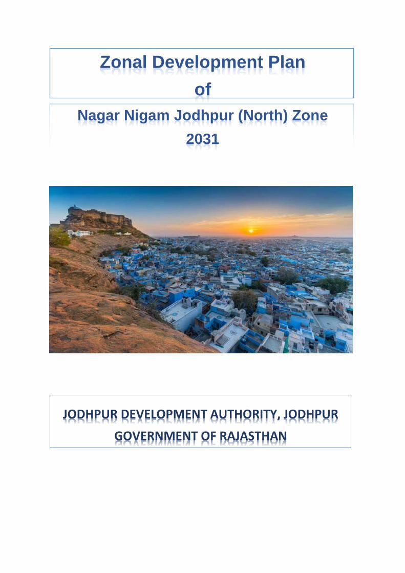
Zonal Development Plan
of
Nagar Nigam Jodhpur (North) Zone
2031
JODHPUR DEVELOPMENT AUTHORITY, JODHPUR
GOVERNMENT OF RAJASTHAN

Zonal Development Plan of Nagar Nigam North Zone, Jodhpur
2
CONTENTS
1 INTRODUCTION 7
REGIONAL SETTING 7
1.1.1 PHYSIOGRAPHY 7
1.1.2 REGIONAL CONTEXT 7
1.1.3 ROAD LINKAGES 8
HISTORICAL BACKGROUND 9
1.2.1 DEMOGRAPHY OF THE TOWN – GROWTH TRENDS 10
MASTER DEVELOPMENT PLAN – 2031 12
ZONAL DEVELOPMENT PLAN 14
1.4.1 DELINEATION OF ADMINISTRATIVE ZONE 14
1.4.2 DELINEATION OF WORK AREA 14
2 ANALYSIS OF NAGAR NIGAM NORTH ZONE 16
LAND USE ANALYSIS AS PER MASTER PLAN 16
LAND USE ANALYSIS (AS PER EXISTING CONDITIONS) 17
2.2.1 RESIDENTIAL 18
2.2.2. COMMERCIAL 18
2.2.2 MIXED LAND USE 18
2.2.3 INDUSTRIAL 18
2.2.4 GOVERNMENT AND SEMI-GOVERNMENT 19
2.2.5 PUBLIC SEMI-PUBLIC 19
3 PLANNING POLICES AND PARAMETERS 22
RESIDENTIAL 22
COMMERCIAL & MIXED 22
3.2.1 COMMERCIAL, MIXED, WHOLESALE, WAREHOUSING 22
3.2.2 URBAN STREET VENDORS 23
3.2.3 NORMS FOR URBAN STREET VENDORS 23
SOCIAL INFRASTRUCTURE 24
3.3.1 EDUCATIONAL 24
3.3.2 HEALTHCARE 25
3.3.3 SOCIAL, CULTURAL AND RELIGIOUS 25
3.3.4 OTHER COMMUNITY REQUIREMENTS 26
Zonal Development Plan of Nagar Nigam North Zone, Jodhpur
3
3.3.5 SAFETY MANAGEMENT 26
PHYSICAL INFRASTRUCTURE 27
3.4.1 WATER SUPPLY 27
POWER SUPPLY 28
3.5.1 DRAINAGE SYSTEM 28
3.5.2 SEWERAGE SYSTEM 28
SOLID WASTE MANAGEMENT 29
RECREATIONAL 29
3.7.1 ORGANIZED GREEN SPACES / SPORTS FACILITIES 29
TRANSPORTATION 30
3.8.1 ROAD 30
4 PROPOSALS – STRATEGIES AND POLICIES 32
PROJECT DEVELOPMENT STRATEGY 32
POPULATION PROJECTION 2031 32
FACILITIES CALCULATION AS PER PROJECTED POPULATION 34
PROPOSED FACILITIES FOR NORTH NAGAR NIGAM ZONE 35
4.4.1 PROPOSED ZONAL FACILILTY AREA: 35
4.4.2 PROPOSED ROADS 36
4.4.3 PROPOSED SAFETY FACILITIES: 36
4.4.4 PROPOSED PLANTATION: 36

Zonal Development Plan of Nagar Nigam North Zone, Jodhpur
4
List of Figures
FIGURE 1 LOCATION OF JODHPUR .................................................................................. 8
FIGURE 2 VIEW OF JODHPUR CITY ................................................................................ 10
FIGURE 3 PROPOSED LAND USE PLAN JODHPUR- 2031 ................................................. 13
FIGURE 4 MAP SHOWING LOCATION OF NAGAR NIGAM NORTH ZONE ON MAP OF PLANNING
ZONES FOR JODHPUR .......................................................................................... 15
Zonal Development Plan of Nagar Nigam North Zone, Jodhpur
5
List of Tables
TABLE 1-1 POPULATION GROWTH DURING 1911-2011 .................................................. 10
TABLE 1-2 WARD WISE POPULATION 2011 ................................................................... 11
TABLE 2-1 ANALYSIS OF PROPOSED LAND USE AS PER MASTER DEVELOPMENT PLAN – 2031
.......................................................................................................................... 16
TABLE 2-2 EXISTING LAND USE CLASSIFICATION ............................................................ 17
TABLE 2-3: ANALYSIS OF EXISTING COMMERCIAL LAND USE .......................................... 18
TABLE 2-4: DETAILED ANALYSIS OF EXISTING EDUCATIONAL FACILITY ............................ 19
TABLE 2-5: DETAILED ANALYSIS OF EXISTING HEALTHCARE FACILITY ............................. 19
TABLE 2-6: DETAILED ANALYSIS OF EXISTING SOCIAL, CULTURAL & RELIGIOUS FACILITY . 20
TABLE 2-7: DETAILED ANALYSIS OF EXISTING RECREATIONAL FACILITY .......................... 21
TABLE 3-1: HIERARCHY AND NORMS FOR RESIDENTIAL AREAS ....................................... 22
TABLE 3-2: HIERARCHY AND NORMS FOR COMMERCIAL CENTERS .................................. 22
TABLE 3-3: NORMS FOR INFORMAL SHOPS / UNITS FOR URBAN STREET VENDORS ........... 24
TABLE 3-4: HIERARCHY AND NORMS FOR EDUCATIONAL FACILITIES ................................ 25
TABLE 3-5: HIERARCHY AND NORMS FOR HEALTHCARE FACILITIES ................................. 25
TABLE 3-6: HIERARCHY AND NORMS FOR SOCIO-CULTURAL AND RELIGIOUS FACILITIES ... 25
TABLE 3-7: NORMS FOR CREMATION AND BURIAL GROUND ............................................ 26
TABLE 3-8: NORMS FOR POLICE FACILITIES .................................................................. 26
TABLE 3-9: NORMS FOR SAFETY FACILITIES.................................................................. 26
TABLE 3-10: DISTRIBUTION SERVICES .......................................................................... 27
TABLE 3-11: PROPOSED WATER SUPPLY REQUIREMENT OF THE ZONE ........................... 28
TABLE 3-12: HIERARCHY AND NORMS FOR ORGANIZED GREEN SPACES ......................... 29
TABLE 3-13: HIERARCHY AND NORMS FOR SPORTS FACILITIES ...................................... 30
TABLE 3-14: MINIMUM STANDARD FOR ROW OF VARIOUS ROAD WIDTHS ........................ 30

Zonal Development Plan of Nagar Nigam North Zone, Jodhpur
6
TABLE 3-15: CARRIAGEWAY WIDTH FOR EACH TYPE OF ROAD ........................................ 30
TABLE 4-1: ESTIMATED POPULATION PROJECTION FOR NORTH NAGAR NIGAM ZONE,
JODHPUR ............................................................................................................ 33
TABLE 4-2: EXISTING ZONE LEVEL FACILITIES OF NAGAR NIGAM NORTH ZONE ................ 34

Zonal Development Plan of Nagar Nigam North Zone, Jodhpur
7
1 INTRODUCTION
REGIONAL SETTING
Jodhpur is the second largest city in the state of Rajasthan. It is located 335 km west
from the state capital Jaipur and 200 km from the city of Ajmer. It was formerly the
seat of a princely state of the same name, the capital of the kingdom known as Marwar.
Being a place of princely palaces, magnificent forts as well as age old temples, this
city of Rajasthan is among the famous tourist destinations in the state as well as India.
Positioned in the Thar Desert’s stark landscape, Jodhpur experiences a bright and
sunny weather all through the year. For this, the city is also known as “Sun City”.
It is also referred to as the “Blue City” due to the vivid blue-painted houses around the
Mehrangarh Fort. The old city circles the fort and is bounded by a wall with several
gates. However, the city has expanded greatly outside the wall over the past several
decades. Jodhpur lies near the geographic centre of Rajasthan state, which makes it
a convenient base for travel in a region much frequented by tourists.
Jodhpur city is one of the major cities of Rajasthan. It is well connected to the rest of
Rajasthan by airways, road and rail links. This city basks in the golden history and
heritage of the state and is located at the fringe of the great Thar Desert. The city was
founded in 1459 A.D by the Rathore rulers.
1.1.1 PHYSIOGRAPHY
Jodhpur district is located in western part of Rajasthan, located between 26°00′ to
27°37′ North latitude and 72°55′ to 73°55′ East. Climate of Jodhpur remain extreme
hot in summer season, extreme cold in winter season. Day and night temperatures
increase gradually and reach their maximum values in May and June respectively. The
temperature varies from 48°C in summer to 4°C in winter.
1.1.2 REGIONAL CONTEXT
The city has well-established rail, road and air networks connecting it to other major
cities of the country. Jodhpur railway station is the Divisional Headquarters of the North
Western Railways (NWR). Jodhpur Airport is one of the prominent airports of
Rajasthan. It is primarily a military airbase with a civil enclosure to allow for civilian air
traffic. Due to Jodhpur’s strategic location, this airport is regarded as one of the most
important ones for the Indian Air Force.
Zonal Development Plan of Nagar Nigam North Zone, Jodhpur
8
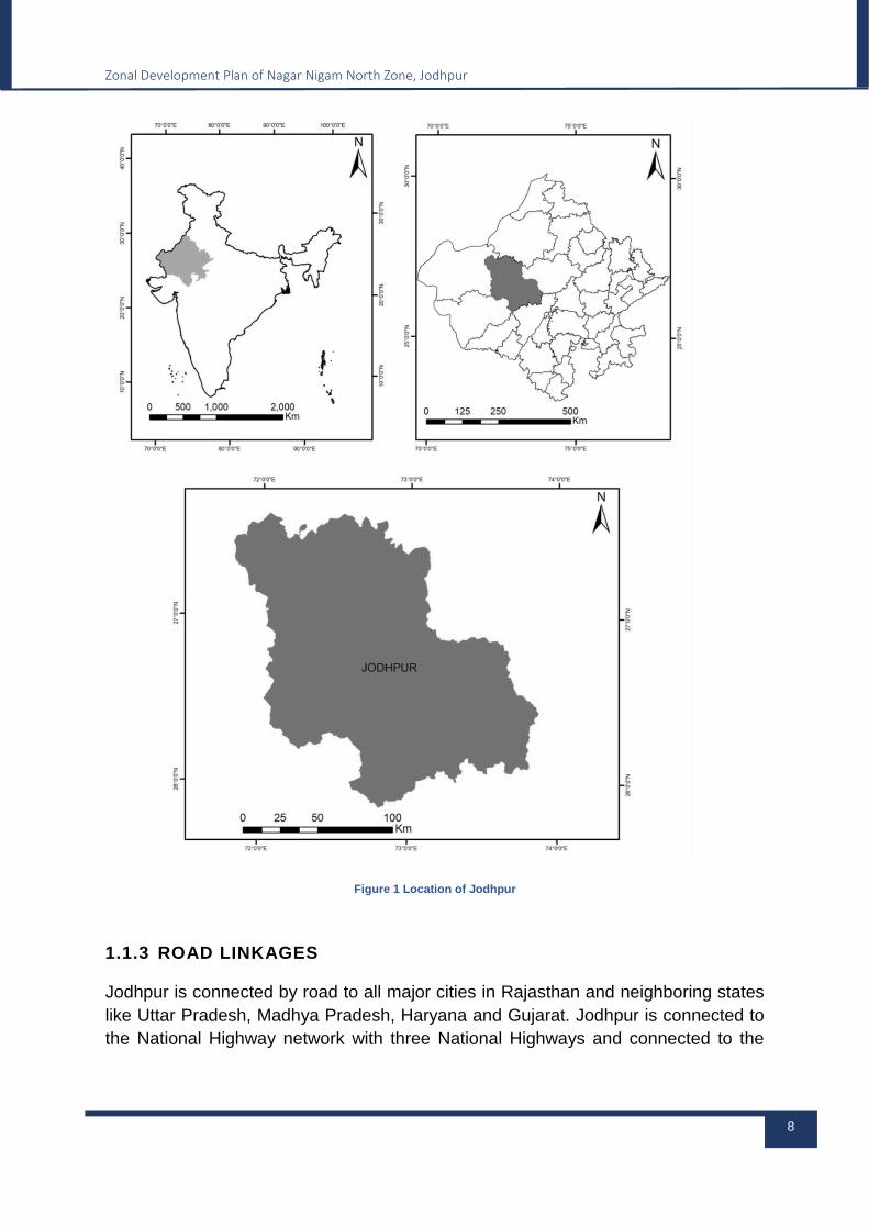
Figure 1 Location of Jodhpur
1.1.3 ROAD LINKAGES
Jodhpur is connected by road to all major cities in Rajasthan and neighboring states
like Uttar Pradesh, Madhya Pradesh, Haryana and Gujarat. Jodhpur is connected to
the National Highway network with three National Highways and connected to the
Zonal Development Plan of Nagar Nigam North Zone, Jodhpur
9
Rajasthan State Highway network with four state highways. Details of above are as
follows:
National Highways
NH-62, Ambala-Kaithal-Hissar-Fatehpur-Jodhpur-Pali
NH-25, connecting Jaitaran-Bilara-Kaparda-Jodhpur Kalyanpur Pachpadra-
Balotra-Tilwara-Kher-Bagundi Dhudhwa-Madhasar-Kawas and terminating at its
junction with NH 68 near Barmer.
State Highways
SH-58 connects Jodhpur with Bheem in Rajsamand district.
SH-61 connects Phalodi in Jodhpur district of Rajasthan with Mandal in Bhilwara
district.
SH-63 connects Banar to Kuchera via Bhopalgarh
SH-68 connects Dangiyawas to Balotra via Kakelao, Khejarli, Guda Kakani, Luni,
Dhundhara, Rampura, and Samdari.
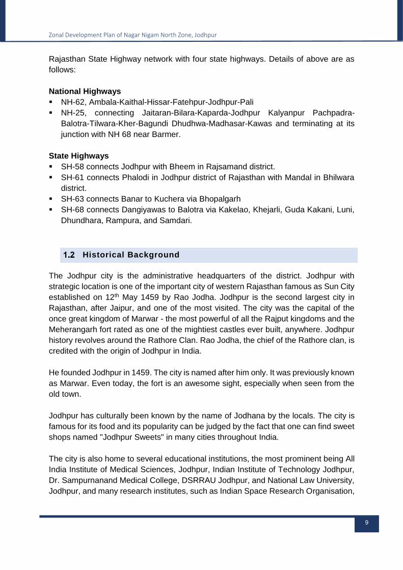
Historical Background
The Jodhpur city is the administrative headquarters of the district. Jodhpur with
strategic location is one of the important city of western Rajasthan famous as Sun City
established on 12th May 1459 by Rao Jodha. Jodhpur is the second largest city in
Rajasthan, after Jaipur, and one of the most visited. The city was the capital of the
once great kingdom of Marwar - the most powerful of all the Rajput kingdoms and the
Meherangarh fort rated as one of the mightiest castles ever built, anywhere. Jodhpur
history revolves around the Rathore Clan. Rao Jodha, the chief of the Rathore clan, is
credited with the origin of Jodhpur in India.
He founded Jodhpur in 1459. The city is named after him only. It was previously known
as Marwar. Even today, the fort is an awesome sight, especially when seen from the
old town.
Jodhpur has culturally been known by the name of Jodhana by the locals. The city is
famous for its food and its popularity can be judged by the fact that one can find sweet
shops named "Jodhpur Sweets" in many cities throughout India.
The city is also home to several educational institutions, the most prominent being All
India Institute of Medical Sciences, Jodhpur, Indian Institute of Technology Jodhpur,
Dr. Sampurnanand Medical College, DSRRAU Jodhpur, and National Law University,
Jodhpur, and many research institutes, such as Indian Space Research Organisation,
Zonal Development Plan of Nagar Nigam North Zone, Jodhpur
10
Defence Research and Development Organisation, Central Arid Zone Research
Institute, Arid Forest Research Institute, and Desert Medicine Research Centre are
also located in the city.
Figure 2 view of Jodhpur City
1.2.1 DEMOGRAPHY OF THE TOWN – GROWTH TRENDS
Jodhpur is the second largest city of the state. It has registered 10 times increase in
population during 1901 to 2001. During 1971-1981 there was phenomenal increase in
population with 59.42 percent increase.
Table below gives the details of population increase in Jodhpur city during various
decades.
Table 1-1 Population Growth during 1911-2011
S. No. Year Population Difference Growth Rate
1 1911 79754 645 0.82
2 1921 73480 -6274 -7.87
3 1931 94736 21256 28.93
4 1941 126842 32106 33.89
5 1951 180717 53875 42.47
6 1961 224760 44083 24.37
7 1971 317612 92852 41.31

Zonal Development Plan of Nagar Nigam North Zone, Jodhpur
11
8 1981 506345 188733 59.42
9 1991 666279 159934 31.52
10 2001 860818 194539 29.19
11 2011 1138300 277482 32.23
Table 1-2 Ward Wise population 2011
Ward Number Population (Census
2011)
Ward Number Population (Census
2011)
1 7702 41 7421
2 6426 42 6399
3 8854 43 9975
4 6462 44 6805
5 7454 45 9349
6 8329 46 11530
7 5912 47 7089
8 7328 48 5639
9 5932 49 6201
10 5929 50 6064
11 7409 51 6645
12 7457 52 6076
13 7463 53 5114
14 7129 54 6353
15 6974 55 6701
16 6862 56 6194
17 7847 57 6006
18 6354 58 4278
19 10289 59 4096
20 6744 60 4974

Zonal Development Plan of Nagar Nigam North Zone, Jodhpur
12
21 6319 61 5283
22 6462 62 5291
23 5873 63 6019
24 6821 64 4292
25 6510 65 7051
26 4777 66 6506
27 5975 67 7156
28 5436 68 8373
29 4845 69 10253
30 5423 70 4304
31 6270 71 5009
32 4751 72 4274
33 6244 73 4180
34 6443 74 2805
35 6029 75 9310
36 5875 76 7671
37 6828 77 4013
38 5932 78 6307
39 5848 79 6722
40 5088 80 8749
Source: Census 2011
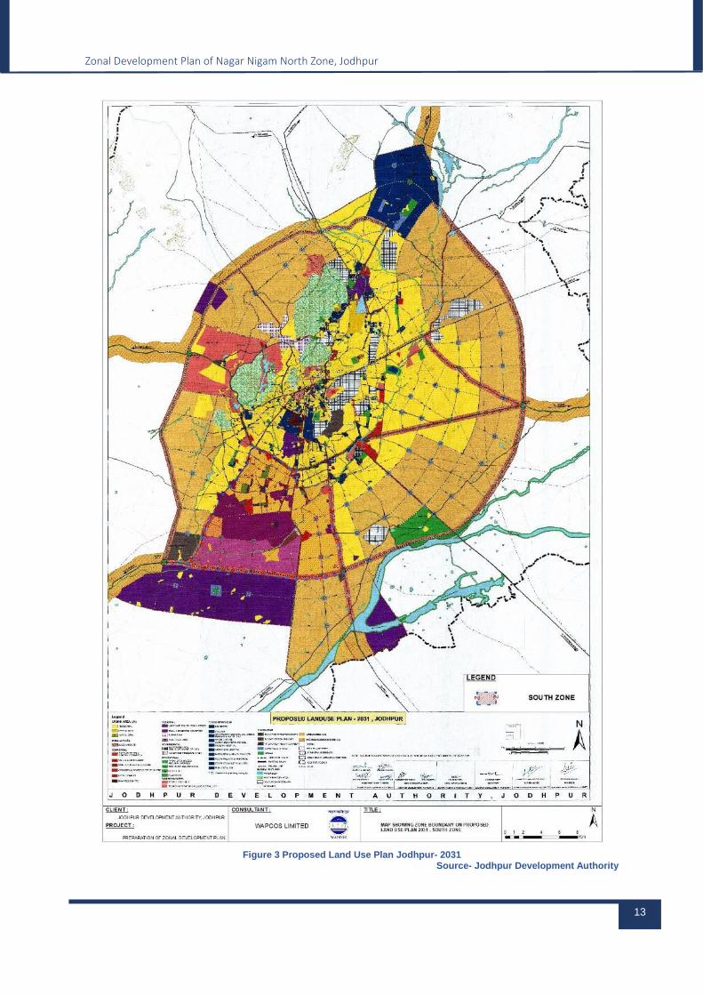
MASTER DEVELOPMENT PLAN – 2031
Master Development Plan of Jodhpur Area Approved vide Gazette Notification order
no F-37/D.I.R (P)/JDA/General/2021/1221 Dated Feb. 18 2021. Zonal Plans are being
prepared under Jodhpur development authority act in order to detail out proposal of
master development plan.
Zonal Development Plan of Nagar Nigam North Zone, Jodhpur
13
Figure 3 Proposed Land Use Plan Jodhpur- 2031
Source- Jodhpur Development Authority
Zonal Development Plan of Nagar Nigam North Zone, Jodhpur
14
Zonal Development Plan
The Master Plan – 2031 for Jodhpur Urban Area shows the proposed land uses
required at the city level based on the population projection for the horizon year 2031.
However, in the absence of proposals for zonal level land uses, the requirement of
zone level facilities is not ensured while approving layout plans. It is therefore, felt
necessary to prepare Zonal Development Plan in order to provide proper infrastructure
and urban facilities in accordance with the requirements of the growing population of
the zone and to ensure a healthy environment for the public. Urban Development,
Housing and Local Self Government Department, Government of Rajasthan, has
issued the guidelines for the preparation of Zonal Development Plans which will detail
out the proposals of Master Plan and thus will act as a link between the layout plans
and Master Plan, containing a zonal base map, existing land use map, land uses as
per Master Plan, land use, facilities, road network plan required at zone level and land
reservations for water bodies & forests etc. as per revenue record and other specific
provisions as per zone requirement, if necessary. The Zoning Regulations will further
ensure the zone level social infrastructure facilities and will provide guidelines to permit
various uses / activities in the proposed use zones of Zonal Development Plan.
1.4.1 DELINEATION OF ADMINISTRATIVE ZONE
Jodhpur Master Plan 2013-2031 is proposed for an area of 446733.94 hectare with
395 Revenue Villages & Jodhpur city. They are as below:
South Planning Zone
North Planning Zone
West Planning Zone
East Planning Zone
1.4.2 DELINEATION OF WORK AREA
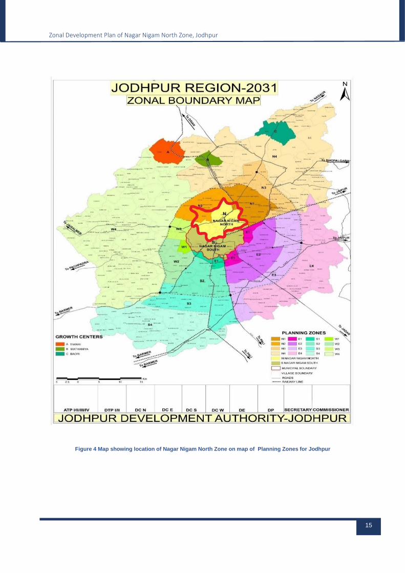
As per Jodhpur Master Development Plan 2031, there are 4 Major zones which are further subdivided into 18 zones Planning Zones.
Nagar Nigam North is assigned to Acro Ventures Limited Pvt. Ltd.
The extension of Preparation of Zonal Plan Nagar Nigam North. Covering about 11609 hectares.
Zonal Development Plan of Nagar Nigam North Zone, Jodhpur
15
Figure 4 Map showing location of Nagar Nigam North Zone on map of Planning Zones for Jodhpur
Zonal Development Plan of Nagar Nigam North Zone, Jodhpur
16
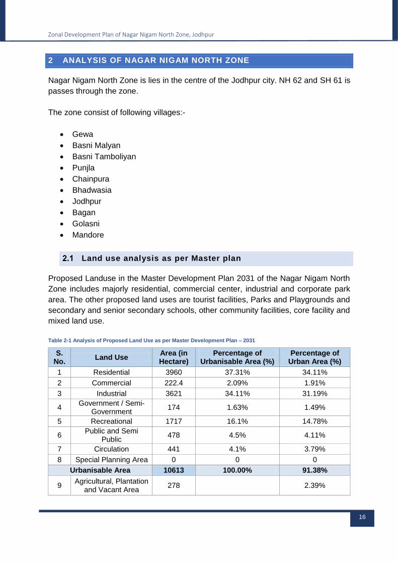
2 ANALYSIS OF NAGAR NIGAM NORTH ZONE
Nagar Nigam North Zone is lies in the centre of the Jodhpur city. NH 62 and SH 61 is
passes through the zone.
The zone consist of following villages:-
Gewa
Basni Malyan
Basni Tamboliyan
Punjla
Chainpura
Bhadwasia
Jodhpur
Bagan
Golasni
Mandore
Land use analysis as per Master plan
Proposed Landuse in the Master Development Plan 2031 of the Nagar Nigam North
Zone includes majorly residential, commercial center, industrial and corporate park
area. The other proposed land uses are tourist facilities, Parks and Playgrounds and
secondary and senior secondary schools, other community facilities, core facility and
mixed land use.
Table 2-1 Analysis of Proposed Land Use as per Master Development Plan – 2031
S. No.
Land Use Area (in Hectare)
Percentage of Urbanisable Area (%)
Percentage of Urban Area (%)
1 Residential 3960 37.31% 34.11%
2 Commercial 222.4 2.09% 1.91%
3 Industrial 3621 34.11% 31.19%
4 Government / Semi-
Government 174 1.63% 1.49%
5 Recreational 1717 16.1% 14.78%
6 Public and Semi
Public 478 4.5% 4.11%
7 Circulation 441 4.1% 3.79%
8 Special Planning Area 0 0 0
Urbanisable Area 10613 100.00% 91.38%
9 Agricultural, Plantation
and Vacant Area 278 2.39%

Zonal Development Plan of Nagar Nigam North Zone, Jodhpur
17
10 Government Reserved 375 3.23%
11 Water bodies /Nalah 343 2.95%
Urban Area 11609 100.00%
Land use analysis (as per Existing conditions)
Base Map and existing land use map has been prepared using Ground Survey by
DGPS and TOTAL STATION with establishment of control points in project area and
by using very high resolution latest Satellite Imagery for digitizing all buildings along
with their existing use, roads, railway lines, water bodies, culverts, bridges, high/low
tension lines, parks, playgrounds, wetlands, important landmarks, heritage buildings,
vacant lands etc.
Generalized existing land use of Nagar Nigam North Zone is mentioned below:-
Table 2-2 Existing land use classification
S. No.
Land use Area
(in Ha.)
Percentage of Total Area (%)
1 Residential Residential 1593 13.72
2 Commercial
Retail Business and General Commercial
60.66 0.52
Warehousing and Go downs
1.72 0.01
Wholesale Business/Malls/Hotels/Othe
rs 36.69 0.32
3 Mixed Use Mixed Use 115.43 0.99
4 Industrial Small & Medium 125.77 1.08
5 Government 7 Semi
Government Government& Semi- Government Office
398.45 3.43
6 Recreational Parks / Open Space 86.5 0.74
Stadium 9.12 0.08
7
Public –
Semi Public
Social Infrastructure
Educational 159.67 1.37
Health Care 9.01 0.07
Religious / Social-Cultural 56.31 0.48
Other Community Facilities 90.54 0.78
Physical Infrastructure
Public Utilities 89.8 0.77
8 Circulation Railway Station / Bus
Stand/Parking lots 9.51 0.08
Roads 725.27 6.25
Developed Area 3567.4
5 30.73

Zonal Development Plan of Nagar Nigam North Zone, Jodhpur
18
9 Open/
Agricultural/Vacant Open/Agricultural/Vacant
7865.65
67.75
10 Water Body Water 176 1.52
Total Developed Area 8041.6
5 69.27
TOTAL AREA 11609 100
2.2.1 RESIDENTIAL
Residential Use accounts to 1593 hectare of area, making it 13.72% of the total area.
S.No. Name of Activity Number Area (Ha.)
1 Plotted & Flatted / Group Housing 5081 1592.26
2 Individual Housing 22 0.74
Total 5103 1593
2.2.2. COMMERCIAL
Commercial use shares only 0.85% of the total area, contributing to 99.07 hectare of
land.
Table 2-3: Analysis of Existing Commercial Land Use
S. No.
Land use Area (in
Ha.)
Percentage of Developed Area
(%)
1 Commerci
al
Retail Business and General Commercial
60.66 0.52
Warehousing and Go downs 1.72 0.01
Wholesale Business/Malls/Hotels/Others
36.69 0.32
Total 99.07 0.85
2.2.2 MIXED LAND USE
Zone has prevalent mixed land use character constituting to 115.43 hectare i.e., 0.99%
of total area.
2.2.3 INDUSTRIAL
As per existing land use, Industrial land use comprises of many Industrial use occupied
plots and 125.77 Hectare land i.e., 1.08% of the total area of the zone.
Zonal Development Plan of Nagar Nigam North Zone, Jodhpur
19
2.2.4 GOVERNMENT AND SEMI-GOVERNMENT
Government offices like Bank office, Police station etc. are situated in this zone area
covering an area of 398.45 hectare and 3.49% of the total area of the zone.
2.2.5 PUBLIC & SEMI-PUBLIC OFFICES
The public semi-public land use in the zone occupies 405.33 Hectare area of land,
which is around 3.49% of the total area and includes social and physical infrastructure
facilities present in Zone.
2.2.5.1 Social Infrastructure
2.2.5.1.1 Educational
Educational facilities stand out to be 159.67 hectare of land and 1.37 % of total area
of zone which comprises of primary, secondary and senior secondary schools,
Colleges, Universities, Professional Colleges, Institutes.
Table 2-4: Detailed Analysis of Existing Educational Facility
S.No. Name of Activity Number Area (Ha.) Percentage of
Developed Area (%)
1 Primary / Secondary School 169 54.05 0.465
2 Senior Secondary School 40 13.445 0.116
3 College/ I.T.I. 51 92.17 0.794
Total 260 159.67 1.37
2.2.5.1.2 Healthcare
Area towards Healthcare Facilities contribute to a least of 9.01 hectare area of land
and 0.07% of total area of the zone having Private Hospital and Government Hospitals
both.
Table 2-5: Detailed Analysis of Existing Healthcare Facility
S.No. Name of Activity Number Area (Ha.)
Percentage of Developed Area (%)
1 Dispensary/ Hospital/ Sub-
Health Centre / Nursing Home/ Others
123 8.51 0.07
2 Veterinary Hospital 1 0.5 0.004

Zonal Development Plan of Nagar Nigam North Zone, Jodhpur
20
Total 124 9.01 0.07
2.2.5.1.3 Social, Cultural and Religious and Other Community Facilities
Social, Cultural and Religious facilities together contribute to 1.26 % of the total area
of the Zone having an area of 146.85 hectare including Fort, dharamshalas, parks
&religious places like Mandir and Masjid.
Table 2-6: Detailed Analysis of Existing Social, Cultural & Religious Facility
S. No.
Name of Activity Number Area (Ha.) Percentage of
Developed Area (%)
1 Religious 79 30.61 0.26
2 Socio-cultural 13 25.7 0.22
3 Other Community Facilities 132 90.54 0.78
Total 224 146.85 1.26
2.2.5.2 Physical Infrastructure
Public Utilities account for 89.8 Hectares and 0.77% of the total area of the zone which
includes Electric Sub-Station, Power House, water works, Community water tanks,
etc.
2.2.5.2.1 Water supply
Currently water is supplied in the zone using tube wells and overhead tanks. Presently
there are around 50 Elevated Service Reservoirs present in this zone and 135 LPCD
is being supplied in this zone.
2.2.5.2.2 Power Supply
Electricity is distributed through L.T lines and H.T. lines, from Power stations.
2.2.5.2.3 Drainage System and Sewerage System
Efficiency of the drainage system is lacking in the North area of Nagar Nigam, Jodhpur.
There is one STP located in Salawas in south zone with capacity of 100 MLD
2.2.5.3 Recreational
Zone has prevalent recreation land use character constituting to 95.62 hectare i.e.,
0.82% of total area. This Recreational use consists of Playgrounds, Parks and
Stadiums.
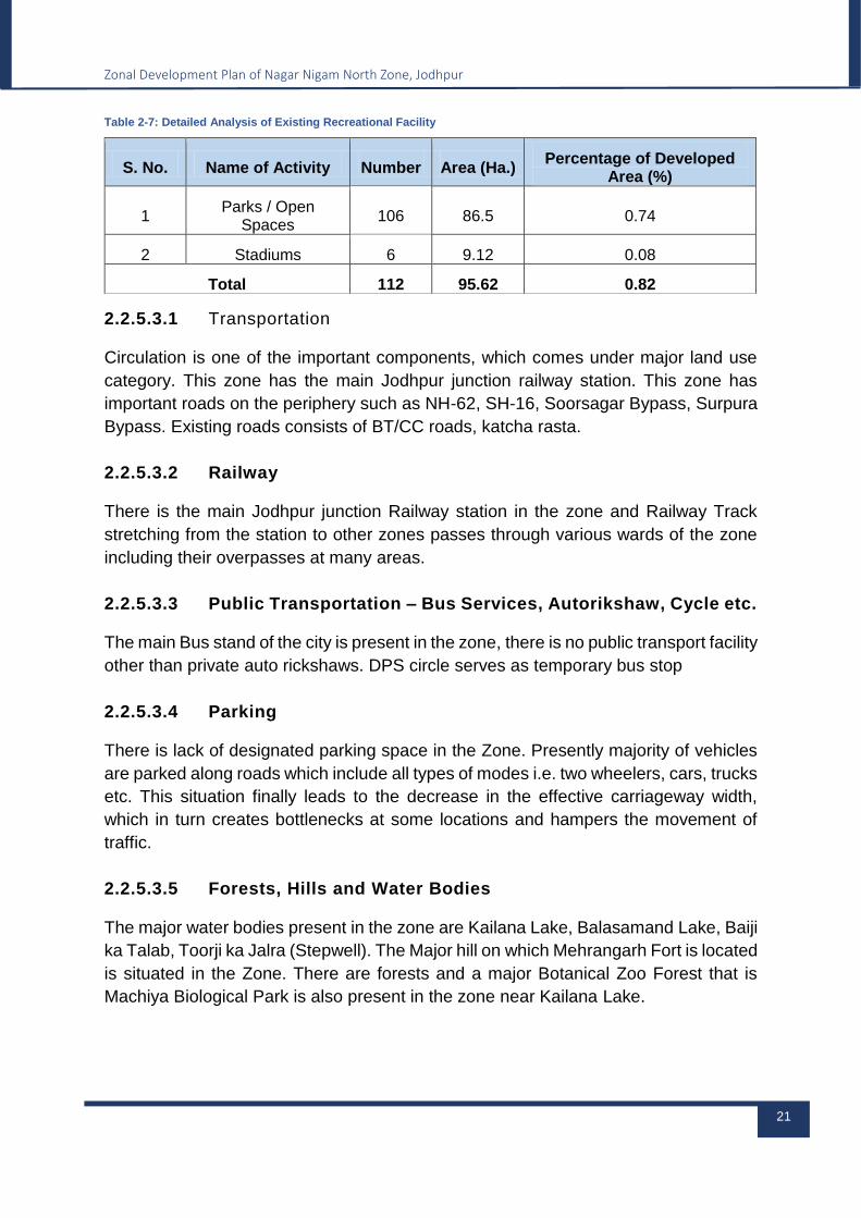
Zonal Development Plan of Nagar Nigam North Zone, Jodhpur
21
Table 2-7: Detailed Analysis of Existing Recreational Facility
S. No. Name of Activity Number Area (Ha.) Percentage of Developed
Area (%)
1 Parks / Open
Spaces 106 86.5 0.74
2 Stadiums 6 9.12 0.08
Total 112 95.62 0.82
2.2.5.3.1 Transportation
Circulation is one of the important components, which comes under major land use
category. This zone has the main Jodhpur junction railway station. This zone has
important roads on the periphery such as NH-62, SH-16, Soorsagar Bypass, Surpura
Bypass. Existing roads consists of BT/CC roads, katcha rasta.
2.2.5.3.2 Railway
There is the main Jodhpur junction Railway station in the zone and Railway Track
stretching from the station to other zones passes through various wards of the zone
including their overpasses at many areas.
2.2.5.3.3 Public Transportation – Bus Services, Autorikshaw, Cycle etc.
The main Bus stand of the city is present in the zone, there is no public transport facility
other than private auto rickshaws. DPS circle serves as temporary bus stop
2.2.5.3.4 Parking
There is lack of designated parking space in the Zone. Presently majority of vehicles
are parked along roads which include all types of modes i.e. two wheelers, cars, trucks
etc. This situation finally leads to the decrease in the effective carriageway width,
which in turn creates bottlenecks at some locations and hampers the movement of
traffic.
2.2.5.3.5 Forests, Hills and Water Bodies
The major water bodies present in the zone are Kailana Lake, Balasamand Lake, Baiji
ka Talab, Toorji ka Jalra (Stepwell). The Major hill on which Mehrangarh Fort is located
is situated in the Zone. There are forests and a major Botanical Zoo Forest that is
Machiya Biological Park is also present in the zone near Kailana Lake.
Zonal Development Plan of Nagar Nigam North Zone, Jodhpur
22
3 PLANNING POLICES AND PARAMETERS
In order to have planned, balanced and integrated development of the zone certain
planning parameters are proposed to be followed, these parameters will be the
guidelines for Proposed Zonal Development Plan.
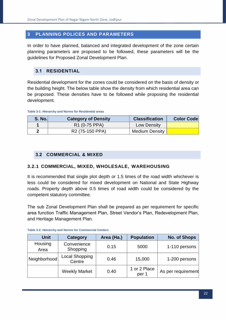
RESIDENTIAL
Residential development for the zones could be considered on the basis of density or
the building height. The below table show the density from which residential area can
be proposed. These densities have to be followed while proposing the residential
development.
Table 3-1: Hierarchy and Norms for Residential areas
S. No. Category of Density Classification Color Code
1 R1 (0-75 PPA) Low Density
2 R2 (75-150 PPA) Medium Density
COMMERCIAL & MIXED
3.2.1 COMMERCIAL, MIXED, WHOLESALE, WAREHOUSING
It is recommended that single plot depth or 1.5 times of the road width whichever is
less could be considered for mixed development on National and State Highway
roads. Property depth above 0.5 times of road width could be considered by the
competent statutory committee.
The sub Zonal Development Plan shall be prepared as per requirement for specific
area function Traffic Management Plan, Street Vendor’s Plan, Redevelopment Plan,
and Heritage Management Plan.
Table 3-2: Hierarchy and Norms for Commercial Centers
Unit Category Area (Ha.) Population No. of Shops
Housing
Area
Convenience Shopping
0.15 5000 1-110 persons
Neighborhood Local Shopping
Centre 0.46 15,000 1-200 persons
Weekly Market 0.40 1 or 2 Place
per 1 As per requirement

Zonal Development Plan of Nagar Nigam North Zone, Jodhpur
23
Community
Lakh
Informal Spaces / Vending Zone
As per
requirement
On the basis of
survey
1 per 10 plots
Milk
distribution
centre / Dairy
Booth
As per
requirement
As per
requirement
As per
requirement
3.2.2 URBAN STREET VENDORS
The informal and un-organized sector is a major source of employment in the
economic fabric of the city for which the following approach is proposed:
Earmarking of 'Hawking' and 'No Hawking' Zones at neighborhood and cluster
levels.
New areas for informal retail shops to be developed and integrated with
housing, commercial, institutional and industrial areas.
Provision of common basic services like toilets, water points, etc.
Area for essential retail outlets e.g., Milk Booth, Fair Price Shop, Bank ATM,
Restaurant etc. may be provided.
Provisions for informal retail units and weekly market to be made, wherever
necessary by the local body / development authority.
Vegetable markets are to be earmarked by the local body/ development
authority / at neighborhood level.
The township policy makes provisions for informal sector in upcoming township
schemes. As per norms 6 % commercial area is to be earmarked in townships and
accordingly
2% area from 6% commercial to be set apart for convenient shopping/ Kiosks /
informal sector.
Colonies developed by Jaipur Development Authority/ RHB/ provides for 2%
towards informal sector.
Residential complex provides for 1.5% plinth area reserved for informal sector
(Kiosk) on stilt level. The space shall be allotted at concessional price.
3.2.3 NORMS FOR URBAN STREET VENDORS
The informal sector retail commercial activities should be incorporated in the planned
development in various use zones. The provision of informal sector trade units should
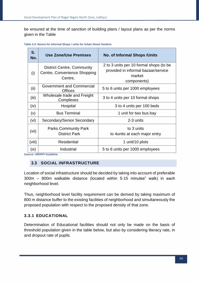
Zonal Development Plan of Nagar Nigam North Zone, Jodhpur
24
be ensured at the time of sanction of building plans / layout plans as per the norms
given in the Table
Table 3-3: Norms for Informal Shops / units for Urban Street Vendors
S.
No. Use Zone/Use Premises No. of Informal Shops /Units
(i)
District Centre, Community
Centre, Convenience Shopping
Centre,
2 to 3 units per 10 formal shops (to be
provided in informal bazaar/service
market
components)
(ii) Government and Commercial
Offices 5 to 6 units per 1000 employees
(iii) Wholesale trade and Freight
Complexes 3 to 4 units per 10 formal shops
(iv) Hospital 3 to 4 units per 100 beds
(v) Bus Terminal 1 unit for two bus bay
(vi) Secondary/Senior Secondary 2-3 units
(vii) Parks Community Park
District Park
to 3 units
to 4units at each major entry
(viii) Residential 1 unit/10 plots
(ix) Industrial 5 to 6 units per 1000 employees
Source: URDPFI Guideline
SOCIAL INFRASTRUCTURE
Location of social infrastructure should be decided by taking into account of preferable
300m – 800m walkable distance (located within 5-15 minutes‟ walk) in each
neighborhood level.
Thus, neighborhood level facility requirement can be derived by taking maximum of
800 m distance buffer to the existing facilities of neighborhood and simultaneously the
proposed population with respect to the proposed density of that zone.
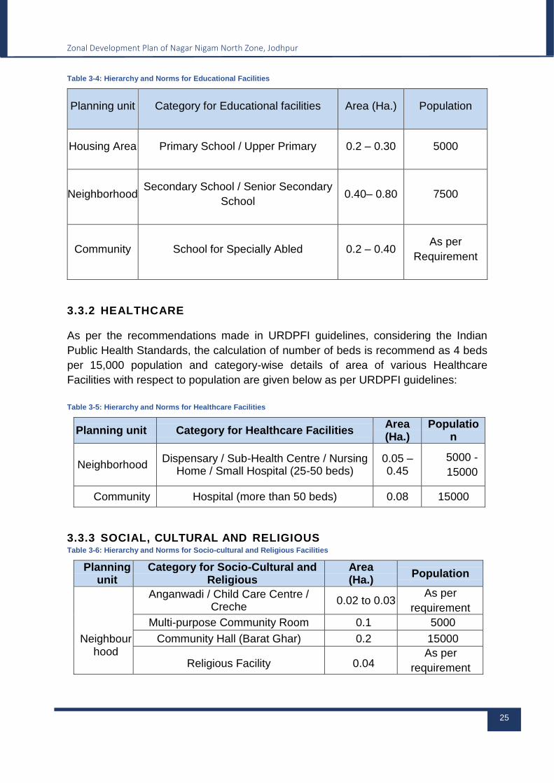
3.3.1 EDUCATIONAL
Determination of Educational facilities should not only be made on the basis of
threshold population given in the table below, but also by considering literacy rate, in
and dropout rate of pupils.
Zonal Development Plan of Nagar Nigam North Zone, Jodhpur
25
Table 3-4: Hierarchy and Norms for Educational Facilities
Planning unit Category for Educational facilities Area (Ha.) Population
Housing Area Primary School / Upper Primary 0.2 – 0.30 5000
Neighborhood Secondary School / Senior Secondary
School 0.40– 0.80 7500
Community School for Specially Abled 0.2 – 0.40 As per
Requirement
3.3.2 HEALTHCARE
As per the recommendations made in URDPFI guidelines, considering the Indian
Public Health Standards, the calculation of number of beds is recommend as 4 beds
per 15,000 population and category-wise details of area of various Healthcare
Facilities with respect to population are given below as per URDPFI guidelines:
Table 3-5: Hierarchy and Norms for Healthcare Facilities
Planning unit Category for Healthcare Facilities Area (Ha.)
Population
Neighborhood Dispensary / Sub-Health Centre / Nursing
Home / Small Hospital (25-50 beds) 0.05 –0.45
5000 -
15000
Community Hospital (more than 50 beds) 0.08 15000
3.3.3 SOCIAL, CULTURAL AND RELIGIOUS Table 3-6: Hierarchy and Norms for Socio-cultural and Religious Facilities
Planning unit
Category for Socio-Cultural and Religious
Area (Ha.)
Population
Neighbour
hood
Anganwadi / Child Care Centre / Creche
0.02 to 0.03 As per
requirement
Multi-purpose Community Room 0.1 5000
Community Hall (Barat Ghar) 0.2 15000
Religious Facility 0.04 As per
requirement
Zonal Development Plan of Nagar Nigam North Zone, Jodhpur
26
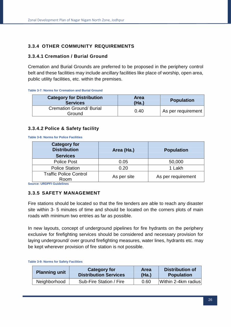
3.3.4 OTHER COMMUNITY REQUIREMENTS
3.3.4.1 Cremation / Burial Ground
Cremation and Burial Grounds are preferred to be proposed in the periphery control
belt and these facilities may include ancillary facilities like place of worship, open area,
public utility facilities, etc. within the premises.
Table 3-7: Norms for Cremation and Burial Ground
Category for Distribution Services
Area (Ha.)
Population
Cremation Ground/ Burial Ground
0.40 As per requirement
3.3.4.2 Police & Safety facility Table 3-8: Norms for Police Facilities
Category for Distribution
Services
Area (Ha.) Population
Police Post 0.05 50,000
Police Station 0.20 1 Lakh
Traffic Police Control Room
As per site As per requirement
Source: URDPFI Guidelines
3.3.5 SAFETY MANAGEMENT
Fire stations should be located so that the fire tenders are able to reach any disaster
site within 3- 5 minutes of time and should be located on the corners plots of main
roads with minimum two entries as far as possible.
In new layouts, concept of underground pipelines for fire hydrants on the periphery
exclusive for firefighting services should be considered and necessary provision for
laying underground/ over ground firefighting measures, water lines, hydrants etc. may
be kept wherever provision of fire station is not possible.
Table 3-9: Norms for Safety Facilities
Planning unit Category for
Distribution Services Area (Ha.)
Distribution of Population
Neighborhood Sub-Fire Station / Fire 0.60 Within 2-4km radius
Zonal Development Plan of Nagar Nigam North Zone, Jodhpur
27
post
Community Fire Station 1.0 2 Lakh / within5-7
km radius Source: URDPFI Guidelines
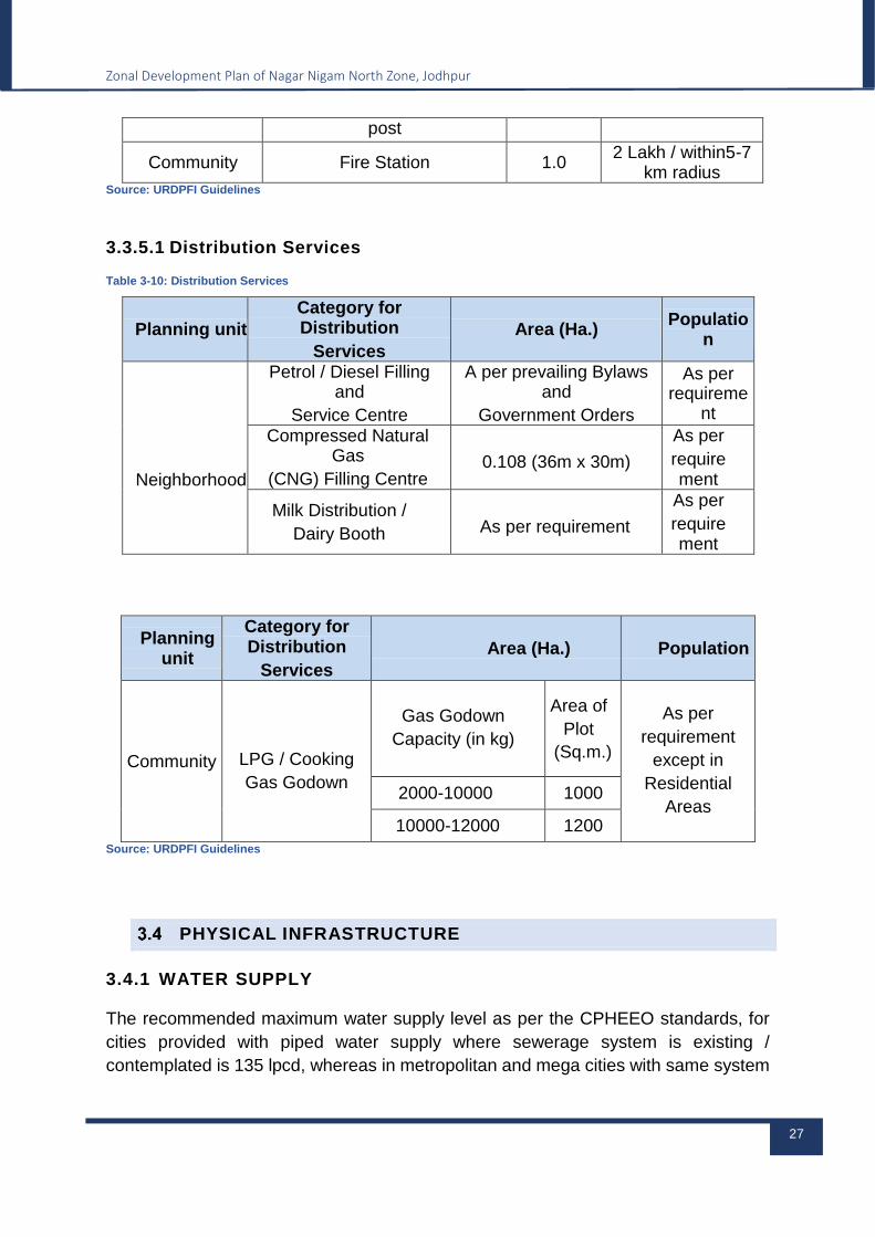
3.3.5.1 Distribution Services Table 3-10: Distribution Services
Planning unit
Category for Distribution
Services
Area (Ha.) Populatio
n
Neighborhood
Petrol / Diesel Filling and
Service Centre
A per prevailing Bylaws and
Government Orders
As per requireme
nt
Compressed Natural Gas
(CNG) Filling Centre 0.108 (36m x 30m)
As per
requirement
Milk Distribution /
Dairy Booth As per requirement
As per
requirement
Planning unit
Category for Distribution
Services
Area (Ha.) Population
Community
LPG / Cooking
Gas Godown
Gas Godown
Capacity (in kg)
Area of
Plot
(Sq.m.)
As per
requirement
except in
Residential
Areas 2000-10000 1000
10000-12000 1200
Source: URDPFI Guidelines
PHYSICAL INFRASTRUCTURE
3.4.1 WATER SUPPLY
The recommended maximum water supply level as per the CPHEEO standards, for
cities provided with piped water supply where sewerage system is existing /
contemplated is 135 lpcd, whereas in metropolitan and mega cities with same system

Zonal Development Plan of Nagar Nigam North Zone, Jodhpur
28
is 150 lpcd and in towns provided with piped water supply without sewerage system
is 70 Lpcd.
Table 3-11: Proposed Water Supply Requirement of the Zone
S.No. Sector Standard Demand
1 Domestic 135-150
2 Public 20
3 Industrial 30
4 Commercial 10
5 Water Loss 20
6 Total 215-230
7 Fire Fighting 1% of total demand
Source: URDPFI Guidelines
Power supply
Low voltage lines (less than 11kv)- a minimum horizontal clear distance of 1.2 m from
nearest conductor of low voltage electrical lines having capacity less than 11 KV shall
be mandatory from any structure or projected part of a building including balcony. The
minimum safety corridor shall be marked as “NO CONSTRUCTION ZONE” in layout
plan. No road, pathway, hoardings or signage or plantation or any other construction
shall be permissible into the minimum safety corridor others – Public Facilities.
Public toilets in public areas / open areas, parks, plazas, parking areas, fuel stations
etc. shall be provided at every 1 km and shall be disabled-friendly and in 50-50 ratio
of male-female, along with proper signage, helpline numbers, modes – pay and use
or free and proper maintenance.
3.5.1 DRAINAGE SYSTEM
As per CPHEEO manual on Sewerage and Sewage Treatment System, sanitary
sewers are not expected to receive storm water. Strict inspection, vigilance, proper
design and construction of sewers and manholes should eliminate this flow or bring it
down to a very insignificant quantity. Therefore, it is evident to plan a separate system
to carry storm water.
3.5.2 SEWERAGE SYSTEM
As per Central Public Health and Environmental Engineering Organization (CPHEEO)
manual 80% of the water supply may be expected to reach the sewers. However, it
Zonal Development Plan of Nagar Nigam North Zone, Jodhpur
29
recommends designing the system by considering minimum waste water flow of 100
liters per capita per day.
Least water intensive sanitation and sewerage systems with decentralized sewage
treatment plants should be incentivized. It has been emphasized that if sewage from
the urban and semi- urban areas were reused for a variety of non-potable uses, the
demand on the potable water supply would be reduced.
Solid waste management
Municipal Solid Waste Management (MSWM) refers to systematic process that
comprises of waste segregation and storage at source, primary collection, secondary
storage, transportation, secondary segregation, resource recovery, processing,
treatment and final disposal of solid waste.
Zero Land-fill for Solid Waste Management projects to maintain environmental
sustainability. In fact, each project should aim to improvement in the environment,
rather than on „minimizing the damage‟. Measures to be taken for recycling and reuse
in the solid waste management system.
RECREATIONAL
3.7.1 ORGANIZED GREEN SPACES / SPORTS FACILITIES
Considering open spaces, including recreational space, organized green and other
common open spaces, all require provision of minimum 10 to 12 sq. m per person as
a desirable area for small towns, 14 to 16 sq. m. for medium towns and 12 to 14 sq.
m. for large and metropolitan cities, whereas in the built up areas minimum norms as
per National Building Code suggests 3.0 sq. m. per person. Along with the above
mentioned norms, category-wise organized green space area requirement is detailed
out in the table given below:
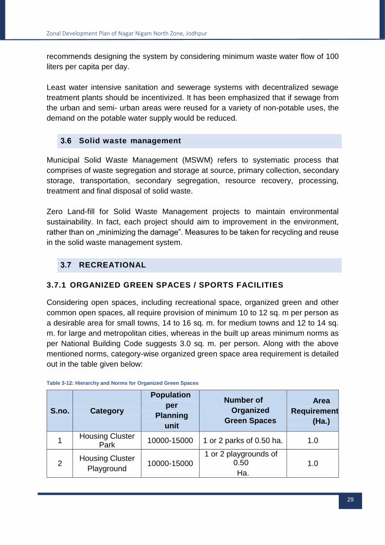
Table 3-12: Hierarchy and Norms for Organized Green Spaces
S.no. Category
Population
per
Planning
unit
Number of
Organized
Green Spaces
Area
Requirement
(Ha.)
1 Housing Cluster
Park 10000-15000 1 or 2 parks of 0.50 ha. 1.0
2 Housing Cluster
Playground 10000-15000
1 or 2 playgrounds of 0.50
Ha.
1.0
Zonal Development Plan of Nagar Nigam North Zone, Jodhpur
30
Source: URDPFI Guidelines
In addition to the above norms and standards, any recreational space shall have
minimum area of 450.00 sq. m. and its minimum average dimension shall not be less
than 7.5 meter and length shall not exceed 2.5 times the average width. Also, if at all
any building line is lining close to the recreational space then shall at least 3 meter
away from the boundary of the recreational open space.
Green areas and other associated activities to be preferably proposed on Government
reserved land. In case government land is not available and is to be proposed on
privately owned land, then the local authority / body shall provide fair compensation
as per laws or otherwise can work out a feasible model offering fair means of income
along with fulfilling the purpose of developing and maintaining green spaces.
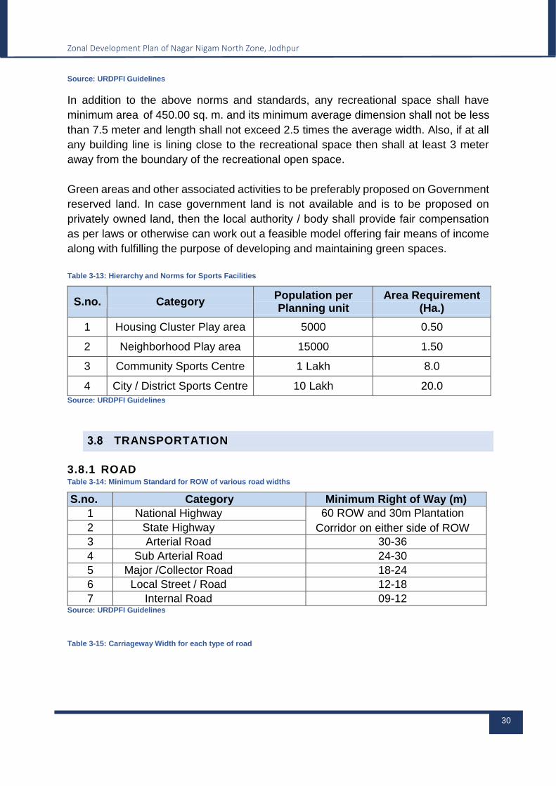
Table 3-13: Hierarchy and Norms for Sports Facilities
S.no. Category Population per Planning unit
Area Requirement (Ha.)
1 Housing Cluster Play area 5000 0.50
2 Neighborhood Play area 15000 1.50
3 Community Sports Centre 1 Lakh 8.0
4 City / District Sports Centre 10 Lakh 20.0 Source: URDPFI Guidelines
TRANSPORTATION
3.8.1 ROAD Table 3-14: Minimum Standard for ROW of various road widths
S.no. Category Minimum Right of Way (m)
1 National Highway 60 ROW and 30m Plantation
Corridor on either side of ROW 2 State Highway
3 Arterial Road 30-36
4 Sub Arterial Road 24-30
5 Major /Collector Road 18-24
6 Local Street / Road 12-18
7 Internal Road 09-12 Source: URDPFI Guidelines
Table 3-15: Carriageway Width for each type of road
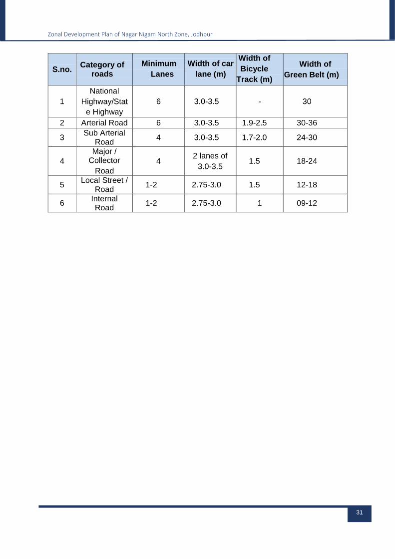
Zonal Development Plan of Nagar Nigam North Zone, Jodhpur
31
S.no. Category of
roads
Minimum
Lanes
Width of car
lane (m)
Width of
Bicycle
Track (m)
Width of
Green Belt (m)
1
National
Highway/Stat
e Highway
6 3.0-3.5 - 30
2 Arterial Road 6 3.0-3.5 1.9-2.5 30-36
3 Sub Arterial
Road 4 3.0-3.5 1.7-2.0 24-30
4
Major / Collector
Road
4 2 lanes of
3.0-3.5 1.5 18-24
5 Local Street /
Road 1-2 2.75-3.0 1.5 12-18
6 Internal Road
1-2 2.75-3.0 1 09-12
Zonal Development Plan of Nagar Nigam North Zone, Jodhpur
32
4 PROPOSALS – STRATEGIES AND POLICIES
The Planning and Building Act understands public participation as an individual’s or a
group’s right to take part in and influence public assessment and decision-making
processes. This means that those who live in a community get involved in planning its
future.
PROJECT DEVELOPMENT STRATEGY
Public participation in a planning process is mindful of the best possible plan”, and will,
as described in the guide, aim to:
Ensure good solutions that pay attention to everyone’s needs
Enable all affected and interested parties to present their views
Promote creativity and enthusiasm, and be an arena for democratic
participation in the local community
Provide a solid basis for decision-making
Public participation is a basic condition in local democracy. It allows the population to
participate and contribute to bring about better planning solutions. The population’s
active role in planning and decision-making processes is highlighted to safeguard our
shared values and basic living conditions in a sustainable society. Good facilitation of
public participation in planning is vital in securing well-functioning and efficient
planning processes. Commencing too quickly, without sufficient involvement from the
affected groups and interests, does not necessarily lead to more efficient planning
processes.
The development of the city ultimately depends upon the expectations and
encouragement of its residents. In order to achieve the objectives, set out in the Zonal
Development Plan, the active participation and cooperation of its residents is required.
The citizen awareness could enable the city to become self-competent and
sustainable. Therefore, it is necessary for the city’s residents to provide their full
support in implementing the programs proposed in the Zonal Development Plan. PPP
and BOT are also proposed to be initiated for basic infrastructure and public amenities.
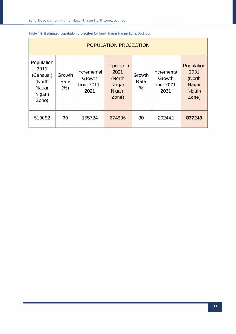
POPULATION PROJECTION 2031
The existing population was 519082 for North Nagar Nigam according to Census Data
2011. North Nagar Nigam is the developable area of the city, 30% growth rate is
assumed for which the projected population comes out to be 674806 for 2021 and
877248 for 2031 which is again with the assumed growth rate of 30%.
Zonal Development Plan of Nagar Nigam North Zone, Jodhpur
33
Table 4-1: Estimated population projection for North Nagar Nigam Zone, Jodhpur
POPULATION PROJECTION
Population
2011
(Census.)
(North
Nagar
Nigam
Zone)
Growth
Rate
(%)
Incremental
Growth
from 2011-
2021
Population
2021
(North
Nagar
Nigam
Zone)
Growth
Rate
(%)
Incremental
Growth
from 2021-
2031
Population
2031
(North
Nagar
Nigam
Zone)
519082 30 155724 674806 30 202442 877248

FACILITIES CALCULATION AS PER PROJECTED POPULATION
Table 4-2: Existing Zone Level Facilities of Nagar Nigam North Zone
Category of Facilities Norms/Guidelines Master Plan
Remarks
Indicator Sub Indicator Req. Facilities for
Proposed Population
Area Required/
Unit
Facilities required as per norms
Total nos. of Existing Facilities
Additional Required Units
Additional Required
Area (Hectares)
Proposed Area in Master
Plan (Hectare
s)
Educational Facilities
Primary One for 4000-
5000 population 2000-3000 175 169 6 1.5
Total proposed in MDP
478 Ha – Existing
Area 406 ha = 72
Hactares available
for addisiton
al required
units
Not additional requirement
Upper Primary
Secondary One for 7500-
10000 population 4000-8000 88 40 48 28.8
Senior Secondary
Degree College/Professional
College
80000 to 1 Lac Population
- 9 51 0 -
Health Facilities
General Hospital One for 15000
population 8000 58 61 0 -
Dispensaries/ Medical Stores
One for 5000 - 15000
500 -4500 58 62 0
-
Recreational Parks/Stadium/Playgr
ound 10000-15000
10000
88 112 0 - -
Not additional requirement
Socio- Cultural Community Facilities
+ Religious One for 15000
population -- 58 224 0 - -
Zonal Development Plan of Nagar Nigam North Zone, Jodhpur
35
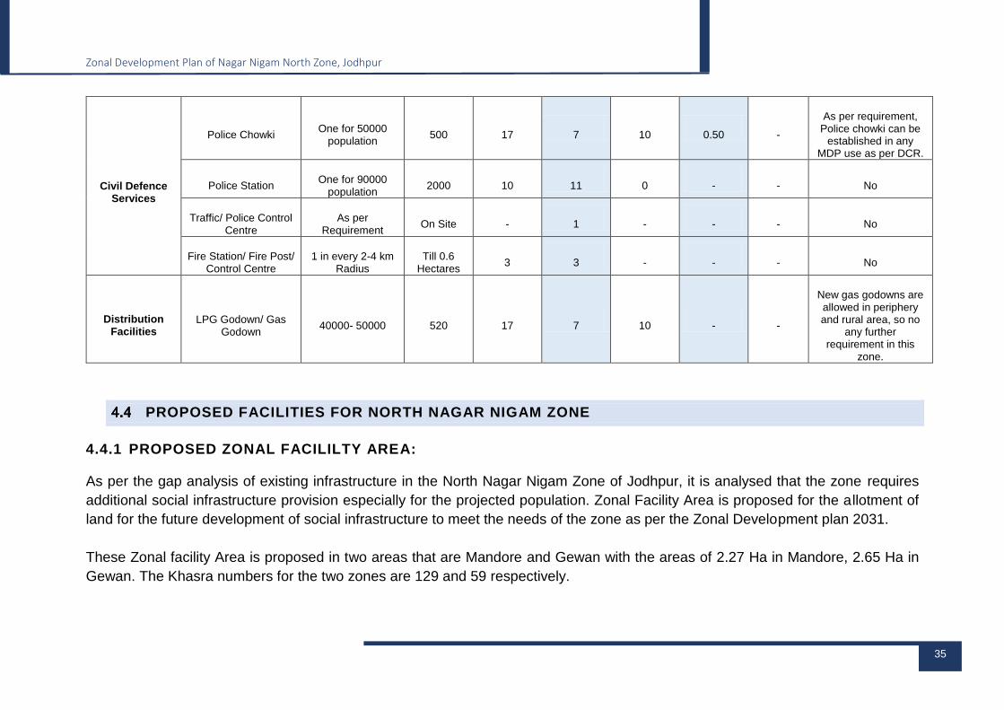
Civil Defence Services
Police Chowki One for 50000
population 500 17 7 10 0.50 -
As per requirement, Police chowki can be
established in any MDP use as per DCR.
Police Station One for 90000
population 2000 10 11 0 - - No
Traffic/ Police Control Centre
As per Requirement
On Site - 1 - - - No
Fire Station/ Fire Post/ Control Centre
1 in every 2-4 km Radius
Till 0.6 Hectares
3 3 - - - No
Distribution Facilities
LPG Godown/ Gas Godown
40000- 50000 520 17 7 10 - -
New gas godowns are allowed in periphery and rural area, so no
any further requirement in this
zone.
PROPOSED FACILITIES FOR NORTH NAGAR NIGAM ZONE
4.4.1 PROPOSED ZONAL FACILILTY AREA:
As per the gap analysis of existing infrastructure in the North Nagar Nigam Zone of Jodhpur, it is analysed that the zone requires
additional social infrastructure provision especially for the projected population. Zonal Facility Area is proposed for the allotment of
land for the future development of social infrastructure to meet the needs of the zone as per the Zonal Development plan 2031.
These Zonal facility Area is proposed in two areas that are Mandore and Gewan with the areas of 2.27 Ha in Mandore, 2.65 Ha in
Gewan. The Khasra numbers for the two zones are 129 and 59 respectively.
4.4.2 PROPOSED ROADS
Proposed Sub Collector and local roads on the either side of the Tiwari Road,
proposed a road link connecting the upper part of the Kailana Lake parallel to the
Kailana Road. The Road widths of the proposed roads are shown in the below table.
4.4.2.1 Special Roads
The following roads are marks as special roads in Zonal Development Plan
1. From Asuji pyau to NLU electric substation via Amritlal Stadium
2. From Mandore Police station to Ram Sagar Chauraha, via Gokul ji pyau and
Bhati circle
3. Nagaur road Krishi mandi to Kishor bagh
4. From Mata ka Than to 8 mile Nagaur Road via aanganwa
The right of way of these special roads are different in different parts, the determination
of right of way of these roads can be determined after the recommendation of the
committee mentioned in Note 2. (Page number 129) of Table 29 of the Master
Development Plan 2031 report. The right of way for these roads will be valid as per
the master plan till the time it is decided by the committee as above.
4.4.3 PROPOSED SAFETY FACILITIES:
Safety Corridor marked along H.T. Lines, possible road has been proposed on both
sides of the line. The proposed security corridors will be valid as per the orders of the
State Government dated 08.03.2017 on both sides of the HT lines.
4.4.4 PROPOSED PLANTATION:
A plantation strip of 30 meters has been proposed around the large reservoirs and a
plantation strip of 9 meters (30 feet) wide has been proposed around the smaller
reservoirs. A 9 meter wide plantation strip has been proposed around the big drains
and water flow system.
Linear extension of the canal which is situated on the hills on the north side of
Mandore, 30 meter plantation buffer is proposed on both sides of the canal. It is
proposed to extend up to NH 65 road connecting Mandore area.
Related Documents


