11.20 Anthropogenic Environments TM Zobeck and MC Baddock, USDA-ARS, Wind Erosion and Water Conservation Research Unit, Lubbock, TX, USA RS Van Pelt, USDA-ARS, Wind Erosion and Water Conservation Research Unit, Big Spring, TX, USA Published by Elsevier Inc. 11.20.1 Introduction 395 11.20.2 Human-Induced Wind Erosion – A Global Perspective 396 11.20.3 Anthropogenic Factors that Influence Wind Erosion 399 11.20.3.1 Tillage Effects 400 11.20.3.2 Effects of Vegetation 401 11.20.4 Environmental Effects of Wind Erosion 402 11.20.5 Techniques for Studying Wind Erosion 404 11.20.5.1 Field Studies 404 11.20.5.2 Field Equipment to Estimate Wind Erosion 405 11.20.5.3 Modeling Wind Erosion 406 11.20.5.4 An Indirect Method to Estimate Wind Erosion 407 11.20.6 Control of Anthropogenic Wind Erosion 407 11.20.7 Future Outlook and Perspectives 408 References 408 Glossary AUSLEM Australian landscape-scale wind erosion model developed for rangeland conditions. Microrelief/microtopography Small-scale differences in the elevations of the soil surface on the order of millimeters to centimeters. PM10 Particulate matter with an aerodynamic diameter of less than 10 mm. Safire An automated, high frequency, electronic saltation impact sensor to detect particles using piezoelectric sensing elements. SENSIT An automated, high frequency, electronic saltation impact sensor to detect particles using piezoelectric sensing elements. Wenglor Relatively inexpensive, commercially available photoelectric laser-based electronic saltation sensor. Abstract Anthropogenic aeolian environments are those where wind erosion – principally mineral dust production – is related to human influences. This chapter begins by citing regions where anthropogenic factors have resulted in significant wind erosion. It details the major human-related controls on aeolian activity, such as changes to soil surface erodibility, especially by tillage, and alteration of vegetation characteristics. The environmental consequences of wind erosion are classifiable as on-site and off-site effects. Field techniques used for studying anthropogenic wind erosion are also discussed, as well as the models used to estimate soil loss and methods for the control of erosion on agricultural land. The US Department of Agriculture offers its programs to all eligible persons regardless of race, color, age, sex, or national origin, and is an equal opportunity employer. Mention of trade names or commercial products is solely for the purpose of providing specific information and does not imply recom- mendation or endorsement by the USDA-ARS. 11.20.1 Introduction Aerosols or airborne dust can originate from sources un- related to anthropogenic activity but may also be initiated or exacerbated by anthropogenic actions. Anthropogenic dust refers to dust activity (emission and suppression) that is pre- sent due to human-related activity (Zender et al., 2004). Zender et al. (2004) proposed two categories of dust activity. Anthropogenic dust of the ‘First Kind’ consists of dust pro- duction and emissions due to human activities that directly modify or disturb the land surface and thereby alter soil erodibility. This disturbance includes activities that mechan- ically inject dust into the atmosphere, independent of wind speed, as well as disturbance that changes the soil surface to make it more susceptible to wind erosion. Anthropogenic dust of the ‘Second Kind’ represents changes in dust emissions and deposition due to effects of climate change. The work de- scribed in this chapter is restricted to anthropogenic dust of the ‘First Kind’ with a primary focus on wind erosion caused by agricultural activities. A survey of 16 present-climate global dust budget estimates revealed annual dust emissions ranging Zobeck, T.M., Baddock, M.C., Van Pelt, R.S., 2013. Anthropogenic environments. In: Shroder, J. (Editor in Chief), Lancaster, N., Sherman, D.J., Baas, A.C.W. (Eds.), Treatise on Geomorphology. Academic Press, San Diego, CA, vol. 11, Aeolian Geomorphology, pp. 395–413. Treatise on Geomorphology, Volume 11 http://dx.doi.org/10.1016/B978-0-12-374739-6.00313-4 395

Welcome message from author
This document is posted to help you gain knowledge. Please leave a comment to let me know what you think about it! Share it to your friends and learn new things together.
Transcript
11.20 Anthropogenic EnvironmentsTM Zobeck and MC Baddock, USDA-ARS, Wind Erosion and Water Conservation Research Unit, Lubbock, TX, USARS Van Pelt, USDA-ARS, Wind Erosion and Water Conservation Research Unit, Big Spring, TX, USA
Published by Elsevier Inc.
11.20.1 Introduction 395
11.20.2 Human-Induced Wind Erosion – A Global Perspective 396 11.20.3 Anthropogenic Factors that Influence Wind Erosion 399 11.20.3.1 Tillage Effects 400 11.20.3.2 Effects of Vegetation 401 11.20.4 Environmental Effects of Wind Erosion 402 11.20.5 Techniques for Studying Wind Erosion 404 11.20.5.1 Field Studies 404 11.20.5.2 Field Equipment to Estimate Wind Erosion 405 11.20.5.3 Modeling Wind Erosion 406 11.20.5.4 An Indirect Method to Estimate Wind Erosion 407 11.20.6 Control of Anthropogenic Wind Erosion 407 11.20.7 Future Outlook and Perspectives 408 References 408Zo
en
Ba
Di
Tre
GlossaryAUSLEM Australian landscape-scale wind erosion model
developed for rangeland conditions.
Microrelief/microtopography Small-scale differences in
the elevations of the soil surface on the order of
millimeters to centimeters.
PM10 Particulate matter with an aerodynamic diameter of
less than 10 mm.
beck, T.M., Baddock, M.C., Van Pelt, R.S., 2013. Anthropogenic
vironments. In: Shroder, J. (Editor in Chief), Lancaster, N., Sherman, D.J.,
as, A.C.W. (Eds.), Treatise on Geomorphology. Academic Press, San
ego, CA, vol. 11, Aeolian Geomorphology, pp. 395–413.
atise on Geomorphology, Volume 11 http://dx.doi.org/10.1016/B978-0-12-374
Safire An automated, high frequency, electronic saltation
impact sensor to detect particles using piezoelectric sensing
elements.
SENSIT An automated, high frequency, electronic
saltation impact sensor to detect particles using
piezoelectric sensing elements.
Wenglor Relatively inexpensive, commercially available
photoelectric laser-based electronic saltation sensor.
Abstract
Anthropogenic aeolian environments are those where wind erosion – principally mineral dust production – is related to
human influences. This chapter begins by citing regions where anthropogenic factors have resulted in significant winderosion. It details the major human-related controls on aeolian activity, such as changes to soil surface erodibility, especially
by tillage, and alteration of vegetation characteristics. The environmental consequences of wind erosion are classifiable as
on-site and off-site effects. Field techniques used for studying anthropogenic wind erosion are also discussed, as well as the
models used to estimate soil loss and methods for the control of erosion on agricultural land.
The US Department of Agriculture offers its programs to all
eligible persons regardless of race, color, age, sex, or national
origin, and is an equal opportunity employer. Mention of
trade names or commercial products is solely for the purpose
of providing specific information and does not imply recom-
mendation or endorsement by the USDA-ARS.
11.20.1 Introduction
Aerosols or airborne dust can originate from sources un-
related to anthropogenic activity but may also be initiated or
exacerbated by anthropogenic actions. Anthropogenic dust
refers to dust activity (emission and suppression) that is pre-
sent due to human-related activity (Zender et al., 2004).
Zender et al. (2004) proposed two categories of dust activity.
Anthropogenic dust of the ‘First Kind’ consists of dust pro-
duction and emissions due to human activities that directly
modify or disturb the land surface and thereby alter soil
erodibility. This disturbance includes activities that mechan-
ically inject dust into the atmosphere, independent of wind
speed, as well as disturbance that changes the soil surface to
make it more susceptible to wind erosion. Anthropogenic dust
of the ‘Second Kind’ represents changes in dust emissions and
deposition due to effects of climate change. The work de-
scribed in this chapter is restricted to anthropogenic dust of
the ‘First Kind’ with a primary focus on wind erosion caused
by agricultural activities. A survey of 16 present-climate global
dust budget estimates revealed annual dust emissions ranging
739-6.00313-4 395
396 Anthropogenic Environments
from 358 to approximately 3000 Tg yr�1 (Zender et al., 2004).
A more recent survey of 13 estimates of present-climate global
dust emissions provides a range from 500 to approximately
3320 Tg yr�1 (Shao et al., 2011). Of this, approximately 11%
has been attributed to an anthropogenic origin, mainly in-
dustrial processes (Satheesh and Moorthy, 2005). Tegen et al.
(2004) estimated the contribution of agricultural areas to the
atmospheric dust load by calibrating a dust-source model with
emission indices derived from dust-storm observations. Their
results indicated that agricultural areas contribute o10% of
the global dust load. The uncertainties in these scale models,
however, is demonstrated by the fact that Mahowald et al.
(2004) found that dust storm frequencies could be explained
by an anthropogenic contribution of anywhere between 0 and
50% of total dust in the atmosphere.
Even though the amount of dust emissions attributed to
anthropogenic factors is a relatively small portion of the total
global dust load, major environmental catastrophes have
been attributed to aeolian activity enhanced by human activ-
ity. Perhaps the most memorable example of anthropogenic-
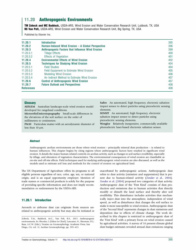
induced wind erosion is the occurrence of the Dust Bowl era
in USA from 1931–39 (Baumhardt, 2003). During this period,
the southern Great Plains of USA suffered from drought and a
severe economic depression. This decade was preceded by
favorable annual precipitation more than 100 mm above the
average, farm mechanization with intensive tillage, and stable
European demand for wheat (Triticum aestivium L.) (Baum-
hardt, 2003; Egan, 2006). Extensive areas that had been suc-
cessfully farmed for three decades became ravished by wind
and drought (Figure 1) creating what became known as the
American Dust Bowl (Stewart et al., 2010). The entire area
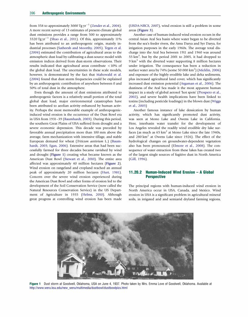
affected was approximately 40 million hectares (Figure 2).
Wind erosion on rangeland and cropland reached an annual
peak of approximately 20 million hectares (Hurt, 1981).
Concern over the severe wind erosion experienced during
the American Dust Bowl and other forms of erosion led to the
development of the Soil Conservation Service (now called the
Natural Resources Conservation Service) in the US Depart-
ment of Agriculture in 1935 (Helms, 2010). Although
great progress at controlling wind erosion has been made
Figure 1 Dust storm at Goodwell, Oklahoma, USA on June 4, 1937. Photohttp://www.weru.ksu.edu/new_weru/multimedia/dustbowl/dustbowlpics.html
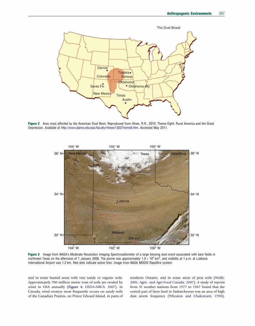
(USDA-NRCS, 2007), wind erosion is still a problem in some
areas (Figure 3).
Another case of human-induced wind erosion occurs in the
central Asian Aral Sea basin where water began to be diverted
from the sea’s feeder rivers, the Amu Darya and Syr Darya, for
irrigation purposes in the early 1960s. The average total dis-
charge into the Aral Sea between 1911 and 1960 was around
55 km3, but by the period 2001 to 2005, it had dropped to
9 km3 with the diverted water supporting 8 million hectares
under irrigation. The consequence has been a reduction in
surface water area by 74% (some 50 000 km2) (Micklin, 2006)
and exposure of the highly erodible lake and delta sediments,
plus increased agricultural land cover, which has significantly
increased dust emission potential (Argaman et al., 2006). The
dustiness of the Aral Sea made it the most apparent human
impact in a study of global aerosol ‘hot spots’ (Prospero et al.,
2002), and severe health implications have been linked to
toxins (including pesticide loadings) in the blown dust (Wiggs
et al., 2003)
Another famous instance of lake dessication by human
activity, which has significantly promoted dust activity,
was seen at Mono Lake and Owens Lake in California.
Here, interbasin water transfer for the development of
Los Angeles revealed the readily wind erodible dry lake sur-
faces (as much as 65 km2 at Mono Lake since the late 1940s,
and 280 km2 at Owens Lake since 1926). The effect of the
hydrological changes on groundwater-dependent vegetation
also has been pronounced (Elmore et al., 2008). The con-
sequence of water extraction from these lakes has created two
of the largest single sources of fugitive dust in North America
(Gill, 1996).
11.20.2 Human-Induced Wind Erosion – A GlobalPerspective
The principal regions with human-induced wind erosion in
North America occur in USA, Canada, and Mexico. Wind
erosion in USA is a significant problem in agricultural mineral
soils, in irrigated arid and semiarid dryland farming regions,
taken by Mrs. Emma Love of Goodwell, Oklahoma. Available at
Denver
The Dust Bowel
TopekaKansas
Oklahoma
AustinTexasNew Mexico
Santa Fe Oklahoma city
Colorado
Figure 2 Area most affected by the American Dust Bowl. Reproduced from Hines, R.R., 2010. Theme Eight: Rural America and the GreatDepression. Available at http://www.alamo.edu/pac/faculty/rhines/1302Theme8.htm. Accessed May 2011.
104° W 102° W 100° W
Oklahoma 36° N
34° N
32° N
100° W102° W
200 km0
Midland
Lubbock
New Mexcio
Amarillo
Texas
104° W
32° N
34° N
36° N
Figure 3 Image from NASA’s Moderate Resolution Imaging Spectroradiometer of a large blowing dust event associated with bare fields innorthwest Texas on the afternoon of 1 January 2006. The plume was approximately 1.0� 105 km2, and visibility at 1 p.m. at LubbockInternational Airport was 1.2 km. Red dots indicate active fires. Image from NASA MODIS Rapidfire system.
Anthropogenic Environments 397
and in some humid areas with very sandy or organic soils.
Approximately 700 million metric tons of soils are eroded by
wind in USA annually (Figure 4; USDA-NRCS, 2007). In
Canada, wind erosion most frequently occurs on sandy soils
of the Canadian Prairies, on Prince Edward Island, in parts of
southern Ontario, and in some areas of peat soils (Wolfe,
2001; Agric. and Agri-Food Canada, 2007). A study of reports
from 31 weather stations from 1977 to 1987 found that the
central part of farm land in Saskatchewan was an area of high
dust storm frequency (Wheaton and Chakravarti, 1990).
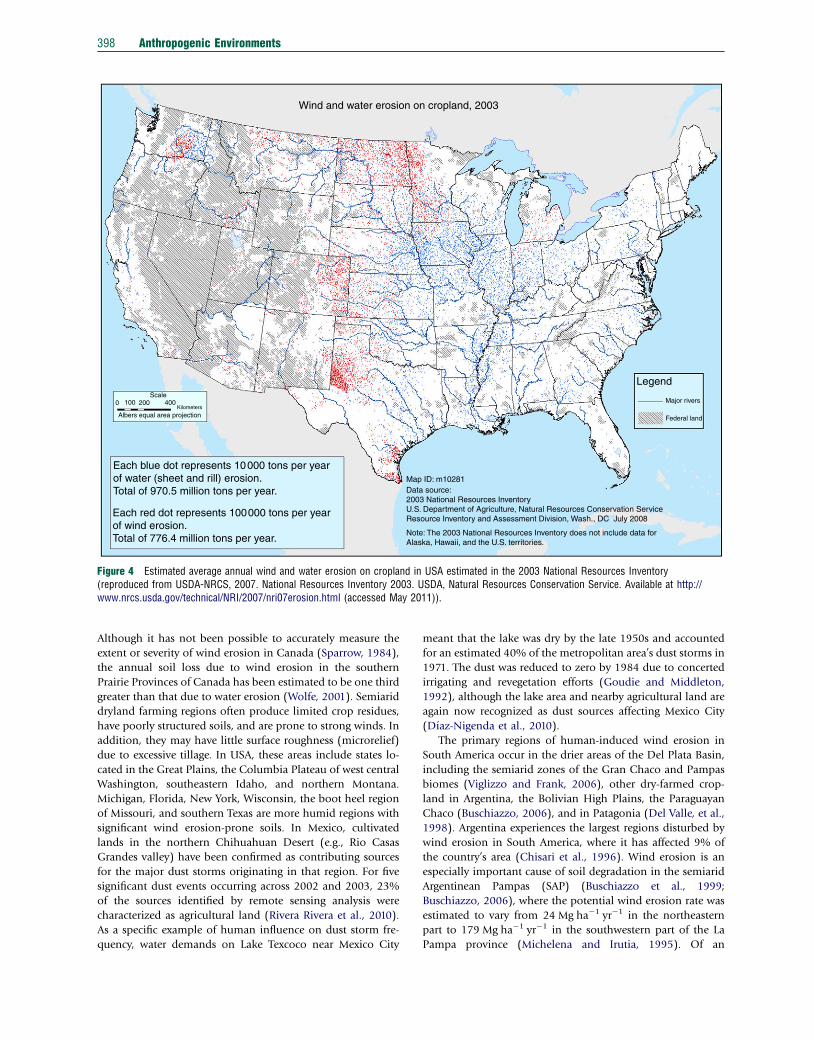
Wind and water erosion on cropland, 2003
Legend
Major rivers
Federal land
Map ID: m10281Data source:2003 National Resources InventoryU.S. Department of Agriculture, Natural Resources Conservation ServiceResource Inventory and Assessment Division, Wash., DC July 2008
Scale0 100 200 400
Kilometers
Albers equal area projection
Each blue dot represents 10000 tons per yearof water (sheet and rill) erosion.Total of 970.5 million tons per year.
Each red dot represents 100000 tons per yearof wind erosion.Total of 776.4 million tons per year.
Note: The 2003 National Resources Inventory does not include data forAlaska, Hawaii, and the U.S. territories.
Figure 4 Estimated average annual wind and water erosion on cropland in USA estimated in the 2003 National Resources Inventory(reproduced from USDA-NRCS, 2007. National Resources Inventory 2003. USDA, Natural Resources Conservation Service. Available at http://www.nrcs.usda.gov/technical/NRI/2007/nri07erosion.html (accessed May 2011)).
398 Anthropogenic Environments
Although it has not been possible to accurately measure the
extent or severity of wind erosion in Canada (Sparrow, 1984),
the annual soil loss due to wind erosion in the southern
Prairie Provinces of Canada has been estimated to be one third
greater than that due to water erosion (Wolfe, 2001). Semiarid
dryland farming regions often produce limited crop residues,
have poorly structured soils, and are prone to strong winds. In
addition, they may have little surface roughness (microrelief)
due to excessive tillage. In USA, these areas include states lo-
cated in the Great Plains, the Columbia Plateau of west central
Washington, southeastern Idaho, and northern Montana.
Michigan, Florida, New York, Wisconsin, the boot heel region
of Missouri, and southern Texas are more humid regions with
significant wind erosion-prone soils. In Mexico, cultivated
lands in the northern Chihuahuan Desert (e.g., Rio Casas
Grandes valley) have been confirmed as contributing sources
for the major dust storms originating in that region. For five
significant dust events occurring across 2002 and 2003, 23%
of the sources identified by remote sensing analysis were
characterized as agricultural land (Rivera Rivera et al., 2010).
As a specific example of human influence on dust storm fre-
quency, water demands on Lake Texcoco near Mexico City
meant that the lake was dry by the late 1950s and accounted
for an estimated 40% of the metropolitan area’s dust storms in
1971. The dust was reduced to zero by 1984 due to concerted
irrigating and revegetation efforts (Goudie and Middleton,
1992), although the lake area and nearby agricultural land are
again now recognized as dust sources affecting Mexico City
(Dıaz-Nigenda et al., 2010).
The primary regions of human-induced wind erosion in
South America occur in the drier areas of the Del Plata Basin,
including the semiarid zones of the Gran Chaco and Pampas
biomes (Viglizzo and Frank, 2006), other dry-farmed crop-
land in Argentina, the Bolivian High Plains, the Paraguayan
Chaco (Buschiazzo, 2006), and in Patagonia (Del Valle, et al.,
1998). Argentina experiences the largest regions disturbed by
wind erosion in South America, where it has affected 9% of
the country’s area (Chisari et al., 1996). Wind erosion is an
especially important cause of soil degradation in the semiarid
Argentinean Pampas (SAP) (Buschiazzo et al., 1999;
Buschiazzo, 2006), where the potential wind erosion rate was
estimated to vary from 24 Mg ha�1 yr�1 in the northeastern
part to 179 Mg ha�1 yr�1 in the southwestern part of the La
Pampa province (Michelena and Irutia, 1995). Of an
Anthropogenic Environments 399
estimated 565 000 ha affected by wind erosion in the SAP,
more than 60% had moderate to heavy wind erosion risks
(Covas and Glave, 1988 from Buschiazzo, 2006). Buschiazzo
and Taylor (1993) have shown that in some areas wind ero-
sion has transformed the soils from Mollisols into Inceptisols
due to the loss of organic matter and decreased thickness of
the surface horizon.
With the large extent of drylands in northern China and
the considerable population interacting with this environ-
ment, there has been substantial research applied to under-
standing the human influence on wind erosion in this region.
An estimated 91 million hectares have been adversely affected
by wind erosion over the past 50 years throughout China, with
nearly 7 million hectares undergoing encroachment by mobile
dunes, whose mobilization is commonly caused by over-
grazing of vegetation cover (Zhao et al., 2006).
The number of dust storms observed in northern China has
shown an overall decline recently, especially since the mid-
1980s, despite an increase in desertification attributed to an-
thropogenic activity (Zhang et al., 2003). Zhang et al. (2003)
reported estimates that the desert area of China has increased
by 2–7% over the past 43 years. Their study shows that the
influence of humans can be particularly notable since the most
heavily human-affected areas, including the Horqin sandy land
and Mu Us desert, have shown overall dust increases in the past
20 years. Mapping of desertified land in the Chaidm Basin re-
vealed a near doubling in the degraded area from 1959 to 1994,
and this region has clearly shown an increasing dustiness trend
contrary to the northern Chinese trend (Wang et al., 2004).
There does, however, remain some debate on the significance of
human sources in degraded grasslands or cultivated lands of
northern China compared to the contribution of natural dust-
bearing areas (Wang et al., 2004).
To counter the unintended consequences of enhancing
wind erosion, considerable effort has been made in China to
reduce aeolian activity: for example, The Great Green Wall
(Parungo et al., 1994). There have also been many examples of
attempts to stabilize sand dune movement as well, for instance,
to protect transport routes using checkerboards of vegetation
(Qiu et al., 2004). Elsewhere in central Asia, the last 25 years
has seen a drying of the Hamoun wetlands in the Sistan basin
of southeast Iran and southwest Afghanistan. Water extraction
due to expanded irrigation and upstream damming of in-
flowing rivers (e.g., the Helmand) has been exacerbated by a
severe recent drought and these dried wetlands are now a sig-
nificant regional dust source (Walker et al., 2009).
In Africa, natural dust emissions from the Sahara have the
greatest global magnitude, and understanding the role of
humans in aerosol emission, especially in the Sahel region,
has been a major aim. One recent study on sediment cores
from the ocean under the North African dust corridor has
linked a rise in dust deposition dated at the start of the
nineteenth century to the beginning of commercial agriculture
in the Sahel region (Mulitza et al., 2010). Moulin and
Chiapello (2006) found that background dust levels over the
Atlantic had increased by a factor of two since the mid-1960s,
based on independent dust concentration and dust optical
thickness measurements. They suggested that after accounting
for the effects of climate, anthropogenic soil degradation as-
sociated with Sahelian population growth was the cause of
increased dust activity. From a ground study on the develop-
ment of nabkha dunes in the Inland Delta region of Mali, the
emergence of these forms on abandoned fields was attributed
directly to enhanced wind erosion on local cultivated lands,
especially during droughts (Nickling and Wolfe, 1994).
Anthropogenic pressure can also affect sand dune dy-
namics. In the dominantly inactive Kalahari dunefield of
southern Africa, adequate vegetation cover is the principal
cause of dune stability for periods when the modern wind
strengths are sufficient for sand transport. Reduction of vege-
tation as a result of grazing pressure has led to several local-
ized increases in surface activity of linear dunes in the
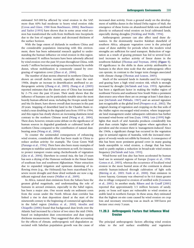
southwest Kalahari (Thomas and Twyman, 2004) (Figure 5).
Of significance in the shifts in dune activity attributable to
humans is the short time scale that the anthropogenic effect
can operate, in contrast to the longer term changes associated
with climate change (Thomas and Leason, 2005).
Much of the semiarid lands in Australia used for cropping
and grazing have a high wind erosion risk, which is strongly
increased by drought (McTainsh and Leys, 1993). Agriculture
has been a significant factor in making the Mallee region of
northwest Victoria and southwest New South Wales a persistent
dust source area where there are on average at least 5 dust days a
year (McTainsh and Pitblado, 1987) and an aerosol signature
just recognizable at the global level (Prospero et al., 2002). The
original clearing of vegetation and cropping on the fine soils of
the Mallee region encouraged wind erosion, where inappropri-
ate land management under subsequent cultivation has further
increased wind-borne soil loss (Leys, 1990). Leys (1999) high-
lights that much of arid Australia produces considerably less
dust than certain higher rainfall regions where agriculture is
prevalent and the erosion there is ‘management-induced’. Since
the 1960s, a significant change has occurred in the vegetation
type in semiarid regions of Australia, with the increased emer-
gence of woody weeds not edible by livestock. A consequence of
this has been more persistent ground cover in many grazing
lands susceptible to wind erosion, a change that has been
used to partly explain a reduction in broad-scale wind erosion
frequency (McTainsh and Leys, 1993).
Wind-borne soil loss also has been accelerated by human
land use in semiarid regions of Europe (Lopez et al., 1998;
Gomes et al., 2003), whereas the occurrence of localized wind
erosion in the more humid areas of the continent is almost
entirely human-induced through cultivation of light soils
(Barring et al., 2003; Funk et al., 2008). Dust emission in
Lower Saxony, Germany was observed to be 6.6 times greater
due to tillage compared to erosion of untilled soils (Goossens
et al., 2001). In another study, Riksen and de Graaff (2001)
reported that approximately 3.5 million hectares of sandy,
peaty, or loess soil types are vulnerable to wind erosion as
arable land in northern Europe. In these areas, they estimated
that the highest on-site costs caused by wind erosion on crop
loss and necessary resowing was as much as 500 Euros per
hectare once every 5 years.
11.20.3 Anthropogenic Factors that Influence WindErosion
The principal anthropogenic factors affecting wind erosion
relate to the soil surface erodibility and vegetation
Figure 5 Heavy grazing on linear dunes in the southwest Kalahari Desert, Botswana. Photo by Paolo D’Odorico.
400 Anthropogenic Environments
characteristics. A recent review of soil erodibility dynamics and
its representation for wind erosion and dust emission models
on agricultural and rangeland surfaces has been provided by
Webb and Strong (2011). As mentioned earlier, there are
stunning examples of how human activity has exposed for-
merly vegetated (Dust Bowl region and the USSR Virgin Lands
Scheme; Goudie and Middleton, 1992, 2006) or wet areas
(Aral Sea, Owens Lake; Gill, 1996) to the ravages of the wind
and led to accelerated wind erosion. Besides agricultural
production and land drainage, wind erosion can also be
accelerated due to fire and overgrazing, both potentially human-
induced, and other anthropogenic activity. Wind erosion is
accelerated after fire on erodible soils due to the great re-
duction in protective vegetation on the soil surface (Zobeck
et al., 1989; Stout and Zobeck, 1998; Whicker et al., 2002;
Vermeire et al., 2005; Sankey et al., 2010). Overgrazing reduces
vegetation on the soil surface as well and also disrupts pro-
tective biotic soil crusts by trampling (Karnieli and Tsoar,
1995). Although overgrazing can produce accelerated wind
erosion, traditional grazing may produce less erosion than
abandoned tilled land (McTainsh and Leys, 1993; Qi et al.,
2008). Biotic crusts, produced by algae, lichens, and other
microorganisms, are a dominant feature on arid and semiarid
landscapes and produce very stable surfaces unless disturbed
(Belnap and Gillette, 1997; Belnap et al., 2009). In a com-
parison of crusted and foot or vehicular disturbed surfaces,
Belnap and Gillette (1997) found friction threshold velocity
much higher, and thus susceptibility to wind erosion was
much lower, for undisturbed crusts than disturbed crusts.
Wheeled vehicles also increase the erodibility of natural
surfaces (Goossens and Buck, 2009) and vehicular traffic on
unpaved roads may lead to dust bearing the contaminants of
local industrial activities (Meza-Figueroa et al., 2009; Sinha
and Banerjee, 1997). Recreational activities such as off-road
vehicle (ORV) driving can also disturb the soil surface and
cause accelerated wind erosion. A recent study of the effects of
ORV traffic on 16 arid soil types in Nevada showed that sur-
face disturbance by ORV traffic increased dust emissions and
surface erodibility initially but that winnowing and com-
paction of sandy soil types resulted in decreased rates of dust
emission and increases in the threshold wind speed required
to entrain particles (Goossens and Buck, 2009). Other non-
agricultural anthropogenic factors that have been studied
include the impact of military maneuvers (Gillies et al., 2010)
and mining operations (McKenna Neuman et al., 2009;
Brotons et al., 2010). Although agricultural and grazing lands,
roads, recreational areas, and other land use contribute to the
overall anthropogenic dust load, this chapter will focus mainly
on wind erosion caused by agricultural activities.
11.20.3.1 Tillage Effects
Tillage refers to the physical manipulation of the soils usually
performed during agricultural operations. Tillage is used to
prepare the soil for planting a crop, for weed control, to in-
corporate chemicals, to disturb a surface crust in order to
improve crop establishment, promote water infiltration,
and offer erosion control. A wide variety of tools are used
during the tillage process. Tillage generally breaks the soil into
aggregates (naturally occurring groups of individual soil par-
ticles) or clods of varying sizes; buries residues and redistrib-
utes organic matter; mixes the soil, commonly burying loose
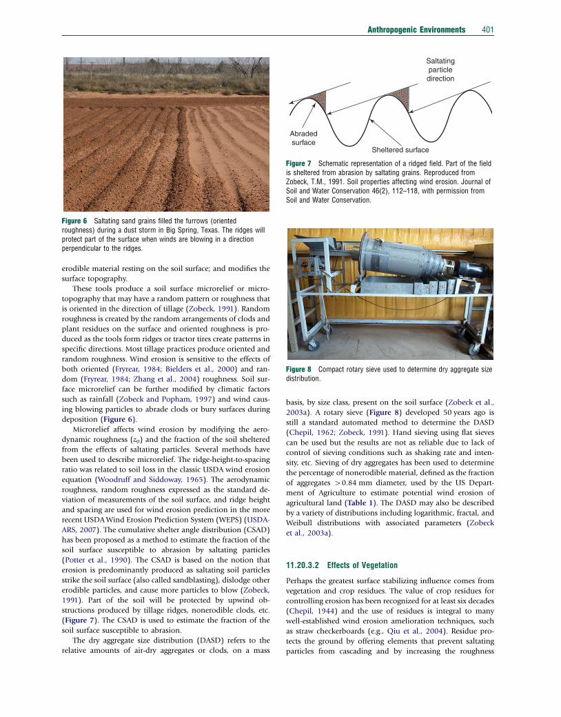
Figure 6 Saltating sand grains filled the furrows (orientedroughness) during a dust storm in Big Spring, Texas. The ridges willprotect part of the surface when winds are blowing in a directionperpendicular to the ridges.
Saltatingparticledirection
Abradedsurface
Sheltered surface
Figure 7 Schematic representation of a ridged field. Part of the fieldis sheltered from abrasion by saltating grains. Reproduced fromZobeck, T.M., 1991. Soil properties affecting wind erosion. Journal ofSoil and Water Conservation 46(2), 112–118, with permission fromSoil and Water Conservation.
Figure 8 Compact rotary sieve used to determine dry aggregate sizedistribution.
Anthropogenic Environments 401
erodible material resting on the soil surface; and modifies the
surface topography.
These tools produce a soil surface microrelief or micro-
topography that may have a random pattern or roughness that
is oriented in the direction of tillage (Zobeck, 1991). Random
roughness is created by the random arrangements of clods and
plant residues on the surface and oriented roughness is pro-
duced as the tools form ridges or tractor tires create patterns in
specific directions. Most tillage practices produce oriented and
random roughness. Wind erosion is sensitive to the effects of
both oriented (Fryrear, 1984; Bielders et al., 2000) and ran-
dom (Fryrear, 1984; Zhang et al., 2004) roughness. Soil sur-
face microrelief can be further modified by climatic factors
such as rainfall (Zobeck and Popham, 1997) and wind caus-
ing blowing particles to abrade clods or bury surfaces during
deposition (Figure 6).
Microrelief affects wind erosion by modifying the aero-
dynamic roughness (z0) and the fraction of the soil sheltered
from the effects of saltating particles. Several methods have
been used to describe microrelief. The ridge-height-to-spacing
ratio was related to soil loss in the classic USDA wind erosion
equation (Woodruff and Siddoway, 1965). The aerodynamic
roughness, random roughness expressed as the standard de-
viation of measurements of the soil surface, and ridge height
and spacing are used for wind erosion prediction in the more
recent USDA Wind Erosion Prediction System (WEPS) (USDA-
ARS, 2007). The cumulative shelter angle distribution (CSAD)
has been proposed as a method to estimate the fraction of the
soil surface susceptible to abrasion by saltating particles
(Potter et al., 1990). The CSAD is based on the notion that
erosion is predominantly produced as saltating soil particles
strike the soil surface (also called sandblasting), dislodge other
erodible particles, and cause more particles to blow (Zobeck,
1991). Part of the soil will be protected by upwind ob-
structions produced by tillage ridges, nonerodible clods, etc.
(Figure 7). The CSAD is used to estimate the fraction of the
soil surface susceptible to abrasion.
The dry aggregate size distribution (DASD) refers to the
relative amounts of air-dry aggregates or clods, on a mass
basis, by size class, present on the soil surface (Zobeck et al.,
2003a). A rotary sieve (Figure 8) developed 50 years ago is
still a standard automated method to determine the DASD
(Chepil, 1962; Zobeck, 1991). Hand sieving using flat sieves
can be used but the results are not as reliable due to lack of
control of sieving conditions such as shaking rate and inten-
sity, etc. Sieving of dry aggregates has been used to determine
the percentage of nonerodible material, defined as the fraction
of aggregates 40.84 mm diameter, used by the US Depart-
ment of Agriculture to estimate potential wind erosion of
agricultural land (Table 1). The DASD may also be described
by a variety of distributions including logarithmic, fractal, and
Weibull distributions with associated parameters (Zobeck
et al., 2003a).
11.20.3.2 Effects of Vegetation
Perhaps the greatest surface stabilizing influence comes from
vegetation and crop residues. The value of crop residues for
controlling erosion has been recognized for at least six decades
(Chepil, 1944) and the use of residues is integral to many
well-established wind erosion amelioration techniques, such
as straw checkerboards (e.g., Qiu et al., 2004). Residue pro-
tects the ground by offering elements that prevent saltating
particles from cascading and by increasing the roughness
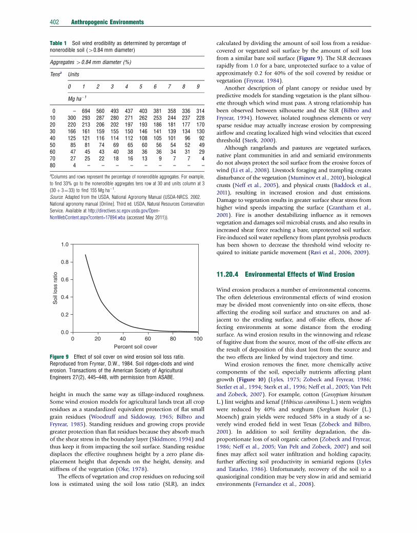
Table 1 Soil wind erodibility as determined by percentage ofnonerodible soil (40.84 mm diameter)
Aggregates 40.84 mm diameter (%)
Tensa Units
0 1 2 3 4 5 6 7 8 9
Mg ha�1
0 – 694 560 493 437 403 381 358 336 31410 300 293 287 280 271 262 253 244 237 22820 220 213 206 202 197 193 186 181 177 17030 166 161 159 155 150 146 141 139 134 13040 125 121 116 114 112 108 105 101 96 9250 85 81 74 69 65 60 56 54 52 4960 47 45 43 40 38 36 36 34 31 2970 27 25 22 18 16 13 9 7 7 480 4 – – – – – – – – –
aColumns and rows represent the percentage of nonerodible aggregates. For example,
to find 33% go to the nonerodible aggregates tens row at 30 and units column at 3
(30þ 3¼33) to find 155 Mg ha�1.
Source: Adapted from the USDA, National Agronomy Manual (USDA-NRCS. 2002.
National agronomy manual [Online]. Third ed. USDA, Natural Resources Conservation
Service. Available at http://directives.sc.egov.usda.gov/Open-
NonWebContent.aspx?content=17894.wba (accessed May 2011)).
100806040
Percent soil cover
2000.0
0.2
0.4
0.6
Soi
l los
s ra
tio
0.8
1.0
Figure 9 Effect of soil cover on wind erosion soil loss ratio.Reproduced from Fryrear, D.W., 1984. Soil ridges-clods and winderosion. Transactions of the American Society of AgriculturalEngineers 27(2), 445–448, with permission from ASABE.
402 Anthropogenic Environments
height in much the same way as tillage-induced roughness.
Some wind erosion models for agricultural lands treat all crop
residues as a standardized equivalent protection of flat small
grain residues (Woodruff and Siddoway, 1965; Bilbro and
Fryrear, 1985). Standing residues and growing crops provide
greater protection than flat residues because they absorb much
of the shear stress in the boundary layer (Skidmore, 1994) and
thus keep it from impacting the soil surface. Standing residue
displaces the effective roughness height by a zero plane dis-
placement height that depends on the height, density, and
stiffness of the vegetation (Oke, 1978).
The effects of vegetation and crop residues on reducing soil
loss is estimated using the soil loss ratio (SLR), an index
calculated by dividing the amount of soil loss from a residue-
covered or vegetated soil surface by the amount of soil loss
from a similar bare soil surface (Figure 9). The SLR decreases
rapidly from 1.0 for a bare, unprotected surface to a value of
approximately 0.2 for 40% of the soil covered by residue or
vegetation (Fryrear, 1984).
Another description of plant canopy or residue used by
predictive models for standing vegetation is the plant silhou-
ette through which wind must pass. A strong relationship has
been observed between silhouette and the SLR (Bilbro and
Fryrear, 1994). However, isolated roughness elements or very
sparse residue may actually increase erosion by compressing
airflow and creating localized high wind velocities that exceed
threshold (Sterk, 2000).
Although rangelands and pastures are vegetated surfaces,
native plant communities in arid and semiarid environments
do not always protect the soil surface from the erosive forces of
wind (Li et al., 2008). Livestock foraging and trampling creates
disturbance of the vegetation (Muminov et al., 2010), biological
crusts (Neff et al., 2005), and physical crusts (Baddock et al.,
2011), resulting in increased erosion and dust emissions.
Damage to vegetation results in greater surface shear stress from
higher wind speeds impacting the surface (Grantham et al.,
2001). Fire is another destabilizing influence as it removes
vegetation and damages soil microbial crusts, and also results in
increased shear force reaching a bare, unprotected soil surface.
Fire-induced soil water repellency from plant pyrolysis products
has been shown to decrease the threshold wind velocity re-
quired to initiate particle movement (Ravi et al., 2006, 2009).
11.20.4 Environmental Effects of Wind Erosion
Wind erosion produces a number of environmental concerns.
The often deleterious environmental effects of wind erosion
may be divided most conveniently into on-site effects, those
affecting the eroding soil surface and structures on and ad-
jacent to the eroding surface, and off-site effects, those af-
fecting environments at some distance from the eroding
surface. As wind erosion results in the winnowing and release
of fugitive dust from the source, most of the off-site effects are
the result of deposition of this dust lost from the source and
the two effects are linked by wind trajectory and time.
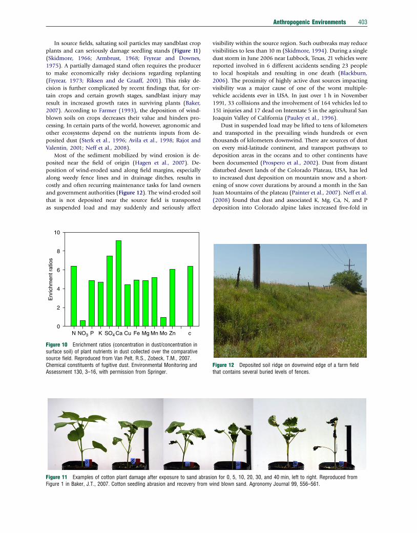
Wind erosion removes the finer, more chemically active
components of the soil, especially nutrients affecting plant
growth (Figure 10) (Lyles, 1975; Zobeck and Fryrear, 1986;
Stetler et al., 1994; Sterk et al., 1996; Neff et al., 2005; Van Pelt
and Zobeck, 2007). For example, cotton (Gossypium hirsutum
L.) lint weights and kenaf (Hibiscus cannibinus L.) stem weights
were reduced by 40% and sorghum (Sorghum bicolor (L.)
Moench) grain yields were reduced 58% in a study of a se-
verely wind eroded field in west Texas (Zobeck and Bilbro,
2001). In addition to soil fertility degradation, the dis-
proportionate loss of soil organic carbon (Zobeck and Fryrear,
1986; Neff et al., 2005; Van Pelt and Zobeck, 2007) and soil
fines may affect soil water infiltration and holding capacity,
further affecting soil productivity in semiarid regions (Lyles
and Tatarko, 1986). Unfortunately, recovery of the soil to a
quasioriginal condition may be very slow in arid and semiarid
environments (Fernandez et al., 2008).
Anthropogenic Environments 403
In source fields, saltating soil particles may sandblast crop
plants and can seriously damage seedling stands (Figure 11)
(Skidmore, 1966; Armbrust, 1968; Fryrear and Downes,
1975). A partially damaged stand often requires the producer
to make economically risky decisions regarding replanting
(Fryrear, 1973; Riksen and de Graaff, 2001). This risky de-
cision is further complicated by recent findings that, for cer-
tain crops and certain growth stages, sandblast injury may
result in increased growth rates in surviving plants (Baker,
2007). According to Farmer (1993), the deposition of wind-
blown soils on crops decreases their value and hinders pro-
cessing. In certain parts of the world, however, agronomic and
other ecosystems depend on the nutrients inputs from de-
posited dust (Sterk et al., 1996; Avila et al., 1998; Rajot and
Valentin, 2001; Neff et al., 2008).
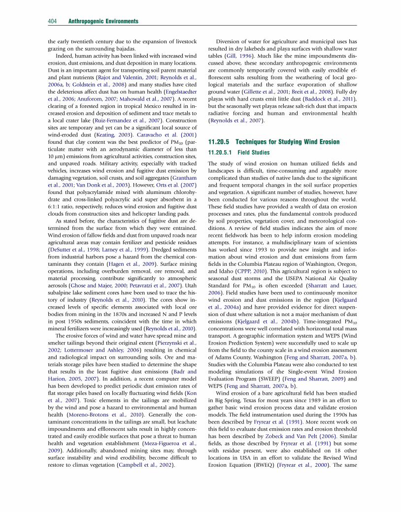
Most of the sediment mobilized by wind erosion is de-
posited near the field of origin (Hagen et al., 2007). De-
position of wind-eroded sand along field margins, especially
along weedy fence lines and in drainage ditches, results in
costly and often recurring maintenance tasks for land owners
and government authorities (Figure 12). The wind-eroded soil
that is not deposited near the source field is transported
as suspended load and may suddenly and seriously affect
Figure 11 Examples of cotton plant damage after exposure to sand abrasiFigure 1 in Baker, J.T., 2007. Cotton seedling abrasion and recovery from w
N NO3 P K SO4 Ca Cu Fe Mg Mn Mo Zn c0
2
4
6
Enr
ichm
ent r
atio
s
8
10
Figure 10 Enrichment ratios (concentration in dust/concentration insurface soil) of plant nutrients in dust collected over the comparativesource field. Reproduced from Van Pelt, R.S., Zobeck, T.M., 2007.Chemical constituents of fugitive dust. Environmental Monitoring andAssessment 130, 3–16, with permission from Springer.
visibility within the source region. Such outbreaks may reduce
visibilities to less than 10 m (Skidmore, 1994). During a single
dust storm in June 2006 near Lubbock, Texas, 21 vehicles were
reported involved in 6 different accidents sending 23 people
to local hospitals and resulting in one death (Blackburn,
2006). The proximity of highly active dust sources impacting
visibility was a major cause of one of the worst multiple-
vehicle accidents ever in USA. In just over 1 h in November
1991, 33 collisions and the involvement of 164 vehicles led to
151 injuries and 17 dead on Interstate 5 in the agricultural San
Joaquin Valley of California (Pauley et al., 1996).
Dust in suspended load may be lifted to tens of kilometers
and transported in the prevailing winds hundreds or even
thousands of kilometers downwind. There are sources of dust
on every mid-latitude continent, and transport pathways to
deposition areas in the oceans and to other continents have
been documented (Prospero et al., 2002). Dust from distant
disturbed desert lands of the Colorado Plateau, USA, has led
to increased dust deposition on mountain snow and a short-
ening of snow cover durations by around a month in the San
Juan Mountains of the plateau (Painter et al., 2007). Neff et al.
(2008) found that dust and associated K, Mg, Ca, N, and P
deposition into Colorado alpine lakes increased five-fold in
on for 0, 5, 10, 20, 30, and 40 min, left to right. Reproduced fromind blown sand. Agronomy Journal 99, 556–561.
Figure 12 Deposited soil ridge on downwind edge of a farm fieldthat contains several buried levels of fences.
404 Anthropogenic Environments
the early twentieth century due to the expansion of livestock
grazing on the surrounding bajadas.
Indeed, human activity has been linked with increased wind
erosion, dust emissions, and dust deposition in many locations.
Dust is an important agent for transporting soil parent material
and plant nutrients (Rajot and Valentin, 2001; Reynolds et al.,
2006a, b; Goldstein et al., 2008) and many studies have cited
the deleterious affect dust has on human health (Engelstaedter
et al., 2006; Anuforom, 2007; Mahowald et al., 2007). A recent
clearing of a forested region in tropical Mexico resulted in in-
creased erosion and deposition of sediment and trace metals to
a local crater lake (Ruiz-Fernandez et al., 2007). Construction
sites are temporary and yet can be a significant local source of
wind-eroded dust (Keating, 2003). Caravacho et al. (2001)
found that clay content was the best predictor of PM10 (par-
ticulate matter with an aerodynamic diameter of less than
10 mm) emissions from agricultural activities, construction sites,
and unpaved roads. Military activity, especially with tracked
vehicles, increases wind erosion and fugitive dust emission by
damaging vegetation, soil crusts, and soil aggregates (Grantham
et al., 2001; Van Donk et al., 2003). However, Orts et al. (2007)
found that polyacrylamide mixed with aluminum chlorohy-
drate and cross-linked polyacrylic acid super absorbent in a
6:1:1 ratio, respectively, reduces wind erosion and fugitive dust
clouds from construction sites and helicopter landing pads.
As stated before, the characteristics of fugitive dust are de-
termined from the surface from which they were entrained.
Wind erosion of fallow fields and dust from unpaved roads near
agricultural areas may contain fertilizer and pesticide residues
(DeSutter et al., 1998; Larney et al., 1999). Dredged sediments
from industrial harbors pose a hazard from the chemical con-
taminants they contain (Hagen et al., 2009). Surface mining
operations, including overburden removal, ore removal, and
material processing, contribute significantly to atmospheric
aerosols (Ghose and Majee, 2000; Petavratzi et al., 2007). Utah
subalpine lake sediment cores have been used to trace the his-
tory of industry (Reynolds et al., 2010). The cores show in-
creased levels of specific elements associated with local ore
bodies from mining in the 1870s and increased N and P levels
in post 1950s sediments, coincident with the time in which
mineral fertilizers were increasingly used (Reynolds et al., 2010).
The erosive forces of wind and water have spread mine and
smelter tailings beyond their original extent (Pierzynski et al.,
2002; Lottermoser and Ashley, 2006) resulting in chemical
and radiological impact on surrounding soils. Ore and ma-
terials storage piles have been studied to determine the shape
that results in the least fugitive dust emissions (Badr and
Harion, 2005, 2007). In addition, a recent computer model
has been developed to predict periodic dust emission rates of
flat storage piles based on locally fluctuating wind fields (Kon
et al., 2007). Toxic elements in the tailings are mobilized
by the wind and pose a hazard to environmental and human
health (Moreno-Brotons et al., 2010). Generally the con-
taminant concentrations in the tailings are small, but leachate
impoundments and efflorescent salts result in highly concen-
trated and easily erodible surfaces that pose a threat to human
health and vegetation establishment (Meza-Figueroa et al.,
2009). Additionally, abandoned mining sites may, through
surface instability and wind erodibility, become difficult to
restore to climax vegetation (Campbell et al., 2002).
Diversion of water for agriculture and municipal uses has
resulted in dry lakebeds and playa surfaces with shallow water
tables (Gill, 1996). Much like the mine impoundments dis-
cussed above, these secondary anthropogenic environments
are commonly temporarily covered with easily erodible ef-
florescent salts resulting from the weathering of local geo-
logical materials and the surface evaporation of shallow
ground water (Gillette et al., 2001; Breit et al., 2008). Fully dry
playas with hard crusts emit little dust (Baddock et al., 2011),
but the seasonally wet playas release salt-rich dust that impacts
radiative forcing and human and environmental health
(Reynolds et al., 2007).
11.20.5 Techniques for Studying Wind Erosion
11.20.5.1 Field Studies
The study of wind erosion on human utilized fields and
landscapes is difficult, time-consuming and arguably more
complicated than studies of native lands due to the significant
and frequent temporal changes in the soil surface properties
and vegetation. A significant number of studies, however, have
been conducted for various reasons throughout the world.
These field studies have provided a wealth of data on erosion
processes and rates, plus the fundamental controls produced
by soil properties, vegetation cover, and meteorological con-
ditions. A review of field studies indicates the aim of more
recent fieldwork has been to help inform erosion modeling
attempts. For instance, a multdisciplinary team of scientists
has worked since 1993 to provide new insight and infor-
mation about wind erosion and dust emissions from farm
fields in the Columbia Plateau region of Washington, Oregon,
and Idaho (CPPP, 2010). This agricultural region is subject to
seasonal dust storms and the USEPA National Air Quality
Standard for PM10 is often exceeded (Sharratt and Lauer,
2006). Field studies have been used to continuously monitor
wind erosion and dust emissions in the region (Kjelgaard
et al., 2004a) and have provided evidence for direct suspen-
sion of dust where saltation is not a major mechanism of dust
emissions (Kjelgaard et al., 2004b). Time-integrated PM10
concentrations were well correlated with horizontal total mass
transport. A geographic information system and WEPS (Wind
Erosion Prediction System) were successfully used to scale up
from the field to the county scale in a wind erosion assessment
of Adams County, Washington (Feng and Sharratt, 2007a, b).
Studies with the Columbia Plateau were also conducted to test
modeling simulations of the Single-event Wind Erosion
Evaluation Program (SWEEP) (Feng and Sharratt, 2009) and
WEPS (Feng and Sharratt, 2007a, b).
Wind erosion of a bare agricultural field has been studied
in Big Spring, Texas for most years since 1989 in an effort to
gather basic wind erosion process data and validate erosion
models. The field instrumentation used during the 1990s has
been described by Fryrear et al. (1991). More recent work on
this field to evaluate dust emission rates and erosion threshold
has been described by Zobeck and Van Pelt (2006). Similar
fields, as those described by Fryrear et al. (1991) but some
with residue present, were also established on 18 other
locations in USA in an effort to validate the Revised Wind
Erosion Equation (RWEQ) (Fryrear et al., 2000). The same
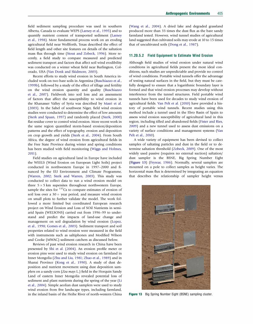
Figure 13 Big Spring Number Eight (BSNE) sampling cluster.
Anthropogenic Environments 405
field sediment sampling procedure was used in southern
Alberta, Canada to evaluate WEPS (Larney et al., 1995) and to
quantify nutrient content of transported sediment (Larney
et al., 1998). More fundamental process work on an eroding
agricultural field near Wollforth, Texas described the effect of
field length and other site features on details of the saltation
mass flux through time (Stout and Zobeck, 1996). More re-
cently, a field study to compare measured and predicted
sediment transport and factors that affect soil wind erodibility
was conducted on a winter wheat field near Burlington, Col-
orado, USA (Van Donk and Skidmore, 2003).
Recent efforts to study wind erosion in South America in-
cluded work on two bare soils in Argentina (Buschiazzo et al.,
1999b), followed by a study of the effect of tillage and fertility
on the wind erosion quantity and quality (Buschiazzo
et al., 2007). Fieldwork into soil loss and an assessment
of factors that affect the susceptibility to wind erosion in
the Khanasser Valley of Syria was described by Masri et al.
(2003). In the Sahel of southwest Niger, field wind erosion
studies were conducted to determine the effect of low amounts
(Sterk and Spaan, 1997) and randomly placed (Sterk, 2000)
flat residue cover to control wind erosion. More recent work in
the same region quantified storm-based erosion/deposition
patterns and the effect of topography, erosion and deposition
on crop growth and yields (Sterk et al., 2004). From South
Africa, the degree of wind erosion from agricultural fields in
the Free State Province during winter and spring conditions
has been studied with field monitoring (Wiggs and Holmes,
2011).
Field studies on agricultural land in Europe have included
the WEELS (Wind Erosion on European Light Soils) project
conducted in northwestern Europe in 1997–2000 and fi-
nanced by the EU Environment and Climate Programme,
(Warren, 2002; Sterk and Warren, 2003). This study was
conducted to collect data to run a wind erosion model on
three 5� 5 km supersites throughout northwestern Europe,
sample the sites for 137Cs to compare estimates of erosion of
soil loss over a 30þ year period, and measure wind erosion
on small plots to further validate the model. The work fol-
lowed a more limited but coordinated European research
project on Wind Erosion and Loss of SOil Nutrients in semi-
arid Spain (WELSONS) carried out from 1996–99 to under-
stand and predict the impacts of land-use change and
management on soil degradation by wind erosion (Lopez,
et al., 1998; Gomes et al., 2003). Sediment transport and soil
properties related to wind erosion were measured in the field
with instruments such as saltiphones and Modified Wilson
and Cooke (MWAC) sediment catchers as discussed below.
Reviews of past wind erosion research in China have been
presented by Shi et al. (2004). An erosion profile meter or
erosion pins were used to study wind erosion on farmland in
Inner Mongolia (Zhu and Liu, 1981; Zhao et al., 1989) and in
Shanxi Province (Kong et al., 1990). A study of dust de-
position and nutrient movement using dust deposition sam-
plers on a sandy corn (Zea mays L.) field in the Horquin Sandy
Land of eastern Inner Mongolia revealed potential loss of
sediment and plant nutrients during the spring of the year (Li
et al., 2004). Simple aeolian dust samplers were used to study
wind erosion from five landscape types, including farmland,
in the inland basin of the Heihe River of north-western China
(Wang et al., 2004). A dried lake and degraded grassland
produced more than 33 times the dust flux as the bare sandy
farmland tested. However, wind tunnel studies of agricultural
land suggested that cultivated soils may erode at 10 to 15 times
that of uncultivated soils (Dong et al., 1987).
11.20.5.2 Field Equipment to Estimate Wind Erosion
Although field studies of wind erosion under natural wind
conditions in agricultural fields present the most ideal con-
ditions, such studies are unpredictable and provide no control
of wind conditions. Portable wind tunnels offer the advantage
of testing natural surfaces in the field, but they must be care-
fully designed to ensure that a logarithmic boundary layer is
formed and that wind erosion processes may develop without
interference from the tunnel structures. Field portable wind
tunnels have been used for decades to study wind erosion of
agricultural fields. Van Pelt et al. (2010) have provided a his-
tory of portable wind tunnels. Recent studies using this
method include a tunnel used in the Ebro Basin of Spain to
assess wind erosion susceptibility of agricultural land in this
region, including tilled and abandoned fields (Fister and Ries,
2009) and a new tunnel used to assess dust emissions on a
variety of surface conditions and management systems (Van
Pelt et al., 2010).
A wide variety of equipment has been devised to collect
samples of saltating particles and dust in the field or to de-
termine saltation threshold (Zobeck, 2009). One of the most
widely used passive (requires no external suction) saltation/
dust sampler is the BSNE, Big Spring Number Eight
(Figure 13) (Fryrear, 1986). Normally, several samplers are
mounted on a pole to collect samples as height varies. The
horizontal mass flux is determined by integrating an equation
that describes the relationship of sampler height versus
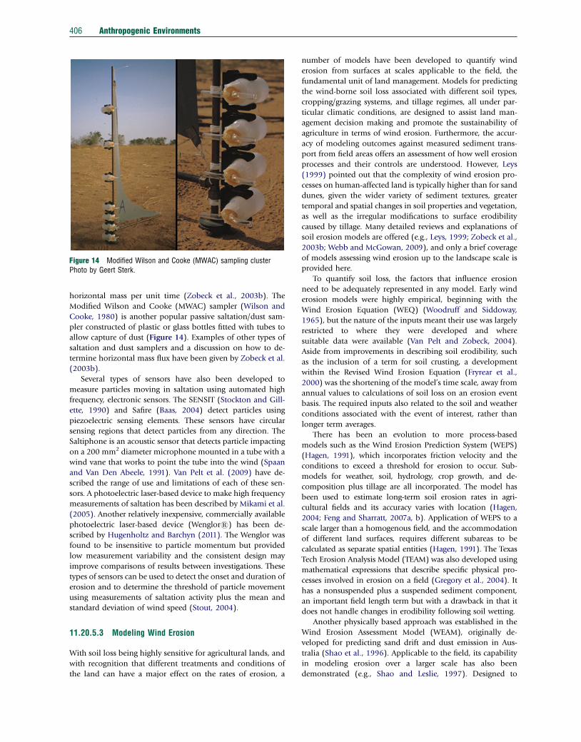
Figure 14 Modified Wilson and Cooke (MWAC) sampling clusterPhoto by Geert Sterk.
406 Anthropogenic Environments
horizontal mass per unit time (Zobeck et al., 2003b). The
Modified Wilson and Cooke (MWAC) sampler (Wilson and
Cooke, 1980) is another popular passive saltation/dust sam-
pler constructed of plastic or glass bottles fitted with tubes to
allow capture of dust (Figure 14). Examples of other types of
saltation and dust samplers and a discussion on how to de-
termine horizontal mass flux have been given by Zobeck et al.
(2003b).
Several types of sensors have also been developed to
measure particles moving in saltation using automated high
frequency, electronic sensors. The SENSIT (Stockton and Gill-
ette, 1990) and Safire (Baas, 2004) detect particles using
piezoelectric sensing elements. These sensors have circular
sensing regions that detect particles from any direction. The
Saltiphone is an acoustic sensor that detects particle impacting
on a 200 mm2 diameter microphone mounted in a tube with a
wind vane that works to point the tube into the wind (Spaan
and Van Den Abeele, 1991). Van Pelt et al. (2009) have de-
scribed the range of use and limitations of each of these sen-
sors. A photoelectric laser-based device to make high frequency
measurements of saltation has been described by Mikami et al.
(2005). Another relatively inexpensive, commercially available
photoelectric laser-based device (Wenglors) has been de-
scribed by Hugenholtz and Barchyn (2011). The Wenglor was
found to be insensitive to particle momentum but provided
low measurement variability and the consistent design may
improve comparisons of results between investigations. These
types of sensors can be used to detect the onset and duration of
erosion and to determine the threshold of particle movement
using measurements of saltation activity plus the mean and
standard deviation of wind speed (Stout, 2004).
11.20.5.3 Modeling Wind Erosion
With soil loss being highly sensitive for agricultural lands, and
with recognition that different treatments and conditions of
the land can have a major effect on the rates of erosion, a
number of models have been developed to quantify wind
erosion from surfaces at scales applicable to the field, the
fundamental unit of land management. Models for predicting
the wind-borne soil loss associated with different soil types,
cropping/grazing systems, and tillage regimes, all under par-
ticular climatic conditions, are designed to assist land man-
agement decision making and promote the sustainability of
agriculture in terms of wind erosion. Furthermore, the accur-
acy of modeling outcomes against measured sediment trans-
port from field areas offers an assessment of how well erosion
processes and their controls are understood. However, Leys
(1999) pointed out that the complexity of wind erosion pro-
cesses on human-affected land is typically higher than for sand
dunes, given the wider variety of sediment textures, greater
temporal and spatial changes in soil properties and vegetation,
as well as the irregular modifications to surface erodibility
caused by tillage. Many detailed reviews and explanations of
soil erosion models are offered (e.g., Leys, 1999; Zobeck et al.,
2003b; Webb and McGowan, 2009), and only a brief coverage
of models assessing wind erosion up to the landscape scale is
provided here.
To quantify soil loss, the factors that influence erosion
need to be adequately represented in any model. Early wind
erosion models were highly empirical, beginning with the
Wind Erosion Equation (WEQ) (Woodruff and Siddoway,
1965), but the nature of the inputs meant their use was largely
restricted to where they were developed and where
suitable data were available (Van Pelt and Zobeck, 2004).
Aside from improvements in describing soil erodibility, such
as the inclusion of a term for soil crusting, a development
within the Revised Wind Erosion Equation (Fryrear et al.,
2000) was the shortening of the model’s time scale, away from
annual values to calculations of soil loss on an erosion event
basis. The required inputs also related to the soil and weather
conditions associated with the event of interest, rather than
longer term averages.
There has been an evolution to more process-based
models such as the Wind Erosion Prediction System (WEPS)
(Hagen, 1991), which incorporates friction velocity and the
conditions to exceed a threshold for erosion to occur. Sub-
models for weather, soil, hydrology, crop growth, and de-
composition plus tillage are all incorporated. The model has
been used to estimate long-term soil erosion rates in agri-
cultural fields and its accuracy varies with location (Hagen,
2004; Feng and Sharratt, 2007a, b). Application of WEPS to a
scale larger than a homogenous field, and the accommodation
of different land surfaces, requires different subareas to be
calculated as separate spatial entities (Hagen, 1991). The Texas
Tech Erosion Analysis Model (TEAM) was also developed using
mathematical expressions that describe specific physical pro-
cesses involved in erosion on a field (Gregory et al., 2004). It
has a nonsuspended plus a suspended sediment component,
an important field length term but with a drawback in that it
does not handle changes in erodibility following soil wetting.
Another physically based approach was established in the
Wind Erosion Assessment Model (WEAM), originally de-
veloped for predicting sand drift and dust emission in Aus-
tralia (Shao et al., 1996). Applicable to the field, its capability
in modeling erosion over a larger scale has also been
demonstrated (e.g., Shao and Leslie, 1997). Designed to
Anthropogenic Environments 407
specifically tackle the spatial and temporal changes that are
commonly lacking in land erodibility modeling, a recent
modeling attempt called AUSLEM has been developed for
rangelands of western Queensland, Australia (see Webb et al.,
2009). Operating at the landscape scale (103 km2), AUSLEM
includes empirical relationships for a series of controlling
variables and produces a novel, daily-resolved outcome re-
lated to the continuum of land erodibility rather than a
quantified soil loss. The effect of animal stocking rates on
erodibility is reflected in the model’s grass cover input factor
within its component submodels.
A European Union-funded project, the Wind Erosion on
European Light Soils study (WEELS), designed and imple-
mented a tool enabling predictions of long-term soil loss
under varying land uses and for different climates (Bohner
et al., 2003). This model describes wind erosion risks in terms
of erosion hours and wind-induced soil loss.
11.20.5.4 An Indirect Method to Estimate Wind Erosion
In spite of the ability to predict erosion rates by modeling, few
quantitative estimates or direct measurements of past erosion
rates exist. Above-ground nuclear weapons testing during the
1950s and 1960s resulted in the release of anthropogenic
radionuclides (AR) including 90Sr, 137Cs, and 239þ 240Pu into
the atmosphere. These AR were deposited on the earth’s sur-
face as wet and dry deposition termed fallout. The first
measurable quantities of fallout began in 1954 and sub-
sequent pulses in 1958 and 1963–64 account for almost all
the AR fallout received to date (Ritchie and McHenry, 1990).
The Nuclear Test Ban Treaty of 1963 effectively halted at-
mospheric inputs of AR, the atmospheric levels of AR fell
rapidly, and by the late 1970s, AR fallout had essentially ended
(Walling and He, 1999). Polyvalent AR such as 137Cs and239þ 240Pu are tightly adsorbed onto the clay and organic
fraction of the soil (Everett et al., 2008) and only move with
the soil particle to which they are attached. Thus decreases in
AR activity on the landscape indicate erosion has occurred and
increases of AR activity indicate deposition.
For several decades, 137Cs has been used to estimate pat-
terns and rates of soil redistribution due to water movement
(Ritchie, 1998). Fewer studies have investigated the use of137Cs to estimate the patterns or rates of soil redistribution by
wind. In North America, one of the first of these studies made
the assumption that the erosion estimated by 137Cs activity
decrease on a field knoll might be due to wind action (de Jong
et al., 1982). Subsequently, 137Cs has been used to estimate
rates and patterns of soil redistribution by wind in North
America (Coppinger et al., 1991; Ritchie et al., 2003), Europe
(Chappell and Warren, 2003), Africa (Chappell et al., 1998),
Australia (Harper and Gilkes, 1994), and Asia (Ping et al.,
2001). Recently, the use of models to estimate soil redistri-
bution rates from water movement has been validated to
estimate redistribution rates by wind (Van Pelt et al., 2007).
Figure 15 Wind strips provide protection to soil and crops nearBozeman, Montana. Photo by Ron Nichols, USDA-NRCS (http://photogallery.nrcs.usda.gov/Detail.asp).
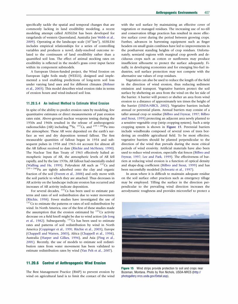
11.20.6 Control of Anthropogenic Wind Erosion
The Best Management Practice (BMP) to prevent erosion by
wind on agricultural land is to limit the contact of the wind
with the soil surface by maintaining an effective cover of
vegetation or managed residues. The increasing use of no-till
and conservation tillage practices has resulted in more effec-
tive surface cover during the period between growing crops.
Further, advances in harvesting equipment such as finger
headers on small grain combines have led to improvements in
the postharvest standing heights of crop residues. Unfortu-
nately, semiarid regions with marginal crop growth and de-
ciduous crops such as cotton or sunflowers may produce
insufficient silhouette to protect the surface adequately. Fi-
nally, in developing economies and for emerging bio-fuel in-
dustries, soil surface protection may not compete with the
alternative use values of crop residues.
Vegetation can also be used to reduce the length of the field
in the direction of wind erosion, thus reducing sediment
emission and transport. Vegetative barriers protect the soil
surface by sheltering an area from the wind on the lee side of
the barrier. A barrier will protect or shelter an area from wind
erosion to a distance of approximately ten times the height of
the barrier (USDA-NRCS, 2002). Vegetative barriers include
annual or perennial plants. Annual barriers may consist of a
taller annual crop or residue (Bilbro and Fryrear, 1997; Bilbro
and Stout, 1999) protecting an adjacent area newly planted to
a sensitive vegetable crop (strip cropping system). Such a strip
cropping system is shown in Figure 15. Perennial barriers
include windbreaks composed of several rows of trees bor-
dering an erodible agricultural field. To be most effective,
vegetative barriers should be planted perpendicular to the
direction of the wind that prevails during the most critical
periods of wind erosivity. Artificial materials have also been
used to reduce wind erosion, especially slat fences (Bilbro and
Fryrear, 1997; Lee and Park, 1999). The effectiveness of bar-
riers at reducing wind erosion is a function of optical density
and shape-drag coefficient (Bilbro and Stout, 1999) and has
been successfully modeled (Schwartz et al., 1997).
In areas where it is difficult to maintain adequate residue
on the soil surface other practices such as emergency tillage
may be employed. Tilling the surface in the direction per-
pendicular to the prevailing wind direction increases the
aerodynamic roughness and provides microrelief to protect a
408 Anthropogenic Environments
portion of the surface as described earlier (Figure 7). Tilling of
finer textured soils can be used to produce nonerodible dur-
able clods that will offer some protection from abrasion until
they are broken down due to rainfall or other weathering
processes. In sandy soils with very fragile or no aggregates,
intense rainfall may promote the development of a weak
surface crust that commonly has loose erodible material de-
posited on it (Zobeck, 1991). This loose erodible material will
readily blow during intense winds. Tillage implements such as
the rotary hoe and sand fighter may be used to disrupt the
crust, produce a rough surface, and bury the loose erodible
material. This technique may be necessary after each intense
rainfall until the crop emerges and grows enough to create
roughness and protect the soil surface. When irrigation is
applied to a dry soil, a reduction in wind erosion can be ex-
pected (USDA-NRCS, 2002). However, irrigation or wetting
the soil offers very short-term mitigation of wind erosion on
sandy soils. These soils dry very rapidly and may erode shortly
after wetting them.
11.20.7 Future Outlook and Perspectives
Fugitive dust has a negative impact on air quality. Non-
attainment of air quality parameters happens several times per
year in wheat-growing regions of Washington (Sharratt and
Lauer, 2006). Although the US Clean Air Act exempted farm-
ing from dust control rules, the San Joaquin Air Quality
Management Districts are moving closer to regulating dust
emissions from agriculture (Engle, 2004). A part of the US
National Food Security Act of 1985 sets a compliance con-
dition of maintaining soil loss at under 11 Mg ha�1 for farmers
seeking government payments and subsidies. Although it is
difficult to place a realistic value on the soil lost to erosion, the
cost of maintaining compliance may dissuade producers from
seeking compliance and further punitive measures to promote
conservation have been suggested (Bunn, 1997, 1998, 1999).
Clearly, improved land management practices have been
linked to a reduction in dust activity (Todhunter and Cihacek,
1999; Stout and Lee, 2003). In Germany, the government is
advising farmers to limit field lengths between wind barriers
for wind erodible soils (Gunreben, 2005). Practices that utilize
the newest agricultural technology, protect natural resources,
and provide a safe, sustainable food source throughout the
world are needed.
From the findings of numerous field and laboratory ex-
periments, and following improvements in modeling erosion
first at the field scale, and then into the landscape or regional
level, there has been considerable appreciation of and ad-
vancement in our understanding of human impacts on ae-
olian processes. Dealing with the anthropogenic contribution
at a larger scale, particularly in global dust modeling, is a
relatively new, but highly significant issue. Considerable un-
certainty still exists regarding the human contribution to dust
loading through land use and the subsequent changes to
surface erodibility (Mahowald et al., 2004). Datasets with
good spatial and temporal resolution that will enable quality
assessments of land use location, extent, and change, espe-
cially in semiarid areas, will be a key requirement in the future.
Further understanding and representation of the spatio
temporal aspects of soil erodibility caused by human activities
can provide improvements but remains a serious challenge in
the development of process-based models (Webb and Strong,
2011). Advances in airborne and satellite remote sensing
provide tools to allow the collection of surface data, including
soil erodibility, with high spatial and temporal resolution.
However, challenges remain in using remote sensing techni-
ques to develop algorithms that provide realistic estimates of
dynamic soil erodibility parameters that make improvements
in global models.
Currently, studies commonly attribute an anthropogenic
component to detected increases in dust loading over time, or,
in order to account for discrepancies between models and
observations (Ginoux et al., 2010). Determining the changes
in wind erosion caused directly by humans as opposed to the
modulations in dustiness that are a result of climatic change
represents an important aim. Improvements of models at all
scales will continue. Furthermore, recalling Zender et al.’s
(2004) Second Kind of anthropogenic dust, the changes in
dust emission caused by human-induced climate change will
require even more research attention in the future.
References
Agric. and Agri-Food Canada, 2007. Wind erosion: an overview. http://www4.agr.gc.ca/AAFC-AAC/display-afficher.doid=1187288822483&lang=eng
Anuforom, A.C., 2007. Spatial distribution and temporal variability of Harmattandust haze in sub-Sahel West Africa. Atmospheric Environment 41, 9079–9090.
Argaman, E., Singer, A., Tsoar, H., 2006. Erodibility of some crust forming soils/sediments from the Southern Aral Sea Basin as determined in a wind tunnel.Earth Surface Processes and Landforms 31, 47–63.
Armbrust, D.V., 1968. Windblown soil abrasive injury to cotton plants. AgronomyJournal 60, 622–625.
Avila, A., Alarcon, M., Queralt, I., 1998. The chemical composition of dusttransported in red rains-I contribution to the biogeochemical cycle of a HolmOak forest in Catalonia (Spain). Atmospheric Environment 32, 179–191.
Baas, A.C.W., 2004. Evaluation of saltation flux responders (Safires) for measuringinstantaneous aeolian sand transport intensity. Geomorphology 59, 99–118.
Baddock, M.C., Zobeck, T.M., Van Pelt, R.S., Fredrickson, E.L., 2011. Dust emissionsfrom undisturbed and disturbed, crusted playa surfaces: cattle trampling effects.Aeolian Research 3, 31–41. http://dx.doi.org/10.1016/j.aeolia.2011.03.007.
Badr, R., Harion, J.L., 2005. Numerical modeling of flow over stockpiles:implications on dust emissions. Atmospheric Environment 39, 5576–5584.
Badr, R., Harion, J.L., 2007. Effect of aggregate storage piles configuration on dustemissions. Atmospheric Environment 41, 360–368.
Baker, J.T., 2007. Cotton seedling abrasion and recovery from wind blown sand.Agronomy Journal 99, 556–561.
Barring, L., Jonsson, P., Mattsson, J.O., Ahman, R., 2003. Wind erosion on arablelands in Scania, Sweden and the relation to the wind climate – a review. Catena52, 173–190.
Baumhardt, R.L., 2003. Dust Bowl Era. In: Stewart, B.A., Howell, T.A. (Eds.),Encyclopedia of Water Science. Marcel-Dekker, New York, pp. 187–191.
Belnap, J., Gillette, D.A., 1997. Disturbance of biological soil crusts: impacts onpotential wind erodibility of sandy desert soils in southeastern Utah. LandDegradation and Development 8, 355–362.
Belnap, J., Reynolds, R.L., Reheis, M.C., Phillips, S.L., Urban, F.E., Goldstein, H.L.,2009. Sediment losses and gains across a gradient of livestock grazing andplant invasion in a cool, semi-arid grassland, Colorado Plateau, USA. AeolianResearch 1, 27–43.
Bielders, C., Michels, K., Rajot, J., 2000. On-farm evaluation of ridging and residuemanagement practices to reduce wind erosion in Niger. Soil Science Society ofAmerica Journal 64, 1776–1785.
Bilbro, J.D., Fryrear, D.W., 1985. Effectiveness of residues from six crops forreducing wind erosion in a semiarid region. Journal of Soil and WaterConservation 40, 358–360.
Bilbro, J.D., Fryrear, D.W., 1994. Wind erosion losses as related to plant silhouetteand soil cover. Agronomy Journal 86, 550–553.
Anthropogenic Environments 409
Bilbro, J.D., Fryrear, D.W., 1997. Comparative performance of forage sorghum,grain sorghum, kenaf, switchgrass, and slat-fence windbarriers in reducing windvelocity. Journal of Soil and Water Conservation 52, 447–452.
Bilbro, J.D., Stout, J.E., 1999. Wind velocity patterns as modified by plastic pipewindbarriers. Journal of Soil and Water Conservation 54, 551–556.
Blackburn, W., 2006. Unusual front leads to tragic scenario along area highway.Lubbock Avalanche-Journal, Online Edition. Available at http://lubbockonline.com/stories/062406/loc_062406027.shtml (accessed May 2011)
Bohner, J., Schafer, W., Conrad, O., Gross, J., Ringeler, A., 2003. The WEELSmodel: methods, results and limitations. Catena 52, 289–308.
Breit, G.N., Goldstein, H.L., Reynolds, R.L., Yount, J.C., 2008. Distribution of majoranions and trace elements in the unsaturated zone at Franklin Lake Playa,California, USA. Proceedings of the 10th International Conference on Salt LakeResearch and Friends of Great Salt Lake Issues Forum, May 11–16, 2008, SaltLake City, UT, USA.
Brotons, J.M., Diaz, A.R., Sarria, F.A., Serrato, F.B., 2010. Wind erosion on miningwaste in southeast Spain. Land Degradation and Development 21, 196–209.
Bunn, J.A., 1997. The implications of alternative beliefs about soil-erosion-productivity relationships and conservation treatments for the economicdynamics of soil erosion on the Southern Texas High Plains. Journal of Soiland Water Conservation 52, 368–375.
Bunn, J.A., 1998. Government policy, wind erosion, and economic viability in semi-arid agriculture: the case of the Southern Texas High Plains. Journal ofAgricultural and Applied Economics 30, 339–351.
Bunn, J.A., 1999. Negative pollution taxes for controlling wind erosion. Reviews ofAgricultural Economics 21, 306–318.
Buschiazzo, D.E., 2006. Management systems in southern South America. In:Peterson, G.A., Unger, P.W., Payne, W.A. (Eds.), Dryland Agriculture, Second ed.Agronomy Monograph No. 23. American Society of Agronomy, Crop ScienceSociety of America, Soil Science Society of America, Madison, WI, USA, pp.395–425.
Buschiazzo, D.E., Taylor, V., 1993. Efectos de la erosion eolica sobre algunaspropiedades de suelos de la region Semiarida Pampeana Argentina. Ciencia delSuelo 10, 46–53.
Buschiazzo, D.E., Zobeck, T.M., Abascal, S.A., 2007. Wind erosion quantity andquality of an Entic Haplustoll of the semi-arid pampas of Argentina. Journal ofArid Environments 69, 29–39.
Buschiazzo, D.E., Zobeck, T.M., Aimar, S.B., 1999. Wind erosion in loess soils ofthe semiarid Argentinian Pampas. Soil Science 164, 133–138.
Campbell, D.R., Lavoie, C., Rochefort, L., 2002. Wind erosion and surfaceinstability in abandoned milled peatlands. Canadian Journal of Soil Science 82,85–95.
Caravacho, O.F., Ashbaugh, L.L., Brown, M.S., Flocchini, R.G., 2001. Relationshipbetween San Joaquin Valley soil texture and PM10 emission potential using theUC Davis dust resuspension test chamber. Transactions of the American Societyof Agricultural Engineers 44, 1603–1608.
Chappell, A., Warren, A., 2003. Spatial scales of 137Cs-derived soil flux by wind ina 25 km2 arable area of eastern England. Catena 52, 209–234.
Chappell, A., Warren, A., Oliver, M.A., Charlton, M., 1998. The utility of 137Csfor measuring soil redistribution rates in southwest Niger. Geoderma 81, 313–337.
Chepil, W.S., 1944. Utilization of crop residues for wind erosion control. ScientificAgriculture 24, 307–319.
Chepil, W.S., 1962. A compact rotary sieve and the importance of dry sieving inphysical soil analysis. Soil Science Society of America Journal 26, 4–6.
Chisari, O.O., Fanelli, J.M., Frenkel, R., 1996. Argentina: growth resumption,sustainability, and environment. World Development 24, 227–240.
Columbia Plateau PM10 Project (CPPP)., 2010. Columbia plateau PM10 projectweb page [Online]. Available at http://www.pnw-winderosion.wsu.edu/ (accessedMay 2011).
Coppinger, K.D., Reiners, W.A., Burke, I.C., Olsen, R.K., 1991. Net erosion on asagebrush steppe landscape as determined by Cesium-137 distributions. SoilScience Society of America Journal 55, 254–258.
Covas, G., Glave, A., 1988. El deterioro del ambiente en la provincia de La Pampa.In: El deterioro del ambiente en la Argentina. PROSA-FECIC, Buenos Aires,Argentina, pp. 109–114.
Del Valle, H.F., Elissalde, N.O., Gagliardini, D.A., Milovich, J., 1998. Arid SoilResearch and Rehabilitation 12, 95–122.
DeSutter, T.M., Clay, S.A., Clay, D.E., 1998. Atrazine, alachlor, and total inorganicnitrogen concentrations of winter wind-eroded sediment samples. Journal ofEnvironmental Science and Health 33, 683–691.
Dıaz-Nigenda, E., Tatarko, J., Jazcilevich, A.D., Garcıa, A.R., Caetano, E., Ruız-Suarez., L.G., 2010. A modeling study of aeolian erosion enhanced by surfacewind confluences over Mexico City. Aeolian Research 2, 143–157.
Dong, G., Li, C., Jin, J., Gao, S., Wu, D., 1987. Some results of simulating tests ofsoil erosion by wind in wind tunnel. Chinese Science Bulletin 32((4)L), 297–301.
Egan, T., 2006. The Worst Hard Times: The Untold Story of Those Who Survivedthe Great American Dust Bowl. Houghton Mifflin Company, Boston.
Elmore, A.J., Kaste, J.M., Okin, G.S., Fantle, M.S., 2008. Groundwater influences onatmospheric dust generation in deserts. Journal of Arid Environments 72,1753–1765.
Engelstaedter, S., Tegen, I., Washington, R., 2006. North African dust emissions andtransport. Earth-Science Reviews 79, 73–100.
Engle, D., 2004. The war on fugitive dust. Erosion Control 11, 34–40.Everett, S.E., Timms, S.G., Hancock, G.J., Bartley, R., Fifield, L.K., 2008.
Comparison of Pu and 137CS as tracers of soil and sediment transport in aterrestrial environment. Journal of Environmental Radioactivity 99, 383–393.
Farmer, A.M., 1993. The effects of dust on plants: a review. Environmental Pollution79, 63–75.
Feng, G., Sharratt, B., 2007a. Scaling from field to region for wind erosionprediction using the Wind Erosion Prediction System and geographicalinformation systems. Journal of Soil and Water Conservation 62, 321–328.
Feng, G., Sharratt, B., 2007b. Validation of WEPS for soil and PM10 loss fromagricultural fields within the Columbia Plateau of the United States. EarthSurface Processes and Landforms 32, 743–753.
Feng, G., Sharratt, B., 2009. Evaluation of the SWEEP model during high windson the Columbia Plateau. Earth Surface Processes and Landforms 34,1461–1468.
Fernandez, D.P., Neff, J.C., Reynolds, R.L., 2008. Biogeochemical and ecologicalimpacts of livestock grazing in semi-arid southeastern Utah, USA. Journal ofArid Environments 72, 777–791.
Fister, W., Ries, J.B., 2009. Wind erosion in the central Ebro Basin under changingland use management. Field experiments with a portable wind tunnel. Journal ofArid Environments 73, 996–1004.
Fryrear, D.W., 1973. Wind damagey..should I replant? American Cotton GrowerMay, 12–25.
Fryrear, D.W., 1984. Soil ridges-clods and wind erosion. Transactions of theAmerican Society of Agricultural Engineers 27(2), 445–448.
Fryrear, D.W., 1986. A field dust sampler. Journal of Soil and Water Conservation41, 117–120.
Fryrear, D.W., Bilbro, J.D., Saleh, A., Schomberg, H., Stout, J.E., Zobeck, T.M.,2000. RWEQ: improved wind erosion technology. Journal of Soil and WaterConservation 55, 183–189.
Fryrear, D.W., Downes, J.D., 1975. Estimating seedling survival from wind erosionparameters. Transactions of the American Society of Agricultural Engineers 18,888–891.
Fryrear, D.W., Stout, J.E., Hagen, L.J., Vories, E.D., 1991. Wind erosion: fieldmeasurement and analysis. Transactions of the American Society of AgriculturalEngineers 34, 155–160.
Funk, R., Reuter, H.I., Hoffmann, C., Engel, W., Ottl, D., 2008. Effect of moisture onfine dust emission from tillage operations on agricultural soils. Earth SurfaceProcesses and Landforms 33, 1851–1863.
Ghose, M.K., Majee, S.F., 2000. Assessment of dust generation due to opencastcoal mining: an Indian case study. Environmental Monitoring and Assessment 6,255–263.
Gill, T.E., 1996. Eolian sediments generated by anthropogenic disturbance of playas:human impacts on the geomorphic system and geomorphic impacts on thehuman system. Geomorphology 17, 207–228.
Gillette, D.A., Niemeyer, T.C., Helm, P.J., 2001. Supply-limited horizontal sand driftat an ephemerally crusted, unvegetated saline playa. Journal of GeophysicalResearch 106(D16), 18 085–18 098.
Gillies, J.A., Etyemezian, V., Kuhns, H., et al., 2010. Dust emissions created by low-level rotary-winged aircraft flight over desert surfaces. Atmospheric Environment44, 1043–1053.
Ginoux, P., Garbuzov, D., Hsu, N.C., 2010. Identification of anthropogenic andnatural dust sources using Moderate Resolution Imaging Spectroradiometer(MODIS) Deep Blue level 2 data. Journal of Geophysical Research 115, D05204.http://dx.doi.org/10.1029/2009JD012398.
Goldstein, H.L., Reynolds, R.L., Reheis, M.C., Yount, J.C., Neff, J.C., 2008.Compositional trends in aeolian dust along a transect across the southwesternUnited States. Journal of Geophysical Research 113(F02S02), http://dx.doi.org/10.1029/2007JF000751.
Gomes, L., Arrue, J.L., Lopez, M.V., et al., 2003. Wind erosion in a semiaridagricultural area of Spain: the WELSONS project. Catena 52, 235–256.
Goossens, D., Buck, B., 2009. Dust dynamics and off-road vehicle trails:measurements on 16 arid soil types, Nevada, USA. Journal of EnvironmentalManagement 90, 3458–3469.
410 Anthropogenic Environments
Goossens, D., Gross, J., Spaan, W., 2001. Aeolian dust dynamics in agriculturalland areas in Lower Saxony, Germany. Earth Surface Processes and Landforms26, 701–720.
Goudie, A.S., Middleton, N.J., 1992. The changing frequency of dust storms.Climatic Change 20, 197–225.
Goudie, A.S., Middleton, N.J., 2006. Desert Dust in the Global System. Springer,Berlin and New York.
Grantham, W.P., Redente, E.F., Bagley, C.F., Paschke, M.W., 2001. Tracked vehicleimpacts to vegetation structure and soil erodibility. Journal of RangeManagement 54, 711–716.
Gregory, J.M., Wilson, G.R., Singh, U.B., Darwish, M.M., 2004. TEAM: integrated,process-based wind-erosion model. Environmental Modelling and Software 19,205–215.
Gunreben, M., 2005. Dealing with soil threats in Lower Saxony, Germany. LandDegradation and Development 16, 547–550.
Hagen, L.J., 1991. A wind erosion prediction system to meet user needs. Journal ofSoil and Water Conservation 46, 106–111.
Hagen, L.J., 2004. Evaluation of the Wind Erosion Prediction System (WEPS)erosion submodel on cropland fields. Environmental Modelling & Software 19,171–176.
Hagen, L.J., Schroeder, P.R., Thai, L., 2009. Estimated particulate emissions bywind erosion from the Indiana Harbor Confined Disposal Facility. PracticePeriodical of Hazardous, Toxic, and Radioactive Waste Management 13,20–28.
Hagen, L.J., Van Pelt, R.S., Retta, A., 2007. Dust deposition near an eroding sourcefield. Earth Surface Processes and Landforms 32, 281–289.
Harper, R.J., Gilkes, R.J., 1994. Evaluation of the 137Cs technique for estimatingwind erosion losses for some sandy western Australian soils. Australian Journalof Soil Research 32, 1369–1387.
Helms, D., 2010. Hugh Hammond Bennett and the creation of the Soil ConservationService. Journal of Soil and Water Conservation 65, 37A–47A.
Hugenholtz, C.H., Barchyn, T.E., 2011. Laboratory and field performance of a laserparticle counter for measuring aeolian sand transport. Journal of GeophysicalResearch-Earth Surface 116, F01010. http://dx.doi.org/10.1029/2010JF001822.
Hurt, R.D., 1981. The Dust Bowl. An Agricultural and Social History. Nelson-Hall,Chicago.
de Jong, E., Villar, H., Bettany, J.R., 1982. Preliminary investigations on the use ofCs-137 to estimate erosion in Saskatchewan. Canadian Journal of Soil Science62, 673–683.
Karnieli, A., Tsoar, H., 1995. Spectral reflectance of biogenic crust developed ondesert dune sand along the Israel-Egypt border. International Journal of RemoteSensing 16, 369–374.
Keating, J., 2003. Dust – and troubles in the wind. Erosion Control 10, 56–59.Kjelgaard, J.F., Chandler, D.G., Saxton, K.E., 2004b. Evidence for direct suspension
of loessial soils on the Columbia Plateau. Earth Surface Processes andLandforms 29, 221–236.
Kjelgaard, J., Sharratt., B., Sundra, I., Lamb, B., Clairborn, C., Saxton, K., Chandler,D., 2004a. PM10 emission from agricultural soils on the Columbia Plateau:comparison of dynamic and time-integrated field-scale measurements andentrainment mechanisms. Agricultural and Forest Meteorology 125, 259–277.
Kon, L.C., Durucan, S., Korre, A., 2007. The development and application of a winderosion model for the assessment of fugitive dust emissions from mine tailingsdumps. International Journal of Mine Reclamation and Environment 21, 198–218.
Kong, X., Miao, J.D., Zhang, T., 1990. Studies on the rules of wind erosion inYouyu County. Bulletin of Soil and Water Conservation 10, 53–57.
Larney, F.J., Bullock, M.S., Janzen, H.H., Ellert, B.H., Olson, E.C.S., 1998. Winderosion effects on nutrient redistribution and soil productivity. Journal of Soiland Water Conservation 53, 133–140.
Larney, F.J., Bullock, M.S., McGinn, S.M., Fryrear, D.W., 1995. Quantifying winderosion on summer fallow in southern Alberta. Journal of Soil and WaterConservation 50, 91–95.
Larney, F.J., Leys, J.F., Muller, J.F., McTainsh, G.H., 1999. Dust and endosulfandeposition in cotton-growing areas of northern New South Wales, Australia.Journal of Environmental Quality 28, 692–701.
Lee, S.J., Park, C.W., 1999. Surface pressure characteristics on a triangular prismlocated behind a porous fence. Journal of Wind Engineering & IndustrialAerodynamics 80, 69–83.
Leys, J.F., 1990. Blow or grow? A soil conservationist’s view to cropping Malleesoil. In: Noble, J.C., Joss, P.J., Jones, G.K. (Eds.), The Mallee Lands: AConservation Perspctive. CSIRO, Melbourne, pp. 280–296.
Leys, J.F., 1999. Wind erosion on agricultural land. In: Goudie, A.S., Livingstone,I., Stokes, S. (Eds.), Aeolian Environments, Sediments and Landforms. Wiley,Chichester, pp. 143–166.
Li, F.R., Zhao, L.Y., Zhang, H., Zhang, T.H., Shirato, Y., 2004. Wind erosion andairborne dust deposition in farmland during spring in the Horqin Sand Land ofeastern Inner Mongolia. Soil and Tillage Research 75, 121–130.
Li, J., Okin, G.S., Alvarez, L.J., Epstein, H.E., 2008. Effects of wind erosion on thespatial heterogeneity of soil nutrients in two desert grassland communities.Biogeochemistry 88, 73–88.
Lopez, M.V., Sabre, M., Garcia, R., Arrue, J.L., Gomes, L., 1998. Tillage effects onsoil surface conditions and dust emission by wind erosion in semiarid Aragon(NE Spain). Soil and Tillage Research 45, 91–105.
Lottermoser, B.G., Ashley, P.M., 2006. Physical dispersion of radioactive mine wasteat the rehabilitated Radium Hill uranium mine site, South Australia. AustralianJournal of Earth Sciences 53, 485–499.
Lyles, L., 1975. Possible effects of wind erosion on soil productivity. Journal ofSoil and Water Conservation 30, 279–283.
Lyles, L., Tatarko, J., 1986. Wind erosion effects on soil texture and organic matter.Journal of Soil and Water Conservation 41, 191–193.
Mahowald, N.M., Ballantine, J.A., Feddema, J., Ramankutty, N., 2007. Global trendsin visibility: implications for dust sources. Atmospheric Chemistry and Physics7, 3309–3339.
Mahowald, N.M., Rivera Rivera, G.D., Luo, C., 2004. Comment on ‘Relativeimportance of climate and land use in determining present and future globalsoil dust emission’ by I. Tegen et al. Geophysical Research Letters 31, L24105.http://dx.doi.org/10.1029/2004GL021272.
Masri, Z., Zobisch, M., Bruggeman, A., Hayek, P., Kardous, M., 2003. Wind erosionin a marginal Mediterranean dryland area: a case study from the KhanasserValley, Syria. Earth Surface Processes and Landforms 28, 1211–1222.
McKenna Neuman, C., Boulton, J.W., Sanderson, S., 2009. Wind tunnel simulationof environmental controls on fugitive dust emissions from mine tailings.Atmospheric Environment 43, 520–529.
McTainsh, G.H., Leys, J.F., 1993. Soil erosion by wind. In: McTainsh, G.H.,Broughton, W.C. (Eds.), Land Degradation Processes in Australia. Longman:Cheshire, Melbourne, pp. 183–233.
McTainsh, G.H., Pitblado, J.R., 1987. Dust storms and related phenomena measuredfrom meteorological records in Australia. Earth Surface Processes andLandforms 12, 415–424.
Meza-Figueroa, D., Maier, R.M., de la Villanueva, M., et al., 2009. The impactof unconfined mine tailings in residential areas from a mining town in asemi-arid environment: Nacozari, Sonora, Mexico. Chemosphere 77,140–147.
Michelena, R.O., Irutia, C.B., 1995. Susceptibility of soil to wind erosion inLa Pampa province, Argentina. Arid Land research and Management 9,227–234.
Micklin, P., 2006. The Aral Sea disaster. Annual Review of Earth and PlanetarySciences 35, 47–72.
Mikami, M., Yamada, Y., Ishizuka, M., Ishimaru, T., Gao, W., Zeng, F., 2005.Measurement of saltation process over Gobi and sand dunes in the TaklimakanDesert, China, with newly developed sand particle counter. Journal ofGeophysical Research 110, D18S02.
Moreno-Brotons, J., Romero-Diaz, A., Alonso-Saria, F., Belmont-Serrato, F., 2010.Wind erosion on mining waste in southeast Spain. Land Degradation andDevelopment 21, 196–209.
Moulin, C., Chiapello, I., 2006. Impact of human-induced desertification on theintensification of Sahel dust emission and export over the last decades.Geophysical Research Letters 33, L18808. http://dx.doi.org/10.1029/2006GL025923.
Mulitza, S., Heslop, D., Pittauerova, D., et al., 2010. Increase in African dust flux atthe onset of commercial agriculture in the Sahel region. Nature 466, 226–228.http://dx.doi.org/10.1038/nature09213.
Muminov, T., Nasyrov, M., Van Pelt, R.S., Sfarov, A.A., Halikulov, A.V.,Hushmurodov, S.S., 2010. Radionuclides in soils along a mountain-basintransect in the Koratepa Mountains of Uzbekistan. Journal of Soil and WaterConservation 65, 117–121.
Neff, J.C., Ballantyne, A.P., Farmer, G.L., et al., 2008. Increasing eolian dustdeposition in the western United States linked to human activity. NatureGeoscience 1, 189–195. http://dx.doi.org/10.1038/ngeo133.
Neff, J.C., Reynolds, R.L., Belnap, J., Lamothe, P., 2005. Multi-decadal impacts ofgrazing on soil physical and biogeochemical properties in southeast Utah.Ecological Applications 15, 87–95.
Nickling, W.G., Wolfe, S.A., 1994. The morphology and origin of Nabkhas, Regionof Mopti, Mali, West Africa. Journal of Arid Environments 28, 13–30.
Oke, T.R., 1978. Boundary Layer Climates. Methuen, London/New York.Orts, W.J., Roa-Espinosa, A., Sojka, R.E., Glenn, G.M., Imam, S.H., Erlacher, K.,
Pedersen, J.S., 2007. Use of synthetic polymers and biopolymers for soil
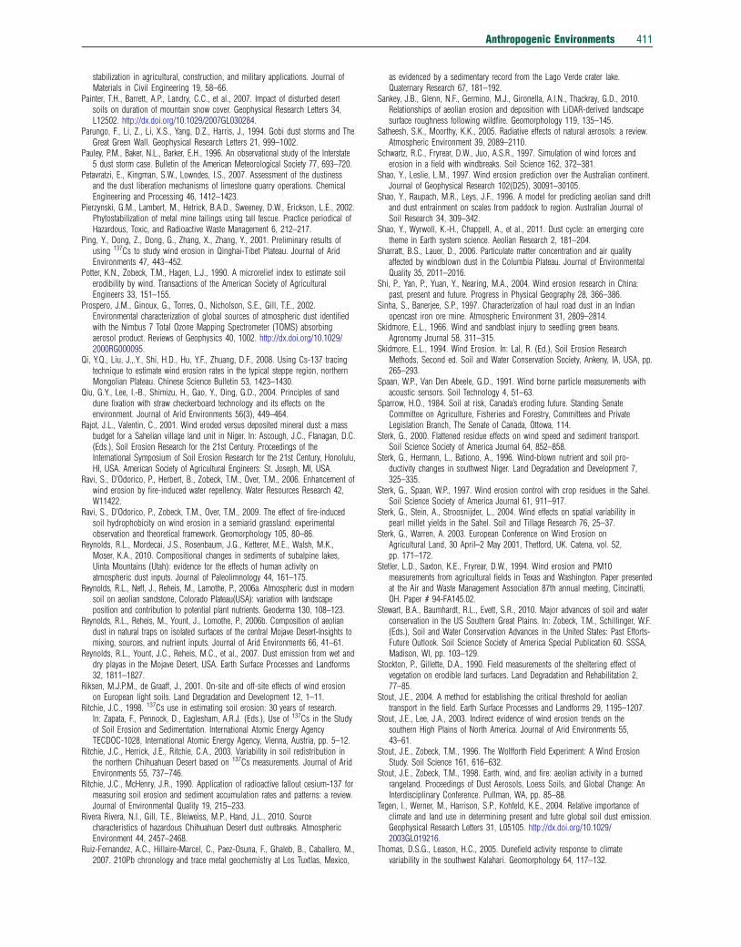
Anthropogenic Environments 411
stabilization in agricultural, construction, and military applications. Journal ofMaterials in Civil Engineering 19, 58–66.
Painter, T.H., Barrett, A.P., Landry, C.C., et al., 2007. Impact of disturbed desertsoils on duration of mountain snow cover. Geophysical Research Letters 34,L12502. http://dx.doi.org/10.1029/2007GL030284.
Parungo, F., Li, Z., Li, X.S., Yang, D.Z., Harris, J., 1994. Gobi dust storms and TheGreat Green Wall. Geophysical Research Letters 21, 999–1002.
Pauley, P.M., Baker, N.L., Barker, E.H., 1996. An observational study of the Interstate5 dust storm case. Bulletin of the American Meteorological Society 77, 693–720.
Petavratzi, E., Kingman, S.W., Lowndes, I.S., 2007. Assessment of the dustinessand the dust liberation mechanisms of limestone quarry operations. ChemicalEngineering and Processing 46, 1412–1423.
Pierzynski, G.M., Lambert, M., Hetrick, B.A.D., Sweeney, D.W., Erickson, L.E., 2002.Phytostabilization of metal mine tailings using tall fescue. Practice periodical ofHazardous, Toxic, and Radioactive Waste Management 6, 212–217.
Ping, Y., Dong, Z., Dong, G., Zhang, X., Zhang, Y., 2001. Preliminary results ofusing 137Cs to study wind erosion in Qinghai-Tibet Plateau. Journal of AridEnvironments 47, 443–452.
Potter, K.N., Zobeck, T.M., Hagen, L.J., 1990. A microrelief index to estimate soilerodibility by wind. Transactions of the American Society of AgriculturalEngineers 33, 151–155.
Prospero, J.M., Ginoux, G., Torres, O., Nicholson, S.E., Gill, T.E., 2002.Environmental characterization of global sources of atmospheric dust identifiedwith the Nimbus 7 Total Ozone Mapping Spectrometer (TOMS) absorbingaerosol product. Reviews of Geophysics 40, 1002. http://dx.doi.org/10.1029/2000RG000095.
Qi, Y.Q., Liu, J.,.Y., Shi, H.D., Hu, Y.F., Zhuang, D.F., 2008. Using Cs-137 tracingtechnique to estimate wind erosion rates in the typical steppe region, northernMongolian Plateau. Chinese Science Bulletin 53, 1423–1430.
Qiu, G.Y., Lee, I.-B., Shimizu, H., Gao, Y., Ding, G.D., 2004. Principles of sanddune fixation with straw checkerboard technology and its effects on theenvironment. Journal of Arid Environments 56(3), 449–464.
Rajot, J.L., Valentin, C., 2001. Wind eroded versus deposited mineral dust: a massbudget for a Sahelian village land unit in Niger. In: Ascough, J.C., Flanagan, D.C.(Eds.), Soil Erosion Research for the 21st Century. Proceedings of theInternational Symposium of Soil Erosion Research for the 21st Century, Honolulu,HI, USA. American Society of Agricultural Engineers: St. Joseph, MI, USA.
Ravi, S., D’Odorico, P., Herbert, B., Zobeck, T.M., Over, T.M., 2006. Enhancement ofwind erosion by fire-induced water repellency. Water Resources Research 42,W11422.
Ravi, S., D’Odorico, P., Zobeck, T.M., Over, T.M., 2009. The effect of fire-inducedsoil hydrophobicity on wind erosion in a semiarid grassland: experimentalobservation and theoretical framework. Geomorphology 105, 80–86.
Reynolds, R.L., Mordecai, J.S., Rosenbaum, J.G., Ketterer, M.E., Walsh, M.K.,Moser, K.A., 2010. Compositional changes in sediments of subalpine lakes,Uinta Mountains (Utah): evidence for the effects of human activity onatmospheric dust inputs. Journal of Paleolimnology 44, 161–175.
Reynolds, R.L., Neff, J., Reheis, M., Lamothe, P., 2006a. Atmospheric dust in modernsoil on aeolian sandstone, Colorado Plateau(USA): variation with landscapeposition and contribution to potential plant nutrients. Geoderma 130, 108–123.
Reynolds, R.L., Reheis, M., Yount, J., Lomothe, P., 2006b. Composition of aeoliandust in natural traps on isolated surfaces of the central Mojave Desert-Insights tomixing, sources, and nutrient inputs. Journal of Arid Environments 66, 41–61.
Reynolds, R.L., Yount, J.C., Reheis, M.C., et al., 2007. Dust emission from wet anddry playas in the Mojave Desert, USA. Earth Surface Processes and Landforms32, 1811–1827.
Riksen, M.J.P.M., de Graaff, J., 2001. On-site and off-site effects of wind erosionon European light soils. Land Degradation and Development 12, 1–11.
Ritchie, J.C., 1998. 137Cs use in estimating soil erosion: 30 years of research.In: Zapata, F., Pennock, D., Eaglesham, A.R.J. (Eds.), Use of 137Cs in the Studyof Soil Erosion and Sedimentation. International Atomic Energy AgencyTECDOC-1028, International Atomic Energy Agency, Vienna, Austria, pp. 5–12.
Ritchie, J.C., Herrick, J.E., Ritchie, C.A., 2003. Variability in soil redistribution inthe northern Chihuahuan Desert based on 137Cs measurements. Journal of AridEnvironments 55, 737–746.
Ritchie, J.C., McHenry, J.R., 1990. Application of radioactive fallout cesium-137 formeasuring soil erosion and sediment accumulation rates and patterns: a review.Journal of Environmental Quality 19, 215–233.
Rivera Rivera, N.I., Gill, T.E., Bleiweiss, M.P., Hand, J.L., 2010. Sourcecharacteristics of hazardous Chihuahuan Desert dust outbreaks. AtmosphericEnvironment 44, 2457–2468.
Ruiz-Fernandez, A.C., Hillaire-Marcel, C., Paez-Osuna, F., Ghaleb, B., Caballero, M.,2007. 210Pb chronology and trace metal geochemistry at Los Tuxtlas, Mexico,
as evidenced by a sedimentary record from the Lago Verde crater lake.Quaternary Research 67, 181–192.
Sankey, J.B., Glenn, N.F., Germino, M.J., Gironella, A.I.N., Thackray, G.D., 2010.Relationships of aeolian erosion and deposition with LiDAR-derived landscapesurface roughness following wildfire. Geomorphology 119, 135–145.
Satheesh, S.K., Moorthy, K.K., 2005. Radiative effects of natural aerosols: a review.Atmospheric Environment 39, 2089–2110.
Schwartz, R.C., Fryrear, D.W., Juo, A.S.R., 1997. Simulation of wind forces anderosion in a field with windbreaks. Soil Science 162, 372–381.
Shao, Y., Leslie, L.M., 1997. Wind erosion prediction over the Australian continent.Journal of Geophysical Research 102(D25), 30091–30105.
Shao, Y., Raupach, M.R., Leys, J.F., 1996. A model for predicting aeolian sand driftand dust entrainment on scales from paddock to region. Australian Journal ofSoil Research 34, 309–342.
Shao, Y., Wyrwoll, K.-H., Chappell, A., et al., 2011. Dust cycle: an emerging coretheme in Earth system science. Aeolian Research 2, 181–204.
Sharratt, B.S., Lauer, D., 2006. Particulate matter concentration and air qualityaffected by windblown dust in the Columbia Plateau. Journal of EnvironmentalQuality 35, 2011–2016.
Shi, P., Yan, P., Yuan, Y., Nearing, M.A., 2004. Wind erosion research in China:past, present and future. Progress in Physical Geography 28, 366–386.
Sinha, S., Banerjee, S.P., 1997. Characterization of haul road dust in an Indianopencast iron ore mine. Atmospheric Environment 31, 2809–2814.
Skidmore, E.L., 1966. Wind and sandblast injury to seedling green beans.Agronomy Journal 58, 311–315.
Skidmore, E.L., 1994. Wind Erosion. In: Lal, R. (Ed.), Soil Erosion ResearchMethods, Second ed. Soil and Water Conservation Society, Ankeny, IA, USA, pp.265–293.
Spaan, W.P., Van Den Abeele, G.D., 1991. Wind borne particle measurements withacoustic sensors. Soil Technology 4, 51–63.
Sparrow, H.O., 1984. Soil at risk, Canada’s eroding future. Standing SenateCommittee on Agriculture, Fisheries and Forestry, Committees and PrivateLegislation Branch, The Senate of Canada, Ottowa, 114.
Sterk, G., 2000. Flattened residue effects on wind speed and sediment transport.Soil Science Society of America Journal 64, 852–858.
Sterk, G., Hermann, L., Bationo, A., 1996. Wind-blown nutrient and soil pro-ductivity changes in southwest Niger. Land Degradation and Development 7,325–335.
Sterk, G., Spaan, W.P., 1997. Wind erosion control with crop residues in the Sahel.Soil Science Society of America Journal 61, 911–917.
Sterk, G., Stein, A., Stroosnijder, L., 2004. Wind effects on spatial variability inpearl millet yields in the Sahel. Soil and Tillage Research 76, 25–37.
Sterk, G., Warren, A. 2003. European Conference on Wind Erosion onAgricultural Land, 30 April–2 May 2001, Thetford, UK. Catena, vol. 52,pp. 171–172.
Stetler, L.D., Saxton, K.E., Fryrear, D.W., 1994. Wind erosion and PM10measurements from agricultural fields in Texas and Washington. Paper presentedat the Air and Waste Management Association 87th annual meeting, Cincinatti,OH. Paper # 94-FA145.02.
Stewart, B.A., Baumhardt, R.L., Evett, S.R., 2010. Major advances of soil and waterconservation in the US Southern Great Plains. In: Zobeck, T.M., Schillinger, W.F.(Eds.), Soil and Water Conservation Advances in the United States: Past Efforts-Future Outlook. Soil Science Society of America Special Publication 60. SSSA,Madison, WI, pp. 103–129.
Stockton, P., Gillette, D.A., 1990. Field measurements of the sheltering effect ofvegetation on erodible land surfaces. Land Degradation and Rehabilitation 2,77–85.
Stout, J.E., 2004. A method for establishing the critical threshold for aeoliantransport in the field. Earth Surface Processes and Landforms 29, 1195–1207.
Stout, J.E., Lee, J.A., 2003. Indirect evidence of wind erosion trends on thesouthern High Plains of North America. Journal of Arid Environments 55,43–61.
Stout, J.E., Zobeck, T.M., 1996. The Wolfforth Field Experiment: A Wind ErosionStudy. Soil Science 161, 616–632.
Stout, J.E., Zobeck, T.M., 1998. Earth, wind, and fire: aeolian activity in a burnedrangeland. Proceedings of Dust Aerosols, Loess Soils, and Global Change: AnInterdisciplinary Conference. Pullman, WA, pp. 85–88.
Tegen, I., Werner, M., Harrison, S.P., Kohfeld, K.E., 2004. Relative importance ofclimate and land use in determining present and futre global soil dust emission.Geophysical Research Letters 31, L05105. http://dx.doi.org/10.1029/2003GL019216.
Thomas, D.S.G., Leason, H.C., 2005. Dunefield activity response to climatevariability in the southwest Kalahari. Geomorphology 64, 117–132.
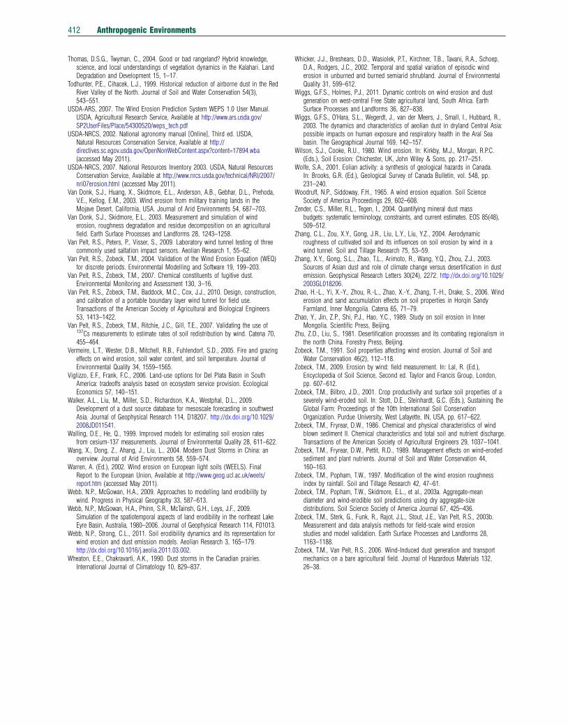
412 Anthropogenic Environments
Thomas, D.S.G., Twyman, C., 2004. Good or bad rangeland? Hybrid knowledge,science, and local understandings of vegetation dynamics in the Kalahari. LandDegradation and Development 15, 1–17.
Todhunter, P.E., Cihacek, L.J., 1999. Historical reduction of airborne dust in the RedRiver Valley of the North. Journal of Soil and Water Conservation 54(3),543–551.
USDA-ARS, 2007. The Wind Erosion Prediction System WEPS 1.0 User Manual.USDA, Agricultural Research Service, Available at http://www.ars.usda.gov/SP2UserFiles/Place/54300520/weps_tech.pdf
USDA-NRCS, 2002. National agronomy manual [Online], Third ed. USDA,Natural Resources Conservation Service, Available at http://directives.sc.egov.usda.gov/OpenNonWebContent.aspx?content=17894.wba(accessed May 2011).
USDA-NRCS, 2007. National Resources Inventory 2003. USDA, Natural ResourcesConservation Service, Available at http://www.nrcs.usda.gov/technical/NRI/2007/nri07erosion.html (accessed May 2011).
Van Donk, S.J., Huang, X., Skidmore, E.L., Anderson, A.B., Gebhar, D.L., Prehoda,V.E., Kellog, E.M., 2003. Wind erosion from military training lands in theMojave Desert, California, USA. Journal of Arid Environments 54, 687–703.
Van Donk, S.J., Skidmore, E.L., 2003. Measurement and simulation of winderosion, roughness degradation and residue decomposition on an agriculturalfield. Earth Surface Processes and Landforms 28, 1243–1258.
Van Pelt, R.S., Peters, P., Visser, S., 2009. Laboratory wind tunnel testing of threecommonly used saltation impact sensors. Aeolian Research 1, 55–62.
Van Pelt, R.S., Zobeck, T.M., 2004. Validation of the Wind Erosion Equation (WEQ)for discrete periods. Environmental Modelling and Software 19, 199–203.
Van Pelt, R.S., Zobeck, T.M., 2007. Chemical constituents of fugitive dust.Environmental Monitoring and Assessment 130, 3–16.
Van Pelt, R.S., Zobeck, T.M., Baddock, M.C., Cox, J.J., 2010. Design, construction,and calibration of a portable boundary layer wind tunnel for field use.Transactions of the American Society of Agricultural and Biological Engineers53, 1413–1422.
Van Pelt, R.S., Zobeck, T.M., Ritchie, J.C., Gill, T.E., 2007. Validating the use of137Cs measurements to estimate rates of soil redistribution by wind. Catena 70,455–464.
Vermeire, L.T., Wester, D.B., Mitchell, R.B., Fuhlendorf, S.D., 2005. Fire and grazingeffects on wind erosion, soil water content, and soil temperature. Journal ofEnvironmental Quality 34, 1559–1565.
Viglizzo, E.F., Frank, F.C., 2006. Land-use options for Del Plata Basin in SouthAmerica: tradeoffs analysis based on ecosystem service provision. EcologicalEconomics 57, 140–151.
Walker, A.L., Liu, M., Miller, S.D., Richardson, K.A., Westphal, D.L., 2009.Development of a dust source database for mesoscale forecasting in southwestAsia. Journal of Geophysical Research 114, D18207. http://dx.doi.org/10.1029/2008JD011541.
Walling, D.E., He, Q., 1999. Improved models for estimating soil erosion ratesfrom cesium-137 measurements. Journal of Environmental Quality 28, 611–622.
Wang, X., Dong, Z., Ahang, J., Liu, L., 2004. Modern Dust Storms in China: anoverview. Journal of Arid Environments 58, 559–574.
Warren, A. (Ed.), 2002. Wind erosion on European light soils (WEELS). FinalReport to the European Union, Available at http://www.geog.ucl.ac.uk/weels/report.htm (accessed May 2011).
Webb, N.P., McGowan, H.A., 2009. Approaches to modelling land erodibility bywind. Progress in Physical Geography 33, 587–613.
Webb, N.P., McGowan, H.A., Phinn, S.R., McTainsh, G.H., Leys, J.F., 2009.Simulation of the spatiotemporal aspects of land erodibility in the northeast LakeEyre Basin, Australia, 1980–2006. Journal of Geophysical Research 114, F01013.
Webb, N.P., Strong, C.L., 2011. Soil erodibility dynamics and its representation forwind erosion and dust emission models. Aeolian Research 3, 165–179.http://dx.doi.org/10.1016/j.aeolia.2011.03.002.
Wheaton, E.E., Chakravarti, A.K., 1990. Dust storms in the Canadian prairies.International Journal of Climatology 10, 829–837.
Whicker, J.J., Breshears, D.D., Wasiolek, P.T., Kirchner, T.B., Tavani, R.A., Schoep,D.A., Rodgers, J.C., 2002. Temporal and spatial variation of episodic winderosion in unburned and burned semiarid shrubland. Journal of EnvironmentalQuality 31, 599–612.
Wiggs, G.F.S., Holmes, P.J., 2011. Dynamic controls on wind erosion and dustgeneration on west-central Free State agricultural land, South Africa. EarthSurface Processes and Landforms 36, 827–838.
Wiggs, G.F.S., O’Hara, S.L., Wegerdt, J., van der Meers, J., Small, I., Hubbard, R.,2003. The dynamics and characteristics of aeolian dust in dryland Central Asia:possible impacts on human exposure and respiratory health in the Aral Seabasin. The Geographical Journal 169, 142–157.
Wilson, S.J., Cooke, R.U., 1980. Wind erosion. In: Kirkby, M.J., Morgan, R.P.C.(Eds.), Soil Erosion: Chichester, UK, John Wiley & Sons, pp. 217–251.
Wolfe, S.A., 2001. Eolian activity: a synthesis of geological hazards in Canada.In: Brooks, G.R. (Ed.), Geological Survey of Canada Bulletin, vol. 548, pp.231–240.
Woodruff, N.P., Siddoway, F.H., 1965. A wind erosion equation. Soil ScienceSociety of America Proceedings 29, 602–608.
Zender, C.S., Miller, R.L., Tegen, I., 2004. Quantifying mineral dust massbudgets: systematic terminology, constraints, and current estimates. EOS 85(48),509–512.
Zhang, C.L., Zou, X.Y., Gong, J.R., Liu, L.Y., Liu, Y.Z., 2004. Aerodynamicroughness of cultivated soil and its influences on soil erosion by wind in awind tunnel. Soil and Tillage Research 75, 53–59.
Zhang, X.Y., Gong, S.L., Zhao, T.L., Arimoto, R., Wang, Y.Q., Zhou, Z.J., 2003.Sources of Asian dust and role of climate change versus desertification in dustemission. Geophysical Research Letters 30(24), 2272. http://dx.doi.org/10.1029/2003GL018206.
Zhao, H.-L., Yi, X.-Y., Zhou, R.-L., Zhao, X.-Y., Zhang, T.-H., Drake, S., 2006. Winderosion and sand accumulation effects on soil properties in Horqin SandyFarmland, Inner Mongolia. Catena 65, 71–79.
Zhao, Y., Jin, Z.P., Shi, P.J., Hao, Y.C., 1989. Study on soil erosion in InnerMongolia. Scientific Press, Beijing.
Zhu, Z.D., Liu, S., 1981. Desertification processes and its combating regionalism inthe north China. Forestry Press, Beijing.
Zobeck, T.M., 1991. Soil properties affecting wind erosion. Journal of Soil andWater Conservation 46(2), 112–118.
Zobeck, T.M., 2009. Erosion by wind: field measurement. In: Lal, R. (Ed.),Encyclopedia of Soil Science, Second ed. Taylor and Francis Group, London,pp. 607–612.
Zobeck, T.M., Bilbro, J.D., 2001. Crop productivity and surface soil properties of aseverely wind-eroded soil. In: Stott, D.E., Steinhardt, G.C. (Eds.), Sustaining theGlobal Farm: Proceedings of the 10th International Soil ConservationOrganization. Purdue University, West Lafayette, IN, USA, pp. 617–622.
Zobeck, T.M., Fryrear, D.W., 1986. Chemical and physical characteristics of windblown sediment II. Chemical characteristics and total soil and nutrient discharge.Transactions of the American Society of Agricultural Engineers 29, 1037–1041.
Zobeck, T.M., Fryrear, D.W., Pettit, R.D., 1989. Management effects on wind-erodedsediment and plant nutrients. Journal of Soil and Water Conservation 44,160–163.
Zobeck, T.M., Popham, T.W., 1997. Modification of the wind erosion roughnessindex by rainfall. Soil and Tillage Research 42, 47–61.
Zobeck, T.M., Popham, T.W., Skidmore, E.L., et al., 2003a. Aggregate-meandiameter and wind-erodible soil predictions using dry aggregate-sizedistributions. Soil Science Society of America Journal 67, 425–436.
Zobeck, T.M., Sterk, G., Funk, R., Rajot, J.L., Stout, J.E., Van Pelt, R.S., 2003b.Measurement and data analysis methods for field-scale wind erosionstudies and model validation. Earth Surface Processes and Landforms 28,1163–1188.
Zobeck, T.M., Van Pelt, R.S., 2006. Wind-Induced dust generation and transportmechanics on a bare agricultural field. Journal of Hazardous Materials 132,26–38.

Anthropogenic Environments 413
Biographical Sketch
Ted M Zobeck is a Research Soil Scientist in the Wind Erosion and Water Conservation Research Unit, Agricultural
Research Service, US Department of Agriculture at Lubbock, TX. Dr. Zobeck has worked on research in aeolian
processes and wind erosion science, surface soil properties related to wind erosion, and soil productivity and
management for more than 25 years. He is currently the President of the International Society for Aeolian
Research and Co-Editor-in-Chief of the Elsevier journal Aeolian Research.
Scott Van Pelt was raised in the Dallas-Ft. Worth suburbs and he was accustomed to the incursions of dust into
this humid area and the remarks of ‘Here comes West Texas!’. After graduating high school, he earned a BS in
Biology and a MS in Plant Ecology and Systematics at the University of New Mexico in 1978 and 1983, re-
spectively. He earned a PhD in Soil Physics from New Mexico State University in 1990. He has worked for several
consulting firms in New Mexico and currently lives in Big Spring, Texas, where he is employed as a Soil Scientist by
the Wind Erosion and Water Conservation Research Unit of the USDA Agricultural Research Service.
Matthew Baddock is an aeolian geomorphologist who has worked in different drylands on three continents. He
employs both field measurement and remote sensing techniques to study wind-related processes and landforms.
His PhD (University of Leicester) was on sand dune dynamics, and in postdoctoral work at Loughborough
University, USDA-ARS, and University of Virginia, he has investigated the controls on dust emission and wind
erosion at a variety of spatial and temporal scales.
Related Documents