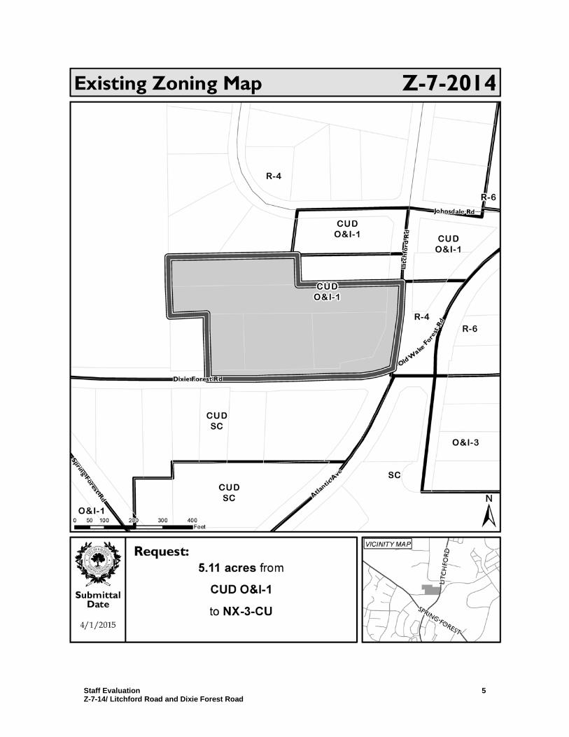
Johnsdale Rd Spring Forest Rd L i t c h f o r d Rd O l d W a k e F or e s t R d At l a nt i c Av e Dixie Forest Rd CUD O&I-1 CUD O&I-1 R-6 R-6 R-4 R-4 CUD SC O&I-3 O&I-1 CUD O&I-1 CUD SC SC 0 100 200 300 400 50 Feet SPRING FOREST LITCHFORD Existing Zoning Map Z-7-2014 ± VICINITY MAP 4/1/2015 Submittal Date Request: 5.11 acres from CUD O&I-1 to NX-3-CU

Welcome message from author
This document is posted to help you gain knowledge. Please leave a comment to let me know what you think about it! Share it to your friends and learn new things together.
Transcript

Johnsdale Rd
Spring Forest Rd
L itc h
fordR
d
Old Wake
Forest
Rd
Atlantic Ave
Dixie Forest Rd
CUDO&I-1 CUD
O&I-1
R-6
R-6R-4
R-4
CUDSC
O&I-3
O&I-1
CUDO&I-1
CUDSC
SC
0 100 200 300 40050Feet
SPRING FOREST
LITCH
FORD
Existing Zoning Map Z-7-2014
±VICINITY MAP
4/1/2015
SubmittalDate
Request:5.11 acres from
CUD O&I-1to NX-3-CU

Certified Recommendation Raleigh Planning Commission
CR# 11634
Case Information Z-7-14 Litchford Road and Dixie Forest Road Location Northwest corner of the intersection of Litchford and Dixie Forest Roads
Addresses: 2321 Dixie Forest Road, 0 Litchford Road, 6201 Litchford Road, 6205 Litchford Road, and 2315 Dixie Forest Road PIN(s): 1716897581,1716896409, 1716897614 and 1716894783
Request Rezone property from Office & Institution-1 Conditional Use (O&I-1 CUD) to Neighborhood Mixed Use- 3 stories-Conditional Use (NX-3-CU)
Area of Request 5.11 acres Property Owner Eagle Land, LLC
3700 Computer Drive, Suite 280 Raleigh, NC 27609
Applicant Michael Birch Morningstar Law Group 630 Davis Drive, Suite 200 Morrisville, NC 27605
Citizens Advisory Council
North— Will Owen, Chair: (919) 264-0565; [email protected]
PC Recommendation
Deadline
June 22, 2015
Comprehensive Plan Consistency The rezoning case is Consistent Inconsistent with the 2030 Comprehensive Plan.
Future Land Use Map Consistency The rezoning case is Consistent Inconsistent with the Future Land Use Map.
Comprehensive Plan Guidance
FUTURE LAND USE Moderate Density Residential (MDR) CONSISTENT Policies Policy LU 1.3 – Conditional Use District Consistency
Policy LU 2.6 – Zoning and Infrastructure Impacts Policy LU 4.7 – Capitalizing on Transit Access Policy LU 6.4 – Bus Stop Dedication Policy LU 7.3 – Single-Family Lots on Major Streets Policy UD 1.10 – Frontage
INCONSISTENT Policies Policy LU 1.2 – Future Land Use Map and Zoning Consistency
Summary of Proposed Conditions 1. Certain uses prohibited. 2. Offers transit easement and provision of bus shelter. 3. Limits uses based on trip generation in the PM peak hour. 4. Requires a development allocation covenant.

Staff Evaluation Z-7-14/ Litchford Road and Dixie Forest Road
2
5. Specifies build-to requirements, pedestrian access, and parking location limitations.
Public Meetings Neighborhood
Meeting CAC Planning Commission City Council Public Hearing
12/18/13 4/3/14; 5/1/14;
4/2/15 Y – 17; N - 0
3/24/15; 5/12/15 5/19/15
Valid Statutory Protest Petition
Attachments
1. Staff report 2. Current zoning conditions [Z-32-94 – Ordinance (1994) 426ZC348] 3. TIA worksheet
Planning Commission Recommendation Recommendation Approve with conditions.
City Council may now schedule this proposal for Public Hearing, or refer it to committee for further study and discussion.
Findings & Reasons 1. While the proposal is inconsistent with the Future Land Use Map, it reflects a trend of conversion of office-zoned and single-family properties in the Dixie Forest Road/Litchford Road vicinity to retail uses.
2. The proposed rezoning is reasonable and in the public interest. The proposal would increase the opportunity for redevelopment by adding potential uses and would allow for a mix of uses in proximity to existing residential areas. In addition, potential traffic impacts will be addressed by the pending capital improvement project for Old Wake Forest Road.
3. The proposal is compatible with the surrounding area. Conditions which prohibit certain uses and limit the intensity of uses mitigate potential impacts on surrounding residential areas.
Motion and Vote Motion: Braun Second: Swink In Favor: Braun, Buxton, Fluhrer, Hicks, Lyle, Swink and Whitsett
This document is a true and accurate statement of the findings and recommendations of the Planning Commission. Approval of this document incorporates all of the findings of the attached Staff Report. ________________________________ _______________________________5/12/15 Planning Director Date Planning Commission Chairperson Date Staff Coordinator: Vivian Ekstrom: (919) 996-2657; [email protected]

Staff Evaluation Z-7-14/ Litchford Road and Dixie Forest Road
3

Staff Evaluation Z-7-14/ Litchford Road and Dixie Forest Road
4
Case Summary
Overview The site of the proposed rezoning is composed of five contiguous parcels on the north side of Dixie Forest Road and the west side of Litchford Road. The site is immediately to the east of, and shares a property line with, Millbrook High School. To the north is the Johnsdale Road neighborhood and to the south is the triangle of land bound by Dixie Forest Road, Atlantic Avenue, and Spring Forest Road. Much of the surrounding area is composed of housing of various densities (single family, townhouses and apartment buildings) that was built over a relatively long time span, from the 1940s through 1980s. The subject properties are located adjacent to single family housing, the athletic fields and parking for Millbrook High School, and a day care. The Pavilion Shopping Center is to the southeast of the site; nearby are a pharmacy, convenience store and single story office buildings. The high school (41 acres) and Millbrook Exchange Park (70 acres) are significant public lands just to the west of the site. The subject properties are vacant, except for 2315 Dixie Forest Road which is occupied by a single family residence. New commercial development has occurred across Dixie Forest Road to the south of the site; a gas station/convenience store and a restaurant were recently constructed. The site is on the western edge of a designated City Growth Center on the Urban Form Map, and Litchford Road is also designated as an Urban Thoroughfare. The Growth Center is anchored by the Triangle Town Center shopping mall. The site is also within a ½ mile of a potential fixed-guideway transit stop at Spring Forest Road and the CSX Railroad. The site is designated for Moderate Density Residential uses on the Future Land Use Map, that is, 6 to 14 dwellings per acre. The neighborhood to the north is designated for Low Density Residential. There is a large swath of land to the south, southeast and east, generally centered on Atlantic Avenue, that is designated for Community Mixed Use. The zoning on the site, O&I-1 CUD, was established by Z-32-94. Conditions of that case restricted building height to no more than 35’ and FAR to no more than .5. There is similarly O&I zoned property to the northeast, but the majority of properties to the north are zoned R-4. The triangle of land to the south is zoned SC CUD and the Pavilion Shopping Center is zoned SC.
Outstanding Issues Outstanding
Issues (None.) Suggested
Mitigation n/a
Zoning Staff Report – Case Z-7-14 Conditional Use District
Staff Evaluation Z-7-14/ Litchford Road and Dixie Forest Road
5

Staff Evaluation Z-7-14/ Litchford Road and Dixie Forest Road
6
Rezoning Case Evaluation
1. Compatibility Analysis
1.1 Surrounding Area Land Use/ Zoning Summary
Subject Property
North South East West
Existing Zoning
Office & Institution-1 Conditional Use District
Office & Institution-1 Conditional Use District, Residential-4
Shopping Center Conditional Use District, Residential-4
Office & Institution-1 Conditional Use District, Residential-4
Office & Institution-1 Conditional Use District, Residential-4
Additional Overlay
n/a n/a n/a n/a n/a
Future Land Use
Moderate Density Residential
Moderate Density Residential, Low Density Residential
Community Mixed Use, Moderate Density Residential
Community Mixed Use
Moderate Density Residential, Public Facilities
Current Land Use
Vacant Single family houses, day care
Vehicle fuel station & convenience store, restaurant, single family houses
Single family houses
Single family house, high school
Urban Form (if applicable)
City Growth Center
City Growth Center (partial)
City Growth Center
City Growth Center
n/a (1 property in City Growth Center)
1.2 Current vs. Proposed Zoning Summary Existing Zoning Proposed Zoning* Residential Density: 101 DUs (19.9 DUs per acre) 191 DUs (37.4 DUs per acre) Setbacks:
Front: Side: Rear:
30’ 5’ 20’
If General Building: 5’
0’ or 6’ 0’ or 6’
Retail Intensity Permitted: n/a 35,000 sf** Office Intensity Permitted: 111,000 sf 111,000 sf**
1.3 Estimated Development Intensities
Existing Zoning Proposed Zoning*
Total Acreage 5.11 5.11 Zoning O&I-1 CUD NX-3-CU

Staff Evaluation Z-7-14/ Litchford Road and Dixie Forest Road
7
Max. Gross Building SF (if applicable)
111,000 sf 209,000 sf
Max. # of Residential Units 101 191 Max. Gross Office SF 99,500 111,000 sf** Max. Gross Retail SF n/a 35,000 sf** Max. Gross Industrial SF n/a n/a Potential F.A.R 0.50 0.94 *The development intensities for proposed zoning districts were estimated using an impact analysis tool. The estimates presented are only to provide guidance for analysis. ** Per conditions limiting peak PM trips. The proposed rezoning is:
Compatible with the property and surrounding area. Surrounding uses for the subject site are a mix of single family residential, commercial, and institutional. In concert with the neighborhood transition standards that would apply for transitions to adjacent residentially-zoned properties, conditions that prohibit certain uses and limit the intensity of uses mitigate potential compatibility issues.
Incompatible. Analysis of Incompatibility:
n/a

Staff Evaluation Z-7-14/ Litchford Road and Dixie Forest Road
8

Staff Evaluation Z-7-14/ Litchford Road and Dixie Forest Road
9

Staff Evaluation Z-7-14/ Litchford Road and Dixie Forest Road
10
2. Comprehensive Plan Consistency Analysis 2.1 Comprehensive Plan Determination of the conformance of a proposed use or zone with the Comprehensive Plan includes consideration of the following questions: • Is the proposal consistent with the vision, themes, and policies contained in the
Comprehensive Plan? • Is the use being considered specifically designated on the Future Land Use Map in the area
where its location is proposed? • If the use is not specifically designated on the Future Land Use Map in the area where its
location is proposed, is it needed to service such a planned use, or could it be established without adversely altering the recommended land use and character of the area?
• Will community facilities and streets be available at City standards to serve the use proposed for the property?
The proposal is inconsistent with the Comprehensive Plan and the Future Land Use Map.
The site’s future land use designation of Moderate Density Residential calls for residential uses with a density of 6 to 14 dwelling units per acre. The proposed NX zoning would allow higher density residential, office, and retail uses. The site is located in a City Growth Center and along an Urban Thoroughfare on Litchford Road; these designations support the application of an urban or hybrid frontage. Although a frontage designation is not proposed, the applicant has offered the conditioned equivalent of a Parking Limited frontage.
Looking at the surrounding area, the proposal would continue the trend of increased commercial zoning and development replacing single family uses. Properties directly across Dixie Forest Road were rezoned from Office and Institution-1 Conditional Use to Shopping Center Conditional Use in 2010; retail uses were recently constructed on two of these lots. In addition, the proposal also limits the intensity of uses on the site (PM peak hour trip generation cannot exceed 203 trips) which could help mitigate some impacts on surrounding residential areas.
Existing community facilities and streets appear sufficient to accommodate the development possible under the proposed rezoning. 2.2 Future Land Use Future Land Use designation: Moderate Density Residential The rezoning request is:
Consistent with the Future Land Use Map.
Inconsistent Analysis of Inconsistency:
The Future Land Use Map calls for residential uses here in the range of 6 to 14 dwelling units per acre. The proposed NX zoning would allow retail, higher density residential, and office uses on the site.

Staff Evaluation Z-7-14/ Litchford Road and Dixie Forest Road
11
2.3 Urban Form Urban Form designation:
Not applicable (no Urban Form designation) The rezoning request is:
Consistent with the Urban Form Map Analysis:
Inconsistent Analysis of Inconsistency:
2.4 Policy Guidance The rezoning request is inconsistent with the following policies: Policy LU 1.2 - Future Land Use Map and Zoning Consistency The Future Land Use Map shall be used in conjunction with the Comprehensive Plan policies to evaluate zoning consistency including proposed zoning map amendments and zoning text changes. The Future Land Use Map designates the site for Moderate Density Residential development, defined in the Comprehensive Plan as permitting 6 to 14 dwelling units per acre. The Plan further notes that the appropriate zoning for areas designated Moderate Density Residential would be R-6, R-10, or RX, with a density cap. Retail and office uses are not envisioned. 2.5 Area Plan Policy Guidance Not applicable. No area plan exists for this location.
3. Public Benefit and Reasonableness Analysis
3.1 Public Benefits of the Proposed Rezoning
• Increased opportunity for redevelopment of the site, through a broadening of potential uses.
• Potential provision of goods and services close to existing residential areas.
n/a
The site is located in a City Growth Center and along an Urban Thoroughfare (Litchford Road); these designations support the application of an urban or hybrid frontage to encourage walkability. Although a frontage designation is not proposed, the applicant has offered a conditioned equivalent of a Parking Limited frontage (build-to standards, primary street-facing entrance, direct pedestrian connection from sidewalk to street-facing building entrance, no more than 2 bays of parking with a single drive aisle).

Staff Evaluation Z-7-14/ Litchford Road and Dixie Forest Road
12
3.2 Detriments of the Proposed Rezoning
• None anticipated.
4. Impact Analysis
4.1 Transportation
Revised conditions for Z-7-2014 limit trip generation in the PM peak hour. The expected increase in trip volume is effectively zero. Although the intersection of Litchford Road & Dixie Forest Road currently operates a LOS-F, a traffic study is not recommended for case Z-7-2014 due to a zero change in PM peak hour trips.
Impact Identified: None.
4.2 Transit Litchford Road is currently served by CAT Route 25L Triangle Town Center. There is a transit stop located in the grassy berm on southbound Litchford Rd opposite Sylvia Dean St. The City of Raleigh Short Range Transit Plan and the Wake 2040 Transit Study both anticipate continued service along this corridor. Impact Identified: A higher density residential area will generate additional ridership on this route. The offer of a transit easement and shelter will mitigate this impact.
4.3 Hydrology Floodplain No FEMA Floodplain present.
Drainage Basin Marsh and a small amount to Perry Stormwater Management Subject to Part 10, Chapter 9
Overlay District None.
Impact Identified: None.
4.5 Parks and Recreation Recreation services for the rezoning case will be provided by Millbrook Exchange Park. There is no impact to recreation level of service. There are no adjacent greenway corridors or connectors to the site. Impact Identified: None.
4.6 Urban Forestry Impact Identified: Tracts 2 acres and larger in size will be required to comply with UDO Article 9.1 at the time of development.
4.7 Designated Historic Resources
The site does not include and is not within 1,000 feet of any Raleigh Historic Landmarks or properties listed on the National Register of Historic Places. Impact Identified: None.

Staff Evaluation Z-7-14/ Litchford Road and Dixie Forest Road
13
4.8 Community Development This site is not located within a redevelopment plan area. Impact Identified: None.
4.9 Appearance Commission As the proposal does not involve a Planned Development, it is not subject to Appearance Commission review.
4.10 Impacts Summary
• The higher intensity commercial uses and higher density residential uses allowed under the proposed zoning will generate additional ridership on the existing bus route.
• Sewer and fire flow matters may need to be addressed upon development.
4.11 Mitigation of Impacts • The provision of a transit easement and shelter will mitigate the potential impact of
increased ridership along the existing bus route. • Address sewer and fire flow capacities at the site plan stage.
5. Conclusions
The proposal is inconsistent with the Comprehensive Plan and the Future Land Use Map. The Moderate Density Residential Future Land Use category calls for development within the range of 6 to 14 dwelling units per acre; high density residential, office and standalone retail uses are not envisioned. However, the requested zoning follows a pattern of similar office-to-retail use rezonings established on properties to the south. In terms of building form and urban design, the Urban Form Map and associated Comprehensive Plan policy guidance support a frontage designation; the proposal offers the conditioned equivalent of a Parking Limited frontage to address this policy guidance.

Planni Develo
Development Services Customer Service Center
One Exchange Plaza 1 Exchange Plaza, Suite 400
Raleigh , North Carolina 27601 Phone 919-996-2495
Fax 919-516-2685
Rezoning Application
Rezoning Request
D General Use r8l Conditional Use D Master Plan
Existing Zoning Classification: 0&1-1 CUD Proposed Zoning Classification Base District: NX Height: 3 Frontage: None
If the property has been previously rezoned, provide the rezoning case number: Z-32-94
Provide all previous transaction numbers for Coordinated Team Reviews, Due Diligence Sessions or Pre-Submittal Conferences.
Property Address: 2321 Dixie Forest Road; 0 Litchford Road; 6201 Litchford Road; 6205 Litchford Road; and 2315 Dixie Forest Road
Property PIN: 1716-89-7581, 1716-89-6409, 1716-89-7614, 1716-89-4783 and 1716-89-4429
Nearest Intersection: Dixie Forest Road and Litchford Road
Property Owner/Address: Eagle Land, LLC 3700 Computer Drive, Suite 280 Raleigh, NC 27609
Thomas LaFerire 11217 Old Creedmoor Road Raleigh, NC 27613
Project Contact Person/Address:
Phone
Email: [email protected]
Phone: (919) 590-0388
OFFICE USE ONLY
Transaction Number
Property size (in acres): 5.11 ac
Fax
Fax Michael Birch, Morningstar Law Group 630 Davis Drive, Suite 200 Email: [email protected] Morrisville, NC 27650
Email:
k/l'?e? ,jN e <? a tr /c;::c;Vt-...
A rezoning application will not be considered complete until all required submittal components listed on the Rezoning Checklist have been received and approved.

Rezoning Request
D General Use
Planning & Development
Rezoning Application
~ Conditional Use D Master Plan
Existing Zoning Classification: 0&1-1 CUD Proposed Zoning Classification Base District: NX Height: 3 Frontage: None
If the property has been previously rezoned, provide the rezoning case number: Z-32-94
Development Services Customer Service Center
One Exchange Plaza 1 Exchange Plaza, Suite 400
Raleigh, North Carolina 27601 Phone 919-996-2495
Fax 919-516-2685
OFFICE USE ONLY
Transaction Number
Provide all previous transaction numbers for Coordinated Team Reviews, Due Diligence Sessions or Pre-Submittal Conferences.
Property Address : 2321 Dixie Forest Road; O Litchford Road; 6201 Litchford Road; 6205 Litchford Road; and 2315 Dixie Forest Road
Property PIN : 1716-89-7581, 1716-89-6409, 1716-89-7614, 1716-89-4783 and 1716-89-4429
Nearest Intersection: Dixie Forest Road and Litchford Road
Property Owner/Address: Eagle Land, LLC
3700 Computer Drive, Suite 280 Raleigh, NC 27609
Thomas LaFerire 11217 Old Creedmoor Road Raleigh, NC 27613
Project Contact Person/Address:
Phone
Email: [email protected]
Phone: (919) 590-0388
Property size (in acres): 5.11 ac
Fax
Fax Michael Birch, Morningstar Law Group 630 Davis Drive, Suite 200 Email: [email protected] Morrisville, NC 27650
Owner/Agent Signature Email:
A rezoning application will not be considered complete until all required submittal components listed on the Rezoning Checklist have been received and approved .

Conditional Use District Zoning Conditions
Zoning Case Number: Z-7-14
Date Submitted: May 11, 2015
Existing Zoning: O&l-1 CUD I Proposed Zoning: NX-3-CUD
Development Services ustomer Service Center
One Exchange Plaza 1 Exchange Plaza, Suite 400
Raleigh, North Carolina 27601 Phone 919-996-2495
Fax 919-516-2685
@.UW!13~@mb\'7
Transaction Number
1. The following principal uses, as listed in Section 6.1.4 "Allowed Principal Use Table", shall be prohibited on the property: boardinghouse; dormitory, fraternity, sorority; emergency shelter - all types; cemetery; telecommunication tower - all types; outdoor recreation - all s; commercial arkin lot; detention center, 'ail, rison; fuel sales.
2. Prior to the issuance of a building permit for new development or the recordation of a subdivision plat or the sale of any lot, a transit easement shall be deeded to the City and recorded in the Wake County Registry. Prior to recordation of the transit easement, the dimensions (not to exceed 15 feet in depth and 20 feet in width) and location of the easement along Dixie Forest Road shall be approved by the Public Works Department and the easement document approved by the City Attorney's Office. Prior to the issuance of a certificate of occupancy for new development, the property owner shall construct an ADA-accessible bus shelter.
3. The land use or land uses developed on the property shall be limited to a use or uses which when analyzed using the Trip Generation Manual published by the Institute of Transportation Engineers will generate no more than 203 total primary trips in the PM peak hour, taking into account pass-by trips and internal capture.
4. Prior to recordation of a subdivision plat or recombination plat or the issuance of a building permit, whichever shall first occur, the owner of the property shall cause to be recorded in the Wake County Registry a restrictive covenant that allocates among the lots of record comprising the property the total primary trips in the PM peak hour permitted by Condition 3 of this rezoning ordinance. Such restrictive covenant shall be approved by the City Attorney or his designee prior to recordation of the restrictive covenant. Such restrictive covenant shall provide that it may be amended or terminated only with the prior written consent of the City Attorney or his designee.
5. a. The build-to area along Litchford Road and Dixie Forest Road shall be between zero (0) feet and one hundred (100) feet (the "Build-To Area").
b. Each building located within the Build-To Area shall have at least one building entrance facing the primary street public right-ofway.
c. A direct pedestrian connection shall be provided between the public sidewalk and the street-facing building entrance. d. No more than two bays of parking with a single drive aisle shall be provided between the public right-of-way and buildings within
the Build-To Area. e. For properties that front along Litchford Road as the primary street, the minimum building width within the Litchford Road Build
To Area shall be fifty percent (50%) and the minimum building width within the Dixie Forest Road Build-To Area shall be twentyfive percent (25%).
f. For properties that front along Dixie Forest Road as the primary street, the minimum building width within the Dixie Forest Road Build-To Area shall be fifty percent (50%) and the minimum building width within the Litchford Road Build-To Area shall be twenty-five percent (25%).
These zoning conditions have been voluntarily offered by the property owner. All property owners must sign each condition page. This page may be photocopied if additional space is needed.
Print Name

Conditional Use District Zoning Conditions
Zoning Case Number: Z-7-14
Date Submitted: May 11, 2015
Existing Zoning: O&l-1 CUD Proposed Zoning: NX-3-CUD
Development Services Customer Service Center
One Exchange Plaza 1 Exchange Plaza, Suite 400
Raleigh, North Carolina 27601 Phone 919-996-2495
Fax 919-516-2685
Transaction Number
1. The following principal uses, as listed in Section 6.1.4 "Allowed Principal Use Table", shall be prohibited on the property: boardinghouse; dormitory, fraternity, sorority; emergency shelter - all types; cemetery; telecommunication tower - all types; outdoor recreation - all pes; commercial parking lot; detention center, 'ail, prison; fuel sales.
2. Prior to the issuance of a building permit for new development or the recordation of a subdivision plat or the sale of any lot, a transit easement shall be deeded to the City and recorded in the Wake County Registry. Prior to recordation of the transit easement, the dimensions (not to exceed 15 feet in depth and 20 feet in width) and location of the easement along Dixie Forest Road shall be approved by the Public Works Department and the easement document approved by the City Attorney's Office. Prior to the issuance of a certificate of occupancy for new development, the property owner shall construct an ADA-accessible bus shelter.
3. The land use or land uses developed on the property shall be limited to a use or uses which when analyzed using the Trip Generation Manual published by the Institute of Transportation Engineers will generate no more than 203 total primary trips in the PM peak hour, taking into account pass-by trips and internal capture.
4. Prior to recordation of a subdivision plat or recombination plat or the issuance of a building permit, whichever shall first occur, the owner of the property shall cause to be recorded in the Wake County Registry a restrictive covenant that allocates among the lots of record comprising the property the total primary trips in the PM peak hour permitted by Condition 3 of this rezoning ordinance. Such restrictive covenant shall be approved by the City Attorney or his designee prior to recordation of the restrictive covenant. Such restrictive covenant shall provide that it may be amended or terminated only with the prior written consent of the City Attorney or his designee.
5. a. The build-to area along Litchford Road and Dixie Forest Road shall be between zero (0) feet and one hundred (100) feet (the "Build-To Area"). ·
b. Each building located within the Build-To Area shall have at least one building entrance facing the primary street public right-ofway.
c. A direct pedestrian connection shall be provided between the public sidewalk and the street-facing building entrance. d. No more than two bays of parking with a single drive aisle shall be provided between the public right-of-way and buildings within
the Build-To Area. e. For properties that front along Litchford Road as the primary street, the minimum building width within the Litchford Road Build
To Area shall be fifty percent (50%) and the minimum building width within the Dixie Forest Road Build-To Area shall be twentyfive percent (25%).
f. For properties that front along Dixie Forest Road as the primary street, the minimum building width within the Dixie Forest Road Build-To Area shall be fifty percent (50%) and the minimum building width within the Litchford Road Build-To Area shall be twenty-five percent (25%).
These zoning conditions have been voluntarily offered by the property owner. All property owners must sign each condition page. This page may be photocopied if additional space is needed.
Owner/Agent Signature Print Name

Planning & Development
Development Services Customer Service Center
One Exchange Plaza 1 Exchange Plaza, Suite 400
Raleigh, North Carolina 27601 Phone 919-996-2495
Fax 919-516-2685
Rezoning Application Addendum
Comprehensive Plan Analysis OFFICE USE ONLY
The applicant is asked to analyze the impact of the rezoning request. State Statutes require that the rezoning either be consistent with the adopted Comprehensive plan, or that the request be reasonable and in the public interest.
Transaction Number
Zoning Case Number
STATEMENT OF CONSISTENCY
Provide brief statements regarding whether the rezoning request is consistent with the future land use designation, the urban form map and any applicable policies contained within the 2030 Comprehensive Plan.
1. The properties are designated Moderate Density Residential on the Future Land Use Map, and this designation recommends residential uses with a density between six and fourteen units per acre. The rezoning request is inconsistent with this guidance because it permits non-residential land uses. However, the rezoning request is reasonable and in the public interest because the properties are located within a City Growth Center and within one-half mile of a planned transit stop and because of the changing zoning and development in the immediate area.
2. The properties are located within a City Growth Center, along an Urban Thoroughfare and within a one-half mile of a planned transit stop, all as shown on the Urban Form Map. The Comprehensive Plan notes that these areas provide significant redevelopment opportunities for more intense development and are characterized by denser commercial development. The rezoning request is consistent with this Urban Form Map guidance because it permits higher density residential uses, office uses and retail uses.
3. The rezoning request is consistent with the following Comprehensive Plan policies: LU 4.5 "Connectivity"; LU 5.2 "Managing Commercial Development Impacts"; LU 5.4 "Density Transitions"; LU 5.6 "Buffering Requirements"; LU 7.1 "Encouraging Nodal Development"; LU 7.3 "Single-Family Lots on Major Roads"; and LU 7.4 "Scale and Design of New Commercial Uses" by permitting higher density residential uses and non-residential uses at the intersection of minor and major thoroughfares, all while providing transitions to adjacent residentially-zoned properties.
4. A recent rezoning (Z-13-1 0) directly across Dixie Forest Road from the properties permitted retail land uses, and two recent site plans for a 24-hour convenience store with gas sales and a 24-hour restaurant have changed the character of the Dixie Forest Road corridor. The rezoning request is consistent with this change in character by permitting retail land uses.
PUBLIC BENEFITS
Provide brief statements regarding the public benefits derived as a result of the rezoning request.
1. The rezoning request benefits the public by permitting service retail land uses at the intersection of a minor and major thoroughfare and in close proximity to residential land uses. Additionally, the permitted land uses and size and scale of such uses are compatible with nearby residential land uses.
Revision 01 .09.14
4812-8107-1896, v. 1

URBAN DESIGN GUIDELINES
If the property to be rezoned is shown as a "mixed use center" or located along a Main Street or Transit Emphasis Corridor as shown on the Urban Form Map in the Comprehensive Plan, the applicant must respond to the Urban Design Guidelines contained in the 2030 Comprehensive Plan.
1. All Mixed-Use developments should generally provide retail (such as eating establishments, food stores, and banks), and other such uses as office and residential within walking distance of each other. Mixed uses should be arranged in a compact and pedestrian friendly form.
Response: The rezoning request permits residential, office and retail land uses, consistent with this guideline.
2. Within all Mixed-Use Areas buildings that are adjacent to lower density neighborhoods should transition (height, design, distance and/or landscaping) to the lower heights or be comparable in height and massing.
Response: The maximum building height of three stories ensures an appropriate transition to adjoining residential uses.
3. A mixed use area's road network should connect directly into the neighborhood road network of the surrounding community, providing multiple paths for movement to and through the mixed use area. In this way, trips made from the surrounding residential neighborhood(s) to the mixed use area should be possible without requiring travel along a major thoroughfare or arterial.
Response: The properties subject to the rezoning do not front along or have access to the neighborhood road network, but do have frontage and access to Dixie Forest Road, which is a minor thoroughfare.
4. Streets should interconnect within a development and with adjoining development. Cui-de-sacs or dead-end streets are generally discouraged except where topographic conditions and/or exterior lot line configurations offer no practical alternatives for connection or through traffic. Street stubs should be provided with development adjacent to open land to provide for future connections. Streets should be planned with due regard to the designated corridors shown on the Thoroughfare Plan.
Response: No new streets are contemplated as part of this development, and there are no opportunities for connections to neighborhood streets.
5. New development should be comprised of blocks of public and/or private streets (including sidewalks). Block faces should have a length generally not exceeding 660 feet. Where commercial driveways are used to create block structure, they should include the same pedestrian amenities as public or private streets.
Response: The properties subject to the rezoning have frontage on two streets, but do not comprise the frontage of a block. The block length of Litchford between Dixie Forest Road and Johnsdale Road is less than 660 feet, and the block length of Dixie Forest Road from Litchford Road to the school access drive is around 660 feet.
6. A primary task of all urban architecture and landscape design is the physical definition of streets and public spaces as places of shared use. Streets should be lined by buildings rather than parking lots and should provide interest especially for pedestrians. Garage entrances and/or loading areas should be located at the side or rear of a property.
Response: Transparency on the ground level will be provided in accordance with the UDO, consistent with this guideline. At this time, building and parking locations have not been determined.
7. Buildings should be located close to the pedestrian-oriented street (within 25 feet of the curb), with off-street parking behind and/or beside the buildings. When a development plan is located along a high volume corridor without on-street parking, one bay of parking separating the building frontage along the corridor is a preferred option. Response: At this time, building and parking locations have not been determined.
8. If the site is located at a street intersection, the main building or main part of the building should be placed at the corner. Parking, loading or service should not be located at an intersection. Response: At this time, building and parking locations have not been determined.
9. To ensure that urban open space is well-used, it is essential to locate and design it carefully. The space should be located where it is visible and easily accessible from public areas (building entrances, sidewalks). Take views and sun exposure into account as well.
Response: An outdoor amenity area will be provided in accordance with the UDO.
10. New urban spaces should contain direct access from the adjacent streets. They should be open along the adjacent sidewalks and allow for multiple points of entry. They should also be visually permeable from the sidewalk, allowing passersby to see directly into the space.
Response: An outdoor amenity area will be provided in accordance with the UDO.
11 . The perimeter of urban open spaces should consist of active uses that provide pedestrian traffic for the space including retail, cafes, and restaurants and higher-density residential. Response: An outdoor amenity area will be provided in accordance with the UDO.
12. A properly defined urban open space is visually enclosed by the fronting of buildings to create an outdoor "room" that is comfortable to users.
Response: An outdoor amenity area will be provided in accordance with the UDO.
13. New public spaces should provide seating opportunities. Response: An outdoor amenity area will be provided in accordance with the UDO.
14. Parking lots should not dominate the frontage of pedestrian-oriented streets, interrupt pedestrian routes, or negatively impact surrounding developments. Response: At this time, building and parking locations have not been determined.
15. Parking lots should be located behind or in the interior of a block whenever possible. Parking lots should not occupy more than 113 of the frontage of the adjacent building or not more than 64 feet, whichever is less.
Response: At this time, building and parking locations have not been determined.
4812-8107-1896, v. 1

16. Parking structures are clearly an important and necessary element of the overall urban infrastructure but, given their utilitarian elements, can give serious negative visual effects. New structures should merit the same level of materials and finishes as that a principal building would, care in the use of basic design elements cane make a significant improvement.
Response: No parking structures are contemplated as part of this development.
17. Higher building densities and more intensive land uses should be within walking distance of transit stops, permitting public transit to become a viable alternative to the automobile.
Response: The rezoning request permits office and retail land uses and higher density residential land uses, all of which are within one-half mile of a planned transit stop and within walking distance to bus stops.
18. Convenient, comfortable pedestrian access between the transit stop and the building entrance should be planned as part of the overall pedestrian network.
Response: Sidewalks will be provided in accordance with the UDO.
19. All development should respect natural resources as an essential component of the human environment. The most sensitive landscape areas, both environmentally and visually, are steep slopes greater than 15 percent, watercourses, and floodplains. Any development in these areas should minimize intervention and maintain the natural condition except under extreme circumstances. Where practical, these features should be conserved as open space amenities and incorporated in the overall site design.
Response: There are no known sensitive landscape or environmental areas on the properties.
20 . It is the intent of these guidelines to build streets that are integral components of community design. Public and private streets, as well as commercial driveways that serve as primary pedestrian pathways to building entrances, should be designed as the main public spaces of the City and should be scaled for pedestrians. Response: No new streets are contemplated as part of this development.
21. Sidewalks should be 5-8 feet wide in residential areas and located on both sides of the street. Sidewalks in commercial areas and Pedestrian Business Overlays should be a minimum of 14-18 feet wide to accommodate sidewalk uses such as vendors, merchandising and outdoor seating.
Response: Sidewalks will be provided in accordance with the UDO.
22. Streets should be designed with street trees planted in a manner appropriate to their function. Commercial streets should have trees which complement the face of the buildings and which shade the sidewalk. Residential streets should provide for an appropriate canopy, which shadows both the street and sidewalk, and serves as a visual buffer between the street and the home. The typical width of the street landscape strip is 6-8 feet. This width ensures healthy street trees, precludes tree roots from breaking the sidewalk, and provides adequate pedestrian buffering. Street trees should be at least 6 114" caliper and should be consistent with the City's landscaping, lighting and street sight distance requirements.
Response: Streets, sidewalks and street landscaping will be provided in accordance with the UDO.
23. Buildings should define the streets spatially. Proper spatial definition should be achieved with buildings or other architectural elements (including certain tree plantings) that make up the street edges aligned in a disciplined manner with an appropriate ratio of height to width.
Response: At this time, building location has not been determined.
24. The primary entrance should be both architecturally and functionally on the front facade of any building facing the primary public street. Such entrances shall be designed to convey their prominence on the fronting facade.
Response: At this time, building location, orientation and design has not been determined.
25. The ground level of the building should offer pedestrian interest along sidewalks. This includes windows entrances, and architectural details. Signage, awnings, and ornamentation are encouraged.
Response: Transparency at the ground level will be provided in accordance with the UDO.
26. The sidewalks should be the principal place of pedestrian movement and casual social interaction. Designs and uses should be complementary to that function. Response: Sidewalks will be provided in accordance with the UDO.
Revision 01.09.14
4812-8107-1896, v. 1

POTENTIAL REZONING OF PROPERTY CONSISTING OF+/- 4.57 ACRES LOCATED IN THE NORTHWEST QUADRANT OF THE INTERSECTION OF LITCHFORD ROAD AND
DIXIE FOREST ROAD, IN THE CITY OF RALEIGH
REPORT OF MEETING WITH ADJACENT PROPERTY OWNERS ON DECEMBER 18, 2013
Pursuant to applicable provisions of the Unified Development Ordinance, a meeting was held with respect to a potential rezoning with adjacent property owners on Wednesday, December 18, 2013, at 7:00 p.m. The property considered for this potential rezoning totals approximately 4.57 acres, located in the northwest quadrant of the intersection of Litchford Road and Dixie Forest Road, in the City of Raleigh, having Wake County Parcel Identification Numbers 1716-89-7581, 1716-89-6409, 1716-89-7614 and 1716-89-4783. This meeting was held at the Millbrook Exchange Park Community Center, Room #2, located at 1905 Spring Forest Road, Raleigh, NC 27615. All owners of property within 100 feet of the subject properties were invited to attend the meeting. Attached hereto as Exhibit A is a copy of the required mailing list for the meeting invitations. A summary of the items discussed at the meeting is attached hereto as Exhibit B. Attached hereto as Exhibit C is a list of individuals who attended the meeting.

EXHIBIT A
LIST OF PROPERTY OWNERS TO WHOM NOTICES WERE SENT
EAGLE LAND LLC 3700 COMPUTER DR STE 280 RALEIGH NC 27609-6531
LAFERIRE, THOMAS A JR 2315 DIXIE FOREST RD RALEIGH NC 27615-7538
PTMLP 5700 6TH AVE ALTOONA PA 16602-1111
JONES, THOMAS WESLEY & BETTY J 6209 LITCHFORD RD RALEIGHNC 27615-7516
HOLST, KARL & ELLEN C 7412 NEW FOREST LN WAKE FOREST NC 27587-9727
SAMPSON BLADEN OIL CO INC POBOX469 CLINTON NC 28329-0469
WAKE COUNTY BOARD OF EDUCATION RE SERVICES DIRECTOR 1551 ROCK QUARRY RD RALEIGH NC 27610-4145 WILLIAMSON, ROGER POBOX3758 NORTH MYRTLE BEACH SC 29582-0758
BATCHELOR, ROBERT & BESSIE TRUSTEES 13405WNC97 ZEBULON NC 27597-6424
PREISS, KIRK & DONNA 1700 HILLSBOROUGH ST RALEIGH NC 27605-1641
HAAG, THOMAS J & JOSEPHINE G 7013 BUCKHEAD DR RALEIGH NC 27615-7008
BARRESI, VINCENT A 120 HARINGEY DR RALEIGH NC 27615-1956
WAFFLE HOUSE INC 5986 FINANCIAL DR NORCROSS GA 30071-2949
BCB REAL ESTATE LLC 5212 RIO GRANDE DR RALEIGH NC 27616-3317
MANASSERI, DIANE 6213 JOHNSDALE RD RALEIGH NC 27615-7508
UZZELL, GAIL C 6301 JOHNSDALE RD RALEIGH NC 27615-7510
BARRESI, VINCENT A 120 HARINGEY DR RALEIGH NC 27615-1956

EXHIBITB
SUMMARY OF DISCUSSION ITEMS
On Wednesday, December 18, 2013, at 7:00 p.m., the applicant held a neighborhood meeting for the property owners adjacent to the parcels subject to the proposed rezoning. The following items were discussed:
1. Uses allowed in the existing zoning districts 2. Uses allowed in proposed zoning district 3. Uses contemplated as part of development 4. History of rezoning of properties in area 5. Status of development of properties on south side of Dixie Forest Road 6. Transitions required by the UDO 7. Urban Form Map guidance for the properties 8. Location of buildings and parking areas

EXHIBITC
NEIGHBORHOOD MEETING ATTENDEES
1. Thomas Laferire 2. Thomas Jones
Related Documents