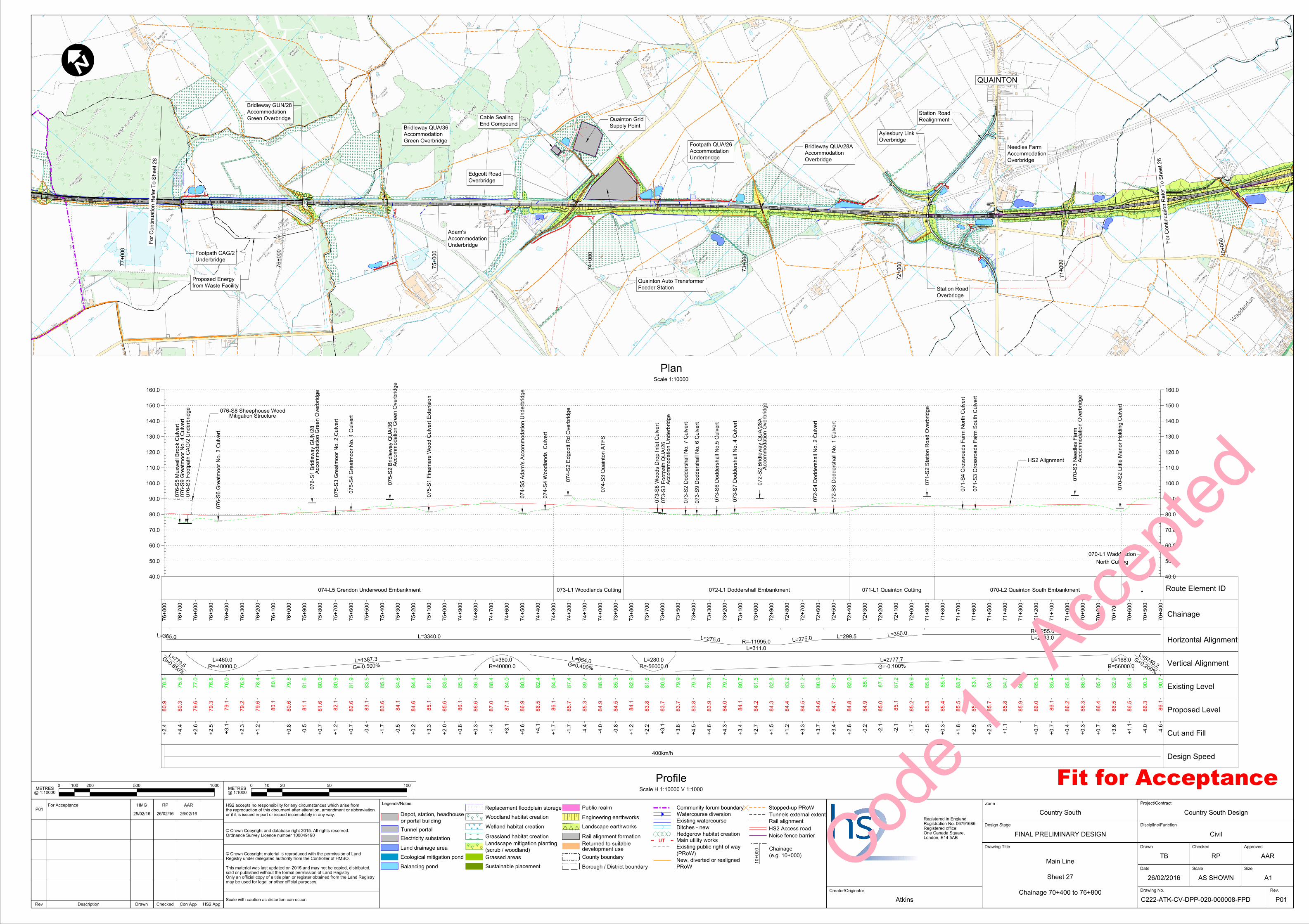
70 + 000 71 + 000 72 + 000 73 + 000 74 + 000 7 5 + 00 0 7 6 + 0 00 77 + 000 40.0 50.0 60.0 70.0 80.0 90.0 100.0 110.0 120.0 130.0 140.0 150.0 160.0 40.0 50.0 60.0 70.0 80.0 90.0 100.0 110.0 120.0 130.0 140.0 150.0 160.0 074 - S3 Qu a i n t on AT FS 072-L1 Doddershall Embankment North Cutting 070-L1 Waddesdon 070-L2 Quainton South Embankment 071-L1 Quainton Cutting Chainage 70 + 400 70 + 500 70 + 600 70 + 700 70 + 800 70 + 900 71 + 000 71 + 100 71 + 200 71 + 300 71 + 400 71 + 500 71 + 600 71 + 700 71 + 800 71 + 900 72 + 000 72 + 100 72 + 200 72 + 300 72 + 400 72 + 500 72 + 600 72 + 700 72 + 800 72 + 900 73 + 000 73 + 100 73 + 200 73 + 300 73 + 400 73 + 500 73 + 600 73 + 700 73 + 800 73 + 900 74 + 000 74 + 100 74 + 200 74 + 300 74 + 400 74 + 500 74 + 600 74 + 700 74 + 800 74 + 900 75 + 000 75 + 100 75 + 200 75 + 300 75 + 400 75 + 500 75 + 600 75 + 700 75 + 800 75 + 900 76 + 000 76 + 100 76 + 200 76 + 300 76 + 400 76 + 500 76 + 600 76 + 700 76 + 800 Horizontal Alignment R=8255.0 L=2133.0 L = 350 . 0 L=299.5 L = 275 . 0 R=-11995.0 L=311.0 L = 275 . 0 L=3340.0 L = 365 . 0 Vertical Alignment L = 5 7 4 0 . 2 G = 0 . 200 % L=168.0 R=56000.0 L = 2777 . 7 G = - 0 . 100 % L=280.0 R=-56000.0 L = 654 . 0 G = 0 . 400 % L=360.0 R=40000.0 L = 1387 . 3 G = - 0 . 500 % L=460.0 R=-40000.0 L = 779 . 6 G= 0 . 650 % Existing Level 90 . 7 90 . 3 85 . 4 82 . 9 85 . 7 86 . 0 85 . 8 85 . 4 85 . 3 85 . 9 84 . 7 83 . 4 83 . 1 83 . 7 85 . 1 85 . 8 86 . 9 87 . 2 87 . 1 85 . 1 82 . 0 81 . 3 80 . 9 81 . 2 83 . 2 82 . 8 81 . 5 80 . 7 79 . 7 79 . 3 79 . 3 79 . 9 80 . 6 81 . 6 82 . 9 85 . 3 88 . 9 89 . 7 87 . 4 84 . 4 82 . 4 80 . 3 84 . 0 88 . 4 86 . 3 85 . 3 83 . 6 81 . 8 84 . 4 84 . 6 85 . 3 83 . 5 81 . 9 80 . 9 80 . 9 81 . 6 79 . 8 80 . 1 78 . 4 76 . 9 76 . 0 76 . 8 77 . 0 75 . 9 78 . 5 Proposed Level 86 . 1 86 . 3 86 . 5 86 . 5 86 . 4 86 . 3 86 . 2 86 . 1 86 . 0 85 . 9 85 . 8 85 . 7 85 . 6 85 . 5 85 . 4 85 . 3 85 . 2 85 . 1 85 . 0 84 . 9 84 . 8 84 . 7 84 . 6 84 . 5 84 . 4 84 . 3 84 . 2 84 . 1 84 . 0 83 . 9 83 . 8 83 . 7 83 . 7 83 . 8 84 . 1 84 . 5 84 . 9 85 . 3 85 . 7 86 . 1 86 . 5 86 . 9 87 . 1 87 . 0 86 . 6 86 . 1 85 . 6 85 . 1 84 . 6 84 . 1 83 . 6 83 . 1 82 . 6 82 . 1 81 . 6 81 . 1 80 . 6 80 . 1 79 . 6 79 . 2 79 . 1 79 . 3 79 . 6 80 . 3 80 . 9 + 1 . 1 + 3 . 6 + 0 . 7 + 0 . 3 + 0 . 4 + 0 . 7 + 0 . 7 + 1 . 1 + 2 . 3 + 2 . 5 + 1 . 8 + 0 . 3 + 2 . 8 + 3 . 4 + 3 . 7 + 3 . 3 + 1 . 2 + 1 . 5 + 2 . 7 + 3 . 4 + 4 . 3 + 4 . 6 + 4 . 5 + 3 . 8 + 3 . 1 + 2 . 2 + 1 . 2 + 1 . 7 + 4 . 1 + 6 . 6 + 3 . 1 + 0 . 3 + 0 . 8 + 2 . 0 + 3 . 3 + 0 . 2 + 0 . 7 + 1 . 2 + 0 . 7 + 0 . 8 + 1 . 2 + 2 . 3 + 3 . 1 + 2 . 5 + 2 . 6 + 4 . 4 + 2 . 4 Cut and Fill - 4 . 6 - 4 . 0 - 0 . 5 - 1 . 7 - 2 . 1 - 2 . 1 - 0 . 2 - 0 . 8 - 4 . 0 - 4 . 4 - 1 . 7 - 1 . 4 - 0 . 5 - 1 . 7 - 0 . 4 - 0 . 5 400km/h Route Element ID Design Speed 073-L1 Woodlands Cutting 074-L5 Grendon Underwood Embankment 070 - S2 L ittl e M a no r Ho l d i ng Cu l v e r t Acc o mm od a ti on Ov e r b r i dg e 070 - S3 Nee d l e s F a r m 071 - S2 St a ti on Ro a d Ov e r b r i dg e 072 - S3 Dodd e r s h a ll No . 1 Cu l v e r t 072 - S4 Dodd e r s h a ll No . 2 Cu l v e r t 074 - S5 Ad a m ’ s Acc o mm od a ti on Und e r b r i dg e 073 - S7 Dodd e r s h a ll No . 4 Cu l v e r t 073 - S6 Dodd e r s h a ll No . 5 Cu l v e r t 073 - S9 Dodd e r s h a ll No . 6 Cu l v e r t 073 - S2 Dodd e r s h a ll No . 7 Cu l v e r t 073 - S8 W ood s Dr op I n l e t Cu l v e r t Acc o mm od a ti on Und e r b r i dg e 073 - S3 F oo t p a t h QUA/ 26 074 - S2 Edg c o tt Rd Ov e r b r i dg e 074 - S4 W ood l a nd s Cu l v e r t Acc o mm od a ti on Gr ee n Ov e r b r i dg e 075 - S2 Br i d l e wa y QUA/ 36 075 - S3 Gr ea t m oo r No . 2 Cu l v e r t Acc o mm od a ti on Gr ee n Ov e r b r i dg e 076 - S1 Br i d l e wa y GUN/ 28 076 - S6 Gr ea t m oo r No . 3 Cu l v e r t 076 - S3 F oo t p a t h CAG/ 2 Und e r b r i dg e 076 - S5 M ux we ll Br ook Cu l v e r t 075 - S4 Gr ea t m oo r No . 1 Cu l v e r t 075 - S1 F i n e m e r e W ood Cu l v e r t Ex t e n s i on Acc o mm od a ti on Ov e r b r i dg e 072 - S2 Br i d l e wa y QUA/ 28 A 076 - S9 Gr ea t m oo r No . 4 Cu l v e r t 071 - S4 Cr o ss r o a d s F a r m No r t h Cu l v e r t 071 - S3 Cr o ss r o a d s F a r m Sou t h Cu l v e r t PSTN 0 500 200 100 1000 @ 1:10000 METRES 0 100 50 20 10 @ 1:1000 METRES Scale H 1:10000 V 1:1000 Profile Scale 1:10000 Plan QUAINTON from Waste Facility Proposed Energy HS2 Alignment Green Overbridge Accommodation Bridleway QUA/36 Underbridge Footpath CAG/2 26/02/2016 TB Civil Atkins Main Line C222-ATK-CV-DPP-020-000008-FPD A1 AS SHOWN Country South Country South Design F o r Co n ti nu a ti o n Re f e r T o Sh ee t 2 6 F o r Con ti nu a ti on Re f e r T o Sh ee t 28 Chainage 70+400 to 76+800 Sheet 27 HMG 25/02/16 FINAL PRELIMINARY DESIGN P01 P01 Mitigation Structure 076-S8 Sheephouse Wood For Acceptance AAR RP 26/02/16 AAR 26/02/16 RP Fit for Acceptance Drawn Checked Approved Drawing No. Date Scale Size Rev. Drawn Rev Description Project/Contract Discipline/Function Zone Creator/Originator Legends/Notes: Drawing Title Design Stage HS2 App Con App Checked Scale with caution as distortion can occur. may be used for legal or other official purposes. Only an official copy of a title plan or register obtained from the Land Registry sold or published without the formal permission of Land Registry. This material was last updated on 2015 and may not be copied, distributed, Registry under delegated authority from the Controller of HMSO. ' Crown Copyright material is reproduced with the permission of Land Ordnance Survey Licence number 100049190 ' Crown Copyright and database right 2015. All rights reserved. or if it is issued in part or issued incompletely in any way. the reproduction of this document after alteration, amendment or abbreviation HS2 accepts no responsibility for any circumstances which arise from London, E14 5AB One Canada Square, Registered office: Registration No. 06791686 Registered in England Tunnel portal Ditches - new Tunnels external extent Woodland habitat creation Wetland habitat creation Grassland habitat creation Ecological mitigation pond HS2 Access road Watercourse diversion Electricity substation Balancing pond Noise fence barrier Replacement floodplain storage Land drainage area (scrub / woodland) Landscape mitigation planting Main utility works County boundary Borough / District boundary Community forum boundary Rail alignment Rail alignment formation Landscape earthworks Engineering earthworks 10 + 000 Stopped-up PRoW Hedgerow habitat creation Grassed areas Sustainable placement Public realm (PRoW) Existing public right of way PRoW New, diverted or realigned (e.g. 10+000) Chainage Existing watercourse or portal building Depot, station, headhouse development use Returned to suitable Underbridge Accommodation Footpath QUA/26 Overbridge Edgcott Road Underbridge Accommodation Adam’s Feeder Station Quainton Auto Transformer Supply Point Quainton Grid End Compound Cable Sealing Overbridge Accommodation Bridleway QUA/28A Overbridge Accommodation Needles Farm Realignment Station Road Overbridge Aylesbury Link Overbridge Station Road Green Overbridge Accommodation Bridleway GUN/28 Code 1 - Accepted

Welcome message from author
This document is posted to help you gain knowledge. Please leave a comment to let me know what you think about it! Share it to your friends and learn new things together.
Transcript
AYLESBURY VALE DISTRICT
COUNTY OF BUCKINGHAMSHIRE
70+000
71+000
72+000
73+000
74+000
75+000
76+000
77+000
40.0
50.0
60.0
70.0
80.0
90.0
100.0
110.0
120.0
130.0
140.0
150.0
160.0
40.0
50.0
60.0
70.0
80.0
90.0
100.0
110.0
120.0
130.0
140.0
150.0
160.0
074-S
3 Q
uainto
n A
TFS
072-L1 Doddershall Embankment
North Cutting
070-L1 Waddesdon
070-L2 Quainton South Embankment071-L1 Quainton Cutting
Chainage
70+400
70+500
70+600
70+700
70+800
70+900
71+000
71+100
71+200
71+300
71+400
71+500
71+600
71+700
71+800
71+900
72+000
72+100
72+200
72+300
72+400
72+500
72+600
72+700
72+800
72+900
73+000
73+100
73+200
73+300
73+400
73+500
73+600
73+700
73+800
73+900
74+000
74+100
74+200
74+300
74+400
74+500
74+600
74+700
74+800
74+900
75+000
75+100
75+200
75+300
75+400
75+500
75+600
75+700
75+800
75+900
76+000
76+100
76+200
76+300
76+400
76+500
76+600
76+700
76+800
Horizontal Alignment
R=8255.0
L=2133.0L=350.0L=299.5
L=275.0R=-11995.0
L=311.0
L=275.0L=3340.0L=365.0
Vertical Alignment
L=5740.2
G=0.200%
L=168.0
R=56000.0
L=2777.7
G=-0.100%
L=280.0
R=-56000.0
L=654.0G=0.400%
L=360.0
R=40000.0
L=1387.3
G=-0.500%
L=460.0
R=-40000.0
L=779.6
G=0.650%
Existing Level 90.7
90.3
85.4
82.9
85.7
86.0
85.8
85.4
85.3
85.9
84.7
83.4
83.1
83.7
85.1
85.8
86.9
87.2
87.1
85.1
82.0
81.3
80.9
81.2
83.2
82.8
81.5
80.7
79.7
79.3
79.3
79.9
80.6
81.6
82.9
85.3
88.9
89.7
87.4
84.4
82.4
80.3
84.0
88.4
86.3
85.3
83.6
81.8
84.4
84.6
85.3
83.5
81.9
80.9
80.9
81.6
79.8
80.1
78.4
76.9
76.0
76.8
77.0
75.9
78.5
Proposed Level 86.1
86.3
86.5
86.5
86.4
86.3
86.2
86.1
86.0
85.9
85.8
85.7
85.6
85.5
85.4
85.3
85.2
85.1
85.0
84.9
84.8
84.7
84.6
84.5
84.4
84.3
84.2
84.1
84.0
83.9
83.8
83.7
83.7
83.8
84.1
84.5
84.9
85.3
85.7
86.1
86.5
86.9
87.1
87.0
86.6
86.1
85.6
85.1
84.6
84.1
83.6
83.1
82.6
82.1
81.6
81.1
80.6
80.1
79.6
79.2
79.1
79.3
79.6
80.3
80.9
+1.1
+3.6
+0.7
+0.3
+0.4
+0.7
+0.7
+1.1
+2.3
+2.5
+1.8
+0.3
+2.8
+3.4
+3.7
+3.3
+1.2
+1.5
+2.7
+3.4
+4.3
+4.6
+4.5
+3.8
+3.1
+2.2
+1.2
+1.7
+4.1
+6.6
+3.1
+0.3
+0.8
+2.0
+3.3
+0.2
+0.7
+1.2
+0.7
+0.8
+1.2
+2.3
+3.1
+2.5
+2.6
+4.4
+2.4
Cut and Fill -4.6
-4.0
-0.5
-1.7
-2.1
-2.1
-0.2
-0.8
-4.0
-4.4
-1.7
-1.4
-0.5
-1.7
-0.4
-0.5
400km/h
Route Element ID
Design Speed
073-L1 Woodlands Cutting074-L5 Grendon Underwood Embankment
070-S
2 Little M
anor
Holdin
g C
ulvert
Acco
mm
odation O
verbridge
070-S
3 N
eedles F
arm
071-S
2 Station R
oad O
verbridge
072-S
3 D
odders
hall N
o. 1 C
ulvert
072-S
4 D
odders
hall N
o. 2 C
ulvert
074-S
5 A
da
m’s A
cco
mm
odation U
nderbridge
073-S
7 D
odders
hall N
o. 4 C
ulvert
073-S
6 D
odders
hall N
o.5 C
ulvert
073-S
9 D
odders
hall N
o. 6 C
ulvert
073-S
2 D
odders
hall N
o. 7 C
ulvert
073-S
8 W
oods Dro
p Inlet
Culvert
Acco
mm
odation U
nderbridge
073-S
3 F
ootp
ath Q
UA/2
6
074-S
2 E
dgcott R
d O
verbridge
074-S
4 W
oodla
nds
Culvert
Acco
mm
odation Gre
en O
verbridge
075-S
2 Bridle
way Q
UA/3
6
075-S
3 Gre
atm
oor
No. 2 C
ulvert
Acco
mm
odation Gre
en O
verbridge
076-S
1 Bridle
way G
UN/2
8
076-S
6 Gre
atm
oor
No. 3 C
ulvert
076-S
3 F
ootp
ath C
AG/2 U
nderbridge
076-S
5 M
ux
well Bro
ok C
ulvert
075-S
4 Gre
atm
oor
No. 1 C
ulvert
075-S
1 Fine
mere W
ood C
ulvert E
xte
nsio
n
Acco
mm
odation O
verbridge
072-S
2 Bridle
way Q
UA/2
8A
076-S
9 Gre
atm
oor
No. 4 C
ulvert
071-S
4 Crossro
ads F
arm N
orth C
ulvert
071-S
3 Crossro
ads F
arm S
outh C
ulvert
PSTN
TR = 30.000mR = 23000.000m L = 195.585m
TR = 30.000m
R = 7266.220m L = 325.339m
TR = 60.000m
R = 2400.000m L = 46.672m
TR = 60.000m
0 500200100 1000
@ 1:10000METRES
0 100502010
@ 1:1000METRES Scale H 1:10000 V 1:1000
Profile
Scale 1:10000
Plan
QUAINTON
from Waste Facility
Proposed Energy
HS2 Alignment
Green Overbridge
Accommodation
Bridleway QUA/36
Underbridge
Footpath CAG/2
26/02/2016
TB
Civil
Atkins
Main Line
C222-ATK-CV-DPP-020-000008-FPD
A1AS SHOWN
Country South Country South Design
For
Continuation R
efer
To S
heet 26
For
Continuation R
efer
To S
heet 28
Chainage 70+400 to 76+800
Sheet 27
HMG
25/02/16
FINAL PRELIMINARY DESIGN
P01
P01
Mitigation Structure076-S8 Sheephouse Wood
For Acceptance
AARRP
26/02/16
AAR
26/02/16
RP
Fit for Acceptance
Drawn Checked Approved
Drawing No.
Date Scale Size
Rev.
DrawnRev Description
Project/Contract
Discipline/Function
Zone
Creator/Originator
Legends/Notes:
Drawing Title
Design Stage
HS2 AppCon AppChecked
Scale with caution as distortion can occur.
may be used for legal or other official purposes.
Only an official copy of a title plan or register obtained from the Land Registry
sold or published without the formal permission of Land Registry.
This material was last updated on 2015 and may not be copied, distributed,
Registry under delegated authority from the Controller of HMSO.
' Crown Copyright material is reproduced with the permission of Land
Ordnance Survey Licence number 100049190
' Crown Copyright and database right 2015. All rights reserved.
or if it is issued in part or issued incompletely in any way.
the reproduction of this document after alteration, amendment or abbreviation
HS2 accepts no responsibility for any circumstances which arise from
London, E14 5AB
One Canada Square,
Registered office:
Registration No. 06791686
Registered in England
Tunnel portalDitches - new
Tunnels external extentWoodland habitat creation
Wetland habitat creation
Grassland habitat creation
Ecological mitigation pond
HS2 Access road
Watercourse diversion
Electricity substation
Balancing pond
Noise fence barrier
Replacement floodplain storage
Land drainage area (scrub / woodland)
Landscape mitigation planting Main utility works
County boundary
Borough / District boundary
Community forum boundary
Rail alignment
Rail alignment formation
Landscape earthworks
Engineering earthworks
10+000
Stopped-up PRoW
Hedgerow habitat creation
Grassed areas
Sustainable placement
Public realm
(PRoW)
Existing public right of way
PRoW
New, diverted or realigned (e.g. 10+000)
Chainage
Existing watercourseor portal building
Depot, station, headhouse
development use
Returned to suitable
Underbridge
Accommodation
Footpath QUA/26
Overbridge
Edgcott Road
Underbridge
Accommodation
Adam’s
Feeder Station
Quainton Auto Transformer
Supply Point
Quainton Grid End Compound
Cable Sealing
Overbridge
Accommodation
Bridleway QUA/28A
Overbridge
Accommodation
Needles Farm
Realignment
Station Road
Overbridge
Aylesbury Link
Overbridge
Station Road
Green Overbridge
Accommodation
Bridleway GUN/28
Code 1
- Acc
epted
Related Documents