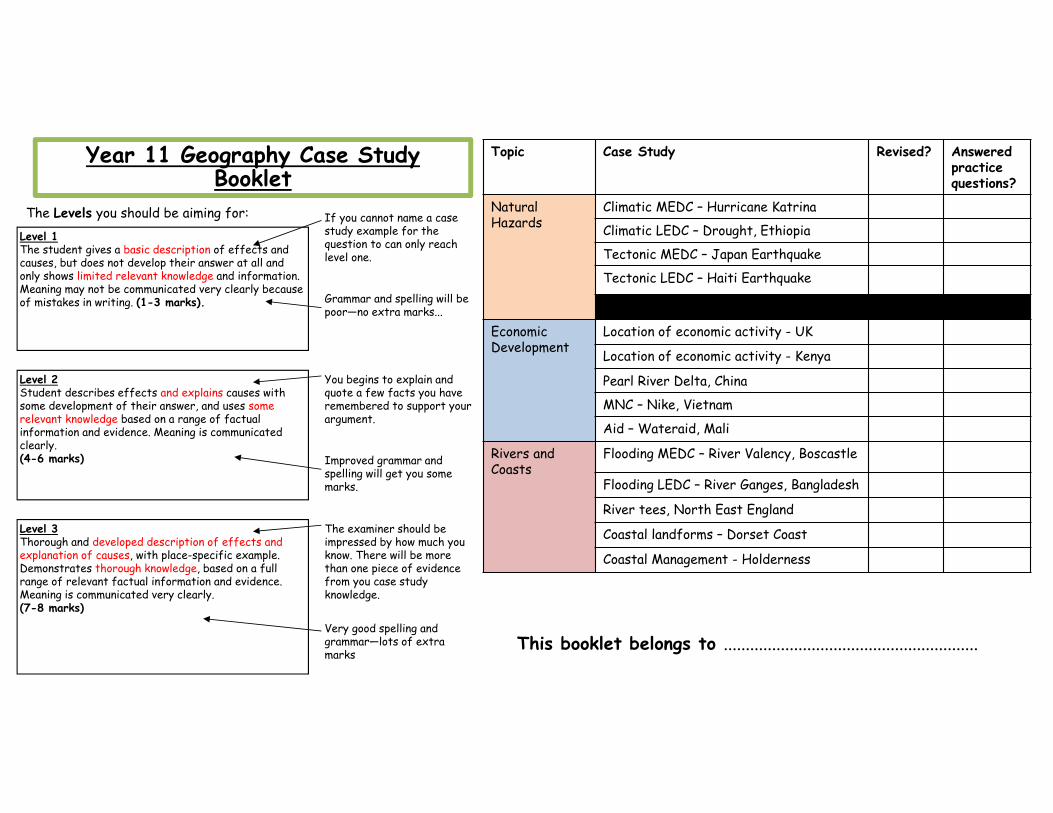
Year 11 Geography Case Study Booklet This booklet belongs to .......................................................... Topic Case Study Revised? Answered practice questions? Natural Hazards Climatic MEDC – Hurricane Katrina Climatic LEDC – Drought, Ethiopia Tectonic MEDC – Japan Earthquake Tectonic LEDC – Haiti Earthquake Economic Development Location of economic activity - UK Location of economic activity - Kenya Pearl River Delta, China MNC – Nike, Vietnam Aid – Wateraid, Mali Rivers and Coasts Flooding MEDC – River Valency, Boscastle Flooding LEDC – River Ganges, Bangladesh River tees, North East England Coastal landforms – Dorset Coast Coastal Management - Holderness Level 1 The student gives a basic description of effects and causes, but does not develop their answer at all and only shows limited relevant knowledge and information. Meaning may not be communicated very clearly because of mistakes in writing. (1-3 marks). Level 2 Student describes effects and explains causes with some development of their answer, and uses some relevant knowledge based on a range of factual information and evidence. Meaning is communicated clearly. (4-6 marks) Level 3 Thorough and developed description of effects and explanation of causes, with place-specific example. Demonstrates thorough knowledge, based on a full range of relevant factual information and evidence. Meaning is communicated very clearly. (7-8 marks) The Levels you should be aiming for: If you cannot name a case study example for the question to can only reach level one. Grammar and spelling will be poor—no extra marks... You begins to explain and quote a few facts you have remembered to support your argument. Improved grammar and spelling will get you some marks. The examiner should be impressed by how much you know. There will be more than one piece of evidence from you case study knowledge. Very good spelling and grammar—lots of extra marks

Welcome message from author
This document is posted to help you gain knowledge. Please leave a comment to let me know what you think about it! Share it to your friends and learn new things together.
Transcript
Year 11 Geography Case Study Booklet
This booklet belongs to ..........................................................
Topic Case Study Revised? Answeredpractice questions?
NaturalHazards
Climatic MEDC – Hurricane Katrina
Climatic LEDC – Drought, Ethiopia
Tectonic MEDC – Japan Earthquake
Tectonic LEDC – Haiti Earthquake
EconomicDevelopment
Location of economic activity - UK
Location of economic activity - Kenya
Pearl River Delta, China
MNC – Nike, Vietnam
Aid – Wateraid, Mali
Rivers andCoasts
Flooding MEDC – River Valency, Boscastle
Flooding LEDC – River Ganges, Bangladesh
River tees, North East England
Coastal landforms – Dorset Coast
Coastal Management - Holderness
Level 1The student gives a basic description of effects and causes, but does not develop their answer at all and only shows limited relevant knowledge and information. Meaning may not be communicated very clearly because of mistakes in writing. (1-3 marks).
Level 2Student describes effects and explains causes with some development of their answer, and uses some relevant knowledge based on a range of factual information and evidence. Meaning is communicated clearly.(4-6 marks)
Level 3Thorough and developed description of effects and explanation of causes, with place-specific example. Demonstrates thorough knowledge, based on a full range of relevant factual information and evidence. Meaning is communicated very clearly. (7-8 marks)
The Levels you should be aiming for: If you cannot name a case study example for the question to can only reach level one.
Grammar and spelling will be poor—no extra marks...
You begins to explain and quote a few facts you have remembered to support your argument.
Improved grammar and spelling will get you some marks.
The examiner should be impressed by how much you know. There will be more than one piece of evidence from you case study knowledge.
Very good spelling and grammar—lots of extra marks
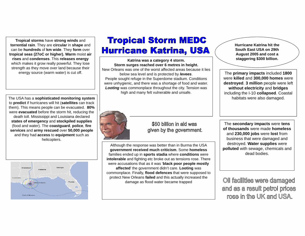
Tropical storms have strong winds and torrential rain. They are circular in shape and can be hundreds of km wide. They form over
tropical seas (27oC or higher). Warm moist air rises and condenses. This releases energywhich makes it grow really powerful. They lose strength as they move over land because their
energy source (warm water) is cut off.
Hurricane Katrina hit the South East USA on 29th August 2005 and cost a staggering $300 billion.
The primary impacts included 1800were killed and 300,000 homes were destroyed. 3 million people were left
without electricity and bridgesincluding the I-10 collapsed. Coastal
habitats were also damaged.
The secondary impacts were tens of thousands were made homeless
and 230,000 jobs were lost from business that were damaged and destroyed. Water supplies were
polluted with sewage, chemicals and dead bodies.
The USA has a sophisticated monitoring systemto predict if hurricanes will hit (satellites can track them). This means people can be evacuated. 80%were evacuated before the storm hit, reducing the
death toll. Mississippi and Louisiana declared states of emergency and stockpiled supplies(food and water). The coastguard, police, fire
services and army rescued over 50,000 peopleand they had access to equipment such as
helicopters. Although the response was better than in Burma the USA government received much criticism. Some homeless
families ended up in sports stadia where conditions were intolerable and fighting etc broke out as tensions rose. There were accusations that as it was ‘black poor people mostly
affected’ the government didn’t care. Looting was commonplace. Finally, flood defences that were supposed to
protect New Orleans failed and this actually increased the damage as flood water became trapped
Katrina was a category 4 storm.Storm surges reached over 6 metres in height.
New Orleans was one of the worst affected areas because it lies below sea level and is protected by levees.
People sought refuge in the Superdome stadium. Conditions were unhygienic, and there was a shortage of food and water. Looting was commonplace throughout the city. Tension was
high and many felt vulnerable and unsafe.

The Sahel region of Africa has been suffering from drought on a
regular basis since the early 1980s. The area naturally experiences
alternating wet and dry seasons.
The result is crop failure, soil erosion, famine and hunger: people are then less able to work when their need is greatest. It becomes a vicious circle and
can result in many deaths, especially among infants and the elderly. In Niger in 2004, the situation was made worse when a plague of locusts consumed any remaining crops. In these cases, people rely on food aid from the international
community.
Desertification – the turning of land, often through physical processes and human mismanagement, into desert. A severe threat to millions in the Sahel region of Africa.
In the Sahel, a drought is declared when there’s below average rainfall for 2 years.
The Sahel has actually suffered drought for most of
the last 30 years.
Drought is different from other hazards unlike floods and tropical storms it never kills people
directly
The Eden project is a charity that plants trees in the area to
give food to the local people

The January 1994 Northridge Earthquake struck hard: the first major earthquake to occur
directly beneath a highly urbanized area in California.
Near the epicenter in the San Fernando Valley, well-engineered buildings withstood violent shaking without
structural damage
Northridge was fairly prepared for earthquakes through education,
rescue efforts and strong buildings.
The earthquake happened on a deep fault in the San Fernado Valley
Primary effects-57 people killed
-9000 injured-Thousands of buildings damaged-Transport links damaged (roads)
Yet due to the earthquake happening early in the morning it reduced the deaths
Secondary effects-Landslides
-Powerlines and waterlines damaged from the debris
-Extensive fires
15,000 aftershocks occurred, these can trigger the collapse
of weak buildings
Wooden buildings were the buildings that
generally collapsed
Landslides were triggered in
mountainous areas, these block roads
and damaged homes
Fires broke out from the leaking gas pipes,
areas were completely destroyed
by the fires
Liquefaction occurred in some areas
It was declared a federal disaster, so 100s of workers
from FEMA helped the community recover
Millions were given to the 600,000 people that applied for
financial assistance.
The USGS monitor the movement yet can not predict , so preparation is key!

A massive 9.0‐magnitude earthquake struck Japan, Friday afternoon 246pm local time, on
11 March 2011 @ 0546 GMT.The earthquake lasted six minutes.
10-meter tsunami was seen at the port in Sendai, near the epicentre.
Japan was largely prepared for the earthquake and many buildings
remained standing afterwards, but it was not prepared for the subsequent
Tsunami..Japan is located on the east edge of the Eurasian Plate.
The oceanic Pacific Plate subducts (sinks under) the Eurasian Plate.This plate margin is “destructive”
It is not a smooth process, friction is present and the plates stick, tension (pressure) builds up.
When this pressure builds up and is released, it causes a rapid shift in the plates and a lot of energy to be released, in this case the 5th most
powerful earthquake ever!
Primary effects‐Approximately 16,000 killed
‐55,000 buildings damaged/ swept away‐Fukushima Nuclear Power Plant damaged and
released extreme amounts of radiation‐4 trains swept away
Secondary effects2 million homeless
‐Power lines, gas and water services severely disrupted
‐Major decline for Japan's agricultural, livestock and fishing industries due to fear of
contamination from radiation‐Tourism numbers decreased over the next
two years
The total cost to re-build the areas affected was
set at £185 billion
Tall buildings swayed violently in central
Tokyo as the aftershocks hit.
Tokyo’s major airports halted flights, though Haneda Airport was
later reported to have reopened several runways. All Tokyo area trains were halted, while the
Shinkansen bullet train service was suspended.
The quake was centered 130 kilometers to the east of the prefecture’s capital, Sendai (365km
north east of Tokyo).
Prezi presentation by A‐level students – very good https://prezi.com/jrdghgfyr7og/tohoku‐japan‐earthquake‐case‐study/Also this is great for effects:http://www.geographypods.com/2‐earthquakes.html
Response‐Local emergency units were sent out to cool down the nuclear reactors of the Fukushima power plant ‐The Red Cross and other related organisations assisted in the search for survivors. ‐Relief organisations like ShelterBox distributed aid to Japan. ‐Local emergency units and volunteers helped searching for the estimate 3,155 missing
Epicentre
Plate margin between
Eurasian and Pacific Plate

The country is located on a conservative plate boundary between the Caribbean Plate and the North American Plate.
3 Million people live in Port au Prince with the majority living in slum conditions after rapid
urbanisation.
The poorest country in the western hemisphere. GDP is 143/227. 66% of the population of Haiti earn less than £1 a day
with 56% of the population classed as “extremely poor”
In early January 2010 the EUreleased €3 m in emergency
funding.
The European Council and its member nations later
announced more than €429 million in aid.
The governments of the United States, Israel ,the Dominican Republic, Canada, Brazil, Italy and Cuba3 sent over 1,000 military and disaster relief personnel each, with the United States being by
far the largest single contributor to the relief efforts.
- 12th January 2010 an earthquake measuring 7.0 on the Richter scale struck Haiti.-The focus was 13km underground
-The epicentre was 25km from the capital Port-au-Prince
-Haiti suffered a huge number of serious aftershocks.
-The number of people in relief camps of tents since the quake was 1.6 million
-In July 2010, CNN returned to Port-au-Prince and reported, "It looks like the quake just happened
yesterday“.-A January 2012 Oxfam report said that a half a
million Haitians remained homeless -Only about 20% of aid has been spent by the Haiti
government as they have no resources.

1. Case Study – Climatic hazard in an LEDCName the LEDC and state the climatic hazard_____________________________________________________
Q. Outline the causes of this hazard and explain the impacts on the country. Include three developed points.
2. Case Study: Climatic hazard in an MEDCName the MEDC and state the climatic hazard_____________________________________________________
Q. Outline line the impacts of the hazard and the sustainability of the responses. Include three developed points.
3. Case Study: Tectonic hazard in an LEDCName the LEDC and state the tectonic hazard
_____________________________________________________
Q. Describe the causes of this hazard and suggest how sustainable the responses were. Include three developed points.
4. Case Study: Tectonic hazard in an MEDCName the MEDC and state the tectonic hazard_____________________________________________________
Q. Describe the effects of this hazard and suggest how sustainable the responses were. Include three developed points.

Fact
ors
that
aff
ect
the
loca
tion
of
econ
omic
act
ivit
y (M
EDC)
–UK

Fact
ors
that
aff
ect
the
loca
tion
of
econ
omic
act
ivit
y (L
EDC)
–Ke
nya

Conflict between economic activity and the environment – Pearl River Delta, China
What is it?The Pearl Delta is in the Republic of China in the low-lying area surrounding the Pearl River estuary where the Pearl River flows into the South China Sea. It is one of the most densely urbanised regions in the world and one of the main hubs of China's economic growth.
The Pearl River Delta has become the world's workshop and is a major manufacturing base for products such as electronic products (such as watches and clocks), toys, garments and textiles, plastic products, and a range of other goods.
Nearly five percent of the world's goods were produced in the Greater Pearl River Delta
in 2001. Over 70,000 Hong Kong companies have plants
there.
All of this manufacturing creates a lot of pollution. The Pearl River Delta is notoriously polluted, with sewage and industrial waste. (Treatment facilities are failing to keep up with the growing population). This has a negative impact on the environment.
The problemsIn October 2009, Greenpeace released a report, "Poisoning the Pearl River" that detailed the results of a study it conducted.
All samples they took contained hazardous properties including heavy metals such as beryllium, copper and manganese.
These substances are associated with a long list of health problems such as cancer, endocrine disruption, renal failure and damage to the nervous system as well being known to harm the environment.
Future ManagementIn 2007, the World Bank approved a $96 million loan to the Chinese government to reduce water pollution in the Pearl River Delta. 7.1 billion was spent on the river by mid 2010 to clean up the river's sewage problems.
The city will build about 30 water treatment plants, which will treat 2.25 million tonnes of water per day. The program hopes to cut down the amount of sewage in the area by 85%,

Multinational Company (MNC) – Nike, Vietnam
Key Facts
Nike is the world's leading supplier of sports footwear and equipment. The company was founded in 1972. The company name comes from the Greek word for 'victory'. Nike does not make any shoes or clothes itself but contracts out to factories in LEDCs.
These subcontracted companies then act on their own and re‐subcontract theiroperations in other Asian countries that give low wages and have no employment laws. E.g. Vietnam, The Philippines and Indonesia.
Benefits
• The average pay at a Nike factory close in Vietnam is $54 a month, 3x higher than other jobs.
• It encourages female employment• Offers jobs to local people• Helps to boost the local economy by employing
people.
Negatives
• Sweatshops – long working hours and poor condiditons
• Child labour• Hazardous working conditions• Below subsistence wages (not enough money to
afford basic food and water)
What is being done by Nike?• Introduced a code of conduct for
subcontractors to ensure that they are treating people properly.
• Decommissioning subcontractors who fail to follow the code of conduct.
• Auditing tools and task force to guarantee human rights.
• Nike have hired independent auditors to make sure that the company subcontractors are living up to Nike’s code of conduct.
• In 1998 Nike changed the minimum age requirements to 17 years old.
The numbers…• Yearly revenue of $19.2 billion (2009).• Products in 140 countries.• Contracts to 700 factories in 45 countries.• Employing 800.000 people in the supply chain.

A sustainable aid project in an LEDC –WaterAid in Mali
What is WaterAid?WaterAid is an international NGO (non-governmental organisation /charity) that focuses on the provision of safe domestic water, sanitation and hygiene education to the world's poorest people. WaterAid's vision is of a world where everyone has access to safe domestic water and effective sanitation.
Poor sanitation means bad health. Bacteria, viruses and parasites found in human waste are responsible for the transmission of cholera, typhoid and other infectious diseases that kill millions of people each year. The problem is huge in both urban and rural areas
WHY IS IT SUSTAINABLE?
WaterAid are training local people to maintain system and raise money to keep it running.
WaterAid are encouraging communities to invest in their own infrastructure.
Education programmes = health benefits
People can cope better with droughts and harsh times in the future.
The government acknowledge that it is possible for everyone to have access to safe water and they begin to help.
Physical reasons• Natural environment is
harsh and deteriorating.• Low rainfall which leads to
drought.
Why are WaterAid in Mali?
Human reasons• Population = 12 million• 50% have access to clean
sustainable water.• Many people live in slums
Wateraid is first targeting Slums in Mali’s capital, it wants to show the government that projects in
slums are easy to set up and sustainable.
Has it been successful?
YES!
• Health has now improved include reducing the deaths from diarrhoea – 65% improvement
• Education is now improving, money is being invested into the infrastructure
• Wateraid employs local people, who they are training up to maintain the system and raise money to keep it running.
• They invest in the community – THIS IS SUSTAINABLE
Possible Case Study Questions- Economic Development
1. Case Study: An Aid project in an LEDC.Name and locate an aid projectDescribe the main features of the project. Explain how the project is sustainable.
2. Case Study: Multi-national companiesName a multi-national company you have studied and a country where it is located.Explain how the multi-national company affects local people and the overall economy of the country. Include at least three different ideas, with detail.
3. Case Study: An aid project in an LEDC.Name the LEDC and aid projectDescribe the main features of the aid project and explain how sustainable the project is. Include at least three developed ideas.
4. Case Study: The effects of economic development.Name and locate an economic activityHow has the economic activity affected the natural environment? What has been done to minimise damage to the environment?
5. Case Study: An economic activity in an LEDCName and locate an example of an economic activity you have studied in an LEDC.Explain why this economic activity is located in this LEDC. What factors might influence decisions about whether the named economic activity remains at this location in the future? Include at least three different ideas, with detail.
6. Case Study: a multi-national companyName a multi-national company and one country where it operates.Explain how the multi-national company affects local people and the economy of that country. Include at least three different ideas, with detail.

River flooding (MEDC) – River Valency, Boscastle
What caused the flash flood?
Impacts of the flood
Management responses to the flood
Social Economic Environmental
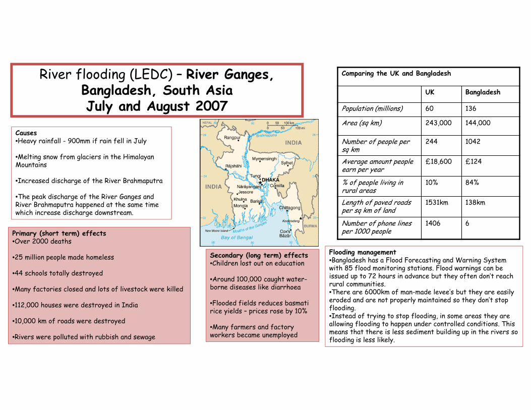
River flooding (LEDC) – River Ganges, Bangladesh, South AsiaJuly and August 2007
Comparing the UK and Bangladesh
UK Bangladesh
Population (millions) 60 136
Area (sq km) 243,000 144,000
Number of people per sq km
244 1042
Average amount people earn per year
£18,600 £124
% of people living in rural areas
10% 84%
Length of paved roads per sq km of land
1531km 138km
Number of phone lines per 1000 people
1406 6
Causes•Heavy rainfall - 900mm if rain fell in July
•Melting snow from glaciers in the Himalayan Mountains
•Increased discharge of the River Brahmaputra
•The peak discharge of the River Ganges and River Brahmaputra happened at the same time which increase discharge downstream.
Primary (short term) effects•Over 2000 deaths
•25 million people made homeless
•44 schools totally destroyed
•Many factories closed and lots of livestock were killed
•112,000 houses were destroyed in India
•10,000 km of roads were destroyed
•Rivers were polluted with rubbish and sewage
Secondary (long term) effects•Children lost out on education
•Around 100,000 caught water-borne diseases like diarrhoea
•Flooded fields reduces basmati rice yields – prices rose by 10%
•Many farmers and factory workers became unemployed
Flooding management•Bangladesh has a Flood Forecasting and Warning System with 85 flood monitoring stations. Flood warnings can be issued up to 72 hours in advance but they often don’t reach rural communities.•There are 6000km of man-made levee’s but they are easily eroded and are not properly maintained so they don’t stop flooding.•Instead of trying to stop flooding, in some areas they are allowing flooding to happen under controlled conditions. This means that there is less sediment building up in the rivers so flooding is less likely.
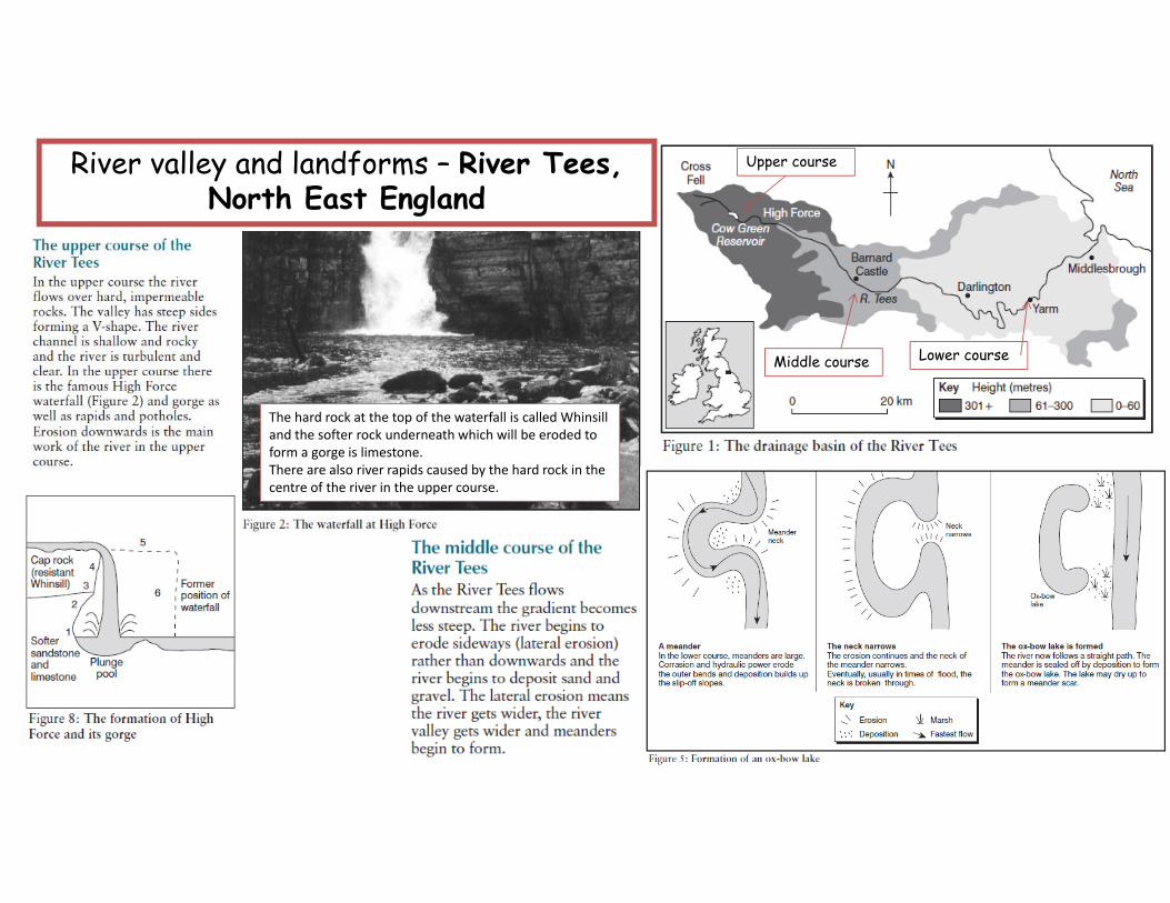
River valley and landforms – River Tees, North East England
Upper course
Middle course Lower course
The hard rock at the top of the waterfall is called Whinsilland the softer rock underneath which will be eroded to form a gorge is limestone.There are also river rapids caused by the hard rock in the centre of the river in the upper course.

River valley and landforms – River Tees, North East England - CONTINUED
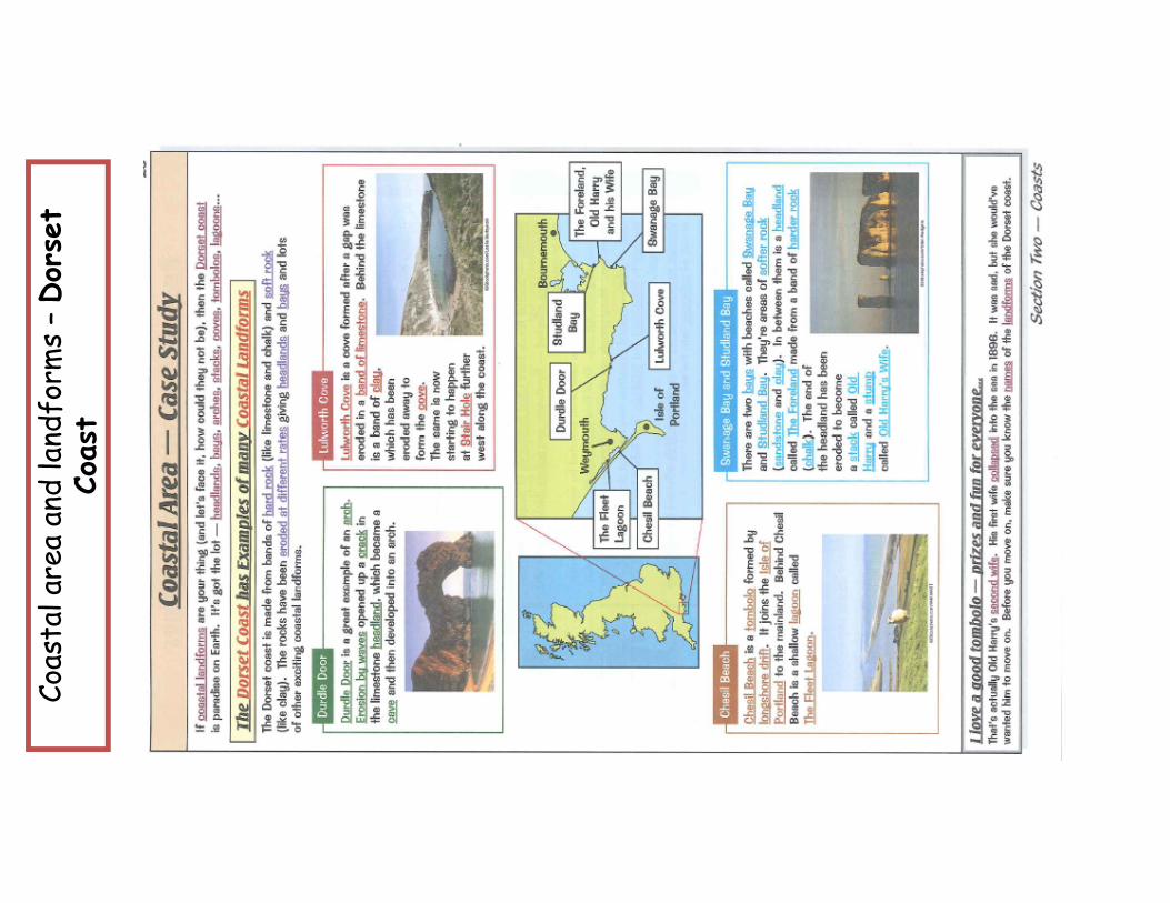
Coas
tal a
rea
and
land
form
s –Dor
set
Coas
t

Coas
tlin
e M
anag
emen
t –
Holde
rnes
s Co
astline
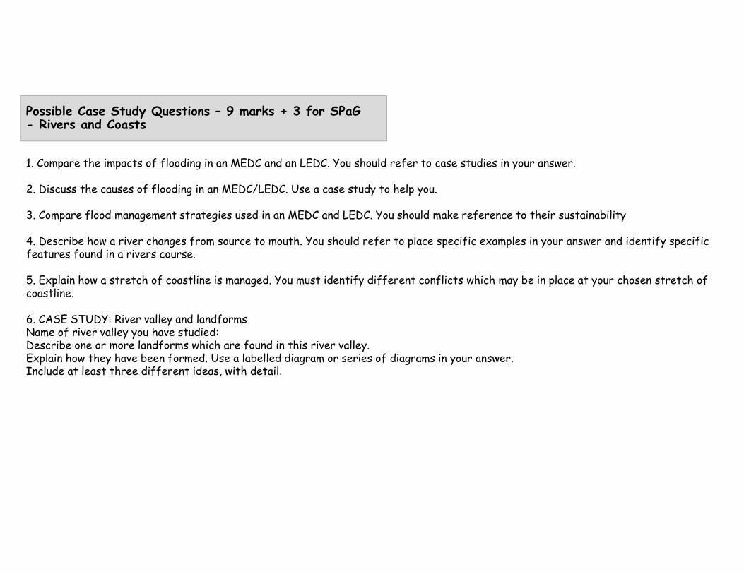
Possible Case Study Questions – 9 marks + 3 for SPaG- Rivers and Coasts
1. Compare the impacts of flooding in an MEDC and an LEDC. You should refer to case studies in your answer.
2. Discuss the causes of flooding in an MEDC/LEDC. Use a case study to help you.
3. Compare flood management strategies used in an MEDC and LEDC. You should make reference to their sustainability
4. Describe how a river changes from source to mouth. You should refer to place specific examples in your answer and identify specific features found in a rivers course.
5. Explain how a stretch of coastline is managed. You must identify different conflicts which may be in place at your chosen stretch of coastline.
6. CASE STUDY: River valley and landformsName of river valley you have studied: Describe one or more landforms which are found in this river valley.Explain how they have been formed. Use a labelled diagram or series of diagrams in your answer.Include at least three different ideas, with detail.
Related Documents


![Cambridge International Examinations Cambridge International … · 2020-01-22 · Primary industry in an LEDC Secondary industry in an MEDC Tertiary industry in an NIC [2] 17 UCLES](https://static.cupdf.com/doc/110x72/5f41e128c38c09184b1fabc2/cambridge-international-examinations-cambridge-international-2020-01-22-primary.jpg)