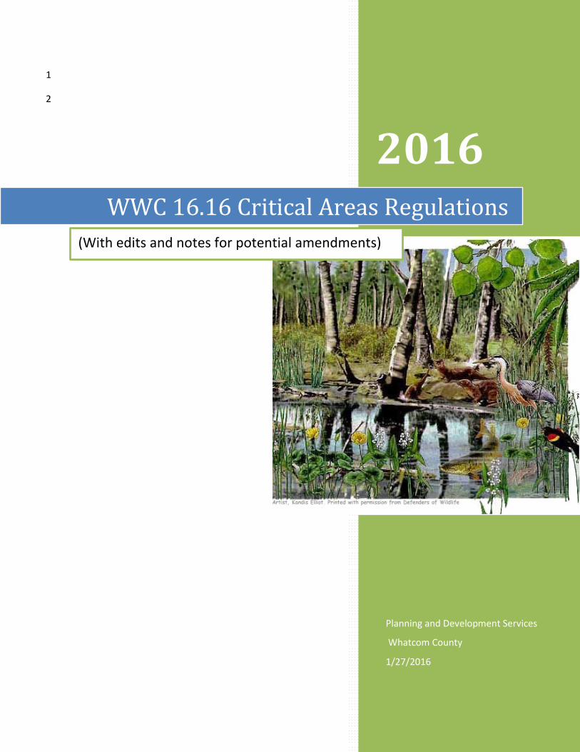
1 2 2016 WWC 16.16 Critical Areas Regulations (With edits and notes for potential amendments) Planning and Development Services Whatcom County 1/27/2016

Welcome message from author
This document is posted to help you gain knowledge. Please leave a comment to let me know what you think about it! Share it to your friends and learn new things together.
Transcript
1
2
2016 WWC 16.16 Critical Areas Regulations
(With edits and notes for potential amendments)
Planning and Development Services
Whatcom County
1/27/2016
WWC 16.16 Critical Areas Regulations (P/C 2nd Public Hearing version) 5/25/16
1
Editor’s Notes: 2
1. All proposed changes are shown in strikeout/underline. 3 2. Double strikeout/underline indicates that original text was moved. However, please note that 4
such marking is an automatic function of MS Word, and it doesn’t always mark it as such (seems 5 hit or miss). Therefore, comments have also been inserted to indicate a move. 6
3. The side comments explain why changes are proposed. 7 4. The editor has tried to log who’s proposed the change: 8
a. “CACAC” or “CAC” refers to the Citizens' Advisory Committee. 9 b. “CATAC” or “TAC” refers to the Technical Advisory Committee. 10 c. “CES” or “CStrong” indicates the Project Manager/editor, Cliff Strong. 11 d. “NRS” refers to Natural Resources Staff 12 e. “P/C” refers to the Planning Commission. 13 f. “WCD” refers to the Whatcom Conservation District. 14 g. Others are from various individuals. 15
5. Note that some of the paragraph numbering/lettering might seem off. However, the numbering 16 is an automatic Word function and when used together with Review Mode it sometimes puts 17 the paragraph’s number/letter after the paragraph. 18
19
i:\planning division\long range planning\cao update\2016 update\code\chapter 16.16 - 2016-05-31, pc public hearing version 2 - clean.docx i
WWC 16.16 Critical Areas Regulations (P/C 2nd Public Hearing version) 5/25/16
Chapter 16.16 – Critical Areas1 1
Table of Contents 2 ARTICLE 1. PURPOSE AND INTENT ................................................................................................................ 1 3
16.16.100 Purpose and intent. ................................................................................................................. 1 4
ARTICLE 2. ADMINISTRATIVE PROVISIONS ................................................................................................... 2 5
16.16.200 Authority. ................................................................................................................................. 2 6
16.16.205 Authorizations required. .......................................................................................................... 2 7
16.16.210 Applicability and severability. .................................................................................................. 2 8
16.16.215 Relationship to other jurisdictions. .......................................................................................... 2 9
16.16.220 Identification and mapping of critical areas. ........................................................................... 3 10
16.16.225 Regulated activities. ................................................................................................................. 3 11
16.16.230 Exempt activities. ..................................................................................................................... 4 12
16.16.235 Activities allowed with notification. ........................................................................................ 4 13
16.16.240 Technical administrator and hearing examiner authority. ...................................................... 7 14
16.16.245 Interdisciplinary team. ............................................................................................................. 8 15
16.16.250 Submittal requirements and critical areas review process. .................................................... 8 16
16.16.255 Critical areas assessment reports. ........................................................................................... 9 17
16.16.260 General mitigation requirements. ......................................................................................... 11 18
16.16.261 Alternative or Innovative Mitigation Plans. ........................................................................... 14 19
16.16.262 Watershed-Based Management Plans. ................................................................................. 15 20
16.16.263 Mitigation Banking. ................................................................................................................ 16 21
16.16.264 In-Lieu Fees. ........................................................................................................................... 18 22
16.16.265 Critical areas protective measures. ....................................................................................... 18 23
16.16.270 Reasonable use. ..................................................................................................................... 19 24
16.16.273 Variances. ............................................................................................................................... 21 25
16.16.275 Nonconforming uses/buildings. ............................................................................................. 22 26
16.16.280 Appeals................................................................................................................................... 23 27
16.16.285 Penalties and enforcement. ................................................................................................... 23 28
16.16.295 Open space and conservation. ............................................................................................... 24 29
1 Prior legislation: Ords. 97-056 and 2004-050.
i:\planning division\long range planning\cao update\2016 update\code\chapter 16.16 - 2016-05-31, pc public hearing version 2 - clean.docx ii

WWC 16.16 Critical Areas Regulations (P/C 2nd Public Hearing version) 5/25/16
ARTICLE 3. GEOLOGICALLY HAZARDOUS AREAS ......................................................................................... 25 1
16.16.300 Purpose. ................................................................................................................................. 25 2
16.16.310 Designation, mapping, and classification. ............................................................................. 25 3
16.16.320 Geologically hazardous areas – General standards. .............................................................. 29 4
16.16.325 Landslide Hazard Areas – Standards. ..................................................................................... 30 5
16.16.340 Seismic Hazard Areas – Standards. ........................................................................................ 31 6
16.16.345 Alluvial Fan Hazard Areas – Standards. .................................................................................. 31 7
16.16.350 Volcanic hazard areas – Standards. ....................................................................................... 32 8
16.16.355 Erosion hazard areas – Standards. ......................................................................................... 34 9
16.16.365 Tsunami Hazard Areas –Standards. ....................................................................................... 36 10
16.16.367 Seiche and Landslide Generated Wave hazard areas – Standards. ....................................... 36 11
16.16.370 Mine Hazard Areas – Standards. ............................................................................................ 36 12
16.16.375 Review and reporting requirements. ..................................................................................... 36 13
ARTICLE 4. FREQUENTLY FLOODED AREAS ................................................................................................. 38 14
16.16.400 Purpose. ................................................................................................................................. 38 15
16.16.410 Designation and mapping – Frequently flooded areas. ......................................................... 38 16
16.16.420 Frequently flooded areas – General standards. .................................................................... 38 17
16.16.430 Review and report requirements. .......................................................................................... 39 18
ARTICLE 5. CRITICAL AQUIFER RECHARGE AREAS ....................................................................................... 40 19
16.16.500 Purpose. ................................................................................................................................. 40 20
16.16.510 Designation, classification and mapping – Critical aquifer recharge areas. .......................... 40 21
16.16.520 Critical aquifer recharge areas – General standards. ............................................................ 40 22
16.16.525 Activity subject to critical areas review. ................................................................................ 41 23
16.16.530 Prohibited uses. ..................................................................................................................... 41 24
16.16.535 Review and report requirements. .......................................................................................... 42 25
ARTICLE 5.5. AREAS WITHIN THE RURAL RESIDENTIAL DISTRICT OF LUMMI ISLAND ................................ 43 26
16.16.540 Areas within the rural residential district of Lummi Island. .................................................. 43 27
16.16.541 Exempt wells. ......................................................................................................................... 43 28
16.16.542 Minimum well spacing for all new wells. ............................................................................... 43 29
16.16.543 Requirements for public water system wells, non-Group B two party wells and nondomestic 30 wells. ....................................................................................................................................................... 43 31
16.16.544 Administrative waiver. ........................................................................................................... 44 32
i:\planning division\long range planning\cao update\2016 update\code\chapter 16.16 - 2016-05-31, pc public hearing version 2 - clean.docx iii
WWC 16.16 Critical Areas Regulations (P/C 2nd Public Hearing version) 5/25/16
ARTICLE 6. WETLANDS ................................................................................................................................ 45 1
16.16.600 Purpose. ................................................................................................................................. 45 2
16.16.610 Wetlands Designation, Rating, and Mapping. ....................................................................... 45 3
16.16.620 Wetlands – General standards............................................................................................... 46 4
16.16.630 Wetland buffer widths. .......................................................................................................... 48 5
16.16.640 Wetland buffer reduction. ..................................................................................................... 49 6
16.16.650 Wetland buffer averaging. ..................................................................................................... 50 7
16.16.660 Wetland buffer increases. ...................................................................................................... 50 8
16.16.670 Review and reporting requirements. ..................................................................................... 50 9
16.16.680 Wetland mitigation. ............................................................................................................... 52 10
16.16.690 Compensatory wetland mitigation plan. ............................................................................... 54 11
ARTICLE 7. HABITAT CONSERVATION AREAS (HCA) .................................................................................... 56 12
16.16.700 Purpose. ................................................................................................................................. 56 13
16.16.710 Habitat conservation areas – Designation, mapping, and classification. .............................. 56 14
16.16.720 Habitat conservation areas – General standards. ................................................................. 58 15
16.16.730 Locally important habitats and species – Standards. ............................................................ 63 16
16.16.740 Habitat conservation area buffers – Standards. .................................................................... 63 17
16.16.750 Habitat conservation areas – Review and reporting requirements. ..................................... 65 18
16.16.760 Habitat conservation areas – Mitigation standards. ............................................................. 67 19
ARTICLE 8. CONSERVATION PROGRAM ON AGRICULTURE LANDS (CPAL) ................................................. 69 20
16.16.800 Purpose. ................................................................................................................................. 69 21
16.16.810 Resource Concerns. ............................................................................................................... 69 22
16.16.820 Classification and Applicability. ............................................................................................. 70 23
16.16.830 Conservation Farm Plans – General Standards. ..................................................................... 71 24
16.16.840 Conservation Farm Plan Requirements. ................................................................................ 71 25
16.16.850 Preparation and Approval of Conservation Farm Plans......................................................... 73 26
16.16.860 Monitoring and Compliance .................................................................................................. 73 27
16.16.870 Limited Public Disclosure. ...................................................................................................... 74 28
ARTICLE 9. DEFINITIONS .............................................................................................................................. 76 29
16.16.900 Definitions. ............................................................................................................................. 76 30
31
i:\planning division\long range planning\cao update\2016 update\code\chapter 16.16 - 2016-05-31, pc public hearing version 2 - clean.docx iv
WWC 16.16 Critical Areas Regulations (P/C 2nd Public Hearing version) 5/25/16
Tables 1
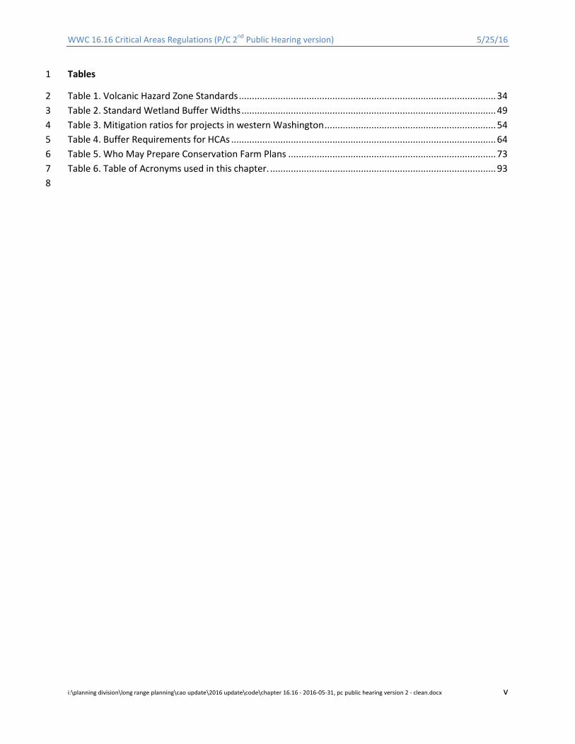
Table 1. Volcanic Hazard Zone Standards ................................................................................................... 34 2 Table 2. Standard Wetland Buffer Widths .................................................................................................. 49 3 Table 3. Mitigation ratios for projects in western Washington .................................................................. 54 4 Table 4. Buffer Requirements for HCAs ...................................................................................................... 64 5 Table 5. Who May Prepare Conservation Farm Plans ................................................................................ 73 6 Table 6. Table of Acronyms used in this chapter. ....................................................................................... 93 7
8
i:\planning division\long range planning\cao update\2016 update\code\chapter 16.16 - 2016-05-31, pc public hearing version 2 - clean.docx v

WWC 16.16 Critical Areas Regulations (P/C 2nd Public Hearing version) 5/25/16
ARTICLE 1. PURPOSE AND INTENT 1
16.16.100 Purpose and intent. 2 A. The purposes of this chapter are to carry out the goals of the Whatcom County comprehensive plan 3
and the State of Washington Growth Management Act (Chapter 36.70A RCW) and its implementing 4 rules by designating and classifying critical areas, and by protecting the functions and values of criti-5 cal areas and the ecological processes that sustain them, while allowing for appropriate economical-6 ly beneficial or productive use of land and property. Critical areas regulated under this chapter in-7 clude geologically hazardous areas, frequently flooded areas, critical aquifer recharge areas, wet-8 lands, and habitat conservation areas. This chapter seeks to maintain harmonious relationships be-9 tween human activity and the natural environment. 10
B. By regulating development and minimizing critical area alterations, this chapter seeks to: 11 1. Protect the public from harm due to landslides, earthquakes, erosion, volcanic events, flooding, 12
and other natural hazards. 13 2. Minimize unnecessary maintenance of public facilities, and costs associated with property dam-14
age, emergency rescue relief operations, and environmental degradation. 15 3. Ensure there are no adverse impacts to the quality and quantity of water resources. 16 4. Alert appraisers, assessors, real estate agents, owners, potential buyers or lessees, and other 17
members of the public to natural conditions that pose a hazard or otherwise limit development. 18 5. Protect wetlands, floodplains, critical aquifer recharge areas, and habitat conservation areas by 19
applying the best available science to ensure no net loss of ecological functions and values. 20 6. Protect species listed as threatened or endangered and their habitats. 21 7. Protect unique, fragile, and/or valuable elements of the environment, including ground and sur-22
face waters, wetlands, anadromous fish species, shellfish, and other fish and wildlife and their 23 habitats. 24
8. Provide County officials with information to approve, condition, or deny project proposals. 25 9. Protect property rights, while allowing for economic development, including agriculture, and al-26
lowing for the development and maintenance of adequate and appropriate public services and 27 essential public facilities. 28
10. Prevent adverse and cumulative environmental impacts to critical areas and mitigate unavoida-29 ble impacts. 30
11. Coordinate Whatcom County’s critical areas protection activities and programs with those of 31 other jurisdictions. 32
12. Coordinate environmental reviews and permitting of proposals with other departments and 33 agencies to avoid duplication and delay. 34
13. Allow for reasonable use of property in accordance with the provisions of WCC 16.16.270. 35 14. Establish critical areas protection standards and procedures that are consistent with state and 36
federal regulations pertaining to critical areas. 37 C. The goals, policies, and purposes set forth in this chapter serve as a basis for exercise of the County’s 38
substantive authority under the State Environmental Policy Act (SEPA) and the County’s SEPA rules. 39 D. The County’s enactment or enforcement of this chapter shall not be construed for the benefit of any 40
individual person or group of persons other than the general public. 41 E. Nothing in this chapter is intended to preclude or discourage beneficial actions that protect, restore, 42
and/or maintain critical areas or minimize risks associated with critical areas. 43 F. Consistent with Whatcom County’s high standard of staff conduct, County staff observe all applica-44
ble federal and Washington laws regarding entry onto privately owned property. 45
46
i:\planning division\long range planning\cao update\2016 update\code\chapter 16.16 - 2016-05-31, pc public hearing version 2 - clean.docx 1
WWC 16.16 Critical Areas Regulations (P/C 2nd Public Hearing version) 5/25/16
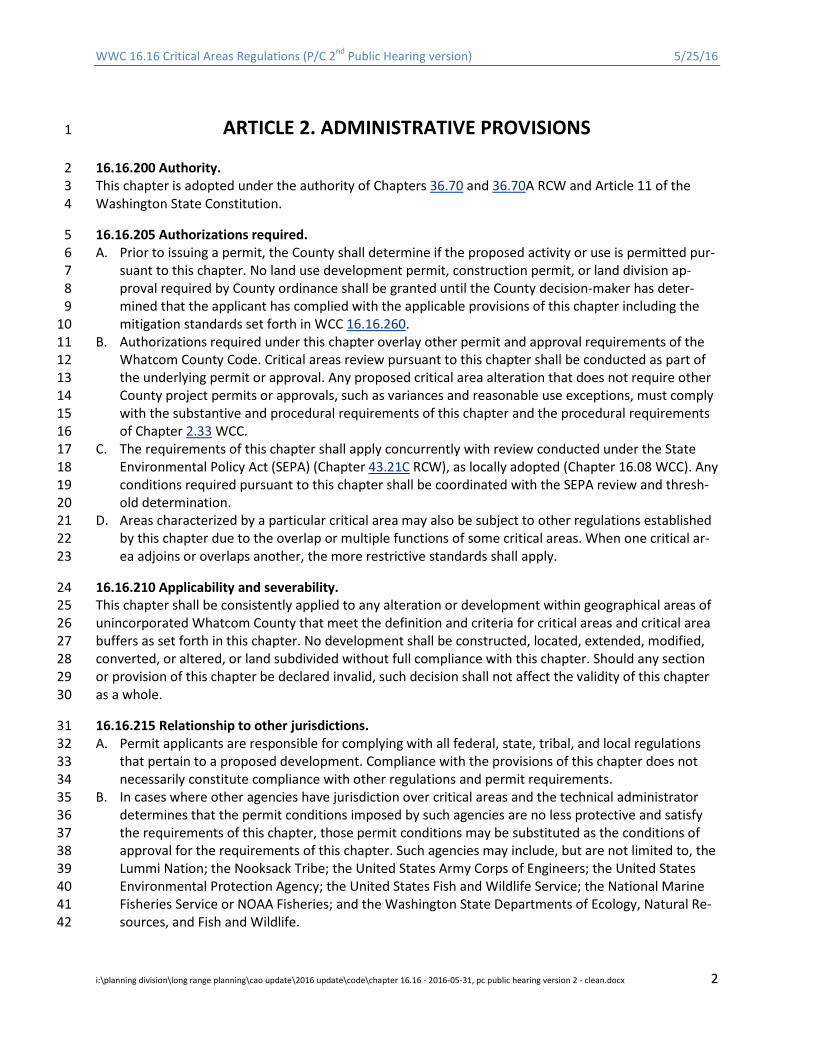
ARTICLE 2. ADMINISTRATIVE PROVISIONS 1
16.16.200 Authority. 2 This chapter is adopted under the authority of Chapters 36.70 and 36.70A RCW and Article 11 of the 3 Washington State Constitution. 4
16.16.205 Authorizations required. 5 A. Prior to issuing a permit, the County shall determine if the proposed activity or use is permitted pur-6
suant to this chapter. No land use development permit, construction permit, or land division ap-7 proval required by County ordinance shall be granted until the County decision-maker has deter-8 mined that the applicant has complied with the applicable provisions of this chapter including the 9 mitigation standards set forth in WCC 16.16.260. 10
B. Authorizations required under this chapter overlay other permit and approval requirements of the 11 Whatcom County Code. Critical areas review pursuant to this chapter shall be conducted as part of 12 the underlying permit or approval. Any proposed critical area alteration that does not require other 13 County project permits or approvals, such as variances and reasonable use exceptions, must comply 14 with the substantive and procedural requirements of this chapter and the procedural requirements 15 of Chapter 2.33 WCC. 16
C. The requirements of this chapter shall apply concurrently with review conducted under the State 17 Environmental Policy Act (SEPA) (Chapter 43.21C RCW), as locally adopted (Chapter 16.08 WCC). Any 18 conditions required pursuant to this chapter shall be coordinated with the SEPA review and thresh-19 old determination. 20
D. Areas characterized by a particular critical area may also be subject to other regulations established 21 by this chapter due to the overlap or multiple functions of some critical areas. When one critical ar-22 ea adjoins or overlaps another, the more restrictive standards shall apply. 23
16.16.210 Applicability and severability. 24 This chapter shall be consistently applied to any alteration or development within geographical areas of 25 unincorporated Whatcom County that meet the definition and criteria for critical areas and critical area 26 buffers as set forth in this chapter. No development shall be constructed, located, extended, modified, 27 converted, or altered, or land subdivided without full compliance with this chapter. Should any section 28 or provision of this chapter be declared invalid, such decision shall not affect the validity of this chapter 29 as a whole. 30
16.16.215 Relationship to other jurisdictions. 31 A. Permit applicants are responsible for complying with all federal, state, tribal, and local regulations 32
that pertain to a proposed development. Compliance with the provisions of this chapter does not 33 necessarily constitute compliance with other regulations and permit requirements. 34
B. In cases where other agencies have jurisdiction over critical areas and the technical administrator 35 determines that the permit conditions imposed by such agencies are no less protective and satisfy 36 the requirements of this chapter, those permit conditions may be substituted as the conditions of 37 approval for the requirements of this chapter. Such agencies may include, but are not limited to, the 38 Lummi Nation; the Nooksack Tribe; the United States Army Corps of Engineers; the United States 39 Environmental Protection Agency; the United States Fish and Wildlife Service; the National Marine 40 Fisheries Service or NOAA Fisheries; and the Washington State Departments of Ecology, Natural Re-41 sources, and Fish and Wildlife. 42
i:\planning division\long range planning\cao update\2016 update\code\chapter 16.16 - 2016-05-31, pc public hearing version 2 - clean.docx 2

WWC 16.16 Critical Areas Regulations (P/C 2nd Public Hearing version) 5/25/16
C. The County shall make findings required by Chapter WCC 2.33 and WCC 16.16.250 when adopting 1 conditions of another jurisdiction’s permit. Such requirements shall be a condition of critical area 2 approval and enforceable by the County. In the event that there is a conflict between permit re-3 quirements and the standards of this chapter, the more restrictive standards shall apply. 4
D. The County shall notify the applicant in writing when adopting other agencies’ conditions pursuant 5 to this section. 6
16.16.220 Identification and mapping of critical areas. 7 A. The County has identified critical areas and areas where the conditions under which critical areas 8
typically occur and/or have the potential to occur. The approximate location and extent of critical 9 areas within the County’s jurisdiction are shown on maps, which shall be available at the planning 10 and development services department for public inspection. 11
B. Property owners, the technical administrator, and/or members of the public may use these maps as 12 a general guide, but the maps do not provide a comprehensive accounting of areas subject to this 13 chapter nor do they provide a definitive critical areas designation. Critical area locations and bound-14 aries shown on the County’s maps are approximate and do not include buffers that may be associat-15 ed with critical areas, and some critical areas may not be shown on the maps at all. 16
C. Field investigation, analysis by a qualified professional, and/or consideration of other sources of 17 credible scientific information may be required to confirm the presence or absence of a critical area 18 and its boundaries and buffers. The County shall update the maps on a regular and consistent basis 19 as new information becomes available. 20
D. Planning and Development Services has the authority to update critical areas maps and shall do so 21 as new critical areas are identified and as new information becomes available. 22
16.16.225 Regulated activities. 23 A. The following activities shall be subject to the provisions of this chapter when they occur within crit-24
ical areas or their buffers: 25 1. Clearing, grading, dumping, excavating, discharging, or filling with any material. This includes 26
creating impervious surfaces. 27 2. Constructing, reconstructing, demolishing or altering the size of any structure or infrastructure, 28
subject to the provisions for a nonconforming structure pursuant to WCC 16.16.275, WCC Chap-29 ter 20.83, and WCC 23.50.070. 30
3. Any other activity for which a County permit is required, excluding permits for interior remodel-31 ing. 32
B. Alteration of critical areas and/or buffers is prohibited except when: 33 1. Alteration is approved pursuant to the reasonable use or variance provisions of WCC 16.16.270 34
and 16.16.273, respectively; or 35 2. Alteration is necessary to accommodate an essential public facility or public utility where no fea-36
sible alternative location will accommodate the facility and the facility is located, designed, and 37 constructed to minimize and, where possible, avoid critical areas disturbance to the maximum 38 extent feasible; or 39
3. Alteration is necessary to accommodate an approved water-oriented use and any associated 40 development/activity and/or the development activities listed in WCC 23.90.130(B)(7)(a) when 41 permitted in accordance with the Whatcom County Shoreline Management Program (SMP); 42 provided, that such development is operated, located, designed and constructed to minimize 43 and, where possible, avoid critical areas disturbance to the maximum extent feasible; or 44
4. Alteration is part of an essential element of an activity allowed by this chapter and all feasible 45 measures to avoid and minimize impacts have been employed. Such feasible measures shall in-46
i:\planning division\long range planning\cao update\2016 update\code\chapter 16.16 - 2016-05-31, pc public hearing version 2 - clean.docx 3
WWC 16.16 Critical Areas Regulations (P/C 2nd Public Hearing version) 5/25/16
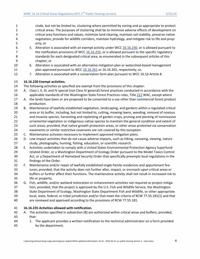
clude, but not be limited to, clustering where permitted by zoning and as appropriate to protect 1 critical areas. The purposes of clustering shall be to minimize adverse effects of development on 2 critical area functions and values, minimize land clearing, maintain soil stability, preserve native 3 vegetation, provide for wildlife corridors, maintain hydrology, and mitigate risk to life and prop-4 erty; or 5
5. Alteration is associated with an exempt activity under WCC 16.16.230, or is allowed pursuant to 6 the notification provisions of WCC 16.16.235, or is allowed pursuant to the specific regulatory 7 standards for each designated critical area, as enumerated in the subsequent articles of this 8 chapter; or 9
6. Alteration is associated with an alternative mitigation plan or watershed-based management 10 plan approved pursuant to WCC 16.16.261 or 16.16.262, respectively; or, 11
7. Alteration is associated with a conservation farm plan pursuant to WCC 16.16 Article 8. 12
16.16.230 Exempt activities. 13 The following activities as specified are exempt from the provisions of this chapter: 14 A. Class I, II, III, and IV special (not Class IV general) forest practices conducted in accordance with the 15
applicable standards of the Washington State Forest Practices rules, Title 222 WAC, except where 16 A. the lands have been or are proposed to be converted to a use other than commercial forest product 17
production. 18 B. Maintenance of lawfully established vegetation, landscaping, and gardens within a regulated critical 19
area or its buffer, including, but not limited to, cutting, mowing lawns, weeding, removal of noxious 20 and invasive species, harvesting and replanting of garden crops, pruning and planting of noninvasive 21 ornamental vegetation or indigenous native species to maintain the general condition and extent of 22 such areas; provided, that native growth protection areas, or other areas protected via conservation 23 easements or similar restrictive covenants are not covered by this exception. 24
C. Maintenance activates necessary to implement approved mitigation plans. 25 D. Low impact activities that do not cause adverse impacts, such as hiking, canoeing, viewing, nature 26
study, photography, hunting, fishing, education, or scientific research. 27 E. Activities undertaken to comply with a United States Environmental Protection Agency Superfund-28
related Order, or a Washington Department of Ecology Order pursuant to the Model Toxics Control 29 Act, or a Department of Homeland Security Order that specifically preempts local regulations in the 30 findings of the Order. 31
F. Maintenance and/or repair of lawfully established single-family residences and appurtenant fea-32 tures; provided, that the activity does not further alter, impact, or encroach upon critical areas or 33 buffers or further affect their functions. The maintenance activity shall not result in increased risk to 34 life or property. 35
G. Fish, wildlife, and/or wetland restoration or enhancement activities not required as project mitiga-36 tion; provided, that the project is approved by the U.S. Fish and Wildlife Service, the Washington 37 State Department of Ecology, Washington State Department Fish and Wildlife, or other appropriate 38 local, state, federal, or tribal jurisdiction and/or that meet the criteria of RCW 77.55.181(1) and that 39 are reviewed and approved according to the provisions of RCW 77.55.181. 40
16.16.235 Activities allowed with notification. 41 A. The activities specified in subsection (B) are authorized within critical areas and buffers; provided, 42
that: 43 1. The applicant provides a written notification to the technical administrator on a form provided 44
by the department. 45
i:\planning division\long range planning\cao update\2016 update\code\chapter 16.16 - 2016-05-31, pc public hearing version 2 - clean.docx 4

WWC 16.16 Critical Areas Regulations (P/C 2nd Public Hearing version) 5/25/16
2. The notification will provide a site plan (in a common scale), photos, and specific information 1 describing the activity and the mitigation to be implemented, if required by the Technical Ad-2 ministrator, to document that the activity will not result in increased risk to public health, safety, 3 and welfare; that adverse impacts to critical areas are minimized; and that disturbed areas are 4 restored as soon as possible following the activity. 5
3. Notification shall be submitted to the technical administrator at least 10 full business days prior 6 to initiating work. 7
4. Unless otherwise specified, notification shall be valid for one year per activity; provided, that 8 there is no change in the scope of the project including, but not limited to, the location and/or 9 extent of the activity allowed under the notification process. 10
5. Upon receipt of the notification, the County may provide guidance on best management prac-11 tices for tree and vegetation protection, construction management, erosion and sedimentation 12 control, water quality protection, and use of chemical applications to be used in the execution 13 of the following activities: 14
B. Activities allowed with notification: 15 1. Emergency construction or activity necessary for the immediate preservation of the public 16
health, safety, and welfare as determined by the technical administrator; provided, that: 17 a. An emergency is an unanticipated and imminent threat to public health, safety, or the envi-18
ronment that requires immediate action within a time period too short to allow full compli-19 ance with this chapter. 20
b. Emergency construction does not include development of new permanent protective struc-21 tures where none previously existed. Where the technical administrator determines that 22 new protective structures are the appropriate means to address an emergency situation, 23 the project proponent shall either obtain any permits that would have been required absent 24 an emergency, pursuant to Chapter 90.58 RCW, Chapter 173-27 WAC, or this chapter, or 25 remove the structure upon abatement of the emergency situation. 26
c. Within the jurisdiction of the Whatcom County Shoreline Management Program (WCC Title 27 23), all emergency construction shall be consistent with the policies and procedural re-28 quirements of WCC Title 23 and this chapter. 29
d. The applicant shall make a reasonable attempt to contact the technical administrator prior 30 to activity; provided, that when prior notice is not feasible, notification of the action shall be 31 submitted to the technical administrator as soon as the emergency is addressed and no later 32 than 14 days following such action. 33
2. Maintenance, operation, and/or repair of existing infrastructure improvements, including dikes 34 and drainage ditches, rights-of-way, trails, roads, fences, and utilities; provided, that the activity 35 does not further alter, impact, or encroach upon critical areas or buffers or further affect their 36 functions. The maintenance activity shall not result in increased risk to life or property. Mainte-37 nance shall be allowed pursuant to the provisions set forth in this chapter; provided, that: 38 a. The applicant shall submit to the technical administrator a written description of the 39
maintenance activity with all of the following general information: 40 1. Type, timing, frequency, and sequence of maintenance activity to be conducted; 41 2. Type of equipment to be used (hand or mechanical); 42 3. Manner in which the equipment will be used; and 43 4. Best management practices to be used. 44
b. The applicant’s written description shall be valid for up to five years provided that there is 45 no significant change in the type or extent of maintenance activity. 46
3. Select removal or pruning of vegetation subject to the following: 47
i:\planning division\long range planning\cao update\2016 update\code\chapter 16.16 - 2016-05-31, pc public hearing version 2 - clean.docx 5
WWC 16.16 Critical Areas Regulations (P/C 2nd Public Hearing version) 5/25/16
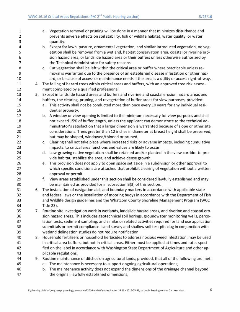
a. Vegetation removal or pruning will be done in a manner that minimizes disturbance and 1 prevents adverse effects on soil stability, fish or wildlife habitat, water quality, or water 2 quantity. 3
b. Except for lawn, pasture, ornamental vegetation, and similar introduced vegetation, no veg-4 etation shall be removed from a wetland, habitat conservation area, coastal or riverine ero-5 sion hazard area, or landslide hazard area or their buffers unless otherwise authorized by 6 the Technical Administrator for safety reasons. 7
c. Cut vegetation shall be left within the critical area or buffer where practicable unless re-8 moval is warranted due to the presence of an established disease infestation or other haz-9 ard, or because of access or maintenance needs if the area is a utility or access right-of-way. 10
4. The felling of hazard trees within critical areas and buffers, with an approved tree risk assess-11 ment completed by a qualified professional. 12
5. Except in landslide hazard areas and buffers and riverine and coastal erosion hazard areas and 13 buffers, the clearing, pruning, and revegetation of buffer areas for view purposes, provided: 14 a. This activity shall not be conducted more than once every 10 years for any individual resi-15
dential property. 16 b. A window or view opening is limited to the minimum necessary for view purposes and shall 17
not exceed 15% of buffer length, unless the applicant can demonstrate to the technical ad-18 ministrator’s satisfaction that a larger dimension is warranted because of slope or other site 19 considerations. Trees greater than 12 inches in diameter at breast height shall be preserved, 20 but may be shaped, windowed/thinned or pruned. 21
c. Clearing shall not take place where increased risks or adverse impacts, including cumulative 22 impacts, to critical area functions and values are likely to occur. 23
d. Low-growing native vegetation shall be retained and/or planted in the view corridor to pro-24 vide habitat, stabilize the area, and achieve dense growth. 25
e. This provision does not apply to open space set aside in a subdivision or other approval to 26 which specific conditions are attached that prohibit clearing of vegetation without a written 27 approval or permit. 28
f. View areas established under this section shall be considered lawfully established and may 29 be maintained as provided for in subsection B(3) of this section. 30
6. The installation of navigation aids and boundary markers in accordance with applicable state 31 and federal laws or the installation of mooring buoys in accordance with the Department of Fish 32 and Wildlife design guidelines and the Whatcom County Shoreline Management Program (WCC 33 Title 23). 34
7. Routine site investigation work in wetlands, landslide hazard areas, and riverine and coastal ero-35 sion hazard areas. This includes geotechnical soil borings, groundwater monitoring wells, perco-36 lation tests, sediment sampling, and similar or related activities required for land use application 37 submittals or permit compliance. Land survey and shallow soil test pits dug in conjunction with 38 wetland delineation studies do not require notification. 39
8. Household fertilizers or household herbicides to address noxious weed infestation, may be used 40 in critical area buffers, but not in critical areas. Either must be applied at times and rates speci-41 fied on the label in accordance with Washington State Department of Agriculture and other ap-42 plicable regulations. 43
9. Routine maintenance of ditches on agricultural lands; provided, that all of the following are met: 44 a. The maintenance is necessary to support ongoing agricultural operations; 45 b. The maintenance activity does not expand the dimensions of the drainage channel beyond 46
the original, lawfully established dimensions; 47
i:\planning division\long range planning\cao update\2016 update\code\chapter 16.16 - 2016-05-31, pc public hearing version 2 - clean.docx 6
WWC 16.16 Critical Areas Regulations (P/C 2nd Public Hearing version) 5/25/16
c. The agricultural activities are conducted pursuant to an approved conservation farm plan 1 prepared pursuant to WCC 16.16.290; 2
d. The farm operator obtains a hydraulic project approval (HPA), if required, from the Wash-3 ington State Department of Fish and Wildlife (WDFW) prior to the maintenance activity; and 4
e. The farm operator provides a copy of the HPA to the technical administrator as part of the 5 written notification. 6
10. Alteration or removal of beaver-built structures two years old or less; provided, that: 7 a. There is no adverse impact to wetland or river or stream functions. 8 b. The property owner obtains an HPA from WDFW (if required) prior to the maintenance ac-9
tivity. 10 c. The property owner provides a copy of the HPA to the technical administrator as part of the 11
written notification. 12
16.16.240 Technical administrator and hearing examiner authority. 13 The technical administrator is the Whatcom County director of planning and development services or 14 his/her designee. The hearing examiner is appointed by the County Council. The technical administrator 15 and the County Hearing Examiner shall administer and enforce the provisions of this chapter pursuant to 16 the following: 17 A. The technical administrator shall have the primary responsibility for reviewing development pro-18
posals for compliance with this chapter and is authorized to approve, deny, or condition permits in 19 accordance with the standards set forth herein. The technical administrator shall also have the fol-20 lowing authority: 21 1. Authority to convene an interdisciplinary team to assist in reviewing development proposals or 22
to solicit review from outside experts in accordance with WCC 16.16.245. 23 2. Authority to grant, condition, or deny reasonable use permits for single-family residential build-24
ing permits within critical areas and/or their buffers 25 3. Authority to grant, condition, or deny reasonable use permits for other development proposals 26
that would affect critical area buffers, but not the critical areas themselves. 27 4. Authority to serve a cease and desist order pursuant to WCC 16.16.285 upon a person undertak-28
ing activity within a critical area or buffer in violation of this chapter. 29 5. Any additional responsibility and/or authority specifically provided for in the subsequent articles 30
of this chapter. 31 B. The technical administrator’s authority shall transfer to another County decision-maker when an-32
other decision-maker is specified for a separate project permit. In such cases, the technical adminis-33 trator shall ensure that all procedural requirements of this chapter are met and shall make a rec-34 ommendation to the designated decision-maker as to how the provisions of this chapter apply to 35 the permit action, including project permits. 36
C. The Whatcom County hearing examiner is hereby vested with responsibility and authority to hear 37 appeals and perform the following duties: 38 1. Authority to grant or deny variances. 39 2. Authority to grant, condition, or deny reasonable use permits for all developments, except sin-40
gle-family building permits, affecting critical areas. 41 3. Authority to decide on appeals of administrative decisions including, but not limited to, reason-42
able use permits issued by the technical administrator. 43 4. Authority to hold public hearings pursuant to Chapters 20.84 and 20.92 WCC. 44
D. In granting, revising, or extending a permit, the technical administrator, or hearing examiner, as ap-45 plicable, may attach such conditions, modifications, or restrictions thereto regarding the location, 46 character, and other features of the proposed development deemed necessary to assure that the 47
i:\planning division\long range planning\cao update\2016 update\code\chapter 16.16 - 2016-05-31, pc public hearing version 2 - clean.docx 7
WWC 16.16 Critical Areas Regulations (P/C 2nd Public Hearing version) 5/25/16
development is consistent with criteria set forth in this chapter. In cases involving unusual circum-1 stances or uncertain effects, a condition may be imposed to allow for future review or reevaluation 2 to assure conformance with this chapter. The technical administrator and/or hearing examiner shall 3 render a final decision in accordance with the timelines established in WCC 2.33.090 and 20.92.430, 4 as applicable. All decisions of the technical administrator and hearing examiner may be appealed 5 pursuant to WCC 20.84.240 and 20.92.600. 6
16.16.245 Interdisciplinary team. 7 The technical administrator may call upon outside expertise including an interdisciplinary team if the 8 technical administrator determines that additional technical assistance is required to assess a critical 9 areas development proposal or ensure the application of best available science. 10 A. The interdisciplinary team shall include the applicant and/or their technical representative, local, 11
state, or federal agency or tribal representatives with expertise in the field, and/or independent 12 qualified professionals with expertise relating to the critical area issue. 13
B. The functions of the interdisciplinary team are to field check and verify critical area determina-14 tions/boundaries and assess species/habitat presence by providing written peer review of the in-15 formation included with an application, identify areas of concern in the application of best available 16 science, provide professional opinions and recommendations relevant to the provisions of this chap-17 ter, and help focus the preparation of subsequent reports and environmental documentation on the 18 most relevant issues. 19
C. The technical administrator will coordinate this effort and seek advice from the team. 20 D. In lieu of convening an interdisciplinary team, the County may require third party review by a quali-21
fied professional for any development proposal, mitigation plan, mitigation bank proposal, or other 22 project for which additional technical expertise is needed. The cost of the third party review shall be 23 the permit applicant’s responsibility. 24
16.16.250 Submittal requirements and critical areas review process. 25 A. All applicants shall complete a prescreening meeting with the technical administrator prior to sub-26
mitting an application subject to this chapter. The purpose of this meeting shall be to discuss the re-27 quirements for a complete application; the critical area standards and procedures; to review con-28 ceptual site plans prepared by the applicant; to discuss appropriate investigative techniques and 29 methods; and to determine reporting requirements. 30
B. Review and approval of a proposed development within a critical area may be initiated through the 31 application for any project permit in Whatcom County. If another authority does not require a pro-32 ject permit, application shall be made pursuant to Chapter 2.33 WCC. 33
C. The technical administrator shall be responsible, in a timely manner, to make one of the following 34 determinations regarding critical areas review: 35 1. Initial Determination. Upon receipt of a permit application, the technical administrator shall use 36
best available science, including but not limited to the County’s critical areas maps, his/her field 37 investigation results, his/her own knowledge of the site, information from appropriate resource 38 agencies, or documentation from a scientific or other credible source to determine if the project 39 will more probably than not adversely impact a critical area or its buffer. 40
2. Determination of Compliance. If the applicant demonstrates to the satisfaction of the technical 41 administrator that the project meets the provisions of this chapter and is not likely to adversely 42 affect critical areas or buffers, the technical administrator shall issue written verification that the 43 proposal complies with this chapter. Written verification shall be included in the project review 44 record for the underlying permit, or issued in accordance with Chapter 2.33 WCC, and no further 45 critical areas review is required. 46
i:\planning division\long range planning\cao update\2016 update\code\chapter 16.16 - 2016-05-31, pc public hearing version 2 - clean.docx 8
WWC 16.16 Critical Areas Regulations (P/C 2nd Public Hearing version) 5/25/16
3. Need for Critical Area Assessment. If the proposed activity does not meet the criteria of subsec-1 tion (C)(2) of this section and would more probably than not affect a critical area or buffer, the 2 technical administrator shall require confirmation of the presence or absence of critical areas 3 through site inspection by a qualified professional or other appropriate means consistent with 4 best available science, and shall notify the applicant in writing of the need to prepare a critical 5 areas assessment report in conformance with WCC 16.16.225. 6
4. Decision to Approve, Condition, or Deny. The technical administrator shall review all pertinent 7 information pertaining to the proposed development and shall approve, condition, or deny the 8 permit based on their review, and shall provide a written decision, including findings of fact to 9 support the decision made, to the applicant. 10
D. The technical administrator may waive the requirement for critical areas review under this chapter 11 when s/he determines that all of the following conditions are met: 12 1. The proposed development activity is located on a parcel that received approval of a previous 13
critical areas review within the prior 5 years, site conditions have not changed, and the applica-14 ble regulations have not substantively changed; 15
2. All critical areas on the parcel have been identified and delineated and the effects of the pro-16 posed development activity have been thoroughly considered in accordance with the most cur-17 rent regulations and Best Available Science; 18
3. The activity is in compliance with all permit conditions including mitigating measures, as appli-19 cable, that were imposed as part of the prior review and there are no outstanding violations of 20 conditions that were imposed as part of the previous review; 21
4. The development activity involves a use that is equally or less intensive than the development 22 activity that was subject to the prior permit. Land use intensity shall be based on factors includ-23 ing development density, critical areas impacts, impervious surface, noise, glare, dust, hours of 24 operation, and traffic. 25
E. Submittal Materials: 26 1. Complete Application 27 2. A detailed site map drawn to a common scale, or survey, showing at least the following: 28
a. Vicinity Map 29 b. Topographic, hydrologic, and vegetative features. 30 c. The location and description of known wildlife and habitat features and all known critical ar-31
eas. 32 d. Proposed development activity with dimensions. 33
3. Existing physical features of the site including buildings, fences, and other structures, roads, 34 parking lots, utilities, water bodies, etc. Structures shall be dimensioned. 35
16.16.255 Critical areas assessment reports. 36 The intent of these provisions is to require a reasonable level of technical study and alternatives analysis 37 pursuant to WCC 16.16.225 sufficient to assess potential project impacts and to protect critical areas. 38 A. When the technical administrator determines a need for a critical area assessment pursuant to WCC 39
16.16.250(C)(3), s/he shall require a critical areas assessment report, to be prepared by a qualified 40 professional and be consistent with best available science. The analysis shall be commensurate with 41 the value or sensitivity of a particular critical area and relative to the scale and potential impacts of 42 the proposed activity. 43
B. The critical areas assessment report shall: 44 1. Demonstrate that the submitted proposal is consistent with the purposes and specific standards 45
of this chapter; 46
i:\planning division\long range planning\cao update\2016 update\code\chapter 16.16 - 2016-05-31, pc public hearing version 2 - clean.docx 9

WWC 16.16 Critical Areas Regulations (P/C 2nd Public Hearing version) 5/25/16
2. Describe all relevant aspects of the development proposal and critical areas adversely affected 1 by the proposal including any geological hazards and risks associated with the proposal, and as-2 sess impacts on the critical area from activities and uses proposed; and 3
3. Where impacts are unavoidable, demonstrate through an alternatives analysis that no other 4 feasible alternative exists. 5
4. Considers the cumulative impacts of the proposed action that includes past, present, and rea-6 sonably foreseeable future actions to facilitate the goal of no net loss of critical areas. Such im-7 pacts shall include those to wildlife, habitat, and migration corridors; water quality and quantity; 8 and other watershed processes that relate to critical area condition, process, and/or service. 9
5. Identify proposed mitigation and protective measures as required by this chapter. 10 C. The technical administrator shall review the critical areas assessment report for completeness and 11
accuracy and shall consider the recommendations and conclusions of the critical areas assessment 12 report to assist in making administrative decisions concerning approval, conditional approval, or de-13 nial of the subject project and to resolve issues concerning critical areas jurisdiction and appropriate 14 mitigation and protective measures. 15
D. Critical areas assessment reports shall generally be valid for a period of five years from the date the 16 assessment is approved by the technical administrator. Future land use applications may require 17 preparation of new or supplemental critical area assessment reports unless it can be demonstrated 18 to the satisfaction of the technical administrator that the previously prepared report is adequate for 19 current analysis. The technical administrator may also require the preparation of a new critical area 20 assessment report or a supplemental report when new information is found demonstrating that the 21 initial assessment is in error. If the technical administrator requires more information in the report, 22 s/he shall make the request in writing to the applicant stating what additional information is needed 23 and why. 24
E. The technical administrator shall reject or request revision of the field and literature findings and 25 conclusions reached in a critical areas assessment report when s/he can demonstrate that the as-26 sessment is inaccurate, incomplete, or does not fully address the critical areas impacts involved. 27
F. To avoid duplication, the reporting requirements of this chapter shall be coordinated if more than 28 one critical area assessment report is required for a site or development proposal. Similarly, where 29 other agencies assessments or reports are required pursuant to other state or federal laws, the ap-30 plicant is encouraged to submit one report that satisfies all such agencies’ requirements. 31
G. In addition to a hard copy, applicants shall provide reports and maps to the County in an electronic 32 format that allows site data to be incorporated into the County critical areas database; however, the 33 County may waive the electronic format requirement for single-family building permits. Applicants 34 shall follow Whatcom County electronic submittal guidelines. This requirement shall not be con-35 strued as a requirement to use specific computer software, though it must be in a format useable by 36 the County. 37
H. At a minimum, a critical areas assessment report shall include the following information: 38 1. A site plan showing the proposed development footprint and clearing limits, all relevant critical 39
areas and buffers within and abutting the site, a written description of the project, an examina-40 tion of project on-site design alternatives, and an explanation of why the proposed activity re-41 quires a location on, or access across, a critical area and why alternatives are not feasible; 42
2. A written description of the critical areas and buffers on or in the vicinity of the site, including 43 their size, type, classification or rating, condition, disturbance history, and functions and values. 44 Projects in frequently flooded areas must comply with the reporting requirements of WCC Title 45 17. Projects on or adjacent to geologically hazardous areas shall identify the type of hazard and 46 assess the associated risks posed by the development or that the development may be subject 47 to; 48
i:\planning division\long range planning\cao update\2016 update\code\chapter 16.16 - 2016-05-31, pc public hearing version 2 - clean.docx 10

WWC 16.16 Critical Areas Regulations (P/C 2nd Public Hearing version) 5/25/16
3. An analysis of potential adverse critical area impacts associated with the proposed activity in-1 cluding, but not limited to, effects related to clearing, grading, noise, light/glare, drilling, dam-2 ming, draining, creating impervious surface, managing stormwater, releasing hazardous materi-3 als, and other alterations, and including an explanation of critical area processes and functions 4 that may be affected; 5
4. An analysis of how critical area impacts or risks will be avoided and/or minimized, and/or an 6 analysis of the proposed measures to prevent or minimize hazards. When impacts cannot be 7 avoided, the report shall include a plan describing mitigation that will be provided to replace 8 critical area functions and values altered as a result of the proposal. The mitigation plan shall be 9 consistent with the provisions of WCC 16.16.260 and provide written documentation showing 10 what the applicant considered for each step in the mitigation sequencing and the other applica-11 ble articles of this chapter; 12
5. The dates, names, signature, and qualifications of the persons preparing the report and docu-13 mentation of analysis methods including any fieldwork performed on the site; and 14
6. Additional reasonable information requested by the technical administrator for the assessment 15 of critical areas impacts or otherwise required by the subsequent articles of this chapter. 16
16.16.260 General mitigation requirements. 17 Developments permitted pursuant to this chapter that adversely impact or alter a critical area or buffer 18 shall include mitigation sufficient to minimize risks associated with geologic hazards and/or maintain or 19 replace critical areas functions and values. Any proposed development that cannot adequately mitigate 20 critical area impacts as determined by the technical administrator shall be denied. 21 A. Mitigation Sequence. 22
1. When an alteration or impact to a critical area is proposed, the applicant shall conduct an alter-23 natives/mitigation sequencing analysis and demonstrate that all reasonable efforts have been 24 taken to mitigate impacts in the following prioritized order: 25 a. Avoiding the adverse impact altogether by not taking a certain action or parts of an action, 26
or moving the action. 27 b. Minimizing adverse impacts by limiting the degree or magnitude of the action and its im-28
plementation by using appropriate technology and engineering, or by taking affirmative 29 steps to avoid or reduce adverse impacts. 30
c. Rectifying the adverse impact by repairing, rehabilitating, or restoring the affected environ-31 ment. 32
d. Reducing or eliminating the adverse impact over time by preservation and maintenance op-33 erations during the life of the action. 34
e. Compensating for the adverse impact by replacing, enhancing, or providing similar substi-35 tute resources or environments and monitoring the adverse impact and the mitigation pro-36 ject and taking appropriate corrective measures. 37
2. Mitigation for individual projects may include a sequenced combination of the above measures 38 as needed to achieve the most effective protection or compensatory mitigation for critical area 39 functions. 40
B. Mitigation Plan. 41 1. Compensatory mitigation shall be provided for all unavoidable adverse alterations to a critical 42
area or buffer. A mitigation plan shall be developed in accordance with an approved critical are-43 as assessment report and be consistent with best available science. Where appropriate, the mit-44 igation plan should be compatible with watershed and recovery planning goals for Whatcom 45 County. The intent of these provisions is to require a level of technical study and analysis suffi-46 cient to protect critical areas and/or protect developments and occupants from critical areas in-47
i:\planning division\long range planning\cao update\2016 update\code\chapter 16.16 - 2016-05-31, pc public hearing version 2 - clean.docx 11

WWC 16.16 Critical Areas Regulations (P/C 2nd Public Hearing version) 5/25/16
volving hazards. The analysis shall be commensurate with the value or sensitivity of a particular 1 critical area and relative to the scale and potential impacts of the proposed activity. 2
2. The mitigation plan shall provide for construction, maintenance, monitoring, and contingencies 3 as required by conditions of approval and consistent with the requirements of this chapter. 4
3. The mitigation plan shall be prepared by a qualified professional; provided, that the technical 5 administrator may waive the requirement to hire a qualified professional to prepare a mitigation 6 plan when the required mitigation involves standard planting or enhancement practices. The 7 waiver shall not be granted for mitigation practices involving wetland creation, rehabilitation 8 and/or restoration. 9
4. The mitigation plan shall contain the following information: 10 a. A description and scaled drawings of the activities proposed to reduce risks associated with 11
geologic hazards and/or flooding, and/or to mitigate for impacts to critical area functions 12 and values. This shall include all clearing, grading/ excavation, drainage alterations, planting, 13 invasive weed management, installation of habitat structures, construction sequencing, best 14 management practices, site protection, irrigation, and other site treatments associated with 15 the development activities. 16
b. Specific information on construction or the proposed mitigation activity including timing, 17 sequence, equipment needs, best management practices, and responsible parties. 18
c. A description of the functions and values that the proposed mitigation area(s) shall provide, 19 and/or a description of the level of hazard mitigation provided. 20
d. The goals, objectives, and performance standards that the proposed mitigation action(s) 21 shall achieve or demonstrate consistency with. 22
e. A description of how the mitigation area(s) will be evaluated and monitored to determine if 23 the performance standards are being met. 24
f. A program and schedule for construction and post-construction performance monitoring of 25 the mitigation project. 26
g. An evaluation of potential adverse impacts on adjacent property owners resulting from the 27 proposed mitigation and measures to address such impacts. Mitigation projects shall not re-28 sult in adverse impacts to adjacent property owners. 29
h. Identification of potential courses of action or contingencies, and any corrective measures 30 to be taken if monitoring or evaluation indicates that project performance standards are not 31 being met. 32
i. Plan sheets with scale identified, showing the edge of the critical area and buffer area. The 33 affected critical area and buffer shall be clearly staked, flagged, and/or fenced prior to and 34 during any site clearing and construction to ensure protection for the critical area and buffer 35 during construction. 36
j. A description of other permits and approvals being sought, including the need for permits 37 from state and/or federal agencies. 38
k. Additional information as required by the subsequent articles of this chapter. 39 C. Mitigation Monitoring and Maintenance. 40
1. The technical administrator shall require that compensatory mitigation projects be monitored 41 annually for at least five years to establish that performance standards have been met. Required 42 monitoring reports shall be submitted to the County annually during the monitoring period to 43 document milestones, successes, problems, and contingency actions of the compensatory miti-44 gation. The technical administrator may reduce the monitoring timeframe to three years for mi-45 nor mitigation projects involving critical area or buffer revegetation or vegetation enhancement, 46 but not for projects involving wetland creation, wetland restoration, stream restoration or other 47 activities that require manipulation of soils or water. All mitigation areas shall be maintained 48
i:\planning division\long range planning\cao update\2016 update\code\chapter 16.16 - 2016-05-31, pc public hearing version 2 - clean.docx 12

WWC 16.16 Critical Areas Regulations (P/C 2nd Public Hearing version) 5/25/16
and managed to prevent degradation and ensure protection of critical area functions and values 1 subject to field verification by the technical administrator. 2
2. The technical administrator shall have the authority to extend the monitoring period, require 3 corrective measures, and/or require additional monitoring reports beyond the initial monitoring 4 period for any project that does not meet the performance standards identified in the mitiga-5 tion plan, or does not provide adequate replacement for the functions and values of the impact-6 ed critical area. 7
3. Permanent protection shall be achieved through deed restriction or other protective covenant 8 in accordance with WCC 16.16.265. 9
D. Mitigation Assurance. 10 1. The applicant and his/her representatives shall demonstrate sufficient scientific expertise and 11
capability to implement the mitigation, monitor the site, and make corrections if the project fails 12 to meet projected goals. The technical administrator may require the following to ensure that 13 the mitigation is fully functional: 14 a. The applicant shall post a mitigation surety in the amount of 125% of the estimated cost of 15
the uncompleted actions or the estimated cost of restoring the functions and values of the 16 critical area that are at risk, whichever is greater. The surety shall be based on an itemized 17 cost estimate of the mitigation activity including clearing and grading, plant materials, plant 18 installation, irrigation, weed management, monitoring, and other costs. 19
b. The surety shall be in the form of an assignment of funds or other means approved by the 20 technical administrator. 21
c. Surety authorized by this section shall remain in effect until the technical administrator de-22 termines, in writing, that the standards bonded for have been met. Surety shall generally be 23 held by the County for a period of five years to ensure that the required mitigation has been 24 fully implemented and demonstrated to function, and may be held for longer periods when 25 necessary. Surety for construction may be reduced after initial completion in an amount not 26 to exceed the cost of monitoring plus not less than 25% of the construction cost. 27
d. Depletion, failure, or collection of surety funds shall not discharge the obligation of an appli-28 cant or violator to complete required mitigation, maintenance, or monitoring. 29
e. Public development proposals shall be relieved from having to comply with the bonding re-30 quirements of this section if public funds have previously been committed for mitigation, 31 maintenance, or monitoring. 32
f. Any failure to satisfy critical area requirements established by law or condition including, 33 but not limited to, the failure to provide a monitoring report within 30 days after it is due or 34 comply with other provisions of an approved mitigation plan shall constitute a default sub-35 ject to the provisions of WCC 16.16.280, and the County may demand payment of any finan-36 cial guarantees or require other action authorized by the County code or any other law. 37
g. Any funds recovered pursuant to this section shall be used to complete the required mitiga-38 tion. 39
i:\planning division\long range planning\cao update\2016 update\code\chapter 16.16 - 2016-05-31, pc public hearing version 2 - clean.docx 13
WWC 16.16 Critical Areas Regulations (P/C 2nd Public Hearing version) 5/25/16
E. Permanent Protection. All mitigation areas shall be protected and managed to prevent degradation 1 and ensure protection of critical area functions and values in perpetuity. Permanent protection shall 2 be achieved through deed restriction or other protective covenant in accordance with WCC 3 16.16.265. If additional development is proposed that impacts a mitigation area and those impacts 4 are accounted for under a new, approved mitigation plan, such protection may be removed so long 5 as the final plan meets the requirements of this chapter for all cumulative impacts. 6
16.16.261 Alternative or Innovative Mitigation Plans. 7 A. The County shall consider and may approve alternative or innovative mitigation plans for major de-8
velopment (as defined in Article 9 of this chapter), planned unit developments (pursuant to Chapter 9 20.85 WCC), and/or development agreements (pursuant to RCW 36.70B.170 through 36.70B.210). 10
B. If approved, said plan shall be used to satisfy the requirements of this chapter and provide relief 11 and/or deviation as appropriate from the specific standards and requirements thereof; provided, 12 that the standards of impact avoidance and minimization shall remain as guiding principles in the 13 application of these provisions and when it is demonstrated that all of the following circumstances 14 exist: 15 1. The proponent(s) demonstrate the organizational and fiscal capability to carry out the purpose 16
and intent of the plan; 17 2. The proponent(s) demonstrate that long-term management, maintenance, and monitoring will 18
be adequately funded and effectively implemented; 19 3. There is a clear likelihood for success of the proposed plan based on supporting scientific infor-20
mation or demonstrated experience in implementing similar plans; 21 4. In terms of functional value, the proposed mitigation plan results in equal or greater protection 22
and conservation of critical areas functions, services, and values than would be achieved using 23 parcel-by-parcel regulations and/or traditional mitigation approaches; 24
5. The plan is consistent with the general purpose and intent of this chapter, the Shoreline Man-25 agement Program (WCC Title 23), and the comprehensive plan; 26
6. The plan shall contain relevant management strategies considered effective and within the 27 scope of this chapter and shall document when, where, and how such strategies substitute for 28 compliance with the specific standards herein; and 29
7. The plan shall contain clear and measurable standards for achieving compliance with the pur-30 poses of this chapter, a description of how such standards will be monitored and measured over 31 the life of the plan, and a fully funded contingency plan if any element of the plan does not meet 32 standards for compliance. 33
i:\planning division\long range planning\cao update\2016 update\code\chapter 16.16 - 2016-05-31, pc public hearing version 2 - clean.docx 14
WWC 16.16 Critical Areas Regulations (P/C 2nd Public Hearing version) 5/25/16
C. Alternative mitigation plans shall be reviewed concurrently with the underlying land use permit(s) 1 and decisions to approve or deny such plans shall be made in accordance with the underlying permit 2 process. The plan shall be reviewed by the technical administrator to ensure compliance with the 3 general purpose and intent of this chapter and to ensure accuracy of the data and effectiveness of 4 proposed management strategies. In making this determination the technical administrator shall 5 consult with the State Departments of Fish and Wildlife, Ecology, Natural Resources, and/or other 6 local, state, federal, and/or tribal agencies or experts. If the technical administrator finds the plan to 7 be complete, accurate, and consistent with the purposes and intent of this chapter, the designated 8 decision-maker shall solicit comment pursuant to the public notice provisions of Chapter 2.33 WCC 9 prior to final approval/denial of permission of the plan to substitute for the requirements and 10 standards of this chapter. 11
16.16.262 Watershed-Based Management Plans. 12 A. The County may consider watershed-based management plans sponsored by watershed improve-13
ment districts, other special purpose districts, or other government agency. 14 B. If approved, said plan shall be used to satisfy the requirements of this chapter and provide relief 15
and/or deviation as appropriate from the specific standards and requirements thereof; provided, 16 that the standards of impact avoidance and minimization shall remain as guiding principles in the 17 application of these provisions and when it is demonstrated that all of the following circumstances 18 exist: 19 1. The proponent(s) demonstrate the organizational and fiscal capability to carry out the purpose 20
and intent of the plan; 21 2. The proponent(s) demonstrate that long-term management, maintenance, and monitoring of 22
the watershed will be adequately funded and effectively implemented; 23 3. There is a clear likelihood for success of the proposed plan based on supporting scientific infor-24
mation or demonstrated experience in implementing similar plans; 25 4. In terms of functional value, the proposed mitigation plan results in equal or greater restoration, 26
protection, and conservation of the impacted critical areas than would be achieved using parcel-27 by-parcel regulations and/or traditional mitigation approaches; 28
5. The plan is consistent with the general purpose and intent of this chapter, the comprehensive 29 plan, and an approved watershed plan prepared pursuant to Chapter 90.82 RCW (the State Wa-30 tershed Management Act) or the plan is prepared under other local or state authority that is 31 consistent with the goals and policies of an applicable and approved watershed plan prepared 32 pursuant to Chapter 90.82 RCW; 33
6. The plan shall contain relevant management strategies considered effective and within the 34 scope of this chapter and shall document when, where, and how such strategies substitute for 35 compliance with the specific standards herein; and 36
7. The plan shall contain clear and measurable standards for achieving compliance with the pur-37 poses of this chapter, a description of how such standards will be monitored and measured over 38 the life of the plan, and a fully funded contingency plan if any element of the plan does not meet 39 standards for compliance. 40
D. Watershed-Based Management Plans shall be approved by the County Council by ordinance and 41 appended to this chapter. The process for approval shall be as follows: 42 1. The plan shall be reviewed by the technical administrator to ensure compliance with the pur-43
poses of this chapter, the Whatcom County Shoreline Management Program (WCC Title 23), and 44 with the comprehensive plan, and to ensure accuracy of the data and effectiveness of proposed 45 management strategies. In making this determination the technical administrator shall consult 46
i:\planning division\long range planning\cao update\2016 update\code\chapter 16.16 - 2016-05-31, pc public hearing version 2 - clean.docx 15
WWC 16.16 Critical Areas Regulations (P/C 2nd Public Hearing version) 5/25/16
with the State Departments of Fish and Wildlife, Ecology, Natural Resources, and/or other local, 1 state, federal, and/or tribal agencies or experts. 2
2. If the technical administrator finds the plan to be complete, accurate, and consistent with the 3 purposes and intent of this chapter, the designated decision-maker shall solicit comment pursu-4 ant to the public notice provisions of Chapter 2.33 WCC prior to final approval/denial of permis-5 sion of the plan to substitute for the requirements and standards of this chapter. 6
3. The designated decision-maker shall not approve watershed-based management plans that con-7 flict with Chapter 90.82 RCW. 8
16.16.263 Mitigation Banking. 9 A. The County may approve mitigation banking as a form of compensatory mitigation for wetland and 10
habitat conservation area impacts when the provisions of this chapter require mitigation and when 11 it is clearly demonstrated that the use of a bank will provide equivalent or greater replacement of 12 critical area functions and values when compared to on-site mitigation; provided, that all of the fol-13 lowing criteria are met: 14 1. Banks shall only be used when they provide significant ecological benefits including long-term 15
conservation of critical areas, important species, habitats and/or habitat linkages, and when 16 they are consistent with the County Comprehensive Plan and create a viable alternative to the 17 piecemeal mitigation for individual project impacts to achieve ecosystem-based conservation 18 goals. 19
2. The bank shall be established in accordance with the Washington State Draft Mitigation Banking 20 Rule, Chapter 173-700 WAC or as revised, and Chapter 90.84 RCW and the federal mitigation 21 banking guidelines as outlined in the Federal Register, Volume 60, No. 228, November 28, 1995. 22 These guidelines establish the procedural and technical criteria that banks must meet to obtain 23 state and federal certification. 24
3. Preference shall be given to mitigation banks that implement restoration actions that have been 25 identified formally by an adopted shoreline restoration plan, watershed planning document 26 prepared and adopted pursuant to Chapter 90.82 RCW, a salmonid recovery plan or project that 27 has been identified on the Salmon Recovery Board Habitat Project List or by the Washington 28 State Department of Fish and Wildlife as essential for fish and wildlife habitat enhancement. 29
B. Mitigation banks shall require a major project permit in accordance with Chapter 20.88 WCC and 30 shall be subject to a formal review process including public review as follows: 31 1. The bank sponsor shall submit a bank prospectus for County review. The prospectus shall identi-32
fy the conceptual plan for the mitigation bank, including: 33 a. The ecological goals and objectives of the bank; 34 b. The rationale for site selection, including a site map and legal description of the prospective 35
bank site; 36 c. A narrative demonstrating compliance with the Whatcom County comprehensive plan, as-37
sociated development standards and this chapter, shoreline restoration plan, watershed 38 planning documents prepared and adopted pursuant to Chapter 90.82 RCW, and/or the 39 salmonid recovery plan; 40
d. A description of the existing site conditions and expected changes in site conditions as a re-41 sult of the banking activity, including changes on neighboring lands; 42
e. A conceptual site design; 43 f. A description of the proposed protective mechanism such as a conservation easement; and 44 g. Demonstration of adequate financial resources to plan, implement, maintain, and adminis-45
ter the project. 46
i:\planning division\long range planning\cao update\2016 update\code\chapter 16.16 - 2016-05-31, pc public hearing version 2 - clean.docx 16
WWC 16.16 Critical Areas Regulations (P/C 2nd Public Hearing version) 5/25/16
2. The technical administrator shall review the bank prospectus either by participating in the 1 state’s Mitigation Bank Review Team (MBRT) process and/or by hiring independent, third-party 2 expertise to assist in the review. 3
3. If the technical administrator determines that the bank prospectus is complete, technically accu-4 rate, and consistent with the purpose and intent of this chapter, s/he shall forward the prospec-5 tus to the County Council for initial review. If the proposed bank involves conversion of agricul-6 tural land to nonagricultural uses, the County Council shall seek an initial recommendation from 7 the Agricultural Advisory Committee as to whether the conversion shall be allowed. The Com-8 mittee’s recommendation shall be nonbinding. The County Council may require mitigation for 9 the loss of agricultural lands. 10
4. If the County Council determines, based on the initial review, that the prospectus is valid, it shall 11 issue a notice to proceed to the bank sponsor. Following receipt of the notice to proceed, the 12 bank sponsor may submit application for a major project permit in accordance with Chapter 13 20.88 WCC. The notice to proceed shall not be construed as final approval of the bank proposal, 14 but shall indicate approval to proceed with the development of the mitigation bank instrument, 15 which details all of the legal requirements for the bank. 16
5. Upon receipt of a draft mitigation banking instrument from the bank sponsor and major project 17 permit application, the technical administrator shall review the banking instrument and major 18 project permit in consultation with the MBRT and/or other third-party expert. Following review 19 of the mitigation banking instrument and major project permit, the technical administrator shall 20 make a recommendation to certify and approve, conditionally certify and approve, or deny the 21 bank proposal and major project permit in accordance with the procedures of Chapter 20.88 22 WCC. 23
6. Following receipt of the recommendation, the County Council shall proceed with review in ac-24 cordance with the procedures outlined in Chapter 20.88 WCC. 25
7. The bank sponsor shall be responsible for the cost of any third-party review. 26 C. The award of bank credits for an approved bank may be negotiated based on habitat acreage, habi-27
tat quality, and contribution to a regional conservation strategy that has been approved by the 28 County and other appropriate regulatory agency(ies). Credit availability may vary in accordance with 29 agreed upon performance criteria for the development of the resource value in question. Awarded 30 bank credits, subject to the approval of the County and regulatory agency(s), may be made transfer-31 able. Whether out-of-kind mitigation credit will be allowed at a particular bank will require a fact-32 specific inquiry on a case-by-case basis for the project creating the impacts. 33
D. Use of Bank Credits 34 1. Credits from a wetland mitigation bank may be approved for use as compensation for unavoida-35
ble impacts to wetlands when: 36 a. The bank is certified under state rules; 37 b. The Administrator determines that the wetland mitigation bank provides appropriate com-38
pensation for the authorized impacts; and 39 c. The proposed use of credits is consistent with the terms and conditions of the certified bank 40
instrument. 41 2. Replacement ratios for projects using bank credits shall be consistent with replacement ratios 42
specified in the certified bank instrument. 43 3. Credits from a certified wetland mitigation bank may be used to compensate for impacts located 44
within the service area specified in the certified bank instrument. In some cases, the service area 45 of the bank may include portions of more than one adjacent drainage basin for specific wetland 46 functions. 47
i:\planning division\long range planning\cao update\2016 update\code\chapter 16.16 - 2016-05-31, pc public hearing version 2 - clean.docx 17

WWC 16.16 Critical Areas Regulations (P/C 2nd Public Hearing version) 5/25/16
16.16.264 In-Lieu Fees. 1 To aid in the implementation of off-site mitigation, the County may develop an in-lieu fee program. This 2 program shall be developed and approved through a public process and be consistent with federal rules, 3 state policy on in-lieu fee mitigation, and state water quality regulations. An approved in-lieu-fee pro-4 gram sells compensatory mitigation credits to permittees whose obligation to provide compensatory 5 mitigation is then transferred to the in-lieu program sponsor, a governmental or non-profit natural re-6 source management entity. Credits from an approved in-lieu-fee program may be used when para-7 graphs 1-6 below apply: 8
1. The approval authority determines that it would provide environmentally appropriate compen-9 sation for the proposed impacts. 10
2. The mitigation will occur on a site identified using the site selection and prioritization process in 11 the approved in-lieu-fee program instrument. 12
3. The proposed use of credits is consistent with the terms and conditions of the approved in-lieu-13 fee program instrument. 14
4. Land acquisition and initial physical and biological improvements of the mitigation site must be 15 completed within three years of the credit sale. 16
5. Projects using in-lieu-fee credits shall have debits associated with the proposed impacts calcu-17 lated by the applicant’s qualified wetland scientist using the method consistent with the credit 18 assessment method specified in the approved instrument for the in-lieu-fee program. 19
6. Credits from an approved in-lieu-fee program may be used to compensate for impacts located 20 within the service area specified in the approved in-lieu-fee instrument. 21
16.16.265 Critical areas protective measures. 22 When an impact to critical area or a buffer has been proposed, a standard buffer width has been al-23 tered, or mitigation is required, one or more of the following protective measure shall be applied: 24 A. Deterrent Devices. The technical administrator, as a condition of permit approval, may require that 25
the outer boundary of a wetland or habitat conservation area and its buffer, a mitigation site, a des-26 ignated open space, or a conservation easement be identified with signs, markers, and/or fencing to 27 minimize potentially harmful intrusions from adjacent land uses, to alert citizens to a potential pub-28 lic health or safety risk associated with a critical area, or to accomplish other objectives specifically 29 provided for elsewhere in this chapter. The technical administrator shall provide specifications on 30 the type, content, and size of the signs prior to permit approval. The signs shall be posted near pri-31 mary access points and approximately every 200 feet along the critical area boundary unless the 32 technical administrator determines that more or less frequent spacing is adequate considering the 33 size and location of the site. 34
B. Notice on Title. The owner of any property containing any critical area or buffer for which a devel-35 opment permit is about to be issued shall record a notice with the County Auditor real estate rec-36 ords, in a format approved by the technical administrator, and provide a copy of the filed notice to 37 the Planning and Development Services Department at the time the permit is issued. The notice 38 shall advise of the presence of a critical area or buffer on the property, and that limitations on ac-39 tions in or affecting the critical area or buffer exist. The notice shall provide that restrictions on uses 40 within the critical area exist until such time as the technical administrator approves a change in re-41 striction and such approval is filed. This notice on title shall not be required for a development pro-42 posal by a public agency or public or private utility within a right-of-way or easement for which they 43 do not have fee-simple title. This requirement may be waived by the Technical Administrator for 44 certain geologically hazardous areas if s/he finds that the risk is so low as to not warrant notification 45 (e.g., old alluvial deposits). 46
i:\planning division\long range planning\cao update\2016 update\code\chapter 16.16 - 2016-05-31, pc public hearing version 2 - clean.docx 18
WWC 16.16 Critical Areas Regulations (P/C 2nd Public Hearing version) 5/25/16
C. Tracts and Easements. Prior to final approval of any development permit, the part of the critical ar-1 ea and required buffer that is located on the site shall be protected using one of the following 2 mechanisms: 3 1. Placed in a separate tract or tracts owned in common by all lots within a subdivision, short sub-4
division, or binding site plan; 5 2. Covered by a protective easement, or public or private land trust dedication; or 6 3. Preserved through an appropriate permanent protective mechanism that provides the same 7
level of permanent protection as designation of a separate tract or tracts as determined by the 8 County Technical Administrator or Hearing Examiner. 9
D. Building Setback. The County shall require buildings and other structures to be set back a minimum 10 distance of 10 feet from the edge of geological hazard setback, a critical area buffer, or from the crit-11 ical area where no buffer is required. The following uses are allowed in the building setback: 12 1. Landscaping; 13 2. Uncovered decks; 14 3. Building overhangs less than 18 inches; 15 4. Impervious surfaces such as driveways, parking lots, roads, and patios; provided, that such sur-16
faces conform to the applicable water quality standards and that construction equipment does 17 not enter or damage the buffer or critical area; 18
5. Clearing and grading; 19 6. Wells. 20
E. Indemnification. At the technical administrator’s discretion, when a permit is granted for develop-21 ment or use within a geologic, flood, or other hazard area, the property owner shall sign an indemni-22 fication agreement acknowledging hazards posed to the development and absolving the County of 23 all responsibility, to be recorded against the property prior to permit issuance. 24
F. Temporary protection measures to identify location of critical areas and buffers such as construc-25 tion fencing, erosion and sediment control, or similar shall be required during construction of the 26 proposed project. 27
16.16.270 Reasonable use. 28 A. Permit applicants for a property so encumbered by critical areas and/or buffers that application of 29
this chapter—including buffer averaging, buffer reduction, or other mechanism—would deny all 30 reasonable use may seek approval pursuant to the reasonable use standards and procedures pro-31 vided in this section. 32
B. Reasonable Use Standards. 33 1. Nothing in this chapter is intended to preclude all reasonable economic use of property. If the 34
application of this chapter would deny all reasonable economic use of the subject property, in-35 cluding agricultural use, use or development shall be allowed if it is consistent with the zoning 36 code and the purposes of this chapter. 37
2. To qualify as a reasonable use, the technical administrator or hearing examiner, as appropriate, 38 must find that the proposal is consistent with all of the following criteria: 39 a. There is no portion of the site where the provisions of this chapter allow reasonable eco-40
nomic use, including agricultural use or continuation of legal nonconforming uses; 41 b. There is no feasible alternative to the proposed activities that will provide reasonable eco-42
nomic use with less adverse impact on critical areas and/or buffers. Feasible alternatives 43 may include, but are not limited to, locating the activity on a contiguous parcel that has 44 been under the ownership or control of the applicant since September 30, 2005, change in 45 use, reduction in size , change in timing of activity, and/or revision of project design; 46
i:\planning division\long range planning\cao update\2016 update\code\chapter 16.16 - 2016-05-31, pc public hearing version 2 - clean.docx 19
WWC 16.16 Critical Areas Regulations (P/C 2nd Public Hearing version) 5/25/16
c. Activities will be located as far as possible from critical areas and the project employs all 1 reasonable methods to avoid adverse effects on critical area functions and values, including 2 maintaining existing vegetation, topography, and hydrology. Where both critical areas and 3 buffer areas are located on a parcel, buffer areas shall be disturbed in preference to the crit-4 ical area; 5
d. The proposed activities will not result in adverse effects on endangered or threatened spe-6 cies as listed by the federal government or the state of Washington, or be inconsistent with 7 an adopted recovery plan; 8
e. Measures shall be taken to ensure the proposed activities will not cause degradation of 9 groundwater or surface water quality, or adversely affect drinking water supply; 10
f. The proposed activities comply with all state, local and federal laws, including those related 11 to erosion and sediment control, pollution control, floodplain restrictions, and on-site 12 wastewater disposal; 13
g. The proposed activities will not cause damage to other properties; 14 h. The proposed activities will not increase risk to the health or safety of people on or off the 15
site; 16 i. The inability to derive reasonable economic use of the property is not the result of segregat-17
ing or dividing the property and/or creating the condition of lack of use after September 30, 18 2005; 19
j. The project includes mitigation for unavoidable critical area and buffer impacts in accord-20 ance with the mitigation requirements of this chapter; 21
k. For single-family residences, the maximum impact area shall be no larger than 2,500 square 22 feet. This impact area shall include the residential structure as well as appurtenant devel-23 opment that are necessarily connected to the use and enjoyment of a single-family resi-24 dence. These appurtenant developments include garages, decks, driveways, parking, utilities 25 (exclusive of an on-site septic system), and all lawn and landscaping, with the following ex-26 ceptions: 27 a. On lots outside of the shoreline jurisdiction, when an extended driveway is necessary to 28
access a portion of a development site with the least impact on critical area and/or 29 buffers, those portions of the driveway shall be excluded from the 2,500 square foot 30 maximum impact area provided that the access road meets the standards of WCC 31 16.16.620(E) or 16.16.720(C), as applicable. 32
b. On lots within the shoreline jurisdiction, when an extended driveway is necessary to ac-33 cess a portion of a development site with the least impact on critical area and/or buff-34 ers, approval of those driveway portions shall be sought through a Shoreline Variance 35 (WCC 23.60.030) and demonstrate that the size and location of the driveway is the min-36 imum relief necessary to access the development site. 37
C. Reasonable Use Procedures. 38 1. Procedural requirements for reasonable use permit applications shall be as follows: 39
a. Reasonable use permit applications shall be subject to an open record public hearing; ex-40 cept, that reasonable use permit applications for single-family residential building permits, 41 or for other development proposals that would affect critical area buffers, but not the criti-42 cal areas themselves, shall be processed administratively by the technical administrator. 43
b. Reasonable use permit applications that require an open record hearing shall be processed 44 in accordance with Chapter 2.33 WCC and WCC 20.84.230. 45
c. Reasonable use permit applications that are subject to administrative approval by the tech-46 nical administrator shall be processed in accordance with WCC 20.84.235. 47
i:\planning division\long range planning\cao update\2016 update\code\chapter 16.16 - 2016-05-31, pc public hearing version 2 - clean.docx 20

WWC 16.16 Critical Areas Regulations (P/C 2nd Public Hearing version) 5/25/16
d. The hearing examiner or technical administrator shall have the authority to set an expiration 1 date for any or all reasonable use approvals. The development proposal must be completed 2 before the approval expires. 3
e. Any person aggrieved by the granting, denying, or rescinding of a reasonable use permit by 4 the technical administrator or any party of record may appeal the Technical Administrator’s 5 pursuant to WCC 16.16.280 or the hearing examiner decision pursuant to Chapter 20.92 6 WCC. 7
f. Any person aggrieved by the granting, denying, or rescinding of a reasonable use permit by 8 the technical administrator may seek review from the hearing examiner pursuant to WCC 9 16.16.280. 10
g. Any application for a reasonable use permit or approval which remains inactive for a period 11 of 180 days shall expire and a new application and repayment of fees shall be required to 12 reactivate the proposal; provided, that the technical administrator may grant a single 90-day 13 extension for good cause. Delays such as those caused by public notice requirements, envi-14 ronmental (SEPA) review, litigation directly related to the proposal, or changes in govern-15 ment regulations shall not be considered as part of the inactive period. 16
2. All reasonable use permit applications or other approvals shall be subject to the provisions of 17 this chapter, which are in effect at the time of application. 18
3. Each application for a reasonable use permit shall be accompanied by a fee as stated in the uni-19 fied fee schedule. 20
4. In making reasonable use decisions, the technical administrator shall require submittal of tech-21 nical reports in accordance with WCC 16.16.255 and/or 16.16.260(B). 22
16.16.273 Variances. 23 A. Where strict application of requirements of this chapter renders compliance with these provisions 24
an undue hardship, permit applicants may seek a variance pursuant to the variance standards and 25 procedures provided in this section. 26
B. Variance Standards. The hearing examiner may grant a variance from the dimensional requirements 27 in this chapter when the applicant proves by clear, cogent, and convincing evidence of all of the fol-28 lowing elements: 29 1. Because of special circumstances applicable to the subject property, including, but not limited 30
to, size, shape, topography, location, surroundings, and other physical conditions, the applica-31 tion of this chapter precludes development of the property by the property owner as otherwise 32 allowed in WCC Title 20; and, 33
2. The granting of the variance will not be injurious to the health or safety of the community and 34 every reasonable effort has been made to minimize adverse effects on critical areas; and, 35
3. The variance does not constitute a grant of special privilege, and is not based upon reasons of 36 hardship caused by previous actions of the current property owner after July 18, 1992, and the 37 proposed modification to a critical area will be the minimum necessary to allow reasonable and 38 economically viable use of the property; and, 39
4. The project includes mitigation for unavoidable critical area and buffer impacts. 40 5. No other feasible alternative exists. 41
C. Variance Procedures. 42 1. Procedural requirements for variances applications shall be as follows: 43
a. Variance applications shall be subject to an open record public hearing, processed in ac-44 cordance with Chapter 2.33 WCC and WCC 20.84.230. 45
i:\planning division\long range planning\cao update\2016 update\code\chapter 16.16 - 2016-05-31, pc public hearing version 2 - clean.docx 21
WWC 16.16 Critical Areas Regulations (P/C 2nd Public Hearing version) 5/25/16
b. The hearing examiner shall have the authority to set an expiration date for any or all vari-1 ance approvals. The development proposal must be completed before the approval expires. 2 The hearing examiner will render a decision pursuant to Chapter 20.92 WCC. 3
c. Any party of record may appeal the hearing examiner decision pursuant to Chapter 20.92 4 WCC. 5
d. Any application for a variance that remains inactive for a period of 180 days shall expire and 6 a new application and repayment of fees shall be required to reactivate the proposal; pro-7 vided, that the technical administrator may grant a single 90-day extension for good cause. 8 Delays such as those caused by public notice requirements, environmental (SEPA) review, 9 litigation directly related to the proposal, or changes in government regulations shall not be 10 considered as part of the inactive period. 11
2. All variance applications shall be subject to the provisions of this chapter that are in effect at the 12 time of application. 13
3. Each application for a variance shall be accompanied by a fee as stated in the unified fee sched-14 ule. 15
4. In making variance decisions, the hearing examiner shall require submittal of technical reports in 16 accordance with WCC 16.16.255 and/or 16.16.260(B). 17
16.16.275 Nonconforming uses/buildings. 18 The following provisions shall apply to legally existing uses and/or buildings and/or structures that do 19 not meet the specific standards of this chapter: 20 A. The lawful use of any legal nonconforming building, structure, land, or premises existing on Septem-21
ber 30, 2005, or authorized under a permit or approval issued, or otherwise vested, prior to that 22 date may be continued, subject to the provisions for a nonconforming structure in Chapter 20.83 23 WCC; provided, that agricultural activities shall conform to Article 8 (Conservation Program on Agri-24 culture Lands). If a nonagricultural nonconforming use is intentionally abandoned for a period of 12 25 months or more, then any future use of the nonconforming building, land, or premises shall be con-26 sistent with the provisions of this chapter. 27
B. Expansion, alteration, and/or intensification of a nonconforming use is prohibited. 28 C. Expansion, alteration, and/or intensification of a legal nonconforming building, or structure (exclud-29
ing normal maintenance and repair), is allowed unless such use will produce impacts that degrade 30 the critical area, including but not limited to vegetation clearing; additional impervious surfaces; 31 generation of surface water runoff; discharge, or risk of discharge of pollutants; increased noise, 32 light or glare, or increased risk associated with geologically hazardous areas. 33
D. Nonconforming structures that are destroyed by fire, explosion, flood, or other casualty may be re-34 stored or replaced in kind if there is no alternative that allows for compliance with the standards of 35 this chapter; provided, that: 36 1. The reconstruction process is commenced within 18 months of the date of such damage; and 37 2. The reconstruction does not expand, enlarge, or otherwise increase the nonconformity, except 38
as provided for in subsection C of this section. 39 E. Nonconforming uses in shoreline areas shall be governed by the shoreline management provisions 40
of the WCC Title 23. 41 F. When a development permit is sought for a parcel containing a nonconforming building or structure 42
that has been intentionally abandoned for a period of 12 months or more, the technical administra-43 tor may require removal of the nonconforming building and restoration of the critical area or buffer 44 in accordance with this chapter as a condition of permit approval. 45
i:\planning division\long range planning\cao update\2016 update\code\chapter 16.16 - 2016-05-31, pc public hearing version 2 - clean.docx 22

WWC 16.16 Critical Areas Regulations (P/C 2nd Public Hearing version) 5/25/16
16.16.280 Appeals. 1 A. Final permit decisions made by the technical administrator shall be subject to appeal in accordance 2
with the procedures of Chapter 2.33 WCC and WCC Title 20; provided, that the applicant may re-3 quest administrative review by the director of planning and development services prior to initiating 4 a formal appeal process. Decisions of conditions applied to specific permits shall be subject to the 5 appeal provisions for that permit. 6
B. Any person may appeal to the hearing examiner a final administrative order, final requirement, final 7 permit decision, or final determination made; provided, that such appeal shall be filed in accordance 8 with the appeal procedure for the underlying permit. If there is no appealable permit or if the ap-9 peal is for a reasonable use permit decision issued by the technical administrator, the appeal shall 10 be filed in writing within 14 calendar days of the date the written decision, order, requirement, or 11 determination is issued and public notice provided, unless the decision is issued as part of a SEPA 12 determination of nonsignificance for which a public comment period is required, in which case a 21-13 day appeal period shall be provided. 14
C. The appeal will be upheld if the applicant proves that the decision appealed is clearly erroneous or 15 based upon error of law. 16
D. The hearing examiner shall have the authority to set an expiration date for any or all appeal approv-17 als. The hearing examiner will render a decision pursuant to Chapter 20.92 WCC. 18
E. Each application for an appeal of an administrative decision to the hearing examiner shall be ac-19 companied by a fee as stated in the unified fee schedule. 20
F. Pursuant to WCC 20.92.610, the applicant, any party of record, or any County department may ap-21 peal any final decision of the hearing examiner to the County Council. The appellant shall file a writ-22 ten notice of appeal at the County Council office within 10 business days of the final decision of the 23 Hearing Examiner. 24
G. Any issue not raised in the original appeal filing is thereafter waived. 25
16.16.285 Penalties and enforcement. 26 A. Any person who violates any of the provisions of this chapter shall be liable for a civil offense and 27
may be fined a sum not to exceed $1,000 for each offense. After a notice of violation has been giv-28 en, each day of site work in conjunction with the notice of violation shall constitute a separate of-29 fense. 30 1. The penalty provided in subsection A of this section shall be assessed and may be imposed by a 31
notice in writing either by certified mail with return receipt requested or by personal service to 32 the person incurring the same. The notice shall include the amount of the penalty imposed and 33 shall describe the violation with reasonable particularity. In appropriate cases, corrective action 34 shall be taken within a specific and reasonable time. 35
2. Within 30 calendar days after the notice is received, the person incurring the penalty may apply 36 in writing to the County for remission or mitigation of such penalty. Upon receipt of the applica-37 tion, the County may remit or mitigate the penalty upon whatever terms the County in its dis-38 cretion deems proper. The County’s final decision on mitigation or revision shall be reviewed by 39 the hearing examiner if the aggrieved party files a written appeal therewith of said decision 40 within 10 calendar days of its issuance. 41
B. If work activity has occurred on a site in violation of this chapter, prompt corrective action, restora-42 tion, or mitigation of the site will be required when appropriate. If this provision is not complied 43 with, the County may restore or mitigate the site and charge the property owner for the full cost of 44 such an activity. Additionally, any and all permits or approvals issued by the County may be denied 45 for that site for a period of up to six years. 46
i:\planning division\long range planning\cao update\2016 update\code\chapter 16.16 - 2016-05-31, pc public hearing version 2 - clean.docx 23
WWC 16.16 Critical Areas Regulations (P/C 2nd Public Hearing version) 5/25/16
C. In the event any person violates any of the provisions of this chapter, the County may issue a correc-1 tion notice to be delivered to the owner or operator, or to be conspicuously posted at the site. In a 2 nonemergency situation, such notice may include notice of the intent to issue a stop work order no 3 less than 10 calendar days following the receipt of the correction notice, and provide for an adminis-4 trative predeprivation hearing within 10 calendar days of the notice. In an emergency situation 5 where there is a significant threat to public safety or the environment, the County may issue a stop 6 work order. The stop work order shall include, in writing, the right to request an administrative pre-7 deprivation hearing within 72 hours following receipt of the stop work order. Failure to comply with 8 the order to stop work shall be a gross misdemeanor punishable upon conviction by a minimum fine 9 of $500 up to a maximum fine of $1,000 or one year in jail, or both. Under no circumstance may the 10 court defer or suspend any portion of the minimum $500 fine for any conviction under this section. 11 Each day or part thereof of noncompliance with said order to stop work shall constitute a separate 12 offense. 13
D. The County may suspend or revoke a permit if the applicant violates the conditions or limitations set 14 forth in the permit or exceeds the scope of the work set forth in the permit. 15
E. The prosecuting attorney may enforce compliance with this chapter by such injunctive, declaratory, 16 or other actions as deemed necessary to ensure that violations are prevented, ceased, or abated. 17
F. Any person who, through an act of commission or omission, procures, aids, or abets in the violation 18 shall be considered to have committed a violation for the purposes of the civil penalty. 19
G. After the Fact Permit Fee. After the fact application fees shall be double the amount established by 20 the Unified fee schedule. 21
16.16.295 Open space and conservation. 22 The following programs may be employed to achieve the purposes of this chapter and minimize the 23 burden to individual property owners from application of the provisions of this chapter: 24 A. Open Space. Any property owner whose property contains a critical area or buffer and who meets 25
the applicable qualifying criteria may apply for open space taxation assessment pursuant to Chapter 26 84.34 RCW. 27
B. Conservation Easement. Any person who owns an identified critical area or its associated buffer may 28 place a conservation easement over that portion of the property by naming the County or its quali-29 fied designee under RCW 64.04.130 as beneficiary of the conservation. This conservation easement 30 may be in lieu of separate critical areas tracts that qualify for open space tax assessment described 31 in subsection A of this section. The purpose of the easement shall be to preserve, protect, maintain, 32 and limit use of the affected property. The terms of the conservation easement may include prohibi-33 tions or restrictions on access and shall be approved by the property owner and the County. 34
C. Conservation Futures Fund. The County may consider using the conservation futures property tax 35 fund as authorized by RCW 84.34.230 for the acquisition of properties containing significant critical 36 areas and their associated buffers. 37
38
i:\planning division\long range planning\cao update\2016 update\code\chapter 16.16 - 2016-05-31, pc public hearing version 2 - clean.docx 24
WWC 16.16 Critical Areas Regulations (P/C 2nd Public Hearing version) 5/25/16
ARTICLE 3. GEOLOGICALLY HAZARDOUS AREAS 1
16.16.300 Purpose. 2 The purpose of this Article is to reduce risks to human life and safety and reduce the risk of damage to 3 structures and property from geologic hazards, to allow for natural geologic processes supportive of 4 forming and maintaining fish and wildlife habitat, and to regulate and inform land use and planning de-5 cisions. It is recognized that the elimination of all risk from geologic hazards is not feasible to achieve but 6 the purpose of this Article is to reduce the risk to acceptable levels. 7
16.16.310 Designation, mapping, and classification. 8 A. Designation. Lands determined to be landslide, seismic, alluvial fan, volcanic, erosion (including 9
channel migration zones), tsunami, seiche and landslide generated waves, or mine hazard areas, are 10 hereby designated as geologically hazardous areas. Development in these geologic hazard areas can 11 put human life, safety, health, and development at risk, alter geologic processes, adversely affect 12 natural resources, and put the development and surrounding developments and uses at risk. 13
B. Mapping. The approximate location and extent of known potential geologically hazardous areas are 14 shown on maps maintained by the County. These maps are useful as a guide for project applicants 15 and/or property owners, and County review of development proposals. However, they do not pro-16 vide a conclusive or definitive indication of geologically hazardous area presence or extent. Potential 17 geologically hazardous areas may exist that do not appear on the maps, and some potential geologi-18 cally hazardous areas that appear on the maps may not meet the geologically hazardous areas des-19 ignation criteria. The County shall update the maps periodically as new information becomes availa-20 ble and may require additional studies during the development review process to supplement 21 and/or confirm the mapping. This chapter does not imply that land outside mapped geologically 22 hazardous areas or uses permitted within such areas will be without risk. This chapter shall not cre-23 ate liability on the part of Whatcom County or any officer or employee thereof for any damages that 24 result from reliance on this chapter or any administrative decision lawfully made hereunder. 25
C. Classification. For purposes of this chapter, geologically hazardous areas shall include all of the fol-26 lowing: 27 1. Landslide Hazard Areas. Landslide hazard areas shall include areas potentially susceptible to 28
landslides based on a combination of geologic, topographic, and hydrologic factors. They include 29 any areas susceptible to mass movement due to any combination of bedrock, soil, slope (gradi-30 ent), slope aspect, slope form (concave, convex, planar), geological structure, surface and sub-31 surface hydrology, or other factors. Landslide hazard areas shall also include areas along which 32 landslide material may be routed or which may be subject to deposition of landslide delivered 33 material. Potential landslide hazard areas include but are not limited to the following areas: 34 a. Potential Landslide Hazard Areas. Potential landslide hazard areas exhibit one or more of 35
the following characteristics: 36 i. Areas designated as quaternary slumps, earth-flows, mudflows, or landslides on maps 37
published by the U.S. Geological Survey, Washington State Department of Natural Re-38 sources, or other reputable sources. ; 39
ii. Areas with all three (3) of the following characteristics: 40 a. Slopes steeper than 15%; 41 b. Hillsides intersecting geologic contacts with a relatively permeable sediment over-42
lying a relatively impermeable sediment or bedrock; and, 43 c. Springs or groundwater seepage; 44
i:\planning division\long range planning\cao update\2016 update\code\chapter 16.16 - 2016-05-31, pc public hearing version 2 - clean.docx 25
WWC 16.16 Critical Areas Regulations (P/C 2nd Public Hearing version) 5/25/16
iii. Areas that have shown movement and/or are underlain or covered by mass wastage 1 debris; 2
iv. Potentially unstable slopes resulting from river or stream erosion or undercutting by 3 wave erosion; 4
v. Slopes having gradients steeper than 80% subject to rock fall during seismic shaking; 5 vi. Areas that show past sloughing or calving of sediment or rocks resulting in a steep 6
slope that is poorly vegetated, resulting in a steep slope that is poorly vegetated; 7 vii. Slopes that are parallel or sub-parallel to planes of weakness (which may include but 8
not be limited to bedding planes, soft clay layers, joint systems, and fault planes) in 9 subsurface materials; 10
viii. Areas that show evidence of, or are at risk from snow avalanches; 11 ix. Deep-seated landslide areas characterized by one or more of the following features: 12
scalloped ridge crests at the top of the slope, crescent shaped depressions, head 13 scarps, side scarps, ponds or sag areas on mid slopes, benches and scarps on mid 14 slope areas, hummocky ground, linear fractures in the ground. These features may be 15 evident in aerial images, topographic maps, LiDAR imagery or on the ground. 16
x. Areas below unstable slopes that could be impacted by landslide run out; 17 xi. Areas above or adjacent to unstable slopes that could be impacted if the landslide ar-18
ea expands; 19 xii. Any area with a slope of 40% or steeper and with a vertical relief of ten (10) or more 20
feet except areas composed of competent bedrock or a properly engineered slopes 21 designed and approved by a geotechnical engineer licensed in the state of Washing-22 ton and experienced with the site; 23
xiii. Areas within which land use activities could affect the slope stability, including but not 24 limited to areas with subsurface hydrologic flow, groundwater recharge areas and sur-25 face water flow; 26
xiv. Areas of historical landslide movement including coastal shoreline areas mapped by 27 the Department of Ecology Coastal Zone Atlas or the Department of Natural Re-28 sources slope stability mapping as unstable (“U” or class 3), unstable old slides (“UOS” 29 or class 4), or unstable recent slides (“URS” or class 5). 30
b. Active Landslide Hazard Areas. Active landslide hazard areas are areas that exhibit indica-31 tors noted in subsection (C)(1)(a) of this section that have been determined through geolog-32 ical assessment to be presently failing or very likely to fail in the near future. 33
2. Seismic Hazard Areas. Whatcom County is located in a seismically active area that will be sub-34 ject to ground motion during local and regional earthquakes. Seismic hazards and risk are par-35 tially addressed in the International Building Code (IBC) or International Residential Code (IRC). 36 Additional seismic hazard areas for the purpose of this chapter include: 37 a. Areas designated as having a “high” and “moderate to high” risk of liquefaction susceptibil-38
ity as mapped on the Liquefaction Susceptibility Map by the Washington State Department 39 of Natural Resources. 40
b. Areas that are identified as underlain by liquefiable soils and due to local topography are al-41 so subject to or interpreted as being potentially impacted by lateral spreading. 42
c. Areas located within 500 feet of Quaternary fault zones with surface offsets. 43 3. Alluvial Fan Hazard Areas. Any area located at the base of a confined mountain channel and de-44
termined to be susceptible to clear-water flooding, debris-laden flows and floods, and erosional 45 impacts shall be designated as an alluvial fan hazard area. Watershed hydrology, geology, slope 46 conditions, topography, current and historic land uses, roads and road drainage, valley bottom 47 conditions, and channel conditions upstream of an alluvial fan area are all fundamental to po-48
i:\planning division\long range planning\cao update\2016 update\code\chapter 16.16 - 2016-05-31, pc public hearing version 2 - clean.docx 26

WWC 16.16 Critical Areas Regulations (P/C 2nd Public Hearing version) 5/25/16
tential hazards and risks on alluvial fans. Alluvial fan hazard areas shall include those areas on al-1 luvial fans potentially impacted by: 2 a. Sediment laden flows (e.g., debris flows, and debris floods); 3 b. Clear water floods; 4 c. Stream channel changes, (including channel avulsion, incision, aggradation or lateral ero-5
sion and migration); 6 d. Erosion. 7 4. Volcanic Hazard Areas. Volcanic hazard areas are those areas that have been affected, or 8
have the potential to be affected, by pyroclastic flows, pyroclastic surges, lava flows, or bal-9 listic projectiles, ash and tephra fall, volcanic gases, and volcanic landslides. Also included 10 are areas that have been or have the potential to be affected by Case M, Case I, or Case II 11 lahars, or by debris flows or sediment-laden events originating from the volcano or its asso-12 ciated deposits. In addition, volcanic hazards include secondary effects such as sedimenta-13 tion and flooding due to the loss of flood conveyance as a result of river channel and flood 14 plain aggradation. The implications of secondary effects may be observed at some distance 15 from the initiating event, and may continue to impact affected drainages over many dec-16 ades following the initiating event. Secondary effects may significantly alter existing stream 17 and river channels, associated channel migration zones and floodplains due to stream and 18 river bed aggradation and channel avulsion. Volcanic hazards include areas that have not 19 been affected recently, but could be affected by future events. Volcanic hazard areas are 20 classified into the following categories: 21 a. Pyroclastic Flow Hazards Areas. Areas that could be affected by pyroclastic flows, pyro-22
clastic surges, lava flows, and ballistic projectiles in future eruptions. During any single 23 eruption some drainages may be unaffected by any of these phenomena, while other 24 drainages are affected by some or all phenomena. Recurrence interval is not known. 25
b. Ash/Tephra fall Hazard Areas. The location of ash/tephra fall hazards at Mt. Baker is 26 predominantly controlled by the prevailing, westerly winds observed on the west coast 27 of North America. However, easterly winds do occur in the region and direct ash/tephra 28 fall impacts to Whatcom County population centers are certainly a possibility. Health 29 hazards, power outages, negative impacts to machinery and aircraft, structural damage 30 (e.g. roof collapse) and extensive disruption of daily activities are all potential hazards. 31
c. Lateral Blast Hazard Areas. Lateral blast hazards result from low-angle, explosive vol-32 canic eruptions that emanate from the flank of a volcano. The occurrence of a lateral 33 blast is largely unpredictable, both with respect to timing and direction, and does not 34 appear to be a common feature of eruptive activity at Mt. Baker, or at other volcanoes 35 globally. Extensive destruction is likely within the lateral blast zone, and mitigation is 36 generally considered unachievable. 37
d. Volcanic Landslide Hazard Areas. Landslides are common on volcanoes due to their rel-38 ative height, steepness, and weakness in both the underlying bedrock and the volcanic 39 deposits due to magma movement and chemical weathering. Landslides size is highly 40 variable depending on site conditions and type, but may achieve high velocity and mo-41 mentum which can carry a landslide across valleys and ridgelines. Given the range of 42 possible landslide types and sizes, specific hazards, risk zones and recurrence interval 43 have not been delineated at Mount Baker. Volcanic landslide hazards are associated 44 with lahar hazards as they pose the potential to generate small to large-scale cohesive 45 lahars. 46
i:\planning division\long range planning\cao update\2016 update\code\chapter 16.16 - 2016-05-31, pc public hearing version 2 - clean.docx 27

WWC 16.16 Critical Areas Regulations (P/C 2nd Public Hearing version) 5/25/16
e. Lahar Hazard Areas. 1 i. Case M Lahar Hazard Areas. Areas that could be affected by cohesive lahars that 2
originate as enormous avalanches of weak, chemically-altered rock from the volca-3 no. Case M lahars can occur with or without eruptive activity. A single, post-glacial, 4 Case M Lahar deposit is known to have traveled down the Middle Fork Nooksack 5 River, and is postulated to have continued down the main stem of the Nooksack 6 River, eventually reaching Bellingham Bay and to have also flowed north to Canada 7 along the pre-historic path of the Nooksack River. Case M Lahars are thus interpret-8 ed to pose a threat to the Sumas River drainage due to the potential for bed ag-9 gradation and channel avulsion to overtop the low-lying drainage divide that exists 10 between the Nooksack and Sumas River drainages. Case M Lahars are considered 11 high consequence, low-probability events. 12
ii. Case I Lahar Hazard Areas. Areas that could be affected by relatively large non-13 cohesive lahars, which most commonly are caused by the melting of snow and glac-14 ier ice by magmatic activity and associated processes, but which can also have a 15 non-eruptive origin. The average recurrence interval for Case I Lahars, based on de-16 posits identified along the flanks of Mount Baker, is postulated to be 500 years, or 17 greater. However, renewed magmatic activity at Mount Baker would be indicative 18 of greatly increased potential for Case I Lahar generation; this may reduce the recur-19 rence interval to approximate that of Case II Lahars. 20
iii. Case II Lahar Hazard Areas. Areas that could be affected by moderately large debris 21 avalanches or small cohesive lahars, or other types of debris flow, generated on the 22 east flank of Mount Baker at Sherman Crater or the upper Avalanche Gorge. Case II 23 Lahars impact the Baker Laker basin and drainage, and are considered correlative to 24 Case I Lahars that may impact the primary drainages on the west and north of 25 Mount Baker, but with increased frequency and comparable volume. The postulated 26 recurrence interval for Case II Lahars at Mount Baker is less than 100 years. 27
4. Erosion Hazard Areas. Erosion hazard areas shall include: 28 a. Channel migration zones, also known as riverine erosion areas, are defined as the areas 29
along a river or stream within which the channel(s) can be reasonably predicted to migrate 30 over time. This is a result of natural and normally occurring geomorphic, hydrological, and 31 related processes when considered with the characteristics of the river or stream and its 32 surroundings, and in consideration of river and stream management plans. Channel migra-33 tion hazard areas shall include: potential channel migration, channel avulsion, bank erosion, 34 and stability of slopes along the river or stream; 35
b. Coastal erosion areas that are subject to shoreline retreat from wind, wave, and tidal ero-36 sion. 37
5. Tsunami Hazard Areas. Tsunami hazard areas include coastal areas susceptible to flooding, in-38 undation, debris impact, and/or mass wasting as the result of a tsunamigenerated by seismic 39 events. 40
6. Seiche and Landslide Generated Wave Hazard Areas. Seiche and landslide generated wave haz-41 ard areas include lake and marine shoreline areas susceptible to flooding, inundation, debris im-42 pact, and/or mass wasting as the result of a seiche or landslide generated waves. No known 43 Best Available Science is currently available to characterize potential seiche hazards in Whatcom 44 County. 45
7. Mine Hazard Areas. Mine hazard areas shall include those lands in proximity to abandoned 46 mines and associated underground mine workings where mine workings are less than 200 feet 47 below ground level. Mine workings include adits (mine entrances), gangways (haulage tunnels), 48
i:\planning division\long range planning\cao update\2016 update\code\chapter 16.16 - 2016-05-31, pc public hearing version 2 - clean.docx 28
WWC 16.16 Critical Areas Regulations (P/C 2nd Public Hearing version) 5/25/16
rooms and chutes (large voids), drifts, pillars (rock left for support) and air shafts. Mine hazards 1 include subsidence, which is the uneven downward movement of the ground surface caused by 2 underground workings caving in; sink holes; contamination of ground and surface water from 3 tailings and underground workings; concentrations of lethal or noxious gases; and underground 4 mine fires. 5
16.16.320 Geologically hazardous areas – General standards. 6 In addition to the applicable general protective measures found in WWC 16.16.265, the following re-7 quirements shall apply to all activities in geologically hazardous areas: 8 A. Generally. New developments shall be located and/or engineered and constructed to reduce risks to 9
life, health, safety, and buildings, and not increase potential for landslides or erosion that could im-10 pact either other properties, public resources, or other critical areas. The County may impose condi-11 tions on development activity in a geologically hazardous area as needed to: 12 1. Protect human life and safety; and 13 2. Minimize the potential for property damage related to seismic events, erosion and/or land-14
slides; 15 3. Minimize the need for stream or river bank or coastal bluff stabilization in the future; 16 4. Reduce public liabilities for damages associated with geologic hazards. 17 5. Protect slope stability and minimize erosion, seismic, and/or landslide hazard risks; 18 6. Maintain natural sediment and erosion processes that are integral to the health and sustainabil-19
ity of freshwater and marine ecosystems as well as minimizing impacts to stream, river, and 20 coastal processes such as channel infill, channel migration, sediment transport, or flooding; 21
B. Impact Avoidance. Impact avoidance measures shall include, but not be limited to, locating the 22 use/development outside of the hazard area, reducing the number, size or scale of buildings, drive-23 ways and other features; altering the configuration or layout of the proposed development; imple-24 menting special engineering methods for construction, drainage, runoff management etc.; foregoing 25 construction of accessory structures; preserving native vegetation; and other feasible protective 26 measures as determined by an alternatives analysis. For some geologic hazards, impact avoidance 27 may mean no development will be permitted on a property. 28
C. Location of Alterations. New development shall be directed toward portions of a parcel or parcels 29 under contiguous ownership that are not subject to, or at risk from, geological hazards and/or are 30 outside any setback or buffer established by this Chapter. 31
D. Critical Facilities Prohibited. Critical facilities as defined in WCC 16.16.800 shall not be constructed 32 or located in geologically hazardous areas if there is a feasible alternative location outside geologi-33 cally hazardous areas that would serve the intended service population. If allowed, the critical facili-34 ty shall be designed and operated to minimize the risk and danger to public health and safety to the 35 maximum extent practicable. 36
E. Review by Qualified Professional. A qualified geologist or geotechnical engineer, licensed in the 37 State of Washington, shall review development proposals that occur in potentially geologically haz-38 ardous areas to determine the potential risk. If development takes place within an identified geolog-39 ically hazardous area requiring design or structural elements to mitigate the hazard, the design shall 40 be approved by a geotechnical engineer licensed in State of Washington with expertise in mitigation 41 of geological hazards. 42
F. Life of Structure. Proposed development shall be sited far enough from erosion and landslide haz-43 ard areas to ensure at least one hundred (100) years of useful life for the proposed structure(s) or 44 infrastructure. The location should be determined by a qualified geologist or engineering geologist, 45 licensed in the State of Washington and be should be based on site specific evaluation of the land-46 slide and/or erosion hazard. 47
i:\planning division\long range planning\cao update\2016 update\code\chapter 16.16 - 2016-05-31, pc public hearing version 2 - clean.docx 29
WWC 16.16 Critical Areas Regulations (P/C 2nd Public Hearing version) 5/25/16
G. Remodels and Additions. Any proposed remodel or addition to an existing permitted or non-1 conforming structure that exceeds a valuation of greater than 50% of the fair market value shall be 2 required to ensure that the entire structure is improved in accordance with all Article 3 require-3 ments. 4
H. Agricultural Activities. Agricultural activities (uses and structures) may be allowed within geological-5 ly hazardous areas without a conservation farm plan as long as the activity does not increase the po-6 tential for landslides, channel migration, or alluvial fan hazards on or off the site; except, that a con-7 servation farm plan shall be required for agricultural activities within landslide hazard areas and as-8 sociated landslide hazard area setbacks (WCC 16.16.325(C)). 9
I. Land Subdivision. Land that is located wholly within a landslide hazard area, riverine or coastal ero-10 sion hazard area, alluvial fan hazard area, lahar hazard area, or mine hazard area or its buffer may 11 not be subdivided to create buildable parcels entirely within the hazardous area. Land that is located 12 partially within a hazard area or its setback may be divided provided that each resulting lot has suffi-13 cient buildable area outside of the hazardous area with provision for drainage, erosion control and 14 related features that will not adversely affect the hazard area or its setback. 15
16.16.325 Landslide Hazard Areas – Standards. 16 A. General Standards. The following activities may be allowed in active landslide hazard areas when all 17
reasonable measures have been taken to minimize risks and other adverse effects associated with 18 landslide hazards, and when the amount and degree of the alteration are limited to the minimum 19 needed to accomplish the project purpose: 20 1. Developments that will have no threat to the health or safety of people and will not increase po-21
tential for landslides on or off the site and meet the reasonable use standards as set forth in 22 WCC 16.16.270. 23
2. Utility lines and pipes that are above-ground, properly anchored and/or designed so that they 24 will continue to function in the event of a slope failure or movement of the underlying materials 25 and will not increase the risk or consequences of static or seismic slope instability or result in a 26 risk of mass wasting. Such utility lines may be permitted only when the applicant demonstrates 27 that no other feasible alternative is available to serve the affected population. 28
3. Access roads and trails that are engineered and built to standards that avoid the need for major 29 repair or reconstruction beyond that which would be required in non-hazard areas. Access roads 30 and trails may be permitted only if the applicant demonstrates that no other feasible alternative 31 exists, including through the provisions of Chapter 8.24 RCW. If such access through critical are-32 as is granted, exceptions or deviations from technical standards for width or other dimensions 33 and specific construction standards to minimize impacts, including drainage and drainage 34 maintenance plans, may be required. 35
4. Stormwater conveyance through a properly designed stormwater pipe when no other storm-36 water conveyance alternative is available. The pipe shall be located above-ground and be 37 properly anchored and/or designed so that it will continue to function in the event of a slope 38 failure or movement of the underlying materials and will not increase the risk or consequences 39 of static or seismic slope instability or result in increased risk of mass wasting activity. 40
B. Landslide hazard Management Zone Standards. Alteration may be allowed within 300 feet of an 41 active landslide hazard area when the technical administrator determines that the following stand-42 ards are met: 43 1. The proposed alteration includes all appropriate measures to avoid, eliminate, reduce, or oth-44
erwise mitigate risks to health and safety. 45 2. The proposed alteration is located outside of a landslide hazard area and any required setback, 46
as set forth in WCC 16.16.335. 47
i:\planning division\long range planning\cao update\2016 update\code\chapter 16.16 - 2016-05-31, pc public hearing version 2 - clean.docx 30
WWC 16.16 Critical Areas Regulations (P/C 2nd Public Hearing version) 5/25/16
3. The development will not decrease slope stability on adjacent properties. The development 1 shall not increase the risk or frequency of landslide occurrences. 2
4. The removal and disturbance of vegetation, clearing, or grading shall be limited to the area of 3 the approved development. 4
5. The development is outside of the area of potential upslope or downslope surface movement or 5 potential deposition in the event of a slope failure. 6
6. The development will not increase or concentrate surface water discharge or sedimentation to 7 adjacent properties beyond predevelopment conditions. 8
7. The proposed alterations will not adversely impact other critical areas. 9 8. Structures and improvements shall minimize alterations to the slope contour, and shall be de-10
signed to minimize impervious lot coverage unless such alterations or impervious surfaces are 11 needed to maintain slope stability. 12
C. Landslide Hazard Area Setbacks. In addition to the applicable general protective measures found in 13 WWC 16.16.265, the technical administrator shall require setbacks from the edges of any identified 14 landslide hazard area in accordance with the following: 15 1. The size of the setback shall be based on the findings of a qualified professional and shall mini-16
mize the risk of property damage, death, or injury resulting from landslides both on and off the 17 property. 18
2. The setback shall include consideration of the hydrologic contribution area to the potential 19 landslide area and/or the area subject to the potential for mass movement, and the downhill ar-20 ea subject to potential deposition. 21
3. The setback shall include consideration of vegetation on the potential landslide area and in are-22 as above and below the potential landslide area. The technical administrator shall have the au-23 thority to require vegetation or other measures to protect or improve slope stability and shall 24 have the authority to require a mitigation plan developed in accordance with 16.16.260, and a 25 conservation easement in accordance with WCC 16.16.265(C) to ensure appropriate vegetation 26 improvements are installed, maintained, and preserved. 27
4. Developments on sites that are directly adjacent to a wetland, marine shoreline, or other habi-28 tat conservation area as defined in Article 7 of this chapter may be subject to additional buffer 29 requirements and standards as set forth in the subsequent articles of this chapter. 30
16.16.340 Seismic Hazard Areas – Standards. 31 Development may be allowed in seismic hazard areas when all of the following apply: 32 A. Structures in seismic hazard areas shall conform to applicable analysis and design criteria of the In-33
ternational Building Code. 34 B. Public roads, bridges, utilities, and trails shall be allowed when there are no feasible alternative loca-35
tions and geotechnical analysis and design are provided that ensure the roadway, bridge, and utility 36 structures and facilities will not be susceptible to damage from seismically induced ground defor-37 mation. Mitigation measures shall be designed in accordance with the most recent version of the 38 American Association of State Highway and Transportation Officials (AASHTO) Manual or other ap-39 propriate document. 40
16.16.345 Alluvial Fan Hazard Areas – Standards. 41 The following activities may be allowed in alluvial fan hazard areas when all reasonable measures have 42 been taken to minimize risks and other adverse effects associated with alluvial fan hazards, when the 43 amount and degree of alteration are limited to the minimum needed to accomplish the project purpose, 44 and when the applicable general protective measures found in WWC 16.16.265 have been applied: 45
i:\planning division\long range planning\cao update\2016 update\code\chapter 16.16 - 2016-05-31, pc public hearing version 2 - clean.docx 31
WWC 16.16 Critical Areas Regulations (P/C 2nd Public Hearing version) 5/25/16
A. Developments that will have no threat to the health or safety of people and will not increase the 1 risks of alluvial fan hazards on or off the site and meet the reasonable use standards as set forth in 2 WCC 16.16.270. 3
B. Roads, utilities, bridges, and other infrastructure when located and designed to prevent adverse im-4 pacts on critical areas and avoid the need for channel dredging or diking or other maintenance activ-5 ities that have the potential to substantially degrade river and stream functions. 6
C. Permanent residential structures and commercial developments shall be allowed in alluvial fan haz-7 ard areas only if the fan has undergone a County-approved study to assess potential hazards, de-8 termine risks, and identify mitigation measures and is deemed suitable for development. The tech-9 nical administrator shall make this determination based on a detailed assessment by a qualified pro-10 fessional that identifies the risks associated with a 500-year return period debris flow or the maxi-11 mum credible event that could impact the alluvial fan. 12
D. Accessory structures not involving human occupancy shall be allowed as long as the structure will 13 not increase the alluvial fan hazards on or off the site. 14
16.16.350 Volcanic hazard areas – Standards. 15 A. Ash/Tephra Fall and Lateral Blast Hazard Areas. Development may be allowed in these areas; pro-16
vided, that all reasonable measures have been taken to minimize risks and adverse effects, and 17 when the amount and degree of the alteration is limited to the minimum needed to accomplish the 18 project purpose, and when the applicable general protective measures found in WWC 16.16.265 19 and the standards of 16.16.320 have been applied. 20
B. Lahar Hazard Zones. Generally speaking, the severity of lahar hazards decrease with distance from 21 the volcanic source, although consequences may increase due to greater development density far-22 ther from the mountain. Distance also allows additional time to implement evacuation procedures 23 and other emergency preparedness measures. Some municipalities have tailored their volcanic haz-24 ard codes based on the ability to evacuate people from within a lahar hazard area, on distance from 25 the source event (i.e., those areas closest to the event will have less time to evacuate than those ar-26 eas farther away from the source of an event), and on the amount of time necessary to conduct 27 evacuation following public notification (such as via an acoustical flow monitoring alarm system) 28 that a lahar has occurred. In Whatcom County a lahar warning system does not exist, nor do de-29 tailed, peer-reviewed lahar inundation and velocity models or travel time analyses. For these rea-30 sons the following Lahar Hazard Zones, which also apply to pyroclastic flow hazards, have been de-31 vised for the purpose of enacting prudent development regulations. These Lahar Hazard Zones, also 32 graphically shown on the County’s Geologic Hazards Map, are generally based on the assumption 33 that detrimental impacts will decrease with distance from the source event, as well as in considera-34 tion of regional topography, published lahar recurrence intervals, and, to a lesser extent, conserva-35 tive lahar travel-time estimates: 36 1. Lahar Hazard Zone A – Includes all areas immediately surrounding the base of Mount Baker that 37
may be impacted by Case M and Case I Lahars as well as those areas potentially impacted by py-38 roclastic and lava flows. Also includes all areas impacted by Case II Lahars on the east side of the 39 Mount Baker including the area immediately surrounding Baker Laker and Lake Shannon that 40 may be impacted by debris flow-generated tsunamis or by the subsequent seiche. Lateral Blast 41 hazards, while destructive, are considered to be rare events and are therefore regulated pursu-42 ant to WCC 16.16.350(A). 43
2. Lahar Hazard Zone B – Includes all areas impacted by Case M and Case I Lahars that are located 44 within 1 hour travel time distance from the source event. Effectively this includes all areas up-45 stream of the State Route 542 Bridge over the Nooksack River at Nugent’s Corner, extending up 46 the Middle Fork Nooksack River to the Mosquito Lake Road Bridge and up the North Fork 47
i:\planning division\long range planning\cao update\2016 update\code\chapter 16.16 - 2016-05-31, pc public hearing version 2 - clean.docx 32
WWC 16.16 Critical Areas Regulations (P/C 2nd Public Hearing version) 5/25/16
Nooksack River to, and including, the community of Glacier. Areas upstream of these locations 1 are considered in Volcanic Hazard Zone A. 2
3. Lahar Hazard Zone C – Includes all areas that may be impacted by Case M and Case I Lahars 3 downstream of the State Route 542 Bridge over the Nooksack River at Nugent’s Corner and ex-4 tending downstream to Everson, as well as within the Sumas River Drainage for a correlative dis-5 tance approximated by a 1.5 hour travel time distance from the source event. 6
4. Lahar Hazard Zone D – Includes all areas that may be impacted by Case M and Case I Lahars 7 downstream of Everson and extending to Bellingham Bay, as well as the area beyond the 1.5 8 hour travel time distance in the Sumas Drainage and extending to the Canadian Border. Recog-9 nizing that hazards associated with a lahar, such as large volumes of debris and sediment, may 10 differ substantially from that which is present during a clear-water flood, for the purposes of 11 regulating development, the extent and severity of hazards in Zone D are considered commen-12 surate with that of a 500-year flood, and development in these areas shall meet the require-13 ments of Article 4, Frequently Flooded Areas. 14
C. Lahar Hazard Zone Regulations. The use regulations shown in Table 1 shall apply within the indicat-15 ed Lahar Hazard Zones. 16
D. Technical Assessment and Review. Any project proposing a maximum occupant load greater than 17 25 shall be required to have a volcanic hazards assessment prepared by a qualified professional that 18 includes recommendations for siting of improvements intending to avoid volcanic hazards and a vol-19 canic hazard management and evacuation plan. In addition, the technical administrator shall have 20 the authority to require such assessment for any project deemed subject to an elevated risk from 21 volcanic hazards. 22
i:\planning division\long range planning\cao update\2016 update\code\chapter 16.16 - 2016-05-31, pc public hearing version 2 - clean.docx 33
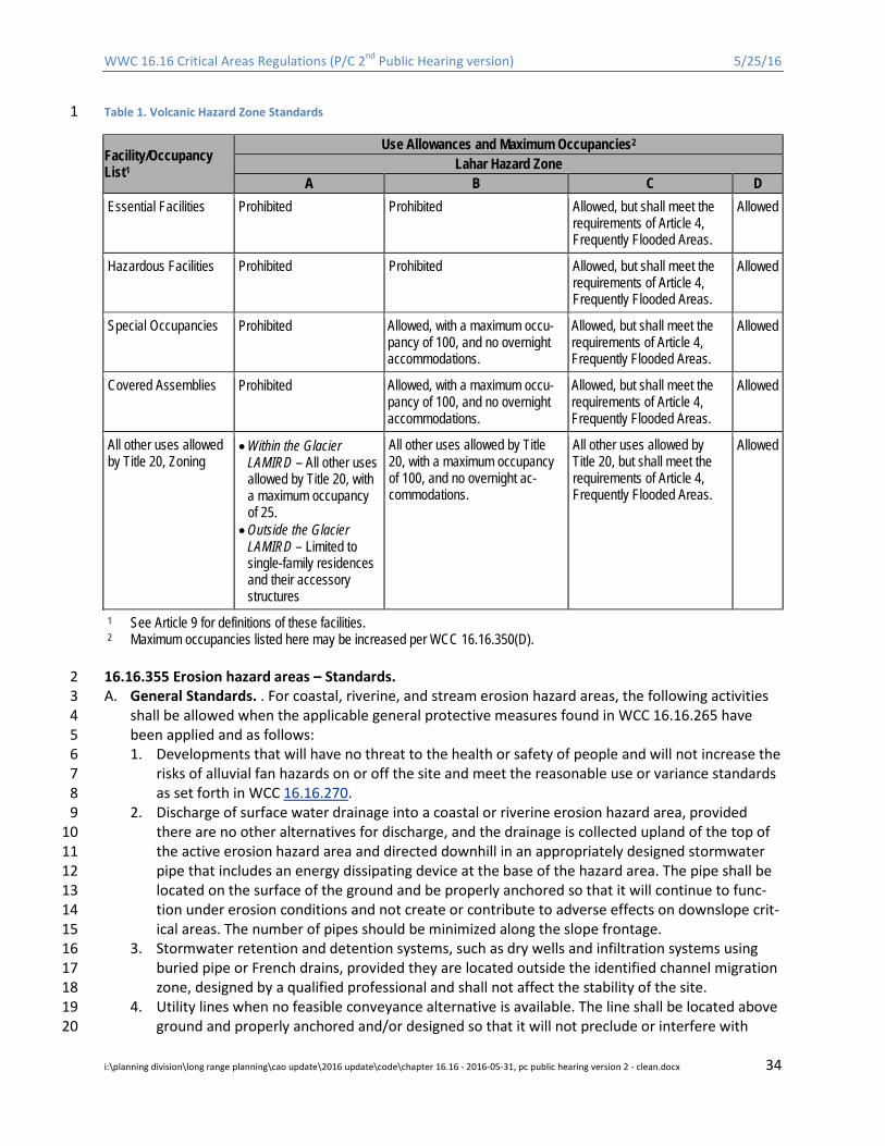
WWC 16.16 Critical Areas Regulations (P/C 2nd Public Hearing version) 5/25/16
Table 1. Volcanic Hazard Zone Standards 1
Facility/Occupancy List1
Use Allowances and Maximum Occupancies2 Lahar Hazard Zone
A B C D Essential Facilities Prohibited Prohibited Allowed, but shall meet the
requirements of Article 4, Frequently Flooded Areas.
Allowed
Hazardous Facilities Prohibited Prohibited Allowed, but shall meet the requirements of Article 4, Frequently Flooded Areas.
Allowed
Special Occupancies Prohibited Allowed, with a maximum occu-pancy of 100, and no overnight accommodations.
Allowed, but shall meet the requirements of Article 4, Frequently Flooded Areas.
Allowed
Covered Assemblies Prohibited Allowed, with a maximum occu-pancy of 100, and no overnight accommodations.
Allowed, but shall meet the requirements of Article 4, Frequently Flooded Areas.
Allowed
All other uses allowed by Title 20, Zoning
• Within the Glacier LAMIRD – All other uses allowed by Title 20, with a maximum occupancy of 25.
• Outside the Glacier LAMIRD – Limited to single-family residences and their accessory structures
All other uses allowed by Title 20, with a maximum occupancy of 100, and no overnight ac-commodations.
All other uses allowed by Title 20, but shall meet the requirements of Article 4, Frequently Flooded Areas.
Allowed
1 See Article 9 for definitions of these facilities. 2 Maximum occupancies listed here may be increased per WCC 16.16.350(D).
16.16.355 Erosion hazard areas – Standards. 2 A. General Standards. . For coastal, riverine, and stream erosion hazard areas, the following activities 3
shall be allowed when the applicable general protective measures found in WCC 16.16.265 have 4 been applied and as follows: 5 1. Developments that will have no threat to the health or safety of people and will not increase the 6
risks of alluvial fan hazards on or off the site and meet the reasonable use or variance standards 7 as set forth in WCC 16.16.270. 8
2. Discharge of surface water drainage into a coastal or riverine erosion hazard area, provided 9 there are no other alternatives for discharge, and the drainage is collected upland of the top of 10 the active erosion hazard area and directed downhill in an appropriately designed stormwater 11 pipe that includes an energy dissipating device at the base of the hazard area. The pipe shall be 12 located on the surface of the ground and be properly anchored so that it will continue to func-13 tion under erosion conditions and not create or contribute to adverse effects on downslope crit-14 ical areas. The number of pipes should be minimized along the slope frontage. 15
3. Stormwater retention and detention systems, such as dry wells and infiltration systems using 16 buried pipe or French drains, provided they are located outside the identified channel migration 17 zone, designed by a qualified professional and shall not affect the stability of the site. 18
4. Utility lines when no feasible conveyance alternative is available. The line shall be located above 19 ground and properly anchored and/or designed so that it will not preclude or interfere with 20
i:\planning division\long range planning\cao update\2016 update\code\chapter 16.16 - 2016-05-31, pc public hearing version 2 - clean.docx 34

WWC 16.16 Critical Areas Regulations (P/C 2nd Public Hearing version) 5/25/16
channel migration and will continue to function under erosion conditions; provided, that utility 1 lines may be located within channel migration zones if they are buried below the scour depth 2 for the entire width of the CMZ. 3
5. Public roads, bridges, and trails when no feasible alternative alignment is available. Facilities 4 shall be designed such that the roadway prism and/or bridge structure will not be susceptible to 5 damage from active erosion. 6
6. Access to private development sites may be allowed to provide access to portions of the site 7 that are not critical areas, if there are no feasible alternative alignments. Alternative access shall 8 be pursued to the maximum extent feasible, including through the provisions of Chapter 8.24 9 RCW. Exceptions or deviations from technical standards for width or other dimensions, and spe-10 cific construction standards to minimize impacts may be specified. 11
7. Stream bank stabilization and shoreline protection may be permitted subject to all of the follow-12 ing standards: 13 i. Shoreline protection measures located within coastal or riverine erosion areas shall use soft 14
armoring techniques (bioengineering erosion control measures as identified by the State 15 Department of Ecology and the Department of Fish and Wildlife guidance) unless the appli-16 cant provides a geotechnical analysis demonstrating that bioengineering approaches will not 17 adequately protect the property. 18
ii. The armoring shall not increase erosion on adjacent properties and shall not eliminate or 19 reduce sediment supply from feeder bluffs. 20
iii. The armoring will not adversely affect critical areas including habitat conservation areas or 21 mitigation will be provided to compensate for adverse effects where avoidance is not feasi-22 ble. 23
iv. The proposal shall comply with WCC Title 23. 24 v. Hard bank armoring is discouraged and may occur only when the property contains an exist-25
ing permanent structure(s) that is in danger from shoreline erosion caused by wave action 26 or riverine processes and not erosion caused by upland conditions, such as the alteration of 27 natural vegetation or drainage, and the armoring shall not increase erosion on adjacent 28 properties and shall not eliminate or reduce sediment supply. 29
vi. The erosion is not being caused by upland conditions, such as the removal of vegetation or 30 human alteration of existing drainage. 31
vii. Nonstructural measures, such as placing or relocating the development further from the 32 shoreline, planting vegetation, or installing on-site drainage improvements, are not feasible 33 or not sufficient. 34
8. New residences shall be located outside of channel migration hazard areas or marine shoreline 35 retreat areas. Accessory structures not involving human occupancy with a footprint equal to or 36 less than 2,500 square feet shall be allowed; provided, that they are located at the outer edge of 37 the migration zone as defined by this chapter; and provided, that the technical administrator 38 may allow larger accessory structures where mitigating measures are feasible and provided for 39 by the applicant. 40
9. New public flood protection measures and expansion of existing ones may be permitted, subject 41 to WCC Title 17, Article 4 of this chapter, and a state hydraulic project approval; provided, that 42 bioengineering or soft armoring techniques shall be used where feasible. Hard bank armoring 43 may occur only in situations where soft approaches do not provide adequate protection. 44
B. Erosion Hazard Area Setbacks. In addition to the applicable general protective measures found in 45 WWC 16.16.265, the technical administrator shall have the authority to require setbacks from the 46 edges of any coastal, stream, or riverine hazard erosion area in accordance with the following: 47
i:\planning division\long range planning\cao update\2016 update\code\chapter 16.16 - 2016-05-31, pc public hearing version 2 - clean.docx 35
WWC 16.16 Critical Areas Regulations (P/C 2nd Public Hearing version) 5/25/16
1. The size of the setback shall be based on the findings of a qualified professional and shall pro-1 tect critical areas and processes and minimize the risk of property damage, death or injury re-2 sulting from erosion over the life of the development, typically identified as 100 years. 3
2. The setback shall include the uphill area subject to potential erosion, the downhill area subject 4 to potential deposition, and any area subject to landslide as a result of erosion. 5
3. The setback shall include woody vegetation adequate to stabilize the soil and prevent soil 6 movement. If the designated setback area lacks adequate woody vegetation, the technical ad-7 ministrator shall have the authority to require vegetation enhancement or other measures to 8 improve slope stability. 9
4. Developments on sites that are directly adjacent to a wetland or marine shoreline or other habi-10 tat conservation area as defined in Article 7 of this chapter may be subject to additional setback 11 requirements and standards as set forth in the subsequent articles of this chapter. 12
16.16.365 Tsunami Hazard Areas –Standards. 13 The standards of WCC 16.16.320 and 16.16.350 shall apply. For development within tsunami hazard ar-14 eas the proposed development shall be designed to provide protection for the tsunami hazard that 15 meets the projected hazard on the Department of Natural Resources Tsunami Inundation Maps. For 16 other low lying coastal areas not included on the Inundation maps, development shall be designed to 17 provide protection for debris impact and an inundation as determined by current Department of Natu-18 ral Resource modeling unless other measures can be shown to provide equal or greater protection. 19
16.16.367 Seiche and Landslide Generated Wave hazard areas – Standards. 20 Standards for seiche and landslide generated wave hazards will only apply if the hazard area is mapped 21 by the United States Geologic Survey or the Department of Natural Resources, Division of Geology and 22 Earth Resources or other credible source approved by Whatcom County. If a mapped hazard is present, 23 the standards of WCC 16.16.320 and 16.16.350 shall apply. For residential development within a 24 mapped seiche and landslide generated wave hazard areas, the proposed development should be de-25 signed to withstand the mapped hazard. If the risk of the event is less than 0.1% on a yearly basis, de-26 velopment standards may not be required, but notice on property title will be required. 27
16.16.370 Mine Hazard Areas – Standards. 28 The standards of WCC 16.16.320 and 16.16.350shall apply. 29
16.16.375 Review and reporting requirements. 30 A. When County critical area maps or other sources of credible information indicate that a site pro-31
posed for development or alteration is, or may be, located within an active or potential geologically 32 hazardous area, the technical administrator shall have the authority to require the submittal of a 33 geological assessment report. 34
B. A geologic hazards assessment report for a geologically hazardous area shall include a field investi-35 gation and contain an assessment of whether or not the type of potential geologic hazard identified 36 is present or not present and if development of the site will increase the potential for landslides or 37 erosion on or off the site. Geology hazard assessment reports shall be prepared, stamped, and 38 signed by a qualified professional. The report should: 39 1. Be appropriate for the scale and scope of the project; 40 2. Include a discussion of all geologically hazardous areas on the site and any geologically hazard-41
ous areas off site potentially impacted by or which could impact the proposed project. If the af-42 fected area extends beyond the subject property, the geology hazard assessment may utilize ex-43 isting data sources pertaining to that area; 44
i:\planning division\long range planning\cao update\2016 update\code\chapter 16.16 - 2016-05-31, pc public hearing version 2 - clean.docx 36
WWC 16.16 Critical Areas Regulations (P/C 2nd Public Hearing version) 5/25/16
3. Clearly state that the proposed project will not decrease slope stability or pose an unreasonable 1 threat to persons or property either on or off site and provide a rationale as to those conclu-2 sions based on geologic conditions and interpretations specific to the project; 3
4. Provide adequate information to determine compliance with the requirements of this article; 4 5. Generally follow the guidelines set forth in the Washington State Department of Licensing 5
Guidelines for Preparing Engineering Geology Reports in Washington (2006). In some cases, such 6 as when it is determined that no landslide or erosion risk is present, a full report may not be 7 necessary to determine compliance with this article, and in those cases a stamped letter or ab-8 breviated report may be provided. 9
6. If a landslide or erosion hazard is identified, provide minimum setback recommendations for 10 avoiding the landslide or erosion hazard, recommendations on stormwater management and 11 vegetation management and plantings, other recommendations for site development so that 12 the frequency or magnitude of landsliding or erosion on or off the site is not altered, and rec-13 ommendations are consistent with this article. 14
7. For projects in seismic hazard areas, the report shall also include a detailed engineering evalua-15 tion of expected ground displacements, amplified seismic-shaking, or other liquefaction and/or 16 dynamic settlement effects and proposed mitigation measures to ensure an acceptable level of 17 risk for the proposed structure type or other development facilities such as access roads and 18 utilities. 19
8. For projects in mine hazard areas, the report shall also include a description of historical data 20 and remnant mine conditions, if available, dates of operation, years of abandonment, strength 21 of overlying rock strata, and other information needed to assess stability of the site together 22 with analysis of surface displacement or foundation stress from collapse of workings. 23
C. A geological assessment for a specific site may be valid for a period of up to five years when the 24 proposed land use activity and site conditions affecting the site are unchanged. However, if any sur-25 face and subsurface conditions associated with the site change during that five-year period, the ap-26 plicant may be required to submit an amendment to the geological assessment. 27
28
i:\planning division\long range planning\cao update\2016 update\code\chapter 16.16 - 2016-05-31, pc public hearing version 2 - clean.docx 37
WWC 16.16 Critical Areas Regulations (P/C 2nd Public Hearing version) 5/25/16
ARTICLE 4. FREQUENTLY FLOODED AREAS 1
16.16.400 Purpose. 2 The purposes of this article are to: 3 A. Reduce the risk to life and safety, public facilities, and public and private property that result from 4
floods. 5 B. Avoid and minimize impacts to fish and wildlife habitats that occur within frequently flooded areas. 6 C. Protect and maintain the beneficial ecological functions and values of frequently flooded areas, in-7
cluding providing the necessary flow regime to form and maintain a full range of functional and ac-8 cessible salmonid habitats both within and outside of frequently flooded areas. 9
D. To ensure compliance with FEMA National Flood Insurance Program (NFIP) protection standards for 10 critical habitats of species listed under the Endangered Species Act. 11
E. In conjunction with the provisions of WCC Title 17, establish review procedures that provide an in-12 tegrated approach to managing floodplain development and maintaining the capacity of the flood-13 plain or floodway to convey and store flood waters. 14
16.16.410 Designation and mapping – Frequently flooded areas. 15 A. Frequently flooded areas are areas located along major rivers, streams, and coastal areas where the 16
depth, velocity, intensity and frequency of flood water during major events present a risk to human 17 life and property. Areas susceptible to these types of hazards are hereby designated as frequently 18 flooded areas and subject to the provisions of this article. 19
B. The approximate location and extent of frequently flooded areas are shown on the County’s critical 20 area maps. These maps are to be used as a guide and do not provide a definitive critical area desig-21 nation. The County shall update the maps as new hazard areas are identified and as new infor-22 mation becomes available. This article does not imply that land outside mapped frequently flooded 23 areas or uses permitted within such areas will be free from flooding or flood damages. This chapter 24 shall not create liability on the part of Whatcom County, any officer or employee thereof, or the 25 Federal Insurance and Mitigation Administration (FIMA), for any flood damages that result from reli-26 ance on this chapter or any administrative decision lawfully made hereunder. 27
C. Frequently flooded areas shall include, but not be limited to: 28 1. Areas subject to a 1% recurrence interval of flood water inundation or a 100-year base flood as 29
mapped on the current effective Federal Emergency Management Agency’s Flood Insurance 30 Rate Maps (FIRM). This includes coastal high hazard areas as defined by this chapter and as 31 identified and designated on the FIRM maps as Zone VE or V; provided, that tsunami hazard ar-32 eas are designated as geologically hazardous areas and subject to the provisions of Article 3 of 33 this chapter. 34
2. Other flood hazard areas identified by the County Public Works Department based on review of 35 historical data, high water marks, photographs of past flooding, or similar information from fed-36 eral, state, county, or other valid sources when base flood elevation data from the Federal In-37 surance and Mitigation Administration has not been provided or is not accurate. 38
16.16.420 Frequently flooded areas – General standards. 39 A. All development shall conform to the provisions of WCC Title 17, Flood Damage Prevention, and the 40
applicable provisions of this chapter. 41 B. Development within frequently flooded areas shall be allowed only when it is consistent with all of 42
the following: 43
i:\planning division\long range planning\cao update\2016 update\code\chapter 16.16 - 2016-05-31, pc public hearing version 2 - clean.docx 38
WWC 16.16 Critical Areas Regulations (P/C 2nd Public Hearing version) 5/25/16
1. FEMA’s National Flood Insurance Program (NFIP), including the protection standards for critical 1 habitats for listed species, which shall be demonstrated through submittal of a habitat assess-2 ment, and if necessary, a mitigation plan prepared by a qualified professional, in accordance 3 with the FEMA Regional Guidance for the Puget Sound Basin. The plan shall identify any federal-4 ly listed species and associated habitats, and demonstrate that no harm will occur to such spe-5 cies or habitats as a result of development within frequently flooded areas; 6
2. The mitigation sequence in WCC 16.16.260; 7 3. Article 7, Habitat Conservation Areas, of this chapter; 8 4. The applicable general protective measures found in WWC 16.16.265. 9
C. The technical administrator shall have the authority to require mitigation for adverse impacts to the 10 ecological functions of Frequently Flooded Areas; provided, that such mitigation shall be consistent 11 and compatible with the goal of protecting health and safety and minimizing risks to property. 12
16.16.430 Review and report requirements. 13 A. When County critical area maps or other sources of credible information indicate that a site pro-14
posed for development is or may be located within a frequently flooded area, the County Public 15 Works Department’s River and Flood Division and/or the technical administrator shall have the au-16 thority to require a critical area assessment report. 17
B. The public works department shall have primary responsibility for reviewing and approving pro-18 posed developments for consistency with WCC Title 17.The technical administrator shall review de-19 velopment proposals for consistency with the standards provided in this chapter. Either may place 20 conditions for approval and/or require mitigation in accordance with this chapter. 21
C. In addition to the requirements of WCC 16.16.225, critical areas assessment reports for frequently 22 flooded areas shall: 23 1. Address adverse impacts to ecological functions and processes, including riparian vegetation. 24
Positive impacts may also be discussed. 25 2. Include mitigation for adverse effects on Frequently Flooded Areas’ ecological functions, where 26
applicable. 27 D. The technical administrator shall have the authority to modify the requirements of Subsection C 28
when s/he determines that any portion of these requirements is unnecessary given the scope 29 and/or scale of the proposed development. 30
E. The technical administrator shall have the authority to require additional information to that re-31 quired in Subsection C that discloses and describes the effects of proposed development on Fre-32 quently Flooded Area functions, including, but not limited to impacts on: storage and conveyance of 33 flood water; channel migration; peak flows and flow velocities; redd scour and displacement of rear-34 ing juvenile fish; sediment quality in streams; shear stress and bank erosion; water quality; wildlife 35 habitat; fish access; and nutrients cycling or other hyporheic functions that link surface and ground-36 water systems. 37
F. Critical areas assessment report requirements may be waived for single-family developments and 38 structures accessory to agricultural uses when the technical administrator and the public works de-39 partment determine that no adverse impacts or risks to life, property, or ecological functions will 40 occur. 41
42
i:\planning division\long range planning\cao update\2016 update\code\chapter 16.16 - 2016-05-31, pc public hearing version 2 - clean.docx 39

WWC 16.16 Critical Areas Regulations (P/C 2nd Public Hearing version) 5/25/16
ARTICLE 5. CRITICAL AQUIFER RECHARGE AREAS 1
16.16.500 Purpose. 2 The purposes of this article are to: 3 A. Preserve, protect, and conserve Whatcom County’s groundwater resources and their functions and 4
values for current and future generations by protecting critical aquifer recharge areas from contam-5 ination. 6
B. Prevent adverse impacts on groundwater quantity by regulating development activities that could 7 deplete aquifer storage, reduce groundwater levels, and/or diminish infiltration and replenishment 8 of groundwater. 9
C. Prioritize the management, protection, and conservation of groundwater recharge areas as sources 10 of potable water supply. 11
D. Establish review procedures for development activities that have the potential to adversely affect 12 critical aquifer recharge areas. 13
16.16.510 Designation, classification and mapping – Critical aquifer recharge areas. 14 A. Critical aquifer recharge areas play a crucial role in supplying potable water (as defined by WAC 365-15
190-030(2)). These recharge areas have geologic conditions that allow high infiltration rates, which 16 contribute significantly to the replenishment of groundwater. These conditions also create a high 17 potential for groundwater contamination. These areas are hereby designated as critical areas and 18 subject to the provisions of this chapter. 19
B. The approximate location and extent of critical aquifer recharge areas are shown on the County’s 20 critical area maps. These maps are to be used as a guide and do not provide a definitive critical area 21 designation. The County shall update the maps as recharge areas are identified and as new infor-22 mation becomes available. 23
C. Critical aquifer recharge areas shall be designated and classified as follows: 24 1. Low, Moderate, and High Susceptibility Aquifer Recharge Areas. Aquifer recharge areas suscep-25
tible to degradation or depletion because of hydrogeologic characteristics are those areas meet-26 ing the criteria established by the State Department of Ecology (Guidance Document for the Es-27 tablishment of Critical Aquifer Recharge Area Ordinances, July 2000, Publication No. 97-30, Ver-28 sion 4.0). 29
2. Wellhead Protection Areas. The area defined by the boundaries of the 10-year time of ground-30 water travel, in accordance with WAC 246-290-135. For purposes of this chapter, all wellhead 31 protection areas shall be designated as highly susceptible critical aquifer recharge areas. 32
D. If special groundwater management areas or susceptible groundwater management areas are es-33 tablished in Whatcom County in accordance with WAC 173-200-090 or 173-100-010, respectively, 34 then these areas shall be incorporated into the highly susceptible aquifer designation. 35
16.16.520 Critical aquifer recharge areas – General standards. 36 In addition to the applicable general protective measures found in WCC 16.16.265, all development in a 37 critical aquifer recharge area shall meet the following standards: 38 A. The proposed development will not cause contaminants to enter the aquifer and will not significant-39
ly affect the recharging of the aquifer in an adverse manner. 40 B. The proposed development must comply with the water source protection requirements and rec-41
ommendations of the Federal Environmental Protection Agency, State Department of Health, and 42 the Whatcom County health department. 43
i:\planning division\long range planning\cao update\2016 update\code\chapter 16.16 - 2016-05-31, pc public hearing version 2 - clean.docx 40
WWC 16.16 Critical Areas Regulations (P/C 2nd Public Hearing version) 5/25/16
C. The proposed development must be designed and constructed in accordance with the County 1 stormwater management requirements or other applicable stormwater management standards 2 (Whatcom County Development Standards Chapter 2, WCC Title 20). 3
16.16.525 Activity subject to critical areas review. 4 The following development activities, when proposed in moderate and high susceptibility critical aquifer 5 recharge areas, have the potential to adversely affect groundwater quality and/or quantity and shall 6 require submittal of a critical areas assessment report as defined in WCC 16.16.255 and 16.16.535: 7 A. Any development with an on-site domestic septic system at a gross density greater than one system 8
per residence per acre. 9 B. All storage tanks and storage facilities for hazardous substances and/or hazardous wastes; provided, 10
that: 11 1. The tanks must comply with Department of Ecology regulations contained in Chapters 173-360 12
and 173-303 WAC as well as International Building Code requirements; 13 2. All new underground tanks and facilities shall be designed and constructed so as to prevent re-14
leases due to corrosion or structural failure for the operational life of the tank, or have a sec-15 ondary containment system to prevent the release of any stored substances; 16
3. All new aboveground storage tanks and facilities shall be designed and constructed so as to pre-17 vent the release of a hazardous substance to the ground, groundwaters, or surface waters by 18 having primary and secondary containment. 19
C. Vehicle repair, servicing and salvaging facilities; provided, that the facility must be conducted over 20 impermeable pads and within a covered structure capable of withstanding normally expected 21 weather conditions. Chemicals used in the process of vehicle repair and servicing must be stored in 22 a manner that protects them from weather and provides containment should leaks occur. Dry wells 23 shall not be allowed on sites used for vehicle repair and servicing. Dry wells existing on the site prior 24 to facility establishment must be abandoned using techniques approved by the State Department of 25 Ecology prior to commencement of the proposed activity. 26
D. Use of reclaimed wastewater must be in accordance with adopted water or sewer comprehensive 27 plans that have been approved by the State Departments of Ecology and Health and the Whatcom 28 County council per Chapter 57.16 RCW; provided, that: 29 1. Surface spreading must meet the groundwater recharge criteria given in RCW 90.46.010(10) and 30
90.46.080. 31 2. Direct injection must be in accordance with the standards developed by authority of RCW 32
90.46.042. 33 E. Any other development activity that the technical administrator determines is likely to have a signif-34
icant adverse impact on groundwater quality or quantity, or on the recharge of the aquifer. The de-35 termination must be made based on credible scientific information. 36
F. Metals and hard rock mining and new sand and gravel mining subject to the provisions of the Coun-37 ty’s current MRL review procedures in Chapter 20.73 WCC; provided, that for new MRLs such activi-38 ties shall be prohibited within the 10-year travel time zone of wellhead protection areas. 39
16.16.530 Prohibited uses. 40 The following developments and uses are prohibited in critical aquifer recharge areas: 41 A. New landfills, including hazardous or dangerous waste, municipal solid waste, special waste, wood 42
waste of more than 2,000 cubic yards, and inert and demolition waste landfills. 43 B. Underground injection wells. Class I, III, and IV wells and subclasses 5F01, 5D03, 5F04, 5W09, 5W10, 44
5W11, 5W31, 5X13, 5X14, 5X15, 5W20, 5X28, and 5N24 of Class V wells. 45
i:\planning division\long range planning\cao update\2016 update\code\chapter 16.16 - 2016-05-31, pc public hearing version 2 - clean.docx 41
WWC 16.16 Critical Areas Regulations (P/C 2nd Public Hearing version) 5/25/16
C. Wood treatment facilities that allow any portion of the treatment process to occur over permeable 1 surfaces (both natural and manmade). 2
D. Facilities that store, process, or dispose of chemicals containing perchloroethylene (PCE) or methyl 3 tertiary butyl ether (MTBE). 4
E. Facilities that store, process, or dispose of radioactive substances. 5 F. Other activities that the technical administrator determines would significantly degrade groundwa-6
ter quality and/or reduce the recharge to aquifers currently or potentially used as a potable water 7 source, or that may serve as a significant source of base flow to a regulated stream. The determina-8 tion must be made based on credible scientific information. 9
16.16.535 Review and report requirements. 10 A. When County critical area maps or other sources of credible information indicate that the proposed 11
development activities listed in WCC 16.16.525 occur within a critical aquifer recharge area, the 12 technical administrator shall have the authority to require a critical area assessment report and to 13 regulate developments accordingly. Critical areas assessment reports for aquifer recharge areas 14 shall meet the requirements WCC 16.16.255 and this section. Assessment reports shall include the 15 following site- and proposal-related information unless the technical administrator determines that 16 any portion of these requirements is unnecessary given the scope and/or scale of the proposed de-17 velopment: 18 1. Available information regarding geologic and hydrogeologic characteristics of the site, including 19
the surface location of all critical aquifer recharge areas located on-site or immediately adjacent 20 to the site, and permeability of the unsaturated zone; 21
2. Groundwater depth, flow direction and gradient based on available information; 22 3. Currently available data on wells and springs within 1,300 feet of the project area; 23 4. The presence and approximate location of other critical areas, including surface waters, within 24
1,300 feet of the project area based on available data and maps; 25 5. Existing and available historic water quality data for the area to be affected by the proposed ac-26
tivity; 27 6. Proposed best management practices; 28 7. The effects of the proposed project on the groundwater quality and quantity, including: 29
a. Potential effects on stream flow, wetlands and/or other resources, and on ecosystem pro-30 cesses; 31
b. Predictive evaluation of groundwater withdrawal effects on nearby wells and surface water 32 features; and 33
c. Predictive evaluation of contaminant transport based on potential releases to groundwater; 34 and 35
8. A spill plan that identifies equipment and/or structures that could fail, resulting in an impact. 36 Spill plans shall include provisions for emergency response provisions as well as regular inspec-37 tion, repair, and replacement of structures and equipment that could fail. 38
B. If the applicant can demonstrate through a valid hydrogeological assessment that geologic and soil 39 conditions underlying their property do not meet the criteria for low, moderate, or high susceptibil-40 ity, the property shall not be considered a critical aquifer recharge area. 41
42
i:\planning division\long range planning\cao update\2016 update\code\chapter 16.16 - 2016-05-31, pc public hearing version 2 - clean.docx 42
WWC 16.16 Critical Areas Regulations (P/C 2nd Public Hearing version) 5/25/16
ARTICLE 5.5. AREAS WITHIN THE RURAL RESIDENTIAL DISTRICT OF 1
LUMMI ISLAND 2
16.16.540 Areas within the rural residential district of Lummi Island. 3
16.16.541 Exempt wells. 4 Wells drilled as a replacement of an existing well are exempt from this article as long as the withdrawal 5 rate is not increased by more than 20% of the existing well. If baseline withdrawal rate information is 6 not available, this must be established by a licensed well driller prior to well replacement. 7
16.16.542 Minimum well spacing for all new wells. 8 Wells shall have a minimum of 200 feet distance between a new well and an existing operating well. 9
16.16.543 Requirements for public water system wells, non-Group B two party wells and nondomestic 10 wells. 11 In addition to the minimum well spacing, the following measures are required for public water system 12 wells, non-Group B two party wells, and nondomestic wells. (Includes “public water system” wells and 13 non-Group B two party wells as defined under Whatcom County drinking water regulations and nondo-14 mestic use wells pumping greater than 250 gpd. “Public water system” is defined under Chapter 24.11 15 WCC as any water system providing piped water for consumption, excluding a system serving only one 16 single-family residence and any system with four or fewer connections serving only residences on the 17 same farm. A “non-Group B two party well” is defined in Chapter 24.11 WCC as a water system using 18 one well to serve two single-family residences for which the director of health has waived all public wa-19 ter system requirements.) 20
A. Chloride Monitoring and Testing. 21 1. Monitoring. Well owners shall collect and have water samples analyzed for chloride concentra-22
tion twice annually, in April and August, and submitted to the Whatcom County health depart-23 ment. 24
2. Chloride Determinations for New Wells or Increased Pumping of Existing Wells. Applications for 25 new wells, applications to convert an existing private well into a two party well, any application 26 to expand the number of connections of a public water system, and nondomestic use wells pro-27 posing greater than 20% increase in groundwater withdrawals in an existing well require a min-28 imum 24-hour-duration pumping test at 100% of the proposed average daily demand, at the 29 end of which a water sample will be collected for analysis of chloride concentration. Subdivi-30 sions using individual wells are required to test wells simultaneously, or alternatively have a li-31 censed hydrogeologist evaluate well interference and water quality changes. Subdivision wells 32 shall remain accessible for future testing in the event of subdivision expansion. 33
3. Restrictions on New Wells or Increased Pumping of Existing Wells. New wells cannot be permit-34 ted, existing private wells cannot be converted to two party wells, existing public water systems 35 cannot expand beyond their existing number of approved connections, and nondomestic wells 36 cannot increase pumping rates greater than 20% if chloride concentrations measured at the end 37 of the test specified in subsection (A)(2) of this section are greater than 100 mg/L. For systems 38 expanding 20% or less within one year, the highest chloride determination within the past year 39 in subsection (A)(1) of this section cannot be greater than 100 mg/L. 40
4. Limit on Water Use by Existing Wells. Any increase (0 to 20%) in water use will not be permitted 41 if either semi-annual analysis in the previous 12-month period indicates greater than 100 mg/L 42
i:\planning division\long range planning\cao update\2016 update\code\chapter 16.16 - 2016-05-31, pc public hearing version 2 - clean.docx 43
WWC 16.16 Critical Areas Regulations (P/C 2nd Public Hearing version) 5/25/16
chloride concentration. If the semi-annual chloride determinations have not been submitted as 1 required, then the pump testing requirement of subsection (A)(2) of this section shall apply. 2
5. Prior to 10 days before the pumping test, all property owners within 1,000 feet of the well loca-3 tion shall be notified by first class mail informing them of the test and providing contact infor-4 mation of the person responsible for the testing. 5
B. Arsenic Monitoring and Testing in the Unconsolidated Aquifer. 6 1. The following monitoring and testing is required unless the well is determined not to be located 7
in the unconsolidated sandstone aquifer. A Washington State licensed hydrogeologist must 8 make the determination in a submitted report. 9
2. Arsenic Determinations for New Wells or Increased Pumping of Existing Wells. Applications for 10 new wells, applications to convert an existing private well into a two party well, any application 11 to expand the number of connections of a public water system, and nondomestic use wells pro-12 posing a greater than 20% increase in groundwater withdrawals in an existing well require a 13 minimum 24-hour-duration pumping test at 100% of the proposed average daily demand, at the 14 end of which a water sample will be collected for analysis of arsenic concentration. 15
3. Restrictions on New Wells or Increased Pumping of Existing Wells. New wells cannot be permit-16 ted, existing private wells cannot be converted to two party wells, existing public water systems 17 cannot expand beyond their existing number of approved connections, and nondomestic wells 18 cannot increase pumping rates greater than 20% if arsenic concentrations measured at the end 19 of the test specified in subsection (B)(2) of this section are greater than 10 μg/L. 20
4. Limit on Water Use by Existing Wells. Any increase (0 to 20%) in water use will not be permitted 21 if the most recent arsenic determination indicated greater than 10 μg/L arsenic concentration. If 22 no arsenic concentration has been determined in the past three years, the pumping test re-23 quirement in subsection (B)(2) of this section shall apply. 24
5. Prior to 10 days before the pumping test, all property owners within 1,000 feet of the well loca-25 tion shall be notified by first class mail informing them of the test and providing contact infor-26 mation of the person responsible for the testing. 27
16.16.544 Administrative waiver. 28 Administrative waivers may be granted to any section of these requirements by petition to the adminis-29 tering agency. Waiver request must demonstrate that the project is consistent with the intent of these 30 requirements; no health hazard would result from this action, and must be stamped by a licensed Wash-31 ington State hydrogeologist. 32
33
i:\planning division\long range planning\cao update\2016 update\code\chapter 16.16 - 2016-05-31, pc public hearing version 2 - clean.docx 44
WWC 16.16 Critical Areas Regulations (P/C 2nd Public Hearing version) 5/25/16
ARTICLE 6. WETLANDS 1
16.16.600 Purpose. 2 The purposes of this article are to: 3 A. Recognize and protect the beneficial functions, values, and services performed by wetlands, which 4
include, but are not limited to, providing food, breeding, nesting and/or rearing habitat for fish and 5 wildlife; recharging and discharging groundwater; contributing to stream flow during low flow peri-6 ods; stabilizing stream banks and shorelines; storing storm and flood waters to reduce flooding and 7 erosion; and improving water quality through biofiltration, adsorption, retention and transformation 8 of sediments, nutrients, and toxicants. 9
B. Regulate land use to avoid adverse effects on wetlands and maintain the functions, services, and 10 values of freshwater and estuarine wetlands throughout Whatcom County. 11
C. Establish review procedures for development proposals in and adjacent to wetlands. 12 D. Establish minimum standards for identifying and delineating wetlands. 13
16.16.610 Wetlands Designation, Rating, and Mapping. 14 A. Wetlands shall be identified in accordance with the requirements of RCW 36.70A.175. Unless oth-15
erwise provided for in this chapter, all areas within the County meeting the criteria in the U.S. Army 16 Corps of Engineers Wetlands Delineation Manual, 1987 Edition, and the Western Mountains, Val-17 leys, and Coast Region supplement (Version 2.0) 2010 or as revised , are hereby designated critical 18 areas and are subject to the provisions of this article. 19
B. The approximate location and extent of wetlands are shown on the County’s critical area maps. 20 However, this information has come from multiple sources over many years’ time and is not precise, 21 only general. Thus, these maps are to be used as a guide and do not provide a definitive critical area 22 designation; a property specific assessment is necessary for that. The county shall update the maps 23 as new wetlands are identified and as new information becomes available. 24
C. Wetlands shall be rated based on categories that reflect the functions and values of each wetland. 25 Wetland categories shall be based on the criteria provided in the Washington State Wetland Rating 26 System for Western Washington, revised 2014, and as amended thereafter, , as determined using 27 the appropriate rating forms and associated figures contained in that publication. These categories 28 are generally defined as follows: 29 1. Category I. Category I wetlands are: (1) relatively undisturbed estuarine wetlands larger than 1 30
acre; (2) wetlands of high conservation value that are identified by scientists of the Washington 31 Natural Heritage Program/DNR; (3) bogs; (4) mature and old-growth forested wetlands larger 32 than 1 acre; (5) wetlands in coastal lagoons; (6) interdunal wetlands that score 8 or 9 habitat 33 points and are larger than 1 acre; and (7) wetlands that perform many functions well (scoring 23 34 points or more). These wetlands: (1) represent unique or rare wetland types; (2) are more sensi-35 tive to disturbance than most wetlands; (3) are relatively undisturbed and contain ecological at-36 tributes that are impossible to replace within a human lifetime; or (4) provide a high level of 37 functions. 38
2. Category II. Category II wetlands are: (1) estuarine wetlands smaller than 1 acre, or disturbed 39 estuarine wetlands larger than 1 acre; (2) interdunal wetlands larger than 1 acre or those found 40 in a mosaic of wetlands; or (3) wetlands with a moderately high level of functions (scoring be-41 tween 20 and 22 points). 42
3. Category III. Category III wetlands are: (1) wetlands with a moderate level of functions (scoring 43 between 16 and 19 points); (2) can often be adequately replaced with a well-planned mitigation 44
i:\planning division\long range planning\cao update\2016 update\code\chapter 16.16 - 2016-05-31, pc public hearing version 2 - clean.docx 45

WWC 16.16 Critical Areas Regulations (P/C 2nd Public Hearing version) 5/25/16
project; and (3) interdunal wetlands between 0.1 and 1 acre. Wetlands scoring between 16 and 1 19 points generally have been disturbed in some ways and are often less diverse or more isolat-2 ed from other natural resources in the landscape than Category II wetlands. 3
4. Category IV. Category IV wetlands have the lowest levels of functions (scoring fewer than 16 4 points) and are often heavily disturbed. These are wetlands that we should be able to replace, 5 or in some cases to improve. However, experience has shown that replacement cannot be guar-6 anteed in any specific case. These wetlands may provide some important functions, and should 7 be protected to some degree. 8
D. All wetlands shall be regulated regardless of size; provided, that hydrologically isolated Category IV 9 wetlands less than 1,000 square feet in size may be adversely impacted when all of the following 10 criteria are met: 11 1. The wetland does not provide significant suitable breeding habitat for native amphibian species. 12
Suitable breeding habitat may be indicated by adequate and stable seasonal inundation, pres-13 ence of thin-stemmed emergent vegetation, and clean water; 14
2. The wetland does not have unique characteristics that would be difficult to replace through 15 standard compensatory mitigation practices; 16
3. The wetland is not located within a habitat conservation area, as defined in WCC 16.16.710, or 17 buffer; 18
4. The wetland is not located within a floodplain and/or not associated with a shoreline of the 19 state as defined by the County’s Shoreline Master Program (WCC Title 23); 20
5. The wetland is not part of a mosaic of wetlands and uplands. This criterion shall be determined 21 using the guidance provided in Ecology’s Wetland Rating System for Western Washington (Pub-22 lication No. 14-06-029); and 23
6. The wetland is not identified as locally significant by a local watershed plan prepared pursuant 24 to Chapter 400-12 WAC. 25
7. Adverse impacts are mitigated pursuant to WCC 16.16.680 26
16.16.620 Wetlands – General standards. 27 The following activities may be permitted in wetlands and/or wetland buffers as specified when all rea-28 sonable measures have been taken to avoid adverse effects on wetland functions and values as docu-29 mented through an alternatives analysis, the amount and degree of alteration are limited to the mini-30 mum needed to accomplish the project purpose, and compensatory mitigation is provided for all ad-31 verse impacts to wetlands that cannot be avoided, : 32 A. Developments that meet the reasonable use or variance standards as set forth in WCC 16.16.270. 33 B. Utility lines in Category II, III, and IV wetlands and their buffers and/or Category I wetland buffers 34
when no feasible conveyance alternative is available shall be designed and constructed to minimize 35 physical, hydrologic, and ecological impacts to the wetland, and meet all of the following: 36 1. The utility line is located as far from the wetland edge and/or buffer as possible and in a manner 37
that minimizes disturbance of soils and vegetation. 38 2. Clearing, grading, and excavation activities are limited to the minimum necessary to install the 39
utility line and the area is restored following utility installation. 40 3. Buried utility lines shall be constructed in a manner that prevents adverse impacts to surface 41
and subsurface drainage. This may include regrading to the approximate original contour or the 42 use of trench plugs or other devices as needed to maintain hydrology. 43
4. Best management practices are used in maintaining said utility corridors such that maintenance 44 activities do not expand the corridor further into the critical area. 45
C. Public roads or bridges in Category II, III, and IV wetlands and their buffers and/or Category I wet-46 land buffers when no feasible alternative alignment is available and the road or bridge is designed 47
i:\planning division\long range planning\cao update\2016 update\code\chapter 16.16 - 2016-05-31, pc public hearing version 2 - clean.docx 46

WWC 16.16 Critical Areas Regulations (P/C 2nd Public Hearing version) 5/25/16
and constructed to minimize physical, hydrologic, and ecological impacts to the wetland, including 1 placement on elevated structures as an alternative to fill, where feasible. 2
D. Access to private development sites may be permitted to cross Category II, III, or IV wetlands or 3 their buffers, provided there are no feasible alternative alignments and measures are taken to main-4 tain preconstruction hydrologic connectivity across the access road. Alternative access shall be pur-5 sued to the maximum extent feasible, including through the provisions of Chapter 8.24 RCW. Excep-6 tions or deviations from technical standards for width or other dimensions, and specific construction 7 standards to minimize impacts may be specified, including placement on elevated structures as an 8 alternative to fill, if feasible. 9
E. Agricultural Uses as follows: 10 1. Construction of an appurtenant structure that is associated with a primary agricultural use; or 11
the reconstruction, remodeling, or maintenance of such structures in wetland buffers, subject to 12 all of the following specific criteria: 13 i. The structure is located within an existing lot of record and is an ongoing agricultural use. 14
ii. There is no other feasible location with less impact to critical areas. 15 iii. Clearing and grading activity and impervious surfaces are limited to the minimum necessary 16
to accommodate the proposed structure and, where possible, surfaces shall be made of 17 pervious materials. 18
2. Ongoing agricultural activities subject to the following: 19 i. The activities are conducted in accordance with all applicable provisions of this chapter and 20
WCC Title 17; or 21 ii. The agricultural activity is in compliance with the Conservation Program on Agricultural 22
Lands (CPAL) as described in Article 8 of this chapter. 23 F. Domestic wells serving single-family developments (including plats, short plats, and individual single-24
family residences) and necessary appurtenances, including a pump and appropriately sized pump 25 house, but not including a storage tank, in wetland buffers when all of the following conditions are 26 met: 27 1. There is no viable alternative to the well site outside of the buffer and the well is located as far 28
back from the wetland edge as is feasible; 29 2. The well is more than 75 feet deep; and 30 3. Any impacts to the wetland and buffer from staging equipment and the well-drilling process are 31
mitigated. 32 G. Stormwater management facilities. 33
1. Stormwater management facilities, limited to detention/retention/treatment ponds, media fil-34 tration facilities, and lagoons or infiltration basins, or bio-retention cells (engineered or 35 raingardens) may be permitted within the outer 50% of a Category II, III or IV wetland buffer; 36 provided, that: 37 i. Construction of the stormwater facility does not displace or impact a forested buffer; 38
ii. The width of the buffer between the stormwater facility and the wetland edge is not less 39 than the low intensity land use buffer standards in WCC 16.16.630; 40
iii. There is no other feasible location for the stormwater facility and the facility is located, con-41 structed, and maintained in a manner that minimizes adverse effects on the buffer and ad-42 jacent critical areas; 43
iv. The stormwater facility is designed to mimic and resemble natural wetlands and meets ap-44 plicable county or state stormwater management standards and the discharge water meets 45 state water quality standards; and 46
v. Low impact development approaches have been implemented to the maximum extent fea-47 sible per the Department of Ecology Stormwater manual. 48
i:\planning division\long range planning\cao update\2016 update\code\chapter 16.16 - 2016-05-31, pc public hearing version 2 - clean.docx 47
WWC 16.16 Critical Areas Regulations (P/C 2nd Public Hearing version) 5/25/16
2. Surface water or stormwater conveyance or discharge facilities such as dispersion trenches, lev-1 el spreaders, and outfalls may be permitted within a Category III or IV wetland buffer on a case-2 by-case basis when the technical administrator determines that all of the following are met: 3 i. Due to topographic or other physical constraints, there are no feasible alternative locations 4
for these facilities in the outer buffer area or outside the buffer. 5 ii. The discharge is located as far from the wetland edge and/or buffer as possible and in a 6
manner that minimizes disturbance of soils and vegetation. 7 iii. The discharge outlet is designed to prevent erosion and promote infiltration. 8 iv. The dispersion outfall is within the outer 25% of the buffer. 9
H. Passive recreation facilities that are part of a nonmotorized trail system or environmental education 10 program, including walkways, wildlife viewing structures, or public education trails; provided, that 11 all of the following criteria are met: 12 1. Private trails shall not exceed 6 feet in width, and public trails shall not exceed 10 feet in width. 13 2. They shall be made of pervious material or elevated where feasible. 14 3. They shall be designed to avoid removal of significant trees. 15 4. When located in the buffer, they should be located in the outer 25% of the buffer. 16 5. If they must cross a wetland, they shall be elevated, constructed to minimize supports, and be 17
the minimum size necessary to accommodate the level of service. 18 6. They shall be constructed and maintained in a manner that minimizes disturbance of the buffer 19
and associated critical areas. 20 I. Single-family developments may be permitted to encroach into wetland buffers subject to the tech-21
nical administrator’s approval; provided, that all of the criteria in WCC 16.16.270(A) (Reasonable 22 Use) are met. 23
J. On-site sewage disposal systems (OSS) may be permitted in wetland buffers when accessory to an 24 approved residential structure: 25 1. When it is not feasible to connect to a public sanitary sewer system; and, 26 2. It is located as far as possible from the wetland; and, 27 3. When it is operated and maintained in accordance with WCC 24.05.170; provided, that adverse 28
effects on water quality are avoided. 29
16.16.630 Wetland buffer widths. 30 The technical administrator shall have the authority to require buffers from the edges of all wetlands (in 31 addition to the building setback required by 16.16.265(D)) in accordance with the following: 32 A. Wetland buffers shall be established to protect the integrity, functions and values of the wetland. 33
Wetland buffers shall be measured perpendicular to the wetland edge on all sides as marked in the 34 field. Buffers shall not include areas that are functionally and effectively disconnected from the wet-35 land by an existing, legally established road or other substantial developed surface. 36
B. The buffer standards required by this article presume the existence of a dense, multi-storied native 37 vegetation community in the buffer adequate to protect the wetland functions and values. When a 38 buffer lacks adequate vegetation, the technical administrator may increase the standard buffer, re-39 quire buffer planting or enhancement, and/or deny a proposal for buffer reduction or buffer averag-40 ing. 41
C. The standard buffer shall be based on a combination wetland category, habitat function score (from 42 the wetland rating form), and land use intensity. The intensity of the land use shall be determined in 43 accordance with the definitions found in Article 9 of this chapter unless the technical administrator 44 determines that a lesser level of impact is appropriate based on information provided by the appli-45 cant demonstrating that the proposed land use will have a lesser impact on the wetland than that 46
i:\planning division\long range planning\cao update\2016 update\code\chapter 16.16 - 2016-05-31, pc public hearing version 2 - clean.docx 48
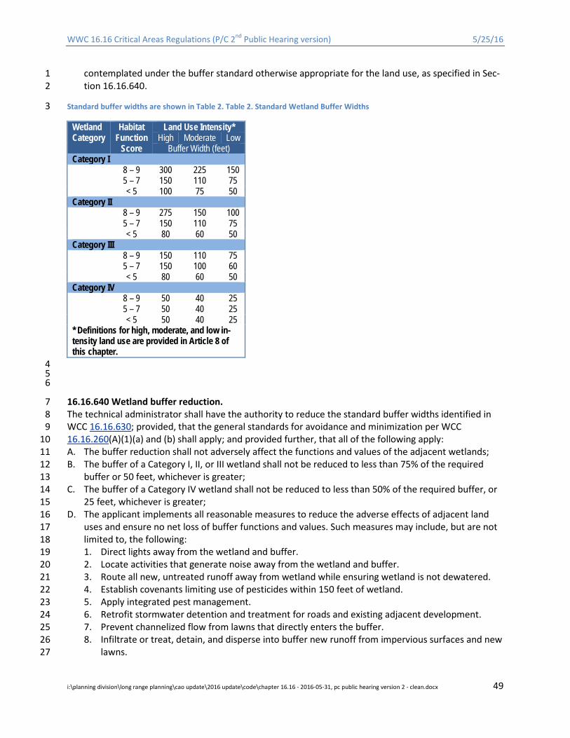
WWC 16.16 Critical Areas Regulations (P/C 2nd Public Hearing version) 5/25/16
contemplated under the buffer standard otherwise appropriate for the land use, as specified in Sec-1 tion 16.16.640. 2
Standard buffer widths are shown in Table 2. Table 2. Standard Wetland Buffer Widths 3
Wetland Category
Habitat Function
Score
Land Use Intensity* High Moderate Low
Buffer Width (feet) Category I 8 – 9 300 225 150 5 – 7 150 110 75 < 5 100 75 50 Category II 8 – 9 275 150 100 5 – 7 150 110 75 < 5 80 60 50 Category III 8 – 9 150 110 75 5 – 7 150 100 60 < 5 80 60 50 Category IV 8 – 9 50 40 25 5 – 7 50 40 25 < 5 50 40 25 * Definitions for high, moderate, and low in-tensity land use are provided in Article 8 of this chapter.
4 5 6
16.16.640 Wetland buffer reduction. 7 The technical administrator shall have the authority to reduce the standard buffer widths identified in 8 WCC 16.16.630; provided, that the general standards for avoidance and minimization per WCC 9 16.16.260(A)(1)(a) and (b) shall apply; and provided further, that all of the following apply: 10 A. The buffer reduction shall not adversely affect the functions and values of the adjacent wetlands; 11 B. The buffer of a Category I, II, or III wetland shall not be reduced to less than 75% of the required 12
buffer or 50 feet, whichever is greater; 13 C. The buffer of a Category IV wetland shall not be reduced to less than 50% of the required buffer, or 14
25 feet, whichever is greater; 15 D. The applicant implements all reasonable measures to reduce the adverse effects of adjacent land 16
uses and ensure no net loss of buffer functions and values. Such measures may include, but are not 17 limited to, the following: 18 1. Direct lights away from the wetland and buffer. 19 2. Locate activities that generate noise away from the wetland and buffer. 20 3. Route all new, untreated runoff away from wetland while ensuring wetland is not dewatered. 21 4. Establish covenants limiting use of pesticides within 150 feet of wetland. 22 5. Apply integrated pest management. 23 6. Retrofit stormwater detention and treatment for roads and existing adjacent development. 24 7. Prevent channelized flow from lawns that directly enters the buffer. 25 8. Infiltrate or treat, detain, and disperse into buffer new runoff from impervious surfaces and new 26
lawns. 27
i:\planning division\long range planning\cao update\2016 update\code\chapter 16.16 - 2016-05-31, pc public hearing version 2 - clean.docx 49

WWC 16.16 Critical Areas Regulations (P/C 2nd Public Hearing version) 5/25/16
9. Post signs at the outer edge of the critical area or buffer to clearly indicate the location of the 1 critical area according to the direction of the County. 2
10. Use privacy fencing. 3 11. Plant with dense native vegetation appropriate for the County to delineate buffer edge and to 4
discourage disturbance. 5 12. Use low impact development where appropriate. 6 13. Establish a permanent conservation easement or tract to protect the wetland and the associat-7
ed buffer. 8 14. Use best management practices to control dust. 9
16.16.650 Wetland buffer averaging. 10 The technical administrator shall have the authority to average wetland buffer widths on a case-by-case 11 basis; provided, that the general standards for avoidance and minimization per WCC 16.16.260(A)(1)(a) 12 and (b) shall apply, and when all of the following criteria are met: 13 A. The buffer averaging does not reduce the functions or values of the wetland; 14 B. The total area contained in the buffer area after averaging is no less than that which would be con-15
tained within the standard buffer, and all increases in buffer dimension for averaging must be gen-16 erally parallel to the wetland boundary to avoid creating buffer “panhandles” unless it constitutes 17 an wildlife corridor; 18
C. The wetland contains variations in sensitivity due to existing physical characteristics or the character 19 of the buffer varies in slope, soils, or vegetation; 20
D. The minimum buffer width of a Category I, II, or III wetland shall not be less than 75% of the widths 21 established under WCC 16.16.630; or 50 feet, whichever is greater; 22
E. The minimum buffer width of a Category IV wetland shall not be less than 50% of the widths estab-23 lished under WCC 16.16.630; or 25 feet, whichever is greater; and 24
F. The buffer has not been reduced in accordance with WCC 16.16.640. Buffer averaging is not allowed 25 if the buffer has been reduced. 26
16.16.660 Wetland buffer increases. 27 The technical administrator shall have the authority to increase the width of the standard buffer width 28 on a case-by-case basis when there is sound evidence that a larger buffer is required by an approved 29 habitat management plan as outlined in WCC 16.16.750, or such increase is necessary to: 30 A. Protect the function and value of that wetland including, but not limited to, compensating for a 31
poorly vegetated buffer or a buffer that has a steep slope (greater than 30%); or 32 B. Prevent windthrow damage; or 33 C. Maintain viable populations of species such as herons and other priority fish and wildlife; or 34 D. Protect wetlands or other critical areas from landslides, erosion or other hazards. 35
16.16.670 Review and reporting requirements. 36 A. When County critical area maps or other sources of credible information indicate that a site pro-37
posed for development or alteration may contain or abut wetlands or wetland buffers, the technical 38 administrator may require a site evaluation (field investigation) by a qualified professional to deter-39 mine whether or not a regulated wetland is present and, if so, its relative location in relation to the 40 proposed project area or site. If the technical administrator determines that a wetland is more likely 41 than not present, the technical administrator shall require a wetland assessment report pursuant to 42 WCC 16.16.255 and subsection B of this section. If no regulated wetlands are present, then wetland 43 review will be considered complete. 44
B. A wetland assessment report describes the characteristics of the subject property and adjacent are-45 as and must be consistent with WCC 16.16.255. The assessment shall include the occurrence, distri-46
i:\planning division\long range planning\cao update\2016 update\code\chapter 16.16 - 2016-05-31, pc public hearing version 2 - clean.docx 50
WWC 16.16 Critical Areas Regulations (P/C 2nd Public Hearing version) 5/25/16
bution, delineation, and determination of the wetland category and standard wetland buffers as set 1 forth in WCC 16.16.630. The investigation shall also include field identification and a complete de-2 lineation of all wetland boundaries (with delineations field flagged and left in the field for County 3 verification), and may include analysis of historical aerial photos, review of public records, and inter-4 views with adjacent property owners. Assessment reports shall include the following site- and pro-5 posal-related information unless the technical administrator determines that any portion of these 6 requirements is unnecessary given the scope and/or scale of the proposed development: 7 1. Location information (legal description, parcel number, and address); 8 2. A qualitative written assessment and accompanying maps of wetlands and buffers within 300 9
feet of the site and an estimate of the existing acreage for each. For on-site wetlands, the as-10 sessment shall include the dominant and subdominant plant species; soil type, color and tex-11 ture; sources of hydrology (patterns of surface and subsurface water movement, precipitation, 12 etc.); topography; and other pertinent information. The assessment of off-site wetlands shall be 13 based on available information and shall not require accessing off-site properties; 14
3. Existing wetland functions and values and a detailed description of the effects of the proposed 15 development on wetland and buffer function and value, including the area of direct wetland dis-16 turbance; area of buffer reduction or averaging including documentation that functions and val-17 ues will not be adversely affected by the reduction or averaging; effects of stormwater man-18 agement; proposed hydrologic alteration including changes to natural drainage or infiltration 19 patterns; effects on fish and wildlife species and their habitats; clearing and grading impacts; 20 temporary construction impacts; and effects of increased noise, light or human intrusion; 21
4. Existing physical features of the site including buildings, fences, and other structures, roads, 22 parking lots, utilities, water bodies, etc.; 23
5. Copies of the wetland rating forms and associated figures from the Ecology Wetland Rating Sys-24 tem for Western Washington, as amended. 25
6. Wetland Determination and Mapping. The exact location of all wetland boundaries shall be de-26 termined through the performance of a field investigation by a qualified wetland professional 27 applying the U.S. Army Corps of Engineers Wetlands Delineation Manual, 1987 Edition, and the 28 Western Mountains, Valleys, and Coast Region supplement (Version 2.0) 2010 or as revised . The 29 wetland boundary shall be marked in the field and surveyed. The surveyed wetlands areas shall 30 be mapped showing location and size of all wetlands. The Technical Administrator may request 31 verification of the wetland delineation by the Army Corps of Engineers when a high degree of 32 accuracy is necessary to determine applicable regulations and requirements. 33
7. Wetland Delineation Requirements. The following are required components of a wetland delin-34 eation report. 35 a. The report shall be prepared by a qualified professional for wetlands, who meets the mini-36
mum requirements as defined in this chapter 37 b. Maps. The wetland delineation report shall include the following maps: 38
i. Vicinity map. 39 ii. Parcel map, with scale, showing all wetlands within 300 feet of the development foot-40
print unless access is denied in writing by the adjacent property owner. Parcel map shall 41 include all streams and drainages (Type 1, 2, 3, 4, or 5 streams), shorelines, floodplains, 42 flood prone areas and critical habitat for threatened and endangered species within 150 43 feet of the development footprint. 44
iii. Topographic map based on city or surveyed data. 45 iv. Map of development proposal with accurate scale. 46
i:\planning division\long range planning\cao update\2016 update\code\chapter 16.16 - 2016-05-31, pc public hearing version 2 - clean.docx 51
WWC 16.16 Critical Areas Regulations (P/C 2nd Public Hearing version) 5/25/16
c. Wetland Analysis. A wetland delineation report shall provide an analysis of all wetlands and 1 buffers (to the extent they can be legally accessed)within 150 feet of the development foot-2 print including, at a minimum, the following information: 3 i. Wetland delineation. 4
ii. The wetland boundaries shall be surveyed by a licensed surveyor or using an equivalent 5 method with an accuracy of plus or minus one foot of a survey. 6
iii. Determination of each wetland size. 7 iv. Description of each wetland class and category. 8 v. Description of overall water sources and drainage patterns on site. 9
vi. Description of vegetation, hydrologic conditions, and soil and substrate conditions. 10 vii. Description of wildlife and habitat. 11
viii. Topographic elevation, at two-foot contours. 12 ix. Functional assessment of the wetland and adjacent buffer using a local or state agency-13
recognized method and including the reference of the method and all data sheets. 14 x. Standard buffer requirements for each wetland. 15
xi. Site plan that includes scale, and wetlands and associated buffers and proposed devel-16 opment 17
C. For single-family building permits, the applicant may hire a qualified professional to prepare the as-18 sessment report or may request that the County assess the regulated wetland(s) and buffers and 19 determine the impacts associated with the project, subject to the following: 20
a. Field investigation by County staff shall be at the discretion of the technical administrator 21 and subject to workload and scheduling constraints. 22
b. Fees for County staff services shall be in accordance with the unified fee schedule. 23 D. If a regulated wetland buffer from a neighboring property extends onto a proposed development 24
site for which review under this chapter is required, the technical administrator shall require that 25 deterrent devices be placed at the edge of the buffer in accordance with WCC 16.16.265. The appli-26 cant shall provide written documentation that no buffer encroachment will occur. The documenta-27 tion shall be in the form of a letter or similar affidavit. 28
16.16.680 Wetland mitigation. 29 In addition to the applicable general protective measures found in WWC 16.16.265, activities that ad-30 versely affect wetlands and/or wetland buffers shall include mitigation sufficient to achieve no net loss 31 of wetland function and values in accordance with WCC 16.16.260 and this section. 32 A. In determining the extent and type of mitigation required, the technical administrator shall consider 33
all of the following: 34 1. The ecological processes that affect and influence critical area structure and function within the 35
watershed or sub-basin; 36 2. The individual and cumulative effects of the action upon the functions of the critical area and 37
associated watershed; 38 3. Observed or predicted trends regarding the gains or losses of specific wetland types in the wa-39
tershed, in light of natural and human processes; 40 4. The likely success of the proposed mitigation measures; 41 5. Effects of the mitigation actions on neighboring properties; and 42 6. Opportunities to implement restoration actions formally identified by an adopted shoreline res-43
toration plan, watershed planning document prepared and adopted pursuant to Chapter 90.82 44 RCW, a watershed plan prepared pursuant to Chapter 400-12 WAC, a salmonid recovery plan or 45 project that has been identified on the Salmon Recovery Board Habitat Project List or by the 46
i:\planning division\long range planning\cao update\2016 update\code\chapter 16.16 - 2016-05-31, pc public hearing version 2 - clean.docx 52

WWC 16.16 Critical Areas Regulations (P/C 2nd Public Hearing version) 5/25/16
Washington State Department of Fish and Wildlife as essential for fish and wildlife habitat en-1 hancement, a fully authorized mitigation bank (§16.16.260(f), or an in lieu fee program. 2
B. Type of Mitigation. 3 1. Wetland Alterations. Compensatory mitigation projects shall restore, create, rehabilitate, en-4
hance, and/or preserve equivalent wetland functions and values pursuant to no net loss of func-5 tion and area. Compensation for wetland alterations shall occur in the following order of prefer-6 ence: 7 a. Reestablishing (also referred to as restoring) wetlands on upland sites that were formerly 8
wetlands. 9 b. Creating wetlands on disturbed upland sites such as those consisting primarily of nonnative, 10
invasive plant species. 11 c. Rehabilitation of existing wetlands for the purposes of repairing or restoring natural and/or 12
historic hydrologic functions. 13 d. Enhancing existing significantly degraded wetlands. 14 e. Preserving Category I or II wetlands that are under imminent threat; provided, that preser-15
vation shall only be allowed in combination with other forms of mitigation and when the 16 technical administrator determines that the overall mitigation package fully replaces the 17 functions and values lost due to development. 18
2. Buffer Alterations. Compensatory mitigation for buffer impacts shall be consistent with WCC 19 16.16.640, 650, and 660 and include enhancement of degraded buffers by planting native spe-20 cies, removing structures and impervious surfaces within buffers, and other measures to achieve 21 equivalent or greater buffer functions. 22
C. Mitigation Ratios. 23 1. Compensation for wetland buffer impacts shall occur at a minimum 1:1 ratio. 24 2. Compensatory mitigation for wetland alterations shall be based on the wetland category and 25
the type of mitigation activity proposed. The replacement ratio shall be determined according to 26 the ratios provided in Table 3; provided, that the replacement ratio for preservation shall be 10 27 times the ratio for reestablishment or creation. The created, reestablished, rehabilitated, or en-28 hanced wetland area shall, at a minimum, provide a level of function equivalent to the wetland 29 being altered and shall be located in an appropriate landscape setting. 30
3. The mitigation ratios noted in Table 3 shall not apply to mitigation banks as defined by this 31 chapter. Credit and debit procedures for mitigation banks shall be determined in accordance 32 with the mitigation banking provisions outlined in WCC 16.16.260(F). 33
i:\planning division\long range planning\cao update\2016 update\code\chapter 16.16 - 2016-05-31, pc public hearing version 2 - clean.docx 53
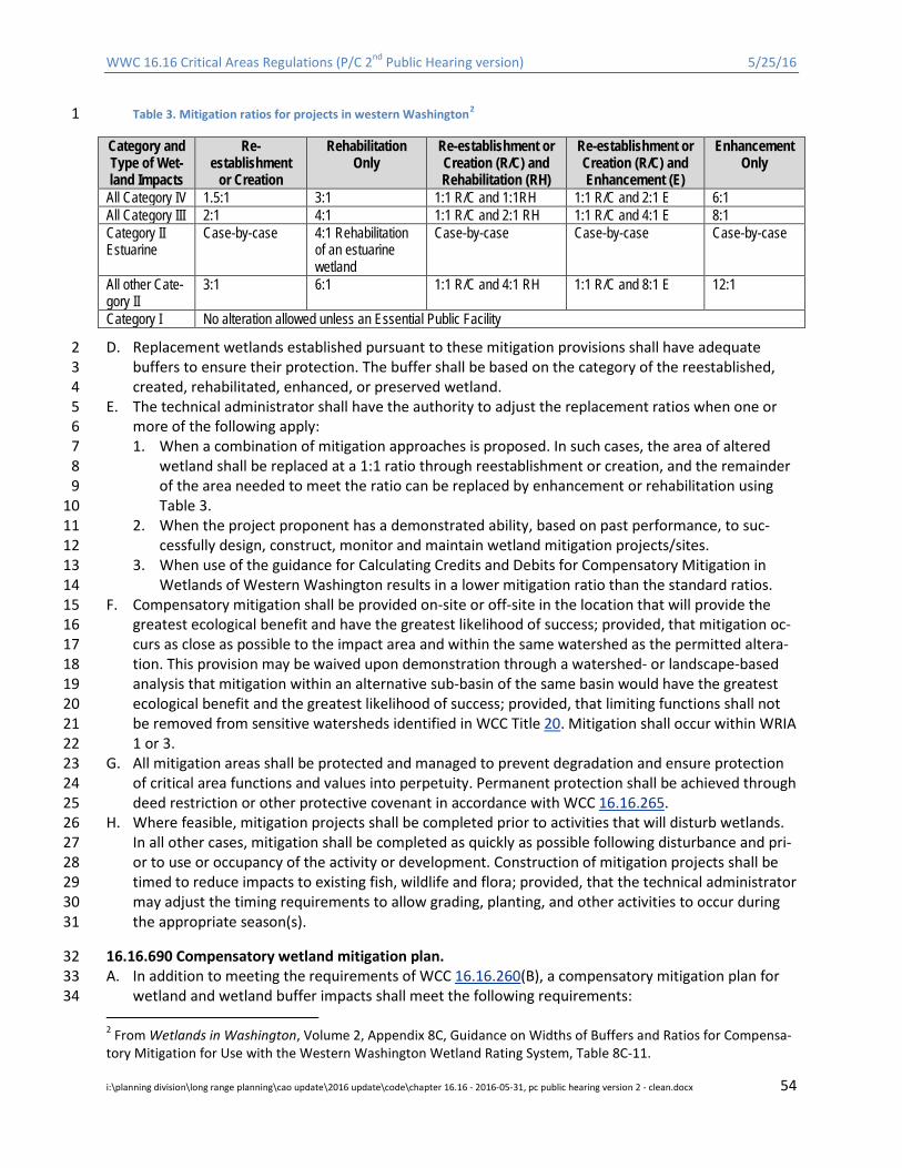
WWC 16.16 Critical Areas Regulations (P/C 2nd Public Hearing version) 5/25/16
Table 3. Mitigation ratios for projects in western Washington2 1
Category and Type of Wet-land Impacts
Re-establishment
or Creation
Rehabilitation Only
Re-establishment or Creation (R/C) and Rehabilitation (RH)
Re-establishment or Creation (R/C) and Enhancement (E)
Enhancement Only
All Category IV 1.5:1 3:1 1:1 R/C and 1:1RH 1:1 R/C and 2:1 E 6:1 All Category III 2:1 4:1 1:1 R/C and 2:1 RH 1:1 R/C and 4:1 E 8:1 Category II Estuarine
Case-by-case 4:1 Rehabilitation of an estuarine wetland
Case-by-case Case-by-case Case-by-case
All other Cate-gory II
3:1 6:1 1:1 R/C and 4:1 RH 1:1 R/C and 8:1 E 12:1
Category I No alteration allowed unless an Essential Public Facility
D. Replacement wetlands established pursuant to these mitigation provisions shall have adequate 2 buffers to ensure their protection. The buffer shall be based on the category of the reestablished, 3 created, rehabilitated, enhanced, or preserved wetland. 4
E. The technical administrator shall have the authority to adjust the replacement ratios when one or 5 more of the following apply: 6 1. When a combination of mitigation approaches is proposed. In such cases, the area of altered 7
wetland shall be replaced at a 1:1 ratio through reestablishment or creation, and the remainder 8 of the area needed to meet the ratio can be replaced by enhancement or rehabilitation using 9 Table 3. 10
2. When the project proponent has a demonstrated ability, based on past performance, to suc-11 cessfully design, construct, monitor and maintain wetland mitigation projects/sites. 12
3. When use of the guidance for Calculating Credits and Debits for Compensatory Mitigation in 13 Wetlands of Western Washington results in a lower mitigation ratio than the standard ratios. 14
F. Compensatory mitigation shall be provided on-site or off-site in the location that will provide the 15 greatest ecological benefit and have the greatest likelihood of success; provided, that mitigation oc-16 curs as close as possible to the impact area and within the same watershed as the permitted altera-17 tion. This provision may be waived upon demonstration through a watershed- or landscape-based 18 analysis that mitigation within an alternative sub-basin of the same basin would have the greatest 19 ecological benefit and the greatest likelihood of success; provided, that limiting functions shall not 20 be removed from sensitive watersheds identified in WCC Title 20. Mitigation shall occur within WRIA 21 1 or 3. 22
G. All mitigation areas shall be protected and managed to prevent degradation and ensure protection 23 of critical area functions and values into perpetuity. Permanent protection shall be achieved through 24 deed restriction or other protective covenant in accordance with WCC 16.16.265. 25
H. Where feasible, mitigation projects shall be completed prior to activities that will disturb wetlands. 26 In all other cases, mitigation shall be completed as quickly as possible following disturbance and pri-27 or to use or occupancy of the activity or development. Construction of mitigation projects shall be 28 timed to reduce impacts to existing fish, wildlife and flora; provided, that the technical administrator 29 may adjust the timing requirements to allow grading, planting, and other activities to occur during 30 the appropriate season(s). 31
16.16.690 Compensatory wetland mitigation plan. 32 A. In addition to meeting the requirements of WCC 16.16.260(B), a compensatory mitigation plan for 33
wetland and wetland buffer impacts shall meet the following requirements: 34
2 From Wetlands in Washington, Volume 2, Appendix 8C, Guidance on Widths of Buffers and Ratios for Compensa-tory Mitigation for Use with the Western Washington Wetland Rating System, Table 8C-11.
i:\planning division\long range planning\cao update\2016 update\code\chapter 16.16 - 2016-05-31, pc public hearing version 2 - clean.docx 54
WWC 16.16 Critical Areas Regulations (P/C 2nd Public Hearing version) 5/25/16
1. The plan shall be based on applicable portions of the Washington State Department of Ecology’s 1 Guidelines for Developing Freshwater Wetland Mitigation Plans and Proposals, 2004, or other 2 appropriate guidance document that is consistent with best available science. 3
2. The plan shall contain sufficient information to demonstrate that the proposed activities are lo-4 gistically feasible, constructible, ecologically sustainable, and likely to succeed. Specific infor-5 mation to be provided in the plan shall include: 6 a. The rationale for site selection; 7 b. General goals of the plan, including wetland function, value, and acreage; 8 c. Description of baseline (existing) site conditions including topography, vegetation, soils, hy-9
drology, habitat features (i.e., snags), surrounding land use, and other pertinent infor-10 mation; 11
d. Field data confirming the presence of adequate hydrology (surface and/or groundwater) to 12 support existing and compensatory wetland area(s); 13
e. Nature of mitigation activities, including area of restored, created, enhanced, rehabilitated 14 and preserved wetland, by wetland type; 15
f. Detailed grading and planting plans showing proposed post-construction topography; gen-16 eral hydrologic patterns; spacing and distribution of plant species; size and type of proposed 17 planting stock; watering or irrigation plans; and other pertinent information; 18
g. A description of site treatment measures including invasive species removal, use of mulch 19 and fertilizer, placement of erosion and sediment control devices, and best management 20 practices that will be used to protect existing wetlands and desirable vegetation; 21
h. A demonstration that the site will have adequate buffers sufficient to protect the wetland 22 functions in perpetuity. 23
B. All compensatory mitigation projects shall be monitored in accordance with WCC 16.16.260(C) for a 24 period necessary to establish that performance standards have been met. The technical administra-25 tor shall have the authority to extend the monitoring period for up to 10 years and require addition-26 al monitoring reports when any of the following conditions apply: 27 1. The project does not meet the performance standards identified in the mitigation plan. 28 2. The project does not provide adequate replacement for the functions and values of the impact-29
ed critical area. 30 3. The project involves establishment of forested plant communities, which require longer time for 31
establishment. 32 C. Reports shall be submitted annually for the first three years following construction and at the com-33
pletion of years five, seven and 10 if applicable to document milestones, successes, problems, and 34 contingency actions of the compensatory mitigation. 35
36
i:\planning division\long range planning\cao update\2016 update\code\chapter 16.16 - 2016-05-31, pc public hearing version 2 - clean.docx 55
WWC 16.16 Critical Areas Regulations (P/C 2nd Public Hearing version) 5/25/16
ARTICLE 7. HABITAT CONSERVATION AREAS (HCA) 1
16.16.700 Purpose. 2 The purposes of this article are to: 3 A. Protect, restore, and maintain native fish and wildlife populations by protecting and conserving fish 4
and wildlife habitat and protecting the ecological processes, functions and values, and biodiversity 5 that sustain these resources. 6
B. Protect marine shorelines, valuable terrestrial habitats, lakes, ponds, rivers, and streams and their 7 associated riparian areas, and the ecosystem processes on which these areas depend. 8
C. Regulate development so that isolated populations of species are not created and habitat degrada-9 tion and fragmentation are avoided. 10
D. Maintain the natural geographic distribution, connectivity, and quality of fish and wildlife habitat 11 and ensure no net loss of such important habitats, including cumulative impacts. 12
16.16.710 Habitat conservation areas – Designation, mapping, and classification. 13 A. Habitat conservation areas are those areas identified as being of critical importance to the mainte-14
nance of certain fish, wildlife, and/or plant species. These areas are typically identified either by 15 known point locations of specific species (such as a nest or den) or by habitat areas or both. All areas 16 within the County meeting these criteria are hereby designated critical areas and are subject to the 17 provisions of this article. 18
B. The approximate location and extent of identified fish, wildlife, and sensitive plant habitat areas are 19 shown on the County’s critical area maps as well as state and federal maps. However, these maps 20 are to be used as a guide and do not provide a definitive critical area determination; each applicant 21 is responsible for having a property-specific determination made pursuant to Article 2. The County 22 shall update the maps as new habitat conservation areas are identified and/or more comprehensive 23 information on function, condition, cover type, and resolution is developed. 24
C. Habitat conservation areas shall include all of the following: 25 1. Streams3. Streams, as defined in Article 9, shall be designated according to the following criteria: 26
a. Shoreline streams are those streams identified and regulated as shorelines of the state as 27 defined by WAC 173-18-410 and designated in the Whatcom County Shoreline Master Pro-28 gram (WCC Title 23). 29
b. Fish-bearing streams that do not meet the definition of shorelines of the state but have cur-30 rent, historic, or potential use by anadromous or resident fish species. The technical admin-31 istrator shall make determinations of known or potential fish use in consultation with feder-32 al, state, and tribal biologists and in accordance with best available science. Factors of con-33 sideration when determining a stream as fish bearing include but are not limited to species 34 life cycle requirements, habitat suitability, channel gradient, presence or lack of fish passage 35 barriers, stocked fish populations by government or tribal entities, and/or a reasoned evalu-36 ation of current, historic, and potential fish use by a qualified professional. 37
c. Non-fish-bearing streams are those streams that have no current, historic, or potential use 38 by anadromous or resident fish. 39
d. Streams do not include ditches as defined in Article 9. 40 2. Areas in which federally listed species are found, have a primary association with, or contain 41
suitable habitat for said listed species, as listed in the US Fish & Wildlife’s Threatened & Endan-42 gered Species List or Critical Habitat List (http://ecos.fws.gov/ecp/), as amended. 43
3 Note that ditched channels may or may not meet the definition of a stream. See Article 9, Definitions.
i:\planning division\long range planning\cao update\2016 update\code\chapter 16.16 - 2016-05-31, pc public hearing version 2 - clean.docx 56
WWC 16.16 Critical Areas Regulations (P/C 2nd Public Hearing version) 5/25/16
3. Areas in which state listed priority species are found, have a primary association with, or contain 1 suitable habitat for said listed species, as listed Washington Department of Fish and Wildlife’s 2 Priority Habitats and Species list (http://wdfw.wa.gov/mapping/phs/ or 3 http://wdfw.wa.gov/conservation/phs/list/), as amended. 4
4. State priority habitats and areas associated with state priority species as listed in Washington 5 Department of Fish and Wildlife’s Priority Habitats and Species list 6 (http://wdfw.wa.gov/mapping/phs/ or http://wdfw.wa.gov/conservation/phs/list/), as amend-7 ed.. 8
5. Areas in which state listed rare plant species are found, or contain suitable habitat for said listed 9 species, as listed in the Department of Natural Resources’ Natural Heritage Program 10 (http://www1.dnr.wa.gov/nhp/refdesk/plants.html), as amended. 11
6. Shellfish Habitat Conservation Areas. 12 7. Kelp and eelgrass beds. 13 8. Documented and potential spawning areas of forage fish, including but not limited to: surf 14
smelt, Pacific herring, Pacific sand lance, northern anchovy, and longfin smelt. 15 9. Naturally occurring ponds and lakes . In-stream ponds shall be regulated based on associated 16
stream type. 17 10. All other waters defined as Waters of the State, including marine waters. 18 11. Natural Area Preserves, Aquatic Reserves, and Natural Resource Conservation Areas as defined 19
by the Washington Department of Natural Resources. 20 12. Portions of the San Juan Islands National Monument within Whatcom County (including 21
Chuckanut Rock, tip of Eliza Island, Eliza Island Rocks, Lummi Rocks, Baker's Reef, Carter Point, 22 Carter Point Rock, and Seal Rock at the North end of Lummi Island, and subsequently designated 23 areas). 24
13. Frequently Flooded Areas that are subject to the Federal Emergency Management Agency’s Na-25 tional Flood Insurance Program Biological Opinion (FEMA BiOp). 26
14. Species and Habitats of Local Importance. Locally important species and habitats that have rec-27 reational, cultural, and/or economic value to citizens of Whatcom County, including the follow-28 ing: 29 a. Species. 30
i. The Department of Planning and Development Services shall maintain a current list of 31 Species of Local Importance as designated by the County Council. As of 2016 the list in-32 cludes: 33
1) Osprey; 34 2) Turkey Vulture; 35 3) Nooksack dace; 36 4) Salish sucker. 37
b. Habitats. 38 ii. The marine nearshore habitat, including coastal lagoons, and the associated vegetated 39
marine riparian zone. These areas support productive eelgrass beds, marine algal turf, and 40 kelp beds that provide habitat for numerous priority fish and wildlife species including, but 41 not limited to, forage fish, seabird and shorebird foraging and nesting sites, and harbor 42 seal pupping and haulout sites. This designation applies to the area from the extreme low 43 tide limit to the ordinary high water mark; provided, that reaches of the marine shoreline 44 that were lawfully developed for commercial and industrial uses prior to the original 45 adoption of this chapter may be excluded from this designation, but not otherwise ex-46 empt from this chapter. See Appendix A of this chapter. 47
i:\planning division\long range planning\cao update\2016 update\code\chapter 16.16 - 2016-05-31, pc public hearing version 2 - clean.docx 57

WWC 16.16 Critical Areas Regulations (P/C 2nd Public Hearing version) 5/25/16
iii. The Chuckanut wildlife corridor, which extends east from Chuckanut Bay and adjacent ma-1 rine waters, including Chuckanut Mountain, Lookout Mountain, the northern portions of 2 Anderson Mountain, and Stewart Mountain continuing along the southern Whatcom 3 County border to Mount Baker/Snoqualmie National Forest boundary. This area repre-4 sents the last remaining place in the Puget Trough where the natural land cover of the 5 Cascades continues to the shore of Puget Sound. 6
iv. The Department of Planning and Development Services shall maintain a current list and 7 map of Habitats of Local Importance, as designated by the County Council. 8
D. In addition to the species, habitats, and wildlife corridors identified in subsection (C)(14) of this sec-9 tion, the County may designate additional species, habitats of local importance, and/or wildlife cor-10 ridors as follows: 11 1. In order to nominate an area, species, or corridor to the category of “locally important,” an indi-12
vidual or organization must: 13 a. Demonstrate a need for special consideration based on: 14
i. Identified species of declining population; 15 ii. Documented species sensitivity to habitat manipulation and cumulative loss; 16
iii. Commercial, recreational, cultural, or, biological, other special value; or 17 iv. Maintenance of connectivity between habitat areas; 18
b. Propose conceptual relevant management strategies considered effective and within the 19 scope of this chapter; 20
c. Identify the general effects on property ownership and use; and 21 d. Provide a map showing the species or habitat location(s). 22
2. Submitted proposals shall be reviewed by the County and may be forwarded to the State De-23 partments of Fish and Wildlife, Natural Resources, and/or other local, state, federal, and/or trib-24 al agencies or experts for comments and recommendations regarding accuracy of data and ef-25 fectiveness of proposed management strategies. 26
3. If the proposal is found to be complete, accurate, and consistent with the purposes and intent of 27 this chapter and the various goals and objectives of the Whatcom County comprehensive plan 28 and the Growth Management Act, the County Council will hold a public hearing to solicit com-29 ment. Approved nominations will become designated locally important habitats, species, or cor-30 ridors and will be subject to the provisions of this chapter. 31
4. The Council may remove species, habitats, or corridors from this list if it can be shown that there 32 is no longer a need to provide protection above and beyond that afforded by WDFW manage-33 ment strategies. Species and habitats of local importance that are not regulated elsewhere in 34 this chapter may be removed if sufficient evidence has been provided by qualified professionals 35 that demonstrates that the species no longer meets any provisions of 16.16.710(D)(1)(a).” 36
16.16.720 Habitat conservation areas – General standards. 37 The following activities may be permitted in habitat conservation areas and/or their buffers when, pur-38 suant to Article 2, all reasonable measures have been taken to avoid adverse effects on species and hab-39 itats, any applicable Washington Department of Fish and Wildlife management recommendations have 40 been applied, compensatory mitigation is provided for all adverse impacts that cannot be avoided, and 41 the amount and degree of the alteration are limited to the minimum needed to accomplish the project 42 purpose; provided, that locally important species and habitats shall be subject to WCC 16.16.730: 43 A. Developments that meet the reasonable use and variance standards set forth in WCC 16.16.270. 44 B. Relocation of streams, or portions of streams, when there is no other feasible alternative and when 45
the relocation will result in equal or better habitat and water quality and quantity, and will not di-46 minish the flow capacity of the stream or other natural stream processes; provided, that the reloca-47
i:\planning division\long range planning\cao update\2016 update\code\chapter 16.16 - 2016-05-31, pc public hearing version 2 - clean.docx 58
WWC 16.16 Critical Areas Regulations (P/C 2nd Public Hearing version) 5/25/16
tion meets state hydraulic project approval requirements and that relocation of shoreline streams 1 shall be prohibited unless the relocation has been identified formally by the Washington State De-2 partment of Fish and Wildlife as essential for fish and wildlife habitat enhancement or identified in 3 watershed planning documents prepared and adopted pursuant to Chapter 90.82 RCW, the WRIA 1 4 Salmonid Recovery Plan or the WRIA 1 Salmon Recovery Board Habitat Project List or County shore-5 line restoration plan. 6
C. Stream crossings, provided they meet all the following criteria: 7 1. There is no other feasible alternative route with less impact on critical areas. 8 2. The crossing minimizes interruption of natural processes such as channel migration, the down-9
stream movement of wood and gravel, and the movement of all fish and wildlife. Bridges are 10 preferred for all stream crossings and should be designed to maintain the existing stream sub-11 strate and gradient, span the bankfull width, or be proven to not have an appreciable increase in 12 backwater elevation at a minimum of a 100-year event and provide adequate vertical clearance 13 for debris likely to be encountered at high water. 14
3. Culverts shall be designed according to applicable state and federal guidance criteria for fish 15 passage as identified in Water Crossing Design Guidelines, WDFW 2013, as amended, and/or the 16 National Marine Fisheries Service Guidelines for Salmonid Passage at Stream Crossings, 2000, 17 (and subsequent revisions) and in accordance with a state hydraulic project approval. The appli-18 cant or property owner shall maintain fish passage through the bridge or culvert. 19
4. The County may require that existing culverts be removed, replaced, or fish passage barrier sta-20 tus corrected as a condition of approval if the culvert is detrimental to fish passage or water 21 quality. 22
5. Roadway widths at culvert crossings shall be limited to the minimum width necessary to ac-23 commodate the roadway’s classification. Culvert length shall be the minimum that is compatible 24 with the roadway width. 25
6. Shared common crossings are the preferred approach where multiple properties can be ac-26 cessed by one crossing. 27
D. Access to private development sites may be permitted to cross habitat conservation areas if there 28 are no feasible alternative alignments. Alternative access shall be pursued to the maximum extent 29 feasible, including through the provisions of Chapter 8.24 RCW. Exceptions or deviations from tech-30 nical standards may be considered by the Technical Administrator on a case-by-case basis where the 31 resulting outcome reduces overall impacts to any identified Critical Area.. 32
E. Construction of a structure, other than a building, that is associated with an agricultural use in the 33 outer 25% of the CPAL designated buffer; or the reconstruction, remodeling, or maintenance of such 34 structures in a habitat conservation area buffer, subject to all of the following criteria: 35 1. The structure is located within an existing lot of record and is an ongoing agricultural use. 36 2. There is no other feasible location with less impact to critical areas. 37 3. Clearing and grading activity and impervious surfaces are limited to the minimum necessary to 38
accommodate the proposed structure and, where possible, surfaces shall be made of pervious 39 materials. 40
4. Unavoidable adverse effects on critical areas are mitigated in accordance with this chapter. 41 F. Stormwater management facilities limited to detention/retention/treatment ponds, media filtra-42
tion, lagoons and infiltration basins may be permitted in a stream buffer, subject to all of the follow-43 ing standards: 44 1. The facility is located in the outer 50% of the standard stream buffer and does not displace or 45
impact a forested riparian community; 46
i:\planning division\long range planning\cao update\2016 update\code\chapter 16.16 - 2016-05-31, pc public hearing version 2 - clean.docx 59

WWC 16.16 Critical Areas Regulations (P/C 2nd Public Hearing version) 5/25/16
2. There is no other feasible location for the stormwater facility and the facility is located, con-1 structed, and maintained in a manner that minimizes adverse effects on the buffer and adjacent 2 critical areas; 3
3. The stormwater facility meets applicable County or state stormwater management standards 4 and the discharge water meets state water quality standards; and 5
4. Low impact development approaches have been considered and implemented to the maximum 6 extent feasible. 7
G. Stormwater conveyance or discharge facilities such as dispersion trenches, level spreaders, and out-8 falls may be permitted in a habitat conservation area buffer on a case-by-case basis when the tech-9 nical administrator determines that all of the following are met: 10 1. Due to topographic or other physical constraints, there are no feasible locations for these facili-11
ties outside the buffer; 12 2. The discharge is located as far from the ordinary high water mark as possible and in a manner 13
that minimizes disturbance of soils and vegetation, except on shoreline slopes where location 14 shall be determined by site characteristics to minimize adverse impacts; 15
3. The discharge outlet is designed to prevent erosion and promote infiltration; and 16 4. The discharge meets freshwater and marine state water quality standards, including the need to 17
evaluate cumulative impacts to 303(d) impaired waterbodies and total maximum daily load 18 (TMDL) standards as appropriate at the point of discharge. Standards should include filtration 19 through mechanical or biological means, vegetation retention, timely reseeding of disturbed ar-20 eas, use of grass-lined bioswales for drainage, and other mechanisms as appropriate within ap-21 proved stormwater “special districts.” 22
5. The discharge outlet is designed to exclude fish from entering or migrating into stormwater con-23 veyance systems. 24
H. Clearing and grading, when allowed as part of an authorized activity or as otherwise allowed in 25 these standards, may be permitted; provided, that the following shall apply: 26 1. Grading is allowed only during the designated dry season, which is typically regarded as May to 27
October of each year; provided, that the County may extend or shorten the designated dry sea-28 son on a case-by-case basis, based on actual weather conditions. Special scrutiny shall be given 29 to Lakes Samish, Padden, and Whatcom watersheds, and Water Resource Special Management 30 Areas as described in WCC 20.80.735. 31
2. Appropriate erosion and sediment control measures shall be used at all times, consistent with 32 Best Management Practices in the Department of Ecology’s Stormwater Management Manual 33 for Wester Washington. The soil duff layer shall remain undisturbed to the maximum extent 34 possible. Where feasible, disturbed topsoil shall be salvaged and/or redistributed to other areas 35 of the site. Areas shall be revegetated as needed to stabilize the site. 36
3. The moisture-holding and infiltration capacity of the topsoil layer shall be maintained by mini-37 mizing soil compaction or reestablishing natural soil structure and infiltrative capacity on all are-38 as of the project area not covered by impervious surfaces. 39
I. Streambank stabilization and shoreline protection may be permitted subject to all of the following 40 standards: 41 1. The stabilization or protection measures shall be designed in accordance with the Washington 42
Department of Fish and Wildlife’s most recent Integrated Streambank Protection Guidelines. 43 2. Natural shoreline processes will be maintained to the maximum extent practicable. 44 3. The activity will not result in increased erosion and will not alter the size or distribution of shore-45
line or stream substrate, or eliminate or reduce sediment supply from feeder bluffs. 46 4. Stream and shoreline protection and launching ramps on shorelines of the state shall comply 47
with WCC Title 23 and with state hydraulic project approval requirements. 48
i:\planning division\long range planning\cao update\2016 update\code\chapter 16.16 - 2016-05-31, pc public hearing version 2 - clean.docx 60
WWC 16.16 Critical Areas Regulations (P/C 2nd Public Hearing version) 5/25/16
5. No net loss to critical fish or wildlife habitat areas or associated wetlands will occur. 1 6. No net loss of juvenile fish migration corridors will occur. 2 7. No net loss of intertidal or riparian habitat function will occur. 3 8. Nonstructural measures, such as placing or relocating the development further from the shore-4
line, planting vegetation, or installing on-site drainage improvements, are not practicable or not 5 sufficient. 6
9. Stabilization is achieved through bioengineering or soft armoring techniques in accordance with 7 an applicable Hydraulic Permit Approval issued by the Washington State Department of Fish and 8 Wildlife. 9
10. Hard bank armoring is discouraged and may occur only when the property contains an existing 10 permanent structure(s) that is in danger from shoreline erosion caused by wave action or river-11 ine processes and not erosion caused by upland conditions, such as the alteration of natural 12 vegetation or drainage, and the armoring shall not increase erosion on adjacent properties and 13 shall not eliminate or reduce sediment supply. An objective alternatives analysis, addressing up- 14 and downstream impacts, shall be conducted to demonstrate that there is no other less envi-15 ronmentally damaging alternatives to the more impacting proposed action. 16
11. Normal sloughing, erosion of steep bluffs, or shoreline erosion itself, without a scientific or ge-17 otechnical analysis, is not a demonstration of need. 18
12. The bank stabilization or shore protection will not adversely affect habitat conservation areas or 19 mitigation will be provided to compensate for adverse effects where avoidance is not feasible. 20
J. Construction of trails and roadways may be permitted in a habitat conservation area buffer when 21 not directly related to a crossing and are subject to all of the following standards: 22 1. There is no other feasible alternative route with less impact on the critical area. 23 2. The road or trail minimizes erosion and sedimentation, hydrologic alteration, and disruption of 24
natural processes such as channel migration, wood recruitment and natural wildlife movement 25 patterns. 26
3. The road or trail through riparian (stream) buffer shall be located in the outer 25% of the stand-27 ard buffer. 28
4. Private trails shall not exceed 5 feet in width, and public trails shall not exceed 10 feet in width, 29 and shall be made of pervious material or on an elevated structure where feasible. Trails may 30 include limited viewing platforms that shall not exceed 12 feet in width and shall be made of 31 pervious materials where feasible. 32
5. The road or trail is constructed and maintained in a manner that minimizes disturbance of the 33 buffer and associated critical areas. 34
K. New utility lines and facilities may be permitted when all of the following criteria are met: 35 1. Impacts to fish and wildlife habitat and/or corridors shall be avoided to the maximum extent 36
possible. 37 2. Where feasible, installation shall be accomplished by boring beneath the scour depth of the 38
stream or water body and the width of the channel migration zone where present. 39 3. Trenching of utilities across a stream channel shall be conducted as perpendicular to the chan-40
nel centerline as possible whenever boring under the channel is not feasible. Utilities shall be in-41 stalled below potential scour depth regardless of method. 42
4. Crossings shall be contained within the footprint of an existing road or utility crossing where 43 possible. 44
5. The utility installation shall not increase or decrease the natural rate, extent, or opportunity of 45 channel migration. 46
L. New public flood protection measures and expansion of existing ones may be permitted, subject to 47 WCC Title 17, Article 4 of this chapter and a state hydraulic project approval; provided, that bioengi-48
i:\planning division\long range planning\cao update\2016 update\code\chapter 16.16 - 2016-05-31, pc public hearing version 2 - clean.docx 61
WWC 16.16 Critical Areas Regulations (P/C 2nd Public Hearing version) 5/25/16
neering or soft armoring techniques shall be used where feasible. Hard bank armoring may occur 1 only in situations where soft approaches do not provide adequate protection. 2
M. In-stream structures such as, but not limited to, high-flow bypasses, dams, and weirs, shall be al-3 lowed only as part of a watershed restoration project as defined pursuant to WCC 23.110.230(10) or 4 identified in watershed planning documents prepared and adopted under Chapter 90.82 RCW, the 5 salmonid recovery plan or Salmon Recovery Board Habitat Project List, and the County’s shoreline 6 restoration plan and upon acquisition of any required state or federal permits. The structure shall be 7 designed to avoid adverse effects on stream flow, water quality, or other habitat functions and val-8 ues. 9
N. Construction, reconstruction, repair, and maintenance of docks and public launching ramps may be 10 permitted subject to the following: 11 1. The dock or ramp is located and oriented and constructed in a manner that minimizes adverse 12
effects on navigation; wave action, water quality, movement of aquatic and terrestrial life; eco-13 logical processes; eelgrass beds, shellfish beds, spawning habitat, wetlands, or other critical are-14 as. 15
2. Docks or ramps on shorelines of the state shall comply with WCC Title 23 and state hydraulic 16 project approval requirements. 17
3. Natural shoreline processes will be maintained to the maximum extent practicable. The activity 18 will not result in increased erosion and will not alter the size or distribution of shoreline or 19 stream substrate, or eliminate or reduce sediment supply from feeder bluffs. 20
4. No net loss to critical fish or wildlife habitat areas or associated wetlands will occur. 21 5. No net loss of juvenile fish migration corridors will occur. 22 6. No net loss of intertidal or riparian habitat function will occur. 23
O. On-site sewage disposal systems (OSS) may be permitted in the outer 50% of HCA buffers when ac-24 cessory to an approved residential structure for which there are no alternatives and when it is not 25 feasible to connect to a public sanitary sewer system and when operated and maintained in accord-26 ance with WCC 24.05.170; provided, that there are no adverse effects on water quality and slope 27 stability. 28
P. Domestic wells serving single-family developments (including plats, short plats, and individual single-29 family residences) and necessary appurtenances, including a pump and appropriately sized pump 30 house, but not including a storage tank, in HCA buffers when all of the following conditions are met: 31 1. There is no viable alternative to the well site outside of the buffer and the well is located as far 32
back from the wetland edge as is feasible; 33 2. Any impacts to the HCA buffer from staging equipment and the well-drilling process are mitigat-34
ed. 35 Q. Single-family developments may be permitted to encroach into stream buffers subject to the tech-36
nical administrator’s approval; provided, that all of the criteria in WCC 16.16.270(A) are met. 37 R. All other development may be allowed in shellfish protection districts outside of actual shellfish hab-38
itats with a valid development permit and when the requirements of subsection O of this section are 39 met. 40
S. Alteration or removal of beaver-built structures more than two years old; provided, that: 41 1. The property owner can show that the beaver dam is harming or likely to harm his or her prop-42
erty. 43 2. It has been demonstrated that beaver deceivers or auto leveler devices cannot appropriately re-44
solve ponding/backwatering that is negatively affecting adjacent land or property.. 45 3. Impacts to wetland, river, or stream functions are minimized and mitigation is provided to com-46
pensate for lost ecological value. 47
i:\planning division\long range planning\cao update\2016 update\code\chapter 16.16 - 2016-05-31, pc public hearing version 2 - clean.docx 62
WWC 16.16 Critical Areas Regulations (P/C 2nd Public Hearing version) 5/25/16
4. The property owner obtains an HPA from WDFW prior to initiating alteration or removal of the 1 beaver-built structure. 2
5. The property owner provides a copy of the HPA to the technical administrator. 3 T. On Eliza Island, WCC 20.35.653 (Bald eagle management plan) shall also apply. 4
16.16.730 Locally important habitats and species – Standards. 5 Alterations that occur within a locally important habitat area or that may affect a locally important spe-6 cies as defined herein shall be subject to review on a case-by-case basis. The technical administrator 7 shall have the authority to require an assessment of the effects of the alteration on species or habitats 8 and may require mitigation to ensure that unmitigated adverse effects do not occur. This standard is 9 intended to allow for flexibility and responsiveness with regard to locally important species and habitats. 10
16.16.740 Habitat conservation area buffers – Standards. 11 In addition to the applicable general protective measures found in WWC 16.16.265 and 16.16.720, the 12 technical administrator shall have the authority to require buffers from the edges of all habitat conser-13 vation areas (in addition to the building setback required by 16.16.265(D) in accordance with the follow-14 ing: 15 1) Buffers shall be established for activities adjacent to habitat conservation areas as necessary to pro-16
tect the integrity, functions, and values of the resource. Buffer widths shall reflect the sensitivity of 17 the species or habitat present and the type and intensity of the proposed adjacent human use or ac-18 tivity. Buffers shall not include areas that are functionally and effectively disconnected from the hab-19 itat area by an existing, legally established road or other substantial developed surface. 20
2) Stream Buffers. 21 1. The standard buffer widths required by this article are considered to be the minimum required 22
and presume the existence of a dense vegetation community in the buffer zone adequate to 23 protect the stream functions and values at the time of the proposed activity. When a buffer 24 lacks adequate vegetation to protect critical area functions, the technical administrator may in-25 crease the standard buffer, require buffer planting or enhancement, and/or deny a proposal for 26 buffer reduction or buffer averaging. 27
2. The standard buffer shall be measured landward horizontally on both sides of the stream from 28 the ordinary high water mark as identified in the field; provided, that for streams with identified 29 channel migration zones, the buffer shall extend outward horizontally from the outer edge of 30 the channel migration zone on both sides. The required buffer shall be extended to include any 31 abutting regulated wetland(s), landslide hazard areas and/or erosion hazard areas and required 32 buffers, but shall not be extended across roads or other lawfully established structures or hard-33 ened surfaces. 34
3. The following standard buffer width requirements are established: 35 i. Shoreline streams: 150 feet; 36
ii. Fish-bearing streams: 100 feet; 37 iii. Non-fish-bearing streams: 50 feet. 38
4. Portions of streams that flow underground may be exempt from these buffer standards at the 39 technical administrator’s discretion when it can be demonstrated that no adverse effects on 40 aquatic species will occur. 41
3) Buffers for Other Habitat Conservation Areas. The technical administrator shall determine appropri-42 ate buffer widths for other habitat conservation areas based on the best available information. 43 Buffer widths for non-stream habitat conservation areas shall be as identified in Table 4: 44
i:\planning division\long range planning\cao update\2016 update\code\chapter 16.16 - 2016-05-31, pc public hearing version 2 - clean.docx 63
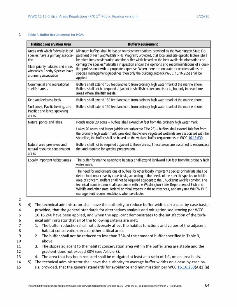
WWC 16.16 Critical Areas Regulations (P/C 2nd Public Hearing version) 5/25/16
Table 4. Buffer Requirements for HCAs 1
Habitat Conservation Area Buffer Requirement Areas with which federally listed species have a primary associa-tion
Minimum buffers shall be based on recommendations provided by the Washington State De-partment of Fish and Wildlife PHS Program; provided, that local and site-specific factors shall be taken into consideration and the buffer width based on the best available information con-cerning the species/habitat(s) in question and/or the opinions and recommendations of a quali-fied professional with appropriate expertise. When there are no state recommendations or species management guidelines then only the building setback (WCC 16.16.255) shall be applied.
State priority habitats and areas with which Priority Species have a primary association
Commercial and recreational shellfish areas
Buffers shall extend 150 feet landward from ordinary high water mark of the marine shore. Buffers shall not be required adjacent to shellfish protection districts, but only in nearshore areas where shellfish reside.
Kelp and eelgrass beds Buffers shall extend 150 feet landward from ordinary high water mark of the marine shore. Surf smelt, Pacific herring, and Pacific sand lance spawning areas
Buffers shall extend 150 feet landward from ordinary high water mark of the marine shore.
Natural ponds and lakes Ponds under 20 acres – buffers shall extend 50 feet from the ordinary high water mark.
Lakes 20 acres and larger (which are subject to Title 23) – buffers shall extend 100 feet from the ordinary high water mark; provided, that where vegetated wetlands are associated with the shoreline, the buffer shall be based on the wetland buffer requirements in WCC 16.16.630.
Natural area preserves and natural resource conservation areas
Buffers shall not be required adjacent to these areas. These areas are assumed to encompass the land required for species preservation.
Locally important habitat areas The buffer for marine nearshore habitats shall extend landward 150 feet from the ordinary high water mark. The need for and dimensions of buffers for other locally important species or habitats shall be determined on a case-by-case basis, according to the needs of the specific species or habitat area of concern. Buffers shall not be required adjacent to the Chuckanut wildlife corridor. The technical administrator shall coordinate with the Washington State Department of Fish and Wildlife and other state, federal or tribal experts in these instances, and may use WDFW PHS management recommendations when available.
2 4) The technical administrator shall have the authority to reduce buffer widths on a case-by-case basis; 3
provided, that the general standards for alternatives analysis and mitigation sequencing per WCC 4 16.16.260 have been applied, and when the applicant demonstrates to the satisfaction of the tech-5 nical administrator that all of the following criteria are met: 6 1. The buffer reduction shall not adversely affect the habitat functions and values of the adjacent 7
habitat conservation area or other critical area. 8 2. The buffer shall not be reduced to less than 75% of the standard buffer specified in Table 3, 9
above. 10 3. The slopes adjacent to the habitat conservation area within the buffer area are stable and the 11
gradient does not exceed 30% (see Article 3). 12 4. The area that has been reduced shall be mitigated at least at a ratio of 1:1, on an area basis. 13
5) The technical administrator shall have the authority to average buffer widths on a case-by-case ba-14 sis; provided, that the general standards for avoidance and minimization per WCC 16.16.260(A)(1)(a) 15
i:\planning division\long range planning\cao update\2016 update\code\chapter 16.16 - 2016-05-31, pc public hearing version 2 - clean.docx 64
WWC 16.16 Critical Areas Regulations (P/C 2nd Public Hearing version) 5/25/16
and (b) shall apply, and when the applicant demonstrates to the satisfaction of the technical admin-1 istrator that all of the following criteria are met: 2 1. The total area contained in the buffer area after averaging is no less than that which would be 3
contained within the standard buffer and all increases in buffer dimension are parallel to the 4 habitat conservation area. 5
2. The buffer averaging does not reduce the functions or values of the habitat conservation area or 6 riparian habitat, or the buffer averaging, in conjunction with vegetation enhancement, increases 7 the habitat function. 8
3. The buffer averaging is necessary due to site constraints caused by existing physical characteris-9 tics such as slope, soils, or vegetation. 10
4. The buffer width is not reduced to less than 75% of the standard width specified in Table 3, 11 above. 12
5. The slopes adjacent to the habitat conservation area within the buffer area are stable and the 13 gradient does not exceed 30%. 14
6. Buffer averaging shall not be allowed if habitat conservation area buffers are reduced pursuant 15 to subsection D of this section. 16
7. Where a buffer has been reduced, the Technical Administrator may require enhancement to the 17 remaining buffer to ensure no net loss of ecologic function, services, or value. 18
6) The technical administrator shall have the authority to increase the width of a habitat conservation 19 area buffer on a case-by-case basis when there is clear evidence that such increase is necessary to 20 achieve any of the following: 21 1. Comply with the requirements of a habitat management plan prepared pursuant to WCC 22
16.16.750. 23 2. Protect fish and wildlife habitat, maintain water quality, ensure adequate flow conveyance, pro-24
vide adequate recruitment for large woody debris, maintain adequate stream temperatures, or 25 maintain in-stream conditions. 26
3. Compensate for degraded vegetation communities, Clean Water Act 303(d) impaired water bod-27 ies, or steep slopes adjacent to the habitat conservation area. 28
4. Maintain areas for channel migration and/or frequently flooded areas. 29 5. Protect adjacent or downstream areas from erosion, landslides, or other hazards. 30 6. Protect streams from high intensity adjacent land uses. 31
16.16.750 Habitat conservation areas – Review and reporting requirements. 32 A. When County critical area maps or other sources of credible information indicate that a site pro-33
posed for development or alteration is more likely than not to contain habitat conservation areas or 34 buffers, or could adversely affect a habitat area or buffer, the technical administrator shall require a 35 site evaluation (field investigation) by a qualified professional or other measures to determine 36 whether or not the species or habitat is present. If no habitat conservation areas are present, then 37 review will be considered complete. If the site evaluation determines that the species or habitat is 38 present, the technical administrator shall require a critical areas assessment report or habitat man-39 agement plan (HMP). 40
B. In addition to the reporting requirements of WCC 16.16.255, the Habitat Conservation Area assess-41 ment report/HMP shall describe the characteristics of the subject property and adjacent areas, in-42 cluding condition, quality, function, and values of the Habitat Conservation Area at a scale appropri-43 ate to the function being evaluated (see WAC 365-196-830(6)). The assessment shall include deter-44 mination of appropriate buffers as set forth in WCC 16.16.740. The assessment shall also include 45 field identification and/or delineation of habitat areas, analysis of historical aerial photos, review of 46 public records, and interviews with adjacent property owners as necessary to determine potential 47
i:\planning division\long range planning\cao update\2016 update\code\chapter 16.16 - 2016-05-31, pc public hearing version 2 - clean.docx 65

WWC 16.16 Critical Areas Regulations (P/C 2nd Public Hearing version) 5/25/16
effects of the development action on critical areas. Assessment reports shall include the following 1 site- and proposal-related information unless the technical administrator determines that any por-2 tion of these requirements is unnecessary given the scope and/or scale of the proposed develop-3 ment: 4 1. A map drawn to a common scale or survey showing the following information: 5
a. Topographic, hydrologic, and vegetative features. 6 b. The location and description of wildlife and habitat features, and all critical areas on or with-7
in 200 feet of the site, or farther given the scale appropriate to the function being evaluat-8 ed. 9
c. Proposed development activity. 10 d. Existing physical features of the site including buildings, fences, and other structures, roads, 11
parking lots, utilities, water bodies, etc. 12 e. Surrounding land uses and zoning (to ensure appropriate buffer) 13
2. An analysis, including an analysis of cumulative impacts, of how the proposed development ac-14 tivities will affect the fish and wildlife habitat conservation area and/or buffer, including the ar-15 ea of direct disturbance; effects of stormwater management; effects on any 303(d) impaired 16 waterbodies; proposed alteration to surface or subsurface hydrology; natural drainage or infil-17 tration patterns; clearing and grading impact; temporary construction impacts; effects of in-18 creased intensity of use (including noise, light, human intrusion, etc.). 19
3. Provisions to reduce or eliminate adverse impacts of the proposed development activities on 20 the functions and values of the Habitat Conservation Area including, but not limited to: 21 a. Buffering; 22 b. Clustering of development; 23 c. Retention of native vegetation; 24 d. Access limitations; 25 e. Seasonal restrictions on construction activities in accordance with the guidelines developed 26
by the Washington State Department of Fish and Wildlife, the U.S. Army Corps of Engineers, 27 the salmonid recovery plan and/or other agency or tribe with expertise and jurisdiction over 28 the subject species/habitat; and 29
f. Other appropriate and proven low impact development techniques. 30 4. Management recommendations developed by WDFW through its PHS program. 31 5. Additional information including, but not limited to, direct observations of species use or de-32
tailed physical and biological characteristics both on and off-site at an appropriate scale (see 33 WAC 365-196-830(6))). The assessment of off-site conditions shall be based on available infor-34 mation and shall not require accessing off-site properties. 35
6. Bald eagle habitats shall be protected pursuant to the Washington State Bald Eagle Protection 36 Rules (WAC 232-12-292), the provisions of which require a site management plan be developed 37 in coordination between the WDFW and landowner whenever projects are proposed on land 38 that involves land containing or adjacent to an eagle nest or communal roost site. The County 39 shall issue development permits only after certification from the WDFW that the development is 40 in compliance with an approved habitat management plan. (See WAC 232-12-292 for specific 41 details.) 42
C. All habitat management plans shall be prepared in consultation with the State Department of Fish 43 and Wildlife and/or other federal, state, local or tribal resource agencies with jurisdiction and exper-44 tise in the subject species/habitat. 45
D. At the request of the applicant, the County may gather the required information in this section for 46 applicants seeking to develop a single-family home; provided, that: 47
i:\planning division\long range planning\cao update\2016 update\code\chapter 16.16 - 2016-05-31, pc public hearing version 2 - clean.docx 66
WWC 16.16 Critical Areas Regulations (P/C 2nd Public Hearing version) 5/25/16
1. Availability of County staff shall be at the discretion of the technical administrator and subject to 1 workload and scheduling constraints. 2
2. Fees for County staff services shall be in accordance with the unified fee schedule. 3
16.16.760 Habitat conservation areas – Mitigation standards. 4 Activities that adversely affect habitat conservation areas and/or their buffers as determined by the 5 technical administrator shall include mitigation sufficient to achieve no net loss of habitat functions and 6 values in accordance with WCC 16.16.260 and this section. 7 A. In determining the extent and type of mitigation required, the technical administrator may consider 8
all of the following: 9 1. The ecological processes that affect and influence critical area structure and function within the 10
watershed or sub-basin; 11 2. The individual and cumulative effects of the action upon the functions of the critical area and 12
associated watershed; 13 3. Observed or predicted trends regarding the gains or losses of specific habitats or species in the 14
watershed, in light of natural and human processes; 15 4. The likely success of the proposed mitigation measures; 16 5. Effects of the mitigation actions on neighboring properties; and 17 6. Opportunities to implement restoration actions formally identified by an adopted shoreline res-18
toration plan, watershed planning document prepared and adopted pursuant to Chapter 90.82 19 RCW, a salmonid recovery plan or project that has been identified on the Salmon Recovery 20 Board Habitat Project List or by the Washington State Department of Fish and Wildlife as essen-21 tial for fish and wildlife habitat enhancement. 22
B. The following additional mitigation standards shall apply: 23 1. Compensatory mitigation for alterations to habitat areas shall achieve equivalent or greater bio-24
logic functions, and shall provide similar functions to those that are lost or altered. 25 2. Compensatory mitigation in the form of habitat restoration or enhancement is required when a 26
habitat is altered permanently as a result of an approved project. Alterations shall not result in 27 net loss of habitat. 28
3. Where feasible, mitigation projects shall be completed prior to activities that will disturb habitat 29 conservation areas. In all other cases, mitigation shall be completed as quickly as possible fol-30 lowing disturbance and prior to use or occupancy of the activity or development. Construction 31 of mitigation projects shall be timed to reduce impacts to existing fish, wildlife and flora; provid-32 ed, that the technical administrator may adjust the timing requirements to allow grading, plant-33 ing, and other activities to occur during the appropriate season(s). 34
4. Compensatory mitigation shall be provided on-site whenever feasible. Off-site mitigation in a lo-35 cation that will provide a greater ecological benefit to the species and/or habitats affected and 36 have a greater likelihood of success may be accepted at the discretion of the Technical Adminis-37 trator. Mitigation shall occur as close to the impact site as possible. As mitigation is moved fur-38 ther away from the impacted habitat the Technical Administrator may increase the amount of 39 mitigation required. If offsite mitigation is proposed, the applicant must demonstrate through 40 an alternatives/ mitigation sequencing analysis (WWC 16.16.260) that the mitigation will have 41 greater ecological benefit. 42
5. All mitigation sites shall have buffers consistent with the buffer requirements established in 43 16.16.740; provided, that the technical administrator shall have the authority to approve a 44 smaller buffer when existing site constraints (such as a road) prohibit attainment of the standard 45 buffer. Mitigation actions shall not create buffer encumbrances on adjoining properties. 46
i:\planning division\long range planning\cao update\2016 update\code\chapter 16.16 - 2016-05-31, pc public hearing version 2 - clean.docx 67

WWC 16.16 Critical Areas Regulations (P/C 2nd Public Hearing version) 5/25/16
6. The technical administrator shall require annual monitoring of mitigation activities and submit-1 tal of annual monitoring reports in accordance with WCC 16.16.260(C) to ensure and document 2 that the goals and objectives of the mitigation are met. The frequency and duration of the moni-3 toring shall be based on the specific needs of the project as determined by the technical admin-4 istrator. 5
7. Mitigation projects involving in-stream work including, but not limited to, installation of large 6 woody debris shall be designed to ensure there are no adverse hydraulic effects on upstream or 7 downstream properties. The County River and Flood Division shall review any such mitigation 8 projects for compliance with this provision. 9
8. On a case-by-case basis, the Technical Administrator shall have the authority to require mitiga-10 tion for impacts to a Habitat Conservation Area at the following ratios: 11 i. Where the mitigation is placed after the impact occurs, at a 1.25:1 ratio (area or function); 12
and, 13 ii. Where the mitigation is in place and functional before the impacts occur (i.e., advanced mit-14
igation), at a 1:1 ratio (area or function).15
i:\planning division\long range planning\cao update\2016 update\code\chapter 16.16 - 2016-05-31, pc public hearing version 2 - clean.docx 68
WWC 16.16 Critical Areas Regulations (P/C 2nd Public Hearing version) 5/25/16
ARTICLE 8. CONSERVATION PROGRAM ON AGRICULTURE LANDS 1
(CPAL) 2
16.16.800 Purpose. 3 A. The well-being of farms and ranches in Whatcom County depends in part on good quality soil, wa-4
ter, air, and other natural resources. Agricultural operations that incorporate protection of the envi-5 ronment, including critical areas and their buffers as defined by this chapter, are essential to achiev-6 ing this goal. 7
B. The purpose of the CPAL program is to allow farmers practicing ongoing agricultural activities that 8 may affect critical areas, their functions and values, and/or their buffers to do so either (i) in accord-9 ance with the standard requirements of this chapter or (ii) pursuant to a conservation farm plan vol-10 untarily prepared and approved pursuant to this Article. If farmers and ranchers are willing to enter 11 into the CPAL program, then flexibility in these provisions may be extended to them. If not, then 12 then they must observe the standard provisions of this Chapter. 13
C. This program shall be subject to continued monitoring and adaptive management to ensure that it 14 meets the purpose and intent of this chapter. 15
16.16.810 Resource Concerns. 16 Agricultural operations have the potential to create adverse impacts to critical areas. It is the County’s 17 policy to minimize such impacts. 18 A. Nutrient Pollution of Water. Animal waste contains nutrients (nitrogen and phosphorous). With 19
each rain, these wastes can wash off the land and into the nearest stream, lake, or wetland. In sur-20 face water, phosphorous and nitrogen fertilize aquatic plants and weeds. As the plants and weeds 21 proliferate and decay, the dissolved oxygen that fish need to survive is depleted. Nitrogen in the 22 form of nitrate is easily dissolved in and carried with rainfall through our permeable soils to 23 groundwater. Nitrate concentrations exceeding the maximum contaminate level for safe drinking 24 water are found in many wells of Whatcom County. These can present a significant human health 25 risk, particularly to the very old and young. 26
B. Pathogen Pollution of Water. Manure contains bacteria and other pathogens. These can make the 27 water unfit for drinking without treatment or shellfish unfit for human consumption. They can also 28 make water unsafe for human contact and recreational sports such as fishing, swimming or water 29 skiing. Both surface and groundwater are vulnerable to this type of pollution. 30
C. Sediment Pollution to Surface Water. Regardless of the amount of supplemental feed provided, 31 large animals will continue grazing until all palatable vegetation is gone. On especially small lots (one 32 or two acres), the animals that are allowed free and continuous access to vegetation quickly graze-33 out and trample pasture grasses and forbs. These areas are then susceptible to invasion by weeds, 34 including noxious weeds, and brush. The resulting bare ground is subject to erosion from wind and 35 water. Lands that lack adequate vegetation are subject to erosion, and contaminated runoff from 36 these areas can enter water bodies and wetlands and interfere with fish and wildlife habitat. 37
D. Degradation of Riparian Areas. The term “riparian” is defined in Article 9 of this chapter and includes 38 the areas adjacent to streams, lakes, marine shorelines and other waters. A healthy riparian area is 39 essential to protecting fish and wildlife, including salmon and shellfish. Dense riparian vegetation 40 along the water’s edge will slow and protect against flood flows; provide infiltration and filtering of 41 pollutants; secure food and cover for fish, birds and wildlife; and keep water cooler in summer. Un-42 controlled grazing removes important riparian vegetation. 43
i:\planning division\long range planning\cao update\2016 update\code\chapter 16.16 - 2016-05-31, pc public hearing version 2 - clean.docx 69
WWC 16.16 Critical Areas Regulations (P/C 2nd Public Hearing version) 5/25/16
16.16.820 Classification and Applicability. 1 A. A conservation farm plan identifies the farming or ranching activities and the practice(s) necessary 2
to avoid their potential negative impacts (resource concerns). Practice selection depends upon the 3 types of livestock raised and crops grown. Based upon the type and intensity of the operation, some 4 generalizations can be made as to the resource concerns and remedies that apply. 5
B. Some operations present relatively low risks to critical areas because of their benign nature, timing, 6 frequency, or location. For these operations, the resource concerns and remedies are relatively easy 7 to identify and implement. These are described in more detail as Type 1 agricultural operations sub-8 ject to standardized conservation farm plans in Sections 16.16.830 and 16.16.840(A). 9
C. Where the potential negative impacts to critical areas are moderate or high, solutions are more dif-10 ficult to formulate and implement. In those circumstances, a more rigorous planning process is re-11 quired. In such cases, a formal written plan shall provide the desired environmental protection. 12 These types of operations are described as agricultural operations requiring custom conservation 13 farm plans in Sections 16.16.830 and 16.16.840(B or C). 14
D. Agricultural activities that qualify for coverage include: 15 1. Type 1 Operations. 16
a. To qualify as a Type 1 operation, a farm shall not exceed one animal unit per one acre of 17 grazable pasture (row and berry crops do not qualify as Type 1). These operations present a 18 low potential risk to critical area degradation including ground/surface water contamination 19 because the animals kept generate fewer nutrients than can be used by the crops grown 20 there. 21
b. Critical areas on Type 1 operations are protected against the potential negative impacts of 22 agricultural activities through the implementation of an approved standard conservation 23 farm plan prepared in accordance with Sections 16.16.830 and 16.16.840(A). 24
c. Those operators qualifying for a Type I (standard) conservation farm plan may elect to do a 25 Type II (custom) conservation farm plan if they want to use “Prescribed Grazing” (NRCS 26 Practice 528A) to manage vegetative filter strips installed alongside critical areas. 27
2. Type 2 Operations. 28 a. Type 2 operations are farms that exceed one animal unit per one acre of grazable pasture; 29
farms that have orchards, vineyards, small-fruit field or row crops; and drainage improve-30 ment districts. These operations present a potential moderate risk to critical area degrada-31 tion, including ground or surface water contamination, because the nutrients applied from 32 manure or commercial fertilizers may exceed that which can be easily used by the crops 33 grown there without careful planning and management. The agricultural activities are also 34 likely to be much more intense than Type 1 operations, posing greater potential risks to 35 other critical areas. 36
b. Critical areas on Type 2 operations are protected against the potential negative impacts of 37 agricultural activities through the implementation of an approved custom conservation farm 38 plan prepared in accordance with Sections 16.16.830 and 16.16.840(B). 39
3. Type 3 Operations. 40 a. Type 3 operations include dairies and animal feeding operations/concentrated animal feed-41
ing operations (AFO/CAFOs). These operations are already regulated by state and federal 42 governments (see Chapter 90.64 RCW et seq.; 40 CFR 122.23 and 40 CFR Part 412). 43
b. Critical areas are protected against the potential negative impacts of Type 3 agricultural ac-44 tivities through the implementation of an approved custom conservation farm plan pre-45 pared in accordance with Sections 16.16.830 and 16.16.840(C). 46
i:\planning division\long range planning\cao update\2016 update\code\chapter 16.16 - 2016-05-31, pc public hearing version 2 - clean.docx 70

WWC 16.16 Critical Areas Regulations (P/C 2nd Public Hearing version) 5/25/16
16.16.830 Conservation Farm Plans – General Standards. 1 A. All conservation farm plans shall include all practicable measures to maintain existing critical area 2
functions and values. 3 B. A conservation farm plan may authorize filling, draining, grading, or clearing activities within critical 4
areas or buffers: 5 1. Only on ongoing agricultural land where such activities are a demonstrated essential part of the 6
ongoing agricultural use or part of routine maintenance; and, 7 2. When it does not expand the boundaries of the ongoing agricultural use; and, 8 3. When Best Management Practices are used in accordance with the approved conservation farm 9
plan. 10 C. A conservation farm plan shall not authorize: 11
1. The construction of new structures. New structures shall be constructed in compliance with the 12 applicable standard requirements of this chapter and the Whatcom County Code. 13
2. New or expanded drainage systems. (Routine maintenance of existing drainage systems may be 14 allowed but only in compliance with the Washington State hydraulic code (WAC 220-660) and 15 the Best Management Practices found in the “Drainage Management Guide for Whatcom Coun-16 ty Drainage Improvement Districts.”) 17
3. The conversion of land to agricultural use. 18
16.16.840 Conservation Farm Plan Requirements. 19 A. Type 1 (Standard) Conservation Farm Plans. Owners of Type 1 operations have limited options to 20
control animal waste because their operations are small. The required conservation farm plan can 21 be prepared by the landowner and include a simple map of the property, a standard checklist de-22 signed to protect water quality, and the following additional components: 23 1. System Siting and Design. Barns, corrals, paddocks, or lots are to be sited to avoid runoff directly 24
into critical areas. 25 a. Where structures exist in critical areas or buffers and cannot be relocated, corrective 26
measures must be taken to avoid runoff of pollutants and bacteria to critical areas. 27 b. Along regulated streams4, lakes, ponds, or wetlands: 28
i. Where trees and shrubs already exist, they shall be retained and managed to preserve 29 the existing functions of the buffer pursuant to the NRCS Conservation Practice 391, 30 “Riparian Forest Buffer.” 31
ii. Where trees and shrubs are absent , a strip or area of herbaceous vegetation shall be 32 established and maintained between barns, corrals, paddocks, and grazing areas pur-33 suant to the USDA Natural Resource Conservation Service’s (NRCS) Conservation Prac-34 tice 393, “Vegetative Filter Strip,” and USDA’s Buffer Width Design Tool for Surface 35 Runoff found in the publication Conservation Buffers Design Guidelines for Buffers, 36 Corridors, and Greenways. Livestock shall be excluded from the vegetative filter strips 37 established to protect critical areas pursuant to NRCS Practice 472, “Access Control.” 38
2. Manure Collection, Storage, and Use. Manure and soiled bedding from stalls and paddocks are 39 to be removed and are to be placed in a storage facility protected from rainfall so that runoff 40 does not carry pollutants and bacteria to critical areas. Manure is to be used as cropland fertiliz-41 er. The rate and timing of manure application shall not exceed crop requirements, or cause sur-42 face or groundwater water quality degradation. It is to be applied in a manner to avoid runoff of 43 nutrients and bacteria to critical areas. 44
4 Note that ditched channels may or may not meet the definition of a stream. See Article 9, Definitions.
i:\planning division\long range planning\cao update\2016 update\code\chapter 16.16 - 2016-05-31, pc public hearing version 2 - clean.docx 71

WWC 16.16 Critical Areas Regulations (P/C 2nd Public Hearing version) 5/25/16
3. Pasture Management. Pastures are to be established and managed pursuant to “Prescribed 1 Grazing” (NRCS Practice 528A). 2
4. Exercise or Barn Lots. These normally bare areas must be stabilized and managed to prevent 3 erosion and sediment movement to critical areas. A diversion terrace shall be installed, where 4 necessary, to hinder flow to and across the lot or paddock. Runoff from the lot must be treated 5 via the vegetative filter strip or riparian buffer as described in subsection (A)( 1) of this section 6 to avoid contaminants reaching critical areas. 7
5. Existing native vegetation within critical areas and their buffers shall be retained. 8 6. Chemical additions, including fungicides, herbicides, and pesticides, shall not be applied within 9
50 feet of standing or flowing water except by a licensed applicator. 10 B. Type 2 (Custom) Conservation Farm Plans. In addition to the elements of a Type 1 conservation 11
farm plan, Type 2 plans must address the following: 12 1. In developing the elements that an approved conservation farm plan must contain, the technical 13
administrator may authorize the use of the methods, technologies, and Best Management Prac-14 tices of the Natural Resources Conservation Service. Other standards may be used when such al-15 ternatives have been developed by a land grant college or a professional engineer with expertise 16 in the area of farm conservation planning. 17
2. Implementation of the conservation farm plan must protect existing values and functions of crit-18 ical areas. Benchmark conditions are to be captured and described in the plan. This may consist 19 of photo documentation, written reports or both. 20
3. Wetlands shall be conserved pursuant to the provisions of Title 180 – National Food Security Act 21 Manual (see http://www.nrcs.usda.gov/programs/wetlands/index.html). 22
4. Custom conservation farm plans need not address the application, mixing, and/or loading of in-23 secticides, fungicides, rodenticides, and pesticides; provided, that such activities are carried out 24 in accordance with the Washington State Department of Agriculture and all other applicable 25 regulations including, but not limited to: the provisions of Chapter 90.48 RCW, the Clean Water 26 Act, United States Code (USC) Section 136 et seq. (Federal Insecticide, Fungicide, and Rodenti-27 cide Act), Chapter 15.58 RCW (Pesticide Control Act), and Chapter 17.21 RCW (Pesticide Applica-28 tion Act). 29
5. Where potential significant impacts to critical areas are identified through a risk assessment, 30 then plans shall be prepared to prevent same by: 31 a. A planning advisor; or 32 b. Through the USDA Natural Resources Conservation Service; or 33 c. The Whatcom conservation district; or 34 d. An eligible farmer or rancher, who participates in this program by: 35
• Attending a County-sponsored or approved workshop, and 36 • Conducting a risk assessment of their farm or ranch, alone or with a planning advisor’s 37
assistance, and 38 • Developing a plan to prevent any identified risks, and 39 • Having the plan approved pursuant to WCC 16.16.290. 40
One resource for guidance is Tips on Land and Water Management for Small Farm and Livestock 41 Owners in Whatcom County, Washington. It can be obtained from the Whatcom Conservation 42 District’s website: http://www.whatcomcd.org/small-farm. Other guidance may also be used, 43 provided it is consistent with the best available science criteria in WAC 365-195-900 through 44 365-195-925. 45
C. Type 3 (Custom) Conservation Farm Plans. 46 1. Conservation farm plans meeting the criteria of state and federal laws pertaining to AFO/CAFOs 47
(see Chapter 90.64 RCW et seq.; 40 CFR 122.23 and 40 CFR Part 412) fulfill the requirements of 48
i:\planning division\long range planning\cao update\2016 update\code\chapter 16.16 - 2016-05-31, pc public hearing version 2 - clean.docx 72
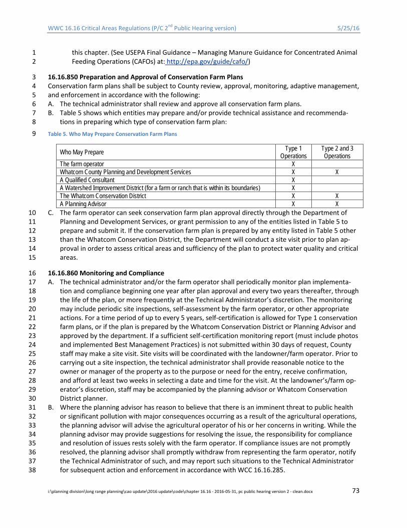
WWC 16.16 Critical Areas Regulations (P/C 2nd Public Hearing version) 5/25/16
this chapter. (See USEPA Final Guidance – Managing Manure Guidance for Concentrated Animal 1 Feeding Operations (CAFOs) at: http://epa.gov/guide/cafo/) 2
16.16.850 Preparation and Approval of Conservation Farm Plans 3 Conservation farm plans shall be subject to County review, approval, monitoring, adaptive management, 4 and enforcement in accordance with the following: 5 A. The technical administrator shall review and approve all conservation farm plans. 6 B. Table 5 shows which entities may prepare and/or provide technical assistance and recommenda-7
tions in preparing which type of conservation farm plan: 8
Table 5. Who May Prepare Conservation Farm Plans 9
Who May Prepare Type 1 Operations
Type 2 and 3 Operations
The farm operator X Whatcom County Planning and Development Services X X A Qualified Consultant X A Watershed Improvement District (for a farm or ranch that is within its boundaries) X The Whatcom Conservation District X X A Planning Advisor X X
C. The farm operator can seek conservation farm plan approval directly through the Department of 10 Planning and Development Services, or grant permission to any of the entities listed in Table 5 to 11 prepare and submit it. If the conservation farm plan is prepared by any entity listed in Table 5 other 12 than the Whatcom Conservation District, the Department will conduct a site visit prior to plan ap-13 proval in order to assess critical areas and sufficiency of the plan to protect water quality and critical 14 areas. 15
16.16.860 Monitoring and Compliance 16 A. The technical administrator and/or the farm operator shall periodically monitor plan implementa-17
tion and compliance beginning one year after plan approval and every two years thereafter, through 18 the life of the plan, or more frequently at the Technical Administrator’s discretion. The monitoring 19 may include periodic site inspections, self-assessment by the farm operator, or other appropriate 20 actions. For a time period of up to every 5 years, self-certification is allowed for Type 1 conservation 21 farm plans, or if the plan is prepared by the Whatcom Conservation District or Planning Advisor and 22 approved by the department. If a sufficient self-certification monitoring report (must include photos 23 and implemented Best Management Practices) is not submitted within 30 days of request, County 24 staff may make a site visit. Site visits will be coordinated with the landowner/farm operator. Prior to 25 carrying out a site inspection, the technical administrator shall provide reasonable notice to the 26 owner or manager of the property as to the purpose or need for the entry, receive confirmation, 27 and afford at least two weeks in selecting a date and time for the visit. At the landowner’s/farm op-28 erator’s discretion, staff may be accompanied by the planning advisor or Whatcom Conservation 29 District planner. 30
B. Where the planning advisor has reason to believe that there is an imminent threat to public health 31 or significant pollution with major consequences occurring as a result of the agricultural operations, 32 the planning advisor will advise the agricultural operator of his or her concerns in writing. While the 33 planning advisor may provide suggestions for resolving the issue, the responsibility for compliance 34 and resolution of issues rests solely with the farm operator. If compliance issues are not promptly 35 resolved, the planning advisor shall promptly withdraw from representing the farm operator, notify 36 the Technical Administrator of such, and may report such situations to the Technical Administrator 37 for subsequent action and enforcement in accordance with WCC 16.16.285. 38
i:\planning division\long range planning\cao update\2016 update\code\chapter 16.16 - 2016-05-31, pc public hearing version 2 - clean.docx 73
WWC 16.16 Critical Areas Regulations (P/C 2nd Public Hearing version) 5/25/16
C. The farm practices described in an approved conservation farm plan will be deemed to be in compli-1 ance with this Chapter so long as the landowner/farm operator is properly and fully implementing 2 the practices and responding to possible adaptive management requirements according to the time-3 line in the plan. This will be verified through conservation farm plan implementation monitoring. 4
D. Agricultural operations shall cease to be in compliance with this Article, and a new or revised con-5 servation farm plan will be required, when the technical administrator determines that any of the 6 following has occurred: 7 1. When a farm or ranch operator fails to properly and fully implement and maintain their conser-8
vation farm plan. 9 2. When implementation of the conservation farm plan fails to protect critical areas. If so, a new or 10
revised conservation farm plan shall be required to protect the values and functions of critical 11 areas at the benchmark condition. 12
3. When substantial changes in the agricultural activities of the farm or livestock operation have 13 occurred that render the current conservation farm plan ineffective. Substantial changes that 14 render a conservation farm plan ineffective are those that: 15 a. Degrade baseline critical area conditions for riparian and wetland areas that existed when 16
the plan was approved; or, 17 b. Result either in a direct discharge or substantial potential discharge of pollution to surface 18
or ground water; or, 19 c. The type of agricultural practices change from Type 1 to Type 2, Type 2 to Type 3, or Type 1 20
to Type 3 operations. 21 4. When the increase in livestock or decrease in land base or nutrient export results in the farm be-22
ing out of balance between the nutrients generated and to be used by growing crops. 23 5. When a new or revised conservation farm plan is required, and the farm operator has been so 24
advised in writing and a reasonable amount of time has passed without significant progress be-25 ing made to develop said plan. Refusal or inability to provide a new plan within a reasonable pe-26 riod of time shall be sufficient grounds to revoke the approved conservation farm plan and re-27 quire compliance with the standard provisions of this chapter. 28
6. When an owner or manager denies the technical administrator reasonable access to the proper-29 ty for technical assistance, monitoring, or compliance purposes, then the technical administrator 30 shall document such refusal of access and notify the owner of his/her findings. The owner shall 31 be given an opportunity to respond in writing to the findings of the technical administrator, pro-32 pose a prompt alternative access schedule, and to state any other issues that need to be ad-33 dressed. Refusal or inability to comply with an approved conservation farm plan within a rea-34 sonable period of time shall be sufficient grounds to revoke said plan and require compliance 35 with the standard provisions of this chapter. 36
E. With one exception, Whatcom County will not use conservation farm plans (standard or custom) as 37 an admission by the landowner that s/he has violated this Chapter. Disclosure of current farm prac-38 tices, structures on conservation farm plan documents, or observations made through monitoring 39 inspections or conservation farm plan approval, will not be used to bring other enforcement actions 40 against a farm operator. The exception is that when matters of major life, health, environment, or 41 safety issues, as determined by the Technical Administrator are observed and the landowner fails to 42 immediately and permanently remediate, then the observations may be used in an enforcement ac-43 tion. 44
16.16.870 Limited Public Disclosure. 45 A. Conservation farm plans not be subject to public disclosure unless required by law; 46
i:\planning division\long range planning\cao update\2016 update\code\chapter 16.16 - 2016-05-31, pc public hearing version 2 - clean.docx 74
WWC 16.16 Critical Areas Regulations (P/C 2nd Public Hearing version) 5/25/16
B. Provided, that the County will collect summary information related to the general location of a farm-1 ing enterprise, the nature of the farming activity, and the specific best management practices to be 2 implemented during the conservation farm plan review process. The summary information shall be 3 provided by the farm operator or his/her designee and shall be used to document the basis for the 4 County’s approval of the plan. Plans shall also be subject to disclosure if required by a court of com-5 petent jurisdiction. Upon request, the County may provide a sample conservation farm plan, exclu-6 sive of site- or property-specific information, to give general guidance on the development of a con-7 servation farm plan. 8
i:\planning division\long range planning\cao update\2016 update\code\chapter 16.16 - 2016-05-31, pc public hearing version 2 - clean.docx 75

WWC 16.16 Critical Areas Regulations (P/C 2nd Public Hearing version) 5/25/16
ARTICLE 9. DEFINITIONS 1
16.16.900 Definitions. 2 “Accessory structure” means a structure that is incidental and subordinate in intensity to a primary use. 3 Barns, garages, storage sheds, and similar appurtenances are examples. 4
“Active alluvial fan” means a portion or all of a fan that has experienced channel changes, erosion, or 5 deposition. Active fans can be identified based on determination by field geomorphic and topographic 6 evidence, and by historical accounts. 7
“Actively farmed” means land that has a documented history of ongoing agricultural use and that is cur-8 rently used primarily for the production of crops and/or raising or keeping livestock. 9
“Activity” means human activity associated with the use of land or resources. 10
“Adaptive management” means using scientific methods to evaluate how well regulatory and non-11 regulatory actions protect the critical area. An adaptive management program is a formal and deliberate 12 scientific approach to taking action and obtaining information in the face of uncertainty. Management 13 policy may be adapted based on a periodic review of new information. 14
“Adequate water supply” means a water supply that meets requirements specified in the Whatcom 15 County drinking water ordinance (Chapter 24.11 WCC). 16
“Agricultural activities” means those activities directly pertaining to the production of crops or livestock 17 including, but not limited to: cultivation; harvest; grazing; animal waste storage and disposal; fertiliza-18 tion; the operation and maintenance of farm and stock ponds or drainage ditches, irrigation systems, 19 and canals; and normal maintenance, repair, or operation of existing serviceable structures, facilities, or 20 improved areas. Neither the construction of new structures nor activities that bring a new, non-ongoing 21 agricultural area into agricultural use are considered agricultural activities. 22
“Agricultural land” is land primarily devoted to the commercial production of horticultural, viticultural, 23 floricultural, dairy, apiary, or animal products, or of berries, grain, hay, straw, turf, seed, Christmas trees 24 not subject to the excise tax imposed by RCW 84.33.100 through 84.33.140, or livestock, and/or lands 25 that have been designated as capable of producing food and fiber, which have not been developed for 26 urban density housing, business, or other uses incompatible with agricultural activity. 27
“Alluvial fan” means a fan-shaped deposit of sediment and organic debris formed where a stream flows 28 or has flowed out of a mountainous upland onto a level plain or valley floor because of a sudden change 29 in sediment transport capacity (e.g., significant change in slope or confinement). 30
“Alluvium” is a general term for clay, silt, sand, gravel, or similar other unconsolidated detrital materials, 31 deposited during comparatively recent geologic time by a stream or other body of running water, as a 32 sorted or semi-sorted sediment in the bed of the stream or on its floodplain or delta. 33
“Alteration” means any human-induced change in an existing condition of a critical area or its buffer. 34 Alterations include, but are not limited to, grading, filling, channelizing, dredging, clearing (vegetation), 35 draining, construction, compaction, excavation, or any other activity that changes the character of the 36 critical area. 37
“Anadromous fish” means fish species that spend most of their lifecycle in salt water, but return to 38 freshwater to reproduce. 39
“Animal unit” means 1,000 pounds of livestock live weight. 40
i:\planning division\long range planning\cao update\2016 update\code\chapter 16.16 - 2016-05-31, pc public hearing version 2 - clean.docx 76

WWC 16.16 Critical Areas Regulations (P/C 2nd Public Hearing version) 5/25/16
“Aquifer” means a geologic formation, group of formations, or part of a formation capable of yielding a 1 significant amount of groundwater to wells or springs (Chapter 173-160 WAC). 2
“Aquifer susceptibility” means the ease with which contaminants can move from the land surface to the 3 aquifer based solely on the types of surface and subsurface materials in the area. Susceptibility usually 4 defines the rate at which a contaminant will reach an aquifer unimpeded by chemical interactions with 5 the vadose zone media. 6
“Aquifer vulnerability” is the combined effect of susceptibility to contamination and the presence of po-7 tential contaminants. 8
“Bankfull width” means: 9 (a) For streams – The measurement of the lateral extent of the water surface elevation perpendicu-10
lar to the channel at bankfull depth. In cases where multiple channels exist, bankfull width is the 11 sum of the individual channel widths along the cross-section (see board manual section 2). 12
(b) For lakes, ponds, and impoundments – Line of mean high water. 13 (c) For tidal water – Line of mean high tide. 14 (d) For periodically inundated areas of associated wetlands – Line of periodic inundation, which will 15
be found by examining the edge of inundation to ascertain where the presence and action of 16 waters are so common and usual, and so long continued in all ordinary years, as to mark upon 17 the soil a character distinct from that of the abutting upland. 18
“Base flood” is a flood event having a 1% chance of being equaled or exceeded in any given year, also 19 referred to as the 100-year flood. Designations of base flood areas on flood insurance map(s) always 20 include the letters A (zone subject to flooding during a 100-year flood, but less so than V zones) or V 21 (zone subject to the highest flows, wave action, and erosion during a 100-year flood). 22
“Bedrock” is a general term for rock, typically hard, consolidated geologic material that underlies soil or 23 other unconsolidated, superficial material or is exposed at the surface. 24
“Best available science” means information from research, inventory, monitoring, surveys, modeling, 25 synthesis, expert opinion, and assessment that is used to designate, protect, or restore critical areas. As 26 defined by WAC 365-195-900 through 365-195-925, best available science is derived from a process that 27 includes peer-reviewed literature, standard methods, logical conclusions and reasonable inferences, 28 quantitative analysis, and documented references to produce reliable information. 29
“Best management practices” means conservation practices or systems of practices and management 30 measures that: 31
1. Control soil loss and reduce water quality degradation caused by nutrients, animal waste, toxins, 32 and sediment; 33
2. Minimize adverse impacts to surface water and groundwater flow, circulation patterns, and to 34 the chemical, physical, and biological characteristics of waters, wetlands, and other fish and 35 wildlife habitat; 36
3. Control plant site runoff, spillage or leaks, sludge or water disposal, or drainage from raw mate-37 rial. 38
“Buffer (the buffer zone)” means the area adjacent to the outer boundaries of critical areas including 39 wetlands; habitat conservation areas such as streams, lakes, and marine shorelines; and/or landslide 40 hazard areas that separates and protects critical areas from adverse impacts associated with adjacent 41 land uses. 42
“Channel migration zone (CMZ)” means the area along a river or stream within which the channel can 43 reasonably be expected to migrate over time as a result of normally occurring processes. It encompasses 44
i:\planning division\long range planning\cao update\2016 update\code\chapter 16.16 - 2016-05-31, pc public hearing version 2 - clean.docx 77

WWC 16.16 Critical Areas Regulations (P/C 2nd Public Hearing version) 5/25/16
that area of current and historic lateral stream channel movement that is subject to erosion, bank de-1 stabilization, rapid stream incision, and/or channel shifting, as well as adjacent areas that are suscepti-2 ble to channel erosion. There are three components of the channel migration zone: (1) the historical 3 migration zone (HMZ) – the collective area the channel occupied in the historical record; (2) the avulsion 4 hazard zone (AHZ) – the area not included in the HMZ that is at risk of avulsion over the timeline of the 5 CMZ; and (3) the erosion hazard area (EHA) – the area not included in the HMZ or the AHZ that is at risk 6 of bank erosion from stream flow or mass wasting over the timeline of the CMZ. The channel migration 7 zone may not include the area behind a lawfully constructed flood protection device. Channel migration 8 zones shall be identified in accordance with guidelines established by the Washington State Department 9 of Ecology. 10
“Clearing” means destruction of vegetation by manual, mechanical, or chemical methods resulting in 11 exposed soils. “Commercial fish” means those species of fish that are classified under the Washington 12 State Department of Fish and Wildlife Food Fish Classification as commercial fish (WAC 220-12-010). 13
“Compensatory mitigation” means a project for the purpose of mitigating, at an equivalent or greater 14 level, unavoidable critical area and buffer impacts that remain after all appropriate and practicable 15 avoidance and minimization measures have been implemented. Compensatory mitigation includes, but 16 is not limited to: wetland creation, restoration, enhancement, and preservation; stream restoration and 17 relocation; rehabilitation; and buffer enhancement. 18
“Conservation” means the prudent management of rivers, streams, wetlands, wildlife and other envi-19 ronmental resources in order to preserve and protect them. This includes the careful use of natural re-20 sources in order to prevent depletion or harm to the environment. 21
“Conservation easement” means a legal agreement that the property owner enters into to restrict uses 22 of the land for purposes of natural resources conservation. The easement is recorded on a property 23 deed, runs with the land, and is legally binding on all present and future owners of the property. 24
“Contaminant” means any chemical, physical, biological, or radiological substance that does not occur 25 naturally in groundwater, air, or soil or that occurs at concentrations greater than those in the natural 26 levels (Chapter 172-200 WAC). 27
“County” means Whatcom County, Washington. 28
"Covered assembly" means any structure that has the potential to provide capacity for large numbers of 29 people or assemblies such as but not limited to convention centers, churches, theatres, etc. 30
“Critical aquifer recharge areas” means areas designated by WAC 365-190-080(2) that are determined 31 to have a critical recharging effect on aquifers (i.e., maintain the quality and quantity of water) used for 32 potable water as defined by WAC 365-190-030(2). 33
“Critical Areas.” The following areas shall be regarded as critical areas: 34 1. Critical aquifer recharge areas; 35 2. Wetlands; 36 3. Geologically hazardous areas; 37 4. Frequently flooded areas; 38 5. Fish and wildlife habitat conservation areas. 39
“Critical areas report” means a report prepared by a qualified professional or qualified consultant based 40 on best available science, and the specific methods and standards for technical study required for each 41 applicable critical area. Geotechnical reports and hydrogeological reports are critical area reports specif-42 ic to geologically hazardous areas and critical aquifer recharge areas, respectively. 43
i:\planning division\long range planning\cao update\2016 update\code\chapter 16.16 - 2016-05-31, pc public hearing version 2 - clean.docx 78

WWC 16.16 Critical Areas Regulations (P/C 2nd Public Hearing version) 5/25/16
“Critical area tract” means land held in private ownership and retained in an open undeveloped condi-1 tion (native vegetation is preserved) in perpetuity for the protection of critical areas. 2
“Critical habitat” means habitat areas with which endangered, threatened, sensitive or monitored 3 plant, fish, or wildlife species have a primary association (e.g., feeding, breeding, rearing of young, mi-4 grating). Such areas are identified herein with reference to lists, categories, and definitions promulgated 5 by the Washington State Department of Fish and Wildlife as identified in WAC 232-12-011 or 232-12-6 014; in the Priority Habitat and Species (PHS) Program of the Department of Fish and Wildlife; or by 7 rules and regulations adopted by the U.S. Fish and Wildlife Service, National Marine Fisheries Service, or 8 other agency with jurisdiction for such designations. 9
“Cumulative Impact” means effects on the environment that are caused by the combined results of past, 10 current and reasonably foreseeable future activities. Evaluation of such cumulative impacts should con-11 sider: (i) current circumstances affecting the critical area and relevant natural processes; (ii) reasonably 12 foreseeable future development that may affect the critical area; and (iii) beneficial effects of any estab-13 lished regulatory programs under other local, state, and federal laws. 14
“Debris flow” means a moving mass of rock fragments, soil, and mud, more than half of the particles 15 being larger than sand size; a general term that describes a mass movement of sediment mixed with 16 water and air that flows readily on low slopes. 17
“Debris torrent” means a violent and rushing mass of water, logs, boulders and other debris. 18
“Deepwater habitats” means permanently flooded lands lying below the deepwater boundary of wet-19 lands. Deepwater habitats include environments where surface water is permanent and often deep, so 20 that water, rather than air, is the principal medium in which the dominant organisms live. The boundary 21 between wetland and deepwater habitat in the marine and estuarine systems coincides with the eleva-22 tion of the extreme low water of spring tide; permanently flooded areas are considered deepwater habi-23 tats in these systems. The boundary between wetland and deepwater habitat in the riverine and lacus-24 trine systems lies at a depth of two meters (6.6 feet) below low water; however, if emergent vegetation, 25 shrubs, or trees grow beyond this depth at any time, their deepwater edge is the boundary. 26
“Delineation” means the precise determination of wetland boundaries in the field according to the ap-27 plication of the specific method described in the 1997 Washington State Wetland Delineation Manual 28 and/or the Corps of Engineers Wetlands Delineation Manual, 1987 Edition, as amended. 29
“Designated Species, Federal.” Federally designated endangered and threatened species are those fish 30 and wildlife species identified by the U.S. Fish and Wildlife Service and the National Marine Fisheries 31 Service that are in danger of extinction or threatened to become endangered. The U.S. Fish and Wildlife 32 Service and the National Marine Fisheries Service should be consulted for current listing status. 33
“Designated Species, State.” State designated endangered, threatened, and sensitive species are those 34 fish and wildlife species native to the state of Washington identified by the Washington Department of 35 Fish and Wildlife, that are in danger of extinction, threatened to become endangered, vulnerable, or 36 declining and are likely to become endangered or threatened in a significant portion of their range with-37 in the state without cooperative management or removal of threats. State designated endangered, 38 threatened, and sensitive species are periodically recorded in WAC 232-12-014 (state endangered spe-39 cies) and WAC 232-12-011 (state threatened and sensitive species). The State Department of Fish and 40 Wildlife maintains the most current listing and should be consulted for current listing status. 41
“Development” means any activity that requires federal, state, or local approval for the use or modifica-42 tion of land or its resources. These activities include, but are not limited to: subdivision and short subdi-43 visions; binding site plans; planned unit developments; variances; shoreline substantial development 44
i:\planning division\long range planning\cao update\2016 update\code\chapter 16.16 - 2016-05-31, pc public hearing version 2 - clean.docx 79

WWC 16.16 Critical Areas Regulations (P/C 2nd Public Hearing version) 5/25/16
and exemptions; clearing activity; fill and grade work; activity conditionally allowed; building or con-1 struction; revocable encroachment permits; and septic approval. 2
“Ditch” means an artificially created watercourse constructed to convey surface or groundwater. Ditch-3 es are graded (manmade) channels installed to collect and convey water to or from fields and roadways. 4 Ditches may include: 5
• irrigation ditches, 6 • waste ways, 7 • drains, 8 • outfalls, 9 • operational spillways, 10 • channels, 11 • stormwater runoff facilities 12 • or other wholly artificial watercourses, except those that directly result from the modification to 13
a natural watercourse. 14
Ditched channels or other artificial water courses where 15
• natural streams existed prior to human alteration, and/or 16 • the waterway is used by anadromous or resident salmonid or other fish populations, or 17 • flows directly into shellfish habitat conservation areas 18
are not considered ditches, but are considered streams for the purposes of this Chapter. 19
“Emergency activities” means those activities which require immediate action within a time too short to 20 allow full compliance with this chapter due to an unanticipated and imminent threat to public health, 21 safety or the environment. Emergency construction does not include development of new permanent 22 protective structures where none previously existed. All emergency construction shall be consistent with 23 the policies of Chapter 90.58 RCW and this chapter. As a general matter, flooding or other seasonal 24 events that can be anticipated and may occur but that are not imminent are not an emergency. 25
“Emergent wetland” means a wetland with at least 30% of the surface area covered by erect, rooted, 26 herbaceous vegetation as the uppermost vegetative strata. 27
“Enhancement” means actions performed within an existing degraded critical area and/or buffer to in-28 tentionally increase or augment one or more functions or values of the existing critical area or buffer. 29 Enhancement actions include, but are not limited to, increasing plant diversity and cover, increasing 30 wildlife habitat and structural complexity (snags, woody debris), installing environmentally compatible 31 erosion controls, or removing nonindigenous plant or animal species. 32
“Erosion” means a process whereby wind, rain, water and other natural agents mobilize, transport, and 33 deposit soil particles. 34
“Erosion hazard areas” means lands or areas underlain by soils identified by the U.S. Department of Ag-35 riculture Natural Resource Conservation Service (NRCS) as having “severe” or “very severe” erosion haz-36 ards and areas subject to impacts from lateral erosion related to moving water such as river channel mi-37 gration and shoreline retreat. 38
"Essential facilities" means those facilities that are necessary to maintain life, health, welfare, and safety 39 functions such as but not limited to: fire and police stations; emergency medical facilities or medical fa-40 cilities containing surgery or emergency treatment areas; emergency response services or preparedness 41 centers and their associated buildings, shelters, or vehicle storage areas; jails; and detention centers; 42
i:\planning division\long range planning\cao update\2016 update\code\chapter 16.16 - 2016-05-31, pc public hearing version 2 - clean.docx 80

WWC 16.16 Critical Areas Regulations (P/C 2nd Public Hearing version) 5/25/16
structures and equipment in government communications centers and other facilities required for 1 emergency response; power generating stations, standby power generating equipment or other types of 2 public utility facilities that if interrupted would cause disruption to normal living and business opera-3 tions; and wastewater treatment plants. 4
“Estuarine wetland” means the zero-gradient sector of a stream where it flows into a standing body of 5 water together with associated natural wetlands; tidal flows reverse flow in the wetland twice daily, de-6 termining its upstream limit. It is characterized by low bank channels (distributaries) branching off the 7 main stream to form a broad, near-level delta; bank; bed and delta materials are silt and clay; banks are 8 stable; vegetation ranges from marsh to forest; and water is usually brackish due to daily mixing and 9 layering of fresh and salt water. 10
“Exotic” means any species of plants or animals that is not indigenous to the area. 11
“Farm pond” means an open water depression created from a non-wetland site in connection with agri-12 cultural activities. 13
“Feasible” means an action, such as a development project, mitigation, or preservation requirement 14 that meets all of the following conditions: 15
a. The action can be accomplished with technologies and methods that have been used in the past 16 in similar circumstances, or studies or tests have demonstrated in similar circumstances that 17 such approaches are currently available and likely to achieve the intended results; 18
b. The action provides a reasonable likelihood of achieving its intended purpose; and, 19 c. The action does not physically preclude achieving the project’s primary intended legal use. 20
In cases where this chapter requires certain actions, unless they are infeasible, the burden of proving 21 infeasibility is on the applicant/ proponent. In determining an action’s infeasibility, the county may 22 weigh the action’s relative costs and public benefits, considered in the short- and long-term time 23 frames. 24
“Feasible alternative” means an action, such as development, mitigation, or restoration, that meets all 25 of the following conditions: (1) the action can be accomplished with technologies and methods that 26 have been used in the past in similar circumstances, or studies or tests have demonstrated in similar 27 circumstances that such approaches are currently available and likely to achieve the intended results; (2) 28 the action provides a reasonable likelihood of achieving its intended purpose; and (3) the action does 29 not physically preclude achieving the project’s primary intended legal use. Feasibility shall take into ac-30 count both short- and long-term monetary and nonmonetary costs and benefits. 31
“Fen” means a mineral-rich wetland formed in peat that has a neutral to alkaline pH. Fens are wholly or 32 partly covered with water and dominated by grass-like plants, grasses, and sedges. 33
“Filling” means the act of transporting or placing by any manual or mechanical means fill material from, 34 to, or on any soil surface, including temporary stockpiling of fill material. 35
“Fill material” means any solid or semi-solid material, including rock, sand, soil, clay, plastics, construc-36 tion debris, wood chips, overburden from mining or other excavation activities, and materials used to 37 create any structure or infrastructure that, when placed, changes the grade or elevation of the receiving 38 site. 39
“Fish and wildlife habitat conservation areas” means areas important for maintaining species in suitable 40 habitats within their natural geographic distribution so that isolated populations are not created. 41
“Fish habitat” means a complex of physical, chemical, and biological conditions that provide the life-42 supporting and reproductive needs of a species or life stage of fish. Although the habitat requirements 43
i:\planning division\long range planning\cao update\2016 update\code\chapter 16.16 - 2016-05-31, pc public hearing version 2 - clean.docx 81
WWC 16.16 Critical Areas Regulations (P/C 2nd Public Hearing version) 5/25/16
of a species depend on its age and activity, the basic components of fish habitat in rivers, streams, 1 ponds, lakes, estuaries, marine waters, and nearshore areas include, but are not limited to, the follow-2 ing: 3
1. Clean water and appropriate temperatures for spawning, rearing, and holding; 4 2. Adequate water depth and velocity for migrating, spawning, rearing, and holding, including off-5
channel habitat; 6 3. Abundance of bank and in-stream structures to provide hiding and resting areas and stabilize 7
stream banks and beds; 8 4. Appropriate substrates for spawning and embryonic development. For stream- and lake-9
dwelling fishes, substrates range from sands and gravel to rooted vegetation or submerged 10 rocks and logs. Generally, substrates must be relatively stable and free of silts or fine sand; 11
5. Presence of riparian vegetation as defined in this article. Riparian vegetation creates a transition 12 zone, which provides shade and food sources of aquatic and terrestrial insects for fish; 13
6. Unimpeded passage (i.e., due to suitable gradient and lack of barriers) for upstream and down-14 stream migrating juveniles and adults. 15
“Flood” or “flooding” means a general and temporary condition of partial or complete inundation of 16 normally dry land areas from the overflow of inland waters and/or the unusual and rapid accumulation 17 of runoff of surface waters from any source. 18
“Floodplain” means the total land area adjoining a river, stream, watercourse, or lake subject to inunda-19 tion by the base flood. 20
“Floodway” means the channel of a river or other watercourse and the adjacent land area that must be 21 reserved in order to discharge the base flood without cumulatively increasing the surface water eleva-22 tion more than one foot. Also known as the “zero rise floodway.” 23
“Forested wetland” means a wetland with at least 30% of the surface area covered by woody vegetation 24 greater than 20 feet in height, excluding monotypic stands of red alder or cottonwood that average 25 eight inches in diameter at breast height or less. 26
“Frequently flooded areas” means lands in the floodplain subject to a 1% or greater chance of flooding 27 in any given year and those lands that provide important flood storage, conveyance and attenuation 28 functions, as determined by the County in accordance with WAC 365-190-080(3). Classifications of fre-29 quently flooded areas include, at a minimum, the “Special Flood Hazard Area” designations of the Fed-30 eral Emergency Management Agency and the National Flood Insurance Program. 31
“Functions, services, and value” means the beneficial functions that critical areas perform, the services 32 they provide humans, and the values people derive from these roles including, but not limited to, water 33 quality protection and enhancement, fish and wildlife habitat, food chain support, flood storage, con-34 veyance and attenuation, groundwater recharge and discharge, erosion control, wave attenuation, pro-35 tection from hazards, providing historical and archaeological resources, noise and visual screening, open 36 space, and recreation. These beneficial roles are not listed in order of priority. 37
“Function assessment” or “functions and values assessment” means a set of procedures, applied by a 38 qualified consultant, to identify the ecological functions being performed in a wetland or other critical 39 area, usually by determining the presence of certain characteristics, and determining how well the criti-40 cal area is performing those functions. Function assessments can be qualitative or quantitative and may 41 consider social values potentially provided by the wetland or other critical area. Function assessment 42 methods must be consistent with best available science. 43
i:\planning division\long range planning\cao update\2016 update\code\chapter 16.16 - 2016-05-31, pc public hearing version 2 - clean.docx 82
WWC 16.16 Critical Areas Regulations (P/C 2nd Public Hearing version) 5/25/16
“Functions” means the processes or attributes provided by areas of the landscape (e.g., wetlands, rivers, 1 streams, and riparian areas) including, but not limited to, habitat diversity and food chain support for 2 fish and wildlife, groundwater recharge and discharge, high primary productivity, low flow stream water 3 contribution, sediment stabilization and erosion control, storm and flood water attenuation and flood 4 peak desynchronization, and water quality enhancement through biofiltration and retention of sedi-5 ments, nutrients, and toxicants. These beneficial roles are not listed in order of priority. 6
“Game fish” means those species of fish that are classified by the Washington State Department of Wild-7 life as game fish (WAC 232-12-019). 8
“Geologically hazardous areas” means areas that, because of their susceptibility to erosion, sliding, 9 earthquake, or other geological events, are not suited to the siting of commercial, residential, or indus-10 trial development consistent with public health or safety concerns. 11
“Gradient” means a degree of inclination, or a rate of ascent or descent, of an inclined part of the 12 earth’s surface with respect to the horizontal; the steepness of a slope. It is expressed as a ratio (vertical 13 to horizontal), a fraction (such as meters/kilometers or feet/miles), a percentage (of horizontal dis-14 tance), or an angle (in degrees). 15
“Grading” means any excavating or filling of the earth’s surface or combination thereof. 16
“Groundwater” means all water that exists beneath the land surface or beneath the bed of any stream, 17 lake or reservoir, or other body of surface water within the boundaries of the state, whatever may be 18 the geological formation or structure in which such water stands or flows, percolates or otherwise 19 moves (Chapter 90.44 RCW). 20
“Groundwater management area” means a specific geographic area or subarea designated pursuant to 21 Chapter 173-100 WAC for which a groundwater management program is required. 22
“Groundwater management program” means a comprehensive program designed to protect groundwa-23 ter quality, to assure groundwater quantity, and to provide for efficient management of water resources 24 while recognizing existing groundwater rights and meeting future needs consistent with local and state 25 objectives, policies and authorities within a designated groundwater management area or subarea and 26 developed pursuant to Chapter 173-100 WAC. 27
“Growing season” means the portion of the year when soil temperatures are above biologic zero (41 28 degrees Fahrenheit). 29
“Growth Management Act” means Chapters 36.70A and 36.70B RCW, as amended. 30
"Habitats of local importance" designated as fish and wildlife habitat conservation areas include those 31 areas found to be locally important by Whatcom County pursuant to WCC 16.16.710(C)(14). 32
“Hazard tree” means any tree that is susceptible to immediate fall due to its condition (damaged, dis-33 eased, or dead) or other factors, and which because of its location is at risk of damaging permanent 34 physical improvements to property or causing personal injury. 35
"Hazardous facilities" means those occupancies or structures housing or supporting toxic or explosive 36 chemicals or substances and any non-building structures housing, supporting or containing quantities of 37 toxic or explosive substances that, if contained within a building, would cause that building to be de-38 fined as a hazardous facility. Hazardous facilities include any elements contained in the definition for 39 "hazardous waste treatment and storage facility." Hazardous facilities may be classified as a group "H" 40 occupancy in the UBC. 41
i:\planning division\long range planning\cao update\2016 update\code\chapter 16.16 - 2016-05-31, pc public hearing version 2 - clean.docx 83

WWC 16.16 Critical Areas Regulations (P/C 2nd Public Hearing version) 5/25/16
“Hazardous substance” means any liquid, solid, gas, or sludge, including any material, substance, prod-1 uct, commodity, or waste, regardless of quantity, that exhibits any of the physical, chemical or biological 2 properties described in WAC 173-303-090 or 173-303-100. 3
“High intensity land use” means land use that includes the following uses or activities: commercial, ur-4 ban, industrial, institutional, retail sales, residential (more than one unit/acre), high-intensity new agri-5 culture (dairies, nurseries, greenhouses, raising and harvesting crops requiring annual tilling, raising and 6 maintaining animals), high-intensity recreation (golf courses, ball fields), hobby farms, and Class IV Spe-7 cial forest practices, including the building of logging roads (note that pursuant to WCC 16.16.230(A) all 8 other forest practices are exempt from this chapter). 9
“Hydraulic project approval (HPA)” means a permit issued by the State Department of Fish and Wildlife 10 for modifications to waters of the state in accordance with Chapter 75.20 RCW. 11
“Hydric soil” means a soil that is or has been saturated, flooded or ponded long enough during the grow-12 ing season to develop anaerobic conditions in the upper part. The presence of hydric soil shall be de-13 termined following the methods described in the NRCS Field Indicators of Hydric Soils version 7, and/or 14 the Corps of Engineers Wetlands Delineation Manual, as amended. 15
“Hydrologic soil groups” means soils grouped according to their runoff-producing characteristics under 16 similar storm and cover conditions. Properties that influence runoff potential are depth to seasonally 17 high water table, intake rate and permeability after prolonged wetting, and depth to a low permeable 18 layer. Hydrologic soil groups are normally used in equations that estimate runoff from rainfall, but can 19 be used to estimate a rate of water transmission in soil. There are four hydrologic soil groups: 20
1. Low runoff potential and a high rate of infiltration potential; 21 2. Moderate infiltration potential and a moderate rate of runoff potential; 22 3. Slow infiltration potential and a moderate to high rate of runoff potential; and 23 4. High runoff potential and very slow infiltration and water transmission rates. 24
“Hydrophytic vegetation” means macrophytic plant life growing in water or on a substrate that is at 25 least periodically deficient in oxygen as a result of excessive water content. 26
“Hyporheic zone” means the saturated zone located beneath and adjacent to streams that contain some 27 proportion of surface water from the surface channel. The hyporheic zone serves as a filter for nutrients, 28 as a site for macroinvertebrate production important in fish nutrition and provides other functions re-29 lated to maintaining water quality. 30
“Impervious surface” means a hard surface area that either prevents or retards the entry of water into 31 the soil mantle as under natural conditions prior to development or that causes water to run off the sur-32 face in greater quantities or at an increased rate of flow compared to natural conditions prior to devel-33 opment. Common impervious surfaces may include, but are not limited to, roof tops, walkways, patios, 34 driveways, parking lots or storage areas, concrete or asphalt paving, gravel roads, packed earthen mate-35 rials, and oiled macadam or other surfaces which similarly impede the natural infiltration of stormwater. 36 Impervious surfaces do not include surface created through proven low impact development tech-37 niques. 38
“Infiltration” means the downward entry of water into the immediate surface of soil. 39
“In-kind compensation” means to replace critical areas with substitute areas whose characteristics and 40 functions mirror those destroyed or degraded by a regulated activity. 41
“Intertidal zone” means the substratum from extreme low water of spring tides to the upper limit of 42 spray or influence from ocean-derived salts. It includes areas that are sometimes submerged and some-43
i:\planning division\long range planning\cao update\2016 update\code\chapter 16.16 - 2016-05-31, pc public hearing version 2 - clean.docx 84

WWC 16.16 Critical Areas Regulations (P/C 2nd Public Hearing version) 5/25/16
times exposed to air, mud and sand flats, rocky shores, salt marshes, and some terrestrial areas where 1 salt influences are present. 2
“Invasive species” means a species that is: (1) nonnative (or alien) to Whatcom County, and (2) whose 3 introduction causes or is likely to cause economic or environmental harm or harm to human health. In-4 vasive species can be plants, animals, and other organisms (e.g., microbes). Human actions are the pri-5 mary means of invasive species introductions. 6
“Lahar” means a mudflow and debris flow originating from the slopes of a volcano. 7
“Lahar hazard area” means areas that have been or potentially could be inundated by lahars or other 8 types of debris flows, according to a map showing Volcano Hazards from Mount Baker, Washington. 9
“Lake” means a naturally or artificially created body of deep (generally greater than 6.6 feet) open water 10 that persists throughout the year. A lake is larger than a pond, greater than one acre in size, equal to or 11 greater than 6.6 feet in depth, and has less than 30% aerial coverage by trees, shrubs, or persistent 12 emergent vegetation. A lake is bounded by the ordinary high water mark or the extension of the eleva-13 tion of the lake’s ordinary high water mark with the stream where the stream enters the lake. 14
“Landfill” means a disposal facility or part of a facility at which solid waste is permanently placed in or on 15 land including facilities that use solid waste as a component of fill. 16
“Landslide” means a general term covering a wide variety of mass movement landforms and processes 17 involving the downslope transport, under gravitational influence of soil and rock material en masse; in-18 cluded are debris flows, debris avalanches, earthflows, mudflows, slumps, mudslides, rock slides, and 19 rock falls. 20
“Landslide hazard areas” means areas that, due to a combination of site conditions like slope inclination 21 and relative soil permeability, are susceptible to mass wasting. 22
“Low intensity land use” means land use that includes the following uses or activities: forestry (cutting 23 of trees only), low-intensity open space (such as passive recreation and natural resources preservation), 24 and unpaved trails. 25
“Maintenance or repair” means those usual activities required to prevent a decline, lapse or cessation 26 from a lawfully established condition or to restore the character, scope, size, and design of a serviceable 27 area, structure, or land use to a state comparable to its previously authorized and undamaged condition. 28 This does not include any activities that change the character, scope, or size of the original structure, 29 facility, utility or improved area beyond the original design. 30
“Major development” means any project for which a major project permit is required pursuant to Chap-31 ter 20.88 WCC. For the purposes of this chapter, “major development” shall also mean any project asso-32 ciated with an existing development for which a major development permit has been required or other 33 existing legally nonconforming development for which a major development permit would otherwise be 34 required if developed under the current land use regulations outlined in WCC Title 20. 35
“Mass wasting” means downslope movement of soil and rock material by gravity. This includes soil 36 creep, erosion, and various types of landslides, not including bed load associated with natural stream 37 sediment transport dynamics. 38
“Mature forested wetland” means a wetland with an overstory dominated by mature trees having a 39 wetland indicator status of facultative (FAC), facultative-wet (FACW), or obligate (OBL). Mature trees are 40 considered to be at least 21 inches in diameter at breast height. 41
i:\planning division\long range planning\cao update\2016 update\code\chapter 16.16 - 2016-05-31, pc public hearing version 2 - clean.docx 85
WWC 16.16 Critical Areas Regulations (P/C 2nd Public Hearing version) 5/25/16
“Maximum Credible Event” means the largest debris flow event that can be hypothesized from geologic 1 processes within the watershed above the alluvial fan with consideration of the volume of sediment and 2 debris that would be available within the drainage combined with the material the from landslides that 3 would enter the drainage, and the volume of water that could become trapped behind and within the 4 debris flow or dammed within the drainage. 5
“Mean annual flow” means the average flow of a river or stream (measured in cubic feet per second) 6 from measurements taken throughout the year. If available, flow data for the previous 10 years should 7 be used in determining mean annual flow. 8
“Mitigation” means individual actions that may include a combination of the following measures, listed 9 in order of preference: 10
1. Avoiding an impact altogether by not taking a certain action or parts of actions; 11 2. Minimizing impacts by limiting the degree or magnitude of an action and its implementation; 12 3. Rectifying impacts by repairing, rehabilitating, or restoring the affected environment; 13 4. Reducing or eliminating an impact over time by preservation and maintenance operations dur-14
ing the life of the action; 15 5. Compensating for an impact by replacing or providing substitute resources or environments; 16
and 17 6. Monitoring the mitigation and taking remedial action when necessary. 18
“Mitigation bank” means a site where wetlands or similar habitats are restored, created, enhanced, or in 19 exceptional circumstances, preserved, expressly for the purpose of providing compensatory mitigation 20 in advance of authorized impacts to aquatic resources. 21
“Mitigation bank instrument” means the documentation of agency and bank sponsor concurrence on 22 the objectives and administration of the bank. The “bank instrument” describes in detail the physical 23 and legal characteristics of the bank, including the service area, and how the bank will be established 24 and operated. 25
“Mitigation Bank Review Team” or “MBRT” means an interagency group of federal, state, tribal and local 26 regulatory and resource agency representatives that are invited to participate in negotiations with the 27 bank sponsor on the terms and conditions of the bank instrument. 28
“Mitigation Bank Review Team process” or “MBRT process” means a process in which the County and 29 other agencies strives to reach consensus with the MBRT members on the terms, conditions, and proce-30 dural elements of the bank instrument. 31
“Mitigation bank sponsor” means any public or private entity responsible for establishing and, in most 32 circumstances, operating a bank. 33
“Mitigation plan” means a detailed plan indicating actions necessary to mitigate adverse impacts to crit-34 ical areas. 35
“Moderate intensity land use” means land use that includes the following uses or activities: residential 36 (one unit/gross acre or less), moderate-intensity open space (parks), moderate-intensity new agriculture 37 (orchards and hay fields), and paved trails. 38
“Monitoring” means evaluating the impacts of development proposals over time on the biological, hy-39 drological, pedological, and geological elements of ecosystem functions and processes, and/or assessing 40 the performance of required mitigation measures through the collection and analysis of data by various 41 methods for the purpose of understanding and documenting changes in natural ecosystems and fea-42 tures compared to baseline or pre-project conditions and/or reference sites. 43
i:\planning division\long range planning\cao update\2016 update\code\chapter 16.16 - 2016-05-31, pc public hearing version 2 - clean.docx 86
WWC 16.16 Critical Areas Regulations (P/C 2nd Public Hearing version) 5/25/16
“Native vegetation” means plant species that are indigenous to Whatcom County and the local area. 1
“Nearshore habitat” means the zone that extends seaward from the marine shoreline to a water depth 2 of approximately 20 meters (66 feet). Nearshore habitat is rich biologically, providing important habitat 3 for a diversity of plant and animal species. 4
“No net loss” means the maintenance of the aggregate total of the County’s critical area functions and 5 values as achieved through a case-by-case review of development proposals. Each project shall be eval-6 uated based on its ability to meet the no net loss goal. 7
“Off-site mitigation” means to replace critical areas away from the site on which a critical area has been 8 adversely impacted by a regulated activity. 9
“Ongoing agriculture” means those activities conducted on lands defined in RCW 84.34.020(2), and 10 those activities involved in the production of crops and livestock, including, but not limited to, operation 11 and maintenance of existing farm and stock ponds or drainage ditches, irrigation systems, changes be-12 tween agricultural activities, and maintenance or repair of existing serviceable structures and facilities. 13 Activities that bring an area into agricultural use are not part of an ongoing activity. An operation ceases 14 to be ongoing when the area on which it was conducted has been converted to a nonagricultural use, or 15 has lain idle for more than five consecutive years unless that idle land is registered in a federal or state 16 conservation program. Forest practices are not included in this definition. 17
“Ordinary high water mark” means the mark or line on all lakes, rivers, streams, and tidal water that will 18 be found by examining the beds and banks and ascertaining where the presence and action of waters 19 are so common and usual and so long continued in all ordinary years, as to mark upon the soil a charac-20 ter distinct from that of the abutting upland in respect to vegetation (RCW 90.58.030(2)(b)). 21
“Overnight accommodations,” for the purposes of this chapter only, means any use that allows more 22 than 10 persons to sleep overnight, either as a primary use (such as hotels/motels, camps, or other lodg-23 ing), or occasionally (such as churches hosting sleepovers), whether in a bed or otherwise. While this 24 latter group of uses may be allowed, hosting overnight groups shall not be and the permit authorizing 25 the use shall include such a condition. 26
“Person” means an individual, partnership, corporation, association, organization, cooperative, public or 27 municipal corporation, state agency or local governmental unit, however designated, or Indian nation or 28 tribe. 29
“Planned unit development (PUD)” means one or a group of specified uses, such as residential, resort, 30 commercial or industrial, to be planned and constructed as a unit. Zoning or subdivision regulations with 31 respect to lot size, building bulk, etc., may be varied to allow design innovations and special features in 32 exchange for additional and/or superior site amenities or community benefits. 33
“Planning advisor” means those qualified individuals who have technical experience and training neces-34 sary to prepare conservation farm plans for agricultural lands and who have been certified a technical 35 service provider by the USDA Natural Resources Conservation Service (see http://techreg.usda.gov) and 36 signed the practice and confidentiality agreement. 37
“Pond” means an open body of water, generally equal to or greater than 6.6 feet deep, that persists 38 throughout the year and occurs in a depression of land or expanded part of a stream and has less than 39 30% aerial coverage by trees, shrubs, or persistent emergent vegetation. Ponds are generally smaller 40 than lakes. Farm ponds, ponds built for the primary purpose of combating fires, stormwater facilities, 41 and beaver ponds less than two years old are excluded from this definition. 42
“Potable” means water that is suitable for drinking by the public (Chapter 246-290 WAC). 43
i:\planning division\long range planning\cao update\2016 update\code\chapter 16.16 - 2016-05-31, pc public hearing version 2 - clean.docx 87
WWC 16.16 Critical Areas Regulations (P/C 2nd Public Hearing version) 5/25/16
“Preservation” means actions taken to ensure the permanent protection of existing, ecologically im-1 portant critical areas and/or buffers that the County has deemed worthy of long-term protection. 2
“Primary association” means the use or potential use of a habitat area by a listed or priority species for 3 breeding/spawning, rearing young, resting, roosting, feeding, foraging, and/or migrating on a frequent 4 and/or regular basis during the appropriate season(s) as well as habitats that are used less frequent-5 ly/regularly but which provide for essential life cycle functions such as breeding/nesting/spawning. 6
“Priority habitat” means a habitat type with unique or significant value to one or more species. An area 7 classified and mapped as priority habitat must have one or more of the following attributes: compara-8 tively high fish or wildlife density; comparatively high fish or wildlife species diversity; fish spawning hab-9 itat; important wildlife habitat; important fish or wildlife seasonal range; important fish or wildlife 10 movement corridor; rearing and foraging habitat; important marine mammal haulout; refuge; limited 11 availability; high vulnerability to habitat alteration; unique or dependent species; or shellfish bed. A pri-12 ority habitat may be described by a unique vegetation type or by a dominant plant species that is of 13 primary importance to fish and wildlife (such as oak woodlands or eelgrass meadows). A priority habitat 14 may also be described by a successional stage (such as old growth and mature forests). Alternatively, a 15 priority habitat may consist of a specific habitat element (such as a consolidated marine/estuarine 16 shoreline, talus slopes, caves, snags) of key value to fish and wildlife. A priority habitat may contain pri-17 ority and/or non-priority fish and wildlife (WAC 173-26-020(24)). 18
“Priority species” means wildlife species of concern due to their population status and their sensitivity to 19 habitat alteration, as defined by the Washington State Department of Fish and Wildlife. 20
“Project” means any proposed or existing activity regulated by Whatcom County. 21
“Project permit” or “project permit application” means any land use or environmental permit or ap-22 proval required by Whatcom County, including, but not limited to, building permits, subdivisions, bind-23 ing site plans, planned unit developments, conditional uses, shoreline substantial development permits, 24 variances, lot consolidation relief, site plan review, permits or approvals authorized by a comprehensive 25 plan or subarea plan. 26
“Qualified professional” or “qualified consultant” means a person with experience and training with 27 expertise appropriate for the relevant critical area subject in accordance with WAC 365-195-905(4). A 28 qualified professional must have obtained a B.S. or B.A. or equivalent degree in biology, soil science, en-29 gineering, environmental studies, fisheries, geology, geomorphology or a related field, and related work 30 experience, and meet the following criteria: 31
1. Is listed on a roster of qualified professionals or qualified consultants prepared by the PDS Natu-32 ral Resource Supervisor. 33
2. A qualified professional for wetlands must have a degree in wildlife biology, ecology, soil sci-34 ence, botany, or a closely related field and a minimum of five years of professional experience in 35 wetland delineation and assessment associated with wetland ecology in the Pacific Northwest 36 or comparable systems. The following is required to be submitted to be placed on the roster: 37 i. Curriculum vitae or resume; and, 38
ii. Three complete and approved wetland delineations (as primary author on at least one), 39 conducted in accordance with the U.S. Army Corps of Engineers Wetlands Delineation Man-40 ual, 1987, or as amended. 41
iii. One complete and approved wetland delineation using the U.S. Army Corps of Engineers 42 Regional Supplement to the Corps of Engineers Wetland Delineation Manual: Western 43 Mountains, Valleys, and Coast Region, 2010, or as amended. Successful completion of a wet-44 land class using this manual may be substituted for this requirement. 45
i:\planning division\long range planning\cao update\2016 update\code\chapter 16.16 - 2016-05-31, pc public hearing version 2 - clean.docx 88
WWC 16.16 Critical Areas Regulations (P/C 2nd Public Hearing version) 5/25/16
3. A qualified professional for habitat conservation areas must have a degree in wildlife biology, 1 ecology, fisheries, or a closely related field and a minimum of three years of professional experi-2 ence related to the subject species/habitat type or approved equivalent work experience. 3
4. A qualified professional for geologically hazardous areas must be a professional engineering ge-4 ologist or geotechnical engineer, licensed in the state of Washington. 5
5. A qualified professional for critical aquifer recharge areas means a Washington State licensed 6 hydrogeologist, geologist, or engineer. 7
6. A qualified professional for tree risk assessment means a certified arborist or certified tree pro-8 fessional with a current ISA Tree Risk Assessment Qualification. 9
7. Anyone who has had their professional licensure or certification revoked for violations of the 10 provisions of their profession does not meet the definition of a qualified professional or quali-11 fied consultant. 12
“Reasonable Use” means any one of the uses allowed within a given zone that has the least impact on 13 the critical areas found on the subject property. For zones that allow single-family residential uses, this 14 typically would mean a house that has a development footprint (including all appurtenances except 15 drainfields) and landscaping of 2,500 square feet or less. 16
“Recharge” means the process involved in the absorption and addition of water from the unsaturated 17 zone to groundwater. 18
“Reestablishment” means the manipulation of the physical, chemical, or biological characteristics of a 19 site with the goal of returning natural or historic functions to a former critical area. Re-establishment 20 results in rebuilding a former critical area and results in a gain in acres and functions. Activities could 21 include removing fill, plugging ditches, or breaking drain tiles 22 “Rehabilitation” means the manipulation of the physical, chemical, or biological characteristics of a site 23 with the goal of repairing natural or historic functions and processes of a degraded critical area. Rehabil-24 itation results in a gain in function but does not result in a gain in area. Activities could involve breaching 25 a dike to reconnect wetlands to a floodplain or returning tidal influence to a wetland. 26
“Resident fish” means a fish species that completes all stages of its life cycle within freshwater and fre-27 quently within a local area. 28
“Restoration” means measures taken to restore an altered or damaged natural feature, including: 29 (a) Active steps taken to restore damaged wetlands, streams, protected habitat, or their buffers to 30
the functioning condition that existed prior to an unauthorized alteration; and 31 (b) Actions performed to re-establish structural and functional characteristics of the critical area 32
that have been lost by alteration, past management activities, or catastrophic events. 33
“Rills” means steep-sided channels resulting from accelerated erosion. A rill is generally a few inches 34 deep and not wide enough to be an obstacle to farm machinery. Rill erosion tends to occur on slopes, 35 particularly steep slopes with poor vegetative cover. 36
“Riparian corridor” or “riparian zone” means the area adjacent to a water body (stream, lake or marine 37 water) that contains vegetation that influences the aquatic ecosystem, nearshore area and/or fish and 38 wildlife habitat by providing shade, fine or large woody material, nutrients, organic debris, sediment fil-39 tration, and terrestrial insects (prey production). Riparian areas include those portions of terrestrial eco-40 systems that significantly influence exchanges of energy and matter with aquatic ecosystems (i.e., zone 41 of influence). Riparian zones provide important wildlife habitat. They provide sites for foraging, breeding 42 and nesting; cover to escape predators or weather; and corridors that connect different parts of a wa-43 tershed for dispersal and migration. 44
i:\planning division\long range planning\cao update\2016 update\code\chapter 16.16 - 2016-05-31, pc public hearing version 2 - clean.docx 89
WWC 16.16 Critical Areas Regulations (P/C 2nd Public Hearing version) 5/25/16
“Riparian vegetation” means vegetation that tolerates and/or requires moist conditions and periodic 1 free flowing water, thus creating a transitional zone between aquatic and terrestrial habitats which pro-2 vides cover, shade and food sources for aquatic and terrestrial insects for fish species. Riparian vegeta-3 tion and their root systems stabilize stream banks, attenuate high water flows, provide wildlife habitat 4 and travel corridors, and provide a source of limbs and other woody debris to terrestrial and aquatic 5 ecosystems, which, in turn, stabilize stream beds. 6
“Scrub-shrub wetland” means a wetland with at least 30% of its surface area covered by woody vegeta-7 tion less than 20 feet in height as the uppermost strata. 8
“Seiche” is a standing wave in an enclosed or partially enclosed body of water. Seiches are typically 9 caused when strong winds and rapid changes in atmospheric pressure push water from one end of a 10 body of water to the other. When the wind stops, the water rebounds to the other side of the enclosed 11 area. The water then continues to oscillate back and forth for hours or even days. In a similar fashion, 12 earthquakes, tsunamis, or severe storm fronts may also cause seiches along ocean shelves and ocean 13 harbors. Seiches and seiche-related phenomena have been observed on lakes, reservoirs, swimming 14 pools, bays, harbors and seas. The key requirement for formation of a seiche is that the body of water 15 be at least partially bounded, allowing the formation of the standing wave. 16
“Seismic hazard areas” means areas that are subject to severe risk of damage as a result of earthquake-17 induced ground shaking, slope failure, settlement, or soil liquefaction. 18
“SEPA” is a commonly used acronym for the State Environmental Policy Act. 19
“Shellfish” means invertebrates of the phyla Arthropoda (class Crustacea), Mollusca (class Pelecypoda) 20 and Echinodermata. 21
“Shellfish habitat conservation areas” means all public and private tidelands suitable for shellfish, as 22 identified by the Washington State Department of Health classification of commercial growing areas, 23 and those recreational harvest areas as identified by the Washington State Department of Ecology are 24 designated as shellfish habitat conservation areas pursuant to WAC 365-190-80. Any area that is or has 25 been designated as a shellfish protection district created under Chapter 90.72 RCW is also a shellfish 26 habitat conservation area. 27
“Shellfish protection district” means the Drayton Harbor shellfish protection district (DHSPD) and the 28 Portage Bay shellfish protection district (PBSPD) (Chapter 16.20 WCC), or other area formed by the 29 County based on RCW Title 90, in response to State Department of Health (DOH) closures or down-30 grades of a commercial shellfish growing area due to a degradation of water quality as a result of pollu-31 tion. These areas include the watershed draining to the shellfish beds as part of the shellfish habitat 32 conservation area. 33
“Shorelands” or “shoreland areas” means those lands extending landward for 200 feet in all directions 34 as measured on a horizontal plane from the ordinary high water mark; floodways and contiguous flood-35 plain areas landward 200 feet from such floodways; and all wetlands and river deltas associated with the 36 streams, lakes and tidal waters which are subject to the provisions of Chapter 90.58 RCW. 37
“Shoreline” (Shoreline Management Act) means all of the water areas of the state, including reservoirs 38 and their associated wetlands, together with lands underlying them, except: 39
1. Shorelines on segments of streams upstream from a point where the mean annual flow is 20 40 cubic feet per second or less and the wetlands associated with such upstream segments; and 41
2. Shorelines on lakes less than 20 acres in size and wetlands associated with such small lakes. 42
i:\planning division\long range planning\cao update\2016 update\code\chapter 16.16 - 2016-05-31, pc public hearing version 2 - clean.docx 90
WWC 16.16 Critical Areas Regulations (P/C 2nd Public Hearing version) 5/25/16
“Shorelines” means all of the water areas of the state as defined in RCW 90.58.030, including reservoirs 1 and their associated shorelands, together with the lands underlying them, except: 2
1. Shorelines of statewide significance; 3 2. Shorelines on segments of streams upstream of a point where the mean annual flow is 20 cubic 4
feet per second (cfs) or less and the wetlands associated with such upstream segments; and 5 3. Shorelines on lakes less than 20 acres in size and wetlands associated with such small lakes. 6
“Shorelines of statewide significance” means those areas defined in RCW 90.58.030(2)(e). 7
“Shorelines of the state” means the total of all “shorelines,” as defined in RCW 90.58.030(2)(d), and 8 “shorelines of statewide significance” within the state, as defined in RCW 90.58.030(2)(e). 9
“Single-family development” means the development of a single-family residence permanently installed 10 and served with utilities on a lot of record. 11
“Site” means any parcel or combination of contiguous parcels, or right-of-way or combination of contig-12 uous rights-of-way, under the applicants/proponent’s ownership or control that is the subject of a de-13 velopment proposal or change in use. 14
“Slope” means: 15 1. Gradient. 16 2. The inclined surface of any part of the earth’s surface, delineated by establishing its toe and top 17
and measured by averaging the inclination over at least 10 feet of vertical relief. 18
“Soil” means all unconsolidated materials above bedrock described in the Soil Conservation Service Clas-19 sification System or by the Unified Soils Classification System. 20
“Sphagnum bog” means a type of wetland dominated by mosses that form peat. Sphagnum bogs are 21 very acidic, nutrient-poor systems, fed by precipitation rather than surface inflow, with specially 22 adapted plant communities. 23
"Special occupancies" means those structures that have the potential to provide capacity for special 24 groups of people such as but not limited to schools, daycare centers, resident incapacitated patients, 25 etc. 26
"Species of local importance" are those species that are of local concern due to their population status 27 or their sensitivity to habitat alteration or that are game species. 28
“Stormwater Manual” or “Stormwater Management Manual for Wester Washington” means the version 29 of the Department of Ecology’s Stormwater Management Manual for Wester Washington most recently 30 adopted by Council. 31
“Streams” means those areas where surface waters produce a defined channel or bed. A defined chan-32 nel or bed is an area that demonstrates clear evidence of the annual passage of water and includes, but 33 is not limited to, bedrock channels, gravel beds, sand and silt beds, and defined-channel swales. The 34 channel or bed need not contain water year-round. This definition includes drainage ditches or other 35 artificial water courses where natural streams existed prior to human alteration, and/or the waterway is 36 used by anadromous or resident salmonid or other fish populations, or flows directly into shellfish habi-37 tat conservation areas. (See also “drainage ditch” definition.) 38
“Structure” means a permanent or temporary building or edifice of any kind, or any piece of work artifi-39 cially built up or composed of parts joined together in some definite manner whether installed on, 40 above, or below the surface of the ground or water, except for vessels. 41
i:\planning division\long range planning\cao update\2016 update\code\chapter 16.16 - 2016-05-31, pc public hearing version 2 - clean.docx 91
WWC 16.16 Critical Areas Regulations (P/C 2nd Public Hearing version) 5/25/16
“Technical administrator” means the director of the planning and development services department or 1 staff member designated by the director to perform the review functions required in this chapter. 2
“Toe” means the lowest part of a slope or cliff; the downslope end of an alluvial fan, landslide, etc. 3
“Top” means the top of a slope; or in this chapter it may be used as the highest point of contact above a 4 landslide hazard area. 5
“Unavoidable” means adverse impacts that remain after all appropriate avoidance and minimization 6 measures have been implemented. 7
“Utilities” means all lines and facilities used to distribute, collect, transmit, or control electrical power, 8 natural gas, petroleum products, information (telecommunications), water, and sewage. 9
“Volcanic hazard areas” means geologically hazardous areas that are subject to pyroclastic flows, lava 10 flows, debris avalanche, or inundation by debris flows, mudflows, or related flooding resulting from vol-11 canic activity. 12
"Waters of the state" or "state waters" means all salt and freshwaters waterward of the ordinary high 13 water line and within the territorial boundary of the state. 14
“Watershed” means a geographic region within which water drains into a particular river, stream or 15 body of water. There are approximately 122 watersheds (e.g., Bertrand, Ten Mile, Dakota, Canyon 16 Creek, Lake Whatcom, Lake Samish) identified in WRIA 1 and 3. These are nested within approximately 17 14 sub-basins (e.g., North Fork Nooksack, Drayton Harbor, Sumas River, Friday Creek), which are nested 18 within four basins (e.g., Nooksack River, Fraser River, Samish River, coastal). 19
“Watershed improvement district” means a special district established pursuant to Chapter 85.38 RCW 20 citation. 21
“Wellhead protection area” means the area (surface and subsurface) managed to protect ground- wa-22 ter-based public water supplies. 23
“Wetland” means areas that are inundated or saturated by surface water or groundwater at a frequency 24 and duration sufficient to support, and that under normal circumstances do support, a prevalence of 25 vegetation typically adapted for life in saturated soil conditions. Wetlands generally include swamps, 26 marshes, bogs, and similar areas. Wetlands do not include those artificial wetlands intentionally created 27 from non-wetland sites, including, but not limited to, irrigation and drainage ditches, grass-lined swales, 28 canals, detention facilities, retention facilities, wastewater treatment facilities, farm ponds, and land-29 scape amenities, or those wetlands created after July 1, 1990, that were unintentionally created as a 30 result of the construction of a road, street, or highway. However, wetlands include those artificial wet-31 lands intentionally created to mitigate wetland impacts. 32
“Wetland buffer” means a designated area contiguous or adjacent to a wetland that is required for the 33 continued maintenance, function, and ecological stability of the wetland. 34
“Wetland class” means the general appearance of the wetland based on the dominant vegetative life 35 form or the physiography and composition of the substrate. The uppermost layer of vegetation that 36 possesses an aerial coverage of 30% or greater of the wetland constitutes a wetland class. Multiple clas-37 ses can exist in a single wetland. Types of wetland classes include forest, scrub/shrub, emergent, and 38 open water. 39
“Wetland delineation” means the precise determination of wetland boundaries in the field according to 40 the application of specific methodology as described in the Corps of Engineers Wetlands Delineation 41
i:\planning division\long range planning\cao update\2016 update\code\chapter 16.16 - 2016-05-31, pc public hearing version 2 - clean.docx 92

WWC 16.16 Critical Areas Regulations (P/C 2nd Public Hearing version) 5/25/16
Manual, 1987 Edition, and the Western Mountains, Valleys, and Coast Region supplement (Version 2.0) 1 2010 or as revised and the mapping thereof. 2
“Wetland edge” means the boundary of a wetland as delineated based on the definitions contained in 3 this chapter. 4
Wetland Enhancement. See “mitigation.” 5
“Wetland mitigation bank” means a site where wetlands and buffers are restored, created, enhanced or, 6 in exceptional circumstances, preserved expressly for the purpose of providing compensatory mitigation 7 in advance of authorized impacts to similar resources. 8
Wetland Restoration. See “mitigation” and “reestablishment.” 9
“Wet meadow” means palustrine emergent wetlands, typically having disturbed soils, vegetation, or 10 hydrology. 11
“Wet season” means the period generally between November 1st and March 30st of most years when 12 soils are wet and prone to instability. The specific beginning and end of the wet season can vary from 13 year to year depending on weather conditions. 14
“Windthrow” means a natural process by which trees are uprooted or sustain severe trunk damage by 15 the wind. 16
“Wood waste” means solid waste consisting of wood pieces or particles generated as a byproduct or 17 waste from the manufacturing of wood products, handling and storage of raw materials and trees and 18 stumps. This includes, but is not limited to, sawdust, chips, shavings, bark, pulp, hog fuel, and log sort 19 yard waste, but does not include wood pieces or particles containing chemical preservatives such as 20 creosote, pentachlorophenol, or copper-chrome-arsenate. 21
Table 6. Table of Acronyms used in this chapter. 22
Acronyms AASHTO American Association of State Highway and Transportation Officials AFO Animal feeding operation AHZ Avulsion hazard zone CAFO Concentrated animal feeding operations CFR Code of Federal Regulations CMZ Channel migration zone CPAL Conservation program on agriculture lands DHSPD Drayton Harbor shellfish protection district DOH Washington State Department of Health EHA Erosion hazard area ESU Ecologically significant unit FAC Facultative FACW Facultative – Wet FIMA Federal Insurance and Mitigation Administration FIRM Flood Insurance Rate Maps FCO Federal species of concern FE Federal endangered FT Federal threatened
i:\planning division\long range planning\cao update\2016 update\code\chapter 16.16 - 2016-05-31, pc public hearing version 2 - clean.docx 93
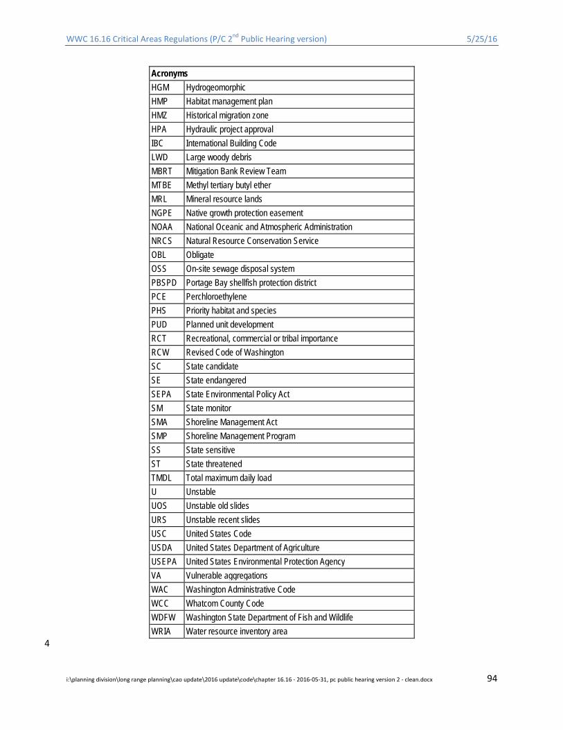
WWC 16.16 Critical Areas Regulations (P/C 2nd Public Hearing version) 5/25/16
Acronyms HGM Hydrogeomorphic HMP Habitat management plan HMZ Historical migration zone HPA Hydraulic project approval IBC International Building Code LWD Large woody debris MBRT Mitigation Bank Review Team MTBE Methyl tertiary butyl ether MRL Mineral resource lands NGPE Native growth protection easement NOAA National Oceanic and Atmospheric Administration NRCS Natural Resource Conservation Service OBL Obligate OSS On-site sewage disposal system PBSPD Portage Bay shellfish protection district PCE Perchloroethylene PHS Priority habitat and species PUD Planned unit development RCT Recreational, commercial or tribal importance RCW Revised Code of Washington SC State candidate SE State endangered SEPA State Environmental Policy Act SM State monitor SMA Shoreline Management Act SMP Shoreline Management Program SS State sensitive ST State threatened TMDL Total maximum daily load U Unstable UOS Unstable old slides URS Unstable recent slides USC United States Code USDA United States Department of Agriculture USEPA United States Environmental Protection Agency VA Vulnerable aggregations WAC Washington Administrative Code WCC Whatcom County Code WDFW Washington State Department of Fish and Wildlife WRIA Water resource inventory area
4
i:\planning division\long range planning\cao update\2016 update\code\chapter 16.16 - 2016-05-31, pc public hearing version 2 - clean.docx 94
Related Documents