GOONDIWINDI REGIONAL COUNCIL PAROO SHIRE COUNCIL BALONNE SHIRE COUNCIL TOOWOOMBA REGIONAL COUNCIL WESTERN DOWNS REGIONAL COUNCIL MARANOA REGIONAL COUNCIL MURWEH SHIRE COUNCIL NORTH BURNETT REGIONAL COUNCIL BANANA SHIRE COUNCIL BLACKALL TAMBO REGIONAL COUNCIL CENTRAL HIGHLANDS REGIONAL COUNCIL Hebel Weir Mungindi Weir Bokhara Weir Glenarbon Weir Cunningham Weir Dirranbandi Weir Balonne Minor River Regulator w/s Donnegri River Weir Talwood Weir Boomi Weir Coomonga Creek Weir Goondiwindi Weir Boggabilla Weir Ben Dor Weir Balonne Minor River Regulator w/s Whetstone Weir Horseshoe Lagoon Buckinbah Weir Jack Taylor Weir Moolabah Weir E J Beardmore Dam Surat Weir Warra Town Weir Chinchilla Town Weir Chinchilla Weir Bungeworgorai Weir Weir Wallumbilla Weir Dogwood Creek Weir Neil Turner Weir New South Wales New South Wales Garah Hebel Mungindi Dareel Yetman Thallon Boomi Dirranbandi Daymar Gradule Goondiwindi Kurumbul Gibinbell Yelarbon Nindigully Talwood Bungunya Toobeah Boolba St George Alton Flinton Southwood Bindle Moonie The Gums Glenmorgan Meandarra Tara Goranba Weranga Kumbarilla Surat Kogan Dunkeld Condamine Warra Chinchilla Brigalow Yuleba Tchanning Jackson Dulacca Drillham Miles Baking Board Mungallala Womalilla Mitchell Amby Muckadilla Hodgson Roma Blythdale Pickanjinnie Morven Gurulmundi Orallo Wandoan Gunnewin Injune Taroom Redbank Cracow Camboon Rawbelle Theodore For Border Rivers Basin, refer to plan WQ4161 For Warrego River Basin, refer to plan WQ4231 For Nebine, Mungallala and Wallam Creeks Basin, refer to plan WQ4221 For Moonie River Basin, refer to plan WQ4171 For Condamine River Basin, refer to plan WQ4223 BORDER RIVERS BASIN WARREGO RIVER BASIN NEBINE, MUNGALLALA AND WALLAM CREEKS BASIN MOONIE RIVER BASIN CONDAMINE RIVER BASIN Lower Nebine Creek Lower Mungallala and Wallam Creeks Lower Balonne Floodplain Briarie Creek St George Floodplain St George Floodplain Lower Moonie River Macintyre Barwon Floodplain Lower Weir River Canning Creek Maranoa Fan Upper Weir River Kumbarilla Ridge Middle Moonie River Upper Mungallala and Wallam Creeks Upper Moonie River Upper Nebine Creek Lower Maranoa River / Coogoon River Murilla Creek Murilla Creek Upper Nebine Creek Kumbarilla Ridge Bungil Creek Bungil Creek Murilla Creek Undulla Creek Kumbarilla Ridge Kumbarilla Ridge Undulla Creek Kumbarilla Ridge Yuleba Creek Dogwood Creek Dogwood Creek Kumbarilla Ridge North-Western Condamine Central Condamine Middle Warrego River Upper Maranoa River Dogwood Creek North-Western Condamine Upper Warrego River Upper Warrego River Upper Maranoa River Upper Warrego River Upper Warrego River Carnarvon Sandstones 422207A 422209A 422211A C un ni n g ham H ig h w a y B ar w o n Hig h way Warr e go Hi g h w a y Car n a rv o n H i g h w a y C astl er eag h H i g h w a y G o r e Hig h w ay M oo n ie H ighw ay L e i c h h a r d t H i g h w a y B alo nn e High wa y B u r n e t t Hi g h w a y L a n d s b or o ug h H i gh w a y 151°E 151°E 150°30'E 150°30'E 150°E 150°E 149°30'E 149°30'E 149°E 149°E 148°30'E 148°30'E 148°E 148°E 147°30'E 147°30'E 147°E 147°E 25°S 25°S 25°30'S 25°30'S 26°S 26°S 26°30'S 26°30'S 27°S 27°S 27°30'S 27°30'S 28°S 28°S 28°30'S 28°30'S 29°S 29°S ´ Prepared on: 27 August 2020 Environmental Protection (Water and Wetland Biodiversity) Policy 2019 Queensland Murray-Darling and Bulloo Basins Map Series This plan forms part of the Queensland Murray-Darling and Bulloo Basins Environmental Values and Water Quality Objectives scheduling document, prepared pursuant to the Environmental Protection (Water and Wetland Biodiversity) Policy 2019. WQ4222 - Maranoa-Balonne Rivers Basin Notes: 1. Plan refers to Queensland waters. Roads and other infrastructure are exempt. 2. Persistent waters in waterways at cease to flow conditions (i.e. waterholes) are considered to be high ecological value (HEV), excluding waters exempt from the Environmental Protection (Water and Wetland Biodiversity) Policy 2019 (refer section 11 (5)). 3. Wetlands shown on this map are sourced from the Queensland Wetland Data Version 5.0 developed by the Queensland Wetlands Program. Refer to the WetlandInfo website (wetlandinfo.des.qld.gov.au) for the most current information on Queensland wetlands. 4. Reference should be made to Matters of State Environmental Significance (MSES) datasets for a full coverage of MSES wetlands, available at: https://qldspatial.information.qld.gov.au. Disclaimer Whilst every care is taken to ensure the accuracy of this product, the Department of Environment and Science makes no representations or warranties about its accuracy, reliability, completeness or suitability for any particular purpose and disclaims all responsibility and all liability (including without limitation, liability in negligence) for all expenses, losses, damages (including indirect or consequential damage) and costs which you may incur as a result of the product being inaccurate or incomplete in any way and for any reason. Includes data © Commonwealth of Australia (Geoscience Australia, MDBA) 2020. © State of Queensland, 2020 Scale: 1:820,000 @ A1 Projection: Geocentric Datum of Australia 1994 (GDA94) Horizontal Datum: Geocentric Datum of Australia 1994 (GDA94) Part of basin 422 0 20 40 60 80 100 Kilometres ! ! Town # * Dam or weir " ) QLD Basin Salinity Management Strategy End- of-Valley sites Watercourse Water canal Highway Local government boundary State border Environmental value boundary Boundary of waters covered by the scheduling document Lake or reservoir Management Intent High ecological value (HEV) waters ! ! ! ! ! ! Slightly disturbed (SD) waters Waters in the scheduled area that are not shown as high ecological value or slightly disturbed have an aquatic ecosystem management intent of moderately disturbed Water Type Briarie Creek Bungil Creek Dogwood Creek Lake Kajarabie (E.J. Beardmore Dam) Lower Balonne Floodplain Lower Maranoa River / Coogoon River Maranoa Fan Murilla Creek St George Floodplain Upper Maranoa River Yuleba Creek Water Type - Waterway only Balonne River Lower Balonne Streams Waterway water type division Queensland ! ! ! ! ! ! ! ! Queensland W Q 4 1 7 1 WQ4223 W Q 0 1 1 1 WQ4231 W Q 4 1 6 1 W Q 4 2 2 1 W Q 4 2 4 1 WQ4222 Toowoomba Charleville Roma Bundaberg Location Map Key to Environmental Values Legend Aquatic Ecosystems Human Consumer Primary Recreation Secondary Recreation Visual Recreation Cultural & Spiritual Values Industrial Use Aquaculture Drinking Water Irrigation Stock Water Farm Supply

Welcome message from author
This document is posted to help you gain knowledge. Please leave a comment to let me know what you think about it! Share it to your friends and learn new things together.
Transcript
GOONDIWINDIREGIONALCOUNCIL
PAROOSHIRE
COUNCIL
BALONNESHIRE
COUNCIL
TOOWOOMBAREGIONALCOUNCIL
WESTERN DOWNSREGIONALCOUNCIL
MARANOAREGIONALCOUNCIL
MURWEHSHIRE
COUNCIL
NORTH BURNETTREGIONAL COUNCIL
BANANASHIRE
COUNCIL
BLACKALL TAMBOREGIONAL COUNCIL
CENTRALHIGHLANDS
REGIONAL COUNCIL
HebelWeir
Mungindi Weir
BokharaWeir
GlenarbonWeir
CunninghamWeir
Dirranbandi Weir
Balonne Minor RiverRegulator w/sDonnegri River
Weir
TalwoodWeir
Boomi Weir CoomongaCreek Weir
Goondiwindi Weir
BoggabillaWeir
Ben Dor Weir
Balonne MinorRiver Regulator w/s
WhetstoneWeir
Horseshoe Lagoon
BuckinbahWeirJack
TaylorWeir
Moolabah Weir
E JBeardmoreDam
Surat Weir
WarraTownWeir
ChinchillaTownWeir
Chinchilla Weir
BungeworgoraiWeir
Weir
WallumbillaWeir
DogwoodCreek Weir
NeilTurnerWeir
New South WalesNew South Wales
Garah
Hebel Mungindi
DareelYetman
Thallon
Boomi
Dirranbandi Daymar
Gradule Goondiwindi
Kurumbul GibinbellYelarbon
Nindigully
Talwood
BungunyaToobeah
Boolba
St George
Alton
Flinton
Southwood
Bindle
Moonie
The GumsGlenmorgan
Meandarra TaraGoranba
Weranga Kumbarilla
Surat
Kogan
Dunkeld
CondamineWarra
Chinchilla
Brigalow
YulebaTchanning
Jackson Dulacca DrillhamMiles
Baking Board
MungallalaWomalilla Mitchell
Amby Muckadilla HodgsonRoma
BlythdalePickanjinnie
MorvenGurulmundi
Orallo
Wandoan
Gunnewin
Injune
Taroom
Redbank
Cracow
CamboonRawbelle
Theodore
For Border RiversBasin, refer
to plan WQ4161
For WarregoRiver Basin,
refer toplan WQ4231
For Nebine,Mungallala andWallam Creeks
Basin, referto plan WQ4221
For Moonie RiverBasin, refer
to plan WQ4171
For CondamineRiver Basin, referto plan WQ4223
BORDERRIVERSBASIN
WARREGORIVERBASIN
NEBINE, MUNGALLALAAND WALLAM
CREEKS BASIN
MOONIERIVERBASIN
CONDAMINERIVER BASIN
LowerNebineCreek
LowerMungallala andWallam Creeks
Lower BalonneFloodplain
Briarie Creek
St GeorgeFloodplain
St GeorgeFloodplain
LowerMoonieRiver Macintyre
BarwonFloodplain
LowerWeirRiver
Canning Creek
Maranoa Fan
UpperWeirRiver
KumbarillaRidge
MiddleMoonieRiver
UpperMungallala andWallam Creeks
UpperMoonieRiver
UpperNebineCreek
LowerMaranoa River /Coogoon River Murilla
Creek
Murilla Creek
UpperNebineCreek
KumbarillaRidge
BungilCreek
Bungil Creek
Murilla Creek Undulla Creek KumbarillaRidge
KumbarillaRidge
UndullaCreek
KumbarillaRidge
Yuleba Creek
Dogwood Creek
DogwoodCreek
KumbarillaRidge
North-WesternCondamine
CentralCondamine
MiddleWarrego River
UpperMaranoa
River
DogwoodCreek
North-WesternCondamine
UpperWarrego
River
UpperWarrego River
UpperMaranoa River
UpperWarrego
River
UpperWarrego
River
CarnarvonSandstones
422207A422209A
422211A
Cunningham Highway
Barwon Highway
Warrego Highway
Carnarv
onHig
hway
Castlereagh H ighway
Gore Highway
Moonie Highway
Leichhardt Highway
Balonne Highway
B urn e ttHighwa y
LandsboroughHighway
151°E
151°E
150°30'E
150°30'E
150°E
150°E
149°30'E
149°30'E
149°E
149°E
148°30'E
148°30'E
148°E
148°E
147°30'E
147°30'E
147°E
147°E25
°S
25°S
25°30
'S
25°30
'S
26°S
26°S
26°30
'S
26°30
'S
27°S
27°S
27°30
'S
27°30
'S
28°S
28°S
28°30
'S
28°30
'S
29°S
29°S
´Prepared on: 27 August 2020
Environmental Protection (Water and Wetland Biodiversity) Policy 2019Queensland Murray-Darling and Bulloo Basins Map Series
This plan forms part of the Queensland Murray-Darling and Bulloo BasinsEnvironmental Values and Water Quality Objectives scheduling document, prepared pursuant
to the Environmental Protection (Water and Wetland Biodiversity) Policy 2019.
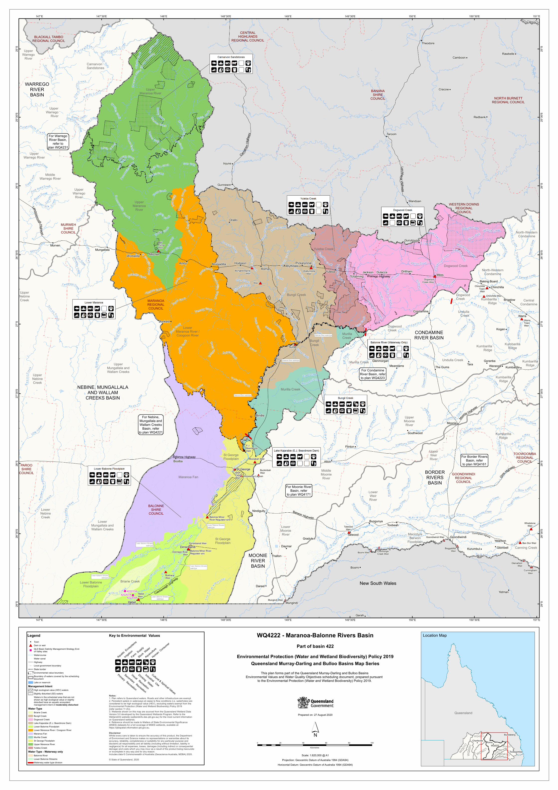
WQ4222 - Maranoa-Balonne Rivers Basin
Notes:1. Plan refers to Queensland waters. Roads and other infrastructure are exempt.2. Persistent waters in waterways at cease to flow conditions (i.e. waterholes) are considered to be high ecological value (HEV), excluding waters exempt from the Environmental Protection (Water and Wetland Biodiversity) Policy 2019 (refer section 11 (5)).3. Wetlands shown on this map are sourced from the Queensland Wetland DataVersion 5.0 developed by the Queensland Wetlands Program. Refer to theWetlandInfo website (wetlandinfo.des.qld.gov.au) for the most current informationon Queensland wetlands.4. Reference should be made to Matters of State Environmental Significance (MSES) datasets for a full coverage of MSES wetlands, available at: https://qldspatial.information.qld.gov.au.Disclaimer Whilst every care is taken to ensure the accuracy of this product, the Departmentof Environment and Science makes no representations or warranties about its accuracy, reliability, completeness or suitability for any particular purpose and disclaims all responsibility and all liability (including without limitation, liability innegligence) for all expenses, losses, damages (including indirect or consequentialdamage) and costs which you may incur as a result of the product being inaccurateor incomplete in any way and for any reason.Includes data © Commonwealth of Australia (Geoscience Australia, MDBA) 2020.© State of Queensland, 2020
Scale: 1:820,000 @ A1Projection: Geocentric Datum of Australia 1994 (GDA94)
Horizontal Datum: Geocentric Datum of Australia 1994 (GDA94)
Part of basin 422
0 20 40 60 80 100
Kilometres
!! Town#* Dam or weir")
QLD Basin Salinity Management Strategy End-of-Valley sitesWatercourseWater canalHighway
! ! Local government boundaryState borderEnvironmental value boundaryBoundary of waters covered by the schedulingdocumentLake or reservoir
Management IntentHigh ecological value (HEV) waters
! ! ! ! !
! ! ! ! !
! ! ! ! ! Slightly disturbed (SD) watersWaters in the scheduled area that are notshown as high ecological value or slightlydisturbed have an aquatic ecosystemmanagement intent of moderately disturbed
Water TypeBriarie CreekBungil CreekDogwood CreekLake Kajarabie (E.J. Beardmore Dam)Lower Balonne FloodplainLower Maranoa River / Coogoon RiverMaranoa FanMurilla CreekSt George FloodplainUpper Maranoa RiverYuleba Creek
Water Type - Waterway onlyBalonne RiverLower Balonne StreamsWaterway water type division
Queensland !!
!!!!
!!
Queensland
WQ4171WQ4223
WQ0111
WQ4231
WQ4161WQ4221
WQ42
41 WQ4222
Toowoomba
Charleville Roma
Bundaberg
Location MapKey to Environmental ValuesLegend
Aquatic Ecosys
tems
Human Consumer
Primary Recreation
Secondary Recreation
Visual Recreation
Cultural & Spiritual Values
Industrial Use
Aquaculture
Drinking Water
Irrigation
Stock Water
Farm Supply
Related Documents