Trimble Navigation Limited, 10355 Westmoor Drive, Suite #100, Westminster, CO 80021, USA © 2009, Trimble Navigation Limited. All rights reserved. Trimble, the Globe & Triangle logo, GeoExplorer, and GPS Pathfinder are trademarks of Trimble Navigation Limited, registered in the United States Patent and Trademark Office and in other countries. DeltaPhase, GeoXH, GeoXT, GPS Analyst, H-Star, Juno, ProXH, Tempest, and Tornado are trademarks of Trimble Navigation Limited. All other trademarks are the property of their respective owners. www.trimble.com Trimble Mapping & GIS Products: New Postprocessing Engine Summary Trimble has developed a new postprocessing engine for its Mapping & GIS product family. The postprocessing engine is built on the latest GNSS technologies, and enables existing Trimble users to achieve better product performance without the need to upgrade their existing hardware. The new Trimble ® DeltaPhase™ technology provides a considerable improvement in code postprocessing accuracy in all environments. Users can now expect postprocessed accuracy of 1 to 3 meters with the Trimble Juno™ SB and Juno SC handhelds. With the GeoXT™ handheld and the GPS Pathfinder ® ProXT receiver, postprocessed accuracy expectations improve from submeter to 50 cm. Users of Trimble H-Star™ technology-capable receivers will achieve decimeter (10 cm / 4 inch) accuracy more often—at longer baselines, in tougher environments, and with shorter occupations. Users of GPS Pathfinder ProXRT receivers with the GLONASS option will now be able to postprocess GLONASS data, achieving decimeter accuracy even in difficult urban environments. Customers who log carrier-phase data for extended periods will achieve higher levels of accuracy, even down to the centimeter (sub-inch) level in good conditions. Position yield—the proportion of quality GNSS positions that can be recorded in a given environment—is increased in tough GNSS environments, due to better satellite signal selection algorithms and new field software settings. Not only is postprocessed accuracy improved, but the accuracy estimates generated by the new postprocessing engine are also more reliable, ensuring that your GNSS metadata accurately reflects the quality of the positions in your GIS database.

Welcome message from author
This document is posted to help you gain knowledge. Please leave a comment to let me know what you think about it! Share it to your friends and learn new things together.
Transcript

Trimble Navigation Limited, 10355 Westmoor Drive, Suite #100, Westminster, CO 80021, USA © 2009, Trimble Navigation Limited. All rights reserved. Trimble, the Globe & Triangle logo, GeoExplorer, and GPS Pathfinder are trademarks of Trimble Navigation Limited, registered in the United States Patent and Trademark Office and in other countries. DeltaPhase, GeoXH, GeoXT, GPS Analyst, H-Star, Juno, ProXH, Tempest, and Tornado are trademarks of Trimble Navigation Limited. All other trademarks are the property of their respective owners.
www.trimble.com
Trimble Mapping & GIS Products: New Postprocessing Engine
Summary
Trimble has developed a new postprocessing engine for its Mapping & GIS product family. The postprocessing engine is built on the latest GNSS technologies, and enables existing Trimble users to achieve better product performance without the need to upgrade their existing hardware.
The new Trimble® DeltaPhase™ technology provides a considerable improvement in code postprocessing accuracy in all environments. Users can now expect postprocessed accuracy of 1 to 3 meters with the Trimble Juno™ SB and Juno SC handhelds. With the GeoXT™ handheld and the GPS Pathfinder® ProXT receiver, postprocessed accuracy expectations improve from submeter to 50 cm.
Users of Trimble H-Star™ technology-capable receivers will achieve decimeter (10 cm / 4 inch) accuracy more often—at longer baselines, in tougher environments, and with shorter occupations. Users of GPS Pathfinder ProXRT receivers with the GLONASS option will now be able to postprocess GLONASS data, achieving decimeter accuracy even in difficult urban environments.
Customers who log carrier-phase data for extended periods will achieve higher levels of accuracy, even down to the centimeter (sub-inch) level in good conditions.
Position yield—the proportion of quality GNSS positions that can be recorded in a given environment—is increased in tough GNSS environments, due to better satellite signal selection algorithms and new field software settings.
Not only is postprocessed accuracy improved, but the accuracy estimates generated by the new postprocessing engine are also more reliable, ensuring that your GNSS metadata accurately reflects the quality of the positions in your GIS database.

www.trimble.com 2
Introduction
This paper introduces Trimble’s latest postprocessing engine, developed with new technologies which improve the accuracy of postprocessed GPS data for all Mapping & GIS receivers, and for the first time provides the ability to postprocess GLONASS data.
For code receivers, the new Trimble DeltaPhase technology provides improved accuracy second-by-second and better accuracy in canopy and multipath environments. This is achieved by combining a number of techniques including: computing each position by examining the measurement data both before and after that epoch; utilizing code, carrier and Doppler data to maximize position accuracy; smart filtering to identify which satellites are affected by multipath; and smart weighting of the residual satellite signal data based on its quality.
Users of Trimble’s premium GPS code products—the GeoXT handheld and the GPS Pathfinder ProXT receiver—can expect an improvement in specified accuracy from submeter to 50 cm, second-by-second.
Users of Juno series handhelds (Juno SB or Juno SC) who previously expected 2 to 5 meters accuracy, will now see postprocessed results in the 1 to 3 meters range, second-by-second.
For receivers with H-Star technology—the GPS Pathfinder ProXRT and ProXH™ receivers, and the GeoXH™ handheld—the new postprocessing engine provides faster convergence to decimeter (10 cm / 4 inch) accuracy at longer ranges from the base station, under tougher conditions, and with shorter occupation times.
In open environments, users can record GPS carrier data for extended periods to achieve even higher levels of accuracy. Within set parameters, even accuracy at the centimeter (sub-inch) level is possible using carrier postprocessing techniques.
Note: The new postprocessing engine described in this White Paper was introduced with version 4.20 of the GPS Pathfinder Office software and version 2.20 of the GPS Analyst™ extension for ESRI ArcGIS Desktop software.
White paper structure This paper is organized in three main sections:
• the first illustrates how the new Trimble DeltaPhase technology improves postprocessed code accuracy.
• the second explains how H-Star accuracy is improved with the new postprocessing engine.
• the third explains how extremely high levels of accuracy can be achieved by logging and postprocessing extended periods of carrier data.
Each section presents the results of testing conducted in up to three environments:
Test Site One: Open
This is an ideal GNSS environment with no obstacles, and where GPS antennas are mounted on rigid survey pillars.
The test results from this site illustrate how performance is improved when there are no other variables to consider, such as multipath and signal strength degradation.
This is effectively a “laboratory” environment for GNSS testing, where you would expect most receivers to comfortably exceed specification.
Test Site Two: Suburban
This is a realistic suburban or light urban test environment, which should reflect the working conditions of a large range of users.
Trimble’s “suburban” test site is actually a light-industrial area located near to a Trimble R&D facility. It consists of 26 carefully surveyed test locations along a two-lane street. Buildings are one- and two-floor business premises with signage on the road and numerous parked vehicles. One side of the road has a row of mature trees, while the other is more sparsely planted.

www.trimble.com 3
The test locations themselves are real utility and city asset features (for example, telecom cable boxes, electrical transformers, fire hydrants, street lights, boundary pegs).
Because this test site most closely resembles the working environment of a “typical” user, it is used to validate GPS receiver specifications. Some GPS vendors characterize their receivers in laboratory conditions (akin to the Open test site); Trimble prefers to characterize the performance of Mapping & GIS products in this more realistic user environment.
Suburban test results presented in this white paper show the accuracy achieved at each of these 26 test locations.
With one exception, the first 17 of these locations are in relatively good GPS environments, where users would expect GPS products to meet or exceed specification.
Most of the features numbered 18 through 26 are located beneath a mix of deciduous and evergreen trees which obscure up to half the sky.
Examples of selected test locations:
Point 1
A cable box at the street edge of a business property and next to a tall sign.
Point 2
A cable box at the street edge of a business property and next to a tall sign.
Point 4
Located beneath a deciduous tree, this is a more difficult feature to map. The branches and foliage frequently impact GPS accuracy when mapping this feature.
Points 21 and 22
Light posts located on either side of a driveway, beneath tall deciduous trees.
Point 23
This feature (a cable box) is completely obscured by a fir tree and is a particularly difficult test for a GPS mapping system.
Point 26
The last feature in our test circuit is a company sign located directly beneath a large tree and with two buildings obscuring the sky on two sides.
dwalton
Line

www.trimble.com 4
Users could expect a GPS mapping system to fall outside its specification when mapping at least some of these “suburban” features. But a quality mapping system should still meet its specification on at least two thirds of these features, despite the harsh conditions.
Test Site Three: Forest canopy
This is a heavily forested tough environment with densely planted fir and pine trees. Tests conducted at this site show how performance and yield have been improved by the new postprocessing engine, even in the most demanding conditions.
Tests are conducted along forest roads which can be surveyed at each end to provide “truth” points:
Further testing is conducted within the forest itself, where yield is often as important as accuracy:
Data collection masks and position yield Traditionally, GPS data collection software has used fixed “masks” to determine which GPS satellite signals to use, and which to ignore. Commonly used masks include a minimum satellite elevation level, a minimum SNR value, or a maximum PDOP. While using fixed masks can ensure that most “bad” GPS signals are rejected, they also cause many perfectly usable signals to be discarded at the same time.
The new Trimble postprocessing engine consistently achieves better results when it has more GPS measurements to work with, including signals from satellites which may be weaker or lower on the horizon. Fortunately, the new engine is also capable of making far better decisions about which GPS signals to use and which to discard.
For this reason, for receivers with configurable masks the default GPS settings have been changed in the latest versions of Trimble field software, with the GPS slider now set to Productivity.
These new settings ensure optimal postprocessed accuracy due to the new postprocessing engine’s ability to select and use the best GPS satellite measurements.
At the same time, position yield potential is significantly increased. Users working in an open environment may see little difference in yield. But if the operating environment includes tall buildings, trees, or other obstacles then the new Productivity settings will increase position yield considerably.
As a rule of thumb, yield in a suburban environment can increase by 20% on average; in a forested environment, yield may increase by 40% or more.

www.trimble.com 5
Section One: Code Postprocessing with DeltaPhase Technology This section examines the test results for code-phase postprocessing, comparing performance of the new postprocessing engine against its predecessor.
GPS data recorded was recorded using a GeoExplorer® 2008 series GeoXT handheld and a Juno SB handheld, and was postprocessed using both the old and new engines. Aside from selecting code postprocessing only, standard settings were used.
Similar results are seen with other Trimble Mapping & GIS receivers of similar quality.
Test 1. Open test environment
Although this is a “perfect” (hence atypical) GPS environment, the data should reflect a realistic logging scenario. So rather than process day-long files, which normal users would never do, the datasets were divided into 2 minute files and processed independently, as if each was a separate feature.
The following chart shows the results of the postprocessed data for the GeoXT handheld:
While there is only a slight improvement in HRMS accuracy with the new postprocessing engine, there is a significant improvement in “spread”, with the worst error reduced by around 50% and the degradation of accuracy with distance much reduced.
With both the old and new postprocessing engines, the HRMS error is well within specification at less than 40 cm.
The Juno SB handheld results in this ideal open environment are as follows:
Both HRMS and maximum error are reduced. In this environment, there is little multipath so typical error is extremely low (barely 1 meter). The new postprocessing engine makes less of a difference here than it does in a tougher environment, discussed in the following set of tests.
Test equipment and process: • GeoXT handheld and Juno SB handheld with
internal antenna, set atop survey pillars • Data logged for an 8 hour period, then diced into 2
minute segments for postprocessing • Base stations at ranges varying from 10 km to 180
km

www.trimble.com 6
Test 2a. Suburban test environment– GeoXT handheld
The following chart compares the accuracies achieved after postprocessing using the old and new engines:
Accuracy summary:
GeoExplorer 2008 series GeoXT handheld (Code only)
Average error Worst error
Old Postprocessing Engine 0.57 meters (1.9 feet)
1.49 meters (4.8 feet)
New Postprocessing Engine 0.33 meters (1.1 feet)
1.10 meters (3.6 feet)
Comments
The new postprocessing engine consistently out-performed the old, with average accuracy well below the new 50 cm specification for the GeoXT handheld at just 33 cm.
The new postprocessing engine kept all but two positions below the 50 cm specification; these two outliers had just above 1 meter of error, but were located right underneath trees and in both cases the old postprocessing engine also struggled.
While the old code postprocessing engine performs well in open environments, it does not do as well under canopy. Here, the new postprocessing engine’s DeltaPhase capability achieved results that are well within the specification.
Test 2b. Suburban test environment– Juno SB handheld
This chart compares the accuracies achieved after postprocessing using the old and new engines:
Test equipment and process: • GeoXT handheld with internal antenna • At each of the 26 test locations, data was logged for
30 seconds • Base station at 10 km range
Test equipment and process: • Juno SB handheld with internal antenna • At each of the 26 test locations, data was logged for
30 seconds • Base station at 10 km range

www.trimble.com 7
Accuracy summary:
Juno SB handheld Average error Worst error Old Postprocessing Engine 1.78 meters
(5.8 feet) 5.30 meters (17.4 feet)
New Postprocessing Engine 1.06 meters (3.5 feet)
2.71 meters (8.9 feet)
Comments
The new postprocessing engine consistently out-performed the old, with the Juno SB handheld comfortably in the new 1 to 3 meter specification range (average accuracy is 1.06 meters; worst error is 2.71 meters). The impact of the new Trimble DeltaPhase technology postprocessing is particularly visible in this range, with the Juno SB handheld performing nearly twice as well as it did with the old postprocessing engine.
Test 3. Forest canopy test environment
Under dense forest canopy, data was logged using a GeoXT handheld and a Juno SB handheld.
Absolute known points were not available inside the forest, but because these forest paths are straight lines it was possible to accurately map each end of a path and draw a straight line between those end-points.
The following section of path shows the positions logged by the GeoXT handheld.
• red squares are the results of postprocessing using the old differential correction engine
• green circles are the results of postprocessing using the new engine
Not only is accuracy improved with the new engine, but yield is significantly increased due to the use of open masks with the new field software.
A similar section of path was mapped using a Juno SB handheld. Again red squares represent positions from the old postprocessing engine, while green circles represent positions from the new engine.
In the case of the Juno SB handheld, there is little difference in yield (due to the higher sensitivity of the GPS receiver). But the improvement in accuracy is significant.
Test equipment and process: • GeoXT handheld and Juno SB handheld with
internal antenna • The tester walked a straight forest path, logging
positions every second where possible • Base station at 10 km range • Data was processed using the old and new
postprocessing engines. In the case of the old engine, postprocessing masks equivalent to the default field software masks were applied; in the case of the new engine, smart masks were applied

www.trimble.com 8
Section Two: H-Star Technology This section examinesthe test results for postprocessed data collected with two Trimble H-Star technology-capable receivers—the GeoExplorer 2008 series GeoXH handheld and the GPS Pathfinder ProXRT receiver.
With the new postprocessing engine, DGPS positions at decimeter (10 cm/4 inch) accuracy are achieved faster, at longer ranges from the base station, and under tougher conditions than with older postprocessing technology.
As noted earlier, users can expect receivers to perform beyond specification in this ideal open environment.
Test 1. Open test environment
The following chart shows postprocessing results for the GeoXH handheld with different base stations:
The new postprocessing engine out-performed the old, both for the internal antenna and the optional Tornado external antenna. With the new engine, H-Star accuracy showed less degradation with distance than with the old postprocessing engine. The residual error did not begin to climb beyond decimeter level until the baseline length is around 200 km.
The following chart shows postprocessing results for the GPS Pathfinder ProXRT with different base stations:
In this case the older postprocessing engine worked on GPS measurements alone; the new postprocessing engine used both GPS and GLONASS measurements. The inclusion of GLONASS data makes little actual difference to the postprocessed accuracy, at least for short baselines, and in this open environment there is no problem with yield, so the benefits of GLONASS are not apparent here.
Test equipment and process: • GeoXH handheld with internal antenna • GPS Pathfinder ProXRT with Tornado antenna • Handheld and antenna set atop survey pillars,
positioned to millimeter accuracy • Data logged for an 8 hour period, then diced into 2
minute segments for postprocessing • Base stations at ranges varying from 10 km to
180 km
www.trimble.com 9
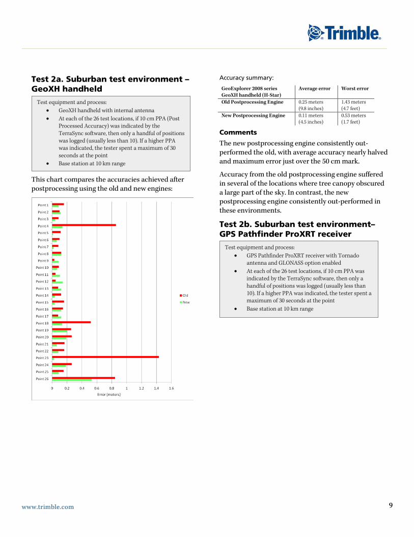
Test 2a. Suburban test environment – GeoXH handheld
This chart compares the accuracies achieved after postprocessing using the old and new engines:
Accuracy summary:
GeoExplorer 2008 series GeoXH handheld (H-Star)
Average error Worst error
Old Postprocessing Engine 0.25 meters (9.8 inches)
1.43 meters (4.7 feet)
New Postprocessing Engine 0.11 meters (4.5 inches)
0.53 meters (1.7 feet)
Comments
The new postprocessing engine consistently out-performed the old, with average accuracy nearly halved and maximum error just over the 50 cm mark.
Accuracy from the old postprocessing engine suffered in several of the locations where tree canopy obscured a large part of the sky. In contrast, the new postprocessing engine consistently out-performed in these environments.
Test 2b. Suburban test environment– GPS Pathfinder ProXRT receiver
Test equipment and process: • GeoXH handheld with internal antenna • At each of the 26 test locations, if 10 cm PPA (Post
Processed Accuracy) was indicated by the TerraSync software, then only a handful of positions was logged (usually less than 10). If a higher PPA was indicated, the tester spent a maximum of 30 seconds at the point
• Base station at 10 km range
Test equipment and process: • GPS Pathfinder ProXRT receiver with Tornado
antenna and GLONASS option enabled • At each of the 26 test locations, if 10 cm PPA was
indicated by the TerraSync software, then only a handful of positions was logged (usually less than 10). If a higher PPA was indicated, the tester spent a maximum of 30 seconds at the point
• Base station at 10 km range

www.trimble.com 10
This chart compares the accuracies achieved after postprocessing using the old and new engines:
Accuracy summary:
ProXRT receiver with GLONASS (H-Star)
Average error Worst error
Old Postprocessing Engine 0.11 meters (4.5 inches)
0.40 meters (16 inches)
New Postprocessing Engine 0.10 meters (3.9 inches)
0.27 meters (11 inches)
Comments
While average accuracy was only slightly improved, the new postprocessing engine eliminated most of the noisy (spiky) measurements and practically halved the worst errors. All results with the new postprocessing engine are within subfoot accuracy and the average accuracy over the 26 test locations is just 10 cm /4 inches.
The use of GLONASS measurements in the new postprocessing engine may have assisted somewhat in the canopy situations, but has not materially altered the overall (average) accuracy.
Effect of baseline length on postprocessed H-Star accuracy Differential GPS accuracy typically degrades as the distance between the rover and the base station increases, due to the increasingly different ionosphere through which satellite signals travel to those two locations. GPS accuracy specifications usually include a parts-per-million (ppm) factor that reflects the steady degradation of accuracy as the baseline length grows.
For example, with the new postprocessing engine the Trimble H-Star receivers now have an accuracy specification of 10 cm + 1ppm.
This formula suggests that accuracy at a range of 100 km will be in the region of 20 cm (10 cm + 1 millionth of 100 km = 10 cm + 10 cm). Similarly, accuracy at a range of 300 km will be in the region of 40 cm (10 cm + 1 millionth of 300 km).
The trend for a specific set of tests can be seen from the following chart:

www.trimble.com 11
The following chart shows H-Star data for the 26 suburban test locations, processed four times with base stations at distances ranging from 10 km to 300 km:
While the general trend of degrading accuracy with distance applies, sometimes a closer base will not yield the best accuracy for every single point, due to myriad localized effects.
As can be clearly seen, the majority of these realistic suburban test locations were mapped to subfoot (<30 cm) accuracy even when processed using a base station at 180 km. When the baseline distance exceeds 300 km the average error is still well below 50 cm.
Estimates of GNSS position accuracy The accuracy of GNSS positions is important to all users. But of nearly as much value is the quality of the accuracy estimates associated with each position that is recorded. GNSS metadata allows for qualitative analysis and informed decision-making, months or years after the data has been collected.
The following chart shows the correlation between the estimated H-Star accuracy and the actual accuracy achieved, for six combined “suburban” tests (using a mix of GeoXH handhelds and ProXRT receivers).
For each location mapped, the chart shows the estimated accuracy plotted against the actual accuracy achieved at that location on that particular test. The blue line indicates the line of perfect correlation between the accuracy estimate and the actual accuracy achieved. As the chart shows, the new accuracy estimates have less variation and tend to be conservative, with the majority lying below that blue line, meaning that actual accuracy is slightly better than the estimated accuracy.

www.trimble.com 12
Section Three: L1 Carrier Postprocessing Note: Continuous carrier postprocessing is only supported in the GPS Pathfinder Office software
This section examines the test results using L1 carrier postprocessing for data recorded with a GeoXT handheld.. Using carrier postprocessing techniques, the HRMS accuracy specifications are:
• 20 cm + 2ppm after 10 minutes continuously tracking satellites
• 10 cm + 2ppm after 20 minutes continuously tracking satellites
• 1 cm + 2ppm after 45 minutes continuously tracking satellites
To achieve 1 cm accuracy, the maximum baseline is 10 km. For all carrier postprocessing, the maximum baseline is 80 km.
Test 1. Open test environment
Using a GeoXT handheld with an external Tempest antenna, accuracy steadily converged over time to the point where the carrier postprocessing engine “initializes” and snaps to 10 cm accuracy. In this test (see chart below), that happened after around 15 minutes. Carrier accuracy will remain at 10 cm level unless logging is sustained for 45 minutes (and the base station is within 10 km), at which time accuracy dips to the 1 cm level.
To view these results in another way, the following scatter-plot illustrates the results of postprocessing 10 minutes of carrier data (after which the HRMS horizontal error is 15.8 cm):
Test equipment and process: • GeoXT handheld with Tempest™ antenna • Survey pillar positioned to millimeter accuracy • Base station at 10 km

www.trimble.com 13
The following scatter-plot illustrates the results of postprocessing 30 minutes of carrier data (after which the HRMS error has dropped to 7.9cm):
The following scatter-plot illustrates the results of postprocessing 60 minutes of carrier data:
The horizontal (2D) HRMS error for all positions logged during this time has fallen to 7.8 mm in this experiment.

www.trimble.com 14
Conclusion The new Trimble postprocessing technology can benefit all users of Trimble Mapping & GIS equipment. Through the application of better algorithms and Trimble DeltaPhase technology, it improves accuracy in harsh environments and over longer baselines, enables improved yield, and provides more reliable accuracy metadata.
With the GeoXT handheld and the GPS Pathfinder ProXT receiver, specified accuracy has improved from submeter to 50 cm. For Juno SB and Juno SC handhelds, specified accuracy is now 1 to 3 meters after postprocessing, down from 2 to 5 meters.
For H-Star technology-capable receivers—the GPS Pathfinder ProXRT or ProXH receivers, and GeoXH handheld—decimeter (10 cm/4 inch) accuracy is achieved at longer baselines, in difficult GPS environments, and with shorter occupation times.
The new Trimble postprocessing engine is available free of charge to all Trimble customers whose software maintenance is up-to-date. Customers whose maintenance has expired will need to purchase a software maintenance update. No new hardware purchase is necessary.