1 WORLD BANK DISCLAIMER The World Bank does not guarantee the accuracy of the data included in the Emissions Reductions Program Document (ER-PD) submitted by REDD+ Country Participant and accepts no responsibility for any consequences of their use. The boundaries, colors, denominations, and other information shown on any map in ER-PD does not imply on the part of the World Bank any legal judgment on the legal status of the territory or the endorsement or acceptance of such boundaries. The Facility Management Team and the REDD Country Participant shall make this document publicly available, in accordance with the World Bank Access to Information Policy and the FCPF Disclosure Guidance (FMT Note CF-2013-2 Rev, dated November 2013). Forest Carbon Partnership Facility (FCPF) Carbon Fund Emission Reductions Program Document (ER-PD) ER Program Name and Country: Promoting REDD+ through Governance, Forest landscapes & Livelihoods in Northern Lao PDR Date of Submission or Revision: _18 May, 2018 _

Welcome message from author
This document is posted to help you gain knowledge. Please leave a comment to let me know what you think about it! Share it to your friends and learn new things together.
Transcript

1
WORLD BANK DISCLAIMER
The World Bank does not guarantee the accuracy of the data included in the Emissions Reductions Program Document (ER-PD) submitted by REDD+ Country Participant and accepts no responsibility for any consequences of their use. The boundaries, colors, denominations, and other information shown on any map in ER-PD does not imply on the part of the World Bank any legal judgment on the legal status of the territory or the endorsement or acceptance of such boundaries.
The Facility Management Team and the REDD Country Participant shall make this document publicly available, in accordance with the World Bank Access to Information Policy and the FCPF Disclosure Guidance (FMT Note CF-2013-2 Rev, dated November 2013).
Forest Carbon Partnership Facility (FCPF)
Carbon Fund
Emission Reductions Program Document (ER-PD)
ER Program Name and Country:
Promoting REDD+ through Governance, Forest landscapes & Livelihoods
in Northern Lao PDR
Date of Submission or Revision: _18 May, 2018 _

2
Table of Contents List of Tables, Figures and Boxes ...............................................................................................5
Executive Summary ....................................................................................................................8
List of Acronyms ......................................................................................................................14
1. Entities responsible for the management and implementation of the proposed ER Program 18
1.1 ER Program Entity that is expected to sign the Emission Reduction Payment Agreement
(ERPA) with the FCPF Carbon Fund ............................................................................................ 18
1.2 Organization(s) responsible for managing the proposed ER Program ................................ 18
1.3 Partner agencies and organizations involved in the ER Program ....................................... 19
2. Strategic Context and Rationale for the ER Program .......................................................20
2.1 Current status of the Readiness Package and summary of additional achievements of
readiness activities in the country .................................................................................................. 20
2.2 Ambition and strategic rationale for the ER Program ......................................................... 22
2.2.1 Ambition and strategic rationale 22
2.2.2 Consistency of the ER Program with national policies and development priorities 24
2.3 Political commitment .......................................................................................................... 26
3. ER Program Location .......................................................................................................28
3.1 Accounting Area of the ER Program .................................................................................. 28
3.2 Environmental and social conditions in the Accounting Area of the ER Program ............. 31
4. Description of actions and interventions to be implemented under the proposed ER Program.
36
4.1 Analysis of drivers and underlying causes of deforestation and forest degradation, and
existing activities that can lead to conservation or enhancement of forest carbon stocks ............. 36
4.2 Assessment of the major barriers to REDD+ ...................................................................... 52
4.3 Description and justification of the planned actions and interventions under the ER
Program that will lead to emission reductions and/or removals .................................................... 54
4.4 Assessment of land and resource tenure in the Accounting Area ....................................... 71
4.4.1 Tenure typologies and range within the ER Program 72
4.4.2 Main issues for the ER Program 77
4.5 Analysis of laws, statutes and other regulatory frameworks ............................................... 78
4.6 Expected lifetime of the proposed ER Program .................................................................. 83
5. Description of stakeholder consultation process ...............................................................84
5.1 Description of stakeholder consultation process ................................................................. 84
5.1.1 Process of stakeholder consultation during the Design Phase 84
5.1.2 Process of stakeholder consultation during the Implementation Phase 87
5.2 Summary of the comments received and how these views have been taken into account in
the design and implementation of the ER Program ....................................................................... 88
6. Operational and Financial Planning ..................................................................................91
6.1 Institutional and implementation arrangements .................................................................. 91
6.1.1 National level REDD+ structures and responsibilities 91
6.1.2 Institutional set up for the ER program 95
6.2 ER Program budget ............................................................................................................. 98
6.2.1 ER Program budget (use of funds) 98
6.2.2 Financing strategy (sources of finance) 99
6.2.3 Financial and economic analysis 105
7. Carbon pools, Sources and Sinks ....................................................................................109
7.1 Description of Sources and Sinks selected ........................................................................ 109
7.2 Description of Carbon Pools and greenhouse gases selected ............................................ 110
8. Reference Level ..............................................................................................................112
8.1 Reference Period ............................................................................................................... 112

3
8.2 Forest definition used in the construction of the Reference Level .................................... 113
8.2.1 Forest definition and land/forest classification system 113
8.2.2 Stratification 116
8.3 Average annual historical emissions over the Reference Period ...................................... 118
8.3.1 General method 118
8.3.2 Activity data (AD) 119
8.3.3 Emission and removal factors (E/R factors) 123
8.3.4 Supplementary analysis on the impact of selective logging 126
8.3.5 Calculation of the average annual historical emissions over the Reference Period 128
8.4 Upward or downward adjustments to the average annual historical emissions over the
Reference Period (if applicable) .................................................................................................. 135
8.5 Estimated Reference Level ................................................................................................ 136
8.6 Relation between the Reference Level, the development of a FREL/FRL for the UNFCCC
and the country‟s existing or emerging greenhouse gas inventory .............................................. 136
8.6.1 Relation between the RL for the ER Program and the national FREL/FRL 136
8.6.2 Consistency with the GHG Inventory 138
8.7 Future improvements of the data used in the Reference Level ......................................... 139
8.7.1 Areas for future improvements related to the Activity Data 139
8.7.2 Areas for future improvements related to the Emission/Removal factors 140
8.7.3 Other thematic areas 140
9. Approach for Measurement, Monitoring and Reporting ................................................142
9.1 Measurement, monitoring and reporting approach for estimating emissions occurring
under the ER-P within the Accounting Area ............................................................................... 142
9.1.1 MMR of Emissions Reduction and Removals 142
9.1.2 Monitoring of drivers and the effectiveness of interventions 146
9.2 Organizational structure for measurement, monitoring and reporting .............................. 150
9.2.1 Organizational structure, responsibilities and competencies 150
9.2.2 Methods and standards for data management and public access to monitoring parameters
153
9.3 Relation and consistency with the National Forest Monitoring System ........................... 154
10. Displacement ............................................................................................................156
10.1 Identification of risk of Displacement ............................................................................... 156
10.2 ER Program design features to prevent and minimize potential Displacement ................ 157
11. Reversals ..................................................................................................................160
11.1 Identification of risk of Reversals ..................................................................................... 160
11.2 ER Program design features to prevent and mitigate Reversals ....................................... 161
11.3 Reversal management mechanism .................................................................................... 163
11.4 Monitoring and reporting of major emissions that could lead to Reversals of ERs .......... 163
12. Uncertainties of the Calculation of Emission Reductions ........................................165
12.1 Identification and assessment of sources of uncertainty ................................................... 165
12.2 Sources of uncertainty of Activity Data (AD) .................................................................. 165
12.3 Sources of uncertainty of Emission/Removal factors ....................................................... 166
12.4 Quantification of uncertainty in Reference Level setting ................................................. 169
13. GHG emission reduction Estimates of ER-Program ................................................171
13.1 Ex-ante estimation of GHG emissions reductions ............................................................ 171
13.2 Key assumptions and results for ex-ante emission reduction quantification .................... 172
14. Safeguards ................................................................................................................179
14.1 Description of how the ER Program meets the World Bank social and environmental
safeguards and promotes and supports the safeguards included in UNFCCC guidance related to
REDD+ ........................................................................................................................................ 179

4
14.1.1 Development of the national level safeguards instruments for REDD+ 179
14.1.2 Summary of the assessment of social and environment issues 183
14.1.3 Policy and legal framework concerns for implementation of safeguards 188
14.1.4 Social and environmental risks and mitigation measures of the ER Program 188
14.2 Description of arrangements to provide information on safeguards during ER Program
implementation ............................................................................................................................ 197
14.2.1 ER Program jurisdictional approach to safeguards 197
14.2.2 Institutional arrangement for monitoring of safeguards 198
14.3 Description of the Feedback and Grievance Redress Mechanism (FGRM) in place and
possible actions for improvement ................................................................................................ 199
14.4 Roadmap and way forward for safeguards ........................................................................ 202
15. Benefit-Sharing Arrangement ..................................................................................204
15.1 Description of benefit-sharing arrangements .................................................................... 204
15.1.1 Categories of beneficiaries, eligibility, types and scale of monetary and non-monetary
benefits 205
15.1.2 Criteria, process and timelines for distribution of monetary and non-monetary benefits
207
15.1.3 Monitoring provisions 210
15.2 Summary of the process of designing the benefit-sharing arrangements .......................... 210
15.3 Description of the legal context of the benefit-sharing arrangements .............................. 213
16. Non Carbon Benefits ................................................................................................215
16.1 Outline of potential Non-Carbon Benefits and identification of Priority Non-Carbon
Benefits ........................................................................................................................................ 215
16.2 Approach for providing information on Priority Non-Carbon Benefits ........................... 219
17. Title to Emission Reductions ...................................................................................221
17.1 Authorization of the ER Program ...................................................................................... 221
17.2 Transfer of Title to ERs ..................................................................................................... 224
18. Data Management and Registry Systems .................................................................226
18.1 Participation under other GHG initiatives ......................................................................... 226
18.2 Data management and Registry systems to avoid multiple claims to ERs ....................... 227
References ...............................................................................................................................232
Annexes .......................................................................................................................................1
Annex 1. Composition of Ethnic Groups in the ER Program Area ................................................. 2
Annex 2: Hotspot Drivers Analysis Report ..................................................................................... 3
Annex 3: Summary description of land and resource tenure typologies ......................................... 4
Annex 4: Land Tenure Assessment for the Emissions Reduction Program (ER-P) of Lao PDR
(consultations with projects through the LIWG) ............................................................................. 9
Annex 5: Land tenure assessment results from provincial survey ................................................... 9
Annex 6: ER Program Indicative activities and indicators ............................................................ 10
Annex 7: Description on entities and roles in the ER Program ..................................................... 18
Annex 8: ER Program budget and Funding sources – by year ...................................................... 21
Annex 9: ER Program Economic and Financial Analysis ............................................................. 23
Annex 10: Emission / Removal Factor Report .............................................................................. 30
Annex 11: Activity Data Report .................................................................................................... 30
Annex 12: Regenerating Vegetation Survey Report ...................................................................... 30
Annex 13: Lao PDR Allometric Equations Report ........................................................................ 30
Annex 14: Letters of Commitment ................................................................................................ 30

5
List of Tables, Figures and Boxes
List of Tables
Table 2.1.a: Summary of the R-Package self-assessment results ...................................................... 20
Table 3.1.a: Land/forest cover of the ER Program area per province 2015 ...................................... 30
Table 3.1.b: Forests in ER Program area by forest administrative categories (2005 and 2015) ....... 30
Table 3.2.a: Forest types per province 2015 ...................................................................................... 31
Table 3.2.b: Population and growth in the ER Program provinces ................................................... 34
Table 4.1.a: Drivers trends from wall-to-wall maps .......................................................................... 37
Table 4.1.b: Drivers of deforestation and degradation identified through stakeholder consultations
............................................................................................................................................................ 39
Table 4.1.c: Results of analysis of the three approaches to the drivers analysis ............................... 40
Table 4.1.d: Summary of the drivers, underlying causes and agents for the ER Program area ......... 52
Table 4.4.a: Land and resource tenure (instrument) typology ........................................................... 74
Table 5.1.a: Topics of consultation with different stakeholder groups .............................................. 86
Table 5.2.a: Summary of comments and responses from consultations with stakeholders ............... 88
Table 6.1.a: Members of the National REDD+ Task Force (NRTF) ................................................. 92
Table 6.1.b: The six REDD+ Technical Working Groups ................................................................. 93
Table 6.1.c: Preliminary identification of support and capacity needs across main REDD+ areas .. 94
Table 6.2.a: ER Program interventions and budget ........................................................................... 99
Table 6.2.b: Summary of funding sources ....................................................................................... 100
Table 6.2.c: Financing sources and mobilization status .................................................................. 101
Table 6.2.d: Sensitivity analysis for ER Program ............................................................................ 107
Table 6.2.e: Sensitivity analysis discount rates to estimate NPV of financial and economic analysis
.......................................................................................................................................................... 107
Table 7.1: Sources and Sinks accounted for in the ER Program ..................................................... 109
Table 7.2.a Carbon pools accounted for under the ER Program ..................................................... 110
Table 7.2.b: Gases accounted for under the ER Program ................................................................ 111
Table 8.2.a: Summary of the definition of “Current Forest” and “Potential Forest” of Lao PDR .. 113
Table 8.2.b: National level land and forest classification system of Lao PDR with IPCC definition
on land use categories “Land/forest classes” ................................................................................... 115
Table 8.2.c: Stratified land/forest classification system and the five REDD+ strata ....................... 117
Table 8.3.a: Activity Data (AD) for the reference period (ha) ........................................................ 121
Table 8.3.b: Emission and Removal (E/R) factors for the reference level (RL) (tCO2e) ................ 123
Table 8.3.c: Loss year based on temperature ................................................................................... 128
Table 8.3.d: Temperature and precipitation in Lao PDR (2014) and Pasoh (study site) ................ 128
Table 8.3.e: Carbon stock of the 5 REDD+ strata ........................................................................... 129
Table 8.3.f: Emissions/Removals Factors for changes .................................................................... 129
Table 8.3.g: AD estimated through design-based estimation for 2005-2010 and 2010-2015 (ha) .. 130
Table 8.3.h: Typologies of change for removals ............................................................................. 131
Table 8.3.i: Over-estimated removals tracked ................................................................................. 132
Table 8.3.j: Tracked over-estimation of emissions .......................................................................... 132
Table 8.3.k: Comparison of before and after adjustment ................................................................. 133
Table 8.3.l: Average annual historical emissions and removals (from 2nd
NFI) over the reference
period – based on changes among 5 REDD+ strata ......................................................................... 133
Table 8.3.m: Estimated total biomass loss from selective logging in ER Program area ................. 133
Table 8.3.n: Average Annual Historical Emissions and Removals over the Reference period ....... 135
Table 8.5.a: ER Program Reference level over the Reference Period (tCO2e/yr) ............................ 136
Table 8.6.a: Comparison table for national FREL/FRL with the ER Program RL ........................ 137
Table 8.6.b: Summary of plan for the NC and BUR ....................................................................... 138

6
Table 9.1.a: Summary of the MRV/MMR plans for Activity Data (AD) ........................................ 143
Table 9.1.b: Summary of MRV/MMR plans for E/R factors .......................................................... 144
Table 9.1.c: Monitoring of drivers ................................................................................................... 149
Table 9.2.a: Preliminary framework of institutions involved in the MRV/MMR ........................... 151
Table 9.2.b: Data for the NFMS database system ........................................................................... 154
Table 12.2.a: Map accuracy and uncertainty of Activity Data 2005 - 2010 .................................. 166
Table 12.2.b: Map accuracy and uncertainty of Activity Data 2010 – 2015 ................................... 166
Table 12.3.a: Cause of uncertainty and relevance for the estimation of Emission/Removals factor
.......................................................................................................................................................... 166
Table 12.3.b: Uncertainty assessment of carbon stock .................................................................... 168
Table 12.3.c: Mean tCO2e/ha and uncertainty by stratum .............................................................. 168
Table 12.3.d: Emission/Removal Factors ........................................................................................ 169
Table 12.3.e: Emission/Removal Factors Uncertainty .................................................................... 169
Table 12.4.a: Uncertainty of the emission level for 2005-2010 and 2010-2015 by sources/sinks .. 169
Table 12.4.b: Uncertainty of the reference level over the reference period .................................... 170
Table 12.4.c: Estimated emissions associated with RV ................................................................... 170
Table 12.4.d: Estimated emissions for degradation from selective logging .................................... 170
Table 13.1.a: Ex-ante GHG emissions reduction and removals of the ER Program ....................... 171
Table 13.2.a: Projected land use change matrix without the ER Program (BAU) for 2019-2025 (ha)
.......................................................................................................................................................... 172
Table 13.2.b: Key ER Program interventions, linkage to RL activity data and assumptions on
effectiveness of interventions .......................................................................................................... 174
Table 13.2.c: Projected land use change matrix with the ER Program for 2019-2025 (ha) ............ 176
Table 13.2.d: Assumed and quantified biomass for forest and non-forest land cover types .......... 176
Table 13.2.e: E/R factors for land use changes for aboveground and belowground biomass (tCO2e)
.......................................................................................................................................................... 177
Table 13.2.f: Projected emissions and removals based on ER Program implementation for 2019-
2025 (tCO2e) .................................................................................................................................... 177
Table 14.1.a: List of projects from which safeguards implementation lessons are drawn .............. 180
Table 14.1.b: Possible negative social and environmental risks and mitigation measures for the key
ER Program interventions ................................................................................................................ 189
Table 14.1.c: Summary of applicable World Bank Safeguards for the ER Program and proposed
approaches ........................................................................................................................................ 194
Table 14.4.a: Roadmap for safeguards development and implementation ...................................... 203
Table 15.1.a: Types of potential monetary and non-monetary benefits by funding source ............. 205
Table 15.1.b: Potential beneficiary types and their benefit sharing rationale .................................. 206
Table 15.1.c: Types of potential benefits by category of beneficiaries ........................................... 207
Table 15.2.a: Thematic areas for deliberation under the Benefit Sharing Plan ............................... 211
Table 15.2.b: Roadmap for the development and consultation of a Benefit Sharing Plan and model
.......................................................................................................................................................... 212
Table 16.1.a: Types of potential benefits from the ER Program ..................................................... 215
Table 16.1.b: Priority non-carbon benefits by category .................................................................. 217
Table 16.2.a: Sources of data for monitoring priority non-carbon benefits ..................................... 219
List of Figures
Figure 3.1.a: Map of land/forest cover of the ER Program area ........................................................ 28
Figure 4.1.a: Disturbance by type for the ER Program area (disturbances > 5ha) ............................ 38
Figure 4.1.b: Major crops per province (2016) .................................................................................. 43
Figure 4.1.c: Forest plantations by year of planting (2014, 2015, 2016), .......................................... 43

7
Figure 4.1.d: Patchwork landscape of shifting cultivation in the Northern uplands .......................... 45
Figure 4.3.a: Theory of change for the ER Program .......................................................................... 55
Figure 4.3.b: Overall ER Program design .......................................................................................... 56
Figure 4.3.c: Component 1 - Strengthening the enabling conditions for REDD+ ............................. 58
Figure 4.3.d: Component 2 - Climate smart agriculture and sustainable livelihoods for forest
dependent people ............................................................................................................................... 62
Figure 4.3.e: Component 3 – Sustainable forest management ........................................................... 67
Figure 4.4.a: Land use plans in the ER Program area ........................................................................ 73
Figure 4.4.b: Percentage area covered under land use instruments (other than LUP and VFMPs) in
the ER Program area .......................................................................................................................... 74
Figure 6.1.a: Institutional structure of REDD+ at national and provincial levels ............................. 92
Figure 6.1.b: Institutional setup for the ER Program ......................................................................... 96
Figure 6.1.c: Example of the coordination and implementation under a sub-component ................. 97
Figure 6.2.a: Share of the ER Program budget by source of finance (for identified sources of total
USD 136.6 million) .......................................................................................................................... 103
Figure 6.2.b: Cash flow analysis of the ER Program with Carbon Fund RBPs (without advanced
payment) .......................................................................................................................................... 104
Figure 8.3.a: Change matrix model .................................................................................................. 120
Figure 8.3.b: Relative values of material weights based on years of decomposition ...................... 128
Figure 8.3.c: Annotated change matrix among 5 REDD+ strata for addressing double-counting in
degradation ....................................................................................................................................... 134
Figure 9.2.a: Conceptual diagram of the database system ............................................................... 153
Figure 9.3.a: Conceptual diagram of Lao PDR‟s NFMS database and its interactions with other
REDD+ systems ............................................................................................................................... 155
Figure 14.3.a: Different options for grievance redress under REDD+ (draft) ................................. 201
Figure 14.3.b: Stages for REDD+ Claim and Complaint Resolution (draft) ................................... 202
Figure 15.1.a: Monetary and Non-monetary benefits ...................................................................... 204
Figure 15.1.b: The proposed benefit-sharing structure at the sub-national level ............................. 208
Figure 15.1.c: Draft benefit sharing structure for RBP for further consultation .............................. 209
Figure 18.1.a: Nesting of sub-projects within the ER Program ....................................................... 227
Figure 18.2.a: Conceptual diagram of the REDD+ Data Management Systems and eventual ER
Transaction Registry ........................................................................................................................ 228
Figure 18.2.b: Screenshot of the NFMS web-portal ........................................................................ 229
Figure 18.2.c: Screenshot of the REDD+ programs and projects database web-portal (demo version)
.......................................................................................................................................................... 230
List of Boxes
Box 1: Terminology on forests used in the ER-PD ..................................................................29
Box 2: A note on categories of drivers .....................................................................................36
Box 3: Shifting cultivation seen through the MRV/MMR for carbon accounting ...................45
Box 4: A note on short-term changes under the same land use ..............................................116
Box 5: The rationale for including the proxy-based approach for selective logging* ............126
Box 6: Experiences in applying the Community Engagement Framework (CEF) from the
SUFORD-SU project ..............................................................................................................181
Box 7: Potential REDD+ JCM project with Japan .................................................................226

8
Executive Summary
The Emission Reductions Program landscape, drivers and trends
The Emissions Reduction (ER) Program of Lao PDR embodies the Government‟s
commitment to reforming land use, enhancing forest restoration and protection. The Government of
Lao PDR (GoL) embraces REDD+ as the opportunity for transforming rural land use, from
opportunistic revenue generation at the cost of natural resources, to strategic and efficient land use
delivered through participatory and integrated planning design.
The national context
The ER Program of Lao PDR corresponds to its Nationally Determined Contributions (NDC)
with significant weight on actions to be taken in the forestry sector, which estimates removing 60-
69 million tCO2e from forest by 2020 compared to 2000, As the country is nearing completion of
REDD+ readiness, the GoL sees the ER Program as an opportunity for launching the
implementation phase of the National REDD+ Program. The ER Program aligns with the draft
National REDD+ Strategy (NRS) to 2025 and Vision to 2030, and is intended to inform strategic
and operational lessons for scaling up REDD+ at nationwide. The ER Program is also strategically
aligned with the Government‟s highest level development plan, the 8 th
National Socio-Economic
Development Plan (NSEDP: 2016-2020); its overall objective is “Reduced poverty, graduation
from LDC status with sustained and inclusive growth through promotion of national potential and
comparative advantages, effective management and utilization of natural resources and strong
international integration”. As a Least Developed Country (LDC), Lao PDR puts due emphasis on
the need for economic development and the need to balance this with sustainable natural resources
management, equitable, and inclusive growth. Namely, the national target of achieving 70 % forest
cover (16.6 million ha) is declared in the 8th
NSEDP and echoed in all national policy documents
that relate to natural resources management.
Rationale for selection of the proposed ER Program area
The Northern landscape of Lao PDR is distinctly unique, owed to the over 20 ethnic groups in
the six provinces who have called the sprawling mountains their home since far before the history
of the State. Remote accessibility and limited public and industrial infrastructure plays a role in
preserving the cultural heritage, but, also presents massive constraints in transportation,
accessibility of social welfare, promotion of industry and trade, among other issues. The provinces
in the Northern region all have international borders connecting them with regional growth centers
of China, Myanmar, Thailand and Vietnam at distances much closer than to Vientiane capital,
which presents both opportunities, as well as challenges, particularly in the form of pressure on land
and forest resources. With the above comes the status as the poorest region within this LDC, giving
way to the pro-poor ER Program design. Lao PDR‟s ER Program area straddles across six of the
Northern provinces of the country, constituting approximately 35 % of the national territory. The
proposed Accounting Area (ER Program area) is a contiguous landscape, covering the entire
administrative areas of Bokeo, Houaphan, Luang Namtha, Luang Prabang, Oudomxay and
Sayabouri provinces. The ER Program area has important functions as critical watersheds feeding
the major tributaries including the Mekong river. The hilly landscape is particularly prone to natural
disasters including landslides and flooding caused by monsoonal rainfall. This supports the
underlying rationale for forest management in the ER Program area other than the climate change
mitigation objectives.
Data suggest that as of the late 1970s Lao PDR was predominantly forested and has been
reduced to its current forest cover of approximately 58.0 % (as of 2015), with accelerated pace of
forest loss towards the late 1990s and 2000s. A birds-eye view of current day Lao PDR and
particularly of the North shows a sprawling patchwork of upland cultivation plots alongside

9
extensive bush fallow, and remaining forests covering difficult terrain. Major developments are
notable, including various scales of hydropower plants dotted along the major river networks, and
mining developments. Despite the low population density (21.7 persons/km2), human intervention
on the forest landscape is virtually inescapable. The annual gross deforestation and forest
degradation in the ER Program area between 2005-2015 was approximately 72,000 ha, compared to
181,000 ha for the national scale. Hence, approximately 40 % of the deforestation and degradation
in the country took place within the selected six provinces, in area terms.
Forest loss has had much to do with interest in land-based investments, increasing over the
years. A survey on national concessions and leases indicated that in 2012, over 2,640 cases of
active leases and concessions were issued covering 1.1 million ha of land, or almost 5% of the
country‟s territory1. As of 2018, an internationally supported initiative of the Government to
inventory land based concessions anecdotally reports that concessions for the mineral sector exceed
10 million hectares2 across the country.
3 According to the 2012 report, of the total area under
concessions and leases, over 80 % were under foreign investments, with Vietnam, China, and
Thailand as the main investors. Approximately 30 % of the land under concessions or leased are
considered to have been previously forest. Land based investments in the Northern region
accounted for 38% of the national share, in area terms. Related to such land concessions and leases,
social and environmental concerns, including negative impacts on rural community livelihoods by
replacing small-holders‟ agricultural areas and access to forests, have risen.
Opportunities for land and forest use sector reform
As with many developing countries, Lao PDR faces challenges in harmonizing land tenure
security with opportunities for land investment for economic growth. Key challenges include
unimplemented land allocation and land use sector plans, incompliant land conversion plans, lack
of transparency in awarding land concessions, “resulting in the wasting use of land, illegal
possession of public land-forest, unlawful granting of land use rights over state land to
individuals” (Party Resolution on Land)4.
With regards to governance, in recent years considerable improvements are noted in applying
the rule of law, but challenges remain in building capacity to institutionalize reform, across the
board. The GoL is taking significant steps for increased transparency, participatory land
management, and setting a clear direction through revision of key policies and regulations such as
the Party Resolution on Land (2017), and the Land and Forestry Laws. The GoL further recognizes
the critical need to address adverse impacts of climate change through broad, effective national
cross-sectoral strategies, and continued participation in regional and global efforts to resolve
environmental challenges.
1 Schönweger et al. 2012. Excluding cases of mining exploration (over 1 million additional ha) and use agreements for
hydropower generation, logging, and contract farming, which were beyond the scope of the inventory. 2 It is not known whether or not this figure includes underground extraction mining concessions (i.e. as opposed to
open-pit) which are not a direct threat or driver of deforestation or forest degradation. 3 Comprehensive land concession data that has been produced through the Land Concession Inventory (with funding
from SDC) since 2014, and is becoming available (as of May 2018). The concession inventory was carried out jointly
with the Ministry of Agriculture and Forestry, the Ministry of Planning and Investment, the Ministry of Energy and
Mines and the Ministry of Natural Resources and Environment, and covers the whole country for agriculture, forestry,
mining and hydropower sectors, including detailed maps of areas granted for concession and actual areas used, and
associated data (concession company, individuals responsible, financing, dates of approval, etc.). It was carried out with
support of the offices of the Provincial Governors and done at both provincial and district levels. The outcome of the
concession inventory has been presented by the MONRE Minister to the Central Committee and the Prime Minister.
The data is in a state now where it can be used, pending a formal agreement for dissemination between ministries.
4 The Central Committee of the Lao People‟s Revolutionary Party‟s Resolution on Enhancement of Land Management
and Development in New Period (3 August 2017).

10
In recent years, the GoL embarked on a number of reforms that will provide a platform for
launching the ER Program interventions. For instance, in 2012, in response to the concerns raised
across the country, the GoL issued a suspension on granting of new concessions for mining,
eucalyptus and rubber investments, which remains in effect today. A national moratorium on
logging in production forests has been also in effect since 2013 in order to protect natural forests
from unsustainable exploitation. The Prime Minister‟s Order (PMO) No.15 of 20165 to strengthen
enforcement of restrictions to halt illegal logging and illegal timber exports, is already
demonstrating significant impact, and is expected to have sustained impact with the GoL‟s official
start of the FLEGT Voluntary Partnership Agreement (VPA) negotiations with the EU. In addition,
the adoption of the Central Party Committee‟s Resolution on Land in 2017 indicating the need for
reform in land management is paving the way for a new Land Law.
The Emission Reductions Program as a solution
This ER Program is designed as a strong, strategic and scalable foundation for addressing the
key drivers of deforestation and forest degradation and reduce greenhouse gas emissions beyond
business as usual. The ER Program is formulated based on strong analysis and understanding of the
main direct and underlying drivers of forest loss. Direct drivers include permanent agriculture
expansion (including rubber) into forest areas, shifting cultivation in its different dimensions
encroaching into forest areas and preventing forests to regenerate, and illegal and unsustainable
timber harvesting. Hydropower, mining and other infrastructure related developments also play a
part. These direct drivers interplay with a set of complex underlying drivers. The pressures
presented by the regional growth centers just across the border from the ER Program provinces are
significant. Such pressures interface with rural populations that presently have little in terms of
alternative options in the face of „land deals‟ offered by investors, and ultimately drive decisions
regarding land-use. Such issues being common to other regions - although with differences in scale
- justify and increase the value of the ER Program as a pioneer program.
The ER Program is developed to respond to the above contexts. The analytical work
supporting this ER Program emanates from two primary processes. First, at the national level, the
Government‟s process to develop a NRS, and second, at the provincial level, a series of Provincial
REDD+ Action Plans (PRAPs) have been consultatively prepared in the six provinces.
The proposed interventions of the ER Program correspond to each of the four main drivers
and are organized into four components, including: i) interventions for an enabling environment for
REDD+, ii) agriculture sector interventions, iii) forestry sector interventions, and iv) a program
management and monitoring component.
Under the Component 1 on enabling conditions, at the core are; activities to strengthen and
mainstream REDD+ into existing policies and legal framework; improved forest governance by
building on the on-going FLEGT initiative to address illegal logging across the supply chain;
development of programs and policies incentivizing deforestation-free investments through
engagement of the private sector; and improved land use planning and compliance monitoring.
Land use planning will target both broader strategic levels to apply integrated cross-sectoral and
vertically-consistent planning, and at the local village level, following the broader master land use
plans, ensuring participatory processes of implementable and equitable land use and forest
management plans. Building capacity within Government (at all levels), as well as in non-
Government actors (such as civil society, mass organizations, academe, private sector etc.) to
mobilize the most cost-efficient arrangements for improving rural land use will be a significant part
5 Prime Minister‟s Order No. 15 of 2016 on „Enhancing strictness on the management and inspection of timber
exploitation, timber movement, and timber businesses.‟

11
of this enabling conditions component. A system for monitoring implementation and conformance
with plans will be institutionalized, and may be linked with incentive mechanisms that reward
conformance. Component 1 will engage strongly with a number of sectors (all represented in the
National REDD+ Task Force and Provincial REDD+ Task Force structures) including agriculture,
forestry, land and investment promotion.
Under Component 2 on agriculture and sustainable livelihoods development, a market
analysis for models adopting climate-smart agriculture practices will be conducted, and resulting
models will be integrated into extension services delivered by local extension agents to rural
farmers. Agriculture is the default livelihood of the rural population and the most direct pressure on
forests. As such, the ER Program will offer direct measures for value chain integration, and agro-
technological solutions for improved yields. Engaging the private sector for climate-smart and
responsible investments is critical for ensuring sustainable decisions on land use. Activities under
this component aim to support a private-public dialogue on REDD+ and climate-smart agriculture,
and to directly invest in scalable models that sustainably engage with local communities including
ethnic groups, and supporting alternative livelihood options.
Under Component 3 on forestry, the ER Program will take a landscape approach to
identifying and enabling resourceful land-use to maximize land potential and ecosystem values. The
ER Program will place a strong focus on forest landscape restoration and management (FLR)
including restoration of degraded forest lands, much of which are found in the „regenerating
vegetation‟ land class largely associated with bush fallow areas. Forest protection activities will
also be introduced, where village communities will be mobilized through a participatory forest
management planning and implementation process of their „village forests‟. Instruments such as the
Village Forest Management Agreement (VFMA) to strengthen the village‟s legal rights to use and
benefit from forest land and resources will be promoted. Linking with the Component 2 agricultural
component activities, the forestry component activities will also mobilize private sector investments
in long-term sustainable commercial forestry activities including in the timber and fiber industries.
Monetary, non-monetary and non-carbon benefits
Village level land use and forest management plans will include activities in both agriculture
and forestry sectors as well as for setting enabling conditions. The activities are designed to support
and incentivize protection of existing natural forests, to support and promote forest restoration and
sustainable plantations development, and to promote agricultural and forest investments that are
deforestation-free and are aligned with land use plans. The design of activities at local and central
levels will in part adopt an „incentives approach‟ where behavior change among agents is
incentivized by rewarding performance through monetary and non-monetary benefits. However,
taking into account the need for up-front investments, as well as the establishment of enabling
conditions to foster change, the benefit sharing mechanism also will incorporate non-performance-
based channels.
The ER Program interventions are also designed to generate non-carbon benefits particularly
in social and governance benefits of participatory development. The ER Program also promotes
pro-poor development and enhanced food security impacts through strong engagement of the rural
population, with attention paid to ethnic groups and women along the entire process, and
corresponding in provisions within the benefit sharing regime. Other priority non-carbon benefits
which are expected include improved land tenure security, enhanced capacity in law enforcement,
monitoring and reporting; and increased watershed protection and forest and landscape restoration.
Considering the jurisdictional nature of the ER Program under which ERs may be generated
from anywhere within the six provinces, and also taking into account the various projects that
operationalize the ER Program, a jurisdictional approach to safeguards will be adopted where a
single safeguards framework will be established covering safeguards of the Government, various

12
relevant donor institutions as well as the World Bank. As of necessity, REDD+ safeguard measures
will be put in place for implementing these activities, ensuring Free, Prior and Informed Consent
(FPIC) by local stakeholders particularly in activities that lead to changes in their practices of land
and resource use. Within the safeguards framework, tools will be developed to ensure full and
effective participation of stakeholders, particularly vulnerable groups including ethnic groups and
women within the communities. Such tools include the Community Engagement Framework (CEF)
and the Gender Action Plan.
The ER Program impact, implementation and the way forward
The Ministry of Agriculture and Forestry (MAF) will spearhead the ER Program through
coordination and collaboration with other relevant agencies at all relevant administrative levels. At
the central level, the REDD+ Division of the Department of Forestry (DOF), under MAF will act as
a secretariat and focal agency to the National REDD+ Task Force (NRTF) comprised of 12 multi-
sectoral/ministerial members on national and programmatic level decision-making. At the
provincial level, Provincial REDD+ Offices within the Provincial Agriculture and Forestry Offices
(PAFO) will act as focal agencies to support the Provincial REDD+ Task Forces, to plan and
deliver against the PRAPs. Such institutional arrangements are relevant and necessary for the ER
Program to ensure strong collaboration and coordination among the different sectors – namely,
agriculture, forestry, land, and investment promotion. The proposed institutional arrangement also
aims for coherence among provinces, and for guidance from the central level to be effectively
channeled, particularly in introducing and carrying out the innovative processes particularly among
enabling environment-related interventions. Engagement of stakeholders beyond the Government,
such as private sector and civil society, is also a critical ingredient for success, and the institutional
set-up will need to cater to this.
The ER Program is an important step in the rolling out the NRS because it provides an
opportunity to test and feedback important experiences on the effectiveness of the proposed
interventions, jurisdictional approach to safeguards, distribution of monetary, non-monetary and
non-carbon benefits, nesting of carbon accounting among different scales (including nesting of the
ER Program into national scale), and institutional arrangement for engaging with multiple sectors
and stakeholder groups.
The activities under the four main components will be rolled out in the six ER Program
provinces, targeting over 70,000 ha for promoting improved agriculture interventions and 320,000
ha for promoting sustainable forest management and FLR. The enabling environment related
activities under Component 1 will also generate impacts beyond the ER Program area. An estimated
42,000 rural households and ethnic minority groups (total approximately 254,000 people) are
projected to benefit from the ER Program at least 40% of whom will be women and ethnic group
members. These estimates are based on the estimates from the PRAPs.
The ER Program envisages a budget of USD 136 million for its roll out (for the six years of
2019-2024). This includes already committed finances from Government and international sources,
anticipated finances including a project under formulation for submission to the Green Climate
Fund, and reinvestments of a part of the anticipated results-based payments from the Carbon Fund.
The ER Program anticipates a potential income stream equivalent to 13.24 million ERs (USD 66.2
million based on USD 5/tCO2e).6 Such ex-ante estimation of emission reductions and removals are
based on the areas of interventions to be implemented and a co-efficient applied to reflect efficiency
rate for non-land-based interventions. This reflects net results of approximately 19.36 million
6 This figure assumes a reversal buffer of 23 % and conservativeness factors of 4 % and 15 % (see Section 11 and 12
for more details).

13
tCO2e, against the 2005-2015 reference level (RL), to be achieved. Of this, 12.67 million tCO2e are
from reduced emissions, and 6.69 million tCO2e are from enhanced removals.
As of May 2018, at the time of the submission of the Final ERPD to the Carbon Fund, there is
wide consensus among the country stakeholders on country readiness, and on the significant
potential for positive implications, for the Lao PDR ER Program to be adopted by the Carbon Fund.
The timing is also considered to be optimal, considering the forestry sector reforms underway (e.g.
PMO No. 15, FLEGT), the development and/or updating of key Government strategies including
the National Socio-Economic Development Plan (NSEDP), the Green Growth Strategy and the
Forest Strategy in the course of the next few years.
The Government acknowledges a number of immediate areas of work that will further
strengthen the country‟s ability to implement the Program and succeed in achieving the anticipated
carbon and non-carbon impacts. Such areas of work are laid out in a roadmap and detailed action
plans and include; i) preparation of the benefit sharing plan through wide consultations and
negotiations, ii) preparation of the ESMF and its associated tools to enable a jurisdictional approach
to safeguards, iii) institutionalization of the proposed grievance redress mechanism and
establishment of a design for an independent monitoring function of safeguards, and iv) issuance of
legal provisions for setting a legal framework for ER titles and the authorization of MAF as the ER
Program Entity of Lao PDR. Under the overall guidance and decision-making of the multi-sectoral
NRTF, and secretarial services from the REDD+ Division of DOF, MAF as the ER Program Entity
stands ready to engage further with the unique opportunity presented through REDD+ and the
FCPF Carbon Fund.

14
List of Acronyms Acronym Meaning
AD Activity Data
AGB Above Ground Biomass
BAU Business as Usual
BGB Below Ground Biomass
BP Bank Procedures
BSP Benefit sharing plan
CDS Capacity development strategy
CEF Community Engagement Framework
CF Carbon Fund
CLIPAD Climate Protection through Avoided Deforestation (project under GIZ and KfW)
CNA Capacity needs assessment
CSA Climate Smart Agriculture
DAFO District Agriculture and Forestry Office
DBH Diameter at Breast Height
DCC Department of Climate Change (under MONRE)
DDG Deputy Director General
DFRM Department of Forest Resources Management (under MoNRE), established 2012 and dissolved in 2016
DG Director General
DOE Department of Environment (under MoNRE)
DoF Department of Forestry (under MAF)
DOFI Department of Forest Inspection (under MAF)
DPI District office of Planning an Investment
DW Dead Wood
E/R factors
Emission and Removal factors
EGDP Ethnic group development plan
ER Emissions reduction
ERR Economic Rate of Return
ESIA Environmental and Social Impact Assessment
ESMF Environmental and Social Management Framework
ESMMP Environmental and social management and monitoring plan
ESMP Environmental and social management plan
FAO Food and Agriculture Organization of the United Nations
FCPF Forest Carbon Partnership Facility
FFRDF Forests and Forest Resources Development Fund
FFS Farmer field schools
FIP Forest Investment Program
FLEGT Forest Law Enforcement, Governance and Trade
FPIC Free, prior and informed consent
FPREP Forestry Sector Policy Strategy for Sustainable Forest Management and REDD+ Promotion

15
Project
FRA Forest Resources Assessment
F-REDD Sustainable Forest Management and REDD+ Support Project (JICA)
FREL Forest reference emission level
FRL Forest reference level
FRR Financial Rate of Return
FTM Forest Type Map
GCF Green Climate Fund
GHG Greenhouse Gas
GoL Government of Lao PDR
GRM Grievance redress mechanism
ICBF Integrated Conservation of Biodiversity and Forests project (KfW)
INDC Intended nationally determined contributions
IPCC Intergovernmental Panel and Climate Change
ISP Integrated Spatial Planning
Lao PDR Lao People's Democratic Republic
LDC Least Developed Country
LFNC Lao Front for National Construction
LIWG Land Information Working Group
LMDP Land Management and Decentralized Planning Project (GIZ)
LUP Land Use Planning
LWU Lao Women's Union
M Million
MAF Ministry of Agriculture and Forestry
MEA multilateral environmental agreements
MEM Ministry of Energy and Mines
MMR Measurement, Monitoring and Reporting
MoF Ministry of Finance
MOIC Ministry of Industry and Commerce
MoNRE Ministry of Natural Resources and Environment
MPI Ministry of Planning and Investment
MPWT Ministry of Public Works and Transportation
MRV Measurement, reporting and verification
MW mega watts
NAFRI National Agriculture and Forestry Research Institute
NBCA National biodiversity conservation area
NDC Nationally Determined Contributions
NEC National Environmental Committee
NFI National Forest Inventory
NFIS National Forest Information System (project under JICA)
NFMS National Forest Monitoring System
NLMA National Land Management Authority

16
NPA National Protected Areas
NPV Net Present Value
NRS National REDD+ Strategy
NRTF National REDD+ Task Force
NSEDP National socio-economic development plan
NTFPs Non-timber forest products
NUOL National University of Laos
OP Operational Policies
PAFO Provincial Agriculture and Forestry Office
PAREDD Participatory Land and Forest Management Project for Reducing Deforestation (under JICA)
PMU Program management unit
POFI Provincial Office of Forest Inspection
PONRE Provincial Office of Natural Resources and Environment
PPI Provincial Office of Planning and Investment
PPIO Provincial planning and investment office
PRAP Provincial REDD+ Action Plan
PRO Provincial REDD+ Office
PRTF Provincial REDD+ Task Force
RAI Responsible Agricultural Investment
RAP Resettlement action plans
RBP Results based payments
REDD+ Reducing emissions from deforestation and forest degradation plus
REL Reference emission level
RF Removal factor
RL reference level
RPF Resettlement policy framework
RPP Readiness proposal plan
RTF National REDD+ Task Force
RV Regenerating Vegetation
SESA Strategic, environmental and social assessment
SFM Sustainable forest management
SIS Safeguards Information System
SUFORD-SU
Scaling Up Participatory Sustainable Forest Management Program
TA technical advisors
TWG Technical working group
UNFCCC United Nations Framework Convention on Climate Change
VDF Village development fund
VFMA Village forest management agreements
VFMP Village forest management plans
VGGT Voluntary Guidelines on the Responsible Governance of Tenure of Land, Fisheries and Forests in the Context of National Food Security
VPA Voluntary Partnership Agreement

17
WREA Watershed Resource and Environment Administration
Acronyms specific to the land/ forest classification system
Acronym Meaning
AP Agriculture Plantation
B Bamboo
BR Barren Land and Rock
CF Coniferous Forest
CL Cloud
DD Dry Dipterocarp Forest
EF Evergreen Forest
G Grassland
MCB Mixed Coniferous and Broadleaved Forest
MD Mixed Deciduous Forest
O Other Land
OA Other Agriculture
P Forest Plantation
RP Rice Paddy
RV Regenerating Vegetation
SA Savannah
SC Scrub
SH Shadow
SW Swamp
U Urban
UC Upland Crop
W Water
Acronyms for province names
Acronym Meaning
BKO Bokeo
HPN Huaphan (can also be seen spelled as Houaphan)
LNT Luang Namtha
LPB Luang Prabang
ODX Oudomxay
SAY Sayabouri (can also be spelled as Xiangabouly or Xayaburi)

18
1. ENTITIES RESPONSIBLE FOR THE MANAGEMENT AND IMPLEMENTATION OF THE PROPOSED ER PROGRAM
1.1 ER Program Entity that is expected to sign the Emission Reduction Payment Agreement (ERPA) with the FCPF Carbon Fund
1.2 Organization(s) responsible for managing the proposed ER Program
Name of entity Ministry of Agriculture and Forestry (MAF)
Type and description of organization
A department within MAF responsible forestry sector policies, governance and regulations including REDD+ at national and sub-national.
Main contact person Mr. Sousath Sayakoummane
Title Director General of Forestry Department, MAF
Deputy Chair of National REDD+ Task Force
Address Khoum Thad Dam, Chanthabuly District, Vientiane Capital, Lao PDR
Telephone +85621 215 000
Email [email protected]
Website
Same entity as ER Program Entity identified in 1.1 above?
A department under the ER Program Entity
If no, please provide details of the organizations(s) that will be managing the proposed ER Program
Name of organization Department of Forestry (DOF), Ministry of Agriculture and Forestry (MAF)
Type and description of organization
As described above under 1.1
Organizational or contractual relation between the organization and the ER Program Entity identified in 1.1 above
A department under the ER Program Entity
Main contact person Mr. Somchay Sanontry
Title REDD+ National Focal Point
Deputy Director General of DoF
Alternate contact person Mr Khamsene Ounekham, Director of REDD+ Division
Address Department of Forestry, That Dam Campus, Vientiane, Lao PDR
Telephone +856-20-5446-6929
Email [email protected]
Website http://dof.maf.gov.la/en/home/

19
1.3 Partner agencies and organizations involved in the ER Program
Name of partner Contact name, telephone and email Core capacity and role in the ER Program
Bokeo Provincial REDD+ Task Force
Main: Mr. Phosikeo Xayachack +8562055185516
Deputy chair of task force
Alternate: Mr. Khampheng Chaiyachack +8562055684128.
Head of PRO
Houaphan Provincial REDD+ Task Force
Main: Mr. Khin Thoummala +8562022346236
Deputy chair of task force
Alternate: Mr. Mr. Houmphan Phoumpanya, +8562028600242, [email protected]
Head of PRO
Luang Namtha Provincial REDD+ Task Force
Main: Mr. Thouang Namvongsa +8562055786637
Deputy chair of task force
Alternate: Mr. Khammeung Dengmany +8562022390230
Head of PRO
Luang Prabang Provincial REDD+ Task Force
Main: Mr. Houmchitsavath Sodasack +8562055570415, [email protected]
Deputy chair of task force
Alternate: Mr. Xang Xanaphon +8562054007777, [email protected]
Head of PRO
Oudomxay Provincial REDD+ Task Force
Main: Mr. Bounkeut Sanongxay +8562022515765
Deputy chair of task force
Alternate: Mr. Bounthan Phonsavanh +8562022840113
Head of PRO
Sayaboury Provincial REDD+ Task Force
Main: Mr. Khamkeung Phanlack +8562022810026
Deputy chair of task force
Alternate: Mr. Sompong Chittavong +8562055775474
Deputy Head of PRO

20
2. STRATEGIC CONTEXT AND RATIONALE FOR THE ER PROGRAM
2.1 Current status of the Readiness Package and summary of additional achievements of readiness activities in the country
The Lao PDR FCPF REDD+ Readiness Package has been developed and submitted to the FCPF in
January 2018. The Readiness Package assesses Lao PDR to be in advanced stages of REDD+
Readiness, scoring „green‟ (significant progress) in three areas including, the drivers analysis (2a.),
identification of REDD+ strategy options (2b.) and, development of Reference Emission Levels
(3a.); scoring „yellow‟ (progressing well, further development required) in four areas, including
national REDD+ management arrangements (1a.), consultation, participation and outreach (1b.),
social and environmental impacts (2d.) and national forest monitoring system (4a.); scoring
„orange‟ (further development required) in the area of implementation framework (2c.) and
information system for multiple benefits, other impacts etc. (4b.) No areas were scored as „red‟ (not
yet demonstrating progress).
Table 2.1.a: Summary of the R-Package self-assessment results Component Sub Component Summary
scores
Readiness organization and consultation
1a. National REDD+ Management Arrangements
1b. Consultation, participation and outreach
REDD+ Strategy preparation
2a. Assessment of Land Use, Land-Use Change Drivers, Forest Law, Policy and Governance
2b. REDD+ Strategy Options
2c. Implementation Framework
2d. Social and Environmental Impacts
Reference Emission Level/Reference Level
3a. Reference Emissions Level/Reference Levels
Monitoring system for forests and safeguards
4a. National Forest Monitoring
4b. Information System for Multiple Benefits, other Impacts, Governance, and Safeguards
Legend:
Significant progress
Progress well, further development required
Further development required
Not yet demonstrating progress
In terms of the key elements of the National REDD+ Program, the current status is as follows:
The National REDD+ Strategy (NRS), originally drafted by the members of the Strategy
technical working group (TWGs: see Section 6.1 on further details regarding the six TWG
under REDD+) and consulted through the other TWGs, regional workshops with provincial
representatives, and various other stakeholder consultation workshops including with the
land and agriculture sector agencies of the central level, and through the multi-sectoral
National REDD+ Task Force (NRTF). The draft NRS is currently being revised based on
feedback from the consultations, and is expected to receive recommendation for approval
from the NRTF, for final approval by the Ministry of Agriculture and Forestry, within 2018.
The Reference Emission Level and Forest Reference Level (REL/FRL) has been
developed through the REL/MRV TWG, and submitted to the UNFCCC in January 2018.

21
The REL/FRL is national in scope, and applies methodologies that are generally consistent
with that of the Reference Level (RL) for the ER Program, applied in this ER-PD document.
A technical assessment of the REL/FRL is due in 2018.
The National Forest Monitoring System (NFMS) is under development. Through the
course of developing the national REL/FRL considerable focus has also been shed on
discussing plans for future monitoring (i.e. MRV/MMR). A standard operating procedure
(SOP) for future National Forest Inventories (NFIs) have been developed, and capacity for
generating activity data (AD) that is consistent with the methodology applied in the
REL/FRL (and RL) is generally present in-country (with scope for further capacity
building.) Databases for hosting historical and future data for carbon accounting and other
aspects of the NFMS has been developed and made publicly accessible through web-portal
<http://nfms.maf.gov.la:4242/nfms/>, and is being designed as a core part of the national
REDD+ Data Management System. With the submission of the REL/FRL now underway,
the relevant divisions within the Government are focusing their capacity to monitoring and
reporting against its REL/FRL.
Under safeguards, the SESA has been developed. The SESA report includes not only the
desk review (scoping) of relevant information on environmental and social for REDD+, but
also describes the process and outcomes of stakeholder consultations on the drivers of
deforestation and degradation, possible strategic interventions, key related environmental
and social issues, and stakeholder priorities. A host of consultation meetings were
conducted for the SESA process, including at the central, regional, provincial, district, and
village cluster levels, throughout the country. Safeguard plans, i.e., the Environmental and
Social Management Framework (ESMF) and the Community Engagement Framework
(CEF) are also being developed. A proposal for Grievance Redress has also been developed,
building on existing national structures and adapting for REDD+. How the country will
collect information on safeguards and report to the UNFCCC (and to other parties) has yet
to be deliberated in detail. The expectation is for a number of sources of information and
databases to cater to information related to safeguards, and for information to be screened
and compiled for providing a summary of information.7
The national coordination and management arrangements for REDD+ have been confirmed
and made operational, including the aforementioned NRTF its six TWGs, the REDD+
Division located within the Department of Forestry (DOF), and a parallel structure at the
provincial level, focusing on seven pilot provinces in the North and South of the country.
Basic principles for REDD+ benefit-sharing have been identified by the benefit-sharing
TWG. Potential host of REDD+ funds have been screened and a candidate existing fund has
been identified, for further consultation and deliberation on benefit sharing. The TWG
recommends that REDD+ payments be channeled through a special funding window under
the Forestry and Forest Resource Development Fund (FFRDF), which is managed by DOF.
Specific benefit-sharing agreements are developed for each individual REDD+ project or
program, such as the ER Program.
A REDD+ communication and outreach strategy has been prepared, to coordinate
awareness raising among different stakeholder groups on issues regarding climate change,
REDD+, and participating in sustainable forest management. A bilingual, Lao-English,
website for the National REDD+ Program is ready to be launched, and will be linked to a
REDD+ geo-spatial web portal enabling public access to key geo-spatially referenced
7 As encouraged by the Carbon Fund Participants, Lao PDR will make efforts to reporting to the UNFCCC on
safeguards mechanisms prior to the signing of the ERPA, as far as possible.

22
REDD+ data. Other communications and information activities have promoted greater
public awareness of REDD+ issues and activities.
The roadmap for the immediate and longer-term future for advancing and achieving REDD+
readiness include the following;
Focus areas for the immediate future (2018-2019)
Development of a generic benefit sharing plan for the country (as well as specific benefit
sharing arrangements for the ER Program), through consultations with broad stakeholders
and direct negotiation with potential beneficiaries including women and ethnic groups;
Furthering work to establish an enabling environment for REDD+, particularly through
revisions of policies, laws and regulations, and development of implementation plans – this
includes the streamlining of REDD+ into new development plans for the next planning
period;
Capacity needs assessment and responding capacity building of different stakeholder
groups, shifting the focus from central level to regional and provincial level stakeholders to
implement the ER Program in particular, and associated partners including Civil Society,
and private sector actors;
Establishing a framework for monitoring of drivers and impact of interventions and
associated capacity building for technical agencies in charge, as well as for local
communities and civil society participation.
Focus areas for the longer-term future (2019-2025)
Development of a the national REDD+ Data Management System and a national carbon
Transaction Registry;
Integration of associated data sets and databases to enable effective and efficient monitoring
and provision of data on safeguards and non-carbon benefits;
Continuous capacity development at all levels and among different stakeholder groups with
a view towards national roll-out of REDD+;
Development of PRAPs for priority provinces - with particular attention to the Central and
Southern regions; and updating of existing PRAPs.
2.2 Ambition and strategic rationale for the ER Program
2.2.1 Ambition and strategic rationale
Lao PDR‟s forests are ecologically unique and of global importance for its biodiversity. Forests are
economically important for the country, and they are vital as a source of important nutrition,
livelihood, and income for the rural population and in particular, the rural poor. Some 80 % of the
population are heavily reliant on forests for timber, food, fuel, fibre, shelter, medicines, condiments
and spiritual protection. In rural areas, forests provide one of the few possible economic activity
alternatives, and non-timber forest products (NTFPs) often are a significant source of household
income.
Of the country‟s total land area of 23 million hectares (ha), land with forest cover accounted for
58.0 % in 2015. 8 Compared to the estimation of around 70 % forest cover in the mid-1960s, the
country has lost significant forest cover. In the past fifteen years, the net deforestation rate has been
at around 2.9 % (approximately 680,000 ha), while agricultural land expanded by approximately 3
% (approximately 715,000 ha) per annum. Another significant change is the increase in land under
forest plantations from 18,000 ha in 2000 to 138,000 ha in 2015, an increase of 120,000 ha. Water
8 Applying the Lao PDR definition of forests, including canopy cover of over 20%.

23
bodies have increased, from 276,000 ha in 2000 to 350,000 ha in 2015 largely due construction of
hydropower reservoirs.9
The situation regarding forest degradation, which encompasses decreases in forest stocking,
changes in species composition and size structure, loss of wildlife and plant habitats, and declines
in wildlife and plant population, is as concerning as deforestation. There are no direct indicators for
monitoring degradation, but, the land cover class known to be largely associated with (but not
exclusively) rotational shifting cultivation and is regarded as areas that if left fallow for sufficient
periods could return into forest10, accounted for approximately 6.1 million ha, or roughly a quarter
of the national land cover, as of 2015. The Northern part of the country where the ER Program is
located contains nearly half of such lands within the whole country.
Lao PDR embraces the REDD+ agenda nationally, and has drafted a NRS. While the National
REDD+ Program will eventually include a roll out for the national scale, in the early phase of the
REDD+ readiness, a number of projects supported by development partners focused their REDD+
pilot actions in the Northern provinces, which gave way to increased capacity and preparedness of
these provinces for REDD+, and the eventual selection of the six Northern provinces as the area for
the Lao ER Program.
Lao PDR‟s ER Program area straddles across six of the Northern provinces of the country,
constituting approximately 35 % of the national territory. The proposed Accounting Area (ER
Program area) is a contiguous landscape, covering the entire administrative areas of Bokeo,
Houaphan, Luang Namtha, Luang Prabang, Oudomxay and Sayabouri provinces. Each province
shares an international border with one of the surrounding countries of Thailand, Myanmar, China
and Viet Nam. The Northern region of Lao PDR is characterized by hilly topography, remote
accessibility and limited public and industrial infrastructure, unique ethnic communities, and a
persistent prevalence of poverty.
The combined area of deforestation and forest degradation in the ER Program area in 2005-2015
was approximately 72,000 ha/year, compared to a national average of 181,000 ha/year.
Approximately 40 % of the deforestation and degradation took place within the selected six
provinces.11 12
The ER Program area presents a suitable landscape for testing different strategies for REDD+. The
proximity of these provinces to regional economic growth centers, namely China and Viet Nam
make the region particularly attractive to regional markets and businesses which has had clear
impacts on the land use change trends of the past decades. Land-based businesses and investments
into the Northern region commonly apply contract farming models thereby making local
communities as the proximate agents taking land use change decisions, with local authorities. The
landscape is suitable and important for interventions that will help the region in sustainable
strategies to respond to increasing domestic land-based commodity demands and underlying cross-
border drivers.
Aside from emission reductions through mitigation interventions, Northern Lao PDR has vast
potential for forest enhancement through reforestation and restoration activities. Compared to the
other regions in the country, the Northern region has a high occurrence of areas zoned for forest
9 Source: based on FIPD forest type maps of 2000, 2005, 2015 of Lao PDR. See also Annex 11 Activity Data Report. 10 Referred to as the “Regenerating Vegetation” (RV) class in Level 2 of the country‟s land/forest classification system. 11 Includes Potential Forest classes (under Level 1 of the country‟s land/ forest classification system; see Sections 3 and
8), including RV, that fall under the 20% canopy cover threshold, but considered to be managed as forest land. 12 Note also that this refers only to degradation accounted through the forest cover change analysis, and does not
include degradation as accounted through the selective logging stump survey (see Section 8 for more details.)
24
management, which are in fact currently highly degraded, in some stage of regrowth or are
comprised of un-stocked forests.
Through the implementation of the ER Program for the six year ERPA term, the Government of
Lao PDR estimates the total net emissions reductions and enhancement of carbon removals of
approximately 21.6 million tCO2e, against its 2005-2015 reference level (RL), to be achieved. Of
this, 13.1 million tCO2e are from reduced emissions, and 8.5 million tCO2e are from enhanced
removals.
The ER Program is considered a critical opportunity for developing and maintaining momentum for
REDD+, and as the inception for the implementation of the National REDD+ Program. The ER
Program is expected to be a key source of experiences and learning to support the broader NRS and
its action plans.
While the Government of Lao PDR is fully committed to implementing the ER Program and the
broader national REDD+ framework, there are existing challenges that will need to be addressed to
ensure the success of the ER Program. Such challenges include the improvement in cross-sectoral
and vertical coordination among sectors and Government levels (i.e. central to local), and capacity
building to coherently implement and enforce regulations and programs among the different levels
(see Section 4.2).
In terms of financial investments to implement the ER Program, the Government envisages
multiple sources of funds including the Government budget, projects funded by development
partners, as well as a significant REDD+ project for Lao PDR, targeting the ER Program area being
formulated for funding under the Green Climate Fund (GCF) (see Section 6.2). Approximately one
third of the financial portfolio for the ER Program is committed or has significant chance of
commitment; the another one third is under the GCF funding, which is in advanced stages of project
formulation13
, and the remaining one third anticipates RBPs from the Carbon Fund.
2.2.2 Consistency of the ER Program with national policies and development priorities
The importance of forest resources and its sustainable management are enshrined in the country‟s
highest level policies, including the 8th National Socio-Economic Development Plan (8th
NSEDP
2016-2020), the Green Growth Strategy under drafting, the Central Party‟s Resolution on Land
(2017), the Forestry Strategy 2020, as well as in Lao PDR‟s Nationally Determined Contributions
(NDC).
The ER Program and its interventions are strategically integrated and aligned with the draft NRS,
which has been developed in alignment with the key national policies and strategy documents. The
current policy environment is favorable for implementation of the ER Program and its proposed
interventions. It will nonetheless be important to invest sufficiently into creating and improving the
enabling environment, particularly in terms of improved capacity among provincial and local level
Government authorities to implement and enforce existing policies and regulations. At the sub-
13 The funds from the GCF is planned to be mobilized with GIZ as the Accredited Entity. A process towards project
formulation is already underway (as of May 2018). A GIZ project scoping mission was dispatched to the country in
April 2018, and a Concept Note is being made available. The project scope will cover the implementation of the ER
Program, namely the agricultural and forestry sector activities on the ground, identified in each of the six PRAPs. The
current proposed scope of the project is approximately USD 45 million. There are prospects for submission of a full
proposal by the end of 2018, to enable project implementation by beginning of 2020. It is important to note that prior to
the start-up of such a GCF project, other international finance and projects will have been mobilized and already
starting implementation, particularly with respect to activities for enabling environment establishment (Component 1
among others).

25
national level, for each of the six provinces involved in the ER Program, a PRAP has been prepared
and approved through a consultative process in identifying the drivers and appropriate interventions
to address these drivers. Adequacy of institutional, technical and financial capacity have been
identified as critical success factors for both the NRS and the ER Program, hence they are well
prioritized. The ER Program consolidates the interventions outlined in the PRAPs, and also adopt
the strategic level interventions outlined in the draft NRS.
The relevance of the ER Program to key Government policies and strategy documents are outlined
below:
With regards to the 8th National Socio-Economic Development Plan (NSEDP: 2016-2020), its
overall objective is “Reduced poverty, graduation from LDC status with sustained and inclusive
growth through promotion of national potential and comparative advantages, effective
management and utilization of natural resources and strong international integration”. As a Least
Developed Country (LDC), Lao PDR puts due emphasis on the need for economic development
and the national policies to clearly focus on the need to balance this development with sustainable
natural resources management, equitable, and inclusive growth. Namely, the national target of
achieving 70 % forest cover (16.6 million ha) is declared in the 8th
NSEDP and echoed in all
national policy documents that relate to natural resources management, and highlight the
importance that the Government place on recovery of its forest resource base.
The draft National Green Growth Strategy (version as of early 2018) embraces the forestry
agenda as a priority and promotes the increase of forest cover and greening of urban areas. Among
other forestry interventions, it identifies the use of economic tools to promote domestic and foreign
investments in tree planting in deforested and degraded land in order to meet the 70 % forest cover
target. The Strategy also identifies the significant role of the agriculture sector in the green growth
path way, and promotes agro-technological solutions to promote environmentally friendly and
climate smart agricultural practices, as well as alternative livelihoods to shifting cultivation.
Strengthening of the environmental management sector including the regulatory framework,
capacity and standardizing environmental management practices is also identified as a core area of
focus under the Strategy. For the implementation of the Strategy, financial mechanisms including
environmental taxes and payments for ecosystem services (PES) are proposed, alongside intentions
to access concessional loans and private sector investments. The World Bank supports the
Government of Lao PDR in a number of reform areas contributing to the Green Growth Strategy
objectives, through the Green Resilient Growth Development Policy Operations.14
The draft National Master Plan on Land Allocation (version as of early 2018) also speaks to the
70 % forest cover target. In this Plan, the overall macro level direction is to reach and maintain a
70:30 ratio balance in terms of conservation and development objectives of land management. The
70 % of land under conservation and protection objectives should consist largely of conservation
and protection forest lands, as well as reserved areas, where management objectives are set towards
watershed management, biodiversity and ecosystem conservation among others. Under the
remaining 30 % of land will be land for residential areas, industrial areas, transport infrastructure,
as well as agricultural and production forest area. The Master Plan is well aware of the challenges
in synchronizing the land use allocations from macro levels with the reality on the ground, and
declares the intention to identify land use objectives taking into account the realities on the ground.
The Forestry Strategy 202015
identifies sector targets as follows:
14 http://www.worldbank.org/en/news/loans-credits/2017/05/31/lao-pdr-first-programmatic-green-growth-development-
policy-operation 15 Lao PDR, 2005. It is noted that the Forestry Strategy is planned for review and updates in 2019.

26
To improve quality of administratively designated forest lands, which make up
approximately 70 % of the total land area, by naturally regenerating up to 6 million ha and
planting (including through assisted natural regeneration) trees up to 500,000 ha in un-
stocked forest area as an integral part of a rural livelihood support system encompassing
stable water supplies and prevention of natural disasters.
To provide a sustainable flow of forest products for domestic consumption and to generate
revenue through sales and export, contributing to livelihood improvement, fiscal revenue
and foreign exchange earnings whilst increasing direct and indirect employment.
To preserve the many species and unique habitats, which are, for different reasons, under
threat.
To conserve environment including protection of soil, conservation of watershed and
combating climate change.
Lao PDR‟s Nationally Determined Contributions (NDC) puts significant weight on the forestry
sector, echoing the forest cover target of 70 %, as well as activities for regeneration of forests. The
NDC estimates removing 60-69 million tCO2e by 2020. Two main activities that act as
implementation measures for Lao PDR‟s Forestry Strategy 2020 include:
Increase and maintain forest cover at 70 % as GHG sinks, and address the risks of flooding
and soil erosion in order to reduce domestic GHG emissions; and
Achieve sustainable community forest management, promote agriculture and forestry, and
alleviate poverty.
The Draft National REDD+ Strategy (NRS) to 2025 and Vision to 2030, once finalized, will be
the official Government document for guiding REDD+ implementation including with the
participation of all relevant stakeholders in the country. It aims to improve the quality and extent of
forests nationwide to provide economic, social, and environmental values. The NRS vision requires
all stakeholders, including households, communities, and the private sector, to be active in strategy
implementation to reduce deforestation and degradation, and promote forest restoration and
reforestation.
The historical emissions and removals from the ER Program area amount to approximately 30% of
emissions from the national scale16
; and indicatively, approximately 56 % of removals from the
national scale (for the reference period of 2005-2015)17
.
2.3 Political commitment
The REDD+ agenda and other developments have had a significant impact in strengthening the
Government‟s commitment to the forestry sector, in recent years. It is in this context that the ER
Program will be rolled out.
An important development has been the issuance of the Prime Minister‟s Order No. 15 of 2016 on
“Enhancing Strictness on the Management and Inspection of Timber Exploitation, Timber
Movement, and Timber Businesses”, which tightened previous efforts to enforce the ban on export
of logs and unprocessed timber to avoid illegal logging, among other issues pertaining to forest
management. This Order followed up with a special task force for its monitoring has seen
significant results compared to other such efforts in the past, including a sharp drop in levels of
timber exports. According to a Forest Trends study, Lao exports of logs and sawn wood to its main
16 Noting that this is an approximate estimation as the national level estimation did not apply the design-based
estimation for generation of the final activity data. 17 Noting that this is an indicative estimation based on the comparison of values for the two scales (i.e. ER Program
area and national scale) estimated without applying the spreading out of removals over a 20 year period.

27
traders of Vietnam and China had decreased by 74% by the end of 2016, compared with their levels
in 2014. The report makes the link between these trade figures and the aforementioned Prime
Minister‟s Order of Lao PDR.18
The Government has also marked further commitment to the forestry sector by starting its
negotiations with the EU towards a Voluntary Partnership Agreement (VPA) for Forest Law
Enforcement, Governance and Trade (FLEGT) in 2017, and initiated development of Timber
Legality Definition and Timber Legality Assurance System, both of which will directly and
indirectly support the REDD+ agenda.
Another important institutional development has been the reconsolidation of management of the
forestry sector under one single ministry, the Ministry of Agriculture and Forestry (MAF), in 2016.
The Government assessed that the separation of the forestry sector between MAF and MONRE,
back in 2011 had led to reduced effectiveness and efficiency in the management of the sector, and
took the decision to return forests under MAF. This has brought significant positive impact not least
in time efficiency of decision-making, where decisions in the past five years often required
consultation between the related agencies of both ministries. For REDD+, this has meant in the
merger of the two REDD+ offices into the current REDD+ Division under DOF.
Considering the multi-sectoral nature of REDD+, the Government set up the National REDD+ Task
Force (NRTF) as the mechanism for coordination and decision making. The NRTF is headed by the
MAF deputy minister, and its membership includes representatives from six ministries (including
MAF, MONRE, MOF, Ministry of Planning and Investment, Ministry of Justice), the Lao Front for
National Development, the National University of Lao, as well as the Chamber of Industry and
Commerce. The NRTF is the highest level institution to deliberate on REDD+ and through the
MAF Minister, reports directly to the Prime Minister.
The NRTF is supported by the REDD+ Division under DOF in MAF, and the six Technical
Working Groups which provide advice on thematic areas of work under REDD+. Coordination on
climate change (including REDD+) is also being strengthened including mainstreaming climate
finance related reporting and monitoring between the forestry sector (DOF) and the climate change
focal point (in MONRE). Through the multi-sectoral and multi-ministerial structure of the NRTF
and the six Technical Working Groups, discussions and decisions related to REDD+ are consulted
across different sectors and coordination is facilitated and continuing to improve as a result.
Consultations and decisions pertaining to the ER Program have also been taken through both of
these mechanisms.
The structure of the NRTF supported by the DOF REDD+ Division is replicated at the provincial
level, where Provincial REDD+ Task Forces (PRTF), supported by Provincial REDD+ Office
(PRO) have been established. PRAPs are developed through a strong and consultative process
involving both, PRTFs, PROs, and district- and village-level stakeholders. Through the cross-
sectoral PRTFs, REDD+ and the proposed ER Program interventions have been discussed and
coordinated with relevant sectoral agencies outside of the forestry sector. Between the central and
provincial levels, strong communication is maintained to consult and to inform provinces of
relevant developments taking place – including the developments pertaining to the ER Program.
Apart from MAF as the lead executing ministry for the ER Program, letters of commitment have
been received and are appended from the Minister of MOF and the Governors of the six provinces,
to demonstrate their strong commitment to the ER Program.
18 Xuan, P.T., et al., 2017.

28
3. ER PROGRAM LOCATION
3.1 Accounting Area of the ER Program
The proposed Accounting Area of the ER Program straddles six Northern provinces of Lao PDR,
constituting approximately 35 % of the national territory. The proposed Accounting Area is a
contiguous landscape, covering the entire administrative areas of Bokeo, Houaphan, Luang
Namtha, Luang Prabang, Oudomxay and Sayabouri provinces. Each province shares an
international border with one of the surrounding countries of Thailand, Myanmar, China and Viet
Nam. The Northern region of Lao PDR is characterized by hilly topography, remote accessibility
and limited public and industrial infrastructure, unique ethnic minority communities, and a
persistent prevalence of poverty.
The selection of the ER Program is due to a number of critical factors. Apart from being a
significant contiguous landscape, the area has experienced 40 % of the country‟s deforestation and
forest degradation (in area terms) in 2005-2015. The region is also well-known for the presence of a
complicated national challenge of prevalence of shifting cultivation practices, as well as being the
poorest region in the country. For such reasons, in the early phase of REDD+ readiness, a number
of projects supported by development partners focused their REDD+ pilot actions in the Northern
provinces, which gave way to increased capacity and preparedness of these provinces for REDD+,
and the eventual selection of the six Northern provinces as the area for the Lao ER Program.
Figure 3.1.a: Map of land/forest cover of the ER Program area
Note: legend of land/forest types is available in the list of acronyms.
The key characteristics of the land/forest cover of the ER Program area are as follows;

29
Forest land (including Current Forest19
and Potential Forest20
classes of the national
land/forest classification system) accounts for 89.5 % of the total ER Program area for
which the national average is 84.7 %.
53.0 % is under Current Forest, for which the national figure is 58.0 %. This indicates high
historical deforestation and forest degradation.
36.5 % is under Potential Forest, which is significantly higher than the national average of
26.7 %. According to the forest type maps analysis over the period of 2000-2015, only 3-4
% of the entire Regenerating Vegetation (RV) area (comprising more than 99 % of the
Potential Forest) were restored to Mixed Deciduous (MD) forest (comprising 88 % of the
Current Forest; RV is considered to grow into MD forest in the absence of disturbances).
6.9 % is under Cropland21
, lower than the national average of 10.1 %. This indicates less
intensive agriculture due to topographical constraints, and suggests dominant practices of
shifting cultivation.
19 Areas with a tree cover and crown density of at least 20%. Forest Plantations are exempted from the rule of the
minimum crown density. 20 Areas with a crown density less than 20% and not permanently being used for other purposes (ie residential,
agriculture etc.). 21 Areas for production of crops, fruit trees etc.
Box 1: Terminology on forests used in the ER-PD
The legal framework stipulates that “Forest land is the area of all land parcels which are covered by forest or the land which is not covered by forest but is determined by the State to be forest land…”. Considering the IPCC definition of Forest land against the national circumstances of the Lao PDR, the IPCC Forest land category for Lao PDR has been determined by the Government to include both “Current Forest” land categories as well as “Potential Forest” categories.
Forest cover can refer to either of the following, and shall be defined in each specific occurrence of the term throughout the ER-PD:
- Areas under “Current Forest”; or
- Areas under “Current Forest” and “Potential Forest”
Current Forest (land/forest classification system Level 1) are areas with a tree cover and crown density of at least 20%. Forest Plantations are exempted from the rule of the minimum crown density.
Level 2 classes under Current Forest include: Evergreen forests (EG), Mixed deciduous forest (MD), Coniferous forests (CF), Mixed coniferous and broadleaved forests (MCB), Dry Dipterocarp forest (DD), and Plantations (P).
Current Forests covers Stratum 1, 2 and 3, and includes Plantations from Stratum 4 (Strata applied under REDD+ carbon accounting).
Potential Forest (land/forest classification system Level 1) are areas with a crown density less than 20% and not permanently being used for other purposes (ie housing, agriculture etc.).
Level 2 classes under Potential Forest include: Regenerating Vegetation (RV), and Bamboo.
Regenerating Vegetation (RV) are previously forested areas in which the crown density has been reduced to less than 20% because of logging or heavy disturbance including shifting cultivation. If the area is left to grow undisturbed it will become forest again.
For detailed information on the Lao land/forest classification system and definitions, see Chapters 8 and 9.

30
Table 3.1.a: Land/forest cover of the ER Program area per province 2015 Unit: ha (unless otherwise specified)
BKO HPN LNT LPB ODX SAY Total %
Current Forest 397,125 894,248 561,679 963,837 544,165 945,817 4,306,872 53.0
Potential Forest 196,557 715,557 284,892 860,959 536,293 371,920 2,966,178 36.5
Other Vegetated Areas
753 48,129 9,896 62,155 1,196 2,065 124,194 1.5
Cropland 91,682 73,161 90,169 81,209 95,503 222,691 654,413 8.1
Settlement 2,603 1,098 1,729 4,565 2,687 3,924 16,607 0.2
Other Land 769 593 366 2,453 202 1,833 6,216 0.1
Above-ground Water Source
8,057 4,341 4,652 14,950 4,878 11,791 48,670 0.6
697,547 1,737,127 953,383 1,990,128 1,184,924 1,560,041 8,123,149 100
(Source: Forest type map 2015, FIPD, DOF, Lao PDR)
BKO: Bokeo province, HPN: Houaphan province, LNT: Luang Namtha province, LPB: Luang Prabang province,
ODX: Oudomxay province, SAY: Sayaburi province.
Forest administrative categories
The Forestry Law (2007) categorizes forests into three administrative categories: Production
Forests; Protection Forests; and Conservation Forests, managed by different administrative levels
(central, provincial, district). There are forests outside of the three forest categories, which are
considered to be mostly under village management, however often without clear management
systems. Further characteristics of the ER Program area, in light of these three forest categories, are
outlined below and in Table 3.1.b:
5.9 million ha or 73 % of the ER Program area are designated under the three forest
categories (higher than the national average of 68%). In 2015, 58.5% of such lands had
forest cover (lower than the national average of 66.1%).
Approximately 43% of the ER Program area are categorized as Protection Forests22
, but
have significantly lower forest cover (52.4 %) when compared with the other two forest
categories.
Forests outside of three forest categories have the highest rate of deforestation (7.5% during
2005-2010) compared to Production Forests (3.3%, including through timber harvesting),
Protection Forests (4.4%) and Conservation Forests (2.0%). It is commonly understood that,
due to lack of operational management systems and proximity to villages, forests outside of
three forest categories are more prone to disturbance (e.g. shifting cultivation, agricultural
expansion, infrastructure, mining road), and unsustainable timber extraction.
Table 3.1.b: Forests in ER Program area by forest administrative categories (2005 and 2015) Unit: thousand ha, percentage
Current Forest (2005)
Current Forest (2015)
Total land area
Forest cover (2005)
Forest cover (2015)
3 forest categories 3,599 3,468 5,926 60.7% 58.5%
Production 690 661 1,049 65.8% 63.0%
22 Protection Forests are designated with the purpose to protect important watersheds, high disaster risk areas (e.g.
landslide, flush flood), soil erosion and national defense, etc. These forests are important for the security of local
livelihood and environmental services.

31
Protection 1,927 1,844 3,519 54.8% 52.4%
Conservation 982 963 1,358 72.3% 70.9%
Forests outside of 3 forest categories
907 839 2,197 41.3% 38.2%
Total area 4,506 4,307 8,123 55.5% 53.0%
(Source: National three forest category data and forest type maps 2005, 2015.)
Note: The total land area of „Forests outside of 3 forest categories‟ include all types of lands outside of the 3 forest
categories, such as agricultural land and residential areas, thus resulting in low forest cover rate.
3.2 Environmental and social conditions in the Accounting Area of the ER Program
Existing vegetation types
The overview of forest types occurring in each of the ER Program provinces is given in the table
below.
Table 3.2.a: Forest types per province 2015 BKO HPN LNT LPB ODX SAY total (ha)
EG 107,284 45,931 143,431 19,518 17,023 148,194 481,380
MD 289,655 820,207 418,071 928,211 526,959 788,350 3,771,453
DD 0 153 1 8,098 85 9,013 17,351
CF 0 25,777 0 5 0 0 25,782
MCB 0 2,180 0 0 0 0 2,180
P 187 0 176 8,005 97 260 8,726
B 230 2,026 2,544 2,725 951 3,259 11,735
RV 196,326 713,531 282,348 858,234 535,342 368,661 2,954,443
(Source: Forest Type Maps 2015)
EG: Evergreen forest; MD: Mixed Deciduous Forest; DD: Dry Dipterocarp Forest; CF: Coniferous Forest; MCB;
Mixed Coniferous and Broadleaved Forest; P: Forest Plantation; B: Bamboo; RV: Regenerating Vegetation.
Climatic conditions
All six ER Program provinces have a two-season, monsoonal cycle with a dry season (October to
April) and a rainy season (May to November). The mean annual temperature is around 24° C,
except for Houaphan which has a lower annual mean temperature due to its mountainous terrain.
December and January are the coldest months for all provinces: the mean temperature during these
months can drop under 20°C. In fact, in January 2016, snow was reported in Houaphan province, an
extreme weather event that had previously not occurred in the province. Annual rainfall is around
1,200 - 1,900 millimeters with most provinces falling below the national average, but, rainfall can
still cause landslides in mountainous areas and localized flooding.
Soil characteristics
The dominant soil type across the six provinces is Acrisols, as in the rest of the country23
.
Biological activity and thus natural regeneration of surface soil that was degraded by mechanical
operations is very slow in Acrisols. Slash-and-burn agricultural practices are well-adapted for the
limited resources of Acrisols.
Rare and endangered species and their habitat
The region is home to a number of important national biodiversity conservation and protection
areas that are known to host rare and endangered species. The Nam-Et Phou Louey National
Protection Area (NPA) in Houaphan province, stretching into Luang Prabang province contributes
23 FAO and ISRIC-Word Soil Information.

32
the highest biological diversity of among protected areas in the Northern region24
, and particularly
renowned for its distinctive montane bird population. Until recently, the NPA harbored one of the
most important tiger populations remaining in Indochina and also lies within the second most
important core area in the world for supporting small carnivore taxa of conservation concern. A
total of 17 globally threatened bird species and 20 mammal species have been recorded in the NPA.
The Nam Xam NPA also in Houaphan province, is an IUCN Category VI forest, retains much of its
rich biodiversity and is home to the white-cheeked gibbon, Asian elephant, bears, langurs, serows,
sambar, hornbill, pheasants, and numerous other rare wildlife species. Luang Namtha province is
home to two National Biodiversity Conservation Areas (NBCAs): Nam Ha NBCA (222,400 ha)
and Nam Khan NBCA (57,400 ha). Diverse biodiversity can be found in these protected areas,
where for instance Nam Ha NBCA is home to over 33 species of mammals, 288 species of birds25
.
Sayabouri province hosts the Nam Phouy NBCA. Nam Phouy is home to 52 species of mammals,
98 bird species, 13 species of reptiles, 3 amphibian species, 15 fish species and diverse other
mollusks, crustaceans and insects, representing an important hub of biodiversity in the country26
.
Oudomxay is home to one NCBA where IUCN red listed species such as tigers, bears, elephants
and deer have been reported. The area is also home to Sino-Himalayan and riverine bird species.
Oudomxay also hosts the Upper Lao Mekong Important Bird Area stretching into the neighboring
provinces of Bokeo, and Sayabouri. The area has bird species including, Rufous-necked Hornbill,
Black-bellied Tern Sterna acuticauda, River Lapwing, Plain Martin Riparia paludicola, River
Lapwing, Small Pratincole Glareola lactea, and Swan Goose Anser cygnoides are some of the
recorded avifauna27
.
Stakeholders and rights-holders
For the National REDD+ Program, stakeholders are considered to fall into five major groups –
Government, local communities, private sector, civil society, and development partners. The local
communities, especially in the North, are comprised of many different ethnic groups. 28 The
Government of Lao PDR officially recognizes 49 different ethnic groups: 23 different ethnic groups
are found in the six ER Program provinces. Luang Namtha province has 18 different ethnic groups,
Bokeo, 12; Luang Prabang, 11; Oudomxay, 10; Houaphan, 8, and Sayaboury, 8.29
The 49 ethnic groups can be classified as belonging to four different ethno-linguistic families. The
Lao ethnic group is numerically dominant, comprising 54.6 % of the national population. Together
with the seven other ethnic groups in the Lao-Tai ethno-linguistic family, these eight groups
represent almost two-thirds (64.7%) of the national population. The Mon-Khmer ethno-linguistic
family has 32 ethnic groups, the Hmong-Hmien ethno-linguistic family has two ethnic groups, and
the Sino-Tibetan ethno-linguistic family has seven ethnic groups.
24 Johnson et al., 2009. 25 Nam Ha NPA, 2015 26 Moore et al., 2011. 27 Ministry of Information, Culture and Tourism, 2014. 28 The Government does not recognize any specific ethnic group as “indigenous peoples.” Nonetheless, the Government
has signed the Declaration of the Rights of Indigenous Peoples and the International Labor Organization agreement
(ILO 169) for on the rights of indigenous peoples. Moreover, it has agreed with development partners that the
protections afforded to indigenous peoples will be respected for 41 ethnic minority groups, i.e., groups that are not
belonging to the majority ethnic Lao or ethnic Tai groups. Due to the fact that these 41 ethnic groups are numerically
numerous in some areas, however, especially in Northern Lao PDR, the Government does not use the term “ethnic
minority.” 29 Source: Manivanh Keokominh, Deputy Director, Lao Front for National Construction, unofficial data, 2017.; and
additional groups noted in the PRAPs.

33
The three major ethno-linguistic families in the ER Program area are the Lao-Tai, the Mon-Khmer,
and the Hmong-Hmien. According to 2005 data, around 45% of the regional population belong to
the Lao-Tai ethno-linguistic family, 30% to the Mon-Khmer, 15% to the Hmong-Mien and the
remaining groups in the Sino-Tibetan compose the remaining 10%30
. Official data on ethnicity by
province is not yet available from the 2015 census. Thus, these six Northern provinces are notable
insofar as in this region, the Lao-Tai ethnic groups comprise less than half the population, whereas
nationwide they comprise two-thirds of the population. The other ethnic groups are more numerous
in these Northern provinces. (For a composition of ethnic groups in the ER Program area, see
Annex 1.) Generally speaking, these groups tend to have lower rates of education, especially among
girls and women, lower rates of self-reported land ownership, higher rates of poverty, and more
food insecurity than the Lao-Tai groups.
Ethnic groups in the Lao-Tai ethno-linguistic family have many linguistic similarities that permit
mutual understanding, as do the groups in the Sino-Tibetan ethno-linguistic family. The Mon-
Khmer ethno-linguistic family has many ethnic groups and sub-groups, and their languages are not
easily mutually understood. The same difficulties with linguistic understanding prevail with the
Hmong-Mien ethnic groups. This linguistic and corresponding educational situation poses great
challenges for REDD+ -- and for development in general. As foresters and other staff often do not
speak the local languages, they have to work with the Lao Front, the Lao Women‟s Union, or others
as interpreters to reach the local communities.
Population demographics and growth
Nationally, population is growing, but, at reduced rates compared to that of the 1990s. During
1985-1995, the average population growth rate was at 2.47% annually. In the following decades,
the annual growth rate fell to 2.08% (1995-2005) and 1.45% (2005-2015). The declining growth
rate is a result of falling birth rates, migration (to neighboring countries for economic reasons),
among other contributing factors. The rural population, while still representing a large majority of
Lao PDR‟s population, declined from 73% in 2005 to 67% by 2015. Among the rural population,
those without road access have declined significantly from 21% in 2005 to just 8% in 2015.
For the ER Program provinces, the population has been growing steadily in all provinces in the past
decade, with average growth at 1.14%. Sayaburi is the second most urban province in the country,
with 40% of its population living in urban areas – second only after Vientiane province.
While demographics is not one of the main direct drivers of deforestation and forest degradation, in
most of the local consultation meetings conducted for the identification of drivers, population
growth was identified as a underlying driver which would increase pressures on land and forests
into the future.
30 Population census 2005.

34
Table 3.2.b: Population and growth in the ER Program provinces
Population in
2005*
Population in
2015**
Growth over 10
years (%)
Urban
population
2015** (%)
Bokeo 145,263 179,243 1.23 33%
Huaphanh 278,677 289,393 1.04 14%
Luang Namtha 145,092 175,753 1.21 27%
Luang Prabang 400,202 431,889 1.08 32%
Oudomxay 264,582 307,622 1.16 24%
Sayabury 338,669 381,376 1.13 40%
Total 1,574,490 1,767,291 1.12
(Source: *: Population census 2005, from Lao Decide; **: Population and housing census 2015)
Main livelihoods and economic activities
Northern Lao PDR has historically been the poorest and most rural region of the country, despite it
having been the target of many poverty reduction programs and projects (e.g. the National Growth
and Poverty Eradication Strategy, Northern Uplands Development Program, and others). Recently,
poverty rates in the North have improved, but statistics still show that the annual per capita income
is the lowest among the three regions, estimated at approximately USD 1,200 for 2013-2014. The
proportion of poor households was reported at approximately 14 % for the same period, and while
comparable with the Southern region, poverty rate is considerably higher than the Central region of
the country31
. Houaphan province has the highest proportion of poor households in the country.
Agriculture is the main livelihood activity in the region. Shifting cultivation practices are
particularly characteristic to this region. Suitable land for paddy rice is limited and yields are
relatively low, as compared to other countries within the Mekong region. Upland production
systems, on the other hand, saw considerable changes over the last decade, due to the strong
demand of cash crops from regional markets coupled with Government efforts to stabilize shifting
cultivation. Cash crops have been introduced, often through contract farming models, for crops
including maize, job‟s tear, sugar cane, rubber and banana. To a lesser extent, cash crops, such as
rubber and banana, have also been introduced through commercial plantations (particularly in
Luang Namtha province) in the early to mid-2000s. While the cash crop boom has led to temporary
livelihood improvements through greater access to cash, longer-term negative livelihood impacts
have also been observed. The drop in global rubber prices have impacted the province and the
region, and the last decade saw major shifts from rubber to banana and other crops.
Nationwide, many provinces (including a few from the ER Program area) reported that at least 90
% of households use wood as their cooking fuel.32
Ethnic groups in the North rely very heavily on forests, use of non-timber forest products (NTFPs),
and upland agriculture for their livelihoods. The Mon-Khmer, as most other Austro-Asiatic groups,
mainly practice shifting cultivation. The importance of livestock is limited to poultry and pigs,
whereas buffaloes and cattle are rare. NTFPs are very important in their economy. Rattan handicraft
production is well developed, but cloth weaving is absent. Hmong also mainly practice shifting
cultivation, although they grow non-glutinous rice as opposed to the other ethnic groups. They are
perhaps more livestock breeders than farmers. Hunting is an important activity for food collection.
31 Lao PDR, 2015. 8th NSEDP. 32 Results of population and housing census 2015.

35
The Lao-Tai population rely mostly on the cultivation of paddy rice and will complement this with
shifting cultivation. They usually raise livestock, mostly buffalo, but also chickens, ducks and pigs.
They also maintain a long tradition of silk production and weaving. Fishing is an essential activity
for food collection. They have a dominant position in business, and are the majority ethnic group in
administrative positions.

36
4. DESCRIPTION OF ACTIONS AND INTERVENTIONS TO BE IMPLEMENTED UNDER THE PROPOSED ER PROGRAM.
4.1 Analysis of drivers and underlying causes of deforestation and forest degradation, and existing activities that can lead to conservation or enhancement of forest carbon stocks
This Section brings together the different sources of information to analyze the drivers of forest
loss, and expounds on a theory of change through a set of interventions that address the drivers,
while also maintaining a level of correspondence to how deforestation and degradation are
accounted for under the MRV/MMR system.
4.1.1 Methodology of drivers’ analysis The analysis of deforestation and degradation drivers for the ER Program was conducted through
the three main approaches noted in the Box 2 above. In addition, for the driver „legal and
unsustainable logging‟, another source of data (i.e. stump measurements from the 2nd
NFI) was
referenced (see Section 8 for more details). Considering the limitations of the methodologies
applied for each of these approaches individually, the results of any one study are not appropriate to
be taken in isolation for determining the drivers or their importance and impact, but rather the
results have been viewed together to inform the decision-making on the ER Program interventions.
Box 2: A note on categories of drivers
Drivers analysis is particularly relevant for two contexts; for identifying interventions to address drivers, and for being able to quantify and monitor both the drivers and impacts of intervention.
For the ER Program, the categorization of drivers (and terminology used) was shaped by the three main approaches of analyzing the drivers; namely, i) wall-to-wall mapping based on change detection using remote sensing, ii) a spatial drivers analysis based on Hansen tree cover loss data and attribution of disturbances for change, and iii) stakeholder consultations held through a number of workshops conducted at provincial and local levels.
The first and second approaches are spatially explicit. The first of these three approaches is based on the MRV/MMR system for carbon accounting, and is the immediate tool that enables the quantification of drivers in carbon (or CO2e) terms. However, the MRV/MMR is not directly tied to the drivers, but rather on the forest and land use categories – largely associated with detection through remote sensing. This means that for this approach, the land and forest classes were for greater part applied as driver categories, and also augmented with further analysis making assumptions into drivers (e.g. if a plot of land was repeatedly identified to be in the land/forest class of ‘regenerating vegetation’, this plot would be identified as a shifting cultivation plot.)
The other two approaches of drivers analysis applied driver categories that are more intuitive to the broad range of stakeholders; for the stakeholder consultation approach, the categories of drivers were defined by the stakeholders themselves, meaning that different consultations at different levels and localities used different categories. Different categorizations of drivers also emerged (e.g. shifting cultivation for subsistence purposes differentiated from shifting cultivation for cash crops etc.)
The driving factors of land use change are rarely clear cut, and that applying different approaches in analysis enables a better understanding of the complex nature of interaction among drivers. At the same time, categories of drivers should be understood as a generic grouping for operational purposes, that requires careful contextualization in understanding what is actually taking place at the local level.

37
A summary of results from the three approaches taken for the drivers analysis is presented below
(i.e. i) wall-to-wall mapping based on change detection using remote sensing, ii) a spatial drivers
analysis based on Hansen tree cover loss data, and iii) stakeholder consultations).
i. Wall-to-wall maps
Drivers were analyzed by identifying land cover change using the forest type maps for 2000, 2005,
2010 and 201533
. The mapping is based on high-resolution remote sensing with ground-truthing.
The 2010 year map was used as the base map to detect changes of the other years (further
description available in Section 8.2). Some key trends gleaned from these maps are presented
below. It is important to note that these maps are the main source of data for generating the Activity
Data for the Reference Levels. Using these maps for the drivers analysis enables the linkage
between the drivers, interventions, and MRV/MMR.
Table 4.1.a: Drivers trends from wall-to-wall maps
2005-2011 (ha) 28
2011-2015 (ha) 28
Loss and degradation of Current Forest classes 1) and breakdown for the main three changes (below)
128,807 165,189
By degradation to Regenerating Vegetation (RV) 2) 97,520 125,326
By conversion to Upland Crop (UC) through slash and burning
3), 4)
9,741 27,191
By conversion to Other Agriculture (OA) by permanent agriculture
21,288 12,169
Conversion of RV into agricultural purposes and breakdown (below)
240,111 90,181
By conversion of RV into OA by permanent agriculture 138,234 32,115
By conversion of RV into UC 4)
101,877 58,066 Notes:
General note: The figures above are based on the results of the wall-to-wall forest type maps used for the generation of
the Reference Level (RL). However, for the RL, further stratification was applied to the land/forest classes, and a
design-based estimation was applied for generating the final Activity Data (AD), thus, the above figures are not meant
to match the AD figures from Section 8.2.
1) Approximately one-third to half was analyzed to have been events on previously un-disturbed forests (results
of time-series analysis).
2) Based on the mapping methodology, distinction between rotational and non-rotational agriculture cannot be
made.
3) This is in fact a temporary change of land use, as it represents a temporary state within the shifting cultivation
cycle.
4) It is important to note that such change events are accounted for when the change event coincides with the
timing of the remote sensing imagery being taken – whereas, in reality, such events are taking place yearly (in
different areas). Thus the expanse is representative for a two year sample period (one year for each analysis
period).
33 The maps are officially referred to as the “maps of 2005, 2010, and 2015”; and the change analysis are
correspondingly referred to as covering for the periods of “2005-2010 and 2010-2015”. However, it is noted that these
maps were actually produced with satellite imageries from the dates of:
“2005 map”: Oct. 2004 - Apr. 2006;
“2010 map”: Nov. 2010 - Mar. 2011;
“2015 map”: Nov. 2014 - Feb. 2015.
Corresponding to the dates of these satellite images, the actual change analysis is for the 6-year period of 2005-2011
and the 4-year period of 2011-2015. For the remainder of this ER-PD and other official documentation, the maps and
change analysis periods reference the official names based on uniform 5-year periods, but, needs to be understood that
the actual analysis applied is not uniformly for each five years.

38
ii. Spatial drivers analysis34
Lao PDR also conducted a spatial analysis of direct drivers of deforestation and degradation, which
yielded the following results (Figure 4.1.a).35 The predominant share of disturbances are attributed
to “shifting cultivation”, “agriculture expansion” and “plantation agriculture”, all of which are
related to agriculture. Other significant disturbances include “road”, and “logging (selective)”, and
“others” which pertain to other infrastructure related drivers including settlements, buildings, etc.
The indicative results of this study corroborate the results of stakeholder consultations conducted at
national and local levels.
Figure 4.1.a: Disturbance by type for the ER Program area (disturbances > 5ha)
(Source: REDD+ Readiness Project in Lao PDR, 2017.)
iii. Stakeholder consultations36
Stakeholder consultations to discuss direct and underlying drivers of deforestation and forest
degradation, and possible responses to these drivers were conducted with stakeholders in the six
provinces, at provincial, district and kumban (village cluster) levels. Consultations were held with
34 REDD+ Readiness Project in Lao PDR, 2017. This remote sensing-based study applied a methodology of basing
disturbances on Hansen Tree cover loss data, and separating out a) disturbances of large-scale (>20 ha) impact
polygons and b) disturbances that are smaller-scale (<5ha) but with high frequency of occurrence on a sampling grid, to
separately assess in percentage-terms the relative number of large scale disturbance polygons by disturbance type (ie.
a)) and relative occurrence of high frequency-smaller-scale disturbances on a sample grid by disturbance type (ie. b)).
Note that over 70% in area terms, of all tree cover loss (from Hansen data) occurs in the <5ha categories (source: based
on email confirmation of author). The analysis of drivers was conducted by staff from the central Forest Inventory and
Planning Division of the Department of Forestry, who have good practical knowledge of forest and land use change
dynamics and remote sensing skills. For each plot drivers were selected from a list (multiple-selection allowed). 35 The study does not distinguish disturbances as either contributing to degradation or deforestation. But applies time-
series analysis of LandSat images to detect the nature of the disturbance for disturbance type selection (allowing
selection of more than one disturbance per polygon/grid.) 36 Stakeholder consultations were held as part of the PRAP process, and documented.

39
the Government staff in six provinces and 50 districts, and villager leaders 37 in 50 kumbans,
representing 339 villages. The stakeholder consultation process aimed to identify the main direct
and indirect drivers and also served to validate the two spatial analysis approaches described above.
For the purpose of the ERPD, drivers, and the interventions have been generalized to the level of
the whole ER Program area. However, for design and implementation of interventions local level
context are well-considered and incorporated.
Table 4.1.b: Drivers of deforestation and degradation identified through stakeholder consultations BKO HPN LNT LPB ODX SAY
Expansion of agricultural land for cash crop cultivation by villagers and/or companies (deforestation)
++ +++ +++ +++ +++ +++
Rubber +++ +++ ++ +++ +
Banana ++ ++
Shifting cultivation and pioneering expanding agriculture for subsistence (deforestation/degradation)
+++ +++ +++ +++ +++ ++
Unsustainable and Illegal logging by companies (degradation)
+++ + ++ ++ ++ ++
Infrastructure development (hydropower, mining , road construction) (deforestation)
++ + + + ++ +
Forest fires from agricultural practices, shifting cultivation land expansion, hunting (deforestation/ degradation)
++ + + + + ++
Unsustainable and Illegal logging and fuelwood collection by villagers (degradation)
+ + + + + +
Legend: The importance level of the individual drivers is based on the relative scale of deforestation and forest
degradation in the provinces. “+” indicates the level of relative importance per province, “+++” being “relatively high
importance” and “+” being “relatively low importance”.38
BKO: Bokeo province, HPN: Houaphan province, LNT: Luang Namtha province, LPB: Luang Prabang province,
ODX: Oudomxay province, SAY: Sayaburi province.
The below table attempts to put the results of the three approaches to drivers analysis side-by-side,
to present an overall picture of the drivers.
37 Village leaders generally attended the kumban meetings: typically the village leadership is primarily men, except for
the woman representing the Lao Women‟s Union at the village level. Thus women were under-represented in these
consultations. 38 PRAP consultation meeting reports.

40
Table 4.1.c: Results of analysis of the three approaches to the drivers analysis
Direct drivers
Agricultural expansion Loss of forests/trees to infrastructure and other developments
Unsustainable and illegal wood harvesting
Loss of forests to permanent agriculture (including agriculture plantations)
Loss of forests to tree crops (mainly rubber)
Loss of forests/trees to shifting cultivation landscapes
Key driver #1 Key driver #2 Key driver #3 Key driver #4
Sou
rce
s
Wall-to-wall maps 1)
(average for 2005-2015)
3,300ha/yr Small (could be
under-represented)
39,006ha/yr39
Small (could be
under-represented)
Primarily not measured
Spatial drivers analysis 2)
31.9% 6.7% 22.9%
28.0% 9.9%
Stakeholder consultations
+++ ++ +++
+ +
Emissions 3)
(average for 2005-2015)
n.a. n.a. +5.98MtCO2e/year40
n.a. 0.841
Notes:
1) Forest/trees only includes 5 classes of natural Current Forest, and exclude regenerating vegetation (RV)
classes.
2) % points attributed to the driver among points for disturbances < 5ha
3) As wall-to-wall maps were stratified and all non-forests were combined into a single stratum, resulting
estimation of emissions cannot be attributed per different non-forest classes.
4.1.2 Nature of the key direct drivers, including underlying causes and barriers This section goes into the description of the nature, agents, and underlying causes of each of the
four main drivers. The trends as seen in each of the provinces differ to some extent, and are not
necessarily captured in the below text. Provincial level trends are described in detail in the
respective Provincial REDD+ Action Plans (PRAPs)42
.
Key driver #1: Loss of forests to permanent agriculture (including agriculture and tree crops –mainly rubber43)
Permanent agriculture is a major driver of deforestation in the ER Program provinces. Permanent
agricultural expansion can be categorized largely into encroachment by small holders through slash
39 Estimated as: 97,520 + 125,326 + (9,741 * 5yr) + (27,191 * 5yr) = 407,506ha/10yrs. 40 A small amount of forest plantations are included in the estimation, but considered negligible. 41 Based on tree stump survey – See Annex 11 Activity Data Report for more details. 42 https://www.dropbox.com/sh/0ic7vhby1zfnpn7/AAD8_044PWjfdl3qM19J08Fca?dl=0 43 Note that in the consultations on drivers analysis, the “tree plantations” was used most often indicating rubber
plantations, and were separated out from conversion to permanent agriculture. Here, “tree crops”, most often referring
to the context of rubber, are used as a sub-set of the driver of permanent agriculture, as the nature of rubber and other
tree crops as driver and the interventions thereof are not significantly different from that of other agricultural crops.

41
and burn practices, and conversion of forests into agricultural plantations, including tree crops
(mainly rubber).
Nature of the driver
Expansion of permanent agriculture, particularly for cash crops (including maize, rubber, banana,
sugar cane, jobs tear, among others), is a major driver of deforestation and forest degradation in the
ER Program area. It is characterized by expanding agriculture in upland ecosystems, due to the high
competition for flat agricultural land for paddy rice. As described below under shifting cultivation
(Key driver #2), cash crops are also cultivated through shifting cultivation practices in some areas,
making the distinction between pioneering shifting cultivation and agricultural expansion for cash
crops somewhat artificial. Some of the main cash crops cultivated in recent years in the ER
Program area and their trends are outlined below.
Banana was identified as a driver of deforestation and forest degradation in Luang Namtha
as well as in Oudomxay, and to some extent also in Bokeo provinces. The area planted with
banana in Oudomxay has expanded to about 2,867 ha. In Luang Namtha banana covers
approximately 1,275 ha. Banana also occupies some of the most fertile agricultural lands.
The majority (> 90 %) of banana are planted through land leases applying contract farming
models. Specifically, banana cultivation is often based on the “1+4” contract farming
model, where villagers provide the land and the company operates the plantation
(responsible for labor, inputs, management and marketing). In this situation, the villager
only receives approximately 30% of the profits, while 70% goes to the company.
While the industry has been an important employer in the provinces, it has been plagued
with social and environmental problems including exposure to harmful agrochemicals, and
environmental contamination due to the inappropriate use of agrochemicals, among others.
Negative social and environmental impacts led to a ban (Prime Minister Order No. 483 of
March, 2017) on the establishment of new banana concessions and a plan to phase out
banana production in seven provinces (Luang Namtha, Bokeo, Oudomxay, Luang Prabang,
Sayabouri, Phongsaly and Vientiane provinces). As the provinces aim to phase out banana
plantations in the coming years, it is not yet clear what other land use will replace banana
and fill in the significant economic gap.
Maize cultivation has expanded extensively since the introduction of contract farming
systems in the early 2000s, peaking around 2007 and 2008 and since then leveling off -
particularly notable in Sayabouri, Oudomxay and Houaphan provinces. Currently Sayabouri
province is the largest producer of maize in the country, accounting for 22 % of national
maize production. Maize is cultivated primarily for use in livestock feed, where much of the
production is exported to neighboring countries such as Thailand, Vietnam and China. The
area of maize can differ greatly from year to year depending on prices, and the prices of
other key cash crops. In 2015 the area of maize in Sayabouri was estimated at 61,530 ha.
Average yields in the province are around 5.45 tons/ha, and in 2015 the province produced
335,465 tons of maize. The province of Oudomxay is currently the second largest producer
of maize in the country. In 2015 the area of maize was approximately 43,837 ha, with
Houaphan following with 31,305 ha.
Job’s tear is cultivated in upland areas, often in areas with poor irrigation and low soil
fertility, and is considered a low-labor-low-input crop. Job´s tear is grown and dried before
it is exported to neighboring countries, especially China and Thailand. In 2015, 63,288 tons
were produced on 23,440 ha in Sayabouri, about 9,067 tons on 2,824 ha in Bokeo, and
approximately 3,685 ha in Oudomxay provinces. Most provinces have identified Job‟s tears
as a crop to increase production area for, in the coming years.

42
Tree crops, namely rubber44
have been major drivers of forest loss in the provinces of
Luang Namtha, Bokeo, Oudomxay, and Luang Prabang (teak in the case of Luang Prabang).
In the case of rubber, the crop was introduced through promotion by local government as a
means to stabilize shifting cultivation practices, and also through investors from China and
Vietnam. In particular, Chinese investments have seen Lao as a favorable destination for
investing in rubber to supply the factories in China, and has been supported by Chinese
government policy incentives to promote replacements to opium cultivation. In the ER
Program area, rubber investments primarily take on the form of contract farming
arrangements, as opposed to plantations in the South of the country. The expanse of rubber
is not well captured.
Currently, Luang Namtha has the largest area of rubber in the country. It is estimated that
rubber covers over 33,467 ha in the province, corresponding to at least 37 % of the
province‟s agricultural land. Rubber emerged in the province in 1994, and since the ´rubber
boom´ in the mid-2000s it has spread into every district. It has been estimated that over half
of the farming households in the province cultivate rubber. The sector has been rapidly
expanding, and the area of rubber in the province has nearly doubled since 2010 when
rubber covered 17,900 ha. A number of factors have since impacted the trend in rubber
investments, including labor shortage facing the onset of maturing stands for tapping, global
rubber price fluctuations, introduction of alternative crops, namely banana.45
The prevalence of contract farming as the model for investments, particularly in the North
of the country is a result of a number of factors, including the issuance of the Prime
Minister‟s Order No. 13 (2012) regarding suspension of new investment projects related to
mining, rubber and eucalyptus plantations. It thereby promotes contract farming models in
the Northern region, as a means to engage local villagers in these agribusiness opportunities
as alternatives to shifting cultivation and a means out of poverty.
44 The expanse of tree plantations (namely rubber) and as a source of deforestation is significantly different depending
on the method of analysis. The remote-sensing based method of analysis used for the carbon accounting reports a
significantly smaller area of tree plantations in expanse, and as a source of deforestation. 45 Shi, 2008.; and Shi, 2015.

43
Figure 4.1.b: Major crops per province (2016)46
Figure 4.1.c: Forest plantations by year of planting (2014, 2015, 2016)47,48
Agents
Small-scale farmers and villagers are the immediate actors engaged in expanding agriculture for
commercial purposes; commercial businesses are closely behind the scene. Contract farming
schemes have been developed for maize in Houaphan in the early 2000s by Vietnamese and
Chinese businesses, and supported by different levels of Government, particularly at the local level
in terms of mediating contracts and facilitating certain types of contracts over others, which have
contributed to increasing deforestation for maize cultivation, and increasingly for other cash crops.
Underlying causes
Economic and market demand: Strong regional markets especially from Vietnam and
China, will continue to drive the production of key export commodities, thus impacting land
use in the ER Program provinces, into the future. For example, per capita pork consumption
in both Vietnam and China has been increasing since 2000. In mainland China, pork
consumption has increased from 24 kg to 31 kg per person per year from 2000 - 201349
, and
pork production in China increased by over 17 million tons in the same period to a total of
52.8 million tons of pork produced per year50
. This growth in pork production and
consumption has in the past decade, directly translated as drive for maize production in the
some of the ER Program provinces. Cultivation of cash crops is seen as a direct ticket out of
poverty for the households, and an important economic pillar for the provincial
governments. As a result, poverty indicators have declined for the provinces in the ER
Program throughout the last decades. The importance of these activities for the provinces of
46 MAF Agricultural Statistics Yearbook, 2016. 47 MAF Agricultural Statistics Yearbook, 2016. 48 A consistent dataset on area of existing rubber plantations for the six provinces was not available. This figure is
assumed to include all types of plantations, limited to those planted in the recent three years. Data on existing rubber
plantations is expected to give a significantly different picture. 49 OECD, 2016. 50 FAO STAT, 2015.
0
1,000
2,000
3,000
4,000
5,000
6,000
Bokeo Huaphanh LuangNamtha
LuangPrabang
Oudomxay Sayabouri
ha
2014 2015 2016

44
the ER Program area is evident in the SEDPs and sectoral plans, which emphasize the
importance of these industries for economic development and poverty reduction.
Agro-technological issues: Various agro-technological factors, including low-yield crop
varieties, and the lack of appropriate management practices, and nitrogen loss in soil due to
consecutive planting of certain crops, lead to the need for additional forest clearing for
agriculture. The productivity of main crops tends to lag behind international standards,
requiring the clearing of larger areas to achieve the same yields. With targets to increase
maize and other cash crop production substantially in the future, this poses a major threat to
forested areas since low-productivity will require more forests to be cleared for agricultural
activities.
While yields have improved with the adoption of contract farming systems, which have
provided farmers with improved maize varieties and agricultural inputs, challenges
associated with mono-cropping on steep slopes are still abound. Increasingly problems with
weeds and pests are occurring, as well as the lack of soil conservation practices in
combination with intensive agricultural practices leading to accelerated soil degradation and
reduced productivity51
, and therefore requirement for additional land to compensate for the
reduced production.
Policy and institutional issues: Land use plans and targets established in the provincial and
district SEDPs are often unaligned, and lead to an inability to monitor and enforce
compliance with plans, policies and regulations. For instance, the Houaphan SEDP
established an official target for agricultural area of 70,545 ha by 2020, while aggregation of
district SEDP targets provided a total agricultural area which was three-fold the provincial
target. Spatial data is available, but often inconsistent with non-spatial data. For example,
Xam Tai‟s district SEDP set a target to increase the total agricultural area from 5,329 ha in
2015 to 6,263 ha in 2020; meanwhile spatial data indicates that agricultural land covered
over 13,463 ha in 2015. These inconsistencies in master planning and zoning are a major
underlying cause of deforestation as these plans are not reflective of the actual land use
activities which are implemented. Limited coordination and unbalanced priorities reflected
in the development plans promote unsustainable use of land including forests.
Key driver #2: Loss of forests/trees to shifting cultivation landscapes
Nature of the driver
In the context of the six provinces of the ER Program area, shifting cultivation is a practice that is
associated with subsistence, and most often with upland rice, but can also occur on other crops –
including cash crops (in the case of Houaphan province, for example, maize has been cultivated
through shifting cultivation expansively). Shifting cultivation involves slash-and-burn practices to
open up forests or regrowth, and rotational practices which researches and expert opinion suggest to
range anywhere between four to nine years, and on average around five years for a full cycle.52
Rotational practices, if stabilized in location, and managed properly (including control of fires) can
be sustainable. Considering the sub-tropical moist conditions of most of the ER Program area, bush
fallow can recover back to forest status within the average shifting cultivation cycle.
The primary issue (as regards REDD+) with shifting cultivation is in „pioneering‟ shifting
cultivation, where shifting cultivation encroaches on forests that have previously not been
cultivated in known history. This can take place as new shifting cultivation plots, or through
gradual expansion of existing plots. When forests are encroached upon gradually, this poses a
51 Ibid 52 Dwyer. M and Dejvongsa V., 2017

45
challenge for detection and monitoring of the change event, particularly as shifting cultivation
occurs sporadically, creating a „patchwork‟ landscape (see photo below).
The other issue with shifting cultivation (which is more significant in area expanse) is continuous
use of these upland shifting cultivation plots with reduced years of fallow, and thereby reducing the
chance of regenerating back into the forest status (i.e. “Current Forest” status).
Figure 4.1.d: Patchwork landscape of shifting cultivation in the Northern uplands
The use of slash-and-burn practices leads to deforestation and degradation due to uncontrolled
forest fires. Forest fires in the province are primarily triggered by slash-and-burn agricultural
practices (clearing land for shifting cultivation and livestock areas). Limited resources and poor fire
management practices, further exacerbates the impact of forest fires. In some provinces of the ER
Program, forest fires are identified as a major driver of deforestation, particularly from agricultural
expansion.
Noting that shifting cultivation as a practice can involve different agricultural crops, there is no
clear distinction between what composes a pioneering shifting cultivation plot, versus a plot that
Box 3: Shifting cultivation seen through the MRV/MMR for carbon accounting
Globally, shifting cultivation is largely understood as an activity associated with forest degradation. However, in the wall-to-wall mapping applied, stabilized rotational shifting cultivation activities are generally accounted for as a shift from classes within “Regenerating Vegetation (RV)” or, Current Forest “mixed deciduous (MD)” forests to “Upland Crop (UC)” (the latter shift from MD to UC may also include pioneering shifting cultivation.) (See Section 8 for more details.) It should be noted that the REDD+ activity to describe both of these shifts, is in fact deforestation, rather than degradation.
It is also noted that other methodologies for measuring and accounting for shifting cultivation may better reflect the nature and expanse of the activity. In this regard, one of the interventions is to
work on an alternative monitoring system that will feed into the MRV system.

46
has encroached into forests for permanent agricultural purposes. With observation over time, it
becomes possible to determine whether that plot is in fact shifting, or permanent. For these reasons,
it is important to understand that the drivers of shifting cultivation and permanent agricultural
activities need to be viewed together, particularly for addressing deforestation.
Agents
Small-scale farmers and villagers are the main actors engaged in shifting cultivation. They use
forest resources for local construction materials, firewood, and for sale. Most villagers acknowledge
the impact of their activities on forests, however admit that poverty and the lack of sustainable
livelihood alternatives limits their ability to adopt sustainable land use practices that adequately
safeguard forest resources.
Underlying causes
Economic and market demand: With increasing competition for land with cash-crops,
combined with growing population, fallow periods are becoming shorter, leading to lower
productivity, increased soil degradation and the need to clear more forests for subsistence
purposes, particularly for upland rice. Upland rice is a major dietary staple in the North,
characterized by shifting cultivation. Upland rice remains an important crop for subsistence
purposes and for ensuring food security, especially due to the hilly terrain and the limited
availability of suitable flat areas for paddy rice cultivation. Increasingly, farmers are
planting less upland rice and investing more in cash-crops. This has a potential impact on
food security if cash-crop prices drastically drop as households may not be able to afford to
buy rice for their families.
Expanding agriculture into forest areas through slash and burn practices is also often a last
resort among poor families moved or relocated because of either infrastructure
development, or village consolidation. In this respect, shifting cultivation practices act as a
safety net for poor and vulnerable groups, who often have less secure land and resource
tenure.
Agro-technological issues: Upland rice yields are often limited by seasonal precipitation as
it is highly susceptible to drought, weed infestations, inadequate research on improved
varieties and practices, inadequate extension support, and the lack of soil conservation
practices to limit erosion. Continual planting of upland rice without intercropping can lead
to massive reductions in soil fertility. For instance, a study in Luang Prabang found that
upland rice yields declined from over 3t/ha/year to 0.5t/ha/year in a 5-year period when rice
upland rice was continually cultivated each year53
.
Policy and institutional issues: Insufficient and inappropriate land use planning is a major
underlying cause of deforestation, either through the complete absence of plans or through
the lack of compliance with usually top-down designed plans. The absence of integrated
spatial planning, and village-level participatory land use planning in some villages is a
major underlying cause of deforestation from pioneering shifting cultivation. Uncertainty
regarding land uses and border demarcation can lead to unclear rules, and gradual
encroachment into forests. Even when village land use plans have been developed, without
adequate incentive mechanisms to encourage implementation, or sanctions discouraging
incompliance, plans often are ignored. Monitoring the overall compliance with land use
plans is weak in many villages and districts, and often areas under cultivation are under-
reported, as many areas are illegally cleared54
. Unclear land and resource rights and land
53 Linquist et al., 2005. 54 WCS & GIZ, 2015.

47
allocation remains a challenge. Land allocation processes, especially in rural areas, have
been hindered by the lack of sufficient capacities, resources and equipment55
. Without
appropriate land allocation, sustainable investments in forests can be greatly limited as
individuals, families and communities do not have a long-term incentive to invest in
sustainable land use activities. The Government has developed a manual on participatory
agriculture and forest land use planning at the village and kumban level, although additional
resources and technical support are required to further clarify land use rights and support the
land allocation process, especially in rural areas.
Cultural issues: Traditional upland agriculture has been practiced historically for
subsistence cropping, characterized by shifting cultivation with long fallow periods. Given
the changing context of the agricultural land, traditional practices are not adequate to
address the emerging challenges in the agricultural sector. Traditional practices are
increasingly being adapted to address challenges such as soil erosion and nutrient depletion
through the adoption of agricultural methods such as intercropping and soil conservation
practices. Although the lack of effective agricultural extension services has been a major
barrier which has prevented the widespread adoption of improved practices.
Key driver #3: Loss of forests/trees to infrastructure and other developments
Major mining and hydropower infrastructure investments also account as major drivers of
deforestation, but overlap as cornerstones of national economic growth. Hydropower and mining
accounted for one fourth of total GDP growth for the period 2001-2015, and were major foreign
currency earners. Mining products accounting for over 58 % of the total export value during the
period 2011-2015.56
Nature of the driver
Infrastructure drivers have a complex interface in driving both deforestation and degradation. While
the development of infrastructure, especially roads and electricity lines, has limited direct impact on
deforestation, the largest impact is the role of improved infrastructure as an underlying cause of
degradation and deforestation by improving access to previously remote places. However,
improving connectivity to markets and urban centers is an important element of the country‟s
development strategy for the Northern region, and the Government has invested in improving road
networks and transportation in the North to support rural socio-economic development. On one
hand, most of these projects are implemented through some form of „endorsement‟ by the
Government and hence they can be viewed as planned conversion. However, there are concerns and
challenges to ensure the Government endorsement go through the full set of due procedures
prescribed in the legal framework. Another serious concern being raised by the Government and by
the public with regards infrastructure projects 57 is delayed or incompliant implementation of
projects against plans. Government has investigated on cases of delayed implementation, to find
that in various cases, the project developer was using the concession only as a means of accessing
forests for timber (the timber generated thereof, referred to as „conversion timber‟). Other concerns
include, the actual implementation of conversion going beyond the authorized boundaries of a
project approval, or even if the conversion is implemented according to the plans, selective logging
known to have taken place outside the boundaries. In the past, cases of logging companies receiving
logging quotas in exchange for agreeing to build roads or other infrastructure were common. Such
practices are considered illegal, however, and recently have been strictly banned through the Prime
55 Thomas, 2015. 56 Lao PDR, 2015. 8th NSEDP. 57 Note also the same applies for agricultural projects.

48
Minister‟s Order No.15 of 201658
. The lack of effective control, law enforcement and monitoring
has generally led to increased unauthorized and unplanned clearing and harvesting in forests due to
infrastructure development.
Hydropower: In recent years, the Government invested in feasibility studies for over 70
hydropower projects around the country59. Thirteen became operational within 2010-2015.
The Ministry of Energy and Mines identifies that exploitable hydropower potential in the
country is approximately 18,000 MW and one-fifth has been developed so far (as of 2014.)
The maximum reservoir area of dams in operation since 2000 accounts for over 80,000ha,
and is suggestive of the magnitude of the area that may have undergone deforestation60. The
8th
NSEDP sets out a target to complete fifteen hydropower plants by 2020. Electricity
generated from these plants will serve Lao PDR‟ population (for which electrification rate
was reported at 84% in 2013)61
as well as neighboring Thailand and Viet Nam. Among the
provinces of proposed ER Program, there are at least another 14 hydropower projects
planned for development, including 10 already in the construction phase. The total capacity
of these 14 projects could amount to over 5,000 MW if completed (Ministry of Energy and
Mines). Into the future, construction of new hydropower dams (particularly of large scale) in
the country are planned to reduce. The establishment of hydropower projects can lead to the
flooding of catchment areas leading to deforestation and forest degradation, in addition to
direct and indirect deforestation from the establishment of key infrastructure for the
projects, including roads. They can further lead to the displacement of local populations and
villages, which can create more pressure on other areas due to village relocation. The Lao
Government is aware of the challenge to quantify the full extent of the impacts of
hydropower on forest areas and carbon stocks due to limited data transparency and
availability. Furthermore, data is often incomplete or the reported areas are not realistic
given the land area in the district and or province (often over- or under-reported).62 For
instance, the total inundated area for existing and planned hydropower plants is unknown.
Mining: Main projects and investments in mining include copper, bauxite, and gold among
other minerals. According to the State Land Leases and Concessions Inventory 2011-2012,
concessions and leases for mining exploitation purposes amounted to nearly 550,000 ha, and
another roughly 1 million ha for mining exploration purposes. This constitutes the largest
type of land investment in area at the time, also with the largest average concession/lease
size of 1,155 ha for mining exploitation, and 9,333 ha for exploration63
. Legal mining
operations occur on over 100,000 ha of land in six ER Program provinces according to
available documents from the provinces. In coming years, mining activities are likely to
expand in the Northern region.
Other infrastructure development: Direct and indirect deforestation and forest
degradation is anticipated together with future planned infrastructure projects, including the
establishment of over 480km of new roads and new power-lines and a railroad project
58 Prime Minister‟s Order No. 15, restricting international trade in logs and unfinished timber, and also providing
increasing support for control of illegal logging. 59 Ministry of Energy and Mines website 2015 60
The State Land Leases and Concessions Inventory excluded hydropower from their scope, thus no comparative
statistics can be determined. 61 8th NSEDP. 62 It should be noted that the spatial drivers analysis (mentioned earlier under this Section) is unable to detect changes
of land use that relate to water, due to the nature of the Hansen tree loss data. Therefore hydropower related
deforestation is not accurately captured from this source of analysis. 63 Schoenweger et al. 2012

49
connecting Lao and China already under construction64. It is also noted that „conversion
timber‟ is currently the only source of commercially accessible legal timber from natural
forests.
Agents
Infrastructure development is commonly contracted out to private businesses. Mining activities are
often conducted by foreign companies – often Vietnamese and Chinese companies – and are
incentivized by the Government as a priority sector for foreign direct investment. Hydropower is
conducted by both national and international companies, where large dams are regulated by the
central Government and smaller dams by provincial authorities.
Underlying causes
Economic and market demand: Growing demand from the rapidly industrializing
economies of the region including Viet Nam and China are a major driver for mining and
energy sector development.
Policy and institutional issues: Hydropower and mining are two of Lao PDR‟s
cornerstones for economic growth. The Government plans on expanding the generation,
transmission, distribution and off-grid development to increase domestic electrification and
to fulfill its power supply commitments with neighboring countries (namely with Thailand,
Viet Nam and Cambodia). The 8th NSEDP sets out a target to complete fifteen hydropower
plants.
In addition to being a key source of economic development, as proclaimed through the
national Climate Change Strategy, hydropower is also seen as an important element in
promoting renewable energy choices.65
In this regard, Lao PDR in its 7th NSEDP
positioned itself to become the “battery of ASEAN” through hydropower generation,
thereby promoting renewable energy nationally and also for the ASEAN region. With the
continued prioritization of national economic growth through these two sectors,
deforestation will inevitably take place. The scope for REDD+ to impact these drivers will
be through indirect means of improving investment management and mitigating greenhouse
gas emissions and other negative impacts as far as possible, including carbon offsetting
through reforestation projects in other locations.
The absence of integrated spatial planning is again a major underlying cause of
deforestation. Governance and law enforcement in the sector are weak, and while efforts are
made to ensure compliance with key contractual agreements and environmental regulations,
often provincial and district offices do not have sufficient technical or financial capacities to
complete technical evaluations of these operations and assess to what extent the companies
are complying with their agreements66.
Key driver #4: Unsustainable and illegal wood harvesting and other drivers of forest degradation
Unsustainable wood extraction67
and illegal logging in forests is a major driver of forest
degradation.
Nature of the driver
64 From the railroad project, maximum emission is estimated as 0.07MtCO2e/year from conversion of forest, and
impact is considered relatively minor. 65 Lao PDR, 2015. Strategy on Climate Change; and Lao PDR, 2013. Second National Communications to the
UNFCCC. 66 WCS & GIZ, 2015. 67 The unsustainable harvest of timber, including legal and illegal extraction, implies harvesting timber at a rate higher
than natural regeneration.

50
Illegal logging for commercial purposes is considered one of the main drivers of forest degradation,
and a major issue for the country. While high-value timber species are better known to exist in the
forests of the Southern and Central regions, within the ER Program area, illegal logging is
particularly an issue along the borders with Vietnam, where a thriving timber market and
increasingly stringent national forest regulations have driven up prices for natural timber species.
The full extent of illegal logging is unclear, but it has a major impact in forested landscapes in the
provinces. In the district-level consultations, most districts identified illegal logging as one of the
main drivers of forest degradation, and as a priority activity to be addressed. Besides directly
causing forest degradation and small-scale direct deforestation, illegal loggers often build make-
shift roads in order to help them to transport the timber and access more remote areas. This in turn
facilitates increased encroachment into forests due to improved access to previously inaccessible
areas. Companies and middle men often supply villagers with harvesting materials (chainsaws or
string saws), where the villagers cut and saw the timber, and then sell it to middle men68
.
Illegal logging is exacerbated by weak forest governance and law enforcement which has further
permitted the expansion of illegal activities in the forestry sector in Lao PDR. Although the exact
scale of illegal logging activities is unknown, there are significant economic losses in tax revenue,
export tariffs, permit fees, and timber processing in the country69
.
Various other activities contribute to the current rates of unsustainable wood extraction including
legal commercial logging, small-scale local logging, and wood fuel extraction. While these
activities undoubtedly have an impact on forest resources, the scale is thought to be substantially
smaller than that of illegal logging.
Legal commercial logging has occurred at relatively limited scales. Quotas have been provided by
the central and local Governments, who also directly receive revenue from commercial logging.
Since 201370
there has been a temporary national moratorium on logging in production forests,
which has been further extended for implementation through the Prime Minister‟s Order No. 15 of
2016.
Small-scale logging quotas can be requested by Government officials and village communities for
local construction and personal use. There is variation in interpretation of the legal framework, but
often considered that the local Government officials can request to harvest up to 5m3 for personal
use, while village chiefs are allowed to approve quotas ranging between 40-50m3 per year for the
entire village. It is not clear how many of such small-scale quotas are given out on an annual basis,
however with insufficient forest control and law enforcement it is likely that logs for personal use
and local markets are often illegally harvested. Small-scale illegal logging may also occur from
villagers for the harvest of small trees for construction, as well as for sale to local businesses and
villagers.
Fuelwood collection is another activity which can result in forest degradation due to unsustainable
wood extraction from forested areas. Fuelwood is the main source of energy for cooking and
heating, with an average household consuming over 2,000 kg of fuel-wood each year. One study
conducted in Vientiane province (outside the ER Program area) on dry dipterocarp forest landscape
indicated that the annual amount of fuelwood used by villagers was equal to approximately 3.0 - 6.3
ha of dry dipterocarp forest71
. Fuelwood is usually collected by rural-households from both primary
68 WCS & GIZ, 2015. 69 Saunders, 2014. 70 Prime Minister‟s Order No. 31 (November 2013) on the Temporary Suspension of Logging in Production Forest. 71 Kimura et al. 2014. Based on the average carbon stock of Dry Dipterocarp forests in Lao (153.6 tC/ha), this would be
460.8 - 967.68 tCO2e/year.

51
and secondary forests. It is not known to what extent fuel-wood collection influences forest
degradation in the province, but it is not thought to be a significant driver on its own, considering
the relatively low population density in the region, as well as the association of fuelwood collection
from bush fallow, and not intact forests. Increasing efforts to promote rural electrification may
reduce fuel-wood use in the long-term, however in the short- and medium-term it remains the
preferred fuel for cooking and heating in the provinces.
The main non-timber forest products (NTFPs) with a lucrative commercial market are red
mushrooms, tea, and bamboo. However, while the current scale of extraction may lead to small-
scale degradation, these activities are not considered major drivers of forest degradation in the
province.
Agents
The demand for natural timber remains high, particularly from regional markets including China
and Vietnam. The agents involved in unsustainable and illegal wood harvesting are many. Of most
serious concern and impact are the organized crimes of illegal logging that involve domestic and
foreign agents (often companies or groups). Such organized crime can also engage various levels of
Government personnel, as well as local villagers.
Underlying causes
Economic and market demand: Illegal commercial logging is often traced back to the
Chinese and Vietnamese export markets, and is especially prevalent in the districts
bordering Vietnam72
. Increasing national regulations and restrictions in the forest sector in
China and Vietnam (including a national logging ban in natural forests in Vietnam) have led
to an increased demand for high value native tree species in their countries, which has led to
an increase in illegal logging in Lao PDR to meet the regional demand for timber.
Policy and institutional issues: The Forestry Strategy to the Year 2020 states that “…weak
law enforcement of laws and regulations has permitted, or not detected, cases of individuals
or firms which go into conservation and protection forests and log or extract NTFPs”73
.
Given provincial plans for road construction and rural electrification, there is a substantial
threat for future deforestation if allocated timber quotas are not effectively monitored. The
legal framework of subsistence logging by villagers (referred to as harvesting for
„customary use‟ in legal documents) in natural forests is somewhat unclear as interpretation
tends to vary by province. The on-going revision of the Forestry Law is reviewing this,
along with the process of developing the timber legality definition under the Forest Law
Enforcement, Governance and Trade (FLEGT) initiative. Nevertheless, with population
growth, it is considered that subsistence logging can also have negative impacts on forest
ecosystems, and this needs to be sustainably managed through better planning and
monitoring particularly at the village level.
4.1.3 The interplay among direct drivers, underlying causes, agents and analysis of impact and trends Stakeholder consultations conducted at various levels have informed the analysis of how underlying
drivers play an important role in driving land use change. Through the stakeholder consultations, an
attempt was made to assess the magnitude of impact each of the underlying causes on the driver,
and also the trends of the underlying causes, if they are subject to increase, decrease or remain
72 Bernama, 2014 in Saunders, 2014. 73 Lao PDR, 2005. Forestry Strategy 2020.

52
stable. Table 4.1.d attempts to illustrate the results as aggregated for the six ER Program provinces.
Results per province are available in the respective PRAP documents74
.
Table 4.1.d: Summary of the drivers, underlying causes and agents for the ER Program area
Underlying Causes --> Demographic Economic Agro-Technological Policy & Institutional
Cultural
Direct drivers Agents
Po
pu
lation
Gro
wth
&
Migratio
n
Dem
and
/ market
forces
Lack of altern
ative
liveliho
od
s / po
verty
Low
pro
du
ctivity
Soil/ Lan
d
Degrad
ation
Infrastru
cture
de
velop
men
t
Inad
eq
uate lan
d
tenu
re
Po
or go
vernan
ce &
law en
forcem
en
t
Inad
eq
uate lan
d u
se p
lann
ing
Go
v’t develo
pm
ent
po
licies
Traditio
nal p
ractices
Shifting cultivation75
Villagers ↑ ↑ ↓ → ↑ ↑ ↓ → → → →
Cash crop and tree crops (rubber)
Villagers & Companies
↑ ↑ ↓ ↓ ↑ ↑ ↓ → → →
Unsustainable Harvesting of Wood Products
Villagers Companies Gov’t
↑ ↑ ↓ → ↑ ↑ ↓ ↓ → ↓ →
Mining Gov’t & Companies
↑ ↑ → → → ↑ → → → →
Hydropower (incl. village relocation)
Gov’t ↑ ↑ → → → ↑ → → → ↑
Legend:
Current underlying cause and impact of deforestation / degradation
Likely future impact of underlying cause in deforestation & degradation
High impact ↑ Increasing impact
Medium impact → Business as usual
Low impact ↓ Decreasing impact
4.2 Assessment of the major barriers to REDD+
Barriers to addressing drivers are complexly interlinked with many of the underlying causes,
particularly those associated with institutional and policy contexts. In this regard, many of the
barriers that have prevented drivers from being addressed in the past have been identified in the
section above, under each of the drivers.
The passages below provide additional contexts in relation to i) the economic growth imperative of
the country, ii) weak inter-sectoral coordination and monitoring against plans, and iii) challenges in
law enforcement, to augment information on particular issues that have acted as obstacles in
addressing the deforestation and degradation drivers.
i. Economic growth imperative
National and provincial policies promote cash crops, such as rubber, maize and biofuels. Various
provincial targets promote cash crops for export; other policies aim to strengthen business
partnerships with Vietnamese and Chinese companies in the agricultural sector. While these
policies are important for the country to meet its development targets and support the national and
74 https://www.dropbox.com/sh/0ic7vhby1zfnpn7/AAD8_044PWjfdl3qM19J08Fca?dl=0 75 Including forest fires.

53
provincial economies, they often fail to recognize the important function of forest ecosystems, and
allow other land uses to encroach into forests. Revised policies and strategies are needed to ensure
that land use activities are implemented to promote sustainable investments, and in line with
broader land use master plans.
ii. Weak inter-sectoral coordination and monitoring against plans
The competing land uses (agriculture, rubber, mining, hydropower among others) are managed
under different provincial agencies including the Department of Energy and Mining, the
Department of Agriculture and Forestry, the Department of Natural Resources and Environment,
and the Department of Transport. While each department may undertake planning processes, cross-
sectoral and spatial planning is often weak, and results in overlapping plans on the ground. At the
provincial level, the Provincial Office of Planning and Investment has the overall mandate to
coordinate, but the current lines of reporting and planning structure does not lead to strong
coordinated inter-sectoral planning. Even with an approved plan in place, the rule of law is weakly
applied, thus unplanned activities may be approved on ad hoc basis. It is not uncommon to find
villages where land use planning and maps have been prepared with the support of one project, and
replaced by other land use plans and maps supported a few years later by a different project.
Overall plan monitoring has also been a challenge, particularly at the local levels, as budgets and
capacity for monitoring wanes. Without a strong culture of monitoring policy, plans and projects,
and periodically updating them, many plans have gone unimplemented or ignored, which ultimately
undermine the rationale for planning.
iii. Forest law enforcement
By and large the policy, legal, and regulatory framework is adequate for managing the country‟s
forest resources, but problems with implementation and enforcement means that the situation on the
ground is generally quite different from what is planned. This situation is not unique to the forest
sector – rather the country as a whole faces the challenge of transitioning to become a “rule of law”
country.
In 2007 the Department of Forest Inspection (DOFI) was created under MAF as an independent
unit with the mandate to enforce the Forestry Law and the Wildlife and Aquatic Law.76
Over the 10
years since its establishment, DOFI‟s progress has been hampered by inadequate allocation of
funds, and also by the lack of experienced staff especially at local level. DOFI staff are
predominantly from a forestry background, rather than a law enforcement background.77
During the
past decade, DOFI has received support for operations and capacity building from a growing
number of development partners. In 2016, DOFI received major political support to improve
control of logging, when Prime Minister‟s Order No. 15, restricting international trade in logs and
unfinished timber, and also providing increasing support for control of illegal logging, was enacted.
Since the Order No. 15 was issued, prosecutions for forest crime and corruption have increased, and
exports of logs and timber to neighboring countries have dramatically decreased.
76 DOFI is mandated to address illegal logging, the smuggling of timber, non-timber forest products and wildlife,
forestry-related corruption, and illegal land encroachment. DOFI is empowered to conduct forestry control operations,
investigate allegations of illegal logging, make arrests and pursue prosecutions, collaborate with other law enforcement
and other government agencies as well as the private sector and civil society, in pursuit of forest law enforcement.
DOFI also is engaged in bilateral, regional, and international law enforcement related to environmental crimes. DOFI is
the largest dedicated forest law enforcement agency in Lao PDR with approximately 600 staff, including in all 18
provinces. 77 UNODC, 2014.

54
4.3 Description and justification of the planned actions and interventions under the ER Program that will lead to emission reductions and/or removals
The ER Program will be the first step in Lao PDR‟s transition from REDD+ readiness to
implementation and subsequently results-based payments. The program design sets the framework
for implementing the NRS in a decentralized manner at sub-national level. While strategically
defined at the province level and executed at the district/village level, the project contributes to
improving the national institutional and regulatory systems in manners that facilitates its replication
and upscaling. The aim of the ER Program is to support the transition to low-emissions, climate
resilient and sustainable development pathways in the forestry, agriculture and cross-cutting areas
as outlined in Figure 4.3.a. The activities outlined under Components 1-3 will lead to improved
land use management and the implementation of sustainable practices in both the agricultural and
forestry sector contributing to emission reductions, strengthened institutional planning and adaptive
capacity for low-emission and climate-resilient economic development.
The ER Program Components are illustrative of how Lao PDR acknowledges that despite
REDD+‟s nascence in the country as a forestry sector initiative, is firmly migrated into a cross-
sectoral agenda involving multiple ministries and sectors at both central and local levels. The
country‟s REDD+ institutions are currently in the process of transitioning itself from the original
forestry sector-heavy set up to an arrangement that is further amenable to the implementation and
impacts into agriculture and land-based investment sectors (as of early 2018).
Goal: To support the transition to low-emission, climate-resilient & sustainable development pathways
↓
Impacts: Reduced emissions from land use, deforestation, forest degradation & through sustainable land use
management & the conservation & enhancement of forest carbon stocks Increased ecosystem resilience & enhanced livelihoods of forest-dependent people
↓
Outcomes: Improved land use management & the implementation of sustainable practices contribution to emissions reductions, strengthened adaptive capacity & strengthened institutional systems for low-emission & climate-resilient planning & development
↓
ER Program Components
Component 1: Strengthening the enabling
conditions for REDD+
Component 2: CSA and sustainable livelihoods
for forest dependent people
Component 3: Sustainable forest management
1.1 Strengthening policies and the legal framework
1.2 Improved forest law enforcement & monitoring
1.3 Improved provincial, district & village level land use planning
1.4 Enhanced land and resource tenure security through land registration and other processes
2.1 Establishment of an enabling environment to promote CSA and REDD+
2.2 Implementation of climate-smart agricultural models
3.1 Establishment of an enabling environment to implement & scale up SFM
3.2 Implementing & scaling up of village forestry
3.3 Implementing & scaling up FLM and sustainable forest plantations

55
Main Government agencies responsible78 (including all sector sub-national level offices)
MAF: Dept. of Forestry Dept. of Forest Inspection Dept. of Agriculture Dept. of Agricultural Land Management
MONRE: Dept. of Land Dept. Environmental quality promotion
MPI: Dept. of Planning and investment
MAF: Dept. of Agriculture Dept. of Technical Extension and Agricultural Processing Dept. of Irrigation National Agriculture and Forestry Research Institute
MAF: Dept. of Forestry
Village Forestry and NTFP Div. Production Forest Div. Plantation Forest Div.
Dept. of Forest inspection
Figure 4.3.a: Theory of change for the ER Program
The ER Program will support a combination interventions for creating enabling conditions within
and across sectors, focusing on the forestry and agricultural sectors to achieve emission reductions
and forest carbon stock enhancements within the proposed lifetime79
. The activities proposed for
implementation are grouped under four main components as elaborated below:
Component 1: Strengthening enabling conditions for REDD+
Component 2: Climate smart agriculture (CSA) and sustainable livelihoods for forest
dependent people
Component 3: Sustainable forests management (SFM)
Component 4: Program management and monitoring
Figure 4.3.b provides an overall summary of the ER Program design where each of the four main
components is divided into a total of twelve sub-components and subsequent activities80
and how
they respond to the drivers of deforestation and forest degradation outlined under Section 4.1.
The design and operationalization of activities under the three main components (1-3) will be based
on detailed background analysis. For Component 1, it will be critical to assess existing socio-
economic conditions and perform a gap analysis of the legal framework and guidelines to support
REDD+ implementation as well as a capacity needs assessment. In the latter part of 2018, the
Government has already planned to undertake a detailed capacity needs assessment and prepare a
capacity development plan to support the implementation of the ER Program using additional
finance received from the FCPF for readiness activities81
.
For Component 2 an in-depth analysis to clearly understand the market and value chain and
opportunities for mobilizing private sector investment through public-private dialogue will be
necessary and this is also planned to be carried out towards the end of 2018 as part of the readiness
process under the FCPF readiness grants. For Component 3, the Government will carry out
necessary feasibility studies to identify and zone landscapes according to FLR potential. Annex 6
shows a timetable for annual activity level implementation.
78 Annex 7 provides a description on entities and their role in the ER Program 79 Investments needed to implement the activities under each of the twelve sub-components are outlined in section 6.2 80 Annex 6 shows a list of indicative activities and indicators. 81 Refer to Lao PDR REDD+ Readiness Package tables 6.2 and 6.3 submitted to the FCPF in January 2018.

56
The ER Program design has also taken lessons from past and present projects hence some activities
being identified to address drivers of deforestation and forest degradation are based on activities of
projects already ongoing or undertaken in the past. It is important that the ER Program leverages on
projects that are under implementation to avoid duplication of effort and also reduce institutional
administrative burdens. For example projects already in progress as outlined in the financing
section (Section 6.2), is the sustainable forest management, land-use planning, village forestry, law
enforcement and land registration, with donor support from various sources. This will contribute to
achieve emission reductions in due course.
Figure 4.3.b: Overall ER Program design
Component 1: Strengthening the enabling conditions for REDD+
Component 1 covers interventions that lay the foundation for the implementation of sustainable
land use and develop the enabling conditions to address the drivers of deforestation and forest
degradation in the key sectors, namely agriculture and forestry sector, but also in other land use
sectors such as infrastructure development. The underpinning strategy is to provide the necessary
tools and capacity for institutional and cross-sectoral planning, coordination and policy and
regulatory implementation. Activities under this target mainstreaming REDD+ into the national and
provincial level socioeconomic development planning and designing of policies and regulations that
address the key drivers of deforestation and forest degradation and building capacity for its
implementation.
Improved law enforcement and planning activities will be achieved through the establishment and
institutionalization of national and province level monitoring systems. The strengthening of
institutional capacities to monitor and sanction forest violations will strengthen the enforcement of
existing laws by national, province and district level authorities. The REDD+ readiness work has
laid the foundation for strengthening already existing policies and regulations.
The Government is already in negotiations with the EU on FLEGT VPA. The first VPA
negotiations started in 2017, and are the first step in a process that is hoped to result in a VPA for
legal timber trade between Laos and the EU, and reform and strengthen Lao PDR‟s forest sector

57
governance. ER Program builds on this opportunity and will focus on building necessary capacity
for both national and sub-national level institutions as part of creating the enabling environment.
Enabling conditions will be further developed through consistent and aligned national, provincial,
district and village level land use planning and the necessary capacity development of the
governmental staff to implement and enforce the plans. This will be integrated into the existing
governmental planning processes and linked to actions for securing land and resource tenure
including land registration. Land use planning and land registration will take into consideration the
existing forest landscape, their protection and sustainable use. Forests and forestland which for the
most part are legally considered as State land and not subject to titling are often managed as
communal (or collective) and customary lands. Strengthening their legal basis for tenure security
will be pursued through developing a due registration process and system of Land Use Plans and
Village Forest Management Agreements.
Under the objective of mainstreaming REDD+ into national and provincial level socio-economic
development planning, a key area of work will be to design policies and Government programs that
can promote economic development in the land use sector, while incentivizing practices upholding
principles of sustainable land use and responsible investment. While such policy level interventions
may take time for maturation and impact to unfold in terms of reduced emissions or enhanced
removals, such incentive mechanisms that effectively engage industry and private sector investors
are considered a critical part of the country‟s strategy in addressing its drivers. In this regard, the
ER Program will engage with the ongoing work in promotion of Responsible Agricultural
Investments (RAI)82
under the agriculture sectors (namely Department of Agriculture Land
Management: DALAM, Department of Agriculture: DOA both under MAF) and under the
Investments Promotion Department (IPD) of the Ministry of Planning and Investment (MPI).
By strengthening the enabling environment, the ER Program triggers transformative impact across
sectors towards developing a low carbon economy. The enabling environment will promote cross-
sector interactions that will be necessitated by, for instance, integrated spatial planning, common
planning and monitoring systems. Sustained institutional capacity is an important outcome that will
enable long-term achievement of transformative cross-sectoral performance.
82 RAI principles established under the Committee on World Food Security:
http://www.fao.org/cfs/home/activities/rai/en/.

58
Figure 4.3.c: Component 1 - Strengthening the enabling conditions for REDD+
Interventions under Component 1 are those which are relevant to address the REDD+ barriers in the
entire land use sector, and have been organized into four sub-components (Figure 4.3.c): i)
strengthening and streamlining policies and the legal framework, ii) improved forest law
enforcement and monitoring, iii) improved provincial, district and village level land use planning,
iv) enhanced land and resource tenure security through land registration and other processes. The
activities under this component are often important precursors for the success of further land-based
interventions. This being the case, interventions that require significant earlier progress are planned
for earlier implementation – while capacity building related activities will be continuous. It is
important to note that for many areas of work, related ground work is already underway particularly
at the central government level, and the ER Program interventions will build on the these
developments.
Sub-component 1.1: Strengthening policies and the legal framework
Strengthening policies for REDD+ at the national and provincial levels will be an important sub-
component to ensure the sustainability of the interventions and results. A gap analysis, supporting
reviews and consultations will take place to support drafting, where necessary, of legal documents
and guidelines to support and mainstream REDD+ implementation. These will include standards
for compliance of deforestation related safeguards for land concessions, legal provisions for
villages‟ rights to use, protect and benefit from village forests, provisions on the role of commercial
harvesting in village forests (based on consultations). Related activities (including the revisions of
the Land and Forestry Laws) are already on-going and expected to lay solid foundation for the
above analysis to be conducted by the early stages of the ER Program lifetime.

59
As a means to ensure the financial sustainability of these interventions, the ER Program will also
look into national Payments for Ecosystem Services and environmental tax provisions as a source
of sustainable financing for forest protection/enhancement measures. However, it is not envisaged
that Payments for Ecosystem Services or environmental tax provisions could already financially
contribute to the ER Program financing since related legislation is not yet in place, but rather they
will contribute to long-term financing for REDD+ at the national scale.
Policy and legal framework development and review will also focus on incentives mechanisms that
may promote sustainable and responsible and therefore, deforestation-free investments in the land
use sector. Related initiatives are already present in the country, with DALAM and DOA under
MAF, and the IPD of MPI as the focal Government agencies. In this regard, a working group on
Responsible Agriculture Investment (RAI) has been established with support from CSOs, and a
dialogue and learning alliance is being cultivated involving both Government and private sector
actors. Activities under this sub-component of the ER Program interventions will build on these
existing platforms to develop programs to promote pre-identified models of responsible investment
in select agricultural commodities (such models are currently under study, and potentially include
commodities such as rubber, forest plantations, banana, coffee and tea). Similar to the case for
Payments for Ecosystem Services, whether the impacts of these investments will manifest during
the ERPA period is questionable. Nonetheless, such policy work is considered a critical part of the
country‟s strategy in addressing REDD+ drivers, and is intended to benefit the roll out phase for the
National REDD+ Program.
The analytical work supporting this proposal clearly indicates the need for both technical and
functional capacity (in addition to financial capacity). In order to address capacity issues raised in
the SESA, the Government will conduct a comprehensive REDD+ capacity needs assessment
across relevant institutions that will have roles and responsibilities for REDD+ implementation.
Such an assessment will define the approach for effective capacity building to help mainstream
REDD+ across sectors.
Trainings will be conducted for Government staff at the provincial and district levels on REDD+,
climate smart agriculture, forest landscape restoration and management and SFM, and to integrate
such activities into sub-national SEDPs and coordinated integrated land use plans.
Cross-sectoral coordination meetings will further be implemented to help promote the exchange of
information and cooperation on REDD+ mainstreaming. These activities will ensure that policies
supporting REDD+ across sectors are integrated into the provincial SEDPs form 2020-2025 and
2025-2030.
The main Government responsibilities for the proposed activities to strengthen policies and the
legal framework for improved enabling conditions for land use planning and REDD+ are with the
two departments Department of Forestry (DoF) under MAF and Department of Land (DoL) under
MoNRE, to draft policies and legislation as well as with their respective legal and policy
departments. As mentioned above, the main responsibilities on the responsible investment
promotion aspects will lie with the agriculture sector (DALAM and DOA) and the IPD of MPI.
Sub-component 1.2: Improved forest law enforcement and monitoring
Lao PDR is in the process of negotiating a VPA with the EU under the FLEGT initiative. The ER
Program will support ongoing efforts to advance the FLEGT process including piloting in the
provinces83. Efforts to improve forest law enforcement and governance will focus on strengthening
the capacities of related provincial and district-level Government officials, by disseminating legal
83 Noting that Sayaburi province is identified as one of three pilot provinces for the FLEGT process, with particular
focus on forest plantations.

60
guidelines and regulations at the district and kumban-levels, strengthening capacities of community
members, local governments and private sector actors and improving information management and
transparency. In addition, the monitoring of Prime Minister Order No. 15 (on addressing illegal
logging) is considered to be a key activity to support the national FLEGT process. The Prime
Minister‟s Order No. 15 instructs finished wood products to be exported and the export of round
and sawn timber is prohibited. Although there have been some decrees issued before to ban the
export of unprocessed timber, this Prime Minister‟s Order No. 15 evidences higher level
commitment to enforcement. In addition, project developers and construction companies are
prohibited from using any timber harvesting in infrastructure development projects in order to
prevent the current practice that companies are paid through the longstanding practice of bartering
timber quotas. Also, both the moratoria on concessions and timber harvesting in Production Forests
have been extended. A Task Force has been established to enforce Prime Minister‟s Order. No 15.
Members of the Task Force have started the implementation of the Order in the provinces which are
considered as hotspots for illegal timber harvesting. Certain project initiatives are also discussing
various remote-sensing technologies that may assist the monitoring of degradation from timber
harvesting, and advancement on this agenda item is anticipated earlier on during the time of the ER
Program implementation.
Capacity building and awareness raising on forest fire prevention, management and regulations will
also be supported to help limit unplanned clearing of forests through the use of inappropriate
practices (from agricultural activities, hunting and other livelihood activities). The Government has
set targets to stabilize shifting cultivation practices, as indicated in the national strategies for
poverty eradication and agricultural development. The ER Program aims to support the
Government‟s efforts on forest fire protection, prevention and control programs. This will include
raising awareness on the impacts of forest fires on local peoples‟ livelihoods, and building
capacities on forest fire prevention.
Enhancing forest law enforcement and governance will further require the establishment of a strong
monitoring system, which will not only support planning processes but also the prevention,
detection and taking legal actions against unauthorized forest clearings. Specific support will also
be provided for the management and monitoring of infrastructure projects to ensure that sustainable
timber quotas are issued, social and environmental impacts are mitigated, and companies do not
exceed their allocated timber quotas.
The specific activities will help support increased compliance with laws when combined with
improved law enforcement.
The core responsibility for forest sector law enforcement is with the Department of Forest
Inspection (DoFI) and its respective line agencies at the provincial and district levels. In terms of
forest resources monitoring (i.e. use of remote sensing technologies etc.), the Forest Inventory and
Planning Division (FIPD) under DoF and the respective line agencies/sections at sub-national level
play a key role. There is currently discussion on a joint DoFI/DOF approach on piloting real time
forest change monitoring underway.
Sub-component 1.3: Improved provincial, district and village level land use planning
Improved land use planning is a priority clearly reflected in national and provincial SEDPs and
sector strategies. The ER Program will support land use planning, monitoring and enforcement
efforts by supporting the Government to have a clear idea of the scale of current and planned
activities, and institutionalizing a clear system to strengthen enforcement of un-permitted forest
clearing. This will help limit unplanned deforestation across sectors including agricultural clearing,
illegal logging with infrastructure and development projects (e.g. roads, hydropower dams,
electricity transmission lines), among others. It will ensure that land use planning is realistic,
implemented, monitored and enforced in order to stabilize the landscape in the ER Program area.

61
Investments will focus on providing support to mainstream and implement integrated spatial
planning (ISP) and participatory land use planning. Land use planning is already being
implemented through various Government and non-Government projects in certain areas in the ER
Program area, thus progress is anticipated earlier on in the ER Program timeframe, to lay ground
for subsequent land based interventions.
The main agency responsible for land use planning is the Department of Land (DoL) under MoNRE
with its line section under PoNRE at sub-national level. In addition, the Department for
Agricultural Land Management (DALaM) under MAF with a corresponding section within the
PAFOs at provincial level leads the agricultural land management.
ISP is under the lead of the Department of Planning (DoP) under MPI and their sub-national level
offices at provincial and district levels.
Sub-component 1.4: Enhanced land and resource tenure security through land registration and
other processes
Security of land and resource tenure significantly impacts decision making on land use, and
sustainability of investments in land and natural resources management. In order to ensure land and
resource tenure security, taking off from the land use planning activities under this Component,
further steps will be taken to register land allocation and resource rights and to formalize these
rights as appropriate, through land titling and forest management agreements. The activities will
support on-going efforts of the Government, and increase capacities and provide resources to
continue with these processes.
For the village forest management agreements (VFMA), developing standard templates including
provisions to strengthen legal implications of the management agreements will be implemented.
Through the application of VFMAs, and a corresponding Village Forest Management Plan
(VFMP), it is envisaged that the legal basis for tenure security of communal or collectively
managed customary forests and forestlands can be strengthened. In this regard, related activities are
already underway at the central level (including drafting of VFMA templates), and advancement is
anticipated within the earlier years of the ER Program timeframe. This work will link directly with
activities under Component 3.
The DoL under MoNRE with the Land Management Section under PoNRE in collaboration with
DoNRE at district level is leading the land registration activities already underway in selected pilot
provinces within the accounting area. The Forestry sector offices starting at with DOF at the
Central level, and the PAFOs and DAFOs (province and district levels, respectively) will be
working closely with the Land sector offices in establishing a process for the VFMAs and cross-
registering these as appropriate.
Component 2: Climate smart agriculture (CSA) and sustainable livelihoods for forest dependent people
Component 2 is closely linked to the major drivers of deforestation and forest degradation as
outlined under Section 4.1, mainly agricultural expansion. Agriculture (including value added)
contributes approximately 24 % to the GDP of Lao PDR. Despite the declining share of agriculture
in GDP to about 24 % in 2015 from 35 % a decade ago and low productivity compared to regional
peers, the sector remains important as it provides work for 64 % of the labor force (despite a fall
from 73 % in 2002/03) and accounted for 44 % of the poverty reduction between 2003 and 201384
.
The analysis of drivers of deforestation shows the cumulative negative impact of unsustainable
agricultural practices and unless there is sector transformation to high productivity with low impact
84 World Bank – Lao Economic Monitor – May 2016.

62
on the environment, the potential for the sector to be more productive without further encroachment
into natural forest will not be realized.
A range of technical options have been successfully tested in the Northern Uplands of Lao PDR
over the last decades to support the transition from mainly subsistence to commercial agriculture.
Component 2 activities will focus on the promotion of Climate Smart Agriculture (CSA)
investment and implementation by the agents of deforestation and forest degradation (e.g. soil
conservation practices, crop diversification, agroforestry techniques such as terracing,
intercropping, among others). The concept of CSA will also be integrated with the principles of
Responsible Agricultural Investment (RAI – see also Component 1 above), to embed broader
social, environmental and economic safeguards and perspectives together with the climate related
concerns central to CSA. This is designed to significantly curb expansion into forested landscapes
and increase household incomes and resilience to climate risks (drought, floods, soil erosion etc.).
Development practitioners as well as village communities are often aware of solutions for
sustainable intensification of upland agriculture. However, practices are rarely adopted due to
external causes such as disruptions from free grazing livestock or because of limited knowledge of
market outlets, or simply because farmers find it less labor-intensive to use chemical products
instead of organic practices.
The investment will be supported through more effective extension services to the target groups,
strengthening their value chain integration through promotion of processing, provision of marketing
support and market information and stronger engagement with the private sector. The activities will
also focus on building cooperative structures to improve negotiation power of these groups and
improve access to rural finance. Women, ethnic groups and other vulnerable groups will receive
special attention.
Figure 4.3.d: Component 2 - Climate smart agriculture and sustainable livelihoods for forest dependent people
Activities under Component 2 will focus on: i) establishment of an enabling environment to
promote responsible, sustainable, deforestation-free and climate-smart agriculture and ii)
implementation of CSA models to address market demand, low productivity, lack of alternatives as
well as land and soil degradation as underlying drivers as identified through stakeholder
consultations at all levels (Figure 4.3.d).

63
Sub-component 2.1: Establishment of an enabling environment to promote climate-smart
agriculture (CSA) & REDD+
Activities included within this sub-component aim to overcome the barriers identified in Section
4.2 ensuring that villagers have clear incentives and adequate support to adopt deforestation free
and sustainable agricultural practices.
One of the major barriers to REDD+ is the lack of alternative livelihood opportunities in remote
mountainous regions in the accounting area. Villagers rely on clearing forests to meet their
subsistence needs. Innovative sustainable agricultural approaches and improved practices have been
identified within Northern Lao PDR which have been piloted to enhance yields while also
improving and diversifying incomes (e.g. terracing, inter-cropping, soil conservation practices, crop
diversification and legume crops, rotation system diversification among others). However, these
have yet to be widely disseminated. For instance, terracing has been increasingly adopted by
farmers who invested in the maize boom of the mid-2000s, and has substantial potential to be
scaled up. Thus, alternative livelihood opportunities that address the drivers of deforestation and
forest degradation while improving rural livelihoods will be identified and developed to help
overcome this barrier to REDD+ and reduce the pressure on agricultural land expansion at the cost
of forests.
In parallel, market assessments and value chain analyses of alternative agriculture and agroforestry
products and systems will be conducted towards the beginning of the ER Program. Under
Component 1 (sub-component 1.1) and related earlier/on-going initiatives, models of responsible
investment in select agricultural commodities (such as rubber, forest plantations, banana, coffee and
tea) will be identified, based on best practices of pilot initiatives already active in the region. Once
identified, sustainable production models will be rolled out, up-scaled and integrated into extension
services, and government staff at the provincial and district level will be trained on alternative
livelihood opportunities as well as climate-smart agriculture and the principles of responsible
agriculture investment. Even under contract farming arrangements, the private sector buyer should
not only play a role in buying agricultural products and linking the production to the demand but
can also play an important role in advisory and extension services for the local producers while the
government should monitor and ensure alignment to RAI and climate-smart principles. Basing on
experiences in the past, innovative models of land lease or contract farming models and contractual
agreements may be explored, that can help to strengthen land tenure security, while providing more
stability to farmers.
Farmer field schools (FFS) and other mechanisms of community-based extension mechanisms will
be supported by the ER Program, ensuring that extension services are carried out effectively
through financial and technical support, especially in deforestation hotspots. Again, the focus is on
alternative livelihood opportunities, responsible and climate-smart agriculture, sustainable land use
and REDD+. Efforts will be made to ensure that women and all ethnic groups access such services,
and are able to overcome specific barriers which may limit their participation (e.g. language).
Strengthening value chain integration and marketing support, along with the development of
agricultural cooperatives for responsible, climate-smart agriculture make up Activity 2.1.3 of the
ER Program. The application of sustainable and inclusive agricultural value chain approaches
directly links to climate-smart agriculture and helps improving performance along the value chain
from access to finance, input supply, to improved agricultural production, to post-harvesting
handling and storage, value-addition processing, distribution, branding and marketing. Application
of sustainable production certification or branding such as through the use of Geographical
Indication (GI), or deforestation-free branding may also augment value addition. The activities will
empower and help farmer groups to act as independent entities to market and sell their goods,
enhancing the negotiating power of villagers and improve access to markets. Capacities will be

64
built on deforestation free and climate-smart agriculture. Improved communication and regular
dissemination of marketing information will further help strengthen value chain linkages, and
increase farmers negotiating capacities.
Public support and investment, as well as public-private partnerships are necessary to ensure that
sustainable technologies and practices are adopted in the long-run. It is needed since, for example,
green technologies may not be profitable in the short-term, but socially and environmentally
beneficial. In order to overcome these short-term trade-offs, incentives mechanisms should be
provided to contribute to the transformation towards climate-smart agricultural practices.
The ER-Program will provide technical support to encourage investments in value adding activities,
such as post-harvest processing, banding and sustainability certification (as appropriate to end
consumer demands) as options to enhance income generation for the farmer. Further trainings will
be provided on financial management for cooperatives and their members, to not only help increase
access to financing but also improve financial management skills and overcome some of the
barriers associated with rural lending.
Engaging the private sector and mobilizing commitments for responsible, climate-smart and
deforestation-free investments is seen as critical for supporting the transformation of the
agricultural sector and to help safeguard forest resources. The ER Program activities aim to support
the mobilization of the private sector and leverage financing by promotion of policies and programs
that incentivize responsible, climate-smart and deforestation-free investments in agriculture (see
Component 1, sub-component 1.1).
Trainings will be conducted for public and private sector actors on REDD+ and climate-smart
agriculture to enhance awareness and disseminate information on sustainable investment
opportunities. The aim is to identify private sector companies that are willing to make sustainable
investments in climate-smart agriculture. Such companies will need to commit to strengthening the
linkages between farmers and sustainable value chains, ultimately supporting the transition to low
emission and climate-resilient land use practices in the agricultural sector.
The responsibility to establish or improve the enabling environment to promote responsible,
climate-smart agriculture (CSA) lies with MAF and more specifically the Department of
Agriculture (DoA), the Department of Technical Extension and Agricultural Processing (DTEAP),
and DALAM. There is also an important role for the Investment Promotion Department of MPI
and its local level offices (provincial and district DPIs) to play in promotion of RAI principles.
Sub-component 2.2: Implementation of climate-smart agricultural models
Direct investments into irrigation systems: As discussed during the consultations, the decline in
agricultural incomes during the dry season leads to increased pressure on forest resources to support
local livelihoods. This decline can at times be cumulative from season to season which is probably
symptomatic of the overall decline in agriculture sector contribution to GDP. Rain-fed agriculture is
often practiced in the ER Program provinces with a limited number of villages with access to
irrigation in both dry and wet seasons. The dry season poses a major challenge for many villagers,
and the ER Program will support infrastructure investments into existing and new irrigation
systems to improve reliability of water for agricultural production in both the wet and dry-seasons.
A strong focus will be put on strengthening water user groups and associations, capacitating them
in operations and maintenance of irrigation infrastructure, working with the local Department of
Irrigation (DOI of MAF) staff. Investments including in irrigation systems to support dry season
cropping and improved agricultural practices, will help improve yields and improve food security in
the provinces. This will also help reduce the expansion of upland rice to feed the provinces‟
growing population. Intercropping and extension support will be provided to improve agricultural
practices, and to support farmers in diversifying including to higher value crops, and enhancing

65
agriculture-based incomes. Part of this Sub-component is to open channels for farmers to have
improved access to grant and loan finance to implement sustainable land use activities in the
agricultural sector that support REDD+. Specifically, investments identified in Sub-component 2.1
will be promoted along with measures to improve soil conservation, access improved tools,
seedling material, etc., among other investments.
Innovative climate-smart agricultural approaches have already been identified and piloted to
enhance yields, diversify incomes, address potential barriers and promote the sustainability of these
systems.
Direct investments into improved upland rice cultivation systems: Investments in improved
upland rice cultivation will lead to reduced deforestation due to the promotion and implementation
of soil conservation practices and more sustainable production systems (e.g. rotations with select
crops known to restore soil nutrients), to reduce soil degradation and increase rotation periods.
These activities acknowledge the importance of upland rice cultivation, especially in communities
without suitable land for paddy rice cultivation, while trying to improve yields, and lengthen
rotation periods and improve the quality of fallow lands to reduce the pressure to expand into
primary forests. Pilot projects have found that adoption of soil conservation practices,
diversification of copping system including rotations of upland rice with sesame and ginger
gardens, legume crops (peanuts, soybean etc.) and jobs tear can improve production per unit area.
For example, incorporating legume crops in association or rotation with upland rice and maize can
improve soil fertility and reduce soil erosion while controlling pest and weed pressure on the crops.
Direct investments into alternative cash crop production systems: The ER Program will engage
with private sector players and local famers to promote alternative cash crop cultivation systems
and support extension and technical services for developing diversified agricultural systems which
promote responsible, climate-smart deforestation-free practices which further support REDD+. For
maize cultivation, this will include scaling up intercropping and diverse rotation cycles to improve
soil quality, and reduce degradation and erosion. Other innovative systems adhering to the
principles of RAI and CSA are being identified and made available during the early stages of the
ER Program (such will may include biofuels, coffee and other cash crops), acknowledging the
potential to promote climate-smart agricultural activities which increase forest carbon stocks and
reduce pressure on natural forests. The proposed activities aim to improve productivity of the main
cash crops, while also improving rotations, reducing soil degradation, and diversifying incomes
making villagers less dependent on one crop for their livelihood. This will not only support
REDD+, but also will enhance the resilience of communities to climate change and market shocks.
Direct investments into livestock raising and fodder production: Investments in sustainable
livestock raising and sustainable fodder production have been identified by numerous pilot projects
and studies as an important activity to improve rural livelihoods and break the poverty cycle in
Northern Lao PDR. The ER Program will promote climate-smart production systems, as well as up-
front financing to help households invest in livestock and fodder production. Livestock feed can be
produced in agroforestry systems or integrated into crop rotations/fallow land to improve soil
quality, while livestock forage/ rotations may be able to be integrated in fallow systems or
contained grazing environments. The promotion of sustainable livestock practices through
extension support and education will be important to ensure that livestock raising and fodder
production enhance incomes and local livelihoods, while also limiting the impacts on the
environment.
The main responsibilities for activities under sub-component 2.2 are with the Department of
Agriculture (DoA) with PAFO‟s Agricultural Section and DAFO‟s Agricultural Unit as line
agencies. In addition, the Department of Technical Extension and Agricultural Processing (DTEAP)

66
with the extension sections and units as sub-national level will have a key role in providing
technical assistance to local farmers adopting new CSA methods.
The Department of Irrigation (DoI) under MAF with PAFO‟s Irrigation section will be responsible
for the investments into irrigation schemes.
Component 3: Sustainable forest management (SFM)
Under Component 3, the ER Program will provide investments into management planning and the
implementation of village forest management and sustainable management of production forests
(260,000 ha). The ER Program is targeting implementing and scaling up Forest Landscape
Restoration (FLR) and Management on at least 70,000 ha including through assisted natural forest
regeneration, plantation development and agroforestry systems to enhance forest carbon stocks.
This will be conducted based on the results of higher level land use planning processes (Component
1). All these activities will be supported by intensive capacity development and training of
government staff and villagers with a strong focus on ethnic groups, women and the most
vulnerable groups. Through preparation and implementation of village forest management planning
and agreements (VFMP and VFMA), the underlying rationale is to strengthen tenure security of
land and forest resources, particularly those land and resources that are regarded as
communal/collective and customary assets.
These activities will be complemented by the value chain integration of the rural population,
identification and mobilization and creation of incentive mechanisms to attract private sector
investments into sustainable forest development and forest landscape management. The government
views this as one of the key parts to support evidence-based policy and investment decisions. Part
of the REDD+ readiness additional funding from the FCPF is earmarked for undertaking an
extensive strategic and economic analysis of NRS interventions and development of a cross-sector
spatial analysis framework for land suitability analysis to support the land use and forestry
planning.
In summary, the ER Program interventions under Component 2 and 3 will directly target at least
42,350 rural households and ethnic groups (total beneficiaries 254,097 people)85
. At least 40% of
project beneficiaries will be women and ethnic minorities. These estimates are based on the
estimated scale of the PRAPs.
85 Beneficiaries were estimated based on the assumptions of: i) average household membership of 6 people, ii)
households have 2.4 ha of agricultural land.

67
Figure 4.3.e: Component 3 – Sustainable forest management
Forestry sector interventions will focus on: i) establishing an enabling environment to implement
and scale up SFM and forest landscape restoration and management (FLR), ii) implementation and
scaling up of Village Forestry, and iii) implementation and scaling up of FLR and sustainable forest
plantations. Interventions under the forestry sector will target results of emissions reductions from
reduced deforestation and degradation as well as results of enhancement of removals from
restoration and reforestation activities. Village Forestry will be one of the key components for the
implementation of forestry sector activities, as village communities are one of the main forest
management agents on the ground. Private sector will also be part of the engagement strategy for
sustainable investments. Thorough consultations with local village communities will underpin the
implementation and identification of these specific interventions.
The FLR approach aims to promote both reduced emissions from deforestation and degradation, as
well as enhanced removals from enhancement of forest carbon stock. Under the FLR approach,
first, interventions will identify and zone landscapes within the ER Program area according to their
ecological potential and contributions, and reflecting their economic social, and institutional
contexts. The forest landscape restoration work will be conducted through an assessment of
potential options for restoration, along with the integrated spatial planning and zoning exercises
(linked to activities under Component 1). This process will identify broad landscapes and
corresponding options for restoration activities. Restoration activities interventions will be context
specific, but may include assisted natural regeneration, forest replanting, agro-forestry practices, or
protection activities.
As mentioned also under Section 3.1, the ER Program area has much potential for activities to
enhance forest carbon stock by applying different methods under FLR, including the two strategic
target areas for enhancement of forest carbon stocks interventions, of i) restoring degraded forests
(i.e. targeting the Regenerating Vegetation class) and ii) selecting more productive uses of degraded
forests such as sustainable forest plantations (see Sub-component 3.3 for more details, including on
provisions to address the REDD+ safeguards.)

68
Sub-component 3.1: Establish an enabling environment to implement & scale up SFM
This set of interventions will establish an enabling environment to incentivize SFM management
and FLR to facilitate a transition to land use activities that reduce emissions from deforestation and
forest degradation. PRAPs for each province provide the basis for creating an enabling environment
for FLR and SFM. The design of the interventions will ensure that effective conditions are in place
to support the implementation and scaling up of the activities. This will include developing a
private-public-CSO coordination mechanism to engage the civil society, and the public and private
sectors on key topics such as REDD+, timber legality, forest governance, FLR and SFM. This will
build the capacities of the aforementioned actors, while supporting efforts to mainstream such
activities.
The ER Program will undertake extensive awareness raising campaigns and capacity building
activities to ensure implementation of FLR and SFM and REDD+ is effective and within the
framework of the PRAP to support the planning, implementation and monitoring of sustainable
land use activities in the forest sector.
Marketing and value-addition support will also be provided to promote the sustainable production
and sale of timber and NTFPs. A comprehensive market assessment and value chain analysis of
alternative production systems and products will be conducted which provides concrete
recommendations for value chain development of specific sustainable timber and NTFPs. Trainings
will be conducted to ensure the dissemination of this information and to support villagers on
adoption SFM.
Scaling up FLR should be leveraged by private-sector investments in sustainable land use activities.
The interventions aim to identify and mobilize private sector investments into FLR and to
strengthen the linkage between private sector and community development. For the ER Program,
the rationale for supporting the investments and supporting the establishment of partnerships
between private sector entities and farmer groups to mobilize investments in FLR is that it will help
promote long-term cooperation between the private sector and farmers and the incentivize
sustainable land use practices in the forest sector.
Considering the limitations of monitoring shifting cultivation landscapes through the forest
monitoring systems employed in the carbon accounting (MRV/MMR), it is proposed that under this
sub-component, alternative methodologies for monitoring shifting cultivation practices will be
studied to more accurately feed data on shifting cultivation practices to the MRV/MMR.
The responsibility to strengthen the enabling environment to implement and scale-up SFM is with
MAF and especially with DOF and its respective Divisions to develop and propose policies and
regulations to improve sustainable forest management and monitoring.
Sub-component 3.2: Implementing & scaling up Village Forestry
Village Forestry is one of the core elements of the forest strategy, as villages are one of the main
agents of forest management on the ground. 86 Forests and forestlands are for the most part legally
considered as State land, for which certain use rights may be acquired, but not titled (See Section
4.4 for more details). Considerable parts of the forests and forestlands are in practice, managed by
communities as collective or communal and customary land. For reasons of accessibility, as well as
social complexity, such areas have been by-passed as in the majority of past land registration and
titling efforts that have prioritized urban and peri-urban areas. In this regard, sub-component 3.2 is
designed to improve tenure security in such landscapes as this is considered to be a core part of the
86 Village Forestry can occur inside and outside of the three forest categories (national, provincial, district level). Where
they occur inside the three forest categories, VFMPs for such areas will be developed to correspond to the management
plans as set by the higher administrative level authorities.

69
package of solutions to stabilize land use (particularly shifting cultivation), and to encourage
sustainable forest management with the participation of the village communities. Village forest
management planning (VFMP) will be conducted, and legally registered through a Village Forest
Management Agreement (VFMA), to strengthen villages‟ legal rights to use, protect and benefit
from their forest resources. For forests and forestlands legally considered as State land and
therefore not subject to titling, VFMPs, and VFMAs in particular, will function as a legal basis for
tenure security. VFMP and VFMA development will prioritize deforestation hotspot areas based on
the land use plans (developed through Component 1).Through participatory processes, VFMPs will
be developed to implement SFM practices at the village level, including forest planting and
restoration activities, forest patrolling and monitoring. Agroforestry activities and mixed
native/commercial species plantations will help restore the forest cover, restore degraded soils and
fallow land, and provide economic alternatives to forest clearing and degradation. These models
will also support the diversification of agricultural systems, and promote sedentary land use
practices which can provide an attractive alternative to shifting agricultural practices.
This will not only require technical support for plan development, but also capacity development in
agro-technological solutions and VFMP implementation and monitoring processes. The role of
village communities to participate in effective forest resources monitoring will also be
institutionalized.
Village Forestry demonstration sites will be established to provide trainings and disseminate
information on best practices. Such activities will reduce the pressure on existing natural forests,
while allowing local villages to benefit from the sustainable use of forest resources. This will
further incentivize villages to protect and safeguard their forests, and will be strengthened by,
improved land use planning, land allocation, improved forest law enforcement and governance and
the other enabling environment activities.
These sub-activities built upon the experiences and lessons learned from projects under the Forest
Investment Plan (FIP) such as SUFORD-SU as well as other donor funded projects, (e.g. CliPAD)
and aims to scale it up.
It is important to note that village level activities in Components 1 and 2, and in other sub-
components under Component 3 (e.g. land use planning, climate smart agriculture, FLR and
sustainable forest plantation implementation) will be conducted as coordinated exercises to ensure
consistency across activities and sectors, and to avoid duplicated or overlapping efforts and plans. It
is also important to note that the village land use plan, VFMP/VFMA are being considered as key
instruments for the basis of benefit sharing (monetary and non-monetary) at the village level (see
Section 15, and Benefit Sharing Plan being developed and negotiated.)
The implementation and scaling-up of sustainable forest management and village forestry is under
the responsibility of the respective divisions under DOF, mainly village forestry and NTPF
division, production forest management division and the conservation forest division to provide
guidance and supervision to the respective line agencies/sections and units at provincial (PAFO)
and district levels (DAFO).
Sub-component 3.3: Implementing & scaling up FLR and sustainable forest plantations for forest
carbon enhancement
FLR activities will support the restoration of degraded lands, promoting a holistic approach to land
use planning and practices and sustainable livelihood activities. Given the nature of deforestation
and forest degradation in the ER Program area, FLR activities will specifically focus on restoration
opportunities in fallow areas and degraded lands.
The regenerating vegetation (RV) lands, largely associated with the bush fallow stage within
shifting cultivation landscapes are seen throughout the country, but is particularly characteristic of

70
the hilly and mountainous ER Program area landscapes. In the ER Program area, nearly one-third of
the total land falls under this class87 largely because, short-fallow shifting-cultivation practice is
widely practiced. But there are also cases where forests once degraded and not under active use
have not naturally regenerated into forests due to the severe degradation. The increase in RV area in
recent years (i.e. approximately 130,000 ha increased between the two time periods of 2005-2010
and 2010-2015, according to the wall-to-wall forest type maps) may be an indication of increased
pioneering shifting cultivation practices.
The ER Program will therefore focus on strengthening engagement with private sector companies
that are willing to engage in SFM practices, upholding the principles of Responsible Agriculture
Investment, and looking for investment opportunities in forest plantations88 in the ER Program area.
This may take the form of contract farming including land lease models (as certain tree plantations
are under a moratorium on concessions as of 2017) engaging with land rights holders in the
localities, willing to engage in long-term commitments with the companies for tree crops on their
land. Plantation development will be prioritized on non-forest areas. However, it is acknowledged
that the RV (ie including bamboo classes) while they are accounted as forests under the REDD+
MRV, can be severely degraded, and development of a sustainably managed forest plantation can
be considered as productive and beneficial use of the land, from an ecological, social, and economic
point of view. This being the case, the ER Program will not discourage activities for sustainable
tree plantation establishment on degraded forests. However, the definition and systems for
identifying forests as degraded will need to be clarified and established with clear guidelines and
protocols. The Government of Lao PDR acknowledges that REDD+ safeguards prevent such
conversions from being included as part of the REDD+ activities for which results-based payments
could be claimed. Therefore, the carbon accounting (MRV/MMR) system for the ER Program will
ensure that such activities are identified and extracted out when reporting for carbon stock
enhancements against the FREL/FRL. (See also Sections 8.2 and 14 regarding safeguards on
conversion of natural forests.)
The implementation and scaling-up of Forest Landscape Restoration as well as the development of
sustainable plantations is also under the responsibility of DOF and its divisions including the
plantation forest division and the respective line agencies under PAFO and DAFO at sub-national
levels. Since FLR takes not only forest land into consideration, also the DoA with its line sections
and units under PAFO and DAFO as well as MoNRE‟s DoL with PoNRE‟s land management
sections needs to be involved in the roll-out of FLR.
Component 4: Program management and monitoring
Component 4 deals with the overall ER Program management and monitoring. The Program
Management Unit (PMU) to be established by the Government to oversee the ER Program
implementation receiving guidance from the REDD+ Division, will ultimately be responsible for
management and overall monitoring. This PMU will be represented by the key sectors
implementing the Components outlined above, and will closely coordinate with the different
national, province and district level entities and actors. Program objectives and progress will be
monitored and the key lessons learned will be shared and disseminated to support national wide
REDD+ strategy implementation. (See section 6.1 for more information on the institutional set up.)
87 Of the total ER Program area, RV accounted for 34.8% in 2005, 34.7% in 2010 and 36.4% in 2015, according to the
wall-to-wall forest type maps. (See also the Activity Data report.) 88 Article 3, Section 9 of the Forestry Law allows allocation of „degraded forest‟ “…that have been heavily damaged
such as land without forest or barren forestland, which are allocated for tree replanting, agriculture-trees products,
permanent animal husbandry areas or using land for other purposes in accordance with the socio-economic
development plan.”

71
The final Component focuses on the implementation of the ER Program, dedicating resources for
Program management, monitoring and evaluation. Resources dedicated to the management and
coordination of Program implementation will ensure that institutional arrangements are in place and
are operational and that appropriate cross-sectoral coordination mechanisms are effective. This also
includes a clear definition of the tasks and responsibilities by each implementing agency to ensure
effective implementation of the interventions.
Monitoring and evaluation (M&E) of the ER Program and PRAPs will also be important to ensure
the effective implementation, and will require that such a system is in place, operational and
effectively integrated into existing sectoral M&E frameworks. This anticipates an active role of the
core sectors relevant to the implementation of the three Components (namely, agriculture, forestry,
land and planning and investment.) This will ensure that the impacts of the ER Program and its
progress towards key indicators can be effectively monitored, and in the instance of potential
unforeseen challenges that action can be quickly taken to continue to support the Program
objectives. Finally, this component will further communicate and disseminate information related to
Program implementation, encouraging knowledge sharing among provinces, districts and sectors.
Province-level meetings and workshops will be conducted to share lessons learned, while public
information campaigns will be conducted to inform the public about the PRAPs and its progress.
4.4 Assessment of land and resource tenure in the Accounting Area
The land and resource tenure assessment
Lao PDR has a vibrant land sector with stakeholders coordinated through a Working Group89
and a
number of thematic sub-groups. Considerable volumes of research and projects activities have been
conducted on different dimensions of land and resource tenure, by various initiatives, academe and
donors and other partners.
For the ER Program preparation, these existing mechanisms and literature were revisited, and an
additional land and resource tenure assessment was undertaken specifically to respond to areas for
which gaps were identified, to fulfill Criterion 28 of the Carbon Fund Methodological Framework.
The primary focus of the assessment were to gather current information and data on the range of
land and resource tenure rights in the ER Program area and also to consult stakeholders on the ER
Program interventions and structure as they relate to issues on land.
The assessment was undertaken through two approaches, of a) engagement with the Land
Information Working Group (LIWG), a Network primarily among of international and national
Civil Society Organizations (CSOs) promoting better land governance in Lao PDR, and b) a desk-
based survey with district, province, and central90
level offices charged with land registration
(referred to as below as „Provincial survey‟). The results of consultations conducted through the
LIWG Network generated a number of analysis and recommendations for the ER Program to take
on board, and the results of the desk-based survey with the land registration offices are in the form
of data on land covered under certain land tenure typologies. It is noted that by design, the data
received from the two processes (and even within each of the processes) differ in scope, but,
beyond such differences of scope, there is also some level of discrepancy in what is being reported.
89 Sub-sector working group on land, under the Natural Resources and Environment Sector Working Group,
participated by Government and development partners. Chairs of the Sub-sector working group on land are the
Department of Land under MONRE and GIZ with the LIWG. 90 While there is a centralized land registry in the Ministry of Natural Resources and Environment (MONRE), land
allocation, registration, and titling processes tend to have decentralized management practices, thus, required (and was
recommended by the MONRE registration office) that the assessment reach out to the district level in order to gain
more accurate information of land management practices.

72
Such variance is considered to reflect not only issues in data management and archiving, but also a
reflection of issues regarding the diverse land and resource tenure instruments, terminology,
interpretation of terminology applied among parties working on land, and across different
jurisdictions.
The information and data gained through these two approaches together with the existing data have
been used to prepare this section of the ER-PD, while reports and data from the two approaches are
available as Annexes 4 and 5.
4.4.1 Tenure typologies and range within the ER Program
In Lao PDR, land titles are identified as the Government‟s targeted instrument for formalizing legal
ownership of land-use rights. Land titling was introduced into Laos in 1995 through an
internationally funded pilot project, and was subsequently scaled up with the Lao Land Titling
Project, funded by the World Bank among others, running until 2009. Government has set targets
on the implementation of land titling including through its NSEDP, yet, to date, titling has only
occurred in a small fraction of the country – namely in the urban and peri-urban setting, or from
donor-funded projects in select rural areas.
In an attempt to make rural land use rights and practices more formally accountable to Government,
the Government implemented the Land Use Planning and Land Allocation Program in the late „90s
to early 2000s. This program implemented land use planning and land allocation in the rural areas,
covering 5,000-7,000 villages, but with differing levels of implementation among villages. Where
budgets and resources were constrained, implementation was limited to demarcating boundaries
between villages on maps, whereas other villages received the whole package of support producing
detailed maps of current and future land use that were registered with the Government, resulting in
land allocation. The biggest legacy from this Government Program may have been the concept of
the Land Use Plans (LUP), which have since been adopted by many Government and non-
Government projects, and have evolved in a number of participatory methodologies being promoted
by different parties.
Within the ER Program area, LUPs cover roughly 40 % of the area, of which roughly 40 % is
considered to be forest area.91
Among the provinces that were able to present data on land
allocation92
, 25 % of the land including 66 % of which are forest areas have been allocated.93
Titles
have been issued on less than 4% of the land area, mostly issued to individuals and households, and
less than 2,000 ha issued to communities.94
Forest areas are not among the areas titled. The most
common instrument used as evidence of land rights by entities are the official receipts of land use
fees (or land taxes), covering approximately 4 % of the land area.
91 Estimated based on results of both provincial surveys and information from projects on the land tenure assessment
conducted for the ER Program. 92 Information not received for Bokeo and Sayaburi provinces. 93 Provincial survey on land tenure assessment for the ER Program. 94 Provincial survey on land tenure assessment for the ER Program.
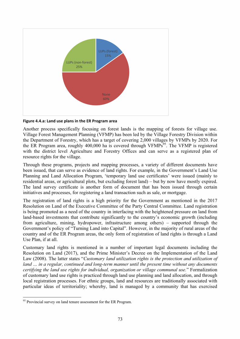
73
Figure 4.4.a: Land use plans in the ER Program area
Another process specifically focusing on forest lands is the mapping of forests for village use.
Village Forest Management Planning (VFMP) has been led by the Village Forestry Division within
the Department of Forestry, which has a target of covering 2,000 villages by VFMPs by 2020. For
the ER Program area, roughly 400,000 ha is covered through VFMPs95
. The VFMP is registered
with the district level Agriculture and Forestry Offices and can serve as a registered plan of
resource rights for the village.
Through these programs, projects and mapping processes, a variety of different documents have
been issued, that can serve as evidence of land rights. For example, in the Government‟s Land Use
Planning and Land Allocation Program, „temporary land use certificates‟ were issued (mainly to
residential areas, or agricultural plots, but excluding forest land) – but by now have mostly expired.
The land survey certificate is another form of document that has been issued through certain
initiatives and processes, for registering a land transaction such as sale, or mortgage.
The registration of land rights is a high priority for the Government as mentioned in the 2017
Resolution on Land of the Executive Committee of the Party Central Committee. Land registration
is being promoted as a need of the country in interfacing with the heightened pressure on land from
land-based investments that contribute significantly to the country‟s economic growth (including
from agriculture, mining, hydropower, infrastructure among others) – supported through the
Government‟s policy of “Turning Land into Capital”. However, in the majority of rural areas of the
country and of the ER Program areas, the only form of registration of land rights is through a Land
Use Plan, if at all.
Customary land rights is mentioned in a number of important legal documents including the
Resolution on Land (2017), and the Prime Minister‟s Decree on the Implementation of the Land
Law (2008). The latter states “Customary land utilization rights is the protection and utilization of
land … in a regular, continued and long-term manner until the present time without any documents
certifying the land use rights for individual, organization or village communal use.” Formalization
of customary land use rights is practiced through land use planning and land allocation, and through
local registration processes. For ethnic groups, land and resources are traditionally associated with
particular ideas of territoriality; whereby, land is managed by a community that has exercised
95 Provincial survey on land tenure assessment for the ER Program.
LUPs (forest) 15%
None 60%
LUPs (non-forest) 25%

74
communal rights over that land. In essence, management of land is governed by the consensus of
the group. Concepts of land ownership and entitlement to land use vary with each ethnic group. In
the ER Program area and throughout the country, registration of customary land rights for village
communities has been promoted through project initiatives, but remain limited.
Figure 4.4.b: Percentage area covered under land use instruments (other than LUP and VFMPs) in the ER Program area96
Areas under land concessions and leases in the Northern region (including, but not limited to the
ER Program area) as of 2012 covered 406,603 ha.97
The magnitude of land under land lease
contracts for contract farming agriculture (including tree plantation) is unknown, but, is considered
to be significant.
Table 4.4a presents the main tenure typologies, their presence in the ER Program area, the legal
framework and key issues (consulted through the LIWG consultation process with land projects).
Table 4.4.a: Land and resource tenure (instrument) typology
Tenure/ instrument typology98
Presence in ER Program area
Legal/institutional framework
Issues99
Pe
rman
en
t
lan
d t
itle
s individuals and households
Extensive mainly in urban and peri-urban areas.
Forest areas: Very
Land law (2003) Art. 3, 21, 22, 49
Titling is prohibited in certain areas, including “Protected forest, preserved forest and un-exploited forestland100” (Art. 7, Decree 88 PM)
96 Provincial survey on land tenure assessment for the ER Program. 97 Excluding cases of mining exploration (over 1 million ha, additional) and use agreements for hydropower generation,
logging, and contract farming. (Source: Schonweger et al, 2012.) The Government, with support from development
partners is undertaking an inventory of all leases and concessions in the country which will provide updated data. The
results of the inventory is becoming available (as of May2018). According to an unofficial report (provided in May
2018), more than 10 million ha of exploration concessions are present in the country, most of which are located in the
ER Program area. Official release of data is still pending. 98 A summary description of each of the tenure typologies is available in Annex 3. 99 Identified based on existing literature and consulted through the consultations on land and resource tenure delivered
with the Land Information Working Group (LIWG). 100 This is understood as Protection and Conservation national forest categories. In fact the National Assembly has
issued an instruction (NA 2016) to review the delineation of the 3 forest categories as they overlap with villages within
forest areas.

75
Tenure/ instrument typology98
Presence in ER Program area
Legal/institutional framework
Issues99
limited.
Notwithstanding, titles are reported to exist even in protection forests. The demarcation of zones for exclusion are largely only on national level maps, and compliance on the ground is weak. Even when zones are clear, titles have been issued as a means to prevent further encroachment.
communities/ collectives
Piloted through a few projects and covers non-forests only: communal plots titled for schools, halls, fishponds, temples, and cemetery/spirit forests by LMDP.
Forests areas: none.
organizations (companies)
Only in non-forests.
Tem
po
rary
lan
d u
se c
ert
ific
ate
s
individuals and households
Non-forests: Yes. Prevalent, where LUP/LA took place.
Forest areas: Very limited.
Land law (2003) Art. 3, Art 48; Decree No. 88/PM
One of the documents certifying land rights.
Extensively used in the LUP/LA Program, and used less in recent times. Temporary for 3 years only, but, most cases are not known to have been transferred into permanent titles.
Granting rights to individuals and organizations prohibited in certain areas, including “Protected forest, preserved forest and un-exploited forestland” (Art. 7, Decree 88 PM)
communities/ collectives
Non-forests: None.
Forests: None.
organizations (companies)
Non-forests: unknown
Forests: none
Lan
d r
egi
stra
tio
n
wit
ho
ut
titl
e
communities/collectives
Forests: Yes MONRE Instruction 6036
Communal and collective land registration for village use forests, grazing areas, and paddy fields have been conducted by LMDP in Huaphan. The ability to convert these into land titles is not clear under the current legal framework.
Oth
er
cert
ific
ate
s
Land Survey Certificate
Non-forests: Yes.
Forests: Yes.
Decree No. 88/PM
LSC is issued in area without a title, when registering a land transaction such as sale, mortgage. It is annexed to the transaction contact to show the land location, boundary, shape and size
Certain provinces (ie LPB, SAY) use this more prevalently over others.
Land Development Certificate (LDC)
Non-forests: Yes
Forests: unknown.
Decree No. 88/PM
LDC is used to confirm that those who hold TLUCs comply with the conditions set in the agreement attached to TLUCs, especially, that the allocated land are ‘developed’. There may be cases where the

76
Tenure/ instrument typology98
Presence in ER Program area
Legal/institutional framework
Issues99
authorities make it a compulsory step before issuing land title
Certificate of Land Ownership History
Non-forests: Yes.
Forests: unknown.
Decree No. 88/PM
Land ownership history is issued in rural areas to keep the land records more official.
Lan
d u
se p
lan
s
Land Use Planning (LUP)
Covers all village lands. PLUP manual (2009)
Family land books will record the land use.
Currently not part of the land registration system, and therefore, lacks strong legal basis.
However, various cases and studies point to the de facto nature of tenure security presented through plans. Legal basis could be strengthened to make this legally binding.
In practice, there are registered LUPs and unregistered LUPs.
Village Forest Management Planning (VFMP)
Forests only, including inside and outside 3 forest categories, including village forests, and forests where villagers are participating in management of forests under State management.
Village allocation and forest management plan guidelines (2012).
Decree 1476 DOF VFMP (2016).
Decree 1477 DOF VFMP Manual (2016).
Village Forest Management Agreements (VFMA)
Includes only village forests (excludes forest under State management)
No legal basis as of yet.
Used only through ‘projects’ for the time-being.
Time-bound corresponding to the VFMP.
Could serve to secure legal tenure over land and resources, as a legally binding document if firmly integrated into the legal system.
Oth
ers
Local level ‘registration’
Land tax receipts
Family books
Village land book
Non-forests: extensive.
Forests: does exist, particularly on village forests and plantations.
Tax receipts are the most prevalently used evidence of land rights, including for mortgage at banks.
State concessions /State land leases
Non-forests: Yes.
Forest areas: Yes
Decree No. 88/PM Art 21;
The allocation and compliance monitoring against concession/lease plans have been subject to major conflicts, nationally. The Central Party’s Resolution on Land (2017) speaks specifically about issues arising from the issuance of State concessions and leases and the need

77
Tenure/ instrument typology98
Presence in ER Program area
Legal/institutional framework
Issues99
for improved land management and administration.
Land leases (on other than State land)
Non-forests: Yes.
Forest areas: Yes.
Land law (2003) Art. 3; Decree No. 88/PM Art 21
Major issues arising through leases (called contract farming 1+4, 2+3 models) resulting in concession-like arrangements, and associated loss of access to land by villagers.
Land particularly shifting cultivation plots are leased out on the basis of, LUPs, land tax receipt, social contracts.
Social contracts
Non-forests: Prevalent.
Forests: Prevalent, particularly for communal swiddens.
No legal basis. Considered difficult to title, leading to internal village conflicts.
A social contract between villagers and district is often acknowledged and acts as informal land security.
This can have both positive and negative results. On the negative side, are the cases of elite-capture.
Customary practices of ethnic groups
Prevalent throughout No legal basis.
4.4.2 Main issues for the ER Program
Land and resource tenure security are particularly important for the ER Program interventions‟
success. As noted in the preceding Section on interventions of the ER Program, activities directly
engaging on land related interventions are prominent in the cross-cutting interventions, namely,
interventions on integrated spatial planning, land use planning at the village level, land allocation
and registration, VFMP and VFMAs, etc. Apart from these interventions working directly on land
and resource tenure security, the drivers and corresponding interventions related to shifting
cultivation and permanent agriculture are designed on the premises of villagers being able to
increase incomes without encroaching into forests. As available livelihood options are primarily
land-based, it is critical that villagers are able to securely access land, use and benefit from it, and in
the event of implementation of land development plans, that villagers are able to access alternative
plots or compensation without the threat of becoming land-less.
As the land tenure assessment indicated, while land titles are considered the most secure land tenure
instrument, land tilting is time and resource-intensive thus not the most suitable instrument for
securing land tenure rights for the vast rural landscape. In addition, the legal basis for titling of land
on forest areas is unclear, and will require more time to clarify. This being the case, the focus of the
ER Program in securing rural land tenure will primarily be through instruments of village level land
use plans and Village Forest Management Plans (VFMPs). Considering that roughly 40 % of the
ER Program areas are already under land use plans or VFMPs, the ER Program will invest in
priority villages in areas that have not been covered or have been covered but require updating or
upgrading of the plans.
Noting the weak legal basis of these instruments (e.g. land use plans and VFMPs not being
effective in negotiating compensation rights with land investors), the ER Program will support
ongoing work (including to influence the drafting of the new Land Law or its by-laws) to

78
strengthen the legal basis of these instruments, to ensure compliance with these plans, and deviation
from it will only happen after a due process of approvals and safeguards requirements being met.
Another major focus of the ER Program interventions will be to develop systems and capacity for
monitoring such plans for conformance.
As of 2017, VFMAs are being pilot-tested through project initiatives, as a means to add further
legally binding nature to the VFMPs. On-going discussions are advocating for the standard VFMA
to include provisions that speak to the rights of the village collective to use, protect and benefit
from the village forests identified in the agreement, for the period of the corresponding VFMP, and
to promote extending the duration of the VFMA and plans for longer-terms into the future. It will
also be important that the VFMAs are acknowledged as full legally binding documents, and that
they are registered not only at the local agriculture and forest offices, but, also registered or
recorded with the land sector (as also recommended through the land tenure assessment). Capacity
within Government for developing VFMPs and VFMAs is being strengthened, and investments
towards their development are planned for the early years of the ER Program.
In the interventions to promote sustainable and responsible agriculture investments (including tree
plantations for enhancement of carbon stocks), the ER Program will promote the design and use of
lease agreements for contract farming models that ensure long-term land rights are not infringed
upon, and that contracts are entered into only with Free, Informed and Prior Consent (FPIC). As
mentioned under the section on Safeguards, the implementation of activities, and particularly
activities that relate to land have significant impact and implications for subsistence needs of the
rural population. Before the implementation of such actions, full participation and consultation, and
particular care for engaging women, ethnic groups and other vulnerable groups, to ensure their buy-
in will need to be addressed. It is noted that as recommended through the LIWG consultations on
land and resource tenure, CSOs including domestic non-profit associations and other mass
organizations have potential to play an important role in facilitating participatory consultation
processes or other roles when rolling out the interventions on the ground.
4.5 Analysis of laws, statutes and other regulatory frameworks
National policies, laws and regulations
The ER Program implementation will cut across multiple sectors but the key sectors where the
interventions will have greater impact are agriculture and forestry and in more general terms, the
land sector. This section discusses the implications of the ER Program on existing laws, statutes
and regulations and vice versa. ER Program legal and compliance aspects are well addressed under
the safeguards section (Section 14) and well analyzed in the national SESA framework.
The legal and policy framework in Lao PDR starts with the Constitution, then laws, resolutions,
Presidential ordinances, decrees, orders and decisions as determined by the “Law on Making
Legislation” passed in 2012. It is important to highlight that the LDC status of Lao PDR has been a
major driver for the Government to promote larger economic development goals and this is
generally reflected in efforts to attract and promote Foreign Direct Investment (FDI) in mining,
hydropower, and agricultural plantation concessions. In part these are sectors where drivers of
deforestation have been identified ranging from policy and governance weaknesses, to weak
regulatory enforcement and poor land use planning.
The Government does not recognize any specific ethnic group as “indigenous peoples.”
Nonetheless, the Government has signed the Declaration of the Rights of Indigenous Peoples and
the International Labor Organization agreement (ILO 169) on the rights of indigenous peoples.
Moreover, it has agreed with development partners that the protections afforded to indigenous
peoples will be respected for 41 ethnic groups, i.e., groups not belonging to the majority ethnic Lao
or ethnic Tai groups. Due to the fact that these 41 ethnic groups are numerically the majority in

79
some areas, however, especially in Northern Lao PDR, the Government does not use the term
“ethnic minority.”
MAF is responsible for the management of agricultural and forestry land and governs this under the
Law on Agriculture (1998) and the Forestry Law (2007). This is particularly relevant considering
MAF as the ER Program Entity (see Section 17.2). The Forestry Law (2007) defines all natural
forest land as the ultimate property of the national community, and managed by the State on its
behalf. This includes village forest land. Plantation forests, however, are the property of individuals
or organizations who have planted the trees. The Forestry Strategy 2020 states the official policy to
adopt the participatory approach to management of forests, and to increase involvement of villagers
in sustainable management and use of village forestland through participatory land use planning
and land allocation which is the essence of Components 2 and 3 among the ER Program
interventions.
The Government is currently revising the Land Law, Forestry Law, and their by-laws in an effort to
update the legislative framework to meet the emerging domestic and international challenges of the
sectors. While this process is taking place, the Government has already taken important steps that
strengthen the vison and objectives of the NRS and the ER Program with the issuance of Prime
Minister‟s Order No. 15 for strengthening the enforcement to combat illegal logging and illegal
timber exports in 2016 with relevant ministries, such as MAF, MONRE, and Ministry of Industry
and Commerce (MOIC) developing their plans for implementation of this Order. The ER Program
response to supporting the Prime Minister‟s Order No. 15 comes through both Components 1, 2 and
3. FLEGT negotiations with the EU present further opportunities to strengthen the regulatory
reforms by the Government and the subsequent implementation of the NRS and the ER Program
propose to support the initiative by establishing a monitoring framework that adequately measures
progress.
On the issue of land tenure, the Government is continuing to address land issues through multiple
measures including policy reviews and regulatory reforms. The Government also recognizes that
mitigation measures such as REDD+ are important components of national climate change response
which need to be included in sectoral policies and regulations. The Government Politburo issued a
Land Policy in August 2017. Revision of the Land Law and Forestry Law are progressing and
expected to be submitted to the National Assembly in the second half of 2018. The new policy and
legislations together are intended to address issues of collective and customary land tenure
(including village forests), land titling, concessions, compensation, and other urgent issues affecting
national development. The ER Program proposes interventions that strengthen the regulatory
framework by improving land use planning which is a priority clearly reflected in national and
provincial SEDPs and sector strategies and specifically providing support to mainstream and
implement integrated spatial planning and participatory land use planning.
Security of land and resource tenure significantly impacts decision making on land use, and
sustainability of investments in land and natural resources management. Part of Component 1
interventions is to ensure land and resource tenure security through registering land allocation and
resource rights and to formalize these rights as appropriate, through land titling and forest
management agreements thus supporting on-going Government efforts. On 3 August 2017, the
Central Committee of the Lao People‟s Revolutionary Party (the Party) issued a Resolution on
Enhancement of Land Management and Development in New Period (Party Resolution on Land).
This is issuance of the Party Resolution on Land is the first time the Party has issued such a
resolution regarding land, and is considered to reflect the Party‟s serious concerns regarding the
heightening of land related conflicts arising throughout the country, and strong position to
improving land governance.

80
The Government‟s ambition of restoring forest cover 70 % is an important driver of some policy
reforms that are being initiated and is an important leverage platform for REDD+. Based on this
Party Resolution on Land, the Master plan for national land allocation will act as the primary
document to classify all land area into the eight land categories, including agriculture and forestry
lands under management by MAF. Such a Master plan is assumed to have a major impact on land
use, and therefore REDD+, and is expected to strengthen forest protection, and particularly within
the three administrative forest categories. The processes for developing and enforcing of this
Master plan on the ground is yet to be established. For the successful implementation of REDD+,
particularly the integrated spatial planning and land use planning related interventions of the ER
Program, it will be important to engage in dialogue to ensure REDD+ objectives are mainstreamed
in the process, and that actual local level land use planning should be agreed and implemented
through participatory processes, applying the Master plan as a reference document.
The Party Resolution on Land‟s reference to strengthening of monitoring of land based concessions,
including on environmental and social impact assessment directly supports related interventions
outlined in the ER Program interventions. This is expected to result in reduced planned conversion
of forests (including conversions taking place outside the permitted areas).
The Property Law (1990) establishes and defines five forms of property: state property; collective
property; individual property; private property (property belonging to a private economic unit other
than an individual or collective); and personal property (items for personal use). It also establishes
that ownership of all land, underground resources, water, forests and wild animals is vested in the
State, though the State may grant rights of possession, use, transfer and inheritance to other entities.
In 2012 the President of the National Assembly Committee on Economic Planning and Finance,
announced the Government's intention to undergo a nation-wide formal process of large-scale land
reform, and prioritize the need for increased local land management, given that access to land for
rural households is fundamental for sustained poverty alleviation101
.
The Land Law (2003) is the principle legislative instrument governing the management, protection
and use of land in Lao PDR. Article 3 of the Land Law reaffirms Article 17 of the Constitution,
through which land belongs to the national community, and the State is charged with the centralized
and uniform management of land, including allocation. Land may be State land, State asset, public
land asset or land for which land use rights are held by individuals, communities or other
organizations. Under the Land Law, all land is classified into a category for which boundaries must
be determined. The category of land determines the scope of use, including allocation to the State,
individuals or for lease, concessions or infrastructure development. The change of land from one
land category to another can be made only if it is considered to be necessary to use the land for
another purpose without inflicting negative impact on the natural or social environment and must
have the prior approval of the concerned management authorities102
.
Discussions are already underway on how the NRS can and will support the Forestry Strategy
which is also expected to be updated. The government will consider various options to determine,
for instance, whether additional legislation and regulations, such as a REDD+ Decree are necessary.
These discussions do not negatively affect the ERPA or ER Program design as they are intended to
strengthen and support the overall implementation of REDD+ in the country.
101 https://www.land-links.org/2012/09/changes-in-laos-land-policy/ “Lao has been undergoing a process of reviewing
and revising various policies and legislation pertaining to land and natural resources. What we've learned from
countries across the world is that by ensuring local peoples' rights to the land they live and work on, we are opening the
door for numerous other benefits for our country." said Dr. Souvanhpheng Bouphanouvong, President of the National
Assembly of Lao‟s Committee on Economic Planning and Finance. 102 The authority involved in approving the land use conversion depends on the size of the land area involved.

81
Section 4.1 provides an important analysis of the drivers of deforestation and forest degradation.
Misaligned land use plans and targets set in development plans established at provincial and district
level lead to an inability to monitor and enforce compliance with plans, policies and regulations.
This misalignment also occurs due to weak inter-institutional coordination. For instance, the
Ministry of Planning and Investment (MPI) leads policies on investment and processing
applications for commercial land concessions at national level, while different land uses
(agriculture, rubber, mining, hydropower among others) are managed under different provincial
agencies including the Provincial Energy and Mining Office, the Provincial Agriculture and
Forestry Office, the Provincial Office of Natural Resources and Environment, and the Provincial
Office of Transport. While each office may undertake planning processes, cross-sectoral and spatial
planning is often weak, and results in overlapping plans on the ground. The National REDD+
Program, and indeed the analytical work to prepare this ER-PD have enabled a broader discussion
on these weakness in policy implementation.
Of note is the fact that PRAPs were designed to ensure congruence with national and provincial
SEDPs and sectoral strategies and plans with a long-term plan for mainstreaming and integration
into planning processes such as land use master planning/zoning and village forest management in
annual and five-year provincial- and district-level plans. This is the practical approach that the NRS
and the ER Program will support and strengthen.
The legislative framework for benefit sharing is an important aspect and understandably one with
significant implications on the success of both the NRS and the ER Program. A process of
examining the issue of benefit-sharing, to establish a general national framework that can be used
and adapted by different REDD+ projects and programs, including the ER Program is underway
with a clear plan to develop a benefit sharing plan before the ERPA. During the development of this
ER-PD, the Benefit Sharing TWG examined the issue of carbon rights. The Constitution (2015) and
Land Law (2003) stipulate that natural resources (i.e. understood to include forest carbon) belong to
the national community (or population) and is managed by the State on its behalf. The Forestry Law
(2007) stipulates that natural forests belong to the national community, and are managed by the
State, whereas planted trees belong to the individuals or entities that plant them. Thereby, rights
holder of the forests also hold the rights to the forest carbon contained within those forests. The
development of both the NRS and the ER-PD is informing options on how to establish equitable
REDD+ benefit sharing in the country. The NRS is already setting the direction and further work is
planned during the 2018.
International Conventions and Agreements
Lao PDR is a signatory of a number of multilateral environmental agreements (MEAs). Of
particular relevance to REDD+, are the three Rio Conventions – the United Nations Framework
Convention on Climate Change (UNFCCC), the Convention on Biological Diversity (CBD), and
the United Nations Convention to Combat Desertification (UNCCD). Being a signatory to the
UNFCCC and especially ratification of the 2015 Paris Agreement which came into force in
November 2016, Lao PDR has made a commitment to reducing greenhouse gas emissions from
various sectors. The Government has clear intentions concerning climate change adaptation and
mitigation articulated through the Nationally-Determined Contributions (NDC). REDD+ is one of
the mitigation measures that the Government will use to reduce greenhouse gas emissions from the
forestry sectors. Therefore the ER Program is an important first practical step towards that goal. In
order to monitor progress to the obligations under the UNFCCC, Lao PDR prepares and has already
submitted its 1st and 2
nd National Communications and is planning to submit its 3
rd National
Communication in early 2019.
Being a signatory to the CBD and taking necessary steps to prevent ecosystem degradation and loss
of biological diversity is critical for Laos because a large proportion of the local communities have

82
a high dependency on forest products. REDD+ mechanism can deliver multiple benefits. In
addition to mitigating climate change, REDD+ can support livelihoods, maintain vital ecosystem
services and preserve globally significant biodiversity with the selection of appropriate
interventions that can exponentially reduce pressure on forests through supporting alternative
livelihoods which are the objectives of both Components 2 and 3.
Lao PDR is also a signatory to the Convention on International Trade in Endangered Species of
Wild Fauna and Flora (CITES, 2004), the Ramsar Convention on Wetlands (2010) and to the
ASEAN regional agreement on trans-boundary haze pollution (2002). The Government is
committed to building synergies with the ASEAN Wildlife Enforcement Network (ASEAN WEN)
to strengthen customs procedures and control illegal cross-border wildlife trade. Lao WEN, a
chapter of the ASEAN WEN has been institutionalized under the Department of Forest Inspection
(DOFI) of MAF, bringing on board all law enforcement agencies responsible for forest and wildlife
law enforcement and developing a coordinated strategy. DOFI is the primary agency responsible
for investigation and law enforcement under the Forestry Law (2007) and the Wildlife and Aquatic
Law (2007). DOFI operates is directly accountable to the secretary body to the MAF Minister.
DOFI and its provincial and district line agencies, (Provincial Offices of Forest Inspection, POFIs
under the Provincial Agriculture and Forestry Offices as well as the Forest Inspection Units under
the District Agriculture and Forestry Offices), are the primary responsible agencies for the
implementation of the law enforcement interventions outlined in Section 4.
Within the Lao Government, the primary responsibility for reporting and communication on these
MEAs lies with MONRE except for the CBD, and CITES, which are under MAF. The fact that
these agreements are under the two ministries that are key for the land sector and especially forestry,
is an important opportunity to improve collaboration with REDD+ interventions and any other
intervention proposed under the ER Program.
Lao PDR is also a signatory to other international agreements as follows;
The United Nations International Labour Organization Convention No. 169 on Indigenous and
Tribal Peoples (ILO 169) was adopted at the International Labour Conference held in Geneva in
June 1989. The basic concepts of the Convention are respect and participation. Respect for the
culture, spirituality, social and economic organisation and their identity, all constituting essential
premises regarding the enduring nature of indigenous and tribal peoples. ILO 169 has been
followed up by the United Nations Declaration on the Rights of Indigenous Peoples (UNDRIP),
agreed on 13 September 2007. It identifies the individual and collective rights of indigenous
peoples, and the duties of governments to respect those rights. While it is not considered to be an
international treaty, it is nonetheless an important document agreed by most of the UN member
countries, including Lao PDR.
Although the Government of Lao PDR does not recognize any of the country‟s 49 different ethnic
groups as “indigenous peoples,” it has agreed with the international community that ethnic minority
groups (i.e. those other than the dominant ethnic groups speaking Lao or Tai languages) are covered
by international safeguards for indigenous peoples. These groups comprise approximately one-third
of the national population.
Lao PDR is a signatory to the Convention to Eliminate Discrimination Against Women (CEDAW),
and has established a National Committee for the Advancement of Women (NCAW)103
. NCAW
has the mandate to lead on gender issues, and all government organizations have NCAW
representatives.
103 Also referred to as the National Committee for the Advancement of Women, Mother and Child (NCAWMC).

83
Lao PDR is among the countries that unanimously endorsed the Voluntary Guidelines on the
Responsible Governance of Tenure of Land, Fisheries and Forests in the Context of National Food
Security (VGGTs) through the Committee on World Food Security in May 2012. Under these
guidelines, recognition of equity and justice were mentioned in the rights and responsibilities in
order to promote equitable tenure rights and access to land, fisheries and forests, for all, women and
men, youth and vulnerable and traditionally marginalized people, within the national context. Lao
PDR aims to follow these voluntary guidelines.
4.6 Expected lifetime of the proposed ER Program
The ER Program duration is seven years, from 2019 to 2025; corresponding to the lifetime of the
proposed project to be submitted to the Green Climate Fund (GCF)104
.
Two options are proposed for the duration of the ERPA; one would be approximately six years
from 2019 to 2024, and the other would be five years from 2020-2024. The six year ERPA is the
preferred option, unless this proves difficult with an extended period required for the formulation of
the ER-PD.
In order to secure cash flow, it is proposed for at least two timings of payments during the time of
the ERPA, and an advanced payment at a very early stage of program implementation (see Section
6 for more details).
By 2025, a review of the ER Program, including a review and updating of the PRAPs will be
conducted, corresponding to the seven year timeframe of the current PRAPs. By this time, further
PRAPs are anticipated to have been developed for the other regions in the country, and that a
national roll-out would be orchestrated under the NRS, based on lessons fed back from the ER
Program implementation.
In this respect, after 2025, it is envisaged that the ER Program will be merged into the National
REDD+ Program and will be continuously implemented with a prospect for performance and RBPs
from a variety of other fund and/or market sources. Institutionally, one of the key lessons to be
gleaned through the initial phase of piloting REDD+ at the sub-national level will be about how to
integrate the unique aspects of REDD+ planning and monitoring into the existing planning and
monitoring institutions. This process of integration will allow the mainstreaming of REDD+ into
existing planning and monitoring, particularly into the 9th
NESDP, and to reduce costs and time
needed for REDD+ planning and monitoring.
104 As indicated in Section 6.2, the proposal under formulation for the GCF will implement a significant part of the ER
Program. Noting however, that the anticipated GCF project is for REDD+ implementation, and does not anticipate the
sales of ERs achieved through the project to the GCF. The Government of Lao PDR will offer ERs generated for the
ER Program area to the Carbon Fund, on a seniority basis, and only offered to other buyers where there is excess of
ERs to be offered – such buyers have not been identified to date.

84
5. DESCRIPTION OF STAKEHOLDER CONSULTATION PROCESS
5.1 Description of stakeholder consultation process
5.1.1 Process of stakeholder consultation during the Design Phase
For the preparation of the ER Program, stakeholder consultations have been conducted with a wide
range of stakeholder representatives ranging from the central to the village cluster level. The
objectives of the consultations were not only to identify drivers of deforestation and forest
degradation, and possible measures to address the identified drivers and barriers for successful
implementation, but also to enhance understanding on the aim of the ER Program and its designed
activities, and pros and cons of implementing it under their jurisdiction. Consultations have been
conducted based on the principles of Free, Prior and Informed Consent (FPIC), aiming for full and
effective consultations with particularly local level stakeholders.
The preparation of the National REDD+ Program, especially its National REDD+ Strategy and
SESA, have been taking place concurrently with the preparation of the ER-PD. To ensure synergy
and efficiency in the parallel implementation of the two important processes, the two processes
were carefully planned to synchronize in their methods, schedule and outputs.
Overall consultation strategy on REDD+
The stakeholders in REDD+ for Lao PDR have been identified and grouped as the five main groups
of: Government; civil society; development partners; communities; and private sector. The ER
Program adopted the same stakeholder grouping for its stakeholder consultations, by building on
the results of the consultations for the National REDD+ Strategy (NRS). This common approach
helped the stakeholders to further their understanding on REDD+ in Lao PDR.
The consultation process for the National REDD+ Program, i.e., on the NRS, Strategic
Environmental and Social Assessment (SESA), and other supporting elements were conducted
primarily (but not exclusively) through the following channels:
Intensive primarily technical level consultation with the six REDD+ Technical Working
Groups (TWG) among Government and quasi-Governmental agencies/organizations (with
participation of other non-Government participants as relevant to the thematic area of
discussion), approximately one-third of the official TWG membership are women (see
Section 6.1 for more information on the TWG);
Strategic level consultations with the National REDD+ Task Force (NRTF) (see Section 6.1
for more information on the NRTF);
Existing sector coordination mechanisms, namely the Forestry-sub-sector Working Group
(FSSWG) under the Agriculture and Forestry Sector Working Group105
, open to, and
participated by a wide stakeholdership of organizations working in the forestry sector;
Consultations with representatives of provinces, districts, and kumban (village cluster); and
Focused consultation meetings with non-Government stakeholder groups of REDD+ of civil
society organizations, private sector, and development partners.
Structures such as the FSSWG and the over-arching Agriculture and Forestry Sector Working
Group listed above are stakeholder platforms also institutionalized in the Government, which solicit
broad participation from wide ranging sector stakeholders operating across the country. Such
structures will continue to be an important modality for broad stakeholder consultation on the ER
Program, particularly as pertains to stakeholders engaged at the central level.
105 Organized as part of the annual Roundtable mechanism supporting the Government‟s strategic dialogues with
development partners. These meetings are commonly delivered as bilingual meetings in Lao and English language.

85
Consultations for the ER Program preparation
It is important to mention that the development of the ER-PD itself been a participatory process,
done through a committee known as the ER-PD Team. Under the leadership of National REDD+
Focal Point and the REDD+ Division, the ER-PD was convened and participated by the partner
organizations actively engaged in REDD+; namely, FCPF REDD+ Readiness Project, the Climate
Protection through Avoided Deforestation (CliPAD) Project of GIZ funded by BMZ, the
Sustainable Forest Management and REDD+ Support Project (F-REDD) of JICA, and the UN-
REDD Program support from FAO, along with the World Bank-financed REDD+ Readiness
operation. This committee met regularly (weekly meetings by default, and more intensively as
required) to discuss and draft sections of the ER-PD. In various instances, this committee was the
venue for providing options for the ER Program formulation, which would then be consulted with
other Government actors and non-Government actors through TWG meetings, consultation
meetings, and through other venues.
For the ER Program formulation, consultations were conducted on a number of occasions for
different thematic focal areas as well as for different purposes in the process leading up to decision-
making. In July and August 2015, two regional workshops were held to discuss the ER-PIN
development with the proposed six provinces of the ER Program. After acceptance into the Carbon
Fund pipeline, further consultations took place with all six provinces in December 2015 to elaborate
the next steps in order to develop the ER-PD. At the central level, the ER Program updates were
introduced through the aforementioned sector coordination mechanism of the FSSWG in its regular
meetings.
From 2016, the six provinces engaged in their respective processes of developing their Provincial
REDD+ Action Plans (PRAPs). PRAPs are the provincial level instrument that identifies the
strategic interventions to address drivers and barriers for REDD+. The PRAPs for the six provinces
are the central instrument through which the ER Program interventions will be rolled out, and
therefore are inherently linked to the ER Program development. For the PRAP preparation in the
six provinces, consultation meetings were held in all 50 districts and 50 selected kumban106
,
engaging with provincial and district staff, and village representatives. The PRAP consultations
intensively discussed and identified main drivers and barriers to REDD+ and priority interventions
for the province.
Another regional meeting with these six provinces was organized in September 2016. In October
2017 all Northern provinces gathered together in Oudomxay province to discuss the National
REDD+ Strategy, SESA, Safeguard Plans and elements of the ER Program including on
institutional arrangement, and benefit sharing.
Apart from the PRAP processes, consultations held with the provinces up to January 2018
discussed the issues and areas including the following, as pertains to the ER Program:
General introduction and awareness raising related to REDD+ and climate change;
Land and resources tenure arrangements;
Institutional arrangement for ER Program implementation;
Non-carbon benefits;
Assessment of negative environmental and social impacts from the ER Program
interventions; and
Benefit sharing structures and principles – provisional ideas.
106 Kumbans were selected based on criteria of (with adaptation to the specifics of each province): i) evidence of past
deforestation or reforestation; ii) accessibility; iii) proximity to NPAs; iv) proximity to international borders; and v)
presence of ethnic minorities, along with other logistical and practical concerns.

86
The following table summarizes the consultations per main stakeholder group.
Table 5.1.a: Topics of consultation with different stakeholder groups
TOPICS
Ce
ntr
al G
ovt
Re
gio
nal
6 p
rovi
nce
s
Pro
vin
ces
Dis
tric
ts
Ku
mb
an
Civ
il so
cie
ty
Pri
vate
se
cto
r
De
velo
pm
en
t
par
tne
rs
Drivers analysis X X X X X X X X
Interventions and social and environmental impact
X X X X X X x X
Institutional arrangement
X X X X
Land X X X X X X
Safeguards X
Grievance redress X
Benefit sharing X X X
Non-carbon benefits X
Carbon accounting X X
In January 2018 an ER Program consultation workshop with the six provinces took place in Luang
Prabang province including with high level provincial officials. Based on the PRAPs developed in
each of the six provinces the draft ER-PD was discussed and consulted. As a result of these
consultations, the provinces have confirmed their participation and commitment to the ER Program.
For development of the six PRAPs, sub-provincial level consultations were held in all 50 districts,
and in 50 kumbans with representatives from 339 villages. The target stakeholders included the
Government agencies and representatives from mass organizations at the provincial and district
levels (i.e. province, district) and representatives of the villagers of the sampled communities. (In
each district, a meeting was held with one selected kumban and the leaders of villages in that
kumban attended the meeting.) Kumbans were selected as part of the district level meetings based
on a set of given criteria such as deforestation hotspots, ethnicity, proximity to National Protected
Areas etc.
Guidelines to conducting stakeholder consultations at the provincial and lower levels has been put
together (PRAP Guidelines - see Part 4 on Conducting Stakeholder Consultations).
In each provice a PRAP Team was established and overseen by the Provincial REDD+ Task Force
(PRTF). The PRAP Team consists of the Provincial REDD+ Office (PRO), staff from Provincial
Agriculture and Forestry Office (PAFO) and Provincial Planning and Investment Office (PPIO) and
is supported by the National REDD+ Division at the Department of Forestry (DoF). The PRAP
Team oversees various District REDD+ Teams (referred to as DRAP teams), led by representatives

87
from the District Agriculture and Forestry Office (DAFO) and the District Office of Planning and
Investment. DRAP teams were responsible for organizing and conducting consultations at the
kumban level in each of the districts. DRAP teams were further responsible for coordinating with
the relevant district line agencies to provide inputs to the PRAP. Numerous rounds of consultations
were conducted for the elaboration of the PRAP. During each round of consultation diverse
stakeholders were consulted, including the Lao Women‟s Union who provided targeted feedback to
ensure that gender aspects were effectively considered, as well as the Lao Front for National
Construction on ethnic group concerns.
Particularly when targeting consultations with kumban and village levels, consultations were
conducted in the local vernacular dialect, following customary traditions appropriate for such
meetings, whenever possible, in order to ensure as far as possible, full and effective participation
and consultation. Annex 1 shows a list of ethnic groups present in each of the six ER Program
provinces as well as those ethnic groups being consulted during the PRAP development process.
Into the future, the local level consultations will follow the Community Engagement Framework
(CEF) to ensure socially inclusive engagement in REDD+ activities.
In some meetings, separate discussions were held with women and with men; in other meetings,
where more than one ethnic group was present, discussions were organized by language group.
Given the high degree of ethnic diversity in the ER Program area, a wide range of ethnic groups
have been consulted.
Women participated in the kumban meetings, although often the only village representatives that
were women were those who represent the Lao Women‟s Union at the village level. At the district,
provincial, regional and national meetings, women participated insofar as they hold relevant
government staff positions.
5.1.2 Process of stakeholder consultation during the Implementation Phase
During the implementation phase of the ER Program, relevant stakeholders, including local
communities will continue to be consulted and engaged following approaches taken during the
preparation phase, but with increased intensity of engagement for the local level stakeholders. For
the local level consultations, the CEF will be applied to ensure social inclusiveness, particularly for
ethnic groups, women, and other vulnerable groups.
The consultations may include, for example, identification of local (village) development priorities,
annual work planning meetings, and periodic review meetings for implementation achievements
and outstanding issues. This mode of participatory development is generally integrated into
development activities in Lao PDR, and supported by relevant policies, legislation, and regulations
requiring projects and activities to have local consultation. (For information on grievance redress
see Section 14.)
Stakeholder consultation and information dissemination will also be further supported by the
National REDD+ Program‟s communication strategy and website. The website will provide
relevant information and resource documents, as well as opportunities for stakeholders to contribute
their ideas to the ER Program management and/or National REDD+ Program management. In
addition, a web portal on REDD+ is under development which will house geospatial information,
including maps and other data relevant to REDD+. This approach aims at promoting transparency
and accountability to the stakeholders.

88
5.2 Summary of the comments received and how these views have been taken into account in the design and implementation of the ER Program
Through the consultation meetings and communications held with the various stakeholders, through
various venues, comments were received. The below table includes a list of the main comments
received, and responses offered by the Government and the ER-PD team.
For each of the consultation meetings held, a minutes of meeting has been prepared (mostly in Lao
language). For the consultation with provinces for PRAP development, the PRAP documents can
be referenced.
Table 5.2.a: Summary of comments and responses from consultations with stakeholders Comment received Response
Cross sectoral and project coordination is an issue. There is miscommunication, overlapping or similar activities, among other issues; and requires improvement.
Agreed. The ER Program works through REDD+ task forces at the central and provincial levels, which have multi-sectoral representation.
To improve coordination with other projects, the ER Program will make a point to reach out to related projects wherever possible.
Women’s participation tends to be encouraged for meetings, but not as strongly encouraged when it comes to implementation. Gender issues need to be mainstreamed as far as possible under REDD+.
Agreed. Gender equity is considered a main principle within the ER Program, and will be mainstreamed in all appropriate levels and areas.
Villagers should have more opportunities to participate in the decision making, capacity building and implementation. Marginalized groups (ethnic minorities, women) could be disadvantaged, how can this be addressed?
Agreed and Noted. The ER Program takes on an inclusive approach paying particular attention on ethnic groups and gender equity. The village level interventions and benefit sharing will be based on consultations with wide groups of representatives and a balanced representation of women.
CSOs should not be involved just through consultation meetings, but through different roles in REDD+ including in facilitating implementation and also in monitoring.
Agreed in principle. The role of CSOs in the full scope of the ER Program will be revisited during the inception phase of the Program.
In order to better understand the role of land tenure security as a non-monetary benefit of the ER Program, the rest of the benefit sharing and interventions need to be presented for consultation.
Agreed in principle. The ER Program development team will endeavor to host consultation meetings on the ER PD including all five stakeholder groups.
There is concern of the risks of conversion of natural forests to forest plantations, as well as negative environmental impact from the alternative livelihoods promoted.
Noted. The ER Program will not discourage conversion of degraded natural forests to sustainable forest plantations, based on due procedural safeguards. The PRAPs and village level plans will be screened against the environmental and social management framework before being implemented.
Monitoring and evaluation should be funded mainly by non-government sources. (comment from Government agencies)
Partially agreed. While the ER-PD anticipates most of the monitoring costs for activity implementation to come from other sources, the costs for conducting the normative forest cover assessment work (not-unique to REDD+) may be justified under Government funding.
REDD+ should be disseminated and integrated into the provincial and District SEDP.
Agreed. This is in the ER Program interventions.
There are many discussions on whether to consider the area under shifting cultivation and fallow as
Agreed. Such areas are referred to as RV areas according to the MRV applied to the ER Program, and

89
Comment received Response
forestland or agricultural land. Taking into account the Government’s ambition to reach the 70% forest cover target, the areas may best be referred to as “agroforestry land” under forestlands. A possible way forward would be to demarcate land that may be converted into permanent agriculture and those areas where that is not considered suitable, within such agroforestry lands.
are accounted under forest land. However, the same land when under cropping will be detected and identified as agricultural land.
The Land Use Planning related interventions will aim to identify the possible conversion zones within the RV.
Commercial agriculture expansion, shifting cultivation, forest fires, and unsustainable logging are major drivers. Therefore, small infrastructure will help to reduce to some degree the deforestation and forest degradation.
Partially agreed. Small-scale infrastructure may be developed where it is appropriate and as identified in the PRAP and other annualized plans.
Learning from SUFORD SU and other major projects, the ER Program should look into engagement with large-scale sustainability-committed private sector actors (i.e. tree plantation, agriculture etc.) that can invest in sustainable land use, processing, bring a market, and jobs. Important that businesses are encouraged to invest into processing in-country.
Agreed. Interventions will incentivize sustainable and deforestation-free investments by private sector. Interventions may be able to directly work with a few large scale private sector players.
Shifting cultivation must be a top priority to address in all villages across the province. This should be done including through village relocation and consolidation, and livelihood improvement.
Partially agreed. Shifting cultivation is indeed one of the main drivers identified, and the interventions have been designed to address this, including promoting alternative livelihoods. Notwithstanding, village relocation and consolidation are not activities to be directly implemented under the ER Program.
Outdated or low-quality land use planning is a major problem. In many cases, the demarcation is done only on paper, and therefore does not match the reality.
Agreed. Land Use Plans will be reviewed or conducted as part of the interventions. The ER Program interventions will promote also the monitoring of LUPs, and incentivize compliance.
Model forest management villages should be created as a means to promote and further study and scale-up.
Agreed in principle. The ER Program interventions when brought down to the PRAP work plans can identify candidates for such models to learn from.
Secured rights to land and forest resource use is essential especially for the local communities to involve in the ER Program.
Agreed. Incorporated into the PRAP design.
Village forest management agreements (VFMA) are being pilot-tested through projects. On-going discussions are advocating for the standard VFMA to include provisions on village collective rights to use, protect and benefit from the village forests; and for exploration for longer-term agreements than the five years under discussion.
Agree. The ER Program interventions on forestry will work with villages to develop Village Forest Management Plans and VFMAs, and to support a standardized VFMA template with provisions for longer-term tenure security.
There are risks of conflicts occurring over land and forest resources, as well as land grabbing by investors or so-called ‘elite capture’ and risk of restricted access to lands.
Noted. Village land use planning will take on participatory decision-making. The ER Program will also work on compliance monitoring for investors, and will invoke a grievance redress mechanism.
The beneficiaries have to be identified, and the benefit sharing mechanism has to be clear for different levels. As monetary benefit will be less than non-monetary benefit, the non-monetary benefits
Agreed. The annualized plans at various levels will outline the activities and budget for ER Program implementation including the monetary and non-monetary incentives. A Benefit-Sharing Plan for the

90
Comment received Response
have to be defined clearly as well. So, all levels know what kind of benefit they will get.
ER-Program will be prepared and agreed with beneficiary representatives.
Villagers should receive more monetary benefits as well as some non-monetary benefits as they are key forest protectors.
Disagreed. For the time-being, the ER Program does not envision a large component of monetary benefits, as it is not considered the most effective or efficient use of resources to reach the REDD+ targets and objectives. Both monetary and non-monetary benefits are being considered to reach the village level, but, the balance will need to be considered and determined in the annualized PRAPs and other plans.

91
6. OPERATIONAL AND FINANCIAL PLANNING
6.1 Institutional and implementation arrangements
6.1.1 National level REDD+ structures and responsibilities
Section 2.3 outlines the level of political commitment to this ER Program. The institutional setting
reflects this commitment. At the national level, multi-sectoral and multi-ministerial structure of the
NRTF and the six TWGs are gradually improving coordination, cooperation and consultation across
different sectors. The NRTF, REDD+ Division, and the six thematic TWGs support all national
REDD+ process working with the provincial level institutions.
Through the process of developing the National REDD+ Strategy (NRS), the NRTF have a
renewed understanding of the cross-sectoral agenda of REDD+ involving multiple ministries and
sectors at both central and local levels. While the country‟s REDD+ institutions were originally
established as a forestry sector-heavy set up, the importance of coordination across sectors, and
namely the roles of agriculture, land, and land investment sectors is becoming palpable (as of early
2018).107
It is noted that the ER Program as the country‟s first large-scale REDD+ program will shift REDD+
into implementation-gear. With this shift, it is expected that through the ER Program, REDD+
objectives will be introduced into sector strategies, based on which, the respective offices and
agencies will be mobilized for its implementation; namely, REDD+ is anticipated to be introduced
into strategies and institutional mandates of the agriculture, land and planning and investment
sectors with the start-up of the ER Program.
The detailed national and sub-national REDD+ institutional structure is outlined in Figure 6.1.a
below.
107 For example, REDD+ was specifically noted in the outcome statement of the Round Table Implementation Meeting
(the Government and donor coordination mechanism) 2016 as “the Government of Lao PDR has paid a special
attention on implementing the Intended National Determined Contribution and the Paris Agreement, as well as REDD+
as they are contributing to the implementation of UNFCCC.” (RTIM, 2016). Also, together with the National REDD+
Strategy (final draft under discussion as of May 2018), the ER Program comes at an optimal timing to further
mainstream REDD+ agenda into the 9th NSEDP (2021-2025), which the preparation is expected to start from 2019.

92
Figure 6.1.a: Institutional structure of REDD+ at national and provincial levels
The institutional representation in the NRTF enables and reflects the Government‟s desire to enable
REDD+ implementation to be effective and broad, mainstreaming REDD+ into non-forestry sector
strategies through high level officials from 16 institutions. The NRTF is chaired by the Deputy
Minister of MAF.
Through the REDD+ Readiness process, and not least, the experience of the ER Program
formulation, is generating renewed understanding of implications of REDD+ implementation in
non-forestry sectors. When and as necessary, a review of the NRTF membership may be conducted
to effectively and efficiently engage the relevant sectors and stakeholder groups in important
REDD+ related decision making.
Table 6.1.a: Members of the National REDD+ Task Force (NRTF) Members Relevance to the REDD+ agenda
1 Deputy-Minister, Ministry of Agriculture and Forestry (MAF)
ER Program Entity
Coordination of key sectors including agriculture, forestry, agricultural land management etc.
2 DG of Department of Forestry (DoF), MAF Forest management; REDD+ focal point
3 DDG of DoF, MAF Ditto
4 DDG of Department of Agricultural Land Management and Development, MAF
Agricultural land management planning, Land use planning
5 DDG of Department of Natural Disaster Management and Climate Change, MoNRE
Climate change; UNFCCC focal point
6 DDG of Land Department, MoNRE Land governance; Land use master planning, Legal framework for land tenure security
7 DDG of Foreign Currency Department, Ministry of Finance
REDD+ fund mechanism; Government counterpart on World Bank related projects

93
8 DDG of Ethnic Group Department, Lao Front for National Development
Ethnic group promotion; Social safeguards; Poverty reduction; Grievance redress mechanism
9 Director of Europe-America Division, Department of International Cooperation, Ministry of Planning and Investment (MPI)
National development planning, Concession management; Responsible investment promotion; Private sector engagement
10 Deputy Director of Administration Division, Department of Environmental Quality Promotion, MoNRE.
Environmental safeguards; ESIA monitoring of concessions and land leases
11 Director of Division of International Administration Law, Ministry of Justice
ER Program Transactions; legal reform
12 Director of Energy Conservation and Saving Division, Ministry of Energy and Mines
Sector-related drivers (e.g. hydropower, mining)
13 Director of Party and Personnel Division, National Lao Women’s Union
Social safeguards; Gender mainstreaming; Participation of women
14 Director of Planning and Cooperation Division, Department of Forest Inspection (DOFI), MAF
Forest monitoring and enforcement; FLEGT; Degradation (logging) monitoring
15 Deputy Director of Research and Technical Management Division, Faculty of Forestry Science, National University of Lao
Forest sciences; Participatory forest management; Forest regulatory reform; etc.
16 Deputy Director of Chamber of Industry and Commerce Sector-related drivers (e.g. agriculture industry and concession)
At the TWG level, representation is thematic and cross-cutting with technical staff assigned from
all relevant Government departments to provide technical advice to the NRTF. It is at the TWG
level that development partners are providing important technical support and targeted capacity
building through multilateral and bilateral REDD+ programs and projects covering the REDD+
thematic components. In addition to reporting the progress from respective thematic areas, the
TWGs consults the NRTF on issues which requires consultation and coordination among the TWGs
as well among different sectors. In this sense, the NRTF also serves as a hub responsible for
streamlining the approaches and thematic areas dealt with among the six TWGs for streamlined
program delivery and maximization of synergy. Table 6.1.b outlines the TWGs.
Table 6.1.b: The six REDD+ Technical Working Groups TWG area of work Chair/Co-chair
Policy and Legal framework Chair: DOF, MAF
Co-chair: Department of Legislation, Ministry of Justice
Land-tenure and land-use Chair: Department of Land Development and Planning, MONRE
Co-chair: Land Management Agricultural Planning, NAFRI
MRV/REL
Chair: Forest Inventory and Planning Division, DOF, MAF
Co-chair: DFRM. MONRE
Social and environmental safeguards and stakeholder participation
Chair: Lao Front for National Construction (LFNC)
Co-chair: Lao Women’s Union (LWU)
Benefit sharing Chair: DOF, MAF
Co-chair: Department of State Property Management, Ministry of Finance
Strategy (Enforcement and implementation of mitigation)
Chair: DOF, MAF
Co-chair: DFRM, MONRE

94
The Government recognizes that the capacity within national and sub-national institutions is
variable. DOF and other institutions have adequately trained professionals, but the volume of work
for both MAF and MONRE offices to effectively undertake duties in the vast areas of land they
oversee and particularly in contrast to the limited financial resources, is overwhelming. Part of the
REDD+ readiness process has been to build additional capacity in these institutions and this will
continue with the FCPF additional finance.
DOF has a good track record of working with the World Bank in implementation of large programs
such the SUFORD projects over the past nine years and as well as the original FCPF Readiness
grant. This experience has provided a sound basis for gradually expanding participatory approaches
to sustainable forest management geographically in the context of REDD+ including with FCPF
and FIP funding. Capacity building for the implementation of the ER Program will be an important
component to be supported by both the Readiness process and finance anticipated from other
development partners. The Government has elected a number of priority areas to build capacity to
directly and indirectly support the ER Program capacity needs across the various components as
outlined in the table below.
Table 6.1.c: Preliminary identification of support and capacity needs across main REDD+ areas National and Provincial REDD+ Management Arrangements
- Ongoing capacity building for the REDD+ Division, NRTF and TWG members on emerging trends and issues with regards REDD+
- Technical support and capacity building for PROs for implementation of ER Program interventions
- Technical support, capacity building/training workshops for NRTF on cross-sector collaboration
REDD+ strategy and interventions
- Strategic and economic analysis of intervention potential with a specific focus on public-private investment options and potential to support the objectives of the Forestry Strategy.
- Development of a cross-sector spatial analysis framework for land suitability analysis to support the land use and forestry planning and economic analysis of REDD+ interventions.
- Broad national economic analysis of REDD+ Strategy interventions options and prioritization (e.g. cost benefit analysis, investment returns, emissions reduction potential, social benefits and values)
- National and sub-national cross sector knowledge sharing, consultation awareness raising and dissemination of REDD+ Strategy Intervention economic analysis results. (includes workshops and other knowledge products)
Stakeholder Engagement
- Cross-sector capacity needs assessment for the implementation of NRS, ERPD, and PRAP interventions and preparation of Capacity Development Plan
- Workshops, training and capacity building in line with identified capacity needs and specifically for cross-sector land use planning and management in the context of REDD+
- Information platform to facilitate and promote transparency in REDD+ implementation and knowledge exchange
- Awareness raising and dissemination of REDD+ material at national level (workshops, campaigns, pamphlets and other publications)
Implementation and monitoring
- Preparation and finalization of benefit sharing plan including stakeholder consultation and awareness raising
- Development of a national REDD+ monitoring system
- Establishment and capacity building of field monitoring units in selected districts to establish a framework for REDD+ progress monitoring

95
Social and Environmental Impacts
- Design of national Safeguards Information System
- Capacity building and mainstreaming REDD+ at National and Sub-national level within and across key sectors (forestry, agriculture and energy).
Reference Emission Level and Monitoring Systems
- Gaps in knowledge and access to remote-sensing technologies which could support effective and cost-efficient monitoring.
- NFI skills to improve the survey design and measurement skills;
- Database and IT skills to manage the data and data system for the MMR;
- Technical knowledge to catch-up with evolving issues in REDD+;
- Standardization of operation to be enhanced through development of SOPs, manuals, hands-on capacity building, etc.
- Need of systematic framework for monitoring;
- Updating and improvement of the FREL/FRL;
- Procurement and updating of hardware and software including relevant training in spatial systems, data collection, updating and management in line IPPC and FCPF requirements (national and sub-national level starting with 6 provinces in the north and a 2 others in the south)
- Design and setup of knowledge management system for REDD+ impact monitoring across key sectors
Provincial REDD+ structures and responsibilities
In the six ER Program provinces, Provincial REDD+ Task Forces (PRTF) have been established,
which are chaired by the provincial Deputy-Governors, and supported by the Provincial REDD+
Offices (PRO). The PROs were initially established under the Provincial Offices of Natural
Resources and Environment (PONRE), but have since been transferred to the Provincial
Agriculture and Forestry Offices (PAFOs). PAFOs represent both the agriculture and forestry
sectors (this is also the case with DAFOs at district levels). The PROs act as the Secretariat to the
PRTFs, and are supported by the REDD+ Division of DOF and six the TWGs.
6.1.2 Institutional set up for the ER program
The institutional set up for the ER Program will include the following:
Administrative oversight of the ER Program including financial management
Administrative oversight of the ER Program on issues pertaining to program governance will be
conducted by the Steering Committee – by the NRTF or, as a sub-committee within the NRTF. In
either case, such committee will involve concerned agencies and stakeholder groups (including e.g.
private sector, civil society, etc.) to enable multi-sectoral and multi-stakeholder planning, decision-
making and implementation process throughout the ER Program.
For the day-to-day operational level, the Government will establish a suitable and representative
Program Management Unit (PMU) under the Steering Committee to implement the ER Program
receiving overall guidance related to REDD+ from the REDD+ Division. Other technical guidance
will be provided by respective technical agencies and stakeholders (e.g. agriculture, land and
planning and investment sectors), as part of the Steering Committee.

96
Figure 6.1.b: Institutional setup for the ER Program
A table outlining the institutions expected to play active roles in the ER Program implementation
and their roles are outlined in Annex 7.
Implementation of ER Program measures
ER Program measures are grouped into three components, including enabling environment related
activities (Component 1), forestry sector activities (Component 2) and agriculture sector activities
(Component 3). Generally speaking, Component 1 will work significantly at the national level for
policy and legal framework related issues, and at all levels for capacity building. For Components 2
and 3, the significant part of the activities will be implemented sub-nationally.
Under all three components, the related Component lead technical sectors will be identified firstly
at the Component level (i.e. agriculture and forestry for Components 2 and 3, respectively). At the
sub-component level, one or more functional technical lead agencies will be identified. These
functional technical leads will coordinate on the technical matters with other relevant sectors, under
the Component lead technical sector agency, and in consultation with the PMU and PPMUs.
For example, under sub-component 1.1 on Strengthening policies and the legal framework, a
number of technical areas of work are envisaged, including the development of policy and legal
framework for Responsible Agricultural Investment (RAI). For the RAI activity, the technical
sectors of concern would be agriculture (including forestry) and investment. It is envisaged that
with the functional technical lead under these two sectors, DALAM, DOA and IPD of MPI would
collectively draw out a workplan and budget, for their technical areas of work (i.e. review or
existing legal framework, conducting analysis and studies, drafting legal frameworks or programs,
and conducting consultations), under the guidance of the Component lead technical agency. Under
specific activities, broader stakeholders will be identified, which may be the forestry sector and the
land use sector, among others. In terms of stakeholder types, private sector, civil society, and
development partners may also be identified and engaged. Acknowledging the importance of cross-
Central Program Management Unit (PMU)
Program management, M&E, coordination
Program management, M&E, coordinationdelivery of PRAPs through/ with Districts, Villages
Provincial REDD+ Offices (PAFO)
Provincial Program Management Units (PPMU)
LNTBKO HPN LPB SAYODX Guidance; Coordination
Program governance; Inter-sectoral coordination; Oversight
Ma
na
gem
ent; Tech
nica
l oversig
ht Rep
ort
ing
REDD+ Division, DOF
Technical guidance on REDD+
ReportingGuidance
Government
PROs
ER Program Steering Committee(NRTF or sub-committee)
Provincial Steering Committees (PRTF or sub-committees)

97
sectoral coordination in this example, as well as in many of the proposed intervention areas, the
PMU and PPMU would play an important role in administratively supporting the coordination
among sectors and with the different stakeholder groups.
Figure 6.1.c: Example of the coordination and implementation under a sub-component
For sub-national level activities, Lao PDR has elected to use PRAPs as the mechanism for
implementing REDD+ actions. PRAPs contain detailed intervention measures, plans and budgets.
PRAPs also form the basis for the economic and financial analysis that underpins this ER Program
incorporating roles and at different levels and sectors of Government and non-Government
institutions. Implementing agencies will prepare annual plans based on input from district and
village levels, and work closely with district and village authorities to implement these plans, which
will be rolled out through participatory planning and implementation, giving due recognition to
women and ethnic groups to ensure their participation and buy-in.
Implementation of Benefit Sharing Plan
Incentivizing actors in reducing deforestation and forest degradation is critical to the success of
both the national REDD+ framework and ER Program. The Government has set the direction for
benefit sharing and will prepare necessary frameworks for results-based funds management and
distribution to reach the beneficiaries on the basis of the principles outlined in Section 15.
Considerations are being made on the approach and which existing fund will be suitable for
receiving, administering and distributing RBPs. The Forest and Forestry Resources Development
Fund (FFRDF) has been provisionally identified as the suitable fund for this task.
Implementation of relevant Safeguard Plan(s) and Feedback and grievance redress mechanism
The implementation of safeguard plans will be done primarily by integrating the safeguards
monitoring into the monitoring framework for the program (Component 4), and also in part through
the NFMS elements particularly where the safeguards relate to geo-spatial concerns such as
conversion of natural forests into other land uses. The actual data to be collected will be specified
through the ESMF. For instance, for the monitoring of safeguards related to ethnic group
participation, it is anticipated that the primary day-to-day monitoring will be conducted by the
village communities themselves. On the other hand, for the monitoring of Cancun Safeguards on
P/PMU
Sub-component 1.1: Strengthening policies and legal frameworkWork area: Responsible Agricultural Investment (RAI)
Investment sector lead
Agriculture sector lead
Planning and finance
ForestryAgriculture Land Mgm’t
Land
Private sectorFinance
institutionsCivil society
Developmentpartners
Lead technical sectors to lead and coordinate;
PMU and PPMU to administratively support in coordination, management and monitoring

98
the conversion of natural forests into forest plantations, this is expected to be monitored (and
safeguarded from being accounted for as results-based payments) as a function of the MRV/MMR
under the NFMS.
Information on monitoring results will be compiled and fed back all the way to the central Program
Management Unit (PMU). It is assumed that within the PMU, staff specialized on safeguards
monitoring will be mobilized to assess if safeguard requirements are being met, and data is being
collected and documented in appropriate manners.
The ER Program being of jurisdictional nature, and including more than one program entity (see
Section 6.2); the ER Program will apply a country approach to safeguards, where the relevant
ESMF tools will be implemented as a country tool, integrating requirements from the various
institutions including the World Bank, as well as the UNFCCC. A function for independent
monitoring of safeguards compliance is to going to be designed and institutionalized for the ER
Program, considering the current limited capacity within the Government.
Options are being reviewed as to how the SIS database will be integrated into, or linked to the
NFMS database managed by the Department of Forestry's Forest Inventory and Planning Division
(FIPD). A REDD+ web-portal is currently under design, and it is envisaged that relevant and
appropriate data related to safeguards monitoring would be made available on this web-portal.
For the feedback and grievance redress, the Government considers it necessary and efficient to
make use of existing feedback and grievance redress mechanisms, which offer administrative,
judicial, legislative options for registering complaints and seeking redress. These mechanisms
operate from the village level, beginning with traditional means of dispute resolution and village
mediation units, village cluster (kumban), through district, regional, provincial, and national levels.
To make these feedback and grievance redress mechanisms effective, public awareness-raising and
capacity building will be undertaken so that stakeholders become more aware of the procedures and
how redress can be accessed.
Stakeholder consultations and information sharing
Considerable stakeholder consultations have been conducted during the design of the ER Program,
as well as the National REDD+ Program. Consultation applying FPIC principles will continue
throughout the implementation of the ER Program. Once the ER Program reaches the
implementation phase, further detailed consultations will take place, including in the steps of
detailing PRAPs into annualized implementation plans. Local level stakeholders, particularly ethnic
groups, women, poor and vulnerable households and groups will be specifically targeted. The
Community Engagement Framework (CEF) outlines the approach for socially inclusive
engagement in REDD+ activities. The Provincial Implementation Units will mobilize specialized
capacity targeting the district or kumban levels that will receive training on FPIC principles and
practices, following the principles applied for the PRAP consultations.
Online communications and information sharing will be promoted including through a bilingual
national REDD+ website hosting data, communication, educational materials regarding REDD+
(including the ER Program). Linked to the website will be the REDD+ geo-spatial web-portal for
key geo-spatial data, maps, and aspects related to the NFMS.
6.2 ER Program budget
6.2.1 ER Program budget (use of funds)
The financing plan and the program budget is closely linked to the ER Program interventions as
well as the six PRAPs. Costings were initially prepared at the province level for the PRAPs. Based
on the aggregated six PRAP costs and the enabling environment interventions for the central

99
Government level, the total ER Program cost is estimated at USD 136.5 million for the period of
the ER Program implementation (i.e. 2019-2025108
) as presented in Table 6.2.a. (Further
breakdown by years is available as Annex 8 - Table 1).
Table 6.2.a: ER Program interventions and budget ER Program interventions Budget USD %
Component 1: Strengthening the enabling conditions for REDD+ 36,558,500 27%
Sub-component 1.1: Strengthening policies and the legal framework 6,103,000 4%
Sub-component 1.2. Improved forest law enforcement and monitoring 18,092,500 13%
Sub-component 1.3. Improved provincial, district and village level land use planning 8,731,500 6%
Sub-component 1.4. Enhanced land and resource tenure security through land registration and other processes
3,631,500 3%
Component 2: Climate smart agriculture (CSA) and sustainable livelihoods for forest dependent people
40,979,366 30%
Sub-component 2.1: Establishment of an enabling environment to promote climate-smart agriculture (CSA) & REDD+
9,268,500 7%
Sub-component 2.2: Implementation of climate-smart agricultural models 31,710,866 23%
Component 3: Sustainable forests management 53,215,443 39%
Sub-component 3.1: Establish an enabling environment to implement & scale up SFM
12,241,000 9%
Sub-component 3.2: Implementing & scaling up Village Forestry 26,222,853 19%
Sub-component 3.3: Implementing & scaling up FLR and sustainable forest plantations
14,751,589 11%
Component 4: ER Program management and monitoring 5,748,000 3%
Sub-Component 4.1: Program management monitoring and evaluation 5,748,000 3%
Total 136,501,309 100%
Note: Budget figures rounded under decimal points, and result in minor discrepancies when summed.
6.2.2 Financing strategy (sources of finance)
The ER Program contributes to existing Government plans and strategies (including the socio-
economic development plans and climate change mitigation and adaptation strategies).
Notwithstanding, in terms of financing the ER Program, the Government will rely largely on non-
Government resources, including parts of the Results Based Payments (RBP) to be received from
the Carbon Fund.
In the NDC, Lao PDR apportioned USD 12.5 million of domestic resources for the implementation
of mitigation and adaptation actions (0.14 % of GDP in 2012). For the forestry sector mitigation
and adaption action implementation, the Government is seeking international financing of USD 220
million and USD 709 million until 2030 for the agricultural sector related adaption measures.109
The financing of the ER Program will rely on domestic and international sources to cover the
estimated program cost of USD 136.5 million. Of this amount, a total of USD 8.1 million will come
from domestic sources including Government budgets from the central and provincial levels. This
is further elaborated in the cash flow analysis below.
108 The ERPA period will last until 2024. The program implementation is expected to run beyond the ERPA timeframe. 109 Lao PDR, 2015 b.

100
Table 6.2.b: Summary of funding sources Funding source Financing sources (USD) % of ER Program budget
Domestic sources 8.1 million 6%
ERPA RBP 45 million 33%
International sources 83.5 million 61%
Total identified sources 136.59 million 100%
Note: Budget figures rounded under decimal points, and result in minor discrepancies when summed.
The financing plan includes parts of the anticipated Carbon Fund RBPs, approximately USD 45
million which will be reinvested into the implementation of the ER Program.110
Out of the assumed financing from the Carbon Fund, Lao PDR seeks an advanced payment of USD
4.7 million in order to fill a critical financial gap in the early years of Program implementation (as
discussed in more detail below). The Government of Lao PDR is well aware that advanced payment
is not guaranteed, and will be negotiated at a later stage, with the Carbon Fund. The Government is
taking steps to identify alternative sources of finance, for filling this financial gap.
The financing sources of the ER Program are categorized into domestic and international sources,
as detailed in Table 6.2.c (further breakdown information by year is available as Annex 8 - Table
2):
Domestic financing sources: Up to USD 8.1 million. This includes the central level
Government budget for program management and the provincial budgets for the forestry and
agricultural sector. As a Least Developed Country (LDC), Lao PDR faces financial
challenges and persistent high fiscal deficits and public debt111
– which are major barriers to
making effective and long-term public sector investments. Thus, the Government‟s financial
contribution to the Program will be limited, but in line with the NDC.
International financing sources: USD 83.5 million (excludes Carbon Fund RBP). Each
source of finance was assessed with respect to their objectives and scope of financing. Based
on which, each source of finance was assigned activities of the ER Program. The following
Table 6.2.c presents the key sources, the expected financing and the status of resource
mobilization.
The Green Climate Fund (GCF) is a key source of international funding that the Government
is expecting to mobilize, with GIZ as the Accredited Entity to the GCF. A process towards
project formulation is already underway (as of May 2018). A GIZ project scoping mission
was dispatched to the country in April 2018, and a Concept Note is being made available.
The project scope will cover the implementation of the ER Program, namely the agricultural
and forestry sector activities on the ground, identified in each of the six PRAPs. The current
proposed scope of the project is approximately USD 45 million. There are prospects for
submission of a full proposal by the end of 2018, to enable project implementation by
beginning of 2020. It is important to note that prior to the start-up of such a GCF project,
other international finance and projects will have been mobilized and already starting
implementation, particularly with respect to activities for enabling environment
establishment (Component 1 among others).
110 In total, Lao PDR is expecting to generate about 15.72 million tCO2e over a period of six years (excluding set asides
as conservativeness and reversal buffers), as elaborated in Section 13. The Government is committed to offer to the
Carbon Fund on seniority basis, the maximum amount of ERs purchasable by the Carbon Fund, including beyond the
amount identified by the Carbon Fund as part of the Letter of Intent signed by the World Bank and the Government of
Lao PDR in 2015. 111 http://www.worldbank.org/en/country/lao/overview

101
Table 6.2.c: Financing sources and mobilization status Financing source
Financing volume (million USD)
Timeframe Activities Status of financing mobilization
Government budget
8.1 2019-2025 Government budget will finance all four components of the ER Program. Generally committed through sectoral and provincial five year plans and budgets.
Carbon Fund – Results-based Financing (RBF) and advance payment
45 Advanced payment: 2019; 2020
RBP: 2022 & 2025
USD 6.97 million - Component 1 (enabling conditions for REDD+) including from advanced
USD 18.25 million - Component 2 (Investment into climate-smart agriculture) to be channeled to rural communities in deforestation and degradation hotspots.
USD 15.25 million – Component 3 (sustainable forestry management)
USD 1.55 million – Component 4 (Program Management and monitoring)
Conditional to approval of the ER-PD and ERPA negotiation by 1st quarter 2019.
Green Climate Fund (GCF)
46.82 2019 – 2025 The GCF is expected to finance all four components.112 Project formulation and preparation currently underway. Expected to be submitted to GCF by end of 2018. GIZ to serve as the accredited entity on behalf of Lao PDR.
World Bank LENS2113
0.75 2019 - 2020 Will support projects particularly relevant to Component 3 on forestry. Currently operational and expected to end by 2020.
KfW (incl. ICBF) 20.32 2019 - 2022 USD 12.8 million - Component 3 (focusing on village forestry and NPA management in Houaphan, Sayabouri and Luang Namtha provinces)
USD 5.7 million - Component 1 (forest law enforcement and monitoring)
USD 1.8 million - Component 2 (enabling conditions for climate-smart agriculture.)
ICBF project is currently operational and is expected to end by 2021
USD 7 million for village forest management is expected to
112 Note that the anticipated GCF project is for REDD+ implementation, and does not anticipate the sales of ERs achieved through the project to the GCF. The
Government of Lao PDR will offer ERs generated for the ER Program area to the Carbon Fund, on a seniority basis, and only offered to other buyers where there is
excess of ERs to be offered – such buyers have not been identified to date. 113 Funds projects by Government agencies and NGOs to be funded through the Environmental Protection Fund.

102
Financing source
Financing volume (million USD)
Timeframe Activities Status of financing mobilization
start in 2019
FCPF Readiness grant 2
3.4 2018 - 2020 USD 2.1 million – Component 1 (related policy and legal framework conditions on national and provincial level; forest law enforcement and monitoring; and improved land use planning activities)
USD 0.2 million – finance early stage investment in Components 2 and 3 (enabling conditions for climate-smart agriculture and forestry.)
USD 0.3 million – Component 4
Expected to be approved by March 2018
JICA 2.07 2019 – 2020 Expected to finance the implementation of component 2 and 3 in the provinces.
Expected to support the NFMS at the central level and forest monitoring in selected ER Program provinces.
Expected to support the 1st national MRV in 2019, including the 3rd NFI and forest mapping. The process and data may support strengthening capacity for the MMR of the ER Program.
Term II budget of the F-REDD Project is expected to commence from February 2018 and end in October 2020. The financing source is counted from 2019 onwards.
FAO and others 2.0 2019 - 2020 USD 2.0 million – Components 1, 2, and 3 To be confirmed.
GIZ (CliPAD & LMDP)
8.12 2019 - 2021 CliPAD
USD 0.5 million - Component 1
USD 4.1 million – Components 2 and 3.
LMDP
USD 1.3 million – Component 1 (strengthening and systematic registration of individual and communal land)
USD 0.25 million – Component 1 (land use planning )
ELTES
USD 2 million – Component 1 (forest law enforcement and legal framework)
Projects are on-going and financing sources is counted from 2019 onwards.
Total 136.59

103
Figure 6.2.a: Share of the ER Program budget by source of finance (for identified sources of total USD 136.6 million)
Cash flow analysis – Assumed ERPA period of 6 years
A cash flow analysis was carried out in preparation of the financing plan. It assumes two
different ERPA periods. One is six years and the other is five years. Figure 6.2.b illustrates
the cash flow status assuming no advanced payments from the Carbon Fund. The financing
gap in the first three years of the Program is most critical, as beyond that, the Government
may be in a stronger position to fill in the finance gap by mobilizing additional domestic and
international funding. In the first three years the financing gap amounts to USD 4.7 million,
while in Year 4, the mid-term payment of RBPs from the Carbon Fund can be anticipated.
To fill this financing gap in the early years of the Program implementation, an advanced
payment of USD 4.7 million is considered ideal (to be compensated for through the mid-term
RBP in Year 4)114
. As noted above, the Government is also in the process of identifying
alternative sources of finance to fill the cash flow gap, and if successful before the ERPA
negotiations, an advanced payment may not be required from the Carbon Fund.
The final RBP in 2025 assumes the verified net ERs for the period between the Years 4-6.
114 The volume of the advanced payment would be compensated through the mid-term payment for RBPs in
Year 4 after verification of ERs that occurred in the first three years.
National government, 1.6%
Provincial government, 4.3% GIZ (CliPAD &
LMDP), 5.9%
JICA+FAO, 3.0%
FCPF Readiness, 2.5%
KfW, 14.9%
WB LENS2, 0.5%
Green Climate Fund, 34.3%
Carbon Fund - Advance, 3.5%
Carbon Fund - RBF, 29.5%
Funding sources overview

104
Figure 6.2.b: Cash flow analysis of the ER Program with Carbon Fund RBPs (without advanced payment)
Note: Assumes no advanced payment, mid-term RBPs in Year 4 and final RBP in Year 6, based on delivery of
actual ERs for the ERPA period of 6 years.
Cash flow analysis – Assumed ERPA period of 5 years
In this scenario, the same amount of ERs will be offered to the Carbon Fund, but over a
period of five years.
The five year ERPA period would equal to the timeframe of Year 2-6 as outlined in the Figure
6.2.b. In this scenario the advanced payment of USD 4.7 million would be required in the
timeframe of Years 2 and 3. The Year 1 financing needs of USD 2.8 million would then need
to be compensated by other international sources.
Considering that international sources are shifted to Year 1, a larger gap remains in Year 2
that would ideally need to be covered by the advanced payment. Thus the volume of advanced
payment remains the same (i.e. USD 4.7 million). The detailed annual financing sources and
flows for both ERPA periods are presented in the Annex 8.
The first RBPs is assumed to occur in Year 3 after the verification of the two initial years of
the ERPA implementation. Out of this payment the advanced payment would be
compensated.
The final payment would occur in Year 6 after the five year ERPA period is completed and
verified.
Need for an advanced payment from the Carbon Fund (USD 4.7 million)
The ER Program interventions are new and additional to the existing Government plans. This
being the case, they have not been fully integrated into the Government 5-year planning and
budgeting process during 2016-2020. Thus these interventions will only be considered in the
Government budget process during next five-year planning period of 2021-2025, by
integrating the PRAPs into the provincial five-year planning, and other central level

105
interventions into central level sector plans. Therefore, advanced payment from the Carbon
Fund will be crucial for the first three years of the ER Program.
The advanced payment will also be crucial in order to support the management and
coordination of the ER Program especially in the first years and to support the enabling
environment investments.
The advanced payment is considered critical for Lao PDR, considering its LDC status, the
fiscal deficit, the elevated public debt, and the five-year planning cycle with budgeting
anticipated for the period 2021-2025. Thus, the needed financing sources on national and
provincial scale will only be considered in the next five-year planning period, while the ER
Program implementation needs to start as soon as possible, to generate verified ERs during
the time of the ERPA.
Also, the advanced payment would provide the crucial financing to strengthen the institutional
arrangement and capacities and provide a strong signal, motivation and trust from the
provincial level to initiate implementation. It will also provide sufficient time to the
Government to mobilize additional financing to cover the remaining financing gap.
6.2.3 Financial and economic analysis
A financial and economic analysis was conducted to assess the ER Program‟s contribution to
social benefits, to support investment decisions by Government and investors. The analysis
puts a monetary value to the social benefit (positive welfare) and to the costs (negative
welfare) as effects of the project by applying a discounted cashflow analysis. Further detailed
analysis, background information in economic and financial analysis and underlying
assumptions is detailed in Annex 9.
The financial analysis was carried out on two levels:
The first level financial analysis was conducted on the farm level. For this,
representative 1 ha farm and forestry models were developed. To demonstrate their
attractiveness and profitability each model was financially assessed. This analysis
reflects the farmer/ land user‟s perspective and uses a consistent timeframe of 10
years. The 10-year period was opted in order to also reflect the long-term investment
and the delayed benefits which are typical for the forestry sector (see Annex 9 for
detailed analysis).
The second level financial analysis was carried out on the level of the entire ER
Program. This reflects the overall Government and national community perspective
and takes into account the entire cost and benefit of the program. The timeframe of the
analysis was seven years – the expected timeframe of ER Program implementation.
The economic analysis integrates externalities such as environmental cost and benefit (e.g.
biodiversity, carbon, soil productivity or avoided losses due to natural catastrophes). In this
analysis a lower discount rate is used and the value of carbon is integrated. Only climate
change mitigation benefits of the Program to the national economy are assessed in the
economic analysis -- other non-carbon benefits were not taken into account and are
qualitatively assessed in the non-carbon benefit analysis of the ER-PD (see Section 16).
Finally a sensitivity analysis was conducted that highlights the impact of changes in key
variables on the financial and economic performance of the program, as further presented.
Financial analysis – ER Program level
The financial analysis considers the forestry and agricultural investments and revenues and
the additional enabling environment, training and capacity development investment by the ER
Program. It changes the perspective from farm level to the society level.

106
For the estimation of the costs, the analysis takes into account the total budget of the ER
Program budget of USD 136.5 million. The costs for the in-kind contributions mainly labor
inputs from community members that will implement the various climate resilient agricultural
and forestry models are also taken into account in the analysis and are estimated at USD
254.76 million. For example, in case of investment into alternative cash production systems or
investment into agroforestry system (e.g. inputs, seeds, tools and equipment) the ER program
will finance the initial three years (excluding labor inputs). All labor inputs by the program
participants and investment beyond the initial three years are counted as in-kind contributions.
In total the program cost is estimated at USD 391.3 million.
On the benefit side (positive welfare), financial benefits of the program implementation will
result in increased levels of production in forestry and agricultural sectors. For the financial
analysis, forest products from natural and plantation forests as well as agricultural products
were valued at current farm-gate market prices. In the ERPA period of six years, these
benefits will amount to USD 421.25 million.
Forestry benefits are significantly lower despite the much larger scale because of the longer
time frames until financial benefits materialize. Notably, most benefits will accrue after the
ER Program implementation period.
Based on the described assumptions the Financial Rate of Return (FRR) for the ER Program
is attractive with a rate of 14.4% after 7 years and results in a positive Net Present Value
(NPV)115
of USD 6 million. This analysis indicates that the financial returns justify the
investment. Beyond that non-market benefits will strengthen the argument for investment
into the ER Program.
Economic analysis – ER Program level
The economic analysis assumes additional economic benefits to the national economy and
society and integrates additional imputed benefits in the analysis. The costs remain the same
as in the financial analysis. The additional economic benefits of the program are expected
reduced GHG emissions and enhanced removals by sinks imputed in the economic analysis.
In the economic analysis, the discount rate is reduced from 10% to 6% (as elaborated in
Annex 9)
With a carbon price of USD 5 /tCO2, the economic analysis results in a NPV of USD 227
million and Economic Rate of Return (ERR) of 365% after 7 years. This reflect the gross ex-
ante emission reductions of 3.6 million tCO2 per year which equals a total economic benefit
of USD 125.1 million116
over the entire program period. With an assumed carbon value of
USD 30 /tCO2117
, the NPV jumps up to USD 1.09 billion.
This demonstrates the significant economic benefits to the society and justifies investment in
the Program. Also, the economic analysis demonstrates that the benefits of reduced emissions
and enhanced removals significantly outweigh other program benefits. The analysis highlights
that the RBPs of USD 5 per tCO2e represent only a fraction of the social value of carbon of
USD 30 per tCO2e.
Beyond the quantified benefits the ER Program investments will result in significant
additional economic benefit to the society due to the other non-carbon benefits not factored
into the analysis.
115 At a discount rate of 10%. 116 Increase of the total economic benefits the program by 30% 117 The World Bank Group guidance on “Social Value of Carbon in Project Appraisal” (2014) recommends to
use a shadow price of social value of carbon at USD 30 in the year 2020.

107
Sensitivity Analysis
The sensitivity analysis assesses the sensitivity of different variables on the overall program
performance. Considering the future uncertainties around prices and costs, the sensitivity
analysis considers scenarios with 10% cost and revenues increase and decrease and their
implication for the overall financial and economic performance.
In a scenario with 10% cost increase, the FRR reduces by about 19% (-4.6%) and the NPV
turns negative to USD -19.1 million. The implication on the ERR is significantly larger and
reduces the NPV to USD 172.2 million (Table 6.2.d).
In a scenario with 10% decrease in revenue, the FRR turns negative to -6.9% (NPV: USD -
19.7 million) while the ERR will reduce to 142% and a NPV reduction to USD 149.1 million
(Table 6.2.d).
Table 6.2.d: Sensitivity analysis for ER Program
Cases Financial analysis Economic analysis (@ USD 5/tCO2)
FRR - 7 years NPV (USD) – 7 years
ERR - 7 years NPV (USD) – 7 years
Base case 14.4% 6.0 365% 227
Project cost (10% higher)
-4.6% -19.1 152% 172.4
Project cost (10% lower)
33% 31.0 Not quantifiable118
281.5
Revenues (10% higher)
31.2% 31.6 Not quantifiable
304.2
Revenues (10% lower)
-6.9% -19.7 142% 149.7
The change of the discount rate for the financial analysis and the economic analysis changes
the net present values as presented in the table below. In all cases the FRR remains positive
and justifies the investment into the program. The same applies to the economic analysis
(Table 6.2.e).
Table 6.2.e: Sensitivity analysis discount rates to estimate NPV of financial and economic analysis
Cases Financial analysis Economic analysis (@ USD 5/tCO2e)
Discount rate NPV (USD) - 7 years
Discount rate NPV (USD) - 7 years
Base case 10% USD 6.0 million 6% USD 227 million
Increase by 2% 12% USD 3.0 million 8% USD 204.9 million
Decrease by 2% 8% USD 9.4 million 4% USD 252.3 million
Summary of financing plan and financial and economic analysis
In summary, the ER Program will require an investment of 136.5 million and in-kind
contribution of USD 254.76 million for the seven year implementation period. This will
generate economic benefits worth USD 421.25 million. By discounting the cost and revenues
118 Not quantifiable because cash flow never turns negative and annual revenues always outweigh the costs.

108
with a 10% financial discount rate the ER Program has a NPV of USD 6 million and FRR of
14.4%. This demonstrates that the investment into the ER Program is attractive and
justifiable. From the economic point of view and the inclusion of the carbon value (USD
5/tCO2) into the analysis, the Program becomes extraordinarily attractive with an ERR of 365
% and a NPV value of USD 227 million.
The financing plan shows that 6% of the program cost will be covered by domestic financing
source, while 94% of the program budget are expected to be covered by international sources.
The financing plan assumes Carbon Fund RBPs for 15.72 million tCO2e and out of this, USD
45 million to be used for financing the ER Program implementation.
The cash flow analysis demonstrates a financing gap of USD 4.7 million for the first three
years of the program. For this, an advanced payment from the Carbon Fund is requested to
make the needed investment into the new and additional transformative enabling environment
to reduce emissions and increase removals by sinks.
The advance payment is required due to Lao‟s LDC status, the fiscal deficit, the elevated
public debt, and the fact that Lao PDR five years planning with respective budgeting will only
be prepared for the period 2021 – 2025. Thus, the needed financing sources on national and
provincial scale will only be considered in the next 5 years planning period, while
implementation needs to start as soon as possible to generate verified ERs.
Also, the advance payment would provide the crucial financing to strengthen the institutional
arrangement and capacities and provide a strong signal, motivation and trust on the provincial
level to initiate implementation. It will also provide sufficient time to the government of Lao
to mobilize additional financing to cover the remaining financing gap.

109
7. CARBON POOLS, SOURCES AND SINKS
7.1 Description of Sources and Sinks selected
The ER Program will account for four REDD+ Activities associated with sources and sinks:
Sources:
o carbon emissions from deforestation; and
o carbon emissions from forest degradation.
Sinks:
o enhancement of carbon stocks through forest restoration; and
o enhancement of forest carbon stock through reforestation.
Table 7.1: Sources and Sinks accounted for in the ER Program
Sources/Sinks Included? Justification / Explanation
Emissions from deforestation
Yes A deforestation event is a change from a forest REDD+ strata to the non-forest REDD+ strata.
This can be caused by activities such as conversion of forests to agricultural land, infrastructure, urbanization etc.
The total emissions from deforestation account for approximately 36% of all forest-related emissions in the reference period (2005-2015).
Emissions from forest degradation
Yes A degradation event is a change within forest land categories from a higher biomass strata to lower biomass strata (this can be caused by activities such as selective logging), and also through measurement of tree stumps as a proxy
indicator of logging activities119 (see Section 8).
The event of a conversion of natural forest to forest plantation is also by definition, a degradation event (see Section 4, Section 8.2 and section 14 on safeguards for how this is regarded to address REDD+ safeguards related to this type of event, and see Section 8 for how such degradation events are managed in terms of carbon accounting). The short-term changes between certain stages of rotational agriculture may also be recorded as a degradation event (see Section 8). In the context of the ER Program area, such degradation events occur most often in classes of Evergreen forest: EG (Strata 1) and Mixed Deciduous forest: MD (Strata 2) being degraded into the Regenerating Vegetation: RV class (Strata 4).
The total emissions from forest degradation account for approx. 64% of all forest-related emissions in the reference period (2005-2015).
Removals from forest enhancement
(Restoration)
Yes A restoration event is a change within forest strata from a lower biomass strata
to a higher biomass strata (in IPCC terms, “forest land remaining forest land
”).
This is often a result of regrowth of the RV class (Strata 4) to other natural forest classes.
Removals from forest enhancement
(Reforestation)
Yes A reforestation event is a change of non-forest land categories (Strata 5) to forest land categories (Strata 1-4).
This is often a result of a non-forest land (Strata 5) being converted into the Plantation class, or regenerating into the RV class (both Strata 4).
119 The issue of potential double-counting has been addressed. See Section 8 for more details.

110
Emissions and Removals from conservation of forest carbon stock
No There is no national definition for this REDD+ activity. 120
Emissions and Removals from sustainable management of forests
No There is no national definition for this REDD+ activity.
However, there is a comprehensive accounting for GHG emissions and removals from forests so GHG emissions and removals that could potentially be included in this activity are included in the other REDD+ activities.
In Lao PDR‟s carbon accounting, all the emissions from deforestation and forest degradation
are regarded as anthropogenic, for the reasons that the ER Program area is home to many
different mountain ethnic groups in and interacting with the forests in their daily lives; and
also in that large-scale natural disasters in forest areas or forest diseases are not common.
7.2 Description of Carbon Pools and greenhouse gases selected
The following tables shows the carbon pools and greenhouse gases considered in the RL of
the ER Program.
Table 7.2.a Carbon pools accounted for under the ER Program
Carbon Pools Selected? Justification / Explanation
Above Ground Biomass (AGB)
Yes AGB consists of the majority of the forest biomass of the ER Program area, thus, considered as a significant carbon pool.
Below Ground Biomass (BGB)
Yes On average, BGB constitutes 37.6% of the AGB per ha. Thus, BGB is considered as a significant carbon pool.
Due to the lack of country-specific data, the IPCC default values were used for the estimation. (See Annex 10: E/R Factors Report for more detail).
Dead Wood
(DW)
No The 2nd NFI included measurement of DW. Historical results showed that emissions from DW through deforestation accounts only 1.7% of the sum of the AGB, BGB, and DW, therefore, considered insignificant (see the Annex 10: E/R Factors Report for more details).
Lao PDR currently lacks complete data sets to account for DW in the RL, and may include this in the measurement of the next NFI. This said, consistency between the RL and MMR will be maintained.
Exclusion of DW is considered to be conservative on the basis of the proposed ER Program interventions being successful.
Litter No As carbon stock of litter was assumed to be small under moist tropical climate such as in Lao PDR (2.1 tC/ha for Lao PDR according to the IPCC 2006 Guideline Volume 4, Chapter 2, Table 2.2), the discussions leading up to the 2nd NFI determined not to measure litter in the 2nd NFI. The emissions from litter can be assumed to be smaller than that of the DW
120 Both emissions and removals occurring in forests remaining in the same category are not accounted for,
except for the emissions from selective logging estimated through measurement of tree stumps as a proxy
indicator, due to lack of datasets. With the future reiteration of NFIs accounting of such emissions and removals
from forests remaining in the same category will become possible (applying stock-change method). However,
for reasons of consistency between the RL and MMR, Lao PDR does not plan to use such data even for the
future MMR for the ER Program. Exclusion of such emissions and removals from forests remaining in the
category is likely to be conservative on the basis of the proposed ER Program interventions being successful.

111
explained above. Inclusion of litter in the measurement will be considered in the future step-wise improvement.
Exclusion of litter is considered to be conservative on the basis of the proposed ER Program interventions being successful.
Soil No There is no reliable country specific data for soil organic carbon. Inclusion of soil organic carbon in the measurement will be considered in the future step-wise improvement.
Exclusion of soil organic carbon is considered to be conservative on the basis of the proposed ER Program interventions being successful.
Table 7.2.b: Gases accounted for under the ER Program
Greenhouse gases
Selected? Justification / Explanation
CO2 Yes The ER Program shall account for CO2 emissions and removals.
Non-CO2
(CH4 and N2O)
No Shifting cultivation is an important disturbance event in the ER Program area, where nearly 100,000ha/year of forest lands are assumed to be affected by slash and burn practices. CH4 and N2O are the gasses emitted from biomass burning.
The estimates of emissions from non-CO2 gasses caused by shifting cultivation account for 5.2% of all forest-related CO2 emissions in the
reference period (2005-2015)121.
However, by the nature of shifting cultivation which is defined as not being permanent, the area of shifting cultivation can only be finally determined through a retrospective confirmation of plots not continuing to be cultivated, which would take place during the next mapping cycle. Therefore, it is difficult to confidently estimate emissions of non-CO2 gasses from shifting cultivation for the current
period (see Annex 11: AD Report122).
There is no country-specific biomass combustion factor which can be applied for slash and burn activities.
Forest fires, which are mostly uncontrolled spreading of fire from slash and burn activities, are another source of emissions of CH4 and N2O. Lao PDR currently does not have a national system to accurately monitor forest fires and its affected areas, and it is also a challenge to distinguish whether the fires are anthropogenic or naturally caused.
For the above reasons, non-CO2 gasses (CH4 and N2O) are excluded from the RL.
Exclusion of CH4 and N2O is considered to be conservative.
However, Lao PDR considers accounting of non-CO2 gasses (CH4 and N2O) as one area for technical improvement into the future.
121 As the forest maps are developed with 5-year intervals, they do not allow accurate estimation of burnt areas
during the 10 year reference period. Thus, the estimation assumed: i) areas of UC as the areas burnt on the year
satellite imagery was obtained; ii) extracted the changes from each forest class to UC in 2005-2010 and 2010-
2015, and iii) calculated an average as the annual burnt area for the reference period. The „Mass of available
fuels‟ for each forest class was calculated from the 2nd NFI data and other available data sources (e.g. IPCC).
The combustion factors were taken from the IPCC Guideline 2006, V4_02_Ch2_Generic table 2.6. 122 Lao PDR, 2018. Activity Data Report.

112
8. REFERENCE LEVEL
Summary of the RL for the ER Program
Elements Contents
Forest Definition “Current Forest”: DBH >10cm, Crown cover >20%, Minimum area >0.5 ha; and
“Potential Forest”: forest land which are in temporarily un-stocked state (for details see next section.)
Forest and Land use class Level 2 classification (8 forest classes,12 non-forest land classes) used for land/forest cover mapping. Then, stratified in to 5 strata.
Scope (Activity) Deforestation
Forest degradation
Forest enhancement (restoration)
Forest enhancement (reforestation)
Carbon Pools Included: AGB, BGB
Not included: Deadwood, Litter, Soil
Gases CO2. Other gases not included.
Scale National
Reference period 2005-2015
Activity
Data
National-scale forest type maps for years 2005, 2010 and 2015123 stratified into 5 strata. Amount of changes in areas among the 5 REDD+ strata estimated through sampling of reference data (design-based area estimation).
Emission/Removal
Factors
Calculated from the amount of changes in carbon stock among the 5 REDD+ strata.
Data from the national-scale forest biomass survey (2nd NFI) and country-specific allometric equation used for the major forest classes. IPCC default values and data from neighbouring Vietnam used for minor vegetation types.
Model applied Historical average
Adjustment Not applied
Others Basically consistent with the national RL (FREL/FRL) to enable nesting124.
To be in a manner consistent with the national MRV system and the GHG Inventory.
Allows associating the emissions/removals and the major forest change events.
8.1 Reference Period
The reference period of the RL for the ER Program is 10 years, with 2005 as the start-date and
2015 as the end-date125.
123 See also footnote 28 in Section 4.1. 124 Lao PDR submitted its proposed national FREL/FRL to the UNFCCC on 5 January 2015. The two main
differences of the national FREL/FRL compared to the RL for the ER Program is: (1) application of design-
based area estimation of AD, and (2) adjustment of removals by reflecting the accretion rate of forest biomass.
These issues will be further considered during the technical assessment processes of the UNFCCC and the ER
Program, which both are planned to progress in parallel.

113
2015 is selected as the end-date for the reason that the latest available wall-to-wall map used
for the development of Activity Data (AD) is for 2015, and no alternative data is available.
This is consistent with the revised and updated Methodological Framework (2016) Indicator
11.1. 126
As the national FREL/FRL for submission to the UNFCCC also selects 2005-2015 for its
reference period, selecting the same reference period with the RL of the ER Program will help
to maintain consistency between the two.
8.2 Forest definition used in the construction of the Reference Level
8.2.1 Forest definition and land/forest classification system
Forest definition
According to the Land Law (2003) and Forestry Law (2007), forest and forest resources in
Lao PDR occur in lands that are designated by the Government as forest lands, and in areas
outside forest lands, and includes both stocked and temporarily un-stocked forests.
The land and forest classification system of the country applies two levels of classification,
namely, Level 1 consisting of seven classes including “Current Forests” and “Potential
Forests” among others, and Level 2 which further classifies the “Current Forest” class under
Level 1 into five natural forest and one plantation forest classes. The land classification
system is illustrated in Table 8.2.b below. The carbon accounting approach applied in the
national FREL/FRL and the RL for the ER Program uses both “Current Forest” and “Potential
Forest” classes as corresponding to the IPCC forestland category.
Lao PDR applies a definition for Current and Potential forests respectively, for which a
summary is shown in the following Table 8.2.a.
Table 8.2.a: Summary of the definition of “Current Forest” and “Potential Forest” of Lao PDR
Current Forest Potential Forest
DBH Minimum of 10cm Lands previously forested, but presently not meeting the definition of “Current Forest” due to various disturbances, and expected to be restored to “Current Forest” status if continuously left undisturbed
Crown Density Minimum of 20%
Area Minimum of 0.5 ha
Note: The main reason of applying the DBH threshold for the “Current Forest” definition, over the more
conventional height threshold is to facilitate the accounting of forest fallow (typically classified as RV) as
Potential Forest (and not Current Forest). Such regenerating forests are often covered by small diameter trees
over 5.0m in height. In the context of the country, such lands should not be considered as Current Forest
because repeated disturbance may maintain such land in an understocked condition for an indeterminate
period of time, and therefore, are better managed when classified as Potential Forests. By applying the
definition of a minimum stand DBH of 10 cm127, forest land covered with small diameter trees which would
have been classified as “Current Forest” under a height threshold definition can be excluded from the NFI
survey measurements.
125 In fact, the forest type map 2005 used the satellite imagery taken in 2004-2005 dry season, and the forest type
map 2015 used that of 2014-2015 dry season which are the base maps used for the 10 years period of the RL.
The future MMR is also thought to follow the same theory, meaning that satellite imagery of year (X) to (X+1)
dry season will be regarded as the forest type map of year X. 126 Indicator 11.1 indicates that “the end-date should be the most recent date prior to two years before the TAP
starts… and for which forest-cover data is available to enable IPCC Approach 3”. The TAP for the Lao ER-PD
started in the beginning of 2018. 127 Experience of experts at DOF generally agree on DBH having a higher correlation with crown cover
compared to that with height.

114
The main reason for the 20% crown density threshold for the “Current Forest” definition is to do with the
national circumstances of trees commonly occurring in rice paddy landscapes in the flatland areas. In order to
avoid misinterpretation of these paddy lands as forests, particularly through remote sensing – as such lands
often have canopy cover of over 10% – the 20% crown density threshold has been adopted, for Current
Forests.
“Potential Forest” is defined as lands previously forested, but presently not meeting the
definition of “Current Forest” due to various disturbances, and expected to be restored to
“Current Forest” status if continuously left undisturbed. This definition is in line with the
IPCC‟s definition of forest land which includes “…a vegetation structure that currently fall
below, but in situ could potentially reach the threshold values used by a country to define the
Forest Land category.” (IPCC, 2006).
In the ER Program area, over 99% of the “Potential Forest” is composed of the RV class, with
the remaining being in the Bamboo class. Due to lack of time-series land-use/cover data with
higher observation frequency, these two classes are classified as “Potential Forest” in each
forest mapping cycle, regardless of their historical land-use/cover. Lao PDR acknowledges
that such classification has limitations. For the purpose of the ER Program, considering there
is no alternative data for use, RV data is used, but considered as proxy data (see further details
in Section 12). There are intentions within the ER Program and more broadly for the benefit
of the forestry sector in general to apply time-series analysis for the better understanding of
the dynamics of the Potential Forest class. That said, for the purpose of the ER Program‟s
carbon accounting (including MMR), such data will not be applied, considering data
limitation at the timing of the RL construction.
This same forest definition was used also in the past two National Communications on
Climate Change submitted to the UNFCCC. Nationally, decisions have already been taken to
also employ the same definition into the future in compiling the national GHG inventory
starting with the Third National Communication which the Government plans to submit to the
UNFCCC in early 2019.128
Land/forest classification system
Around 2010, when Lao PDR initiated the development of its national forest type maps (wall-
to-wall maps of the entire territory) to support REDD+, the Government and the stakeholders
first reviewed the land/forest classification system to be applied for the mapping exercise.
An important principle was to ensure the classification system was in harmony with the land-
use category definition of the IPCC in order to maintain consistency between the REDD+
FREL/FRL and REDD+ MRV/MMR and the National GHG Inventory. Another was to
determine how to categorize the temporarily un-stocked forests in the classification system
(“regenerating vegetation: RV”). This reflects the unique situation of forests and forest use in
the country, and in particular, the prevalence of shifting cultivation, and presence of vast areas
of forest fallow. This land-use is seen throughout the country, but is particularly characteristic
of the hilly and mountainous Northern landscapes including the ER Program area where a
significant area is covered under forest fallow stages of shifting cultivation, regenerating
through natural vegetative succession, going in and out (currently only in limited cases) of
temporarily un-stocked states. Restoration of RV into the Current Forest status has been
limited (approximately 100,000ha during the 2005-2015 period) despite this being a high
128 This definition is different from the one which Lao PDR used for the reporting to the FAO Forest Resources
Assessment (FRA) 2015. In FAO-FRA, Lao PDR defines “forest” as: minimum height of trees of 5.0 m;
minimum forest canopy cover of 10%; and minimum area of 0.5ha. This was done to be consistent with the FAO
global definition of forests.

115
priority agenda of the Government as stated in the 8th
National Socio-Economic Development
Plan (NSEDP). The ER Program is designed to support this agenda.
It should be also noted that distinguishing RV and MD classes which are continuous phases of
regeneration in many cases, poses a technical challenge in remote sensing129
. To improve the
accuracy of classification, the initial classification of satellite imagery was further reviewed
and revised by applying the „8 years threshold‟ as the standard number of years for forest
regeneration after a forest plot is slashed and burnt. Based on this method, MD plots where
vegetation loss was confirmed in the past one to eight years, identified in annual vegetation
loss dataset by Hansen et al (2013), were revised to RV with an assumption that land will not
regenerate into MD class in less than 8 years. This made the mapping of MD area
conservative, and thereby making emissions/removals estimate conservative. See Annex 11
Activity Data Report for further details.
Table 8.2.b: National level land and forest classification system of Lao PDR with IPCC definition on land use categories “Land/forest classes”
IPCC Definition National level classification system
Level 1 Level 2
Forest Land Current Forest Evergreen Forest EG
Mixed Deciduous Forest MD
Dry Dipterocarp Forest DD
Coniferous Forest CF
Mixed Coniferous and Broadleaved Forest MCB
Forest Plantation P
Potential Forest Bamboo B
Regenerating Vegetation RV
Grassland Other Vegetated Areas Savannah SA
Scrub SR
Grassland G
Cropland Cropland Upland Crop UC
Rice Paddy RP
Other Agriculture OA
Agriculture Plantation AP
Settlement Settlement Urban Areas U
Other land Other Land Barren Land and Rock BR
Other Land O
Wetland Above-ground Water Source
River (Water) W
Wetland (Swamp) SW
129 Similar to the case when applying a height threshold, the DBH threshold cannot be applied through remote
sensing. However, knowing the challenges of distinguishing RV and MD in forest mapping, several efforts were
made. For example, larger number of ground-truthing points were given to the two classes, particularly to
ambiguous polygons. The DBH > 10cm threshold was applied at the ground-truthing and the results were
reflected into the interpretation process afterwards. Ancillary information, such as topography, land-use in
neighboring land-plots, shape/size of the land-plot, proximity to village areas, were also used.
For generation of EF, the DBH criterion is applied in the biomass survey (2nd NFI), by only measuring the forest
plots which meet the definition of “Current Forest” including the DBH threshold criteria.
Lao PDR acknowledges the potential for discrepancies between the “Current Forest” captured in forest mapping
and in the biomass survey. However, it should be noted that this is a fairly common issue due to the technical
constraint of remote sensing, even when applying a height threshold criteria.

116
8.2.2 Stratification
For the purpose of the REDD+ MRV including the MRV/MMR for the ER Program, the
national land and forest classification explained in Section 8.2.1 are condensed into five strata
(referred to as the 5 REDD+ strata). Such simplified stratification is intended to reduce
uncertainty of emissions and removals while balancing the accuracy of sampling and the
cost/efforts required. The forest stratification used for the construction of the ER Program RL
includes the following five types of forestland and non-forest land as shown in Table 8.2.c:
Evergreen Forest (EG) has distinctly high carbon stocks (200.0 tC/ha), thus, separated
as an independent stratum – Stratum 1 (expanse: 481,320 ha, 5.9 % of the ER Program
area).
Mix Deciduous Forest (MD), Conifer Forest (CF) and Mixed Coniferous and
Broadleaved Forest (MCB) form one stratum on the basis of similarity in carbon
stocks (87.7 tC/ha, 92.6 tC/ha, 114.7 tC/ha). – Stratum 2 (expanse: 3,799,415 ha, 46.8
% of the ER Program area).
Dry Dipterocarp Forest (DF) will form one stratum due to the difference in carbon
stock from other forest classes (43.2 tC/ha), and also due to the fact that they are
mostly distributed in the low-lands and prone to conversion to other land use –
Stratum 3 (expanse: 17,351 ha, 0.2 % of the ER Program area).
Box 4: A note on short-term changes under the same land use
Among the land/forest classes, Upland Crop (UC) and Regenerating Vegetation (RV) classes are for the most part considered to be stages of the shifting cultivation cycle, and these lands are considered to re-grow and recover through natural vegetative succession. Through intensive discussions within the Department of Forestry (DOF) and with stakeholders on whether to classify these under the IPCC land use category of “Forest Land” or “Cropland”, it was concluded that, in line with the IPCC definition, to classify RV as “Forest
Land” as they are “…a vegetation structure that currently fall below, but in situ could potentially reach the threshold values used by a country to define the Forest Land category.” (IPCC, 2006) and classify UC as “Cropland” as they are used, even temporarily, for cropping at the time of mapping.
Lao PDR recognizes that by applying such method of classification, a piece of land not undergoing land use change, but, only temporary land cover change (i.e. short-term changes) would be subject to designation as undergoing a change event. However, Lao PDR choses to apply this method for the REDD+ FRL/FREL and MMR/MRV. The strong rationale for this decision is the Government’s commitment to its agenda of stabilizing the shifting cultivation landscape and increasing forest cover to 70%. The overestimation of change resulting from method of classification is consistently and symmetrically conducted for emissions and removals. For example, when a shifting cultivation landscape undergoes change from RV to UC this short-term loss is recorded; on the other hand, when the UC is left for fallow and regenerates into RV, this removal is also recorded; meaning that overestimation of emissions is offset by overestimation of removals, so far as the rotational agricultural practice continues.
Upland Crop (UC) Regenerating Vegetation (RV) Mixed Deciduous Forest (MD)
DBH > 10cm
Crown Cover > 20%

117
Plantation (P), Bamboo (B) and Regenerating Vegetation (RV) will form one strata on
the basis of similarity in average carbon stock (37.2 tC/ha, 24.4 tC/ha, 17.4 tC/ha) and
the limited area in the ER Program area– Stratum 4 (expanse: 2,974,904ha, 36.6% of
the ER Program area).130
The remaining 12 non-forest classes will form one stratum – Stratum 5 (expanse:
850.100ha, 10.5% of the ER Program area). Lao PDR understands that stratifying all
non-forest classes into one stratum deviates from the IPCC guideline, as it creates one
single stratum for Grassland, Cropland, Settlements, Other land and Wetlands, which
prevents category-specific estimation methods following IPCC good practices.
However, nearly 90% of the national area is under Forest Land category, and 7% of
the 10% of non-forest area is Cropland. Therefore, combining these non-forest strata
was considered as a reasonable simplification of the analysis for purposes of
quantifying forest carbon, and is expected to avoid introducing additional uncertainties
associated with trying to track small areas of non-forest strata at a finer scale of
classification, while it would make little difference in the estimate.
Table 8.2.c: Stratified land/forest classification system and the five REDD+ strata
Land/forest classes Area (ha)
2015
% of
total
area
REDD+
strata
Level 1 Level 2
Current
Forest
Evergreen Forest EG 481,380 5.9% 1
Mixed Deciduous Forest MD
3,799,415 46.8% 2 Coniferous Forest CF
Mixed Coniferous and
Broadleaved Forest MCB
Dry Dipterocarp Forest DD 17,351 0.2% 3
Forest Plantation P
2,974,904 36.6% 4 Potential Forest
Bamboo B
Regenerating Vegetation RV
Other vegetated
Areas
Savannah SA
850,100 10.5% 5
Scrub SR
Grassland G
Cropland
Upland Crop UC
Rice Paddy RP
Other Agriculture OA
130 UNFCCC Safeguards requires that REDD+ actions are not used for the conversion of natural forests.
Therefore, it is important that the carbon accounting method allows for tracking conversion of natural forests,
including conversion into plantations. A common type of such conversion is the conversion of RV to P, which,
according to the respective carbon stocks would theoretically be an „enhancement of carbon stock (restoration)‟
event. By stratifying P together with RV and B, the conversion of RV to P is not accounted for as a restoration
event.
For this and other conversions of natural forests into plantations, while, the REDD+ stratification stratifies forest
plantations together with natural forest classes of RV and B as a single stratum, the underlying mapping process
applies the Level 2 land/forest classification system, and will allow for tracking of conversion of natural forests,
including into forest plantations.

118
Agriculture Plantation AP
Settlement Urban U
Other Land Barren Land and Rock BR
Other Land O
Above-ground
Water Source
River (Water) W
Wetland (Swamp) SW
Total 8,123,149 100.0%
8.3 Average annual historical emissions over the Reference Period
Description of the method used for calculating the average annual historical emissions over the Reference Period
8.3.1 General method
Reflecting the dynamic nature of land-use change in the ER Program area, and also to
adequately monitor the future impacts of the ER Program, Lao PDR considers it more
appropriate to present historical emissions and removals separately per each source and sink
activity. Accordingly, the four sources and sinks (i.e., emissions from deforestation and
degradation, and removals from restoration and reforestation) are estimated by calculating the
changes in biomass caused by the shift from one REDD+ strata to another.
Considering the available nationally derived data, Lao PDR applies an approach principally
following the gain-loss method in calculating the average annual historical emissions and
removals over the reference period, using Activity Data (AD) and Emission/Removal Factors
(E/R factors). However, as explained in Section 7.1 (footnote 119), both emissions and
removals occurring in forests remaining in the same category are not accounted for, except in
the case of emissions from selective logging estimated through measurement of tree stumps as
a proxy indicator. For land converted to other land-use, the equation below is used.
(Source: 2006 IPCC GL, Volume 4, Chapter 2)
Where:
ΔCB = annual change in carbon stocks in biomass on land converted to other
land-use category, in tonnes C yr-1
ΔCG = annual increase in carbon stocks in biomass due to growth on land
converted to another land-use category, in tonnes C yr-1
ΔCCONVERSION = initial change in carbon stocks in biomass on land converted to other
land-use category, in tonnes C yr-1
ΔCL = annual decrease in biomass carbon stocks due to losses from harvesting,
fuel wood gathering and disturbances on land converted to other land-use
category, in tonnes C yr-1

119
However, it is noted that due to lack of datasets, Lao PDR is currently not able to separately
account carbon gains (ΔCG) and carbon losses (ΔCL) due to land-use change, instead, they
are combined into a single emission estimate as represented in the equation below.
(Source: 2006 IPCC GL, Volume 4, Chapter 2)
Where:
ΔCCONVERSION = initial change in biomass carbon stocks on land converted to another land
category, tonnes C
BAFTERi = biomass stocks on land type i after the conversion, tonnes d.m. ha-1
BBEFOREi = biomass stocks on land type i before the conversion, tonnes d.m. ha-1
ΔATO_OTHERSi = area of land use i converted to another land-use category, ha
CF = carbon fraction of dry matter, tonnes C (tonnes d.m.)-1
i = type of land use converted to another land-use category
• The AD is generated spatially using satellite-based analysis of land/forest cover for the
two periods: 2005-2010 and 2010-2015. National-scale Forest Type Maps are used as the
basis for estimating the AD. Changed areas are detected by change detection method, and
then applied design-based area estimation with respect to generating statistically reliable
estimates.
• E/R factors are basically generated using national-scale biomass data from the 2nd
National Forest Inventory combined with country-specific allometric equations, and an
independent biomass measurement data for RV class131
. IPCC default and data from
neighboring Vietnam are used for some land/forest classes where no country-specific data
are available.
Apart from the above, Lao PDR estimates emissions from forest degradation by selective
logging through proxy approach (See section 8.3.4). The approach uses the tree stump records
measured through the 2nd
NFI to complement the impact of selective logging which was
considered as under-represented. The approach also complements quantifying forest
degradation in stable forest classes where forest biomass data for applying the stock-
difference method is limited.
Activity data and emission factors used for calculating the average annual historical emissions over the Reference Period
8.3.2 Activity data (AD)
The below table provides the overview of the AD used in the construction of the RL. For
further description of the methods and results, the AD report (Annex 11) should be viewed.
The data used for construction of the AD for the RL are made available in the National Forest
131 The reason for not using the 1st NFI data is explained in the Annex 10: Emission and Removal Factors Report.

120
Monitoring System (NFMS) Portal (see Section 9), and can be viewed with access
permission.
Description of the
parameter including the
time period covered (e.g.
forest-cover change
between 2000 – 2005 or
transitions between forest
categories X and Y
between 2003-2006):
The AD is developed by applying design-based area estimation with respect to
generating statistically reliable estimates. The method follows the good
practice recommended by Olofsson et al. (2014)132, which regards the stratified
forest type maps to serve as an initial stratification of the population of
interest for the purposes of designing and collecting reference data which will
actually be used to estimate the actual changed areas.
The AD is derived as the amount of changes in areas which relate to any of the
four sources and sinks: Emissions from Deforestation and Degradation,
Removals from Restoration; and Reforestation.
The below change matrix model depicts the 25 possible change and non-
change options among the five REDD+ strata.
The changes are analyzed for two time periods: 2005-2010; and 2010-2015,
based on the national forest type maps.
Figure 8.3.a: Change matrix model
In Lao PDR’s carbon accounting, all emissions from deforestation and forest
degradation are regarded as anthropogenic, for the reason that, the ER
Program area is occupied by many ethnic groups living in and interacting with
forests; and large-scale natural disasters in forest areas or forest diseases are
not common.
132 Application of this method for the development of AD was advised by the World Bank mission during the
preparation of the ER-PD.
stratum 1 stratum 2 stratum 3 stratum 4 stratum 5
stratum 1 SF1 DG1 DG2 DG4 DF1 Deforestation (DF)
stratum 2 RS1 SF2 DG3 DG5 DF2 Degradation (DG)
stratum 3 RS2 RS4 SF3 DG6 DF3 Restoration (RS)
stratum 4 RS3 RS5 RS6 SF4 DF4 Reforestation (RF)
stratum 5 RF1 RF2 RF3 RF4 SNF Stable Forest (SF)
Stable Non-Forest (SNF)
Year
X
YearX+5

121
Explanation for which
sources or sinks the
parameter is used (e.g.
deforestation or forest
degradation):
Sources: Deforestation and Forest Degradation
Sinks: Forest Enhancement (Restoration) and Forest Enhancement
(Reforestation)
Deforestation: loss of forest carbon stock due to conversion of a forest land
stratum to non-forest land stratum.
Forest Degradation: downward shift of a forest stratum from a higher carbon
stock strata to another forest stratum with lower carbon stock. This will
effectively include cases of transitional land use change events such as
deforestation events not captured in the 5 years mapping interval (e.g. stages
of rotational agriculture from a recovered forest to a forest fallow, between
which, it would have gone through a non-forest stage, or, land conversion for
forest plantations). Through the application of this method, fallow land from
shifting cultivation sites are largely captured within the RV category and occur
most prominently in MD and EG forests, accounting for the vast majority of the
degradation events.
AD of selective logging is reported separately through another method, thus
not included here (see Section 8.3.4).
Forest Enhancement (Restoration): upward shift of a forest land stratum with
lower carbon stock to another forest/land stratum with higher carbon stock.
Forest Enhancement (Reforestation): gain of forest carbon stock due to
conversion of non-forest land stratum to a forest land stratum.
Data unit (e.g. ha/yr): ha/yr
Value for the parameter: Table 8.3.a: Activity Data (AD) for the reference period (ha)
2010
Stratum
1 Stratum 2
Stratum
3
Stratum 4 Stratum 5
20
05
Stratum
1 473,906 355 0
482 154
Deforestation
Stratum
2 71
3,802,79
3 0
128,892 28,727
Degradation
Stratum
3 0 0 17,056
66 65
Restoration
Stratum
4 0 57,361 60
2,516,04
7 223,674
Reforestation
Stratum
5 0 0 0
182,805 690,635
No Change
Total 8,123,149
2015
Stratum
1 Stratum 2
Stratum
3
Stratum 4 Stratum 5
20
10
Stratum
1 483,524 120 7
257 767
Deforestation
Stratum
2 0
3,770,43
0 161
101,607 42,539
Degradation
Stratum
3 0 0 17,171
121 184
Restoration
Stratum
4 0 45,796 49
2,712,74
7 99,489
Reforestation
Stratum
5 0 0 0
142,703 705,477
No Change
Total 8,123,149
Source of data (e.g.
official statistics) or
description of the method
for developing the data,
including (pre-)processing
Wall-to-wall national land/forest maps with the Level 2 (see Table 8.4)
classification for the years 2005, 2010 and 2015 developed by the Forest
Inventory and Planning Department (FIPD) of DoF, MAF.
The maps are generated using 2010 as the benchmark map, and the maps for
the other years developed through applying a change detection method in

122
methods for data derived
from remote sensing
images (including the type
of sensors and the details
of the images used):
order to maintain consistency of classification and interpretation.
For the 2010 and 2015 maps, 5m resolution RapidEye imagery were used. For
the 2005 map, SPOT 4&5 multi-spectral imagery was used.
The maps are used as a stratification to develop sample data for design based
areas estimation of AD for the period 2005-2010 and 2010-2015
See Annex 11 AD Report for details.
Spatial level (local,
regional, national or
international):
Regional data derived from national dataset
Given the large size of the ER Program area, which is more than one third of
the total land area of the country, and in order to be consistent with the
approach of the national FREL/FRL (submitted to the UNFCCCC in January
2018), the national forest type maps are used for generation of AD.
Discussion of key
uncertainties for this
parameter:
The source of uncertainty of AD is in the errors associated with procedures for
interpretation of land/forest classes. This is commonly associated with the
quality of satellite data, interoperability of the different sensors, image
processing, cartography and thematic standards, location and co-registration,
the interpretation procedure itself and post-processing. The following two
issues are particularly identified as the challenges, and improvements are
considered in the future MRV/MMR:
Uncertainty originating from map classification error, particularly RV
and MD classes.
Uncertainty originating from difficulties in distinguishing the land uses,
particularly between UC (a temporal cropping under shifting
cultivation) and OA (permanent agriculture).
As the cyclical clearing cycle of RV can vary across the ER Program area,
ranging from four to nine years, and on average 5 years, the 5-year forest
mapping cycle may present limitations in capturing the actual land cover
change. To compromise for this potential limitation, following the comments
of the TAP, the activity data related for RV is considered as proxy data for the
case of degradation.
Seasonal variability in forests was considered during interpretation. Some of
the deciduous type trees in “MD”, “MDB” “DD” “P” shed leaves in
the dry season. Especially, forest plantations such as teak under “P” may
experience obvious difference in crown cover and could be seen as other
land/forest classes, such as UC or agricultural lands. In order to mitigate such
errors, the forest mapping teams of FIPD assigned their staff who are familiar
with the region to use their local knowledge. Information on terrain, road
network, etc., were also used to support the interpretation. It should be also
noted that the satellite imagery used for the Forest Type Maps 2005, 2010,
2015 were all taken during the dry season for consistency sake. Based on the
above, errors due to seasonal variability are considered as minimized.
Lao PDR acknowledges the lack of an established Standard Operating
Procedure (SOP) for forest mapping, and plans to develop such SOP by the end
of 2020 (i.e. before the 1st monitoring in 2021). This shall contribute to reduce
the level of uncertainty related to AD.

123
Estimation of accuracy,
precision, and/or
confidence level, as
applicable and an
explanation of
assumptions/methodolog
y in the estimation:
The accuracy of the maps and the design-based estimation of AD areas are
estimated following the methods described in Olofsson et al. (2014).
Accuracy of forest cover change 2005-2010: overall accuracy 92.3 %. Accuracy
of forest cover change 2010-2015: overall accuracy 90.4 %
(See Section 12.1 for details.)
8.3.3 Emission and removal factors (E/R factors)
The below table provides the overview of the E/R factors used in the construction of the RL.
For further description of the methods and results, the E/R factors Report (Annex 10) should
be viewed. The data used for construction of the E/R factors for the RL are made available in
the National Forest Monitoring System (NFMS) Portal (see Section 9), and can be viewed
with access permission.
Description of the
parameter including the
forest class if applicable:
E/R factors are developed for each type of land/forest cover change (i.e. 20
possible change combinations) and by taking the difference in carbon stock
of each of the 5 REDD+ strata (5 REDD+ strata are referenced in Table 8.2.c).
AGB and BGB are the carbon pools selected.
Data unit (e.g. t CO2/ha): tCO2e/ha
Value for the parameter: Table 8.3.b: Emission and Removal (E/R) factors for the reference level
(RL) (tCO2e)
Stratum 1
(EG) Stratum 2
(MD/CF/MCB) Stratum 3
(DD) Stratum 4
(P/B/RV) Stratum 5
(NF)
Stratum 1
(EG) -410.5 -575.1 -667.6 -715.4
Stratum 2
(MD/CF/MCB) 410.5 -164.6 -257.1 -304.9
Stratum 3
(DD) 575.1 164.6 -92.6 -140.3
Stratum 4
(P/B/RV) 667.6 257.1 92.6 -47.8
Stratum 5
(NF) 715.4 304.9 140.3 47.8
Source of data (e.g.
official statistics, IPCC,
scientific literature) or
description of the
assumptions, methods
and results of any
underlying studies that
have been used to
determine the
parameter:
Five forest classes subject to the 2nd NFI (EG, MD, DD, CF
and MCB)
For strata 1, 2, and 3, measurement data from the 2nd NFI is used.
The 2nd NFI was conducted in the dry season of 2015-2016 and 2016-2017,
and a total of 559 survey plots were distributed across these strata through
systematic-random-sampling.
Country-specific allometric equations were developed and applied for the
three major Level 2 forest classes (i.e. EG, MD and DD). For the other two
forest classes (CF and MCB) the allometric equations developed in Vietnam
were used.
The BGB is estimated using the root-shoot ratio derived from the IPCC GL

124
2006 Volume 4 Chapter 4 Table 4.4. (0.2 for AGM < 125, and 0.24 for AGB >
125).
Biomass is converted to carbon stock by using the Carbon Fraction (CF= 0.47
mainly) derived from the IPCC GL 2006, Volume 4, Chapter 4, Table 4.3.
Regenerating Vegetation (RV)
Carbon stock of RV is estimated based on the results from the “RV survey”133 . As the RV occurs most prominently in Northern Lao PDR (including the
ER Program area), survey sites were distributed in three provinces in the
Northern region, one province in the Central region and one province in the
Southern region. A total of 120 survey plots (40 survey clusters with three
survey plots each) were distributed and the measurement of DBH for trees
and biomass weight measurement for the understories were conducted.
The value of carbon stocks of remaining forest/land classes are mostly taken
from IPCC GL 2006.
Bamboo (B)
The E/R factors of the Northern Central Coast region of Vietnam are used.
Plantations (P)
Carbon stocks were derived from default factors of the IPCC database. Note
that the extent of P class, as detected through the forest type maps is
limited.
(See Annex 10 E/R factors Report and Annex 14 RV Survey Report for more
details.)
Other land classes
The value of carbon stocks of remaining land classes (non-forest classes) are
mostly taken from IPCC GL 2006 and combined into a single area-weighted
estimate for the non-forest class (annexed to Annex 10 E/R factors for the
full source).
Spatial level (local,
regional, national or
international):
National dataset134
Two options were considered:
a) Using national E/R factors derived from the national NFI data for
plots from the entire country.
b) Using E/R factors derived from only the NFI data for plots within the
six provinces of the ER Program area.
Option b) was considered a weak option, as there were too few sample plots
133 See, DOF, et al. (2017). Development of a Lao-specific Equation for the Estimation of Biomass of
„Regenerating Vegetation‟ and Determination of the Threshold Years for its Regeneration into Forest.
<http://dof.maf.gov.la/en/home/> for more details. 134 Note that Lao PDR, so far, only has one set of national forest biomass data which is based on the 2nd NFI
data (including with reference to other sources including the IPCC, data from neighboring countries, etc.). The
future NFI campaigns (e.g. the 3rd NFI scheduled for 2018-2019 dry season) will enable estimation of changes in
carbon stock of respective forest classes to be surveyed. The reason for not using the 1st NFI data is explained
in the Annex 10 Emission and Removal Factors (E/R factor) Report.

125
in most of the Level-2 forest types in the ER Program area (see Annex 10).
In order to assess the level of bias and judge the usability of national E/R
factors (i.e. option a) above), the plot data of the entire country and that of
the ER Program area were compared and analyzed. The plots in the six
provinces resulted to be within the range of that for the rest of the country.
Thus, although this is acknowledged as a source of uncertainty, the bias
arising from the use of national E/R factors for the ER Program area is
considered as limited, therefore, not discussed in below (See Annex 10 E/R
Factors Report for more detail)..
Discussion of key
uncertainties for this
parameter:
A SOP for the NFI has been developed and was used in the 2nd NFI campaign.
The future NFI campaigns will based on the SOP (with continuous
improvements) in order to minimize the level of uncertainty to the extent
possible.
According to the IPCC GL 2006 (Volume 1 Chapter 3 3.1.5 Causes of
Uncertainty), the following are the most common source of uncertainties:
Lack of completeness, Model, Lack of data, Lack of representativeness of
data, Statistical random sampling error, Measurement error, Misreporting or
Misclassification and Missing data.
For the case of Lao PDR, the following are the key sources of uncertainties
associated with the E/R factors which is converted into propagation of
errors.
Uncertainty of AGB originating from sampling error
Uncertainty of AGB originating from biomass equation
Uncertainty of Root-to-Shoot ratios due to the use of IPCC default
values
Uncertainty of Carbon Fraction factor due to the use of IPCC default
values
Uncertainty of AGB originating from measurement error
(See further under Section 12 on Uncertainties.)
In addition, there are potential systematic uncertainties listed below which
are contained in the approach applied, however, their impact on uncertainty
are difficult to be assessed nor to be reduced immediately in practical
manners, therefore, considered as an issue for future improvement:
Unknown age class and growth rates of forests, influencing both
removals and emission estimates;
Application of strata-specific E/R factors which do not explicitly
estimate the emissions and removals based on their true dynamics.
The resulting over-estimation of emissions from deforestation and
degradation is addressed through the analysis of time-series
(Section 8.3.5.) to the extent possible.
Estimation of accuracy,
precision, and/or
confidence level, as
applicable and an
explanation of the
Using the propagation-of-error approach the range of uncertainty is
estimated to be 9.8-20.4% relative uncertainty at 95% confidence level based
on the accuracy assessment.
(See Section 12.1 for more details.)

126
assumptions/methodology
in the estimation:
8.3.4 Supplementary analysis on the impact of selective logging
Selective logging, both legal and illegal, is considered as a major driver of forest degradation
(see Section 4.1 Major driver #4). Emissions from such selective logging in addition to
degradation accounted through the land/forest-use change matrix, predominately associated
with rotational agriculture, makes forest degradation a significant source of emissions for Lao
PDR and the ER Program area. Moreover, considering the Government‟s strong commitment
to tackle illegal logging, the ER Program attempts to explore methods to quantify historical
emissions caused by selective logging.
The remote sensing technology currently applied in Lao PDR‟s forestry sector does not allow
reasonable assessment of the historical biomass loss caused by selective logging. Other
information sources, such as the Government statistics related to logging, UN-COMTRADE
statistics on timber export and research literatures were reviewed, however they were found to
be insufficient to provide reasonable estimates.
On the other hand, the 2nd
NFI recorded the diameter and height of tree stumps observed in
the measurement plots. By using this data the ER Program attempts to estimate the historical
emissions caused by selective logging through the following steps.
In the 2nd
NFI, tree stumps were measured. For stumps, five parameters were measured:
Box 5: The rationale for including the proxy-based approach for selective logging*
Lao PDR considers the inclusion of this proxy-based approach as underpinning the core principles of REDD+ and its global objectives. As the main text also mentions, the intention of applying this proxy-based approach is to ensure that Lao PDR’s REDD+ strategy by design, addresses the major concern of forest degradation from illegal logging.
Under the current context of the country where a moratorium on logging is in place, selective logging is considered as predominantly illegal logging activities, and to a lesser extent also includes local villagers’ ‘customary use’ of forest resources for meeting subsistence needs.
Illegal forest activities not only pose a serious threat to climate change objectives and the health of forest ecosystems, but also undermine sustainable forest industry development and sustainable forest-based livelihoods. The geo-political context of the region also gives rise risks of illegal activities feeding cross-border or international markets. In the past few years, the Government of Lao PDR has taken extraordinary measures to address this, such as the issuance of the Prime Minister’s Order #15, directly targeting issues around illegal forest activities and trade, as well as engagement in the FLEGT Voluntary Partnership Agreement negotiations with the EU. From these and further interventions from the ground, Lao PDR expects to see tangible impact in forest management and governance, and for this to translate into carbon accounting results. Lao PDR firmly believes that REDD+ as a global mechanism is intended precisely to function as an impetus for developing countries to seriously address and be rewarded for addressing issues such as illegal logging derived forest degradation.
This proxy-based approach has been identified through wide consultations as the best available method to quantify the impacts of illegal logging, at the current time in Lao PDR. However, the limitations around its design are well-acknowledged, and therefore, compromised by applying the prescribed 15 % conservativeness factor.
* This box was inserted to explain Lao PDR’s position to use this proxy-based approach for accounting emissions from selective logging, in response to a communication from CFP questioning the appropriateness of its inclusion.

127
Height (H) - this will be below 1.3m
Smallest Diameter (D1) – this is the smallest diameter across the top of the stump
D2 – the diameter at a 90o angle to D1.
Locational information (Latitude / Longitude)
Instrument used for tree felling (e.g. machine, saw axe)
Procedure for biomass loss estimation:
1. Calculate average diameter D from D1 and D2 for each stump
2. Exclude stumps that were not felled by "machine" or "saw axe" (to exclude
incidents of natural disturbances)
3. Estimate the DBH from the diameter at the base and height by using the following
equation developed in Cambodia135.
DBH=D – (-C1 ln (H+1.0)-C1 ln (2.3))
Where:
D=Average Diameter of stump, H=Height of stump,
Ln (|C1|)=d0+d1*D+d2*H+d3*D*H
d0=1.68, d1=0.0146, d2=-0.82, d3=0.0068
4. Estimate the AGB by using the allometric equation used in the 2nd
NFI.
5. Convert the AGB loss by using an area ratio (t/ha)
6. Sum up the AGB loss by sub-plot
7. Estimate plot average AGB loss (t/ha) by dividing the sum of AGB loss above by
four (including non- stump plot)
8. Estimate average AGB loss(t/ha) for each forest type by dividing the total number
of plot of each forest type
9. Estimate BGB loss by using default conversion factor found in the IPCC 2006
Guidelines
10. Convert biomass to CO2 with the same conversion factor for estimate carbon
stock
11. Estimate total loss tCO2 by multiplying above value by the area of forest type map
2015 for each forest type.
The above method allows an estimation of the biomass loss (and thereby, the emissions) from
selective logging. However, it does not give information on when the trees were actually
felled, which is essential for accounting the results in the RL.
An equation which allows the estimation of years required for wood materials to
decompose136 from the experimental study in Pasoh in the Malaysian Peninsula (Yoneda et al.
2016) was referenced. The graph below shows the change of relative value of material weight
under different temperatures and climate conditions (e.g. precipitation) which is considered
to be reasonably similar to that of Lao PDR including the ER Program area.
135 Ito et al. 2010. 136 Yoneda et al. 2016.

128
Figure 8.3.b: Relative values of material weights based on years of decomposition
Table 8.3.c: Loss year based on temperature
Temperature (°C)
20 22 24 26 28 30 32
50% loss(year) 5.6 4.6 4.0 3.5 3.1 2.7 2.3
95% loss(year) 14.6 12.7 11.1 9.6 8.4 7.3 6.3
As in the following tables, the average temperature of Lao PDR is 26.9 °C, and average
temperature of Luang Prabang province within the ER Program area, is 26.6 °C. Assuming a
cooler temperature of 24-26 °C in the forest, 3.7-4.2 years are required for 50% loss of a
stump (i.e. decomposition) and 9.8 -11.3 years for 95% loss. Accordingly, it is considered
reasonable to assume that the stumps observed and recorded in the 2nd
NFI were felled within
12 years before the 2nd
NFI field survey (implemented in dry season of 2015-2016 and 2016-
2017).
Table 8.3.d: Temperature and precipitation in Lao PDR (2014) 137 and Pasoh (study site)
Temperature (
°C) Precipitation (mm/yr)
Luang Prabang 26.6 1469
Vientiane capital 27.0 1349
Savannakhet 26.5 1461
Champasack 27.3 2416
Average 26.9 1674
Pasoh* 25.5 1724.4
*Recorded in the forest
8.3.5 Calculation of the average annual historical emissions over the Reference Period
The method of calculating the average annual historical emissions and removals over the
reference period is described below.
137 Lao Statistics Bureau (http://www.lsb.gov.la/en/Meteorology14.php)
Temperature
Passed years of decomposition
(Year)
Relativ
e valu
es of m
aterial weig
hts
Temperature
Passed years of decomposition
(Year)
Relativ
e valu
es of m
aterial weig
hts
Temperature
Passed years of decomposition
(Year)
Relativ
e valu
es of m
aterial weig
hts
Temperature
Passed years of decomposition
(Year)
Relativ
e valu
es of m
aterial weig
hts
Temperature
Passed years of decomposition (Year)
Relativ
e valu
es of m
aterial weig
hts
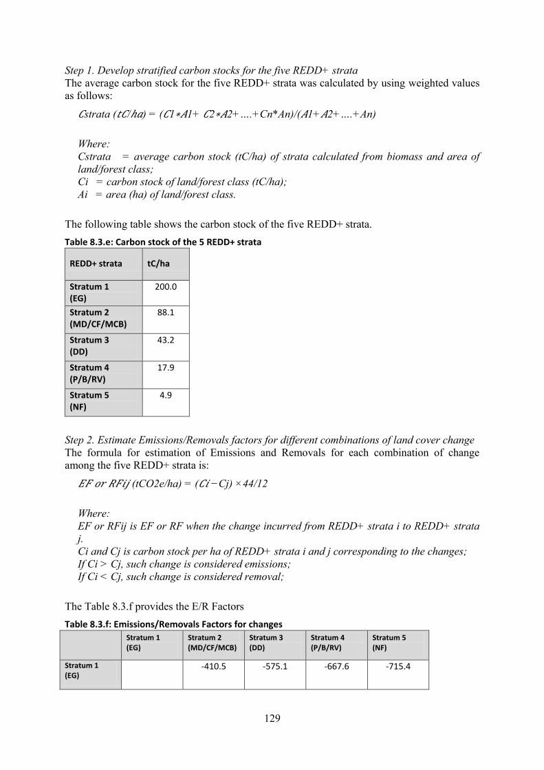
129
Step 1. Develop stratified carbon stocks for the five REDD+ strata
The average carbon stock for the five REDD+ strata was calculated by using weighted values
as follows:
𝐶strata (𝑡𝐶/ℎ𝑎) = (𝐶1∗𝐴1+ 𝐶2∗𝐴2+….+Cn*An)/(𝐴1+𝐴2+….+An)
Where:
Cstrata = average carbon stock (tC/ha) of strata calculated from biomass and area of
land/forest class;
Ci = carbon stock of land/forest class (tC/ha);
Ai = area (ha) of land/forest class.
The following table shows the carbon stock of the five REDD+ strata.
Table 8.3.e: Carbon stock of the 5 REDD+ strata
REDD+ strata tC/ha
Stratum 1 (EG)
200.0
Stratum 2 (MD/CF/MCB)
88.1
Stratum 3 (DD)
43.2
Stratum 4 (P/B/RV)
17.9
Stratum 5 (NF)
4.9
Step 2. Estimate Emissions/Removals factors for different combinations of land cover change
The formula for estimation of Emissions and Removals for each combination of change
among the five REDD+ strata is:
𝐸𝐹 𝑜𝑟 𝑅𝐹𝑖𝑗 (tCO2e/ha) = (𝐶𝑖 −Cj) ×44/12
Where:
EF or RFij is EF or RF when the change incurred from REDD+ strata i to REDD+ strata
j.
Ci and Cj is carbon stock per ha of REDD+ strata i and j corresponding to the changes;
If Ci > Cj, such change is considered emissions;
If Ci < Cj, such change is considered removal;
The Table 8.3.f provides the E/R Factors
Table 8.3.f: Emissions/Removals Factors for changes
Stratum 1 (EG)
Stratum 2 (MD/CF/MCB)
Stratum 3 (DD)
Stratum 4 (P/B/RV)
Stratum 5 (NF)
Stratum 1 (EG)
-410.5 -575.1 -667.6 -715.4

130
Stratum 1 (EG)
Stratum 2 (MD/CF/MCB)
Stratum 3 (DD)
Stratum 4 (P/B/RV)
Stratum 5 (NF)
Stratum 2 (MD/CF/MCB)
410.5 -164.6 -257.1 -304.9
Stratum 3 (DD)
575.1 164.6 -92.6 -140.3
Stratum 4 (P/B/RV)
667.6 257.1 92.6 -47.8
Stratum 5 (NF)
715.4 304.9 140.3 47.8
Step 3. Generate AD based on design-based estimation (2005-2010 and 2010-2015)
Derive the amount of changes in areas which relate to any of the four activities of sources and
sinks: Emissions from Deforestation and Degradation, Removals from Restoration; and
Reforestation.
Table 8.3.g: AD estimated through design-based estimation for 2005-2010 and 2010-2015 (ha)
2010
Stratum 1 Stratum 2 Stratum 3 Stratum 4 Stratum 5
20
05
Stratum 1 473,906 355 0 482 154
Stratum 2 71 3,802,793 0 128,892 28,727
Stratum 3 0 0 17,056 66 65
Stratum 4 0 57,361 60 2,516,047 223,674
Stratum 5 0 0 0 182,805 690,635
Total 8,123,149
2015
Stratum 1 Stratum 2 Stratum 3 Stratum 4 Stratum 5
20
10
Stratum 1 483,524 120 7 257 767
Stratum 2 0 3,770,430 161 101,607 42,539
Stratum 3 0 0 17,171 121 184
Stratum 4 0 45,796 49 2,712,747 99,489
Stratum 5 0 0 0 142,703 705,477
Total 8,123,149
Legend:
Deforestation
Degradation
Restoration
Reforestation
No Change

131
Step 4. Estimate average annual historical emissions and removals from land cover change
over the reference period
Average annual historical emissions and removals from land cover change is calculated with
the method explained in Section 8.3.1. Further, two adjustments were made with an aim to
make the estimation as accurate as possible:
i) Adjustment of removals (regrowth rate and reversals)
For land cover changes which result in emissions (i.e. „Deforestation‟ and „Forest
Degradation‟), the entire expected emission is assumed to occur over the time period in
question. Meanwhile,for land/forest cover changes which result in removals (i.e. „Restoration‟
and „Reforestation‟),
a. Adjustment was made based on the typology summarized below, by considering the
types of changes and rate of tree growth. This recognizes that in forest ecosystems,
forest biomass increase slowly over time to reach their full biomass (IPCC 2006)138.
Table 8.3.h: Typologies of change for removals Sinks From To Adjustment of removals
Restoration
Stratum 4
(RV)
Stratum 1, 2 and
3
In principle, 40-years 139 is assumed as the transition
period from non-forest to Current Forest (i.e. Stratum 1,
2 and 3). From there, deduct 5 years as period for RV to
reach its average biomass stock (See RV Survey Report),
to arrive at 35 years for the transition period for biomass
of Stratum 4 to reach Stratum 1, 2 and 3.
Stratum 2
(MD, CF
and MCB)
Stratum 3
(DD)
Stratum with
higher biomass
In principle, 20 years140 is assumed as a transition period
for forest with lower biomass to reach forest with higher
biomass.
Reforestation
Stratum 5
(non-
forest)
Stratum 4
(predominantly,
RV)
In principle, the full removal factor is applied at the time
change is observed, as RV reaches its average biomass
stock after 5 years (See RV Survey Report) 141 .
Adjustment based on 40-years default applied to the
years following.
Stratum 5
(non-
forest)
Stratum 1, 2 or 3 No such change observed.
138 IPCC (2006, Volume 4, Chapter 4.3: Land Converted to Forest Land) suggests default period of 20 year time
interval for forest ecosystems to be established. 139 The assumption is based on reference to the ERPD of neighboring Vietnam, which assumes 40 years for a
non-forest to reach “Evergreen broadleaf forest – Medium”. The Lao experts agreed on this assumption, as rather
conservative. The actual mapping cycle of 6 years and 4 years are also reflected in the actual calculation (See
footnote 32 in Section 4.1). 140 Again, following the case of Vietnam where 20 years is assumed as a period for forest with lower biomass
shift to forest with higher biomass. However, such changes are actually rare: 71 ha for 2005-2010 and nil for
2010-2015. The actual mapping cycle of 6 years and 4 years are also reflected in the actual calculation. 141 The actual mapping cycle of 6 years and 4 years are also reflected in the actual calculation.

132
b. Reversals during the RL period (10 years) were identified through time-series analysis
of polygons, in order to avoid double-counting. This is because due to the estimation
method of generating AD for two independent periods (i.e. 2005-2010 and 2010-2015),
there is a chance that the emissions from reversal events which have occurred during
the reference period are unreported (in other words, removals are over-estimated).
This was done by tracking all the change patterns which are regarded as reversals (e.g.
strata 4 in 2005, changed to stratum 2 in 2010 and reverted back to stratum 4 in 2015)
as shown in Table 8.3.i below. The respective estimated areas were multiplied with the
accumulated biomass of each land calculated based on typologies in Table 8.3.h above,
and the results were deducted as over-estimated removals. The resulting over-
estimation from such removals, which was 117,058 tCO2e, were deducted from
“Restoration” of 2010-2015 period.
Table 8.3.i: Over-estimated removals tracked
Stratum in
2005
Stratum in
2010
Stratum in
2015
Estimated
area
(ha)*
Emissions to be
deducted from Reversals
(tCO2e)
Change
patterns from
time series
4 2 4 2,299 67,553
4 2 5 1,684 49,494
4 3 5 1 11
*The estimated area was calculated by adjusting the area from the time-series-data with
the ratio of sources and sinks derived from the design-based area estimation for 2005-
2010 period. The actual mapping cycle of 6 years and 4 years are also reflected in the
calculation (See footnote 32 in Section 4.1)
ii) Adjustment of emissions from deforestation and degradation
In the current estimation, there is a concern that emissions from deforestation and degradation
is overestimated. This is because, the E/R factors are strata-specific and do not reflect the
actual accumulated biomass which may be lower. For example, a MD forest which is in its
early regrowth stage (e.g. 10th
year) should have lower biomass than the average biomass of
entire MD class including all its age ranges. If for example a land parcel shifted from strata 4,
strata 3, and back to strata 4, the indication would be that the strata 3 forests before the
disturbance event would have reached at maximum, only about 10-11 years. Such change
patterns were tracked through the time-series-analysis of forest maps as shown in Table 8.3.j
below. The respective estimated areas were multiplied with the accumulated biomass of each
land calculated based on typologies in Table 8.3.h above. The resulting over-estimation of
emissions from deforestation, which was 370,580 tCO2e, and over-estimation of emissions
from forest degradation, which was 317,915 tCO2e, were estimated and deducted, respectively.
Table 8.3.j: Tracked over-estimation of emissions
Stratum in
2005
Stratum in
2010
Stratum in
2015
Estimated
area (ha)
Overestimation of emissions
to be deducted
(tCO2e)
Change
patterns from
time series
4 2 4 1,492 -317,915
4 2 5 1,467 -370,453
4 3 5 1 -127

133
*The estimated area was calculated by adjusting the area from the time-series-data with the
ratio of sources and sinks derived from the design-based area estimation for 2010-2015
period. The actual mapping cycle of 6 years and 4 years are also reflected in the
calculation (See footnote 32 in Section 4.1)
The comparison of before and after the adjustment is shown in the following table.
Table 8.3.k: Comparison of before and after adjustment Before adjustment After adjustment
2005-2010 (tCO2e)
2010-2015 (tCO2e)
Annual average 2005-2015 (tCO2e/yr)
2005-2010 (tCO2e)
2010-2015 (tCO2e)
Annual average 2005-2015 (tCO2e/yr)
Deforestation 19,561,481 18,295,554 3,785,703 19,561,481 17,924,974 3,748,645
Degradation 33,612,595 26,385,998 5,999,859 33,612,595 26,068,083 5,968,068
Reforestation -8,731,889 -6,816,407 -1,554,830 -8,731,889 -5,453,126 -1,418,501
Restoration -14,782,824 -11,778,956 -2,656,178 -2,537,961 -2,921,082 -545,904
The average annual historical emissions and removals over the reference period after the
adjustment of removals are described in the following tables.
Table 8.3.l: Average annual historical emissions and removals (from 2nd NFI) over the reference period – based on changes among 5 REDD+ strata
Emissions(+)/ Removals(-)
Source/Sink activity
2005-2010 (tCO2e)
2010-2015 (tCO2e)
Average annual 2005-2015
(tCO2e/year)
Deforestation 19,561,481 17,924,974 3,748,645
Forest Degradation
33,612,595 26,068,083 5,968,068
Reforestation -8,731,889 -5,453,126 -1,418,501
Restoration -2,537,961 -2,921,082 -545,904
Total Emission 53,174,076 43,993,056 9,716,713
Total Removals -11,269,849 -8,374,208 -1,964,406
Emissions from forest degradation including selective logging
Table 8.3.m presents the estimated total biomass loss from selective logging in the ER
Program area. As the stumps observed and recorded in the 2nd
NFI were assumed to be felled
within 12 years before its field survey (see Section 8.3.4), the total is divided by 12 years to
derive the annual average emissions.
Table 8.3.m: Estimated total biomass loss from selective logging in ER Program area
Ave loss tCO2e/ha
StD StE Area(ha) Forest type map 2015
tCO2e/12 year
EG: Evergreen Forest 3.7 7.5 3.7 481,380 1,802,956

134
MD: Mixed Deciduous Forest
2.1 7.0 0.7 3,771,453 7,736,569
DD: Dry Dipterocarp 5.8 10.1 3.2 17,351 100,002
CF: Conifer Forest - - - 25,782 -
MCB: Mixed Conifer and Broadleaved forest
- - - 2,180 -
Total 9,639,528
Annual average (tCO2e) (Total divided by 12 years)
803,294
If the biomass loss from selective logging is simply added to the forest degradation identified
through the stratified forest type maps, the problem of double-counting of emissions occurs.
YearX+5
stratum
1
stratum
2
stratum
3 stratum 4
stratum
5
Year
X
stratum
1 SF1 DG1 DG2
DG
but
Tree
stumps
not
measure
d
DF
stratum
2 SF2 DG3
stratum
3 RS
SF3
stratum
4 SF4
stratum
5 RF SNF
Legend:
Deforestation (DF)
Degradation (DG)
Restoration (RS)
Reforestation (RF)
Stable Forest (SF)
Stable Non-Forest (SNF)
Figure 8.3.c: Annotated change matrix among 5 REDD+ strata for addressing double-counting in degradation
As in Figure 8.3.c, emissions from forest degradation estimated through the stratified forest
type maps are represented in DG1, DG2 and DG3 (tree stumps were not measured in Stratum
4 during the 2nd
NFI). Forest degradation occurring within the same forest strata, are
represented in SF1, SF2, SF3 (and SF4); these are not accounted for due to lack of repeated
biomass measurement); these are not accounted for due to lack of repeated biomass
measurement.
In Strata 1, 2 and 3 (therefore, DG1, DG2, DG3, and SF1, SF2, SF3), tree stumps were
measured during the 2nd
NFI. Using these measurements, the emissions from selective logging
were estimated.

135
As a result, in DG1, DG2, and DG3, emissions from the Forest Cover Change Matrix and
from selective logging are both represented, and parts of such emissions are assumed to be
overlapping (i.e. double-counted.) To avoid such double counting, either one of the forest
degradation sources should be deducted from the accounting. Considering the emissions from
selective logging cannot be accurately associated with the Forest Cover Change Matrix142, the
option to deduct the emissions from the Forest Cover Change Matrix in DG1, DG2, and DG3,
is selected. The following estimations are applied:
a. The emissions from forest degradation based on changes among 5 REDD+ strata (i.e.
Table 8.3.i)
(DG1 + DG2 + DG3 + DG) = 5,968,068 tCO2e/year.
b. The emissions from forest degradation estimated based on changes among 5 REDD+
strata within the stratum
(DG1 + DG2 + DG3) = 22,535 tCO2e/year (estimated through AD * E/R factors).
c. The emissions from selective logging estimated through proxy-based approach
(included in SF1, SF2, SF3, DG1, DG2, DG3) = 803,294 tCO2e/year.
The total emissions from forest degradation is therefore 6,780,619 tCO2e/year
5,968,068 (a) - 22,535 (b) + 803,294 (c) = 6,748,827 tCO2e/year
As the result, the average annual emissions and removals over the reference period is
estimated to be:
Emissions: 10,497,473 tCO2e/year; and
Removals: -1,964,406 tCO2e/year.
Table 8.3.n: Average Annual Historical Emissions and Removals over the Reference period
Emissions(+)/ Removals(-)
Source/Sink 2005-2010 (tCO2)
2010-2015 (tCO2)
Annual average 2005-2015
(tCO2/year)
Deforestation 19,561,481 17,924,974 3,748,645
Forest Degradation 38,286,544 29,201,727 6,748,827
Changes among REDD+ strata
33,466,780 25,988,551 5,945,533
Logging 4,819,764 3,213,176 803,294
Reforestation -8,731,889 -5,453,126 -1,418,501
Restoration -2,537,961 -2,921,082 -545,904
Total Emission 57,848,024 47,126,701 10,497,473
Total Removals -11,269,849 -8,374,208 -1,964,406
8.4 Upward or downward adjustments to the average annual historical emissions over the Reference Period (if applicable)
No adjustments have been made to the RL.
142 The timing of the felling of the tree stump cannot be accurately determined, making the association with the
Forest Cover Change Matrix a challenge.

136
8.5 Estimated Reference Level
Table 8.5.a is the RL of the ER Program based on the average historical emissions/removals
in the ER Program area over the reference period (2005-2015); no adjustments have been
applied. The forest reference emission level is 10,554,847 tCO2e per year, whereas the forest
reference level for removals is -1,974,161 tCO2e per year.
Table 8.5.a: ER Program Reference level over the Reference Period (tCO2e/yr) Average annual historical emissions by sources and sinks
Year Emissions:
Deforestation
Emissions:
Forest
Degradation
Removals:
Reforestation
Removals:
Restoration
Reference level
(tCO2e/yr)
Emissions Removals
2005 3,260,247 6,381,091 -1,455,315 -422,993 9,641,337 -1,878,308
2006 3,260,247 6,381,091 -1,455,315 -422,993 9,641,337 -1,878,308
2007 3,260,247 6,381,091 -1,455,315 -422,993 9,641,337 -1,878,308
2008 3,260,247 6,381,091 -1,455,315 -422,993 9,641,337 -1,878,308
2009 3,260,247 6,381,091 -1,455,315 -422,993 9,641,337 -1,878,308
2010 3,260,247 6,381,091 -1,455,315 -422,993 9,641,337 -1,878,308
2011 4,481,243 7,300,432 -1,363,281 -730,271 11,781,675 -2,093,552
2012 4,481,243 7,300,432 -1,363,281 -730,271 11,781,675 -2,093,552
2013 4,481,243 7,300,432 -1,363,281 -730,271 11,781,675 -2,093,552
2014 4,481,243 7,300,432 -1,363,281 -730,271 11,781,675 -2,093,552
Annual
average
2005-2015
3,748,645 6,748,827 -1,418,501 -545,904 10,497,473 -1,964,406
8.6 Relation between the Reference Level, the development of a FREL/FRL for the UNFCCC and the country’s existing or emerging greenhouse gas inventory
8.6.1 Relation between the RL for the ER Program and the national FREL/FRL
In early 2016, Lao PDR agreed on a roadmap to submit its national FREL/FRL for the
UNFCCC‟s technical assessment round of 2018 (i.e. submitted to the UNFCCC in January
2018). The submission timing was decided considering the timing when the AD and E/R
factors become fully available for the construction of national FREL/FRL (see Section 8.3).
Concurrently, the opportunity to participate in the Carbon Fund emerged. Lao PDR was
invited to present its ER-PIN at the FCPF Thirteenth Meeting of the Carbon Fund (CF13) in
Brussels, Belgium, October 13-16, 2015, and then the ER-PIN was officially submitted to the
Carbon Fund. The ER-PIN was accepted into the Carbon Fund pipeline with conditions
(Resolution CFM/13/2015/4), and then the Letter of Intent was signed between the World bank
and the Government (LOI 20/07/2017).

137
Throughout this process, harmonization between the RL for the ER Program and the national
FREL/FRL has been considered. In fact, the national FREL/FRL, in majority of aspects
applies consistent methodologies as defined through the Carbon Fund Methodological
Framework, to mitigate any inconsistency or differences between the two.
In principle, the national FREL/FRL and the RL for the ER Program is based on the same
dataset, prepared by the same team in DOF using mostly the same methodologies, applying
the same reference period, and assessed by the same group of stakeholders, thus, the ER
Program RL can be considered as a sub-set of the national FREL/FRL. The following table
provides the comparison of national FREL/FRL and the RL for the ER Program.
Table 8.6.a: Comparison table for national FREL/FRL with the ER Program RL
National FREL/FRL ER Program RL
Methodologies
AD National-scale forest type maps for year 2005, 2010, and 2015.
Application of design-based area estimation of AD will be applied for the modified submission to maintain consistency with the ER Program
Design-based area estimation of AD.
(based on Forest type map for the ER Program area derived from the national-scale forest type map for year 2005, 2010, and 2015)
EF/RFs 2nd NFI.
Combination of country-specific allometric equation and IPCC default values.
Adjustment of removals as explained in Section 8.3.5 will be applied for the modified submission to maintain consistency with the ER Program.
2nd NFI.
Combination of country-specific allometric equation and IPCC default values.
Reference Period 2005-2015 2005-2015
Carbon pools AGB, BGB AGB, BGB
Non-CO2 gasses no no
Scope of activities deforestation,
forest degradation,
forest enhancement (restoration)
forest enhancement
(reforestation)
deforestation,
forest degradation,
forest enhancement (restoration)
forest enhancement
(reforestation)
Model applied Historical average Historical average
Adjustment n.a. n.a.
Uncertainty assessment
n.a. Propagation of error approach
Technical team
Government team Department of Forestry Department of Forestry
Supporting partners JICA F-REDD, FCPF Readiness Project JICA F-REDD, FCPF Readiness Project
Assessment process
Technical endorsement
REL/MRV Technical Working Group,
National REDD+ Task Force,
Ministry of Agriculture and Forestry
REL/MRV Technical Working Group,
National REDD+ Task Force,
Ministry of Agriculture and Forestry
Political endorsement
Ministry of Natural Resources and Environment, as the UNFCCC focal point
Ministry of Agriculture and Forestry, as the implementing Agency of ER Program

138
Following the abovementioned roadmap, the national FREL/FREL was officially submitted to
the UNFCCC on 5 January 2018 and in the process of technical assessment at the time of
submission of this ER-PD. As both the assessment of ER Program and the national
FREL/FRL are occurring simultaneously, consistency between the two RL for the ER
Program and national FREL/FRL will be maintained to the extent possible. In case the two
results in some inconsistency, Lao PDR will prepare to clarify the differences, and consider
ways to quantify the consequent differences in emissions/removals estimation143
.
8.6.2 Consistency with the GHG Inventory
Plans for the future GHG Inventory
Lao PDR has so far submitted two National Communications (NC) to the UNFCCC:
The 1st National Communications in year 2000 with year 1990 as the base year for the
GHG Inventory
The 2nd
National Communications in year 2013 with year 2000 as the base year for
GHG Inventory
Currently, the government is preparing the 3rd
National Communication as well as the 1st
Biennial Updating Report (BUR) with the support of UNEP/GEF. The overviews are
summarized in the table below.
Table 8.6.b: Summary of plan for the NC and BUR
3rd National Communication 1st Biennial Updating Report
Target date of submission
January 2019 January 2019
Reporting year 2010 2014
IPCC Guideline generally applied
IPCC 2006 in combination with IPCC 1996 for some areas which have limited data
IPCC 2006 in combination with IPCC 1996 for some areas which have limited data
LULUCF data AD from DOF
EF/RFs from DOF
AD from DOF
EF/RFs from DOF
As seen from the table above, generally the data from DOF, which are the data used for the
construction of national FREL/FRL and the RL for the ER Program, are agreed to be used in
the GHG Inventory, acknowledging that they are the best available data which meets the
standard of IPCC 2006 AFOLU.144
However, the details need to be closely coordinated in
order to avoid possible inconsistencies, and also to be transparent and accountable for
explaining the relationship between the GHG Inventory and the RL for the ER Program (and
the future MMR results).
143 This issue, to some extent, depends on what the Carbon Fund and UNFCCC require, through their respective
TAP and TA processes. Currently based on the technical assessments for the two processes taking place in
parallel, Lao PDR notes there are some differences in the requirements raised by the two assessment teams.
Therefore, Lao PDR would expect further guidance by the FCPF Carbon Fund on the extent and cases of
consistency required. 144 The 1st and 2nd National Communications applied the IPCC Revised Guideline for National GHG Inventory
1996.

139
Measures to maintain consistency
The GHG Inventory Division of Department of Climate Change (DCC) under MONRE
(restructured from the Department of Disaster Management and Climate Change or DDMCC
in 2017) is responsible for coordinating the compilation of the GHG Inventory, and also acts
as the national focal point to the UNFCCC. Therefore, coordination with the DCC is vital to
maintain the consistency between RL for the ER Program and the GHG Inventory (and the
future MRV/MMR).
In principle, as the RL of the ER Program can be regarded as a sub-set of the national
FREL/FRL, the consistency between RL of the ER Program and the GHG-Inventory can be
enabled through harmonization of the national FREL/FRL and the GHG Inventory. Several
avenues exist that will facilitate this process:
The DCC is one of the members of the REL/MRV TWG. All the issues related to REL
and MRV are discussed, technically reviewed and endorsed by the TWG before the
final decision is made by the Government. Harmonization between national
FREL/FRL and the RL for the ER Program, and the GHG Inventory is listed as one of
the tasks of the TWG, the issue has been, and will continue to be discussed through
this coordination mechanism.
The Deputy Director of DDC is a member of the NRTF. The NRTF is responsible for
endorsing the issues related to REDD+, including the REL.
Under the coordination of DCC, a Task Force for the 3rd
NC and the 1st BUR has been
established as an ad hoc committee to prepare the GHG Inventory. Staff from FIPD,
who are the members of the FREL/FRL drafting team, are assigned as the member of
the GHG Inventory Task Force, and can bridge REDD+ and the GHG Inventory.
Supporting development partners are pro-actively raising this issue in various venues,
to facilitate the collaboration between DOF and DCC.
8.7 Future improvements of the data used in the Reference Level
Lao PDR has identified the areas for future improvement on its FREL/FRL (and therefore the
ER Program RL) as follows145
:
8.7.1 Areas for future improvements related to the Activity Data
Improvement of classification between RV and MD
In the development of the wall-to-wall forest type maps, distinguishing RV and MD posed a
technical challenge, especially when the land is under continuous phases of regeneration. The
remote sensing team of FIPD-DOF tried using ancillary data, such as identifying a threshold
year for RV to regenerate back to MD. For the future forest mapping, Lao PDR will attempt
to explore methods to fine-tune the classification in order to enable further analysis of
land/forest cover change over time.
Improvement of classification between UC and OA
Distinguishing UC and OA classes also posed a challenge, as they have very similar texture
on satellite imagery. Therefore, in the current mapping method, land continuously interpreted
as UC over the two time periods was determined as permanent agricultural land (ie. OA class).
In the future, Lao PDR may explore using options, such as the technologies to analyze „big
data‟, multi-temporal satellite dataset available, and GIS data from different sources (e.g. land
concession data), which meet its needs.
145 Noting that consistency between RL and MRV/MMR will always be a major issue for consideration when
planning improvements.

140
Further capacity building of the remote sensing, GIS and IT engineers
With the rapid innovation of remote sensing, GIS and IT technologies, demand for sufficient
competent engineers is high. The skills and knowledge of the skilled senior engineers of FIPD
needs to systematically be passed on to the younger generation. There is also an emerging
need for IT engineers who can manage and operate database systems which handle large and
diverse range of digital data.
8.7.2 Areas for future improvements related to the Emission/Removal factors
Securing sufficient numbers of survey plots per forest and non-forest classes
In the 2nd
NFI, there was low congruence between the predicted and actual classification of
forest classes for the NFI plots. This resulted in lower than desired samples for non-MD forest
classes. As such, for the future iteration of the NFI, it is recommended to increase the number
of non-MD plots, to ensure minimum thresholds are met for all forest classes. Also, since the
lands other than those categorized as currently stocked (i.e. EG, MD, DD, CF, MCB, P) in the
forest type maps were not sampled, there is a concern of bias (although not significant). Thus,
future NFIs should sample whole landscapes and verify forest as well as non-forest.
Carbon stock of Regenerating Vegetation (RV)
The carbon stock of RV was measured separately from the 2nd
NFI and calculated from the
average carbon stock of different years, therefore, there is a limitation in the
representativeness of data which resulted in relatively high uncertainty. The measurement did
not include dead wood. The future NFI could incorporate the measurement of carbon stock of
RV, including dead wood, in its design.
Continuous improvement of E/R factors
Default value from the IPCC Guidelines were used to estimate carbon stock for some of the
land/forest classes where country-specific data do not exist. Also, allometric equations for
minor forest classes applied ones from neighboring country (i.e. Vietnam). Developing
country-specific carbon stock data and allometric equations in the future, shall contribute to
reducing the uncertainty of E/R factors.
8.7.3 Other thematic areas
Inclusion of non-CO2 gases emission from shifting cultivation and forest fires
Shifting cultivation is an important source of emission in the ER Program area. Although
quantification of such emission was tested during the RL construction process, due to the lack
of reliable data (AD and E/R factors including specific combustion factors for shifting
cultivation), non-CO2 emissions from shifting cultivation and consequent uncontrolled fires
are is not accounted in the current RL. Although exclusion of such non-CO2 gases (primarily
CH4 and N2O) are considered as conservative, Lao PDR will consider this as one area for
technical improvement into the future.
Inclusion of dead wood (DW) as a carbon pool
The 2nd
NFI measured DW for the five natural forest classes (i.e. EG, MD, CF, DD, MCB)
which accounts for approximately 60 % of the forest land, but not for the RV class. Therefore,
the data on DW is considered incomplete, and partial inclusion of DW may result in
inconsistent estimation, leading to the possibility of over-estimation. Although exclusion of
DW is considered as conservative, Lao PDR will consider its inclusion as one area for
technical improvement into the future.
Inclusion of litter and soil as a carbon pool
The current NFI system does not include measurement of litter since carbon stock of litter is
assumed as insignificant and the cost of measuring may not meet the benefit; however, this
will be consulted again in the future NFI campaign. Measurement of soil carbon will be even
more challenging, as it will require additional technical and financial capacity. Meanwhile,

141
emissions from soil could be fairly in Lao PDR, especially under the situations where land-
use is dynamic, therefore, it is considered as an area which improvements are expected.
Measurement of emissions from forest degradation by selective logging
As emissions from forest degradation by selective logging is difficult to measure in the
current remote sensing applied in Lao PDR‟s forestry sector, an alternative approach was
applied (i.e. estimating the emissions from the tree stumps recorded in the 2nd
NFI). For
maintaining consistency between the RL and future MRV/MMR, repetition of the same
survey will be required. However, depending on the frequency of future measurements and
reporting, repetition of the same survey may not be a feasible option. There are some
initiatives in the country to measure emissions from forest degradation by selective logging
through advanced remote sensing techniques. If such options prove reasonable, Lao PDR may
consider adopting such options.

142
9. APPROACH FOR MEASUREMENT, MONITORING AND REPORTING
9.1 Measurement, monitoring and reporting approach for estimating emissions occurring under the ER-P within the Accounting Area
9.1.1 MMR of Emissions Reduction and Removals
The measurement, monitoring and reporting (MMR/MRV) approach for the ER Program is
planned as follows:
Measurement
The „Measurement‟ will quantify the amount of ERs achieved through the implementation of
the ER Program. The measurement will be done against the submitted RL through the same or
demonstrably equivalent methods used to construct the RL. As with the RL, the measurement
results shall incorporate the results of uncertainty assessments.
Monitoring
The „Monitoring‟ is the repeated measurement of the ERs generated under the ER Program.
Following the requirements of the Carbon Fund Methodological Framework (Indicator 14.2),
the measurement will be conducted twice during the ER Program.
1st measurement: 2021
2nd
measurement: 2024 (assuming that this will be the last year to conduct the final
measurement for the Carbon Fund)
Reporting
Based on the results from „Measurement‟ and „Monitoring‟ the primary role of „Reporting‟ is
to communicate the results of ERs to the Carbon Fund. However, by coupling with the
monitoring of the drivers, respective interventions and the impacts (or the results), the
„Reporting‟ also contributes to transparently disseminating the results of implementation of
the ER Program.
The MRV/MMR of the ER Program is designed to be conducted in a consistent manner which
was applied for the construction of RL. This will consists of:
1. Use of AD and E/R factors based on land/forest area change analysis
o Generation of AD estimated based on the stratified wall-to-wall mapping and
through design-based area estimation; and
o Generation of E/R factors based on the biomass data from the 4th
NFI in
2020/2021 dry season and 5th
NFI in 2023/2024 dry season (if for any reason
they are not conducted, the results from the 3rd
NFI data will be used. Noting
that, the stump survey will be conducted regardless of the implementation of
the 4th
and 5th
NFIs).
2. Use of proxy data to estimate emission from forest degradation by selective
logging
o Tree stumps surveyed through field measurement. The tree stumps survey will
be conducted twice during the ERPA period, namely in 2020/2021 dry season
and 2023/2024 dry season146
.
146 Meanwhile, Lao PDR is currently considering alternative approaches to measure degradation by selective
logging through remote sensing. This approach may benefit the future carbon accounting in general, if proved
superior in terms of accuracy, consistency with the RL, and future sustainability. However, considering the

143
o
3. Uncertainty assessment
o Quantification of uncertainty by using propagation of error approach.
o For the two proxy approaches/data sets (emissions and removal related to RV
for degradation, and emissions from selective logging), a 15%
conservativeness factor will be applied.
Details of the parameters to be used (i.e. AD and E/R factors) are provided below.
Table 9.1.a: Summary of the MRV/MMR plans for Activity Data (AD) Parameter: Activity Data (AD)
Description: Consistent with the methods applied for the RL, the AD will be derived as the amount of changes in areas which relate to any of the four activities under the sources and sinks; i.e. Emissions from Deforestation and Degradation, Removals from Restoration; and Reforestation.
Data unit: ha/year
Source of data or measurement/calculation methods and procedures to be applied (e.g. field measurements, remote sensing data, national data, official statistics, IPCC Guidelines, commercial and scientific literature), including the spatial level of the data (local, regional, national, international) and if and how the data or methods will be approved during the Term of the ERPA
To maintain the consistency with the ER Program RL, and also with the national FREL/FREL, the AD will be developed by the applying the same satellite imagery or demonstrably equivalent to the ones used for the end year of the RL (i.e. RapidEye)147, in combination with ground truthing.
ER Program area data derived from national scale dataset (scale 1:100,000) to be mapped by the national forest mapping agency (FIPD of DOF).
Reference sampling for design-based area estimation to be carried out by the national forest mapping agency (FIPD of DOF).
AD of selective logging to be reported separately through proxy data, thus not included here (see Section 8.3.4).
Once the AD is produced by the FIPD of DOF, the data will first be technically reviewed within DOF, and then by the REL/MRV TWG. Then the data will be politically endorsed by the NRTF as well as MAF (as the Ministry in charge of forestry, and also the lead executing agency of the ER Program) and finally reported to the Carbon Fund through the MRV/MMR protocol.
Frequency of monitoring/recording: Indicatively:
1st monitoring in late 2021, using the satellite imagery of the dry season 2020-21.
2nd monitoring in late 2024, using the satellite imagery of the dry season 2023-24148.
Monitoring equipment: Satellite imagery, remote sensing software and hardware, field
issues around consistency between the RL and MMR under the Carbon Fund Methodological Framework, Lao
PDR does not plan to apply them in the future MMR for the ER Program, as pointed out by the TAP. 147 In fact, Lao PDR is exploring the option to use Sentinel satellite for the next mapping cycle, considering its
accessibility (free costs), frequency, etc. However, how this can produce „demonstrably equivalent‟ result is
unknown and requires pilot testing. In addition, following the innovations in remote sensing technologies, use of
various data, such as multi-temporal satellites, high resolution satellites, and freely available global dataset will
be explored to create robust data. 148 This means that a complete collection of data for the full ERPA period will not be available. There could be
options, such as to conduct the MMR in 2024/2025 dry season, or to extrapolate the MMR results from
2023/2024 dry season data to a reasonable period. As this issue relates to the regulation of the Carbon Fund, Lao
PDR would like to request for guidance by the Carbon Fund.

144
Parameter: Activity Data (AD)
equipment for ground-truthing.
Quality Assurance/Quality Control procedures to be applied:
FIPD of DOF, through technical support from Japan (JICA), has been continuously improving the mapping techniques and methods. Through continued technical support from JICA, FIPD plans to develop a Standard Operating Procedure (SOP) by the end of 2020 (i.e. before the 1st monitoring in 2021), which will further standardize the mapping methods and results. The SOP will include standards on, such as pre-processing of satellite imagery, segmentation, automated and manual change detection, land forest classification, ground-truthing, and others.
Identification of sources of uncertainty for this parameter
Consistent with the construction of RL, sources of uncertainty of AD is in the error from procedures for interpretation of land/forest classes, which are attributable to the current limitation of remote sensing technology, and the human factors (e.g. skill of the interpreters).
As explained in Section 8.7, three areas for future improvements have been identified in order to reduce uncertainty of AD:
Improvement of classification between RV and MD
Improvement of classification between UC and OA
Further capacity building of the remote sensing, GIS and IT engineers
Process for managing and reducing uncertainty associated with this parameter
See above.
Any comment: By the time of the 1st MRV/MMR, Lao PDR plans to review the optimum mapping system based on the latest mapping technology, available resources (satellite imagery, financial sustainability, etc.), and further technical standards/requirements of the Carbon Fund.
The principle is to ensure demonstrably equivalent methods to those used to set the RL while cost-performance and quality of the AD.
As the MMR plans to generate the AD twice during the ERPA period, the probability of detecting multiple changes in RV class will likely increase. This changed probability will lead to some systematic error into the AD. However, this is likely to be result in conservative estimation of ERs, as a greater amount of deforestation and forest degradation activity is likely to be detected during the MMR.
Table 9.1.b: Summary of MRV/MMR plans for E/R factors Parameter: Emission/Removal factor (E/R Factors)
Description: Consistent with the methods applied for the RL, E/R factors will be developed by taking the difference between the carbon stocks among the 5 REDD+ strata.
Data unit: tCO2e/ha
Source of data or measurement/calculation methods
DOF, in charge of this task, expects to conduct the NFI every 5

145
Parameter: Emission/Removal factor (E/R Factors)
and procedures to be applied (e.g. field measurements, remote sensing data, national data, official statistics, IPCC Guidelines, commercial and scientific literature), including the spatial level of the data (local, regional, national, international) and if and how the data or methods will be approved during the Term of the ERPA
years.
For the immediate future, Lao PDR plans to conduct its 3rd NFI in the dry season of 2018-2019149. In principle, the survey methods applied for the 2nd NFI will be used in the 3rd NFI and beyond in order to maintain consistency.
Measurement of DW in RV class and other improvements will be considered as possible in order to refine the carbon stock measurement. However, this is not intended to be included in the MMR in order to maintain consistency with the RL.
Upon acceptance of the ER Program by the Carbon Fund, the 4th and 5th NFIs are expected to be conducted for the MRV/MMR during the ER Program period, in 2020/2021 dry season and 2023/2024 dry season, respectively.
Frequency of monitoring/recording: In principle, every 5 years, depending on availability of Government funding (or other sources of funds).
Monitoring equipment: A complete biomass survey procedure is standardized by the Standard Operating Procedure (SOP). It is assumed that the current SOP will continue to be used for the future surveys. Below are the list of main equipment to be used.
Field equipment: Tablet-based device with satellite data, GIS data and recording sheet pre-installed. Internet connection for immediate data uploading to the central database.
Other survey equipment (e.g. GPS, Distance Measuring Equipment (DME), Clinometer, automobile).
Office equipment: Computer with a central database installed; Connection to network server.
Quality Assurance/Quality Control procedures to be applied:
The Quality Assurance (QA) and Quality Control (QC) are built-in to the survey process and standardized by the SOP.
QA: training of field crews before the survey; measurement check and data sheet check by the team leader; reflection and feedback after each survey.
QC: random check of recorded data (approx. 10% of the total); re-measurement of a total of 10% of sampling locations randomly or systematically chosen, and re-measured by senior experts of FIPD.
Identification of sources of uncertainty for this parameter
Consistent with the construction of the RL, the following are the key sources of uncertainties associated with the E/R factors.
Uncertainty of AGB originating from sampling error
Uncertainty of AGB originating from biomass equation
Uncertainty of Root-to-Shoot ratios due to the use of IPCC default values
Uncertainty of Carbon Fraction factor due to the use of IPCC default values
Uncertainty of AGB originating from measurement error
As in Section 8.7, three areas for future improvements have been identified in order to the uncertainties above:
Allocation of adequate sampling plots to all the areas of interest
Improvement of carbon stock data of RV
149 With support from JICA and FCPF Readiness Grant.

146
Parameter: Emission/Removal factor (E/R Factors)
Development of country-specific parameters
Process for managing and reducing uncertainty associated with this parameter
See above.
Any comment: n.a. So far, it is considered likely that the 3rd NFI will be conducted during the ERPA period, and the areas identified for future improvement will be incorporated to the extent possible.
9.1.2 Monitoring of drivers and the effectiveness of interventions
In addition to the MRV/MMR, Lao PDR also plans to introduce, through a stepwise-manner,
a system to monitor the drivers and the results of respective interventions for the ER Program
area. This has several elements of importance:
Lao PDR currently lacks an effective system to monitor the drivers of deforestation
and forest degradation. This is done on an ad-hoc basis by the central and provincial
Governments, constrained by availability of financial resources, human resources and
technical capacity (including tools and equipment);
It is important for evaluating the impacts (or the results) of the ER Program on forest
conservation, and also to create a constructive feedback mechanism to periodically
improve the ER Program interventions;
As part of the above point, effectiveness interventions can be measured and assessed
(as applied in the ex-ante estimation of ERs in Table 13.2.b) to feedback for
subsequent reviews and revisions of the PRAPs and intervention plans;
Government‟s recent renewed commitment to forest governance discourages forest
violations (as already seen as the impact of PM Order 15 to address illegal logging),
and promotes sustainable forest management. This should be monitored in different
ways;
A systematic approach to monitoring will support the forest rangers to fulfill and
improve their performance by providing advanced monitoring systems and tools;
Monitoring the impacts on drivers and interventions will enhance the transparency of
the ER Program and may also serve some use in determining benefit sharing
arrangements.
Such attempt under the ER Program will eventually be scaled-up to the national level and will
comprise a core part of the national forest monitoring system (NFMS).
Monitoring of the Key driver #1: Loss of forests to permanent agriculture (including
agriculture and tree plantations)
Permanent agriculture can be categorized into two types: encroachment by small holders
through slash and burn practices for subsistence and commercial farming; and conversion of
forests into agricultural plantation concessions, including tree crops. It is often the case that
legal development of agricultural land can initiate encroachment into surrounding forest areas,
and expand beyond what is legally planned or approved.
Monitoring to protect „intact‟ forests will be the primary focus here, and early detection of
agricultural expansion into intact forest areas before the annual cropping season is necessary.

147
In addition, geo-spatial data of agricultural concession boundaries150 can support to monitor
the compliance/non-compliance by the concession owners (planned deforestation), and also
predict threats of encroachments (un-planned deforestation).
Monitoring of the Key driver #2: Loss of forests/trees to shifting cultivation landscapes
In the ER Program area, shifting cultivation typically involves slash-and-burn practices to
open up forests („pioneering‟). This can take place as new shifting cultivation plots, or
through gradual expansion of existing plots, and rotational practices which are known to
range anywhere between four to nine years, and on average around five years for a full cycle.
The ER Program puts primary focus on protecting „intact‟ forests which have previously not
been cultivated since year 2000 (the rationale is that such forest areas can be identified
through time-series-analysis of forest type maps 2000, 2005, 2010, 2015), which covers
nearly 4,200,000 ha or 52 % of the total ER Program area. Such forests are considered to be
rich in carbon, biodiversity, and other ecosystem values, therefore, will be the immediate
target for protecting from „pioneering‟ shifting cultivation, and will be strategically positioned
also as the core forests for landscape-level forest conservation and restoration.
Detection and monitoring of deforestation becomes a challenge especially when the forests
are encroached on through gradual expansion, therefore, early detection of encroachment into
„intact‟ forests has particular importance. This could be done through a combination of near-
real time monitoring through satellites, and field-based land-use monitoring. Activities to
engage local forest rangers and forest communities in monitoring or patrolling their forests
with regards to their forest and land use plans are already incorporated into the intervention
design (see Section 4.3).
The monitoring of „rotational‟ shifting cultivation practice is even more challenging by
remote sensing, as the size of one plot tends to be small, may occur sporadically, and the
changed vegetation cover is too small to be clearly observed through remote sensing.
Therefore, this needs to be combined with other field-oriented monitoring measures, including
through community monitoring and patrolling as indicated above. To date, there have been
pilots carried out in some provinces (e.g. Houaphan, Luang Prabang). The standard method
would be based on the village-level land use planning and management information to
mobilize villagers to monitor the changes in land and forest use; and verify the results of the
participatory monitoring with remote-sensing based methods.
The use of slash-and-burn practices often leads to further deforestation and forest degradation
when the uncontrolled fire expands into adjacent lands. Forest fires in the provinces are
mostly triggered by slash-and-burn of lands for cropping and/or livestock grazing, which
takes place normally at the end of the dry season and the start of the rainy season (i.e.
February through May). Lack of effective monitoring and early warning systems, limited
resources and poor fire management practices further exacerbates the impact of forest fires.
An intensive monitoring and early warning system during high forest fire risk seasons, both
from satellite and ground-based monitoring, are being considered.
Monitoring of the Key driver #3: Loss of forests/trees to infrastructure and other
developments
Development of infrastructure including roads, hydropower, and mining are not as extensive
as agriculture, but still result in deforestation and forest degradation. The lack of effective
control, law enforcement and monitoring has, in general, led to increased unauthorized and
150
Government has been working on compiling, digitizing and evaluating land concession data through the
“Land Concession Inventory and Quality of Investment Assessment” with technical support from Center for
Development and Environment and financial support from Swiss Government.

148
unplanned clearing of forested land due to infrastructure development, and many cases are
reported where companies log exceeding their given quota or concession conversion area. A
strict monitoring of compliance/non-compliance of the infrastructure projects in site clearing
can be conducted by overlaying project boundary information and remote sensing through
satellites. The recent Government‟s efforts, such as addressing illegal logging (Prime
Minister‟s Order No. 15) and the FLEGT VPA initiative151, provide opportunities to push this
agenda forward.
However, another issue is the role of improved infrastructure as an underlying cause of
deforestation by improving access to previously remote places. Such deforestation/forest
degradation events will be monitored under the Key driver #4 below.
Monitoring of the Key driver #4: Unsustainable and illegal wood harvesting
Illegal logging is a major issue nation-wide. Within the ER Program area, it is particularly an
issue along the borders with China and Vietnam, where thriving timber markets exist, and
also around newly developed infrastructure, such as road networks and feeder roads for
development projects. There are other activities related to unsustainable wood extraction
including legal commercial logging, small-scale local logging, and wood fuel extraction.
Considering the opportunity, feasibility and cost-benefit, the monitoring of Key driver #4 will
prioritize monitoring of illegal wood harvesting. There are several initiatives aiming at
detecting illegal or selective loggings using remote sensing satellites as well as field-based
law enforcement152. The ER Program will collaborate with these initiatives to come up with
optimum monitoring system of this driver.
Monitoring of forest carbon enhancement
The ER Program area contains a large area of the RV class, which are the potential for forest
carbon enhancement through reforestation (either plantation development or planting of
native species for natural forests) and forest restoration (e.g. conservation zoning, assisted
natural regeneration). The time time-series-analysis using forest type maps 2000, 2005, 2010,
2015 shows that nearly 2,750,000 ha or 34 % of the total ER Program area have been under
short-rotation shifting cultivation practices, or in severely degraded conditions preventing
regeneration in to the Current Forest status. In line with the Government‟s goal to increase
forest cover, the interventions of the ER Program aims to reduce conversion of „intact‟ forests
to RV, and then provide incentives for the RV to regenerate back into Current Forests through
forest landscape restoration approach.
Monitoring of forest enhancement by remote sensing has similar challenges with the
monitoring of „rotational‟ shifting cultivation practice, due to the patchwork landscape and
gradual changes in crown cover. Frequent monitoring through multi-temporal satellite
datasets is expected to allow continuous monitoring of lands undergoing forest enhancement.
However, it needs to be combined with other field-oriented monitoring measures (e.g.
community-based monitoring of the land-use plans as explained above).
151 The FLEGT TLAS system technically supported by the German Government is currently designing a pilot
activity to monitor timber logging in infrastructure project sites, and associated illegal loggings in-situ/ex-situ. It
is not yet certain whether the pilot site(s) include ER Program provinces, however, the piloted system is expected
to become applicable in the ER Program area. 152 Such as SUFORD Project supporting sustainable production forest management, ProFLEGT Project
supporting FLEGT VPA and TLAS, and EC-JRC testing satellite based detection of illegal loggings in Lao
PDR.

149
It should be noted that this monitoring will also reduce the uncertainty in carbon accounting,
by improving the MRV/MMR of forest enhancement which were the challenge at the time of
construction of RL (See Section 8).
The following table summarizes the monitoring systems:
Table 9.1.c: Monitoring of drivers
Monitoring frequency
Monitoring method
Key driver #1: Loss of forests to permanent agriculture (including agriculture and tree plantations)
Remote sensing: near-real-time monitoring especially before the cropping season)
Others: field-based monitoring
Use of free/commercial multi-temporal global satellite dataset (e.g. Sentinel, Landsat, other commercial satellites).
Detect the tree loss, as soon as possible, before the cropping/planting season when the sites are cleared (either by slash and burn or other means). Continued observation of land use in the following years will enable distinguishing
permanent agriculture from ‘rotational’ agriculture.
Compliance/non-compliance of concessions can be monitored by overlaying the cleared forest area with the concession boundary, and field check.
Key driver #2: Loss of forests/trees to shifting cultivation landscapes
Remote sensing: near-real-time monitoring (especially before the annual cropping season)
Others: field-based monitoring
Monitoring of forest fire needs to be further considered
Use of free/commercial multi-temporal global satellite dataset (e.g. Sentinel, Landsat, other commercial satellites).
Detect, as early as possible, the tree loss before the cropping season when the sites are slashed and burnt.
Distinguish between intact forest (i.e. forests not subject to shifting cultivation or other major land use changes since 2000) and fragmented forest (i.e. forests subject to shifting cultivation or other major land use changes after 2000) through time-series-analysis of historical forest type maps (2000, 2005, 2010 and 2015). Loss of intact forest can be regarded as caused by
‘pioneering’ type of agriculture, while loss of fragmented forest could be regarded as caused
by ‘rotational’ agriculture.
The detection of ‘pioneering’ agriculture (i.e. including pioneering shifting cultivation and pioneering of permanent agriculture) by remote sensing is based on the distinct change in tree crown cover.
The detection of ‘rotational’ shifting cultivation by remote sensing is technically challenging due to the small change in vegetation cover. Therefore, monitoring needs to be combined with other information (e.g. field-based land use monitoring) or by giving a different attribute.
Key driver #3: Loss of forests/trees to infrastructure
Remote sensing: near-real-time
Use of free/commercial multi-temporal global satellite dataset (e.g. Sentinel, Landsat, other

150
Monitoring frequency
Monitoring method
and other developments monitoring
Others: monitoring of legally logged timber.
commercial satellites).
Detect the tree loss before the site clearance. Compliance/non-compliance of site clearance against plans can be monitored by overlaying remote sensing images of the cleared forest area with the project boundary and through field check.
The Lao FLEGT TLAS system under development is expected to support the monitoring of legally logged timber from the project sites.
Illegal timber harvesting induced by the projects (e.g. roads, hydropower, and mining) will be monitored under the Key driver #4.
Key driver #4: Unsustainable and illegal wood harvesting
Remote sensing: Near-real-time monitoring and early warning
Others: intensive field monitoring of hotspots
Use of free/commercial multi-temporal global satellite dataset (e.g. Sentinel, Landsat, other commercial satellites) with high-frequency.
Possibly detect the harvesting incidents from the change of crown cover using Very High Resolution Satellites (need testing).
Monitoring of hotspots, such as high historical
tree loss area, ‘deforestation frontier’, expansion of road network, etc., combined with field-level monitoring/patrolling (need testing)
TLAS system currently developed under Lao FLEGT is expected to support the monitoring of illegally logged timbers.
Monitoring of forest enhancement
Remote sensing: minimum once every year.
Others: field-based monitoring
Use of free/commercial multi-temporal global satellite dataset (e.g. Sentinel, Landsat, other commercial satellites) with high-frequency.
Monitoring of areas zoned for forest enhancement under forest landscape restoration approach and village-level PLUPs.
Monitoring needs to be combined with other information (e.g. field-based land use monitoring) or by giving a different attribute.
9.2 Organizational structure for measurement, monitoring and reporting
9.2.1 Organizational structure, responsibilities and competencies
Due to the inter-sectorial nature of REDD+ and the ER Program, the MMR will be carried out
through a coordinated partnership among different entities. The table below shows the
preliminary framework of the entities to be involved and their main responsibilities, which
will be further streamlined, tested and improved through the implementation of the ER
Program. In principle, the institutional arrangement of the MMR will be consistent between
that of the ER Program and that for the National REDD+ Program. While a number of
REDD+-unique responsibilities are envisaged (particularly with respect to carbon accounting),
most institutional arrangements build on existing arrangements and responsibilities of the
respective entities. Where new responsibilities are identified, appropriate training and
orientation will be considered, as well as allocation of budgets to conduct the activities.

151
Table 9.2.a: Preliminary framework of institutions involved in the MRV/MMR
DOF DOFI Provincial Government
Private sector, local community
REL/MRV TWG
NRTF MAF
MMR Conduct the MMR
Participate in NFI as local guides
Technically review the MMR results. Collaborate with other TWGs.
Endorse the MMR results. Facilitate collaboration with other concerned sectors
Responsible for the MMR as the executing agency.
Monitoring of drivers and interventions
Provide supporting data for enforcement.
Compile the monitoring results.
Enforcement
Enforcement
Participate Technically review the monitoring results. Collaborate with other TWGs.
Facilitate collaboration with other concerned sectors following the monitoring results
Responsible for the monitoring as the executing agency.
The role of each entity and their competencies are summarized below:
Role and capacity of entities for conducting MMR
Department of Forestry (DOF)
DOF, as the national entity responsible for forest management, will play the main role in the
MRV/MMR. FIPD of DOF will continue to be responsible for generating the AD
(provisionally in year 2021 and 2024) and E/R factors, and also the estimation of emissions
from selective logging, by applying the same or equivalent methodologies used for the
construction of the RL (in case there are methodological improvements which substantially
alters the RL, Lao PDR may consult the Carbon Fund).
REL/MRV Technical Working Group (TWG)
The REL/MRV TWG will technically review the results of the MRV/MMR. The TWG
consists of members from the four key government agencies (FIPD of DOF, Department of
Agriculture Land Management of MAF, DCC of MONRE, and the Faculty of Forestry of
NoUL). The TWG is technically supported by international projects and advisors and is an
open process. Although the MRV/MMR itself is under the responsibility of the REL/MRV
TWG, members of other TWGs including, Benefit Sharing TWG, Land tenure and land-use
TWG, Enforcement and implementation of mitigation actions TWG will be invited as
appropriate, where there are links between the thematic areas. Having DDC of MONRE, who
is responsible for climate change related issues including REDD+ and GHG Inventory, as a
member of the TWG will allow the coordination of the MMR process and results with other
GHG mitigation initiatives in the country.
National REDD+ Task Force (NRTF)
The NRTF will be responsible for reviewing and politically endorsing the results of
MRV/MMR of emissions reduction and removals, including the MMR reports before the

152
submission to the Carbon Fund (although depending on the type of reports). The NRTF
consists of concerned government agencies who have stake in forestry, land-use, climate
change, poverty reduction and other issues related to REDD+ in Lao PDR.
Ministry of Agriculture and Forestry (MAF)
The MAF, as the lead executing agency of the ER Program will be responsible for the overall
governance and supervision of the MRV/MMR, and will undertake the final responsibility to
submit the MRV/MMR reports to the Carbon Fund.
Private sector and local community
The private sector and local community will be informed of the results to ensure transparency
and accountability in MMR. Some of them, particularly the local communities, will be
involved in supporting the technical work, such as being local guides for the NFI (as they was
the case in the 2nd NFI). Moreover, the information from their own activities are expected to
be used as ancillary information to support and improve the MMR, particularly in forest
mapping. This includes, for example, plantation management information of the forest
companies to improve classification of plantations, and village-level forest monitoring
activities based on the land-use plans to further understand the stages of shifting-cultivation
and forest regeneration stages153
. Other potential means of engagement will be explored
through the course of designing of detailed activities and implementation of the ER Program.
Role and capacity of entities for conducting monitoring of drivers and interventions
Department of Forestry (DOF)
FIPD of DOF will have the primary role to provide remotely sensed data related to the drivers
and interventions to the relevant agencies, such as DOFI and the provincial Government
offices.
Department of Forest Inspection (DOFI, under MAF)
The DOFI, in collaboration with DOF and the provincial governments, is responsible for
forest law enforcement.
Sub-national Government offices
At the provincial level, Provincial Agriculture and Forestry Offices (PAFO) and District
Agriculture and Forestry Offices (DAFO) will undertake primary role on monitoring in their
administrative territory in line with the design of the ER-P and also feedback the results for
improvement.
Private sector, local communities
The private sector entities that engage in the ER Program activities and local communities
will play a key in monitoring, as the main agents that will deliver on the land-based
interventions under the ER Program. For example, businesses with land concessions will be
responsible to monitor the compliance of their business and mitigate any associated impacts
(e.g. encroachment to the adjacent forests). Local communities are expected to monitor their
forests based on the land-use plan and any other valid plans agreed on.
REL/MRV and other Technical Working Groups (TWGs)
The proposed monitoring framework and methodologies will be technically reviewed by the
REL/MRV TWG together with the six TWGs as appropriate. The monitoring and information
will also be shared among the six TWGs (including REL/MRV TWG) in order to ensure
153 Noting the need for consistency with the RL.

153
alignment with their actions, and to generate positive synergy throughout the implementation
of the ER Program.
The discussions on monitoring of drivers and interventions are still in early stages, and
stakeholder mapping and overall designing of the monitoring system is currently being
undertaken. As discussed elsewhere (e.g. Chapter 4 and 6), the importance of collaboration
with the agriculture and investment sector are well recognized, and agencies such as DALAM
and DOA under MAF as well as MPI will be engaged in monitoring activities and in the
analysis of the monitoring data. There are also potentials for collaboration with the forest
monitoring of FLEGT VPA including adopting satellite based methodologies for monitoring
of illegal logging (EU Joint Research Center), and land concession monitoring (being
proposed by CDE Bern University), among others.
9.2.2 Methods and standards for data management and public access to monitoring parameters
The monitoring parameters for the MRV/MMR and for the monitoring of drivers and
interventions will be collected and analyzed in the manner and by the responsible entities as
explained above. Taking into account the technical capacity of actors, technological options
and technical/financial support available, the Government of Lao PDR will ambitiously aim
for continuous improvements.
In principle, the idea will be to manage and archive data within a unified database. The
National Forest Monitoring System (NFMS) database which has been developed and is
accessible through web-portal <http://nfms.maf.gov.la:4242/nfms/> will serve as the central
database for accessing the dataset necessary for the reconstruction of the RL, as well as both
MRV/MMR and monitoring data. This NFMS database (and its sub-databases) form a core
part of Lao PDR‟s REDD+ Data Management System (DMS), which in the future will also
host a function as an ER Transaction Registry (see Chapter 18).
A conceptual diagram of the database system is shown in Figure 9.2.a below, and the types of
data items to be stored are shown in Table 9.2.b below.
Figure 9.2.a: Conceptual diagram of the database system

154
Table 9.2.b: Data for the NFMS database system Data related to AD Data type
Forest type maps 2000, 2005, 2010, 2015 Raster data
Forest cover change map 2000-2005, 2005-2010, 2010-2015 Raster data
* partly vector data
Satellite imagery used for the development of forest type maps
Landsat (2000), SPOT4, 5 MS(2005), RapidEye (2010, 2015)
* Both false color and true color
Raster data
Data related to E/R Factors Data type
1st NFI data Tabular data
2nd NFI data Tabular data
Other data Data type
Administrative area: national, province, district Vector data
Forest category: Production Forest, Protection Forest, Conservation Forest
Vector data
Reports Data type
FREL/FRL Report to the UNFCCC including annexes Under preparation. To be
1st National Communication to the UNFCCC Available in UNFCCC website
2nd National Communication to the UNFCCC Ditto
As explained, the NFMS portal will serve as a web-portal for the public to access data and
methodologies used for the construction of RL. In the future, once Lao PDR conducts the
MMR, data and results will also be made public through the NFMS web-portal.
In addition to the information on RL and MMR, information on monitoring of drivers and
interventions are also envisaged to be made accessible through the web-portal..
9.3 Relation and consistency with the National Forest Monitoring System
As summarized in Section 9.1 and Section 9.2, Lao PDR is under the process of designing the
National Forest Monitoring System (NFMS) which will support both the MRV/MMR and
monitoring of the drivers and interventions (a conceptual picture show in Figure 9.3.a below).
There are several related initiatives progressing in parallel, and they will be coordinated under
the NRTF and the REL/MRV TWG so that the NFMS will contribute to the overall
performance monitoring of the forestry sector.

155
Figure 9.3.a: Conceptual diagram of Lao PDR’s NFMS database and its interactions with other REDD+ systems
Estimation of Emissions Reductions and Removals
As Lao PDR has decided to derive AD and E/R factors for the ER Program from the national-
level datasets, the emissions and removals occurring in the ER Program area can be easily
estimated by defining and extracting the area of interest for analysis. The geographical
boundary of the ER Program area is based on the provincial boundaries of the six provinces,
thereby facilitating the extraction process. As explained elsewhere, the E/R factors applied for
the ER Program will be identical to the national level E/R factors. This will allow easy nesting
of the sub-national (ER Program) and the national level.
The ER Program, will be nested into the national REDD+ implementation to avoid double
accounting of emission reduction and/or removal enhancement at the national level. This
means that the RL of the ER Program will be nested into the national FREL/FRL submitted to
the UNFCCC. Similarly, the resulting emission reduction and/or removal enhancement will
be nested into the national REDD+ performance to be reported to UNFCCC in a technical
annex to the BUR154
.
Monitoring of the Drivers and Interventions
It is envisaged that the NFMS will be further scaled-up in the future, by adding and
incorporating the forest monitoring functions (as discussed in Section 9.1.2) which supports
the monitoring of drivers and the results of interventions. The ER Program will serve as an
optimal testing ground to develop and roll-out such monitoring for future scaling-up across
the country. Whether the NFMS may include the Safeguard Information System and other
functions in its design is still under discussion.
154 Actually, as also discussed in Section 8.6, to what extent the RL of the ER Program and the national
FREL/FRL submitted to the UNFCCC can maintain consistency depends on the requirements by the two
assessment processes and somewhat unclear at the time of this submission. However, Lao PDR will purse ways
to enable nesting of the two.
Other Monitoring Functions such as
Satellite Land Monitoring System
National Forest Inventory
NFMS/DB
PaMs (REDD+ activities)
NFMS
Web
-Portal
Safeguard
Safeguard Information System (SIS)
NFMS: National Forest Monitoring System
ER Transaction Registry
DMS
REDD+ Registry System
DMS: Data Management System ER: Emission Reduction
PaMs: Policies and Measures

156
10. DISPLACEMENT
10.1 Identification of risk of Displacement
The overall risk of displacement of domestic emissions as a result of the proposed ER
Program measures, is assessed to be low (three drivers are assessed as low, and one driver
assessed as medium).
Driver of deforestation or degradation
Risk of Displacement
Explanation / justification of risk assessment as a result of the ER-P interventions
Key driver #1: Loss of forests to permanent agriculture (including agriculture & tree plantations)
Med (domestic/ international)
If interventions under the ER Program are successfully rolled out and sustainable zero-deforestation investments ‘crowd-in’ to replace the unsustainable agricultural practices, there are risks that such unsustainable investments may be displaced to other parts of the country where ER Program interventions are not implemented.
Regional market demands from neighboring countries have a significant bearing on this driver. Therefore, displacement to other countries of the region is also possible.
Risks of displacement of agricultural expansion into forests to areas outside the ER Program is present at medium levels.
Key driver #2: Loss of forests/trees to shifting cultivation landscapes
Low (domestic) Under the ER Program, shifting cultivation practices will be controlled to discourage encroaching into ‘intact forests’, and increased periods of fallow will be promoted wherever possible. Theoretically, this may lead to decisions displace shifting cultivation practices to outside the Program area. This may happen, particularly where shifting cultivation is practiced for the production of cash crops. However, shifting cultivation is closely associated with the village communities, and it is not likely that village communities would chose to relocate unless, economic and subsistence needs or opportunities are significantly compromised by the Program interventions. The design of the ER Program interventions will not be such, as supported by the high NPV estimated in the financial analysis (see Section 6.2, and next sub-section on mitigation measures).
It is also noted that more than half of the ER Program provincial boundaries are international borders involving large rivers such as the Mekong, making displacement across borders difficult.
Based on the above, risks of displacement of shifting cultivation to areas outside the ER Program are low, and exist in limited scales along borders with provinces outside the ER

157
Driver of deforestation or degradation
Risk of Displacement
Explanation / justification of risk assessment as a result of the ER-P interventions
Program area.
Key driver #3: Loss of forests/trees to infrastructure and other developments
Low (domestic) By and large, infrastructure development needs are by nature site-specific. As the ER Program intervention is not intended to change the infrastructure development plan, but, rather to mitigate its negative impacts, the ER Program interventions are not perceived to cause displacement.
However, with increased law enforcement and monitoring including of conversion timber, this could result in reduced ‘conversion-timber’, and suppress the timber supply for feeding market demands. This may potentially lead to increase of illegal logging outside the ER Program area (i.e. this would be a displacement of key driver #4).
However, the Northern region is not a main source of high-value timber, and considering the Government’s on-going control on illegal logging (including through the issuance of the Prime Minister’s Order No. 15 of 2016), the risk level is assumed low.
Key driver #4: Legal and illegal wood harvesting and other drivers of forest degradation
Low (mainly domestic and international)
High value timber have largely been depleted in the Northern region, therefore, reduced timber supply from the ER Program area resulting from the successful implementation of the ER Program is not considered to present a significant gap for the timber market for high value timber, and particularly not for the regional market.
While it may present a gap in the market for low-grade timber, such markets (i.e. domestic and local) are less inclined to go far distances to fill gaps, as this has cost implications.
Considering the above and Government’s ongoing efforts to nationally curb illegal logging (including domestic measures such as the Prime Minister’s Order No. 15 and its implementation, as well as international efforts including engagement with FLEGT VPA and bilateral cooperation with Viet Nam in forest protection and trade), the risk level is assumed low.
10.2 ER Program design features to prevent and minimize potential Displacement
Overall, risks of displacing drivers into other areas of the country will be addressed by the
Government‟s intention to roll out REDD+ eventually at the national scale. Through the
Governments national forest monitoring system, specific monitoring measures will be
employed to monitor drivers and ER Program interventions, which will facilitate the process

158
of addressing displacement risks (see Section 9.1.2 for more details on the monitoring
measures).
Below, specific measures to address risks of displacement for the immediate future, and also
mitigation measures for addressing cross-border displacement are provided.
Driver Risk of Displacement
Risk mitigation strategy and corresponding intervention Component
Key driver #1: Loss of forests to permanent agriculture (including agriculture & tree plantations)
Medium
(domestic/ international)
The ER Program will engage with the existing businesses to improve and shift their investments into more sustainable practices based on zero-deforestation principles, to reduce risks of displacement, and a win-win situation may emerge. In order for this scenario to take place, incentives to curb unsustainable agriculture practices and offer incentives for those who are willing to practice sustainable agriculture. Ultimately a shift in consumer mentality towards responsible and socially and environmentally conscious consumerism needs to take place. Though this is outside the scope of the ER Program, the Program will take on measures to link up with activities targeting such objectives for both the domestic and regional markets.
Interventions will address risks through policies including at national scale, to promote responsible and sustainable zero-deforestation agriculture including:
- Strengthening policies and governance to provide enabling environment for CSA promotion (activity 1.1.2);
- Strengthening value chain integration and development of CSA cooperatives to promote agro-technological solutions (2.1.3);
- Private sector mobilization on implementing REDD+ and CSA (activity 2.1.4)
- Implementation of CSA and other non-farm livelihood activities (activity 2.2.2);
- Develop incentives mechanisms for attracting sustainable investments in the forestry sector (activity 3.1.2)
.
Key driver #2: Loss of forests/trees to shifting cultivation landscapes
Low (domestic) Interventions include enhancing land tenure security and participatory land use planning, where the agent of shifting cultivation are directly and centrally involved in the planning of future land use.
The interventions also include agro-technological solutions to increase yields and improve soil conditions, so that economic and subsistence needs of the villagers are improved or at least maintained. Alternative non-land-based livelihood options will also be promoted.
Agreements with conditionality clauses possibly to be linked to the benefit sharing may be negotiated as part of the benefit sharing plan.
Indicative activities to address this risk include:
- Development of alternative livelihood

159
Driver Risk of Displacement
Risk mitigation strategy and corresponding intervention Component
opportunities (activity 2.1.1)
- Development and operation of farmer field schools (activity 2.1.2)
- Strengthening value chain integration and development of CSA cooperatives to promote agro-technological solutions (2.1.3);
- Implementation of CSA and other non-farm livelihood activities (activity 2.2.2)
Key driver #3: Loss of forests/trees to infrastructure and other developments
Low (domestic) Interventions are not intended to cancel infrastructure projects and other developments, but to improve planning and conformance with plans, thereby mitigating the risk of displacing emissions from such projects.
Interventions will also target enhanced capacity in monitoring plans by Government.
Indicative activities to address this risk include:
- Capacity development and training for improved law enforcement (activity 1.2.2)
- Provision of technical and financial support for effective monitoring and enhanced law enforcement (activity 1.2.3)
- Monitoring the implementation of PMO #15 (activity 1.2.4)
- Improved guidelines and capacity for compliance of deforestation related safeguards (activity 1.2.6)
- Institutionalize near-real time monitoring for deforestation hotspots including concession areas (activity 1.2.7)
- Improved processes and capacity for monitoring of deforestation (activity 3.1.6)
Key driver #4: Legal and illegal wood harvesting
Low (domestic and international)
The main ER Program interventions to address this driver are in fact enabling condition interventions, including support to the Government’s FLEGT initiative which is a national initiative.
The ER Program will also consider together with Government policy-making, promotion of sustainable forest management, including access to timber for domestic and commercial uses by village communities, when conditions are met.
Indicative activities to address this risk include:
- Strengthen policies to reduce deforestation and degradation (activity 1.1.1)
- Promotion of FLEGT (activity 1.2.1)
- Improved land use planning approaches (activity 1.3.1)
- Awareness raising, capacity building for SFM including village forest management (activity 3.1.3)
- Management planning for village forestry (activity 3.2.1)
- Implementation of village forestry (activity 3.2.2)

160
11. REVERSALS
11.1 Identification of risk of Reversals
Reversal (or non-permanence) of ERs (including removal benefits) could result from
anthropogenic and natural causes (including fire, disease, illegal logging, market price
fluctuations, emergent policies from other sectors or countries, etc.). The risks of reversals
during the ERPA term and beyond, range from low to medium. The Table below provides an
assessment of the anthropogenic and natural risks of reversals that may affect ERs during the
term of the ERPA and beyond, and the corresponding mitigation strategies. The resulting risk
factor is assessed as 23 % out of 40 %.
Risk factors
Default reversal risk set-aside %
Discount %
Resulting reversal risk set-aside %
Justification Remaining Risks
Default risk 10% n.a. 10% n.a. n.a.
Lack of broad and sustained stakeholder support
(Mainly during the ERPA period)
10% 5% 5% The ER Program interventions are designed to assist and engage directly with the village communities, and also with the businesses (to the extent feasible and appropriate).
Villagers have been consulted through the PRAP formulation processes, and will continue to be engaged through consultations, applying FPIC as appropriate, during the course of implementation of the ER Program.
Future market demand and price for agricultural commodities and timber.
Lack of institutional capacities and/or ineffective vertical/cross sectoral coordination
(Both during and after the ERPA period.)
10% 5% 5% From the higher levels of central and provincial Government involved in the ER Program, high levels of commitment have been secured to ensure effective participation and coordination.
However, REDD+ is a new mechanism for Government agencies apart from the forestry sector and other stakeholders in the country.
While there is increased knowledge and capacity on REDD+, securing timely support and engagement from the various levels of Government and across different sectors will be a challenge.
Limited number of qualified Government personnel in the different levels and across sectors, who are capacitated to deliver on REDD+ implementation.
Lack of long term effectiveness in addressing underlying drivers
(Mainly after
5% 2% 3% Government has renewed its commitment to the forestry sector particularly in terms of addressing improved governance. This is evident from the issuance of the Prime Minister’s Order No. 15, engagement in the FLEGT VPA negotiations, and also expressed in the new Green
Weak rule of law and corruption.
Drop in agricultural commodity and timber prices.

161
Risk factors
Default reversal risk set-aside %
Discount %
Resulting reversal risk set-aside %
Justification Remaining Risks
the ERPA period)
Growth Strategy being drafted.
The revision of the Land law, Forestry law, and Climate Change Law present opportunities for mainstreaming REDD+ into Government policies, and sustaining its momentum.
The NRS is in its final stage of drafting and will be a key document to roll out REDD+ nationally (expected in early 2018).
The design of REDD+ benefit sharing allows reinvestment of results-based payments to sustain and scale-up the interventions.
Time-series-analysis of the forest type maps shows that once degraded forests (i.e. Regenerating Vegetation: RV class) are restored to forests, in most cases these forests are then maintained as forests, and not reverted back into RV (i.e. being slashed and burnt again).155 This indicates that the risks of reversal is small or negligible.
Exposure and vulnerability to natural disturbances
(Both during and after the ERPA period)
5% 5% 0% The ER-P area is not prone to many natural disasters. Forest fires are an issue which the ER Program interventions address (i.e. activity 1.2.8 Development of a forest fire management prevention and awareness raising).
Default risk + A+B+C+D 23%
11.2 ER Program design features to prevent and mitigate Reversals
For Lao PDR, the over-arching approach to avoid reversal events during, and particularly
beyond the lifetime of the ER Program (beyond 2025) is for the ER Program to be adopted
into the National REDD+ Program. As mentioned elsewhere, the ER Program is designed to
function as the inception phase of REDD+ for the country, to feed experience into the rolling
out of REDD+ at the national scale. In this regard, the key policies and measures designed for
the ER Program will be continued well beyond the lifetime of the ER Program.
The ER Program also is designed to sustain impact and avoid reversal events beyond the
Program lifetime by institutionalizing capacity, policies and measures firmly within the
Government as well as within the relevant stakeholders and their conduct.
155 Less than 0.5% (or 20,000ha) of the forest cover experienced reverting back into RV or deforestation.

162
Risk factors Remaining Risks Mitigation and risk management measures
Lack of broad and sustained stakeholder support
Future market demand and price for agricultural commodities and timbers
Future market demand and fluctuation of agricultural commodity and timber prices is affected by various issues including many of which are not locally determined or controlled.
During ERPA period: The ER Program has thus far been designed by, and will continue to engage villagers in the design of interventions (i.e. including land use plans, village forest management plans and agreements, agricultural investments and extension support) and benefit sharing arrangements in order to ensure relevance of the interventions and buy-in by the proponents. By exposing farmers to the theory of market risks and dynamics, and promoting longer-term perspectives in farming, and promoting villagers to engage in diversifying crops to ensure income streams for different time spans – including tree plantations that can act as long-term bank accounts for life events that require funds.
Beyond ERPA period: Negotiation skills of villagers will be improved so villagers are able to determine for themselves what and how much will be planted, rather than being controlled by businesses.
Also, if interventions are implemented properly, high market demand and prices could present an opportunity for sustainable agricultural practices.
Lack of institutional capacities and/or ineffective vertical/cross sectoral coordination
Limited number of qualified personnel at different Government levels, who are capacitated to deliver on REDD+.
During and after the ERPA period:
The ER Program, together with the other projects working on REDD+ will invest in continuing to increase the capacity for REDD+ implementation across different sectors and levels of Government to foster cross-sector coordination and mainstreaming REDD+ PAMs into existing planning processes.
The ER Program will also engage with non-Government actors including civil society organizations and mass organizations that have experience and networks with relevant stakeholders and may act as facilitators in REDD+ implementation, particularly at the local level.
The Government acknowledges that this will require raising capacity and awareness of these potential partners regarding REDD+, as they may be experts in their respective fields, but, new to REDD+.
By raising capacity among Government and non-Government actors, an important avenue for sustaining impact and carrying interventions forward beyond the lifetime of the ER Program will be secured.
Lack of long term effectiveness in addressing underlying drivers
Weak rule of law and corruption.
Drop in agricultural commodity and timber prices.
Mainly for after the ERPA period:
One of the four Components of the ER Program interventions is on creating an enabling environment for REDD+ (i.e. Component 1) which has a significant focus on improving forest governance and the rule of law. As

163
Risk factors Remaining Risks Mitigation and risk management measures
seen in the drivers analysis part on underlying drivers, weak governance has significant indirect impact on all drivers. The ER Program therefore specifically targets activities to improve forest governance across the different levels of Government, and also to work with non-Government actors to open up space for dialogue and participation.
The enabling environment interventions will involve a host of broad-based reforms, or interventions that will be conducted in hand with broader Government policies. As outlined elsewhere in this document, on-going Government policies such as the suspension of logging in PFAs, moratorium on land-based concessions, and the requirement for value-addition for timber exports are an integral part of the ER Program interventions, that together will make and sustain impact. The review of these temporary Government policies will be informed by the progress and impact including of these ER Program interventions.
For agricultural commodity and timber prices, see above.
11.3 Reversal management mechanism
Selection of Reversal management mechanism
Reversal management mechanism Selected (Yes/No)
Option 1:
The ER Program has in place a Reversal management mechanism that is substantially equivalent to the Reversal risk mitigation assurance provided by the ER Program CF Buffer approach
No
Option 2:
ERs from the ER Program are deposited in an ER Program-specific buffer, managed by the Carbon Fund (ER Program CF Buffer), based on a Reversal risk assessment.
Yes
Based on the above analysis, 23% of the ERs will be deposited into the ER Program-specific
buffer managed by the Carbon Fund.
As specified under Carbon Fund Methodological Framework indicator 20.1, at the latest one
year before the end of the ERPA term, the ER Program will have in place a robust reversal
management mechanism or another specified approach that addresses the risk of reversals
beyond the term of the ERPA.
11.4 Monitoring and reporting of major emissions that could lead to Reversals of ERs
The MRV/MMR system of Lao PDR conducts a time-series analysis of forest type maps to
analyze trends in land cover change. Forest type maps of different years are overlaid to create
time-series change data by forest parcel, allowing for the identification of area that undergo

164
reversal events.156
Through demonstration of the same approach in the future MRV/MMR,
reversals of ERs during the ER Program period as well as beyond its lifetime can be tracked
and quantified.
For RV and shifting cultivation related land categories, typically, lands undergo cyclical
change dynamics with some of them rotating with a shorter cycle than the default 5-year
mapping interval therefore, creating a situation where the resulting change analysis may
appear as RV remaining RV, rather than the RV to UC and back to RV. Lao PDR
acknowledges the challenge of monitoring the emissions/removals associated with such land
cover changes. Lao PDR has determined it most unbiased to take on an approach of
monitoring and accounting of even such temporary land use and cover changes, noting that by
applying the principle of symmetrical reporting, temporary changes are also monitored and
accounted, or not, for both removal and emission events.
Emissions and removals are only accounted for in lands that shift between strata, e.g. from
UC (Stratum 1) to RV (Stratum 4) as a removal event or from RV to UC as an emission event.
Only the reversals among strata (e.g. RV regenerating to MD (in stratum 2) and reversed to
RV (in stratum 4)) are monitored and accounted for and such reversals can be effectively
tracked and quantified as explained above using the same time series analysis.
The MRV/MMR system will enable the quantification, in area and emissions associated with
such cases. In addition to the MRV/MMR currently scheduled twice during the ERPA term
(in 2021 and 2024), near-real monitoring of drivers and interventions to be developed step-
wise will provide information to strengthen the monitoring, mitigation and management of
reversals in a timely manner. It is particularly important that any signs of reversals are
detected and prevented from further expansion through effective forest management
interventions incorporated in the program design.
156 Through such a time-series-analysis, it has already been identified that for the reference period, once
degraded forests (i.e. Regenerating Vegetation: RV class) are restored to forests, in most cases these forests are
then maintained as forests, and not reverted back into RV. The area that reverted back into RV status was as
small as 0.5% of the forest cover or 20,000 ha. This indicates that once the RV is restored to MD, the risks of
reversal (i.e. being slashed and burnt again) is small or negligible.

165
12. UNCERTAINTIES OF THE CALCULATION OF EMISSION REDUCTIONS
12.1 Identification and assessment of sources of uncertainty
Uncertainty is an essential element of the RL and ERs, since projections of emissions and
removal differ from the actual underlying value. Uncertainty associated with AD and E/R
factors is quantified by providing accuracy, confidential interval, distribution error and
propagation of error following the 2006 IPCC Guidelines for National Greenhouse Gas
Inventories (Chapter 3)157
. The quantification method applied are simple error propagation
equations, since errors in data and methods are not considered large as defined in the IPCC
Guideline.
The Sources and Sinks of emission and removals are:
Emission from Deforestation (DF)
Emission from Forest degradation (DG)
Removals from Reforestation (RF)
Removals from Restoration (RS)
Apart from the above, there are two types of emissions from forest degradation which are
considered as proxy data, thereby the general conservativeness factor of 15% are applied:
i) Emissions associated with RV
Large parts of the RV lands are considered to be cyclically cleared under shifting cultivation.
As the clearing cycle range is suggested to range anywhere between four to nine years, and on
average around five years for a full cycle, the frequency of the time-series of activity data
used for the RL (5 years), may not be fully capable to track the true carbon stock balance of
this land class. The TAP considered this as a source of systematic error which is difficult to
quantify, and may contain a high level of uncertainty, and commented to consider the activity
data for RV as proxy data. Recognizing the TAP‟s assessment, a conservativeness factor of
15 % is applied to emissions from forest degradation associated with the RV lands.
ii) Emissions from selective logging
Emissions from forest degradation by selective logging was estimated by use of proxy data.
Therefore, a general conservativeness factor of 15 % is applied following Criterion 22.2 of the
Carbon Fund Methodological Framework, and not included below. The same
conservativeness factor of 15% will be applied to the future MMR result for selective logging,
provided that same measurement method is applied.
12.2 Sources of uncertainty of Activity Data (AD)
The sources of uncertainty of AD is in the error from procedures for interpretation of
land/forest classes. This is commonly associated with the quality of satellite data,
interoperability of the different sensors, image processing, cartography and thematic
standards, location and co-registration, the interpretation procedure itself and post-processing.
Assessment of uncertainty of Activity Data (AD)158
Errors are calculated following the good practices for assessing accuracy assessment of land
change as recommended in Olofsson et al (2014)159
. To employ this approach, the land use
157 IPCC, 2006 b. 158 See the Annex 11: AD Report for details.

166
change classes were validated using Collect Earth160
, where a total of 937 polygons
accounting for an area of 8,123,149 ha was validated using the online tool. See Annex 11
Activity Data Report for details.
Table 12.2.a: Map accuracy and uncertainty of Activity Data 2005 - 2010 Class DF DG RF RS SF SNF
AD uncertainty 15.4% 40.1% 26.7% 50.4% 1.7% 13.0%
User accuracy 86.7% 60.0% 73.3% 66.7% 95.9% 86.6%
Producer accuracy 86.7% 69.2% 71.0% 83.3% 96.3% 73.4%
Overall accuracy 93.8%
Table 12.2.b: Map accuracy and uncertainty of Activity Data 2010 – 2015 Class DF DG RF RS SF SNF
AD uncertainty 29.5% 31.8% 28.1% 70.5% 1.4% 13.7%
User accuracy 76.7% 60.0% 73.3% 3.3% 97.8% 75.6%
Producer accuracy 79.3% 72.0% 81.5% 11.1% 94.7% 70.2%
Overall accuracy 90.4%
12.3 Sources of uncertainty of Emission/Removal factors161
The IPCC GL 2006 for National Greenhouse Gas Inventories (Volume 1, Chapter 3), lists out
eight broad causes of uncertainties. Some cause of uncertainty (e.g. bias) may be difficult to
identify and quantify. Accordingly, the causes of uncertainties for the E/R Factors and their
application in the uncertainty assessment are summarized in Table 12.3.a.
Table 12.3.a: Cause of uncertainty and relevance for the estimation of Emission/Removals factor
Cause of Uncertainty Relevance for the EF? Applied (yes/no) and explanations
Lack of completeness Considered not relevant. The 2nd NFI was complete. The survey followed the SOP.
No
Model Relevant and significant. Affects estimation of biomass. Uncertainty in statistical models used to estimate biomass as function of tree parameters, models to estimate BGB, and models to convert from biomass to carbon.
Yes
(bullet No.2, 3 and 4 below)
Lack of data Relevant, but, minor. Data do not exist to estimate emissions/removals from several pools (litter and soil) which are assumed to be insignificant (< 10%).
No
Lack of representativeness of data
Partially relevant to the data of the 2nd NFI. Emission factors come from a statistically sound random sampling plots distributed across the entire country but applied to the 6 provinces. As discussed in Section 8.3.3, the difference is not expected to be significant.
Relevant to the RV data due to limited number of plot data.
Partially relevant to the 2nd NFI data
Yes to RV
159 Olofsson et. al., 2014. 160 Details at: http://www.openforis.org/tools/collect-earth.html 161
See Annex 10 E/R factors Report for details.

167
Cause of Uncertainty Relevance for the EF? Applied (yes/no) and explanations
Statistical random sampling error
Relevant and significant. Affects estimation of Emission Factors from forest inventory samples.
Yes
Errors of forest carbon stock estimation are assessed
(bullet No.1 below)
Measurement error Relevant. Measurement of tree DBH assumed to be with minor error according to the QC results, although reference data is limited
Yes
(bullet No.5 below)
Misreporting or misclassification
Considered not relevant. Field data were collected following the SOP, and The data were recorded through the tablet-based survey application to eliminate data loss and reduce data input errors. Field survey team were trained before conducting survey.
No
Missing data Considered not relevant. Sampling and forest cover mapping covers 100% of the area of interest. Field data were collected following the SOP, and data were recorded through the tablet-based survey application to eliminate data loss and reduce data input errors.
No
The main parameters which cause uncertainty of E/R Factors are considered as follows:
4. Uncertainty of AGB originating from sampling error (2nd
NFI data)
5. Uncertainty of AGB originating from biomass equation
6. Uncertainty of Root-to-Shoot ratios due to the use of IPCC default values (IPCC
GL 2006)
7. Uncertainty of Carbon Fraction factor due to the use of IPCC default values
(IPCC GL 2006)
8. Uncertainty of AGB originating from measurement error (QC of 2nd
NFI)
After the uncertainty of each parameter are assessed, the total uncertainty of carbon stock was
calculated through „propagation of error approach‟ and by using the following generic
equations given in the IPCC Guidelines 2006.

168
Table 12.3.b: Uncertainty assessment of carbon stock
Forest class Estimates (% of mean) of uncertainty source Uncertainty
(AGB+BGB) (%) 1. 2. 3. 4. 5.
EG 14.0 3.9 11.5 2.7 - 18.7
MD 5.0 3.8 11.5 2.7 3.1 13.7
CF 13.2 18.0 20.3 2.7 - 30.3
MCB 22.3 18.0 11.5 2.7 8.7 32.2
DD 8.7 3.6 11.5 2.7 4.1 15.6
P - 18.0 20.3 2.7 - 27.3
B 15.7 0.3 - 2.7 - 15.9
RV 27.0 - 0.9 2.7 - 27.1
NF N/A N/A N/A N/A - 20.0
As the land/forest classification was stratified into the 5 REDD+ strata, the average carbon
stock by stratum was calculated by using weighted value based on the area proportion. The
Table 12.3.c shows the range derived from uncertainty levels (tCO2e/ha) for each stratum and
its uncertainty (%).
Table 12.3.c: Mean tCO2e/ha and uncertainty by stratum
Strata Mean (tCO2e/ha)
Uncertainty range (tCO2e/ha)
Uncertainty (%)
1 733.4 +/- 137.0 18.7%
2 322.9 +/- 40.1 13.3%
3 158.3 +/- 24.7 15.6%
4 65.8 +/- 16.7 25.4%
5 18.0 +/- 3.6 20.0%
The E/R factors are developed by taking the difference in average carbon stock (as tCO2e) of
each REDD+ strata as shown in the Table 12.3.d. The uncertainty of the E/R factors is shown
in Table 12.3.e.

169
Table 12.3.d: Emission/Removal Factors Unit: tCO2e/ha
Stratum 1 (EG)
Stratum 2 (MD/CF/MCB)
Stratum 3 (DD)
Stratum 4 (P/B/RV)
Stratum 5 (NF)
Stratum 1 (EG)
+410.5 +575.1 +667.6 +715.4
Stratum 2 (MD/CF/MCB)
-410.5 +164.6 -257.1 +304.9
Stratum 3 (DD)
-575.1 -164.6 +92.6 +140.3
Stratum 4 (P/B/RV)
-667.6 -257.1 -92.6 +47.8
Stratum 5 (NF)
-715.4 -304.9 -140.3 -47.8
Table 12.3.e: Emission/Removal Factors Uncertainty
Stratum 1 (EG)
Stratum 2 (MD/CF/MCB)
Stratum 3 (DD)
Stratum 4 (P/B/RV)
Stratum 5 (NF)
Stratum 1 (EG)
13.6% 15.6% 17.3% 18.2%
Stratum 2 (MD/CF/MCB)
13.6% 10.3% 11.9% 12.7%
Stratum 3 (DD)
15.6% 10.3% 13.3% 14.2%
Stratum 4 (P/B/RV)
17.3% 11.9% 13.3% 20.4%
Stratum 5 (NF)
18.2% 12.7% 14.2% 20.4%
12.4 Quantification of uncertainty in Reference Level setting
Based on the uncertainty assessment of AD and E/R factors, the overall uncertainty of the RL
is calculated using propagation of error approach. Table 12.4.a and Table 12.4.b show the
results of the uncertainty of the RL, which are 20.0% for emissions and 17.9% for removals.
This will result in a conservativeness factor of 4 % for both emissions and removals,
according to the Criterion 22.2 of the Carbon Fund Methodological Framework.
Table 12.4.a: Uncertainty of the emission level for 2005-2010 and 2010-2015 by sources/sinks
Source/Sink
2005-2010 2010-2015
Amount (tCO2e)
Uncertainty range (tCO2e)
Uncertainty range (%)
Amount (tCO2e)
Uncertainty range (tCO2e)
Uncertainty range (%)
DF 19,561,481 3,755,811 19.2% 17,924,974 5,673,689 31.7%
DG 0 - - 0 - -
RF -8,731,889 -2,537,526 29.1% -5,453,126 -1,654,831 30.3%
RS -2,537,961 -1,293,232 51.0% -2,921,082 -1,306,751 44.7%
Note: To avoid double-counting between strata-based estimation and proxy-based estimation for selective
logging under degradation (DG), the former is deducted, thus resulting as 0 tCO2e.

170
Table 12.4.b: Uncertainty of the reference level over the reference period
Source/Sink
2005-2015
Amount (tCO2e)
Uncertainty range (tCO2e)
Uncertainty range (%)
DF 3,748,645 750,750 20.0%
DG 0 - -
RF -1,418,501 -297,743 21.0%
RS -545,904 -185,264 33.9%
2005-2015 Source/Sink
Amount tCO2e
Uncertainty range tCO2e
Uncertainty range %
Emission 3,748,645 750,750 20.0%
Removal -1,964,406 -350,676 17.9%
In addition, for emissions from forest degradation associated with RV and by selective
logging which was estimated through use of proxy data, a general conservativeness factor of
15% will be applied following Criterion 22.2 of the Carbon Fund Methodological Framework.
Table 12.4.c: Estimated emissions associated with RV
Source/Sink Emissions(+)/ Removals(-) for 2005-2010 (tCO2e)
Emissions(+)/ Removals(-) for 2010-2015 (tCO2e)
Average annual Emissions(+)/ Removals(-) for 2005-2015 (tCO2e/year)
Emissions associated with
RV
33,466,780 25,988,551 5,945,533
Table 12.4.d: Estimated emissions for degradation from selective logging
Source/Sink
Emissions(+)/ Removals(-) for 2005-2010 (tCO2e)
Emissions(+)/ Removals(-) for 2010-2015 (tCO2e)
Average annual Emissions(+)/ Removals(-) for 2005-2015 (tCO2e/year)
Emissions from degradation from selective logging
4,819,764 3,213,176 803,294

171
13. GHG EMISSION REDUCTION ESTIMATES OF ER-PROGRAM
13.1 Ex-ante estimation of GHG emissions reductions
For the six-year ERPA period of 2019-2024162
, the ex-ante reduced emissions and increased
removals are estimated at 19.36 million tCO2e. This is comprised of 12.67 million tCO2e
emission reductions, which is equivalent to a reduction of 20% compared to the reference
level (RL) emissions; and increase in removals equivalent to 6.69 million tCO2e which is an
increase by 57%163
compared to the removals in the RL (Table 13.1.a).
Excluding the estimated 4% conservativeness factor for removals and emission due to
deforestation and forest degradation (excluding RV)164
, the 15% conservativeness factor for
emission from forest degradation associated with RV and also for emissions from selective
logging165
and the 23% reversals buffer (as quantified in Sections 11 and 12), the net ex-ante
estimated emission reductions and removals are 13.24 million tCO2e over the six-year period.
All key assumptions are further described in the subsequent sections.
For the seven-year ER Program implementation period of 2019-2025, the ex-ante estimate of
reduced emissions and increased removals are estimated at 22.58 million tCO2e.
Table 13.1.a: Ex-ante GHG emissions reduction and removals of the ER Program (tCO2e)
Reference level
Emissions
(A)
Reference level
Removals
(B)
Ex-ante estimation Emissions
(C)
Ex-ante estimation Removals
(D)
Total ex-ante
estimation of ERs
(E)=(A)-(C)+(B)-(D)
Expected set-aside
for buffers and
conservativeness
(F)
Total ERs without set-aside for buffer
and conservati
veness
(G)=(E)-(F)
Yr 1 10,497,472 -1,964,405 8,386,623 -3,079,856 3,226,301 1,020,378 2,205,922
Yr 2 10,497,472 -1,964,405 8,386,623 -3,079,856 3,226,301 1,020,378 2,205,922
Yr 3 10,497,472 -1,964,405 8,386,623 -3,079,856 3,226,301 1,020,378 2,205,922
Yr 4 10,497,472 -1,964,405 8,386,623 -3,079,856 3,226,301 1,020,378 2,205,922
Yr 5 10,497,472 -1,964,405 8,386,623 -3,079,856 3,226,301 1,020,378 2,205,922
Yr 6 10,497,472 -1,964,405 8,386,623 -3,079,856 3,226,301 1,020,378 2,205,922
Yr 7 10,497,472 -1,964,405 8,386,623 -3,079,856 3,226,301 1,020,378 2,205,922
5 yr total 52,487,360 -9,822,025 41,933,114 -15,399,281 16,131,503 5,101,892 11,029,611
6 yr total 62,984,832 -11,786,430 50,319,736 -18,479,137 19,357,803 6,122,270 13,235,533
7 yr total 73,482,304 -13,750,835 58,706,359 -21,558,993 22,584,104 7,142,648 15,441,455
162 For the ERPA terms, two options are considered. One option is the six-year ERPA term, and the other is the
five-year ERPA term. In the event that Lao PDR‟s ER-PD development is extended well into 2019, the five-year
ERPA term will be adopted. Until then, the six-year ERPA term is the preferred option for Lao PDR. 163 This high rate in removal activities is due in part to the accounting methodology where some of the carbon
removals are spread over years depending on their change types. This being the case, removals were generated
from activities taken during the reference period (ie 2005-2015), in the accounting period. See also the section
8.3.5 for explanation. 164 This comprises 35% of emissions.. 165 As explained in Section 12.4, i) RV (57% of the emissions) and; ii) selective logging (8% of the emissions),
are considered as using proxy data for their activity data, which triggers a 15 % conservativeness factor.

172
The major GHG benefits are anticipated from the REDD+ activities of reduced forest
degradation and deforestation. The reduced deforestation benefits are estimated to generate
3.26 million tCO2e, while the ERs from reduced forest degradation are estimated at 9.40
million tCO2e. Additional ERs from removals from reforestation are estimated at 3.33 million
tCO2e, while removal benefits due to restoration are estimated at 3.36 million tCO2e (in the
case of the six-year period ERPA term).
13.2 Key assumptions and results for ex-ante emission reduction quantification
The ex-ante ER estimates are closely linked to the RL as described (see Section 8) and the
proposed interventions (Section 4.3).
Activity data
Land use change matrix without ER-Program interventions
Ensuring full consistency with the RL methodology, first, a „business as usual‟ land use
change matrix for the proposed ER Program duration (2019-2025) was developed – assuming
no ER Program interventions. The land use change matrix projection followed the same land
use change patterns as observed in the reference (Table 13.2.a). For this, the average annual
land use change for each possible change event was quantified for the period 2005-2015 and
projected for the period 2019-2025.
Table 13.2.a: Projected land use change matrix without the ER Program (BAU) for 2019-2025 (ha) 2025
EG MD/CF/MCB DD P/B/RV NF
20
19
EG 472,056 285 4 444 553
MD/CF/MCB 43 3,733,936 97 138,299 42,760
DD 0 0 16,876 112 150
P/B/RV 0 61,894 65 2,578,029 193,897
NF 0 0 0 195,305 688,345
Note: EG: Evergreen forest; MD: Mixed Deciduous Forest; CF: Coniferous Forest; MCB; Mixed Coniferous and
Broadleaved Forest; DD: Dry Dipterocarp Forest; P: Forest Plantation; B: Bamboo; RV: Regenerating
Vegetation; NF: Non-Forest Land.
Color coding: Grey: Land/Forest remains in the same land classification category; Yellow: Forest degradation;
Orange: Deforestation areas; Green: Forest restoration; Blue: Reforestation.
The results of this land use change matrix were multiplied with the same emission/removal
factor (E/R factor) as used in the RL which resulted in the same annual emission and
removals as in the RL (See Table 13.2.e for E/R factors used).
Consistent with the RL methodology, carbon removals for reforestation and restoration were
quantified in the same manner. Thereby adjustment was made by considering the types of
changes and rate of tree growth to the expected removals from reforestation and restoration
for the ER Program implementation period
Projection of an ER Program implementation land use change matrix
The projected business as usual (BAU) land use change matrix (2019-2025) was used to
develop ER Program implementation land use change matrix. The ER Program
implementation land use change matrix links the ER Program interventions with the
respective activity data (land uses and changes used in the land use change matrix). Thereby,

173
each land-based intervention of the ER Program is attributed to a specific land use class and
land use change.
For example, the natural forest management intervention as described under Sub-component
3.3 (see Section 4.3) will help protect forests from deforestation and degradation. In the land
use change matrix this is translated to the reduction of the change from the MD/CF/MCB
strata to P/B/RV strata (See Table 13.2.c). Or planting new forests will result in change of
non-forest land (NF) to the P/B/RV strata. Table 13.2.c summarizes the key interventions of
the ER-PD, their scale, and the expected impact on land use changes.
Considering that implementation of the proposed intervention is not likely to be 100%
effective, adjustment factors were applied that reduce the effectiveness and countable ER
benefits from ER Program interventions. For each intervention model a specific effectiveness
factor was applied. The assumptions of the effectiveness factors are based on expert
judgement and consultation with experts that have experience with project implementation in
Lao PDR. After the initial verification period, the assumed effectiveness factors will be
verified and potential adjustments can be made.
In total, the forestry and agricultural interventions are expected to occur on an area of 436,559
ha while the program implementation and respective enabling environment investments will
unfold its impact over the ER Program area scale.

174
Table 13.2.b: Key ER Program interventions, linkage to RL activity data and assumptions on effectiveness of interventions Activity Planned intervention
area (ha) % of remaining land use class
Resulting change event in land use change matrix
Assumed effectiveness
factor
Area with effective
implementation area (ha)
Comment / explanatory note
Sustainable Natural Forest Management & NTFP cultivation166
259,019 6.0% MD/CF/MCB to P/B/RV
Reduced degradation 10% 25,902
Assume that majority of intervention occurs on MD forest area; Noting that not all areas are under heavy pressure of deforestation, a low effectiveness factor is assigned.
Natural forest enrichment planting
22,236 0.9% RV to MD/CF/MCB
Restoration 50% 11,118
Assume that the intervention is implemented on RV forest areas with 50% success rate of regeneration
Forest landscape restoration of non-forest land
31,322 4.5% NF to RV/P/B
Reforestation 70% 21,925
Assume that intervention occurs on non-forest land and planting/regeneration survival rate is at least 70%
166
Activities here and under other elements may involve the conversion of RV class into plantations (P). The Government of Lao PDR acknowledges that REDD+
safeguards prevent such conversions from being included as part of the REDD+ activities for which results-based payments could be claimed. Therefore, the carbon
accounting (MRV/MMR) system for the ER Program will ensure that such activities are identified and extracted out when reporting for carbon stock enhancements
against the FREL/FRL. This is considered to be technically possible by capturing the conversion of RV class into P in the wall-to-wall map before the two are
stratified into one stratum.

175
Activity Planned intervention area (ha)
% of remaining land use class
Resulting change event in land use change matrix
Assumed effectiveness
factor
Area with effective
implementation area (ha)
Comment / explanatory note
Establishment of agroforestry system
29,905 4.3% NF to RV
Reforestation 70% 20,934
Agricultural land is transformed into Regenerating Vegetation land use class. Survival rate is likely to be high at 70%
Low emission and climate resilient agriculture
94,077 13.6% RV/P/B to NF
Reduced deforestation 30% 28,223
Increased revenues and productivity of agricultural land will reduce expansion pressure by 30%
Total 436,559
108,102

176
Beyond the forestry and agriculture interventions, GHG benefits will also occur due to the
enabling environment and policy related interventions (mainly Component 1) and also due to
the strengthened capacities of Government and non-Government actors.
Such interventions will generate GHG benefits on the entire ER Program scale. However, the
quantification of each enabling environment intervention is challenging and will result in
GHG emissions only in combination with land-based interventions.
Considering future uncertainties and the difficulty to predict the real effectiveness of the
enabling environment interventions, while being conservative, it was decided that the
enabling environment interventions would result in an additional 10% of the projected
deforestation and forest degradation to be reduced. Areas already counted under land-based
interventions, are excluded from this quantification to avoid double counting of results.
For forest restoration and reforestation, the same approach is followed, but applying an
additional 5% (instead of 10%) as the effectiveness factor of the enabling conditions
intervention impact.
As a result, the following land use change matrix was calculated (Table 13.2.c). Compared to
the activity data of the reference period, this is a reduction of deforestation by 21% or on
49,137 ha for the proposed six-year ERPA period. Forest degradation would be reduced by
27% or on 37,236 ha. Restoration and reforestation would increase each by 23% and 27%
compared to RL, equivalent to 14,218 ha of forest restoration and 52,624 ha reforestation.
Table 13.2.c: Projected land use change matrix with the ER Program for 2019-2025 (ha) ha 2025
Land classification EG MD/CF/MCB DD P/B/RV NF
2019
EG 473,287 257 4 399 497
MD/CF/MCB 45 3,743,673 87 101,158 38,484
DD 0 0 16,920 101 135
P/B/RV 0 76,107 69 2,584,751 149,107
NF 0 0 0 247,929 690,140
Note: Legend and color codes apply from Table 13.12.a
Emission/Removal factors (E/R factors)
For all calculations the following E/R factors were used, fully consistent with the RL
methodology (see Section 8). The following table summarizes the carbon stock and the
carbon stock changes for land use changes.
It should be noted, that in reality, if and when Lao PDR determines to conduct a 3rd
NFI, E/R
factors will be updated based on its results, and thereby affect estimation of results from the
ER Program interventions.
Table 13.2.d: Assumed and quantified biomass for forest and non-forest land cover types Land cover classification code
Land cover classification Aboveground and belowground biomass in tCO2e
EG Evergreen Forest 733.43
MD/CF/MCB Mixed Deciduous Forest / Coniferous Forest / Mixed Coniferous and Broadleaved Forest
322.89

177
DD Dry Dipterocarp Forest 158.33
P/B/RV Forest Plantation / Bamboo / Regenerating Vegetation
65.78
NF Non-Forest 18.02
Table 13.2.e: E/R factors for land use changes for aboveground and belowground biomass (tCO2e)
EG MD/CF/MCB DD P/B/RV NF
EG - -410.5 -575.1 -667.6 -715.4
MD/CF/MCB 410.5 - -164.6 -257.1 -304.9
DD 575.1 164.6 - -92.6 -140.3
P/B/RV 667.6 257.1 92.6 - -47.8
NF 715.4 304.9 140.3 47.8 -
Note: Legend and color codes apply from Table 13.2.a
Emission and Removals from the ER Program implementation
The following Table 13.2.f presents the ex-ante estimation of emission and removals from the
ER Program implementation.
Table 13.2.f: Projected emissions and removals based on ER Program implementation for 2019-2025 (tCO2e) 167
2025
Land classification EG MD/CF/MCB DD P/B/RV NF
2019
EG 0 -105,313 -2,044 -266,549 -355,769
MD/CF/MCB 18,435 0 -14,330 -26,008,091 -11,732,553
DD 0 0 0 -9,357 -18,902
P/B/RV 131 19,567,481 6,359 0 -7,122,275
NF 0 0 0 11,842,645 0
Note: Legend and color codes apply from Table 13.2.a
Noting the removals occurring as a result of activities from the reference period (i.e. 2005-
2010 and 2010-2015) were only partly accounted for in the reference period, the average
annual removals from restoration of the RL period were assumed for the ex-ante estimates168
.
This equals to 0.55 million tCO2e/year for restoration. This represents 18 % of the total
removals in the ER Program implementation period.
167 The table does not include degradation emission due to selective logging and are added in the overall
calculations. The table does not include reforestation and restoration related removals that were initiated in the
period 2005 – 2015, and also the adjustment of removals based on the types of changes and rate of tree growth:
these are added in the final quantification of the ex-ante calculations. 168 Noting that for the RL, no „residual‟ removals from past interventions were distributed.

178
In total, compared to the RL, emission reductions of 12.67 million tCO2e and additional
carbon removals of 6.69 million tCO2e is estimated for the 2019-2025 period (as shown in
Table 13.1.a).

179
14. SAFEGUARDS
14.1 Description of how the ER Program meets the World Bank social and environmental safeguards and promotes and supports the safeguards included in UNFCCC guidance related to REDD+
The Government of Lao PDR fully acknowledges that social and environmental safeguards
are critical to help ensure that planned activities are successful as well as to reduce conflict,
optimize benefits, and help ensure that activities do not result in unintentional harm to people
or ecosystems. The ER Program is not unique in its social and environmental safeguard
requirements. The country already has a set of legislation aimed to minimize, or mitigate,
harm to people and the environment, and at the same time to bring the most benefit from
development activities, including REDD+, to people of all ethnic groups throughout the
country. National policies, laws and regulations that are explicitly and some cases implicitly
reflect social and environmental safeguards already exist.
While the aim of the ER Program is to improve environmental, social, and governance
conditions, the program interventions would have potential negative impacts if the social,
environmental and gender considerations and issues are not well-designed, implemented, and
monitored. Of concern are any possible negative environmental impacts of activities aiming
to reduce pressure on forest lands, as well as any possible negative social impacts on local
communities, especially any ethnic groups, women, or poor people that may be particularly
disadvantaged with respect to access to land and natural resources.
14.1.1 Development of the national level safeguards instruments for REDD+
The Strategic Environmental and Social Safeguards Assessment (SESA) and the Environmental and Social Management Framework (ESMF)
The strategic level Strategic Environmental and Social Safeguards Assessment (SESA) was
implemented at the national level. Upstream analytical work combined with robust
consultations with key and relevant stakeholders were conducted, with the aim of identifying
the social, environmental and gender issues, risks and impacts related to the national REDD+
strategy. The SESA process ensured that social, environmental and gender concerns will be
integrated into the development and implementation process of the REDD+ strategy and key
interventions in the ER Program area. Consultations were conducted using the community
engagement approach used by a number of World Bank financed projects supporting natural
resource management in Lao PDR, and a platform for participation of relevant stakeholders
to integrate social environmental and gender concerns related to REDD+ implementation.
Furthermore, recommendations were made on how to address gaps in relevant policy, legal
frameworks, and institutional capacity to manage risks/impacts.
The preparation of this ER Program has taken place in parallel with some major components
of the national REDD+ readiness process specifically the preparation of the national SESA,
Environmental and Social Management Framework (ESMF) and benefit sharing mechanism
design. The REDD+ Readiness process includes preparation of a SESA and ESMF and the
process takes a broad and wide assessment of previous and current projects supported by
various development partners. Important lessons can be drawn from past and present projects
including those in infrastructure, energy, agriculture and forestry that have been supported
including by the World Bank and IFC (See Box 6 illustrating the experience of the World
Bank FIP and Finland supported project of SUFORD-SU, and experiences of implementing
the Community Engagement Framework as part of its safeguards framework). A subset of
these programs is listed in the Table below.

180
Table 14.1.a: List of projects from which safeguards implementation lessons are drawn Program or Project Period Project Summary
Forest Investment Program (FIP) support to the Lao Forest Investment Plan (Lao FIP), consisting of partial support (co-financing):
2012-2018 Supporting grassroots forest managers and communities to engage in participatory sustainable forest management (PSFM) in all types of forests, to contribute to REDD+
Scaling Up Participatory Sustainable Forest Management (SUFORD-SU), also supported by World Bank (IDA) and the Ministry for Foreign Affairs (MFA) of Finland. [This project was preceded by three World Bank-Finnish supported projects between 1995 and 2012: FOMACOP, SUFORD, and SUFORD-AF.] FIP co-financing
(See Box 6 on experiences from SUFORD-SU.)
2013-2018
Supporting PSFM in 41 Production Forest Areas (PFAs) in 13 provinces; working on forest landscape management in 4 provinces and 33 pilot village forests; supporting forest law enforcement in 18 provinces
SUFORD-AF and SUFORD-SU: REDD+ related technical assistance supported by Finnish Ministry for Foreign Affairs. (See Box 6 on experiences from SUFORD-SU.)
2011-2017 Initial work on REDD+ project; subsequent work to support FIP investments in REDD+; REL and monitoring ERs for project areas; forest land use planning
Smallholder Plantation Development supported by the International Finance Corporation and private sector partners.
FIP co-financing
2014- Working with Stora Enso in south-central Laos (Savannekhet and Saravane Provinces). Exploring support to other partners.
Protecting Forests for Ecosystem Services, which constitutes additional financing from FIP to the Asian Development Bank for the Biodiversity Conservation Corridor (BCC) Initiative
FIP co-financing
2016- Additional financing for REDD+-related activities and work with additional villages adjacent to protected areas and corridors.
Climate Protection through Avoided Deforestation and Degradation (CliPAD) program, funded by the German government and implemented by GIZ and KfW2009-2019
National support to REDD+ and climate finance issues. Initial provincial work in Xayaboury, now field work focused on Houaphan Province
These programs have been implemented at various levels supporting the strengthening of
institutional arrangements, leadership, knowledge and accountability in natural resource
management. These programs have provided valuable lessons that show that there is

181
continued need to strengthen institutional and community capacities for understanding and
implementing environmental and social policies; process for identifying risks and impacts
and process for monitoring and evaluation.
An ESMF, is an output of the SESA process, and is currently in draft form. The ESMF
includes a Community Engagement Framework (CEF) that would serve as the framework
instruments for managing and mitigating the environmental, social, and gender risks and
impacts of future REDD+ investments (projects, activities, and/or policies and regulations)
associated with implementing a REDD+ program. The ESMF provides a direct link to the
relevant safeguard policies and procedural requirements of the World Bank. The CEF
provides guidelines for working with ethnic minority and other local communities, and thus
responds to the Ethnic Group (Indigenous Peoples) Operational Policy. The CEF also
incorporates the main elements of an access restriction process framework and the
Resettlement Policy Framework, required to mitigate and compensate for impacts anticipated
under the World Bank‟s Operational Policy on involuntary resettlement. These safeguard
guidelines are to be followed by all REDD+ projects within the National REDD+ Program,
including the ER Program.
The SESA process consisted of preparatory activities, scoping and baseline studies,
stakeholder consultations, and assessment of the National REDD+ Strategy (NRS) strategy
Box 6: Experiences in applying the Community Engagement Framework (CEF) from the SUFORD-SU project
Under the SUFORD-SU project, the Community Engagement Framework (CEF) was developed providing key provisions to address the World Bank safeguard policies on Indigenous Peoples and Involuntary Resettlement. The CEF requires that the project engage with all project beneficiaries in a culturally relevant way, on the basis of a free, prior, and informed consultation aimed at establishing broad-based and sustainable community support for the project.
In the initial phase of the SUFORD-SU project implementation, the implementation of the CEF by provincial and district level staff posed a challenge, particularly terms of applying communication and consultation techniques that would appropriately engage communities. This often implied a change of communication and consultation approaches compared to usual practice. It also meant a change of mindset for local government staff.
The project embraced this challenge and provided customized training under the CEF for local government staff, which resulted in enhanced awareness among the community on the underlying objectives and rationale for the activities of the project – according to the results from monitoring. Impacts were reported, for example, where under the project access restrictions to forest resources were enforced, behavior of villagers shifted from trying to get around these restrictions, to embracing and promoting the restrictions as they were able to better-appreciate the rationale for the restrictions, and as the project equipped them with practical skills and knowledge to cope with income losses following the restriction.
The village participants also recounted positively about the experiences of villages’ self-determination in project participation and activity identification/selection, enabled by District level support and facilitation. Women, ethnic groups, and poor members of the villages were identified as part of the initial stakeholder mapping and their effective participation in meetings and decision-making in key project activities such as community resource profiling, land use planning and developing the community action plan was facilitated, followed up and monitored.
While the CEF application requires time, resources, and significant capacity building, government staff and project stakeholders consider the CEF approach and experience under the SUFORD-SU project as exposure to an effective mechanism that directly contributes to project delivery and one that can be useful to institutionalize into government work flows.

182
options. The preparatory activities included a review of the Lao R-PP and ER-PIN, review of
related prior works, and participatory preparation of the SESA work plan. The literature
review identified important issues relating to the use of forests and land by different ethnic
groups, gender differences in forest resource use, land tenure issues related to forest
management, and issues of forest governance. The scoping and baseline studies included
stakeholder mapping, stakeholder orientation and engagement, confirming the drivers of
deforestation and degradation, identifying proposed interventions and structuring the strategy
options, and identifying key environmental and social issues associated with the strategy
options. This initial work produced interim working reports – the Updated REDD+
Stakeholder Map, the Stakeholder Engagement Plan, and the Scoping of Key Environmental
and Social Issues. These reports have all fed into this SESA report.
Stakeholder engagement and consultations under REDD+
The Lao PDR SESA is heavily based on stakeholder consultations -- throughout the process
of determining the most important drivers of deforestation and degradation, the underlying
causes behind the drivers, and identification of proposed interventions, including the
opportunities and challenges in implementing the proposed interventions. Separately from the
SESA process, stakeholder consultations have also been extensively conducted in the six
Northern provinces as part of the preparation of their PRAPs, with consultations in all 50
districts and 50 village clusters (kumban), representing 339 villages. In addition to the six ER
Program provinces in the North, five provinces were selected in the Central and Southern
Regions where local consultations took place in 6 districts and in 8 kumban, the latter
involving 66 villages. The local consultations were held in selected environmental and social
“hotspots,” as determined with use of the Hansen tree cover loss data, and social indicators,
especially with the district poverty level. Stakeholder consultations were also conducted
separately for the private sector, civil society, and development partners.
The Stakeholders‟ Priority Report documents data from these consultations. The stakeholder
consultations verified two other important satellite based analyses of the drivers of
deforestation and degradation: one based on national wall-to-wall mapping of forest cover
and land uses done for years 2000, 2005, 2010, and 2015, and the other a direct analysis of
drivers of selected sample plots (identified with use of Hansen tree cover loss data).
Additional assessment analyzed stakeholders‟ roles, and how the stakeholders perceived the
urgency, relevance, and importance of different issues, the strengths, opportunities,
weaknesses, threats, and environmental and social impacts.
Consultations in the ER Program area
Six Northern Provinces –Bokeo, Houaphan, Luang Namtha, Luang Prabang, Oudomxay and,
Sayaburi– compose the ER Program area. As part of the preparation ER-PD, each province
prepared a PRAP169
. Much of the work, however, was completed after the SESA fieldwork
and analysis. Stakeholder consultations on direct and underlying drivers of deforestation and
forest degradation were conducted with stakeholders in the six provinces, at provincial,
district and kumban levels, to discuss direct and underlying drivers of deforestation and forest
degradation, and possible responses to these drivers. The methodology used for these ER
Program stakeholder consultations paralleled that used in central and southern provinces, as
inputs into the national SESA and the NRS. The consultation for the ER Program, however,
was more intensive than for the rest of the country, as it consisted of consultations with all six
provinces, and for each province, with all districts, and one kumban per district. After the
field consultations, additional meetings were held at provincial level. The broad stakeholder
169
The six PRAP reports are available as background documents.

183
consultation process aimed to identify the main direct and indirect drivers, the basket of
potential benefits and also served to validate other drivers analysis conducted through remote
sensing analysis, specifically the two spatial analysis approaches described above. Under the
stakeholder consultation process, drivers‟ identification was done in the context of the
immediate locality thus, certain drivers were present in some localities, where they were
absent or not considered important in other localities. Different categorizations of drivers also
emerged (e.g., shifting cultivation for subsistence purposes differentiated from shifting
cultivation for cash crops, etc.).
14.1.2 Summary of the assessment of social and environment issues
Poverty and forest resources dependency among ethnic groups and pro-poor development
As discussed in Sections 3 and 4, Lao PDR, and particularly the Northern region is ethnically
diverse. The Lao Government recognizes 160 ethnic sub-groups within 49 ethnic groups.
Poverty rates vary by ethnicity. In 2013, poverty was higher among non-Lao-Tai ethnic
groups. Although the Government has determined that none of the 49 ethnic groups are
designated as “indigenous” per se, it also recognizes that there are peoples within the country
who meet the criteria. Such peoples are called “ethnic groups” in Lao PDR and are
considered synonymous with the World Bank definition of indigenous people as defined in
World Bank OP 4.10. Poverty is higher among ethnic groups in general, with the non Lao-Tai
contributing to 55 % of all poor people despite being only one-third of the population in Lao
PDR.
Shifting cultivation has been traditionally practiced by many of these ethnic groups who have
inhabited the uplands. Shifting cultivation is also generally linked to poverty (but, studies
have also indicated that in some areas, marginal shifting cultivation landscapes increased,
while poverty rates decreased). Shifting cultivation is largely dependent on community‟s
general accessibility; but within, social distances or marginality, play a more important role
than physical distances to markets, services, and infrastructure.
Another crucial aspect for rural life, especially for ethnic groups is the close attachment to
forests in the uplands, rural communities also still rely on hunting, fishing and gathering of
NTFPs for family consumption and income generation. NTFPs can be domesticated, sold in
local markets and some are traded internationally. NTFPs including edible insects are known
to provide 60 % of the income of rural villages. An estimated 40 % of protein consumption is
derived from fisheries, making it the main source of animal protein. Over 700 edible NTFPs
have been recorded including edible shoots and other vegetables, fruits, tubers, mushrooms
and wildlife. NTFPs are mainly managed in a traditional manner based on customary rules.
Overall, poorer families tend to rely more on NTFPs for subsistence (given adequate forest
quality and access) than better off families. (See also Section 3.2 for more information on
stakeholders and rights-holders.)
ER Program design responses
The ER Program interventions are designed to promote non-carbon benefits particularly in
the governance principles of participatory development, pro-actively engaging with ethnic
groups and women along the entire process. In addition, the ER Program also promotes pro-
poor development through strong engagement of the rural population, with attention paid to
ethnic groups in the planning processes, and corresponding as benefit sharing regimes. Pro-
poor development is an underlying focus of the Government, for which it has achieved
significant developments in past years. The selection of the ER Program area has also in part
been based on the rationale for pro-poor development, as the North has the highest incidence

184
of poverty in the country. This principle of pro-poor development will be carried through in
the ER Program by institutionalizing safeguards to ensure the participation of marginalized
groups in village level planning and interventions.
Alternative livelihoods development will be a significant focus to help ensure proposed land
uses are not at the cost of rural livelihoods. In this respect, sustainable livelihoods principles
will be applied including putting people at the center of development (so that policies and
institutions work in ways that are congruent with households‟ livelihood strategies); holistic
(in that alternative livelihoods approaches seek to identify the most pressing constraints faced
by, and promising opportunities open to, people regardless of sector or geography); dynamic
(in that they seek to support positive patterns of change); building on strengths (seeking in the
first instance to identify potentials); emphasizing macro-micro links (underlining the
importance of macro-level policies and institutions to the livelihood options of communities
and individuals, and stressing the case for higher-level policy to be informed by lessons
learned at the local level); and sustainability (broadly understood to include environmental,
economic, social and institutional dimensions). Sustainable alternative livelihoods approaches
emphasize the importance of assets (human, financial, social, physical and natural), mediated
through policies and institutions --- including markets --- in enabling households successfully
to enhance their livelihoods.
Section 4 of the ERPD provides several activities that will contribute to safeguarding the
interest of forest communities and ethnic groups, while benefiting from livelihood activities,
land use mapping and village titling, security of tenure and benefit sharing distribution
especially non-carbon. The ER Program will take a landscape approach to identifying
resourceful land use to maximize land potential. A strong focus will be cast on forest
landscape restoration (FLR) including restoration of degraded forest lands. much of which
are found in the „regenerating vegetation‟ land class largely associated with bush fallow in
shifting agriculture practices.
Forest protection activities will also be introduced, where village communities including
ethnic groups will be mobilized through a participatory forest management planning and
implementation process of their village forests. Instruments such as the Village Forest
Management Agreements to strengthen the village‟s legal rights to use and benefit from
forest land and resources will be promoted. REDD+ safeguards will be carefully screened in
implementing these activities, ensuring Free, Prior and Informed Consent (FPIC) by local
stakeholders in any activities that lead to land use change. Village level land use and forest
management plans will include activities in both agriculture and forestry sectors as well as for
setting enabling conditions. The activities are designed to support and incentivize protection
of existing natural forests, to support and promote forest restoration and sustainable
plantations development, and to promote agricultural and forest investments that are
deforestation-free and are aligned with the land use plans.
The implementation of the agriculture and sustainable livelihoods development component
will involve a market analysis to identify models for adopting climate-smart agriculture
practices. From the analysis, resulting models will be integrated into extension service
delivery by local extension agents to rural farmers. As agriculture is the default livelihood of
all the ethnic groups that comprise the rural population, and exerts the most direct pressure on
forests, the ER Program will offer direct assistance to intensify agricultural production on
agriculture land and thus aim to reduce extensive agriculture spreading into forest land. It will
aim to strengthen agricultural value chain integration, development of agricultural
cooperatives and agro-technological solutions for improved yields, better access to markets,

185
to improve agricultural practices. (See also Section 4.3 for more information on sustainable
livelihoods for forest dependent people.)
Customary land use and rights
Land is one of the most valuable and often considered to be a sacred, asset held by
communities. Access to land and resources are traditionally associated with particular ideas
of territoriality; whereby, land is managed by a community that has exercised communal
rights over that land. Management of land is governed by the consensus of the socio-political
group - or emanates from the group it governs. Concepts of land ownership and entitlement to
land use vary by ethnic group.
Villagers in remote rural areas have customarily been using land and natural resources
including forest products. Where land is used for shifting cultivation, it is customarily
considered communal land. Local communities share this land periodically for crop
cultivation, traditionally for rice cultivation (and more recently, also for commercial crops).
The sharing rules are based certain social, cultural and environmental characteristics
associated with the ethnic group and locality.
In the legal framework, the Prime Minister‟s Decree on Implementation of the Land Law
(2008) defines, “Customary land utilization rights is the protection and utilization of land …
in a regular, continued and long-term manner until the present time without any documents
certifying the land use rights for individual, organization or village communal use.” Greater
recognition of customary land rights is also enabled through other legal framework - e.g., of
subsistence needs in the Decree 27 on the Management and Use of Forest and Forest Land,
the recognition of communal land contained in Directive 564 under the National Land
Management Authority (NLMA), and Article 42 of the 2007 Forestry Law (currently under
revision) which recognizes customary use of forest and forest products as well as village use
forests. However, gaps remain, with inconsistency within the legal framework and limited
practical guidelines for implementation. Protection of customarily managed land is also
challenged by the lack of progress made in relation to informing and empowering
communities to act upon their rights when land disputes arise.
The Government applies a land book system to record land types, their allocation of use
rights and changes thereof. Land users are issued land documents as evidence of their rights
to the land. The level of tenure security to land is in part determined by the nature of the
instrument issued as evidence of land rights. Such instruments range from full permanent
titles to land tax receipts issued by the village administration (See Section 4.4 and Annex 3
for more information on the types of instruments). Permanent land titles can offer up to a
maximum of the five full rights to land (rights to protect, use, usufruct, inherit and transfer),
but it should be noted that currently land titles have been issued mostly in urban and peri-
urban areas, including in agricultural land, but, not on forest lands. According to the legal
framework, permanent land titles cannot be issued to collectives170
on the forest lands as
defined by State, cannot be issued to any entity for conservation and protection forest lands.
(See further related discussion under Section 4.4, Table 4.4.a and Annex 3).
ER Program design responses
Further clarity on recognition of customary rights could be important to the success of
REDD+, and particularly for equitable benefit sharing. It should be noted however, that under
the benefit sharing principles of the ER Program, land and forest resources rights (both
170 The term applies to both the general idea of communal or collectives.

186
statutory and customary claims) will be taken into account in determining entitlement to
REDD+ benefits.
For the implementation of ER Program interventions, it will be necessary to carefully take
into account, the degree, or lack thereof, of clarity and compliance between legality and
customary practices regarding land and natural resources. The ER Program activities will
further facilitate land tenure security through participatory land use planning and registration
as well as through Village Forest Management Planning and Village Forest Management
Agreements.
Under the ER Program, through the application of the CEF, and by engaging with customary
law authorities on the customary use of land, a clearer and more comprehensive
understanding of the underlying customary uses and ideas of land and resource ownership
and entitlement to land and resource use for each ethnic group, will be achieved.
Gender issues; Women and land and forest resources use rights
Rural women constitute a large proportion of the agriculture sector labor force in the country,
including for 50-70% of paddy and upland rice growing, 50% of household animal
husbandry, at least 50% of cash crop production and most of household vegetable
gardening.171
Women are farmers across all ethnic groups and farming systems. The
differences in household allocation of labor result in different impacts on women and men
from different government policies and actions which in many cases results in greater
hardships for women. Many of the causes of women‟s reduced rights to a secure livelihood
are structural, with some of the causes induced by policy and resulting in women‟s reduced
access to productive resources, especially land.
Women across all ethnic groups are involved in the collection of NTFPs equally or more than
men. In villages and communities with longer and more interdependent relations with forest,
and where there is adequate access to reasonable quality forest, women tend to be involved in
NTFP collection on a daily basis. They collect forest foods such as wild banana for pigs, and
various greens, insects, mushrooms, shoots and fruits for family consumption. Men may hunt
and trap small mammals and birds and collect wild honey. The household dependence on
forest areas depends also on the general preferences, and orientation of the ethnic group
whether to collect or not. When families collect NTFPs for sales, there is greater allocation of
both male and female labor to this task.
Land tenure rights that are relevant to women involve those over ownership, acquisition,
management, administration, enjoyment, and disposition of land, territories, natural resources
and property. Women‟s land rights need to be clear in terms of both policy and practice.
Rural areas are characterized by insecure land tenure and decreasing access to land and
common resources. Women are generally less knowledgeable about land use rights and land
titles than men, and especially at the community level, it is generally the village authorities
and mostly men who discuss and make decisions regarding village land.172
Differences in access rights to land and natural resources may also fluctuate between
different categories of women, for example between widows with children, widows without
children, daughters, stepdaughters and adopted daughters. Although land titles can include
the names of both husband and wife as owners of family land, but this practice is not always
followed. Many women do not exercise their legal rights due to cultural or knowledge
171 USAID (n.d), 2016. 172 GIZ.

187
limitations, which result in only their husband‟s name being registered on the land
documents. Residence pattern after marriage directly influence women rights and
prerogatives over resources.
ER Program design responses
Gender inequality vis-à-vis land use rights, including forest land rights, has the potential for
serious negative implications for women‟s abilities to benefit under REDD+ on the same
scale as men. When women are represented to a much lower extent on land titles, it may also
mean a reduced availability of credit for productive investments. A gender action plan is
being prepared as part of the ESMF to ensure that women benefit from ER Program
interventions. The action plan would include gender specific indicators to monitor outcomes
and impacts of the intervention. Through the CEF and ESMF provisions to be established on
gender and development, the role and practices, as well as the legal state of land and resource
rights for women will be safeguarded.
The ER Program (see Section 4) proposes several activities that will contribute to
safeguarding the interest of women in forest communities and different ethnic groups, while
benefiting from livelihood activities, land use mapping and security of tenure and benefit
distribution including non-monetary and non-carbon benefits.
Conversion of natural forests to other uses including plantations
The conversion of natural forests to other land uses is one of the central rationales for the ER
Program. The drivers of such conversion are discussed in detail under Section 4.1.
Conversion of natural forests have included planned conversions as part of the Government‟s
development plans (including at central, provincial or other administrative levels), as well as
unplanned and unsustainable patterns of land use change. Even under cases of planned
conversion, scope to further improve processes such as those related to permission for
conversion, implementation of the conversion plan including buffer zone management, and
monitoring is acknowledged.
ER Program design responses
As the interventions elaborated under Section 4.3 point out, the ER Program measures and
activities are designed to reduce as far as possible, conversion of natural forests into other
uses, particularly into plots for agricultural crops.
The national REDD+ process and this ER Program expose the need for extensive land use
capability analysis in order to develop site productive and include additional quality measures
in the forest cover classes. This work is planned under the FCPF additional finance and will
provide quantitative qualitative measures on states of land degradation and potential for
determining the most productive use of land while protecting natural forest.
However, as a developing country with a need to meet domestic food security and economic
growth objectives, complete abandoning of planned deforestation is not practical. As already
elaborated under Section 4.1 and 4.3, there are a number of such planned conversions
including infrastructure projects that will take place within the ER Program area. With
regards such projects, the ER Program‟s interventions will be to ensure mitigation of negative
impacts, including the area converted, and mitigating negative impact to the buffer zones
around the conversion areas. Also as described under Section 4.3, conversion of severely
degraded natural forest area into industrial tree plantations is also planned to take place,
through controlled processes, where this is considered to be in the best interest for social,
environmental and economic considerations.
While the safeguards processes will not preclude such conversions from taking place within
the ER Program area, the carbon accounting system of the ER Program is designed so that

188
such conversions (including industrial tree plantations) do not trigger enhancement of
removals resulting in ERs. For the conversion into other land uses (i.e. non-forestry land
uses), this will be accounted as full carbon loss, under the carbon accounting system.
14.1.3 Policy and legal framework concerns for implementation of safeguards
The SESA (Section 2.5) refers to the international commitments, policy, legal and regulatory
framework related to environmental and social safeguards. Key gaps and challenges in the
policies, laws, and regulations regarding safeguards have been analyzed by the REDD+
technical working groups (See also Section 4.5). The key challenges found from the legal and
regulatory framework review under social and environmental aspects include:
The rural land tenure security and customary rights which could be strengthened by
allocating all the land that remains unallocated, especially in the rural areas.
While the Constitution and the law on the Lao Women‟s Union mention gender
concerns, many legal documents related to forestry and environment have limited
provisions for gender.
The relative rights, roles, and knowledge of women vs. men in the forest management
are yet to be well-acknowledged, especially in the rural areas.
Public consultation is mentioned in most of the laws, but the procedural aspects of the
consultations could be defined better. Public consultations mostly rely on project
holders, in particular with the IEE and ESIA preparation and implementation process;
thus, promotion of stakeholder engagement is a prerequisite for all development.
All ethnic groups and women should be engaged through proper consultations and
awareness raising but there is limited and some cases no specific social and
environmental provisions or guidelines for conducting consultations with different
ethnic groups in ways that the groups consider appropriate.
Grievance redress mechanisms could be clearer for all citizens. At the local level,
people usually rely on the village mediation unit for conflict resolution.
Section 2.1 of the draft ESMF compares policies among UNFCCC REDD+ safeguard, the
World Bank policies and Government of Lao PDR Environmental and Social Safeguard.
Section 2.3 of the draft ESMF identifies gaps between the World Bank and Lao PDR social
and environmental safeguards.
14.1.4 Social and environmental risks and mitigation measures of the ER Program
The following Table 14.1.b analyzes the possible negative social and environmental risks
associated with the proposed interventions of the ER Program, and corresponding mitigation
measures. These have been identified through consultation with central and provincial level
stakeholders.

189
Table 14.1.b: Possible negative social and environmental risks and mitigation measures for the key ER Program interventions
Indicative activities Relevant safeguards Possible negative social or environmental risks or impacts (S: Social, E: Environmental)
Possible mitigation measures
Component 1 : Enabling conditions for REDD+
Policy & legal framework
FLEGT
Land use planning
Land tenure security
PES decree
Lao Policies, Laws, and Regulations
UNFCCC REDD+ Safeguards
full and effective participation
traditional knowledge
national circumstances
World Bank:
Environmental assessment
Natural habitats
Forestry
Pest management
Ethnic Groups (Indigenous Peoples)
Resettlement
Cultural Resources
Gender
Conflicts and/or gaps in policies and legal framework create loopholes, permitting negative social and environmental impacts
Improve policy and legal framework, to close loopholes
Build capacity for law enforcement
Establishment of GRM
(S) Risk of targeting “little guys” instead of major actors; in short-term, some people will lose access to former (possibly illegal) livelihoods
Set primary target on law enforcement actions on major actors;
Refrain from rewarding law enforcement actions that incentivize targeting the smaller players over larger more organized actors;
Promote alternative livelihood skills before loss of livelihood occurs (process framework for loss of access to resources)
(S) If not well implemented, people could lose access to land or natural resources that they have customarily used;
Promote equitable land use plan, and enhanced tenure security with access to resources for all stakeholders through:
promote strong ownership of land use planning process by the community, and ensure participation of ethnic groups, women, and other vulnerable groups;
Use of FPIC in project decision-making;
Follow CEF guidelines;
Legal awareness-raising of land rights, especially among non-Lao-Tai ethnic groups and women;
Establishment of GRM involving wide consultations
Use of various instruments (eg VFMA, LUPs, etc.) to strengthen tenure security

190
Indicative activities Relevant safeguards Possible negative social or environmental risks or impacts (S: Social, E: Environmental)
Possible mitigation measures
Promote alternative livelihood skills before loss of livelihood occurs (process framework for loss of access to resources)
(Target: Women and men, particularly the poor in rural communities from all ethnic groups with the communities)
(E) Failure to recognize environmental values in local level land use planning
(E) Failure to recognize high conservation value (HCV) areas during land use planning processes
Undertake studies, where needed, to determine suitable uses for land
Improved planning for conservation of high-value biodiversity areas, including establishing standards for its identification
Greater awareness-raising on environmental protection, including forest fires
Enhanced forest law enforcement with greater community participation
(S) Land tenure security may be jeopardized by short-circuiting due processes of consultation, full participation, etc.
(S) Unequitable land and resource registration processes may weaken land rights, particularly for women (by not having names of both husband and wife on land documents)
Promote Improved benefit-sharing of forest revenues and forest resources with local populations by:
promote strong ownership of land use planning process by the community, and ensure participation of ethnic groups, women, and other vulnerable groups;
Use of FPIC in project decision-making;
Follow CEF guidelines;
Legal awareness-raising of land rights, especially among non-Lao-Tai ethnic groups and women;
Establishment of GRM involving wide consultations
(S) Unequitable benefit-sharing under PES or REDD+ system
Negotiate benefit-sharing plan with stakeholders;
Establishment of GRM through wide consultations
Component 2: Climate Smart Agriculture (CSA) and sustainable livelihoods for forest-dependent people
Climate-smart agricultural (CSA) models
Lao Policies, Laws, and Regulations
(S) Risk of loss of (access to) land for alternative uses and livelihood options
Promote equitable land use plan, and enhanced tenure security with access to resources for all stakeholders

191
Indicative activities Relevant safeguards Possible negative social or environmental risks or impacts (S: Social, E: Environmental)
Possible mitigation measures
Agro-technological investments
Farmer field schools (FFS) & extension
Alternative livelihoods
UNFCCC REDD+ Safeguards
biodiversity
full and effective participation
traditional knowledge
World Bank :
Environmental assessment
Natural habitats
Forestry
Pest management
Ethnic Groups (Indigenous Peoples)
Resettlement
Cultural Resources
Gender
through:
promote strong ownership of land use planning process by the community, and ensure participation of ethnic groups, women, and other vulnerable groups;
Use of FPIC in project decision-making;
Follow CEF guidelines;
Legal awareness-raising of land rights, especially among non-Lao-Tai ethnic groups and women;
Establishment of GRM through wide consultations
Use of various instruments to strengthen tenure security
Promote improved agricultural productivity through:
support for increased agricultural productivity and improved value chains
(Target: Women and men in rural communities from all ethnic groups with the communities; Rural farmers and also private sector investors in agricultural concessions and contract farming)
Where this occurs despite mitigation measures, ensure impacted subjects are duly compensated.
(S) Risks of unequitable participation and benefits, i.e., elite capture

192
Indicative activities Relevant safeguards Possible negative social or environmental risks or impacts (S: Social, E: Environmental)
Possible mitigation measures
(E) Negative environmental impacts from irrigation systems, cash crops, fodder production and livestock production systems – including from use of pesticides on soil, human health, air, water (ground and surface)
If such impacts likely, prepare Environmental and Social Management and Monitoring Plan (ESMMP) or Environmental Management Plan, to outline mitigation impacts, and report on compliance;
Where pesticides are to be used, including through contract farming practices, prepare Integrated Pest Management Plan and follow procedures. Pay special attention to the negative possible impacts from pesticides on soil, human health, air, both ground and surface water (see above)
Reduced environmental damage, such as erosion through crop diversification
Component 3: Sustainable forest management
Village forest management
Forest landscape management and restoration
Tree plantations
Lao Policies, Laws, and Regulations
UNFCCC REDD+ Safeguards
conversion of natural forests
biodiversity
full and effective participation
traditional
(S) Risks of unequitable participation and benefits, i.e., elite capture
Promote Improved benefit-sharing of forest revenues and forest resources with local populations by:
promote strong ownership of land use planning process by the community, and ensure participation of ethnic groups, women, and other vulnerable groups;
Use of FPIC in project decision-making;
Follow CEF guidelines;
Legal awareness-raising of land rights, especially among non-Lao-Tai ethnic groups and women;
Establishment of GRM through wide consultations
Use of various instruments (eg. VFMA) to strengthen
(S) Risks of SC fallow and/or pasture lands of communities being subject to reforestation efforts (thereby losing access to land and livelihoods)

193
Indicative activities Relevant safeguards Possible negative social or environmental risks or impacts (S: Social, E: Environmental)
Possible mitigation measures
knowledge
World Bank :
Environmental assessment
Natural habitats
Forestry
Pest management
Ethnic Groups (Indigenous Peoples)
Resettlement
Cultural Resources
Gender
tenure security
Support for village forestry, forest restoration;
support for re-delineation of forest categories as part of overall forest landscape management and integrated spatial planning;
improved management of tree plantations;
increased protection against fire
(E) possible environmental impacts from plantations (hydrology, pesticides)
(E) Conversion of natural forests to other uses and forest plantations
Monitoring to be specified and followed and monitoring reports to be submitted as scheduled;
Establish standards and provide training on procedures for identifying degraded forestland for conversion, including for plantations, and due procedures for conversion;
The underlying method for carbon accounting allows for tracking of conversion of natural forest classes into other non-natural forest classes overtime;
The underlying method for carbon accounting ensures that any conversion of natural forests into other uses, including conversion into plantations will not be accounted as a REDD+ activity to trigger results-based payments.
Negative impacts on health, soil and water from pesticide use
Reduced problems of pollution and health risks from pesticides and agro-chemicals by:
prepare an integrated pest management plan;
follow Lao Pesticide Law and World Bank safeguard on pest management, especially concerning pesticides not to be used, and awareness-raising on pesticide safety procedures to be followed
Training and support for proper use of pesticides and agro-chemicals

194
The ER Program is expected to trigger the following World Bank safeguards, or Operational
Policies/Bank Procedures (OP/BPs):
Environmental Assessment (OP/BP 4.01);
Natural Habitats (OP/BP 4.04);
Forests (OP/BP 4.36);
Pest Management (OP 4.09);
Physical Cultural Resources (OP/BP 4.11);
Indigenous Peoples (this policy in Lao PDR refers to approximately one-third of the
national population, or 41 of 49 ethnic groups) (OP/BP 4.10);
Involuntary Resettlement (OP/BP 4.12); and
Gender and Development (OP/BP 4.20). This OP provides a cross-cutting approach
needed to ensure the social inclusiveness of projects wholly or partially financed or
supported by the World Bank.
Table 14.1.c: Summary of applicable World Bank Safeguards for the ER Program and proposed approaches World Bank Safeguard Policies
Triggered Proposed approach
Environmental Assessment
OP/BP 4.01
Yes Environmental impacts are identified including: i) securing land-use rights and providing collective land titles could provide opportunities to the land use rights or titles holders to exploit the forest resources on the land with weak law enforcement and monitoring; ii) commercial village forestry, if approved, would be faced with some risks in terms of unsustainable harvesting of forest products and exacerbated forest degradation, hence reduced biomass and forest quality; iii) poor land use decisions without Forest Landscape Restoration and Management decisions leading to allocation of forests to non-forest uses like agriculture and forest concessions; iv) using forest plantations as the means for Forest Landscape Restoration may result in monoculture, risk in invasion of adjacent natural forest by non-native species, use of plantation species that are water demanding, exacerbating soil erosion, developing unsuitable habitats for local wildlife, and possible increase in chemical pollution and solid wastes in the environment and increase health risks from the use of pesticides and chemicals in plantation and later processing.
The ESMF will establish the modalities and procedures to address potential negative environmental and social impacts from the interventions, including the screening criteria, procedures and institutional responsibilities. The specific processes in the ESMF are to: (i) establish clear procedures and methodologies for the environmental and social assessment, review, approval and implementation of interventions to be financed under the program; (ii) specify appropriate roles and responsibilities, and outline reporting procedures, for managing and monitoring environmental and social concerns related to program interventions; and (iii) determine the training, capacity building and technical assistance needed to successfully implement the provisions of the ESMF.
Natural habitats
Yes Activities proposed in the ER program area are expected to have significant positive environmental impacts to natural habitats due to a reduction in forest loss and forest enrichment. This policy is triggered given that the ER Program will work both within existing protected areas as well as other

195
OP/BP 4.04
forest habitats of varying significance. However, the Program is not expected to involve conversion of critical natural habitats. If the ER Program is successful, the impacts on critical forest habitats are expected to be positive, nevertheless SESA and ESMF evaluates the possible risks associated with interventions on forest habitats within protected areas as well as other sensitive forest habitats. The ESMF includes provisions to assess possible impacts prior to any actions being undertaken on the ground. This policy will help ensure that the interventions under the ER Program consider conservation of biodiversity and critical natural habitats. During the implementation phase, monitoring activities will be established to ensure that critical natural habitats are not adversely affected.
Forests
OP/BP 4.36
Yes This policy will be triggered because most actions and specific activities under the ER Program will be implemented in areas characterized by forest ecosystems. Forest management plans and forest management strategies to be implemented will need to pay attention to issues related to the health of forest ecosystems (e.g. planting of native versus exotic tree species, forest fire prevention and control practices, etc.) In addition, due to the
obvious importance of REDD+ as part of Lao PDR’s long-term forest and environmental management approach and the importance of forests for the livelihoods of many communities, this policy will apply. As part of the ESMF key policy requirement relating to heathy forest ecosystems will be carefully analyzed taking into consideration the mitigation of threats to biodiversity. This will include measures and specific actions the Government has put in place to mitigate the direct and underlying causes of biodiversity loss. The National Biodiversity Strategy and Action Plan and the updated Forest Strategy would be the vehicle for the implementation and promotion of biodiversity conservation. In addition, updated Forest Law and Wildlife and Aquatic Law will further protect key ecosystems and species, to forest, wildlife and aquatic resources, would be used to enhance healthy forests. The ESMF would outline the environment impact assessment to be undertaken during implementation.
Pest Management
OP/BP 4.09
Yes This policy is triggered since it is conceivable that some forestry, agricultural and livelihood activities supported by activities under the ER Program may involve the use of pesticides. Impacts and risks of any potential use of chemicals in forest management and other activities, if needed, will be analyzed and mitigated through actions contained in forest and landscape management plans. The Pest Management Plan in line with Lao PDR legal regulations and the World Bank policies on pesticide uses would be developed as part of the ESMF.
Physical and Cultural
Resources
OP/BP 4.11
Yes This policy will be triggered since some forest areas where ER Program activities will be implemented may be considered by some ethnic groups in society as important cultural, spiritual and historical places, or may contain chance finds of cultural artifacts. The mitigation actions to address the potential issues on physical cultural resources will be included in the ESMF.
Indigenous Peoples
OP/BP 4.10
Yes The ER Program area includes at least 23 different ethnic groups, of which 17 are subject to the IP safeguards. The preparation of the ER Program included the engagement of mass organizations (Lao Front for National
Construction, The Women’s Union), NGOs, and local non-profit associations, and who were involved the consultation process. The implementation may affect different forest-dependent communities; implementation may also catalyze restrictive land zoning processes throughout the area that may put ethnic group livelihoods at some risk. The ESMF will include a Community Engagement Framework (CEF) that will

196
serve as an Ethnic Group Planning Framework that will then guide screening and preparation of site-specific Ethnic Group Development Plans (EGDP), if needed, during the implementation of the ER Program. Site-specific EGDP will be developed based on the result of the SESA and consultations (to be conducted based on the principles of FPIC) and disclosed locally before Program interventions that the EGDP supports start implementation. The EGDPs will be disclosed prior to appraisal for the activities that will be identified prior to or by appraisal. The ER Program includes mechanisms that will facilitate adequate consultations with communities in challenging locations including a locally prioritized management plan that require an assessment of impacts and possible mitigation measures to avoid or address potential undesirable effects. Gender issues will be addressed as part of the CEF and any site-specific EGDP.
Involuntary Resettlement OP/BP 4.12
Yes This is triggered to ensure affected persons (including land owners, land users and forest-dependent communities and/or individuals) are properly consulted and not coerced or forced to accept or commit to REDD+ activities or other forest management/reforestation activities that may require land acquisition or restrict access to natural resources on which they depend on for their livelihoods. The SESA has identified and assessed the possibility of any involuntary land acquisition or restriction of access to natural resources that may occur, and management processes are included in the ESMF, as part of the CEF to mitigate potential impacts. Consultations will be conducted following the principles of FPIC, prior to any decisions on resettlement can be taken. A Resettlement Policy Framework (RPF) that lays down the principles and objectives, eligibility criteria of displaced persons, modes of compensation and rehabilitation, participation features and grievances procedures that will guide the compensation and potential resettlement of program affected persons is included in the CEF. The RPF will guide the preparation of site-specific Resettlement Action Plans (RAP), in the event that land acquisition or resettlement is required under the ER Program. There also the potential for an involuntary restriction of access to natural resources (for example, NTFPs, fuelwood collection) to legally designated production and protection forest areas and protected areas which may result in adverse impacts on the livelihoods of people using these resources. The CEF will function to ensure adequate consultations with specific communities in specific locations for proposed interventions through the preparation of Process Plans when working with the management board entities and with a benefit sharing agreement mechanism for natural resources use. The Process Plans will guide procedures to identify, assess, minimize and mitigate potential adverse impacts on local livelihoods by restriction of access.
Safety of Dams
OP/BP 4.37
TBD Some interventions may require irrigation which use or rely on dams. The extent to which irrigated lands may potentially rely on impoundment areas has not been determined.
International Waterways OP/BP 7.50
TBD Some project areas may locate in areas that are part of the Mekong River Basin. This will be confirmed during the appraisal phase.
Disputed Areas OP/BP
7.60
No This policy will not be triggered, as neither the program nor related investments will be located in disputed areas as defined in the policy.

197
14.2 Description of arrangements to provide information on safeguards during ER Program implementation
14.2.1 ER Program jurisdictional approach to safeguards
Mainstreaming safeguard measures in development programs across all sectors is part of the
Government‟s priorities. The Government has committed substantial resources from the
additional funding support from the FCPF to strengthen institutional capacity for safeguards
implementation, monitoring and reporting for the duration and beyond the ER Program life.
The program of work under this additional funding support is presented the R-Package
submission to the FCPF.
In acknowledging the value and importance of the support from the World Bank and the
ensuing obligation to meet relevant safeguards, the Government also recognizes that
opportunities will arise for funding from other development partners. The budget presented in
this ERPD outlines several potential sources of funding: hence the ER Program activities may
take many forms, and will be implemented by a wide range of actors. However, the
Government notes that the Methodological Framework is more explicit in Criterion 24
requiring that “the ER Program meets the World Bank social and environmental safeguards”
and no distinction is made on the basis of funding sources and implementation actors. The
Government notes that this ambiguity may raise issues of accountability and supervision of
safeguard compliance.
Given the nature of the ER Program, the Government is accountable for the implementation
of safeguards. From the nature and structure of the ER Program, the World Bank would not
be in a position to take responsibility for the close supervision of safeguard aspects of all
constituent ER Program activities. In particular:
Unlike other carbon operations in which the World Bank has acted as Trustee, where
the underlying investment is typically confined to a reasonably limited geographic
space or footprint, the ER Program implementation takes the form of a landscape
jurisdictional approach covering six provinces in the north, as mentioned above.
The ER Program assumes financing from multiple different sources including
Government, bilateral donors, and private sector entities. Activities under the ER
Program also include legacy programs and projects with their own social and
environmental management frameworks. This complicates any World Bank effort to
closely supervise such activities, and limit the World Bank‟s ability to directly
influence their design or implementation.
Fundamentally, the ERPA payments will be made against evidence of reduced
emissions and will not finance implementation of the ER Program activities
themselves, thereby, limiting the World Bank‟s ability to induce blanket safeguard
compliance.
The Government recognizes the nature of safeguards commitment attached to results-based
payments, and the importance of retaining ER Program consistency irrespective of the source
of funding and implementation actors. Hence, the Government will apply a jurisdictional
approach to safeguards, undertaking necessary due diligence such that proposed intervention
activities meet not only the World Bank safeguards, but also the national legal framework,
other donor requirements and UNFCCC safeguards (i.e. a jurisdictional approach to
safeguards, as opposed to a project-based approach).
Considering the ER Program‟s jurisdictional nature in which the entire ER Program area will
be a potential source of ERs, strong focus will be put on building systemic capacity within
the Government in environmental and social risk management. The past experiences in

198
implementing safeguard policies also point to the need of a strong capacity building effort at
all levels of the Government (see Box 6.)
Along with capacity building, a function for independent oversight of compliance with the
safeguards policies for the ER Program, to be conducted by external parties will be
established. Noting that such function has been proposed and communicated to the
Government by the Technical Assessment Panel (TAP) of this ERPD during the review of the
Advanced ERPD draft, the details for institutionalizing such function are not yet available.173
However, Lao PDR accepts this proposal and will take measures to institutionalize such as
process, with a proposed timeline matching that for the ESMF.
14.2.2 Institutional arrangement for monitoring of safeguards
The monitoring of safeguards will be done primarily by integrating the safeguards monitoring
into the monitoring framework for other program activities, as well as through the NFMS
elements of monitoring of drivers and interventions and the MMR/MRV (see Section 9.1).
For instance, for the monitoring of ethnic groups related safeguards, it is anticipated that the
primary day-to-day monitoring will be conducted by the village communities themselves. On
the other hand, for the monitoring of safeguards on the conversion of natural forests into
forest plantations, this is expected to be monitored (and safeguarded from being accounted
for as results-based payments) as a function of the MRV/MMR under the NFMS.
For each level of activity implementation (i.e. central, provincial, district and village levels),
corresponding to the annualized plans for the PRAPs and other sectoral plans, a monitoring
framework will be developed including implementation plans and budgets. Monitoring will
require day-to-day recording of what and how activities are implemented, to be conducted by
the implementing unit as well as periodic checks conducted including by specialized staff or
with third party involvement, depending on the nature of the items to monitor.
Information on monitoring results will be compiled and fed back all the way to the central
Program Management Unit (PMU). It is assumed that within the PMU, staff specialized on
safeguards monitoring will be mobilized to assess if safeguard requirements are being met,
and data is being collected and documented in appropriate manners.
As noted in the section above, the ER Program being of jurisdictional nature, and including
more than one program entity (see Section 6.2); the ER Program will apply a jurisdictional
approach to safeguards, where the relevant ESMF tools will be implemented as a country
tool, integrating requirements from the various institutions including the World Bank, as well
as the UNFCCC.174
As mentioned also above, a function for independent monitoring of
safeguards compliance is to going to be designed and institutionalized for the ER Program,
considering the current limited capacity within the Government.
Options are being reviewed as to how the SIS database will be integrated into, or linked to the
NFMS database managed by the Department of Forestry's Forest Inventory and Planning
Division (FIPD). A REDD+ web-portal is currently under design, and it is envisaged that
relevant and appropriate data related to safeguards monitoring would be made available on
this web-portal.
173 Notably, budgeting for such function has not been taken into account yet at this stage. 174 It is noted that already, joint project reporting is taking place for REDD+ related projects, under the Lao
Forest Investment Program (FIP) where annual country reports to the global FIP, and to co-financing donor
institutions on the activities and impacts of the three supported national projects.

199
The actual data to be collected will be specified through the ESMF. In terms of community
engagement, information will need to be collected on participation in, benefit from, and
impacts by gender, ethnic group, and other relevant social characteristics, such as poverty
status. Regarding environmental safeguards, information will need to be monitored regarding
conservation of high-conservation value forests, critical habitat, other areas of biodiversity
significance, and conversion of natural forests into plantations. Use and disposal of pesticides
and other agro-chemicals must be monitored, and where problems arise, protocols must be in
place to deal with any possible cases of human, livestock, or wildlife poisoning, or
environmental contamination. Monitoring of conformity with land use plans will also be
needed, to ensure that natural forests are not encroached upon or converted to other
(unplanned or unauthorized) land use.
Capacity building requirements for monitoring of safeguards
Understanding of safeguard principles and procedures is limited in Lao PDR, and often
perceived to be just a matter of donor requirements. It is vital, therefore, to stress how
safeguards are policies, laws, and regulations, to protect people and the environment, and that
Lao PDR has its own safeguards. In this regard, the jurisdictional approach to safeguards
through which the safeguards of the World Bank and UNFCCC among others will be
integrated into a single safeguards framework will be an important approach of the ER
Program‟s success.
Capacity-building on these safeguard issues is required at all levels, from grassroots level in
rural communities through district, provincial, and national levels, and among different
stakeholder groups, including private sector and civil society. Monitoring of the safeguards
will be needed to ensure broader understanding and compliance, and also to inform adaptive
management. Along with training on monitoring of safeguards will also be training on
feedback and grievance redress mechanisms (FGRM – see Section 14.3 below), for
responding to situations that could arise due to non-compliance with safeguard policies, laws,
and regulations.
As implementation of the ER Program begins, a detailed capacity assessment related to
safeguard and FGRM will be undertaken, to ensure that the capacity-building needs of all
program partners are understood, and support is designed accordingly. Given the wide range
of program partners, skills development and awareness-raising will need to target a range of
different stakeholders.
Reporting on safeguards
Reporting on the safeguard instruments will be an integral part of M&E. As mentioned
above, the Government through the PMU will be responsible for self-reporting of the
compliance with the safeguard instruments, accompanied by independent third-party
monitoring. Indicators for measuring safeguards are integrated within the PRAPs and will be
an integral part of the program management and decision-making processes, e.g. to feed
lessons learned quickly into revising systems, guidelines, and procedures, as well as to
develop appropriate training programs. Participatory M&E tools will be used at the village
level. For sustainability, M&E at higher levels will be developed as a routine function of
government agencies at those levels, rather than as a project-specific M&E.
14.3 Description of the Feedback and Grievance Redress Mechanism (FGRM) in place and possible actions for improvement
The existing Lao PDR national Feedback and Grievance Redress Mechanisms (FGRM)
consist of several alternative mechanisms for registering grievances and feedback, and
seeking redress. These existing mechanisms consist of: 1) traditional, customary complaint

200
resolution processes, which vary by ethnic group; 2) village mediation units; 3) the judicial
system, with regional, provincial, and national courts, and with the accompanying law
enforcement authorities; 4) the administrative system of Government, going for example,
from the village to the relevant district office to the relevant provincial office, to the national
ministry, or going to the district Justice Office, Department of Home Affairs, then the Justice
Department at the Ministry of Justice, and ultimately the Central Cabinet; 5) the Party
system, wherein complaints can be registered with the Lao Women‟s Union or Lao Front for
National Construction, then the Central Party Cabinet; or 6) the legislative system, with
appeals to the Provincial Assembly or National Assembly. The approach varies depending
upon the type of problem. For example, issues dealing with rights to land are often handled
through the judicial system.
Traditional dispute resolution mechanisms vary by ethnic group, and are used to settle
disputes based on customary law and traditions. The Hmong, for example, are socially
organized into clans, and traditionally disputes are settled by the (male) clan elders. Other
ethnic groups have different arrangements.
Village mediation units are comprised of village authorities, including members from the
local chapter of the Lao Front for National Development, and also may include customary
leaders. They often deal with issues of land and family disputes among the villagers, such as
divorces. If the dispute involves outsiders, or the village leadership, then resolution must be
sought at a higher level.
In terms of the legal and judicial system, six different Government law enforcement agencies
are involved in enforcement of forestry-related laws, and in bringing cases to the Public
Prosecutor. The lead agency in enforcement of the Forestry Law and the Wildlife and
Aquatic Law is the Department of Forest Inspection (under MAF).
Under REDD+, all stakeholders have the right to make requests, claims, complaints, and
requests for justice in accordance with the social and environmental safeguard measures and
conditions; transparency with respect to information, the distribution of benefits and
responsibilities, legal and customary rights and participation in activities and processes.
The resolution of claims and complaints arising from REDD+ shall be based on existing
grievance and redress systems. Accordingly, REDD+ related claims and complaints can be
proposed, considered, and resolved according to traditional customs, administratively,
legally, or legislatively according to the case in hand, and in accordance with Law on Claim
and Complaint Resolution175
. In addition to the existing systems, for REDD+ issues, it is also
proposed that complaints may also be registered and resolved through the Lao Front for
National Development, which has chapters at all levels of central to village level
administration. The Lao Front is mandated in awareness raising, conflict resolution and
promoting participation of all ethnic groups.
The proposed FGRM for REDD+ has been consulted with the National REDD+ Task Force,
a number of TWGs, and also with the participating Provinces of the ER Program, but, has yet
to be widely consulted or made public beyond these groups. There are plans for such
consultation to take place with wider stakeholders including with village level stakeholders,
and civil society organizations starting in 2018.
The different options available and being discussed for placing complaints and grievance
under REDD+ is illustrated in Figure 14.3.a.
175 National Assembly, 2014.

201
Figure 14.3.a: Different options for grievance redress under REDD+ (draft)
The resolution of REDD+ claims and complaints must be consistent with the policies and
laws of the Lao PDR and the relevant international conventions and must especially ensure
the protection and promotion of the rights and interests of those affected by REDD+
activities. Improvements of the livelihoods of REDD+ stakeholders should be promoted with
independence, transparency, equality, fairness, and neutrality. The various stages (of
complaint resolution) must be recorded, including the participation and consultation of the
relevant parties.
To improve the existing systems, much greater awareness-raising will be needed, so that
stakeholders understand their legal rights and options for grievance redress. Many
stakeholders are unaware of the wide range of alternatives for problem resolution. Villagers,
for example, may be familiar with customary dispute resolution mechanisms and village
mediation units, but not other higher levels of institutions for problem resolution. Moreover,
the Government encourages villages to solve problems at their own level, and publicly
recognizes villages that do not have to forward on complaints as “case-free villages.” Work
remains to be done in increasing public awareness of individual and community rights to
grievance redress. Another challenge for redress is that much of the existing system requires
that complaints be submitted in writing, which puts illiterate stakeholders at a disadvantage.
The National Assembly, however, has established a telephone “hot line” for registering
grievances, and the Government is also exploring use of social media.
Law enforcementLegislative Administrative JudicialParty
Pro
vin
cial
Dis
tric
tV
illag
eC
entr
al
Kumban Police
National Assembly
Provincial Assembly
Central Cabinet
Dept. of Justice (MoJ)
Provincial Dept. of Home Affairs
District Justice Office
Supreme Court Prosecutor
Provincial Police
District Police
Central Chapter Lao Front for
Nat’l Dev.
Provincial chapter LFND
District chapterLFND
Area CourtsPublic
prosecutors
Regional Courts Public
prosecutors
Village chapter LFND
Grievant

202
Figure 14.3.b: Stages for REDD+ Claim and Complaint Resolution (draft)
Further description of the FRGM for REDD+ will be further elaborated under the section on
REDD+ Grievance Redress Mechanisms of the CEF.
14.4 Roadmap and way forward for safeguards
Having received REDD+ readiness support up to 2020, the Government is committed to
ensuring all essential components to operationalize REDD+ are in place for subsequent
participation in results-based REDD+ regime. Finalizing the national Safeguards framework
is a priority over the next 12 months. The primary objective is to ensure a clear framework is
in place in anticipation of subsequent financial support for implementation at both national
level and within the ER Program.
While there has been much progress on safeguards related work at the national level,
particularly for the strategic level under the development of the SESA, Lao PDR is well
aware of the need to further advance in the deliberation and development of a number of key
tools that are central to the safeguards framework, particularly the ESMF including its sub-
tools such as the CEF. The FGRM also needs to be further developed, based on the proposed
approaches outlined in the section above. It is noted that the need to develop these tools
through effective engagement of relevant stakeholders will be essential, and in this regard, a
stakeholder consultation action plan is being developed (see Section 15.2 under the roadmap
for benefit sharing plan development.)
The Government has already identified a program of work for work under safeguards with
funding from the FCPF additional finance, and work is under way (as of May 2018). Table

203
14.4.a outlines the main components requiring further work, and a timeframe for its
implementation.
Table 14.4.a: Roadmap for safeguards development and implementation Component Description of main tasks When
Capacity building
Capacity building for jurisdictional safeguards implementation in each of the 6 provinces and all program partners. Within government, there will development of guidelines for transparent self-reporting
On-going
Main campaigns in Q4 2018 – Q1 2019
SIS Finalize design and implementation of SIS
Capacity building for managing the SIS at national and provincial level including data collection
Enable public access
Up to Q4 2018
SESA Finalization of the SESA Up to Q3 2018
ESMF Ensure and Environmental Management framework is in place with relevant guidelines to address any potential environmental impacts and necessary mitigation measures
A stand-alone Resettlement Policy Framework (RPF) to be prepared to address any potential land acquisition and/or physical relocation and restriction to access to natural resources, as required by the World Bank Involuntary Resettlement policy (OP 4.12)
Q2 2018-Q3 2018
Community Engagement Framework (CEF)
Identify gaps and opportunities for resettlement, access restriction and ethnic group inclusion and participation
Q3 2018
Feedback and Redress Mechanism
Consultation and training on feedback and grievance redress mechanisms (FGRM – see Section 14.3 below), for responding to situations that could arise due to non-compliance with safeguard policies, laws, and regulations
Q2 2018- Q4 2018
Safeguards Monitoring (National)
Capacity building for national level institutions to implement and monitor social and environmental safeguards
On-going
Main campaigns Q3 2018
Safeguards Monitoring (Provincial)
Capacity building for provincial level institutions, sub-provincial and community level to implement and monitor social and environmental safeguards
On-going
Main campaigns in Q4 2018 – Q1 2019
Independent monitoring
Establishing an independent third-party monitoring unit and ensuring indicators for measuring safeguards are integrated within the PRAPs
Q4 2018

204
15. BENEFIT-SHARING ARRANGEMENT
15.1 Description of benefit-sharing arrangements
The context for the Benefit Sharing Plan of the ER Program
The Benefit Sharing Plan (BSP) of the ER Program is under development, and is informed by
national level discussions under the NRS. The draft NRS has so far outlined an indication on
the REDD+ benefit sharing framework. The Government will expeditiously work to establish
a solid Benefit Sharing Plan prior to the ERPA negotiations. Such a plan will be negotiated
and agreed with different groups of potential beneficiaries before the ERPA signature. The
below description presents a draft outline of the Benefit Sharing Plan, subject to further
consultation and deliberation.
As defined in the Carbon Fund Methodological Framework, benefits under the ER Program
will include both monetary and non-monetary benefits, and include benefits that are incurred
after some period of implementation (ex-post); as well as up front benefits (ex-ante) to enable
the REDD+ interventions (Figure 15.1.a)176
. The volume of Results-Based Payments (RBP)
from the Carbon Fund (based on USD 5 /tCO2e pricing) will not be sufficient to cover costs
of all benefits, even in the event that Lao PDR performs better than the levels as estimated in
the ax-ante ER estimation section (see Section 13.1). Other funds to be mobilized are
identified in the section on ER Program financing (see Section 6.2).
Figure 15.1.a: Monetary and Non-monetary benefits
(Source: Methodological Framework of the Carbon Fund)
176 Ex-post and ex-ante benefits in this context refers to benefits before and after the validation of performance.
This includes performance validation in the context of the ERs for RBP per the ERPA, as well as performance at
the local scale for implementing land-based interventions. If, based on further negotiation and consultation on
the benefit sharing plan, it is decided that benefit sharing in part (or in full) will be triggered by conditions of
performance, then, this assumes ex-post benefits. Any benefits to be offered before the validation of the
conditionality, in order to perform the actions, would then be ex-ante.

205
Table 15.1.a: Types of potential monetary and non-monetary benefits by funding source
ER Program Interventions
Monetary or non-monetary goods, services or other benefits related to payments received under the ERPA by the ER Program Entity, or funded with such received payments.
Other monetary or non-monetary benefits that (i) are directly related to the implementation and operation of the ER Program, (ii) provide a direct incentive to beneficiaries to help implement the ER Program, and (iii) can be monitored in an objective manner.
Component 1: Enabling environment
Enhanced land and resource tenure security
Investments for enabling environment interventions
Component 2: Agriculture
Investments for agriculture and forestry sector interventions including:
Extension services
Seedlings, fertilizer and other agricultural input
Facilitation for forest certification
$: Funds for village development funds
Component 3: Forestry
15.1.1 Categories of beneficiaries, eligibility, types and scale of monetary and non-monetary benefits
For Lao PDR, the NRS has provisionally adopted some key principles of benefit sharing:
effectiveness, efficiency, and equitable sharing. 177 Furthermore, the benefit-sharing
rationales178 to be employed in the NRS, and namely, in the ER Program include: the hotspot
priority rationale, legal rights rationale, the cost rationale, the facilitation rationale, the
emissions reduction rationale, and the pro-poor rationale.
Potential beneficiaries include the following three beneficiary types: i) rural forest-dependent
communities (including non-Lao-Tai ethnic groups), ii) State bodies (at all levels), and iii)
other stakeholders, such as private sector, civil society organizations, projects (by CSOs,
private sector and development partners), and research institutions and will be subject to
benefit sharing agreements based on the above-mentioned rationales (Table 15.1.b):
Hotspot priority areas: the ER Program identifies areas that are considered to be
hotspots of deforestation and degradation risk, and/or priority areas for carbon
enhancement activities. Actors located within such hotspot priority areas are
important change agents, and therefore potential beneficiaries.
Legal rights holders of associated land and forest resources: the holder of land and
resource rights including both legal and customary rights, noting that such rights do
not automatically imply rights to benefit, but, entitlement to potentially benefit, in
light of the other criteria.
Implementers (performers): those who have reduced emissions through the use,
protection and management of forests and forest resources.
Investors: those directly investing capital and/or labor into REDD+ activities. (This
may include any potential investors of sub-projects that may be nested into the ER
177 These “3 E‟s” – effectiveness, efficiency, and equity - have been proposed by the Center for International
Forestry Research (CIFOR). 178 CIFOR research identified six different rationales for REDD+ benefit-sharing among the REDD+ countries
studied.

206
Program. For more information on sub-projects and nesting, see Section 17.2 and
18.1.)
Facilitators: those indirectly contributing to REDD+ implementation at all levels in a
facilitation role.
In addition to the above, particularly the poor shall be prioritized, to achieve
development and reduction or eradication of poverty.
On-going discussions on benefit sharing additionally advocate that benefit sharing should be
a pro-poor, i.e., preferentially benefit poorer households. If this pro-poor rationale also is
accepted, then REDD+ will contribute to poverty reduction, which is a particularly important
issue for the ER Program area.
The specifics of how the above criteria will be used will be defined through the process of
developing the benefit sharing plan. It is important to note that while for example, the rights
holders‟ criterion is a strong one, the combination with other criteria as well as principles of
efficiency and effectiveness may warrant that certain rights holders may not necessarily
receive benefits.
Table 15.1.b: Potential beneficiary types and their benefit sharing rationale Potential beneficiary type Basis of benefit sharing Rationale for benefit sharing
Village communities (represented by village forest units, village authority) with priority for REDD+ (i.e. deforestation/ degradation hotspots etc.) and pro-poor
Performance of forest protection and restoration (e.g. conformity with Village forest management plans (VFMP) and land use plans.)
Labor, time and opportunity cost input
Emissions reduction rationale
Cost rationale
Investors / Businesses Performance of forest activities (afforestation, restoration, etc.)
Emissions reduction rationale
Cost rationale
Department of Forestry Performance of forest protection and restoration (i.e. MRV results for ER P area)
Costs for executing and coordinating the ER Program implementation
Facilitation rationale
Cost rationale
Provincial Government (represented by the Provincial REDD+ Task Force)
Performance of forest protection and restoration (i.e. monitoring results for province)
Costs for executing and coordinating the PRAP implementation
Facilitation rationale
Cost rationale
District Government (represented by the District Agriculture and Forestry Office)
Performance of forest protection and restoration (i.e. monitoring results for district)
Costs for executing and coordinating the PRAP implementation at district level
Facilitation rationale
Cost rationale
Under the ER Program, benefits are defined as inputs to proponents involved in the ER
Program implementation that incentivize behavior change towards positive REDD+ results.
Such benefits can be categorized into the following types of monetary and non-monetary
benefits (Table 15.1.c).

207
Table 15.1.c: Types of potential benefits by category of beneficiaries
Potential beneficiaries Non-monetary benefits Monetary benefits
Imp
lem
en
ters
Village communities Agriculture and forest land and resource tenure security
Agricultural extension
Facilitation to certification etc.
Agricultural, forestry inputs
Cash to village funds
Inve
sto
rs /
Imp
lem
en
ters
Committed businesses working with zero-deforestation commitments
Facilitated land access
Reduced transaction costs by way of facilitation
Committed businesses Facilitation to certification etc.
Faci
litat
ors
Department of Forestry Capacity building
Budgets
Provincial Government (represented by the Provincial REDD+ Task Force)
Capacity building
Budgets
District Government (represented by the District Agriculture and Forestry Office)
Capacity building
Budgets
15.1.2 Criteria, process and timelines for distribution of monetary and non-monetary benefits
The national REDD+ Readiness process conducted substantive assessment of options and
opportunities for setting up a REDD+ fund management framework by looking at existing
funds. Through the Benefit-Sharing TWG, considered the pros and cons of three existing
national funds for hosting the RBPs once received. These are; the Forestry and Forest
Resources Development Fund (FFRDF), the Environmental Protection Fund, and the Poverty
Reduction Fund. Based on the fund characteristics, the FFRDF has been identified as the best
potential host for the REDD+ RBPs. At this stage, the Benefit Sharing TWG has
recommended that the REDD+ Fund will be established as a specialized sub-window within
the FFRDF. It has also been agreed that the monetary flow of REDD+ results based payments
can be adapted to the framework used for the benefit-sharing of the timber revenues from
harvesting from production forests, as specified in Prime Minister‟s Order No. 1 (2012).179
The REDD+ fund will host the RBP and may also host other types of funds that finance
monetary and non-monetary benefits. Figure 15.1.b outlines the general framework and basis
for the Benefit Sharing Plan at the sub-national level.
179 Revenues from timber harvests are to be shared between the National Treasury (in lieu of timber taxes and
royalties) and the FFRDF, with the latter distributing shares to the PAFOs, DAFOs, and villages involved in the
logging, based on a set percentage share. (President Decree on Timber Revenue Sharing for PSFM, No.
001/PM, 2012.) (See also Section 15.1.3)

208
RBPs from the ER Program together with other sources of funds will be reinvested into a host
of interventions as well as costs for directly facilitating the ER Program (noting that for the
costs of interventions required before the first ERPA payment will come from non-ERPA
sources), including actions to be taken at the central level, which, by and large will be the
interventions for creating enabling environments for REDD+.
Figure 15.1.b: The proposed benefit-sharing structure at the sub-national level
For the sub-national level, ER Program interventions will be executed through the PRAPs
and their annualized plans. Each year, based on the terms and agreements in the PRAPs, each
participating province will receive a budget allocation to implement the PRAP annual plan180.
The PRAPs and annual plans contain the sectoral and land use plans and budgets. The
budgets include the costs of implementation of interventions. The budgets will also include
required funding to cover activities of the provincial and district authorities (i.e. based on the
facilitation and cost rationales for benefit sharing). A part of the PRAP budget may be
triggered as a performance-based conditionality (this is currently under discussion and will be
confirmed at a later stage).
Options for, and pros and cons of inclusion of cash benefits for the village level are being
considered. Options include the following:
To include cash benefits in association with the village level sectoral and land use
plan budgets, which may be accessed by villages based on their agreed terms as
specified in the annual sectoral or land use plans. Such funds may be channeled to a
village fund, and use of proceeds would be prescribed in its rules and regulations.
Potentially, such cash benefits may be triggered by a performance-based
conditionality. This would require a transparent and feasible monitoring system to be
developed and employed.
To establish a window for channeling funds through a „call for proposals‟ that would
be assessed based on certain set criteria. Such a window may be established in parallel
to another window for the sectoral and land use plan budgets, so that priority villages
180 This is to say that allocations will be made at the provincial level, but, does not necessarily mean that the
entire provincial budget will necessarily go to the provincial account. The actual flow of funds should be
determined taking into account efficiency of fund transfers.

209
in the deforestation/degradation hotspots of the ER Program area would still receive
necessary funds to carry out activities, while other non-priority villages would also
have an opportunity to participate.
To not opt for distributing cash benefits at the village level, as this would have high
transaction costs to implement, particularly if it requires a monitoring of performance
as a conditionality for disbursements. The other rationale for not opting for cash
benefits to the village level is to avoid villages‟ reliance on REDD+ payments which
is at this stage not guaranteed to be sustained, or to be sufficient to act as an incentive
for behavior change.
For the ER Program, until the first payment is triggered per the ERPA, the budgets for the
PRAP (and therefore the sectoral and land use plans) are anticipated from non-Carbon Fund
sources. For the cash benefits, these may be sourced exclusively from the ERPA RBPs. An
indicative distribution of the ERPA RBPs as being discussed is presented in the Figure 15.1.c
below.
Figure 15.1.c: Draft benefit sharing structure for RBP for further consultation
ERPA Results-Based Payments (100%)
Gov’t budg
et(7%)
Main fund
(FFRDF)(13%)
REDD+ Window(80%)
Provinces
PRAP budget(based on plans)
Performance-based
window
HPN ODXLNT LPB SAYBKO
Plan budgetPerfor
mance-based
2 3…1
Province budget
Plan budgetPerformance-based
2 3…1
District budget
Proposal-
basedor
Cash payments
or none
Districts
Villages
Legend:Indicates optional windows being considered.
Numbers in brackets are all indicative.

210
Specific provisions on the fund, process and criteria for distribution have yet to be identified,
but will be determined before the timing of the ERPA signature, based on further
consultations and negotiations with stakeholders.
15.1.3 Monitoring provisions
Monitoring of benefit sharing has a number of important elements, including i) monitoring of
fund distribution with respect to rules and safeguard plans, ii) monitoring the use of proceeds
against plans, and iii) monitoring of performance for the distribution of conditional
performance-based benefits.
For i) monitoring of funds distribution with respect to rules and safeguard plans, the
specific rules and safeguards that pertain to the ER Program will be institutionalized
for the identified REDD+ fund (potentially, the FFRDF) potentially including
provisions for independent third-party monitoring of funds distribution.
For ii) monitoring the use of proceeds against plans, this can be monitored largely
through the monitoring of the PRAPs (and their annualized plans) and their sectoral
plans. For the monetary benefits channeled to the village funds, use of proceeds will
be monitored and reported according to rules and regulations as approved also by the
district authority, or monitored and reported according to the rules of the host fund
(such as the FFRDF);
For iii) monitoring of performance for distribution of conditional performance-based
benefits, feasible and effective monitoring parameters and indicators for monitoring
will need to be identified. Such a monitoring system is inherently linked to the
National Forest Monitoring System (NFMS) (see Section 9). Certain safeguards and
local-level monitoring are outside the NFMS, but, will be rolled out in coordination
with the monitoring under the NFMS to reduce costs and transactions.
15.2 Summary of the process of designing the benefit-sharing arrangements
The basket of benefits including monetary and non-monetary benefits, as well as the non-
carbon benefits were initially identified and analyzed through the consultations conducted at
the different administrative levels for identifying drivers and response measures for
deforestation and forest degradation. These benefits were then analyzed as belonging to either
the monetary and non-monetary benefits or non-carbon benefits on the basis of whose
perceived benefits they were. To the extent that they were considered to be perceived benefits
of agents of deforestation, and could be considered as an incentive towards behavior change,
they were identified as a monetary or non-monetary benefit. On the other hand, where
benefits were perceived as accruing to the larger general public, they were identified as a
non-carbon benefit. (See more on this distinction under Section 16 on Non-carbon benefits.)
The REDD+ Benefit Sharing TWG has been examining the issue of benefit-sharing, to
establish a framework that can be used by different REDD+ projects and programs, including
the ER Program. The Benefit Sharing TWG includes members from different Government
agencies, including DoF, Ministry of Finance (MOF), the FFRDF, the Environment
Protection Fund, and the Ministry of Industry and Commerce. The Benefit Sharing TWG has
participated in specialized workshops on this topic, as well as study tours to Cambodia and
Vietnam.
Apart from the Benefit Sharing TWG, the benefit sharing system has been discussed with a
number of projects and development partners, through consultations on the ER Program held
at the central and provincial levels. For the ER Program, a detailed Benefit Sharing Plan will
be developed in consultation, through negotiations and agreement, with the target

211
beneficiaries in the six provinces. This work is now being commenced through the mobilized
Additional Finance under the FCPF Readiness Grant. This Benefit Sharing Plan will undergo
consultation including with local ethnic groups, especially those in poor forest-dependent
local communities. A general outline of the areas for deliberation pertaining to the Benefit
Sharing Plan is provided below (Table 15.2.a) and a roadmap for the development of the
Benefit Sharing Plan is provided as Table 15.2.b below. It is important to note that all areas
identified for deliberation under the Benefit Sharing Plan need to be fully consulted with
stakeholders involving those at the local levels, and also engaging non-government
stakeholders such as civil society and private sector.
Table 15.2.a: Thematic areas for deliberation under the Benefit Sharing Plan Thematic considerations Indicative questions for deliberation
Fund and fund flows
Identification of suitable fund
Building operational guidelines for fund distribution
Transparency and audit provisions
Can the FFRDF house the REDD+ RBPs?
Will funds be channeled directly, or go through each administrative layer?
What are the costs for administering the fund?
Legal considerations
Legal basis for entitlement to benefit from transfer of titles to ERs.
Ensuring consistency across legislation regarding carbon and associated rights.
What are the implications for rights holders of land and forest resources?
How can customary rights holders be identified?
What legal basis is needed for sub-projects to reserve rights to benefit?
Effective, efficient and equitable distribution of benefits
Deliberate on establishment of ;
o performance-based window
o proposal-based window
Bundling of benefits
Will the BS arrangement include a performance-based window to incentivize behavior change?
Will a proposal-based window need to be considered to ensure equitable opportunity to benefit?
What portion/ parts should be monetary vs non-monetary benefits?
How can benefits be bundled with other benefits from PES etc?
Monitoring and reporting provisions
Develop rules for use of proceeds
Developing monitoring and reporting protocol for use of proceeds
Building capacity for monitoring across all administrative levels
How to ensure funds are channeled as planned?
How to ensure funds are used appropriately?
Grievance redress
(In linkage with the work under safeguards,)
Design through consultations, an effective GRM system
Publicize the GRM at all levels
Training in conflict resolution
How can complaints be raised and effectively resolved?
How can the GRM mechanism be socialized?

212
Table 15.2.b: Roadmap for the development and consultation of a Benefit Sharing Plan and model Activities Expected outputs 2018 2019
Jun Jul Aug Sep Oct Nov Dec Jan
Development of options and considerations per thematic areas for consideration (see above Table 15.2.a)
Options and proposals per thematic consideration, and an overview of all elements
Planning and validation of stakeholder consultation process and plans
Stakeholder Consultation Action Plan
Approval of the Stakeholder Consultation Action plan
Consultations of certain thematic areas with TWGs and with representatives from different stakeholder groups
Consultation on thematic areas with NRTF members
Comments on a draft model, and advise on stakeholder consultations planning
Conducting consultation on a BS model with stakeholders at sub-national level in the accounting area
Comments and suggestions from stakeholders at from sub-national for revising the draft BS model
Consolidation of BS model Draft revised BS model
Consultation on the revised draft the BS model at sub-national level in the accounting area
Validation by sub-national stakeholders
Construction of the BS model into a BSP Draft BSP
Present the proposed BSP to NRT and seek validation from the members
Approval of the BSP by MAF

213
15.3 Description of the legal context of the benefit-sharing arrangements
Through the Benefit Sharing TWG, rights to REDD+ benefits have been discussed based on
the land and natural resource principles enshrined in the Constitution and relevant laws
below.
Legally speaking, as the Constitution (2015) and Land Law (2003) stipulates, land and
natural resources belongs to the national community (or population) and is managed by the
State on its behalf. Under the Forestry Law (2007) it is stipulated that natural forests belong
to the national community, and are managed by the State, whereas planted trees belong to the
individuals or entities that plant them. Both the Land Law and Forestry Law have provisions
for land and forests to be acquired and/or titled to rights holders for a maximum of five rights,
including the right to protect, use, usufruct, transfer and inherit. Carbon, like air, water, soil,
and the space above land, is managed by to the State on behalf of the national community.
The carbon right is linked to, but not automatically implied within land and forest resource
rights, whether they are public or private land and forest resource rights. (See also Section
4.5).
It is noted that Emission Reductions (ERs), unlike trees cannot be generated and traded
through the effort of single entities. This is particularly relevant in the context of the ER
Program, where the Government and a host of other institutions are involved and financially,
technically, and politically support the process for generating ERs (see Section 6.1 on
institutional arrangements, and Section 6.2 on financing). This being the case, the legal rights
holder of the land or forests are considered as only one one among other eligible beneficiaries
entitled to benefit from the carbon, i.e. through the transfer of title to the ERs.
Based on the above, and in the context of REDD+ in Lao PDR, and the ER Program in
particular, the distribution of benefits from the ERs generated shall be based on a number of
criteria including, but not limited to the rights holder rationale. (Other proposed criteria are
listed under Section 15.1.1.)
The legal basis of the above proposed arrangements will be established through a benefit
sharing arrangement, to be articulated in the Benefit Sharing Plan, as regards the ER
Program. The State, and specifically MAF181
, on behalf of the national community as charged
with the management of land and natural resources, will be responsible for ensuring a due
process of consultation and adoption of such a Benefit Sharing Plan by the Government.
Other legal considerations related to benefit sharing
The legal framework recognizes customary land rights as “the protection and utilization of
land … in a regular, continued and long-term manner until the present time without any
documents certifying the land use rights for individual, organization or village communal
use.”182
Despite the article above, registration of customary land rights for village
communities has not been practiced in the country (namely, through land titles), with the
exception of a few pilot cases driven by projects in provinces outside the ER Program area.
Policy dialogue to clarify legal procedures and framework for village community land rights
through titling is expected to continue, however, not anticipated for resolution in time for the
181 As is anticipated to be assigned by the Government through means of a letter by the Prime Minister (or
similar), during 2018, or before the ERPA signature. The draft provisions for such are introduced under Section
17. 182 Decree on Implementation of the Land Law, 2008.

214
ER Program implementation. The ER Program therefore primarily targets alternative
processes of securing land use rights including customary rights – namely through land use
planning and allocation, as well as through village forest management agreements (VFMAs –
see Section 4.3).
The Presidential Decree, No. 001 (PMO No. 001, 2012) describes benefit-sharing in
Production Forest Area among the entities engaged in participatory sustainable forest
management. Under this decree, 30 % of the all timber revenues go to the FFRDF from
where 30 % is then distributed to PAFOs, 30 % to DAFOs, and 40 % to local communities
involved. This decree, however, has not yet been implemented, due to the logging ban that
has been in force for the Production Forest Areas. This decree increases the percentage of
revenue going to local communities, from previous timber revenue benefit-sharing policies.
Benefit sharing and the process of its formulation will also comply with the UNFCCC
REDD+ safeguards as well as the Paris Agreement. Other relevant international conventions
that Lao PDR is party to and will be complied to in benefit sharing include; the United
Nations International Labour Organization Convention No. 169 on Indigenous and Tribal
Peoples (ILO 169) and the United Nations Declaration on the Rights of Indigenous Peoples
(UNDRIP). The UNDRIP identifies the individual and collective rights of indigenous
peoples, and the duties of governments to respect those rights. Although the Government of
Lao PDR does not recognize any of the country‟s 49 different ethnic groups as “indigenous
peoples,” it has agreed with the international community that ethnic minority groups (i.e.
those other than the dominant ethnic groups speaking Lao or Tai languages) are covered by
international safeguards for indigenous peoples. These groups comprise approximately one-
third of the national population.
Lao PDR is a signatory to the Convention to Eliminate Discrimination Against Women
(CEDAW), and has established a National Committee for the Advancement of Women
(NCAW)183
. NCAW has the mandate to lead on gender issues, and all government
organizations have NCAW representatives.
Lao PDR is among the countries that unanimously endorsed the Voluntary Guidelines on the
Responsible Governance of Tenure of Land, Fisheries and Forests in the Context of National
Food Security (VGGTs) through the Committee on World Food Security in May 2012. Under
these guidelines, recognition of equity and justice were mentioned in the rights and
responsibilities in order to promote equitable tenure rights and access to land, fisheries and
forests, for all, women and men, youth and vulnerable and traditionally marginalized people,
within the national context. Lao PDR aims to follow these voluntary guidelines.
183 Also referred to as the National Committee for the Advancement of Women, Mother and Child (NCAWMC).

215
16. NON CARBON BENEFITS
16.1 Outline of potential Non-Carbon Benefits and identification of Priority Non-Carbon Benefits
According to the Carbon Fund Methodological Framework, non-carbon benefits are defined
as “any benefits produced by or in relation to the implementation and operation of the ER
Program, other than ERs and Monetary or Non-monetary benefits[…] Such Non-carbon
benefits may include, but not limited to, the improvement of local livelihoods, building of
transparent and effective forest governance structures, making progress on securing land
tenure, and enhancing or maintaining biodiversity and/or other ecosystem services.”
Efforts have been taken over the last five years of the REDD+ readiness process towards
creating a conducive environment to enable enhancement of non-carbon benefits. In this
regard, the SESA and ESMF are important national instruments outlining how environmental
and social priorities associated with current patterns of land use and forest management will
manage and promote priority non-carbon benefits. The Government of Lao PDR has taken
further steps to transform the land, agriculture, forestry and rural development sectors to
strengthen governance and law enforcement, create sustainable income opportunities and
alternative livelihoods. The reforms and development strategies of the Government (as
outlined under Section 2.2) will act as a launching ground for the ER Program interventions
to generate further non-carbon benefits.
The identification of non-carbon benefits was conducted as an integrated process, under the
consultations on drivers and response measures to deforestation and forest degradation. These
consultations were conducted at different administrative levels, from the national level down
to the kumban (village cluster) levels. Consultations were held in the six provinces of the ER
Program, in all 50 districts, and with village leaders from 50 selected hotspot kumbans,
representing 339 villages (see Section 4.1 for further information.) From the experience of
Lao PDR, the distinction between non-monetary benefits and non-carbon benefits is not as
clear as defined under the Methodological Framework, and is rather an academic exercise of
sorting out what is under which. As a means for distinction, the question of to whom the
benefit accrues was posed. Where the benefit accrues to the agent of deforestation, and
therefore is perceived as an incentive for behavior change, this was considered as a non-
monetary benefit. On the other hand, where the benefit accrues to the general public and/or
could be considered as a general social improvement or generation of an enabling
environment, this was considered a non-carbon benefit. In this regard, while land tenure
reform in general could be a non-carbon benefit, securing land tenure for specific populations
that without this may have perceived less incentive for sustainable land use, was regarded as
a non-monetary benefit.
The range of benefits were identified through the consultations at the different levels,
particularly through the analysis of underlying drivers, i.e. the constraints and barriers driving
deforestation and degradation. Table 16.1.a provides an illustration of the different potential
benefits identified from the ER Program.
Table 16.1.a: Types of potential benefits from the ER Program
Potential benefits
Non-carbon or Non-monetary benefit
Typology of non-carbon benefits
Underlying causes
Typology of causes
Strengthened capacity to control market forces and negotiate with
Non-monetary
Strong demand/ market forces
Economic

216
businesses
Bigger market for sustainably produced products
Non-carbon Social/
Environmental
Alternative livelihood options and capacity
Non-monetary
Lack of alternative livelihoods
Access to and knowledge of agro-technological solutions
Non-monetary
Low yield Agro-technological
Access to finance Non-monetary and monetary
Ability to improve land for agriculture
Non-monetary
Soil and land degradation
Improved forest health Non-carbon Environmental
Improved bio-diversity and ecosystem services
Non-carbon Environmental
Improved integrated planning Non-carbon Governance Infrastructure development Improved environmental
monitoring and management Non-carbon Governance/
Environmental
Improved land tenure governance
Non-carbon Governance/ Social
Inadequate land tenure
Policy and institutional
Enhanced food security Non-carbon Social
Improved land tenure security Non-monetary
Improved governance and law enforcement
Non-carbon Governance Poor governance and law enforcement
Sustainable and better coordinated development policies
Non-carbon Governance Government development policies
Access to and knowledge of alternative agricultural practices
Non-monetary
Traditional practices
Cultural
Recognition of local knowledge and customary uses
Non-carbon Social
Through the NRS SESA process, Lao PDR has undertaken wide consultations to determine
the relevance of REDD+ strategy options including sub-national or jurisdictional programs
thus enabling stakeholders to identify what benefits (non-monetary and carbon and non-
carbon) will accrue from REDD+ implementation. The ER Program is therefore
fundamentally geared towards targeted interventions while also taking a more comprehensive
landscape approach and aligning with broader green growth priorities that address multiple
cross-sector economic and regulatory issues including, forestry, water, river basin
management planning and management, energy and infrastructure planning - all of which
contribute to climate resilience and disaster risk considerations.
As a result, for the ER Program, the process of identifying priority non-carbon benefits is
considered by looking at the relevance to different stakeholders and national socio-economic
and green growth development priorities. In addition, the wide consultations and analysis has

217
provided important guidance in the design of the ER Program interventions as well as in the
identification of priority non-carbon benefits.
Table 16.1.b: Priority non-carbon benefits by category
Non-carbon benefits Priority ER Program strategy
Socio-economic
Reduced poverty incidence Yes The ER Program design focuses pro-poor. Village/kumban consultations highlighted the lack of alternative livelihoods. The CEF as well as safeguards measures will ensure participation of ethnic groups and other marginalized groups by ensuring broad participation throughout the programs interventions. Marginalized and vulnerable groups will be pro-actively engaged in program measures to improve and sustain their livelihood options. The development of agricultural and forestry value chains will enable local communities to produce and market improved products.
Enhanced food security Yes
Increased participation (particularly of women and ethnic groups) in sustainable forest management, land use planning, and village development activities
Yes The role of communities for broader participation through participatory land use planning with enhanced support from extension services to raise standards, village forest management as well as improved land tenure security. These are important aspects that lead to enhanced recognition and rights of the village community in planning, managing, protecting, using and benefiting from village forest resources including village forests inside the national forestlands.
Increased knowledge, skills, and participation among rural communities, namely ethnic groups
The ER Program’s design to centrally engage local communities including ethnic groups and women in particular, in land use planning, village forest management planning and the application of the CEF will ensure knowledge transfer as well as review and recognition of sustainable traditional knowledge.
Recognition of local knowledge and customary use of forests
Environmental Increased watershed protection, protection of streams and water sources
Yes The proposed ER Program area contains five National Protected Areas (conservation forest areas),

218
Increased conservation of natural habitat for wild species and biodiversity
as well as numerous Production Forest Areas and Protection Forest Areas. Within this region, work is ongoing to re-establish biodiversity conservation corridors.
Increased forest restoration/rehabilitation
Yes
Governance Increased participation in forest management
Yes This is also reflected at in national level green growth priorities supported by a strong focus on policy reforms including strengthening regulatory enforcement, addressing gaps in policies, laws and regulations and improving monitoring of implementation. Feedback from stakeholders aligns with the widely held view that improvements in forest management can only be achieved through reforms and strengthening of forest governance systems. Component 1 on enabling conditions for REDD+ will address forest governance related issues, including alignment with and support to the FLEGT process, capacity building in Government and non-Government actors, transparent and strengthened data management in land management and carbon accounting; and strengthening capacity in applying rule of law and enforcement of regulations.
Improved land tenure security Yes
Improved capacity for law enforcement, monitoring and reporting
Yes
Improved transparency in decision making

219
16.2 Approach for providing information on Priority Non-Carbon Benefits
The Government of Lao PDR has prepared a National REDD+ Strategy (NRS) in parallel
with this ER Program as well as PRAPs in all six ER Program provinces. The consultative
process used to prepare PRAPs is important and informs the development of the national
level framework for operationalizing and implementing REDD+ strategy options. The
development of the NRS has focused on setting the vision and identifying strategic
interventions including policy measures again in parallel with the preparation of the ER
Program. The NRS specifies programs and strategic interventions over three phases, (2018-
2020, 2021-2025, and 2026-2030) targeting five core interventions areas which interleave
with the ER Program interventions. Each of these phases will have a monitoring and
evaluation framework, and as of necessity, this includes reporting on benefit realization.
The program‟s monitoring and evaluation system that will systematically collect data on the
implementation of activities will provide information on priority non-carbon benefits.
The completion of the Benefit Sharing Plan will provide key indicators for priority non-
carbon benefits and, hence, inform the monitoring and evaluation system.
Table 16.2.a: Sources of data for monitoring priority non-carbon benefits Priority non-carbon benefits Indicative parameters Sources of data
Reduced poverty incidence Income levels;
Access to subsistence needs such as access to land, access to food, etc.
Program M&E (Component 4) will monitor impacts in income levels, access to subsistence needs, etc.
Enhanced food security Perceived food security (access to food)
Program M&E (Component 4) will monitor impacts in access to subsistence needs
Increased participation (particularly of women and ethnic groups) in sustainable forest management, land use planning, and village development activities
Number of participants among women and ethnic groups in key village level activities;
Perceived role in decision making
As part of the safeguards system, CEF implementation and monitoring reports will inform participation particularly of vulnerable groups in ER Program activities on the ground.
Increased watershed protection, protection of streams and water sources
Protection of forests around protected areas
As part of the NFMS, the forest and land cover mapping will provide information on land cover change including around protected areas.
Increased forest restoration/rehabilitation
Presence/ restoration of forests particularly in Regenerating Vegetation areas
As part of the NFMS, the forest and land cover mapping will provide information on forest cover change.
Program M&E (Component 4) will also provide reports on actual restoration/rehabilitation activities implemented.
Increased participation in forest management
Number of village forest management plans and agreements
As part of the safeguards system, CEF implementation and monitoring reports will inform participation particularly of vulnerable groups in ER Program activities on the ground.

220
Improved land tenure security Number of village forest management plans and agreements;
Land loss related complaints
Program M&E (Component 4) will provide reports on actual activities promoting land tenure security on the ground.
Policy and legal framework reforms will be monitored at the national level.
FGRM reports on cases of land loss
Improved capacity for law enforcement, monitoring and reporting
Number of trainings offered on legal matters, monitoring of social or environmental safeguards and impact
Conformance of concessions
Program M&E (Component 4) will provide information on capacity building interventions implemented, and impacts.
FLEGT, Government’s concessions inventory, and other national processes will provide information on national level impact.
The Program‟s monitoring and evaluation (Component 4 of the interventions) implements the
activity, output and impact level monitoring of interventions at all levels. For the local level
interventions, each of the six PRAPs has a monitoring and evaluation framework, also to be
implemented through Component 4 of the interventions. This will be important to ensure the
effective implementation of the PRAPs, and will require that such a system is in place,
operational and effectively integrated into existing sectoral monitoring and evaluation
frameworks. This will ensure that the impacts of the PRAP and its progress towards key
indicators can be effectively monitored, including non-carbon benefits.
By looking at priority non-carbon benefits from a national level, it enables broader
integration into socio-economic priorities as well as national level monitoring and reporting.
The Government recognizes the importance of having a safeguards framework that will
ensure sustainability of programs of national significance such as REDD+. But more
importantly, as REDD+ gets mainstreamed into institutional operational plans, it becomes
part of the Government‟s existing institution. This approach enables both macro and micro
level monitoring due to the existence of both vertical and horizontal integration of sectoral
strategies and of course landscape emissions reduction programs.

221
17. TITLE TO EMISSION REDUCTIONS
17.1 Authorization of the ER Program
In light of the development and issuance of the Prime Minister‟s decree (or similar legal
document) as mentioned above, a number of key areas of consideration have been identified
and deliberated. The points below offer proposed direction for each of these key areas of
consideration that the decree (or similar) should address. The direction have been discussed
and proposed through initial consultations with a limited stakeholders from Government and
a number of national and international technical advisors working in related fields. The
overall approach elaborated under Sections 17.1 and 17.2 of MAF‟s ability as the ER
Program Entity to legally transfer titles to ERs to the Carbon Fund Trustee has undergone
legal review by an independent lawyer. 184
In the course of the next months, under the political guidance and leadership of the NRTF,
MAF will initiate a process of drafting and consultations, in part linked to the development of
the benefit sharing model and plans, to consult and deliberate further on the directions
proposed below. Consultations will involve Government and non-government stakeholders,
considering the wide scope of related issues (including benefit sharing, nesting of sub-
projects, etc.) and implications of this legal document. Assuming timely delivery including of
the reviews and clearances from the justice sector and the Parliament, the issuance of the
decree by end of 2018, or early 2019.
Taking into account the results of these consultations, a decree will be drafted, further
reviewed and consulted, before approval and issuance by the Prime Minister.
184 This has undergone legal review by Tony Lamb, BA/LLM/MDR, Legal Consultant to the World Bank and
United Nations.
Name of entity Ministry of Agriculture and Forestry (MAF)
Main contact person Mr. Sousath Sayakoummane
Title Director General of Forestry Department, MAF
Deputy Chair of National REDD+ Task Force
Address Khoum Thad Dam, Chanthabuly District, Vientiane Capital, Lao PDR
Telephone +85621 215 000
Email [email protected]
Website
Reference to the decree, law
or other type of decision that
identified this entity as the
national authority on REDD+
that can approve ER
Programs
The Constitution 2015 (and the Land Law 2003) refer to the State as
manager of natural resources on land, on behalf of the national community;
Prime Minister Decree No. 06 of January 08, 2011, establishing MAF’s role
as the coordinator of the National REDD+ Task Force;
The assignment of MAF as the specific agency of the Government is
expected to be issued through a decree by the Prime Minister or similar
documentation of legal standing, within 2018, or at least before the signing
of the ERPA. This legislation is expected to define and deliberate on carbon,
carbon rights and related provisions, limited to the scope and objectives of
the ER Program. (Key points reflecting the direction of the legal document
are provided below.)

222
Key points reflecting the direction of the legal document to define, deliberate on carbon related issues for
the scope of the ER Program
Definition and
applicable
scope of the
legislation
• Emissions Reduction (ER) is the generic name for units of emission reductions or
units of carbon removals
• An ER unit is one ton of carbon dioxide equivalent (tCO2e) which has been reduced or
removed from the set reference level.
• The title to an ER unit is registered through transferable certificates issued by MAF on
behalf of the State.
• The applicable scope of this legislation is the scope of the ER Program per the terms
of the ERPA.
ERs and the
right to
transfer ERs
• ERs, like air, water, soil, and the space above land, belongs to the national
community, and is managed by the State on its behalf. Only the State can issue title
to ERs.
• The State will share benefits resulting from the transfer of titles to the ERs, based on
criteria determined through the Benefit Sharing Plan. Such criteria takes into account
land and/or forest resource rights, whether they are publically or privately utilized, as
an integral part of the set of eligibility criteria for i) rural forest-dependent
communities, ii) State bodies, and iii) other stakeholders, such as private sector, civil
society organizations, projects, and research institutions to benefit from the transfer
of titles to ERs.
Role of MAF • Authority to manage the issuance of ERs: MAF as coordinator of the NRTF, is
appointed as the authority on behalf of the State, to coordinate with other sectors
and actors as relevant, to manage the issuance of ERs.
• Authority to set ER prices: MAF, in consultation with the Ministry of Finance is
authorized to set ER prices through entry into the ERPA negotiation with the Carbon
Fund, or through any other methods as approved by the Minister, to be implemented
in a transparent manner.
• Authority to transfer ERs: MAF is the authorized specific entity of the State to
transfer ERs to the Carbon Fund, per the ERPA, and to other approved buyers.
Management
of an ER
registry and
avoiding
double
counting
• MAF is mandated with the responsibility to develop procedures for the registration of
all ERs through a centralized ER registry. As a temporary measure, existing third
parties registries may also be used. The ER registry should contain information
including, but not limited to:
o A unique trackable ID for each ER issued,
o The entity generating the ER (for the ER Program, this will be the ER
Program)
o The activity type of ER and any other relevant characteristics, such as
price of ER and applicable duration, and
o The methodology for setting the reference level/baseline and accounting
the ER.
• The risks of double counting of ERs is avoided by applying the ER Registry and by
establishing MAF as the sole entity with the role and authority to issue ERs.
• The ER Registry shall be open for free public inspection.
• MAF is mandated to coordinate to design procedures for resolving cases of double
counting, in the event that such should occur, involving measures for immediate
suspension of further transferring of ERs, notification to concerned parties, and

223
establishment of an inspection committee including proponents of all related
respective GHG-initiatives and third party experts to inspect and resolve the issue. If
resolution cannot be sought through this process, the case shall be brought to court.
Nesting of sub-
projects
• MAF is mandated to coordinate to design a mechanism for nesting sub-projects
within the ER Program; MAF is mandated to design based on consultations, publicize,
and operate a procedure specifying steps and allocated maximum timeframe per
step, for the approval of nested sub-projects.
• Conditions for nesting is based on the principle of the sub-project’s ability to adopt
the ER Program design, namely, but not limited to carbon accounting methods (i.e.
the reference level and MMR), safeguards requirements, the interventions, and
benefit sharing design. Detailed conditions for sub-projects to be nested within the
ER Program will be defined within the mechanism to be designed.
• Stand-alone REDD+ projects that are not able to adopt the ER Program provisions on
carbon accounting and safeguards are to be precluded.
Seniority of
the Carbon
Fund to
receive ERs
The Carbon Fund reserves the right to access up to the amount to be determined in the
ERPA (but likely to be no less than 8.4 M ERs) on a seniority basis, and beyond which, MAF
reserves the right to either transfer further titles to ERs to the Carbon Fund, or to other
buyers. In the unlikely event that less than the expected number of titles to be transferred
to the Carbon Fund is generated by the ER Program as a total, Sub-projects will not have
the option to be allocated title to ERs.
Management
of monetized
ERs
MAF creates an accounting system to record all monetization of ERs. Distribution of such
funds are exclusively on the basis of the benefit sharing arrangement as adopted in the
Benefit Sharing Plan.
Benefit sharing
arrangement
• MAF is mandated to coordinate to design arrangements for benefit sharing for ERs
generated under the ER Program (excluding those ERs or monetized benefits from
titles to ERs that are allocated to sub-projects should such occur), which shall be
incorporated into a benefit sharing plan. The benefit sharing plan will be developed
through an open and transparent consultative process, and will be adopted by the
National REDD+ Task Force to validate its effect.
• Entitlement to receive benefits resulting from the transfer from ERs from the State is
linked to, but not automatically implied within land and forest resource rights,
whether they are publically or privately utilized land and forest resources. Benefit
sharing of ERs takes into account land and/or forest resource rights as an integral part
of the set of eligibility criteria for i) rural forest-dependent communities, ii) State
bodies, and iii) other stakeholders, such as private sector, civil society organizations,
projects, and research institutions to benefit from ERs.
• Allocation of ERs to sub-projects nested within the ER Program is an integral part of
the benefit sharing arrangement, and will be defined through the mechanism as
mandated to MAF for designing.
Instructions on
carbon
activities
• MAF is authorized to issue further legal guidance in order to issue, and transfer title
to ERs

224
17.2 Transfer of Title to ERs
Title to ERs is defined as “the full legal and beneficial title and exclusive rights to ERs
contracted for under the ERPA… NB: … However, the definition relates to the ERs only. In
particular, it does not entail any rights, titles or interest to land and territories”.185
No ER title has yet been established or transferred in the country. National level discussions
on eligibility to benefit from transferred titles to ERs are taking place, and the ER Program is
seen as a significant test case for the country to deliberate on and implement a carbon regime.
In this regard, the issuance of a high level legal document is foreseen which will define and
deliberate on ERs, and related provisions, limited to the scope and objectives of the ER
Program (See above Section 17.1).
Legally speaking, as the Constitution (2015) and Land Law (2003) stipulates, land and
natural resources (i.e. understood to include forest carbon) belongs to the national community
(or population) and is managed by the State on its behalf. This provides general legal basis
for the ER Program Entity on behalf of the State, and on behalf of the national community as
a whole, to manage the transfer of ER titles.
Under the Forestry Law (2007) it is stipulated that natural forests belong to the national
community, and are managed by the State, whereas planted trees belong to the individuals or
entities that plant them. Both the Land Law and Forestry Law have provisions for land and
forests to be acquired and/or titled to rights holders for a maximum of five rights, including
the right to protect, use, usufruct, transfer and inherit. Therefore, it is understood that rights
holders of the land or forests would also have a stake in the forest carbon contained within
those forests. (See also Section 4.5).
However, it is noted that Emission Reductions (ERs), unlike trees cannot be generated and
traded through the effort of single entities. This is particularly relevant in the context of the
ER Program, where the Government and a host of other institutions are involved and
financially, technically, and politically support the process for generating ERs (see Section
6.1 on institutional arrangements, and Section 6.2 on financing). This being the case, the legal
rights holder of the land or forest resources are considered as only one among other eligible
beneficiaries entitled to benefit from the carbon, i.e. through the transfer of title to the ERs.
Based on the above, and in the context of Lao PDR, and the ER Program in particular, the
distribution of benefits from the ERs generated shall be based on a number of criteria
including, but not limited to the rights holder rationale. Other, principles and rationales for
benefit-sharing 186 to be employed have been identified as: effectiveness, efficiency, and
equitable sharing, based on rationales of the hotspot priority rationale, the cost rationale, the
facilitation rationale, the emissions reduction rationale and the pro-poor rationale, with the
description of beneficiaries provided below.
Hotspot priority areas: the ER Program identifies areas that are considered to be
hotspots of deforestation and degradation risk, and/or priority areas for carbon
enhancement activities. Actors located within such hotspot priority areas are
important change agents, and therefore potential beneficiaries.
Legal rights holders of associated land and forest resources: the holder of land and
resource rights including both legal and customary rights, noting that such rights do
185 Carbon Fund Methodological Framework, 2016. 186 CIFOR research identified six different rationales for REDD+ benefit-sharing among the REDD+ countries
studied.

225
not automatically imply rights to benefit, but, entitlement to potentially benefit, in
light of the other criteria.
Implementers (performers): those who have reduced emissions through the use,
protection and management of forests and forest resources. Within this, particularly
the poor, to achieve development and reduction or eradication of poverty.
Investors: those directly investing capital and/or labor into REDD+ activities. (This
may include any potential investors of sub-projects that may be nested into the ER
Program.)
Facilitators: those indirectly contributing to REDD+ implementation at all levels in a
facilitation role.
In addition to this, particularly the poor shall be prioritized, to achieve development
and reduction or eradication of poverty.
The legal basis of the above proposed arrangements will be established through means of a
benefit sharing arrangement articulated within the Benefit Sharing Plan to be developed
through consultative processes and adopted by the Government. The State, and specifically
MAF187
, on behalf of the national community as charged with the management of land and
natural resources, will be responsible for ensuring a due process of consultation and adoption
of such a Benefit Sharing Plan by the Government.
Based on the discussions that have taken place thus far with regards right to transfer titles to
ERs, and general consultations with the wider community regarding the nature of the ER
Program and the anticipated ERPA, the Government is of the opinion that the ER Program
Entity, on behalf of the State and national community is a trusted entity with the capacity to
transfer the titles to ERs to the Carbon Fund under the ERPA. Further consultation on this
matter is planned, before the timing of the ERPA signature.
By entering into the ERPA, the ER Program Entity, on behalf of the Government, assumes
binding responsibility to treat the ERs as unique to transfer to the Carbon Fund, up to the
amount specified in the Letter of Intent188
signed between the Government of Lao PDR and
the World Bank.
187 As is anticipated to be assigned by the Government through means of a decree by the Prime Minister (or
similar), during 2018, or before the ERPA signature. 188 Letter of Intent, July 2016.

226
18. DATA MANAGEMENT AND REGISTRY SYSTEMS
Lao PDR‟s REDD+ Data Management and Registry System is under consideration. Some of
the contents for the Data Management System (DMS) is currently under development, and a
registry function is anticipated into the future. This registry is considered to be a part of the
country‟s national carbon registry for all sectors (if and when available), to ensure integrity
and consistency in the context of the NDC, Greenhouse Gas Inventory (GHG-I), the National
REDD+ Program, and with the domestic carbon market, if established into the future.
For the ERs under the ERPA, a centralized registry managed by a third party will be used to
ensure that each ER unit is appropriately issued, serialized, transferred, retired, and/or
cancelled; and ensure that each ER is not issued, counted, or claimed by more than one entity.
18.1 Participation under other GHG initiatives
Currently, under the ER Program there are no confirmed commitments to, or activities that
have transferred ERs to any other GHG mitigation initiatives.189 However in the future, the
ER Program is open to the possibility of
other initiatives that may be launched
within the ER Program area, which may
include the transfer of ERs (see Box 7).
The intention of the Government is to
allow „nesting‟ of such projects within
the ER Program. Considering the
potential complications that may arise
including risks of double counting, the
Government will allow for such projects
only under the condition of their ability
to be fully nested within the ER Program
by, requiring the application of a
FREL/FRL and MRV/MMR that is fully
consistent with that of the ER Program,
applications of the provisions of the ER
Program safeguards, and other relevant
design of the ER Program. Figure 18.1.a
illustrates the intended flow for the
nesting of sub-projects within the ER
Program.
189 Outside the ER Program area, there are two REDD+ projects registered under the Verified Carbon Standard
(VCS) in Lao PDR:
• VCS Project ID 1684 “Mitigation of GHG: Rubber based agro-forestry system for sustainable
development and poverty reduction in Pakkading, Bolikhamsay Province”: The project has an area of
969.20 ha, in Bolikhamsay province in Central Lao PDR, and expects to sequester approximately 1.1
million tCO2e during its 30-year project period from 2008-2037 (36,916 tCO2e/year), and;
• VCS Project ID 1398 “Reducing Emissions from Deforestation and Carbon Enhancement in Xe Pian
National Protected Area” (in Champasack province, in Southern Lao PDR). The Project Area has an
area of 141,963 ha of the Xe Pian NPA, excluding the core parts of the NPA (of 51,892 ha), and is
expected to sequester approximately 5.7 million tCO2e during its 30 year project period from 2014-
2043 (191,180 tCO2e/year), approximately 0.65 million tCO2e during its 1st baseline period (10 years)
from 2014-2024 (64,981 tCO2e/year).
Box 7: Potential REDD+ JCM project with Japan
Over the past years, a process of negotiation of operating potential Joint Crediting Mechanism (JCM) projects has taken place with the Government of Japan. This negotiation is yet to be concluded (as of May 2018.) In the meantime, a Japanese project proponent and its Lao counterpart, applying subsidies from the Government of Japan, has invested into the REDD+ research project that is located within the ER Program area (within Luang Prabang province) since 2013, aiming to develop into a potential REDD+ JCM project. This research project ended in early 2018. While there is no confirmation at the time of the ERPD development on whether the said project may officially become an REDD+ JCM project or not, communication between the two Governments have identified such a possibility occurring into the future, including possibly overlapping with the ERPA duration.

227
Figure 18.1.a: Nesting of sub-projects within the ER Program
ER transfers from the ER Program or any other initiative (as applicable) will be tracked and
recorded in a centralized ER transaction registry. Initially, the Government intends to use an
ER transaction registry managed by a third party.
It should be noted that with the support of UNEP/GEF, Lao PDR plans to complete its 3rd
National Communications as well as the 1st Biennial Updating Report in early 2019. Through
these experiences, the country is expected to have improved institutional arrangement to
manage GHG-related information; enhanced capacity to understand, manage and analyse data
on GHG emissions and removals; increased knowledge for projection and planning of climate
change mitigation actions; refined assessment of technical and financial capacity needs; and
outline of the domestic MRV system. DCC of MONRE, who is a member of the NRTF as
well as the REL/MRV TWG, is executing the UNEP/GEF project as the responsible agency
for climate change including the compilation of the national GHG inventory. The ER
Program through DOF will maintain close coordination with the DCC.
18.2 Data management and Registry systems to avoid multiple claims to ERs
In principle, the ER Program is designed as a nested part of the national REDD+ program. To
avoid double counting of ERs (and/or removal enhancement), any REDD+ results will be
nested into the national REDD+ performance to be reported to the UNFCCC in the technical
annex to the BUR.
Lao PDR is in the process of developing its REDD+ Data Management System and will
eventually also develop a registry function. The REDD+ Data Management Systems and a
web-based portal is intended to allow for nesting of ERs (and/or removals) from other GHG
mitigation initiatives (facilitated by requiring as far as possible, the application of a
FREL/FRL and MRV/MMR that is consistent with the national and ER Program systems – as
above. Noting that under the ER Program, sub-projects will only be allowed on the basis of
ability to be fully nested under the ER Program design – See Section 18.1).
The REDD+ Data Management System will provide information on:
MAF is the focal point for approval of sub-projects and will be responsible for issuance, allocation and transfer of ERs.
Project can adopt the ERP carbon accounting methods, safeguards, and
other relevant design of the ERP.
NO: Agree on stand-alone Project baseline
between MAF and Project.
Set and agree on a cap on max ERs to be allocated to the
Project.
Conduct MMR as prescribed by the
Project, and undergo validation by MAF.
MAF to allocate ERs to Project entity.
YES: Agree on Sub-project baseline with
MAF.
Based on MMR, agree on the share/number of ERs from the ERP area to be
allocated to the Sub-Project.
MAF to allocate ERs to Sub-Project entity.
MAF to monetize the ERs and shares parts of
the benefit with the Sub-Project
In order to manage risks of leakage and non-permanence, a certain standard buffer reserve may be withheld by ER Program.
Sub-projects nested within the ERP (projects that can align their baselines/ MRV, safeguard requirements and all other relevant design with that of the ERP) will be accepted based on an approval process.
The sub-project baseline may be determined as a % of the ERP RL, or, may be determined and agreed on separately with MAF, but by applying data used for the ERP RL.
For the duration of the ERPA and in the ER Program area, stand-alone projects (i.e. projects unable to align their baselines and MRV with that of the ERP) will not be allowed.
Stand-alone projects Nested sub-projects

228
Lao PDR’s NFMS databases, as the basis for carbon accounting to manage data
including on Activity Data (AD), Emission Factors (E/R factors), average annual
emissions over the reference period, auxiliary data, background reports and metadata,
among others. The database system is considered to further expand the variety of data
including accuracy and uncertainty assessment data, and unified archiving and
browsing of reference data for forest mapping (e.g. data from the national forest cover
assessment, NFI survey, and drivers study) with the completion target of 2020. A
screenshot of the web-portal based NFMS database is shown as Figure 18.2.b;
REDD+ programs and projects database including on project boundary, project
entity, ER Entity, project location, scope of REDD+ activities and carbon pools,
reference level. A demonstration version is under development (as of 2018) and
further upgraded in subsequent years. A screenshot of the demo version under
development is shown as Figure 18.2.c; and
Monitoring data and results on REDD+ drivers and effectiveness of interventions,
safeguards and non-carbon benefits, as applicable. This will be done in a step-wise
manner starting from pilot testing in limited areas then expanded through the ER
Program.
Hardware (e.g. data servers, back-up servers, and computers) and software (e.g. Operating
System, Database software, GIS servers) will also be upgraded to ensure suitable
environment for the operation of the REDD+ Data Management System.
Figure 18.2.a: Conceptual diagram of the REDD+ Data Management Systems and eventual ER Transaction Registry
Such a Data Management System will enable the nesting of any projects without the risk of
double-claims on ERs (including within the ER Program area, provided this were take place),
by requiring through use of legal provisions, for all projects with ER transactions to be
registered within such a system, and by applying a consistent approach to carbon accounting,
as far as possible (See Section 17.1 and Figure 18.1.a).

229
The initial focus of the Data Management System development has been on the NFMS
database which enables automated estimation of forest carbon stocks and its changes over
time190
. Functions will include the following (see Section 9.2 for more information on the
NFMS Database):
Archive, calculate and output the AD
Archive, calculate and output the E/F factors
Calculate, evaluate and output the forest carbon stocks and its changes, and convert to
tCO2e.
The advantage of this system is that it will consolidate official datasets required for REDD+
carbon accounting, reduce transactions for estimation by automation, avoid the risks of
human errors in the entire estimation process, and ensure transparency of the estimation
methods and results. Moreover, overlaying such information with the administrative
boundary data, forest category data, and other forestry-related datasets will allow the data
users to analyze the state of forests from multiple dimension according to their area of
interests.
Certain parts of or related to the REDD+ Data Management System are currently under
development, including NFMS web-portal (Figure 18.2.b) and a demo version of the projects
database (Figure 18.2.c).
Figure 18.2.b: Screenshot of the NFMS web-portal
190 However, the final estimation of forest carbon stocks and its changes depend on the carbon accounting
methodologies and terms applied in the respective GHG initiatives, including the ER Program. Therefore, while
the NFMS Database will serve to apply the methodologies for the National REDD+ Program, the final figures
may require further adjustment, taking into account the specific terms and requirements (e.g. prescribed buffer
reserve calculations and conservativeness factors).

230
Figure 18.2.c: Screenshot of the REDD+ programs and projects database web-portal (demo version)
This REDD+ Data Management System is hosted at the Forest Inventory and Planning
Division (FIPD) of the Department of Forestry. Access and download of datasets permitted
through differentiated levels of user permission.
Further development of the REDD+ Data Management System will take place in 2018
onward, and will include development of a Standard Operating Procedures for data
management and provisions to audit the Data Management System as needed and agreed with
the Carbon Fund. Considering the current circumstances where no other GHG mitigation
initiatives are confirmed in the ER Program area, and also considering the ER Program will
be fully nested within the national level carbon accounting, reference level and reporting, as
well as the uncertainty around best practices in transaction registries, as an interim measure,
and for the duration and purpose of the ER Program, Lao PDR choses to use a centralized ER
transaction registry managed by a third party, (including the FCPF Centralized Registry being
discussed) as an option provided in the Carbon Fund Methodological Framework. Further
exploration and study on different options of registry are planned before deciding the final
design of the ER transaction registry.
The provisional roadmap for the main components is shown below:
2nd half 2018 Fine-tune the NFMS database (e.g. data quality, analysis function).
Upgrade the NFMS web-portal (e.g. security system, interface) to enable full public disclosure.
Complete the Data Management System, including the REDD+ programs and projects database.
Summarize the study results of ER transaction registry (1st batch).
2019 Expansion of NFMS function (e.g. forest monitoring, monitoring of PaMs) – continue into 2020.
Support the 1st national MRV, such as archiving of AD and EF, and background data (e.g. satellite imagery, Forest Type Map 2019, 3rd NFI data). Improve the function accordingly – continue into 2020.
Upgrade the Data Management System, including the REDD+

231
programs and projects database.
Summarize the study results of ER transaction registry (2nd batch) and develop the system.
Document SOP for DMS and ER transaction registry – continue into 1st half 2020.
2020 Prepare for the 1st MMR of the ER Program.
2021- Conduct MMRs of the ER Program
Further upgrading and improvement of each database/system.

232
References DOF, et al. (2017). Development of a Lao-specific Equation for the Estimation of Biomass of
„Regenerating Vegetation‟ and Determination of the Threshold Years for its
Regeneration into Forest. <http://dof.maf.gov.la/en/home/> for more details.
Dwyer, M., and Dejvongsa, V., 2017. Forest and Agricultural Land Use Planning: A Strategic
Analysis of the TABI Approach in Lao PDR. A review of The Agro-Biodiversity
Initiative (TABI) commissioned by the Swiss Agency for Development and
Cooperation (SDC). May 2017.
FAO and ISRIC-Word Soil Information.
FAOStat, 2015.
Forest Carbon Partnership Facility. World Bank Safeguard Policies and the UNFCCC
REDD+ Safeguards. FMT Note CF-2013-3. 28 August 2013, 3 pages.
GIZ. Impact Study of GIZ Land Program Laos – English - Assessing the contribution to
changes in land use, investments in land and perceived tenure security.
IPCC 2006 b. Inter-governmental Panel on Climate Change. Guidelines for National
Greenhouse Gas Inventories.
IPCC 2006. Inter-governmental Pannel on Climate Change. Good Practice Guidance for
Land Use, Land-Use Change and Forestry. Published by Institute for Global
Environmental Strategies (IGES) for the IPCC.
Ito et al.2010. Estimate Diameter at Breast Height from Measurements of Illegally Logged
Stumps in Cambodian Lowland Dry Evergreen Forest
JICA, SIDA, GTZ, 2010.Participatory Agriculture and Forest Land Use Planning at Village
and Village Cluster Levels.
Johnson, A., C. Vongkhamheng, and T. Saithongdam 2009. The diversity, status and
conservation of small carnivores in a montane tropical forest in northern Laos. Oryx
43:626–633.
Kimura, K., Yoneda, R., Bounphakxay, K., Singkone, X., Phonesavang., M., 2014. The use
of fueld wood in Lao farming communities - case study from Vientiane province.
Kokusai Kaihatsu Journal. (In Japanese only.)
Lao PDR, 2003. First National Communication on Climate Change, 2000.
Lao PDR, 2013. Second National Communication on Climate Change, 2013.
Lao PDR, 2015. 8th NSEDP: Five Year National Social Economic Development Plan VIII
(2016-2020).
Lao PDR, 2018. Activity Data Report. Department of Forestry, Lao PDR.
Lao Statistics Bureau (http://www.lsb.gov.la/en/Meteorology14.php)
Letter of Intent, 2016. Letter of Intent: Potential transfer of emission reductions from the
"Promoting REDD+ through Governance, Forest Landscapes and Livelihoods in
Northern Lao PDR' Program in Lao People's Democratic Republic. Signed between the
World Bank and Ministry of Finance, 20 July 2016.
Linquist, B., Saito, K., Keoboualapha, B., Phengchan, S., Songyikhansutho, K., Phanthaboon,
K., Vongphoutone, B., Navongsai, V., Horie, T. 2005. Improving Rice Based Upland
Cropping Systems for the Lao PDR. In: Shifting cultivation and poverty eradication in

233
the uplands for the Lao PDR. Proceedings, NAFRI workshop, 27-30 January 2004,
Luang Prabang, Lao PDR. National Agriculture and Forestry Research Institute
(NAFRI): 299-313.
MAF Agricultural Statistics Yearbook, 2016.
MAF, 2005. Forestry Strategy to the Year 2020 of the Lao PDR. Vientiane, Lao PDR.
Ministry of Information, Culture and Tourism. 2014. Lao People‟s Democratic Republic:
Greater Mekong Sub region Tourism Infrastructure for Inclusive Growth Project. ADB
Re-port. Vientiane, Lao PDR
MONRE. 2010. Strategy on Climate Change of the Lao PDR. Vientiane, Lao PDR.
Moore, C., Ferrand, J., Khiewvongphachan, X. 2011. Investigation of the Drivers of
Deforesta-tion and Forest Degradation in Nam Phui National Protected Area, Lao PDR.
NAFRI, 2005. Lao PDR Poverty-Environment Nexus (PEN) Case Study: Non Timber Forest
Product (NTFP), PEN II National Consultation Workshop Presentation, 1-2 August.
Nam Ha NPA, 2015. Nam Ha National Protected Area – Luang Namtha – Laos. Available
online: <http://www.namha-npa.org/info/nam_ha_npa.htm> [Accessed 2017.09.04]
OECD, 0216.
Olofsson, P.; Foody G. M.; Herold M.; Stehman S. V.; Woodcock C. E.; Wulder M. A. 2014.
Good practices for estimating area and assessing accuracy of land change. Remote
Sensing of Environment 148, 42-57 pp.
Party Resolution on Land, 2017. The Central Committee of the Lao People‟s Revolutionary
Party‟s Resolution on Enhancement of Land Management and Development in New
Period (3 August 2017).
Population census 2005.
Prime Minister‟s Order No. 15, May 2016, on Strengthening Strictness of Timber Harvest
Management and Inspection, Timber Transport and Business.
Prime Minister‟s Order No. 31/PM, dated 5 November 2013 on the Temporary Suspension of
Logging in Production Forest.
Provincial survey on land tenure assessment for the ER Program. 2017.
REDD+ Readiness Project in Lao PDR, 2017. Satellite-based Identification of the Major
Deforestation and Degradation Drivers in Lao PDR.
Results of population and housing census 2015.
Saunders, J. 2014. Illegal Logging and Related Trade: The Response in Lao PDR. London
UK: Chatham House.
Schönweger O., Heinimann A., Epprecht M., Lu J., Thalongsengchanh P., 2012: Concessions
and Leases in the Lao PDR: Taking Stock of Land Investments. Centre for
Development and Environment (CDE), University of Bern, Bern and Vientiane:
Geographica Bernensia
Shi, W. 2008. Rubber Boom in Luang Namtha: A Transnational Perspective. GTZ, Vientiane,
Lao PDR.
Shi, W. 2015. Field Notes: Rubber Boom in Luang Namtha: Seven Years Later.

234
SODA 2015, Poverty in Lao PDR: Poverty, Gender and Ethnicity in Agriculture Sector in the
Nam Ngum River Basin, Available at: http://rightslinklao.org/wp-
content/uploads/downloads/2015/10/ Lao_Poverty_Report__FEV_4.9.2015.pdf
STEA, 2004. National Biodiversity Strategy to 2020 and Action Plan to 2010. Science
Technology and Environment Agency. Vientiane.
Thomas, I.L. 2015. Drivers of Deforestation in the Greater Mekong Subregion, Lao PDR
Country Report. USAID Lowering Emissions in Asia´s Forests (LEAF). Vientiane, Lao
PDR.
UNFCCC SBSTA 12/CP.17
USAID (n.d), 2016. Lao PDR: Property Rights and Resource Governance Profile,
https://www.land-links.org/wp-
content/uploads/2016/09/USAID_Land_Tenure_Laos_Profile.pdf
WCS & GIZ, Wildlife Conservation Society Lao PDR and the Deutsche Gesellschaft für
Internati-onale Zusammenarbeit (GIZ) GmbH. 2015. Report on the Assessment of
Drivers of Defor-estation and Forest Degradation in Houaphan Province. Vientiane,
Lao PDR.
WFP 2003, Food and Nutrition Security Atlas of Laos.
World Bank – Lao Economic Monitor – May 2016.
Xuan, P.T., Treanor, N.B., Canby, K., 2017. Impacts of the Laos logs and sawnwood export
bans: significant reductions in exports to major markets of Vietnam and China in 2016.
Forest Trends Report Series: Forest Policy, Trade and Finance. Forest Trends, April
2017.
Yoneda et al. 2016. Inter-annual variations of net ecosystem productivity of a primeval
tropical forest basing on a biometric method with a long-term data in Pasoh, Peninsular
Malaysia. TROPICS Vol. 25 (1) 1-12.

1
Annexes
Annex 1. Composition of Ethnic Groups in the ER Program Area ............................................ 2
Annex 2: Hotspot Drivers Analysis Report ................................................................................ 3
Annex 3: Summary description of land and resource tenure typologies .................................... 4
Annex 4: Land Tenure Assessment for the Emissions Reduction Program (ER-P) of Lao PDR
(consultations with projects through the LIWG) ........................................................................ 9
Annex 5: Land tenure assessment results from provincial survey .............................................. 9
Annex 6: ER Program Indicative activities and indicators ....................................................... 10
Annex 7: Description on entities and roles in the ER Program ................................................ 18
Annex 8: ER Program budget and Funding sources – by year ................................................. 21
Annex 9: ER Program Economic and Financial Analysis ........................................................ 23
Annex 10: Emission / Removal Factor Report ......................................................................... 30
Annex 11: Activity Data Report ............................................................................................... 30
Annex 12: Regenerating Vegetation Survey Report ................................................................. 30
Annex 13: Lao PDR Allometric Equations Report ................................................................... 30
Annex 14: Letters of Commitment ........................................................................................... 30

2
Annex 1. Composition of Ethnic Groups in the ER Program Area
No Ethnic Groups Six Northern Provinces (ER Program Area)
HP LPB XAY LNT BK ODX
Lao-Tai Ethno-Linguistic Family
1 Lao
2 Tai
3 Lue X
4 Nyouan (Luman, Yuan)
5 Nyang (Ngang)
6 Tai Nue
Mon-Khmer Ethno-Linguistic Family
7 Khmu
8 Pong (Phong)
9 Xing Moon
10 Moy
11 Thene
12 Bidh
13 Lamet
14 Sam Tao
15 Akha
16 Prai X
Hmong-Mien Ethno-Linguistic Family
17 Hmong
18 Emien
Sino-Tibetan Ethno-Linguistic Family
19 Phou Noy
20 Ho
21 Sila
22 Lahu
23 Lanten X
Total: total in LFNC figures
(total with PRAP additions) 8 11
7
(or 8)
16
(or 18) 12 10
Sources:
: Ms. Manivanh Keokominh, Deputy Director, Lao Front for National Construction, unofficial data, 2017.
X: Additional groups noted in the PRAP work. In Xayaboury were also Luman and Yuan, but they are in the
same ethnic groups as Nyoun.
: Ethnic groups being consulted during the PRAP kumban consultations.

3
Annex 2: Hotspot Drivers Analysis Report (Appended as separate file)

4
Annex 3: Summary description of land and resource tenure typologies Summary description of land and resource tenure typologies
Land ownership
Article 17 of the national Constitution (2015) states that “the State protects the property rights
(such as the rights of possession, use, usufruct and disposition) and the inheritance rights of
organisations and individuals. All lands, minerals, water sources, atmospheres, forests,
natural products, aquatic and wild animals, and other natural resources are a national heritage,
and the State ensures the rights to use, transfer and inherit it in accordance with the laws.”
Article 3 of the Land Law (2003) states that “Land of the Lao PDR is under the ownership of
the national community as prescribed in Article 17 of the Constitution in which the State is
charged with the centralized and uniform management [of land] throughout the country and
with the allocation [of land] to individuals, families and economic organisations for use, lease
or concession, [the allocation] to army units, State organisations, political organisations, the
Lao Front for National Construction, [and] mass organisations for use[, and the allocation] to
aliens, apatrids4, foreign individuals and organisations of such persons for lease or
concession.”
Land titles
Article 49 of the Land Law (2003) stipulates that a “land title is the only document which is
considered as the main evidence for permanent land use rights.”
Land titling is considered an integral process for formalizing tenure arrangements, and targets
for issuance of titles are indicated in important policy documents including the National
Socio-Economic Development Plans. A number of land tilting projects have been
implemented in the country, but, the focus has predominantly been on titling of urban and
peri-urban plots.
Land Titles are considered the ultimate status in terms of securing land tenure in Lao PDR. In
fact, titling is considered the final step in the Participatory Land Use Planning (PLUP)
process, and land allocation through the next tenure regime of Land Certificates also implies
that until titles are issued, the allocation process is tentative.
Under the current legislative framework, there are no provisions which directly prevent the
issuance of land titles in production forest areas. Protection forests and conservation forests
however are excluded from titling in Article 7 of the Decree No. 88/PM, dated 3 June 2008
on the Implementation of Land Law.191
Collective/communal land titles
Land titles that have been issued have overwhelmingly been to individuals and households,
and also to organizations (i.e. legal entities). In the Land Law (2003), there is no provision
specifying whether a land title can be issued to communities or villages (or collectives, as
tends to be the preferred reference to collective organizations, as well as to villages and
communities). In the 2017 Central Party Resolution on Land, collectives are identified as a
type pf rights holder, but, again, there is no clarity in terms of whether they are eligible for
titles.
Under the GIZ LMDP project, communal plots have been issued titles to collectives covering
areas with schools, meeting halls, fishponds, temples, and cemetery/spirit forests, indicating
191 Tolvanen, J. K. 2015.

5
that the current MONRE land registration system accommodates registration of titles to
collectives, but not to communities.192
In the case of the Nam Tuen Two resettled hamlets of
Nakai district in Khamouane province, a collective land title was granted including all village
area except those areas with specific land designation to individuals or the State. Effectively,
this included village forests, community agricultural land, and conservation and production
forestland.193
The Nakai case is unique, and the single case in Lao PDR so far, where a
communal title (issued to a collective) was granted to include most eligible areas of the
village. It is also unique in that forests were included in the scope of the title.
Land Certificates
Article 48 of the Land Law (2003) stipulates that “a land certificate is an official document
certifying the temporary use right of agricultural land or forest land which is issued by the
district or municipal administration to an individual or organisation that has the right to use
such land.” It goes on to say “[a]n individual or organisation that has the land certificate has
the right relating to inheritance in the land according to the term of the land certificate, but
shall not have the right to transfer or use the land certificate as share contribution, or to use it
as security or to lease [it].” Further, in two separate articles (19 and 22) specifically for
agricultural and forest lands, land certificates are again mentioned, with specification of its
validity for a three year term.
The purpose of a Land Certificate is clearly for as a temporary measure (also in Direction no.
6036 of MONRE), to later become permanent, presumably through issuance of a title.
However, the draft Land Law does not contain any provision of the need for a temporary step
before making the rights permanent.
Land Certificates (or Temporary Land Use Certificates: TLUC) were heavily used during the
Land Use Planning and Land Allocation (LUP/LA) Program of the government during the
late 1990s and early 2000s, and the idea was for these TLUC to mature into permanent titles,
if no conflicts or issues arise for three years. However, to date, there is no report of the
Certificates issued through the LUP/LA to have gone through such process. On the other
hand, there are also no particular evidence pointing to expiration of the Certificates though
the three years have elapsed. In these cases, the Land Certificates were issued primarily to
households and individuals.
Collective/communal Certificates
In the case of Sangthong District of Vientiane Province, five villages supported through a
bamboo value chain development project under SNV-GDA, were issued certificates for
collective land – primarily secondary village bamboo forests.194
Other documents
In the Decree No. 88/PM, dated 3 June 2008, other documents certifying land utilization
rights are listed, including Land Survey Certificates, Certificates of Land Ownership History,
and Land Development Certificates.
Land Survey Certificate (LSC)
192 Ling, S. 2017. 193 Schneider, T. 2013. 194 Ibid.

6
The LSC is a document certifying the land utilization rights assigned by the state to
individuals or state organizations, political organizations, Lao Front for National
Construction, mass organizations, and state economic organizations with a view to
use it for various purposes based on each land category specified in the law.
Organization being granted a LSC, shall have no right to transfer, lease out, grant
concession, put in share or collateral. Individual being granted LSC shall have only
the right to manage, protect, use, usufruct, and inherit. In case that a holder of LSC
has already leased out or used the land as collateral with the bank or financial
institution, such person shall request for a Land Title to be used as a legal document
certifying the land use rights.
Land Development Certificate (LDC)
LDC is an official document issued by the concerned land use management sector,
based on the development plan, in order to prove that the concerned land parcel has
been developed. This LDC is required for forming a land file for applying for land
registration, as stipulate in Article 18 and 43 of the Land Law.
Certificate of Land Ownership History
This is the document certifying the acquisition of land which shows the historical
evolution of the protection and use of land.
Land use planning (LUP)
Land use plans and the land use planning process is not defined in the Land Law (2003). The
LUP process is understood to be a process that largely emerged through the LUP/LA
Program, and has since been taken up by various projects, and has resulted in a number of
LUP related manuals, among those ones that have been endorsed by the government. The
LUP is most often regarded as a process and output for land allocation, and can range from
the delineation of the village boundaries, to zonation of general land use categories in the
village, and ultimately, to mapping out boundaries of plot at the household level. The 2017
Central Party Resolution on Land also refers to LUP, but in the context of higher level land
use plans (i.e. national master plan).
LUPs are intended to bring some level of tenure security in addition to improving land use,
management and also improve land use monitoring. According to the government endorsed
manual for LUP (called Participatory Land Use Planning: PLUP), and the LUP/LA Program
(suspended in 2003), the LUP is an integral part of a process beginning with village territory
mapping, and expected to culminate in land registration and land titling. However, in
practice, in the case of the LUP/LA Program implementation reached only as far as the
issuance of Land Certificates, which, as mentioned above, are for temporary purposes. In
more cases than not including, but not limited to the LUP/LA Program, LUPs have been
conducted and have not had much follow-up on either its implementation, or in registration or
titling the results of the LUPs. LUPs are often welcomed by villagers, perceived to prevent
further boundary conflicts with other neighboring villages and in fact various positive
outcomes from LUPs have been reported, but overall, villagers tend not to feel that LUP
alone can bring significant impact on tenure security in the face of actual conflicts.195
195 Ling, S. 2017.

7
Village forest management plans
The legal and policy framework for village forestry is under review and development (as of
November 2017); notwithstanding the policy direction village forestry has been firmly set in
the Forestry Strategy 2020.
Article 90 of the Forestry Law (2007) states “The allocation right to use forest and forestland
areas of the State is the decision of authorized organizations to grant forest and forestland
areas to village administration authorities for long term sustainable use according to the
management plan and laws and regulations. Allocation of rights to use forestland is the
decision of authorized organizations to grant forestland to individuals, households and
organizations living in the designed forest area for the sustainable use according to the
contract and laws and regulations.” Article 91 also says the “right to use natural forest areas
not to be transferred through inheritance.” Article 93 speaks about the five rights of 1)
preserve, 2) use, 3) obtain usufruct, 4) transfer, and 5) inheritance that can be granted to
individuals, households and organizations for planted forests and forestlands, but does not
speak about such rights on natural forests, for which limited rights can be granted to State
organizations (Article 95). Allocation of forests from the village level to individuals,
households and organizations happens through land use plans (LUPs) through which the
processes of zoning, forest category classification, and delineation of forest boundaries takes
place.
In recent years, the Village Forestry and NTFP Division of the Department of Forestry (DOF)
has endorsed such a process and manual for village forest management planning, which
contains the process of LUP for forests within village boundaries, called the Village Forest
Management Plan (VFMP). The intentions of the VFMP are close to the intentions of the
LUP under LUP/LA, and is a process for mapping and allocation of forests. In fact, for the
VFMP, the first step is to review any existing LUPs, and to update or improve them as
necessary. Under the VFMP process under discussion, forest allocation is generally targeted
for a management group within a village, represented by village authorities, and does make
not make reference to individuals or households.
Village forest management agreements (VFMA)
Also under discussion through the aforementioned VFMP process, is the possibility to
strengthen land and resource tenure for village forests occurring outside the three forest
categories (other than at the village level) by institutionalizing the VFMP (for the applicable
scope) through a signed agreement between the village authorities and district government;
the Village Forest Management Agreement (VFMA).
Land Tax certificates
Land tax certificates are receipts for taxes paid on land on which rights have been assigned to
individuals, households and organizations. Land taxes are collected by the village authority,
and the basis for rights assignment are various, including through land allocation processes,
through land transfers (i.e. sales), through inheritance, and often also based on customary
practice, which may include traditional long-term use, or more recent practices of land use.
Land tax certificates may well be the most prevalent, well-known and used documentation as
evidencing land rights (i.e. occupation), particularly in the rural areas.

8
Contract farming 196
, 197
Contract farming models are prevalent for agricultural investments in the country, and
particularly in the Northern region. A contract farming arrangement often takes on the form
of land lease agreements, negotiated between the villager and company (or broker) and can
also involve the District particularly in the stages of identification of land plots.
One plus four
Under this model of contract farming, villagers provide land, and the companies are
responsible for the entirety of plantation management for the first several years, in
exchange for 30% of the future plantation and current wages. In reality, under this
model, companies have been reported to receive large tracts of village uplands (i.e.
often shifting cultivation plots).
Two plus three
Under this model of contract farming, villagers provide land and labor (ie. 2 inputs) and
investors contribute capital, technique and market access (i.e. 3 inputs), with a general
profit-sharing scheme of 70% for villagers and 30% for companies. This model has
been promoted by provinces as an alternative to concessions, but, has the general
observation of experiences have been that they often result in the same arrangement as
the 1+4 model in the end.
Dwyer, Michael. 2017. Land and Forest Tenure in Laos: Baseline Overview 2016 with
Options for Community Participation in Forest Management. UN-REDD.
Shi, Weiyi. 2008. Rubber Boom in Luang Namtha - A Transnational Perspective. Rural
Development in Mountainous Areas of Northern Lao PDR. GTZ.
196 Shi, W. 2008 197 Dwyer, M. 2017
There are two terms covering land managed or held by a group of people: collective land (din luam mu), and
communal land (din xoum xon). Although these terms have in some legal documents been used interchangeably,
or only one of them is used (PM Decree No. 88/2008 only mentions collective land, whereas Instruction No.
1668/NLMA 2008 only mentions communal land2). In the 2017 Politburo‟s Resolution on Land, the term
“collective” was used, over the choice to refer to both collective and communal in the draft versions of the
policy.

9
Annex 4: Land Tenure Assessment for the Emissions Reduction Program (ER-P) of Lao PDR (consultations with projects through the LIWG) (Appended as separate file)
Annex 5: Land tenure assessment results from provincial survey (Appended as separate file)

10
Annex 6: ER Program Indicative activities and indicators Activity No. Priority Actions Implementation Scale Indicative output indicators
Sub-component 1.1 Strengthening policies & legal framework *198
year 1 2 3 4 5 6 7
Activity 1.1.1.
Strengthen policies to reduce
deforestation & forest
degradation into
national/provincial strategies
and policies
x x x x x x x
National
Cross-
cutting/
province-
wide
Policy gap analysis & drafted legal guidelines in consultation with local authorities
REDD+ supporting policies across sectors are integrated into provincial SEDPs 2020-2025 & 2025 –
2030
FLR & Sustainable natural forest management are both integrated into for the periods from 2020-
2025 & 2025-2030
Activity 1.1.2.
Strengthen policies,
governance & institutions to
provide an enabling
environment that promotes
FLR, SFM & climate smart
agriculture
x x x x x x x
Improved policies including on e.g. commercial harvesting in village use forests; strengthening legal
basis for village forestry/village forest management agreements / Develop guidelines for compliance
of deforestation related safeguards for land concessions
Capacity building & 5 trainings per province for government staff on integrating REDD+; climate-
smart agriculture, FLR & sustainable natural forest management into SEDPs, watershed management
plans & coordinated integrated land use planning
At least 2 meetings per year with sector representatives at the provincial level to enhance cross-sector
coordination
Cross-sectoral coordination meetings take place regularly between provincial & local authorities (2
meetings per year)
Activity 1.1.3.
Review and enforce national
PES and environmental tax
provisions
x x x x x x x National Draft PES decree reviewed and comments for improvements provided
tbc (tax provisions)
Sub-component 1.2. Improved forest law enforcement & monitoring *171
198 For activities under Component 1, many actions are already on-going, or anticipated to start before the ER Program timeframe, thus enabling earlier advancement. Related
capacity building activities will require continuous implementation.

11
Activity No. Priority Actions Implementation Scale Indicative output indicators
Activity 1.2.1
Promotion of FLEGT through
support to national FLEGT
roadmap implementation
x x x x x x x National TLD drafts available and consulted
TLAS drafted;
Activity 1.2.2
Capacity development &
trainings for provincial &
district-level government staff
on improved forest law
enforcement & REDD+
x x x x x x x
Cross-
cutting/
province-
wide
At least 25 trainings on forest law enforcement & timber legality have been carried out in each
province for private sector actors & government authority staff members. Training contents have been
taken up by Provincial & District-level staff for the enforcement of forest laws & regulations
Necessary equipment to implement improved law enforcement strategies has been purchased &
capacities are built for the practical application of such tools & equipment
Activity 1.2.3
Provision of technical &
financial support to
government staff for effective
implementation of monitoring
& enhanced law enforcement
x x x x x x x
Budget provided for additional field staff & transportation to enable inspections & improved law
enforcement, & to address identified law violations in forested areas
Government staff effectively executes logging inspections & check points & processing facilities
Necessary equipment to government staff has been purchased to execute the inspections & capacities
are built for the practical application of such tools & equipment
Activity 1.2.4 Monitoring implementation of
PMO # 15 x x x
Quarterly reports against monitoring framework for PMO#15 implementation are available with focus
on the ER-Program area
Activity 1.2.5
Awareness raising campaigns
& trainings on forest law
enforcement & REDD+ with
diverse stakeholders (village
clusters, private sector actors,
etc.)
x x x x x x x
At least 25 awareness raising campaigns & dissemination of legal guidelines have been implemented
at the district & kumban-levels per province targeting private sector & community members & local
government authority staff
Activity 1.2.6
Developed/improved
guidelines and built capacity
for compliance of
deforestation related
safeguards for agricultural
concessions and leases
x x x x x x x
Guidelines developed
At least 2 trainings per province have been conducted on compliance of deforestation related
safeguards for agricultural concessions and leases with relevant government authorities
Activity 1.2.7
Develop and institutionalize
system for near-real time
monitoring for deforestation/
degradation hotspots including
concession areas
x x x x x x x
Near-real time monitoring system developed and rolled-out to monitor deforestation/degradation
hotspots and concession areas.
At least 30% of the forest rangers of each province trained on near-real time forest monitoring
system.

12
Activity No. Priority Actions Implementation Scale Indicative output indicators
Activity 1.2.8.
Development of a forest fire
management prevention and
awareness raising
x x x x x x x
At least 30 Awareness raising campaigns per province during before the clearing seasons for shifting
cultivation land preparation and villagers have increase awareness on fire prevention
At least 25 village level trainings to prevent and manage forest fires per province in villages adjacent
to national protected areas, national production forests etc.
Activity 1.2.9
Environmental and social
management and monitoring
of infrastructure project
x x x x x x x
Trainings of governmental staff Environmental & Social Management & Monitoring plans for
infrastructure projects (2 trainings annually per year per province over 4 years)
Training on participatory consultation & grievance mechanisms establishment & operation (1 training
per 2 districts per year)
Support governmental staff in the preparation & operationalization of Social & Environmental
Management & Monitoring Plan for 2 infrastructure projects per province
Sub-component 1.3. Improved provincial, district & village level land use planning *171
Activity 1.3.1
Mainstream improved land use
planning approaches
(including ISP & PLUP)
within five-year planning
cycles (i.e. SEDP 2020-2025)
focusing on the deforestation
& forest degradation hotspot
areas
x x x x x x x
Cross-
cutting/
province-
wide
Provincial coordination committee of land use planning established & meetings take place regularly
(at least 2 meetings per year)
Boundaries of different land use at the village level are clearly delineated and demarcated
Integrated spatial planning (ISP) on provincial & districts levels are developed, implemented &
integrated into the provincial & district SEDPs (2020-2025; 2026-2030)
PLUPs are scaled up & fully integrated & enforced
Procurement of equipment & tools for land use planning
Activity 1.3.2
Capacity building & technical
support to government staff &
communities to support the
implementation &
enforcement of improved land
use planning approaches
(including ISP & PLUP).
x x x x x x x
Government staff & local communities have strengthened understanding of REDD+ & inter-sectoral
cooperation & integrated planning processes
At least 4 trainings implemented on ISP per province
At least 4 trainings implemented on PLUP per province, Government staff provides ongoing support
for the implementation, monitoring, enforcement & scaling up of forest landscape management, ISP
& PLUP
Necessary equipment & travel support to implement improved land use planning has been procured &
used.
Activity 1.3.3
Establishment of a land use
information system &
monitoring protocol, &
provision of implementation
support of land use plans
x x x x x x x
At least 12 training courses per province have been carried out & capacities are built on the
monitoring system & government staff are able to independently implement land use planning,
monitoring & enforcement approaches.
Ongoing technical support for the implementation & inspections of the land use plans (ISPs &
PLUPs)
Land use plans are monitored & enforced
Sub-component 1.4. Enhanced land and resource tenure security through land registration and other processes *171

13
Activity No. Priority Actions Implementation Scale Indicative output indicators
Activity 1.4.1.
Capacity Development &
training for government staff
on land registration & land
titling process
x x x
Cross-
cutting/
Province-
wide
At least 3 training courses have been carried out per province. Government staff is able to
independently implement land registration & land titling
Activity 1.4.2.
Implementation of land
registration & land titling with
awareness raising &
dissemination of land law,
inheritance law, family law,
other land related laws
x x x x x x x
At least 8 awareness raising campaigns disseminating land related laws have been carried out per
province
Land of 300 villages (located in deforestation hotspots) has been successfully registered & been titled
to respective households
Travel costs have been provided for government staff implement land registration & titling processes
in 300 villages
Sub-component 2.1. Establishment of an enabling environment to promote climate-smart agriculture (CSA) and REDD+
Activity 2.1.1.
Development of alternative
livelihood opportunities that
address the drivers of
deforestation & forest
degradation and promote
sustainable zero-deforestation
agricultural practices to
improve the livelihoods of the
rural population.
x x x x
Province -
wide
Comprehensive market assessments, & value chain analysis of alternate agriculture & agroforestry
products/ systems
Specific extension models have been integrated into existing extension services
Government staff trained on identified alternate livelihood opportunities, & have strengthened
capacities on climate-smart agriculture & REDD+
At least 10 training courses on development & implementation of alternative livelihood opportunities
have been carries out per province
Activity 2.1.2
Development & operation of
Farmer Field Schools (FFS) &
provision of technical support
(extension services) to build
capacities & support the
implementation of climate-
smart agriculture activities in
deforestation hotspots.
x x x x x x x
Extension services are carried out effectively through technical & financial support in deforestation
hotspot areas & reach diverse ethnic minorities groups & women
At least 10 Farmer Field Schools have been developed & are operational per province
Extension staff are trained & capable in providing extension services to support the upscaling &
implementation of alternative agricultural practices
At least 16 trainings on deforestation free, climate-smart agriculture & alternate livelihood
opportunities in the agricultural sector have been carried out per province for farmers & farmers have
strengthened capacities on climate-smart agriculture & REDD+
Activity 2.1.3.
Strengthening value chain
integration, & supporting the
development of agricultural
cooperatives for climate-smart
agriculture to promote agro-
technological solutions for
improved yields, better access
to markets, and sustainable
x x x x x x x
Farm cooperatives are enabled / established to act as independent entities to market & sell their goods
& access finance
Cooperative members have strengthened capacities on deforestation free & climate-smart agriculture
At least 8 trainings on financial management of cooperatives & its members per province
Support provided with post-harvest processing, to help farmers add value to their crops
Improved communication & dissemination of marketing information (prices, opportunities, etc.), to
support the negotiation power of farmers & to strengthen value chain linkages.

14
Activity No. Priority Actions Implementation Scale Indicative output indicators
resource use
Activity 2.1.4.
Private sector mobilization &
private-public dialogue on
implementing REDD+ &
climate-smart agriculture
x x x x x x x
Public-private dialogue established to support the implementation & mainstreaming of REDD+ &
climate smart-agriculture
At least 2 Private sector companies are identified per province that invest in the target regions &
provide farmer linkage to value chains (create demand)
Capacities built of public & private sector actors on deforestation free & climate-smart agriculture.
At least 4 trainings on private public partnership approaches have been carried out
Round tables to facilitate private sector engagement & coordinate private & public investments have
been held (2 times/year)
Sub-component 2.2. Implementation of climate-smart agricultural models
Activity 2.2.1
Infrastructure investments
into existing & new irrigation
systems
x x x x x x x 5,998 ha At least 5,998 ha of land have access to newly established or maintained irrigation to support climate
smart agricultural production
Activity 2.2.2
Implementation of climate-
smart agriculture & other non-
farm livelihood, income
generation & food security
activities
x x x x x x x 70,393 ha
Improved access to grant & debt finance for households to implement sustainable land use activities
in the agricultural sector that support REDD+. Finance can be used to access improved tools,
fertilizer, & alternative crop seedling material, among other investments. Such finance will ensure the
adoption of:
- Alternative cropping systems for paddy fields are adopted on 8,860 ha
- Alternative cash crop production practices are adopted on 51,013 ha
- Improved fodder production practices are adopted on 10,520 ha
- Improved livestock production systems adopted by 10,520 households
Sub-component 3.1. Establish an enabling environment to implement & scale up sustainable forest management
Activity 3.1.1
Development of private-
public-CSO coordination
mechanism to engage the
private sector and civil society
on key topics such as REDD+,
timber legality, forest
governance, FLR &
sustainable natural forest
management (public includes
LFNC, LWU & Lao Youth
organization).
x x x x x x x National
Public-private CSO dialogue established to support the design, planning, implementation &
mainstreaming of REDD+, FLR & sustainable natural forest management.
Capacities built of public, CSO & private sector actors on REDD+, FLR & sustainable natural forest
management.

15
Activity No. Priority Actions Implementation Scale Indicative output indicators
Activity 3.1.2
Develop incentives
mechanisms for attracting
sustainable investments in the
forestry sector
x x x x x x x tbc
Activity 3.1.3
Awareness raising, capacity
building & training for
provincial & district staff, on
policies, regulations, FLR,
sustainable forest management
(incl. VFM) & REDD+
x x x x x x x
Governmental staff are trained & are able to provide support in the planning, implementation &
monitoring of FLR & SFM via participation in training sessions including workshops & on the job
training.
Government staff, stakeholders & communities have strengthened capacities to effectively implement
FLR, VFM & SFM
Activity 3.1.4
Marketing & value addition
support for sustainably
produced forest products
x x x x x x x
A comprehensive market assessment & value chain analysis of alternate production systems &
products is conducted & provides recommendations for value chain development of specific forest
products
Provision of 2 trainings on marketing of forest products per province
At least 4 trainings per province on processing & value addition of identified products / value chains
(e.g. cardamom, rattan, bamboo, local fruits)
Activity 3.1.5
Implement an independent
monitoring of forest
conversion & illegal logging
by local authorities, local
communities & civil society
organizations & private sector
x x x x x x x
Inspection & monitoring of logging sites & check points are effectively carried out by & registered in
one centralized information system
Local communities & civil society organizations report forest conversion violations to government
authorities.
Activity 3.1.6
Improved process and capacity
for assessing, monitoring of
deforestation from permanent
conversion to agriculture, and
enforcing compliance for
agricultural concessions and
leases
x x x x x x x
Agricultural expansion into forests are monitored in all the villages which have LUP.
Land concession information and forest monitoring information are combined to allow verification
the state of concessions.
Activity 3.1.7.
Identification & mobilization
of private sector investments
into forest landscape
restoration & support
x x x x x x x
At least 2 private sector companies are identified that invest into FLR per province
At least 2 private sector-farmer groups partnerships established / mobilized that implement FLR
activities per province

16
Activity No. Priority Actions Implementation Scale Indicative output indicators
smallholder linkage to private
sector investment
Sub-component 3.2. Implementing & scaling up Village Forestry
Activity 3.2.1
Management planning for
village forestry in natural
forests & for sustainable
forest management in
production forests
x x x x x x x
VFM plans are developed & implemented on deforestation and forest degradation hotspots, linked
with PLUP strengthening linkage within cross-cutting PAM component 1 sub-component 1.3
Activity 3.2.2
Implementation of
management plans to support
sustainable natural forest
management activities in
production forests & village
forests including a village
forest patrolling and
monitoring system being
implemented
x x x x x x x 259,019
ha
Sustainable management of natural forests & sustainable use of forest resources (incl. NTFPs)
implemented on an additional 259,019 ha of land
Activity 3.2.3.
Capacity development on
implementation of natural
forest management &
implementation of village
forest management plans &
management plans for
sustainable forest management
in production forests
x x x x x x x Province
wide
Ten sustainable natural forest management pilot & demonstration sites are established
At least 300 training are conducted on village management planning & natural forest management
practices
Villages in deforestation hotspots have capacities strengthened in FLR, SFM, & the management of
financial inputs for livelihood-related activities.
Activity 3.2.4
Implementation support for
national protected area (NPA)
management focusing on
deforestation hotspots &
buffer zone management
x x x x x x x tbc
Sub-component 3.3. Implementing & scaling up FLR and sustainable forest plantations

17
Activity No. Priority Actions Implementation Scale Indicative output indicators
Activity 3.3.1.
Implementation of FLR
activities, including the
establishment of agroforestry
systems & mixed-species
plantations (including native
species)
x x x x x x x
70,615 ha
FLR (including commercial & mixed-species plantations, restoration of protection forests in
watersheds, etc.) in hotspots identified & implemented (incl. social & environmental standards &
linked with land use planning) on additional land area
23,764 ha of forest plantations established on degraded lands (50% are expected to be funded by
private investors)
16,946 ha of degraded natural forest are restored
29,905 ha of agroforestry systems established on non-forested land
Activity 3.3.2.
Village level capacity
development & training on
implementing forest landscape
restoration practices
x x x x x x x At least 300 trainings in villages are conducted on FLR activities
Sub-component 4.1. Program management, monitoring & evaluation
Activity 4.1.1
Management & coordination
of the ER-Program
implementation
x x x x x x x
National /
Province-
wide
Institutional arrangements are in place & operational
Activity 4.1.2
Monitoring & Evaluation
(M&E) of the ER-Program
implementation
x x x x x x x A M&E system is in place & is effectively monitoring the implementation of ER-Program activities
& integrated into sectoral M&E frameworks
Activity 4.1.3.
Communication &
information sharing on ER-
Program implementation &
knowledge sharing among
provinces & among districts
x x x x x x x
National and Province level meetings / workshop to share lessons learned
Public information campaigns, local media were carried out
Preparation & dissemination of lessons learned & results

18
Annex 7: Description on entities and roles in the ER Program Name of partner Core capacity and role in the ER Program
National Level
National REDD+ Division Division within DOF responsible for the overall implementation and coordination of REDD+ activities throughout the country. Supports the PRO with capacity building, policy review and revision and in its provincial management duties.
Ministry of Planning and Investment (MPI) – Department of Planning (DoP)
National level ministry responsible for the coordination and development of national development strategies and action plans. Ensures the cooperation and integration across ministries to achieve stated national socio-economic goals. Supports the capacity building of its provincial line agencies to ensure planning processes and development plans integrate spatial planning and forest land management.
Ministry of Agriculture and Forestry (MAF)
National level ministry responsible for policy, management and protection of forestry and agricultural resources.
Department of Forestry (DOF) Department within MAF responsible for policy development, management and protection of forest resources nationally. Conducts policy analysis, revision and alignment in support of PRAP objectives. Provides capacity building and technical support to PAFO for PRAP implementation.
Department of Forestry Inspection (DOFI)
DOFI responsible for the inspection and law enforcement of forest and wildlife laws and regulations. Provides technical support and capacity building to POFI for provincial level law enforcement in support of the PRAP.
Department of Forestry – Division of Village Forestry and NTFP Management
Division under DOF responsible for policy development, guidelines and technical support for the development of village-level forest and NTFP management. Provides technical support and capacity building for PAFO on the implementation of village forest management (VFM).
Department of Agriculture (DOA)
Department within MAF responsible for policy development, management and protection of agricultural resources nationally. Conducts policy analysis, revision and alignment in support of PRAP objectives. Provides capacity building and technical support to PAFO for PRAP implementation.
Department of Agriculture Land Management (DALam)
Department within MAF responsible for agricultural land management and planning. Provides capacity building and technical support to PAFO for PRAP implementation of land-use plans and land allocation.
Department of Irrigation (DOI) Department within MAF responsible for expanding access to irrigation infrastructure for agricultural cultivation, primarily for rice production. Provides technical support and capacity building for the expansion of paddy area in the province under the PRAP.
Department of Department of Technical Extension and
Department within MAF responsible for the provision of agriculture and extension services and processing as well as the development of local-level cooperatives. Primarily a technical service provider. Provides technical support and capacity building to

19
Name of partner Core capacity and role in the ER Program
Agricultural Processing (DTEAP) PAFO in support of PRAP implementation.
Ministry of Natural Resources and Environment (MoNRE) – Department of Land Management Section
Department within the Ministry of Natural Resources and Environment (MoNRE) responsible for land-use planning and allocation. Supports PoNRE – Land Management Section with land-use planning and allocation under the PRAP.
National Agriculture and Forestry Research Institute (NAFRI)
National level institute that conducts policy, technical and market research and analyses in the agriculture and forestry sectors. Supports policy review and research into innovative agricultural models for implementation under the PRAP
Ministry of Finance National level ministry responsible for management and distribution of national and international sources of finance and funds. Supports the design, establishment and implementation of the financing scheme for PRAP agriculture and forestry investments.
Provincial Level
Provincial REDD+ Task Force (PRTF)
Provincial cross-sectoral body with responsibility and oversight of REDD+ activities in the province. Bears ultimate responsibility for the implementation of the PRAP
Provincial REDD+ Office (PRO) Provincial body that executes the day-to-day management and coordination activities for the PRTF, including PRAP management and coordination.
Governors’ Office Provincial administrative office responsible for establishing provincial development goals and strategies. Provides overall guidance to the PRAP process and ensures provincial line agencies conform to PRAP objectives.
Provincial Department of Planning and Investment (PDPI) – Planning Section
Provincial line agency of the MPI-DoP. Responsible for coordination and development of provincial development strategies and action plans. Ensures the cooperation and integration across line agencies to achieve stated national socio-economic goals. Ensures line agency plans conform with PRAP objectives, supports the integration of improved spatial planning, and forest landscape planning into provincial planning processes.
Provincial Agriculture and Forestry Office (PAFO)
Provincial line agency to the Ministry of Agriculture. Same remit as MAF but at the provincial level. Main body to coordinate the implementation of PRAP activities.
PAFO – Agriculture Section Provincial line agency to the Department of Agriculture. Provides technical implementation support, coordination and capacity building for DAFOs for the implementation of agriculture sector based PAMs.
PAFO – Agriculture and Land Management Section
Provincial line agency to the Department of Agriculture Land Management. Provides technical implementation support, coordination and capacity building for land-use planning and allocation under the PRAP.
PAFO – Forestry Section Provincial line agency to the Department of Forestry. Responsible for the management and protection of three forest categories at the provincial level. Provides a critical role in the implementation of several of the Forestry Sector PAMs.
PAFO – Agriculture and Forestry Provincial line agency to NAFRI. Supports research into alternative agricultural production methods and approaches.

20
Name of partner Core capacity and role in the ER Program
Research Section
PAFO – Agriculture and Forest Extension Section
Provincial line agency responsible forest and agricultural extension services. Critical role in supporting DAFO and local communities with capacity building and training on the adoption of new agricultural and forestry production methods.
PAFO – Planning and Management Section
Administrative section of PAFO. Responsible for planning and monitoring of PAFO activities. Ensures PAFO activities achieve PRAP plans. Critical role in the M&E of the PRAP
PAFO – Irrigation Section Provincial line agency to the Department of Irrigation. Responsible for expanding access to irrigation infrastructure for agricultural cultivation, primarily for rice production. Provides technical support and capacity building for the expansion of paddy area in the province under the PRAP.
PAFO – Livestock and Fishery Section
Provincial line agency responsible for the provision of capacity building and technical support in the development of improved livestock production methods in the province under the PRAP.
Provincial Department of Finance
Provincial lice agency to the Ministry of Finance responsible for management and distribution of national and international sources of finance and funds. Supports the design, establishment and implementation of the financing scheme for PRAP agriculture and forestry investments.
Private Sector No specific actors identified, however, based on provincial planning and PAM financing protocols developed can play a role in the execution of PAM financing and the development of innovative agricultural and forestry investments and business models.
District Level
District Agriculture and Forestry Office
District line agency to PAFO and MAF. Responsible for the on-the-ground implementation of agricultural and forestry PAMs at the district level. Closest point of contact with local communities.
District Office Natural Resources and Environment
District line agency of PoNRE and MoNRE. Responsible for the on-the-ground implementation of land use planning and land registration PAMs at the district level.
Lao Front for National Development
The district line agency takes over responsibilities in terms of awareness raising, conflict resolution and promoting participation of all ethnic groups.
Lao Women’s Union The district line agency takes over responsibilities in terms of awareness raising, conflict resolution, promoting and ensure gender and participation and empowerment of women.

21
Annex 8: ER Program budget and Funding sources – by year
Table 1: Summary of the total ER-Program costs (expected uses of funds) USD
Year Year 1 Year 2 Year 3 Year 4 Year 5 Year 6 Year 7 Total
(7 years)
1. Strengthening enabling conditions for emission reductions 10,634,500 7,189,000 5,330,500 3,918,000 3,315,000 3,207,000 2,964,500 36,558,500
1.1. Strengthening and streamlining policies 1,813,000 1,304,000 794,000 545,000 506,000 558,000 583,000 6,103,000
1.2. Improved forest law enforcement and monitoring 4,450,500 2,953,000 2,842,000 2,400,000 1,976,000 1,765,000 1,706,000 18,092,500
1.3. Improved land use planning 3,456,500 2,115,000 903,000 625,500 488,000 673,000 470,500 8,731,500
1.4. Land registration and titling 914,500 817,000 791,500 347,500 345,000 211,000 205,000 3,631,500
2. Promotion of CSA and sustainable livelihood development 4,901,876 4,948,443 5,795,852 6,148,197 6,235,549 6,414,600 6,534,849 40,979,366
2.1. Establishment of enabling environment 2,746,000 1,988,500 1,270,500 934,500 688,500 797,500 843,000 9,268,500
2.2. Implementation of deforestation free & climate-smart agriculture 2,155,876 2,959,943 4,525,352 5,213,697 5,547,049 5,617,100 5,691,849 31,710,866
3. Promotion of sustainable forest management and carbon stock enhancements 6,721,679 6,832,159 7,405,289 7,914,304 7,779,954 8,284,754 8,277,304 53,215,443
3.1. Establishment of enabling environment 2,973,000 2,483,000 1,614,000 1,413,000 1,152,000 1,413,500 1,192,500 12,241,000
3.2. Implementation and scaling-up of sustainable forest management 3,087,368 2,948,485 3,665,353 4,025,037 4,140,287 4,180,787 4,175,537 26,222,853
3.3. Implementation of scaling-up of forest landscape restoration 661,311 1,400,674 2,125,936 2,476,267 2,487,667 2,690,467 2,909,267 14,751,589
4. Program Management and Emissions Monitoring 993,500 823,000 776,500 804,000 773,500 773,500 804,000 5,748,000
Total uses 23,251,555 19,792,603 19,308,141 18,784,501 18,104,003 18,679,854 18,580,653 136,501,309

22
Table 2: Financing sources by years (Sources of funds) – 6 year ERPA period USD
Year Year 1 Year 2 Year 3 Year 4 Year 5 Year 6 Year 7 Total
(7 years)
Total uses of funds (program costs) 23,251,555 19,792,603 19,308,141 18,784,501 18,104,003 18,679,854 18,580,653 136,501,309
Expected sources of funds (incl. Carbon Fund RBP) 23,245,000 19,835,000 19,275,000 31,106,557 9,200,000 9,660,000 21,266,710 136,501,309
1. National 1,155,000 1,155,000 1,155,000 1,155,000 1,155,000 1,155,000 1,155,000 8,085,000
National government 315,000 315,000 315,000 315,000 315,000 315,000 315,000 2,205,000
Provincial governments 840,000 840,000 840,000 840,000 840,000 840,000 840,000 5,880,000
2. International 22,090,000 18,680,000 18,120,000 29,951,557 8,045,000 8,505,000 20,111,710 128,416,309
GIZ (CliPAD & LMDP) 2,950,000 2,620,000 2,550,000 0 0 0 0 8,120,000
JICA+FAO 1,500,000 1,420,000 1,150,000 0 0 0 0 4,070,000
FCPF Readiness 1,650,000 1,750,000 0 0 0 0 0 3,400,000
KfW 5,500,000 5,400,000 5,200,000 4,220,000 0 0 0 20,320,000
WB LENS2 375,000 375,000 0 0 0 0 0 750,000
Green Climate Fund 7,355,000 6,165,000 8,220,000 6,555,000 8,045,000 8,505,000 1,980,000 46,825,000
Carbon Fund – Advance payment 2,760,000 950,000 1,000,000 4,710,000
Carbon Fund - RBF 22,089,599 18,131,710 40,221,309
Net annual revenue (=Total sources – Total uses) -6,555 42,397 -33,141 12,322,055 -8,904,003 -9,019,854 2,686,057
Total cumulative financing needs / liquidity gap -6,555 35,842 2,701 12,324,757 3,420,754 -5,599,099

23
Annex 9: ER Program Economic and Financial Analysis
The financial and economic analysis or cost and benefit analysis is conducted to assess the
project‟s contribution to social benefits to support decision making on whether to invest into
a project or not. The analysis puts a monetary value to the social benefit (positive welfare)
and to the costs (negative welfare) as effects of the project by applying a discounted cashflow
analysis.
For the analysis the Net Present Value (NPV) and the Financial (FRR) and Economic Rate of
Return (ERR) are used as performance indicators.
The NPV is the result of a discounted cash flow that accrue to the national beneficiaries
(public and private combined) due to the implementation of the project. NPV takes into
account the time-value of money. Since waiting for profits is less attractive than obtaining
profits now, the “value” of future profits and costs is discounted by a specific percentage rate,
the discount rate.
The FRR and ERR are indicator in % at which the cost and benefits of a project, discounted
over its life, are equal. In other words, the FRR/ERR is the discount rate that makes the NPV
of all cash flows from the project equal to zero. In practice, if the ERR is calculated at 6%,
and the assumed social discount rate is 6%, the NPV value will be zero. If the ERR is higher
than the applied discount rate the NPV of a project will be positive and vice versa.
The discounting of cashflows is conducted because future cost and revenues are worth less
than the cost and revenues today. To consider this, different discount rates are normally used
in the financial and economic analyses. In the economic analysis the social discount rate is
used which reflects the social view on how future benefits and costs should be valued against
present ones. In the financial analysis the discount rate is normally higher and reflect the
opportunity cost of capital (EC, 2014).
For the economic analysis, a social discount rate at 6% is used. The social discount rate
(SDR) reflects a society‟s relative valuation of today‟s well-being versus future well-being.
In the financial analysis a discount rate of 10% is considered. This reflects the approximate
cost of capital of lending to long-term forestry and agriculture sector projects in Lao PDR.
The financial analysis takes into account only the costs and revenues that constitute financial
flows between actors and for which actual functioning markets exist. The financial analysis
was carried put on two levels:
Investments of the ER-Programs will be devoted to agriculture and forestry activities. For these, representative 1ha farm and forestry models were developed. To demonstrate their attractiveness and profitability each model was financially assessed. This analysis reflect the farmer / land user’s perspective and used a consistent timeframe of 10 years. The 10 years period was selected in order to also reflect the long-term investment and the delayed benefits which are typically in the forestry sector, as further outlined.
The second level financial analysis was carried out on the level of the entire ER-Program. This reflects the overall government and national community perspective and takes into account the entire cost and benefit of the program. The timeframe of the analysis was 7 years (2019 – 2025), the expected timeframe of ER-Program implementation.
The economic analysis integrates externalities such as environmental cost and benefit (e.g.
biodiversity, carbon, soil productivity or avoided losses due to natural catastrophes) and was
conducted only from the government / national community perspective. In this analysis a

24
lower discount rate is used and the value of carbon was integrated. Other environmental
goods and services were not taken into account and are qualitatively assessed in the non-
carbon benefit analysis of the ER-PD.
Finally a sensitivity analysis was conducted that highlights the impact of changes in key
variables on the financial and economic performance of the program, as further presented.
Financial analysis - Farm / forestry level
In the design of the Provincial REDD+ Action Plans (PRAPs) and the ER-Program
interventions, representative models were identified and developed based on previously
implemented projects and research in Lao PDR. For each of the identified farm and forestry
models, a cost and benefit analysis was carried out. At the same time these models were used
as a basis for the estimation of the ER-Program budget. The analysis is based on various
previous experiences in Lao with the implementation of the proposed interventions.199
All models were designed on a 1 ha basis. Each 1ha model estimates the costs, the benefits
from sale of products and the investment needs, valued at current market prices. The
following steps were applied in developing each 1ha model: o The costs of the activities (including labor days and material costs) required to
undertake a) the baseline land use activity (e.g. illegal cutting), and b) the REDD+ scenario land use activity (e.g. forest law enforcement, sustainable natural forest management), were estimated based on local and project data/statistics (including from pilot projects in the country), national cost norms, expert interviews, and published literature (including project documents and final reports). There was substantial variation in the economic data from the afore mentioned studies, and as a result conservative assumptions were made based on the available data, which were then triangulated with discussions with key actors and data from neighboring regions / countries or former project experiences.
o Benefits from produced goods (e.g. agricultural products, wood/firewood) were estimated from expected yields and prices obtained from the aforementioned sources. Benefits were then annualized to provide the estimated annual yields per product.
o Once the costs and benefits had been calculated, annual cash flows were then calculated based on the difference between the total annual material and establishment costs, as well as the total annual benefits.
199 The following projects and documents provided specific financial land use data and assessments for improved land uses, which served as a reference for the analysis and financial assessment (See Annex 3 for further information):
i) Rivera (2015) ii) The Agro Biodiversity Initiative (MAF and the Swiss Agency for Development and Cooperation;
Wong 2014) iii) Wong et al. (2014) iv) Nam Theun 2 Multipurpose Development Project (NT2; Wong 2014) v) I-REDD Project (JICA; Castella et al. 2012) vi) The Northern Uplands Development Project (NUDP 2009) vii) Nakai Plateau Resettlement Project (World Bank, Asian Development Bank ADB, French
Development Agency AfD; Connell 2005); viii) Fogdestam, N., Gæalnander, H. (2004); Newby et al. (2010)

25
o The cost and benefit analyses were conducted for the proposed project period of seven years.
o The one hectare models and respective investment costs were scaled to the target area and distributed over seven years.
The table 1 shows the net present value and the Financial Rate of Return of these
farm/forestry models assuming a consistent timeframe of 10 years.
Table 1: Financial analysis farm/forestry level interventions
Sub-component /Activity Area (ha) ER-PD FRR (%) over 10
years /ha
NPV over 10 years
/ha (discount rates
10%) (USD)
Sub-Component 2.2. Low emissions and climate resilient agricultural
Investments into paddy
(establishment/maintenance &
alternative cropping methods)
[Activity 2.2.1]
14,858 17.5% 4,943
Investments in alternative
cashcrop production systems (for
corn & upland rice systems)
[Activity 2.2.2]
56,379 26.5% 856
Investments in fodder production
systems
[under Activity 2.2.2]
11,840 33.2% 1,382
Investments in livestock
production systems
[under Activity 2.2.2]
11,000 22% 1,038
Sub-Component 3.2. Natural forest management models
Implementation of natural forest
management plans to support
sustainable natural forest
management activities
[Activity 3.2.2]
259,019 21.8% 57
Sub-component 3.3. Forest landscape restoration and management models
Investments in short rotation
native tree species plantations
[Activity 3.3.1]
31,322 6.1% -231
Investments in enrichment of
natural degraded forests
[Activity 3.3.1]
22,236 8.8% -30
Investments in agroforestry
systems
[Activity 3.3.1]
29,905 42.1% 558
Financial analysis - ER-Program level
The financial analysis considers the land-based investment and revenues and the additional
enabling environment, training and capacity development investment by the ER-Program and
changes the perspective from farm level to the society level.

26
Costs of ER-Program implementation
For the estimation of the costs (negative welfare to the society), the analysis takes into
account the total budget of the ER-Program budget of USD 136.5 million. These cost include
the investment into deforestation-free and climate smart agriculture and forestry models, but
do not reflect the full cost of production. These cost will be borne by the implementation
agents (in-kind labor, long-term maintenance beyond the early stage investment etc.). The
costs for the in-kind contributions and land management are also taken into account in the
analysis and are estimated at USD 254.76 million, assuming the scale as presented in Table 1.
In total the program cost is estimated at USD 391.3 million.
The estimations for the non-land-based interventions and respective costs related to the
enabling environment, capacity development, awareness raising campaigns were based on an
individual activity level, assuming staff needs, travel, goods and service investment. The
following key underlying assumptions were assumed in the estimation of the program budget:
Table 2: Key cost assumptions in developing the ER-Program financing plan
Cost category Unit Unit cost (USD) Unit costs (LAK) (‘000)
National Staff Months 3,000 24,600
Consultants Months 15,000 123,000
Training courses Trainings 4,000 32,800
Awareness Campaigns Districts 10,000 82,000
Goods Districts 15,000 123,000
Implementation costs Districts 5,000 41,000
Int'l Staff Months 13,000 106,600
DSA and travel costs Lump Sum 1,500 12,300
Workshops Workshops 2,500 20,500
Revenues of ER-Program implementation
On the benefit side (positive welfare), financial benefits of the program implementation will
result in increased levels of production in forestry sector and agricultural sector. For the
financial analysis forest products from natural and plantation forests as well as agricultural
products were valued at current farm-gate market prices. Between 2019-2024 these benefits
will amount to USD 421.25 million.
Forest product value from natural forests and plantations including timber and non-timber forest products, will amount to USD 140.5 million.
Benefit from improved livelihoods and climate-smart agriculture implementation will
amount to USD 280.76 million.
Forestry benefits are significantly lower despite the much larger scale because of the longer
time frames in forestry until financial benefit materialize. Over a longer period than the
program implementation, the benefit will significantly increase and increase the benefit levels
significantly.
The benefit of the ER-Program are only quantified on the level of the individual PAMs, while
benefits from enabling environment such as improved law enforcement, land registration, or

27
land use planning will unfold the positive impact beyond the targeted intervention area.
These benefit are not taken into account in the analysis.
Financial analysis results
Based on the described assumptions the Financial Rate of Return (FRR) for the ER
Program is attractive with a rate of 14.4% after 7 years and results in a positive Net
Present Value (NPV) of USD 6 million. This analysis indicates that the financial returns
justify the investment. Beyond that non-market benefits will strengthen the argument for
investment into the ER Program.
Economic analysis - ER-Program level
The economic analysis assumes additional economic benefits to the national economy and
society and integrates additional imputed benefits in the analysis. The costs remain the same
as in the financial analysis. The additional economic benefits of the program are expected
reduced GHG emissions and enhanced removals by sinks imputed in the economic analysis.
Two major approaches were used to integrate the social value of carbon into the program.
The World Bank Group guidance on “Social Value of Carbon in Project Appraisal” (2014) recommends to use a shadow price of social value of carbon at USD 30 in the year 2020. Considering this guidance, the economic analysis used this guidance the integrated the ex-
ante estimates of 25.24 million tCO2 (gross) over a period of 7 years. This would results in
addition benefit worth USD 756.7 million.
In the second scenario a carbon value of USD 5 tCO2 was used that reflects the expected
Carbon Fund results based payment price. With this price the benefit increase by USD 126.1 million.
With a carbon price of USD 5 /tCO2, the economic analysis results in a NPV of USD 227
million and ERR of 365% after 7 years. With an assumed carbon value of USD 30
/tCO2200
, the NPV jumps up to USD 1.09 billion.
This demonstrates the significant economic benefits to the society and justifies investment in
the program. Also, the economic analysis demonstrates that the benefits of reduced emissions
and enhanced removals by sinks significantly outweigh other program benefits. The analysis
highlights that the results based payments of USD 5 per tCO2e represent only a fraction of the
social value of carbon of USD 30 per tCO2e. This serves as powerful signal to direct national
and international investment to reducing emissions from deforestation and forest degradation
and increasing removals by sinks from enhancement of carbon stocks.
Beyond the quantified benefits the ER-P investments will result in significant additional
economic benefit to the society due to the other environmental and social benefits of the
project such as provision ecosystem services (e.g. water for the rural population and the
hydropower industry, reduced losses due to a reduced soil erosion and improved productivity,
maintenance of biodiversity, employment and poverty reduction) from which the society will
benefit. These benefit are not factored into the analysis. Counting in these ecosystem services
into the analysis will significantly increase the profitability and economic performance of the
ER-Program, because of the large positive impacts on protecting the province level forest that
provide these ecosystem services.
200 The World Bank Group guidance on “Social Value of Carbon in Project Appraisal” (2014) recommends to
use a shadow price of social value of carbon at USD 30 in the year 2020.

28
Sensitivity analysis
The sensitivity analysis assesses the sensitivity of different variables on the overall program
performance. In the sensitivity analysis below the FRR, the ERR and the respective NPVs are
presented under different cost and revenues sensitivity scenarios. Considering the future
uncertainties around prices and costs of the program, sensitivity analysis considers scenarios
with 10% cost and revenues increase and decrease and their implication for the overall
financial and economic performance of the program.
In a scenario with 10% cost increase, the FRR reduces by about 19% (-4.6%) and the NPV
turns negative to USD -19.1 million. The implication on the ERR is significantly larger and
reduces the NPV to USD 172.2 million.
In a scenario with 10% decrease in revenue, the FRR turns negative to -6.9% (NPV: USD -
19.7 million) while the ERR will reduce to 142% and a NPV reduction to USD 149.1 million.
Table 3: Sensitivity analysis for ER-Program
Cases
Financial analysis Economic analysis (@ USD
5/tCO2)
FRR - 7 years NPV (USD) –
7 years ERR - 7 years
NPV (USD) –
7 years
Base case 14.4% 6.0 365% 227
Project cost (10%
higher) -4.6% -19.1 152% 172.4
Project cost (10%
lower) 33% 31.0 Not quantifiable
201 281.5
Revenues (10%
higher) 31.2% 31.6 Not quantifiable 304.2
Revenues (10%
lower) -6.9% -19.7 142% 149.7
The change of the discount rate for the financial analysis and the economic analysis changes
the net present values as presented in the table below. In all cases the FRR remains positive
and justifies the investment into the program. The same applies to the economic analysis.
Table 4: Sensitivity analysis discount rates to estimate NPV of financial and economic analysis
Cases Financial analysis
Economic analysis (@ USD
5/tCO2e)
Discount rate NPV (USD) - 7
years Discount rate
NPV (USD) - 7
years
Base case 10% USD 6.0 million 6% USD 227
201 Not quantifiable because cash flow never turns negative and annual revenues always outweigh the costs.

29
million
Increase by 2% 12% USD 3.0 million 8% USD 204.9
million
Decrease by 2% 8% USD 9.4 million 4% USD 252.3
million
.

30
Annex 10: Emission / Removal Factor Report https://www.dropbox.com/s/s05hvodn0saayrq/20180125_ERPD%20EF%20%20Report_032
3%28clean%29.pdf?dl=0
Annex 11: Activity Data Report https://www.dropbox.com/s/qtcylwbvsl8ll3d/20180125_ERPD%20AD%20%20Report_0323
%20%28clean%29.pdf?dl=0
Annex 12: Regenerating Vegetation Survey Report http://dof.maf.gov.la/en/publications/REL-and-Supporting-Docs/#wpfb-cat-54
Annex 13: Lao PDR Allometric Equations Report http://dof.maf.gov.la/download/REL-and-Supporting-Docs/AE-Report_20180108.pdf
Annex 14: Letters of Commitment https://www.dropbox.com/s/tgjajs87jqoul7r/Commitment%20letters%20-
%205prov%20ERP.pdf?dl=0
https://www.dropbox.com/s/qtcylwbvsl8ll3d/20180125_ERPD%20AD%20%20Report_0323%20%28clean%29.pdf?dl=0
Related Documents