U.S. Department of the Interior U.S. Geological Survey Fact Sheet 2008–3020 April 2008 World Assessment of Oil and Gas Fact Sheet Assessment of Undiscovered Petroleum Resources of the North and East Margins of the Siberian Craton, Russian Federation Printed on recycled paper Introduction In 2007, the U.S. Geological Survey (USGS) completed an assessment of potential undiscovered, technically recover- able (assuming the absence of sea ice) crude oil, natural gas, and natural gas liquids (collectively referred to as petroleum) resources in the Yenisey-Khatanga Basin, Lena-Anabar Basin, Lena-Vilyui Basin (northern part), and the Zyryanka Basin Provinces of the Russian Federation (fig. 1). As with other areas and basins assessed in the USGS Circum-Arctic Oil and Gas Resource Appraisal (CARA) program, this area shares important characteristics with many Arctic basins, including sparse data, significant petroleum-resource potential, geologic uncertainty, and technical barriers that impede exploration and development. As defined for CARA, the Yenisey-Khatanga Basin Province includes approximately 391,000 km 2 ; the Lena- Anabar Basin Province, approximately 125,000 km 2 ; the north- ern Priverkhoyansk part of the Lena-Vilyuy Basin Province, approximately 55,000 km 2 , and the Zyryanka Basin Province, approximately 56,000 km 2 . Assessment Units The Yenisey-Khatanga Basin, Lena-Anabar Basin, and Lena-Vilyui Basin Provinces formed on the margins of the Siberian craton and later underwent compressional deformation as a result of collision with other tectonic plates. The sedimen- tary successions of these provinces are similar because of their close proximity (fig. 1) and similar depositional histories. The Zyryanka Basin is a foreland basin that developed on top of a backarc basin formed during accretion and deformation of neighboring tectonic plates. This basin is bounded by exten- sively deformed rocks derived from oceanic/island arc terranes that, in part, were subjected to Cenozoic extension. F our geologic provinces located along the north and east margins of the Siberian craton were assessed for undiscovered crude oil, natural gas, and natural gas liquids/ condensates resources as part of the U.S. Geological Survey’s (USGS) Circum-Arctic Oil and Gas Resource Appraisal. Using a geology-based methodology, the USGS estimated the mean undiscovered, conventional petroleum resources in these provinces to be approximately 28 billion barrels of oil equivalent, including approximately 8 billion barrels of crude oil, 106 trillion cubic feet of natural gas, and 3 billion barrels of natural gas liquids. For purposes of assessment, the four provinces were subdi- vided into seven geologically distinctive assessment units (AUs) on the basis of structural style—the Khatanga Saddle, Yenisey- Khatanga Basin, Lena-Anabar Basin, Lena-Anabar Updip, Sukhan-Motorchun Riphean Rift, Northern Priverkhoyansk Foredeep, and Zyryanka Basin AUs (fig. 1). The Lena-Anabar Basin AU was evaluated using two mutually exclusive geological scenarios (table 1); the differences between them are such that the populations of undiscovered accumulations cannot be statistically combined into a single distribution. One scenario assumes that a thick lower Paleozoic section was deposited and subsequently removed by erosion before the Permian. This scenario allows for the possibility of Precambrian and Cambrian source rocks to have become thermally mature with respect to petroleum genera- tion during the Paleozoic, and thus any accumulated petroleum would have been destroyed by the subsequent erosion. The other scenario assumes no early Paleozoic deposition and petroleum maturation probably occurred during the late Paleozoic and early Mesozoic. All of the AUs were quantitatively assessed. Petroleum System Elements Two total petroleum systems were defined in each of the Yenisey-Khatanga Basin, Lena-Anabar Basin, and Lena-Vilyui Basin Provinces—one with Proterozoic and Cambrian source rocks and the other with upper Paleozoic through Juras- sic source rocks. However, because of suspected mixing of petroleum, the two systems were combined into the Proterozoic- Paleozoic-Mesozoic Composite Total Petroleum System (TPS) for these provinces. In addition, a Mesozoic Composite TPS was defined within the Yenisey-Khatanga Basin Province to exclude Proterozoic and Paleozoic rocks with low petroleum- source potential. A Paleozoic-Mesozoic Composite TPS was identified in the Zyryanka Basin Province. This TPS, which incorporates the Zyryanka Basin AU (table 1), contains sedi- mentary rocks that are different from those in the other prov- inces. The greatest geologic uncertainty for the assessment of all AUs is with respect to the timing of petroleum charge and preservation of accumulations. Analyses of crude oil and natural gas from producing wells, shows, seeps, and bitumen indicate the presence of mature source rocks in all of the AUs. Major reservoir rocks include Proterozoic and lower Paleozoic carbonate and clastic rocks and upper Paleozoic and Mesozoic clastic rocks. Postu- lated traps for petroleum accumulations include compressional structures (folds and thrust faults) and updip pinchouts, as well as other stratigraphic traps.

Welcome message from author
This document is posted to help you gain knowledge. Please leave a comment to let me know what you think about it! Share it to your friends and learn new things together.
Transcript
U.S. Department of the InteriorU.S. Geological Survey
Fact Sheet 2008–3020April 2008
World Assessment of Oil and Gas Fact Sheet
Assessment of Undiscovered Petroleum Resources of the North and East Margins of the Siberian Craton, Russian Federation
Printed on recycled paper
IntroductionIn 2007, the U.S. Geological Survey (USGS) completed
an assessment of potential undiscovered, technically recover-able (assuming the absence of sea ice) crude oil, natural gas, and natural gas liquids (collectively referred to as petroleum) resources in the Yenisey-Khatanga Basin, Lena-Anabar Basin, Lena-Vilyui Basin (northern part), and the Zyryanka Basin Provinces of the Russian Federation (fig. 1). As with other areas and basins assessed in the USGS Circum-Arctic Oil and Gas Resource Appraisal (CARA) program, this area shares important characteristics with many Arctic basins, including sparse data, significant petroleum-resource potential, geologic uncertainty, and technical barriers that impede exploration and development. As defined for CARA, the Yenisey-Khatanga Basin Province includes approximately 391,000 km2; the Lena-Anabar Basin Province, approximately 125,000 km2; the north-ern Priverkhoyansk part of the Lena-Vilyuy Basin Province, approximately 55,000 km2, and the Zyryanka Basin Province, approximately 56,000 km2.
Assessment UnitsThe Yenisey-Khatanga Basin, Lena-Anabar Basin, and
Lena-Vilyui Basin Provinces formed on the margins of the Siberian craton and later underwent compressional deformation as a result of collision with other tectonic plates. The sedimen-tary successions of these provinces are similar because of their close proximity (fig. 1) and similar depositional histories. The Zyryanka Basin is a foreland basin that developed on top of a backarc basin formed during accretion and deformation of neighboring tectonic plates. This basin is bounded by exten-sively deformed rocks derived from oceanic/island arc terranes that, in part, were subjected to Cenozoic extension.
Four geologic provinces located along the north and east margins of the Siberian craton were assessed for undiscovered crude oil, natural gas, and natural gas liquids/condensates resources as part of the U.S. Geological Survey’s (USGS) Circum-Arctic Oil and Gas Resource Appraisal. Using a geology-based methodology, the USGS estimated the mean undiscovered, conventional petroleum resources in these provinces to be approximately 28 billion barrels of oil equivalent, including approximately 8 billion barrels of crude oil, 106 trillion cubic feet of natural gas, and 3 billion barrels of natural gas liquids.
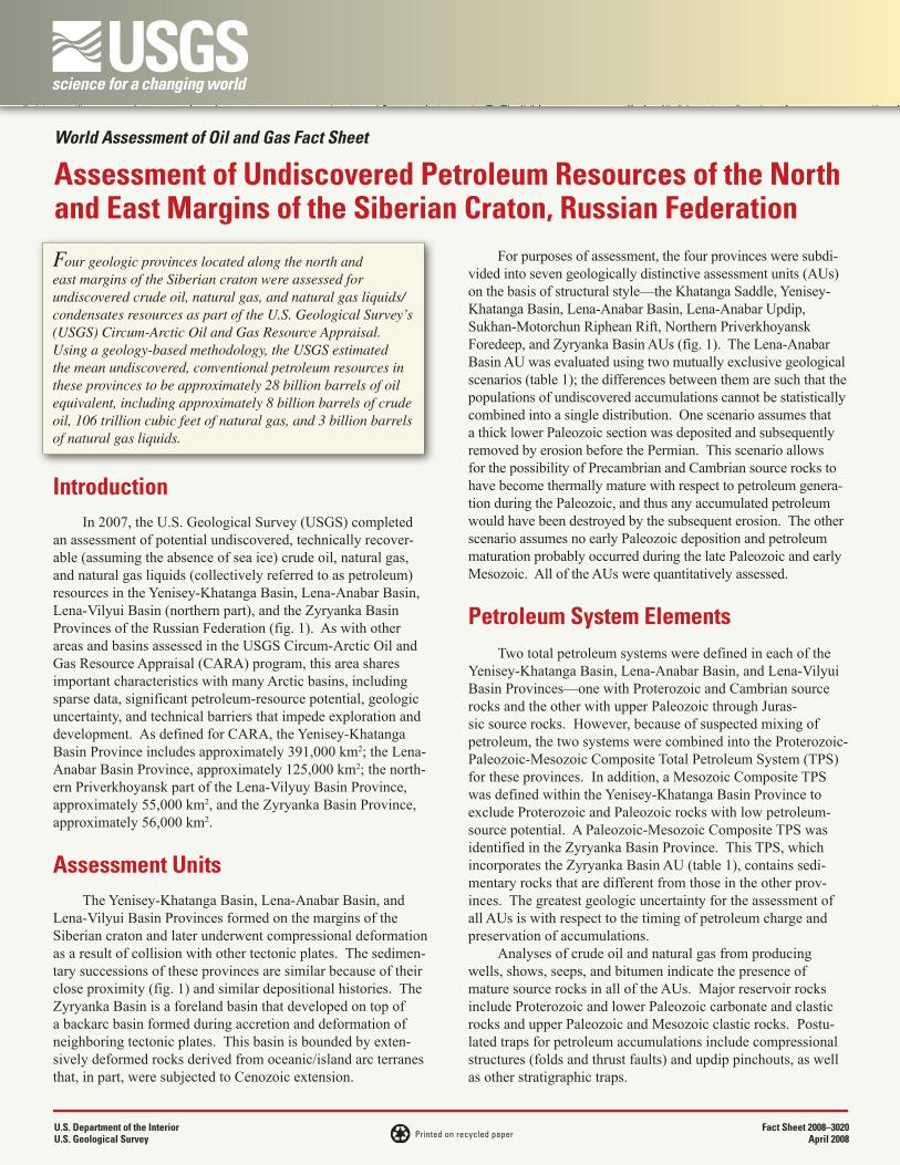
For purposes of assessment, the four provinces were subdi-vided into seven geologically distinctive assessment units (AUs) on the basis of structural style—the Khatanga Saddle, Yenisey-Khatanga Basin, Lena-Anabar Basin, Lena-Anabar Updip, Sukhan-Motorchun Riphean Rift, Northern Priverkhoyansk Foredeep, and Zyryanka Basin AUs (fig. 1). The Lena-Anabar Basin AU was evaluated using two mutually exclusive geological scenarios (table 1); the differences between them are such that the populations of undiscovered accumulations cannot be statistically combined into a single distribution. One scenario assumes that a thick lower Paleozoic section was deposited and subsequently removed by erosion before the Permian. This scenario allows for the possibility of Precambrian and Cambrian source rocks to have become thermally mature with respect to petroleum genera-tion during the Paleozoic, and thus any accumulated petroleum would have been destroyed by the subsequent erosion. The other scenario assumes no early Paleozoic deposition and petroleum maturation probably occurred during the late Paleozoic and early Mesozoic. All of the AUs were quantitatively assessed.
Petroleum System ElementsTwo total petroleum systems were defined in each of the
Yenisey-Khatanga Basin, Lena-Anabar Basin, and Lena-Vilyui Basin Provinces—one with Proterozoic and Cambrian source rocks and the other with upper Paleozoic through Juras-sic source rocks. However, because of suspected mixing of petroleum, the two systems were combined into the Proterozoic-Paleozoic-Mesozoic Composite Total Petroleum System (TPS) for these provinces. In addition, a Mesozoic Composite TPS was defined within the Yenisey-Khatanga Basin Province to exclude Proterozoic and Paleozoic rocks with low petroleum-source potential. A Paleozoic-Mesozoic Composite TPS was identified in the Zyryanka Basin Province. This TPS, which incorporates the Zyryanka Basin AU (table 1), contains sedi-mentary rocks that are different from those in the other prov-inces. The greatest geologic uncertainty for the assessment of all AUs is with respect to the timing of petroleum charge and preservation of accumulations.
Analyses of crude oil and natural gas from producing wells, shows, seeps, and bitumen indicate the presence of mature source rocks in all of the AUs. Major reservoir rocks include Proterozoic and lower Paleozoic carbonate and clastic rocks and upper Paleozoic and Mesozoic clastic rocks. Postu-lated traps for petroleum accumulations include compressional structures (folds and thrust faults) and updip pinchouts, as well as other stratigraphic traps.

Reference
IHS Energy, 2006, International petroleum exploration and production database [includes data current through December, 2006]: IHS Energy; database available from IHS Energy, 15 Inverness Way East, Englewood, CO 80112, U.S.A.
For Further InformationAssessment results are available at the USGS Central Energy
Team website, http://energy.usgs.gov/arctic, or contact Donald L. Gautier, Task Leader for the USGS Circum-Arctic Oil and Gas Resource Appraisal ([email protected]).
Circum-Arctic Petroleum Resource Assessment Team
T.R. Klett (assessing geologist), K.J. Bird, P.J. Brown II, R.R. Charpentier, D.L. Gautier, D.W. Houseknecht, T.E. Moore, J.K. Pitman, R.W. Saltus, C.J. Schenk, A.K. Shah, K.I. Takahashi, M.E. Tennyson, and C.J. Wandrey
AcknowledgmentGeographical Information System analysis was performed by
F.M. Persits.
Resource SummaryThe USGS assessed undiscovered conventional, technically
recoverable petroleum resources (discovered reserves not included), resulting in the estimated mean volumes of a probability distribution of approximately 8 billion barrels (1 billion metric tons) of crude oil, 106 trillion cubic feet (3 trillion cubic meters) of natural gas, and 3 billion barrels (400 million metric tons) of natural gas liquids (table 1). The largest volume of undiscovered petroleum is estimated to be in the Yenisey-Khatanga Basin AU.
Oil and gas fields (IHS Energy, 2006)
0
Assessed arctic province area
Arctic assessment unit boundaries
Water depth (meters)-1,000-500-100
EXPLANATION
OilGas
YENISEY-KHATANGA, LENA-ANABAR, LENA-VILYUI, AND ZYRYANKA PROVINCES
Clarke 1866 Stereographic North PoleStereographic North PoleFalse Easting: 0.000000
False Northing: 0.000000Central Meridian: 130.000000Standard Parallel: 1:75000000
SIBERIANCRATON Zyryanka Basin
12520101
Taimyr fold andthrust belt
Verk
hoya
nsk
fold
and
thru
st b
elt
De LongIslands
East SiberianSea
LaptevSea
Arctic Ocean
Kotel’nyi NovosibirskIslands
NovayaSibir
MalyiLyakhov
Bol’shoiLyakhov
TaimyrPeninsula
Zyryanka BasinProvince 1252
Yenisey-Khatanga BasinProvince 1175
Yenisey-KhatangaBasin 11750201
Khatanga Saddle11750101 Lena-Anabar Basin
12000101
Lena-Anabar Updip12000102
Sukhan-MotorchunRiphean Rift 12000103
Northern PriverkhoyanskForedeep 12140101
100º 110º 120º 130º 140º
65º
70º
60º
350 KILOMETERS
Arctic Circle
Turu
khan
-Nor
ilsk
fold
and
thru
st b
elt
Lena-VilyuiBasin Province
1214
Lena-AnabarBasin Province
1200
Figure 1. Map showing location of geologic provinces and assessment units along the northern and eastern margins of the Siberian craton north of the Arctic Circle.
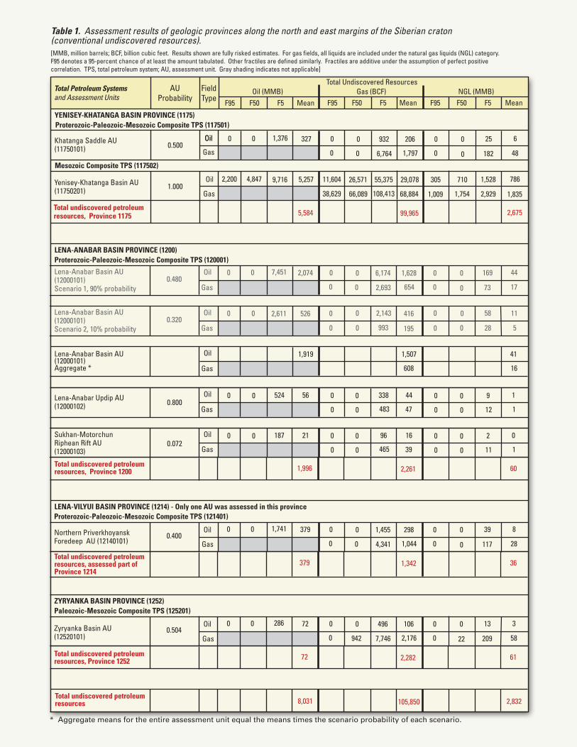
Table 1. Assessment results of geologic provinces along the north and east margins of the Siberian craton(conventional undiscovered resources).
Proterozoic-Paleozoic-Mesozoic Composite TPS (117501)
Gas
OilKhatanga Saddle AU(11750101)
[MMB, million barrels; BCF, billion cubic feet. Results shown are fully risked estimates. For gas fields, all liquids are included under the natural gas liquids (NGL) category. F95 denotes a 95-percent chance of at least the amount tabulated. Other fractiles are defined similarly. Fractiles are additive under the assumption of perfect positivecorrelation. TPS, total petroleum system; AU, assessment unit. Gray shading indicates not applicable]
Yenisey-Khatanga Basin AU(11750201)
Total undiscovered petroleumresources, Province 1175
Mesozoic Composite TPS (117502)
Total Undiscovered ResourcesTotal Petroleum Systemsand Assessment Units
FieldType
Oil (MMB) Gas (BCF) NGL (MMB)
2,200 4,847 9,716 5,257 11,604 26,571 55,375 29,078 305 710 1,528 786
38,629 66,089 108,413 68,884 1,7541,009 2,929 1,835
5,584 99,965 2,675
F95 F50 F5 Mean F95 F50 F5 Mean F95 F50 F5 Mean
AUProbability
Total undiscovered petroleumresources 8,031 105,850 2,832
Gas
Oil1.000
* Aggregate means for the entire assessment unit equal the means times the scenario probability of each scenario.
Oil
YENISEY-KHATANGA BASIN PROVINCE (1175)
0 0 1,376 327 0 0 932 206 0 0 25 6
0 0 6,764 1,797 0 0 182 480.500
Proterozoic-Paleozoic-Mesozoic Composite TPS (120001)
Gas
OilLena-Anabar Basin AU(12000101)Scenario 1, 90% probability
Gas
OilLena-Anabar Basin AU(12000101)Scenario 2, 10% probability
Gas
OilLena-Anabar Basin AU(12000101)Aggregate *
LENA-ANABAR BASIN PROVINCE (1200)
0 0 7,451 2,074
0 0 2,611 526
0 0 6,174 1,628
0 0 2,143 416
0
0
0
0
169
58
44
11
0 0 2,693 654 0 0 73 17
0 993 0 0 28 5
1,919 1,507 41
16608
Total undiscovered petroleumresources, Province 1200 1,996 2,261 60
0.480
0.320
Gas
OilLena-Anabar Updip AU(12000102)
56 44 1
147Gas
OilSukhan-MotorchunRiphean Rift AU(12000103)
21 16 0
139
Gas
OilNorthern PriverkhoyanskForedeep AU (12140101)
LENA-VILYUI BASIN PROVINCE (1214) - Only one AU was assessed in this province
0 0 1,741 379 0 0 1,455 298 0 0 39 8
0 0 4,341 1,044 0 0 117 280.400
Total undiscovered petroleumresources, assessed part ofProvince 1214
379 1,342 36
Paleozoic-Mesozoic Composite TPS (125201)
Gas
OilZyryanka Basin AU(12520101)
ZYRYANKA BASIN PROVINCE (1252)
0 0 286 72 0 0 496 106 0 0 13 3
0 942 7,746 2,176 0 22 209 580.504
Total undiscovered petroleumresources, Province 1252 72 2,282 61
0.800
0.072
Proterozoic-Paleozoic-Mesozoic Composite TPS (121401)
0
0
0
0
524
187
0
0
0
0
338
96
0
0
0
0
0
483
465
195
0
0
0
0
0
0
0
0
9
12
2
11
Related Documents