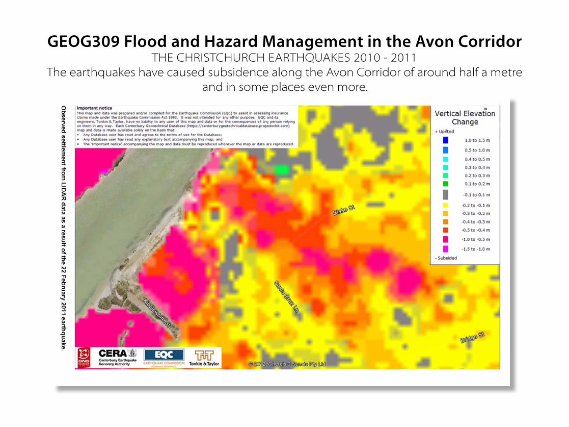
GEOG309 Flood and Hazard Management in the Avon Corridor THE CHRISTCHURCH EARTHQUAKES 2010 - 2011 The earthquakes have caused subsidence along the Avon Corridor of around half a metre and in some places even more.

Work with canterbury university
Mar 15, 2016
This is a part of current work with Canterbury University GEOG309 Flood and Hazard Management in the Avon Corridor
Welcome message from author
This document is posted to help you gain knowledge. Please leave a comment to let me know what you think about it! Share it to your friends and learn new things together.
Transcript
GEOG309 Flood and Hazard Management in the Avon Corridor THE CHRISTCHURCH EARTHQUAKES 2010 - 2011
The earthquakes have caused subsidence along the Avon Corridor of around half a metre and in some places even more.

It is obvious when comparing LiDAR images before and after the earthquakes that some areas are actually lower
than the Red Zoned Bexley
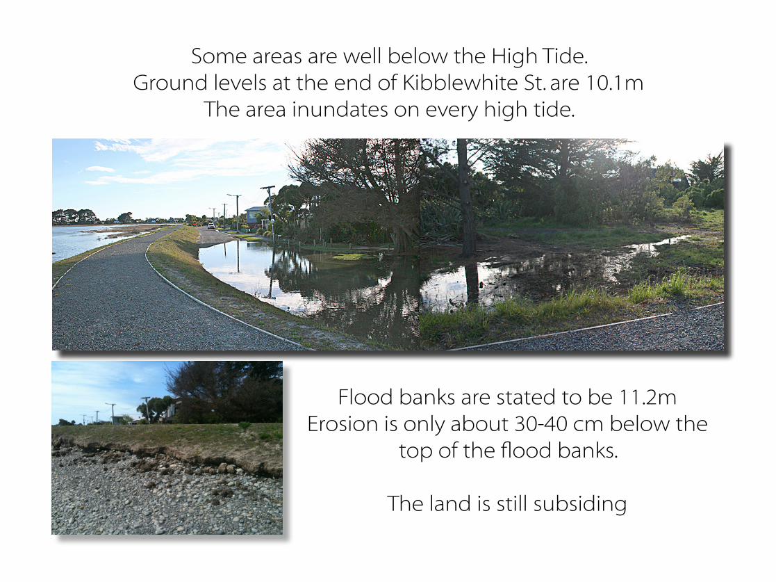
Some areas are well below the High Tide.Ground levels at the end of Kibblewhite St. are 10.1m
The area inundates on every high tide.
Flood banks are stated to be 11.2mErosion is only about 30-40 cm below the
top of the flood banks.
The land is still subsiding

Lateral displacement of the area is significant.There are about 700 meters down to bedrock.

Current plans for Sea Level changes till 2100 = 50cm
Current plans and predictions from Council
estimate that the current flood banks are
sufficient to prevent flooding in the area
despite 50 cm sea level rise.
The fact with water and sand is that water will find
its way to it natural level. When sea level rises
the ground water rises and land bearing decreases.
Houses might sink.
This area has been dewatered
extensively after the earthquakes.
This is a very short term solution.M
arine ParadePine Avenue
Estuary Road
Pages Road Anzac Drive
Dyers Road
Union Street
Bexley Road
Bridge StreetBreezes Road
Keyes Road
New Brighton Road
Bak
er S
treet
Waitaki Street
Hawke Street
Oram
Avenue
Wairoa Street
Lons
dale
Street
Pal
mer
s R
oad
Beresford Street
Car
isbr
ooke
Stre
et
Owles Terrace
Birch Street
Bow
er A
venu
e
Eure
ka S
treet
Blake Street
Rowan Avenue
Rowse
s Road
Orari Street
Seaview Road
Marlow Road
Tovey Street
Wattle D
rive
Sin
clai
r Stre
et
Kibblewhite Street
Jervois Street
Jellicoe Street
Keppel Street
Falcon Street
Meo
n St
reet
Hood Street
Rodney Street
Sandra Street
Shackleton Street
Guernsey Street
Wetlands Grove
Cor
ham
pton
Stre
et
Morganwood Street
Rawson Street
Bellamy Avenue
Mountbatten Street
War
bling
ton
Stre
etFa
rnbo
roug
h St
reet
Cradock Street
Portchester Street
Admirals Way
Caithness Street
Brighton Mall
Woodlands Place
Mattingley Street
Drake Street
Parenga Place
Seabreeze Close
Waik
are
Lane
Rawhiti Avenue
Mitcha
m P
lace
Otakaro Place
Bexley Road
¯
LIDAR Data August 2011for CCC use only Scale: (A4)
Drawn: IBDate: 29 April 2013
Avon River Modelled Flood Depth: Map 6
LegendCity Plan Flood Management Area
Flood Depth0.0 - 0.2 m
0.2 - 0.4 m
0.4 - 0.6 m
0.6 - 0.8 m
0.8 - 1.0 m
1.0 - 1.2 m
1.2 - 1.4 m
1.4 - 1.6 m
1.6 - 1.8 m
1.8 - 2.0 m
2.0 - 2.2 m
2.2 - 2.4 m
2.4 - 2.6 m
2.6 - 2.8 m
2.8 - 3.0 m
0 500250Meters
Background: World Street MapESRI, ArcGIS Online Name: Avon_D13_50yr_pt5mSLR_PostDecEQ_SB11pt2_v5_Depth
1:15,000Model Version: D13Rainfall: 50 yearBathymetry: Post December EarthquakeSea Level Rise: 0.5 mStopbanks: 11.2 m RL

What you have seen so far is the area that has flood banks
Most of the area South of Bridge St. does not have any floodbanks in place.

Christchurch land is the best investigated land in the world
Should the communities be made aware of known hazards?
Should a managed retreat be considered?
What is the responsible approach?
Many Scientists have different
opinion on probable sea level rise.
The big question is.
WHAT DOES THE
FUTURE HOLD FOR THIS AREA?
200 Year flood plainCCC Plan
200 Year flood plainCCC Plan
Floor levels Before Earthquakes.
Damage after Earthquakes - Floor levels and Land drop.
BEFORE
NOW
Floor Level 11. 35m
Floor Level 11. 25m
Floor Level 11. 15m
Floor Level 11. 05m
Floor Level 10. 95m
Floor Level 10. 85m
Floor Drop , 15 cm
Floor Drop, 35 cm
Floor Drop, 45 cm
Floor Drop, 55 cm
Floor Drop, 65 cm
Floor Drop , 25 cm
Floor-levels now from 11.5 - 10.8 metersLowest properties, uninsurable, not a valid mortgage security. Hazard potential from building authorities.
These houses can be refused insurance. Consequences; EQC is not liable in case of future events.
50 Year flood plain
50 Year flood plain
200 Year flood plainCCC Plan
Using “Existing Use Rights” these repairs are allowed by CCC.
50 Year flood plain
CCC South New Brighton Reserves Management PlanPlan for Sea Level Rise of 50cm and consider a rise of at least 80cm by 2100.
Questions from The South Brighton Residents’ Association
Illustrations modified from EQC land report
AFTER REPAIRS
All houses built to then current floor-levels of 11.5 meters, 50 year flood plainValuable properties, insurable, valid mortgage security.
We would like to know why CCC has enabled the use of “Existing Use Rights” to by pass the Christchurch City Plan Regulations
1. What are the lowest floor levels CCC will consent based on "Existing Use Rights"? 2. Will CCC be liable for to low floor levels consented when flooding occurs in this area as per the leaking house syndrome?
3. Has CCC looked into legal implications of using "Existing Use Rights" in Flood management area considering the Land Drop? 4. What are the conditions that would trigger a Hazard Notice issued on the LIM/PIM? (No use in stating “we will not do that”) (Insurance question)5. What certainty can be given by the insurance companies that they will continue to provide insurance after flooding occurs in this area?
http://www.facebook.com/BrightsideTheSouth
Related Documents