JESSICA SUZANNE ROUNDY master of landscape architecture

Work Samples
Mar 31, 2016
Jessica Suzanne Roundy MLA, Rhode Island School of Design work samples: process, built work, published work, drawing samples, resume
Welcome message from author
This document is posted to help you gain knowledge. Please leave a comment to let me know what you think about it! Share it to your friends and learn new things together.
Transcript

JESSICA SUZANNE ROUNDYmaster of landscape architecture
process1.1 Graduate Th esis: Dissolving Topographies1.2 Graduate Studio: Urban Systems
built work2.1 Lopez Island Residence2.2 Common Ground Sustainable Community2.3 San Miguel de Allende Residence2.4 El Rincon Community Center
published work3.1 ArquiTK3.2 Metropolis3.3 Feed Forward Feedback
WORK SAMPLES
drawing samples4.1 Grading Plan4.2 Planting Plan4.3 Detail Sections4.4 Data Mapping
resume

process

1.1 Graduate Th esis Dissolving Topographies: Coastal Markings in a Dynamic Edge Condition Advisor: Karen Nelson
As a dynamic edge, the dissolving terrain of the coast creates a fl uid environment in which the nature of resources must be critically examined. By framing this condition, fi rst perceptually and then physically, the edge becomes spatial while continuing to fl uctuate as an active condition. Upon closer investigation of this natural coastal process two distinct edge conditions emerge, each with a particular scale of time and space: the tidal edge and the fresh/saltwater edge. Th is landscape becomes an active fi eld addressing both transitory and bound conditions. In order to defend the cultural and ecological habitats present on site, topographical interventions reinterpret the traces of a Naval Base as a cultural structure to facilitate the framing of edge conditions on multiple scales.
process
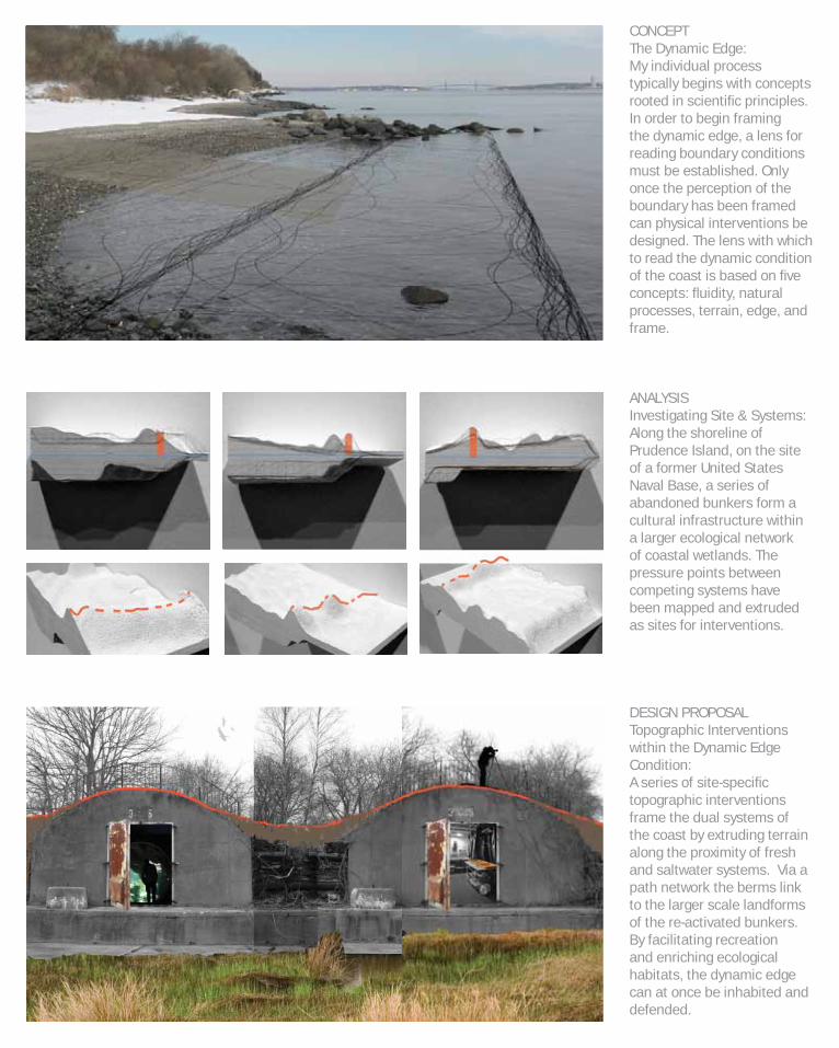
ANALYSIS Investigating Site & Systems:Along the shoreline of Prudence Island, on the site of a former United States Naval Base, a series of abandoned bunkers form a cultural infrastructure within a larger ecological network of coastal wetlands. The pressure points between competing systems have been mapped and extruded as sites for interventions.
CONCEPT The Dynamic Edge:My individual process typically begins with concepts rooted in scientifi c principles.In order to begin framing the dynamic edge, a lens for reading boundary conditions must be established. Only once the perception of the boundary has been framed can physical interventions be designed. The lens with which to read the dynamic condition of the coast is based on fi ve concepts: fl uidity, natural processes, terrain, edge, and frame.
DESIGN PROPOSAL Topographic Interventions within the Dynamic Edge Condition:A series of site-specifi c topographic interventions frame the dual systems of the coast by extruding terrain along the proximity of fresh and saltwater systems. Via a path network the berms link to the larger scale landforms of the re-activated bunkers. By facilitating recreation and enriching ecological habitats, the dynamic edge can at once be inhabited and defended.

1.2 Graduate Studio Urban Systems: Dilution as Conduit Between Urban Infrastructure and Natural Systems Professor: Elizabeth Hermann
Th is project investigates dilution as a medium to connect urban and natural systems in the form of waste water treatment. Th e elements of water, circulation, and movement are addressed by using fi ltration as a process that responds to ecological and cultural conditions. Systems are actively engaged by realizing waste and water runoff as raw urban materials and by capitalizing on such unseen resources. In a broad sense urbanism in this project takes on the attitude of a dualistic balance between concentrating density, in terms of existing and proposed infrastructure, and expanding natural systems, in terms of both passive and active open space.
process

ANALYSISMapping Systems:Due to site and program being a given in the studio process begins with analysis and in this instance was conducted through inter-disciplinary collaborative research. This map conveys the relationships between waste, population growth, pools per capita, aquifer depletion, and bedrock. Working simultaneously in two and three-dimensions was critical to gaining additional insight into these complex relationships.
DESIGN PROPOSALThe Salt River Institute for Advanced Study in Water, Structure, and Appropriate Desert Dwelling:The fi nal site plan is based on a cycle of water which is collected from multiple sources and diluted through a series of processes. Visual clues play a vital role in the site being an active educational experience. The water cycle is purposely exposed for this reason. The northwest portion of the site is developed in detail as the water cycle begins and ends here, offering the greatest educational experience, resulting in a focused density of public program and space.
CONCEPTMapping Fluid:My individual conceptual design work is rooted in the systems explored during the analysis stage. The decision making process begins in this phase through testing how to move water across the site. The conceptual design of the site is also based on gestures derived from preexisting urban forms or directionality found in the site’s context.


built work

2.1 Lopez Island Residence, 2009-Present Landscape Design & Installation San Juan Islands, Washington State Project Architect: Miller|Hull Partnership
built work
Th is modern single-family home sits strikingly above a meadow and within a homestead orchard. Th e landscape design seeks to blur the edges between the meadow/orchard and the contemporary spaces directly adjacent to the home through the use of grading and a plant palette based in grasses. Color is introduced with vibrant grasses to play off of the highlighted siding, echoing the introduction of bright green and orange to the otherwise metal and glass building by introducing the same colors to the existing evergreen and gold landscape. Th e scope of work included siting of the driveway and paths, grading plan, designing and installing an enclosed garden and entry gardens, and continual restoration of the meadow and orchard.

2.2 Common Ground Sustainable Community, 2007-09 Construction & Landscape Design Lopez Island, Washington State Project Architect: Mithun
built work
Th e Lopez Community Land Trust’s Common Ground Housing Cooperative has won numerous awards for it’s sustainable design and living features such as straw-bale and natural plaster construction, solar power, permaculture, rain gardens, bioswales, and net-zero energy and water consumption. Th e scope of work included a construction internship, fi rst in site-preparation to install infrastructure for both potable and non-potable water systems and to site structures; next to lead a team of interns in construction of the homes. I then worked directly for the Co-op to alleviate drainage problems through a new grading plan and implement low-cost landscape elements such as fencing and stonework.
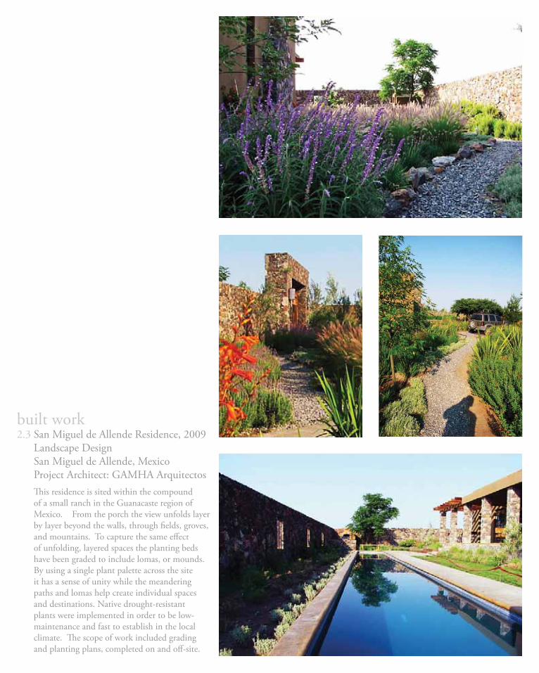
2.3 San Miguel de Allende Residence, 2009 Landscape Design San Miguel de Allende, Mexico Project Architect: GAMHA Arquitectos
built work
Th is residence is sited within the compound of a small ranch in the Guanacaste region of Mexico. From the porch the view unfolds layer by layer beyond the walls, through fi elds, groves, and mountains. To capture the same eff ect of unfolding, layered spaces the planting beds have been graded to include lomas, or mounds. By using a single plant palette across the site it has a sense of unity while the meandering paths and lomas help create individual spaces and destinations. Native drought-resistant plants were implemented in order to be low-maintenance and fast to establish in the local climate. Th e scope of work included grading and planting plans, completed on and off -site.

2.4 El Rincon Community Center, 2008 Design/Build El Rincon, Dominican Republic Instructors: Kyle Bergman & Sandy Lawton, Yestermorrow School
built work
In three-weeks time a team of students from the United States worked with local El Rincon citizens to design and build a new entry for their Women’s Center, which houses community events and an eco-tourism venture. Our main goal was to make the site both physically and visually accessible by implementing new circulation for both pedestrians and vehicles, and open gathering areas framed by fabric-formed retaining and seating walls. In addition to the entryway we also plumbed an existing cistern, the sole local source of water, and delivered it to a clean, street-side water plaza.


published work

3.1 ArquiTK Año 9 No. 52 (April 2010) Landscape Design Credit
Nombre del Proyecto: Casa VorisUbicación: Ejido Guerrero, San Miguel de Allende, Gto., MéxicoProyecto Arquitectónico: GAMHA ArquitectosArquitectura de Paisaje: Jessica RoundySuperfi cie: Construcción 150 m2, Terreno 2 haFotografía: Geraldine Adeath M.
published work

3.2 Metropolis Magazine Vol. 29, No. 7 (February 2010) Letter to the Editor
published work
p. 2
-3 p
rolo
gue
text
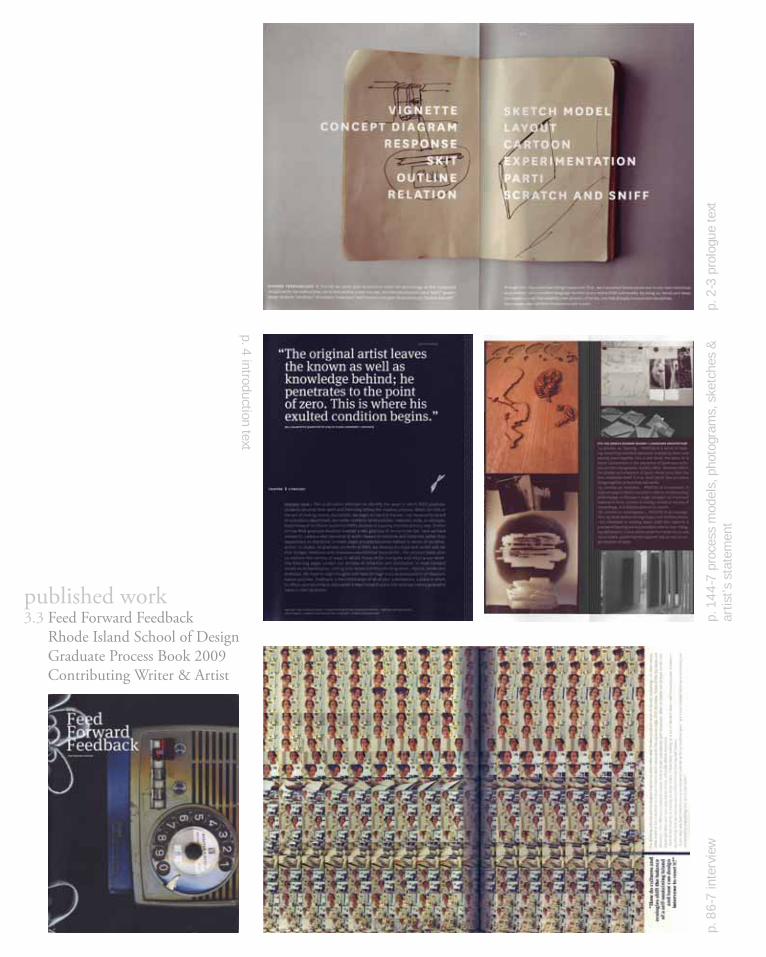
3.3 Feed Forward Feedback Rhode Island School of Design Graduate Process Book 2009 Contributing Writer & Artist
p. 4 introduction text
p. 8
6-7
inte
rvie
wp.
14
4-7
pro
cess
mod
els,
pho
togr
ams,
ske
tche
s &
ar
tist’s
sta
tem
ent
published work

Feed Forward Feedback Excerpts:
p. 2-3 prologue text*:SHARED TERMINOLOGY -> This fall we asked grad students to share the terminology of their respective disciplines for the method they use to fi rst develop a new concept. Architecture students use a “parti;” graphic design students “mind map;” ID students “prototype;” and if you’re in the glass department you “scratch and sniff.” Through this discussion two things happened: fi rst, we translated terms particular to our own individual departments into a common language familiar to our entire RISD community. By doing so, words and ideas converged in a way that created a new glossary of terms, one that actually transcended disciplines. JESSICA ROUNDY >> PRIME MINISTER OF THE GRADUATE STUDENT ALLIANCE
p. 4 introduction text*:PROCESS TEAM >> This publication attempts to identify the ways in which RISD graduate students develop their work and how they defi ne the creative process. When we look at the act of making across disciplines, we begin to identify themes, not necessarily based on a student’s department, but rather rooted in commonalities: materials, tools, or concepts. Feed Forward Feedback examines RISD’s process in a purely interdisciplinary way. Similar to how RISD graduate students created a new glossary of terms in the fall, here we have worked to create a new taxonomy of work--based on methods and materials rather than department or discipline. In these pages process becomes defi ned in terms of narrative, action, or object. As graduate students at RISD, we develop a unique and varied skill set that bridges mediums and dissolves conventional boundaries. The process book aims to capture the variety of ways in which those skills instigate and inspire out work. The following pages contain our process of collection and distillation. In Feed Forward we act as archaeologists, visiting your space and documenting place, objects, words and desktops. We hope to align thoughts and ideas through a visual juxtaposition of disparate spaces and text. Feedback is the culmination of all of your submissions, a place in which to refl ect upon all artifacts discovered in Feed Forward and to fi nd amongst them a generative value in their synthesis.PROCESS TEAM: JESSICA ROUNDY >> PRIME MINISTER OF GSA; CHARLOTTE POTTER >> AMATEUR ARCHAEOLOGIST; JOHN O’KEEFE >> AMATEUR ARCHAEOLOGIST; LUCAS ROY >> DESIGN CONQUISTADOR
p. 87 interview:“How do cultures and ecologies shift the balance of a self-sustaining island and how can design intervene to reset it?”JESSICA ROUNDY >> LANDSCAPE ARCHITECTURE“I’m studying cultural and ecological balance to determine what Prudence Island needs to be self-sustaining--in other words, what needs to be contained and bound versus what transcends the dynamic edge of it’s shoreline. Some of the big issues are seasonal--the difference between winter and summer populations and resources. What an island can sustain on its own, especially when you have population in fl ux, critically effects resources.Part of the Process is looking at what exists. I have been looking as a lot of derelict sites--old infrastructures, bunkers--questioning how we can repurpose infrastructure that has been left behind.If you step way back islands are an endangered species as far as landform goes. But if you consider them as a terrain they are connected to everything that surrounds them.”
p. 147 artist’s statement:[114-116] JESSICA ROUNDY >> LANDSCAPE ARCHITECTURE114. process as: layering... PROCESS IS a series of layering; extracting individual elements, evaluating them, and piecing them together into a new form; this takes on a literal construction in the discipline of landscape architecture with topographic models; often, moments within the greater accumulation of layers reveal more than the fi nal composite itself; it is as much about how to piece things together as how they will settle.115. process as: evolution... PROCESS IS an evolution; it captures the way in which a concept is able to morph/evolve/shift/change; in this way a single concept can transcend material or form; counter to having a formal or set way of doing things, it is fl uid/dynamic in its nature.116. process as: investigation... PROCESS IS an investigation; my work evolves through layers and multiples scales; I am interested in creating space itself that captures a process of layering and accumulation with an ever changing delineation; I come at this study from both macro and micro scales, examining Narragansett Bay as well as single droplets of water.
*Text based on a presentation to the RISD Board Of Trustees given by Jessica Roundy, Fall 2008


drawing samples

4.1 Grading Plan (AutoCAD) Stormwater in Site Design, Demonstration Project Materials & Technology III, RISD, 2009
drawing samples
Th e proposed grading for the site of this Middle School facilitates the further development of two existing swales, provides access to the river, and returns the south portion of the site to a evenly sloping fi eld for recreation. As a design concept pedestrian and water circulation are linked in order to support education and recreation. Th e two systems are located in close proximity to one another to allow students to traverse the site parallel to the network of stormwater planters and then between the two swales. In this regard the route of the water runoff should serve as an educational tool. An educational platform at the beginning of the path down to the river helps facilitate this. Best management practices are employed across the site to collect, fi lter, and direct stormwater runoff . Stormwater is collected from the rooftops of both existing and proposed structures and fi ltered through fl ow-through and infi ltration planters, and is directed across the parking lot into a bioswale which connects to the river.

4.2 Planting Plan (AutoCAD) Lopez Island Residence Entry Garden Built Work, 2010
drawing samples Adiantum pedatumMaidenhair Fern
Arctostaphylos uva-ursiKinnikinnick
Mahonia nervosaLow Oregon Grape
Polystichum munitumSword Fern
Aquilegia formosaRed Columbine
Cornus sericaRed-Osier Dogwood
Gaultheria shallonSalal
Ilex crenata ‘Compacta’Compacta Holly
Mahonia aquifoliumHigh Oregon Grape
Vaccinium ovatumEvergreen Huckleberry
Imperata cylindrica ‘Rubra’Japanese Blood Grass
Nassella tenuissimaMexican Feather Grass
Panicum virgatum ‘Hanse Herms’Red Switch Grass
Th is planting plan introduces bright color to an otherwise evergreen palette in order to delineate pathways and direct visitors to the two points of entry of the house: breezeways painted in red-orange and chartreuse-green. Red (Imperata cylindrica) and green (Nassella tenuissima) lines are extended in the form of grasses from oblique angles where the colors of the breezeway siding are visible from the entry landscape. Th e pathways are sited along these lines so that the grasses at their sides visually lead to house with their color. Th e structure and texture of the grasses also make them stand out amidst the native evergreen shrubs and groundcovers which comprise the rest of the planting plan. To extend the concept of the entry garden into the larger landscape, the red line continues beyond the path which bisects it with native plants whose features turn red during various seasons (Cornus serica, Aquilegia formosa, Vaccinium ovatum) so that a portion of the red line remains visible stretching into the landscape year round.

4.3 Detail Sections (AutoCAD) Construction Details in Public Space Materials & Technology II, RISD, 2008
drawing samples
A series of various wall typologies form the constructed language within a proposed park setting as a repeated design element. Th e various wall typologies to be incorporated throughout the park include walls that are freestanding, retaining, seating, and planters. Th e walls are a critical tool both conceptually in order to defi ne space and functionally in order to stabilize the sloping site. Th e two most common wall typologies across the site function as retaining walls and seating walls and provide planting beds or functional space on the side of the slope which they retain, adding value in their multiple programmatic functions.

4.4 Data Mapping (ArcGIS & Microsoft Excel) Presenting Spatial/Temporal Precipitation Data Principles of Hydrology, Brown University, 2009
Delineating Flow Patterns with Hydrology Tools Principles of Hydrology, Brown University, 2009
a. fl ow direction b. fl ow accumulation c. stream network d. stream order e. watershed delineation
a. b. c.
d. e.
drawing samples
Th is report analyzes the spatial and temporal character of precipitation data in the area of the South Platte River Basin. Initial inspection of the data set identifi ed dominant spatial features to be the elevation of stations and percentage of coverage, and temporal features to be mean monthly precipitation and annual precipitation. By charting the data set, it illustrates that precipitation peaks during the summer months in a relatively uniform curve, implying a monsoonal cycle. Th e presentation of data attributes with symbolization illustrates the dominant spatial features in the hydrological climate as a concentration of high annual precipitation averages corresponding to both the density of streams and the highest elevations within the region. A pattern is established with data points along streams that show a gradual increase in annual precipitation averages with proximity to either an outfl ow or convergence point.

EDUCATIONRhode Island School of Design Providence, RIMaster of Landscape Architecture, 2010Th esis: Dissolving Topographies: Coastal Markings in a Dynamic Edge Condition
Claremont McKenna College Claremont, CABachelor of Arts, Art History; Minor in Leadership, 2004Th esis: Searching for a Sustainable Architectural Style: A History of Residential Architecture’sDialogue with the Environment
INTERNSHIPS & EXPERIENCELopez Community Land Trust Lopez Island, WAConstruction Intern, 2007-09Completed site-preparation, construction, landscape design, grading and landscaping for the award-winning Common Ground Housing Cooperative designed by Mithun.
Design Arts Group, Inc. Los Angeles, CAIntern & Landscape Designer, 2005Designed a rooftop garden, critiqued offi ce design work, and created a catalog of product information.
Th e Miller|Hull Partnership Seattle, WAArchitecture Intern, 2003Collaborated with staff to produce models, presentation boards, awards submissions, publications, and as-built drawings. Created a database for products.
dA Center for the Arts Pomona, CAIntern & Assistant Curator, 2003Managed publicity, oversaw related classes, and coordinated delivery of pieces for a show. Completed in conjunction with a research project on civic leadership.
SKILLSDesignBroad experience in landscape design ranging in scale and scope from residential to urban with an emphasis on ecology, process, systems, integration, and collaboration.CreativeMixed media modeling, hand drawing, hybrid drawing, collage, book and publication arts, digital photography and abstract analog photographic techniques.TradeConcrete, timber-frame, straw-bale, and natural plaster construction, siting, grading, stonework, fencing, planting and pruning.ProgramsAdobe CS4: Photoshop, Illustrator, InDesign; Auto-CAD, 3DS Max; Arc-GIS; Sketch-Up; Rhino; Microsoft Offi ce: PowerPoint, Excel, Word.
ACHIEVEMENTS & ACTIVITIESVolunteer, Fish & Bird Field Surveys, Fisherman Bay Marine Health Observatory, 2010Volunteer, Website Development, Lopez Locavores, 2010Student Leader of the Year/Student Leadership Scholarship, RISD 2009Prime Minister, Graduate Student Alliance, RISD 2008-09Project Coordinator & Contributing Writer, Feed Forward Feedback, RISD 2009Student Representative, Search Committee for the Dean of Students, RISD 2009Student Representative, Trustees Committee on Student Life, RISD 2008-09Teaching Assistant, Department of Landscape Architecture, RISD 2007-09Minister of Records & Communication, Graduate Student Alliance, RISD 2007-08Landscape Architecture Department Liaison, RISD 2007-08Member, Respond|Design, RISD 2007-08Team Unity Award (Co-ed Team Captain), CMS Track & Field, 2003-04Four-Year Letterman, NCAA Track & Field, CMS 2000-2004Editor-in-Chief, Th e Ayer, CMC 2001-02
jessica suzanne roundy681 lopez road
lopez island, wa [email protected]
206.595.6473

Related Documents