Journal home page: www.ijreb.org WIRELESS GIS BASED ON RF PLANNING IN GSM NETWORKS - Deepika. P 2014 Vol. 2 (2) Page 92 ISSN 2321-743X International Journal of Research in Engineering and Bioscience Volume 2 (Issue 2) Pages (92-103) IJREB WIRELESS GIS BASED ON RF PLANNING IN GSM NETWORKS Deepika. P Assistant Professor, Department Of ECE, Jeppiaar institute of Technology, Chennai ABSTRACT This project aims to implement a system for accessing GIS outcomes through a combination of GPS and GSM. “RF planning in GSM” is used for planning and using radio frequency to its maximum utility. It is based on cell concept, where the system consists of different cells and each cell is used to transmit and receive signal from mobile station(MS).Various parameters are defined for the functioning of base station(BS) these parameters include the coverage area of cell which depends on various factors like transmission power of base station(BS),location of base station(BS).With the increasing popularity of cellular telephony service, providers are have to support more and more users with limited infrastructure. Nowhere, is it more apparent than the limited resource of “Spectrum.” With the amount of money being spent in acquiring the rights to use pieces of spectrum, it is imperative that this resource be wed in the most cost-effective manner to provide excellent quality of service to as many users as possible. This paper describes configurable network features in ATOLL. KEYWORDS: Mobile GIS, GSM network, RF planning toll, Atoll, Wireless communication

Welcome message from author
This document is posted to help you gain knowledge. Please leave a comment to let me know what you think about it! Share it to your friends and learn new things together.
Transcript
Journal home page: www.ijreb.org
WIRELESS GIS BASED ON RF PLANNING IN GSM NETWORKS - Deepika. P 2014 Vol. 2 (2) Page 92
ISSN 2321-743X International Journal of Research in
Engineering and Bioscience Volume 2 (Issue 2) Pages (92-103)
IJREB
WIRELESS GIS BASED ON RF PLANNING IN GSM NETWORKS
Deepika. P
Assistant Professor, Department Of ECE, Jeppiaar institute of Technology, Chennai
ABSTRACT
This project aims to implement a system for accessing GIS outcomes through a
combination of GPS and GSM. “RF planning in GSM” is used for planning and using
radio frequency to its maximum utility. It is based on cell concept, where the system
consists of different cells and each cell is used to transmit and receive signal from mobile
station(MS).Various parameters are defined for the functioning of base station(BS) these
parameters include the coverage area of cell which depends on various factors like
transmission power of base station(BS),location of base station(BS).With the increasing
popularity of cellular telephony service, providers are have to support more and more
users with limited infrastructure. Nowhere, is it more apparent than the limited resource
of “Spectrum.” With the amount of money being spent in acquiring the rights to use
pieces of spectrum, it is imperative that this resource be wed in the most cost-effective
manner to provide excellent quality of service to as many users as possible. This paper
describes configurable network features in ATOLL.
KEYWORDS: Mobile GIS, GSM network, RF planning toll, Atoll, Wireless communication

Journal home page: www.ijreb.org
WIRELESS GIS BASED ON RF PLANNING IN GSM NETWORKS - Deepika. P 2014 Vol. 2 (2) Page 93
ISSN 2321-743X International Journal of Research in
Engineering and Bioscience Volume 2 (Issue 2) Pages (92-103)
IJREB
INTRODUCTION
In a wireless cellular network, radio
frequencies are used to carry voice or data
between base stations and mobiles. The traffic
in today‟s cellular network is usually too high
to allow the usage of a channel for one call at a
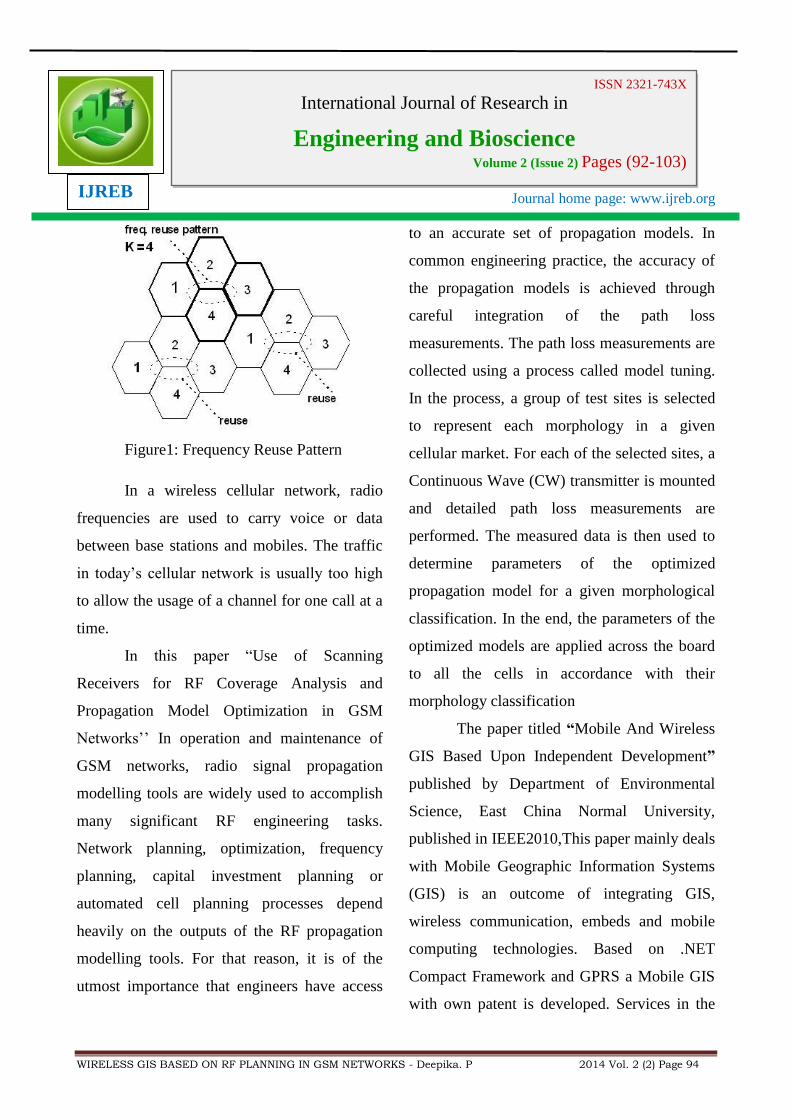
time. Same radio channels using the same
channel for more than one call. This is known
as “channel reuse “and cells using the same
channel are called “channel cells”. Besides
interference caused by co-channel cells, cells
using adjacent frequencies can also cause
certain amount of interference, which usually is
significantly lower than the channel
interference, but still not desirable in certain
cases.
Hence, careful planning of this limited
number of radio frequencies becomes an
important issue in today‟s TDMA and GSM
network planning. A good frequency planning
methodology will be able to either decrease the
interference level in a cellular network thus
increase the quality of service or increase the
capacity of the network by assigningmaximum
numberof frequencies possible toeach sector
while maintaining the interference level below
tolerable.
LITERATURE SURVEY
In this paper “Advanced frequency
planning techniques for TDMA and GSM
networks” produced by Chang Yu and Sairam
Subramanian It is deals With the increasing
popularity of cellular telephony service,
providers are having to support more and more
users with limited infrastructure. Nowhere, is it
more apparent than the limited resource of
“Spectrum‟ ‟With the amount of money being
spent in acquiring the rights to use pieces of
spectrum, it is imperative that this resource be
wed in the most cost-effective manner to
provide excellent quality of service to as many
users as possible. In this article we address the
classic spectrum utilization problem of
frequency planning. We present a new and
novel method for solving this problem for
TDMA systems such as GSM and North
American cellular systems. The past work in
this area has focussed on either:
a. Using an idealized hexagonal grid
system.
b. Using an idealized modelling of the RF
environment.
Journal home page: www.ijreb.org
WIRELESS GIS BASED ON RF PLANNING IN GSM NETWORKS - Deepika. P 2014 Vol. 2 (2) Page 94
ISSN 2321-743X International Journal of Research in
Engineering and Bioscience Volume 2 (Issue 2) Pages (92-103)
IJREB
Figure1: Frequency Reuse Pattern
In a wireless cellular network, radio
frequencies are used to carry voice or data
between base stations and mobiles. The traffic
in today‟s cellular network is usually too high
to allow the usage of a channel for one call at a
time.
In this paper “Use of Scanning
Receivers for RF Coverage Analysis and
Propagation Model Optimization in GSM
Networks‟‟ In operation and maintenance of
GSM networks, radio signal propagation
modelling tools are widely used to accomplish
many significant RF engineering tasks.
Network planning, optimization, frequency
planning, capital investment planning or
automated cell planning processes depend
heavily on the outputs of the RF propagation
modelling tools. For that reason, it is of the
utmost importance that engineers have access
to an accurate set of propagation models. In
common engineering practice, the accuracy of
the propagation models is achieved through
careful integration of the path loss
measurements. The path loss measurements are
collected using a process called model tuning.
In the process, a group of test sites is selected
to represent each morphology in a given
cellular market. For each of the selected sites, a
Continuous Wave (CW) transmitter is mounted
and detailed path loss measurements are
performed. The measured data is then used to
determine parameters of the optimized
propagation model for a given morphological
classification. In the end, the parameters of the
optimized models are applied across the board
to all the cells in accordance with their
morphology classification
The paper titled “Mobile And Wireless
GIS Based Upon Independent Development”
published by Department of Environmental
Science, East China Normal University,
published in IEEE2010,This paper mainly deals
with Mobile Geographic Information Systems
(GIS) is an outcome of integrating GIS,
wireless communication, embeds and mobile
computing technologies. Based on .NET
Compact Framework and GPRS a Mobile GIS
with own patent is developed. Services in the
Journal home page: www.ijreb.org
WIRELESS GIS BASED ON RF PLANNING IN GSM NETWORKS - Deepika. P 2014 Vol. 2 (2) Page 95
ISSN 2321-743X International Journal of Research in
Engineering and Bioscience Volume 2 (Issue 2) Pages (92-103)
IJREB
system include: downloading map by General
Packet Radio Service (GPRS), defining
geographical coordinate system of maps,
Global Position System (GPS) connection and
information dynamically showing on map,
sharing users‟ GPS information through SMS
(Short Message Service) to establish
communication between system users, vector
feature map and related property data editing
and shortest route planning. The system is now
used in field data collection and simple
navigation. With the fast development of
embed and wireless communication
technologies, traditional desktop GIS has an
obvious trend of developing towards mobile
computing environment. Mobile GIS is more
and more widely used in all kinds of trades.
Mobile GIS is a child of GIS and mobile
devices, such as PDA. It has the advantage of
bothtraditional GIS and the convenience of
mobile device.
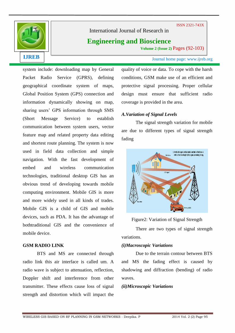
GSM RADIO LINK
BTS and MS are connected through
radio link this air interface is called um. A
radio wave is subject to attenuation, reflection,
Doppler shift and interference from other
transmitter. These effects cause loss of signal
strength and distortion which will impact the
quality of voice or data. To cope with the harsh
conditions, GSM make use of an efficient and
protective signal processing. Proper cellular
design must ensure that sufficient radio
coverage is provided in the area.
A.Variation of Signal Levels
The signal strength variation for mobile
are due to different types of signal strength
fading
Figure2: Variation of Signal Strength
There are two types of signal strength
variations.
(i)Macroscopic Variations
Due to the terrain contour between BTS
and MS the fading effect is caused by
shadowing and diffraction (bending) of radio
waves.
(ii)Microscopic Variations
Journal home page: www.ijreb.org
WIRELESS GIS BASED ON RF PLANNING IN GSM NETWORKS - Deepika. P 2014 Vol. 2 (2) Page 96
ISSN 2321-743X International Journal of Research in
Engineering and Bioscience Volume 2 (Issue 2) Pages (92-103)
IJREB
. Due to multipath, Short-term or
Rayleigh fading the MS moves, radio waves
from many different paths will be received.
Signalling in GSM
The various entities in the GSM
network are connected to one another through
signalling networks. Signalling is used for
subscriber mobility, subscriber registration, call
establishment,etc. The connections to the
various entities are known as „reference points‟.
Examples include:
A interface – the connection between
MSC and BSC;
A bis interface – the connection
between BSC and BTS;
D interface – the connection between
MSC and HLR;
Um interface – the radio connection
between MS and BTS.
INTRODUCTION OF GSM
A.Specification of GSM
Carrier Separation : 200 KHz
Duplex Distance : 45 MHz
No. of RF carriers : 124
Access Method : TDMA/FDMA
Modulation Method : GMSK
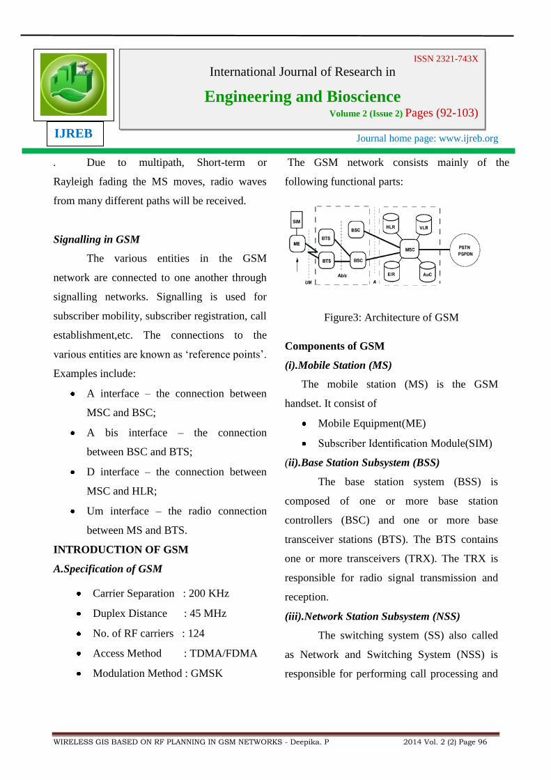
The GSM network consists mainly of the
following functional parts:
Figure3: Architecture of GSM
Components of GSM
(i).Mobile Station (MS)
The mobile station (MS) is the GSM
handset. It consist of
Mobile Equipment(ME)
Subscriber Identification Module(SIM)
(ii).Base Station Subsystem (BSS)
The base station system (BSS) is
composed of one or more base station
controllers (BSC) and one or more base
transceiver stations (BTS). The BTS contains
one or more transceivers (TRX). The TRX is
responsible for radio signal transmission and
reception.
(iii).Network Station Subsystem (NSS)
The switching system (SS) also called
as Network and Switching System (NSS) is
responsible for performing call processing and
Journal home page: www.ijreb.org
WIRELESS GIS BASED ON RF PLANNING IN GSM NETWORKS - Deepika. P 2014 Vol. 2 (2) Page 97
ISSN 2321-743X International Journal of Research in
Engineering and Bioscience Volume 2 (Issue 2) Pages (92-103)
IJREB
Subscriber-related functions. The switching
system includes the following functional units
Mobile Switching Centre
Home Location Register
Visitor Location Register
Equipment Identity Register
Authentication Center
RF PLANNING USING ATOLL
Atoll is a comprehensive Window-
based multi-technology and user-friendly radio-
planning environment that supports wireless
telecom operators during the whole network
lifetime, from initial design to densification and
optimization. More than an engineering tool,
Atoll is an open, scalable and flexible technical
information system that integrates easily with
other IT systems, increases productivity and
shortens lead times. Atoll supports a full range
of implementation scenarios, from stand-alone
to enterprise-wide server-based configurations
using distributed and parallel computing.
Advanced network design features: high-
performance propagation calculation engine,
multi-layered and hierarchical networks
supported, traffic modelling, automatic
frequency/code planning and network
optimization.
A. Introduction
Achieving maximum capacity while
maintaining an acceptable grade of service and
good speech quality is the main issue for the
network planning. Planning an immature
network with a limited number of subscribers is
not the real problem. The difficulty is to plan a
network that allows future growth and
expansion. Wise re-use of site location in the
future network structure will save money for
the operator.
VariousSteps Involved In Planning Procedure
Planning means building a network able to
provide service to the customers wherever they
are. This work can be simplified and structured
in certain steps.
System requirements
Define radio planning
Initial network plan
Surveys
Individual site design
Implementation
Launch of service
On-going testing
This process should not be considered just
as it is depicted, in a single flow of events. For
instance, the radio planning and surveying
actions are interlinked in an ongoing iterative
Journal home page: www.ijreb.org
WIRELESS GIS BASED ON RF PLANNING IN GSM NETWORKS - Deepika. P 2014 Vol. 2 (2) Page 98
ISSN 2321-743X International Journal of Research in
Engineering and Bioscience Volume 2 (Issue 2) Pages (92-103)
IJREB
process that should ultimately lead to the
individual site design.
C.Planning Models
Propagation in land mobile service at
frequencies from 300 to 1800MHz is affected
in varying degrees by topography,
morphography, ground constants and
atmospheric conditions.
A very common way of propagation loss
presentation isthe usage of so called
propagation curves, normally derived from
some measurement formulae are
Okumara Y. and others, for field strength
and its variability in VHF andUHF land
Mobile Radio Service.
Hata. M, Empirical formula for
Propagation Loss in Land Mobile
RadioServices.
Cost –207, Digital Land Mobile Radio
Communication.
Cost-231, Urban Transmission Loss for
Mobile Radio in the 900 and 1800MHz
bands.
D.Planning Tools
Tools are the software packages that help
for planning the network. Some of the software
packages used in cellular network planning is
Networking planning system (NPS/X)
Network measurement system
(NMS/X) developed by Nokia
Cellular planning with NPS/X is based on
utilization of digitized map and measurement
results. The design database includes the
parameters of the base stations, antennas,
propagation models and system parameters.
The basic package includes:
Coverage area calculation
Composite coverage area dominance
Point to point calculation
Interference area calculation etc.,
E.Planning for Cellular Network
In general the planning process starts
with the inputs from the customer. The
customer inputs include customer requirements
business plans system characteristics and any
other constraints. After the planned system is
implemented the assumptions made during the
planning process need to be validated and
corrected whereever necessary through an
optimization process. Total planning process
can be divided in to four parts
Capacity Planning
Coverage Planning
Parameter Planning
Optimization

Journal home page: www.ijreb.org
WIRELESS GIS BASED ON RF PLANNING IN GSM NETWORKS - Deepika. P 2014 Vol. 2 (2) Page 99
ISSN 2321-743X International Journal of Research in
Engineering and Bioscience Volume 2 (Issue 2) Pages (92-103)
IJREB
(i) Capacity Planning
The capacity of a given network is
measured in terms of the subscribers or the
traffic load that it can handle. The former
requires knowledge of subscriber calling habits
(average traffic per subscriber) while the latter
is more general. The steps for calculating the
network capacity are first find the maximum no
of carriers per cell that can be reached for the
different regions based on the frequency reuse
patterns and the available spectrum
thencalculate the capacity of the given cell
using blocking probability and the number of
carriers Finally the sum of all cell capacities
gives the network capacity.
A.Network Dimensioning Input
Network Dimensioning (ND) is usually
the first task to start the planning of a given
cellular network. The main result is an
estimation of the equipment necessary to meet
the following requirements.
Capacity related
Coverage related
Quality related
B.Capacity calculation
The capacity of a given network is
measured in terms of the subscribers or the
traffic load that it can handle. The steps for
calculating the network capacity are
Find the maximum no of carriers per cell
that can be reached for the different
regions based on the frequency reuse
patterns and the available spectrum.
Calculate the capacity of the given cell
using blocking probability and the number
of carriers.
Finally the sum of all cell capacities gives
the network capacity.
C.SpectrumEfficiency
Efficiency= S / (n X A X B)
S - Total spectrum available
n - Reuse factor
A - Cell area
B -Channel bandwidth
D.Erlang B Table
To calculate the capacity of the given
cell using blocking probability and the number
of carriers we need the well-known Erlang B
table or formulas and the no of traffic channels
for different number of carriers. The result we
get is the traffic capacity in Erlangs, which can
easily be transferred into the number of
subscribers.

Journal home page: www.ijreb.org
WIRELESS GIS BASED ON RF PLANNING IN GSM NETWORKS - Deepika. P 2014 Vol. 2 (2) Page 100
ISSN 2321-743X International Journal of Research in
Engineering and Bioscience Volume 2 (Issue 2) Pages (92-103)
IJREB
Erlangs = n X t / 3600
n = no of calls attempted
t = total duration in seconds
E.PowerBudget Calculations
To guarantee a good quality in both
directions (uplink and downlink) the power
ofBTS and MS should be in balance at the edge
of the cell. The main idea behind the power
budget calculations is to receive the maximum
output power level of BTS transmitter as a
function of BTS and MS sensitivity levels, MS
output power, antenna gain (Rx & TX),
diversity reception, cable loss, combiner loss,
etc.
Table 1: output power of BTS
class Max output power
1 320W
2 160W
3 80W
4 40W
5 20W
6 10W
7 5W
8 2.5W
Table 2: output power of MS
class Max output power
1 20W
2 8W
3 5W
4 2W
5 .8W
(ii)Coverage Planning
The objective of coverage planning
phase in coverage limited network areas is to
find a minimum amount of cell sites with
optimum locations for producing the required
coverage for the target area. Coverage planning
is normally performed with prediction modules
on digital map database. The basic input
information for coverage planning includes:
Coverage regions
Coverage threshold values on per regions
(outdoor, in-car, indoor)
Antenna (tower height limitations)
Preferred antenna line system
specifications
Preferred BTS specification
Digital Maps
There are different types of information
that can be digitized and used for coverage
predictions. The most important from the
Journal home page: www.ijreb.org
WIRELESS GIS BASED ON RF PLANNING IN GSM NETWORKS - Deepika. P 2014 Vol. 2 (2) Page 101
ISSN 2321-743X International Journal of Research in
Engineering and Bioscience Volume 2 (Issue 2) Pages (92-103)
IJREB
network planning point ofview are topography
(terrain heights), morphography (area types),
and roads trafficdensity. For the micro cell
modelling, which is required in a dense urban
environment, more information and heighten
resolution maps should be used. Information
about the buildings and streets is essential, so
the pixel size from 5m to 25m is reasonable.
(iii)Frequency Planning
The main goal of the frequency-
planning task is to increase the efficiency of the
spectrum usage, keeping the interference in the
network below some predefined level.
Therefore it is always related to interference
predictions.
Frequency reuse patterns, Channel
requirement on cell basis according to the
capacity planning
Traffic density distribution over the service
area.
The frequency allocation is based on cell-
to-cell interference probability estimation
according to the network topology, field
strength distribution and traffic load. This
results in customized frequency performance of
the selected radio network elements. The
starting point of automatic frequency allocation
is much better, since the act site coordinates
and BTS characteristics are available. Usage of
propagation model based on digital maps, we
are able to obtain interferencePredictions very
near to reality
Optimization
Network Optimization can be defined as
a continuous process of improving overall
network quality. Looking at network quality
two different views should be considered. The
customers (subscribers) view and the more
comprehensive operators view .Network
optimization service and more general the
Nokia Quality cycle service package are
designed to support the operator in the most
efficient way to improve all different aspects of
network quality. Nokia tools experts with
detailed system knowledge and the global
network of experience provide the operator
with the most sophisticated services.
CALCULATION
R F Planning For Cudallore District
1. LONGITUDE:78degree51minEAST;11
degree46minNORTH79degree7
minEAST; 11degree24minNORTH
2. LATITUDE:79degree34minEAST;11de
gree13minNORTH79degree36minE
3. TOTAL SITES :110-120
Journal home page: www.ijreb.org
WIRELESS GIS BASED ON RF PLANNING IN GSM NETWORKS - Deepika. P 2014 Vol. 2 (2) Page 102
ISSN 2321-743X International Journal of Research in
Engineering and Bioscience Volume 2 (Issue 2) Pages (92-103)
IJREB
4. URBAN :550E
5. SUBURBAN :1500E
6. OTHERS :700E
GRADE OF SERVICE (GOS) is always taken
as 2%
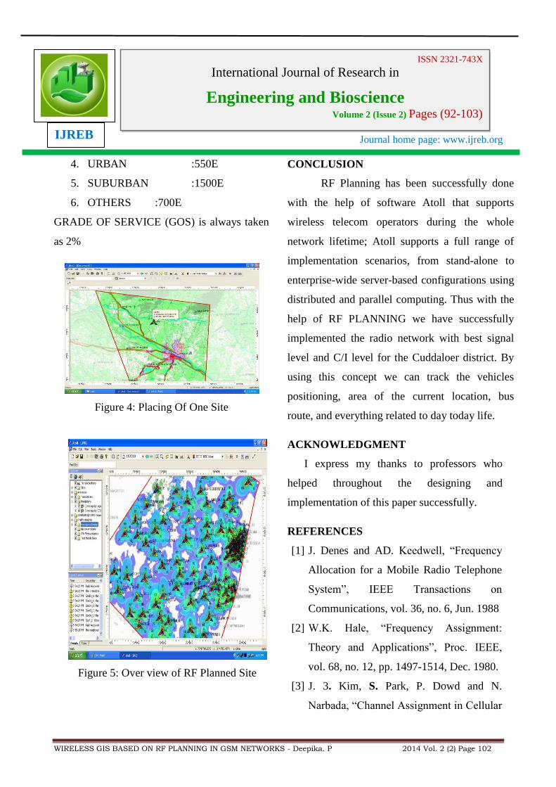
Figure 4: Placing Of One Site
Figure 5: Over view of RF Planned Site
CONCLUSION
RF Planning has been successfully done
with the help of software Atoll that supports
wireless telecom operators during the whole
network lifetime; Atoll supports a full range of
implementation scenarios, from stand-alone to
enterprise-wide server-based configurations using
distributed and parallel computing. Thus with the
help of RF PLANNING we have successfully
implemented the radio network with best signal
level and C/I level for the Cuddaloer district. By
using this concept we can track the vehicles
positioning, area of the current location, bus
route, and everything related to day today life.
ACKNOWLEDGMENT
I express my thanks to professors who
helped throughout the designing and
implementation of this paper successfully.
REFERENCES
[1] J. Denes and AD. Keedwell, “Frequency
Allocation for a Mobile Radio Telephone
System”, IEEE Transactions on
Communications, vol. 36, no. 6, Jun. 1988
[2] W.K. Hale, “Frequency Assignment:
Theory and Applications”, Proc. IEEE,
vol. 68, no. 12, pp. 1497-1514, Dec. 1980.
[3] J. 3. Kim, S. Park, P. Dowd and N.
Narbada, “Channel Assignment in Cellular

Journal home page: www.ijreb.org
WIRELESS GIS BASED ON RF PLANNING IN GSM NETWORKS - Deepika. P 2014 Vol. 2 (2) Page 103
ISSN 2321-743X International Journal of Research in
Engineering and Bioscience Volume 2 (Issue 2) Pages (92-103)
IJREB
Radio Using Genetic Algorithms”,
Wireless Personal Communications 3:273-
286, 1996.
[4] W.K. Lai and G.G. Cog hill, “Channel
Assignment through Evolutionary
Optimization”, IEEE Transactions on
Vehicular Technology, vol. 45, and no. 1.
[5] Lee.W.C.Y (2005) “Wireless and Cellular
Communication”, McGraw-Hill Third
edition.Mijatorvic.N, Kostanivc.I,
Dickey.S (2008)”Comparison of Receive
Signal Level Measurement Techniques in
GSM Cellular Networks‟‟.
[6] Theodore S.Rappaport (2003) “Wireless
Communication: Principles and Practice”,
Pearson Education, Second Edition.
[7] Blake.R (2003)”Wireless Communication
Technology”, Thomson Delmar, Third
edition.
[8] J¨org Kluge, Ulrich Br¨uning, Markus
Fischer,LarRzymianowicz,Patrick Schulz
and Mathias WaackThe ATOLL approach
for a fast and reliable System Area
Network Third Intl. Workshop on
Advanced Parallel Processing
Technologies (APPT‟99)
conference,October 19-21 1999, in
Changsha, P.R. China.
[9] N. Mijatovic, I. Kostanic, S. Dickey,
“Comparisonof Receive Signal Level
Measurement Techniques in GSM Cellular
Networks,” in proceedings of CCNC 2008,
January 10-13, 2008
Related Documents