Deepwater Horizon Oil Spill (DWHOS) NRDA Plankton Sampling Plan & Winter 2011 Cruise Plan March 29, 2011 Prepared by: Deborah French-McCay, Eileen Graham & Melanie Schroeder (ASA), and Daniel Hahn (NOAA OR&R) Reviewed by: William Graeber, Jeffery Simms, Amy Piko (Cardno ENTRIX) & Mark Benfield (LSU) on behalf of BP Proposed Cruise Dates R/V Oregon Ii — February 16— March 22, 2011 Leg 1: February 16— March 2, 2011 Leg 2: March 8— March 22, 2011 Background/Justification Conceptual Model — Water Column Organisms The trustees have developed a preliminary conceptual model of the DWH release, potential pathways and routes of exposure, and potential receptors. This preliminary model has informed the trustees’ decision to pursue the studies outlined in the work plan. By signing this work plan and agreeing to fund the work outlined, BP is not endorsing the model articulated in the work plan nor is BP endorsing the full geographic extent of sampling, the rationale pro vided for it, or the use of multiple gear types at numerous locations within the work plan. Release and Pathway Oil released from the broken well head both dispersed at depth and rose through nearly a mile of water column. The composition of the released gas-liquid mixture changed overtime and space as the result of dilution, changes in pressure, dissolution, and addition of other constituents such as dispersants, methanol, and anti-foaming additives. Of oil that made it to the water surface, some entrained water forming mousse, was dispersed into the water column naturally and by application of dispersants, and some was removed mechanically or by in situ burning. Floating oil, oil droplets, flocculated and dissolved components were transported large distances at various levels of the water column. Oil also picked up sediments, and other particulate material, some of which became neutrally or slightly negative buoyant, sinking to various depths. The oil dispersed at the wellhead (both via turbulence or by injection of dispersants) was transported by currents that varied in time and space, yielding a complex pathway of subsurface oil contamination that affected abyssal, bathypelagic, and meso-pelagic waters of the offshore Gulf of Mexico. 1 I P a ge NRDA WInter 2011 Oregon II SEAMAP sampling cruise Plan

Welcome message from author
This document is posted to help you gain knowledge. Please leave a comment to let me know what you think about it! Share it to your friends and learn new things together.
Transcript

Deepwater Horizon Oil Spill (DWHOS)
NRDA Plankton Sampling Plan& Winter 2011 Cruise Plan
March 29, 2011
Prepared by: Deborah French-McCay, Eileen Graham & Melanie Schroeder (ASA), and Daniel Hahn(NOAA OR&R)Reviewed by: William Graeber, Jeffery Simms, Amy Piko (Cardno ENTRIX) & Mark Benfield (LSU)on behalf of BP
Proposed Cruise Dates
R/V Oregon Ii — February 16— March 22, 2011Leg 1: February 16— March 2, 2011Leg 2: March 8— March 22, 2011
Background/Justification
Conceptual Model — Water Column Organisms
The trustees have developed a preliminary conceptual model of the DWH release, potential pathwaysand routes of exposure, and potential receptors. This preliminary model has informed the trustees’decision to pursue the studies outlined in the work plan. By signing this work plan and agreeing to fundthe work outlined, BP is not endorsing the model articulated in the work plan nor is BP endorsing the fullgeographic extent ofsampling, the rationale providedfor it, or the use of multiple gear types atnumerous locations within the work plan.
Release and PathwayOil released from the broken well head both dispersed at depth and rose through nearly a mile of watercolumn. The composition of the released gas-liquid mixture changed overtime and space as the resultof dilution, changes in pressure, dissolution, and addition of other constituents such as dispersants,methanol, and anti-foaming additives. Of oil that made it to the water surface, some entrained waterforming mousse, was dispersed into the water column naturally and by application of dispersants, andsome was removed mechanically or by in situ burning. Floating oil, oil droplets, flocculated anddissolved components were transported large distances at various levels of the water column. Oil alsopicked up sediments, and other particulate material, some of which became neutrally or slightlynegative buoyant, sinking to various depths. The oil dispersed at the wellhead (both via turbulence orby injection of dispersants) was transported by currents that varied in time and space, yielding acomplex pathway of subsurface oil contamination that affected abyssal, bathypelagic, and meso-pelagicwaters of the offshore Gulf of Mexico.
1 I P a ge NRDA WInter 2011 Oregon II SEAMAP sampling cruise Plan

Routes of ExposureFish and invertebrates in the water column are exposed to contaminants by swimming throughcontaminated water, spending time on/in contaminated sediments, taking up contaminants throughbody surfaces, passing contaminated water over respiratory structures, and ingesting water, oil droplets,contaminated biota, and particulates contaminated with oil as part of feeding. Additionally, sensitivelife stages of pelagic fish and invertebrates come in direct contact with floating oil that covers and ismixed into the neuston layer (upper O.5m) where many embryos and larvae develop. Other neustonicorganisms exposed to surface oil include many small invertebrates important to the food web. In thewater column, organisms are also exposed to suspended oil droplets, which can foul appendages orother body surfaces. Water column organisms have also been exposed to dispersants dissolved inwater, on oil droplets and adsorbed to suspended particulate matter. Water column organisms werealso exposed to dissolved and water-borne chemical additives such as methanol and anti-foamingagents.
Plankton in the north-eastern Gulf of Mexico, which include early life history stages of fish andinvertebrates, as well as smaller invertebrate holo-plankton and gelatinous zooplankton, are amongthose biota exposed to the released oil and spill-related chemicals. Plankton in the upper 20Cm of thewater column were exposed both offshore and on the shelf. Figure 1 shows the approximate extent ofoil observed on the water surface using radar data, which indicates some areas potentially affected byfloating oil.
Figure 1. Cumulative potential surface oil extent of the Deepwater Horizon spill. (Figure derived fromcompositing April, May, June, and July radar shape files available on the NOAA ERMA website. Notethat radar images with noted anomalies were not included in composite.)
2 I P a g e NRDA winter 2011 Oregon 11 SEAMAP Sampling Cruise Plan

Summary of Historical Shelf and Offshore Plankton Data
The NMFS/NOAA SEAMAP program is a long-standing plankton survey that covers nearly all of the Gulfof Mexico. With 25 years of data, this program offers a significant resource for understanding thecharacteristics of the natural state of this community. This is augmented by several state-based surveysthat sample in waters closer to shore. In 2009, the SEAMAP program completed a winter, spring, andfall plankton survey. Each of these surveys took over a month to complete. The spring and fall surveyssample using the bongo and neuston net procedures; the strength of this data set is the longevity, 2009was the 28th year1. The winter survey targets ichthyoplankton that are underrepresented in thespring/fall sampling programs and attempts to capture the presence of winter-spawning species (mainlygrouper species and tilefish). The main limitation of the historical SEAMAP plankton surveys is that onlythe spring survey covers the offshore area. Plankton in the nearshore waters are well covered over allthe seasons as plankton samples are collected in conjunction with the shrimp/groundfish surveys.Figures 1-10 of Attachment 1 summarize the historical and current datasets for plankton fish andcrustaceans.
The SEAMAP sampling area covers the entire northern GOM in the US EEZ from the 10 m isobath toapproximately the 200 m isobath, and comprises approximately 300 designated sampling sites (i.e.‘SEAMAP’ stations). Most stations are located at 30-nautical mile or 0.5° (56 km) intervals in a fixed,systematic, 2-dimensional latitude-longitude grid of transects across the GOM. This grid extends fromthe Texas shelf to the Florida west coast shelf. Some SEAMAP stations are located at <56 km intervals,especially along the continental shelf edge; while others have been moved to avoid obstructions,navigational hazards or shallow water. In general, the array of stations or standard cruise track forplankton sampling varies by survey (fall, winter, spring, summer) (Attachment 1).
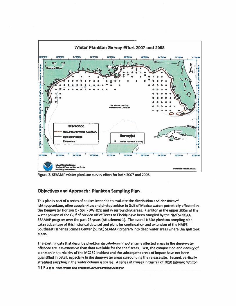
Historically the winter SEAMAP survey has been a dedicated plankton sampling effort. Survey yearsinclude 1983, 1984, 1993, 1996, 2007, 2008, and 2009. There has been variable spatial coverage in thistime series in U.S. GOM waters, although 2007, 2008, and 2009 shared similar cruise tracks. Forexample the survey effort for both 2007 and 2008 is shown in Figure 2. Unlike the fall and springplankton SEAMAP surveys, there is no established “standard” cruise track for the winter.
1 NOAA, 2010. Annual Report of the Southeast Area Monitoring and Assessment Program (SEAMAP). Number 177.
3 I P a g e NRDA Winter 2011 Oregon II SEAMAP Sampling Cruise Plan
Objectives and Approach: Plankton Sampling Plan
This plan is part of a series of cruises intended to evaluate the distribution and densities ofichthyoplankton, other zooplankton and phytoplankton in Gulf of Mexico waters potentially affected bythe Deepwater Horizon Oil Spill (DWHOS) and in surrounding areas. Plankton in the upper 200m of thewater column of the Gulf of Mexico off of Texas to Florida have been sampled by the NMFS/NOAASEAMAP program over the past 25 years (Attachment 1). The overall NRDA plankton sampling plantakes advantage of this historical data set and plans for continuation and extension of the NMFSSoutheast Fisheries Science Center (SEFSC) SEAMAP program into deep water areas where the spill tookplace.
The existing data that describe plankton distributions in potentially affected areas in the deep-wateroffshore are less extensive than data available for the shelf areas. First, the composition and density ofplankton in the vicinity of the M252 incident and the subsequent areas of impact have not beenquantified in detail, especially in the deep-water areas surrounding the release site. Second, verticallystratified sampling in the water column is sparse. A series of cruises in the fall of 2010 (aboard Walton4 I P a g e NRDA Winter 2011 Oregon II SEAMAP Sampling Cruise Pbn

Smith and Nick Skansi) targeted 30 deepwater stations around and southwest of the MC252 incidentsite. Subsequent sampling in other seasons at the sites in those plans provides additional quantitativeinformation and to document the plankton community in subsequent time periods.
This plan describes a NRDA survey for winter 2011 plankton sampling where a subset of the standardSEAMAP stations have been selected for sampling, as well as additional offshore stations. The samplingand analysis protocols in the upper 200m of the water column are those used in the SEAMAP program.lchthyo- and zooplankton will be sampled using paired bongo nets and at the water surface with aneuston net. Depth-discrete plankton samples taken at various intervals will be carried out using aMultiple Opening/Closing Net and Environmental Sensing System (MOCNESS).
Methodology
NRDA SEAMAP Plan and Sampling StationsThe NOAA Ship Oregon I/will depart Pascagoula, MS on February 16, 2011 to conduct the NRDA WinterPlankton survey. The 30-day cruise will be conducted in 2 legs; one 15 day (February 16— March 2) andone 15 day leg (March 8— March 22). In this work plan, the NRDA effort will support the entire surveyaboard the RN Oregon II.
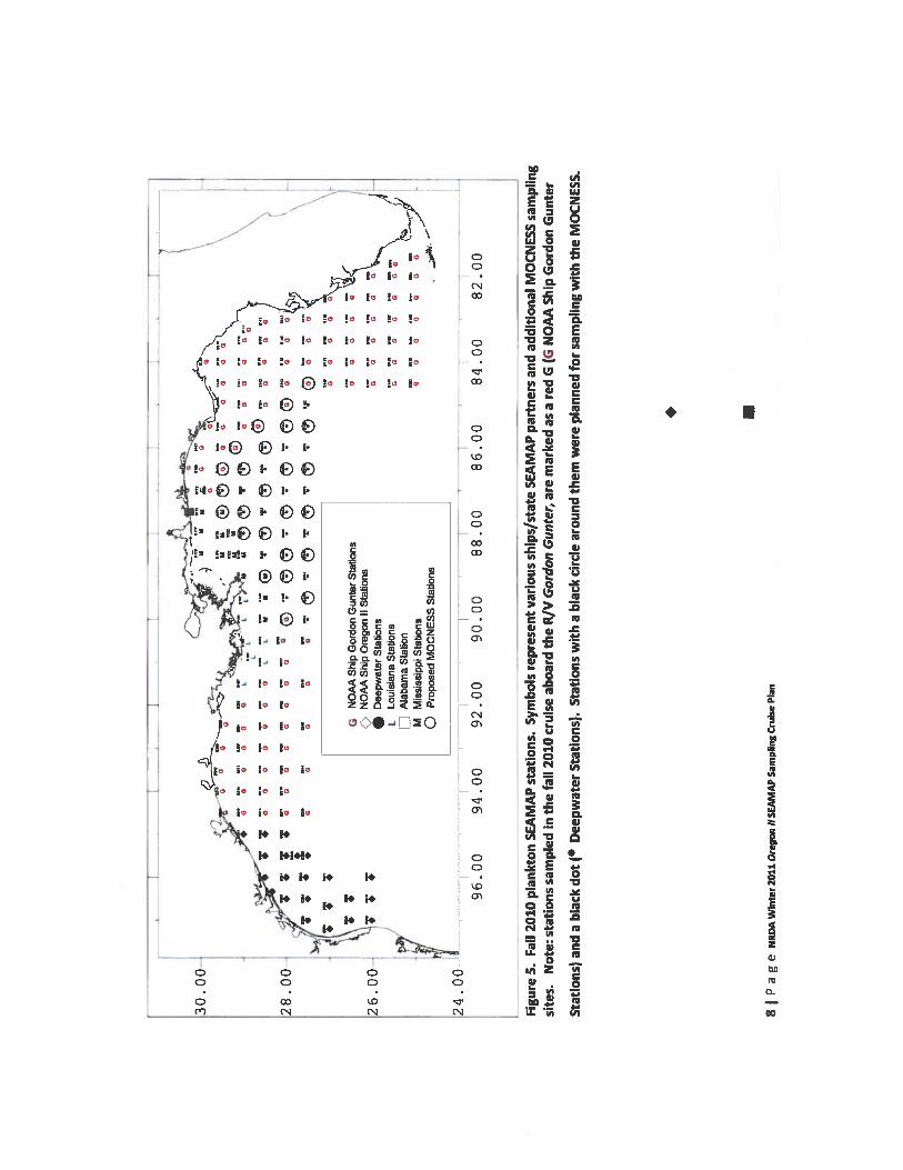
Due to the extent of the area potentially affected by oil, there is need to sample additional stationsbeyond the shelf region off the coast of Louisiana, Mississippi, Alabama, and Florida. For the NRDAeffort, stations have been added to the cruise track to fill the gap in the deepwater areas of interestrelative to the spill. The stations used to fill out the grid are there because the spill was in deep waterand, in the case for most surveys, was initiated at a location that was beyond the normal scope ofstandard sampling. Figure 5 shows the stations sampled by the Gordon Gunter in the fall 2010 SEAMAPcruise, supported in part by NRDA. The deep water offshore stations are located in >200m of water andspecifically capture information about plankton beyond the shelf and in the vicinity of the releaselocation of the oil spill. The position of the additional stations was determined by extending thestandard 3ONM SEAMAP sampling grid into the offshore area. Figures 3-4 shows the position of theplankton stations that the Oregon II will target for the winter 2011 survey. In addition, the State ofLouisiana will survey 7 stations that it sampled in faIl 2010 (light blue stations in Figure 3) in March 2011.Mississippi will not be sampling in winter 2011.
For more detail on SEAMAP operations and protocols see Attachment 2 “SEAMAP Field OperationsManual” and the annual SEAMAP environmental and biological atlas reports found at:http://www.gsmfc.orgJdefault.php?p=sm ov.htm#:content@12:Iinks@13
The cruise track and selected station array for the 2011 winter survey is designed to attain data atoffshore and inshore stations, and to perform more sampling in the deep water areas than is normallyperformed as part of the SEAMAP program (Figures 2-4). This station configuration encompassessurface waters that are potentially influenced by major physical factors in the Gulf, e.g., the MississippiRiver discharge and the loop current. SEAMAP stations having time series data (i.e., winter SEAMAPsurveys prior to 2011) near the spill area were included and prioritized. Stations on the Florida shelfwere included as those areas show higher (chlorophyll) productivity in satellite color imagery, areconnected hydrodynamically to at least part of the spill-affected area, and are thought to be importantgrouper spawning grounds. In addition, ancillary observations by academics and others have suggestedoil contamination may have been present in areas on or near the Florida Shelf.
5 I P a g e NRDA Winter 2011. Oregon II SEAMAP sampling Cruise Plan

In addition to bongo and neuston net sampling, depth stratified shallow (130m) 1 m MOCNESS sampleswill be taken at many of the stations deeper than 200m, with priority on the slope areas (Figure 3, 4), asmore of the oil contamination was observed over the slope rather than offshore. This will allow us toexamine the vertical distributions of plankton in both daylight and nighttime conditions. Attachment 11contains the list of coordinates for the stations in Figures 3 and 4.
202 8022-01 Th-0a1 7” ‘01610508325 062 l0207063lfl254R1CJEJ1610i53g0143 I 6135 •oi is
I245l .Bo61l249 0D65I286 1607265 lBD7Bt162 1515215144 5131 •oi is
I1SW- Isw-Ew SE-i lSE-2SE-3 lSE-4SE-5ISE-6 (Isi Si •si 01 3 20
2S GO 0 N
LX km
iI I I
INm
Figure 3. 2011 NRDA winter plankton stations. Black squares and green represent Oregon II stationsfor bongo-neuston sampling. (Black squares are part of the regular SEAMAP program; green squareswere added for the DWHOS plankton program in fall 2010.) Red outlined stations are those where aMOCNESS tow will also be attempted (time and weather permitting). Ught blue squares are stationsthat Louisiana is going to sample.
•NS7
NSSI 10179
“ ‘— NOSI 15323
•5204 02001B197 •6192 b6160•5b8716153151621
16193 INS1 INS2 1N53 l4
6201 •Bi 96 18194.61 91 .oie9is8i 842S1l•6325
•6203
NS8 INSS •0320
5176 IB174i7if159.0i65l81S8 •Bi58i40I
0322
00ij175002i70 1B159•615516111 513715116
•160A0aiIB252lD8253i 64 •6i04•5i12 B1361B117
6 I P a g e NRDA Winter 2011 Oregon II SEAMAP Sampling Cruise Plan

B
e20000W ue.w a40000W
GUN
QIoo1i - l — -. — ——
B B
B .. B B BB B
BB B B • B B N B
N • • I
S N B B SF B B B5
2B0Q4
— B B
S B
OOOON
Figure 4. 2011 NRDA winter plankton stations with bathymetry. Black squares and green representOregon II stations for bongo-neuston sampling. (Black squares are part of the regular SEAMAPprogram; green squares were added for the DWHOS plankton program in fall 2010.) Red outlinedstations are those where a MOCNESS tow will also be attempted (time and weather permitting). Lightblue squares are stations that Louisiana is going to sample.
.
7 P a g e NRDA Winter 2011 Oregon II SEAMAP Sampling Cruise Plan
-.
77
77
77
LL
7U
U0
7®
7
77
(Ja0000000
*7
77
77
T777
TG
NO
AA
Ship
Gor
don
Gun
ter
Sta
tion
sa
a
—N
OA
ASh
ipO
rego
nII
Sta
tion
s—
-.
66
50
00
•D
eepw
ater
Sta
tion
sL
Lou
isia
naS
tati
ons
77
77
77
7[]
Jab
am
aSt
atio
n•,
—
MM
issi
ssip
piS
tati
ons
60
0G
aa
0P
ropo
sed
MO
ON
ES
SS
tati
ons
96.0
094.0
09
2.0
090.0
08
8.0
086.0
08
4.0
08
2.0
0
Fig
ure
5.Fa
ll20
10pl
ankt
onSE
AM
AP
stat
ions.
Sym
bols
repre
sent
vari
ous
ship
s/st
ate
SEA
MA
Pp
artn
ers
and
addi
tion
alM
OC
NE
SSsa
mpl
ing
site
s.N
ote:
stat
ion
ssa
mpl
edin
the
fall
2010
crui
seab
oard
the
R/V
Gor
don
Gun
ter,
are
mar
ked
asa
red
G(G
NO
AA
Ship
Gor
don
Gun
ter
Sta
tion
s)an
da
blac
kd
ot
(D
eepw
ater
Sta
tion
s).
Sta
tion
sw
ith
abl
ack
circ
lear
ound
them
wer
epl
anne
dfo
rsa
mpl
ing
wit
hth
eM
OC
NE
SS.
30
.00
28.0
0
26
.00
-
24.0
0
8P
ag
eN
RDA
Win
ter
2011
Ore
gon
IIS
EA
MA
PSa
mpl
ing
Cru
ise
Pla
n

Sampling ProceduresThe primary objective of the survey is to assess the occurrence, abundance, and distribution of the earlylife stages of winter spawning fishes, especially grouper, tilefish, mullet, and menhaden. Early life stagesof commercially important invertebrates (lobsters, decapods) and other invertebrates will also beassessed. Additional organisms of interest include other zooplankton and ichthyoplankton notmentioned above.
In the upper 200m of the water column ichthyo- and zooplankton will be sampled using paired bongonets and at the water surface using a neuston net. Standard SEAMAP sampling protocols will befollowed at each station for the primary gear: oblique bongo tow to a maximum depth of 200 m, 10 mmneuston tow, and CTD profile to a maximum depth of 20Cm. (The bongo tow and CTD cast will beshallower than 200m if the local water depth is <20Cm.) The sample attained from the left bongo netwill be immediately preserved in 10% formalin and transferred approximately 24-48 hours later into95% ethanol. Samples from the right bongo and neuston nets will be immediately preserved in 95%ethanol and transferred approximately 24-48 hours later into fresh 95% ethanol. For detailed SEAMAPprotocols and sample processing see Attachment 2 “SEAMAP Field Operations Manual”.
Vertical distribution of plankton in the epipelagic zone (the top layer of the ocean where sunlightreaches and where photosynthesis can occur) will be measured by sampling at depth discrete intervalsat many of the offshore stations using a 1 m MOCNESS (0.505mm mesh). The MOCNESS will not bedeployed at the same time as the other gear types while on station. The MOCNESS will be towedobliquely through the water column from a maximum depth of 130m (or from a safe distance off the seafloor). The first net (net 0) will be open all the way down to the maximum depth. Upon commencingthe oblique tow back to the surface, net 1 will be opened and cover the depth horizon from 130 to 100.Additional nets will be opened and closed at depth intervals of 20m up to the surface. Much of thewater column sampled by the MOCNESS will also be covered by the other plankton sampling gear. Theadvantages of the MOCNESS sampling as compared to bongo tows include 1) collection of highresolution depth-discrete data, which is not achieved in the bongo tows; 2) a larger sample volume forincreased detection of rarer taxa; and 3) a larger net mouth that should reduce net avoidance. Thetarget volume filtered for each depth strata is 250m3. For more detail on MOCNESS deployment andsample processing see Attachment 3 (NOAA Cruise Instructions) and Attachment 12 (1-rn MOCNESSSample Handling and Preservation Protocol).
For all sampling gears, detailed observations (abundance, wet weight volume, and species) of net-caught jellyfish, ctenophores, and other large zooplankton will be recorded and photographed.Sampling will occur around the clock, as normally performed during SEAMAP surveys (Attachments 2, 3),and as such, samples will be obtained both in daylight and during the night.
Additional NRDA Personnel for R/V Oregon II:2 NOAA Data Managers per leg1-2 ENTRIX employees per leg
VesselOperations will be completed on the NOAA vessel R/V Oregon II
9 P a e NRDA Winter 2011 Oregon IISEAMAP Sampling Cruise Plan

Estimated Costs:Totals For February 16-NOAA OMAO Vessel
Day Rate March 2, and March 8—c2March 22
Staging/Dc- Staging/DeOp Cost/Day Op Cost/DayStaging Cost - Op Staging/Destaging . Staging Cost
- High OpLow/Med Days Days
- High OpLow/Med
Item Optempo OptempoVessel Base Pay (14) 2,118.76 2,118.76 30 6 63,562,80 12,712.56Wage Marine
2,574.00 2,26800 77,220.00 13,608.00OvertimeEmployer Surcharge -
656.82 656.82 19,704.47 3,940.8931%NOAA Corps Officer
528.85 528.85 15,865.57 3,173.11SalariesNC Special
259.26 259.26 7,777.86 1,555.57Pay/Benefits
NOAA Overhead Rate556.66 556.66 16,699.68 3,339.94
(22.07%)NOAA Line Office
216.91 216.91 6,507.35 1,301.47Overhead Rate (8.60%)NOAA FMC Rate (0.0%) 0.00 0.00 0.00 0.00GSA RentReimbursable Rate 227.00 227.00 6,810.02 1,362.00(9.00%)Maintenance
3,670.00 110,100.00 0.00surcharge
Food/Supplies/Services 2,332.00 118.11 69,960.00 708.64Fuel ($2.64/gal); 850
2,244.00 67,320.00 0.00gal/dayMOC ShoresideSupport (112.3%) of
2,973.27 2,973.27 89,198.06 17,839.61WM and NOAA CorpsLabor costsTotal Vessel Cost: 550,725.81 59,541.80•staging/De..Staginr6 days, Arrival/Departure days = 4, Days at Sea = 26
NRDA Costs Op Days Day Rate
2 NRDA Managers 45,000.00BP Representatives Provided(Cardno-Entrix) Elsewhere
TOTAL BUDGET: 655,267.62
*Cruise will be supported by 6 NOAA NMFS SEFSC science staff, costs of NOAA staff are not included inthe cost estimate.
Budgeting
The Parties acknowledge that this budget is an estimate, and that actual costs may prove to be higher.BP’s commitment to fund the costs of this work includes any additional reasonable costs within thescope of this work plan that may arise. The trustees will make a good faith effort to notify BP in advanceof any such increased costs. The vessel costs, field survey costs and miscellaneous costs indicated inchart above shall be reimbursed by BP upon receipt of written invoices submitted by the Trustees.
10 P a g e NRDA Winter ZOll Oregon II SEAMAP Sampling Cruise Plan

Safety PlansBP’s full operations and safety plans are attached as appendices. A HASP binder is provided to eachvessel. In addition, the NOAA incident site safety plan (which all NOAA employees and contractors mustsign prior to the cruise) is attached (Attachment 4). Vessels will call into SIMOPS based on the currentregulations (Attachment 5). Vessels will report in daily using the attached situation report (Attachment6).
Transfer of the shared electronic media in the onboard equipment to each of the party’s hardware forretention and use.All profile, acoustic, and other electronic data (including photographs) will be saved to an on-boardcomputer, and all data shall be migrated to a dedicated hard drive. The data will be controlled andmanaged by the trustees under project protocols, including Chain-of-Custody tracking of the hard drive.The hard drive will be duplicated in full immediately following the cruise, and the duplicate hard drivewill be provided to Cardno ENTRIX on behalf of BP. The original hard drive shall be kept in a securefacility in trustee custody.
By the end of the cruise, all documentation, including COCs, field notes, sampling logs, sampling forms,photos, photo logs, ship logs, and GPS tracking shall be transferred to the NOAA NRDA Sample IntakeTeam following NRDA data management protocols. An identical copy of all documentation will beprovided to BP/Cardno ENTRIX at the end of the cruise.
Sample RetentionAll materials associated with the collection or analysis of samples under these protocols or pursuant toany approved work plan, except those consumed as a consequence of the applicable sampling oranalytical process, must be retained unless and until approval is given for their disposal in accordancewith the retention requirements set forth in paragraph 14 of Pretrial Order U 1 (issued August 10, 2010)and any other applicable Court Orders governing tangible items that are or may be issued in MDL No.2179 IN RE: Oil Spill by the Oil Rig “DEEPWATER HORIZON” (E.D. LA 2010). Such approval to disposemust be given in writing and by a person authorized to direct such action on behalf of the state orfederal agency whose employees or contractors are in possession or control of such materials.
LaboratorySamples will be transferred, and held under NOAA NRDA chain of custody, to Dr. Malinda Sutor of theDepartment of Oceanography and Coastal Sciences of Louisiana State University for further processing.Samples will be stored in a secure facility, processed in the lab and data distributed as described in aseparate workplan (currently under development).
Distribution of Laboratory ResultsEach laboratory shall deliver raw data, including all necessary metadata, generated as part of this workplan as a Laboratory Analytical Data Package (LADP) simultaneously to the trustee Data ManagementTeam (DMT), the Louisiana Oil Spill Coordinator’s Office (LOSCO) on behalf of the State of Louisiana andto BP (or Cardno ENTRIX on behalf of BP). The electronic data deliverable (EDD) spreadsheet with prevalidated analytical results, which is a component of the complete LADP, will also be delivered to thesecure FTP drop box maintained by the trustees’ Data Management Team (DMT). Any preliminary datadistributed to the DMT shall also be distributed to LOSCO and to BP (or Cardno ENTRIX on behalf of BP).Thereafter, the DMT will validate and perform quality assurance/quality control (QA/UC) procedures on
11 I Pa g e NRoAwlnterzolioregonhlsEAMApsampvngcrulseplan

the LADP consistent with the authorized Quality Assurance Project Plan, after which time thevalidated/QAJQC’d data shall be made available simultaneously to all trustees and BP (or Cardno ENTRIXon behalf of BP). Any questions raised on the validated/QA/QC results shall be handled per theprocedures in the Quality Assurance Project Plan and the issue and results shall be distributed to allparties. In the interest of maintaining one consistent data set for use by all parties, only thevalidated/QA/QC’d data set released by the DMT shall be considered the consensus data set. In order toassure reliability of the consensus data and full review by the parties, no party shall publish consensusdata until 7 days after such data has been made available to the parties. The LADP shall not be releasedby the DMT, LOSCO, BP or Cardno ENTRIX prior to validation/QA/QC absent a showing of criticaloperational need. Should any party show a critical operational need for data prior to validation/QA/QC,any released data will be clearly marked “preliminary/unvalidated” and will be made available equally toall trustees and to BP (or Cardno ENTRIX on behalf of BP).
Attachments:Attachment 1. Summary of Historical Shelf and Offshore Plankton DataAttachment 2. SEAMAP Field Operations ManualAttachment 3. NMFS/NOAA SEAMAP Oregon II Winter 2011 Cruise InstructionsAttachment 4. NOAA-NRDA_MC_252_Site_Safety_Plan_5.13. 10Attachment 5. NRDA SIMOPS Procedures 111710Attachment 6. DWH Vessel Daily SitRepAttachment 7. NRDA_Field_Sampler_Data_Management_Protocol_10_23_2010Attachment 8. Transfer of Personnel and Material at Sea 070510Attachment 9. MC252 HSSE Incident Reporting Final 02 May 10 rev 1Attachment 10. MC252 Analytical QAP V2.2Attachment 11. Winter2Oll SEAMAP Stations maps and coordinatesAttachment 12. 1-rn MOCNESS Sample Handling and Preservation Protocol
12 P a g e NRDA Winter zan Oregon /ISEAMAP Sampling Cruise Plan

Deepwater Horizon Oil Spill (DWHOS)
NRDA Plankton Sampling Plan& WInter 2011 Cruise Plan
Rf Oregon II — February 16— March 22, 2011
March 29,2011
Approval of this work plan Is for the purposes of obtaining data for the Natural Resource DamageAssessment. Parties each reserve Its right to produce Its own independent Interpretation and analysis ofany data collected pursuant to this work plan.
7
Federal Trustee Approval
________________
7/25/j(
Louisiana Approval
_______
BP Approval I JOJLName
JCA k€Printed Name
Name
13 P .1 g e
Related Documents