1 Cambridge Archaeology Field Group Wimpole Project Wimpole: Silent voices and deserted homes V5 Final

Welcome message from author
This document is posted to help you gain knowledge. Please leave a comment to let me know what you think about it! Share it to your friends and learn new things together.
Transcript
1
Cambridge Archaeology Field Group
Wimpole Project
Wimpole: Silent voices and deserted homes
V5 Final
2
Table of Contents ........................................................................................................................................................ 1
SUMMARY ............................................................................................................................................... 4 Section 1 .................................................................................................................................................. 4
1. INTRODUCTION .......................................................................................................................... 4 1.1 Location and scope of work ................................................................................................ 4 1.2 Geology and topography ..................................................................................................... 4 1.3 Historical background ......................................................................................................... 5 1.4 Acknowledgements ............................................................................................................. 8
Section 2 .................................................................................................................................................. 9 2. AIMS AND METHODS ................................................................................................................. 9
2.1 Aims ..................................................................................................................................... 9 2.2 Methods .............................................................................................................................. 9
2.2.1 Fieldwalking ................................................................................................................ 9 2.2.2 Test Pit Excavation ..................................................................................................... 10 2.2.3 Excavations ................................................................................................................ 12 2.2.5 Documentary Research ............................................................................................. 13
Section 3 ................................................................................................................................................ 14 3 RESULTS .................................................................................................................................... 14
3.1 Fieldwalking ...................................................................................................................... 14 3.1.1 Summary Results ....................................................................................................... 14 3.1.2 Mesolithic to Early Bronze Age ................................................................................. 15 3.1.3 Iron Age ..................................................................................................................... 15 3.1.4 Roman ....................................................................................................................... 15 3.1.5 Saxon and Saxo-Norman ........................................................................................... 16 3.1.6 Medieval .................................................................................................................... 16 3.1.7 Late Medieval ............................................................................................................ 16
3.2 Test pit excavation ............................................................................................................. 18 3.2.4. Pottery Identification ................................................................................................ 21 3.2.5 Earlier prehistoric ...................................................................................................... 21 3.2.6 Mid/Late Iron Age ..................................................................................................... 21 3.2.7 Roman ....................................................................................................................... 21 3.2.8 Early/Middle Saxon ................................................................................................... 21 3.2.9 Late Saxon-Early Medieval ........................................................................................ 22 3.2.10 Medieval .................................................................................................................... 22 3.2.11 Late Medieval ............................................................................................................ 22 3.2.12 Post-Medieval to Modern ......................................................................................... 22
3.3 Cobbs Wood - Field 3 ........................................................................................................ 22 3.3.1 Topography and background ..................................................................................... 22 3.3.2 Results ....................................................................................................................... 23
Section 4 ................................................................................................................................................ 32 4. DOCUMENTS ........................................................................................................................... 32 Result Summary ................................................................................................................................ 32
4.1 Introduction ...................................................................................................................... 32 4.2 Early Beginnings: Wimpole in the Saxo-Norman period (1066 to 1086) .......................... 33 4.3 Population ......................................................................................................................... 34 4.4 Personal Names ................................................................................................................. 35 4.5 Land Use ............................................................................................................................ 37
Section 5 ................................................................................................................................................ 41 5 DISCUSSION.............................................................................................................................. 41
5.1 Background ....................................................................................................................... 41
3
5.2 Commentary ..................................................................................................................... 41 5.2.1 Pre-history to Roman up to 5th century AD .............................................................. 41 5.2.2 Early Medieval to the Norman Conquest - 5th to 11th centuries. ............................ 42 5.2.3 Medieval 12th to 15th centuries. .............................................................................. 44 5.2.4 Early Modern 16th to 19th centuries. ....................................................................... 45
Bibliography .......................................................................................................................................... 51
List of Figures Figure 1 Map showing roads, tracks and settlements in Wimpole parish on the Hare Map of 1638 .…7 Figure 2 Map of Test pit locations and house sites from Hare map -1638…………………………………………12 Figure 3 Map of fields walked in the survey…..…………………………………………………………………………………14 Figure 4 Maps of flint and pottery finds from fieldwalking at Wimpole……………………………………………18
Figure 5 Position of the 10 squares and the test pits at Cobbs Wood field – field 3………………………....24 Figure 6 Distribution of the pottery finds from the 20m squares walked by Smith and Damant……….27 List of Tables
Table 1 Position of Test Pits – Ordnance Survey references (all TL)……………………………………………….….12
Table 2 Numbers of prehistoric to Late Medieval pottery and flint found during fieldwalking………...15
Table 3 Test pits – summary of significant finds……………………………………………………………………..………..21
Table 4 Test Pit pottery identifications by Paul Blinkhorn grouped into periods……………………………….22
Table 5 Pottery from Test Pits by period…………………………………………………………………………………………..22
Table 6 Pottery identifications by Paul Blinkhorn for pottery from the Cobbs Wood field…………….25 Table 7 Pottery from 10m squares walked by CAFG on Cobbs Wood field……………………………………….24 Table 8 Pottery from 10m squares walked by YAC on Cobbs Wood field………………………………………….25 Table 9 Numbers of sherds by period found in 20 m. square fieldwalkingin Cobbs Wood field………25 Table 10 Pottery Occurrence in Cobbs Wood Test Pits by Period……………………………………………………..28 Table 11 Non-pottery occurrence in Cobbs wood Test pits………………………………………………………………29 Table 12 Summary - Metal finds Cobbs Wood………………………………………………………………………………….30 Table 13 Roman Coin Finds from the main Survey Winter 2012/13………………………………………………….31
Abbreviations
BM British Museum
CAFG Cambridge Archaeology Field Group
CC Cambridgeshire Collection
CCC Cambridgeshire County Council
CCCCO Corpus Christi College, Cambridge
CRO Cambridge Records Office
CUL Cambridge University Library
CUP Cambridge University Press
EDR Ely Diocesan Records
ICC Inquisitio Comitatus Cantabrigiensis
NottmU Nottingham University
PCAS Proceedings of the Cambridge Antiquarian Society
RCHM(E) Royal Commission on Historical Monuments (England),
VCH Victoria County History
VCH notes Handwritten notes of VCH researchers, held at the CRO
4
SUMMARY
The parish of Wimpole does not have a nucleated village settlement. The earliest representation is
seen on the map drawn by Benjamin Hare in 1638 for Thomas Chicheley. Extensive fieldwalking,
limited test pit excavation and metal detecting has shown evidence that there was activity, possibly
settlement, in the Bronze Age, Iron Age, Roman, Early/Middle and Late Saxon periods and through
the medieval period into modern times. Significant sites have been newly identified by these
methods in areas not previously studied. Documentary research has concentrated on identifying
people who lived and worked on the land and on tracing land use. Documents not previously
published have been found to contribute to the understanding of the development of the landscape.
It is hoped that this study has contributed to a fuller understanding of the history of Wimpole and
the surrounding region and will encourage further work.
The report comprises five main sections. Section 1 contains the Introduction; section 2 the aims and
methods; section 3 the results of the practical field work; section 4 the results of the documentary
research, and section 5 is an outline discussion of the results. Supplementary data can be found in
the Appendices.
Section 1
1. INTRODUCTION
1.1 Location and scope of work
1.1.1 Archaeological work in the parish of Wimpole has been conducted intermittently by the
Cambridge Archaeology Field Group (CAFG) since 1982. This work has taken five main forms:
field walking, an earthwork survey, a test pit survey, metal detecting and excavations. An
earthwork survey was carried out at Cobbs Wood in 1982 (May, 1982). Field walking
occurred between 1989 and 2013 with about 30% of the parish being surveyed. Excavation
of features associated with the gardens and a house next to Home Farm was undertaken
between 1999 and 2012; detailed results of this work will be reported separately.
1.1.2 In 2013 a grant was obtained from the Heritage Lottery Fund in order to carry out further
field work and to relate this to the previous results. Between 20th and 28th July 2013 15 test
pits were excavated on the National Trust Estate as a community programme run by CAFG.
As part of the 2013 project members of CAFG undertook research in documents from various
archives, with particular reference to identification of people and families living in the parish.
1.2 Geology and topography
1.2.1 The parish of Wimpole is some 2,468 acres (999 hectares) in extent and lies about eight
miles (13 Km) southwest of Cambridge. It is bounded (with some adjustments) by Ermine
Street on the west and the ancient Mare Way track to the north. The river Rhee runs along
5
the southern edge, as does the probable Roman road connecting Ermine Street to Cambridge
(now the A603). The western side is largely formed by the lines of medieval field boundaries.
Within the parish, Wimpole Hall and its park now cover the early settlements of Wimpole.
1.2.2. The British Geological Survey (BGS 2001 and 2002) shows boulder clay to the north which
falls from a scarp of over 250ft (76m) OD through chalk and gault, to river gravel in the south
at around 50ft (15m) OD. The chalk outcrop is irregular and a long tongue stretches south
east through the parish to the church which stands on its furthest extension. The junction
with the gault generates a number of springs providing plentiful fresh water. The area is well
wooded with belts of trees to the north and west planted as part of landscaping work in the
nineteenth century.
1.3 Historical background
1.3.1 There are no extensive published studies of the development of the landscape of the parish
of Wimpole or of the farmers and artisans who lived in and used that landscape.
1.3.2 The National Trust guidebook by David Souden (2004) devotes just three of its 96 pages to
the history of the estate outside the Park for the period prior to 1814. The farms and
earthworks, including ridge and furrow, recorded by the Royal Commission on Historical
Monuments are given as factual statements of what was present but there is little analysis of
the significance of these features (RCHM(E) 1968). Likewise there is a very full account of the
earthworks in the RCHME survey of 1998 with some attempt to relate these features to
documentary evidence (Patterson, 1998). The fullest published account of the history of the
parish is found in volume 5 of the Victoria County History of Cambridgeshire. This contains
evidence concerning manors and estates and the economic history with reference to land
use and organisation (Elrington, 1973). This latter book was an invaluable source during
initial attempts to relate people to places within this project. Papers published in the
Proceedings of Cambridge Antiquarian Society are mainly concerned with individual finds of
artefacts or with details from the Domesday survey. Taylor (1997) briefly discusses the
earthworks and the finds recorded in the Cambridgeshire Heritage Environment Record
(CHER), including a 6th century burial excavated at Wimpole Lodge.
1.3.3 Much has been written by archaeologists and local historians in recent years about landscape
development, particularly for the period after the collapse of the Roman state around
410AD. Emphasis has been on the origins of open field agriculture and the nucleation of
settlements. Landscape Archaeology of Anglo-Saxon England contains a useful introduction
and chapters by significant contributors to the discussion (Higham and Ryan 2010). In the
introduction, Higham draws attention to recent strategies of extensive fieldwalking combined
with new evidence of the dating and distribution of pottery – exampling Ipswich ware of the
8/9th centuries (Higham and Ryan 2010 p. 9). This new evidence has suggested that
settlement withdrew from the heavy clays to lighter soils in the very early Saxon period, of
particular significance for the interpretation of the evidence from Wimpole’s heavy clays.
1.3.4 Another element of the discussion of post-Roman landscape development is to understand
the origins of nucleated settlements (as opposed to dispersed), open field systems and
common, or Midland, field systems. An extensive study of 19th century Ordnance Survey
maps by Roberts and Wrathmell (Roberts et al 2002) suggests a central province of England
where nucleated settlements predominated, with dispersed settlement to the east and
6
south. The dispersed settlement shown in the parish of Wimpole on the 1638 map produced
by Benjamin Hare (henceforth ‘Hare Map’) (CRO R77/1) for Thomas Chicheley, the then
owner of the estate, lies on the south eastern fringe of the central province.
1.3.5 Oosthuizen (2010) has proposed that open fields may have evolved from prehistoric or
Romano-British field systems. She suggests that the ‘common fields’ of the central province,
with their communally regulated agricultural activity, may have developed in the early
medieval period from the less regulated open fields but that there is no clear evidence for
association with nucleation of settlements. For Wimpole there are no surviving manorial
records, so although the Hare map shows distributed strips in what appear to be two fields,
one across the north of the parish and one south of the manor house (although the latter is
so widespread it could have been two), it is not possible to say how they were regulated.
1.3.6 After the illustration of the landscape in the 1638 Hare Map the next depiction is in the
drawing of 1707 by Leonard Knyff engraved by Johannes Kip for the Earl of Radnor (Adshead,
2007, 16). Although this shows parts of the estate, mainly the Park area, its chief function
was to show off the vast gardens built for the Earl, which had replaced all the garden
structures that Thomas Chicheley had built (CAFG unpublished findings). Thereafter much of
the illustrative material about the estate concentrates on the house and its development
(Adshead, 2007).
1.3.7 The Cambridgeshire Heritage Environmental Record (CHER) contains 30 items dated to the
medieval period and earlier for the parish of Wimpole. Of these, four are late Iron Age, 11
Roman, 2 Anglo-Saxon and 16 medieval. The quality of these records is variable; for example
the site called the deserted village of Wratworth (CHER 03347) has no known Ordnance
Survey grid reference, whereas the Anglo-Saxon strap end (MCB17741) was a find made by
CAFG with an accurate grid reference.
1.3.8 According to the CHER, Iron Age and Roman finds have been made in the areas to the south
of the A603 (Cambridge to Arrington road), an area not included in this study (CHER
CB14686, 11493, 9583, MCB18176). A Roman presence is evident, particularly where the
Cambridge Road meets Ermine Street near the point where Ermine Street crosses the River
Rhee at Arrington Bridge, an ancient ford. Excavations uncovered a small complex of
buildings, including a possible ‘Mansio’ (CHER 08384, 08385, 03334, 03335).
1.3.9 In the Domesday Book, Wimpole is listed with two adjacent vills, Wratworth and Whitwell,
although both ceased to exist as separate entities before the end of the 13th century. The
first clear evidence of the shape of the parish comes from the Hare Map of 1638. This shows
that the eastern boundary ran further west than it does now in several places. The north,
west and southern boundaries respect older landscape markers (a Roman road, the Mare
Way and the River Rhee) and it may be that changes to the eastern boundary reflect the
absorption of Wratworth by both Wimpole and Orwell.
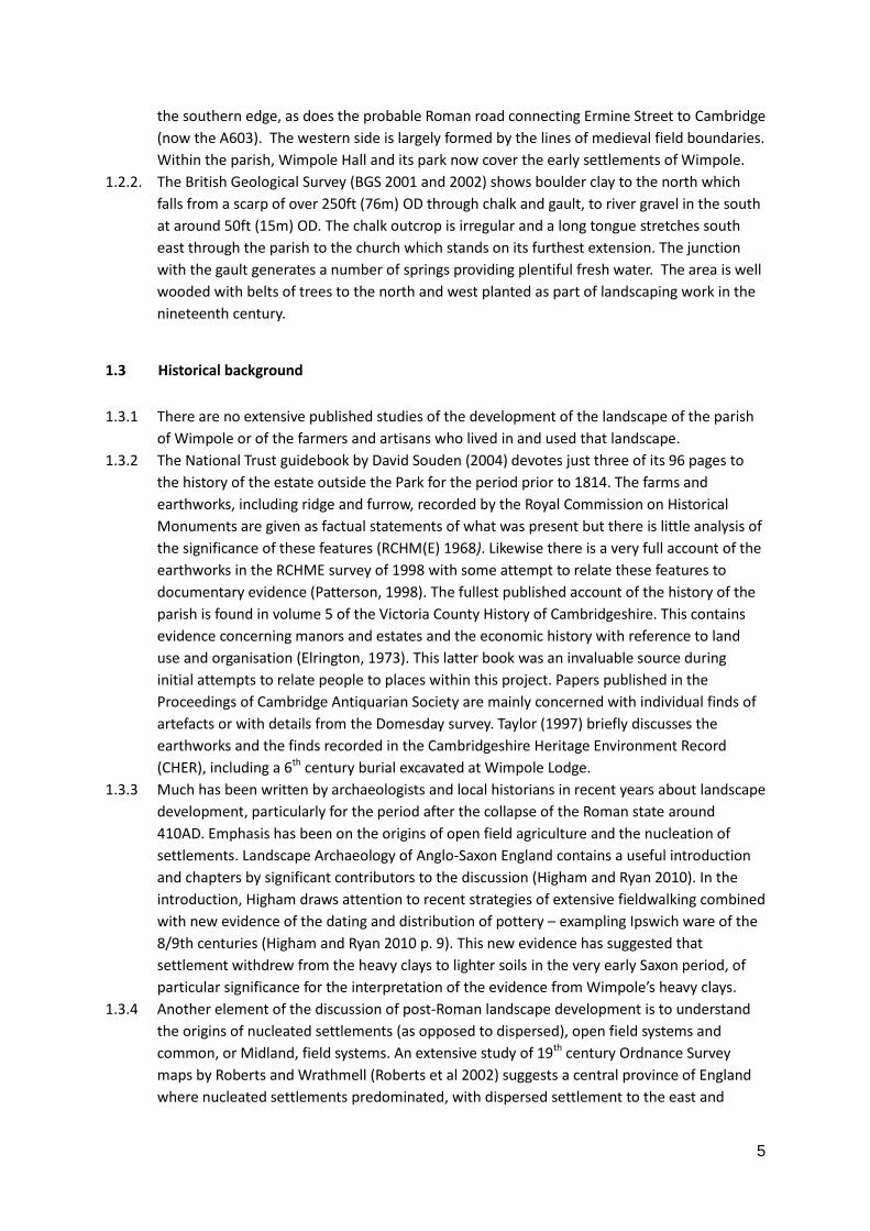
1.3.10 The Hare Map also shows a network of roadways and tracks crossing the parish (see Fig. 1).
In particular two north-south roads crossed the parish from the Mare Way to the Cambridge
Road. The eastern road has survived as the principal road through the middle of the parish,
although that on the west, Wimpole Way, was probably more important. The roads were
both crossed in the north by a road that left the Mare Way near Ross's Farm and ran in a
semi-circle to re-join the Mare Way east of the parish boundary, and in the south by a road
from Arrington. Part of the southern road has survived as a private road and public footway.
Several lesser roads linked the four already mentioned, and the remains of some have
survived as rutted hollow-ways.
7
Figure 1 Map showing roads, tracks and settlements in Wimpole parish on the Hare Map of 1638
8
1.3.11 The roads appear to be a mixture of long distance and local routes. East west long distance
routes link Arrington and Great Eversden and places further afield, while Crane’s Lane still
leads north to Kingston. Others seem typical of local medieval interweaving tracks providing
access to fields. The Hare Map shows the location of six hamlets which seem to have
developed alongside these roads, including Bennall End and Thresham End to the south of
the Wimpole Hall. Settlement in the 17th century was scattered along the roads across the
middle part of the parish and centred on the junction of Wimpole Way with the Arrington
road. The manor house, church, rectory and several other buildings lay north-west of the
cross-roads, and houses straggled west along the Arrington road.
1.3.12 Enclosure of the open fields and the creation in the 17th century of several new farms, which
generally remained eight in number, resulted in the concentration of the declining
population on the farmsteads, away from the centre of the parish. A similar process of
enclosure by Thomas Chicheley took place in Arrington to the west but Kingston (1810) ,
Eversden (1811) and Orwell (1837) were not enclosed until the 19th century by
parliamentary act (Elrington, 1973). The major expansion of the park began in 1720 and
reached its peak by 1772 with the work of Capability Brown.
1.3.13 In 1815 Robert Withers surveyed Wimpole and Arrington for the estate of the Earl of
Hardwick, this was revised and adjusted and printed in 1828 (Withers, 1828). The OS map of
1836 shows a landscape very like that of today, although New Wimpole had yet to be built.
Emparkment had removed the hamlets and much of the original network of trackways.
1.3.14 Volume 5 of the Victoria County History of Cambridgeshire contains an extensive description
of the development of the parish based on documentary research. However, little evidence is
presented identifying the people who lived and worked in Wimpole. Although the
Domesday Book of 1086 gives details of owners and occupiers of land, the documentary
sources between then and the 17th century are sparse, there being no extant manorial court
rolls. The RCHM(E) have recorded in Volume 1 West Cambridgeshire, upstanding buildings
and earthworks; the latter have been surveyed in the Park area by RCHM(E) in their detailed
report by Paul Pattison and David Garrow (Pattison, 1998).
1.3.15 There are no early eye witness accounts of the estate but the Rev. Plumptre describes his
visit in 1800 to what seems a very benign world (CAFG 2014).
1.4 Acknowledgements
1.4.1 The main sponsor of this project was the Heritage Lottery Fund ‘All our Stories’ grant
programme, grant number AS-12-02809. Our thanks go to our sponsor and the many other
organisations and individuals who have contributed over the years that CAFG members have
worked on the Wimpole estate. The National Trust, through Angus Wainwright and local
staff, has always been very supportive in providing access and facilities. We are grateful to
the staff of Oxford Archaeology East and the Jigsaw programme they run, for advice and
equipment loans; and for the advice we have had from Susan Oosthuizen and Carenza Lewis.
Finally, none of the work would have been achieved without the time and labour provided
by past and present members of CAFG.
9
Section 2
2. AIMS AND METHODS
2.1 Aims
2.1.1 The aim of the study was to trace the origin and history of the medieval settlement in the
parish of Wimpole and more generally to establish the pattern of settlement and land use
across the whole parish for all periods.
2.1.2 It was further intended to involve members of the public generally, specifically from local
parishes, in the process and outcomes of the study. Members of CAFG were encouraged to
develop skills in field studies, excavation, documentary research and report writing.
One of the aims of the project was to find documentary evidence that might put names to
the people who lived in Wimpole before the expansion of the Park in the 1640s, and to look
for any information on what happened to them and the land they used.
2.2 Methods
2.2.1 Fieldwalking
2.2.1.1 CAFG has been fieldwalking at Wimpole since 1989, and methods have changed over the
period. Initially, between 1989 and 2003, fieldwalking was recorded within 100m squares
based on OS National Grid co-ordinates. Before walking started, grid lines were laid out using
tape measures and reference to OS maps at a scale of 1:12500. Personnel, spaced 10m
apart, walked in straight lines across the square. Finds of all periods were placed in plastic
bags and the bags attached to a marker cane. The position of each cane was marked on a
plan and later converted into a grid reference. In 2003 a hand-held Global Positioning
System device (Garmin eTrex GPS) was acquired, and thereafter the grid lines were not laid
out. The spacing between walkers was, as previously, 10m, and the GPS was used to record
the position of the finds. The OS National Grid references in the GPS were downloaded into
an Excel spreadsheet and the finds identifications added.
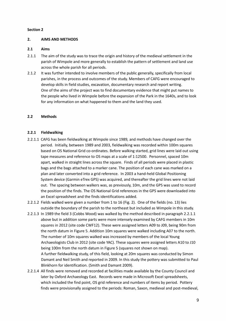
2.2.1.2 Fields walked were given a number from 1 to 16 (Fig. 2). One of the fields (no. 13) lies
outside the boundary of the parish to the northeast but included as Wimpole in this study.
2.2.1.3 In 1989 the field 3 (Cobbs Wood) was walked by the method described in paragraph 2.2.1.1
above but in addition some parts were more intensely examined by CAFG members in 10m
squares in 2012 (site code CWF12). These were assigned letters A09 to J09, being 90m from
the north datum in Figure 5. Addition 10m squares were walked including A07 to the north.
The number of 10m squares walked was increased by members of the local Young
Archaeologists Club in 2012 (site code YAC). These squares were assigned letters A10 to J10
being 100m from the north datum in Figure 5 (squares not shown on map).
A further fieldwalking study, of this field, looking at 20m squares was conducted by Simon
Damant and Neil Smith and reported in 2009. In this study the pottery was submitted to Paul
Blinkhorn for identification. (Smith and Damant 2009).
2.2.1.4 All finds were removed and recorded at facilities made available by the County Council and
later by Oxford Archaeology East. Records were made in Microsoft Excel spreadsheets,
which included the find point, OS grid reference and numbers of items by period. Pottery
finds were provisionally assigned to the periods: Roman, Saxon, medieval and post-medieval,
10
with a proportion assigned to an ‘Uncertain’ category.
2.2.1.5 Expert identification of all pottery older than post-medieval, including the ‘Uncertain’
category, was carried out by pottery specialist Paul Blinkhorn. In most cases this required
retrieval of pottery collections from storage, either from Cambridgeshire County Council or
from Oxford Archaeology East. The original records were then modified in the light of the
expert analysis. The process of comparing the two records, however, revealed a small
number of irresolvable differences between them, relating to the numbers of pieces of pot
recorded at some of the find points. As a consequence there are some minor differences
between Paul Blinkhorn’s data (Table 2 and Appendix 1) and the full list of fieldwalking
pottery artefacts available as a spreadsheet from CAFG. For the sake of consistency, the
former were used for the further analysis of pottery presented in this report.
2.2.1.6 Expert analysis of flint artefacts was carried out by Lawrence Billington (Appendix 2)
2.2.1.7 Distribution maps of pot, processed by period, were generated using QGIS.
2.2.2 Test Pit Excavation
2.2.2.1 Based on the evidence of houses on the Hare Map and the results of fieldwalking by CAFG,
1m square test pits were excavated in an attempt to recover datable finds to indicate the
period of activity.
2.2.2.2 Following excavation of the site of a house, Mr Ratford's according to the Withers map of
1815, CAFG agreed with Angus Wainwright, NT Regional Archaeologist, that test pits would
be excavated near the site of houses identified on the 1638 Hare Map.
2.2.2.3 In addition to CAFG members, approaches were made to Orwell History Group, Meldreth
History Group and to NT volunteers to seek support in the excavation of the test pits.
2.2.2.4 The excavating of the test pits was based on the method devised by Carenza Lewis at Access
Cambridge Archaeology, University of Cambridge in 0.1m layers , called ‘contexts’ in this
report, down to undisturbed natural soil. Because the soil is derived from a heavy gault clay,
it proved very difficult to use a sieve on all contexts but very careful attention was given to all
excavated material. Finds of all periods were collected by context and washed at facilities
made available by Oxford Archaeology East at Bar Hill, Cambridgeshire. Pottery was
separated to be sent for identification by Paul Blinkhorn; other finds were identified by CAFG
members with advice from OA East experts at Bar Hill.
2.2.2.5 As part of an intensive examination of field 3 (Cobbs Wood) 10 test pits were excavated in
2013 by the method described in 2.2.2.4.
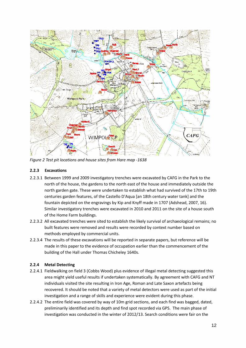
2.2.2.6 The locations of fifteen test pits excavated in 2013 are shown by the blue squares in Fig. 4,
numbers 1 to 7, 7A, 8 to 14 and at the OS grid points given in Table 1.
Figure 4 also shows the positions of houses shown on the Hare Map. These were used to
guide the position chosen for test pits in Bennall End, and Green End – the intention was to
avoid the actual house site, assuming Hare’s map has some degree of accuracy, but to be
within the possible toft.(Green End is a recently used name for the north east part of the
Park south of the lakes)
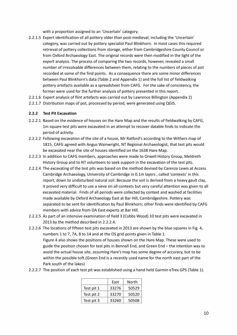
2.2.2.7 The position of each test pit was established using a hand held Garmin eTrex GPS (Table 1).
East North
Test pit 1 33276 50529
Test pit 2 33270 50520
Test pit 3 33260 50508
11
Table 1 Position of Test pits - Ordnance Survey references (all TL)
2.2.2.8 Test pits 1, 2 and 3 were positioned to straddle the earthwork platform and ditch that appear
to be Mr Neal’s house south east of Bennall End on the Hare Map.
Test pits 4, 5, 6, and 7 & 7A, were positioned to test the area now called Green End, north-
west of the hall, where the houses of Daintry, Jepson and Gryper are shown on the Hare
Map. Test pits 13 and 14 were positioned on an earthwork enclosure abutting the south side
of the stream, 13 in the apparent ditch and 14 on the central platform. There is no house
shown here by Hare on the map of 1638.
Test pits 8, 9, 10, 11 and 12 were positioned north to south on Folly Field (field 5), north of
the ornamental lakes.
2.2.2.9 An analysis of the soil types recorded for each context was plotted on one graph and the
weight of each identified pottery type per context one second graph for each test pit (see
appendix 3). In addition all other finds were recorded for each test pit (see appendix 3). The
full results of Paul Blinkhorn’s pottery identifications are presented in Appendix 4.
Test pit 4 33681 51422
Test pit 5 33662 51441
Test pit 6 33736 51481
Test pit 7 33749 51473
Test pit 7A 33745 51472
Test pit 8 33587 51851
Test pit 9 33609 51795
Test pit 10 33613 51717
Test pit 11 33613 51754
Test pit 12 33664 51883
Test pit 13 33782 51584
Test pit 14 33759 51584
12
Figure 2 Test pit locations and house sites from Hare map -1638
2.2.3 Excavations
2.2.3.1 Between 1999 and 2009 investigatory trenches were excavated by CAFG in the Park to the
north of the house, the gardens to the north east of the house and immediately outside the
north garden gate. These were undertaken to establish what had survived of the 17th to 19th
centuries garden features, of the Castello D'Aqua [an 18th century water tank] and the
fountain depicted on the engravings by Kip and Knyff made in 1707 (Adshead, 2007, 16).
Similar investigatory trenches were excavated in 2010 and 2011 on the site of a house south
of the Home Farm buildings.
2.2.3.2 All excavated trenches were sited to establish the likely survival of archaeological remains; no
built features were removed and results were recorded by context number based on
methods employed by commercial units.
2.2.3.4 The results of these excavations will be reported in separate papers, but reference will be
made in this paper to the evidence of occupation earlier than the commencement of the
building of the Hall under Thomas Chicheley 1640s.
2.2.4 Metal Detecting
2.2.4.1 Fieldwalking on field 3 (Cobbs Wood) plus evidence of illegal metal detecting suggested this
area might yield useful results if undertaken systematically. By agreement with CAFG and NT
individuals visited the site resulting in Iron Age, Roman and Late Saxon artefacts being
recovered. It should be noted that a variety of metal detectors were used as part of the initial
investigation and a range of skills and experience were evident during this phase.
2.2.4.2 The entire field was covered by way of 10m grid sections, and each find was bagged, dated,
preliminarily identified and its depth and find spot recorded via GPS. The main phase of
investigation was conducted in the winter of 2012/13. Search conditions were fair on the
13
whole, but the ground was wet and sometimes frozen. Subsequent ad hoc visits to the site,
under better conditions (dry, warm and the field rolled and planted (Spring 2014)), have
shown there still to be artefacts to be found on ground previously extensively covered.
2.2.4.3 For the purposes of this report the coin analysis has been separated from the main body of
the metal work review as these are unique items and require their own section. Following analysis of the coins the metal items were analysed by function and by period: i.e. Personal Items – Roman – Saxon – Medieval etc.
2.2.4.4 A variety of metal detectors was used across the site, in a variety of weather and soil conditions. All of these factors, plus the experience levels of the detectorists themselves, will have impacted retrieval rates. The survey was conducted in both 10m grid pattern format and free-range work. The field was successfully covered in its entirety. Detectors used included Mikelab Safari, Garrett GTAx 550 & Minelab Etrac, CScope CS2M, XP Deus & Blisstool, Garrett Ace 250, Tesoro Cortes.
2.2.4.5 All finds were recorded with an OS grid reference and most have the depth of finding recorded. Full recorded details are available in a spreadsheet created by Peter Dight with the help of fellow detectorists and held by CAFG as Excel ‘ALL_WCF12_Finds_V07c’ .
2.2.5 Documentary Research
2.2.5.1 The research was carried out by a group of CAFG members, largely but not exclusively on an
individual basis, with monthly meetings to exchange findings and review progress. A prime
source was the1638 Hare Map as this puts tenants’ names to houses and land holdings. The
Victoria County History for Cambridgeshire Vol V was also an important starting point.
2.2.5.2 Published and unpublished works were consulted and, in addition, the following repositories
were visited:
Cambridge University Library
Cambridgeshire Collection (at Cambridge Central Library)
Cambridge Records Office
Nottingham University
Cambridge University College archives (King’s, Corpus Christi)
Wimpole Hall office files
2.2.5.3 The National Archives on-line catalogue was consulted, but not pursued to original
documents. British Library manuscripts were only used where quoted by others.
2.2.5.4 Summaries were extracted from published works. A few original manuscripts have been
transcribed by members but, for the majority, only information directly relevant to the
project was extracted. The length of the project did not allow detailed study, especially of
those documents in Secretary-hand or in Latin. For this reason, where documents had
already been transcribed, the transcription was used.
2.2.5.5 The Hare Map was studied in detail and a list of land holders’ names and the locations and
sizes of their holdings were recorded, see Appendix 10. This was used as a resource for
tracing family names backwards and forwards. (A more extensive spreadsheet is available
from CAFG)
2.2.5.6 An exhaustive search was made of relevant entries in most of the repositories, but in the
Cambridgeshire Records Office a selection was made of those documents which appeared to
offer the most useful information in relation to the aims of the project. There are many
more available for research.
14
The search avoided references to the Hall and Park and its owners except as they might
reflect on the tenants. The decision was made to restrict searches to the period before
about 1840 as by that time the landscape was largely as it is now.
Section 3
3 RESULTS
3.1 Fieldwalking
3.1.1 Summary Results
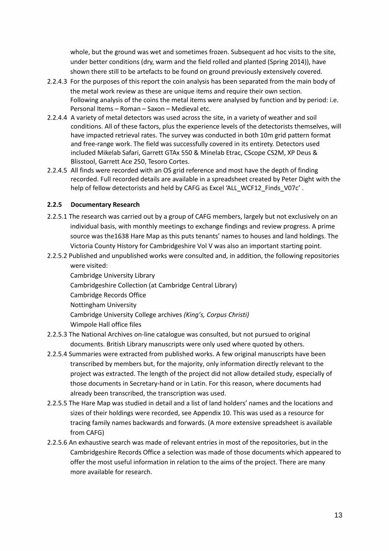
3.1.1.1 The total area covered by the fieldwalking survey (Fig. 3, excluding field 13) is approximately
300 hectares. This constitutes around 30% of the Wimpole Estate and 75% of the arable land
in the parish available for fieldwalking north of the A603. Fields walked lie in two main
regions of the Estate: on the rising ground north of the Hall - mainly north of the lakes - and
in the south of the Estate.
Figure 3 Fields walked in the survey
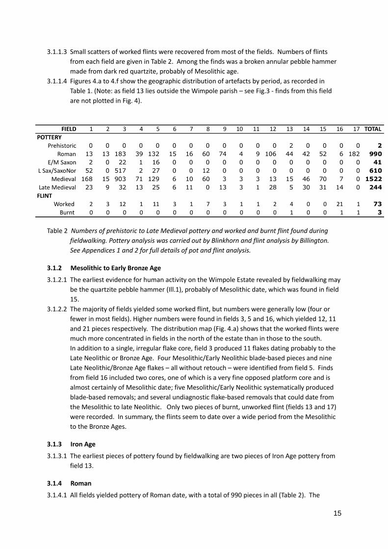
3.1.1.2 The numbers of pot sherds from each chronological period, following expert identification,
are shown in Table 2. Post-medieval and modern pottery is omitted from the table. A
detailed analysis of pottery fabrics is given in Appendix 1. As mentioned above (paragraph
2.2.3), the total numbers of sherds in Table 1 differ slightly from numbers in Appendix 1,
which records all finds from each field.
15
3.1.1.3 Small scatters of worked flints were recovered from most of the fields. Numbers of flints
from each field are given in Table 2. Among the finds was a broken annular pebble hammer
made from dark red quartzite, probably of Mesolithic age.
3.1.1.4 Figures 4.a to 4.f show the geographic distribution of artefacts by period, as recorded in
Table 1. (Note: as field 13 lies outside the Wimpole parish – see Fig.3 - finds from this field
are not plotted in Fig. 4).
Table 2 Numbers of prehistoric to Late Medieval pottery and worked and burnt flint found during
fieldwalking. Pottery analysis was carried out by Blinkhorn and flint analysis by Billington.
See Appendices 1 and 2 for full details of pot and flint analysis.
3.1.2 Mesolithic to Early Bronze Age
3.1.2.1 The earliest evidence for human activity on the Wimpole Estate revealed by fieldwalking may
be the quartzite pebble hammer (Ill.1), probably of Mesolithic date, which was found in field
15.
3.1.2.2 The majority of fields yielded some worked flint, but numbers were generally low (four or
fewer in most fields). Higher numbers were found in fields 3, 5 and 16, which yielded 12, 11
and 21 pieces respectively. The distribution map (Fig. 4.a) shows that the worked flints were
much more concentrated in fields in the north of the estate than in those to the south.
In addition to a single, irregular flake core, field 3 produced 11 flakes dating probably to the
Late Neolithic or Bronze Age. Four Mesolithic/Early Neolithic blade-based pieces and nine
Late Neolithic/Bronze Age flakes – all without retouch – were identified from field 5. Finds
from field 16 included two cores, one of which is a very fine opposed platform core and is
almost certainly of Mesolithic date; five Mesolithic/Early Neolithic systematically produced
blade-based removals; and several undiagnostic flake-based removals that could date from
the Mesolithic to late Neolithic. Only two pieces of burnt, unworked flint (fields 13 and 17)
were recorded. In summary, the flints seem to date over a wide period from the Mesolithic
to the Bronze Ages.
3.1.3 Iron Age
3.1.3.1 The earliest pieces of pottery found by fieldwalking are two pieces of Iron Age pottery from
field 13.
3.1.4 Roman
3.1.4.1 All fields yielded pottery of Roman date, with a total of 990 pieces in all (Table 2). The
16
geographic distribution, however, was not uniform (Fig. 4.b). With the exception of field 17,
significantly higher numbers of Roman pottery sherds came from the northern part of the
estate compared with the south, with the highest concentrations in fields 3, 5, and 12.
Notably field 8 also produced 26 pieces of Roman roof tile, concentrated in the north of the
field, suggesting the presence of a significant building on the site. The southern part of field
17, a triangular piece of land bounded by the A603 to the north, a Roman road to the south
and Ermine Street to the west, produced 182 pieces of Roman pottery, with a particular
concentration along the side of Ermine Street.
3.1.5 Saxon and Saxo-Norman
3.1.5.1 Pottery of Saxon age was found only in the north of the estate (Figs. 4.c and d). Early and
Middle Saxon pottery was found in small amounts in fields to the north of the lakes (Fig. 4.c).
In particular, field 5 produced two pieces of Early/Middle Saxon organic tempered ware, and
eight pieces of Ipswich Ware.
A much larger concentration of Late Saxon/Saxo-Norman sherds was found on the northern
edge of Cobbs Wood, particularly field 3, which yielded 418 and 96 sherds of St. Neots Ware
and Thetford Ware respectively. Field 5 also yielded 18 pieces of St. Neots Ware (Fig. 4.d).
3.1.6 Medieval
3.1.6.1 Table 1 shows that medieval pottery constituted the largest category of pottery found, with a
total of 1522 pieces. The distribution of medieval pottery mirrors that of the Late Saxon,
with a major concentration near Cobbs Wood and a secondary concentration about 1km to
the west on the southward facing slope just north of the stream (Fig. 4.e). The most
common fabrics among the medieval sherds were Miscellaneous Sandy Coarseware (520
pieces), Hertfordshire Grey Ware (384 pieces) and Shelly Coarseware (279 pieces). Of
particular note are 43 pieces of Ely Ware from field 8.
3.1.7 Late Medieval
3.1.7.1 All fields yielded at least one piece of late medieval pottery (Fig. 4.f). There is a significant
contrast in distribution relative to medieval and Late Saxon wares, with a much more even
distribution across the estate. The great majority of the sherds were from Late Transitional
Medieval Wares (236 out of total of 246 pieces).
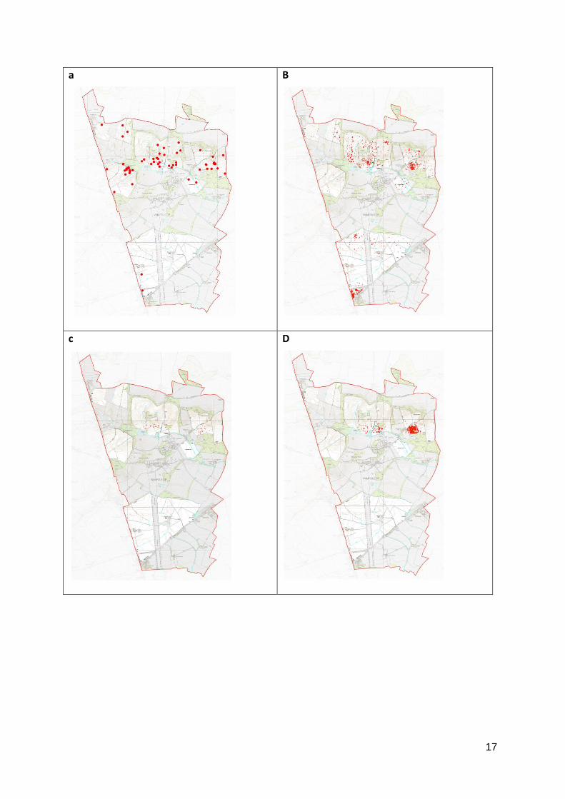
17
a B
c D
18
e F
Figure 4 Flint and pottery finds from fieldwalking at Wimpole. a. Worked and burnt flint; b. Roman
pottery; c. Early/Middle Saxon pottery; d. Late Saxon/Saxo-Norman pottery; e. Medieval
pottery; f. Late medieval pottery
3.2 Test pit excavation
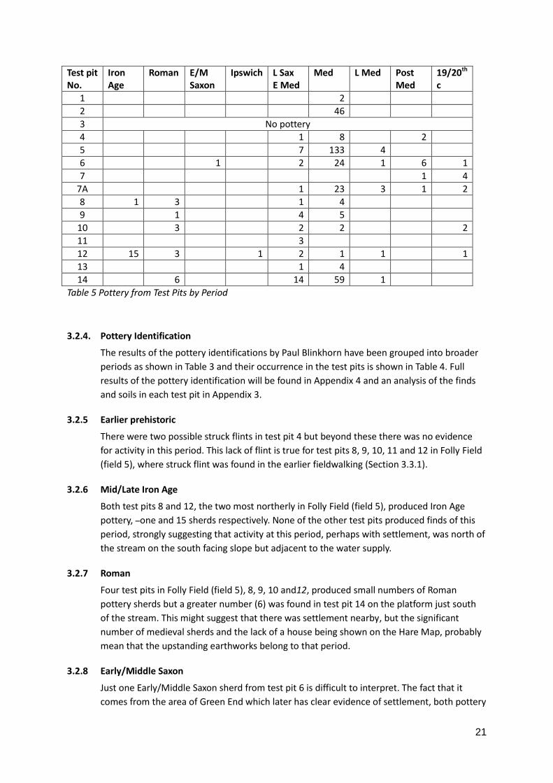
3.2.1 The results of the test pit excavations is summarised in Table 3 with more complete data in Appendix 8. Table 4 gives the pottery types identified by Paul Blinkhorn, with these divided into periods and table 5 gives the pottery finds divided by periods in each test pit.
3.2.2
Test pit no. Summary significance (see appendix 3 for more detail)
1 Four contexts excavated produced two sherds of pottery weighing 3g in context 2. These were 12th to 14th century Hertfordshire grey and Hedingham wares. Possibly indicates nearby activity of this date.
2 47 pottery sherds were excavated with a total weight of 166g (1 sherd missing in Blinkhorn analysis). Contexts 1, 2, and 3 produced pottery from 12th to 14th centuries – Hertfordshire Grey, Hedingham and Ely wares. These were associated with significant numbers of bone fragments and oyster shells. Although this is a relatively thin layer of material it suggests it is part of a midden deposit from Mr Neale’s house. The material from context 1, 2, and 3 would suggest domestic waste with a significant number of bone fragments and oyster shells. Medieval pottery was found in each context and didn’t show clear stratigraphy, this mirrors the lack of distinction between the composition of the soil in these contexts. No later wares were found, particularly from the 17th century, the date of the 1638 Hare map, where Mr Neale’s house is shown to be present.
3 The test pit had a 0.1m layer of soil and thereafter was mainly grey clay – possibly re-deposited to fill the ditch surrounding Mr Neale’s house. There was no evidence of later activity.
4 12 sherds of pottery were found weighing a total of 82g. The earliest pottery is late
Key to pottery numbers
1-2 3-4 5-10
19
Saxon Thetford Ware 10th to 12th century with 12th to 15th century Shelly Coarse ware, Hertfordshire Grey and Ely Wares. The two sherds of Glazed Red earthenware can date from the 16th century but could be intrusive in Context 4. The pottery assemblage reflects nearby activity from late Saxon to late medieval, possibly associated with Mr Daintry’s house but the lack of 16th and 17th century pottery does not reflect presence of a house shown on the Hare map.
5 Late Saxon St Neot’s and Thetford Wares suggest a start date in the 10th century with the remaining pottery suggesting activity from the 12th to the 14th century. As with the previous house site, Test pit 4, it suggests activity ceased or was greatly diminished after the 15th century, where again it is difficult to relate these findings to the evidence of the Hare map.
6 37 sherds weighing 339g were excavated. The one sherd of Early/Middle Saxon -5th to 8th centuries - pottery is a notable find from this test pit, somewhere nearby there may well have been occupation at this time. The St Neot's type ware suggests Late Saxon activity and there are wares from the 12th to the 15th centuries with one sherd of Late Medieval Oxidised ware possibly into the 16th century. The Midland Black ware and Glazed Red Earthenware may represent slight activity in the early modern period up to 1700. Perhaps here there is evidence of activity after the 15th century.
7 A total of 7 sherds weighing 61g were found. This test pit exposed a large amount of stone immediately under the turf, along with 19th century pottery. As it seemed likely that there was significant archaeology, albeit of a recent date, it was decided to move the position 3m to the west.
7A 32 sherds were found weighing 183.2g. The pottery sequence is similar to test pit 6 but without the Early/Middle Saxon, but there is slightly more activity into the 17th century suggested by the Bourne 'D' ware [15th to 17th century] and the Glazed Red earthenware. As with most of the relatively shallow test pits the stratigraphy does not seem to reflect succeeding periods of deposition – unlike test pit 5 which reached 1.1m.
8 10 sherds of pottery were recovered (only 9 appear on the Blinkhorn list missing 1 from context 6) This test pit was the furthest north of all in Folly field, well up the slope away from the lakes and thus clear of contamination from the digging of the lakes and their subsequent clearance.. The pottery sequence present here is clearly different to Test pits 1- 7A, here there is an Iron Age sherd and a significant number of Roman sherds. There is almost a complete absence of medieval pottery, what there is dates from the 10th to the 15th century, perhaps here this reflects dispersal in agricultural activity or that any settlement activity is further south down the slope.
9 10 sherds found (56g) 1RB, 3 SNW, 1 THE, 3 ELY, 2 HED. Test pits 9, 10 and 11 may all have been affected by deposition of soil removed from the lakes both in the 18th century and in the later 20th century as suggested by the number of fresh water mussel shells. It is possible that the pottery is derived from this source and therefore it is difficult to interpret the results. Like TP 8 there is a small amount of Roman pottery but here perhaps a more significant number of 10th to 15th century sherds. As elsewhere there is a notable absence of later pottery.
10 There are 3 sherds of Roman pot and 4 sherds (2 St Neots and 2 Ely) of 10th to 12 century pottery plus 2 sherds of 19th c pot. As with test pits 9 and 11 the fresh water mussel shells may just reflect the movement of soil from the digging of the lakes in the 18th century and later clearance.
11 3 sherds of medieval pottery were found. Almost devoid of pottery this test pit showed a clear differentiation at context 4, the
20
soil below may be the soil from 18th century dumping of waste from the lake.
12 15 sherds (55g) Iron Age pot were found plus 2 Roman plus 1 Ipswich ware sherd. The stratigraphic position of these sherds may well reflect ploughing but the absence of fresh water mussel shells strongly suggests this test pit was clear of the material derived from the construction of the lakes. The Iron Age, Roman, Ipswich, St Neot's and Early Medieval Sandy ware suggests that there may well be significant activity in this area in all these period. There is no suggestion of a house near this test pit site on Hare's 1638 map.
13 5 sherds only were found in this test pit. The platform with surrounding ditch evident on the ground where TP 13 and TP14 were placed does not have a house shown on the Hare map of 1638. TP13 was excavated in what appears to be a ditch surrounding the platform. Because of both time constraint and a somewhat complicated archaeology this was not excavated below context 6. The pottery suggests nearby activity from the 10th to the 15th century and as in many of the test pits no later evidence.
14 80 pottery sherds were found in this test pit. The pottery has a significant Roman content (6 sherds weighing 77g) and the remaining pottery from the 10th to the 15th century. None of the other test pits south of the lake or stream have produced Roman pottery, but the date range of the medieval pottery is similar to many other test pits and as with others no pottery later than the 15th century.
Table 3 Test pits – summary of significant finds
3.2.3
Table headers Identifications by Paul Blinkhorn
Iron Age IA: All Iron Age
Roman RB: All Romano-British
E/M Sax E/MS: Early/Middle Saxon Wares, c. AD450 – 700.
Ipswich IPS: Ipswich Ware, AD720-850.
L Sax E Med SN: St Neots-type Ware, c. AD900-1100. THT: Thetford-type Ware, 10th – 12th century.
Med SHC: Shelly Coarseware, AD1100-1400. EMW: Early Medieval Sandy Wares, 12th – 14th century. HG: Hertfordshire Grey Ware, mid 12th – 14th century. ELY: Ely Ware, mid 12th -15th century. HED: Hedingham Ware, late 12th – 14th century. BB: Brill/Boarstall Ware, c. AD1200-?1600.
L Med CSW: Cambridgeshire Sgraffito Ware, 14th – 15th century. LMT: Late Medieval Transitional Wares, c. AD1400-1550. BD: Bourne ‘D’ Ware, AD1450 – 1650. LMOx: Late Medieval Oxidized Ware, mid 15th – mid 16th century.
Post Med GRE: Glazed Red Earthenware, 16th – 19th century. MB: Midland Blackware, AD1580-1700.
19/20th c 19thC: Miscellaneous 19th and 20th century wares.
Table 4 Test Pit pottery identifications by Paul Blinkhorn grouped into periods
21
Test pit No.
Iron Age
Roman E/M Saxon
Ipswich L Sax E Med
Med L Med Post Med
19/20th c
1 2
2 46
3 No pottery
4 1 8 2
5 7 133 4
6 1 2 24 1 6 1
7 1 4
7A 1 23 3 1 2
8 1 3 1 4
9 1 4 5
10 3 2 2 2
11 3
12 15 3 1 2 1 1 1
13 1 4
14 6 14 59 1
Table 5 Pottery from Test Pits by Period
3.2.4. Pottery Identification
The results of the pottery identifications by Paul Blinkhorn have been grouped into broader
periods as shown in Table 3 and their occurrence in the test pits is shown in Table 4. Full
results of the pottery identification will be found in Appendix 4 and an analysis of the finds
and soils in each test pit in Appendix 3.
3.2.5 Earlier prehistoric
There were two possible struck flints in test pit 4 but beyond these there was no evidence
for activity in this period. This lack of flint is true for test pits 8, 9, 10, 11 and 12 in Folly Field
(field 5), where struck flint was found in the earlier fieldwalking (Section 3.3.1).
3.2.6 Mid/Late Iron Age
Both test pits 8 and 12, the two most northerly in Folly Field (field 5), produced Iron Age
pottery, one and 15 sherds respectively. None of the other test pits produced finds of this
period, strongly suggesting that activity at this period, perhaps with settlement, was north of
the stream on the south facing slope but adjacent to the water supply.
3.2.7 Roman
Four test pits in Folly Field (field 5), 8, 9, 10 and12, produced small numbers of Roman
pottery sherds but a greater number (6) was found in test pit 14 on the platform just south
of the stream. This might suggest that there was settlement nearby, but the significant
number of medieval sherds and the lack of a house being shown on the Hare Map, probably
mean that the upstanding earthworks belong to that period.
3.2.8 Early/Middle Saxon
Just one Early/Middle Saxon sherd from test pit 6 is difficult to interpret. The fact that it
comes from the area of Green End which later has clear evidence of settlement, both pottery
22
and houses on the Hare Map, might be interpreted as evidence of activity in the area in this
period.
3.2.9 Late Saxon-Early Medieval
The one sherd of Ipswich ware from test pit 12 is, like the Early/Middle Saxon sherd, difficult
to interpret.
Although the number of Late Saxon-early medieval sherds from each test pit are small, there
seems to be activity at Green End and Folly Field, no evidence of that period was found in
the three test pits at Bennall End.
3.2.10 Medieval
All test pits, except 3, 7 (19/20th centuries only) and 11, produced pottery assigned to the
medieval period. Of the test pits producing the greatest quantity of medieval pottery, test pit
5, which was excavated to below 1.0m, appeared to be sited in an area used as a midden
adjacent to what is shown on the later Hare Map as Widow Jepson’s house. Likewise, test pit
2 was near the site of Mr Neal’s house, but test pit 14 was on the earthwork feature south of
the stream at Green end.
3.2.11 Late Medieval
With only five test pits having pottery for this period and then in very small numbers, there is
a clear reduction in activity. This is very surprising as those at Bennall End and Green End
were placed near to the site of houses shown on the Hare Map where there are identifiable
people who appear in the documentary sources.
3.2.12 Post-Medieval to Modern
The very limited amount of 19/20th century pottery suggests that the sites of the test pits
had been grassed over and used as pasture as they are now.
Fresh water mussels were found in some of these test pits, probably as a result of periods of
clearance of the ornamental lakes to the south. They were found only in context 2 in test pit
8; but in test pit 9 in contexts 1, 2, 3, 4 and 6; test pit 10 in context 4 and test pit 11 in
contexts 1, 2, 3, 4 and 5. None was found in test pit 12.
3.3 Cobbs Wood - Field 3
The field to the north of the moated site in the wood known as Cobbs Wood has been
extensively studied as part of this project at Wimpole. This field is referred to as field 3 in the
fieldwalking results in paragraph 2.2.1.2 above. In view of the quantity of finds, the results
are reported in this separate section.
3.3.1 Topography and background
The field slopes up from the south west, 40m OD at the edge of the wood, to a high point in
the north east at 65m OD, with a relatively level area at the lower part and then rising more
rapidly.
The track passing Cobbs Wood Farm rising north east over the ridge to Great Eversden is
shown on the Hare Map somewhat to the north of its current route immediately east of
Cobbs Wood farm. Three houses are shown in this area, the homes of Mr. North, Mr Malden
23
and Mr Holder but these are near to the current farm not in the field reported here.
Geophysical surveys have been undertaken by Rheesearch and these, along with fieldwalking
of 20m squares by Simon Damant and Neil Smith, are presented in the report by Neil Smith
(Smith 2012). The pottery produced in this later fieldwalking was submitted to Paul
Blinkhorn by CAFG in 2015. The results of Test pits excavated by CAFG and metal detecting, in
part organised for CAFG by Peter Dight but extended by Dominic Shelley, are also presented
in this section.
3.3.2 Results
3.3.2.1 Fieldwalking
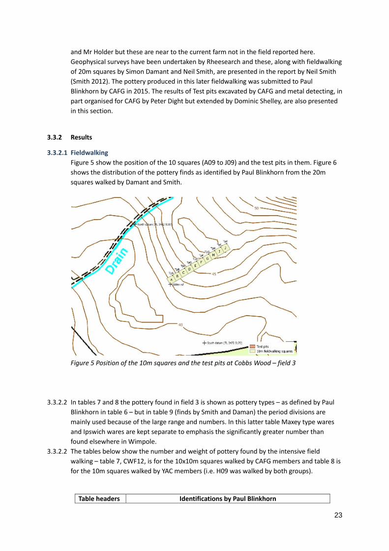
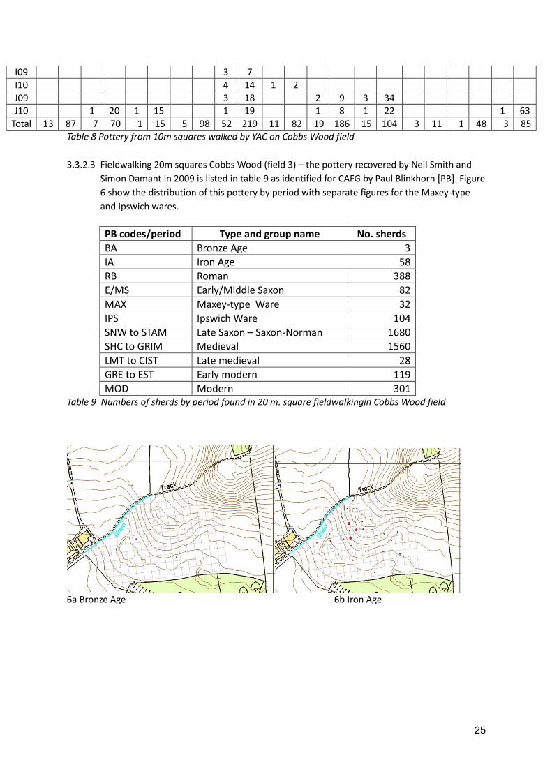
Figure 5 show the position of the 10 squares (A09 to J09) and the test pits in them. Figure 6
shows the distribution of the pottery finds as identified by Paul Blinkhorn from the 20m
squares walked by Damant and Smith.
Figure 5 Position of the 10m squares and the test pits at Cobbs Wood – field 3
3.3.2.2 In tables 7 and 8 the pottery found in field 3 is shown as pottery types – as defined by Paul
Blinkhorn in table 6 – but in table 9 (finds by Smith and Daman) the period divisions are
mainly used because of the large range and numbers. In this latter table Maxey type wares
and Ipswich wares are kept separate to emphasis the significantly greater number than
found elsewhere in Wimpole.
3.3.2.2 The tables below show the number and weight of pottery found by the intensive field
walking – table 7, CWF12, is for the 10x10m squares walked by CAFG members and table 8 is
for the 10m squares walked by YAC members (i.e. H09 was walked by both groups).
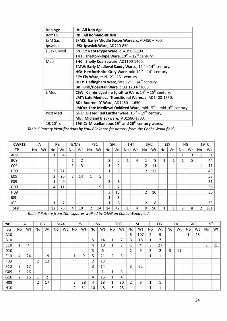
Table headers Identifications by Paul Blinkhorn
24
Iron Age IA: All Iron Age
Roman RB: All Romano-British
E/M Sax E/MS: Early/Middle Saxon Wares, c. AD450 – 700.
Ipswich IPS: Ipswich Ware, AD720-850.
L Sax E Med SN: St Neots-type Ware, c. AD900-1100. THT: Thetford-type Ware, 10th – 12th century.
Med SHC: Shelly Coarseware, AD1100-1400. EMW: Early Medieval Sandy Wares, 12th – 14th century. HG: Hertfordshire Grey Ware, mid 12th – 14th century. ELY: Ely Ware, mid 12th -15th century. HED: Hedingham Ware, late 12th – 14th century. BB: Brill/Boarstall Ware, c. AD1200-?1600.
L Med CSW: Cambridgeshire Sgraffito Ware, 14th – 15th century. LMT: Late Medieval Transitional Wares, c. AD1400-1550. BD: Bourne ‘D’ Ware, AD1450 – 1650. LMOx: Late Medieval Oxidized Ware, mid 15th – mid 16th century.
Post Med GRE: Glazed Red Earthenware, 16th – 19th century. MB: Midland Blackware, AD1580-1700.
19/20th c 19thC: Miscellaneous 19th and 20th century wares.
Table 6 Pottery identifications by Paul Blinkhorn for pottery from the Cobbs Wood field
CWF12 IA RB E/MS IPS1 SN THT SHC ELY HG 19thC
TP No Wt No Wt No Wt No Wt No Wt No Wt No Wt No Wt No Wt No Wt
A09 1 4 1 3 1 1
B09 1 2 2 5 1 4 1 9 1 1 1 5 44
C09 1 3 1 2 2 11 1 11
D09 3 21 1 3 2 12 49
E09 2 26 2 14 1 5 58
F09 1 9 3 6 31
G09 4 11 1 9 2 2 38
H09 3 15 2 10 36
I09 1 3
J09 1 7 1 6 2 8 33
Total 12 78 4 19 2 14 14 42 1 4 9 50 1 1 2 8 2 301
Table 7 Pottery from 10m squares walked by CAFG on Cobbs Wood field
YAC IA RB MAX IPS SN THT SHC ELY HG GRE 19thC
Sq No Wt No Wt No Wt No Wt No Wt No Wt No Wt No Wt No Wt No Wt No Wt
A10 5 107 2 9 1 48
B10 5 14 1 7 3 18 1 7 1 1
C10 1 4 4 10 1 3 1 4 3 27 1 21
D10 3 6 2 9 2 2 3 11
E10 4 24 1 19 1 9 5 21 2 5 1 1
F09 2 12 2 13
F10 3 17 3 14 3 22
G09 3 26 1 1 1 3
G10 2 16 1 2 4 16 1 4
H09 2 17 2 38 4 18 1 30 2 9 1 1
H10 2 51 10 48 3 28 1 1
25
I09 3 7
I10 4 14 1 2
J09 3 18 2 9 3 34
J10 1 20 1 15 1 19 1 8 1 22 1 63
Total 13 87 7 70 1 15 5 98 52 219 11 82 19 186 15 104 3 11 1 48 3 85
Table 8 Pottery from 10m squares walked by YAC on Cobbs Wood field
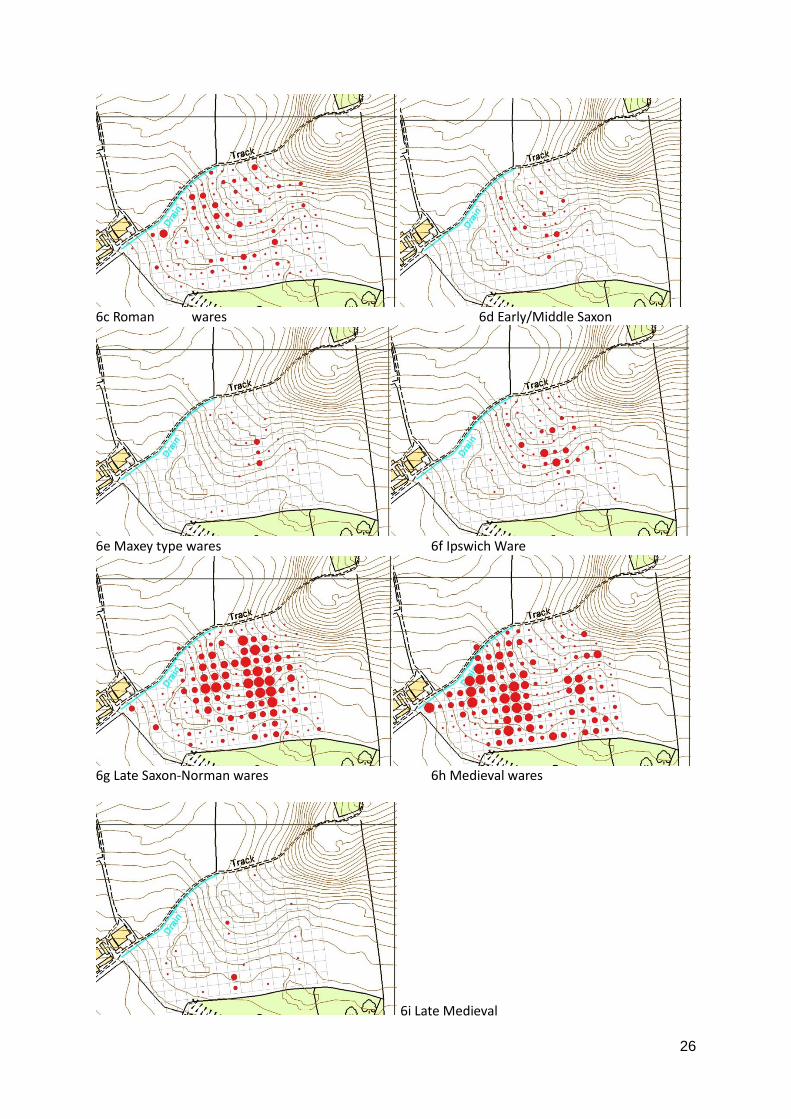
3.3.2.3 Fieldwalking 20m squares Cobbs Wood (field 3) – the pottery recovered by Neil Smith and
Simon Damant in 2009 is listed in table 9 as identified for CAFG by Paul Blinkhorn [PB]. Figure
6 show the distribution of this pottery by period with separate figures for the Maxey-type
and Ipswich wares.
PB codes/period Type and group name No. sherds
BA Bronze Age 3
IA Iron Age 58
RB Roman 388
E/MS Early/Middle Saxon 82
MAX Maxey-type Ware 32
IPS Ipswich Ware 104
SNW to STAM Late Saxon – Saxon-Norman 1680
SHC to GRIM Medieval 1560
LMT to CIST Late medieval 28
GRE to EST Early modern 119
MOD Modern 301 Table 9 Numbers of sherds by period found in 20 m. square fieldwalkingin Cobbs Wood field
6a Bronze Age 6b Iron Age
26
6c Roman wares 6d Early/Middle Saxon
6e Maxey type wares 6f Ipswich Ware
6g Late Saxon-Norman wares 6h Medieval wares
6i Late Medieval
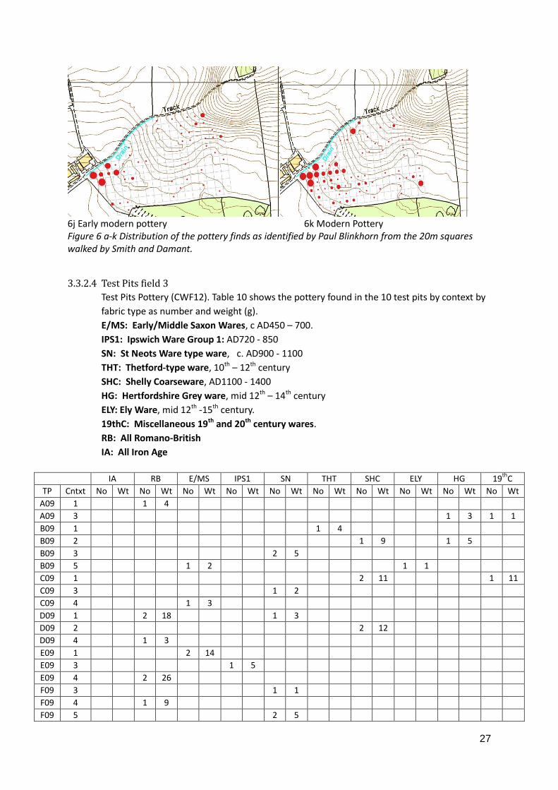
27
6j Early modern pottery 6k Modern Pottery Figure 6 a-k Distribution of the pottery finds as identified by Paul Blinkhorn from the 20m squares walked by Smith and Damant.
3.3.2.4 Test Pits field 3
Test Pits Pottery (CWF12). Table 10 shows the pottery found in the 10 test pits by context by
fabric type as number and weight (g).
E/MS: Early/Middle Saxon Wares, c AD450 – 700.
IPS1: Ipswich Ware Group 1: AD720 - 850
SN: St Neots Ware type ware, c. AD900 - 1100
THT: Thetford-type ware, 10th – 12th century
SHC: Shelly Coarseware, AD1100 - 1400
HG: Hertfordshire Grey ware, mid 12th – 14th century
ELY: Ely Ware, mid 12th -15th century.
19thC: Miscellaneous 19th and 20th century wares.
RB: All Romano-British
IA: All Iron Age
IA RB E/MS IPS1 SN THT SHC ELY HG 19
thC
TP Cntxt No Wt No Wt No Wt No Wt No Wt No Wt No Wt No Wt No Wt No Wt
A09 1 1 4
A09 3 1 3 1 1
B09 1 1 4
B09 2 1 9 1 5
B09 3 2 5
B09 5 1 2 1 1
C09 1 2 11 1 11
C09 3 1 2
C09 4 1 3
D09 1 2 18 1 3
D09 2 2 12
D09 4 1 3
E09 1 2 14
E09 3 1 5
E09 4 2 26
F09 3 1 1
F09 4 1 9
F09 5 2 5
28
G09 2 4 11
G09 3 1 9
G09 4 2 2
H09 2 1 1
H09 4 2 14 2 10
I09 5 1 3
J09 1 1 7 1 2
J09 3 1 6
J09 4 1 6
Table 10 Pottery Occurrence in Cobbs Wood Test Pits
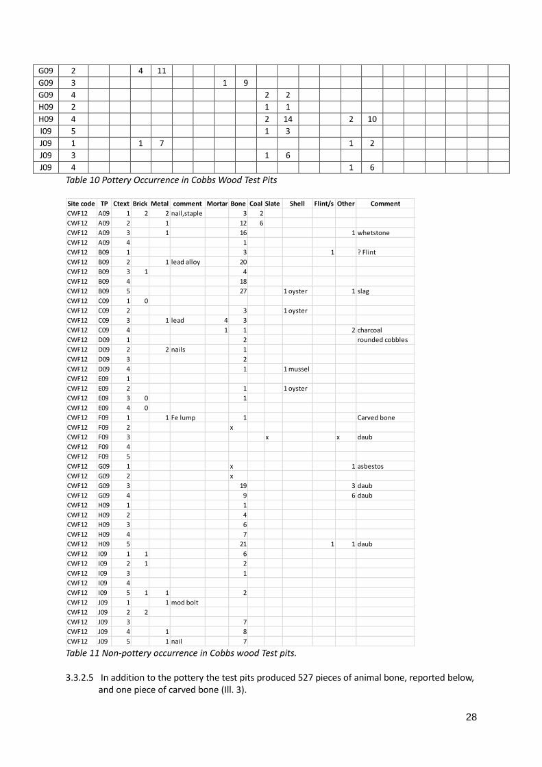
Table 11 Non-pottery occurrence in Cobbs wood Test pits. 3.3.2.5 In addition to the pottery the test pits produced 527 pieces of animal bone, reported below,
and one piece of carved bone (Ill. 3).
Site code TP Ctext Brick Metal comment Mortar Bone Coal Slate Shell Flint/s Other Comment
CWF12 A09 1 2 2 nail,staple 3 2
CWF12 A09 2 1 12 6
CWF12 A09 3 1 16 1 whetstone
CWF12 A09 4 1
CWF12 B09 1 3 1 ? Flint
CWF12 B09 2 1 lead alloy 20
CWF12 B09 3 1 4
CWF12 B09 4 18
CWF12 B09 5 27 1 oyster 1 slag
CWF12 C09 1 0
CWF12 C09 2 3 1 oyster
CWF12 C09 3 1 lead 4 3
CWF12 C09 4 1 1 2 charcoal
CWF12 D09 1 2 rounded cobbles
CWF12 D09 2 2 nails 1
CWF12 D09 3 2
CWF12 D09 4 1 1 mussel
CWF12 E09 1
CWF12 E09 2 1 1 oyster
CWF12 E09 3 0 1
CWF12 E09 4 0
CWF12 F09 1 1 Fe lump 1 Carved bone
CWF12 F09 2 x
CWF12 F09 3 x x daub
CWF12 F09 4
CWF12 F09 5
CWF12 G09 1 x 1 asbestos
CWF12 G09 2 x
CWF12 G09 3 19 3 daub
CWF12 G09 4 9 6 daub
CWF12 H09 1 1
CWF12 H09 2 4
CWF12 H09 3 6
CWF12 H09 4 7
CWF12 H09 5 21 1 1 daub
CWF12 I09 1 1 6
CWF12 I09 2 1 2
CWF12 I09 3 1
CWF12 I09 4
CWF12 I09 5 1 1 2
CWF12 J09 1 1 mod bolt
CWF12 J09 2 2
CWF12 J09 3 7
CWF12 J09 4 1 8
CWF12 J09 5 1 nail 7
29
3.3.2.5 Bone By Neil Smith
CWF12
Bone from the test pits (CWF12) has been examined by Neil Smith, who reports that the total number of species present is five: cattle, chicken, horse, pig and sheep; plus oyster shell. This is the usual range of domesticated species. Five bones have evidence of butchery, mostly concentrated in test pits B and F, but there is no obvious pattern. The details are: Test Pit B4 cattle scapula B5 sheep metatarsal F2 sheep radius F4 medium-sized (? sheep) rib H5 cattle pelvis
3.3.3 Metal detecting
This section has yet to be completed. Appendix 6 contains a table of metal finds recovered
in the 2013 study which have been given a date or date range. Further finds are yet to be
added.
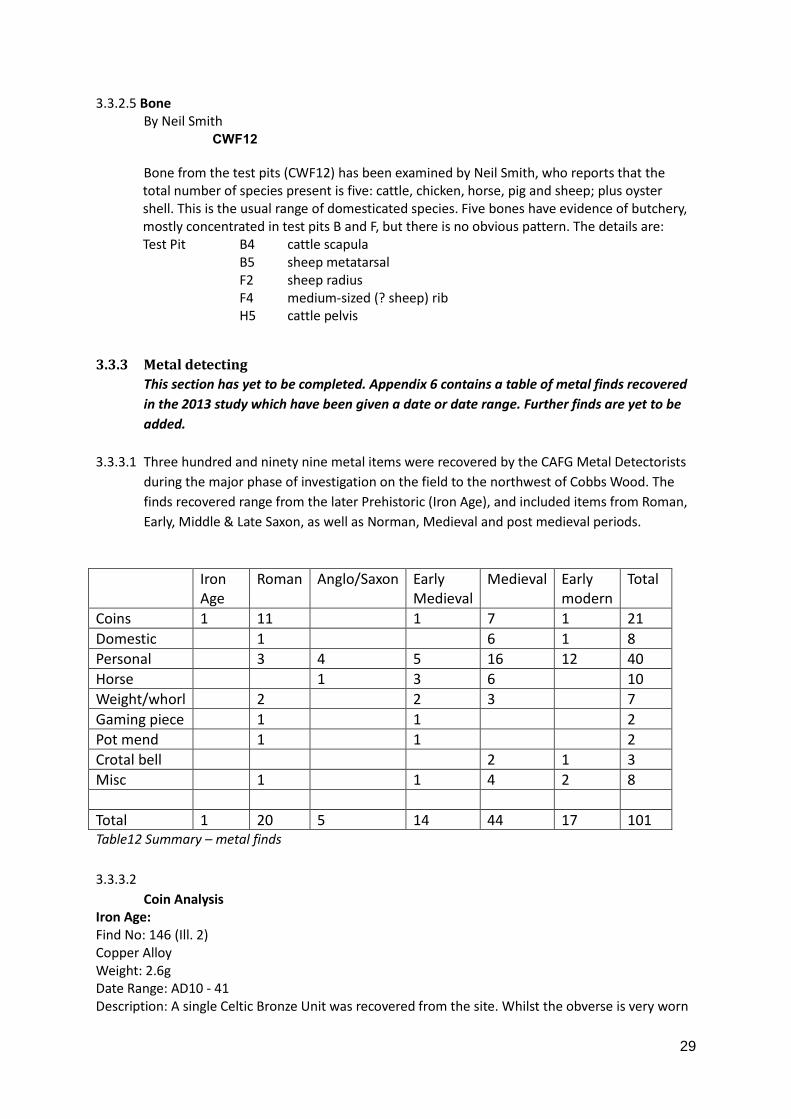
3.3.3.1 Three hundred and ninety nine metal items were recovered by the CAFG Metal Detectorists
during the major phase of investigation on the field to the northwest of Cobbs Wood. The
finds recovered range from the later Prehistoric (Iron Age), and included items from Roman,
Early, Middle & Late Saxon, as well as Norman, Medieval and post medieval periods.
Iron Age
Roman Anglo/Saxon Early Medieval
Medieval Early modern
Total
Coins 1 11 1 7 1 21
Domestic 1 6 1 8
Personal 3 4 5 16 12 40
Horse 1 3 6 10
Weight/whorl 2 2 3 7
Gaming piece 1 1 2
Pot mend 1 1 2
Crotal bell 2 1 3
Misc 1 1 4 2 8
Total 1 20 5 14 44 17 101 Table12 Summary – metal finds
3.3.3.2
Coin Analysis Iron Age: Find No: 146 (Ill. 2) Copper Alloy Weight: 2.6g Date Range: AD10 - 41 Description: A single Celtic Bronze Unit was recovered from the site. Whilst the obverse is very worn
30
it is possible to determine the legend: “CVNOB ELINI” in two panels. The reverse shows Victory seated. The coin is similar to those recorded by Spink (S324) and the Ancient British Coin designation ABC2918. Roman: 12 Roman coins were found during the initial metal detecting survey. Subsequent follow up visits to the site have recovered a further three coins. The earliest of the coins is a Sestersius of Antoninus Pius (AD138 - 161), the latest being from the House of Theodosius (AD383 - 395/401). As table 10 below indicates the condition of the coins is poor with all coins being described as worn or very worn. The ground conditions have, however, been favourable to the coins with good patination on all examples. This is an assemblage typical of the local area. Similar sites in neighbouring parishes display the same broad spectrum of dates. Sporadic finds of first and second century coinage are then largely overtaken by the more ubiquitous late third and fourth century denominations . From the main Survey Winter 2012/13
Find No
Weight (g)
Condition Description Reference
49 14.55g Worn Sestertius of Antoninus Pius (AD138 - 161), Rome mint
Spink496
371 17.53 Worn Sestertius of Lucilla, wife of Lucius Verus (AD161 - 169), Rome mint
Spink507A
88 8g Worn As of Crispina, wife of Commodus (AD177 -192), Rome mint
329 1.46 Worn Radiate of Gallienus (AD266 - 268)
123 1.57 Very Worn
AE3: House of Constantine (AD319 - 321)
149 1.3 Worn AE3; GLORIA EXERCITVS two soldiers standing either side of standard, Constantine II (AD335 - 341)
S608A
190 1.82 Very Worn
Gloria Romanorvm, House of Valentinian (AD364 - 378)
230 1.7 Worn AE3: Gloria Romanorvm, Valens (364-378)
287 2.42 Very Worn
AE3; Secvritas Reipvblicae, House of Valentinian (AD364 - 378)
S620A
150 1 Very Worn
Victory advancing, House of Theodosius (AD383 - 395/401)
158 1.07 Very Worn
AE4: Fourth Century. Indeterminate Emperor.
Ad Hoc Finds Spring 2014:
Find No
Weight Condition Description Reference
DS1 1.8g Very Worn
Probable contemporary copy of copper alloy nummus of the House of Constantine – GLORIA EXERCITVS, two soldiers and two standards type struck c. AD330-40 or later.
31
DS2 1.6g Worn Copper alloy nummus of Valentinian 1 (AD 364-7) Unknown Mint.
DS3 1.9g Heavily corroded and worn
Indeterminate Emperor. Fourth Century likely.
Table 13 Roman Coin Finds This section will contain a description of the ‘significant’ items meaning those which are unique, unusual, datable and contribute to understanding the status and date range of activity. 3.3.4 Comment on Cobbs Wood – Field 3 3.3.4.1 The field next to Cobbs Wood (field 3) has yielded evidence of activity (section 3.3.2) from
the Bronze Age to the Modern period. The combined use of extensive and intensive fieldwalking along with limited excavation with test pits and with the use of metal detection has provided evidence in quantities not seen elsewhere in the parish.
3.3.4.2 The longevity of activity on this site indicated by the finds, with the added quality of some of the late Saxon and Medieval metal, finds suggest this was a place of importance until the 15th century. The lack of late Medieval and Early Modern finds reflects similar results elsewhere in the study area. This along with the lack of houses on the Hare map suggests the site was abandoned in the 15th century.
32
Section 4
4. DOCUMENTS
Result Summary
The earliest documentary references found were of 1066, in the Domesday Book. The vill
was divided between two landowners, with no sokemen unlike neighbouring vills, and there
were still two manors in 1086. The population at this time is estimated at around 70. The
separate vills of Wratworth and Whitwell recorded in 1086 had disappeared by 1279,
Wratworth apparently divided between the parishes of Wimpole and Orwell. The population
increase was such that the Hundred Rolls of 1279 record 108 tenants, although how many
lived in the parish is not clear. The Lay Subsidy Rolls of 1327 list 66 taxpayers, a considerable
decrease. Of those listed, 38 bore the same surname as tenants in 1279, and a few names
persisted until at least the late 16th century.
There were 36 families in 1563, a further decrease from the 173 adults recorded in the 1377
Poll Tax Roll, and this number remained stable until after 1638, as the Hare Map of that date
shows 35 houses besides the manor house and the rectory. The map shows the extent of
enclosure at that time, which had gone sufficiently far for Sir Thomas Chicheley, in the early
17th century, to give £20 annually as compensation for the loss of cottagers’ common rights.
His son hastened the process and by 1654 some holdings were described as farms. The
Hearth Tax returns recorded 28 houses in 1662, falling to 20 in 1674. The sale of the estate in
1686 listed 22 tenants.
Some of the family names appearing in the early parish registers of the 1560s are referred to
in 1638, but of the 26 family names recorded in 1638, only two survived into the 18th
century. Figures and names taken together suggest a relatively stable population from the
mid-16th century to the mid-17th century but which then declined at a rapid rate, with few
incomers staying long. It has not, unfortunately, been possible to determine with any
certainty where displaced tenants moved. It may be simply that houses were not re-let once
they were empty.
Most of the farms were established in the late 17th and 18th centuries, from architectural
assessments and records showing eight properties described as farms as far back as 1684
and again in 1828. The farms shown in 1828 are all still identifiable in the present day, albeit
with some name changes.
By 1830 the landscape was effectively as it is today other than at New Wimpole.
4.1 Introduction
4.1.1 The results of this study of documentary sources are presented under the main themes of
population, people and landscape. In trying to satisfy the aims set out, activities concerned
with Wimpole Hall itself are not covered.
33
4.1.2 References to information in the Victoria County History for Cambridgeshire have been
included in this report where they are relevant to the themes covered but not otherwise.
4.1.3 In the references to the Domesday Book entries, VCH V (p. 263) suggests that a vill of
Whitwell existed in what is now the south west corner of Wimpole parish. By 1279 (Rot.
Hund.ii, 566-7), the only Whitwell formed part of Barton (and later Coton, where a Whitwell
Farm exists). A study of names suggests that the manor holder might have taken the name
to a new location, but no further research has been undertaken on this matter (see
Appendix 9). The separate vill of Wratworth had apparently been absorbed into the present
parishes of Wimpole and Orwell by 1279 (Rot. Hund.ii, 566-7), and Appendix 8 discusses the
most likely locations of the manors involved. (References found to the land held by religious
houses have not been further examined and would need separate study).
4.1.4 A prime source is the 1638 Hare Map (CRO R77/1) as this puts tenants’ names to houses and
land holdings. A list of land holders’ names and the locations and sizes of their holdings was
produced as the original schedule is no longer extant (see Appendix 10). This source was
used as a base for tracing family names backwards and forwards.
4.1.5 Appendix 7.1 gives greater detail of what has been found relating to personal names and
land use and Appendices 7 to 27 contain notes made of evidence collected. In this section,
specific subjects have been summarised to emphasise the connections between the
documentary sources and the archaeology findings.
4.1.6 An incomplete manuscript in Latin at King’s College, Cambridge (WIM/1), believed to date to
the 1370s, has very kindly been translated by Bill Franklin. It is not proposed to publish the
translation with this report but to treat it separately. However, information gleaned from
the document (‘the King’s document’) has been included here.
4.2 Early Beginnings: Wimpole in the Saxo-Norman period (1066 to 1086)
4.2.1 The only source available for this period is the Domesday survey of 1086 in its two applicable
versions, the Domesday Book and the Inquisitio Comitatus Cantabrigiensis. Prior to 1066
there were two estates totalling 4 hides, one held by Eddeva the Fair (who owned land all
over the country) and the other by Earl Gyrth. By 1086, the estate of Eddeva was in the
hands of Count Alan of Brittany and that of Earl Gyrth was with Eudo the steward, from
whom Humphrey de Anneville held it. Werateworde or Wratworth, on the other hand, had
been held by 12 sokemen in 1066, and in 1086 was divided into five manors; and Whitwell
had been held by 15 sokemen and was in four manors in 1086. Orwell appears to have been
held by 12 sokemen and the Church of Chatteris, and was in seven manors in 1086.
4.2.2 Notably no sokemen (free men – probably peasant farmers) were recorded in Wimpole in
1066, unlike in the whole of the rest of the Wetherley Hundred, and in particular the
parishes of the Bourn valley over the hill to the north where there were more than
elsewhere in Cambridgeshire. Could this indicate an origin in some way different from the
surrounding villages?
However, the population mix of villeins (3), bordars (1), cottars (6) and serfs (3) in 1086 looks
similar to the rest of the Hundred. Wratworth had 3 villeins, 17 bordars, 10 cottars and 2
serfs; Whitwell 1 villein, 1 bordar and 9 cottars; and Orwell 2 villeins, 14 bordars and 4
cottars.
4.2.3 The total number of ploughlands for Wimpole is recorded as five, a relative measure of the
amount of arable land, plus meadow for 11/2 ploughs. Also recorded are 200 sheep, implying
grazing on the waste and stubbles, six pigs – usually a reflection of the amount of woodland,
34
not much in this parish, along with two horses and four asses on Humphrey’s land. The one
bordar held 15 acres of land. Wratworth had arable for 51/2 ploughs and meadow for 4 ½;
Whitwell arable for 5 ploughs and meadow for 3; and Orwell arable for 5 ploughs and
meadow/pasture for 3. All were assessed in Domesday at 4 hides.
4.3 Population
4.3.1 Domesday Book states that in 1086 there were 10 tenants between the two manors (3
villeins, 1 bordar and 6 cottars) and 3 slaves/serfs. If the serfs had families and the normal
multiple of 4.5 or 5 is used, then the population would have been around 70. However if
those recorded in Wratworth and Whitwell are added, there may have been a total
population of about 285 (Taylor, 1997, 122).
4.3.2 Wratworth, which had had 30 tenants and two slaves/serfs in 1086, was divided between
Wimpole and Orwell by 1279 (VCH V, 268; Rot. Hund, ii, 566-7). The earliest Cambridgeshire
Subsidy Roll was taken in about 1250, when Wimpole was assessed at £4 5s 0d. No mention
was made of Wratworth, which may be relevant (EA Notes, 1895-6, 267). It is not possible to
tell how many people were assimilated into each parish, but an early medieval settlement
around what is now Cobbs Wood Farm, and thought to have been in Wratworth, eventually
became Little End in Wimpole, so it is likely that there was a significant addition to the
population. Whitwell had 11 people enumerated in 1086 so, if it still existed, this would have
added to the population. In the Hundred Rolls of 1279 (Rot. Hund. ii, 566-7), 131 holdings
were recorded in Wimpole. However, assuming that no two people had the same fore and
surname, there were 40 free tenants, 28 villeins, 21 cottagers and 20 tenants whose status
was not specified (a potential population of about 480 on a 4.5 multiplier). Only one tenant
is recorded as being of Arrington; but it is possible that others may have lived outside the
parish. Details appear as a spreadsheet at Appendix 10.
4.3.3 By 1327, in the Lay Subsidy Rolls (a tax based on one twentieth of the value of moveable
goods), there were 66 taxpayers in Wimpole (White, 35/6). Not all of these would have lived
in the parish but, taking into account those not taxable, the potential population can be
estimated at around 300. If estimates are correct, this would indicate that the population
dropped dramatically in the early 14th century. The total of the tax payable for Wimpole was
£5.1s.8d (by calculation of the individual amounts rather than the figure stated by White).
Orwell with Malton was assessed at £5.16s.61/2d, from 56 taxpayers.
4.3.4 In the Lay Subsidy of 1334 (one fifteenth of the value of moveable goods in rural areas),
Wimpole was assessed at £7.5.0. In the same subsidy, Orwell with Malton was assessed at
£9.6s.0d (Glasscock, 1975, 26). The poll tax roll of 1377 has no list of names, but records an
adult population (all, male and female, of 14 and over) of 173, paying a total of £2.17s.8d.
Orwell has 203 adults, paying £3.17s.8d (East Anglian NS xii, 258; Palmer, 1912; VCH 1973,
264). Taylor (1997, 122) gives an estimated total population of 225, indicating a potential
further decline in population. The King’s document, although incomplete, appears to show
that in the 1370s the main manor holders had taken over many of the individual holdings of
50 years previously. Only eight of the family names in the 1327 Lay Subsidy Roll have been
positively identified in this document as still holding land.
4.3.5 The Bishop’s return of 1563 showed 36 families living in Wimpole (VCH V, 264, fn 24),
potentially a population of 184 (Taylor, 1997, 122), and considerably lower than in 1377.
Calculations indicate that the population rose by 63 in the first ten years of the parish
registers, from 1560.
35
4.3.6 The Hare Map of 1638 shows 35 tenanted houses besides the manor house and rectory
(Appendix 10). Allowing five people per household, this gives a population of around 175,
little different from 70 years previously.
4.3.7 However, the Hearth Tax returns of 1662 and 1664 record 28 dwellings including the Hall,
potentially a population of 116. (Taylor, 1997, 122), and by 1674 the number of dwellings
had reduced to 20.
4.3.8 By 1686 there were 22 tenants (BM Add Ch44832 in Aldred) and 19 in 1711 (Nottm U:
P1/C1/1/2) and 1715 (CRO: R52/12/42/1).
4.3.9 A rental of 1790 lists 17 tenants plus the Overseers of the Poor (CRO: R52/12/4/5), with four
charitable donations being made from the estate to individuals in 1788-89 (CRO:
R52/12/4/14).
4.3.10 The 1801 census recorded 56 families, with a total of 202 people, (VCH, 264, fn 25) or 324
people in 47 houses (Lysons, 1808, 23, said to be from the same census) so the population
was slowly increasing. So much so, that the 1831 census gives a population of 583 (VCH V,
264, fn 25). The 1841 census, however, records 88 households, and a population of 402; and
that of 1851, a population of 452.
4.3.11 From the evidence available, the population of Wimpole, after a surge probably in the 13th
century, declined in the early part of the 14th century and again in the 15th/16th centuries.
From the middle of the 16th century the population remained fairly stable for 100 years,
declined in the later 17th century, then increased again at the end of the 18th century.
4.4 Personal Names
4.4.1 This section attempts to draw out some of the more significant findings from the research on
the names of people who lived in Wimpole. The detailed results of the research can be
found at Appendix 7.1.
4.4.2 Documents reveal that some early family names were long-lasting:
Avenel 1243 to 1387 (as holders of a manor) (VCH, V, 267) Also appear to be at least partly
resident
Calvus (Caufe) 1176 (Farrer 1920, 251) to 1327 (Lay Subsidy) (holder of Whitwell manor in
1086)
Bassingbourn 1194 manor holders until the manor was sold before 1375 (VCH, 265, fn 37)
Banks (de Bancis) 1086 (ICC (VCH I, 419)) to c.1302-1316 (VCH V, 267)
Francis 1166 (the Red book, 332) to 1327 (Lay Subsidy) and 1370s (King’s document). Appear
to be resident
Tichemers 1279 (Hundred Rolls) to early 17th century (Titchman as landholder) (CRO:
R52/12/9/2; R52/12/42/1)
Brocke (Broke) 1279 (Hundred Rolls) to 1632 (parish registers)
Payn 1279 (Hundred Rolls) to 1566 (parish registers)
Kynge 1279 (Hundred Rolls) to 1591 (parish registers)
De Wratteworth 1260 (as jurymen - Palmer, 1912, 22) to 1370s (King’s document)
4.4.3 The Hundred Rolls recorded 109 tenants, representing 77 family names, of which 26 appear
in Wimpole in the 1327 Lay Subsidy. A spreadsheet of the tenants’ names, holdings and rent
is at Appendix 13. The Lay Subsidy Rolls of 1327 name 66 taxpayers (White, 35/6), of whom
38 have family names appearing in 1279. The names of taxpayers, as listed by Palmer, are
included at Appendix 14 and a comparison of names in 1279 and 1327 is in Appendices 29
and 30. Several of the family names appearing in 1279, but not in 1327 in Wimpole, can be
36
seen in Orwell in the Lay Subsidy –Springold, Jope, Bacoun, ad Fonte, Molend and le Taylour.
Some names are found in both parishes. This could be an instructive line of research, but
beyond the scope of this project.
4.4.4 The King’s document, dated to the mid-1370s to judge by names of the manor holders, is a
list of land and landholders showing current and previous landholders. Names continuing
from 1327 include Avenel, Badecok, Borel, Coulyns, Payn, atte Welle and Laurence de
Wrattworth. Laurence de Wrattworth seems to be the only person to retain the same
holdings; others have been passed to family members. Three names which appear in 1279
but not in 1327, reappear in this document: Kynge, Silveyn and Gocelyne.
4.4.5 The next apparently complete list of tenants of Wimpole is the Hare Map of 1638, which
contains the names of the tenants of land, not all of whom lived in the parish. Where they
did, the houses are indicated. Allowing for alterations in spelling, eight of the 26 families in
35 houses had certainly been in the parish since at least the 1560s when the parish registers
began: Griper (from 1506 when William Grype died, leaving a will), Hubbard, Jepson, Seamer
(Seymour, Semat), Stokes, Pratt (from 1554 in Gryper wills), Maldin (from 1542 will) and
Moore. The Godfreys first appear in the parish registers in 1576 and the Slinnets were
recorded in 1615 (CUL: EDR H1/6 WIMPOLE). The Finches, despite being the second largest
land holders in 1638, appear in the parish registers only between 1632 and 1646. The full
details of the tenants and their holdings are in Appendix 10.
4.4.6 Later documents, together with parish registers, indicate how long families remained in the
village. Of 13 tenants specified in a mortgage taken out by Thomas Chicheley in 1654 (CRO:
R52/12/38/9), five had arrived in the parish since 1638. The full list appears at Appendix 18.
This is the first reference found to “farms” other than a lease to George Holder in 1604 (BM
Add Ms 36234 in VCH notes). Of these 12 tenants, only three appeared in the 1674 Hearth
Tax returns (Aldred, 1996): George Holder, Robert Hemings and Richard Weyman, of whom
only the Holder name appeared in 1638. The tenants in the 1654 mortgage were not, of
course, the only tenants on the estate: six family names appeared in 1638 but not then until
the Hearth Tax returns (Evans and Rose, 2000, 318/9). Three families had held houses in
1638 and three land only.
4.4.7 In rentals of 1684 (CUL : MS Doc 1526) and 1686 (BM Add Ch44832 in Aldred), when the
estate was sold to Sir John Cutler, the only family names still surviving from 1638 are Adams
(possibly not a direct descendant as there is no record of the name in the parish registers
between 1609 and 1679), Ball/Bell, Godfrey, Hubbard (none of whom appeared in the
Hearth Tax returns) and Stokes. From the 1654 mortgage there is also Hayward. By the time
of rentals in 1711 (Nottm U: P1C1/1/2), 1715 and 1716 (the latter two contained in a
mortgage, CRO: R52/12/42/1) of the 19 tenants, the only earlier family names still appearing
are Adams and Hubbard/Hubert. The Austin, Henley/Handley, Haggar and Johnson names
first appeared in the Hearth Tax returns; the rest were new. The rentals appear at
Appendices J and K.
4.4.8 Looking at the surnames that appear on the Hare Map and taking the records above
together with the parish registers and Ely Consistory Court (will probate) registers, of the 26
family names in 1638, only two survive into the 18th century: Stokes to 1703 and
Hubbard/Hubbert to 1716. Other names occurring before the 17th century include:
Seamer/ Semat/Semar from 1470 to 1644
Maldin from 1494 to 1643
Godfrey from 1576 to 1686 (with one parish register entry in 1725)
37
Holder from 1594 to 1674
Chapman from 1562 to 1671
The remainder are not recorded after 1665. Of the 12 who appear first in the 17th century,
only Baron appears later than 1664, to 1691. A table of the known survival of family names
can be found at Appendix 22.
4.4.9 By 1790, 17 tenants plus the Overseers of the Poor were paying rent (CRO: R52/12/4/5).
None of the tenants’ names survive from 1715, but William Radford leased land by 1727 (….)
and William Sampson was still a tenant, as was widow Kefford. They were both referred to in
a letter of 1747 (BM Mss…; transcript in “Please My Lord”). The rental appears at Appendix
23. Only eight tenants had sufficient land to appear in the land tax assessment of 1810 (CRO:
294/O132), only one of whom, Joseph Pateman, appeared as a tenant in 1790. The family
continued in the village until at least 1851. The Tithe Commutation Agreement of 1837 was
eventually signed by the Tithe Commissioners for England in 1851. The Arber, Titchmarsh,
Elliston and Webb family names continue from 1810 - 20, joined by Meyers, Giffen and
Mortlock from the 1830s. The schedule of land holders appears at Appendix 27. Bird Porter,
who was included in the land tax assessment of 1810, appears on the 1851 census, 70 years
of age.
4.4.10 A few families were long-term residents of Wimpole, but it is noticeable that most of the
names appearing in 1638 vanished during the latter half of the 17th century, to be replaced
in part by short-term tenants.
4.5 Land Use
This section attempts to pick up traces of changes in land use revealed in documents and
also notes the continuation of certain field and road names. Further details are contained in
Appendix 2.
4.5.1 In 1086, the majority of the land of the vill was farmed for the benefit of the lord of the
manor. Overall, there was arable land for five ploughs and meadow for one and a half
ploughs, with 200 sheep. Woodland for fences may have been little more than hedgerows. It
is not possible to tell whether the tenants lived in close proximity. Count Alan had two
villeins, one border (with 15 acres), six cottars and two slaves; whereas Humphrey’s estate
was worked by one villein and one serf.
4.5.2 There was sufficient woodland in the 12th century to require a forester (Farrer, 1920, 251),
and there are other references to woodland between the late 12th century (the Red book of
the Exchequer, 332), (VCH V, 266) and 1279 (Rot. Hund, ii, 566-7). Aldred refers to the open
fields called North and South in the 13th century (citing BM Add MS 36234 f.3; also VCH V,
268). Otherwise there is little information until the Hundred Rolls of 1279.
4.5.3 The amounts of land held by tenants in 1279 (Rot. Hund. ii 566-7) are shown in Appendix 13.
Assuming there was not more than one tenant with the same fore and surname, 108 tenants
held land and/or a dwelling. There were 40 free tenants with a total of 50 holdings (including
2 held in villenage) and also members of the manor-holding Avenel, Bassingbourn and
Francis families; 28 villeins; 21 cotterelli (cottagers); and 20 whose status is not specified.
The holdings varied in size, except that the villeins each held 10 acres or a multiple (six held
20 acres and one 40 acres). Only 44 dwellings and five crofts are recorded, so some tenants
may have held land only and lived elsewhere, but others must have occupied dwellings
under a form of tenure not of relevance to the inquiry. VCH V, 268, comments on the
holdings.
38
4.5.4 The total payable from Wimpole in the 1327 Lay Subsidy Rolls was £5.4s.1d. (calculation
from figures in White, 35/6). The wealthiest of the 66 taxpayers were Dna Agnet Auenel,
owing 12s. 2d., and Margaret de Bassingburn owing 10s. The full list appears at Appendix 14.
In the Lay Subsidy of 1334, Wimpole was assessed at £7.5s.0d. (Glasscock, 1975, 26). The
poll tax roll of 1377 has no list of names, but records an adult population of 173, paying a
total of £2.17s.8d. (East Anglian NS xii, 258; VCH 1973, 264; Palmer 1912, 113). This suggests
a dramatic drop in value. Orwell was recorded with 203 adults, paying £3.17s.8d. (Palmer
1912, 113).
4.5.5 Land names appearing in the mid-14th century are Sumerleswe, Wynepolmore, Wenepolfel,
le Mor and Syreslond (Cartulary, ed Underwood, 2008). The King’s document, apparently of
the 1370s, appears to list land by field and deserves further study as it describes the location
of many holdings. John Suyliton (Swillington in VCH V, 265, from a different source) had
taken over the Bassingbourn manor but also many of the individual holdings, as had John
Avenel, holder of a manor, including a number of crofts. At one point the North Field (Camp
Boriali) is described as in Sireslond. Aldred records a North Field in 1518 (citing BM Add MS
36234 f.14).
4.5.6 There are only a few documents which give any clue as to who holds land before the early
17th century, when land transactions involving the Chicheleys (now the major manor
holders) begin to become available and appear to indicate a consolidation of their direct
holdings. In 1607, for example, jointure lands were surrendered to Sir Thomas Chicheley
(CRO: R52/12/42/1; R52/12/14/1). Also about this time, although a precise date is not
known, Sir Thomas gave an annual rent charge of £20 as compensation for the loss of
cottagers’ common rights through enclosure (CRO: P179/25/1; P179/1/2; C/32/9 [Report of
Charity Commissioners]). This suggests enclosure had already progressed a considerable
way.
4.5.7 In 1614 and 1615 there were a number of land transactions between Sir Thomas Chicheley
and John Wingfield the Elder and the Younger, the non-resident holders of Claydons manor.
These involved 520 acres of land, some in the High Field and some in the Low Field, and the
manor of Claydons alias Wimpole. The land was finally conveyed to Thomas Chicheley in
1651(CRO: R52/12/42/1; R52/12/8/2; R52/12/11/7-17; R52/12/14/2).
4.5.8 The Hare Map was drawn for the lord of the manor, Thomas Chicheley, two years after
Thomas turned 21 and before he started to build the present Hall in about 1640. The map
shows the old manor house with its moat and small adjacent park (a park was recorded in
1302, Muniments EPNS,82) It also shows the already enclosed fields near the manor house
(mostly held by Daniel Finch) and around what is potentially the site of the Wratworth
settlement (the larger part being wood held by the lord). There were six small hamlets and
open fields farmed in strips by most of the tenants in the rest of the parish. There were open
fields across the north of the parish and a large area south of the manor house. The
separate areas in the north are identified by double letters, those in the south by single
letters, which suggests that they were treated as two entities at that time. A number of
pockets in these fields appear to be farmed by one individual, presumably an accumulation
of strips. About one quarter of the estate was already enclosed. This is the first opportunity
to see not only where houses were at that time, but also who the tenants were, as individual
land holdings are named. There were 35 tenanted houses, the tenanted part of the estate
amounting to 1,652 acres. At this point, the areas surrounding and apparently belonging
directly to the manor house amounted to some 55 acres.
39
4.5.9 On the Hare Map there are land names, some of which recall earlier ownership: Avenells
Peice, Bushie Avenells, Great Avenells, Baunes, Cobbes, Kings Greene (Close and Pightle),
Lamphill, Maldins, Moores Close, Ratford and Walters. The Avenells names occur north of
the hall and Moores Closes to the south, probably equating to the High Field and Low Field
mentioned in 1614/15. However open field names are not given on the Hare Map and it is
not clear how they were organised. Some of these names and some others were still in use
in the 19th century Tithe Map (see paragraph 4.5.20 below). There are also road names,
some of which were in use in the 14th century, such as Wynpolweye, Russlebrookweye,
Aruyngstrate, Quendene, Stapilddeweye and Grendich (King’s document).
4.5.10 In 1648 Thomas Chicheley began to lease the Orwell manor from the City of London (CUL:
Doc 1458) and exchanged a number of parcels of land in the common fields in Orwell for
their equivalent in Wimpole. These exchanges were mostly with people who lived in Orwell
and seem to be part of a drive to consolidate his Wimpole estate to the parish boundary.
These parcels of land, varying in size, totalled about 27 acres (CRO: L17/1-13) and appear to
fall within the Wimpole parish boundary but outside the manor estate. Also in 1648, Thomas
Barron of Wimpole, a blacksmith, exchanged with Chicheley an acre of customary land held
of the manor of Orwell and his right of common to graze cattle in the town fields of
Wimpole, in return for a pightle and close of pasture south of his house (CRO: R52/12/37/1).
Again in 1648, Robert Finch, son of Daniel, who had been the biggest landholder after the
Chicheleys, was a maltster in Royston and sold property in Wimpole to Thomas Chicheley for
£440 (CRO: R52/12/9/2; R52/12/42/1), although it was leased back to him for a peppercorn
rent.
4.5.11 Thomas Chicheley took out his first mortgage in 1654 on part of the estate (CRO:
R52/12/38/9). This refers to properties as farms for the first time, and offers evidence of
ever-expanding enclosure. A lease to George Holder of the farm “where he dwells” in 1604
(BM Add Ms 36234 in VCH notes) included his homestall and some closes, but he also held
land in the open fields. Of the 13 holdings mortgaged, five properties are described as farms,
the largest landholding being 500 acres arable and 100 acres pasture and the smallest 2
acres meadow or pasture. Two other farmers held arable land, 120 acres each; all other land
mortgaged was meadow or pasture. The full list appears at Appendix 16. Rentals of 1684
(CUL Ms Doc 1526) and 1686 (BM Add Ch 44832, Aldred transcription) show one farm as still
considerably larger than the others, with a rent of £133 a year, with seven other properties
referred to as farms, the next highest rental being £110. Nineteen tenants paid rent, the
lowest being 6s. 8d.; no rent was paid by four tenants. The full list of tenants and their rent
appears in Appendix 18. By this time the Park, stocked with deer, contained about 210 acres.
About 100 acres was in hand, mostly sown with sainfoin.
4.5.12 Observations on tenancies, with the rent payable, the property rented, and the condition of
houses and outbuildings, carried out in May 1710 while Lord Radnor was still the estate
owner (NottmU: Portland P1 E3/1/1/4) indicate that formal leases first began in the early
years of the 18th century. Details are shown in Appendix 19.1. Further rentals in 1711
(NttmU: P1C1/1/2) and 1715 (CRO: R52/12/42/1) again show 19 tenants paying rent, with
one tenant paying twice the rent of anyone else. The tenants and their annual rent in the
two years are shown in Appendices 19.3 and 20.
4.5.13 The number of houses declined over the 17th century, see paragraphs 4.3.6 & 7 above.
RCHM(E) (West Cambridgeshire, 1968,211-2) has dated five existing buildings to the 17th or
early 18th centuries.
40
4.5.14 By 1790, 17 tenants plus the Overseers of the Poor were paying rent. Eleven of the tenants
paid between £47.10s and £70 in rent per half year. The remaining six, plus the Overseers of
the Poor, paid between 5 shillings and £2, suggesting that these rents were for the
remaining houses and cottages on the estate (CRO: R52/12/4/5). The rental appears at
Appendix 23. According to a survey of agriculture in the county in the early 1790s, there
were 36 houses, including the Hall, with 47 families. The farms were in general small and
there were roughly equal amounts of pasture and plough, the whole parish being enclosed.
Husbandry consisted of two crops and a fallow year. The soil was in general very wet, but in
the winters of 1792 and 93, 5,600 poles of hollow ditching and 440 poles of open ditches
were executed. The park comprised about 400 acres (Vancouver, C, 1794).
4.5.15 A map of the park, pleasure-grounds and Home Farm of 1800 (CUL: MS Plans 609) shows
houses north and south of and opposite Home Farm as still standing, and the Brick End
houses as built, together with a building north of the stream and east of the lakes. The Rev.
James Plumptre recorded a view of Wimpole in December 1800 (Ousby, 1992, 191-200), in
which he reported on visiting gardens at the new-built cottages in the Avenue leading to
Cambridge. There were about six gardens together, of about 16 poles each, surrounded by a
strong fence and separated by young quick hedges.
4.5.16 Although 56 families in 47 houses were counted in the 1801 census (Lysons, 1808) only 8
tenants, plus Lord Hardwicke, had sufficient land to appear in the land tax assessment of
1810, and the number of tenants of substantial farms seems to remain at eight to 1840. See
appendices 25 and 26.
4.5.17 In Robert Withers’ surveys of 1815 (National Trust: WIM/D/560), reviewed 1828 (CCC: COL
C43.C32.3), Pateman’s Farm was what is now Cobb’s Wood Farm. The cottages opposite
Home Farm are still shown in these surveys. In 1828, eight farms are shown: Home Farm,
Eight Elms Farm, Thornberry Hill Farm and Coomb Grove Farm are all in their present
positions; Wimpole Hole Farm became Valley Farm; Porter’s Farm became River Cam Farm;
Arber’s Farm became Hoback Farm; and Titchmarsh’s Farm became Cambridge Road Farm.
By this time there were a few houses south of the Cambridge Road near Arrington Bridge,
just one north of the Cambridge Road and two or three others scattered around the parish.
Field names and occupiers on the Wither’s map will be found in Appendix 28.
4.5.18 Abstracts of Bills and Expenditure 1791-1826 (notes at Wimpole Hall, originals in the
Hertfordshire Record Office) indicate that new roads were laid out between 1820 and 1826,
plus park plantations and inclosures. A guide of 1820 also comments that : “inclosures have
been considerably extended, and many more acres of land brought into cultivation”
(Deighton & Sons, 1820, 117-9).
4.5.19 The latest document recorded for the project was the 1837 tithe commutation agreement
list, finalised in 1851. By this time, the Park comprised about 206 acres out of a total of 2406
titheable land, divided amongst 12 tenants, the lord of the manor and glebe land. Seven of
the tenants had a homestead or cottage. The schedule appears at Appendix 27.
4.5.20 A number of the field/holding names on the Tithe Map persist from the 1638 Hare Map:
Butter Mead, Cobbs, Kings Green, Lamp Hill, Maldins (as Maldwins), Mill Field, New Field,
Peacock Tail, Well Mead, Walters as Waters, and Wood Furlong. Cobb’s and Lamp Hill are
still found today.
4.5.21 By 1837 the landscape was effectively as it is today, other than the houses built at New
Wimpole from the 1840s; and the number of farms appears to have remained the same
since the mid-17th century.
41
Section 5
5 DISCUSSION
5.1 Background
5.1.1 The lack of published studies about the development of the landscape of the parish of
Wimpole or of the farmers and artisans who lived in and used that landscape encouraged an
attempt in this study to assemble all the evidence that could be found, both fieldwork and
documentary. It is hoped that a contribution has been made to a fuller understanding of this
history and will encourage further work to relate Wimpole to the surrounding region.
5.1.2 In the historical background section of this paper a summary is given of the questions posed
by archaeologists and historians concerning landscape and settlement. The nature of Roman
and earlier settlement is evident in the south west Cambridgeshire landscapes – dispersed or
nucleated (Taylor 2007). Significant attention has been applied to the development of open-
field agriculture and the nature of settlement in the post Roman period (Oosthuizen 2006).
The migration of people into and out of parishes, and the nature of their land holdings in the
17th and 18th centuries is also a subject which has been extensively studied. In this section
an attempt has been made to interpret some of the evidence presented in the sections
above but clearly many other aspects could be studied.
5.2 Commentary
5.2.1 Pre-history to Roman up to 5th century AD
In his book on the archaeology of Cambridgeshire Cyril Fox makes very little reference to the
parish of Wimpole. Furthermore there is very little analysis of landscape development that
relates evidence from the surrounding area to the parish of Wimpole.
5.2.1.1 Reports to the CHER list a few sites where flint work has been found, and recent work by
CAFG has located a small number of additional sites. The analysis of the 91 struck flints from
this project suggests that activity took place throughout the Mesolithic, Neolithic and Early
Bronze Age on the slopes north of the river in fields 3 and 5, and in field 16 overlooking the
river valley from higher ground. One significant find is the pebble hammer from field 15; this
seems to have been made from a pebble of reddish-brown quartzite which can be found
scattered in the area – perhaps this one broke in manufacture. The evidence does at least
demonstrate that this valley cut into the chalk ridge through the boulder clays was visited in
the Mesolithic and Neolithic periods.
5.2.1.2 Three sherds of Bronze Age pottery found after heavy ploughing at Cobbs Wood (field 3) in
2009 are a rare find and their recovery suggests there was settlement here in this period.
5.2.1.3 The Iron Age pottery finds suggest that there was activity at Cobbs Wood (field 3) and Folly
Field (field 5) but interpretation is difficult without excavation. The settlement site south of
the A603 road (CHER CB14686) found when a gas pipe line was put across the parish shows
that settlement was also present on the flatter lands in the south.
5.2.1.4 The evidence for widespread Roman settlement is much more convincing (Figure 4b). The
excavation of a suggested mansio where Ermine Street meets the Roman road to Cambridge
(CHER 03334/5) demonstrates significant activity in that area; fieldwalking results in field 17
42
is part of this settlement. Five additional possible rural farm settlement sites, identified by
concentrations of roman pottery, (fields 3, 5/9, 8, 12, 13) suggest that there were smaller
and larger farmsteads dispersed widely across the landscape. It may be assumed that they
had arable and pasture fields associated with them. These results, of low status dispersed
settlements, are similar to those found in the Bourn Valley to the north (unpublished
fieldwalking by CAFG) and along the line of the A428 (Albion Archaeology 2008). There must
be the possibility that a large villa site exists in areas not available for this study. The test pits
excavated by CAFG in the grassed areas of the Park south of the lakes recovered only 6
sherds of Roman pottery, in test pit 14 (platform just south of the stream). Oxford
Archaeology East in excavating 504 planting holes for trees in the Park found just 4 sherds of
Roman pottery in 3 test pits in the Bennall End area. Excavations by CAFG, between 1999 and
2009, looking for garden features north of the present house, produced 85 sherds of Roman
pottery, all in derived contexts.
5.2.2 Early Medieval to the Norman Conquest - 5th to 11th centuries.
5.2.2.1 Much recent work on landscape development has been directed towards increasing the
understanding of the origins of common fields and nucleated settlements. In her study of the
origins of the form and management of early medieval fields, Oosthuizen (2013) makes a
strong case for the survival of British populations through the Roman centuries. She suggests
that, if this is correct, their ‘inherited cultural perspectives and attitudes’ will have influenced
post-Roman Anglo-Saxon society. She claims that continuities in the form and management
of arable and pasture can be seen from prehistoric periods through to the charters and
records of the Norman period. In contrast to this view Williamson (2013) makes a strong case
for the influence of environmental factors in determining the site of Early Saxon settlement
and the location of their fields.
5.2.2.2 The results of excavation of test pits to study currently occupied rural settlements (CORS) by
Carenza Lewis (2010) and her team have been interpreted as showing that the siting of CORS
is not related to Early/Middle Saxon settlements. Fifteen out of 18 of the settlements
reported by Lewis showed pottery evidence of Saxon date – that is from 5th to the 11th
centuries (87/420 test pits: 21%). Four of these had Early and Middle Saxon pottery (two of
which had no Late Saxon pot) and 13 had Late Saxon pot. Roman pottery seems to be more
often associated with the Early/Middle Saxon pottery but the numbers are quite small.
Wright (2015) questions the definitions of CORS used by Lewis and suggests that the random
sampling strategy used means that many test pits are located outside “ ‘historic’, village
centres, such as recently developed suburban areas”. He goes on to point out that in
Cottenham, Cambridgeshire, test pits produced no Middle Saxon pottery whereas extensive
excavations by CAU (Mortimer, 2000) produced evidence of Early and Middle Saxon
occupation (Wright, 2015, p.12).
Of the test pits excavated at Wimpole in 2013, only 27% had Roman pottery and only one of
these had Middle Saxon Ipswich Ware while one other test pit, without Roman pottery, had
one sherd of Early/Middle Saxon. However 67% of test pits, including those with Roman
pottery, had Late Saxon/early medieval pottery. Only one (No. 14) of the test pits (4, 5, 6, 7,
7A, 13 and14) in the area of the Park, here called Green End, contained Roman sherds. One
(No. 6) had one sherd of Early/Middle Saxon ware. If this is seen as an Early/Middle Saxon
settlement then it would represent a site having less than 2 sherds of Roman pottery. This
43
lack of pottery contrasts with the results from Cobbs Wood field (field 3) where pottery of all
periods occurs suggesting the stronger possibility of continuity from Roman to Early Saxon
periods at that site.
5.2.2.3 In his study of Open Fields in Northamptonshire, David Hall (2014) found that 22% of his sites
with Early/Middle Saxon pottery lie on Roman settlements. Most of these sites were on light
soils – avoiding the heavy clays. As nearly all of the soils in Wimpole derive from heavy clays
these are difficult to avoid but it might be significant that, based on the areas studied, the
earlier sites are north of the stream on the south facing slope.
5.2.2.4 In their study of twelve parishes in Whittlewood Forest, Jones and Page (2006) identify three
models of village development which have been postulated recently by historians and
archaeologists. The first model, based largely on fieldwalking in Northamptonshire (Brown
and Foard, 1998), suggests that dispersed Early/Middle Saxon sites were abandoned in the
9th century in favour of nucleated settlements. With the demise of these dispersed
settlements the land was available to be laid out in long furlongs, thus leading to open field
systems. A second model (Lewis et al., 1997) sees a more protracted development of villages
from the mid-9th to the mid-13th century. Increasing population and therefore demand for
food along with an increasingly complex division of land forced communities to come
together to re-organise into nucleated villages with open fields. The third model (Williamson,
2003) emphasises the influence of agricultural needs and environmental factors as the
driving forces for nucleation of settlements and development of open fields in the middle
Saxon period.
5.2.2.5 The evidence from fieldwalking and test pits at Wimpole is difficult to fit into these models.
No nucleated settlement developed. Sites with Early/Middle Saxon pottery continued to
have pottery evidence until at least the 14th century but it is possible that settlement was
deliberately positioned on the south facing slopes in the north of the parish. None of the
sites of test pits are CORS and thus it may be that test pits are not appropriate as a way of
studying this landscape.
5.2.2.6 Continuity of settlement from Roman to Early Saxon is always difficult to prove but the
recovery of 112 sherds of Early/Middle Saxon pottery in field 3 and 16 sherds in field 5
suggests that there was activity in both periods in the proximity of these fields.
5.2.2.7 On field 3 the combined results of fieldwalking by the standard CAFG procedure, intensive
fieldwalking of 10m and 20m squares, test pit excavation and metal detection have shown
that there is evidence of activity, if not settlement, probably from the Bronze Age. It is
difficult to interpret the amount and nature of the Bronze Age and Iron Age activity without
excavation but the Roman pottery is in a quantity sufficient, by comparison with other sites
at Wimpole, to suggest that there was a significant settlement here. The lack of ceramic
building material suggests that there was no large villa complex but, perhaps, a farm centre.
Of much greater significance is the presence of relatively large numbers of Early/Middle
Saxon pottery sherds. These along with the part of a ceramic loom weight from 10m square
A07 (Ill 5), suggests occupation at this site, perhaps with continuity from the Roman period.
The pottery and particularly the metal finds suggest that throughout the medieval period
this was a high status site which went into decline in the late medieval period and had been
abandoned by the 16th century.
In the early modern and modern periods the activity had moved to the western end of the
field, an area shown on the 1st Edition OS map as having cottages.
5.2.2.8 Evidence for Later Anglo-Saxon activity is much more widespread – fields 1, 3, 4 and 5 and

44
Test pits 4 to 14 have pottery dating from the 10th and 11th centuries. Of particular interest
is likely eastward trading connections demonstrated by Ipswich Ware which is not found
much further west into Bedfordshire. In addition Maxey ware is being obtained from the
west.
5.2.2.9 Documentary research for this period is limited to the evidence from Domesday, from which
it is clear that Wimpole, Wratworth and Whitwell were separate vils each of similar size. The
lack of sokemen in Wimpole is unusual compared to surrounding vils and that there were
only two manorial holdings contrasts with Wratworth (5) and Whitwell (4). The agriculture
seems to be of a general nature with sheep and pigs and presumably grain crops.
The disappearance of parishes of Wratworth and Whitwell seems to have occurred by c.
AD1250. In appendices 8 and 9 there is a possible explanation of what happened to this land
and the manors. The use of the name Whitwell may have been transferred to the parish of
Barton (now in the parish of Coton) by the Waruhel family who had property in Wimpole and
Arrington.
5.2.3 Medieval 12th to 15th centuries.
5.2.3.1 The fieldwork evidence presented above, based mainly on dated pottery, suggests that there
was a thriving community in the settlement areas which later appear as houses on the Hare
Map. Fields 1 to 16 and test pits 1 to 14 all had pottery of the medieval period (1452 sherds).
Late medieval pottery occurred on all fields 1 to 16 in smaller numbers (244 sherds) but only
in test pits 5, 6, 7A, 12 and 14, where there were 10 sherds in all. Of particular significance is
the longevity of the pottery sequence on the site now called Cobbs Wood (field 3), on the
Hare map as Little End and possibly previously Wratworth. Of the settlements shown on the
Hare map, a test pits excavated at Green End (so called in recent times) had one sherd of
pottery from the 10th century. Almost without exception the pottery sequences from the
test pits cease in the 16th century, even where they are adjacent to house sites indicated on
the 17th century Hare Map.
5.2.3.2 Bennall End appears to overlie ridge and furrow of earlier arable agriculture, suggesting this
may be a later occupation. The test pits (1, 2) at Mr Neal’s house contained pottery dating
from the 12th to 14th centuries but his house is on the western edge of what became
Bennall End.. The ridge and furrow north of Bennall End is a fine example of this type of
earthwork – early aerial photographs show that it was more extensive in the parish – more
can be seen in the tree belts north of field 8.
5.2.3.3 The settlements at Thresham End, around the church and rectory and at Green End all stand
on, or near to, a track running north to south. These could be seen as a dispersed settlement
where elements have migrated along the track, creating a polyfocal settlement. Unlike other
south Cambridgeshire villages these never coalesced into a nucleated settlement – in fact
from the evidence of the dated pottery finds they were declining after the 15th century, to
be swept away by Thomas Chicheley from the 1650s when he extended the Park and
appears to have created the farms.
5.2.3.4 There is evidence that the land was divided into two fields in the 13th and 14th centuries –
with exact division of customary holdings between the ‘campo australi’ and the ‘campo
boriali’ (Postgate, 1964). By the 17th century Wimpole appears to have two open fields,
while the adjacent parishes had multiple open fields – Arrington (5), Gt. and Lt. Eversden (5)
and Orwell (6) while only Kingston to the north had two open fields. It is not clear if
Wimpole’s open fields were further divided after AD1327 (Postgate, 1964). The two or three
45
field system is characteristic of the Midland type, usually associated with a strict regime of
control. Recent research on open fields (Hall, 2014) emphasises the difficulties of
interpretation of pottery scatters and test pits and the importance of evidence relating to the
demise of Roman administration and its replacement by so called Anglo-Saxon control. Hall’s
volume contains a useful summary of the evidence for Cambridgeshire (Hall, 2014, p.228)
5.2.4 Early Modern 16th to 19th centuries.
5.2.4.1 The early modern period is mainly represented in this study by the results of the
documentary research. The test pits rarely showed evidence of pottery post 15th century
and, although the fieldwalking recovered large quantities of later pottery, most of this is
difficult to date accurately and a decision was made by CAFG that these would not be
retained, and they were simply recorded as ‘post-medieval’.
5.2.4.2 The development of farming in the early modern period has been the subject of much
discussion, particularly the breakdown of the medieval open field system. The move to
enclosure of the fields and cultivate new crops has been seen as an important change in the
late 17th and 18th centuries. Wade-Martin (2004) suggests that this could be a result of the
influence of returning Royalists bringing ideas from the Low Countries after 1660, and in
addition ‘very few landlords were investing in farm improvements before the 1750s’. She
draws a distinction between farmers who were driving the new agricultural practices and
landlords who were primarily involved in improving the infrastructure of their estates. To
maximise the financial return from their estates landlords were trying to move farmers from
copyhold arrangements with fines levied for entry and changes in circumstances to leases as
short as 2 years – farmers with no lease were thought to have little cause to improve their
farms or practice which would have enabled higher rents to be paid.
5.2.4.3 The developments at Wimpole seem to be in the vanguard of such changes. After Thomas
Chicheley commissioned the Hare map in 1638 he began building his new house and by
1657, before the end of the Commonwealth, he had already divided the estate into farms
from which he was collecting rents. At the same time or shortly afterwards he invested, or at
least encouraged, in the improved infrastructure of new farmhouses as at Mr Radford’s
house (CAFG records). In addition Chicheley consolidated the estate by purchase and
exchange of land.
5.2.4.4 By the time that the estate was sold by Lord Radnor to the Duke of Newcastle in 1711 there
is clear evidence of leases lasting up to 9 years and that the landlord was accepting
responsibility for maintenance of houses and barns. At the same time there is evidence that
at least one tenant had to provide 4 days of boon work – a hangover from the manorial
estate, Appendix 19.1 Francis Austen.
5.2.5 Commentary on Documentary sources
5.2.5.1 Population
Although the records indicating population numbers are necessarily incomplete until the
19th century, they indicate that, after an increase in the 13th century, Wimpole suffered a
dramatic population decline in the early 14th century, perhaps as a result of the poor
weather and consequent famine. There appears to be a continued but less marked decline
over the rest of the century, with a degree of concentration of land holdings. Perhaps, as
Wimpole was a collection of scattered hamlets, the Black Death did not have the same
46
impact as elsewhere. By the middle of the 16th century, the population was even lower:
possibly this was the result of early enclosure. It was stable for about a century but dropped
again from the middle of the 17th century as the Park was extended and open fields
enclosed, and remained small until the early 19th century.
As always, however, population figures taken from different sources compiled for different
purposes must be used with caution.
5.2.5.2 Names
Names of tenants have been gathered from many different sources and give snapshots of
the inhabitants at certain times. It has been possible to find some family names surviving
over long periods (Appendix 22) and to use that survival to suggest when hamlets may have
ceased (Appendix 21).
Until the mid-sixteenth century, the most complete lists of names are in the Hundred Rolls of
1279, the Lay Subsidy Roll of 1327 and the manuscript at King’s College. Manor Court records
do not appear to have survived, so the further collection of names depends on the existence
of individual documents and who they involved. A few names can be seen to last, the most
notable likely residents being
Banks (de Bancis) 1086 to c.1302-1316
Francis 1166 to 1370s
Tichemers 1279 to early 17th century (Titchman as landholder)
Brocke (Broke) 1279 to 1632
Payn 1279 to 1566
Kynge 1279 to 1591
Seamer (Semat) 1470 to 1644
Maldin 1494 to 1643
The records from about 1560 suggest that in 1638, three years after Thomas Chicheley came
of age, there had been a reasonably stable population since at least the middle of the
previous century, but that over the next 50 years, fewer and fewer old families still lived in
the parish and that many newcomers stayed for only a short time.
There is no evidence that the families living in the hamlets that disappeared to make way for
the park were displaced en masse. An attempt has been made to look at the last records of
the family names in each of the hamlets to see whether any pattern emerges. The Thresham
End names disappear from Wimpole by 1664 and they do not appear in the parish registers
of the adjoining parishes. The Bennell End names seem to disappear by about 1680, apart
from Hubbard, which may relate to a different property. There are records in Arrington that
may be of some of the families. Of those living north of the hall but south of the stream,
Baron’s house is known to have been sold in 1694, the other names have gone by about
1650, not to adjacent parishes. There were cottages along the road until the early 19th
century, but the last record of the names from 1638, apart from Stokes, is in 1658. The
names of those around what is now Brick End continued to the 1680s. The Chapmans and
Godfreys, however, had what were described as farms in 1654 and consequently likely to be
47
elsewhere in the parish. The Little End names last until 1674, but this area later became
Cobbs Wood Farm. The findings are attached at Appendix 21.
Some attempts at creating family trees (not included in this report) from the parish registers
indicate that there was a considerable amount of inter-marriage between village families.
During the 18th century families tended not to stay in the parish for more than about 50
years as far as one can tell. The division of the estate into eight discrete tenant farms, with
the rest of the villagers living on small plots and probably working on the estate for wages,
would have encouraged an increase in mobility.
5.2.5.3 Land Use
Medieval records suggest a village with perhaps one lord of the manor with a presence, even
if part-time, as was common, although in 1279 six manor holders were recorded. Several
land-holders had sufficient land to offer to the Hospital of St John, but the majority of
tenants held strips of land in the open fields. The Chicheley family, who had first gained
estates in Wimpole in the 15th century, gradually increased their direct holdings and had
enclosed some land by the early 17th century. There had certainly been two open fields in
the medieval period, but there may have been a further one, to the west of the manor
house, where ridge and furrow can be seen (RCHM(E), West Cambridgeshire, 1968, 226-7),
but which was enclosed land, largely in the hands of Daniel Finch, in 1638. The 1638 Hare
Map shows substantial open fields remaining, but also small crofts and those areas enclosed
for the use of the lord. From no later than 1648 Thomas Chicheley appears to have begun a
concerted drive to consolidate his estate and enclose more of the parish.
The documents support the contention that the remaining open fields were enclosed in the
late C17/early C18, with the tenants living on their holdings, an arrangement unusual in
West Cambridgeshire (RCHM(E), West Cambridgeshire, 1968,211-2).
The Hearth Tax returns, taken with the evidence of name survival, (see Appendix 22) suggest that the
hamlets of Thresham End and Bennell End disappeared by the 1660s at the latest, when the park was
extended to the south of the Hall (see also Phibbs,1980). The end of the hamlets north and east of
the hall is less easy to determine, but such records as have been seen suggest that a few families
present in 1638 were moved to farms, but that they had largely vanished from the parish by the
sale of the estate in 1696. Details are included in Appendix 21.
The 18th century saw a consolidation, so that by the early 19th century, the landscape was
essentially as it is now, with the exception of New Wimpole.
5.2.5.4 General
Records indicate that Wimpole has, in some ways, always been unusual:
o There were no sokemen pre- 1066, unlike in neighbouring areas
o It incorporated part of another vill which had been more populous

48
o Wimpole was almost the only estate in the county where extensive single (non-
institutional) ownership enabled the development of a formal landscape (Bendall,
1992, 18)
o Enclosure happened early under private ownership
o There were only modest land holdings by church authorities or Cambridge colleges
A further instructive line of research, besides making fuller use of references already
gathered and searching out other original documents, would be comparisons with
neighbouring parishes.
---oOo---
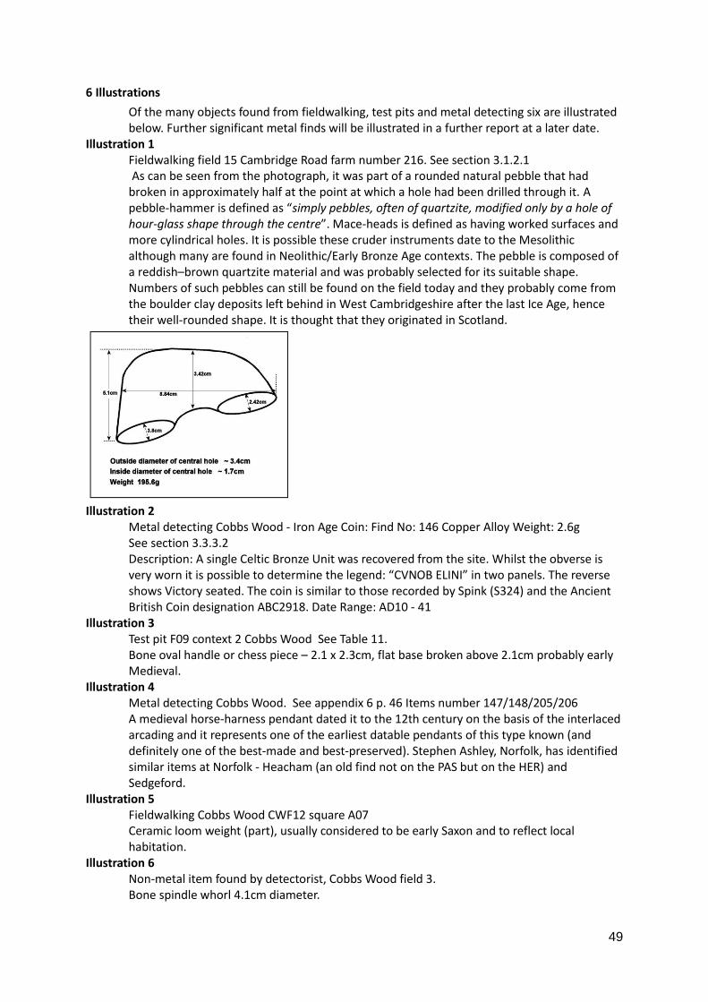
49
6 Illustrations
Of the many objects found from fieldwalking, test pits and metal detecting six are illustrated below. Further significant metal finds will be illustrated in a further report at a later date.
Illustration 1 Fieldwalking field 15 Cambridge Road farm number 216. See section 3.1.2.1 As can be seen from the photograph, it was part of a rounded natural pebble that had broken in approximately half at the point at which a hole had been drilled through it. A pebble-hammer is defined as “simply pebbles, often of quartzite, modified only by a hole of hour-glass shape through the centre”. Mace-heads is defined as having worked surfaces and more cylindrical holes. It is possible these cruder instruments date to the Mesolithic although many are found in Neolithic/Early Bronze Age contexts. The pebble is composed of a reddish–brown quartzite material and was probably selected for its suitable shape. Numbers of such pebbles can still be found on the field today and they probably come from the boulder clay deposits left behind in West Cambridgeshire after the last Ice Age, hence their well-rounded shape. It is thought that they originated in Scotland.
Illustration 2
Metal detecting Cobbs Wood - Iron Age Coin: Find No: 146 Copper Alloy Weight: 2.6g See section 3.3.3.2 Description: A single Celtic Bronze Unit was recovered from the site. Whilst the obverse is very worn it is possible to determine the legend: “CVNOB ELINI” in two panels. The reverse shows Victory seated. The coin is similar to those recorded by Spink (S324) and the Ancient British Coin designation ABC2918. Date Range: AD10 - 41
Illustration 3 Test pit F09 context 2 Cobbs Wood See Table 11. Bone oval handle or chess piece – 2.1 x 2.3cm, flat base broken above 2.1cm probably early Medieval.
Illustration 4 Metal detecting Cobbs Wood. See appendix 6 p. 46 Items number 147/148/205/206 A medieval horse-harness pendant dated it to the 12th century on the basis of the interlaced arcading and it represents one of the earliest datable pendants of this type known (and definitely one of the best-made and best-preserved). Stephen Ashley, Norfolk, has identified similar items at Norfolk - Heacham (an old find not on the PAS but on the HER) and Sedgeford.
Illustration 5 Fieldwalking Cobbs Wood CWF12 square A07 Ceramic loom weight (part), usually considered to be early Saxon and to reflect local habitation.
Illustration 6 Non-metal item found by detectorist, Cobbs Wood field 3. Bone spindle whorl 4.1cm diameter.
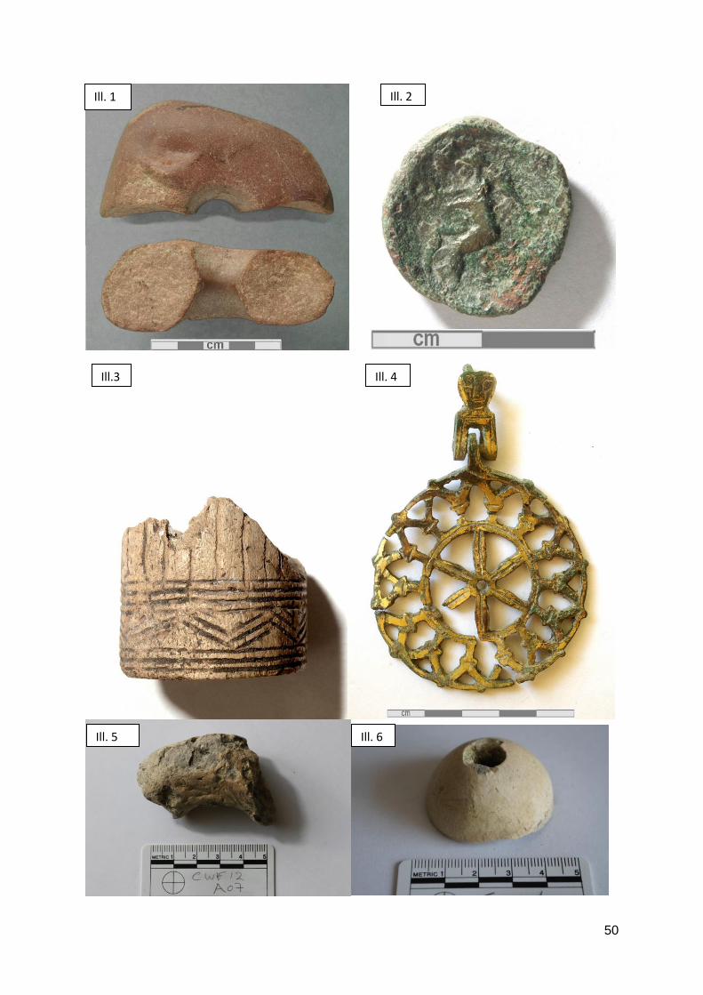
50
Ill. 1 Ill. 2
Ill.3 Ill. 4
Ill. 5 Ill. 6
51
Bibliography
Adshead, David, Wimpole; architectural drawings and topographical views, 2007, National Trust, pp.
Albion Archaeology: Abrams, Joe and Ingham, David, Farming on the edge : archaeological evidence
from the clay uplands to the west of Cambridge, 2008, East Anglia Archaeology rpt. 123
Aldred, Oscar R , Wimpole's Medieval Landscape - Stagnation, Development and Change,
unpublished draft thesis 1996
Bendall A.S., Maps, Land and Society: a history, with carto-bibliography of Cambridgeshire estate
maps, c. 166-1836, Cambridge, 1992
Brown, T and Foard, G, The Saxon landscape: a regional perspective, in The Archaeology of
Landscape Eds P. Everson and T. Williamson, Manchester, 1998, pp. 67-94
CAFG, Three Earthwork Surveys, Proceedings of the Cambridge Antiquarian Society, LXXXI (1992)
CAFG, Wimpole: silent voices and deserted homes, 2014
Underwood, Malcolm ed., Cartulary of the Hospital of St John the Evangelist, Cambridge 2008
Cambridgeshire Record Society
Cambs & Hunts Archaeological Society, Vol V
Spufford, Peter, gen. ed., Consistory Court of Ely Probate Records 1449 - 1858,., Vol 107, 1996, British
Record Society Index Library
J Deighton and sons, A Guide through the University of Cambridge … including a Tour to Ely, Wimpole
and Newmarket etc., Cambridge, 1820 (CUL: Cam.d.41.10.8)
East Anglian Notes and Queries, 1858 – 1910 (CC: C05)
Elrington, C R (ed) Victoria County History, A History of Cambridge and the Isle of Ely, 1973, vol 5
Wimpole pp 263-272
Evans, Nesta & Rose, Susan, Cambridgeshire Hearth Tax, 2000, British Records Society
Farrer, William, Feudal Cambridgeshire, CUP, 1920 (CC43)
Fox, Cyril, The Archaeology of the Cambridge Region, 1923, Cambridge
Hall, David, The Open Fields of England, 2014, Oxford, pp.136-8
Glasscock, Robin, ed., The Lay Subsidy of 1334, 1975, Oxford University Press for the British Academy
(CC32.7)
Higham, Nicholas J. and Ryan, Martin J.Eds., Landscape archaeology of Anglo-Saxon England,
2010,Woodbridge
Jones, Richard and Page Mark, Medieval Villages in and English Landscape: beginnings and ends,
2006, Macclesfield. pp 79 - 104
Kimball, Elizabeth G., ed., A Cambridgeshire Gaol Delivery Roll 1332-1334, 1978, Cambridge
Kingston, A. 1897 East Anglia and the Great Civil War (CC 45.2)
Lewis, C, Exploring Black Holes: Recent Investigations in currently Occupied Rural Settlements in
Eastern England, in Higham et al 2010, pp102-103
Lewis, C, Mitchell-Fox, P and Dyer, C., Village, Hamlet and Field: Changing Medieval Settlements,
Macclesfield, 2001.
Lysons, Daniel & Samuel, Magna Britannia Cambridgeshire, 1808.
Mortimer, R. Village development and ceramic sequence: The Middle and Late Saxon village at
Lordship lane, Cottenham, Cambridgeshire, PCAS, 89 pp5-34
Oosthuizen, Susan, Landscapes decoded: the origins and development of Cambridgeshire’s medieval
fields, 2006, University of Hertfordshire Press.
Oosthuizen, Susan, Medieval field systems and settlement nucleation: common or separate origins?,
pp.107 – 131 in
52
Oosthuizen, Susan, Tradition and transformation in Anglo-Saxon England: archaeology, common
rights and landscape, 2013, Bloomsbury.
Ousby, Ian Ed, .James Plumptre's Britain: The journals of a Tourist in the 1790's, 1992, Hutchinson
Oxford Archaeology East : Archaeological test pit evaluation at Wimpole Park, Cambridgeshire,
Report 1453 March 2013, Report 1598 May 2014, Report 1734 January 2015.
Palmer, William Mortlock, Cambridgeshire Subsidy Rolls 1250-1695 and Feet of Fines, Edward IV to
Elizabeth 1912, Goose & Son – reprints from The East Anglian 1898 – 1909
Pattison, Paul and Garrow, D, Wimpole Park, Cambridgeshire, 1998, Cambridge – an unpublished
report.
Rye,Walter , ed., Pedes Finium ,1891, Deighton Bell & Macmillan for the Cambridge Antiquarian
Society
Phibbs, John, Survey of Wimpole, NT unpublished, 1980
Postgate, Malcolm R, The open fields of Cambridgeshire, Theses,1964, University of Cambridge
Roberts, Brian K and Wrathmell Stuart, Region and place, 2002, Swindon
Royal Commission on Historical Monuments, England, An Inventory of Historical Monuments in the
County of Cambridge, vol 1 West Cambridgeshire, 1968,
Souden, David, Wimpole Hall, Cambridgeshire, revised 2004, National Trust
Taylor, Alison, Archaeology of Cambridgeshire: Vol 1, South West Cambridgeshire, 1997, CCC
Taylor, Jeremy, Atlas of Roman rural settlement, Council of British Archaeology
Vancouver, Charles, 1794. General View of the Agriculture in the County of Cambridge. Observations
by Mr Robert Harvey. Board of Agriculture and Internal Improvement (CRO: C.22)
Victoria History of the Counties of England: Cambridgeshire and the Isle of Ely, Volume 1. 1938
(reprint 1967), ed. LF Salzman, University of London
Victoria History of the County of Cambridge and the Isle of Ely, Volume V. 1973, ed. RB Pugh.
Wimpole section by Jennifer I Kermode. University of London
Wade-Martins, Farmer, Landlord and Landscapes, Rural Britain, 1720 to 1870, 2004, Macclesfield.
pp.1-2
Williamson, Tom, Shaping Medieval Landscapes: settlement, society and environment, 2003,
Macclesfield
Williamson, Tom, Environment, society and landscape in early medieval England, 2013, Woodbridge.
White, CH Evelyn, ed, The Lay Subsidy of 1 Edward III (1327) for Cambridgeshire, translated by JJ
Muskett. Publisher and date not known (CC32.7)
Wright, Duncan W., ‘Middle Saxon’ settlement and society, 2015, Oxford.
---oOo---
Related Documents