Will County County-Wide All Hazard Mitigation Plan 2013 Update of 2008 County-wide All Hazard Mitigation Plan Developed by: Will County All Hazard Mitigation Steering Committee Based on 2008 Will County County-wide All Hazard Mitigation Plan by

Welcome message from author
This document is posted to help you gain knowledge. Please leave a comment to let me know what you think about it! Share it to your friends and learn new things together.
Transcript
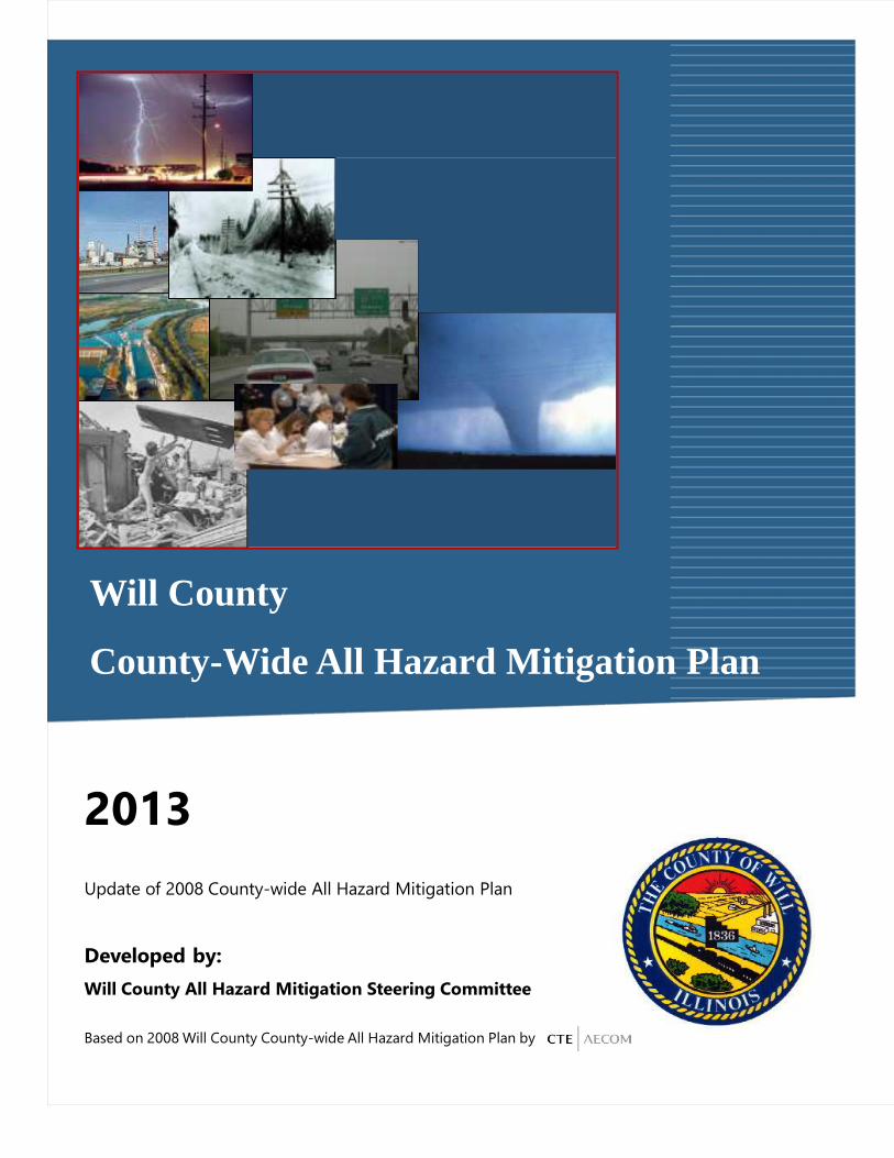
Will County
County-Wide All Hazard Mitigation Plan
2013
Update of 2008 County-wide All Hazard Mitigation Plan
Developed by:
Will County All Hazard Mitigation Steering Committee
Based on 2008 Will County County-wide All Hazard Mitigation Plan by
Will County Emergency Management Agency County-Wide All Hazard Mitigation Plan
November, 2013 Table of Contents i
TABLE OF CONTENTS
EXECUTIVE SUMMARY................................................................................................................ i - x
CHAPTER 1 – INTRODUCTION ..................................................................................................... 1-1 Resolution of Adoption .................................................................................................................. 1-2 Planning Process Methods .............................................................................................................. 1-3 Mitigation Project Team ................................................................................................................. 1-4 Will County Mitigation Steering Committee ................................................................................... 1-4 Participating Communities ............................................................................................................. 1-4 Public Involvement ........................................................................................................................ 1-9 Identify Hazards and Assess Risk ................................................................................................. 1-12 Identify Mitigation Goals, Objectives, and Actions ....................................................................... 1-14 Plan Monitoring and Maintenance ................................................................................................ 1-16
CHAPTER 2 – WILL COUNTY COMMUNITY OVERVIEW ...................................................... 2-1 Historical Overview ....................................................................................................................... 2-1 Will County Municipalities ............................................................................................................ 2-2 Geography and Climate .................................................................................................................. 2-3 Land Use Patterns .......................................................................................................................... 2-9 Buildings ..................................................................................................................................... 2-13 Transportation .............................................................................................................................. 2-19 Population Characteristics ............................................................................................................ 2-21
CHAPTER 3 – ALL HAZARD RISK ASSESSMENT SUMMARY ................................................ 3-1 Natural Hazard Risk Summary ....................................................................................................... 3-3 Technological Hazard Risk Summary ............................................................................................. 3-6 Societal Hazard Risk Summary ...................................................................................................... 3-9
CHAPTER 4 – HAZARD PROFILES AND VULNERABILITY ASSESSMENT .......................... 4-1 County Assets ................................................................................................................................ 4-3 Tornadoes ...................................................................................................................................... 4-8 Winter / Ice Storms ...................................................................................................................... 4-27 Thunderstorm ............................................................................................................................... 4-39 Flood, Flash Flood, and Ice Jams .................................................................................................. 4-48 Earthquake ................................................................................................................................... 4-86 Drought........................................................................................................................................ 4-97 Extreme Heat ............................................................................................................................. 4-105 Infrastructure Failure .................................................................................................................. 4-112 Hazardous Material – Fixed Site and Transportation ................................................................... 4-115 Nuclear Power Plant Accident .................................................................................................... 4-119

Will County Emergency Management Agency County-Wide All Hazard Mitigation Plan
November, 2013 Table of Contents ii
Pipeline Ruptures ....................................................................................................................... 4-128 Non-Hazardous Material Transportation ..................................................................................... 4-136 Fire ............................................................................................................................................ 4-145 Dam Failure ............................................................................................................................... 4-147 Land Subsidence ........................................................................................................................ 4-156 Terrorist Attack .......................................................................................................................... 4-160 Enemy Attack ............................................................................................................................ 4-166 Public Health ............................................................................................................................. 4-168 Civil Disturbance ....................................................................................................................... 4-183
CHAPTER 5 – MITIGATION GOALS, OBJECTIVES, & STRATEGIES .................................... 5-1 Goals and Objectives ...................................................................................................................... 5-1 Planning Elements.......................................................................................................................... 5-6 Legal Authorities ........................................................................................................................... 5-7 Jurisdictional Planning Documents ................................................................................................. 5-9 International Building Codes Adoption by Jurisdiction ................................................................. 5-10 Implementation of Mitigation Action Items .................................................................................. 5-12 Mitigation Actions Summary........................................................................................................ 5-13
CHAPTER 6 – MITIGATION ACTIONS ........................................................................................ 6-1 Common Themes and Issues .......................................................................................................... 6-1 Hazard Mitigation Actions and Implementation .............................................................................. 6-5
CHAPTER 7 – MITIGATION PLAN MAINTENANCE ................................................................. 7-1 Monitoring, Evaluation, and Updating the Plan .............................................................................. 7-1 The Five-Year Action Plan ............................................................................................................. 7-2 Criteria for Evaluation .................................................................................................................... 7-2 Continued Public Involvement ....................................................................................................... 7-4
APPENDICES APPENDIX A............................................................................. RESOLUTION OF ADOPTION APPENDIX B........................................................................................... HAZARD MODELING APPENDIX C .............................................................. BENEFIT COST ANALYSIS GUIDANCE APPENDIX D .............................................................. HAZARD MITIGATION ACTION FORM APPENDIX E...................................................................................... PUBLIC INVOLVEMENT APPENDIX F....................................... UPDATES TO 2008 ALL HAZARD MITIGATION PLAN

Will County Emergency Management Agency County-Wide All Hazard Mitigation Plan Executive Summary
November, 2013 i
EXECUTIVE SUMMARY
The Will County County-Wide All Hazard Mitigation Plan is designed to meet the requirements of the
Federal Disaster Mitigation Act of 2000 (DMA2K) and provide a useful document to reduce the impact of
hazards county-wide. The plan will meet the Act’s hazard mitigation planning regulations that require
jurisdictions to have an adopted and Federal Emergency Management Agency (FEMA) approved Hazard
Mitigation Plan to be eligible for mitigation grant funding. Although the DMA2K requires local
governments to only address natural hazards, the Will County Emergency Management Agency thought it
was imperative to address all hazards including technological and societal (including terrorism) hazards.
The 2013 update to the Will County County-Wide All Hazard Mitigation Plan provides a first step
towards identifying strategies and actions to prepare the community for natural, technological, and
societal hazards. To ensure the integration of the plan into existing emergency management operations
and systems, the 2013 Will County Risk Assessment was updated and incorporated. The 2013 risk
assessment consists of three documents:
• Will County Hazard Analysis dated November, 2013
• Will County Terrorism Vulnerability Assessment dated December, 2003
• Will County Terrorism Vulnerability Assessment of Critical Infrastructure Results dated March,
2004
These documents are summarized within the mitigation plan and were a strong component in establishing
the plan’s goals and objectives as well as identifying specific actions outlined in this plan. Emergency
Management agencies at all levels of government in Will County realize the inter-dependencies of
mitigation with response, recovery, and preparedness functions. This plan identifies select response,
recovery, and preparedness actions and identifies agencies responsible for these actions.
Purpose
Over the past two and half decades, the nation has witnessed an alarming increase in the number of and
destruction from disasters. Destruction associated with disasters has created a significant increase in
direct and indirect costs, as well as economic disruption and loss of life. The toll of a disaster on a
community extends far beyond the physical damage, resulting in long term disruption of local and
regional economies. The events of September 11th, 2001, underscored the importance in identifying

Will County Emergency Management Agency County-Wide All Hazard Mitigation Plan Executive Summary
November, 2013 ii
emerging threats, while Hurricane Katrina demonstrated the importance of planning and inter-agency
coordination for catastrophic disasters at a local level.
The intent of DMA2K is to control the cost of federal disaster assistance by initiating a sustained, national
program for pre-disaster hazard mitigation planning. In order to be eligible for mitigation funding
through FEMA’s programs, communities must develop and adopt a hazard mitigation plan. This program
enables participating communities to implement planned, cost-effective mitigation measures before and
after an event.
The mitigation planning and hazard analysis simulation process in this plan identified and prioritized the
steps and actions to mitigate the impact of all the various categories of hazards. This process identified
gaps in existing documents and current operations and practices. The communities of Will County are
familiar with the impacts of disasters and recognize that a disaster could occur with little or no warning.
Planning for a sustainable, resilient, and prepared community is essential to reduce damages to homes,
facilities, and infrastructure; prevent loss of life; minimize disruption of essential and critical services;
and maintain continuity of the local economy and government operations.
Plan Review Tool
To ensure that the updated Will County County-Wide All Hazard Mitigation Plan meets the requirements
of DMA2K, the Mitigation Project Team cross-referenced the All Hazard Mitigation Plan with FEMA’s
Local Mitigation Plan Review Tool. FEMA uses the tool to evaluate mitigation plans. In addition, the
tool identifies where each plan element is located within the plan document. The tool can also be used as
part of an internal quality assurance procedure.
Public Involvement
The broadened scope of an All Hazard Mitigation Plan did create challenges due to the sensitivity of
some technological and societal hazards with regard to sharing sensitive information with the public.
Today’s society requires communities to control the distribution of sensitive and vital documents since
the control of this information could minimize potential risks.
Despite the security issues, the Will County communities realize that public involvement is critical to the
success of any strategic planning process, including hazard mitigation. It is important for hazard
mitigation plans to target concerns, comments, and perception of risk as factors in the creation of

Will County Emergency Management Agency County-Wide All Hazard Mitigation Plan Executive Summary
November, 2013 iii
mitigation strategies. To ensure consensus with the public, the Mitigation Project Team developed
several mechanisms to secure sensitive information and to still reach out to the public to participate in the
Will County County-Wide All Hazard Mitigation Plan. Public input was incorporated into the mitigation
plan through various efforts including:
• Steering Committee - A Mitigation Steering Committee comprised of various professionals with
local knowledge and expertise was organized. The Mitigation Steering Committee members are
identified in Appendix E.
• Local Input - The Mitigation Steering Committee members met with local organizations and
jurisdictions to update them on the progress of the project, as well as to solicit their participation
and support of the All Hazard Mitigation Plan to identify potential mitigation projects.
Information, comments, concerns, and ideas that would be incorporated into the plan were
gathered during these meetings. A summary of these meetings is provided in Appendix E.
• Expert Guidance - The Mitigation Project Team, composed of CTE/AECOM and the Polis
Center, held interviews to solicit input and guidance from experts in given fields and provide
modeling of likely hazards. This information and guidance were included in the development of
the plan. A summary of these interviews is provided in Appendices B and E.
• Workshops - The Hazard Mitigation Steering Committee held mitigation workshops to review
and update the mitigation goals and objectives and to identify mitigation actions to be
incorporated into the 2013 Will County County-Wide All Hazard Mitigation Plan. Invitations to
attend this workshop were extended to local jurisdictions, various community organizations, and
neighboring counties. A summary of meetings and workshops for the update of the plan are
provided in Appendix E.
• Public Meetings - The Hazard Mitigation Steering Committee held a public meeting to inform the
public of the All Hazard Mitigation Plan and the mitigation goals and objectives. The intent of
this meeting was to provide a forum for the public to share their comments, concerns, and ideas
that could be incorporated into the plan. An overview of the All Hazard Mitigation project and a
questionnaire was distributed at this meeting, as well as posted on the Will County Emergency
Management Agency (EMA) website. The questionnaire was developed to target the public’s
Will County Emergency Management Agency County-Wide All Hazard Mitigation Plan Executive Summary
November, 2013 iv
thought on what Will County’s greatest risks are, what they have done to mitigate their home
against disasters, and what they would do if a disaster strikes. Information on this public meeting
is provided in Appendix E.
The Mitigation Team developed a public survey for the plan update to gauge the concerns of the
public, as well as provide feedback to help guide the Committee in identifying potential
mitigation actions. The questionnaire was developed to target the public’s thoughts on what their
and their community’s greatest risks are, what they have done to mitigate at their home, and what
they would do when a disaster strikes. This questionnaire was available through the Will County
EMA website (http://www.willcountyema.org) and Facebook page along with jurisdictional
websites. This allowed the public to communicate their concerns, comments, and ideas on what
their community and/or Will County can do to mitigate hazards. A sample of the website and
Facebook postings along with the results of the public survey are found in Appendix E.
The public was also given an opportunity to review the updated plan which was posted on the
Will County EMA and jurisdictional websites along with the ability for the public to posts
comments on a Survey Monkey link. The website posting can be found in Appendix E.
Mitigation Goals and Objectives
Through these efforts, All Hazard Mitigation Goals and Objectives were developed and updated. Goals
define the expectations of the plan and serve as general guidelines. They are typically broad policy-type
statements, long term, and represent global visions. Objectives are strategies or implementation steps to
attain an identified goal. Unlike goals, objectives are specific and measurable. The goals and objectives
were identified during the risk assessment and molded throughout the planning process, then finalized and
updated during the Mitigation Workshops.
Will County Emergency Management Agency County-Wide All Hazard Mitigation Plan Executive Summary
November, 2013 v
Goal #1: Protect and secure life and property.
Objectives:
• Increase public education and awareness of all hazards and what they can do to protect
and secure their community.
• Implement effective approaches to protect neighborhoods, buildings, and critical
facilities and infrastructure from all hazards.
• Nurture and support local and regional organizations that have missions that fulfill this
goal.
• Increase capabilities to disseminate pre-event and post-event information
• Increase readiness of the public and all levels of government within Will County
Goal #2: Continue to improve and enhance county-wide emergency management programs
and develop relationships county-wide.
Objectives:
• Support and promote the integration of efficient emergency management and homeland
security operations, functions, and tools with local, state, and federal governments,
private industry, non-governmental organizations, community groups, and other
emergency management partners.
• Identify essential government functions and develop back-up plans to ensure reliable
services during a time of emergency.
• Leverage existing opportunities to upgrade aging equipment and infrastructure that are
critical to emergency management.
• Encourage and support the professional development fields relevant to Emergency
Management.
Will County Emergency Management Agency County-Wide All Hazard Mitigation Plan Executive Summary
November, 2013 vi
Goal #3: Ensure economic stability, preserve cultural resources, and improve quality of life
throughout Will County.
Objectives:
• Nurture and support strategic local and regional private/public partnerships to limit or
minimize the impact from a disaster to key employers and from market sectors.
• Work with local universities, private/non-profit organizations, and other organizations to
identify opportunities to implement mitigation.
• Promote and nurture mitigation actions that facilitate security to private and public
sectors while leveraging available funding.
• Increase readiness of the private sector within Will County and promote private sector
readiness within the region.
Goal #4: Develop, promote, and integrate mitigation actions.
Objectives:
• Assist Will County and its participating jurisdictions in the development of mitigation
proposals and identify sources of federal funding.
• Identify and facilitate mitigation opportunities pertinent to the locale with internal,
neighboring, and regional partners.
• Assist essential and critical facilities (hospitals, universities, utilities, and eligible
private/non-profits) to identify mitigation opportunities.
• Engrain mitigation strategies and actions into everyday planning and project
development.
• Integrate mitigation projects with other federal funding sources (FEMA, DHS, US EPA,
HUD, etc) and projects in order to maximize efficiency and program eligibility.

Will County Emergency Management Agency County-Wide All Hazard Mitigation Plan Executive Summary
November, 2013 vii
Goal #5: Take advantage of opportunities offered by growth while also protecting natural
systems and natural resources.
Objectives:
Incorporate hazard mitigation practices into the activities of other County departments
and Will County jurisdictions.
Integrate mitigation actions into existing and future opportunities, projects, and
developments.
Focus on flood hazard mitigation actions that can increase open space and meet targets
for natural environment sustainability.
Planning Process
The Will County County-Wide All Hazard Mitigation Plan process involves four distinct phases that will
enable communities to articulate their risks and identify and develop mitigation actions for all hazards.
These phases are:
• Organize Resources
• Assess Risks
• Identify Mitigation Actions
• Implement the Mitigation Plan
Organize Resources
The vital component of this effort was to identify the Mitigation Steering Committee. The Mitigation
Steering Committee acted as a point of contact for the various interested groups and provided support of
the Mitigation Planning process. Identification of this core group is important in ensuring implementation
and support of the Mitigation Plan. The following characteristics were considered when soliciting
participation:
• Ability to speak for the organization;
• Provide visionary characteristics;
• Have a desire and time to commit, and;
• Have an understanding of local politics and issues.
Will County Emergency Management Agency County-Wide All Hazard Mitigation Plan Executive Summary
November, 2013 viii
Will County EMA chaired this committee and representatives from Will County departments provided
strategic guidance and were active throughout the development of the hazard mitigation plan. Many of
the Will County representatives were also members of local organizations that have relevance to the Will
County County-Wide All Hazard Mitigation Plan and its update.
Risk Assessment
The County government recognized the importance of identifying and analyzing all of Will County’s
hazards; therefore, in 2013 Will County reviewed and updated the hazard risk analysis. The 2013 risk
analysis consists of three documents:
• Will County Hazard Analysis dated November, 2013
• Will County Terrorism Vulnerability Assessment dated December, 2003
• Will County Terrorism Vulnerability Assessment of Critical Infrastructure Results dated March,
2004
These risk analysis documents were the fundamental building blocks of the Will County County-Wide All
Hazard Mitigation Plan. As part of the hazard mitigation plan, these risk analyses were updated and
summarized without detailing information that is sensitive to local security.
The assessment and analysis of the vulnerability to the County is a definitive measure of the risk
associated with each individual hazard. The Risk Assessment describes, analyzes, and evaluates the risks
facing Will County from three categories of hazards: Natural, Technological, and Societal.
The description of each hazard category elaborates upon and:
• Defines the different types of hazards
• Identifies historical events that have occurred locally and/or regionally
• Defines the hazard profiles, parameters, and characteristics
• Assesses possible vulnerabilities
• Determines probable scenarios
• Models select hazards
Will County Emergency Management Agency County-Wide All Hazard Mitigation Plan Executive Summary
November, 2013 ix
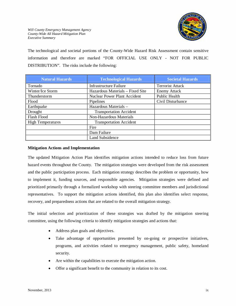
The technological and societal portions of the County-Wide Hazard Risk Assessment contain sensitive
information and therefore are marked “FOR OFFICIAL USE ONLY - NOT FOR PUBLIC
DISTRIBUTION”. The risks include the following:
Mitigation Actions and Implementation
The updated Mitigation Action Plan identifies mitigation actions intended to reduce loss from future
hazard events throughout the County. The mitigation strategies were developed from the risk assessment
and the public participation process. Each mitigation strategy describes the problem or opportunity, how
to implement it, funding sources, and responsible agencies. Mitigation strategies were defined and
prioritized primarily through a formalized workshop with steering committee members and jurisdictional
representatives. To support the mitigation actions identified, this plan also identifies select response,
recovery, and preparedness actions that are related to the overall mitigation strategy.
The initial selection and prioritization of these strategies was drafted by the mitigation steering
committee, using the following criteria to identify mitigation strategies and actions that:
• Address plan goals and objectives.
• Take advantage of opportunities presented by on-going or prospective initiatives,
programs, and activities related to emergency management, public safety, homeland
security.
• Are within the capabilities to execute the mitigation action.
• Offer a significant benefit to the community in relation to its cost.
Natural Hazards Technological Hazards Societal Hazards Tornado Infrastructure Failure Terrorist Attack Winter/Ice Storm Hazardous Materials – Fixed Site Enemy Attack Thunderstorm Nuclear Power Plant Accident Public Health Flood Pipelines Civil Disturbance Earthquake Hazardous Materials – Drought Transportation Accident Flash Flood Non-Hazardous Materials High Temperatures Transportation Accident Fire Dam Failure Land Subsidence
Will County Emergency Management Agency County-Wide All Hazard Mitigation Plan Executive Summary
November, 2013 x
• Have an identified funding source or sources.
• Have an identified lead agency with appropriate jurisdictional authority to coordinate
implementation.
• Have an identified schedule for implementation.
A benefit/cost analysis is an important component in the hazard mitigation planning process. As the
scope of mitigation actions are defined and costs are developed, the Mitigation Steering Committee will
work with other departments and local jurisdictions to analyze these actions based on FEMA’s benefit
cost methodology. This analysis will assist in determining the actions necessary to effectively minimize
costs and prevent damage from future hazards.
Implementation, Monitoring, and Maintenance
Will County EMA will maintain and update the 2013 Will County County-Wide All Hazard Mitigation
Plan and continue to encourage participation by all communities in the County. The update of this plan
will occur every five years as mandated by DMA2K with input from participating communities. The Will
County Mitigation Steering Committee will gather each year to assess the status of the mitigation actions.
Public input will continuously be solicited via the Will County EMA website as well as through local
organizations and public-private partnerships.
Will County Emgerncy Management Agency County-Wide All Hazard Mitigation Plan Chapter 1: Introduction
November, 2013 Chapter 1 - 1
CHAPTER 1: INTRODUCTION
Will County is one of the nation’s fastest growing counties. It is all too familiar with natural disasters, the
existing risk of technological hazards, and the growing threat of societal hazards. After decades of
gradual change, urban sprawl is moving into the farmland areas. In the last twenty years, the population
of the County increased by 320,000 (89% growth). This population was attracted to the County because
of opportunities that developed due to the expansion of businesses and homes. Although many residents
welcome this growth as a sign of prosperity and progress, it also results in increased traffic, greater
demand on infrastructure, and a loss of open space. The most devastating impact can be one that is not
realized each day, but when a disaster strikes.
Although disasters have occurred in the County, Will
County and its jurisdictions have not experienced a
catastrophic natural event, a terrorist attack, or an incident
of national significance. Despite this, emergency
management agencies throughout the County recognize
that a disaster could occur in the future with little or no
warning. The development of open space and farmland,
increasing dependency on technology, and new
developing threats greatly enhance the possibility and
impact of a disaster. Planning for a sustainable, resilient,
and prepared community is essential to prevent loss of
life, disruption of essential and critical services, economic
and business interruption, and damages to homes,
facilities, and infrastructure. Most importantly, this plan
will assist the communities of Will County in recognizing
its vulnerabilities and preparing for future recovery
efforts.
Over the past three decades, the nation has witnessed an
alarming number of disasters incurring substantial destruction. Destruction associated with disasters has
created a significant increase in direct and indirect costs, as well as economic disruption and loss of life.
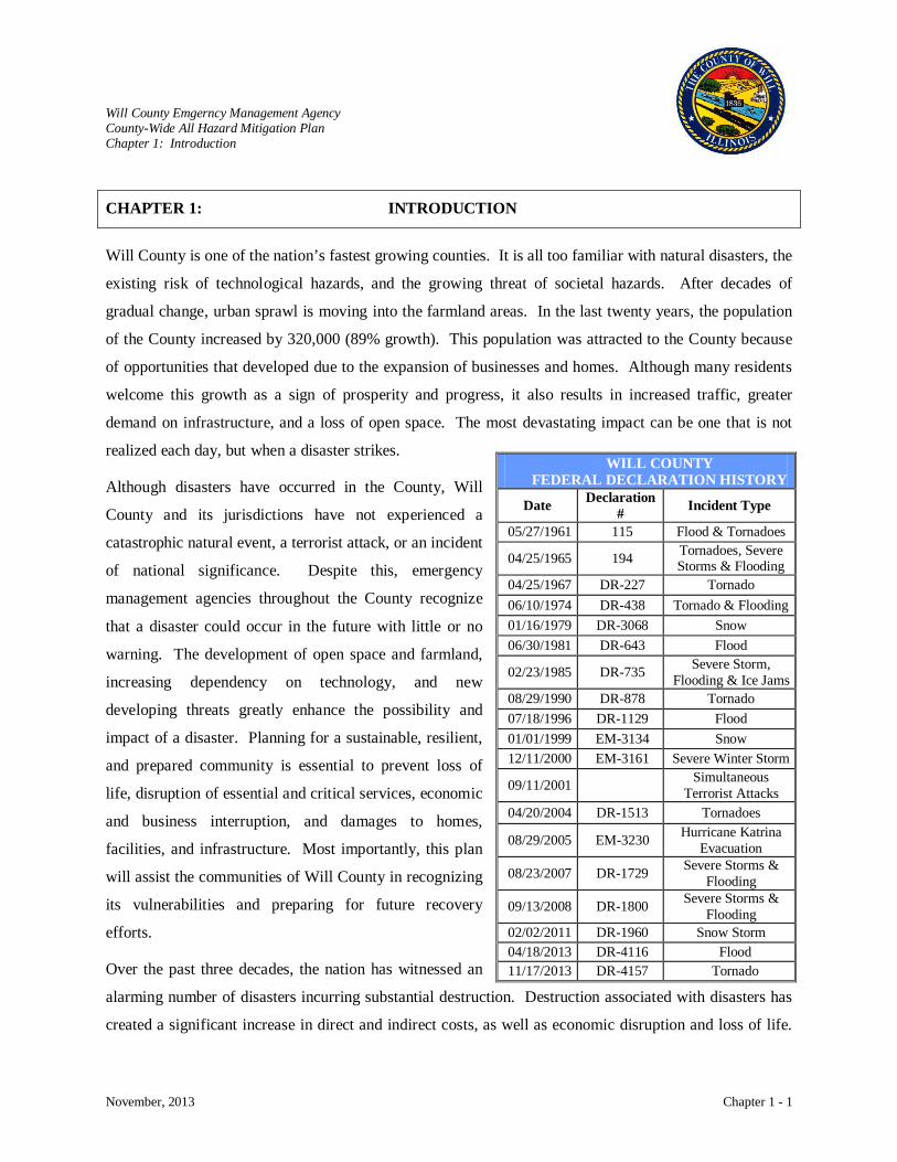
WILL COUNTY FEDERAL DECLARATION HISTORY
Date Declaration # Incident Type
05/27/1961 115 Flood & Tornadoes
04/25/1965 194 Tornadoes, Severe Storms & Flooding
04/25/1967 DR-227 Tornado 06/10/1974 DR-438 Tornado & Flooding 01/16/1979 DR-3068 Snow 06/30/1981 DR-643 Flood
02/23/1985 DR-735 Severe Storm, Flooding & Ice Jams
08/29/1990 DR-878 Tornado 07/18/1996 DR-1129 Flood 01/01/1999 EM-3134 Snow 12/11/2000 EM-3161 Severe Winter Storm
09/11/2001 Simultaneous Terrorist Attacks
04/20/2004 DR-1513 Tornadoes
08/29/2005 EM-3230 Hurricane Katrina Evacuation
08/23/2007 DR-1729 Severe Storms & Flooding
09/13/2008 DR-1800 Severe Storms & Flooding
02/02/2011 DR-1960 Snow Storm 04/18/2013 DR-4116 Flood 11/17/2013 DR-4157 Tornado
Will County Emgerncy Management Agency County-Wide All Hazard Mitigation Plan Chapter 1: Introduction
November, 2013 Chapter 1 - 2
The toll of a disaster on a community extends far beyond the physical damage, but can also result in the
long term disruption of local and regional economies. As a result, Congress passed Public Law 106-390,
The Disaster Mitigation Act of 2000 (DMA2K). The intent of DMA2K was to control federal costs of
disaster assistance by initiating a national, sustained program for pre-disaster hazard mitigation. This
program enables participating communities to implement planned, pre-identified, cost-effective
mitigation measures before or after an event. In order to be eligible for mitigation funding through
FEMA programs, communities must develop and adopt a hazard mitigation plan.
The Will County County-Wide All Hazard Mitigation Plan covers those jurisdictions that participated in
the hazard mitigation planning process. Will County EMA is the local organization that provides
emergency management services throughout Will County. Will County EMA applied for and received
funding to develop the 2008 hazard mitigation plan and worked closely with local jurisdictions,
municipalities and townships throughout the mitigation planning process and plan update.
Resolution of Adoption
This Plan serves to recommend mitigation measures for Will County. Adoption of this plan by the Will
County Board and the participating communities initiates the implementation of these recommendations.
Adoption is also a requirement for recognition of the plan by mitigation funding programs.
The adoption of this Will County County-Wide All Hazard Mitigation Plan was done by resolution of the
County Board. A sample resolution of adoption is included as Appendix A of the plan. Resolutions of
adoption by Will County and participating jurisdictions will become part of this plan as they are adopted.
Through these resolutions of adoption, each jurisdiction will certify their agreement with the risk
assessment and the mitigation goals, objectives, strategies, implementation, monitoring, and update
schedule.
The municipal, fire protection districts, colleges, and other agencies’ resolutions should adopt each action
item that is pertinent to the community and assign a person responsible for it. Once the state and federal
reviewers certify the plan approval, Will County will forward the plan to each participating jurisdiction
for formal adoption. Copies of these resolutions will be held on file with the Will County EMA. With
adoption, the County and each municipality, agency, or institution are individually eligible to apply for
FEMA mitigation grant funding.
Will County Emgerncy Management Agency County-Wide All Hazard Mitigation Plan Chapter 1: Introduction
November, 2013 Chapter 1 - 3
Planning Process Methods
The Will County County-Wide All Hazard Mitigation Plan process involves four distinct phases that will
enable the communities within Will County to articulate their risks and identify and develop mitigation
actions. These phases include:
• Organize Resources
• Assess Risks
• Identify Mitigation Actions
• Develop and Implement the Mitigation Plan
Organize Resources
Will County EMA served as the coordinating body for the planning process. They collaborated closely
with the communities of Will County and local organizations. Furthermore, Will County EMA solicited
participation from surrounding communities to be involved throughout the process.
The Will County Mitigation Steering Committee was actively involved in all of the stages of the planning
process: hazard identification, risk assessment, mitigation strategy development, and mitigation action
identification. Disasters often cross county boundaries; therefore, Will County solicited the participation
of several jurisdictions that straddle the boundaries of the County to improve the opportunity to identify
and implement regional mitigation actions. Several advantages of this relationship include:
• Collaboration allows for resource sharing between communities and neighboring counties.
• Issues that affect multiple jurisdictions can be discussed and leveraged together to show a
greater benefit of a mitigation action.
• Reduced duplication of efforts.
• Establishment of relationships prior to an event occurring. These relationships are
fundamental to emergency management activities during all phases: preparedness, response,
recovery, and mitigation.
Many individuals and groups were crucial contributors to the creation of this plan. The following
identifies them and their role in the process.
Will County Emgerncy Management Agency County-Wide All Hazard Mitigation Plan Chapter 1: Introduction
November, 2013 Chapter 1 - 4
Will County Emergency Management Agency
Will County EMA works closely with all jurisdictional emergency management agencies throughout the
County to provide emergency management services. Will County EMA applied for and received funding
from IEMA and FEMA to develop the 2008 hazard mitigation plan. Will County EMA was the lead for
the 2013 update of the original plan and chaired the Will County Mitigation Steering Committee. Will
County EMA served as the coordinating body for the planning process and collaborated closely with
other County departments, local jurisdictions, local organizations, and the public. Furthermore, Will
County EMA solicited participation from the public and surrounding communities to be involved
throughout the process.
Mitigation Project Team
The Mitigation Project Team consisted of a core team with mitigation and recovery experience, as well as
Geographic Information Systems (GIS) analysis and Hazards U.S Multi-hazard (HAZUS-MH) modeling.
The Mitigation Project Team was led by a Certified Emergency and Floodplain Manager and consisted of
professionals with diverse backgrounds in emergency management, engineering, environmental sciences,
and homeland security. GIS analysis and HAZUS-MH modeling were performed by the Polis Center
(Polis), a not-for-profit, university-based organization with staff dedicated to researching and applying
GIS technology.
Will County Mitigation Steering Committee
The Will County Mitigation Steering Committee was comprised of officials from various Will County
departments that are actively involved with local organizations and are conduits to local jurisdictions:
• Will County EMA
• Will County Engineering and Transportation
• Will County Department of Planning
• Will County GIS
Participating Communities
The Mitigation Steering Committee solicited the participation of local jurisdictions throughout the
mitigation planning process. County and local jurisdictions were invited to participate in the plan update
process. This includes the thirty-seven municipalities that have all or some of their municipal limits
within Will County. The municipalities that are predominantly within surrounding counties but whose
municipal limits expand into Will County are denoted (*) in the following table.
Will County Emgerncy Management Agency County-Wide All Hazard Mitigation Plan Chapter 1: Introduction
November, 2013 Chapter 1 - 5
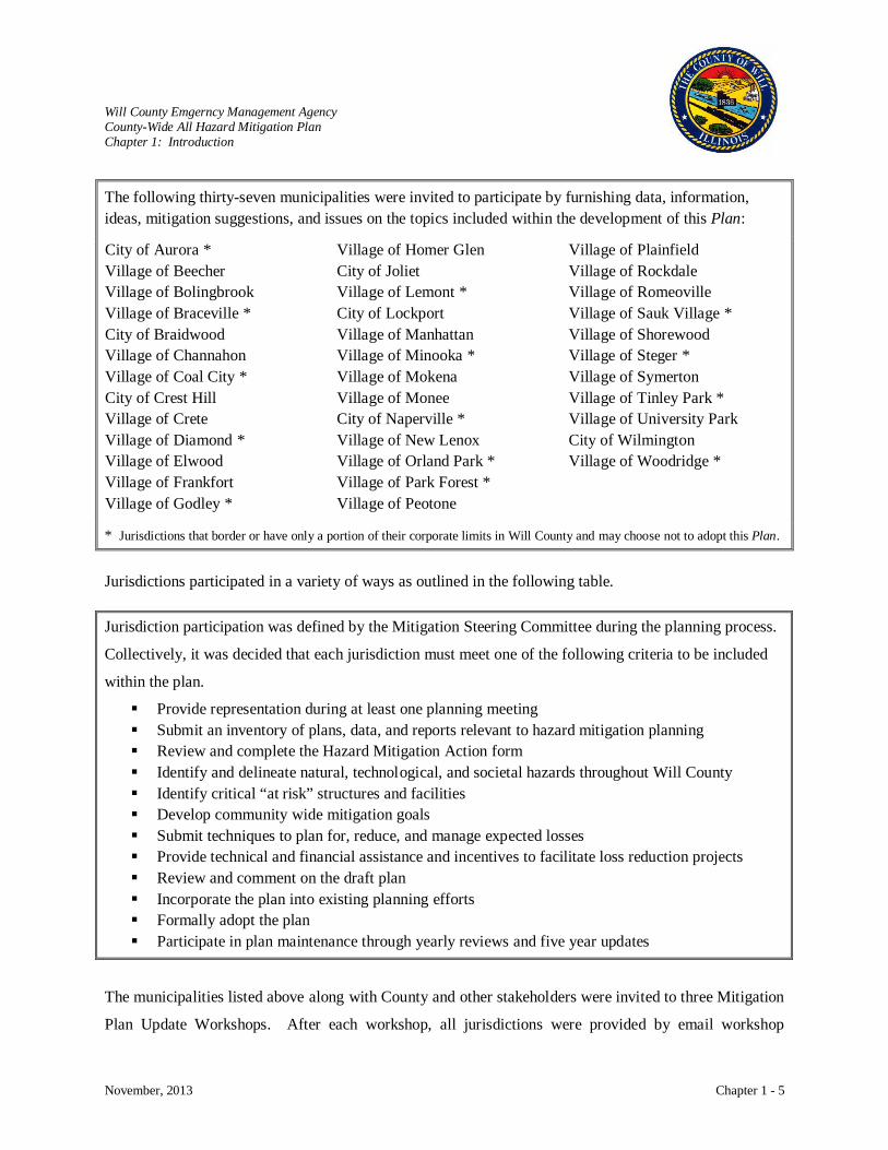
The following thirty-seven municipalities were invited to participate by furnishing data, information, ideas, mitigation suggestions, and issues on the topics included within the development of this Plan:
City of Aurora * Village of Beecher Village of Bolingbrook Village of Braceville * City of Braidwood Village of Channahon Village of Coal City * City of Crest Hill Village of Crete Village of Diamond * Village of Elwood Village of Frankfort Village of Godley *
Village of Homer Glen City of Joliet Village of Lemont * City of Lockport Village of Manhattan Village of Minooka * Village of Mokena Village of Monee City of Naperville * Village of New Lenox Village of Orland Park * Village of Park Forest * Village of Peotone
Village of Plainfield Village of Rockdale Village of Romeoville Village of Sauk Village * Village of Shorewood Village of Steger * Village of Symerton Village of Tinley Park * Village of University Park City of Wilmington Village of Woodridge *
* Jurisdictions that border or have only a portion of their corporate limits in Will County and may choose not to adopt this Plan. Jurisdictions participated in a variety of ways as outlined in the following table.
Jurisdiction participation was defined by the Mitigation Steering Committee during the planning process.
Collectively, it was decided that each jurisdiction must meet one of the following criteria to be included
within the plan.
Provide representation during at least one planning meeting Submit an inventory of plans, data, and reports relevant to hazard mitigation planning Review and complete the Hazard Mitigation Action form Identify and delineate natural, technological, and societal hazards throughout Will County Identify critical “at risk” structures and facilities Develop community wide mitigation goals Submit techniques to plan for, reduce, and manage expected losses Provide technical and financial assistance and incentives to facilitate loss reduction projects Review and comment on the draft plan Incorporate the plan into existing planning efforts Formally adopt the plan Participate in plan maintenance through yearly reviews and five year updates
The municipalities listed above along with County and other stakeholders were invited to three Mitigation
Plan Update Workshops. After each workshop, all jurisdictions were provided by email workshop
Will County Emgerncy Management Agency County-Wide All Hazard Mitigation Plan Chapter 1: Introduction
November, 2013 Chapter 1 - 6
materials and suggested updates collected during the workshop for review. Those who were not able to
attend a workshop were encouraged to provide their comments and questions. Not all of the jurisdictions
were able to attend the workshops, but of those that did, many submitted comments on the workshop
results by email, telephone, or contact with Mitigation Steering Committee members. Those jurisdictions
that did not attend any workshop or respond to workshop follow-up emails were contacted numerous
times by telephone, email, and face-to-face at other meetings. The importance of the mitigation plan
update and their participation was stressed in these contacts. Most of the jurisdictions whose municipal
limits are within Will County that did not respond are small communities that only have part-time or
volunteer staff.
A number of jurisdictions whose municipal limits are predominantly outside of Will County participated
in the development of the plan update. Those jurisdictions that did not are involved with the Hazard
Mitigation Plan of their respective county. These jurisdictions were aware of Will County’s progress in
updating the plan and indicated they were following the progress through the email updates.
Representatives from jurisdictions within and outside Will County who met the participation requirement
by participating in meetings, document review, and information gathering are identified in the following
table. Additional information on jurisdictional participation may be found in Appendix E (see E-9).
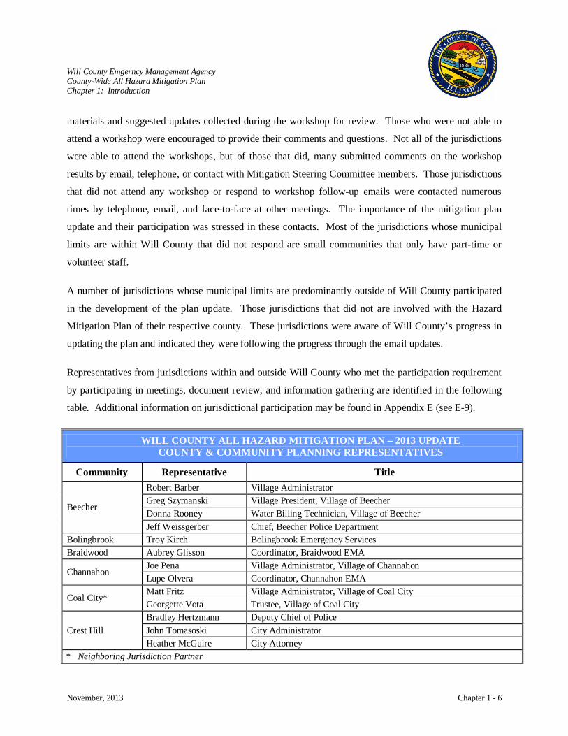
WILL COUNTY ALL HAZARD MITIGATION PLAN – 2013 UPDATE COUNTY & COMMUNITY PLANNING REPRESENTATIVES
Community Representative Title
Beecher
Robert Barber Village Administrator Greg Szymanski Village President, Village of Beecher Donna Rooney Water Billing Technician, Village of Beecher Jeff Weissgerber Chief, Beecher Police Department
Bolingbrook Troy Kirch Bolingbrook Emergency Services Braidwood Aubrey Glisson Coordinator, Braidwood EMA
Channahon Joe Pena Village Administrator, Village of Channahon Lupe Olvera Coordinator, Channahon EMA
Coal City* Matt Fritz Village Administrator, Village of Coal City Georgette Vota Trustee, Village of Coal City
Crest Hill Bradley Hertzmann Deputy Chief of Police John Tomasoski City Administrator Heather McGuire City Attorney
* Neighboring Jurisdiction Partner
Will County Emgerncy Management Agency County-Wide All Hazard Mitigation Plan Chapter 1: Introduction
November, 2013 Chapter 1 - 7
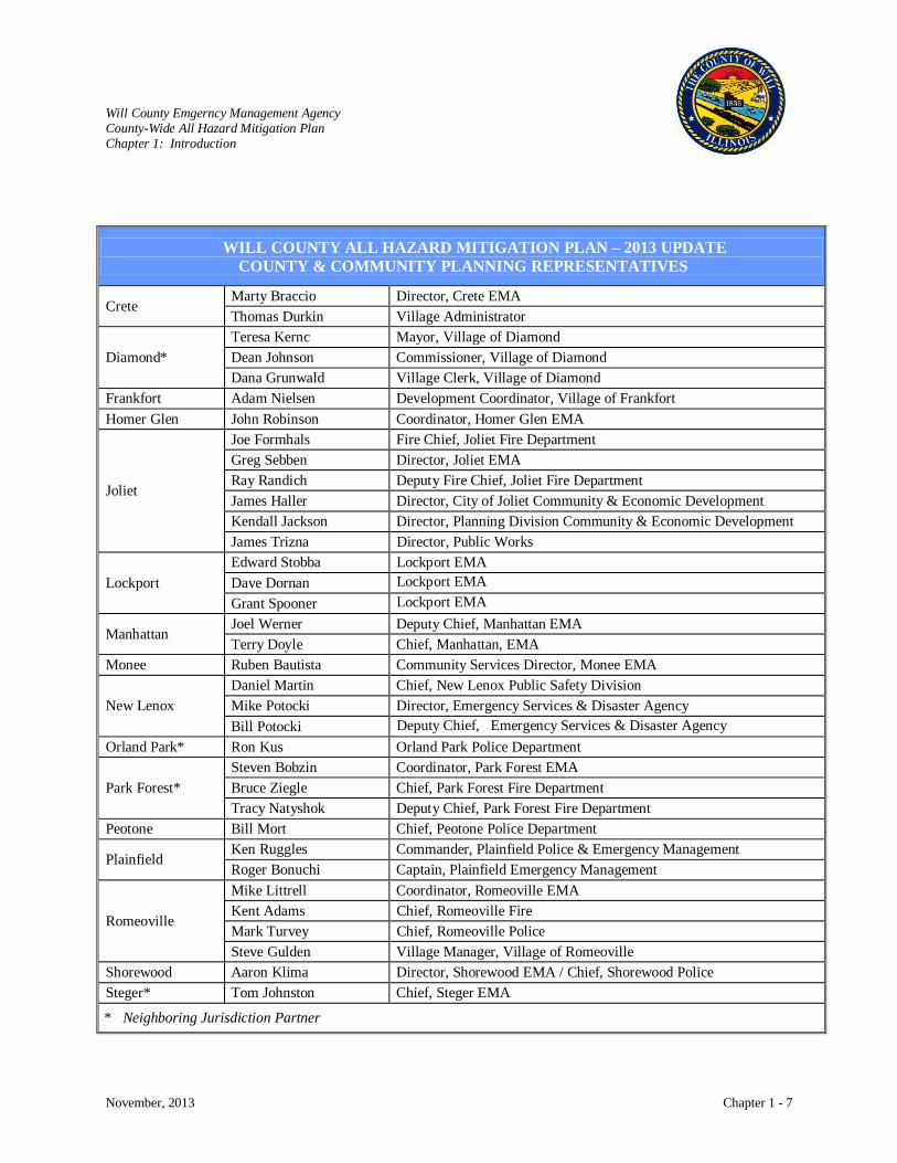
WILL COUNTY ALL HAZARD MITIGATION PLAN – 2013 UPDATE COUNTY & COMMUNITY PLANNING REPRESENTATIVES
Crete Marty Braccio Director, Crete EMA Thomas Durkin Village Administrator
Diamond* Teresa Kernc Mayor, Village of Diamond Dean Johnson Commissioner, Village of Diamond Dana Grunwald Village Clerk, Village of Diamond
Frankfort Adam Nielsen Development Coordinator, Village of Frankfort Homer Glen John Robinson Coordinator, Homer Glen EMA
Joliet
Joe Formhals Fire Chief, Joliet Fire Department Greg Sebben Director, Joliet EMA Ray Randich Deputy Fire Chief, Joliet Fire Department James Haller Director, City of Joliet Community & Economic Development Kendall Jackson Director, Planning Division Community & Economic Development James Trizna Director, Public Works
Lockport Edward Stobba Lockport EMA Dave Dornan Lockport EMA Grant Spooner Lockport EMA
Manhattan Joel Werner Deputy Chief, Manhattan EMA Terry Doyle Chief, Manhattan, EMA
Monee Ruben Bautista Community Services Director, Monee EMA
New Lenox Daniel Martin Chief, New Lenox Public Safety Division Mike Potocki Director, Emergency Services & Disaster Agency Bill Potocki Deputy Chief, Emergency Services & Disaster Agency
Orland Park* Ron Kus Orland Park Police Department
Park Forest* Steven Bobzin Coordinator, Park Forest EMA Bruce Ziegle Chief, Park Forest Fire Department Tracy Natyshok Deputy Chief, Park Forest Fire Department
Peotone Bill Mort Chief, Peotone Police Department
Plainfield Ken Ruggles Commander, Plainfield Police & Emergency Management Roger Bonuchi Captain, Plainfield Emergency Management
Romeoville
Mike Littrell Coordinator, Romeoville EMA Kent Adams Chief, Romeoville Fire Mark Turvey Chief, Romeoville Police Steve Gulden Village Manager, Village of Romeoville
Shorewood Aaron Klima Director, Shorewood EMA / Chief, Shorewood Police Steger* Tom Johnston Chief, Steger EMA
* Neighboring Jurisdiction Partner
Will County Emgerncy Management Agency County-Wide All Hazard Mitigation Plan Chapter 1: Introduction
November, 2013 Chapter 1 - 8
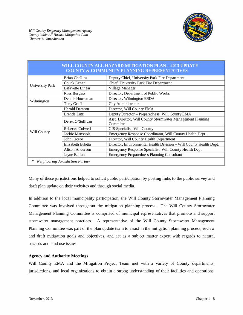
Many of these jurisdictions helped to solicit public participation by posting links to the public survey and
draft plan update on their websites and through social media.
In addition to the local municipality participation, the Will County Stormwater Management Planning
Committee was involved throughout the mitigation planning process. The Will County Stormwater
Management Planning Committee is comprised of municipal representatives that promote and support
stormwater management practices. A representative of the Will County Stormwater Management
Planning Committee was part of the plan update team to assist in the mitigation planning process, review
and draft mitigation goals and objectives, and act as a subject matter expert with regards to natural
hazards and land use issues.
Agency and Authority Meetings
Will County EMA and the Mitigation Project Team met with a variety of County departments,
jurisdictions, and local organizations to obtain a strong understanding of their facilities and operations,
WILL COUNTY ALL HAZARD MITIGATION PLAN – 2013 UPDATE COUNTY & COMMUNITY PLANNING REPRESENTATIVES
University Park
Brian Chellios Deputy Chief, University Park Fire Department Chuck Exner Chief, University Park Fire Department Lafayette Linear Village Manager Ross Burgess Director, Department of Public Works
Wilmington Dennis Houseman Director, Wilmington ESDA Tony Graff City Administrator
Will County
Harold Damron Director, Will County EMA Brenda Lutz Deputy Director – Preparedness, Will County EMA
Derek O’Sullivan Asst. Director, Will County Stormwater Management Planning Committee
Rebecca Colwell GIS Specialist, Will County Jackie Mansholt Emergency Response Coordinator, Will County Health Dept. John Cicero Director, Will County Health Department Elizabeth Bilotta Director, Environmental Health Division – Will County Health Dept. Alison Anderson Emergency Response Specialist, Will County Health Dept. Jayne Ballun Emergency Preparedness Planning Consultant
* Neighboring Jurisdiction Partner
Will County Emgerncy Management Agency County-Wide All Hazard Mitigation Plan Chapter 1: Introduction
November, 2013 Chapter 1 - 9
risks, existing programs and projects, and opportunities to implement mitigation actions. A summary and
explanation of these meetings is provided in Appendix E.
Expertise Interviews
The Mitigation Project Team interviewed and solicited input from a variety of experts in the field of
engineering, natural hazards, technological hazards, terrorism, etc. A summary and explanation of these
meetings is provided in Appendix E.
Public Involvement
The broad scope of the Will County County-Wide All Hazard Mitigation Plan did create challenges due to
the nature of technological and societal hazards and the ability to share sensitive information with the
public. Today’s society prohibits openly sharing vital documents and information since this information
could identify potential vulnerabilities. Despite the security issues, the Mitigation Team developed
several mechanisms to secure sensitive information and still reach out to the public to participate in the
Will County County-Wide All Hazard Mitigation Plan. Public input was incorporated into the plan
through various efforts.
• A Mitigation Steering Committee comprised of various professionals with local knowledge and
expertise was organized. The Mitigation Steering Committee members are identified in
Appendix E.
• The Mitigation Project Team held meetings with various governing entities and jurisdictions to
understand their risks and to gather information, as well as comments, concerns, and ideas that
would be incorporated into the plan. Those attending included various professionals in
emergency services, engineering and planning; local jurisdictions; County departments; and
community organizations. A summary of these meetings is provided in Appendix E.
• The Mitigation Project Team held interviews to solicit input and guidance from experts in given
fields. This information and guidance was included in the development of the plan. A summary
of these interviews is provided in Appendix E.
• The Hazard Mitigation Steering Committee held workshops to review and define the mitigation
goals and objectives and to review and identify mitigation actions to be incorporated into the Will
County County-Wide All Hazard Mitigation Plan. Invitations were extended to various
Will County Emgerncy Management Agency County-Wide All Hazard Mitigation Plan Chapter 1: Introduction
November, 2013 Chapter 1 - 10
community organizations to attend this workshop. A copy of the Hazard Mitigation Action form
that was distributed is provided in Appendix D.
• Will County EMA held a public meeting to allow the public to participate in the 2008 Will
County County-Wide All Hazard Mitigation Plan. This public meeting enabled the community to
learn about the hazards and the mitigation planning process. It also allowed them to
communicate their concerns, comments, and ideas on what their community and/or Will County
can do to mitigate all hazards. A copy of the public notice is provided in Appendix E.
• Will County EMA posted an overview of the County-Wide All Hazard Mitigation project and a
public survey on the Will County and jurisdictional websites. The questionnaire was developed
to target the public’s thoughts on what their and their community’s greatest risk is, what they
have done to mitigate at their home, and what they would do when a disaster strikes. A copy of
the survey and results is provided in Appendix E.
• A draft of the 2013 Will County County-Wide All Hazard Mitigation Plan was posted on the Will
County EMA and jurisdictional websites for public review and comment.
Resources
The Will County Planning Committee utilized a variety of planning documents and technical data, reports
and studies to direct the plans development. Resources include land use plans, comprehensive plans, city
ordinances, building codes, zoning ordinances, historical research documents, subject-specific text books,
interviews with local officials, interviews with regional experts, local planning, engineering, GIS data,
and emergency management documents. The planning process also incorporated the existing 2008 Will
County Hazard Mitigation Plan and elements of the 2010 and 2013 State Hazard Mitigation plan into the
creation of this update along with a variety of FEMA reference documents. When applicable, the Project
Team utilized HAZUS-MH. HAZUS-MH is a GIS based loss estimation model developed by FEMA.
HAZUS-MH was used to model the county-wide impacts of historical earthquakes and flooding events.

Will County Emgerncy Management Agency County-Wide All Hazard Mitigation Plan Chapter 1: Introduction
November, 2013 Chapter 1 - 11
REFERENCE AND INFORMATION SOURCES
AT&T Information and data on area communication systems
Centers for Disease Control and Prevention Information, data, charts/graphs, and loss history on public health risks
City of Redmond Office of Emergency Management
Hazard Identification Vulnerability Analysis (HIVA) 2001
Climatology for Chicago O’Hare IL Area climate information Commonwealth Edison Information and data on energy systems Exelon Corporation Information on nuclear power plants and their function
Federal Emergency Management Agency Guides, plans, data, charts/graphs, authorities, hazard information, and other emergency planning information
GEOMET Technologies, Inc Maryland Hazard Analysis HAZUS Hazard modeling International Code Council Jurisdictional adoption of International Codes Illinois Department of Natural Resources Information, data, charts/graphs on rivers, dams, levees
Illinois Emergency Management Agency Planning guides, state and local mitigation plans, data, charts/graphs, hazard information, and descriptions of Federal and State roles
Illinois State Geological Survey Information, data, charts/graphs on earthquakes Illinois State Water Survey Information data, charts/graphs on climate Joliet/Will County Center for Economic Development Information, data, charts/graphs on county economics
Landesman, L. Public Health Management of Disaster (2001). Washington, D.C.: American Public Health Association.
Michigan Department of State Police. Planning guides Michigan Hazard Analysis and Mitigation Plan
National Climatic Data Center Information, data, and loss history on natural hazards National Flood Insurance Program Information, data, and loss history on floods National Inventory of Dams Information and data on county dams

Will County Emgerncy Management Agency County-Wide All Hazard Mitigation Plan Chapter 1: Introduction
November, 2013 Chapter 1 - 12
REFERENCE AND INFORMATION SOURCES
National Oceanic and Atmospheric Administration
Information, data, charts/graphs on weather
National Transportation Safety Board Information, data, and loss history on transportation hazards National Weather Service Forecast Office Information, data, charts/graphs on weather events Nicor Gas Information and data on energy sources Northeastern Illinois Planning Commission Regional planning information
Office of Pipeline Safety Information, data, charts/graphs, loss history on pipeline hazards
Pipeline and Hazardous Materials Safety Administration
Information, data, charts/graphs, loss history on pipeline and transportation hazards
The Polis Center at IUPUI Hazard modeling State Climatologist Office for Illinois Information, data, charts/graphs, loss history on weather U.S. Army Corps of Engineers Information, data, charts/graphs, loss history on dams/levees U.S. Census Bureau Population data and characteristics (2010) U.S. Department of Agriculture Information, data, and charts/graphs
U.S. Department of Transportation Information, data, charts/graphs, loss history on transportation hazards
U.S. Environmental Protection Agency Information and data on environmental issues U.S. Geological Survey Information, data, charts/graphs, loss history on earthquakes
Will County Government Plans, authorities, data, maps, and descriptions of county government roles
World Health Organization Information, data, and charts/graphs on public health hazards
Identify Hazards and Assess Risk
The Mitigation Project Team recognizes that the assessment and analysis of the vulnerability is a
definitive measure of the risk associated with each individual hazard. The All Hazard Risk Assessment
summarizes the 2013 Will County Hazard Analysis and further describes, analyzes, and assesses the
county-wide risks from three categories of hazards: natural, technological, and societal. The description
of each hazard category elaborates upon and defines the different types of hazards, identifies historical
events that have occurred locally and/or regionally, defines the hazard profiles, parameters, and
characteristics; assesses possible vulnerabilities; determines probable scenarios; and models select
hazards. The associated risks for each hazard were defined through the following process:
1. Identify, define, and describe each hazard
2. Determine hazard profile and characteristics
3. Identify historical occurrences
4. Analyze and assess hazard risk
Will County Emgerncy Management Agency County-Wide All Hazard Mitigation Plan Chapter 1: Introduction
November, 2013 Chapter 1 - 13
In order to effectively and efficiently integrate existing documents and operations, the 2013 Will County
Hazard Analysis was incorporated into the Will County County-Wide All Hazard Mitigation Plan. This
allowed Will County to identify mitigation objectives, strategies, and actions that address all of Will
County’s risks. The Will County Terrorism Vulnerability Assessment and the Terrorism Vulnerability
Assessment of Critical Infrastructure Results were not referenced in this document due to the sensitive
information that is contained in these reports.
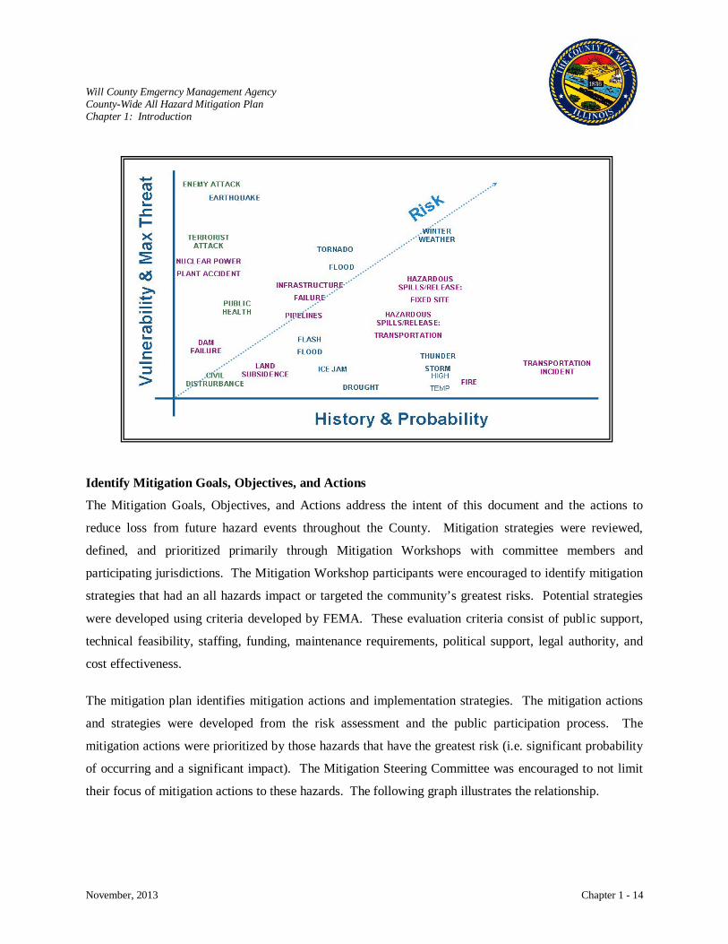
The 2013 Will County Hazard Analysis utilized a formal, structured procedure to develop mitigation and
emergency operation plans. FEMA has developed a process for assessing and evaluating hazards. Will
County utilized this process for assessing and evaluating hazards in order to promote a common base for
completing the analysis by defining criteria and providing a scoring system. Four criteria were used to
describe and assess the potential hazards, the four criteria include:
• History – past record of occurrences of the specified hazard. It is a guide of what has occurred in
the past but is not a guarantee of what may occur in the future.
• Vulnerability – pertains to the people that might be killed, injured, or contaminated and to
property that might be destroyed, damaged, or contaminated due to the occurrences of a specified
hazard.
• Maximum Threat – consists of the impacts from a ‘worst case’ scenario of a specified hazard and
is where the greatest impact to people and property is expected and assessed.
• Probability – refers to the likelihood of the occurrence of a specified hazard. It is expressed as
the number of chances per year that an event of a specific intensity will occur.
To complement the 2013 Risk Analysis, the methods employed by the Illinois Emergency Management
Agency (IEMA) and FEMA were incorporated to provide consistency between all levels of government.
The following graph illustrates the risk analysis based on the probability/history of the event and the
vulnerability/maximum threat (or impact) of the hazard.
Will County Emgerncy Management Agency County-Wide All Hazard Mitigation Plan Chapter 1: Introduction
November, 2013 Chapter 1 - 14
Identify Mitigation Goals, Objectives, and Actions
The Mitigation Goals, Objectives, and Actions address the intent of this document and the actions to
reduce loss from future hazard events throughout the County. Mitigation strategies were reviewed,
defined, and prioritized primarily through Mitigation Workshops with committee members and
participating jurisdictions. The Mitigation Workshop participants were encouraged to identify mitigation
strategies that had an all hazards impact or targeted the community’s greatest risks. Potential strategies
were developed using criteria developed by FEMA. These evaluation criteria consist of public support,
technical feasibility, staffing, funding, maintenance requirements, political support, legal authority, and
cost effectiveness.
The mitigation plan identifies mitigation actions and implementation strategies. The mitigation actions
and strategies were developed from the risk assessment and the public participation process. The
mitigation actions were prioritized by those hazards that have the greatest risk (i.e. significant probability
of occurring and a significant impact). The Mitigation Steering Committee was encouraged to not limit
their focus of mitigation actions to these hazards. The following graph illustrates the relationship.
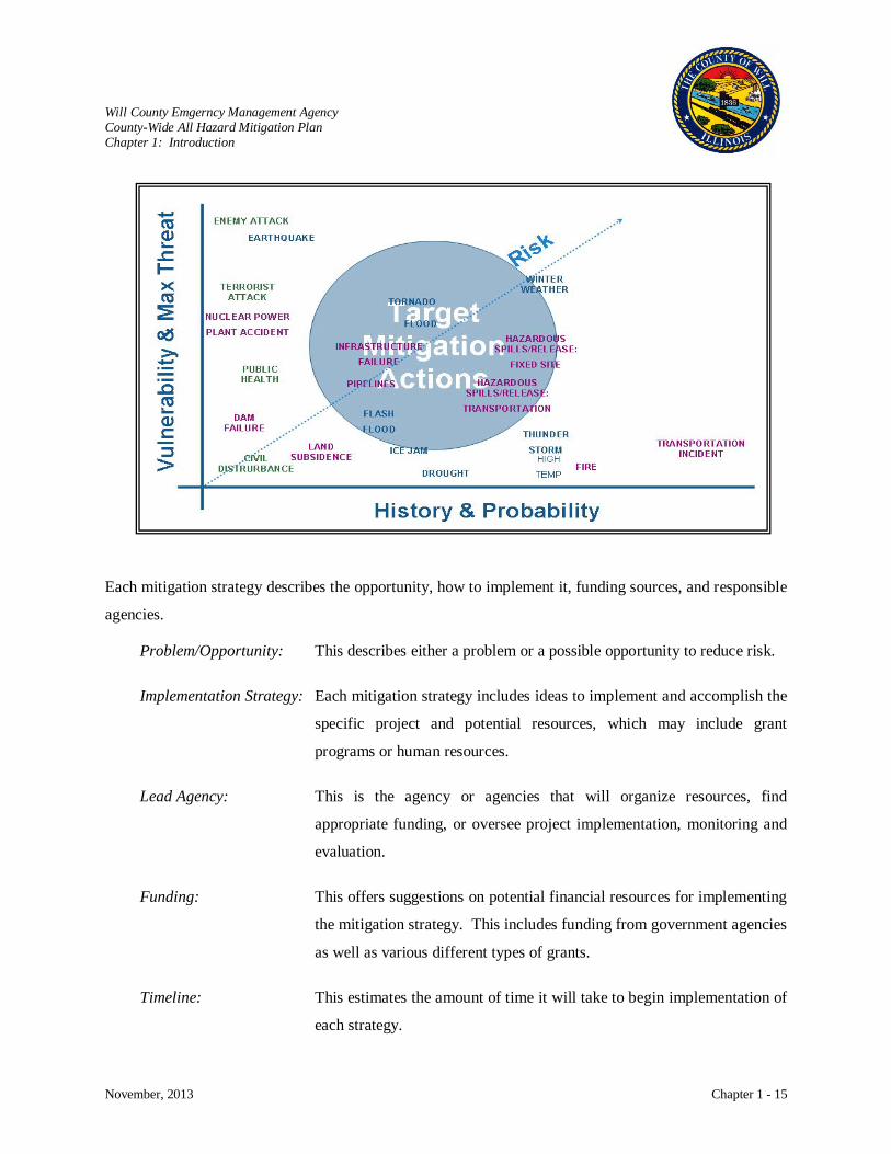
Will County Emgerncy Management Agency County-Wide All Hazard Mitigation Plan Chapter 1: Introduction
November, 2013 Chapter 1 - 15
Each mitigation strategy describes the opportunity, how to implement it, funding sources, and responsible
agencies.
Problem/Opportunity: This describes either a problem or a possible opportunity to reduce risk.
Implementation Strategy: Each mitigation strategy includes ideas to implement and accomplish the
specific project and potential resources, which may include grant
programs or human resources.
Lead Agency: This is the agency or agencies that will organize resources, find
appropriate funding, or oversee project implementation, monitoring and
evaluation.
Funding: This offers suggestions on potential financial resources for implementing
the mitigation strategy. This includes funding from government agencies
as well as various different types of grants.
Timeline: This estimates the amount of time it will take to begin implementation of
each strategy.
Will County Emgerncy Management Agency County-Wide All Hazard Mitigation Plan Chapter 1: Introduction
November, 2013 Chapter 1 - 16
Mitigation Plan Development
The Will County County-Wide All Hazard Mitigation Plan documents the mitigation planning process and
addresses the elements required in 44 CFR Part 201.6(c). Although the DMA2K requires local
governments to only address natural hazards, Will County EMA thought it was imperative to address all
hazards, including technological and societal (which includes terrorism) hazards. Will County EMA also
recognizes the importance of integrating mitigation with other state and federal directives.
Plan Monitoring and Maintenance
The Mitigation Steering Committee, with support of participating jurisdictions, will review the plan
annually or within 45 days of any disaster event. They will regularly review each goal and objective to
determine its relevance to the changing situation throughout Will County. They will also monitor and
evaluate the mitigation strategies in this plan to ensure that the document reflects current hazard analyses,
development trends, code changes, and risk analyses and perceptions. The committee will hear progress
reports from the parties responsible for the various implementation actions to monitor progress and create
future action plans and mitigation strategies. They will review the plan when other plans are being
updated, such as capital improvement project plans and comprehensive plan updates to ensure
consistency.
The participating jurisdictions and Will County recognize the importance of effectively communicating
with the public about the community’s hazards and what they can do to be prepared and mitigate their
threats. Continued public involvement is an important part of implementing, monitoring, and maintaining
the Will County County-Wide All Hazard Mitigation Plan. Will County EMA has provided a forum to
educate the public and solicit input, in order to effectively involve residents in the update and review of
the plan, as members of the Planning Committee.
Will County EMA, with active participation of County departments, local jurisdictions, and
organizations, will maintain and update the Will County County-Wide All Hazard Mitigation Plan. The
update of this plan will occur every five years as mandated by DMA2K. The Hazard Mitigation Steering
Committee will continue to solicit additional members and gather each year to assess the status of the
mitigation actions. Public input will be solicited throughout the year through a variety of methods that
include public meetings, website postings, and other means to provide a conduit to the community.
Will County Emgerncy Management Agency County-Wide All Hazard Mitigation Plan Chapter 1: Introduction
November, 2013 Chapter 1 - 17
FEMA Mitigation Plan Review Tool
The Will County County-Wide All Hazard Mitigation Plan is designed to meet the requirements of
DMA2K, while also developing a useable document to identify opportunities to alleviate the impact
and/or consequence of hazards on all of the communities of Will County. To ensure that the plan meets
the requirements of DMA2K, the Mitigation Project Team cross-referenced the All Hazard Mitigation
Plan with FEMA’s Local Mitigation Plan Review Tool. FEMA uses this tool to evaluate mitigation plans.
In addition, the tool identifies where each plan element is located within the plan document. The review
tool can also be used as part of an internal quality assurance procedure.
Will County Emergency Management Agency County-Wide All Hazard Mitigation Plan Chapter 2: Will County Community Overview
November, 2013 Chapter 2 - 1
CHAPTER 2: WILL COUNTY COMMUNITY OVERVIEW
A community overview is presented to provide background information in order to put the risk
assessment into perspective. The community overview also aids in the evaluation of proposed mitigation
measures. To ensure the integration of the Will County County-Wide All Hazard Mitigation Plan with
other County, jurisdictional, and emergency management planning documents, portions of this section
originating from the Will County Hazard Analysis, were updated with recent changes within Will County
and the participating jurisdictions and supplemented with information on hazard mitigation planning.
Historical Overview
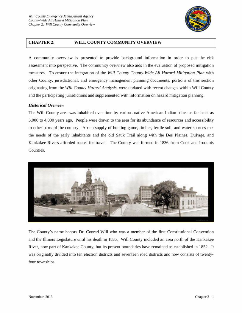
The Will County area was inhabited over time by various native American Indian tribes as far back as
3,000 to 4,000 years ago. People were drawn to the area for its abundance of resources and accessibility
to other parts of the country. A rich supply of hunting game, timber, fertile soil, and water sources met
the needs of the early inhabitants and the old Sauk Trail along with the Des Plaines, DuPage, and
Kankakee Rivers afforded routes for travel. The County was formed in 1836 from Cook and Iroquois
Counties.
The County’s name honors Dr. Conrad Will who was a member of the first Constitutional Convention
and the Illinois Legislature until his death in 1835. Will County included an area north of the Kankakee
River, now part of Kankakee County, but its present boundaries have remained as established in 1852. It
was originally divided into ten election districts and seventeen road districts and now consists of twenty-
four townships.
Will County Emergency Management Agency County-Wide All Hazard Mitigation Plan Chapter 2: Will County Community Overview
November, 2013 Chapter 2 - 2
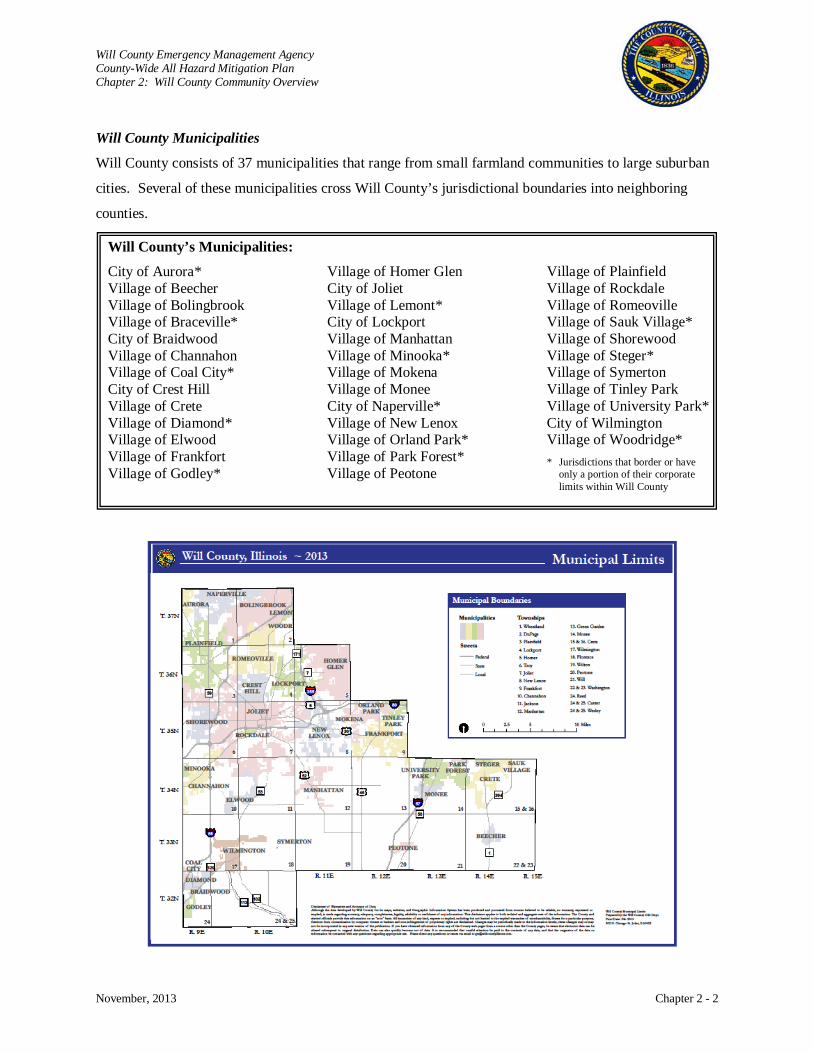
Will County Municipalities
Will County consists of 37 municipalities that range from small farmland communities to large suburban
cities. Several of these municipalities cross Will County’s jurisdictional boundaries into neighboring
counties.
Will County’s Municipalities:
City of Aurora* Village of Beecher Village of Bolingbrook Village of Braceville* City of Braidwood Village of Channahon Village of Coal City* City of Crest Hill Village of Crete Village of Diamond* Village of Elwood Village of Frankfort Village of Godley*
Village of Homer Glen City of Joliet Village of Lemont* City of Lockport Village of Manhattan Village of Minooka* Village of Mokena Village of Monee City of Naperville* Village of New Lenox Village of Orland Park* Village of Park Forest* Village of Peotone
Village of Plainfield Village of Rockdale Village of Romeoville Village of Sauk Village* Village of Shorewood Village of Steger* Village of Symerton Village of Tinley Park Village of University Park* City of Wilmington Village of Woodridge*
* Jurisdictions that border or have only a portion of their corporate limits within Will County

Will County Emergency Management Agency County-Wide All Hazard Mitigation Plan Chapter 2: Will County Community Overview
November, 2013 Chapter 2 - 3
Geography and Climate
Will County, covering an area of 846 square miles, is one of
Illinois’ 102 counties. The County is part of the Chicago
Metropolitan area, located in northeastern Illinois. Joliet, the
county seat, is located approximately forty miles southwest of
Chicago at an altitude of approximately 600 feet above sea level.
The continental glaciers that covered Illinois thousands of years
ago created the relatively flat terrain. As the Wisconsonian, the
last glacier in Illinois, retreated and melted, the lakes and rivers
that were important to the County’s early inhabitants were
formed. Today, water transportation remains important for the
shipment of goods as the County’s three main rivers: Des Plaines,
DuPage, and Kankakee. These rivers run along the Chicago
Sanitary and Ship Canal and Illinois and Michigan (I&M) Canal
and provide a connection between the Great Lakes and Gulf of Mexico.
After glaciation, prairies formed over most of Illinois. The morainal and Grand Prairie sections
predominated in Will County. The windblown silt deposited during glacial retreat and prairie vegetation
created a mollisol or dark-colored soil found in the northern half or two-thirds of Illinois. This type of
soil is conducive to the growing of
corn, oats, soybean, wheat, and hay
that are grown by today’s farmers.
The area experiences a humid
continental climate with hot summers
and cold winters. Three air masses
influence the County’s climate.
Generally in the winter, cold, dry air
flows down from Canada. The
summer months experience warm,
very humid air from the Gulf of
Mexico. Dry, warm air from the
Pacific Ocean occurs especially in the
fall.
Will County Township Map
Will County Emergency Management Agency County-Wide All Hazard Mitigation Plan Chapter 2: Will County Community Overview
November, 2013 Chapter 2 - 4
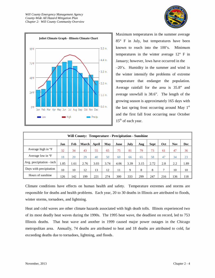
Maximum temperatures in the summer average
85° F in July, but temperatures have been
known to reach into the 100’s. Minimum
temperatures in the winter average 12° F in
January; however, lows have occurred in the
–20’s. Humidity in the summer and wind in
the winter intensify the problems of extreme
temperature that endanger the population.
Average rainfall for the area is 35.8” and
average snowfall is 38.6”. The length of the
growing season is approximately 165 days with
the last spring frost occurring around May 1st
and the first fall frost occurring near October
15th
of each year.
Will County: Temperature - Precipitation - Sunshine
Jan Feb March April May June July Aug Sept Oct Nov Dec Average high in °F 32 34 43 55 65 75 81 79 73 61 47 36 Average low in °F 18 20 29 40 50 60 66 65 58 47 34 23
Avg. precipitation - inch 1.85 1.61 2.76 3.03 3.74 4.06 3.39 3.15 2.72 2.8 2.2 1.89 Days with precipitation 10 10 12 13 12 11 9 8 8 7 10 10
Hours of sunshine 126 142 199 221 274 300 333 299 247 216 136 118
Climate conditions have effects on human health and safety. Temperature extremes and storms are
responsible for deaths and health problems. Each year, 20 to 30 deaths in Illinois are attributed to floods,
winter storms, tornadoes, and lightning.
Heat and cold waves are other climate hazards associated with high death tolls. Illinois experienced two
of its most deadly heat waves during the 1990s. The 1995 heat wave, the deadliest on record, led to 753
Illinois deaths. That heat wave and another in 1999 caused major power outages in the Chicago
metropolitan area. Annually, 74 deaths are attributed to heat and 18 deaths are attributed to cold, far
exceeding deaths due to tornadoes, lightning, and floods.
Joliet Climate Graph - Illinois Climate Chart

Will County Emergency Management Agency County-Wide All Hazard Mitigation Plan Chapter 2: Will County Community Overview
November, 2013 Chapter 2 - 5
Flooding is the single most damaging weather hazard in Illinois. Ever-increasing heavy precipitation
since the 1940s has led to increased flood peaks on Illinois’ rivers. Flood losses recorded in the National
Oceanic and Atmospheric Administration’s (NOAA) Nation Climatic Data Center (NCDC) database
exceeded $5.5 billion in Illinois between 1993 and 2012. Since 1965, flooding was either the main or a
significant contributing factor for 32 out of the 52 Presidential Disaster Declarations declared in Illinois.
Climatic Controls
Five factors control the continental climate of Illinois: sun, weather systems, topography, urban areas, and
Lake Michigan. Two major controls are latitude (reflecting the amount of solar input) and weather
systems (air masses and cyclonic storms). The effects of topography, Lake Michigan, and urban areas are
of lesser significance because they influence local climate conditions, rather than conditions statewide.
Climatic Controls
Sun
• Primary energy source for virtually all weather phenomena, in large part, determines air temperatures and seasonal variations
• Solar energy is three to four times greater in early summer than in early winter at Illinois' mid-latitude location, which results in warm summers and cold winters when combined with the state's inland location
Weather Systems
• Second major factor affecting the state's climate • Create wide variety of weather conditions that occur almost daily as a result of varying air
masses and passing storm systems • Polar jet stream often is located near or over Illinois, especially in fall, winter, and spring,
and is the focal point for the creation and movement of low-pressure storm systems, characterized by clouds, winds, and precipitation
• Settled weather associated with high pressure systems is generally ended every few days by the passage of low-pressure systems
Topography • Shawnee Hills extend across southern Illinois and have elevations 500 to 900 feet higher
than the surrounding terrain • This change in elevation is enough to increase annual precipitation by about 10 to 15 percent
Urban Areas
• Buildings, parking lots, roads, and industrial activities make the urban climate noticeably different than that of surrounding rural areas
• Chicago tends to be warmer by 2°F, on average, especially at night • Also enhance summertime precipitation downwind of the city and cause changes in
humidity, cloudiness, wind speed and direction
Lake Michigan
• Influences the climate of northeastern Illinois, especially Chicago • Large thermal mass of the lake tends to moderate temperatures, causing cooler summers and
warmer winters • Major benefit is cool lake breezes that provide some relief from summer heat • Also tends to increase cloudiness in the area and suppress summer precipitation • Winter precipitation is enhanced by lake-effect snows that occur when winds blow from the
north or northeast • Winds allow air to pass over the relatively warm lake, boosting storm system energy and
water content, leading to increased snowfall Source: Illinois Climate Atlas. S. A. Changnon, J. R. Angel, and K. E. Kunkel. Illinois State Water Survey, Champaign, Illinois.
Will County Emergency Management Agency County-Wide All Hazard Mitigation Plan Chapter 2: Will County Community Overview
November, 2013 Chapter 2 - 6
Illinois Temperature
Average annual temperatures range from 48°F (north) to 58°F (south), with highs ranging from 57°F
(north) to 67°F (south). Average winter highs range from the 30s (north) to the mid-40s (south), while
average lows range from the teens (north) to the upper 20s (south). Average summer highs are in the 80s,
while lows are in the 60s across the state. Both spring and fall have more moderate temperatures.
Average spring highs range from 57°F (north) to 67°F (south), while average lows range from 36°F
(north) to 48°F (south). Average fall highs range from 60°F (north) to 70°F (south), while average lows
range from 40°F (north) to 48°F (south).
Northern Illinois averages 10 days at or above 90°F (north) compared to just over 40 days (south). Days
at or above 100°F are quite rare, occurring about every other year (north) and 2 days annually (south).
Illinois averages 140 days at or below 32°F (north) but only 80 such days (south). Days at or below 0°F
range from 16 days annually (north) to 2 days (south).
Average annual heating-degree days range from 70 days (north) to 40 days (south). Average annual
cooling-degree days range from 80 days (north) to 160 days (south). The base temperature used for both
heating-degree and cooling-degree days is the same (65°F).
The average length of the frost-free growing season in Illinois ranges from 160 days (north) to more than
190 days (south). Average dates of the last occurrence of 32°F in spring range from April 28 (north) to
April 7 (south), while the average dates of the first occurrence of this temperature in fall range from
October 7 (north) to October 21 (south), and about October 14 near Lake Michigan, including the
Chicago area, due to relatively warm waters of the lake.
The highest and lowest temperatures ever reported in Illinois were 117°F in East St. Louis on July 14,
1954, and -36°F in Congerville on January 5, 1999.
Precipitation
Average precipitation exceeds 48 inches per year (south), compared to less than 32 inches (north).
Snowfall distribution is just the opposite, with averages of 36 inches per year in the north to less than 10
inches in extreme southern Illinois. Winter snowfall is heaviest in the Chicago area, enhanced by lake-
effect snows from Lake Michigan. Variability in precipitation also extends over time. There have been
major multi-year droughts in the 1930s and 1950s and major, prolonged wet periods during the 1970s and
1980s. May and June are typically the wettest months, and January and February are the driest. Each

Will County Emergency Management Agency County-Wide All Hazard Mitigation Plan Chapter 2: Will County Community Overview
November, 2013 Chapter 2 - 7
year, Illinois has rainstorms producing 40 or more flash-floods each with 4 to 8 inches of rainfall in a few
hours in localized areas.
The average number of days with measurable precipitation ranges from 110 days (north) to just under 100
days (south). The number of days with an inch or more of precipitation ranges from 8 days (north) to 13
days (south), and the number of days with an inch or more of snow ranges from 12 days (north) to 4 days
(south). Days with 6 inches or more of snow are infrequent, ranging from once per year (north) to once in
three years (south). Typical dates of the first inch of snow range from November 20th (Chicago area) to
December 20th (south). Typical dates of the last inch of snow range from March 26 (north) to March 5
(south). The average number
of days with a measurable
snow depth (1 inch or more)
ranges from 60 days
(northwest) to only 10 days
(southwest).
Precipitation records for
Illinois include:
• Greatest 24-hour rainfall
was 16.94 inches at
Aurora on July 17-18,
1996
• Greatest one-year
precipitation was 74.58
inches at New Burnside in
1950
• Greatest 24-hour snowfall
was 37.8 inches at Astoria
on February 27-28, 1900
• Greatest winter snowfall
was 105.1 inches at
Antioch in 1978-1979.
Available from: http://www.climate-charts.com/Locations/u/US72530001115491.php
Will County Emergency Management Agency County-Wide All Hazard Mitigation Plan Chapter 2: Will County Community Overview
November, 2013 Chapter 2 - 8
Severe Weather
Illinois experiences about 29 tornadoes annually. Peak months are April-June (63 percent of the total),
but tornadoes have occurred in all months. Although Illinois averages four tornado-related fatalities per
year, the number varies widely from year to year.
Thunderstorms account for 50-60 percent of annual precipitation and are quite common in Illinois with an
average of 60 storms (far northeast) to 80 storms (southwest). Nearly half of all thunderstorm days occur
during the June-August period. Similarly, the average number of cloud-to-ground lightning strikes per
square mile ranges from 5 strikes (northeast) to more than 11 strikes (southwest). Some thunderstorms
produce hail, and annual average hail-days vary from 3.3 days (southwest) to less than 1.8 days
(northeast).
Climate and the Economy
Major businesses in Illinois are highly climate sensitive. Crop yields are dependent upon climate
conditions because irrigation generally is not used. Illinois serves as the nation’s center for air and
surface transportation. With the nation’s second busiest passenger airport (O’Hare) and the rail hub
of the nation at Chicago, Illinois also is the heart of the nation’s trucking industry. Each form of
transportation is influenced by weather and climate extremes, and resulting delays in shipments are a
major problem for manufacturers in Illinois.
Vegetation
Will County is located at the northeastern edge of the Tall Grass Prairie biome. The area was historically
dominated by prairie and scattered woodlands, with wetlands associated with depressions and riverine
systems. Much of the original vegetative communities of Will County are no longer present. The County
is now made up primarily of agricultural land with various urban and suburban communities. Remnants
of pre-settlement vegetation can still be found in the various Will County Forest Preserve District
preserves and greenways, Illinois State Parks, and Illinois Nature Preserves located within the County.
Rivers
Three major river corridors are located within Will County; these corridors are associated with the
DuPage River, the Kankakee River, and the Des Plaines River. Various creeks feed into the three main
rivers, including Forked, Manhattan, Pike, Rock Run, Trim, Spring, Deer, Lily Cache, Grant, Thorn,
Jackson, Prairie, Hickory, Sugar, and Plum Creeks.
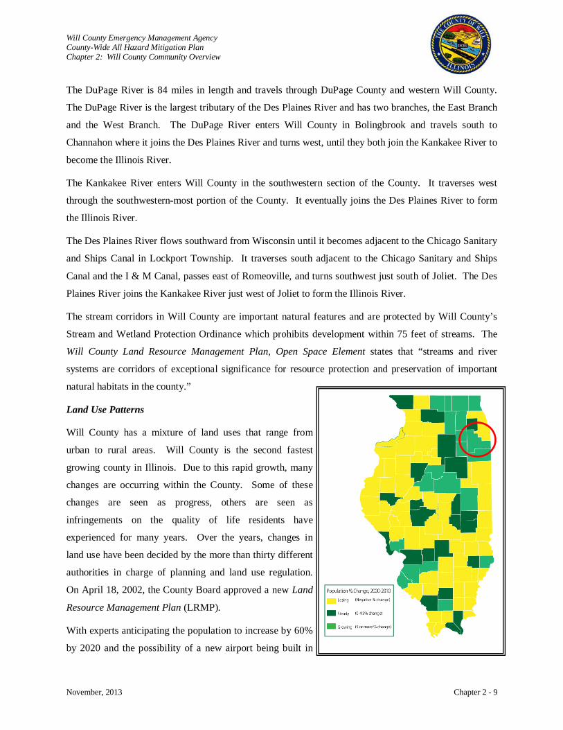
Will County Emergency Management Agency County-Wide All Hazard Mitigation Plan Chapter 2: Will County Community Overview
November, 2013 Chapter 2 - 9
The DuPage River is 84 miles in length and travels through DuPage County and western Will County.
The DuPage River is the largest tributary of the Des Plaines River and has two branches, the East Branch
and the West Branch. The DuPage River enters Will County in Bolingbrook and travels south to
Channahon where it joins the Des Plaines River and turns west, until they both join the Kankakee River to
become the Illinois River.
The Kankakee River enters Will County in the southwestern section of the County. It traverses west
through the southwestern-most portion of the County. It eventually joins the Des Plaines River to form
the Illinois River.
The Des Plaines River flows southward from Wisconsin until it becomes adjacent to the Chicago Sanitary
and Ships Canal in Lockport Township. It traverses south adjacent to the Chicago Sanitary and Ships
Canal and the I & M Canal, passes east of Romeoville, and turns southwest just south of Joliet. The Des
Plaines River joins the Kankakee River just west of Joliet to form the Illinois River.
The stream corridors in Will County are important natural features and are protected by Will County’s
Stream and Wetland Protection Ordinance which prohibits development within 75 feet of streams. The
Will County Land Resource Management Plan, Open Space Element states that “streams and river
systems are corridors of exceptional significance for resource protection and preservation of important
natural habitats in the county.”
Land Use Patterns
Will County has a mixture of land uses that range from
urban to rural areas. Will County is the second fastest
growing county in Illinois. Due to this rapid growth, many
changes are occurring within the County. Some of these
changes are seen as progress, others are seen as
infringements on the quality of life residents have
experienced for many years. Over the years, changes in
land use have been decided by the more than thirty different
authorities in charge of planning and land use regulation.
On April 18, 2002, the County Board approved a new Land
Resource Management Plan (LRMP)
With experts anticipating the population to increase by 60%
by 2020 and the possibility of a new airport being built in
.
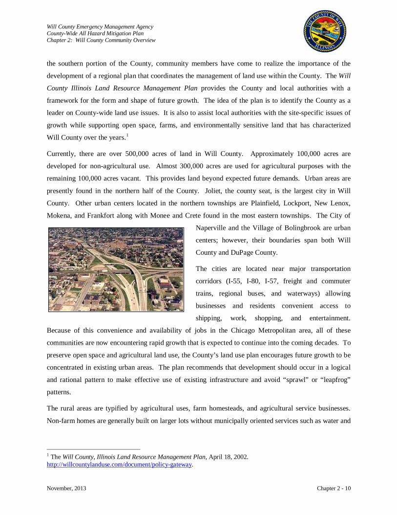
Will County Emergency Management Agency County-Wide All Hazard Mitigation Plan Chapter 2: Will County Community Overview
November, 2013 Chapter 2 - 10
the southern portion of the County, community members have come to realize the importance of the
development of a regional plan that coordinates the management of land use within the County. The Will
County Illinois Land Resource Management Plan provides the County and local authorities with a
framework for the form and shape of future growth. The idea of the plan is to identify the County as a
leader on County-wide land use issues. It is also to assist local authorities with the site-specific issues of
growth while supporting open space, farms, and environmentally sensitive land that has characterized
Will County over the years.1
Currently, there are over 500,000 acres of land in Will County. Approximately 100,000 acres are
developed for non-agricultural use. Almost 300,000 acres are used for agricultural purposes with the
remaining 100,000 acres vacant. This provides land beyond expected future demands. Urban areas are
presently found in the northern half of the County. Joliet, the county seat, is the largest city in Will
County. Other urban centers located in the northern townships are Plainfield, Lockport, New Lenox,
Mokena, and Frankfort along with Monee and Crete found in the most eastern townships. The City of
Naperville and the Village of Bolingbrook are urban
centers; however, their boundaries span both Will
County and DuPage County.
The cities are located near major transportation
corridors (I-55, I-80, I-57, freight and commuter
trains, regional buses, and waterways) allowing
businesses and residents convenient access to
shipping, work, shopping, and entertainment.
Because of this convenience and availability of jobs in the Chicago Metropolitan area, all of these
communities are now encountering rapid growth that is expected to continue into the coming decades. To
preserve open space and agricultural land use, the County’s land use plan encourages future growth to be
concentrated in existing urban areas. The plan recommends that development should occur in a logical
and rational pattern to make effective use of existing infrastructure and avoid “sprawl” or “leapfrog”
patterns.
The rural areas are typified by agricultural uses, farm homesteads, and agricultural service businesses.
Non-farm homes are generally built on larger lots without municipally oriented services such as water and
1 The Will County, Illinois Land Resource Management Plan, April 18, 2002. http://willcountylanduse.com/document/policy-gateway.
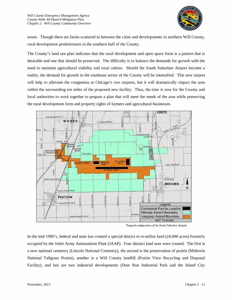
Will County Emergency Management Agency County-Wide All Hazard Mitigation Plan Chapter 2: Will County Community Overview
November, 2013 Chapter 2 - 11
sewer. Though there are farms scattered in between the cities and developments in northern Will County,
rural development predominates in the southern half of the County.
The County’s land use plan indicates that the rural development and open space form is a pattern that is
desirable and one that should be preserved. The difficulty is to balance the demands for growth with the
need to maintain agricultural viability and rural culture. Should the South Suburban Airport become a
reality, the demand for growth in the southeast sector of the County will be intensified. This new airport
will help to alleviate the congestion at Chicago’s two airports, but it will dramatically impact the area
within the surrounding ten miles of the proposed new facility. Thus, the time is now for the County and
local authorities to work together to prepare a plan that will meet the needs of the area while preserving
the rural development form and property rights of farmers and agricultural businesses.
In the mid 1990’s, federal and state law created a special district to re-utilize land (24,000 acres) formerly
occupied by the Joliet Army Ammunition Plant (JAAP). Four distinct land uses were created. The first is
a new national cemetery (Lincoln National Cemetery), the second is the preservation of prairie (Midewin
National Tallgrass Prairie), another is a Will County landfill (Prairie View Recycling and Disposal
Facility), and last are two industrial developments (Deer Run Industrial Park and the Island City
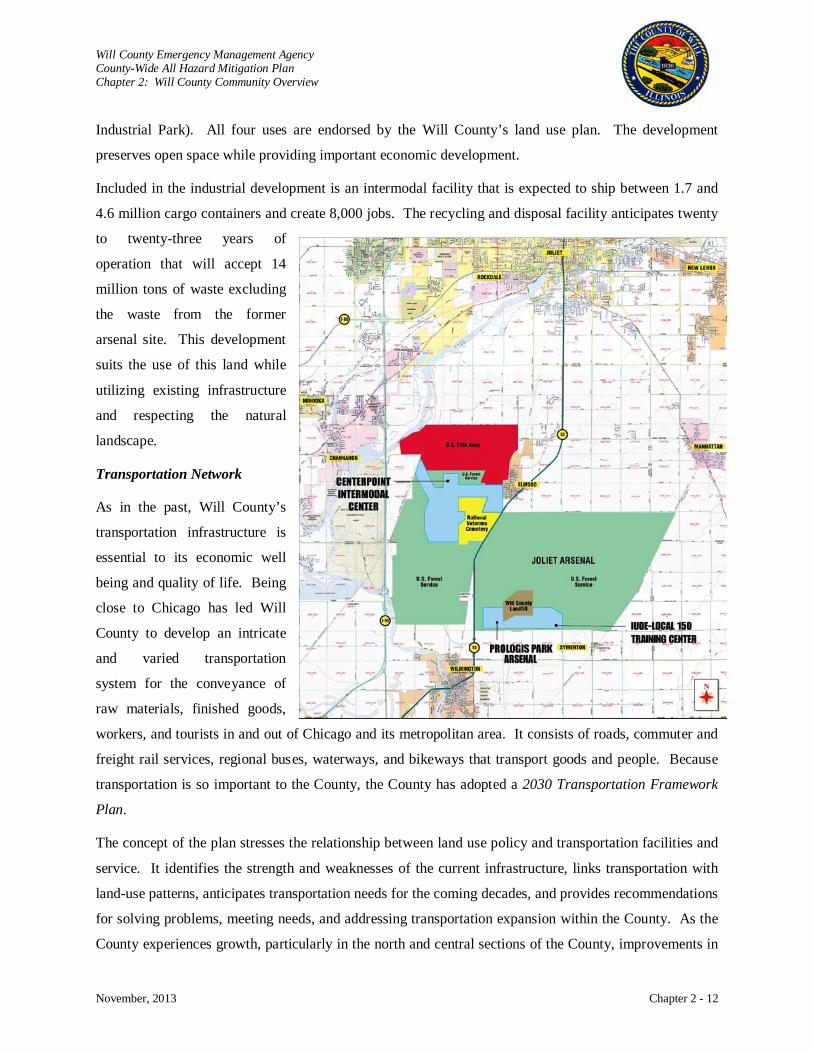
Will County Emergency Management Agency County-Wide All Hazard Mitigation Plan Chapter 2: Will County Community Overview
November, 2013 Chapter 2 - 12
Industrial Park). All four uses are endorsed by the Will County’s land use plan. The development
preserves open space while providing important economic development.
Included in the industrial development is an intermodal facility that is expected to ship between 1.7 and
4.6 million cargo containers and create 8,000 jobs. The recycling and disposal facility anticipates twenty
to twenty-three years of
operation that will accept 14
million tons of waste excluding
the waste from the former
arsenal site. This development
suits the use of this land while
utilizing existing infrastructure
and respecting the natural
landscape.
Transportation Network
As in the past, Will County’s
transportation infrastructure is
essential to its economic well
being and quality of life. Being
close to Chicago has led Will
County to develop an intricate
and varied transportation
system for the conveyance of
raw materials, finished goods,
workers, and tourists in and out of Chicago and its metropolitan area. It consists of roads, commuter and
freight rail services, regional buses, waterways, and bikeways that transport goods and people. Because
transportation is so important to the County, the County has adopted a 2030 Transportation Framework
Plan.
The concept of the plan stresses the relationship between land use policy and transportation facilities and
service. It identifies the strength and weaknesses of the current infrastructure, links transportation with
land-use patterns, anticipates transportation needs for the coming decades, and provides recommendations
for solving problems, meeting needs, and addressing transportation expansion within the County. As the
County experiences growth, particularly in the north and central sections of the County, improvements in
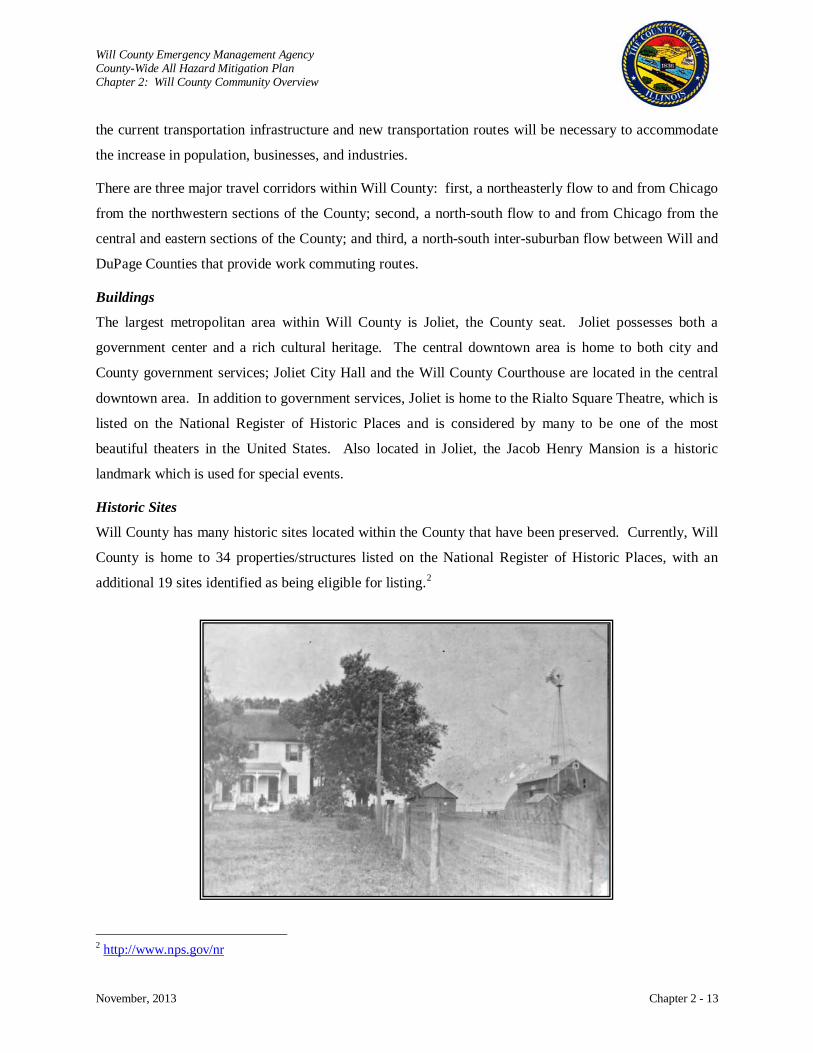
Will County Emergency Management Agency County-Wide All Hazard Mitigation Plan Chapter 2: Will County Community Overview
November, 2013 Chapter 2 - 13
the current transportation infrastructure and new transportation routes will be necessary to accommodate
the increase in population, businesses, and industries.
There are three major travel corridors within Will County: first, a northeasterly flow to and from Chicago
from the northwestern sections of the County; second, a north-south flow to and from Chicago from the
central and eastern sections of the County; and third, a north-south inter-suburban flow between Will and
DuPage Counties that provide work commuting routes.
Buildings
The largest metropolitan area within Will County is Joliet, the County seat. Joliet possesses both a
government center and a rich cultural heritage. The central downtown area is home to both city and
County government services; Joliet City Hall and the Will County Courthouse are located in the central
downtown area. In addition to government services, Joliet is home to the Rialto Square Theatre, which is
listed on the National Register of Historic Places and is considered by many to be one of the most
beautiful theaters in the United States. Also located in Joliet, the Jacob Henry Mansion is a historic
landmark which is used for special events.
Historic Sites
Will County has many historic sites located within the County that have been preserved. Currently, Will
County is home to 34 properties/structures listed on the National Register of Historic Places, with an
additional 19 sites identified as being eligible for listing.2
2 http://www.nps.gov/nr
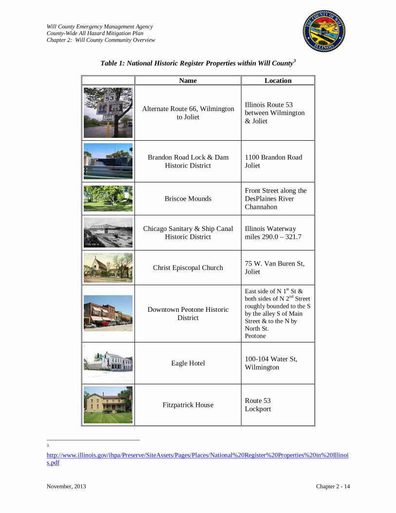
Will County Emergency Management Agency County-Wide All Hazard Mitigation Plan Chapter 2: Will County Community Overview
November, 2013 Chapter 2 - 14
Table 1: National Historic Register Properties within Will County3
Name Location
Alternate Route 66, Wilmington to Joliet
Illinois Route 53 between Wilmington & Joliet
Brandon Road Lock & Dam Historic District
1100 Brandon Road Joliet
Briscoe Mounds
Front Street along the DesPlaines River Channahon
Chicago Sanitary & Ship Canal Historic District
Illinois Waterway miles 290.0 – 321.7
Christ Episcopal Church 75 W. Van Buren St, Joliet
Downtown Peotone Historic District
East side of N 1st St & both sides of N 2nd Street roughly bounded to the S by the alley S of Main Street & to the N by North St. Peotone
Eagle Hotel 100-104 Water St, Wilmington
Fitzpatrick House Route 53 Lockport
3 http://www.illinois.gov/ihpa/Preserve/SiteAssets/Pages/Places/National%20Register%20Properties%20in%20Illinois.pdf

Will County Emergency Management Agency County-Wide All Hazard Mitigation Plan Chapter 2: Will County Community Overview
November, 2013 Chapter 2 - 15
National Historic Register Properties within Will County
Name Location
Flanders House 405 W. Main Street Plainfield.
Ron George Round Barn NE of Romeoville off US 66 Romeoville
John Heck House 1225 S. Hamilton Lockport
Jacob H. Henry House 20 S. Eastern Ave Joliet
Illinois & Michigan Canal
7 miles SW of Joliet on U.S. Route 6 in Channahon State Park Joliet
Joliet YMCA 215 N. Ottawa Street Joliet
Joliet East Side Historic District
Between Washington and Union Sts, 4th and Eastern Avenues Joliet
Joliet Municipal Airport 4000 W. Jefferson Street Joliet
Joliet Steel Works 927 Collins Street Joliet
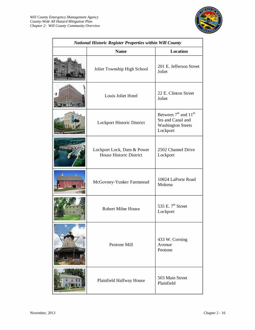
Will County Emergency Management Agency County-Wide All Hazard Mitigation Plan Chapter 2: Will County Community Overview
November, 2013 Chapter 2 - 16
National Historic Register Properties within Will County
Name Location
Joliet Township High School 201 E. Jefferson Street Joliet
Louis Joliet Hotel 22 E. Clinton Street Joliet
Lockport Historic District
Between 7th and 11th Sts and Canal and Washington Steets Lockport
Lockport Lock, Dam & Power House Historic District
2502 Channel Drive Lockport
McGovney-Yunker Farmstead 10824 LaPorte Road Mokena
Robert Milne House 535 E. 7th Street Lockport
Peotone Mill 433 W. Corning Avenue Peotone
Plainfield Halfway House 503 Main Street Plainfield
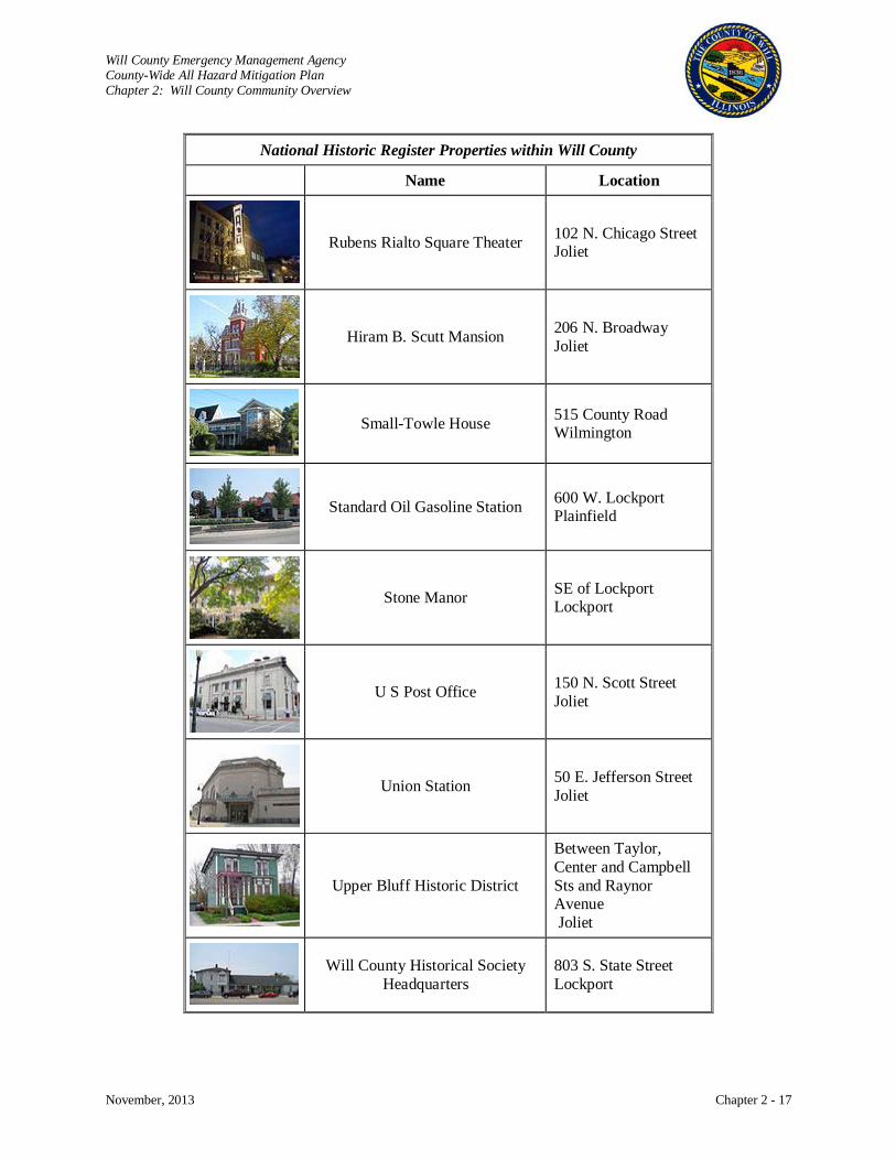
Will County Emergency Management Agency County-Wide All Hazard Mitigation Plan Chapter 2: Will County Community Overview
November, 2013 Chapter 2 - 17
National Historic Register Properties within Will County
Name Location
Rubens Rialto Square Theater 102 N. Chicago Street Joliet
Hiram B. Scutt Mansion 206 N. Broadway Joliet
Small-Towle House 515 County Road Wilmington
Standard Oil Gasoline Station 600 W. Lockport Plainfield
Stone Manor SE of Lockport Lockport
U S Post Office 150 N. Scott Street Joliet
Union Station 50 E. Jefferson Street Joliet
Upper Bluff Historic District
Between Taylor, Center and Campbell Sts and Raynor Avenue Joliet
Will County Historical Society Headquarters
803 S. State Street Lockport

Will County Emergency Management Agency County-Wide All Hazard Mitigation Plan Chapter 2: Will County Community Overview
November, 2013 Chapter 2 - 18
Additionally, the Will County Land Use Department maintains a register of historic places. Below are the
places that are considered Historic Landmarks on this register. Additional information can be located at:
http://willcountylanduse.com/historic-preservation/will-county-local-landmark-program.
Table 2: Will County Register of Historic Landmarks Name Location
16th Lockport Township Street Bridge, circa 1899 David Aldrich House City of Wilmington John C. Baker Barn, circa 1898 Manhattan Township
Beecher Cemetery & Mausoleum, circa 1913 Beecher Township
Beecher Railroad Depot, circa 1872 Village of Beecher Boy Scout Cabin Village of New Lenox Rodney Bowen House City of Wilmington Brown Cemetery Custer Township Brown Church Cemetery Jackson Township Dickinson General Store Village of New Lenox
District 117 Paton School Manhattan Township
District 121 Schmuhl School New Lenox Township
Division Street Bridge across the Des Plaines River Lockport Township
James Ducker House Village of Mokena
John Fiddyment Home, circa 1840s Lockport Township
Patrick Fitzpatrick House, circa 1842 Lockport Township
Fred Francis 4-H Field Village of New Lenox
William Gooding Home Lockport Township
Friedrich Gottlieb Seggerbruch Homestead Crete Township
German Baptist Society Cemetery, circa 1860 Green Garden Township
Joliet Works, US Steel, Koppers Coke Oven Plant Joliet Township
Christian Krohn House Will Township
Landon’s Store Unincorporated Ritchie
John Lane Monument, circa 1916 Homer Township
Oliver Lovell Farmstead Florence Township
New Lenox/Haven Grade School Village of New Lenox
Niver-Pickel-Walsh Farm, circa 1850 Plainfield Township
North Providence Ridge Cemetery Jackson Township
Will County Emergency Management Agency County-Wide All Hazard Mitigation Plan Chapter 2: Will County Community Overview
November, 2013 Chapter 2 - 19
Ogren-Reed House Village of New Lenox
Old Brick Tavern Monument New Lenox Township
Paton School, circa 1860 Manhattan Township
H.A. Rathje Mill, circa 1872 Village of Peotone
Riegel Farm Village of University Park
Ritchey United Methodist Church Wesley Township
Benjamin F. Russell House Village of Homer Glen
John Salisbury House Village of New Lenox
Solder’s Widow’s Laundry House Wilmington Township
Small-Towel House Wilmington Township
Springbanks Road Bridge, circa 1912 Plainfield Township
Carl Wilhelm Steiber House Crete Township
William Tilsy Barn Village of Homer Glen
Union Burial Cemetery, circa 1852 Frankfort Township
Wabash Railroad Depot Wesley Township
Wesley Township Hall, circa 1872 Village of Peotone
Wheatland Cemetery Wheatland Township
Wheatland United Presbyterian Church and Cemetery Wheatland Township
Transportation
Roads: The highway system consists of four interstate highways that include I-55, I-57, I-80, and I-355.
Interstates 55 and 80 intersect in Joliet, the county seat, providing high accessibility. The state highways
include IL 1, 7, 45, 50, 53, 59, and 394 along with U.S. Routes 6, 30, and 52. Fifty-six county highways
exist to provide service between U.S. and state highways. Township roads serve the needs of the farming
community and municipal streets serve local and through traffic within a city or village.
The Will County 2030 Transportation Framework Plan identified the fact that substantial growth is
forecasted for Will County, this growth will require transportation improvements. The plan makes
specific suggestions for regional interstate, major roadway, arterial streets, and intersection realignments
to accommodate this growth.4
4 Barton-Aschman Associates, Will County 2030 Transportation Framework Plan, March 2009.
http://willcountylanduse.com/resource/document/2009-transportation-plan
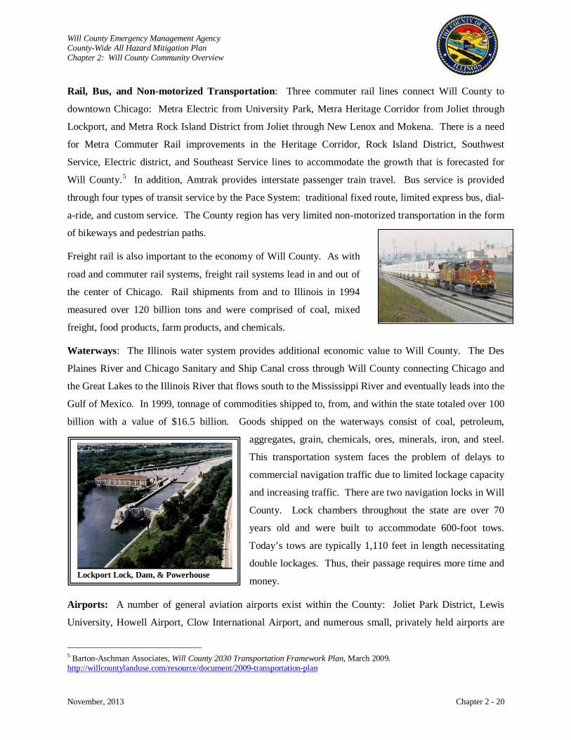
Will County Emergency Management Agency County-Wide All Hazard Mitigation Plan Chapter 2: Will County Community Overview
November, 2013 Chapter 2 - 20
Rail, Bus, and Non-motorized Transportation: Three commuter rail lines connect Will County to
downtown Chicago: Metra Electric from University Park, Metra Heritage Corridor from Joliet through
Lockport, and Metra Rock Island District from Joliet through New Lenox and Mokena. There is a need
for Metra Commuter Rail improvements in the Heritage Corridor, Rock Island District, Southwest
Service, Electric district, and Southeast Service lines to accommodate the growth that is forecasted for
Will County.5
Freight rail is also important to the economy of Will County. As with
road and commuter rail systems, freight rail systems lead in and out of
the center of Chicago. Rail shipments from and to Illinois in 1994
measured over 120 billion tons and were comprised of coal, mixed
freight, food products, farm products, and chemicals.
In addition, Amtrak provides interstate passenger train travel. Bus service is provided
through four types of transit service by the Pace System: traditional fixed route, limited express bus, dial-
a-ride, and custom service. The County region has very limited non-motorized transportation in the form
of bikeways and pedestrian paths.
Waterways: The Illinois water system provides additional economic value to Will County. The Des
Plaines River and Chicago Sanitary and Ship Canal cross through Will County connecting Chicago and
the Great Lakes to the Illinois River that flows south to the Mississippi River and eventually leads into the
Gulf of Mexico. In 1999, tonnage of commodities shipped to, from, and within the state totaled over 100
billion with a value of $16.5 billion. Goods shipped on the waterways consist of coal, petroleum,
aggregates, grain, chemicals, ores, minerals, iron, and steel.
This transportation system faces the problem of delays to
commercial navigation traffic due to limited lockage capacity
and increasing traffic. There are two navigation locks in Will
County. Lock chambers throughout the state are over 70
years old and were built to accommodate 600-foot tows.
Today’s tows are typically 1,110 feet in length necessitating
double lockages. Thus, their passage requires more time and
money.
Airports: A number of general aviation airports exist within the County: Joliet Park District, Lewis
University, Howell Airport, Clow International Airport, and numerous small, privately held airports are
5 Barton-Aschman Associates, Will County 2030 Transportation Framework Plan, March 2009. http://willcountylanduse.com/resource/document/2009-transportation-plan
Lockport Lock, Dam, & Powerhouse

Will County Emergency Management Agency County-Wide All Hazard Mitigation Plan Chapter 2: Will County Community Overview
November, 2013 Chapter 2 - 21
located within the County. In addition to local airports, there is easy accessibility to Chicago’s O’Hare
International and Midway Airports. Plans are being debated for a South Suburban Airport which would
be located in the County’s Peotone area and would demand additional infrastructure to support
transportation needs and area growth that would inevitably result.
Population Characteristics
It is important to examine the population characteristics since densely populated areas typically
experience the majority of destruction during a disaster. Further, growing communities offer
opportunities to identify additional mitigation measures. Between 1990 and 2010, Will County’s
population grew by over 320,000 people, nearly doubling its population in just twenty years.
Approximately 85% of the County’s population lives in the northern townships of Wheatland, DuPage,
Plainfield, Lockport, Homer, Troy, Joliet, New Lenox, and Frankfort. Accordingly, it is also where the
major urban areas are concentrated and the most growth is being experienced. The remaining townships,
with the exception of Monee and Crete, are more rural in their characteristics. The age distribution
throughout the County population is 29% for under 18 years old, 61.6% for 18 to 64 years, and 9.32% for
ages 65 years and older.
Growth: Census statistics show that Will County is the second fastest growing County in the State of
Illinois. The County increased in population from just over 350,000 in 1990 to over 677,000 in 2010. In
2012, estimates placed the County’s population at 682,518. Estimated population totals for Will County
will reach 1,215,818 by 2030. The townships that may expect to see significant growth by 2030 are
DuPage, Frankfort, Homer, Monee, New Lenox, Plainfield, Troy, and Wheatland. Rapid employment
growth will be seen in DuPage, Troy, Frankfort, Monee, and Crete Townships. Should the proposed
South Suburban Airport be built, higher growth in population and employment will occur in Monee,
Crete, Peotone, Will, and possibly Green Garden and Washington townships.
Gender, Age, and Race: The population of the County is almost equally divided between male and
female. The median age is 33 years for the County, but a median between three to eight years higher is
seen in the more rural townships. County-wide, the population is predominantly white, 82%, with more
diverse populations found in the townships of Wheatland, DuPage, Lockport, Troy, Joliet, Monee, Crete,
and Wesley. Blacks or African Americans represent 11% of the County population and Hispanics or
Latinos total 15%.
Language: English is the predominant language spoken at home throughout the County (88% of the
population five years and over). Spanish (7%), Indo-European (3.2%), and Asian and Pacific Island
Will County Emergency Management Agency County-Wide All Hazard Mitigation Plan Chapter 2: Will County Community Overview
November, 2013 Chapter 2 - 22
(1.4%) were the other predominant languages spoken at home. Those who speak English less than “very
well” represent 4.6% of the County population five years and over. Individual townships have fairly
similar statistics with the exception being Joliet, Will, and rural townships.
In Joliet Township, English only is spoken at home in 80.3% of the population five years and over. The
rural townships tend to have an English only rate of approximately 95% with Spanish and Indo-European
being evenly split with a rate of approximately 2% each. These townships also have a lower rate, roughly
1%, of the population that does not speak English well.
Special Needs: Based on the 2000 census, there are approximately 57,900 people disabled within the
County’s population. Of the people ages five to twenty years, 5.8% (1.5% of the total County population)
are disabled. The population of twenty-one to sixty-four years of age has a 12.3% disabled rate (7% of
the total County population). Last, 38.4% (3% of the total County population) of the County’s people
sixty-five and older are disabled. This pattern of distribution is consistent throughout most of the
townships. Lower rates of disability are seen in Wheatland Township’s population of five to twenty years
(3.9%) and New Lenox and Frankfort Townships’ sixty-five years and over population (31.8%, 30.2%
respectively). Joliet Township has a higher rate of disability (21.8%) in its twenty-one to sixty-four years
population.
Economics can also impact the ability to respond during a disaster. Poorer residents may not have the
resources to stockpile supplies for a disaster or evacuate following a disaster. In 2003, 6% of Will County
residents were living in poverty. Five percent of all families and 17% of families whose head of
household was female had income levels below the poverty level (U.S. Census, 2003 estimate).
Economic Characteristics: Again, location is essential to Will County’s economic success. Will County
is proximate to Chicago, one of the nation’s major cities. O’Hare and Midway Airports, four interstate
highways, railways, and waterways provide access for goods, services, and workers to move in and out of
Chicago. In addition, there are over ninety business parks with available space for businesses, low real
estate property taxes, and many varied choices in housing. Will County has a labor force of over 250,000
people that includes skilled labor. Of the people age twenty-five years and older, 90.2% are high school
graduates and 31.3% have bachelor degrees or higher. Add to that, the County’s central location in a
metropolitan area allows businesses to draw from a six-county labor force of 4.3 million people.
Range of Entities: Business entities encompass manufacturing, retail, professional service, education
services, health care, real estate, and a growing entertainment industry. Major employers include
Presence Saint Joseph Medical Center, Harrah’s Joliet Casino and Empress Casino Joliet Corp., Will
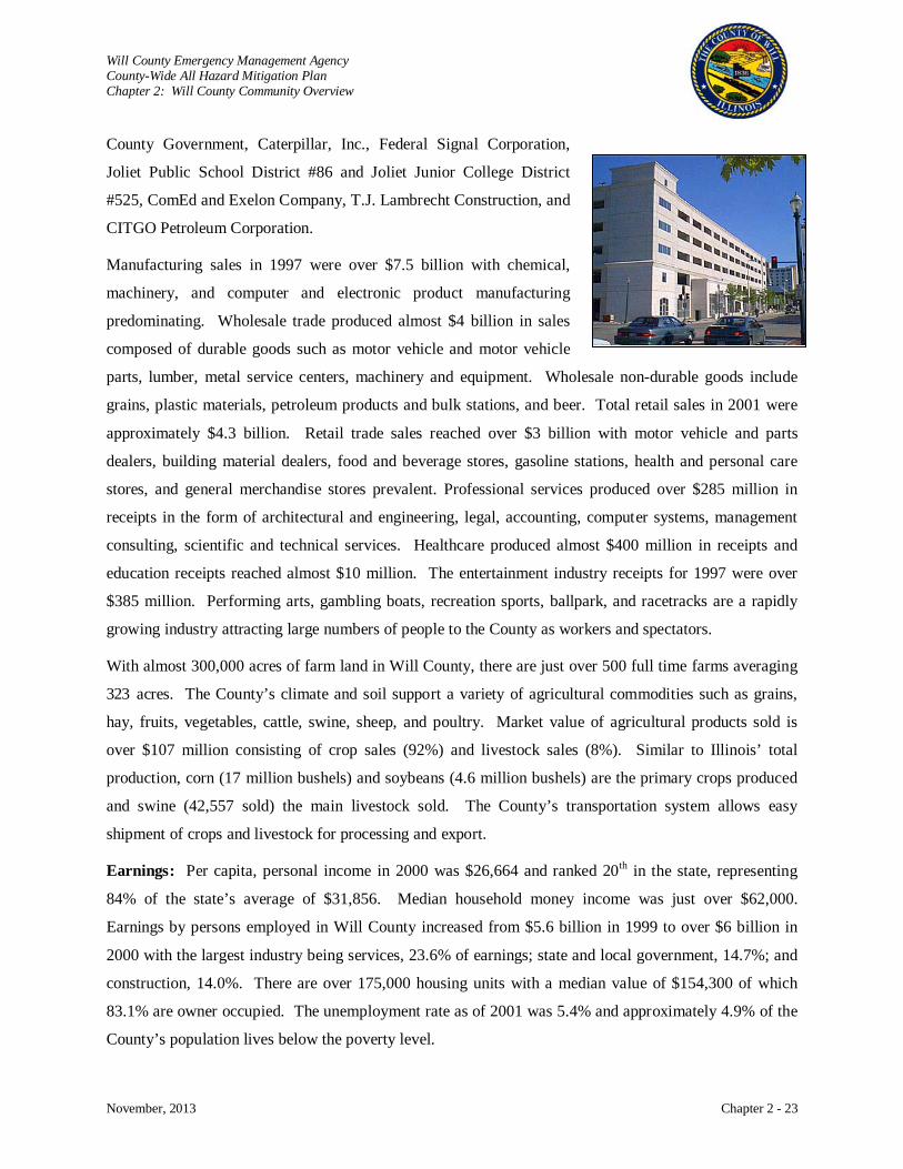
Will County Emergency Management Agency County-Wide All Hazard Mitigation Plan Chapter 2: Will County Community Overview
November, 2013 Chapter 2 - 23
County Government, Caterpillar, Inc., Federal Signal Corporation,
Joliet Public School District #86 and Joliet Junior College District
#525, ComEd and Exelon Company, T.J. Lambrecht Construction, and
CITGO Petroleum Corporation.
Manufacturing sales in 1997 were over $7.5 billion with chemical,
machinery, and computer and electronic product manufacturing
predominating. Wholesale trade produced almost $4 billion in sales
composed of durable goods such as motor vehicle and motor vehicle
parts, lumber, metal service centers, machinery and equipment. Wholesale non-durable goods include
grains, plastic materials, petroleum products and bulk stations, and beer. Total retail sales in 2001 were
approximately $4.3 billion. Retail trade sales reached over $3 billion with motor vehicle and parts
dealers, building material dealers, food and beverage stores, gasoline stations, health and personal care
stores, and general merchandise stores prevalent. Professional services produced over $285 million in
receipts in the form of architectural and engineering, legal, accounting, computer systems, management
consulting, scientific and technical services. Healthcare produced almost $400 million in receipts and
education receipts reached almost $10 million. The entertainment industry receipts for 1997 were over
$385 million. Performing arts, gambling boats, recreation sports, ballpark, and racetracks are a rapidly
growing industry attracting large numbers of people to the County as workers and spectators.
With almost 300,000 acres of farm land in Will County, there are just over 500 full time farms averaging
323 acres. The County’s climate and soil support a variety of agricultural commodities such as grains,
hay, fruits, vegetables, cattle, swine, sheep, and poultry. Market value of agricultural products sold is
over $107 million consisting of crop sales (92%) and livestock sales (8%). Similar to Illinois’ total
production, corn (17 million bushels) and soybeans (4.6 million bushels) are the primary crops produced
and swine (42,557 sold) the main livestock sold. The County’s transportation system allows easy
shipment of crops and livestock for processing and export.
Earnings: Per capita, personal income in 2000 was $26,664 and ranked 20th in the state, representing
84% of the state’s average of $31,856. Median household money income was just over $62,000.
Earnings by persons employed in Will County increased from $5.6 billion in 1999 to over $6 billion in
2000 with the largest industry being services, 23.6% of earnings; state and local government, 14.7%; and
construction, 14.0%. There are over 175,000 housing units with a median value of $154,300 of which
83.1% are owner occupied. The unemployment rate as of 2001 was 5.4% and approximately 4.9% of the
County’s population lives below the poverty level.
Will County Emergency Management Agency County-Wide All Hazard Mitigation Plan Chapter 2: Will County Community Overview
November, 2013 Chapter 2 - 24
Taxes: Various tax structures are applied to business, personal income, and property within Will County.
Federal and state income taxes are applied to personal and corporate income, but no local personal or
corporate income taxes exists. A state sales tax of 6.25% is applied to tangible personal property with
local sales tax rates varying from 0 to 2.5%. The state imposes a utility tax on electricity and natural gas
supplies, and some local governments also collect a utility tax. Local governments are authorized to
collect property taxes on real property that is assessed at 33.4% of market value. The typical tax rate per
$100 of assessed value is $6.62.
Incentives: Along with the application of federal, state, and local taxes, a number of tax incentives are
applied to promote development and expansion of businesses and rejuvenate economically distressed
areas. As an example, Joliet, Lockport, and Rockdale are part of the DesPlaines River Valley Enterprise
Zone that provides ten-year property tax abatement and other tax incentives on all real improvements that
increase the assessed valuation of property. Other forms of incentives to encourage business
development, expansion, modernization, and competitive improvement include participation loan
programs, industrial training programs, industrial revenue bonds, environmental bonds, venture funds, tax
increment financing (TIF), block grants, and various Small Business Administration (SBA) assistance
programs. These assistance programs are provided by federal, state, and local sources.
Growth Resources: Encouraging growth, a number of organizations provide business development
resources to expand the economy within the County. To name a few, Will County Center for Economic
Development provides information and assistance in locating or expanding businesses in Will County.
The Illinois Department of Commerce & Community Affairs is the state’s economic development agency
that provides programs and services designed to help Illinois businesses thrive in the global economy.
The Will Economic Network is a county-wide consortium which ensures the highest level of cooperation
between the public and private sectors assisting businesses to locate, grow, and prosper in Will-. The
Joliet Arsenal Development Authority oversees the redevelopment of the former Joliet Army Ammunition
Plant property. City Center Partnership also provides programs and incentives to help new and expanding
businesses. Another business development resource is the Three Rivers Manufacturer’s Association that
serves the needs of local manufacturers in Will and Grundy counties. The assistance and resources that
organizations like these provide make the area attractive to businesses looking to develop or expand.
Future: What the economic future holds for Will County can only be estimated. The Chicago
metropolitan area continues to grow outward into the surrounding counties. Of these collar counties, Will
County is expected to be the fastest growing. It is forecasted that the area as a whole will grow by 25%
while Will County is expected to grow over 60% within the next twenty years. This means that
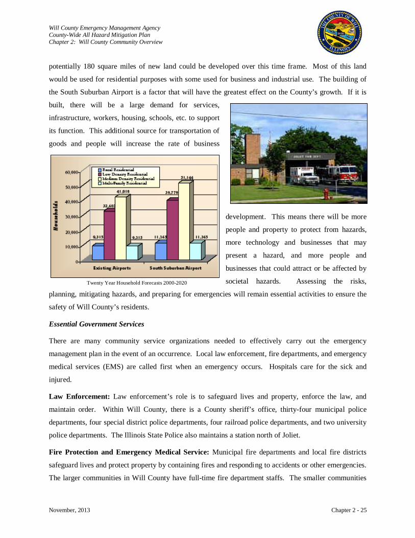
Will County Emergency Management Agency County-Wide All Hazard Mitigation Plan Chapter 2: Will County Community Overview
November, 2013 Chapter 2 - 25
potentially 180 square miles of new land could be developed over this time frame. Most of this land
would be used for residential purposes with some used for business and industrial use. The building of
the South Suburban Airport is a factor that will have the greatest effect on the County’s growth. If it is
built, there will be a large demand for services,
infrastructure, workers, housing, schools, etc. to support
its function. This additional source for transportation of
goods and people will increase the rate of business
development. This means there will be more
people and property to protect from hazards,
more technology and businesses that may
present a hazard, and more people and
businesses that could attract or be affected by
societal hazards. Assessing the risks,
planning, mitigating hazards, and preparing for emergencies will remain essential activities to ensure the
safety of Will County’s residents.
Essential Government Services
There are many community service organizations needed to effectively carry out the emergency
management plan in the event of an occurrence. Local law enforcement, fire departments, and emergency
medical services (EMS) are called first when an emergency occurs. Hospitals care for the sick and
injured.
Law Enforcement: Law enforcement’s role is to safeguard lives and property, enforce the law, and
maintain order. Within Will County, there is a County sheriff’s office, thirty-four municipal police
departments, four special district police departments, four railroad police departments, and two university
police departments. The Illinois State Police also maintains a station north of Joliet.
Fire Protection and Emergency Medical Service: Municipal fire departments and local fire districts
safeguard lives and protect property by containing fires and responding to accidents or other emergencies.
The larger communities in Will County have full-time fire department staffs. The smaller communities
Twenty Year Household Forecasts 2000-2020

Will County Emergency Management Agency County-Wide All Hazard Mitigation Plan Chapter 2: Will County Community Overview
November, 2013 Chapter 2 - 26
have volunteer staffs that respond when an emergency occurs. There are also several special fire
departments maintained by the major oil and chemical companies. EMS is responsible for immediate
medical attention. There are over twenty local EMS units within the County and several private or
corporate EMS units serving the community. For care beyond first aid, Will County has two hospitals,
Presence Saint Joseph Medical Center and Silver Cross Hospital and Medical Center located in Joliet.
The Will County Health Department is another agency providing important services to the public, not
only in the event of an emergency, but also everyday. They provide comprehensive public health
programs and primary health care and dental service for medically underserved residents. More than 300
agency professionals work to prevent disease and promote a healthy environment for the growing
County’s residents. Throughout an emergency, public health consequences are evaluated, findings are
reviewed, and affected people are debriefed. The department provides epidemiological follow-up of a
population suffering a known, clearly defined health effect in
association with a clear-cut cause. Public health also supports
the provision of health care, evacuation of patients, hospital
care coordination, public health information, victim
identification, and mortuary services. Emergencies may
include, among others, hazardous chemicals, contaminated
food or water, infectious/communicable disease, floods,
tornadoes, or radiation exposure.
Schools: Will County currently has 29 school districts under the jurisdiction of the Will County Regional
Office of Education. This office oversees 19 elementary districts, three high school districts, and seven
unit districts.6
Elementary School Districts located in Will County include Beecher, Braidwood, Chaney Monge,
Channahon, Crete-Monee, Elwood, Fairmont, Frankfort, Homer, Joliet, Laraway, Ludwig-Reed-Walsh,
Manhattan, Milne-Kelvin Grove, Mokena, Naperville, New Lenox, Peotone, Plainfield, Richland,
Additionally, there are other school districts located within the County that may come under other
jurisdictions because their district boundaries are of a multi-county nature. High School Districts located
within Will County include Beecher, Channahon, Crete Monee, Joliet Township, Lincoln Way, Lockport
Township, Naperville, Peotone, Plainfield, Reed Cluster (Braidwood), Valley View (Romeoville and
Bolingbrook), and Wilmington.
6 http://www.willroe.org/index.php/schools-districts/school-directory

Will County Emergency Management Agency County-Wide All Hazard Mitigation Plan Chapter 2: Will County Community Overview
November, 2013 Chapter 2 - 27
Rockdale, Summit Hill, Taft (Lockport), Troy, Union, University Park, Valley View, Will County, and
Wilmington. A map of the school district boundaries within Will County can be found at:
http://www.willroe.org/index.php/schools-districts/school-district-maps.
Non-Essential Government Services
Will County has a rich and diversified offering of publicly owned recreational facilities located
throughout the County. There are also several Illinois state parks located in the County. Channahon State
Park is the official trailhead for the I&M Canal State Trail. The I&M Canal State Trail is made up of 61
miles of multi-purpose trail that ends at LaSalle/Peru. The Des Plaines Fish and Wildlife Area in
Wilmington offers fishing and hunting opportunities, as well as an 80-acre nature preserve. Additionally,
the State of Illinois recognizes 17 dedicated nature preserves in Will County. A dedicated nature preserve
is designed to preserve the natural features of the land;
nature preserves do not necessarily allow public access
but most do. Only high quality natural areas qualify for
this designation.
There are two federally-owned parks located within Will
County. The I & M Canal National Heritage Canal is
operated by the National Park Service and serves to
maintain the historic and cultural heritage associated with
what was originally a 97-mile canal from the Chicago
River to the Illinois River. Today, the Park Service offers
a variety of recreational and interpretive services for
visitors. The U.S. Forest Service operates the first
tallgrass prairie in the United States, Midewin National
Tallgrass Prairie. Established in 1996, this 15,454-acre
property once belonged to the Joliet Army Ammunition
Plant. Today, it is being restored to tallgrass prairie and
is dedicated to conserving, restoring, and enhancing
natural habitat. A significant number of threatened and
endangered species are located at Midewin. More
information may be found at www.fs.fed.us/mntp.
7 http://www.reconnectwithnature.org/preserves-trails/preserves-and-trails.asp
Will County Dedicated Nature Preserves7
Name General Location
Braidwood Dunes and Savanna Braidwood
Dellwood Park West Lockport
Goodenow Grove Crete
Grant Creek Prairie Wilmington
Hitts Siding Prairie Wilmington
Kankakee River Kankakee
Lake Renwick Heron Rookery Plainfield
Lockport Prairie Lockport
Long Run Seep Lockport
Messenger Woods New Lenox
O’Hara Woods Romeoville
Raccoon Grove Monee
Romeoville Prairie Romeoville
Sand Ridge Savanna Braidwood
Thorn Creek Woods Park Forest
Vermont Cemetery Prairie Aurora
Wilmington Shrub Prairie Braidwood

Will County Emergency Management Agency County-Wide All Hazard Mitigation Plan Chapter 2: Will County Community Overview
November, 2013 Chapter 2 - 28
The County also owns and operates a variety of open-space parcels through the Will County Forest
Preserve District. The County currently has 30 forest preserves.
Will County Forest Preserves General Location Braidwood Dunes and Savanna Nature Preserve Braidwood Colvin Grove Preserve Joliet Evans-Judge Preserve Wilmington Forked Creek Preserve - Ballou Road Access Wilmington Forked Creek Preserve - Butcher Lane Access Wilmington Forked Creek Preserve - Forsythe Woods Wilmington Goodenow Grove Nature Preserve Beecher Hadley Valley - Bruce Road Access Homer Glen Hadley Valley - Gougar Road Access Joliet Hadley Valley - Route 6 Access Joliet Hammel Woods - Crumby Recreation Area Shorewood Hammel Woods - DuPage River Access Shorewood Hammel Woods - Route 59 Access Shorewood Hickory Creek Preserve - Hickory Creek Barrens New Lenox Hickory Creek Preserve - Hickory Creek Junction Mokena Hickory Creek Preserve - LaPorte Road Access Mokena Hunters Woods Frankfort Isle a la Cache Romeoville Joliet Iron Works Historic Site Joliet Keepataw Preserve Bolingbrook Lake Chaminwood Preserve Minooka Lake Renwick Preserve - Copley Nature Park Plainfield Lake Renwick Preserve - Heron Rookery Nature Preserve Plainfield Lake Renwick Preserve - Turtle Lake Access Plainfield Lambs Woods Lockport Laughton Preserve Wilton Center Lockport Prairie Nature Preserve Lockport Lower Rock Run Preserve - I&M Canal Access Joliet Lower Rock Run Preserve – McClintock Road Access Joliet McKinley Woods - Frederick's Grove Channahon McKinley Woods - Kerry Sheridan Grove Channahon Messenger Marsh Homer Glen Messenger Woods Nature Preserve Homer Glen Monee Reservoir Monee O'Hara Woods Preserve Romeoville Prairie Bluff Preserve Lockport Raccoon Grove Nature Preserve Monee Riverview Farmstead Preserve Naperville Rock Run Preserve - Black Road Access Joliet Rock Run Preserve - Paul V. Nichols Access Joliet Rock Run Rookery Preserve Joliet Runyon Preserve Lockport Sauk Trail Reservoir Joliet Sugar Creek Preserve Joliet Teale Woods Preserve Joliet Theodore Marsh Crest Hill Thorn Creek Woods Nature Preserve Park Forest Vermont Cemetery Preserve Naperville Veterans Woods - Roy F. Hassert Grove Bolingbrook Veterans Woods - Traders Corner Romeoville Whalon Lake Naperville Wolf Creek Preserve Naperville
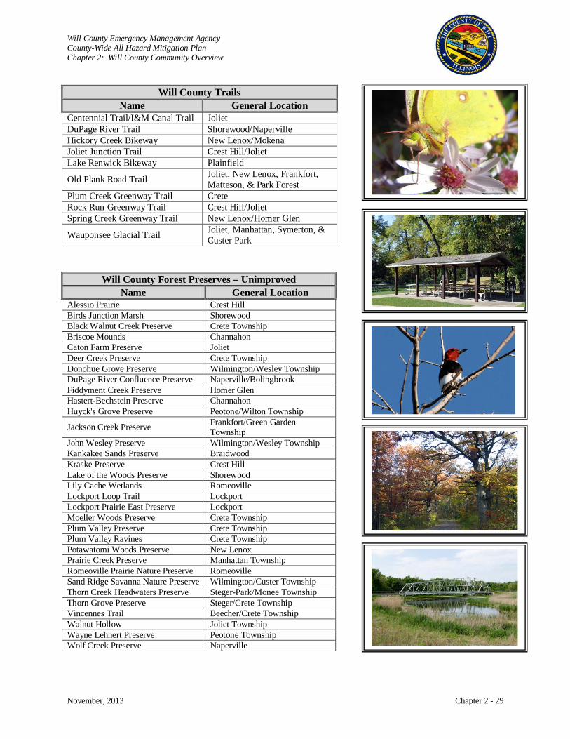
Will County Emergency Management Agency County-Wide All Hazard Mitigation Plan Chapter 2: Will County Community Overview
November, 2013 Chapter 2 - 29
Will County Trails
Name General Location Centennial Trail/I&M Canal Trail Joliet DuPage River Trail Shorewood/Naperville Hickory Creek Bikeway New Lenox/Mokena Joliet Junction Trail Crest Hill/Joliet Lake Renwick Bikeway Plainfield
Old Plank Road Trail Joliet, New Lenox, Frankfort, Matteson, & Park Forest
Plum Creek Greenway Trail Crete Rock Run Greenway Trail Crest Hill/Joliet Spring Creek Greenway Trail New Lenox/Homer Glen
Wauponsee Glacial Trail Joliet, Manhattan, Symerton, & Custer Park
Will County Forest Preserves – Unimproved Name General Location
Alessio Prairie Crest Hill Birds Junction Marsh Shorewood Black Walnut Creek Preserve Crete Township Briscoe Mounds Channahon Caton Farm Preserve Joliet Deer Creek Preserve Crete Township Donohue Grove Preserve Wilmington/Wesley Township DuPage River Confluence Preserve Naperville/Bolingbrook Fiddyment Creek Preserve Homer Glen Hastert-Bechstein Preserve Channahon Huyck's Grove Preserve Peotone/Wilton Township
Jackson Creek Preserve Frankfort/Green Garden Township
John Wesley Preserve Wilmington/Wesley Township Kankakee Sands Preserve Braidwood Kraske Preserve Crest Hill Lake of the Woods Preserve Shorewood Lily Cache Wetlands Romeoville Lockport Loop Trail Lockport Lockport Prairie East Preserve Lockport Moeller Woods Preserve Crete Township Plum Valley Preserve Crete Township Plum Valley Ravines Crete Township Potawatomi Woods Preserve New Lenox Prairie Creek Preserve Manhattan Township Romeoville Prairie Nature Preserve Romeoville Sand Ridge Savanna Nature Preserve Wilmington/Custer Township Thorn Creek Headwaters Preserve Steger-Park/Monee Township Thorn Grove Preserve Steger/Crete Township Vincennes Trail Beecher/Crete Township Walnut Hollow Joliet Township Wayne Lehnert Preserve Peotone Township Wolf Creek Preserve Naperville
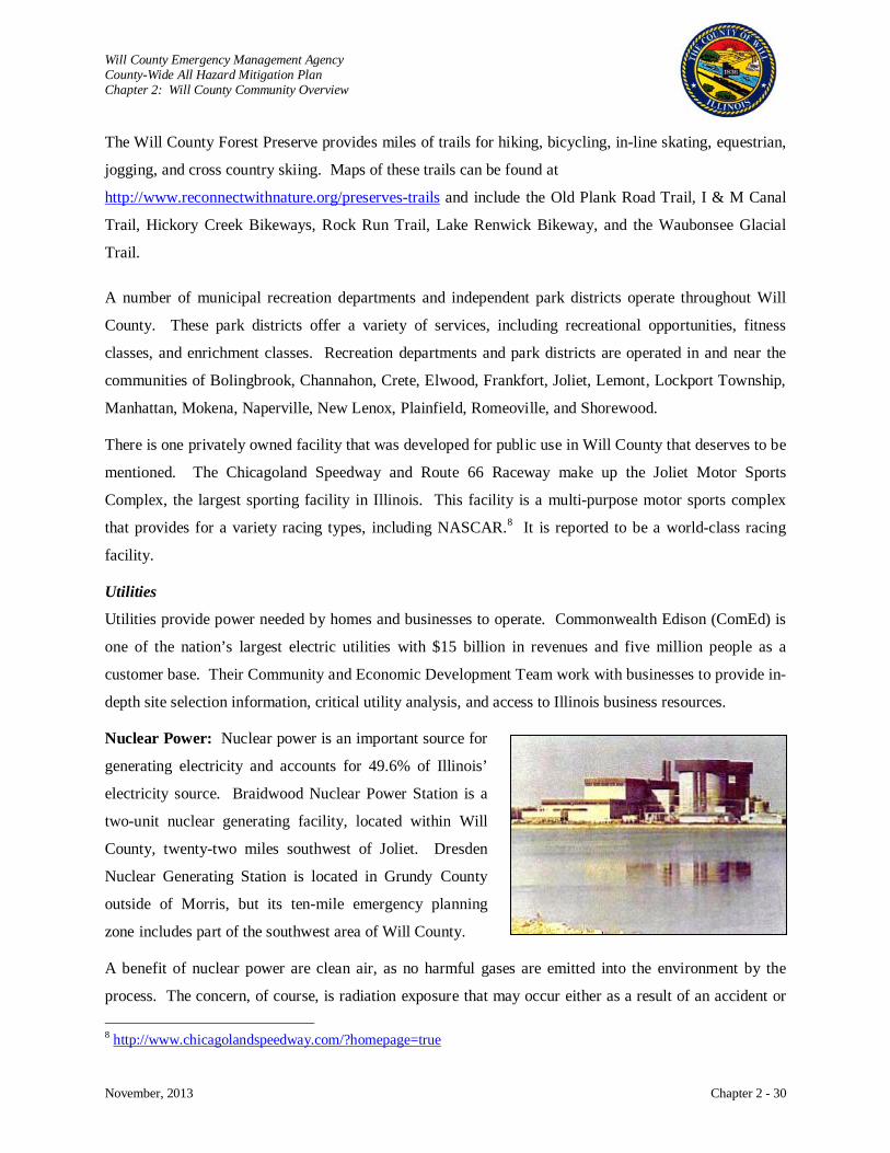
Will County Emergency Management Agency County-Wide All Hazard Mitigation Plan Chapter 2: Will County Community Overview
November, 2013 Chapter 2 - 30
The Will County Forest Preserve provides miles of trails for hiking, bicycling, in-line skating, equestrian,
jogging, and cross country skiing. Maps of these trails can be found at
http://www.reconnectwithnature.org/preserves-trails and include the Old Plank Road Trail, I & M Canal
Trail, Hickory Creek Bikeways, Rock Run Trail, Lake Renwick Bikeway, and the Waubonsee Glacial
Trail.
A number of municipal recreation departments and independent park districts operate throughout Will
County. These park districts offer a variety of services, including recreational opportunities, fitness
classes, and enrichment classes. Recreation departments and park districts are operated in and near the
communities of Bolingbrook, Channahon, Crete, Elwood, Frankfort, Joliet, Lemont, Lockport Township,
Manhattan, Mokena, Naperville, New Lenox, Plainfield, Romeoville, and Shorewood.
There is one privately owned facility that was developed for public use in Will County that deserves to be
mentioned. The Chicagoland Speedway and Route 66 Raceway make up the Joliet Motor Sports
Complex, the largest sporting facility in Illinois. This facility is a multi-purpose motor sports complex
that provides for a variety racing types, including NASCAR.8
Nuclear Power: Nuclear power is an important source for
generating electricity and accounts for 49.6% of Illinois’
electricity source. Braidwood Nuclear Power Station is a
two-unit nuclear generating facility, located within Will
County, twenty-two miles southwest of Joliet. Dresden
Nuclear Generating Station is located in Grundy County
outside of Morris, but its ten-mile emergency planning
zone includes part of the southwest area of Will County.
It is reported to be a world-class racing
facility.
Utilities
Utilities provide power needed by homes and businesses to operate. Commonwealth Edison (ComEd) is
one of the nation’s largest electric utilities with $15 billion in revenues and five million people as a
customer base. Their Community and Economic Development Team work with businesses to provide in-
depth site selection information, critical utility analysis, and access to Illinois business resources.
A benefit of nuclear power are clean air, as no harmful gases are emitted into the environment by the
process. The concern, of course, is radiation exposure that may occur either as a result of an accident or 8 http://www.chicagolandspeedway.com/?homepage=true
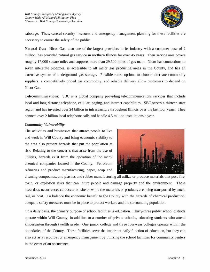
Will County Emergency Management Agency County-Wide All Hazard Mitigation Plan Chapter 2: Will County Community Overview
November, 2013 Chapter 2 - 31
sabotage. Thus, careful security measures and emergency management planning for these facilities are
necessary to ensure the safety of the public.
Natural Gas: Nicor Gas, also one of the largest providers in its industry with a customer base of 2
million, has provided natural gas service in northern Illinois for over 45 years. Their service area covers
roughly 17,000 square miles and supports more than 29,500 miles of gas main. Nicor has connections to
seven interstate pipelines, is accessible to all major gas producing areas in the County, and has an
extensive system of underground gas storage. Flexible rates, options to choose alternate commodity
suppliers, a competitively priced gas commodity, and reliable delivery allow customers to depend on
Nicor Gas.
Telecommunications: SBC is a global company providing telecommunications services that include
local and long distance telephone, cellular, paging, and internet capabilities. SBC serves a thirteen state
region and has invested over $4 billion in infrastructure throughout Illinois over the last four years. They
connect over 2 billion local telephone calls and handle 4.5 million installations a year.
Community Vulnerability
The activities and businesses that attract people to live
and work in Will County and bring economic stability to
the area also present hazards that put the population at
risk. Relating to the concerns that arise from the use of
utilities, hazards exist from the operation of the many
chemical companies located in the County. Petroleum
refineries and product manufacturing, paper, soap and
cleaning compounds, and plastics and rubber manufacturing all utilize or produce materials that pose fire,
toxin, or explosion risks that can injure people and damage property and the environment. These
hazardous occurrences can occur on site or while the materials or products are being transported by truck,
rail, or boat. To balance the economic benefit to the County with the hazards of chemical production,
adequate safety measures must be in place to protect workers and the surrounding population.
On a daily basis, the primary purpose of school facilities is education. Thirty-three public school districts
operate within Will County, in addition to a number of private schools, educating students who attend
kindergarten through twelfth grade. One junior college and three four-year colleges operate within the
boundaries of the County. These facilities serve the important daily function of education, but they can
also act as a resource for emergency management by utilizing the school facilities for community centers
in the event of an occurrence.
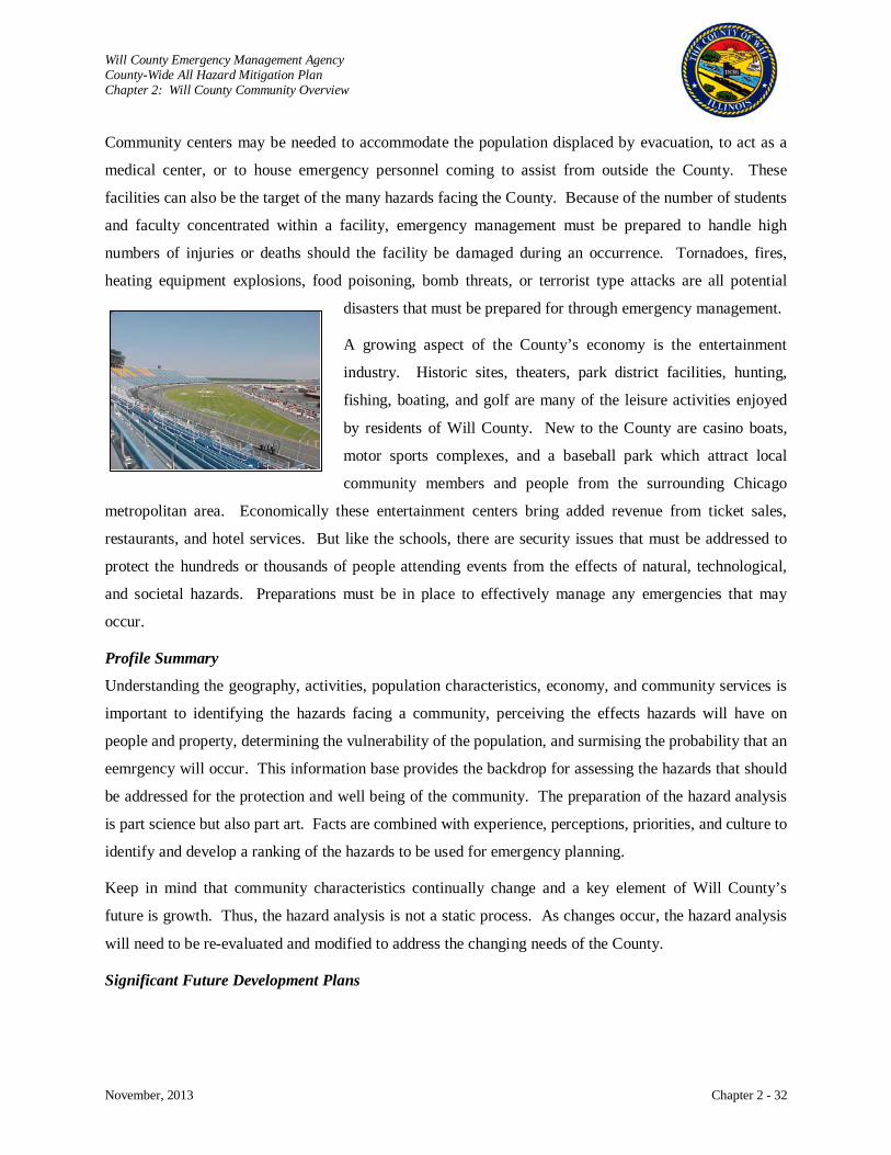
Will County Emergency Management Agency County-Wide All Hazard Mitigation Plan Chapter 2: Will County Community Overview
November, 2013 Chapter 2 - 32
Community centers may be needed to accommodate the population displaced by evacuation, to act as a
medical center, or to house emergency personnel coming to assist from outside the County. These
facilities can also be the target of the many hazards facing the County. Because of the number of students
and faculty concentrated within a facility, emergency management must be prepared to handle high
numbers of injuries or deaths should the facility be damaged during an occurrence. Tornadoes, fires,
heating equipment explosions, food poisoning, bomb threats, or terrorist type attacks are all potential
disasters that must be prepared for through emergency management.
A growing aspect of the County’s economy is the entertainment
industry. Historic sites, theaters, park district facilities, hunting,
fishing, boating, and golf are many of the leisure activities enjoyed
by residents of Will County. New to the County are casino boats,
motor sports complexes, and a baseball park which attract local
community members and people from the surrounding Chicago
metropolitan area. Economically these entertainment centers bring added revenue from ticket sales,
restaurants, and hotel services. But like the schools, there are security issues that must be addressed to
protect the hundreds or thousands of people attending events from the effects of natural, technological,
and societal hazards. Preparations must be in place to effectively manage any emergencies that may
occur.
Profile Summary
Understanding the geography, activities, population characteristics, economy, and community services is
important to identifying the hazards facing a community, perceiving the effects hazards will have on
people and property, determining the vulnerability of the population, and surmising the probability that an
eemrgency will occur. This information base provides the backdrop for assessing the hazards that should
be addressed for the protection and well being of the community. The preparation of the hazard analysis
is part science but also part art. Facts are combined with experience, perceptions, priorities, and culture to
identify and develop a ranking of the hazards to be used for emergency planning.
Keep in mind that community characteristics continually change and a key element of Will County’s
future is growth. Thus, the hazard analysis is not a static process. As changes occur, the hazard analysis
will need to be re-evaluated and modified to address the changing needs of the County.
Significant Future Development Plans

Will County Emergency Management Agency County-Wide All Hazard Mitigation Plan Chapter 2: Will County Community Overview
November, 2013 Chapter 2 - 33
It is important for the Will County County-Wide All Hazard Mitigation Plan to be incorporated into other
County plans. The following is a discussion of Will County’s development initiatives. Hazard mitigation
should be incorporated wherever feasible.
Land Resource Management Plan
The Will County Land Resource Management Plan was developed to establish a framework which allows
local communities to work with regional entities in order to allow for carefully planned land development
and management during Will County’s projected growth. The following priority issues were identified in
the plan:
• Regional coordination among various government entities,
• The need for regional open-space and agricultural protection,
• The need for environmental protection,
• The quality and timing of new development,
• Automotive transportation needs,
• Promoting a compact (non-sprawled) form of development,
• Housing density and variety, and
• Non-automotive transportation needs.
The Land Resource Management Plan identifies goals and strategies to fulfill the priority issues
identified. Additionally, the plan provides use concepts that provide guidance to local communities on
how to manage land use by such categories as development, open space, transportation, historic
preservation, and stormwater management.
A Forms & Concepts Handbook accompanies the Land Resource Management Plan, in which regional
development forms should be promoted. Development use concepts are provided to guide local
communities in assessing specific development proposals to see if they fit with the community’s land use
form. Specific development forms discussed in this handbook are:
• Rural areas
• Hamlets
• Towns
• Urban communities
• Suburban communities
• Interstate access locations
• Former Joliet Army Ammunition Plant area, and
Will County Emergency Management Agency County-Wide All Hazard Mitigation Plan Chapter 2: Will County Community Overview
November, 2013 Chapter 2 - 34
• South Suburban Airport.
Specific development use concepts designed to protect the chosen development form are provided in the
handbook. These development use concepts include:
• Agriculture,
• Conservation design,
• Conventional residential suburban,
• Traditional residential,
• Multi-family complex,
• Employment campuses,
• Regional commercial,
• Mid-scale commercial,
• Neighborhood commercial,
• Free standing industry and office, and
• Projects of regional impact.
An Open Space Element handbook also accompanies the Land Resource Management Plan. This
handbook promotes initiatives for managing development in high priority areas to create greenway
corridors as well as create large preserves for the protection of biodiversity. This handbook also provides
criteria for identifying land for inclusion in the open space system.
Will County 2030 Transportation Framework Plan
The Will County 2030 Transportation Framework Plan is the outcome of a collaborative effort among
municipalities, townships, and regional agencies. The plan was written to guide transportation
improvements through the year 2030 for all modes of transportation, including roads, public
transportation, railroads, bikeways, pedestrian, equestrian, and airport transportation.
The Transportation Framework Plan identified the fact that substantial growth is forecasted for Will
County; this growth will require transportation improvements. DuPage, Wheatland, Homer, Lockport,
New Lenox, Frankfort, Plainfield, Monee, and Crete were identified as the townships predicted to
experience the greatest amount of growth and in need of the greatest amount of transportation
improvements. Will Township will also experience significant increases in transportation needs if the
South Suburban Airport is built. Continued growth in the east, southwest, northwest and west central
areas will require improved Metra commuter train service.
Will County Emergency Management Agency County-Wide All Hazard Mitigation Plan Chapter 2: Will County Community Overview
November, 2013 Chapter 2 - 35
The Transportation Framework Plan makes specific suggestions for roadway improvements, including
major roadways, arterial streets, and intersection realignments. Additionally, specific recommendations
are made for regional arterial improvements, corridor studies, Metra commuter rail improvements, and
Pace bus system improvements.
Will County Stormwater Management Plan
The Will County Stormwater Management Plan represents a coordinated effort on the part of Will County
and its municipalities to manage issues as they pertain to floodplain and stormwater management.
Planning activities are coordinated through the Will County Stormwater Management Planning
Committee. The Committee focuses on existing stormwater management programs as well as issues
related to future development. A major focus area is the adoption of a county-wide stormwater ordinance
to ensure consistency of approach and to coordinate stormwater issues that extend beyond political
boundaries. The reduction of risk brought about by flooding is an important goal of the Stormwater
Management Plan and the Stormwater Management Planning Committee.
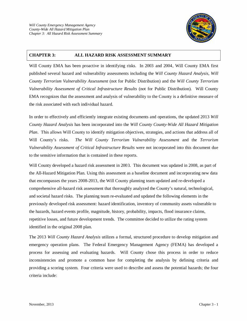
Will County Emergency Management Agency County-Wide All Hazard Mitigation Plan Chapter 3: All Hazard Risk Assessment Summary
November, 2013 Chapter 3 - 1
CHAPTER 3: ALL HAZARD RISK ASSESSMENT SUMMARY
Will County EMA has been proactive in identifying risks. In 2003 and 2004, Will County EMA first
published several hazard and vulnerability assessments including the Will County Hazard Analysis, Will
County Terrorism Vulnerability Assessment (not for Public Distribution) and the Will County Terrorism
Vulnerability Assessment of Critical Infrastructure Results (not for Public Distribution). Will County
EMA recognizes that the assessment and analysis of vulnerability to the County is a definitive measure of
the risk associated with each individual hazard.
In order to effectively and efficiently integrate existing documents and operations, the updated 2013 Will
County Hazard Analysis has been incorporated into the Will County County-Wide All Hazard Mitigation
Plan. This allows Will County to identify mitigation objectives, strategies, and actions that address all of
Will County’s risks. The Will County Terrorism Vulnerability Assessment and the Terrorism
Vulnerability Assessment of Critical Infrastructure Results were not incorporated into this document due
to the sensitive information that is contained in these reports.
Will County developed a hazard risk assessment in 2003. This document was updated in 2008, as part of
the All-Hazard Mitigation Plan. Using this assessment as a baseline document and incorporating new data
that encompasses the years 2008-2013, the Will County planning team updated and re-developed a
comprehensive all-hazard risk assessment that thoroughly analyzed the County’s natural, technological,
and societal hazard risks. The planning team re-evaluated and updated the following elements in the
previously developed risk assessment: hazard identification, inventory of community assets vulnerable to
the hazards, hazard events profile, magnitude, history, probability, impacts, flood insurance claims,
repetitive losses, and future development trends. The committee decided to utilize the rating system
identified in the original 2008 plan.
The 2013 Will County Hazard Analysis utilizes a formal, structured procedure to develop mitigation and
emergency operation plans. The Federal Emergency Management Agency (FEMA) has developed a
process for assessing and evaluating hazards. Will County chose this process in order to reduce
inconsistencies and promote a common base for completing the analysis by defining criteria and
providing a scoring system. Four criteria were used to describe and assess the potential hazards; the four
criteria include:

Will County Emergency Management Agency County-Wide All Hazard Mitigation Plan Chapter 3: All Hazard Risk Assessment Summary
November, 2013 Chapter 3 - 2
• History – past record of occurrences of the specified hazard. It is a guide of what has
occurred in the past but is not a guarantee of what may occur in the future. • Vulnerability – pertains to the people that might be killed, injured, or contaminated and to
property that might be destroyed, damaged, or contaminated due to the occurrences of a specified hazard.
• Maximum Threat – consists of the impacts from a ‘worst case’ scenario of a specified hazard and is where the greatest impact to people and property is expected and assessed.
• Probability – refers to the likelihood of the occurrence of a specified hazard. It is expressed as the number of chances per year that an event of a specific intensity will occur.
Each of the four criteria is given a weighting factor as one criterion can be judged to be more important
than another:
History 2 points Vulnerability 5 points Maximum Threat 10 points Probability 7 points
Each of the four criteria were evaluated and given a description of the likelihood or impact of the event. The descriptive terms used were low, medium, and high. Each of the three descriptive terms is given a numerical value:
Low 1 point Medium 5 points High 10 points
The composite score for each hazard is calculated by multiplying the descriptive numerical value assigned
to each weighted criterion score. Each weighted score is summed to determine the hazards composite
score.
The following is a list of the natural, technological, and societal hazards investigated, while a summary of
the 2013 Will County Hazard Analysis is shown on the following pages.
Natural Hazards Technological Hazards Societal Hazards Tornado Infrastructure Failure Terrorist Attack Winter/Ice Storm Hazardous Materials – Fixed Site Enemy Attack Thunderstorm Hazardous Materials – Transportation Accident Public Health Flood Non-Hazardous Materials – Transportation Accident Civil Disturbances Earthquake Nuclear Power Plant Accident Drought Pipeline Rupture Flash Flood Fire Extreme Heat Dam Failure Ice Jams Subsidence
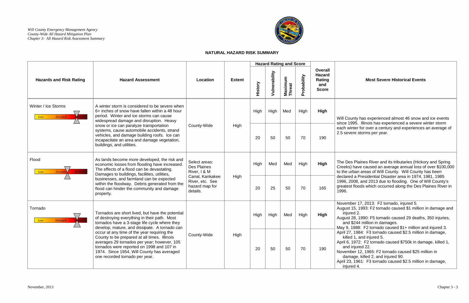
Will County Emergency Management Agency County-Wide All Hazard Mitigation Plan Chapter 3: All Hazard Risk Assessment Summary
November, 2013 Chapter 3 - 3
NATURAL HAZARD RISK SUMMARY
Hazards and Risk Rating Hazard Assessment Location Extent
Hazard Rating and Score Overall Hazard Rating
and Score
Most Severe Historical Events
His
tory
Vuln
erab
ility
Max
imum
Th
reat
Prob
abili
ty
Winter / Ice Storms
A winter storm is considered to be severe when 6+ inches of snow have fallen within a 48 hour period. Winter and ice storms can cause widespread damage and disruption. Heavy snow or ice can paralyze transportation systems, cause automobile accidents, strand vehicles, and damage building roofs. Ice can incapacitate an area and damage vegetation, buildings, and utilities.
County-Wide High
High High Med High High Will County has experienced almost 46 snow and ice events since 1995. Illinois has experienced a severe winter storm each winter for over a century and experiences an average of 2.5 severe storms per year.
20 50 50 70 190
Flood
As lands become more developed, the risk and economic losses from flooding have increased. The effects of a flood can be devastating. Damages to buildings, facilities, utilities, businesses, and farmland can be expected within the floodway. Debris generated from the flood can hinder the community and damage property.
Select areas: Des Plaines River, I & M Canal, Kankakee River, etc. See hazard map for details.
High
High Med Med High High The Des Plaines River and its tributaries (Hickory and Spring Creeks) have caused an average annual loss of over $100,000 to the urban areas of Will County. Will County has been declared a Presidential Disaster area in 1974, 1981, 1985 1996, 2008, and 2013 due to flooding. One of Will County’s greatest floods which occurred along the Des Plaines River in 1996.
20 25 50 70 165
Tornado
Tornados are short lived, but have the potential of destroying everything in their path. Most tornados have a 3-stage life cycle where they develop, mature, and dissipate. A tornado can occur at any time of the year requiring the County to be prepared at all times. Illinois averages 29 tornados per year; however, 105 tornados were reported on 1998 and 107 in 1974. Since 1954, Will County has averaged one recorded tornado per year.
County-Wide High
High High Med High High
November 17, 2013: F2 tornado, injured 5. August 15, 1993: F2 tornado caused $1 million in damage and
injured 2. August 28, 1990: F5 tornado caused 29 deaths, 350 injuries,
and $244 million in damages. May 9, 1988: F2 tornado caused $1+ million and injured 3. April 27, 1984: F3 tornado caused $2.5 million in damage,
killed 1, and injured 5. April 6, 1972: F2 tornado caused $750k in damage, killed 1,
and injured 22. November 12, 1965: F2 tornado caused $25 million in
damage, killed 2, and injured 90. April 23, 1961: F3 tornado caused $2.5 million in damage,
injured 4.
20 50 50 70 190
Low Elevated Severe
Low Elevated Severe
Low Elevated Severe

Will County Emergency Management Agency County-Wide All Hazard Mitigation Plan Chapter 3: All Hazard Risk Assessment Summary
November, 2013 Chapter 3 - 4
NATURAL HAZARD RISK SUMMARY
Hazards and Risk Rating Hazard Assessment Location Extent
Hazard Rating and Score Overall Hazard Rating
and Score
Most Severe Historical Events
His
tory
Vuln
erab
ility
Max
imum
Th
reat
Prob
abili
ty
Extreme Heat
Prolonged periods of extreme heat and humidity have a deleterious effect upon a community, particularly the elderly and those who cannot afford cooling capabilities. Heatstroke and heat exhaustion are more intense in urban areas. Other effects of extreme heat are water shortages, fire hazards, excessive demands for energy, damaged crops, and danger to livestock.
County-Wide Moderate
High Low Low High Medium
See page 4-107.
20 5 10 70 105
Earthquake
There are thousands of earthquakes in the US each year, but most are so small in magnitude that they are barely noticed. Some of the most violent earthquakes have occurred in the central US. The New Madrid Fault Zone runs from Cairo, Illinois to Memphis, Tennessee. Will County would be affected indirectly from a large New Madrid Earthquake. The Sandwich Fault zone is located in northern Illinois and extends into Will County.
See Hazard Map Low
Low Low High Low Medium/ Low
August 20, 1804 - An estimated 4.5 magnitude earthquake shook the southern Lake Michigan area.
May 26, 1909 - an estimated 5.1 magnitude occurred in northern Illinois. The exact location isn’t known, but the greatest shaking occurred in and near Aurora.
December 29, 1985 - an estimated 3.0 magnitude occurred in northern Illinois, 31 miles outside of Chicago
June 24, 2004 a 4.2 magnitude earthquake occurred near Ottawa, IL.
February 10, 2010 at 3.8 magnitude earthquake occurred near Lily Lake in Kane County.
2 5 100 7 114
Thunderstorm
Severe thunderstorms are weather systems accompanied by strong winds, lightning, heavy rain, and possibly hail and tornados. Thunderstorms can fall into 4 categories: Single-cell storms, multi-cell cluster storms, multi-cell line storms, and super cell storms. Super cell storms are the most severe and cause extensive damage and threat to life.
County-Wide High
High Med Med High High
Will County has experienced over 100 severe Thunderstorms and high wind since 1996.
20 25 50 70 165
Low Elevated Severe
Low Elevated Severe
Low Elevated Severe
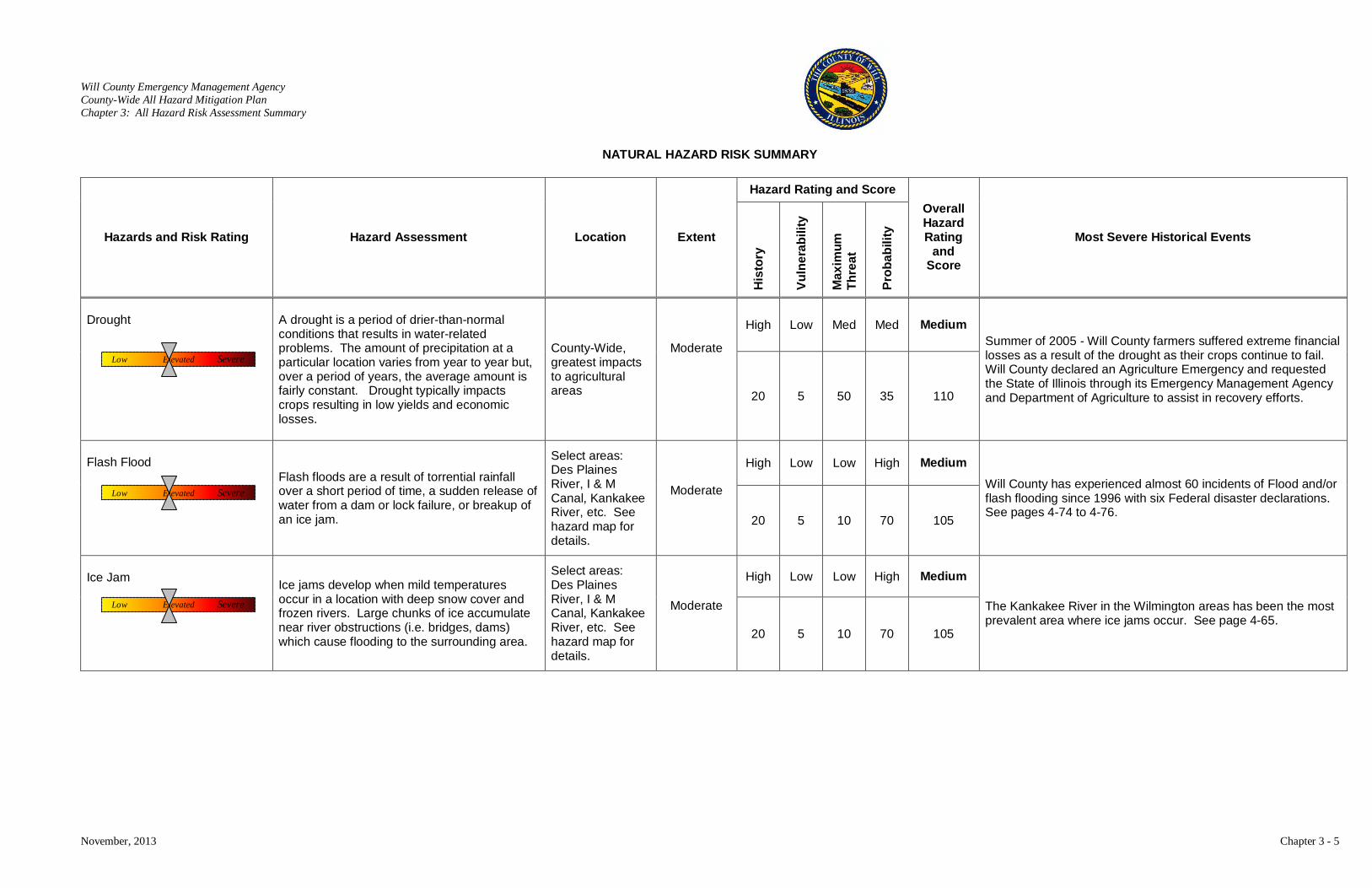
Will County Emergency Management Agency County-Wide All Hazard Mitigation Plan Chapter 3: All Hazard Risk Assessment Summary
November, 2013 Chapter 3 - 5
NATURAL HAZARD RISK SUMMARY
Hazards and Risk Rating Hazard Assessment Location Extent
Hazard Rating and Score Overall Hazard Rating
and Score
Most Severe Historical Events
His
tory
Vuln
erab
ility
Max
imum
Th
reat
Prob
abili
ty
Drought
A drought is a period of drier-than-normal conditions that results in water-related problems. The amount of precipitation at a particular location varies from year to year but, over a period of years, the average amount is fairly constant. Drought typically impacts crops resulting in low yields and economic losses.
County-Wide, greatest impacts to agricultural areas
Moderate
High Low Med Med Medium Summer of 2005 - Will County farmers suffered extreme financial losses as a result of the drought as their crops continue to fail. Will County declared an Agriculture Emergency and requested the State of Illinois through its Emergency Management Agency and Department of Agriculture to assist in recovery efforts. 20 5 50 35 110
Flash Flood Flash floods are a result of torrential rainfall
over a short period of time, a sudden release of water from a dam or lock failure, or breakup of an ice jam.
Select areas: Des Plaines River, I & M Canal, Kankakee River, etc. See hazard map for details.
Moderate
High Low Low High Medium Will County has experienced almost 60 incidents of Flood and/or flash flooding since 1996 with six Federal disaster declarations. See pages 4-74 to 4-76.
20 5 10 70 105
Ice Jam Ice jams develop when mild temperatures
occur in a location with deep snow cover and frozen rivers. Large chunks of ice accumulate near river obstructions (i.e. bridges, dams) which cause flooding to the surrounding area.
Select areas: Des Plaines River, I & M Canal, Kankakee River, etc. See hazard map for details.
Moderate
High Low Low High Medium
The Kankakee River in the Wilmington areas has been the most prevalent area where ice jams occur. See page 4-65.
20 5 10 70 105
Low Elevated Severe
Low Elevated Severe
Low Elevated Severe
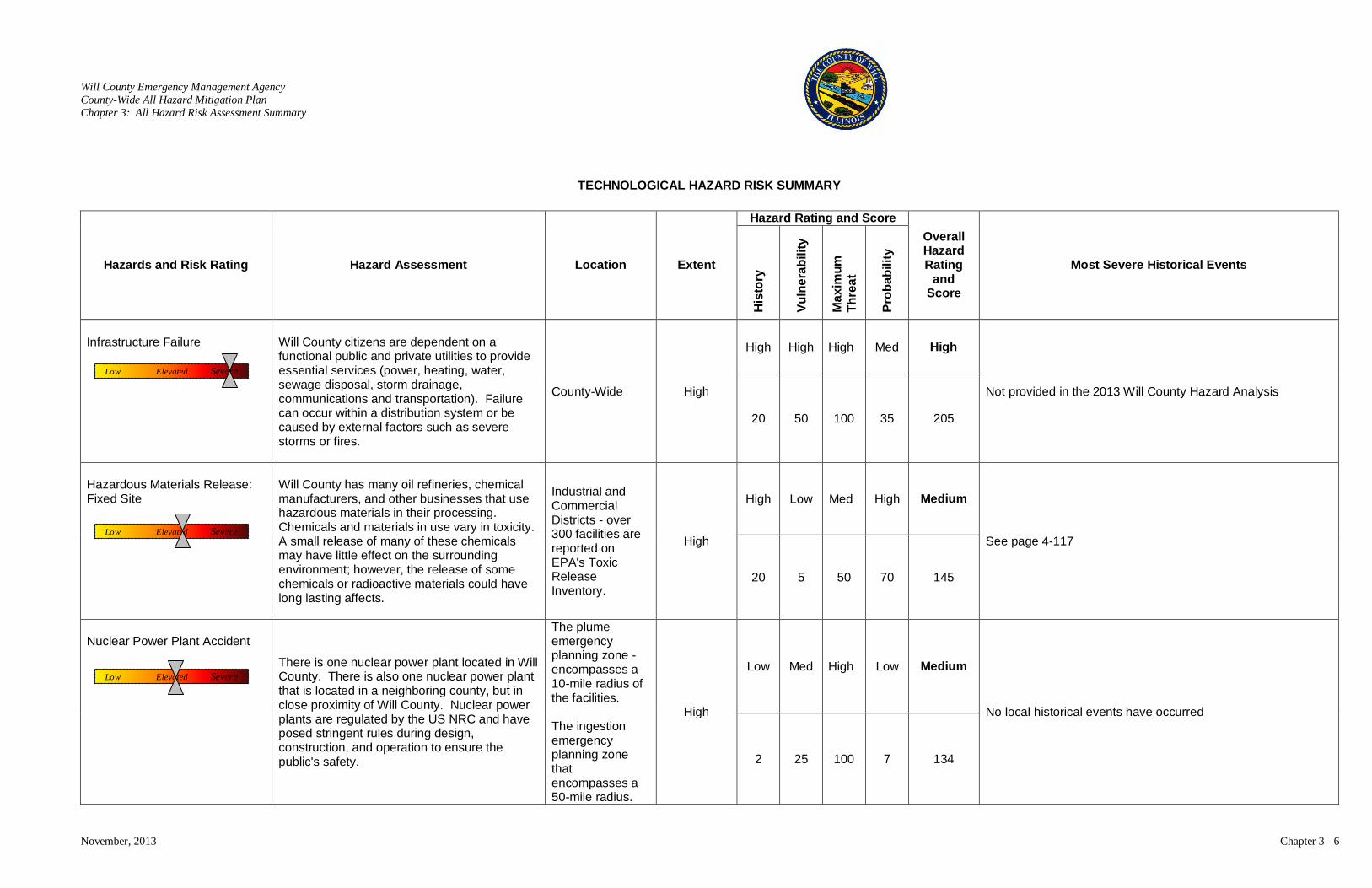
Will County Emergency Management Agency County-Wide All Hazard Mitigation Plan Chapter 3: All Hazard Risk Assessment Summary
November, 2013 Chapter 3 - 6
TECHNOLOGICAL HAZARD RISK SUMMARY
Hazards and Risk Rating Hazard Assessment Location Extent
Hazard Rating and Score Overall Hazard Rating
and Score
Most Severe Historical Events
His
tory
Vuln
erab
ility
Max
imum
Th
reat
Prob
abili
ty
Infrastructure Failure
Will County citizens are dependent on a functional public and private utilities to provide essential services (power, heating, water, sewage disposal, storm drainage, communications and transportation). Failure can occur within a distribution system or be caused by external factors such as severe storms or fires.
County-Wide High
High High High Med High
Not provided in the 2013 Will County Hazard Analysis
20 50 100 35 205
Hazardous Materials Release: Fixed Site
Will County has many oil refineries, chemical manufacturers, and other businesses that use hazardous materials in their processing. Chemicals and materials in use vary in toxicity. A small release of many of these chemicals may have little effect on the surrounding environment; however, the release of some chemicals or radioactive materials could have long lasting affects.
Industrial and Commercial Districts - over 300 facilities are reported on EPA's Toxic Release Inventory.
High
High Low Med High Medium
See page 4-117
20 5 50 70 145
Nuclear Power Plant Accident There is one nuclear power plant located in Will
County. There is also one nuclear power plant that is located in a neighboring county, but in close proximity of Will County. Nuclear power plants are regulated by the US NRC and have posed stringent rules during design, construction, and operation to ensure the public's safety.
The plume emergency planning zone - encompasses a 10-mile radius of the facilities. The ingestion emergency planning zone that encompasses a 50-mile radius.
High
Low Med High Low Medium
No local historical events have occurred
2 25 100 7 134
Low Elevated Severe
Low Elevated Severe
Low Elevated Severe
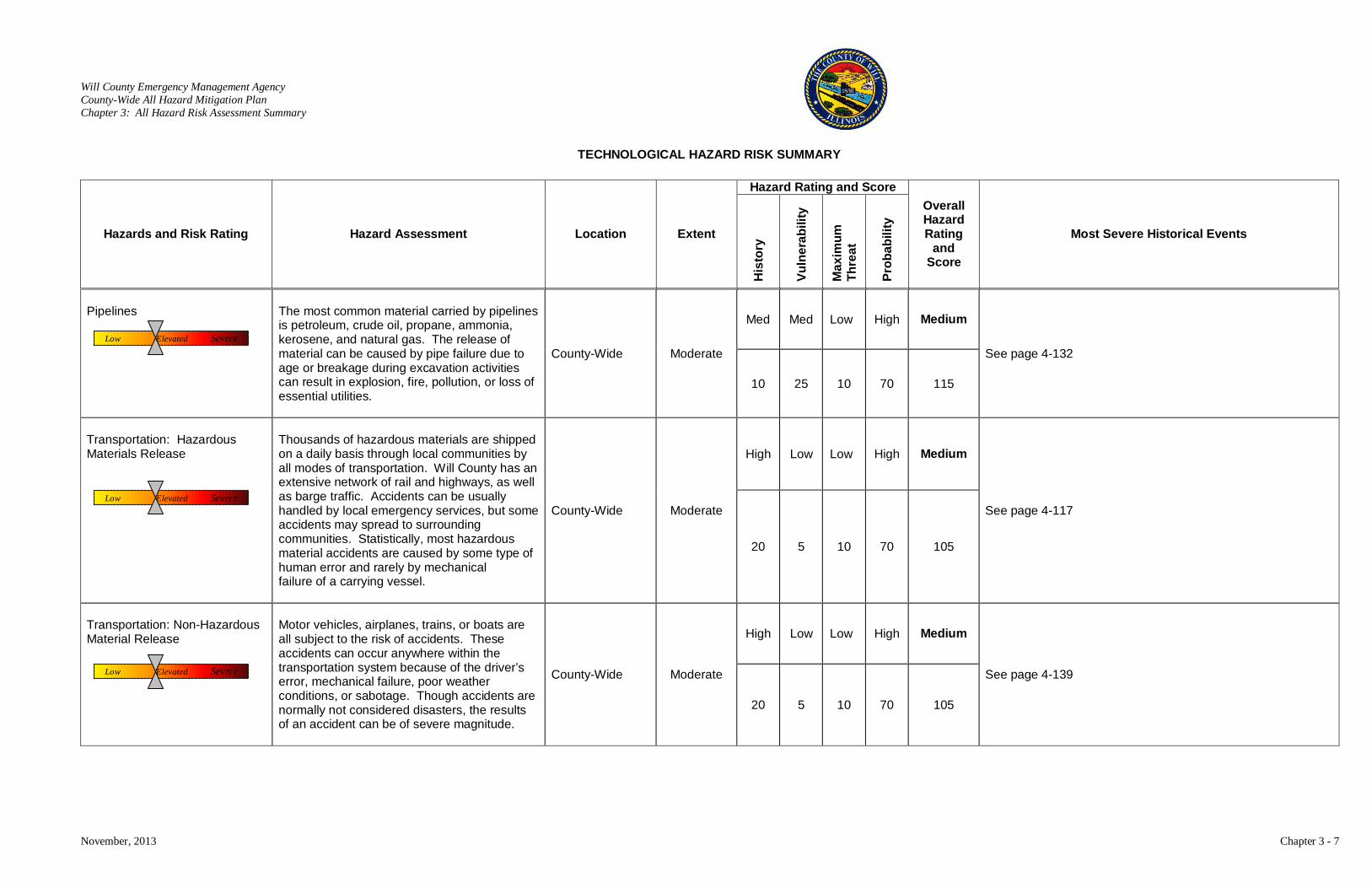
Will County Emergency Management Agency County-Wide All Hazard Mitigation Plan Chapter 3: All Hazard Risk Assessment Summary
November, 2013 Chapter 3 - 7
TECHNOLOGICAL HAZARD RISK SUMMARY
Hazards and Risk Rating Hazard Assessment Location Extent
Hazard Rating and Score Overall Hazard Rating
and Score
Most Severe Historical Events
His
tory
Vuln
erab
ility
Max
imum
Th
reat
Prob
abili
ty
Pipelines
The most common material carried by pipelines is petroleum, crude oil, propane, ammonia, kerosene, and natural gas. The release of material can be caused by pipe failure due to age or breakage during excavation activities can result in explosion, fire, pollution, or loss of essential utilities.
County-Wide Moderate
Med Med Low High Medium
See page 4-132
10 25 10 70 115
Transportation: Hazardous Materials Release
Thousands of hazardous materials are shipped on a daily basis through local communities by all modes of transportation. Will County has an extensive network of rail and highways, as well as barge traffic. Accidents can be usually handled by local emergency services, but some accidents may spread to surrounding communities. Statistically, most hazardous material accidents are caused by some type of human error and rarely by mechanical failure of a carrying vessel.
County-Wide Moderate
High Low Low High Medium
See page 4-117
20 5 10 70 105
Transportation: Non-Hazardous Material Release
Motor vehicles, airplanes, trains, or boats are all subject to the risk of accidents. These accidents can occur anywhere within the transportation system because of the driver’s error, mechanical failure, poor weather conditions, or sabotage. Though accidents are normally not considered disasters, the results of an accident can be of severe magnitude.
County-Wide Moderate
High Low Low High Medium
See page 4-139
20 5 10 70 105
Low Elevated Severe
Low Elevated Severe
Low Elevated Severe
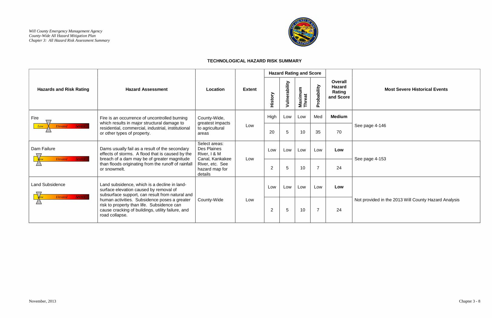
Will County Emergency Management Agency County-Wide All Hazard Mitigation Plan Chapter 3: All Hazard Risk Assessment Summary
November, 2013 Chapter 3 - 8
TECHNOLOGICAL HAZARD RISK SUMMARY
Hazards and Risk Rating Hazard Assessment Location Extent
Hazard Rating and Score
Overall Hazard Rating
and Score
Most Severe Historical Events
His
tory
Vuln
erab
ility
Max
imum
Th
reat
Prob
abili
ty
Fire
Fire is an occurrence of uncontrolled burning which results in major structural damage to residential, commercial, industrial, institutional or other types of property.
County-Wide, greatest impacts to agricultural areas
Low
High Low Low Med Medium
See page 4-146 20 5 10 35 70
Dam Failure
Dams usually fail as a result of the secondary effects of storms. A flood that is caused by the breach of a dam may be of greater magnitude than floods originating from the runoff of rainfall or snowmelt.
Select areas: Des Plaines River, I & M Canal, Kankakee River, etc. See hazard map for details
Low
Low Low Low Low Low
See page 4-153
2 5 10 7 24
Land Subsidence
Land subsidence, which is a decline in land-surface elevation caused by removal of subsurface support, can result from natural and human activities. Subsidence poses a greater risk to property than life. Subsidence can cause cracking of buildings, utility failure, and road collapse.
County-Wide Low
Low Low Low Low Low
Not provided in the 2013 Will County Hazard Analysis
2 5 10 7 24
Low Elevated Severe
Low Elevated Severe
Low Elevated Severe
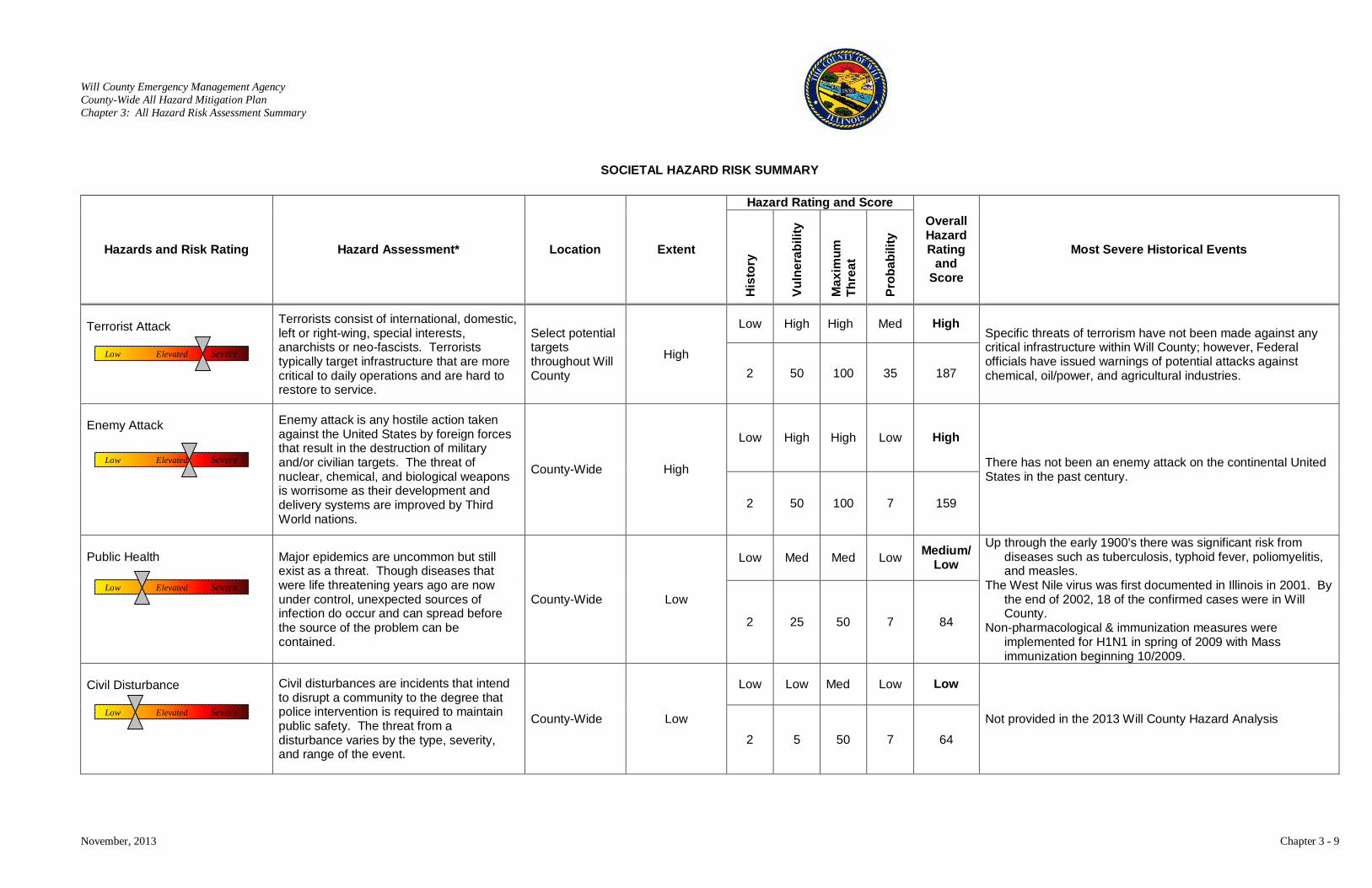
Will County Emergency Management Agency County-Wide All Hazard Mitigation Plan Chapter 3: All Hazard Risk Assessment Summary
November, 2013 Chapter 3 - 9
SOCIETAL HAZARD RISK SUMMARY
Hazards and Risk Rating Hazard Assessment* Location Extent
Hazard Rating and Score Overall Hazard Rating
and Score
Most Severe Historical Events
His
tory
Vuln
erab
ility
Max
imum
Th
reat
Prob
abili
ty
Terrorist Attack
Terrorists consist of international, domestic, left or right-wing, special interests, anarchists or neo-fascists. Terrorists typically target infrastructure that are more critical to daily operations and are hard to restore to service.
Select potential targets throughout Will County
High
Low High High Med High Specific threats of terrorism have not been made against any critical infrastructure within Will County; however, Federal officials have issued warnings of potential attacks against chemical, oil/power, and agricultural industries. 2 50 100 35 187
Enemy Attack
Enemy attack is any hostile action taken against the United States by foreign forces that result in the destruction of military and/or civilian targets. The threat of nuclear, chemical, and biological weapons is worrisome as their development and delivery systems are improved by Third World nations.
County-Wide High
Low High High Low High
There has not been an enemy attack on the continental United States in the past century.
2 50 100 7 159
Public Health Major epidemics are uncommon but still
exist as a threat. Though diseases that were life threatening years ago are now under control, unexpected sources of infection do occur and can spread before the source of the problem can be contained.
County-Wide Low
Low Med Med Low Medium/ Low
Up through the early 1900's there was significant risk from diseases such as tuberculosis, typhoid fever, poliomyelitis, and measles.
The West Nile virus was first documented in Illinois in 2001. By the end of 2002, 18 of the confirmed cases were in Will County.
Non-pharmacological & immunization measures were implemented for H1N1 in spring of 2009 with Mass immunization beginning 10/2009.
2 25 50 7 84
Civil Disturbance
Civil disturbances are incidents that intend to disrupt a community to the degree that police intervention is required to maintain public safety. The threat from a disturbance varies by the type, severity, and range of the event.
County-Wide Low
Low Low Med Low Low
Not provided in the 2013 Will County Hazard Analysis
2 5 50 7 64
Low Elevated Severe
Low Elevated Severe
Low Elevated Severe
Low Elevated Severe
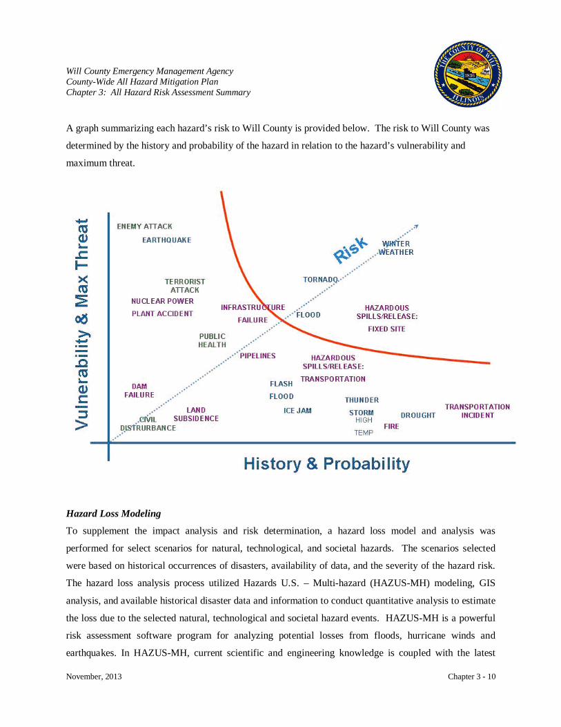
Will County Emergency Management Agency County-Wide All Hazard Mitigation Plan Chapter 3: All Hazard Risk Assessment Summary
November, 2013 Chapter 3 - 10
A graph summarizing each hazard’s risk to Will County is provided below. The risk to Will County was
determined by the history and probability of the hazard in relation to the hazard’s vulnerability and
maximum threat.
Hazard Loss Modeling
To supplement the impact analysis and risk determination, a hazard loss model and analysis was
performed for select scenarios for natural, technological, and societal hazards. The scenarios selected
were based on historical occurrences of disasters, availability of data, and the severity of the hazard risk.
The hazard loss analysis process utilized Hazards U.S. – Multi-hazard (HAZUS-MH) modeling, GIS
analysis, and available historical disaster data and information to conduct quantitative analysis to estimate
the loss due to the selected natural, technological and societal hazard events. HAZUS-MH is a powerful
risk assessment software program for analyzing potential losses from floods, hurricane winds and
earthquakes. In HAZUS-MH, current scientific and engineering knowledge is coupled with the latest
Will County Emergency Management Agency County-Wide All Hazard Mitigation Plan Chapter 3: All Hazard Risk Assessment Summary
November, 2013 Chapter 3 - 11
Geographic Information Systems (GIS) technology to produce estimates of hazard related damage before,
or after, a disaster occurs.
The analysis reports obtained from the HAZUS-MH model includes the following:
• Estimation of the losses to structures and contents
• Estimation of the losses to structure use and function
• Projection of human losses
• Estimation of the primary direct and indirect loss
The HAZUS-MH and GIS analysis was used to determine which individual assets were vulnerable to the
largest potential losses; by adding the structure loss, content loss, and function loss for each asset to
determine the total loss. This process produced the following:
• Calculation of the losses to each asset
• Calculation of the estimated damages for each hazard event
• Creation of a map that shows a composite of the areas of highest loss
Many of the human-induced hazards provide some unique implications for loss estimation because these
events can take place with different magnitudes, in any location, at any time, and under various
circumstances. Because the characteristics of many of the human-induced events are not definitive, a
generalized loss analysis was conducted. The following scenarios were assessed and analyzed utilizing
GIS data and HAZUS-MH modeling.
• Overbank Flooding Event of Will County Stream and River Reaches.
• A F4 Plainfield Tornado.
• A 5.3 magnitude earthquake in DuPage County. This was the largest historical earthquake in
the Chicago area.
• A hazardous materials release from a large industrial facility.
• A hazardous materials release from a transportation incident.
• A terrorist bombing with a similar magnitude of that of the 1995 Oklahoma City bombing.
The Hazard Loss Modeling findings and reports are provided in Appendix B.
Will County Emergency Management Agency County-Wide All Hazard Mitigation Plan Chapter 3: All Hazard Risk Assessment Summary
November, 2013 Chapter 3 - 12
Scenario Summaries
Overbank Flooding Event of Will County Stream and River Reaches
The FEMA Flood Insurance Rate Maps (FIRM) indicate that a large area of Will County’s built
environment is within the Base Flood Elevation. The Base Flood Elevation (BFE) is defined as the area
that has a 1% chance of flooding in any given year. HAZUS-MH Flood Risk Module would be utilized
for modeling riverine flooding of Will County's stream and river network.
F4 Plainfield Tornado
GIS Analysis was utilized to determine the impacts of the 1990 Plainfield Illinois F4 tornado that skipped
through Will County during mid afternoon. Although the track of this tornado was identified, detailed
information on the area damaged could not be determined. Will County GIS data was utilized to
determine structures identified within the damage areas. The potential loss of a F4 tornado traveling a
similar path as the 1990 F4 tornado was projected based on today’s built environment and in today’s
economy.
5.1 Magnitude Earthquake in DuPage County, Illinois
This was the largest historical earthquake in the Chicago area. HAZUS-MH Earthquake Risk Module
provides estimates of damage and loss to buildings, essential facilities, transportation and utility lifelines,
and population based on scenario or probabilistic earthquakes. In addition, the Earthquake Risk Module
estimates the debris generated, fire, casualties, and shelter requirements following the disaster. Based on
consultation with the Illinois State Geologic Survey, the May 26, 1909 earthquake that occurred near
Aurora, Illinois is the best scenario to model with the limitations on available data. Although this
earthquake was a 5.1-magnitude, limitations of the HAZUS-MH model does not provide accurate
information for those earthquakes less than a magnitude 5.5. Therefore, this earthquake analysis assumes
that this historical earthquake had a magnitude of 5.5. Due to information constraints on soil types, the
analysis of a larger earthquake generated from the New Madrid Fault could not be conducted.
Hazardous Materials Release: Fixed Facility
The U.S. EPA’s ALOHA (Areal Locations of Hazardous Atmospheres) model was utilized to assess the
area of impact for a chlorine release at a large industrial facility located southwest of Joliet near Arsenal
Will County Emergency Management Agency County-Wide All Hazard Mitigation Plan Chapter 3: All Hazard Risk Assessment Summary
November, 2013 Chapter 3 - 13
Road and Interstate 55. Chlorine is a common chemical that is used in industrial operations and can be
found in either liquid or gas form. For this scenario, moderate atmospheric and climatic conditions with a
slight breeze from the west were assumed. The target area of Arsenal Road and I-55, “Joliet Arsenal
Hub”, was chosen due to its large industrial facilities, rail and truck hubs, and the presence of a large
number of large quantity hazardous material generators.
Hazardous Materials Release: Transportation Incident
The U.S. EPA’s ALOHA (Areal Locations of Hazardous Atmospheres) model was utilized to assess a
chlorine release from a barge at a large transportation hub southwest of Joliet at US Route 6, Interstate 55,
and the Des Plaines River. Rail, truck tankers, and barges commonly haul chlorine, as well as other
hazardous materials, to and from facilities. For this scenario, moderate atmospheric and climatic
conditions with a slight breeze from the west were assumed. The target area of the US Route 6, I-55, and
Des Plaines River was chosen due to its heavy barge traffic, large rail and truck hubs, as well as the
presence of a large number of large quantity hazardous material generators.
Terrorist Bombing
GIS Analysis was utilized to determine the impacts of a bombing near a critical infrastructure of Will
County with a similar magnitude of the April 19, 1995 Oklahoma City Bombing. In the Oklahoma City
Bombing, a Ryder rental truck was loaded with approximately 5,000 pounds of ammonium nitrate
fertilizer and detonated outside of the Murrah Federal Building. The explosion generated a pressure blast
of 500,000 psi, destroyed one-third of the Murrah Federal Building, and created a crater thirty feet wide
and eight feet deep. The Will County target analyzed in this hazard modeling is the Will County Court
House.
Limitations
The analysis of hazards is complicated by a number of factors including laws, customs, ethics, values,
attitudes, political preferences, and complex infrastructures and built environment. A hazard analysis
provides a wealth of valuable information that is essential for identifying goals, prioritizing actions,
planning and preparedness, and recovering and mitigating future hazards.
The assessment of data and identifying the risk to a community is not a hard science. It is difficult to
predict hazard impacts, and conclusions are not absolute. The perception of what constitutes a risk and a
Will County Emergency Management Agency County-Wide All Hazard Mitigation Plan Chapter 3: All Hazard Risk Assessment Summary
November, 2013 Chapter 3 - 14
judgment of its impact can differ from individual to individual. The changing natural, built, or societal
environments can have a significant affect on each hazard assessment. A hazard risk assessment does
provide a guide to evaluate Will County’s risks and guides the Will County EMA to perform their
mission of protecting the County. For this reason, it is important to periodically update and improve the
County’s Risk Assessment with best available data.
Regional All Hazards Risk Assessment Project
FEMA provides funds to the Illinois-Indiana-Wisconsin (IL-IN-WI) Combined Statistical Area (CSA)
under the Regional Catastrophic Preparedness Grant Program (RCPGP). The purpose of the RCPGP is to
support preparedness efforts of local jurisdictions, spanning multiple states, in planning for catastrophic
events or disasters. An initiative under the RCPGP was the Regional All Hazards Risk Assessment
Project. Will County Emergency Management Agency was a member of this subcommittee whose
mission was to plan for and mitigate catastrophic and routine incidents.
The project completed in July, 2013, provided Will County with two analysis tracks. The first was an
assessment of the capabilities of the County to implement the 31 Core Capabilities described in the
National Preparedness Goal. The other was software called System-wide Multi-hazard Risk Tool
(SMRT) utilized to conduct risk analysis. SMRT was used for the regional assessment of chosen hazards:
tornados, extreme heat, pandemic, blackout, and terrorism.
The Core Capability assessment and SMRT software tool will enhance the County’s ability to analyze
risk and improve planning to address the hazards faced by the County. The SMRT software will be used
to re-evaluate the hazard analysis in an effort to obtain consistent and objective data. The Core Capability
assessment establishes a baseline for preparedness from which training and resource needs can be
identified and improved. Along with the regional risk assessment completed under the project, the data
generated from these tools will help to develop a county-wide Threat and Hazard Identification Risk
Assessment (THIRA) which will lead to improved mitigation planning.

Will County Emgerncy Management Agency County-Wide All Hazard Mitigation Plan Chapter 4: Hazard Profiles & Vulnerability Assessment
November, 2013 Chapter 4 - 1
CHAPTER 4: HAZARD PROFILES AND VULNERABILITY ASSESSMENT
The following profiles include not only natural hazards but also technological and societal hazards that
have the potential to affect Will County. The location of Will County is a factor in many of the hazards
that face the County. Being located in the Midwest, the County is subject to extreme changes in climate.
During the spring through fall seasons, the County experiences many thunderstorms. These storms can be
quite severe and bring with them the damaging effects of wind, lightning, hail, and flood. Will County is
also located in the section of the United States that experiences the most tornado activity. The worst
tornado to hit the County occurred in 1990. The summer months can also bring high temperatures which
may lead to periods of drought and its damaging effect on crops and water supply. As the seasons change
to winter, the temperature can change to extreme cold and along with this cold often comes snow, ice,
more wind, and more flooding. These winter
storms can knock down the power supply and
bring travel routes to a close.
The location of Will County is also the
reason for many of the technological and
societal hazards that the County may
experience. Being proximate to Chicago,
Will County is the hub for many
transportation systems that lead into the
Chicago area. Interstate highways, railways,
bus routes, waterways, pipelines, and airports
are systems that transport raw materials, finished products, and people in and out of the County. These
transportation systems encourage the development of business enterprises which bring in materials to
produce products utilized throughout the country and the world.
Along with these transportation systems and entities of commerce come risks. Some of the chemicals
used in manufacturing and agriculture have hazardous effects on people and the environment. As these
chemicals are transported or processed, there is the potential for spills, fire, explosion, and harmful
contamination. Nuclear power plants utilize fuel that can have damaging effects for generations should it
be released during transportation or a plant accident. Though technological advances have helped to
make Will County prosperous, the potential for harm must be addressed through programs of
preparedness.
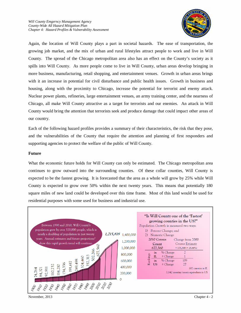
Will County Emgerncy Management Agency County-Wide All Hazard Mitigation Plan Chapter 4: Hazard Profiles & Vulnerability Assessment
November, 2013 Chapter 4 - 2
Again, the location of Will County plays a part in societal hazards. The ease of transportation, the
growing job market, and the mix of urban and rural lifestyles attract people to work and live in Will
County. The spread of the Chicago metropolitan area also has an effect on the County’s society as it
spills into Will County. As more people come to live in Will County, urban areas develop bringing in
more business, manufacturing, retail shopping, and entertainment venues. Growth in urban areas brings
with it an increase in potential for civil disturbance and public health issues. Growth in business and
housing, along with the proximity to Chicago, increase the potential for terrorist and enemy attack.
Nuclear power plants, refineries, large entertainment venues, an army training center, and the nearness of
Chicago, all make Will County attractive as a target for terrorists and our enemies. An attack in Will
County would bring the attention that terrorists seek and produce damage that could impact other areas of
our country.
Each of the following hazard profiles provides a summary of their characteristics, the risk that they pose,
and the vulnerabilities of the County that require the attention and planning of first responders and
supporting agencies to protect the welfare of the public of Will County.
Future
What the economic future holds for Will County can only be estimated. The Chicago metropolitan area
continues to grow outward into the surrounding counties. Of these collar counties, Will County is
expected to be the fastest growing. It is forecasted that the area as a whole will grow by 25% while Will
County is expected to grow over 50% within the next twenty years. This means that potentially 180
square miles of new land could be developed over this time frame. Most of this land would be used for
residential purposes with some used for business and industrial use.
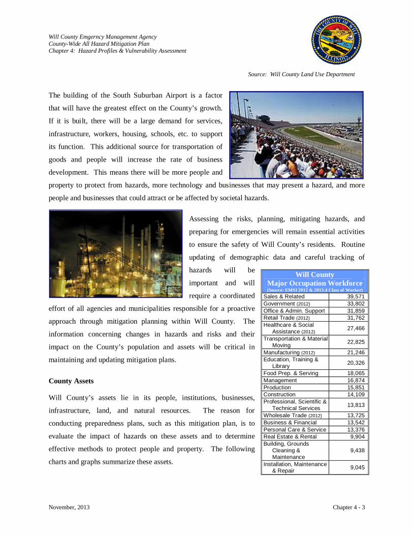
Will County Emgerncy Management Agency County-Wide All Hazard Mitigation Plan Chapter 4: Hazard Profiles & Vulnerability Assessment
November, 2013 Chapter 4 - 3
The building of the South Suburban Airport is a factor
that will have the greatest effect on the County’s growth.
If it is built, there will be a large demand for services,
infrastructure, workers, housing, schools, etc. to support
its function. This additional source for transportation of
goods and people will increase the rate of business
development. This means there will be more people and
property to protect from hazards, more technology and businesses that may present a hazard, and more
people and businesses that could attract or be affected by societal hazards.
Assessing the risks, planning, mitigating hazards, and
preparing for emergencies will remain essential activities
to ensure the safety of Will County’s residents. Routine
updating of demographic data and careful tracking of
hazards will be
important and will
require a coordinated
effort of all agencies and municipalities responsible for a proactive
approach through mitigation planning within Will County. The
information concerning changes in hazards and risks and their
impact on the County’s population and assets will be critical in
maintaining and updating mitigation plans.
County Assets
Will County’s assets lie in its people, institutions, businesses,
infrastructure, land, and natural resources. The reason for
conducting preparedness plans, such as this mitigation plan, is to
evaluate the impact of hazards on these assets and to determine
effective methods to protect people and property. The following
charts and graphs summarize these assets.
Will County Major Occupation Workforce (Source: EMSI 2012 & 2013.4 Class of Worker)
Sales & Related 39,571 Government (2012) 33,802 Office & Admin. Support 31,859 Retail Trade (2012) 31,762 Healthcare & Social
Assistance (2012) 27,466
Transportation & Material Moving 22,825
Manufacturing (2012) 21,246 Education, Training &
Library 20,326
Food Prep. & Serving 18,065 Management 16,874 Production 15,851 Construction 14,109 Professional, Scientific &
Technical Services 13,813
Wholesale Trade (2012) 13,725 Business & Financial 13,542 Personal Care & Service 13,376 Real Estate & Rental 9,904 Building, Grounds
Cleaning & Maintenance
9,438
Installation, Maintenance & Repair 9,045
Source: Will County Land Use Department
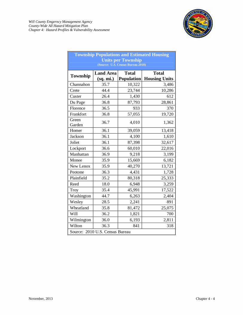
Will County Emgerncy Management Agency County-Wide All Hazard Mitigation Plan Chapter 4: Hazard Profiles & Vulnerability Assessment
November, 2013 Chapter 4 - 4
Township Populations and Estimated Housing Units per Township
(Source: U.S. Census Bureau 2010)
Township Land Area (sq. mi.)
Total Population
Total Housing Units
Channahon 35.7 10,322 3,486 Crete 44.4 23,744 10,286 Custer 26.4 1,430 612 Du Page 36.8 87,793 28,861 Florence 36.5 933 370 Frankfort 36.8 57,055 19,720 Green Garden 36.7 4,010 1,362
Homer 36.1 39,059 13,418 Jackson 36.1 4,100 1,610 Joliet 36.1 87,398 32,617 Lockport 36.6 60,010 22,016 Manhattan 36.9 9,218 3,199 Monee 35.9 15,669 6,182 New Lenox 35.9 40,270 13,721 Peotone 36.3 4,431 1,728 Plainfield 35.2 80,318 25,333 Reed 18.0 6,948 3,259 Troy 35.4 45,991 17,522 Washington 44.7 6,263 2,404 Wesley 28.5 2,241 891 Wheatland 35.8 81,472 25,075 Will 36.2 1,821 700 Wilmington 36.0 6,193 2,811 Wilton 36.3 841 318 Source: 2010 U.S. Census Bureau
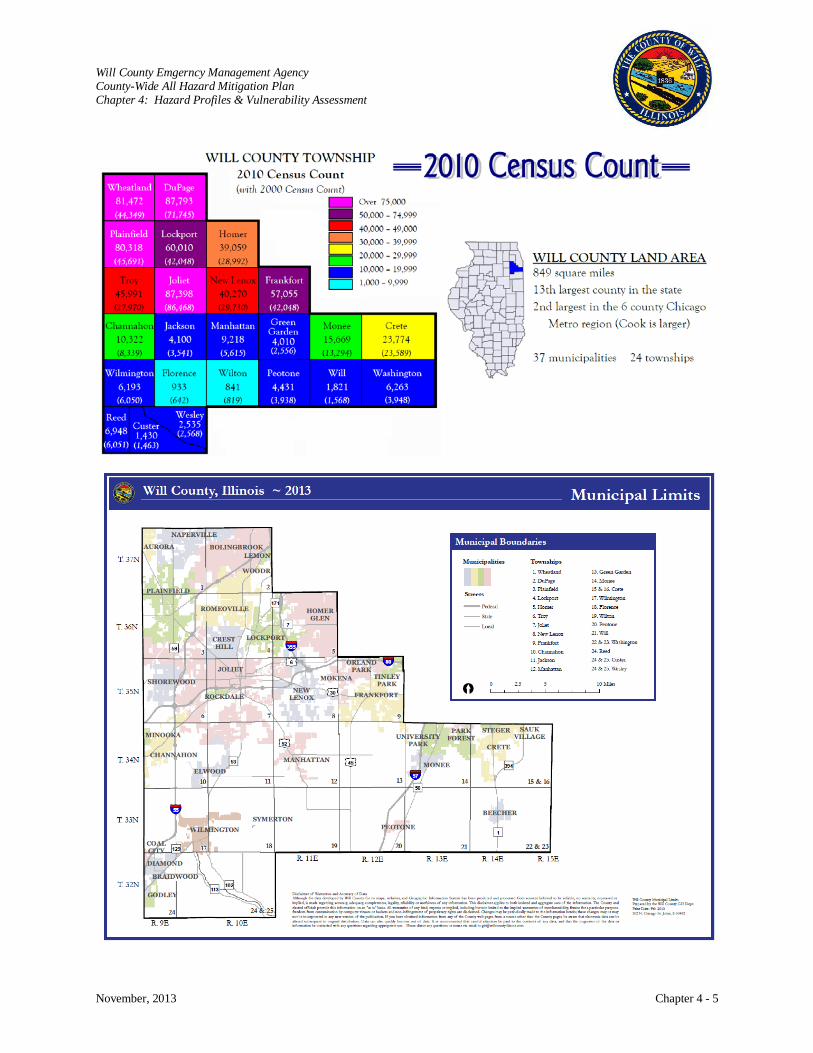
Will County Emgerncy Management Agency County-Wide All Hazard Mitigation Plan Chapter 4: Hazard Profiles & Vulnerability Assessment
November, 2013 Chapter 4 - 5
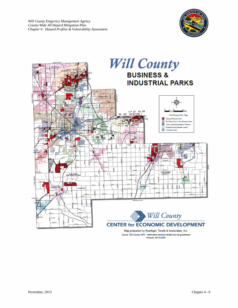
Will County Emgerncy Management Agency County-Wide All Hazard Mitigation Plan Chapter 4: Hazard Profiles & Vulnerability Assessment
November, 2013 Chapter 4 - 6
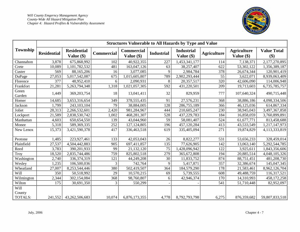
Will County Emgerncy Management Agency County-Wide All Hazard Mitigation Plan Chapter 4: Hazard Profiles & Vulnerability Assessment
July, 2006 Chapter 4 - 7
Township Structures Vulnerable to All Hazards by Type and Value
Residential Residential Value ($) Commercial Commercial
Value ($) Industrial Industrial Value ($) Agriculture Agriculture
Value ($) Value Total
($) Channahon 3,878 675,868,992 102 40,922,355 227 1,453,341,177 114 7,138,371 2,177,270,895 Crete 10,089 1,101,782,532 481 163,047,126 63 38,257,407 622 53,302,122 1,356,389,187 Custer 569 88,165,206 16 3,077,085 9 2,984,784 378 26,674,344 120,901,419 DuPage 27,053 5,017,542,087 675 1,015,605,807 789 2,902,293,444 55 3,622,071 8,939,063,409 Florence 377 48,952,410 6 2,090,931 8 20,357,517 320 42,606,090 114,006,948 Frankfort 21,281 5,263,794,348 1,318 1,021,057,305 592 431,220,501 209 19,713,603 6,735,785,757 Green Garden 1,449 369,203,754 18 13,041,411 32 829,959 777 107,640,324 490,715,448
Homer 14,685 3,653,316,654 349 378,555,435 91 27,576,231 368 38,886,186 4,098,334,506 Jackson 1,799 243,103,104 79 38,884,005 128 286,755,189 366 46,125,036 614,867,334 Joliet 28,313 2,266,532,601 2,420 981,284,967 444 210,605,247 230 38,945,043 3,497,367,858 Lockport 21,589 2,838,530,742 1,002 468,281,307 528 437,229,783 184 16,858,059 3,760,899,891 Manhattan 4,603 650,654,550 139 43,044,960 59 58,081,407 524 61,677,771 813,458,688 Monee 5,318 589,369,335 252 127,124,805 196 457,120,284 413 43,533,549 1,217,147,973 New Lenox 15,373 3,421,590,378 417 336,463,518 619 335,405,094 271 19,874,829
4,113,333,819
Peotone 1,485 223,927,461 133 42,053,043 26 8,822,277 531 53,656,233 328,459,014 Plainfield 27,537 4,504,442,883 905 697,411,857 135 77,626,905 142 13,063,140 5,292,544,785 Reed 3,783 390,201,933 99 21,132,120 75 1,428,096,942 122 3,925,611 1,843,356,606 Troy 18,520 2,835,744,486 759 825,802,518 279 365,672,808 194 20,885,514 4,048,105,326 Washington 2,740 336,374,319 121 44,249,208 30 11,833,752 874 88,751,451 481,208,730 Wesley 1,235 106,500,036 3 742,764 9 5,417,871 357 32,386,674 145,047,345 Wheatland 27,007 8,253,544,446 380 502,419,507 364 184,579,290 178 21,583,461 8,962,126,704 Will 350 50,518,992 29 10,570,215 69 5,739,555 608 49,488,759 116,317,521 Wilmington 2,344 302,154,084 368 98,760,807 6 42,946,374 170 14,310,993 458,172,258 Wilton 175 30,691,350 3 550,299 - - 541 51,710,448 82,952,097 Will County TOTALS: 241,552 43,262,506,683 10,074 6,876,173,355 4,778 8,792,793,798 6,275 876,359,682 59,807,833,518
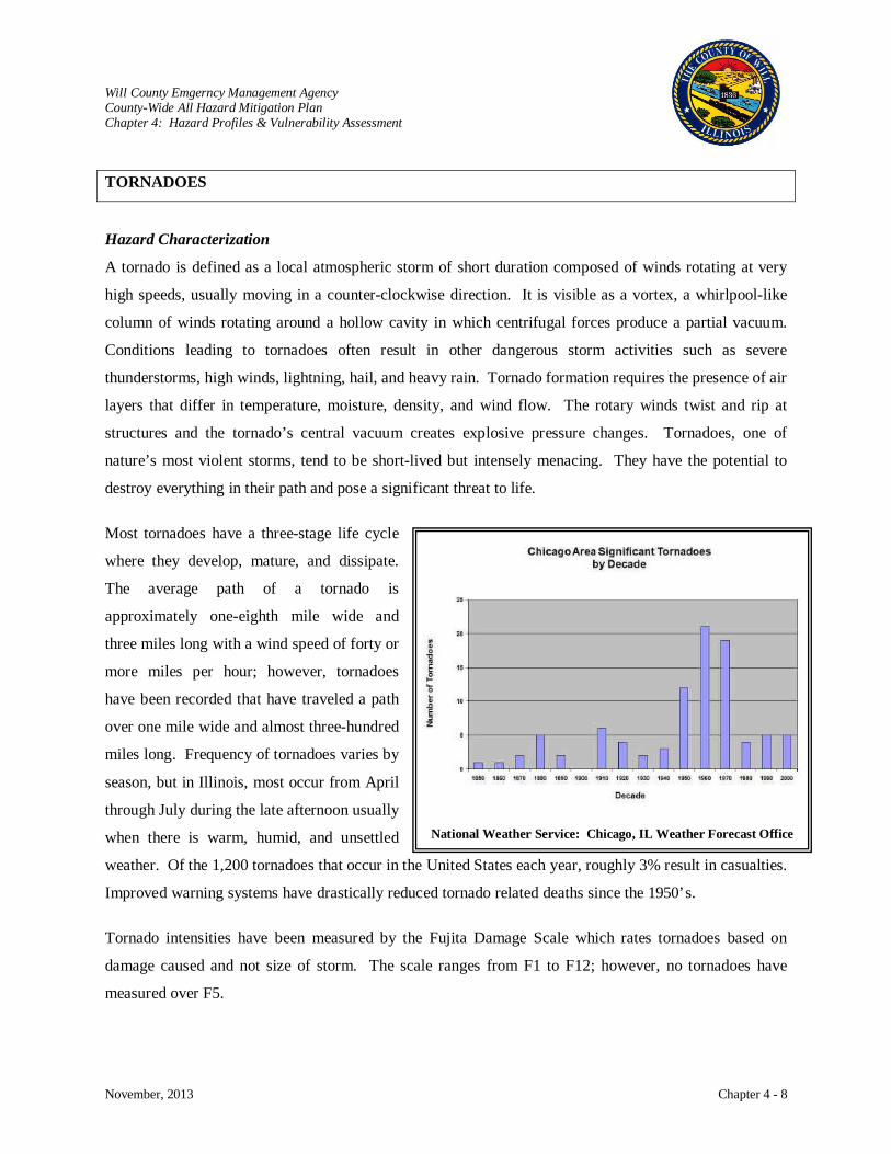
Will County Emgerncy Management Agency County-Wide All Hazard Mitigation Plan Chapter 4: Hazard Profiles & Vulnerability Assessment
November, 2013 Chapter 4 - 8
TORNADOES
Hazard Characterization
A tornado is defined as a local atmospheric storm of short duration composed of winds rotating at very
high speeds, usually moving in a counter-clockwise direction. It is visible as a vortex, a whirlpool-like
column of winds rotating around a hollow cavity in which centrifugal forces produce a partial vacuum.
Conditions leading to tornadoes often result in other dangerous storm activities such as severe
thunderstorms, high winds, lightning, hail, and heavy rain. Tornado formation requires the presence of air
layers that differ in temperature, moisture, density, and wind flow. The rotary winds twist and rip at
structures and the tornado’s central vacuum creates explosive pressure changes. Tornadoes, one of
nature’s most violent storms, tend to be short-lived but intensely menacing. They have the potential to
destroy everything in their path and pose a significant threat to life.
Most tornadoes have a three-stage life cycle
where they develop, mature, and dissipate.
The average path of a tornado is
approximately one-eighth mile wide and
three miles long with a wind speed of forty or
more miles per hour; however, tornadoes
have been recorded that have traveled a path
over one mile wide and almost three-hundred
miles long. Frequency of tornadoes varies by
season, but in Illinois, most occur from April
through July during the late afternoon usually
when there is warm, humid, and unsettled
weather. Of the 1,200 tornadoes that occur in the United States each year, roughly 3% result in casualties.
Improved warning systems have drastically reduced tornado related deaths since the 1950’s.
Tornado intensities have been measured by the Fujita Damage Scale which rates tornadoes based on
damage caused and not size of storm. The scale ranges from F1 to F12; however, no tornadoes have
measured over F5.
National Weather Service: Chicago, IL Weather Forecast Office
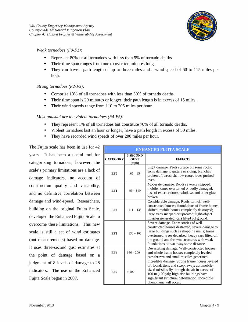
Will County Emgerncy Management Agency County-Wide All Hazard Mitigation Plan Chapter 4: Hazard Profiles & Vulnerability Assessment
November, 2013 Chapter 4 - 9
Weak tornadoes (F0-F1):
Represent 80% of all tornadoes with less than 5% of tornado deaths. Their time span ranges from one to over ten minutes long. They can have a path length of up to three miles and a wind speed of 60 to 115 miles per
hour.
Strong tornadoes (F2-F3):
Comprise 19% of all tornadoes with less than 30% of tornado deaths. Their time span is 20 minutes or longer, their path length is in excess of 15 miles. Their wind speeds range from 110 to 205 miles per hour.
Most unusual are the violent tornadoes (F4-F5):
They represent 1% of all tornadoes but constitute 70% of all tornado deaths. Violent tornadoes last an hour or longer, have a path length in excess of 50 miles. They have recorded wind speeds of over 200 miles per hour.
The Fujita scale has been in use for 42
years. It has been a useful tool for
categorizing tornadoes; however, the
scale’s primary limitations are a lack of
damage indicators, no account of
construction quality and variability,
and no definitive correlation between
damage and wind-speed. Researchers,
building on the original Fujita Scale,
developed the Enhanced Fujita Scale to
overcome these limitations. This new
scale is still a set of wind estimates
(not measurements) based on damage.
It uses three-second gust estimates at
the point of damage based on a
judgment of 8 levels of damage to 28
indicators. The use of the Enhanced
Fujita Scale began in 2007.
ENHANCED FUJITA SCALE
CATEGORY 3 SECOND
GUST (mph)
EFFECTS
EF0 65 – 85
Light damage. Peels surface off some roofs; some damage to gutters or siding; branches broken off trees; shallow-rooted trees pushed over.
EF1 86 – 110
Moderate damage. Roofs severely stripped: mobile homes overturned or badly damaged; loss of exterior doors; windows and other glass broken
EF2 111 – 135
Considerable damage. Roofs torn off well-constructed houses; foundations of frame homes shifted; mobile homes completely destroyed; large trees snapped or uprooted; light-object missiles generated; cars lifted off ground.
EF3 136 – 165
Severe damage. Entire stories of well-constructed houses destroyed; severe damage to large buildings such as shopping malls; trains overturned; trees debarked; heavy cars lifted off the ground and thrown; structures with weak foundations blown away some distance.
EF4 166 – 200 Devastating damage. Well-constructed houses and whole frame houses completely leveled; cars thrown and small missiles generated.
EF5 > 200
Incredible damage. Strong frame houses leveled off foundations and swept away; automobile-sized missiles fly through the air in excess of 100 m (109 yd); high-rise buildings have significant structural deformation; incredible phenomena will occur.
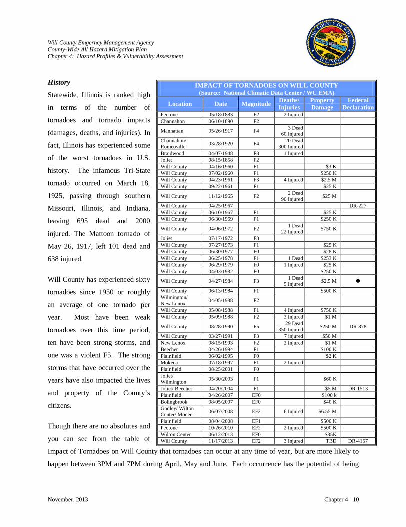
Will County Emgerncy Management Agency County-Wide All Hazard Mitigation Plan Chapter 4: Hazard Profiles & Vulnerability Assessment
November, 2013 Chapter 4 - 10
History
Statewide, Illinois is ranked high
in terms of the number of
tornadoes and tornado impacts
(damages, deaths, and injuries). In
fact, Illinois has experienced some
of the worst tornadoes in U.S.
history. The infamous Tri-State
tornado occurred on March 18,
1925, passing through southern
Missouri, Illinois, and Indiana,
leaving 695 dead and 2000
injured. The Mattoon tornado of
May 26, 1917, left 101 dead and
638 injured.
Will County has experienced sixty
tornadoes since 1950 or roughly
an average of one tornado per
year. Most have been weak
tornadoes over this time period,
ten have been strong storms, and
one was a violent F5. The strong
storms that have occurred over the
years have also impacted the lives
and property of the County’s
citizens.
Though there are no absolutes and
you can see from the table of
Impact of Tornadoes on Will County that tornadoes can occur at any time of year, but are more likely to
happen between 3PM and 7PM during April, May and June. Each occurrence has the potential of being
IMPACT OF TORNADOES ON WILL COUNTY (Source: National Climatic Data Center / WC EMA)
Location Date Magnitude Deaths/ Injuries
Property Damage
Federal Declaration
Peotone 05/18/1883 F2 2 Injured Channahon 06/10/1890 F2
Manhattan 05/26/1917 F4 3 Dead 60 Injured
Channahon/ Romeoville 03/28/1920 F4 20 Dead
300 Injured
Braidwood 04/07/1948 F3 1 Injured Joliet 08/15/1858 F2 Will County 04/16/1960 F1 $3 K Will County 07/02/1960 F1 $250 K Will County 04/23/1961 F3 4 Injured $2.5 M Will County 09/22/1961 F1 $25 K
Will County 11/12/1965 F2 2 Dead 90 Injured $25 M
Will County 04/25/1967 DR-227 Will County 06/10/1967 F1 $25 K Will County 06/30/1969 F1 $250 K
Will County 04/06/1972 F2 1 Dead 22 Injured $750 K
Joliet 07/17/1972 F3 Will County 07/27/1973 F1 $25 K Will County 06/30/1977 F0 $28 K Will County 06/25/1978 F1 1 Dead $253 K Will County 06/29/1979 F0 1 Injured $25 K Will County 04/03/1982 F0 $250 K
Will County 04/27/1984 F3 1 Dead 5 Injured $2.5 M
Will County 06/13/1984 F1 $500 K Wilmington/ New Lenox 04/05/1988 F2
Will County 05/08/1988 F1 4 Injured $750 K Will County 05/09/1988 F2 3 Injured $1 M
Will County 08/28/1990 F5 29 Dead 350 Injured $250 M DR-878
Will County 03/27/1991 F3 7 injured $50 M New Lenox 08/15/1993 F2 2 Injured $1 M Beecher 04/26/1994 F1 $100 K Plainfield 06/02/1995 F0 $2 K Mokena 07/18/1997 F1 2 Injured Plainfield 08/25/2001 F0 Joliet/ Wilmington 05/30/2003 F1 $60 K
Joliet/ Beecher 04/20/2004 F1 $5 M DR-1513 Plainfield 04/26/2007 EF0 $100 k Bolingbrook 08/05/2007 EF0 $40 K Godley/ Wilton Center/ Monee 06/07/2008 EF2 6 Injured $6.55 M
Plainfield 08/04/2008 EF1 $500 K Peotone 10/26/2010 EF2 2 Injured $500 K Wilton Center 06/12/2013 EF0 $35K Will County 11/17/2013 EF2 3 Injured TBD DR-4157
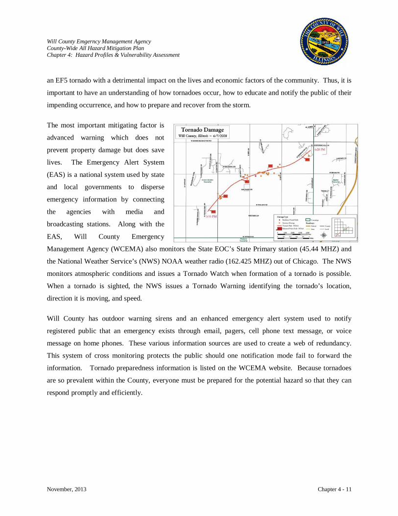
Will County Emgerncy Management Agency County-Wide All Hazard Mitigation Plan Chapter 4: Hazard Profiles & Vulnerability Assessment
November, 2013 Chapter 4 - 11
an EF5 tornado with a detrimental impact on the lives and economic factors of the community. Thus, it is
important to have an understanding of how tornadoes occur, how to educate and notify the public of their
impending occurrence, and how to prepare and recover from the storm.
The most important mitigating factor is
advanced warning which does not
prevent property damage but does save
lives. The Emergency Alert System
(EAS) is a national system used by state
and local governments to disperse
emergency information by connecting
the agencies with media and
broadcasting stations. Along with the
EAS, Will County Emergency
Management Agency (WCEMA) also monitors the State EOC’s State Primary station (45.44 MHZ) and
the National Weather Service’s (NWS) NOAA weather radio (162.425 MHZ) out of Chicago. The NWS
monitors atmospheric conditions and issues a Tornado Watch when formation of a tornado is possible.
When a tornado is sighted, the NWS issues a Tornado Warning identifying the tornado’s location,
direction it is moving, and speed.
Will County has outdoor warning sirens and an enhanced emergency alert system used to notify
registered public that an emergency exists through email, pagers, cell phone text message, or voice
message on home phones. These various information sources are used to create a web of redundancy.
This system of cross monitoring protects the public should one notification mode fail to forward the
information. Tornado preparedness information is listed on the WCEMA website. Because tornadoes
are so prevalent within the County, everyone must be prepared for the potential hazard so that they can
respond promptly and efficiently.
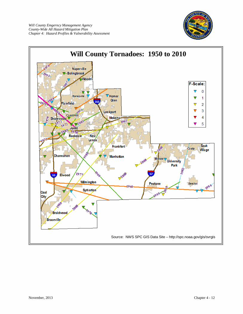
Will County Emgerncy Management Agency County-Wide All Hazard Mitigation Plan Chapter 4: Hazard Profiles & Vulnerability Assessment
November, 2013 Chapter 4 - 12
Will County Tornadoes: 1950 to 2010
Source: NWS SPC GIS Data Site – http://spc.noaa.gov/gis/svrgis
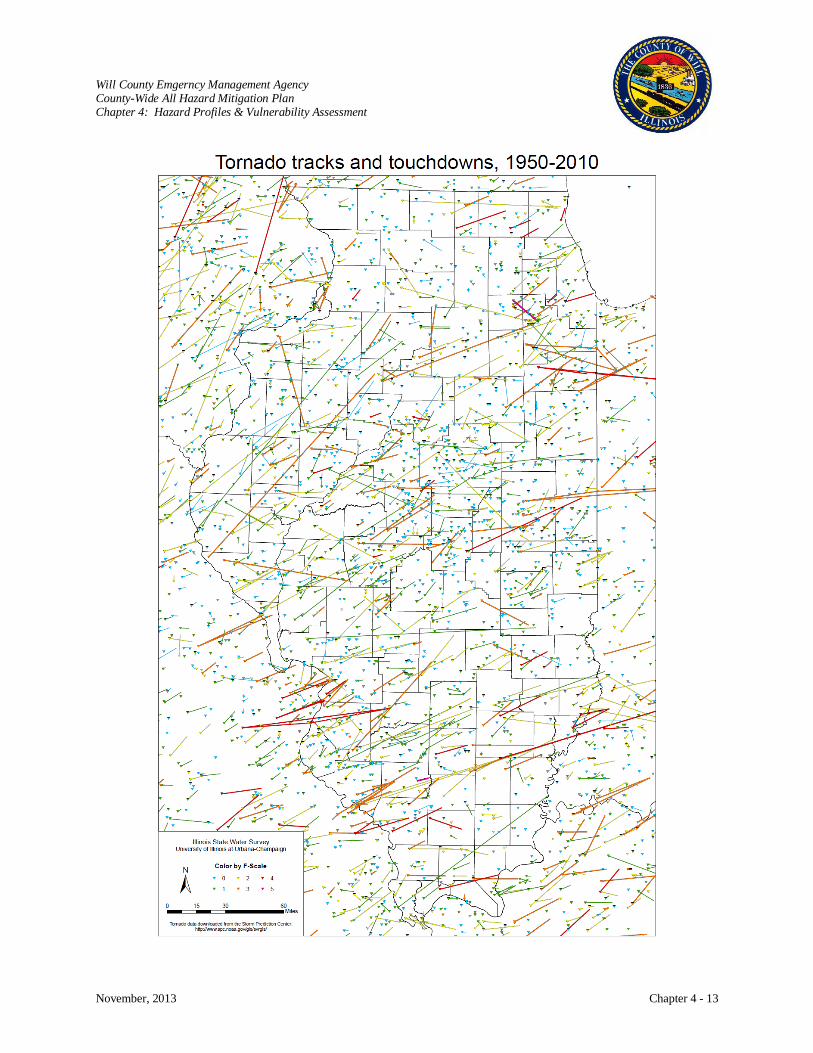
Will County Emgerncy Management Agency County-Wide All Hazard Mitigation Plan Chapter 4: Hazard Profiles & Vulnerability Assessment
November, 2013 Chapter 4 - 13

Will County Emgerncy Management Agency County-Wide All Hazard Mitigation Plan Chapter 4: Hazard Profiles & Vulnerability Assessment
November, 2013 Chapter 4 - 14
Source: Tornado Plots for Illinois, Illinois State Water Survey
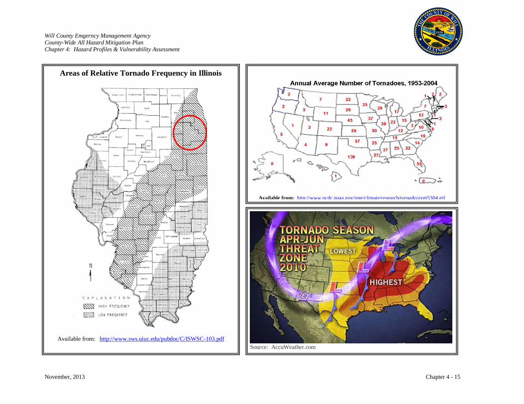
Will County Emgerncy Management Agency County-Wide All Hazard Mitigation Plan Chapter 4: Hazard Profiles & Vulnerability Assessment
November, 2013 Chapter 4 - 15
Areas of Relative Tornado Frequency in Illinois
Available from: http://www.sws.uiuc.edu/pubdoc/C/ISWSC-103.pdf
Available from: http://www.ncdc.noaa.gov/img/climate/research/tornado/avgt5304.gif
Source: AccuWeather.com

Will County Emgerncy Management Agency County-Wide All Hazard Mitigation Plan Chapter 4: Hazard Profiles & Vulnerability Assessment
November, 2013 Chapter 4 - 16
Severe Storms and Tornado – November 17, 2013 Federal Disaster Declaration #4157 Individual Assistance - $23,397 (76 referrals) Public Assistance - unavailable
The potential for severe weather was detected several days in advance. As early as Thursday morning,
November 14, most of central and southeast Illinois was included in the severe weather outlook for
Sunday. At that range, areas are highlighted if there is at least a 30% chance of receiving severe weather.
The outlook from late Saturday morning, indicated a 45% chance of severe weather over much of the
Midwest and a 10% chance of seeing significant severe weather (defined as either tornadoes of at least
EF-2 strength, winds of 75 mph, hail of at least 2" in diameter, or any combination thereof) within 25
miles of any given point.
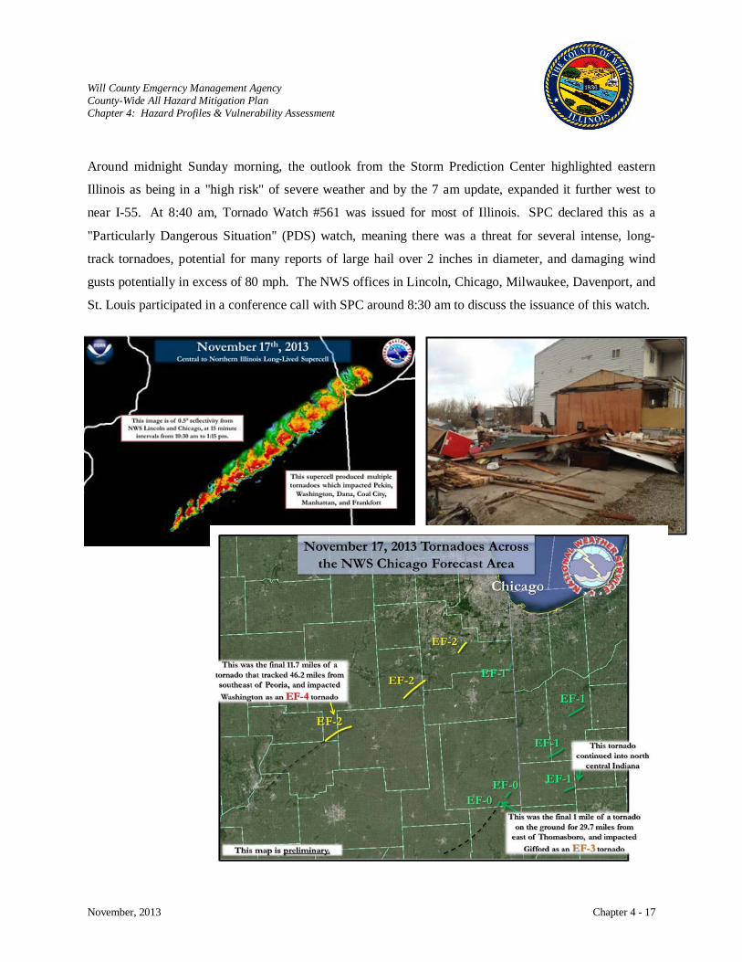
Will County Emgerncy Management Agency County-Wide All Hazard Mitigation Plan Chapter 4: Hazard Profiles & Vulnerability Assessment
November, 2013 Chapter 4 - 17
Around midnight Sunday morning, the outlook from the Storm Prediction Center highlighted eastern
Illinois as being in a "high risk" of severe weather and by the 7 am update, expanded it further west to
near I-55. At 8:40 am, Tornado Watch #561 was issued for most of Illinois. SPC declared this as a
"Particularly Dangerous Situation" (PDS) watch, meaning there was a threat for several intense, long-
track tornadoes, potential for many reports of large hail over 2 inches in diameter, and damaging wind
gusts potentially in excess of 80 mph. The NWS offices in Lincoln, Chicago, Milwaukee, Davenport, and
St. Louis participated in a conference call with SPC around 8:30 am to discuss the issuance of this watch.
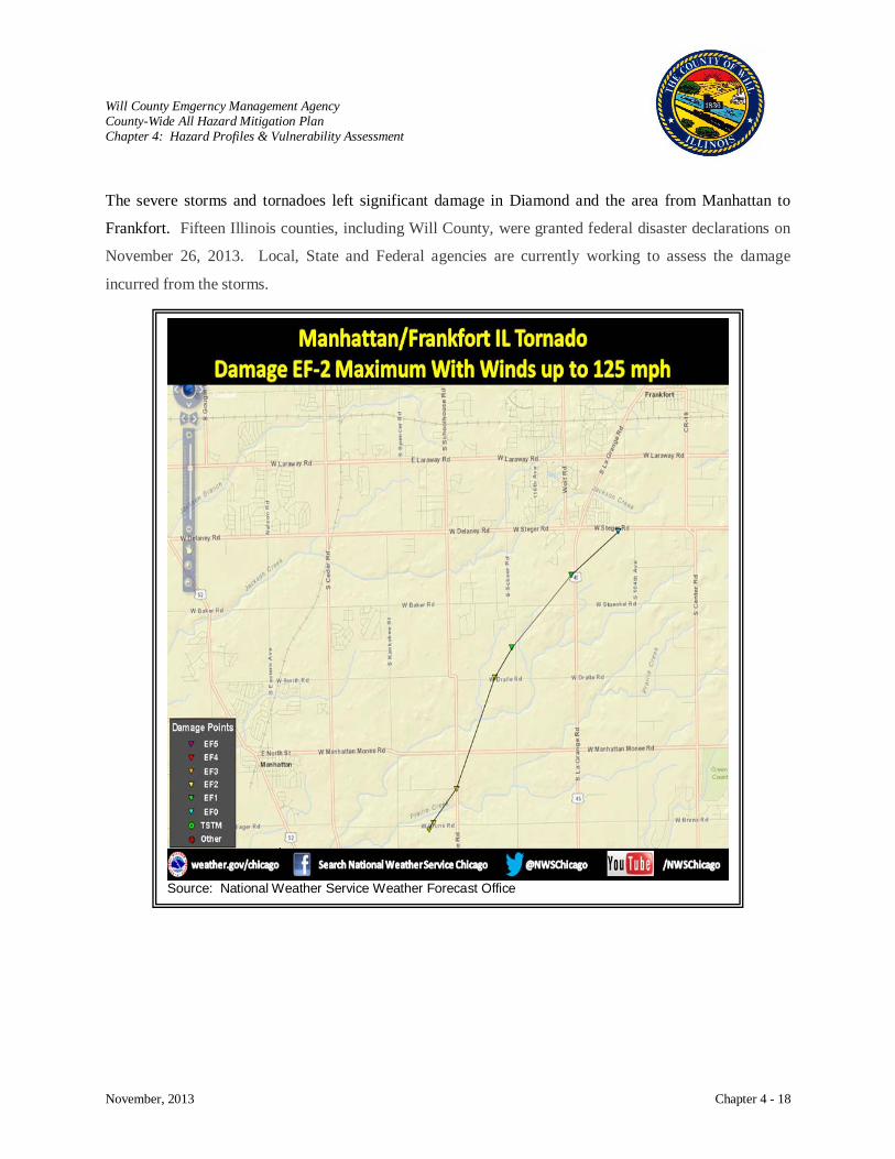
Will County Emgerncy Management Agency County-Wide All Hazard Mitigation Plan Chapter 4: Hazard Profiles & Vulnerability Assessment
November, 2013 Chapter 4 - 18
The severe storms and tornadoes left significant damage in Diamond and the area from Manhattan to
Frankfort. Fifteen Illinois counties, including Will County, were granted federal disaster declarations on
November 26, 2013. Local, State and Federal agencies are currently working to assess the damage
incurred from the storms.
Source: National Weather Service Weather Forecast Office
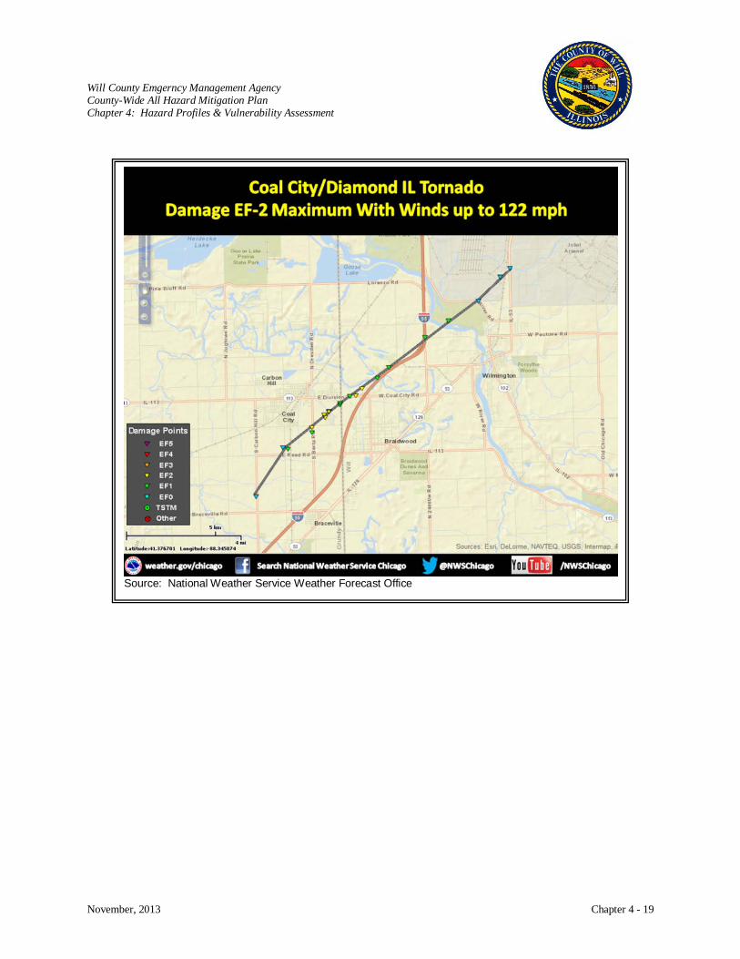
Will County Emgerncy Management Agency County-Wide All Hazard Mitigation Plan Chapter 4: Hazard Profiles & Vulnerability Assessment
November, 2013 Chapter 4 - 19
Source: National Weather Service Weather Forecast Office
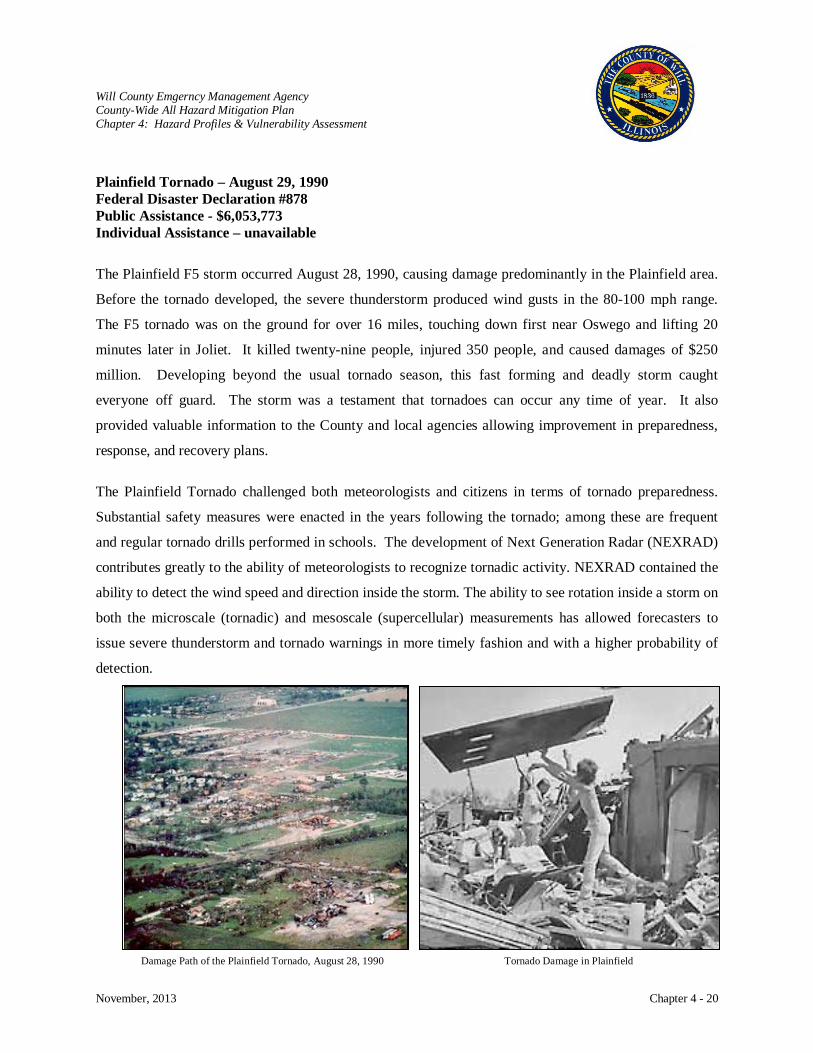
Will County Emgerncy Management Agency County-Wide All Hazard Mitigation Plan Chapter 4: Hazard Profiles & Vulnerability Assessment
November, 2013 Chapter 4 - 20
Tornado Damage in Plainfield
Damage Path of the Plainfield Tornado, August 28, 1990
Plainfield Tornado – August 29, 1990 Federal Disaster Declaration #878 Public Assistance - $6,053,773 Individual Assistance – unavailable
The Plainfield F5 storm occurred August 28, 1990, causing damage predominantly in the Plainfield area.
Before the tornado developed, the severe thunderstorm produced wind gusts in the 80-100 mph range.
The F5 tornado was on the ground for over 16 miles, touching down first near Oswego and lifting 20
minutes later in Joliet. It killed twenty-nine people, injured 350 people, and caused damages of $250
million. Developing beyond the usual tornado season, this fast forming and deadly storm caught
everyone off guard. The storm was a testament that tornadoes can occur any time of year. It also
provided valuable information to the County and local agencies allowing improvement in preparedness,
response, and recovery plans.
The Plainfield Tornado challenged both meteorologists and citizens in terms of tornado preparedness.
Substantial safety measures were enacted in the years following the tornado; among these are frequent
and regular tornado drills performed in schools. The development of Next Generation Radar (NEXRAD)
contributes greatly to the ability of meteorologists to recognize tornadic activity. NEXRAD contained the
ability to detect the wind speed and direction inside the storm. The ability to see rotation inside a storm on
both the microscale (tornadic) and mesoscale (supercellular) measurements has allowed forecasters to
issue severe thunderstorm and tornado warnings in more timely fashion and with a higher probability of
detection.
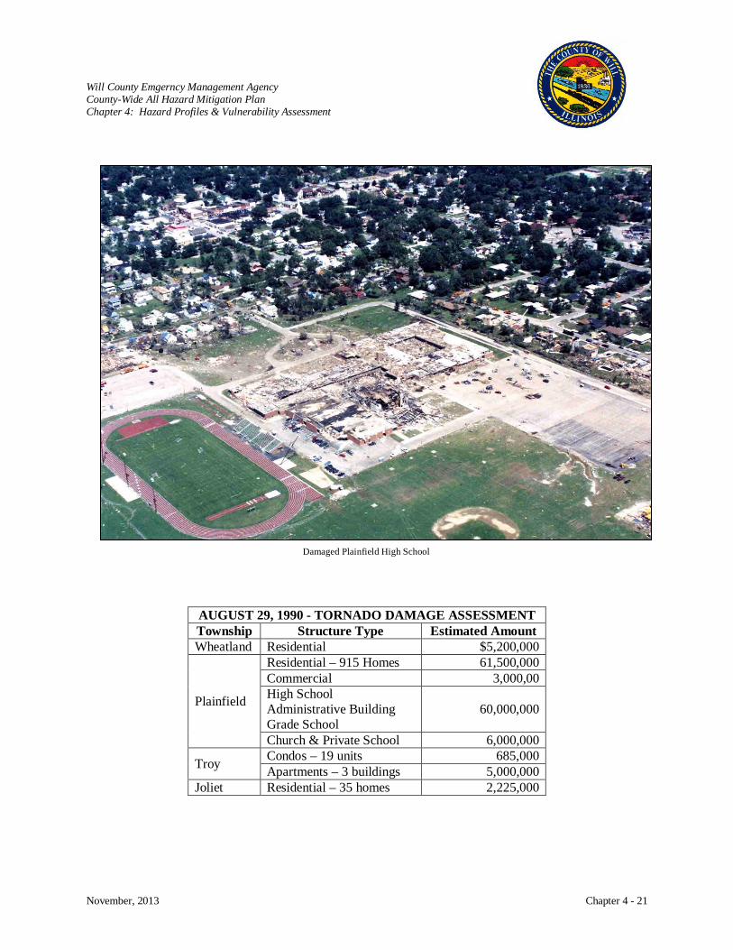
Will County Emgerncy Management Agency County-Wide All Hazard Mitigation Plan Chapter 4: Hazard Profiles & Vulnerability Assessment
November, 2013 Chapter 4 - 21
Damaged Plainfield High School
AUGUST 29, 1990 - TORNADO DAMAGE ASSESSMENT Township Structure Type Estimated Amount Wheatland Residential $5,200,000
Plainfield
Residential – 915 Homes 61,500,000 Commercial 3,000,00 High School Administrative Building Grade School
60,000,000
Church & Private School 6,000,000
Troy Condos – 19 units 685,000 Apartments – 3 buildings 5,000,000
Joliet Residential – 35 homes 2,225,000
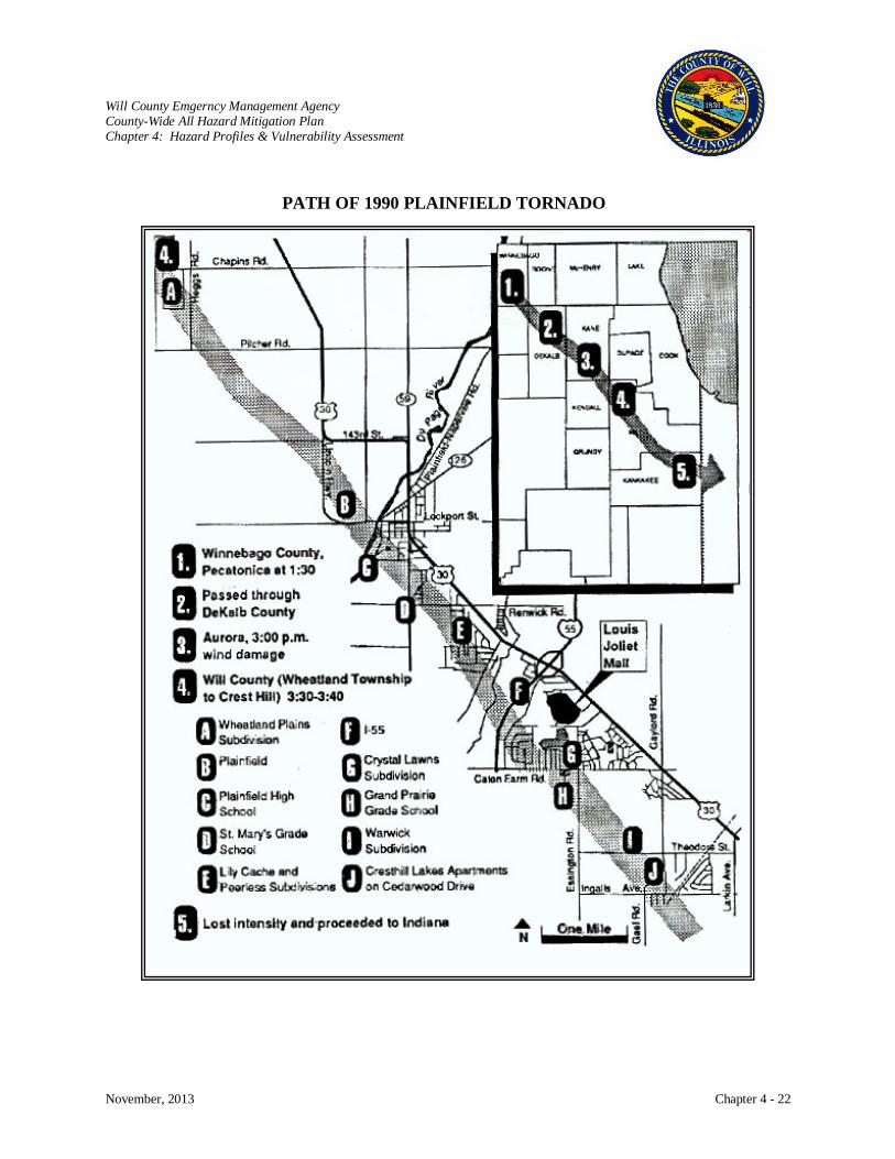
Will County Emgerncy Management Agency County-Wide All Hazard Mitigation Plan Chapter 4: Hazard Profiles & Vulnerability Assessment
November, 2013 Chapter 4 - 22
PATH OF 1990 PLAINFIELD TORNADO

Will County Emgerncy Management Agency County-Wide All Hazard Mitigation Plan Chapter 4: Hazard Profiles & Vulnerability Assessment
November, 2013 Chapter 4 - 23
Mitigation Measures
With the number and intensity of tornadoes that have occurred in Will County, it is important to look at
measures that can be taken to mitigate the impact of tornadoes on communities.
Safe rooms were one action item that participants discussed. The expense to retrofit existing
structures can be prohibitive, but the County and communities can encourage the construction and
use of safe rooms in new construction.
Through building codes, wind resistant construction and materials can be encouraged to make
structures more resistant to wind storms. Communities adopting international building code
standards are listed in Chapter 5, page 5-10.
Forecasting of severe weather by the National Weather Service (NWS) continues to improve
providing timely alerts advising the public to take cover. The County has been working together
with the NWS, the U.S. Geological Survey, GIS, web-developers, and others to electronically
link monitoring systems and use the latest communication tools to improve forecasting and alert
systems in order to provide the public with real-time storm information.
The County and communities have been distributing education materials on the dangers of severe
weather and how to prepare through websites, social media, newsletters, news media, and
community events. Some sources of preparedness materials include FEMA, American Red
Cross, Illinois EMA, CDC, and Illinois Department of Public Health (IDPH).
Risk Characterization
A tornado can occur at any time of the year requiring the County to be prepared at all times. Since 1950,
Illinois has averaged 37 tornadoes per year; however, 105 tornadoes were reported in 1998 and 107 in
1974. At least 24 tornadoes were reported during the
storms of November 17, 2013. Out of all of the
counties within Illinois, Will County has been ranked
as one of the top counties in the state affected by
tornadoes.
Due to the destructive nature of tornadoes and wind,
these events impact human life, health, and public
safety. Community-wide impacts include: utility
damage and outages, infrastructure damage (transportation and communication systems), structural
Will County Emgerncy Management Agency County-Wide All Hazard Mitigation Plan Chapter 4: Hazard Profiles & Vulnerability Assessment
November, 2013 Chapter 4 - 24
damage, and damaged or destroyed critical facilities. Tornadoes can also cause severe transportation
problems and make travel extremely dangerous.
Impact: High Damage to Buildings
Although tornadoes strike at random, making all buildings vulnerable, three types of structures are
more likely to suffer damage:
Mobile homes
Homes on crawlspaces (more susceptible to lift)
Buildings with large spans, such as airplane hangers, gymnasiums and factories
Structures within the direct path of a tornado vortex are often reduced to rubble. However, structures
adjacent to the tornado’s path are often severely damaged by high winds flowing into the tornado
vortex, known as inflow winds. It is here, adjacent to the tornado’s path, where the building type and
construction techniques are critical to the structure’s survival. Tornado impact to buildings is high.
Critical Facilities
Because a tornado can hit anywhere in the County, all critical facilities are susceptible to being hit.
Schools are a particular concern for two reasons:
They have large numbers of people present, either during school or as a storm shelter.
They have large span areas, such as gyms and theaters.
The 1990 Plainfield tornado was an unfortunate example of this. It struck the Plainfield High School,
Grand Prairie Elementary School, St. Mary Immaculate Church, and the gymnasium to the Church’s
elementary school. Cost to repair the two public schools was estimated at up to $35 million. The cost
for the church and its school was $5 million. Other large span buildings were also affected in 1990.
In addition to the schools and their gyms, hangers at the Aurora Airport and Joliet’s Essington Road
Fire Station were damaged.
Health and Safety
The numerous deaths and injuries incurred by tornadoes since the 1950’s give testament to the threat
Will County’s population faces from tornadoes. Flying debris, collapsing structures, or being swept
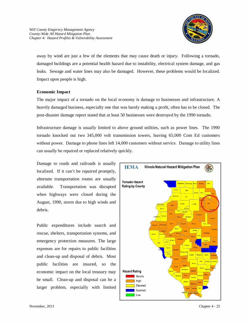
Will County Emgerncy Management Agency County-Wide All Hazard Mitigation Plan Chapter 4: Hazard Profiles & Vulnerability Assessment
November, 2013 Chapter 4 - 25
away by wind are just a few of the elements that may cause death or injury. Following a tornado,
damaged buildings are a potential health hazard due to instability, electrical system damage, and gas
leaks. Sewage and water lines may also be damaged. However, these problems would be localized.
Impact upon people is high.
Economic Impact
The major impact of a tornado on the local economy is damage to businesses and infrastructure. A
heavily damaged business, especially one that was barely making a profit, often has to be closed. The
post-disaster damage report stated that at least 50 businesses were destroyed by the 1990 tornado.
Infrastructure damage is usually limited to above ground utilities, such as power lines. The 1990
tornado knocked out two 345,000 volt transmission towers, leaving 65,000 Com Ed customers
without power. Damage to phone lines left 14,000 customers without service. Damage to utility lines
can usually be repaired or replaced relatively quickly.
Damage to roads and railroads is usually
localized. If it can’t be repaired promptly,
alternate transportation routes are usually
available. Transportation was disrupted
when highways were closed during the
August, 1990, storm due to high winds and
debris.
Public expenditures include search and
rescue, shelters, transportation systems, and
emergency protection measures. The large
expenses are for repairs to public facilities
and clean-up and disposal of debris. Most
public facilities are insured, so the
economic impact on the local treasury may
be small. Clean-up and disposal can be a
larger problem, especially with limited
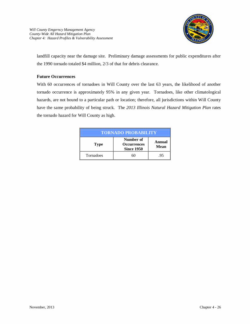
Will County Emgerncy Management Agency County-Wide All Hazard Mitigation Plan Chapter 4: Hazard Profiles & Vulnerability Assessment
November, 2013 Chapter 4 - 26
landfill capacity near the damage site. Preliminary damage assessments for public expenditures after
the 1990 tornado totaled $4 million, 2/3 of that for debris clearance.
Future Occurrences
With 60 occurrences of tornadoes in Will County over the last 63 years, the likelihood of another
tornado occurrence is approximately 95% in any given year. Tornadoes, like other climatological
hazards, are not bound to a particular path or location; therefore, all jurisdictions within Will County
have the same probability of being struck. The 2013 Illinois Natural Hazard Mitigation Plan rates
the tornado hazard for Will County as high.
TORNADO PROBABILITY
Type Number of
Occurrences Since 1950
Annual Mean
Tornadoes 60 .95
Will County Emgerncy Management Agency County-Wide All Hazard Mitigation Plan Chapter 4: Hazard Profiles & Vulnerability Assessment
November, 2013 Chapter 4 - 27
WINTER / ICE STORMS
Hazard Characterization
The National Weather Service refers to Winter Storms as the Deceptive Killers
Six or more inches of snow have fallen within a forty-eight hour period;
because most deaths are
indirectly related to the storm. Instead, people die in traffic accidents on icy roads and of hypothermia
from prolonged exposure to cold. A winter storm is considered to be severe when:
A snow storm has produced conditions, such as high winds, leading to property damage, death, or
injuries regardless of the amount of snowfall;
There is a glaze storm in which ten percent of the cooperative U.S. Weather Bureau substations
in Illinois have reported glaze; or
There is a glaze storm in which property damage, deaths, or injuries have occurred.
Snow and ice are threats to most of the U.S. during the northern hemisphere’s winter, which begins
December 21st and ends March 21st
Ice Storm: Occurs when moisture falls and freezes immediately upon impact. Ice
storms occur when cold air at the surface is overridden by warm, moist air at
higher altitudes.
. During the early and late months of the winter season, snow
becomes warmer, giving it a greater tendency to melt on contact or stick to the surface. The beginning
and end of the winter season also brings a greater chance of freezing rain and sleet.
There are many ways for winter storms to form, but certain key ingredients are needed. First
temperatures must be below freezing in the clouds and near the ground. There must be a source of
moisture in the form of evaporating water. Severe winter storms are fueled by strong temperature
gradients and an active upper-level cold jet stream. When you hear the term “severe winter storm
warning”, freezing temperatures, heavy snowfall, or freezing rain come to mind. There are three
categories of winter storms:
Blizzard: This is the most dangerous of all winter storms. A blizzard combines low
temperatures, heavy snowfall, and winds of at least 35 miles per hour,
reducing visibility to one-quarter mile or less for at least three hours.
Heavy Snow Storm: Will produce six inches or more of snow in 48-hours or less.
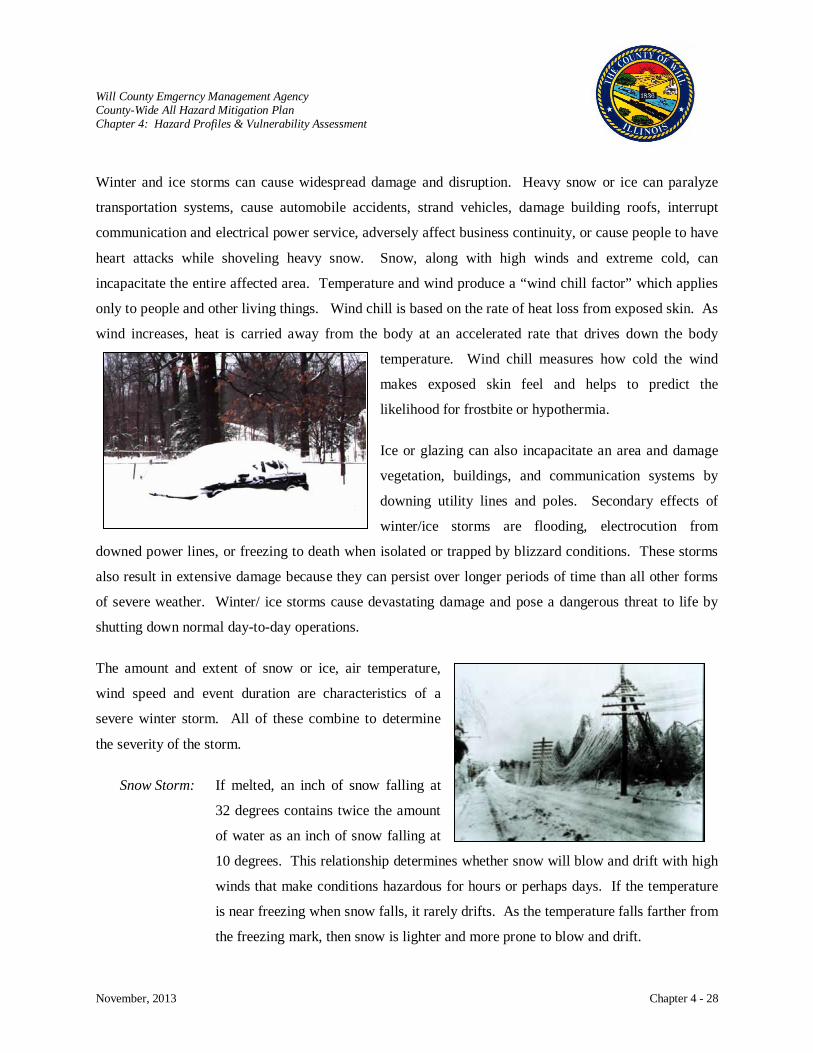
Will County Emgerncy Management Agency County-Wide All Hazard Mitigation Plan Chapter 4: Hazard Profiles & Vulnerability Assessment
November, 2013 Chapter 4 - 28
Winter and ice storms can cause widespread damage and disruption. Heavy snow or ice can paralyze
transportation systems, cause automobile accidents, strand vehicles, damage building roofs, interrupt
communication and electrical power service, adversely affect business continuity, or cause people to have
heart attacks while shoveling heavy snow. Snow, along with high winds and extreme cold, can
incapacitate the entire affected area. Temperature and wind produce a “wind chill factor” which applies
only to people and other living things. Wind chill is based on the rate of heat loss from exposed skin. As
wind increases, heat is carried away from the body at an accelerated rate that drives down the body
temperature. Wind chill measures how cold the wind
makes exposed skin feel and helps to predict the
likelihood for frostbite or hypothermia.
Ice or glazing can also incapacitate an area and damage
vegetation, buildings, and communication systems by
downing utility lines and poles. Secondary effects of
winter/ice storms are flooding, electrocution from
downed power lines, or freezing to death when isolated or trapped by blizzard conditions. These storms
also result in extensive damage because they can persist over longer periods of time than all other forms
of severe weather. Winter/ ice storms cause devastating damage and pose a dangerous threat to life by
shutting down normal day-to-day operations.
The amount and extent of snow or ice, air temperature,
wind speed and event duration are characteristics of a
severe winter storm. All of these combine to determine
the severity of the storm.
Snow Storm: If melted, an inch of snow falling at
32 degrees contains twice the amount
of water as an inch of snow falling at
10 degrees. This relationship determines whether snow will blow and drift with high
winds that make conditions hazardous for hours or perhaps days. If the temperature
is near freezing when snow falls, it rarely drifts. As the temperature falls farther from
the freezing mark, then snow is lighter and more prone to blow and drift.
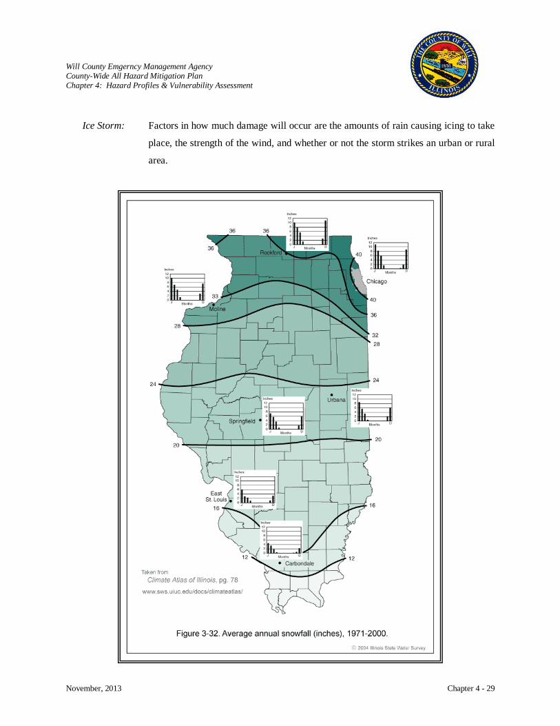
Will County Emgerncy Management Agency County-Wide All Hazard Mitigation Plan Chapter 4: Hazard Profiles & Vulnerability Assessment
November, 2013 Chapter 4 - 29
Ice Storm: Factors in how much damage will occur are the amounts of rain causing icing to take
place, the strength of the wind, and whether or not the storm strikes an urban or rural
area.

Will County Emgerncy Management Agency County-Wide All Hazard Mitigation Plan Chapter 4: Hazard Profiles & Vulnerability Assessment
November, 2013 Chapter 4 - 30
TERMS USED BY WEATHER FORECASTERS
Freezing Rain Rain that freezes when it hits the ground, creating a coating of ice on roads, walkways, trees and power lines.
Sleet Rain that turns to ice pellets before reaching the ground. Sleet also causes roads to freeze and become slippery.
Winter Storm Watch A winter storm is possible in your area.
Winter Storm Warning A winter storm is occurring, or will soon occur in your area.
Blizzard Warning
Sustained winds or frequent gusts to 35 miles-per-hour or greater and considerable falling or blowing snow (reducing visibility to less than a quarter mile) are expected to prevail for a period of three hours or longer.
Frost/Freeze Warning Below freezing temperatures are expected.
Source: Are You Ready?, FEMA, H-34/September 2002
Average Annual Number of Days with Freezing Rain (ice)
Available from:
http://www.sws.uiuc.edu/atmos/statecli/Winter/figure6.htm
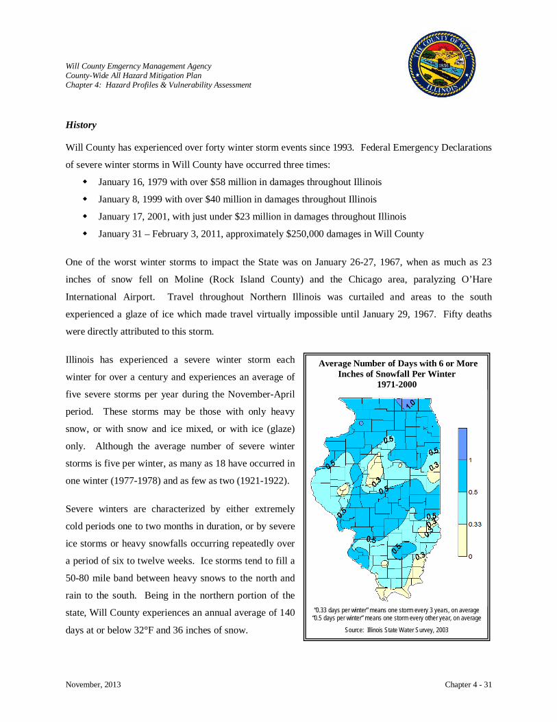
Will County Emgerncy Management Agency County-Wide All Hazard Mitigation Plan Chapter 4: Hazard Profiles & Vulnerability Assessment
November, 2013 Chapter 4 - 31
History
Will County has experienced over forty winter storm events since 1993. Federal Emergency Declarations
of severe winter storms in Will County have occurred three times:
January 16, 1979 with over $58 million in damages throughout Illinois
January 8, 1999 with over $40 million in damages throughout Illinois
January 17, 2001, with just under $23 million in damages throughout Illinois
January 31 – February 3, 2011, approximately $250,000 damages in Will County
One of the worst winter storms to impact the State was on January 26-27, 1967, when as much as 23
inches of snow fell on Moline (Rock Island County) and the Chicago area, paralyzing O’Hare
International Airport. Travel throughout Northern Illinois was curtailed and areas to the south
experienced a glaze of ice which made travel virtually impossible until January 29, 1967. Fifty deaths
were directly attributed to this storm.
Illinois has experienced a severe winter storm each
winter for over a century and experiences an average of
five severe storms per year during the November-April
period. These storms may be those with only heavy
snow, or with snow and ice mixed, or with ice (glaze)
only. Although the average number of severe winter
storms is five per winter, as many as 18 have occurred in
one winter (1977-1978) and as few as two (1921-1922).
Severe winters are characterized by either extremely
cold periods one to two months in duration, or by severe
ice storms or heavy snowfalls occurring repeatedly over
a period of six to twelve weeks. Ice storms tend to fill a
50-80 mile band between heavy snows to the north and
rain to the south. Being in the northern portion of the
state, Will County experiences an annual average of 140
days at or below 32°F and 36 inches of snow.
Average Number of Days with 6 or More Inches of Snowfall Per Winter
1971-2000
“0.33 days per winter” means one storm every 3 years, on average
“0.5 days per winter” means one storm every other year, on average
Source: Illinois State Water Survey, 2003

Will County Emgerncy Management Agency County-Wide All Hazard Mitigation Plan Chapter 4: Hazard Profiles & Vulnerability Assessment
November, 2013 Chapter 4 - 32
Winter Storm – January 8, 1999 Federal Emergency Declaration #3134 Public Assistance - $1,010,500
A winter storm struck portions of the Midwest on January 1 to 3, 1999, producing 9 to 22 inches of snow
and northeast winds gusting to over 30 mph in the Chicago area. Soon after the snow ended, record low
temperatures occurred on January 3rd and 4th with values of -20°F or lower. The governor of Illinois
declared the entire state a disaster on January 4th
County and municipalities incurred problems and high costs
. The worst impact was the storm’s affect on
transportation which was either halted or delayed for two to four days and the source of many accidents.
Automobiles, trains, airplanes, boats, and snowmobiles were impacted. Issues that developed as a result
of this winter storm included:
with snow removal – this proved to be the major share of public assistance.
Major vehicle accidents occurred on roadways with deaths (1 in Will County) and injuries.
Retail businesses closed, transportation of raw materials and finished goods were delayed, and schools closed.
Stranded traveling motorists were housed in emergency shelters. Vehicles parked on city streets were buried as snow removal equipment tried to clear streets. Blood shortages occurred.
Fortunately, the storm was accurately predicted several days in advance allowing communities to prepare,
was spread out over a long duration, and occurred on a long holiday weekend. Those factors helped
mitigate the impact on transportation and commerce.
Severe Winter Storm and Snow – January 31 to February 3, 2011
Federal Disaster Declaration #1960
Public Assistance - $2,976,578
Northern Illinois and northwest Indiana were walloped by a powerful winter storm between January 31
and February 2, 2011. An initial period of light accumulating snow occurred from the evening of January
31st into the morning of February 1st, including lake effect snowfall over northeastern Illinois. From the
afternoon of February 1st through the early morning of February 2nd, the snowstorm was accompanied by
fierce winds, gusting to 50 to 60 mph and higher. The intense winds and heavy snow reduced visibility to
near zero at times and produced widespread snowdrifts of 2 to 5 feet, and a few drifts of 10 feet or more.
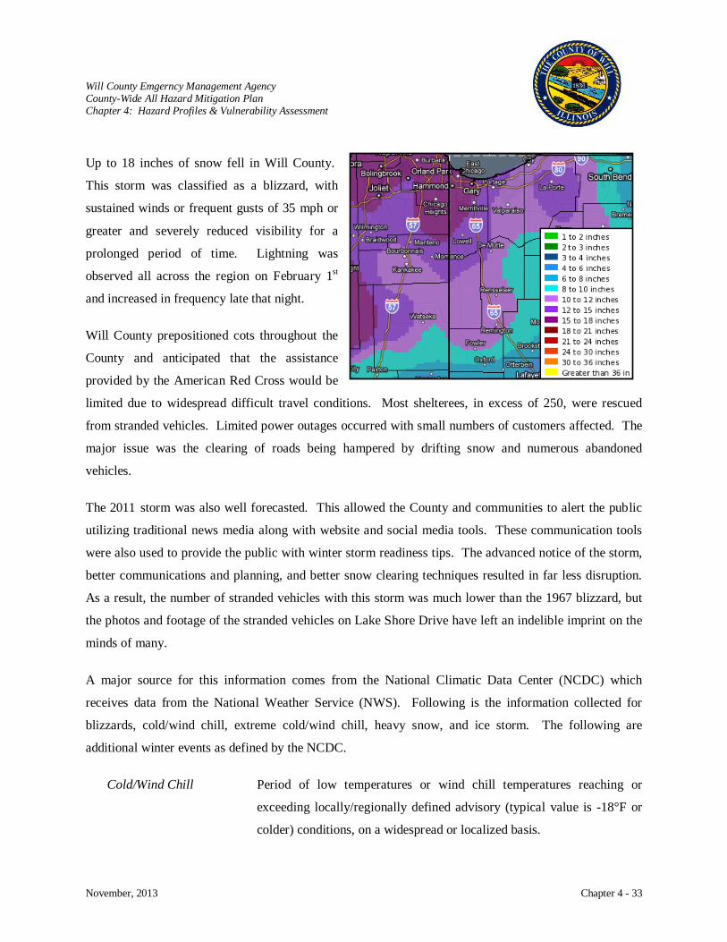
Will County Emgerncy Management Agency County-Wide All Hazard Mitigation Plan Chapter 4: Hazard Profiles & Vulnerability Assessment
November, 2013 Chapter 4 - 33
Up to 18 inches of snow fell in Will County.
This storm was classified as a blizzard, with
sustained winds or frequent gusts of 35 mph or
greater and severely reduced visibility for a
prolonged period of time. Lightning was
observed all across the region on February 1st
Will County prepositioned cots throughout the
County and anticipated that the assistance
provided by the American Red Cross would be
limited due to widespread difficult travel conditions. Most shelterees, in excess of 250, were rescued
from stranded vehicles. Limited power outages occurred with small numbers of customers affected. The
major issue was the clearing of roads being hampered by drifting snow and numerous abandoned
vehicles.
The 2011 storm was also well forecasted. This allowed the County and communities to alert the public
utilizing traditional news media along with website and social media tools. These communication tools
were also used to provide the public with winter storm readiness tips. The advanced notice of the storm,
better communications and planning, and better snow clearing techniques resulted in far less disruption.
As a result, the number of stranded vehicles with this storm was much lower than the 1967 blizzard, but
the photos and footage of the stranded vehicles on Lake Shore Drive have left an indelible imprint on the
minds of many.
A major source for this information comes from the National Climatic Data Center (NCDC) which
receives data from the National Weather Service (NWS). Following is the information collected for
blizzards, cold/wind chill, extreme cold/wind chill, heavy snow, and ice storm. The following are
additional winter events as defined by the NCDC.
and increased in frequency late that night.
Cold/Wind Chill Period of low temperatures or wind chill temperatures reaching or
exceeding locally/regionally defined advisory (typical value is -18°F or
colder) conditions, on a widespread or localized basis.
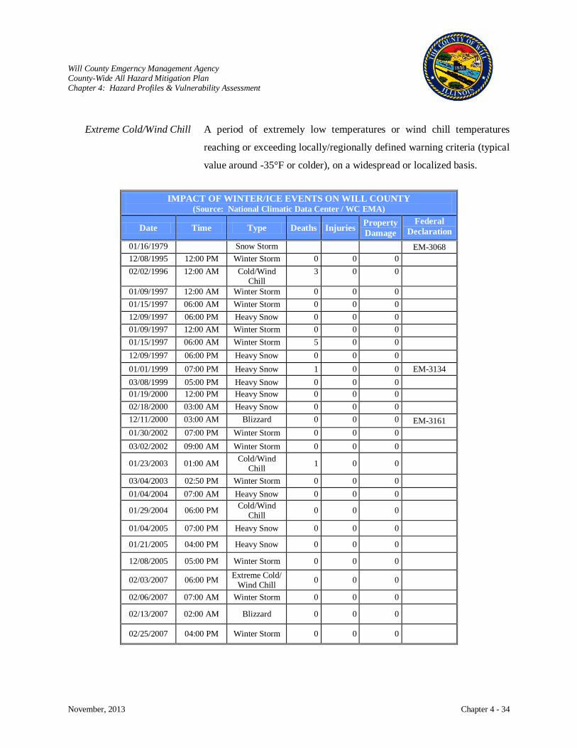
Will County Emgerncy Management Agency County-Wide All Hazard Mitigation Plan Chapter 4: Hazard Profiles & Vulnerability Assessment
November, 2013 Chapter 4 - 34
Extreme Cold/Wind Chill A period of extremely low temperatures or wind chill temperatures
reaching or exceeding locally/regionally defined warning criteria (typical
value around -35°F or colder), on a widespread or localized basis.
IMPACT OF WINTER/ICE EVENTS ON WILL COUNTY
(Source: National Climatic Data Center / WC EMA)
Date Time Type Deaths Injuries Property Damage
Federal Declaration
01/16/1979 Snow Storm EM-3068 12/08/1995 12:00 PM Winter Storm 0 0 0 02/02/1996 12:00 AM Cold/Wind
Chill 3 0 0
01/09/1997 12:00 AM Winter Storm 0 0 0 01/15/1997 06:00 AM Winter Storm 0 0 0 12/09/1997 06:00 PM Heavy Snow 0 0 0 01/09/1997 12:00 AM Winter Storm 0 0 0 01/15/1997 06:00 AM Winter Storm 5 0 0 12/09/1997 06:00 PM Heavy Snow 0 0 0 01/01/1999 07:00 PM Heavy Snow 1 0 0 EM-3134 03/08/1999 05:00 PM Heavy Snow 0 0 0 01/19/2000 12:00 PM Heavy Snow 0 0 0 02/18/2000 03:00 AM Heavy Snow 0 0 0 12/11/2000 03:00 AM Blizzard 0 0 0 EM-3161 01/30/2002 07:00 PM Winter Storm 0 0 0 03/02/2002 09:00 AM Winter Storm 0 0 0
01/23/2003 01:00 AM Cold/Wind Chill 1 0 0
03/04/2003 02:50 PM Winter Storm 0 0 0 01/04/2004 07:00 AM Heavy Snow 0 0 0
01/29/2004 06:00 PM Cold/Wind Chill 0 0 0
01/04/2005 07:00 PM Heavy Snow 0 0 0
01/21/2005 04:00 PM Heavy Snow 0 0 0
12/08/2005 05:00 PM Winter Storm 0 0 0
02/03/2007 06:00 PM Extreme Cold/ Wind Chill 0 0 0
02/06/2007 07:00 AM Winter Storm 0 0 0
02/13/2007 02:00 AM Blizzard 0 0 0
02/25/2007 04:00 PM Winter Storm 0 0 0

Will County Emgerncy Management Agency County-Wide All Hazard Mitigation Plan Chapter 4: Hazard Profiles & Vulnerability Assessment
November, 2013 Chapter 4 - 35
IMPACT OF WINTER/ICE EVENTS ON WILL COUNTY (Source: National Climatic Data Center / WC EMA)
Date Time Type Deaths Injuries Property Damage
Federal Declaration
12/01/2007 11:00 AM Ice Storm 0 0 0 12/15/2007 06:00 PM Heavy Snow 0 0 0 12/31/2007 01:00 AM Heavy Snow 0 0 0 12/15/2008 12:00 AM Cold/Wind
Chill 1 0 0
12/18/2008 10:00 PM Winter Storm 0 0 0 12/21/2008 01:00 AM Blizzard 0 0 0 12/21/2008 07:00 AM Extreme
Cold/Wind Chill
0 0 0
01/14/2009 01:00 AM Winter Storm 0 0 0 12/23/2009 10:00 AM Heavy Snow 0 0 0 12/30/2009 12:00 AM Cold/Wind
Chill 1 0 0
01/15/2009 06:00 AM Extreme Cold/Wind Chill
0 0 0
01/07/2010 Winter Storm 0 0 0 02/08/2010 10:00 PM Winter Storm 0 0 0 12/03/2010 12:00 AM Cold/Wind
Chill 2 0 0
12/11/2010 02:00 PM Winter Storm 0 0 0 12/27/2010 06:00 PM Cold/Wind
Chill 1 0 0
02/01/2011 01:00 PM Blizzard 0 0 $250 K DR-1960 01/12/2012 08:00 AM Winter Storm 0 0 0 01/20/2012 11:00 AM Winter Storm 0 0 0 02/28/2012 12:00 AM Cold/Wind
Chill 1 0 0
03/05/2013 06:00 AM Winter Storm 0 0
Mitigation Measures
Actions that can be taken to mitigate the impact of winter storms include:
The adoption and enforcement of building codes that ensure structural stability, address snow
roof loads, and provide adequate insulation. Jurisdictions that have adopted the International
Building Code (IBC) and International Residential Code (IRC) are listed in Chapter 5, page 5-10.
Trees and other vegetation cause about 20% of all electric service interruptions. Preventive
pruning around aerial power lines is vital to providing reliable electric service. ComEd, the
electric provider in Will County, has a routine tree maintenance that keeps above ground power
lines clear. This program includes tree trimming, tree removal and clearing storm-damaged trees
Will County Emgerncy Management Agency County-Wide All Hazard Mitigation Plan Chapter 4: Hazard Profiles & Vulnerability Assessment
November, 2013 Chapter 4 - 36
or tree limbs from power lines. Their vegetation management crews are trained in proper
arboricultural pruning techniques, which meet the standards set by the American National
Standards Institute (ANSI). ComEd is also upgrading overhead power lines with new overhead
cables. The new cables are stronger, have a protective coating and are spaced closer together to
help reduce power outages caused by severe weather, trees and wildlife. Additionally, overhead
power lines are being replaced in some areas and with underground cable so customers
experience fewer power outages.
ComEd also employs smart grids that monitor the electric grid and respond to potential problems
and interruptions and smart switches that automatically reroute electricity around problem areas
so customers experience fewer and shorter power outages.
A leading cause of death during winter storms is from automobile or other transportation
accidents. Strategies to reduce accidents is planning for adequate road and debris clearing
capabilities, using snow fencing to limit blowing and drifting of snow over critical roadway
segments, and utilizing roadway heating technology to prevent snow/ice buildup.
Public education about severe winter weather impacts and how the public can prepare is essential.
Will County EMA and communities have ongoing public education for severe winter weather
preapration through websites, social media, alert systems, traditional news media, and community
events. Education outreach continues to improve as technology expands communication tool
choices.
Will County and the communities work with the American Red Cross to maintain a system of
warming centers to protect vulnerable populations and people who become stranded on the
roadways.
Risk Characterization
Impact: High
Damage to Buildings
Historically, roofs would collapse due to heavy snow loads, but most buildings are now constructed
with low temperatures, snow loads, and ice storms in mind. With today’s energy consciousness,
buildings are much better insulated than they were 50 years ago. Winter storms do not have a major
impact on buildings. Impact on buildings is low.
Will County Emgerncy Management Agency County-Wide All Hazard Mitigation Plan Chapter 4: Hazard Profiles & Vulnerability Assessment
November, 2013 Chapter 4 - 37
Critical Facilities
The major impacts of snow and ice storms on property are to utilities and roads. Power lines and tree
limbs coated with heavy ice result in disrupted power and telephone service, often for days. Even
small accumulations of ice can be extremely dangerous to motorists and pedestrians. Bridges and
overpasses are particularly dangerous because they freeze before other surfaces. When transportation
is disrupted, schools close, emergency services are delayed, some businesses close, and some
government services are delayed. Impact on critical facilities is low.
Health and Safety
Winter storms bring the following two types of safety hazards:
Weather-related hazards, including hazardous driving and walking conditions and heart
attacks from strenuous activity such as shoveling snow.
Extreme cold, from the low temperatures, wind chill, and loss of heat due to power
outages.
In the United States, the number of deaths peaks in midwinter and reaches a low point in late summer, but
most deaths are not directly related to the weather. Certain populations are especially vulnerable to the
cold, including the elderly, the homeless, and lower income families with heating problems. About 70%
of the injuries caused by snow and ice storms result from vehicle accidents and 25% occur to people
caught out in the storm. Extreme cold can result in people and animals suffering from frostbite and
hypothermia. Frostbite is damage to tissue caused by the effects of ice crystals in frozen tissue.
Extremities (hands, feet, ears, and nose) with more circulation difficulties are most frequently affected.
Hypothermia is the lowering of the core body temperature. It is “clinically significant” when the body
temperature is below 95°F. Severe hypothermia occurs when the body’s temperature drops below 85°F,
resulting in unconsciousness. If help does not come, death follows. Great care is needed to properly re-
warm a person, even in mild cases. Health and safety impact is moderate.
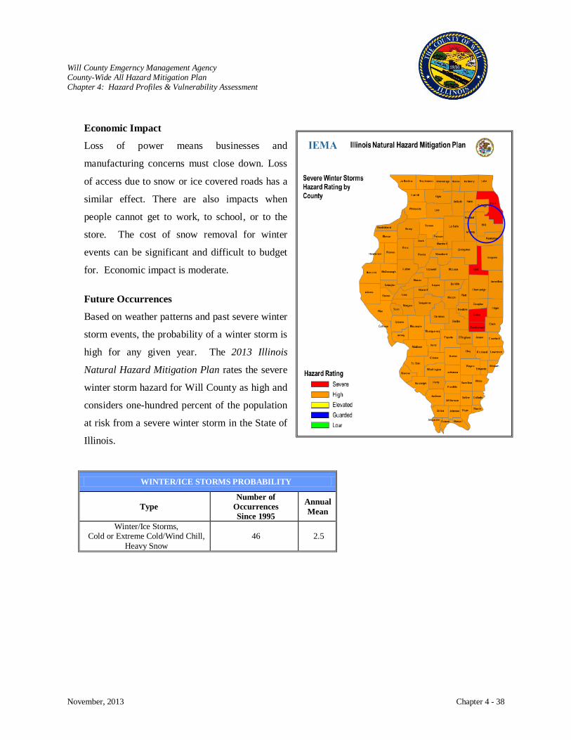
Will County Emgerncy Management Agency County-Wide All Hazard Mitigation Plan Chapter 4: Hazard Profiles & Vulnerability Assessment
November, 2013 Chapter 4 - 38
Economic Impact
Loss of power means businesses and
manufacturing concerns must close down. Loss
of access due to snow or ice covered roads has a
similar effect. There are also impacts when
people cannot get to work, to school, or to the
store. The cost of snow removal for winter
events can be significant and difficult to budget
for. Economic impact is moderate.
Future Occurrences
Based on weather patterns and past severe winter
storm events, the probability of a winter storm is
high for any given year. The 2013 Illinois
Natural Hazard Mitigation Plan rates the severe
winter storm hazard for Will County as high and
considers one-hundred percent of the population
at risk from a severe winter storm in the State of
Illinois.
WINTER/ICE STORMS PROBABILITY
Type Number of
Occurrences Since 1995
Annual Mean
Winter/Ice Storms, Cold or Extreme Cold/Wind Chill,
Heavy Snow 46 2.5

Will County Emgerncy Management Agency County-Wide All Hazard Mitigation Plan Chapter 4: Hazard Profiles & Vulnerability Assessment
November, 2013 Chapter 4 - 39
THUNDERSTORM
Hazard Characterization
Severe thunderstorms are weather systems accompanied by strong winds, lightning, heavy rain, and
possibly hail and tornadoes.
They occur anytime of year, but more frequently during the warm spring and summer months.
Thunderstorms typically only last thirty to forty minutes.
They form when a shallow layer of warm, moist air meets up with a deeper layer of cool, dry air.
All thunderstorms follow a three-stage life cycle.
The cumulus stage is the development period where the storm consists only of updrafts or
upward moving air currents. The updrafts reach heights of 20,000 feet above ground.
The mature stage is the strongest and most dangerous stage of the storm cycle. Upward and
downward moving air currents collide with precipitation resulting in the downdraft area. As
the downdraft reaches the ground, it spreads out and forms a gust front where damaging
winds may develop.
In the dissipating stage, excessive precipitation and downdrafts weaken the storm, gust fronts
move away depleting the energy of the storm.

Will County Emgerncy Management Agency County-Wide All Hazard Mitigation Plan Chapter 4: Hazard Profiles & Vulnerability Assessment
November, 2013 Chapter 4 - 40
Thunder storms can fall into four categories. Singe-cell storms are typically weak, short-lived, and poorly
organized. Multicell cluster storms are the most common type and are a cluster of cells moving as one
unit. Multicell line storms are squall lines that have a long line of storms with a continuous gust front
from the forward edge of the storm. Supercell storms have a single updraft, are very strong, and produce
severe weather. Along with wind that can damage property, lightning also poses a serious hazard causing
fire to property that is struck and serious injury or death to individuals who are struck.
Severe thunderstorms are most likely to happen in the spring and summer months and during the
afternoon and evening hours but can occur year-round and at all hours. Thunderstorms can bring four
hazards:
Flooding,
Lightning,
High winds, tornadoes and microbursts, and
Hail.
In Illinois, thunderstorms
occur when there is a collision
of moist, warm air moving
north from the Gulf of Mexico
with colder fronts moving east
from the Rocky Mountains
resulting in cold air overriding
a layer of warm air causing
the warm air to rise rapidly.
Thunderstorms may occur
singly, in clusters, or in lines.
In the course of a few hours, it
is possible for several
thunderstorms to affect one
location or a single
thunderstorm to affect one location for an extended time. Thunderstorms typically are 15 miles in
diameter and produce heavy rain anywhere from 30 minutes to an hour.
Average Number of Thunderstorm Days per Year in the U.S.
Source: National Weather Service
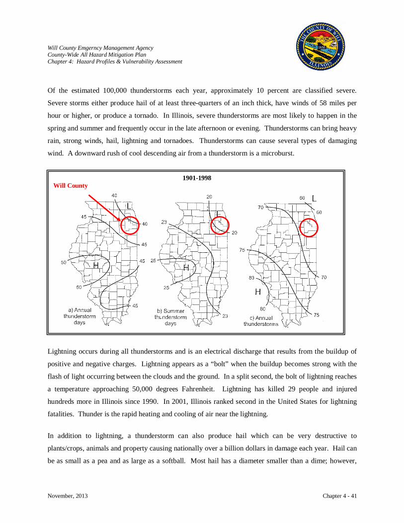
Will County Emgerncy Management Agency County-Wide All Hazard Mitigation Plan Chapter 4: Hazard Profiles & Vulnerability Assessment
November, 2013 Chapter 4 - 41
Of the estimated 100,000 thunderstorms each year, approximately 10 percent are classified severe.
Severe storms either produce hail of at least three-quarters of an inch thick, have winds of 58 miles per
hour or higher, or produce a tornado. In Illinois, severe thunderstorms are most likely to happen in the
spring and summer and frequently occur in the late afternoon or evening. Thunderstorms can bring heavy
rain, strong winds, hail, lightning and tornadoes. Thunderstorms can cause several types of damaging
wind. A downward rush of cool descending air from a thunderstorm is a microburst.
Lightning occurs during all thunderstorms and is an electrical discharge that results from the buildup of
positive and negative charges. Lightning appears as a “bolt” when the buildup becomes strong with the
flash of light occurring between the clouds and the ground. In a split second, the bolt of lightning reaches
a temperature approaching 50,000 degrees Fahrenheit. Lightning has killed 29 people and injured
hundreds more in Illinois since 1990. In 2001, Illinois ranked second in the United States for lightning
fatalities. Thunder is the rapid heating and cooling of air near the lightning.
In addition to lightning, a thunderstorm can also produce hail which can be very destructive to
plants/crops, animals and property causing nationally over a billion dollars in damage each year. Hail can
be as small as a pea and as large as a softball. Most hail has a diameter smaller than a dime; however,
1901-1998 Will County
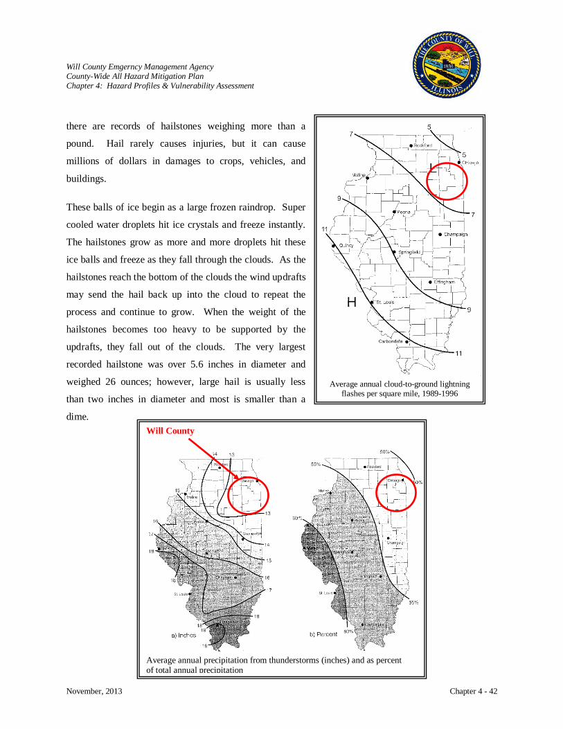
Will County Emgerncy Management Agency County-Wide All Hazard Mitigation Plan Chapter 4: Hazard Profiles & Vulnerability Assessment
November, 2013 Chapter 4 - 42
Average annual cloud-to-ground lightning
flashes per square mile, 1989-1996
there are records of hailstones weighing more than a
pound. Hail rarely causes injuries, but it can cause
millions of dollars in damages to crops, vehicles, and
buildings.
These balls of ice begin as a large frozen raindrop. Super
cooled water droplets hit ice crystals and freeze instantly.
The hailstones grow as more and more droplets hit these
ice balls and freeze as they fall through the clouds. As the
hailstones reach the bottom of the clouds the wind updrafts
may send the hail back up into the cloud to repeat the
process and continue to grow. When the weight of the
hailstones becomes too heavy to be supported by the
updrafts, they fall out of the clouds. The very largest
recorded hailstone was over 5.6 inches in diameter and
weighed 26 ounces; however, large hail is usually less
than two inches in diameter and most is smaller than a
dime.
Will County
Average annual precipitation from thunderstorms (inches) and as percent of total annual precipitation
Will County Emgerncy Management Agency County-Wide All Hazard Mitigation Plan Chapter 4: Hazard Profiles & Vulnerability Assessment
November, 2013 Chapter 4 - 43
History
Will County has experienced over 200 severe storm events since 1950. Federal Emergency Declarations
of severe storms in Will County have occurred five times:
June 30, 1981, over $4 million in damages throughout Illinois
March 29, 1985, almost $8 million in damages throughout Illinois
July 25, 1996, almost $259 million in damages throughout Illinois
April 23, 2004, almost $6 million in damages throughout Illinois
August 23, 2007, over $230 thousand in damages throughout Will County
Although they do not receive as much recognition as tornado events, thunderstorm winds cause more
damage year-to-year than tornadoes. In 1993 alone, Illinois experienced 38 events of thunderstorm winds
which caused a minimum estimate of well over five million dollars in damage, while the 34 tornadoes
caused a maximum of just over 1.5 million dollars. Seven severe thunderstorms traversed the State in
June of 1993, creating most of this damage, but significant losses occurred in seven other months. In the
10-year period from 1981 to 1990, damage estimates from severe wind equaled or exceeded damages
caused by tornadoes in five of the years. In addition, death tolls from severe winds exceeded tornado
deaths for six of these years, and the number of injuries caused by severe wind was greater in three years
(data from Storm Data publication, NOAA/NWS). The damages caused by high winds have been
relatively consistent from year-to-year.
Nationwide it is estimated that 25 million cloud-to-ground lightning flashes occur each year, 1,000 people
are injured, and 80 are killed with about $5 billion in economic impact resulting from lightning.
According to Mr. Chris Miller, WCM, National Weather Service, Lincoln, IL, “Illinois experiences nearly
650,000 lightning strikes each year.” Illinois ranks high among the 50 states for lightning fatalities. Over
the past 40 years, 96 people have been killed by lightning in Illinois. As a result, IEMA and the NWS
have recently established the Lightning Safety Awareness Week as a public education project.
Hail occurs frequently in Illinois averaging 74 times a year or 3,951 times since 1950. There have been
no deaths, but 23 injuries. Hail does extensive damage: property damage over $73 million and crop
damage over $5 million in the last 53 years. The potential size of hail stones illustrate the damage they
can cause. April 23, 1961, several six inch hail stones were reported in Kankakee, IL. While six inches is
very unusual, 46 events had hail stones greater than three inches and in the 2-3 inch range.
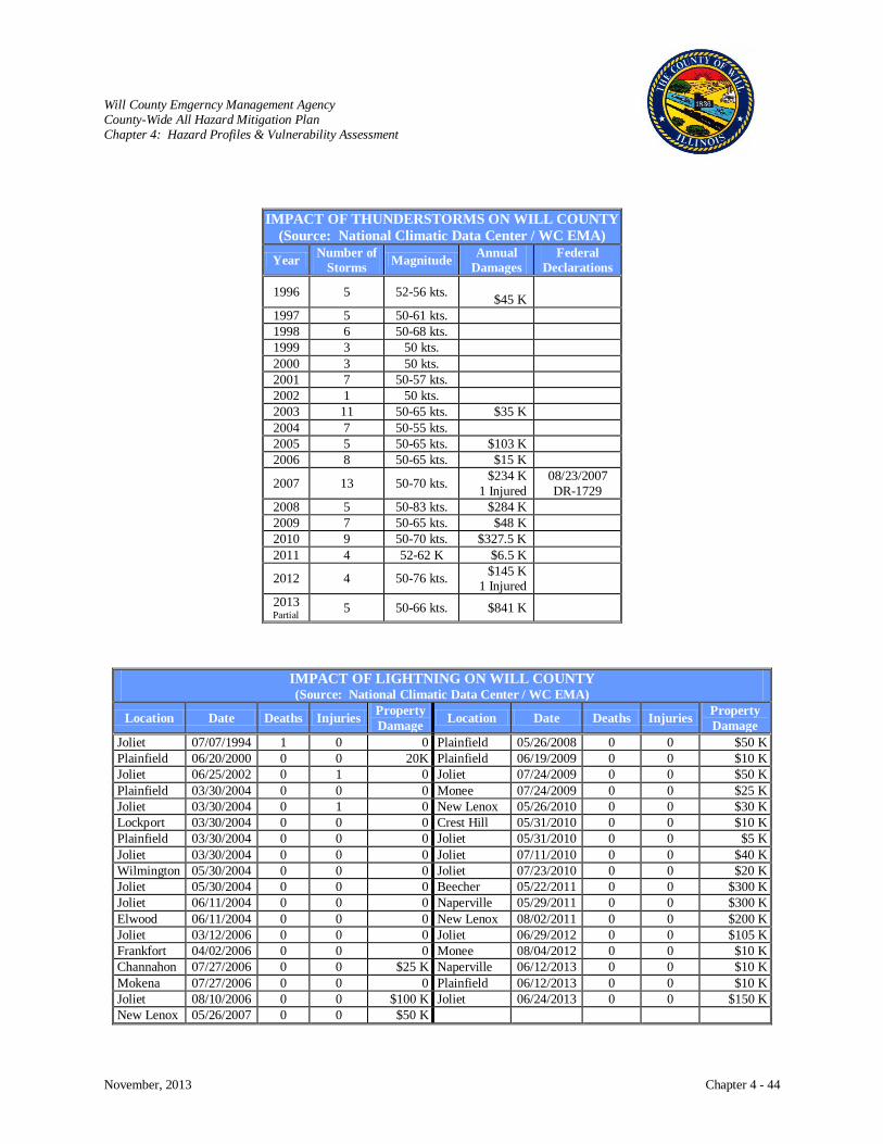
Will County Emgerncy Management Agency County-Wide All Hazard Mitigation Plan Chapter 4: Hazard Profiles & Vulnerability Assessment
November, 2013 Chapter 4 - 44
IMPACT OF THUNDERSTORMS ON WILL COUNTY (Source: National Climatic Data Center / WC EMA)
Year Number of Storms Magnitude Annual
Damages Federal
Declarations
1996 5 52-56 kts. $45 K
1997 5 50-61 kts. 1998 6 50-68 kts. 1999 3 50 kts. 2000 3 50 kts. 2001 7 50-57 kts. 2002 1 50 kts. 2003 11 50-65 kts. $35 K 2004 7 50-55 kts. 2005 5 50-65 kts. $103 K 2006 8 50-65 kts. $15 K
2007 13 50-70 kts. $234 K 1 Injured
08/23/2007 DR-1729
2008 5 50-83 kts. $284 K 2009 7 50-65 kts. $48 K 2010 9 50-70 kts. $327.5 K 2011 4 52-62 K $6.5 K
2012 4 50-76 kts. $145 K 1 Injured
2013 Partial 5 50-66 kts. $841 K
IMPACT OF LIGHTNING ON WILL COUNTY (Source: National Climatic Data Center / WC EMA)
Location Date Deaths Injuries Property Damage Location Date Deaths Injuries Property
Damage Joliet 07/07/1994 1 0 0 Plainfield 05/26/2008 0 0 $50 K Plainfield 06/20/2000 0 0 20K Plainfield 06/19/2009 0 0 $10 K Joliet 06/25/2002 0 1 0 Joliet 07/24/2009 0 0 $50 K Plainfield 03/30/2004 0 0 0 Monee 07/24/2009 0 0 $25 K Joliet 03/30/2004 0 1 0 New Lenox 05/26/2010 0 0 $30 K Lockport 03/30/2004 0 0 0 Crest Hill 05/31/2010 0 0 $10 K Plainfield 03/30/2004 0 0 0 Joliet 05/31/2010 0 0 $5 K Joliet 03/30/2004 0 0 0 Joliet 07/11/2010 0 0 $40 K Wilmington 05/30/2004 0 0 0 Joliet 07/23/2010 0 0 $20 K Joliet 05/30/2004 0 0 0 Beecher 05/22/2011 0 0 $300 K Joliet 06/11/2004 0 0 0 Naperville 05/29/2011 0 0 $300 K Elwood 06/11/2004 0 0 0 New Lenox 08/02/2011 0 0 $200 K Joliet 03/12/2006 0 0 0 Joliet 06/29/2012 0 0 $105 K Frankfort 04/02/2006 0 0 0 Monee 08/04/2012 0 0 $10 K Channahon 07/27/2006 0 0 $25 K Naperville 06/12/2013 0 0 $10 K Mokena 07/27/2006 0 0 0 Plainfield 06/12/2013 0 0 $10 K Joliet 08/10/2006 0 0 $100 K Joliet 06/24/2013 0 0 $150 K New Lenox 05/26/2007 0 0 $50 K
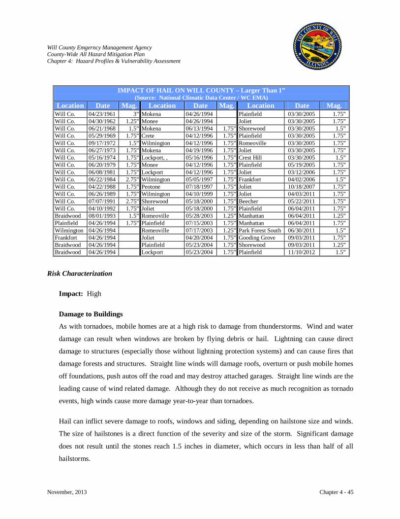
Will County Emgerncy Management Agency County-Wide All Hazard Mitigation Plan Chapter 4: Hazard Profiles & Vulnerability Assessment
November, 2013 Chapter 4 - 45
IMPACT OF HAIL ON WILL COUNTY – Larger Than 1” (Source: National Climatic Data Center / WC EMA)
Location Date Mag. Location Date Mag. Location Date Mag. Will Co. 04/23/1961 3” Mokena 04/26/1994 Plainfield 03/30/2005 1.75” Will Co. 04/30/1962 1.25” Monee 04/26/1994 Joliet 03/30/2005 1.75” Will Co. 06/21/1968 1.5” Mokena 06/13/1994 1.75” Shorewood 03/30/2005 1.5” Will Co. 05/29/1969 1.75” Crete 04/12/1996 1.75” Plainfield 03/30/2005 1.75” Will Co. 09/17/1972 1.5” Wilmington 04/12/1996 1.75” Romeoville 03/30/2005 1.75” Will Co. 06/27/1973 1.75” Mokena 04/19/1996 1.75” Joliet 03/30/2005 1.75” Will Co. 05/16/1974 1.75” Lockport, , 05/16/1996 1.75” Crest Hill 03/30/2005 1.5” Will Co. 06/20/1979 1.75” Monee 04/12/1996 1.75” Plainfield 05/19/2005 1.75” Will Co. 06/08/1981 1.75” Lockport 04/12/1996 1.75” Joliet 03/12/2006 1.75” Will Co. 06/22/1984 2.75” Wilmington 05/05/1997 1.75” Frankfort 04/02/2006 1.5” Will Co. 04/22/1988 1.75” Peotone 07/18/1997 1.75” Joliet 10/18/2007 1.75” Will Co. 06/26/1989 1.75” Wilmington 04/10/1999 1.75” Joliet 04/03/2011 1.75” Will Co. 07/07/1991 2.75” Shorewood 05/18/2000 1.75” Beecher 05/22/2011 1.75” Will Co. 04/10/1992 1.75” Joliet 05/18/2000 1.75” Plainfield 06/04/2011 1.75” Braidwood 08/01/1993 1.5” Romeoville 05/28/2003 1.25” Manhattan 06/04/2011 1.25” Plainfield 04/26/1994 1.75” Plainfield 07/15/2003 1.75” Manhattan 06/04/2011 1.75” Wilmington 04/26/1994 Romeoville 07/17/2003 1.25” Park Forest South 06/30/2011 1.5” Frankfort 04/26/1994 Joliet 04/20/2004 1.75” Gooding Grove 09/03/2011 1.75” Braidwood 04/26/1994 Plainfield 05/23/2004 1.75” Shorewood 09/03/2011 1.25” Braidwood 04/26/1994 Lockport 05/23/2004 1.75” Plainfield 11/10/2012 1.5”
Risk Characterization
Impact: High
Damage to Buildings
As with tornadoes, mobile homes are at a high risk to damage from thunderstorms. Wind and water
damage can result when windows are broken by flying debris or hail. Lightning can cause direct
damage to structures (especially those without lightning protection systems) and can cause fires that
damage forests and structures. Straight line winds will damage roofs, overturn or push mobile homes
off foundations, push autos off the road and may destroy attached garages. Straight line winds are the
leading cause of wind related damage. Although they do not receive as much recognition as tornado
events, high winds cause more damage year-to-year than tornadoes.
Hail can inflict severe damage to roofs, windows and siding, depending on hailstone size and winds.
The size of hailstones is a direct function of the severity and size of the storm. Significant damage
does not result until the stones reach 1.5 inches in diameter, which occurs in less than half of all
hailstorms.
Will County Emgerncy Management Agency County-Wide All Hazard Mitigation Plan Chapter 4: Hazard Profiles & Vulnerability Assessment
November, 2013 Chapter 4 - 46
Critical Facilities
Critical facilities are susceptible to the same damage and disruption from thunderstorms as other
buildings. Emergency operations can be disrupted as thunderstorms and lightning affect radio
communications and antennas are a prime target for lightning. To date, there is no record of critical
facilities having incurred any damages due to severe storms. Damage to critical facilities is
considered moderate.
Health and Safety
No special health problems are attributable to thunderstorms, other than the potential for tetanus and
other diseases that arise from injuries and damaged property. Serious burns or death are the common
outcomes when lightning strikes a human being. Overall health hazard: Low
The threat to life varies by the cause of death. Between 1995 and 2000, the NWS reported 20 people
in Illinois were killed by flash floods, wind, and lightning resulting from thunderstorms. Hail rarely
causes loss of life.
Lighting kills more people than tornadoes. Most lightning fatalities and injuries occur outdoors at
recreation events and under or near trees. Most of these deaths can be prevented through safe
practices. Much information has come out over the last 20 years about lightning safety, for example,
before 1990, an average of 89 people were killed by lightning each year. By 2000, this number had
dropped to 52.
Hail occurs frequently in Illinois averaging 74 times a year or 3,951 times since 1950. There have
been no deaths, but 23 injuries.
Economic Impact
Thunderstorms can impact transportation and utilities. Airplanes have crashed when hit by
downbursts or lightning. Automobiles and their windshields are subject to damage by hail. Power
lines can be knocked out by lightning or knocked down by wind and debris. Lightning can also cause
power surges that damage appliances, electronic equipment and computers. However, many
buildings have lightning rods and back up power systems that can recover quickly. Cost of clean-up
by towns can be extensive.

Will County Emgerncy Management Agency County-Wide All Hazard Mitigation Plan Chapter 4: Hazard Profiles & Vulnerability Assessment
November, 2013 Chapter 4 - 47
Future Occurrences All counties are susceptible to severe storms. At any
one time, it has been determined that over 25% of the
County population might experience severe storms.
This determination is supported by Mr. Chris Miller,
WCM, National Weather Service, Lincoln, IL, as
follows: “Damage from severe thunderstorms is usually
on a much broader spatial scale in the state of Illinois.
The past 49 years of data indicated that more than
11,000 reports of severe thunderstorm damage occurred
(approximately 7,000 wind and 4,000 hail reports) in the
state of Illinois. Approximately 80% of the severe
thunderstorms are multicellular or a supercell hybrid,
which are capable of producing damaging wind and/or
large hail over approximately a 400 to 500 square mile
area. The remaining severe thunderstorms are squall
lines, which can produce damage over 100% of the affected counties. Thus, the vulnerability to severe
thunderstorms should be high (greater than 25% of the population affected) in each county across
Illinois.” This is reinforced by a study done by Stanley Chagnon of Chagnon Climatologist, in his
publication “Thunderstorms Across the Nation - An Atlas of Storms, Hail, and Their Damages in the 20th
Century”. This study indicated that in an analysis of thunderstorm caused catastrophes, Illinois ranked
4th in the United States in total thunderstorm
catastrophes between 1949 and 1998.”
The 2013 Illinois Natural Hazard Mitigation Plan
rates the severe storms hazard for Will County as
severe.
SEVERE STORM PROBABILITY
Type Number of
Occurrences Since 1996
Annual Mean
Thunderstorm & High Wind 109 6.4
Lightning 24 1.4 Hail 88 5.1
Will County Emgerncy Management Agency County-Wide All Hazard Mitigation Plan Chapter 4: Hazard Profiles & Vulnerability Assessment
November, 2013 Chapter 4 - 48
FLOOD, FLASH FLOOD and ICE JAMS
Hazard Characterization
Rivers and streams naturally overflow onto the lands adjacent to them. These lands, or flood plains, act
as a natural reservoir and temporary channel for the excess water that dissipates over time. Flooding has
only become a problem since people started to occupy the floodplains. The attractiveness of the level,
fertile land of the floodplain has encouraged development despite the flood-prone nature of the area.
However, as these lands have become further developed, it has given rise to an increasing public demand
for protection from the economic losses caused by the inevitable flooding.
Flooding may not always be directly attributable to a river, stream or lake overflowing its banks. Rather,
it may simply be the combination of excessive rainfall and/or snowmelt, saturated ground, and inadequate
drainage. With no place to go, the water will find the lowest elevations – areas that are often not in a
floodplain. That type of flooding is becoming increasingly prevalent, as development outstrips the ability
of the drainage infrastructure to properly carry and disperse the water flow. Flooding also occurs due to
combined storm and sanitary sewers that cannot handle the tremendous flow of water that often
accompanies storm events. Typically, the result is water backing into basements, which damages
mechanical systems and can create serious public health and safety concerns. Other cases involve the
ponding of waters across roads or in other low-lying areas.
Except for fire, the most common hazard in the United States is flooding with thousands of incidents
occurring each year from oceans, rivers, lakes, small streams, gullies, creeks, culverts, dry streambeds or
low lying ground. The Federal Emergency Management Agency’s (FEMA) standard definition of a flood
is:
“A general and temporary condition of partial or complete inundation of two or more acres of
normally dry land area or of two or more properties (at least one of which is the policyholder's
property) from:
Overflow of inland or tidal waters; or Unusual and rapid accumulation or runoff of surface waters from any source; or Mudflow; or

Will County Emgerncy Management Agency County-Wide All Hazard Mitigation Plan Chapter 4: Hazard Profiles & Vulnerability Assessment
November, 2013 Chapter 4 - 49
Collapse or subsidence of land along the shore of a lake or similar body of water as a result of erosion or undermining caused by waves or currents of water exceeding anticipated cyclical levels that result in a flood as defined above.”
A simpler definition is too much water in the wrong place. Since water circulates from clouds to the soil
to streams to rivers to the oceans and returns to the clouds, a scientific definition of a flood is an
imbalance in the “hydrological system” with more water flowing through the system than the system can
draw off.
Hydrologic Cycle
The hydrologic cycle begins with the evaporation of water from the surface of the ocean. As moist air is
lifted, it cools and water vapor condenses to form clouds. Moisture is transported around the globe until
it returns to the surface as precipitation. Once the water reaches the ground, one of two processes may
occur: 1) some of the water may evaporate back into the atmosphere or 2) the water may penetrate the
surface and become groundwater. Groundwater either seeps its way into the oceans, rivers, and streams,
or is released back into the atmosphere through transpiration. The balance of water that remains on the
earth's surface is runoff, which empties into lakes, rivers and streams and is carried back to the oceans,
where the cycle begins again.
Summary of the Hydrologic Cycle

Will County Emgerncy Management Agency County-Wide All Hazard Mitigation Plan Chapter 4: Hazard Profiles & Vulnerability Assessment
November, 2013 Chapter 4 - 50
There are many factors that contribute to the flooding of a river or stream. These factors are an
abnormally heavy rainfall, the melting of packed snow, the simultaneous arrival of flood crests from
major tributaries, the formation of ice jams which block the river flow, inadequately designed storm water
systems, and the creation of hydrologic structures (i.e. dams and levees) which are prone to failure and
either cause an incident or aggravate an already existing one. Primarily, floods do occur in the springtime
but can occur any time of the year.
Types of Floods
Riverine Floods: Develop slowly, sometimes over a period of days or weeks.
Flash Floods: Develop quickly, sometimes in just a few minutes. Usually flash floods are
the result of intense storms dropping large amounts of rain within a brief
period.
Ice Jam Floods: Jammed ice creates a dam across the channel over which the water and ice
mixture continues to flow causing more jamming to occur. Backwater
upstream from the ice dam may rise rapidly and overflow the channel banks.
When the ice dam fails, flooding occurs releasing the water stored behind the
dam.
Overland Floods: Occurs outside a defined river or stream (e.g. ponding in a low lying area).
Aquifer Flood: Water is expelled from a subterranean geologic formation to the surface
causing flooding in the immediate area.
Subterranean Flood: Water floods into tunnels that are normally dry.
Structure Failure: Online structure or levee fails.
Most riverine flooding occurs in early spring and is the result of excessive rainfall and/or the combination
of rainfall and snowmelt. Ice jams are also a cause of flooding in winter and early spring and can cause
dangerous flash flooding to occur if the ice suddenly gives way. Severe thunderstorms may cause
flooding during the summer or fall, although these are normally localized and have more impact on
watercourses with smaller drainage areas.
The effects of a flood can be devastating and floods are probably the most pervasive of all natural hazards
in the U.S. Between the inundation of water and the force of the current, both lives and property can be
lost. People and animals can drown or be injured by the floodwaters and the current-borne debris. This

Will County Emgerncy Management Agency County-Wide All Hazard Mitigation Plan Chapter 4: Hazard Profiles & Vulnerability Assessment
November, 2013 Chapter 4 - 51
same debris can also cause structural damage to buildings, roads, bridges, and railroads. Sanitary, power,
water, and communication installations can be severely damaged and their systems interrupted for long
periods of time. Crops can be carried away by the current or destroyed by the inundation. Farmlands
may be deeply eroded by new channels, resulting in the loss of valuable topsoil.
Many low lying areas of the County are also damaged yearly by heavy rains. Although they have not
been declared disasters, the damage caused by this flooding is extensive. Since the flood plains have been
built upon over the years, it would be financially unfeasible to buy all the property that is in the flood
zones. Therefore, steps have been taken to evacuate homes along rivers and creeks when water is
predicted to overflow the river’s banks. For low lying areas, some of the flooding has been attributed to
poor sewer and run-off tiles, debris, as well as other items that obstruct the natural flow of the water.
Once these problems are corrected, many of the flooding problems will be alleviated.
Flood Terms
100-Year Flood Plain: A flood event that statistically has a 1 out of 100 (or one percent) chance
of being equaled or exceeded on a specific watercourse in any given
year. A flood event of this magnitude is often used to determine if flood
insurance is either advisable or required on a property.
500-Year Flood Plain: A flood having a 0.2% or greater annual probability of occurring every
year.
Base Flood: Defined by FEMA as the flood having a 1-percent probability of being
equaled or exceeded in any given year; also referred to as the 100-year
flood.
Flood Stage: The point at which the water level in a stream begins to cause damage to
structures. It may be below the point at which the water level in a stream
overtops the banks and spreads out onto the floodplain if structures are
located in a floodway.
Floodplain: The area adjoining a watercourse that may be covered by floodwater
during a flood. This area, if left undisturbed, acts to store excess
floodwater. The floodplain is made up of two sections: the floodway and
the flood fringe.

Will County Emgerncy Management Agency County-Wide All Hazard Mitigation Plan Chapter 4: Hazard Profiles & Vulnerability Assessment
November, 2013 Chapter 4 - 52
Floodway: A flow path (sometimes artificial) that carries significant volumes of
floodwaters during a flood. The floodway carries the bulk of the
floodwater downstream and is usually the area where water velocities
and forces are the greatest. NFIP regulations require that the floodway
be kept open and free from development or other structures that would
obstruct or divert flood flows onto other properties.
Flood Fringe: The areas of a delineated floodplain adjacent to the floodway where
encroachment may be permitted.
Mitigation: Flood mitigation is any action taken to reduce risk to people or property
from flooding and its effects. Nonstructural measures are used to make
existing and future development more resilient to flooding or to preserve
(or restore) natural floodplain functions so that developed property is not
affected. Structural measures seek to prevent the advance of flood
waters, usually through an engineered measure such as a dam, levee, or
floodwall.
Streamflow:
Commonly, people interpret the 50-year flood
definition to mean “once every 50 years.” This is
incorrect. Statistically speaking, a 50-year flood
has a 1/50 (2 %) chance of occurring in any given
year. In reality, a 50-year flood could occur two
times in the same year, two years in a row, or four
times over the course of 50 years. It is possible
not to have a 50-year flood over the course of 100
years.
The discharge that occurs in a natural channel.
FEMA uses the “base” flood as the basis for its
regulatory requirements and flood insurance rate
setting; it is also the basis for this analysis. The
base flood is the 1% chance flood, i.e., the flood
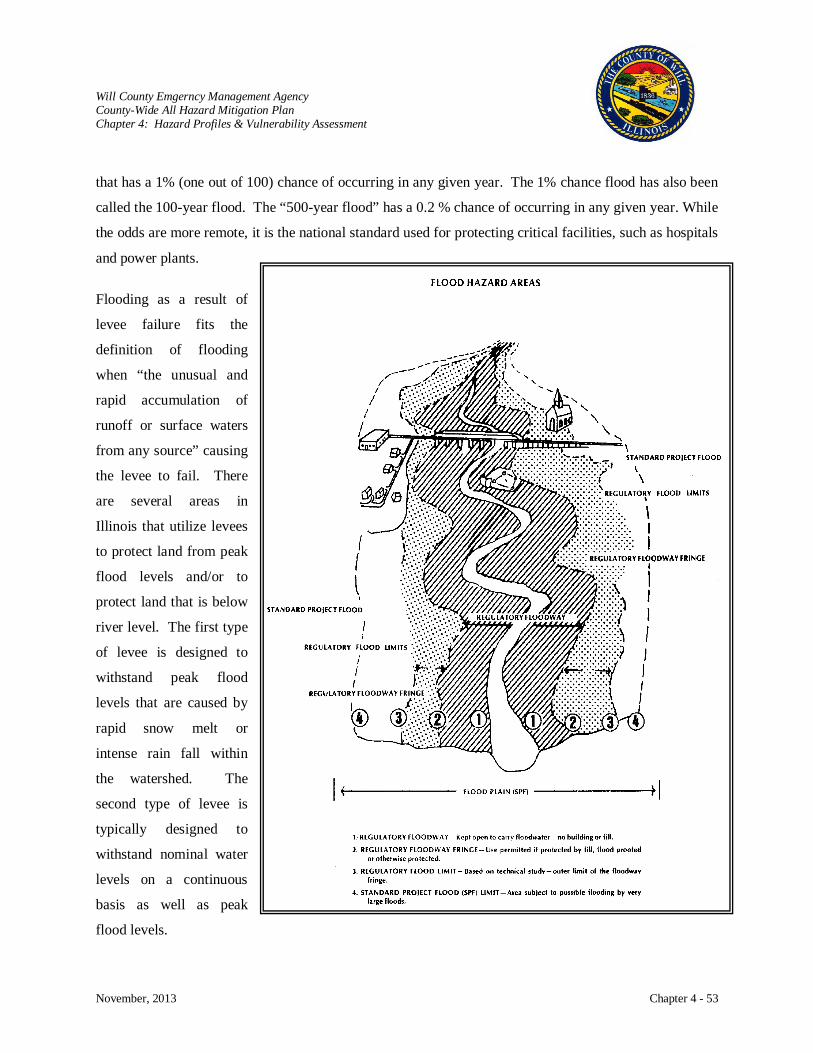
Will County Emgerncy Management Agency County-Wide All Hazard Mitigation Plan Chapter 4: Hazard Profiles & Vulnerability Assessment
November, 2013 Chapter 4 - 53
that has a 1% (one out of 100) chance of occurring in any given year. The 1% chance flood has also been
called the 100-year flood. The “500-year flood” has a 0.2 % chance of occurring in any given year. While
the odds are more remote, it is the national standard used for protecting critical facilities, such as hospitals
and power plants.
Flooding as a result of
levee failure fits the
definition of flooding
when “the unusual and
rapid accumulation of
runoff or surface waters
from any source” causing
the levee to fail. There
are several areas in
Illinois that utilize levees
to protect land from peak
flood levels and/or to
protect land that is below
river level. The first type
of levee is designed to
withstand peak flood
levels that are caused by
rapid snow melt or
intense rain fall within
the watershed. The
second type of levee is
typically designed to
withstand nominal water
levels on a continuous
basis as well as peak
flood levels.
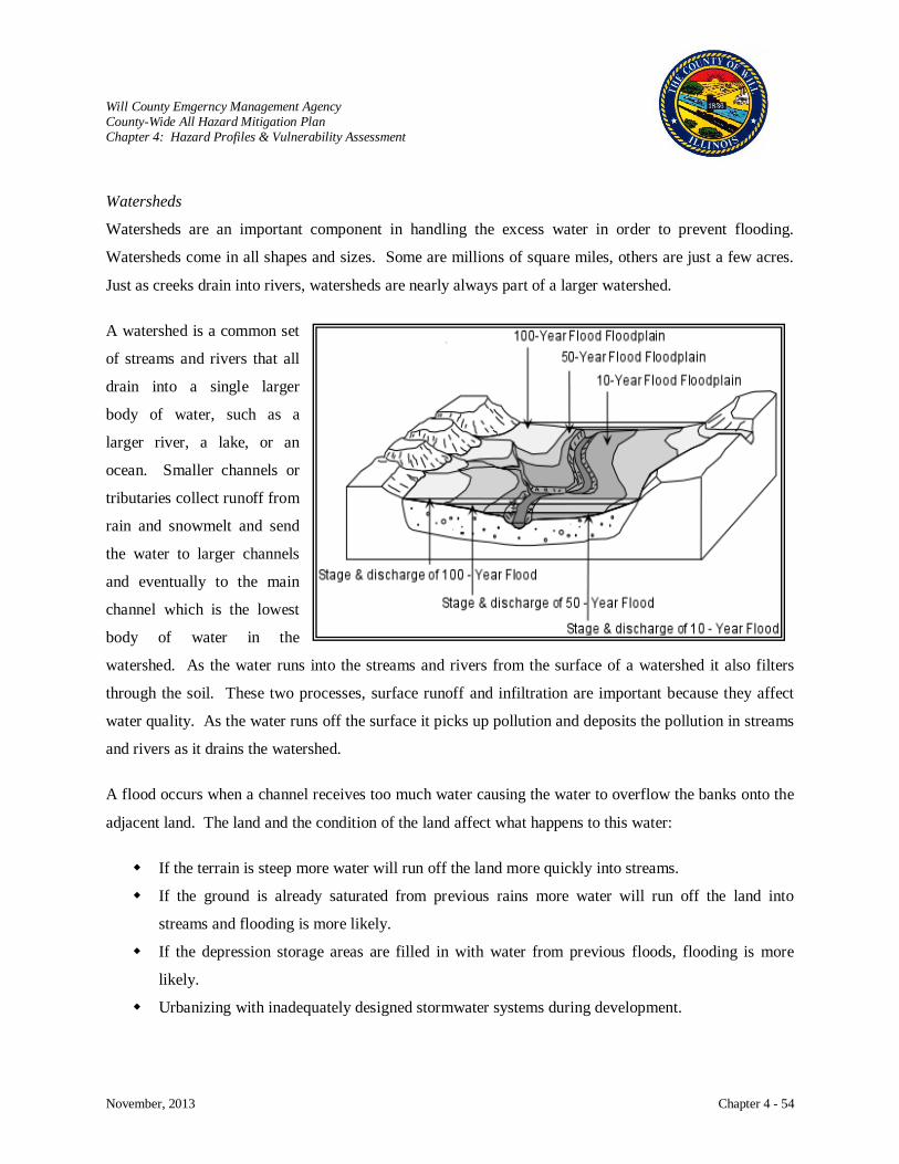
Will County Emgerncy Management Agency County-Wide All Hazard Mitigation Plan Chapter 4: Hazard Profiles & Vulnerability Assessment
November, 2013 Chapter 4 - 54
Watersheds
Watersheds are an important component in handling the excess water in order to prevent flooding.
Watersheds come in all shapes and sizes. Some are millions of square miles, others are just a few acres.
Just as creeks drain into rivers, watersheds are nearly always part of a larger watershed.
A watershed is a common set
of streams and rivers that all
drain into a single larger
body of water, such as a
larger river, a lake, or an
ocean. Smaller channels or
tributaries collect runoff from
rain and snowmelt and send
the water to larger channels
and eventually to the main
channel which is the lowest
body of water in the
watershed. As the water runs into the streams and rivers from the surface of a watershed it also filters
through the soil. These two processes, surface runoff and infiltration are important because they affect
water quality. As the water runs off the surface it picks up pollution and deposits the pollution in streams
and rivers as it drains the watershed.
A flood occurs when a channel receives too much water causing the water to overflow the banks onto the
adjacent land. The land and the condition of the land affect what happens to this water:
If the terrain is steep more water will run off the land more quickly into streams.
If the ground is already saturated from previous rains more water will run off the land into
streams and flooding is more likely.
If the depression storage areas are filled in with water from previous floods, flooding is more
likely.
Urbanizing with inadequately designed stormwater systems during development.
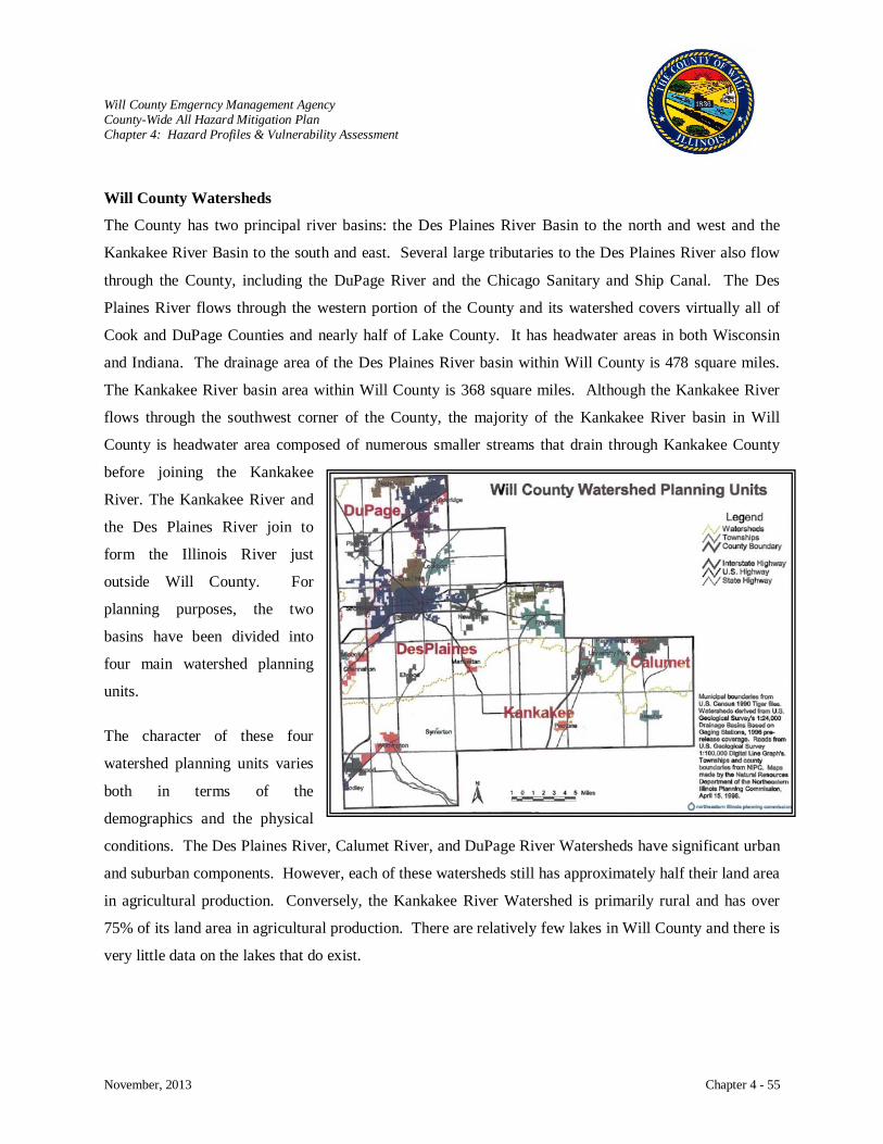
Will County Emgerncy Management Agency County-Wide All Hazard Mitigation Plan Chapter 4: Hazard Profiles & Vulnerability Assessment
November, 2013 Chapter 4 - 55
Will County Watersheds
The County has two principal river basins: the Des Plaines River Basin to the north and west and the
Kankakee River Basin to the south and east. Several large tributaries to the Des Plaines River also flow
through the County, including the DuPage River and the Chicago Sanitary and Ship Canal. The Des
Plaines River flows through the western portion of the County and its watershed covers virtually all of
Cook and DuPage Counties and nearly half of Lake County. It has headwater areas in both Wisconsin
and Indiana. The drainage area of the Des Plaines River basin within Will County is 478 square miles.
The Kankakee River basin area within Will County is 368 square miles. Although the Kankakee River
flows through the southwest corner of the County, the majority of the Kankakee River basin in Will
County is headwater area composed of numerous smaller streams that drain through Kankakee County
before joining the Kankakee
River. The Kankakee River and
the Des Plaines River join to
form the Illinois River just
outside Will County. For
planning purposes, the two
basins have been divided into
four main watershed planning
units.
The character of these four
watershed planning units varies
both in terms of the
demographics and the physical
conditions. The Des Plaines River, Calumet River, and DuPage River Watersheds have significant urban
and suburban components. However, each of these watersheds still has approximately half their land area
in agricultural production. Conversely, the Kankakee River Watershed is primarily rural and has over
75% of its land area in agricultural production. There are relatively few lakes in Will County and there is
very little data on the lakes that do exist.
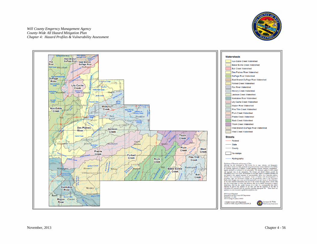
Will County Emgerncy Management Agency County-Wide All Hazard Mitigation Plan Chapter 4: Hazard Profiles & Vulnerability Assessment
November, 2013 Chapter 4 - 56
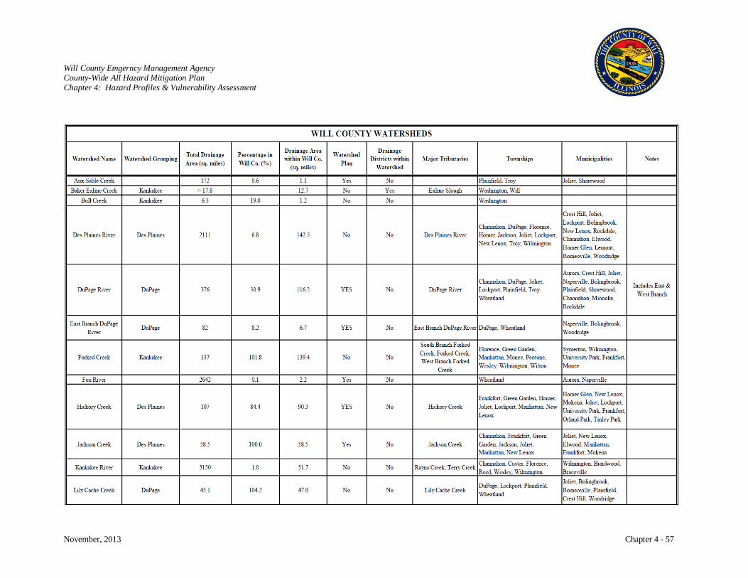
Will County Emgerncy Management Agency County-Wide All Hazard Mitigation Plan Chapter 4: Hazard Profiles & Vulnerability Assessment
November, 2013 Chapter 4 - 57
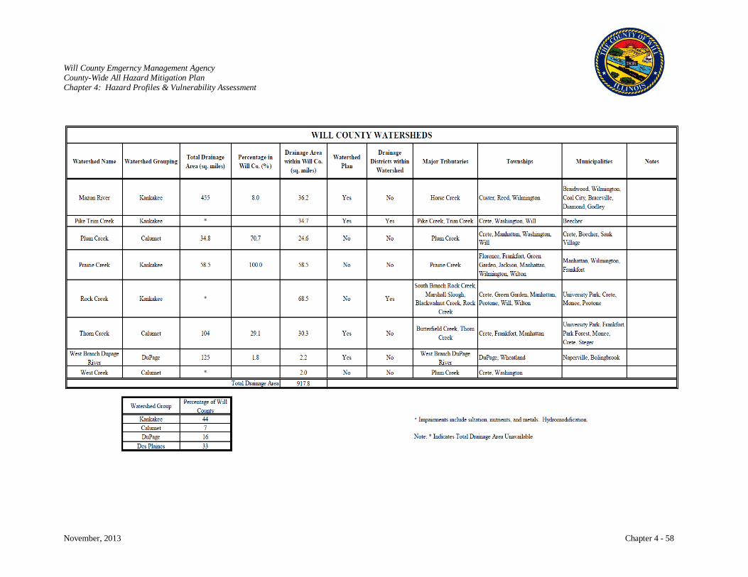
Will County Emgerncy Management Agency County-Wide All Hazard Mitigation Plan Chapter 4: Hazard Profiles & Vulnerability Assessment
November, 2013 Chapter 4 - 58

Will County Emgerncy Management Agency County-Wide All Hazard Mitigation Plan Chapter 4: Hazard Profiles & Vulnerability Assessment
November, 2013 Chapter 4 - 59
Will County Stormwater Management Planning Committee
Will County Stormwater Management Planning Committee (WCSMPC) is an intergovernmental entity
with representation from both municipalities and Will County. The WCSMPC is an advisory body to the
Will County Board and is responsible for directing the implementation of Comprehensive Stormwater
Management Plan and its revision, if necessary. The Stormwater Plan establishes the recommended role
of the WCSMPC, which are:
Administration and Management: The WCSMPC is composed of half municipal and half County
Board representation. The WCSMPC has authority to establish its own committees and to retain
engineering, legal, and financial advisors and inspection personnel; yet, it is planned that County staff
will provide these services for the committee as feasible. The committee is required by state statutes
to meet, at a minimum, quarterly.
Regulation: The WCSMPC is an advisory body to the County Board and is instrumental in
developing and maintaining a county-wide ordinance for the County Board and in advising the
County Board on issues related to stormwater management in Will County. The committee’s
recommendations require due consideration and any regulatory enactments in contravention to the
committee’s recommendations requires a super majority vote of the County Board.
Planning: This is a primary role for the WCSMPC, which is the preparation and maintenance of this
plan, the county-wide stormwater ordinance, and implementation of the county-wide plan.
Maintenance: The Stormwater Management Plan provides authority for the County to ensure
maintenance of stormwater facilities and the natural drainage system.
Will County Ordinance and Guides:
Will County Stormwater Management Ordinance - http://willcountylanduse.com/sites/default/files/StormwaterOrd_20100325.pdf
Will County Stormwater Technical Guidance Manual - http://willcountylanduse.com/sites/default/files/Approved_TGM_August_25_2010.pdf
Will County Comprehensive Stormwater Management Plan - http://willcountylanduse.com/sites/default/files/WillCo_SWPlan_1998.pdf
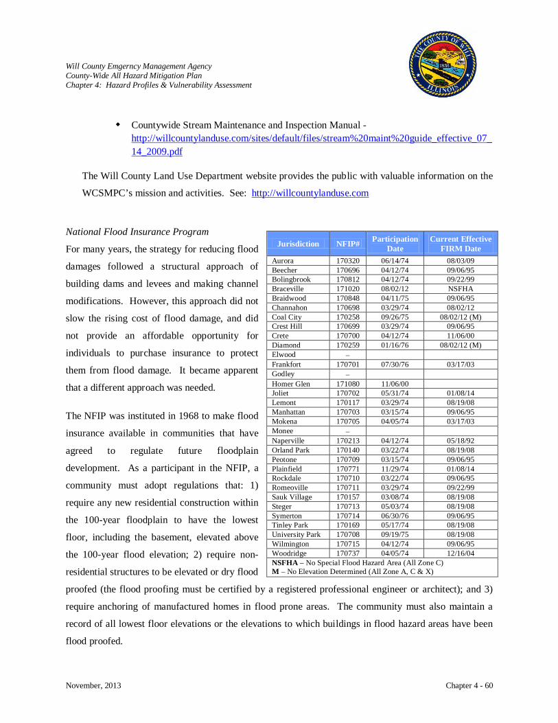
Will County Emgerncy Management Agency County-Wide All Hazard Mitigation Plan Chapter 4: Hazard Profiles & Vulnerability Assessment
November, 2013 Chapter 4 - 60
Countywide Stream Maintenance and Inspection Manual - http://willcountylanduse.com/sites/default/files/stream%20maint%20guide_effective_07_14_2009.pdf
The Will County Land Use Department website provides the public with valuable information on the
WCSMPC’s mission and activities. See: http://willcountylanduse.com
National Flood Insurance Program
For many years, the strategy for reducing flood
damages followed a structural approach of
building dams and levees and making channel
modifications. However, this approach did not
slow the rising cost of flood damage, and did
not provide an affordable opportunity for
individuals to purchase insurance to protect
them from flood damage. It became apparent
that a different approach was needed.
The NFIP was instituted in 1968 to make flood
insurance available in communities that have
agreed to regulate future floodplain
development. As a participant in the NFIP, a
community must adopt regulations that: 1)
require any new residential construction within
the 100-year floodplain to have the lowest
floor, including the basement, elevated above
the 100-year flood elevation; 2) require non-
residential structures to be elevated or dry flood
proofed (the flood proofing must be certified by a registered professional engineer or architect); and 3)
require anchoring of manufactured homes in flood prone areas. The community must also maintain a
record of all lowest floor elevations or the elevations to which buildings in flood hazard areas have been
flood proofed.
Jurisdiction NFIP# Participation Date
Current Effective FIRM Date
Aurora 170320 06/14/74 08/03/09 Beecher 170696 04/12/74 09/06/95 Bolingbrook 170812 04/12/74 09/22/99 Braceville 171020 08/02/12 NSFHA Braidwood 170848 04/11/75 09/06/95 Channahon 170698 03/29/74 08/02/12 Coal City 170258 09/26/75 08/02/12 (M) Crest Hill 170699 03/29/74 09/06/95 Crete 170700 04/12/74 11/06/00 Diamond 170259 01/16/76 08/02/12 (M) Elwood − Frankfort 170701 07/30/76 03/17/03 Godley − Homer Glen 171080 11/06/00 Joliet 170702 05/31/74 01/08/14 Lemont 170117 03/29/74 08/19/08 Manhattan 170703 03/15/74 09/06/95 Mokena 170705 04/05/74 03/17/03 Monee − Naperville 170213 04/12/74 05/18/92 Orland Park 170140 03/22/74 08/19/08 Peotone 170709 03/15/74 09/06/95 Plainfield 170771 11/29/74 01/08/14 Rockdale 170710 03/22/74 09/06/95 Romeoville 170711 03/29/74 09/22/99 Sauk Village 170157 03/08/74 08/19/08 Steger 170713 05/03/74 08/19/08 Symerton 170714 06/30/76 09/06/95 Tinley Park 170169 05/17/74 08/19/08 University Park 170708 09/19/75 08/19/08 Wilmington 170715 04/12/74 09/06/95 Woodridge 170737 04/05/74 12/16/04 NSFHA – No Special Flood Hazard Area (All Zone C) M – No Elevation Determined (All Zone A, C & X)
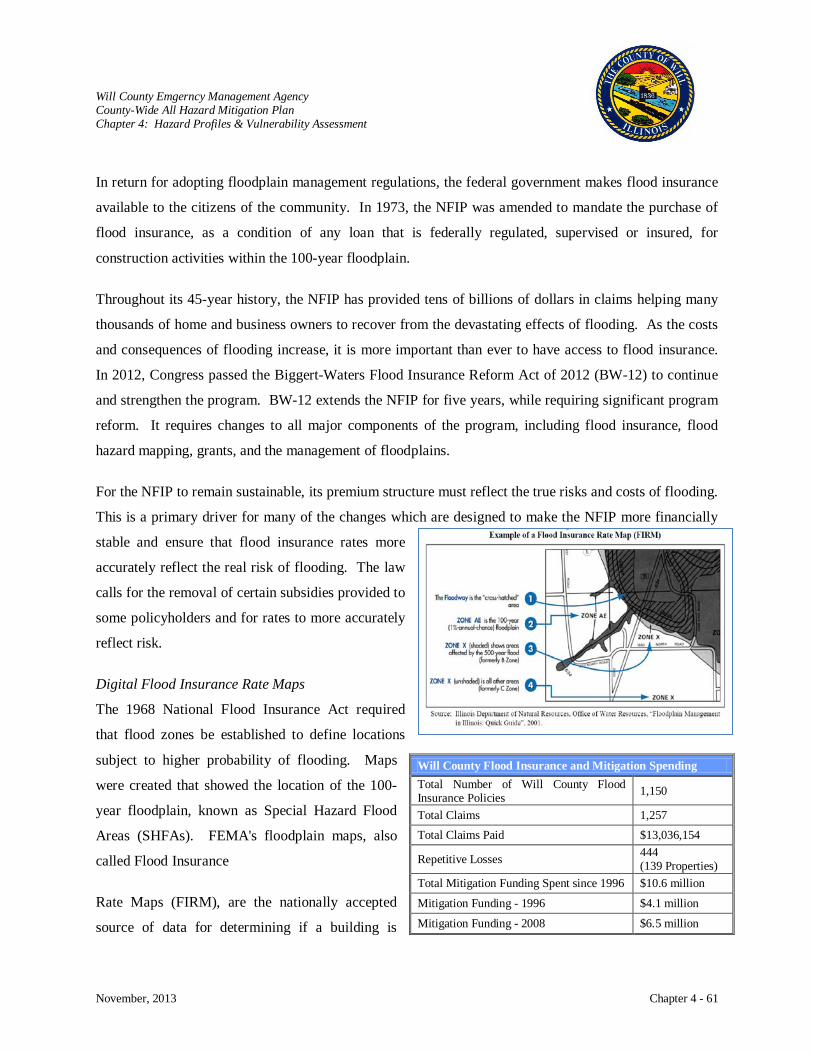
Will County Emgerncy Management Agency County-Wide All Hazard Mitigation Plan Chapter 4: Hazard Profiles & Vulnerability Assessment
November, 2013 Chapter 4 - 61
In return for adopting floodplain management regulations, the federal government makes flood insurance
available to the citizens of the community. In 1973, the NFIP was amended to mandate the purchase of
flood insurance, as a condition of any loan that is federally regulated, supervised or insured, for
construction activities within the 100-year floodplain.
Throughout its 45-year history, the NFIP has provided tens of billions of dollars in claims helping many
thousands of home and business owners to recover from the devastating effects of flooding. As the costs
and consequences of flooding increase, it is more important than ever to have access to flood insurance.
In 2012, Congress passed the Biggert-Waters Flood Insurance Reform Act of 2012 (BW-12) to continue
and strengthen the program. BW-12 extends the NFIP for five years, while requiring significant program
reform. It requires changes to all major components of the program, including flood insurance, flood
hazard mapping, grants, and the management of floodplains.
For the NFIP to remain sustainable, its premium structure must reflect the true risks and costs of flooding.
This is a primary driver for many of the changes which are designed to make the NFIP more financially
stable and ensure that flood insurance rates more
accurately reflect the real risk of flooding. The law
calls for the removal of certain subsidies provided to
some policyholders and for rates to more accurately
reflect risk.
Digital Flood Insurance Rate Maps
The 1968 National Flood Insurance Act required
that flood zones be established to define locations
subject to higher probability of flooding. Maps
were created that showed the location of the 100-
year floodplain, known as Special Hazard Flood
Areas (SHFAs). FEMA's floodplain maps, also
called Flood Insurance
Rate Maps (FIRM), are the nationally accepted
source of data for determining if a building is
Will County Flood Insurance and Mitigation Spending Total Number of Will County Flood Insurance Policies 1,150
Total Claims 1,257 Total Claims Paid $13,036,154
Repetitive Losses 444 (139 Properties)
Total Mitigation Funding Spent since 1996 $10.6 million
Mitigation Funding - 1996 $4.1 million
Mitigation Funding - 2008 $6.5 million
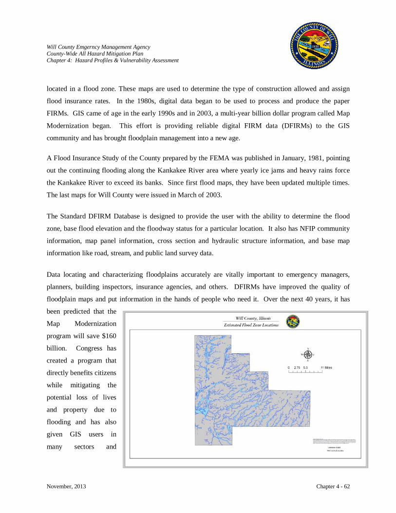
Will County Emgerncy Management Agency County-Wide All Hazard Mitigation Plan Chapter 4: Hazard Profiles & Vulnerability Assessment
November, 2013 Chapter 4 - 62
located in a flood zone. These maps are used to determine the type of construction allowed and assign
flood insurance rates. In the 1980s, digital data began to be used to process and produce the paper
FIRMs. GIS came of age in the early 1990s and in 2003, a multi-year billion dollar program called Map
Modernization began. This effort is providing reliable digital FIRM data (DFIRMs) to the GIS
community and has brought floodplain management into a new age.
A Flood Insurance Study of the County prepared by the FEMA was published in January, 1981, pointing
out the continuing flooding along the Kankakee River area where yearly ice jams and heavy rains force
the Kankakee River to exceed its banks. Since first flood maps, they have been updated multiple times.
The last maps for Will County were issued in March of 2003.
The Standard DFIRM Database is designed to provide the user with the ability to determine the flood
zone, base flood elevation and the floodway status for a particular location. It also has NFIP community
information, map panel information, cross section and hydraulic structure information, and base map
information like road, stream, and public land survey data.
Data locating and characterizing floodplains accurately are vitally important to emergency managers,
planners, building inspectors, insurance agencies, and others. DFIRMs have improved the quality of
floodplain maps and put information in the hands of people who need it. Over the next 40 years, it has
been predicted that the
Map Modernization
program will save $160
billion. Congress has
created a program that
directly benefits citizens
while mitigating the
potential loss of lives
and property due to
flooding and has also
given GIS users in
many sectors and
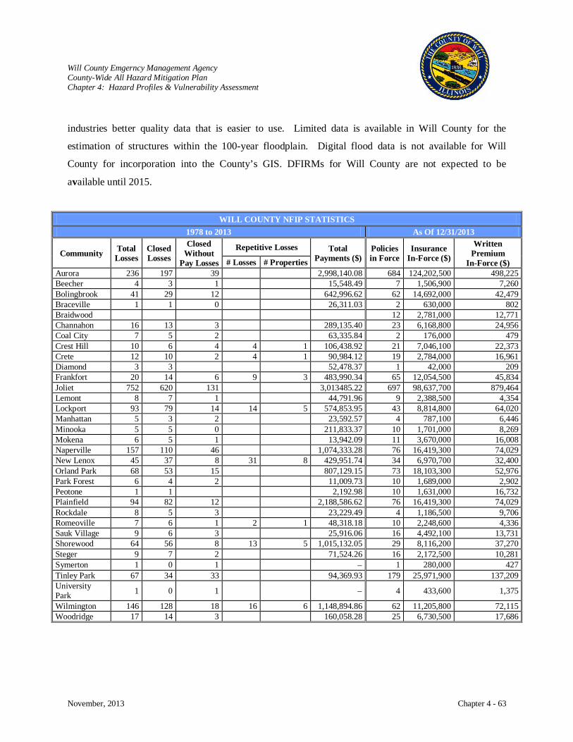
Will County Emgerncy Management Agency County-Wide All Hazard Mitigation Plan Chapter 4: Hazard Profiles & Vulnerability Assessment
November, 2013 Chapter 4 - 63
industries better quality data that is easier to use. Limited data is available in Will County for the
estimation of structures within the 100-year floodplain. Digital flood data is not available for Will
County for incorporation into the County’s GIS. DFIRMs for Will County are not expected to be
available until 2015.
WILL COUNTY NFIP STATISTICS 1978 to 2013 As Of 12/31/2013
Community Total Losses
Closed Losses
Closed Without
Pay Losses
Repetitive Losses Total Payments ($)
Policies in Force
Insurance In-Force ($)
Written Premium
In-Force ($) # Losses # Properties Aurora 236 197 39 2,998,140.08 684 124,202,500 498,225 Beecher 4 3 1 15,548.49 7 1,506,900 7,260 Bolingbrook 41 29 12 642,996.62 62 14,692,000 42,479 Braceville 1 1 0 26,311.03 2 630,000 802 Braidwood 12 2,781,000 12,771 Channahon 16 13 3 289,135.40 23 6,168,800 24,956 Coal City 7 5 2 63,335.84 2 176,000 479 Crest Hill 10 6 4 4 1 106,438.92 21 7,046,100 22,373 Crete 12 10 2 4 1 90,984.12 19 2,784,000 16,961 Diamond 3 3 52,478.37 1 42,000 209 Frankfort 20 14 6 9 3 483,990.34 65 12,054,500 45,834 Joliet 752 620 131 3,013485.22 697 98,637,700 879,464 Lemont 8 7 1 44,791.96 9 2,388,500 4,354 Lockport 93 79 14 14 5 574,853.95 43 8,814,800 64,020 Manhattan 5 3 2 23,592.57 4 787,100 6,446 Minooka 5 5 0 211,833.37 10 1,701,000 8,269 Mokena 6 5 1 13,942.09 11 3,670,000 16,008 Naperville 157 110 46 1,074,333.28 76 16,419,300 74,029 New Lenox 45 37 8 31 8 429,951.74 34 6,970,700 32,400 Orland Park 68 53 15 807,129.15 73 18,103,300 52,976 Park Forest 6 4 2 11,009.73 10 1,689,000 2,902 Peotone 1 1 2,192.98 10 1,631,000 16,732 Plainfield 94 82 12 2,188,586.62 76 16,419,300 74,029 Rockdale 8 5 3 23,229.49 4 1,186,500 9,706 Romeoville 7 6 1 2 1 48,318.18 10 2,248,600 4,336 Sauk Village 9 6 3 25,916.06 16 4,492,100 13,731 Shorewood 64 56 8 13 5 1,015,132.05 29 8,116,200 37,270 Steger 9 7 2 71,524.26 16 2,172,500 10,281 Symerton 1 0 1 − 1 280,000 427 Tinley Park 67 34 33 94,369.93 179 25,971,900 137,209 University Park 1 0 1 − 4 433,600 1,375
Wilmington 146 128 18 16 6 1,148,894.86 62 11,205,800 72,115 Woodridge 17 14 3 160,058.28 25 6,730,500 17,686
Will County Emgerncy Management Agency County-Wide All Hazard Mitigation Plan Chapter 4: Hazard Profiles & Vulnerability Assessment
November, 2013 Chapter 4 - 64
FLASH FLOOD Hazard Characterization
Two types of flooding occur with rivers and streams. Riverine flooding is a result of persistent rain and
causes a slow rising of water causing it to overflow over several days or weeks. This type of flooding has
been previously discussed and is the most typical type of flooding in Will County. Flash floods are a
result of torrential rainfall over a short period of time, a sudden release of water from a dam failure, or
breakup of an ice jam. These floods occur suddenly with tremendous force. Flash floods can turn calm
rivers and streams into a turbulent torrent that is able to carry away boulders, trees, houses, trailers, cars,
and people.
Flash flooding is a major killer. All flash floods strike quickly and end swiftly. They can be deadly
because they produce rapid rises in water levels and have devastating flow velocities. Many flash floods
occur at night when they are difficult to see. Most flash flood deaths are related to vehicles being washed
away. People are warned not to attempt driving or walking across a flooded area because as little as two
feet of moving water will carry most cars away.
Flash floods can occur within several seconds to several hours and with little warning. Several factors
can contribute to flash flooding. Among these are rainfall intensity, rainfall duration, surface conditions,
and topography and slope of the receiving basin. Most flash flooding is caused by slow-moving
thunderstorms in a local area or by heavy rains associated with hurricanes and tropical storms. Although
flash flooding occurs often along mountain streams, it is also common in urbanized areas where much of
the ground is covered by impervious surfaces.
Areas with steep slopes and narrow stream valleys are particularly vulnerable to flash flooding, as are the
banks of small tributary streams. In hilly areas, the high-velocity flows and short warning time make
flash floods hazardous and very destructive. Flash floods also can be caused by dam failure, the release
of ice-jam flooding, or the collapse of a debris dam.
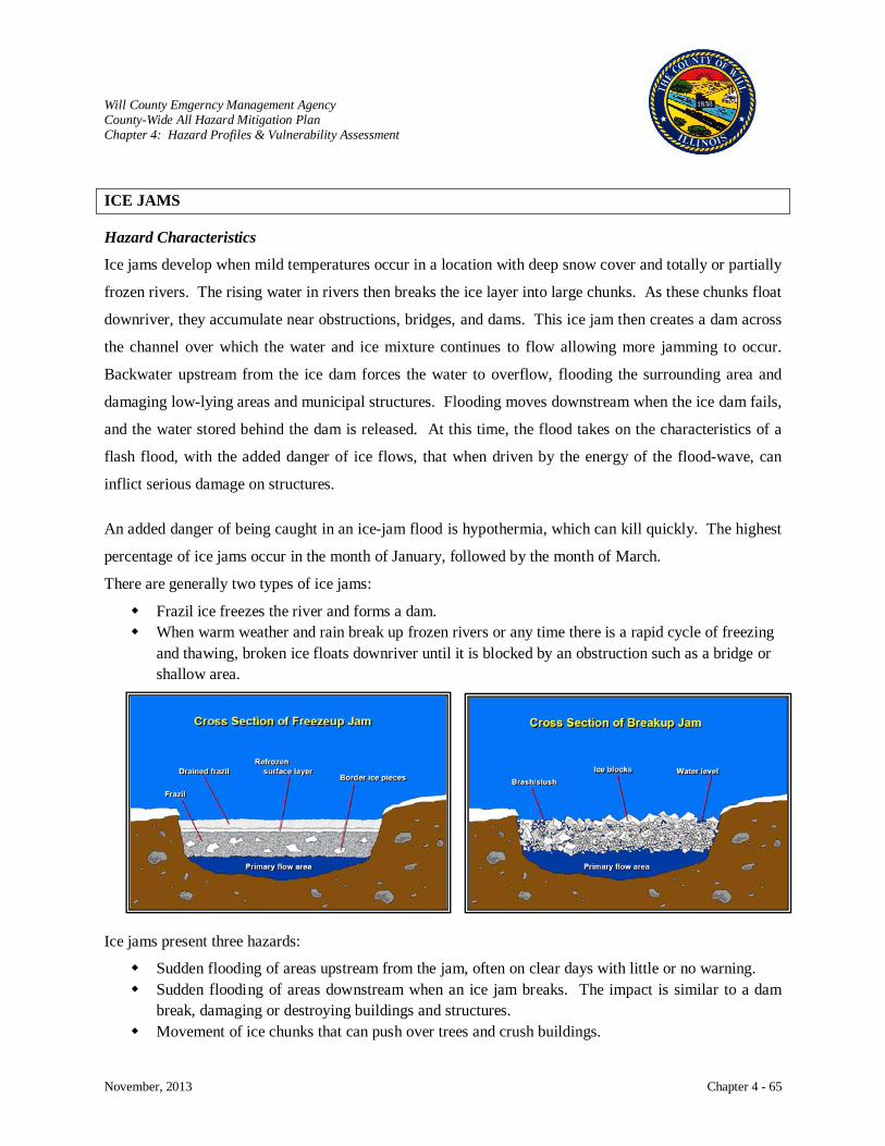
Will County Emgerncy Management Agency County-Wide All Hazard Mitigation Plan Chapter 4: Hazard Profiles & Vulnerability Assessment
November, 2013 Chapter 4 - 65
ICE JAMS Hazard Characteristics
Ice jams develop when mild temperatures occur in a location with deep snow cover and totally or partially
frozen rivers. The rising water in rivers then breaks the ice layer into large chunks. As these chunks float
downriver, they accumulate near obstructions, bridges, and dams. This ice jam then creates a dam across
the channel over which the water and ice mixture continues to flow allowing more jamming to occur.
Backwater upstream from the ice dam forces the water to overflow, flooding the surrounding area and
damaging low-lying areas and municipal structures. Flooding moves downstream when the ice dam fails,
and the water stored behind the dam is released. At this time, the flood takes on the characteristics of a
flash flood, with the added danger of ice flows, that when driven by the energy of the flood-wave, can
inflict serious damage on structures.
An added danger of being caught in an ice-jam flood is hypothermia, which can kill quickly. The highest
percentage of ice jams occur in the month of January, followed by the month of March.
There are generally two types of ice jams:
Frazil ice freezes the river and forms a dam. When warm weather and rain break up frozen rivers or any time there is a rapid cycle of freezing
and thawing, broken ice floats downriver until it is blocked by an obstruction such as a bridge or shallow area.
Ice jams present three hazards:
Sudden flooding of areas upstream from the jam, often on clear days with little or no warning. Sudden flooding of areas downstream when an ice jam breaks. The impact is similar to a dam
break, damaging or destroying buildings and structures. Movement of ice chunks that can push over trees and crush buildings.

Will County Emgerncy Management Agency County-Wide All Hazard Mitigation Plan Chapter 4: Hazard Profiles & Vulnerability Assessment
November, 2013 Chapter 4 - 66
History: Flood, Flash Flood, and Ice Jams
Will County has always been afflicted by the
constant damage and destruction of flooding.
Damage caused by the 1974 floods was sufficient to
declare the County to be a Presidential disaster area.
Once again, a Presidential disaster area would be
declared in this area due to the flooding in June,
1981. The DuPage River was declared a State
Disaster area from the flooding of July, 1983, which
included the Will County townships of DuPage,
Homer, Lockport, Plainfield, and Troy. Federal
disasters were again declared for flooding, including the DuPage River area, occurring in July, 1996;
September, 2008; and April, 2013. Mitigation funding of approximately $10.6 million has been spent in
Will County from the 1996 and 2008 floods.
Severe Storms and Flooding – July 17 to August 7, 1996 Federal Disaster Declaration #1129 Public Assistance - $4,265,671 Individual Assistance - $933,042 (974 referrals)
Severe storms and torrential rains began on July 17th and continued intermittently through August 7,
1996. Nearly 17 inches of rain fell in northern Will County on July 17th and 18th. Flash flooding resulted
in widespread power outages, disruption of commuter rail service, and the flooding of thousands of home
and hundreds of businesses. Major transportation routes, including interstate highways, city streets, and
commuter rail lines were closed due to the flooding. Damage was widespread throughout Will County
with several million of dollars in property damage. Major flooding occurred in the western half of the
County in the townships of Lockport, New Lenox, Joliet, Wheatland, DuPage, Homer, Frankfort, Troy,
Wilton, Plainfield, Crete, and Channahon. As a result of the Federal declaration, grants and low interest
loans were made available to homeowners. Home located along the DuPage River were purchased by the
Federal government in Plainfield, Shorewood, and Channahon. Public assistance helped to rebuild roads
and bridges that were destroyed or damaged as a result of the flooding.
The Kankakee River downstream of Wilmington is prone to Ice Jams
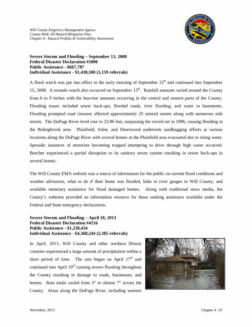
Will County Emgerncy Management Agency County-Wide All Hazard Mitigation Plan Chapter 4: Hazard Profiles & Vulnerability Assessment
November, 2013 Chapter 4 - 67
Severe Storms and Flooding – September 13, 2008 Federal Disaster Declaration #1800 Public Assistance - $667,787 Individual Assistance - $1,438,500 (1,159 referrals)
A flood watch was put into effect in the early morning of September 13th and continued into September
15, 2008. A tornado watch also occurred on September 13th
Individual Assistance - $4,368,244 (2,385 referrals)
. Rainfall amounts varied around the County
from 6 to 9 inches with the heaviest amounts occurring in the central and eastern parts of the County.
Flooding issues included sewer back-ups, flooded roads, river flooding, and water in basements.
Flooding prompted road closures affected approximately 25 arterial streets along with numerous side
streets. The DuPage River level rose to 23.86 feet, surpassing the record set in 1996, causing flooding in
the Bolingbrook area. Plainfield, Joliet, and Shorewood undertook sandbagging efforts at various
locations along the DuPage River with several homes in the Plainfield area evacuated due to rising water.
Sporadic instances of motorists becoming trapped attempting to drive through high water occurred.
Beecher experienced a partial disruption to its sanitary sewer system resulting in sewer back-ups in
several homes.
The Will County EMA website was a source of information for the public on current flood conditions and
weather advisories, what to do if their home was flooded, links to river gauges in Will County, and
available monetary assistance for flood damaged homes. Along with traditional news media, the
County’s websites provided an information resource for those seeking assistance available under the
Federal and State emergency declarations.
Severe Storms and Flooding – April 18, 2013 Federal Disaster Declaration #4116 Public Assistance - $1,238,434
In April, 2013, Will County and other northern Illinois
counties experienced a large amount of precipitation within a
short period of time. The rain began on April 17th and
continued into April 19th causing severe flooding throughout
the County resulting in damage to roads, businesses, and
homes. Rain totals varied from 3” to almost 7” across the
County. Areas along the DuPage River, including western
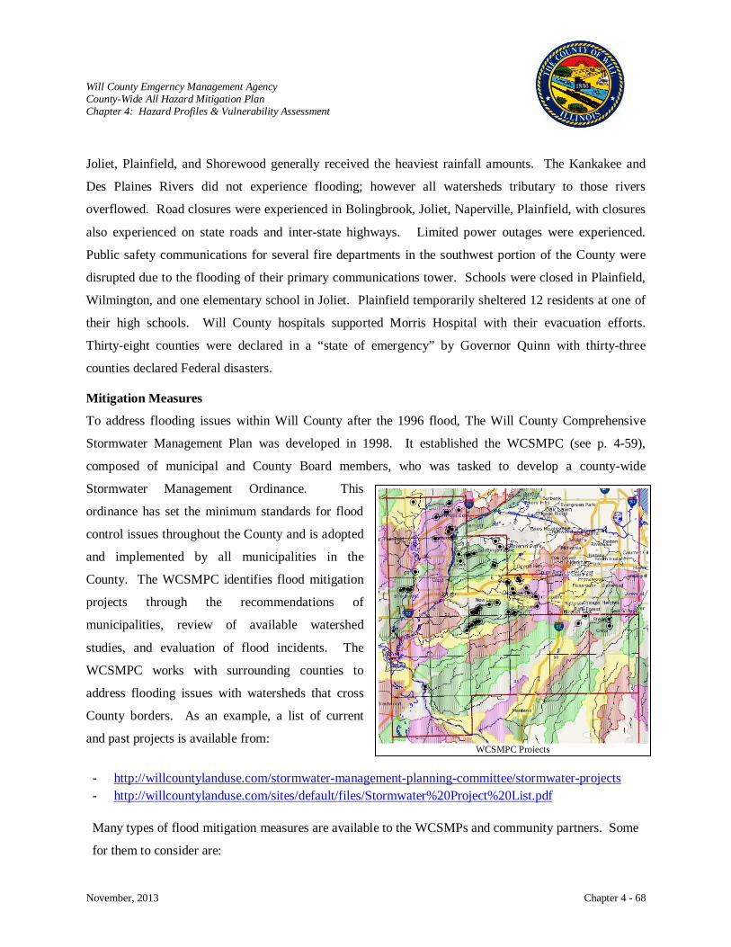
Will County Emgerncy Management Agency County-Wide All Hazard Mitigation Plan Chapter 4: Hazard Profiles & Vulnerability Assessment
November, 2013 Chapter 4 - 68
Joliet, Plainfield, and Shorewood generally received the heaviest rainfall amounts. The Kankakee and
Des Plaines Rivers did not experience flooding; however all watersheds tributary to those rivers
overflowed. Road closures were experienced in Bolingbrook, Joliet, Naperville, Plainfield, with closures
also experienced on state roads and inter-state highways. Limited power outages were experienced.
Public safety communications for several fire departments in the southwest portion of the County were
disrupted due to the flooding of their primary communications tower. Schools were closed in Plainfield,
Wilmington, and one elementary school in Joliet. Plainfield temporarily sheltered 12 residents at one of
their high schools. Will County hospitals supported Morris Hospital with their evacuation efforts.
Thirty-eight counties were declared in a “state of emergency” by Governor Quinn with thirty-three
counties declared Federal disasters.
Mitigation Measures
To address flooding issues within Will County after the 1996 flood, The Will County Comprehensive
Stormwater Management Plan was developed in 1998. It established the WCSMPC (see p. 4-59),
composed of municipal and County Board members, who was tasked to develop a county-wide
Stormwater Management Ordinance. This
ordinance has set the minimum standards for flood
control issues throughout the County and is adopted
and implemented by all municipalities in the
County. The WCSMPC identifies flood mitigation
projects through the recommendations of
municipalities, review of available watershed
studies, and evaluation of flood incidents. The
WCSMPC works with surrounding counties to
address flooding issues with watersheds that cross
County borders. As an example, a list of current
and past projects is available from:
- http://willcountylanduse.com/stormwater-management-planning-committee/stormwater-projects - http://willcountylanduse.com/sites/default/files/Stormwater%20Project%20List.pdf
Many types of flood mitigation measures are available to the WCSMPs and community partners. Some
for them to consider are:
WCSMPC Projects

Will County Emgerncy Management Agency County-Wide All Hazard Mitigation Plan Chapter 4: Hazard Profiles & Vulnerability Assessment
November, 2013 Chapter 4 - 69
Maintaining and implementing the Will County Stormwater Management Plan to indentify flooding issues and strategizing methods to address those issues will continue to reduce damages to infrastructure and buildings. Issues to be addressed in the County’s watersheds by the WCSMPC include surface flooding, stream maintenance, erosion/sedimentation control, water quality, watershed education, infrastructure maintenance, agency coordination, and property damage. The following chart identifies some of the watershed concerns and partner jurisdictions in addressing those concerns.
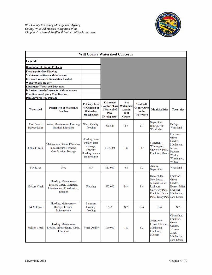
Will County Emgerncy Management Agency County-Wide All Hazard Mitigation Plan Chapter 4: Hazard Profiles & Vulnerability Assessment
November, 2013 Chapter 4 - 70
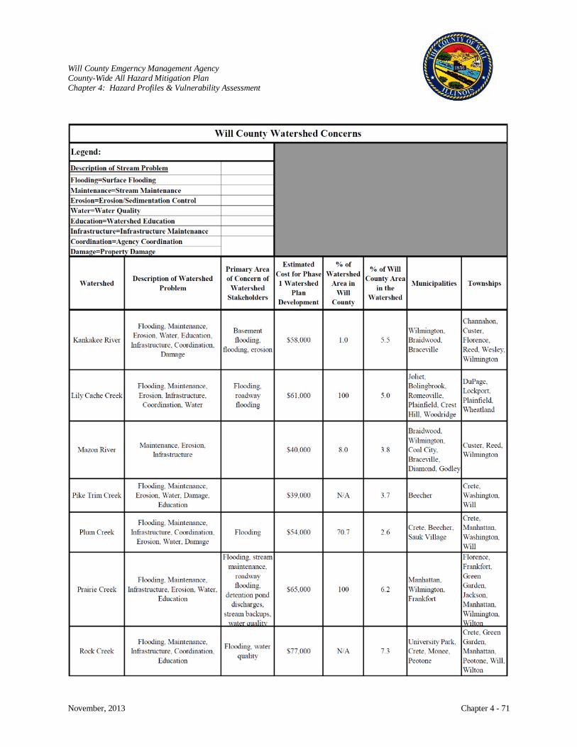
Will County Emgerncy Management Agency County-Wide All Hazard Mitigation Plan Chapter 4: Hazard Profiles & Vulnerability Assessment
November, 2013 Chapter 4 - 71
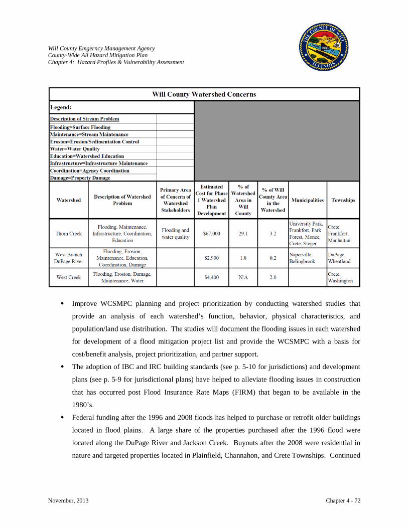
Will County Emgerncy Management Agency County-Wide All Hazard Mitigation Plan Chapter 4: Hazard Profiles & Vulnerability Assessment
November, 2013 Chapter 4 - 72
Improve WCSMPC planning and project prioritization by conducting watershed studies that
provide an analysis of each watershed’s function, behavior, physical characteristics, and
population/land use distribution. The studies will document the flooding issues in each watershed
for development of a flood mitigation project list and provide the WCSMPC with a basis for
cost/benefit analysis, project prioritization, and partner support.
The adoption of IBC and IRC building standards (see p. 5-10 for jurisdictions) and development
plans (see p. 5-9 for jurisdictional plans) have helped to alleviate flooding issues in construction
that has occurred post Flood Insurance Rate Maps (FIRM) that began to be available in the
1980’s.
Federal funding after the 1996 and 2008 floods has helped to purchase or retrofit older buildings
located in flood plains. A large share of the properties purchased after the 1996 flood were
located along the DuPage River and Jackson Creek. Buyouts after the 2008 were residential in
nature and targeted properties located in Plainfield, Channahon, and Crete Townships. Continued

Will County Emgerncy Management Agency County-Wide All Hazard Mitigation Plan Chapter 4: Hazard Profiles & Vulnerability Assessment
November, 2013 Chapter 4 - 73
buyouts of pre-FIRM structures in special flood hazard areas or retrofitting will help to alleviate
issues with repetitive loss properties.
Improved technology in monitoring rain and stream gauges allows the NWS and USGS to
develop better forecasting models and real-time data that will enable government agencies,
private institutions, and individuals to make more informed decisions about risk based policies
and actions to mitigate the dangers posed by floods. Additionally, improved forecasting and
real-time data combined with the latest in communications and alert systems will also mitigate the
dangers of floods and help to save lives. Will County Land Use Department and Emergency
Management Agency (EMA) continue to partner with the NWX, USGS, and other agencies to
improve forecasting, utilize advanced technology, implement mitigation measures, and maintain
planning to ensure the public’s safety.
Communities within Will County are part of the NFIP by meeting minimum standards. The
County and communities could improve flood plain management by committing to the NFIP’s
Community Rating System (CRS) which is a voluntary incentive program that recognizes and
encourages community floodplain management activities that exceed the minimum NFIP
requirements. Through this program, flood insurance premium rates would be discounted to
reflect the reduced flood risk resulting from meeting the three goals of the CRS: Reduce flood
damage to insurable property, strengthen and support the insurance aspects of the NFIP, and
encourage a comprehensive approach to floodplain management.
Utilize DFIRMS when completed to identify critical facilities located in high flood hazard areas
and with GIS to develop and maintain a county-wide database of flood controlled areas,
purchased flood plain properties, and flood prone properties to be acquired.
Another important mitigation measure is flood risk and mitigation techniques education. Federal
and state agencies provide a wealth of information on flood risks and dangers which can be
provided to the public in flood prone areas. Also, it is important to inform the public about the
availability of flood insurance. Other education outreach can inform the public about mitigation
techniques that they can implement at their homes or businesses. Educational material can be
provided to the public through expanding communication technology. Print material can be
distributed through traditional methods of brochures, news media, newsletters, or presentations at
community events. Websites and the growing social media are other educational avenues to
reach the public. Smartphone applications (apps) are another effective educational tool. County
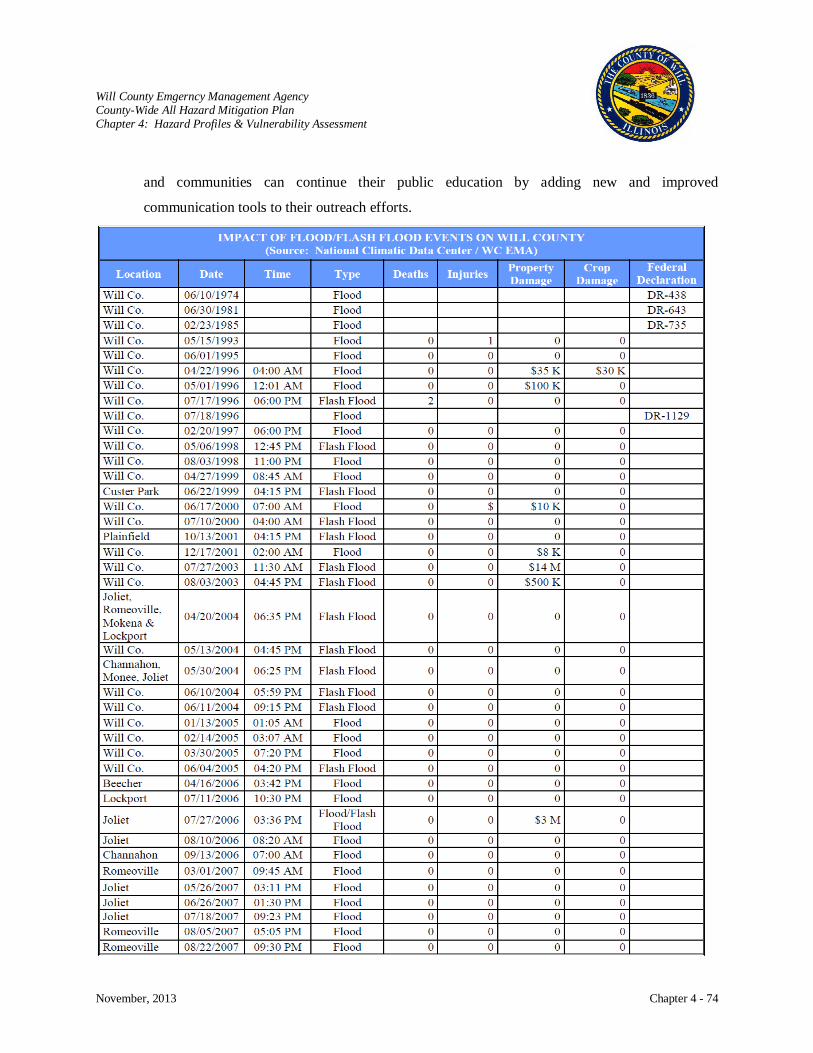
Will County Emgerncy Management Agency County-Wide All Hazard Mitigation Plan Chapter 4: Hazard Profiles & Vulnerability Assessment
November, 2013 Chapter 4 - 74
and communities can continue their public education by adding new and improved
communication tools to their outreach efforts.
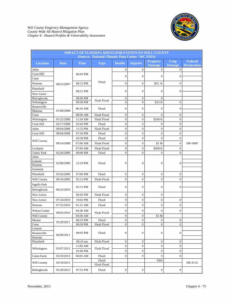
Will County Emgerncy Management Agency County-Wide All Hazard Mitigation Plan Chapter 4: Hazard Profiles & Vulnerability Assessment
November, 2013 Chapter 4 - 75
IMPACT OF FLOOD/FLASH FLOOD EVENTS ON WILL COUNTY (Source: National Climatic Data Center / WC EMA)
Location Date Time Type Deaths Injuries Property Damage
Crop Damage
Federal Declaration
Joliet
08/23/2007
06:05 PM
Flood
0 0 0 0 Crest Hill
0 0 0 0
Crete Peotone 08:12 PM 0 0 $25 K 0
Plainfield 08:21 PM 0 0 0 0
New Lenox Bolingbrook, 06:00 PM
Flash Flood 0 0 0
Wilmington 09:30 PM 0 0 $15 K 0 Romeoville
01/08/2008 06:10 AM Flood 0 0 0 0
Mokena Crete 08:00 AM Flash Flood 0 0 0 0 Wilmington 01/22/2008 11:34 AM Flash Flood 0 0 $100 K 0 Crest Hill 02/17/2008 03:45 PM Flood 0 0 0 0 Joliet 06/04/2008 11:33 PM Flash Flood 0 0 0 0 Crest Hill 08/04/2008 07:50 PM Flood 0 0 0 0
Will County 09/14/2008
03:30 PM Flood 0 0 0 0
DR-1800 07:00 AM Flash Flood 0 0 $1 M 0
Lockport 07:00 AM Flash Flood 0 0 $500 K 0 Tinley Park 02/26/2009 09:00 PM Flood 0 0 0 0 Joliet
03/08/2009 12:10 PM Flood 0 0 0 0
Lemont Peotone Fairmont Plainfield 05/26/2009 07:00 PM Flood 0 0 0 0
Will County 06/16/2009 05:15 PM Flash Flood 0 0 0 0
Ingalls Park
06/23/2010 05:15 PM Flood 0 0 0 0
Bolingbrook
New Lenox 06:45 PM Flash Flood 0 0 0
New Lenox 07/24/2010 10:02 PM Flood 0 0 0 0
Peotone 07/25/2010 01:15 AM Flood 0 0 0 0
Wilton Center 08/03/2010
04:30 AM Flash Flood
0 0 0 0
Will County 04:30 AM 0 0 $1 M Monee 05/28/2011 06:23 PM Flood 0 0 0 0 Crete 06:30 PM Flash Flood 0 0 0 0 Lemont
06/09/2011 08:05 PM Flood 0 0 0 0
Romeoville Peotone Plainfield 06:10 am Flash Flood 0 0 0 0
Wilmington 05/07/2012 11:00 AM
Flash Flood 0 0 0 0
01:00 PM 0 0 0 0
Caton Farm 03/10/2013 06:05 AM Flood 0 0 0 0
Will County 04/18/2013 Flood TBD
DR-4116 Flash Flood
Bolingbrook 05/28/2013 07:55 PM Flood 0 0 0 0
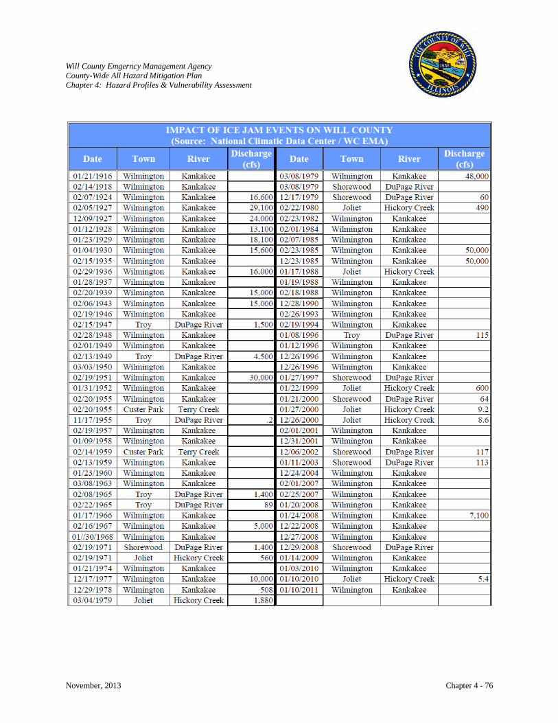
Will County Emgerncy Management Agency County-Wide All Hazard Mitigation Plan Chapter 4: Hazard Profiles & Vulnerability Assessment
November, 2013 Chapter 4 - 76
Will County Emgerncy Management Agency County-Wide All Hazard Mitigation Plan Chapter 4: Hazard Profiles & Vulnerability Assessment
November, 2013 Chapter 4 - 77
Risk Characterization
Flooding is generally part of a natural cycle that has many important and beneficial functions for the
environment. Flooding raises the water table in wetlands, maintains biodiversity, and replenishes
nutrients back into the soil. Additionally, higher water tables allow fish and water plants to re-colonize
and may also help to control some invasive species. Flooding, however, becomes a problem in the built
environment. Drainage systems and city sewers can become overwhelmed, causing raw sewage to back
up in basements and onto roadways. Flooding in urban areas can also cause increased runoff, which may
carry pollutants through storm sewers into rivers and lakes. Urban runoff can be toxic, as it may contain
garbage, fertilizers, oil and other residues from city streets.
Riverine flooding has caused displacement, property damage, and impacts on the health of residents.
Floods can damage or destroy public and private property, disable utilities, make roads and bridges
impassable, destroy crops and agricultural lands, cause disruption to emergency services, and result in
fatalities. People may be stranded in their homes for several days without power or heat, or they may be
unable to reach their homes at all. Long-term collateral dangers include the outbreak of disease,
widespread animal death, broken sewer lines causing water supply pollution, downed power lines, broken
gas lines, fires, and the release of hazardous materials.
Flooding is a hazard whose risks are routinely underestimated by the public, who may be inclined to
attempt to walk or drive through shallow waters, or to allow their children and pets to play in the water as
if it were part of a beach or swimming pool. Public education is vital so that there is widespread
knowledge of the contaminants and germs that floodwaters contain, and a greater awareness of the risks
that floodwaters pose to drivers and pedestrians.
Drivers need to know that roads and bridges are often weakened and degraded by flood impacts, and that
the road they assume is still there under shallow waters may no longer be intact. Floodwaters tend to
conceal the presence of open manholes, dangerous debris (such as rusty nails and metal), and live
electrical wires that can cause harmful shocks. Less than a foot of flowing water can cause vehicles to
end up in a ditch or sinkhole, where persons may find it impossible to escape from a submerged vehicle
under the pressures exerted by flowing water. Those who are tempted to walk through floodwaters
should be informed that the waters tend to conceal the presence of open manholes and dangerous debris,
such as rusty nails and metal, or live electrical wires that can cause harmful shocks.
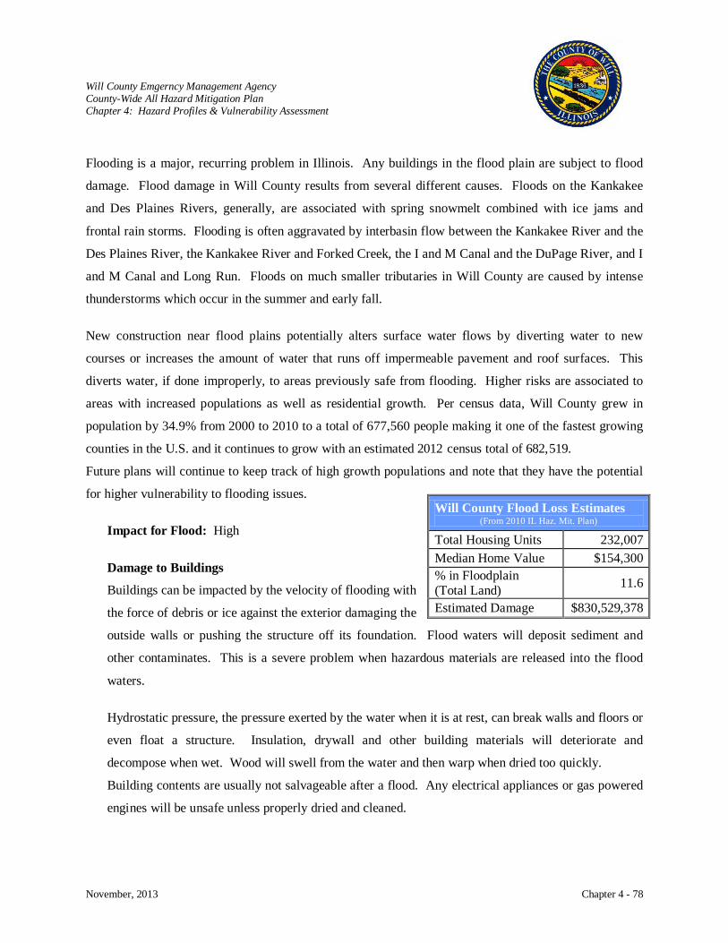
Will County Emgerncy Management Agency County-Wide All Hazard Mitigation Plan Chapter 4: Hazard Profiles & Vulnerability Assessment
November, 2013 Chapter 4 - 78
Flooding is a major, recurring problem in Illinois. Any buildings in the flood plain are subject to flood
damage. Flood damage in Will County results from several different causes. Floods on the Kankakee
and Des Plaines Rivers, generally, are associated with spring snowmelt combined with ice jams and
frontal rain storms. Flooding is often aggravated by interbasin flow between the Kankakee River and the
Des Plaines River, the Kankakee River and Forked Creek, the I and M Canal and the DuPage River, and I
and M Canal and Long Run. Floods on much smaller tributaries in Will County are caused by intense
thunderstorms which occur in the summer and early fall.
New construction near flood plains potentially alters surface water flows by diverting water to new
courses or increases the amount of water that runs off impermeable pavement and roof surfaces. This
diverts water, if done improperly, to areas previously safe from flooding. Higher risks are associated to
areas with increased populations as well as residential growth. Per census data, Will County grew in
population by 34.9% from 2000 to 2010 to a total of 677,560 people making it one of the fastest growing
counties in the U.S. and it continues to grow with an estimated 2012 census total of 682,519.
Future plans will continue to keep track of high growth populations and note that they have the potential
for higher vulnerability to flooding issues.
Impact for Flood: High
Damage to Buildings
Buildings can be impacted by the velocity of flooding with
the force of debris or ice against the exterior damaging the
outside walls or pushing the structure off its foundation. Flood waters will deposit sediment and
other contaminates. This is a severe problem when hazardous materials are released into the flood
waters.
Hydrostatic pressure, the pressure exerted by the water when it is at rest, can break walls and floors or
even float a structure. Insulation, drywall and other building materials will deteriorate and
decompose when wet. Wood will swell from the water and then warp when dried too quickly.
Building contents are usually not salvageable after a flood. Any electrical appliances or gas powered
engines will be unsafe unless properly dried and cleaned.
Will County Flood Loss Estimates (From 2010 IL Haz. Mit. Plan)
Total Housing Units 232,007 Median Home Value $154,300 % in Floodplain (Total Land) 11.6
Estimated Damage $830,529,378
Will County Emgerncy Management Agency County-Wide All Hazard Mitigation Plan Chapter 4: Hazard Profiles & Vulnerability Assessment
November, 2013 Chapter 4 - 79
Again, wood will warp and split. Upholstered furniture, carpeting, mattresses, and household goods
cannot be dried out to useable condition. Dampness, unless mitigated within 24 to 48 hours, will then
encourage the growth of mold. Mold spores can germinate and grow in a moist or damp
environment, on any surface that contains organic matter. A home that’s been flooded can provide
ideal conditions for the growth and proliferation of mold. Indoor mold can trigger allergies or
allergy-like symptoms affecting the upper respiratory system.
Critical Facilities
For some activities and facilities, even a slight chance of flooding is too great a threat. Typical critical
facilities include hospitals, fire stations, police stations, storage of critical records, and similar
facilities. These facilities should be given special consideration when formulating regulatory
alternatives and floodplain management plans. A critical facility should not be located in a floodplain
if at all possible. If a critical facility must be located in a floodplain, it should be provided a higher
level of protection so that it can continue to function and provide services after the flood.
Communities should develop emergency plans to continue to provide these services during the flood.
Under Executive Order 11988, Floodplain Management, Federal agencies funding and/or permitting
critical facilities are required to avoid the 0.2% (500-year) floodplain or protect the facilities to the
0.2% chance flood level.
Damage to critical facilities can add to the widespread damage experienced by floods by reducing
services they provide to the public. Damage to utilities or pipelines can cause outages. Flooded
water or wastewater treatment plants can create serious health hazards. Transportation and
communication systems can be limited or shut down. Fires are damaging when areas are inaccessible
to fire equipment.
Health and Safety
It is imperative that people heed warnings during floods. A car will float in less than two feet of
moving water sweeping it into deeper waters. Most deaths during floods are a result of people
trapped in their vehicles. It is important that people heed travel warnings as road conditions can be
easily misjudged. Water on roads can be much deeper than it appears or sections of road or small
bridges can be washed out and the damage not visible.

Will County Emgerncy Management Agency County-Wide All Hazard Mitigation Plan Chapter 4: Hazard Profiles & Vulnerability Assessment
November, 2013 Chapter 4 - 80
Health is affected when drinking water is contaminated with dirt, oil, chemicals, or other debris found
in the stormwater runoff. It is important that private wells in flooded areas be tested for
contamination and contaminated wells disinfected before resuming well use. As flood waters recede,
pools of standing water become a breeding ground for mosquitoes. Wet farm fields negatively impact
the planting and harvest seasons and can damage farm equipment. Damp areas of buildings not
properly disinfected begin to grow mold or mildew. People may experience heart attacks from
overexertion or stress. Deaths also occur from electrocution when electrical mechanisms short out
and create live current.
Floods also have a psychological impact on the people who have lost their home or keepsakes. For
those located in floodplain areas, knowledge that their homes could be flooded again causes
additional psychological strain.
Economic Impact
Flood has an economic impact on all residents of the County. Public expenditures are expended on
flood fighting, sandbags, fire department calls, road closures and repairs, clean-up, and repairs to
damaged public property. The public is further impacted when the underfunded NFIP makes payouts
for flood claims. The NFIP is meant to be self-supporting, though in 2003 the Government
Accountability Office (GAO) found that repetitive-loss properties cost the taxpayer about $200
million annually. To cover these costs, the NFIP borrows from the U.S. Treasury when losses are
heavy, and these loans are paid back with interest. After 45 years, flood risks continue and the costs
and consequences of flooding are increasing dramatically. As previously discussed, the Biggert-
Waters Flood Insurance Reform Act of 2012 (BW-12) was passed to make the NFIP more sustainable
and financially sound.
Business losses also occur due to flood damage to the facility structures and inventory. Customers
may not be able to reach businesses located in the flood area or raw materials or goods cannot be
transported in or out. Additionally, businesses can be impacted by employees who must clean-up
their flood damaged homes. Repeated flooding in an area can cause declining property values. In
rural areas, flooded fields can mean the loss of the season’s crops or food source for livestock.
Will County Emgerncy Management Agency County-Wide All Hazard Mitigation Plan Chapter 4: Hazard Profiles & Vulnerability Assessment
November, 2013 Chapter 4 - 81
Future Occurrence
Though flooding can never be eliminated, measures can be taken to lessen the impact of flooding.
Among the more notable flood protection measures is the WCSMPC. It is responsible for directing
the implementation of Comprehensive Stormwater Management Plan and provides the Will County
Stormwater Technical Guidance Manual to developers, applicants, and administrators to assist them
in complying with the Stormwater Management Ordinance and the technical requirements of a
stormwater permit application.
The primary purpose of the WCSMPC is to provide county-wide coordination of stormwater
management in Will County, to ensure consistent levels of flood mitigation, and to prevent
stormwater related problems throughout the County's watersheds. This provides for a consolidated
county-wide framework.
The goals for the Will County Stormwater Program are as follows:
1. Consolidate and coordinate existing stormwater management programs and activities into an
effective, unified county-wide structure.
2. Prevent increases in stormwater related problems associated with development,
redevelopment and other watershed activities.
3. Remediate existing problems related to improper management of stormwater runoff and
encroachment into floodprone areas.
4. Ensure maintenance, management, and sustainable operation of natural and manmade
stormwater drainage and storage features.
A result of their work is the comprehensive county-wide stormwater ordinance that applies to both
incorporated and unincorporated areas. It minimizes any increases in stormwater-related problems
and specifies standards for stormwater drainage and detention, floodplain management, soil erosion
and sediment control, and stream and wetland protection in a single document. To ensure consistency
among watershed plans, the committee coordinates watershed projects within the County and with
neighboring counties where watersheds cross County borders. Since 2009, sixty stormwater projects
have been established by the committee.
- See: http://willcountylanduse.com/sites/default/files/Stormwater%20Project%20List.pdf
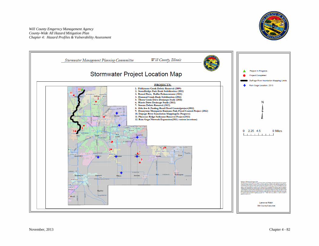
Will County Emgerncy Management Agency County-Wide All Hazard Mitigation Plan Chapter 4: Hazard Profiles & Vulnerability Assessment
November, 2013 Chapter 4 - 82
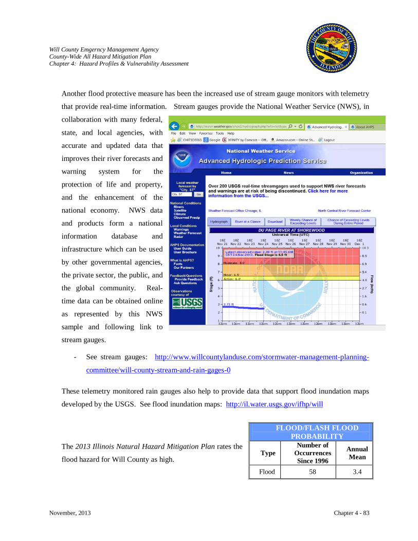
Will County Emgerncy Management Agency County-Wide All Hazard Mitigation Plan Chapter 4: Hazard Profiles & Vulnerability Assessment
November, 2013 Chapter 4 - 83
Another flood protective measure has been the increased use of stream gauge monitors with telemetry
that provide real-time information. Stream gauges provide the National Weather Service (NWS), in
collaboration with many federal,
state, and local agencies, with
accurate and updated data that
improves their river forecasts and
warning system for the
protection of life and property,
and the enhancement of the
national economy. NWS data
and products form a national
information database and
infrastructure which can be used
by other governmental agencies,
the private sector, the public, and
the global community. Real-
time data can be obtained online
as represented by this NWS
sample and following link to
stream gauges.
- See stream gauges: http://www.willcountylanduse.com/stormwater-management-planning-
committee/will-county-stream-and-rain-gages-0
These telemetry monitored rain gauges also help to provide data that support flood inundation maps
developed by the USGS. See flood inundation maps: http://il.water.usgs.gov/ifhp/will
The 2013 Illinois Natural Hazard Mitigation Plan rates the
flood hazard for Will County as high.
FLOOD/FLASH FLOOD PROBABILITY
Type Number of
Occurrences Since 1996
Annual Mean
Flood 58 3.4
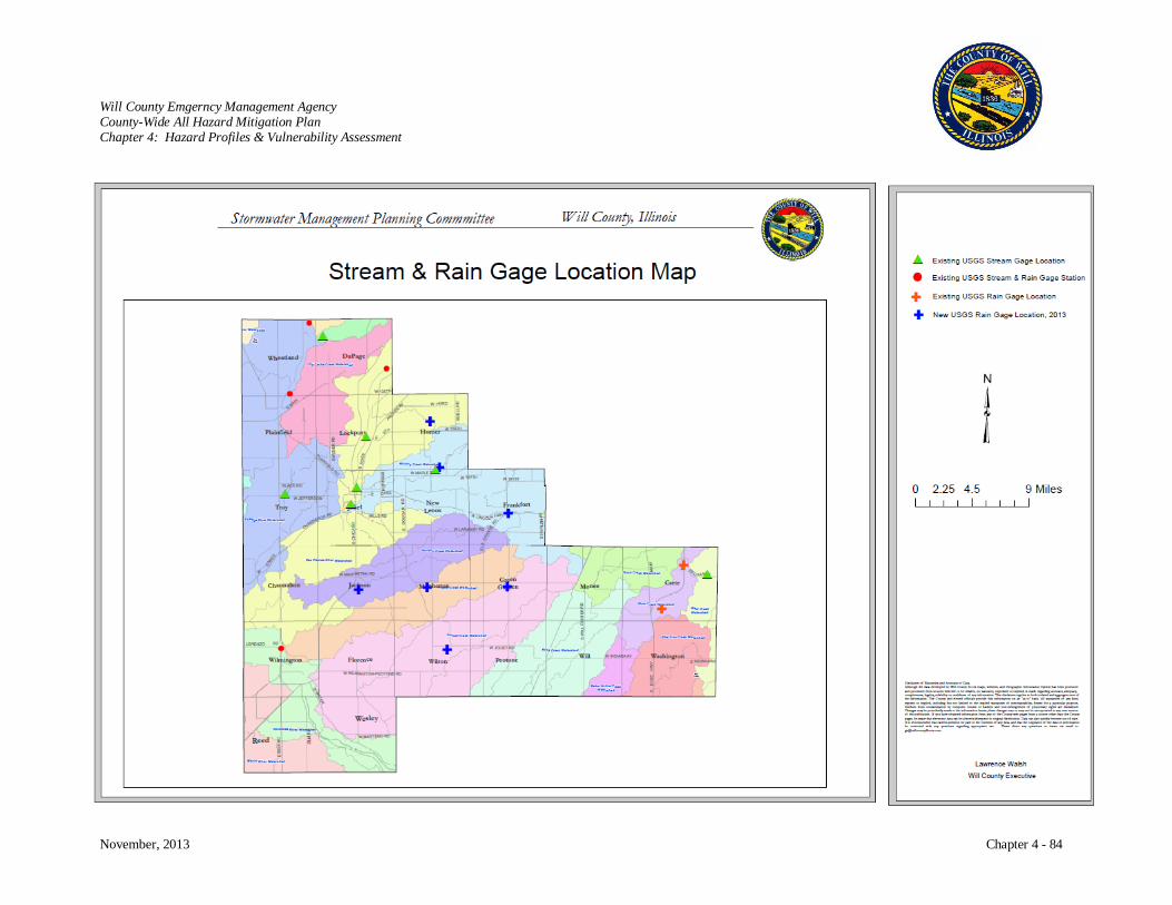
Will County Emgerncy Management Agency County-Wide All Hazard Mitigation Plan Chapter 4: Hazard Profiles & Vulnerability Assessment
November, 2013 Chapter 4 - 84
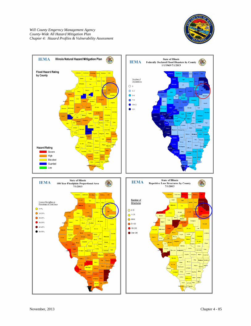
Will County Emgerncy Management Agency County-Wide All Hazard Mitigation Plan Chapter 4: Hazard Profiles & Vulnerability Assessment
November, 2013 Chapter 4 - 85

Will County Emgerncy Management Agency County-Wide All Hazard Mitigation Plan Chapter 4: Hazard Profiles & Vulnerability Assessment
November, 2013 Chapter 4 - 86
EARTHQUAKE
Hazard Characterization
The earth’s crust is far from being a motionless mass, but rather, it is in a constant state of flux. A sudden
motion of the ground that causes surface faulting or ground rupture, ground shaking, and ground failure is
the result of an earthquake. The onset of a large earthquake is initially signaled by a deep rumbling or by
disturbed air making a rushing sound. This is shortly followed by a series of violent ground movements.
The ground often splits and there can be large, permanent displacements of the earth. Buildings, bridges,
dams, tunnels, and other rigid structures are damaged or collapse when subjected to this stress.
In addition to structural problems, water in tanks, ponds, and rivers are frequently displaced. In lakes, an
oscillation known as “seiching” occurs in which the water surges from one end of the lake to the other,
causing the water to reach great heights and eventually the lake overflows its banks. Secondary effects
are dam failures, fires, floods, and subsidence. Earthquakes can trigger other types of ground failures
which could contribute to the damage, such as landslides and liquefaction. In the latter situation, shaking
can mix groundwater and soil, liquefying and weakening the ground that supports buildings and severing
utility lines. This is a special problem in floodplains where the water table is relatively high and the soils
are more susceptible to liquefaction.
There are thousands of earthquakes in the U.S. each
year, but most are so small in magnitude that they are
unable to be felt. Historically, the most violent
earthquakes have occurred in the central U.S. The old
flat-lying, intact bedrock of the central United States
behaves as a good “transmitter” of the earthquake’s
energy, and tremors can be felt hundreds of miles
away. By contrast, the young, broken up bedrock of
the West Coast allows the energy to dissipate quickly,
which keeps the effects of the earthquake more
localized.
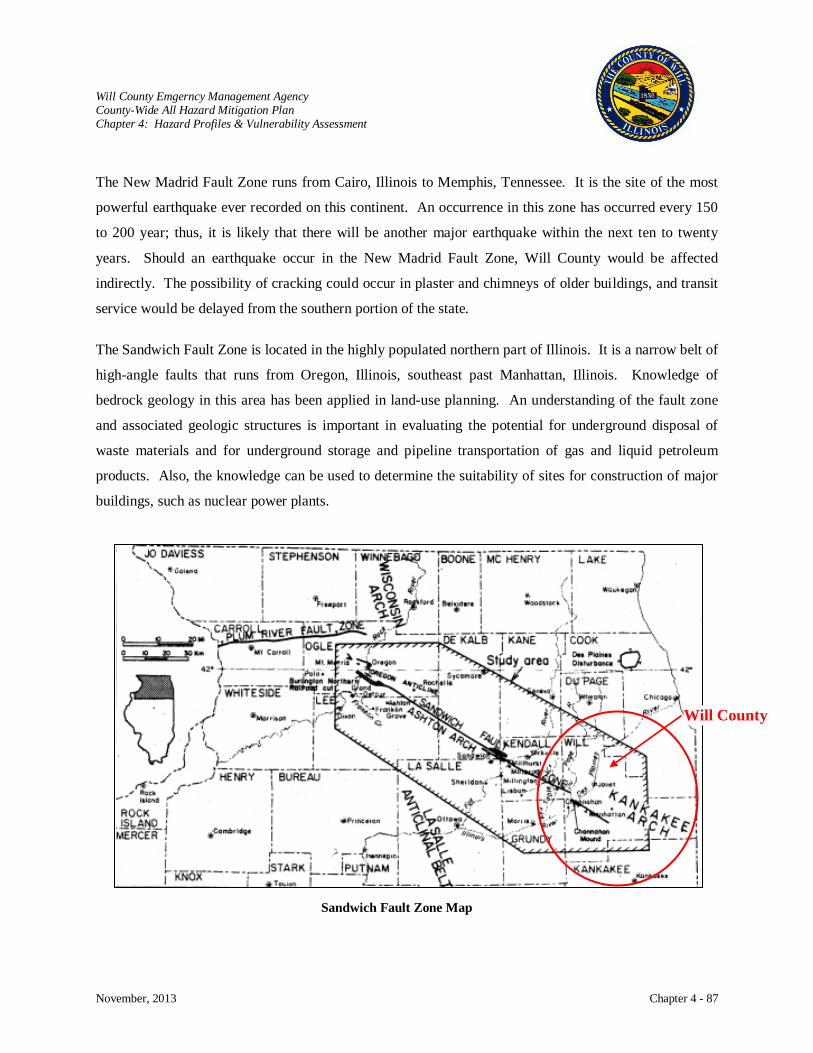
Will County Emgerncy Management Agency County-Wide All Hazard Mitigation Plan Chapter 4: Hazard Profiles & Vulnerability Assessment
November, 2013 Chapter 4 - 87
Will County
The New Madrid Fault Zone runs from Cairo, Illinois to Memphis, Tennessee. It is the site of the most
powerful earthquake ever recorded on this continent. An occurrence in this zone has occurred every 150
to 200 year; thus, it is likely that there will be another major earthquake within the next ten to twenty
years. Should an earthquake occur in the New Madrid Fault Zone, Will County would be affected
indirectly. The possibility of cracking could occur in plaster and chimneys of older buildings, and transit
service would be delayed from the southern portion of the state.
The Sandwich Fault Zone is located in the highly populated northern part of Illinois. It is a narrow belt of
high-angle faults that runs from Oregon, Illinois, southeast past Manhattan, Illinois. Knowledge of
bedrock geology in this area has been applied in land-use planning. An understanding of the fault zone
and associated geologic structures is important in evaluating the potential for underground disposal of
waste materials and for underground storage and pipeline transportation of gas and liquid petroleum
products. Also, the knowledge can be used to determine the suitability of sites for construction of major
buildings, such as nuclear power plants.
Sandwich Fault Zone Map
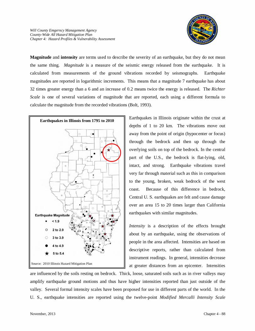
Will County Emgerncy Management Agency County-Wide All Hazard Mitigation Plan Chapter 4: Hazard Profiles & Vulnerability Assessment
November, 2013 Chapter 4 - 88
Magnitude and intensity are terms used to describe the severity of an earthquake, but they do not mean
the same thing. Magnitude is a measure of the seismic energy released from the earthquake. It is
calculated from measurements of the ground vibrations recorded by seismographs. Earthquake
magnitudes are reported in logarithmic increments. This means that a magnitude 7 earthquake has about
32 times greater energy than a 6 and an increase of 0.2 means twice the energy is released. The Richter
Scale is one of several variations of magnitude that are reported, each using a different formula to
calculate the magnitude from the recorded vibrations (Bolt, 1993).
Earthquakes in Illinois originate within the crust at
depths of 1 to 20 km. The vibrations move out
away from the point of origin (hypocenter or focus)
through the bedrock and then up through the
overlying soils on top of the bedrock. In the central
part of the U.S., the bedrock is flat-lying, old,
intact, and strong. Earthquake vibrations travel
very far through material such as this in comparison
to the young, broken, weak bedrock of the west
coast. Because of this difference in bedrock,
Central U. S. earthquakes are felt and cause damage
over an area 15 to 20 times larger than California
earthquakes with similar magnitudes.
Intensity is a description of the effects brought
about by an earthquake, using the observations of
people in the area affected. Intensities are based on
descriptive reports, rather than calculated from
instrument readings. In general, intensities decrease
at greater distances from an epicenter. Intensities
are influenced by the soils resting on bedrock. Thick, loose, saturated soils such as in river valleys may
amplify earthquake ground motions and thus have higher intensities reported than just outside of the
valley. Several formal intensity scales have been proposed for use in different parts of the world. In the
U. S., earthquake intensities are reported using the twelve-point Modified Mercalli Intensity Scale
Earthquakes in Illinois from 1795 to 2010
Source: 2010 Illinois Hazard Mitigation Plan

Will County Emgerncy Management Agency County-Wide All Hazard Mitigation Plan Chapter 4: Hazard Profiles & Vulnerability Assessment
November, 2013 Chapter 4 - 89
increasing from barely detectable to catastrophic. For any earthquake, there will be multiple intensities,
depending on the location of observers - but only one magnitude.
History
In the United States, the most frequent reports of earthquakes come from the West coast, but the largest
earthquakes in the lower 48 states occurred in Missouri in 1811 and 1812 along the New Madrid Faults.
The Great New Madrid Earthquakes are the benchmarks from which all earthquakes in the Midwest are
measured. An important fact is that the earthquakes of 1811 and 1812 were not single events. Rather the
earthquakes were a series of over 2,000 shocks in five months.
Six of these quakes were larger than a magnitude of 7 on the Richter Scale and two were near magnitude
8. They totally destroyed the town of New Madrid and caused the land to roll in visible waves. They
raised and sank the land as much as 20 feet. The tremors of these earthquakes were no doubt felt
throughout all of Illinois, since the quakes are said
to have rung church bells in New England.
Northern Illinois: Fire at Aurora - One of the
largest earthquakes in Illinois occurred in northern
Illinois on May 26, 1909. The exact location of the
magnitude 5.1 (estimated) earthquake is not known,
but the largest intensities occurred in and near
Aurora where many chimneys fell, a stove
overturned, gas lines broke, and a fire started.
Although considerable excitement ensued, the
Aurora fire was quickly extinguished and soon
forgotten. It was felt over 500,000 square miles,
buildings swayed in Chicago where there was fear that the walls would collapse, houses were jostled out
of plumb in Beloit, Wisconsin, and brick walls cracked as far away as Bloomington.
A somewhat smaller earthquake occurred nearby in 1912. A magnitude 4.0 earthquake centered in north-
central Illinois south of Rockford, near the village of Amboy, woke many Chicago area residents when it
Northern Illinois Earthquakes
Source: 2010 Illinois Hazard Mitigation Plan
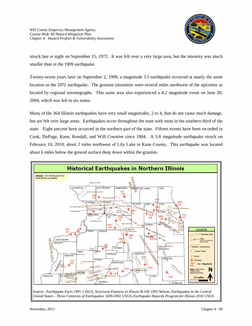
Will County Emgerncy Management Agency County-Wide All Hazard Mitigation Plan Chapter 4: Hazard Profiles & Vulnerability Assessment
November, 2013 Chapter 4 - 90
struck late at night on September 15, 1972. It was felt over a very large area, but the intensity was much
smaller than in the 1909 earthquake.
Twenty-seven years later on September 2, 1999, a magnitude 3.5 earthquake occurred at nearly the same
location as the 1972 earthquake. The greatest intensities were several miles northwest of the epicenter as
located by regional seismographs. This same area also experienced a 4.2 magnitude event on June 28,
2004, which was felt in six states.
Many of the 364 Illinois earthquakes have very small magnitudes, 2 to 4, that do not cause much damage,
but are felt over large areas. Earthquakes occur throughout the state with most in the southern third of the
state. Eight percent have occurred in the northern part of the state. Fifteen events have been recorded in
Cook, DuPage, Kane, Kendall, and Will Counties since 1804. A 3.8 magnitude earthquake struck on
February 10, 2010, about 2 miles northwest of Lily Lake in Kane County. This earthquake was located
about 6 miles below the ground surface deep down within the granites.
Source: Earthquake Facts 1991-1 ISGS, Structural Features in Illinois B-100 1995 Nelson, Earthquakes in the Central United States – Three Centuries of Earthquakes 1699-2002 USGS, Earthquake Hazards Program for Illinois 2010 USGS
Will County Emgerncy Management Agency County-Wide All Hazard Mitigation Plan Chapter 4: Hazard Profiles & Vulnerability Assessment
November, 2013 Chapter 4 - 91
Risk Characterization
Although there have been over 560 earthquakes in Illinois during the last two centuries, only very few of
them have caused any damage (Modified Mercalli Intensity of VI or higher) or injuries. Larger
earthquakes in the New Madrid region have caused more damage in Illinois. The risk of probable damage
from future earthquakes can be estimated based on the historical record of past earthquakes. The USGS
have created maps for building codes in areas of the largest probable ground shaking that have a low
probability of being exceeded over a 50 year period. They have plotted information as numerical values
of ground shaking, or accelerations. These values can be converted to Modified Mercalli Intensities.
These USGS maps only show the estimate of shaking on the top of bedrock. Shaking will be modified by
the overlying soils.
For most of Illinois, the risk is dominated by the possibility of large earthquakes recurring in the New
Madrid Seismic Zone, south of Illinois. In this scenario, the maximum accelerations in the southern-most
counties of Illinois exceed 60 percent of gravity, or Modified Mercalli Intensity X. Although the risk
decreases to the north, there is a 2 % probability during the next 50 years that accelerations greater than
10 percent of gravity, Modified Mercalli Intensity VII, could be exceeded in any of the southern half of
Illinois. Because of the current record of minor to moderate earthquakes in northern Illinois, occurring
west of Chicago, the risk of damaging earthquake motions increases in the western suburbs of Chicago.
But if magnitude 4 to 5 earthquakes occur near or South of Chicago, as early events have been located,
damage could occur to weak, old structures throughout parts of the city.
Earthquakes create numerous risks in people’s homes. People can lessen the severity of earthquake
damage by identifying hazards that exist in their homes, schools, or places of business and then
systematically removing or correcting each hazard. This is especially important in the southernmost
counties of Illinois where the earthquake risks are the greatest. Some common hazards include: free
standing water heaters, stoves, and other gas or electric appliances which could move or fall during an
earthquake; bookshelves or filing cabinets which are free standing or bookshelves with objects stored
above head level; water or gas pipes which are not fastened well to walls or ceiling, and large panes of
glass which could fracture and fly apart.
Some other things that people can do to make their homes more earthquake ready include: keeping a few
days supply of food and water available; being sure each home has a fire extinguisher and smoke alarm;
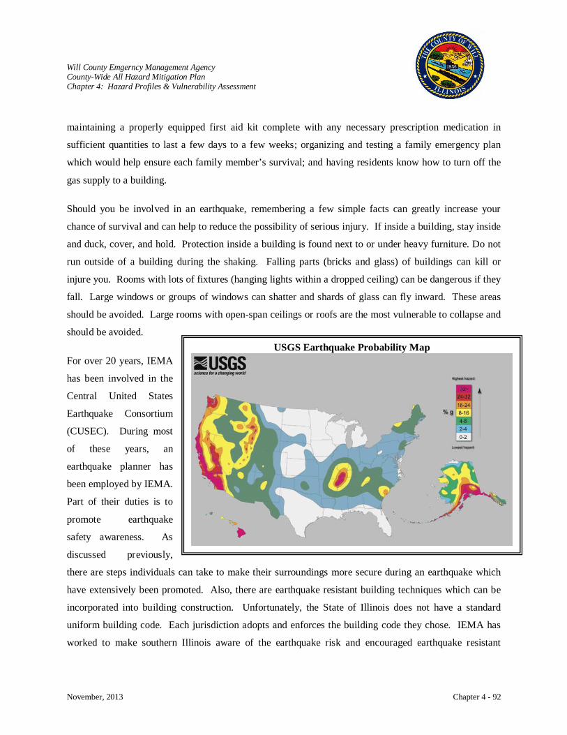
Will County Emgerncy Management Agency County-Wide All Hazard Mitigation Plan Chapter 4: Hazard Profiles & Vulnerability Assessment
November, 2013 Chapter 4 - 92
maintaining a properly equipped first aid kit complete with any necessary prescription medication in
sufficient quantities to last a few days to a few weeks; organizing and testing a family emergency plan
which would help ensure each family member’s survival; and having residents know how to turn off the
gas supply to a building.
Should you be involved in an earthquake, remembering a few simple facts can greatly increase your
chance of survival and can help to reduce the possibility of serious injury. If inside a building, stay inside
and duck, cover, and hold. Protection inside a building is found next to or under heavy furniture. Do not
run outside of a building during the shaking. Falling parts (bricks and glass) of buildings can kill or
injure you. Rooms with lots of fixtures (hanging lights within a dropped ceiling) can be dangerous if they
fall. Large windows or groups of windows can shatter and shards of glass can fly inward. These areas
should be avoided. Large rooms with open-span ceilings or roofs are the most vulnerable to collapse and
should be avoided.
For over 20 years, IEMA
has been involved in the
Central United States
Earthquake Consortium
(CUSEC). During most
of these years, an
earthquake planner has
been employed by IEMA.
Part of their duties is to
promote earthquake
safety awareness. As
discussed previously,
there are steps individuals can take to make their surroundings more secure during an earthquake which
have extensively been promoted. Also, there are earthquake resistant building techniques which can be
incorporated into building construction. Unfortunately, the State of Illinois does not have a standard
uniform building code. Each jurisdiction adopts and enforces the building code they chose. IEMA has
worked to make southern Illinois aware of the earthquake risk and encouraged earthquake resistant
USGS Earthquake Probability Map

Will County Emgerncy Management Agency County-Wide All Hazard Mitigation Plan Chapter 4: Hazard Profiles & Vulnerability Assessment
November, 2013 Chapter 4 - 93
Typical minor damage (Modified Mercalli Intensity VI to VII) from Lawrenceville, Illinois M 5.0 earthquake. Bricks thrown from Chimney and diagonal masonry cracks in church tower.
construction in new buildings. All new schools built with State funds must comply with the 2007
International Building Code.
Damage to Buildings
Damage to buildings, highways, power lines, pipelines and other structures only partly depend on the
amount of energy released during the earthquake. Certain kinds of earth materials resting on the
bedrock amplify the earthquake ground motions. In Illinois, structures built on thick, loose sediments
of river flood plains are more likely to be damaged than structures on glacial till (stiff, pebbly clay) or
bedrock. In fact, seismic intensity may increase one or more units on the Modified Mercalli Intensity
Scale, if loose sediments are present. Also, loose sandy sediments with high moisture content can
turn to liquid, quick sand type state - (liquefaction), when shaken enough.
Generally, wood frame buildings and structures on solid ground fare best during an earthquake.
Wood frame buildings are flexible enough to withstand ground shaking and swaying. Evaluations of
recent earthquakes found that damage was primarily caused to:
Un-reinforced masonry structures
Older buildings with some degree of deterioration
Buildings without foundation ties
Multi-story structures with open or “soft” first floors
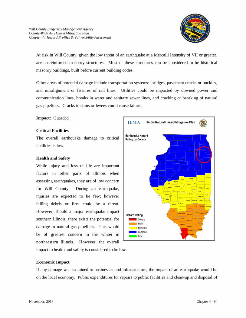
Will County Emgerncy Management Agency County-Wide All Hazard Mitigation Plan Chapter 4: Hazard Profiles & Vulnerability Assessment
November, 2013 Chapter 4 - 94
At risk in Will County, given the low threat of an earthquake at a Mercalli Intensity of VII or greater,
are un-reinforced masonry structures. Most of these structures can be considered to be historical
masonry buildings, built before current building codes.
Other areas of potential damage include transportation systems: bridges, pavement cracks or buckles,
and misalignment or fissures of rail lines. Utilities could be impacted by downed power and
communication lines, breaks in water and sanitary sewer lines, and cracking or breaking of natural
gas pipelines. Cracks in dams or levees could cause failure.
Impact: Guarded
Critical Facilities
The overall earthquake damage to critical
facilities is low.
Health and Safety
While injury and loss of life are important
factors in other parts of Illinois when
assessing earthquakes, they are of low concern
for Will County. During an earthquake,
injuries are expected to be few; however
falling debris or fires could be a threat.
However, should a major earthquake impact
southern Illinois, there exists the potential for
damage to natural gas pipelines. This would
be of greatest concern in the winter in
northeastern Illinois. However, the overall
impact to health and safely is considered to be low.
Economic Impact
If any damage was sustained to businesses and infrastructure, the impact of an earthquake would be
on the local economy. Public expenditures for repairs to public facilities and clean-up and disposal of
Will County Emgerncy Management Agency County-Wide All Hazard Mitigation Plan Chapter 4: Hazard Profiles & Vulnerability Assessment
November, 2013 Chapter 4 - 95
debris can be high, especially if the structures are not insured for earthquakes. The overall expected
economic impact is considered to be low.
Future Occurrence
The 2013 Illinois Natural Hazard Mitigation Plan rates the earthquake hazard for Will County as
guarded.
STATE-WIDE ESTIMATE WITH DEFAULT DATA
The Federal Emergency Management Agency sponsored HAZUS (Hazards US) computer loss
estimation program comes with default data of building and some infrastructure inventory from
various sources including the 2000 census. It uses one type of soil for the entire area. Soils
modify the earthquake ground motions that travel through the bedrock and typically amplify the
ground motions, increasing shaking at the ground surface as compared to the shaking on the
bedrock. The default building inventory contains numbers of structures by construction type per
census track and replacement costs for structures are based on an average cost per square foot for
2002. It contains an inventory of essential facilities such as: hospitals, medical clinics, schools,
fire stations, police stations and emergency operations facilities and high potential loss facilities
such as: dams, levees, military installations, nuclear power plants and hazardous material sites.
State-Wide Damage for Magnitude 6.3 New Madrid Event
HAZUS estimates that 4,453 buildings will sustain at least moderate damage and of those 1,689
will be completely damaged. No essential facilities are expected to be completely damaged and a
large percentage will be functional on the day of the event. It is estimated 6,321 households will
be without potable water and 3,964 without electricity on the day of the event. Eight of the
22,854 bridges in Illinois are expected to be completely damaged along with two ferry facilities.
Debris generated is estimated to be 219,000 tons. Displaced households are 1,882 with 556
requiring shelter. There are 540 casualties and a total direct economic impact of about $920
million.
State-Wide Damage for Magnitude 7.7 New Madrid Event
HAZUS estimates that 75,272 buildings will sustain at least moderate damage and of those
19,044 will be completely damaged. Forty-two essential facilities are expected to be completely
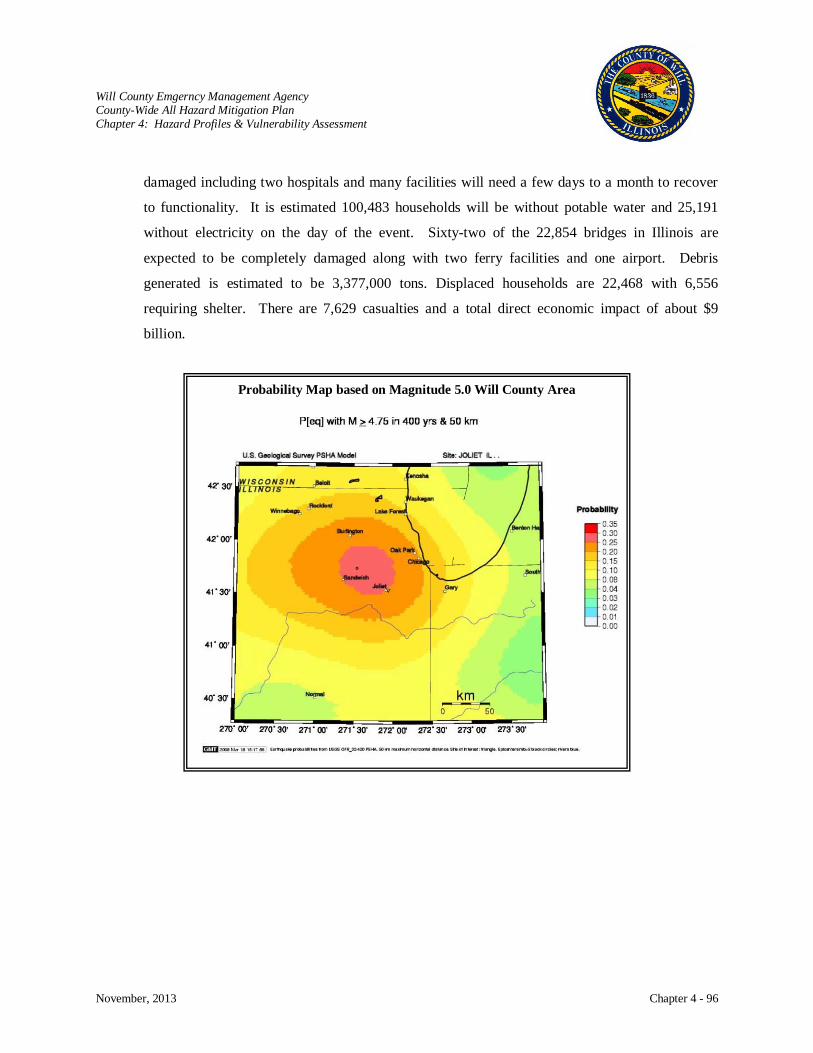
Will County Emgerncy Management Agency County-Wide All Hazard Mitigation Plan Chapter 4: Hazard Profiles & Vulnerability Assessment
November, 2013 Chapter 4 - 96
damaged including two hospitals and many facilities will need a few days to a month to recover
to functionality. It is estimated 100,483 households will be without potable water and 25,191
without electricity on the day of the event. Sixty-two of the 22,854 bridges in Illinois are
expected to be completely damaged along with two ferry facilities and one airport. Debris
generated is estimated to be 3,377,000 tons. Displaced households are 22,468 with 6,556
requiring shelter. There are 7,629 casualties and a total direct economic impact of about $9
billion.
Probability Map based on Magnitude 5.0 Will County Area
Will County Emgerncy Management Agency County-Wide All Hazard Mitigation Plan Chapter 4: Hazard Profiles & Vulnerability Assessment
November, 2013 Chapter 4 - 97
DROUGHT
Hazard Characterization
The basic cause of drought in Will County and the surrounding counties is a prolonged deficiency of
rainfall that can happen any time of the year. The effects of the drought vary in different areas due to
such factors as unequal distribution of rainfall, differences in topography and soil, the erratic distribution
of drainage features, and the continuing change in the underlying bedrock geology throughout Will
County. In certain locations, man’s erratic development, alteration, and misuse of natural resources will
significantly affect the severity of the drought. Drought devastates crops resulting in low yields and
economic losses. Winds blow away topsoil and create dust storms further eroding farm land. Water
tables are lowered. Forests and grasslands are susceptible to fire.
A drought is defined as the cumulative deficit of precipitation relative to what is normal for a region over
an extended period of time. Unlike other natural hazards, a drought is a non-event that evolves as a
prolonged dry spell. Droughts occur when a long period passes without substantial rainfall. A heat wave
combined with a drought is a very dangerous situation. When a drought begins or ends may be difficult
to determine. A drought can be short, lasting just a few months, or persist for years before climatic
conditions return to normal. There are four commonly used operational definitions:
Meteorological Drought: A period of well-below-average precipitation that spans from a
few months to a few years.
Agricultural Drought: A period when soil moisture is inadequate to meet the demands for
crops to initiate and sustain plant growth.
Hydrological Drought: A period of below-average streamflow and/or depleted reservoir
storage (i.e., streamflow, reservoir and lake levels, ground
water).
Economic Drought: This definition deals with the supply and demand of water. Some
years there is an ample supply of water and in other years there is
not enough to meet human and environmental needs.
Will County Emgerncy Management Agency County-Wide All Hazard Mitigation Plan Chapter 4: Hazard Profiles & Vulnerability Assessment
November, 2013 Chapter 4 - 98
While drought conditions can occur at any time throughout the year, the most apparent time is during the
summer months. High temperatures, prolonged high winds, and low relative humidity can aggravate
drought conditions. Because the impacts of a drought accumulate slowly at first, a drought may not be
recognized until it has become well established. The many aspects of drought reflect its varied impacts
on people and the environment. While the impacts of precipitation deficit may be extensive, it is the
deficit, not the impacts, that defines a meteorological drought.
Primary Effects
Crop failure is the most apparent effect of drought in that it has a direct impact on the
economy and, in many cases, health (nutrition) of the population that is affected by it. Due
to a lack of water and moisture in the soil, many crops will not produce normally or
efficiently and, in many cases, may be lost entirely.
Water shortage is a very serious effect of drought in that the availability of potable water is
severely decreased when drought conditions persist. Springs, wells, streams, and reservoirs
have been known to run dry due to the decrease in ground water, and, in extreme cases,
navigable rivers have become unsafe for navigation as a result of drought.
Secondary Effects
Fire susceptibility is increased with the absence of moisture associated with a drought. Dry
conditions have been known to promote the occurrence of widespread wildfires.
Tertiary Effects
Environmental degradation in the forms of erosion and ecological damage can be seen in
cases of drought. As moisture in topsoil decreases and the ground becomes dryer, the
susceptibility to windblown erosion increases. In prolonged drought situations, forest root
systems can be damaged and/or destroyed resulting in loss of habitat for certain species. In
addition, prolonged drought conditions may result in loss of food sources for certain species.
In prolonged drought situations the soil surrounding structures subsides, sometimes creating
cracks in foundations and separation of foundations from above ground portions of the
structure.
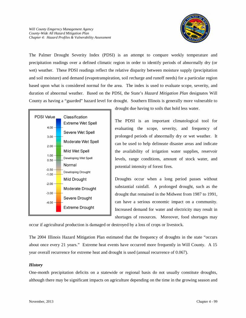
Will County Emgerncy Management Agency County-Wide All Hazard Mitigation Plan Chapter 4: Hazard Profiles & Vulnerability Assessment
November, 2013 Chapter 4 - 99
The Palmer Drought Severity Index (PDSI) is an attempt to compare weekly temperature and
precipitation readings over a defined climatic region in order to identify periods of abnormally dry (or
wet) weather. These PDSI readings reflect the relative disparity between moisture supply (precipitation
and soil moisture) and demand (evapotranspiration, soil recharge and runoff needs) for a particular region
based upon what is considered normal for the area. The index is used to evaluate scope, severity, and
duration of abnormal weather. Based on the PDSI, the State’s Hazard Mitigation Plan designates Will
County as having a “guarded” hazard level for drought. Southern Illinois is generally more vulnerable to
drought due having to soils that hold less water.
The PDSI is an important climatological tool for
evaluating the scope, severity, and frequency of
prolonged periods of abnormally dry or wet weather. It
can be used to help delineate disaster areas and indicate
the availability of irrigation water supplies, reservoir
levels, range conditions, amount of stock water, and
potential intensity of forest fires.
Droughts occur when a long period passes without
substantial rainfall. A prolonged drought, such as the
drought that remained in the Midwest from 1987 to 1991,
can have a serious economic impact on a community.
Increased demand for water and electricity may result in
shortages of resources. Moreover, food shortages may
occur if agricultural production is damaged or destroyed by a loss of crops or livestock.
The 2004 Illinois Hazard Mitigation Plan estimated that the frequency of droughts in the state “occurs
about once every 21 years.” Extreme heat events have occurred more frequently in Will County. A 15
year overall recurrence for extreme heat and drought is used (annual recurrence of 0.067).
History
One-month precipitation deficits on a statewide or regional basis do not usually constitute droughts,
although there may be significant impacts on agriculture depending on the time in the growing season and
Will County Emgerncy Management Agency County-Wide All Hazard Mitigation Plan Chapter 4: Hazard Profiles & Vulnerability Assessment
November, 2013 Chapter 4 - 100
on soil moisture conditions. Agricultural and hydrologic droughts have different lag times in relation to
the timing of precipitation, and their intensities do not correlate exactly with one another.
Agricultural droughts typically trigger the availability of several USDA emergency assistance programs
from the Farmers Home Administration (loans), Agricultural Stabilization and conservation Service
(disaster assistance payments), Natural Resource Conservation Service (formerly SCS, for technical
assistance), and Federal Crop Insurance Corporation (loss claims). In September 1983, all 102 counties
were proclaimed State disaster areas because of high temperatures and insufficient precipitation beginning
in mid-June. More recently in 1988, 54 percent of the State was impacted by drought-like conditions,
resulting in disaster relief payments to landowners and farmers exceeding $382 million, but no State
proclamations.
The Palmer Drought Severity Index (PDSI) is an attempt to compare weekly temperature and
precipitation readings over a defined climatic region in order to identify periods of abnormally dry (or
wet) weather. These PDSI readings reflect the relative disparity between moisture supply (precipitation
and soil moisture) and demand (evapotranspiration, soil recharge and runoff needs) for a particular region
based upon what is considered normal for the area. The index is used to evaluate scope, severity, and
duration of abnormal weather.
Both the timing and amount of precipitation are responsible for the occurrence of a drought. The mean
annual precipitation in Illinois varies from 34 inches in Northern Illinois to 46 inches in the South.
Annual amounts fluctuate primarily within a 10-inch range of the median. The most severe drought in
recent years was 1988, when rainfall was 88 percent of normal. The timing or distribution was also
abnormal because 1988 saw less than 50 percent of the April through August normal rainfall. Droughts
of this magnitude occur about once every 21 years.
A smaller drought occurred in the northern two-thirds of the State (NWS zones 1-10). Although it only
lasted through the month of May 1992, Chicago, Moline and Rockford recorded the driest May on record,
and Springfield and Peoria their second driest.
Precipitation of less than 88 percent of normal also occurred in all of Illinois in September of 1994,
Northwestern Illinois in December of 1994, the northern half of the State in February of 1995, all of the

Will County Emgerncy Management Agency County-Wide All Hazard Mitigation Plan Chapter 4: Hazard Profiles & Vulnerability Assessment
November, 2013 Chapter 4 - 101
Will County
State in March, and the northern half again in June of 1995. However, even though precipitation values
were below average, none of these were considered drought-like conditions officially.
Precipitation values from 54 to 65 percent of normal for the months of February and April of 1996, in
northwest and central portions of the State would technically put those areas into the 3-month or 6-month
precipitation drought categories. However, above average precipitation in May reversed all drought
impacts.
A severe drought
struck Illinois in 2005-
06, especially in the
northern half of the
State. Dry conditions
in 2005 reached a
historic level of
severity in some parts
of Illinois and ranked
as one of the three
most severe droughts
in Illinois in 112 years
of records. The
timing of the dryness during the spring and summer, when water demand and use are high, ensured
substantial impacts on agriculture and other sectors. The drought also had several unusual characteristics.
The drought area was long and narrow, extending from south Texas to the Great Lakes. But within the
Midwest, the drought had relatively minor impact on states other than Illinois. A record number of
remnants of hurricanes and tropical storms passed through Illinois during July, August and September,
substantially ameliorating drought conditions in portions of central and southern Illinois. Crop yields
were surprisingly high in parts of the State, perhaps providing evidence of increased drought resistance in
modern varieties and the benefits of timely rains.
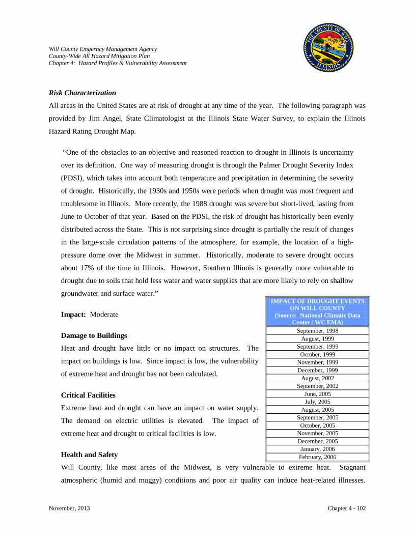
Will County Emgerncy Management Agency County-Wide All Hazard Mitigation Plan Chapter 4: Hazard Profiles & Vulnerability Assessment
November, 2013 Chapter 4 - 102
Risk Characterization
All areas in the United States are at risk of drought at any time of the year. The following paragraph was
provided by Jim Angel, State Climatologist at the Illinois State Water Survey, to explain the Illinois
Hazard Rating Drought Map.
“One of the obstacles to an objective and reasoned reaction to drought in Illinois is uncertainty
over its definition. One way of measuring drought is through the Palmer Drought Severity Index
(PDSI), which takes into account both temperature and precipitation in determining the severity
of drought. Historically, the 1930s and 1950s were periods when drought was most frequent and
troublesome in Illinois. More recently, the 1988 drought was severe but short-lived, lasting from
June to October of that year. Based on the PDSI, the risk of drought has historically been evenly
distributed across the State. This is not surprising since drought is partially the result of changes
in the large-scale circulation patterns of the atmosphere, for example, the location of a high-
pressure dome over the Midwest in summer. Historically, moderate to severe drought occurs
about 17% of the time in Illinois. However, Southern Illinois is generally more vulnerable to
drought due to soils that hold less water and water supplies that are more likely to rely on shallow
groundwater and surface water.”
Impact: Moderate
Damage to Buildings
Heat and drought have little or no impact on structures. The
impact on buildings is low. Since impact is low, the vulnerability
of extreme heat and drought has not been calculated.
Critical Facilities
Extreme heat and drought can have an impact on water supply.
The demand on electric utilities is elevated. The impact of
extreme heat and drought to critical facilities is low.
Health and Safety
Will County, like most areas of the Midwest, is very vulnerable to extreme heat. Stagnant
atmospheric (humid and muggy) conditions and poor air quality can induce heat-related illnesses.
IMPACT OF DROUGHT EVENTS ON WILL COUNTY
(Source: National Climatic Data Center / WC EMA)
September, 1998 August, 1999
September, 1999 October, 1999
November, 1999 December, 1999
August, 2002 September, 2002
June, 2005 July, 2005
August, 2005 September, 2005
October, 2005 November, 2005 December, 2005 January, 2006
February, 2006
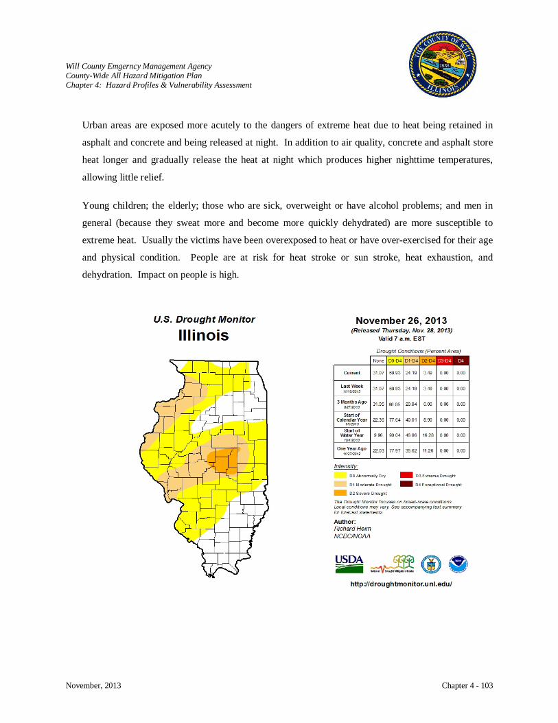
Will County Emgerncy Management Agency County-Wide All Hazard Mitigation Plan Chapter 4: Hazard Profiles & Vulnerability Assessment
November, 2013 Chapter 4 - 103
Urban areas are exposed more acutely to the dangers of extreme heat due to heat being retained in
asphalt and concrete and being released at night. In addition to air quality, concrete and asphalt store
heat longer and gradually release the heat at night which produces higher nighttime temperatures,
allowing little relief.
Young children; the elderly; those who are sick, overweight or have alcohol problems; and men in
general (because they sweat more and become more quickly dehydrated) are more susceptible to
extreme heat. Usually the victims have been overexposed to heat or have over-exercised for their age
and physical condition. People are at risk for heat stroke or sun stroke, heat exhaustion, and
dehydration. Impact on people is high.
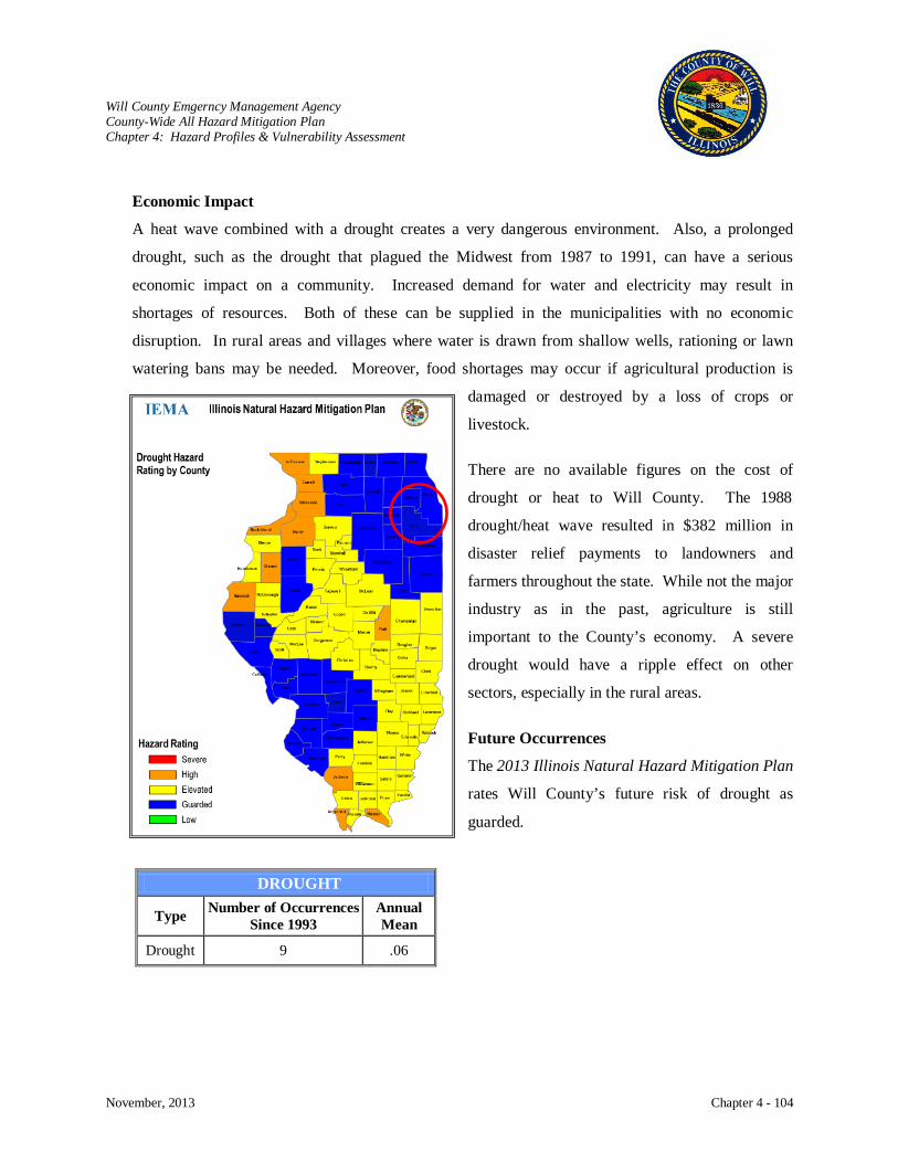
Will County Emgerncy Management Agency County-Wide All Hazard Mitigation Plan Chapter 4: Hazard Profiles & Vulnerability Assessment
November, 2013 Chapter 4 - 104
Economic Impact
A heat wave combined with a drought creates a very dangerous environment. Also, a prolonged
drought, such as the drought that plagued the Midwest from 1987 to 1991, can have a serious
economic impact on a community. Increased demand for water and electricity may result in
shortages of resources. Both of these can be supplied in the municipalities with no economic
disruption. In rural areas and villages where water is drawn from shallow wells, rationing or lawn
watering bans may be needed. Moreover, food shortages may occur if agricultural production is
damaged or destroyed by a loss of crops or
livestock.
There are no available figures on the cost of
drought or heat to Will County. The 1988
drought/heat wave resulted in $382 million in
disaster relief payments to landowners and
farmers throughout the state. While not the major
industry as in the past, agriculture is still
important to the County’s economy. A severe
drought would have a ripple effect on other
sectors, especially in the rural areas.
Future Occurrences
The 2013 Illinois Natural Hazard Mitigation Plan
rates Will County’s future risk of drought as
guarded.
DROUGHT
Type Number of Occurrences Since 1993
Annual Mean
Drought 9 .06
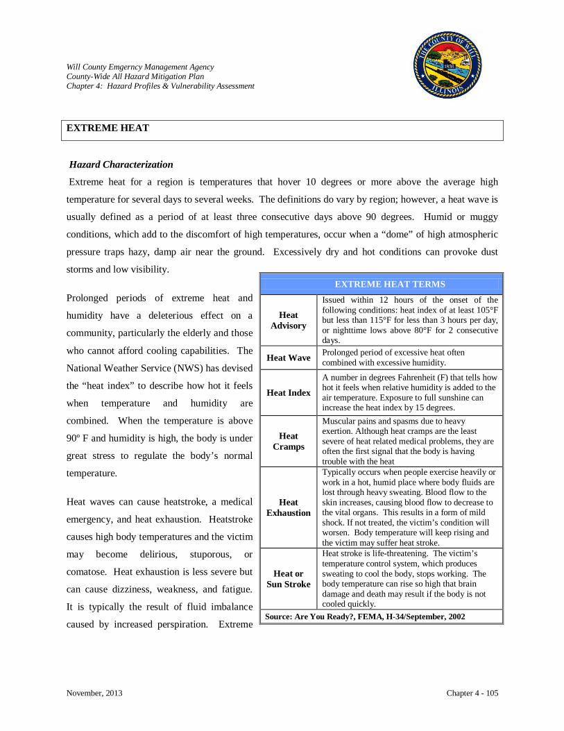
Will County Emgerncy Management Agency County-Wide All Hazard Mitigation Plan Chapter 4: Hazard Profiles & Vulnerability Assessment
November, 2013 Chapter 4 - 105
EXTREME HEAT
Hazard Characterization
Extreme heat for a region is temperatures that hover 10 degrees or more above the average high
temperature for several days to several weeks. The definitions do vary by region; however, a heat wave is
usually defined as a period of at least three consecutive days above 90 degrees. Humid or muggy
conditions, which add to the discomfort of high temperatures, occur when a “dome” of high atmospheric
pressure traps hazy, damp air near the ground. Excessively dry and hot conditions can provoke dust
storms and low visibility.
Prolonged periods of extreme heat and
humidity have a deleterious effect on a
community, particularly the elderly and those
who cannot afford cooling capabilities. The
National Weather Service (NWS) has devised
the “heat index” to describe how hot it feels
when temperature and humidity are
combined. When the temperature is above
90º F and humidity is high, the body is under
great stress to regulate the body’s normal
temperature.
Heat waves can cause heatstroke, a medical
emergency, and heat exhaustion. Heatstroke
causes high body temperatures and the victim
may become delirious, stuporous, or
comatose. Heat exhaustion is less severe but
can cause dizziness, weakness, and fatigue.
It is typically the result of fluid imbalance
caused by increased perspiration. Extreme
EXTREME HEAT TERMS
Heat Advisory
Issued within 12 hours of the onset of the following conditions: heat index of at least 105°F but less than 115°F for less than 3 hours per day, or nighttime lows above 80°F for 2 consecutive days.
Heat Wave Prolonged period of excessive heat often combined with excessive humidity.
Heat Index
A number in degrees Fahrenheit (F) that tells how hot it feels when relative humidity is added to the air temperature. Exposure to full sunshine can increase the heat index by 15 degrees.
Heat Cramps
Muscular pains and spasms due to heavy exertion. Although heat cramps are the least severe of heat related medical problems, they are often the first signal that the body is having trouble with the heat
Heat Exhaustion
Typically occurs when people exercise heavily or work in a hot, humid place where body fluids are lost through heavy sweating. Blood flow to the skin increases, causing blood flow to decrease to the vital organs. This results in a form of mild shock. If not treated, the victim’s condition will worsen. Body temperature will keep rising and the victim may suffer heat stroke.
Heat or Sun Stroke
Heat stroke is life-threatening. The victim’s temperature control system, which produces sweating to cool the body, stops working. The body temperature can rise so high that brain damage and death may result if the body is not cooled quickly.
Source: Are You Ready?, FEMA, H-34/September, 2002
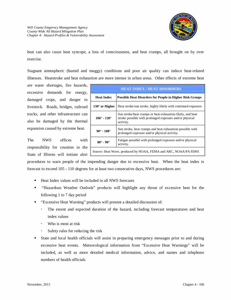
Will County Emgerncy Management Agency County-Wide All Hazard Mitigation Plan Chapter 4: Hazard Profiles & Vulnerability Assessment
November, 2013 Chapter 4 - 106
heat can also cause heat syncope, a loss of consciousness, and heat cramps, all brought on by over
exercise.
Stagnant atmospheric (humid and muggy) conditions and poor air quality can induce heat-related
illnesses. Heatstroke and heat exhaustion are more intense in urban areas. Other effects of extreme heat
are water shortages, fire hazards,
excessive demands for energy,
damaged crops, and danger to
livestock. Roads, bridges, railroad
tracks, and other infrastructure can
also be damaged by the thermal
expansion caused by extreme heat.
The NWS offices with
responsibility for counties in the
State of Illinois will initiate alert
procedures to warn people of the impending danger due to excessive heat. When the heat index is
forecast to exceed 105 - 110 degrees for at least two consecutive days, NWS procedures are:
Heat Index values will be included in all NWS forecasts
“Hazardous Weather Outlook” products will highlight any threat of excessive heat for the
following 1 to 7 day period
“Excessive Heat Warning” products will present a detailed discussion of:
The extent and expected duration of the hazard, including forecast temperatures and heat
index values
Who is most at risk
Safety rules for reducing the risk
State and local health officials will assist in preparing emergency messages prior to and during
excessive heat events. Meteorological information from “Excessive Heat Warnings” will be
included, as well as more detailed medical information, advice, and names and telephone
numbers of health officials
HEAT INDEX / HEAT DISORDERS
Heat Index Possible Heat Disorders for People in Higher Risk Groups
130° or Higher Heat stroke/sun stroke, highly likely with continued exposure.
106° - 130° Sun stroke/heat cramps or heat exhaustion likely, and heat stroke possible with prolonged exposure and/or physical activity.
90° - 108° Sun stroke, heat cramps and heat exhaustion possible with prolonged exposure and/or physical activity.
80° - 90° Fatigue possible with prolonged exposure and/or physical activity.
Source: Heat Wave, produced by NOAA, FEMA and ARC, NOAA/PA 85001

Will County Emgerncy Management Agency County-Wide All Hazard Mitigation Plan Chapter 4: Hazard Profiles & Vulnerability Assessment
November, 2013 Chapter 4 - 107
Forecasts, outlooks and warnings will be released by the NWS to the media, over NOAA’s All
Hazards Weather Alert Radio system, and via NEWS web sites.
History
Severe heat waves have caused catastrophic crop failures, thousands of deaths and widespread power
outages due to increased use of air conditioning. The Illinois Department of Public Health (IDPH) has
provided information on heat related deaths. Identifying the exact number of deaths due to heat is very
difficult. Usually heat is not the primary cause listed on the death certificate
but an “underlying cause”.
The heat waves of the summer of 1995 caused deaths and injuries previously
unseen in the State of Illinois. Throughout the entire State, the combination of
record or near record high temperatures and high dewpoint temperatures led to
heat indices routinely above the 120-degree mark from July 12-17. The heat
index peaked at 125 degrees on July 14 when the air temperature was 98
degrees and the relative humidity was 63 degrees.
An approach used by IDPH to identify heat as being
responsible for deaths is to look at “excess deaths”.
In 1995, there were roughly 600-700 excess deaths.
IDPH identifies heat as a contributor to the death of 600 to 700 people. These
figures are slightly higher for 1995 than other figures identified in this section.
All of the sources have documented that excessive heat can contribute to death.
Conditions such as these create hardships for respiratory and cardiovascular
systems of every person, but especially in toddlers and the elderly. The human
body is very capable of handling extreme temperatures; however, when high
humidity accompanies these conditions, it is often too much for the body to
handle (the same is true for the human body with cold temperatures when
combined with strong winds, producing dangerous wind chills).
Scattered power outages compounded the problem when Commonwealth
Edison, the supplier of electricity to virtually the entire Chicago metropolitan area, and other electric
IMPACT OF HEAT EVENTS ON WILL
COUNTY (Source: National
Climatic Data Center / WC EMA)
July 12, 1995
June 25, 1997
June 22, 2009
July 21, 1999
July 28, 1999
August 16, 1999
May 23, 2010
May 30, 2011
July 4, 2012
July 19, 2013
HEAT RELATED DEATHS in ILLINOIS
1990-2007 YEAR # of DEATHS 1990 7 1991 10 1992 1 1993 12 1994 11 1995 152 1996 10 1997 12 1998 12 1999 174 2000 11 2001 19 2002 22 2003 5 2004 3 2005 10 2006 17 2007 8
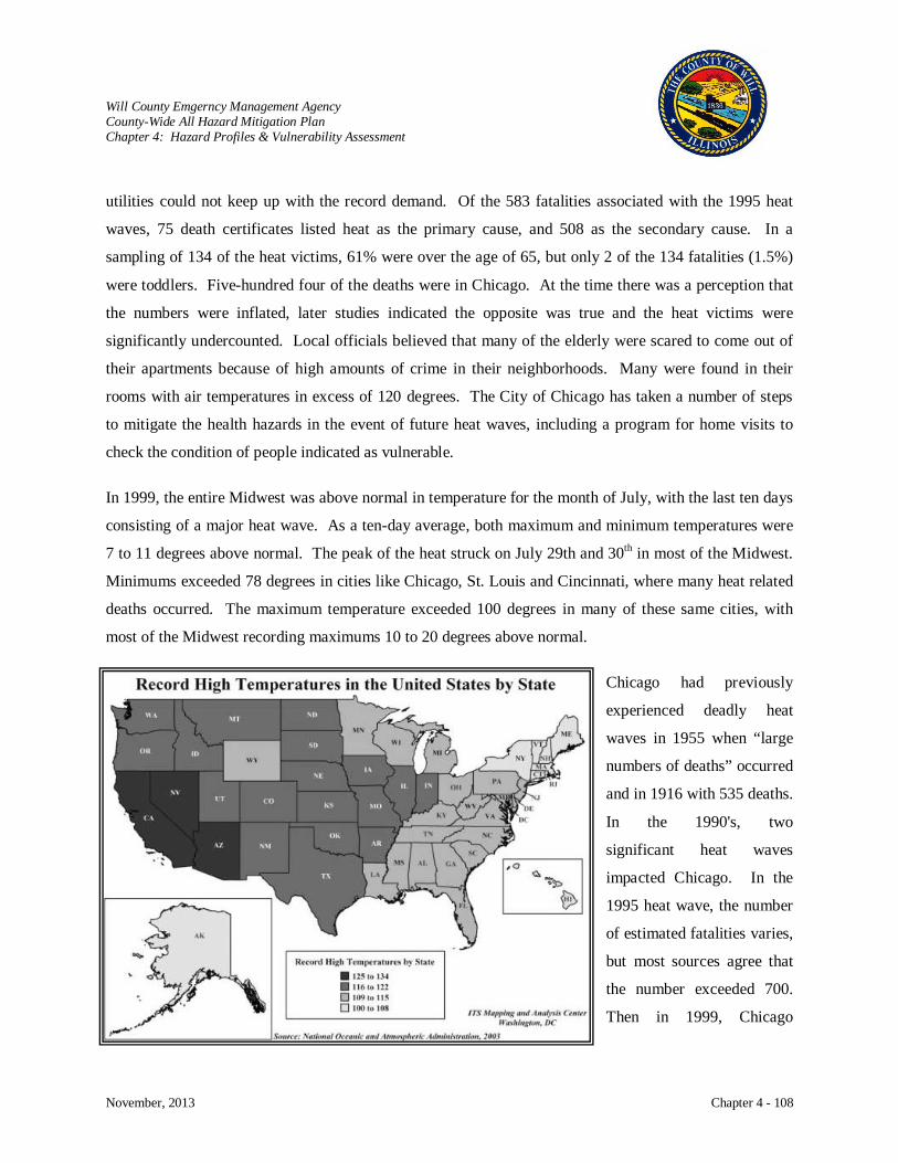
Will County Emgerncy Management Agency County-Wide All Hazard Mitigation Plan Chapter 4: Hazard Profiles & Vulnerability Assessment
November, 2013 Chapter 4 - 108
utilities could not keep up with the record demand. Of the 583 fatalities associated with the 1995 heat
waves, 75 death certificates listed heat as the primary cause, and 508 as the secondary cause. In a
sampling of 134 of the heat victims, 61% were over the age of 65, but only 2 of the 134 fatalities (1.5%)
were toddlers. Five-hundred four of the deaths were in Chicago. At the time there was a perception that
the numbers were inflated, later studies indicated the opposite was true and the heat victims were
significantly undercounted. Local officials believed that many of the elderly were scared to come out of
their apartments because of high amounts of crime in their neighborhoods. Many were found in their
rooms with air temperatures in excess of 120 degrees. The City of Chicago has taken a number of steps
to mitigate the health hazards in the event of future heat waves, including a program for home visits to
check the condition of people indicated as vulnerable.
In 1999, the entire Midwest was above normal in temperature for the month of July, with the last ten days
consisting of a major heat wave. As a ten-day average, both maximum and minimum temperatures were
7 to 11 degrees above normal. The peak of the heat struck on July 29th and 30th
Chicago had previously
experienced deadly heat
waves in 1955 when “large
numbers of deaths” occurred
and in 1916 with 535 deaths.
In the 1990's, two
significant heat waves
impacted Chicago. In the
1995 heat wave, the number
of estimated fatalities varies,
but most sources agree that
the number exceeded 700.
Then in 1999, Chicago
in most of the Midwest.
Minimums exceeded 78 degrees in cities like Chicago, St. Louis and Cincinnati, where many heat related
deaths occurred. The maximum temperature exceeded 100 degrees in many of these same cities, with
most of the Midwest recording maximums 10 to 20 degrees above normal.
Will County Emgerncy Management Agency County-Wide All Hazard Mitigation Plan Chapter 4: Hazard Profiles & Vulnerability Assessment
November, 2013 Chapter 4 - 109
experienced another heat wave that closely matched the 1995 event, but the death toll was reduced to
approximately 100 people. A paper written by Michael Palace and Stanley Chignon, of the State Water
Survey, attribute much of the reduction in deaths to mitigation efforts. The efforts included education by
the news media and care monitoring procedures for the urban elderly. The September 2005, Chicago All-
Hazard Risk Assessment also states the 1999 deaths were lower than 1995 and believed to be the result of
the implementation of Chicago’s Extreme Weather Operations Plan.
Risk Characterization
The New York Times article dated August 13, 2002, “Most Deadly of the Natural Disasters: The Heat
Wave” states that heat waves kill more people in the United States than all other natural disasters
combined.” The article goes on to state that a University of Delaware study indicated that 1,500
American city dwellers die each year because of heat compared with 200 from tornadoes, earthquakes and
floods combined.
This natural disaster has long been overlooked because there is not visible damage like in a tornado and
its impact is greatly understated in terms of human toll because not all heat related deaths are recorded.
The current mitigation planning process encourages the State to look at such factors as urbanization, the
elderly, and low income. It is impossible to ignore these factors when analyzing heat waves. According
to historical discussion and the above referenced article, when the Chicago heat wave of July 1995,
occurred “the poor, the old, residents of abandoned and violent neighborhoods who lived alone, lacked
access to transportation and lacked air-conditioning” were the victims.
The time we have until the next heat wave is unknown, but all of the major reports on global warming
indicate that an increase in severe heat waves is likely. Chicago is one of the State’s most vulnerable
areas because of their size and population. Their Risk Assessment predicts 17.8 days a year where
temperatures breach the 90 degree mark.
Articles all agree that summer heat kills more people than other natural hazards. The National Weather
Service (NWS) indicates that in a normal year the number will be 175 Americans. Other sources project
the number of deaths to be much higher each year. So not only do we not know when heat waves will
strike, we do not have a firm estimate on the number of people who will be impacted.
Will County Emgerncy Management Agency County-Wide All Hazard Mitigation Plan Chapter 4: Hazard Profiles & Vulnerability Assessment
November, 2013 Chapter 4 - 110
Impact: Moderate
Damage to Buildings
Heat and drought have little or no impact on structures.
Critical Facilities
Extreme heat and drought can have an impact on water supply. The demand on electric utilities is
elevated.
Health and Safety
Heat kills by pushing the human body beyond its limits. Under normal conditions, the body's internal
thermostat produces perspiration that evaporates and cools the body. However, in extreme heat and
high humidity, evaporation is slowed and the body must work extra hard to maintain a normal
temperature.
Most heat disorders occur because the victim has been overexposed to heat or has over exercised for
his or her age and physical condition. Other conditions that can induce heat-related illnesses include
stagnant atmospheric conditions and poor air quality.
Extreme heat events can be just as deadly as other natural hazards due to the nature of the event.
Extreme heat doesn’t immediately impact people when it sets in, instead it is when the periods of
extreme heat last for days and weeks that it takes its toll on people. The elderly are at particular risk.
Economic Impact
Generally, extreme heat impacts agricultural areas in the State.
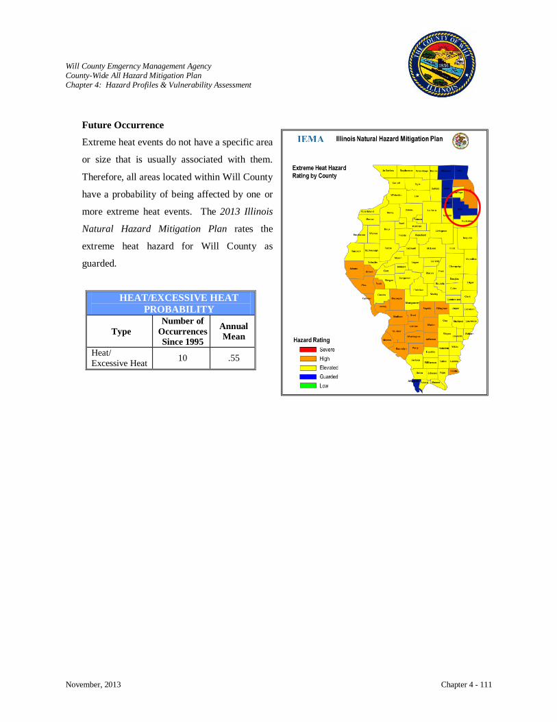
Will County Emgerncy Management Agency County-Wide All Hazard Mitigation Plan Chapter 4: Hazard Profiles & Vulnerability Assessment
November, 2013 Chapter 4 - 111
Future Occurrence
Extreme heat events do not have a specific area
or size that is usually associated with them.
Therefore, all areas located within Will County
have a probability of being affected by one or
more extreme heat events. The 2013 Illinois
Natural Hazard Mitigation Plan rates the
extreme heat hazard for Will County as
guarded.
HEAT/EXCESSIVE HEAT PROBABILITY
Type Number of
Occurrences Since 1995
Annual Mean
Heat/ Excessive Heat 10 .55

Will County Emgerncy Management Agency County-Wide All Hazard Mitigation Plan Chapter 4: Hazard Profiles & Vulnerability Assessment
November, 2013 Chapter 4 - 112
INFRASTRUCTURE FAILURE
Hazard Characterization
Infrastructure failure of critical public or private utilities results in a temporary loss of essential functions
and/or services. The residents of Will County depend on the public and private utility infrastructure to
provide essential services such as electric power, heating and air conditioning, water, sewage disposal and
treatment, storm drainage, communications, and transportation. Failure of any of these services for an
extended length of time would require an emergency management organization response to supply food,
water, heating, etc. Failure can occur within a distribution system or be caused by external factors such as
severe storms or fire. Codes and standards govern the design, construction, and operation of
infrastructures, but they are inadequate to protect against disaster related damage.
Electricity failure interrupts the functions of businesses and homes, causes life-threatening situations in
medical facilities, creates traffic stoppages, spoils food, and disrupts communication and computer
functions. Failure of heating and air conditioning units can threaten lives in extreme cold or hot weather.
Disruption of storm drainage can lead to flooding, and inoperable sewage treatment facilities will cause
pollution leading to serious public health problems. Infrastructure failure heavily impacts the most
vulnerable members of the community, namely the elderly, children, impoverished individuals, and
people in poor health. The cost to repair these systems along with the economic and societal damage
caused by lengthy disruption is excessively high.
History
Utility interruptions have been rare in Will County other than those associated with weather events.
Risk Characterization
Infrastructure failure may result from natural, technological, or societal hazards along with human error,
equipment failure, or poor maintenance. The impact of infrastructure failure can be significant depending
on the length of disruption and the extent of the affected area. Infrastructure failures can also create
serious safety hazards when power lines are down, fire or explosion ensues, or hazardous materials are
released into the environment.
Will County Emgerncy Management Agency County-Wide All Hazard Mitigation Plan Chapter 4: Hazard Profiles & Vulnerability Assessment
November, 2013 Chapter 4 - 113
Natural hazards include tornadoes and severe thunder or winter storms that may damage utility supply
lines. Extreme heat can place a high demand for electricity causing an over-demand and failure of power
grids. Drought can impact water supplies. Technological hazards can impact infrastructure through fire,
pipeline damage, or industrial accidents. Societal hazards include intentional acts of disruption resulting
from terrorist attacks, civil disturbances, or sabotage.
Disruptions
Electric Utility: Affects the population primarily during winter and summer when the
need and demand for heat and air-conditioning are high. Electric
disruptions impact business when computers, lighting, refrigeration, gas
pumps, and other equipment cannot be powered.
Telecommunications: Society has become very dependent on our variety of communication
devices. When telephone service is disrupted, the use of land or cell
phones, internet, or credit cards may be impacted. This can have a
negative affect on emergency services and the banking system. Usage
overloads of cell phones occur when there are large public events or
emergencies. Storms may have an affect on radio communications.
With many forms of communication devices available to us, the
unavailability of one type should not affect the use of others.
Water Supply: Severe drought can have an impact on water supply causing restrictions
on use.
Wastewater Services: Damage to wastewater facilities may cause sanitation and biological
hazards, overloading of systems causing overflows and pollution, sewage
discharge, and economic loss due to cleanup costs.
Gas Supply: Damage to gas supply systems can cause fire, explosion, death,
evacuation of affected areas, loss of heat and cooking facilities, and
economic losses to business and industry.

Will County Emgerncy Management Agency County-Wide All Hazard Mitigation Plan Chapter 4: Hazard Profiles & Vulnerability Assessment
November, 2013 Chapter 4 - 114
Petroleum Distribution: Loss of petroleum supply and distribution networks can result in fire,
explosions, death, panic buying of fuel, social disruption, environmental
cleanup costs, and economic losses to business and industry.
Transportation Systems: Infrastructure losses would cause the loss of traffic signals and damage
to roadways, bridges, or waterways due to fire or explosion resulting in
traffic congestion, social disorder, and economic losses.
Impact: High
Damage to Buildings
Damage to buildings due to infrastructure failure is low. The potential exists for water damage when
a facility is without heat and pipes freeze causing them to burst. Fire is another hazard when people
find alternate sources for heat or light when electricity or heating fuel is disrupted. Explosion can
occur from damaged gas lines.
Health and Safety
Impact on people and pets occurs when heating and cooling sources are lost. With extreme cold and
heat events, the elderly are generally the first population group to be adversely affected. Injury or
death may be possible when fire, explosions, or gas leaks occur.
Economic Impact
A study characterizing infrastructure failure interdependencies identified the sectors affected as:
HVAC in buildings, effects on water systems, effects on health systems, and effects on road
transportation systems. If disrupted by infrastructure failure, all of the sectors could have a
significant impact on businesses and homes in the affected area.
Future Occurrence
Infrastructure failure may occur individually or in combination with natural or technological hazards.
It is estimated that the probability of occurrence and effect is low; however, the potential exists for
widespread effect, particularly as secondary effects from hazards such as tornadoes.
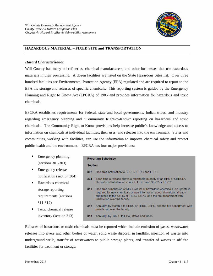
Will County Emgerncy Management Agency County-Wide All Hazard Mitigation Plan Chapter 4: Hazard Profiles & Vulnerability Assessment
November, 2013 Chapter 4 - 115
HAZARDOUS MATERIAL – FIXED SITE and TRANSPORTATION
Hazard Characterization
Will County has many oil refineries, chemical manufacturers, and other businesses that use hazardous
materials in their processing. A dozen facilities are listed on the State Hazardous Sites list. Over three
hundred facilities are Environmental Protection Agency (EPA) regulated and are required to report to the
EPA the storage and releases of specific chemicals. This reporting system is guided by the Emergency
Planning and Right to Know Act (EPCRA) of 1986 and provides information for hazardous and toxic
chemicals.
EPCRA establishes requirements for federal, state and local governments, Indian tribes, and industry
regarding emergency planning and “Community Right-to-Know” reporting on hazardous and toxic
chemicals. The Community Right-to-Know provisions help increase public’s knowledge and access to
information on chemicals at individual facilities, their uses, and releases into the environment. States and
communities, working with facilities, can use the information to improve chemical safety and protect
public health and the environment. EPCRA has four major provisions:
Emergency planning
(sections 301-303)
Emergency release
notification (section 304)
Hazardous chemical
storage reporting
requirements (sections
311-312)
Toxic chemical release
inventory (section 313)
Releases of hazardous or toxic chemicals must be reported which include emission of gases, wastewater
releases into rivers and other bodies of water, solid waste disposal in landfills, injection of wastes into
underground wells, transfer of wastewaters to public sewage plants, and transfer of wastes to off-site
facilities for treatment or storage.
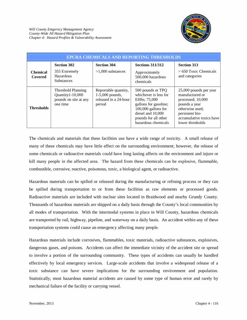
Will County Emgerncy Management Agency County-Wide All Hazard Mitigation Plan Chapter 4: Hazard Profiles & Vulnerability Assessment
November, 2013 Chapter 4 - 116
EPCRA CHEMICALS AND REPORTING THRESHOLDS
Chemical Covered
Section 302
355 Extremely Hazardous Substances
Section 304
>1,000 substances Sections 311/312 Approximately 500,000 hazardous chemicals
Section 313
> 650 Toxic Chemicals and categories
Thresholds
Threshold Planning Quantity1-10,000 pounds on site at any one time
Reportable quantity, 1-5,000 pounds, released in a 24-hour period
500 pounds or TPQ whichever is less for EHSs; 75,000 gallons for gasoline; 100,000 gallons for diesel and 10,000 pounds for all other hazardous chemicals
25,000 pounds per year manufactured or processed; 10,000 pounds a year otherwise used; persistent bio-accumulative toxics have lower thresholds
The chemicals and materials that these facilities use have a wide range of toxicity. A small release of
many of these chemicals may have little effect on the surrounding environment; however, the release of
some chemicals or radioactive materials could have long lasting affects on the environment and injure or
kill many people in the affected area. The hazard from these chemicals can be explosive, flammable,
combustible, corrosive, reactive, poisonous, toxic, a biological agent, or radioactive.
Hazardous materials can be spilled or released during the manufacturing or refining process or they can
be spilled during transportation to or from these facilities as raw elements or processed goods.
Radioactive materials are included with nuclear sites located in Braidwood and nearby Grundy County.
Thousands of hazardous materials are shipped on a daily basis through the County’s local communities by
all modes of transportation. With the intermodal systems in place in Will County, hazardous chemicals
are transported by rail, highway, pipeline, and waterway on a daily basis. An accident within any of these
transportation systems could cause an emergency affecting many people.
Hazardous materials include corrosives, flammables, toxic materials, radioactive substances, explosives,
dangerous gases, and poisons. Accidents can affect the immediate vicinity of the accident site or spread
to involve a portion of the surrounding community. These types of accidents can usually be handled
effectively by local emergency services. Large-scale accidents that involve a widespread release of a
toxic substance can have severe implications for the surrounding environment and population.
Statistically, most hazardous material accidents are caused by some type of human error and rarely by
mechanical failure of the facility or carrying vessel.
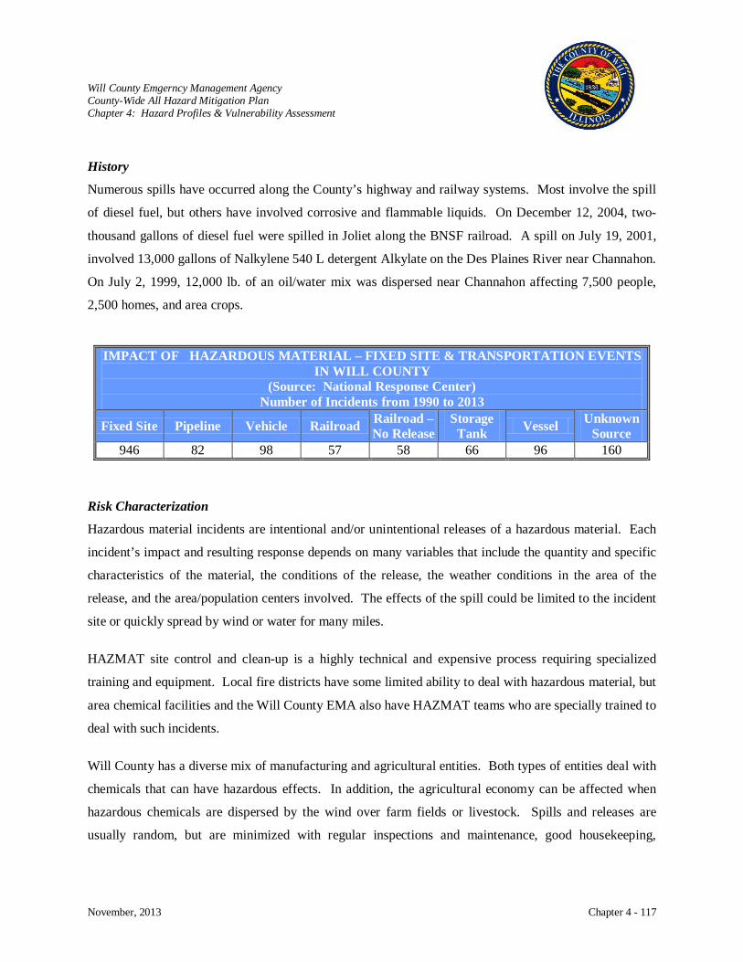
Will County Emgerncy Management Agency County-Wide All Hazard Mitigation Plan Chapter 4: Hazard Profiles & Vulnerability Assessment
November, 2013 Chapter 4 - 117
History
Numerous spills have occurred along the County’s highway and railway systems. Most involve the spill
of diesel fuel, but others have involved corrosive and flammable liquids. On December 12, 2004, two-
thousand gallons of diesel fuel were spilled in Joliet along the BNSF railroad. A spill on July 19, 2001,
involved 13,000 gallons of Nalkylene 540 L detergent Alkylate on the Des Plaines River near Channahon.
On July 2, 1999, 12,000 lb. of an oil/water mix was dispersed near Channahon affecting 7,500 people,
2,500 homes, and area crops.
Risk Characterization
Hazardous material incidents are intentional and/or unintentional releases of a hazardous material. Each
incident’s impact and resulting response depends on many variables that include the quantity and specific
characteristics of the material, the conditions of the release, the weather conditions in the area of the
release, and the area/population centers involved. The effects of the spill could be limited to the incident
site or quickly spread by wind or water for many miles.
HAZMAT site control and clean-up is a highly technical and expensive process requiring specialized
training and equipment. Local fire districts have some limited ability to deal with hazardous material, but
area chemical facilities and the Will County EMA also have HAZMAT teams who are specially trained to
deal with such incidents.
Will County has a diverse mix of manufacturing and agricultural entities. Both types of entities deal with
chemicals that can have hazardous effects. In addition, the agricultural economy can be affected when
hazardous chemicals are dispersed by the wind over farm fields or livestock. Spills and releases are
usually random, but are minimized with regular inspections and maintenance, good housekeeping,
IMPACT OF HAZARDOUS MATERIAL – FIXED SITE & TRANSPORTATION EVENTS IN WILL COUNTY
(Source: National Response Center) Number of Incidents from 1990 to 2013
Fixed Site Pipeline Vehicle Railroad Railroad – No Release
Storage Tank Vessel Unknown
Source 946 82 98 57 58 66 96 160

Will County Emgerncy Management Agency County-Wide All Hazard Mitigation Plan Chapter 4: Hazard Profiles & Vulnerability Assessment
November, 2013 Chapter 4 - 118
effective emergency plans, readily available fire suppression equipment, proper warning labels, the use of
appropriate containers and storage, and training in proper safety and handling procedures.
Impact: High
Damage to Buildings
Damage can result from contamination, but in most cases damage or destruction occurs from fire or
explosion.
Critical Facilities
Critical infrastructures can be damaged or destroyed by fire or explosion. Water supplies can be
contaminated when hazardous chemicals enter the water system.
Health and Safety
Health problems may be immediate, such as skin burns, eye and lung irritation, or delayed, such as
cancer and genetic damage.
Economic Impact
Chemicals released into the environment contaminating soil, ground or surface water, buildings, and
crops or affecting the health of the area population can prove costly to contain, remediate, and
cleanup to acceptable standards. When the responsible party for the spill cannot be identified, it can
leave the local and state government in charge of protecting the public and financing the clean-up
process.
Future Occurrence
As the County continues to grow and attract more industrial and manufacturing companies, the
potential for future hazardous material spills and release will also grow.

Will County Emgerncy Management Agency County-Wide All Hazard Mitigation Plan Chapter 4: Hazard Profiles & Vulnerability Assessment
November, 2013 Chapter 4 - 119
NUCLEAR POWER PLANT ACCIDENT
Hazard Characterization
There are two nuclear power plants, the Braidwood Nuclear Power Station and Dresden Nuclear
Generating Station, which have direct effect on the population of Will County. The areas of risk
associated with these facilities are the plume emergency planning zone that encompasses a ten-mile radius
of the facility and the ingestion emergency planning zone that encompasses a fifty-mile radius. Because
of the danger of exposure from radioactive materials, plants are sited away from major population centers
and are designed with safety systems and back-up safety systems. Nuclear plants are required to have an
emergency radiological response plan in effect.
Braidwood Generating Station
Exelon's newest nuclear power station is located in northeastern Illinois, approximately 20 miles
southwest of Joliet and about 60 miles southwest of Chicago in Will County. The station is built on a
4,457-acre site, and its
cooling lake was formed
from scarred farming land
and an old strip mine. It’s
Units 1 and 2 began
commercial operation in July
and October of 1988,
respectively. The initial
construction cost for the
station was $5.2 billion.
Both of Braidwood's units
are pressurized water reactors
designed by Westinghouse.
Each unit is capable of
generating nearly 1,200 net
megawatts and together they
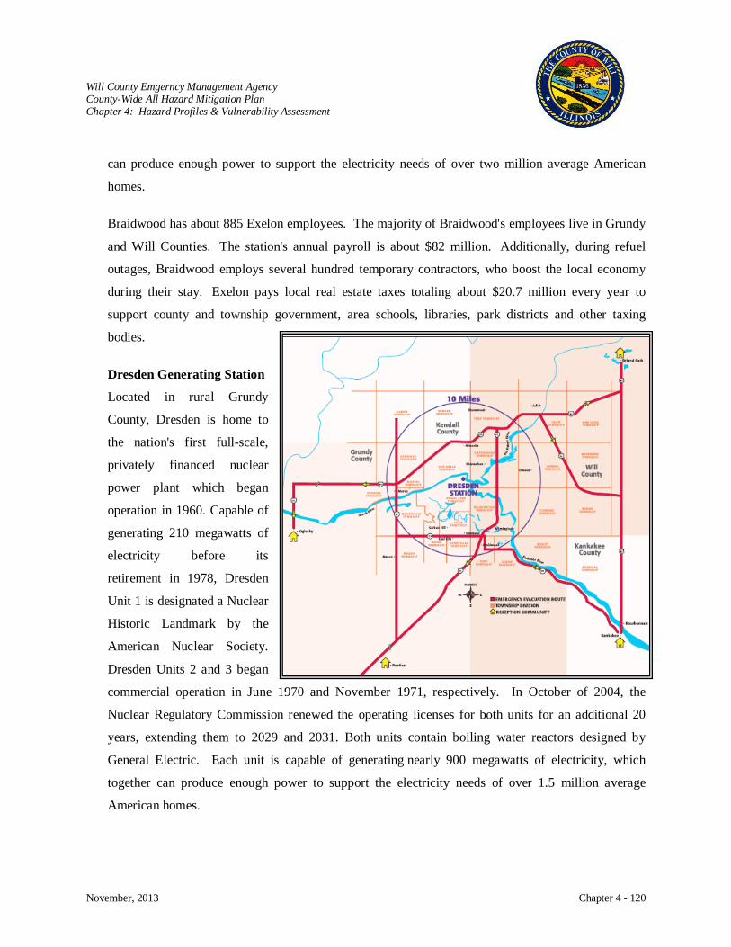
Will County Emgerncy Management Agency County-Wide All Hazard Mitigation Plan Chapter 4: Hazard Profiles & Vulnerability Assessment
November, 2013 Chapter 4 - 120
can produce enough power to support the electricity needs of over two million average American
homes.
Braidwood has about 885 Exelon employees. The majority of Braidwood's employees live in Grundy
and Will Counties. The station's annual payroll is about $82 million. Additionally, during refuel
outages, Braidwood employs several hundred temporary contractors, who boost the local economy
during their stay. Exelon pays local real estate taxes totaling about $20.7 million every year to
support county and township government, area schools, libraries, park districts and other taxing
bodies.
Dresden Generating Station
Located in rural Grundy
County, Dresden is home to
the nation's first full-scale,
privately financed nuclear
power plant which began
operation in 1960. Capable of
generating 210 megawatts of
electricity before its
retirement in 1978, Dresden
Unit 1 is designated a Nuclear
Historic Landmark by the
American Nuclear Society.
Dresden Units 2 and 3 began
commercial operation in June 1970 and November 1971, respectively. In October of 2004, the
Nuclear Regulatory Commission renewed the operating licenses for both units for an additional 20
years, extending them to 2029 and 2031. Both units contain boiling water reactors designed by
General Electric. Each unit is capable of generating nearly 900 megawatts of electricity, which
together can produce enough power to support the electricity needs of over 1.5 million average
American homes.
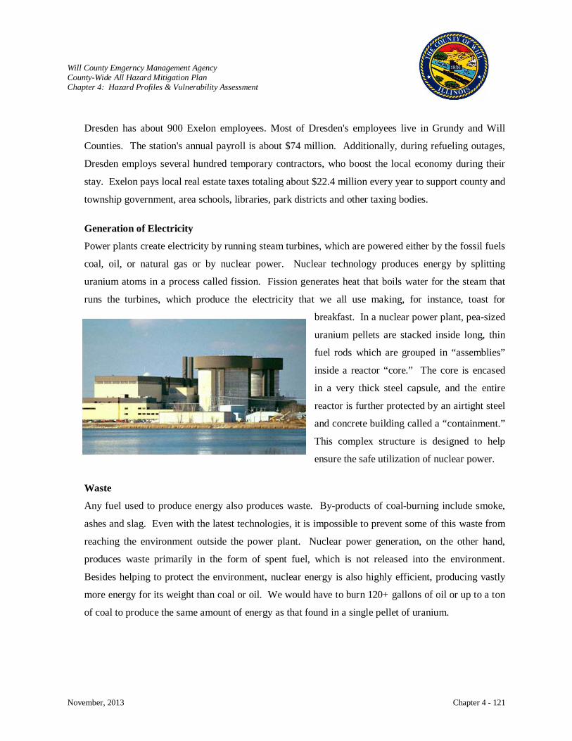
Will County Emgerncy Management Agency County-Wide All Hazard Mitigation Plan Chapter 4: Hazard Profiles & Vulnerability Assessment
November, 2013 Chapter 4 - 121
Dresden has about 900 Exelon employees. Most of Dresden's employees live in Grundy and Will
Counties. The station's annual payroll is about $74 million. Additionally, during refueling outages,
Dresden employs several hundred temporary contractors, who boost the local economy during their
stay. Exelon pays local real estate taxes totaling about $22.4 million every year to support county and
township government, area schools, libraries, park districts and other taxing bodies.
Generation of Electricity
Power plants create electricity by running steam turbines, which are powered either by the fossil fuels
coal, oil, or natural gas or by nuclear power. Nuclear technology produces energy by splitting
uranium atoms in a process called fission. Fission generates heat that boils water for the steam that
runs the turbines, which produce the electricity that we all use making, for instance, toast for
breakfast. In a nuclear power plant, pea-sized
uranium pellets are stacked inside long, thin
fuel rods which are grouped in “assemblies”
inside a reactor “core.” The core is encased
in a very thick steel capsule, and the entire
reactor is further protected by an airtight steel
and concrete building called a “containment.”
This complex structure is designed to help
ensure the safe utilization of nuclear power.
Waste
Any fuel used to produce energy also produces waste. By-products of coal-burning include smoke,
ashes and slag. Even with the latest technologies, it is impossible to prevent some of this waste from
reaching the environment outside the power plant. Nuclear power generation, on the other hand,
produces waste primarily in the form of spent fuel, which is not released into the environment.
Besides helping to protect the environment, nuclear energy is also highly efficient, producing vastly
more energy for its weight than coal or oil. We would have to burn 120+ gallons of oil or up to a ton
of coal to produce the same amount of energy as that found in a single pellet of uranium.
Will County Emgerncy Management Agency County-Wide All Hazard Mitigation Plan Chapter 4: Hazard Profiles & Vulnerability Assessment
November, 2013 Chapter 4 - 122
History
Worldwide
Three significant accidents in the fifty year history of civil nuclear power generation are:
Three Mile Island (USA 1979) The reactor was severely damaged but radiation was
contained and there were no adverse health or environmental
consequences.
Chernobyl (Ukraine 1986) The destruction of the reactor by steam explosion and fire
directly killed 41 people and had significant health and
environmental consequences. Studies continue on the health
effects on the impacted population.
Fukushima (Japan 2011) Following a major earthquake, a tsunami disabled the power
supply and cooling of three reactors. All three cores largely
melted in the first three days. There have been no deaths or
cases of radiation sickness from the nuclear accident, but
over 100,000 people had to be evacuated from their homes.
Studies of health effects are ongoing.
Will County
Nuclear regulatory agencies require testing of groundwater along with emissions from nuclear
generation facilities. Tritium is a radioactive isotope of hydrogen that produces a weak level of
radiation. It is produced naturally in the upper atmosphere when cosmic rays strike atmospheric
gases and is produced in larger quantities as a by-product of the nuclear energy industry. When
combined with oxygen, tritium has the same chemical properties as water. Tritium can be found at
very low levels in nearly all water sources. The area located on the northeast corner of the Braidwood
Generation Station property just south of Smiley Road was the location of tritiated water that spilled
back in 1998.
The highest concentration of tritium in a well from this location showed 230,000 picocuries per liter
in Dec. 2005. As of Dec. 2007, the highest on-site concentration of tritium detected in groundwater
has decreased more than 90 percent to 22,800 picocuries per liter. To further expedite the
remediation process and ensure increased capture of tritiated groundwater on plant property south of
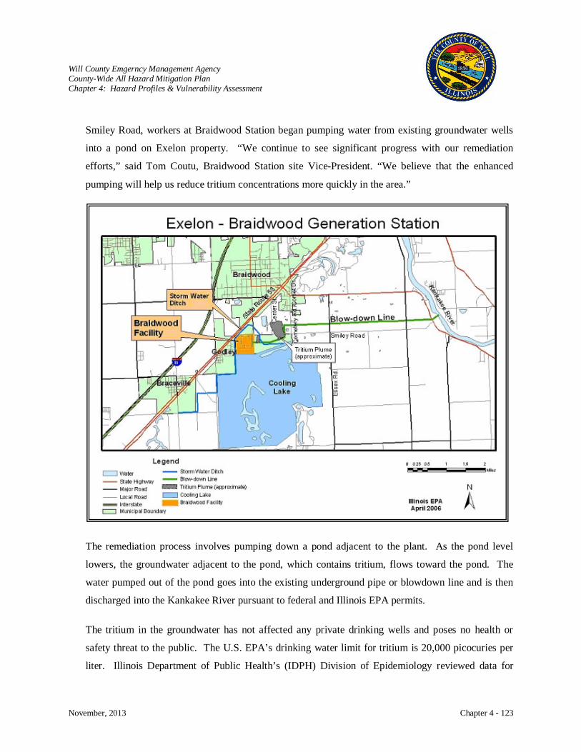
Will County Emgerncy Management Agency County-Wide All Hazard Mitigation Plan Chapter 4: Hazard Profiles & Vulnerability Assessment
November, 2013 Chapter 4 - 123
Smiley Road, workers at Braidwood Station began pumping water from existing groundwater wells
into a pond on Exelon property. “We continue to see significant progress with our remediation
efforts,” said Tom Coutu, Braidwood Station site Vice-President. “We believe that the enhanced
pumping will help us reduce tritium concentrations more quickly in the area.”
The remediation process involves pumping down a pond adjacent to the plant. As the pond level
lowers, the groundwater adjacent to the pond, which contains tritium, flows toward the pond. The
water pumped out of the pond goes into the existing underground pipe or blowdown line and is then
discharged into the Kankakee River pursuant to federal and Illinois EPA permits.
The tritium in the groundwater has not affected any private drinking wells and poses no health or
safety threat to the public. The U.S. EPA’s drinking water limit for tritium is 20,000 picocuries per
liter. Illinois Department of Public Health’s (IDPH) Division of Epidemiology reviewed data for
Will County Emgerncy Management Agency County-Wide All Hazard Mitigation Plan Chapter 4: Hazard Profiles & Vulnerability Assessment
November, 2013 Chapter 4 - 124
cancer incidence, childhood mortality, infant mortality, low birth weight and congenital anomalies in
Will County and Braidwood, IL. These investigations by IDPH found that the pediatric cancer
incidence and mortality rates were not significantly different from those for comparison groups. In
addition, they found no evidence of an increased cancer incidence rate after the startup of the nuclear
power plants.
Risk Characterization
Essentially, radiation is a form of energy that can travel through the air, just like light, heat or radio
waves. Small amounts of radiation are naturally generated by different elements in the environment.
Food, water, air and sunlight all expose us daily to tiny amounts of radiation. Uranium is simply a more
powerful source of radiation which, when used properly, can be highly beneficial.
Sometimes people are concerned that a power plant reactor will “blow up,” but this is virtually
impossible. The uranium contains only 3 to 4 percent fissionable material, and the fuel is further diluted
to slow down the fission process. This low concentration can generate enough heat to boil water but not
enough to explode. In short, there is no way for a power plant reactor to produce a nuclear explosion.
Some people also think that they, or the environment, may be accidentally exposed to nuclear radiation by
living or being near a nuclear power plant. Although radioactivity can be dangerous, keep in mind that a
power plant reactor is designed to contain radiation, protecting the rest of the plant and the surrounding
community. To ensure the greatest safety, however, any incident at a power plant that presents the
slightest potential for a leak would be addressed with the utmost care. First, special teams would gather
detailed radiation readings at the plant and throughout surrounding areas. Depending on a number of
factors, which include the amount of radiation released and weather conditions that would affect
movement of the radioactive “plume”, state officials would recommend a course of action. A significant
incident might require people to stay indoors or to evacuate to temporary relocation centers. In any event,
you would be instructed in a safe course of action to protect yourself and your loved ones.
Accidents occur in three different levels or degrees. The first degree is an accident that is handled
effectively within the plant by safety systems. The second is an accident in which the safety systems
malfunction and radioactive noble gases and iodine are released into the atmosphere. The third degree is
a core meltdown and involves an accident in the cooling system. Three dominant exposure modes people
Will County Emgerncy Management Agency County-Wide All Hazard Mitigation Plan Chapter 4: Hazard Profiles & Vulnerability Assessment
November, 2013 Chapter 4 - 125
experience as a result of a release of radioactive materials are whole body exposure, thyroid exposure, and
exposure from ingestion of radioactive materials.
Regulations for nuclear power plants are stringent to ensure the public’s safety.
Nuclear Power Plants (6) in Illinois and the United States are subject to meeting standards
established by the Nuclear Regulatory Commission (NRC) and the State. These building and
construction standards are delineated in each plant’s Updated Safety Analysis Report.
There are no specific land-use practices in place for areas surrounding a nuclear power plant.
However, for the area surrounding each nuclear power plant, a 10-mile Emergency Planning
Zone has been established. Detailed plans are established, implemented and trained against to
ensure that offsite response organizations can effectively manage an accident at a nuclear power
plant.
The IEMA limits the quantities of radioactive materials a facility can have on hand at any one
time. A licensing and enforcement program accomplishes this limitation.
For existing nuclear power plants, utility access controls are in place to prevent unauthorized
access to the facility. The IEMA works with shippers of high hazard radioactive material to
improve the performance of shipping containers.
The basic characteristics of radiation are fixed by the Laws of Physics and are immutable. IEMA
is working with manufacturers of high hazard radioactive materials to improve their basic
structural integrity and reduce the probability of release during normal use and accident
conditions.
The Bureau of Nuclear Facility Safety (BNFS) reviews all licensing issues to ensure the
requirements for nuclear power plant protective systems and equipment are maintained.
Additionally IEMA’s Resident Inspectors routinely inspect these systems for operability and
maintenance activities. IEMA Response personnel are equipped with appropriate radiological
detection and monitoring instrumentation, personal protective equipment, dosimetry, training and
procedures to handle a radiological emergency.
Nuclear power plants are designed, built and operated with redundant and diverse critical systems
and equipment.

Will County Emgerncy Management Agency County-Wide All Hazard Mitigation Plan Chapter 4: Hazard Profiles & Vulnerability Assessment
November, 2013 Chapter 4 - 126
Impact: High
Damage to Buildings
Damage to property is low; however,
contamination could have major adverse
effects rendering buildings and facilities
unusable.
Critical Facilities
Damage or destruction of the nuclear
generation station would impact the
production and delivery of electricity to the
area. Complete shutdown of the
Braidwood station could impact electric
service to as many as two million homes.
The shutdown of Dresden could impact electric service to as many as one and a half million homes.
Water and sewer utilities would be unable to function without electricity to power pumps.
Health and Safety
Radiation is measured in rems or in millirems (thousandths of a rem). On average, a person living in
Illinois receives about 300 millirem of radiation annually from natural sources and another 60
millirem or so from X-rays and other medical procedures. It takes more than 60 times this much,
over 20,000 millirem in a single day, to produce identifiable effects in the body. Federal regulations
allow workers to receive up to 5,000 millirem of radiation in the course of a year’s work.
Economic Impact
The partial or complete loss of electric generation would have a severe economic impact on Will
County and the surrounding area. Homes and businesses would lose the use of utilities necessary for
everyday living and business activities. Transportations systems would be impeded since road and
railways would lose the use of lights and signals necessary for controlling traffic. Fuel would become
unavailable without functioning fuel pumps. Most needed services would be impacted.
Generating and Relay Stations
Major Electrical Transmission Lines
Will County Emgerncy Management Agency County-Wide All Hazard Mitigation Plan Chapter 4: Hazard Profiles & Vulnerability Assessment
November, 2013 Chapter 4 - 127
Future Occurrences
There have been three major reactor accidents in the history of civil nuclear power: Three Mile
Island, Chernobyl, and Fukushima nuclear disasters. These are the only major accidents to have
occurred in more than 14,500 cumulative reactor years of commercial operations in thirty-three
countries. One was contained without harm to anyone, the next involved an intense fire without
provision for containment, and the third severely tested the containment, allowing some release of
radioactivity. Extraordinary effort has been put into safety and security issues to safeguard the public
against harmful incidents with stringent regulations enforced by the Nuclear Regulatory Commission.
The risks from western nuclear power plants, in terms or the consequences of an accident or terrorist
attack, are minimal.

Will County Emgerncy Management Agency County-Wide All Hazard Mitigation Plan Chapter 4: Hazard Profiles & Vulnerability Assessment
November, 2013 Chapter 4 - 128
Major Natural Gas Transmission Lines
PIPELINE RUPTURES
Hazard Characterization
Pipelines are a potential hazard because of the materials conveyed within them. The most common
materials carried by pipelines are petroleum, crude oil,
propane, ammonia, kerosene, and natural gas. Pipelines
range in diameter from 3/8 inch to 3+ feet in diameter
with many of the pipes having been laid more than
twenty-five years ago. Elements in the soil such as
moisture, bacteria, or acids act on the pipes causing
damaging exposure. The release of material because of
pipe failure due to age or breakage during excavation
work can cause explosion, fire, pollution, or loss of
communication or power. Pipeline failures can also be
secondary to land subsidence, earthquake, fires, or
erosion.
Pipelines are the safest method of transporting materials; however, it is not without problems. The results
of pipeline failure are injuries, fatalities, and/ or property damage. Pipeline failures are a potential hazard
within Will County because of the vast network that travels through the County into Chicago. The
County is a major hub in the United States natural gas pipeline grid where pipelines from Canada and the
Gulf of Mexico meet and then fan out to serve the Midwest.
The federal government establishes minimum pipeline safety standards under the U.S. Code of Federal
Regulations (CFR), Title 49 "Transportation", Parts 190 - 199. The Office of Pipeline Safety (OPS),
within the U.S. Department of Transportation, Pipeline and Hazardous Materials Safety Administration
(PHMSA), has overall regulatory responsibility for hazardous liquid and gas pipelines under its
jurisdiction in the United States. OPS inspects and enforces the pipeline safety requirements for interstate
gas pipeline operators in Illinois. OPS also inspects and enforces the pipeline safety regulations for both
intrastate and interstate hazardous liquid pipeline operators in Illinois.

Will County Emgerncy Management Agency County-Wide All Hazard Mitigation Plan Chapter 4: Hazard Profiles & Vulnerability Assessment
November, 2013 Chapter 4 - 129
Operator compliance with state and federal pipeline safety regulations is monitored through a
comprehensive inspection and enforcement program. The Illinois Commerce Commission, Pipelines
Safety Section, certification by OPS, is in charge of identifying and checking standards of safety within
the State of Illinois. They work in partnership with the federal Pipeline and Hazardous Materials Safety
Administration (PHMSA) to assure pipeline operators are meeting requirements for safe, reliable, and
environmentally sound operation of their facilities. The program is comprised of field inspections of
operations, maintenance, and construction activities; programmatic inspections of operator procedures,
processes, and records; incident investigations and corrective actions; and through direct dialogue with
operator management.
PHMSA's 135 federal inspectors and our 375 state partners are responsible for regulating over 3,100
operators who operate 2.6 million miles of pipelines, 129 liquefied natural gas facilities, and 6,448
hazardous liquid breakout tanks. Through PHMSA oversight programs, significant pipeline incidents
have decreased by 12.5% since 2008. Pipeline safety personnel spend 80 percent of their time conducting
safety-related activities, including inspections and incident investigations on the ground, in the lab, and at
the office, as well as enforcement and public outreach.
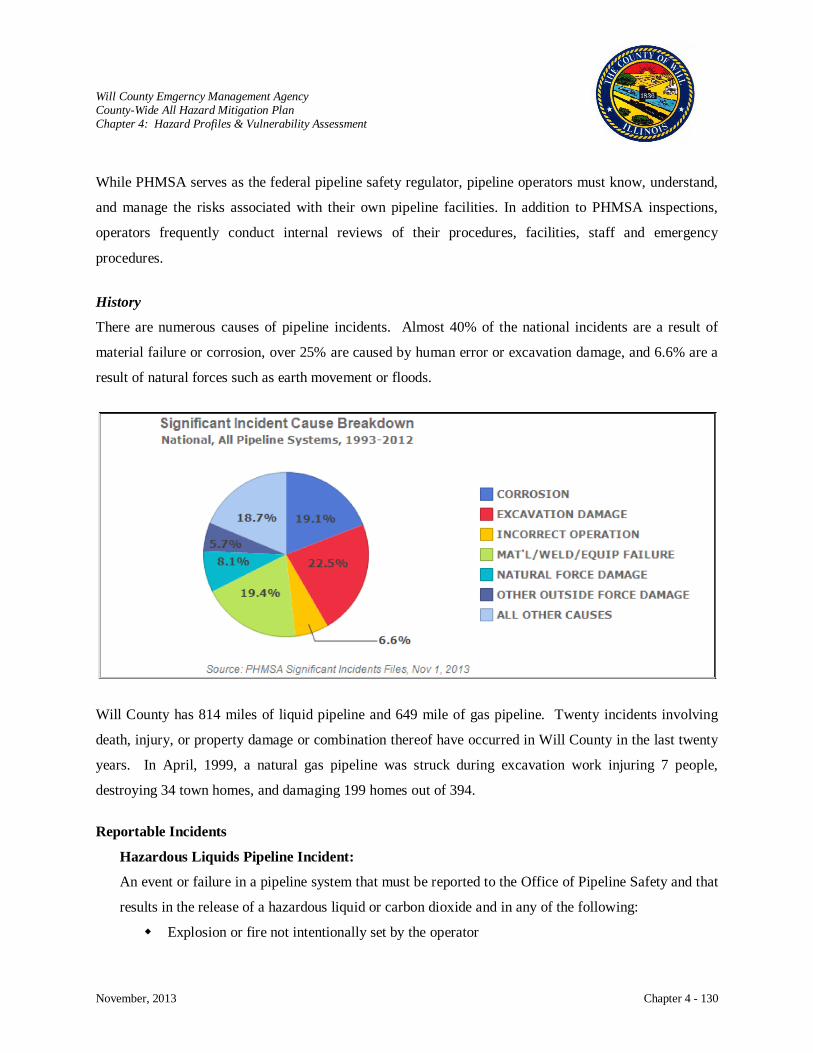
Will County Emgerncy Management Agency County-Wide All Hazard Mitigation Plan Chapter 4: Hazard Profiles & Vulnerability Assessment
November, 2013 Chapter 4 - 130
While PHMSA serves as the federal pipeline safety regulator, pipeline operators must know, understand,
and manage the risks associated with their own pipeline facilities. In addition to PHMSA inspections,
operators frequently conduct internal reviews of their procedures, facilities, staff and emergency
procedures.
History
There are numerous causes of pipeline incidents. Almost 40% of the national incidents are a result of
material failure or corrosion, over 25% are caused by human error or excavation damage, and 6.6% are a
result of natural forces such as earth movement or floods.
Will County has 814 miles of liquid pipeline and 649 mile of gas pipeline. Twenty incidents involving
death, injury, or property damage or combination thereof have occurred in Will County in the last twenty
years. In April, 1999, a natural gas pipeline was struck during excavation work injuring 7 people,
destroying 34 town homes, and damaging 199 homes out of 394.
Reportable Incidents
Hazardous Liquids Pipeline Incident:
An event or failure in a pipeline system that must be reported to the Office of Pipeline Safety and that
results in the release of a hazardous liquid or carbon dioxide and in any of the following:
Explosion or fire not intentionally set by the operator
Will County Emgerncy Management Agency County-Wide All Hazard Mitigation Plan Chapter 4: Hazard Profiles & Vulnerability Assessment
November, 2013 Chapter 4 - 131
Release of 5 gallons (19 liters) or more of hazardous liquid or carbon dioxide, except that no
report is required for a release of less than 5 barrels (0.8 cubic meters) resulting from a
pipeline maintenance activity if the release is:
Not otherwise reportable under this section (i.e., 49 CFR 195.50),
Not one described in 49 CFR 195.52(a)(4),
Confined to company property or pipeline right-of-way, and
Cleaned up promptly;
Death of any person
Personal injury necessitating hospitalization
Estimated property damage, including cost of cleanup and recovery, value of lost product,
and damage to the property of the operator or others, or both, exceeding $50,000 (49 CFR
149.50).
Involves a release of gas from a pipeline or of liquefied natural gas (LNG) or gas from an
LNG facility and results in
Natural Gas Pipeline Incident:
An event in the natural gas pipeline system that must be reported to the Office of Pipeline Safety and:
Death, or personal injury necessitating in-patient hospitalization; or
Estimated property damage, including cost of gas lost, and damage to the property of the
operator or others, or both, of $50,000 or more.
Results in an emergency shutdown of an LNG facility.
Is significant, in the judgment of the operator, even though it did not meet the criteria of (1)
or (2) above (49 CFR 191.3).
Risk Characterization
As communities and pipelines grow closer together, concerns about protecting people and the
environment from risk of pipeline incidents have increased. Community awareness and involvement
programs are a key component to safeguarding pipeline safety. By knowing where pipelines are located
and how to manage activities near them, we can live safely around them. Risks associated with pipeline
incidents are explosion, contamination, asphyxiation, and fire resulting in injury, death, and property
damage. Leaking pipes can send hazardous liquids into the soil or water or gases into the atmosphere.
Fortunately, major incidents are infrequent.
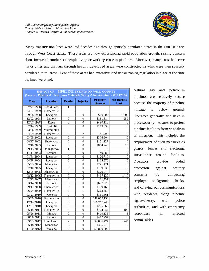
Will County Emgerncy Management Agency County-Wide All Hazard Mitigation Plan Chapter 4: Hazard Profiles & Vulnerability Assessment
November, 2013 Chapter 4 - 132
Many transmission lines were laid decades ago through sparsely populated states in the Sun Belt and
through West Coast states. These areas are now experiencing rapid population growth, raising concern
about increased numbers of people living or working close to pipelines. Moreover, many lines that serve
major cities and that run through heavily developed areas were constructed in what were then sparsely
populated, rural areas. Few of these areas had extensive land use or zoning regulation in place at the time
the lines were laid.
Natural gas and petroleum
pipelines are relatively secure
because the majority of pipeline
mileage is below ground.
Operators generally also have in
place security measures to protect
pipeline facilities from vandalism
or intrusion. This includes the
employment of such measures as
guards, fences and electronic
surveillance around facilities.
Operators provide added
protection against security
concerns by conducting
employee background checks,
and carrying out communications
with residents along pipeline
rights-of-way, with police
authorities, and with emergency
responders in affected
communities.
IMPACT OF PIPELINE EVENTS ON WILL COUNTY (Source: Pipeline & Hazardous Materials Safety Administration / WC EMA)
Date Location Deaths Injuries Property Damage
Net Barrels Lost
02/22/1988 I-80 & I-55 1 04/27/1989 Romeoville 09/08/1998 Lockport 0 0 $60,605 1,800 12/02/1998 Lemont 0 0 $181,814 259 12/07/1998 Essex 0 0 $480,110 0 02/14/1999 Crest Hill 0 0 $119,639 0 03/26/1999 Wilmington 04/29/1999 Romeoville 0 7 $1,795 0 03/05/2002 Lockport 0 0 $376,604 0 08/27/2002 Shorewood 0 0 $151,127 0 07/10/2003 Lemont 0 0 $854,248 15 09/13/2003 Bolingbrook 1 0 0 0 11/11/2003 Lemont 0 0 $9,084 6 01/31/2004 Lockport 0 0 $120,710 0 04/28/2004 Lockport 0 0 $164,576 0 05/03/2004 Manhattan 0 0 $241,421 0 07/10/2005 Lockport 0 0 $109,035 0 12/05/2005 Shorewood 0 0 $379,044 0 08/12/2006 Romeoville 0 0 $467,139 1,419 02/23/2007 Manhattan 0 0 $1,731 10 03/14/2008 Lemont 0 0 $607,926 09/17/2008 Shorewood 0 0 $109,469 3 06/24/2009 Romeoville 0 1 $263,354 03/21/2010 Mokena 0 0 $161,561 09/09/2010 Romeoville 0 0 $49,003,154 0 12/14/2010 Lockport 0 0 $16,215,240 0 12/31/2010 Lockport 0 0 $255,268 0 05/14/2011 Romeoville 0 0 $724,047 100 05/26/2011 Monee 0 0 $419,135 3 08/08/2011 Lemont 0 0 $412,297 3 03/03/2012 New Lenox 2 3 $2,836,777 1,245 05/18/2012 Manhattan 0 0 $395,779 0 11/20/2012 Mokena 0 0 $9,800,000
Will County Emgerncy Management Agency County-Wide All Hazard Mitigation Plan Chapter 4: Hazard Profiles & Vulnerability Assessment
November, 2013 Chapter 4 - 133
After the terrorist attacks of September 11, 2001, awareness increased of safeguards and security needs
relative to our nation’s critical infrastructure. The Office of Pipeline Safety (OPS), along with the
Department of Homeland Security and the pipeline industry began looking at ways to enhance the
security of our energy pipeline infrastructure thereby ensuring that critical energy transportation was not
disrupted. Enhanced communication networks were developed to share information on suspicious
activities and potential threats to the pipeline infrastructure and to begin identifying noteworthy and
possible enhancements to help assure the security of hazardous liquid and natural gas pipeline systems.
Following 9/11/01, OPS undertook several initiatives to help reduce the increased threat of terrorist
activity against pipelines:
Communications
Vulnerability Assessments
Developing consensus security guidance with the pipeline industry and states on conducting
vulnerability assessments, improving security plans, developing specific deterrent and protective
actions, and upgrading response and recovery plans
Obtaining executive-level commitment from pipeline operators to implement needed security
provisions described in the guidance
Developing a definition for “critical pipeline facility” and a system of recommended deterrent
and protective measures that are synchronized with the threat control levels of the Office of
Homeland Security’s threat warning system
Drafting and distributing for review by state and federal officials initial verification audit
protocols
Soliciting R&D proposals to detect encroachments, continuously monitor rights-of-ways and
improve system controls
Working with DOE and FERC to address issues related to rapid response and recovery of critical
pipeline service in the case of a pipeline disturbance.
The Pipeline Safety Improvement Act (PSIA) of 2002 serves to further strengthen regulations regarding
pipeline safety and security. Federal pipeline safety regulations require pipeline operators to conduct
continuing public awareness programs to provide pipeline safety information to four stakeholder
audiences:
Affected Public
Will County Emgerncy Management Agency County-Wide All Hazard Mitigation Plan Chapter 4: Hazard Profiles & Vulnerability Assessment
November, 2013 Chapter 4 - 134
Emergency Officials
Local Public Officials
Excavators
OPS will continue its efforts relative to pipeline security by:
Collaborating with pipeline operators, state pipeline safety agencies, and other federal agencies to
continue identifying critical facilities using the established definition of “critical pipeline facility”
Continuing work with the DOE, FERC and other federal agencies, states and the pipeline industry
to advance planning for rapid response and recovery of damaged pipeline systems. This will
include identifying and resolving barriers to recovery, including the sharing of critical parts and
the need for emergency authorities
Planning and conducting regional exercises with emphasis on response and recovery
Continuing to work with state pipeline safety agencies to verify that pipeline operators have
developed and implemented security, response and recovery plans for critical pipeline facilities
Impact: Moderate
Damage to Buildings
Pipeline incidents can cause extensive damage to buildings through contamination, fire, or explosion.
Critical Facilities
The United States currently consumes about 63 billion cubic feet of natural gas daily, nearly all of
which is transported by pipeline and about 19.5 million barrels of petroleum products. Interruptions
in pipeline service can cause delays in natural gas production and utilities, and chemical processing
plants who utilize the products transported through the pipeline system. Communication systems or
electric power can also be lost when underground lines are damaged.
Health and Safety
Injuries and deaths occur when fire, explosion, or noxious fumes result when pipelines are damaged
or fail due to corrosion or material defects.
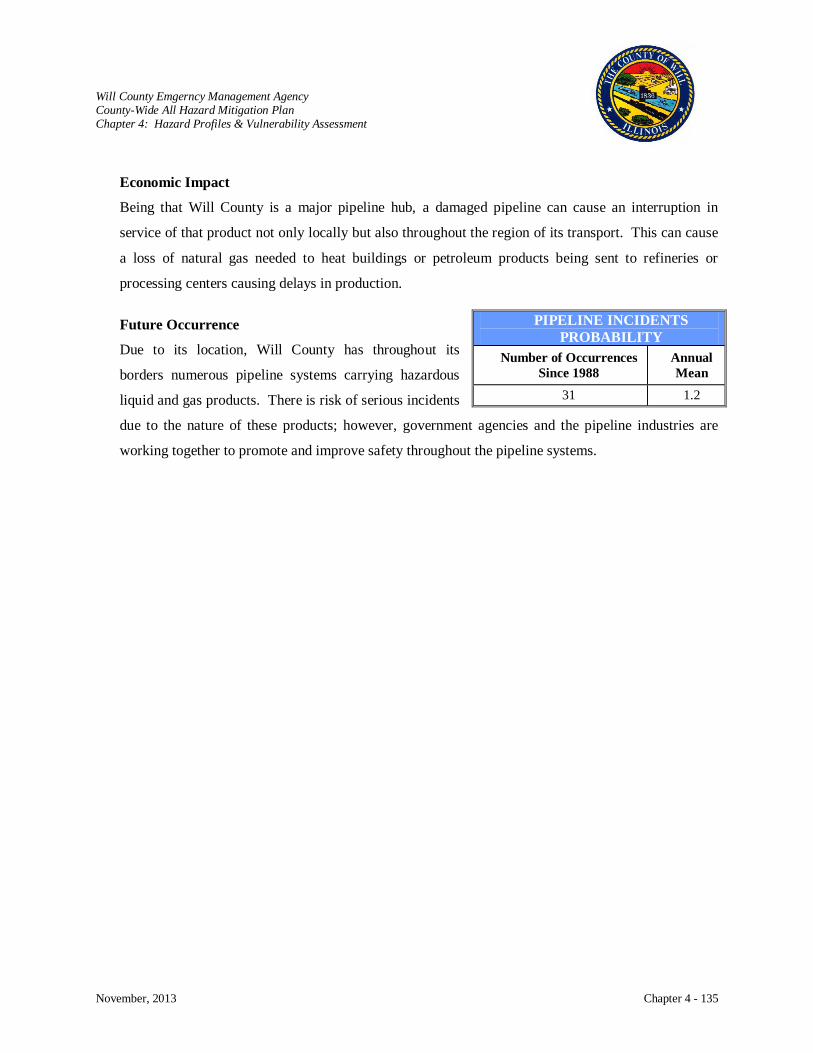
Will County Emgerncy Management Agency County-Wide All Hazard Mitigation Plan Chapter 4: Hazard Profiles & Vulnerability Assessment
November, 2013 Chapter 4 - 135
Economic Impact
Being that Will County is a major pipeline hub, a damaged pipeline can cause an interruption in
service of that product not only locally but also throughout the region of its transport. This can cause
a loss of natural gas needed to heat buildings or petroleum products being sent to refineries or
processing centers causing delays in production.
Future Occurrence
Due to its location, Will County has throughout its
borders numerous pipeline systems carrying hazardous
liquid and gas products. There is risk of serious incidents
due to the nature of these products; however, government agencies and the pipeline industries are
working together to promote and improve safety throughout the pipeline systems.
PIPELINE INCIDENTS PROBABILITY
Number of Occurrences Since 1988
Annual Mean
31 1.2

Will County Emgerncy Management Agency County-Wide All Hazard Mitigation Plan Chapter 4: Hazard Profiles & Vulnerability Assessment
November, 2013 Chapter 4 - 136
NON-HAZARDOUS MATERIAL TRANSPORTATION
Hazard Characterization
The transportation sector consists of roads, commuter and freight rail services, regional buses, waterways,
and bikeways that transport goods and people. Being proximate to Chicago has led Will County to
develop an intricate and varied transportation system for the conveyance of raw materials, finished goods,
workers, and tourists in and out of Chicago and its metropolitan area. It has developed over decades as a
result of public and private investment. The diversity and size of the transportation sector makes it
essential to the County’s economy and security.
Regardless of the mode of transportation, accidents can and do occur. Motor vehicles, airplanes, trains, or
boats are all subject to the risk of accidents. These accidents can occur anywhere within the
transportation system because of the driver’s error, mechanical failure, poor weather conditions, or
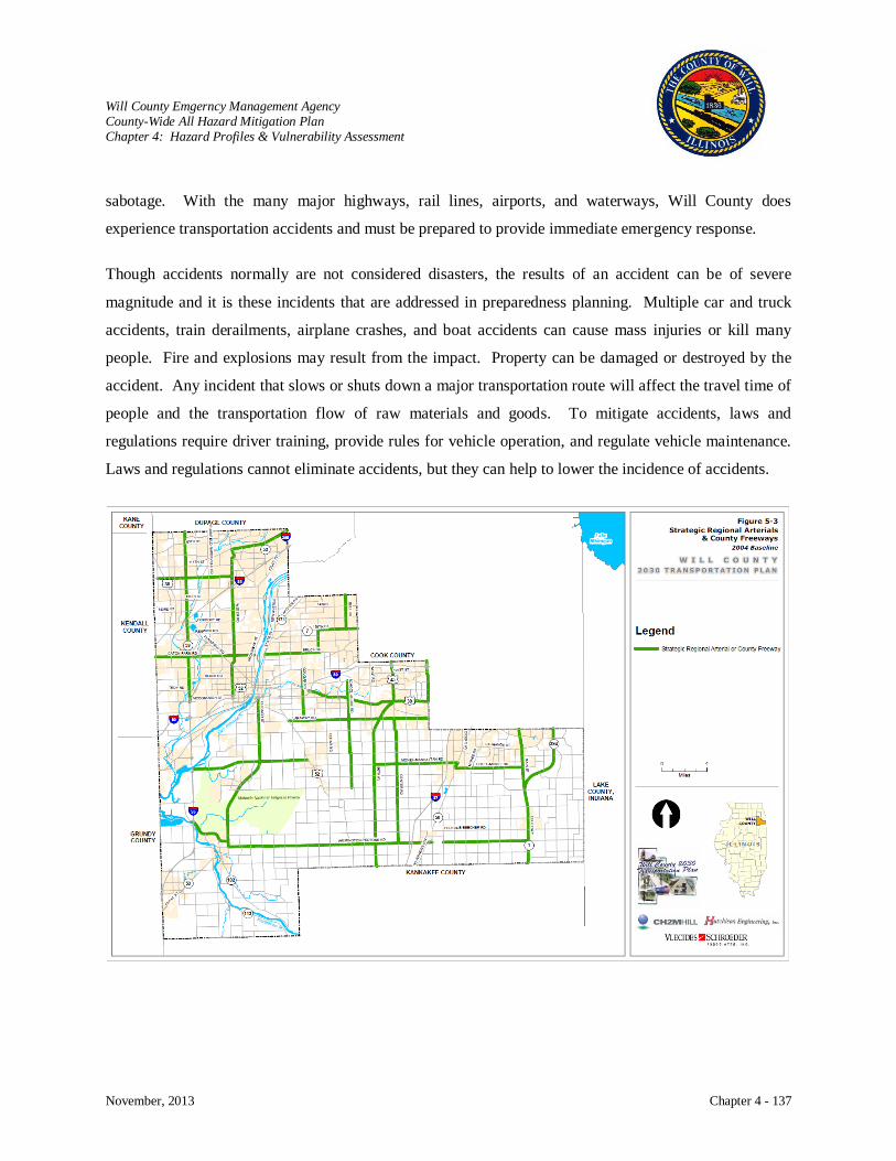
Will County Emgerncy Management Agency County-Wide All Hazard Mitigation Plan Chapter 4: Hazard Profiles & Vulnerability Assessment
November, 2013 Chapter 4 - 137
sabotage. With the many major highways, rail lines, airports, and waterways, Will County does
experience transportation accidents and must be prepared to provide immediate emergency response.
Though accidents normally are not considered disasters, the results of an accident can be of severe
magnitude and it is these incidents that are addressed in preparedness planning. Multiple car and truck
accidents, train derailments, airplane crashes, and boat accidents can cause mass injuries or kill many
people. Fire and explosions may result from the impact. Property can be damaged or destroyed by the
accident. Any incident that slows or shuts down a major transportation route will affect the travel time of
people and the transportation flow of raw materials and goods. To mitigate accidents, laws and
regulations require driver training, provide rules for vehicle operation, and regulate vehicle maintenance.
Laws and regulations cannot eliminate accidents, but they can help to lower the incidence of accidents.
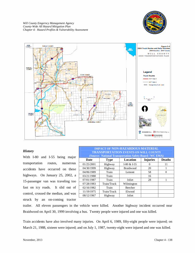
Will County Emgerncy Management Agency County-Wide All Hazard Mitigation Plan Chapter 4: Hazard Profiles & Vulnerability Assessment
November, 2013 Chapter 4 - 138
History
With I-80 and I-55 being major
transportation routes, numerous
accidents have occurred on these
highways. On January 25, 2002, a
15-passenger van was traveling too
fast on icy roads. It slid out of
control, crossed the median, and was
struck by an on-coming tractor
trailer. All eleven passengers in the vehicle were killed. Another highway incident occurred near
Braidwood on April 30, 1999 involving a bus. Twenty people were injured and one was killed.
Train accidents have also involved many injuries. On April 6, 1989, fifty-eight people were injured; on
March 21, 1988, sixteen were injured; and on July 1, 1987, twenty-eight were injured and one was killed.
IMPACT OF NON-HAZARDOUS MATERIAL TRANSPORTATION EVENTS ON WILL COUNTY
(Source: National Transportation Safety Board / WC EMA) Date Type Location Injuries Deaths
01/25/2001 Highway I-80 & I-55 0 11 04/30/1999 Highway Braidwood 20 1 04/06/1989 Train Lemont 58 0 03/21/1988 Train 16 07/01/1987 Train Joliet 28 1 07/28/1983 Train/Truck Wilmington 02/16/1982 Train Beecher 11/19/1975 Train/Truck Elwood 08/12/1967 Highway Joliet

Will County Emgerncy Management Agency County-Wide All Hazard Mitigation Plan Chapter 4: Hazard Profiles & Vulnerability Assessment
November, 2013 Chapter 4 - 139
Risk Characterization
Interdependences exist between the various modes of transportation as goods are moved in and out of the
County between highway, rail, and water. Interdependences also exist between transportation and every
other sector of the economy. Consequently, accidents in the transportation sector may impact other
industries that rely on it for its transport of raw materials, finished goods, and workers.
Impact: Moderate
Transportation Modes
Airports: The aviation mode has the symbolic value of representing the freedom of movement that
Americans value so highly along with the technological and industrial prowess which has
made the United States a world power. The nation’s aviation system consists of
airports/airplanes and the associated assets needed to support their operations and
aviation command, control, communications, and information systems needed to
maintain safe use of our national airspace. Will County has six private or general
aviation airports that provide business and recreational aerial service to the local area.

Will County Emgerncy Management Agency County-Wide All Hazard Mitigation Plan Chapter 4: Hazard Profiles & Vulnerability Assessment
November, 2013 Chapter 4 - 140
Bridges: Vehicular and railroad bridges represent choke points and therefore play a very critical
role and present unique challenges. Within Will County are major bridges that cross
waterways, railways, and connect major interstates that are important links in the
transportation system. Should they be damaged or destroyed, emergency response and
movement of both commercial and private vehicles would be severely hampered.
Highways: The trucking and busing industry is a
fundamental component of not only our
national but also our County
transportation infrastructure. Without the
transportation sector’s resources, the
movement of people, goods, and services
would be greatly impeded. Components
of this infrastructure include highways,
roads, inter-modal terminals, bridges, tunnels, trucks, buses, and maintenance facilities.
Millions of privately owned and commercial trucking vehicles utilize the extensive
interstate system that crosses Illinois on a daily basis, and millions of tons of goods are
shipped in and out of the state each year. The interstate network is vital to the
commercial trucking industry for both intra- and inter-state shipments of products.
There are three major travel corridors within Will County: first, a northeasterly flow to
and from Chicago from the northwestern sections of the County; second, a north-south
flow to and from Chicago from the central and eastern sections of the County; and
third, a north-south inter-suburban flow between Will and DuPage Counties that
provide work commuting routes. The County’s highway system consists of four
interstate highways and nine state highways. The interstate highway system is
designed as a paved, four-lane, high-speed vehicle travel corridor that allows virtually
uninterrupted travel through the Chicago Metropolitan Area and to other parts of
Illinois and surrounding states. Over one-hundred County highways exist to provide
service between interstate and state highways while township roads serve the needs of
the farming community and municipal streets serve local and through traffic within the
cities and villages.

Will County Emgerncy Management Agency County-Wide All Hazard Mitigation Plan Chapter 4: Hazard Profiles & Vulnerability Assessment
November, 2013 Chapter 4 - 141

Will County Emgerncy Management Agency County-Wide All Hazard Mitigation Plan Chapter 4: Hazard Profiles & Vulnerability Assessment
November, 2013 Chapter 4 - 142
Railroads/ Train Stations:
Illinois is viewed as the center of the nation’s rail network. Chicago is considered the
railroad capital and has established its status as the nation’s railroad intermodal hub.
There are roughly 7,300 route miles or railroad lines in Illinois and approximately
4,000 of those miles are vital to the transportation of freight and passengers within
Illinois. More than 40 railroads are able to provide service from Illinois to every part
of the United States. Trains carry mining, manufacturing, and agricultural products;
liquid chemicals and fuels; and consumer goods. The EJ&E Railroad (now the
Canadian National) and BNSF Railway Company provide transportation of goods and
Metra provides commuter transportation in and out of Will County.
Two new intermodal centers are up and running in Will County. Approximately 454
million tons of freight, or 24.5 percent of the total tons of freight carried, go through

Will County Emgerncy Management Agency County-Wide All Hazard Mitigation Plan Chapter 4: Hazard Profiles & Vulnerability Assessment
November, 2013 Chapter 4 - 143
Illinois. Coal, an essential resource for the generation of electricity, composes almost
20% of the freight. Passenger trains transport over 20 million intercity travelers
annually, and 45 million passengers use trains and subways operated by local transit
authorities. Metra provides commuter transportation in and out of Will County.

Will County Emgerncy Management Agency County-Wide All Hazard Mitigation Plan Chapter 4: Hazard Profiles & Vulnerability Assessment
November, 2013 Chapter 4 - 144
Health and Safety
Traffic accidents are influenced by weather conditions, speed of traffic, and the number of vehicles
occupying the road. Conditions that lead to accidents include rain, fog, ice, heavy rain, strong winds,
high speed, and heavy traffic congestion. Accordingly, people are injured or killed as a result of
accidents.
Economic Impact
Short delays due to slow downs or shut downs in transportation systems are the most common results
of accidents. Should a major transportation route be shut down for an extended period of time, people
traveling through that area and businesses transporting raw materials and goods could be impacted
until that route is repaired.
Future Occurrence
As the County grows in population and business/manufacturing entities, use of all transportation
systems will increase and likely increase in the number of accidents.
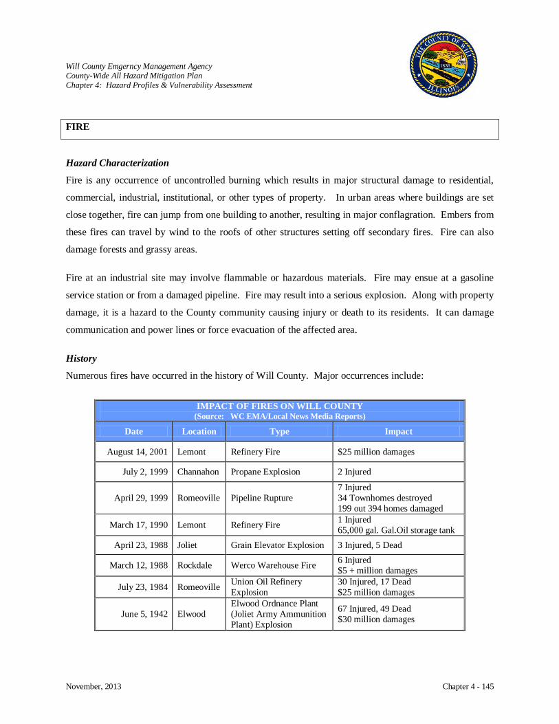
Will County Emgerncy Management Agency County-Wide All Hazard Mitigation Plan Chapter 4: Hazard Profiles & Vulnerability Assessment
November, 2013 Chapter 4 - 145
FIRE
Hazard Characterization
Fire is any occurrence of uncontrolled burning which results in major structural damage to residential,
commercial, industrial, institutional, or other types of property. In urban areas where buildings are set
close together, fire can jump from one building to another, resulting in major conflagration. Embers from
these fires can travel by wind to the roofs of other structures setting off secondary fires. Fire can also
damage forests and grassy areas.
Fire at an industrial site may involve flammable or hazardous materials. Fire may ensue at a gasoline
service station or from a damaged pipeline. Fire may result into a serious explosion. Along with property
damage, it is a hazard to the County community causing injury or death to its residents. It can damage
communication and power lines or force evacuation of the affected area.
History
Numerous fires have occurred in the history of Will County. Major occurrences include:
IMPACT OF FIRES ON WILL COUNTY
(Source: WC EMA/Local News Media Reports)
Date Location Type Impact
August 14, 2001 Lemont Refinery Fire $25 million damages
July 2, 1999 Channahon Propane Explosion 2 Injured
April 29, 1999 Romeoville Pipeline Rupture 7 Injured 34 Townhomes destroyed 199 out 394 homes damaged
March 17, 1990 Lemont Refinery Fire 1 Injured 65,000 gal. Gal.Oil storage tank
April 23, 1988 Joliet Grain Elevator Explosion 3 Injured, 5 Dead
March 12, 1988 Rockdale Werco Warehouse Fire 6 Injured $5 + million damages
July 23, 1984 Romeoville Union Oil Refinery Explosion
30 Injured, 17 Dead $25 million damages
June 5, 1942 Elwood Elwood Ordnance Plant (Joliet Army Ammunition Plant) Explosion
67 Injured, 49 Dead $30 million damages
Will County Emgerncy Management Agency County-Wide All Hazard Mitigation Plan Chapter 4: Hazard Profiles & Vulnerability Assessment
November, 2013 Chapter 4 - 146
Risk Characterization
A fire or explosion may occur at any time with no warning. Urban fires may result in very costly
damages. Urban communities with newer industrial and business facilities are reasonably secure from
potential conflagration. These buildings are generally constructed of fire resistive materials, protected
with automatic sprinkler systems, equipped with fire extinguishing and fire detection systems, and
reasonably well separated.
Prevention is a simple solution to reduce destructive fires. It is incumbent upon each citizen to prepare
and practice fire safety. Good public education programs on fire safety, fire alarms, and fire response are
important prevention measures.
Impact: Low
Damage to Buildings Fires cause serious damage or destruction to buildings.
Critical Facilities Critical facilities can be seriously damaged or destroyed by fires disrupting services to businesses and household.
Health and Safety Fires cause serious burns, injuries, smoke inhalation, and death to individuals inside burning buildings, first responders, and area population when hazardous chemicals are released into the atmosphere as a result of fire or explosion.
Economic Impact Injury, loss of property, and business interruption can have devastating economic impact to individuals, businesses, industry, and populations served by affected businesses and infrastructure. There may or may not be insurance to cover the cost of structure repair or replacement, injuries, or lost business.
Future Occurrence The risk of fire is always a potential but can be mitigated with fire safety practices, fire detection systems, fire suppression equipment, and fire resistive materials. New facilities must meet building codes which are implemented to reduce fire risk for the protection of people and property.

Will County Emgerncy Management Agency County-Wide All Hazard Mitigation Plan Chapter 4: Hazard Profiles & Vulnerability Assessment
November, 2013 Chapter 4 - 147
DAM FAILURE
Hazard Characterization
A dam is built to control water and can be made from earth, rocks, or concrete. Dams are usually
constructed on rivers to store water in a reservoir during times of excess flow and then released as needed.
They are important because they provide water for drinking, industrial processes, fishing, recreation,
navigation, and transport of raw goods on rivers. The water impounded behind a dam is referred to as the
reservoir and is measured in acre-feet, with one acre-foot being the volume of water that covers one acre
of land to a depth of one foot. Due to topography, even a small dam may have a reservoir containing
many acre-feet of water.
Dam failure is an accidental or unintentional collapse or other failure of an impoundment structure that
results in downstream flooding. Dams are man-made structures and dam failures are usually considered
technological hazards; however, dams usually fail as a result of the secondary effects of storms. Dam
failures may result from natural events, human-caused events, or a combination thereof. Failure can
result in the release of the reservoir contents that include water, mine wastes or agricultural refuse causing
a negative impact upstream or downstream or at location remote from the dam. A flood that is caused by
the breach of a dam may be of greater magnitude than floods originating from the runoff of rainfall or
snowmelt.
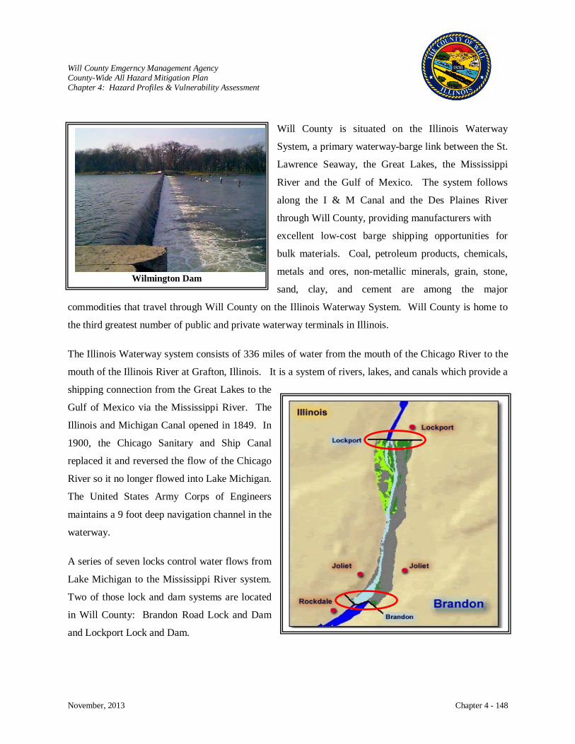
Will County Emgerncy Management Agency County-Wide All Hazard Mitigation Plan Chapter 4: Hazard Profiles & Vulnerability Assessment
November, 2013 Chapter 4 - 148
Will County is situated on the Illinois Waterway
System, a primary waterway-barge link between the St.
Lawrence Seaway, the Great Lakes, the Mississippi
River and the Gulf of Mexico. The system follows
along the I & M Canal and the Des Plaines River
through Will County, providing manufacturers with
excellent low-cost barge shipping opportunities for
bulk materials. Coal, petroleum products, chemicals,
metals and ores, non-metallic minerals, grain, stone,
sand, clay, and cement are among the major
commodities that travel through Will County on the Illinois Waterway System. Will County is home to
the third greatest number of public and private waterway terminals in Illinois.
The Illinois Waterway system consists of 336 miles of water from the mouth of the Chicago River to the
mouth of the Illinois River at Grafton, Illinois. It is a system of rivers, lakes, and canals which provide a
shipping connection from the Great Lakes to the
Gulf of Mexico via the Mississippi River. The
Illinois and Michigan Canal opened in 1849. In
1900, the Chicago Sanitary and Ship Canal
replaced it and reversed the flow of the Chicago
River so it no longer flowed into Lake Michigan.
The United States Army Corps of Engineers
maintains a 9 foot deep navigation channel in the
waterway.
A series of seven locks control water flows from
Lake Michigan to the Mississippi River system.
Two of those lock and dam systems are located
in Will County: Brandon Road Lock and Dam
and Lockport Lock and Dam.
Wilmington Dam
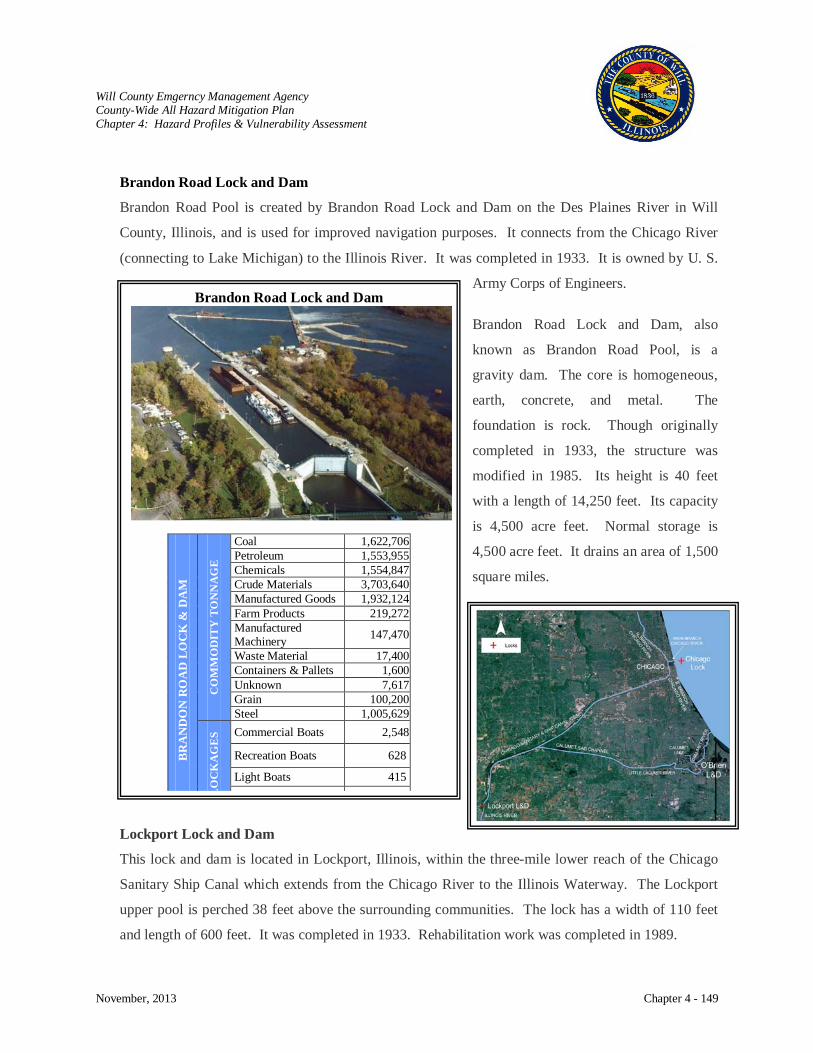
Will County Emgerncy Management Agency County-Wide All Hazard Mitigation Plan Chapter 4: Hazard Profiles & Vulnerability Assessment
November, 2013 Chapter 4 - 149
Brandon Road Lock and Dam
Brandon Road Pool is created by Brandon Road Lock and Dam on the Des Plaines River in Will
County, Illinois, and is used for improved navigation purposes. It connects from the Chicago River
(connecting to Lake Michigan) to the Illinois River. It was completed in 1933. It is owned by U. S.
Army Corps of Engineers.
Brandon Road Lock and Dam, also
known as Brandon Road Pool, is a
gravity dam. The core is homogeneous,
earth, concrete, and metal. The
foundation is rock. Though originally
completed in 1933, the structure was
modified in 1985. Its height is 40 feet
with a length of 14,250 feet. Its capacity
is 4,500 acre feet. Normal storage is
4,500 acre feet. It drains an area of 1,500
square miles.
Lockport Lock and Dam
This lock and dam is located in Lockport, Illinois, within the three-mile lower reach of the Chicago
Sanitary Ship Canal which extends from the Chicago River to the Illinois Waterway. The Lockport
upper pool is perched 38 feet above the surrounding communities. The lock has a width of 110 feet
and length of 600 feet. It was completed in 1933. Rehabilitation work was completed in 1989.
Brandon Road Lock and Dam
BRA
ND
ON
RO
AD
LO
CK
& D
AM
CO
MM
OD
ITY
TO
NN
AG
E
Coal 1,622,706 Petroleum 1,553,955 Chemicals 1,554,847 Crude Materials 3,703,640 Manufactured Goods 1,932,124 Farm Products 219,272 Manufactured Machinery 147,470
Waste Material 17,400 Containers & Pallets 1,600 Unknown 7,617 Grain 100,200 Steel 1,005,629
LOC
KA
GE
S Commercial Boats 2,548
Recreation Boats 628
Light Boats 415

Will County Emgerncy Management Agency County-Wide All Hazard Mitigation Plan Chapter 4: Hazard Profiles & Vulnerability Assessment
November, 2013 Chapter 4 - 150
A safety assessment was completed in 2005.
The Lockport Pool Approach Dike and walls
were confirmed potentially unsafe. Total
estimated repair project cost is
$132,400,000. The Approach Dike is
presently under repair with a 300 foot test
section of full depth concrete cut-off wall
being constructed. If successful, it will lead
to 4,300 feet of the dike receiving a full
depth cut-off wall. Interim risk reduction
measures were completed including weir
repair and tree cutting along the back side of
the dike. In addition, design of the left
descending bank wall repairs is underway
with a proposed fourth quarter contract
award.
Lockport Lock and Dam
LOC
KPO
RT
RO
AD
LO
CK
& D
AM
CO
MM
OD
ITY
TO
NN
AG
E
Coal 1,607,210 Petroleum 1,580,305 Chemicals 1,550,197 Crude Materials 3,592,954 Manufactured Goods 1,801,459 Farm Products 214,572 Manufactured Machinery 179,520
Waste Material 17,400 Containers & Pallets 1,600 Unknown 7,617 Grain 98,800 Steel 1,021,364
LOC
KA
GE
S Commercial Boats 2,696
Recreation Boats 545
Light Boats 413 O h B 34
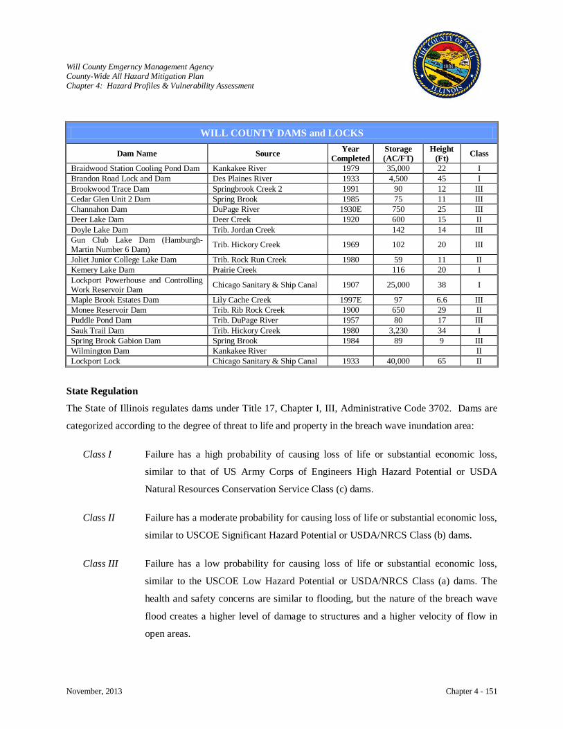
Will County Emgerncy Management Agency County-Wide All Hazard Mitigation Plan Chapter 4: Hazard Profiles & Vulnerability Assessment
November, 2013 Chapter 4 - 151
State Regulation
The State of Illinois regulates dams under Title 17, Chapter I, III, Administrative Code 3702. Dams are
categorized according to the degree of threat to life and property in the breach wave inundation area:
Class I Failure has a high probability of causing loss of life or substantial economic loss,
similar to that of US Army Corps of Engineers High Hazard Potential or USDA
Natural Resources Conservation Service Class (c) dams.
Class II Failure has a moderate probability for causing loss of life or substantial economic loss,
similar to USCOE Significant Hazard Potential or USDA/NRCS Class (b) dams.
Class III Failure has a low probability for causing loss of life or substantial economic loss,
similar to the USCOE Low Hazard Potential or USDA/NRCS Class (a) dams. The
health and safety concerns are similar to flooding, but the nature of the breach wave
flood creates a higher level of damage to structures and a higher velocity of flow in
open areas.
WILL COUNTY DAMS and LOCKS
Dam Name Source Year Completed
Storage (AC/FT)
Height (Ft) Class
Braidwood Station Cooling Pond Dam Kankakee River 1979 35,000 22 I Brandon Road Lock and Dam Des Plaines River 1933 4,500 45 I Brookwood Trace Dam Springbrook Creek 2 1991 90 12 III Cedar Glen Unit 2 Dam Spring Brook 1985 75 11 III Channahon Dam DuPage River 1930E 750 25 III Deer Lake Dam Deer Creek 1920 600 15 II Doyle Lake Dam Trib. Jordan Creek 142 14 III Gun Club Lake Dam (Hamburgh-Martin Number 6 Dam) Trib. Hickory Creek 1969 102 20 III
Joliet Junior College Lake Dam Trib. Rock Run Creek 1980 59 11 II Kemery Lake Dam Prairie Creek 116 20 I Lockport Powerhouse and Controlling Work Reservoir Dam Chicago Sanitary & Ship Canal 1907 25,000 38 I
Maple Brook Estates Dam Lily Cache Creek 1997E 97 6.6 III Monee Reservoir Dam Trib. Rib Rock Creek 1900 650 29 II Puddle Pond Dam Trib. DuPage River 1957 80 17 III Sauk Trail Dam Trib. Hickory Creek 1980 3,230 34 I Spring Brook Gabion Dam Spring Brook 1984 89 9 III Wilmington Dam Kankakee River II Lockport Lock Chicago Sanitary & Ship Canal 1933 40,000 65 II
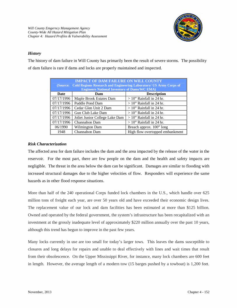
Will County Emgerncy Management Agency County-Wide All Hazard Mitigation Plan Chapter 4: Hazard Profiles & Vulnerability Assessment
November, 2013 Chapter 4 - 152
History
The history of dam failure in Will County has primarily been the result of severe storms. The possibility
of dam failure is rare if dams and locks are properly maintained and inspected.
Risk Characterization
The affected area for dam failure includes the dam and the area impacted by the release of the water in the
reservoir. For the most part, there are few people on the dam and the health and safety impacts are
negligible. The threat in the area below the dam can be significant. Damages are similar to flooding with
increased structural damages due to the higher velocities of flow. Responders will experience the same
hazards as in other flood response situations.
More than half of the 240 operational Corps funded lock chambers in the U.S., which handle over 625
million tons of freight each year, are over 50 years old and have exceeded their economic design lives.
The replacement value of our lock and dam facilities has been estimated at more than $125 billion.
Owned and operated by the federal government, the system’s infrastructure has been recapitalized with an
investment at the grossly inadequate level of approximately $220 million annually over the past 10 years,
although this trend has begun to improve in the past few years.
Many locks currently in use are too small for today’s larger tows. This leaves the dams susceptible to
closures and long delays for repairs and unable to deal effectively with lines and wait times that result
from their obsolescence. On the Upper Mississippi River, for instance, many lock chambers are 600 feet
in length. However, the average length of a modern tow (15 barges pushed by a towboat) is 1,200 feet.
IMPACT OF DAM FAILURE ON WILL COUNTY (Source: Cold Regions Research and Engineering Laboratory/ US Army Corps of
Engineers National Inventory of Dams/WC EMA) Date Dam Description
07/17/1996 Maple Brook Estates Dam > 10” Rainfall in 24 hr. 07/17/1996 Puddle Pond Dam > 10” Rainfall in 24 hr. 07/17/1996 Cedar Glen Unit 2 Dam > 10” Rainfall in 24 hr. 07/17/1996 Gun Club Lake Dam > 10” Rainfall in 24 hr. 07/17/1996 Joliet Junior College Lake Dam > 10” Rainfall in 24 hr. 07/17/1996 Channahon Dam > 10” Rainfall in 24 hr.
06/1990 Wilmington Dam Breach approx. 100” long 1948 Channahon Dam High flow overtopped embankment

Will County Emgerncy Management Agency County-Wide All Hazard Mitigation Plan Chapter 4: Hazard Profiles & Vulnerability Assessment
November, 2013 Chapter 4 - 153
Consequently, for a modern tow to navigate through these antiquated locks, it must split in half and transit
the lock one section at a time, resulting in costly delays.
The U.S. Army Corps of Engineers reports increasing amounts of scheduled and unscheduled downtime
at the locks on America’s inland navigation system. In 2005, for example, the Corps reported navigation
locks were unavailable (scheduled and unscheduled without ice) for about 110,000 hours (about 4,600
days). Queue delays at congested or unavailable locks cost the industry hundreds of millions of dollars
annually.
Waterborne transportation is generally out of sight, out of mind. But the inland waterways transportation
system binds us together in this country and allows us to turn on lights, eat our cereal in the morning, and
drive our cars to work. It deserves our support and our commitment to nurture it, not neglect it.
Impact: Low
Dam Failures
Dam failures usually occur when the spillway capacity is inadequate and water overtops the dam or
when internal erosion through the dam foundation occurs, also known as piping. If internal erosion or
overtopping causes a full structural breach, a high-velocity, debris-laden wall of water is released and
rushes downstream, damaging or destroying whatever is in its path. Dam failures may result from
one or more the following:
Prolonged periods of rainfall and flooding [the cause of most failures
Inadequate spillway capacity which causes excess overtopping flows
Internal erosion due to embankment or foundation leakage or piping
Improper maintenance
Improper design
Negligent operation
Failure of upstream dams
Landslides into reservoirs
High winds
Earthquakes.
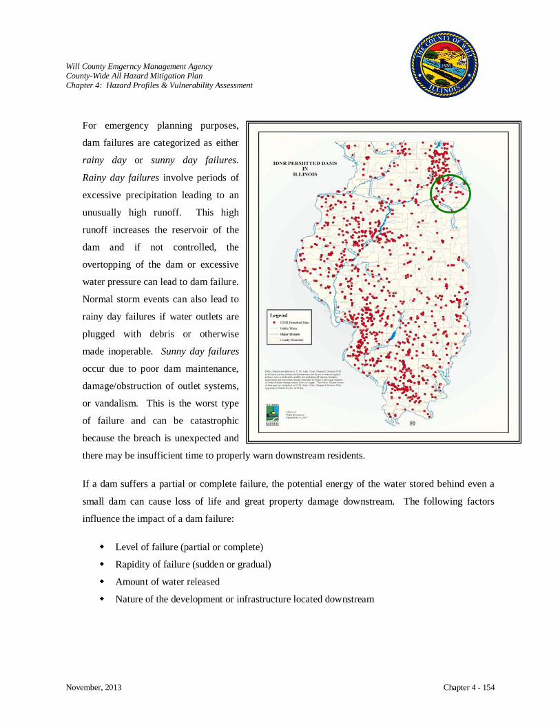
Will County Emgerncy Management Agency County-Wide All Hazard Mitigation Plan Chapter 4: Hazard Profiles & Vulnerability Assessment
November, 2013 Chapter 4 - 154
For emergency planning purposes,
dam failures are categorized as either
rainy day or sunny day failures.
Rainy day failures involve periods of
excessive precipitation leading to an
unusually high runoff. This high
runoff increases the reservoir of the
dam and if not controlled, the
overtopping of the dam or excessive
water pressure can lead to dam failure.
Normal storm events can also lead to
rainy day failures if water outlets are
plugged with debris or otherwise
made inoperable. Sunny day failures
occur due to poor dam maintenance,
damage/obstruction of outlet systems,
or vandalism. This is the worst type
of failure and can be catastrophic
because the breach is unexpected and
there may be insufficient time to properly warn downstream residents.
If a dam suffers a partial or complete failure, the potential energy of the water stored behind even a
small dam can cause loss of life and great property damage downstream. The following factors
influence the impact of a dam failure:
Level of failure (partial or complete)
Rapidity of failure (sudden or gradual)
Amount of water released
Nature of the development or infrastructure located downstream
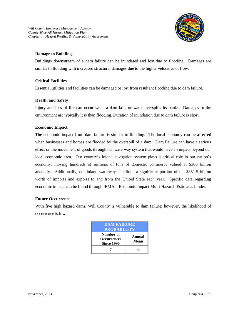
Will County Emgerncy Management Agency County-Wide All Hazard Mitigation Plan Chapter 4: Hazard Profiles & Vulnerability Assessment
November, 2013 Chapter 4 - 155
Damage to Buildings
Buildings downstream of a dam failure can be inundated and lost due to flooding. Damages are
similar to flooding with increased structural damages due to the higher velocities of flow.
Critical Facilities
Essential utilities and facilities can be damaged or lost from resultant flooding due to dam failure.
Health and Safety
Injury and loss of life can occur when a dam fails or water overspills its banks. Damages to the
environment are typically less than flooding. Duration of inundation due to dam failure is short.
Economic Impact
The economic impact from dam failure is similar to flooding. The local economy can be affected
when businesses and homes are flooded by the overspill of a dam. Dam Failure can have a serious
effect on the movement of goods through our waterway system that would have an impact beyond our
local economic area. Our country’s inland navigation system plays a critical role in our nation’s
economy, moving hundreds of millions of tons of domestic commerce valued at $300 billion
annually. Additionally, our inland waterways facilitate a significant portion of the $851.5 billion
worth of imports and exports to and from the United State each year. Specific data regarding
economic impact can be found through IEMA – Economic Impact Multi-Hazards Estimates binder.
Future Occurrence
With five high hazard dams, Will County is vulnerable to dam failure; however, the likelihood of
occurrence is low.
DAM FAILURE PROBABILITY
Number of Occurrences Since 1990
Annual Mean
7 .44
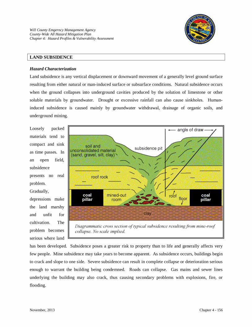
Will County Emgerncy Management Agency County-Wide All Hazard Mitigation Plan Chapter 4: Hazard Profiles & Vulnerability Assessment
November, 2013 Chapter 4 - 156
LAND SUBSIDENCE Hazard Characterization
Land subsidence is any vertical displacement or downward movement of a generally level ground surface
resulting from either natural or man-induced surface or subsurface conditions. Natural subsidence occurs
when the ground collapses into underground cavities produced by the solution of limestone or other
soluble materials by groundwater. Drought or excessive rainfall can also cause sinkholes. Human-
induced subsidence is caused mainly by groundwater withdrawal, drainage of organic soils, and
underground mining.
Loosely packed
materials tend to
compact and sink
as time passes. In
an open field,
subsidence
presents no real
problem.
Gradually,
depressions make
the land marshy
and unfit for
cultivation. The
problem becomes
serious where land
has been developed. Subsidence poses a greater risk to property than to life and generally affects very
few people. Mine subsidence may take years to become apparent. As subsidence occurs, buildings begin
to crack and slope to one side. Severe subsidence can result in complete collapse or deterioration serious
enough to warrant the building being condemned. Roads can collapse. Gas mains and sewer lines
underlying the building may also crack, thus causing secondary problems with explosions, fire, or
flooding.

Will County Emgerncy Management Agency County-Wide All Hazard Mitigation Plan Chapter 4: Hazard Profiles & Vulnerability Assessment
November, 2013 Chapter 4 - 157
History
No history of mine subsidence is available for review in this plan. While over 750,000 acres of the state
have been undermined, the occurrence of mine subsidence, statistically, is fairly infrequent.
Risk Characterization
The southwestern portion of Will County was once the site of shaft coalmines. Most of these mines were
abandoned around the turn of the century, but the mined-out areas still exist. Estimates that were taken
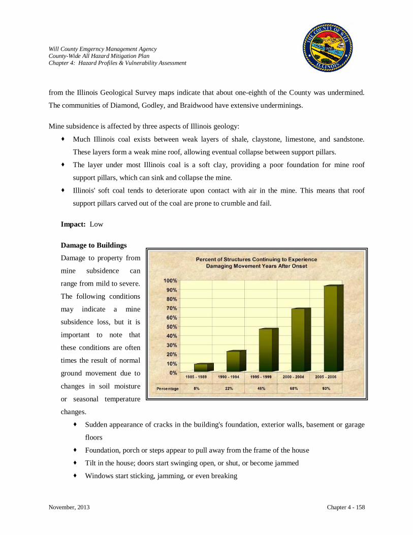
Will County Emgerncy Management Agency County-Wide All Hazard Mitigation Plan Chapter 4: Hazard Profiles & Vulnerability Assessment
November, 2013 Chapter 4 - 158
from the Illinois Geological Survey maps indicate that about one-eighth of the County was undermined.
The communities of Diamond, Godley, and Braidwood have extensive underminings.
Mine subsidence is affected by three aspects of Illinois geology:
Much Illinois coal exists between weak layers of shale, claystone, limestone, and sandstone.
These layers form a weak mine roof, allowing eventual collapse between support pillars.
The layer under most Illinois coal is a soft clay, providing a poor foundation for mine roof
support pillars, which can sink and collapse the mine.
Illinois' soft coal tends to deteriorate upon contact with air in the mine. This means that roof
support pillars carved out of the coal are prone to crumble and fail.
Impact: Low
Damage to Buildings
Damage to property from
mine subsidence can
range from mild to severe.
The following conditions
may indicate a mine
subsidence loss, but it is
important to note that
these conditions are often
times the result of normal
ground movement due to
changes in soil moisture
or seasonal temperature
changes.
Sudden appearance of cracks in the building's foundation, exterior walls, basement or garage
floors
Foundation, porch or steps appear to pull away from the frame of the house
Tilt in the house; doors start swinging open, or shut, or become jammed
Windows start sticking, jamming, or even breaking

Will County Emgerncy Management Agency County-Wide All Hazard Mitigation Plan Chapter 4: Hazard Profiles & Vulnerability Assessment
November, 2013 Chapter 4 - 159
Noticeable separations between walls and floors
Water pipes break, resulting in contaminated tap water, loss of water pressure or interior
water damage
Popping or snapping might be heard as the ground shifts
If mine subsidence is the cause, it is likely that several of these problems will develop. Initial damage
may occur within a few days or gradually over months. Ground movement from mine subsidence
usually continues for years.
Future Occurrence
It is theoretically possible for an entire mine to collapse. Generally, with mine subsidence, it will not
be an extensive area, usually less than 3 acres. Probably the most effective way of stopping mine
subsidence is to eliminate gravity. Since we can not do that, mine subsidence probably can not be
fully stopped. Modern mining techniques, such as those used in Illinois today, minimize the potential
for future mine subsidence. The Illinois Mine Subsidence Insurance Fund generally investigates
losses caused by older mines, which were mined a generation or two ago.

Will County Emgerncy Management Agency County-Wide All Hazard Mitigation Plan Chapter 4: Hazard Profiles & Vulnerability Assessment
November, 2013 Chapter 4 - 160
TERRORIST ATTACK
Hazard Characterization
The Code of Federal Regulations defines terrorism as “... an intentional, unlawful use of force and
violence against persons or property to intimidate or coerce a government, the civilian population, or any
segment thereof, in furtherance of political or social objectives.” The Federal Bureau of Investigation
(FBI) adds that terrorism can be domestic or
international. FEMA’s definition of
terrorism incorporates the use of Weapons of
Mass Destruction (WMD) which would
include biological, chemical, nuclear, and
radiological weapons; arson, incendiary,
explosive, and armed attacks; industrial
sabotage and intentional hazardous materials
releases; agriterrorism; and cyberterrorism.
The intent of these activities is to instill fear
into a community and cause death or serious
injury to people or significant damage to
property or information systems.
According to the Federal Emergency
Management Agency (FEMA), there is no
universal definition of terrorism, despite
decades of debate, and the term can be
interpreted in many ways. Common usage of
the term has become a catchall that includes
political violence and non-political criminals.
Complicating the issue of defining terrorism
even further, U.S. statutes do not include terrorism as a crime. Accordingly, terrorists are arrested for
elements of their terrorist acts, such as murder or weapons violations.
Terrorism Components Description
Violence/ Force
Violence/Force only needs to be threatened as long as the act is perceived to be real. Violence is utilized to achieve maximum publicity in order to create psychological effects beyond the immediate physical damage.
Victims as Pawns
Victims are not necessarily the direct targets but are used as pawns to cause fear in those who witness the attack. The plight of the victim is intended to frighten onlookers into a course of political or social action. The randomness of the choice of victim increases fear and anxiety.
Fear/Terror
Psychological techniques are used to bring about conformity of behavior. Fear is the actual agent of change. Fear erodes people’s trust in the government to protect them and they push officials to fulfill the terrorist’s demands.
Observers as Audience
Terrorists are trying to gain the attention of society, not necessarily the victim. Those who observe the act are the targets or “audience”. Media coverage can further the terrorist’s cause by broadcasting the act and the terrorist’s agenda.
Political or Social Change
The intention of the act is to generate the public’s fear or distrust in the government in order to force change in political, social, economic, religious, or ideological beliefs in order to facilitate the terrorist’s desired change.

Will County Emgerncy Management Agency County-Wide All Hazard Mitigation Plan Chapter 4: Hazard Profiles & Vulnerability Assessment
November, 2013 Chapter 4 - 161
Definition
In order to assess vulnerability to terrorism, a common understanding of what terrorism is must be
deciphered. It is probably best to agree that the meaning of terrorism changes over time as political
and social settings change. The meaning of terrorism may need to be adaptable just as terrorists are
adaptable to events and surroundings in order to further their cause.
Most definitions studied incorporate the key elements of violence, victims, fear, observers, and
political/social causes. By accepting these five elements as a basis for the meaning of terrorism, it
will allow us to move forward to assess potential vulnerability to terrorist acts.
Many state and local law
enforcement agencies have a
broader definition of terrorism
than the FBI whose statistics
point to low levels of terrorist
activity. Unlike the FBI, these
agencies recognize right-wing
extremists (Neo-Nazi, anti-
Semitic, anti-federalist) and
identify specific organizations
(anti-abortion, animal right,
environmentalist) as the most
likely sources of terrorism within
their communities.
A broader definition of terrorism
at the local level may be a good
thing. In the assessment process,
a broader definition of terrorism
may allow planners to identify a
more expansive range of potential terrorists, targets, methods, weapons, etc. A wider range of
terrorist possibilities requires local planners to prepare a more comprehensive plan to avert or
Types of Terrorists Description
International Supported by a government, but the terrorism is directed against citizens or agencies of other states.
Domestic Local, national acts by individuals or groups acting independently of any government support.
Left or Right-wing
Left-wing groups strive to reform or overthrow the established government for the greater freedom or well-being of the common man. Their actions tend to be symbolic; rarely do they act to cause widespread, arbitrary casualties. Right-wing groups endeavor to maintain the power of the state or to preserve the advantages held by a certain group. There is often a religious, racial, or politically paranoid survivalist dimension to their ideas. They can be extremely violent.
Special Interests
Groups may support “liberal” or “conservative” issues; like left-wing groups, less lethal in their actions. Special interest groups include those who may oppose legalized abortion or nuclear power, radical environmentalists, and militant animal rights activists.
Anarchists Perceives themselves as the purest of terrorists, live to destroy state’s authority and strive for complete freedom. Their politics are the most extreme.
Neo-Fascists Share characteristics with communism. They are revolutionary, look to overturn the entire order and create a new order of the most far-reaching sort.
Will County Emgerncy Management Agency County-Wide All Hazard Mitigation Plan Chapter 4: Hazard Profiles & Vulnerability Assessment
November, 2013 Chapter 4 - 162
mitigate such disasters. Terrorists tend to prefer situations that maximize the element of surprise. A
community that has carefully identified its most likely targets and instituted protective measures
against terrorism is a less desirable victim to terrorists. By having an understanding of the broader
range of possible terrorist methods, more expansive methods of detection, aversion, training,
response, and recovery can be developed in order to secure the safety of the community and avert the
potential of terrorism.
Weapons
Bombs, firearms, and limited range rockets continue to be the most common weapons used by today’s
terrorists. These weapons are easy to obtain, transport, and use. Occurring more frequently is the use
of secondary explosives to increase casualties. The concern is the growing use of unconventional
weapons. These include chemical, biological, and radiological weapons, more commonly referred to
as Weapons of Mass Destruction (WMD). These weapons have increased capacity to kill large
numbers of people. The use of WMDs is limited because they are more difficult to obtain and handle.
Just the thought of their use creates massive fear and may make the use of such weapons more
appealing to terrorists.
Targets
Terrorists target infrastructure that are more critical to daily operations and are harder to restore to
service. Interrupting and disabling services that the public depends on for health, economic, and
social activities brings attention and recognition that terrorist groups seek. The impact of the attack is
furthered when critical infrastructures are interconnected. With advances in communication and
technology, more and more critical infrastructures are becoming dependent upon the others. The
literature on terrorism shows that some critical infrastructures are targeted more often than others
because of the nature of the services they provide. Areas most vulnerable to terrorism include
transportation systems, industry, utilities, and entertainment/recreation venues. Attacking these
critical infrastructures disables important services the public depends on or may cause further damage
to the population and structures surrounding the attack area.
History
Incidents of terrorism have been minimal within Will County. Two groups are known to operate within
Will County. One is the Animal Liberation Front (ALF) whose cause is to support animal rights. ALF is
Will County Emgerncy Management Agency County-Wide All Hazard Mitigation Plan Chapter 4: Hazard Profiles & Vulnerability Assessment
November, 2013 Chapter 4 - 163
described by their founder, Ronnie Lee, as a “…non-violent guerilla organization, dedicated to the
liberation of animals from all forms of cruelty and persecution at the hands of mankind.”
There are many variations within the types of terrorist activities. While natural hazards may be readily
identifiable and somewhat predictable, terrorist activities cannot be reliably predicted. Terrorists are not
under any one person or nation’s control, but identify with various national or international communities,
religions, cults, or philosophies. Thus, terrorist type activities can occur anywhere at any time. As a
nation, we have experienced occurrences of terrorism. The Boston Marathon bombing, Columbine High
School shootings, attacks of 9/11, anthrax mailings, and Washington, D.C. area sniper shootings are
examples of how difficult it is to anticipate when and where such random acts of human-caused disasters
may occur. As the population of Will County grows and more industrial and sports/entertainment
Activists turned
from legal tactics of hunt disruption to illegal tactics of sabotage when they grew weary of being
assaulted and jailed and sought more effective tactics. ALF migrated to the U.S. in the early 1980s and is
now an international movement in over twenty countries.
ALF is a loosely associated collection of cells of people who go underground and violate the law on
behalf of animals. They break and enter to rescue animals, and they also destroy property in order to
prevent further harm done to animals and to weaken exploitation industries economically. Official ALF
guidelines are: (1) to liberate animals from places of abuse; (2) to inflict economic damage to industries
that profit from animal exploitation; (3) to reveal the horrors and atrocities committed against animals
behind locked doors, and (4) to take all necessary precautions against harming any human or nonhuman
animals. ALF claimed responsibility for the April, 2003, fire at an exotic meat market located in
Lockport.
The other terrorist group operating within Will County reported by law enforcement officials is a right-
wing white supremacist group. In the recent past, they have staged rallies and demonstrations in support
of their ideas.
Potentially threatening incidents have occurred that involve transportation sites. These occurrences
include photographic surveillance within Will County, bomb threats to locks and dams, suspicious aircraft
flights, and suspicious individuals/vehicles identified within Illinois.
Risk Characterization
Will County Emgerncy Management Agency County-Wide All Hazard Mitigation Plan Chapter 4: Hazard Profiles & Vulnerability Assessment
November, 2013 Chapter 4 - 164
complexes are developed, the threat and incident of a terrorist attack becomes more attractive, more
probable.
Specific threats of terrorism have not been made against any critical infrastructure within Will County.
Federal officials have issued warnings of potential attacks against the chemical, oil and gas, nuclear,
electrical power, and agricultural industries. International terrorist groups, such as al Qaeda, attempt to
strike at poorly defended targets. They are determined to attack the U.S. homeland and seek a way to
disrupt the country’s economic and military base. They most likely would use conventional weapons to
cause contamination, disruption, and terror.
Environmental activist groups are very active throughout Illinois. They have committed numerous
criminal acts including arson and criminal damage to property. Groups, such as the Earth Liberation
Front (ELF), target any commercial or industrial venture that would disrupt land, water, or other
environmental features. They are highly organized and practice leaderless resistance principles.
Members are hardcore fanatics some of who are accomplished arsonists, vandals, and saboteurs.
Impact: High
Damage to Buildings
Bombs are terrorists’ weapon of choice. Bombs, along with incendiary devices, can cause serious
damage or destruction to buildings.
Critical Facilities
Terrorists are drawn to critical facilities. They are highly visible or vulnerable targets, which can
attract attention to the terrorists’ cause and instill fear into the public witnessing the act. Terrorists
can damage or destroy these facilities with bombs or incendiary devices, but they also can disrupt the
function of critical facilities by infiltrating the electronic infrastructure of these facilities.
Cyberterrorism threatens the inter-connected networks that regulate the flow of power, water,
financial services, medical care, telecommunication networks, and transportation systems.
Health and Safety
The threat of harm to the health and safety of human beings is part of the psychology of terrorism.
The mere threat of harm may be sufficient for the terrorists to further their cause.

Will County Emgerncy Management Agency County-Wide All Hazard Mitigation Plan Chapter 4: Hazard Profiles & Vulnerability Assessment
November, 2013 Chapter 4 - 165
Economic Impact
Impairing the economic structure of a society can be the intent of the terrorist act. By damaging the
business and critical infrastructure directly or by threat, the terrorist gain the attention they seek to
promote their cause.
Future Occurrence
Will County is vulnerable to terrorism. Its location in the Chicago metropolitan area and the
infrastructure that supports the function of that metropolitan area make it a potentially attractive target
to terrorists. Transportation systems, manufacturing industries, power plants, pipeline systems, and
entertainment venues are some of the potential targets that terrorists may to drawn to for publicizing
their cause. Details of the critical infrastructure that may be at risk by terrorism can be found in the
Will County Terrorism Vulnerability Assessment.
Will County Emgerncy Management Agency County-Wide All Hazard Mitigation Plan Chapter 4: Hazard Profiles & Vulnerability Assessment
November, 2013 Chapter 4 - 166
ENEMY ATTACK
Hazard Characterization
Enemy attack is any hostile action taken against the United States by foreign forces that result in the
destruction of military and/or civilian targets. It is conventional war as seen in WWII that could occur
through accident, miscalculation, an irrational act, or a deliberate act. The attacking foreign forces are
more clearly defined than in a terrorist attack. Foreign forces are identified as an organized government
with military forces rather than a pocket of militants or extremists. The methods of attack could include
explosives, nuclear arms, or chemical or biological weapons.
History
No occurrence has occurred in the U.S. since September 11, 2001; however, all areas of the U.S. are at
risk at any time for direct or secondary effects.
Risk Characterization
Explosives would be life threatening and damaging to public and private structures. Nuclear weapons
would have devastating and far-reaching effects. The blast overpressure, fire, and radioactive fallout
could affect millions of lives and completely destroy property and infrastructure. The effects of chemical
and/or biological weapons would differ depending on the agent used. Chemical agents include blister,
blood gases, lung irritants, and nerve agents. Biological weapons contain living organisms that can cause
disease or death, but are dependent on their ability to reproduce. The threat of nuclear, chemical, and
biological weapons is worrisome as their development and delivery systems are improved by Third World
nations desiring more control.
Impact: High
Future Occurrence
The events of September 11th are evidence that the threat of enemy attack is real. Local law
enforcement must work closely with State and Federal agencies to identify and coordinate response to
potential threats from enemies. Local law enforcement must be watchful of individuals or groups
who may be:
Recording or monitoring activities;
Will County Emgerncy Management Agency County-Wide All Hazard Mitigation Plan Chapter 4: Hazard Profiles & Vulnerability Assessment
November, 2013 Chapter 4 - 167
Trying to obtain information about military operations;
Testing security barriers or procedures;
Acquiring supplies for use as weapons, uniforms, or other controlled items;
Acting suspiciously or appearing to be out of place;
Attempting dry or trial runs to test their plan of attack; or
Deploying assets to be used in an attack.
Potential targets within Will County are an army training facility, raceway venue, numerous
manufacturing/refining companies, and nuclear facilities that may draw the interest of an enemy.
Careful observance of suspicious activities and coordination with Federal law enforcement may
prevent attacks from happening in the future.
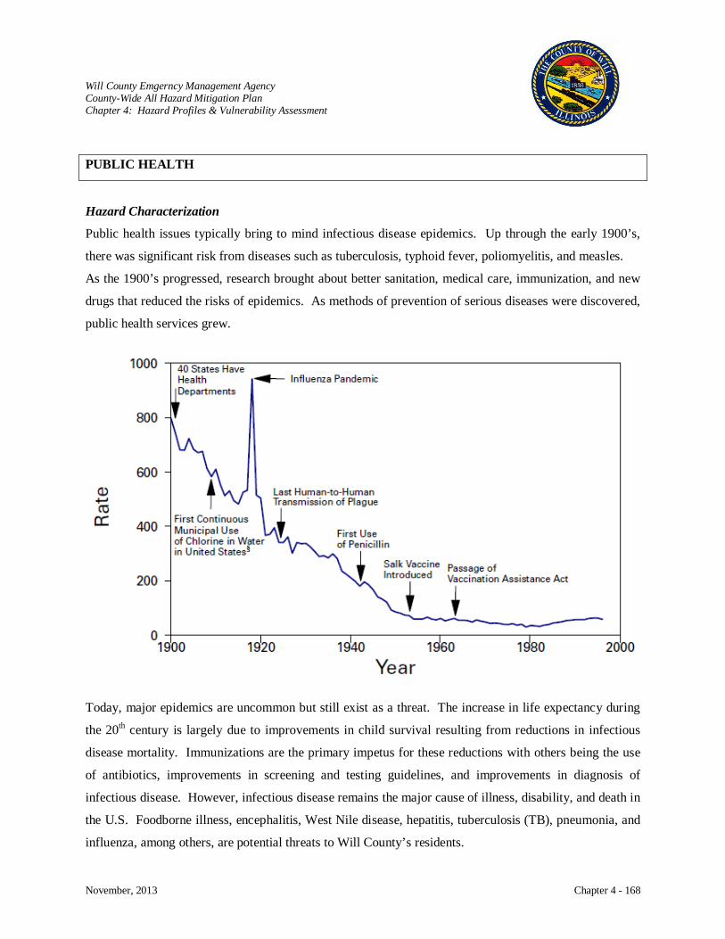
Will County Emgerncy Management Agency County-Wide All Hazard Mitigation Plan Chapter 4: Hazard Profiles & Vulnerability Assessment
November, 2013 Chapter 4 - 168
PUBLIC HEALTH
Hazard Characterization
Public health issues typically bring to mind infectious disease epidemics. Up through the early 1900’s,
there was significant risk from diseases such as tuberculosis, typhoid fever, poliomyelitis, and measles.
As the 1900’s progressed, research brought about better sanitation, medical care, immunization, and new
drugs that reduced the risks of epidemics. As methods of prevention of serious diseases were discovered,
public health services grew.
Today, major epidemics are uncommon but still exist as a threat. The increase in life expectancy during
the 20th century is largely due to improvements in child survival resulting from reductions in infectious
disease mortality. Immunizations are the primary impetus for these reductions with others being the use
of antibiotics, improvements in screening and testing guidelines, and improvements in diagnosis of
infectious disease. However, infectious disease remains the major cause of illness, disability, and death in
the U.S. Foodborne illness, encephalitis, West Nile disease, hepatitis, tuberculosis (TB), pneumonia, and
influenza, among others, are potential threats to Will County’s residents.
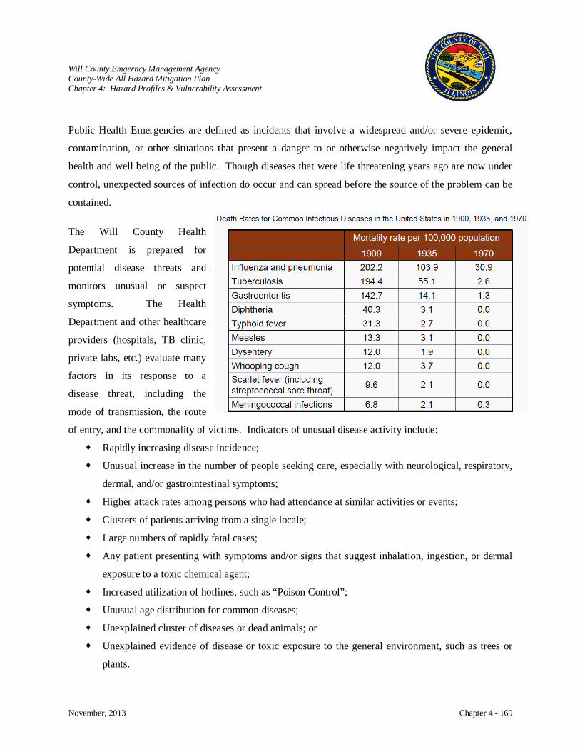
Will County Emgerncy Management Agency County-Wide All Hazard Mitigation Plan Chapter 4: Hazard Profiles & Vulnerability Assessment
November, 2013 Chapter 4 - 169
Public Health Emergencies are defined as incidents that involve a widespread and/or severe epidemic,
contamination, or other situations that present a danger to or otherwise negatively impact the general
health and well being of the public. Though diseases that were life threatening years ago are now under
control, unexpected sources of infection do occur and can spread before the source of the problem can be
contained.
The Will County Health
Department is prepared for
potential disease threats and
monitors unusual or suspect
symptoms. The Health
Department and other healthcare
providers (hospitals, TB clinic,
private labs, etc.) evaluate many
factors in its response to a
disease threat, including the
mode of transmission, the route
of entry, and the commonality of victims. Indicators of unusual disease activity include:
Rapidly increasing disease incidence;
Unusual increase in the number of people seeking care, especially with neurological, respiratory,
dermal, and/or gastrointestinal symptoms;
Higher attack rates among persons who had attendance at similar activities or events;
Clusters of patients arriving from a single locale;
Large numbers of rapidly fatal cases;
Any patient presenting with symptoms and/or signs that suggest inhalation, ingestion, or dermal
exposure to a toxic chemical agent;
Increased utilization of hotlines, such as “Poison Control”;
Unusual age distribution for common diseases;
Unexplained cluster of diseases or dead animals; or
Unexplained evidence of disease or toxic exposure to the general environment, such as trees or
plants.
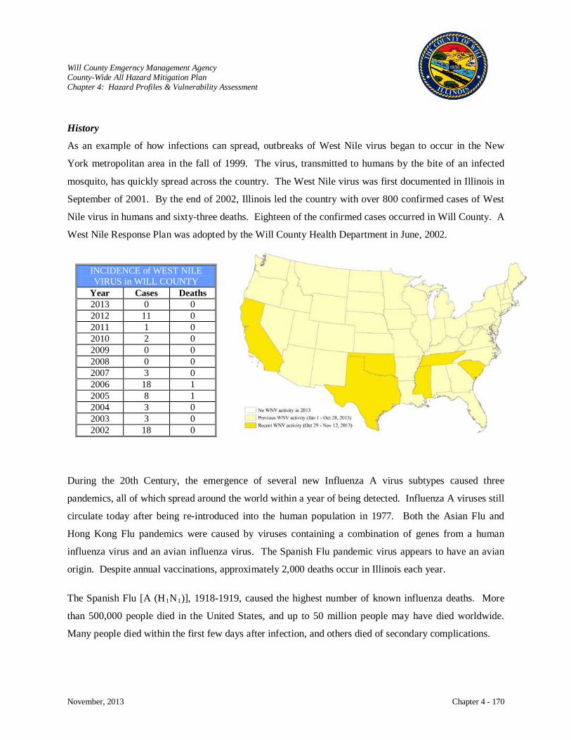
Will County Emgerncy Management Agency County-Wide All Hazard Mitigation Plan Chapter 4: Hazard Profiles & Vulnerability Assessment
November, 2013 Chapter 4 - 170
History
As an example of how infections can spread, outbreaks of West Nile virus began to occur in the New
York metropolitan area in the fall of 1999. The virus, transmitted to humans by the bite of an infected
mosquito, has quickly spread across the country. The West Nile virus was first documented in Illinois in
September of 2001. By the end of 2002, Illinois led the country with over 800 confirmed cases of West
Nile virus in humans and sixty-three deaths. Eighteen of the confirmed cases occurred in Will County. A
West Nile Response Plan was adopted by the Will County Health Department in June, 2002.
During the 20th Century, the emergence of several new Influenza A virus subtypes caused three
pandemics, all of which spread around the world within a year of being detected. Influenza A viruses still
circulate today after being re-introduced into the human population in 1977. Both the Asian Flu and
Hong Kong Flu pandemics were caused by viruses containing a combination of genes from a human
influenza virus and an avian influenza virus. The Spanish Flu pandemic virus appears to have an avian
origin. Despite annual vaccinations, approximately 2,000 deaths occur in Illinois each year.
The Spanish Flu [A (H1N1)], 1918-1919, caused the highest number of known influenza deaths. More
than 500,000 people died in the United States, and up to 50 million people may have died worldwide.
Many people died within the first few days after infection, and others died of secondary complications.
INCIDENCE of WEST NILE VIRUS in WILL COUNTY
Year Cases Deaths 2013 0 0 2012 11 0 2011 1 0 2010 2 0 2009 0 0 2008 0 0 2007 3 0 2006 18 1 2005 8 1 2004 3 0 2003 3 0 2002 18 0
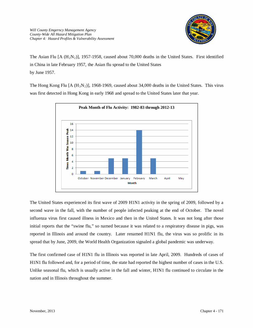
Will County Emgerncy Management Agency County-Wide All Hazard Mitigation Plan Chapter 4: Hazard Profiles & Vulnerability Assessment
November, 2013 Chapter 4 - 171
The Asian Flu [A (H2N2)], 1957-1958, caused about 70,000 deaths in the United States. First identified
in China in late February 1957, the Asian flu spread to the United States
by June 1957.
The Hong Kong Flu [A (H3N2
The United States experienced its first wave of 2009 H1N1 activity in the spring of 2009, followed by a
second wave in the fall, with the number of people infected peaking at the end of October. The novel
influenza virus first caused illness in Mexico and then in the United States. It was not long after those
initial reports that the “swine flu,” so named because it was related to a respiratory disease in pigs, was
reported in Illinois and around the country. Later renamed H1N1 flu, the virus was so prolific in its
spread that by June, 2009, the World Health Organization signaled a global pandemic was underway.
The first confirmed case of H1N1 flu in Illinois was reported in late April, 2009. Hundreds of cases of
H1N1 flu followed and, for a period of time, the state had reported the highest number of cases in the U.S.
Unlike seasonal flu, which is usually active in the fall and winter, H1N1 flu continued to circulate in the
nation and in Illinois throughout the summer.
)], 1968-1969, caused about 34,000 deaths in the United States. This virus
was first detected in Hong Kong in early 1968 and spread to the United States later that year.
Peak Month of Flu Activity: 1982-83 through 2012-13
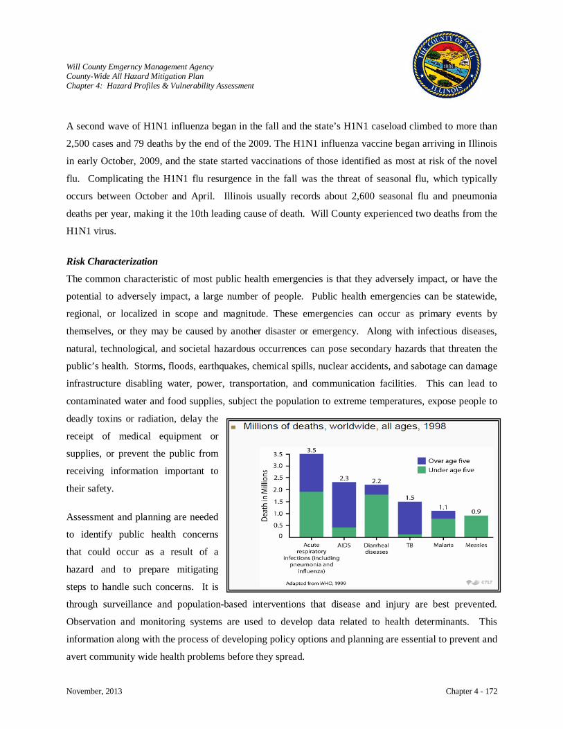
Will County Emgerncy Management Agency County-Wide All Hazard Mitigation Plan Chapter 4: Hazard Profiles & Vulnerability Assessment
November, 2013 Chapter 4 - 172
A second wave of H1N1 influenza began in the fall and the state’s H1N1 caseload climbed to more than
2,500 cases and 79 deaths by the end of the 2009. The H1N1 influenza vaccine began arriving in Illinois
in early October, 2009, and the state started vaccinations of those identified as most at risk of the novel
flu. Complicating the H1N1 flu resurgence in the fall was the threat of seasonal flu, which typically
occurs between October and April. Illinois usually records about 2,600 seasonal flu and pneumonia
deaths per year, making it the 10th leading cause of death. Will County experienced two deaths from the
H1N1 virus.
Risk Characterization
The common characteristic of most public health emergencies is that they adversely impact, or have the
potential to adversely impact, a large number of people. Public health emergencies can be statewide,
regional, or localized in scope and magnitude. These emergencies can occur as primary events by
themselves, or they may be caused by another disaster or emergency. Along with infectious diseases,
natural, technological, and societal hazardous occurrences can pose secondary hazards that threaten the
public’s health. Storms, floods, earthquakes, chemical spills, nuclear accidents, and sabotage can damage
infrastructure disabling water, power, transportation, and communication facilities. This can lead to
contaminated water and food supplies, subject the population to extreme temperatures, expose people to
deadly toxins or radiation, delay the
receipt of medical equipment or
supplies, or prevent the public from
receiving information important to
their safety.
Assessment and planning are needed
to identify public health concerns
that could occur as a result of a
hazard and to prepare mitigating
steps to handle such concerns. It is
through surveillance and population-based interventions that disease and injury are best prevented.
Observation and monitoring systems are used to develop data related to health determinants. This
information along with the process of developing policy options and planning are essential to prevent and
avert community wide health problems before they spread.

Will County Emgerncy Management Agency County-Wide All Hazard Mitigation Plan Chapter 4: Hazard Profiles & Vulnerability Assessment
November, 2013 Chapter 4 - 173
Potential Public Health Events
West Nile Virus: Usually spread by mosquitoes, a mild case of this virus will mimic the flu, while
a severe case is life threatening. No drugs or vaccines are available to treat West
Nile Virus.
The virus is present in Will County; however, most people fully recover from it.
In more severe cases, intensive supportive therapy is indicated, often involving
hospitalization, intravenous fluids, airway management, respiratory support
(ventilator), prevention of secondary infections (pneumonia, urinary tract), and
good nursing care.
Influenza: On average, 10-20 percent of U.S. residents will contract the flu by person-to-
person contact. This is commonly a result of respiratory droplets released during
coughing and sneezing. Some of these influenza cases will be fatal. Each year,
the flu claims 36,000 American lives.
Healthy adults are usually not at risk for serious complications. Typically, the
elderly, small children, those with weakened immune systems, and those affected
WILL COUNTY HEALTH DEPARTMENT STATISTICS Comm.
Health Center Visits
Water Supply Inspect.
Sewage Inspect.
Food San. Inspect.
Flu Vaccines
Food Borne Illness
E. Coli Salmonellosis
Hepatitis Incidents
A B C 2012 1,271 676 7,835 1,417 90 4 63 233 2011 1,264 702 7,771 1,827 107 1 58 268 2010 1,255 716 7,756 1,963 118 3 60 230 2009 1,461 831 7,431 3,217 3 78 2008 1,367 1,190 7,262 2,788 7 83 19 168 319 2007 1,812 1,198 6,697 2,512 7 120 26 177 274 2006 25,374 1,648 1,281 6,610 2,669 1 8 98 2 94 261 2005 29,667 1,155 1,348 6,097 3,891 7 9 112 10 83 259 2004 25,828 959 1,250 5,560 3,784 7 8 100 6 93 282 2003 28,141 1,074 1,220 5,717 3,274 5 10 79 2 78 222 2002 24,145 1,344 1,205 5,303 2,752 2 7 75 17 98 212 2001 21,378 1,196 1,263 4,779 3,202 5 7 57 20 70 240 2000 22 9 78 17 58 169

Will County Emgerncy Management Agency County-Wide All Hazard Mitigation Plan Chapter 4: Hazard Profiles & Vulnerability Assessment
November, 2013 Chapter 4 - 174
by other illnesses are especially susceptible. Though, populations vulnerable to a
specific influenza strain will vary. Vaccine is available each year for seasonal
flu and vaccination is effective because the type of virus we are exposed to each
winter can be reliably predicted.
Pandemic: A pandemic is a disease that attacks or affects the population of an extensive
area. This is sometimes an entire country or continent. Each year, different
strains of influenza are labeled as potential pandemic threats. Pandemics occur
three to four times a century and can take place any season.
An influenza pandemic is a global outbreak of disease that occurs when a new
Influenza A virus appears or “emerges” in the human population, causes serious
illness, and spreads easily among people worldwide. Experts predict an infection
rate of 25 to 50 percent of the population, depending on the severity of the virus
strain.
Will County Emgerncy Management Agency County-Wide All Hazard Mitigation Plan Chapter 4: Hazard Profiles & Vulnerability Assessment
November, 2013 Chapter 4 - 175
Pandemics are different from seasonal outbreaks or “epidemics” of influenza.
Seasonal outbreaks are caused by subtypes of influenza viruses that already
circulate among people, whereas pandemic outbreaks are caused by new
subtypes, by subtypes that have never circulated among people, or by subtypes
that have not circulated among people for a long time. Pandemic influenza tends
to occur in waves. The reasons for multiple waves of varying impact are not
precisely understood, but they probably include adaptation of the virus to its new
host, demographic or geographic variation, seasonality, and the overall immunity
of the population. Past influenza pandemics have led to high levels of illness,
death, social disruption, and economic loss.
A vaccine against pandemic flu may not be available at the start of a pandemic.
New types of viruses must be accurately identified, and producing an effective
vaccine may take six months.
Swine and Pigs may be infected with influenza viruses that are different from human flu
Avian Influenza: viruses. Swine flu viruses spread among pigs and – while rare –
H5N1 is a highly pathogenic, highly disease causing, avian (bird) flu virus that
has caused serious outbreaks in domestic poultry in parts of Asia and the Middle
they can spread
from pigs to people too. The Centers for Disease Control and Prevention (CDC)
is concerned about a new flu virus that has been found in U.S. pigs and has
infected people too. This virus is called H3N2v when it infects people. Most
cases have happened in people exhibiting pigs at fairs. Exposure to pigs,
especially close contact with pigs, is the main risk factor for infection with this
virus. While most illness has been mild, some people have been hospitalized.
Avian flu affects birds and is transmitted most commonly to humans by birds or
through an intermediate host. Human infections with avian influenza (AI, or
“bird flu”) are rare but do occur, most commonly after exposure to infected
poultry (bird-to-human spread). Limited person-to-person spread of bird flu is
thought to have occurred rarely in the past.
Will County Emgerncy Management Agency County-Wide All Hazard Mitigation Plan Chapter 4: Hazard Profiles & Vulnerability Assessment
November, 2013 Chapter 4 - 176
East. Although H5N1 does not usually infect humans, nearly 600 cases of human
cases of H5N1 have been reported from 15 countries since 2003.
• Most human cases of “highly pathogenic“ H5N1 virus infection have
occurred in people who had recent contact with sick or dead poultry that
were infected with H5N1 viruses. About 60% of people infected with the
virus died from their illness.
• Unlike other types of flu, H5N1 usually does not spread between people.
• There have been no reported infections with these viruses in birds, poultry, or
people in the United States.
• You cannot get infected with these viruses from properly handled and cooked
poultry or eggs.
Human infections with a new avian influenza virus, A (H7N9), continue to be
reported in China. The virus has been detected in poultry in China as well.
While mild illness in human cases has been seen, most patients have had severe
respiratory illness and some people have died. No cases of H7N9 outside of
China have been reported. Most important, however, is that this transmission not
be sustained (ongoing). The new H7N9 virus has not been detected in people or
birds in the United States.
Coronaviruses: The name coronavirus comes from its appearance under the microscope – the
viruses have a spiky or crown-like (corona) appearance. Until recently, SARS-
CoV was the only member of the coronavirus family known to cause death or
severe respiratory disease in humans. The other viruses in this group cause mild
upper-respiratory infections in humans and are associated with respiratory,
gastrointestinal, and neurologic diseases in animals. One reason that SARS-CoV
might have been more lethal than other coronaviruses is that it appears to
interfere with an enzyme system in humans that is critical for regulating body
fluid balance. Therefore, the virus could disrupt normal functioning of the lungs
by blocking this enzyme system and allowing fluid to leak into the air sacs of the
lungs, resulting in severe respiratory illness.
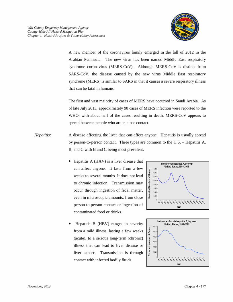
Will County Emgerncy Management Agency County-Wide All Hazard Mitigation Plan Chapter 4: Hazard Profiles & Vulnerability Assessment
November, 2013 Chapter 4 - 177
A new member of the coronavirus family emerged in the fall of 2012 in the
Arabian Peninsula. The new virus has been named Middle East respiratory
syndrome coronavirus (MERS-CoV). Although MERS-CoV is distinct from
SARS-CoV, the disease caused by the new virus Middle East respiratory
syndrome (MERS) is similar to SARS in that it causes a severe respiratory illness
that can be fatal in humans.
The first and vast majority of cases of MERS have occurred in Saudi Arabia. As
of late July 2013, approximately 90 cases of MERS infection were reported to the
WHO, with about half of the cases resulting in death. MERS-CoV appears to
spread between people who are in close contact.
Hepatitis: A disease affecting the liver that can affect anyone. Hepatitis is usually spread
by person-to-person contact. Three types are common to the U.S. – Hepatitis A,
B, and C with B and C being most prevalent.
Hepatitis A (HAV) is a liver disease that
can affect anyone. It lasts from a few
weeks to several months. It does not lead
to chronic infection. Transmission may
occur through ingestion of fecal matter,
even in microscopic amounts, from close
person-to-person contact or ingestion of
contaminated food or drinks.
Hepatitis B (HBV) ranges in severity
from a mild illness, lasting a few weeks
(acute), to a serious long-term (chronic)
illness that can lead to liver disease or
liver cancer. Transmission is through
contact with infected bodily fluids.
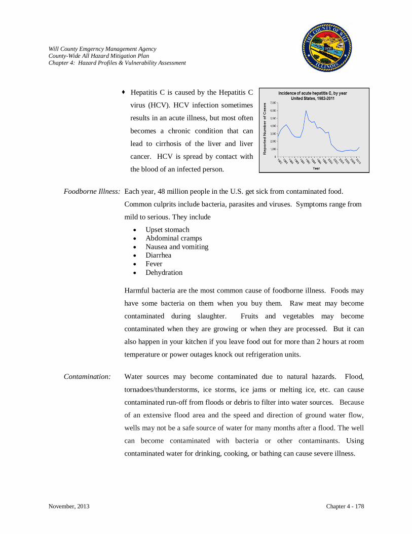
Will County Emgerncy Management Agency County-Wide All Hazard Mitigation Plan Chapter 4: Hazard Profiles & Vulnerability Assessment
November, 2013 Chapter 4 - 178
Hepatitis C is caused by the Hepatitis C
virus (HCV). HCV infection sometimes
results in an acute illness, but most often
becomes a chronic condition that can
lead to cirrhosis of the liver and liver
cancer. HCV is spread by contact with
the blood of an infected person.
Foodborne Illness: Each year, 48 million people in the U.S. get sick from contaminated food.
Common culprits include bacteria, parasites and viruses. Symptoms range from
mild to serious. They include
• Upset stomach • Abdominal cramps • Nausea and vomiting • Diarrhea • Fever • Dehydration
Harmful bacteria are the most common cause of foodborne illness. Foods may
have some bacteria on them when you buy them. Raw meat may become
contaminated during slaughter. Fruits and vegetables may become
contaminated when they are growing or when they are processed. But it can
also happen in your kitchen if you leave food out for more than 2 hours at room
temperature or power outages knock out refrigeration units.
Contamination: Water sources may become contaminated due to natural hazards. Flood,
tornadoes/thunderstorms, ice storms, ice jams or melting ice, etc. can cause
contaminated run-off from floods or debris to filter into water sources. Because
of an extensive flood area and the speed and direction of ground water flow,
wells may not be a safe source of water for many months after a flood. The well
can become contaminated with bacteria or other contaminants. Using
contaminated water for drinking, cooking, or bathing can cause severe illness.
Will County Emgerncy Management Agency County-Wide All Hazard Mitigation Plan Chapter 4: Hazard Profiles & Vulnerability Assessment
November, 2013 Chapter 4 - 179
Waste water from malfunctioning septic tanks or chemicals seeping into the
ground can contaminate the ground water even after well water is tested and
found to be safe. It is necessary to take long range precautions, including
repeated testing, to protect the safety of drinking water.
Bioterrorism: A Bioterrorism attack is the deliberate release of viruses, bacteria, or other
germs (agents) used to cause illness or death in people, animals, or plants.
These agents are typically found in nature, but it is possible that they could be
changed to increase their ability to cause disease, make them resistant to current
medicines, or to increase their ability to spread into the environment. Biological
agents can be spread through the air, through water, or in food. Terrorists may
use biological agents because they can be extremely difficult to detect and do
not cause illness for several hours to several days.
Surveillance is the cornerstone for Bioterrorism and Pandemic Influenza
Preparedness. Early recognition and reporting of any disease outbreak, along
with rapid implementation of post-attack prophylaxis (preventive
medicine/vaccination), are the two most critical means of reducing losses. In
the event of a public health emergency, the Will County Pharmaceutical
Distribution Plan provides a multi-jurisdictional response for mass distribution
of pharmaceuticals (antibiotic medications) to the entirety of Will County and
any other areas of responsibility.
Agroterrorism: Agroterrorism is defined as “the deliberate introduction of an animal or plant
disease for the purpose of generating fear, causing economic losses, or
undermining social stability.” It represents a tactic to attack the economic
stability of the United States. Killing livestock and plants or contaminating food
can help terrorists cause economic crises in the agriculture and food industries.
Secondary goals include social unrest and loss of confidence in government.
Because it lacks the drama and spectacle of more common terrorist violence,
such as bombings and murders, agroterrorism has remained a secondary
Will County Emgerncy Management Agency County-Wide All Hazard Mitigation Plan Chapter 4: Hazard Profiles & Vulnerability Assessment
November, 2013 Chapter 4 - 180
consideration, and no documented attacks in the homeland have occurred since
9/11.
Within Will County, potential targets for agroterrorism exist through its farming
and transportation industry
Tuberculosis: Tuberculosis (TB) is a contagious and potentially life-threatening disease caused
by a bacterium called Mycobacterium tuberculosis
Surveillance of communicable disease and environmental disease
being transmitted through the
air. While it can affect any part of the body (such as the brain, the kidneys or the
spine), TB usually affects the lungs.
Although both preventable and curable, tuberculosis once was the leading cause
of death in the United States. Today in Illinois, less than 30 deaths a year are
attributed to tuberculosis and the number of cases in the state has fallen more
than 40 percent in the past 10 years, reaching an all-time low of 633 in 2003.
Public Health Mitigation:
Monitoring systems through schools and hospitals
Biowatch, EpiX, and other surveillance tools
Inspection of food handling facilities
Testing of wells and septic systems
Mosquito traps
Public education
Disease agents
Prophylactic intervention (anti-viral medication, anti-biotics, and/or immunization if
available)
Safe food handling
Boil water orders
Sanitation, good hygiene and other protective measures
Will County Emgerncy Management Agency County-Wide All Hazard Mitigation Plan Chapter 4: Hazard Profiles & Vulnerability Assessment
November, 2013 Chapter 4 - 181
Emergency preparedness plans and resources to address protection, response, and recovery issues Pandemic Influenza Plan Strategic National Stockpile – Mass Dispensing Plan Personal Protective Equipment (PPE) caches
Mutual aid agreements with surrounding health departments and community partners
Impact: Low
Critical Facilities
Critical facilities could be impacted because of the loss of people to run them by a widespread
infectious agent occurring naturally or intentially/unintentially spread by terrorist, animals/insects, or
people traveling the world. Between 15-35 percent of the U.S. population could be affected by an
influenza pandemic. Workers may be unable to work because they are ill, may die from the infection,
or may need to care for infected family members. Accordingly, the ability of critical facilities to
provide service will be seriously affected due to the severe reduction in workforce capacity.
Health and Safety
Many scientists believe it is only a matter of time until the next influenza pandemic occurs. The
severity of the next pandemic cannot be predicted, but modeling studies suggest the impact of a
pandemic on the United States could be substantial. In the absence of any control measures
(vaccination or drugs), it has been estimated that in the United States, a “medium-level” pandemic
could cause 89,000-207,000 deaths, 314,000-734,000 hospitalizations, 18-42 million outpatient visits,
and another 20-47 million sick people.
Immunizations are a cost-effective method in preventing infectious disease and childhood
immunization programs provide a high return on investment. Routine childhood immunization
schedule saves 33,000 lives, prevents 14 million cases of disease, reduces direct health care costs by
$9.9 billion, and saves $33.4 billion in indirect healthcare costs.
Economic Impact
Trust for America's Health (TFAH)'s March 2007 report Pandemic Flu and Potential for U.S.
Economic Recession finds a severe pandemic flu outbreak could result in the second worst recession
Will County Emgerncy Management Agency County-Wide All Hazard Mitigation Plan Chapter 4: Hazard Profiles & Vulnerability Assessment
November, 2013 Chapter 4 - 182
in the U.S. since World War II. The U.S. Gross Domestic Product (GDP) could drop over 5.5
percent, leading to an estimated $683 billion loss.
Future Occurrence
The probability of a widespread public health emergency is every 10 years or less. Minor outbreaks
and incidents have the potential to occur more frequently. Will County is a major hub for
transportation of raw materials and products and a potential method for transporting in an infectious
agent. New infectious diseases continue to be detected and infectious disease must be studied in a
global context because of increased international travel and migration, import of foods and
agricultural practices, and continued threat of bioterrorism.
Public health emergencies typically occur on a regional basis. Sources include infected animals,
contaminated food, and improperly prepared food. While the whole County is vulnerable to a public
health emergency, the source of the infection may be a farm or restaurant.
Will County Emgerncy Management Agency County-Wide All Hazard Mitigation Plan Chapter 4: Hazard Profiles & Vulnerability Assessment
November, 2013 Chapter 4 - 183
CIVIL DISTURBANCE Hazard Characterization
Civil disturbances are incidents that intend to disrupt a community to the degree that police intervention is
required to maintain public safety. Civil disturbances can include prison or institutional rebellions,
disruptive political gatherings, violent labor disputes, urban protests or riots, demonstrations, or problems
at large-scale events resulting in police intervention and arrests. Civil disturbances can occur anytime but
tend to be more frequent during summer months when the hot, humid weather places a stress on the
public.
The threat from a disturbance varies by the type, severity, and range of the event. Public welfare and
property are at risk along with infrastructure services such as electricity, water supply, public
transportation, communications, etc. Government buildings, universities, military bases, nuclear power
plants, and correctional facilities tend to be targeted the most. As the profile of Will County points out,
Will County has all of these types of facilities and entities. Thus, preparation to effectively deal with civil
disturbances is important.
History
No documentation of recent civil disturbances is available.
Risk Characterization
The economic impact to urban areas during civil unrest and following such events can be profound.
Direct impacts include looting and smashed windows as well as endangering shop owners and customers.
Indirect economic impacts result from the loss of business when potential customers do not approach
businesses for extended periods of time. Customer impressions and habits can change from the
experience of a single threatening event.
Civil Disturbances or Demonstrations can be identified in three (3) categories:
Peaceful, Non-Obstructive Demonstrations
Non-Violent, Disruptive Demonstrations
Violent, Disruptive Demonstrations
Will County Emgerncy Management Agency County-Wide All Hazard Mitigation Plan Chapter 4: Hazard Profiles & Vulnerability Assessment
November, 2013 Chapter 4 - 184
The severity of civil disturbance depends on the nature of the disturbance. A localized civil disturbance
involving a small segment of the population, for instance, workers who chose to strike and establish a
picket line, or some other small scale demonstration, would have a low severity rating. In the instance of
a low severity civil disturbance, police might be called upon to ensure that protestors did not block traffic
corridors or intrude on private property. A moderately severe civil disturbance would be one wherein the
protests disrupt nearby businesses and possibly cause some property damage. In this instance, police
intervention would be required to restore order without employing chemical agents or physical force. A
severe civil disturbance would involve rioting, arson, looting, and assault.
Civil disturbance can, in extreme cases, cause extensive social disruption, loss of jobs, death, and property
damage. These may result either from those involved in the action or initiated by those in higher
authority in response to what they perceive as a threat to either the status quo or their own authority. In
addition, the government may also curtail certain civil liberties even to the eventual imposition of martial
law. Looting and general vandalism are the most common activities associated with civil disturbance.
Arson is also quite common and can quickly spread due to slow response times of overwhelmed fire
departments. Transportation routes can become blocked making it difficult for non-rioters to leave the
area and difficult for the emergency response personnel to arrive. Long-term effects may include a local
depressed economy, environmental damage, social disruption, and long lasting animosity between the
contending groups.
Impact: Low
Damage to Buildings
Buildings and property can be damaged or destroyed by participants of civil disturbances or fire if it
ensues.
Critical Facilities
Disruption of services such as electricity, water supply, public transportation, communications, etc.,
could result from civil disorder.
Health and Safety
Injury and loss of life can occur as a result of civil disturbance.
Will County Emgerncy Management Agency County-Wide All Hazard Mitigation Plan Chapter 4: Hazard Profiles & Vulnerability Assessment
November, 2013 Chapter 4 - 185
Economic Impact
Loss of life and property as well as fear can be a factor and interrupt the normal functioning of a
community. The need for increased security for sites vulnerable to civil disorder places demands on
local law enforcement organizations.
Future Occurrence
The occurrence of civil disorder is always a possibility, but the likelihood is low. The potential for
civil disturbances exists within Will County because of:
Large manufacturing enterprises and labor organizations that could result in public
demonstration over labor disputes;
Will County Jail, River Valley Juvenile Detention Center, and Stateville Correctional
facilities that could face uprisings due to overcrowding or jail conditions;
Three universities and a junior college that could experience student demonstrations or crowd
disturbances; or
Radical groups, such as the Animal Liberation Front (ALF) and a right-wing white
supremacist group that are known to exist in the county.

Will County Emergency Management Agency County-Wide All Hazard Mitigation Plan Chapter 5: Mitigation Goals, Objectives, and Strategies
November, 2013 Chapter 5 - 1
CHAPTER 5: MITIGATION GOALS, OBJECTIVES, & STRATEGIES
Will County Emergency Management Agency (EMA), with the collaboration of participating
jurisdictions, have identified the expectations of the Will County County-Wide All Hazard Mitigation
Plan and the strategies to meet these goals and objectives. The expectations of this planning document
are defined as the Mitigation Goals and Objectives. The mitigation plan’s goals are broad statements that
describe the principles that will guide the suggested mitigation. The objectives are targeted statements
that define strategies and implementation procedures to attain the mitigation plan’s goals. The Committee
developed the goals, objectives, and strategies based upon the findings of the All Hazard Risk
Assessment, previously prepared by the County, individual expertise, knowledge of existing and planned
county-wide programs and projects, and collaboration with participating jurisdictions. The Mitigation
Steering Committee held a workshop on October 10, 2013, with participating jurisdictions to review and
update, further define, and finalize the goals and objectives originally established in 2008.
Goals and Objectives
Goal #1: Protect and secure life and property.
Objectives:
• Increase public education and awareness of all hazards and what they can do to protect
and secure their community.
• Implement effective approaches to protect neighborhoods, buildings, and critical
facilities and infrastructure from all hazards.
• Nurture and support local and regional organizations that have missions that fulfill this
goal.
• Increase capabilities to disseminate pre-event and post-event information.
• Increase readiness of the public and all levels of government within Will County.
Will County Emergency Management Agency County-Wide All Hazard Mitigation Plan Chapter 5: Mitigation Goals, Objectives, and Strategies
November, 2013 Chapter 5 - 2
Goal #2: Continue to improve and enhance county-wide emergency management programs
and develop relationships county-wide.
Objectives:
• Support and promote the integration of efficient emergency management and homeland
security operations, functions, and tools with local, state, and federal governments,
private industry, non-governmental organizations, community groups, and other
emergency management partners.
• Identify essential government functions and develop back-up plans to ensure reliable
services during a time of emergency.
• Leverage existing opportunities to upgrade aging equipment and infrastructure that are
critical to emergency management.
• Encourage and support the professional development fields relevant to Emergency
Management.
Goal #3: Ensure economic stability, preserve cultural resources, and improve quality of life
throughout Will County.
Objectives:
• Nurture and support strategic local and regional private/public partnerships to limit or
minimize the impact from a disaster to key employers and from market sectors.
• Work with local universities, private/non-profit organizations, and other organizations to
identify opportunities to implement mitigation.
• Promote and nurture mitigation actions that facilitate security to private and public
sectors while leveraging available funding.
• Increase readiness of the private sector within Will County and promote private sector
readiness within the region.
Will County Emergency Management Agency County-Wide All Hazard Mitigation Plan Chapter 5: Mitigation Goals, Objectives, and Strategies
November, 2013 Chapter 5 - 3
Goal #4: Develop, promote, and integrate mitigation actions.
Objectives:
• Assist Will County and its participating jurisdictions in the development of mitigation
proposals and identify sources of federal funding.
• Identify and facilitate mitigation opportunities pertinent to the locale with internal,
neighboring, and regional partners.
• Assist essential and critical facilities (hospitals, universities, utilities, and eligible
private/non-profits) to identify mitigation opportunities.
• Engrain mitigation strategies and actions into everyday planning and project
development.
• Integrate mitigation projects with other federal funding sources (FEMA, DHS, US EPA,
HUD, etc.) and projects in order to maximize efficiency and program eligibility.
Goal #5: Take advantage of opportunities offered by growth while also protecting natural
systems and natural resources.
Objectives:
Incorporate hazard mitigation practices into the activities of other County departments
and Will County jurisdictions.
Integrate mitigation actions into existing and future opportunities, projects, and
developments.
Focus on flood hazard mitigation actions that can increase open space and meet targets
for natural environment sustainability.
Mitigation Implementation Strategies
The Mitigation Implementation Strategies section of this plan addresses the action plan to reduce loss
from future hazard events throughout Will County. The specific projects, responsible agencies, potential
funding sources, and priorities are listed in the pages that follow.
Will County Emergency Management Agency County-Wide All Hazard Mitigation Plan Chapter 5: Mitigation Goals, Objectives, and Strategies
November, 2013 Chapter 5 - 4
Prioritization
Mitigation strategies were defined and prioritized primarily through a formalized workshop with
participating jurisdictions. The initial selection and prioritization of these strategies was drafted by the
mitigation project planning team, using the following criteria to identify mitigation strategies and actions
that:
• Address the plan’s goals and objectives.
• Take advantage of opportunities presented by on-going or future initiatives, programs,
and activities related to emergency management, public safety, homeland security,
planning, growth management, community development, transportation, utilities, and
other capital improvements, facilities maintenance, code revisions, and other programs to
build mitigation opportunities into on-going functions of government to the maximum
extent possible.
• Are within the capabilities of Will County and/or local jurisdiction that find the
mitigation strategy and action to be pertinent to their locale to execute the mitigation
action.
• Offer a significant benefit in relation to its cost.
• Have an identified funding source or sources.
• Have an identified lead agency with appropriate jurisdictional authority to coordinate
implementation.
• Have an identified schedule for implementation.
The team devised a worksheet (Appendix D) to organize all mitigation ideas and priorities. The
participants were encouraged to identify mitigation strategies that had an all-hazards approach and that
targeted select hazards that were determined to have a significant risk to communities in Will County.
The participants were persuaded to consider evaluation criteria as indicated in the State and Local
Mitigation Planning How-To-Guides developed by FEMA. These evaluation criteria consist of public
support, technical feasibility, staffing, funding, maintenance requirements, political support, legal
authority, and cost effectiveness. Information from these worksheets is incorporated into the matrix
shown on pages 5-13 through 5-20.

Will County Emergency Management Agency County-Wide All Hazard Mitigation Plan Chapter 5: Mitigation Goals, Objectives, and Strategies
November, 2013 Chapter 5 - 5
A detailed benefit-cost analysis (BCA) was not conducted during the mitigation strategy development
phase. A detailed BCA will be done at the time that the mitigation action strategy’s defined scope of
work is developed and supported. Although the benefits of a mitigation action can be determined, an
accurate cost could not be determined at this meeting because of too many unknown variables.
Integrating Mitigation
Some of the mitigation strategies suggested are more accurately defined as preparedness, response, and
recovery actions. Although the purpose of a hazard mitigation plan is to address mitigation actions, the
communities of Will County recognized the importance of integrating overlapping functions of all phases
of emergency management. The preparedness, response, and recovery actions identified support the goals
and objectives of this plan. Although FEMA mitigation funds may not be able to fund these actions, the
communities of Will County consider these actions as important in achieving the overall goals and
objectives of this plan. Will County EMA also recognizes that hazard risks, vulnerabilities, and disasters
often transcend beyond political boundaries. Therefore, the plan also addresses strategies for long term
planning and coordination purposes as neighboring jurisdictions develop hazard mitigation plans.
The results of this plan will be incorporated into ongoing planning efforts for Will County and its
jurisdictions. Funding opportunities to implement a variety of the mitigation action items identified in the
plan are identified within each mitigation action item found on pages 6-5 thru 6-35 in Chapter 6. Funding
avenues for these action items varies dependent on the potential funding opportunities and the identified
responsible organizations. The identified Mitigation Action Items and Goals within the Will County All-
Hazards Mitigation Plan will be integrated into the following ongoing planning efforts when applicable.
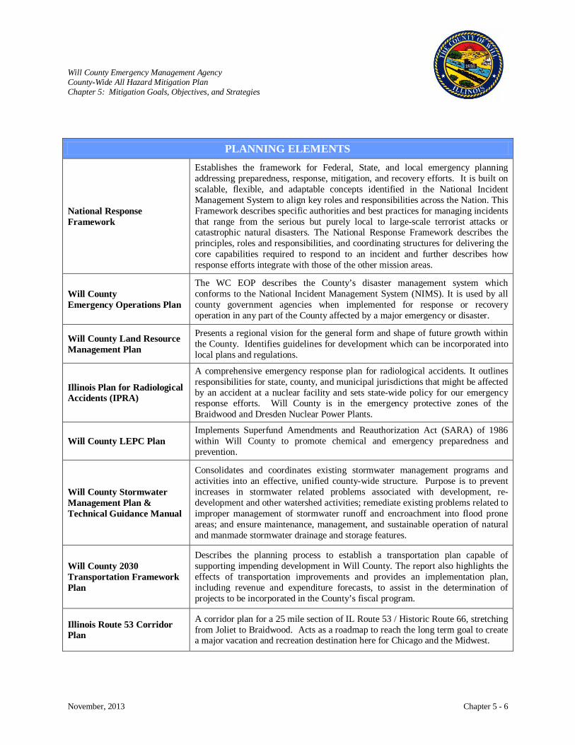
Will County Emergency Management Agency County-Wide All Hazard Mitigation Plan Chapter 5: Mitigation Goals, Objectives, and Strategies
November, 2013 Chapter 5 - 6
PLANNING ELEMENTS
National Response Framework
Establishes the framework for Federal, State, and local emergency planning addressing preparedness, response, mitigation, and recovery efforts. It is built on scalable, flexible, and adaptable concepts identified in the National Incident Management System to align key roles and responsibilities across the Nation. This Framework describes specific authorities and best practices for managing incidents that range from the serious but purely local to large-scale terrorist attacks or catastrophic natural disasters. The National Response Framework describes the principles, roles and responsibilities, and coordinating structures for delivering the core capabilities required to respond to an incident and further describes how response efforts integrate with those of the other mission areas.
Will County Emergency Operations Plan
The WC EOP describes the County’s disaster management system which conforms to the National Incident Management System (NIMS). It is used by all county government agencies when implemented for response or recovery operation in any part of the County affected by a major emergency or disaster.
Presents a regional vision for the general form and shape of future growth within the County. Identifies guidelines for development which can be incorporated into local plans and regulations.
Will County Land Resource Management Plan
Illinois Plan
A comprehensive emergency response plan for radiological accidents. It outlines responsibilities for state, county, and municipal jurisdictions that might be affected by an accident at a nuclear facility and sets state-wide policy for our emergency response efforts. Will County is in the emergency protective zones of the Braidwood and Dresden Nuclear Power Plants.
for Radiological Accidents (IPRA)
Will County LEPC Plan Implements Superfund Amendments and Reauthorization Act (SARA) of 1986 within Will County to promote chemical and emergency preparedness and prevention.
Will County Stormwater Management Plan & Technical Guidance Manual
Consolidates and coordinates existing stormwater management programs and activities into an effective, unified county-wide structure. Purpose is to prevent increases in stormwater related problems associated with development, re-development and other watershed activities; remediate existing problems related to improper management of stormwater runoff and encroachment into flood prone areas; and ensure maintenance, management, and sustainable operation of natural and manmade stormwater drainage and storage features.
Will County 2030 Transportation Framework Plan
Describes the planning process to establish a transportation plan capable of supporting impending development in Will County. The report also highlights the effects of transportation improvements and provides an implementation plan, including revenue and expenditure forecasts, to assist in the determination of projects to be incorporated in the County’s fiscal program.
Illinois Route 53 Corridor Plan
A corridor plan for a 25 mile section of IL Route 53 / Historic Route 66, stretching from Joliet to Braidwood. Acts as a roadmap to reach the long term goal to create a major vacation and recreation destination here for Chicago and the Midwest.

Will County Emergency Management Agency County-Wide All Hazard Mitigation Plan Chapter 5: Mitigation Goals, Objectives, and Strategies
November, 2013 Chapter 5 - 7
Planning and its implementation must be conducted within the authority of the governing body. The
primary laws, regulations, programs and policies that have an impact on mitigation programs in Will
County are listed below.
LEGAL AUTHORITIES
Robert T. Stafford Disaster Relief and Emergency Assistance Act, PL 100-707
Provides the legal authority for the federal government to provide assistance to states during declared major disasters and emergencies. Outlines the actions Federal agencies are likely to take to assist State, tribal, and local governments that are affected by a major disaster or emergency. Authorizes the delivery of federal technical, financial, logistical, and other assistance to states and localities during declared major disasters or emergencies. The Federal Emergency Management Agency (FEMA) coordinates administration of disaster relief resources and assistance to states. Federal assistance is provided under the Stafford Act if an event is beyond the combined response capabilities of state and local governments.
Superfund Amendments and Reauthorization Act (SARA) of 1986
Title III of SARA establishes the “Emergency Planning and Community Right to Know Act” which includes:
1. Procedures for emergency planning in states and localities. 2. Building a framework of community awareness concerning potential chemical
hazards and requirements for submission of MSDS chemical inventory forms and toxic release forms.
3. Trade secrets protections, citizen petitions, and information availability. A State Emergency Response Commission (SERC) is appointed by the Governor and is under the Illinois Emergency Management Agency and supports Local Emergency Planning Committees (LEPC), assists in chemical emergency planning, provides public access to chemical data, raises public awareness of chemical risks, and encourages public participation in local chemical safety issues.
(20 ILCS 3305) Illinois Emergency Management Agency Act
Outlines the responsibilities and actions performed by the State of Illinois during, before and after a disaster but also provides legal authority and guidance to “local political subdivisions” i.e. Local governments on emergency management issues. In chapter 127 paragraph 1060, the IEMA Act authorizes and guides local governments to establish “Emergency Service and Disaster Agencies (ESDA)” in their perspective jurisdictions. Paragraph 1061, provides the legal authority for local governments regarding local disaster declarations. Mutual Aid requirements and guidelines are discusses in Chapter 127 paragraph 1063 for local governments.
(50 ILCS 805 Section 4) Land Resource Management Planning Act:
Encourages municipalities and counties to protect the land, air, water, natural resources and environment of the State and to encourage the use of such resources in a manner which is socially and economically desirable through the adoption of joint or compatible Local Land Resource Management Plans.
(765 ILCS 77/) Residential Real Property Disclosure Act
Requires a seller to tell a potential buyer, if they are aware of any basement flooding, if the property is in the floodplain, or if the seller has flood insurance.
(425 ILCS 25/9 Section 9) Fire Investigation Act
Enables the State Fire Marshal to make, or cause to be made, inspections of buildings, structures and premises to determine their conformity with the provisions in this Act and their safety to life and property from fire or other emergency requiring evacuation of the building (such as presence of explosive or flammable gasses, fume hazard, and power failure).
(50 ILCS 815 Section 2) Flood Damage Prevention Act
Enables local governments to issue building permits in relation to infrastructure for runoff water. Any county or municipality may, by ordinance, adopt requirements that all applications for building permits contain a statement that such buildings and appurtenances connected therewith include facilities for the orderly runoff or retention of rain and melting snow. The governing body of the county or municipality shall determine rain and snowfalls taking into consideration such factors as the permeability and water absorbing quality of the soil and adequacy of existing water-ways.
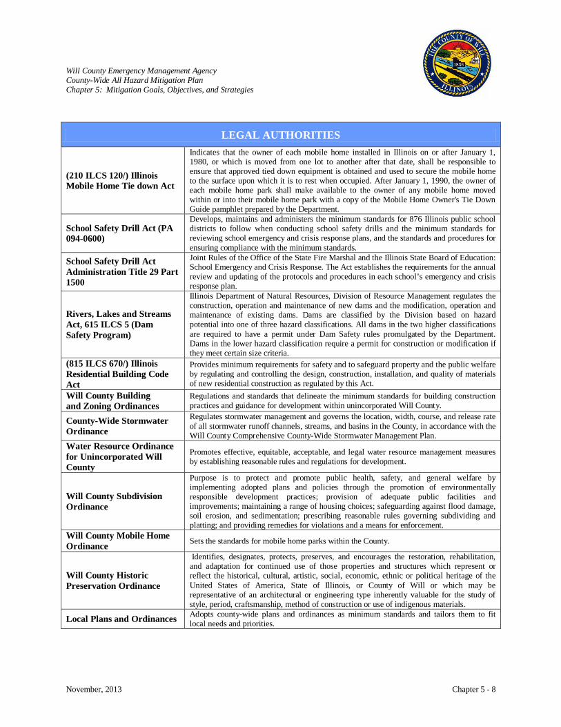
Will County Emergency Management Agency County-Wide All Hazard Mitigation Plan Chapter 5: Mitigation Goals, Objectives, and Strategies
November, 2013 Chapter 5 - 8
LEGAL AUTHORITIES
(210 ILCS 120/) Illinois Mobile Home Tie down Act
Indicates that the owner of each mobile home installed in Illinois on or after January 1, 1980, or which is moved from one lot to another after that date, shall be responsible to ensure that approved tied down equipment is obtained and used to secure the mobile home to the surface upon which it is to rest when occupied. After January 1, 1990, the owner of each mobile home park shall make available to the owner of any mobile home moved within or into their mobile home park with a copy of the Mobile Home Owner's Tie Down Guide pamphlet prepared by the Department.
School Safety Drill Act (PA 094-0600)
Develops, maintains and administers the minimum standards for 876 Illinois public school districts to follow when conducting school safety drills and the minimum standards for reviewing school emergency and crisis response plans, and the standards and procedures for ensuring compliance with the minimum standards.
School Safety Drill Act Administration Title 29 Part 1500
Joint Rules of the Office of the State Fire Marshal and the Illinois State Board of Education: School Emergency and Crisis Response. The Act establishes the requirements for the annual review and updating of the protocols and procedures in each school’s emergency and crisis response plan.
Rivers, Lakes and Streams Act, 615 ILCS 5 (Dam Safety Program)
Illinois Department of Natural Resources, Division of Resource Management regulates the construction, operation and maintenance of new dams and the modification, operation and maintenance of existing dams. Dams are classified by the Division based on hazard potential into one of three hazard classifications. All dams in the two higher classifications are required to have a permit under Dam Safety rules promulgated by the Department. Dams in the lower hazard classification require a permit for construction or modification if they meet certain size criteria.
(815 ILCS 670/) Illinois Residential Building Code Act
Provides minimum requirements for safety and to safeguard property and the public welfare by regulating and controlling the design, construction, installation, and quality of materials of new residential construction as regulated by this Act.
Will County Building and Zoning Ordinances
Regulations and standards that delineate the minimum standards for building construction practices and guidance for development within unincorporated Will County.
County-Wide Stormwater Ordinance
Regulates stormwater management and governs the location, width, course, and release rate of all stormwater runoff channels, streams, and basins in the County, in accordance with the Will County Comprehensive County-Wide Stormwater Management Plan.
Promotes effective, equitable, acceptable, and legal water resource management measures by establishing reasonable rules and regulations for development.
Water Resource Ordinance for Unincorporated Will County
Purpose is to protect and promote public health, safety, and general welfare by implementing adopted plans and policies through the promotion of environmentally responsible development practices; provision of adequate public facilities and improvements; maintaining a range of housing choices; safeguarding against flood damage, soil erosion, and sedimentation; prescribing reasonable rules governing subdividing and platting; and providing remedies for violations and a means for enforcement.
Will County Subdivision Ordinance
Sets the standards for mobile home parks within the County. Will County Mobile Home Ordinance
Identifies, designates, protects, preserves, and encourages the restoration, rehabilitation, and adaptation for continued use of those properties and structures which represent or reflect the historical, cultural, artistic, social, economic, ethnic or political heritage of the United States of America, State of Illinois, or County of Will or which may be representative of an architectural or engineering type inherently valuable for the study of style, period, craftsmanship, method of construction or use of indigenous materials.
Will County Historic Preservation Ordinance
Adopts county-wide plans and ordinances as minimum standards and tailors them to fit local needs and priorities. Local Plans and Ordinances
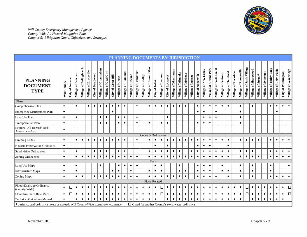
Will County Emergency Management Agency County-Wide All Hazard Mitigation Plan Chapter 5: Mitigation Goals, Objectives, and Strategies
November, 2013 Chapter 5 - 9
PLANNING DOCUMENTS BY JURISDICTION
PLANNING DOCUMENT
TYPE
Will
Cou
nty
City
of A
uror
a
Vill
age
of B
eech
er
Vill
age
of B
olin
gbro
ok
Vill
age
of B
race
ville
City
of B
raid
woo
d
Vill
age
of C
hann
ahon
Vill
age
of C
oal C
ity
City
of C
rest
Hill
Vill
age
of C
rete
Vill
age
of D
iam
ond
Vill
age
of E
lwoo
d
Vill
age
of F
rank
fort
Vill
age
of G
odle
y
Vill
age
of H
omer
Gle
n
City
of J
olie
t
Vill
age
of L
emon
t
City
of L
ockp
ort
Vill
age
of M
anha
ttan
Vill
age
of M
inoo
ka
Vill
age
of M
oken
a
Vill
age
of M
onee
City
of N
aper
ville
Vill
age
of N
ew L
enox
Vill
age
of O
rlan
d Pa
rk
Vill
age
of P
ark
Fore
st
Vill
age
of P
eoto
ne
Vill
age
of P
lain
field
Vill
age
of R
ockd
ale
Vill
age
of R
omeo
ville
Vill
age
of S
auk
Vill
age
Vill
age
of S
hore
woo
d
Vill
age
of S
tege
r*
Vill
age
of S
ymer
ton
Vill
age
of T
inle
y Pa
rk
Vill
age
of U
niv.
Par
k
City
of W
ilmin
gton
Vill
age
of W
oodr
idge
Plans Comprehensive Plan Emergency Management Plan Land Use Plan Transportation Plan Regional All Hazards Risk Assessment Plan
Codes & Ordinances Building Codes Historic Preservation Ordinance Subdivision Ordinances Zoning Ordinances
Maps Land Use Maps Infrastructure Maps Zoning Maps
Flood Related Flood /Drainage Ordinance (County-Wide) Flood Insurance Rate Maps Technical Guidelines Manual Jurisdictional ordinance meets or exceeds Will County-Wide stormwater ordinance Opted for another County’s stormwater ordinance

Will County Emergency Management Agency County-Wide All Hazard Mitigation Plan Chapter 5: Mitigation Goals, Objectives, and Strategies
November, 2013 Chapter 5 - 10
INTERNATIONAL BUILDING CODES ADOPTION BY JURISDICTION (JULY, 2014)
INTERNATIONAL BUILDING CODE
City
of A
uror
a *
Vill
age
of B
eech
er
Vill
age
of B
olin
gbro
ok
Vill
age
of B
race
ville
*
City
of B
raid
woo
d
Vill
age
of C
hann
ahon
Vill
age
of C
oal C
ity *
City
of C
rest
Hill
Vill
age
of C
rete
Vill
age
of D
iam
ond
*
Vill
age
of E
lwoo
d
Vill
age
of F
rank
fort
Vill
age
of G
odle
y*
Vill
age
of H
omer
Gle
n
City
of J
olie
t
Vill
age
of L
emon
t *
City
of L
ockp
ort
Vill
age
of M
anha
ttan
Vill
age
of M
inoo
ka *
Vill
age
of M
oken
a
Vill
age
of M
onee
City
of N
aper
ville
*
Vill
age
of N
ew L
enox
Vill
age
of O
rlan
d Pa
rk *
Vill
age
of P
ark
Fore
st *
Vill
age
of P
eoto
ne
Vill
age
of P
lain
field
Vill
age
of R
ockd
ale
Vill
age
of R
omeo
ville
Vill
age
of S
auk
Vill
age
*
Vill
age
of S
hore
woo
d
Vill
age
of S
tege
r*
Vill
age
of S
ymer
ton
Vill
age
of T
inle
y Pa
rk *
Vill
age
of U
niv.
Par
k *
City
of W
ilmin
gton
Vill
age
of W
oodr
idge
*
Will
Cou
nty
International Building Code
International Residential Code
International Fire Code
International Mechanical Code
International Plumbing Code International Private Sewage Disposal Code
International Fuel Gas Code
International Energy Conservation Code International Property Maintenance Code
International Existing Building Code International Code Council Performance Code * Jurisdictions that border or have only a portion of their corporate limits in Will County and may choose not to adopt this Plan. Obtained from: http://www.iccsafe.org
Will County Emergency Management Agency County-Wide All Hazard Mitigation Plan Chapter 5: Mitigation Goals, Objectives, and Strategies
November, 2013 Chapter 5 - 11
Mitigation Actions
The mitigation plan identifies mitigation actions that were developed from the risk assessment, the
Steering Committee, collaboration with participating jurisdictions, and the public participation process.
Each mitigation strategy describes the opportunity, how to implement it, funding sources, and responsible
agencies.
The matrix on pages 5-13 through 5-20 provides a guide of the mitigation actions that were identified and
where, in Chapter 6, further detail can be found. The matrix describes:
• The hazard that the strategy addresses. • The implementation timeline for the project. Short-term mitigation items are either 1)
crucial to the life safety of Will County residents, or 2) relatively easy to implement because funding has already been secured or is readily available. Any project noted as on-going should be implemented early in the planning cycle, but will be a continuous project once implementation has occurred.
• The agency that will take the lead in implementing the strategy. • Potential sources of funding. • References to detailed information about the strategy in Chapter 6. • The plan goal(s) the strategy addresses.
The Mitigation Actions identified in Chapter 6 address the following:
Problem/Opportunity: This describes either a problem or a possible opportunity to reduce risk.
Implementation Strategy: Each mitigation strategy includes ideas to implement and accomplish the
specific project and potential resources, which may include grant
programs or human resources.
Lead Agency: This is the agency or agencies that will organize resources, find appropriate funding, or oversee project implementation, monitoring and evaluation.
Funding: This offers suggestions on potential financial resources for implementing the mitigation strategy. This includes funding from government agencies as well as various different types of grants.
Timeline: This estimates the amount of time it will take to begin implementation of each strategy.
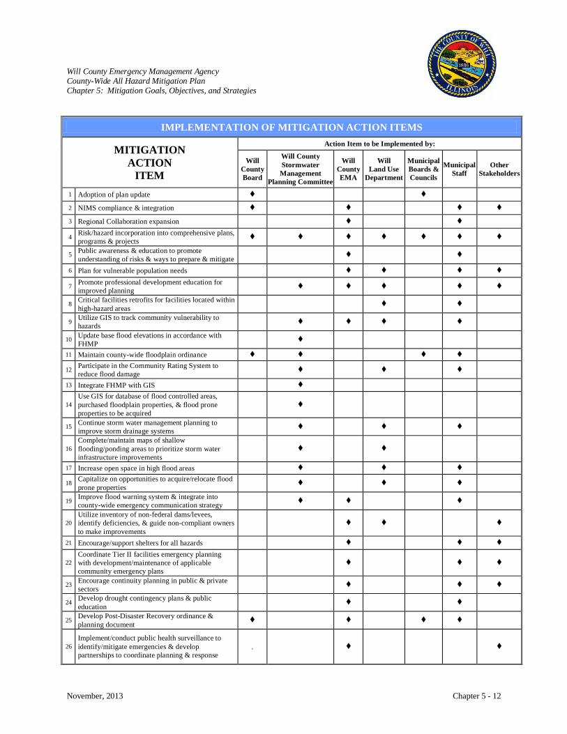
Will County Emergency Management Agency County-Wide All Hazard Mitigation Plan Chapter 5: Mitigation Goals, Objectives, and Strategies
November, 2013 Chapter 5 - 12
IMPLEMENTATION OF MITIGATION ACTION ITEMS
MITIGATION ACTION
ITEM
Action Item to be Implemented by:
Will County Board
Will County Stormwater Management
Planning Committee
Will County EMA
Will Land Use
Department
Municipal Boards & Councils
Municipal Staff
Other Stakeholders
1 Adoption of plan update 2 NIMS compliance & integration 3 Regional Collaboration expansion 4 Risk/hazard incorporation into comprehensive plans,
programs & projects 5 Public awareness & education to promote
understanding of risks & ways to prepare & mitigate 6 Plan for vulnerable population needs 7 Promote professional development education for
improved planning 8 Critical facilities retrofits for facilities located within
high-hazard areas 9 Utilize GIS to track community vulnerability to
hazards 10 Update base flood elevations in accordance with
FHMP 11 Maintain county-wide floodplain ordinance 12 Participate in the Community Rating System to
reduce flood damage 13 Integrate FHMP with GIS
14 Use GIS for database of flood controlled areas, purchased floodplain properties, & flood prone properties to be acquired
15 Continue storm water management planning to improve storm drainage systems
16 Complete/maintain maps of shallow flooding/ponding areas to prioritize storm water infrastructure improvements
17 Increase open space in high flood areas 18 Capitalize on opportunities to acquire/relocate flood
prone properties
19 Improve flood warning system & integrate into county-wide emergency communication strategy
20 Utilize inventory of non-federal dams/levees, identify deficiencies, & guide non-compliant owners to make improvements
21 Encourage/support shelters for all hazards
22 Coordinate Tier II facilities emergency planning with development/maintenance of applicable community emergency plans
23 Encourage continuity planning in public & private sectors
24 Develop drought contingency plans & public education
25 Develop Post-Disaster Recovery ordinance & planning document
26 Implement/conduct public health surveillance to identify/mitigate emergencies & develop partnerships to coordinate planning & response
.
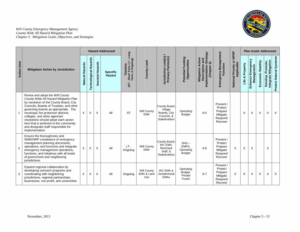
Will County Emergency Management Agency County-Wide All Hazard Mitigation Plan Chapter 5: Mitigation Goals, Objectives, and Strategies
November, 2013 Chapter 5 - 13
Act
ion
Item
Mitigation Action by Jurisdiction
Hazard Addressed
Tim
elin
e (S
T –
Shor
t Ter
m, L
T –
Long
Te
rm, &
Ong
oing
)
Cou
nty
Lead
Juri
sdic
tion
Lead
(s) /
Pr
imar
y Pa
rtne
r(s)
Pote
ntia
l Fun
ding
O
ppor
tuni
ties
Miti
gatio
n A
ctio
n D
escr
iptio
n an
d Im
plem
enta
tion
Stra
tegy
(C
hapt
er 6
)
Emer
genc
y M
anag
emen
t Fu
nctio
n
Nat
iona
l Pri
ority
or N
FRP
App
licab
le
Plan Goals Addressed
Nat
ural
Haz
ards
Tech
nolo
gica
l Haz
ards
Soci
etal
Haz
ards
Specific Hazard
Life
& P
rope
rty
Enha
nce
Em
erge
ncy
Man
agem
ent
Econ
omic
Sta
bilit
y
Dev
elop
, Pro
mot
e,
Inte
grat
e M
itiga
tion
Prot
ect N
atur
al S
yste
ms
1
Revise and adopt the Will County County-Wide All Hazard Mitigation Plan by resolution of the County Board, City Councils, Boards of Trustees, and other governing boards as appropriate. The municipal, fire protection districts, colleges, and other agencies’ resolutions should adopt each action item that is pertinent to the community and designate staff responsible for implementation.
X X X All ST Will County EMA
County Board, Village
Boards, City Councils, &
Stakeholders
Operating Budget 6-5
Prevent / Protect Prepare Mitigate Respond Recover
X X X X X
2
Ensure the thoroughness and NIMS/NRP compliance of emergency management planning documents, operations, and functions and integrate emergency management operations, functions, and initiatives with all levels of government and neighboring jurisdictions.
X X X All LT - Ongoing
Will County EMA
County Board, WC EMA, Municipal Staff, &
Stakeholders
DHS – EMPG,
Operating Budget
6-6
Prevent / Protect Prepare Mitigate Respond Recover
X X X X
3
Expand regional collaboration by developing outreach programs and coordinating with neighboring jurisdictions, regional partnerships, businesses, non-profit, and universities.
X X X All Ongoing Will County
EMA & Land Use
WC EMA & Jurisdictional
EMAs
Operating Budget, Private Funds
6-7
Prevent / Protect Prepare Mitigate Respond Recover
X X X X X X
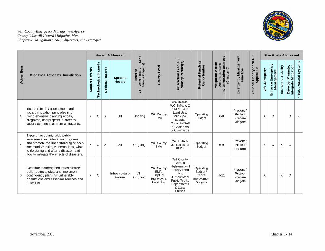
Will County Emergency Management Agency County-Wide All Hazard Mitigation Plan Chapter 5: Mitigation Goals, Objectives, and Strategies
November, 2013 Chapter 5 - 14
Act
ion
Item
Mitigation Action by Jurisdiction
Hazard Addressed
Tim
elin
e (S
T –
Shor
t Ter
m, L
T –
Long
Te
rm, &
Ong
oing
)
Cou
nty
Lead
Juri
sdic
tion
Lead
(s) /
Pr
imar
y Pa
rtne
r(s)
Pote
ntia
l Fun
ding
O
ppor
tuni
ties
Miti
gatio
n A
ctio
n D
escr
iptio
n an
d Im
plem
enta
tion
Stra
tegy
(C
hapt
er 6
)
Emer
genc
y M
anag
emen
t Fu
nctio
n
Nat
iona
l Pri
ority
or N
FRP
App
licab
le
Plan Goals Addressed
Nat
ural
Haz
ards
Tech
nolo
gica
l Haz
ards
Soci
etal
Haz
ards
Specific Hazard
Life
& P
rope
rty
Enha
nce
Em
erge
ncy
Man
agem
ent
Econ
omic
Sta
bilit
y
Dev
elop
, Pro
mot
e,
Inte
grat
e M
itiga
tion
Prot
ect N
atur
al S
yste
ms
4
Incorporate risk assessment and hazard mitigation principles into comprehensive planning efforts, programs, and projects in order to secure communities from all hazards.
X X X All Ongoing Will County EMA
WC Boards, WC EMA, WC
SMPC, WC Land Use, Municipal Boards/
Councils/Staff & Chambers of Commerce
Operating Budget 6-8
Prevent / Protect Prepare Mitigate
X X X X
5
Expand the county-wide public awareness and education programs and promote the understanding of each community’s risks, vulnerabilities, what to do during and after a disaster, and how to mitigate the effects of disasters.
X X X All Ongoing Will County EMA
WC EMA & Jurisdictional
EMAs
Operating Budget 6-9
Prevent / Protect Prepare
X X X X
6
Continue to strengthen infrastructure, build redundancies, and implement contingency plans for vulnerable populations and essential services and networks.
X X Infrastructure Failure
LT - Ongoing
Will County EMA,
Dept. of Highway, & Land Use
Will County Dept. of
Highways, will County Land
Use, Jurisdictional Public Works Departments
& Local Utilities
Operating Budget / Capital
Improvement Budgets
6-11
Prevent / Protect Prepare Mitigate
X X X
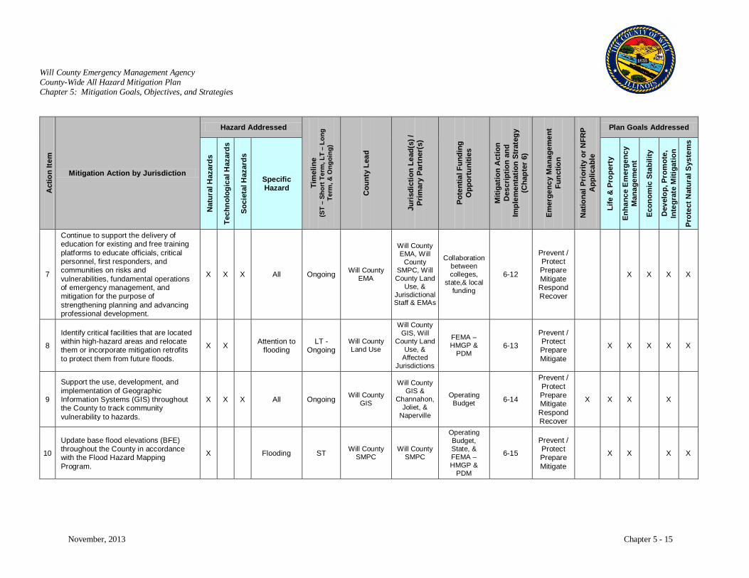
Will County Emergency Management Agency County-Wide All Hazard Mitigation Plan Chapter 5: Mitigation Goals, Objectives, and Strategies
November, 2013 Chapter 5 - 15
Act
ion
Item
Mitigation Action by Jurisdiction
Hazard Addressed
Tim
elin
e (S
T –
Shor
t Ter
m, L
T –
Long
Te
rm, &
Ong
oing
)
Cou
nty
Lead
Juri
sdic
tion
Lead
(s) /
Pr
imar
y Pa
rtne
r(s)
Pote
ntia
l Fun
ding
O
ppor
tuni
ties
Miti
gatio
n A
ctio
n D
escr
iptio
n an
d Im
plem
enta
tion
Stra
tegy
(C
hapt
er 6
)
Emer
genc
y M
anag
emen
t Fu
nctio
n
Nat
iona
l Pri
ority
or N
FRP
App
licab
le
Plan Goals Addressed
Nat
ural
Haz
ards
Tech
nolo
gica
l Haz
ards
Soci
etal
Haz
ards
Specific Hazard
Life
& P
rope
rty
Enha
nce
Em
erge
ncy
Man
agem
ent
Econ
omic
Sta
bilit
y
Dev
elop
, Pro
mot
e,
Inte
grat
e M
itiga
tion
Prot
ect N
atur
al S
yste
ms
7
Continue to support the delivery of education for existing and free training platforms to educate officials, critical personnel, first responders, and communities on risks and vulnerabilities, fundamental operations of emergency management, and mitigation for the purpose of strengthening planning and advancing professional development.
X X X All Ongoing Will County EMA
Will County EMA, Will
County SMPC, Will County Land
Use, & Jurisdictional Staff & EMAs
Collaboration between colleges,
state,& local funding
6-12
Prevent / Protect Prepare Mitigate Respond Recover
X X X X
8
Identify critical facilities that are located within high-hazard areas and relocate them or incorporate mitigation retrofits to protect them from future floods.
X X Attention to flooding
LT - Ongoing
Will County Land Use
Will County GIS, Will
County Land Use, &
Affected Jurisdictions
FEMA –HMGP &
PDM 6-13
Prevent / Protect Prepare Mitigate
X X X X X
9
Support the use, development, and implementation of Geographic Information Systems (GIS) throughout the County to track community vulnerability to hazards.
X X X All Ongoing Will County GIS
Will County GIS &
Channahon, Joliet, &
Naperville
Operating Budget 6-14
Prevent / Protect Prepare Mitigate Respond Recover
X X X X
10
Update base flood elevations (BFE) throughout the County in accordance with the Flood Hazard Mapping Program.
X Flooding ST Will County SMPC
Will County SMPC
Operating Budget, State, & FEMA –HMGP &
PDM
6-15
Prevent / Protect Prepare Mitigate
X X X X
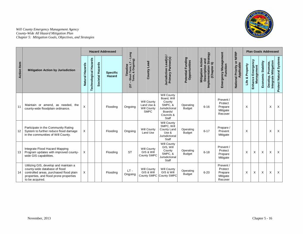
Will County Emergency Management Agency County-Wide All Hazard Mitigation Plan Chapter 5: Mitigation Goals, Objectives, and Strategies
November, 2013 Chapter 5 - 16
Act
ion
Item
Mitigation Action by Jurisdiction
Hazard Addressed
Tim
elin
e (S
T –
Shor
t Ter
m, L
T –
Long
Te
rm, &
Ong
oing
)
Cou
nty
Lead
Juri
sdic
tion
Lead
(s) /
Pr
imar
y Pa
rtne
r(s)
Pote
ntia
l Fun
ding
O
ppor
tuni
ties
Miti
gatio
n A
ctio
n D
escr
iptio
n an
d Im
plem
enta
tion
Stra
tegy
(C
hapt
er 6
)
Emer
genc
y M
anag
emen
t Fu
nctio
n
Nat
iona
l Pri
ority
or N
FRP
App
licab
le
Plan Goals Addressed
Nat
ural
Haz
ards
Tech
nolo
gica
l Haz
ards
Soci
etal
Haz
ards
Specific Hazard
Life
& P
rope
rty
Enha
nce
Em
erge
ncy
Man
agem
ent
Econ
omic
Sta
bilit
y
Dev
elop
, Pro
mot
e,
Inte
grat
e M
itiga
tion
Prot
ect N
atur
al S
yste
ms
11 Maintain or amend, as needed, the county-wide floodplain ordinance. X Flooding Ongoing
Will County Land Use & Will County
SMPC
Will County Board, Will
County SMPC, &
Jurisdictional Boards/
Councils & Staff
Operating Budget 6-16
Prevent / Protect Prepare Mitigate Recover
X X X
12 Participate in the Community Rating System to further reduce flood damage in the communities of Will County.
X Flooding Ongoing Will County Land Use
Will County SMPC, Will County Land
Use & Jurisdictional
Staff
Operating Budget 6-17
Prepare / Prevent Mitigate
X X X
13 Integrate Flood Hazard Mapping Program updates with improved county-wide GIS capabilities.
X Flooding ST Will County GIS & Will
County SMPC
Will County GIS, Will County
SMPC, & Jurisdictional
Staff
Operating Budget 6-18
Prevent / Protect Prepare Mitigate
X X X X X
14
Utilizing GIS, develop and maintain a county-wide database of flood controlled areas, purchased flood plain properties, and flood prone properties to be acquired.
X Flooding LT - Ongoing
Will County GIS & Will
County SMPC
Will County GIS & Will
County SMPC
Operating Budget 6-20
Prevent / Protect Prepare Mitigate Recover
X X X X X

Will County Emergency Management Agency County-Wide All Hazard Mitigation Plan Chapter 5: Mitigation Goals, Objectives, and Strategies
November, 2013 Chapter 5 - 17
Act
ion
Item
Mitigation Action by Jurisdiction
Hazard Addressed
Tim
elin
e (S
T –
Shor
t Ter
m, L
T –
Long
Te
rm, &
Ong
oing
)
Cou
nty
Lead
Juri
sdic
tion
Lead
(s) /
Pr
imar
y Pa
rtne
r(s)
Pote
ntia
l Fun
ding
O
ppor
tuni
ties
Miti
gatio
n A
ctio
n D
escr
iptio
n an
d Im
plem
enta
tion
Stra
tegy
(C
hapt
er 6
)
Emer
genc
y M
anag
emen
t Fu
nctio
n
Nat
iona
l Pri
ority
or N
FRP
App
licab
le
Plan Goals Addressed
Nat
ural
Haz
ards
Tech
nolo
gica
l Haz
ards
Soci
etal
Haz
ards
Specific Hazard
Life
& P
rope
rty
Enha
nce
Em
erge
ncy
Man
agem
ent
Econ
omic
Sta
bilit
y
Dev
elop
, Pro
mot
e,
Inte
grat
e M
itiga
tion
Prot
ect N
atur
al S
yste
ms
15 Continue stormwater management planning and ordinances to improve existing storm drainage systems.
X X Flooding and Infrastructure
Failure
LT - Ongoing
Will County Dept. of
Highways, Will County Land Use, & Will
County SMPC
Will County Dept. of
Highways, Will County Land Use, Will County SMPC, Will
County EMA, &
Jurisdictional Planning
Departments & Public Works
See p. 4-69 to 4-72 for
watershed jurisdictions
FEMA -HMGP,
US EPA, Operating
Budget
6-21
Prevent / Protect Prepare Mitigate
X X X
16
Complete and maintain maps of shallow flooding and urban ponding areas to prioritize stormwater infrastructure improvements.
X Flooding ST
Will County Land Use & Will County
SMPC
Will County Land Use & Will County
SMPC
Operating Budget 6-23
Prevent / Protect Prepare Mitigate
X X X

Will County Emergency Management Agency County-Wide All Hazard Mitigation Plan Chapter 5: Mitigation Goals, Objectives, and Strategies
November, 2013 Chapter 5 - 18
Act
ion
Item
Mitigation Action by Jurisdiction
Hazard Addressed
Tim
elin
e (S
T –
Shor
t Ter
m, L
T –
Long
Te
rm, &
Ong
oing
)
Cou
nty
Lead
Juri
sdic
tion
Lead
(s) /
Pr
imar
y Pa
rtne
r(s)
Pote
ntia
l Fun
ding
O
ppor
tuni
ties
Miti
gatio
n A
ctio
n D
escr
iptio
n an
d Im
plem
enta
tion
Stra
tegy
(C
hapt
er 6
)
Emer
genc
y M
anag
emen
t Fu
nctio
n
Nat
iona
l Pri
ority
or N
FRP
App
licab
le
Plan Goals Addressed
Nat
ural
Haz
ards
Tech
nolo
gica
l Haz
ards
Soci
etal
Haz
ards
Specific Hazard
Life
& P
rope
rty
Enha
nce
Em
erge
ncy
Man
agem
ent
Econ
omic
Sta
bilit
y
Dev
elop
, Pro
mot
e,
Inte
grat
e M
itiga
tion
Prot
ect N
atur
al S
yste
ms
17
Increase open space and conservation easements, as well as incorporate natural mitigation features, in high flood hazard areas throughout the County.
X Attention to flooding Ongoing Will County
Land Use
Will County Land Use &
Jurisdictional Staff
See p. 4-69 to 4-72 for
watershed jurisdictions
Federal Clean Water
Act 319 funds,
FEMA – HMGP &
PDM, Private
Developer Incentive Programs
6-24
Prevent / Protect Prepare Mitigate
X X X
18 Continue to capitalize on opportunities to acquire, relocate, or elevate flood prone properties.
X Flooding LT - Ongoing
Will County Land Use & Will County
SMPC
Will County Land Use, Will County SMPC, & Affected
Jurisdictional Staff
See p. 4-69 to 4-72 for watershed
jurisdictions
FEMA –HMGP.
Army Corp of Eng.
6-26
Prevent / Protect Prepare Mitigate
X X X X
19
Expand and improve existing flood warning system capability and integrate it with a county-wide emergency communication strategy.
X Flooding LT Will County EMA
Will County EMA, Will
Count SMPC, &
Jurisdictional EMAs
DHS – EMPG IEMA
6-27 Prepare Respond X X X
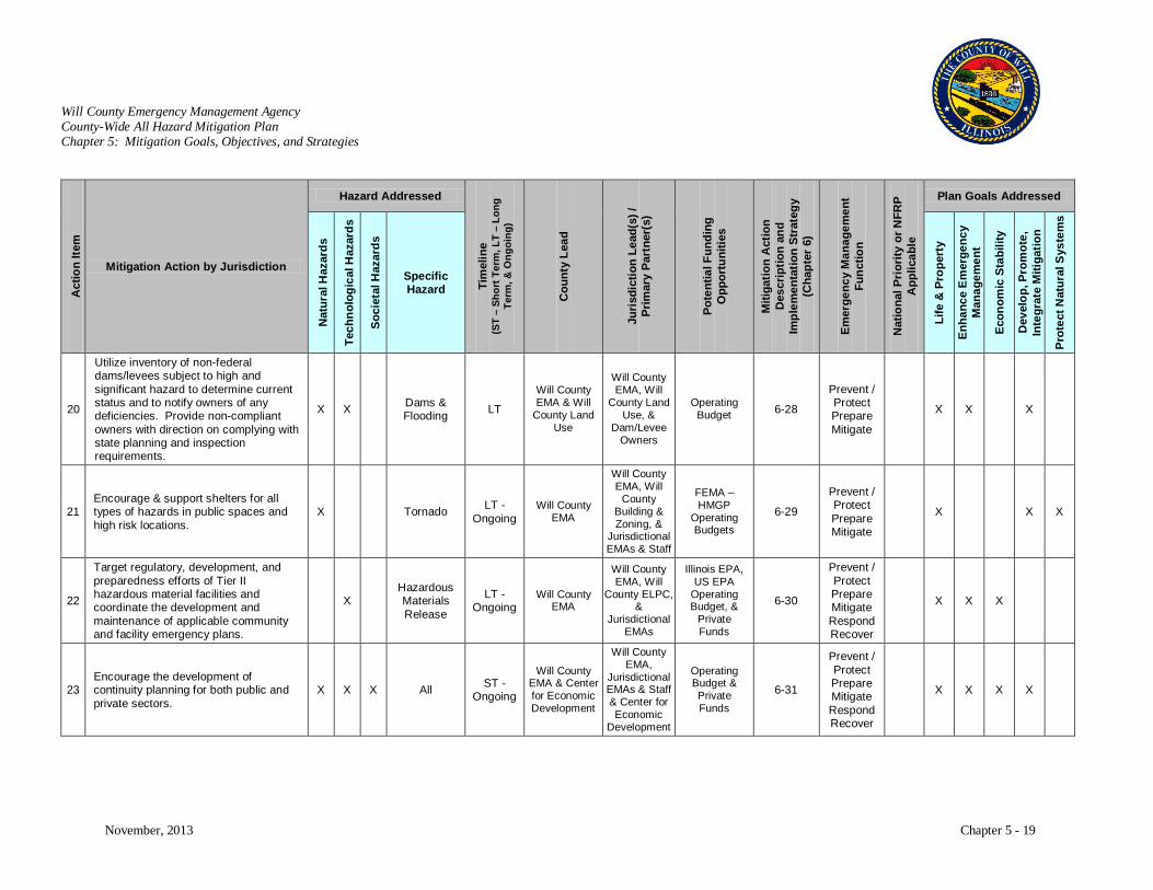
Will County Emergency Management Agency County-Wide All Hazard Mitigation Plan Chapter 5: Mitigation Goals, Objectives, and Strategies
November, 2013 Chapter 5 - 19
Act
ion
Item
Mitigation Action by Jurisdiction
Hazard Addressed
Tim
elin
e (S
T –
Shor
t Ter
m, L
T –
Long
Te
rm, &
Ong
oing
)
Cou
nty
Lead
Juri
sdic
tion
Lead
(s) /
Pr
imar
y Pa
rtne
r(s)
Pote
ntia
l Fun
ding
O
ppor
tuni
ties
Miti
gatio
n A
ctio
n D
escr
iptio
n an
d Im
plem
enta
tion
Stra
tegy
(C
hapt
er 6
)
Emer
genc
y M
anag
emen
t Fu
nctio
n
Nat
iona
l Pri
ority
or N
FRP
App
licab
le
Plan Goals Addressed
Nat
ural
Haz
ards
Tech
nolo
gica
l Haz
ards
Soci
etal
Haz
ards
Specific Hazard
Life
& P
rope
rty
Enha
nce
Em
erge
ncy
Man
agem
ent
Econ
omic
Sta
bilit
y
Dev
elop
, Pro
mot
e,
Inte
grat
e M
itiga
tion
Prot
ect N
atur
al S
yste
ms
20
Utilize inventory of non-federal dams/levees subject to high and significant hazard to determine current status and to notify owners of any deficiencies. Provide non-compliant owners with direction on complying with state planning and inspection requirements.
X X Dams & Flooding LT
Will County EMA & Will
County Land Use
Will County EMA, Will
County Land Use, &
Dam/Levee Owners
Operating Budget 6-28
Prevent / Protect Prepare Mitigate
X X X
21 Encourage & support shelters for all types of hazards in public spaces and high risk locations.
X Tornado LT - Ongoing
Will County EMA
Will County EMA, Will
County Building & Zoning, &
Jurisdictional EMAs & Staff
FEMA – HMGP
Operating Budgets
6-29
Prevent / Protect Prepare Mitigate
X X X
22
Target regulatory, development, and preparedness efforts of Tier II hazardous material facilities and coordinate the development and maintenance of applicable community and facility emergency plans.
X Hazardous Materials Release
LT - Ongoing
Will County EMA
Will County EMA, Will
County ELPC, &
Jurisdictional EMAs
Illinois EPA, US EPA
Operating Budget, &
Private Funds
6-30
Prevent / Protect Prepare Mitigate Respond Recover
X X X
23 Encourage the development of continuity planning for both public and private sectors.
X X X All ST - Ongoing
Will County EMA & Center for Economic Development
Will County EMA,
Jurisdictional EMAs & Staff & Center for Economic
Development
Operating Budget & Private Funds
6-31
Prevent / Protect Prepare Mitigate Respond Recover
X X X X
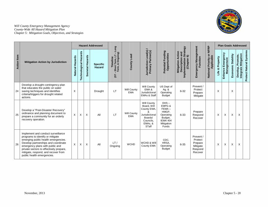
Will County Emergency Management Agency County-Wide All Hazard Mitigation Plan Chapter 5: Mitigation Goals, Objectives, and Strategies
November, 2013 Chapter 5 - 20
Act
ion
Item
Mitigation Action by Jurisdiction
Hazard Addressed
Tim
elin
e (S
T –
Shor
t Ter
m, L
T –
Long
Te
rm, &
Ong
oing
)
Cou
nty
Lead
Juri
sdic
tion
Lead
(s) /
Pr
imar
y Pa
rtne
r(s)
Pote
ntia
l Fun
ding
O
ppor
tuni
ties
Miti
gatio
n A
ctio
n D
escr
iptio
n an
d Im
plem
enta
tion
Stra
tegy
(C
hapt
er 6
)
Emer
genc
y M
anag
emen
t Fu
nctio
n
Nat
iona
l Pri
ority
or N
FRP
App
licab
le
Plan Goals Addressed
Nat
ural
Haz
ards
Tech
nolo
gica
l Haz
ards
Soci
etal
Haz
ards
Specific Hazard
Life
& P
rope
rty
Enha
nce
Em
erge
ncy
Man
agem
ent
Econ
omic
Sta
bilit
y
Dev
elop
, Pro
mot
e,
Inte
grat
e M
itiga
tion
Prot
ect N
atur
al S
yste
ms
24
Develop a drought contingency plan that educates the public on water saving techniques and identifies criteria/triggers for drought related actions.
X Drought LT Will County EMA
Will County EMA &
Jurisdictional EMAs & Staff
US Dept of Ag. &
Operating Budget
6-32
Prevent / Protect Prepare Mitigate
X X
25
Develop a “Post-Disaster Recovery” ordinance and planning document to prepare a community for an orderly recovery operation.
X X X All LT Will County EMA
Will County Board, Will
County EMA, &
Jurisdictional Boards/
Councils, EMAs, &
STaff
DHS – EMPG & FEMA – HMGP,
Operating Budget,
IEMA 404 Mitigation
Funds
6-33 Prepare Respond Recover
X X X X
26
Implement and conduct surveillance programs to identify or mitigate emerging public health emergencies. Develop partnerships and coordinate emergency plans with public and private sectors to effectively prepare, mitigate, respond, and recover from public health emergencies.
X X X All LT / Ongoing WCHD WCHD & Will
County EMA
CDC, HRSA,
Operating Budget
6-35
Prevent / Protect Prepare Mitigate Respond Recover
X X X X
Will County Emergency Management Agency County-Wide All Hazard Mitigation Plan Chapter 6. Mitigation Actions
November, 2013 Chapter 6 - 1
CHAPTER 6: MITIGATION ACTIONS
Overview
The communities of Will County have numerous natural, technological, and societal hazards that pose a
threat to the residents, businesses, infrastructure, property, and community assets. Identifying and
prioritizing mitigation actions are the fundamental component of the Will County County-Wide All
Hazard Mitigation Plan. Analyzing mitigation actions that address all or multiple hazards will improve
the effectiveness and benefits. However, mitigation actions that address one hazard category (i.e., natural
hazards) or a specific hazard (flooding) are also identified in this section.
A cost-benefit analysis was not developed due to the open scope of many of these items. A cost-benefit
analysis based on FEMA’s methodology will be developed when the actions are implemented. The cost
benefit analysis will help in prioritizing actions by describing appropriate benefit-cost methodologies for
evaluating the effectiveness of a range of potential mitigation actions. As a result, mitigation actions are
prioritized by whether they address the target hazards identified in the risk assessment or by the number
of hazards that they address. To complement state initiatives, mitigation actions that address relative
“National Priorities”, as dictated by DHS doctrines, are also identified. The intent of this section is to
identify actions that will accurately articulate the communities of Will County’s needs for mitigating the
consequence of high risk events and to improve emergency services.
Common Themes and Issues
Rapid Growth and Urban Sprawl
Will County is one of the Nation’s fastest growing counties. Between 1990 and 2010, Will County’s
population grew by 89% or over 320,000 people. Annual estimates and future projections show this rapid
growth trend will continue with population totals exceeding 1.1 million people. Currently there is a
population of 682,518, which makes Will County’s population the fourth largest in the state and the 89th
largest in the country. This rapid growth makes Will County the second fastest developing county in
Illinois.
Will County Emergency Management Agency County-Wide All Hazard Mitigation Plan Chapter 6. Mitigation Actions
November, 2013 Chapter 6 - 2
The nation has witnessed an alarming increase in the number and severity of natural disasters. Experts
believe that this trend will continue, with the potential of larger and more devastating disasters occurring.
While geophysical disasters, such as earthquakes, have remained relatively constant in this country over
the past 50 years, weather-related disasters have skyrocketed. In addition, our technological advances
have further increased our vulnerabilities and potential for impacts are exacerbated with the growing
presence of societal hazards such as terrorism.
Population growth and urbanization are major contributors to a community’s increase in vulnerability, as
well as exacerbating the potential impacts of a disaster. Urban sprawl and our desire to control our
environment with engineered structures have led to more development in high-risk areas. This
encouragement of developing high-risk areas, coupled with aging infrastructure, makes the potential
impact of a disaster even greater. In addition, growing populations combined with increased risks require
a greater need for identifying evacuation routes. Larger populations and a higher concentration of people
living in urban areas will result in disasters that affect a larger number of individuals.
One of the Will County’s greatest risks is flooding. ‘No Adverse Impact Floodplain Management’ is a
managing principle being offered by the Association of State Floodplain Managers (ASFPM) that is easy
to communicate and from a policy perspective tough to challenge. In essence, a no impact floodplain is
one where the action of one property owner does not adversely impact the rights of other properties, as
measured by increased flood peaks, flood stage, flood velocity, and erosion and sedimentation potentials.
While Will County participates in the National Flood Insurance Program (NFIP) guidelines, many
structures remain at risk simply because they are in the floodplain. By joining the Community Rating
System (CRS), the County:
• Will reduce insurance premiums of those policy holders located in the floodplain.
• Would have a process in place to enable the County to tailor future development.
• Would better allow communities to incorporate environmental concerns into floodplain management.
Digital Flood Insurance Rate Maps (DFIRM) for Will County is expected to be completed in 2015
providing a digital version of the FEMA flood insurance rate maps designed for use with digital mapping
and analysis software. Flood Insurance Studies (FIS) date back to the late 1970’s and early 1980’s. As a

Will County Emergency Management Agency County-Wide All Hazard Mitigation Plan Chapter 6. Mitigation Actions
November, 2013 Chapter 6 - 3
result, the flood elevations associated with various flood events may not be indicative of expected flood
inundation. This discrepancy, coupled with the current increase in population density, will be resolved
when final DFIRMS are available.
Similarly, the location and conditions of Will County non-federal dams should be assessed since
increased population density downstream of a dam could result in increased destruction during a dam
failure.
Local and Regional Partnerships
Like all emergency management functions, hazard mitigation begins at the local level. Individual
properties and businesses can be the most vulnerable to hazards. Therefore, it is important for businesses,
industry representatives, and local governments to form partnerships and work together to plan for
disasters. This partnership would create a more thorough response and initiate the framework and
resources needed for post-disaster recovery. Partnerships will bring mitigation into the forefront.
Development of local and regional partnerships was identified by FEMA as a National Priority.
Crisis Management vs. Consequence Management
Since September 11th
“Any action taken to eliminate or reduce long-term risk to human life and property from
the consequences of natural and human-caused hazards”. Such actions are taken to
reduce the consequences of disasters and break the vicious cycle of destruction, repair,
, there has been much debate on the roles and responsibilities of emergency
management. Although there is a close relationship between crisis and consequence management, there
are defined differences. Crisis management is predominately a law enforcement function and includes
measures to identify, acquire, and plan the use of resources needed to anticipate, prevent and/or resolve a
threat or act of terrorism. Consequence management is predominately an emergency management
function and includes measures to protect public health and safety, restore essential government services,
and provide emergency relief to governments, businesses, and individuals affected by the consequences
of an event. For this reason, the hazard mitigation actions are focused on alleviating the impacts or
consequences of a hazard, whether it is a natural or man-made event.
By definition, mitigation actions are:
Will County Emergency Management Agency County-Wide All Hazard Mitigation Plan Chapter 6. Mitigation Actions
November, 2013 Chapter 6 - 4
destruction, repair, etc. Mitigation actions are the foundation of a truly effective
emergency management program.”
Leveraging Available Funds
In recent years, the financial resources for mitigation activities have declined with the reduction in funds
for the FEMA Pre-Disaster Mitigation Program (PDM) and the Hazard Mitigation Grant Program
(HMGP). However, leveraging Department of Homeland Security (DHS) initiatives to address natural,
technological, and societal hazards, as well as potentially funding mitigation actions, will ensure
efficiency in public funding. The 2005 Emergency Management Performance Grants – Program
Guidance and Application Kit states that “emergency managers at all levels should leverage all available
funding and resources from multiple sources wherever possible…(and)…should not restrict their
activities to only Federal funding to achieve the goals outlined within their strategies. Rather, special
attention should be given to leveraging relevant funding sources and resources that support”… mitigation
activities.1
1 “The Subcommittee on Economic Development, Public Buildings, & Emergency Management Hearing on The National Preparedness System: What are we preparing for?” April 14, 2005.
Additional sources include other Federal preparedness programs, those offered by Department
of Health and Human Services (HHS) through CDC, Department of Health and Human Services (HRSA),
and the U.S. Food and Drug Administration; the Department of Agriculture; the Department of Justice
(DOJ); the Department of Transportation; FEMA; DHS Science and Technology Directorate; DHS
Information Analysis and Infrastructure Protection Directorate; and other relevant organizations. In
addition to federal programs, State homeland security and preparedness programs and resources may be
available to meet the objectives outlined in the Will County County-Wide All Hazard Mitigation Plan.
Regardless of the mitigation activities and the corresponding jurisdictions and potential funding
mechanisms that have been identified, it is not the intent of this plan to convey any specific commitment
or obligation to carry out a specific project. It is understood that the completion of mitigation actions
identified in this plan are contingent upon further planning and review, specific endorsement or approval
from appropriate agencies and governing bodies, and financial, technical, and other necessary resources.
http://www.house.gov/transportation/pbed/04-14-05/04-14-05memo.html
Will County Emergency Management Agency County-Wide All Hazard Mitigation Plan Chapter 6. Mitigation Actions
November, 2013 Chapter 6 - 5
Hazard Mitigation Actions and Implementation
Mitigation Action #1: Revise and adopt the Will County-Wide All Hazard Mitigation Plan by resolution of the County Board, City Councils, Boards of Trustees, and other governing boards as appropriate. The municipal, fire protection districts, colleges, and other agencies’ resolutions should adopt each action item that is pertinent to the community and assign a person responsible for it.
Goals Addressed: Goal #1 - Protect and secure life and property.
Goal #2 - Continue to improve and enhance county-wide emergency management programs and develop relationships county- wide.
Goal #3 - Ensure economic stability, preserve cultural resources, and improve quality of life throughout Will County.
Goal #4 - Develop, promote, and integrate mitigation actions.
Goal #5 - Take advantage of opportunities offered by growth while also protecting natural systems and resources.
Problem/Opportunity: Formal adoption of this Plan ensures that County and municipal staffs are authorized and instructed to implement its action items. Adoption is also a requirement for recognition of the Plan by mitigation funding programs and the Community Rating System.
Implementation Strategy: Gain public and political support to adopt the plan. Jurisdictions: County Board, Village Boards, City Councils, and Other Stakeholder
Boards Lead Agency: Will County Emergency Management Agency (EMA) Funding: Operating Budget Timeline: Short-term
Will County Emergency Management Agency County-Wide All Hazard Mitigation Plan Chapter 6. Mitigation Actions
November, 2013 Chapter 6 - 6
Mitigation Action #2: Ensure the thoroughness and NIMS/NRP compliance of emergency management planning documents, operations, and functions and integrate emergency management operations, functions, and initiatives with all levels of government and neighboring jurisdictions.
Goals Addressed: Goal #1 - Protect and secure life and property.
Goal #2 - Continue to improve and enhance county-wide emergency management programs and develop relationships county-wide.
Goal #4 - Develop, promote, and integrate mitigation actions.
Problem/Opportunity: Local emergency management agencies have worked tirelessly to secure the community and to keep up to date on revolving threats, as well as the evolution of emergency management. There have been significant changes within the field of emergency management following the events of September 11th and recent hurricanes/tornadoes, as well as the introduction of new directives, changes to the National Federal Response Plan, and the development of the National Incident Management System. It is essential to ensure that emergency management doctrine, operational systems, and programs at all levels of government within Will County are thorough and integrated.
Implementation Strategy: Execute a gap analysis of emergency planning documents and operational systems throughout Will County at all levels of government. Identify needs and actions to ensure thoroughness and integration of emergency management operations and functions at all levels of government. For example, in order to be compliant with the National Response Plan, Will County EMA should develop a Recovery Operations Plan that addresses all hazards and integrates federal and state directives.
Jurisdictions: Will County Board, Will County EMA, Municipal Staff, and other Stakeholder Boards
Lead Agency: Will County Emergency Management Agency
Funding: FEMA - Hazard Mitigation Grant Program (HMGP), Operating Budget
Timeline: Long-term/Ongoing
Will County Emergency Management Agency County-Wide All Hazard Mitigation Plan Chapter 6. Mitigation Actions
November, 2013 Chapter 6 - 7
Mitigation Action #3: Expand regional collaboration by developing outreach programs and coordinating with neighboring jurisdictions, regional partnerships, businesses, non-profit, and universities.
Goals Addressed: Goal #1 - Protect and secure life and property.
Goal #2 - Continue to improve and enhance county-wide emergency management programs and develop relationships county-wide.
Goal #3 - Ensure economic stability, preserve cultural resources, and improve quality of life throughout Will County.
Goal #4 - Develop, promote, and integrate mitigation actions.
Goal #5 - Take advantage of opportunities offered by growth while also protecting natural systems and resources.
Problem/Opportunity: Major events will have cross-geographic consequences and impacts. There is a large need within emergency management for embracing partnerships across multiple jurisdictions, regions, and States in building capabilities cooperatively. Successful regional collaboration would allow for multi-jurisdictional and multi-disciplinary approach to increase efficiency and leverage local and regional capabilities.
Implementation Strategy: Formalize, update, and expand mutual aid agreements with surrounding communities, regional partnerships, and other organizations for the purposes of sharing equipment, personnel, and facilities during an emergency.
Exercise the execution of mutual aid agreements to identify challenges and familiarize officials with regional resources.
Coordinate preparedness assistance expenditures and planning efforts on a regional basis to avoid duplicative or inconsistent investments.
Jurisdictions: Will County EMA and Jurisdictional EMAs Lead Agency: Will County Emergency Management Agency and Will County Land Use Funding: Operating Budget, Private Funds Timeline: Ongoing
Will County Emergency Management Agency County-Wide All Hazard Mitigation Plan Chapter 6. Mitigation Actions
November, 2013 Chapter 6 - 8
Mitigation Action #4: Incorporate risk assessment and hazard mitigation principles into comprehensive planning efforts, programs, and projects in order to secure communities from all hazards.
Goals Addressed: Goal #1 - Protect and secure life and property.
Goal #2 - Continue to improve and enhance county-wide emergency management programs and develop relationships county-wide.
Goal #4 - Develop, promote, and integrate mitigation actions.
Goal #5 - Take advantage of opportunities offered by growth while also protecting natural systems and resources.
Problem/Opportunity: Will County is one of the Nation’s fastest growing communities. Population growth and urbanization are major contributors to a community’s increase in vulnerability, as well as exacerbates the potential impacts of a disaster. Urban sprawl and our desire to control our environment with engineered structures have led to more development in high-risk areas.
Implementation Strategy: Support, promote, and expand the development of the Hazard Mitigation Steering Committee into a permanent component throughout the County. Implement annual workshops and roundtables to educate others on the need for and benefits of mitigation, identify opportunities, and integrate developments into revisions of the All Hazard Mitigation Plan along with local plans and ordinances.
Jurisdictions: Will County Boards, Will County EMA, Will County Stormwater Management Planning Committee, Will County Land Use, Local Municipal Boards/Councils and Staff, and Chambers of Commerce
Lead: Will County EMA
Funding: Operating Budget
Timeline: Ongoing
Will County Emergency Management Agency County-Wide All Hazard Mitigation Plan Chapter 6. Mitigation Actions
November, 2013 Chapter 6 - 9
Mitigation Action #5: Expand the county-wide public awareness and education programs and promote the understanding of each community’s risks, vulnerabilities, what to do during and after a disaster, and how to mitigate the effects of disasters.
Goals Addressed: Goal #1 - Protect and secure life and property.
Goal #2 - Continue to improve and enhance county-wide emergency management programs and develop relationships county-wide.
Goal #3 - Ensure economic stability, preserve cultural resources, and improve quality of life throughout Will County.
Goal #4 - Develop, promote, and integrate mitigation actions.
Problem/Opportunity: When a disaster occurs, it affects everyone living in the community. Therefore, it is essential to ensure public awareness of the community’s threats and what they can do to prepare and measures they can take to reduce the consequences of a disaster. During and after a hazard event, emergency responders may be either overwhelmed with emergency calls or unable to access some residential areas. It is important that individual households are prepared for a period of self-sufficiency while responders deal with more immediate and life-threatening situations. Disasters also open a window of opportunity following a disastrous event of local, national or international significance in which citizens will take action to improve their own safety and preparedness. This strategy supports response and recovery.
Implementation Strategy: Evaluate existing public education efforts and identify opportunities to expand or develop new programs that present the risks that face the community and measures they can take to prepare and mitigate. Leverage existing forums such as public meetings, universities, and workshops to deliver these programs.
• Develop and index a mitigation/preparedness packet for the public and for the media to have ready for each type of hazard.
Following a disaster, provide rapid information to the public on disaster preparedness and mitigation measures. Follow up with sustained education campaign for the following two months.
Will County Emergency Management Agency County-Wide All Hazard Mitigation Plan Chapter 6. Mitigation Actions
November, 2013 Chapter 6 - 10
• Develop customized recovery packets for each hazard for
delivery to the public and media to have ready for when a disaster occurs.
• Draft a campaign strategy to deploy the information strategically.
• Expand current advertising/public service announcements (PSA) outlet information.
• Promote the development of Citizen Corps Councils and Community Emergency Response Teams (CERT).
• Utilize the latest communication technology for public education outreach.
Jurisdictions: Will County EMA and Jurisdictional EMAs
Lead Agency: Will County EMA
Funding: Operating Budget
Timeline: Ongoing

Will County Emergency Management Agency County-Wide All Hazard Mitigation Plan Chapter 6. Mitigation Actions
November, 2013 Chapter 6 - 11
Mitigation Action #6: Continue to strengthen infrastructure, build redundancies, and implement contingency plans for vulnerable populations and essential services and networks.
Goals Addressed: Goal #1 - Protect and secure life and property.
Goal #3 - Ensure economic stability, preserve cultural resources, and improve quality of life throughout Will County.
Goal #4 - Develop, promote, and integrate mitigation actions.
Problem/Opportunity: Hazard events can cause power outages, obstruct roads, and disrupt essential services. This can have a devastating impact on isolated communities and select populations.
Implementation Strategy: Continue an analysis utilizing GIS applications to identify areas that lack redundancy. Focus should be given on essential utility systems, road networks, and critical facility service areas. Develop a system of priority routes, facilities, and systems for hazard events and their associated needs. Work with other departments and work with utilities in order to identify needs and actions to cost effectively implement redundancies.
Jurisdictions: WC Department of Highways, WC Land Use, Jurisdictional Public Work Departments, and local utilities
Lead Agency: Will County EMA, Will County Department of Highways, and Will County Land Use
Funding: Operating and capital improvement budgets
Timeline: Long-term/Ongoing
Will County Emergency Management Agency County-Wide All Hazard Mitigation Plan Chapter 6. Mitigation Actions
November, 2013 Chapter 6 - 12
Mitigation Action #7: Continue to support the delivery of existing and free training platforms to educate officials, critical personnel, first responders, and communities on risks, fundamental operations of emergency management, and mitigation for the purpose of improving community preparedness and advancement of professional development.
Goals Addressed: Goal #2 - Continue to improve and enhance county-wide emergency management programs and develop relationships county-wide.
Goal #3 - Ensure economic stability, preserve cultural resources, and improve quality of life throughout Will County.
Goal #4 - Develop, promote, and integrate mitigation actions.
Goal #5 - Take advantage of opportunities offered by growth while also protecting natural systems and resources.
Problem/Opportunity: It is essential to have political and peer support prior to, during, and following a disaster by establishing, cultivating, and maintaining relationships throughout the County, between communities, local officials and department liaisons prior to an event. In addition, the field of Emergency Management has grown rapidly over the past few decades. The challenges and complexities of the relationship between our environment, global politics and their impacts on our infrastructure, economics, and sustainability have required the need for a vast array of specialty.
Implementation Strategy: Continue county-wide emergency management workshops and training for communities, department liaisons and local officials that focuses on their community’s risks, vulnerabilities, and opportunities to protect and mitigate. Also, encourage and support emergency management and other related professionals throughout the County to obtain higher education degrees, certifications, and membership in professional organizations.
Jurisdictions: Will County EMA, Will County Stormwater Management Planning Committee, Will County Land Use, and Jurisdictional staff and EMAs
Lead Agency: Will County EMA
Funding: Collaboration between local colleges and universities, state, and local funding
Timeline: Ongoing
Will County Emergency Management Agency County-Wide All Hazard Mitigation Plan Chapter 6. Mitigation Actions
November, 2013 Chapter 6 - 13
Mitigation Action #8: Identify critical facilities that are located within high-hazard areas and
relocate them or incorporate mitigation retrofits to protect them from future floods.
Goals Addressed: Goal #1 - Protect and secure life and property.
Goal #2 - Continue to improve and enhance county-wide emergency management programs and develop relationships county-wide.
Goal #3 - Ensure economic stability, preserve cultural resources, and improve quality of life throughout Will County.
Goal #4 - Develop, promote, and integrate mitigation actions.
Goal #5 - Take advantage of opportunities offered by growth while also protecting natural systems and resources.
Problem/Opportunity: The flood modeling conducted in this report identified several fire stations and schools that were located within or near the 100 year floodplain. NFIP regulations encourage communities to have critical facilities outside of the 500 year floodplain.
FEMA now provides the Standard Digital Flood Insurance Rate Map (DFIRM) Database which is a digital version of the FEMA flood insurance rate map that is designed for use with digital mapping and analysis software. Will County is expected to receive their DFIRMs in the near future which will allow planners to more accurately identify critical facilities located in flood-prone areas.
Implementation Strategy: Upon receipt of updated DFIRM database provided by FEMA, conduct a detailed study of each facility to evaluate the potential impacts to each facility and identify mitigation options to protect it from future damages and to ensure operations during an event. Conduct a benefit-cost analysis and implement the best mitigation alternative.
Jurisdictions: Will County GIS, Will County Land Use, and affected Jurisdictional Staff
Lead Agency: Will County Land Use
Funding: FEMA - HMGP & Pre-Disaster Mitigation (PDM)
Timeline: Long-term/Ongoing
Will County Emergency Management Agency County-Wide All Hazard Mitigation Plan Chapter 6. Mitigation Actions
November, 2013 Chapter 6 - 14
Mitigation Action #9: Support the use, development, and implementation of Geographic Information Systems (GIS) throughout the County to track communities’ vulnerability to hazards.
Goals Addressed: Goal #1 - Protect and secure life and property.
Goal #2 - Continue to improve and enhance county-wide emergency management programs and develop relationships county-wide.
Goal #4 - Develop, promote, and integrate mitigation actions.
Problem/Opportunity: Will County communities are increasingly incorporating geospatial technologies and data into their daily operations. Geospatial technologies and data have become a valued asset in preparedness, protection, response, and recovery emergency management operations. In the preparedness phase, emergency management planners, as well as responders, need current, accurate, and easily accessible information to ensure the readiness of teams to respond. The mapping and analysis of critical infrastructure vulnerabilities and public health surveillance capabilities is an important component of strategy development including response and recovery in order to provide a dynamic common operating picture, coordinate and track emergency assets, enhance capabilities, understand event impacts, accurately estimate damage, locate safety zones for quarantine or detention, and facilitate recovery. Through the mitigation planning process, the Will County communities have identified the benefit of integrating HAZUS technology and the benefits of robust, accurate, and detailed data.
Implementation Strategy: Continue to encourage communities to invest in GIS technology by training staff, obtaining and updating detailed geospatial data, and incorporating GIS technology and modeling programs into community decisions. Data sharing agreements have been made with twenty-eight communities throughout Will County along with many other tax districts and agencies.
Jurisdictions: Will County GIS and Jurisdictions with GIS (Channahon, Joliet, and Naperville)
Lead Agency: Will County GIS
Funding: Operating Budget
Timeline: Ongoing

Will County Emergency Management Agency County-Wide All Hazard Mitigation Plan Chapter 6. Mitigation Actions
November, 2013 Chapter 6 - 15
Mitigation Action #10: Update base flood elevations (BFE) throughout the County in accordance with the Flood Hazard Mapping Program.
Goals Addressed: Goal #1 - Protect and secure life and property.
Goal #2 - Continue to improve and enhance county-wide emergency management programs and develop relationships county-wide.
Goal #4 - Develop, promote, and integrate mitigation actions.
Goal #5 - Take advantage of opportunities offered by growth while also protecting natural systems and resources.
Problem/Opportunity: Current development is based on outdated BFE’s determined in the late 1970’s and early 1980’s. These outdated flood maps may not adequately represent present flood inundation levels for areas with increased urban and commercial development. Continuing development based on current BFE’s may result in an increased negative impact. Additionally, many areas impacted will likely not possess flood insurance due to their expectations of the base flood elevation.
Implementation Strategy: The Digital Flood Insurance Rate Maps (DFIRM) for Will County are almost complete. Once completed, the Stormwater Management Planning Committee will begin utilizing them for planning and mitigation projects.
Jurisdiction: Will County Stormwater Management Planning Committee
Lead Agency: Will County Stormwater Management Planning Committee
Funding: Implementation Strategy - Operating Budget. Overall Mitigation – State and Federal
Timeline: Short-term
Will County Emergency Management Agency County-Wide All Hazard Mitigation Plan Chapter 6. Mitigation Actions
November, 2013 Chapter 6 - 16
Mitigation Action #11: Maintain or amend, as needed, the county-wide floodplain ordinance.
Goals Addressed: Goal #1 - Protect and secure life and property.
Goal #4 - Develop, promote, and integrate mitigation actions.
Goal #5 - Take advantage of opportunities offered by growth while also protecting natural systems and resources.
Problem/Opportunity: A community's agreement to adopt and enforce floodplain management ordinances, particularly with respect to new construction is an important element in making flood insurance available to home and businesses owners. Currently over 20,000 communities voluntarily adopt and enforce local floodplain management ordinances that provide flood loss reduction building standards for new and existing development. Will County has updated the County floodplain ordinance to incorporate more stringent regulations. Supporting the ordinance is the County’s Stormwater Management Plan and Technical Guidance Manual for County-Wide Stormwater Ordinance.
Implementation Strategy: Maintain or amend the ordinance as needed. All communities in Will County have adopted the County’s ordinance or implemented more stringent measures.
Jurisdictions: Will County Board, Will County Stormwater Management Planning Committee, and all Municipal Boards/Councils & Staff
Lead Agency: Will County Land Use and Stormwater Management Planning Committee
Funding: Operating Budget
Timeline: Ongoing
Will County Emergency Management Agency County-Wide All Hazard Mitigation Plan Chapter 6. Mitigation Actions
November, 2013 Chapter 6 - 17
Mitigation Action #12: Participate in the Community Rating System to further reduce flood damage in the communities of Will County.
Goals Addressed: Goal #1 - Protect and secure life and property.
Goal #4 - Develop, promote, and integrate mitigation actions.
Goal #5 - Take advantage of opportunities offered by growth while also protecting natural systems and resources.
Problem/Opportunity: Currently, the County and jurisdictions do not participate in the Community Rating System (CRS). The CRS is part of the National Flood Insurance Program and can provide discounts of up to 45% off flood insurance premiums for residents of communities that participate. Communities apply for a CRS classification and are given credit points that reflect the impact of their activities on reducing flood losses, insurance rating, and promoting awareness. CRS process includes ten steps: 1) organize, 2) involve the public, 3) coordinate with agencies and organizations, 4) assess the hazard, 5) evaluate the problem, 6) set goals, 7) review mitigation strategies, 8) draft action plan, 9) adopt the plan, 10) implement, evaluate, and revise.
Implementation Strategy: Leverage the Will County County-Wide All Hazard Mitigation Plan to fulfill some of the requirements identified in the CRS process. Identify gaps needed to implement the CRS and maximum CRS points.
Jurisdictions: Will County Stormwater Management Planning Committee, Will County Land Use, and Jurisdictional Staff
Lead Agency: Will County Land Use
Funding: Operating Budget
Timeline: Ongoing
Will County Emergency Management Agency County-Wide All Hazard Mitigation Plan Chapter 6. Mitigation Actions
November, 2013 Chapter 6 - 18
Mitigation Action #13: Integrate Flood Hazard Mapping Program updates with improved county-wide GIS capabilities.
Goals Addressed: Goal #1 - Protect and secure life and property.
Goal #2 - Continue to improve and enhance county-wide emergency management programs and develop relationships county-wide.
Goal #3 - Ensure economic stability, preserve cultural resources, and improve quality of life throughout Will County.
Goal #4 - Develop, promote, and integrate mitigation actions.
Goal #5 - Take advantage of opportunities offered by growth while also protecting natural systems and resources.
Problem/Opportunity: Will County GIS Division is currently working closely with jurisdictions to improve GIS capabilities and develop measures to protect communities from flooding. County-wide GIS capabilities have been steadily increasing; however, there is a limitation in the amount of data available. The County would like to utilize the existing technology and to leverage FEMA’s current Risk Map Program initiative to map flood hazards. The Risk Map Program will:
• Create new maps that take advantage of revised data and improved technologies for identifying flood hazards.
• Create up-to-date maps to support a flood insurance program that is more closely aligned with actual risk, encourage wise floodplain management, and increase the public’s flood hazard awareness.
• Provide local communities and various stakeholders desired more timely updates of floodplain maps and easier access to the data.
• Map Modernization is a cornerstone for helping communities to be better prepared for flood disasters. The NFIP currently serves 4.5 million policyholders and provides $650 billion in coverage.
Will County Emergency Management Agency County-Wide All Hazard Mitigation Plan Chapter 6. Mitigation Actions
November, 2013 Chapter 6 - 19
Implementation Strategy: Maintain Data Sharing Agreements or Data Licensing Agreements between
Will County GIS and participating jurisdictions and taxing/agency bodies throughout the County. Provide training to staff on the use of GIS technologies and supporting models.
Jurisdictions: Will County GIS, Will County Stormwater Management Planning committee, and local Jurisdictions
Lead Agency: Will County GIS and Stormwater Management Planning Committee
Funding: Operating Budget
Timeline: Short-term
Will County Emergency Management Agency County-Wide All Hazard Mitigation Plan Chapter 6. Mitigation Actions
November, 2013 Chapter 6 - 20
Mitigation Action #14: Utilizing GIS, develop and maintain a county-wide database of flood controlled areas, purchased flood plain properties, and flood prone properties to be acquired.
Goals Addressed: Goal #1 - Protect and secure life and property.
Goal #2 - Continue to improve and enhance county-wide emergency management programs and develop relationships county-wide.
Goal #3 - Ensure economic stability, preserve cultural resources, and improve quality of life throughout Will County.
Goal #4 - Develop, promote, and integrate mitigation actions.
Goal #5 - Take advantage of opportunities offered by growth while also protecting natural systems and resources.
Problem/Opportunity: As budgets shrink and the need grows for managing mitigation and recovery projects within rapidly growing communities, efficiency in managing information on flood prone areas is essential. GIS provides management of data and mapping capabilities that allows analysis of the information for planning, mitigation, and recovery purposes. Mitigation funding of approximately $10.6 million has been spent in securing repetitive loss properties in Will County from the 1996 and 2008 floods. Data on flood controlled areas, previously purchased flood plain properties, and flood prone properties to be purchased can be integrated into useable formats for planners. This will improve efficiency in flood plain management projects and maximize limited budgets.
Implementation Strategy: Use improved GIS capabilities and completed DFIRMs for Will County when available to integrate flood plain data on flood controlled areas, purchased flood plain properties, and flood prone properties to be acquired. This will allow planners to be more efficient in data analysis and budgeting for planning, mitigation, and recovery projects.
Jurisdictions: Will County GIS and Stormwater Management Planning Committee
Lead Agency: Will County GIS and Stormwater Management Planning Committee
Funding: Operating Budget
Timeline: Long-term/Ongoing

Will County Emergency Management Agency County-Wide All Hazard Mitigation Plan Chapter 6. Mitigation Actions
November, 2013 Chapter 6 - 21
Mitigation Action #15: Continue stormwater management planning and ordinances to improve existing storm capacity and drainage systems. Utilize watershed studies and mapping to identify and prioritize mitigation needs in each watershed. Potential projects include retention basins improvement, culvert enlargement/improvement, stream maintenance, erosion/sedimentation control, water quality assessment, watershed and flood risks education, infrastructure maintenance, agency coordination, property/infrastructure protection, roadway elevations correction, and data for improved emergency planning/response.
Goals Addressed: Goal #1 - Protect and secure life and property.
Goal #4 - Develop, promote, and integrate mitigation actions.
Goal #5 - Take advantage of opportunities offered by growth while also protecting natural systems and resources.
Problem/Opportunity: Current watershed concerns have been identified through existing studies, community recommendations, and past flood incident data. There is a concern that some of the drainage systems throughout the County are undersized due to the rapid development within the County from rural farm fields to suburbanized communities. As the County developed, farm field tiles that once controlled flooding were abandoned as developments were built on neighboring land. Growing communities increase the need for effective stream maintenance, proper sizing of retention basins and culverts, erosion/sedimentation control, and protection of property and infrastructure from flooding.
Watershed studies would assist the WCSMPC to identify, prioritize, and address flooding issues; thus, these studies would provide a cost-effective approach to addressing existing and future flood problems. Staffing and funding are obstacles for the development of the studies and implementing recommended flood control measures.
Implementation Strategy: Utilize Will County Stormwater Plan and Technical Guidance to:
• Employ studies by a licensed professional engineer to re-evaluate watersheds and determine the true flood areas and issues causing flooding.
Will County Emergency Management Agency County-Wide All Hazard Mitigation Plan Chapter 6. Mitigation Actions
November, 2013 Chapter 6 - 22
• Assess problematic areas where field tiles were once the primary
method of flood control. • Perform an enhancement capability assessment of the stormwater
facility to handle the increase of flood waters. • Have the stormwater facilities fixed or re-sized to the appropriate
capacity. • Address erosion and sedimentation control issues. • Identify and address infrastructure maintenance issues. • Coordinate flood projects with neighboring counties where
watersheds cross jurisdictions. • Continue education of public on watershed and flood risk issues • Review available data to improve emergency planning and
response.
Jurisdictions: Will County Land Use Department, Will County Stormwater Management Planning Committee, Will County Department of Highways, Will County EMA, and Jurisdictional Planning Departments and Public Works (see pages 4-69 to 4-72 for watershed concerns and specific municipalities in watersheds)
Lead Agency: Will County Land Use Department, Will County Stormwater Management Planning Committee, and Will County Department of Highways
Funding: FEMA - HMGP, US EPA Local - Operating Budget
Timeline: Long-term/Ongoing
Will County Emergency Management Agency County-Wide All Hazard Mitigation Plan Chapter 6. Mitigation Actions
November, 2013 Chapter 6 - 23
Mitigation Action #16: Complete and maintain maps of shallow flooding and urban ponding areas to prioritize stormwater infrastructure improvements.
Goals Addressed: Goal #1 - Protect and secure life and property.
Goal #4 - Develop, promote, and integrate mitigation actions.
Goal #5 - Take advantage of opportunities offered by growth while also protecting natural systems and resources.
Problem/Opportunity: Some areas throughout the County are subject to flooding that occurs as a result of poor drainage rather than proximity to a river or stream. Major developments have been constructed in these shallow flooding areas and more are proposed. Flooding can occur well outside of mapped floodplains and the number of flood insurance policy holders outside of identified flood-prone areas demonstrates the need to map shallow flooding areas. Identifying shallow flooding areas would help reduce future problems and future surprises to residents, and provide a prioritized list of needed capital improvements. Tools, such as GIS and Light Detection and Ranging (LIDAR) maps, are available to identify shallow flooding areas.
Implementation Strategy: Identify past occurrences of shallow flooding, urban ponding, and high ground water areas using LIDAR and county-wide aerial photography of historical floods. Incorporate these into flood maps to monitor and prioritize infrastructure improvements throughout the County.
Jurisdictions: Will County Land Use and Will County Stormwater Management Planning Committee
Lead Agency: Will County Land Use and Stormwater Management Planning Committee
Funding: Operating Budget
Timeline: Short-term
Will County Emergency Management Agency County-Wide All Hazard Mitigation Plan Chapter 6. Mitigation Actions
November, 2013 Chapter 6 - 24
Mitigation Action #17: Increase open space and conservation easements, as well as incorporate
natural features, in high flood hazard areas throughout the County.
Goals Addressed: Goal #1 - Protect and secure life and property.
Goal #4 - Develop, promote, and integrate mitigation actions.
Goal #5 - Take advantage of opportunities offered by growth while also protecting natural systems and resources.
Problem/Opportunity: Extensive new development could greatly alter the natural hydrology throughout the County. Each new development adds impervious surfaces, such as sidewalks, driveways, foundations or others. This means that, because less water filters through the ground and into the water table, more rain drains more rapidly into stormwater management systems, streams and rivers. This situation increases the risk of flooding, adds sediment and toxins to run off, and slows aquifer replenishment. Furthermore, the cumulative affect of rapid growth throughout the County degrades environmental quality and increases the risk of flooding.
Low impact development (LID) has the potential to alleviate these adverse impacts through the creation of appropriately placed green space, landscaping, grading, streetscapes, roads and parking lots. LID can achieve multifunctional objectives and help to reduce stormwater impacts, and provide and maintain the beneficial hydrologic functions of a natural drainage system.
Implementation Strategy: Coordinate existing Will County Stormwater Management Plan into overall flood hazard mitigation activities. This could achieve several objectives:
• Ensure coordination of other planning efforts with those of the Will County Stormwater Management Plan Committee.
• Ensure coordination with the Will County Stormwater Management Planning Committee on issues pertaining to floodplain development, stormwater control, and other related matters.
• Ensure a wider understanding of and adherence to the Stormwater Management Plan and Stormwater Ordinance.
Coordinate and implement efforts to increase open space in high hazard areas throughout the County with the Will County Land Use Plan. The use of LID could achieve several objectives:
Will County Emergency Management Agency County-Wide All Hazard Mitigation Plan Chapter 6. Mitigation Actions
November, 2013 Chapter 6 - 25
• LID measures can result in no net increase in run off thereby
maintaining the current flood risk without affecting development potential.
• It recharges the aquifer. Groundwater supplies at least 95% of the drinking water supply and water critical for commerce in Will County.
• It supports the hydrologic regime, in turn supporting a healthy ecosystem and demanding less cost for maintenance and energy.
• It results in open space.
Develop county/jurisdiction regulations and guidelines that implement LID objectives to:
• Minimize impacts to the extent practicable by reducing imperviousness, conserving natural resources and ecosystems, maintaining natural drainage courses, reducing the use of pipes and minimizing clearing/grading.
• Recreate detention and retention storage dispersed and evenly distributed throughout a site with the use of open swales, fatter slopes, depressions, storage rain gardens (bio-retention), water use (rain barrels) and others.
• Maintain the predevelopment time of concentration by strategically routing flows to maintain travel time.
• Provide effective public education and socioeconomic incentives to ensure property owners use effective pollution prevention measures and maintain management measures.
Jurisdictions: Will County Land Use and local Jurisdictional Staff (Aurora, Bolingbrook, Braceville, Channahon, Crest Hill, Diamond, Elwood, Frankfort, Homer Glen, Joliet, Lemont, Lemont, Lockport, Manhattan, Minooka, Naperville, New Lenox, Park Forest, Plainfield, Rockdale, Romeoville, Shorewood, Steger, Wilmington, Woodridge)
Lead Agency: Will County Land Use
Funding: Federal Clean Water Act Section 319 Funds, FEMA – HMGP & PDM, county/jurisdiction operating budgets, private developers incentive programs
Timeline: Ongoing
Will County Emergency Management Agency County-Wide All Hazard Mitigation Plan Chapter 6. Mitigation Actions
November, 2013 Chapter 6 - 26
Mitigation Action #18: Continue to capitalize on opportunities to acquire, relocate, or elevate flood prone properties.
Goals Addressed: Goal #1 - Protect and secure life and property.
Goal #3 - Ensure economic stability, preserve cultural resources, and improve quality of life throughout Will County.
Goal #4 - Develop, promote, and integrate mitigation actions.
Goal #5 - Take advantage of opportunities offered by growth while also protecting natural systems and resources.
Problem/Opportunity: FEMA is currently updating digital flood maps in Will County that should be available soon. The new DFIRMS will be overlaid onto aerial photographs identifying structures that are within a flood zone providing information for mitigation opportunities.
Implementation Strategy: Identify structures within the flood zones and evaluate these locations for accuracy. Often flood maps do not reflect changes of the site due to new development, new elevations caused by placed fill, or flood control and stormwater infrastructure.
Compare the findings of the strategy above to existing inventory of repetitive loss structures.
Educate the public of this risk and promote potential opportunities to mitigate such as buy-out programs, relocation, or elevation.
Jurisdictions: Will County Land Use, Will County Stormwater Management Planning Committee, and local Jurisdictions in the Des Plaines River, DuPage River, and Kankakee River Watersheds (see pages 4-69 to 4-72 for municipalities within those watersheds).
Lead Agency: Will County Land Use and Stormwater Management Planning Committee
Funding: FEMA - HMGP and Army Corps of Engineers
Timeline: Long-term/Ongoing
Will County Emergency Management Agency County-Wide All Hazard Mitigation Plan Chapter 6. Mitigation Actions
November, 2013 Chapter 6 - 27
Mitigation Action #19: Expand and improve existing flood warning system capability and integrate it with a county-wide emergency communication strategy.
Goals Addressed: Goal #1 - Protect and secure life and property.
Goal #2 - Continue to improve and enhance county-wide emergency management programs and develop relationships county-wide.
Goal #4 - Develop, promote, and integrate mitigation actions.
Problem/Opportunity: Will County has improved its flood monitoring resources to assist in notifying communities quickly and accurately of a flood threat. A flood warning system may consist of people or machines monitoring water level with stream gauges. Although a flood warning system does not provide long term damage reduction, it can alleviate health and safety risk by providing citizens time to remove belongings that could be damaged. Additionally, Will County has successfully issued approximately 800 NOAA weather radios throughout the County as part of improving the emergency communication system.
Implementation Strategy: Continue to expand flood warning systems that monitor water levels of rivers, streams, creeks, and other bodies of water that threaten properties throughout the County and incorporate these systems into the county-wide emergency communication strategy.
Jurisdictions: Will County EMA, Will County Stormwater Management Planning Committee, and Jurisdictional EMAs (Bolingbrook, Channahon, Frankfort, Homer Glen, Joliet, Lockport, Manhattan, Naperville, New Lenox, Romeoville, Shorewood, Wilmington)
Lead Agency: Will County EMA
Funding: DHS Emergency Performance Grants (EMPG), Illinois Emergency Management Agency (IEMA)
Timeline: Long-term
Will County Emergency Management Agency County-Wide All Hazard Mitigation Plan Chapter 6. Mitigation Actions
November, 2013 Chapter 6 - 28
Mitigation Action #20: Utilize inventory of non-federal dams/levees subject to high and significant hazard to determine current status and to notify owners of any deficiencies. Provide non-compliant owners with direction on complying with state planning and inspection requirements.
Goals Addressed: Goal #1 - Protect and secure life and property.
Goal #2 - Continue to improve and enhance county-wide emergency management programs and develop relationships county-wide.
Goal #4 - Develop, promote, and integrate mitigation actions.
Problem/Opportunity: Failure of significant and high hazard dams would cause significant loss of life and property damage.
Implementation Strategy: Focus on category 1 (potential loss of life) and 2 (potential loss of infrastructure) dams/levees to determine current status of structure and emergency plan. Collaborate with the Illinois Department of Natural Resources – Office of Water Resources to determine inspection status of non-compliant dam owners.
Jurisdictions: Will County EMA, Will County Land Use, and Dam/Levee Owners
Lead Agency: Will County EMA and Land Use Department
Funding: Operating Budget
Timeline: Long-term

Will County Emergency Management Agency County-Wide All Hazard Mitigation Plan Chapter 6. Mitigation Actions
November, 2013 Chapter 6 - 29
Mitigation Action #21: Encourage & support shelters for all types of hazards in public spaces and high risk locations.
Goals Addressed: Goal #1 - Protect and secure life and property.
Goal #4 - Develop, promote, and integrate mitigation actions.
Goal #5 - Take advantage of opportunities offered by growth while also protecting natural systems and resources.
Problem/Opportunity: The exponential growth throughout the County has resulted in the inadequacies of providing enough shelter space. Community recreational and residential parks, golf courses, and nature preserves do not have adequate shelters for residents during a severe storm or tornado. Furthermore, many of the public buildings, schools, and critical facilities were built before advancements in shelter construction.
Temperature extremes occasionally require the need to provide heating or cooling centers for public use, particularly for populations most susceptible to temperature extremes.
Mobile home parks and manufactured home communities are vulnerable to high winds and tornados.
Implementation Strategy: Encourage and support the increase of shelters through the construction of dual use, multi-hazard shelters in the community’s most popular parks, golf courses, and other public venues. Community facilities should incorporate technological advancements for sheltering purposes and double as heating and cooling centers during severe temperatures.
Evaluate the existing shelters in public buildings county-wide to determine needs and improvements necessary to adequately shelter inhabitants during a storm or tornado.
Jurisdictions: Will County EMA, Will County Building and Zoning, and Jurisdictional EMAs and Zoning Staff
Lead Agency: Will County EMA
Funding: FEMA - HMGP; county/jurisdiction operating budgets
Timeline: Long-term/Ongoing

Will County Emergency Management Agency County-Wide All Hazard Mitigation Plan Chapter 6. Mitigation Actions
November, 2013 Chapter 6 - 30
Mitigation Action #22: Target regulatory, development, and preparedness efforts of Tier II hazardous material facilities and coordinate the development and maintenance of applicable community and facility emergency plans.
Goals Addressed: Goal #1 - Protect and secure life and property.
Goal #2 - Continue to improve and enhance county-wide emergency management programs and develop relationships county-wide.
Goal #3 - Ensure economic stability, preserve cultural resources, and improve quality of life throughout Will County.
Problem/Opportunity: Will County has many oil refineries, chemical manufacturers, and other businesses that use hazardous materials in their processing. Chemicals and materials in use vary in toxicity. There are a large number of known facilities that store large quantities of reportable hazardous materials that are required for their industrial process. Communities should be aware of the hazardous materials being used for industrial processes within their jurisdiction. By working together, industry and communities can coordinate emergency plans to identify the location of facilities, transportation routes of hazardous materials, procedures for immediate response, a community-wide evacuation plan, a public notification plan, facility point of contacts, and a plan for exercising simulations.
Implementation Strategy: Continue to support efforts to assess and monitor Tier II facility release contingency plans by using geospatial data to help manage information on Tier II facilities, on-site hazardous material types and quantities, site configuration, and compliance status. Implement methods to regulate these facilities and to provide incentives for facilities to share information on an annual basis. Incorporate Risk Management Plans developed by those facilities that are required by U.S. EPA regulations for sites that manufacture, store, or handle hazardous materials into the community’s emergency plan to ensure the safety of the public.
Jurisdictions: Will County EMA, Will County LEPC, and Jurisdictional EMAs (all but Godley, Homer Glen, and Symerton)
Lead Agency: Will County EMA
Funding: IEPA, US EPA, Operating Budget, and Private Funds
Timeline: Long-term/Ongoing
Will County Emergency Management Agency County-Wide All Hazard Mitigation Plan Chapter 6. Mitigation Actions
November, 2013 Chapter 6 - 31
Mitigation Action #23: Encourage the development of continuity planning for both public and private sectors.
Goals Addressed: Goal #1 -
evelop, promote, and integrate mitigation actions.
Problem/Opportunity: Planning for contingencies before an event and developing strong partnerships have enabled businesses to alleviate damage and to recover from disasters quickly and ensure economic stability throughout Will County and the region.
Implementation Strategy: Execute a Continuity of Operations Plan for Will County to ensure that essential functions of Will County and its Protect and secure life and property.
Goal #2 - Continue to improve and enhance county-wide emergency management programs and develop relationships county-wide.
Goal #3 - Ensure economic stability, preserve cultural resources, and improve quality of life throughout Will County.
Goal #4 - Dcommunities can be performed and are not interrupted during an emergency or disaster. The Continuity of Operations Plan will identify alternate facilities, delegations of authority, orders of succession, and notification and check-in procedures.
Develop and/or support a business contingency organization, such as the Great Lakes Partnership. Secure chambers of commerce and business associations’ support and identify potential business participants. Develop a forum to educate, provide technical assistance, and encourage development of business continuity plans.
Jurisdictions: Will County EMA, Jurisdictional EMAs and Staff
Lead: Will County EMA and Center for Economic Development
Funding: Operating Budgets and Private Funds
Timeline: Short-term/Ongoing
Will County Emergency Management Agency County-Wide All Hazard Mitigation Plan Chapter 6. Mitigation Actions
November, 2013 Chapter 6 - 32
Mitigation Action #24: Develop a drought contingency plan that educates the public on water saving techniques and identifies criteria/triggers for drought related actions.
Goals Addressed: Goal #1 - Protect and secure life and property.
Goal #3 - Ensure economic stability, preserve cultural resources, and improve quality of life throughout Will County.
Problem/Opportunity: In the summer of 2005, Will County experienced a severe drought that created severe hardships on the farming community throughout the County. A drought contingency plan can help anticipate the needs and actions to take during future droughts. Additionally, public education on water saving techniques and identifying criteria/triggers for drought for implementing drought response measures can help minimize problems during droughts.
Implementation Strategy: Leverage the experience of the 2005 drought to develop a county-wide drought contingency plan and public education for future events.
Jurisdictions: Will County EMA and Jurisdictional EMAs and Staff
Lead Agency: Will County EMA
Funding: US Department of Agriculture and Operating Budget
Timeline: Long-term
Will County Emergency Management Agency County-Wide All Hazard Mitigation Plan Chapter 6. Mitigation Actions
November, 2013 Chapter 6 - 33
Mitigation Action #25: Develop a “Post-Disaster Recovery” ordinance and planning document to prepare communities for an orderly recovery operation.
Goals Addressed: Goal #1 - Protect and secure life and property.
Goal #2 - Continue to improve and enhance county-wide emergency management programs and develop relationships county-wide.
Goal #3 - Ensure economic stability, preserve cultural resources, and improve quality of life throughout Will County.
Goal #4 - Develop, promote, and integrate mitigation actions.
Problem/Opportunity: Post-disaster recovery is an arduous process that can have a heavy toll on communities. Disasters can often destroy the community’s fundamental markets. Disasters can also create a severe loss of income, unemployment, a disruption of life, a reduction in property values, and cause communities to fail. A quick and orderly recovery process is essential to ensure a community’s future.
A post disaster recovery ordinance regulates repair activity, generally depending on property location. It prepares a community to respond to a disaster in an orderly fashion by requiring citizens to: 1) obtain permits for repairs, 2) refrain from making repairs, or 3) make repairs using standard methods.
A post disaster recovery plan outlines the roles and responsibilities during the recovery efforts, identifies needs for debris management operations, incorporates pre-identified mitigation measures, and integrates other mechanisms to adequately manage the local recovery efforts of a disaster.
Implementation Strategy: Educate public officials on the need for a “Post Disaster Recovery” ordinance by citing past examples of where lack of ordinances restricted recovery efforts and where ordinances expedited the recovery process.
Develop and pass a Post Disaster Recovery ordinance.
Develop a county-wide Post Disaster Recovery Plan that integrates other county-wide emergency planning doctrine.
Will County Emergency Management Agency County-Wide All Hazard Mitigation Plan Chapter 6. Mitigation Actions
November, 2013 Chapter 6 - 34
Pass the ordinance.
Jurisdictions: Will County Board, Will County EMA, and Jurisdictional Boards/Councils, EMAs and Staff
Lead Agency: Will County EMA
Funding: Operating budget, DHS – EMPG, FEMA – HMGP, and IEMA 404 Mitigation funds
Timeline: Long-term
Will County Emergency Management Agency County-Wide All Hazard Mitigation Plan Chapter 6. Mitigation Actions
November, 2013 Chapter 6 - 35
Mitigation Action #26: Implement and conduct surveillance programs to identify or mitigate emerging public health emergencies. Develop partnerships and coordinate emergency plans with public and private sectors to effectively prepare, mitigate, respond, and recover from public health emergencies.
Goals Addressed: Goal #1 - Protect and secure life and property.
Goal #2 - Continue to improve and enhance county-wide emergency management programs and develop relationships county- wide.
Goal #3 - Ensure economic stability, preserve cultural resources, and improve quality of life throughout Will County.
Goal #4 - Develop, promote, and integrate mitigation actions. Problem/Opportunity: If left unchecked, various diseases or environmental conditions can result
in widespread illness and threats to life. Public health emergencies can occur as a result of natural, technological and societal hazards. Systems for surveillance and communication are required to identify public health emergencies and warn the public of potential threats to life. Along with surveillance, public health programs must be in place to prevent or mitigate occurrences. Partnerships with private and public sectors are necessary to coordinate plans, educate the public, and implement emergency plan strategies.
Implementation Strategy: Maintain and enhance emergency plans that address public health hazards and partnerships with public and private sectors to implement emergency plans that safeguard lives and enhance healthy lifestyles.
Jurisdictions: Will County Health Department and EMA Lead Agency: Will County Public Health Department Funding: CDC, HRSA, and Operating Budget
Timeline: Long-term / Ongoing
Will County Emergency Management Agency County-Wide All Hazard Mitigation Plan Chapter 7: Mitigation Plan Maintenance
November, 2013 Chapter 7 - 1
CHAPTER 7: MITIGATION PLAN MAINTENANCE
Will County and the participating jurisdictions and communities will ensure that goals, objectives, and
action items described in this document will remain relevant by maintaining, monitoring, evaluating, and
updating the Will County County-Wide All Hazard Mitigation Plan.
Monitoring, Evaluation, and Updating the Plan
To assure that the All Hazard Mitigation Plan continues to provide an appropriate path for risk reduction
throughout the County, it is necessary to regularly evaluate and update it. The participating jurisdictions
throughout the County would like to make mitigation a more predominant component of emergency
management activities. The communities of Will County will call on the Hazard Mitigation Steering
Committee to convene on an annual basis to determine the progress of the Will County County-Wide All
Hazard Mitigation Plan. The Committee involved in producing this original plan will be invited to be an
active participant in the plan update. As the Will County County-Wide All Hazard Mitigation Plan
matures, new stakeholders will be identified to join the existing Committee.
Will County EMA is responsible for contacting committee members and organizing the annual meeting.
The committee will be responsible for:
• Re-assessing hazards and risks to ensure emerging hazards are identified and addressed.
• Annually reviewing each goal and objective to determine its relevance to the changing
situation.
• Monitoring and evaluating the mitigation strategies in this plan to assure that the document
reflects current hazard analyses, development trends, code changes and risk analyses and
perceptions.
• Assuring the appropriate implementation of the 5-year action plan, described below. The
committee will hear progress reports from the parties responsible for the various
implementation actions to monitor progress.
• Creating future action plans and mitigation strategies. These should be carefully assessed and
prioritized using benefit-cost analysis (BCA) methodology that FEMA has developed. More
information about FEMA’s BCA is provided in Appendix G.
Will County Emergency Management Agency County-Wide All Hazard Mitigation Plan Chapter 7: Mitigation Plan Maintenance
November, 2013 Chapter 7 - 2
• Assuring a continuing role for public comment and involvement as the mitigation plan
evolves.
• Reassessing the plan in light of any major hazard event. The Committee will convene within
45 days of any major event to review all applicable data and to consider the risk assessment,
plan goals, objectives, and action items given the effects of the hazard event. Applicable
hazard-dependent action items, which are listed below, should be implemented at that time.
• Review the hazard mitigation plan in connection to other plans, projects, developments and
other significant initiatives.
• Coordinate with internal departments, neighboring municipalities, and local authorities to
incorporate regional initiatives that transcend the boundaries of the County.
• Update the plan every five years and submit to IEMA for FEMA approval.
The Five-Year Action Plan
This section outlines the implementation agenda that the Hazard Mitigation Steering Committee should
follow for the five years following adoption of this plan.
The mitigation action items summarized in Chapter 5 from pages 5-7 through 5-12 have been identified
based on input from the Committee and other participants. More information about each of the items
listed can be found in Chapter 6 and identifies the risks they address and their potential to reduce loss.
The benefit to cost was not done for the mitigation strategies listed in this plan. Rather, this analysis
using the Department of Homeland Security / Federal Emergency Management Agency (DHS/FEMA)
approved Benefit Cost Methods shall be used at the time of a given strategy’s development and
implementation. The decision to do the benefit to cost to analysis at the time of a strategy’s development
is due to the fact of the unknown variables for each listed strategy. The Hazard Mitigation Steering
Committee will consider the following an action plan for the 5-year planning cycle.
Criteria for Evaluation
In addition to implementing the action plan described above, the Hazard Mitigation Steering Committee
will be responsible for evaluating the plan. One of the first tasks of the committee will be to determine
the criteria to be used for evaluation of the plan. Included among these criteria should be:
Will County Emergency Management Agency County-Wide All Hazard Mitigation Plan Chapter 7: Mitigation Plan Maintenance
November, 2013 Chapter 7 - 3
• Are the goals and objectives still relevant?
• Is the risk assessment still appropriate, or has the nature or magnitude of the hazard and/or
vulnerability changed over time?
• Are current resources appropriate for implementing this plan?
• Have lead agencies participated as originally proposed?
• Have outcomes been adequate?
• What problems have occurred in the implementation process?
• Have members of the public been adequately involved in the process? Are their comments
being heard?
Implementation through Existing Programs
The communities of Will County have recognized the importance of incorporating hazard mitigation
practices within existing plans, projects, and programs. The Committee will strive to involve all
jurisdictions and departments, as well as local non-participating jurisdictions and neighboring counties to
find mitigation opportunities with existing or planned projects and programs. To execute this, Will
County EMA will provide strategic outreach to coordinate activities and implement mitigation actions
that meet the goals and objectives identified in this plan.
Some of the mitigation strategies suggested are more accurately defined as preparedness, response, and
recovery actions. Although a hazard mitigation plan is to address mitigation actions, participating
jurisdictions recognize the importance of integrating overlapping functions into all phases of emergency
management. The preparedness, response, and recovery actions identified support the goals and
objectives of this plan. Emergency management agencies throughout the County recognize that
DHS/FEMA mitigation funds may not be used to fund these actions. However, these actions are
considered important in achieving the overall goals and objectives of this plan.
In recent years, the financial resources for mitigation activities have declined with the reduction in funds
for the Pre-Disaster Mitigation Program and the hazard mitigation grant program. The jurisdictions of
Will County intend on leveraging DHS initiatives into mitigation actions in order to ensure efficiency in
public funding. The 2006 Emergency Management Performance Grants – Program Guidance and
Will County Emergency Management Agency County-Wide All Hazard Mitigation Plan Chapter 7: Mitigation Plan Maintenance
November, 2013 Chapter 7 - 4
Application Kit states that “emergency managers at all levels should leverage all available funding and
resources from multiple sources wherever possible…(and)…should not restrict their activities to only
Federal funding to achieve the goals outlined within their strategies. Rather, special attention should be
given to leveraging relevant funding sources and resources that support”… mitigation activities. 1
• Implement the National Incident Management System and National Response Plan
DHS’ Interim National Preparedness Goal (INPG) lends itself the opportunity to be integrated into Will
County County-Wide All Hazard Mitigation Plan. The seven national priorities as identified by DHS
consist of:
• Expand regional collaboration
• Implement the Interim National Infrastructure Protection Plan
• Strengthen information sharing and collaboration capabilities
• Strengthen interoperable communications
• Strengthen CBRNE detection, response, and decontamination capabilities
• Strengthen medical surge and mass prophylaxis capabilities
In addition to these priorities, DHS also initiated an additional national priority which was a result of
2005 Hurricane Katrina.
• Strengthen emergency operations planning and citizen capabilities.
Continued Public Involvement
Although the Disaster Mitigation Act of 2000 requires local governments to only address natural hazards,
the County thought it was imperative to address all hazards, including technological and societal hazards.
Despite the security issues, public involvement is critical to the success of any strategic planning process,
including hazard mitigation. It is important for hazard mitigation plans to target concerns, comments, and
perception of risk as factors in the creation of mitigation strategies. To facilitate the goal of continued
public involvement in the planning process, the Committee will assure that the following steps are taken:
1 “The Subcommittee on Economic Development, Public Buildings, & Emergency Management Hearing on The National Preparedness System: What are we preparing for?” April 14, 2005. http://www.house.gov/transportation/pbed/04-14-05/04-14-05memo.html
Will County Emergency Management Agency County-Wide All Hazard Mitigation Plan Chapter 7: Mitigation Plan Maintenance
November, 2013 Chapter 7 - 5
• The public will be directly involved in the update and review of the plan as members of the
All Hazard Mitigation Planning Committee.
• Copies of the plan will be catalogued and kept on hand at appropriate agencies throughout the
County. Will County EMA will also post portions of the plan on Will County EMA
maintained websites. Sensitive information on technological and political hazards will be
“For Official Use Only – Not for Public Distribution”.
• Will County EMA will initiate a forum to educate public officials, jurisdiction officials, and
the public on hazard mitigation.
• A meeting with jurisdictions will be held annually to provide the public with a forum for
discussing concerns, opinions, and ideas with the All Hazard Mitigation Steering Committee.
Will County Emgergency Management Agency County-Wide All Hazard Mitigation Plan Appendix A – Resolution of Adoption
November, 2013 Appendix A
APPENDIX A RESOLUTION OF ADOPTION
Will County Emergency Management Agency County-Wide All Hazard Mitigation Plan Appendix A – Resolution of Adoption
November, 2013 Appendix A - 1
RESOLUTION OF ADOPTION
RESOLUTION
ADOPTING THE EMERGENCY MANAGEMENT
COUNTYWIDE ALL-HAZARDS MITIGATION PLAN, JULY, 2008 EDITION
WHEREAS, The County of Will, in conjunction with its municipalities, desires to minimize the impacts caused by disasters; and,
WHEREAS, the process of identifying hazards, risks, and mitigation opportunities is an important part of the County’s Emergency Management posture; and,
WHEREAS, County, municipal, and other governmental agencies and organizations have participated in this process in order to develop a Countywide All-Hazards Mitigation Plan; and,
WHEREAS, the County of Will originally adopted an initial Plan in 2006; and,
WHEREAS, the Plan requires periodic review and revision in order to reflect the changing needs of the County and to ensure continued compliance with the Federal Disaster Mitigation Act of 2000; and,
WHEREAS, maintenance of the plan in accordance with Federal mitigation planning requirements will
ensure that the County of Will and participating municipalities may remain eligible for Federal pre-disaster and post-disaster mitigation funds; and,
WHEREAS, municipalities in Will County that have participated in the development of the Plan and that adopt the Plan by municipal resolution may also fulfill their mitigation planning requirements. Now, therefore, be it
RESOLVED, that the Countywide All-hazards Mitigation Plan, July, 2008 Edition be adopted by the County of Will. And, be it further RESOLVED, that this resolution be made part of the Plan. Adopted by the Will County Board this 21st day of August, 2008 Vote: Yes ______ No ______ Pass ______ (SEAL) ____________________________________ Nancy Schultz Voots Will County Clerk Approved this _______ day of August, 2008. ____________________________________ Lawrence M. Walsh Will County Executive
Will County Emergency Management Agency County-Wide All-Hazard Mitigation Plan Appendix B – Hazard Modeling
November, 2013
APPENDIX B HAZARD MODELING
Will County Emergency Management Agency County-Wide All-Hazard Mitigation Plan Appendix B – Hazard Modeling
November, 2013 Appendix B - 1
Will County Hazard Risk Assessment Overbank Flooding Results
Disclaimer: The estimates of social and economic impacts contained in this report were produced using HAZUS loss estimation methodology software and which is based on current scientific and engineering knowledge. There are uncertainties inherent in any loss estimation technique. Therefore, there may be significant differences between the modeled results contained in this report and the actual social and economic losses following a specific hazard. This analysis is intended to provide conceptual information that can be used to identify mitigation opportunities. These results can be improved by using enhanced inventory data and hazard information.
Submitted by: The Polis Center at IUPUI
1200 Waterway Blvd., Suite 100 Indianapolis, Indiana 46202
Phone: (317) 278-2455 FAX: (317) 278-1830
Submitted to: Consoer Townsend Envirodyne Engineers
(CTE) 303 East Wacker Drive
Suite 600 Will County, Illinois 60601-5276
January 6, 2006
Will County Emergency Management Agency County-Wide All-Hazard Mitigation Plan Appendix B – Hazard Modeling
November, 2013 Appendix B - 2
Overbank Flood Hazards
The HAZUS-MH Flood Model determines the flood risk to a community based on nationwide GIS data sets. The model allows users to characterize flood levels and estimate the expected amounts of damage to buildings and infrastructure as well as the amount of displaced population, shelter requirements, and a variety of other outputs. The FEMA Flood Insurance Rate Maps (FIRM) indicate that most of Will County’s built environment is outside of the Base Flood Elevation area. The Base Flood Elevation (BFE) is defined as the area that has a 1% chance of flooding in any given year. Overbank flooding of Will County was modeled using FEMA’s GIS-based HAZUS-MH risk assessment application. The flood hazard modeling was based on areas that are potentially vulnerable to flooding as indicated on the digital flood maps provided by Will County.
Review Existing Information Existing maps were used to identify the areas of study. Will County has digitized
copies of the hardcopy FEMA Flood Insurance Rate Maps (FIRMS). Hydrologic analysis was performed for all reaches identified in the Will County flood GIS data.
Analysis The HAZUS-MH Flood model can be used in a variety of ways for the purpose of
predicting flooding and assessing the impacts of that flooding. Model options range from having HAZUS perform all necessary hydrologic and hydraulic calculations based solely upon a user provided digital elevation model to integrating selected output from other flood models for the purpose of developing what are typically more accurate flood depth grids.
The analysis conducted for Will County used two different approaches that took
advantage of the capabilities of the HAZUS model. In both cases, we studied the potential impacts of overbank flooding along the Calumet River which were based upon the Base Flood Elevation (BFE) defined on the flood maps for that area. The BFE is defined as the area that has a 1% chance of flooding in any given year. For the first type of analysis we applied a level 2 methodology which used discharges from the Will County FEMA Flood Insurance Study, Revised March 2003. This study utilized discharges for streams studied in detail.
For the second type of HAZUS-MH analysis, a Level I methodology was applied
for the remaining flood prone stream segments. A Level I methodology performs the entire hydrologic and hydraulic analysis based upon a user provided digital elevation

Will County Emergency Management Agency County-Wide All-Hazard Mitigation Plan Appendix B – Hazard Modeling
November, 2013 Appendix B - 3
model. For this project we used the elevation model obtained from Will County. This digital elevation model consists of elevation points at approximately 1 meter intervals.
Assumptions: HAZUS generates a combination of site specific and aggregated loss estimates depending upon the analysis options that are selected and upon the input that is provided by the user. Aggregate inventory loss estimates – which include building stock analysis - are based upon the assumption that building stock is evenly distributed across census blocks. Therefore, it is possible that overestimates of damage will occur in some areas while underestimates will occur in other areas. With this in mind, total losses tend to be more reliable over larger geographic areas than for individual census blocks. Site specific analysis is based upon loss estimations for individual structures. Analysis of site specific structures takes into account the depth of water in relation to the structure. It also takes into account the actual dollar exposure to the structure for the costs of building reconstruction, content, and inventory. However, damages are based upon the assumption that each structure falls into a structural class – for example, small versus large hospitals - and that structures in each class will respond in similar fashion to a specific depth of flooding. Site specific analysis is also based upon a point location rather than a polygon and therefore the model does not account for the percentage of a building that is inundated. These assumptions suggest that the loss estimates for site specific structures as well as for aggregate structural losses need to be viewed as approximations of losses that are subject to considerable variability rather than as exact engineering estimates of losses to individual structures.
Results The total economic loss is included in Table 1 and depicted by census block in
Figures 1 and 2. The majority of the estimated building losses, 88%, were related to flooding of residential structures. As expected, the majority of the flood damage occurs in the western half of the county in the urban areas near the City of Joliet. Figures 3, 4, and 5 include five flood prone areas with orthophotos the HAZUS-MH calculated flood boundary (in red), Will County digitized flood map boundary (in blue), and census block outlines (in black) shown. These census blocks have the highest calculated economic losses. These 9 census blocks had estimated total losses exceeding $6 million each. The two census blocks in Figure 3 are located near Route 59 in the Village of Plainfield, and are impacted by flooding from the DuPage River. Figure 4 shows a census block in Joliet near the intersection of I-55 and Caton Farm. A number of the residential units are within both the digitized and calculated flood boundary areas, and are also impacted by flooding

Will County Emergency Management Agency County-Wide All-Hazard Mitigation Plan Appendix B – Hazard Modeling
November, 2013 Appendix B - 4
from the DuPage River. Figure 5 census blocks are located on the banks of the Kankakee River NW of Lorenzo near County Line Road and Blodgett.
Table 1. Will County Total Economic Loss - 100-Year Flood
General Occupancy
Estimated Total
Buildings
Total Damaged Buildings
Total Building
Exposure X $1,000
Total Economic Loss X $1,000
Building Loss X $1,000
Commercial 1,004 6 $2,549,025 $100,806 $10,482
Education 20 0 $230,858 $14,191 $405
Government 37 0 $47,902 $32,956 $708
Industrial 246 0 $772,712 $10,495 $3,162 Religious/Non-
Profit 36 0 $132,948 $3,608 $119
Residential 147,744 1,485 $27,315,338 $179,631 $114,572
Total 149,087 1,491 $31,048,783 $341,687 $129,448
Note: The estimated total buildings number is a calculated value based on total square footage of damage in each census block. For a given census block damage, the number of buildings can equal 0 and incur damage if the total square footage of damage does not add up to one equivalent structure.
*Building Losses (see above table) Building losses (structural and non structural repair costs for damaged and destroyed buildings) Content Losses (Costs of damage to building contents) Inventory losses (Losses of building inventory contents related to business activities) *Total Economic Losses (see above table) Building losses Wage losses (consistent with income loss) Capital-related income losses (a measure of the loss of productivity, services or sales) Rental income losses (to building owners) Relocation expenses (for businesses and institutions)
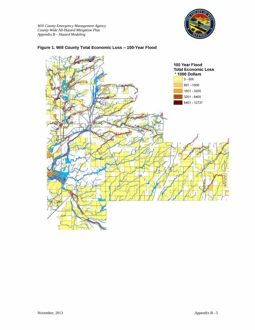
Will County Emergency Management Agency County-Wide All-Hazard Mitigation Plan Appendix B – Hazard Modeling
November, 2013 Appendix B - 5
Figure 1. Will County Total Economic Loss – 100-Year Flood

Will County Emergency Management Agency County-Wide All-Hazard Mitigation Plan Appendix B – Hazard Modeling
November, 2013 Appendix B - 6
Figure 2. Will County Urban Areas (Joliet) Total Economic Loss - 100-Year Flood
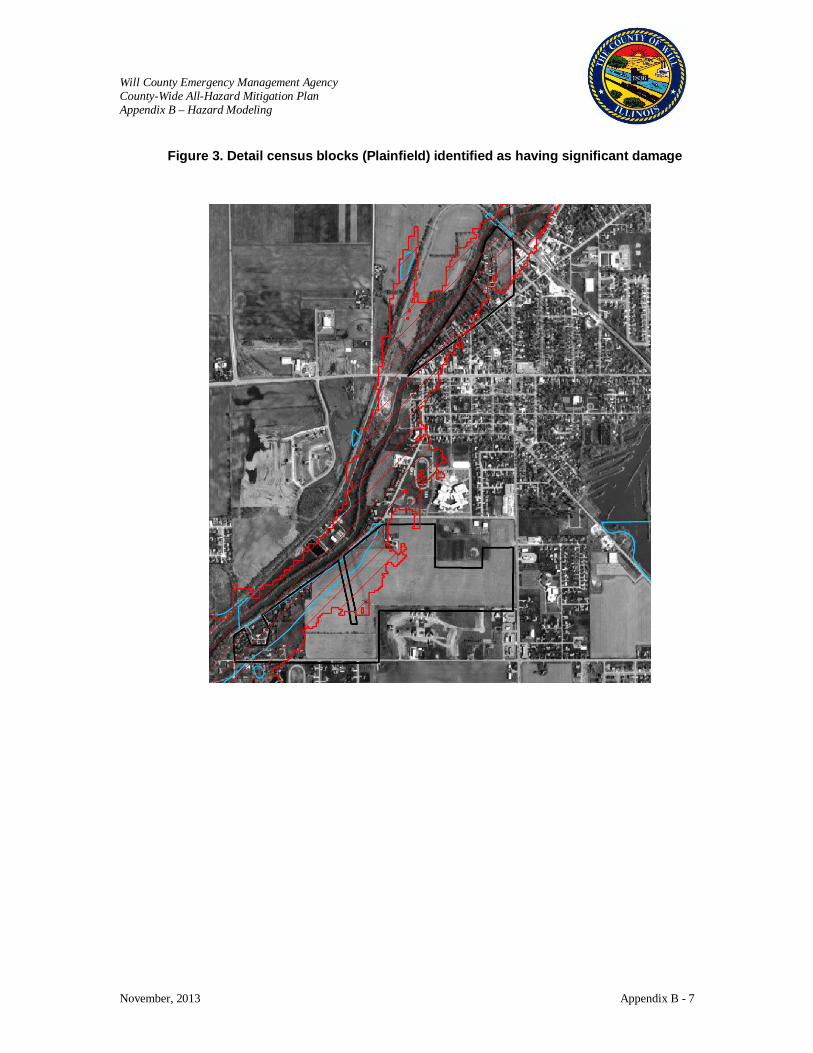
Will County Emergency Management Agency County-Wide All-Hazard Mitigation Plan Appendix B – Hazard Modeling
November, 2013 Appendix B - 7
Figure 3. Detail census blocks (Plainfield) identified as having significant damage
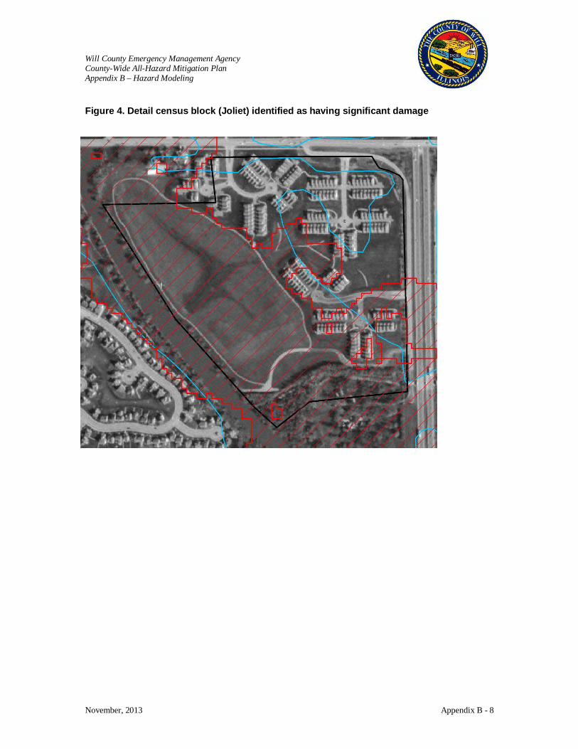
Will County Emergency Management Agency County-Wide All-Hazard Mitigation Plan Appendix B – Hazard Modeling
November, 2013 Appendix B - 8
Figure 4. Detail census block (Joliet) identified as having significant damage
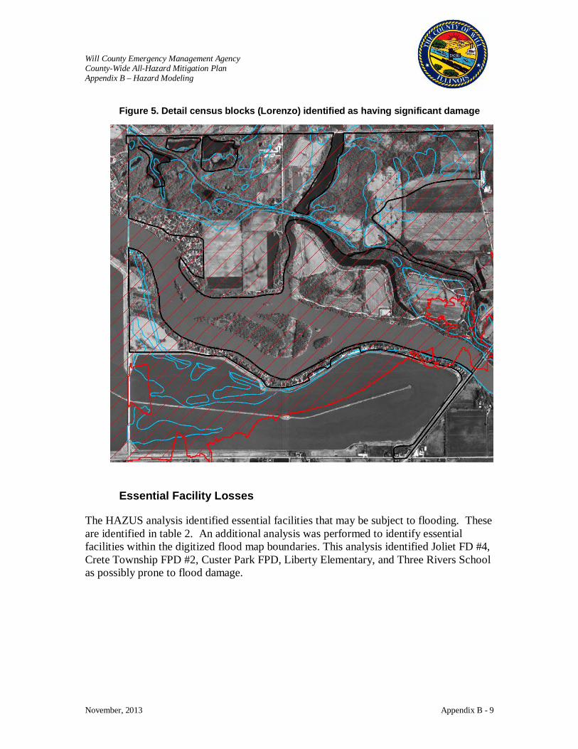
Will County Emergency Management Agency County-Wide All-Hazard Mitigation Plan Appendix B – Hazard Modeling
November, 2013 Appendix B - 9
Figure 5. Detail census blocks (Lorenzo) identified as having significant damage Essential Facility Losses
The HAZUS analysis identified essential facilities that may be subject to flooding. These are identified in table 2. An additional analysis was performed to identify essential facilities within the digitized flood map boundaries. This analysis identified Joliet FD #4, Crete Township FPD #2, Custer Park FPD, Liberty Elementary, and Three Rivers School as possibly prone to flood damage.
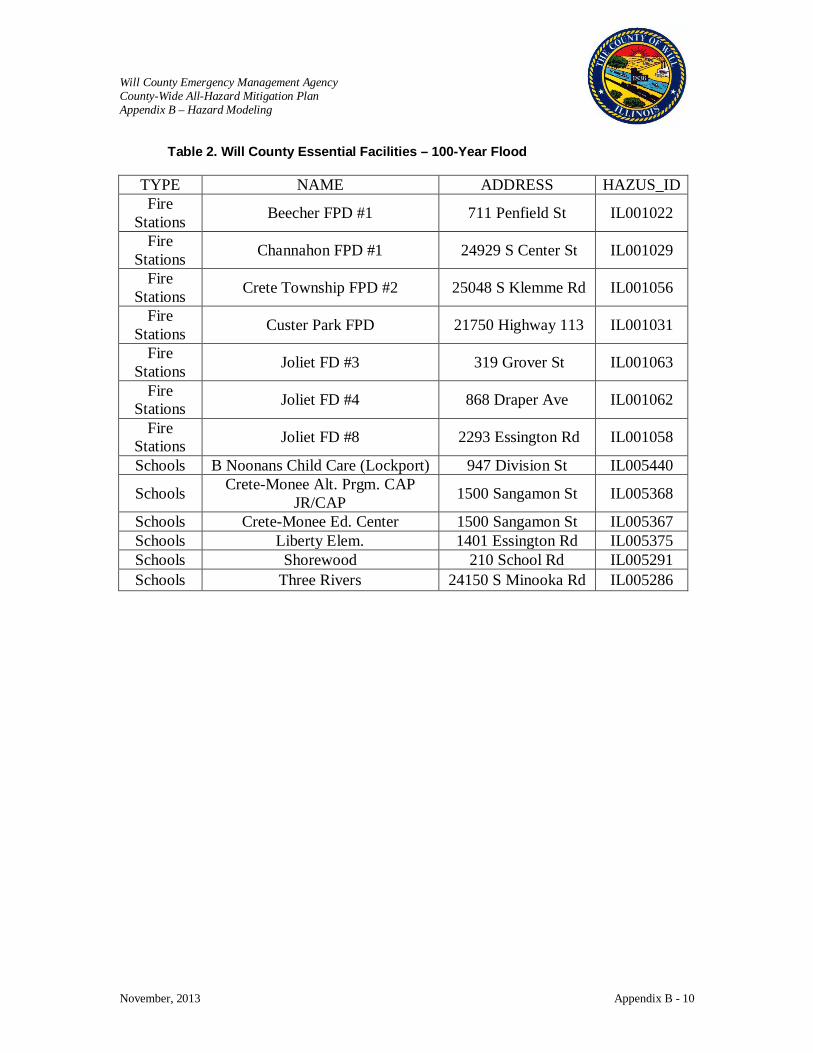
Will County Emergency Management Agency County-Wide All-Hazard Mitigation Plan Appendix B – Hazard Modeling
November, 2013 Appendix B - 10
Table 2. Will County Essential Facilities – 100-Year Flood
TYPE NAME ADDRESS HAZUS_ID Fire
Stations Beecher FPD #1 711 Penfield St IL001022
Fire Stations Channahon FPD #1 24929 S Center St IL001029
Fire Stations Crete Township FPD #2 25048 S Klemme Rd IL001056
Fire Stations Custer Park FPD 21750 Highway 113 IL001031
Fire Stations Joliet FD #3 319 Grover St IL001063
Fire Stations Joliet FD #4 868 Draper Ave IL001062
Fire Stations Joliet FD #8 2293 Essington Rd IL001058
Schools B Noonans Child Care (Lockport) 947 Division St IL005440
Schools Crete-Monee Alt. Prgm. CAP JR/CAP 1500 Sangamon St IL005368
Schools Crete-Monee Ed. Center 1500 Sangamon St IL005367 Schools Liberty Elem. 1401 Essington Rd IL005375 Schools Shorewood 210 School Rd IL005291 Schools Three Rivers 24150 S Minooka Rd IL005286

Will County Emergency Management Agency County-Wide All-Hazard Mitigation Plan Appendix B – Hazard Modeling
November, 2013 Appendix B 11
Will County Hazard Risk Assessment Historical Tornado Scenario Results
Disclaimer: The estimates of social and economic impacts contained in this report were produced using limited GIS and HAZUS loss estimation data. There are uncertainties inherent in any loss estimation technique. Therefore, there may be significant differences between the modeled results contained in this report and the actual social and economic losses following a specific hazard. This analysis is intended to provide conceptual information that can be used to identify mitigation opportunities. These results can be improved by using enhanced inventory data and hazard information.
Tornado Hazards
Submitted by: The Polis Center at IUPUI
1200 Waterway Blvd., Suite 100 Indianapolis, Indiana 46202
Phone: (317) 278-2455 FAX: (317) 278-1830
Submitted to: ConsoerTownsend Envirodyne Engineers
(CTE) 303 East Wacker Drive
Suite 600 Will County, Illinois 60601-5276
January 9, 2006
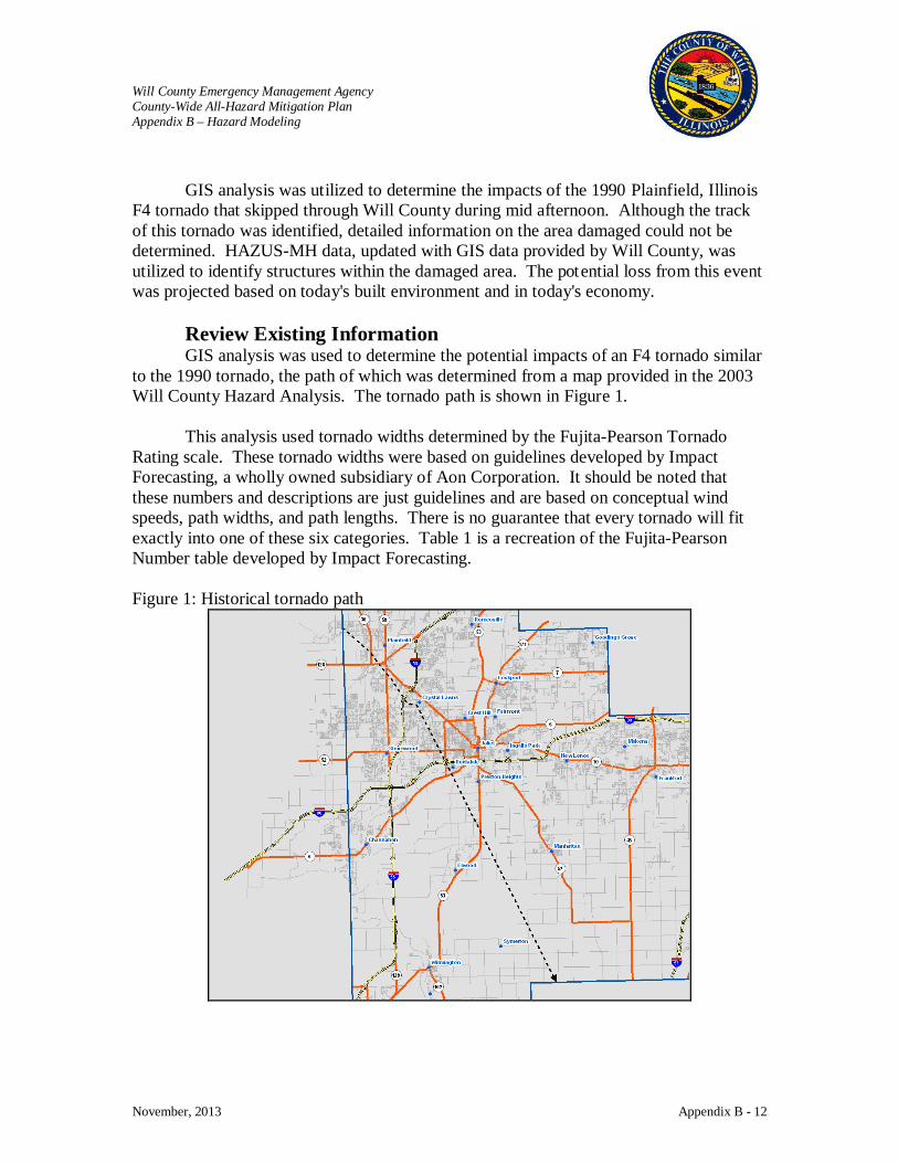
Will County Emergency Management Agency County-Wide All-Hazard Mitigation Plan Appendix B – Hazard Modeling
November, 2013 Appendix B - 12
GIS analysis was utilized to determine the impacts of the 1990 Plainfield, Illinois
F4 tornado that skipped through Will County during mid afternoon. Although the track of this tornado was identified, detailed information on the area damaged could not be determined. HAZUS-MH data, updated with GIS data provided by Will County, was utilized to identify structures within the damaged area. The potential loss from this event was projected based on today's built environment and in today's economy.
Review Existing Information GIS analysis was used to determine the potential impacts of an F4 tornado similar
to the 1990 tornado, the path of which was determined from a map provided in the 2003 Will County Hazard Analysis. The tornado path is shown in Figure 1.
This analysis used tornado widths determined by the Fujita-Pearson Tornado Rating scale. These tornado widths were based on guidelines developed by Impact Forecasting, a wholly owned subsidiary of Aon Corporation. It should be noted that these numbers and descriptions are just guidelines and are based on conceptual wind speeds, path widths, and path lengths. There is no guarantee that every tornado will fit exactly into one of these six categories. Table 1 is a recreation of the Fujita-Pearson Number table developed by Impact Forecasting. Figure 1: Historical tornado path

Will County Emergency Management Agency County-Wide All-Hazard Mitigation Plan Appendix B – Hazard Modeling
November, 2013 Appendix B - 13
Table 1: Fujita-Pearson Tornado Rating
Fujita-Pearson Number
Estimated Wind Speed Path Width Path Length Description of Destruction
0 (Gale) 40 -72 mph 6 - 17 yards 0.3 - 0.9 miles Light damage, some damage to chimneys, branches broken, sign boards damaged, shallow-rooted trees blown over.
1 (Moderate) 73 - 112 mph 18 - 55 yards 1.0 - 3.1 miles Moderate damage, roof surfaces peeled off, mobile homes pushed off foundations, attached garages damaged.
2 (Significant) 113 - 157 mph 56 - 175 yards 3.2 - 9.9 miles
Considerable damage, entire roofs torn from frame houses, mobile homes demolished, boxcars pushed over, large trees snapped or uprooted.
3 (Severe) 158 - 206 mph 176 - 566 yards 10 - 31 miles
Severe damage, walls torn from well-constructed houses, trains overturned, most trees in forests uprooted, heavy cars thrown about.
4 (Devastating) 207 - 260 mph 0.3 - 0.9 miles 32 - 99 miles
Complete damage, well-constructed houses leveled, structures with weak foundations blown off for some distance, large missiles generated.
5 (Incredible) 261 - 318 mph 1.0 - 3.1 miles 100 - 315 miles
Foundations swept clean, automobiles become missiles and thrown for 100 yards or more, steel-reinforced concrete structures badly damaged.
Analysis According to the Impact Forecast methodology, a F4 tornado will have a width of
0.3 to 0.9 miles. The Fujita-Pearson scale describes the impact as “Complete damage, well-constructed houses leveled, structures with weak foundations blown off for some distance, large missiles generated.” Once the historical path was digitized, two buffers were created. The first was 0.3 miles in width (the yellow buffer) and the second was 0.9 miles in width (the orange buffer).The buffers are depicted in Figure 2.
The 2000 Census Block layer that is provided with HAZUS was then added to ArcMap. For each of the two buffers, HAZUS-MH data consisting of the 2000 Census Block layer, the building count layer, and the building dollar exposure were “clipped” thus creating two new layers, each one the same geometric size and shape as the buffer. For each of these new layers, the shape’s area field was updated.
A field was added to the table to denote the percentage of each Census Block that fell inside the buffer. To populate this field, the area of each clipped Census Block was divided by the area of the original Census Block. The percentages were then multiplied by the original building count, exposure, and population values.
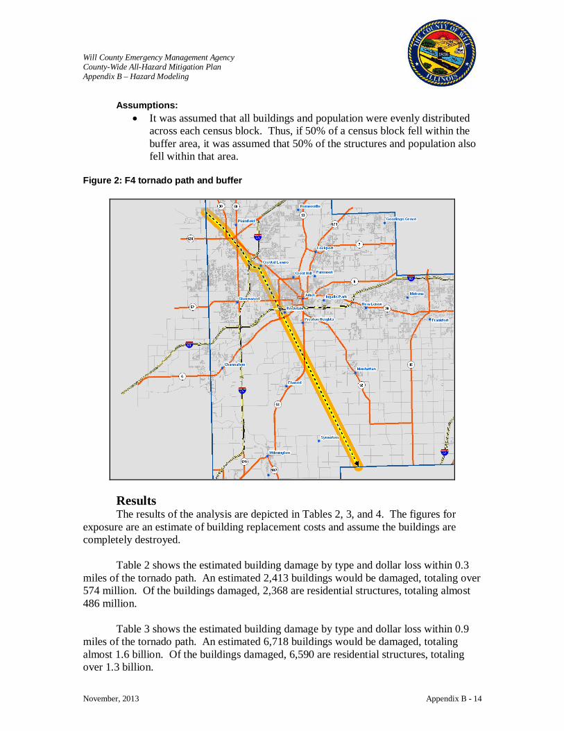
Will County Emergency Management Agency County-Wide All-Hazard Mitigation Plan Appendix B – Hazard Modeling
November, 2013 Appendix B - 14
Assumptions: • It was assumed that all buildings and population were evenly distributed
across each census block. Thus, if 50% of a census block fell within the buffer area, it was assumed that 50% of the structures and population also fell within that area.
Figure 2: F4 tornado path and buffer
Results The results of the analysis are depicted in Tables 2, 3, and 4. The figures for
exposure are an estimate of building replacement costs and assume the buildings are completely destroyed.
Table 2 shows the estimated building damage by type and dollar loss within 0.3 miles of the tornado path. An estimated 2,413 buildings would be damaged, totaling over 574 million. Of the buildings damaged, 2,368 are residential structures, totaling almost 486 million.
Table 3 shows the estimated building damage by type and dollar loss within 0.9 miles of the tornado path. An estimated 6,718 buildings would be damaged, totaling almost 1.6 billion. Of the buildings damaged, 6,590 are residential structures, totaling over 1.3 billion.

Will County Emergency Management Agency County-Wide All-Hazard Mitigation Plan Appendix B – Hazard Modeling
November, 2013 Appendix B - 15
Table 4 shows the estimated number of people affected. Within 0.3 miles of the
tornado path, there would be almost 9,000 people. Within 0.9 miles of the tornado path, there would be over 23,000 people.
It is important to note that these estimates are based on an area weighted analysis. In this analysis it was assumed that all buildings and population were evenly distributed across each census block. Thus, if 50% of a census block fell within the buffer area, it was assumed that 50% of the structures and population also fell within that area. In reality, the actual number of buildings and people could be much higher or lower than estimated. Table 2: Estimate of Damage within 0.3 Miles
Occupancy Type Building Counts Exposure (thousands of dollars)
Residential 2,368 485,896
Commercial 44 77,249
Industrial 1 6,901
Agriculture 0 276
Religious 0 1,956
Government 0 58
Education 0 2,015
Total 2,413 574,351 Table 3: Estimate of Damage within 0.9 Miles
Occupancy Type Building Counts Exposure (thousands of dollars)
Residential 6,590 1,319,027
Commercial 115 218,931
Industrial 9 28,020
Agriculture 0 1,296
Religious 2 12,143
Government 2 3,070
Education 0 4,414
Total 6,718 1,586,901
Will County Emergency Management Agency County-Wide All-Hazard Mitigation Plan Appendix B – Hazard Modeling
November, 2013 Appendix B - 16
Table 4: Estimated Number of People Affected
Distance Within 0.3 Miles Within 0.9 Miles
Population 8,638 23,341
Essential Facilities Damage Within 0.3 miles of this historical tornado path, there is one care facility, one fire
station, and four schools. The name, address, and HAZUS ID of these facilities are provided in Table 5. Within the 0.3 to 0.9 miles, there is one emergency center, three fire stations, and eight schools. The name, address, and HAZUS ID of these facilities are provided in Table 6. Based on the Fujita-Pearson Number table, facilities located within 0.3 to 0.9 miles of this tornado path would be completely destroyed. The locations of these facilities in relation to the tornado path and width are depicted in Figure 3. Table 5: Essential Facilities within 0.3 Miles of Historical Tornado Path TYPE NAME ADDRESS HAZUS_ID
Care Facilities Provena St. Joseph Medical Center 333 N Madison St IL000228
Fire Stations Joliet FD #8 2293 Essington Rd IL001058
Schools Grand Prairie Elem. 3100 Caton Farm Rd IL005373
Schools Plainfield Academy Alternative 500 W Fort Beggs Dr IL005392
Schools Plainfield Central H.S. 611 W Fort Beggs Dr IL005389
Schools St Mary Immaculate 15629 S Route 59 IL005472 Table 6: Essential Facilities within 0.3 to 0.9 Miles of Historical Tornado Path
TYPE NAME ADDRESS HAZUS_ID
Emergency Centers Rockdale EOC 603 Otis Ave IL000168
Fire Stations Joliet FD #6 2049 Oneida St IL001060
Fire Stations Plainfield FPD #1 703 N Des Plaines St IL001011
Fire Stations Rockdale FPD 603 Otis Avenue IL001012
Schools B Noonans Child Care (Joliet) 2504 Fairway Dr IL005441
Schools Bonnie McBeth Learning Center 15730 Howard St IL005377
Schools C. Sandburg 1100 Lilac Lane IL005313
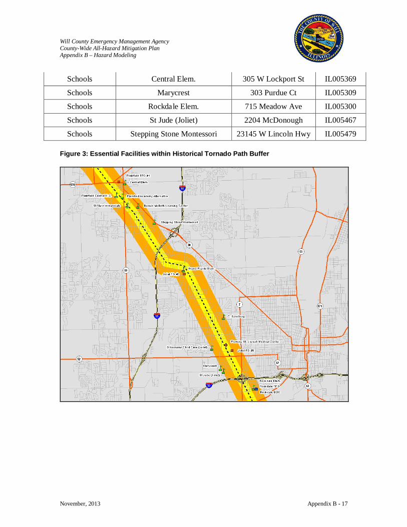
Will County Emergency Management Agency County-Wide All-Hazard Mitigation Plan Appendix B – Hazard Modeling
November, 2013 Appendix B - 17
Schools Central Elem. 305 W Lockport St IL005369
Schools Marycrest 303 Purdue Ct IL005309
Schools Rockdale Elem. 715 Meadow Ave IL005300
Schools St Jude (Joliet) 2204 McDonough IL005467
Schools Stepping Stone Montessori 23145 W Lincoln Hwy IL005479 Figure 3: Essential Facilities within Historical Tornado Path Buffer
Will County Emergency Management Agency County-Wide All-Hazard Mitigation Plan Appendix B – Hazard Modeling
November, 2013 Appendix B - 18
Will County Earthquake Risk Assessment Results
Disclaimer: The estimates of social and economic impacts contained in this report were produced using HAZUS loss estimation methodology software and which is based on current scientific and engineering knowledge. . There are uncertainties inherent in any loss estimation technique. Therefore, there may be significant differences between the modeled results contained in this report and the actual social and economic losses following a specific hazard. This analysis is intended to provide conceptual information that can be used to identify mitigation opportunities. These results can be improved by using enhanced inventory data and hazard information.
Submitted by: The Polis Center at IUPUI
1200 Waterway Blvd., Suite 100 Indianapolis, Indiana 46202
Phone: (317) 278-2455 FAX: (317) 278-1830
Submitted to: Consoer Townsend Envirodyne Engineers
(CTE) 303 East Wacker Drive
Suite 600 Chicago, Illinois 60601-5276
January 6, 2006
Will County Emergency Management Agency County-Wide All-Hazard Mitigation Plan Appendix B – Hazard Modeling
November, 2013 Appendix B - 19
Introduction
The CTE team contacted Dr. Robert Bauer of the Illinois State Geological Survey (ISGS) to obtain existing geological information and recommendations for earthquake scenarios. Three earthquake scenarios were developed to provide a reasonable basis for earthquake planning in Will County.
These included one deterministic scenario based upon input from the ISGS. A deterministic scenario is based on a specific event without explicit consideration of the probability of its occurrence. The scenario for this study was based on the June 26, 1909 5.1 magnitude Aurora, Illinois ( 41.6N 88.1W ) earthquake. According to the ISGS web site, this earthquake has been related to the La Salle anticline in the Illinois Basin. During the earthquake, many chimneys fell, a stove overturned, and gas line connections broke at Aurora. Several chimneys were downed at Forreston, Naperville, Streator, Triumph, and Troy Grove, and one fell at Waukegan. Brick walls cracked at Bloomington, and sidewalks cracked and many chimneys were damaged at Freeport. At Platteville, Wis., about 130 km northwest of Chicago, an old building was cracked; houses were jostled out of plumb at Beloit, Wisconsin about 240 km northwest of Chicago.
Additionally, the analysis included two different types of probabilistic scenarios. These types of scenarios are based on ground shaking parameters derived from U.S. Geological Survey probabilistic seismic hazard curves.
The first selected probabilistic scenario was a 500 year return period scenario. This scenario evaluates the average impacts of a multitude of possible earthquake epicenters with a magnitude that would be typical of that expected for a 500 year return period.
The second probabilistic scenario was one that allowed us to calculate an annualized loss. The annualized loss analysis in HAZUS-MH provides a means for averaging potential losses from future scenarios while considering their probabilities of occurrence. The HAZUS-MH earthquake model evaluates 8 different return period scenarios including those for the 100, 250, 500 750, 1000 1500, 2000, and 2500 year return period earthquake events. It then calculates the probabilities of these events as well as the interim events, calculates their associated losses, and sums these losses to calculate an annualized loss. These analysis options were chosen because they are useful for prioritization of seismic reduction measures and for simulating mitigation strategies.
Earthquake hazard modeling scenarios performed consisted of:
• A 5.3 magnitude earthquake in Aurora, Illinois (deterministic scenario) • 500 year return period event (probabilistic scenario) • Annualized Earthquake Loss (probabilistic scenario)
Review Existing Information The ISGS team desires to model a large magnitude earthquake from the New Madrid fault in
order to ascertain the potential impact on high rise structures in the Will County area. However, it was determined that such a model could not be run for the following reasons.
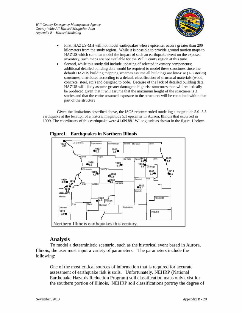
Will County Emergency Management Agency County-Wide All-Hazard Mitigation Plan Appendix B – Hazard Modeling
November, 2013 Appendix B - 20
• First, HAZUS-MH will not model earthquakes whose epicenter occurs greater than 200 kilometers from the study region. While it is possible to provide ground motion maps to HAZUS which can then model the impact of such an earthquake event on the exposed inventory, such maps are not available for the Will County region at this time.
• Second, while this study did include updating of selected inventory components; additional detailed building data would be required to model these structures since the default HAZUS building mapping schemes assume all buildings are low-rise (1-3 stories) structures, distributed according to a default classification of structural materials (wood, concrete, steel, etc.) and designed to code. Because of the lack of detailed building data, HAZUS will likely assume greater damage to high rise structures than will realistically be produced given that it will assume that the maximum height of the structures is 3 stories and that the entire assumed exposure to the structures will be contained within that part of the structure
Given the limitations described above, the ISGS recommended modeling a magnitude 5.0- 5.5 earthquake at the location of a historic magnitude 5.1 epicenter in Aurora, Illinois that occurred in 1909. The coordinates of this earthquake were 41.6N 88.1W longitude as shown in the figure 1 below.
Figure1. Earthquakes in Northern Illinois
Analysis To model a deterministic scenario, such as the historical event based in Aurora,
Illinois, the user must input a variety of parameters. The parameters include the following:
One of the most critical sources of information that is required for accurate assessment of earthquake risk is soils. Unfortunately, NEHRP (National Earthquake Hazards Reduction Program) soil classification maps only exist for the southern portion of Illinois. NEHRP soil classifications portray the degree of
Will County Emergency Management Agency County-Wide All-Hazard Mitigation Plan Appendix B – Hazard Modeling
November, 2013 Appendix B - 21
shear-wave amplification that can occur during ground shaking. Because of the lack of soils data, the analysis used a default scenario with D class soils. Dr. Bauer indicated that Will County and the surrounding area do not have a map for liquefaction potential that could be used by HAZUS-MH. However, according to literature, historical (moment magnitude 5.1-5.5) earthquakes should not generate liquefaction and therefore it was determined that no additional effort would be put forth to assess liquefaction potential for this study. Will County has seasonal water table depths of 2 to 3 meters. These probably should not matter since liquefaction should not be expected with earthquake magnitudes below magnitudes of about 6.5. For the analysis we used a depth to water table of 3 meters. ISGS recommended an earthquake depth of 5.0 kilometers for the deterministic Aurora earthquake. The historical earthquake depths identified by ISGS ranged from 5 to 10 km. HAZUS-MH also requires the user to define an attenuation (amplitude of the waves) function unless ground motion maps are supplied. Because Will County has experienced smaller earthquakes, ISGS made the decision to use the Toro et al. (1997) attenuation function for calculation of ground motion. Assumptions: The probabilistic analysis and the annualized loss analysis do not require user
input of the variables listed above. The assumptions of the annualized loss analysis are as follows:
• Census tract-based analyses with the assumption that all aggregate inventory is concentrated at the centroid of the census tract for purposes of performing loss analysis
• HAZUS uses USGS probabilistic hazard maps • Default soft soil (NEHRP Class D) conditions • No ground failure effects • 2000 demographic information • 2002 square footage data for building occupancies • 2002 Means Data for Building Replacement Cost • Building-related economic losses only. Losses to lifelines not included Long term or
indirect losses not considered
HAZUS-MH is a planning tool. The application is not intended as a substitute for detailed engineering analysis. The estimates of social and economic impacts contained in this report were produced using HAZUS loss estimation methodology software which is based on current scientific and engineering knowledge. There are uncertainties inherent in any loss estimation technique. Therefore, there may be significant differences between the modeled results contained in this report and the actual social and economic losses following a
Will County Emergency Management Agency County-Wide All-Hazard Mitigation Plan Appendix B – Hazard Modeling
November, 2013 Appendix B - 22
specific hazard event. These results can be improved by using enhanced inventory data and hazard information.
5.3 Magnitude with an Epicenter in Aurora, Illinois HAZUS-MH Earthquake Risk Module provides estimates of damage and loss to
buildings, essential facilities, transportation and utility lifelines, and population based on scenario or probabilistic earthquakes. In addition, the Earthquake Risk Module estimates the debris generated, fire, casualties, and shelter requirements following the disaster. Based on consultation with the Illinois State Geologic Survey, the May 26, 1909 5.1 magnitude earthquake that occurred in near Aurora, Illinois is the best scenario to model with the limitations on available data.
Results: The results of the initial analysis, the 5.3 magnitude Earthquake with an Epicenter
in Aurora, Illinois are depicted in Table 1 and 2 and Figure 1. Table 1 identifies the calculated number of damaged buildings by general occupancy classification. HAZUS estimates that about 12,369 buildings will be at least moderately damaged. This is over 8.00 % of the total number of buildings in the region. There are an estimated 405 buildings that will be damaged beyond repair.
Table 2 represents building economic losses in millions of dollars. The losses
include capital losses as well as income losses. A description of the losses is included in the table. The total building-related losses were 1,137.82 (millions of dollars); 6 % of the estimated losses were related to the business interruption of the region. By far, the largest loss was sustained by the residential occupancies which made up over 81 % of the total loss.
Figure 1 represents the building economic losses by census tracts in thousands of
dollars. Analysis of this figure indicates that the most substantial damage would occur in the north part of the county. This is consistent with the area that is currently developed in the county.
Essential Facility Losses Aurora Event The HAZUS analysis calculated no essential facility losses for this event.
Essential facilities include police stations, fire stations, schools, medical care facilities, and emergency operation centers and are analyzed on a site by site basis.
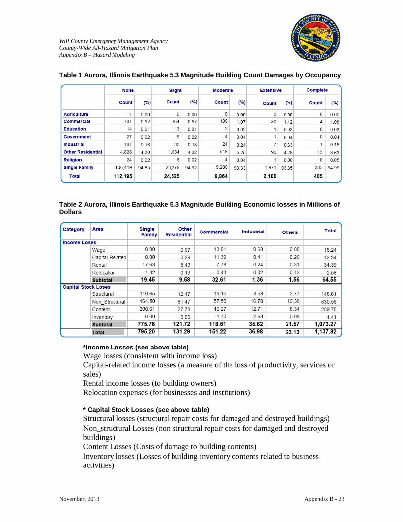
Will County Emergency Management Agency County-Wide All-Hazard Mitigation Plan Appendix B – Hazard Modeling
November, 2013 Appendix B - 23
Table 1 Aurora, Illinois Earthquake 5.3 Magnitude Building Count Damages by Occupancy
Table 2 Aurora, Illinois Earthquake 5.3 Magnitude Building Economic losses in Millions of Dollars
*Income Losses (see above table) Wage losses (consistent with income loss) Capital-related income losses (a measure of the loss of productivity, services or sales) Rental income losses (to building owners) Relocation expenses (for businesses and institutions) * Capital Stock Losses (see above table) Structural losses (structural repair costs for damaged and destroyed buildings) Νon_structural Losses (non structural repair costs for damaged and destroyed buildings) Content Losses (Costs of damage to building contents) Ιnventory losses (Losses of building inventory contents related to business activities)
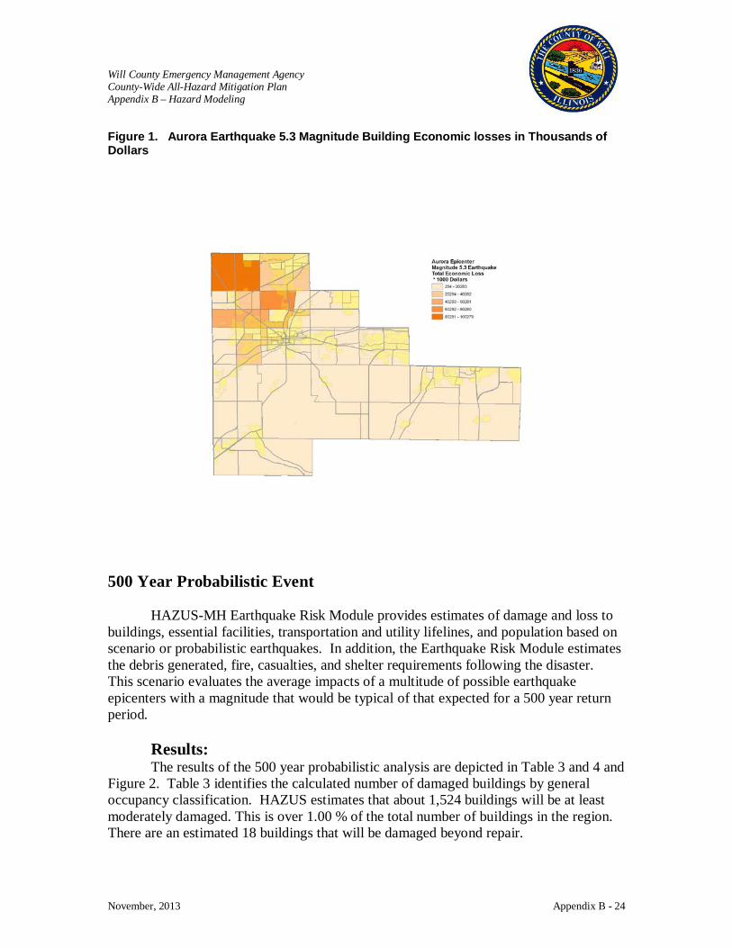
Will County Emergency Management Agency County-Wide All-Hazard Mitigation Plan Appendix B – Hazard Modeling
November, 2013 Appendix B - 24
Figure 1. Aurora Earthquake 5.3 Magnitude Building Economic losses in Thousands of Dollars
500 Year Probabilistic Event HAZUS-MH Earthquake Risk Module provides estimates of damage and loss to
buildings, essential facilities, transportation and utility lifelines, and population based on scenario or probabilistic earthquakes. In addition, the Earthquake Risk Module estimates the debris generated, fire, casualties, and shelter requirements following the disaster. This scenario evaluates the average impacts of a multitude of possible earthquake epicenters with a magnitude that would be typical of that expected for a 500 year return period.
Results: The results of the 500 year probabilistic analysis are depicted in Table 3 and 4 and
Figure 2. Table 3 identifies the calculated number of damaged buildings by general occupancy classification. HAZUS estimates that about 1,524 buildings will be at least moderately damaged. This is over 1.00 % of the total number of buildings in the region. There are an estimated 18 buildings that will be damaged beyond repair.
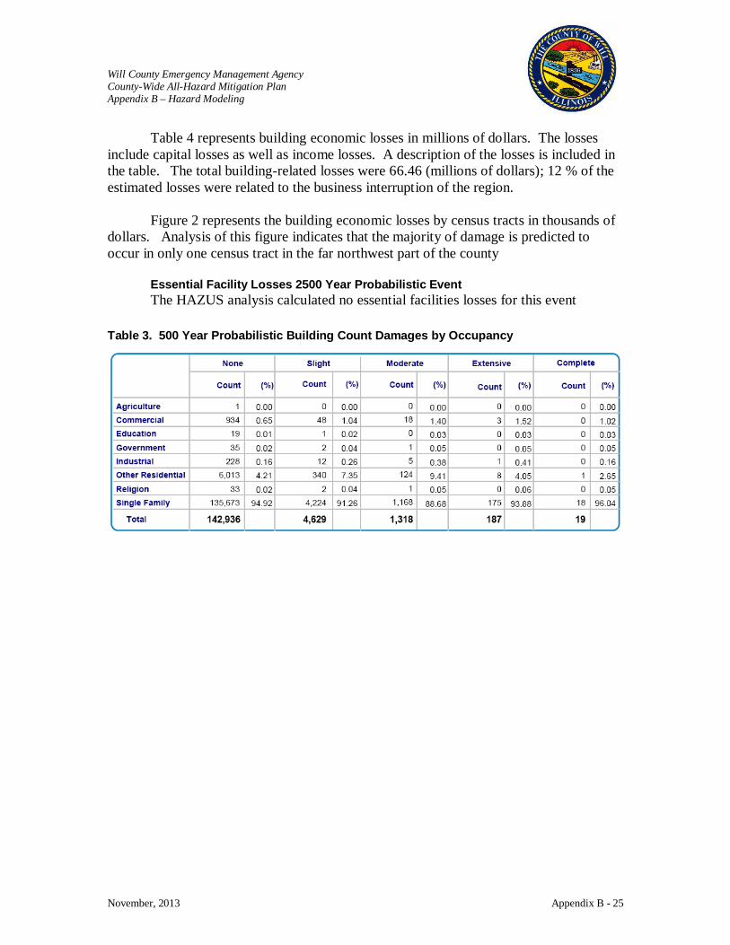
Will County Emergency Management Agency County-Wide All-Hazard Mitigation Plan Appendix B – Hazard Modeling
November, 2013 Appendix B - 25
Table 4 represents building economic losses in millions of dollars. The losses include capital losses as well as income losses. A description of the losses is included in the table. The total building-related losses were 66.46 (millions of dollars); 12 % of the estimated losses were related to the business interruption of the region.
Figure 2 represents the building economic losses by census tracts in thousands of
dollars. Analysis of this figure indicates that the majority of damage is predicted to occur in only one census tract in the far northwest part of the county
Essential Facility Losses 2500 Year Probabilistic Event The HAZUS analysis calculated no essential facilities losses for this event
Table 3. 500 Year Probabilistic Building Count Damages by Occupancy

Will County Emergency Management Agency County-Wide All-Hazard Mitigation Plan Appendix B – Hazard Modeling
November, 2013 Appendix B - 26
Table 4. 500 Year Probabilistic Building Economic losses in Millions of Dollars
* Income Losses (see above table) Wage losses (consistent with income loss) Capital-related income losses (a measure of the loss of productivity, services or sales) Rental income losses (to building owners) Relocation expenses (for businesses and institutions) *Capital Stock Losses (see above table) Structural losses (structural repair costs for damaged and destroyed buildings) Νon_structural Losses (non structural repair costs for damaged and destroyed buildings) Content Losses (Costs of damage to building contents) Ιnventory losses (Losses of building inventory contents related to business activities)

Will County Emergency Management Agency County-Wide All-Hazard Mitigation Plan Appendix B – Hazard Modeling
November, 2013 Appendix B - 27
Figure 2. 500 year Probabilistic Building Economic losses in Thousands of Dollars
Annualized Loss HAZUS-MH Earthquake Risk Module provides estimates of damage and loss to
buildings, essential facilities, transportation and utility lifelines, and population based on scenario or probabilistic earthquakes. In addition, the Earthquake Risk Module estimates the debris generated, fire, casualties, and shelter requirements following the disaster. The annualized loss analysis in HAZUS-MH provides a means for averaging potential losses from future scenarios while considering their probabilities of occurrence. The HAZUS-MH earthquake model evaluates 8 different return period scenarios including those for the 100, 250, 500 750, 1000 1500, 2000, and 2500 year return period earthquake events. It then calculates the probabilities of these events as well as the interim events, calculates their associated losses, and sums these losses to calculate an annualized loss.
Results: The results of the annualized analysis are depicted in Table 5 and 6 and Figure 3.
Table 5 indicates identifies the average annual estimated number of buildings at risk to be damaged by general occupancy classification. HAZUS estimates that about 1,202 buildings will be at least moderately damaged. This is over 1.00 % of the total number of buildings in the region. There are an estimated 1 buildings that will be damaged beyond repair.
Table 6 identifies the average annual estimated economic risk in millions of
dollars. The risk includes capital losses as well as income losses. A description of the
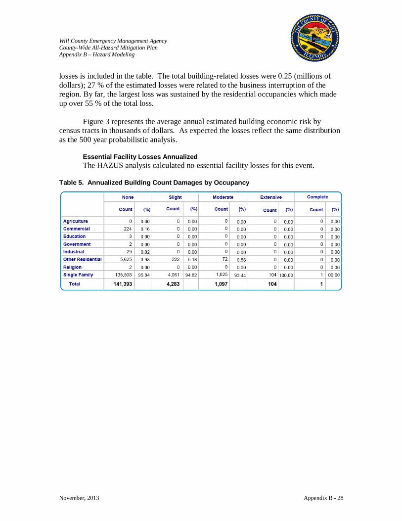
Will County Emergency Management Agency County-Wide All-Hazard Mitigation Plan Appendix B – Hazard Modeling
November, 2013 Appendix B - 28
losses is included in the table. The total building-related losses were 0.25 (millions of dollars); 27 % of the estimated losses were related to the business interruption of the region. By far, the largest loss was sustained by the residential occupancies which made up over 55 % of the total loss.
Figure 3 represents the average annual estimated building economic risk by
census tracts in thousands of dollars. As expected the losses reflect the same distribution as the 500 year probabilistic analysis.
Essential Facility Losses Annualized The HAZUS analysis calculated no essential facility losses for this event.
Table 5. Annualized Building Count Damages by Occupancy
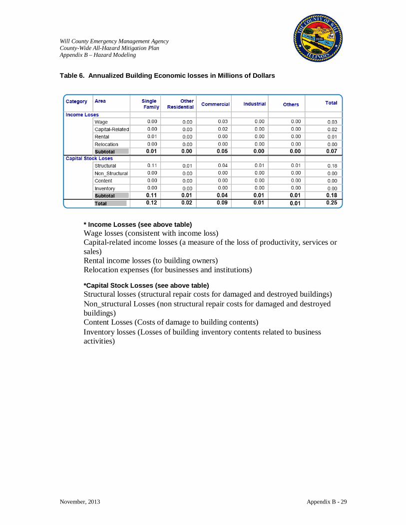
Will County Emergency Management Agency County-Wide All-Hazard Mitigation Plan Appendix B – Hazard Modeling
November, 2013 Appendix B - 29
Table 6. Annualized Building Economic losses in Millions of Dollars
* Income Losses (see above table) Wage losses (consistent with income loss) Capital-related income losses (a measure of the loss of productivity, services or sales) Rental income losses (to building owners) Relocation expenses (for businesses and institutions) *Capital Stock Losses (see above table) Structural losses (structural repair costs for damaged and destroyed buildings) Νon_structural Losses (non structural repair costs for damaged and destroyed buildings) Content Losses (Costs of damage to building contents) Ιnventory losses (Losses of building inventory contents related to business activities)
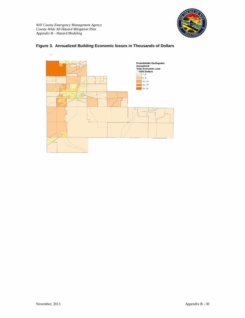
Will County Emergency Management Agency County-Wide All-Hazard Mitigation Plan Appendix B – Hazard Modeling
November, 2013 Appendix B - 30
Figure 3. Annualized Building Economic losses in Thousands of Dollars
.
Will County Emergency Management Agency County-Wide All-Hazard Mitigation Plan Appendix B – Hazard Modeling
November, 2013 Appendix B - 31
Will County Hazard Risk Assessment Hazardous Materials Results (Arsenal Rd & I-55)
Disclaimer: The estimates of social and economic impacts contained in this report were produced using limited GIS and HAZUS loss estimation data. There are uncertainties inherent in any loss estimation technique. Therefore, there may be significant differences between the modeled results contained in this report and the actual social and economic losses following a specific hazard. This analysis is intended to provide conceptual information that can be used to identify mitigation opportunities. These results can be improved by using enhanced inventory data and hazard information.
Submitted by: The Polis Center at IUPUI
1200 Waterway Blvd., Suite 100 Indianapolis, Indiana 46202
Phone: (317) 278-2455 FAX: (317) 278-1830
Submitted to: Consoer Townsend Envirodyne Engineers
(CTE) 303 East Wacker Drive
Suite 600 Chicago, Illinois 60601-5276
December 20, 2005

Will County Emergency Management Agency County-Wide All-Hazard Mitigation Plan Appendix B – Hazard Modeling
November, 2013 Appendix B - 32
Hazardous Materials (Arsenal Rd & I-55)
The U.S. EPA’s ALOHA (Areal Locations of Hazardous Atmospheres) model was utilized to assess the area of impact for a chlorine release near a large industrial facility located southwest of Joliet near Arsenal Road and Interstate 55. ALOHA is a computer program designed especially for use by people responding to chemical accidents, as well as for emergency planning and training. Chlorine is a common chemical used in industrial operations that can be found in either liquid or gas form. Rail, truck tankers, and barges commonly haul chlorine, as well as other hazardous materials, to and from facilities. For this scenario, moderate atmospheric and climatic conditions with a slight breeze from the west were assumed. The target area of Arsenal Rd and I-55 was chosen due to its large industrial facilities, rail and truck hubs, and the presence of a large number of large quantity hazardous material generators.
Review Existing Information The 2000 Census Block boundaries and population figures, as well as the values
for building counts and building replacement cost were extracted from the HAZUS-MH provided inventory. The geographic area covered in this analysis is depicted in Figure 1. Figure 1: Location of Chlorine Release

Will County Emergency Management Agency County-Wide All-Hazard Mitigation Plan Appendix B – Hazard Modeling
November, 2013 Appendix B - 33
Analysis In terms of the atmospheric conditions, ALOHA was setup with a wind speed of 5
mph at a westerly direction. The temperature was set for 68° F with a medium level of humidity and partly cloudy skies.
In terms of the source conditions, a horizontal, cylindrical-shaped tank was selected. The diameter of the tank was set to 9 feet. The length of the tank was set to 66 feet. These settings created a tank with a volume of 31,409 gallons. At the time of this release, the tank was estimated to be 80% full. The chlorine in this tank is in its liquid state. This release was based on a leak from a hole, a little less than ½” in diameter and 12 inches above the bottom of the tank.
Using the settings above, approximately 20,450 pounds of material would be released. The image in Figure 2 depicts the plume footprint generated by ALOHA. As the substance moves away from the source, the level of concentration of that substance decreases. Each color-coded area depicts a level of concentration. These concentrations are measured in parts per million, or ppm. Figure 2: Plume Footprint Generated by ALOHA

Will County Emergency Management Agency County-Wide All-Hazard Mitigation Plan Appendix B – Hazard Modeling
November, 2013 Appendix B - 34
The area in red, at 20 ppm, would extend no more than 1,647 yards out from the point of release. The area in orange, at 3 ppm, would extend no more than 2.6 miles out from the point of release. The area in yellow, at 1 ppm, would extend no more than 4.6 miles out from the point of release. The gray area depicts what ALOHA refers to as “uncertainty lines”, which means that within the confines of the entire plume footprint, the ALOHA model is 95% confident that the release will stay within this boundary.
The 2000 Census Block layer was added to ArcMap and overlaid with the plume footprint. The 2000 Census Block layer was then clipped against each of the four footprint areas. Clipping could be defined as the process of extracting features from one layer, in this case the 2000 Census Block layer, based on the boundary of another layer, in this case one of the four footprint areas. Figures 3 and 4 depict the 2000 Census Block areas before and after the “clipping” process. Figure 3: The 2000 Census Block Areas before the “Clipping” Process
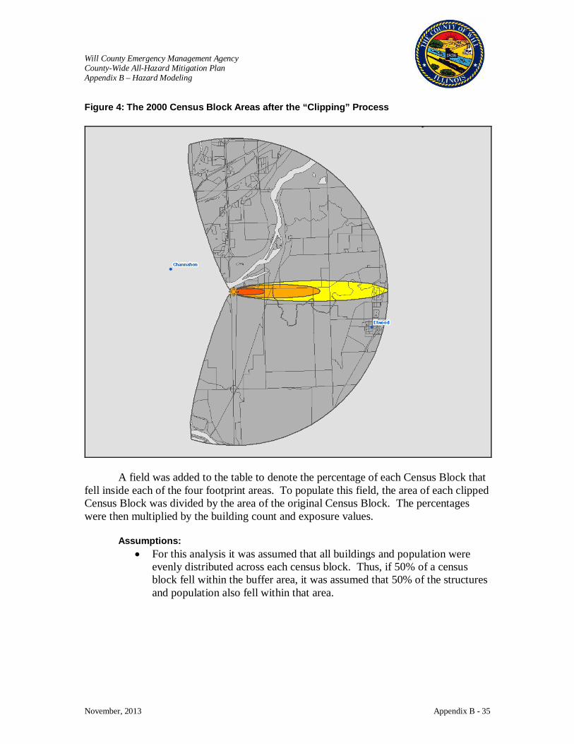
Will County Emergency Management Agency County-Wide All-Hazard Mitigation Plan Appendix B – Hazard Modeling
November, 2013 Appendix B - 35
Figure 4: The 2000 Census Block Areas after the “Clipping” Process
A field was added to the table to denote the percentage of each Census Block that fell inside each of the four footprint areas. To populate this field, the area of each clipped Census Block was divided by the area of the original Census Block. The percentages were then multiplied by the building count and exposure values.
Assumptions: • For this analysis it was assumed that all buildings and population were
evenly distributed across each census block. Thus, if 50% of a census block fell within the buffer area, it was assumed that 50% of the structures and population also fell within that area.
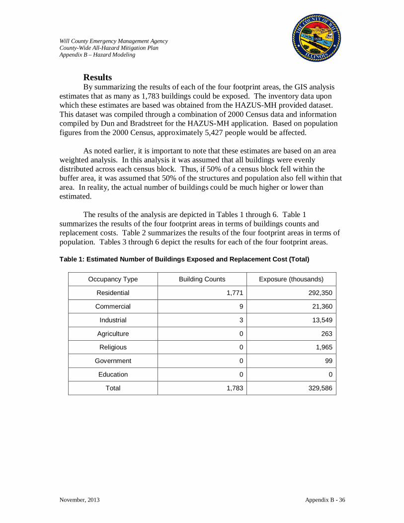
Will County Emergency Management Agency County-Wide All-Hazard Mitigation Plan Appendix B – Hazard Modeling
November, 2013 Appendix B - 36
Results By summarizing the results of each of the four footprint areas, the GIS analysis
estimates that as many as 1,783 buildings could be exposed. The inventory data upon which these estimates are based was obtained from the HAZUS-MH provided dataset. This dataset was compiled through a combination of 2000 Census data and information compiled by Dun and Bradstreet for the HAZUS-MH application. Based on population figures from the 2000 Census, approximately 5,427 people would be affected.
As noted earlier, it is important to note that these estimates are based on an area weighted analysis. In this analysis it was assumed that all buildings were evenly distributed across each census block. Thus, if 50% of a census block fell within the buffer area, it was assumed that 50% of the structures and population also fell within that area. In reality, the actual number of buildings could be much higher or lower than estimated.
The results of the analysis are depicted in Tables 1 through 6. Table 1 summarizes the results of the four footprint areas in terms of buildings counts and replacement costs. Table 2 summarizes the results of the four footprint areas in terms of population. Tables 3 through 6 depict the results for each of the four footprint areas. Table 1: Estimated Number of Buildings Exposed and Replacement Cost (Total)
Occupancy Type Building Counts Exposure (thousands)
Residential 1,771 292,350
Commercial 9 21,360
Industrial 3 13,549
Agriculture 0 263
Religious 0 1,965
Government 0 99
Education 0 0
Total 1,783 329,586

Will County Emergency Management Agency County-Wide All-Hazard Mitigation Plan Appendix B – Hazard Modeling
November, 2013 Appendix B - 37
Table 2: Estimated Population (By Area and Total)
Plume Area Population
Red 0
Orange 0
Yellow 155
Gray 5,272
Total 5,427
Table 3: Estimated Number of Buildings Exposed and Replacement Cost (Red Area)
Occupancy Type Building Counts Exposure (thousands)
Residential 0 13
Commercial 0 228
Industrial 0 0
Agriculture 0 0
Religious 0 0
Government 0 0
Education 0 0
Total 0 241
Table 4: Estimated Number of Buildings Exposed and Replacement Cost (Orange Area)
Occupancy Type Building Counts Exposure (thousands)
Residential 0 6
Commercial 0 101
Industrial 0 0
Agriculture 0 0
Religious 0 0
Government 0 0
Education 0 0
Total 0 107
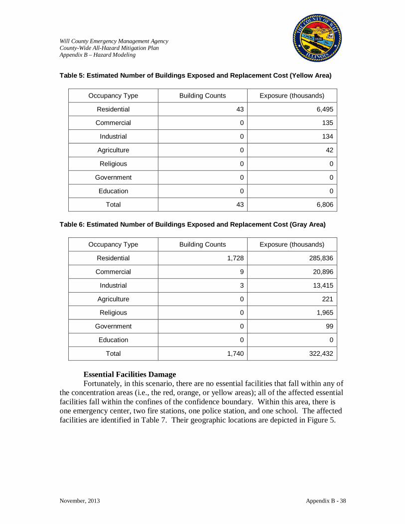
Will County Emergency Management Agency County-Wide All-Hazard Mitigation Plan Appendix B – Hazard Modeling
November, 2013 Appendix B - 38
Table 5: Estimated Number of Buildings Exposed and Replacement Cost (Yellow Area)
Occupancy Type Building Counts Exposure (thousands)
Residential 43 6,495
Commercial 0 135
Industrial 0 134
Agriculture 0 42
Religious 0 0
Government 0 0
Education 0 0
Total 43 6,806
Table 6: Estimated Number of Buildings Exposed and Replacement Cost (Gray Area)
Occupancy Type Building Counts Exposure (thousands)
Residential 1,728 285,836
Commercial 9 20,896
Industrial 3 13,415
Agriculture 0 221
Religious 0 1,965
Government 0 99
Education 0 0
Total 1,740 322,432
Essential Facilities Damage Fortunately, in this scenario, there are no essential facilities that fall within any of
the concentration areas (i.e., the red, orange, or yellow areas); all of the affected essential facilities fall within the confines of the confidence boundary. Within this area, there is one emergency center, two fire stations, one police station, and one school. The affected facilities are identified in Table 7. Their geographic locations are depicted in Figure 5.
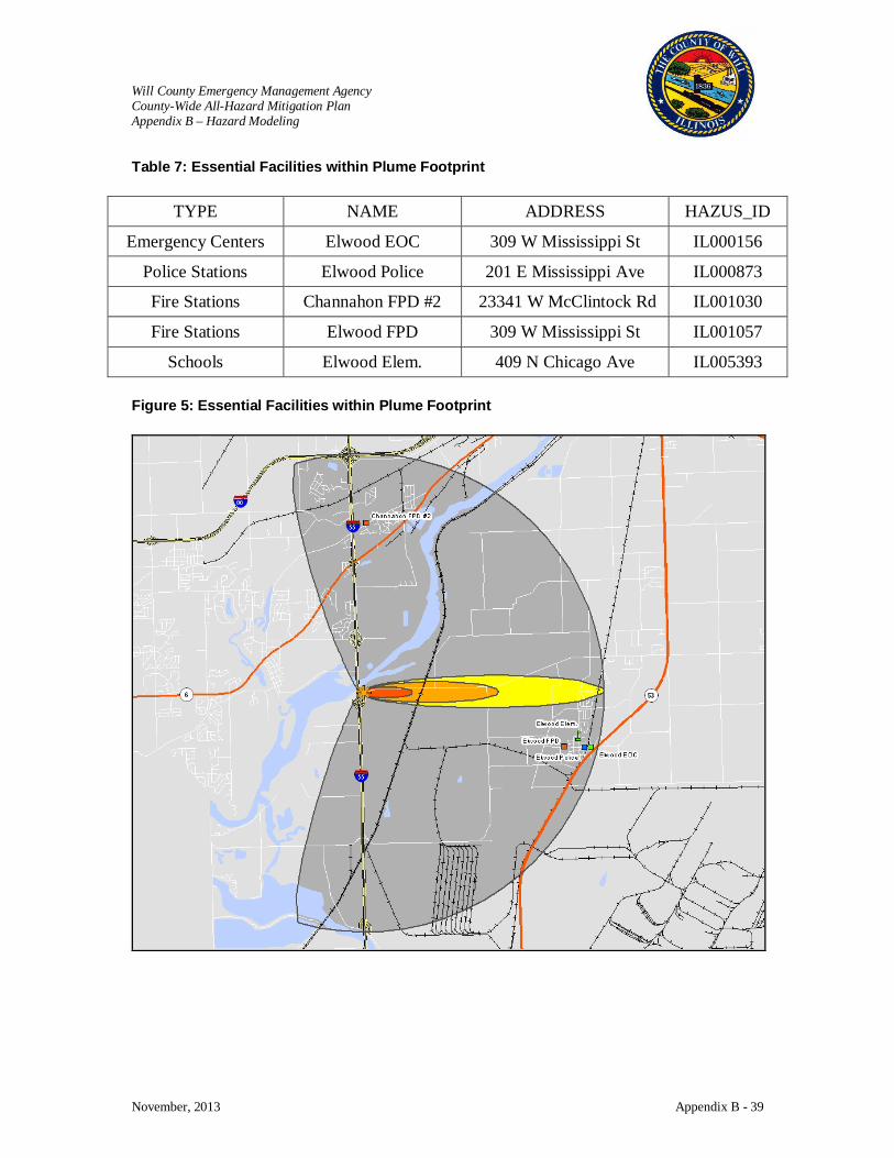
Will County Emergency Management Agency County-Wide All-Hazard Mitigation Plan Appendix B – Hazard Modeling
November, 2013 Appendix B - 39
Table 7: Essential Facilities within Plume Footprint
TYPE NAME ADDRESS HAZUS_ID
Emergency Centers Elwood EOC 309 W Mississippi St IL000156
Police Stations Elwood Police 201 E Mississippi Ave IL000873
Fire Stations Channahon FPD #2 23341 W McClintock Rd IL001030
Fire Stations Elwood FPD 309 W Mississippi St IL001057
Schools Elwood Elem. 409 N Chicago Ave IL005393 Figure 5: Essential Facilities within Plume Footprint
Will County Emergency Management Agency County-Wide All-Hazard Mitigation Plan Appendix B – Hazard Modeling
November, 2013 Appendix B - 40
Will County Hazard Risk Assessment Hazardous Materials Results (Barge)
Disclaimer: The estimates of social and economic impacts contained in this report were produced using limited GIS and HAZUS loss estimation data. There are uncertainties inherent in any loss estimation technique. Therefore, there may be significant differences between the modeled results contained in this report and the actual social and economic losses following a specific hazard. This analysis is intended to provide conceptual information that can be used to identify mitigation opportunities. These results can be improved by using enhanced inventory data and hazard information.
Submitted by: The Polis Center at IUPUI
1200 Waterway Blvd., Suite 100 Indianapolis, Indiana 46202
Phone: (317) 278-2455 FAX: (317) 278-1830
Submitted to: Consoer Townsend Envirodyne Engineers
(CTE) 303 East Wacker Drive
Suite 600 Chicago, Illinois 60601-5276
January 9, 2006
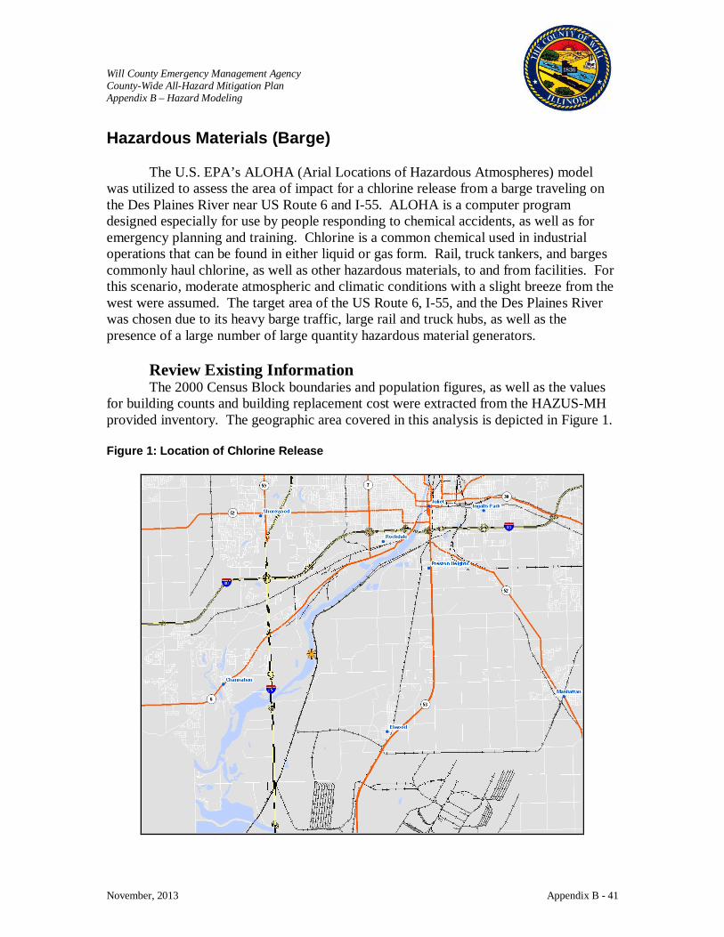
Will County Emergency Management Agency County-Wide All-Hazard Mitigation Plan Appendix B – Hazard Modeling
November, 2013 Appendix B - 41
Hazardous Materials (Barge)
The U.S. EPA’s ALOHA (Arial Locations of Hazardous Atmospheres) model was utilized to assess the area of impact for a chlorine release from a barge traveling on the Des Plaines River near US Route 6 and I-55. ALOHA is a computer program designed especially for use by people responding to chemical accidents, as well as for emergency planning and training. Chlorine is a common chemical used in industrial operations that can be found in either liquid or gas form. Rail, truck tankers, and barges commonly haul chlorine, as well as other hazardous materials, to and from facilities. For this scenario, moderate atmospheric and climatic conditions with a slight breeze from the west were assumed. The target area of the US Route 6, I-55, and the Des Plaines River was chosen due to its heavy barge traffic, large rail and truck hubs, as well as the presence of a large number of large quantity hazardous material generators.
Review Existing Information The 2000 Census Block boundaries and population figures, as well as the values
for building counts and building replacement cost were extracted from the HAZUS-MH provided inventory. The geographic area covered in this analysis is depicted in Figure 1. Figure 1: Location of Chlorine Release
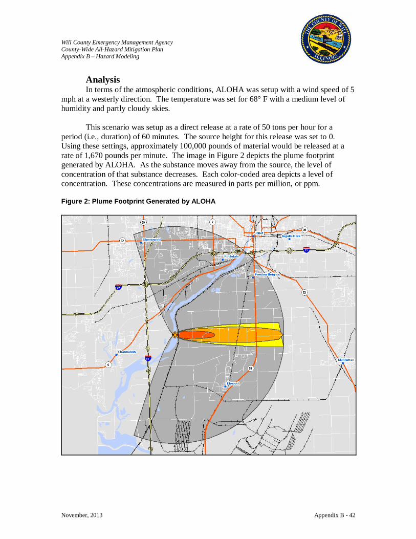
Will County Emergency Management Agency County-Wide All-Hazard Mitigation Plan Appendix B – Hazard Modeling
November, 2013 Appendix B - 42
Analysis In terms of the atmospheric conditions, ALOHA was setup with a wind speed of 5
mph at a westerly direction. The temperature was set for 68° F with a medium level of humidity and partly cloudy skies.
This scenario was setup as a direct release at a rate of 50 tons per hour for a period (i.e., duration) of 60 minutes. The source height for this release was set to 0. Using these settings, approximately 100,000 pounds of material would be released at a rate of 1,670 pounds per minute. The image in Figure 2 depicts the plume footprint generated by ALOHA. As the substance moves away from the source, the level of concentration of that substance decreases. Each color-coded area depicts a level of concentration. These concentrations are measured in parts per million, or ppm. Figure 2: Plume Footprint Generated by ALOHA

Will County Emergency Management Agency County-Wide All-Hazard Mitigation Plan Appendix B – Hazard Modeling
November, 2013 Appendix B - 43
The area in red, at 20 ppm, would extend no more than 2.2 miles out from the point of release. The area in orange, at 3 ppm, would extend no more than 6 miles out from the point of release. The area in yellow, at 1 ppm, would extend more than 6 miles out from the point of release. The gray area depicts what ALOHA refers to as “uncertainty lines”, which means that within the confines of the entire plume footprint, the ALOHA model is 95% confident that the release will stay within this boundary.
The 2000 Census Block layer was added to ArcMap and overlaid with the plume footprint. The 2000 Census Block layer was then clipped against each of the four footprint areas. Clipping could be defined as the process of extracting features from one layer, in this case the 2000 Census Block layer, based on the boundary of another layer, in this case one of the four footprint areas. Figures 3 and 4 depict the 2000 Census Block areas before and after the “clipping” process. Figure 3: The 2000 Census Block Areas before the “Clipping” Process
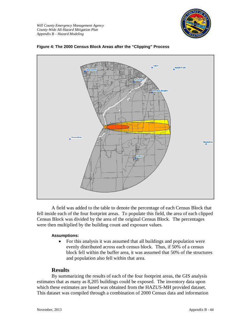
Will County Emergency Management Agency County-Wide All-Hazard Mitigation Plan Appendix B – Hazard Modeling
November, 2013 Appendix B - 44
Figure 4: The 2000 Census Block Areas after the “Clipping” Process
A field was added to the table to denote the percentage of each Census Block that fell inside each of the four footprint areas. To populate this field, the area of each clipped Census Block was divided by the area of the original Census Block. The percentages were then multiplied by the building count and exposure values.
Assumptions: • For this analysis it was assumed that all buildings and population were
evenly distributed across each census block. Thus, if 50% of a census block fell within the buffer area, it was assumed that 50% of the structures and population also fell within that area.
Results By summarizing the results of each of the four footprint areas, the GIS analysis
estimates that as many as 8,205 buildings could be exposed. The inventory data upon which these estimates are based was obtained from the HAZUS-MH provided dataset. This dataset was compiled through a combination of 2000 Census data and information
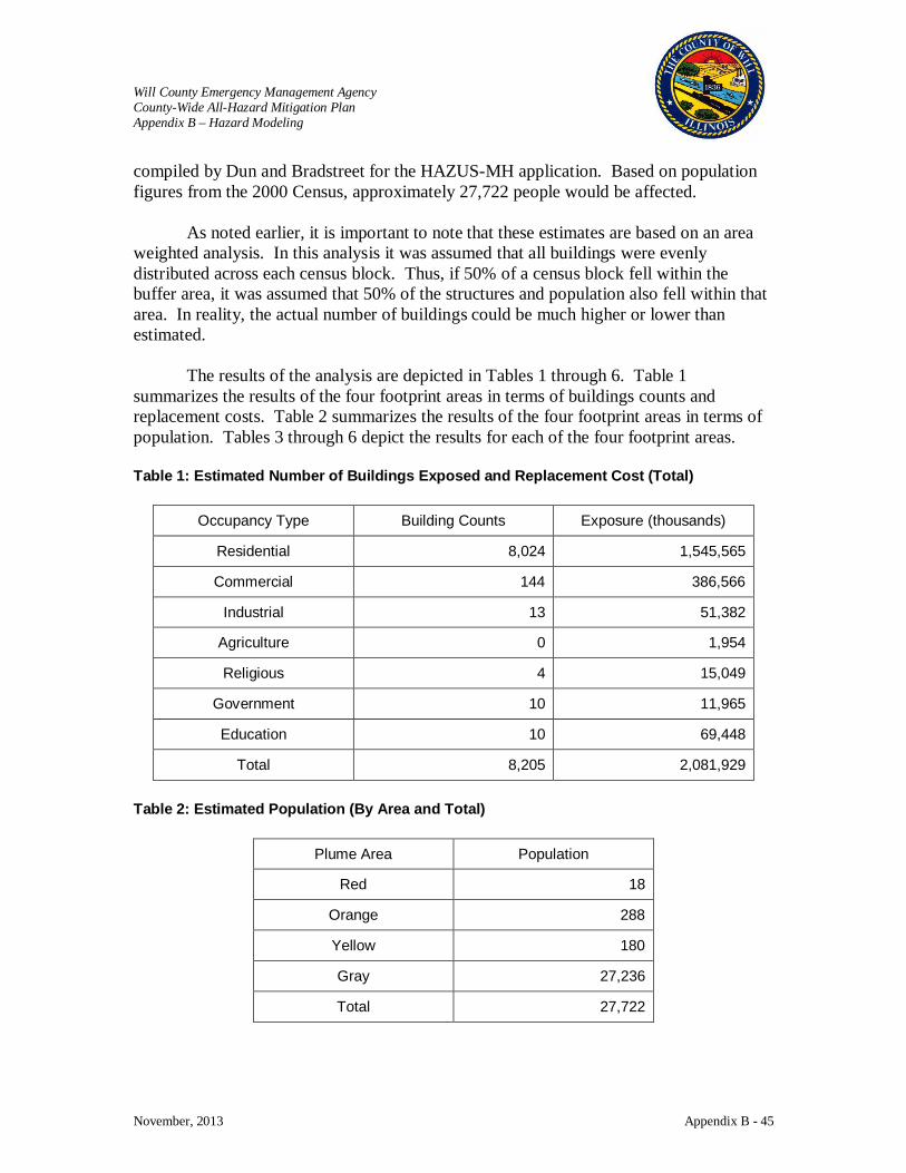
Will County Emergency Management Agency County-Wide All-Hazard Mitigation Plan Appendix B – Hazard Modeling
November, 2013 Appendix B - 45
compiled by Dun and Bradstreet for the HAZUS-MH application. Based on population figures from the 2000 Census, approximately 27,722 people would be affected.
As noted earlier, it is important to note that these estimates are based on an area weighted analysis. In this analysis it was assumed that all buildings were evenly distributed across each census block. Thus, if 50% of a census block fell within the buffer area, it was assumed that 50% of the structures and population also fell within that area. In reality, the actual number of buildings could be much higher or lower than estimated.
The results of the analysis are depicted in Tables 1 through 6. Table 1 summarizes the results of the four footprint areas in terms of buildings counts and replacement costs. Table 2 summarizes the results of the four footprint areas in terms of population. Tables 3 through 6 depict the results for each of the four footprint areas. Table 1: Estimated Number of Buildings Exposed and Replacement Cost (Total)
Occupancy Type Building Counts Exposure (thousands)
Residential 8,024 1,545,565
Commercial 144 386,566
Industrial 13 51,382
Agriculture 0 1,954
Religious 4 15,049
Government 10 11,965
Education 10 69,448
Total 8,205 2,081,929
Table 2: Estimated Population (By Area and Total)
Plume Area Population
Red 18
Orange 288
Yellow 180
Gray 27,236
Total 27,722

Will County Emergency Management Agency County-Wide All-Hazard Mitigation Plan Appendix B – Hazard Modeling
November, 2013 Appendix B - 46
Table 3: Estimated Number of Buildings Exposed and Replacement Cost (Red Area)
Occupancy Type Building Counts Exposure (thousands)
Residential 6 1,093
Commercial 0 0
Industrial 0 0
Agriculture 0 0
Religious 0 0
Government 0 0
Education 0 0
Total 6 1,093
Table 4: Estimated Number of Buildings Exposed and Replacement Cost (Orange Area)
Occupancy Type Building Counts Exposure (thousands)
Residential 95 16,090
Commercial 0 818
Industrial 0 786
Agriculture 0 47
Religious 0 0
Government 0 0
Education 0 0
Total 95 17,741
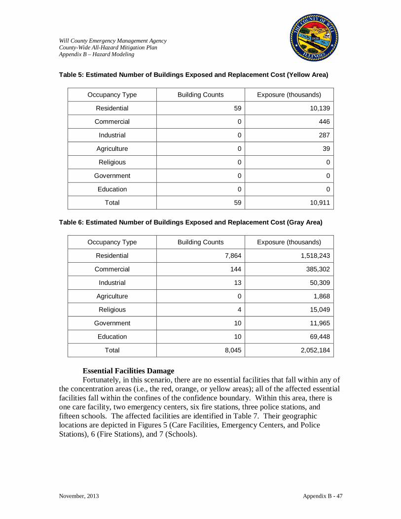
Will County Emergency Management Agency County-Wide All-Hazard Mitigation Plan Appendix B – Hazard Modeling
November, 2013 Appendix B - 47
Table 5: Estimated Number of Buildings Exposed and Replacement Cost (Yellow Area)
Occupancy Type Building Counts Exposure (thousands)
Residential 59 10,139
Commercial 0 446
Industrial 0 287
Agriculture 0 39
Religious 0 0
Government 0 0
Education 0 0
Total 59 10,911
Table 6: Estimated Number of Buildings Exposed and Replacement Cost (Gray Area)
Occupancy Type Building Counts Exposure (thousands)
Residential 7,864 1,518,243
Commercial 144 385,302
Industrial 13 50,309
Agriculture 0 1,868
Religious 4 15,049
Government 10 11,965
Education 10 69,448
Total 8,045 2,052,184
Essential Facilities Damage Fortunately, in this scenario, there are no essential facilities that fall within any of
the concentration areas (i.e., the red, orange, or yellow areas); all of the affected essential facilities fall within the confines of the confidence boundary. Within this area, there is one care facility, two emergency centers, six fire stations, three police stations, and fifteen schools. The affected facilities are identified in Table 7. Their geographic locations are depicted in Figures 5 (Care Facilities, Emergency Centers, and Police Stations), 6 (Fire Stations), and 7 (Schools).
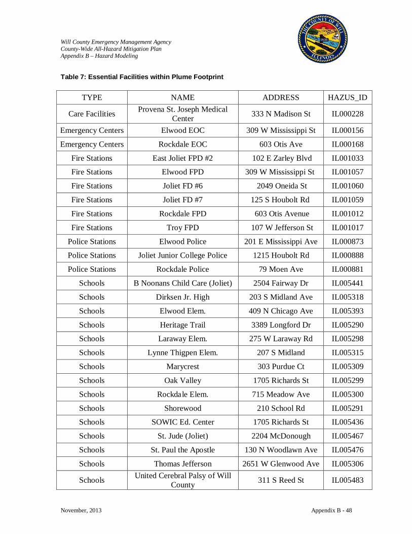
Will County Emergency Management Agency County-Wide All-Hazard Mitigation Plan Appendix B – Hazard Modeling
November, 2013 Appendix B - 48
Table 7: Essential Facilities within Plume Footprint
TYPE NAME ADDRESS HAZUS_ID
Care Facilities Provena St. Joseph Medical Center 333 N Madison St IL000228
Emergency Centers Elwood EOC 309 W Mississippi St IL000156
Emergency Centers Rockdale EOC 603 Otis Ave IL000168
Fire Stations East Joliet FPD #2 102 E Zarley Blvd IL001033
Fire Stations Elwood FPD 309 W Mississippi St IL001057
Fire Stations Joliet FD #6 2049 Oneida St IL001060
Fire Stations Joliet FD #7 125 S Houbolt Rd IL001059
Fire Stations Rockdale FPD 603 Otis Avenue IL001012
Fire Stations Troy FPD 107 W Jefferson St IL001017
Police Stations Elwood Police 201 E Mississippi Ave IL000873
Police Stations Joliet Junior College Police 1215 Houbolt Rd IL000888
Police Stations Rockdale Police 79 Moen Ave IL000881
Schools B Noonans Child Care (Joliet) 2504 Fairway Dr IL005441
Schools Dirksen Jr. High 203 S Midland Ave IL005318
Schools Elwood Elem. 409 N Chicago Ave IL005393
Schools Heritage Trail 3389 Longford Dr IL005290
Schools Laraway Elem. 275 W Laraway Rd IL005298
Schools Lynne Thigpen Elem. 207 S Midland IL005315
Schools Marycrest 303 Purdue Ct IL005309
Schools Oak Valley 1705 Richards St IL005299
Schools Rockdale Elem. 715 Meadow Ave IL005300
Schools Shorewood 210 School Rd IL005291
Schools SOWIC Ed. Center 1705 Richards St IL005436
Schools St. Jude (Joliet) 2204 McDonough IL005467
Schools St. Paul the Apostle 130 N Woodlawn Ave IL005476
Schools Thomas Jefferson 2651 W Glenwood Ave IL005306
Schools United Cerebral Palsy of Will County 311 S Reed St IL005483
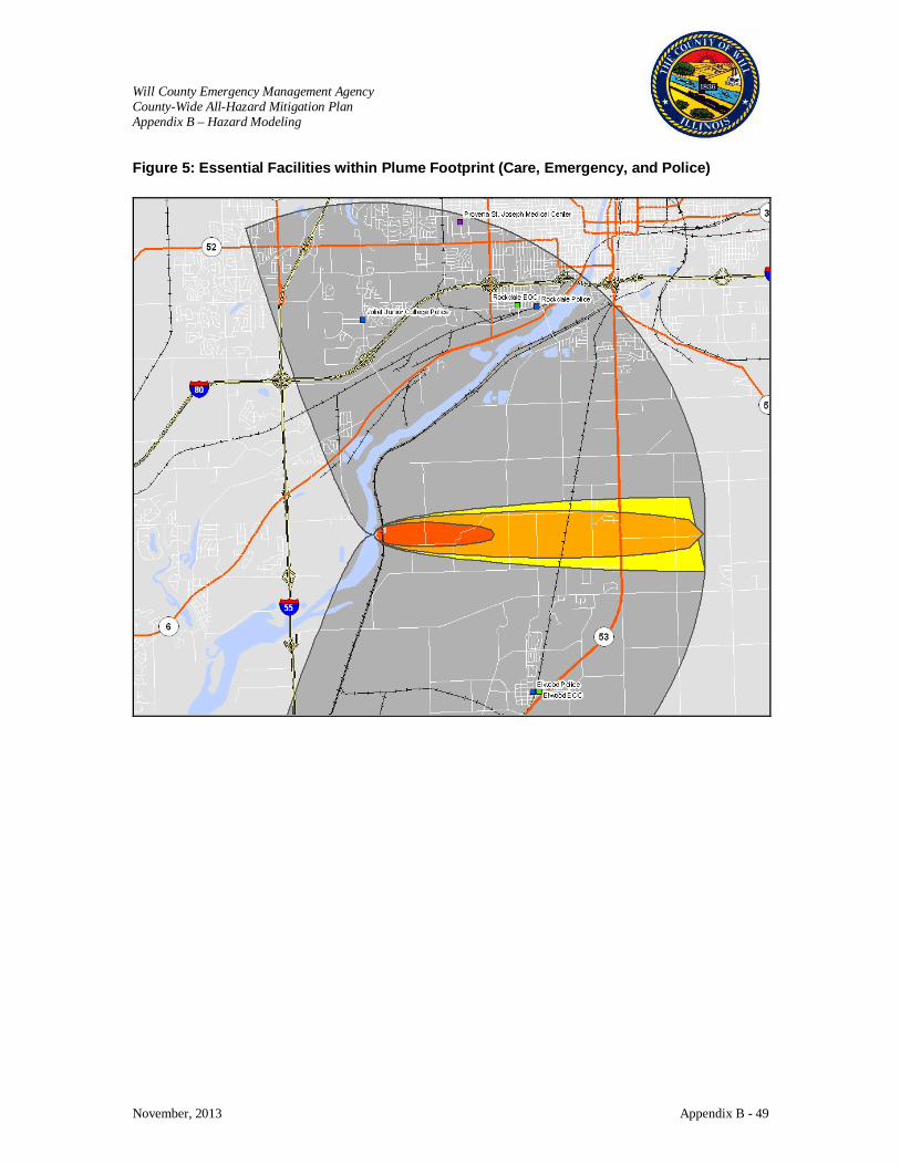
Will County Emergency Management Agency County-Wide All-Hazard Mitigation Plan Appendix B – Hazard Modeling
November, 2013 Appendix B - 49
Figure 5: Essential Facilities within Plume Footprint (Care, Emergency, and Police)
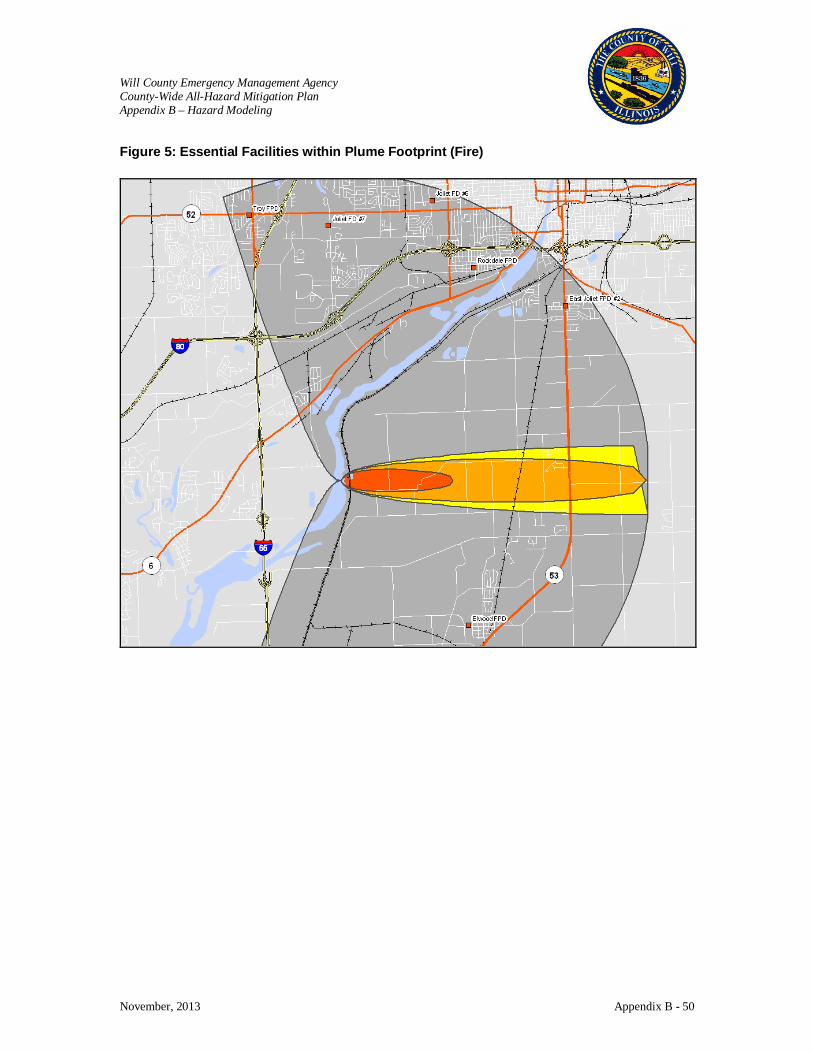
Will County Emergency Management Agency County-Wide All-Hazard Mitigation Plan Appendix B – Hazard Modeling
November, 2013 Appendix B - 50
Figure 5: Essential Facilities within Plume Footprint (Fire)
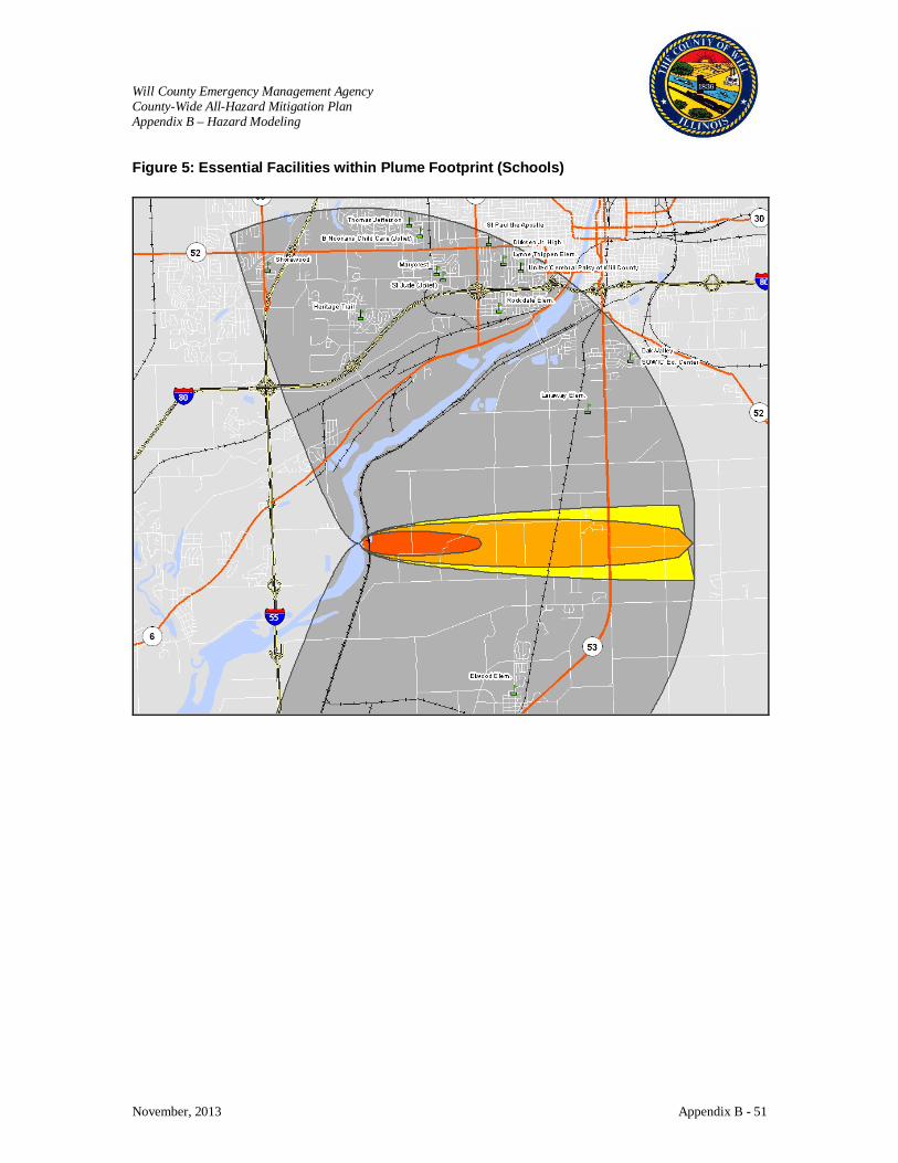
Will County Emergency Management Agency County-Wide All-Hazard Mitigation Plan Appendix B – Hazard Modeling
November, 2013 Appendix B - 51
Figure 5: Essential Facilities within Plume Footprint (Schools)

Will County Emergency Management Agency County-Wide All-Hazard Mitigation Plan Appendix B – Hazard Modeling
November, 2013 Appendix B - 52
Will County Hazard Risk Assessment Munitions Results
Disclaimer: The estimates of social and economic impacts contained in this report were produced using limited GIS and HAZUS loss estimation data. There are uncertainties inherent in any loss estimation technique. Therefore, there may be significant differences between the modeled results contained in this report and the actual social and economic losses following a specific hazard. This analysis is intended to provide conceptual information that can be used to identify mitigation opportunities. These results can be improved by using enhanced inventory data and hazard information.
Submitted by: The Polis Center at IUPUI
1200 Waterway Blvd., Suite 100 Indianapolis, Indiana 46202
Phone: (317) 278-2455 FAX: (317) 278-1830
Submitted to: Consoer Townsend Envirodyne Engineers
(CTE) 303 East Wacker Drive
Suite 600 Chicago, Illinois 60601-5276
December 19, 2005
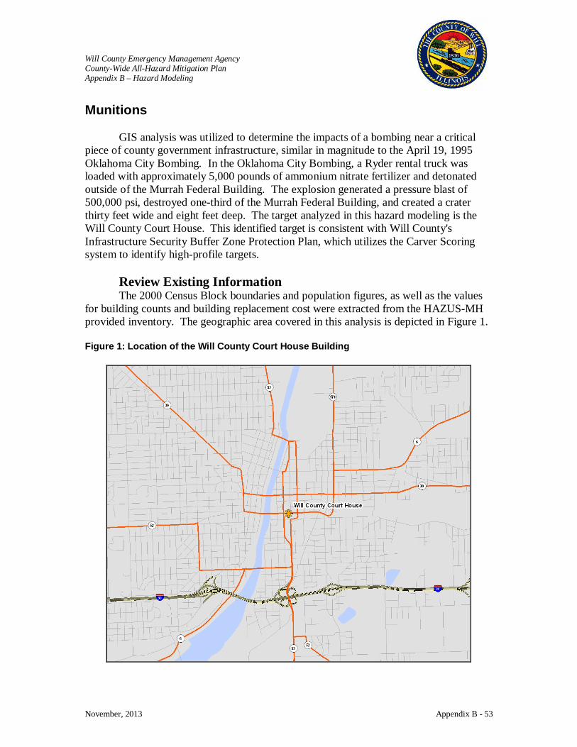
Will County Emergency Management Agency County-Wide All-Hazard Mitigation Plan Appendix B – Hazard Modeling
November, 2013 Appendix B - 53
Munitions
GIS analysis was utilized to determine the impacts of a bombing near a critical piece of county government infrastructure, similar in magnitude to the April 19, 1995 Oklahoma City Bombing. In the Oklahoma City Bombing, a Ryder rental truck was loaded with approximately 5,000 pounds of ammonium nitrate fertilizer and detonated outside of the Murrah Federal Building. The explosion generated a pressure blast of 500,000 psi, destroyed one-third of the Murrah Federal Building, and created a crater thirty feet wide and eight feet deep. The target analyzed in this hazard modeling is the Will County Court House. This identified target is consistent with Will County's Infrastructure Security Buffer Zone Protection Plan, which utilizes the Carver Scoring system to identify high-profile targets.
Review Existing Information The 2000 Census Block boundaries and population figures, as well as the values
for building counts and building replacement cost were extracted from the HAZUS-MH provided inventory. The geographic area covered in this analysis is depicted in Figure 1. Figure 1: Location of the Will County Court House Building
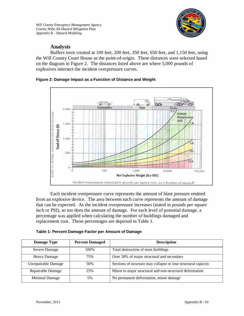
Will County Emergency Management Agency County-Wide All-Hazard Mitigation Plan Appendix B – Hazard Modeling
November, 2013 Appendix B - 54
Analysis Buffers were created at 100 feet, 200 feet, 350 feet, 650 feet, and 1,150 feet, using
the Will County Court House as the point-of-origin. These distances were selected based on the diagram in Figure 2. The distances listed above are where 5,000 pounds of explosives intersect the incident overpressure curves. Figure 2: Damage Impact as a Function of Distance and Weight
Each incident overpressure curve represents the amount of blast pressure emitted
from an explosive device. The area between each curve represents the amount of damage that can be expected. As the incident overpressure increases (stated in pounds per square inch or PSI), so too does the amount of damage. For each level of potential damage, a percentage was applied when calculating the number of buildings damaged and replacement cost. Those percentages are depicted in Table 1. Table 1: Percent Damage Factor per Amount of Damage
Damage Type Percent Damaged Description
Severe Damage 100% Total destruction of most buildings
Heavy Damage 75% Over 50% of major structural and secondary
Unrepairable Damage 50% Sections of structure may collapse or lose structural capacity
Repairable Damage 25% Minor to major structural and non-structural deformation
Minimal Damage 5% No permanent deformation, minor damage

Will County Emergency Management Agency County-Wide All-Hazard Mitigation Plan Appendix B – Hazard Modeling
November, 2013 Appendix B - 55
As stated above, buffers were created at 100 feet, 200 feet, 350 feet, 650 feet, and 1,150 feet, using the Will County Court House as the point-of-origin. The image in Figure 3 depicts the Will County Court House building and its surroundings, with the five buffer regions emanating outward. Figure 3: Affected Area around the Will County Court House Building
The 2000 Census Block layer was added to ArcMap and overlaid with the five buffer areas. The 2000 Census Block layer was then clipped against each of the five buffer areas. Clipping could be defined as the process of extracting features from one layer, in this case the 2000 Census Block layer, based on the boundary of another layer, in this case one of the five buffer areas. Figures 4 and 5 depict the 2000 Census Block areas before and after the “clipping” process.
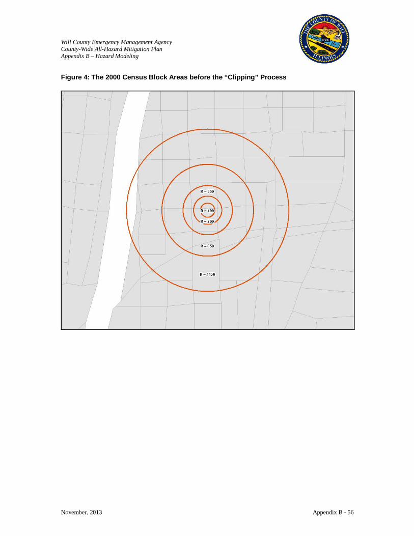
Will County Emergency Management Agency County-Wide All-Hazard Mitigation Plan Appendix B – Hazard Modeling
November, 2013 Appendix B - 56
Figure 4: The 2000 Census Block Areas before the “Clipping” Process

Will County Emergency Management Agency County-Wide All-Hazard Mitigation Plan Appendix B – Hazard Modeling
November, 2013 Appendix B - 57
Figure 5: The 2000 Census Block Areas after the “Clipping” Process
A field was added to the table to denote the percentage of each Census Block that fell inside each of the five buffer areas. To populate this field, the area of each clipped Census Block was divided by the area of the original Census Block. The percentages were then multiplied by the building count and exposure values.
Assumptions: • For this analysis it was assumed that all buildings and population were
evenly distributed across each census block. Thus, if 50% of a census block fell within the buffer area, it was assumed that 50% of the structures and population also fell within that area.
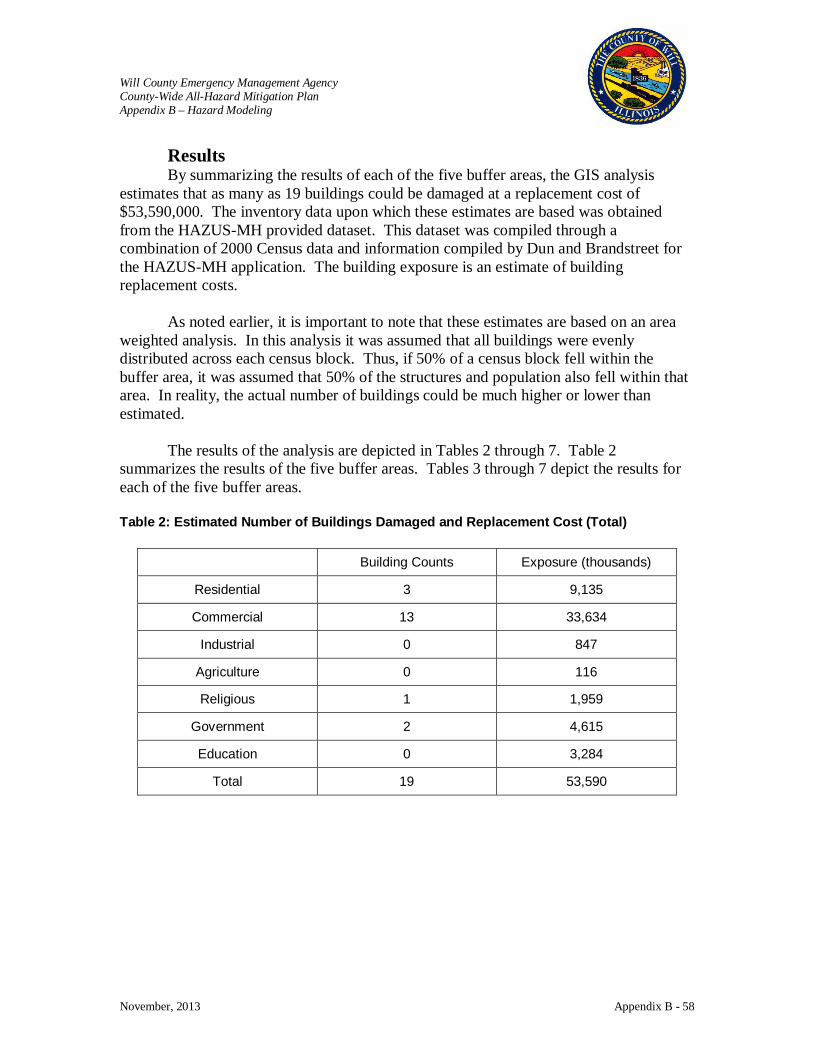
Will County Emergency Management Agency County-Wide All-Hazard Mitigation Plan Appendix B – Hazard Modeling
November, 2013 Appendix B - 58
Results By summarizing the results of each of the five buffer areas, the GIS analysis
estimates that as many as 19 buildings could be damaged at a replacement cost of $53,590,000. The inventory data upon which these estimates are based was obtained from the HAZUS-MH provided dataset. This dataset was compiled through a combination of 2000 Census data and information compiled by Dun and Brandstreet for the HAZUS-MH application. The building exposure is an estimate of building replacement costs.
As noted earlier, it is important to note that these estimates are based on an area weighted analysis. In this analysis it was assumed that all buildings were evenly distributed across each census block. Thus, if 50% of a census block fell within the buffer area, it was assumed that 50% of the structures and population also fell within that area. In reality, the actual number of buildings could be much higher or lower than estimated.
The results of the analysis are depicted in Tables 2 through 7. Table 2 summarizes the results of the five buffer areas. Tables 3 through 7 depict the results for each of the five buffer areas. Table 2: Estimated Number of Buildings Damaged and Replacement Cost (Total)
Building Counts Exposure (thousands)
Residential 3 9,135
Commercial 13 33,634
Industrial 0 847
Agriculture 0 116
Religious 1 1,959
Government 2 4,615
Education 0 3,284
Total 19 53,590
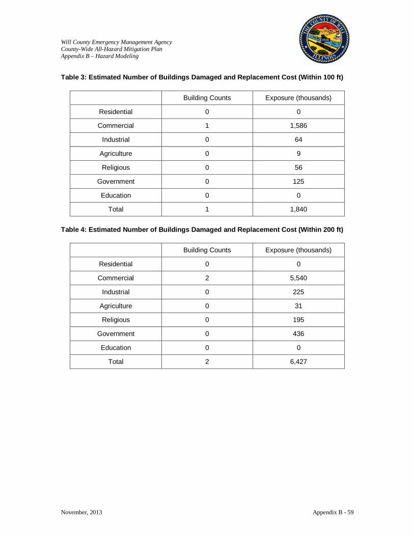
Will County Emergency Management Agency County-Wide All-Hazard Mitigation Plan Appendix B – Hazard Modeling
November, 2013 Appendix B - 59
Table 3: Estimated Number of Buildings Damaged and Replacement Cost (Within 100 ft)
Building Counts Exposure (thousands)
Residential 0 0
Commercial 1 1,586
Industrial 0 64
Agriculture 0 9
Religious 0 56
Government 0 125
Education 0 0
Total 1 1,840
Table 4: Estimated Number of Buildings Damaged and Replacement Cost (Within 200 ft)
Building Counts Exposure (thousands)
Residential 0 0
Commercial 2 5,540
Industrial 0 225
Agriculture 0 31
Religious 0 195
Government 0 436
Education 0 0
Total 2 6,427

Will County Emergency Management Agency County-Wide All-Hazard Mitigation Plan Appendix B – Hazard Modeling
November, 2013 Appendix B - 60
Table 5: Estimated Number of Buildings Damaged and Replacement Cost (Within 350 ft)
Building Counts Exposure (thousands)
Residential 0 0
Commercial 4 9,804
Industrial 0 391
Agriculture 0 55
Religious 0 338
Government 0 756
Education 0 0
Total 4 11,344
Table 6: Estimated Number of Buildings Damaged and Replacement Cost (Within 650 ft)
Building Counts Exposure (thousands)
Residential 0 885
Commercial 2 4,805
Industrial 0 150
Agriculture 0 21
Religious 0 130
Government 0 771
Education 0 0
Total 2 6,762

Will County Emergency Management Agency County-Wide All-Hazard Mitigation Plan Appendix B – Hazard Modeling
November, 2013 Appendix B - 61
Table 7: Estimated Number of Buildings Damaged and Replacement Cost (Within 1,150 ft)
Building Counts Exposure (thousands)
Residential 3 8,250
Commercial 4 11,899
Industrial 0 17
Agriculture 0 0
Religious 1 1,240
Government 2 2,527
Education 0 3,284
Total 10 27,217
Essential Facilities Damage
Within 100 feet of the blast point, there is one Police Station, the Will County’s Sheriff’s Office. Within the last buffer area, or from 651 feet out to 1,150 feet from the blast point, there are one emergency center and one police station, the Joliet EOC and the Joliet Police respectively. The affected facilities and their addresses are identified in Table 8. Their geographic locations are depicted in Figure 6. Table 8: Essential Facilities within Defined Blast Radius
TYPE NAME ADDRESS HAZUS_ID
Emergency Centers Joliet EOC 150 W Jefferson St IL000160
Police Stations Joliet Police 150 W Washington St IL000874
Police Stations Will County Sheriff's Office 14 W Jefferson St IL000891
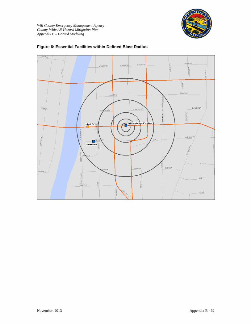
Will County Emergency Management Agency County-Wide All-Hazard Mitigation Plan Appendix B – Hazard Modeling
November, 2013 Appendix B - 62
Figure 6: Essential Facilities within Defined Blast Radius
Will County Emgergency Management Agency County-Wide All Hazard Mitigation Plan Appendix C – Benefit Cost Analysis Guidance
November, 2013 Appendix C
APPENDIX C BENEFIT COST ANALYSIS GUIDANCE
Will County Emergency Management Agency County-Wide All Hazard Mitigation Plan Appendix C – Benefit Cost Analysis Guidance
November, 2013 Appendix C - 1
BENEFIT COST ANALYSIS GUIDANCE
The following FEMA provided document provides an overview of the FEMA Benefit-Cost Analysis
(BCA) process, its benefits, and the FEMA BCA Software available online.
September, 2012, FEMA released the Benefit Cost Analysis Tool version 4.8 which is available to be
used to demonstrate cost-effectiveness for FEMA's HMA grant programs. A link is provided below to
download the software. Due to the size of the toolkit, the installation files are separated into three
separate .ZIP files.
• Tool available from: http://www.fema.gov/benefit-cost-analysis#0
• Training in the Benefit Cost Analysis process is available online from:
http://training.fema.gov/EMIWeb/IS/courseOverview.aspx?code=IS-276
• Onsite training in the Benefit Cost Analysis process is available from the Emergency
Management Institute with more information available from:
http://training.fema.gov/EMIGrams/2013/1007%20-%20Training%20Opportunity%20-
%20E0276%20Benefit-Cost%20Analysis%20Entry-Level%20Training%20Apr22-
24%20%20Aug25-27%202014.pdf

B-1ENGINEERING PRINCIPLES AND PRACTICES for Retrofitting Flood-Prone Residential Structures
E N G I N E E R I N G P R I N C I P L E S A N D P R A C T I C E S
APPENDIX B
Understanding the FEMA Benefit-Cost Analysis ProcessThe Stafford Act authorizes the President to establish a program to provide technical and financial assistance to state and local governments to assist in the implementation of hazard mitigation measures that are cost effective and designed to substantially reduce injuries, loss of life, hardship, or the risk of future damage and destruction of property. To evaluate proposed hazard mitigation projects prior to funding FEMA requires a Benefit-Cost Analysis (BCA) to validate cost effectiveness. BCA is the method by which the future benefits of a mitigation project are estimated and compared to its cost. The end result is a benefit-cost ratio (BCR), which is derived from a project’s total net benefits divided by its total project cost. The BCR is a numerical expression of the cost effectiveness of a project. A project is considered to be cost effective when the BCR is 1.0 or greater, indicating the benefits of a prospective hazard mitigation project are sufficient to justify the costs. Although the preparation of a BCA is a technical process, FEMA has developed software, written materials, and training to support the effort and assist with estimating the expected future benefits over the useful life of a retrofit project. It is imperative to conduct a BCA early in the project development process to ensure the likelihood of meeting the cost-effective eligibility requirement in the Stafford Act.
B.1 RiskRisk is defined in terms of expected probability and frequency of the hazard occurring, the people and property exposed, and the potential consequences. To estimate future damages (and the benefits of avoiding them), the probabilities of future events must be considered. The probabilities of future events profoundly affect whether a proposed retrofit project is cost effective. For example, the benefits of avoiding flood damage for a building in the 10-percent-annual-chance of flooding floodplain will be enormously greater than the benefits of avoiding flood damage for an identical building situated at the 0.001-percent-annual-chance of flooding level. In addition to the probability of the future flood events, it is just as important to consider the consequences associated with said event on a building. Estimated flood damages for a one-story building will typically be greater than that of a multi-story building or a building with a closed versus open foundation. The damages sustained by existing buildings exposed to flood hazards include site damage, structural and
ContentsAPPENDIX B. Understanding the FEMA Benefit-Cost Analysis Process .............................B-1B.1 Risk ............................................................................................................................................B-1B.2 Benefits ...................................................................................................................................... B-2B.3 Estimating Benefits .................................................................................................................... B-3B.4 FEMA BCA Software ............................................................................................................... B-5
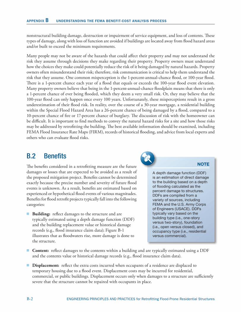
B-2 ENGINEERING PRINCIPLES AND PRACTICES for Retrofitting Flood-Prone Residential Structures
APPENDIX B UNDERSTANDING THE FEMA BENEFIT-COST ANALYSIS PROCESS
nonstructural building damage, destruction or impairment of service equipment, and loss of contents. These types of damage, along with loss of function are avoided if buildings are located away from flood hazard areas and/or built to exceed the minimum requirements.
Many people may not be aware of the hazards that could affect their property and may not understand the risk they assume through decisions they make regarding their property. Property owners must understand how the choices they make could potentially reduce the risk of it being damaged by natural hazards. Property owners often misunderstand their risk; therefore, risk communication is critical to help them understand the risk that they assume. One common misperception is the 1-percent-annual-chance flood, or 100-year flood. There is a 1-percent chance each year of a flood that equals or exceeds the 100-year flood event elevation. Many property owners believe that being in the 1-percent-annual-chance floodplain means that there is only a 1-percent chance of ever being flooded, which they deem a very small risk. Or, they may believe that the 100-year flood can only happen once every 100 years. Unfortunately, these misperceptions result in a gross underestimation of their flood risk. In reality, over the course of a 30-year mortgage, a residential building within the Special Flood Hazard Area has a 26-percent chance of being damaged by a flood, compared to a 10-percent chance of fire or 17-percent chance of burglary. The discussion of risk with the homeowner can be difficult. It is important to find methods to convey the natural hazard risks for a site and how those risks may be addressed by retrofitting the building. The best available information should be examined, including FEMA Flood Insurance Rate Maps (FIRM), records of historical flooding, and advice from local experts and others who can evaluate flood risks.
B.2 BenefitsThe benefits considered in a retrofitting measure are the future damages or losses that are expected to be avoided as a result of the proposed mitigation project. Benefits cannot be determined exactly because the precise number and severity of future flood events is unknown. As a result, benefits are estimated based on experienced or hypothetical flood events of various magnitudes. Benefits for flood retrofit projects typically fall into the following categories:
� Building: reflect damages to the structure and are typically estimated using a depth damage function (DDF) and the building replacement value or historical damage records (e.g., flood insurance claim data); Figure B-1 illustrates that as floodwaters rise, more damage is done to the structure.
� Content: reflect damages to the contents within a building and are typically estimated using a DDF and the contents value or historical damage records (e.g., flood insurance claim data).
� Displacement: reflect the extra costs incurred when occupants of a residence are displaced to temporary housing due to a flood event. Displacement costs may be incurred for residential, commercial, or public buildings. Displacement occurs only when damages to a structure are sufficiently severe that the structure cannot be repaired with occupants in place.
NOTE
A depth damage function (DDF) is an estimation of direct damage to the building based on a depth of flooding calculated as the percent damage to structures. DDFs are compiled from a variety of sources, including FEMA and the U.S. Army Corps of Engineers (USACE). DDFs typically vary based on the building type (i.e., one-story versus two-story), foundation (i.e., open versus closed), and occupancy type (i.e., residential versus commercial).
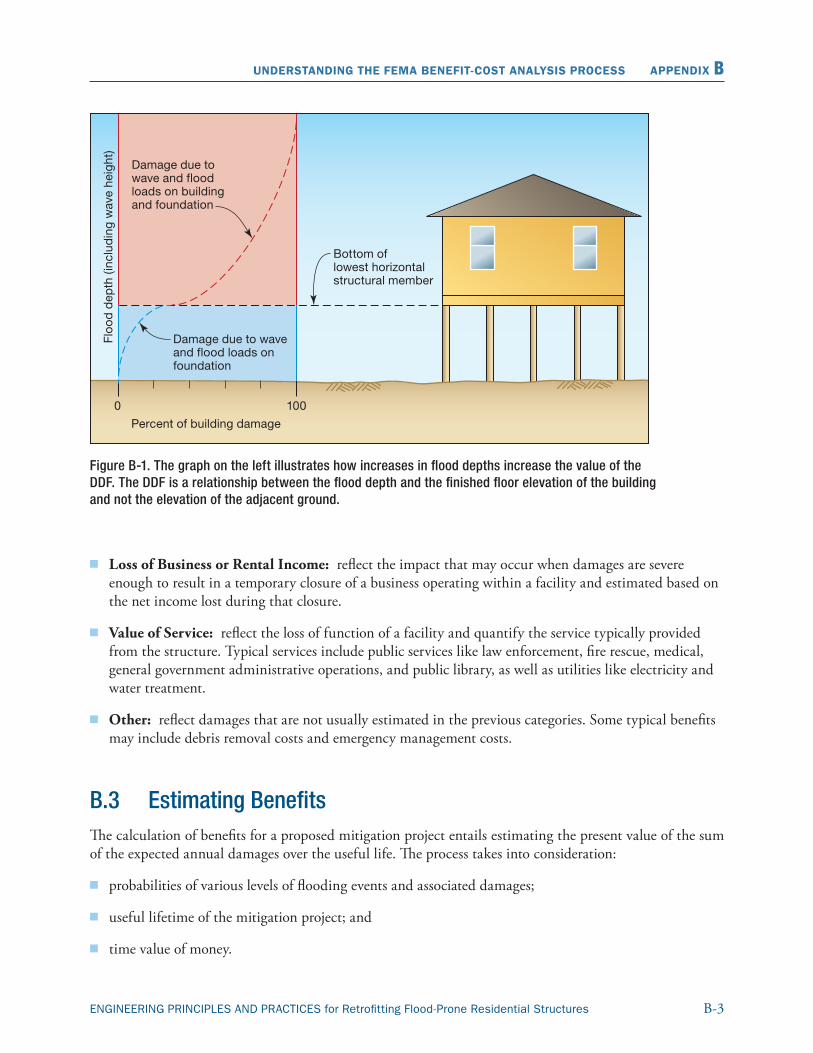
B-3ENGINEERING PRINCIPLES AND PRACTICES for Retrofitting Flood-Prone Residential Structures
UNDERSTANDING THE FEMA BENEFIT-COST ANALYSIS PROCESS APPENDIX B
Figure B-1. The graph on the left illustrates how increases in flood depths increase the value of the DDF. The DDF is a relationship between the flood depth and the finished floor elevation of the building and not the elevation of the adjacent ground.
� Loss of Business or Rental Income: reflect the impact that may occur when damages are severe enough to result in a temporary closure of a business operating within a facility and estimated based on the net income lost during that closure.
� Value of Service: reflect the loss of function of a facility and quantify the service typically provided from the structure. Typical services include public services like law enforcement, fire rescue, medical, general government administrative operations, and public library, as well as utilities like electricity and water treatment.
� Other: reflect damages that are not usually estimated in the previous categories. Some typical benefits may include debris removal costs and emergency management costs.
B.3 Estimating BenefitsThe calculation of benefits for a proposed mitigation project entails estimating the present value of the sum of the expected annual damages over the useful life. The process takes into consideration:
� probabilities of various levels of flooding events and associated damages;
� useful lifetime of the mitigation project; and
� time value of money.
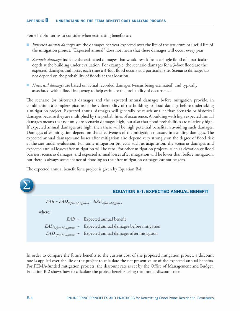
B-4 ENGINEERING PRINCIPLES AND PRACTICES for Retrofitting Flood-Prone Residential Structures
APPENDIX B UNDERSTANDING THE FEMA BENEFIT-COST ANALYSIS PROCESS
Some helpful terms to consider when estimating benefits are:
� Expected annual damages are the damages per year expected over the life of the structure or useful life of the mitigation project. “Expected annual” does not mean that these damages will occur every year.
� Scenario damages indicate the estimated damages that would result from a single flood of a particular depth at the building under evaluation. For example, the scenario damages for a 3-foot flood are the expected damages and losses each time a 3-foot flood occurs at a particular site. Scenario damages do not depend on the probability of floods at that location.
� Historical damages are based on actual recorded damages (versus being estimated) and typically associated with a flood frequency to help estimate the probability of occurrence.
The scenario (or historical) damages and the expected annual damages before mitigation provide, in combination, a complete picture of the vulnerability of the building to flood damage before undertaking a mitigation project. Expected annual damages will generally be much smaller than scenario or historical damages because they are multiplied by the probabilities of occurrence. A building with high expected annual damages means that not only are scenario damages high, but also that flood probabilities are relatively high. If expected annual damages are high, then there will be high potential benefits in avoiding such damages. Damages after mitigation depend on the effectiveness of the mitigation measure in avoiding damages. The expected annual damages and losses after mitigation also depend very strongly on the degree of flood risk at the site under evaluation. For some mitigation projects, such as acquisition, the scenario damages and expected annual losses after mitigation will be zero. For other mitigation projects, such as elevation or flood barriers, scenario damages, and expected annual losses after mitigation will be lower than before mitigation, but there is always some chance of flooding so the after mitigation damages cannot be zero.
The expected annual benefit for a project is given by Equation B-1.
EQUATION B-1: EXPECTED ANNUAL BENEFIT
EAB = EADBefore Mitigation – EADAfter Mitigation
where: EAB = Expected annual benefit EADBefore Mitigation = Expected annual damages before mitigation EADAfter Mitigation = Expected annual damages after mitigation
In order to compare the future benefits to the current cost of the proposed mitigation project, a discount rate is applied over the life of the project to calculate the net present value of the expected annual benefits. For FEMA-funded mitigation projects, the discount rate is set by the Office of Management and Budget. Equation B-2 shows how to calculate the project benefits using the annual discount rate.
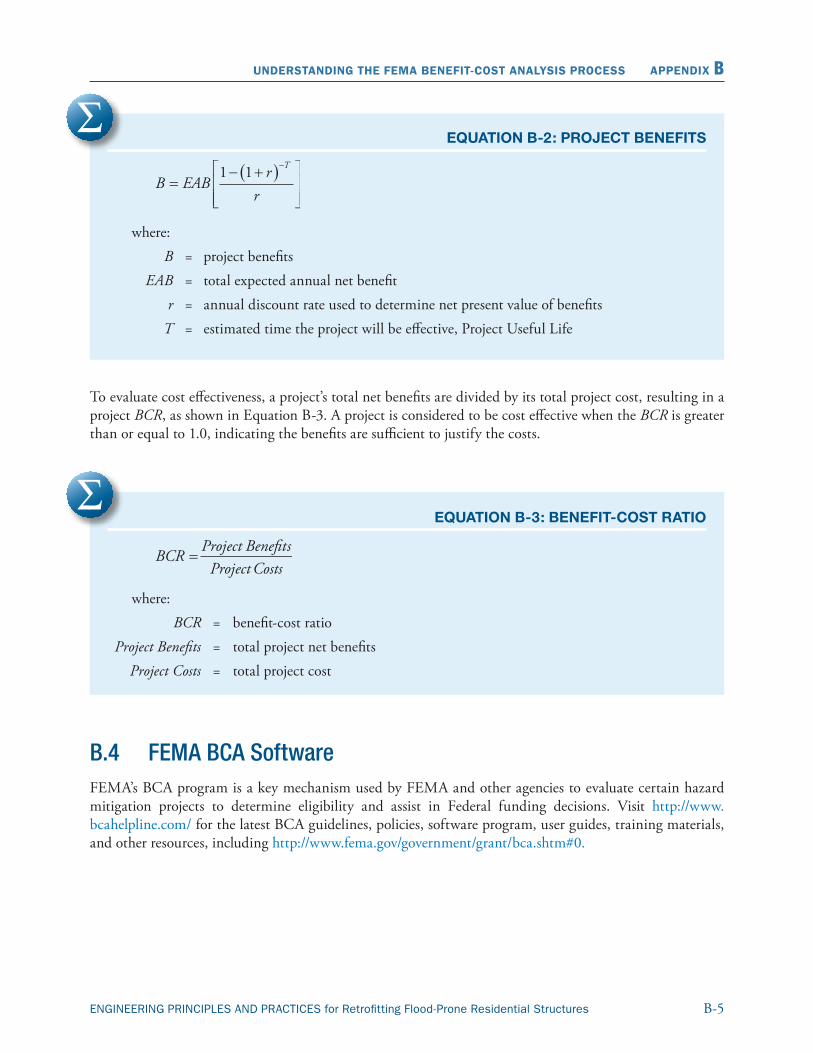
B-5ENGINEERING PRINCIPLES AND PRACTICES for Retrofitting Flood-Prone Residential Structures
UNDERSTANDING THE FEMA BENEFIT-COST ANALYSIS PROCESS APPENDIX B
EQUATION B-2: PROJECT BENEFITS
where: B = project benefits EAB = total expected annual net benefit r = annual discount rate used to determine net present value of benefits T = estimated time the project will be effective, Project Useful Life
To evaluate cost effectiveness, a project’s total net benefits are divided by its total project cost, resulting in a project BCR, as shown in Equation B-3. A project is considered to be cost effective when the BCR is greater than or equal to 1.0, indicating the benefits are sufficient to justify the costs.
EQUATION B-3: BENEFIT-COST RATIO
where: BCR = benefit-cost ratio Project Benefits = total project net benefits Project Costs = total project cost
B.4 FEMA BCA Software FEMA’s BCA program is a key mechanism used by FEMA and other agencies to evaluate certain hazard mitigation projects to determine eligibility and assist in Federal funding decisions. Visit http://www.bcahelpline.com/ for the latest BCA guidelines, policies, software program, user guides, training materials, and other resources, including http://www.fema.gov/government/grant/bca.shtm#0.

Will County Emgergency Management Agency County-Wide All Hazard Mitigation Plan Appendix D – Hazard Mitigation Action Form
November, 2013 Appendix D
APPENDIX D HAZARD MITIGATION ACTION FORM
Will County Emergency Management Agency County-Wide All Hazard Mitigation Plan Appendix D – Hazard Mitigation Action Form
November, 2013 Appendix D - 1
HAZARD MITIGATION ACTION FORM
The following form was provided at the Mitigation Steering Committee Workshop to facilitate the
creation and organization of potential hazard mitigation actions that could be submitted by any of the
meeting participants.
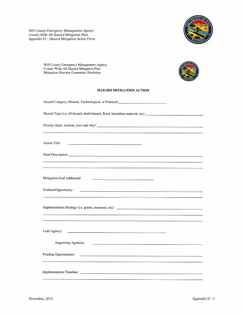
Will County Emergency Management Agency County-Wide All Hazard Mitigation Plan Appendix D – Hazard Mitigation Action Form
November, 2013 Appendix D - 2

Will County Emgergency Management Agency County-Wide All Hazard Mitigation Plan Appendix E – Public Involvement
November, 2013 Appendix E
APPENDIX E PUBLIC INVOLVEMENT
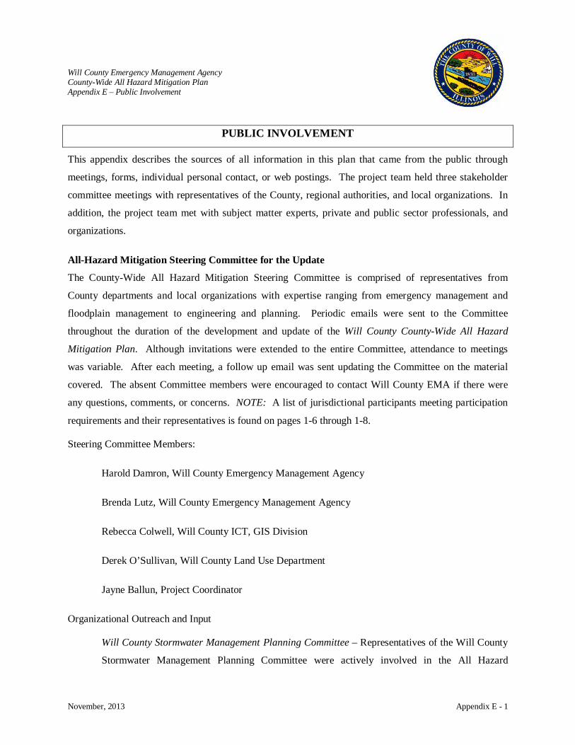
Will County Emergency Management Agency County-Wide All Hazard Mitigation Plan Appendix E – Public Involvement
November, 2013 Appendix E - 1
PUBLIC INVOLVEMENT This appendix describes the sources of all information in this plan that came from the public through
meetings, forms, individual personal contact, or web postings. The project team held three stakeholder
committee meetings with representatives of the County, regional authorities, and local organizations. In
addition, the project team met with subject matter experts, private and public sector professionals, and
organizations.
All-Hazard Mitigation Steering Committee for the Update
The County-Wide All Hazard Mitigation Steering Committee is comprised of representatives from
County departments and local organizations with expertise ranging from emergency management and
floodplain management to engineering and planning. Periodic emails were sent to the Committee
throughout the duration of the development and update of the Will County County-Wide All Hazard
Mitigation Plan. Although invitations were extended to the entire Committee, attendance to meetings
was variable. After each meeting, a follow up email was sent updating the Committee on the material
covered. The absent Committee members were encouraged to contact Will County EMA if there were
any questions, comments, or concerns. NOTE: A list of jurisdictional participants meeting participation
requirements and their representatives is found on pages 1-6 through 1-8.
Steering Committee Members:
Harold Damron, Will County Emergency Management Agency
Brenda Lutz, Will County Emergency Management Agency
Rebecca Colwell, Will County ICT, GIS Division
Derek O’Sullivan, Will County Land Use Department
Jayne Ballun, Project Coordinator
Organizational Outreach and Input
Will County Stormwater Management Planning Committee – Representatives of the Will County
Stormwater Management Planning Committee were actively involved in the All Hazard
Will County Emergency Management Agency County-Wide All Hazard Mitigation Plan Appendix E – Public Involvement
November, 2013 Appendix E - 2
Mitigation planning and reported the activities and development of the project. In 1993, the Will
County Board authorized creation of a county Stormwater Management Planning Committee. In
1996, a full complement of 18 municipal and County representatives began meeting regularly and
working with local planning commissions to develop a stormwater management plan.
Steering Committee Workshop Summaries
Workshop 1: August 27, 2013
This meeting was a 1½ hour kick-off meeting with Will Emergency Management Agency and the
Mitigation Project Team to inform participants about the County-Wide All Hazard Mitigation Plan update
and identify expectations of the project. The Mitigation Project Team was led by Harold Damron,
Director of the Will County Emergency Management Agency. The project kick-off focused on the
following:
• Welcome & Introductions
• Hazard Mitigation Defined
• Will County: County-Wide All Hazard Mitigation Plan – 2008
• What’s in the 2008 Plan?
o All Hazard Risk Assessment
o Hazard Profiles & Vulnerability Assessment
o Mitigation Goals, Objectives & Strategies
o Mitigation Actions
• Mitigation Success Stories
• What Does It Mean to Participate?
• Benefits & Adoption of the Plan
• Future Meeting Dates
o Second Meeting – Workshop
o Third Meeting – Draft & Final Steps
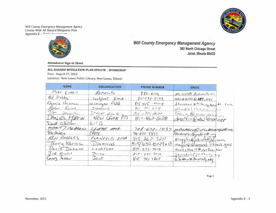
Will County Emergency Management Agency County-Wide All Hazard Mitigation Plan Appendix E – Public Involvement
November, 2013 Appendix E - 3
Will County Emergency Management Agency County-Wide All Hazard Mitigation Plan Appendix E – Public Involvement
November, 2013 Appendix E - 4
Workshop 2: October 10, 2013
This was a two hour meeting, focused primarily on reviewing and updating the Goals, Objectives, and
Mitigation Actions of the Will County County-Wide All Hazard Mitigation Plan. Input, comments, and
recommendations were solicited on changes and additions to the mitigation goals, objectives, and action
items. Mr. Harold Damron, Director of Will County EMA, provided introductory remarks. Ms. Jayne
Ballun led the review and update process.
First, participants were asked to review the mitigation goals and objectives to determine if any changes
were needed. Next, mitigation actions were reviewed identifying items that have been completed or need
to be eliminated. Remaining action items were reviewed in detail and suggested updates were noted.
Worksheets to facilitate the identification of additional mitigation initiatives were provided and
participants were asked to submit their ideas for the next meeting.
The Mitigation Steering Committee was updated on the schedule of the All Hazard Mitigation Plan and
their next steps as part of the steering committee. All jurisdictions were asked to link the public survey to
their websites and Facebook pages as appropriate.
• All Hazards Risk Assessment Review
• Capability Assessment & THIRA
• Review of Mitigation Goals & Objectives
• Review & Update of Mitigation Actions
• Completed or Obsolete
• Ongoing / Continuing
• New
• Public Survey
• Future Meeting Date
• Questions

Will County Emergency Management Agency County-Wide All Hazard Mitigation Plan Appendix E – Public Involvement
November, 2013 Appendix E - 5
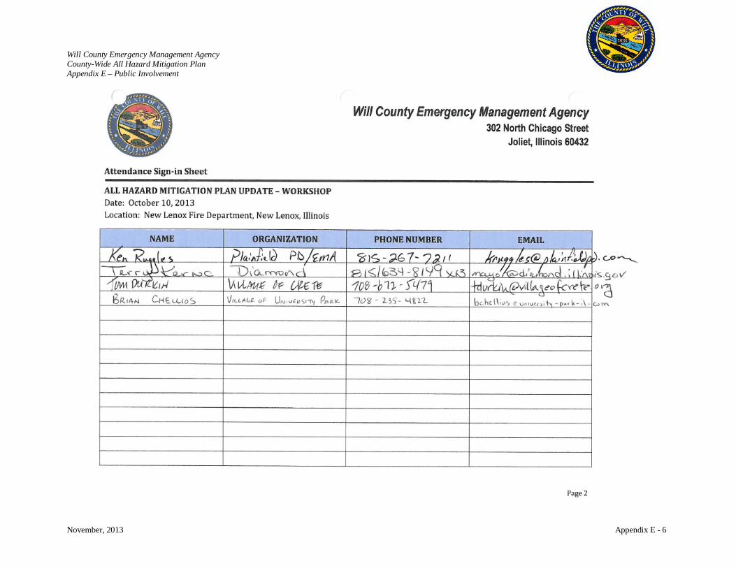
Will County Emergency Management Agency County-Wide All Hazard Mitigation Plan Appendix E – Public Involvement
November, 2013 Appendix E - 6
Will County Emergency Management Agency County-Wide All Hazard Mitigation Plan Appendix E – Public Involvement
November, 2013 Appendix E - 7
Workshop 3: November 19, 2013
The intent of this 1½ hour workshop was to finalize the county-wide mitigation goals, objectives, and
mitigation actions. Participation from local jurisdictions was solicited by email and telephone. Prior to
this meeting, the Mitigation Steering Committee and participating jurisdictions were provided a draft of
Chapters 5 and 6 of the plan update. These two chapters detailed the update of the Will County County-
Wide All Hazard Mitigation Plan’s mitigation goals, objectives and action items. Each jurisdiction was
asked to review these chapters in detail and come to the meeting to discuss the finalization of these
chapters.
Days before this meeting, a tornado came through central and northern Illinois impacting several
communities in Will County. A number of regular participants were unable to attend as a result. Mr.
Harold Damron, Director of the Will County Emergency Management Agency, gave an overview of the
current status of the tornado incident, needs being addressed, and shared pictures of the damages that
were a result of the tornado. Ms. Jayne Ballun then led the review of the final draft of the Will County County-
Wide All Hazard Mitigation Plan’s mitigation goals, objectives and action items.
Hazard Mitigation Plan Updates
o Executive Summary – overview of mitigation actions
o Chapter 1 – Mitigation Process
o Chapter 2 – Community Overview
o Chapter 3 – Hazard Risk Assessment Summary & Capability Assessment
o Chapter 4 – Hazard Profiles
o Chapter 5 – Mitigation Goals, Objectives & Strategies
o Chapter 6 – Mitigation Actions
o Chapter 7 – Mitigation Plan Updates & Maintenance
Draft posted on WC EMA website for review by jurisdictions & public
Submission to IEMA for approval – then to FEMA
Once approved by FEMA, submit for adoption by boards
Questions

Will County Emergency Management Agency County-Wide All Hazard Mitigation Plan Appendix E – Public Involvement
November, 2013 Appendix E - 8
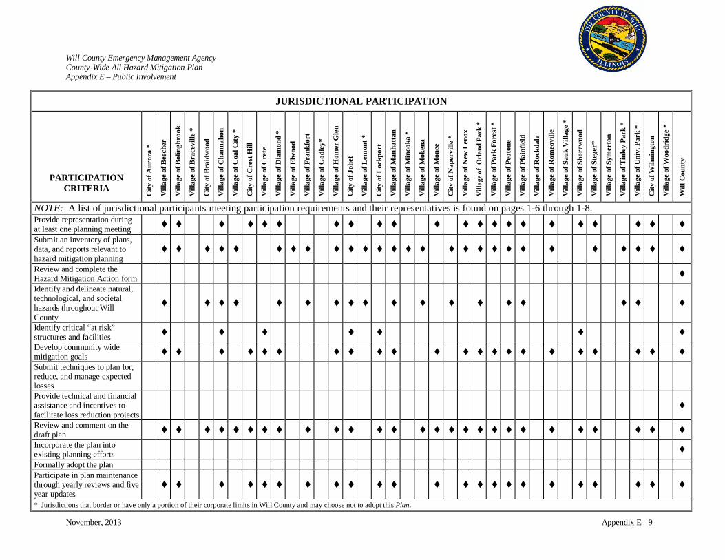
Will County Emergency Management Agency County-Wide All Hazard Mitigation Plan Appendix E – Public Involvement
November, 2013 Appendix E - 9
JURISDICTIONAL PARTICIPATION
PARTICIPATION CRITERIA
City
of A
uror
a *
Vill
age
of B
eech
er
Vill
age
of B
olin
gbro
ok
Vill
age
of B
race
ville
*
City
of B
raid
woo
d
Vill
age
of C
hann
ahon
Vill
age
of C
oal C
ity *
City
of C
rest
Hill
Vill
age
of C
rete
Vill
age
of D
iam
ond
*
Vill
age
of E
lwoo
d
Vill
age
of F
rank
fort
Vill
age
of G
odle
y*
Vill
age
of H
omer
Gle
n
City
of J
olie
t
Vill
age
of L
emon
t *
City
of L
ockp
ort
Vill
age
of M
anha
ttan
Vill
age
of M
inoo
ka *
Vill
age
of M
oken
a
Vill
age
of M
onee
City
of N
aper
ville
*
Vill
age
of N
ew L
enox
Vill
age
of O
rlan
d Pa
rk *
Vill
age
of P
ark
Fore
st *
Vill
age
of P
eoto
ne
Vill
age
of P
lain
field
Vill
age
of R
ockd
ale
Vill
age
of R
omeo
ville
Vill
age
of S
auk
Vill
age
*
Vill
age
of S
hore
woo
d
Vill
age
of S
tege
r*
Vill
age
of S
ymer
ton
Vill
age
of T
inle
y Pa
rk *
Vill
age
of U
niv.
Par
k *
City
of W
ilmin
gton
Vill
age
of W
oodr
idge
*
Will
Cou
nty
NOTE: A list of jurisdictional participants meeting participation requirements and their representatives is found on pages 1-6 through 1-8. Provide representation during at least one planning meeting
Submit an inventory of plans, data, and reports relevant to hazard mitigation planning
Review and complete the Hazard Mitigation Action form
Identify and delineate natural, technological, and societal hazards throughout Will County
Identify critical “at risk” structures and facilities
Develop community wide mitigation goals
Submit techniques to plan for, reduce, and manage expected losses
Provide technical and financial assistance and incentives to facilitate loss reduction projects
Review and comment on the draft plan
Incorporate the plan into existing planning efforts
Formally adopt the plan Participate in plan maintenance through yearly reviews and five year updates
* Jurisdictions that border or have only a portion of their corporate limits in Will County and may choose not to adopt this Plan.
Will County Emergency Management Agency County-Wide All Hazard Mitigation Plan Appendix E – Public Involvement
November, 2013 Appendix E - 10
After the third update workshop, the progress completed on the Will County County-Wide All-Hazard
Mitigation Plan update consisted of:
• Review of all plan chapters and appendices of the Will County County-Wide All-Hazard
Mitigation Plan updating the County profile, maps, hazard incident history, and other pertinent
reference material.
• Review with each jurisdiction of their plans and ordinances
• Provision to each jurisdiction of website link to the draft plan update for final review by
jurisdiction and public comment.
Target Expertise Input and Correspondence Summaries
HAZUS Installation and Integration
For the original plan, the Mitigation Project Team held a working meeting with Will County EMA and
Will County GIS Division. The Polis Center installed and implemented the HAZUS-MH software on
Will County equipment. To validate the installation and demonstrate the HAZUS-MH capabilities, the
Mitigation Project Team performed an Earthquake risk assessment using the HAZUS-MH default data.
Following the validation, the Mitigation Project Team demonstrated the software, data, and HAZUS-MH
risk assessment reports to the staff.
Correspondence with FEMA on Past Disaster Declaration Information
For the original plan, the Mitigation Project Team contacted FEMA Mitigation Officer to provide input
and data on past declarations in Will County. The Mitigation Project Team was soliciting information on
the type of disaster, eligible federal costs reimbursed, types of Public Assistance project categories, and
other pertinent information for this project. FEMA could not readily access this information and
requested the Mitigation Project Team to contact IEMA.
Correspondence with IEMA on Past Disaster Declarations for Will County
For the original plan, the Mitigation Project Team contacted IEMA Mitigation Officer to provide input
and data on past declarations in the County. IEMA provided data on all state declarations by County, the
type of federal assistance received, and the federal costs. IEMA also provided weather data of past
events.
Will County Emergency Management Agency County-Wide All Hazard Mitigation Plan Appendix E – Public Involvement
November, 2013 Appendix E - 11
For the update of the plan, information on past declarations was obtained from the IEMA Hazard
Mitigation Plan and FEMA’s website: http://www.fema.gov/disasters.
Correspondence with US Army Corps of Engineers
For the original plan, the Mitigation Project Team contacted the US Army Corps of Engineers to obtain
information on hazardous material that is transported through the County via U.S Waterways, Harbors,
and the Great Lakes. The US Army Corps of Engineers provided detailed historical information, type of
materials, and insight on the County’s busiest waterways.
For the update of the plan, much of this information is now available online through various websites of
the US Army Corps of Engineers and National Transportation Safety Board.
GIS Integration Working Meeting and Correspondence
For the original plan, the intent of this meeting was to provide a brief tutorial on HAZUS-MH to Will
County GIS Division staff and to identify County GIS data that will be incorporated into the HAZUS-MH
model and GIS Analysis. The Polis Center provided the strategy of updating and integrating County GIS
data and the data documentation that will be required. A review was conducted of each attribute (field) in
the databases and identified the attributes that will be updated. The attributes are of four major types
listed below.
• Mandatory for HAZUS to run correctly (i.e. building classes)
• Required for reports (i.e. number of beds)
• Not required (i.e. American hospital Association (AHA) ID)
• Data and information will come from another source (soil type from Illinois Geological Survey)
Will County Stormwater Management Committee Coordination
For the original plan, a coordination meeting was held with representatives of the Will County
Stormwater Management Committee. This meeting was lead by a Mitigation Steering Committee
member who is also a member of the Will County Stormwater Management Committee. A brief
overview of FEMA’s Mitigation Program and the requirements of the Disaster Mitigation Act of 2000
were provided. An overview of the All-Hazard Mitigation Plan was discussed, outlining the goals,
strategies, and progress of the Will County County-Wide All Hazard Mitigation Plan. The Mitigation
Will County Emergency Management Agency County-Wide All Hazard Mitigation Plan Appendix E – Public Involvement
November, 2013 Appendix E - 12
Project Team solicited guidance from the Will County Stormwater Management Committee on what their
greatest risks were and requested their input.
For the plan update, Mr. Derek O’Sullivan, Assistant Director of the Will County Land Use Department
and member of the Stormwater Management Planning Committee, provided technical assistance in the
review and update of the Will County County-Wide All Hazard Mitigation Plan.
Email and Telephone Correspondence with Dr. Bauer (Illinois State Geologic Survey)
For the original plan, the Mitigation Project Team began correspondence with Dr. Bauer with the Illinois
State Geologic Survey to identify and quantify the risk of an earthquake to the communities of Will
County. Dr. Bauer provided a plethora of input on the impacts of an earthquake originating from the New
Madrid fault system, the Des Plaines impact structure, or the assorted fault traces in Northern Illinois. Dr.
Bauer also provided input on the hazard modeling scenario most likely to occur and what would truly
represent an event that would significantly impact the County.
Great Lakes Partnership (GLP) Coordination and General Meeting Attendance
For the original plan, the Mitigation Team held periodic meetings with representatives of the Great Lakes
Partnership and attended their annual conference in October of 2005. GLP’s mission is to bring business
and government leaders together for cross-sector collaboration to address critical infrastructure
interdependencies and related homeland and economic security challenges. Their goal is to proactively
promote business continuity planning through the use of best practices, information sharing, and
innovation.
The Mitigation Team attended the Great Lakes Partnership’s General Meeting on October 20, 2005. The
GLP General Meeting had the theme “Sustainable Preparedness” and was a day-long session attended by
subject matter experts and representatives of the private and public sector. The Mitigation Project Team
solicited input, recommendations, and ideas from private and public sector professionals, as well as
subject matter experts.
Local Emergency Planning Commission (LEPC) Solicitation
Will County EMA solicited input from the Will County LEPC and extended invitations to attend the
Committee Meetings. The Will County LEPC is an organization of industrial, governmental and citizen

Will County Emergency Management Agency County-Wide All Hazard Mitigation Plan Appendix E – Public Involvement
November, 2013 Appendix E - 13
groups whose purpose is to provide a forum in which the local community and facilities can discuss
issues related to hazardous substances.
Launch of a New Public Will County EMA Website
To maintain public interest and to update them on the latest development in emergency management, Will
County EMA updated their web-site in time for the 2006 Severe Weather Preparedness Season. Will
County EMA provided a link to the latest development of the hazard mitigation project.
Since then, Will County EMA has maintained their website and added the social media Facebook tool to
provide the public and response partners with information on the hazards, preparedness, weather alerts,
special needs registry, and other valuable information to inform the public. Utilization of websites and
social media has become an everyday tool for educating public about the hazards that face Will County
and for the public to provide input on emergency management issues. Will County EMA has also
participated in the Chicago Regional Catastrophic Planning Team’s public information campaign called
Gear Up/Get Ready which has provided the region with a wealth of emergency preparedness education
materials and public activities.
Will County EMA Website
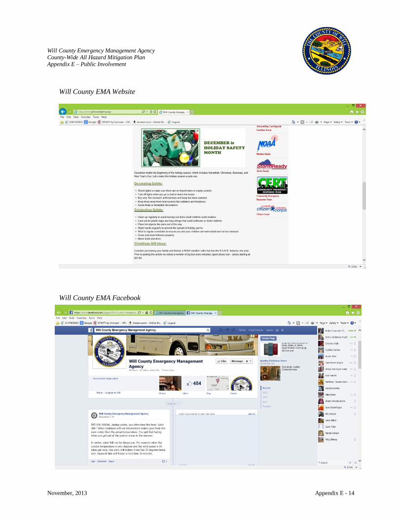
Will County Emergency Management Agency County-Wide All Hazard Mitigation Plan Appendix E – Public Involvement
November, 2013 Appendix E - 14
Will County EMA Website
Will County EMA Facebook
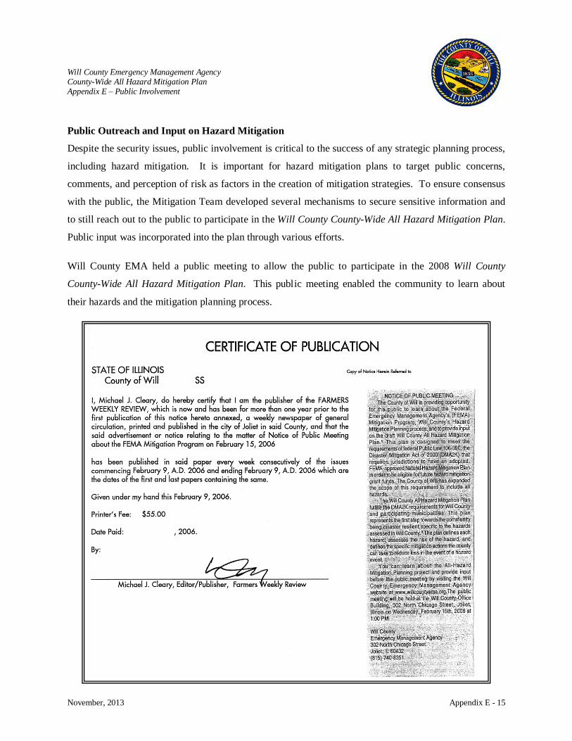
Will County Emergency Management Agency County-Wide All Hazard Mitigation Plan Appendix E – Public Involvement
November, 2013 Appendix E - 15
Public Outreach and Input on Hazard Mitigation
Despite the security issues, public involvement is critical to the success of any strategic planning process,
including hazard mitigation. It is important for hazard mitigation plans to target public concerns,
comments, and perception of risk as factors in the creation of mitigation strategies. To ensure consensus
with the public, the Mitigation Team developed several mechanisms to secure sensitive information and
to still reach out to the public to participate in the Will County County-Wide All Hazard Mitigation Plan.
Public input was incorporated into the plan through various efforts.
Will County EMA held a public meeting to allow the public to participate in the 2008 Will County
County-Wide All Hazard Mitigation Plan. This public meeting enabled the community to learn about
their hazards and the mitigation planning process.
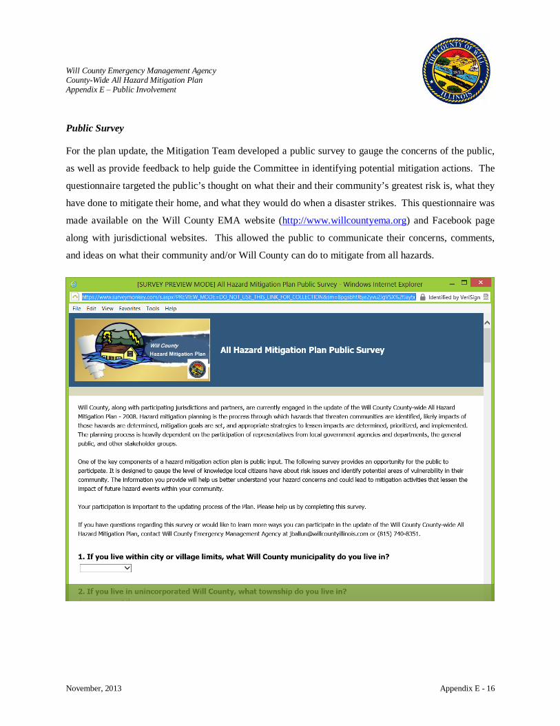
Will County Emergency Management Agency County-Wide All Hazard Mitigation Plan Appendix E – Public Involvement
November, 2013 Appendix E - 16
Public Survey
For the plan update, the Mitigation Team developed a public survey to gauge the concerns of the public,
as well as provide feedback to help guide the Committee in identifying potential mitigation actions. The
questionnaire targeted the public’s thought on what their and their community’s greatest risk is, what they
have done to mitigate their home, and what they would do when a disaster strikes. This questionnaire was
made available on the Will County EMA website (http://www.willcountyema.org) and Facebook page
along with jurisdictional websites. This allowed the public to communicate their concerns, comments,
and ideas on what their community and/or Will County can do to mitigate from all hazards.
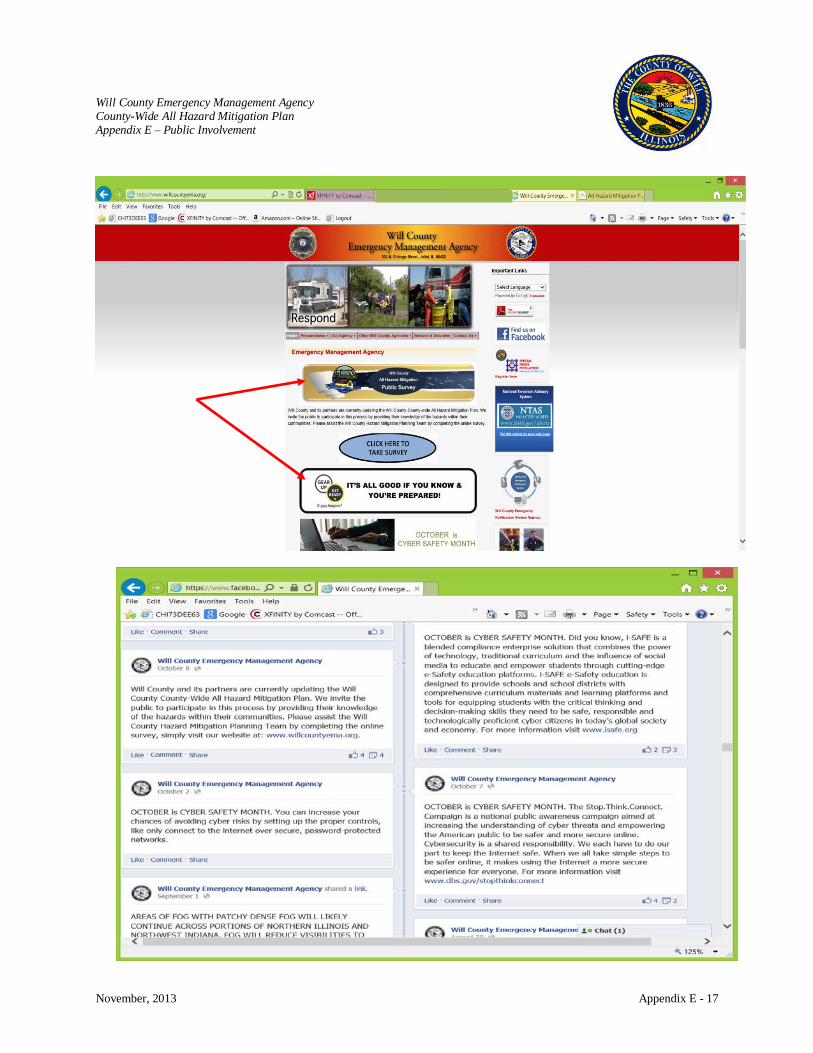
Will County Emergency Management Agency County-Wide All Hazard Mitigation Plan Appendix E – Public Involvement
November, 2013 Appendix E - 17
f
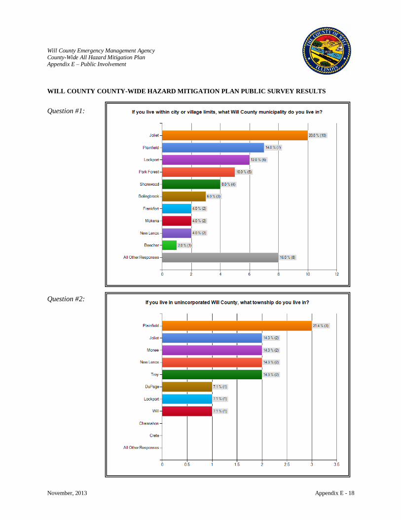
Will County Emergency Management Agency County-Wide All Hazard Mitigation Plan Appendix E – Public Involvement
November, 2013 Appendix E - 18
WILL COUNTY COUNTY-WIDE HAZARD MITIGATION PLAN PUBLIC SURVEY RESULTS
Question #1:
Question #2:
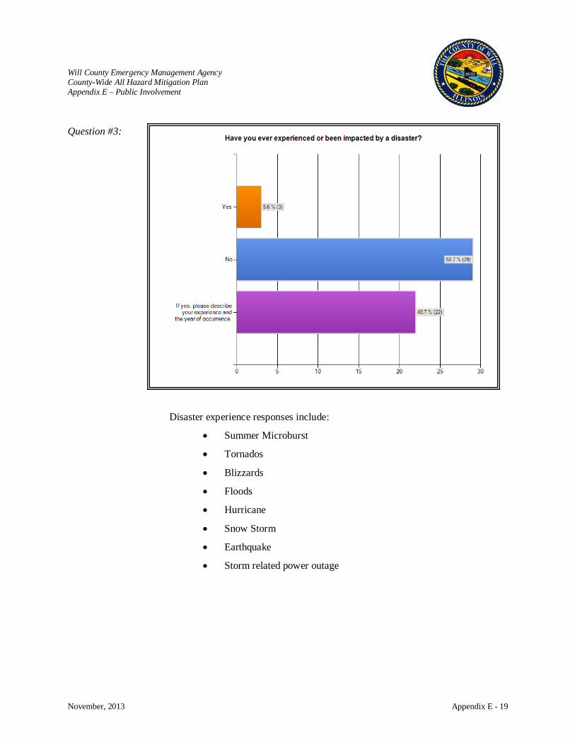
Will County Emergency Management Agency County-Wide All Hazard Mitigation Plan Appendix E – Public Involvement
November, 2013 Appendix E - 19
Question #3:
Disaster experience responses include:
• Summer Microburst
• Tornados
• Blizzards
• Floods
• Hurricane
• Snow Storm
• Earthquake
• Storm related power outage
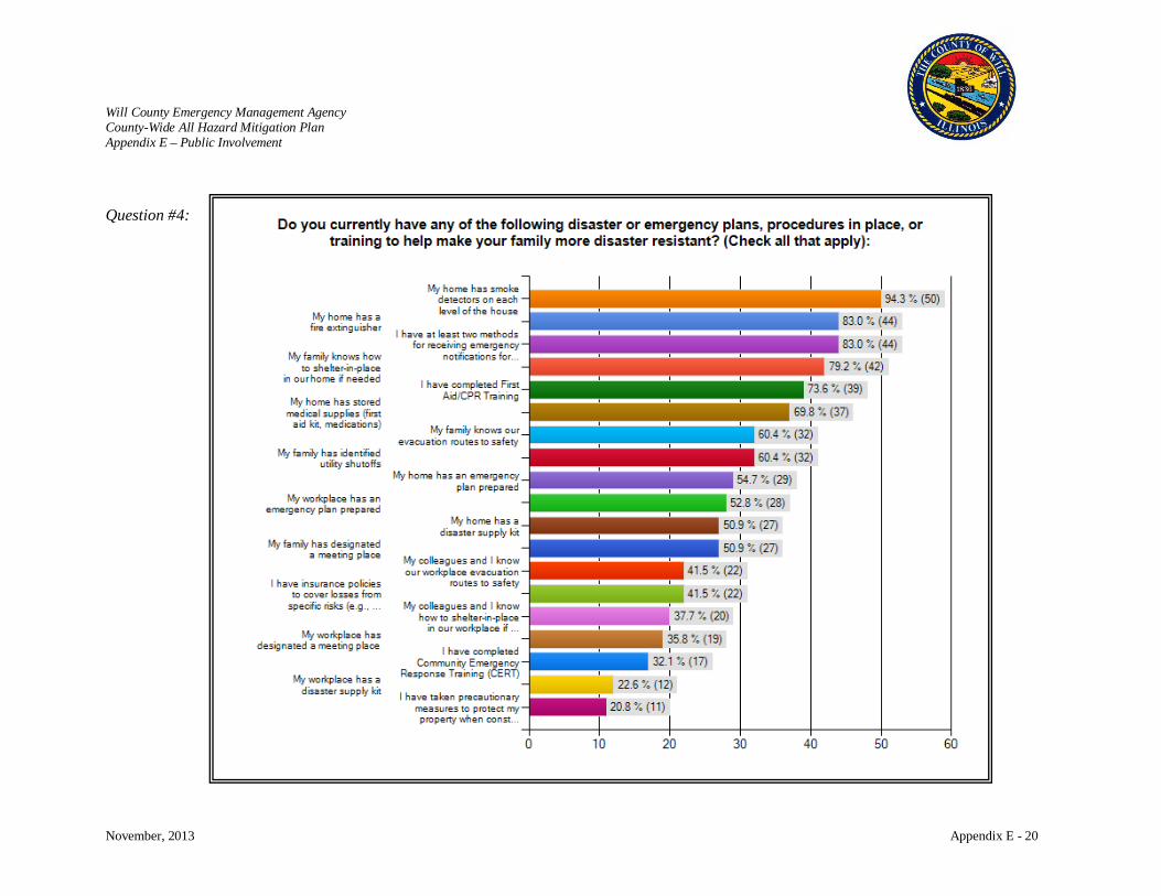
Will County Emergency Management Agency County-Wide All Hazard Mitigation Plan Appendix E – Public Involvement
November, 2013 Appendix E - 20
Question #4:

Will County Emergency Management Agency County-Wide All Hazard Mitigation Plan Appendix E – Public Involvement
November, 2013 Appendix E - 21
Question #5:
Question #6:
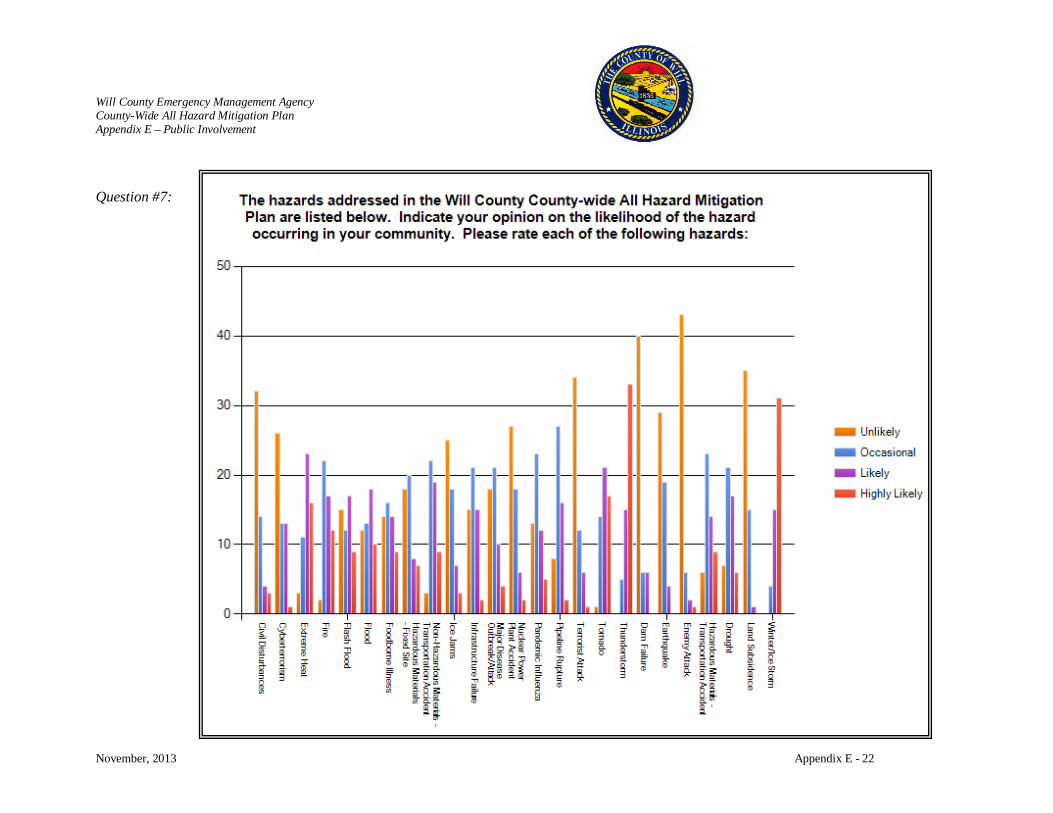
Will County Emergency Management Agency County-Wide All Hazard Mitigation Plan Appendix E – Public Involvement
November, 2013 Appendix E - 22
Question #7:
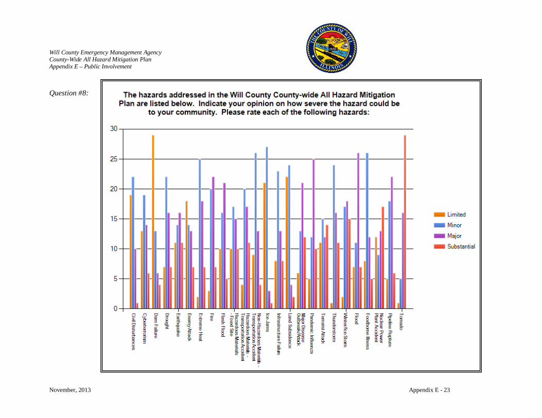
Will County Emergency Management Agency County-Wide All Hazard Mitigation Plan Appendix E – Public Involvement
November, 2013 Appendix E - 23
Question #8:
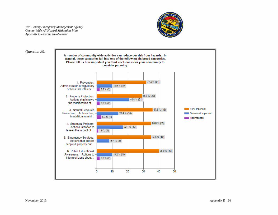
Will County Emergency Management Agency County-Wide All Hazard Mitigation Plan Appendix E – Public Involvement
November, 2013 Appendix E - 24
Question #9:
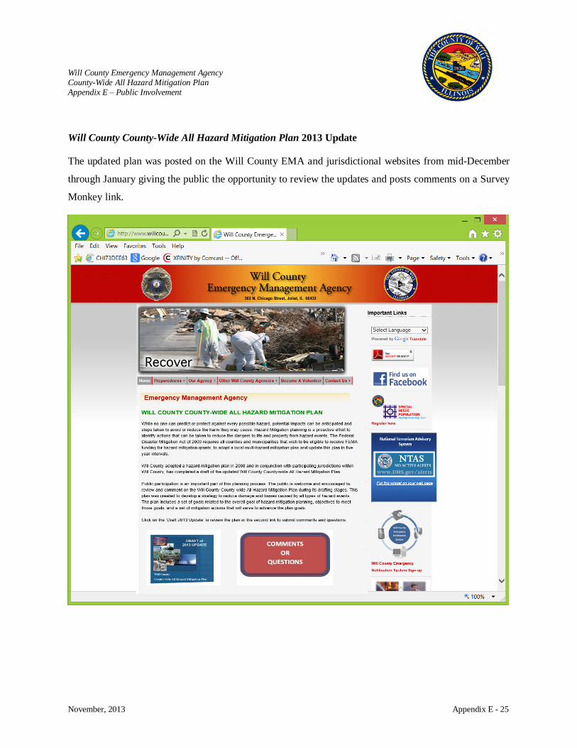
Will County Emergency Management Agency County-Wide All Hazard Mitigation Plan Appendix E – Public Involvement
November, 2013 Appendix E - 25
Will County County-Wide All Hazard Mitigation Plan 2013 Update
The updated plan was posted on the Will County EMA and jurisdictional websites from mid-December
through January giving the public the opportunity to review the updates and posts comments on a Survey
Monkey link.

Will County Emgergency Management Agency County-Wide All Hazard Mitigation Plan Appendix F – Updates to 2008 Will County-Wide All Hazard Mitigation Plan
November, 2013 Appendix F
APPENDIX F UPDATES TO 2008 Will County County-Wide All Hazard Mitigation Plan
Will County Emergency Management Agency County-Wide All Hazard Mitigation Plan Appendix F – Updates to 2008 Will County-Wide All Hazard Mitigation Plan
November, 2013 Appendix F - 1
UPDATES TO 2008 WILL COUNTY COUNTY-WIDE ALL HAZARD MITIGATION PLAN
The update of the 2008 Will County County-Wide All Hazard Mitigation Plan consisted of a review of the
data, hazards, and hazard incidents that have occurred over the last five years. The Will County Hazard
Mitigation Planning Committee reviewed, analyzed and commented on every section of the 2008 Plan.
Edits and comments were made to the introductory and profile sections. The Committee used Census
2010 data, where available, or the most current information in updating the demographics and land use in
Will County for the profile section. Upon review of the introductory and overview sections of the risk
assessment, the Committee decided to keep the same hazards in the 2008 Plan as no new hazards had
affected the area that were not considered in 2008. Occurrence and probability data was updated as part of
the plan’s risk assessment.
For the vulnerability assessment, critical facilities, building counts and losses were updated to reflect
changes over the past five years. The overall goals and objectives of the 2008 plan were reviewed and it
was determined that a number of the same objectives and goals would remain in the Plan Update. Plan
maintenance procedures were also reviewed and updated to reflect current changes in staff and
annual/bi‐annual meetings. A review of the mitigation actions by the Planning Committee was conducted
on the actions identified in the 2008 Plan and any amendments thereto and provided an analysis as to
whether each action is ongoing, has been completed or should be deleted from the Plan Update. A status
of each has been provided in the update.
The following factors were taken into consideration when reviewing the 2008 Plan:
• Whether the goals address current and expected conditions;
• If the nature/magnitude of risks have changed;
• If there are current resources appropriate for implementing the Plan;
• Whether implementation problems, such as technical, political, legal or coordination issues hinder
development;
• If outcomes have occurred as expected; and
• How communities, agencies and partners participated in the implementation process.

Will County Emergency Management Agency County-Wide All Hazard Mitigation Plan Appendix F – Updates to 2008 Will County-Wide All Hazard Mitigation Plan
November, 2013 Appendix F - 2
SUMMARY OF CHANGES IN WILL COUNTY COUNTY-WIDE ALL HAZARD MITIGATION PLAN
2008 AHHMP Updated AHHMP Summary of Changes
Executive Summary Executive Summary Updated to reflect plan updates and modified goals
Chapter 1 - Introduction Chapter 1 - Introduction Updated to reflect plan updates and addition of list of Federal Declarations
Chapter 2 – Will County Community Overview
Chapter 2 – Will County Community Overview
Updated community overview to reflect census data and community changes along with other pertinent community information
Chapter 3 – All Hazard Risk Assessment
Chapter 3 – All Hazard Risk Assessment Updated Historical Events
Chapter 4 – Hazard Profiles & Vulnerability Assessment
Chapter 4 – Hazard Profiles & Vulnerability Assessment
Updated data, historical events, maps, census material, watersheds and flood concerns, and other information as necessary
Chapter 5 – Mitigation Goals, Objectives, & Strategies
Chapter 5 – Mitigation Goals, Objectives, & Strategies
Updated to reflect modifications in goals, objectives, and mitigation actions made during workshops
Chapter 6 – Mitigation Actions Chapter 6 – Mitigation Actions Updated to reflect modifications in goals, objectives, and mitigation actions made during workshops
Chapter 7 – Mitigation Plan Maintenance
Chapter 7 – Mitigation Plan Maintenance
Minor updates made to reflect modifications in goals, objectives, and mitigation actions made during workshops
Appendices A through J Appendices A through F Incorporated pertinent information into the body of the plan
Representatives from Will County departments, local jurisdictions, and community partners came
together in workshops to review the 2008 Goals, Objectives, and Mitigation Actions developed to
determine current status of actions items, current needs, and changes within the counties communities.
The result of the workshops and update of these Goals, Objectives, and Mitigation Actions is summarized
in the following table.
Mitigation Success Stories
Will County endeavors to improve planning and implement effective mitigation actions for the safety of
the public it serves and for the development of an inviting and successful place to live, work, and play.

Will County Emergency Management Agency County-Wide All Hazard Mitigation Plan Appendix F – Updates to 2008 Will County-Wide All Hazard Mitigation Plan
November, 2013 Appendix F - 3
County and local jurisdictions have come together to develop and implement the mitigation actions
identified in the 2008 Will County County-Wide All Hazard Mitigation Plan. Progress is being made
daily with jurisdictions coming together to identify and address the identified issues. Highlights include:
Flood Mitigation
• County-Wide Stormwater Management Ordinance and plan were updated in 2010 and
supplemented with the Technical Guidance Manual for County-Wide Stormwater Ordinance.
The ordinance was adopted by all communities within Will County, with twenty-nine
communities meeting requirements to be delegated responsibilities for ordinance
enforcement.
• Property Buyouts of approximately $10.6 million have resulted with funding from the 1996
and 2008 flood mitigation grants. This allows the County and communities to implement
open space planning for areas in commercial and private developments with repetitive
flooding.
• With a common ordinance and planning guidance, sixty-one stormwater projects have been
identified and are being addressed by the WCSMPC.
• Flood Monitoring has improved as a result of the installation of additional stream gauges.
Jurisdictions works with the National Weather Service to utilize the data to anticipate
flooding issues and safeguard the public.
See tools developed with NWS and USGS:
− http://www.willcountylanduse.com/stormwater-management-planning-
committee/will-county-stream-and-rain-gages-0
− http://il.water.usgs.gov/ifhp/will
Collaborative Efforts
• The RCPGP has been an important initiative being several collaborative projects to the
County which include the development of plans for a regional hub that includes mass care
and evacuation elements, citizen preparedness through the GearUp!GetReady! Program,
regional assessment of capabilities and an all hazard risk assessment plan, logistics and
resource management planning, and animal sheltering projects.

Will County Emergency Management Agency County-Wide All Hazard Mitigation Plan Appendix F – Updates to 2008 Will County-Wide All Hazard Mitigation Plan
November, 2013 Appendix F - 4
• Participants from the IL-IN-WI CSA came together to participate in Whole Community
conferences that provided training and opportunities to discuss issues.
• WC EMA and local jurisdictions have been very active in the RCPGP program.
Training and Public Awareness
• NIMS training has been an important tool in promoting professional development in
emergency management throughout the County. Since 2009, thirteen people have obtained
or renewed their IPEM and eight people have received their CEM designation.
• Public education has increased with the use of websites, Facebook pages,newsletters, and
video/radio PSAs. WC EMA has implemented and supported a speaker’s bureau and county-
wide PIO group as outreach for public education.
• The WC EMA Public Preparedness Group and local jurisdictions are active in community
events for public education and utilize the RCPCP’s GearUp!Get Ready! Program.
GIS Use
• GIS is an important tool that is being integrated county-wide for planning, response, and
recovery activities. Upon receipt of the updated DFIRMS, additional floodplain
management projects will be implemented using this technology.
Storm Ready and Weather Radios
• The County has adopted the StormReady program and has encouraged local jurisdictions to
also participate. StormReady is a nationwide community preparedness program to help
community develop plans to handle all types of severe weather through the implementation
of guidelines that improve their hazardous weather operations.
• WC EMA has worked with the school districts to help them prepare for weather hazards and
has distributed 800 weather radios throughout the County as part of this program.
The following chart provides additional status reports on all of the 2008 Mitigation Actions along with
the plans for the 2013 Mitigation Actions.
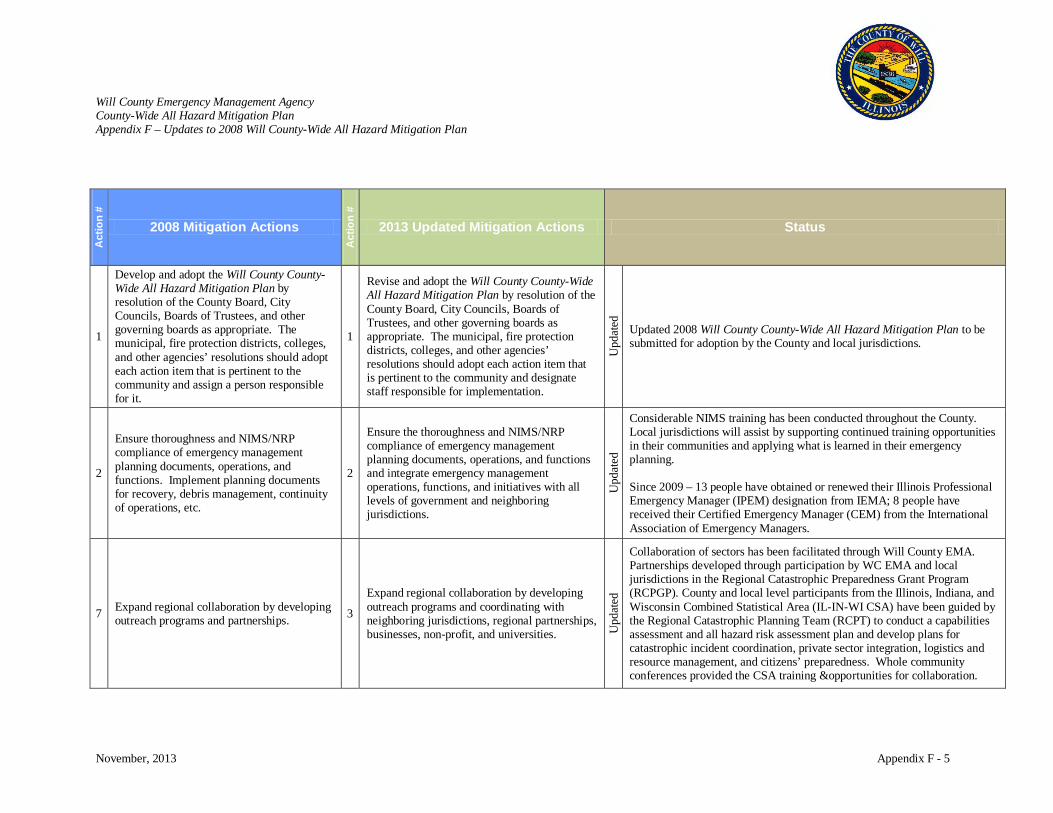
Will County Emergency Management Agency County-Wide All Hazard Mitigation Plan Appendix F – Updates to 2008 Will County-Wide All Hazard Mitigation Plan
November, 2013 Appendix F - 5
Act
ion
#
2008 Mitigation Actions
Act
ion
#
2013 Updated Mitigation Actions Status
1
Develop and adopt the Will County County-Wide All Hazard Mitigation Plan by resolution of the County Board, City Councils, Boards of Trustees, and other governing boards as appropriate. The municipal, fire protection districts, colleges, and other agencies’ resolutions should adopt each action item that is pertinent to the community and assign a person responsible for it.
1
Revise and adopt the Will County County-Wide All Hazard Mitigation Plan by resolution of the County Board, City Councils, Boards of Trustees, and other governing boards as appropriate. The municipal, fire protection districts, colleges, and other agencies’ resolutions should adopt each action item that is pertinent to the community and designate staff responsible for implementation.
Upd
ated
Updated 2008 Will County County-Wide All Hazard Mitigation Plan to be submitted for adoption by the County and local jurisdictions.
2
Ensure thoroughness and NIMS/NRP compliance of emergency management planning documents, operations, and functions. Implement planning documents for recovery, debris management, continuity of operations, etc.
2
Ensure the thoroughness and NIMS/NRP compliance of emergency management planning documents, operations, and functions and integrate emergency management operations, functions, and initiatives with all levels of government and neighboring jurisdictions.
Upd
ated
Considerable NIMS training has been conducted throughout the County. Local jurisdictions will assist by supporting continued training opportunities in their communities and applying what is learned in their emergency planning. Since 2009 – 13 people have obtained or renewed their Illinois Professional Emergency Manager (IPEM) designation from IEMA; 8 people have received their Certified Emergency Manager (CEM) from the International Association of Emergency Managers.
7 Expand regional collaboration by developing outreach programs and partnerships. 3
Expand regional collaboration by developing outreach programs and coordinating with neighboring jurisdictions, regional partnerships, businesses, non-profit, and universities. U
pdat
ed
Collaboration of sectors has been facilitated through Will County EMA. Partnerships developed through participation by WC EMA and local jurisdictions in the Regional Catastrophic Preparedness Grant Program (RCPGP). County and local level participants from the Illinois, Indiana, and Wisconsin Combined Statistical Area (IL-IN-WI CSA) have been guided by the Regional Catastrophic Planning Team (RCPT) to conduct a capabilities assessment and all hazard risk assessment plan and develop plans for catastrophic incident coordination, private sector integration, logistics and resource management, and citizens’ preparedness. Whole community conferences provided the CSA training &opportunities for collaboration.
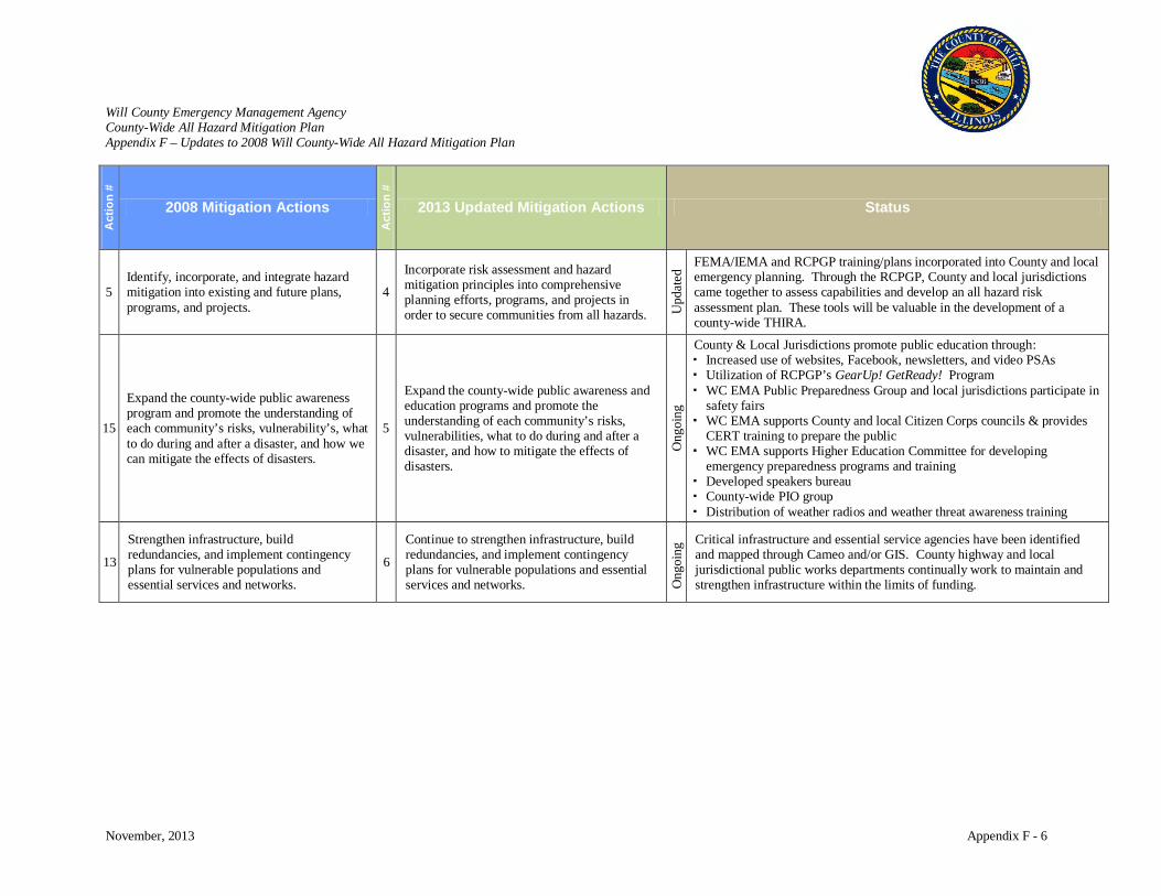
Will County Emergency Management Agency County-Wide All Hazard Mitigation Plan Appendix F – Updates to 2008 Will County-Wide All Hazard Mitigation Plan
November, 2013 Appendix F - 6
Act
ion
#
2008 Mitigation Actions
Act
ion
#
2013 Updated Mitigation Actions Status
5 Identify, incorporate, and integrate hazard mitigation into existing and future plans, programs, and projects.
4
Incorporate risk assessment and hazard mitigation principles into comprehensive planning efforts, programs, and projects in order to secure communities from all hazards. U
pdat
ed FEMA/IEMA and RCPGP training/plans incorporated into County and local
emergency planning. Through the RCPGP, County and local jurisdictions came together to assess capabilities and develop an all hazard risk assessment plan. These tools will be valuable in the development of a county-wide THIRA.
15
Expand the county-wide public awareness program and promote the understanding of each community’s risks, vulnerability’s, what to do during and after a disaster, and how we can mitigate the effects of disasters.
5
Expand the county-wide public awareness and education programs and promote the understanding of each community’s risks, vulnerabilities, what to do during and after a disaster, and how to mitigate the effects of disasters.
Ong
oing
County & Local Jurisdictions promote public education through: Increased use of websites, Facebook, newsletters, and video PSAs Utilization of RCPGP’s GearUp! GetReady! Program WC EMA Public Preparedness Group and local jurisdictions participate in
safety fairs WC EMA supports County and local Citizen Corps councils & provides
CERT training to prepare the public WC EMA supports Higher Education Committee for developing
emergency preparedness programs and training Developed speakers bureau County-wide PIO group Distribution of weather radios and weather threat awareness training
13
Strengthen infrastructure, build redundancies, and implement contingency plans for vulnerable populations and essential services and networks.
6
Continue to strengthen infrastructure, build redundancies, and implement contingency plans for vulnerable populations and essential services and networks. O
ngoi
ng Critical infrastructure and essential service agencies have been identified
and mapped through Cameo and/or GIS. County highway and local jurisdictional public works departments continually work to maintain and strengthen infrastructure within the limits of funding.

Will County Emergency Management Agency County-Wide All Hazard Mitigation Plan Appendix F – Updates to 2008 Will County-Wide All Hazard Mitigation Plan
November, 2013 Appendix F - 7
Act
ion
#
2008 Mitigation Actions
Act
ion
#
2013 Updated Mitigation Actions Status
24 & 29
Develop/expand existing training platforms to educate officials and communities on risks, fundamental operations of emergency management, and mitigation. And Support the advancement of the emergency management profession.
7
Continue to support the delivery of education for existing and free training platforms to educate officials, critical personnel, first responders, and communities on risks and vulnerabilities, fundamental operations of emergency management, and mitigation for the purpose of strengthening planning and advancing professional development.
Ong
oing
• Continue support of FEMA/IEMA training and encourage the pursuit of IPEM and CEM certification.
• Identify additional training that can be brought to the local level for professional development and used in developing more robust emergency plans.
• WC EMA supports Higher Education Committee for developing emergency preparedness programs & training
• JJC secured grant to develop/expand emergency preparedness plan, acquire emergency equipment, train staff, & conduct exercises
• Local jurisdictions are encouraged to identify/open facilities suitable for training purposes and encourage staff and community members to participate.
3 Relocate and/or harden critical facilities that are located within high-hazard areas. 8
Relocate and/or incorporate mitigation retrofits for critical facilities that are located within high-hazard areas. Ong
oing
Progress ongoing but limited by funding opportunities. Fire station located in floodplain area replaced with new station in new location. Awaiting updated DFIRMS (which are now being delayed until 2015) to accurately identify critical facilities in high hazard areas.
6 Support the use, development, and implementation of Geographic Information Systems (GIS) throughout the County.
9
Support the use, development, and implementation of Geographic Information Systems (GIS) throughout the County to track community vulnerability to hazards. O
ngoi
ng
GIS use continues to increase as progress is made in flood mapping and development of flood mitigation planning. More can be done once updated DFIRM maps are received. The use of GIS has been valuable during response and recovery efforts, such as during the April, 2013 flood and November, 2013 tornado. WC GIS has agreements with 28 communities, 20 townships, fire districts, park districts, & other tax districts & agencies. Three communities have established their own GIS departments.
31
Update base flood elevations (BFE) throughout the County in accordance with the FEMA Region V Map Modernization program.
10 Update base flood elevations (BFE) throughout the County in accordance with the Flood Hazard Mapping Program. O
ngoi
ng
Progress pending receipt of updated DFIRMS (2015 at earliest).
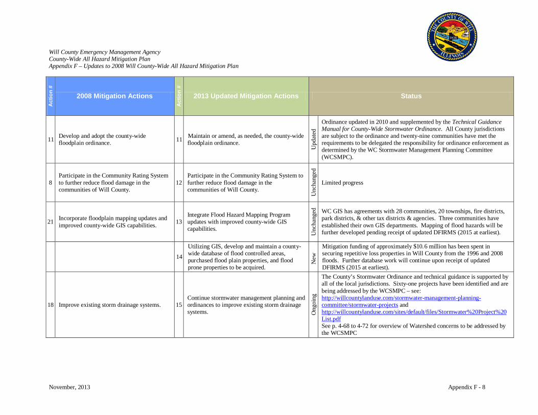
Will County Emergency Management Agency County-Wide All Hazard Mitigation Plan Appendix F – Updates to 2008 Will County-Wide All Hazard Mitigation Plan
November, 2013 Appendix F - 8
Act
ion
#
2008 Mitigation Actions
Act
ion
#
2013 Updated Mitigation Actions Status
11 Develop and adopt the county-wide floodplain ordinance. 11 Maintain or amend, as needed, the county-wide
floodplain ordinance.
Upd
ated
Ordinance updated in 2010 and supplemented by the Technical Guidance Manual for County-Wide Stormwater Ordinance. All County jurisdictions are subject to the ordinance and twenty-nine communities have met the requirements to be delegated the responsibility for ordinance enforcement as determined by the WC Stormwater Management Planning Committee (WCSMPC).
8 Participate in the Community Rating System to further reduce flood damage in the communities of Will County.
12 Participate in the Community Rating System to further reduce flood damage in the communities of Will County.
Unc
hang
ed
Limited progress
21 Incorporate floodplain mapping updates and improved county-wide GIS capabilities. 13
Integrate Flood Hazard Mapping Program updates with improved county-wide GIS capabilities.
Unc
hang
ed
WC GIS has agreements with 28 communities, 20 townships, fire districts, park districts, & other tax districts & agencies. Three communities have established their own GIS departments. Mapping of flood hazards will be further developed pending receipt of updated DFIRMS (2015 at earliest).
14
Utilizing GIS, develop and maintain a county-wide database of flood controlled areas, purchased flood plain properties, and flood prone properties to be acquired.
New
Mitigation funding of approximately $10.6 million has been spent in securing repetitive loss properties in Will County from the 1996 and 2008 floods. Further database work will continue upon receipt of updated DFIRMS (2015 at earliest).
18 Improve existing storm drainage systems. 15 Continue stormwater management planning and ordinances to improve existing storm drainage systems. O
ngoi
ng
The County’s Stormwater Ordinance and technical guidance is supported by all of the local jurisdictions. Sixty-one projects have been identified and are being addressed by the WCSMPC – see: http://willcountylanduse.com/stormwater-management-planning-committee/stormwater-projects and http://willcountylanduse.com/sites/default/files/Stormwater%20Project%20List.pdf See p. 4-68 to 4-72 for overview of Watershed concerns to be addressed by the WCSMPC
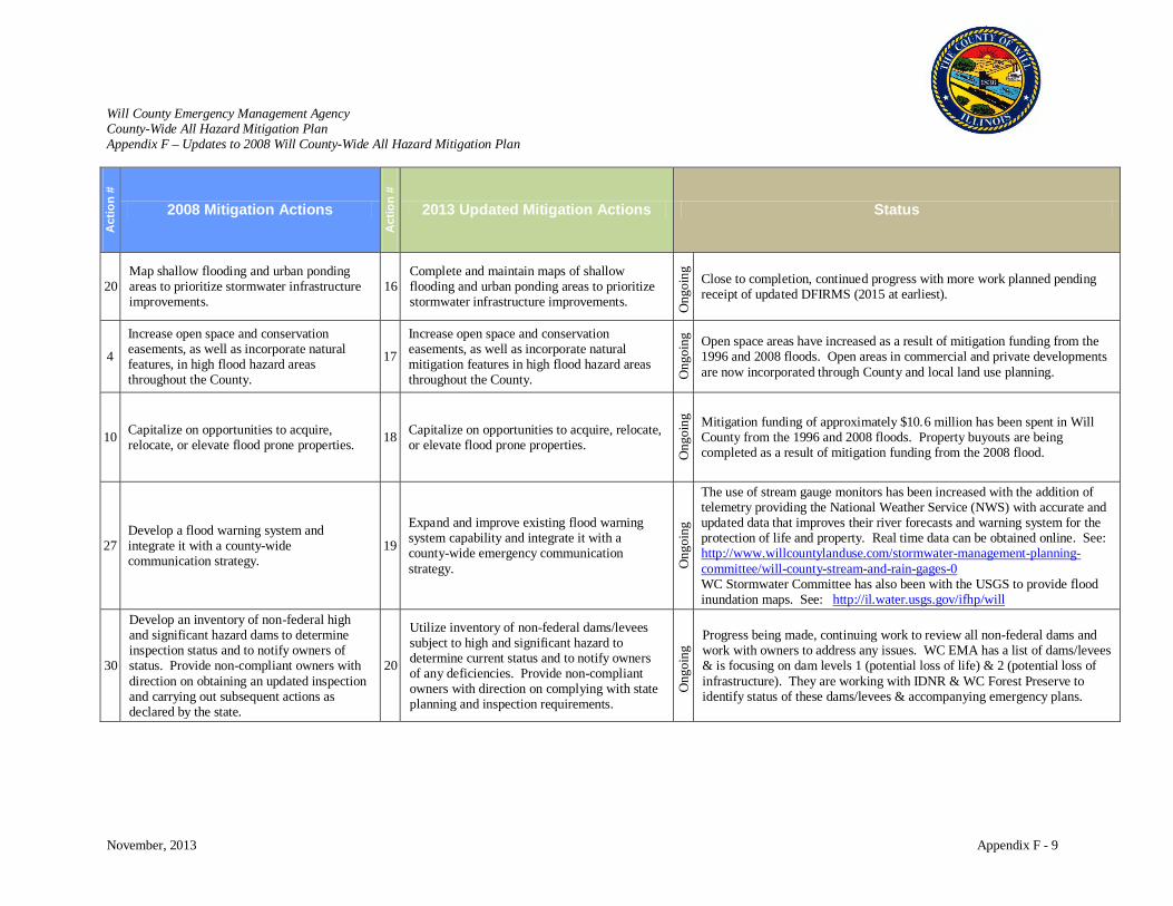
Will County Emergency Management Agency County-Wide All Hazard Mitigation Plan Appendix F – Updates to 2008 Will County-Wide All Hazard Mitigation Plan
November, 2013 Appendix F - 9
Act
ion
#
2008 Mitigation Actions
Act
ion
#
2013 Updated Mitigation Actions Status
20 Map shallow flooding and urban ponding areas to prioritize stormwater infrastructure improvements.
16 Complete and maintain maps of shallow flooding and urban ponding areas to prioritize stormwater infrastructure improvements. O
ngoi
ng
Close to completion, continued progress with more work planned pending receipt of updated DFIRMS (2015 at earliest).
4
Increase open space and conservation easements, as well as incorporate natural features, in high flood hazard areas throughout the County.
17
Increase open space and conservation easements, as well as incorporate natural mitigation features in high flood hazard areas throughout the County. O
ngoi
ng
Open space areas have increased as a result of mitigation funding from the 1996 and 2008 floods. Open areas in commercial and private developments are now incorporated through County and local land use planning.
10 Capitalize on opportunities to acquire, relocate, or elevate flood prone properties. 18 Capitalize on opportunities to acquire, relocate,
or elevate flood prone properties.
Ong
oing
Mitigation funding of approximately $10.6 million has been spent in Will County from the 1996 and 2008 floods. Property buyouts are being completed as a result of mitigation funding from the 2008 flood.
27 Develop a flood warning system and integrate it with a county-wide communication strategy.
19
Expand and improve existing flood warning system capability and integrate it with a county-wide emergency communication strategy. O
ngoi
ng
The use of stream gauge monitors has been increased with the addition of telemetry providing the National Weather Service (NWS) with accurate and updated data that improves their river forecasts and warning system for the protection of life and property. Real time data can be obtained online. See: http://www.willcountylanduse.com/stormwater-management-planning-committee/will-county-stream-and-rain-gages-0 WC Stormwater Committee has also been with the USGS to provide flood inundation maps. See: http://il.water.usgs.gov/ifhp/will
30
Develop an inventory of non-federal high and significant hazard dams to determine inspection status and to notify owners of status. Provide non-compliant owners with direction on obtaining an updated inspection and carrying out subsequent actions as declared by the state.
20
Utilize inventory of non-federal dams/levees subject to high and significant hazard to determine current status and to notify owners of any deficiencies. Provide non-compliant owners with direction on complying with state planning and inspection requirements.
Ong
oing
Progress being made, continuing work to review all non-federal dams and work with owners to address any issues. WC EMA has a list of dams/levees & is focusing on dam levels 1 (potential loss of life) & 2 (potential loss of infrastructure). They are working with IDNR & WC Forest Preserve to identify status of these dams/levees & accompanying emergency plans.

Will County Emergency Management Agency County-Wide All Hazard Mitigation Plan Appendix F – Updates to 2008 Will County-Wide All Hazard Mitigation Plan
November, 2013 Appendix F - 10
Act
ion
#
2008 Mitigation Actions
Act
ion
#
2013 Updated Mitigation Actions Status
14 Build and improve existing shelters in public spaces and high risk locations. 21
Encourage & support shelters for all types of hazards in public spaces and high risk locations. O
ngoi
ng
WC EMA continues to work with the American Red Cross to update and develop community shelters. WC EMA, WC Regional Office of Education, and WC Sheriff’s Office work collaboratively to maintain ARC agreements, shelter profiles, and site maps. Other facilities are identified for warming/cooling centers. Local jurisdictions will focus on integrating shelters into new construction where possible.
9 & 19
Target regulatory, development, and preparedness efforts of Tier II hazardous material facilities. And Encourage communities located in areas at high-risk to a hazardous materials release to develop, maintain, and update emergency plans with cooperation from commercial and industrial facilities.
22
Target regulatory, development, and preparedness efforts of Tier II hazardous material facilities and coordinate the development and maintenance of applicable community and facility emergency plans. O
ngoi
ng
Ongoing progress with the support of the Will County Local Emergency Planning Committee (LEPC). Will County has an active LEPC composed of state and local officials, fire, police, emergency management, emergency medical service, hospitals, media, and industry. The function of the WC LEPC is to develop emergency plans to protect the public in the event of chemical accidents and to communicate these plans to the public. The LEPC works closely with industry and includes industry representatives with their primary goal being to protect the public. The Risk Management Plan information for each facility has been woven into the LEPCs Comprehensive Chemical Contingency Plan to increase our effectiveness. Tier II facilities are mapped in Cameo.
25
Encourage the development of continuity planning for jurisdictions and the largest employers and companies headquartered in the County.
23 Encourage the development of continuity planning for both public and private sectors.
Ong
oing
Ongoing progress requiring professional development of County and local emergency planners and collaboration with governing and private sector partners.
28 Develop a drought contingency plan that identifies and incorporates water saving measures.
24
Develop a drought contingency plan that educates the public on water saving techniques and identifies criteria/triggers for drought related actions. U
ncha
nged
Limited progress
16
Develop a “Post-Disaster Recovery” ordinance and planning document to prepare a community for an orderly recovery operation.
25 Develop a “Post-Disaster Recovery” ordinance and planning document to prepare a community for an orderly recovery operation.
Unc
hang
ed
Limited progress
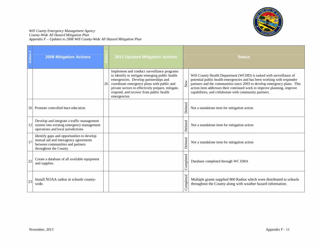
Will County Emergency Management Agency County-Wide All Hazard Mitigation Plan Appendix F – Updates to 2008 Will County-Wide All Hazard Mitigation Plan
November, 2013 Appendix F - 11
Act
ion
#
2008 Mitigation Actions
Act
ion
#
2013 Updated Mitigation Actions Status
26
Implement and conduct surveillance programs to identify or mitigate emerging public health emergencies. Develop partnerships and coordinate emergency plans with public and private sectors to effectively prepare, mitigate, respond, and recover from public health emergencies.
New
Will County Health Department (WCHD) is tasked with surveillance of potential public health emergencies and has been working with responder partners and the communities since 2003 to develop emergency plans. This action item addresses their continued work to improve planning, improve capabilities, and collaborate with community partners.
26 Promote controlled burn education
Del
eted
Not a standalone item for mitigation action
12 Develop and integrate a traffic management system into existing emergency management operations and local jurisdictions
Del
eted
Not a standalone item for mitigation action
17
Identify gaps and opportunities to develop mutual aid and interagency agreements between communities and partners throughout the County.
Del
eted
Not a standalone item for mitigation action
22 Create a database of all available equipment and supplies.
Com
plet
ed
Database completed through WC EMA
23 Install NOAA radios in schools county-wide.
C
ompl
eted
Multiple grants supplied 800 Radios which were distributed to schools throughout the County along with weather hazard information.
Related Documents