1 Wilderness Trip Planner This guide is intended to help you with planning your overnight wilderness adventure, and to help with understanding and supporting the mission of the National Park Service: “…to conserve the scenery and the natural and historic objects and the wild life therein and to provide for the enjoyment of the same in such manner and by such means as will leave them unimpaired for the enjoyment of future generations.” -The National Park Service Organic Act It is with this idea of preservation for future generations that we ask you to review and follow the guidelines and restrictions in this document. General Park Information 47050 Generals Highway Three Rivers, CA 93271 559-565-3341 www.nps.gov/seki Wilderness Information 47050 Generals Highway #60 Three Rivers, CA 93271 559-565-3766 www.nps.gov/seki/planyourvisit /wilderness.htm In Case of Emergency Dial 911 from any pay phone inside the parks or call the 24-hour emergency park dispatch center 559-565-3195. What’s Inside: General Park Contact Information………………………………….. 1 What Is “Wilderness”? ……………………………………………... 2 Minimum Impact Restrictions………………………………............ 3 Group-Size Limits When Off Maintained Trails…………………… 5 Trail Overview Map………………………………………………… 6 Trails: Cedar Grove/Road’s End Area……………………………… 7 Trails: Grant Grove (NPS) & Big Meadows Area (USFS)…………. 8 Trails: Lodgepole/Giant Forest Area……………………………….. 9 Trails: Foothills Area……………………………………………….. 10 Trails: Mineral King Area…………………………………………... 11 Iconic Hikes: Mt. Whitney, JMT, & PCT…………………………... 12 Wilderness Permits…………….…………………………………… 13 Leave No Trace……………………………………………………... 17 Food Storage & Bears……………………….……………………… 18 Food-Storage Box Locations..…………………………………… 20 Fire In The Wilderness……………………………………………… 22 Mountain Lions & Big Horn Sheep………………………………… 23 Safety In The Wilderness…………………………………………… 24 Hiking Etiquette…………………………………………………….. 28 Fishing & Pets………………………………………………………. 29 Stock Use…………………………………………………………… 29 Military Over-Flights……………………………………………….. 29 Archaeology………………………………………………………… 30 Working In The Wilderness………………………………………… 30 Books……………………………………………………………….. 31 Maps………………………………………………………………… 31 Web Links…………………………………………………………... 32 Parting Words………………………………………………………. 32 “The mountains are calling and I must go” – John Muir

Welcome message from author
This document is posted to help you gain knowledge. Please leave a comment to let me know what you think about it! Share it to your friends and learn new things together.
Transcript

1
Wilderness Trip Planner This guide is intended to help you with planning your overnight wilderness adventure, and to help with understanding and supporting the mission of the National Park Service:
“…to conserve the scenery and the natural and historic objects and the wild life therein and to provide for the enjoyment of the same in such manner and by such means as will leave them unimpaired for the enjoyment of future generations.”
-The National Park Service Organic Act
It is with this idea of preservation for future generations that we ask you to review and follow the guidelines and restrictions in this document.
General Park Information 47050 Generals Highway Three Rivers, CA 93271 559-565-3341www.nps.gov/seki
Wilderness Information 47050 Generals Highway #60 Three Rivers, CA 93271 559-565-3766www.nps.gov/seki/planyourvisit/wilderness.htm
In Case of Emergency Dial 911 from any pay phone inside the parks or call the 24-hour emergency park dispatch center 559-565-3195.
What’s Inside:
General Park Contact Information………………………………….. 1 What Is “Wilderness”? ……………………………………………... 2 Minimum Impact Restrictions………………………………............ 3 Group-Size Limits When Off Maintained Trails…………………… 5 Trail Overview Map………………………………………………… 6 Trails: Cedar Grove/Road’s End Area……………………………… 7 Trails: Grant Grove (NPS) & Big Meadows Area (USFS)…………. 8 Trails: Lodgepole/Giant Forest Area……………………………….. 9 Trails: Foothills Area……………………………………………….. 10 Trails: Mineral King Area…………………………………………... 11 Iconic Hikes: Mt. Whitney, JMT, & PCT…………………………... 12 Wilderness Permits…………….…………………………………… 13 Leave No Trace……………………………………………………... 17 Food Storage & Bears……………………….……………………… 18 Food-Storage Box Locations..…………………………………… 20 Fire In The Wilderness……………………………………………… 22 Mountain Lions & Big Horn Sheep………………………………… 23 Safety In The Wilderness…………………………………………… 24 Hiking Etiquette…………………………………………………….. 28 Fishing & Pets………………………………………………………. 29 Stock Use…………………………………………………………… 29 Military Over-Flights……………………………………………….. 29 Archaeology………………………………………………………… 30 Working In The Wilderness………………………………………… 30 Books……………………………………………………………….. 31 Maps………………………………………………………………… 31 Web Links…………………………………………………………... 32 Parting Words………………………………………………………. 32
“The mountains are calling and I must go” – John Muir

2
Find a Park Experience Find Your Park is about more than just national parks! It's about the National Park Service working in your community through education programs, community assistance projects, and more. It's about state parks, local parks, trails, museums, historic sites, and the many ways that the American public can connect with history and culture, enjoy nature, and make new discoveries.
Join us at: http://www.findyourpark.com/
Wilderness with a Capital "W" In 1964, with the passage of the Wilderness Act, Congress established the National Wilderness Preservation System to protect some of the nation’s most wild, natural and undisturbed landscapes. As defined by the Act, "wilderness, in contrast with those areas where man and his own works dominate the landscape, is hereby recognized as an area where the earth and its community of life are untrammeled by man, where man himself is a visitor who does not remain." There are now more than 750 designated wilderness areas in nearly every state and Puerto Rico.
Sequoia and Kings Canyon Wilderness Today In 1984, the California Wilderness Act designated over 85% of Sequoia and Kings Canyon National Parks as the Sequoia-Kings Canyon Wilderness. This gave 722,983 acres the nation’s highest legal protection from development or abuse. Congress designated an additional area, the 39,967 acre John Krebs Wilderness, and added 45,129 acres to the Sequoia-Kings Canyon Wilderness with passage of the Omnibus Public Land Management Act of 2009. Today, 808,078 acres or 93.3% of Sequoia and Kings Canyon National Parks is designated wilderness, and another 30,000 acres (3.5%) in the parks are managed as wilderness per National Park Service policy.
Almost completely surrounded by US Forest Service-managed wilderness, the wilderness units of Sequoia and Kings Canyon National Parks are part of the second largest contiguous wilderness complex in the lower 49 states.

3
Minimum Impact Restrictions Terms and Conditions of Wilderness Permit
GENERAL TRAVEL REQUIREMENTS
• Wilderness permits are required for all overnight travel.• A signed permit must be in the permittee’s possession and must be presented to an authorized person upon request.• To prevent erosion and preserve vegetation, do not short-cut trails.• Do not build rock cairns or other trail markers.• Pets are not allowed in the wilderness.• Pack out all trash, including toilet paper.• All wheeled vehicles and all motorized equipment are prohibited in wilderness per the Wilderness Act of 1964.• Discharge of any firearm or weapon is prohibited. Possession of weapons, including bear spray, is prohibited. Possession of firearms is
subject to state regulationsPARTY SIZE LIMITS
• Maximum party size is 15 people on-trail; 12 people off-trail, and in these specific areas the limit is 8 people off-trail:Colony Mill Road Trail; Darwin Canyon/Lamarck Col (includes Class 1 area); Don Cecil Trail; Dusy Basin;Mt. Whitney Management Area/Mt. Langley (includes Class 1area); Sixty Lake Basin; and Sphinx Lakes
• “Off-trail” is ½ mile from a maintained trail for overnight use, and 100 yards from a maintained trail for day use areas.• Affiliated groups may not travel or camp within ½ mile of each other if the total group size exceeds the limits described above.• If traveling with stock separate restrictions apply, please inform ranger if traveling with stock for more information.
CAMPSITE SELECTION• Camp as far from water as possible, never camp within 25 feet of water. Always try to camp further than 100 feet from water.• Camping within 25 feet of water is only allowed in previously well-established campsites.• Camp on durable surfaces (rock, sand, dirt, snow, etc.) Do not camp on vegetation or in meadows. Use previously impacted areas.• Do not construct rock walls, dig trenches, make new fire rings (or add rocks to existing fire rings), bough beds or camp furniture.• Do not camp before reaching the first camping area for your specific trailhead, a list of these can be found in the wilderness trip planner.
Area Specific Camping Restrictions:Lakes Trail -No camping at Aster Lake or Heather Lake-Camp only in designated sites at Pear and Emerald Lakes.-3 night limit (combined)
Eagle/Mosquito Trails -No camping between the trail and Eagle Lake-No camping within ¼ mile of first Mosquito Lake Atwell/Hockett Trail-No camping between the trail and Whitman CreekColumbine Lake-No camping within 100 feet of the lake
High Sierra Trail -Camp only in designated sites at Bearpaw Meadow-One night camping limit at Hamilton Lakes
Rae Lakes Loop area -Camp only in designated sites in Lower Paradise Valley-Two night camping limit in Paradise Valley-One night camping limit per lake between Dollar Lake
and Glen Pass-No camping within ¼ mile of Bullfrog Lake-Two night camping limit at Charlotte and Kearsarge Lakes and
Along JMT from Woods Creek Crossing to Vidette Meadow
Redwood Canyon and other Kings Trails Don Cecil Trail, Dusy Basin (basin-wide), North Dome -Two night camping limit-10 person party size limit in Redwood Canyon
Camping will be allowed in specific areas close to the front country (e.g., Colony Mill Trail, Don Cecil Trail, and North Dome) Camping is prohibited on these trails prior to the listed first-camp locations. Please call the wilderness office for more information
Mt. Whitney/Crabtree area -No camping at Timberline Lake-3 night camping limit at Lower and Upper Soldier Lakes-2 night camping limit at Crabtree/ Whitney Creek area and Guitar lake
SANITATION • Human waste must be buried at least 6” deep and 100 ft. from trails, camps, and all water sources. Pack out used toilet paper.• All soap, including biodegradable soap, should be used and disposed of away from water sources. Carry water 100 ft. from the source before
washing. This includes washing clothes, dishes, and yourself.ADDITIONAL SAFETY RECOMMENDATIONS
Wilderness is a place where self-reliance and preparedness is essential. Be prepared for a wide variety of hazardous situations.
• Many wilderness illnesses are attributable to poor hygiene. Wash your hands often.• We recommend that you boil, treat, or filter drinking water.• Before setting up camp carefully look for dead or dying trees, trees with dead branches or leaning trees. Do not camp under dead or dying
trees, trees that are leaning or have dead branches.• Drowning is a leading cause of death in National Parks. Be extremely cautious when considering crossing rivers, wading or swimming. Cold

4
water, swift currents and unstable footing contribute to making swimming and wading dangerous and potentially deadly. FOOD STORAGE RESTRICTIONS
Properly store food items when not in use to prevent bears and other wildlife from becoming conditioned to human food. Report any wildlife-related injuries, property damage, or unusual encounters to a ranger.
Food items include: any food meant for human or pack stock consumption; food-tainted garbage, recyclables and trash, such as empty cans, bottles, or food wrappers; any equipment with food residue or odor; toiletries such as soap, toothpaste, ointments, and lotions.
The only proper food storage methods are: using an allowed portable animal-resistant food-storage container; using a permanent animal-resistant food-storage box; or using the counter-balance hanging technique. When camping in an area without food storage boxes or adequate trees for hanging food, you must carry an animal-resistant food-storage container.
Other food storage requirements: • Portable park-allowed animal-resistant food-storage containers are required for storing all food items in the following areas:North Dome, Rae Lakes Loop (including the Woods Creek drainage south from Pinchot Pass, the Bubbs Creek drainage north of ForesterPass, and the Kearsarge Lakes area), Dusy Basin/Bishop Pass Corridor, Rock Creek Drainage, Pear and Emerald Lakes.• Food-storage boxes are for immediate on-site use only. Caching food or gear within food-storage boxes is prohibited.• All food items must be removed from your car and stored in the food-storage boxes at the trailhead including containers such as ice chestsunless they are completely empty and free of all food residue.
CAMPFIRE RESTRICTIONS Note that during times of high fire danger, additional campfire restrictions may be implemented. Campfire restrictions also apply to the use of wood-burning camp stoves. (E.g. Biolite or “Zip stoves”)
Kings Canyon National Park
Sequoia National Park Kaweah and Tule River Drainages (West of the Great Western Divide)
Sequoia National Park Kern River Drainage
(E. of the Great Western Divide)
-No fires above 10,000 ft.-No Fires in Granite Basin-No fires in Redwood
Canyon
-No fires above 9,000 ft.-No fires at Pinto Lake-No fires in Summit Lake Basin-No fires in the Dillonwood area
-No fires in Hamilton Lakes Basin
-No fires in Mineral King Valley above the ranger station
-No fires above 10,000 ft.
Other campfire requirements: • Where fires are allowed, use existing fire rings. Do not build new ones or add rocks to existing fire rings.• Use only dead wood found on the ground. Do not chop live vegetation or remove dead branches from standing trees.• Fires must be attended at all times.• Do not burn trash. (Plastic and foil must be carried out)• Put out fires with water ½ hour before leaving your campsite and stir the ashes. Do not use dirt to put out fires.
SEARCH AND RESCUE POLICY Search and rescue actions are conducted on a discretionary basis. The level and necessity of the response is determined through evaluation of the situation by field personnel. Rescuer safety is always our first priority. These parks expect visitors to exhibit a high degree of self-reliance and responsibility for their own safety commensurate with the difficulty of their chosen activities. The higher risk the activity, the more you need to be prepared for dealing with emergency situations.
If you choose to carry a hand-held electronic signaling device, be familiar with its operation, limitations, and frequency of failure to transmit. Do not rely on it to summon rescue personnel or notify family you are “OK.”
If you find yourself in a true emergency, and have exhausted all means of self-rescue/help, contact a ranger in the field or call Park Dispatch at 559-565-3195. There is little to no cell reception in most areas of these parks. When you make contact, provide clear, concise information regarding thenature and exact location of the problem or injury, as well as the number of people involved. Be aware that help may be several days out.Be prepared to help yourself.
I have read and understand the above policies and assure that all party members will comply:
Group Leader Signature: Date:
NPS/USFS Permit Issuer Signature: Date:
WILDERNESS INFORMATION Feel free to contact us after your trip to report conditions or ask questions. 559-565-3766
Sequoia and Kings Canyon National Parks, Wilderness Office
47050 Generals Hwy #60 Three Rivers, CA 93271
www.nps.gov/seki/planyourvisit/wilderness.htm EXPERIENCE YOUR AMERICA™

5
Group-Size Limits When Off Maintained TrailsAs more large groups have ventured off developed trails, impacts have increased, including trampling of vegetation and erosion. Groups traveling ½ mile or more off maintained trails are limited to no more than 12 individuals and 12 stock with no more than 14 combined. Except in areas with specific lower limits (see below)
• Redwood Canyon: Maximum of 10 people 10 stock• Colony Mill Road Trail; Darwin Canyon / Lamarck Col (includes Class 1 trail area); Don Cecil Trail; Dusy Basin;
Mount Whitney Management Area / Mount Langley (includes Class 1 trail area); Sixty Lake Basin; and SphinxLakes: Maximum of 8 people
• Sixty Lake Basin: Combined party size of 8 (people and stock) for day rides into Sixty Lake Basin. Trail closed tostock beyond a point 1.8 miles from the junction of the JMT and the Sixty Lake Basin Trail.
• Miter Basin above Penned Up Meadow: Combined party size of 8 (people and stock) for day rides on the Class 1 trailinto Miter Basin.

6
Trail OverviewFrom oak woodlands to granite peaks, the trails of Sequoia and Kings Canyon National Parks offer many wilderness travel options for any season. Snowshoes or skis make winter travel easier and good hiking boots usually suffice for the rest of the year. Within the parks, trails start from five major geographic areas: Cedar Grove/Roads End, Grant Grove, Lodgepole/Giant Forest, Foothills (Middle, South, and North Fork of the Kaweah River), and the Mineral King area. Trails also enter the parks from Inyo National Forest to the east, Sequoia National Forest to the south and west, and Sierra National Forest to the north and west. The trails described in this planner are merely the beginnings of an extensive network. Nearly 750 miles of maintained trails plus endless cross-country routes wind through the parks. Be sure to grab a detailed map and plan to take a day, a week, or a lifetime to explore. Information about purchasing maps and guidebooks is on page 31.
1
2 3
4
8
7
6 5
10
9
11
12
18
17 16
15
14
13
19 20 21
23 22
24
25
The trail numbers on this map arefor reference only within this planner. Use these numbers to find more information on pages 5-9.

7
Cedar Grove/Road’s End • Advanced reservations only, no walk ups available. All permits will be issued by email.• Trailhead numbers correspond to the map on page 6.• Abbreviations: JMT = John Muir Trail, PCT = Pacific Crest Trail.
Trail #
Trail Name Daily Entry Quota
Destination(s) First Camping Area
Trailhead & High Point Elevations
USGS 7.5" Map(s)
1 Lewis Creek 25 people
Frypan Meadow, Kennedy Pass
4 miles to Comb Creek
4,000' & 10,820' at Kennedy Pass
Cedar Grove, Slide Bluffs
Leaves from Lewis Creek. Hot, strenuously steep, few people. Plan to start early in the day. Access to Grizzly Lakes, Kennedy Lakes, and Kennedy Canyon. Trail through Kennedy Canyon is faint and should be treated as a cross-country route. The Lewis Creek drainage showcases recent fire ecology. No campfires above 10,000 ft. ---------------------------------------------------------------------------------------------------------------------------------------------------------------- 2 Copper Creek 20
people Granite Basin & Lake
4.4 miles to Lower Tent Meadow
5,000' & 10,673' at Granite Pass
The Sphinx, Marion Peak
Leaves from Road’s End. Hot and steep. Plan to start early in the day. Access to Granite Basin, Granite Lake, Volcanic Lakes, State Lakes, and Middle Fork of the Kings River. No campfires in Granite Basin or above 10,000 ft. ---------------------------------------------------------------------------------------------------------------------------------------------------------------- 3 Woods Creek 25
people Paradise Valley, Rae Lakes Loop
6.5 miles to Lower Paradise Valley
5,000' & 11,978 at Glen Pass
The Sphinx, Mt. Clarence King
Leaves from Road’s End. Start of the very popular Rae Lakes Loop, in the easier clockwise direction. Dramatic and diverse. Steady, moderate climb. Access to the JMT/PCT. Two-night camping limit for Paradise Valley, Charlotte Lake, Kearsarge Lakes, and one night camping limit per lake in the Rae Lakes area (from Dollar Lake to Glen Pass). No campfires above 10,000 ft. Animal-resistant food-storage containers required. Popular trail with many people at any given time. ---------------------------------------------------------------------------------------------------------------------------------------------------------------- 4 Bubbs Creek 25
people East lake, Rae Lakes Loop
4 miles to Sphinx Creek
5,000' & 11,978' at Glen Pass
The Sphinx, Mt. Clarence King
Leaves from Road’s End. Start of the popular Rae Lakes Loop, in the more strenuous counter-clockwise direction. Dramatic and diverse. Steep and strenuous to Sphinx Creek, then steady and moderate climb. Access to East Lake at Junction meadow. Access to the JMT/PCT at Vidette Meadow. Two-night camping limit at Charlotte Lake, Kearsarge Lakes, and one-night camping limit at each lake in the Rae Lakes area. No campfires above 10,000 ft. Animal-resistant food-storage containers required. Popular trail with many people at any given time.
You may encounter "Drift Fences" in the wilderness. These fences are utilized to keep stock (horses, mules, and llamas) from roaming freely or impacting ecologically sensitive areas. Each fence has either a sliding pole or swinging gate across the trail for visitors to pass through. Please close all gates behind you to protect wilderness resources.

8
Grant Grove & Jennie Lakes Wilderness Area (US Forest Service)
• Advanced reservations only, no walk ups available.All permits will be issued by email.
# Entry Quota
• Trailhead numbers correspond to the map on page 6.
Trail Trail Name Daily Destination(s) First CampingArea(In Park)
Trailhead & High Point Elevations
USGS 7.5" Map(s)
5 Redwood Canyon 15 people
Redwood Canyon, Big Springs
1 mile to Redwood Creek
6,200' & 7,000' on Redwood Mtn.
General Grant Grove
Leaves from the Redwood Saddle. Relatively easy trail through one of the largest sequoia groves. Two 6.5-mile loops can be combined. Maximum group size is 10 people. Two-night camping limit. No campfires. ---------------------------------------------------------------------------------------------------------------------------------------------------------------- 6 Sugarloaf 25
people Sugarloaf Valley, Roaring River
3.8 miles to Parks’ Boundary*
7,925' & 9,200' near Pond Mdw.
Mt. Silliman, Sphinx Lakes
Leaves from the Big Meadows Road (USFS). Moderate. Forests, creeks, meadows, glaciated canyons. Access from the Big Meadows Road to the Marvin Pass trailhead or the Sunset Meadow trailhead. No campfires above 10,000 ft in Kings Canyon. ---------------------------------------------------------------------------------------------------------------------------------------------------------------- 7 Belle Canyon 25
people Seville, Lost, & Ranger Lakes
4.4 miles to Parks’ Boundary*
7,925' & 9,120' at unnamed saddle
Muir Grove, Mt. Silliman
Leaves from the Big Meadows Road (USFS). Moderate. Forests, lakes, vistas. Combine with the JO Pass Trail for a loop option through Jennie Lakes Wilderness. No campfires above 10,000 ft. in Kings Canyon National Park. No campfires above 9,000 ft. in the Kaweah River drainage of Sequoia National Park. ---------------------------------------------------------------------------------------------------------------------------------------------------------------- 8 JO Pass 15
people Twin Lakes Clover Creek, Cahoon Gap
6.5 miles to Parks’ Boundary*
7,925' & 9,414' at JO Pass Muir Grove, Mt. Silliman
Leaves from the Big Meadows Road (USFS). Moderate. Forests, lakes, vistas. Combine with the Belle Canyon Trail for a loop option through Jennie Lakes Wilderness. No campfires above 10,000 ft. in Kings Canyon National Park. No campfires above 9,000 ft. in the Kaweah River drainage of Sequoia National Park.
Special Note for Jennie Lakes Wilderness, Sequoia National Forest (USFS) If you access Sequoia and Kings Canyon National Parks through the Jennie Lakes Wilderness (via trail #’s 6, 7, or 8) you are subject to the daily entry quota based on where you spend your first night in the national parks. If you camp only in the Jennie Lakes Wilderness and never camp in the national parks, you do not need a wilderness permit. The Sequoia National Forest only requires a fire permit, which is available at www.preventwildfireca.org. The forest service requires a fire permit for both campfires and camp stoves. For more questions about Sequoia National Forest areas call (559) 338-2251. *Hikers may camp at Rowell Meadow before reaching the parks boundary on Sugarloaf, Belle Canyon or J.O. Pass trail. Rowell Meadow isin the Jennie Lakes Wilderness 2 miles from the trailhead.
You may encounter "Drift Fences" in the wilderness. These fences are utilized to keep stock (horses, mules, and llamas) from roaming freely or impacting ecologically sensitive areas. Each fence has either a sliding pole or swinging gate across the trail for visitors to pass through. Please close all gates behind you to protect wilderness resources.

9
Lodgepole/Giant Forest Area Trails Permits are self-issued at Giant Forest Museum during the winter months.
• Advanced reservations only, no walk ups available. All permits will be issued by email.•
# Entry Quota
• Trailhead numbers correspond to the map on page 6.Trail Trail Name Daily Destination(s) First Camping
Area Trailhead & High Point Elevations
USGS 7.5" Map(s)
9 Twin Lakes 30 people
Twin Lakes 3 miles to Cahoon Meadow
6,700' & 10,160' at Silliman Pass
Mt. Silliman, Lodgepole
Leaves from Lodgepole Campground area. Moderately steep. Forests, meadows, lakes. Connect with trail #'s 6, 7, and/or 8 to make a lollipop loop. No campfires above 9,000 ft. in Kaweah River Drainage (thus, no campfires at Twin Lakes) and no campfires above 10,000 ft. in Kings Canyon National Park. ---------------------------------------------------------------------------------------------------------------------------------------------------------------- 10 Lakes Trail
Pear & Emerald Lakes,
5 miles to Emerald Lake
7,200' & 9,500' at Pear Lake
Lodgepole
Tablelands Leaves from Wolverton. Moderately steep. Lakes and cross-country access to the Tablelands. No campfires at the lakes or beyond in the Tablelands. No camping at Heather or Aster Lakes. Camp only in designated sites at Pear and Emerald Lakes.. Animal-resistant food-storage containers required. ---------------------------------------------------------------------------------------------------------------------------------------------------------------- 11 Alta 25
people Alta Peak 3 miles to
Panther Gap (no water)
7,200' & 11,200' at Alta Peak
Lodgepole
Leaves from Wolverton. Steady climb to Alta Peak. Campfires only allowed at Panther Gap and Mehrten Meadow. A spur trail connects with the High Sierra Trail. ---------------------------------------------------------------------------------------------------------------------------------------------------------------- 12 High Sierra 30
people Bearpaw Meadow/ Mt Whitney
2.8 miles to Panther Creek
6,700' & 14,494' at Mt. Whitney
See complete list below
Leaves from Crescent Meadow. Eventually leads to the summit of Mount Whitney, approximately 70 miles away. A dramatic trans-Sierra route that crosses the Great Western Divide, drops to the Kern Canyon, and climbs again to the highest peak in the contiguous 48 states. Campfire restrictions vary; see page 4 for more details. Camp only at designated sites at Bearpaw Meadow. Topographic maps for entire trail include Lodgepole, Triple Divide Peak, Mt. Kaweah, Chagoopa Falls, Mt. Whitney, and Mt. Langley.
Special Note for Guests with Lodging at Bearpaw & Sequoia High Sierra Camps •Bearpaw High Sierra Camp guests are not subject to the daily entry quota or the wilderness permit fee (provided all nights are spent at thecamp). However, guests must still obtain a wilderness permit for the High Sierra Trail from the Lodgepole Visitor Center. If guests camp inthe wilderness prior to, or after staying at the camp, the quotas and fees will apply.
•Sequoia High Sierra Camp is located in Sequoia National Forest. Guests do not need a wilderness permit unless camping within NationalPark Service boundaries prior to, or after staying at the camp.
You may encounter "Drift Fences" in the wilderness. These fences are utilized to keep stock (horses, mules, and llamas) from roaming freely or impacting ecologically sensitive areas. Each fence has either a sliding pole or swinging gate across the trail for visitors to pass through. Please close all gates behind you to protect wilderness resources.

10
Foothills Area Trails Advanced reservations only, no walk ups available. All permits will be issued by email.
During the winter months, permits are self-issued at the Foothills Visitor Center or at the Southfork campground area.
# Entry Quota
• Trailhead numbers correspond to the map on page 6. Trail Trail Name Daily Destination(s) First Camping
Area Trailhead & High Point Elevations
USGS 7.5" Map(s)
13 Middle Fork 25 people
Redwood Meadow Grove, Bearpaw Meadow
3.5 miles to Panther Creek
3,800' & 7,800' at Bearpaw Meadow
Lodgepole, Triple Divide Peak
Leaves from east of Buckeye Campground. Slight grade along Middle Fork of Kaweah River and then steepens after 13 miles. Oaks, chaparral, river, vistas. Best in spring, fall, and winter; not recommended in heat of summer. Watch for ticks, poison oak, and rattlesnakes ---------------------------------------------------------------------------------------------------------------------------------------------------------------- 14 Ladybug 15
people South Fork Grove
1.7 miles to Ladybug Camp
3,600' & 6,000' at South Fork Grove
Dennison Peak, Moses Mtn.
Leaves from South Fork Campground. Short trail ends at South Fork Grove in 5 miles. Giant sequoia trees, river. Best in spring, fall, and winter. Watch for ticks, poison oak, and rattlesnakes. ---------------------------------------------------------------------------------------------------------------------------------------------------------------- 15 Garfield Grove 15
people Garfield Grove, Hockett Plateau
4 miles to Garfield Grove
3,600' & 8,500' at Hockett Meadow
Dennison Peak, Moses Mtn.
Leaves from South Fork Campground. Steep and challenging climb. Good early-season trail. Giant sequoia trees; meadows and lakes on plateau. Watch for ticks, poison oak, and rattlesnakes at lower elevations.
Special Note for Foothills Visitors
For your personal safety, carefully weigh the risk of venturing off trail in the foothills. Illegal marijuana gardens and associated drug traffickers have been found in these areas. These parks work diligently to address the problem, but you should be aware of the potential danger. If you stay on the established trails you should greatly minimize, if not eliminate, the risk. Report anything suspicious to a park ranger.
You may encounter "Drift Fences" in the wilderness. These fences are utilized to keep stock (horses, mules, and llamas) from roaming freely or impacting ecologically sensitive areas. Each fence has either a sliding pole or swinging gate across the trail for visitors to pass through. Please close all gates behind you to protect wilderness resources.

11
Mineral King Area Trails Advanced reservations only, no walk ups available. All permits will be issued by email. . •
# Entry Quota
• Trailhead numbers correspond to the map on page 6.Trail Trail Name Daily Destination(s) First Camping
Area Trailhead & High Point Elevations
USGS 7.5" Map(s)
16 Paradise Ridge 15 people
Atwell Grove, Redwood Mdw
3.3 miles to Paradise Ridge (no water)
6,500' & 8,400' at Paradise Ridge
Silver City, Lodgepole
Leaves from Atwell Mill Campground. Steep and dry on both sides of Paradise Ridge. Giant Sequoias and vistas. Side trip: unmaintained trail to Paradise Peak. Nine miles to Redwood Meadow. Trail is difficult to follow. ------------------------------------------------------------------------------------------------------------------------------------------------------------------------------- 17 Timber Gap 25
people Cliff Creek 2.3 miles to
Timber Gap 7,800' & 9,400' at Timber Gap
Mineral King
Leaves from Sawtooth Trailhead. Forests to Cliff Creek, alpine access over Blackrock Pass. Combine with trail #s 18 or 25 for loop options past Little and Big Five Lakes. See page 4 for campfire restrictions in the area. -------------------------------------------------------------------------------------------------------------------------------------------------------------------------------- 18 Sawtooth Pass 20
people Monarch & Crystal Lakes
4.2 miles to Lower Monarch Lake
7,800' & 11,630' at Sawtooth Pass
Mineral King
Leaves from Sawtooth Trailhead. Steep and strenuous. Lakes, vistas. Access to Kern Canyon. Rough, difficult to follow, unmaintained trail between Monarch and Columbine Lakes over Sawtooth Pass. No camping within 100ft of Columbine Lakes.Can combine with trail #s 17 or 25 for loop options. No campfires west of Sawtooth Pass. No campfires above 10,000 ft. in the Kern River Drainage. -------------------------------------------------------------------------------------------------------------------------------------------------------------------------------- 19 Atwell-Hockett 25
people Hockett Plateau 6 miles to Clover
Creek 6,600' & 8,500' at Hockett Meadow
Silver City, Moses Mountain
Leaves from Atwell Mill Campground. Moderate. Giant Sequoias, forests, meadows. 9.8 miles to Hockett Meadow. Popular stock trail. ------------------------------------------------------------------------------------------------------------------------------------------------------------------------------- 20 Tar Gap 25
people Hockett Plateau 6 miles to Deer
Creek 7,500' & 8,600' at Tar Gap Ridge
Silver City, Moses Mountain
Leaves from Cold Springs Campground. Moderate. Giant Sequoias, forests, meadows. 9.4 miles to Hockett Meadow. Popular stock trail. ------------------------------------------------------------------------------------------------------------------------------------------------------------------------------- 21 Mosquito 25
people Mosquito Lakes 4.1 miles to
Mosquito Lake #2
7,800' & 9,080' at Mosquito lake #2
Mineral King
Leaves from Eagle/ Mosquito Trailhead. Moderately strenuous. Lakes, forests, vistas. Cross-country to upper Mosquito Lakes and Mineral Lakes. No campfires. ------------------------------------------------------------------------------------------------------------------------------------------------------------------------------ 22 Eagle Lake 20
people Eagle Lake 3.4 miles to
Eagle Lake 7,800' & 10,010' at Eagle Lake
Mineral King
Leaves from Eagle/ Mosquito Trailhead. Steady and steep. Lakes, vistas, sinkholes. No camping between the trail and the lake. No campfires. ------------------------------------------------------------------------------------------------------------------------------------------------------------------------------- 23 White Chief 25
people White Chief Lake 4.1 miles to
White Chief Lake 7,800' & 10,200' at trail's end
Mineral King
Leaves from Eagle/ Mosquito Trailhead. Moderately strenuous. Colorful canyon filled with history. Meadows, sinkholes, mines, vistas. No campfires. May require some minor route finding. ------------------------------------------------------------------------------------------------------------------------------------------------------------------------------- 24 Farewell Gap 30
people Golden Trout Wilderness
4 miles to Farewell Junction
7,800' & 10,600' at Farewell Gap
Mineral King
Leaves from Franklin Pass Trailhead. Steep and strenuous. Lakes, vistas. Access to points in Golden Trout Wilderness (such as Bullfrog Lakes and Little Kern River) and Kern Canyon. No campfires north of Farewell Gap. No campfires above 10,000 ft. in the Kern River Drainage. -------------------------------------------------------------------------------------------------------------------------------------------------------------------------------- 25 Franklin Pass 30
people Franklin Lakes 4 miles to
Farewell Junction 7,800' & 11,800' at Franklin Pass
Mineral King
Leaves from Franklin Pass Trailhead. Steep and strenuous. Lakes, vistas. Access to Kern Canyon. No campfires west of Franklin Pass in the Kern River Drainage above 10,000 ft. Combine with trail #s 17, 18, or 24 for loop options.
Special Note for Mineral King Visitors: See “Marmots in Mineral King” on page 26.

12
Mount Whitney, John Muir and Pacific Crest Trails Mount Whitney As the highest peak in the contiguous 48 states, Mount Whitney is an extremely popular destination. Inyo National Forest administers an annual lottery via recreation.gov for access to Mount Whitney from east of the Sierra Nevada crest. For more information on obtaining permits from the east side, contact Inyo National Forest at (760) 873-2483 or visit www.fs.usda.gov/main/inyo/passes-permits/recreation.
Permits obtained for the western trailheads from Sequoia and Kings Canyon National Parks are valid to climb Mount Whitney and exit via the Mount Whitney Trail - no extra permits are required. Keep in mind that the hike is much longer. For example, if you start on the High Sierra Trail from Crescent Meadow, you must travel nearly 80 miles across the Sierra Nevada to exit at Whitney Portal.
With tens of thousands of people in this fragile, alpine environment every year, human waste and toilet paper must be packed out. Pack-out kits (. E.g.Wag Bags®) are available at the Eastern Sierra Interagency Visitor Center in Lone Pine. They are also available west of the Sierra Nevada Divide from permit issuing locations in Sequoia and Kings Canyon (to be used from Guitar Lake to Whitney Portal).
Altitude sickness is an illness that can occur when at high altitude (typically above 8,000 feet or 2,400 m ). Symptoms of mild to moderate altitude sickness include dizziness, fatigue, headache, shortness of breath, and rapid heart rate. The best treatment for altitude sickness is to descend to a lower altitude.
Animal-resistant food storage containers are required when camping on the east side of Trail Crest. All food, trash, and scented items must fit inside the container while in the Mount Whitney zone. A map of this zone is available at http://www.fs.usda.gov/detail/inyo/recreation/?cid=fsbdev3_003846
Pacific Crest National Scenic Trail (PCT) Stretching from the Mexican border to beyond the Canadian border, the Pacific Crest National Scenic Trail is one of our country's classic long distance trails. Of the PCT's 2,638 miles, nearly 100 miles pass through these parks. As a thru-hiker, you must obtain a permit through the Pacific Crest Trail Association (www.pcta.org). As a section hiker, you obtain a permit from the agency who manages your starting trailhead. Both types of wilderness permits are valid for travel through these parks. The PCT passes through the Rock Creek and Rae Lakes Loop animal-resistant food-storage container requirement areas (described on page 18) where all travelers are required to use animal-resistant containers. You must use the animal-resistant containers or boxes to store all your food, garbage, and scented items.
John Muir Trail (JMT) The same food-storage requirements described above for PCT hikers also apply to JMT through-hikers, that is, if you are in a container required area, you must possess and use an allowed container. From its northern terminus in Yosemite Valley, the JMT runs northeast, passing south of Half Dome and then on to Tuolumne Meadows. From there the trail turns south, through Yosemite National Park, Inyo and Sierra National Forests and Kings Canyon National Park, and ending on Mount Whitney in Sequoia National Park
Food Resupply Food drops are allowed only when you are there, in person, to receive the delivery directly from a friend or a commercial pack station. All food wrappers, empty boxes, and other trash must be carried out by the person meeting you. Food drops CANNOT be left in food-storage boxes or cached anywhere in the park. If food is found, it will be confiscated by rangers.
Mailing Supplies to the Front Country The Visitor Center in Cedar Grove will accept packages via UPS. Pack with mice in mind and include a “dispose by” date. Hikers name, C/O Cedar Grove Rangers, Cedar Grove Visitors Center, 108417 Westside Drive, KCNP, CA 93633

13
Wilderness Permits Trips Starting Inside Sequoia & Kings Canyon National Parks To protect the wilderness and preserve the wilderness experience for present and future generations, all overnight trips require a wilderness permit subject to daily entry quotas for each trail. Day hikes do not require a permit, except for Mount Whitney (see page 12 for more details). Wilderness permits are issued through advanced reservations only, no walk ups available. All permits will be issued by email. Pages 7-11 show daily entry quotas for each trail.
Inside the Quota Period Daily entry quotas (the number of people who are allowed to start hiking on a trail each day) apply during the primary use season, which is established as the Friday before Memorial Day through the Saturday of September that falls between the 23rd and the 29th. During this time, each permit incurs a fee of $10 per permit, plus $5 per person regardless of length of trip.
Outside the Quota Period From late September to the Thursday before Memorial Day weekend, permits are not limited by quotas. Wilderness permits are still required; they are self-issued at the visitor center or permit station closest to the trailhead and are free.
Permit Reservations Advanced reservations will be required for all wilderness permits in 2020; no walk-up permits will be issued. Areas that were previously walk-up only will now be available for reservations. To request a reservation an application must be emailed and submitted at least two weeks in advance of the wilderness entry date. All permits will be issued remotely by email. Trailhead availability and more information can be found at www.nps.gov/seki/planyourvisit/wilderness_permits.htm.
With reduced services in the parks, visitors will need to plan ahead and arrive prepared for their trip. Rangers will not be available to answer questions at the trailhead. Please review this trip planner and our website prior to calling or sending an email about trip planning.
Walk-up/First-come, First-serve Permits Due to the impacts of COVID-19 and with public health in mind, the parks’ capacity to meet the high demand for wilderness no walk-up permits will be issued. Areas that were previously walk-up only will now be available for reservations.
Guests of Bearpaw & Sequoia High Sierra Camps: Please read the box titled “Special Note for Guests of Bearpaw and Sequoia High Sierra Camps” on page 9.

14
Wilderness Permits (continued) For Trails Starting Outside Sequoia and Kings Canyon National Parks Inyo National Forest issues permits east of the parks. Most trails have quotas and reservations are accepted. Popular trails into the parks include: Piute Pass, Bishop Pass, Taboose Pass, Sawmill Pass, Baxter Pass, Kearsarge Pass, Shepherd Pass, Trail Crest (Mount Whitney), Cottonwood Lakes, and Cottonwood Pass. For reservations, go to www.recreation.gov. For more information contact the Inyo National Forest Wilderness Office at (760) 873-2483, or the Eastern Sierra Interagency Visitor Center at (760) 876-6222, or visit http://www.fs.usda.gov/inyo. Sequoia National Forest issues permits to the south and west of the parks, has no quotas, and only requires wilderness permits for the Golden Trout Wilderness (not for the Jennie Lakes Wilderness). Fire permits are required for camp fires and camp stoves and can be obtained online at www.preventwildfireca.org. Common trails into the parks from the Golden Trout Wilderness include Forks of the Kern, Jerky, Fish Creek, Clicks, Summit, and Long Canyon. For more information contact Sequoia National Forest (559) 784-1500 or visit www.fs.usda.gov/sequoia. Sierra National Forest issues permits to the north and west of the parks. Quotas exist and reservations are accepted. Common trails into the parks include Crown/Rancheria, Courtright, Deer Cove, Florence, and Mono Creek. For more information contact Sierra National Forest at (559) 855-5360 or visit www.fs.usda.gov/sierra.
Trailhead Name From Whom to Get Wilderness Permits
Destination Inside Sequoia & Kings Canyon National Parks
Baxter Pass Inyo National Forest Baxter Lakes, Rae Lakes, Sixty Lakes Basin Bishop Pass Inyo National Forest Dusy Basin, LeConte Canyon Clicks Sequoia National Forest Kern Canyon, Mineral King Courtright Sierra National Forest Goddard Canyon Cottonwood Lakes Inyo National Forest Rock Creek, Miter Basin, Soldier Lakes Cottonwood Pass Inyo National Forest Rock Creek, Siberian Outpost Crown/Rancheria Sierra National Forest Tehipite Valley, Middle Fork Kings River Fish Creek Sequoia National Forest Kern Canyon Florence Lake Sierra National Forest Evolution Valley, Goddard Canyon Forks of the Kern Sequoia National Forest Kern Canyon Jerky Sequoia National Forest Kern Canyon
Kearsarge Pass Inyo National Forest Kearsarge Lakes, Charlotte Lake, Rae Lakes, Center Basin
Lamarck Lakes Inyo National Forest Darwin Canyon, Evolution Valley Lewis Camp Sequoia National Forest Kern Canyon Long Canyon Sequoia National Forest Hockett Plateau, Mineral King Meysan Lake Inyo National Forest Miter Basin Mount Whitney Inyo National Forest Hitchcock Lakes, Crabtree
North Fork, Lone Pine Creek Inyo National Forest Mount Russell, Tulainyo Lake, Wales Lake, Wallace Lake
North Fork, Big Pine Creek Inyo National Forest Dusy Basin, Palisades Basin Piute Pass Inyo National Forest Evolution Valley Sawmill Pass Inyo National Forest Woods Lake, Twin Lakes Shepherd Pass Inyo National Forest Diamond Mesa, Tyndall Creek, Bighorn Plateau South Fork, Big Pine Creek Inyo National Forest Palisades Basin, Dusy Basin Summit Sequoia National Forest Hockett Plateau, Mineral King, Kern Canyon Taboose Pass Inyo National Forest Bench Lake, Upper Basin Wishon Reservoir Sierra National Forest Ionian Basin, Goddard Canyon

15
Sequoia & Kings Canyon National Park Service U.S. Department of the Interior
Sequoia and Kings Canyon National Parks
2020 Wilderness Permit Application Reservations are available for the following trailheads:
Cedar Grove Area (Trails 1-4 in the Wilderness Trip Planner: Lewis Creek, Copper Creek, Woods Creek, Bubbs Creek Grant Grove Area (Trails 5-8): Redwood Canyon, Sugarloaf, Belle Canyon, JO Pass Lodgepole Area (Trails 9-12): Twin Lakes, Alta, High Sierra, Pear and Emerald LakesFoothills Area (Trails 13-15: Middle Fork Kaweah River, Ladybug, and Garfield Grove Mineral King Area (Trails 16-25: Paradise Ridge, Timber Gap, Sawtooth Pass, Atwell-Hockett, Tar Gap, Mosquito Lake, Eagle Lake, White Chief, Farewell Gap, Franklin Pass
Reservation applications are accepted from midnight (PST, March 1 to mid-September. Applications received outside of this time frame will not be processed. Applications must be received a minimum of two weeks in advance of a trip’s start date. For more information, visit www.nps.gov/seki/planyourvisit/wilderness.htm or call 559-565-3766.
Trip Information List alternate entry dates and/or trails, in order of preference, in case your first choice is unavailable. Your entire party must start on the entry date at the entry trail listed on your permit. Exit dates and exit trails can be estimated.
Entry Date Entry Trail Exit Date Exit Trail 1 2 3 4
Preferred number of people in group: Minimum number of people acceptable: Number of stock animals: Is this a guided/organized group? If yes, group name: To find out if your group requires a Special Use Permit (SUP) or a Commercial Use Authorization (CUA), go to www.nps.gov/seki/planyourvisit/permits.htm. Additional fees are associated.
Trip Leader Information Name Address
City State Zip Daytime phone Email (for confirmation letter)
Payment Reservations require payment of $10 per permit, plus $5 per person. Fees are non-refundable once they have been processed. Once your reservation has been booked we will send you a link to Pay.Gov so you can complete payment. You will have 10 days from reciept of the link to complete payment or your reservation will be cancelled. DO NOT send credit card information via email with this application.
Submit Applications Mail: Sequoia & Kings Canyon National Parks Email: [email protected] Permit Reservations 47050 Generals Hwy #60 Three Rivers, CA 93271

16
Wilderness Permit Reservation Instructions Sequoia & Kings Canyon National Parks
Step 1: Fill out and email the application form. Fill out the form electronically and email it to the address above. Please include a daytime phone number to avoid delays with your reservation. Use the Wilderness Trip Planner on our website to find trailhead names. Only one application is needed per group. (Duplicate applications may result in duplicate, non-refundable charges.) To reserve more than one trip, fill out a separate application for each trip. The Wilderness Office processes applications in the order they are received. Applications received prior to 12:01am March 1 will not be processed.
Step 2: Payment of the $10 per permit, plus $5 per person wilderness camping fee will be through Pay.Gov. Upon compleation of your booking we will email you a link to our Pay.Gov payment form. In the email you will be given a permit ID number that you will use to pay for your reservation. Payment can be made by credit or debit card, bank account (ACH), Amazon, or PayPal account. The fee is not refundable, not transferable to other parties or future years, and not for re-sale. You will have 10 days from receipt of the link to complete payment or your reservation will be canceled.
Step 3: Read and print your Pay.Gov confirmation letter.
Step 4: Speak with a ranger to obtain your permit by email. Your confirmation letter is not a wilderness permit and cannot be used for overnight travel. No walk-up permits will be issued. All permits will be issued by email. The week before your trip, rangers will contact you by phone at the number provided in your reservation application. Plan to spend up to 15 minutes to provide your itinerary, verify fee payment, and receive an orientation. Rangers will review minimum impact requirements to protect the wilderness, provide updates on trail conditions and safety issues, and answer any other questions. Following the orientation, rangers will email the completed wilderness permit. Wilderness travelers will need to print their permit and carry it with them on their wilderness trip.
Frequently Asked Questions
Can I make changes to my trip after my application is processed? Changes to the entry date or trail and increases in group size must be made at least one week before your entry date. Additional people will incur an addtional $5/person fee if quota space is available. Any additional changes result in a $10 processing fee. Changes to reduce group size can be made at any time with no additional cost. Once processed the fee is not refundable.
When are permits required? When are entry trail quotas in place? Permits are required year-round for all overnight wilderness trips. Daily entry-trail quotas and fees are in place from the Friday before Memorial Day through late September. Outside the quota period, permits are self-issued at visitor centers or permit stations. Permits are not required for day hikes. Permits for the Lakes Trail (to Emerald and Pear Lakes) will be reservable with a daily entry quota and 2 night length of stay limit.
Are there limits on group sizes? The maximum group size is 15 people,10 in Redwood Canyon, and 12 when traveling off maintained trails (In certain areas, the group-size limit is 8 when off maintained trails). Your group must use the entry trail on the entry date shown in the confirmation letter, and travel together throughout the trip. If your group is larger than 15, you must split into smaller groups that travel and camp at least ½-mile apart at all times. Please be aware of changes to party size limits when traveling with stock. You can find more information in the Wilderness Trip Planner.
For more wilderness information, including specific restrictions and requirements related to camping, campfires, and portable animal-resistant food-storage containers, visit our website at www.nps.gov/seki/planyourvisit/wilderness.htm. Have a great trip
17
Leave No Trace Note: Italicized sections of text in this section are legal restrictions in these parks and offenses are citable.
Leave No Trace is a national education program that promotes the responsible enjoyment and active stewardship of the outdoors. The National Park Service is just one of many partners encouraging everyone to practice the seven principles of Leave No Trace. For other tips and more details about Leave No Trace, visit www.lnt.org.
Plan Ahead and Prepare Know the restrictions, regulations and special concerns for the area you'll visit. Prepare for extreme weather, hazards, and emergencies. Visit in small groups when possible. Maximum group size is 15 people & 20 head of stock with no more than 28 combined, 12 or 8 in some off-trail areas. Select terrain, mileage, and elevation changes that match the skills and abilities of your group. Carry appropriate food, clothing, equipment, and water. Ensure you have the essentials. Repackage food to minimize waste.
Travel and Camp on Durable Surfaces Never camp on vegetation, especially meadows. Camp on bare ground, such as established sites, rock, gravel, or snow. Avoid camping beneath dead trees or overhanging dead branches. Protect riparian areas by camping at least 100 ft. from water where terrain permits. Campsites must always be at least 25 ft. from water. Good campsites are found, not made. "Improvements" such as rock walls, trenches, or bough beds are prohibited. Building new fire rings is strongly discouraged.
Dispose of Waste Properly Pack out all trash, leftover food, and litter. Inspect your campsite and rest areas for trash or spilled foods. Deposit solid human waste in cat holes dug 6 to 8 inches deep at least 100 ft. from water, campsites, and trails. Cover and disguise the cat hole when finished. Pack out toilet paper and hygiene products. Bring plastic baggies solely for this purpose. Never use any type of soap directly in a water source to wash yourself, dishes, or clothes. Carry water for these purposes at least 100 ft. away from streams and lakes. Scatter strained dishwater.
Leave What You Find Preserve the past. Do not take or disturb cultural or historic artifacts. Leave rocks, plants and other natural objects as you find them. Avoid introducing or transporting non-native species - brush off your boots and clean your trekking poles before and after your trip.
Minimize Campfire Impact Follow the campfire restrictions detailed on page 4. Campfires can cause lasting impacts. You create the least impact if you use only a stove for cooking and forego the campfire. Where fires are permitted, use established fire rings. Do not build new ones or enlarge existing ones. Keep fires small. Only use dead wood from the ground that can be broken by hand. Always attend the fire. Completely extinguish campfires by drowning with water (not dirt) and stirring until all heat is gone. Pack out trash (plastic emits toxic fumes when burned and aluminum foil does not burn PACK THESE OUT!).
Respect Wildlife Observe wildlife from a distance. Do not follow, disturb, or approach them. Never feed animals. Feeding wildlife damages their health, alters natural behaviors, and exposes them to predators. Protect wildlife and your food by storing food and trash securely. See pages 18-19 for food-storage restrictions.
Be Considerate of Other Visitors Respect other visitors and protect the quality of their experience. Be courteous. Yield to other users on the trail. Take breaks and camp away from trails and other visitors. Let nature's sounds prevail. Avoid loud voices and noises.

18
Food-Storage & Bears Help keep all wildlife wild by paying close attention to the techniques and restrictions discussed on this page and pages 3, 18-19. Restrictions require proper food storage and prohibit feeding of any wildlife (violations can result in fines up to $5000).
Among the wide diversity of animal species here in the parks is the black bear. Black bears (Ursus americanus) are the only species of bear in Sequoia and Kings Canyon National Parks and are an integral part of the Sierran ecosystem. They can be brown, blonde, gray, black, or colors in between. Bears naturally forage for food by digging up roots, ripping apart logs, and eating berries. When human food is made available to a bear, these intelligent animals quickly change their natural behavior in order to continue obtaining the high calorie items. They can become destructive and dangerous in their attempts to obtain human food. When that happens, for human safety, they must be killed. This change in behavior can happen quickly, so each encounter is an important opportunity for you to keep a bear wild and natural. By following all food-storage restrictions and suggestions you are helping to save the life of a bear.
Food items are defined as food meant for human or stock consumption, food-tainted garbage and recyclables (empty cans and bottles, food wrappers, etc.), toiletries such as soap, toothpaste, cosmetics, and lotions. Food containers such as ice chests and coolers are also considered “food items,” unless they are completely empty and free of food particles. Soiled tableware and cookware must be washed or stored as a food item.
Mandatory Animal-Resistant Food-Storage Container Areas Wilderness visitors must use portable park-approved animal-resistant food-storage containers within the Rae Lakes Loop vicinity, North Dome, the Dusy & Palisades basins,the Rock Creek drainage and Pear and Emerald Lake. This requirement is in effect from May 1 through October 31. All garbage, scented items & food must be stored in the containers. Where containers are required, the counter-balancing technique of hanging food is prohibited.
•Rae Lakes Loop & Vicinity: This area is accessed from Cedar Grove on the Bubbs Creek Trail or the Woods Creek Trail, from the John Muir Trail between Forester Pass and Sawmill Pass, and from the east via Sawmill Pass or Kearsarge Pass. The Inyo National Forest has an adjacent requirement in the Kearsarge Pass area that applies to all visitors.
•Dusy & Palisades Basins: This area includes Bishop Pass to the junction with the John Muir Trail in LeConte Canyon, Dusy Basin, and Palisades Basin. The Inyo National Forest has an adjacent requirement in the Bishop Pass area that applies to all visitors.
•Rock Creek Drainage: This area includes Miter Basin, Soldier Lake, Siberian Outpost, Rock Creek proper, and all cross-country routes. Specifically the area defined as the Rock Creek drainage west of Cottonwood and New Army Passes, southof Crabtree Pass, south of Guyot Pass, and north-northwest of the Sequoia National Park boundary and Siberian Pass. The Inyo National Forest has an adjacent requirement in the Cottonwood Lakes/Pass area that applies to all visitors.
•Pear and Emerald Lake Basins.
With the implementation of the Wilderness Stewardship Plan, some food storage boxes will be removed in the next few years. Please check at your trailhead for food storage box locations.
For maps of areas described above that require container use visit:
www.nps.gov/seki/planyourvisit/bear_bc.htm http://www.fs.usda.gov/detail/inyo/recreation/?cid=fsbdev3_003846

19
Food-Storage & Bears (continued) Best Idea: Carry and Use Food-storage Containers Animal-resistant food-storage containers are strongly encouraged throughout the parks and are required in several areas. Permit issuing stations inside the parks rent them. For the latest models allowed and rental prices, visit our website. Other ranger stations outside the parks, such as those in Lone Pine and Bishop, have these containers available for rent. Also inquire at your local outdoor gear stores. Food-storage containers allow for maximum freedom when choosing campsites—you can stop when you’re tired or explore areas without food-storage boxes (also known as “bear boxes”). Do not store animal-resistant food-storage containers in food-storage boxes. Your food is safe in a properly closed animal-resistant food-storage container. Leave the space for people who need the boxes to properly store their food. Good Option: Use Food-Storage Boxes When in working condition and used properly, the metal food-storage boxes are bear-resistant. However, boxes are not completely reliable. Winter snows and trees can damage them. In popular areas at popular times, boxes may fill up. Thus, you should still carry rope to hang food (using the counter-balance method) in case the boxes are full or broken or you do not reach your intended destination. Remember: Boxes must be shared with others camping in the area and cannot be locked with your personal padlock. Food may NOT be cached in these boxes for future use. Rangers will confiscate cached food. With the implementation of the Wilderness Stewardship Plan some food storage boxes will be removed beginning this season check at your trailhead for current food storage box locations. Last Resort: Counter-Balance Effective counter-balancing can be extremely difficult to achieve. The smart, persistent bears of these parks may be able to retrieve your food. For illustrations and instructions to effectively counter-balance, be sure to visit: www.nps.gov/seki/planyourvisit/bear_bc.htm . When camping in a location without food storage boxes and without adequate trees for hanging food, you must carry an animal-resistant food-storage container.
Before Your Trip •Inform yourself about the food-storage restrictions in the areas you plan to visit. See pages 3, 18-19 for details. If you will
be outside the container requirement areas, decide which method of food storage you will use (containers are highlyrecommended everywhere).
•If you decide to use food-storage boxes, please keep in mind they must be shared with others and locking them is notpermitted. Carry rope to hang food in case the locker is full or you don't camp where you intended.
• Use the food-storage boxes at the trailheads to store any food containers or food you won’t be taking with you. Bears breakinto vehicles if they see or smell signs of food.
•Blacks bears are interested in your food, not you. No fatality due to bears has ever been recorded in these parks. Wheninjuries have occurred, they have ALWAYS been associated with improper food storage.
On the Trail •Never leave scented items unattended or outside a container - even for a short time, like a bathroom break.
•If you are considering a nap on the trail, make sure all your food is stored properly before falling asleep. Nappinghikers have been bitten by bears attempting to get food from pockets.
Around Camp •Store soap, sunscreen, toothpaste, garbage, lip balm, and other scented items in the same manner as food. Bears areattracted to anything with an odor.
•If a bear comes into your camp, you can often scare it away by making loud noises (such as banging pots together). Bebold, but keep a safe distance and use good judgment.
•If a bear does get your food, NEVER attempt to get it back. You are responsible for cleaning up any mess, packing out thedebris, and reporting the incident to the nearest ranger.
After Your Trip Please report any injuries, property damage, or unusual encounters with bears to a park ranger before leaving the parks. Your reports may help prevent future problems. You may also contact: [email protected].
Learn About Bears and Bear Encounters: http://www.nps.gov/seki/planyourvisit/bear_encounters.htm

20
Food-storage Box Locations: Kings Canyon National Park Note: Food storage box locations and conditions listed below are accurate as of 2017. Box conditions can deteriorate.
Bubbs Creek Drainage Sphinx Creek (2) 1 above Bubbs Creek trail east of crossing; 1 across creek on Avalanche Pass trail (fully
functional but damaged) Charlotte Creek (1) below trail, east of crossing Lower Junction Mdw (1) next to trail, just below meadow Junction Mdw (East Creek) (1) west of East Creek Trail, south of Bubbs Creek log crossing Vidette Meadow (2) 1 at Lower Vidette on south side of Bubbs Creek trail, west of JMT; 1 at east Vidette, on
JMT above Bubbs Creek Junction, south side of trail 9,900' Elevation/JMT (1)* on south side of JMT, approximately 0.2 mile below "No Fires Above Here" sign; NOT
FUNCTIONAL (DO NOT USE) JMT/Center Basin Trail (1) below trail approximately 150 yards south of JMT/Center Basin junction East Lake (2) 1 at upper end of lake; 1 at lower end of lake Charlotte Lake Area Charlotte lake (1) at west end of lake Kearsarge Lakes (1)* 1 at south end of upper small lake; 1 on north shore of largest upper lake; 1 on north shore
of lowest small lake. One Locker will be available in 2017.
Copper Creek Trail Lower Tent Meadow (1)* below creek crossing, east side of creek
Lewis Creek Trail Frypan Meadow (1)* on upper side of meadow in campsite
Sugarloaf/Roaring River Area Ranger Lake (2) 1 on east side of lake; 1 on north end of lake Seville Lake (2) 1 on north side of lake; 1 on west side of lake. Lost Lake (1) in main camp area on north side of lake. Sugarloaf Meadow (1) at south end of meadow near hitch rail Roaring River RS (3)* 1 west of bridge; 1-100 yards north of Lackey cabin; 1-200 yards south of cabin, west side
of river.
Comanche Meadow (1)* next to trail near lower east end.
Woods Creek/Rae Lakes Area Lower Paradise Valley (2) 1 above trail; 1 below trail Middle Paradise Valley (1) above the trail Upper Paradise Valley (2) both below the river crossing Woods Creek/JMT (2) both on south side of foot bridge Arrowhead Lake (1) on east shore, next to trail Lower Rae Lake (1) East shore, west of the trail Middle Rae Lake (2) both east shore west of sign
*These food storage boxes are scheduled to be removed or closed in the future. Check at your trailhead for current locations andavailability.
21
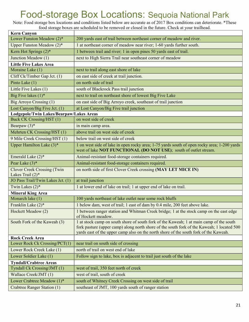
Food-storage Box Locations: Sequoia National Park Note: Food storage box locations and conditions listed below are accurate as of 2017 Box conditions can deteriorate. *These
food storage boxes are scheduled to be removed or closed in the future. Check at your trailhead. Kern Canyon
Lower Funston Meadow (2)* 200 yards east of trail between northeast corner of meadow and river. Upper Funston Meadow (2)* 1 at northeast corner of meadow near river; 1-60 yards further south. Kern Hot Springs (2)* 1 between trail and river; 1 in open pines 50 yards east of trail. Junction Meadow (1) next to High Sierra Trail near southeast corner of meadow Little Five Lakes Area
Moraine Lake (1) next to trail along east shore of lake Cliff Ck/Timber Gap Jct. (1) on east side of creek at trail junction. Pinto Lake (1) on north side of trail Little Five Lakes (1) south of Blackrock Pass trail junction Big Five lakes (1)* next to trail on northeast shore of lowest Big Five Lake Big Arroyo Crossing (1) on east side of Big Arroyo creek, southeast of trail junction Lost Canyon/Big Five Jct. (1) at Lost Canyon/Big Five trail junction Lodgepole/Twin Lakes/Bearpaw/Lakes Areas Buck CK Crossing/HST (1) on west side of creek Bearpaw (3)* in main camp area. Mehrten CK Crossing/HST (1) above trail on west side of creek 9 Mile Creek Crossing/HST (1) below trail on west side of creek Upper Hamilton Lake (3)* 1 on west side of lake in open rocky area; 1-75 yards south of open rocky area; 1-200 yards
west of lake NOT FUNCTIONAL (DO NOT USE); south of outlet stream. Emerald Lake (2)* Animal-resistant food-storage containers required. Pear Lake (3)* Animal-resistant food-storage containers required. Clover Creek Crossing (Twin Lakes Trail (2)*
on north side of first Clover Creek crossing (MAY LET MICE IN)
JO Pass Trail/Twin Lakes Jct. (1) at trail junction Twin Lakes (2)* 1 at lower end of lake on trail; 1 at upper end of lake on trail. Mineral King Area Monarch lake (1) 100 yards northeast of lake outlet near some rock bluffs Franklin Lake (2)* 1 below dam, west of trail; 1 east of dam by 0.4 mile, 200 feet above lake. Hockett Meadow (2) 1 between ranger station and Whitman Creek bridge; 1 at the stock camp on the east edge
of Hockett meadow. South Fork of the Kaweah (3) 1 at stock camp on south shore of south fork of the Kaweah; 1 at main camp of the south
fork pasture (upper camp) along north shore of the south fork of the Kaweah; 1 located 500 yards east of the upper camp also on the north shore of the south fork of the Kaweah.
Rock Creek Area Lower Rock Ck Crossing/PCT(1) near trail on south side of crossing
Lower Rock Creek Lake (1) north of trail on west end of lake Lower Soldier Lake (1) Follow sign to lake, box is adjacent to trail just south of the lake Tyndall/Crabtree Areas
Tyndall Ck Crossing/JMT (1) west of trail, 350 feet north of creek Wallace Creek/JMT (1) west of trail, south of creek Lower Crabtree Meadow (1)* south of Whitney Creek Crossing on west side of trail Crabtree Ranger Station (1) southeast of JMT, 100 yards south of ranger station

22
Fire in the WildernessNatural Fire During your visit to Sequoia and Kings Canyon National Parks, you may see a wildfire or its smoke in the wilderness. Fire has been a natural part of the Sierra Nevada ecosystem for centuries and the parks’ allow this natural wilderness event when it is safe to do so.
Natural fires occur at frequent intervals. Fire thins competing species, recycles nutrients into the soil, releases seeds for germination, and opens holes in the forest canopy for sunlight to enter. All of these are critical to the health of the Sierra Nevada forests. Yet another ecological benefit of regular lightning fires is that they limit the size and severity of subsequent fires.
Fires increase forage for deer and other grazers. Many animals hunt near the fire’s edge. Fire also creates habitat for several animals including bird and rodents.
For more information about the parks’ fire management program, please visit: http://www.nps.gov/seki/naturescience/ficwhyfire.htm http://www.nps.gov/seki/naturescience/fire.htm
23
Mountain Lions and Bighorn Sheep Mountain Lions Mountain lions (also known as cougars) are one of the wildest symbols of wilderness. When visiting their habitat, you should understand their behavior and act accordingly to protect them and yourself. The likelihood of seeing a lion is small and the likelihood of encountering an aggressive lion is even smaller. However, you should still be prepared. Use extra caution if you are hiking alone. Watch children closely, never let them run ahead on the trail. If you cross paths with a mountain lion, the key goal is to convince it that you are not prey. DO NOT RUN! Mountain lions often chase things that run because they associate running with prey. Do not crouch down. Try to appear as large as possible. Attempts to hide are unsuccessful - lions see most people long before people see lions. Hold your ground or back away slowly while facing the lion. If little children are with you, pick them up. If the lion behaves aggressively, wave your hands, shout, and throw stones or sticks at it. If attacked, fight back! Report any mountain lion sighting to a park ranger as soon as possible. Sierra Nevada Bighorn Sheep Sierra Nevada Bighorn Sheep are currently listed as endangered under both federal and state law. While this does not impose additional restrictions on wilderness travel in these national parks, the Inyo National Forest (immediately adjacent to our eastern border) may have additional restrictions to protect the bighorn sheep in specific areas. Please contact the Inyo National Forest for more information (see page 14). Bighorn Sheep are now occupying the Great Western Divide for the first time in over 100 years due to recent efforts by state and federal agencies. For more information, please visit: http://www.nps.gov/seki/learn/nature/bighorn-sheep.htm

24
Safety in the Wilderness Are You Prepared For This Trip? One primary value of wilderness is that it is a place that allows us to be self-reliant in the natural world. It is wholly up to us to enjoy its benefits, and survive its challenges. Wilderness provides outstanding opportunities to recreate in a primitive setting. Preparation and planning before your trip increases the likelihood of your enjoyment and a successful adventure. When venturing into wilderness you are responsible for your own well-being. Search & Rescue Leave detailed trip plans (including anticipated travel routes and campsites) with someone who can notify the parks’ 24-hour emergency dispatch center at (559) 565-3195 if you are more than 24 hours overdue. You should also leave a description of your equipment (tent color, clothing type/color, etc.) and provisions with your emergency contact. Each year, a number of park wilderness visitors become ill, injured, or incapacitated in some way. It is our policy to assist those in need when it is necessary, within the skill capabilities of available staff, and when it can be accomplished in a manner that provides reasonable safety for search and rescue personnel. Search and rescue actions are conducted on a discretionary basis. The level and necessity of the response is determined through evaluation of the situation by field personnel. Rescuer safety is ALWAYS our first priority. As a wilderness traveler you are expected to exhibit a high degree of self-reliance and responsibility for safety commensurate with the difficulty of your chosen activities; more preparation is required to deal with emergencies as risk increases. If you find yourself in a true emergency, and have exhausted all means of self-rescue, contact a ranger in the field, or call park dispatch with a cell (signals are inconsistent), or satellite phone. There is little to no cell reception in most areas of these parks. When you make contact, provide clear, concise information regarding the nature & exact location of the problem or injury, as well as the number of people involved. Be aware that help may be several days out, and your best preparation is to be ready to help yourself. If you get lost, stay put. Try to stay in a clearing or large rocky outcropping. Lay out a colorful tarp or build a small smoky fire in a safe area. Wait for searchers to find you. High Water Never underestimate the power of moving water— it can be deadly. Look for natural bridges such as logs or rocks. However, be careful, they can be extremely slippery. If none are available, wade across where the water is wide and shallow. Do not cross above rapids or gorges in case you fall. Unbuckle your pack's waist strap, face upstream, and use a long stick or hiking poles for stability. Wearing shoes is safer than crossing barefoot. If you are in a group, cross together holding on to one another. Do not tie yourself into ropes. Cross when the water level is lowest, usually in the morning, or choose another, safer, route. Altitude Illness Altitude illness can strike anyone. Typically it occurs at altitudes over 10,000 ft., but serious cases have occurred as low as 8,000 ft. Allow time for a slow ascent, adjusting gradually to altitude. Awakening with temporary shortness of breath is not uncommon. This alone is normally not a cause for alarm. Acute mountain sickness (AMS) usually starts as a mild illness with headache, nausea, difficulty sleeping, and fatigue. It is often treatable with rest, fluids, and mild analgesics, such as aspirin, acetaminophen, or ibuprofen. When AMS becomes severe, two life-threatening conditions may develop: High Altitude Pulmonary Edema (HAPE) or High Altitude Cerebral Edema (HACE). HAPE symptoms include extreme shortness of breath, the need to sit up to breathe, extreme fatigue, wheezing or coughing, and/or the inability to sleep. HACE symptoms include very severe headache, vomiting, confusion, loss of balance or coordination, and in later stages, loss of consciousness. Immediate descent to low altitude is the only cure. Get immediate help; the condition can progress rapidly and death is possible. The patient may walk slowly to low altitude if his/ her condition is not too severe. Extreme cases may require evacuation by helicopter with help from rangers. If a ranger cannot be found at a station, quickly proceed to the nearest trailhead to report the emergency. Hypothermia Hypothermia, which is a subnormal body temperature, can lead to mental and physical collapse and even death. Caused by combinations of cold, wetness, and wind, it is aggravated by exhaustion. Hypothermia can develop in any season. Stay dry. Wet clothes can lose up to 90% of their insulating value. Wool and synthetics provide better warmth when wet than down or cotton. Wet cotton will actually cause rapid cooling. Signs of hypothermia are uncontrollable shivering, slurred speech, memory lapses, incoherence, stumbling, drowsiness, and exhaustion. The victim may deny the problem. Believe the symptoms, not the victim. Even mild cases demand immediate attention. Shelter the victim from wind and rain. Strip off all wet clothes. Get them warm clothes and into a sleeping bag. Provide external sources of warmth such as warm drinks, hot water bottles or your own body heat. Keep them awake.
25
Safety in the Wilderness (continued) Lightning Watch for approaching storms and go to a safe area before they arrive. Avoid mountain peaks, ridges, open areas, lone trees, shallow caves, and cliffs. Forested areas away from the tallest trees are safer. If you are in a treeless area and cannot get to a safer place, lay out insulating material (such as a foam pad) on the ground and sit on it. Only your buttocks and feet should touch the material. Use this method only if there are no alternatives. Do NOT seek shelter in the Mt. Whitney Hut or the Muir Pass Shelter – lightning can be conducted to individuals inside. Natural Fire In this fire-dependent ecosystem, fire helps create a healthy mosaic of plant communities. Lightning fires are permitted to do their ecological work in large portions of these parks. You may have an opportunity to see or travel through a burning or recently burned area. Trail closures may be necessary for public safety. In other cases, trails may remain open. Use caution and remain alert for hazards such as active fire, dense smoke, rolling rocks and logs, falling trees or branches, and stump holes. Water Quality Drink smart. Lakes and streams can be contaminated even if they look and taste pure. Giardia has been found in some mountain streams. The incubation period for this intestinal parasite is 6 to 15 days after ingesting contaminated water. Symptoms include nausea, abdominal cramps, flatulence, lethargy, diarrhea, and weight loss. The disease may persist for weeks or months if untreated. The most certain treatment to make water safe to drink is to bring it to a boil. Many hikers prefer filtration for water treatment. Hand-pump filters with a pore size less than 0.5 micron should remove harmful bacteria and protozoa, including giardia. Chemical disinfectants, such as iodine or chlorine tablets, are not as reliable as heat in killing giardia. Use chemical disinfectants in conjunction with a filtration system. Ultra-violet sterilizers are practical to carry and seem effective for wilderness visitors. Hand Washing Most illnesses contracted while in the wilderness are attributable to poor hygiene. Washing hands after using the “toilet” and before eating or preparing food (to prevent fecal contamination) is just as important as treating water. Waterless hand sanitizer comes in small, light-weight containers, perfect for your backpack. Human-Waste Disposal The potential health hazard from human waste is ever present. To prevent the spread of disease, dispose of your body waste properly. Bury feces at least 6 inches deep and at least 100 ft. from water, trails, and campsites. Carry out your used toilet paper and dispose of properly. Double Zip-lock plastic bags work well. Ticks Ticks are found most commonly in naturally vegetated areas like woods and forests at lower elevations. These small insects attach to humans and other animals. Ticks then feed on the blood of their host for several days. In the spring and early summer smaller immature ticks – roughly the size of a poppy seed–called “nymphs” are most active. Ticks may carry the bacterium that causes Lyme disease and can transmit the bacterium to humans while they feed. Early symptoms of Lyme disease often include a spreading rash accompanied by flu-like symptoms such as fever and body aches. While Lyme disease is the most common tick-borne illness in California, ticks can transmit other human illnesses, such as Rocky Mountain spotted fever. California Department of Public Health recommends the following to avoid ticks and tick-borne diseases:
•Wear light colored long pants and long-sleeved shirts when spending time outdoors. Tuck pant legs into boots or socks and tuck shirts into pants. •Apply repellents registered for use against ticks and stay on trails when hiking.
•Conduct a tick-check over your entire body, including the hairline, armpits, back of knees and groin after outdoor activities, including picnicking. •Continue to watch for ticks for up to three days after returning from tick habitat.
•Parents should check their children thoroughly for ticks.

26
Safety in the Wilderness (continued) Poison Oak Poison oak is a shrub common in the foothills up to 6,000 ft. To avoid encountering poison oak, learn to identify it. Poison Oak is often red in the fall with whitish berries, bare in the winter, and shiny green leaves in groups of three in the spring. Remember: leaves of three, let it be! Long sleeves and pants are your best protection. Contamination between clothing can occur if stored together. Rattlesnakes Look before you step when you are in rattlesnake country. Use hiking poles especially in vegetation to act as a buffer for your legs. Cover your legs with pants and gaiters and wear shoes that cover the ankle, even during short night excursions. If you are bitten, remain calm and seek help. Tree Hazards Numerous trees fall over in wilderness areas throughout the summer months. Areas of high concern are previously burned areas, edges of meadows, and areas of beetle kill. Avoid walking through areas of high concern when windy, particularly in the late afternoon. An assessment of trees surrounding your camping area is always a good idea. Trips/Falls Most injuries occur when we are in a hurry or tired. Stretching every day reduces risk of injury. However, injuries can happen to anyone, regardless of age, experience, or fitness level. If you twist an ankle or knee, try not to fight gravity if you can help it. Tensing up and trying to catch your fall can often make the injury worse. Rest, Ice, Compress, Elevate (RICE) is helpful post-injury. Hiking poles and braces for problem joints can help prevent such mishaps. Wilderness - General Warning Travel in wilderness, by its nature is an exercise in self-sufficiency. Use caution and be realistic about your level and type of experience, skill and comfort. If you choose to carry a hand-held electronic signaling device, be familiar with its operation and limitations. Do not base your safety or rely on it to summon rescue personnel as it may fail in the field due to battery power, breaking, connection failures, etc. (see page 27). These parks expect visitors to exhibit a high degree of self-reliance and responsibility for their own safety commensurate with the difficulty of their chosen activities; that is, the higher risk the activity, the more you need to be prepared for dealing with emergency situations. Marmots in Mineral King Like bears, jays and ground squirrels, marmots have not only become accustomed to visitors, they have learned that people are a source of food. Marmots are the largest members of the squirrel family and occasional chewers of boots, backpack straps, hiking pole grips, and radiator hoses.
Each spring and early summer until mid-July, the marmots of Mineral King have been known to dine on radiator hoses and car wiring. They can disable a vehicle. On several occasions, marmots have not escaped the engine compartment quickly enough and unsuspecting drivers have given them rides to other parts of the parks; several have ridden as far as southern California! Various means, including wrapping a tarp around the entire vehicle completely covering the wheel wells, and leaving vehicle hoods propped open, are used in an attempt to keep marmots from damaging vehicles. Wrapping chicken wire around the vehicle is no longer advised as marmots have found a way to defeat this method. If you visit Mineral King, especially before mid- July, check under you hood before driving away. Let the rangers know whether or not your vehicle has been damaged.

27
Safety in the Wilderness (continued) ADVISORY: EMERGENCY SATELLITE LOCATOR DEVICES
Using the SOS or 911 button on a satellite-locator device carries the same responsibility as dialing 911 from a telephone. Use these devices only to request help in a true emergency. Ask yourself: are you willing to put other people at risk to solve your problem? Read this advisory before your trip in order to understand your responsibilities and the consequences of your actions. Know that rescues are risky to personnel and expensive to agencies. Rescuer safety is ALWAYS our first priority. Even if you activate the emergency beacon on a SPOT, PLB, or similar device, response may take longer than 24 hours depending on weather, time of day, your location, and other factors. Responsibilities before leaving home:
• Know and consider your personal skills and limitations when planning your wilderness travel. Wilderness is a place for personal challenge, responsibility, and a high degree of self-reliance. Are you ready to deal with the dynamic hazards of wilderness?
• If you choose to carry a hand-held electronic signaling device, be familiar with its operation, limitations, and frequency of failure to transmit. Do not rely on it to summon rescue personnel or notify family you are “OK”. Read the instructions for your device; keep them with you. Understand how it works and what services provided by the manufacturer must be activated and purchased. If required, register your device and provide all the information requested.
• Some devices (e.g. SPOT) ask for a primary contact in the case of an emergency activation. Do not start your trip until that person has complete details, including: Your intended route; alternate routes you might take; when and where you plan to start and end;
knowledge about your experience level; and photographs and descriptions of your gear. Full names and photographs of all members of your party and their emergency contacts. The difference between HELP, and SOS/911 on a SPOT-type device:
SOS/911 - for a true emergency: immediate response (through On-Star System) Help: Not an emergency, signals your chosen contacts, and they already know what to do (E.g. hike or drive to your location, etc.) I’m OK: Signals your chosen contacts. One or two days of no signal is common and not necessarily an emergency. Transmission in wilderness may be very inconsistent. The National Park Service (NPS) will not respond to HELP or a missed I’m OK check in as an emergency unless we have additional information. If you have a true emergency, activate SOS/911. Share this information with all chosen contacts.
How to access your tracking webpage, including login and password. Knowing your prior waypoints or tracking information may help the NPS to respond.
Responsibilities during your trip: • Your knowledge, experience, and equipment will contribute most to your survival. Can you self-rescue or get help
from other hikers? Do not signal SOS/911 unless it is a true emergency, but do not be afraid to signal if you know it is justified.
• If you activate SOS/911 and it is safe to stay where you are, don’t leave. It may be harder for rescuers to find you if you move. Stopping the SOS/911 signal or activating the OK signal may not cancel a response, so stay in the areas where you activated the SOS/911 even if the emergency has passed.
Responsibilities after your trip or emergency
• If you activated the SOS/911 but have not been contacted by the NPS or other agency personnel, call us immediately once you are out of the wilderness; we may be looking for you. Sequoia and Kings Canyon National Parks’ 24-hour emergency dispatch phone number is 559-565-3195.
• Let your contact(s) know as soon as you are out of the wilderness and not in need of help. Your locator device is only a tool. Activate SOS/911 only in a true emergency, and the NPS will do everything reasonable to help you.

28
Wilderness Etiquette •Hikers should always yield to pack animals. Stand downhill from passing pack animals and other stock so as to not appear predatory. •In general, allow uphill travelers the right of way. Unless the uphill party is looking for a reason to have a break, allow them to continue with the momentum they have to get up the hill. When planning for and spending time in wilderness, think about the experience of others around you and try to be considerate. For example, •Try to get to your camping area well before dark so a proper site can be found and the noises of settling in for the night are not disturbing the sleep of others. •While walking or riding, normal human noises of conversation are a good warning for Sierra Black Bears to vacate the
area, but yelling in a disruptive manner can be an unwanted disturbance to the solitude of others. •Do not create or construct displays that disturb the natural state of the area. •When walking or riding on-trail, walk single file in the middle of the trail even when it’s wet or muddy so trails are not
widened or re-routed. •When walking or riding off-trail in a group, spread out so you do not create a new trail. •Leave flowers and foliage undisturbed so that they can be enjoyed by other hikers and contribute to their native ecosystem. •If you will be using a WAG BAG®, do not leave it anywhere in the wilderness. It should be disposed of properly in a front-country trash receptacle. •If you find an artifact, do not disturb or collect it. Leave the artifact where you found it so that it can be understood in context. If possible, note the GPS coordinates or specific directions to the location where you found the artifact and relay this information to a park ranger. •If you have concerns about the actions of another wilderness traveler, tell a Park Service employee. Remember, we are all stewards of our national parks. The positive actions you take today can leave a wonderful experience for tomorrow.

29
Fishing and Pets
Fishing Fishing requires a California state fishing license for everyone aged 16 or older. Obtain a license and a copy of state fishing regulations before your trip. State fishing regulations and license information is also available online at www.dfg.ca.gov.
A. State fishing regulations apply to all areas in Sequoia and Kings Canyon National Park except for those areas listed in section B below.
B. Exceptions to state fishing regulations for Sequoia and Kings Canyon National Park: a. In areas below 9,000 ft. in elevation and more
than one-quarter (.25) of a mile from developed areas. “Developed areas,” for the purposes of this regulation, are defined as areas within one-quarter (1/4) of a mile of buildings, campgrounds, picnic areas or parking lots that accommodate more than five (5) vehicles. i. Rainbow Trout, Sacramento Sucker, Kern
Rainbow, Sculpin, and Roach fish (i.e. native species of the park) must be released.
ii. Artificial flies or lures with barb-less hooks are required.
b. Soda Springs Creek (Sequoia NP) is closed to fishing
Pets Pets are NOT allowed in the wilderness of Sequoia and Kings Canyon National Parks because they disturb wildlife and other visitors, even unintentionally with their simple presence. A general rule of thumb is that pets are allowed in Sequoia and Kings Canyon National Parks anywhere that a car can go. Front-country campgrounds, picnic areas, roads, and other developed areas are the only places where pets are allowed. They are not permitted on any hiking trails.
In developed areas, pets must be kept on a leash at all times. The leash must be less than 6 ft. (1.8 meters) long. For your pet’s safety, please don’t leave pets in hot cars. Pets cannot be left tied and unattended at any time. In the National Forest lands that surround Sequoia and Kings Canyon National Parks, leashed pets are allowed on trails (subject to restrictions in bighorn sheep habitat). See page 14.
Stock Use Recreational stock use in these parks is subject to a series of controls to ensure minimal impacts. Stock users need to be familiar with all information contained in the Stock Users Guide. Additional information can be obtained from the Wilderness Office (559-565-3766), or found on our website at: http://www.nps.gov/seki/planyourvisit/stockuse.htm.
Commercial users must obtain a Commercial Use Authorization (CUA) to operate in Sequoia and Kings Canyon National Parks, as well as any other public land areas through which a trip will be passing. For information regarding CUAs, please contact the Sequoia and Kings Canyon National Parks Concessions Office at (559) 565-3103 or e-mail [email protected].
Military Over-Flights Much of the wilderness in Sequoia and Kings Canyon National Parks underlies a special military training airspace - the R-2508 Complex. Military pilots train for combat missions in the complex, often by flying low and fast. Such flights can be very startling to people and animals. In the portion of the R-2508 Complex that is over these parks, pilots are required to fly no lower than 3,000 ft. above ground level. Occasionally pilots do fly lower than allowed. If the military's radar tapes confirm a pilot flew lower than allowed, disciplinary action is possible. If you witness an incident you feel is questionable, please report it to: R-2508 Central Control Facility 100 Sparks Road Building 2580 Edwards Air Force Base CA 93524 Note the date, time, location, direction of flight, and describe the aircraft in as much detail as possible. Please send a copy of your letter to Sequoia and Kings Canyon National Park.

30
Archaeology: Voices from the Past Many physical clues remain in the wilderness of Sequoia and Kings Canyon National Parks of those who ventured before us: obsidian arrowheads, prehistoric pottery, pictographs, mines, graves, and cabins. If you encounter such sites or artifacts, do not disturb them. Human history is still being recorded and deciphered in the wilderness. Preserving these traces of the past allows others to view and enjoy them.
Archaeological remains are nonrenewable resources that may have been in place for thousands of years. Disturbing them removes, and in some cases, destroys the context from which to study and enjoy them. Disturbing sites and artifacts is a crime punishable by law. Do not excavate, remove, damage, alter, or deface items of archeological interest. If you find evidence of an archeological site, report it to a ranger. With your help and respect, these stories will not be lost.
You may also encounter historic structures such as the Mount Whitney Summit Hut built in 1909 for meteorological observations or the beehive-shaped John Muir Memorial Shelter on Muir Pass built in the 1930s. Unfortunately, vandalism, trash, and human waste have compromised their integrity, and camping in or near them is prohibited. Please respect their historic value and use them only if an emergency arises. Do not leave any materials, objects or trash in these structures.
Working in the Wilderness Wilderness & Trailhead Rangers As snow melts from the high country in early summer, wilderness rangers prepare to return to their remote ranger stations. They will spend three to four months patrolling hundreds of miles of trails and thousands of acres of wilderness. Their typical duties include reporting on trail conditions, enforcing regulations and restrictions, picking up trash, rehabilitating damaged campsites, performing minor trail maintenance, checking meadow conditions, monitoring bear activity, administering first aid, dispensing information, searching for lost hikers, and coordinating rescues. Their primary role is to ensure that your wilderness is protected and you have an enjoyable, safe experience. Trailhead rangers perform just as important work as the wilderness rangers. Based in the front-country, these rangers issue wilderness permits, educate visitors on wilderness ethics, and perform much of the same work as wilderness rangers within a day or so walk from the trailheads. Help the rangers protect your wilderness by following the wilderness restrictions and guidelines specified in this Trip Planner. And, if you encounter a ranger, please share your observations.

31
Books Hiking Sequoia & Kings Canyon National Parks by Laurel Scheidt. Covers eighty-six trails that vary in difficulty from easy strolls to challenging treks. Sequoia and Kings Canyon National Parks: Your Complete Hiking Guide by Mike White. Details trips for all levels, covering both the west and the east sides of the parks. The High Sierra: Peaks, Passes, and Trails by R.J. Secor. Comprehensive resource covers most known routes throughout the High Sierra. Recommended to hikers wishing to hike off maintained trails. Backpacker Magazine’s Outdoor Survival: Skills to Survive and Stay Alive by Molly Absolon. Introduction to basic and intermediate skills. Backpacker Magazine’s Trailside Navigation: Map and Compass by Molly Absolon. Introduction to basic and intermediate skills.
Topographic Maps Support the Parks: Buy from the Sequoia Parks Conservancy The Sequoia Parks Conservancy (SPC) is a non-profit organization that works to support Sequoia & Kings Canyon National Parks. SPC sells educational materials in visitor centers throughout the parks. Common trip planning guides are listed here, but be sure to visit http://store.sequoiaparksconservancy.org/ for their complete selection. Orders may also be placed by phone at (559) 565-4256.
7.5 Minute USGS Topographic Quadrangle Maps The diagram to the right lists the names of the quadrangle maps. The grey line is the boundary of Sequoia & Kings Canyon National Parks. Major roads inside the parks are black lines on the left side of the diagram.
National Geographic Maps National Geographic Trails Illustrated Map: Sequoia and Kings Canyon National Parks, Mount Whitney
Tom Harrison Maps: Mount Whitney High Country; Kings Canyon High Country; Mineral King; Sequoia & Kings Canyon
SPC Published Map: Rae Lakes Loop
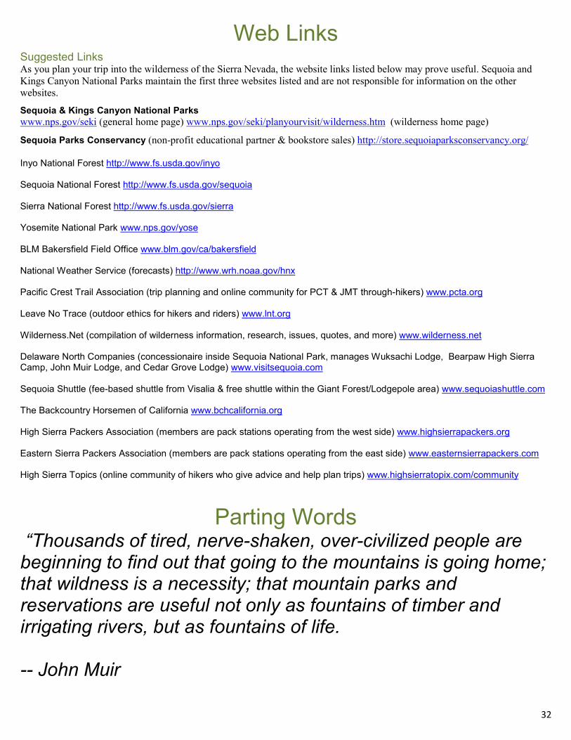
32
Web Links Suggested Links As you plan your trip into the wilderness of the Sierra Nevada, the website links listed below may prove useful. Sequoia and Kings Canyon National Parks maintain the first three websites listed and are not responsible for information on the other websites.
Sequoia & Kings Canyon National Parks www.nps.gov/seki (general home page) www.nps.gov/seki/planyourvisit/wilderness.htm (wilderness home page)
Sequoia Parks Conservancy (non-profit educational partner & bookstore sales) http://store.sequoiaparksconservancy.org/ Inyo National Forest http://www.fs.usda.gov/inyo Sequoia National Forest http://www.fs.usda.gov/sequoia Sierra National Forest http://www.fs.usda.gov/sierra Yosemite National Park www.nps.gov/yose BLM Bakersfield Field Office www.blm.gov/ca/bakersfield National Weather Service (forecasts) http://www.wrh.noaa.gov/hnx Pacific Crest Trail Association (trip planning and online community for PCT & JMT through-hikers) www.pcta.org Leave No Trace (outdoor ethics for hikers and riders) www.lnt.org Wilderness.Net (compilation of wilderness information, research, issues, quotes, and more) www.wilderness.net Delaware North Companies (concessionaire inside Sequoia National Park, manages Wuksachi Lodge, Bearpaw High Sierra Camp, John Muir Lodge, and Cedar Grove Lodge) www.visitsequoia.com Sequoia Shuttle (fee-based shuttle from Visalia & free shuttle within the Giant Forest/Lodgepole area) www.sequoiashuttle.com The Backcountry Horsemen of California www.bchcalifornia.org High Sierra Packers Association (members are pack stations operating from the west side) www.highsierrapackers.org Eastern Sierra Packers Association (members are pack stations operating from the east side) www.easternsierrapackers.com High Sierra Topics (online community of hikers who give advice and help plan trips) www.highsierratopix.com/community
Parting Words “Thousands of tired, nerve-shaken, over-civilized people are beginning to find out that going to the mountains is going home; that wildness is a necessity; that mountain parks and reservations are useful not only as fountains of timber and irrigating rivers, but as fountains of life. -- John Muir
Related Documents