Where Should I Turn? Moving from Individual to Collaborative Navigation Strategies to Inform the Interaction Design of Future Navigation Systems Jodi Forlizzi HCII and School of Design, Carnegie Mellon University 5000 Forbes Ave. 2504E NSH Pittsburgh, PA 15213, USA [email protected] William C. Barley Department of Communication Studies, Northwestern University 2240 Campus Drive Evanston, IL 60208, USA [email protected] Thomas Seder General Motors Corporation 30500 Mound Rd, P.O. Box 9055 MC: 480-106-256 Warren, Mi 48090-9055, USA [email protected] ABSTRACT The design of in-vehicle navigation systems fails to take into account the social nature of driving and automobile navigation. In this paper, we consider navigation as a social activity among drivers and navigators to improve design of such systems. We explore the implications of moving from a map-centered, individually-focused design paradigm to one based upon collaborative human interaction during the navigation task. We conducted a qualitative interaction design study of navigation among three types of teams: parents and their teenage children, couples, and unacquainted individuals. We found that collaboration varied among these different teams, and was influenced by social role, as well as the task role of driver or navigator. We also found that patterns of prompts, maneuvers, and confirmations varied among the three teams. We identify overarching practices that differ greatly from the literature on individual navigation. From these discoveries, we present design implications that can be used to inform future navigation systems. Author Keywords Interaction design, navigation system, GPS system, in-car navigation, driving, human-system interaction design. ACM Classification Keywords H5.m. Information interfaces and presentation (e.g., HCI): Miscellaneous. General Terms Design, Human Factors INTRODUCTION Driving has historically been a social activity. Even the first automobiles were designed to hold both a driver and passenger. Today, both business and pleasure trips often have social aspects, where trips are planned and executed with joint goals in mind. Similarly, the act of navigating to a destination, whether known or unknown, also evokes social behavior. Drivers often need assistance finding their way along a route, whether the path to the destination is familiar or not. This information can be provided by a passenger acting as a navigator. Navigation assistance is a growing area of importance, and has implications for a growing population of younger and older drivers, fleet operators, and public transportation providers. Modern technology, such as GPS, has drastically changed how we navigate when we drive. Location-based software systems help increasing numbers of drivers wayfind. While these systems are useful, they have design shortcomings that impact ease of use. For example, visual information is often crowded on the display, making the navigation display hard to read at a glace. Speech and sound output can be improperly phrased, redundant, or incomprehensible. The timing of visual and auditory cues Permission to make digital or hard copies of all or part of this work for personal or classroom use is granted without fee provided that copies are not made or distributed for profit or commercial advantage and that copies bear this notice and the full citation on the first page. To copy otherwise, or republish, to post on servers or to redistribute to lists, requires prior specific permission and/or a fee. CHI 2010, April 10–15, 2010, Atlanta, Georgia, USA. Copyright 2010 ACM 978-1-60558-929-9/10/04....$10.00. Figure 1. Study setup showing driver and navigator collaborating in a navigation task. CHI 2010: Driving, Interrupted April 10–15, 2010, Atlanta, GA, USA 1261

Welcome message from author
This document is posted to help you gain knowledge. Please leave a comment to let me know what you think about it! Share it to your friends and learn new things together.
Transcript
Where Should I Turn? Moving from Individual to Collaborative Navigation Strategies to Inform
the Interaction Design of Future Navigation Systems Jodi Forlizzi
HCII and School of Design, Carnegie Mellon University
5000 Forbes Ave. 2504E NSH
Pittsburgh, PA 15213, USA [email protected]
William C. Barley Department of
Communication Studies, Northwestern University
2240 Campus Drive Evanston, IL 60208, USA
Thomas Seder General Motors Corporation
30500 Mound Rd, P.O. Box 9055 MC: 480-106-256
Warren, Mi 48090-9055, USA [email protected]
ABSTRACT The design of in-vehicle navigation systems fails to take into account the social nature of driving and automobile navigation. In this paper, we consider navigation as a social activity among drivers and navigators to improve design of such systems. We explore the implications of moving from a map-centered, individually-focused design paradigm to one based upon collaborative human interaction during the navigation task. We conducted a qualitative interaction design study of navigation among three types of teams: parents and their teenage children, couples, and unacquainted individuals. We found that collaboration varied among these different teams, and was influenced by social role, as well as the task role of driver or navigator. We also found that patterns of prompts, maneuvers, and confirmations varied among the three teams. We identify overarching practices that differ greatly from the literature on individual navigation. From these discoveries, we present design implications that can be used to inform future navigation systems.
Author Keywords Interaction design, navigation system, GPS system, in-car navigation, driving, human-system interaction design.
ACM Classification Keywords H5.m. Information interfaces and presentation (e.g., HCI): Miscellaneous.
General Terms Design, Human Factors
INTRODUCTION Driving has historically been a social activity. Even the first automobiles were designed to hold both a driver and passenger. Today, both business and pleasure trips often have social aspects, where trips are planned and executed with joint goals in mind. Similarly, the act of navigating to a destination, whether known or unknown, also evokes social behavior. Drivers often need assistance finding their way along a route, whether the path to the destination is familiar or not. This information can be provided by a passenger acting as a navigator.
Navigation assistance is a growing area of importance, and has implications for a growing population of younger and older drivers, fleet operators, and public transportation providers. Modern technology, such as GPS, has drastically changed how we navigate when we drive. Location-based software systems help increasing numbers of drivers wayfind. While these systems are useful, they have design shortcomings that impact ease of use. For example, visual information is often crowded on the display, making the navigation display hard to read at a glace. Speech and sound output can be improperly phrased, redundant, or incomprehensible. The timing of visual and auditory cues
Permission to make digital or hard copies of all or part of this work forpersonal or classroom use is granted without fee provided that copies arenot made or distributed for profit or commercial advantage and that copies bear this notice and the full citation on the first page. To copy otherwise,or republish, to post on servers or to redistribute to lists, requires priorspecific permission and/or a fee. CHI 2010, April 10–15, 2010, Atlanta, Georgia, USA. Copyright 2010 ACM 978-1-60558-929-9/10/04....$10.00.
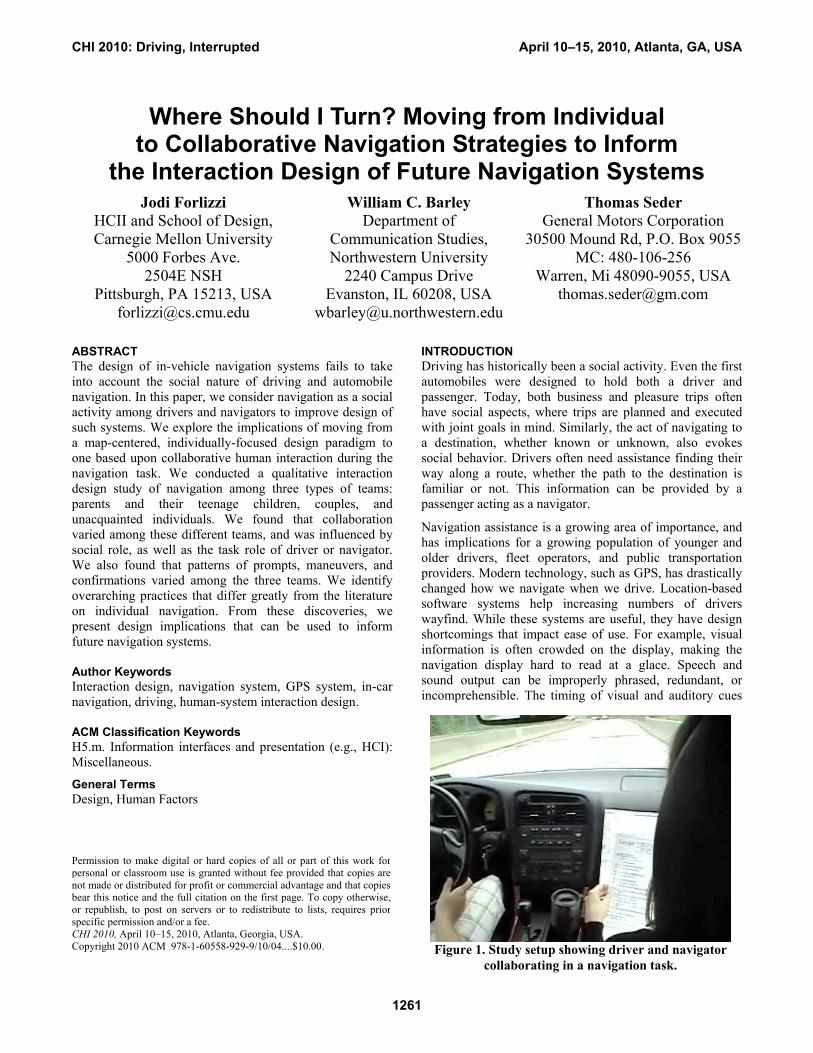
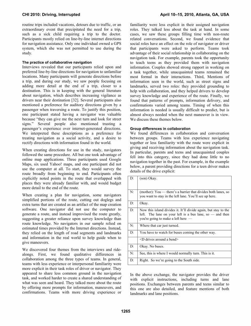
Figure 1. Study setup showing driver and navigator collaborating in a navigation task.
CHI 2010: Driving, Interrupted April 10–15, 2010, Atlanta, GA, USA
1261
can be poor, resulting in directions that are given too near the next maneuver or without consideration of attention demand. Additionally, users have reported that navigation systems contribute to a feeling of being lost or disembodied from the environment [29]. This is because the time spent interacting with a navigation system slows the process of developing knowledge about the external world, and slows the process of building a representation of the world by interacting with landmarks, signage, and other features of the landscape.
In practice, in-car navigation works best when done collaboratively — when the driver is assisted by a navigator providing information in a timely fashion, checking for understanding, and offering clarifications. In this paper, we report on a qualitative interaction design study to understand navigation as a collaborative task, rather than a task where an individual focuses on reading a map, to explore how it might change or inform how a navigation system might offer a driver information (Figure 1). In the study, drivers and navigators worked together in a car to navigate a route to an unfamiliar destination in a real-world situation. Based on a literature review, evaluations of existing navigation systems, and our observational study, we identified three areas of interest:
1) How do teams of parents and teens, couples, and unacquainted individuals who have differing levels of familiarity and driving experience collaborate during a navigation task?
2) How does the social relationship between a navigator and a driver affect the interaction? Do drivers act only as drivers or do they feel comfortable taking over the role of the navigator?
3) How do patterns of prompts, maneuvers, and confirmation utterances factor into the navigation task, especially in relation to information such as landmarks and signs seen outside of the car?
Our goal was to explore these questions, and to use the resulting knowledge about navigation as a social and collaborative activity to potentially inform human-system interaction design of future in-car navigation systems. Although the majority of US drivers drive alone, we believe that considering human-human interactions during a navigation task can inform human-system interactions, even for drivers who are alone in the car.
In the next section of the paper, we provide a background on wayfinding behavior, current navigation systems, and team collaboration in navigation. We then present the method and findings from our study. We conclude with a discussion of design implications meant to guide future navigation system design.
BACKGROUND Navigation systems are accessible by more and more people every day, for applications such as driving, hiking, public
transportation, and for navigating in air, land, and sea vehicles. To understand all of the human-machine interaction issues that factor into the use of a navigation system, we researched several themes related to navigation as a social activity: the process of wayfinding and navigation, in-car navigation systems, and social role in collaboration and shared knowledge. In this section, we summarize relevant findings from this research.
Wayfinding and navigation The goal of navigation is to achieve movement through a space to reach a specific destination, using a physical or mental representation of the area [41]. Mental representations generally are derived from one of three forms of information: landmark, route, or survey information. Landmark information is often the first type of information that is learned about a route. It includes prominent landmarks in the region such as tall buildings, businesses, bodies of water, and parks. Some research discusses how good landmarks are easily identified visually or associated with past trips [6, 8]. Route information relates to the process of getting from origin to destination, and is usually a subjective view of the environment. Survey knowledge is the most advanced type of information. It is spatial, often abstract knowledge that enables an individual to draw an accurate map of the environment. Survey knowledge is built up over many experiences of an area, and is the most objective type of knowledge [39].
A number of models for how individual navigation occurs have been introduced in the literature. One model describes strategic (planning), maneuvering (maintaining position on the route), and control (control of the vehicle) behaviors [32]. This model was later extended to integrate the driver’s goals and tools in navigation to create a six part model: trip planning, preview, identify, confirm, trust, and orientation [6, 35]. Maps play a critical role in the navigation process, often aiding in decision making through perceptual and cognitive processes. MacEachren created a comprehensive body of work on how maps are read and interpreted, combining approaches from vision, visual perception, and spatial cognition [31].
A growing body of research exists on how people use maps and space in the vehicle collaboratively. Ethnographic studies of tourists’ navigation activities resulted in findings about real-world navigation skills and proposed designs for systems that combine electronic maps and guidebooks to support collaborative tourist activities [4, 27]. Another study led to creation of a shared information system for wayfinding within a physical and virtual museum exhibit [6]. A different study examined map use, providing thick descriptions of how people naturally orient and read maps while navigating [5]. A different research effort began to document what happens in the space of a vehicle during a journey, and how social and organizational activities unfold [26]. While these studies were generally not focused on the
CHI 2010: Driving, Interrupted April 10–15, 2010, Atlanta, GA, USA
1262
design of future systems, their findings are relevant to the design of collaborative, in-vehicle navigation systems.
In summary, navigation is an activity that relies on information from the world mediated with maps as abstract representations. Landmark and route knowledge combine to create survey knowledge, a cognitive map of the environment. Individuals navigate using a strategy that decomposes the task into various sub-tasks, and available information sources and tools are used to assist achieving the task goals. A passenger can be employed as an invaluable collaborator in the role of navigation and wayfinding.
Current navigation systems Over the past five years, in-vehicle navigation systems have become more and more sophisticated. However, a survey of the market shows that many of these systems have roughly the same features [9], and that the interaction design of these features follow a one-way information exchange.
To start planning a trip, users can enter a specific address, choose a point of interest, or select a location from a favorites list. Text can be input using a touch-screen alphanumeric or QWERTY keyboard on the device, or in the case of some newer systems, by using a speech recognition system. Once a route is discovered and generated, users are generally offered the options of faster time, shorter distance, or avoiding tolls.
When navigating the route, the display changes dynamically based on the position of the car. A common metaphor is to model the visual display after a paper map, relying on a simple distortion to give the display the appearance of a 3-dimensional worldview. These displays are often visually complex, and offer a view of only a small area of the entire route. Auditory cues, which are normally given twice before each maneuver, once in advance and once just before the maneuver, can enhance navigation performance [19, 25, 30].
If a driver leaves the planned route, the system will calculate a new route on the fly (often, while informing the driver that it is “recalculating.”) Additionally, some of the more recent systems recommend detours based on live traffic updates or construction information that can be downloaded wirelessly. In the event of a planned or unplanned missed maneuver, a new calculation must be made by the system. These can take several seconds and often provide minimal feedback.
In summary, navigation systems are useful, but the timing and visual presentation of information can be improved. Current systems present information with little regard for the driver’s cognitive capacity, and do not allow for drivers to prompt for clarifications, to ask for information to be repeated, or to control the timing of information delivery. They are designed to direct the driver rather than collaboratively navigate with them. Furthermore, they do not take into account whether a passenger is present or
absent. Therefore, in our study, we were particularly interested in how patterns of prompts and confirmations would be presented and acknowledged.
Collaboration and communication Successful communication and collaboration rely on common ground, the shared knowledge and shared experience of speaker and listener that are known to be mutually available [11, 12, 13, 15]. In any conversation, participants are continuously and dynamically assessing what each other knows, and using this knowledge to form subsequent utterances. The principle of least collaborative effort asserts that participants in communication will try to minimize the work that each put into the communication process [12].
In collaboration, members of a team take into account what the other sees and knows [38]. This includes an understanding of the focus of the other’s attention, where he or she is pointing, what other gestures are used, and how prior knowledge, prior experience, and a shared visual view plays a role in the collaboration [1, 2, 3, 11, 13, 17].
Shared experience can aid in the collaboration process. Early research on collaboration resulted in an understanding how aware collaborators were of each other, using as a measure the presence or absence of the collaborator’s face [10]. More recent research focuses on the view of a shared visual task space [13]. Other research shows that shared access to a visual view of a workspace supports different, and more efficient, communication processes, such as less explicit speech [24, 36]. Additionally, how the end of a speaking turn is projected and received can affect completion of a task and the perception of its effectiveness [33].
Additionally, shared knowledge has been shown to have more influence on group judgments than information held individually [17]. Another study compared collaboration processes used by groups of strangers and acquainted groups solving a murder mystery with varied levels of shared information. All-stranger groups were more likely to identify the correct suspect when information was fully shared, but familiar and partially familiar groups were more likely to identify the correct suspect when critical clues remain unshared [20]. These results show that strangers may aggregate information, while those who know each other may pool information strategically. Although the tasks in these studies differ from navigation they suggest that collaboration strategies can differ depending upon relative familiarity of group members.
Other literature focuses on professional navigation as a collaborative task [21, 22, 23, 35]. These studies show that experienced teams are able to accomplish complex navigation tasks faster, and with less error, than individuals. However, most studies of in-car navigation examine individual strategies [ex., 28]. This is because driving practices are less formalized than those of professional
CHI 2010: Driving, Interrupted April 10–15, 2010, Atlanta, GA, USA
1263
navigators. We believe that conceptualizing automotive navigation as a collaborative activity, in regard to role definition and the interaction between task and social roles can inform the design of information presentation in navigation systems.
In summary, collaborative communication relies on a shared understanding of what the other sees and knows. Research suggests that collaboration strategies may differ depending on group familiarity and experience. In our study, we were interested in how team members would uphold or modify their role relative to the navigation task, based on these characteristics.
Rationale From our investigations of the literature and the current state-of-the-art in navigation systems, we chose teams that would vary in driver experience and familiarity. Three different types of dyads were chosen to collaborate in a navigation task. We chose these teams because we suspected that social role and familiarity would interact with task roles, creating some interesting conditions for collaboration and grounding during the navigation task. We suspected that the amount of shared knowledge a team had about a route would affect both the use of external world information during the task, and the amount of conversation that took place unrelated to the task at hand. To investigate these issues, we undertook a field study of navigation with these teams. In the next section, we describe the design of the study.
METHOD We chose to conduct a qualitative study in two US cities to understand how navigation unfolds between a driver and a navigator. To do so, we identified two routes in each city with an equal number of maneuvers and similar travel times on highways and secondary roads. During the study, the navigator would plan and communicate a route to the driver in order to successfully reach one of the two destinations.
Initially, each team (parents and teens, couples, or unacquainted pairs) was introduced to the experiment and answered some general questions about their driving history and routine and non-routine trips. Next, one member of the team was selected to be the navigator and the other was selected to be the driver. In all cases, we chose teens to drive in the parent-teen pairs; we predicted that the teens’ lack of driving experience and familiarity with the area would encourage the pairs to interact more explicitly. We asked couples to take on the roles they would most commonly use when navigating to a new place. We wanted to understand how highly familiar and experienced teams would communicate and manage roles. For unacquainted pairs, roles were assigned randomly.
The driver and navigator were separated, and the navigator was taken to a room equipped with a computer with an Internet connection, a printer, a telephone, pencil and paper, and a traditional map. Each navigator was assigned a
destination, and given as much time as necessary to generate a set of directions that would be used to help the driver get to the destination. The navigator was then reunited with the driver.
The route was then traversed with the navigator using the directions she had generated to communicate navigation information to the driver. Two experimenters observed from the backseat. Participants were informed that experimenters would generally sit and quietly observe the trip. Drives were videotaped and any artifacts generated to assist in navigation were saved and reviewed. Experimenters occasionally probed on particular issues that occurred during the route (for example: Do you know what road this is?). The drives took on average between 20 and 40 minutes in one direction. When the destination was reached, the group took a break and experimenters conducted a debrief interview.
Twenty participants in two US cities participated in the study, ranging in age from 18-53, ten males and ten females. They comprised three types of teams: parents and teens (N=5, teens were consistently chosen to be the drivers, with the goal of inspiring more dialogue about navigating the route); couples (N=3, couples decided for themselves who would drive and navigate); and unacquainted pairs (N=2, roles were randomly assigned by the experimenters). Participants asked to drive to the destination farthest from the driver’s home address. This minimized the chance that the driver would be familiar with the destination and increased the chance that explicit direction giving would occur.
Introductory and debrief interview data were reviewed and coded for relevant mentions of navigation behavior. Artifacts generated to use during navigation (maps, line by line directions, etc.) were analyzed for evidence of landmark, route, and survey knowledge. Conversations from the drive to the destination for each pair were professionally transcribed, and coded for utterances by driver, navigator, and experimenter, for maneuvers of the vehicle, and for gestures made by driver and navigator. An open coding scheme [40] was developed focusing on interactions that were explicitly related to the navigation task. Codes were initially based on Michon and Burnett’s navigation model, and were extended with several additional codes [32]. Utterances were differentiated in terms of requests for information, maneuvers, confirmations, rejections, and other. Conversation unrelated to the wayfinding task was coded as Other. Conversations were also time coded to understand differing patterns in when and how information is requested and given.
RESULTS All of the participants in our study were routine drivers who made repeated drives to the same destinations during weekdays and weekends. All rated themselves as good to excellent drivers, and felt they had a good familiarity with the city in which they lived. Common reasons for non-
CHI 2010: Driving, Interrupted April 10–15, 2010, Atlanta, GA, USA
1264
routine trips included vacations, detours due to traffic, or an extraordinary event that precipitated the need for a trip, such as a sick child requiring a trip to the doctor. Participants mostly relied on line-by-line internet directions for navigation assistance. Only one individual owned a GPS system, which she was not permitted to use during the study.
The practice of collaborative navigation Interviews revealed that our participants relied upon and preferred line-by-line directions for navigation to unfamiliar locations. Many participants will generate directions before a trip, and during our study, we saw people focusing on adding more detail at the end of a trip, closer to a destination. This is in keeping with the general literature about navigation, which describes increasing vigilance as drivers near their destination [32]. Several participants also mentioned a preference for auditory directions given by a passenger when traversing a route. To justify this position, one participant stated having a navigator was valuable because “they can give me the next turn and look for street signs.” Several people also mentioned trusting a passenger’s experience over internet-generated directions. We interpreted these descriptions as a preference for treating navigation as a social activity, and a desire to rectify directions with information found in the world.
When creating directions for use in the study, navigators followed the same procedure. All but one took advantage of online map applications. Three participants used Google Maps, six used Yahoo! maps, and one participant did not use the computer at all. To start, they would survey the route broadly from beginning to end. Participants often explicitly noted points in the route that overlapped with places they were already familiar with, and would budget more detail to the end of the route.
When creating a plan for navigation, some navigators simplified portions of the route, cutting out doglegs and extra turns that are created as an artifact of the map creation software. One navigator did not use the computer to generate a route, and instead improvised the route greatly, suggesting a greater reliance upon survey knowledge than route knowledge. No navigators in our sample relied on estimated times provided by the Internet directions. Instead, they relied on the length of road segments and landmarks and information in the real world to help guide when to give maneuvers.
We discovered four themes from the interviews and ride-alongs. First, we found qualitative differences in collaboration among the three types of teams. In general, teams with less experience or interpersonal familiarity were more explicit in their task roles of driver or navigator. They appeared to share less common ground in the navigation task, and worked harder to create a shared understanding of what was seen and heard. They talked more about the route by offering more prompts for information, maneuvers, and confirmations. Teams with more driving experience or
familiarity were less explicit in their assigned navigation roles. They talked less about the task at hand. In some cases, we saw these groups filling time with non-route related conversations. Second, we found evidence that social roles have an effect on the role of navigator or driver that participants were asked to perform. Teams took advantage of their social relationship in collaborating on the navigation task. For example, parents took the opportunity to teach teens as they provided them with navigation information. Couples showed strong rapport in working on a task together, while unacquainted teams remained the most formal in their interactions. Third, Mentions of information seen in the world, such as street signs and landmarks, served two roles: they provided grounding to help with collaboration, and they helped drivers to develop survey knowledge and experience of the route. Finally, we found that patterns of prompts, information delivery, and confirmations varied among teams. Timing of when this information is needed is usually difficult to predict, but is almost always needed when the next maneuver is in view. We discuss these themes below.
Group differences in collaboration We found differences in collaboration and conversation between groups. Teams with less experience navigating together or less familiarity with the route were explicit in giving and receiving information about the navigation task. In particular, parents and teens and unacquainted couples fell into this category, since they had done little to no navigation together in the past. For example, in the example below, a parent providing directions for a teen driver makes details of the drive explicit:
D:
(son) Okay.
N: (mother): You — there’s a barrier that divides both lanes, so you want to stay in the left lane. You’ll see up here.
D: Okay.
D: Now this island divides it. It’ll divide again, but stay to the left. The lane on your left is a bus lane, so — and then you're going to make a left here —
N: Where that car just turned.
D: You have to watch for buses coming the other way.
<D drives around a bend>
D: Okay. No buses.
N: See, this is where I would normally turn. This is it.
D: Right. So we’re going to the South side.
In the above exchange, the navigator provides the driver with explicit instructions, including turns and lane positions. Exchanges between parents and teens similar to this one are also detailed, and feature mentions of both landmarks and lane positions.
CHI 2010: Driving, Interrupted April 10–15, 2010, Atlanta, GA, USA
1265
Similarly explicit interactions can be found in this unacquainted team, where no conversation takes place other than that relative to the navigation tasks, and landmarks including a church and a street sign are referenced:
D: (woman) [after driving in silence of a long period] Are we turning somewhere?
N: (man) Yeah, we’re turning onto Scott Road so that’s when we get up to the lights. It’s where the big church is.
N: All right, that’s the church. You want to get in the left lane.
D: This is Scott right here?
N: Yeah, right here, left on Scott.
N: And this apparently turns into Castle Boulevard in about half a mile.
N: Turn Right on Cooke Lane.
D: What's it called? Cooke?
N: Cooke, yeah. See the sign? You know what I mean?
D: Yeah, yeah.
In this conversation, the navigator is explicit about the directions that are given to the driver. He provides detailed lane position information, as well as situated instructions about where to turn in the near future. This level of detail was less common in married couples.
Teams with greater experience navigating as a group or high familiarity of the route were less explicit in getting and receiving information. Couples mostly conformed to this behavior, fluidly exchanging information and including content not related to the task at hand, as in this example:
N: (wife)Where to?
D: (husband): [Route] 44.
N: Where on 44?
D: Waters and Poplar.
N: Oh, right.
D: What have we got?
N: Where Jake works? Worked? Didn’t he?
D: No, he works on the East Side.
N: Did he used to work at 44?
D: I don’t know. Maybe he did. So where are we going now?
N: We have to get back on [Route] 67.
In this conversation, instructions are provided at a much higher level, and common knowledge is assumed, for example in the driver adding detail to the driver’s statements, and in the conversation about a mutual acquaintance, Jake.
Overlap in social and task roles We constructed teams with varying social relationships to understand how they might increase variation in conversation during the navigation task. In teams with less shared knowledge, we found that the task role of driver or navigator took precedence over the social roles, but teams with more shared knowledge, we saw that the social role often takes precedence. This was signaled by conversation unrelated to the navigation task.
First, social role was used to create rapport, casting positive emotion on the process of completing the task together. For example, in one of the couples, the driver was accustomed to participating in the route preparation and navigation. She took control of the navigation activity and used her social role to change the subject of conversation and avoid taking directions from her husband:
N: (husband) So you know which exit we’ve got to get off on, right?
D: (wife) Yeah.
N: Shopsville Road. [The directions] take us off to the right over here, and then we’re going to just bear off, go up the hill and go the back way.
D: I could go straight to get to Stephen Avenue too.
N: You could. Either way. Do you want to go this way?
D: No —
N: Follow the directions? What do you want to do?
D: I don’t want to listen to Tom Jones [on the radio]!
In this exchange, the driver takes over the task of navigating from the driver and making her own decisions about what exit to use. The driver changes the subject when asked if she is interested in following the given directions. This kind of improvisation was not seen in parent and teen or unacquainted teams.
The presence or absence of non-task related conversation in our data appeared to indicate the implicit or explicit nature of the task and the importance of social roles. In our data, parents and teens made the highest number of utterances related to the drive, but also many exchanges about prior experiences along the route. Couples collaborated loosely, moving from task roles of navigator and driver to social roles and the social norms of their marriages. Unacquainted teams talked mostly about the maneuvers on the drive, possibly due to the fact that they had the least shared knowledge, the least trust in their shared activity, and the least common ground of all the teams.
Situating the route in experience Coinciding with the literature on navigation strategies, all groups discussed landmarks as they traversed the route [6, 7]. These conversations were used in two ways. The most
CHI 2010: Driving, Interrupted April 10–15, 2010, Atlanta, GA, USA
1266
common was an informal discussion of landmarks that were passed and activities that had occurred at them; the second was the explicit reliance upon previously visited landmarks as a grounded tool for navigation.
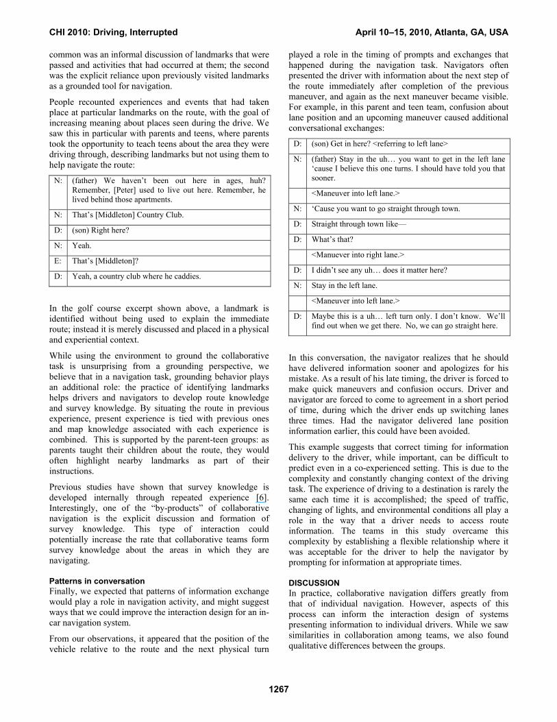
People recounted experiences and events that had taken place at particular landmarks on the route, with the goal of increasing meaning about places seen during the drive. We saw this in particular with parents and teens, where parents took the opportunity to teach teens about the area they were driving through, describing landmarks but not using them to help navigate the route:
N: (father) We haven’t been out here in ages, huh? Remember, [Peter] used to live out here. Remember, he lived behind those apartments.
N: That’s [Middleton] Country Club.
D: (son) Right here?
N: Yeah.
E: That’s [Middleton]?
D: Yeah, a country club where he caddies.
In the golf course excerpt shown above, a landmark is identified without being used to explain the immediate route; instead it is merely discussed and placed in a physical and experiential context.
While using the environment to ground the collaborative task is unsurprising from a grounding perspective, we believe that in a navigation task, grounding behavior plays an additional role: the practice of identifying landmarks helps drivers and navigators to develop route knowledge and survey knowledge. By situating the route in previous experience, present experience is tied with previous ones and map knowledge associated with each experience is combined. This is supported by the parent-teen groups: as parents taught their children about the route, they would often highlight nearby landmarks as part of their instructions.
Previous studies have shown that survey knowledge is developed internally through repeated experience [6]. Interestingly, one of the “by-products” of collaborative navigation is the explicit discussion and formation of survey knowledge. This type of interaction could potentially increase the rate that collaborative teams form survey knowledge about the areas in which they are navigating.
Patterns in conversation Finally, we expected that patterns of information exchange would play a role in navigation activity, and might suggest ways that we could improve the interaction design for an in-car navigation system.
From our observations, it appeared that the position of the vehicle relative to the route and the next physical turn
played a role in the timing of prompts and exchanges that happened during the navigation task. Navigators often presented the driver with information about the next step of the route immediately after completion of the previous maneuver, and again as the next maneuver became visible. For example, in this parent and teen team, confusion about lane position and an upcoming maneuver caused additional conversational exchanges:
D: (son) Get in here? <referring to left lane>
N: (father) Stay in the uh… you want to get in the left lane ‘cause I believe this one turns. I should have told you that sooner.
<Maneuver into left lane.>
N: ‘Cause you want to go straight through town.
D: Straight through town like—
D: What’s that?
<Manuever into right lane.>
D: I didn’t see any uh… does it matter here?
N: Stay in the left lane.
<Maneuver into left lane.>
D: Maybe this is a uh… left turn only. I don’t know. We’ll find out when we get there. No, we can go straight here.
In this conversation, the navigator realizes that he should have delivered information sooner and apologizes for his mistake. As a result of his late timing, the driver is forced to make quick maneuvers and confusion occurs. Driver and navigator are forced to come to agreement in a short period of time, during which the driver ends up switching lanes three times. Had the navigator delivered lane position information earlier, this could have been avoided.
This example suggests that correct timing for information delivery to the driver, while important, can be difficult to predict even in a co-experienced setting. This is due to the complexity and constantly changing context of the driving task. The experience of driving to a destination is rarely the same each time it is accomplished; the speed of traffic, changing of lights, and environmental conditions all play a role in the way that a driver needs to access route information. The teams in this study overcame this complexity by establishing a flexible relationship where it was acceptable for the driver to help the navigator by prompting for information at appropriate times.
DISCUSSION In practice, collaborative navigation differs greatly from that of individual navigation. However, aspects of this process can inform the interaction design of systems presenting information to individual drivers. While we saw similarities in collaboration among teams, we also found qualitative differences between the groups.
CHI 2010: Driving, Interrupted April 10–15, 2010, Atlanta, GA, USA
1267
Parents and teens had limited experience navigating together, and teen drivers had little driving experience. Non-route related interactions enriched the task, with parents acting as experienced teachers in offering information to assist in the navigation task. Parents helped teens situate the route in their previous experience, recommended lane positions frequently, and repeated maneuvers often, to help teens not only drive safely but to make sure “that [she] will know the route for next time.”
Married couples had a great deal of experience navigating together. During the navigation task, we observed communication about the route through less formalized and more efficient strategies for exchanging information. We also saw married couples abandon their task roles, with the driver frequently taking over the role of the navigator. Married couples may have trusted their partners most in the shared navigation task, allowing for more free-form conversation. One couple even professed to “treating our drive like a date.”
Unacquainted teams had no experience navigating together, thus they had no shared route experiences. They had no hierarchy in role; they created common ground in the navigation task using efficient cycles of prompt-maneuver-confirm exchanges. They may have felt some uncertainty in undertaking the navigation task together. For example, unacquainted teams never situated the route in experience, and on more than one occasion, politely disagreed about what to do. Their formalized, cyclical interactions were most similar to current individual-navigation system relationships [19, 25, 30].
Although we did not have enough data to fully understand the role of gender, it may also play a role in the communication structures of same gender teams, in keeping with other findings in the literature [16]. For example, an unacquainted group comprised of two women talked more frequently than unacquainted teams of mixed gender. These gender issues merit further study.
DESIGN RECOMMENDATIONS The collaborative behaviors observed during our study have direct implications for the design of future navigation systems that assist individual drivers. In this section, we provide ideas to guide the interaction design of future in-vehicle navigation systems. Some are technically feasible today; some are not.
The design metaphor for most current navigation systems relies upon individual navigation strategies, namely those involving the use of maps. Because the driver is partially offloading the navigation task by interacting with an external agent, namely, the navigation system, it follows that the interaction metaphor would benefit if it involved some characteristics of human-to-human collaboration. Our key recommendations include: 1) allow for varied and flexible types of information for drivers, 2) allow for more interactivity in the timing and manner of information
delivery, and 3) better situate the route in the driver’s prior experience. To achieve these recommendations, future systems can employ technology to maintain an awareness of the driver’s state and the surrounding context, and to respond dynamically to changes in context and driver preferences and abilities.
Varied, flexible information. Sensors and simple controls that are available today can record and respond to a driver’s preferences, allowing for a variety of information to be delivered. In collaborative navigation, drivers fluctuate between relying on navigation information and making decisions on their own when driving. To support this, an easy way can be provided to mute the system, instead of navigating through a number of menus as is currently done on many of today’s systems. Future technology could allow a number of information delivery mechanisms to be accommodated in the interaction design of the navigation system. For example, a system might provide both a detailed and an abstract means of information delivery. It might offer information about the next maneuver first as specific information (“Take Route 15 North”), and next as a lane position when the maneuver is visible in the world (“Left lane 15 North”). When a detour is taken, the system could dynamically access traffic information and assess whether and why a driver is taking a detour, or if the driver has accidentally driven off the route, before attempting a recalculation.
Interactivity in information delivery. Contextual research on state-of-the-art navigation systems and discussion of current navigation systems in our interviews revealed that the timing of the next maneuver is often given too early or too late to be of use. As our study showed, even human navigators find it difficult to predict the correct times to deliver route information when working side by side with the driver. Drivers in collaborative teams overcome this by prompting the navigator directly for information when necessary. Research has also recommended consistent timing for auditory prompts about upcoming maneuvers [18]. Navigation systems should allow for more interactivity in the timing and manner of information delivery. Currently, information should be presented using visual, auditory, and even haptic modalities. In the future, drivers should be able to verbally prompt a system for information, to confirm when information has been received, and even to barge in on a command, with the goal of skipping to the next maneuver. As speech recognition technologies become more robust, they can be utilized to support better interaction design. In the future, drivers may be able to request the next maneuver at a variety of times and in a variety of formats. Providing a simple prompt-for-information mechanism would also allow the driver to access the route information in an adaptive and fluid manner.
Use of prior experience. Today’s navigation systems track the location of home and other favorite locations. A future navigation system can leverage this knowledge and better
CHI 2010: Driving, Interrupted April 10–15, 2010, Atlanta, GA, USA
1268
situate the route in the driver’s prior experience by making intelligent inferences about landmarks that are passed on a route. In the future, as a driver explores a new route, the navigation system could identify previous destinations along the way. This would extend the mental model of the driver, and help to teach routes, as opposed to dictating them to the driver. This would help to extend the driver’s survey knowledge of an area, rather than further distancing her from the real world [29].
We believe that these recommendations, some which are feasible now, and some which rely on future technology, can increase the effectiveness of a navigation system and how much drivers like, trust, and rely on the system [32].
LIMITATIONS This study is small, and qualitative in nature. Therefore, there are limitations in the generalizability of the data collected. In addition, biases may have been introduced in the study design through the way that we assigned initial task roles within each team, and the presence of and interaction with researchers during the study.
CONCLUSIONS In this paper, we presented a qualitative interaction design study of collaborative navigation activities, with the goal of understanding navigation as a collaborative task, rather than a task where an individual focuses on reading a map. We chose three types of teams to explore the variety of strategies that might be used for collaborating on the task. We discovered that overall, navigation-related activity was fairly consistent, but that the pattern and structure of information delivery differed for each team.
From these discoveries, we have argued that collaborative navigation activities can be used to inform the interaction design of future in-vehicle navigation systems for individual drivers. By considering the technical opportunities of future context-aware systems, as well as the way people act with, modify, and rely on information, better systems can be designed and deployed that help drivers in the future.
ACKNOWLEDGMENTS This work was generously funded by General Motors. We thank Imran Sobh for his assistance with data collection.
REFERENCES 1. Argyle, M., and Cook, M. (1976). Gaze and mutual
gaze. Cambridge, UK: Cambridge University Press. 2. Barnard, P., May, J., and Seller, D. (1996). Deixis and
points of view in media spaces: An empirical gesture. Behaviour and Information Technology, 15, 37-50.
3. Boyle, E.A., Anderson, A.H., and Newlands, A. (1994). The effects of visibility on dialogue and performance in a cooperative problem solving task. Language and Speech, 37, 1-20.
4. Brown, B., and Laurier, E. (2004). Designing electronic maps: an ethnographic approach. In Map Design for Mobile Applications. New York, Springer Verlag.
5. Brown, B. and Laurier, E. (2005). Maps & journeying: an ethnomethodological investigation. Cartographica, v4n3, p. 17-51.
6. Brown, B., MacColl, I., Chalmers, M., Galani, A., Randell, C., and Steed, A. (2003). Lessons from the lighthuse: Collaboration in a shared mixed reality system. Proceedings of CHI03. New York, NY: ACM Press, 577-584.
7. Burnett, G.E. (1998). Turn Right at King’s Head: Drivers’ Requirements for Route Guidance Information. Ph.D. Thesis, Loughborough University, UK.
8. Burnett, G.E., Smith, D. and May A. (2001). Supporting the Navigation Task: Characteristics of ‘Good’ Landmarks. Contemporary Ergonomics 441–446. London: Taylor & Francis.
9. Cha, C. (2008). The Best Five GPS Systems. cNet Magazine. http://reviews.cnet.com/best-gps/, accessed September, 2008.
10. Chapanis, A., Ochsman, R.B., Parrish, R.N., and Weeks, G.D. (1972). Studies in Interactive Communication: I. The effects of four communication modes on the behavior of teams during cooperative problem solving. Human Factors, 14, 487-509.
11. Clark, H.H. (1996). Using Language. Cambridge, UK: Cambridge University Press.
12. Clark, H.H., and Brennan, .E. (1991). Grounding in Communication. In L.B. Resnick, R.M. Levine, and S.D. Tesley Eds., Perspectives on Socially Shared Cognition. Washington, DC, APA Press, 127-149.
13. Clark, H.H., and Krytsch, M.A. (2004). Speaking while monitoring addressees for understanding. Journal of Memory and Language, 50, 62-81.
14. Clark, H.H., and Marshall, C.R. (1981). Definite reference and mutual knowledge. IN B.L. Webber, A.K. Joshi, and I.A. Sag Eds., Elements of discourse understanding. Cambridge, UK: Cambridge University Press, 1—63.
15. Clark, H.H., and Wilkes Gibbes, D. (1996). Referring as a collaborative process. Cognition, 22, 1-39.
16. Furumo, K. and Pearson, J.M. (2007). Gender-Based Communication Styles, Trust, and Satisfaction in Virtual Teams. Journal of Information, Information Technology, and Organizations, v2, 46-60.
17. Gergle, D, Kraut, R.E., and Fussell, S.R. (2004). Language Efficiency and Visual Technology: Minimizing Collaborative Effort with Visual Information. Journal of Language and Social Psychology, v23 n4, 491-517.
CHI 2010: Driving, Interrupted April 10–15, 2010, Atlanta, GA, USA
1269

18. Gigone, D., and Hastie, R. (1993). The common knowledge effect: information sharing and group judgment. Journal of Psychology and Social Psychology, v65n5, 959-974.
19. Gröhn, M., Lokki, T., and Takala, T. (2005). Comparison of auditory, visual, and audiovisual navigation in a 3D space. ACM Transactions on Applied Perception, 2, 564-570.
20. Gruenfeld, D., Mannix, E.A., Williams, K.Y., and Neale, M.A. (1996). Group Composition and Decision Making: How Member Familarity and Information Distribution Affect Process and Performance. Organizational Behavior and Human Decision Processes, v67n1, 1-15.
21. Hutchins, E. Cognition in the Wild. Cambridge, MA: MIT Press, 1995.
22. Hutchins, E. (1995) How a cockpit remembers its speeds. Cognitive Science. 19, 265-288.
23. Hutchins, E. and Klausen, T. (1996) Distributed cognition in an airline cockpit. In Y. Engeström and D. Middleton Eds., Cognition and communication at work. New York: Cambridge University Press. pp. 15-34.
24. Kraut, R.E., Fussell, S.R., and Siegel, J. (2003), Visual Information as a Conversational Resource in Collaborative Physical Tasks. Journal of Human-Computer Interaction, v18, 13-49.
25. Labiale, G. (1990). In-Car Road Information: Comparisons of Auditory and Visual Presentation. Proceedings of HFES90. New York, NY: HFES, 623-627.
26. Laurier, B., Lorimer, H., Brown, B., Jones, O. Juhlin, O., Noble, A., Perry, M. Pica, D., Sormani, P., Strebel, I., Swan, L., Taylor, A., Watts, L. and Weilenman, A. (2008). Driving and ‘Passengering’: Notes on the Ordinary Organization of Car Travel. Mobilities, v3n1, 1-23.
27. Laurier, B., and Brown, B. (2006). Rotating maps and users: praxiological aspects of alignment and orientation. Online papers archived by the Institute of Geography, School of Geosciences, University of Edinburgh, GEO-022.
28. Lee, J., Forlizzi, J., and Hudson, S.E. (2008). Iterative Design of MOVE: A Situationally Appropriate Vehicle Navigation System. International Journal of Human-Computer Studies, V66N3, 198-215.
29. Leshed, G., Velden, T., Rieger, O., Kot, B., and Sengers, P. (2008). In-Car GPS Navigation: Engagement with and Disengagement from the
Environment. Proceedings of CHI08. New York, NY: ACM Press, 1675-1684.
30. Liu, Y.C. (2001). Comparative study of the effects of auditory, visual, and multimodality displays on drivers’ performance in advanced traveler information systems. Ergonomics,, 44, 425-442.
31. MacEachren, A.M. (1995). How Maps Work. New York, NY: The Guilford Press.
32. Michon, J.A. (1985). A Critical View of Driver Behaviour Models. In Eds. L. Evans and R.S. Schwing, Human Behaviour and Safety. New York, NY: Plenum Press, 485-524.
33. Mondada, L. (2006). Participants’ online analysis and multimodal practices: projecting the end of the turn and the closing of the sequence. Discourse Studies, v8n1, 117-129.
34. Nass, C. and Brave, C. (2005). Wired for Speech. Boston, MA: MIT Press.
35. Nomura, S., Hutchins, E. and Holder, B. (2006) The Use of Paper in Commercial Airline Flight Operations. Proceedings from CSCW ’06. Alberta, CA ACM Press
36. Ranjan, A., Birnholtz, J.P. and Balakrishnan, R. (2007). Dynamic Shared Visual Spaces: experimenting with automatic camera control in a remote repair task. Proceedings of CHI07. New York, NY: ACM Press, 1177-1186.
37. Ross, T. and Burnett, G. (2001). Evaluation of the Human-Machine Interface to Vehicle Navigation Systems as an Example of Ubiquitous Computing. International Journal of Human-Computer Studies, 55 (4), 661-674.
38. Schober, M.F., and Clark, H.H. (1989). Undersanding by addressers and overhearers. Cognitive Psychology, 21, 211-232.
39. Sholl, M.J. (1987). Cognitive maps as orienting schemata. Journal of Experimental Psychology: Learning, Memory, and Cognition, 13, 615-628.
40. Strauss, A. and Corbin, J. (1998). Basics of Qualitative Research (2nd Edition) Thousand Oaks, CA: Sage Publications.
41. Wickens, C.D. and Hollands, J.G. (2000). Engineering Psychology and Human Performance (3rd ed.) Upper Saddle River, NJ: Prentice Hall.
CHI 2010: Driving, Interrupted April 10–15, 2010, Atlanta, GA, USA
1270
Related Documents


