Volume XVII, Issue 3, March 2021 THE MONTHLY MAGAZINE ON POSITIONING, NAVIGATION AND BEYOND What do the New Geospatial Guidelines have for Spatial Planners? RNI: DELENG/2005/15153 No: DL(E)-01/5079/2020-22 Publication: 15 th of every month Licensed to post without pre-payment U(E) 28/2020-22 Posting: 27 th /28 th of every month at NDPSO Rs.150 I SSN 0973-2136

Welcome message from author
This document is posted to help you gain knowledge. Please leave a comment to let me know what you think about it! Share it to your friends and learn new things together.
Transcript

Volume XVII, Issue 3, March 2021 THE MONTHLY MAGAZINE ON POSITIONING, NAVIGATION AND BEYOND
What do the New Geospatial Guidelines have for Spatial Planners?
RNI: DELENG/2005/15153 No: DL(E)-01/5079/2020-22 Publication: 15th of every month Licensed to post without pre-payment U(E) 28/2020-22Posting: 27th/28th of every month at NDPSO Rs.150
ISSN
0973-2
136
NEW ELLIPSE-D
Visit our website: www.sbg-systems.com
0.05°ATTITUDE POSITION
1 cmHEADING0.02°
» RTK Centimetric Position
» Quad Constellations
» Post-processing Software
The Smallest Dual Frequency & Dual Antenna INS/GNSS
Ellipse-DRTK Dual Antenna
Ellipse-NRTK Single Antenna
OEMRTK Best-in-class SWaP-C

OLD COORDINATES
In Coordinates10 years before…
mycoordinates.org/vol-6-issue-3-March -11
Evaluation of high sensitivity GPS receivers
SDI framework
Operation and implementation of heading reference system
Jiahuang Zhang, Binghao Li, Andrew G Dempster and Chris Rizos
School of Surveying and Spatial Information System, UNSW, Australia
“high sensitivity” GPS (HSGPS) receivers are widely used for many mass market applications. Under harsh signal environments, the HSGPS receivers can still provide PVT solutions, although the accuracy is not as good as in clear sky conditions. From the tests, one can observe that, in general, the newer receivers performed best. The performance of the receivers from different the manufacturers varies – one receiver may perform very well in one aspect, but not that as well against other criteria. There is no single clear “winner” on the HSGPS receiver market. However, with technological advances a better HSGPS receiver can always be expected to be released.
Piotr Kaniewski and Jakub Kazubek Faculty of Electronics Military University of Technology, Warsaw, Poland
Dead Reckoning (DR) allows to determine the current position of a vehicle using heading and velocity measurements. One of the data streams needed for DR can be provided by the Heading Reference System (HRS). The HRS provides heading estimates, which allow DR to calculatethe direction of a vehicle displacement and, along with velocity information, to predict the current position of the vehicle.
This article presents a project and hardware design of HRS system, utilizing an electronic compass with tilt sensors and a gyro. These additional sensors are used to correct the compass measurements. The main task of the developed system is to determine the current heading on the almost continuous basis and with as high accuracy as possible.
Warwick Jones CEO LANDZONE Wellington, New Zealand
Micahel Ellyett Enterprise Strategic Transformation & Optimization (ESTO) Auckland, New Zealand
Ngo Duc Mau General Department of Land Administration (GDLA) Hanoi, Vietnam
We believe that an NSDI requiresa framework with specific characteristics, capabilities and structure in order to allow best practice to be capture and applied. It is only by establishing this that we will significantly affect the efficacy of NSDI implementations. Assuring implementation schedules, operational effectiveness and fit for purpose.
Coordinates March 2021 | 3
ArticlesUsing geomatics to fight the pandemic in Italy: A case study Michail Elaiopoulos, NElla VulcaNo, NorMaN
KEViN pistErzi, alEssaNdro BiaNchi aNd cristiaNa patruNo 6 Surveying education – Prospects and challenges post COVID-19 daVid MitchEll 9 What do the New Geospatial Guidelines have for Spatial Planners? MahaVir
aNd praBh BEdi 14 Systematic Land Titling using Open Source Geospatial Software and Machine Learning: the MLG experience 17 MEhraN GhaNdEhari, MariaM paul, sKy youNG, didiEr saGashya, trENt larsoN, ailEy
K. huGhEs, BEN WhitE aNd duaNE JohNsoN C++ for cartography and geodesy students: How Eratosthenes calculated the radius of the Earth V r zaBlotsKii 24
This issue has been made possible by the support and good wishes of the following individuals and companies Ailey K. Hughes, Alessandro Bianchi, Ben White, Cristiana Patruno, David Mitchell, Didier Sagashya, Duane Johnson, James van Rens, Mahavir, Mariam Paul, Mehran Ghandehari, Michail Elaiopoulos, Nella Vulcano, Norman Kevin Pisterzi, Prabh Bedi, Sky Young, Trent Larson, and V R Zablotskii; Labsat, SBG System, and many others.
COLOPHON AND CONTENTS
In this issueCoordinates Volume 17, Issue 3, March 2021
0102030405060708090
I prefer to learn through online study
(real �me).
I prefer to learn through online study (deferred - not in real
�me)
I prefer to learn through tradi�onal face-to-face (F2F)
study.
I prefer 'blended learning' which
combines F2F and online study.
Very strongly or fairly strongly agree
ColumnsMy Coordinates Editorial 5 His Coordinates JaMEs VaN rENs 29 News Gis 30 iMaGiNG 32 GNss 33 lBs 34 uaV 35
iNdustry 36
Mailing Address
A 002, Mansara Apartments
C 9, Vasundhara Enclave
Delhi 110 096, India.
Phones +91 11 42153861, 98102 33422, 98107 24567
[information] [email protected]
[editorial] [email protected]
[advertising] [email protected]
[subscriptions] [email protected]
Web www.mycoordinates.org
Coordinates is an initiative of CMPL that aims to broaden the
scope of positioning, navigation and related technologies.
CMPL does not neccesarily subscribe to the views expressed
by the authors in this magazine and may not be held liable for
any losses caused directly or indirectly due to the information
provided herein. © CMPL, 2021. Reprinting with permission is
encouraged; contact the editor for details.
Annual subscription (12 issues)
[India] Rs.1,800 [Overseas] US$100
Printed and published by Sanjay Malaviya on behalf of
Coordinates Media Pvt Ltd
Published at A 002 Mansara Apartments, Vasundhara
Enclave, Delhi 110096, India.
Printed at Thomson Press (India) Ltd, Mathura Road,
Faridabad, India
Editor Bal Krishna
Owner Coordinates Media Pvt Ltd (CMPL)
This issue of Coordinates is of 40 pages, including cover.
4 | Coordinates March 2021

ADVISORS Naser El-Sheimy PEng, CRC Professor, Department of Geomatics Engineering, The University of Calgary Canada, George
Cho Professor in GIS and the Law, University of Canberra, Australia, Professor Abbas Rajabifard Director, Centre for SDI and Land
Administration, University of Melbourne, Australia, Luiz Paulo Souto Fortes PhD Associate Professor, University of State of Rio Janeiro
(UERJ), Brazil, John Hannah Professor, School of Surveying, University of Otago, New Zealand
MYCOORDINATES
Another feat of human perseverance
When the Mars 2020 Perseverance Rover
Landed on the surface of Mars on Feb 18,2021
To look for habitability, seek biosignatures, cashing samples and
test oxygen production from the Martian atmosphere.
Equipped with new entry, descent, and landing (EDL) technologies, such as Terrain-Relative Navigation (TRN),
That allows the rover to detect and avoid hazardous terrain
By diverting around it during its descent through the Martian atmosphere.
Rocks and soil samples would be collected and stored that may later be retrieved and ferry back to Earth by future missions for further research.
It is not only digging about the traces of life in the past but more about exploring the possibility of human habitation in future.
If Mars ever get habitated by the humans, will it be in safe hands?
It is not only about perseverance, but also about preservation.
Bal Krishna, Editor [email protected]
Perseverance Imag
e co
urte
sy: m
ars.n
asa.
gov
Coordinates March 2021 | 5

GIS
Using geomatics to fight the pandemic in Italy: A case studyIntegration of GNSS with modern GIS tools for the governance of the vaccination infrastructure in Italy
Michail ElaiopoulosProgram ManagerNTT DATA Italia
Nella VulcanoAssociate ManagerNTT DATA Italia
Norman Kevin PisterziConsultantNTT DATA Italia
Alessandro BianchiClient ManagerNTT DATA Italia
Cristiana PatrunoSenior ConsultantNTT DATA Italia
On December 2020, the Italian Public Administration requested
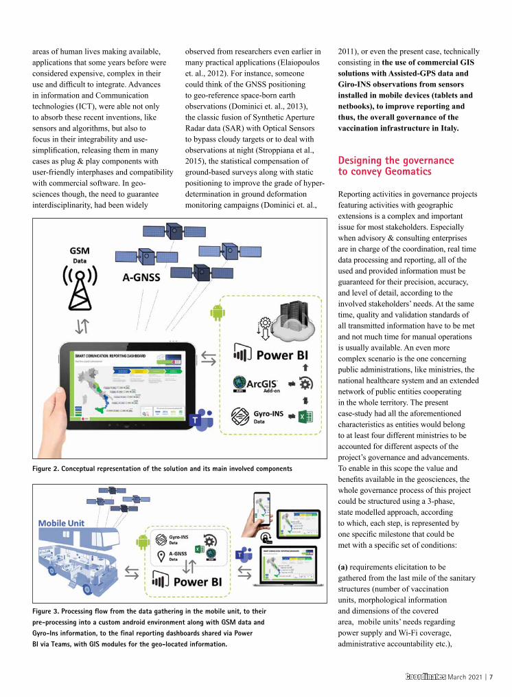
the governance of a project aiming in the creation of the digital infrastructure needed to support the anti-Covid-19 vaccination. Among the most important objectives of the project was the real time, multi-stakeholder accountability, with both push and pull information, about the state of installation and operativity of all the mobile digital assets involved 5 Italian Regions. To guarantee these objectives, having to deal with a project of a national extension, members of the team designed and proposed a multi-disciplinary solution, integrating positioning data and GIS features under the recently released reporting platform, Microsoft Power BI. The specific technical aim has been to provide an interactive reporting dashboard, with multi-level accountability and controlled accessibility, that features real-time updating on the operativity of all assets in the network, their positioning and states, calculated from A-GNSS observations and Gyro-INS data that are managed in a mobile android APP
environment. The designed architecture is fast to develop, highly versatile and customizable. For this reason, mostly plug-and-play, both hardware and software components have been chosen and used to provide accurate, real-time, and effective reporting on the global advancement and operativity of the project according to the specific needs of each stakeholder group. The case study evidenced the powerful opportunities offered today by commercial tools that convey geomatic principles and techniques into more versatile, integrable and contextless applications. In addition, the paper tried to evidence that, even if the applicability of these tools is immediate, there is still need to cultivate a certain knowledge of the traditional principles of geomatics, that when used accordingly, can provide very interesting and valuable solutions.
Geomatics means… integration
Digital transformation, since a couple of decades, has been revolutionizing most
Figure 1. Commercial software Microsoft Power BI integrated with the Esri’s ArcGIS addon to visualize the position of a mobile unit operating in a series of remote vaccination points
6 | Coordinates March 2021
areas of human lives making available, applications that some years before were considered expensive, complex in their use and difficult to integrate. Advances in information and Communication technologies (ICT), were able not only to absorb these recent inventions, like sensors and algorithms, but also to focus in their integrability and use-simplification, releasing them in many cases as plug & play components with user-friendly interphases and compatibility with commercial software. In geo-sciences though, the need to guarantee interdisciplinarity, had been widely
observed from researchers even earlier in many practical applications (Elaiopoulos et. al., 2012). For instance, someone could think of the GNSS positioning to geo-reference space-born earth observations (Dominici et. al., 2013), the classic fusion of Synthetic Aperture Radar data (SAR) with Optical Sensors to bypass cloudy targets or to deal with observations at night (Stroppiana et al., 2015), the statistical compensation of ground-based surveys along with static positioning to improve the grade of hyper-determination in ground deformation monitoring campaigns (Dominici et. al.,
2011), or even the present case, technically consisting in the use of commercial GIS solutions with Assisted-GPS data and Giro-INS observations from sensors installed in mobile devices (tablets and netbooks), to improve reporting and thus, the overall governance of the vaccination infrastructure in Italy.
Designing the governance to convey Geomatics
Reporting activities in governance projects featuring activities with geographic extensions is a complex and important issue for most stakeholders. Especially when advisory & consulting enterprises are in charge of the coordination, real time data processing and reporting, all of the used and provided information must be guaranteed for their precision, accuracy, and level of detail, according to the involved stakeholders’ needs. At the same time, quality and validation standards of all transmitted information have to be met and not much time for manual operations is usually available. An even more complex scenario is the one concerning public administrations, like ministries, the national healthcare system and an extended network of public entities cooperating in the whole territory. The present case-study had all the aforementioned characteristics as entities would belong to at least four different ministries to be accounted for different aspects of the project’s governance and advancements. To enable in this scope the value and benefits available in the geosciences, the whole governance process of this project could be structured using a 3-phase, state modelled approach, according to which, each step, is represented by one specific milestone that could be met with a specific set of conditions:
(a) requirements elicitation to be gathered from the last mile of the sanitary structures (number of vaccination units, morphological information and dimensions of the covered area, mobile units’ needs regarding power supply and Wi-Fi coverage, administrative accountability etc.),
Figure 2. Conceptual representation of the solution and its main involved components
Figure 3. Processing flow from the data gathering in the mobile unit, to their pre-processing into a custom android environment along with GSM data and Gyro-Ins information, to the final reporting dashboards shared via Power BI via Teams, with GIS modules for the geo-located information.
Coordinates March 2021 | 7
(b) predisposition, logistics and handling of the digital assets to guarantee the vaccination mobile unit’s needs (mobile thermal printers, wireless barcode readers, tablets, netbooks, Wi-Fi mobile routers, etc.),
(c) the governance of the installation, issues management, integration and start-up of all devices in the interested territories both in hospitals and in remote units.
In some parts of the process, the set of conditions to be met is provided by the onboard sensors of the device (Gyro/Ins/GNSS). The processing of all data was designed to be done into an android mobile APP environment enabling their parametrization as an input spreadsheet to be read by the power BI tool. The last one should be interrogated periodically by various dashboards, adequately pre-customized according to the needs of each stakeholder. The dashboards would be finally shared directly as Microsoft Teams Tabs with respect and limitations to the accountability level of each stakeholder group, his or her institution and role in the project. Thus, from and architectonical point of view, the solution has been designed to guarantee a constant flow of information directly to the Microsoft Teams application of each stakeholder.
Deliverables and discussion
The key feature of the deliverable was designed to be its ability to handle the complexity of many institutions involved with the supply, distribution, installation, management and use of mobile assets constantly operating around the country. in particular, the fact that assets may be
used, owned, and managed by different entities, emerge the need to design a central governance that accounts separately each involved entity, with specific reports including actual position, state and operativity of all units.
Thanks to the navigable information in GIS environment, stakeholders have the freedom to interrogate the system for specific information, without the risk to enter in conflict with other divisions thanks to the various layers and the access levels pre-designed for all stakeholders’ groups. Responsibility issues are also seem to be quite manageable with the proposed solution as administrative owners of the assets are able to observe in real time where the assets of their responsibility are located, their state of operation, the operators that accompany the assets and the future locations that are released by the planning department.
Among the benefits of the project’s government is the fact that the solution features some planning abilities consisting in pre-designed KPIs that calculate the volumes of the operativity, the future needs in terms of consumables and supplies, as well as, the grade of advancement of all operation at present and in future instances. Another quite promising aspect has been the choice to design most components (except from the android supporting APP) using commercial tool mostly developed by major software providers as Microsoft. Under critical situations like the one of a pandemic strike, this choice speeded up the whole project both because of the existing and easily accessible knowledge and with for their fast integration, especially with respect to custom
solutions that need development from scratch. Regarding the final result, a certain number of constrains with respect to the customizability to the various needs was considered even if during the first weeks of application test it has not yet appeared.
References
Elaiopoulos, M., Dominici, D., Rosciano E., Alicandro M., 2012. Versatile and Interactive Surveying Methodologies to Provide Specific Topographic Solutions. Case of Study: Evaluating A Radio Antenna’s Prototype. International Federation of Surveyors. FIG Working Week - Rome, Italy, 4-5 May 2012
Abdalla, R., 2018. Urbanization and Crisis Management Using Geomatics Technologies. Crisis Management - Theory and Practice. DOI: 10.5772/intechopen.76415.
Franch-Pardo, I., Napoletano, B., Rosete-Verges, F. and Billa, L., 2020. Spatial analysis and GIS in the study of COVID-19. A review. Science of The Total Environment, 739, p.140033.
D. Dominici, E. Rosciano, M. Alicandro, M. Elaiopoulos, S. Trigliozzi and V. Massimi, “Cultural heritage documentation using geomatic techniques: Case study: San Basilio’s monastery, L’Aquila,” 2013 Digital Heritage International Congress Marseille, France, 2013, pp. 211-214, doi: 10.1109/DigitalHeritage.2013.6743735.
Stroppiana, D., Azar, R., Calò, F., Pepe, A., Imperatore, P., Boschetti, M., Silva, J., Brivio, P. and Lanari, R., 2015. Integration of Optical and SAR Data for Burned Area Mapping in Mediterranean Regions. Remote Sensing, 7(2), pp.1320-1345.
Dominici, D., Galeota, D., Gregori, A., Rosciano, E., Alicandro, M. and, Elaiopoulos, M. Using new techniques of geomatic and structural control in the old city center of L’Aquila after the April 6, 2009 earthquake. Joint International Symposium on Deformation Monitoring, Hong Kong, Nov. 2011
Features some planning abilities consisting in pre-
designed KPIs that calculate the volumes of the
operativity, the future needs in terms of consumables
and supplies, as well as, the grade of advancement
of all operation at present and in future instances
8 | Coordinates March 2021

The professional surveying education responses during the COVID-19
pandemic has resulted in an unprecedented shift in how we teach surveying students. While many institutions had increased the amount of online learning, and blended learning prior to COVID-19, the response across the global surveying education community has been phenomenal. During lockdown periods many academic staff had only a short time to adapt to either a totally online teaching mode, or predominantly online. For a profession which has a long history of very practical face-to-face (f2f) tuition, this is a big change.
The fact that many subjects were already offered online and both staff and students had some experience with online learning and teaching helped during this period of adaptation. In my discussions with colleagues, students were very accepting of the need for this change, even if it did not suit them all personally.
SURVEYING
Surveying1 education – Prospects and challenges post COVID-19The predominantly online mode of learning used during periods of COVID lockdown has both positive and negative impacts for learning
David MitchellChair of Commission 2, International Federation of Surveyors
1 In this article the term “Surveying” is based on the International Federation of Surveyors (FIG) definition of a surveyor which is very broad and includes all of the spatial disciplines.
As we approach the second quarter of 2021, we can reflect on the challenges that the adaptation to online study presented for students, academic staff and employers of our students and graduates. The predominantly online mode of learning used during periods of COVID lockdown has both positive and negative impacts for learning. In this article I consider these challenges and how they have impacted surveying education and consider what the future may hold as we head into the “new normal” post-COVID.
SDG Goal 4 and our response to COVID-19
SDG Goal 4 aims to “ensure inclusive and equitable quality education and promote lifelong learning opportunities for all.” In particular, the aim of Target 4.3 is to “By 2030, ensure equal access for all women and men to affordable and quality technical, vocational and tertiary education, including university”.
Also, Target 4.5 calls for the elimination of “gender disparities in education and ensure equal access to all levels of education and vocational training for the vulnerable, including persons with disabilities, indigenous peoples and children in vulnerable situations”. Recent studies have found that women are more likely to prefer online study than men (YouGov, 2021).
Online learning allows higher education to provide learning opportunities where
While surveying academic staff did an outstanding
job adjusting to delivery learning opportunities
online, the preparation time for each session was
much more than before and created significant
workload pressure for many staff. Developing online
learning materials and delivering these online is
more time consuming that traditional f2f mode
Coordinates March 2021 | 9
students can study any-time and anywhere. This is very significant opportunity for surveying education as students who previously lived too far away from the education institution, or were impacted by disabilities or cultural disadvantages may not have been able to come to the campus to study. Also, those that are required to work long hours to support themselves during study can better manage their various time demands and fit in study at times that work for them.
This is also a very significant opportunity in our efforts to meet SDG target 4.3 as online study opportunities remove some of the barriers to ensuring inclusive and equitable quality education and life-long learning opportunities for all.
How COVID-19 has impacted surveying education, and what we did and what we have learned.
While much development of digital learning materials, and learning management systems (LMS), had occurred prior to COVID, the uptake of digital learning uptake was accelerated by COVID-19 (YouGov, 2021). In fact, the development of LMS and related technology had progressed to a level that made the rapid transition possible. If COVID had occurred a decade ago then a response such as we saw in 2020 would have been much more difficult.
Overall, this was a remarkable achievement by surveying education institutions globally. We have witnessed a fundamental shift in how higher education is offered! It really brought forward decisions on the design of online learning by several years.
While there were differences
in the approach taken by individual higher education institutions in response to COVID-19, there were many common themes. There are three typical learning modes being used by academic institutions - traditional f2f, remote online, or a blended (or hybrid) learning which is a combination of both. Most institutions adapted to COVID lockdown periods by going totally online or facilitating remote learning. Typical innovations during lockdown included:• Lectures being run using video
conferencing tools which allowed students to use audio and/or chat to ask questions. Where possible lectures were recorded for later play back.
• Lecture materials placed on the LMS. • Staff worked remotely and were
provided with ICT support to ensure they were ready to broadcast lectures online and create videos. For example, the University of Glasgow provide staff with ‘studio in a box’ kits for recording material at home (Kelly, 2020).
• Where students did not have computers or access to internet, the lecture materials were posted to them, and loan computers provided where possible (Whittal 2021).
• Short instructional videos to explain a particular concept or process, or to provide a briefing for practical work.
• Video-recording work on current projects to play back to the students.
• It was universally accepted that practical classes were a critical part of the learning experience. Many
academic institutions modified timetables to fit in as much practical tuition before and after lockdown periods as possible.
• Group project work was undertaken remotely with students using online communication platforms or social media.
• Access to learning materials is broadening. Social media platforms are actively used by young people as part of their informal learning. Younger look for educational features on social media platforms (30% of Millennials, 29% of Generation Z, 19% of older generations). For example, 24% of Generation Z and 15% of Millennials surveyed used Twitter to educate themselves about environmental issues, compared with just 6% of those in older generations (YouGov, 2021).
So, what did we learn from this experience in 2020? Academic staff have told us that the job of teaching has become increasingly challenging. While surveying academic staff did an outstanding job adjusting to delivery learning opportunities online, the preparation time for each session was much more than before and created significant workload pressure for many staff. Developing online learning materials and delivering these online is more time consuming that traditional f2f mode.
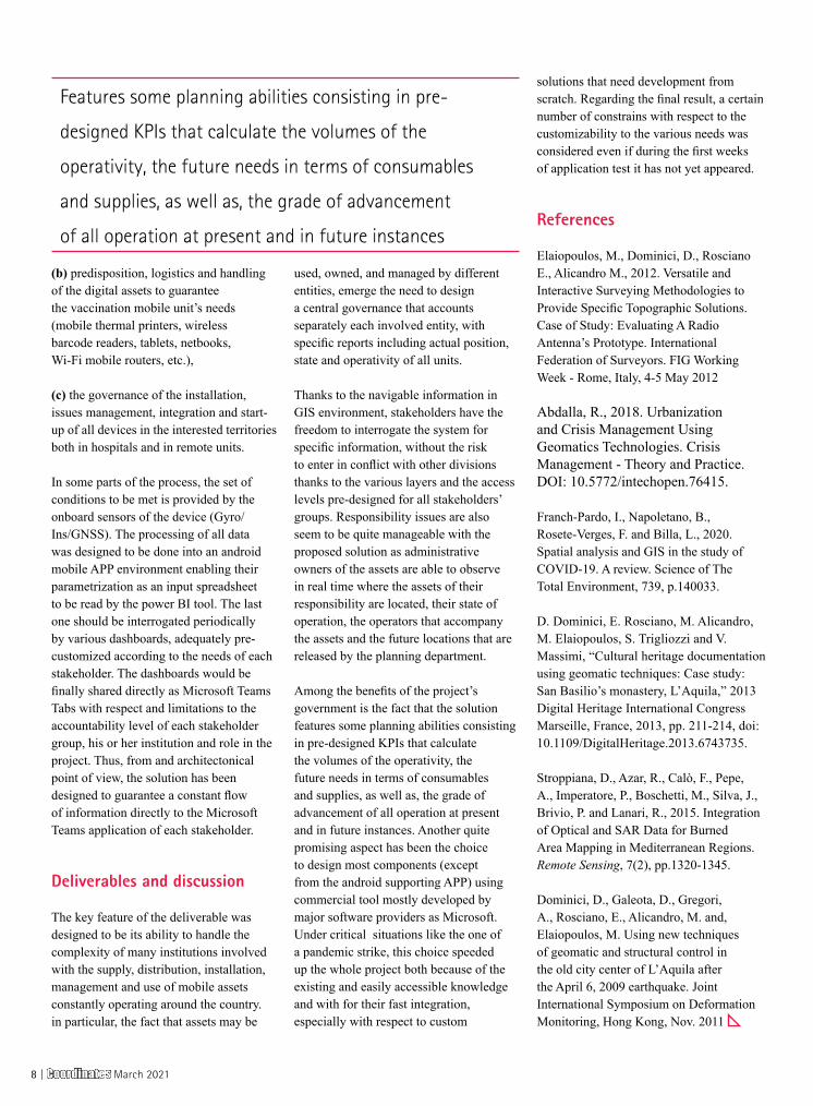
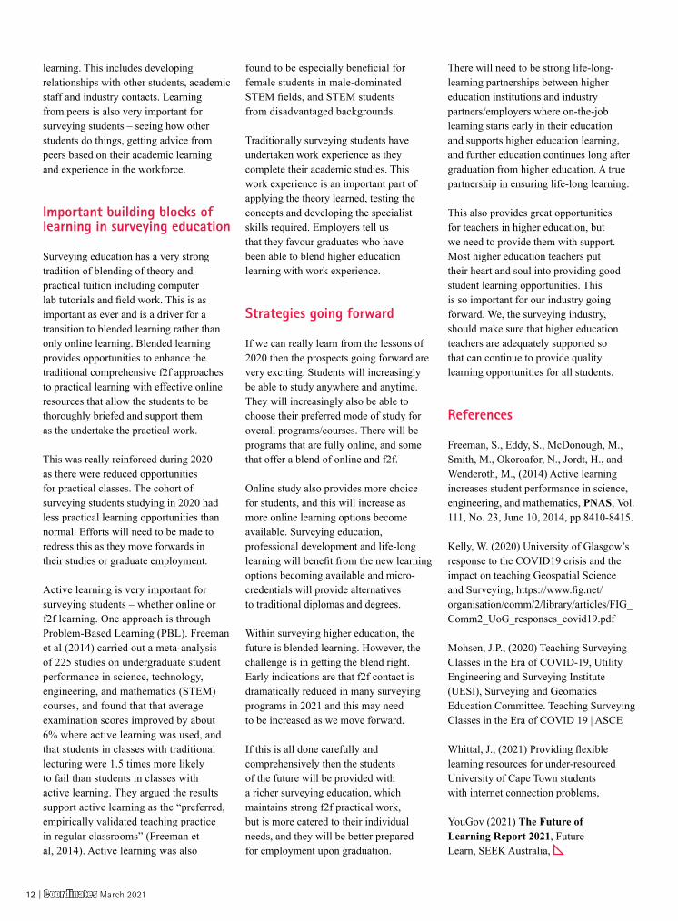
Students’ opinions about online learning vary. FIG Commission 2 working group 2.3 developed a questionnaire on surveying students approaches to learning and studying, this was distributed globally during 2020. The preliminary results are informed by students experiences during periods of lockdown and help us to understand what students prefer.
In terms of the learning mode the preferred options for most students are f2f and blended learning:1. Only 37% prefer to learn through
online study (real time), and only 31% prefer to learn through online study (deferred - not in real time). This is in line with other studies such as Yougov
10 | Coordinates March 2021
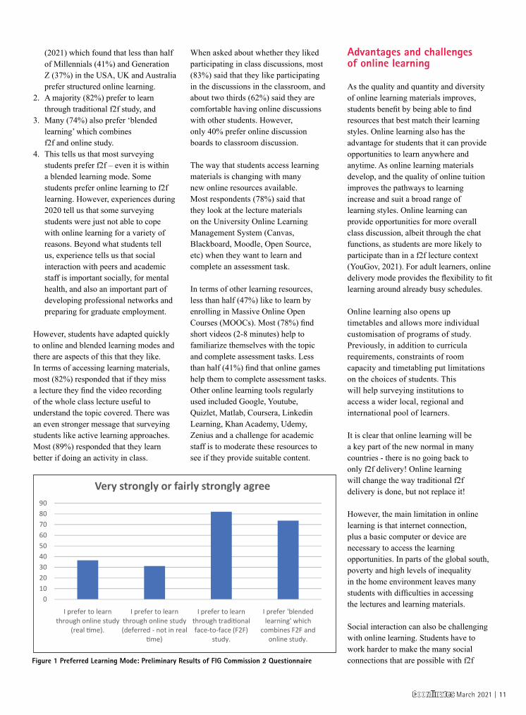
(2021) which found that less than half of Millennials (41%) and Generation Z (37%) in the USA, UK and Australia prefer structured online learning.
2. A majority (82%) prefer to learn through traditional f2f study, and
3. Many (74%) also prefer ‘blended learning’ which combines f2f and online study.
4. This tells us that most surveying students prefer f2f – even it is within a blended learning mode. Some students prefer online learning to f2f learning. However, experiences during 2020 tell us that some surveying students were just not able to cope with online learning for a variety of reasons. Beyond what students tell us, experience tells us that social interaction with peers and academic staff is important socially, for mental health, and also an important part of developing professional networks and preparing for graduate employment.
However, students have adapted quickly to online and blended learning modes and there are aspects of this that they like. In terms of accessing learning materials, most (82%) responded that if they miss a lecture they find the video recording of the whole class lecture useful to understand the topic covered. There was an even stronger message that surveying students like active learning approaches. Most (89%) responded that they learn better if doing an activity in class.
When asked about whether they liked participating in class discussions, most (83%) said that they like participating in the discussions in the classroom, and about two thirds (62%) said they are comfortable having online discussions with other students. However, only 40% prefer online discussion boards to classroom discussion.
The way that students access learning materials is changing with many new online resources available. Most respondents (78%) said that they look at the lecture materials on the University Online Learning Management System (Canvas, Blackboard, Moodle, Open Source, etc) when they want to learn and complete an assessment task.
In terms of other learning resources, less than half (47%) like to learn by enrolling in Massive Online Open Courses (MOOCs). Most (78%) find short videos (2-8 minutes) help to familiarize themselves with the topic and complete assessment tasks. Less than half (41%) find that online games help them to complete assessment tasks. Other online learning tools regularly used included Google, Youtube, Quizlet, Matlab, Coursera, Linkedin Learning, Khan Academy, Udemy, Zenius and a challenge for academic staff is to moderate these resources to see if they provide suitable content.
Advantages and challenges of online learning
As the quality and quantity and diversity of online learning materials improves, students benefit by being able to find resources that best match their learning styles. Online learning also has the advantage for students that it can provide opportunities to learn anywhere and anytime. As online learning materials develop, and the quality of online tuition improves the pathways to learning increase and suit a broad range of learning styles. Online learning can provide opportunities for more overall class discussion, albeit through the chat functions, as students are more likely to participate than in a f2f lecture context (YouGov, 2021). For adult learners, online delivery mode provides the flexibility to fit learning around already busy schedules.
Online learning also opens up timetables and allows more individual customisation of programs of study. Previously, in addition to curricula requirements, constraints of room capacity and timetabling put limitations on the choices of students. This will help surveying institutions to access a wider local, regional and international pool of learners.
It is clear that online learning will be a key part of the new normal in many countries - there is no going back to only f2f delivery! Online learning will change the way traditional f2f delivery is done, but not replace it!
However, the main limitation in online learning is that internet connection, plus a basic computer or device are necessary to access the learning opportunities. In parts of the global south, poverty and high levels of inequality in the home environment leaves many students with difficulties in accessing the lectures and learning materials.
Social interaction can also be challenging with online learning. Students have to work harder to make the many social connections that are possible with f2f
0102030405060708090
I prefer to learn through online study
(real �me).
I prefer to learn through online study (deferred - not in real
�me)
I prefer to learn through tradi�onal face-to-face (F2F)
study.
I prefer 'blended learning' which
combines F2F and online study.
Very strongly or fairly strongly agree
Figure 1 Preferred Learning Mode: Preliminary Results of FIG Commission 2 Questionnaire
Coordinates March 2021 | 11
learning. This includes developing relationships with other students, academic staff and industry contacts. Learning from peers is also very important for surveying students – seeing how other students do things, getting advice from peers based on their academic learning and experience in the workforce.
Important building blocks of learning in surveying education
Surveying education has a very strong tradition of blending of theory and practical tuition including computer lab tutorials and field work. This is as important as ever and is a driver for a transition to blended learning rather than only online learning. Blended learning provides opportunities to enhance the traditional comprehensive f2f approaches to practical learning with effective online resources that allow the students to be thoroughly briefed and support them as the undertake the practical work.
This was really reinforced during 2020 as there were reduced opportunities for practical classes. The cohort of surveying students studying in 2020 had less practical learning opportunities than normal. Efforts will need to be made to redress this as they move forwards in their studies or graduate employment.
Active learning is very important for surveying students – whether online or f2f learning. One approach is through Problem-Based Learning (PBL). Freeman et al (2014) carried out a meta-analysis of 225 studies on undergraduate student performance in science, technology, engineering, and mathematics (STEM) courses, and found that that average examination scores improved by about 6% where active learning was used, and that students in classes with traditional lecturing were 1.5 times more likely to fail than students in classes with active learning. They argued the results support active learning as the “preferred, empirically validated teaching practice in regular classrooms” (Freeman et al, 2014). Active learning was also
found to be especially beneficial for female students in male-dominated STEM fields, and STEM students from disadvantaged backgrounds.
Traditionally surveying students have undertaken work experience as they complete their academic studies. This work experience is an important part of applying the theory learned, testing the concepts and developing the specialist skills required. Employers tell us that they favour graduates who have been able to blend higher education learning with work experience.
Strategies going forward
If we can really learn from the lessons of 2020 then the prospects going forward are very exciting. Students will increasingly be able to study anywhere and anytime. They will increasingly also be able to choose their preferred mode of study for overall programs/courses. There will be programs that are fully online, and some that offer a blend of online and f2f.
Online study also provides more choice for students, and this will increase as more online learning options become available. Surveying education, professional development and life-long learning will benefit from the new learning options becoming available and micro-credentials will provide alternatives to traditional diplomas and degrees.
Within surveying higher education, the future is blended learning. However, the challenge is in getting the blend right. Early indications are that f2f contact is dramatically reduced in many surveying programs in 2021 and this may need to be increased as we move forward.
If this is all done carefully and comprehensively then the students of the future will be provided with a richer surveying education, which maintains strong f2f practical work, but is more catered to their individual needs, and they will be better prepared for employment upon graduation.
There will need to be strong life-long-learning partnerships between higher education institutions and industry partners/employers where on-the-job learning starts early in their education and supports higher education learning, and further education continues long after graduation from higher education. A true partnership in ensuring life-long learning.
This also provides great opportunities for teachers in higher education, but we need to provide them with support. Most higher education teachers put their heart and soul into providing good student learning opportunities. This is so important for our industry going forward. We, the surveying industry, should make sure that higher education teachers are adequately supported so that can continue to provide quality learning opportunities for all students.
References
Freeman, S., Eddy, S., McDonough, M., Smith, M., Okoroafor, N., Jordt, H., and Wenderoth, M., (2014) Active learning increases student performance in science, engineering, and mathematics, PNAS, Vol. 111, No. 23, June 10, 2014, pp 8410-8415.
Kelly, W. (2020) University of Glasgow’s response to the COVID19 crisis and the impact on teaching Geospatial Science and Surveying, https://www.fig.net/organisation/comm/2/library/articles/FIG_Comm2_UoG_responses_covid19.pdf
Mohsen, J.P., (2020) Teaching Surveying Classes in the Era of COVID-19, Utility Engineering and Surveying Institute (UESI), Surveying and Geomatics Education Committee. Teaching Surveying Classes in the Era of COVID 19 | ASCE
Whittal, J., (2021) Providing flexible learning resources for under-resourced University of Cape Town students with internet connection problems,
YouGov (2021) The Future of Learning Report 2021, Future Learn, SEEK Australia,
12 | Coordinates March 2021
POLICY
What do the new Geospatial guidelines have for Spatial planners?While there are many positives that will accrue from the changes brought about by the Guidelines, there are some aspects about which the Planners will need to be concerned about
Dr. MahavirProfessor and Head of the Department of Physical Planning, School of Planning and Architecture, New Delhi 110002, India
Dr. Prabh BediSpatial Planner and Geospatial Expert, India
Planners have been using maps for making plans and for its
implementation. With the emergence of the field of geospatial industry there has been increasing dependence for various planning tasks. Over the past few decades, changes in the policies and guidelines have impacted the work of the planners. The authors have here attempted to analyse the New Geospatial Guidelines from the perspective of Spatial Planners.
What do planners’ do?
Planners’ prime role is to plan the towns, cities, and the areas in the immediate vicinity of the urban centers. Their key deliverable being development plans, popularly known as master plans. One of the first steps in any planning activity is surveying and mapping of the existing conditions. Initially, these activities had been taken up by the authorities themselves involving long hours of data collection in the field using various traditional surveying techniques and collation of same on the drafting table. Some efforts
were made to use the then latest available technology of aerial photography and photogrammetry to map some towns. The process of obtaining the aerial photographs involved special approvals from concerned ministries involving time and laborious procedure. These and related activities involved large time periods, significant investments, specific hardware and software and skilled professionals.
With the ease in availability of computers, some tasks began to be done using semi-automated processes. This process largely consisted of digitization and vectorization of various data layers leading to the reduction in the time for creation of the data which had primarily consisted of drafting of the existing and proposed land use maps. Over the decades, efforts were put in by some city authorities towards creation of the spatial data using the available CAD and GIS technologies (Bedi, 2016). The deliverables till now were limited to drafting the maps using these technologies instead of by hand. Use of the GIS technology in analysis and application was still far in between like better enforcement and collection of property tax in Mirzapur (Gibbons, 2010) and billing (and prevention of theft) of utilities like water, electricity, piped gas was the earliest examples.
What Geospatial industry has been offering to planners?
The advancement in information systems and technology saw initiatives being
Though the Guidelines themselves are generally silent
on the frequency of availability of geospatial data,
these will further reinforce the need for availability of
more frequent socio-economic data, viz., the Census
of India, which is provided decennially at present
Coordinates March 2021 | 13
made towards using GIS software for not mere data creation and generating colorful maps, but for its more intense use like in municipal services applications. Various government led missions and schemes were launched like National Spatial Database Infrastructure (NSDI) and National Urban Information Systems (NUIS). Under these, guidelines and standards were set up for creation and use of data and applications. Agencies and organisations like Survey of India, National Atlas and Thematic Mapping Organisation (NATMO) and National Remote Sensing Centre (NSRC) have been undertaking the ongoing gargantuan task of mapping the country and adapting to the changes in the technology. The availability of satellite images through national (BHUVAN) and international (Google Earth and likes) platforms to the academicians, researchers, and industry professionals, brought some level of ease in the work of Planners. The mapping tasks that were solely dependent on physical surveys, could be more easily accomplished using the satellite images and aerial photographs. Though access to these geospatial products was limited largely to government organisations and even these required special approvals. Overtime, access to the maps and data produced by these organisations became fraught with delays due to long wait for approvals from the involved government departments.
National Map Policy of 2005 was the first step towards easing the access to spatial data without compromising on the national security. Remote Sensing Data Policy, 2011 removed the restrictions on all satellite remote sensing data up to one meter resolution. During the last decade, government has come up with various policies and draft bills on data sharing, geospatial information, and drones in order to streamline the fast-growing geospatial industry. In 2016, government released the draft Geospatial Information Regulation Bill (GIRB) on the use, creation and storage of spatial data. It has been stated by the authors about it being regressive and reverting everything urban to the dark ages (Bedi
and Mahavir, 2016 and Mahavir, 2016). All these policies have had an impact on the planning field. Though there have been downsides of these policies, but to a large extent these policies have benefited the planners in their work towards making more informed decisions for the plans across the various scales. The most recent New Geospatial Guidelines, 2021 is a liberalisation initiative in the field.
What do the new guidelines have for planners?
Planners’ involvement and requirement for the quantum, accuracy and detailing of the data in the process of plan preparation varies by type and scale. Some plans vary by the sector addressed as environmental or transport plans at sub-city, city or intercity levels. Others vary at neighborhood, zonal, urban to regional scales. The starting point for all these is data on maps and provide the end deliverable in the map form too. Planning is a repetitive and cyclic activity. Every few years, plans are to be revised and new plans are required to be drafted. Planners’ work is highly dependent on data, which needs to be spread over a timeline implying that data creation and updation an ongoing activity and is the basic infrastructure for the planner (Mahavir and Bedi, 2012). Quality of data and ease of access to same has the required effect on the success in plan preparation and its implementation process. Any delay in the procurement of data like satellite images has an impact on the resultant data creation further having repercussions on the delay in completion of the projects.
Satellite images today are considered as the starting point of most planning projects. The practice that has been adopted by most private players in the planning field due to the delays in procuring the satellite images is to rely on easily and freely available satellite data on the web to start the projects and undertake the preliminary tasks, until the government approved satellite images are made available for the project. This is the method adopted to relatively reduce the losses in project costs and time. The
liberalised Geospatial Guidelines do state the involvement of small players in data production. With the liberalisation of acquisition and production of geospatial data and services, the delays in data procurement due to various approvals are likely to be reduced. At this stage it is being assumed that such data is likely to be available that has since long been listed under restricted and prohibited zones like coastal zones and border area or those in close proximity to the strategically sensitive establishments. More clarity on the ease of availability of satellite images specially in terms of time in procurement and paperwork involved would be detrimental in the much-required success of the planning projects. The Guidelines do state that there will be not any negative list of prohibited and restricted areas. This is being largely understood as no restriction in the mapping and data creation of such prohibited areas that are strategically important from country’s defense perspective. The question still remains will the satellite images of these areas be available?
With the permission being granted to Indian companies for terrestrial mobile mapping survey and street view survey (Government of India, 2021), there will be concerns for data quality. Data quality concern here is being stated with respect to spatial and non-spatial data accuracy. The Guidelines clearly state that only Indian organisations will be able to create resolution higher than one meter. This is an aspect that needs to be treaded with caution as in high resolution images and large-scale mapping accuracy, especially in urban areas can have a long-lasting impact on the projects.
The change being brought in by the Guidelines stating that maps and geospatial data of accuracy/value finer than the threshold value of one meter can be not only created but be owned by Indian entities only and be stored and processed in India only. This leaves the status of all those multi-national organisations that are involved in the various planning projects in question as these companies will not be able to create
14 | Coordinates March 2021
the geospatial database, but only license the same from the Indian companies which opens up the avenues for startups and Indian Planning firms to venture into projects in the likes of SMART City and AMRUT Mission and projects for small and medium towns, thereby opening up business avenues to the tune of one lakh crore by 2029 (Sharma et. al., 2021). At the same time, the Guidelines have created an opportunity for Indian companies as these will be solely the ones that can undertake such tasks.
The use of geospatial technology in the field of planning has been largely limited to data creation and map making. Though some use of application has been done from time to time, there are many aspects of planning that can be further enhanced with these liberalised guidelines like local area planning, planning enforcement where high resolution images and maps would play a vital role for stringent enforcement of building byelaws and check unauthorised use and violation of FAR.
In the plan making process, more effective public participation can be possible with linking the new liberal Guidelines to emerging social media platforms and tools. This easy access would lead to more transparent documentation and management of mutations and sub-division of built property further improving the litigation process.
The Guidelines will also play a positive and supportive role in disaster management with quick and timely creation of the data including satellite images for the purposes of post disaster activities. Digital maps of finer accuracy will help in providing timely support to the victims. In light of the current pandemic, there is a scope for better identification and management of containment zones with the availability of high-resolution satellite images and higher granularity of non-spatial data, as has been the case with Gurgaon’s Integrated Command and Control Centre.
The 4IR, which is at a nascent stage and City Digital Twins are other areas that will benefit with these liberalised guidelines and have a scope for integration into core
planning activities in turn enabling the planners in providing the citizens with better living spaces ad experiences.
The Guidelines change is also seen at a time of rise in competition in the geospatial field. With the liberalisation in the geospatial industry many planning professionals are expected to be more involved in its various processes – surveying, data procurement and creation, editing, collection, manipulation, application, hosting and other related activities which had been typically sublet to geospatial professionals. This is expected to positively influence the costs of production and at the same time impact the quality of data produced. It is reiterated that there will be a need for strict adherence to the data and application standards. It is also foreseen that the Guidelines may lead to monopolisation of amongst the private players.
Conclusions
While there are many positives that will accrue from the changes brought about by the Guidelines, there are some aspects about which the Planners will need to be concerned about, that is danger of too much data - like too much data creation and high resolution of images is likely to create data noise. Standardisation of the requirement for the application at various scales and resolution is a possible solution to such problems. Though the Guidelines themselves are generally silent on the frequency of availability of geospatial data, these will further reinforce the need for availability of more frequent socio-economic data, viz., the Census of India, which is provided decennially at present.
It must be noted that the current initiative are guidelines, which in due course may lead to a policy and an act, which will put the various aspects put forth in the Guidelines in clearer perspective. The liberal Guidelines released by Department of Space and Technology is a step towards creating a competitive and vibrant geospatial environment in the country. It is sure to be a watershed not only in the geospatial industry, but all those related fields that this industry supports.
References
[1] Bedi, Prabh, 2016, Indian National Urban Information Systems as an input for Planning Decision Making by Municipalities, unpublished Ph. D. Thesis, School of Planning and Architecture, New Delhi.
[2] Bedi, Prabh and Mahavir, 2016, ‘Smart Cities and Not So Smart Geospatial Information Regulation Bill 2016’, in SPANDREL, Issue 12, Monsoon 2016-17 (ISSN:2231-4601 SPANDREL), pp 82-91
[3] Gibbons, Scott, 2010, ‘Mirzapur-A GIS that works’ accessed at Mirzapur: A GIS that works - Geospatial World on 01 March, 2021
[4] Government of India, 2021, ‘Guidelines for acquiring and producing geospatial data and geospatial data services including maps’ accessed at Final Approved Guidelines on Geospatial Data.pdf (dst.gov.in) on 28 February, 2021
[5] Mahavir and Bedi, 2012, ‘A case for financing the ‘data’ as part of infrastructure’, accessed at Coordinates : A resource on positioning, navigation and beyond » Blog Archive » A case for financing the `data’ as part of infrastructure (mycoordinates.org) on 10 March, 2021.
[6] Mahavir, 2016, ‘The Geospatial Information Regulation Bill’ accessed at Coordinates : A resource on positioning, navigation and beyond » Blog Archive » The Geospatial Information Regulation Bill (mycoordinates.org) on 09 March, 2021.
[7] Sharma, S. N., Singh, S. and Aravind, I., 2021, ‘Mapping the way to Rs. 1,00,000 crore’, Economic Times February 21-27, 2021.
Coordinates March 2021 | 15
LAND ADMINISTRATION
Systematic Land Titling using Open Source Geospatial Software and Machine Learning: the MLG experienceIn this paper, the use of open source software technologies are discussed including: geospatial software (e.g., GDAL, QGIS, Geoserver, PostGIS, Open Layers) to gather, store, manage, analyze and visualize geospatial data, machine learning to extract building footprints from drone imagery
Mehran GhandehariMedici Land Governance, Utah, USA
Ailey K. HughesMedici Land Governance, Utah, USA
Mariam PaulMedici Land Governance, Utah, USA
Ben WhiteMedici Land Governance, Utah, USA
Sky YoungMedici Land Governance, Utah, USA
Duane JohnsonMedici Land Governance, Utah, USA
Didier SagashyaMedici Land Governance, Utah, USA
Trent LarsonMedici Land Governance, Utah, USA
Medici Land Governance (MLG) captures property information
including spatial and textual data by identifying and mapping land boundaries using high resolution drone imagery. MLG works closely with country governments to establish formal property ownership for land owners by implementing Systematic Land Titling programs using user-friendly, low-cost, and secure land administration systems built on open source geospatial technology. In this
paper, the use of open source software technologies are discussed including: geospatial software (e.g., GDAL, QGIS, Geoserver, PostGIS, Open Layers) to gather, store, manage, analyze and visualize geospatial data, machine learning to extract building footprints from drone imagery and recognizing text from ID, and blockchain technology for tamper proof public records.
Introduction
Lack of formal property rights is a significant issue in the world. Around 20%-30% of land parcels worldwide have been formally registered, resulting in land insecurity for many (White and Martin 2002). Traditional land administration systems for recording property rights can be expensive, restrictive in terms of technology, less efficient, and less transparent to government officials and land owners (Williamson et al. 2010). In this paper, it is demonstrated that new emerging technologies, open source software and availability of modern instruments would speed up mass titling in developing nations. The case of Lusaka, Zambia will be used as an example of the tools, applications and methodology developed by Medici Land Governance (MLG)1.
16 | Coordinates March 2021
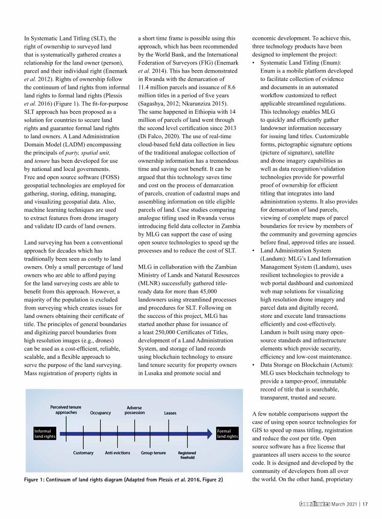
In Systematic Land Titling (SLT), the right of ownership to surveyed land that is systematically gathered creates a relationship for the land owner (person), parcel and their individual right (Enemark et al. 2012). Rights of ownership follow the continuum of land rights from informal land rights to formal land rights (Plessis et al. 2016) (Figure 1). The fit-for-purpose SLT approach has been proposed as a solution for countries to secure land rights and guarantee formal land rights to land owners. A Land Administration Domain Model (LADM) encompassing the principals of party, spatial unit, and tenure has been developed for use by national and local governments. Free and open source software (FOSS) geospatial technologies are employed for gathering, storing, editing, managing, and visualizing geospatial data. Also, machine learning techniques are used to extract features from drone imagery and validate ID cards of land owners.
Land surveying has been a conventional approach for decades which has traditionally been seen as costly to land owners. Only a small percentage of land owners who are able to afford paying for the land surveying costs are able to benefit from this approach. However, a majority of the population is excluded from surveying which creates issues for land owners obtaining their certificate of title. The principles of general boundaries and digitizing parcel boundaries from high resolution images (e.g., drones) can be used as a cost-efficient, reliable, scalable, and a flexible approach to serve the purpose of the land surveying. Mass registration of property rights in
a short time frame is possible using this approach, which has been recommended by the World Bank, and the International Federation of Surveyors (FIG) (Enemark et al. 2014). This has been demonstrated in Rwanda with the demarcation of 11.4 million parcels and issuance of 8.6 million titles in a period of five years (Sagashya, 2012; Nkurunziza 2015). The same happened in Ethiopia with 14 million of parcels of land went through the second level certification since 2013 (Di Falco, 2020). The use of real-time cloud-based field data collection in lieu of the traditional analogue collection of ownership information has a tremendous time and saving cost benefit. It can be argued that this technology saves time and cost on the process of demarcation of parcels, creation of cadastral maps and assembling information on title eligible parcels of land. Case studies comparing analogue titling used in Rwanda versus introducing field data collector in Zambia by MLG can support the case of using open source technologies to speed up the processes and to reduce the cost of SLT.
MLG in collaboration with the Zambian Ministry of Lands and Natural Resources (MLNR) successfully gathered title-ready data for more than 45,000 landowners using streamlined processes and procedures for SLT. Following on the success of this project, MLG has started another phase for issuance of a least 250,000 Certificates of Titles, development of a Land Administration System, and storage of land records using blockchain technology to ensure land tenure security for property owners in Lusaka and promote social and
economic development. To achieve this, three technology products have been designed to implement the project:• Systematic Land Titling (Enum):
Enum is a mobile platform developed to facilitate collection of evidence and documents in an automated workflow customized to reflect applicable streamlined regulations. This technology enables MLG to quickly and efficiently gather landowner information necessary for issuing land titles. Customizable forms, pictographic signature options (picture of signature), satellite and drone imagery capabilities as well as data recognition/validation technologies provide for powerful proof of ownership for efficient titling that integrates into land administration systems. It also provides for demarcation of land parcels, viewing of complete maps of parcel boundaries for review by members of the community and governing agencies before final, approved titles are issued.
• Land Administration System (Landum): MLG’s Land Information Management System (Landum), uses resilient technologies to provide a web portal dashboard and customized web map solutions for visualizing high resolution drone imagery and parcel data and digitally record, store and execute land transactions efficiently and cost-effectively. Landum is built using many open-source standards and infrastructure elements which provide security, efficiency and low-cost maintenance.
• Data Storage on Blockchain (Actum): MLG uses blockchain technology to provide a tamper-proof, immutable record of title that is searchable, transparent, trusted and secure.
A few notable comparisons support the case of using open source technologies for GIS to speed up mass titling, registration and reduce the cost per title. Open source software has a free license that guarantees all users access to the source code. It is designed and developed by the community of developers from all over the world. On the other hand, proprietary Figure 1: Continuum of land rights diagram (Adapted from Plessis et al. 2016, Figure 2)
Coordinates March 2021 | 17
software has been developed by a team of developers from a single company. Choosing the appropriate system between open source or proprietary software can be challenging. proprietary solutions are widely used in land administration and cadastre systems, but the use of open source geospatial software has been significantly increased in the recent years (Zein et al. 2015). In this paper, open source GIS software technologies used to meet the objective of low-cost, time saving and efficiency are discussed.
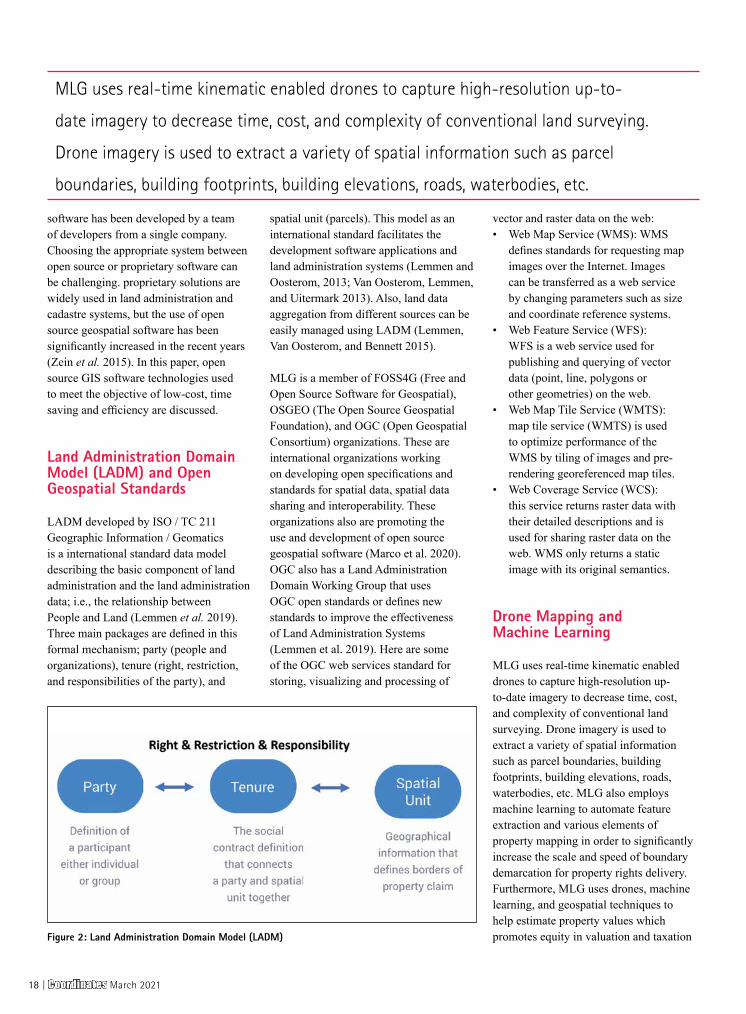
Land Administration Domain Model (LADM) and Open Geospatial Standards
LADM developed by ISO / TC 211 Geographic Information / Geomatics is a international standard data model describing the basic component of land administration and the land administration data; i.e., the relationship between People and Land (Lemmen et al. 2019). Three main packages are defined in this formal mechanism; party (people and organizations), tenure (right, restriction, and responsibilities of the party), and
spatial unit (parcels). This model as an international standard facilitates the development software applications and land administration systems (Lemmen and Oosterom, 2013; Van Oosterom, Lemmen, and Uitermark 2013). Also, land data aggregation from different sources can be easily managed using LADM (Lemmen, Van Oosterom, and Bennett 2015).
MLG is a member of FOSS4G (Free and Open Source Software for Geospatial), OSGEO (The Open Source Geospatial Foundation), and OGC (Open Geospatial Consortium) organizations. These are international organizations working on developing open specifications and standards for spatial data, spatial data sharing and interoperability. These organizations also are promoting the use and development of open source geospatial software (Marco et al. 2020). OGC also has a Land Administration Domain Working Group that uses OGC open standards or defines new standards to improve the effectiveness of Land Administration Systems (Lemmen et al. 2019). Here are some of the OGC web services standard for storing, visualizing and processing of
vector and raster data on the web:• Web Map Service (WMS): WMS
defines standards for requesting map images over the Internet. Images can be transferred as a web service by changing parameters such as size and coordinate reference systems.
• Web Feature Service (WFS): WFS is a web service used for publishing and querying of vector data (point, line, polygons or other geometries) on the web.
• Web Map Tile Service (WMTS): map tile service (WMTS) is used to optimize performance of the WMS by tiling of images and pre-rendering georeferenced map tiles.
• Web Coverage Service (WCS): this service returns raster data with their detailed descriptions and is used for sharing raster data on the web. WMS only returns a static image with its original semantics.
Drone Mapping and Machine Learning
MLG uses real-time kinematic enabled drones to capture high-resolution up-to-date imagery to decrease time, cost, and complexity of conventional land surveying. Drone imagery is used to extract a variety of spatial information such as parcel boundaries, building footprints, building elevations, roads, waterbodies, etc. MLG also employs machine learning to automate feature extraction and various elements of property mapping in order to significantly increase the scale and speed of boundary demarcation for property rights delivery. Furthermore, MLG uses drones, machine learning, and geospatial techniques to help estimate property values which promotes equity in valuation and taxation Figure 2: Land Administration Domain Model (LADM)
MLG uses real-time kinematic enabled drones to capture high-resolution up-to-
date imagery to decrease time, cost, and complexity of conventional land surveying.
Drone imagery is used to extract a variety of spatial information such as parcel
boundaries, building footprints, building elevations, roads, waterbodies, etc.
18 | Coordinates March 2021
and allows for a cost effective and more frequent valuation updating.
An open source photogrammetry toolkit named OpenDroneMap2 is tested to process drone imageries and to generate orthophotos, DEMs and 3D models. The results are compared with Pix4D3, a proprietary software which is widely used for processing drone imagery. The generated raster data is clipped and projected using GDAL as an open source geospatial module. Based on our experience, for a large-scale project with a very large dataset, this simple operations takes a long time using other conventional GIS software.
The high-resolution imagery as a very valuable data source is processed using machine learning algorithms to automatically extract different type of spatial data. FastAI4 is an open source python module used to extract building footprints from drone imagery. Pre-existing building footprints are downloaded from Open Street Map (OSM)5 and are used for training the deep learning model. Osmium6 and Robosat7 are used to process the OSM data and extract buildings as a GeoJson file. GDAL8 is used to make titles and generate a Slippy map as well as to convert OSM GeoJson files to binary Geotifs. Finally, FastAI is used to train a segmentation model to be used for extracting building footprints in other areas.
Spatial Data Infrastructure
A large amount of data is captured with drones and various type of geospatial data can be extracted from the imagery. A Spatial Data Infrastructure (SDI) is needed to manage the data, metadata and users, simplify the search and discovery of geospatial data, and maintain data integrity. Based on another definition, SDI is “the technology, policies, standards, human resources, and related activities necessary to acquire, process, distribute, use, maintain, and preserve spatial data” (The White House, Office
of Management and Budget 2002). MLG is testing GeoNode9 as an open source geospatial content management system for deploying a SDI. The goal is to provide a geospatial data portal that all of the organizations and stakeholders can have an easy access to the data. For example, the drone imagery captured for a large area and other data extracted from imagery (e.g., parcels, building footprints, roads, rivers) needs to be imported into a spatial data structure in order to be easily accessible for visualization and download by various organizations.
Desktop GIS and Geospatial Libraries
QGIS10 as an open source cross-platform and free desktop geospatial software is used to manage and analyze the vector and raster data stored in Open Geospatial Consortium (OGC) formats such as GeoPackage and GeoJSON. QGIS is actively developed by a very large community of contributors and improvements and new features are frequently added to the software. It is flexible and new tools can be developed
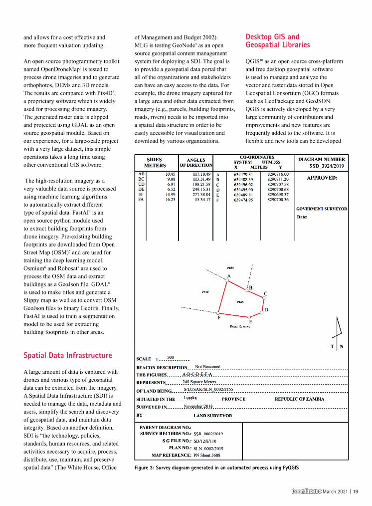
Figure 3: Survey diagram generated in an automated process using PyQGIS
Coordinates March 2021 | 19
to meet the exact specifications without dependending on external party. It has a much lower total cost of ownership. It provides a culture of collaboration and can attract better talents for the company and some other advantages such as greater security, more freedom and customization, and working on most operating systems. It has some disadvantages as well such as the lack of some tools for analysis and modeling and the lack of a good technical support (Badea and Badea 2016).
Python and some open source geospatial modules (e.g., GDAL, Rasterio11, Geopandas12, Shapely13) are used to process drone images and automate GIS processes. For example, Geopandas is used to read and write parcel data, and check for attribute and geometry issues. PyQGIS is used as an stand-alone python script for automated generation of survey diagrams while producing land titles. Figure 3 shows the survey diagram generated using PyQGIS. It only takes 3 seconds to generate each diagram that is quite fast. The other advantage of PyQGIS is the possibility if running the code in a QGIS docker. This way the entire process for generating these diagrams can be automated on the cloud.
GDAL/OGR are used as the core geospatial libraries for geospatial ETL processes. GDAL is used for reading, writing, and processing of raster data and OGR is used for handling simple features vector data. Geographic Resources Analysis Support System (GRASS) is also used for cleaning the geometry for solving topological errors.
GIS Web Mapping
Geospatial vector data is transformed to a database implemented on the cloud
to be used in mobile and web land titling applications. PostgreSQL14 as an open source relational object-based database is used to store and analyze spatial data. PostGIS15 as an extension of PostgreSQL is used to provide simple and advanced spatial analytic capability and is natively supported by other GIS applications and libraries such as Geoserver, QGIS, and GDAL. Geospatial raster data is stored on the
Geoserver16 that is an open source server used for sharing and mapping imagery and parcel data using standard protocols developed by the OGC such as Web Map Service (WMS), and Web Feature Service (WFS). For designing web-based mapping applications, Open Layer17 is used as an open-source JavaScript library. Open Street Map is used as a base layer for web mapping solution.
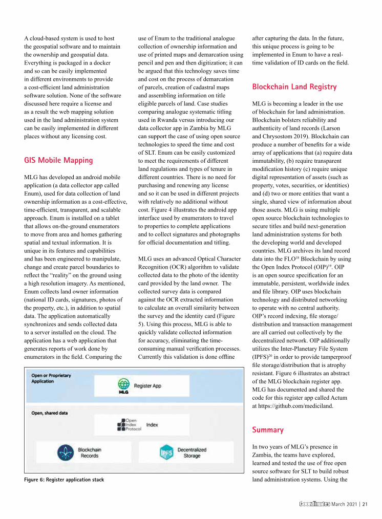
Figure 5: Validating of ID card using OCR and machine learning techniques
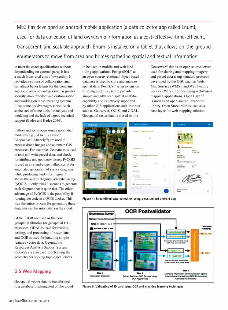
Figure 4: Streamlined data collection using a customized android app
MLG has developed an android mobile application (a data collector app called Enum),
used for data collection of land ownership information as a cost-effective, time-efficient,
transparent, and scalable approach. Enum is installed on a tablet that allows on-the-ground
enumerators to move from area and homes gathering spatial and textual information
20 | Coordinates March 2021
A cloud-based system is used to host the geospatial software and to maintain the ownership and geospatial data. Everything is packaged in a docker and so can be easily implemented in different environments to provide a cost-efficient land administration software solution. None of the software discussed here require a license and as a result the web mapping solution used in the land administration system can be easily implemented in different places without any licensing cost.
GIS Mobile Mapping
MLG has developed an android mobile application (a data collector app called Enum), used for data collection of land ownership information as a cost-effective, time-efficient, transparent, and scalable approach. Enum is installed on a tablet that allows on-the-ground enumerators to move from area and homes gathering spatial and textual information. It is unique in its features and capabilities and has been engineered to manipulate, change and create parcel boundaries to reflect the “reality” on the ground using a high resolution imagery. As mentioned, Enum collects land owner information (national ID cards, signatures, photos of the property, etc.), in addition to spatial data. The application automatically synchronizes and sends collected data to a server installed on the cloud. The application has a web application that generates reports of work done by enumerators in the field. Comparing the
use of Enum to the traditional analogue collection of ownership information and use of printed maps and demarcation using pencil and pen and then digitization; it can be argued that this technology saves time and cost on the process of demarcation of parcels, creation of cadastral maps and assembling information on title eligible parcels of land. Case studies comparing analogue systematic titling used in Rwanda versus introducing our data collector app in Zambia by MLG can support the case of using open source technologies to speed the time and cost of SLT. Enum can be easily customized to meet the requirements of different land regulations and types of tenure in different countries. There is no need for purchasing and renewing any license and so it can be used in different projects with relatively no additional without cost. Figure 4 illustrates the android app interface used by enumerators to travel to properties to complete applications and to collect signatures and photographs for official documentation and titling.
MLG uses an advanced Optical Character Recognition (OCR) algorithm to validate collected data to the photo of the identity card provided by the land owner. The collected survey data is compared against the OCR extracted information to calculate an overall similarity between the survey and the identity card (Figure 5). Using this process, MLG is able to quickly validate collected information for accuracy, eliminating the time-consuming manual verification processes. Currently this validation is done offline
after capturing the data. In the future, this unique process is going to be implemented in Enum to have a real-time validation of ID cards on the field.
Blockchain Land Registry
MLG is becoming a leader in the use of blockchain for land administration. Blockchain bolsters reliability and authenticity of land records (Larson and Chrysostom 2019). Blockchain can produce a number of benefits for a wide array of applications that (a) require data immutability, (b) require transparent modification history (c) require unique digital representation of assets (such as property, votes, securities, or identities) and (d) two or more entities that want a single, shared view of information about those assets. MLG is using multiple open source blockchain technologies to secure titles and build next-generation land administration systems for both the developing world and developed countries. MLG archives its land record data into the FLO18 Blockchain by using the Open Index Protocol (OIP)19. OIP is an open source specification for an immutable, persistent, worldwide index and file library. OIP uses blockchain technology and distributed networking to operate with no central authority. OIP’s record indexing, file storage/distribution and transaction management are all carried out collectively by the decentralized network. OIP additionally utilizes the Inter-Planetary File System (IPFS)20 in order to provide tamperproof file storage/distribution that is atrophy resistant. Figure 6 illustrates an abstract of the MLG blockchain register app. MLG has documented and shared the code for this register app called Actum at https://github.com/mediciland.
Summary
In two years of MLG’s presence in Zambia, the teams have explored, learned and tested the use of free open source software for SLT to build robust land administration systems. Using the Figure 6: Register application stack
Coordinates March 2021 | 21
above-mentioned technologies, during the Ministry of Lands and Natural Resources (MLNR) pilot project in Lusaka, Zambia, MLG collected about 45,000 land parcels’ information which led to title eligible parcels in less than one year. Historically, the MLNR in Zambia has titled up to 13,000 land parcels in a year with the sporadic land titling processes.
The successful completion of the pilot phase has led to an agreement between Lusaka City Council and MLG for the issuance of no less than 250,000 certificates of title to land owners. The use of open source technology has helped MLG to provide a low cost, efficient and scalable solution. Open source software has tremendous benefits and has gained enormous popularity in the recent years. It can encourage innovation, increase the number of users and provide new solutions to old problems. MLG has used open source to provide customized tools and applications without boundaries or limitations.
Endnotes1. https://www.mediciland.com2. https://www. opendronemap.org3. https://www.pix4d.com/4. https://www.fast.ai5. https://www.openstreetmap.org6. https://github.com/
osmcode/osmium-tool7. https://github.com/mapbox/robosat8. https://www.gdal.org9. http://geonode.org10. https://www.qgis.org11. https://rasterio.readthedocs.
io/en/stable/12. http://geopandas.org/13. https://github.com/
Toblerity/Shapely14. https://www.postgresql.org15. https://postgis.net/16. http://geoserver.org/17. https://openlayers.org/18. https://flo.cash/19. https://www.
openindexprotocol.com20. https://ipfs.io
References
Badea, A. C., & Badea, G. (2016). Considerations on Open Source GIS Software vs. Proprietary GIS Software. RevCAD 20.
Di Falco, S., Laurent-Lucchetti, J., Veronesi, M., & Kohlin, G. (2020). Property Rights, Land Disputes and Water Scarcity: Empirical Evidence from Ethiopia. American Journal of Agricultural Economics, 102(1), 54-71.
Du Plessis, J., Augustinus, C., Barry, M., Lemmen, C., & Royson, L. (2016, March). The continuum of land rights approach to tenure security: consolidating advances in theory and practice+ powerpoint. In Scaling up responsible land governance, proceedings of the annual World Bank conference on land and poverty, 14-18 March 2016, Washington DC, United States (pp. 1-48).
Enemark, S., Bell, K. C., Lemmen, C. H. J., & McLaren, R. (2014). Fit-for-purpose land administration. International Federation of Surveyors (FIG).
Enemark, S., McLaren, R., & Lemmen, C. (2015). Fit-for-purpose land administration guiding principles. Global Land Tool Network (GLTN): Copenhagen, Denmark.
Larson, T., Chrysostom, C. (2019). Deploying titling and customary land registration systems with a blockchain element. The annual World Bank conference on land and poverty, 25-29 March 2019, Washington DC, United States.
Lemmen, C. H. J., & Van Oosterom, P. J. M. (2013). The land administration domain model standard. In Proceedings 5th Land Administration Domain Model Workshop, Kuala Lumpur, Malaysia, 24-25 September 2013. FIG.
Lemmen, C., Van Oosterom, P., & Bennett, R. (2015). The land administration domain model. Land use policy, 49, 535-545.
Lemmen, C. H. J., van Oosterom, P. J. M., Kalantari, M., Unger, E. M., & De Zeeuw, C. J. (2019). OGC White Paper on Land Administration.
Marco, M., Amin, M., Rautenbach, V., & Brovelli, M. A. (2020). Geospatial openness: from software to standards & data. Open Geospatial Data, Software and Standards, 5(1).
Nkurunziza E. (2015). Implementing and sustaining land tenure regularization in Rwanda. In: Hilhorst T. & Meunier F. ed., How innovation in land administration reform improve on doing business. Washington DC: World Bank, pp. 10-19
Sagashya, D. G. (2012). Rwanda: Reforming land administration to enhance the investment environment. Untying the Land Knot: Making Equitable, Efficient, and Sustainable Use of Industrial and Commercial Land, Washington: World Bank Publications, 57-70.
The White House, Office of Management and Budget (2002) Circular No. A-16 Revised, August 19, 2002
Van Oosterom, P., Lemmen, C., & Uitermark, H. (2013). ISO 19152: 2012, land administration domain model published by ISO. FIG Working Week 2013 in Nigeria–Environment for Sustainability, Abuja, Nigeria, 6–10 May 2013.
White, A., & Martin, A. (2002). Who owns the world’s forests. Forest Trends, Washington, DC.
Williamson, I., Enemark, S., Wallace, J., & Rajabifard, A. (2010). Land administration for sustainable development (p. 487). Redlands, CA: ESRI Press Academic.
ZEIN, T., TIMM, C., & HARTFIEL, D. P. (2015). Concept, Design and Development of Land Administration and Cadastre Systems Using Open Source Software. In 2015 World Bank Conference on Land and Poverty (pp. 23-27).
The Paper Prepared For Presentation At The “2020 World Bank Conference on Land and Poverty” The World Bank - Washington DC, March 16-20, 2020.
22 | Coordinates March 2021

GEODESY
C++ for cartography and geodesy students: How Eratosthenes calculated the radius of the EarthA computer training program to be used as training content in lectures, seminars, and homework has been developed. The program computes the radius of the Earth by the method of the ancient Greek scientist Eratosthenes
V.R. ZablotskiiAssociate Professor of Computing and Aerospace Information Processing at the Faculty of Applied Astronautics and Photogrammetry at Moscow State University of Geodesy and Cartography. Also he is Associate Professor of Physics at Bauman Moscow State Technical University. The area of scientific interests is related to remote sensing of the Earth, GIS and the training cartographers and surveyors in C++ programming.
At the Moscow University of Geodesy and Cartography the training course
“C++ for cartographers and surveyors” is used to educate students. The C++ programming course focuses on the use of cartographic tasks and geodetic exercises to illustrate various programming language constructions. A computer training program to be used as training content in lectures, seminars, and homework has been developed. The program computes the radius of the Earth by the method of the ancient Greek scientist Eratosthenes. A detailed reference source that explains the purpose of the program instructions used has been developed.
Introduction
The C++ programming course for undergraduate students developed at the Moscow State University of Geodesy and Cartography (MIIGAiK) is geared towards the needs of the surveying and cartographic industry. This is the request of today to create programming courses suitable for particular higher education institutions taking into account their scientific specialization. The course lectures contain a large number of C++ programs, with almost every new concept of the programming language illustrated through a training program. A dialog of
the user running the program is given, as well as the output of the program to the screen. Thus, in the lecture, practical, and homework the students are taught with the use of ready-made programs. All of these computer programs have geodetic content. Another innovation used in this course is a verbal analysis of the code that means the students perform analysis of the programs in speech with the help of an interactive electronic board.
The program design has been developed for quite a long time and now several design methods for the computer industry are used, for example, object-oriented design (OOD), domain-driven design (DDD). The ultimate goal of any design process is a software product created with minimum costs and on time. However, the universal methodology of educational programming for teaching students has not yet been developed. It is likely the educational designing and programming should be based on domain-driven principles of teaching (DDT). This teaching of programming should be based on thematic training computer programs and specialized courses, related to the particular engineering specializations. For example, it is necessary to use tasks and programs from general geodesy for teaching surveyors and cartographers. On the other hand, it is necessary to use
Coordinates March 2021 | 23

the tasks and programs from physics that are suitable for physicists and so on.
The existence of specific literature, which could support the training process, is an important indicator of the formation of academic discipline. It should be noted that now providing such literature is quite satisfactory, seeing that there are many textbooks on programming in C++. Some of them are presented in the list of references [1-4]. Nevertheless, there are no C++ programming textbooks focused on training specialized engineers such as cartographers and surveyors.
Application of training computer programs with geodetic content in the educational process
There are quite a lot of options for using ready-made programs in practical. First, a ready-made and debugged code could be used directly. For example, students can be asked to run a program on a PC with a programming environment installed. At the initial stages of the programming training course, when the student masters the features of the code development environment and writes a code after a ready-made sample program. This way of using ready-made programs is a very effective way of teaching programming.
Typing a code cannot be considered an exercise of little use, and here an analogy of making a conspectus of a topic under study after a textbook is read. When typing the code, students memorize the spelling of keywords, learn to use formats of C++ programming language constructions, and a lot of other useful information
occur. The student gains experience of work with the development environment, which is a prerequisite for writing and running programs. At the same time, the student accumulates knowledge in creating programs, code editing, and bug finding. Special schemes have been developed to make fault finding more effective. Typing the code and working with it, the student gets acquainted with them. In practice, it is possible to offer students to work with ready-made programs that contain artificial errors already introduced in them. Completing such training tasks, students are taught to detect and correct simple syntax errors deliberately placed in the program code.
In later stages of training, working with ready-to-use programs is also very useful. Once the program is launched, the task of a student is to examine the performance of the program. The expected result is to be compared with the observed result obtained via running the program on PC. The student independently analyzes the code, studies the data and in this respect formats that must be entered into the program, as well as their influence on the program output. A PC is a good assistant to a student in this work.
Through interaction with the program, a student gets a deeper understanding of the purpose of the program and forms a detailed view of its implementation. After self-study of the code, the student, having prepared a spoken reply explains to the audience how the program which is being displayed on an interactive electronic board works. The teacher’s computer controls the electronic board.
A spoken analysis of the code which could be observed on the electronic board is a very important element of training since the entire group in the computer class is involved in this process. As a result of such collaborative work with the code, effective solutions are found, and the correct approach to the analysis of the code is formed. This state of the student group contributes to a favorable educational environment in which the most active and successful students teach lagging students. Learning takes place in a friendly atmosphere and consequently has a high rate of benefit. The role of the teacher in this learning environment is to monitor spoken replies and explain the most complex parts of the program code. Such an educational environment simulates the usual communication between students, devoid of external adverse factors, and contributes to the development of an effective learning process in the student group. The educational process acquires the features of the game when a group of “excellent students” and a group of “C grade students” are naturally formed. The fallen behind students are, therefore, not self-contained. Actively observing the spoken analysis of the program, they absorb the
it is possible to offer students to work with ready-
made programs that contain artificial errors already
introduced in them. Completing such training tasks,
students are taught to detect and correct simple syntax
errors deliberately placed in the program code
A proper and effective program is usually also
aesthetically attractive. To develop a sense of
aesthetic perception of a code, it is necessary to
acquaint students with samples of “beautiful”
programs. Computer programs used in this course are
enriched code, which is a specific style of coding
24 | Coordinates March 2021
elements of reading the program code. By regularly listening to explanations of the program parts, the C-students are encouraged to improve their knowledge of the programming language. As a result, the spoken analysis of the code becomes a stage performance where the whole group takes part. This is the most interesting part of practical. The reading and interpretation of computer programs largely replace the input and running of those programs on the computer.
The program, as a work of intellectual creativity, has its own inner beauty familiar to programmers. A proper and effective program is usually also aesthetically attractive. To develop a sense of aesthetic perception of a code, it is necessary to acquaint students with samples of “beautiful” programs. Computer programs used in this course are enriched code, which is a specific style of coding. Providing detailed comments, usage of meaningful identifiers, consistent indentation, and vertical alignment of curly brackets are the main characteristics of this coding concept. Vertical formatting is also used to improve code readability, highlighting the basic units of a program, such as control statements and functions. This approach makes it much easier for students to learn a software code that is comprehensive and well recorded.
The first student programs are usually very far from the perfect ones. Nevertheless, students receive tasks to develop their own curriculum models. But it is highly desirable to acquaint students with programs written by professional programmers who possess the knowledge in the specific field of activity in which students are trained.
Let us discuss the advantages of using ready-made programs as homework. Homework, unlike practical, is focused on students working on the program during longer periods. This allows for more complex programs to be developed at home so that students can deliberate over a problem. There are several options for working with homework ready-made code. The first way is to modify
the program to increase its functionality. If the program works with input data from the keyboard, it is possible to modify the code so that it is possible to import data from a file into the program. If there is a program that handles user input from the keyboard, its protection could be strengthened by making it more resistant to entering false data.
Another way of working with the code of the ready-to-use program is to detect artificial errors intentionally made in the code. Search and detection of errors in the code takes the lion’s share of program development time. It is advisable to upgrade this skill to students along with the study of algorithms and methods of coding in the C++ programming language. As is well known, the errors a programmer encounters are of three main types: syntax, logic, and run-time errors. The last category of bugs is considered the most complex and difficult to detect. Nevertheless, syntax bugs and even some types of logical bugs that may be included in the program code are intended to encourage students to detect and eliminate them. The task of the learner, in this case, is to detect bugs, debug and run the program. Such assignments have one important advantage in terms of checking student’s performance. The debugged program works, and it is easy to find it out as soon as the teacher looks at the PC screen.
A working computer program can be used as an illustration of software designs when lecturing. Visualization of the program code via an interactive board allows students to observe the program work and make sure of the purpose and use of new software constructions. Demonstration of a running program is the best way to familiarize students with the specifics of the code. An entire program can be displayed on the whiteboard since it usually takes no more than 70 lines of code. Analyzing the entire program, not a piece of its curricula makes it easier to understand the program code. As a result, a student gets acquainted with the syntax of programming language constructs and practices to include any
particular construct in the program.
The active interaction of the lecturer with the program is a computer experiment. For example, projecting a program performance on the whiteboard, a lecturer can change the value of a constant or a loop counter. Then the program is compiled once again, run, and the results of the program are immediately shown. Experiments on the code are didactic and allow introducing elements of a game into the lecture. Lectures become less formal if the lecturer communicates with the students asking, for example, “What happens if you change the type of this variable?” or “What happens if you change places of those two functions in the program code?” There is a dialogue between the lecturer and the audience. Course content obtained at such lectures is easy to memorize. Students actively discuss it after lectures. For an experienced lecturer, it is not difficult to find intriguing tasks for demo computer programs, search for a solution of which will be of interest to the audience.
Problems of remote examination of C++ programming at the present stage
The CORONAVIRUS / COVID-19 pandemic has significantly affected higher
Another way of working
with the code of the
ready-to-use program is
to detect artificial errors
intentionally made in the
code. Search and detection
of errors in the code takes
the lion’s share of program
development time
Coordinates March 2021 | 25
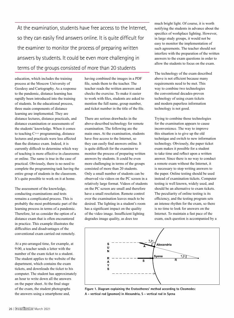
education, which includes the training process at the Moscow University of Geodesy and Cartography. As a response to the pandemic, distance learning has rapidly been introduced into the training of students. In the educational process, three main components of distance learning are implemented. They are distance lectures, distance practicals, and distance examination or assessments of the students’ knowledge. When it comes to teaching C++ programming, distance lectures and practicals were less affected than the distance exam. Indeed, it is currently difficult to determine which way of teaching is more effective in classrooms or online. The same is true in the case of practical. Obviously, there is no need to complete the programming task having the entire group of students in the classroom. It’s quite possible to work on it at home.
The assessment of the knowledge, conducting examinations and tests remains a complicated process. This is probably the most problematic part of the learning process in terms of a pandemic. Therefore, let us consider the option of a distance exam that is often encountered in practice. This example illustrates the difficulties and disadvantages of the conventional exam carried out remotely.
At a pre-arranged time, for example, at 9:00, a teacher sends a letter with the number of the exam ticket to a student. The student applies to the website of the department, which contains the exam tickets, and downloads the ticket to his computer. The student has approximately an hour to write down all the answers on the paper sheet. At the final stage of the exam, the student photographs the answers using a smartphone and,
having combined the images in a PDF file, sends them to the teacher. The teacher reads the written answers and checks the exercise. To make it easier to work with files, students are asked to mention the full name, group number, and ticket number in the title of the file.
There are serious drawbacks in the above-described technology for remote examination. The following are the main ones. At the examination, students have free access to the Internet, so they can easily find answers online. It is quite difficult for the examiner to monitor the process of preparing written answers by students. It could be even more challenging in terms of the groups consisted of more than 20 students. Only a small number of students can be observed via videos on the PC screen in a relatively large format. Videos of students on the PC screen are small and therefore have a small resolution. Remote control over the examination leaves much to be desired. The lighting in a student’s room has a significant impact on the quality of the video image. Insufficient lighting degrades image quality, as does too
much bright light. Of course, it is worth notifying the students in advance about the specifics of workplace lighting. However, in large study groups, it would not be easy to monitor the implementation of such agreements. The teacher should not interfere with the preparation of the written answers to the exam questions in order to allow the students to focus on the exam.
The technology of the exam described above is not efficient because many requirements need to be met. This way to combine two technologies the conventional decades-proven technology of using exam tickets and modern paperless information technology is not good.
Trying to combine those technologies for the examination appears to cause inconvenience. The way to improve this situation is to give up the old technique and switch to new information technology. Obviously, the paper ticket exam makes it possible for a student to take time and reflect upon a written answer. Since there is no way to conduct a remote exam without the Internet, it is necessary to stop writing answers to the paper. Online testing should be used instead of examination tickets. Computer testing is well known, widely used, and should be an alternative to exam tickets. The peculiarity of online testing is its efficiency, and the testing program sets an intense rhythm for the exam, so there is no time to look for answers on the Internet. To maintain a fast pace of the exam, each question is accompanied by a
Figure 1. Diagram explaining the Eratosthenes’ method according to Cleomedes: A - vertical rod (gnomon) in Alexandria, S - vertical rod in Syena
At the examination, students have free access to the Internet,
so they can easily find answers online. It is quite difficult for
the examiner to monitor the process of preparing written
answers by students. It could be even more challenging in
terms of the groups consisted of more than 20 students
26 | Coordinates March 2021
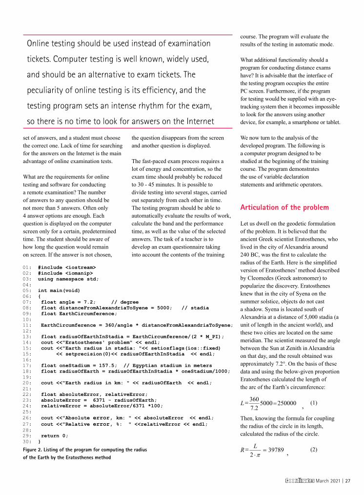
set of answers, and a student must choose the correct one. Lack of time for searching for the answers on the Internet is the main advantage of online examination tests.
What are the requirements for online testing and software for conducting a remote examination? The number of answers to any question should be not more than 5 answers. Often only 4 answer options are enough. Each question is displayed on the computer screen only for a certain, predetermined time. The student should be aware of how long the question would remain on screen. If the answer is not chosen,
the question disappears from the screen and another question is displayed.
The fast-paced exam process requires a lot of energy and concentration, so the exam time should probably be reduced to 30 - 45 minutes. It is possible to divide testing into several stages, carried out separately from each other in time. The testing program should be able to automatically evaluate the results of work, calculate the band and the performance time, as well as the value of the selected answers. The task of a teacher is to develop an exam questionnaire taking into account the contents of the training
course. The program will evaluate the results of the testing in automatic mode.
What additional functionality should a program for conducting distance exams have? It is advisable that the interface of the testing program occupies the entire PC screen. Furthermore, if the program for testing would be supplied with an eye-tracking system then it becomes impossible to look for the answers using another device, for example, a smartphone or tablet.
We now turn to the analysis of the developed program. The following is a computer program designed to be studied at the beginning of the training course. The program demonstrates the use of variable declaration statements and arithmetic operators.
Articulation of the problem
Let us dwell on the geodetic formulation of the problem. It is believed that the ancient Greek scientist Eratosthenes, who lived in the city of Alexandria around 240 BC, was the first to calculate the radius of the Earth. Here is the simplified version of Eratosthenes’ method described by Cleomedes (Greek astronomer) to popularize the discovery. Eratosthenes knew that in the city of Syena on the summer solstice, objects do not cast a shadow. Syena is located south of Alexandria at a distance of 5,000 stadia (a unit of length in the ancient world), and these two cities are located on the same meridian. The scientist measured the angle between the Sun at Zenith in Alexandria on that day, and the result obtained was approximately 7.2°. On the basis of these data and using the below-given proportion Eratosthenes calculated the length of the arc of the Earth’s circumference:
(1)
Then, knowing the formula for coupling the radius of the circle in its length, calculated the radius of the circle.
(2)Figure 2. Listing of the program for computing the radius of the Earth by the Eratosthenes method
Online testing should be used instead of examination
tickets. Computer testing is well known, widely used,
and should be an alternative to exam tickets. The
peculiarity of online testing is its efficiency, and the
testing program sets an intense rhythm for the exam,
so there is no time to look for answers on the Internet
Coordinates March 2021 | 27

As a result, the Earth’s radius is 39789 stadia. At present, it is not known what kind of stadia the scientist used. There was an Egyptian stadium (equal according to some sources, 157.5 m, according to others - 172.5 m), a Greek stadium is of 178 m. If a stadium is equal to 157.5 m, it turns out that the radius of the Earth is 6267 km. For modern data, the average Earth radius is 6371 km. In Fig. 1 a diagram illustrating the Eratosthenes’ method for determining the Earth’s radius according to Cleomedes is presented. This is only the scheme and the sizes of individual portions for clarity and understanding of the solution are distorted.
Discussion of the results
The program developed is intended to illustrate the training content of the second lecture of the course “C++ for cartographers and surveyors” [5]. In this lecture, students are introduced to programming concepts such as constants, variables, and types of variables, learn to compose programs using arithmetic operators. The lecture describes how to write comments in the style of C++ and C. The features of input and output of data to the screen using setprecision (0) are considered. Examples from geodesy and cartography show how to use enumerators. Making students familiar with overflow errors usually takes place at the initial stage of the programming course. Learning to work with variable types and constants is a milestone in mastering the basics of programming. Let us take a closer look at the code of the program.
Each of the programs used in the “C++ for Cartographers and Surveyors” course has an explanatory reference
intended for students to learn what a computer program does and how it works. The following is an explanatory reference for the program under study.
In lines 07 - 09 variables are initialized: the variable angle is 7°12′, distance from Alexandria to Syena would be distanceFromAlexandriaToSyene equals 5000 stadia, and variable EarthCircumference is unknown. The EarthCircumference is computed by formula 1 put into line 11. Line 13 computes the Earth’s radius using formula 2. Next, in line 15, the radius of the Earth is displayed on the screen, and the output of the radius value is carried out as an integer without a fractional part. In line 18, one stadium is a variable oneStadium, and it is initialized with a value of 157.5 m. Then in line 18, the value of the radius of the Earth in stadia is converted to the value in kilometers, and the result is displayed. In line 22, two variables of absolute and relative errors are declared. Their values are computed in lines 23 and 24. The results are displayed on the screen. This is where the program stops.
Let us compile and run the program, so the following output is got:
Eratosthenes’ problemEarth radius in stadia: 39789 Earth radius in km: 6267 Absolute error, km: 104 Relative error, %: 2
Let us make a final remark. As can be seen from the result, the error in the determination of the radius of the Earth by the Eratosthenes method is insignificant even from the point of view of modern times. Of course, if one stadium is equal to 178 m, the value of the error will
increase. Calculations show that the relative error will be 11% respectively.
Conclusions
The training course “C++ for cartographers and surveyors” is used to educate students at the Moscow University of Geodesy and Cartography. The issues of the development and use of a training course under the conditions of the teaching of students in two academic subjects of general geodesy and programming are considered. A computer training program to be used as training content in lectures, seminars, and homework has been developed. The program computes the radius of the Earth by the method of the ancient Greek scientist Eratosthenes. The program can be used as training material in a programming course to illustrate instructions of initialization and declaration of variables, arithmetic operators. An example of reference information for self-study, which describes in detail the program code and explains the purpose of the instructions used, is presented.
References
Deitel H., Deitel P. (2006) C++ How to program. Prentice Hall, New Jersey, USA.
Podbelskiy V.V. (2003) C++ language. Finance and Statistics. Moscow, Russia.
Siddhartha Rao (2012) SAMS Teach Yourself C++ in one hour a day. SAMS, USA.
Stroustrup B. (1997). The C++ Programming Language. Addison-Wesley, Reading, USA.
Zablotskii V.R. (2019) Training computer programs for the geodesy and cartography students: determining the coordinates of points using the geodetic intersection and resection. Proceedings of the 19th Geoconference, SGEM-2019, Bulgaria. https://doi.org/10.5593/sgem2019/2.2/S09.049.
The error in the determination of the radius of the Earth by
the Eratosthenes method is insignificant even from the point
of view of modern times. Of course, if one stadium is equal
to 178 m, the value of the error will increase. Calculations
show that the relative error will be 11% respectively
28 | Coordinates March 2021
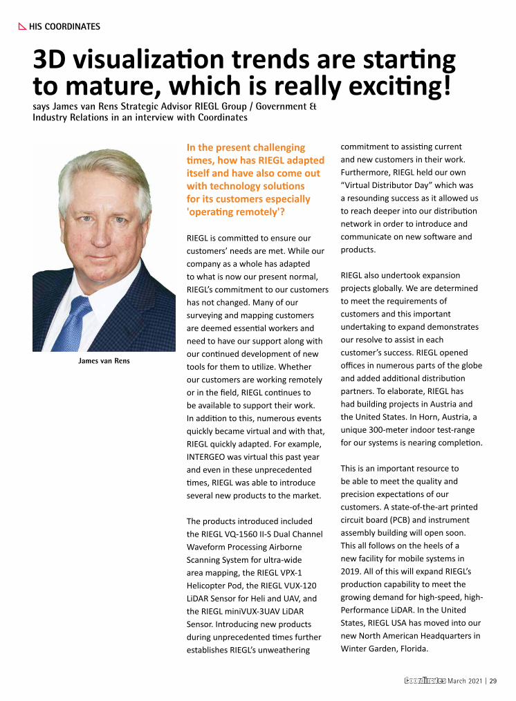
In the present challenging times, how has RIEGL adapted itself and have also come out with technology solutions for its customers especially 'operating remotely'?
RIEGL is committed to ensure our customers’ needs are met. While our company as a whole has adapted to what is now our present normal, RIEGL’s commitment to our customers has not changed. Many of our surveying and mapping customers are deemed essential workers and need to have our support along with our continued development of new tools for them to utilize. Whether our customers are working remotely or in the field, RIEGL continues to be available to support their work. In addition to this, numerous events quickly became virtual and with that, RIEGL quickly adapted. For example, INTERGEO was virtual this past year and even in these unprecedented times, RIEGL was able to introduce several new products to the market.
The products introduced included the RIEGL VQ-1560 II-S Dual Channel Waveform Processing Airborne Scanning System for ultra-wide area mapping, the RIEGL VPX-1 Helicopter Pod, the RIEGL VUX-120 LiDAR Sensor for Heli and UAV, and the RIEGL miniVUX-3UAV LiDAR Sensor. Introducing new products during unprecedented times further establishes RIEGL’s unweathering
commitment to assisting current and new customers in their work. Furthermore, RIEGL held our own “Virtual Distributor Day” which was a resounding success as it allowed us to reach deeper into our distribution network in order to introduce and communicate on new software and products.
RIEGL also undertook expansion projects globally. We are determined to meet the requirements of customers and this important undertaking to expand demonstrates our resolve to assist in each customer’s success. RIEGL opened offices in numerous parts of the globe and added additional distribution partners. To elaborate, RIEGL has had building projects in Austria and the United States. In Horn, Austria, a unique 300-meter indoor test-range for our systems is nearing completion.
This is an important resource to be able to meet the quality and precision expectations of our customers. A state-of-the-art printed circuit board (PCB) and instrument assembly building will open soon. This all follows on the heels of a new facility for mobile systems in 2019. All of this will expand RIEGL’s production capability to meet the growing demand for high-speed, high-Performance LiDAR. In the United States, RIEGL USA has moved into our new North American Headquarters in Winter Garden, Florida.
HIS COORDINATES
James van Rens
3D visualization trends are starting to mature, which is really exciting!says James van Rens Strategic Advisor RIEGL Group / Government & Industry Relations in an interview with Coordinates
Coordinates March 2021 | 29
NEWS - GIS
This provides RIEGL customers in this hemisphere with an important resource for repairs, support, calibration fields, as well as new sales and administration offices.
How do you see the evolution of 3-D visualization technologies and what has been the contribution of LIDAR in the same?
3D visualization has been around for a while, but the trends are starting to mature which is really exciting. The nexus of virtual (augmented) reality, real-time rendering, and cloud computing are providing real power to the revolution of Digital Twins. Virtual reality is an important collaboration tool for design and planning. This helps to visualize projects and projecting them onto tabletops, computers, or even field handheld devices. Real-time rendering supports and improves the virtual reality experience; however, it needs further development to lower costs so its expansion into commercial applications can begin.
Cloud computing is an important element to be able to access the data from anywhere and on any platform, but most importantly in real-time to support information at the point of work. Two of the big geospatial players, ESRI and AUTODESK, have collaborated to provide a smooth integration of ArcGIS and Revit.
A primary benefit is the ability to access data quickly and easily from multiples sources whether they are Computer Aided Design (CAD) models or imagery, LiDAR scans from anywhere. Cloud storage of data for
instant access, data management for proper order, visualization and sharing for effective collaboration are some of the many benefits.
All of this is extremely exciting but what does this have to do with LiDAR? Well, for these trends to be successful and have faster adoption, high fidelity image information is critical. The reason this information is critical is because high fidelity LiDAR systems with advanced image sensors allow the algorithms to see the assets.
What is the importance of hyper spectral imaging and the data thus created in the protection and preservation of historically important buildings and structures?
In the field of surveying and mapping, one of the most important steps are the correct identification of surfaces not only in the natural world, but also the built world.
Sometimes we describe this as classification. The addition of multi and hyperspectral systems allows for more correct identification of the building materials, impact of weathering and, of course, the correct geometry of the structure as provided by the LiDAR. The integration of hyperspectral imaging with LiDAR allows for more information from a wider spectrum rather than only the traditional primary colors. This important step has many applications and implications. This technique provides the ability to discern subtle differences rather than an educated guess. The imaging systems still need to mature and grow in order to foster more widespread use.
18th century fort brought to Life with LiDAR and 3D Modeling
A Canadian archaeologist has used advanced mapping and visualization technologies to bring one of the earliest European settlements in North America back to life. Dr. Jonathan Fowler combined a centuries-old map with a modern 3D terrain model to portray Fort Anne and its surrounding in stunning detail – just as the Nova Scotia site looked in 1706. Fowler created the 3D representation of Fort Anne using the Surfer surface mapping package from Golden Software of Golden, Colo.
Fort Anne is remarkably well preserved considering its age and violent history. In 1605, French explorers set up a fur trading post on the Annapolis River in an area they named Acadia, now part of present-day Nova Scotia. France began building a “Vauban-style” star fort there in 1702. The area experienced numerous attacks and sieges from different enemies – including pirates – and changed hands several times. Fort Anne fell to the British in 1710 and later played an important role in the Acadian Deportation.
To create the 3D map of Fort Anne, Fowler loaded airborne LiDAR data into the Surfer package to generate a ‘bare Earth’ terrain model depicting the topography of the area as it exists today, minus vegetation and buildings. Fowler exaggerated the LiDAR elevation values slightly in Surfer to emphasize relief.
Next, the archaeologist obtained a digitized version of a 1706 military map from France’s National Archives showing the fort and nearby town. He overlaid the digital map on the terrain model in Surfer to create a realistic 3D view of Fort Anne shortly after its construction. Fowler repeated the process using a 1753 map from the Library of Congress to depict the site under British rule. Detailed interpretation of the 3D model has just begun, and Fowler believes previously unknown facts about Fort Anne and the surrounding landscape may soon be revealed. www.GoldenSoftware.com
30 | Coordinates March 2021
Port of Antwerp appoints Unifly as UTM technology partner
Port of Antwerp has become the first seaport to initiate unmanned air traffic management in a busy and complex port environment. In doing so, they are the first non-aviation authority to become a fully-fledged geozone manager. As geozone manager, the port will be responsible for managing ground risk related to above-the-ground activity, with respects to operational and working drones, overall safety and seamless integration of processes required; all of which are intended to amp up productivity and efficiency of port operations.
Unifly has been appointed as technology partner to develop the Port’s Unmanned Traffic Management (UTM) platform. It has a proven track record rolling out UTM systems at a national level in Belgium, Canada and Germany among others. The Belgian company also collaborated closely with Port of Antwerp over the past few years to initiate research, tests and demonstrations relating to drone traffic management in urban airspaces. www.portofantwerp.com
Extensis offers GeoViewer Pro
Extensis® has announced its GeoViewer Pro for Desktop application will now be offered at no charge. GeoViewer Pro is a standalone GIS image viewer for compressed MrSID files, raster imagery, LiDAR point clouds, and vector layers.
GeoViewer Pro was developed by LizardTech, now Extensis, as a paid multi-feature upgrade to the free GeoViewer application. It allows end users to view satellite, aerial and drone image files, as well as LiDAR data and GIS vectors. www.extensis.com
Update to the Global Mapper now available
Blue Marble Geographics® has announced the release of version 22.1 of the Global Mapper and Lidar Module Software Development Kits® (SDKs).
It enable developers to incorporate much of the functionality of the standard versions of Global Mapper and the accompanying Lidar Module into their own applications. They also offer the means to create extensions within the desktop application to provide customized tools for project-specific functionality. Administered using a simple Windows DLL, the Global Mapper SDK can be used in a variety of programming languages and supports an extensive list of file formats. The Lidar Module SDK provides developers access to advanced point cloud processing functionality, including the Pixels to Points® tool and much more. bluemarblegeo.com
Bentley Systems enters into ~ $1.05 Billion Agreement to Acquire Seequent
Bentley Systems has entered into a definitive agreement with investors led by Accel-KKR to acquire Seequent—a leader in software for geological and geophysical modeling, geotechnical stability, and cloud services for geodata management, visibility, and collaboration—for $900 million in cash, subject to adjustment, plus 3,141,361 BSY Class B shares. The acquisition of Seequent is expected to initially add approximately 10% to each of Bentley Systems’ key financial metrics (ARR, annual revenue, and EBITDA) and is expected to be measurably accretive to Bentley’s organic growth rate. Most significantly, the combination will deepen the potential of infrastructure digital twins to help understand and mitigate environmental risks, advancing resilience and sustainability. www.seequent.com
University of Birmingham teams up with ARAI
University of Birmingham and The Automotive Research Association of India (ARAI) based in Pune, India, have signed a Memorandum of Understanding (MoU) agreeing to identify joint research interests in the fields of air quality management, alternative fuels, power train and electric vehicle technology.
The Vehicle and Engine Technology Research Centre in the University’s School of Mechanical Engineering has a world-leading research profile in combustion engines and low carbon vehicle technology. The University works closely with UK industry in engine architecture and advanced engine technologies, helping to design the engines and fuels for the future; including hybrid powertrains.
ARAI is India’s premier automotive research and development institute set up by the automotive industry with the Government of India. ARAI is an autonomous body affiliated to the Ministry of Heavy Industries and Public Enterprises, Government of India and is recognized by the Department of Scientific and Industrial Research, Government of India.
The partnership will also see British and Indian air pollution experts working together to create a blueprint to tackle the challenge of particulate emissions in India – looking to develop and deliver solutions identified in the plan. The partners also plan to support the development of education programmes that will help produce future transport leaders and world-leading research. NOAA begins transition exclusively to electronic navigation charts
NOAA will begin to implement its sunset plan for paper nautical charts this month, starting with the current paper chart 18665 of Lake Tahoe. After August, NOAA’s electronic navigational chart will be the only NOAA nautical chart of the area.
This is the first traditional paper chart to be fully supplanted by an electronic chart as part of NOAA’s Office of Coast Survey Raster Sunset Plan, which includes a new process to notify mariners of the transition of individual paper charts to electronic charts. These charts are easier to update and maintain, keeping mariners safer with up-to-date information on marine hazards.
As part of the sunset plan, released in 2019, mariners will be officially notified of this chart’s cancellation in the U.S. Coast
Coordinates March 2021 | 31
NEWS - IMAGING
Guard Local Notice to Mariners. A note in the lower left corner of the chart will state that it is the last paper edition and it will be canceled six months later on August 26.
NOAA will continue to announce the cancellation of additional paper charts as the sunset plan progresses, initially based on volume of sales or downloads, and in regions with improved NOAA electronic navigational chart coverage. Cancellation of all traditional paper and associated raster chart products will be completed by January 2025. Source: NOAA
Fully digitised cadastral survey data model and exchange
The Intergovernmental Committee on Surveying and Mapping (ICSM) and Land Information New Zealand (LINZ) have announced that SURROUND NZ Ltd will lead the development of an Australian/New Zealand 3D Cadastral Survey Data Model and Exchange (3D CSDM) programme. It aims to create a widely adopted standard across Australia and New Zealand for exchanging digital cadastral survey data between the survey industry and government land administration agencies.
New Zealand Surveyor-General and ICSM representative Anselm Haanen says the appointment of SURROUND is an important step in developing a consistent model for exchanging digital cadastral survey information between the survey industry and government land administration agencies. A crucial component of the work will be engaging with survey software suppliers. Their contribution will help ensure that their products can meet the needs of the surveyors producing the cadastral survey datasets for lodgement as well as the needs of jurisdictions, as defined by the harmonised data model.
LINZ is leading the programme in partnership with Australian Department of Environment, Land, Water and Planning (Victoria), the Department of Customer Service (New South Wales), Landgate (Western Australia), and the Department of Natural Resources, Mines and Energy (Queensland). [email protected]
weather and traffic sensors, for example, to provide a dynamic online platform for hyper local, near real time flood risk assessments.
Providing real world context and accuracy, the Bluesky data enables visualisations of evolving events that will enable flood risk managers to employ just in time maintenance and alleviation methods, such as clearing blocked drains or setting up mobile defences. www.bluesky-world.com
Hiber launches second generation satellite
Hiber, the European satellite Internet-of-Things (IoT) company, has announced that its most recent satellite, Hiber Four, has been successfully launched in space, via SpaceX’s first rideshare mission of 2021 - Transporter-1.
Hiber Four is a second generation satellite developed and assembled by Hiber’s engineers in its Amsterdam office. Hiber Four, and its sister satellite Hiber Three, are half the volume (3U) of the previous generation, which reduces the mass and decreases the launch costs by up to 50%. The newest generation of satellites also have an on-board propulsion system allowing Hiber’s ground engineers to adjust the satellite’s orbit. This ensures that Hiber Four, and its future descendants, avoid collisions and, importantly, de-orbit themselves at the end-of-life, making Hiber one of the most responsible CubeSat constellation operators in the world. www.hiber.global
Teledyne CARIS releases Onboard360
Teledyne CARIS has released Onboard360 featuring CARIS Collect. The newly released software delivers a seamless flow of data into the Ping-to-ChartTM workflow. When combined with the Onboard360 Process module, logged data is imported and processed automatically allowing near real-time and remote quality monitoring of in-progress surveys. The CARIS Collect module provides simple and effective data collection for the most common sonar and lidar systems in the market.
TCarta awarded NOAA grant
TCarta Marine has been awarded a Small Business Innovation Research (SBIR) Phase II grant from the National Oceanic and Atmospheric Administration (NOAA). The research focuses on enhancing Satellite Derived Bathymetry technology for application in the coastal waters of Alaska.
Satellite Derived Bathymetry (SDB) extracts water depth measurements from multispectral satellite imagery using advanced physics-based algorithms. Traditionally, this technology has yielded the most accurate results in clear, calm waters; however, TCarta has recently taken the lead in expanding SDB applications to more challenging marine environments worldwide. www.tcarta.com
China Aerospace launches remote-sensing satellites into orbit
China launched a Long March 4C carrier rocket at the Jiuquan Satellite Launch Center in Northwest China to deploy Yaogan 31-03 remote-sensing satellites, according to the China Aerospace Science and Technology Corp, the nation’s leading space contractor.
Developed by the China Academy of Space Technology, a China Aerospace subsidiary, the satellites are the third group in the Yaogan 31 family and are tasked with conducting electromagnetic environmental monitoring and related technology tests, the statement said. www.chinadaily.com.
Newcastle University pioneers hyper-resolution flood risk modelling
Newcastle University is developing advanced computer modelling to assess the flood risk of individual properties using LiDAR data and oblique aerial photography from Bluesky. The project will use Artificial Intelligence to extract information from other datasets, including old reports and flood asset registers, and bring this together with
32 | Coordinates March 2021
NEWS - GNSS
holistic defense strategy that considers the integrity of the PNT data from its reception through its use in the supported system.”
The PNT Integrity Library and Epsilon Algorithm Suite are open source and available free of charge. www.dhs.gov
NIST Finalizes Cybersecurity Guidance for PNT Systems
As part of an effort to help users apply its well-known Cybersecurity Framework (CSF) as broadly and effectively as possible, the National Institute of Standards and Technology (NIST) has released finalized cybersecurity guidance for positioning, navigation and timing (PNT) services.
Formally titled Foundational PNT Profile: Applying the Cybersecurity Framework for the Responsible Use of Positioning, Navigation and Timing (PNT) Services (NISTIR 8323), the document is part of NIST’s response to the Feb. 12, 2020, Executive Order 13905, Strengthening National Resilience Through Responsible Use of Positioning, Navigation, and Timing Services. To develop the profile, NIST sought public input regarding the general use of PNT data before releasing a draft version in October 2020. The finalized version reflects public comments NIST received on the draft.
The “profile,” a term NIST uses to describe the application of the CSF to a specific implementation scenario, is intended to help mitigate the cybersecurity risks that confront PNT services. These services are important to national and economic security and include the Global Positioning Systems that are widely used by smartphone-based navigation apps, as well as split-second timing technologies that enable stock trading and efficient control of the power grid.
“Many efforts to secure PNT services were underway before we began developing this profile, but there wasn’t a formal reference for risk mitigation that everyone could use,” said NIST’s Jim McCarthy, one of the profile’s authors. “The Executive
Order was targeted to address all users of PNT services, and we are confident the entire community can benefit.”
The main addition since the draft version was released is a “Quick Guide” intended to offer users an easier way to get started using the profile.
“The Quick Guide illustrates all the areas we cover in the profile and simplifies them,” McCarthy said. “Those less familiar with their own use of PNT services will benefit from the guide, as the process of implementing the profile may seem complicated for the novice user.” IT personnel might appreciate the extensive set of references the authors have included. These range from guidance already published by both government and private sector entities to academic papers and other technical sources.
“The profile has perhaps the most comprehensive list of PNT cybersecurity references compiled into a single document so far,” McCarthy said. “They can serve as examples for anyone trying to tailor the profile’s approach to their own system.” McCarthy said that although the profile was now finalized, NIST would continue to look for ways to keep it current.
“In accordance with the Executive Order, we plan to revisit the profile every two years or as needed,” he said. “We intend to make sure it remains useful.” www.nist.gov
GSA Entrepreneurship Day
The European GNSS Agency (GSA) has announced the winners in this year’s MyGalileoSolution & MyGalileoDrone competitions. The jury has selected the winning teams in both competitions based not only on their innovative use of key Galileo differentiators but also on their market-oriented approach and potential for wide uptake. The winning teams were announced during Entrepreneurship Day, hosted by the GSA on 02 March. In the MyGalileoDrone competition, the first prize went to the team Abzero (Italy), for Nautilus – a unique tracking solution
Free Resources to Protect Critical Infrastructure From GPS Spoofing
The Department of Homeland Security (DHS) Science and Technology Directorate (S&T) has published the Positioning, Navigation, and Timing (PNT) Integrity Library and Epsilon Algorithm Suite to protect against Global Navigation Satellite System (GNSS) spoofing, or deceiving a Global Positioning System (GPS) device through false signals. These resources advance the design of PNT systems and increase resilience of critical infrastructure to PNT disruptions.
PNT services, such as GPS, are a national critical function that enable many applications within the critical infrastructure sectors. However, “The increasing reliance on GPS for military, civil and commercial applications makes the system vulnerable,” according to Space Policy Directive-7 (SPD-7), issued on January 15, 2021. “GPS users must plan for potential signal loss and take reasonable steps to verify or authenticate the integrity of the received GPS data and ranging signal, especially in applications where even small degradations can result in loss of life.”
The PNT Integrity Library and Epsilon Algorithm Suite address this issue by providing users a method to verify the integrity of the received GPS data. “We are excited to release these resources to the PNT community to improve resiliency against potential GPS signal loss,” said DHS S&T PNT Program Manager Brannan Villee.
“Since GPS signals can be jammed or spoofed, critical infrastructure systems should not be designed with the assumption that GPS data will always be available or will always be accurate,” said Jim Platt, Chief of Strategic Defense Initiatives at the Cybersecurity and Information Security Agency (CISA) National Risk Management Center. “Application of these tools will provide increased security against GPS disruptions. However, DHS also recommends a
Coordinates March 2021 | 33
NEWS - LBS
for the autonomous delivery of medical goods. Second prize was awarded to Spectralight (Poland) for SpectraDrone, an outside leisure application. ThunderFly (Czech Republic) received third prize for TF-ATMON – a system for performing in-situ atmospheric measurements, while fourth prize went to Raytrack (Spain) for 5GBeamCheck, which uses a UAV to perform 5G antenna tests. The winning team receives EUR 100,000, with EUR 60,000 going to the team in second place, EUR 40,000 for third place, and EUR 30,000 to the fourth.
In the MyGalileoSolution competition, the first place in Track 1 (from idea to prototype) went to VisionAnchor (Slovenia) the world’s first video anchor monitoring system for boats , with second prize going to BitPet (Norway), an Augmented Reality mobile game where each player takes care of a digital pet and third prize – to BeeLive (Greece), a beekeeper’s decision making and social networking tool based on GNSS-enabled devices. Meanwhile, in Track 2 (from prototype to product), the top three teams were 10Lines (Estonia), the autonomous parking lot marking solutions in first place, followed by V-Labs (Switzerland), the Augmented Reality solution for visualizing, measuring and modifying geospatial data with centimeter accuracy in second and Lympik Oculus (Austria), a sport analysis application in third. MyGalileoSolution is the biggest competition ever organized by the GSA, with a prize pool of almost EUR 1.5 million shared by 50 teams, including the six finalists, with awards ranging from EUR 15,000 to EUR 60,000. gsa.europa.eu
Glonass satellite retired after 10 years in service
The satellite of the Glonass-M type was switched off after its atomic clock, a key piece of timekeeping equipment, broke down, a source in the know told Sputnik. “No.731 was retired on March 9, 2021. The use of the spacecraft was discontinued,» the center said in a statement. www.urdupoint.com
3,000+ Km Navigation-assisted autonomous driving expedition
XPeng Inc. has announced the launch of a long-distance navigation-assisted autonomous driving expedition from March 19 to 26, 2021, covering a total distance of 3,675 km across six provinces in China. The performance of XPeng’s newly released autonomous driving assistance function - Navigation Guided Pilot (NGP) - will be fully tested in 3,145 km of highway driving, starting from Guangzhou, all the way north to Beijing.
The total distance of 3,675 km consists of about 3,145 km of highways, where the key functionalities and reliability of the NGP, including automatic highway ramp entering and exiting, automatic switching of highways and optimization of lane choices, automatic lane changing, overtaking and speed limit adjustment, will be fully tested by the press and third parties. The frequency of human driver intervention, and the success rate for the functions listed above, are among the key indicators to be tested in these sophisticated driving scenarios on China’s highways. https://en.xiaopeng.com
Voice Assistant Capabilities Integration into its GPS Location Platform
GTX Corp has announced the integration of smart voice assistant technology to its suite of GPS devices and management tools.
By incorporating natural language processing (NLP) and voice assistant features into its GPS tracking backend platform and utilizing home assistant devices, such as Amazon Echo, Google Home or IBM Watson, customers will be able to retrieve relevant information about devices such as location and movement. In coordination with the launch of its completely re-engineered 4G LTE GPS SmartSole and module, users will be able to call alerts, set geo-fences and know where family members, or even pets are with a simple voice command. GTXCorp.com
Verizon enters into agreement with incubed IT
Verizon has entered into a definitive agreement to acquire incubed IT, the creator of a software platform providing autonomous navigation tools to administer, manage and optimize mixed fleets of robots in industrial settings. Upon closing and as Verizon continues to expand its 5G coverage, capacity, and mobile edge compute capabilities, incubed IT’s autonomous software will enable enterprise customers to gain new efficiencies as they scale their autonomous mobile robot fleets. verizon.com
Sensible 4 autonomous driving software tested by VTT
Early this year Sensible 4 started trials with two open road pilots in Norway, one near Oslo and another one in Gjesdal. To enable these pilots, a driving permit from Vegvesen, the Norwegian road authority, was required. In Finland, VTT has a long history with autonomous machines and testing. Vegvesen relied on VTT’s technical expertise in testing and validation of Sensible 4 autonomous systems.
The tests that preceded the Norway pilots, including the obstacle detection and avoidance trials, were conducted in Nummela airfield in September 2020. The measurements were carried by using the automated vehicle tools and prototypes developed by VTT for enabling benchmarking the automated driving functions. The test scenarios included reacting to several static and as well as dangerously moving objects in the front of the vehicle. Sensible 4 technology performed safely in all the tested scenarios. The tests were carried out systematically analyzing the driving scenarios, safety risks and conducting real measurements. https://sensible4.fi
Baidu to demonstrate commercialized autonomous driving
Baidu, Inc. received qualifications for 35 vehicles to demonstrate commercialized autonomous driving operations, and
34 | Coordinates March 2021
qualifications for 10 vehicles to conduct driverless testing, by Cangzhou traffic authorities. These qualifications will allow Baidu to be the first company in China to experiment with various monetization mechanisms for autonomous driving services, marking a landmark step on Baidu Apollo’s road to commercialization. In recent years, Cangzhou has been a leading city for the development of autonomous driving. It was the first city in northern China to carry out manned tests of autonomous driving and has the third largest intelligent-connected test road network in the country.
ADLINK Launches Compact SMARC AI-on-Module
ADLINK Technology Inc., a global leader in edge computing, has launched the LEC-IMX8MP SMARC module, the first SMARC rev. 2.1 AI-on-Module (AIoM) that uses NXP’s next-generation i.MX 8M Plus SoC for edge AI applications. The LEC-IMX8MP integrates NXP NPU, VPU, ISP and GPU computing in a compact size for future-proof AI-based applications across industrial AIoT/ IoT, smart homes, smart cities and beyond. www.adlinktech.com
Location IQ partners with Orbital Insight
Location IQ, a leading Australian economic consultancy firm specializing in location, property, mapping and data solutions, announced that it is expanding its partnership with Orbital Insight, the geospatial analytics company.
Location IQ provides property clients with geospatial analysis powered by Orbital Insight to help inform strategic business decisions. Location IQ first partnered with Orbital Insight in March 2020 to analyze 40 shopping centers in New South Wales, amid growing uncertainty at the start of the pandemic.
Location IQ will use the Orbital Insight GO platform to monitor the shifting patterns of activity at over 1,000 shopping centers across Australia. www.locationiq.com.au
India notifies Unmanned Aircraft System Rules, 2021
The Indian Government on 14 March notified the Unmanned Aircraft System Rules, 2021. These rules will apply to Unmanned Aircraft System (UAS) registered in India, wherever they may be or possessing or engaged in exporting, importing manufacturing, trading, leasing, operating, transferring or maintaining an Unmanned Aircraft System in India or all UAS for the time being in or over India.
The rules categorizes unmanned aircraft system into three categories: aeroplane, rotorcraft and hybrid unmanned aircraft system. They are also classified based upon the maximum all up weight including its pay load.
The rules also provide that a person shall be eligible to grant authorization as importer, manufacturer, trader, owner or operator, if that person is a citizen of India, 18 years of age or above. In case of company or a body corporate provided that it is a registered entity and has its principal place of business within India and the Chairman and at least two-thirds of its directors are citizens of individuals or a local authority or any legal entity has its principal place of business with India, whether incorporated or not, Central Government and State Government or agency thereof. The rules also define the roles and responsibilities of UAS wherein the operator is responsible for functioning of safe operations of UAS. www.livelaw.in
FAA announces effective dates for final drone rules
The final rules requiring remote identification of drones and allowing some flights over people, over moving vehicles and at night under certain conditions will go into effect on April 21, 2021. Remote identification (Remote ID) requires identification of drones in flight as well as the location of their control stations or takeoff point. It provides crucial information to our national security and law enforcement partners, and other officials charged with ensuring public
safety. Airspace awareness reduces the risk of drone interference with other aircraft, people and property on the ground.
The Operations Over People rule applies to pilots who fly under Part 107 of the Federal Aviation Regulations. The ability to fly over people and over moving vehicles varies depending on the level of risk a small drone operation presents to people on the ground. The rule allows operations based on four categories, which can be found in the rule’s Executive Summary (PDF). Additionally, this rule allows operations at night under certain conditions. Prior to flying under the new provisions, a remote pilot must pass the updated initial knowledge test or complete the appropriate updated online training course, which will be available on April 6, 2021.
Part 107 currently prohibits drone operations over people, over moving vehicles and at night unless the operator obtains a waiver from the FAA. The new FAA regulations jointly provide increased flexibility to conduct certain small drone operations without obtaining a waiver. www.faa.gov
New Drone Surveillance System for Canadian Coast Guard
Kongsberg Geospatial has been selected by Defence Research and Development Canada (DRDC) to conduct trials of a new long-endurance UAV surveillance system for the Canadian Coast Guard. The MartinUAV V-BAT aircraft was selected to provide the unique ability to combine take off and landing from the small confines aboard ship with the long endurance of a fixed-wing aircraft while carrying multiple sensors.
The aircraft will communicate with the Kongsberg Geospatial sensor data management system, called MIDAS, which allows a range of sensor data, including full-motion video from unmanned systems to be processed and
NEWS - UAV
Coordinates March 2021 | 35
NEWS - INDUSTRY
exploited in near real-time by analysts on board Canadian Coast Guard ships. CINTIQS Military Technology Consulting will be providing consulting services for the planning and conduct of the flight trials and sensor employment to validate systems performance. https://kongsberggeospatial.com
Flytrex secures $9.3M
Flytrex, an on-demand drone delivery for food and retail company, has announced the closing of an $8 million financing led by existing investors Benhamou Global Ventures (BGV) and btov. The financing complements a recently awarded grant from the Israel Innovation Authority for a total of $9.3 million. The investment comes in the wake of several significant milestones for the on-demand drone delivery company. In September 2020, a benchmark pilot project between Flytrex and Walmart was announced to deliver select grocery and household essential items from Walmart stores in Fayetteville, North Carolina using Flytrex’s autonomous drone delivery service. www.flytrex.com
Delta Drone and Doosan Mobility signs OEM integration deal
Delta Drone International’s safety specialist brand, ParaZero, has signed its largest multinational OEM (original equipment manufacturer) integration deal with industrial equipment world-leader, Doosan Mobility Innovation (DMI). The agreement will see ParaZero integrate its patented SafeAir parachute technology with Doosan’s award-winning DS30 endurance drone. www.deltadrone.com
AMAALA signs MoU with the SAFCSP
AMAALA, the ultra-luxury development located along Saudi Arabia’s north western coast, has signed a Memorandum of Understanding (MoU) with the Saudi Federation for Cyber Security, Programming and Drones (SAFCSP). The signing will pave the way for the adoption of innovative and emerging technologies within the fields of drones, programming, and artificial Intelligence at AMAALA and
marks a significant step in the development of electronic services software, and the enhancement of cybersecurity knowledge. www.amaala.com
New Era in UAS Tactical Mapping, Aerial Intelligence
senseFly has announced a new distribution partnership with North Carolina USA, based Tough Stump Technologies. The partnership is designed to help professionals and organizations in the defense and governmental sectors with the collection and analysis of aerial intelligence and tactical mapping data using advanced UAS (drones). www.toughstump.com
DJI Announces FPV Drone and Motion Controller
B&H is excited to announce the DJI FPV, a revolutionary hybrid drone that combines the thrilling experience of low-latency FPV flying with prosumer-grade image-capture technology, including the ability to shoot hi-res stills and 4K video. It is equipped a low-latency video transmission system that will allow pilots to experience the thrills of being “inside” the cockpit while flying at speeds of up to 87 MPH. www.bhphotovideo.com
INPEX-Terra Drone Intelligent Drone Plan
Terra Drone and INPEX jointly have announced a capital tie-up and the launch of the INPEX-Terra Drone Intelligent Drone Plan. Terra Drone is an air mobility startup with technical expertise in automated flight and operational management of air mobility solutions including drones and flying automobiles.
Terra Drone and INPEX have until now collaborated on various initiatives regarding the inspection equipment in the field of crude oil development and production. Through the Plan, they will seek to promote the digital transformation and support the sustainable growth of the oil and natural gas industry in Japan and around the world and contribute to enhancing the presence of Japan. www.terra-drone.net/global
Large-scale Deployment for Sonardyne Fetch AZA
A new breed of underwater sensor that is able to self-calibrate, enabling precise, long-duration subsidence monitoring at all depths, has been deployed at scale for the first time. The 20-plus Fetch Ambient-Zero-Ambient (AZA) pressure monitoring transponders (PMTs), developed by underwater technology specialist Sonardyne, will support an ongoing long-term, large-scale seabed monitoring project at Ormen Lange – Norway’s second largest gas field – for A/S Norske Shell.
New rugged GPS Active L1/L2 Patch Antenna
Southwest Antennas has introduced an all-new, high-performance GPS & GLONASS Active L1/L2 patch antenna for high-accuracy location service, timing, and navigation applications. Part # 1065-042 covers both the L1 and L2 bands, supporting military, commercial, and industrial applications. www.southwestantennas.com
Trimble Siteworks SE Starter Edition
Trimble has introduced the Trimble® Siteworks SE Starter Edition, an entry-level, easy-to-use construction surveying software at an affordable price point. Using a construction GNSS receiver, a supervisor, foreman, grade checker or site engineer can easily check a grade, slope or alignment and navigate the project more accurately and in less time than with traditional survey methods. Budget-conscious contractors can realize a quick return on investment by giving more personnel on the jobsite access to survey technology, enabling more productive and efficient field crews. www.trimble.com
Six New GNSS-ready external antennas by Laird Connectivity
Laird Connectivity has announced the imminent launch of six new GNSS-ready external antennas suitable for a range of applications including vehicle mount. The GNS1559MPF or Mini GNSS is a small
36 | Coordinates March 2021
is fully capable of multi-constellation and multi-frequency simulations for a wide range of GNSS applications.
A new key enhancement to the NCS NOVA GNSS Simulator is comprehensive support of new Galileo OS signal message improvements on E1B. By enabling real-time simulation of the Galileo OS message improvements, the NCS NOVA GNSS Simulator expands a user’s Galileo signal capability. www.ifen.com
Environmental and geotechnical surveys by Fugro
Fugro has been awarded multiple contracts by Eni Angola to carry out geotechnical and environmental surveys off the coast of Angola between now and May, and two Fugro vessels from the world’s largest fleet of specialist geotechnical and geophysical vessels are currently active in the region.
Multipurpose survey vessel the Fugro Scout, specifically designed for seabed sampling and in situ testing in water depths up to 3,000m, has embarked on a deepwater environmental survey to acquire, analyse and interpret sediment and water samples from Eni Angola’s Agogo field development.
The Fugro Scout will also perform a range of geotechnical site investigations on the project, with work due to start soon.
A second vessel, the Fugro Helmert, will join the Fugro Scout to conduct a route survey in Angola’s nearshore areas, including various environmental, geotechnical and geophysical surveys, to allow Eni Angola to calculate the best installation route and optimize cable burial protection for the New Gas Consortium.
GMV participates in the kick-off of the European GEODE project
As part of the consortium, led by FDC, the technology multinational GMV has participated in the GEODE Kick-Off meeting held on February 8.
GEODE (GalilEO for EU DEfence) is a crucial and decisive step towards the development of the Galileo Public Regulated Service (PRS) military User Segment and one of the most ambitious Defense cooperation projects launched under the umbrella of the European Commission’s European Defence Industrial Development Programme (EDIDP). Cofinanced by Belgium, Germany, Italy, France and Spain, GEODE is supported by the EU with a grant of about 44 million Euros.
GEODE aims to boost the EU industry’s competitiveness in the highly strategic domain of military positioning, navigation, timing, and synchronization (PNT) and to endow EU military forces with Galileo Public Regulated Service (PRS) capacity. The project will be implemented by a Consortium of 30 undertakings from 14 EU countries, including GMV as part of the Spanish participation. www.gmv.com
infiniDome successfully completes “GPS Jammed” Scenario Flight Ops
infiniDome Ltd., the GPS Security Company, has announced the successful completion of UAS flight trials conducted under GNSS jamming scenarios. The test flight was part of the NA’AMA initiative, a project to push the boundaries of BVLOS (Beyond Visual Line of Sight) operation and accelerate the adoption of UAS in urban environments. This project was made possible by the Israeli Ministry of Transportation, Israel Innovation Authority and Civil Aviation Authority (CAAI). During the rigorous testing, infiniDome increased GNSS resiliency by 400% in the hostile jamming environment. The drone’s GPS receiver overcame GPS jamming scenarios using infiniDome’s GPSdome protection which locked on and maintained the GNSS signals throughout the jamming tests. infinidome.com
Sokkia announces the availability of new robotic total stations
Sokkia announced the availability of new robotic total stations designed to improve
form factor, rugged, high performance, and cost-effective solution for most GNSS or asset tracking applications. The five multi-port variants offer coverage for cellular, Wi-Fi, GNSS, FirstNet, and Emergency Services Network (ESN) frequencies and allow for MIMO and/or navigation/location opportunities within the same antenna. lairdconnect.com
Four additional payload mission data units for L3Harris Technologies
L3Harris Technologies (has received contracts totaling $137 million for four navigation payload Mission Data Units (MDU) for future GPS III Follow-on (GPS IIIF) satellites. Lockheed Martin, the prime contractor for GPS III/IIIF, selected L3Harris in 2018 to design and build the first two fully-digital MDUs, the heart of the satellite’s navigation payload. The MDU generates more powerful GPS signals and assures clock operations for GPS users. L3Harris.com
High-precision GNSS SE868SY-D receiver module by Telit
Telit has announced the SE868SY-D a multi-frequency, high-precision GNSS receiver module for applications that require high accuracy, fast updates, multi-constellation support and multipath resistance. At just 11x11 mm, the SE868SY-D easily accommodates ultra-compact devices and IoT trackers. Featuring Sony’s next-generation CXD5610 GNSS receiver LSI, the SE868SY-D also is the first product from a new strategic collaboration between Sony and Telit. Telit.com
NCS NOVA GNSS simulator enhancement
IFEN GmbH has announced that its NCS NOVA GNSS Simulator now fully supports the simulation of Galileo Open-Service (OS) signal improvements based on the new Galileo OS SIS ICD V2.0.
The NCS NOVA GNSS Simulator is a high-end, powerful and easy to use satellite navigation testing and R&D device. It
Coordinates March 2021 | 37
First name .........................................................................
Last name ..........................................................................
Designation .......................................................................
Organization .....................................................................
Address ...............................................................................
...............................................................................................
City ................................... Pincode .................................
State ................................ Country .................................
Phone .................................................................................
Fax .......................................................................................
Email ...................................................................................
I enclose cheque no. ......................................................
drawn on ...........................................................................
date .................................. towards subscription
charges for Coordinates magazine
in favour of ‘Coordinates Media Pvt. Ltd.’
Sign .................................. Date .......................................
Mail this form with payment to:
CoordinatesA 002, Mansara Apartments
C 9, Vasundhara Enclave
Delhi 110 096, India.
If you’d like an invoice before sending your
payment, you may either send us this completed
subscription form or send us a request for
an invoice at [email protected]
YES! I want my
I would like to subscribe for (tick one)
Rs.1800/US$100 Rs.3000/US$170 Rs.4300/US$240
job site productivity. The iX-1200 and iX-600 total stations are professional-level positioning tools for survey and layout in the building construction and infrastructure trades. Engineered for integration with field controllers, software, and GNSS receivers, the total stations are designed as part of a full workflow solution. https://us.sokkia.com
Hexagon partners with Navantia for new combat system
Hexagon’s Geospatial division announced that Navantia has selected Luciad, Hexagon’s platform for building advanced location intelligence and real-time situational awareness applications, to equip the combat system of five future F-110 frigates for the Spanish Navy. The agreement will also cover corresponding tests, validations and simulation environments.
Starting in 2016, Hexagon’s Luciad was subjected to the strictest technical benchmarks by Navantia and the Spanish Navy, along with other comparable geospatial technologies on the market. Luciad surpassed the competition to secure the partnership. Since then, Navantia has developed initial versions of the combat system, which integrates sensors, nautical cartography, AIS tracks and more.
Trimble introduced the Trimble® TSC5 Controller
Trimble introduced the Trimble® TSC5 Controller, a new rugged-yet-lightweight field solution that continues Trimble’s legacy of creating high-quality controllers for land and civil construction surveyors. Built for practical, everyday
tasks, it combines high performance and dependability so professionals can complete tasks efficiently and accurately.
Featuring an Android 10 operating system, the Trimble TSC5 is fully integrated with Trimble’s land and construction surveying instruments and software packages, including Trimble Access™ 2021 Field Software, Trimble Siteworks Software. www.trimble.com
BAE Systems positioning for growth in military GPS
BAE Systems announced on Feb. 17 that it won the largest share of a $552 million deal the Space Force awarded to three companies in November to design and manufacture advanced GPS receivers that provide positioning, navigation and timing to U.S. military forces.
The Space Force’s Space and Missile Systems Center is buying new military GPS receivers that are smaller, lighter and will allow the military to use a jam-resistant GPS signal known as M-code, or military code. The Space Force selected three suppliers — Raytheon, L3Harris and BAE Systems — to develop these receivers. BAE Systems’ share of the $552 million deal is $247 million.
BAE Systems is positioning to become a dominant supplier of M-code receivers following the $1.9 billion acquisition of the Collins Aerospace military GPS division that was previously owned by United Technologies Corp. UTC had to sell Collins’ GPS business in order to clear the antitrust regulatory requirements of its merger with Raytheon. https://spacenews.com
I, Sanjay Malaviya, hereby declare that the particulars given above are true to the best of my knowledge and belief.
March 1, 2021 Signature of publisher
FORM IVPlace of publication: New DelhiPeriodicity: MonthlyPrinter’s name: Thomson PressNationality: IndianAddress: Mathura Road,
Faridabad, India
Publisher’s name: Sanjay MalaviyaNationality: IndianAddress: 499D, Shipra Sun City,
Indirapuram, GaziabadEditor’s name: Bal KrishnaNationality: IndianAddress: A 002, Mansara
Apartments, C 9, Vasundhara Enclave, Delhi – 110096
38 | Coordinates March 2021
Surveying education inC vid times
RNI: DELENG/2005/15153 No: DL(E)-01/5079/20-22 Publication: 15th of every month Licensed to post without pre-payment U(E) 28/2020-22Posting: 19th/20th of every month at NDPSO Rs.150
Volume XVI, Issue 10, October 2020 THE MONTHLY MAGAZINE ON POSITIONING, NAVIGATION AND BEYOND
ISSN
0973-2
136
The cost-effectiveness of controlling dengue in Indonesia
Volume XVI, Issue 12, December 2020 THE MONTHLY MAGAZINE ON POSITIONING, NAVIGATION AND BEYOND
UAV technology for formulation of GIS based master plans
RNI: DELENG/2005/15153 No: DL(E)-01/5079/20-22 Publication: 15th of every month Licensed to post without pre-payment U(E) 28/2020-22Posting: 19th/20th of every month at NDPSO Rs.150
ISSN
0973-2
136
GNSS for pest detection and
control in GREENHOUSES
Volume XVI, Issue 11, November 2020 THE MONTHLY MAGAZINE ON POSITIONING, NAVIGATION AND BEYOND
Data is Gold. Make it Ornament!
Galileo Green Lane
Exploiting GNSS in Covid times
RNI: DELENG/2005/15153 No: DL(E)-01/5079/20-22 Publication: 15th of every month Licensed to post without pre-payment U(E) 28/2020-22Posting: 19th/20th of every month at NDPSO Rs.150
ISSN
0973-2
136
LANDADMINISTRATION ANDCLIMATERESILIENCY
A Map is a Living Structure with the Recurring Notion of far more Smalls than Larges
Decision support system for engineering structure supervision
RNI: DELENG/2005/15153 No: DL(E)-01/5079/20-22 Publication: 15th of every month Licensed to post without pre-payment U(E) 28/2020-22Posting: 19th/20th of every month at NDPSO Rs.150
Volume XVI, Issue 8, August 2020 THE MONTHLY MAGAZINE ON POSITIONING, NAVIGATION AND BEYOND
ISSN
0973-2
136
An ideal GNSS system is one
that is impossible to
spoof and difficult to jam
Y Jade Morton
BIM, can be a solution for property disputes?
Volume XVI, Issue 9, September 2020 THE MONTHLY MAGAZINE ON POSITIONING, NAVIGATION AND BEYOND
ISSN
0973-2
136
RNI: DELENG/2005/15153 No: DL(E)-01/5079/20-22 Publication: 15th of every month Licensed to post without pre-payment U(E) 28/2020-22Posting: 19th/20th of every month at NDPSO Rs.150
Volume XVI, Issue 4, April 2020 THE MONTHLY MAGAZINE ON POSITIONING, NAVIGATION AND BEYOND
ISSN
0973-2
136
A report on GNSS performance standards
Also:Living Structure Down to Earth and Up to Heaven: Christopher Alexander
Long-range single baseline RTK GNSS positioning
Covid-19 lockdown 1.0 and air pollution in north-western India using Sentinel 5P
RNI: DELENG/2005/15153 No: DL(E)-01/5079/20-22 Publication: 15th of every month Licensed to post without pre-payment U(E) 28/2020-22Posting: 19th/20th of every month at NDPSO Rs.150

Coordinates March 2021 | 39
Surveying education inC vid times
RNI: DELENG/2005/15153 No: DL(E)-01/5079/20-22 Publication: 15th of every month Licensed to post without pre-payment U(E) 28/2020-22Posting: 19th/20th of every month at NDPSO Rs.150
Volume XVI, Issue 10, October 2020 THE MONTHLY MAGAZINE ON POSITIONING, NAVIGATION AND BEYOND
ISSN
0973-2
136
The cost-effectiveness of controlling dengue in Indonesia
Volume XVI, Issue 12, December 2020 THE MONTHLY MAGAZINE ON POSITIONING, NAVIGATION AND BEYOND
UAV technology for formulation of GIS based master plans
RNI: DELENG/2005/15153 No: DL(E)-01/5079/20-22 Publication: 15th of every month Licensed to post without pre-payment U(E) 28/2020-22Posting: 19th/20th of every month at NDPSO Rs.150
ISSN
0973-2
136
GNSS for pest detection and
control in GREENHOUSES
Volume XVI, Issue 11, November 2020 THE MONTHLY MAGAZINE ON POSITIONING, NAVIGATION AND BEYOND
Data is Gold. Make it Ornament!
Galileo Green Lane
Exploiting GNSS in Covid times
RNI: DELENG/2005/15153 No: DL(E)-01/5079/20-22 Publication: 15th of every month Licensed to post without pre-payment U(E) 28/2020-22Posting: 19th/20th of every month at NDPSO Rs.150
ISSN
0973-2
136
LANDADMINISTRATION ANDCLIMATERESILIENCY
A Map is a Living Structure with the Recurring Notion of far more Smalls than Larges
Decision support system for engineering structure supervision
RNI: DELENG/2005/15153 No: DL(E)-01/5079/20-22 Publication: 15th of every month Licensed to post without pre-payment U(E) 28/2020-22Posting: 19th/20th of every month at NDPSO Rs.150
Volume XVI, Issue 8, August 2020 THE MONTHLY MAGAZINE ON POSITIONING, NAVIGATION AND BEYOND
ISSN
0973-2
136
An ideal GNSS system is one
that is impossible to
spoof and difficult to jam
Y Jade Morton
BIM, can be a solution for property disputes?
Volume XVI, Issue 9, September 2020 THE MONTHLY MAGAZINE ON POSITIONING, NAVIGATION AND BEYOND
ISSN
0973-2
136
RNI: DELENG/2005/15153 No: DL(E)-01/5079/20-22 Publication: 15th of every month Licensed to post without pre-payment U(E) 28/2020-22Posting: 19th/20th of every month at NDPSO Rs.150
Volume XVI, Issue 4, April 2020 THE MONTHLY MAGAZINE ON POSITIONING, NAVIGATION AND BEYOND
ISSN
0973-2
136
A report on GNSS performance standards
Also:Living Structure Down to Earth and Up to Heaven: Christopher Alexander
Long-range single baseline RTK GNSS positioning
Covid-19 lockdown 1.0 and air pollution in north-western India using Sentinel 5P
RNI: DELENG/2005/15153 No: DL(E)-01/5079/20-22 Publication: 15th of every month Licensed to post without pre-payment U(E) 28/2020-22Posting: 19th/20th of every month at NDPSO Rs.150

RAC1206_LS-Coord-WorkAnywhere-fp-feb21-p.indd 1 24/02/2021 12:59
Related Documents


