WETLAND DELINEATION REPORT SHIP DOCK 5 PROJECT SWG-2016-00832 HARRIS COUNTY, TEXAS Prepared for: LBC Houston, LP 11666 Port Road Seabrook, Texas 77586 Prepared by: Lloyd Engineering, Inc. 6565 West Loop Street, Suite 708 Bellaire, Texas 77401 November 2016

Welcome message from author
This document is posted to help you gain knowledge. Please leave a comment to let me know what you think about it! Share it to your friends and learn new things together.
Transcript
WETLAND DELINEATION REPORT SHIP DOCK 5 PROJECT
SWG-2016-00832 HARRIS COUNTY, TEXAS
Prepared for:
LBC Houston, LP 11666 Port Road
Seabrook, Texas 77586
Prepared by:
Lloyd Engineering, Inc. 6565 West Loop Street, Suite 708
Bellaire, Texas 77401
November 2016
Wetland Delineation Report: LBC Ship Dock 5
Lloyd Engineering, Inc. ii
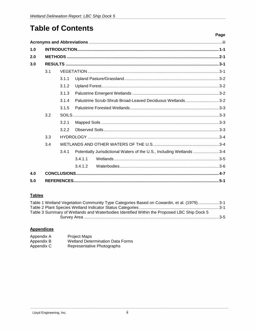
Table of Contents Page
Acronyms and Abbreviations .................................................................................................................... iii
1.0 INTRODUCTION ........................................................................................................................... 1-1
2.0 METHODS .................................................................................................................................... 2-1
3.0 RESULTS ..................................................................................................................................... 3-1
3.1 VEGETATION .................................................................................................................. 3-1
3.1.1 Upland Pasture/Grassland .................................................................................. 3-2
3.1.2 Upland Forest ...................................................................................................... 3-2
3.1.3 Palustrine Emergent Wetlands ........................................................................... 3-2
3.1.4 Palustrine Scrub-Shrub Broad-Leaved Deciduous Wetlands ............................. 3-2
3.1.5 Palustrine Forested Wetlands ............................................................................. 3-3
3.2 SOILS ............................................................................................................................... 3-3
3.2.1 Mapped Soils ...................................................................................................... 3-3
3.2.2 Observed Soils .................................................................................................... 3-3
3.3 HYDROLOGY .................................................................................................................. 3-4
3.4 WETLANDS AND OTHER WATERS OF THE U.S. ........................................................ 3-4
3.4.1 Potentially Jurisdictional Waters of the U.S., Including Wetlands ...................... 3-4
3.4.1.1 Wetlands ........................................................................................... 3-5
3.4.1.2 Waterbodies ...................................................................................... 3-6
4.0 CONCLUSIONS ............................................................................................................................ 4-7
5.0 REFERENCES .............................................................................................................................. 5-1
Tables
Table 1 Wetland Vegetation Community Type Categories Based on Cowardin, et al. (1979) .................. 3-1 Table 2 Plant Species Wetland Indicator Status Categories ..................................................................... 3-1 Table 3 Summary of Wetlands and Waterbodies Identified Within the Proposed LBC Ship Dock 5
Survey Area ..................................................................................................................... 3-5
Appendices
Appendix A Project Maps Appendix B Wetland Determination Data Forms Appendix C Representative Photographs
Wetland Delineation Report: LBC Ship Dock 5
Lloyd Engineering, Inc. iii
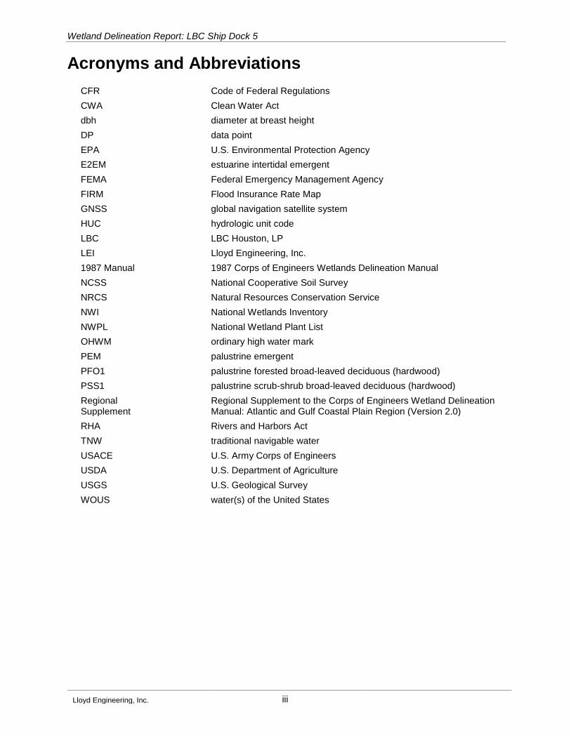
Acronyms and Abbreviations
CFR Code of Federal Regulations
CWA Clean Water Act
dbh diameter at breast height
DP data point
EPA U.S. Environmental Protection Agency
E2EM estuarine intertidal emergent
FEMA Federal Emergency Management Agency
FIRM Flood Insurance Rate Map
GNSS global navigation satellite system
HUC hydrologic unit code
LBC LBC Houston, LP
LEI Lloyd Engineering, Inc.
1987 Manual 1987 Corps of Engineers Wetlands Delineation Manual
NCSS National Cooperative Soil Survey
NRCS Natural Resources Conservation Service
NWI National Wetlands Inventory
NWPL National Wetland Plant List
OHWM ordinary high water mark
PEM palustrine emergent
PFO1 palustrine forested broad-leaved deciduous (hardwood)
PSS1 palustrine scrub-shrub broad-leaved deciduous (hardwood)
Regional Supplement
Regional Supplement to the Corps of Engineers Wetland Delineation Manual: Atlantic and Gulf Coastal Plain Region (Version 2.0)
RHA Rivers and Harbors Act
TNW traditional navigable water
USACE U.S. Army Corps of Engineers
USDA U.S. Department of Agriculture
USGS U.S. Geological Survey
WOUS water(s) of the United States
Wetland Delineation Report: LBC Ship Dock 5
Lloyd Engineering, Inc. 1-1
1.0 Introduction
This report presents the results of a wetland delineation conducted on behalf of LBC Houston, LP (LBC)
for the proposed LBC Ship Dock 5 project, U.S. Army Corps of Engineers (USACE) Project No. SWG-2016-
00832. The proposed project is located in La Porte, Texas approximately 0.72-mile east of the intersection
of State Highway 146 and Shoreacres Boulevard and is positioned on the northwest shoreline of the
Bayport Terminal. Lloyd Engineering, Inc. (LEI) conducted environmental investigations intermittently
between the months of August and September within an approximate 19-acre survey area. The proposed
project is positioned within the USACE Galveston District, and is located on the U.S. Geological Survey
(USGS) League City, Texas, 7.5-minute series topographic quadrangle map (USGS, 1982). Refer to the
vicinity map provided as Figure 1 in Appendix A for a depiction the project location.
The purpose of the investigation was to determine the location and extent of any potential waters of the
United States (WOUS), including wetlands, within the survey area, as defined by Section 404 of the Clean
Water Act (CWA) and/or Section 10 of the Rivers and Harbors Act (RHA) subject to the jurisdiction of the
USACE Galveston District and U.S. Environmental Protection Agency (EPA). This information was obtained
through both desktop and field investigations.

Wetland Delineation Report: LBC Ship Dock 5
Lloyd Engineering, Inc. 2-1
2.0 Methods
Impact assessments to potential jurisdictional areas (including wetlands), as defined by code of federal
regulations (CFR) 328, were conducted within all portions of the 19-acre survey area. Aerial photography,
National Wetlands Inventory (NWI) data, National Resources Conservation Service soil survey data, and
Federal Emergency Management Agency (FEMA) National Flood Hazard Layer data were reviewed prior
to field investigations. As required by existing regulations or regional general permits, potential wetlands,
as defined by the USACE 1987 Wetlands Delineation Manual ("1987 Manual") (Environmental Laboratory,
1987) and the Regional Supplement to the Corps of Engineers Wetland Delineation Manual: Atlantic and
Gulf Coastal Plain Region (Version 2.0) ("Regional Supplement") (USACE, 2010), were evaluated based
on the presence of hydrophytic vegetation, wetland hydrology, and hydric soils. This evaluation included
assessments of any ephemeral, intermittent, and perennial streams; navigable and non-navigable
waterways; wetlands; and other special aquatic sites (i.e., sanctuaries and refuges, wetlands, mudflats,
vegetated shallows, coral reefs, and riffle and pool complexes [1987 Manual]).
The field effort and approach followed guidelines provided by the 1987 Manual and as specified by the
USACE Galveston District Compliance Section, for properties greater than 5 acres in size. The guidelines
state that for sites greater than 5 acres with baselines less than 0.25-mile, three transect lines are required.
For this investigation, three transect lines were established to accurately categorize the vegetative
communities within the 19-acre survey area.
Vegetation, hydrology, and soils were evaluated and recorded in the field at each data point (DP). Plant
species were recorded at each DP by visually estimating the percent areal cover of each species using
nested sampling plots by strata, in accordance with the Regional Supplement. The 2016 National Wetland
Plant List (NWPL) website, Version 3.3 (Lichvar et al., 2016) was used to determine the indicator status of
plant species. Taxonomy of plant species follows Lichvar, et al. (2016) and the NRCS PLANTS Database
(U.S. Department of Agriculture [USDA] NRCS, 2016). Field indicators of hydrology and hydric soils were
evaluated and recorded at each DP. A shallow soil pit was dug at each DP, to document soil characteristics
and to examine subsurface hydrology. The soil pit was left open for at least 10 minutes, to allow any free
water in the soil to stabilize, before recording the depth to free water in the pit and the depth to saturated
soil. Meanwhile, soil characteristics were recorded and included, but were not limited to, soil color(s),
texture, structure, and presence of redoximorphic features, nodules, or concretions, and hydric soil
indicators. The moist matrix color, and when present, moist mottle color of soils, were determined by soil
horizon/strata utilizing the Munsell Soil Color Charts (Kollmorgen Instruments Corporation, 2000). At DP
locations where the wetland vegetation, soil, and hydrology criteria were met, the site was identified as a
wetland and categorized following the classification system of Cowardin et al. (1979). At the time of the
assessment, the DP locations, wetland boundaries, and ordinary high water mark (OHWM) limits of WOUS
within the overall site were delineated according to field data and digitally georeferenced/mapped using a
Trimble Geo 7X global navigation satellite system (GNSS) with sub-meter accuracy.
Wetland Delineation Report: LBC Ship Dock 5
Lloyd Engineering, Inc. 3-1
3.0 Results
Field investigations were conducted intermittently from August to September 2016, to identify any wetlands
or waterbodies within the survey area potentially subject to USACE jurisdiction under Section 404 of the
CWA and/or Section 10 of the RHA. The vegetation, hydrology, and soil characteristics at each DP were
recorded on the wetland determination data forms provided in Appendix B.
3.1 Vegetation
During the field investigations, six vegetation communities were identified within the survey area, including,
upland grasslands, upland forest, palustrine emergent (PEM) wetland, palustrine scrub-shrub broad-leaved
deciduous (PSS1) wetland, and palustrine forested hardwood (PFO1) wetland, and estuarine intertidal
emergent (E2EM) wetlands. The wetland vegetation community types are based on the Cowardin, et al.
(1979) classification system and are defined in Table 1 below. Refer to Appendix C for representative
photographs of the vegetation communities observed within the survey area.
Table 1 Wetland Vegetation Community Type Categories
Based on Cowardin, et al. (1979)
Symbol Vegetation Type
PEM Palustrine emergent
PSS1 Palustrine scrub-shrub broad-leaved deciduous (hardwood)
PFO1 Palustrine forested broad-leaved deciduous (bottomland hardwood)
E2EM Estuarine intertidal emergent
The wetland indicator status for each plant species, as defined in Table 2 was determined using Lichvar
et al. (2016). Each indicator status reflects a plant species' fidelity and preference for wetlands or uplands
based upon its frequency and abundance in wetlands versus uplands and the availability of wetland habitat
across the local to regional landscape (Lichvar and Minkin, 2008). The resulting indicator status categories
are used in determining dominance of hydrophytic versus non-hydrophytic vegetation at each DP.
Table 2 Plant Species Wetland Indicator Status Categories
Code Category Definition
OBL Obligate Wetland Hydrophyte - Almost always occurs in wetlands
FACW Facultative Wetland Hydrophyte - Usually occurs in wetlands, but may occur in non-wetlands
FAC Facultative Hydrophyte - Occurs in wetlands and non-wetlands
FACU Facultative Upland Non-hydrophyte - Usually occurs in non-wetlands, but may occur in wetlands
UPL Obligate Upland Non-hydrophyte - Almost never occurs in wetlands
Source: Lichvar et al., 2016. The National Wetland Plant List. 2016 Wetland Ratings. Phytoneuron: 2016-4-30. Website Version 3.3 available at http://rsgisias.crrel.usace.army.mil/nwpl_static/mapper/mapper.html.

Wetland Delineation Report: LBC Ship Dock 5
Lloyd Engineering, Inc. 3-2
3.1.1 Upland Pasture/Grassland
Areas described as upland grassland within the survey area typically consisted of herbaceous vegetative
cover within a topographically elevated landscape. Common vegetation species observed in the upland
pasture/grassland communities included annual ragweed (Ambrosia artemisiifolia, FACU), bermuda grass
(Cynodon dactylon, FACU), annual sumpweed (Iva annua, FAC), beaked panicum (Panicum anceps, FAC),
bahia grass (Paspalum notatum, FACU), Canada golden-rod (Solidago canadensis, FACU), and smut
grass (Sporobolus indicus, FACU). Based on the technical criterial outlined in the Regional Supplement,
the vegetation observed within this community is not representative of a hydrophytic plant community.
3.1.2 Upland Forest
Areas described as upland forest within the survey area typically consisted of woody vegetation with a dbh
greater than 3 inches. Upland forested communities pronominally consisted of tallow (Triadica sebifera,
FAC), with sugarberry (Celits laevigata, FACW), American elm (Ulmus americana, FAC), loblolly pine
(Pinus taeda, FAC) interspersed throughout. Due to minimal sunlight penetrating the canopy, a low diversity
of herbaceous and woody vine species was noted within upland forested communities. The species noted
with frequency included American beautyberry (Callicarpa americana, FACU) southern dewberry (Rubus
trivialis, FACU), eastern poison ivy (Toxicodendron radicans, FAC), and Virginia creeper (Parthenocissus
quinquefolia, FACU). Based on the technical criterial outlined in the Regional Supplement, some species
observed within the upland forested community are considered hydrophytic plants, but due to the lack of
indicators of wetland hydrology and/or absence of hydric soils this vegetative community was considred
most consistent with upland forest communities.
3.1.3 Palustrine Emergent Wetlands
Areas described as PEM wetlands within the survey area consisted of freshwater wetlands that exhibited a
dominance of herbaceous plant species. PEM wetlands are typically dominated by emergent and rooted
herbaceous hydrophytes, excluding mosses and lichens, that are present for most of the growing season
in most years. These wetlands are usually dominated by perennial plants (Cowardin et al., 1979). The
Regional Supplement defines the herbaceous stratum as all herbaceous (non-woody) plants, including
herbaceous vines, regardless of size, and woody species, except woody vines, less than approximately
3 feet in height. Common vegetation species observed within PEM wetlands included swamp smartweed
(Persicaria hydropiperoides, OBL), jointed flatsedge (Cyperus articulates, OBL), bushy goldentop
(Euthamia leptocephala, FACW), sand spike-rush (Eleocharis montevidensis, FACW), and bog rush
(Juncus marginatus, FACW). Based on the technical criteria outlined in the 1987 Manual and the Regional
Supplement, the vegetation observed within this community is representative of a hydrophytic plant
community.
3.1.4 Palustrine Scrub-Shrub Broad-Leaved Deciduous Wetlands
Historically, PSS wetlands were described as being typically dominated by woody vegetation less than
20 feet tall that may consist of true shrubs, young trees, or trees and shrubs that are stunted by
environmental conditions (Cowardin, et al., 1979). The currently used Regional Supplement (USACE,
2010) defines the sapling and shrub strata as woody plants, excluding vines, which are 3 inches or less at
Wetland Delineation Report: LBC Ship Dock 5
Lloyd Engineering, Inc. 3-3
dbh and 20 feet or more in height (sapling) or 3 to 20 feet in height (shrub). Dominant species occurring
within this wetland community consisted of Chinese tallow, swamp smartweed, jointed flatsedge, sand
spike-rush, bushy goldentop, eastern baccharis (Baccharis halimifolia, FAC), wax myrtle (Morella cerifera,
FAC), and black willow (Salix nigra, OBL). Based on the technical criteria outlined in the 1987 Manual and
the Regional Supplement, the vegetation observed within this community is representative of a hydrophytic
plant community.
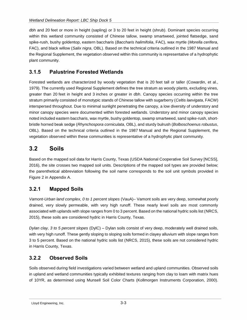
3.1.5 Palustrine Forested Wetlands
Forested wetlands are characterized by woody vegetation that is 20 feet tall or taller (Cowardin, et al.,
1979). The currently used Regional Supplement defines the tree stratum as woody plants, excluding vines,
greater than 20 feet in height and 3 inches or greater in dbh. Canopy species occurring within the tree
stratum primarily consisted of monotypic stands of Chinese tallow with sugarberry (Celtis laevigata, FACW)
interspersed throughout. Due to minimal sunlight penetrating the canopy, a low diversity of understory and
minor canopy species were documented within forested wetlands. Understory and minor canopy species
noted included eastern baccharis, wax myrtle, bushy goldentop, swamp smartweed, sand spike-rush, short-
bristle horned beak sedge (Rhynchospora corniculata, OBL), and sturdy bulrush (Bolboschoenus robustus,
OBL). Based on the technical criteria outlined in the 1987 Manual and the Regional Supplement, the
vegetation observed within these communities is representative of a hydrophytic plant community.
3.2 Soils
Based on the mapped soil data for Harris County, Texas (USDA National Cooperative Soil Survey [NCSS],
2016), the site crosses two mapped soil units. Descriptions of the mapped soil types are provided below;
the parenthetical abbreviation following the soil name corresponds to the soil unit symbols provided in
Figure 2 in Appendix A.
3.2.1 Mapped Soils
Vamont-Urban land complex, 0 to 1 percent slopes (VauA)– Vamont soils are very deep, somewhat poorly
drained, very slowly permeable, with very high runoff. These nearly level soils are most commonly
associated with uplands with slope ranges from 0 to 3 percent. Based on the national hydric soils list (NRCS,
2015), these soils are considered hydric in Harris County, Texas.
Dylan clay, 3 to 5 percent slopes (DylC) – Dylan soils consist of very deep, moderately well drained soils,
with very high runoff. These gently sloping to sloping soils formed in clayey alluvium with slope ranges from
3 to 5 percent. Based on the national hydric soils list (NRCS, 2015), these soils are not considered hydric
in Harris County, Texas.
3.2.2 Observed Soils
Soils observed during field investigations varied between wetland and upland communities. Observed soils
in upland and wetland communities typically exhibited textures ranging from clay to loam with matrix hues
of 10YR, as determined using Munsell Soil Color Charts (Kollmorgen Instruments Corporation, 2000).

Wetland Delineation Report: LBC Ship Dock 5
Lloyd Engineering, Inc. 3-4
Evaluation of hydric soils was completed based on criteria defined in NRCS (2010) and as outlined in the
1987 Manual and the Regional Supplement.
Soils observed in wetland areas within the proposed survey area typically developed under anaerobic
(i.e., inundated/saturated edaphic conditions) or alternating aerobic-anaerobic conditions (i.e., wet/dry
hydroperiod). The hydric soil indicators observed within the wetland communities included F3-Depleted
Matrix (i.e., exhibiting a depleted matrix and a chroma of 2 or less with or without redox concentrations).
Hydric soils observed within the wetland communities in the survey area consisted of clay and clay loam
textures ranging in color from very dark gray (10YR 4/1) to brown (10YR 4/2) with redox concentrations
ranging from dark yellowish brown (10YR 4/6) to yellowish brown (10YR 5/6).
Soils observed in upland areas at the site typically developed under aerobic soil conditions. Based on the
criteria outlined in NRCS (2010), and as outlined in the 1987 Manual and the Regional Supplement, the
majority of the soils observed within the upland communities were not considered hydric. The observed
upland soils ranged from clay to clay loam, varying in color from brown (10YR 4/3) to very pale brown
(10YR 8/3), and when present, redox concentrations ranged from yellowish-brown (10YR 5/8) to dark
yellowish brown (10YR 4/6). The data points in upland areas that exhibited hydric soils either lacked
hydrophytic vegetation or lacked both hydrology and hydrophytic vegetation.
Refer to the wetland determination data forms provided in Appendix B for detailed descriptions of observed
soils at individual wetland and upland locations within the survey area.
3.3 Hydrology
Primary indicators of wetland hydrology observed in wetland communities included surface water, high
water table, saturation, oxidized rhizospheres on living roots, water-stained leaves, drift deposits, and algal
mat or crust. Secondary indicators of wetland hydrology observed in the wetland communities included
drainage patterns, geomorphic position, and positive FAC-neutral test. Some upland communities exhibited
secondary indicators of wetland hydrology, including FAC-neutral test and geomorphic position. However,
all upland data points that met the hydrology criterion did not meet the hydrophytic vegetation and/or hydric
soil criteria. Refer to the wetland determination data forms provided in Appendix B for site-specific
observations of hydrology identified at each wetland location.
3.4 Wetlands and other Waters of the U.S.
Wetlands and waterbodies identified within the survey area included PFO1, PSS1, PEM, and E2EM
wetlands, and a perennial stream. Table 3 provides a summary of all features identified within the survey
area. Appendix A contains project maps depicting the location of all wetlands and waterbodies identified
within the survey area. Appendices B and C contain the Regional Supplement wetland determination data
forms and representative photographs, respectively.
3.4.1 Potentially Jurisdictional Waters of the U.S., Including Wetlands
Potentially jurisdictional linear waterbodies identified within the survey area exhibited an OHWM and/or a
mean lower low water boundary, and a surface connection to a waterbody subject to jurisdiction under
Wetland Delineation Report: LBC Ship Dock 5
Lloyd Engineering, Inc. 3-5
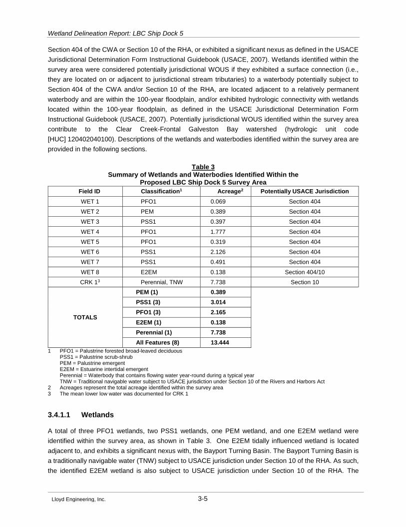
Section 404 of the CWA or Section 10 of the RHA, or exhibited a significant nexus as defined in the USACE
Jurisdictional Determination Form Instructional Guidebook (USACE, 2007). Wetlands identified within the
survey area were considered potentially jurisdictional WOUS if they exhibited a surface connection (i.e.,
they are located on or adjacent to jurisdictional stream tributaries) to a waterbody potentially subject to
Section 404 of the CWA and/or Section 10 of the RHA, are located adjacent to a relatively permanent
waterbody and are within the 100-year floodplain, and/or exhibited hydrologic connectivity with wetlands
located within the 100-year floodplain, as defined in the USACE Jurisdictional Determination Form
Instructional Guidebook (USACE, 2007). Potentially jurisdictional WOUS identified within the survey area
contribute to the Clear Creek-Frontal Galveston Bay watershed (hydrologic unit code
[HUC] 120402040100). Descriptions of the wetlands and waterbodies identified within the survey area are
provided in the following sections.
Table 3 Summary of Wetlands and Waterbodies Identified Within the
Proposed LBC Ship Dock 5 Survey Area
Field ID Classification1 Acreage2 Potentially USACE Jurisdiction
WET 1 PFO1 0.069 Section 404
WET 2 PEM 0.389 Section 404
WET 3 PSS1 0.397 Section 404
WET 4 PFO1 1.777 Section 404
WET 5 PFO1 0.319 Section 404
WET 6 PSS1 2.126 Section 404
WET 7 PSS1 0.491 Section 404
WET 8 E2EM 0.138 Section 404/10
CRK 13 Perennial, TNW 7.738 Section 10
TOTALS
PEM (1) 0.389
PSS1 (3) 3.014
PFO1 (3) 2.165
E2EM (1) 0.138
Perennial (1) 7.738
All Features (8) 13.444
1 PFO1 = Palustrine forested broad-leaved deciduous PSS1 = Palustrine scrub-shrub PEM = Palustrine emergent E2EM = Estuarine intertidal emergent Perennial = Waterbody that contains flowing water year-round during a typical year TNW = Traditional navigable water subject to USACE jurisdiction under Section 10 of the Rivers and Harbors Act
2 Acreages represent the total acreage identified within the survey area 3 The mean lower low water was documented for CRK 1
3.4.1.1 Wetlands
A total of three PFO1 wetlands, two PSS1 wetlands, one PEM wetland, and one E2EM wetland were
identified within the survey area, as shown in Table 3. One E2EM tidally influenced wetland is located
adjacent to, and exhibits a significant nexus with, the Bayport Turning Basin. The Bayport Turning Basin is
a traditionally navigable water (TNW) subject to USACE jurisdiction under Section 10 of the RHA. As such,
the identified E2EM wetland is also subject to USACE jurisdiction under Section 10 of the RHA. The

Wetland Delineation Report: LBC Ship Dock 5
Lloyd Engineering, Inc. 3-6
remaining wetlands identified within the survey area located within the 100-year floodplain and therefore
subject to USACE jurisdiction under Section 404 of the CWA.
Emergent wetlands are usually dominated by perennial plants (Cowardin, et al., 1979). Areas containing
herbaceous vegetation that covered at least 5 percent of the substrate during the peak of the growing
season were considered to be vegetated (USACE, 2010) and were classified as emergent wetlands. One
PEM wetland and one E2EM wetland were identified within the survey area.
Scrub-shrub wetlands are described by Cowardin, et al. (1979) as being typically dominated by woody
vegetation less than 20 feet tall that may consist of true shrubs, young trees, or trees and shrubs that are
stunted by environmental conditions. As specified in Cowardin, et al. (1979), wetlands that were comprised
of either (1) 30 percent or greater sapling and/or shrub cover, or (2) tree and shrub strata that in
combination covered 30 percent or more of the area, were classified as scrub-shrub. Three PSS1 wetlands
were identified within the survey area.
Forested wetlands are characterized by woody vegetation that is 6 meters (20 feet) tall or taller (Cowardin,
et al., 1979). As specified in Cowardin, et al. (1979), wetlands that contained 30 percent or more areal
canopy cover consisting of tree-sized species, as defined in USACE (2010), were considered to be forested
wetlands. Three PFO1 wetlands were identified within the survey area.
3.4.1.2 Waterbodies
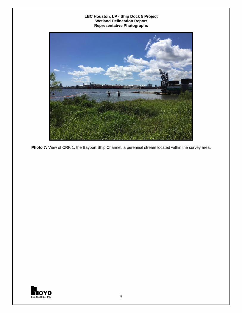
One perennial stream (CRK 1) was identified within the survey area of the proposed project. Portions of the
survey area of the proposed project intersect the Bayport Ship Channel, a waterbody dredged for ship traffic
connecting to the Houston Ship Channel. The Bayport Ship Channel is considered a TNW and subject to
USACE jurisdiction under Section 10 of the RHA.
Perennial streams are waterbodies that contain flowing water year-round during a typical year. The water
table is located above the streambed for most of the year, and groundwater is the primary source of water
for stream flow. Runoff from rainfall is a supplemental source of eater for stream flow (Wetland Training
Institute [WTI], 2012). Perennial streams that exhibit an OHWM and/or mean lower low water boundary are
considered WOUS potentially subject to USACE jurisdiction under Section 404 of the CWA and/or Section
10 of the RHA.
Wetland Delineation Report: LBC Ship Dock 5
Lloyd Engineering, Inc. 4-7
4.0 Conclusions
Potential WOUS, including wetlands, identified within the survey area of the proposed project included
perennial streams, and emergent, scrub-shrub, and forested wetlands. The survey area included potentially
jurisdictional features subject to USACE jurisdiction under Section 404 of the CWA consisting of one
perennial stream, one PEM, one E2EM, three PSS1, three PFO1 wetlands. Of these, WET 8, an E2EM
tidally-influenced wetland, and CRK 1, the Bayport Ship Channel, are subject to USACE jurisdiction under
Section 10 of the RHA.
Wetland Delineation Report: LBC Ship Dock 5
Lloyd Engineering, Inc. 5-1
5.0 References
Cowardin, L. M., V. Carter, F. C. Golet, E. T. LaRoe. 1979. Classification of wetlands and deepwater
habitats of the United States. U.S. Department of the Interior, Fish and Wildlife Service,
Washington, D.C. Jamestown, North Dakota: Northern Prairie Wildlife Research Center Online.
http://www.npwrc.usgs.gov/resource/wetlands/classwet/index.htm (Version 04DEC1998).
Environmental Laboratory. 1987. Corps of Engineers Wetlands Delineation Manual. Technical Report Y
87 1, U.S. Army Engineer Waterways Experiment Station, Vicksburg, Mississippi.
Kollmorgen Instruments Corporation. 2000. Munsell Soil Color Charts. Year 2000 Revised Washable
Edition. GretagMacbeth, New Windsor, New York.
Lichvar, R. W., M. Butterwick, N. C. Melvin, and W. N. Kirchner. 2016. Lichvar, R. W., D. L. Banks, W. N.
Kirchner, and N. C. Melvin. 2016. The National Wetland Plant List: 2016 wetland ratings.
Phytoneuron 2016-30: 1-17. Published 28 April 2016. ISSN 2153 733X. Website Version 3.3
available at http://rsgisias.crrel.usace.army.mil/nwpl_static/mapper/mapper.html. Accessed
October 2016.
Lichvar, Robert W., and Paul Minkin. 2008. Concepts and Procedures for Updating the National Wetland
Plant List ERDC/CRREL TN-08-3
(http://rsgisias.crrel.usace.army.mil/NWPL_CRREL/docs/ERDC-CRREL_TN 08 3.pdf). U.S. Army
Engineer Research and Development Center, Cold Regions Research and Engineering
Laboratory, Hanover, New Hampshire.
Natural Resources Conservation Service (NRCS). 2010. Field Indicators of Hydric Soils in the United
States. Version 7.0. L. M. Vasilas, G. W. Hurt, and C. V. Noble (Eds.). USDA, NRCS, in
cooperation with the National Technical Committee for Hydric Soils.
_____. 2016. Web Soil Survey. Available on-line at http://websoilsurvey.nrcs.usda.gov/. Accessed
October 2016.
_____. 2015. "Lists of Hydric Soils: National List, all states (December 2015)." U.S. Department of
Agriculture. Available on-line at http://soils.usda.gov/use/hydric/.
U.S. Army Corps of Engineers. 2010. Regional Supplement to the Corps of Engineers Wetland
Delineation Manual, Atlantic and Gulf Coastal Plain Region (Version 2.0), ed. J. S. Wakeley, R.
W. Lichvar, and C. V. Noble. ERDC/EL TR 10 20. Vicksburg, Mississippi: U.S. Army Engineer
Research and Development Center.
U.S. Army Corps of Engineers and Environmental Protection Agency. U.S. Army Corps of Engineers
Jurisdictional Determination Form Instructional Guidebook. 2007. Available on-line at http://www.
usace.army.mil/Portals/2/docs/civilworks/regulatory/cwa_guide/jd_guidebook_051207final.pdf.
U.S. Department of Agriculture (USDA) National Cooperative Soil Survey (NCSS). 2016. Soil Survey
Geographic Database (SSURGO) and State Soil Geographic Database (STATSGO) digital soil
survey products. Available online via California Soil Resource Lab SoilWeb streaming interface
Wetland Delineation Report: LBC Ship Dock 5
Lloyd Engineering, Inc. 5-2
(download at http://www.gelib.com/soilweb.htm) or via Natural Resources Conservation Service
(NRCS) Web Soil Survey at http://websoilsurvey.nrcs.usda.gov/. Accessed October 2016.
U.S. Department of Agriculture (USDA) Natural Resources Conservation Service (NRCS). 2016. The
PLANTS Database National Plant Data Team, Greensboro, North Carolina, 27401 4901 USA.
http://www.nrcs.usda.gov/Internet/FSE_DOCUMENTS/nrcs144p2_051372.pdf. Accessed
October 2016.
U.S. Geological Survey. 1982. League City, Texas, 7.5-minute Series Topographic Map.
http://ngmdb.usgs.gov/ngmdb/ngmdb_home.html. Accessed October 2016.
Wetland Training Institute, Inc. (WTI). 2012. Nationwide Permits Complete: 2012 Edition. Robert J. Pierce
and Sam Collinson, eds., David E. Dearing, contributing author.
Lloyd Engineering, Inc.
Appendix A
Project Maps
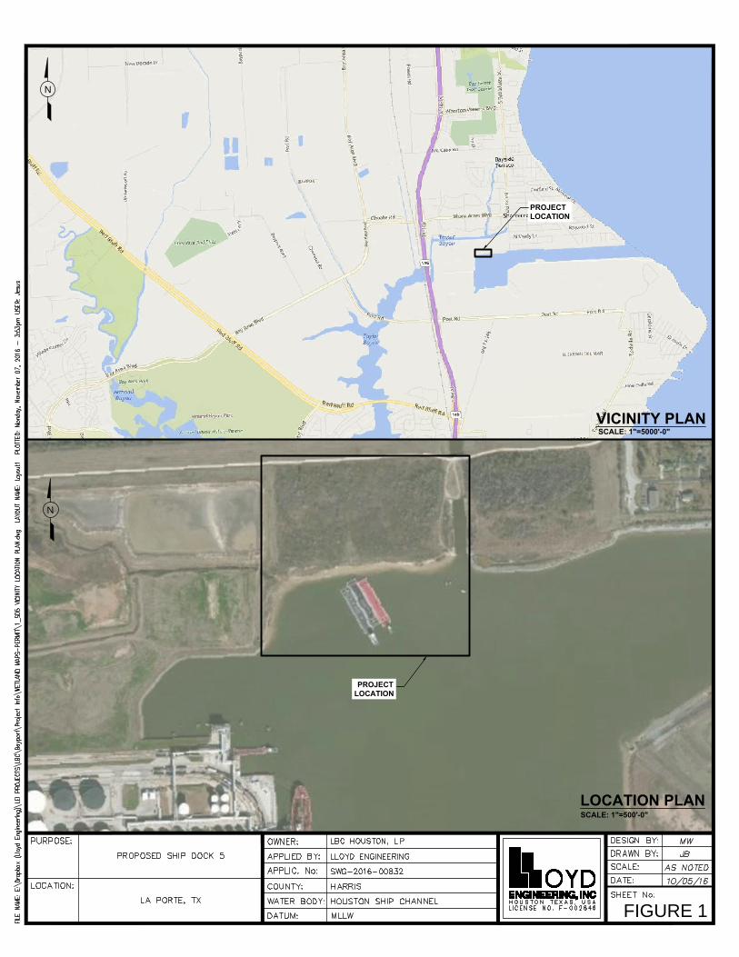
N
VICINITY PLAN
PROJECT
LOCATION
PROJECT
LOCATION
LOCATION PLAN
N
FIGURE 1
SCALE: 1"=500'-0"
SCALE: 1"=5000'-0"

N
LE
GE
ND
FIGURE 2
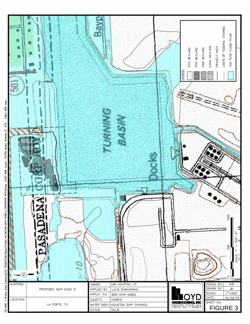
LE
GE
ND
N
FIGURE 3

Lloyd Engineering, Inc.
Appendix B
Wetland Determination Data Forms
Wetland Determination Data Forms have been excluded from this Draft for Reviewing Purposes
Lloyd Engineering, Inc.
Appendix C
Representative Photographs
LBC Houston, LP - Ship Dock 5 Project Wetland Delineation Report Representative Photographs
1
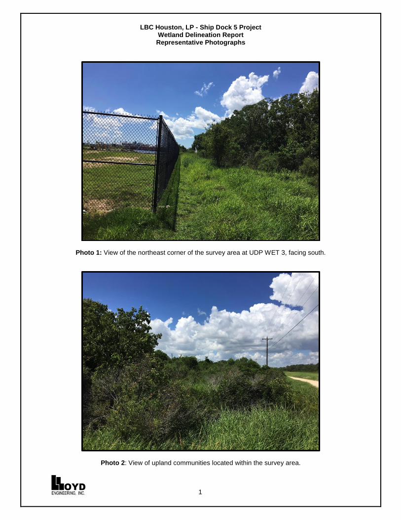
Photo 1: View of the northeast corner of the survey area at UDP WET 3, facing south.
Photo 2: View of upland communities located within the survey area.

LBC Houston, LP - Ship Dock 5 Project Wetland Delineation Report Representative Photographs
2
Photo 3: View of upland pasture vegetative communities at UDP WET 4, facing west.
Photo 4: View of WET 3, a PSS1 wetland located within the survey area, facing south.

LBC Houston, LP - Ship Dock 5 Project Wetland Delineation Report Representative Photographs
3
Photo 5: View of WET 4, a PFO1 wetland located within the survey area, facing west.
Photo 6: View of WET 8, an estuarine intertidal emergent wetland located within the survey area.
LBC Houston, LP - Ship Dock 5 Project Wetland Delineation Report Representative Photographs
4
Photo 7: View of CRK 1, the Bayport Ship Channel, a perennial stream located within the survey area.
Related Documents