PROJECT SITE: FORMER LANDFILL BLUE ISLAND, COOK COUNTY , ILLINOIS PREPARED FOR: CITY OF BLUE ISLAND CITY HALL 13051 SOUTH GREENWOOD BLUE ISLAND, ILLINOIS 60406 PREPARED BY: V3 COMPANIES OF ILLINOIS, LTD. 7325 JANES AVENUE WOODRIDGE, ILLINOIS 60517 630.724.9200 OCTOBER 12, 2007 WETLAND DELINEATION AND ASSESSMENT REPORT

Welcome message from author
This document is posted to help you gain knowledge. Please leave a comment to let me know what you think about it! Share it to your friends and learn new things together.
Transcript

PROJECT SITE:
FORMER LANDFILL BLUE ISLAND, COOK COUNTY, ILLINOIS
PREPARED FOR:
CITY OF BLUE ISLAND CITY HALL
13051 SOUTH GREENWOOD BLUE ISLAND, ILLINOIS 60406
PREPARED BY:
V3 COMPANIES OF ILLINOIS, LTD. 7325 JANES AVENUE
WOODRIDGE, ILLINOIS 60517 630.724.9200
OCTOBER 12, 2007
WETLAND
DELINEATION AND ASSESSMENT REPORT

We hereby certify that this Wetland Delineation and Assessment Report has been prepared by V3 Companies of Illinois, for use by the City of Blue Island, its affiliates, lenders, and assignees. Project Staff:
Desiree A. Poole Ecologist
Jennifer L. Wollenweber Soil Scientist
Approved by:
Thomas E. Slowinski Principal, Director of Wetland/Ecology Group Natural Resources Division
E:\2007\07223\Reports\Natural Resources\Wetland\Wetland Delineation Report 07223.doc

TABLE OF CONTENTS
EXECUTIVE SUMMARY .............................................................................................................1
INTRODUCTION AND BACKGROUND...................................................................................3
Wetland Determination Methods ..........................................................................................4
RESULTS OF THE FIELD INVESTIGATION ..........................................................................5
Wetland Areas .........................................................................................................................5
Area 1 – Excavated Detention Basin/Isolated Emergent Wetland ................................5
Area 2 – Excavated Detention Basin/Isolated Emergent Wetland ................................6
Area 3 –Isolated Emergent Wetland/Waters ....................................................................7
Other Areas Investigated .......................................................................................................9
Area 4 – Intermittent Drainageway .....................................................................................9
Additional Areas Investigated..............................................................................................10
Area 5 - Upland....................................................................................................................10
REFERENCES CITED ...............................................................................................................11
APPENDIX I – WETLAND DELINEATION DATA FORMS
APPENDIX II – REPRESENTATIVE PHOTOGRAPHS
APPENDIX III – REGULATORY INFORMATION
APPENDIX IV – DELINEATION METHODS AND FLORISTIC ANALYSIS
APPENDIX V – ENDANGERED SPECIES RECORDS INQUIRY
APPENDIX VI – SITE HISTORY
EXHIBITS

EXECUTIVE SUMMARY
The approximately 35-acre subject property was investigated by V3 Companies of Illinois (V3) on September 19, 2007, to determine the presence, extent and quality of any wetlands or other areas under U.S. Army Corps of Engineers (ACOE) jurisdiction. The property consists of a former landfill owned by the City of Blue Island.
Delineation Summary
Two excavated detention basins, one wetland, and two ditches were delineated on the subject property, totaling approximately 24.1 acres. Areas 1 and 2 are excavated detention basins, located in the northern portion of the property (approximately 3.0 acres and 3.3 acres, respectively). Area 3 is an approximately 17.6-acre emergent wetland/waters located in the southern portion of the site. Area 4 includes a railroad, right-of-way ditch (approximately 2,100 linear feet; 0.2 acres), located along the western property boundary.
Areas 1, 2, 3 and 4 all lack a contiguous surface connection to the Little Calumet River or any other surface water tributary system and are, in our opinion, are isolated wetlands/waters and are not under ACOE jurisdiction. A jurisdictional determination from the ACOE is recommended to confirm these designations. Information concerning applicable regulatory requirements is provided in Appendix III.
Threatened and Endangered Species Summary As part of the overall site and wetland habitat evaluation, requests for information concerning federally listed species were made to the U.S. Fish and Wildlife (FWS) and the Illinois Department of Natural Resources (IDNR). The FWS response indicates that they do no believe that any federally endangered or threatened species occur within the vicinity of the site. The FWS consultation has therefore been terminated. The IDNR response states that no known listed species are known to occur near the site, nor would any known threatened or endangered species be affected by the proposed site development. The IDNR consultation process was therefore concluded. See Appendix V for more detailed information.
Regulatory Summary
Pursuant to Section 404 of the Clean Water Act, the U. S. Army Corps of Engineers (ACOE) has jurisdiction over the placement of fill or dredged material in all jurisdictional waters of the United States. Jurisdictional areas include rivers, streams, tributary waterways, lakes, natural ponds and wetlands adjacent to these areas. A Section 404 permit must be obtained before placing any fill material within a jurisdictional area.
Wetlands that lack a continuous surface connection through a relatively permanent tributary to traditionally navigable waters are considered isolated wetlands and are not regulated under the Clean Water Act.1 To be considered relatively permanent a tributary must have continuous flow at least seasonally (typically at least three months). Swales and erosional features are generally not considered to be tributaries or waters of the United States. Ditches excavated wholly in and draining only uplands and that do not carry a relatively permanent flow are also generally not waters of the U. S. Wetlands adjacent to tributaries and ditches that do not have a
1 June 5, 2007, USEPA and Department of the Army Joint Memorandum, Clean Water Act Jurisdiction Following the U. S. Supreme Court
Decision in Rapanos v. United States and Carabell v. United States.
Wetland Delineation and Assessment Report V3 Companies of Illinois, Ltd. • 1 Blue Island Industrial Park October, 2007 Blue Island, Cook County, Illinois 07223

relatively continuous flow will be regulated only if they have a significant nexus to traditionally navigable waters. A significant nexus determination will be based on hydrologic and ecological factors.
Table 1. Wetland/Waters Summary Table.
Area On-Site Acreage
Off-site Acreage
Native Mean Conservatism
(NMC)*
Floristic Quality
Index (FQI)* HQAR ACOE Jurisdiction
1 3.0 -- 1.2 2.7 N N 2 3.3 -- 2.0 4.0 N N 3 17.6 -- 3.0 17.4 N N 4 0.2 -- -- -- N N
Total 24.1 --
* Based on the Floristic Quality Assessment (FQA) methodology in Plants of the Chicago Region (Swink and Wilhelm, 1994).
Wetland Delineation and Assessment Report V3 Companies of Illinois, Ltd. • 2 Blue Island Industrial Park October, 2007 Blue Island, Cook County, Illinois 07223

INTRODUCTION AND BACKGROUND
The subject property was investigated by V3 Companies of Illinois (V3) on September 19, 2007, to determine the presence, extent and quality of any wetlands or other areas under U.S. Army Corps of Engineers (ACOE) jurisdiction. Delineated wetland boundaries were marked in the field using pink wire flags labeled “Wetland Delineation” and numbered consecutively from one to the end. This report summarizes the results of the wetland investigation and provides technical documentation for all delineated wetlands.
The approximately 35-acre property is located south of West 120th Street, east of the Chicago, Rock Island, and Pacific Railroad, and west of I-57 (Blue Island, Cook County, Illinois; Blue Island quadrangle; Township 37N Range 4E Section 30; 41.671408 N 87.3667006 W). The site is currently vacant.
SITE HISTORY
The approximately 35-acre study area is part of a much larger inactive former landfill. The Illinois Brick Company owned the site from at least 1930 until 1952. During this period, the Illinois Brick Company operated a clay pit and excavated approximately 30-35 feet of clay for its brick-making operations, which were housed on the property. John Sexton Contractors Company purchased the land in 1952 and operated a landfill at the site until 1966. The excavated pits were then used to landfill approximately 3,129,000 cubic yards of mixed municipal, commercial, and industrial wastes. A 6-14 foot clay cap exists on the former landfill.
Prior to 1988, the City of Calumet Park complained that surface water runoff from the landfill impacted the City’s adjacent property to the east. As a result, Sexton constructed stormwater detention ponds (Areas 1 and 2) on the subject property. An April 1988 site reconnaissance by the USEPA indicated the presence of two wetland areas on the eastern portion of the site (January 9, 1989 Screening Site Inspection Report, Ecology and Environment Inc.). Therefore the stormwater ponds had apparently been created at some time before April 1988. A copy of the USEPA reconnaissance report is included in Appendix VI.
On March 14, 1997, representatives from the ACOE observed that fill material had been discharged into a wetland located on the subject property. On April 9, 1997, the ACOE issued a Cease & Desist Order to the City of Blue Island for the subject property. A December 3, 1997, letter written by the ACOE confirmed that the unauthorized wetland debris and fill had been removed and the violation had been resolved (Appendix VI). No further action was required.
BACKGROUND INFORMATION - MAPS
One excavated, semi-permanently flooded, open-water wetland (POWFx) is identified on the National Wetlands Inventory (NWI) map in the northern portion of the property (Exhibit II). The USGS topo base-layer also indicates a second open water feature and a depressional area in the south.
Wetland Delineation and Assessment Report V3 Companies of Illinois, Ltd. • 3 Blue Island Industrial Park October, 2007 Blue Island, Cook County, Illinois 07223

The USGS Hydrologic Atlas indicates that the site lies within the Little Calumet River watershed (Exhibit III). This river is located approximately 2,300 feet south of the site. The Little Calumet River is part of the larger Chicago/Grand Calumet River watershed.
The Hydrologic Unit map (12-digit) indicates that the property is located in watershed 071200030505 (Exhibit IV).
The FEMA Flood Insurance Rate Map identifies one area of the site that lies within the 100-year flood plain (Exhibit V). This area is shown in the southern portion of the site as a depressional floodplain area that is isolated from any tributary system.
Based on the digital soil survey completed by the Natural Resources Conservation Service (NRCS) in 2007, the project limits are unmapped. Therefore, an exhibit illustrating the soils has not been included within this report.
Exhibit VI is a 1” = 200’ scale AirPhoto USATM aerial photograph (2006) showing the location of the identified wetlands as well as the sampling points within each wetland and in investigated upland areas. Wetland boundaries shown on this exhibit were determined by V3 Companies of Illinois on September 19, 2007, using a combination of autonomous GPS, aerial interpretation, and a historical topographic survey. The wetland boundaries as depicted do not constitute a professional land survey.
WETLAND DETERMINATION METHODS
Wetland determinations are made following the methods given in the Corps of Engineers Wetlands Delineation Manual (1987). Under the delineation procedures in this manual, an area must exhibit characteristic wetland hydrology, hydric soils, and hydrophytic vegetation to be considered a wetland. If field investigation determines that any of the three parameters are not satisfied, the area usually does not qualify as wetland. Moreover, drainage ditches excavated in dry land are generally not considered jurisdictional waters of the United States by the Corps of Engineers (preamble to 33 CFR Parts 320 through 330, Federal Register Vol. 56, No. 219, 41217).
As part of a delineation report, data forms and technical information are required by the Army Corps of Engineers, to document the three parameters for any area determined to be wetland. Data forms for wetlands identified at the subject property are provided in Appendix I. Representative photographs of delineated wetlands are provided in Appendix II. A brief description of the field methods used, a description of the three wetland parameters, and a commentary on floristic analysis are provided in Appendix IV.
Plant species lists are compiled for each area identified, focusing on the plant communities within each identified wetland area. This accumulated floristic data is analyzed using the Floristic Quality Assessment (FQA) methodology, which is an assessment technique that was developed for a rapid quality evaluation of vegetation in a defined area. Technical names in the FQA and this report follow the nomenclature of Plants of the Chicago Region (Swink and Wilhelm, 1994). A detailed explanation of the Floristic Quality Assessment method is provided in Appendix IV.
Wetland Delineation and Assessment Report V3 Companies of Illinois, Ltd. • 4 Blue Island Industrial Park October, 2007 Blue Island, Cook County, Illinois 07223

RESULTS OF THE FIELD INVESTIGATION WETLAND AREAS
Area 1 – Excavated Detention Basin/Isolated Emergent Wetland Data Point 8
Area 1 is an excavated detention basin/emergent wetland (approximately 3.0 acres) located in the northern portion of the site (Exhibit VII). Based on the Screening Site Inspection Report (Ecology and Environment Inc., January, 1989), Area 1 was excavated prior to April 1989 to reduce flooding on a neighboring property. This area drains into a ditch (Area 4) located adjacent to the Chicago, Rock Island, and Pacific Railroad. Water flowing within this ditch drains into a series of closed storm sewers before it enters the Little Calumet River, approximately 2,300 linear feet away (at that junction point). Area 1 lacks a contiguous surface connection to the Little Calumet River or any other surface water tributary system and in our opinion, qualifies as an isolated wetland/excavated detention basin.
Area 1 provides moderate stormwater storage, sediment retention, and water filtration functions because of its moderate size. However, it has low floristic diversity and little structural complexity, so it provides low quality wildlife habitat.
Summary:
• Non-jurisdictional, isolated /excavated detention basin/wetland • Quality: Not a High Quality Aquatic Resource
Waterfowl and Amphibian Species Observed: None
Vegetation: The dominant plant species present are common reed (Phragmites australis), narrow-leaved cattail (Typha angustifolia), and purple loosestrife (Lythrum salicaria). All of the dominant species are hydrophytic, so the vegetation criterion is satisfied. Because of disturbances associated with landfill and industrial activities in the surrounding area, the plant community is not well-developed, which results in a low floristic quality rating. The floristic quality calculations and plant species inventory are provided below.
FLORISTIC QUALITY DATA Native 5 71.4% Adventive 2 28.6% 5 NATIVE SPECIES Tree 1 14.3% Tree 0 0.0% 7 Total Species Shrub 1 14.3% Shrub 1 14.3% 1.2 NATIVE MEAN C W-Vine 1 14.3% W-Vine 0 0.0% 0.9 W/Adventives H-Vine 0 0.0% H-Vine 0 0.0% 2.7 NATIVE FQI P-Forb 1 14.3% P-Forb 1 14.3% 2.3 W/Adventives B-Forb 0 0.0% B-Forb 0 0.0% -3.2 NATIVE MEAN W A-Forb 0 0.0% A-Forb 0 0.0% -2.6 W/Adventives P-Grass 1 14.3% P-Grass 0 0.0% AVG: Fac. Wetland A-Grass 0 0.0% A-Grass 0 0.0% P-Sedge 0 0.0% P-Sedge 0 0.0% A-Sedge 0 0.0% A-Sedge 0 0.0% Cryptogam 0 0.0%
Wetland Delineation and Assessment Report V3 Companies of Illinois, Ltd. • 5 Blue Island Industrial Park October, 2007 Blue Island, Cook County, Illinois 07223

ACRONYM C SCIENTIFIC NAME W WETNESS PHYSIOGNOMY COMMON NAME ______ FRAPES 1 Fraxinus pen. subintegerrima 0 FAC Nt Tree GREEN ASH LYTSAL 0 LYTHRUM SALICARIA -5 OBL Ad P-Forb PURPLE LOOSESTRIFE PHRAUS 1 Phragmites australis -4 FACW+ Nt P-Grass COMMON REED RHACAT 0 RHAMNUS CATHARTICA 3 FACU Ad Shrub COMMON BUCKTHORN SALINT 1 Salix interior -5 OBL Nt Shrub SANDBAR WILLOW TYPANG 1 Typha angustifolia -5 OBL Nt P-Forb NARROW-LEAVED CATTAIL VITRIP 2 Vitis riparia -2 FACW- Nt W-Vine RIVERBANK GRAPE_______ Hydrology: Surface hydrology or soil saturation was absent at the time of the field investigation, but the presence of drainage patterns, and a positive FAC-neutral test both indicate that hydrology would normally be present during the growing season. Therefore, the hydrology criterion is satisfied.
Soils: The soil at Data Point 8 was classified as Made Land, Aquent. The profile exhibits hydric soil field indicator F3, Depleted Matrix, and satisfies the soils criterion.
Conclusion: Area 1 satisfies all three criteria and qualifies as an isolated, non-jurisdictional wetland.
Area 2 – Excavated Detention Basin/Isolated Emergent Wetland Data Point 6
Area 2 is an excavated detention basin/emergent wetland (approximately 3.3 acres) located directly south of Area 1 (Exhibit VII). Area 2 was also excavated prior to April 1989 to reduce flooding on a neighboring property. This area drains into Area 4 located adjacent to the Chicago, Rock Island, and Pacific Railroad. Water flowing within this ditch drains into a series of closed storm sewers before it enters the Little Calumet River, approximately 2,300 linear feet away (at that junction point). Area 2 lacks a contiguous surface connection to the Little Calumet River or any other surface water tributary system and in our opinion, qualifies as an isolated wetland/excavated detention basin.
Area 2 provides moderate stormwater storage, sediment retention, and water filtration functions because of its moderate size. However, it has low floristic diversity and little structural complexity, so it provides low quality wildlife habitat.
Summary: • Non-jurisdictional, isolated wetland/excavated detention basin • Quality: Not a High Quality Aquatic Resource
Waterfowl and Amphibian Species Observed: None. Vegetation: The dominant plant species present is common reed (Phragmites australis), which is a hydrophytic plant. Therefore, the vegetation criterion is satisfied. Because of disturbances associated with landfill and industrial activities in the surrounding area, the plant community is not well-developed, which results in a low floristic quality rating. The floristic quality calculations and plant species inventory are provided below.
Wetland Delineation and Assessment Report V3 Companies of Illinois, Ltd. • 6 Blue Island Industrial Park October, 2007 Blue Island, Cook County, Illinois 07223

FLORISTIC QUALITY DATA Native 4 57.1% Adventive 3 42.9% 4 NATIVE SPECIES Tree 0 0.0% Tree 1 14.3% 7 Total Species Shrub 0 0.0% Shrub 0 0.0% 2.0 NATIVE MEAN C W-Vine 0 0.0% W-Vine 1 14.3% 1.1 W/Adventives H-Vine 0 0.0% H-Vine 0 0.0% 4.0 NATIVE FQI P-Forb 3 42.9% P-Forb 1 14.3% 3.0 W/Adventives B-Forb 0 0.0% B-Forb 0 0.0% 0.8 NATIVE MEAN W A-Forb 0 0.0% A-Forb 0 0.0% 0.4 W/Adventives P-Grass 1 14.3% P-Grass 0 0.0% AVG: Faculative (-) A-Grass 0 0.0% A-Grass 0 0.0% P-Sedge 0 0.0% P-Sedge 0 0.0% A-Sedge 0 0.0% A-Sedge 0 0.0% Cryptogam 0 0.0% ACRONYM C SCIENTIFIC NAME W WETNESS PHYSIOGNOMY COMMON NAME___________ APOSIB 2 Apocynum sibiricum -1 FAC+ Nt P-Forb PRAIRIE INDIAN HEMP EUPRUG 4 Eupatorium rugosum 5 UPL Nt P-Forb WHITE SNAKEROOT LYTSAL 0 LYTHRUM SALICARIA -5 OBL Ad P-Forb PURPLE LOOSESTRIFE PHRAUS 1 Phragmites australis -4 FACW+ Nt P-Grass COMMON REED SOLDUL 0 SOLANUM DULCAMARA 0 FAC Ad W-Vine BITTERSWEET NIGHTSHADE SOLALT 1 Solidago altissima 3 FACU Nt P-Forb TALL GOLDENROD ULMPUM 0 ULMUS PUMILA 5 UPL Ad Tree SIBERIAN ELM__________
Hydrology: Surface hydrology or soil saturation was absent at the time of the field investigation, but the presence of drainage patterns and a positive FAC-neutral test both indicate that hydrology normally would be present during the growing season. Therefore, the hydrology criterion is satisfied.
Soils: The soil at Data Point 6 was classified as Made Land, Aquent. The profile at Data Point 6 exhibits hydric soil field indicator F3, Depleted Matrix, and satisfies the soils criterion.
Conclusion: Area 2 satisfies all three criteria and qualifies as an isolated, non-jurisdictional wetland.
Area 3 –Isolated Emergent Wetland/Waters Data Points 1, 2, and 3
Area 3 is an emergent wetland/waters (approximately 17.6 acres) located in the southern portion of the study area (Exhibit VII). This wetland resides within the former location of the landfill. The uneven terrain associated with the settling of the former landfill has created numerous wet-pockets throughout this area. Over time, hydric soils have formed and hydrophytic vegetation established in the depressions where water perches on the clay lined cap. An excavated ditch associated with this area lies along the southern property boundary and drains into Area 4. Area 4 is a ditch located adjacent to the Chicago, Rock Island, and Pacific Railroad. Water flowing within both of these ditches drain into a series of closed storm sewers before they enter the Little Calumet River, approximately 2,300 linear feet away (at that junction point). Area 3 lacks a contiguous surface connection to the Little Calumet River or any other surface water tributary system and in our opinion, qualifies as isolated wetland/waters. Area 3 provides moderate stormwater storage, sediment retention, and water filtration functions because of its moderate size. However, it has moderate floristic diversity and little structural complexity, so it provides low quality wildlife habitat.
Wetland Delineation and Assessment Report V3 Companies of Illinois, Ltd. • 7 Blue Island Industrial Park October, 2007 Blue Island, Cook County, Illinois 07223

Summary:
• Non-jurisdictional, isolated wetland/waters • Quality: Not a High Quality Aquatic Resource
Waterfowl and Amphibian Species Observed: None. Vegetation: The dominant plant species present are switch grass (Panicum virgatum), Torrey’s rush (Juncus torreyi), purple loosestrife (Lythrum salicaria), eastern cottonwood (Populus deltoides), and stiff goldenrod (Solidago rigida). More than 50% of the dominant species are hydrophytic, so the vegetation criterion is satisfied. It appears that this area was previously seeded with native vegetation in the past, a possible result of the historic violation and re-seeding on-site. Therefore, this area has a moderate floristic quality rating. However, disturbances associated with landfill and industrial activities in the surrounding area have degraded the site. This area provides low quality wildlife habitat. The floristic quality calculations and plant species inventory are provided below. FLORISTIC QUALITY DATA Native 33 73.3% Adventive 12 26.7% 33 NATIVE SPECIES Tree 6 13.3% Tree 2 4.4% 45 Total Species Shrub 0 0.0% Shrub 3 6.7% 3.0 NATIVE MEAN C W-Vine 1 2.2% W-Vine 0 0.0% 2.2 W/Adventives H-Vine 0 0.0% H-Vine 0 0.0% 17.4 NATIVE FQI P-Forb 11 24.4% P-Forb 3 6.7% 14.9 W/Adventives B-Forb 1 2.2% B-Forb 3 6.7% -0.8 NATIVE MEAN W A-Forb 4 8.9% A-Forb 0 0.0% -0.2 W/Adventives P-Grass 6 13.3% P-Grass 1 2.2% AVG: Faculative (+) A-Grass 0 0.0% A-Grass 0 0.0% P-Sedge 4 8.9% P-Sedge 0 0.0% A-Sedge 0 0.0% A-Sedge 0 0.0% Cryptogam 0 0.0% ACRONYM C SCIENTIFIC NAME W WETNESS PHYSIOGNOMY COMMON NAME ACESAI 0 Acer saccharinum -3 FACW Nt Tree SILVER MAPLE AMBARE 0 Ambrosia artemisiifolia ela 3 FACU Nt A-Forb COMMON RAGWEED ANDGER 5 Andropogon gerardii 1 FAC- Nt P-Grass BIG BLUESTEM GRASS ASTNOV 4 Aster novae-angliae -3 FACW Nt P-Forb NEW ENGLAND ASTER ASTSIS 3 Aster simplex -5 OBL Nt P-Forb PANICLED ASTER BIDFRO 1 Bidens frondosa -3 FACW Nt A-Forb COMMON BEGGAR'S TICKS CALCAN 3 Calamagrostis canadensis -5 OBL Nt P-Grass BLUE JOINT GRASS CASNIC 7 Cassia nictitans 4 FACU- Nt A-Forb WILD SENSITIVE PLANT CIRVUL 0 CIRSIUM VULGARE 4 FACU- Ad B-Forb BULL THISTLE CRAMOL 2 Crataegus mollis 4 FACU- Nt Tree DOWNY HAWTHORN DAUCAR 0 DAUCUS CAROTA 5 UPL Ad B-Forb QUEEN ANNE'S LACE DIPSYL 0 DIPSACUS SYLVESTRIS 5 UPL Ad B-Forb COMMON TEASEL DUCIND 0 DUCHESNEA INDICA 4 FACU- Ad P-Forb INDIAN STRAWBERRY ELEERY 2 Eleocharis erythropoda -5 OBL Nt P-Sedge RED-ROOTED SPIKE RUSH ELESMA 5 Eleocharis smallii -5 OBL Nt P-Sedge MARSH SPIKE RUSH ERICAN 0 Erigeron canadensis 1 FAC- Nt A-Forb HORSEWEED EUPRUG 4 Eupatorium rugosum 5 UPL Nt P-Forb WHITE SNAKEROOT FRAVIR 1 Fragaria virginiana 1 FAC- Nt P-Forb WILD STRAWBERRY FRAPES 1 Fraxinus pennsylvanica sub. 0 FAC Nt Tree GREEN ASH JUNDUD 4 Juncus dudleyi 0 [FAC] Nt P-Forb DUDLEY'S RUSH JUNEFF 7 Juncus effusus -5 OBL Nt P-Forb COMMON RUSH JUNTOR 4 Juncus torreyi -3 FACW Nt P-Forb TORREY'S RUSH LYTSAL 0 LYTHRUM SALICARIA -5 OBL Ad P-Forb PURPLE LOOSESTRIFE OENBIE 0 Oenothera biennis 3 FACU Nt B-Forb COMMON EVENING PRIMROSE PANVIR 5 Panicum virgatum -1 FAC+ Nt P-Grass SWITCH GRASS PHAARU 0 PHALARIS ARUNDINACEA -4 FACW+ Ad P-Grass REED CANARY GRASS PHRAUS 1 Phragmites australis -4 FACW+ Nt P-Grass COMMON REED POPDEL 2 Populus deltoides -1 FAC+ Nt Tree EASTERN COTTONWOOD RHACAT 0 RHAMNUS CATHARTICA 3 FACU Ad Shrub COMMON BUCKTHORN RHAFRA 0 RHAMNUS FRANGULA -1 FAC+ Ad Shrub GLOSSY BUCKTHORN RHUTYP 1 Rhus typhina 5 UPL Nt Tree STAGHORN SUMAC ROSMUL 0 ROSA MULTIFLORA 3 FACU Ad Shrub MULTIFLORA ROSE
Wetland Delineation and Assessment Report V3 Companies of Illinois, Ltd. • 8 Blue Island Industrial Park October, 2007 Blue Island, Cook County, Illinois 07223

SALBAB 0 SALIX BABYLONICA -3 FACW Ad Tree WEEPING WILLOW SCIPEN 4 Scirpus pendulus -5 OBL Nt P-Sedge RED BULRUSH SCIVAC 5 Scirpus validus creber -5 OBL Nt P-Sedge GREAT BULRUSH SILLAC 5 Silphium laciniatum 5 UPL Nt P-Forb COMPASS PLANT SOLGRG 4 Solidago graminifolia -2 FACW- Nt P-Forb COMMON GRASS-LEAVED GOLDENROD SOLRIG 4 Solidago rigida 4 FACU- Nt P-Forb STIFF GODENROD SOLSEM 0 SOLIDAGO SEMPERVIRENS 3 [FACU] Ad P-Forb SEASIDE GOLDENROD SORNUT 5 Sorghastrum nutans 2 FACU+ Nt P-Grass INDIAN GRASS SPAPEC 4 Spartina pectinata -4 FACW+ Nt P-Grass PRAIRIE CORD GRASS TYPANG 1 Typha angustifolia -5 OBL Nt P-Forb NARROW-LEAVED CATTAIL ULMPUM 0 ULMUS PUMILA 5 UPL Ad Tree SIBERIAN ELM ULMRUB 4 Ulmus rubra 0 FAC Nt Tree SLIPPERY ELM VITRIP 2 Vitis riparia -2 FACW- Nt W-Vine RIVERBANK GRAPE
Hydrology: Surface hydrology or soil saturation was absent at the time of the field investigation, but the presence of drift lines, drainage patterns, a positive FAC-neutral test and oxidized root channels all indicate that hydrology normally would be present during the growing season. Therefore, the hydrology criterion is fulfilled.
Soils: The soil at Data Points 1, 2, and 3, were classified as Made Land, Aquent. The profile at all three data points exhibited hydric soil field indicator F3, Depleted Matrix, and satisfies the soils criterion.
Conclusion: Area 3 satisfies all three criteria and qualifies as an isolated, non-jurisdictional wetland.
OTHER AREAS INVESTIGATED
Area 4 – Intermittent Drainageway No Data Points Taken Area 4 is an intermittent drainageway that is located within the right-of-way of the Chicago, Rock Island, and Pacific Railroad. Area 4 receives water from Areas 1, 2, and 3, and eventually drains into an under ground sewer system at the southern terminus of the ditch. Area 4 is relatively narrow (approximately 5 feet wide) and shallow (less than 1 foot deep). Area 4 contains a hydrophytic plant community within the OHWM that is dominated by common reed and narrow-leaved cattail. A data point was not taken within this area. However, since much of the area in and around the site is heavily disturbed, it was assumed that soils within Area 4 were similar to those of Areas 1, 2, and 3. The soils within Area 4 are presumed to be Made Land Aquent and exhibit hydric soil field indicator F3, Depleted Matrix. This area satisfies the soils criterion. Conclusion: Area 4 satisfies all three criteria and qualifies as isolated waters, and is not subject to ACOE jurisdiction.
Wetland Delineation and Assessment Report V3 Companies of Illinois, Ltd. • 9 Blue Island Industrial Park October, 2007 Blue Island, Cook County, Illinois 07223

ADDITIONAL AREAS INVESTIGATED
Area 5 - Upland Data Points 4, 5, and 7
Area 5 is composed of the disturbed upland areas located throughout the property.
Vegetation: The dominant plant species in Area 5 are common teasel (Dipsacus sylvestrus), eastern cottonwood (Populus deltoides), stiff goldenrod (Solidago rigida), white snakeroot (Eupatorium rugosum), little bluestem (Andropogon scoparius), and switch grass (Panicum virgatum). Less than half the dominant plant species are hydrophytic, so the vegetation criterion is not satisfied. The floristic quality calculations and species inventory are provided below.
FLORISTIC QUALITY DATA Native 13 65.0% Adventive 7 35.0% 13 NATIVE SPECIES Tree 1 5.0% Tree 1 5.0% 20 Total Species Shrub 0 0.0% Shrub 0 0.0% 3.8 NATIVE MEAN C W-Vine 0 0.0% W-Vine 0 0.0% 2.5 W/Adventives H-Vine 0 0.0% H-Vine 0 0.0% 13.6 NATIVE FQI P-Forb 9 45.0% P-Forb 2 10.0% 11.0 W/Adventives B-Forb 0 0.0% B-Forb 3 15.0% 0.5 NATIVE MEAN W A-Forb 0 0.0% A-Forb 0 0.0% 1.4 W/Adventives P-Grass 3 15.0% P-Grass 1 5.0% AVG: Faculative (-) A-Grass 0 0.0% A-Grass 0 0.0% P-Sedge 0 0.0% P-Sedge 0 0.0% A-Sedge 0 0.0% A-Sedge 0 0.0% Cryptogam 0 0.0% ACRONYM C SCIENTIFIC NAME W WETNESS PHYSIOGNOMY COMMON NAME ACHMIL 0 ACHILLEA MILLEFOLIUM 3 FACU Ad P-Forb YARROW ANDSCO 5 Andropogon scoparius 4 FACU- Nt P-Grass LITTLE BLUESTEM GRASS ASTSIS 3 Aster simplex -5 OBL Nt P-Forb PANICLED ASTER DAUCAR 0 DAUCUS CAROTA 5 UPL Ad B-Forb QUEEN ANNE'S LACE DIPSYL 0 DIPSACUS SYLVESTRIS 5 UPL Ad B-Forb COMMON TEASEL EUPRUG 4 Eupatorium rugosum 5 UPL Nt P-Forb WHITE SNAKEROOT HELDIV 5 Helianthus divaricatus 5 UPL Nt P-Forb WOODLAND SUNFLOWER HELGRO 2 Helianthus grosseserratu -2 FACW- Nt P-Forb SAWTOOTH SUNFLOWER HELTUB 3 Helianthus tuberosus 0 FAC Nt P-Forb JERUSALEM ARTICHOKE MELALB 0 MELILOTUS ALBA 3 FACU Ad B-Forb WHITE SWEET CLOVER PANVIR 5 Panicum virgatum -1 FAC+ Nt P-Grass SWITCH GRASS PHRAUS 1 Phragmites australis -4 FACW+ Nt P-Grass COMMON REED POAPRA 0 POA PRATENSIS 1 FAC- Ad P-Grass KENTUCKY BLUE GRASS POPDEL 2 Populus deltoides -1 FAC+ Nt Tree EASTERN COTTONWOOD RANHIS 8 Ranunculus hispidus 0 FAC Nt P-Forb ROUGH BUTTERCUP RUMCRI 0 RUMEX CRISPUS -1 FAC+ Ad P-Forb CURLY DOCK SOLALT 1 Solidago altissima 3 FACU Nt P-Forb TALL GOLDENROD SOLRIG 4 Solidago rigida 4 FACU- Nt P-Forb STIFF GOLDENROD SOLRUG 6 Solidago rugosa -1 FAC+ Nt P-Forb ROUGH GOLDENROD ULMPUM 0 ULMUS PUMILA 5 UPL Ad Tree SIBERIAN ELM Hydrology: Wetland hydrology indicators were not observed, so the hydrology criterion is not satisfied.
Soils: The soil at Data Points 4 and 5 were classified as Made Land Orthent. Neither of the profiles meets any of the hydric soil field indicators. Therefore the soils criterion was not satisfied at either of these locations. The soil at Data Point 7 was classified as Made Land Aquent. This profile exhibits hydric soil field indicator F3, Depleted Matrix, and satisfies the soils criterion.
Conclusion: This area fails to satisfy all three criteria, and therefore is not a wetland.
Wetland Delineation and Assessment Report V3 Companies of Illinois, Ltd. • 10 Blue Island Industrial Park October, 2007 Blue Island, Cook County, Illinois 07223

REFERENCES CITED
Cowardin, L.M., V. Carter, and E.T. LaRoe. 1979. Classification of Wetlands and Deepwater Habitats of the United States. U.S. Department of the Interior, Fish and Wildlife Service, Office of Biological Services. FWS/OBS-79/31. Washington, D.C. 20240.
Environmental Laboratory. 1987. "Corps of Engineers Wetlands Delineation Manual," Technical Report Y-87-1, U.S. Army Engineer Waterways Experiment Station, Vicksburg, Mississippi.
Reed, P. 1988. National List of Plant Species that Occur in Wetlands. National Wetland Inventory, U.S. Department of the Interior, Fish and Wildlife Service, St. Petersburg, FL. Available at: http://www.nwi.fws.gov/bha/list88.html.
Swink, F. and G. Wilhelm. 1994. Plants of the Chicago Region. 4th Edition. Indianapolis: Indiana Academy of Science.
Taft, J., G. Wilhelm, D. Ladd, and L. Masters. 1997. Floristic Quality Assessment for Illinois. Erigenia 15(1): 3-97.
U.S. Army Corps of Engineers, Chicago District. 2007. Chicago District Regional Permit Program. Available at: http://www.lrc.usace.army.mil/co-r/modified4webrppfinal.pdf
U.S. Army Corps of Engineers. 2007. Jurisdictional Determination Form Instructional Guidebook. Available at: http://www.usace.army.mil/cw/cecwo/reg/cwa_guide/jd_guide book_051207final.pdf
U.S. Department of Agriculture, Natural Resources Conservation Service. 1995. Hydric Soils of Illinois. Available at: ftp://ftp-fc.sc.egov.usda.gov/NSSC/Hydric_Soils/Lists/il.pdf.
U.S. Department of Agriculture, Natural Resources Conservation Service. 2006. Field Indicators of Hydric Soils in the United States, Version 6.0. G.W. Hurt and L.M. Vasilas (eds.). USDA, NRCS, in cooperation with the National Technical Committee for Hydric Soils. Available at: ftp://ftpfc.sc.egov.usda.gov/NSSC/Hy dric_Soils/FieldIndicators_ v 6 _0.pdf
Wetland Delineation and Assessment Report V3 Companies of Illinois, Ltd. • 11 Blue Island Industrial Park October, 2007 Blue Island, Cook County, Illinois 07223

AAAPPPPPPEEENNNDDDIIIXXX III
WETLAND DELINEATION DATA FORMS

Blue Island Industrial Park
City of Blue Island
D. Poole, J. Wollenweber
Wetland
Area 3
01
Panicum virgatum Herb FAC+
Cook
Juncus torreyi Herb FACW
Lythrum salicaria Herb OBL
Populus deltoides Tree FAC+
100.0%
All of the dominant species are hydrophytic, so the vegetation criterion is satisfied.
The presence of primary wetland hydrology indicators satisfies the hydrology criterion.
No
Yes
19-Sep-07
Illinois
ROUTINE WETLAND DETERMINATION(1987 COE Wetlands Delineation Manual)
VEGETATION
Project/Site:Applicant/Owner:
Investigator:
Do Normal Circumstances exist on the site?Is the site significantly disturbed (Atypical Situation)?
Date:County:State:
Community ID:Transect ID:Plot ID:
Dominant Plant Species
Percent of Dominant Species that are OBL, FACW or FAC (excluding FAC-).
Remarks:
Remarks:
HYDROLOGY
Recorded Data (Describe in Remarks):Stream, Lake or Tide GaugeAerial PhotographsOther
No Recorded Data Available
Field Observations:
Depth of Surface Water:
Depth to Free Water in Pit:
Depth to Saturated Soil:
(in.)
(in.)
(in.)
Wetland Hydrology Indicators:Primary Indicators:
Inundated
Saturated in Upper 12 inches
Water MarksDrift LinesSediment Deposits
Drainage Patterns in WetlandsSecondary Indicators (2 or more required):
Oxidized Root Channels in Upper 12 inches
Water-Stained Leaves
Local Soil Survey DataFAC-Neutral Test
Other (Explain in Remarks0
Stratum Indicator Dominant Plant Species Stratum Indicator
Is there a potential for Problem Areas? No

Unknown
0-6 / Silty Clay Loam; matrix mixed withCommon Distinct4/310YRMF 10YR 5/1
No
/ 10YR3/1.
6+ / Impenetrable.IMP
/
/
This profile exhibits hydric soil field indicator F3, Depleted Matrix, and satisfies the soils criterion.
Yes
YesYes Yes
This location satisfies all three criteria and qualifies as wetland.
Plot ID: 01
Made Land, Aquent
Remarks:
Remarks:
SOILS
WETLAND DETERMINATION
HistosolHistic EpipedoSulfidic OdorAquic Moisture RegimReducing ConditionGleyed or Low-Chroma Col
ConcretionsHigh Organic Content in Surface Layer in Sandy SoilsOrganic Streaking in Sandy SoilsListed on Local Hydric Soils ListListed on National Hydric Soils ListOther (Explain in Remarks)
Map Unit Name(Series and Phase): Drainage Class:
Field ObservationsConfirm Mapped Type?Taxonomy (Subgroup):
Profile Description:
(inches) Horizon Mottle Colors Mottle Abundance/ Texture, Concretions
Hydric Soil Indicators:
Depth(Munsell Moist) Size/Contrast Structure etc. Matrix Color
(Munsell Moist)
Hydric Vegetation Present?Wetland Hydrology Present?Hydric Soils Present? Is this Sampling Point Within a Wetland?
Approved by HQUSACE 3/92

Blue Island Industrial Park
City of Blue Island
D. Poole, J. Wollenweber
Wetland
Area 3
02
Panicum virgatum Herb FAC+
Cook
Phragmites australis Herb FACW+
Populus deltoides Tree FAC+
100.0%
All of the dominant species are hydrophytic, so the vegetation criterion is satisfied.
The presence of a primary wetland hydrology indicator satisfies the hydrology criterion.
No
Yes
19-Sep-07
Illinois
ROUTINE WETLAND DETERMINATION(1987 COE Wetlands Delineation Manual)
VEGETATION
Project/Site:Applicant/Owner:
Investigator:
Do Normal Circumstances exist on the site?Is the site significantly disturbed (Atypical Situation)?
Date:County:State:
Community ID:Transect ID:Plot ID:
Dominant Plant Species
Percent of Dominant Species that are OBL, FACW or FAC (excluding FAC-).
Remarks:
Remarks:
HYDROLOGY
Recorded Data (Describe in Remarks):Stream, Lake or Tide GaugeAerial PhotographsOther
No Recorded Data Available
Field Observations:
Depth of Surface Water:
Depth to Free Water in Pit:
Depth to Saturated Soil:
(in.)
(in.)
(in.)
Wetland Hydrology Indicators:Primary Indicators:
Inundated
Saturated in Upper 12 inches
Water MarksDrift LinesSediment Deposits
Drainage Patterns in WetlandsSecondary Indicators (2 or more required):
Oxidized Root Channels in Upper 12 inches
Water-Stained Leaves
Local Soil Survey DataFAC-Neutral Test
Other (Explain in Remarks0
Stratum Indicator Dominant Plant Species Stratum Indicator
Is there a potential for Problem Areas? No

Unknown
0-10 / Silty Clay Loam; 4% gravel, matrixCommon Prominent5/85YRMF 10YR 5/1
No
/ mixed with 10YR3/2.
10+ / Impenetrable.IMP
/
/
This profile exhibits hydric soil field indicator F3, Depleted Matrix, and satisfies the soils criterion.
Yes
YesYes Yes
This location satisfies all three criteria and qualifies as wetland.
Plot ID: 02
Made Land, Aquent
Remarks:
Remarks:
SOILS
WETLAND DETERMINATION
HistosolHistic EpipedoSulfidic OdorAquic Moisture RegimReducing ConditionGleyed or Low-Chroma Col
ConcretionsHigh Organic Content in Surface Layer in Sandy SoilsOrganic Streaking in Sandy SoilsListed on Local Hydric Soils ListListed on National Hydric Soils ListOther (Explain in Remarks)
Map Unit Name(Series and Phase): Drainage Class:
Field ObservationsConfirm Mapped Type?Taxonomy (Subgroup):
Profile Description:
(inches) Horizon Mottle Colors Mottle Abundance/ Texture, Concretions
Hydric Soil Indicators:
Depth(Munsell Moist) Size/Contrast Structure etc. Matrix Color
(Munsell Moist)
Hydric Vegetation Present?Wetland Hydrology Present?Hydric Soils Present? Is this Sampling Point Within a Wetland?
Approved by HQUSACE 3/92

Blue Island Industrial Park
City of Blue Island
D. Poole, J. Wollenweber
Wetland
Area 3
03
Panicum virgatum Herb FAC+
Cook
Populus deltoides Tree FAC+
Solidago rigida Herb FACU-
66.7%
Greater than 50% of the dominant species are hydrophytic, so the vegetation criterion is satisfied.
The presence of a primary wetland hydrology indicator satisfies the hydrology criterion.
No
Yes
19-Sep-07
Illinois
ROUTINE WETLAND DETERMINATION(1987 COE Wetlands Delineation Manual)
VEGETATION
Project/Site:Applicant/Owner:
Investigator:
Do Normal Circumstances exist on the site?Is the site significantly disturbed (Atypical Situation)?
Date:County:State:
Community ID:Transect ID:Plot ID:
Dominant Plant Species
Percent of Dominant Species that are OBL, FACW or FAC (excluding FAC-).
Remarks:
Remarks:
HYDROLOGY
Recorded Data (Describe in Remarks):Stream, Lake or Tide GaugeAerial PhotographsOther
No Recorded Data Available
Field Observations:
Depth of Surface Water:
Depth to Free Water in Pit:
Depth to Saturated Soil:
(in.)
(in.)
(in.)
Wetland Hydrology Indicators:Primary Indicators:
Inundated
Saturated in Upper 12 inches
Water MarksDrift LinesSediment Deposits
Drainage Patterns in WetlandsSecondary Indicators (2 or more required):
Oxidized Root Channels in Upper 12 inches
Water-Stained Leaves
Local Soil Survey DataFAC-Neutral Test
Other (Explain in Remarks0
Stratum Indicator Dominant Plant Species Stratum Indicator
Is there a potential for Problem Areas? No

Unknown
0-12 / Silt LoamCommon Distinct5/610YRMF 10YR 4/1
No
12+ / Impenetrable.IMP
/
/
/
This profile exhibits hydric soil field indicator F3, Depleted Matrix, and satisfies the soils criterion.
Yes
YesYes Yes
This location satisfies all three criteria and qualifies as wetland.
Plot ID: 03
Made Land, Aquent
Remarks:
Remarks:
SOILS
WETLAND DETERMINATION
HistosolHistic EpipedoSulfidic OdorAquic Moisture RegimReducing ConditionGleyed or Low-Chroma Col
ConcretionsHigh Organic Content in Surface Layer in Sandy SoilsOrganic Streaking in Sandy SoilsListed on Local Hydric Soils ListListed on National Hydric Soils ListOther (Explain in Remarks)
Map Unit Name(Series and Phase): Drainage Class:
Field ObservationsConfirm Mapped Type?Taxonomy (Subgroup):
Profile Description:
(inches) Horizon Mottle Colors Mottle Abundance/ Texture, Concretions
Hydric Soil Indicators:
Depth(Munsell Moist) Size/Contrast Structure etc. Matrix Color
(Munsell Moist)
Hydric Vegetation Present?Wetland Hydrology Present?Hydric Soils Present? Is this Sampling Point Within a Wetland?
Approved by HQUSACE 3/92

Blue Island Industrial Park
City of Blue Island
D. Poole, J. Wollenweber
Upland
Area 5
04
andropogon scoparius Herb FACU-
Cook
Solidago rigida Herb FACU-
Dipsacus sylvestris Herb NI
Populus deltoides Tree FAC+
25.0%
Less than 50% of the dominant species are hydrophytic, so the vegetation criterion is not satisfied.
Hydrology indicators were not observed, so the hydrology criterion is not satisfied..
No
Yes
19-Sep-07
Illinois
ROUTINE WETLAND DETERMINATION(1987 COE Wetlands Delineation Manual)
VEGETATION
Project/Site:Applicant/Owner:
Investigator:
Do Normal Circumstances exist on the site?Is the site significantly disturbed (Atypical Situation)?
Date:County:State:
Community ID:Transect ID:Plot ID:
Dominant Plant Species
Percent of Dominant Species that are OBL, FACW or FAC (excluding FAC-).
Remarks:
Remarks:
HYDROLOGY
Recorded Data (Describe in Remarks):Stream, Lake or Tide GaugeAerial PhotographsOther
No Recorded Data Available
Field Observations:
Depth of Surface Water:
Depth to Free Water in Pit:
Depth to Saturated Soil:
(in.)
(in.)
(in.)
Wetland Hydrology Indicators:Primary Indicators:
Inundated
Saturated in Upper 12 inches
Water MarksDrift LinesSediment Deposits
Drainage Patterns in WetlandsSecondary Indicators (2 or more required):
Oxidized Root Channels in Upper 12 inches
Water-Stained Leaves
Local Soil Survey DataFAC-Neutral Test
Other (Explain in Remarks0
Stratum Indicator Dominant Plant Species Stratum Indicator
Is there a potential for Problem Areas? No

Unknown
0-2 / Silt Loam; Asphalt, effervescent.MF 10YR 3/2
No
2+ / ImpenetrableIMP
/
/
/
Hydric soil indicators were not observed, so the soils criterion is not satisfied.
No
NoNo No
This location fails all three criteria and does not qualify as wetland.
Plot ID: 04
Made Land, Orthent
Remarks:
Remarks:
SOILS
WETLAND DETERMINATION
HistosolHistic EpipedoSulfidic OdorAquic Moisture RegimReducing ConditionGleyed or Low-Chroma Col
ConcretionsHigh Organic Content in Surface Layer in Sandy SoilsOrganic Streaking in Sandy SoilsListed on Local Hydric Soils ListListed on National Hydric Soils ListOther (Explain in Remarks)
Map Unit Name(Series and Phase): Drainage Class:
Field ObservationsConfirm Mapped Type?Taxonomy (Subgroup):
Profile Description:
(inches) Horizon Mottle Colors Mottle Abundance/ Texture, Concretions
Hydric Soil Indicators:
Depth(Munsell Moist) Size/Contrast Structure etc. Matrix Color
(Munsell Moist)
Hydric Vegetation Present?Wetland Hydrology Present?Hydric Soils Present? Is this Sampling Point Within a Wetland?
Approved by HQUSACE 3/92

Blue Island Industrial Park
City of Blue Island
D. Poole, J. Wollenweber
Upland
Area 5
05
Panicum virgatum Herb FAC+
Cook
andropogon scoparius Herb FACU-
50.0%
Only 50% of the dominant species are hydrophytic, so the vegetation criterion is not satisfied.
Hydrology indicators were not osbserved, so the hydrology criterion is not satisfied.
No
Yes
19-Sep-07
Illinois
ROUTINE WETLAND DETERMINATION(1987 COE Wetlands Delineation Manual)
VEGETATION
Project/Site:Applicant/Owner:
Investigator:
Do Normal Circumstances exist on the site?Is the site significantly disturbed (Atypical Situation)?
Date:County:State:
Community ID:Transect ID:Plot ID:
Dominant Plant Species
Percent of Dominant Species that are OBL, FACW or FAC (excluding FAC-).
Remarks:
Remarks:
HYDROLOGY
Recorded Data (Describe in Remarks):Stream, Lake or Tide GaugeAerial PhotographsOther
No Recorded Data Available
Field Observations:
Depth of Surface Water:
Depth to Free Water in Pit:
Depth to Saturated Soil:
(in.)
(in.)
(in.)
Wetland Hydrology Indicators:Primary Indicators:
Inundated
Saturated in Upper 12 inches
Water MarksDrift LinesSediment Deposits
Drainage Patterns in WetlandsSecondary Indicators (2 or more required):
Oxidized Root Channels in Upper 12 inches
Water-Stained Leaves
Local Soil Survey DataFAC-Neutral Test
Other (Explain in Remarks0
Stratum Indicator Dominant Plant Species Stratum Indicator
Is there a potential for Problem Areas? No

Unknown
0-10 / Silt Loam; 5% gravel, asphalt.MF 10YR 3/2
No
10+ / ImpenetrableIMP
/
/
/
Hydric soil indicators were not observed, so the soils criterion is not satisfied.
No
NoNo No
This location fails all three criteria and does not qualify as wetland.
Plot ID: 05
Made Land, Orthent
Remarks:
Remarks:
SOILS
WETLAND DETERMINATION
HistosolHistic EpipedoSulfidic OdorAquic Moisture RegimReducing ConditionGleyed or Low-Chroma Col
ConcretionsHigh Organic Content in Surface Layer in Sandy SoilsOrganic Streaking in Sandy SoilsListed on Local Hydric Soils ListListed on National Hydric Soils ListOther (Explain in Remarks)
Map Unit Name(Series and Phase): Drainage Class:
Field ObservationsConfirm Mapped Type?Taxonomy (Subgroup):
Profile Description:
(inches) Horizon Mottle Colors Mottle Abundance/ Texture, Concretions
Hydric Soil Indicators:
Depth(Munsell Moist) Size/Contrast Structure etc. Matrix Color
(Munsell Moist)
Hydric Vegetation Present?Wetland Hydrology Present?Hydric Soils Present? Is this Sampling Point Within a Wetland?
Approved by HQUSACE 3/92

Blue Island Industrial Park
City of Blue Island
D. Poole, J. Wollenweber
Wetland
Area 2
06
Phragmites australis Herb FACW+
Cook
100.0%
The dominant species are hydrophytic, so the vegetation criterion is satisfied.
The presence of a primary wetland hydrology indicator satisfies the hydrology criterion.
No
Yes
19-Sep-07
Illinois
ROUTINE WETLAND DETERMINATION(1987 COE Wetlands Delineation Manual)
VEGETATION
Project/Site:Applicant/Owner:
Investigator:
Do Normal Circumstances exist on the site?Is the site significantly disturbed (Atypical Situation)?
Date:County:State:
Community ID:Transect ID:Plot ID:
Dominant Plant Species
Percent of Dominant Species that are OBL, FACW or FAC (excluding FAC-).
Remarks:
Remarks:
HYDROLOGY
Recorded Data (Describe in Remarks):Stream, Lake or Tide GaugeAerial PhotographsOther
No Recorded Data Available
Field Observations:
Depth of Surface Water:
Depth to Free Water in Pit:
Depth to Saturated Soil:
(in.)
(in.)
(in.)
Wetland Hydrology Indicators:Primary Indicators:
Inundated
Saturated in Upper 12 inches
Water MarksDrift LinesSediment Deposits
Drainage Patterns in WetlandsSecondary Indicators (2 or more required):
Oxidized Root Channels in Upper 12 inches
Water-Stained Leaves
Local Soil Survey DataFAC-Neutral Test
Other (Explain in Remarks0
Stratum Indicator Dominant Plant Species Stratum Indicator
Is there a potential for Problem Areas? No

Unknown
0-10 / Silt LoamCommon Distinct5/610YRMF 10YR 4/2
No
10+ / Impenetrable.IMP
/
/
/
This profile exhibits hydric soil field indicator F3, Deplated Matrix, and satisfies the soils criterion.
Yes
YesYes Yes
This location satisfies all three criteria and qualifies as wetland.
Plot ID: 06
Made Lande, Aquent
Remarks:
Remarks:
SOILS
WETLAND DETERMINATION
HistosolHistic EpipedoSulfidic OdorAquic Moisture RegimReducing ConditionGleyed or Low-Chroma Col
ConcretionsHigh Organic Content in Surface Layer in Sandy SoilsOrganic Streaking in Sandy SoilsListed on Local Hydric Soils ListListed on National Hydric Soils ListOther (Explain in Remarks)
Map Unit Name(Series and Phase): Drainage Class:
Field ObservationsConfirm Mapped Type?Taxonomy (Subgroup):
Profile Description:
(inches) Horizon Mottle Colors Mottle Abundance/ Texture, Concretions
Hydric Soil Indicators:
Depth(Munsell Moist) Size/Contrast Structure etc. Matrix Color
(Munsell Moist)
Hydric Vegetation Present?Wetland Hydrology Present?Hydric Soils Present? Is this Sampling Point Within a Wetland?
Approved by HQUSACE 3/92

Blue Island Industrial Park
City of Blue Island
D. Poole, J. Wollenweber
Upland
Area 5
07
eupatorium rugosum Herb UPL
Cook
Phragmites australis Herb FACW+
Dipsacus sylvestris Herb NI
33.3%
Less than 50% of the dominant species are hydrophytic, so the vegetation criterion is not satisfied.
Wetland hydrology indicators were not observed, so the hydrology criterion is not satisfied.
No
Yes
19-Sep-07
Illinois
ROUTINE WETLAND DETERMINATION(1987 COE Wetlands Delineation Manual)
VEGETATION
Project/Site:Applicant/Owner:
Investigator:
Do Normal Circumstances exist on the site?Is the site significantly disturbed (Atypical Situation)?
Date:County:State:
Community ID:Transect ID:Plot ID:
Dominant Plant Species
Percent of Dominant Species that are OBL, FACW or FAC (excluding FAC-).
Remarks:
Remarks:
HYDROLOGY
Recorded Data (Describe in Remarks):Stream, Lake or Tide GaugeAerial PhotographsOther
No Recorded Data Available
Field Observations:
Depth of Surface Water:
Depth to Free Water in Pit:
Depth to Saturated Soil:
(in.)
(in.)
(in.)
Wetland Hydrology Indicators:Primary Indicators:
Inundated
Saturated in Upper 12 inches
Water MarksDrift LinesSediment Deposits
Drainage Patterns in WetlandsSecondary Indicators (2 or more required):
Oxidized Root Channels in Upper 12 inches
Water-Stained Leaves
Local Soil Survey DataFAC-Neutral Test
Other (Explain in Remarks0
Stratum Indicator Dominant Plant Species Stratum Indicator
Is there a potential for Problem Areas? No

Unknown
0-10 / Silt Loam; relict mottles.Common Distinct5/410YRMF 10YR 5/1
No
10+ / ImpenetrableIMP
/
/
/
This profile exhibits hydric soil field indicator F3, Deplated Matrix, and satisfies the soils criterion.
No
NoYes No
This location fails the vegetation and hydrology criteria and does not qualify as wetland.
Plot ID: 07
Made Land, Aquent
Remarks:
Remarks:
SOILS
WETLAND DETERMINATION
HistosolHistic EpipedoSulfidic OdorAquic Moisture RegimReducing ConditionGleyed or Low-Chroma Col
ConcretionsHigh Organic Content in Surface Layer in Sandy SoilsOrganic Streaking in Sandy SoilsListed on Local Hydric Soils ListListed on National Hydric Soils ListOther (Explain in Remarks)
Map Unit Name(Series and Phase): Drainage Class:
Field ObservationsConfirm Mapped Type?Taxonomy (Subgroup):
Profile Description:
(inches) Horizon Mottle Colors Mottle Abundance/ Texture, Concretions
Hydric Soil Indicators:
Depth(Munsell Moist) Size/Contrast Structure etc. Matrix Color
(Munsell Moist)
Hydric Vegetation Present?Wetland Hydrology Present?Hydric Soils Present? Is this Sampling Point Within a Wetland?
Approved by HQUSACE 3/92

Blue Island Industrial Park
City of Blue Island
D. Poole, J. Wollenweber
Wetland
Area 1
08
Phragmites australis Herb FACW+
Cook
Typha angustifolia Herb OBL
Lythrum salicaria Herb OBL
100.0%
All of the dominant species are hydrophytic, so the vegetation criterion is satisfied.
The presence of a primary wetland hydrology indicator satisfies the hydrology criterion.
No
Yes
19-Sep-07
Illinois
ROUTINE WETLAND DETERMINATION(1987 COE Wetlands Delineation Manual)
VEGETATION
Project/Site:Applicant/Owner:
Investigator:
Do Normal Circumstances exist on the site?Is the site significantly disturbed (Atypical Situation)?
Date:County:State:
Community ID:Transect ID:Plot ID:
Dominant Plant Species
Percent of Dominant Species that are OBL, FACW or FAC (excluding FAC-).
Remarks:
Remarks:
HYDROLOGY
Recorded Data (Describe in Remarks):Stream, Lake or Tide GaugeAerial PhotographsOther
No Recorded Data Available
Field Observations:
Depth of Surface Water:
Depth to Free Water in Pit:
Depth to Saturated Soil:
(in.)
(in.)
(in.)
Wetland Hydrology Indicators:Primary Indicators:
Inundated
Saturated in Upper 12 inches
Water MarksDrift LinesSediment Deposits
Drainage Patterns in WetlandsSecondary Indicators (2 or more required):
Oxidized Root Channels in Upper 12 inches
Water-Stained Leaves
Local Soil Survey DataFAC-Neutral Test
Other (Explain in Remarks0
Stratum Indicator Dominant Plant Species Stratum Indicator
Is there a potential for Problem Areas? No

Unknown
0-10 / Silt Loam, effervescent.Common Distinct5/610YRMF 10YR 4/2
No
10+ / Impenetrable.IMP
/
/
/
This profile exhibits hydric soil field indicator F3, Deplated Matrix, and satisfies the soils criterion.
Yes
YesYes Yes
This location satisfies all three criteria and qualifies as wetland.
Plot ID: 08
Made Land, Aquent
Remarks:
Remarks:
SOILS
WETLAND DETERMINATION
HistosolHistic EpipedoSulfidic OdorAquic Moisture RegimReducing ConditionGleyed or Low-Chroma Col
ConcretionsHigh Organic Content in Surface Layer in Sandy SoilsOrganic Streaking in Sandy SoilsListed on Local Hydric Soils ListListed on National Hydric Soils ListOther (Explain in Remarks)
Map Unit Name(Series and Phase): Drainage Class:
Field ObservationsConfirm Mapped Type?Taxonomy (Subgroup):
Profile Description:
(inches) Horizon Mottle Colors Mottle Abundance/ Texture, Concretions
Hydric Soil Indicators:
Depth(Munsell Moist) Size/Contrast Structure etc. Matrix Color
(Munsell Moist)
Hydric Vegetation Present?Wetland Hydrology Present?Hydric Soils Present? Is this Sampling Point Within a Wetland?
Approved by HQUSACE 3/92

AAAPPPPPPEEENNNDDDIIIXXX IIIIII
REPRESENTATIVE PHOTOGRAPHS

PHOTO 1
Date: 09/19/07
Photo of Area 2, an isolated emergent wetland/excavated detention basin. View facing north.
PHOTO 2
Date: 06/09/06
Representative photo of Area 2, an isolated emergent wetland/excavated detention basin. View facing west.
PHOTO 3
Date: 09/19/07
Photo of Area 3, an emergent wetland situated on top of an old landfill. View facing west.

PHOTO 4
Date: 09/19/07
Another photo of Area 3, an isolated wetland. View facing northwest.
PHOTO 5
Date: 09/19/07
Representative photo of the upland portion of the property, Area 5. View facing southeast.
PHOTO 6
Date: 09/19/07
Another photo of the Area 5. View facing west.

AAAPPPPPPEEENNNDDDIIIXXX IIIIIIIII
REGULATORY INFORMATION

REGULATORY REQUIREMENTS
U.S. ARMY CORPS OF ENGINEERS
Pursuant to Section 404 of the Clean Water Act, the U. S. Army Corps of Engineers (ACOE) has jurisdiction over the placement of fill or dredged material in all jurisdictional waters of the United States. Jurisdictional areas include rivers, streams, tributary waterways, lakes, natural ponds and wetlands adjacent to these areas. A Section 404 permit must be obtained before placing any fill material within a jurisdictional area.
Wetlands that lack a continuous surface connection through a relatively permanent tributary to traditionally navigable waters are considered isolated wetlands and are not regulated under the Clean Water Act.2 To be considered relatively permanent a tributary must have continuous flow at least seasonally (typically at least three months). Swales and erosional features are generally not considered to be tributaries or waters of the United States. Ditches excavated wholly in and draining only uplands and that do not carry a relatively permanent flow are also generally not waters of the U. S. Wetlands adjacent to tributaries and ditches that do not have a relatively continuous flow will be regulated only if they have a significant nexus to traditionally navigable waters. A significant nexus determination will be based on hydrologic and ecological factors.
General permits, including nationwide and regional permits, are designed to expedite the processing of permits for minor non-controversial projects that are similar in nature and of minimal environmental impact. Currently, 49 nationwide permits have been issued. They became effective on March 19, 2007, and will expire on March 18, 2012.
Within the boundaries of the Chicago District, ACOE, most NWPs were replaced with the Regional Permit Program (RPP) on April 1, 2007. Category I RPPs will generally authorize impacts of 0.50 acres or less. Category II RPPs will authorize impacts of between 0.50 acres and 1.0 acre. Any projects proposing impacts to High Quality Aquatic Resources will be processed under Category II. Compensatory wetland mitigation, at a ratio of 1.5:1, is required for all projects that impact more than 0.10 acre. Mitigation for impacts to High Quality Aquatic Resources typically is required at a higher ratio (generally 3:1 or greater).
High Quality Aquatic Resources (HQARs) are aquatic areas considered to be regionally critical due to their uniqueness, scarcity, and/or value, and other wetlands considered to perform functions important to the public interest, as defined in 33 CFR 320.4(b)(2). These resources include Advanced Identification (ADID) sites, bogs, ephemeral pools, fens, forested wetlands, sedge meadows, seeps, streams rated Class A or B in the Illinois Biological Stream Characterization study, streamside marshes, wet prairies, wetlands supporting Federal or Illinois endangered or threatened species, and wetlands with a floristic quality index of 20 or greater, or mean C-value of 3.5 or greater. These areas generally are regarded as unsuitable for dredge or fill activities. See Appendix IV for definitions of the wetland types, and criteria used to evaluate the presence of HQARs during wetland delineations.
2 June 5, 2007, USEPA and Department of the Army Joint Memorandum, Clean Water Act Jurisdiction Following the U. S. Supreme
Court Decision in Raponos v. United States and Carabell v. United States.

Wetland impacts greater than 1.0 acre will require authorization under an individual permit (IP), which requires greater scrutiny of the proposed project by the COE and other concerned government agencies, and a comment period from the general public.
ADDITIONAL GUIDANCE REGARDING WATERS OF THE U.S.
Although classified as “waters of the U.S.”, natural, unvegetated, open water ponds qualify as “deepwater aquatic habitats” and are not themselves wetlands. The following citation from Paragraph 27 in the 1987 Corps of Engineers Wetlands Delineation Manual contains the definition, diagnostic environmental characteristics, and technical approach for deepwater aquatic habitats.
a. Definition. Deepwater aquatic habitats are areas that are permanently inundated at mean annual water depths greater than 6.6 feet (2 meters) or permanently inundated areas less than 6.6 feet deep that do not support rooted-emergent or woody plant species.
b. Diagnostic environmental characteristics. Deepwater aquatic habitats have the following diagnostic environmental characteristics:
1. Vegetation. No rooted-emergent or woody plant species are present in these permanently inundated areas.
2. Soil. The substrate technically is not defined as a soil if the mean water depth is more than 6.6 feet, or if it will not support rooted emergent or woody plants.
3. Hydrology. The area is permanently inundated at mean water depths more than 6.6 ft.
c. Technical approach for the identification and delineation of deepwater aquatic habitats. When any one of the diagnostic characteristics identified in b above is present, the area is a deepwater aquatic habitat.
Excavated ponds do not meet the definition of natural ponds and generally do not qualify as jurisdictional “waters of the United States”, as defined by the Army Corps of Engineers. In particular, the following areas are not classified as “waters of the United States”, according to stipulations in the preamble to 33 CFR Parts 320 through 330, Vol. 51, No. 219, November 13, 1996, page 41217:
• Artificial lakes or ponds created by excavating and/or diking dry land to collect and retain water and used exclusively for such purposes as stock watering, irrigation, settling basins, or rice growing;
• Artificial reflecting or swimming pools or other small ornamental bodies of water created by excavating and/or diking dry land to retain water for primarily aesthetic purposes; and
• Water filled depressions created in dry land incidental to construction activity and for the purpose of obtaining fill, sand, or gravel.

AAAPPPPPPEEENNNDDDIIIXXX IIIVVV
DELINEATION METHODS AND FLORISTIC ANALYSIS

WETLAND DELINEATION METHODS
The site was field-inspected and plant species lists were recorded to document the vegetation types present. Wetland indicator categories are assigned to each plant species based on a regional list published by the U.S. Fish and Wildlife Service in 1988. The categories are based on the estimated probability that a species would be naturally encountered in a wetland. Under the Corps of Engineers Wetlands Delineation Manual (1987), if more than 50% of the dominant plant species in a given area are in the categories FAC (excluding FAC-), FACW, or OBL, then the area is considered to be dominated by hydrophytic vegetation and representative of a wetland plant community.
Plant Indicator Status Categories
Indicator Category Symbol Indicator Definition
Obligate Wetland Plants OBL Plants that occur almost always (estimated probability greater than 99%) in wetlands under natural conditions, but which may also occur rarely in non-wetlands.
Facultative Wetland Plants FACW Plants that usually occur in wetlands (estimated probability 67% to 99%), but occasionally are found in non-wetlands.
Facultative Plants FAC Plants with a similar likelihood (estimated probability 33% to 67%) of occurring in both wetlands and non-wetlands.
Facultative Upland Plants FACU Plants that usually occur in non-wetlands (estimated probability 67% to 99%) but occasionally are found in wetlands.
Obligate Upland Plants UPL Plants that occur almost always (estimated probability greater than 99%) in non-wetlands under natural conditions, but which may also occur rarely in wetlands.
In addition to hydrophytic dominance, each suspected wetland must also exhibit wetland hydrology and hydric soil characteristics. The hydrology and soils are described in the field based on samples obtained using a hand soil probe.
As defined in the Federal Register (Federal Register, Volume 59: July 13, 1994), “A hydric soil is a soil that formed under conditions of saturation, flooding, or ponding long enough during the growing season to develop anaerobic conditions in the upper part.” According to the National Technical Committee for Hydric Soils, documentation of the presence or absence of a hydric soil can only be determined through on-site investigation, not strictly by its classification. Consequently, the presence of a soil on a hydric soil list does not mean that the soil is hydric. Soils are identified as hydric if they possess certain field indicators, as defined in the Field Indicators of Hydric Soils in the United States (USDA, NRCS, Version 4.0, March 1998). However, some hydric soils lack the currently listed hydric indicators.

The absence of an indicator in a soil does not exclude that soil from being classified as hydric. Soil series, soil color, the presence of mottling or gleying, and depth to water table are determined and recorded in the field. These features, when present, may indicate a hydric soil when hydric soil field indicators are absent. To properly use hydric soil field indicators, a basic knowledge of soil landscape relationships and soil survey procedures is necessary. Soils reported herein are classified in accordance with Soil Taxonomy, Agriculture Handbook AH-436, U.S. Department of Agriculture.
Determinations of hydrology are primarily based on observations of inundation, soil saturation in the soil core, permanent watermarks, and other recognized wetland hydrology indicators. Indicators of wetland hydrology may include drainage patterns (usually in combination with topography or low landscape position), drift lines, sediment deposition, watermarks, stream gage data and flood predictions, historic records, visual observation of saturated soils, and visual observation of inundation. These are known as "primary indicators", any one of which is sufficient evidence that wetland hydrology is present when combined with a hydrophyte-dominated plant community and hydric soils. So-called "secondary indicators" may be used to determine whether wetland hydrology is present in the absence of a primary indicator. When primary indicators are not present, two secondary indicators must be present to conclude that wetland hydrology is present. Secondary indicators are: presence of oxidized rhizospheres associated with living plant roots in the upper 12 inches of the soil; presence of water-stained leaves; local soil survey hydrology data for identified soils; and a positive FAC-neutral test, meaning that more “wet” plant species than “dry” species are dominant in the location, which presumably is because of frequent or prolonged soil saturation or inundation.

FLORISTIC QUALITY ASSESSMENT
Plant communities of the site were evaluated with the Floristic Quality Assessment (FQA) methodology, a widely-used technique used for rapid assessment of the floristic quality in a defined area or plant community. In using FQA, the presence of each plant species is recorded, generating a species inventory. This inventory is entered into computer software that was used to generate the species lists used in this report. Floristic quality calculations are also generated that provides a compilation of various floristic quality data, resulting in a determination of the floristic quality of the subject area.
The floristic quality data for an area partially indicates its quality as a natural area (i.e., relative to known or perceived pre-settlement or disturbance conditions). One indicator of the degree of disturbance or floristic quality in an area is the calculated Native Floristic Quality Index (Native FQI). A high Native FQI value indicates a high-quality natural area, but how high the Native FQI must be for an area to be of high quality is a subjective determination. In general, a wetland (or other defined area) with a Native FQI greater than 20.00 from a single observation may be considered a moderately high quality plant community. These areas have a high potential for containing more conservative or high-quality plant species. Therefore, adverse impacts to such areas, especially wetlands and subsequent proposals for compensatory mitigation, may be scrutinized carefully by the regulatory agencies.
A high number of native species with high coefficients of conservatism (C) (a subjective measure of quality based on habitat specificity and relative tolerance to disturbance; weedy species are highly disturbance tolerant, and are lower ranked) will result in a high Native FQI. The C value is based on the relative rarity of a species and/or the resiliency of a species following disturbance. Coefficients of conservatism for native plant species range from 0 for ubiquitous, weedy species to 10 for rare, highly conservative species. Adventive species are not assigned a C value for the calculations. Adventive species are non-native species that have entered the Chicago region since European settlement. These species generally do not lend themselves to increased floristic quality, but instead appear after a disturbance. Thus, a high proportion of these species in a given area or community may be an indication of a lower quality plant community.
The Native FQI essentially is equivalent to the Native Index (NI) or Natural Areas Rating Index (NARI) from earlier versions of the FQA method (known as the Open Lands Assessment method, or more simply as the Wilhelm Index). The current FQA is a revision of the original technique described in the Plants of the Chicago Region (Swink and Wilhelm, 1979).
The wetness coefficient (W, ranging from -5 to +5) refers to the corresponding wetland indicator status (e.g., OBL = obligate wetland species, -5; FAC = facultative species, 0; UPL = upland species, +5) for U.S. Fish and Wildlife Service Region 3 (Illinois, Michigan, Indiana, Missouri, Iowa, Wisconsin, and Minnesota). A wetland indicator status noted in brackets (e.g., [FACW]) is a modification of the Region 3 indicator status to apply locally in the 22-county Chicago region covered by Plants of the Chicago Region. The Wetness coefficient is useful in evaluating the general “wetness” affinity of a sampled plant community. If the average indicator status among all species present is in the FAC, FACW, or OBL classes, then the plant community may be considered hydrophytic.

HIGH QUALITY AQUATIC RESOURCES
U.S. ARMY CORPS OF ENGINEERS, CHICAGO DISTRICT REGIONAL PERMIT PROGRAM
High Quality Aquatic Resources (HQARs) include Advanced Identification (ADID) sites (mapped in Kane, Lake and McHenry Counties), bogs, dune and swale complexes, ephemeral pools, fens, forested wetlands, sedge meadows, seeps, streams rated Class A or B in the Illinois Biological Stream Characterization study, wet prairies, wetlands supporting Federal or Illinois endangered or threatened species, and wetlands with a floristic quality index of 20 or greater, or mean C-value of 3.5 or greater. These definitions are listed below. If a given wetland meets one or more of these definitions, that wetland is considered a HQAR and a Category II Regional Permit or Individual Permit is required.
Advanced Identification (ADID) sites: Aquatic sites that have been identified by the Chicago District and U.S. Environmental Protection Agency, in advance of specific permit requests, as areas generally unsuitable for the disposal of dredged or fill material, because of a variety of factors, including high floristic values, water quality or storage functions, or similar wetland functions performed at elevated levels. ADID sites include various waters of the U.S., including wetlands.
Bog: A low nutrient peatland, usually in a glacial depression, that is acidic in the surface stratum and often dominated at least in part by the genus Sphagnum.
Dune and Swale Complex: Areas usually parallel to the Lake Michigan shoreline and typified by sandy, linear, upland ridges alternating with low-relief wetland created over time during changes in the Lake Michigan’s water levels.
Ephemeral pool: A seasonally inundated depression within a forested wetland or upland community, usually located on a moraine, glacial outwash plain, or in an area shallow to bedrock; also known locally as a "vernal pool." These areas may not be permanently vegetated.
Fen: A peatland, herbaceous (including calcareous floating mats) or wooded, with calcareous groundwater flow.
Forested wetland: A wetland dominated by native woody vegetation with at least one of the following species or genera present: Carya spp., Cephalanthus occidentalis, Cornus alternifolia, Fraxinus nigra, Juglans cinerea, Nyssa sylvatica, Quercus spp., Thuja occidentalis, Betula nigra, Betula alleghaniensis, Betula papyrifera, Fagus grandifolia..
Sedge meadow: A wetland dominated by at least one of the following genera: Carex, Calamagrostis, Cladium, Deschampsia, Eleocharis, Rynchospora, Scleria, or Eriophorum.
Seep: A wetland, herbaceous or wooded, with saturated soil or inundation resulting from the diffuse flow of groundwater to the surface stratum. [Seeps typically occur on slopes because of blocked vertical infiltration.]

Streams rated A or B in the Illinois Biological Stream Characterization study: A table of these streams within the Chicago District is included on the next page. Streams tributary to these streams may have an uncertain status, so should not be impacted until the Chicago District has made a determination.
Wet prairie: A wetland dominated by native graminoid species with a diverse indigenous forb component that is seasonally saturated and/or temporarily inundated and may resemble a fen in its best development. Species found in a high quality wet prairie include at least one of the following: Calamagrostis canadensis, Spartina pectinata, Aster puniceus firmus, Beckmannia syzigachne, Chelone glabra, Eleocharis wolfii, Lysimachia quadrifolia, Oenothera perennis, Oenothera pilosella, Pedicularis lanceolata, and Solidago ohioensis.
Wetlands Supporting Federal or Illinois Endangered or Threatened Species: An Agency Action Report is routinely requested from the Illinois Department of Natural Resources (IDNR) and from the U.S. Fish and Wildlife Service (FWS) for wetland delineations. These reports indicate the likelihood of listed species (that is, those species considered legally protected as threatened or endangered) being found near or on a subject property, or possible encroachment into protected natural area reserves. If a listed species record is indicated for the site, an endangered and threatened species investigation may be required to evaluate the actual presence or absence of the species in question. This inquiry is preliminary and does not preclude the presence of otherwise unrecorded listed species.
Wetlands with a Floristic Quality Index of 20 or greater or a mean C-value of 3.5 or greater: Plant species inventories collected during wetland delineations are used to generate floristic quality values using the Floristic Quality Assessment method published in Plants of the Chicago Region (Swink and Wilhelm, 1994). These tables are included in this report for each of the areas identified as wetland.

CLASS A & B STREAMS1
WITHIN THE CHICAGO DISTRICT
Class Stream Reach County A Manhattan Creek Entire stream Will Kishwaukee River Beaver Creek to Highway 176 East of Marengo McHenry Piscasaw Little Beaver Creek to Wisconsin state line McHenry Rush Creek Entire stream McHenry B DuPage River Mouth to Lily Cache Creek Will Bull Creek Entire stream Will
Waubansee Creek Entire stream DuPage Kane
Exline Slough Upstream of Exline Will Jackson Creek Entire stream Will Coon Creek Entire stream Kane Big Rock Creek Entire stream Kane Boone Creek Entire stream McHenry Fox River Big Rock Creek to Pistakee Lake McHenry Fox River Grass Lake to Wisconsin state line Lake Mill Creek Mouth to Kaneville Road Kane
North Branch Nippersink Creek Mouth to Wisconsin state line McHenry
Nippersink Creek Mouth to North Branch Nippersink McHenry Nippersink Creek North Branch Nippersink to Wonder Lake McHenry Nippersink Creek Wonder Lake to Wisconsin State line McHenry Squaw Creek Entire stream Lake Stony Creek Entire stream Kane Tyler Creek Upstream of Randall Road Kane Black Walnut Creek Entire stream Will Forked Creek Upstream of South Branch Forked Creek Will Kankakee River I-55 up to Wiley Creek Will Pike Creek Entire stream Will Rock Creek Entire stream Will Franklinville Creek Entire stream McHenry Des Plaines River Mill Creek upstream to Wisconsin state line Lake
West Branch Piscasaw Mouth up to Wisconsin state line McHenry
South Branch Kishwaukee River Entire stream McHenry
Kane
North Branch Kishwaukee River Entire stream McHenry
Willow Creek Mouth up to Wisconsin state line McHenry 1 From Biological Stream Characterization: Biological Assessment of Illinois Stream Quality through 1993. November 1996. Illinois Environmental Protection Agency.

AAAPPPPPPEEENNNDDDIIIXXX VVV
ENDANGERED SPECIES RECORDS INQUIRY

ENDANGERED SPECIES RECORDS INQUIRY
A request for information concerning federally listed species was made to the U.S. Fish and Wildlife Service (FWS) on September 17, 2007. Information concerning state listed species was obtained using the Illinois Department of Natural Resources (IDNR) Ecological Compliance Assessment Tool (EcoCAT).
A response from the FWS, dated October 1, 2007, states that a review of their records indicates that they do not believe that there are federally endangered or threatened species within the vicinity of the site. Therefore consultation has been terminated. A copy of this response is included following this section.
The EcoCAT report, dated September 26, 2007, indicates that no known listed species are known to occur near the site, nor would any known threatened or endangered species be affected by the proposed site development. The consultation process was therefore concluded. A copy of the EcoCAT report is included following this section.


City of Blue Island c/o: V3 Companies of Illinois IDNR Project #: 0803268Applicant:
Contact: Amy Halsall Date: 09/26/2007
7325 Janes Avenue
Woodridge, IL 60517
Address:
Project:
Address:
City of Blue Island Industrial Park
N/A, Blue Island
Description: industrial development
Natural Resource Review Results
Consultation for Endangered Species Protection and Natural Areas Preservation (Part 1075)
The Illinois Natural Heritage Database contains no record of State-listed threatened or endangered species, Illinois
Natural Area Inventory sites, dedicated Illinois Nature Preserves, or registered Land and Water Reserves in the
vicinity of the project location. Therefore, consultation under part 1075 is terminated.
Wetland Review (Part 1090)
This review is valid for two years unless new information becomes available that was not previously considered; the
proposed action is modified; or additional species, essential habitat, Natural Areas, or wetlands are identified in the
vicinity. If the project has not been implemented within two years of the date of this letter, or any of the above listed
conditions develop, a new consultation is necessary. Termination does not imply IDNR's authorization or
endorsement.
The National Wetlands Inventory does not show wetlands within 250 feet of the project location. Therefore, the
wetland review under Part 1090 is terminated.
County: Cook
Township, Range, Section:
37N, 14E, 30
Location
The applicant is responsible for the
accuracy of the location submitted
for the project.
Local or State Government Jurisdiction
City of Blue IslandN/A13051 S. Greenwood Avenue
Blue Island, Illinois 60406
217-785-5500
Division of Ecosystems & Environment
Michael Branham
IL Department of Natural Resources Contact
Page 1 of 2

IDNR Project Number: 0803268
The Illinois Natural Heritage Database cannot provide a conclusive statement on the presence, absence, or
condition of natural resources in Illinois. This review reflects the information existing in the Database at the time of
this inquiry, and should not be regarded as a final statement on the site being considered, nor should it be a
substitute for detailed site surveys or field surveys required for environmental assessments. If additional protected
resources are encountered during the project’s implementation, compliance with applicable statutes and regulations
is required.
Disclaimer
Terms of Use
By using this website, you acknowledge that you have read and agree to these terms. These terms may be revised
by IDNR as necessary. If you continue to use the EcoCAT application after we post changes to these terms, it will
mean that you accept such changes. If at any time you do not accept the Terms of Use, you may not continue to
use the website.
1. The IDNR EcoCAT website was developed so that units of local government, state agencies and the public could
request information or begin natural resource consultations on-line for the Illinois Endangered Species Protection
Act, Illinois Natural Areas Preservation Act, and Illinois Interagency Wetland Policy Act. EcoCAT uses databases,
Geographic Information System mapping, and a set of programmed decision rules to determine if proposed actions
are in the vicinity of protected natural resources. By indicating your agreement to the Terms of Use for this
application, you warrant that you will not use this web site for any other purpose.
2. Unauthorized attempts to upload, download, or change information on this website are strictly prohibited and may
be punishable under the Computer Fraud and Abuse Act of 1986 and/or the National Information Infrastructure
Protection Act.
3. IDNR reserves the right to enhance, modify, alter, or suspend the website at any time without notice, or to
terminate or restrict access.
EcoCAT operates on a state of Illinois computer system. We may use software to monitor traffic and to identify
unauthorized attempts to upload, download, or change information, to cause harm or otherwise to damage this site.
Unauthorized attempts to upload, download, or change information on this server is strictly prohibited by law.
Security
Unauthorized use, tampering with or modification of this system, including supporting hardware or software, may
subject the violator to criminal and civil penalties. In the event of unauthorized intrusion, all relevant information
regarding possible violation of law may be provided to law enforcement officials.
Privacy
EcoCAT generates a public record subject to disclosure under the Freedom of Information Act. Otherwise, IDNR
uses the information submitted to EcoCAT solely for internal tracking purposes.
Page 2 of 2

AAAPPPPPPEEENNNDDDIIIXXX VVVIII
SITE HISTORY


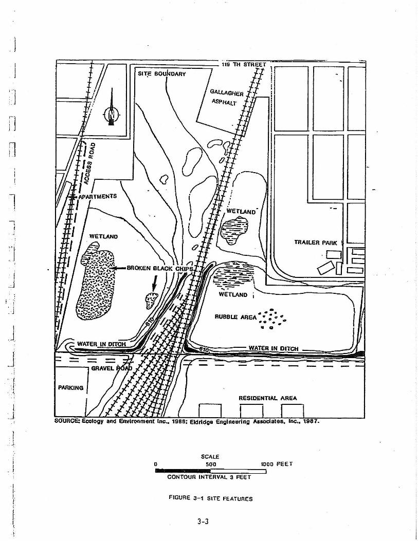

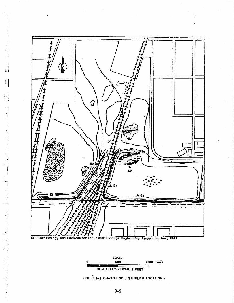


EEEXXXHHHIIIBBBIIITTTSSS

§̈¦57
119th
Ash
land
Vinc
enne
s
120th
Mar
shfie
ld
124th
Div
isio
nP
aulina
123rd
Page
121stLi
ncol
n
Hal
e
Woo
d
119th
Hon
ore
Wat
kins W
olcott
Was
hing
ton
Win
ches
ter
Was
hing
ton
Page
123rd
119th
120th
121st
120th
121st
121st
120th
WoodH
onor
e
City of Blue Island13051 South Greenwood Ave.
Blue Island, Illinois 60406
StreetMap USA (2006)
Project Location Map Blue Island Industrial Park
07223 I
NTS09/14/07
11
±
TITLE:
PROJECT:
BASE LAYER:
CLIENT:
PROJECT NO. EXHIBIT:
SHEET: OF:
QUADRANGLE:
DATE:
SCALE:
Blue Island
V3 Companies7325 Janes AvenueWoodridge, IL 60517630.724.9200 phone630.724.9202 faxwww.v3co.com
Project Location
E:\2007\07223\Drawings\ARCVIEW\Wetlands\W21\ExhI_loc07223.mxd

POWFX
U
PEMC
PEMC
POWFX
City of Blue Island13051 South Greenwood Ave.
Blue Island, Illinois 60406
USGS Topographic Map (1993)
National Wetlands Inventory Map Blue Island Industrial Park
07223 II
NTS09/14/07
11
±
TITLE:
PROJECT:
BASE LAYER:
CLIENT:
PROJECT NO. EXHIBIT:
SHEET: OF:
QUADRANGLE:
DATE:
SCALE:
Blue Island
V3 Companies7325 Janes AvenueWoodridge, IL 60517630.724.9200 phone630.724.9202 faxwww.v3co.com
Project Location
E:\2007\07223\Drawings\ARCVIEW\Wetlands\W21\ExhII_nwi07223.mxd

City of Blue Island13051 South Greenwood Ave.
Blue Island, Illinois 60406
USGS Topographic Map (1993)
USGS Hydrologic Atlas Blue Island Industrial Park
07223 III
NTS09/14/07
11
±
TITLE:
PROJECT:
BASE LAYER:
CLIENT:
PROJECT NO. EXHIBIT:
SHEET: OF:
QUADRANGLE:
DATE:
SCALE:
Blue Island
V3 Companies7325 Janes AvenueWoodridge, IL 60517630.724.9200 phone630.724.9202 faxwww.v3co.com
Project Location
E:\2007\07223\Drawings\ARCVIEW\Wetlands\W21\ExhIIIhydr07223.mxd

[
071200030505
City of Blue Island13051 South Greenwood Ave.
Blue Island, Illinois 60406
USGS Topographic Map (1993)
12-Digit Hydrologic Unit Code Map Blue Island Industrial Park
07223 IV
NTS09/14/07
11
±
TITLE:
PROJECT:
BASE LAYER:
CLIENT:
PROJECT NO. EXHIBIT:
SHEET: OF:
QUADRANGLE:
DATE:
SCALE:
Blue Island
V3 Companies7325 Janes AvenueWoodridge, IL 60517630.724.9200 phone630.724.9202 faxwww.v3co.com
Project Location
E:\2007\07223\Drawings\ARCVIEW\Wetlands\W21\ExhIVhuc07223.mxd

City of Blue Island13051 South Greenwood Ave.
Blue Island, Illinois 60406
N/A
Flood Insurance Rate Map Blue Island Industrial Park
07223 V
NTS09/14/07
11
Blue Island
±Project Location
TITLE:
PROJECT:
PROJECT NO.:
EXHIBIT:
SHEET: OF:
BASE LAYER:
CLIENT: QUADRANGLE: DATE:
SCALE:
V3 Companies7325 Janes AvenueWoodridge, IL 60517630.724.9200 phone630.724.9202 faxwww.v3co.com
E:\2007\07223\Drawings\ARCVIEW\Wetlands\W21\ExhV_firm07223.mxd

X1
X2X3
X4
X5
X6
X7
X8
Area 3
Area 2
Area 1
Area 4
Area 5
Area 5
Area 5
TITLE:
PROJECT:
BASE LAYER:
Client:
PROJECT NO.:
EXHIBIT:
SHEET: OF:
FILE NAME:
DATE:
SCALE:
±
Project Location
City of Blue Island13051 South Greenwood Ave.
Blue Island, Illinois 60406
2006 AirPhoto USA
Preliminary Wetland Exhibit Blue Island Industrial Park
07223 VI
1" = 200'09/27/07
11
EXHVII_prewet07223
V3 Companies7325 Janes AvenueWoodridge, IL 60517630.724.9200 phone630.724.9202 faxwww.v3co.com
E:\2007\07223\Drawings\ARCVIEW\Wetlands\W21\ExhVII_prewet07223.mxd
Note: The wetland boundaries shown on this exhibit were determined using a combination of autonomous GPS, aerial interpretation, and a historical topographic survey. The wetland boundaires as depcited do not constitute a professional land survey.

Related Documents


