Wetland Assessment in California: Context and Progress Towards Method Development Martha Sutula & Eric Stein, So. Calif. Coastal Water Research Project Josh Collins, San Francisco Estuary Institute Ross Clark, California Coastal Commission Paul Jones, US EPA Region 9

Welcome message from author
This document is posted to help you gain knowledge. Please leave a comment to let me know what you think about it! Share it to your friends and learn new things together.
Transcript
Wetland Assessment in California: Context and Progress Towards Method Development
Martha Sutula & Eric Stein, So. Calif. Coastal Water Research ProjectJosh Collins, San Francisco Estuary InstituteRoss Clark, California Coastal Commission
Paul Jones, US EPA Region 9

Wetland AssessmentContext & Method DevelopmentContext & Method Development
Need for Wetland Assessment in California
Partnerships working towards Regional
Wetlands Assessment Programs
Conceptual Framework for AssessmentThree Tiers of Assessment
Methods Development (EMAP, SCREAM, CRAM)
Opportunities for collaboration

Definition of “Wetlands”
ESTUARINE WETLANDS
PALUSTRINE WETLANDS
(VERNAL POOLS)
RIPARIAN CORRIDOR
RIVERINE WETLANDS
MARINE WETLANDS
LACUSTRINE WETLANDS (LAKE)
FRESHWATER WETLANDUPLAND
GRASSLAND
UPLAND SCRUB/SHRUB
RIPARIAN CORRIDOR
STREAM CHANNEL
US FWS definition (Cowardin et al. 1979)
Broadly inclusive, including shallow water
aquatic habitats such as wadeable streams
……PLUS…..……PLUS…..
Riparian areas adjacent to wetlands (upland transition areas)

California Wetlands: Need for AssessmentHighest wetland loss
rate in the nation
Rapidly urbanizing coastal zones (anthropogenic stress, wetland degradation/loss)
Active regional programs in wetland recovery
What is the abundance and distribution of wetlands?
What is the ambient condition and how is it changing over time?
What is the effect of restoration and mitigation activities?
Where should mgmt actions or recovery work be targeted?

Status and Challenges of State and Regional Wetlands Assessment
No updated wetlands inventory
Little ambient wetlands monitoring
Projects monitored in disparate ways
No single authority
Monitoring seen as tax on conservation
Budgets are tight and getting tighter
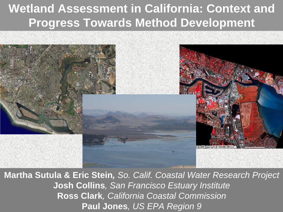
Meeting the Challenge …
We Are Uniting Regional Partnerships to Build A Standardized Approach to
Assessing Wetland Status and Trends
San Francisco Bay Area
Wetlands Regional Monitoring Program
Central California Wetlands
Comprehensive GIS Project

So. Calif. Wetlands Recovery Project (WRP)
A partnership of public agencies working cooperatively to acquire, restore, and enhance wetlands and riparian areas in coastal watersheds between Point Conception and the International border with Mexico.

WRP Programmatic Goals
• Preserve and restore coastal wetlands• Preserve and restore stream corridors and
freshwater wetlands in coastal watersheds• Recover native habitat and species diversity• Integrate wetlands recovery with other public
objectives (e.g. water quality, flood control)• Promote education and compatible access• Advance the science of wetland restoration and
management

WRP Strategy
• Acquire property from willing sellers
• Restore and enhance wetlands where allowed by landowners and land managers
• Educate people about the best approaches to protecting and managing wetlands

WRP Partners: State and Federal
• Corps of Engineers• U.S. Environmental
Protection Agency• Fish and Wildlife Service• National Marine Fisheries• Natural Resources
Conservation Service
• Resources Agency• Cal. EPA• Coastal Conservancy• Coastal Commission• Dept. of Fish and Game• State Lands Commission• State and Regional Water
Quality Control Boards
Federal AgenciesFederal Agencies State AgenciesState Agencies
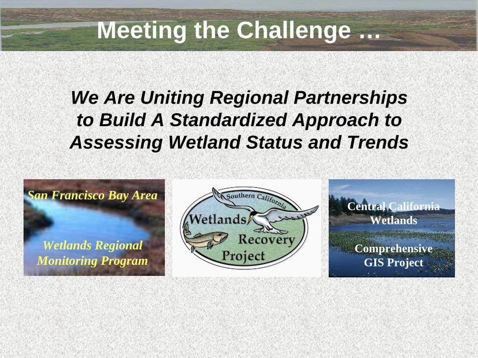
Projects Funded by WRP
Percent of $61.8 Million Spent on Acquisition, Restoration and Planning
Acquisition52%
Restoration 31%
Planning 17%
0
500
1,000
1,500
2,000
2,500
San Diego Orange Los Angeles Ventura Santa Barbara
Acquisition and Restoration Projects Funded to Date (Acres)
PlanningRestorationAcquisition
34 projects funded to date
9 projects scheduled for 2003 funding
$62 million spent to date

How is Wetland Recovery Progressing in Southern California?
We do not know…
• What is impact of WRP $$?• How is recovery offset by stress from
anthropogenic activities?
Regional wetlands monitoring is overdue

….Working with Other State Partners to Develop Standardized Monitoring Program
San Francisco Bay Area
Wetlands Regional Monitoring Program
San Francisco Bay Area
Wetlands Regional Monitoring Program
Central California Wetlands
Comprehensive GIS Project
Central California Wetlands
Comprehensive GIS Project
USEPA CWA Section 104
USEPA ORD
USEPA EMAP
USEPA STAR
NSF
California Sea Grant
California State Board
USGS Map/Gap Analysis Division
NOAA Coastal Services Center
SF & TR NERR
USFWS NWI
North Coast(SFEI)
Central Coast(CCC)
South Coast(SCCWRP)
California Coastal
Wetlands Monitoring
Venture

Venture Organization
Statewide Core TeamStatewide Core Team Regional TeamsRegional Teams
• Coordinates the overall process of technical development and implementation
• Shares technical expertise and experience among regions
• Integrates science and policy
• Provides regional perspective
• Helps with tool verification, calibration, and validation
• Helps with implementation
• SCCWRP• SFEI• USEPA• ACOE• CDFG• SWRCB• Reg. Water Boards• CCC• UCLA• SFSU
• CDFG• USFWS• Reg. Water Boards • CNPS• SCC• Private Consultants • WRP Science Panel and
Managers Group• WRP County Task Forces

Three Tiers of A Comprehensive Wetland Assessment Program
Level 1: Resource Inventory(Regional)
Level 2: Condition Assessment
(Regional to Site)
Level 3: Intensive
Monitoring(Site)
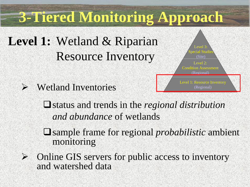
3-Tiered Monitoring Approach
Wetland Inventories
status and trends in the regional distribution and abundance of wetlandssample frame for regional probabilistic ambient monitoring
Online GIS servers for public access to inventory and watershed data
Level 1: Wetland & Riparian Resource Inventory
Level 1: Resource Inventory(Regional)
Level 2: Condition Assessment
(Regional)
Level 3: Special Studies
(Site)

3-Tiered Monitoring Approach
Developing a rapid assessment method to assess wetland condition
Working with EMAP to piloting innovative sampling designs for regional surveys of ambient condition
Developing landscape assessment methods (SCREAM model and EMAP landscape indicators)
Level 2: Condition assessmentLevel 1: Resource Inventory
(Regional)
Level 2: Condition Assessment
(Regional)
Level 3: Special Studies
(Site)
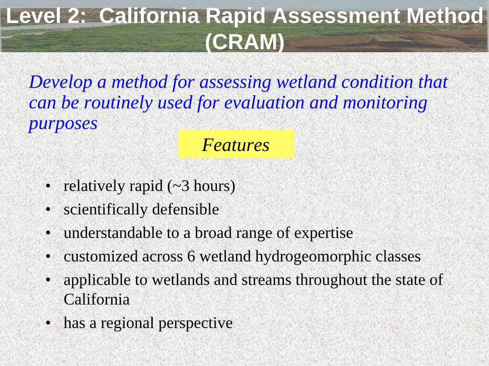
• relatively rapid (~3 hours)• scientifically defensible• understandable to a broad range of expertise• customized across 6 wetland hydrogeomorphic classes• applicable to wetlands and streams throughout the state of
California• has a regional perspective
Level 2: California Rapid Assessment Method (CRAM)
Develop a method for assessing wetland condition that can be routinely used for evaluation and monitoring purposes
Features
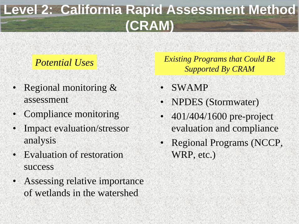
• SWAMP• NPDES (Stormwater)• 401/404/1600 pre-project
evaluation and compliance• Regional Programs (NCCP,
WRP, etc.)
• Regional monitoring & assessment
• Compliance monitoring• Impact evaluation/stressor
analysis• Evaluation of restoration
success• Assessing relative importance
of wetlands in the watershed
Level 2: California Rapid Assessment Method (CRAM)
Existing Programs that Could Be Supported By CRAM
Potential Uses
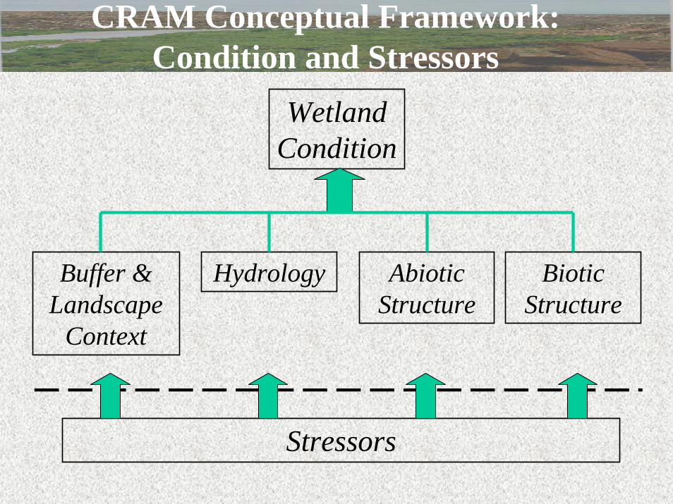
CRAM Conceptual Framework: Condition and Stressors
Wetland Condition
Buffer & Landscape
Context
Hydrology Abiotic Structure
Biotic Structure
Stressors

CRAM Conceptual Framework: Condition Attributes and Metrics
Wetland Condition
Buffer & Hydrology Abiotic Structure
Biotic Structure% of AA with Buffer
Buffer Condition
Ave Buffer Width

CRAM Conceptual Framework: Condition Attributes and Metrics
Wetland Condition
Buffer & Landscape
Context
Hydrology Abiotic Structure
Biotic Structure
Water Source
Floodplain Connection
Hydroperiod

CRAM Conceptual Framework: Condition Attributes and Metrics
Wetland Condition
Buffer & Landscape
Context
Hydrology Abiotic Structure
Biotic Structure
Abiotic Patch Richness
Sediment Integrity
Topographic Complexity

CRAM Conceptual Framework: Condition Attributes and Metrics
Wetland Condition
Buffer & Landscape
Context
Hydrology Abiotic Structure
Biotic Structure
Biotic Patch Richness
Horizontal Structure
Vertical Structure
Plant Comm. Integrity
Organic Matter Accum.

CRAM Attributes and MetricsMetrics scaled for each wetland class
Attributes Metrics
Percent of AA with Buffer
Average Buffer Width
Buffer Condition Buffer and Landscape
Context
General Landscape Context
Sources of Water
Hydroperiod Hydrology
Floodplain Connection
Abiotic Patch Richness Topographic Complexity Abiotic Substrate Condition Biotic Patch Richness Vertical Structure Horizontal Structure Total Plant Species Richness Plant Litter
Structure
Biotic
Exotic Invasive Plant Cover
Stressors
Overall Condition

CRAM Development
• Initial method development• Field verification & refinement
– Assess the general ability of metrics to discern high vs. low condition wetland
• Field calibration & refinement– Develop scaling/scoring of metrics
• Field validation & refinement– Test the efficacy of the method to
predict condition, fine-tune metrics
• Education, outreach, training
Phasing• Initial development
for coastal regions
• Later phases will provide regionalmodification for inland watersheds
Development Steps

Potential Calibration Measures• Percent of catchment subject to hydrologic control• Percent invasive species• Richness or diversity of plant communities
– Species-area curves– Recruitment of natural species
• Biologic indices– Plants– Amphibians– Macroinvertebrates
• Contaminant sources in the contributing watershed• Entrenchment ratio
– Width of floodprone area relative to width of channel• Quantification of topographic or structure complexity
Additional calibration measures will be developed during the verification phase

• Vegetation• Fauna• Contaminants• Habitat
fragmentation• Landscape-level
stressors
Level 2: Probabilistic Ambient Survey of Wetland Condition and Stress
EMAP 2002 Intertidal Wetland Pilot:
Goleta Slough
Bolsa Chica
Mugu
Chula Vista
Upper Newport Bay
Anaheim Bay
Santa Margarita
Ballona Wetlands
Mission Bay
Tijuana Estuary
Talbert Marsh
Carpinteria Marsh
Agua Hedionda
Sweetwater Marsh
Deveraux Slough
San Elijo Marsh
Penesquitos Lagoon
Batiquitos Lagoon
Past
Pacific Ocean
Southern California
San Francisco Bay

Core Plot
Drainage Area
Watershed
Nested Systems

Watershed development has led to unnaturally complex tidal marsh shapes …
with an overabundance of upland edge …
that has been degraded due to adjacent increases in human population density …
resulting in local decreases in native plant species diversity.
Preliminary Findings of WEMAP Wetland Intensification

Level 2: Landscape Assessment Tools So. California Riparian Ecosystem Assessment Method
• Partnership with NOAA CSC• Landscape-scale, GIS-based
assessment approach = can achieve regional coverage
• Evaluates condition of riparian areas based on water quality, hydrology and habitat support
• Method development and testing in 5 pilot watersheds
• Will be used for monitoring, assessment, and decision support
Entrenchment
Topography
Soil
Impervious Cover
Exotic Species
Hydro-modifications
Land Use
Vegetative Cover
Floodplain Condition
Entrenchment
Topography
Soil
Impervious Cover
Exotic Species
Hydro-modifications
Land Use
Vegetative Cover
Floodplain Condition
Overall Condition
Overall Condition
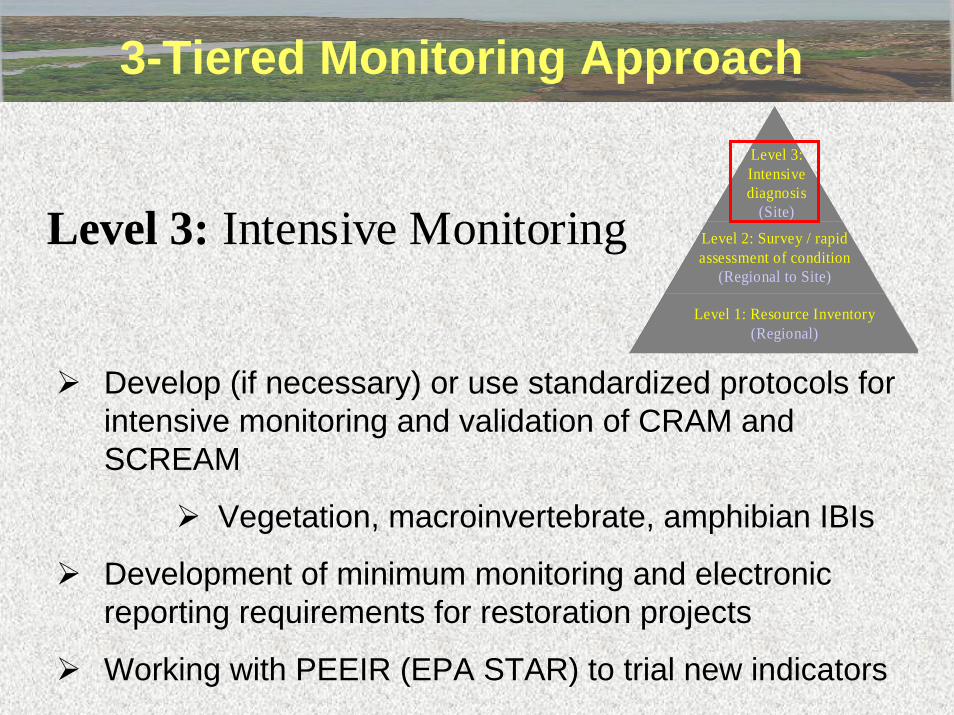
3-Tiered Monitoring Approach
Develop (if necessary) or use standardized protocols for intensive monitoring and validation of CRAM and SCREAM
Vegetation, macroinvertebrate, amphibian IBIs
Development of minimum monitoring and electronic reporting requirements for restoration projects
Working with PEEIR (EPA STAR) to trial new indicators
Level 3: Intensive MonitoringLevel 1: Resource Inventory
(Regional)
Level 2: Survey / rapid assessment of condition
(Regional to Site)
Level 3: Intensive diagnosis
(Site)

Building Wetland Assessment Toolkit
Level 1: Resource Characterization(Regional)
Level 2: Survey / rapid assessment of condition
(Regional to Site)
Level 3: Intensive diagnosis
(Site)
CRAMRegional Surveys
SCREAM
Landscape Profiles
On-line Servers
Indicator Research
Protocol Development
IBIs

Developing Wetlands Regional Monitoring Program
Level 1: Resource Characterization(Regional)
Level 2: Survey / rapid assessment of condition
(Regional to Site)
Level 3: Intensive diagnosis
(Site)
CRAMRegional Surveys
SCREAM
Landscape Profiles
On-line Servers
Indicator Research
Protocol Development
IBIs
•SF Bay Area- Existing RMP for Trace Substances, but working to include wetlands
•So. California- WRP Science Panel working on detailed conceptual framework of WRMP
Opportunities for CollaborationValidation of rapid assessment and landscape methods with other bioassessment methods (IBIs)
Use of wetland rapid assessment tools to augment surface water quality monitoring
Improve interagency coordination with respect to wetland and water quality monitoring

Contact Information
Josh Collins (510-746-7365; [email protected])
Eric Stein (714-372-9233; [email protected])
Martha Sutula (714-372-9222; [email protected])
Related Documents