West Lakeshore Drive Shared Use Path Colchester, Vermont December 20, 2012 Scoping Study _________________________ _________

Welcome message from author
This document is posted to help you gain knowledge. Please leave a comment to let me know what you think about it! Share it to your friends and learn new things together.
Transcript
West Lakeshore Drive Shared Use Path Colchester, Vermont
December 20, 2012
Scoping Study
_________________________ _________

V:\1953\active\195310607\transportation\report\Scoping Report\W Lakeshore Dr Scoping Study 12-20-12.docx
110 West Canal Street, Suite 202 Winooski, VT 05404 T 802-660-4071 F 802-660-4079 www.ccrpcvt.org The preparation of this document has been financed through transportation planning funds provided by the U.S. Department of Transportation and matching funds provided by Chittenden County’s 18 municipalities and the Vermont Agency of Transportation. The views and opinions expressed do not necessarily state or reflect those of the U.S. Department of Transportation.
Submitted by:
55 Green Mountain Drive So. Burlington, VT 05403 (802) 864-0223
Colchester Shared Use Path—West Lakeshore Drive iii
Project Committee
Christine Forde, CCRPC Bryan Davis, CCRPC Bryan Osborne, Town of Colchester
Greg Edwards, Stantec David DeBaie, Stantec Jon Leinwohl, Stantec

iv Colchester Shared Use Path – West Lakeshore Drive
Contents 1.0 Introduction 1
1.1 Project Background ..........................................................................................................1 1.2 Project Area .....................................................................................................................2
2.0 Existing Conditions 3
2.1 Public Issues and Concerns.............................................................................................3 Concerns ........................................................................................................................................ 3 Suggestions ..................................................................................................................................... 3 Observations .................................................................................................................................. 4
2.2 Regional and Local Plans ................................................................................................6 2.3 Land Uses/Zoning ............................................................................................................7 2.4 Bicycle/Pedestrian Facilities.............................................................................................9 2.5 Roadways ...................................................................................................................... 10 2.6 Traffic Conditions ........................................................................................................... 11
2.6.1 Traffic Volumes ............................................................................................................... 11 2.6.2 Traffic Operations Analysis ............................................................................................. 13 2.6.3 Crash Analysis ................................................................................................................. 13
2.7 Natural / Cultural Resources ........................................................................................... 15 2.8 Archaeological Resources ............................................................................................. 23 2.9 Utilities ........................................................................................................................... 24
2.9.1 Aerial Utilities ................................................................................................................. 24 2.9.2 Underground Utilities ..................................................................................................... 24
3.0 Project Purpose and Need 25
3.1 Project Purpose ............................................................................................................. 25 3.2 Project Need .................................................................................................................. 25
4.0 Alternative Alignments 26
4.1 Multiuse Path Design Criteria ......................................................................................... 26 4.2 Multi-Use Path Typical Section ...................................................................................... 27 4.3 Alternatives Development .............................................................................................. 27 4.4 Future Traffic Conditions / Alternatives Development .................................................... 29
4.4.1 Traffic Volumes ............................................................................................................... 29 4.4.2 Future Design Hour Volumes at Project Intersections .................................................... 29 4.4.3 Intersection Level of Service ............................................................................................ 30 4.4.4 Project Alternatives Traffic Consideration ...................................................................... 30 4.4.5 Northside Route ............................................................................................................... 30 4.4.6 Southside Route ............................................................................................................... 31 4.4.7 Vehicle Conflicts .............................................................................................................. 31 4.4.8 All-Way STOP at Church Road/ West Lakeshore Drive and Holy Cross Road ............... 31 4.4.9 Application of Other Traffic Control Devices for Pedestrian Safety ............................... 32
4.5 Alternatives Narrative ..................................................................................................... 33 4.5.1 Alternative 1 – North Side ............................................................................................... 33 4.5.2 Alternative 2 – South Side ............................................................................................... 35
4.6 Project Cost ................................................................................................................... 38 4.7 Alternatives Evaluation Matrix ........................................................................................ 39 4.8 Public Participation / Meetings ....................................................................................... 40

Colchester Shared Use Path—West Lakeshore Drive v
4.9 Preferred Alternative ...................................................................................................... 40 APPENDIX A -- Local Concerns Meeting and Alternatives Presentation Agenda and Minutes APPENDIX B -- Archaeological Report
Figure List Figure 1: Colchester Pedestrian Network...............................................................................1 Figure 2: Project Location Plan ..............................................................................................2 Figure 3 Existing Conditions Plan ...........................................................................................5 Figure 4: Colchester Zoning Map ...........................................................................................8 Figure 5: Roadway Characteristics ...................................................................................... 10 Figure 6 West Lakeshore Drive west of Prim Road - Weekday Volume ............................... 12 Figure 7 West Lakeshore Drive west of Prim Road -Weekend Volumes .............................. 12 Figure 8: Intersection Peak Hour Traffic Occurrence ........................................................... 13 Figure 9: LOS - Level of Service based on delay as calculated with Synchro
software .................................................................................................................. 12 Figure 10: Church Road/ Holy Cross Road Crash Pattern ................................................... 14 Figure 11: W Lakeshore Drive mm 0.21 to 0.36 Crash Pattern........................................... 14 Figure 12: Prim Road Crash Pattern ..................................................................................... 14 Figure 13: W Lakeshore Drive mm 0.52 to 0.70 Crash Pattern............................................ 14 Figure 14: Design Criteria Table .......................................................................................... 27 Figure 15: Path Typical ......................................................................................................... 28 Figure 16: Vehicle Conflict Potential at Shared Use Path Crossings ................................... 31 Figure 17: Alternative Plans ................................................................................................. 37
Colchester Shared Use Path—West Lakeshore Drive 1
1.0 Introduction
1.1 Project Background
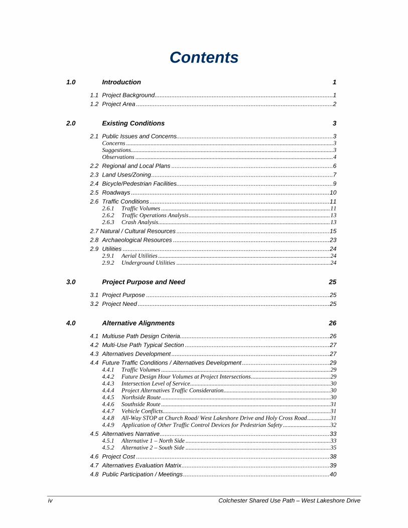
The Town of Colchester has constructed the majority of a shared use path system extending from Colchester village westerly through the town and across the causeway. The path system is also complete from Airport Park to the Winooski River Bridge leading to Burlington. Two sections of the path remain to be constructed to complete this east-west corridor (see Figure 1). One of these uncompleted sections is in Colchester village; the other is located between the West Lakeshore Drive/Prim Road intersection and the Holy Cross Road/Church Road intersection. This latter section along West Lakeshore Drive is the subject of this study. The purpose of the scoping process is to further develop and evaluate alternatives for the path location. In this case, the overall concept and location of the east-west corridor was decided long ago. Consequently, the alternatives considered in this study will assess whether the shared use path should be located along the northerly or the southerly side of West Lakeshore Drive and develop the concept and impacts for the preferred alignment. An important component of the scoping process is soliciting public input, and seeking endorsement of a preferred alternative.
The CCRPC solicited a proposal from Stantec to work with the their staff and the Town of Colchester to establish the purpose and need, further develop and evaluate alternatives, and involve property owners and the public in the process.
Figure 1: Colchester Pedestrian Network

2 Colchester Shared Use Path – West Lakeshore Drive
1.2 Project Area
The study corridor is located along West Lakeshore Drive between Prim Road and Church Road. At the east end of the project area, the new shared use path will connect with a concrete sidewalk that now ends on the east side of the Prim Road/ West Lakeshore Drive intersection. At the west end of the project, the new path will connect with the Holy Cross Road shared use path constructed in 2010 that ends on the west side of the Church Road. In the case of the south alternative, this scoping study will present a concept for crossing Prim Road. For the north alternative, it will evaluate crossing West Lakeshore Drive. It will also evaluate the three-way intersection at Holy Cross Road/Church Road/West Lakeshore Drive and consider concepts for improving crossing pedestrians at this intersection. See project location plan on the Figure 2.
Figure 2: Project Location Plan
Colchester Shared Use Path—West Lakeshore Drive 3
2.0 Existing Conditions
2.1 Public Issues and Concerns
A Local Concerns Meeting was held on June 14, 2011 concurrently with a Colchester Select Board meeting. The purpose of this public meeting was to gather input from municipal officials, the public and special interest groups to obtain local and regional concerns. The Local Concerns Meeting was publicly advertised in the Colchester Sun weekly newspaper and written notification was mailed to abutting property owners approximately two weeks prior to the meeting. The Select Board agenda, sign in sheet and meeting minutes from the June 14, 2011 meeting are included in Appendix A.
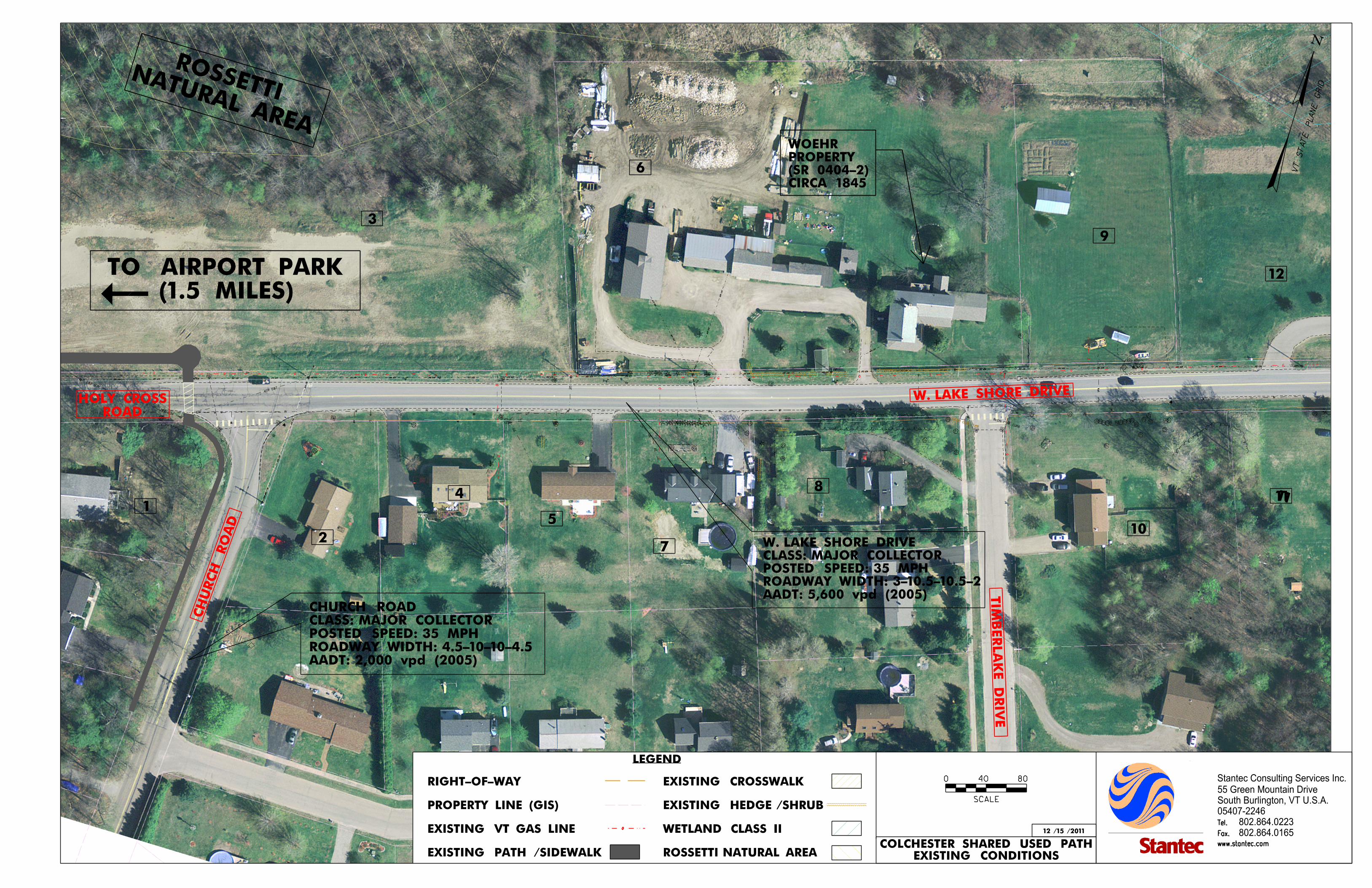
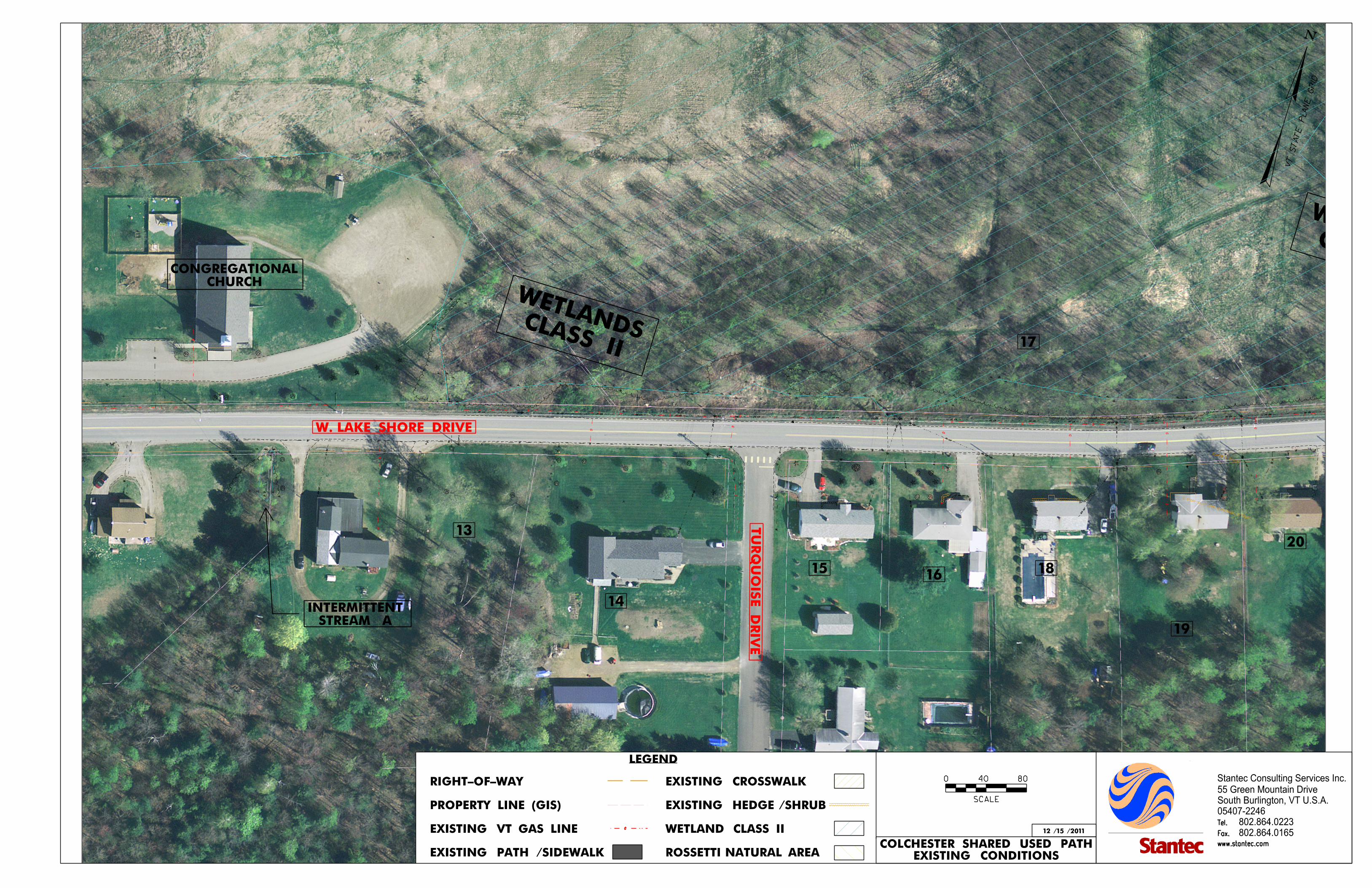
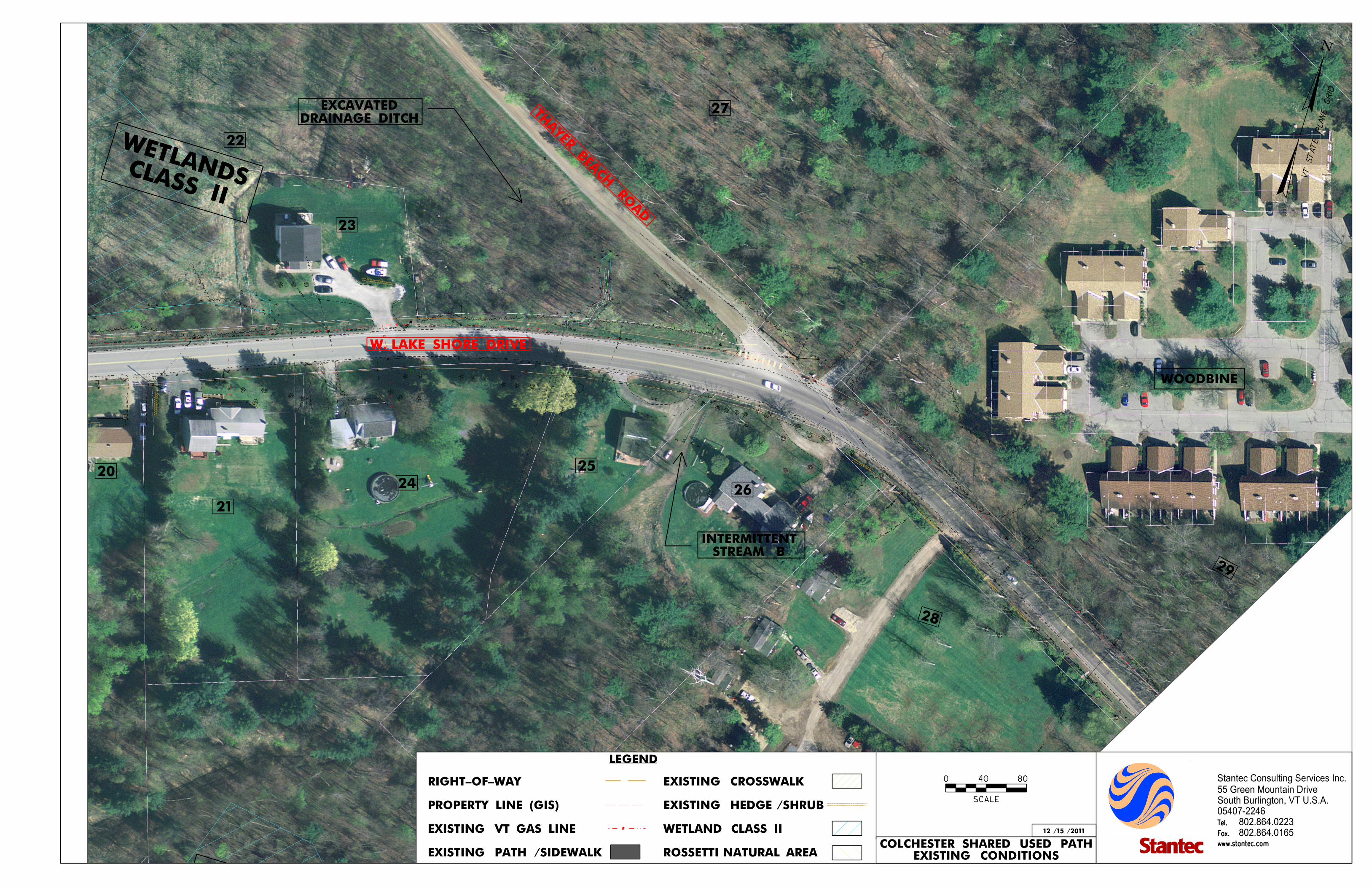
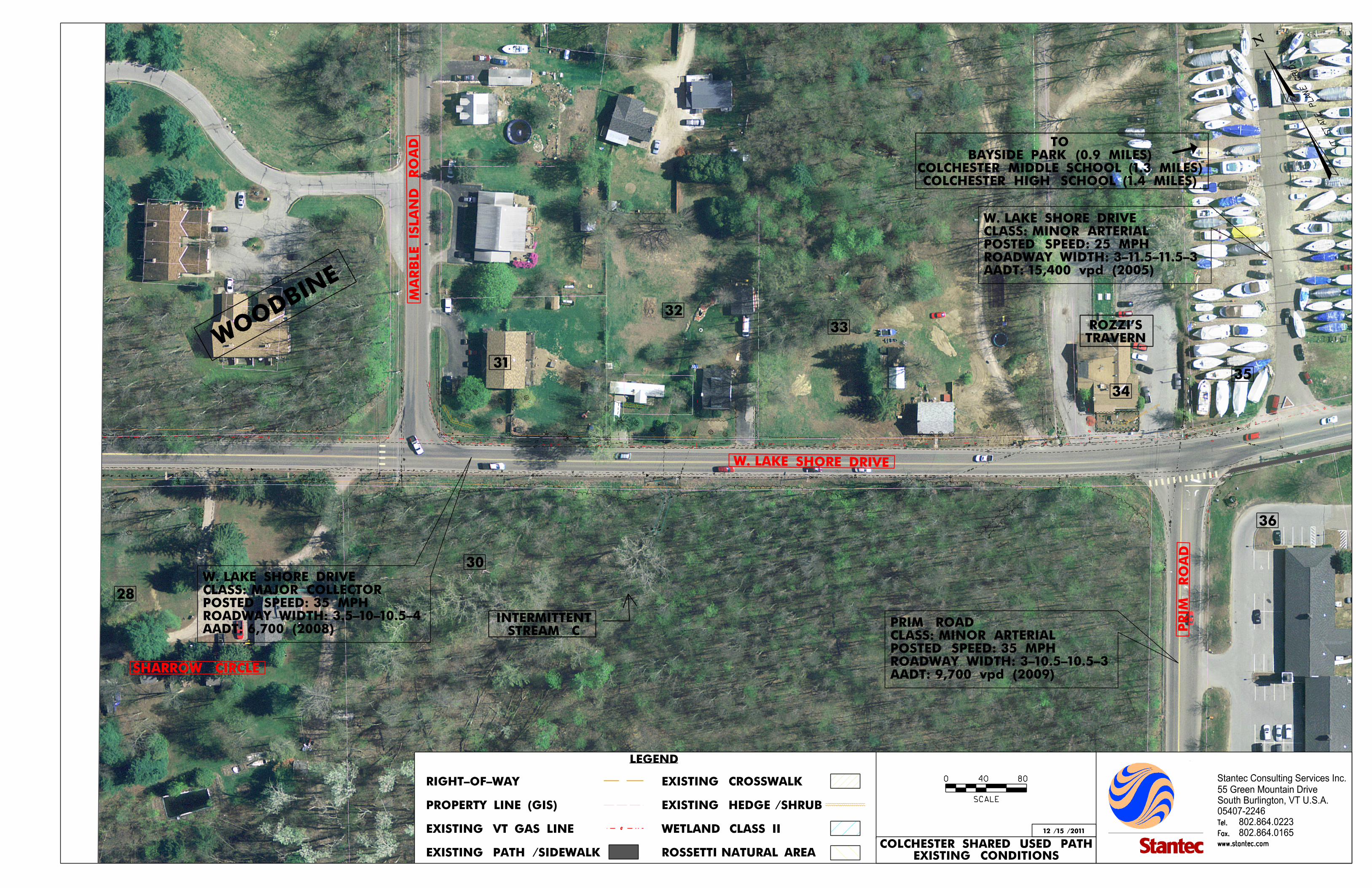
The meeting included an initial presentation regarding the project definition process to educate the participants about the project development process. This was followed by a project overview and review of existing conditions by Stantec. An existing conditions plan, Figure 3, was developed for use at this meeting. An open discussion was then held to identify concerns and ideas regarding the project. Following is a summary of key issues from this meeting. A more complete listing of concerns, suggestions and observations from the meeting is included in the Stantec's Meeting Notes, Appendix A.
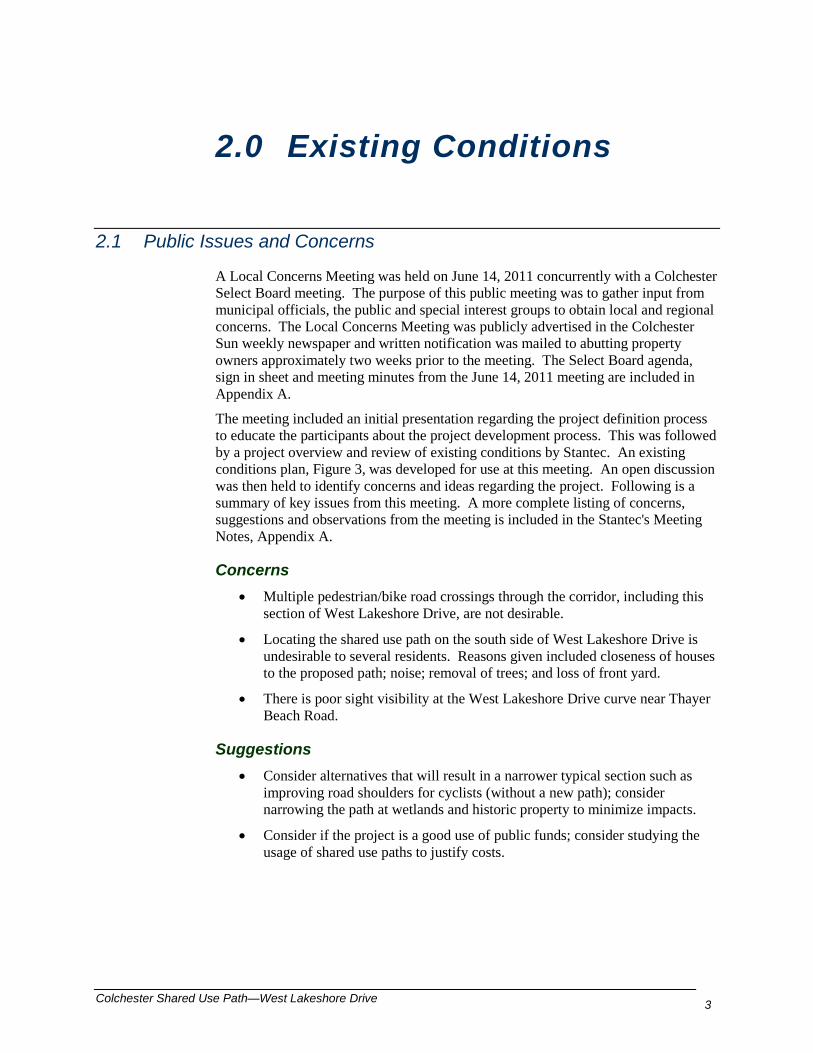
Concerns • Multiple pedestrian/bike road crossings through the corridor, including this
section of West Lakeshore Drive, are not desirable.
• Locating the shared use path on the south side of West Lakeshore Drive is undesirable to several residents. Reasons given included closeness of houses to the proposed path; noise; removal of trees; and loss of front yard.
• There is poor sight visibility at the West Lakeshore Drive curve near Thayer Beach Road.
Suggestions • Consider alternatives that will result in a narrower typical section such as
improving road shoulders for cyclists (without a new path); consider narrowing the path at wetlands and historic property to minimize impacts.
• Consider if the project is a good use of public funds; consider studying the usage of shared use paths to justify costs.
4 Colchester Shared Use Path – West Lakeshore Drive
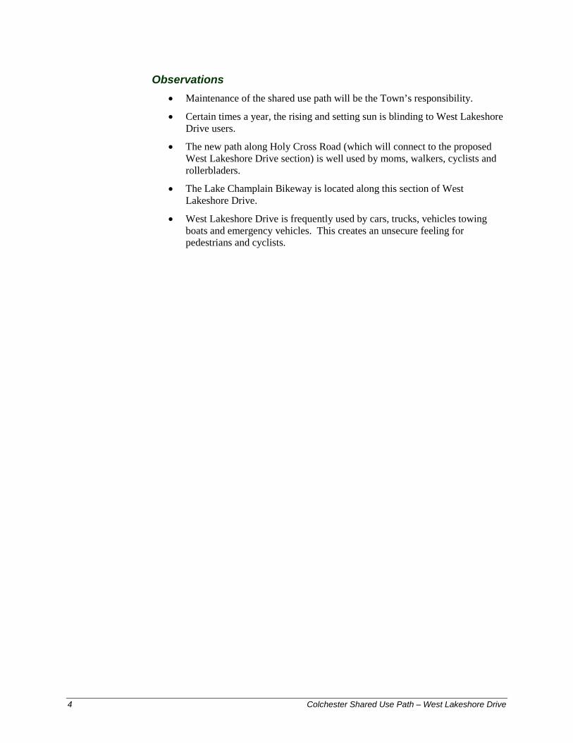
Observations • Maintenance of the shared use path will be the Town’s responsibility.
• Certain times a year, the rising and setting sun is blinding to West Lakeshore Drive users.
• The new path along Holy Cross Road (which will connect to the proposed West Lakeshore Drive section) is well used by moms, walkers, cyclists and rollerbladers.
• The Lake Champlain Bikeway is located along this section of West Lakeshore Drive.
• West Lakeshore Drive is frequently used by cars, trucks, vehicles towing boats and emergency vehicles. This creates an unsecure feeling for pedestrians and cyclists.
.
BEGIN CONC. CURB
BEGIN CONC. CURB
BEGIN CONC. CURB
.
.
. . ...
.
.
.
..
.
. .
.
.
.
.
.
... ..
.
.
.
.
W. LAKE SHORE DRIVE
CH
UR
CH
RO
AD
0
SCALE
5001000
0
SCALE
5001000
0
SCALE
5001000
(1.5 MILES)TO AIRPORT PARK
1
2
4
ROADHOLY CROSS
TIM
BER
LA
KE
DRIV
E
CIRCA 1845(SR 0404-2)PROPERTY WOEHR
5
7
6
8
10
9
12
1111
NATURAL AREA
ROSSETTI
N
VT S
TAT
E
PLA
NE
GRID
www.stantec.com
Fax.
Tel.
www.stantec.com
Fax.
Tel.
Stantec Consulting Services Inc.
05407-2246
802.864.0223
802.864.0165
55 Green Mountain Drive
South Burlington, VT U.S.A.
www.stantec.com
Fax.
Tel.
LEGEND
12 / 15 / 2011
0
SCALE
40 80
ROSSETTI NATURAL AREA
WETLAND CLASS II
EXISTING HEDGE / SHRUB
EXISTING CROSSWALK
EXISTING PATH / SIDEWALK
EXISTING VT GAS LINE
PROPERTY LINE (GIS)
RIGHT-OF-WAY
EXISTING CONDITIONSCOLCHESTER SHARED USED PATH
3
AADT: 5,600 vpd (2005)ROADWAY WIDTH: 3-10.5-10.5-2 POSTED SPEED: 35 MPHCLASS: MAJOR COLLECTORW. LAKE SHORE DRIVE
AADT: 2,000 vpd (2005)ROADWAY WIDTH: 4.5-10-10-4.5POSTED SPEED: 35 MPHCLASS: MAJOR COLLECTORCHURCH ROAD
lsmiley
Text Box
Figure 3
lsmiley
Text Box
Page 5A
www.stantec.com
Fax.
Tel.
www.stantec.com
Fax.
Tel.
Stantec Consulting Services Inc.
05407-2246
802.864.0223
802.864.0165
55 Green Mountain Drive
South Burlington, VT U.S.A.
www.stantec.com
Fax.
Tel.
LEGEND
12 / 15 / 2011
0
SCALE
40 80
ROSSETTI NATURAL AREA
WETLAND CLASS II
EXISTING HEDGE / SHRUB
EXISTING CROSSWALK
EXISTING PATH / SIDEWALK
EXISTING VT GAS LINE
PROPERTY LINE (GIS)
RIGHT-OF-WAY
N
VT S
TAT
E
PLA
NE
GRID
EXISTING CONDITIONSCOLCHESTER SHARED USED PATH
.
.
.
.
2 STORY SPLIT LEVEL/2’OVERHANG IN FRONT
.
CONCRETE PAVERS
CONCRETE PAVERS
.
..
.
.
.
.
TU
RQ
UOIS
E
DRIV
ESTREAM A
INTERMITTENT
W. LAKE SHORE DRIVE
CHURCHCONGREGATIONAL
13
14
17
1516
18
19
20
CLASS II
WETLANDS
CLASS II
WETLANDS
lsmiley
Text Box
Figure 3
lsmiley
Text Box
Page 5B
.
.
.
..
.
.
.
.
.
.
.
.
.
THAYER BEA
CH RO
AD
DRAINAGE DITCHEXCAVATED
W. LAKE SHORE DRIVE
WOODBINE
STREAM BINTERMITTENT
20
21
23
24
27
25
26
29
22
28
CLASS II
WETLANDS
CLASS II
WETLANDS
www.stantec.com
Fax.
Tel.
www.stantec.com
Fax.
Tel.
Stantec Consulting Services Inc.
05407-2246
802.864.0223
802.864.0165
55 Green Mountain Drive
South Burlington, VT U.S.A.
www.stantec.com
Fax.
Tel.
LEGEND
12 / 15 / 2011
0
SCALE
40 80
ROSSETTI NATURAL AREA
WETLAND CLASS II
EXISTING HEDGE / SHRUB
EXISTING CROSSWALK
EXISTING PATH / SIDEWALK
EXISTING VT GAS LINE
PROPERTY LINE (GIS)
RIGHT-OF-WAY
N
VT S
TAT
E
PLA
NE
GRID
EXISTING CONDITIONSCOLCHESTER SHARED USED PATH
lsmiley
Text Box
Figure 3
lsmiley
Text Box
Page 5C
.
.
ROZZIS
LAKESHORE
TAVERN
.
.
.
. .... ..
MA
RB
LE IS
LA
ND
RO
AD
W. LAKE SHORE DRIVE
PRIM
RO
AD
28
SHARROW CIRCLE
STREAM CINTERMITTENT
COLCHESTER HIGH SCHOOL (1.4 MILES)COLCHESTER MIDDLE SCHOOL (1.3 MILES)
BAYSIDE PARK (0.9 MILES)TO
TRAVERNROZZI’S
31
32
30
33
36
AADT: 9,700 vpd (2009)ROADWAY WIDTH: 3-10.5-10.5-3POSTED SPEED: 35 MPHCLASS: MINOR ARTERIALPRIM ROAD
34
35
AADT: 15,400 vpd (2005)ROADWAY WIDTH: 3-11.5-11.5-3POSTED SPEED: 25 MPHCLASS: MINOR ARTERIALW. LAKE SHORE DRIVE
WOODBI
NE
www.stantec.com
Fax.
Tel.
www.stantec.com
Fax.
Tel.
Stantec Consulting Services Inc.
05407-2246
802.864.0223
802.864.0165
55 Green Mountain Drive
South Burlington, VT U.S.A.
www.stantec.com
Fax.
Tel.
LEGEND
12 / 15 / 2011
0
SCALE
40 80
ROSSETTI NATURAL AREA
WETLAND CLASS II
EXISTING HEDGE / SHRUB
EXISTING CROSSWALK
EXISTING PATH / SIDEWALK
EXISTING VT GAS LINE
PROPERTY LINE (GIS)
RIGHT-OF-WAY
N
VT ST
ATE P
LA
NE
GRID
EXISTING CONDITIONSCOLCHESTER SHARED USED PATH
AADT: 6,700 (2008)ROADWAY WIDTH: 3.5-10-10.5-4POSTED SPEED: 35 MPHCLASS: MAJOR COLLECTORW. LAKE SHORE DRIVE
lsmiley
Text Box
Figure 3
lsmiley
Text Box
Page 5D

6 Colchester Shared Use Path – West Lakeshore Drive
2.2 Regional and Local Plans
Pertinent plans collected and reviewed include:
1. CCMPO Regional Bicycle-Pedestrian Plan Update dated September 22, 2008.
2. 2025 Chittenden County Metropolitan Transportation Plan adopted January 19, 2005.
3. Colchester Town Plan adopted July 10, 2007.
The 2007 Colchester Town Plan states the importance of a public path system to the Town. Following are excerpts from the Town Plan that are relevant to the proposed shared use path on West Lakeshore Drive. Chapter 10 Transportation
• Multiuse paths support alternative modes of transportation which are to be encouraged. The Town has envisioned an east-to-west trunk line multiuse path from Colchester Pond to Airport Park and similarly a north-to-south route from Milton to Winooski. These routes, as well as various other feeder multiuse paths, are designated on the Towns Official Map. (Town Plan Page 87)
• The Town has undertaken several sections of the trunk-line from Colchester Pond to Airport Park and plans to construct more components of this route through the Capital Transportation Plan and the TIP including Prim Road and Route 2A. (Town Plan Page 87)
• Policies, Item 12. The town will consider bicycle path improvements in designing, scheduling and constructing roadway improvement projects. Where possible and practical, the Town will strive to provide Class I paths along arterial and collector roadways as well as on-road facilities. (Town Plan Page 89)
• Policies, Item 24. A bicycle path between Colchester Pond and Airport Park shall be the priority bicycle path for Colchester to complete. This route shall act as a trunk line that all other bicycle routes shall strive to tie into. The Town shall strive to integrate this trunk-line and other bicycle paths and bicycle routes of adjacent communities. (Town Plan Page 90)
• Policies, Item 26. The Lake Champlain Byways program should continue to be supported for its importance in promoting alternative transportation and tourism. (Town Plan Page 90)
Chapter 5 Parks & Recreation
• The Transportation Chapter of this Plan details multi-the use paths, however, it is worth noting the significant recreational value of these paths herein. Multi-use paths provide space not only for alternative transportation but for jogging, rollerblading, cross-country skiing, walking, and recreational bicycling… Multi-use paths often connect parks and other destinations. (Town Plan Page 52)

Colchester Shared Use Path—West Lakeshore Drive 7
• Policies, Item 3. Multi-the use paths and trails have significant recreational value and should be encouraged as both transportation and recreational amenities. (Town Plan Page 132)
2.3 Land Uses/Zoning
The Colchester Zoning Map effective May 30, 2012 (Figure 4) shows that land on the southerly side of West Lakeshore Drive between Prim Road and Sharrow Circle is in a Commercial Zoning District. Within this district, the land between Prim Road and the Marble Island Road intersection is presently undeveloped and forested, while some residential housing exists from this undeveloped parcel easterly to Sharrow Circle.
All of the remaining land in the project area is within Residential Zoning Districts. The majority of this land is used for residential housing, with the exception of a Class II wetland located on the northerly side of the West Lakeshore Drive between Thayer Beach Road and the Congregational Church.
No changes in land use or zoning are presently anticipated.

Figure 4: Zoning Map
Colchester Shared Use Path—West Lakeshore Drive 9
2.4 Bicycle/Pedestrian Facilities
Presently there are no bicycle or pedestrian accommodations on West Lakeshore Drive within the study area between Church Road and Prim Road. Cyclists must ride within the 2.5 foot wide paved shoulder or encroach into the 10.5 foot wide travel Lanes. Pedestrians use this narrow shoulder or walk in the grass along the edge of the road where this is an option.
Immediately to the west of the Church Road intersection, a shared use path designed to the Colchester Public Works Standards was constructed in 2010 along the northerly side of Holy Cross Road. Immediately to the east of the Prim Road intersection, there is an existing 5 foot wide concrete sidewalk with a grass strip along the southerly side of West Lakeshore Drive. The shared use path and sidewalk on each end of the study section were constructed as segments of the Town’s multiuse path corridor connecting Colchester Pond with Airport Park. This east-west multiuse path corridor initiative is included in the Colchester Town Plan adopted in 2007, and completion of the path network is set forth as a policy in the 2007 Town Plan.
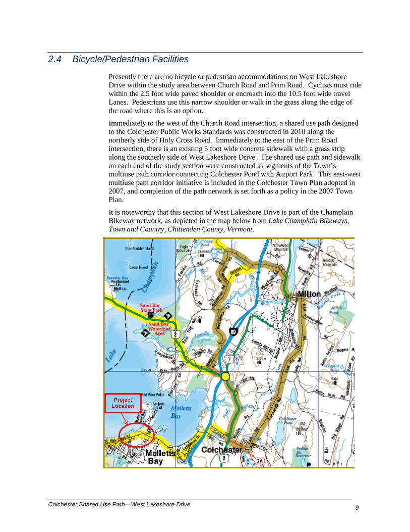
It is noteworthy that this section of West Lakeshore Drive is part of the Champlain Bikeway network, as depicted in the map below from Lake Champlain Bikeways, Town and Country, Chittenden County, Vermont.
Project Location
10 Colchester Shared Use Path – West Lakeshore Drive
2.5 Roadways
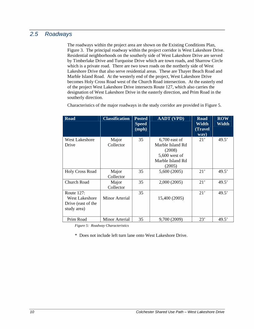
The roadways within the project area are shown on the Existing Conditions Plan, Figure 3. The principal roadway within the project corridor is West Lakeshore Drive. Residential neighborhoods on the southerly side of West Lakeshore Drive are served by Timberlake Drive and Turquoise Drive which are town roads, and Sharrow Circle which is a private road. There are two town roads on the northerly side of West Lakeshore Drive that also serve residential areas. These are Thayer Beach Road and Marble Island Road. At the westerly end of the project, West Lakeshore Drive becomes Holy Cross Road west of the Church Road intersection. At the easterly end of the project West Lakeshore Drive intersects Route 127, which also carries the designation of West Lakeshore Drive in the easterly direction, and Prim Road in the southerly direction.
Characteristics of the major roadways in the study corridor are provided in Figure 5.
Road Classification Posted
Speed (mph)
AADT (VPD) Road Width (Travel
way)
ROW Width
West Lakeshore Drive
Major Collector
35 6,700 east of Marble Island Rd
(2008) 5,600 west of
Marble Island Rd (2005)
21’ 49.5’
Holy Cross Road Major Collector
35 5,600 (2005) 21’ 49.5’
Church Road Major Collector
35 2,000 (2005) 21’ 49.5’
Route 127: West Lakeshore Drive (east of the study area)
Minor Arterial
35 15,400 (2005)
21’ 49.5’
Prim Road Minor Arterial 35 9,700 (2009) 23’ 49.5’ Figure 5: Roadway Characteristics
* Does not include left turn lane onto West Lakeshore Drive.
Colchester Shared Use Path—West Lakeshore Drive 11
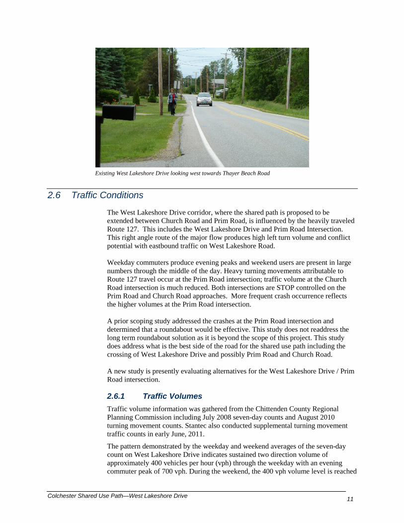
Existing West Lakeshore Drive looking west towards Thayer Beach Road
2.6 Traffic Conditions
The West Lakeshore Drive corridor, where the shared path is proposed to be extended between Church Road and Prim Road, is influenced by the heavily traveled Route 127. This includes the West Lakeshore Drive and Prim Road Intersection. This right angle route of the major flow produces high left turn volume and conflict potential with eastbound traffic on West Lakeshore Road. Weekday commuters produce evening peaks and weekend users are present in large numbers through the middle of the day. Heavy turning movements attributable to Route 127 travel occur at the Prim Road intersection; traffic volume at the Church Road intersection is much reduced. Both intersections are STOP controlled on the Prim Road and Church Road approaches. More frequent crash occurrence reflects the higher volumes at the Prim Road intersection. A prior scoping study addressed the crashes at the Prim Road intersection and determined that a roundabout would be effective. This study does not readdress the long term roundabout solution as it is beyond the scope of this project. This study does address what is the best side of the road for the shared use path including the crossing of West Lakeshore Drive and possibly Prim Road and Church Road. A new study is presently evaluating alternatives for the West Lakeshore Drive / Prim Road intersection.
2.6.1 Traffic Volumes Traffic volume information was gathered from the Chittenden County Regional Planning Commission including July 2008 seven-day counts and August 2010 turning movement counts. Stantec also conducted supplemental turning movement traffic counts in early June, 2011.
The pattern demonstrated by the weekday and weekend averages of the seven-day count on West Lakeshore Drive indicates sustained two direction volume of approximately 400 vehicles per hour (vph) through the weekday with an evening commuter peak of 700 vph. During the weekend, the 400 vph volume level is reached

12 Colchester Shared Use Path – West Lakeshore Drive
midmorning. The volume level increases to 600 vph by noontime and remains at that level until after 5:00 PM. Figures 6 and 7 illustrates these West Lakeshore Drive trends west of Prim Road. Of course, this volume is greater East of Prim Road.
Figure 6 West Lakeshore Drive west of Prim Road - Weekday Volume
Figure 7 West Lakeshore Drive west of Prim Road -Weekend Volumes
Turning movements at Prim Road and to a lesser degree at Church Street are a concern for pedestrians in traversing the corridor. Approximately 1-2 percent of the traffic volume are heavy vehicles including trucks and buses. The times of day that peak hour conditions occur at each intersection are presented in Figure 8. The peak hour traffic volumes are illustrated in diagrams provided in the appendix.
0100200300400500600700800
Vehi
cles
per
Hou
r
Summer Weekday Hourly Traffic Volume Variation West Lakeshore Drive
0100200300400500600700800
7:00AM
8:00AM
9:00AM
10:00AM
11:00AM
12:00PM
1:00PM
2:00PM
3:00PM
4:00PM
5:00PM
6:00PM
Vehi
cles
Per
Hou
r
Summer Weekend Hourly Traffic Volume Variation West Lakeshore Drive
Colchester Shared Use Path—West Lakeshore Drive 13
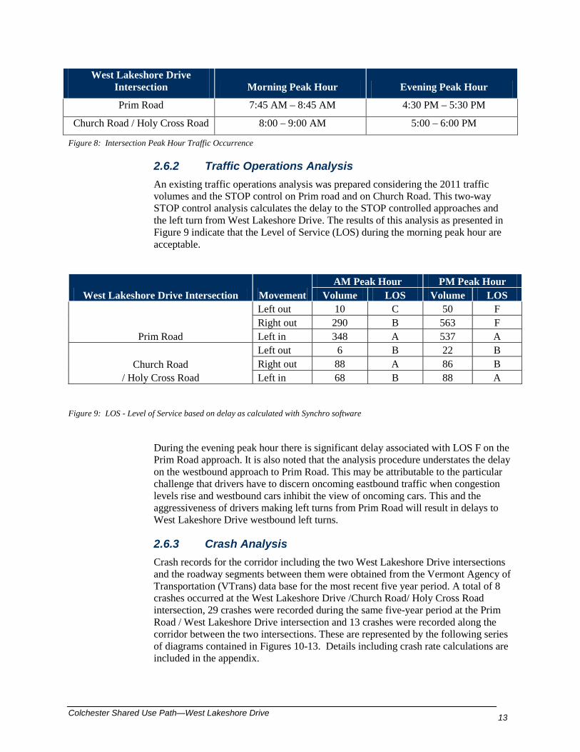
West Lakeshore Drive Intersection Morning Peak Hour Evening Peak Hour
Prim Road 7:45 AM – 8:45 AM 4:30 PM – 5:30 PM
Church Road / Holy Cross Road 8:00 – 9:00 AM 5:00 – 6:00 PM
Figure 8: Intersection Peak Hour Traffic Occurrence
2.6.2 Traffic Operations Analysis An existing traffic operations analysis was prepared considering the 2011 traffic volumes and the STOP control on Prim road and on Church Road. This two-way STOP control analysis calculates the delay to the STOP controlled approaches and the left turn from West Lakeshore Drive. The results of this analysis as presented in Figure 9 indicate that the Level of Service (LOS) during the morning peak hour are acceptable.
West Lakeshore Drive Intersection Movement AM Peak Hour PM Peak Hour
Volume LOS Volume LOS
Prim Road
Left out 10 C 50 F Right out 290 B 563 F Left in 348 A 537 A
Church Road / Holy Cross Road
Left out 6 B 22 B Right out 88 A 86 B Left in 68 B 88 A
Figure 9: LOS - Level of Service based on delay as calculated with Synchro software
During the evening peak hour there is significant delay associated with LOS F on the Prim Road approach. It is also noted that the analysis procedure understates the delay on the westbound approach to Prim Road. This may be attributable to the particular challenge that drivers have to discern oncoming eastbound traffic when congestion levels rise and westbound cars inhibit the view of oncoming cars. This and the aggressiveness of drivers making left turns from Prim Road will result in delays to West Lakeshore Drive westbound left turns.
2.6.3 Crash Analysis Crash records for the corridor including the two West Lakeshore Drive intersections and the roadway segments between them were obtained from the Vermont Agency of Transportation (VTrans) data base for the most recent five year period. A total of 8 crashes occurred at the West Lakeshore Drive /Church Road/ Holy Cross Road intersection, 29 crashes were recorded during the same five-year period at the Prim Road / West Lakeshore Drive intersection and 13 crashes were recorded along the corridor between the two intersections. These are represented by the following series of diagrams contained in Figures 10-13. Details including crash rate calculations are included in the appendix.
14 Colchester Shared Use Path – West Lakeshore Drive
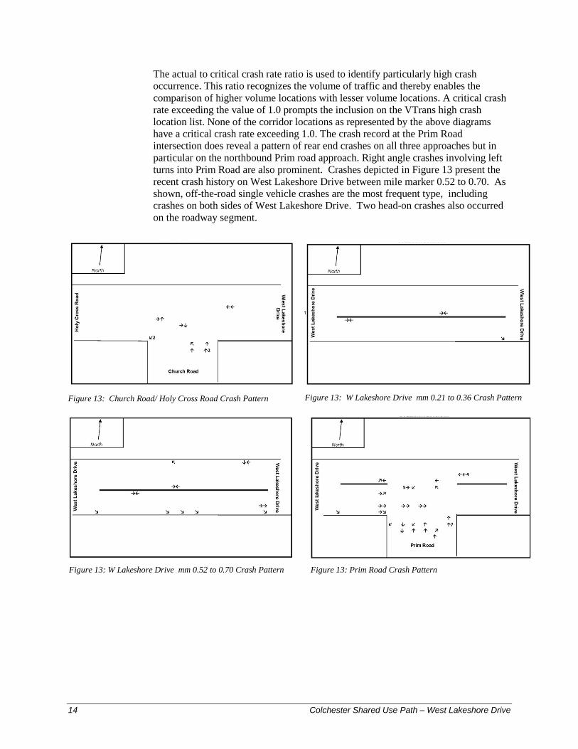
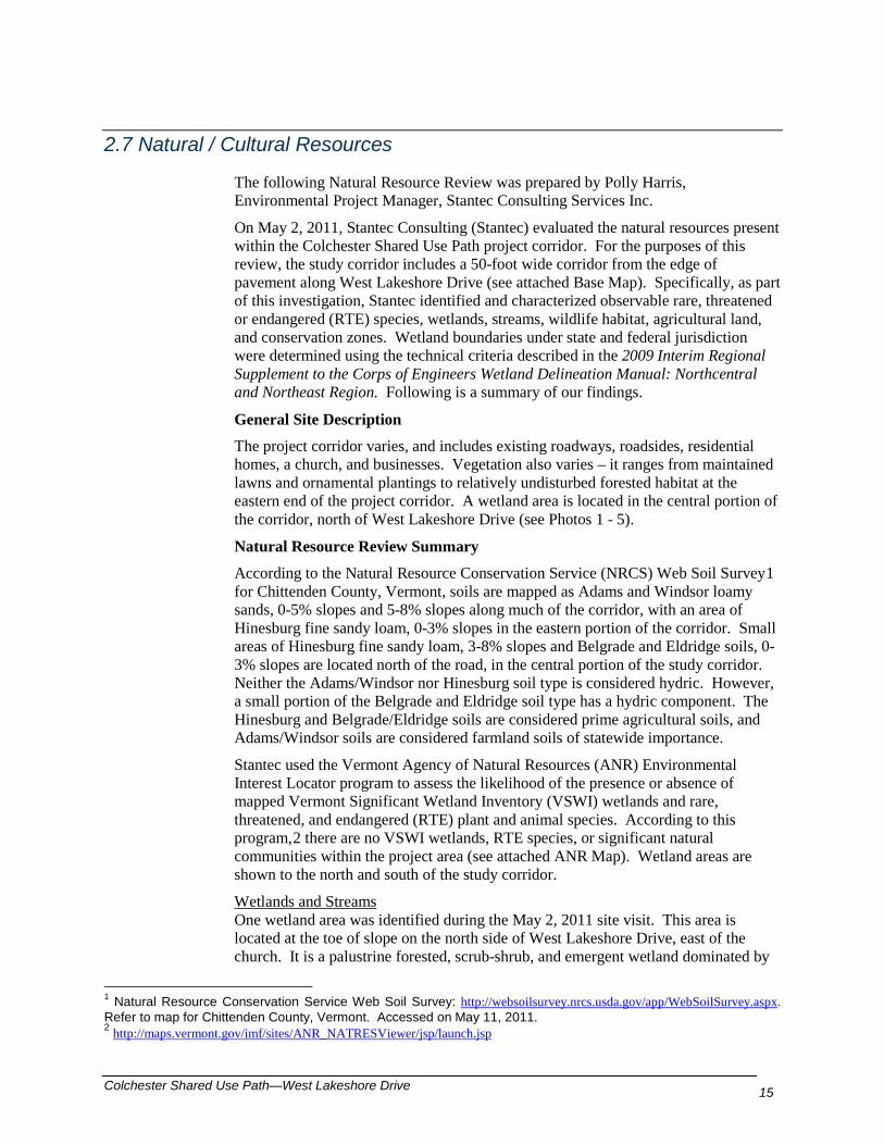
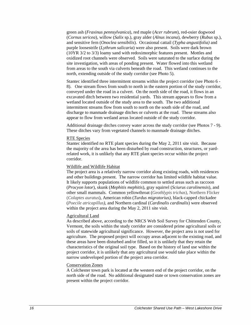
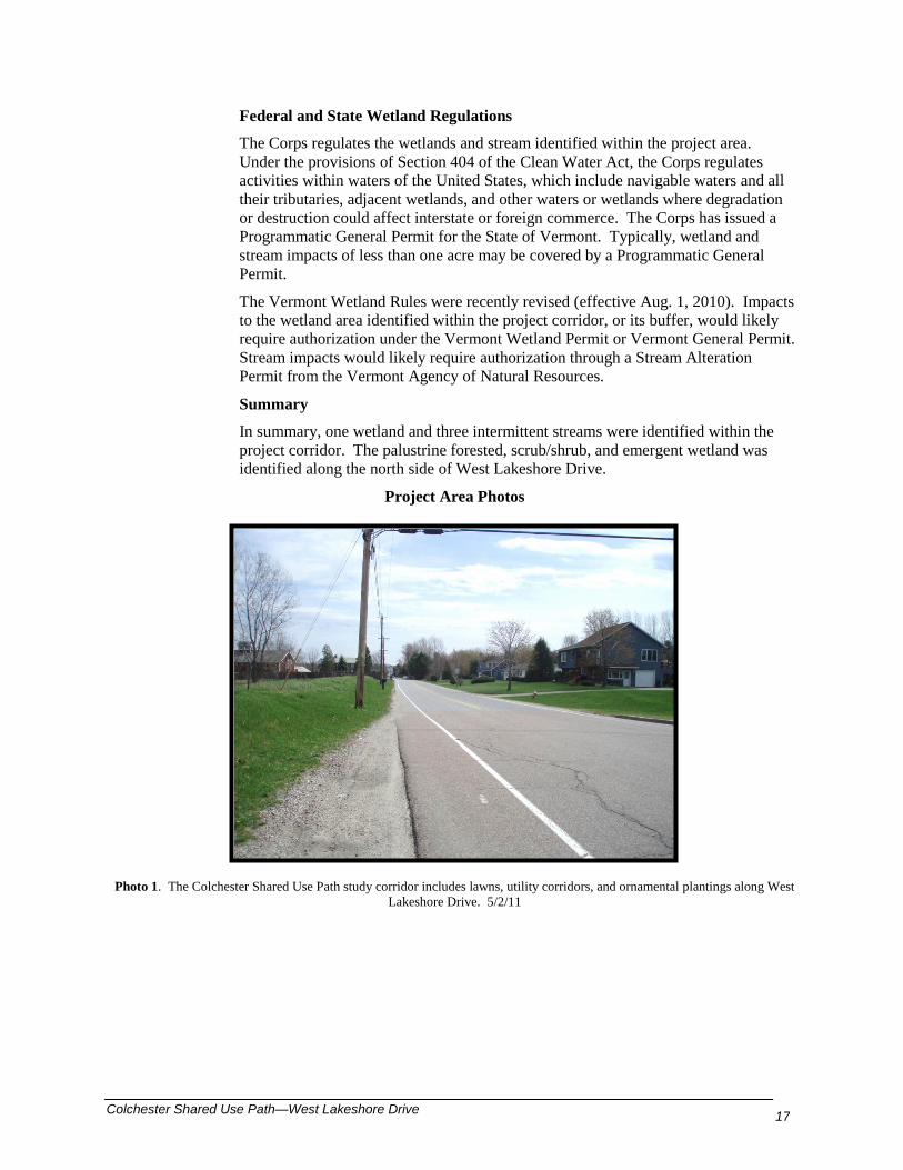
The actual to critical crash rate ratio is used to identify particularly high crash occurrence. This ratio recognizes the volume of traffic and thereby enables the comparison of higher volume locations with lesser volume locations. A critical crash rate exceeding the value of 1.0 prompts the inclusion on the VTrans high crash location list. None of the corridor locations as represented by the above diagrams have a critical crash rate exceeding 1.0. The crash record at the Prim Road intersection does reveal a pattern of rear end crashes on all three approaches but in particular on the northbound Prim road approach. Right angle crashes involving left turns into Prim Road are also prominent. Crashes depicted in Figure 13 present the recent crash history on West Lakeshore Drive between mile marker 0.52 to 0.70. As shown, off-the-road single vehicle crashes are the most frequent type, including crashes on both sides of West Lakeshore Drive. Two head-on crashes also occurred on the roadway segment.
Figure 13: Church Road/ Holy Cross Road Crash Pattern Figure 13: W Lakeshore Drive mm 0.21 to 0.36 Crash Pattern
Figure 13: W Lakeshore Drive mm 0.52 to 0.70 Crash Pattern Figure 13: Prim Road Crash Pattern
Colchester Shared Use Path—West Lakeshore Drive 15
2.7 Natural / Cultural Resources
The following Natural Resource Review was prepared by Polly Harris, Environmental Project Manager, Stantec Consulting Services Inc.
On May 2, 2011, Stantec Consulting (Stantec) evaluated the natural resources present within the Colchester Shared Use Path project corridor. For the purposes of this review, the study corridor includes a 50-foot wide corridor from the edge of pavement along West Lakeshore Drive (see attached Base Map). Specifically, as part of this investigation, Stantec identified and characterized observable rare, threatened or endangered (RTE) species, wetlands, streams, wildlife habitat, agricultural land, and conservation zones. Wetland boundaries under state and federal jurisdiction were determined using the technical criteria described in the 2009 Interim Regional Supplement to the Corps of Engineers Wetland Delineation Manual: Northcentral and Northeast Region. Following is a summary of our findings.
General Site Description
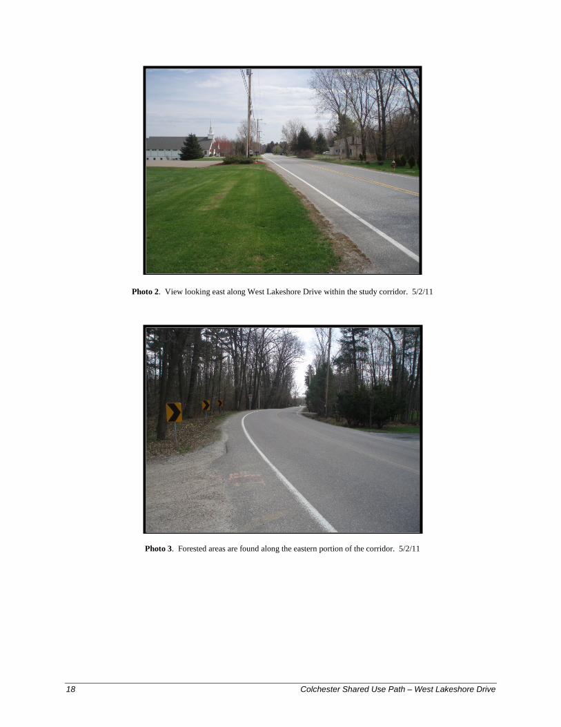
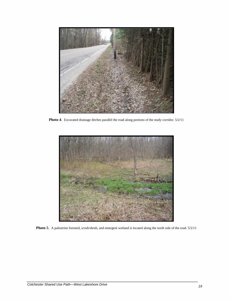
The project corridor varies, and includes existing roadways, roadsides, residential homes, a church, and businesses. Vegetation also varies – it ranges from maintained lawns and ornamental plantings to relatively undisturbed forested habitat at the eastern end of the project corridor. A wetland area is located in the central portion of the corridor, north of West Lakeshore Drive (see Photos 1 - 5).
Natural Resource Review Summary
According to the Natural Resource Conservation Service (NRCS) Web Soil Survey1 for Chittenden County, Vermont, soils are mapped as Adams and Windsor loamy sands, 0-5% slopes and 5-8% slopes along much of the corridor, with an area of Hinesburg fine sandy loam, 0-3% slopes in the eastern portion of the corridor. Small areas of Hinesburg fine sandy loam, 3-8% slopes and Belgrade and Eldridge soils, 0-3% slopes are located north of the road, in the central portion of the study corridor. Neither the Adams/Windsor nor Hinesburg soil type is considered hydric. However, a small portion of the Belgrade and Eldridge soil type has a hydric component. The Hinesburg and Belgrade/Eldridge soils are considered prime agricultural soils, and Adams/Windsor soils are considered farmland soils of statewide importance.
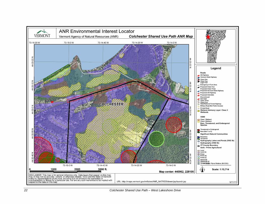
Stantec used the Vermont Agency of Natural Resources (ANR) Environmental Interest Locator program to assess the likelihood of the presence or absence of mapped Vermont Significant Wetland Inventory (VSWI) wetlands and rare, threatened, and endangered (RTE) plant and animal species. According to this program,2 there are no VSWI wetlands, RTE species, or significant natural communities within the project area (see attached ANR Map). Wetland areas are shown to the north and south of the study corridor.
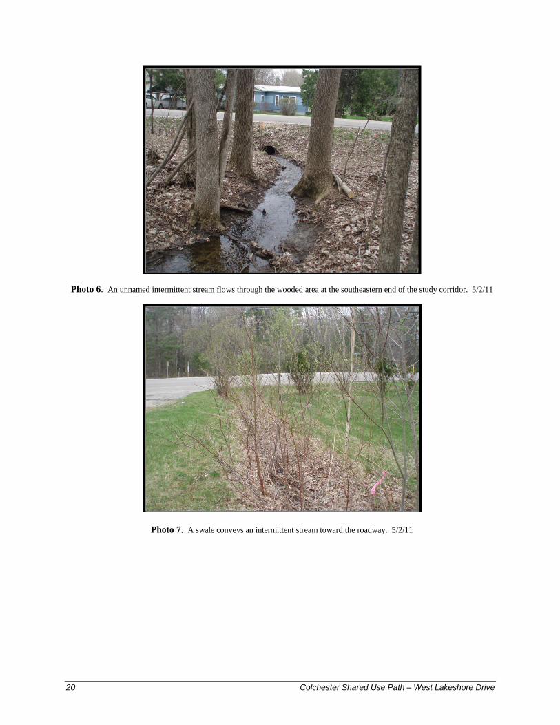
Wetlands and Streams One wetland area was identified during the May 2, 2011 site visit. This area is located at the toe of slope on the north side of West Lakeshore Drive, east of the church. It is a palustrine forested, scrub-shrub, and emergent wetland dominated by
1 Natural Resource Conservation Service Web Soil Survey: http://websoilsurvey.nrcs.usda.gov/app/WebSoilSurvey.aspx. Refer to map for Chittenden County, Vermont. Accessed on May 11, 2011. 2 http://maps.vermont.gov/imf/sites/ANR_NATRESViewer/jsp/launch.jsp
16 Colchester Shared Use Path – West Lakeshore Drive
green ash (Fraxinus pennsylvanica), red maple (Acer rubrum), red-osier dogwood (Cornus sericea), willow (Salix sp.), gray alder (Alnus incana), dewberry (Rubus sp.), and sensitive fern (Onoclea sensibilis). Occasional cattail (Typha angustifolia) and purple loosestrife (Lythrum salicaria) were also present. Soils were dark brown (10YR 3/2 to 3/3) loamy sand with redoximorphic features present. Mottles and oxidized root channels were observed. Soils were saturated to the surface during the site investigation, with areas of ponding present. Water flowed into this wetland from areas to the south via culverts beneath the road. This wetland continues to the north, extending outside of the study corridor (see Photo 5).
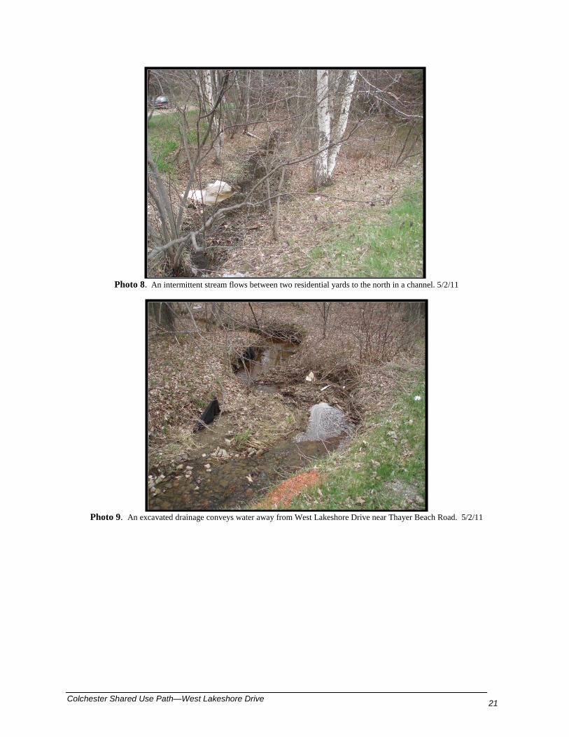
Stantec identified three intermittent streams within the project corridor (see Photo 6 - 8). One stream flows from south to north in the eastern portion of the study corridor, conveyed under the road in a culvert. On the north side of the road, it flows in an excavated ditch between two residential yards. This stream appears to flow from a wetland located outside of the study area to the south. The two additional intermittent streams flow from south to north on the south side of the road, and discharge to manmade drainage ditches or culverts at the road. These streams also appear to flow from wetland areas located outside of the study corridor.
Additional drainage ditches convey water across the study corridor (see Photos 7 - 9). These ditches vary from vegetated channels to manmade drainage ditches.
RTE Species Stantec identified no RTE plant species during the May 2, 2011 site visit. Because the majority of the area has been disturbed by road construction, structures, or yard-related work, it is unlikely that any RTE plant species occur within the project corridor.
Wildlife and Wildlife Habitat The project area is a relatively narrow corridor along existing roads, with residences and other buildings present. The narrow corridor has limited wildlife habitat value. It likely supports populations of wildlife common to settled areas such as raccoon (Procyon lotor), skunk (Mephitis mephitis), gray squirrel (Sciurus carolinensis), and other small mammals. Common yellowthroat (Geothlypis trichas), Northern Flicker (Colaptes auratus), American robin (Turdus migratorius), black-capped chickadee (Poecile atricapillus), and Northern cardinal (Cardinalis cardinalis) were observed within the project area during the May 2, 2011 site visit.
Agricultural Land As described above, according to the NRCS Web Soil Survey for Chittenden County, Vermont, the soils within the study corridor are considered prime agricultural soils or soils of statewide agricultural significance. However, the project area is not used for agriculture. The proposed project will occupy areas adjacent to the existing road, and these areas have been disturbed and/or filled, so it is unlikely that they retain the characteristics of the original soil type. Based on the history of land use within the project corridor, it is unlikely that any agricultural use would take place within the narrow undeveloped portion of the project area corridor.
Conservation Zones A Colchester town park is located at the western end of the project corridor, on the north side of the road. No additional designated state or town conservation zones are present within the project corridor.
Colchester Shared Use Path—West Lakeshore Drive 17
Federal and State Wetland Regulations
The Corps regulates the wetlands and stream identified within the project area. Under the provisions of Section 404 of the Clean Water Act, the Corps regulates activities within waters of the United States, which include navigable waters and all their tributaries, adjacent wetlands, and other waters or wetlands where degradation or destruction could affect interstate or foreign commerce. The Corps has issued a Programmatic General Permit for the State of Vermont. Typically, wetland and stream impacts of less than one acre may be covered by a Programmatic General Permit.
The Vermont Wetland Rules were recently revised (effective Aug. 1, 2010). Impacts to the wetland area identified within the project corridor, or its buffer, would likely require authorization under the Vermont Wetland Permit or Vermont General Permit. Stream impacts would likely require authorization through a Stream Alteration Permit from the Vermont Agency of Natural Resources.
Summary
In summary, one wetland and three intermittent streams were identified within the project corridor. The palustrine forested, scrub/shrub, and emergent wetland was identified along the north side of West Lakeshore Drive.
Project Area Photos
Photo 1. The Colchester Shared Use Path study corridor includes lawns, utility corridors, and ornamental plantings along West Lakeshore Drive. 5/2/11
18 Colchester Shared Use Path – West Lakeshore Drive
Photo 2. View looking east along West Lakeshore Drive within the study corridor. 5/2/11
Photo 3. Forested areas are found along the eastern portion of the corridor. 5/2/11
Colchester Shared Use Path—West Lakeshore Drive 19
Photo 4. Excavated drainage ditches parallel the road along portions of the study corridor. 5/2/11
Photo 5. A palustrine forested, scrub/shrub, and emergent wetland is located along the north side of the road. 5/2/11
20 Colchester Shared Use Path – West Lakeshore Drive
Photo 6. An unnamed intermittent stream flows through the wooded area at the southeastern end of the study corridor. 5/2/11
Photo 7. A swale conveys an intermittent stream toward the roadway. 5/2/11
Colchester Shared Use Path—West Lakeshore Drive 21
Photo 8. An intermittent stream flows between two residential yards to the north in a channel. 5/2/11
Photo 9. An excavated drainage conveys water away from West Lakeshore Drive near Thayer Beach Road. 5/2/11
22 Colchester Shared Use Path – West Lakeshore Drive

Colchester Shared Use Path—West Lakeshore Drive 23
2.8 Archaeological Resources
An archaeological resource assessment was conducted in the project area by Hartgen Associates. Following is an abstract from their report. Please refer to Appendix B for the complete archaeological report. Hartgen Archeological Associates, Inc. (HAA) was contracted by Stantec on behalf of the Town of Colchester to conduct an Archeological and Historical Resource Assessment for the Colchester Shared-Use Path proposed for a section of West Lakeshore Drive between Church Road and Prim Road, an area approximately 4,800 feet (1,463 m) in length. The project is being conducted to comply with Section 106 of the National Historic Preservation Act of 1966, as amended. The project alignment has not been determined, so both sides of the road were examined as potential locations. The path is proposed to consist of a 10 foot (3.0 m) wide path separated from West Lakeshore Drive by a 7 foot (2.1 m) wide grass strip, for a total of approximately 20 feet (6.0 m) of disturbance. As both sides of the road are being examined, the area of potential effects (APE) for the project is approximately 4.41 acres (1.78 ha). During a site visit on June 3, 2011, the project area was examined for areas of archeological potential and historic preservation concerns related to historic structures or features adjacent to the project APE. Water, gas and storm drain alignments are present along both sides of the road and house service lines for water, gas and electric connections cross the APE in some locations. However, outside of these disturbed areas, there is little disturbance evident. Environmental factors and the high number of reported precontact archeological sites in the area indicate a high potential for precontact sites to be present within undisturbed areas of the APE. One 19th-century standing structure and several others documented on historic maps along the project area and may remain within modified structures, indicate some potential for historic archeological deposits within the APE. The potential effects of the project on standing historic structures are limited to impacts to landscape features and outbuildings associated with the National Register eligible Woehr house. Avoidance of archeologically sensitive areas is preferred and would entail decreasing the width of the APE to limit it to the footprint of existing disturbance from existing utility lines. If avoidance is not possible, Phase IB archeological reconnaissance survey is recommended, consisting of the excavation of shovel test pits along the sensitive areas of the APE. Avoidance of impacts to the NRE Woehr property on the north side of West Lakeshore Drive is recommended, with construction of the proposed improvements along the south side of the road being the most effectual way to affect this. There are no other project design concerns.
24 Colchester Shared Use Path – West Lakeshore Drive
2.9 Utilities
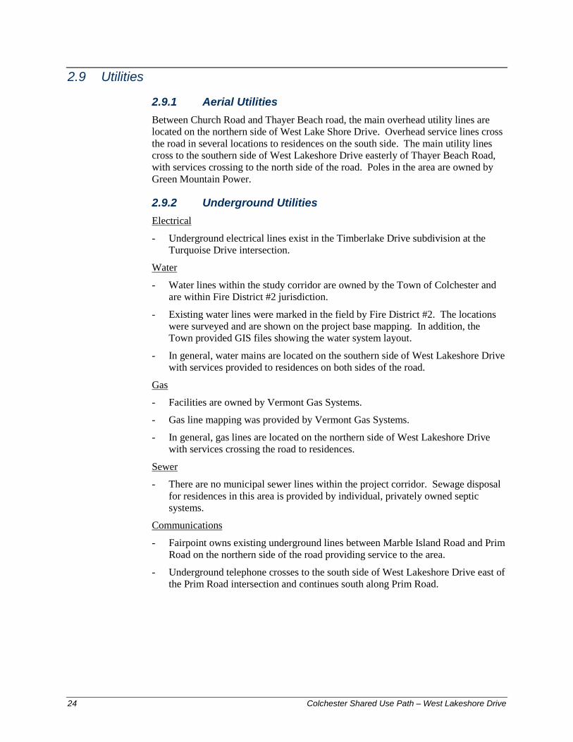
2.9.1 Aerial Utilities Between Church Road and Thayer Beach road, the main overhead utility lines are located on the northern side of West Lake Shore Drive. Overhead service lines cross the road in several locations to residences on the south side. The main utility lines cross to the southern side of West Lakeshore Drive easterly of Thayer Beach Road, with services crossing to the north side of the road. Poles in the area are owned by Green Mountain Power.
2.9.2 Underground Utilities Electrical
- Underground electrical lines exist in the Timberlake Drive subdivision at the Turquoise Drive intersection.
Water
- Water lines within the study corridor are owned by the Town of Colchester and are within Fire District #2 jurisdiction.
- Existing water lines were marked in the field by Fire District #2. The locations were surveyed and are shown on the project base mapping. In addition, the Town provided GIS files showing the water system layout.
- In general, water mains are located on the southern side of West Lakeshore Drive with services provided to residences on both sides of the road.
Gas
- Facilities are owned by Vermont Gas Systems.
- Gas line mapping was provided by Vermont Gas Systems.
- In general, gas lines are located on the northern side of West Lakeshore Drive with services crossing the road to residences.
Sewer
- There are no municipal sewer lines within the project corridor. Sewage disposal for residences in this area is provided by individual, privately owned septic systems.
Communications
- Fairpoint owns existing underground lines between Marble Island Road and Prim Road on the northern side of the road providing service to the area.
- Underground telephone crosses to the south side of West Lakeshore Drive east of the Prim Road intersection and continues south along Prim Road.
25 Colchester Shared Use Path—West Lakeshore Drive
3.0 Project Purpose and Need
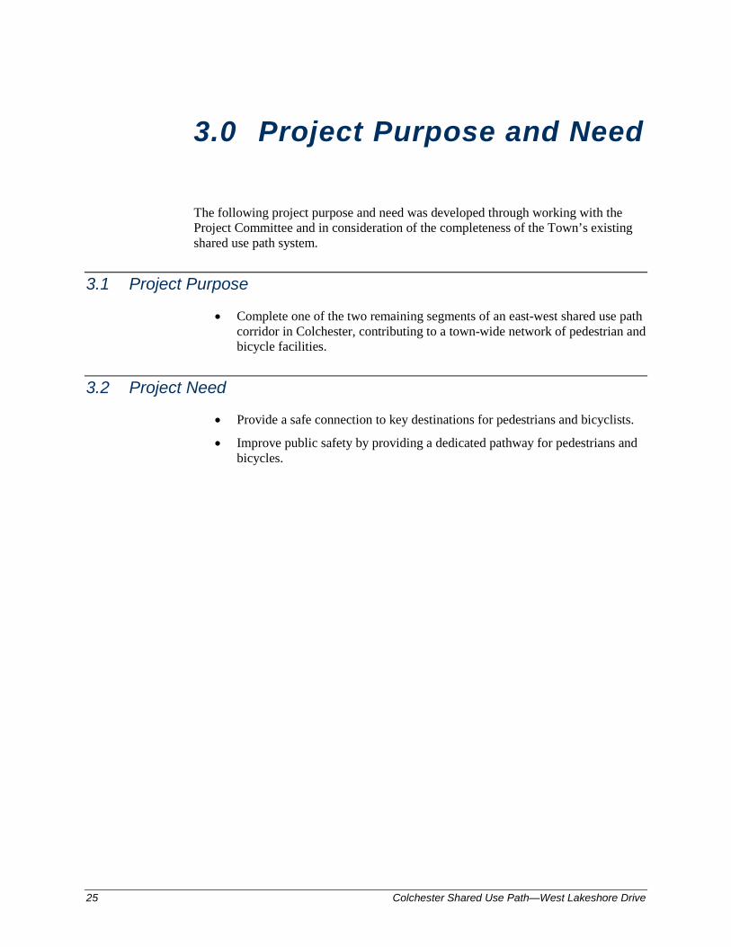
The following project purpose and need was developed through working with the Project Committee and in consideration of the completeness of the Town’s existing shared use path system.
3.1 Project Purpose
• Complete one of the two remaining segments of an east-west shared use path corridor in Colchester, contributing to a town-wide network of pedestrian and bicycle facilities.
3.2 Project Need
• Provide a safe connection to key destinations for pedestrians and bicyclists.
• Improve public safety by providing a dedicated pathway for pedestrians and bicycles.

Colchester Shared Use Path—West Lakeshore Drive
26
4.0 Alternative Alignments
4.1 Multiuse Path Design Criteria
Applicable roadway and multiuse path design criteria are tabulated below based on the following references:
• Town of Colchester Department of Public Works Specifications and Standards
• Vermont Pedestrian and Bicycle Facility Planning and Design Manual
• Vermont State Design Standards
• AASHTO Guide for the Development of Bicycle Facilities
Parameter West Lakeshore Drive Reference Functional Classification Major Collector (uncurbed) Class 2
Town Highway
AADT 5,600 vpd (2005) west of Marble Island Road
6,700 vpd (2008) east of Marble
Island Road
Design Vehicle WB-62 Posted Speed 35 mph Design Speed 40 mph Stopping Sight Distance 225 ft. VSS Sect. 5.4.1 Corner Sight Distance 385 ft. VSS Sect. 5.4.2 Travel Lane Width
Minimum Vermont State Standard 11 ft. VSS Sect. 5.6 Minimum Colchester Typical 11 ft. Colchester DPW Standards &
Specifications Existing 10.5 ft.
Proposed No change Shoulder Width (Shared use)
Existing 2.5 ft. Minimum w/Bicycles Vermont State
Standard 3 ft. VSS Sect. 5.14.1
Minimum Colchester Town Typical 2-4 ft. Colchester DPW Standards & Specifications
Proposed No Change Clear Zone
With Vertical Curb 1.5 ft. VSS Sect. 5.9 Without Vertical Curb 14-16 ft. VSS Sect. 5.9
Sidewalk Offset from Right of Way
27 Colchester Shared Use Path—West Lakeshore Drive
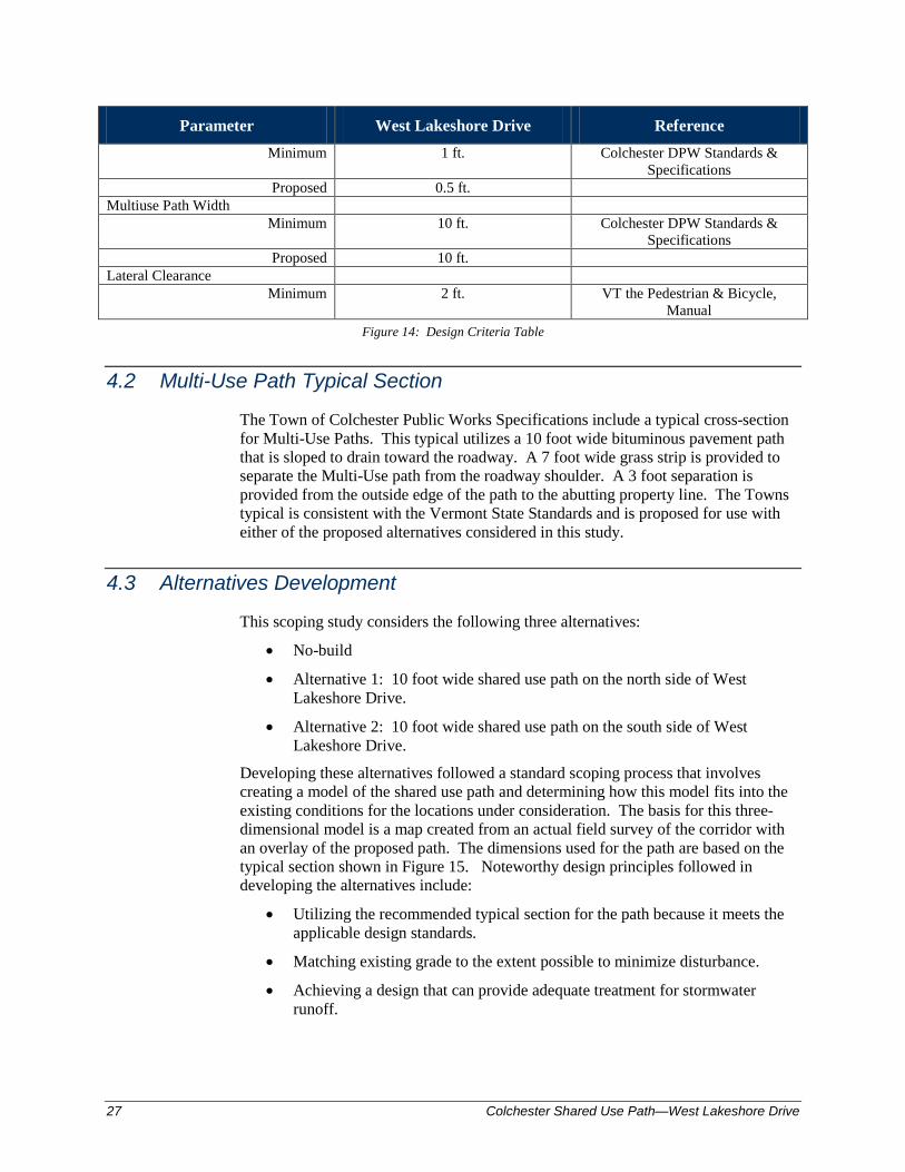
Parameter West Lakeshore Drive Reference Minimum 1 ft. Colchester DPW Standards &
Specifications Proposed 0.5 ft.
Multiuse Path Width Minimum 10 ft. Colchester DPW Standards &
Specifications Proposed 10 ft.
Lateral Clearance Minimum 2 ft. VT the Pedestrian & Bicycle,
Manual Figure 14: Design Criteria Table
4.2 Multi-Use Path Typical Section
The Town of Colchester Public Works Specifications include a typical cross-section for Multi-Use Paths. This typical utilizes a 10 foot wide bituminous pavement path that is sloped to drain toward the roadway. A 7 foot wide grass strip is provided to separate the Multi-Use path from the roadway shoulder. A 3 foot separation is provided from the outside edge of the path to the abutting property line. The Towns typical is consistent with the Vermont State Standards and is proposed for use with either of the proposed alternatives considered in this study.
4.3 Alternatives Development
This scoping study considers the following three alternatives:
• No-build
• Alternative 1: 10 foot wide shared use path on the north side of West Lakeshore Drive.
• Alternative 2: 10 foot wide shared use path on the south side of West Lakeshore Drive.
Developing these alternatives followed a standard scoping process that involves creating a model of the shared use path and determining how this model fits into the existing conditions for the locations under consideration. The basis for this three-dimensional model is a map created from an actual field survey of the corridor with an overlay of the proposed path. The dimensions used for the path are based on the typical section shown in Figure 15. Noteworthy design principles followed in developing the alternatives include:
• Utilizing the recommended typical section for the path because it meets the applicable design standards.
• Matching existing grade to the extent possible to minimize disturbance.
• Achieving a design that can provide adequate treatment for stormwater runoff.

10.5'10.5'7'10' ± ±
TRAVEL LANE TRAVEL LANE
3'
EXISTING RIGHT-OF-WAY
25' (ROUNDED)
8'
PERMANENT
EASEMENT
10'
TEMPORARY
EASEMENT FOR
CONSTRUCTION
PHASE ONLY
33.0'
REQUIRED WIDTH FOR NEW PATH CONSTRUCTION
℄
WEST LAKE
SHORE DRIVE
ROAD
SHOULDER
2.5'±
GRASS
STRIP
SHARED USE
PATH
PROPOSED
TYPICAL SECTION
V:\1
95
3\a
ctive
\1
95
31
06
07
\tra
nsp
orta
tio
n\d
ra
win
g\P
la
ns fo
r R
ep
ort\S
ha
re
d u
se
p
ath
se
ctio
n.d
wg
, T
yp
, 1
2/1
4/2
01
2 1
:5
4:3
0 P
M, td
ug
ua
y, D
WG
T
o P
DF
.p
c3
lsmiley
Text Box
Page 28
lsmiley
Text Box
Figure 15
29 Colchester Shared Use Path—West Lakeshore Drive
This scoping study was also tasked with analyzing the intersection at West Lakeshore Drive/Holy Cross Road/Church Road to determine if a three-way stop condition would improve safety for pedestrians and cyclists utilizing the shared use path. This analysis is presented in Section 4.4.
The no-built alternative was not evaluated in detail since it does not meet the project's objectives. Alternatives 1 and 2 were developed in detail. Features of these alternatives are presented in the following sections.
4.4 Future Traffic Conditions / Alternatives Development
Traffic conditions along West Lakeshore Drive and at its intersections with Prim Road and Church Road are expected to experience some growth in the volume of traffic. The intersection operations are not expected to change as both will remain as STOP controlled on the minor approach for the purposes of this study. For completeness the future levels of service are reported. As part of this study, Stantec conducted a review of ALL-WAY STOP at Church Road and this will be reported within this section. At Prim Road, alternatives to the existing are being studied by others and that work will not be included in this report. When considering the alternative shared use path routes along West Lakeshore Drive there is a need to cross two or more roadways. The conflicts with vehicles traveling on those roadways are a concern in the absence of traffic signal control that would provide protected crossings. To assess this pedestrian–vehicle conflict, Stantec identified the potential conflicts by estimating the daily vehicles, discerning the difference between through traffic and turning traffic, and summed the total potential conflicting vehicles for each route. This assessment is discussed in detail in this section.
4.4.1 Traffic Volumes Within the next 20 years there will likely be several periods of traffic growth and other periods when traffic remains stable or perhaps drops. More recently, due in part to the economy, traffic volume levels have not significantly changed so basing a future project on recent experience would not produce a substantive change to the existing for planning purposes particularly when there are no known planned developments. For this reason Stantec has applied a nominal annual growth rate of 1 percent per year to the existing traffic volumes.
4.4.2 Future Design Hour Volumes at Project Intersections The year 2030 is the basis for the future traffic considerations. Annual growth was estimated on the 19 years between 2011 when the traffic counts were conducted and the planning year 2030. Over that period traffic is estimated to grow 21 percent considering the annual increment and compounding over the 19 year period. Graphics depicting the morning and evening peak period turning movements at the West Lakeshore Drive intersections with Church Road and Prim Road are provided in the appendix.
Colchester Shared Use Path—West Lakeshore Drive
30
4.4.3 Intersection Level of Service Intersection levels of service have been reported for the two major intersections within the project area under existing conditions in a section 2.6 of this report. The standard analysis for intersections that are stopped controlled is somewhat limited as there are only results provided for the STOP controlled movements. Uncontrolled movements are theoretically free and not subject to delay. The standard model does not recognize the random interaction of minor street drivers asserting themselves and forcing the drivers on West Lakeshore Drive to stop or slow down as occurs when delays occur on Prim Road due to the high peak period volume on West Lakeshore Drive. Moreover, while added traffic on all roadways may increase the delay on a STOP controlled approach, once the level of service drops to LOS F the incremental delay is not reliably measured. Therefore the future conditions analysis results can be briefly summarized as follows:
• At the Church Road intersection with West Lakeshore Drive, the STOP controlled Church Road approach will continue to experience Level of Service B during both the morning and evening peak periods through 2030.
• At the Prim Road intersection with West Lakeshore Drive, the STOP controlled Prim Road approach will experience a reduced Level of Service from B to C during the morning peak period and will continue to experience LOS F during the evening peak period.
The worksheets and detailed summary tables for the 2030 level of service analysis are provided in the appendix.
4.4.4 Project Alternatives Traffic Consideration Stantec has conducted analysis of the alternative north side and south side routes for the West Lakeshore Drive shared use path. At the westerly end of the project, the proposed path will connect with the existing Holy Cross Road shared use path which is located on the northerly side of West Lakeshore Drive, just west of the Church Road intersection. At the easterly end, the proposed path will connect with an existing sidewalk which is located on the southerly side of West Lakeshore Drive, east of the Prime Road intersection. An assessment of changing the control at the Church Road intersection from One-Way STOP to All-Way STOP was conducted. The concept of All-Way STOP at the Church Road intersection would yield benefits to pedestrians as conflicts with vehicles would be positively controlled; however, there are significant safety consequences for drivers on West Lakeshore Drive as explained in this section.
4.4.5 Northside Route The northside route alternative for the shared use path along West Lakeshore Drive runs from the existing shared use path on the northside of West Lakeshore Drive at Church Road to the Marble Island Road intersection; from this point west of the intersection the route crosses West Lakeshore Drive to the south side; the northside route actually continues on the southside to and across Prim Road. There are two roadways crossed: West Lakeshore Drive and Prim Road.
31 Colchester Shared Use Path—West Lakeshore Drive
The West Lakeshore Road crossing west of Prim Road involves considerably less daily volume than a crossing east of Prim Road. At this location West Lakeshore Road is a two-lane roadway with shoulders on both sides requiring a crossing of approximately 34 feet. The Prim Road crossing involves crossing three lanes one southbound and two on the northbound approach. The crossing length would also include the added width associated with the turning radii on both sides of Prim Road. All totaled, the crossing is approximately 75 feet.
4.4.6 Southside Route The southside route alternative runs between the same intended shared use path end points. There is no crossing of West Lakeshore Drive on this route because it terminates at the Church Road intersection and Holy Cross Road continues to the west as a two lane roadway with two foot shoulders. The Holy Cross Road crossing would be approximately 30 feet within an existing crosswalk. This southside shared use path route would continue easterly by crossing Church Road, a crossing of approximately 45 feet ( two lanes and the intersection corner widening) and continue easterly to Prim Road and the 75 foot crossing described above.
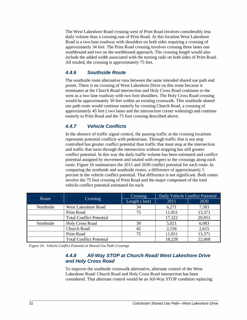
4.4.7 Vehicle Conflicts In the absence of traffic signal control, the passing traffic at the crossing locations represents potential conflicts with pedestrians. Through traffic that is not stop controlled has greater conflict potential than traffic that must stop at the intersection and traffic that turns through the intersection without stopping has still greater conflict potential. In this way the daily traffic volume has been estimated and conflict potential assigned by movement and totaled with respect to the crossings along each route. Figure 16 summarizes the 2011 and 2030 conflict potential for each route. In comparing the northside and southside routes, a difference of approximately 5 percent in the vehicle conflict potential. That difference is not significant. Both routes involve the 75 foot crossing of Prim Road and the major component of the total vehicle conflict potential estimated for each.
Route Crossing Crossing Daily Vehicle Conflict Potential Length ( feet) 2011 2030
Northside West Lakeshore Road 34 6,271 7,583 Prim Road 75 11,051 13,371 Total Conflict Potential 17,322 20,951
Southside Holy Cross Road 30 5,021 6,083 Church Road 45 2,156 2,615 Prim Road 75 11,051 13,371 Total Conflict Potential 18,228 22,068 Figure 16: Vehicle Conflict Potential at Shared Use Path Crossings
4.4.8 All-Way STOP at Church Road/ West Lakeshore Drive and Holy Cross Road To improve the southside crosswalk alternative, alternate control of the West Lakeshore Road/ Church Road and Holy Cross Road intersection has been considered. That alternate control would be an All-Way STOP condition replacing
Colchester Shared Use Path—West Lakeshore Drive
32
the existing single approach STOP control on Church Road. Stopping the through traffic on West Lakeshore Road may improve the desirability of this crossing. Stantec has reviewed the applicable sections of the Manual on Uniform traffic Control Devices (MUTCD) which addresses the conditions which prompt an All-Way STOP condition. There are important considerations regarding vehicular traffic. Volumes on all approaches should be nearly the same for All-Way STOP control. This same treatment for similar volumes is consistent with the placement of STOP control on the minor street approach when volumes are not similar. Drivers have a tendency to ignore STOP control when a STOP condition is imposed on the clear major traffic flow. This in turn leads to rear end crashes or more importantly pedestrians crossing with a false sense of protection. The major flow through this intersection is clearly West Lakeshore Road to/from Holy Cross Road. This is particularly true during the evening peak hour when the West Lakeshore Approach traffic is nearly four times Church Road approach traffic and Holy Cross Road is 140 percent of Church Road. On this basis the All-Way STOP at this location is not advisable.
4.4.9 Application of Other Traffic Control Devices for Pedestrian Safety Other than the use of stop signs at intersections where there are pedestrian crossings, there are other traffic control devices that are typically considered for pedestrian safety such as pavement markings and signs. And there are additional measures including beacons and pedestrian refuge areas that may also be appropriate improvement measures. Pavement Markings and Signing The Manual on Uniform Traffic Control Devices (MUTCD) prescribes the use of pavement markings and signing at pedestrian crossings. Conformance to the MUTCD regarding message, color, size, and reflectivity is important as they contribute to driver familiarity and recognition. Pedestrian safety is improved through driver awareness when these devices are properly located. Both horizontal (pavement markings) and vertical (signs) devices are recommended at pedestrian crosswalks. Proper pavement markings can be seen by pedestrians but not so readily seen by approaching drivers. The crosswalk should be complemented by signs to further enhance visibility and driver recognition of the crossing. The MUTCD prescribes the use of the “walking pedestrian” graphic (W11-2) or, in some cases “wheel chair pedestrian” graphic (W11-9) warning signs. At the crosswalks these are supplemented by a plaque illustrating a downward pointing arrow. Another plaque is used in advance of the crossing indicating “AHEAD” or “ ___ FEET”. Typically these signs are yellow, or in the vicinity of schools, a florescent yellow-green color is used. These colors should be consistent within the same general area or zone. The size and location of these signs is predicated on the vehicle speeds. In some instances overhead signing may also be appropriate. Beacons The MUTCD identifies flashing beacons as devices that may supplement crosswalk markings and signing. Flashing beacons may be used at pedestrian crossings to indicate when pedestrian activity can be expected. These may be pedestrian actuated or they may be programmable at crossings where pedestrian usage is predictable.

33 Colchester Shared Use Path—West Lakeshore Drive
The MUTCD (Section 4F.02) identifies flashing hybrid beacons as devices that may supplement crosswalks markings and signing. Hybrid beacons are pedestrian actuated and do not require programming. The beacon’s appearance is unique with two lenses at the top of the head and one below. When “at rest” the top two lenses and the bottom lens are dark (no illumination). When actuated the lower lens first flashes, then steady yellow, then again dark when the top two lenses are steady red during the pedestrian walk interval. The lights alternate during the pedestrian clearance interval. This relatively new hybrid beacon is applied to a select set of conditions. These are the number of pedestrians during a peak hour, roadway speed, crossing distance and the vehicular volume during the same hour. For example a hybrid beacon may be warranted, on a major roadway where the speed limit is 35 mph or less at a crossing where there are 20 pedestrians during the peak hour walking across a 34 foot crosswalk and where the two way traffic volume during the same peak hour is 1700 vehicles. As the number of pedestrian crossings increase the number of vehicles required to meet this guideline reduces. Although not presently warranted for the crosswalks within the project area, use of these beacons may be reconsidered in the future based on actual usage of the shared use path and traffic volumes. Refuge Islands The length of pedestrian crossings is critical to safety and consequently this distance should be as short as practical. Extending the sidewalk beyond the curb line at the corners of intersections can be effective and reducing the crosswalk length through the implementation of a raised island can also be effective. In each instance the alignment of the vehicular lanes must be adequate to avoid potential hazards where drivers have difficulty navigating the revised roadway and the refuge island that may now represent an obstacle. Within the study corridor, the length of crossing three lanes at Prim Road is most concerning. It is noted that this crossing location and Route 127 intersection and is presently being analyzed under a separate “Circumferential Highway Alternatives” study. Recommendations to address improved pedestrian safety at this crossing will be addressed in that more encompassing study.
4.5 Alternatives Narrative
4.5.1 Alternative 1 – North Side This alternative proposes construction of the shared use path on the northerly side of West Lake Shore Drive. The path begins at the terminus of the existing Holy Cross Road shared use path and extends easterly to Marble Island Road. The path then crosses West Lakeshore Drive and proceeds easterly to the Prim Road intersection where it connects with the existing sidewalk on West Lakeshore Drive. The reasons for proposing that Alternative 1 cross West Lakeshore Drive at Marble Island Road are twofold:
1. If the path were to continue from Marble Island Road to Prim Road along the northerly side of West Lakeshore Drive, there is no good location in this vicinity to cross pedestrians and cyclists on West Lakeshore Drive to the existing sidewalk on the south side of West Lakeshore Drive due to the stop

Colchester Shared Use Path—West Lakeshore Drive
34
condition. A relatively safe Prim Road crosswalk can be provided on the south side of West Lakeshore Drive at the Prim Road intersection.
2. There is an existing house on parcel #33 that is located very close to the existing right-of-way line and edge of the existing roadway. The front entrance to this house is elevated well above the adjacent roadway. Consequently, it is not practical to construct the shared use path in front of this house.
3. Rozzi’s Tavern (parcel #34) utilizes two driveway entrances located close to the West Lakeshore Drive/Prim Road intersection. There is also a private ROW adjacent to the Tavern property. It is not desirable from a safety standpoint to introduce a shared use path through this area due to the complexity of the traffic movements.
The following list itemizes features associated with this alternative and identifies potential impacts. The list is organized as one travels from the westerly end of the project at Church Road to the easterly end of the project at Prim Road.
• The shared use path will be 10 feet wide, bituminous pavement, with a 7 foot wide grass swale separating the path from the existing roadway shoulder.
• The proposed path will connect directly to the existing shared use path on Holy Cross Road.
• Existing roadway layout is unaffected along the corridor.
• West Lake Shore Drive existing right-of-way width is 49.5 feet along the corridor. An additional 8 foot permanent easement will be required to the north, outside the right-of-way. A temporary construction easement will be required, extending to the northern construction limit, for grading purposes.
• The Vermont Gas main may need to be relocated from the beginning of path construction to beyond the Booska property.
• The path will be shifted to abut the roadway along parcel #6 to avoid the historically sensitive area. This requires eliminating the 7 foot wide grass strip. Vertical granite curb, with a 7 inch reveal, will be used to provide separation between the existing roadway and the proposed path.
• Aprons for all driveways being crossed will be repaved.
• The Congregational Church’s water service line may need to be relocated.
• The light pole in front of the church may need to be relocated.
• The Vermont Gas main may need to be relocated in front of the church property.
• Approximately 950 feet of gabion retaining wall, with 4 foot high chain link fence, will be required to minimize the effects to the existing Class II wetlands.
• A new crosswalk will be installed at the Thayer Beach Road Intersection.
• The Woodbine water service line may need to be relocated.
35 Colchester Shared Use Path—West Lakeshore Drive
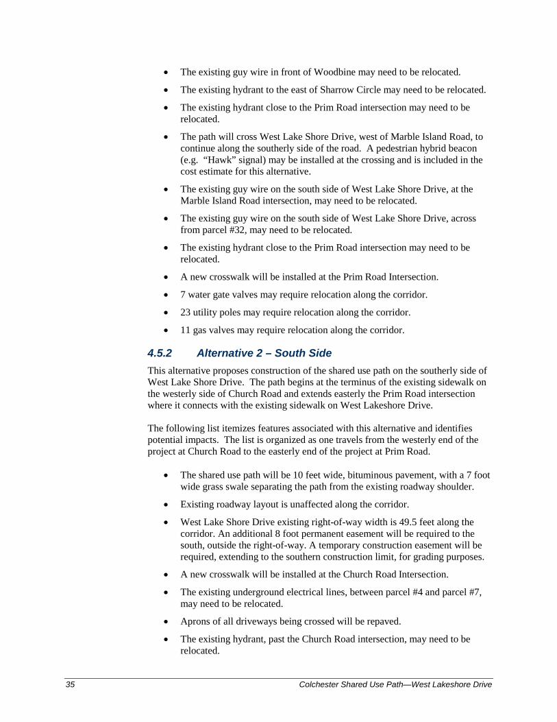
• The existing guy wire in front of Woodbine may need to be relocated.
• The existing hydrant to the east of Sharrow Circle may need to be relocated.
• The existing hydrant close to the Prim Road intersection may need to be relocated.
• The path will cross West Lake Shore Drive, west of Marble Island Road, to continue along the southerly side of the road. A pedestrian hybrid beacon (e.g. “Hawk” signal) may be installed at the crossing and is included in the cost estimate for this alternative.
• The existing guy wire on the south side of West Lake Shore Drive, at the Marble Island Road intersection, may need to be relocated.
• The existing guy wire on the south side of West Lake Shore Drive, across from parcel #32, may need to be relocated.
• The existing hydrant close to the Prim Road intersection may need to be relocated.
• A new crosswalk will be installed at the Prim Road Intersection.
• 7 water gate valves may require relocation along the corridor.
• 23 utility poles may require relocation along the corridor.
• 11 gas valves may require relocation along the corridor.
4.5.2 Alternative 2 – South Side This alternative proposes construction of the shared use path on the southerly side of West Lake Shore Drive. The path begins at the terminus of the existing sidewalk on the westerly side of Church Road and extends easterly the Prim Road intersection where it connects with the existing sidewalk on West Lakeshore Drive. The following list itemizes features associated with this alternative and identifies potential impacts. The list is organized as one travels from the westerly end of the project at Church Road to the easterly end of the project at Prim Road.
• The shared use path will be 10 feet wide, bituminous pavement, with a 7 foot wide grass swale separating the path from the existing roadway shoulder.
• Existing roadway layout is unaffected along the corridor.
• West Lake Shore Drive existing right-of-way width is 49.5 feet along the corridor. An additional 8 foot permanent easement will be required to the south, outside the right-of-way. A temporary construction easement will be required, extending to the southern construction limit, for grading purposes.
• A new crosswalk will be installed at the Church Road Intersection.
• The existing underground electrical lines, between parcel #4 and parcel #7, may need to be relocated.
• Aprons of all driveways being crossed will be repaved.
• The existing hydrant, past the Church Road intersection, may need to be relocated.
Colchester Shared Use Path—West Lakeshore Drive
36
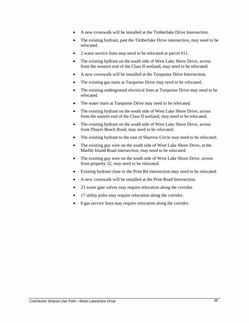
• A new crosswalk will be installed at the Timberlake Drive Intersection.
• The existing hydrant, past the Timberlake Drive intersection, may need to be relocated.
• 2 water service lines may need to be relocated at parcel #11.
• The existing hydrant on the south side of West Lake Shore Drive, across from the western end of the Class II wetland, may need to be relocated.
• A new crosswalk will be installed at the Turquoise Drive Intersection.
• The existing gas main at Turquoise Drive may need to be relocated.
• The existing underground electrical lines at Turquoise Drive may need to be relocated.
• The water main at Turquoise Drive may need to be relocated.
• The existing hydrant on the south side of West Lake Shore Drive, across from the eastern end of the Class II wetland, may need to be relocated.
• The existing hydrant on the south side of West Lake Shore Drive, across from Thayer Beach Road, may need to be relocated.
• The existing hydrant to the east of Sharrow Circle may need to be relocated.
• The existing guy wire on the south side of West Lake Shore Drive, at the Marble Island Road intersection, may need to be relocated.
• The existing guy wire on the south side of West Lake Shore Drive, across from property 32, may need to be relocated.
• Existing hydrant close to the Prim Rd intersection may need to be relocated.
• A new crosswalk will be installed at the Prim Road Intersection.
• 23 water gate valves may require relocation along the corridor.
• 17 utility poles may require relocation along the corridor.
• 8 gas service lines may require relocation along the corridor.
.
BEGIN CONC. CURB
BEGIN CONC. CURB
BEGIN CONC. CURB
.
.
. . ...
.
.
.
..
.
. .
.
.
.
.
.
... ..
.
.
.
.
05407-2246
802.864.0223
802.864.0165
55 Green Mountain Drive
South Burlington, VT U.S.A.
W. LAKE SHORE DRIVE
CH
UR
CH
RO
AD
0
SCALE
5001000
0
SCALE
5001000
0
SCALE
5001000
(1.5 MILES)TO AIRPORT PARK
1
2
4
ROADHOLY CROSS
TIM
BER
LA
KE
DRIV
E
CIRCA 1845(SR 0404-2)PROPERTY WOEHR
5
7
6
8
10
9
12
11
NATURAL AREA
ROSSETTI
N
VT S
TAT
E
PLA
NE
GRID
www.stantec.com
Fax.
Tel.
www.stantec.com
Fax.
Tel.
Stantec Consulting Services Inc.
www.stantec.com
Fax.
Tel.
ALTERNATIVES PRESENTATIONCOLCHESTER SHARED USED PATH
LEGEND
12 / 15 / 2011
0
SCALE
40 80
PROPOSED CROSSWALK
PROPOSED GREEN STRIP / GRADING LIMIT
PROPOSED BITUMINOUS CONCRETE SIDEWALK
PROPOSED GABION WALL
ROSSETTI NATURAL AREA
WETLAND CLASS II
EXISTING HEDGE / SHRUB
EXISTING CROSSWALK
EXISTING PATH / SIDEWALK
EXISTING VT GAS LINE
PROPERTY LINE (GIS)
RIGHT-OF-WAY
NORTH SIDEALTERNATIVE 1
SOUTH SIDEALTERNATIVE 2
3
AADT: 5,600 vpd (2005)ROADWAY WIDTH: 3-10.5-10.5-2 POSTED SPEED: 35 MPHCLASS: MAJOR COLLECTORW. LAKE SHORE DRIVE
AADT: 2,000 vpd (2005)ROADWAY WIDTH: 4.5-10-10-4.5POSTED SPEED: 35 MPHCLASS: MAJOR COLLECTORCHURCH ROAD
lsmiley
Text Box
Figure 17
lsmiley
Text Box
Page 37A
05407-2246
802.864.0223
802.864.0165
55 Green Mountain Drive
South Burlington, VT U.S.A.
www.stantec.com
Fax.
Tel.
www.stantec.com
Fax.
Tel.
Stantec Consulting Services Inc.
www.stantec.com
Fax.
Tel.
ALTERNATIVES PRESENTATIONCOLCHESTER SHARED USED PATH
LEGEND
12 / 15 / 2011
0
SCALE
40 80
PROPOSED CROSSWALK
PROPOSED GREEN STRIP / GRADING LIMIT
PROPOSED BITUMINOUS CONCRETE SIDEWALK
PROPOSED GABION WALL
ROSSETTI NATURAL AREA
WETLAND CLASS II
EXISTING HEDGE / SHRUB
EXISTING CROSSWALK
EXISTING PATH / SIDEWALK
EXISTING VT GAS LINE
PROPERTY LINE (GIS)
RIGHT-OF-WAY
N
VT S
TAT
E
PLA
NE
GRID
NORTH SIDEALTERNATIVE 1
SOUTH SIDEALTERNATIVE 2
.
.
.
.
2 STORY SPLIT LEVEL/2’OVERHANG IN FRONT
.
CONCRETE PAVERS
CONCRETE PAVERS
.
..
.
.
.
.
TU
RQ
UOIS
E
DRIV
ESTREAM A
INTERMITTENT
W. LAKE SHORE DRIVE
CHURCHCONGREGATIONAL
13
14
17
1516
18
19
20
CLASS II
WETLANDS
CLASS II
WETLANDS
lsmiley
Text Box
Figure 17
lsmiley
Text Box
Page 37B
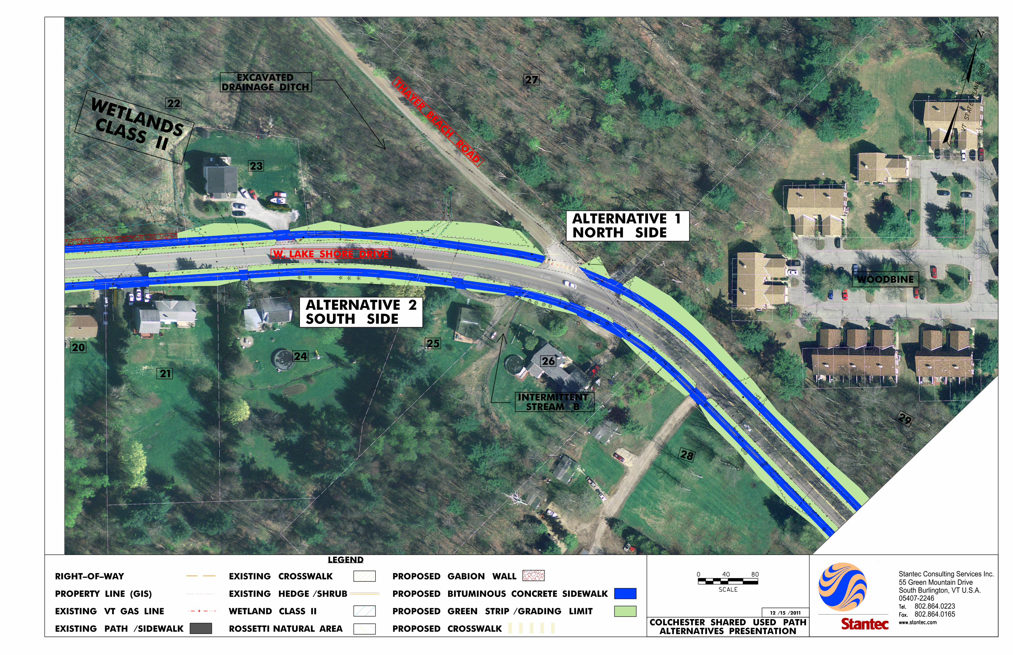
.
.
.
..
.
.
.
.
.
.
.
.
.
05407-2246
802.864.0223
802.864.0165
55 Green Mountain Drive
South Burlington, VT U.S.A.
THAYER BEA
CH RO
AD
DRAINAGE DITCHEXCAVATED
W. LAKE SHORE DRIVE
WOODBINE
STREAM BINTERMITTENT
20
21
23
24
27
25
26
29
22
28
CLASS II
WETLANDS
www.stantec.com
Fax.
Tel.
www.stantec.com
Fax.
Tel.
Stantec Consulting Services Inc.
www.stantec.com
Fax.
Tel.
ALTERNATIVES PRESENTATIONCOLCHESTER SHARED USED PATH
LEGEND
12 / 15 / 2011
0
SCALE
40 80
PROPOSED CROSSWALK
PROPOSED GREEN STRIP / GRADING LIMIT
PROPOSED BITUMINOUS CONCRETE SIDEWALK
PROPOSED GABION WALL
ROSSETTI NATURAL AREA
WETLAND CLASS II
EXISTING HEDGE / SHRUB
EXISTING CROSSWALK
EXISTING PATH / SIDEWALK
EXISTING VT GAS LINE
PROPERTY LINE (GIS)
RIGHT-OF-WAY
N
VT S
TAT
E
PLA
NE
GRID
NORTH SIDEALTERNATIVE 1
SOUTH SIDEALTERNATIVE 2
lsmiley
Text Box
Figure 17
lsmiley
Text Box
Page 37C
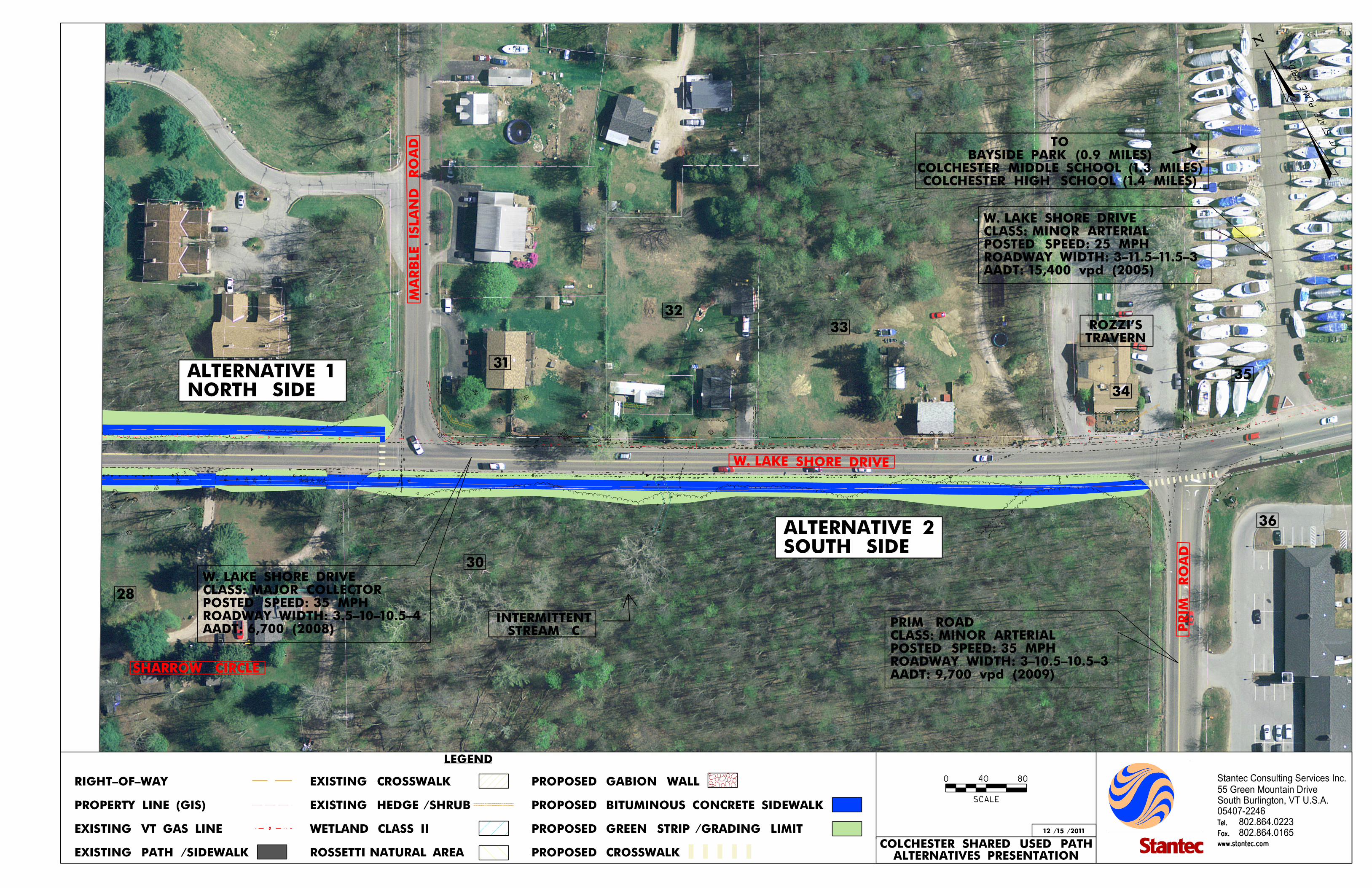
.
.
ROZZIS
LAKESHORE
TAVERN
.
.
.
. .... ..
05407-2246
802.864.0223
802.864.0165
55 Green Mountain Drive
South Burlington, VT U.S.A.
MA
RB
LE IS
LA
ND
RO
AD
W. LAKE SHORE DRIVE
PRIM
RO
AD
28
SHARROW CIRCLE
STREAM CINTERMITTENT
COLCHESTER HIGH SCHOOL (1.4 MILES)COLCHESTER MIDDLE SCHOOL (1.3 MILES)
BAYSIDE PARK (0.9 MILES)TO
TRAVERNROZZI’S
31
32
30
33
36
AADT: 9,700 vpd (2009)ROADWAY WIDTH: 3-10.5-10.5-3POSTED SPEED: 35 MPHCLASS: MINOR ARTERIALPRIM ROAD
34
35
AADT: 15,400 vpd (2005)ROADWAY WIDTH: 3-11.5-11.5-3POSTED SPEED: 25 MPHCLASS: MINOR ARTERIALW. LAKE SHORE DRIVE
www.stantec.com
Fax.
Tel.
www.stantec.com
Fax.
Tel.
Stantec Consulting Services Inc.
www.stantec.com
Fax.
Tel.
ALTERNATIVES PRESENTATIONCOLCHESTER SHARED USED PATH
LEGEND
12 / 15 / 2011
0
SCALE
40 80
PROPOSED CROSSWALK
PROPOSED GREEN STRIP / GRADING LIMIT
PROPOSED BITUMINOUS CONCRETE SIDEWALK
PROPOSED GABION WALL
ROSSETTI NATURAL AREA
WETLAND CLASS II
EXISTING HEDGE / SHRUB
EXISTING CROSSWALK
EXISTING PATH / SIDEWALK
EXISTING VT GAS LINE
PROPERTY LINE (GIS)
RIGHT-OF-WAY
N
VT ST
ATE P
LA
NE
GRID
NORTH SIDEALTERNATIVE 1
SOUTH SIDEALTERNATIVE 2
AADT: 6,700 (2008)ROADWAY WIDTH: 3.5-10-10.5-4POSTED SPEED: 35 MPHCLASS: MAJOR COLLECTORW. LAKE SHORE DRIVE
lsmiley
Text Box
Figure 17
lsmiley
Text Box
Page 37D

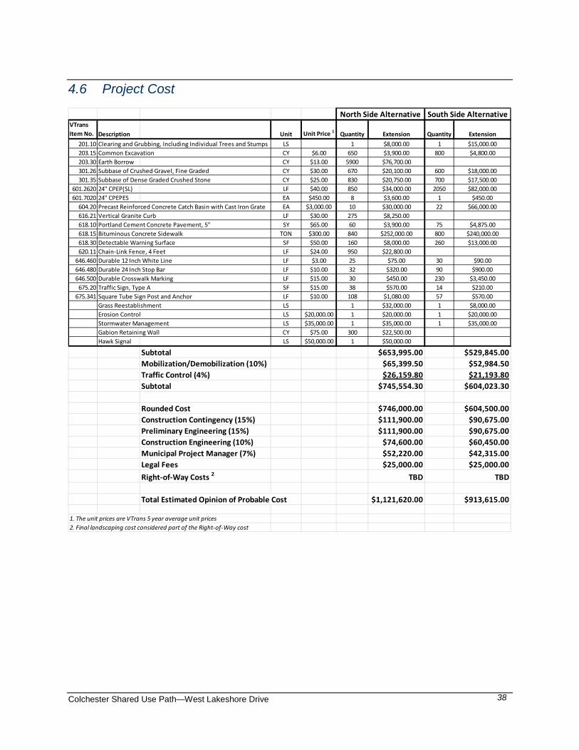
Colchester Shared Use Path—West Lakeshore Drive
38
4.6 Project Cost
VTransItem No. Description Unit Unit Price 1 Quantity Extension Quantity Extension
201.10 Clearing and Grubbing, Including Individual Trees and Stumps LS 1 $8,000.00 1 $15,000.00203.15 Common Excavation CY $6.00 650 $3,900.00 800 $4,800.00203.30 Earth Borrow CY $13.00 5900 $76,700.00301.26 Subbase of Crushed Gravel, Fine Graded CY $30.00 670 $20,100.00 600 $18,000.00301.35 Subbase of Dense Graded Crushed Stone CY $25.00 830 $20,750.00 700 $17,500.00
601.2620 24" CPEP(SL) LF $40.00 850 $34,000.00 2050 $82,000.00601.7020 24" CPEPES EA $450.00 8 $3,600.00 1 $450.00
604.20 Precast Reinforced Concrete Catch Basin with Cast Iron Grate EA $3,000.00 10 $30,000.00 22 $66,000.00616.21 Vertical Granite Curb LF $30.00 275 $8,250.00618.10 Portland Cement Concrete Pavement, 5" SY $65.00 60 $3,900.00 75 $4,875.00618.15 Bituminous Concrete Sidewalk TON $300.00 840 $252,000.00 800 $240,000.00618.30 Detectable Warning Surface SF $50.00 160 $8,000.00 260 $13,000.00620.11 Chain-Link Fence, 4 Feet LF $24.00 950 $22,800.00
646.460 Durable 12 Inch White Line LF $3.00 25 $75.00 30 $90.00646.480 Durable 24 Inch Stop Bar LF $10.00 32 $320.00 90 $900.00646.500 Durable Crosswalk Marking LF $15.00 30 $450.00 230 $3,450.00
675.20 Traffic Sign, Type A SF $15.00 38 $570.00 14 $210.00675.341 Square Tube Sign Post and Anchor LF $10.00 108 $1,080.00 57 $570.00
Grass Reestablishment LS 1 $32,000.00 1 $8,000.00Erosion Control LS $20,000.00 1 $20,000.00 1 $20,000.00Stormwater Management LS $35,000.00 1 $35,000.00 1 $35,000.00Gabion Retaining Wall CY $75.00 300 $22,500.00Hawk Signal LS $50,000.00 1 $50,000.00
Subtotal $653,995.00 $529,845.00Mobilization/Demobilization (10%) $65,399.50 $52,984.50Traffic Control (4%) $26,159.80 $21,193.80Subtotal $745,554.30 $604,023.30
Rounded Cost $746,000.00 $604,500.00Construction Contingency (15%) $111,900.00 $90,675.00Preliminary Engineering (15%) $111,900.00 $90,675.00Construction Engineering (10%) $74,600.00 $60,450.00Municipal Project Manager (7%) $52,220.00 $42,315.00Legal Fees $25,000.00 $25,000.00Right-of-Way Costs 2 TBD TBD
Total Estimated Opinion of Probable Cost $1,121,620.00 $913,615.00
1. The unit prices are VTrans 5 year average unit prices2. Final landscaping cost considered part of the Right-of-Way cost
North Side Alternative South Side Alternative
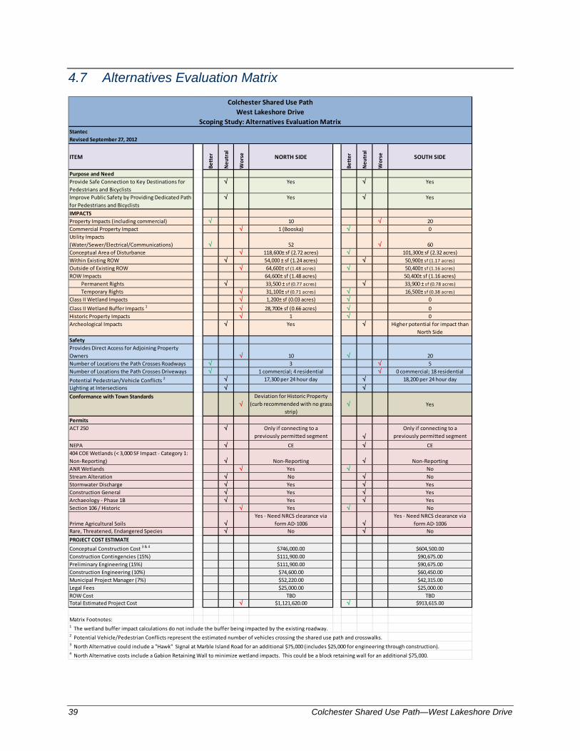
39 Colchester Shared Use Path—West Lakeshore Drive
4.7 Alternatives Evaluation Matrix
StantecRevised September 27, 2012
ITEM
Bett
er
Neu
tral
Wor
se NORTH SIDE
Bett
er
Neu
tral
Wor
se SOUTH SIDE
Purpose and NeedProvide Safe Connection to Key Destinations for Pedestrians and Bicyclists
√ Yes √ Yes
Improve Public Safety by Providing Dedicated Path for Pedestrians and Bicyclists
√ Yes √ Yes
IMPACTSProperty Impacts (including commercial) √ 10 √ 20Commercial Property Impact √ 1 (Booska) √ 0Utility Impacts (Water/Sewer/Electrical/Communications) √ 52 √ 60Conceptual Area of Disturbance √ 118,600± sf (2.72 acres) √ 101,300± sf (2.32 acres)Within Existing ROW √ 54,000 ± sf (1.24 acres) √ 50,900± sf (1.17 acres)Outside of Existing ROW √ 64,600± sf (1.48 acres) √ 50,400± sf (1.16 acres)ROW Impacts 64,600± sf (1.48 acres) 50,400± sf (1.16 acres) Permanent Rights √ 33,500 ± sf (0.77 acres) √ 33,900 ± sf (0.78 acres) Temporary Rights √ 31,100± sf (0.71 acres) √ 16,500± sf (0.38 acres)Class II Wetland Impacts √ 1,200± sf (0.03 acres) √ 0Class II Wetland Buffer Impacts 1 √ 28,700± sf (0.66 acres) √ 0Historic Property Impacts √ 1 √ 0Archeological Impacts √ Yes √ Higher potential for impact than
North SideSafetyProvides Direct Access for Adjoining Property Owners √ 10 √ 20Number of Locations the Path Crosses Roadways √ 3 √ 5Number of Locations the Path Crosses Driveways √ 1 commercial; 4 residential √ 0 commercial; 18 residentialPotential Pedestrian/Vehicle Conflicts 2 √ 17,300 per 24 hour day √ 18,200 per 24 hour dayLighting at Intersections √ √Conformance with Town Standards
√Deviation for Historic Property
(curb recommended with no grass strip)
√ Yes
PermitsACT 250 √ Only if connecting to a
previously permitted segment √Only if connecting to a
previously permitted segment
NEPA √ CE √ CE404 COE Wetlands (< 3,000 SF Impact - Category 1: Non-Reporting) √ Non-Reporting √ Non-ReportingANR Wetlands √ Yes √ NoStream Alteration √ No √ NoStormwater Discharge √ Yes √ YesConstruction General √ Yes √ YesArchaeology - Phase 1B √ Yes √ YesSection 106 / Historic √ Yes √ No
Prime Agricultural Soils √Yes - Need NRCS clearance via
form AD-1006 √Yes - Need NRCS clearance via
form AD-1006Rare, Threatened, Endangered Species √ No √ NoPROJECT COST ESTIMATEConceptual Construction Cost 3 & 4 $746,000.00 $604,500.00Construction Contingencies (15%) $111,900.00 $90,675.00Preliminary Engineering (15%) $111,900.00 $90,675.00Construction Engineering (10%) $74,600.00 $60,450.00Municipal Project Manager (7%) $52,220.00 $42,315.00Legal Fees $25,000.00 $25,000.00ROW Cost TBD TBDTotal Estimated Project Cost √ $1,121,620.00 √ $913,615.00
Matrix Footnotes:1 The wetland buffer impact calculations do not include the buffer being impacted by the existing roadway.2 Potential Vehicle/Pedestrian Conflicts represent the estimated number of vehicles crossing the shared use path and crosswalks. 3 North Alternative could include a "Hawk" Signal at Marble Island Road for an additional $75,000 (includes $25,000 for engineering through construction).4 North Alternative costs include a Gabion Retaining Wall to minimize wetland impacts. This could be a block retaining wall for an additional $75,000.
Colchester Shared Use PathWest Lakeshore Drive
Scoping Study: Alternatives Evaluation Matrix

Colchester Shared Use Path—West Lakeshore Drive
40
4.8 Public Participation / Meetings
A Local Concerns Meeting was held on June 14, 2011 concurrently with a Colchester Select Board meeting. The purpose of this public meeting was to gather input from municipal officials, the public and special interest groups to obtain local and regional concerns. Please refer to section 2.1 of this report for a synopsis of the Local Concerns Meeting and to Appendix A for minutes from this meeting and a list of attendees. An Alternatives Presentation Meeting was held on June 26, 2012 concurrently with a Select Board meeting. The purpose of this meeting was to present the two alternative alignments considered in this scoping study with regard to safety, environmental impacts, right-of, way impacts and overall project costs. These alternatives were presented to the Select Board for their determination of the preferred alternative. The Alternatives Presentation Meeting was publicly advertised in the Colchester Sun weekly newspaper and written notification was mailed to abutting property owners approximately two weeks prior to the meeting. The meeting included a project overview and presentation of the alternatives by Stantec. Public concerns and questions were heard and this was followed by the Select Board’s decision to endorse Alternative 2, the southerly side of West Lakeshore Drive, as the preferred location for the shared use path. Please refer to Appendix A for minutes from this meeting and a list of attendees.
4.9 Preferred Alternative
Based on information provided in the Alternatives Evaluation Matrix, consideration of public comments, and a recommendation by the Director of Public Works, the Select Board decided by vote that locating the shared use path on the southerly side of West Lakeshore Drive is the preferred alternative. The following are considerations supporting the south side of alternative:
• The Class II wetland is not impacted.
• The property eligible for the Historic Register is not impacted.
• No deviations from the Town Standards are required to construct the shared use path on the South side.
• Provides direct access to the shared use path for 20 adjoining property versus 10 properties on the north side.
• Although 20 adjoining properties are impacted to some extent by the south side alternative versus 10 property on the north side, the conceptual area of disturbance outside of the existing ROW is 14,200 sf less on the south side, and the Temporary Rights required are estimated to be 14,600 sf less on the south side.
• Overall project costs are estimated to be approximately $208,000 (19%) less.


APPENDIX A
Local Concerns Meeting and Alternative Presentation
Agenda and Minutes


1. CALL TO ORDER
Chairman Paquette called the meeting to order at 7:35 p.m. after the Public Hearing adjourned. The Pledge of Allegiance was recited.
2. ROLL CALL SELECTBOARD: L. Richard Paquette, Roger Derby, Marc Landry, Mickey Palmer
and Nadine Scibek. ADMINISTRATION: Al Voegele (Town Manager); Joan Boehm (Asst. Town
Manager/CFO), Bryan Osborne (Public Works Director), Chief Chuck Kirker (Police Chief), Robert Vickery (Assessor) and Mike Chmielewski (Fire Chief).
3. CITIZENS TO BE HEARD
Brian Grenon, a resident of Colchester requested that the Town set a policy as to how the abatement process is to occur. There seems to be some misinformation being given out. Specifically that if a tax abatement form or request is not received by June 21, you have to wait until next year. He believed that was incorrect because State Statute says abatement can be filed at anytime if it meets criteria. He asked the Chair to develop a policy since he brought this up at the last meeting yet nothing was done. Mr. Grenon also asked for clarification on how many days a person had to grieve their assessment that was mailed to them. Robert Vickery responded they have 14 days from the date the mailing was sent out. There has to be a letter requesting an appeal or a phone call for an appointment at which time a letter can be brought in. Mr. Grenon asked if the warning had been placed in five places twice. Mr. Voegele stated he wasn’t aware that they would have to be placed twice as it would be the same information. He will check into it. Doug Mulac, a Lister with the Town stated that in an article in the Colchester Sun Mr. Voegele wrote that the Town doesn’t have the capacity to abate all the taxes and Mr. Mulac believed that wasn’t up to the Town. People were getting upset with the information and attitude of Town employees. Mr. Voegele replied he was not made aware of any complaints. Mr. Grenon believed that since this was a one-of-a-kind situation, Town administration should go back to the budget to see where they are spending funds, referring to the bike path and causeway repairs. He believed the Town didn’t have the right to say they can’t abate taxes as the Town Clerk was saying. Mr. Paquette suggested that Mr. Grenon and Karen Richard sit down with him to discuss any accusations.
MINUTES COLCHESTER SELECTBOARD MEETING
JUNE 14, 2011 @ 7:30 p.m.
MEETING HOUSE, MAIN STREET, COLCHESTER, VT _________________________

COLCHESTER SELECT BOARD - ………………….. Page 2
Pam Loranger understood that this was a difficult process and there were lessons to be learned. There was a lot of confusion in her neighborhood on abatement. Next time it could be done better.
4. CONSENT AGENDA
a. Minutes of Special Meeting May 24, 2011 b. Minutes of Selectboard Public Hearing May 24, 2011 c. Minutes of Regular Meeting May 24, 2011
MOTION was made by Roger Derby and SECONDED by Mickey Palmer to approve the Consent Agenda with the following changes to the Special Meeting Minutes of May 24, 2011: Selectboard Members Present: Delete ‘L. Richard Paquette’. The MOTION carried 4-0.
5. FINANCIAL REPORT a. Chief Financial Officer’s Report
Joan Boehm gave her report for April, 2011 explaining that as of now it looks like the Board won’t need to dip into the Fund Balance by the $341,000 they budgeted for. She will know more by the end of the fiscal year. In April, General Fund expenditures were $10,000 less than last year and there was $359,000 more in revenue than expenses taken in. There was $2,500 less in taxes taken in. Other Funds had more revenue than expenses except for the Capital Transportation Plan. She then reviewed revenues and expenses by department. Ms. Boehm then reported on the Government Finance Officers Conference she attended explaining she would like to prepare a policy for Selectboard review to set a minimum amount for the Fund Balance and a timeframe to replenish it if it dips below the minimum. She also reported on other topics including lean government, part-time health insurance benefits in government after retirement, Union membership in government and outcome based budgeting. Brian Grenon asked what the projection was for the amount of taxes the Town would pay out for abatement. Ms. Boehm answered it was $50,000 but it could change.
6. SPECIAL BUSINESS ITEMS
a. Local Concerns Meeting: Proposed Shared Path – West Lakeshore Drive Bryan Osborne introduced Christine Forde of the CCMPO and Greg Edwards and John Leinwohl from Stantec Consultants. Mr. Osborne gave a history of the project and showed a map of the pedestrian path. There were two portions not yet complete, one was in the village and there were plans with the State to do that project. The other portion is West Lakeshore Drive. This is only the planning level study. John Leinwohl gave a presentation showing a map of the proposed path, the next steps, and a purpose and need for the project (scoping study). Some issues included existing utilities, historic structures, residential homes and waterways. They were here to receive citizen input on the project before they go to the next step.

COLCHESTER SELECT BOARD - ………………….. Page 3
Several concerns were brought up by residents in the area. These included the danger of having a bike path cross the road, restrictions as to what side to build on, funding, timeframe for completion, suggestion to widen road instead of building separate path, non-bicycle usage of current bike path, who’s responsible for upkeep, width of path, noise factor and intrusion on homes, car speed, easements, R.O.W. and compensation, improving drainage, missed wetlands, sun glare, removal of trees, drainage at intersection of Prim Road and West Lakeshore Drive, challenge of Prim Road intersection, and a suggestion to separate the bike path from the road with trees. It was also noted that the section of West Lakeshore Drive near the marinas was unsafe and should be looked at for upgrades. Mr. Leinwohl stated they will review the information received this evening and give an alternative presentation in Late August/ early September. b. Yearly Update from Police Chief Chief Kirker reported there were 28 officers on board including 3 Sergeants, 4 Detectives, 2 Youth Service Officers and 3 Administrative Staff. There is also a civilian staff of 7 Dispatchers, 1 Records Supervisor and 3 part-time Civilian Staff including bike patrol. Officers are sworn staff and certified instructors in many areas. Dispatch handles call for Rescue, Fire and Police for Colchester and Milton, a total of 27,000 residents. The 5 year total activity for the department spiked in 2007, 2008 in part because of gas drive off’s. Because of that spike they will no longer respond to stations that have not initiated pay before you pump. Drug activity has decreased due to an increase in investigations. He showed figures of investigations since 2007 of deaths, sex crimes, lewd conduct, robbery, assaults, domestic violence, property crimes, drug investigations and other crimes explaining increases, decreases and the nature of crimes. He also reviewed figures of motor vehicle crashes with injury and fatality. Chief Kirker then went over current management issues including a staff shortage due to deployment and the need for diversity training. Future challenges will be renewing the 5-year plan and getting a new police station.
7. APPROVAL OF PETITIONS & LICENSES b. Carters License for Gauthier Trucking Co. c. Carters License for All Cycle Waste/Casella Waste Systems d. Carters License for Myers Container Service Corp. MOTION was made by Roger Derby and SECONDED by Marc Landry to approve a Carters License for Gauthier Trucking Company, All Cycle Waste/Casella Waste Systems and Myers Container Service Corp. The MOTION carried 4-0.
8. APPROVAL OF LIQUOR LICENSES – Recess To Liquor Control Commission There were no liquor licenses to approve. 9. OLD BUSINESS a. Re-appointments to Chittenden County Metropolitan Planning Org. (TAC)
COLCHESTER SELECT BOARD - ………………….. Page 4
MOTION was made by Roger Derby and SECONDED by Marc Landry to re-appoint Bryan Osborne to the Chittenden County Regional Planning Commission’s Transportation Advisory Committee (TAC) for a period from July 1, 2011 through June 30, 2013 and Mickey Palmer as the Chittenden County Regional Planning Commission’s Technical Advisory Board (TAC) Alternate Representative from July 1, 2011 through June 30, 2013. Mickey Palmer said he didn’t feel he was an effective member because he doesn’t have the background information needed at the meetings. He thought another member of the Department of Public Works would be a better choice. Al Voegele stated that background information will be given to Mr. Palmer before he attends meetings. The MOTION carried 4-0.
b. Discussion and Action: Code of Ordinances Chapter 12 – Stop Sign Warrant Analysis for Conquest Circle MOTION was made by Roger Derby and SECONDED by Marc Landry to approve an amendment to the Colchester Code of Ordinances, Chapter 12 – Stop Sign Warrant Analysis for Conquest Circle.
The MOTION carried 4-0. 10. NEW BUSINESS
a. Discussion: LED Community Sign for Colchester Mr. Voegele explained that the idea of a community sign has come from the Recreation Department, CEDAC and the public. Two possible locations would be in front of Malletts Bay Elementary School or at Bayside Park. Issues would be the cost, design and what it would be used for. Suggestions from the Board included considering placement for a banner instead of an LED sign but some members felt that the LED sign would be able to get more information out with less effort. Also, the Board would not want to be in violation of Town Ordinances. Mr. Voegele stated he would put out an RFP after doing more research. b. Discussion: Request from Town of Essex for Joint Meeting Regarding Alternative Project Development Mr. Voegele believed the Board would want to meet with the Town of Essex Selectboard on this topic so he responded positively to Linda Myers’ letter. Mr. Paquette asked that the Town Manager’s Office schedule the meeting.
11. ADDITIONAL BUSINESS – MANAGER’S RECOMMENDATIONS
Mr. Voegele reported that Larry Waters has agreed to replace Julie Benay on the Heritage Steering Committee and asked the Board for a motion. MOTION was made by Marc Landry and SECONDED by Mickey Palmer to appoint Larry Waters to the Heritage Steering Committee. The MOTION carried 4-0. Mr. Voegele also reported that the Colchester/Milton Rotary is working to clean up debris in the area on June 25 and 26th. They will also have the Chittenden Solid Waste District working with them as well as volunteers. He and the Rotary will be visiting areas to see

COLCHESTER SELECT BOARD - ………………….. Page 5
what equipment will be needed and Mr. Voegele will be looking at safety issues to make sure OSHA rules will be met so no one gets hurt.
12. INFORMATIONAL ITEMS a. Week Ending June 10, 2011
Nadine Scibek reported that the Food Shelf has found a new location next to the Colchester Center Fire Department. They will be moving in the fall. Mike Chmielewski stated there will be a lease agreement with the Food Shelf to insure the Food Shelf will be paying for a lease and utilities so taxpayers don’t get charged.
13. FUTURE AGENDA ITEMS June 28, 2011 • Public Hearing: Compensation Hearing for Exit 16 STP Sidewalk • Fish and Wildlife Department Presentation: Proposal to Purchase Land at Munson Flats • Yearly Update from Public Works Director
14. ANNOUNCEMENTS Marc Landry reported that he and Roger Derby will be attending the annual meeting for the Metropolitan Planning Organization and Regional Planning Commission which will include a train ride. This is the same night that the two organizations will merge and vote for new officers.
15. APPROVAL OF WARRANTS a. Warrant #’s 11-34 and 11-35
MOTION was made by Marc Landry and SECONDED by Mickey Palmer, to approve warrant # 11-34 in the amount of $598,603.12 and warrant #11-35 in the amount of $229,382.96. The Board questioned volleyball nets, Free Press subscriptions, professional services, recreation charter and library grant.
The MOTION carried 4-0. 16. EXECUTIVE SESSION
At 10:50 MOTION was made by Roger Derby and SECONDED by Marc Landry to enter executive session to discuss contracts where premature general public knowledge would clearly place the state, municipality, other public body, or person involved at a substantial disadvantage. The MOTION carried 4-0.
At 11:30 the regular meeting was reconvened. 17. ADJOURNMENT The meeting was adjourned at 11:30 p.m. Minutes respectfully submitted by June Campbell, Recording Secretary.
COLCHESTER SELECT BOARD - ………………….. Page 6
SIGNATURE PAGE:
The minutes were approved on June 28, 2011
COLCHESTER SELECTBOARD: __________________________________ ___________________________________ L. Richard Paquette Marc Landry __________________________________ ___________________________________ Roger C. Derby Myron Palmer __________________________________ Nadine Scibek
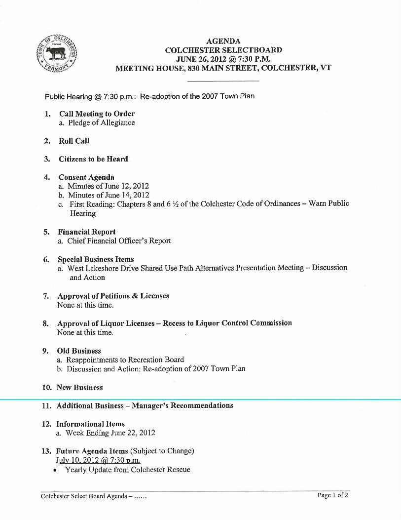


1. CALL TO ORDER
Chairman Paquette called the meeting to order at 7:52 p.m. after the Public Hearing adjourned. The Pledge of Allegiance was recited.
2. ROLL CALL
SELECTBOARD: L. Richard Paquette, Marc Landry, Nadine Scibek, Herbert Downing and Kathrine Niquette.
ABSENT: ………. ADMINISTRATION: Al Voegele (Town Manager), Joan Boehm (Assistant Town Manager/CFO), Sarah Hadd (Planning and Zoning Director) and Bryan Osborne (Public Works Director).
3. CITIZENS TO BE HEARD
Inge Schaefer reminded everyone that there will be a meeting of the Historical Society on Wednesday, June 27th at 7:00 p.m. in the Historical Society Building to discuss the 250th Anniversary of Colchester.
Doug Mulac mentioned the Costco permit for the gas station and the companies opposing it. His concern was that Colchester is losing businesses, siting My Web Grocer and Charlebois. He felt we needed to start looking to bring business in and retain the ones we have.
4. CONSENT AGENDA
a. Minutes of June 12, 2012 b. Minutes of June 14, 2012 MOTION was made by Nadine Scibek and SECONDED by Kathrine Niquette to accept the minutes of June 12 and June 14, 2012 with the following corrections: Minutes of June 12th: Page 3, agenda item 6b, 2nd paragraph: replace ‘Fire District #2’ with ‘Fire District #3’; Page 4, Agenda Item #12: insert ‘building’ before ‘permits’; Page 4, Agenda Item #15: Place ‘.’ After ‘Police Department’.
The MOTION carried 4-0. c. First Reading: Chapters 8 and 6 ½ of the Colchester Code of Ordinances – Warn Public Hearing Sarah Hadd reported there was discussion on the fee schedule at an earlier Selectboard meeting and the changes brought before the Board tonight was the result. The Board questioned, what effect changes would have on revenue, the goal of the change in fees, Green Mountain Power being exempt from these fees, Exemption of 1-5 and 22
MINUTES COLCHESTER SELECTBOARD MEETING
JUNE 26, 2012 @ 7:30 p.m.
MEETING HOUSE, 830 MAIN STREET, COLCHESTER, VT _____________________________

COLCHESTER SELECT BOARD – …… Page 2
plus of the State rules, comparison with other Towns, 2% surcharge on credit/debit cards and sandwich board fees. The Board recommended that Ms. Hadd bring to the Board a comparison of recent building types to show what the old fee was verses the new fee. Also, to use Burlington’s new building permit fee of $8.50 per 1,000 square feet on the same. A correction was made to page 6 of 10 to replace ‘.$15’ with ‘$.15’. MOTION was made by Nadine Scibek and SECONDED by Kathrine Niquette to warn a public hearing on July 24, 2012 at the Colchester Meeting House on Main Street for proposed changes to Chapter’s 6 ½ and 8 of the Code of Ordinances. The MOTION carried 4-0.
5. FINANCIAL REPORT a. Chief Financial Officer’s Report
Joan Boehm reported that she projected the year will end with a deficit of $540,000. This was mostly due to a decrease in tax revenues due to appeals, the auditors’ recommendation to keep liability money aside for the appeals, and the Green Mountain Power Appeal. The Town is at 92% of the year and revenues are at 86% of where they should be at this time of year and expenditures are at 87%. She explained the areas below and above the projected revenues and expenditures. Reviewing the Trends Report for the month of May, there was $160,000 less revenue than last May and she reviewed each revenue line in the report.
Looking at other funds, the Police and Reserve Funds had higher expenditures. Parks and Recreation covered 73% of expenses, Department of Public Works 70% and the other departments are at 55%. The final figures for the year won’t be available for a couple of months but she expects a $540,000 loss.
The Board questioned CUSI payment, where the Police Station Building Funds show in the
report and how much had been spent on the Police Station. 6. SPECIAL BUSINESS a. West Lakeshore Drive Shared Use Path Alternatives Presentation Meeting – Discussion
and Action Bryan Osborne explained the process of how the current alternatives were arrived at,
including a Local Concerns Meeting held June 14, 2011. He was requesting that the Board vote on which alternative they preferred tonight. Their approval is needed in order to move forward applications for Federal and State funds to pay for a large part of the project. Even with the approval it could be several years before it would begin. CCMPO has paid for the work that went into the project so far.
John Leinwohl of Stantec Engineering hired as a consulting firm by the CCMPO presented
information on the path. He reviewed a map showing the North Side and South Side alternatives. The North Side has issues including an historic site needing permitting, 2 wetlands, the need for a retaining wall and fill, a home close to the road, Rozzi’s traffic and the need for a crossing. The South Side Alternative had issues including a lot of properties being affected, fill needed for an intermittent stream, the cost in trying to minimize the impact and deep ditches. He reviewed an Evaluation Matrix showing impacts, safety, permits and project cost. The South Side showed to be less expensive with fewer impacts.
COLCHESTER SELECT BOARD – …… Page 3
Questions from the public included the impact of tree clearing on the South Side, cost of
the retaining wall, concern for safe crossing, lowering the speed limit, risk of crossing driveways on the south side, impact of properties being effected being downplayed, dangerous Prim Road intersection, having the path stay on the same side as the existing path, consider building a wide shoulder instead of path, and how close easements come to properties.
The Board questioned if permits were figured into cost, if issues brought up tonight would
be considered in design phase, cost of an archaeological study, the average of property taking on South Side, and R.O.W.’s. Mr. Osborne believed either alternative would work but his professional opinion was the South Side Alternative was the better alternative and gave his reasons.
MOTION was made by Herbert Downing and SECONDED by Marc Landry to
approve the South Side Alternative from the West Lakeshore Drive Shared Use Path Alternatives Presentation.
Board members gave reasons for the alternative they chose. The MOTION carried 3-1 (Kathrine Niquette opposed). 7. APPROVAL OF PETITIONS & LICENSES
There were no petitions or licenses for approval.
8. APPROVAL OF LIQUOR LICENSES – Recess to Liquor Control Board. There were no Liquor Licenses for approval. 9. OLD BUSINESS a. Reappointments to Recreation Board
MOTION was made by Nadine Scibek and SECONDED by Herbert Downing to reappoint Dick Pecor, Buddy Marceau, Linda Lovell and Kevin Hatin to the Recreation Advisory Board for a period of 2 years to end on June 30, 2014. The MOTION carried 4-0. b. Discussion and Action: Re-adoption of 2007 Town Plan MOTION was made by Nadine Scibek to approve re-adoption of the 2007 Town Plan. Nadine asked if the motion should have a date. Discussion occurred with no SECOND to the MOTION. Discussion included Regional Planning just approving the 2007 Town Plan for a 5-year period, the warning being incorrect, extending it for 6 months or 5 years and why the need to have a date in the motion. Nadine Scibek amended her MOTION: MOTION was made by Nadine Scibek and SECONDED by Herbert Downing to approve re-adoption of the 2007 Town Plan until January 13, 2013. Discussion included a concern to go with 5 years as the Regional Planning Commission just approved and what happens if there is no Town Plan by January 13, 2013. Two members stated they would not vote for the amended motion.
Nadine made a new MOTION:

COLCHESTER SELECT BOARD – …… Page 4
MOTION was made by Nadine Scibek and SECONDED by Herbert Downing to approve re-adoption of the 2007 Town Plan for 5 years.
The MOTION carried 4-0.
MOTION was made by Marc Landry and SECONDED by Kathrine Niquette to require amendment to the just readopted Town Plan no later than January 13, 2013 to incorporate Chapters and revisions offered by the Planning Commission.
The MOTION carried 4-0. Discussion occurred on who would be responsible for getting the Economic Development portion complete for the Town Plan to have it complete by the January 13th deadline. Other Old Business Nadine Scibek referred to the most recent letter forwarded to the Board regarding the State’s response on the drop-off, which she believed showed their openness to the project if it could be done in conjunction with the park and ride. The Board suggested that Mr. Voegele set up a meeting with CSWD, VTrans, Ms. Scibek and Mr. Downing to discuss it. Mr. Voegele was also appointed to write a letter to Tom Moreau authorizing CSWD’s involvement with VTrans and the Town on this project.
10. NEW BUSINESS Kathrine Niquette requested that the Board re-appoint John Abry and Bill Peters to CEDAC, explaining that it was brought up during the CEDAC meeting she attended on June 21st. MOTION was made by Kathrine Niquette and SECONDED by Marc Landry to re-appoint John Abry and Bill Peters to the Community and Economic Development Advisory Counsel for a period of 2 years. The MOTION carried 4-0. Discussion included the role of CEDAC, the Economic Development position, the possibility of CCDC and CEDAC working together, more networking needed, and who was doing the work to assist businesses. There was also discussion on the Green Mountain Power appeal and possible action against Vision Reappraisal. This will be brought back to the Board in July when there is more information.
11. ADDITIONAL BUSINESS – MANAGER’S RECOMMENDATIONS Mr. Voegele reported that the Board approved an increase of 1 ½ cents for the FY’14 Budget and even with that, the budget will need to be cut by $250,000. He and Ms. Boehm are working on a survey to send to random residents to get their thoughts on where reductions should be made. There are also four people helping to construct the FY’14 Budget: Bob Campbell, Matthew Granai, Emily Stebbins-Wheelock and Melissa Young. Mr. Voegele reported that the University of Vermont was still requesting the Town put up the Road at So. Park Drive. He would be setting up a meeting to have them speak to the Selectboard.
12. INFORMATIONAL ITEMS
a. Week Ending March 23, 2013

COLCHESTER SELECT BOARD – …… Page 5
There were no comments made. 13. FUTURE AGENDA ITEMS
July 10, 2012 @ 7:30 p.m. • Yearly Update from Colchester Rescue
14. ANNOUNCEMENTS
Al Voegele and Kathrine Niquette will have a monthly program called “Straight Talk’. The first one is being edited now. There will be a DVD presentation of ‘Postcards of Colchester’ produced by Tom Mulcahy on Thursday, June 28th, 4:30 p.m. at the School House at Airport Park.
15. APPROVAL OF WARRANTS
a. Warrant # 12-36 MOTION was made by Marc Landry and SECONDED by Herbert Downing, to approve Warrant #12-36 in the amount of $342,470.47. The Board questioned iPad expenses, out-of-state training, legal bills, office walls for Recreation Department, picnic tables, payment to So. Burlington Fire Department, and Police Department supplies. The MOTION carried 4-0.
16. EXECUTIVE SESSION There was no executive session called. 17. ADJOURNMENT
MOTION was made by Herbert Downing and SECONDED by Nadine Scibek, to adjourn the meeting. The MOTION carried 4-0.
The meeting was adjourned at 11:52 p.m. Minutes respectfully submitted by June Campbell, Recording Secretary.
COLCHESTER SELECT BOARD – …… Page 6
SIGNATURE PAGE:
These minutes of June 26, 2012 were approved on July 10, 2012.
COLCHESTER SELECTBOARD: __________________________________ ___________________________________ L. Richard Paquette Marc Landry __________________________________ ___________________________________ Nadine Scibek Herbert J. Downing
__________________________________ Kathrine R. Niquette

APPENDIX B
Archaeological Report

ARCHEOLOGICAL RESOURCE AND HISTORIC PRESERVATION ASSESSMENT Colchester Shared Use Path Project West Lakeshore Drive, between Church Road and Prim Road Town of Colchester Chittenden County, Vermont HAA # V556-11 Submitted to: Jon Leinwohl Stantec 55 Green Mountain Drive South Burlington, Vermont 05403 Prepared by: Hartgen Archeological Associates, Inc. PO Box 81 Putney, Vermont 05346 p +1 802 387 6020 f +1 802 387 8524 e [email protected] www.hartgen.com An ACRA Member Firm www.acra-crm.org June 2011
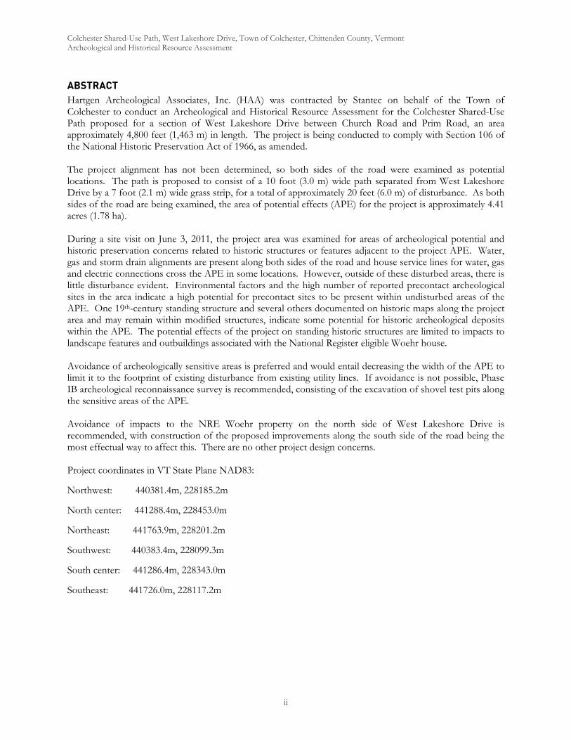
Colchester Shared-Use Path, West Lakeshore Drive, Town of Colchester, Chittenden County, Vermont Archeological and Historical Resource Assessment
ii
ABSTRACT Hartgen Archeological Associates, Inc. (HAA) was contracted by Stantec on behalf of the Town of Colchester to conduct an Archeological and Historical Resource Assessment for the Colchester Shared-Use Path proposed for a section of West Lakeshore Drive between Church Road and Prim Road, an area approximately 4,800 feet (1,463 m) in length. The project is being conducted to comply with Section 106 of the National Historic Preservation Act of 1966, as amended. The project alignment has not been determined, so both sides of the road were examined as potential locations. The path is proposed to consist of a 10 foot (3.0 m) wide path separated from West Lakeshore Drive by a 7 foot (2.1 m) wide grass strip, for a total of approximately 20 feet (6.0 m) of disturbance. As both sides of the road are being examined, the area of potential effects (APE) for the project is approximately 4.41 acres (1.78 ha). During a site visit on June 3, 2011, the project area was examined for areas of archeological potential and historic preservation concerns related to historic structures or features adjacent to the project APE. Water, gas and storm drain alignments are present along both sides of the road and house service lines for water, gas and electric connections cross the APE in some locations. However, outside of these disturbed areas, there is little disturbance evident. Environmental factors and the high number of reported precontact archeological sites in the area indicate a high potential for precontact sites to be present within undisturbed areas of the APE. One 19th-century standing structure and several others documented on historic maps along the project area and may remain within modified structures, indicate some potential for historic archeological deposits within the APE. The potential effects of the project on standing historic structures are limited to impacts to landscape features and outbuildings associated with the National Register eligible Woehr house. Avoidance of archeologically sensitive areas is preferred and would entail decreasing the width of the APE to limit it to the footprint of existing disturbance from existing utility lines. If avoidance is not possible, Phase IB archeological reconnaissance survey is recommended, consisting of the excavation of shovel test pits along the sensitive areas of the APE. Avoidance of impacts to the NRE Woehr property on the north side of West Lakeshore Drive is recommended, with construction of the proposed improvements along the south side of the road being the most effectual way to affect this. There are no other project design concerns. Project coordinates in VT State Plane NAD83:
Northwest: 440381.4m, 228185.2m
North center: 441288.4m, 228453.0m
Northeast: 441763.9m, 228201.2m
Southwest: 440383.4m, 228099.3m
South center: 441286.4m, 228343.0m
Southeast: 441726.0m, 228117.2m
Colchester Shared-Use Path, West Lakeshore Drive, Town of Colchester, Chittenden County, Vermont Archeological and Historical Resource Assessment
ii
TABLE of CONTENTS
Management Summary and Recommendations............................................................................................................. 1 Introduction......................................................................................................................................................................... 1 Project Information............................................................................................................................................................ 1
Description of the Area of Potential Effects (APE)................................................................................................ 1 Research Design.................................................................................................................................................................. 1 Environmental Background .............................................................................................................................................. 5
Present Land Use and Current Conditions................................................................................................................ 5 Soils .................................................................................................................................................................................. 5 Bedrock Geology ........................................................................................................................................................... 5 Physiography and Hydrology....................................................................................................................................... 5
Documentary Research...................................................................................................................................................... 7 Archeological Sites......................................................................................................................................................... 7 State and National Register .......................................................................................................................................... 7 Previous Surveys ............................................................................................................................................................ 9
Historical Map Review....................................................................................................................................................... 9 Architectural Discussion.................................................................................................................................................. 13
Sidewalks and curbs..................................................................................................................................................... 14 Street Furniture and Retaining Walls ........................................................................................................................ 14 Historic Plantings and Landscape Features ............................................................................................................. 14
Archeological Sensitivity Assessment ............................................................................................................................ 17 Precontact Archeological Sensitivity......................................................................................................................... 17 Historic Archeological Sensitivity ............................................................................................................................. 17
Archeological Potential .................................................................................................................................................... 18 Recommendations ............................................................................................................................................................ 18 Bibliography....................................................................................................................................................................... 19 APPENDIX I: VDHP Environmental Predictive Model
APPENDIX II: Vermont ArcheoMap
Map List
Map 1. Project Location ................................................................................................................................................... 2 Map 2A. Project Area, West Half ................................................................................................................................... 3 Map 2B. Project Area, East Half …………………………………………………………………………...4 Map 3. Project area in 1857............................................................................................................................................ 10 Map 4. Project area in 1869............................................................................................................................................ 11 Map 5. Project area in 1915............................................................................................................................................ 12 Map 6. Project area in 1948............................................................................................................................................. 13
Photograph List
Photo 1. West end of APE. Note berm on the left and residential subdivision and ............................................ 6 Photo 2. Fill slope along the north side of the APE between the Malletts Bay Congregational Church............ 6 Photo 3. Structure 19A, modified c. 1850 house at Sharrow Circle. View to the southwest............................. 14 Photo 4. Typical residences along the south side of the APE (Structures 11 and 12 – right and left).............. 15 Photo 5. Woehr House (c. 1845; SR 0404-02) at west end of the APE. View to the northeast. ...................... 15
Colchester Shared-Use Path, West Lakeshore Drive, Town of Colchester, Chittenden County, Vermont Archeological and Historical Resource Assessment
iii
Photo 6. Woehr House and outbuilding. Note small shed and hedges along the project APE. ....................... 16 Photo 7. Woehr House, detail of shed and hedges along project APE. View to the west/northwest............. 16 Photo 8. Small drainage located between Structure 16 and 17. View to the southwest...................................... 17
Table List
Table 1. Soils in Project Area............................................................................................................................................ 5 Table 2. VAI Archeological Sites within One Mile (1.6 km) of the Project Area .................................................... 7 Table 3. NR/NRE Properties and Inventoried Buildings within or Adjacent (<200ft) to the Project Area ...... 7 Table 4. Previously Unsurveyed Properties Adjacent to the Project Area ............................................................... 8

Colchester Shared-Use Path, West Lakeshore Drive, Town of Colchester, Chittenden County, Vermont Archeological and Historical Resource Assessment
1
ARCHEOLOGICAL AND HISTORICAL RESOURCE ASSESSMENT
MANAGEMENT SUMMARY AND RECOMMENDATIONS
The archeological and historical resource assessment for the Colchester Shared-Use Path project identified much of the project area of potential effects (APE) as sensitive for archeological deposits. Avoidance of these areas is preferred. Avoidance might be accomplished through narrowing of the APE to areas immediately adjacent to the roadside. If sensitive areas can not be avoided Phase IB archeological reconnaissance survey is recommended. Such survey would consist of the excavation of shovel test pits in sensitive areas within the APE.
Historic preservation concerns for the project are limited to impacts to the National Register eligible (NRE) Woehr house. Construction of the sidewalk on the north side of the road would adversely impact the property by the probable removal of one of the outbuildings, as well as removal of significant landscape elements associated with it. Selection of the south side of the road for the site of the proposed improvements would avoid these impacts.
INTRODUCTION
Hartgen Archeological Associates, Inc. (HAA) was retained by Stantec to conduct an Archeological and Historical Resource Assessment for the proposed Colchester Shared Use Pathway located on West Lakeshore Drive in the Town of Colchester, Chittenden County, Vermont. The lead agency for this project is the Chittenden County Metropolitan Planning Organization (CCMPO). This review and sensitivity assessment was conducted to comply with Section 106 of the National Historic Preservation Act. The investigation was conducted according to the Vermont State Historic Preservation Office’s Guidelines for Conducting Archeology in Vermont (2002).
PROJECT INFORMATION
A site visit was conducted by project director Thomas R. Jamison on June 3, 2011 to observe and photograph existing conditions within the project area. The information gathered during the site visit is included in the relevant sections of this report.
Description of the Area of Potential Effects (APE)
The area of potential effects (APE) includes all portions of the property that will be directly or indirectly altered by the proposed undertaking. The project area is located along West Lakeshore Drive between Church Road on the west and Prim Road on the east, a corridor approximately 1463 meters (4800 ft) long (Maps 1, 2A and 2B). The project is expected to consist of construction of a 10 foot (3.0 m) wide shared use path separated from West Lakeshore Drive by a 7 foot (2.1 m) wide grass strip, for a total of approximately 20 feet (6 m) width of project disturbance. The project may require moving utility lines and construction of drainage features. It is unknown at this time which side of the road the path will be placed. Therefore, both sides have been examined. The APE is centered on West Lakeshore Drive and encompasses approximately 4.41 acres (1.78 ha).
RESEARCH DESIGN
The project objectives are to identify areas of archeological sensitivity based on environmental factors, known site information and historical information for the project APE and the general vicinity as appropriate. In addition, standing structures adjacent to the APE were examined to identify historic structures and possible effects of the project on those structures.
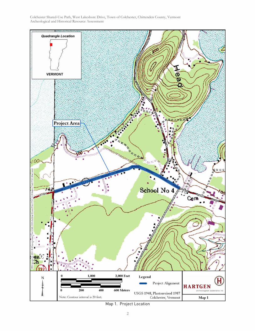
Colchester Shared-Use Path, West Lakeshore Drive, Town of Colchester, Chittenden County, Vermont Archeological and Historical Resource Assessment
2
Map 1. Project Location

Colchester Shared-Use Path, West Lakeshore Drive, Town of Colchester, Chittenden County, Vermont Archeological and Historical Resource Assessment

Colchester Shared-Use Path, West Lakeshore Drive, Town of Colchester, Chittenden County, Vermont Archeological and Historical Resource Assessment
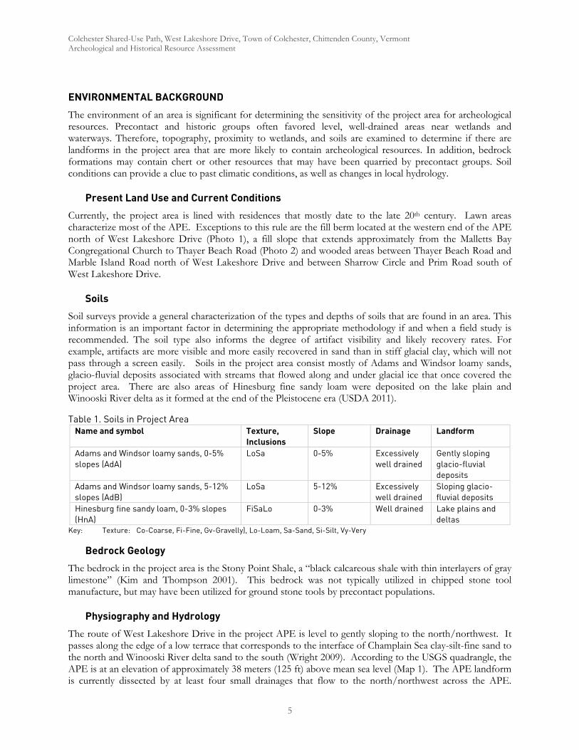
Colchester Shared-Use Path, West Lakeshore Drive, Town of Colchester, Chittenden County, Vermont Archeological and Historical Resource Assessment
5
ENVIRONMENTAL BACKGROUND
The environment of an area is significant for determining the sensitivity of the project area for archeological resources. Precontact and historic groups often favored level, well-drained areas near wetlands and waterways. Therefore, topography, proximity to wetlands, and soils are examined to determine if there are landforms in the project area that are more likely to contain archeological resources. In addition, bedrock formations may contain chert or other resources that may have been quarried by precontact groups. Soil conditions can provide a clue to past climatic conditions, as well as changes in local hydrology.
Present Land Use and Current Conditions
Currently, the project area is lined with residences that mostly date to the late 20th century. Lawn areas characterize most of the APE. Exceptions to this rule are the fill berm located at the western end of the APE north of West Lakeshore Drive (Photo 1), a fill slope that extends approximately from the Malletts Bay Congregational Church to Thayer Beach Road (Photo 2) and wooded areas between Thayer Beach Road and Marble Island Road north of West Lakeshore Drive and between Sharrow Circle and Prim Road south of West Lakeshore Drive.
Soils
Soil surveys provide a general characterization of the types and depths of soils that are found in an area. This information is an important factor in determining the appropriate methodology if and when a field study is recommended. The soil type also informs the degree of artifact visibility and likely recovery rates. For example, artifacts are more visible and more easily recovered in sand than in stiff glacial clay, which will not pass through a screen easily. Soils in the project area consist mostly of Adams and Windsor loamy sands, glacio-fluvial deposits associated with streams that flowed along and under glacial ice that once covered the project area. There are also areas of Hinesburg fine sandy loam were deposited on the lake plain and Winooski River delta as it formed at the end of the Pleistocene era (USDA 2011).
Table 1. Soils in Project Area Name and symbol Texture,
Inclusions Slope Drainage Landform
Adams and Windsor loamy sands, 0-5% slopes (AdA)
LoSa
0-5% Excessively well drained
Gently sloping glacio-fluvial deposits
Adams and Windsor loamy sands, 5-12% slopes (AdB)
LoSa 5-12% Excessively well drained
Sloping glacio-fluvial deposits
Hinesburg fine sandy loam, 0-3% slopes (HnA)
FiSaLo 0-3% Well drained Lake plains and deltas
Key: Texture: Co-Coarse, Fi-Fine, Gv-Gravelly), Lo-Loam, Sa-Sand, Si-Silt, Vy-Very
Bedrock Geology
The bedrock in the project area is the Stony Point Shale, a “black calcareous shale with thin interlayers of gray limestone” (Kim and Thompson 2001). This bedrock was not typically utilized in chipped stone tool manufacture, but may have been utilized for ground stone tools by precontact populations.
Physiography and Hydrology
The route of West Lakeshore Drive in the project APE is level to gently sloping to the north/northwest. It passes along the edge of a low terrace that corresponds to the interface of Champlain Sea clay-silt-fine sand to the north and Winooski River delta sand to the south (Wright 2009). According to the USGS quadrangle, the APE is at an elevation of approximately 38 meters (125 ft) above mean sea level (Map 1). The APE landform is currently dissected by at least four small drainages that flow to the north/northwest across the APE.

Colchester Shared-Use Path, West Lakeshore Drive, Town of Colchester, Chittenden County, Vermont Archeological and Historical Resource Assessment
6
However, there may have been other small drainages in the past that have silted in with the agricultural use and development of the area during the past 250 years.
Photo 1. West end of APE. Note berm on the left and residential subdivision and Structure 2 on the right. View to the east.
Photo 2. Fill slope along the north side of the APE between the Malletts Bay Congregational Church and Thayer Beach Road. View to the east.

Colchester Shared-Use Path, West Lakeshore Drive, Town of Colchester, Chittenden County, Vermont Archeological and Historical Resource Assessment
7
DOCUMENTARY RESEARCH
Archeological Sites
Previously reported archeological sites provide an overview of both the types of sites that may be present in the project area and relation of sites throughout the surrounding region. The presence of few reported sites, however, may result from a lack of previous systematic survey and does not necessarily indicate a decreased archeological sensitivity within the project area.
An examination of the archeological site files at the Vermont Division for Historic Preservation (VDHP) identified fourteen reported archeological sites within one mile (1.6 km) of the project area (Table 2). Eleven of these sites are precontact ranging form the Late Archaic to the Late Woodland (approximately 850 BC to AD 1600). The three historic sites are shipwrecks under the waters of Malletts Bay. The Springlet Site (VT-CH-662) is located adjacent to the west end of the APE, north of West Lakeshore Road.
Table 2. VAI Archeological Sites within One Mile (1.6 km) of the Project Area VAI Site No. Site Identifier Description Proximity to
Project Area FS40 Coates Island Unknown precontact 0.87 mi to NE FS103 Coates Island Unknown precontact 0.28 mi to NE VT-CH-41 P. Lagues Late Woodland, projectile point, ceramics 1.0 mi to S VT-CH-72 Smith Late Archaic, Middle to Late Woodland, projectile
points, flakes, tools 0.85 mi to W
VT-CH-200 Unknown precontact 0.95 mi to SE VT-CH-248 Sample Area YAB Middle to Late Woodland, ceramics, hearth 0.93 mi to SE VT-CH-540 Archaic, atlatl weight 0.95 mi to E/SE VT-CH-662 Springlet Terminal Archaic 300 ft to N VT-CH-729 Middle Woodland, projectile points, ceramics, flakes 0.46 mi to W VT-CH-919 Wreck VVV Ferry Plattsburgh 0.4 mi to E VT-CH-924 Wreck EEE 1940s-50s power boat 0.83 mi to E VT-CH-926 Wreck KKK Modern power boat 0.81 mi to E/NE VT-CH-942 Norbert Middle to Late Woodland, lithics, ceramics, bone, FCR 0.6 mi to E/SE VT-CH-943 Shore Acres Middle to Late Woodland, lithics, ceramics, bone, FCR 0.45 mi to E/SE
State and National Register
A search of the Vermont Historic Sites and Structures Survey (VHSSS) and the National Register of Historic Places (NR) identified one VHSSS property adjacent to the project APE. The c. 1845 Woehr House (SR 0404-2) is located directly adjacent to the APE on the west end north of West Lakeshore Drive (Map 2A; Photos 1 and 2). This property consists of a middle 19th-century timber framed and brick veneered Greek Revival style house and several outbuildings. The next closest listed property is the 1914-1915 Holy Cross Church (SR 0404-1) located on Church Road southwest and out of sight of the APE. There are no National Register listed properties in the project vicinity.
Table 3. NR/NRE Properties and Inventoried Buildings within or Adjacent (<200ft) to the Project Area VHSSS Number
Property Name Status Description Location and Proximity to Project Area
0404-2 Woehr House NRE c. 1845 Greek Revival house with outbuildings
Directly adjacent to northwest end of APE

Colchester Shared-Use Path, West Lakeshore Drive, Town of Colchester, Chittenden County, Vermont Archeological and Historical Resource Assessment
8
Table 4 lists the properties along the APE that have not previously been surveyed for National Register eligibility. Brief descriptions and opinion of NR eligibility are included in the table. They are assigned arbitrary numbers in the table and on Maps 2A and 2B.
Table 4. Previously Unsurveyed Properties Adjacent to the Project Area Survey # (Maps 2A & 2B)
Property NRE Determination
Description Location (WLD=West Lakeshore Drive)
1 Not NRE c.1985 wood-framed ranch S side of WLD, immediately E of Church Rd
2 1821 West Lakeshore Drive
Not NRE c.1970s wood-framed raised ranch with later two story addition
S side of WLD, W end of APE
3 1799 West Lakeshore Drive
Not NRE c. 1970s wood-framed ranch S side of WLD, W end of APE
4 Not NRE c.1985 wood-framed cape with attached garage
S side of WLD, W end of APE
5 Not NRE c.1980 wood framed cape or classic cottage
S side of WLD, immediately W of Timberlake Dr
6 Not NRE Contemporary two-story wood-framed duplex, c.1990
S side of WLD, immediately E of Timberlake Dr
7 1647/1649 West Lakeshore Drive
Not NRE Contemporary two-story wood-framed duplex, c.1990
S side of WLD, W of Timberlake Dr
8 Not NRE Two-story wood-framed dwelling, likely incorporating late 19th or early 20th century structure
S side of WLD, W of Timberlake Dr
9 Not NRE c.1965 wood-framed split-level S side of WLD, immediately W of Turquoise Dr
10 Not NRE c.1960 wood-framed ranch S side of WLD, immediately E of Turquoise Dr
11 1495 West Lakeshore Drive
Not NRE c.1960 wood-framed ranch S side of WLD, E of Turquoise Dr
12 1478 West Lakeshore Drive
Not NRE c.1985 wood-framed raised ranch S side of WLD, E of Turquoise Dr
13 1447 West Lakeshore Drive
Not NRE c.1975 wood-framed raised ranch S side of WLD, E of Turquoise Dr
14 1431 West Lakeshore Drive
Not NRE c.1975 wood-framed raised ranch S side of WLD, E of Turquoise Dr
15 1407 West Lakeshore Drive
Not NRE c.1970 wood-framed ranch S side of WLD, E of Turquoise Dr
16 1388 West Lakeshore Drive
Not NRE c.1950 wood-framed cape with split stone façade
S side of WLD, E of Turquoise Dr
17 Structure demolished
S side of WLD, E of Turquoise Dr
18 Not NRE c.1980 cape S side of WLD, across from Thayer Beach Rd
19 Sharrow Circle Not NRE Mid-19th century two-story wood-framed house, with mid-20th century one-story wood-framed guest cottages
S side of WLD, between Thayer Beach Rd and Malletts Head Rd
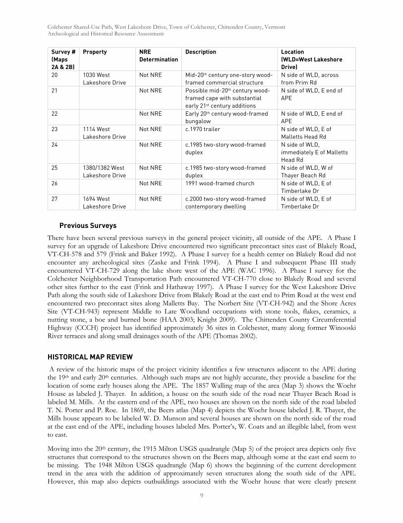
Colchester Shared-Use Path, West Lakeshore Drive, Town of Colchester, Chittenden County, Vermont Archeological and Historical Resource Assessment
9
Survey # (Maps 2A & 2B)
Property NRE Determination
Description Location (WLD=West Lakeshore Drive)
20 1030 West Lakeshore Drive
Not NRE Mid-20th century one-story wood-framed commercial structure
N side of WLD, across from Prim Rd
21 Not NRE Possible mid-20th century wood-framed cape with substantial early 21st century additions
N side of WLD, E end of APE
22 Not NRE Early 20th century wood-framed bungalow
N side of WLD, E end of APE
23 1114 West Lakeshore Drive
Not NRE c.1970 trailer N side of WLD, E of Malletts Head Rd
24 Not NRE c.1985 two-story wood-framed duplex
N side of WLD, immediately E of Malletts Head Rd
25 1380/1382 West Lakeshore Drive
Not NRE c.1985 two-story wood-framed duplex
N side of WLD, W of Thayer Beach Rd
26 Not NRE 1991 wood-framed church N side of WLD, E of Timberlake Dr
27 1694 West Lakeshore Drive
Not NRE c.2000 two-story wood-framed contemporary dwelling
N side of WLD, E of Timberlake Dr
Previous Surveys
There have been several previous surveys in the general project vicinity, all outside of the APE. A Phase I survey for an upgrade of Lakeshore Drive encountered two significant precontact sites east of Blakely Road, VT-CH-578 and 579 (Frink and Baker 1992). A Phase I survey for a health center on Blakely Road did not encounter any archeological sites (Zaske and Frink 1994). A Phase I and subsequent Phase III study encountered VT-CH-729 along the lake shore west of the APE (WAC 1996). A Phase I survey for the Colchester Neighborhood Transportation Path encountered VT-CH-770 close to Blakely Road and several other sites further to the east (Frink and Hathaway 1997). A Phase I survey for the West Lakeshore Drive Path along the south side of Lakeshore Drive from Blakely Road at the east end to Prim Road at the west end encountered two precontact sites along Malletts Bay. The Norbert Site (VT-CH-942) and the Shore Acres Site (VT-CH-943) represent Middle to Late Woodland occupations with stone tools, flakes, ceramics, a nutting stone, a hoe and burned bone (HAA 2003; Knight 2009). The Chittenden County Circumferential Highway (CCCH) project has identified approximately 36 sites in Colchester, many along former Winooski River terraces and along small drainages south of the APE (Thomas 2002).
HISTORICAL MAP REVIEW
A review of the historic maps of the project vicinity identifies a few structures adjacent to the APE during the 19th and early 20th centuries. Although such maps are not highly accurate, they provide a baseline for the location of some early houses along the APE. The 1857 Walling map of the area (Map 3) shows the Woehr House as labeled J. Thayer. In addition, a house on the south side of the road near Thayer Beach Road is labeled M. Mills. At the eastern end of the APE, two houses are shown on the north side of the road labeled T. N. Porter and P. Roe. In 1869, the Beers atlas (Map 4) depicts the Woehr house labeled J. R. Thayer, the Mills house appears to be labeled W. D. Munson and several houses are shown on the north side of the road at the east end of the APE, including houses labeled Mrs. Porter’s, W. Coats and an illegible label, from west to east.
Moving into the 20th century, the 1915 Milton USGS quadrangle (Map 5) of the project area depicts only five structures that correspond to the structures shown on the Beers map, although some at the east end seem to be missing. The 1948 Milton USGS quadrangle (Map 6) shows the beginning of the current development trend in the area with the addition of approximately seven structures along the south side of the APE. However, this map also depicts outbuildings associated with the Woehr house that were clearly present
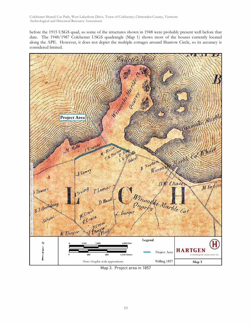
Colchester Shared-Use Path, West Lakeshore Drive, Town of Colchester, Chittenden County, Vermont Archeological and Historical Resource Assessment
10
before the 1915 USGS quad, so some of the structures shown in 1948 were probably present well before that date. The 1948/1987 Colchester USGS quadrangle (Map 1) shows most of the houses currently located along the APE. However, it does not depict the multiple cottages around Sharrow Circle, so its accuracy is considered limited.
Map 3. Project area in 1857

Colchester Shared-Use Path, West Lakeshore Drive, Town of Colchester, Chittenden County, Vermont Archeological and Historical Resource Assessment
11
Map 4. Project area in 1869
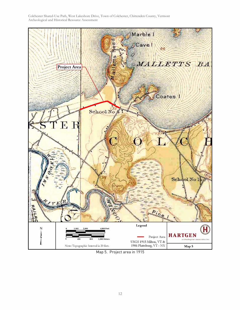
Colchester Shared-Use Path, West Lakeshore Drive, Town of Colchester, Chittenden County, Vermont Archeological and Historical Resource Assessment
12
Map 5. Project area in 1915

Colchester Shared-Use Path, West Lakeshore Drive, Town of Colchester, Chittenden County, Vermont Archeological and Historical Resource Assessment
13
Map 6. Project area in 1948
ARCHITECTURAL DISCUSSION
Although structures within the APE span the period c.1845 to the present, the overwhelming majority of them date to the late 20th century. A few of the houses in the APE may have initially been constructed in the 19th century, but have been substantially altered by subsequent additions. These include the house associated with the guest cabins at Sharrow Circle (Structure 19; Photo 3). With the exception of the Woehr house, none
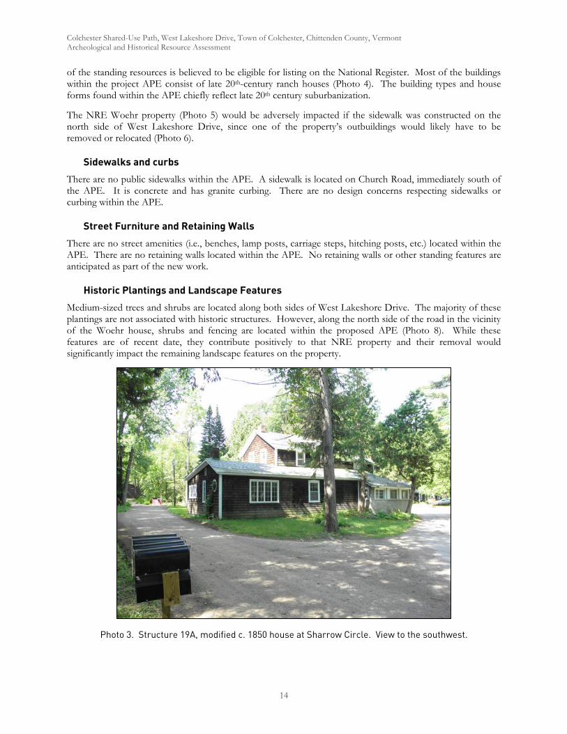
Colchester Shared-Use Path, West Lakeshore Drive, Town of Colchester, Chittenden County, Vermont Archeological and Historical Resource Assessment
14
of the standing resources is believed to be eligible for listing on the National Register. Most of the buildings within the project APE consist of late 20th-century ranch houses (Photo 4). The building types and house forms found within the APE chiefly reflect late 20th century suburbanization.
The NRE Woehr property (Photo 5) would be adversely impacted if the sidewalk was constructed on the north side of West Lakeshore Drive, since one of the property’s outbuildings would likely have to be removed or relocated (Photo 6).
Sidewalks and curbs
There are no public sidewalks within the APE. A sidewalk is located on Church Road, immediately south of the APE. It is concrete and has granite curbing. There are no design concerns respecting sidewalks or curbing within the APE.
Street Furniture and Retaining Walls
There are no street amenities (i.e., benches, lamp posts, carriage steps, hitching posts, etc.) located within the APE. There are no retaining walls located within the APE. No retaining walls or other standing features are anticipated as part of the new work.
Historic Plantings and Landscape Features
Medium-sized trees and shrubs are located along both sides of West Lakeshore Drive. The majority of these plantings are not associated with historic structures. However, along the north side of the road in the vicinity of the Woehr house, shrubs and fencing are located within the proposed APE (Photo 8). While these features are of recent date, they contribute positively to that NRE property and their removal would significantly impact the remaining landscape features on the property.
Photo 3. Structure 19A, modified c. 1850 house at Sharrow Circle. View to the southwest.
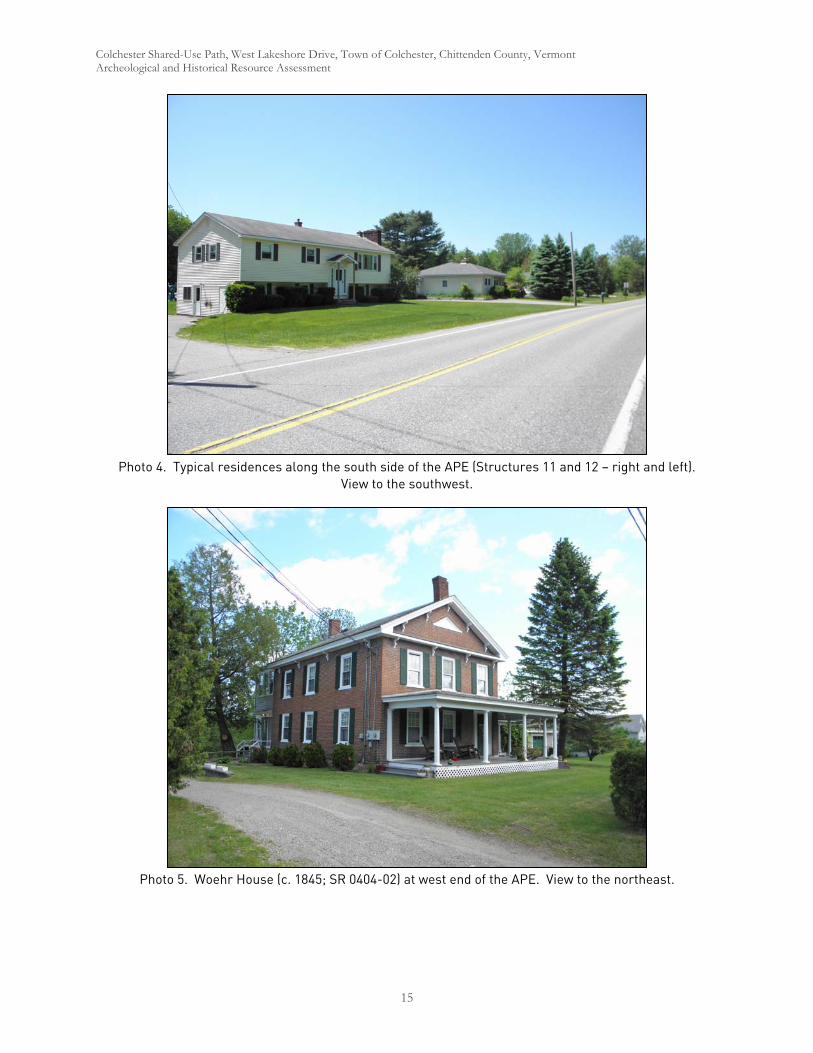
Colchester Shared-Use Path, West Lakeshore Drive, Town of Colchester, Chittenden County, Vermont Archeological and Historical Resource Assessment
15
Photo 4. Typical residences along the south side of the APE (Structures 11 and 12 – right and left). View to the southwest.
Photo 5. Woehr House (c. 1845; SR 0404-02) at west end of the APE. View to the northeast.

Colchester Shared-Use Path, West Lakeshore Drive, Town of Colchester, Chittenden County, Vermont Archeological and Historical Resource Assessment
16
Photo 6. Woehr House and outbuilding. Note small shed and hedges along the project APE. View to the northwest.
Photo 7. Woehr House, detail of shed and hedges along project APE. View to the west/northwest.
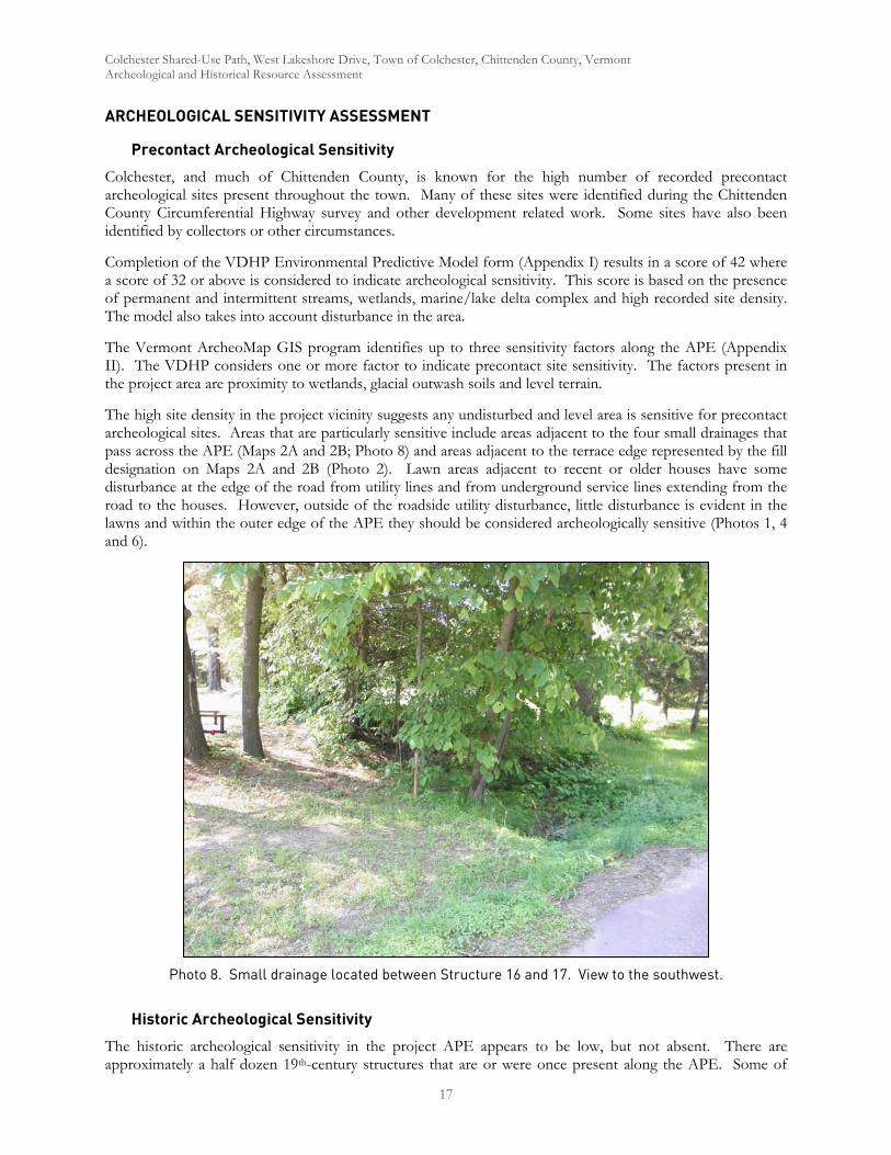
Colchester Shared-Use Path, West Lakeshore Drive, Town of Colchester, Chittenden County, Vermont Archeological and Historical Resource Assessment
17
ARCHEOLOGICAL SENSITIVITY ASSESSMENT
Precontact Archeological Sensitivity
Colchester, and much of Chittenden County, is known for the high number of recorded precontact archeological sites present throughout the town. Many of these sites were identified during the Chittenden County Circumferential Highway survey and other development related work. Some sites have also been identified by collectors or other circumstances.
Completion of the VDHP Environmental Predictive Model form (Appendix I) results in a score of 42 where a score of 32 or above is considered to indicate archeological sensitivity. This score is based on the presence of permanent and intermittent streams, wetlands, marine/lake delta complex and high recorded site density. The model also takes into account disturbance in the area.
The Vermont ArcheoMap GIS program identifies up to three sensitivity factors along the APE (Appendix II). The VDHP considers one or more factor to indicate precontact site sensitivity. The factors present in the project area are proximity to wetlands, glacial outwash soils and level terrain.
The high site density in the project vicinity suggests any undisturbed and level area is sensitive for precontact archeological sites. Areas that are particularly sensitive include areas adjacent to the four small drainages that pass across the APE (Maps 2A and 2B; Photo 8) and areas adjacent to the terrace edge represented by the fill designation on Maps 2A and 2B (Photo 2). Lawn areas adjacent to recent or older houses have some disturbance at the edge of the road from utility lines and from underground service lines extending from the road to the houses. However, outside of the roadside utility disturbance, little disturbance is evident in the lawns and within the outer edge of the APE they should be considered archeologically sensitive (Photos 1, 4 and 6).
Photo 8. Small drainage located between Structure 16 and 17. View to the southwest.
Historic Archeological Sensitivity
The historic archeological sensitivity in the project APE appears to be low, but not absent. There are approximately a half dozen 19th-century structures that are or were once present along the APE. Some of

Colchester Shared-Use Path, West Lakeshore Drive, Town of Colchester, Chittenden County, Vermont Archeological and Historical Resource Assessment
18
these structures may be standing, but are hidden by recent renovations. In those cases, the historic archeological potential associated with those renovated structures may still remain in the adjacent yard areas. However, the APE is restricted within approximately 20 feet (6 m) of the edge of pavement. Although there is some potential for early structures to have been located between the existing standing structures and the road, historic deposits along the road are more likely to consist of sheet middens associated with the occupations or roadside debris, rather than work areas that would retain significant deposits. The case of the Woehr House is an exception with the small shed located so close to the roadside (Photo 7).
ARCHEOLOGICAL POTENTIAL
The archeological potential of the project APE can be considered in two zones, immediately adjacent to the road and on the outside edges of the APE. Immediately along the roadside, there is substantial disturbance from a variety of utility alignments. These disturbances are primarily from a water line on the south side of the road and a gas line on the north side. In addition, there are a number of drop inlets and ditches along the APE indicating storm sewer infrastructure. Buried electric, water and gas services also cross the APE periodically. Despite these disturbances, much of the lawn areas outside of the roadside utility alignments are considered to have potential for archeological deposits.
RECOMMENDATIONS
Undisturbed areas in the project APE have a high potential for intact archeological deposits. Most of this potential relates to precontact occupation of the area. However, several 19th-century houses were located along the project APE and historic deposits associated with those structures, standing or not, may remain within the APE. The project APE extends approximately 20 feet (6 m) from the edge of the pavement, outside of the disturbance from roadside utility alignments. Avoidance of sensitive areas could be accomplished by narrowing the APE to coincide with the existing disturbance of the water, gas and storm drain lines along the APE. If that is not possible, Phase IB archeological reconnaissance survey is recommended.
Historic preservation concerns for the project are limited to impacts to the National Register eligible Woehr House and associated outbuildings and landscape features. Construction of the sidewalk on the north side of the road would adversely impact the property by the probable removal of one of the outbuildings, as well as removal of significant landscape elements associated with it. Selection of the south side of the road for the site of the proposed improvements would avoid these impacts.
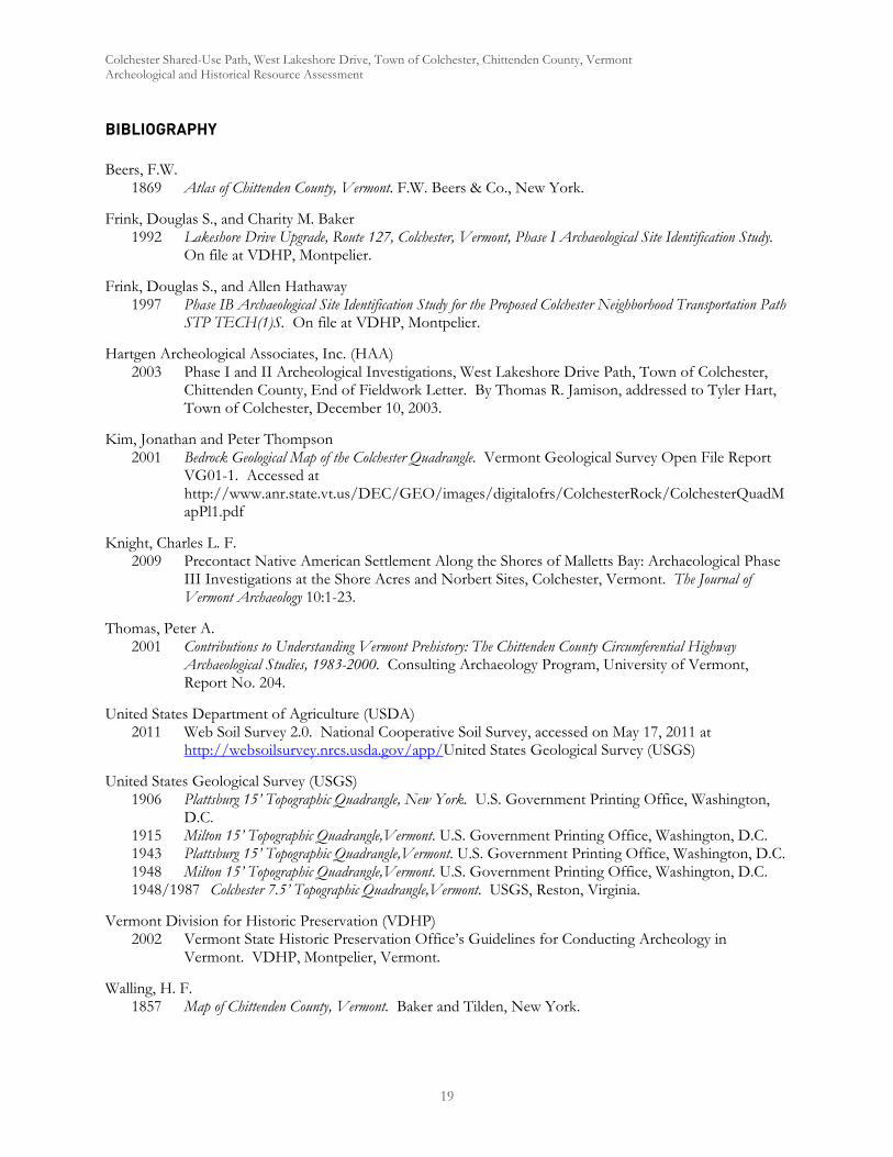
Colchester Shared-Use Path, West Lakeshore Drive, Town of Colchester, Chittenden County, Vermont Archeological and Historical Resource Assessment
19
BIBLIOGRAPHY
Beers, F.W. 1869 Atlas of Chittenden County, Vermont. F.W. Beers & Co., New York.
Frink, Douglas S., and Charity M. Baker 1992 Lakeshore Drive Upgrade, Route 127, Colchester, Vermont, Phase I Archaeological Site Identification Study.
On file at VDHP, Montpelier.
Frink, Douglas S., and Allen Hathaway 1997 Phase IB Archaeological Site Identification Study for the Proposed Colchester Neighborhood Transportation Path
STP TECH(1)S. On file at VDHP, Montpelier.
Hartgen Archeological Associates, Inc. (HAA) 2003 Phase I and II Archeological Investigations, West Lakeshore Drive Path, Town of Colchester,
Chittenden County, End of Fieldwork Letter. By Thomas R. Jamison, addressed to Tyler Hart, Town of Colchester, December 10, 2003.
Kim, Jonathan and Peter Thompson 2001 Bedrock Geological Map of the Colchester Quadrangle. Vermont Geological Survey Open File Report
VG01-1. Accessed at http://www.anr.state.vt.us/DEC/GEO/images/digitalofrs/ColchesterRock/ColchesterQuadMapPl1.pdf
Knight, Charles L. F. 2009 Precontact Native American Settlement Along the Shores of Malletts Bay: Archaeological Phase
III Investigations at the Shore Acres and Norbert Sites, Colchester, Vermont. The Journal of Vermont Archaeology 10:1-23.
Thomas, Peter A. 2001 Contributions to Understanding Vermont Prehistory: The Chittenden County Circumferential Highway
Archaeological Studies, 1983-2000. Consulting Archaeology Program, University of Vermont, Report No. 204.
United States Department of Agriculture (USDA) 2011 Web Soil Survey 2.0. National Cooperative Soil Survey, accessed on May 17, 2011 at
http://websoilsurvey.nrcs.usda.gov/app/United States Geological Survey (USGS)
United States Geological Survey (USGS) 1906 Plattsburg 15’ Topographic Quadrangle, New York. U.S. Government Printing Office, Washington,
D.C. 1915 Milton 15’ Topographic Quadrangle,Vermont. U.S. Government Printing Office, Washington, D.C. 1943 Plattsburg 15’ Topographic Quadrangle,Vermont. U.S. Government Printing Office, Washington, D.C. 1948 Milton 15’ Topographic Quadrangle,Vermont. U.S. Government Printing Office, Washington, D.C. 1948/1987 Colchester 7.5’ Topographic Quadrangle,Vermont. USGS, Reston, Virginia.
Vermont Division for Historic Preservation (VDHP) 2002 Vermont State Historic Preservation Office’s Guidelines for Conducting Archeology in
Vermont. VDHP, Montpelier, Vermont.
Walling, H. F. 1857 Map of Chittenden County, Vermont. Baker and Tilden, New York.

Colchester Shared-Use Path, West Lakeshore Drive, Town of Colchester, Chittenden County, Vermont Archeological and Historical Resource Assessment
20
Werner Archaeological Consulting (WAC) 1996 Preliminary Discussion, Field Investigation Proposal, Appendix: Photographs, Phase III Data Recovery Study:
Hidden Lake Residential Subdivision, Lakeview Drive, Colchester, Vermont. On file at VDHP, Montpelier.
Wright, Stephen 2009 Surficial Geologic Map of the Colchester, Vermont 7.5 Minute Quadrangle. Vermont Geological Survey
Open File Report VG09-2. Accessed at http://www.anr.state.vt.us/DEC/GEO/images/digitalofrs/ColchesterSurf.pdf
Zaske, Frank and Douglas S. Frink 1994 University Health Center, Town of Colchester, Chittenden County, Vermont, Phase I Archaeological Site
Identification Study. On file at VDHP, Montpelier.
Colchester Shared-Use Path, West Lakeshore Drive, Town of Colchester, Chittenden County, Vermont Archeological and Historical Resource Assessment
APPENDIX I: VDHP Environmental Predictive Model

Vermont Division for Historic Preservation DHP#Archeological Resources Assessment Form Organization & Recorder: HAA. INC./T. Jamison
Date: 6/9/2011
ArcheoMapTool GIS Model
0–90 m 1290-180 m 60–90 m 1290-180 m 60–90 m 890-180 m 4
0–90 m 1290-180 m 60–90 m 890-180 m 40–90 m 890-180 m 40–90 m 890-180 m 4
8) Knoll or Swamp Island32 Layer 1: Proximity to Rivers and
Permanent Streams (0-180 m)
9) Stable Riverine Island 32 Layer 2: Proximity to Waterbodies (0-180 m)
0–90 m 1290-180 m 60–90 m 1290-180 m 6
0–90 m 1290-180 m 6
0–90 m 1290-180 m 6
Layer 4: Proximity to Stream-Waterbody Confluences (0-180 m)
Layer 3: Proximity to Wetlands (0-180 m)
6C. Wetlands
12) Lake Coves, Peninsulas, and Bayheads
Layer 2: Proximity to Waterbodies (0-180 m)
13) Proximity to Wetlands*
Field Inspection Comments
Variable
Layer 10: Floodplain Soils Presence
-
Layer 7: Proximity to Waterfalls (0-180 m)
12
1) Proximity to Rivers and Permanent Streams
3) Proximity to Permanent River/Stream Confluences
2) Proximity to Intermittent Streams
-
Layer 6: Proximity to River/Stream Confluences (0-180 m)
Layer 1: Proximity to Rivers and Permanent Streams (0-180 m)
12
6) Proximity to Heads of Drainages
B. Lakes and Ponds
10) Proximity to Pond or Lake
11) Proximity to Stream-Waterbody Confluences
7) Major Floodplain - Alluvial Terrace
Layer 2: Proximity to Waterbodies (0-180 m)
A. Rivers and Streams (Existing or relict)
Layer 5: Proximity to Heads of Permanent Drainages (0-300 m)
Envronmental Predictive Model
Variable Proximity Value Assigned Score
5) Proximity to Waterfalls
4) Proximity to Intermittent Stream Confluences
Archeological Resources Form Page 1 of 3 Revised 10/09/2006

ArcheoMapTool GIS Model Field Inspection Comments
Variable
Envronmental Predictive Model
Variable Proximity Value Assigned Score
14) Knoll or Swamp Island 32 Layer 3: Proximity to Wetlands (0-180 m)
15) High Elevated Landform (e.g. Knoll Top, Ridge Crest, Promontory) 12
See Landmarks (Info Layers) and Catchment layers (Water-related Layers)
16) Valley Edge Features (e.g. Kame Outwash Terrace) 12 Layer 9 Glacial Outwash and
Kame Terrace Soils
17) Marine/Lake Delta Complexes 12 12 Layer 9 Glacial Outwash and Kame Terrace Soils Presence
18) Champlain Sea or Glacial Lake Shore Line** 12 Layer 8: Paleo Lake Soils
Proximity (0-180 m)
19) Caves and Rockshelters 32 -
20) Natural Travel Corridors (e.g. Drainage Divides) 12
See Landmarks (Info Layers) and catchment layers (Water-related Layers)
0–90 m 890–180 m 4
0–90 m 890–180 m 4
23) Special Environmental or Natural Area~
0–180 m 32 -
24) High Likelihood of Burials 32 See VAI layer (Under Construction)
25) High Recorded Archeological Site Density 32 32 See VAI layer (Under
Construction)26) High likelihood of containing significant site based on recorded or archival data or oral tradition
32See VAI layer (Under Construction)
22) Potential or Apparent Prehistoric Quarry for Lithic Material Procurement
D) Valley edge and Glacial Landforms
E. Other Environmental Factors
See Soils with "M" parent material (Under Construction)
F. Other High Sensitivity Layers
21) Existing or Relict Springs -
Archeological Resources Form Page 2 of 3 Revised 10/09/2006
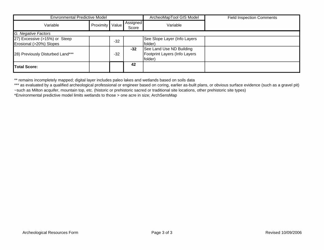
ArcheoMapTool GIS Model Field Inspection Comments
Variable
Envronmental Predictive Model
Variable Proximity Value Assigned Score
27) Excessive (>15%) or Steep Erosional (>20%) Slopes -32 See Slope Layer (Info Layers
folder)
28) Previously Disturbed Land*** -32-32 See Land Use ND Building
Footprint Layers (Info Layers folder)
** remains incompletely mapped; digital layer includes paleo lakes and wetlands based on soils data
~such as Milton acquifer, mountain top, etc. (historic or prehistoric sacred or traditional site locations, other prehistoric site types)*Environmental predictive model limits wetlands to those > one acre in size; ArchSensMap
42
*** as evaluated by a qualified archeological professional or engineer based on coring, earlier as-built plans, or obvious surface evidence (such as a gravel pit)
G. Negative Factors
Total Score:
Archeological Resources Form Page 3 of 3 Revised 10/09/2006
Colchester Shared-Use Path, West Lakeshore Drive, Town of Colchester, Chittenden County, Vermont Archeological and Historical Resource Assessment
APPENDIX II: Vermont ArcheoMap
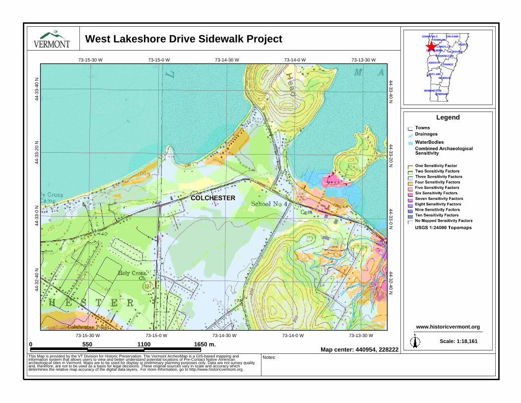
44-33-40 N44-3
3-40
N
44-32-40 N44-3
2-40
N
44-33-0 N44-3
3-0
N
44-33-20 N44-3
3-20
N
73-14-0 W
73-14-0 W
73-15-30 W
73-15-30 W
73-14-30 W
73-14-30 W
73-13-30 W
73-13-30 W
73-15-0 W
73-15-0 W
West Lakeshore Drive Sidewalk Project
0 550 1100 1650 m.
Legend
www.historicvermont.org
This Map is provided by the VT Division for Historic Preservation. The Vermont ArcheoMap is a GIS-based mapping andinformation system that allows users to view and better understand potential locations of Pre-Contact Native Americanarcheological sites in Vermont. Maps are to be used for display or preliminary planning purposes only. Data are not survey qualityand, therefore, are not to be used as a basis for legal decisions. These original sources vary in scale and accuracy whichdetermines the relative map accuracy of the digital data layers. For more information, go to http://www.historicvermont.org.
Notes:
Scale: 1:18,161
Map center: 440954, 228222
Related Documents