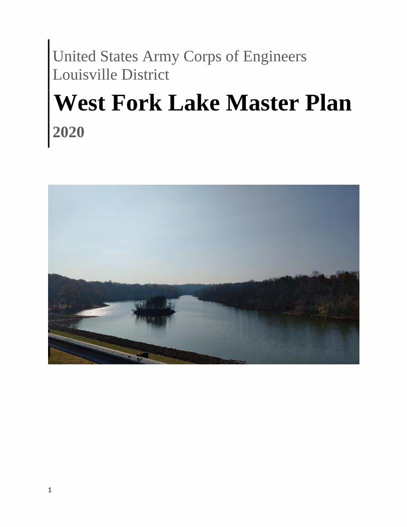
1 United States Army Corps of Engineers Louisville District West Fork Lake Master Plan 2020

Welcome message from author
This document is posted to help you gain knowledge. Please leave a comment to let me know what you think about it! Share it to your friends and learn new things together.
Transcript
1
United States Army Corps of Engineers
Louisville District
West Fork Lake Master Plan 2020
2
Master Plan
West Fork of Mill Creek Lake
Hamilton County, Ohio
PREFACE
Over the last several decades, public concern for environmental quality has remained a major issue.
Administering agencies are faced with the need for sound land management guidelines. It is vital that
planning and management efforts be directed toward the goal of optimum utilization of public lands and
that these efforts be based on sound environmental principles and a thorough knowledge of the
capabilities and limitations of the resources involved. It is important that the various aspects of land
management plans be reviewed and frequently updated, in order to provide an orderly progression of
ongoing management practices, based on the most recent information obtainable.
It is the purpose of this Master Plan to guide the comprehensive management and development of
recreational, natural, and cultural resources for West Fork of Mill Creek Lake, Hamilton County, Ohio.
The presently approved Master Plan, dated November 1979, is outdated.
This revision to the Master Plan was initiated to evaluate the present and future recreational demands
at the project in coordination with the Great Parks of Hamilton County. The lake and the lands
immediately surrounding the lake are owned by the U.S. Corps of Engineers. The park lands north of the
project are owned by Hamilton County. The Federal and County lands are known to the general public as
Winton Woods Park. With the exception of the golf course, group camping areas, and some trails,
recreation sites and associated development are located on project lands. It will be the goal of this
document to evaluate the recreational usage of West Fork Lake, evaluate Great Parks’ current
development at the lake and to outline a program of development for future management and facilities
development.
3
Table of Contents Chapter 1 - Introduction ............................................................................................................................... 7
1.1 Project Authorization .................................................................................................................... 7
1.2 Project Purpose ............................................................................................................................ 7
1.3 Purpose and Scope of Master Plan ............................................................................................. 8
1.4 Project Description ...................................................................................................................... 9
1.5 Listing of Prior DMs...................................................................................................................... 9
1.6 Listing of Pertinent Project Information .................................................................................. 10
Chapter 2 - Project Setting and Factors Influencing Management and Development ......................... 11
2.1 Description of Reservoir(s) and/or Navigation Pool(s) ........................................................... 11
2.2 Hydrology (surface water, groundwater) ................................................................................ 11
2.3 Sedimentation and Shoreline Erosion ..................................................................................... 11
2.4 Water Quality. ............................................................................................................................ 12
2.5 Project Access ............................................................................................................................ 14
2.6 Climate........................................................................................................................................ 14
2.7 Topography, Geology, and Soils ............................................................................................... 15
2.8 Resource Analysis (level 1 inventory data) .............................................................................. 15
2.8.1 Fish and Wildlife Resources ................................................................................................ 15
2.8.2 Vegetative Resources .......................................................................................................... 16
2.8.3 Threatened & Endangered Species ..................................................................................... 16
2.8.4 Invasive Species .................................................................................................................. 17
2.8.5 Ecological Setting ................................................................................................................ 18
2.8.6 Wetlands ............................................................................................................................. 18
2.9 Cultural Resources ...................................................................................................................... 19
2.9.1 Prehistoric Setting ............................................................................................................... 19
2.9.2 Historic Setting .................................................................................................................... 19
2.9.3 Previous Investigations at West Fork Lake ......................................................................... 21
2.9.4 Recorded Cultural Resources .............................................................................................. 21
2.9.5 Long-term Cultural Resources Objectives ........................................................................... 22
2.9.6 Implications of Historic Resources on Development .......................................................... 22
2.10 Demographics ............................................................................................................................. 22
2.11 Economics ................................................................................................................................... 23
4
2.12 Recreation Facilities, Activities, and Needs ................................................................................ 23
2.12.1 Zones of Influence ............................................................................................................... 23
2.12.2 Visitation Profile .................................................................................................................. 24
2.12.3 Recreation Analysis ............................................................................................................. 24
2.12.4 Recreational carrying capacity ............................................................................................ 24
2.13 Real Estate ................................................................................................................................... 24
2.13.1 Acquisition Authorization ................................................................................................... 24
2.13.2 Fee Lands ............................................................................................................................ 24
2.13.3 Licensed Lands .................................................................................................................... 25
2.13.4 Disposals ............................................................................................................................. 25
2.13.5 Outgrants ............................................................................................................................ 25
2.14 Pertinent Public Laws .................................................................................................................. 27
Chapter 3 - Resource Objectives ................................................................................................................. 29
3.1 Vision ........................................................................................................................................... 29
3.1.1 Goals.................................................................................................................................... 29
3.2 USACE Environmental Operating Principles: .............................................................................. 29
3.3 Resource Objectives: ................................................................................................................... 30
Chapter 4 - Land Allocation, Land Classification, Water Surface, and Project Easement Lands ................ 31
4.1 Land Allocation ............................................................................................................................ 31
4.2 Land Classification ....................................................................................................................... 31
4.2.1 Project Operations .............................................................................................................. 32
4.2.2 High Density Recreation ...................................................................................................... 32
4.2.3 Mitigation ............................................................................................................................ 33
4.2.4 Environmentally Sensitive Areas ......................................................................................... 33
4.2.5 Multiple Resource Management Lands .............................................................................. 33
4.2.6 Water Surface ..................................................................................................................... 34
4.2.7 Project Easement Lands ...................................................................................................... 35
Chapter 5 - Resource Plan ........................................................................................................................... 36
5.1 Classification and justification .................................................................................................... 36
5.1.1 Project Operations ..................................................................................................................... 36
5.1.2 High Density Recreation ............................................................................................................. 36
5.1.3 Environmentally Sensitive Areas (ESAs) ..................................................................................... 38
5.1.4 Multiple Resource Managed Lands ............................................................................................ 39
5
5.1.6 Mitigation ................................................................................................................................... 40
Chapter 6 - Special Topics/Issues/Considerations ...................................................................................... 41
Chapter 7 - Agency and Public Coordination .............................................................................................. 42
7.1 Agency Scoping Meeting ............................................................................................................. 42
7.2 Agency and Tribal Coordination .................................................................................................. 42
7.3 Public Meeting ............................................................................................................................ 42
Chapter 8 - Summary of Recommendations ............................................................................................... 43
8.1 Land Classifications ..................................................................................................................... 43
8.2 Improved Recreation .................................................................................................................. 43
8.3 Improve Water Quality ............................................................................................................... 43
8.4 Improved Communications ......................................................................................................... 43
8.5 Cultural and Natural Resources Protection ................................................................................ 44
Chapter 9 - Bibliography ............................................................................................................................. 45
6
List of Figures: Figure 1: West Fork Lake water quality monitoring sites (2018) Figure 2: Time series water temperature and dissolved oxygen data collected from the tailwater (2WFR10000)
List of Tables: Table 1: Flood Damage Benefits by Year for West Fork Lake of Mill Creek Table 2: Previously Issued Design Memoranda Table 3: Flood Pool Information Table 4: Trophic State Index score for each monitoring site Table 5: Wetlands within the Project Area
Table 6: Surrounding Populations Table 7: Federal Land Distribution Table 8: Land Classification Acres
Appendices: (A) NEPA documents (B) Summary of Public Comments (C) Other appendices as necessary (D) Plates (Project Maps/ Site Plans/ Tables)
7
Chapter 1 - Introduction
1.1 Project Authorization The West Fork of Mill Creek Lake Project (the “Project”) is a unit of the general comprehensive
flood control plan for the Ohio River Basin, adopted by the Flood Control Act approved 28 June
1938 (Public Law No. 761, 75th Congress, 3rd Session).
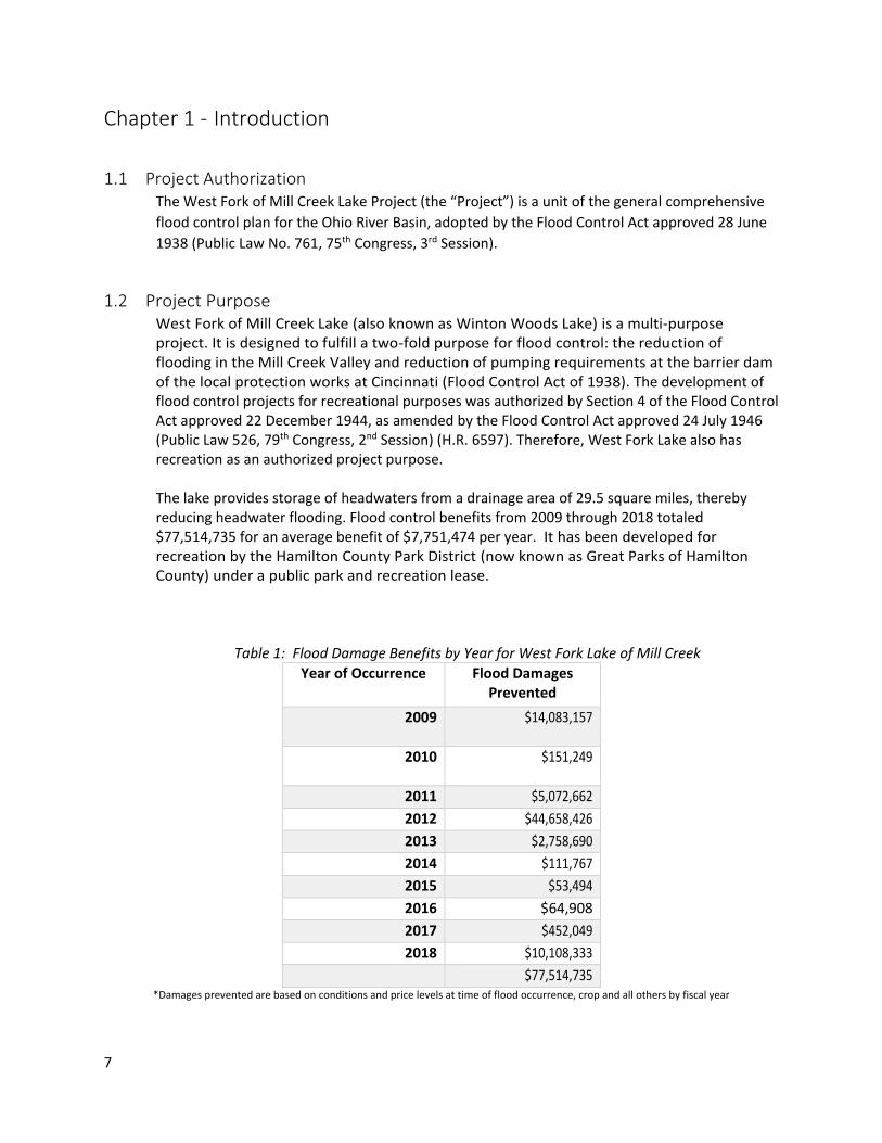
1.2 Project Purpose West Fork of Mill Creek Lake (also known as Winton Woods Lake) is a multi-purpose project. It is designed to fulfill a two-fold purpose for flood control: the reduction of flooding in the Mill Creek Valley and reduction of pumping requirements at the barrier dam of the local protection works at Cincinnati (Flood Control Act of 1938). The development of flood control projects for recreational purposes was authorized by Section 4 of the Flood Control Act approved 22 December 1944, as amended by the Flood Control Act approved 24 July 1946 (Public Law 526, 79th Congress, 2nd Session) (H.R. 6597). Therefore, West Fork Lake also has recreation as an authorized project purpose. The lake provides storage of headwaters from a drainage area of 29.5 square miles, thereby reducing headwater flooding. Flood control benefits from 2009 through 2018 totaled $77,514,735 for an average benefit of $7,751,474 per year. It has been developed for recreation by the Hamilton County Park District (now known as Great Parks of Hamilton County) under a public park and recreation lease.
Table 1: Flood Damage Benefits by Year for West Fork Lake of Mill Creek
Year of Occurrence Flood Damages Prevented
2009 $14,083,157
2010 $151,249
2011 $5,072,662
2012 $44,658,426
2013 $2,758,690
2014 $111,767
2015 $53,494
2016 $64,908
2017 $452,049
2018 $10,108,333 $77,514,735
*Damages prevented are based on conditions and price levels at time of flood occurrence, crop and all others by fiscal year
8
Due to the favorable climate in the Cincinnati area during much of the year and the project’s permanent pool of 675 feet, early studies recognized that the project possessed possibilities for recreational use. By providing opportunities for active recreation, U.S. Army USACE of Engineers (USACE) lakes help combat one of the most significant of the nation’s health problems: lack of physical activity. Additionally, recreational programs and activities at USACE lakes help strengthen family ties and friendships; provide opportunities for children to develop personal skills, social values and self-esteem; and increase water safety. Recreation experiences increase motivation to learn more about the environment; understanding and awareness of environmental issues; and sensitivity to the environment.
1.3 Purpose and Scope of Master Plan In accordance with Engineering Regulation (ER) 1130-2-550 Change 07, dated 30 January 2013 and Engineering Pamphlet (EP) 1130-2-550 Change 05, dated 30 January 2013, Master Plans are required for most USACE water resources development projects having a federally owned land base. The current approved master plan for West Fork Lake was completed in 1979 and is in need of updating. This revision of the West Fork Lake Master Plan is intended to bring the Master Plan up to date and be useful for the next 25 years, in accordance with ER 1130-2-550 Section 3-5(c)(2)(c). The purpose of this Master Plan is to provide guidance for the preservation, conservation, restoration, maintenance, management and development of project lands, waters and associated resources. The Master Plan is intended to aid responsible stewardship of project resources for the benefit of present and future generations. The Master Plan evaluates the present use and future potential of those resources and recommends strategies for the future management and development of those resources. Because this Master Plan is conceptual in nature; it identifies general types, intensities and locations of activities, not specific designs or programmatic descriptions. The Master Plan is based on responses to regional and local needs, resource capabilities and suitability, and expressed public interests that are consistent with authorized project purposes and pertinent legislation and regulations. The Master Plan provides a USACE district-level plan that is consistent with national objectives and other state and regional goals and programs. Future actions by the USACE and by the agencies and individuals granted leases or licenses for use of project lands must be consistent with the Master Plan. The Master Plan is distinct from the project-level implementation emphasis of the Operational Management Plan (OMP). Policies in the Master Plan are guidelines that will be implemented through provisions of the OMP, specific Design Memorandums (DMs) and other planning mechanisms. The broad objectives of this Master Plan are to:
• Determine appropriate uses and intensities of development for project resources; • Provide a framework within which the OMP and other planning mechanisms can be
developed and implemented; and • Establish a basis on which outgrants and recreational development proposals can be
evaluated.
9
1.4 Project Description West Fork Lake, locally known as Winton Woods Lake, is located in Hamilton County, Ohio, in
northern Cincinnati. Interstate 275 passes approximately 2 miles north of West Fork Lake while
Interstate 75 passes approximately 3 miles to the east. Winton Road passes directly through the
project. The subdivision of Greenhills is located immediately north of the lake. Construction on
the lake was initiated in March 1949 and completed in December 1952 at a cost of $1,013,200.
In April of 1953, the project reached seasonal pool (officially, minimum pool) elevation of 675
feet, initiating effective operation.
West Fork of Mill Creek Lake gathers stormwater runoff from a 29.5 square mile watershed
which is contained entirely within Hamilton County. The major tributary of the drainage area is
West Fork of Mill Creek, though a number of small intermittent streams also feed into West Fork
of Mill Creek Lake. The Mill Creek watershed, of which West Fork of Mill Creek Lake’s watershed
is a portion of, covers 166.2 square miles. Land use within the watershed is largely suburban
residential and typical commercial retail.
USACE owns 1,323.32 acres of land, of which 1,282.97 acres are leased to the county park district, Great Parks of Hamilton County (GPHC), leaving 40.35 acres of USACE operational lands surrounding the dam. GPHC owns additional land north of the project land. It should be emphasized that the park lands (generally to the north) surrounding the West Fork Lake Project lands are managed, maintained, and provided with recreational facilities equipment by GPHC under a public park and recreation lease and are not covered by this Master Plan. All lands owned in fee by USACE including those leased to GPHC are included. For this reason, the resource objectives and land classification recommendations of this plan were sent to GPHC for review and comment during development.
1.5 Listing of Prior DMs The original Master Plan for West Fork Lake (West Fork of Mill Creek Lake Master Plan) was completed in 1954. The current Master Plan was completed in 1979 with the title Design Memorandum No. 2. This revision serves to update the 1979 master plan to reflect changes to land use, facilities, and applicable statutes and USACE guidance. This revision does not negate projects proposed in the 1979 master plan. As a Master Plan is a high-level planning document, detailed projects to be proposed under this Master Plan will be addressed in the OMP.
10
Table 2: Previously Issued Design Memoranda
Previously Issued Design Memoranda
Title Design Memorandum Approval Date
Real Estate Planning Report 5/11/1979
Definite Project Report 10/18/1949
LEDO Letter (Deletion of Certain Fringe Tracts)
10/15/1951
Master Plan 7/28/1954
Real Estate Required for ROW, DM #1 1/23/1973
Master Plan, DM #2 11/1/1979
1.6 Listing of Pertinent Project Information The first operational lake in the Louisville District, West Fork Lake is better known locally as Winton Woods Lake. The Hamilton County Park District changed the name to pay tribute to historical Winton Road, constructed in 1798 as part of a military trace. The lake operates as a unit of the general plan for the Ohio River Basin to effect reduction in flood stages at all points downstream from the lake. The project reduces the pumping requirements at the Mill Creek barrier dam of the Cincinnati local protection project and reduces damage from headwater flooding in the Mill Creek valley. The Louisville District Engineer and Chief of Operations have delegated responsibility and
authority for the management of land and facilities at West Fork Lake to an onsite project
manager. The overall natural resources and park management responsibilities within the
boundaries of the lake are assigned to Operation Division personnel stationed at West Fork
Lake.
Prior to the authorization of the West Fork of Mill Creek Lake project, the area of and
surrounding the reservoir area was selected as a proposed park in the Master Plan of Hamilton
County, Ohio. During the years when definite plans for recreational development were being
made, the Resettlement Administration in the 1930’s purchased a large portion of the proposed
park area for the purpose of constructing a Federal model housing project known as Greenhills.
11
Chapter 2 - Project Setting and Factors Influencing Management and
Development
2.1 Description of Reservoir(s) and/or Navigation Pool(s) The project consists of an earth dam across the valley with outlet at the base of the right
abutment and an uncontrolled spillway cut through the right abutment. The outlet works is
composed of three slide gates for control at the upstream end, a single semi-elliptical concrete
conduit and a conventional type stilling basin at the down-stream end. The USACE operates
control gates from a tower by means of hydraulic hoists. In addition to the three control gates,
there is a 20-inch bypass valve and pipe from the lake to outlet conduit for passage of low flows
during dry weather season. The USACE operates the lake so as to regulate the outflow to
provide the greatest benefits by reduction in flood stages along Mill Creek and the reduction of
pumping rate at the barrier dam at Cincinnati local protection project. The lake has no
established minimum release rate, although this flow generally does not fall below 2 cfs.
Table 3: Flood Pool Information
Pool Elevation of Pool Capacity (acre-feet) Area (acres) Backwater Main Stream (length-
miles)
Minimum 675 1,530 183 3.3 Flood
Control 675-702 9,850 557 3.3-3.9 Total
Storage 702 11,380 557 3.9
2.2 Hydrology (surface water, groundwater) The Mill Creek Watershed covers 166.2 square miles and encompasses thirty-seven political jurisdictions. The watershed is located in the Interior Plateau and Eastern Corn Belt Plains, US EPA Level 3 Ecoregions. The Mill Creek main stem flows 28.1 miles through southeastern Butler County and central Hamilton County to its confluence with the Ohio River. From its origin elevation of approximately 797’ in Liberty Township, the stream falls an average of 11.8 feet/mile to an elevation of 466’ at its confluence with the Ohio River in the City of Cincinnati. Aquatic life uses for the streams in the Mill Creek watershed reflect the high degree of urban and industrial development that has occurred within the watershed. The Mill Creek is currently designated Warm Water Habitat from its headwaters in Butler County to river mile (RM) 7.3 in Hamilton County, and Modified Warm Water Habitat (MWH) for the lower eight miles of the stream, where the U.S. Army USACE of Engineers has permanently modified the channel.
2.3 Sedimentation and Shoreline Erosion The shoreline at minimum pool elevation 675 is approximately 10 miles in length. The topography around the shoreline is generally moderate. Erosion concerns at West Fork of Mill Creek Lake are somewhat alleviated by the practices of maintaining a single permanent lake pool level and limiting the horsepower of motorboats allowed on the lake, though these

12
practices do not entirely prevent erosion at the project. Should sedimentation and erosion concerns persist, West Fork of Mill Creek Lake may require additional dredging in the future.
2.4 Water Quality. The USACE water quality monitoring program at West Fork Lake began in 1974 and, according to the 2018 Annual Water Quality Report, consists of the sample sites shown in Figure 1 below. Approximately 30 water quality constituents are measured at the lake station regularly and reports are released on an annual basis
Figure 1: West Fork Lake water quality monitoring sites (2018)
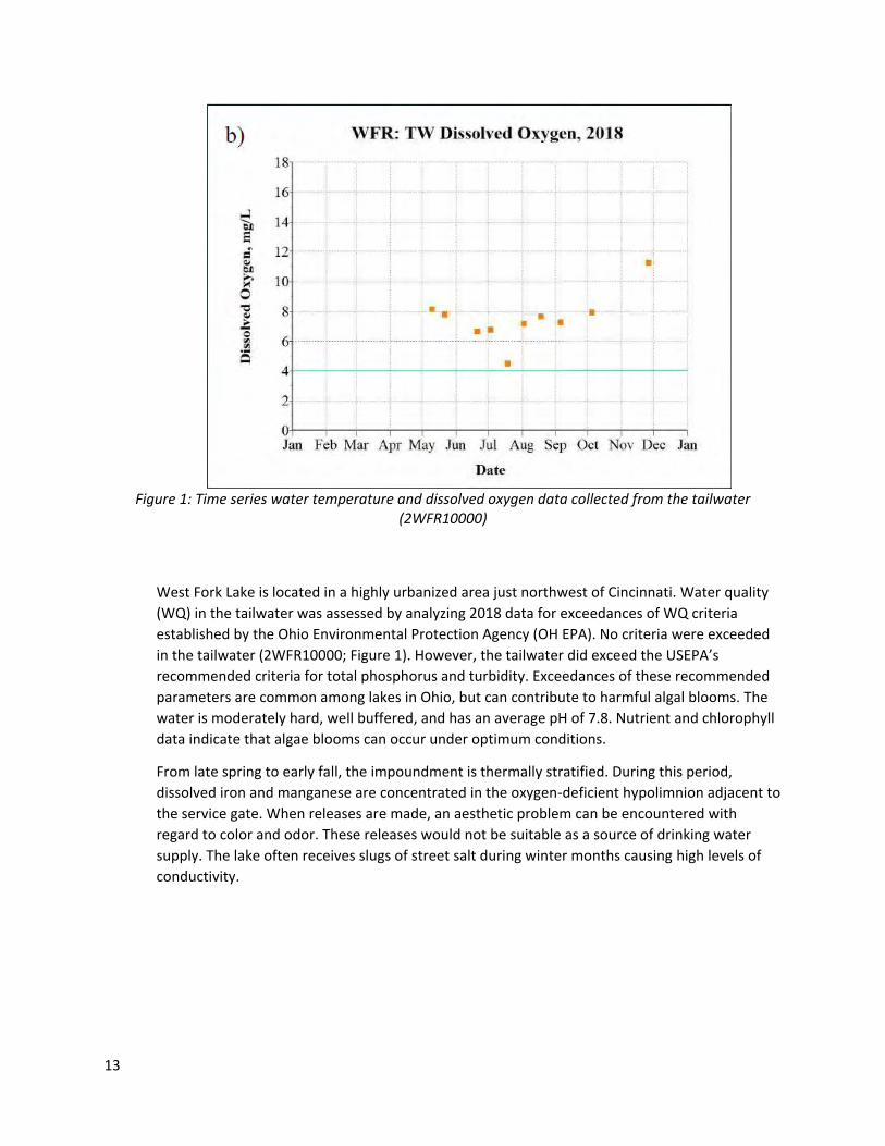
13
Figure 1: Time series water temperature and dissolved oxygen data collected from the tailwater
(2WFR10000)
West Fork Lake is located in a highly urbanized area just northwest of Cincinnati. Water quality
(WQ) in the tailwater was assessed by analyzing 2018 data for exceedances of WQ criteria
established by the Ohio Environmental Protection Agency (OH EPA). No criteria were exceeded
in the tailwater (2WFR10000; Figure 1). However, the tailwater did exceed the USEPA’s
recommended criteria for total phosphorus and turbidity. Exceedances of these recommended
parameters are common among lakes in Ohio, but can contribute to harmful algal blooms. The
water is moderately hard, well buffered, and has an average pH of 7.8. Nutrient and chlorophyll
data indicate that algae blooms can occur under optimum conditions.
From late spring to early fall, the impoundment is thermally stratified. During this period,
dissolved iron and manganese are concentrated in the oxygen-deficient hypolimnion adjacent to
the service gate. When releases are made, an aesthetic problem can be encountered with
regard to color and odor. These releases would not be suitable as a source of drinking water
supply. The lake often receives slugs of street salt during winter months causing high levels of
conductivity.
14
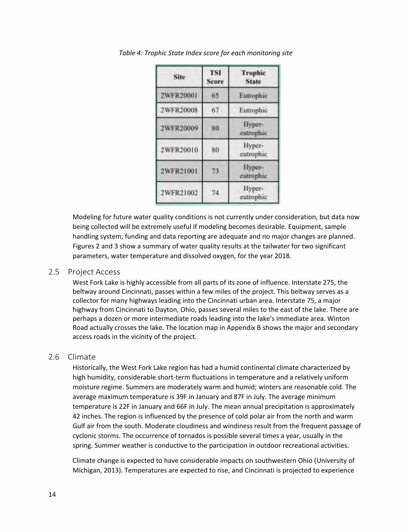
Table 4: Trophic State Index score for each monitoring site
Modeling for future water quality conditions is not currently under consideration, but data now
being collected will be extremely useful if modeling becomes desirable. Equipment, sample
handling system, funding and data reporting are adequate and no major changes are planned.
Figures 2 and 3 show a summary of water quality results at the tailwater for two significant
parameters, water temperature and dissolved oxygen, for the year 2018.
2.5 Project Access West Fork Lake is highly accessible from all parts of its zone of influence. Interstate 275, the beltway around Cincinnati, passes within a few miles of the project. This beltway serves as a collector for many highways leading into the Cincinnati urban area. Interstate 75, a major highway from Cincinnati to Dayton, Ohio, passes several miles to the east of the lake. There are perhaps a dozen or more intermediate roads leading into the lake's immediate area. Winton Road actually crosses the lake. The location map in Appendix B shows the major and secondary access roads in the vicinity of the project.
2.6 Climate Historically, the West Fork Lake region has had a humid continental climate characterized by
high humidity, considerable short-term fluctuations in temperature and a relatively uniform
moisture regime. Summers are moderately warm and humid; winters are reasonable cold. The
average maximum temperature is 39F in January and 87F in July. The average minimum
temperature is 22F in January and 66F in July. The mean annual precipitation is approximately
42 inches. The region is influenced by the presence of cold polar air from the north and warm
Gulf air from the south. Moderate cloudiness and windiness result from the frequent passage of
cyclonic storms. The occurrence of tornados is possible several times a year, usually in the
spring. Summer weather is conductive to the participation in outdoor recreational activities.
Climate change is expected to have considerable impacts on southwestern Ohio (University of
Michigan, 2013). Temperatures are expected to rise, and Cincinnati is projected to experience
15
more than 85 days of temperatures over 90°F by the end of the century. The incidence of heat
waves is also expected to increase, which could make the summer months in the area less
suitable for outdoor recreational activities. Precipitation in southwestern Ohio is projected to
increase during the winter, spring, and fall months, though summer months should become
drier. When rain does fall, it will be more likely to do so during heavy rain events. This will
exacerbate flooding and water quality concerns, and may also contribute to more frequent
sewage overflows. This may be of particular concern for the West Fork Lake project, which is
already experiencing ongoing issues with sedimentation and sewage overflows.
2.7 Topography, Geology, and Soils The topography of the project area on one hand enhances the visual quality of the lake, but a
lack of steep shoreline allows portions to be overused. With proper management limiting kinds
of usage, the generally developable and usable topography of the project enhances its overall
recreational experience.
The project area is located in the great Central Lowland Province. The area is composed of
nearly horizontal thin-bedded limestone and shale. The present Mill Creek Valley was cut by a
stream much larger than the present Mill Creek. The larger stream was evidently displaced by
the glacial advances and later followed the retreat of the invading ice at the end of the ice age.
The effects of glacial withdrawal is readily seen in the remains of the irregular morinal hills and
deposits of glacial drift that still rise above the general surface of the area from the Illinoisan or
Wisconsin glacial periods. The residual soil is from the parent thin-bedded shale and limestone
bedrock. No apparent faulting exists in the project area.
2.8 Resource Analysis (level 1 inventory data) The Resource Analysis section of the Master Plan is an assessment of existing natural conditions at West Fork Lake. It is intended to facilitate the understanding of development suitability and constraints that will affect future management decisions at the project site.
2.8.1 Fish and Wildlife Resources The West Fork Lake supports a local urban fishery primarily for warm water game fish.
Under the Master Plan, GPHC would continue to work to improve the fishery at the
Project by stocking fish and maintaining and creating fish habitat. Likewise, wildlife and
forest management would also still be the responsibility of GPHC.
Wildlife include gray squirrels, ground squirrels, cottontail rabbits, migratory waterfowl,
and other common species. While no endangered or threatened species are known to
occur on project lands, this topic is addressed in section 2.8.3 below.
The northern one-third of the lake is presently being managed as a marshland habitat
but has a severe siltation problem. It has been reported that the siltation rate is
decreasing. This large amount of siltation is not reducing the flood storage of the lake
16
but is severely reducing the amount of navigable water above Winton Road and the
amount of water in the minimum pool.
2.8.2 Vegetative Resources West Fork Lake’s vegetative resources are of particular interest due to the lake’s
location within the greater Cincinnati metropolitan area. West Fork Lake represents a
rare large green space within a highly developed landscape, and this make the project’s
vegetation an important resource in supporting the local area’s wildlife. Forests within
the project area generally correspond to one of two forest types: south-central interior
mesophytic forest and southern interior low plateau dry-mesic oak forest. These forests
are predominantly deciduous. Within the project area, the canopy is dominated by
species such as ash (Fraxinus spp.), cherry (Prunus spp.), elm (Ulmus spp.), walnut
(Juglans spp.), and maple (Acer spp.). The project area also contains smaller forested
areas of pine trees, including junipers (Juniperus spp.). West Fork Lake contains a variety
of herbaceous plant species as well. Herbaceous species that have been identified
within the project area include common blue violet (Viola sororia), Dutchman’s
breeches (Dicentra cucullaria), Virginia spring beauty (Claytonia virginica), Canada wild
ginger (Asarum canadense), wingstem (Verbesina alternifolia), jumpseed (Persicaria
virginiana), white snakeroot (Ageratina altissima), pale jewelweed (Impatiens pallida),
and common selfheal (Prunella vulgaris). In the more heavily developed portions of the
project area, vegetation is mostly limited to lawn grass.
2.8.3 Threatened & Endangered Species The USFWS maintains lists of rare plants and wildlife that occur in each county of the
US. The State of Ohio maintains a separate inventory of state-ranked endangered and
threatened species and species of special concern. This list can be obtained through the
ODNR website, either as a complete account for all such species throughout the state or
by specific county.
An official list from the USFWS dated April 16, 2020 for the West Fork Lake Project
included seven endangered species: the Indiana bat (Myotis sodalis), Fanshell
(Cyprogenia stegaria), Pink Mucket (Lampsilis abrupta), Rayed Bean (Villosa fabalis),
Sheepnose Mussel (Plethobasus cyphyus), Snuffbox Mussel (Epioblasma triquetra) and
Running Buffalo Clover (Trifolium stoloniferum). In addition to these species, the
northern long-eared bat (Myotis septentrionalis) is listed as a threatened species under
ESA and also has potential to occur throughout Ohio, including West Fork Lake (USFWS,
2016). While these species may not necessarily be present within project boundaries,
activities within those boundaries are considered to have the potential to impact these
species.
West Fork Lake is within the range of the Indiana bat. In the spring, bats emerge from
hibernation and migrate to summer roost sites. During the summer months, female
Indian bats establish maternity colonies of up to 100 bats under the loose bark of trees
and in tree cavities. Loss and fragmentation of forest habitat are among the major
17
threats to Indiana bat populations. Other threats include white-nose syndrome, winter
disturbance, and environmental contaminants (USFWS, 2019b).
A number of endangered freshwater mussels have ranges that include the West Fork
Lake Project area. North America has the highest diversity of these organisms in the
world and, within North America, the Midwest region has historically had some of the
largest numbers of these species (USFWS, 2019a). These organisms are found on
lakebeds and streambeds, and filter the water for food particles. Freshwater mussels
are imperiled by dams and the lowering of water quality by sedimentation and erosion.
West Fork Lake is within the potential range of running buffalo clover. Running buffalo
clover is a perennial plant species that, in Ohio, typically flowers in May. Running buffalo
clover requires periodic disturbance, and it is believed that this species historically grew
in landscapes disturbed by bison herds (USFWS, 2019c). The absence of bison and their
ecosystem effects is likely one of the reasons why this species is imperiled, along with
habitat loss and competition with invasive plants.
The northern long-eared bat was listed as a threatened species in 2015 due to declines
mostly associated with white-nose syndrome. The bats spend winter hibernating in
caves and mines. During the summer, the bats roost singly or in colonies underneath
bark, in cavities or in crevices of both live trees and snags. Males and non-reproductive
females may also roost in cooler places, like caves and mines.
Bald eagles are not known to nest within the project, but eagles have recently been
observed near the project (WXVU, 2019). These birds are protected under the MBTA
and the Bald and Golden Eagle Protection Act.
2.8.4 Invasive Species USFWS defines an invasive species as one that is “not native to an ecosystem and which
causes or is likely to cause economic or environmental harm or harm to human health.”
Invasive species out-compete native plants and wildlife, degrading, changing or
replacing native habitats (USFWS, 2012). Invasive species are commonly introduced or
spread through periodic disturbance of an area. Awareness of current and local
emerging invasive species and their potential impacts can help address and limit their
spread. Future development and maintenance projects should be aware of and attempt
to limit the spread of invasive species found at the project. Additionally, visitors can be
made aware of invasive species and the threat they pose through interpretive signs. The
ODNR maintains a list of invasive species found in Ohio on their website.
A species of particular concern is the emerald ash borer (Agrilus planipennis), which has
a confirmed presence throughout Great Parks of Hamilton County and across the state
of Ohio. Adults of this species target ash trees to lay eggs under the bark. The larvae
that hatch from these eggs proceed to consume the tree’s living tissue, and in so doing
inhibit the tree’s ability to transfer water and nutrients. This kills the tree over the
course of two to five years. Great Parks of Hamilton County is treated infected ash trees
18
with an injectable insecticide to counteract this problem. In addition, dead or dying ash
trees are identified and removed to reduce public health hazards.
An emerging high-priority species of concern is the Asian longhorned beetle
(Anoplophora glabripennis), which has been found in Ohio, but has not yet reached
Hamilton County (USDA APHIS, 2020b). Preferred targets for the Asian longhorned
beetle include maple species, birches, elms, horse chestnut, Ohio buckeye and willows
(Meng et al., 2015). The beetle grows and reproduces in hardwoods, eventually killing
the tree. USDA Animal and Plant Health Inspection Service (APHIS) is conducting an
eradication program for the Asian longhorned beetle in an attempt to limit its spread.
This beetle has the potential to devastate forests throughout Ohio, including those at
West Fork Lake, and could influence future management decisions (USDA APHIS,
2020a). Great Parks of Hamilton County is working to stop the movement of firewood,
which can act as a vector for this species, and also provides clean firewood for purchase
at Winton Woods and other district campgrounds.
Great Parks of Hamilton County also manages a number of invasive plant species as part
of its invasive species removal project (Great Parks of Hamilton County, 2020). Several
prominent species of concern include bush honeysuckle (Lonicera maackii), Japanese
honeysuckle (Lonicera japonica), winter creeper (Euonymus fortunei), garlic mustard
(Alliaria petiolata), and lesser celandine (Ranunculus ficaria). Species such as these act
to smother or shade out native vegetation, and disrupt the ecosystem in the process.
Great Parks of Hamilton County employs a variety of methods to keep these invasive
species in check, including cutting, hand pulling, mowing, burning, and spraying or
injecting herbicides. While these activities can limit the presence of invasive plants, they
are not able to entirely eliminate them and will most likely need to be conducted
indefinitely.
2.8.5 Ecological Setting The West Fork of Mill Creek Lake project was completed in 1952 and has been a part of
its local environment for such a long time that existing ecological areas that have
developed are stable. Ecological issues are addressed in Sections 2.8.1 and 2.8.2 for Fish
and Wildlife Resources and Vegetative Resources.
2.8.6 Wetlands According to the National Wetlands Inventory (NWI), West Fork Lake contains seven
potentially jurisdictional wetlands within the project area (see Appendix D, Wetlands
Map). The NWI map shows that wetlands are predominantly located near the western
portion of the lake. This area also has the greatest diversity in wetland types, with sites
representing emergent, scrub-shrub and forested wetland classifications. However, the
single largest wetland site at West Fork Lake is located on a portion of the northern
shore of the lake. On average, wetland sites are approximately 1.66 acres in size. The
smallest site is an emergent wetland approximately 0.45 acres in size, while the largest
is a forested wetland approximately 4.88 acres in size. The wetlands around the western
19
portion of the lake comprise 6.3 acres out the 11.63 acres of total wetlands around
West Fork Lake.
Table 5: Wetlands within the Project Area
Wetland Type Abbreviation Number of Sites
Total Acreage
Palustrine emergent, temporary, seasonally or semi-permanently flooded wetland
PEM 3 1.92
Palustrine scrub shrub, temporary or seasonally flooded wetland
PSS 2 3.24
Palustrine forested, temporary, seasonally or semi-permanently flooded or intermittently exposed wetland
PFO 2 6.47
2.9 Cultural Resources
2.9.1 Prehistoric Setting The relative location of West Fork Lake has a spatiotemporal occupation of Native
Americans spanning from the Paleoindians around 14,000 years before present (BP) into
the early 19th century with Shawnee Indians; with Euro-American contact with Native
Americans occurring around AD 1750. An all-inclusive chronology of the eastern United
States –pertaining to West Fork Lake—divides this general chronological sequence into
the following periods: Paleoindian (12,000-8,000 BC); Archaic (8000-1000 BC);
Woodland (1000 BC to AD 1000); Fort Ancient (AD1000-1750); and Ethnographic
(European contact and settlement, AD1750-Present).
These periods represent culturally distinct techno-complexes relating to human adaptation in and around the area surrounding West Fork Lake. Because cultural resources associated with these periods have the potential to be considered Historical Properties—defined by the National Historic Preservation Act (NHPA) as “any historic or prehistoric district, site, building, structure, or object included in, or eligible for inclusion in, the National Register of Historic Places maintained by the Secretary of the Interior”—the requirements of Section 106 of the NHPA for Federal agencies to consider effects of their undertakings on Historic Properties may be triggered by specific undertakings implemented under this Master Plan.
2.9.2 Historic Setting By the beginning of the 18th Century, increasing settlements on the Eastern seaboard of
the North American continent and intertribal warfare in the east caused a general
migration westward. As the Iroquois moved westward, Miami Indians moved into the
river valley now bearing that name. During this period of Indian migration, four
important tribes occupied land which later became the State of Ohio: the Miamis, the
Shawnees, the Wyandots, and the Delawares. Old Chillicothe, near the present Oldtown
in Greene County, was the site of a major Shawnee settlement, around which many
20
military campaigns were waged. It is reported that the famous Shawnee Chief,
Tecumseh, was born there.
The first reported European entry in the area was by the French explorer, La Salle,
whose exploration took him south from Lake Erie to the Ohio River and part of its valley
during the latter part of the 17th century. French fur traders entered the area in 1692
but discontinued their work there because of the great distance to the Great Lakes and
the presence of the Iroquois tribes. However, British traders from Albany, Philadelphia,
and Charleston were undaunted, and developed an extensive fur trade in the area by
the 1740's. Because of its geographic location and the network of navigable waterways,
the Ohio Valley was considered the key to control of interior America.
The British capitalized on the conflict between the Indians and the colonists during the
American Revolution, by enlisting the aid of many Indians. Even so, only minor
skirmishes were fought in Ohio. The Battle of Piqua was the only major battle of the
Revolution to take place in the Little Miami River Valley.
The earliest settlers in the Mill Creek valley area arrived in 1789. Soon after, Hamilton
County was organized in 1790. The area of Hamilton County continued to grow into the
early 1800s, with the State of Ohio established in 1803. During the first half of the 19th
Century, population grew, and the number of settlements increased along the entire
length of the Little Miami River, including the Mill Creek valley area. The river and other
streams provided water power for many mills needed by the early settlers for grinding
their grain. Settlers to the area also began to clear the surrounding and forests for
farms.
Updates to transportation played a major role in the development of the Hamilton
County and Mill Creek valley area. During the 1820s to the 1840s, the development and
completion of the Miami Canal (later renamed the Miami & Erie Canal) provided direct
access for farmers in the area to commercial interests both along the Ohio River and the
Great Lakes. By the 1840s, the railroad began to replace canals as a preferred means to
transport good to market. The first railroad to reach the Mill Creek valley was the
Cincinnati & Hamilton Railroad in 1847. A second railroad entered the Mill Creek valley
area in 1860 with the completion of the Marietta & Cincinnati Railroad. Railroads
continued to be a driving force for economic development throughout the 19th century
and into the first decades of the 20th century.
The Mill Creek valley area continued to grow into the 20th century, which shadowed the
economic success of the city of Cincinnati. This included suburban neighborhoods in the
area of northern Hamilton County. In 1938, the USACE received authorization to
construct the West Fork Mill Creek Reservoir. Completed in 1952, the earthen dam
eliminated flooding along Mill Creek that originated on the West Fork.
Prior to the creation of West Fork Reservoir, the creation of Winton Woods Park
(previously named West Fork Lake) began with the purchase of land in 1936. In 1939, Winton Woods Park was created from 905 acres that were leased from the federal
government. The USACE received authorization to construct the West Fork Reservoir in
21
1938. Completed in 1952, this earthen dam effectively eliminated Mill Creek floods
originating on the West Fork. With the creation of the park, suburban neighborhoods
began to be developed in the area in the 1950s and 1960s. Today the area around the
project is a heavily used urban park.
2.9.3 Previous Investigations at West Fork Lake All of the previous investigations at West Fork Lake were carried out as part of
compliance with Section 106 under the NHPA. The earliest archeological investigation in
the West Fork Lake area was the survey of the West Branch Mill Creek sanitary
interceptor sewer in 1977 by Robert Genheimer and Elizabeth Scheurer. Their survey
did not identify any archaeological sites within the West Fork Lake boundary.
In 2002, the USACE carried out a cultural resources survey in preparation of the
construction of a log cabin and sidewalk at West Fork Lake. The survey did not identify
any historic properties within the footprint of the log cabin and the sidewalk.
In 2007, Gray and Pape, Inc. carried out a Phase I cultural resources survey of the
proposed West Fork Lake Campground and Cabin development project. The survey did
not find any cultural resources within the area of the proposed campground cabin
development project.
In 2007, Environment and Archaeology, LLC carried out a Phase I cultural resources
survey of the Parky’s Farm improvements. These improvements consisted of a new
outdoor playground, a reconfigured animal pen area, two small shelters and a box stall
barn. Their survey did not identify any cultural resources within the area of the
proposed improvements.
In 2009, Environment and Archaeology, LLC carried out a Phase I cultural resources
survey of a proposed pole barn at Parky’s Farm at West Fork Lake. Their survey did not
identify any cultural resources within the area of the proposed improvements.
In 2010, the U.S. Army USACE of Engineers, Seattle District Center of Expertise for the
Preservation of Historic Buildings & Structures, conducted an identification and
evaluation of the National Register eligibility of the Dam Tender’s House at West Fork
Lake. The identification effort revealed the house represents several phases of
construction and alterations between 1890 up until the date of federal acquisition in
1949. However, though lacking architectural merit as a vernacular or period building
type, the Dam Tender’s House is a significant example of the USACE' policy of housing
dam tending personnel and their families during the period. The property is therefore
eligible for listing in the NRHP under Criterion A as a remnant of a nationwide federal
agency policy for around-the-clock, on-site administration and management of flood
control projects.
2.9.4 Recorded Cultural Resources Currently, there is one NRHP listed historic property located at West Fork Lake, the
Jediah Hill Covered Bridge. The bridge was listed in the National Register of Historic
22
Places (NRHP) on 1973. The Dam Tender’s House has been previously recommended as
eligible for listing to the NRHP under Criterion A. The house is located near the West
Fork Dam. Two potential archeological sites have been recorded at West Fork Lake
(33HA184 and 33HA185). Both of these sites are listed in the Ohio History Connection
GIS database as natural features and not mounds, and have not been formally evaluated
to determine their eligibility for the NRHP. In addition, two above ground structures, the
Groff Flour Mill (HAM0134749) and the house located at 1586 Covered Bridge Road, are
also located at West Fork Lake but have not been formally evaluated to determine their
eligibility for the NRHP.
2.9.5 Long-term Cultural Resources Objectives As funding allows, the USACE will develop a Cultural Resources Management Plan (CRMP), which will be incorporated into the Operational Management Plan in accordance with EP 1130-2-540. The purpose of the CRMP is to provide a comprehensive program to direct the historic preservation activities and objectives at West Fork Lake. A full inventory of cultural resources at West Fork Lake has been completed in compliance with Section 110 of the National Historic Preservation Act (NHPA). In consultation with the Ohio State Historic Preservation Officer (SHPO), all currently known sites must be evaluated to determine their eligibility for the NRHP. All future cultural resource investigations at West Fork Lake must be coordinated with the SHPO and federally-recognized Tribes to insure compliance with the NHPA, the Archaeological Resources Protection Act, and the Native American Graves Protection and Repatriation Act.
2.9.6 Implications of Historic Resources on Development Prior to the implementation of any ground disturbing activity, project or federal undertaking, such as those described in this Master Plan proposed actions shall comply with Section 106 of the NHPA. A federal undertaking, as defined by 36 CFR Part 800.16(y), is “…any project, activity, or program funded in whole or part under the direct or indirect jurisdiction of a Federal Agency, including those carried out by or on behalf of a Federal Agency; those carried out with Federal Assistance; and those requiring a Federal permit, license, or approval.” Section 106 compliance shall be conducted by USACE. In the event of unanticipated historic or prehistoric resources are encountered, all work must cease immediately and the USACE archaeologist shall be contacted before work may resume. Resources determined eligible for the NRHP must be protected from proposed project impacts, or the impacts must be mitigated.
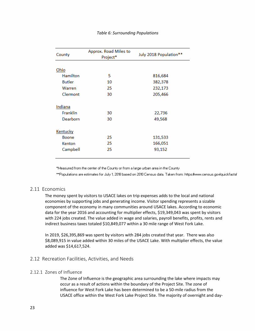
2.10 Demographics The population projection from the 2010 census for Hamilton County as of July 2018 was 816,684 people. Surrounding population estimates for 2018 are shown in Table 6 below.
23
Table 6: Surrounding Populations
2.11 Economics
The money spent by visitors to USACE lakes on trip expenses adds to the local and national economies by supporting jobs and generating income. Visitor spending represents a sizable component of the economy in many communities around USACE lakes. According to economic data for the year 2016 and accounting for multiplier effects, $19,349,043 was spent by visitors with 224 jobs created. The value added in wage and salaries, payroll benefits, profits, rents and indirect business taxes totaled $10,849,077 within a 30 mile range of West Fork Lake. In 2019, $26,395,869 was spent by visitors with 284 jobs created that year. There was also $8,089,915 in value added within 30 miles of the USACE Lake. With multiplier effects, the value added was $14,617,524.
2.12 Recreation Facilities, Activities, and Needs
2.12.1 Zones of Influence The Zone of Influence is the geographic area surrounding the lake where impacts may occur as a result of actions within the boundary of the Project Site. The zone of influence for West Fork Lake has been determined to be a 50-mile radius from the USACE office within the West Fork Lake Project Site. The majority of overnight and day-
24
use visitors originate within this zone. Also, this is the most common distance used by the USACE in recreation-related studies and master plan documents.
2.12.2 Visitation Profile The West Fork of Mill Creek Lake is a popular spot for locals and visitors alike. West Fork/Winton Woods Lake provides an array of recreational opportunities, the vast majority being part of the 1,282.97 acres leased to Hamilton County Park District. Visitations for the GPHC managed areas of the lake totaled 815,823 in 2019. The USACE operated dam and reservoir meanwhile had 13,704 day visitations in the same year.
2.12.3 Recreation Analysis The majority of the West Fork Lake Park is leased to the Hamilton County Park District. The park has a wide array of recreational activities including Frisbee Golf, a parkour course, picnicking, hiking, boating, two golf courses, a campground, and Parky’s Farm. Parky’s Farm is a demonstration farm that gives visitors a taste of the country in the suburbs of Cincinnati.
2.12.4 Recreational carrying capacity
There currently is no carrying capacity study for West Fork Lake.
2.13 Real Estate
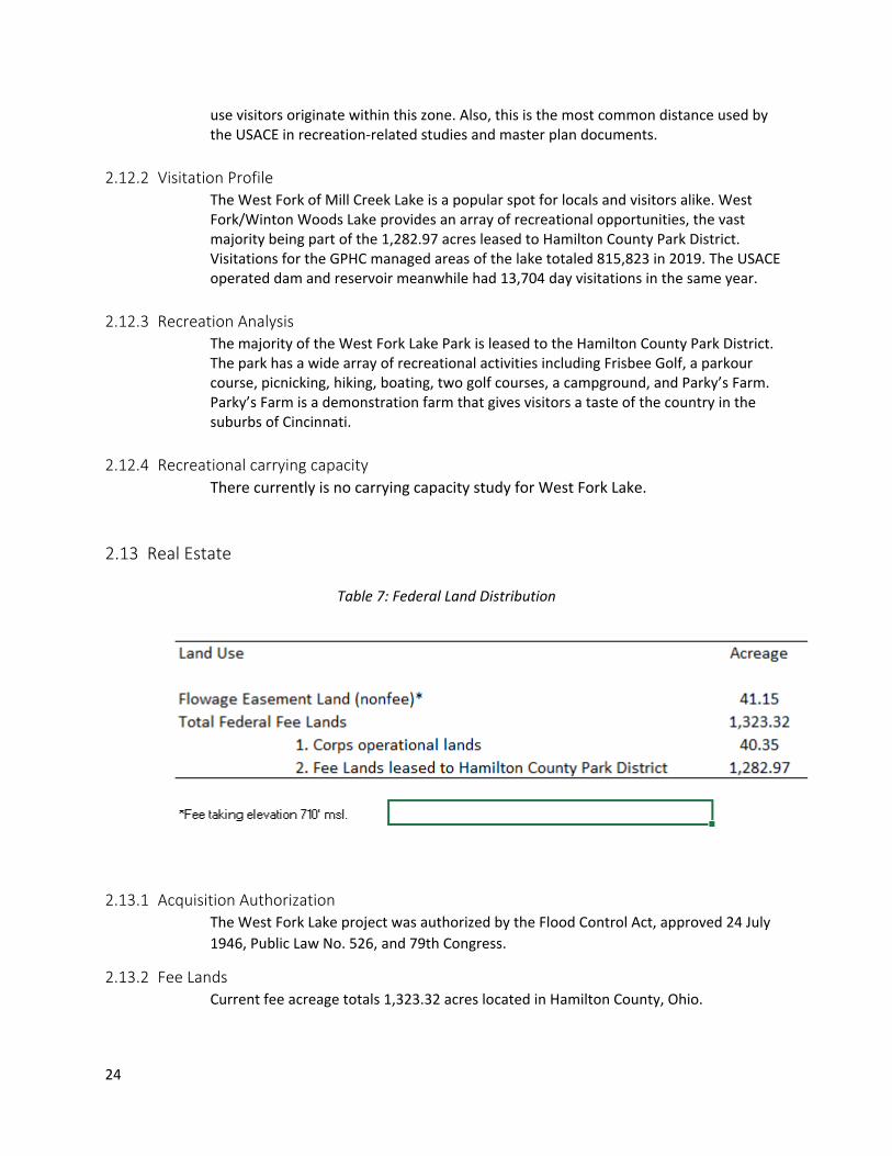
Table 7: Federal Land Distribution
2.13.1 Acquisition Authorization The West Fork Lake project was authorized by the Flood Control Act, approved 24 July
1946, Public Law No. 526, and 79th Congress.
2.13.2 Fee Lands Current fee acreage totals 1,323.32 acres located in Hamilton County, Ohio.
25
2.13.3 Licensed Lands There are lands on which license interests are held but no fee title ownership was
acquired. There is a 0.05 acre license at West Fork Lake located in Hamilton County,
Ohio for the purpose of installing and maintaining a 6-inch sanitary sewer line.
2.13.4 Disposals 26.86 fee acres was conveyed to Greenhills Exempted Village School District, Greenhills,
Ohio by Quitclaim Deed dated August 5, 1959 (portion of Tract A).
2.13.5 Outgrants Outgrants allow use of federally-owned land by state and local agencies as well as
private corporations and individuals. Outgrants specify what types of activities are
allowed on Federal lands and all Federal regulations still apply.
Leases: The USACE leases 1,283 fee acres at West Fork Lake to the Great Parks of
Hamilton County, Ohio under Lease No. DACW27-1-76-064 for public park and
recreational purposes. The term of the lease is fifty (50) years, beginning January 1,
1976 and ending December 31, 2025. The Great Parks of Hamilton County, Ohio has
entered into one third party agreement with the Winton Woods City School District to
allow the school to operate practices, training and events for the High School Rowing
Team. The term of the third party agreement is one year, and is renewable annually
each January.
Easements: Numerous easement outgrants are issued to various entities for the
construction, operation, and maintenance of water, sewer, electric, telephone, and
cable lines. Other easements grant various entities the right to construct, operate and
maintain roads and bridges.
Outgrant Number Grantee Purpose Term
Unnumbered Hammond Land Development Corporation
Sanitary trunk sewer line
7/30/2006*
052-WFMC-3 Board of County Commissioners of Hamilton County
road right-of-way perpetual
052-WFMC-6 Trustees of Springfield Township
road right-of-way perpetual
052-WFMC-8 Hamilton County road right-of-way perpetual 052-WFMC-9 Hamilton County road right-of-way perpetual
052-WFMC-10 Hamilton County 12’ sewerline 9/21/1954 – 9/20/2004*
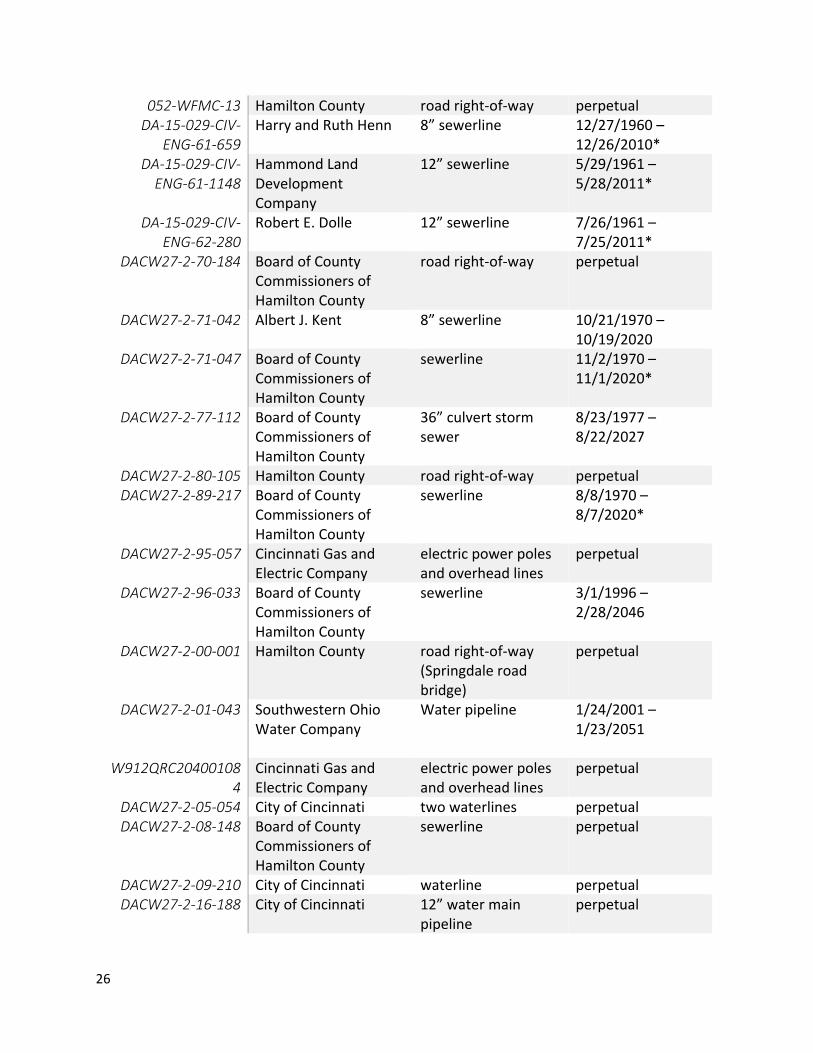
26
052-WFMC-13 Hamilton County road right-of-way perpetual DA-15-029-CIV-
ENG-61-659 Harry and Ruth Henn 8” sewerline 12/27/1960 –
12/26/2010* DA-15-029-CIV-
ENG-61-1148 Hammond Land Development Company
12” sewerline 5/29/1961 – 5/28/2011*
DA-15-029-CIV-ENG-62-280
Robert E. Dolle 12” sewerline 7/26/1961 – 7/25/2011*
DACW27-2-70-184 Board of County Commissioners of Hamilton County
road right-of-way perpetual
DACW27-2-71-042 Albert J. Kent 8” sewerline 10/21/1970 – 10/19/2020
DACW27-2-71-047 Board of County Commissioners of Hamilton County
sewerline 11/2/1970 – 11/1/2020*
DACW27-2-77-112 Board of County Commissioners of Hamilton County
36” culvert storm sewer
8/23/1977 – 8/22/2027
DACW27-2-80-105 Hamilton County road right-of-way perpetual DACW27-2-89-217 Board of County
Commissioners of Hamilton County
sewerline 8/8/1970 – 8/7/2020*
DACW27-2-95-057 Cincinnati Gas and Electric Company
electric power poles and overhead lines
perpetual
DACW27-2-96-033 Board of County Commissioners of Hamilton County
sewerline 3/1/1996 – 2/28/2046
DACW27-2-00-001 Hamilton County road right-of-way (Springdale road bridge)
perpetual
DACW27-2-01-043 Southwestern Ohio Water Company
Water pipeline 1/24/2001 – 1/23/2051
W912QRC20400108
4 Cincinnati Gas and Electric Company
electric power poles and overhead lines
perpetual
DACW27-2-05-054 City of Cincinnati two waterlines perpetual DACW27-2-08-148 Board of County
Commissioners of Hamilton County
sewerline perpetual
DACW27-2-09-210 City of Cincinnati waterline perpetual DACW27-2-16-188 City of Cincinnati 12” water main
pipeline perpetual
27
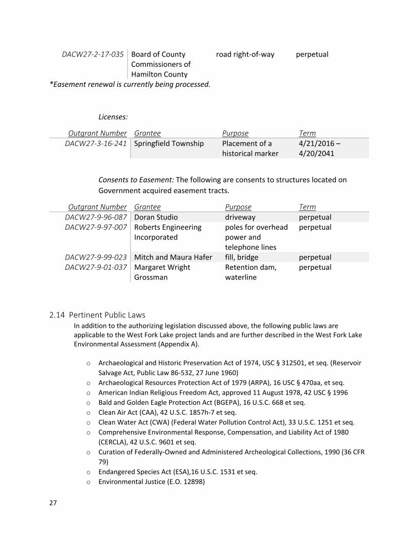
DACW27-2-17-035 Board of County Commissioners of Hamilton County
road right-of-way perpetual
*Easement renewal is currently being processed.
Licenses:
Outgrant Number Grantee Purpose Term
DACW27-3-16-241 Springfield Township Placement of a historical marker
4/21/2016 – 4/20/2041
Consents to Easement: The following are consents to structures located on
Government acquired easement tracts.
Outgrant Number Grantee Purpose Term
DACW27-9-96-087 Doran Studio driveway perpetual DACW27-9-97-007 Roberts Engineering
Incorporated poles for overhead power and telephone lines
perpetual
DACW27-9-99-023 Mitch and Maura Hafer fill, bridge perpetual DACW27-9-01-037 Margaret Wright
Grossman Retention dam, waterline
perpetual
2.14 Pertinent Public Laws In addition to the authorizing legislation discussed above, the following public laws are applicable to the West Fork Lake project lands and are further described in the West Fork Lake Environmental Assessment (Appendix A).
o Archaeological and Historic Preservation Act of 1974, USC § 312501, et seq. (Reservoir
Salvage Act, Public Law 86-532, 27 June 1960)
o Archaeological Resources Protection Act of 1979 (ARPA), 16 USC § 470aa, et seq.
o American Indian Religious Freedom Act, approved 11 August 1978, 42 USC § 1996
o Bald and Golden Eagle Protection Act (BGEPA), 16 U.S.C. 668 et seq.
o Clean Air Act (CAA), 42 U.S.C. 1857h-7 et seq.
o Clean Water Act (CWA) (Federal Water Pollution Control Act), 33 U.S.C. 1251 et seq.
o Comprehensive Environmental Response, Compensation, and Liability Act of 1980
(CERCLA), 42 U.S.C. 9601 et seq.
o Curation of Federally-Owned and Administered Archeological Collections, 1990 (36 CFR
79)
o Endangered Species Act (ESA),16 U.S.C. 1531 et seq.
o Environmental Justice (E.O. 12898)
28
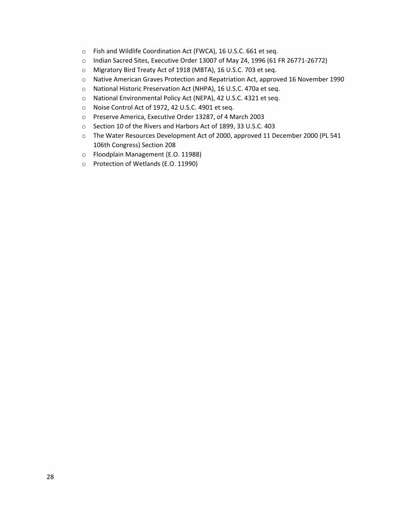
o Fish and Wildlife Coordination Act (FWCA), 16 U.S.C. 661 et seq.
o Indian Sacred Sites, Executive Order 13007 of May 24, 1996 (61 FR 26771-26772)
o Migratory Bird Treaty Act of 1918 (MBTA), 16 U.S.C. 703 et seq.
o Native American Graves Protection and Repatriation Act, approved 16 November 1990
o National Historic Preservation Act (NHPA), 16 U.S.C. 470a et seq.
o National Environmental Policy Act (NEPA), 42 U.S.C. 4321 et seq.
o Noise Control Act of 1972, 42 U.S.C. 4901 et seq.
o Preserve America, Executive Order 13287, of 4 March 2003
o Section 10 of the Rivers and Harbors Act of 1899, 33 U.S.C. 403
o The Water Resources Development Act of 2000, approved 11 December 2000 (PL 541
106th Congress) Section 208
o Floodplain Management (E.O. 11988)
o Protection of Wetlands (E.O. 11990)
29
Chapter 3 - Resource Objectives
3.1 Vision The USACE vision for the ongoing management of the land, water and recreational resources of West Fork Lake is to increase the protections for the natural and cultural resources and create sustainable solutions for a safe and clean lake, particularly protecting environmentally sensitive resources, and providing visitors with a quality recreation experience.
3.1.1 Goals
GOAL A. Provide the best management practices to respond to regional needs, resource capabilities
and capacities, and expressed public interests consistent with authorized project purposes.
GOAL B. Protect and manage project natural and cultural resources through sustainable
environmental stewardship programs.
GOAL C. Provide public outdoor recreation opportunities that support project purposes and public
interests while sustaining project natural resources.
GOAL D. Recognize the unique qualities, characteristics, and potentials of the project.
GOAL E. Provide consistency and compatibility with national objectives and other State and regional
goals and programs.
3.2 USACE Environmental Operating Principles:
Foster sustainability as a way of life throughout the organization.
Proactively consider environmental consequences of all Corps activities and act accordingly.
Create mutually supporting economic and environmentally sustainable solutions.
Continue to meet our corporate responsibility and accountability under the law for activities undertaken by the Corps, which may impact human and natural environments.
Consider the environment in employing a risk management and systems approach throughout the life cycles of projects and programs.
Leverage scientific, economic and social knowledge to understand the environmental context and effects of Corps actions in a collaborative manner.
Employ an open, transparent process that respects views of individuals and groups interested in Corps activities.
30
3.3 Resource Objectives:
Objective 1: Improve the quality of the recreational experience for all users. o Action 1: Increase access to boat ramps by improving trails and roadways. o Action 2: Maintain a strong relationship with local schools to provide quality
educational programs by establishing a point of contact and holding regular meetings.
o Action 3: Schedule annual events such as bird counts, trash clean ups and citizen surveys.
o Action 4: Add additional recreational opportunities such as zip lines and an adventure outpost.
o Action 5: Repair and update trails within the lake area including relocating the Kingfisher Trail away from the creek in order to keep the trail from flooding regularly.
o Action 6: Connect existing trails to allow better access to the lake by biking/walking.
Objective 2: Improve the water quality and other natural resources within the lake area. o Action 1: Regularly monitor lake water quality for particulates and other
pollution from point and non-point sources. o Action 2: Coordinate with the local Metropolitan Sewer District to resolve the
leaking sewer pipes that cross the lake in two major areas. o Action 3: Remove invasives and plant native species in Harpers Meadow and the
meadow at Paul’s tract. o Action 4: Plant native shade trees near the fishing area.
Objective 3: Improve communications and advertising for the lake. o Action 1: Create a new branding campaign to adopt the name Winton Woods
Lake to include new signage and branding, while working and coordinating with Great Parks.
o Action 2: Develop a communication plan between the USACE and Great Parks and include important entities such as Ohio Department of Natural Resources (ODNR) that involve frequent and consistent information on maintenance issues.
o Action 3: Create a Memorandum of Understanding to provide clarity on who has enforcement authority on USACE land.
Objective 4: Identify and protect the cultural resources within the Project area. o Action 1: Provide better protection for the covered bridge and raptor house
against vandalism. o Action 2: Form a cultural resources task force to clean up and maintain natural
resources in the lake area. o Action3: Create and maintain a communication plan with interested tribal
nations.
31
Chapter 4 - Land Allocation, Land Classification, Water Surface, and
Project Easement Lands
The information presented in this chapter pertains to the current land allocation and future land classification at West Fork Lake. In addition to land allocation and land classification, this chapter identifies easement lands that are located within and around project lands. Describing the allocation and classification of project lands and identifying easement lands helps project officials and decision-makers understand the current use, development and management of project lands. The land classification and allocation categories are established for all USACE projects based on Engineering Pamphlet (EP) 1130-2-550, Recreation Operations and Maintenance Policies and help guide decisions for future development.
4.1 Land Allocation The possible land allocations as outlined in EP 1130-2-550are as follows:
Operations (i.e., flood control, hydropower, etc.) Lands acquired for the congressionally authorized purpose of constructing and operating the project. Most project lands are included in this allocation.
Recreation. Lands acquired specifically for the congressionally authorized purpose of recreation. These are referred to as separable recreation lands. Recreation lands in this allocation can only be given a land classification of “recreation”.
Fish and wildlife. Lands acquired specifically for the congressionally authorized purpose of fish and wildlife management. These are referred to as separable fish and wildlife lands. Lands under this allocation can only be given a land classification of “Wildlife Management”.
Mitigation. Lands acquired or designated specifically for the congressionally
authorized purpose of offsetting losses associated with development of the
project. These are referred to as separable mitigation lands. Lands under this
allocation can only be given a land classification of “Mitigation”.
4.2 Land Classification The land is further categorized into classifications to identify use and management of all project lands (Appendix D). Land classification categories as defined by EP 1130-2-550 are as follows:
Project Operations
High Density Recreation
Mitigation
Environmentally Sensitive Areas
Multiple Resource Managed Lands o Low Density Recreation o Wildlife Management o Vegetative Management
32
Water Surface o Restricted o Designated no wake o Fish and Wildlife Sanctuary o Open Recreation
Easement Lands o Operations Easement o Flowage Easement o Conservation Easement.
The land classifications, as defined below, represent the future of land use at West Fork Lake. The planning team, in conjunction with project staff and stakeholders, identified the appropriate classifications for land surrounding the project based on resources, demand projections, demand trends and capacity needs. These classifications, which are based on existing land use and zoning, should be considered future land use areas for the next 20 to 30 years. Thus, the lands were classified to retain current land use and represent ideal future land uses throughout the project (See land classification map in Appendix D).
4.2.1 Project Operations The project operations (PO) classification is used to classify lands that are required for the dam, spillway, maintenance facilities, administrative facilities and any other land associated with project maintenance and operation. Recreation is not permitted on project operations lands. Where compatible with operational requirements, Project Operations lands may be used for wildlife habitat management, recreational use, or agricultural activities. Licenses, permits, easements, or other outgrants are issued only for uses that do not conflict with operational requirements.
4.2.2 High Density Recreation High-density recreation (HDR) classification is used to classify lands that are developed for intensive recreational use for visitors to the project. This land use classification allows the greatest amount of land disturbance of all land use categories for the project. Examples of HDR lands include day use areas, amphitheaters, campgrounds, beaches, cabins, quasi-public development, and commercial concessions such as marinas, restaurants, lodges, etc. All recreational development should be planned and designed to accommodate large numbers of visitors. This includes boat ramps and large capacity vehicle parking lots for passenger vehicles, large vehicles, and vehicles with trailers. Boat ramps in HDR areas would accommodate multiple boat launches/recoveries simultaneously. Restroom facilities would be provided in proximity to the boat ramps and parking areas. No uses that would negatively affect the ability of visitors to enjoy active recreational experiences at the project should be permitted. Agricultural activities are not permitted in HDR areas unless part of an interpretive program or to maintain viewsheds. Low-density recreational activities such as picnicking and hiking are allowed and require restrooms on HDR classified lands. Permits, leases or easements for man-made
33
intrusions or facilities that would be consistent with the expectations of visitors and the needs of concessionaire operators would be allowed. Mountain biking trails and off-highway vehicle use is prohibited. HDR areas at West Fork Lake include the campground and picnic areas, the marina, Parky’s Farm, the disc golf field and the Ranger Station and visitor’s center.
4.2.3 Mitigation Mitigation lands are lands used to offset ecological losses associated with development at the project. No mitigation lands have been identified at the project.
4.2.4 Environmentally Sensitive Areas The Environmentally sensitive area (ESA) classification applies to lands in which aesthetic, ecological, cultural or scientific features have been identified and deemed sensitive to development and intense land use. Project management must ensure that the sensitive features in the ESAs are not adversely impacted. Prohibiting or heavily limiting development on ESAs is a standard procedure for protecting these lands. Preservation of these areas would be accomplished by strictly, or completely, limiting public access and prohibiting agricultural activities. Buffering of ESAs may be necessary; the size of the buffer would depend on the ecology of the area. No licenses, leases, permits or easements for man-made intrusions in these areas would be permitted. Mountain biking trails and off-highway vehicle use is prohibited. For West Fork Lake, all areas identified as wetlands by the National Wetland Inventory as well as areas with known cultural resources were designated as ESAs.
4.2.5 Multiple Resource Management Lands Multiple resource management lands allow for the designation of predominant use as described with the understanding that other compatible uses may also occur on these lands without impacting the predominant use. The compatible uses that may occur on multiple resource management lands are described below.
Low Density Recreation
LDR are lands designated for passive public recreational use that require minimal development and infrastructure. Agricultural and vegetative management activities would be permitted if they could be incorporated into interpretive programs or are necessary to maintain viewsheds. Low-density recreational activities, such as low-capacity boat ramps and docks, picnicking, primitive camping, fishing, wildlife viewing and hiking, would be allowed. These LDR areas would require restrooms and parking lots with the capacity for vehicles with trailers. Mountain biking trails and off-highway vehicle use is prohibited. LDR land is located at multiple locations throughout West Fork Lake, including the picnic and wildlife viewing areas near the park entrance and on the west side of the lake, the wildlife viewing area on the north western end of the lake and the basketball courts near the USACE office.
34
Wildlife Management
Wildlife management lands are designated for stewardship of fish and wildlife. These lands are characterized by valuable wildlife habitats that are managed to benefit certain game and non-game species or the natural community as a whole. Agricultural activities are permitted under strict oversight of the ODNR to improve habitat. Other management recommendations for wildlife management lands include tree repression (to provide woodlands with a diversity of tree successions), food plot planting, parking area construction, maintenance of levees and water levels, monitoring of eagle nests, construction of osprey platforms, crop leases, and managing woodlands. Boat ramps are an acceptable improvement in the wildlife management areas. There are currently no wildlife management areas at West Fork Lake.
Vegetative Management
Vegetative management lands are designated for stewardship of forest, wetland and other native vegetative cover. These areas are managed to promote the biodiversity of vegetative habitats and include a variety of habitat types. Active management of invasive plant species may also be conducted in these areas. These areas stabilize soils, minimizing erosion along the shoreline of the lake. Vegetative management areas are widely distributed at West Fork Lake. Vegetative management occurs at the meadow area just north of the project operations that is managed by a volunteer group through Great Parks. This area includes a wetland and until recently contained native flowers and grasses. This area recently suffered a setback when it was accidentally mowed due to a lack of communication between Great Parks and the USACE. Therefore, it is now in need of rest and management for the natural resources to be restored. The outlook area at the northernmost reaches of the park, as well as the large forested area northwest of the Ranger’s Station is in need of invasives removal and management.
Future or Inactive Recreation Areas
These areas have site characteristics compatible with potential future recreational development. Future recreation areas are divided into future LDR and future HDR areas based on resource analysis. These areas provide opportunities for future recreation pursuits when demand and funding can accommodate. Identifying these areas as future LDR or future HDR areas also allows for flexibility in determining the most appropriate activities, as trends in recreation are always changing. There are no Future LDR or HDR lands identified in the Master Plan.
4.2.6 Water Surface There are no water surface classification recommendations made for the project area.
35
4.2.7 Project Easement Lands There are lands on which easement interests are held but no fee title ownership was
acquired. There are 41.15 acres of easement lands at West Fork Lake located in
Hamilton County, Ohio consisting of occasional flowage, utility/pipeline, road and
drainage ditch purposes.
Operations Easements
Utility/Pipeline Easement: Utility easements allow the government to construct,
install and maintain utilities/pipelines to service USACE-owned facilities. There
is a 0.03 acre pipeline easement for water service at West Fork Lake.
Drainage Ditch Easement: There is 0.04 acres of drainage ditch easement for
surface drainage purposes at West Fork Lake.
Flowage Easement
These are easements purchased by the USACE which grants the Government the right to occasionally or permanently flood private land during flood risk management operations. There are 41.08 acres of perpetual flowage easements at West Fork Lake. The purpose of these easements is to provide adequate storage for flood waters.
Conservation Easement
There are no known conservation easements within the West Fork Lake boundary.
36
Chapter 5 - Resource Plan
5.1 Classification and justification The West Fork Lake Land Classifications are:
1) Project Operations
2) High Density Recreation
3) Environmentally Sensitive Areas
4) Multiple Resource Managed Lands
5) Water Surface
The descriptions of how Project lands will be managed are presented in broad terms. A more
descriptive plan for managing these lands can be found in the West Fork Lake Operational
Management Plan (OMP). Management tasks described in the OMP must support the Resource
Objectives, Land Classifications, and Resource Plan set forth in this Master Plan.
Table 8: Land Classification Acres
Land Classification Acres
Operations 78.86
High Density Rec 366.92
Low Density Rec 315.93
Environmentally Sensitive 130.98
Vegetative Management 289.57
5.1.1 Project Operations
This category includes the lands required for the dam, spillway, the USACE offices and
parking and other areas that are used solely for the operation of the project. There are
78.86 acres of lands under this classification that is managed by the USACE. The
management strategy for this area is to continue providing physical security necessary
to insure continued operations of the dam and related facilities. No public access is
permitted at the dam with the exception of the basketball court area and trail heads
located northeast of the dam.
5.1.2 High Density Recreation These lands are designated for intensive levels of recreational use to accommodate and
support the recreational needs and desires of visitors. They include lands on which
existing or planned major recreational facilities are located and allow for developed
public recreation facilities, concession development, and high-density or high-impact
recreational use. In general, any uses of these lands that interfere with public
enjoyment of recreation opportunities are prohibited. Low-density recreation and
37
wildlife management activities compatible with intensive recreation use are acceptable,
especially on an interim basis. No agricultural uses are permitted on those lands except
on an interim basis for maintenance of scenic or open space values. Permits, licenses,
and easements are not issued for non-compatible manmade intrusions such as
pipelines; overhead transmission lines; and non-project roads, except where warranted
by the public interest and where no viable alternative area or route is available.
There is no high density recreation on USACE managed land, while the Great
Parks of Hamilton County has 366.92 acres of land that are identified as high density
recreation within the areas leased from the USACE. The USACE does not provide any
maintenance within any of these locations but does, at times, provide support to the
managing agency. The USACE has to provide review of requests and ensure accordance
with applicable laws and regulations for proposed activities within high density
recreation areas. The general plan for the management of these lands (primarily by the
Corps’ partners) is to maintain existing facilities and otherwise manage these areas in
accordance with the Resource Objectives identified in Chapter 3. These areas currently
leased to Great Parks that are classified as high density recreational lands are listed
below:
Adventure Outpost: The Adventure Outpost is aimed at teaching outdoor skills
and safety. The outpost includes a group camp area, biking and fitness opportunities,
archery, paddling, and offers classes, a school program guide and team building
exercises. Classes are guided by knowledgeable, certified staff to teach outdoor skills
and safety.
Parky’s Farm: Parky’s Farm is a 100+ acre educational farm that includes indoor
and outdoor playgrounds, picnic shelters, garden, orchard and animals. They offer
hands-on farm experience for children of all ages, field trips, summer day camps and
also hosts events.
Harbor: The Winton Woods Harbor is probably the busiest attraction that
Winton Woods Lake has to offer. This area includes a traditional playground and wet
playground, snack bar, boathouse with a variety of rentals, canoe and kayak launch,
picnic areas and fishing.
Campground: The campground features 123 total campsites with 37 RV sites, 68
tent sites, and 18 cabin sites and is within walking distance of Winton Woods Harbor.
Winton Centre: Multipurpose building that also serves as the administrative
offices and Ranger Department headquarters for Great Parks of Hamilton County.
Winton Woods Riding Center: The riding center is mainly a lessons facility,
qualified to teach western horsemanship, contesting, natural horsemanship, hunt seat,
hunter jump and dressage style of riding. The facility offers group, private, and semi-
38
private lessons as well as spring and summer day camps, trail rides, badge programs and
horse shows. The facility also provides a scenic 2.6 mile horse trail for public trail riders.
5.1.3 Environmentally Sensitive Areas (ESAs) ESAs at West Fork Lake include wetland areas found throughout the lake area and some culturally sensitive areas, totaling 130.98 acres. All of these areas should be protected from unnecessary development. Defining sensitive areas as part of the master plan process assists in the protection of valuable resources. Many factors contribute to identifying sensitive areas. These sites are mapped and managed by the USACE. Data includes locations of threatened and endangered species and cultural sites not available to the public. Degree of sensitivity varies by location and by contributing factors to sensitivity. An area may be available to construct a properly designed hiking trail, or may be actively managed by forest practices like timber stand improvement without negatively impacting the site’s sensitivity. Other sites can be very sensitive to human disturbance and need adequate protection from development. Examples of this degree of sensitivity would involve eagle nests, osprey nests and heron rookeries. These animals are threatened by human activities especially during active breeding seasons. Buffering of sensitive locations is necessary for resource protection. Size of the buffer is tied to the ecology of the location. On occasion, multiple sensitive areas may exist within proximity to one another. These are often combined into one larger sensitive area. Fragmentation threatens sensitive species and large block habitats have been identified as sensitive. Many wildlife species that are identified as having significant conservation need are often associated with large habitats.
The wetlands found at West Fork Lake are largely fragmented. Further fragmentation is prohibited. The following occurrences on the landscape can contribute to areas being classified as sensitive. Oftentimes, multiple contributors to sensitivity exist on one area.
• Known or discovered cultural sites • Large tract woodlands • Mature oak woodlands • Reforestations • Remnant prairies • Larger planted prairies • Wetlands identified in the National Wetlands Inventory • Lands possessing unique wildlife value by diversity or conservative species • Steep slope • Aesthetic quality or aesthetic views (scenic) • Corridors between habitats that protect connectivity Areas designated as sensitive can change over time and continued monitoring is
critical to their protection. Through the use of Geographic Information System (GIS) databases maintained with separated layers, the dynamic nature of sensitivity can be managed in an up-to-date program. Some areas may be highly sensitive to change; other areas need prescribed management to remain viable. Management practices can
39
include invasive species control, prescribed fire or plantings. The goal of sensitive area management is to protect and preserve known areas that contribute to the diversity and health of the Miami River Watershed. The program should be beneficial to plants, animals and the people that enjoy the resource. The general plan for the management of these lands is to provide protection for wetlands and cultural resources, and otherwise manage these areas in accordance with the Resource Objectives identified in Chapter 3.
5.1.4 Multiple Resource Managed Lands These are areas where the predominant use is that of the sub-classification. However,
there are other compatible uses which may occur on these lands without impacting the
predominant use. These lands can be divided into four sub-categories for the purposes
of this master plan. These categories are: Low Density Recreation, Wildlife
Management, Vegetative Management, and Future/Inactive Recreation Areas. The
general plan for the management of these lands (primarily by the Corps’ partners) is to
maintain existing facilities and otherwise manage these areas in accordance with the
Resource Objectives identified in Chapter 3. The following is a description of the
acreages, and description of use pertaining to each sub-category.
5.1.4.1 Low Density Recreation
Low density refers to lands with minimal development or infrastructure that support passive public recreational use (e.g. primitive camping, fishing, hunting, trails, wildlife viewing, etc.). Although West Fork is a largely urban lake, there are 315.93 acres of land that remain undeveloped and are considered areas of low density recreation. Natural conditions preclude intensive public use development because extensive alteration of natural systems would be required. Difficult access also is a factor indicating low-density use as most appropriate for these lands. This classification may be appropriate when a conflict exists between public use and wildlife habitat. Private or long-term exclusive group use of these lands will not be permitted. Management practices leading to habitat improvements for the benefit of wildlife are encouraged. No licenses, permits, or easements will be issued for such non-compatible manmade intrusion, such as underground or exposed pipelines, cables, overhead transmission lines, or non-project roads. Exceptions to this restriction may be made where necessary to serve a demonstrated public need only in those instances where no reasonable alternative is available. Hunting and agricultural uses are permitted on this land. There are 346.41 acres of land classified as low density recreation in the project area. The majority of this land is located on the west side of the lake where there are hiking trails and picnic areas. There is also a wildlife viewing area on the north east side of the lake and an area with trails just south of the disc golf fields (see Land Classifications Map, Appendix D).
5.1.4.2 Wildlife Management General
Wildlife Management areas are lands designated for stewardship of fish and wildlife resources. Wildlife management is typically conducted by the USACE,
40
USFWS or the Ohio DNR. According to the Environmental Assessment (Appendix A), there are no known threatened or endangered species within the project area; although species such as the northern long eared bat, the Indiana Bat and Bald Eagle have either been observed near the project area or are known to exist in the potential range of the lake.
While there are currently no wildlife management areas designated at West Fork Lake, there is a need for further monitoring to ensure that any potential habitat areas for threatened and endangered species be preserved and maintained. These lands could provide public hunting opportunities for both big and small game. The management plans for these potential areas would include common wildlife management practices, such as planting of food plots, maintaining public access, and implementing a nesting box program. Non-game species are also managed by the USACE. Special attention is given to Species of Greatest Conservation Need (SGCN). These species are identified as having small or declining populations. SGCNs will continue to receive attention to assure they are managed in accordance to their habitat needs and parameters.
5.1.4.3 Vegetation Management
These lands are designated for stewardship of forest, prairie, and other native vegetative cover. There are several areas designated as vegetative management areas at West Fork totaling 289.57 acres. These areas were identified as areas that are especially overrun with invasives or are in areas with wildlife viewing and few or no recreational trails. One area of note is the managed meadow located on the north east side of the lake where volunteers from Great Parks had been controlling invasives and planting native species in order to create habitat for insects, birds and other species. This area should be protected and allowed to rest in order to reestablish the native growth that was recently destroyed. All vegetation management areas should be monitored for invasive species and are in need of regular invasives removal.
5.1.4.4 Future or Inactive Recreation Areas
These areas have site characteristics compatible either with future recreational development or recreation areas that are closed. Until there is an opportunity to develop or reopen these areas, they will be managed for multiple resources. There are no locations at West Fork Lake that match this description.
5.1.6 Mitigation Mitigation lands are acquired or designated specifically to minimize adverse
environmental effects to USACE lakes. There are no mitigation lands located within the
West Fork Lake project boundary.
41
Chapter 6 - Special Topics/Issues/Considerations There are several important items to consider in this Master Plan update that make West Fork Lake a unique project. Stakeholders and decision-makers at the project should carefully consider these aspects when making land use and operational decisions. Need for Carrying Capacity Study Currently, there is not a recreational carrying capacity study that has been documented for West Fork Lake. The Greater Cincinnati metropolitan area has over 2 million people and is growing at a rate of just under a half a percent a year. Downtown Cincinnati is just under 20 miles from West Fork Lake. With projected population growth and the location of the lake in an urban center, there is potential for increased usage in the years to come. In order to ensure the continued safe operation of the lake and its recreational facilities, a carrying capacity study is needed. Outreach Program A rebranding plan should be considered in order to improve public relations and consistency between the Great Parks managed areas and the dam and USACE operated areas. Since the lake is most commonly known as Winton Woods to the public and is the title that Great Parks uses for this lake, this is the obvious choice for rebranding. The USACE will work to utilize this name in its communications and will prioritize the changing of West Fork to Winton Woods on all messaging including road signs, the lake website, social media and on USACE documents. Sewer Infrastructure Another consideration will be the improvement and maintenance of the sewer infrastructure that crosses the lake, which has a history of leaking and impacting water quality. The MSD holds the easement and maintains this infrastructure. USACE will continue to work with MSD to ensure that the impacts of this leakage are understood and that the public is aware of the dangers of exposure to contaminated waters. In the past, there have been issues with communicating with MSD; therefore they will be included in the communication plan to ensure a regular point of contact and clear communication of the issues associated with the sewer infrastructure. Volunteers and Partnerships In today’s financial environment, volunteering and partnering are essential tools that allow the USACE to effectively manage recreation and environmental resources. In order to successfully meet the agency’s recreation and stewardship missions and to foster shared values, vision, and a sense of ownership, it is imperative that the USACE work together with volunteers, state governments, private/public organizations, local communities, and other partners to maintain or advance programs, from wildlife
protection and habitat improvement, to recreation facility enhancements.
Public Law 98-63, Supplemental Appropriations Act of 1983, authorized the USACE’ Volunteer Program. At West Fork Lake, volunteers (managed by Great Parks) play an important role in protecting the natural resources and maintaining recreation facilities. Volunteers serve as campground hosts, operate visitor centers, conduct programs, clean shorelines, restore fish and wildlife habitat, and maintain park trails and facilities, among a number of tasks. USACE personnel can recruit their own volunteers or get help from the Volunteer Clearinghouse, www.USACElakes.us/volunteer, (1-800-VOL-TEER or 1-800-865-8337), a national information center for people interested in volunteering at USACE lakes across the country.
42
Chapter 7 - Agency and Public Coordination In January 2019, the USACE announced its decision to revise the Master Plan, which was last revised in 1979 Throughout the process, the USACE involved the public, and coordinated with Tribes, Federal, state, and local agencies, and communities. Public involvement is important to the overall success of the master planning effort. Stakeholder and public meetings were held in the summer of 2019, providing the public, stakeholders and other public agencies opportunities to participate in defining the master plan.
7.1 Agency Scoping Meeting The USACE held an initial scoping meeting with state and local agencies directly involved in managing USACE lands at West Fork Lake on July 11, 2019. This meeting focused on announcing the intent to revise the Master Plan, purpose and need for revision, USACE master planning processes, and expectations or concerns of partners.
7.2 Agency and Tribal Coordination All Ohio tribes were contacted via letter on April 8, 2020. The USACE received a response from the Miami Tribe of Oklahoma on April 14, 2020 (see Appendix C).
7.3 Public Meeting On July 25, 2019, USACE employees hosted a public meeting in order to take comment and hear concerns and priorities from stakeholders and members of the community. Notice was given via news release; the Cincinnati Inquirer and posted to Great Parks of Hamilton County’s social media page. Participants were asked to sign in at a table where staff provided the participants with information on the structure of the public meeting and comment forms. Large scale maps were set up and the stakeholder presentation was displayed. USACE employees were available to answer questions and receive comments. Interested persons had the opportunity to comment about the project using a variety of methods:
Filling out a survey at the open house;
Giving verbal comment; and
Submitting comment using electronic mail.
Four members of the public attended the meeting and gave comment. The public comment period was open from July 25- August 30th. All comments received were considered, and some proposals were integrated into the Draft Master Plan.
43
Chapter 8 - Summary of Recommendations This Master Plan conceptually establishes and guides the orderly development, administration, maintenance, preservation, enhancement and management of all natural, cultural, and recreational resources at West Fork Lake. The Master Plan is a land use management document and does not address water management operations, associated prime facilities (dam, spillway etc.), or shoreline management as those operations are outlined in separate documents. This Master Plan is stewardship-driven and seeks to balance recreational development and use with protection and conservation of natural and cultural resources.
The following are focal points within this document that will assist USACE management in facing
contemporary challenges well into the future.
8.1 Land Classifications As illustrated in the land classifications map, land uses at West Fork will remain largely
unchanged. The major actions from the classification of land would be the continued or new
vegetative management of a large portion of the lake. Invasives removal is the main measure to
come of this classification but additionally, some native plantings are needed, particularly in the
meadow to the north of the operations area.
8.2 Improved Recreation While Great Parks provides a comprehensive recreation throughout the lake, there are still
some areas for improvement that will increase the overall recreational experience for users.
Increased boat ramp access, improved maintenance and upgrading for trails and the addition of
recreational opportunities in the defined recreational areas were all themes that were
mentioned by stakeholders and/or the public.
8.3 Improve Water Quality One of the most prevalent themes that occurred during the master planning process was the
poor water quality experienced from both point and non-point sources in the lake. Regular
monitoring of the lake and better coordination with MSD will allow the USACE to better
understand the pollutants within the lake in order to directly define what measures need to be
taken to improve the water quality of the lake. Additionally, removal of invasives and native
plantings in the fishing area as well as in defined meadows will assist in improving water quality.
8.4 Improved Communications A major theme at West Fork Lake is the relationship between the USACE and Great Parks of
Hamilton County, which leases and operates the majority of the land at West Fork. Good
communication is key to successful operations of the park. Ideally, a communication plan should
be created to ensure regular, clear communication between Great Parks, the USACE and other
major stakeholders, as well as communication with the public. This plan would include points of
44
contact for stakeholders, set clear expectations on what information should be communicated
and what tools will be used.
As mentioned in the special topics section, a rebranding plan should also be set in place that
would entail changing USACE signage, digital media and other USACE documents to refer to the
lake as Winton Woods.
8.5 Cultural and Natural Resources Protection West Fork Lake contains cultural resources that have suffered from vandalism over the years.
Steps need to be taken to prevent these types of activities such as better security or public
education on the importance of cultural resources. A cultural resources task force can be
formed to tackle these issues and work to improve communications with the public as well as
tribal nations.
45
Chapter 9 - Bibliography GPHC. 2019. Maintaining Reservoirs.
http://blog.greatparks.org/2019/06/maintaining-reservoirs/. Accessed 20 April 2020.
GPHC. 2020. Projects: Removing Invasive Species.
https://www.greatparks.org/discovery/projects/removing-invasive-species Accessed 15 April
2020.
Mehri, N., P. A. Cummins, I. M. Nelson, T. L. Wilson, and S. Kunkel. 2019. Ohio Population Interactive
Data Center, Scripps Gerontology Center, Miami University, Oxford, OH.
www.ohio-population.org. Accessed 20 April 2020.
Meng, P. S., K. Hoover, & M. A. Keena. 2015. Asian Longhorned Beetle (Coleoptera: Cerambycidae),
an Introduced Pest of Maple and Other Hardwood Trees in North America and Europe. Journal
of Integrated Pest Management 6(1): 1-13.
Mill Creek Alliance. https://www.themillcreekalliance.org/what-is-a-watershed
NatureServe Explorer. 2008. Terrestrial Ecological System: Southern Interior Low Plateau Dry-Mesic
Oak Forest.
https://explorer.natureserve.org/Taxon/ELEMENT_GLOBAL.2.722783/Southern_Interior_Low_P
lateau_Dry-Mesic_Oak_Forest. Accessed 21 April 2020.
NatureServe Explorer. 2017. Terrestrial Ecological System: South-Central Interior Mesophytic Forest.
https://explorer.natureserve.org/Taxon/ELEMENT_GLOBAL.2.722791/South-
Central_Interior_Mesophytic_Forest. Accessed 21 April 2020.
ODNR. 2020. Ohio Water Wells. https://gis.ohiodnr.gov/MapViewer/?config=waterwells. Accessed
20 April 2020.
Ohio EPA. 2016. Biological and Water Quality Study of Southwest Ohio River Tributaries, 2014.
https://epa.ohio.gov/Portals/35/documents/SWORT%20TSD%202014.pdf. Accessed 20 April
2020.
State of Ohio – Office of Research. County Trends.
https://development.ohio.gov/reports/reports_countytrends_map.htm. Accessed 20 April 2020.
STATS Indiana, using data from the Indiana Business Research Center, IU Kelley School of Business.
Indiana County-Level Census Counts, 1900 to 2010.
46
https://www.stats.indiana.edu/population/PopTotals/historic_counts_counties.asp. Accessed
20 April 2020.
STATS Indiana, using data from the Indiana Business Research Center, IU Kelley School of Business.
Indiana Population Projections. http://www.stats.indiana.edu/pop_proj/. Accessed 20 April
2020.
University of Kentucky. Kentucky: By the Numbers. http://kybtn.ca.uky.edu/. Accessed 20 April
2020.
University of Louisville. Kentucky State Data Center. http://ksdc.louisville.edu/data-
downloads/projections/. Accessed 20 April 2020.
University of Michigan. 2013. The Potential Impacts of Climate Change on Dayton, Ohio.
http://graham.umich.edu/media/files/GLAA-
C/Dayton/Dayton%20Climate%20Impacts%20Executive%20Summary.pdf. Accessed 15 April
2020.
USACE. 1996. ER 1130-2-550, Project Operations – Recreation Operations and Maintenance
Guidance and Procedures.
https://www.publications.usace.army.mil/Portals/76/Publications/EngineerPamphlets/EP_1130
-2-550.pdf. Accessed 27 April 2020.
USACE. 2019. VERS – Visitation Estimation & Reporting System.
https://USACElakes.erdc.dren.mil/employees/usurveys/vehicle.cfm. Accessed 20 April 2020.
USDA APHIS. 2020a. Asian Longhorned Beetle. https://www.aphis.usda.gov/aphis/resources/pests-
diseases/hungry-pests/the-threat/asian-longhorned-beetle/asian-longhorned-beetle. Accessed
17 April 2020.
USDA APHIS. 2020b. Asian Longhorned Beetle Maps.
https://www.aphis.usda.gov/aphis/ourfocus/planthealth/plant-pest-and-disease-
programs/pests-and-diseases/asian-longhorned-beetle/ct_alb_maps. Accessed 17 April 2020.
US Climate Data. https://www.usclimatedata.com/climate/cincinnati/ohio/united-states/usoh0188.
Accessed May 8, 2020.
US Department of Commerce, Bureau of Census. 2010. Social Explorer Tables: ACS 2010 (1-Year
Estimates). Accessed 20 April 2020.
47
US EPA. 2020. Current Nonattainment Counties for All Criteria Pollutants.
https://www3.epa.gov/airquality/greenbook/ancl.html. Accessed 20 April 2020.
US EPA. NEPAssist Tool. https://nepassisttool.epa.gov/nepassist/nepamap.aspx. Accessed 20 April
2020.
USFWS. 2012. Invasive Species. https://www.fws.gov/invasives/. Accessed 17 April 2020.
USFWS. 2019a. America's Mussels: Silent Sentinels.
https://www.fws.gov/midwest/endangered/clams/mussels.html. Accessed 17 April 2020.
USFWS. 2019b. Indiana Bat (Myotis sodalis).
https://fws.gov/midwest/endangered/mammals/inba/index.html. Accessed 17 April 2020.
USFWS. 2019c. Running Buffalo Clover (Trifolium stoloniferum).
https://www.fws.gov/midwest/Endangered/plants/rbcl/index.html. Accessed 17 April 2020.
USFWS. 2020. Northern Long-Eared Bat Myotis septentrionalis.
https://fws.gov/midwest/endangered/mammals/nleb/nlebFactSheet.html. Accessed 17 April
2020.
World Population Review. https://worldpopulationreview.com/us-cities/cincinnati-population/.
Accessed May 8, 2020.
WVXU. 2019a. National Bird Makes Rare Appearances At Winton Woods.
https://www.wvxu.org/post/national-bird-makes-rare-appearances-winton-woods#stream/0.
Accessed 17 April 2020.
WVXU. 2019b. Winton Lake Re-Opens, But Sewage Spill Emblematic Of Bigger Problem, CUFA Says.
https://www.wvxu.org/post/winton-lake-re-opens-sewage-spill-emblematic-bigger-problem-
cufa-says#stream/0. Accessed 20 April 2020.

48
Appendices
49
Appendix A: Environmental Analysis
Environmental Assessment
for the
West Fork of Mill Creek Lake
Master Plan
Cincinnati, Ohio
July 2020

This page intentionally left blank
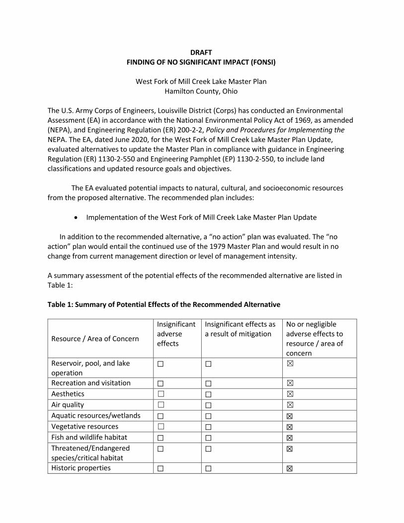
DRAFT FINDING OF NO SIGNIFICANT IMPACT (FONSI)
West Fork of Mill Creek Lake Master Plan
Hamilton County, Ohio The U.S. Army Corps of Engineers, Louisville District (Corps) has conducted an Environmental Assessment (EA) in accordance with the National Environmental Policy Act of 1969, as amended (NEPA), and Engineering Regulation (ER) 200-2-2, Policy and Procedures for Implementing the NEPA. The EA, dated June 2020, for the West Fork of Mill Creek Lake Master Plan Update, evaluated alternatives to update the Master Plan in compliance with guidance in Engineering Regulation (ER) 1130-2-550 and Engineering Pamphlet (EP) 1130-2-550, to include land classifications and updated resource goals and objectives. The EA evaluated potential impacts to natural, cultural, and socioeconomic resources from the proposed alternative. The recommended plan includes:
Implementation of the West Fork of Mill Creek Lake Master Plan Update
In addition to the recommended alternative, a “no action” plan was evaluated. The “no action” plan would entail the continued use of the 1979 Master Plan and would result in no change from current management direction or level of management intensity. A summary assessment of the potential effects of the recommended alternative are listed in Table 1: Table 1: Summary of Potential Effects of the Recommended Alternative
Resource / Area of Concern
Insignificant adverse effects
Insignificant effects as a result of mitigation
No or negligible adverse effects to resource / area of concern
Reservoir, pool, and lake operation
☐ ☐ ☒
Recreation and visitation ☐ ☐ ☒
Aesthetics ☐ ☐ ☒
Air quality ☐ ☐ ☒
Aquatic resources/wetlands ☐ ☐ ☒ Vegetative resources ☐ ☐ ☒ Fish and wildlife habitat ☐ ☐ ☒ Threatened/Endangered species/critical habitat
☐ ☐ ☒
Historic properties ☐ ☐ ☒
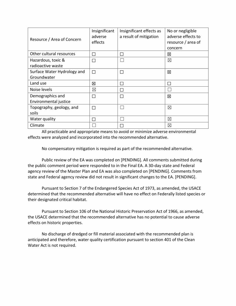
Resource / Area of Concern
Insignificant adverse effects
Insignificant effects as a result of mitigation
No or negligible adverse effects to resource / area of concern
Other cultural resources ☐ ☐ ☒ Hazardous, toxic & radioactive waste
☐ ☐ ☒
Surface Water Hydrology and Groundwater
☐ ☐ ☒
Land use ☒ ☐ ☐ Noise levels ☒ ☐ ☐
Demographics and Environmental justice
☐ ☐ ☒
Topography, geology, and soils
☐ ☐ ☒
Water quality ☐ ☐ ☒
Climate ☐ ☐ ☒
All practicable and appropriate means to avoid or minimize adverse environmental effects were analyzed and incorporated into the recommended alternative.
No compensatory mitigation is required as part of the recommended alternative.
Public review of the EA was completed on [PENDING]. All comments submitted during
the public comment period were responded to in the Final EA. A 30-day state and Federal agency review of the Master Plan and EA was also completed on [PENDING]. Comments from state and Federal agency review did not result in significant changes to the EA. [PENDING].
Pursuant to Section 7 of the Endangered Species Act of 1973, as amended, the USACE determined that the recommended alternative will have no effect on Federally listed species or their designated critical habitat.
Pursuant to Section 106 of the National Historic Preservation Act of 1966, as amended, the USACE determined that the recommended alternative has no potential to cause adverse effects on historic properties. No discharge of dredged or fill material associated with the recommended plan is anticipated and therefore, water quality certification pursuant to section 401 of the Clean Water Act is not required.
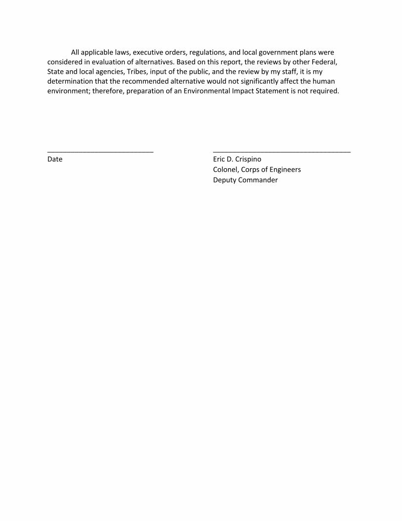
All applicable laws, executive orders, regulations, and local government plans were considered in evaluation of alternatives. Based on this report, the reviews by other Federal, State and local agencies, Tribes, input of the public, and the review by my staff, it is my determination that the recommended alternative would not significantly affect the human environment; therefore, preparation of an Environmental Impact Statement is not required. ___________________________ ___________________________________
Date Eric D. Crispino
Colonel, Corps of Engineers
Deputy Commander

This page intentionally left blank
Executive Summary
The U.S. Army Corps of Engineers’ (USACE) West Fork of Mill Creek Lake Project (Project) is located
within the greater metropolitan area of Cincinnati, Ohio in the southwestern corner of the state. The
Project is located approximately 13 miles north of downtown Cincinnati, and is located entirely within
Hamilton County, Ohio.
USACE holds title to 1,323 acres of land and water that comprise West Fork of Mill Creek Dam and
Reservoir. In addition, USACE has 41.15 acres of flowage easement lands. Of the fee land, USACE leases
1,283 acres to Great Parks of Hamilton County (GPHC) for public park facilities and recreation, natural
area preservation, fish, wildlife, and forest management purposes. This leased area is managed by GPHC
as part of the 2,555-acre Winton Woods Park.
Master Plans are required for civil works projects (such as the Project) for which USACE has
administrative responsibility for management of natural and manmade resources. Master Plans provide
guidelines and direction for future project development and provide a district-level policy consistent
with national objectives and other state and regional goals and programs. The existing Project Master
Plan was completed in 1979, and there has been no comprehensive update to the Master Plan in 41
years. As such, USACE is updating the current Master Plan to provide an up-to-date basis upon which to
evaluate contemporary proposals.
The proposed updated Master Plan includes updates to resource objectives that respond to identified
issues and that specify measurable and attainable activities for resource development and/or
management of the lands and waters under the jurisdiction of the Louisville District, West Fork of Mill
Creek Lake Project Office. Neither USACE nor GPHC currently have plans for development of new major
recreational amenities. The continued maintenance of existing facilities, improvement of some existing
facilities, and protection of the Project’s natural areas and natural resources would involve a number of
small-scale actions that are recommended under the updated Master Plan. This Environmental
Assessment (EA) describes the existing environmental conditions at the Project (affected environment),
providing a baseline for measuring expected changes that could result from adoption of the proposed
updated Master Plan. An Environmental Impact Statement (EIS) is not required because the effects of
adopting the proposed updated Master Plan are not expected to be significant.

This page intentionally left blank
i
Table of Contents
1.0 INTRODUCTION ..................................................................................................................... 1
1.1 Project Location ............................................................................................................................. 1
1.2 Authorization and Project Description .......................................................................................... 2
1.3 Project Overview ........................................................................................................................... 2
1.4 National Environmental Policy Act Overview ................................................................................ 2
1.5 Scope of the EA ............................................................................................................................. 3
2.0 PURPOSE AND NEED FOR USACE ACTION .............................................................................. 5
2.1 Master Plan Overview ................................................................................................................... 5
2.2 Purpose and Need for the Updated Master Plan .......................................................................... 5
3.0 Alternatives ........................................................................................................................... 8
3.1 No Action ....................................................................................................................................... 8
3.2 Proposed Action – Approval and Use of the Updated Master Plan .............................................. 8
3.2.1 Scope and Objectives of the Updated Master Plan .......................................................... 9
3.2.2 Land Allocation, Land Classification, and Resource Objectives......................................... 9
4.0 AFFECTED ENVIRONMENT / ENVIRONMENTAL CONSEQUENCES .......................................... 13
4.1 Reservoir, Pool, and Lake Operation ........................................................................................... 14
4.1.1 Existing Condition ........................................................................................................... 14
4.1.2 Environmental Consequences ........................................................................................ 14
4.2 Climate ........................................................................................................................................ 16
4.2.1 Existing Condition ........................................................................................................... 16
4.2.2 Environmental Consequences ........................................................................................ 16
4.3 Air Quality .................................................................................................................................... 16
4.3.1 Existing Condition ........................................................................................................... 16
4.3.2 Environmental Consequences ........................................................................................ 17
4.4 Topography, Geology, and Soils .................................................................................................. 17
4.4.1 Existing Condition ........................................................................................................... 17
4.4.2 Environmental Consequences ........................................................................................ 18
4.5 Surface Water Hydrology and Groundwater ............................................................................... 19
4.5.1 Existing Condition ........................................................................................................... 19
4.5.2 Environmental Consequences ........................................................................................ 21
4.6 Water Quality .............................................................................................................................. 21
4.6.1 Existing Condition ........................................................................................................... 21
ii
4.6.2 Environmental Consequences ........................................................................................ 22
4.7 Habitats ....................................................................................................................................... 23
4.7.1 Existing Condition ........................................................................................................... 23
4.7.2 Environmental Consequences ........................................................................................ 24
4.8 Listed Species .............................................................................................................................. 25
4.8.1 Existing Condition ........................................................................................................... 25
4.8.2 Environmental Consequences ........................................................................................ 26
4.9 Demographics and Environmental Justice .................................................................................. 27
4.9.1 Existing Condition ........................................................................................................... 27
4.9.2 Environmental Consequences ........................................................................................ 30
4.10 Recreation and Visitation ............................................................................................................ 31
4.10.1 Existing Condition ........................................................................................................... 31
4.10.2 Environmental Consequences ........................................................................................ 32
4.11 Cultural Resources ....................................................................................................................... 33
4.11.1 Existing Condition ........................................................................................................... 33
4.11.2 Environmental Consequences ........................................................................................ 35
4.12 Hazardous, Toxic, and Radioactive Waste Materials (HTRW) ..................................................... 36
4.12.1 Existing Condition ........................................................................................................... 36
4.12.2 Environmental Consequences ........................................................................................ 36
4.13 Aesthetics / Visual Qualities ........................................................................................................ 36
4.13.1 Existing Condition ........................................................................................................... 36
4.13.2 Environmental Consequences ........................................................................................ 37
4.14 Noise ............................................................................................................................................ 37
4.14.1 Existing Condition ........................................................................................................... 37
4.14.2 Environmental Consequences ........................................................................................ 37
5.0 CUMULATIVE EFFECTS ......................................................................................................... 40
6.0 SUMMARY OF ENVIRONMENTAL EFFECTS ............................................................................ 42
7.0 COMPLIANCE WITH ENVIRONMENTAL LAWS ....................................................................... 44
8.0 PUBLIC INVOLVEMENT......................................................................................................... 50
9.0 REFERENCES ........................................................................................................................ 52
List of Figures
Figure 1 Project Vicinity Map ....................................................................................................................... 1
Figure 2 Proposed Land Classification at West Fork of Mill Creek Lake ..................................................... 11
iii
Figure 3 Inundation Areas at Summer and Flood Control Pools ................................................................ 15
Figure 4 West Fork of Mill Creek Lake Watershed ..................................................................................... 20
Figure 5 West Fork of Mill Creek Lake Drive Time ..................................................................................... 28
List of Tables
Table 1 Soil Associations in Order of Predominance ................................................................................ 18
Table 2 Population in Area of Influence ................................................................................................... 27
Table 3 Age Distribution, 2010-2030 ........................................................................................................ 29
Table 4 Median Household Income .......................................................................................................... 30
Table 5 Recreational Activities at West Fork of Mill Creek Lake ............................................................... 31
Table 6 Visitation Data 2013-2019 ........................................................................................................... 32
Table 7 Summary of Environmental Effects from the Proposed Action ................................................... 42
iv
List of Acronyms
BMP – Best Management Practice
CEQ – Council on Environmental Quality
CFR – Code of Federal Regulations
DO – Dissolved Oxygen
EA – Environmental Assessment
EIS – Environmental Impact Statement
EM – Engineer Manual
EP – Engineer Pamphlets
ER – Engineering Regulation
ESA – Endangered Species Act of 1973
FONSI – Finding of No Significant Impact
GPHC – Great Parks of Hamilton County
HAB – Harmful Algal Bloom
MBTA – Migratory Bird Treaty Act
MSD – Metropolitan Sewer District of Greater Cincinnati
NAAQS – National Ambient Air Quality Standards
NEPA – National Environmental Policy Act of 1969
NHPA – National Historic Preservation Act of 1966
NRHP – National Register of Historic Places
ODNR – Ohio Department of Natural Resources
Project – West Fork of Mill Creek Lake Project
SHPO – Ohio State Historic Preservation Office
USACE – United States Army Corps of Engineers
USEPA – United States Environmental Protection Agency
USFWS – United States Fish and Wildlife Service
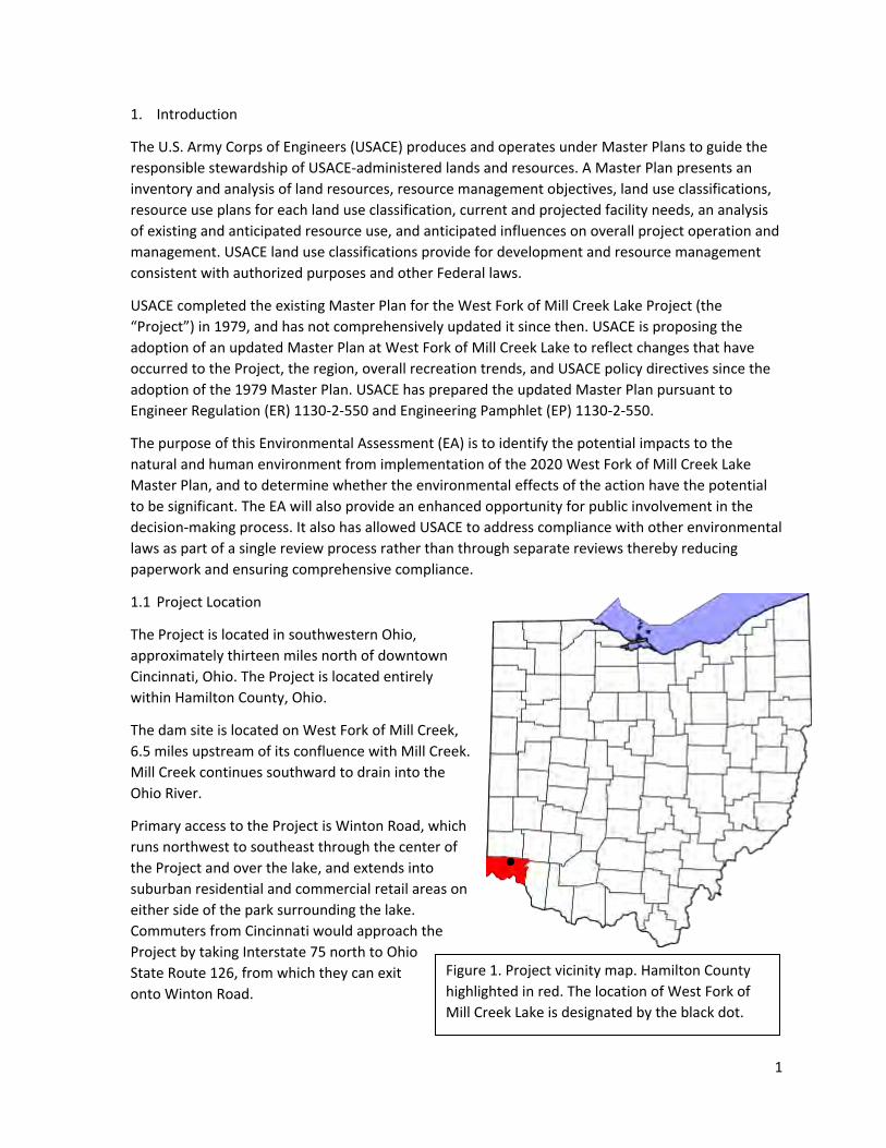
1
1. Introduction
The U.S. Army Corps of Engineers (USACE) produces and operates under Master Plans to guide the
responsible stewardship of USACE-administered lands and resources. A Master Plan presents an
inventory and analysis of land resources, resource management objectives, land use classifications,
resource use plans for each land use classification, current and projected facility needs, an analysis
of existing and anticipated resource use, and anticipated influences on overall project operation and
management. USACE land use classifications provide for development and resource management
consistent with authorized purposes and other Federal laws.
USACE completed the existing Master Plan for the West Fork of Mill Creek Lake Project (the
“Project”) in 1979, and has not comprehensively updated it since then. USACE is proposing the
adoption of an updated Master Plan at West Fork of Mill Creek Lake to reflect changes that have
occurred to the Project, the region, overall recreation trends, and USACE policy directives since the
adoption of the 1979 Master Plan. USACE has prepared the updated Master Plan pursuant to
Engineer Regulation (ER) 1130-2-550 and Engineering Pamphlet (EP) 1130-2-550.
The purpose of this Environmental Assessment (EA) is to identify the potential impacts to the
natural and human environment from implementation of the 2020 West Fork of Mill Creek Lake
Master Plan, and to determine whether the environmental effects of the action have the potential
to be significant. The EA will also provide an enhanced opportunity for public involvement in the
decision-making process. It also has allowed USACE to address compliance with other environmental
laws as part of a single review process rather than through separate reviews thereby reducing
paperwork and ensuring comprehensive compliance.
1.1 Project Location
The Project is located in southwestern Ohio,
approximately thirteen miles north of downtown
Cincinnati, Ohio. The Project is located entirely
within Hamilton County, Ohio.
The dam site is located on West Fork of Mill Creek,
6.5 miles upstream of its confluence with Mill Creek.
Mill Creek continues southward to drain into the
Ohio River.
Primary access to the Project is Winton Road, which
runs northwest to southeast through the center of
the Project and over the lake, and extends into
suburban residential and commercial retail areas on
either side of the park surrounding the lake.
Commuters from Cincinnati would approach the
Project by taking Interstate 75 north to Ohio
State Route 126, from which they can exit
onto Winton Road.
Figure 1. Project vicinity map. Hamilton County
highlighted in red. The location of West Fork of
Mill Creek Lake is designated by the black dot.
2
1.2 Authorization and Project Description
The Project is a unit of the general comprehensive flood control plan for the Ohio River Basin,
adopted by the Flood Control Act of 28 June 1938 (Public Law 761, 75th Congress, 3rd session).
Congress authorized the development of flood control projects for recreational purposes via Section
4 of the Flood Control Act of 22 December 1944 as amended by the Flood Control Act of 24 July
1946 (Public Law 526, 79th Congress, 2nd Session) (H.R. 6597). Lake construction began in March
1949, and was completed in December 1952.
The Project provides flood protection to the West Fork of Mill Creek Valley, and to the Mill Creek
Valley. As a unit in the comprehensive plan for the Ohio River Basin, it also reduces flooding at all
points downstream along Mill Creek and the Ohio River. Additionally, the lake provides
opportunities for recreation and fish and wildlife management activities.
USACE holds title to 1,323 acres of land and water that comprise West Fork of Mill Creek Dam and
Reservoir. In addition, USACE has 41.15 acres of flowage easement lands. Of the fee land, USACE
leases 1,283 acres to Great Parks of Hamilton County (GPHC) for public park facilities and recreation,
natural area preservation, fish, wildlife, and forest management purposes. This leased area is
managed by GPHC as part of the 2,555-acre Winton Woods Park.
1.3 Project Overview
The dam at West Fork of Mill Creek Lake is comprised of a rolled earth fill with a mowed turf
downstream face and a riprap upstream face. The maximum height of the dam is 100 feet and crest
length is 1,100 feet. The top elevation of the dam is 733 feet above mean sea level (msl). The dam
structures include a conduit-type outlet works and a spillway (with a control tower), a non-public
road across the top of the dam, a USACE project manager office that also serves as a mechanic’s
building, and a parking area.
The outlet works consist of a control tower and a reinforced concrete conduit. Flow is controlled by
three service gates – each with 4.25-foot horizontal by 8.5-foot vertical dimensions. Each one of
these gates has one 16-inch low-flow bypass pipe.
The emergency spillway is a concrete lined exit cut through the right abutment. The crest elevation
is 702 feet above msl. The width of the cut is 44 feet and the length of the cut is 900 feet. The
spillway is designed to accommodate a maximum discharge of 17,500 cubic feet per second (cfs) of
flow.
1.4 National Environmental Policy Act Overview
USACE has prepared this EA in accordance with the National Environmental Policy Act of 1969
(NEPA) and the Council on Environmental Quality’s (CEQ) Regulations (40 Code of Federal
Regulations (CFR) §§ 1500-1508), as reflected in the Corps of Engineers’ Engineering Regulation, ER
200-2-2. ER 200-2-2 supplements, and applies in conjunction with, the CEQ regulations.
The regulations set forth a process whereby USACE assesses the environmental effects of proposed
major federal actions and considers reasonable alternatives to these proposed actions. In general,
federal agencies prepare an EA to evaluate whether or not a federal action has the potential to
cause significant environmental effects. If the agency determines that the action would significantly
3
affect the quality of the human environment, the agency prepares an Environmental Impact
Statement (EIS) to evaluate the proposed action and alternatives in greater detail. If the EA
concludes that the action will not have significant environmental impacts, the agency will issue a
Finding of No Significant Impact (FONSI) to document the basis for that conclusion. Certain federal
actions are “categorically excluded” from NEPA documentation requirements because the action
does not “individually or cumulatively have a significant effect on the human environment.” The
Categorical Exclusions applicable to USACE actions include routine operations and maintenance
(O&M) activities at completed USACE projects (ER 200-2-2; 33 CFR § 230.9).
The CEQ’s NEPA Regulations do not contain a detailed discussion regarding the format and content
of an EA, but an EA must briefly discuss the:
Need for the proposed action;
Proposed action and alternatives (when there is an unresolved conflict concerning
alternative uses of available resources);
Environmental effects of the proposed action and alternatives; and
Agencies and persons consulted in the preparation of the EA.
1.5 Scope of the EA
NEPA requires federal agencies to review potential environmental effects of federal actions which
includes the adoption of formal plans, such as Master Plans, approved by federal agencies upon
which future agency actions will be based. Pursuant to ER 1130-2-550, USACE has prepared this EA
to fulfill its regulatory requirements under NEPA and to inform the public and to provide USACE with
the information needed to make an informed decision about the potential effects to the natural and
human environment from the proposed adoption of the updated West Fork of Mill Creek Lake
Master Plan.
The intention of the proposed Master Plan update is to provide guidance for the preservation,
conservation, restoration, maintenance, management and development of project lands, waters and
associated resources. It is not feasible to define the exact nature of potential impacts for all
potential future actions prior to the development of specific project proposals. Accordingly, this EA
does not consider the implementation of specific projects discussed within the updated Master Plan,
or that could be recommended in the future consistent with the updated Master Plan, as those
projects are conceptual in nature. To ensure future environmental consequences are identified and
documented as accurately as possible, additional NEPA analysis will be conducted, as appropriate,
for future projects that are proposed to be carried out in accordance with this Master Plan update
(including those identified within the Master Plan update), once funding is available and detailed
project planning and design occur.
The scope of the updated Master Plan and EA are limited to actions on USACE property, with the
exception of the consideration of potential cumulative effects associated with actions that have
taken place or are proposed to take place in the surrounding area.

4
This page intentionally left blank
5
2. PURPOSE AND NEED FOR USACE ACTION
2.1 Master Plan Overview
Master plans are required for civil works projects and other fee-owned lands for which USACE has
administrative responsibility for management of natural and manmade resources. The Master Plan
is the basic document guiding USACE responsibilities pursuant to federal laws to preserve, conserve,
restore, maintain, manage, and develop the Project lands, waters, and associated resources. The
Master Plan is a dynamic planning document that deals in concepts, not in details of design or
administration. Detailed management and administration functions are handled in a separate
Operational Management Plan (OMP), which translates the concepts of the Master Plan in
operational terms.
ER 1130-2-550 establishes the policy for the management of recreation programs and activities, and
for the operation and maintenance of USACE recreation facilities and related structures, at civil
works water resource projects. EP 1130-2-550 establishes guidance for the preparation of Master
Plans. As stated therein, the primary goals of the Master Plans are to prescribe an overall land and
water management plan, resource objectives, and associated design and management concepts,
which:
1) Provide the best possible combination of responses to regional needs, resource capabilities and
suitability, and expressed public interests and desires consistent with authorized project
purposes;
2) Contribute towards providing a high degree of recreation diversity within the region;
3) Emphasize the particular qualities, characteristics, and potentials of the Project; and
4) Exhibit consistency and compatibility with national objectives and other state and regionals
goals and programs
2.2 Purpose and Need for the Updated Master Plan
It is USACE policy that each Master Plan shall be reviewed on a periodic basis and be updated as
required (ER 1130-2-550). USACE approved the existing West Fork of Mill Creek Lake Master Plan in
1979, and has not updated the Master Plan in 41 years. There have been changes in demand for
recreation, adjacent population growth, new concerns with threatened and endangered species and
sensitive habitats, and updates to USACE master planning regulations and guidance, which dictate
the need to update the Master Plan for the Project. Because the current Master Plan does not
reflect these changes, USACE is updating it to provide an up-to-date basis upon which to evaluate
contemporary proposals.
The Master Plan update would provide a comprehensive description of the Project, a discussion of
factors influencing resource management and development, an identification and discussion of
special problems, a synopsis of public involvement and input to the planning process, and
descriptions of past, present, and proposed development.
The purpose of the Proposed Action is to ensure that the conservation and sustainability of the land,
water, and recreational resources at the Project comply with applicable environmental laws and
regulations and to maintain quality land for future use. The Master Plan is intended to serve as a
comprehensive land and recreation management plan for the next 15 to 25 years, which reflects

6
changes that have occurred since 1979 in outdoor recreation trends, regional land use, population,
legislative requirements, USACE management policy, and wildlife habitat at West Fork of Mill Creek
Lake.
Accordingly, the need for the Proposed Action is to update the West Fork of Mill Creek Lake Master
Plan pursuant to the January 2013 updates to ER and EP 1130-2-550.

7
This page intentionally left blank
8
3. Alternatives
When preparing an EA, federal agencies must consider a range of alternatives that could reasonably
achieve the purpose and need that the Proposed Action is intended to address. The alternatives to
be evaluated in this EA are a No Action Alternative of continuing to operate the Project under the
1979 Master Plan, and the Proposed Action Alternative of implementing and operating the Project
consistent with the 2020 West Fork of Mill Creek Lake Master Plan that is proposed for adoption.
USACE initially considered other alternatives to the Proposed Action as part of the scoping process
for the Master Plan and this EA. During this process, USACE and other management partners worked
to develop options for classifying project lands and identifying Resource Objectives (Master Plan,
Chapter 3) for these lands. The findings of the planning team revealed that there was only one
action alternative that would meet the purpose, need, and objectives of the master planning
process. As such, no other alternatives beyond the No Action and Proposed Action Alternative (the
Preferred Alternative) are being carried forward for analysis in this EA.
3.1 No Action
Inclusion of the No Action Alternative is required by CEQ regulations and serves as a basis for
comparison against which the effects of the Proposed Action can be evaluated. Under the No Action
Alternative, USACE would take no action and would not adopt the updated Master Plan. The 1979
Mater Plan would remain in effect, and the No Action Alternative would result in “no change” from
current management direction or level of management intensity. Master plans provide the basis for
evaluating contemporary proposals, and the 1979 document does not account for the many
substantial changes that have occurred since then. The existing Master Plan is capable of providing
only minimal support to development and management of the Project. Future development
decisions would therefore be assessed on an ad hoc basis without the benefit of a comprehensive
assessment of recreation and natural resource conditions and opportunities at the Project.
Under the No Action Alternative, development and management of the Project area would likely
take the same general direction outlined in the proposed Master Plan update and therefore, would
generally share the same environmental consequences. However, future developments or resource
management policies would require approval on a case-by-case basis without the benefit of
evaluation in the context of an updated overall plan or analysis in an EA.
3.2 Proposed Action Alternative (Preferred Alternative) – Approval and Use of the Updated Master
Plan
Under this alternative, USACE would adopt and implement the updated West Fork of Mill Creek Lake
Master Plan, which would replace the 1979 Master Plan. The updated Master Plan addresses
considerable changes in the demographics, recreation demand, amenities within the Project,
amenities on adjacent properties, current environmental conditions, and pertinent laws and
policies. This alternative is the Agency Preferred Alternative because it would meet the need for
sustainable management and conservation of natural resources within the Project while also
providing for current and future quality outdoor recreational needs of the public, and would satisfy
USACE regulations governing master planning for civil works projects.
9
As discussed above, the scope of the Proposed Action Alternative does not encompass
implementation of specific projects discussed within the 2020 Master Plan, or that could be
recommended in the future consistent with the 2020 Master Plan, as those projects are conceptual
in nature. Additional NEPA analysis will be conducted, as appropriate, for such future projects once
funding is available and detailed project planning and design occur.
3.2.1 Scope and Objectives of the Updated Master Plan
The Master Plan provides guidance and direction for future project development and use and is
based on authorized project purposes, USACE policies and regulations on the operation of USACE’s
projects (USACE, 1996), responses to regional and local needs, resource capabilities and suitable
uses, and expressed public interests consistent with authorized project purposes and pertinent
legislation. The Master Plan provides a District-level policy consistent with national objectives and
other state regional goals and programs.
3.2.2 Land Allocation, Land Classifications, and Resource Objectives
Land allocations at all USACE Civil Works water resource projects are based on the Congressionally-
authorized purpose for which the Project lands were acquired. Project lands are further categorized
into classifications based on the primary use for which project lands are managed. Proposed land
classification at West Fork of Mill Creek Lake can be seen in Figure 2. Land classification categories
as defined by EP 1130-2-550 are as follows:
1. Project Operations
2. High Density Recreation
3. Mitigation
4. Environmentally Sensitive Areas
5. Multiple Resource Management
a. Low Density Recreation
b. Wildlife Management
c. Vegetative Management
d. Future High Density Recreation
e. Future Low Density Recreation
The 1979 Master Plan does not determine or establish land classifications for the Project as described above. Implementation of the Proposed Action will be the first time USACE applies these land classifications to the Project’s lands. The land classifications determined or established in the updated Master Plan are intended to define land use at the Project for the next 20-30 years. These classifications, which are based on existing land use and zoning, should be considered the future land use areas for the next 20-30 years. Thus, the lands were classified to retain current land use and to represent ideal future land uses throughout the project. The updated Master Plan includes updates to resource objectives that would respond to identified issues and that specify measurable and attainable activities for resource development and/or management of the lands and water under the jurisdiction of the Louisville District, West Fork of Mill Creek Lake Project Office. Each resource objective of the updated Master Plan, and lists of recommended actions to achieve these objectives, are described below.

10
Objective 1: Improve the quality of the recreational experience for all users. o Action 1: Increase access to boat ramps by improving trails and roadways. o Action 2: Maintain a strong relationship with local schools to provide quality
educational programs by establishing a point of contact and holding regular meetings.
o Action 3: Schedule annual events such as bird counts, trash clean ups and citizen surveys.
o Action 4: Add additional recreational opportunities such as zip lines and an adventure outpost.
o Action 5: Repair and update trails within the lake area including relocating the Kingfisher Trail away from the creek in order to keep the trail from flooding regularly.
o Action 6: Connect existing trails to allow better access to the lake by biking/walking.
Objective 2: Improve the water quality and other natural resources within the lake area. o Action 1: Regularly monitor lake water quality for particulates and other
pollution from point and non-point sources. o Action 2: Coordinate with the local Metropolitan Sewer District to resolve the
leaking sewer pipes that cross the lake in two major areas. o Action 3: Remove invasives and plant native species in Harpers Meadow and the
meadow at Paul’s tract. o Action 4: Plant native shade trees near the fishing area.
Objective 3: Improve communications and advertising for the lake. o Action 1: Create a new branding campaign to adopt the name Winton Woods
Lake to include new signage and branding, while working and coordinating with Great Parks.
o Action 2: Develop a communication plan between the USACE and Great Parks and include important entities such as Ohio Department of Natural Resources (ODNR) that involve frequent and consistent information on maintenance issues.
o Action 3: Create a Memorandum of Understanding to provide clarity on who has enforcement authority on USACE land.
Objective 4: Identify and protect the cultural resources within the Project area. o Action 1: Provide better protection for the covered bridge and raptor house
against vandalism. o Action 2: Form a cultural resources task force to clean up and maintain natural
resources in the lake area. o Action3: Create and maintain a communication plan with interested tribal
nations.

11
Figu
re 2
. Pro
po
sed
Lan
d C
lass
ific
atio
n a
t W
est
Fork
of
Mill
Cre
ek L
ake

12
This page intentionally left blank
13
4. Affected Environment/Environmental Consequences
The National Environmental Policy Act and the Council on Environmental Quality’s NEPA
Implementing Regulations require than an EA identify the likely environmental effects of a proposed
project and that the agency determine whether those impacts may be significant. Impacts can be
either beneficial or adverse and can be either directly related to the action or indirectly caused by
the action. Direct effects are caused by the action and occur at the same time and place (40 CFR §
1508.8[a]). Indirect effects are caused by the action and are later in time or further removed in
distance, but are still reasonable foreseeable (40 CFR § 1508.8[b]).
The determination of whether an impact significantly affects the quality of the human environment
must consider the context of an action and the intensity of the impacts (40 CFR § 1508.27).
The term “context” refers to the affected environment in which the proposed action would take
place and is based on the specific location of the proposed action, taking into account the entire
affected region, the affected interests, and the locality. The term intensity refers to the magnitude
of change that would result if the proposed action were implemented.
Determining whether an effect significantly affects the quality of the human environment also
requires an examination of the relationship between context and intensity. In general, the more
sensitive the context (i.e. the specific resource in the proposed action’s affected area), the less
intensive an impact needs to be in order for the action to be considered significant. Conversely, the
less intense of an impact, the less scrutiny even sensitive resources need because of the overt
inability of an action to effect change to the physical environment. The consideration of context and
intensity also must account for the indirect and cumulative effects from a proposed action. This
section describes the existing environmental conditions in the Project area (affected environment)
providing a baseline for measuring expected changes that would result from implementation of the
proposed Master Plan update.
This Section presents the adverse and beneficial environmental effects (direct and indirect) of the
Proposed Action and the No Action Alternative. The section is organized by resource topic, with the
effects of alternatives discussed under each resource topic. Impacts are quantified whenever
possible. Qualitative descriptions of impacts are explained by accompanying text where used.
Qualitative definitions/descriptions of impacts as used in this section of the EA include:
Intensity:
No Effect, or Negligible – a resource would not be affected, or the effects would be at or
below the level of detection, and changes would not be of any measurable or perceptible
consequence.
Minor – effects on a resource would be detectable, although the effects would be localized,
small, and of little consequence to the sustainability of the resource. Mitigation measures, if
needed to offset adverse effects, would be simple and achievable.
Moderate – effects on a resource would be readily detectable, localized, and measurable.
Mitigation measure, if needed to offset adverse effects, would be extensive and likely
achievable.
14
Significant – effects on a resource would be obvious and would have substantial
consequences. The resource would be severely impaired so that it is no longer functional in
the Project area. Mitigation measures to offset the adverse effects would be extensive, and
success of the mitigation measures would not be guaranteed.
Duration:
Short term – temporary effects caused by the construction and/or implementation of a
selected alternative; and
Long term – caused by an alternative and remain after the action has been completed
and/or after it is in full and complete operation.
All potentially relevant resource areas were initially considered for analysis in this EA. Consistent
with NEPA implementing regulations and guidance (40 CFR § 1502.2[b]), some resource topics are
not discussed, or the discussion is limited in scope, due to the lack of direct effect from the
Proposed Action on the resource or because that resource is not located within the Project.
4.1 Reservoir, Pool, and Lake Operation
4.1.1 Existing Conditions
The primary purposes of the Project are flood control and recreation. The reservoir was designed to
store floodwaters and slow the release downstream, reducing flood risk in the lower Mill Creek
Valley and ultimately along the Ohio River. Figure 3 shows inundation areas between the permanent
pool (West Fork of Mill Creek Lake does not seasonally adjust pool levels) of 675 feet above msl and
the flood control level and spillway of 702 feet above msl. This top of the dam and dike is 733.5 feet
above msl. The lake’s record pool is 699.7 feet above msl on March 20th, 2008.
The West Fork of Mill Creek Lake does not have an established minimum release rate. Releases are
dependent upon reservoir inflows. However, the rate of release generally does not go below 2 cfs.
4.1.2 Environmental Consequences
4.1.2.1 No Action
Under the No Action Alternative, the updated Master Plan would not be approved for the Project in
the foreseeable future and there would be no comprehensive planning for the Project. As this
alternative would result in the operation and management of the Project continuing as outlined in
the 1979 Master Plan, no effects to the reservoir, pool, or lake operations are anticipated.
4.1.2.2 Proposed Action
Implementation of the ongoing project management under the updated Master Plan would result in
no changes to the West Fork of Mill Creek Reservoir or lake operations. Operations are controlled by
the Project’s Operational Management Plan; the updated Master Plan would not change lake
operations.
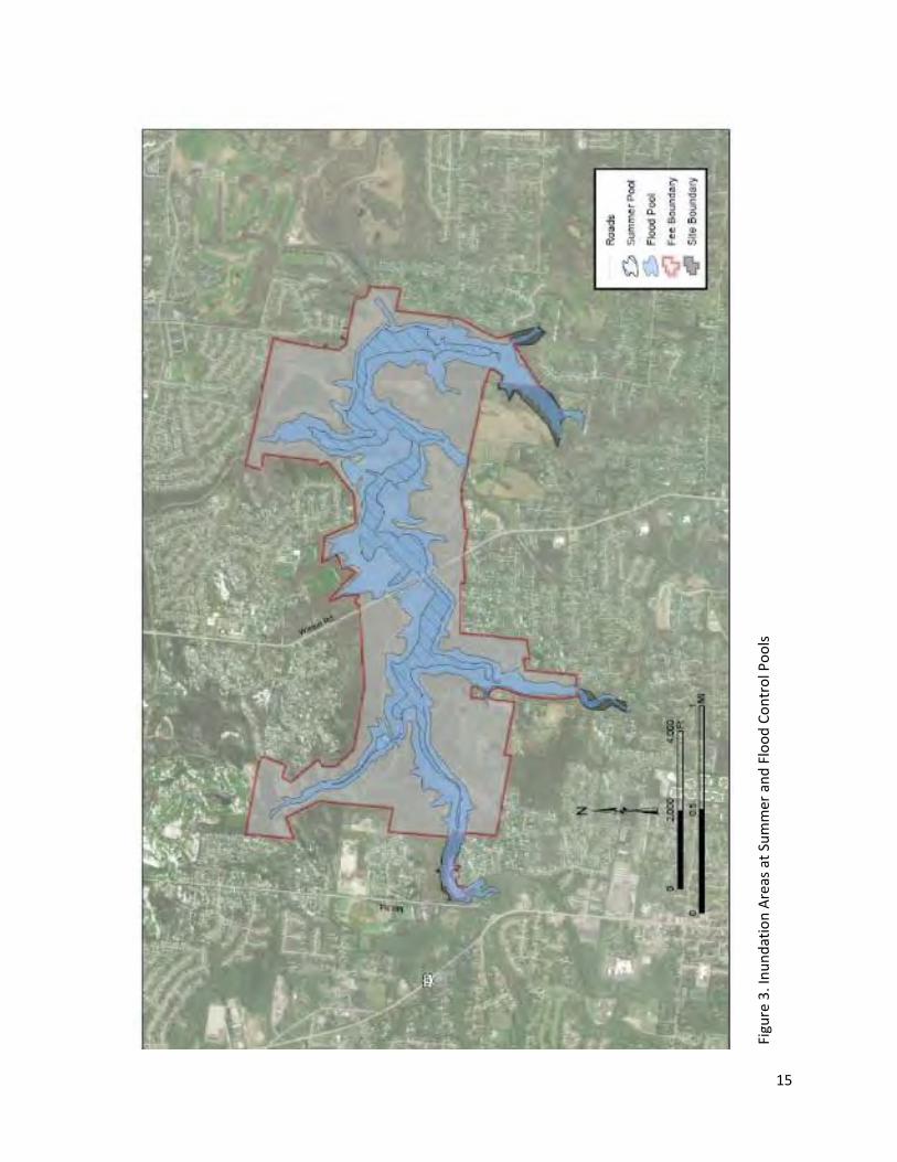
15
Figu
re 3
. In
un
dat
ion
Are
as a
t Su
mm
er a
nd
Flo
od
Co
ntr
ol P
oo
ls
16
4.2 Climate
4.2.1 Existing Condition
Historically, southwestern Ohio has had a humid continental climate characterized by high humidity,
considerable short-term fluctuations in temperature and a relatively uniform moisture regime.
Summers are moderately warm and humid; winters are reasonably cold. The region is influenced by
the presence of cold polar air from the north and warm Gulf air from the south. Moderate
cloudiness and windiness result from the frequent passage of cyclonic storms. The occurrence of
tornados is possible several times a year, usually in the spring.
Climate change is expected to have considerable impacts on southwestern Ohio (University of
Michigan, 2013). Temperatures are expected to rise, and Cincinnati is projected to experience more
than 85 days of temperatures over 90°F by the end of the century. The incidence of heat waves is
also expected to increase. Precipitation in southwestern Ohio is projected to increase during the
winter, spring, and fall months, and summer months should become drier. When rain does fall, it
will be more likely to do so during heavy rain events. This will exacerbate flooding and water quality
concerns, and may also contribute to more frequent sewage overflows.
4.2.2 Environmental Consequences
4.2.2.1 No Action
Under the No Action Alternative, the updated Master Plan would not be approved for the Project in
the foreseeable future and there would be no comprehensive planning for the Project. As this
alternative would result in the operation and management of West Fork of Mill Creek Lake
continuing as outlined in the 1979 Master Plan, no effects to climate are anticipated.
4.2.2.2 Proposed Action
The implementation of the Proposed Action would have a negligible effect on greenhouse gas
emissions and climate. Potential implementation of future projects in accordance with the updated
Master Plan could generate short-term emissions from construction activities, including emissions of
greenhouse gases. Future development and increased recreational opportunities could also
generate increased visitation and corresponding greenhouse gas emissions from vehicles. These
increases, however, would be insignificant to local, regional, and global greenhouse gas levels and to
corresponding changes to climate conditions. Increases in greenhouse gas emissions could also be
offset by people traveling a shorter distance to access recreational facilities not previously offered at
the Project. However, these potential future actions (including those discussed in the updated
Master Plan) are at this time conceptual, and their implementation would require separate NEPA
analysis, as appropriate.
4.3 Air Quality
4.3.1 Existing Condition
The U.S. Environmental Protection Agency (USEPA) Office of Air Quality Planning and Standards has
set National Ambient Air Quality Standards (NAAQS) for six principal pollutants, called “criteria”
pollutants. They are carbon monoxide, nitrogen dioxide, ozone, lead, particulates of 10 microns or
less in size (PM-10 and PM-2.5), and sulfur dioxide. Ozone is the only parameter not directly emitted
into the air but that forms in the atmosphere when three atoms of oxygen (O3) are combined by a
17
chemical reaction between oxides of nitrogen (NOX) and volatile organic compounds (VOC) in the
presence of sunlight. Motor vehicle exhaust and industrial emissions, gasoline vapors, and chemical
solvents are some of the major sources of NOX and VOC, also known as ozone precursors. Strong
sunlight and hot weather can cause ground-level ozone to form in harmful concentrations in the air.
Hamilton County is not in attainment for 8-hour ozone standards near Cincinnati, and the EPA has
classified this non-attainment as “marginal” (US EPA, 2020). West Fork of Mill Creek Lake, which is
located in Hamilton County and is approximately thirteen miles north of downtown Cincinnati, is
within the area of marginal ozone non-attainment.
4.3.2 Environmental Consequences
4.3.2.1 No Action
Under the No Action Alternative, the updated Master Plan would not be approved for the Project in
the foreseeable future and there would be no comprehensive planning for the Project. As this
alternative would result in the operation and management of the Project continuing as outlined in
the 1979 Master Plan, no effects to air quality are anticipated.
4.3.2.2 Proposed Action
Air quality would not be predicted to change from existing conditions as the effects of implementing
the updated Master Plan on air quality would be negligible. Because the action of implementing the
updated Master Plan would not result in any emissions increase, the action is exempt from
conformity determination under the General Conformity Rule. Potential implementation of future
projects in accordance with the updated Master Plan would be expected to result in localized and
short term emissions associated with construction of new or improved amenities (e.g. utility
trenching, road paving, supplying asphalt/concrete, excavation, etc.). Emissions from construction
actions would typically include byproducts of diesel and gasoline combustion, fugitive dust, and
vapors from asphalt paving. The emissions associated with equipment operation and construction
would be localized and short term, and would not be expected to significantly affect air quality in
the vicinity of the Project. However, these potential future actions (including those discussed in the
updated Master Plan) are at this time conceptual, and their implementation would require separate
NEPA analysis, as appropriate.
4.4 Topography, Geology, and Soils
4.4.1 Existing Conditions
West Fork of Mill Creek Lake is split between the Southern Ohio Loamy Till Plain and Illinoian Till
Plain physiographic regions. The Wisconsin glacial boundary is located near the vicinity of the
Project. This area is characterized by gently rolling hills. Elevations at the Project site range from 640
to 790 feet above msl.
Locations throughout the Project area have limited potential for development due to slopes greater
than 15 percent. USACE Engineering Manual (EM)-1110-1-400, under Chapter 2, recommends
avoiding development on slopes greater than 15 percent unless there is no other acceptable
alternative. Approximately 44 percent of the Project area consists of slopes greater than 15 percent.
18
West Fork of Mill Creek Lake is underlain with bedrock dating to the Ordovician period –
approximately 485 to 444 million years ago. This bedrock is mostly shale and limestone and is part
of the Grant Lake and Fairview formations.
According to the United States Department of Agriculture (USDA) Natural Resources Conservation
Service (NRCS), four broad soil associations are predominant at the Project site. These soil
associations are listed in Table 1 and have been divided into two development suitability categories:
1) Suitable for development or 2) Unsuitable for development
Table 1. Soil Associations in Order of Predominance
Soil Series Typical Slope Suitability Based on Slope and Soil Type
Eden Moderate – Very Steep Suitable. Moderately deep and well drained soils. Formed in residuum from interbedded calcareous shale, siltstone and limestone.
Markland Gentle – Steep Suitable. Very deep and well drained soils on lake plains. Formed in this loess and underlying calcareous, fine-textured lacustrine sediments.
Switzerland Gentle – Steep Suitable. Deep and moderately well drained soils. Formed in loess and residuum weathered from interbedded soft calcareous shale and limestone.
Jonesboro-Rossmoyne
Flat – Gentle Suitable. Very deep and moderately well drained soils. Formed in loess and the underlying till.
Based on the information presented in Table 1, all of the predominant soil associations at West Fork
of Mill Creek Lake provide suitable areas for development. However, areas with the Eden or
Markland soil series are perhaps best suited for development, as these soils are well drained. Areas
with the Switzerland or Jonesboro-Rossmoyne soil series are moderately well drained, making them
more somewhat more prone to inundation than Eden or Markland soils, though not to such an
extent that they would be unsuitable for development. Development may be limited in some areas
due to steep slopes.
4.4.2 Environmental Consequence
4.4.2.1 No Action
Under the No Action Alternative, the updated Master Plan would not be approved for the Project in
the foreseeable future and there would be no comprehensive planning for the Project. As this
alternative would result in the operation and management of West Fork of Mill Creek Lake
continuing as outlined in the 1979 Master Plan, no effects to topography, geology, or soils are
anticipated.
4.4.2.2 Proposed Action
The topography, geology, and soils of the Project would not be predicted to change from existing
conditions as the effects of implementing the updated Master Plan on these features would be
negligible. Potential implementation of future projects in accordance with the updated Master Plan
would use best management practices (e.g. use of silt fences) to minimize erosion and soil loss,
19
when appropriate. As a result, the effects to topography, geology, and soils from potential future
projects would not be expected to be significant. However, these potential future actions (including
those discussed in the updated Master Plan) are at this time conceptual, and their implementation
would require separate NEPA analysis, as appropriate.
4.5 Surface Water Hydrology and Groundwater
4.5.1 Existing Conditions
West Fork of Mill Creek Lake is a 1,323-acre project fed primarily by West Fork of Mill Creek. The
tailwater drains in to West Fork of Mill Creek, which flows eastward and southward 6.5 miles until it
merges with Mill Creek. Mill Creek continues southward to drain into the Ohio River. The dam
functions to control flooding in West Fork of Mill Creek, while simultaneously providing recreational
opportunities via the reservoir.
West Fork of Mill Creek Lake gathers stormwater runoff from a 29.5 square mile watershed which is
contained entirely within Hamilton County. The major tributary of the drainage area is West Fork of
Mill Creek, though a number of small intermittent streams also feed into West Fork of Mill Creek
Lake. The Mill Creek watershed, of which West Fork of Mill Creek Lake’s watershed is a portion of,
covers 166.2 square miles. Land use within the watershed is largely suburban residential and typical
commercial retail.
West Fork of Mill Creek Lake was formed on West Fork of Mill Creek in 1952 following the
construction of the dam. The dam is located on West Fork of Mill Creek, 6.5 miles upstream from its
confluence with Mill Creek. West Fork of Mill Creek Lake maintains a consistent pool of 188 acres of
water and a shoreline length of 10.4 miles year round.
Boats on West Fork of Mill Creek Lake, both rented and privately owned, are limited to motors of six
horsepower or less. Public launch ramps for trailered boats and trailer parking are not available or
provided at West Fork of Mill Creek Lake, limiting private watercraft to those light enough to be
carried from a parking area to a designated launch area.
Sedimentation has been a long standing issue at West Fork of Mill Creek Lake, and one that has
been exacerbated by developments in the lands adjacent to the Project area that are beyond
USACE’s control. When West Fork of Mill Creek Lake was dredged in 1995 and 1996, 930,000 cubic
yards of silt were removed (GPHC, 2019). Erosion concerns at West Fork of Mill Creek Lake are
somewhat alleviated by the practices of maintaining a single permanent lake pool level and limiting
the horsepower of motorboats allowed on the lake, though these practices do not entirely prevent
erosion at the Project. Should sedimentation and erosion concerns persist, West Fork of Mill Creek
Lake may require additional dredging in the future.
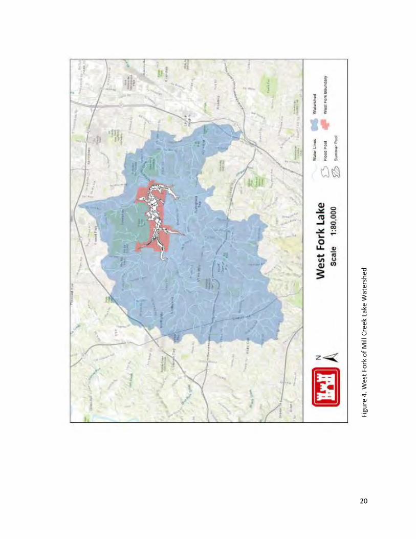
20
Figu
re 4
. Wes
t Fo
rk o
f M
ill C
reek
Lak
e W
ater
shed
21
Tailwater Area
The tailwater area is located downstream of the dam. The tailwater area is fed by water release
from the dam, which is variable depending on the West Fork of Mill Creek Lake’s water inputs. While
West Fork of Mill Creek Lake has no established minimum release rate, this flow generally does not
fall below 2 cfs.
Groundwater
West Fork of Mill Creek Lake lies near the Wisconsin glacial margin, and is thus nearby to glacial till
from both the Wisconsinan age and the Illinoian age. ODNR has two classifications for groundwater
within the Project area. The first classification, which covers most of the Project area, corresponds
with areas that would not expect any wells to yield more than three gallons per minute of water.
This makes the area quite poor for groundwater collection. A portion of the northeastern project
area has a different classification, with ODNR expecting any wells here to produce no more than ten
gallons per minute of water. ODNR also states that, depending on local geologic conditions, this area
may also be limited to less than three gallons per minute of water. The only water well near the
Project is located in this northeastern area, and is privately owned (ODNR, 2020).
4.5.2 Environmental Consequences
4.5.2.1 No Action
Under the No Action Alternative, the updated Master Plan would not be approved for the Project in
the foreseeable future and there would be no comprehensive planning for the Project. As this
alternative would result in the operation and management of West Fork of Mill Creek Lake
continuing as outlined in the 1979 Master Plan, no short-term effects to surface water hydrology or
groundwater are anticipated. Long-term adverse effects to the Project’s water resources are
possible due to the absence of land classification and resource objectives that would contribute to
effective stewardship of the Project’s resources.
4.5.5.2 Proposed Action
There would be no environmental consequences of implementing the Master Plan update expected
to the surface water hydrology or groundwater of the Project. The land classification and resource
objectives in the updated Master Plan would allow land management and land uses to be
compatible with the goals of good stewardship of water resources.
4.6 Water Quality
4.6.1 Existing Condition
The EPA’s NEPAssist tool identifies both West Fork of Mill Creek Lake and the streams feeding into it
as impaired. The degree of this impairment appears to vary throughout the year. For instance,
dissolved oxygen (DO) readings of West Fork of Mill Creek Lake have been low enough for the lake
to be impaired for proposed lake habitat use designation, though seasonal changes in West Fork of
Mill Creek Lake’s DO levels allow for the stocking of rainbow trout in March and October (Ohio EPA,
2016). Bacterial samples taken in May and July of 2013 and 2014 exceeded recreation use criteria
for Primary Contact Recreation, though the two-year geometric mean of all results met the lake
habitat criteria (Ohio EPA, 2016). Water quality measurements taken in 2017 and 2018 have found
22
that West Fork of Mill Creek Lake meets state criteria for temperature and DO, though the lake
exceeded state criteria for total phosphorus and turbidity. While the NEPAssist tool also identifies
the tailwater area as being impaired for water quality, USACE reports from 2017 and 2018 have
found that the tailwater area, unlike West Fork of Mill Creek Lake, did not exceed any water quality
criteria set by the Ohio EPA.
West Fork of Mill Creek Lake exists within the Cincinnati metropolitan area, and wastewater
treatment is primarily handled by the Metropolitan Sewer District of Greater Cincinnati (MSD).
There are two aerial sewer lines that run over the lake. One of these sewer lines has experienced
failure at several times in the Winton Woods area adjacent to the lake. In 2019, West Fork of Mill
Creek Lake was briefly closed due to a sewer obstruction that had caused sewage to leak near the
lake (WVXU, 2019b). The lake’s exposure to untreated or partially treated sewage may contribute to
harmful algal blooms (HABs). The lake’s close proximity to suburban residential areas may also
contribute to HABs, as fertilizers used on lawns may result in nutrient runoff into the lake.
HABs in Ohio are addressed by ODNR as they are the lead agency for HAB response in the state. The
ODNR works with the Ohio EPA and Ohio Department of Health to sample for cyanobacteria and
cyanotoxins at designated swimming beaches and to post any required recreational advisories.
USACE Louisville District supports the state agencies by reporting any visual HAB indicators and by
participating in a Sign Posting and Communication Plan to communicate HAB potential for the
visiting public.
West Fork of Mill Creek Lake is currently at risk of experiencing HABs. The lake has been found to
have high phosphorus levels, and Trophic State Index values calculated from lake measurements
have West Fork of Mill Creek Lake categorized as eutrophic, or even hypereutrophic in certain
locations. Sewage leaks from the surrounding areas may be contributing to this nutrient
overabundance. Chlorophyll-a can be used as an index to approximate phytoplankton biomass,
which rises to high levels during a HAB. In 2013 and 2014, chlorophyll-a levels were taken from West
Fork of Mill Creek Lake and were high enough for the lake to be considered impaired, though HABs
were not observed during either of those years. USACE reports from 2017 and 2018 found that the
phytoplankton community was dominated by the presence of cyanobacteria, further indicating
West Fork of Mill Creek Lake’s potential to experience HABs.
4.6.2 Environmental Consequences
4.6.2.1 No Action
Under the No Action Alternative, the updated Master Plan would not be approved for the Project in
the foreseeable future and there would be no comprehensive planning for the Project. As this
alternative would result in the operation and management of West Fork of Mill Creek Lake
continuing as outlined in the 1979 Master Plan, no short-term effects to water quality are
anticipated. However, the updated Master Plan recommends actions that could benefit water
quality over the long-term, and the failure to implement the Master Plan update may result in these
actions not being taken. Thus, the No Action Alternative carries a risk for long-term adverse effects
to the water quality of the Project.
23
4.6.2.2 Proposed Action
Implementation of the updated Master Plan would be expected to result in long-term beneficial
effects to water quality in the reservoir and tailwater. Recommended actions in the updated Master
Plan to improve water quality include monitoring the lake for particulates and other pollution and
coordinating with MSD to resolve leaking sewer pipes that cross the water and that may be partially
responsible for the lake’s nutrient overabundance. Although the construction of any new amenities
or recreational features in accordance with the updated Master Plan could result in ground-surface
disturbances that could increase runoff and diminish water quality, best management practices
during construction (e.g. use of silt fences) would be expected to minimize the potential for
deleterious effects. After construction was completed, re-seeding and re-vegetation would be
performed to minimize erosion losses and protect soils. However, these potential future actions
(including those discussed in the updated Master Plan) are at this time conceptual, and their
implementation would require separate NEPA analysis, as appropriate.
4.7 Habitats
4.7.1 Existing Condition
There are eight habitats contained at West Fork of Mill Creek Lake. Three of these consist of
regularly disturbed areas: developed lands, managed tree areas and agricultural areas. These
regularly disturbed areas are home to edge and urban adaptive species. Typical animal species
found in these habitats include songbirds, coyotes, foxes, deer, raptors, mice, squirrels, raccoons
and rabbits. The remaining five habitats are described below.
Open Water
A large portion of the Project consists of open water. West Fork of Mill Creek Lake is classified as
warmwater habitat. Fish living in the open water environment at West Fork of Mill Creek Lake
include blue, shovelhead and bullhead catfish, yellow perch, and largemouth bass. Some species are
stocked seasonally, such as channel catfish during the summer months. GPHC annually restocks
West Fork of Mill Creek Lake’s fish population, and is responsible for the maintenance and
improvement of fishing at the lake.
Wetlands
West Fork of Mill Creek Lake wetlands are located in floodplains surrounding the lake. Wetlands are
frequently classified by their predominant vegetation class, and the Project contains emergent,
scrub-shrub, and forested wetlands. Flora typical to wetlands may include various sedges, cattail,
spikerush, smartweed, knotweed, arrowhead, pickerelweed, pondweed, naid, watermilfoil,
bladderwort, duckweed and waterlily. Trees such as willow, cottonwood, sycamore, maple, ash, and
oak tend to dominate in forested wetlands. Wetlands can function as habitat for many animals,
including red-winged blackbird, muskrats, mink, beaver, reptiles and amphibians, as well as a wide
range of waterfowl.
South-Central Interior Mesophytic Forest
This habitat is characterized by a mixed-mesophytic community, typically found south of the glacial
boundary. The South-Central Interior Mesophytic Forest is predominantly found on lower slopes, in
24
coves and in other protected landscape areas. Small streams are common in this community. This
habitat contains a rich herb layer often comprised of abundant spring ephemerals such as spring
beauty and Dutchman’s breeches. Other herbs common to this forest-type include white trillium,
black baneberry and great Indian plantain. Dominant canopy species are sugar maple and American
beech with maples, black walnut and sassafras (NatureServe Explorer, 2017).
Southern Interior Low Plateau Dry-Mesic Oak Forest
This habitat is characterized by upland hardwood-dominated forests located along ridge tops and
slopes of various aspects on unglaciated terrain. Southern Interior Low Plateau Dry-Mesic Oak
Forest can encompass a range of moisture gradients from submesic to drier associations. In general,
the canopy of this forest type is dominated by oak and hickory, though maple, beech, ash and
walnut can also be present. The understory of this forest type is typically dominated by shrubs and
small trees, though the typical species here will vary with local aspect, soil and moisture conditions.
Among forbs, representatives of the Fabaceae (comprising legumes, peas, and beans) and
Asteraceae (comprising asters and daisies) are prominent, though again this varies with local
conditions. (NatureServe Explorer, 2008).
Common animals to both forest types include white-tailed deer, gray squirrels, fox squirrels,
raccoons, songbirds, woodpeckers, owls and foxes.
Old Fields
Old fields are successional habitats characterized by grasses, shrubs and trees. These habitats are
typically transitioning from grasslands to young forests. In the Midwest, early successional habitats
are characterized by the following plant species: blackberry, raspberry, switchgrass, big bluestem
and little bluestem among other grasses, fobs and shrubs. Wildlife species may include cottontail
rabbit, white-tailed deer, turkey, wrens, sparrows, grouse, coyotes, foxes and other various
songbirds and furbearers.
4.7.2 Environmental Consequences
4.7.2.1 No Action
Under the No Action Alternative, the updated Master Plan would not be approved for the Project in
the foreseeable future and there would be no comprehensive planning for the Project. As this
alternative would result in the operation and management of West Fork of Mill Creek Lake
continuing as outlined in the 1979 Master Plan, the Project’s wetlands would not be classified as
environmentally sensitive areas. However, neither USACE nor GPHC have any plans to develop these
areas of the Project that would be prevented or altered by this land use classification, and thus no
degradation to these wetland areas would be expected under the No Action Alternative over the
short-term. However, such developments could be planned for in the future, and the absence of
land classifications could put the Project’s wetlands at risk over the long-term. No effects to the
other habitats present at the Project are anticipated.
4.7.2.2 Proposed Action
There would be no adverse environmental consequences of implementing the Master Plan update
expected to the habitats of the Project. Because there are no current plans to develop the areas that
25
are being classified as environmentally sensitive (i.e. wetlands), the implementation of the Proposed
Action Alternative would not have any short term effect on these areas. However, the Proposed
Action Alternative may have long term beneficial effects by protecting environmentally sensitive
areas from degradation by future developments. Potential implementation of future projects in
accordance with the updated Master Plan for the Project are required to comply with NEPA and
many other laws pertaining to the conservation of natural and cultural resources. Prior to
implementation of any development activity that could adversely impact terrestrial or aquatic
habitats, field surveys and all appropriate coordination with state and/or federal agencies will be
conducted by USACE. As such, future development would be expected to occur with minimal effects
to the habitats of the Project.
In addition, under the proposed action, GPHC would continue to work to improve the fishery at the
Project by stocking fish and maintaining and creating fish habitat. Likewise, wildlife and forest
management would also still be the responsibility of GPHC.
4.8 Listed Species
Lists of threatened, endangered and species of special concern are maintained by the USFWS and
the State of Ohio. Under the Endangered Species Act (ESA) of 1973 (16 U.S.C. §§ 1531-1544),
endangered species are defined as any species in danger of extinction throughout all or portions of
its range. A threatened species is any species likely to become endangered in the foreseeable future.
The ESA defines critical habitat of the above species as a geographic area that contains the physical
or biological features that are essential to the conservation of a particular species and that may
need special management or protection. This section also covers birds listed under the Migratory
Bird Treaty Act (MBTA) of 1918 (16 U.S.C. §§ 703-712) as birds of conservation concern.
4.8.1 Existing Condition
The USFWS maintains lists of rare plants and wildlife that occur in each county of the US. The State
of Ohio maintains a separate inventory of state-ranked endangered and threatened species and
species of special concern. This list can be obtained through the ODNR website, either as a complete
account for all such species throughout the state or by specific county.
An official list from the USFWS, dated April 16, 2020, for the Project included seven endangered
species: the Indiana bat (Myotis sodalis), fanshell (Cyprogenia stegaria), pink mucket (Lampsilis
abrupta), rayed bean (Villosa fabalis), sheepnose mussel (Plethobasus cyphyus), snuffbox mussel
(Epioblasma triquetra) and running buffalo clover (Trifolium stoloniferum). In addition to these
species, the northern long-eared bat (Myotis septentrionalis) is listed as a threatened species under
the ESA and also has potential to occur throughout Ohio, including West Fork of Mill Creek Lake
(USFWS, 2020). While these species may not necessarily be present within project boundaries,
activities within those boundaries are considered to have the potential to impact these species.
West Fork of Mill Creek Lake is within the range of the Indiana bat. In the spring, bats emerge from
hibernation and migrate to summer roost sites. During the summer months, female Indiana bats
establish maternity colonies of up to 100 bats under the loose bark of trees and in tree cavities. Loss
and fragmentation of forest habitat are among the major threats to Indiana bat populations. Other
26
threats include white-nose syndrome, winter disturbance, and environmental contaminants
(USFWS, 2019b).
Fanshell, pink mucket, rayed bean, sheepnose mussel, and snuffbox mussel are all endangered
freshwater mussels that have ranges that encompass the Project area. North America has the
highest diversity of freshwater mussels in the world and, within North America, the Midwest region
has historically had some of the largest numbers of these species (USFWS, 2019a). These organisms
are found on lakebeds and streambeds, and filter the water for food particles. Freshwater mussels
are imperiled by dams and the lowering of water quality by sedimentation and erosion.
West Fork of Mill Creek Lake is within the potential range of running buffalo clover. Running buffalo
clover is a perennial plant species that, in Ohio, typically flowers in May. Running buffalo clover
requires periodic disturbance, and it is believed that this species historically grew in landscapes
disturbed by bison herds (USFWS, 2019c). The absence of bison and their ecosystem effects is likely
one of the reasons why this species is imperiled, along with habitat loss and competition with
invasive plants.
The northern long-eared bat was listed as a threatened species in 2015 due to declines mostly
associated with white-nose syndrome. The bats spend winter hibernating in caves and mines. During
the summer, the bats roost singly or in colonies underneath bark, in cavities or in crevices of both
live trees and snags. Males and non-reproductive females may also roost in cooler places, like caves
and mines.
Bald eagles have recently been observed near the Project, though they are not known to nest there
(WVXU, 2019a). These birds are protected under the MBTA and the Bald and Golden Eagle
Protection Act.
In addition to the potential effects to endangered or threatened species, potential effects to critical
habitats must also be considered. No critical habitats are located at the Project.
4.8.2 Environmental Consequences
4.8.2.1 No Action
USACE anticipates that no effect to listed species resources would be incurred as a result of
implementing the No Action Alternative.
4.8.2.2 Proposed Action
Listed Species Effects Determination
Implementation of the Master Plan update would not result in any changes to the operations of the
Project and would have no effect to the Indiana bat (Myotis sodalis), fanshell (Cyprogenia stegaria),
pink mucket (Lampsilis abrupta), rayed bean (Villosa fabalis), sheepnose mussel (Plethobasus
cyphyus), snuffbox mussel (Epioblasma triquetra), running buffalo clover (Trifolium stoloniferum) or
northern long-eared bat (Myotis septentrionalis). Consultation pursuant to Section 7 of the
Endangered Species Act (ESA) is not required for a “no effect” determination.
Future development projects that may be proposed under the updated Master Plan will still be
subject to the required seasonal restrictions on timber clearing to protect roosting bats. Tree
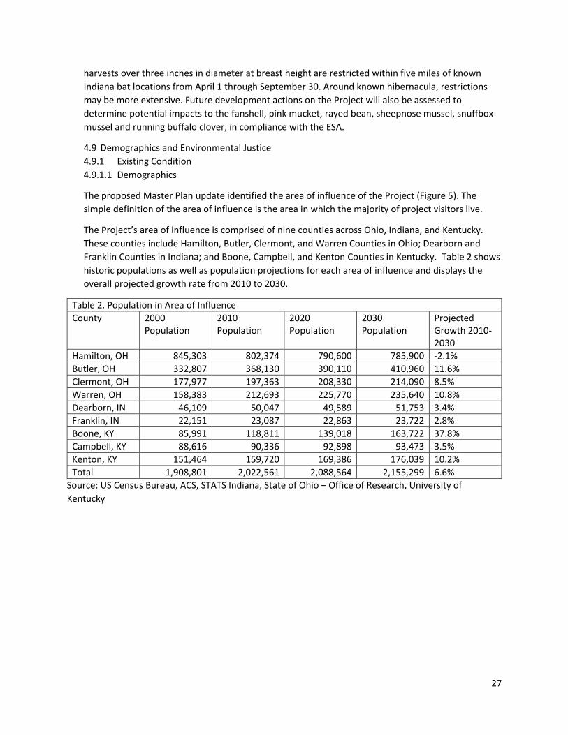
27
harvests over three inches in diameter at breast height are restricted within five miles of known
Indiana bat locations from April 1 through September 30. Around known hibernacula, restrictions
may be more extensive. Future development actions on the Project will also be assessed to
determine potential impacts to the fanshell, pink mucket, rayed bean, sheepnose mussel, snuffbox
mussel and running buffalo clover, in compliance with the ESA.
4.9 Demographics and Environmental Justice
4.9.1 Existing Condition
4.9.1.1 Demographics
The proposed Master Plan update identified the area of influence of the Project (Figure 5). The
simple definition of the area of influence is the area in which the majority of project visitors live.
The Project’s area of influence is comprised of nine counties across Ohio, Indiana, and Kentucky.
These counties include Hamilton, Butler, Clermont, and Warren Counties in Ohio; Dearborn and
Franklin Counties in Indiana; and Boone, Campbell, and Kenton Counties in Kentucky. Table 2 shows
historic populations as well as population projections for each area of influence and displays the
overall projected growth rate from 2010 to 2030.
Table 2. Population in Area of Influence
County 2000 Population
2010 Population
2020 Population
2030 Population
Projected Growth 2010-2030
Hamilton, OH 845,303 802,374 790,600 785,900 -2.1%
Butler, OH 332,807 368,130 390,110 410,960 11.6%
Clermont, OH 177,977 197,363 208,330 214,090 8.5%
Warren, OH 158,383 212,693 225,770 235,640 10.8%
Dearborn, IN 46,109 50,047 49,589 51,753 3.4%
Franklin, IN 22,151 23,087 22,863 23,722 2.8%
Boone, KY 85,991 118,811 139,018 163,722 37.8%
Campbell, KY 88,616 90,336 92,898 93,473 3.5%
Kenton, KY 151,464 159,720 169,386 176,039 10.2%
Total 1,908,801 2,022,561 2,088,564 2,155,299 6.6%
Source: US Census Bureau, ACS, STATS Indiana, State of Ohio – Office of Research, University of
Kentucky
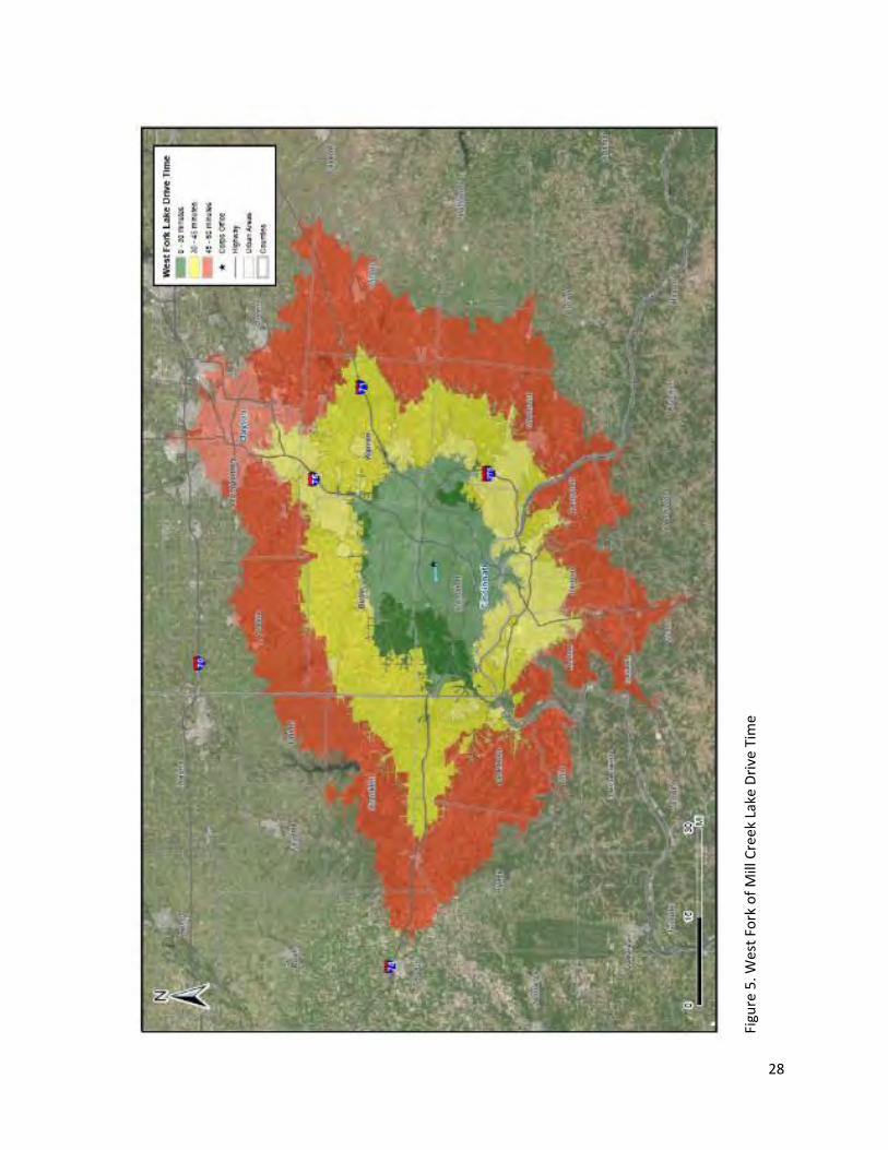
28
Figu
re 5
. Wes
t Fo
rk o
f M
ill C
reek
Lak
e D
rive
Tim
e
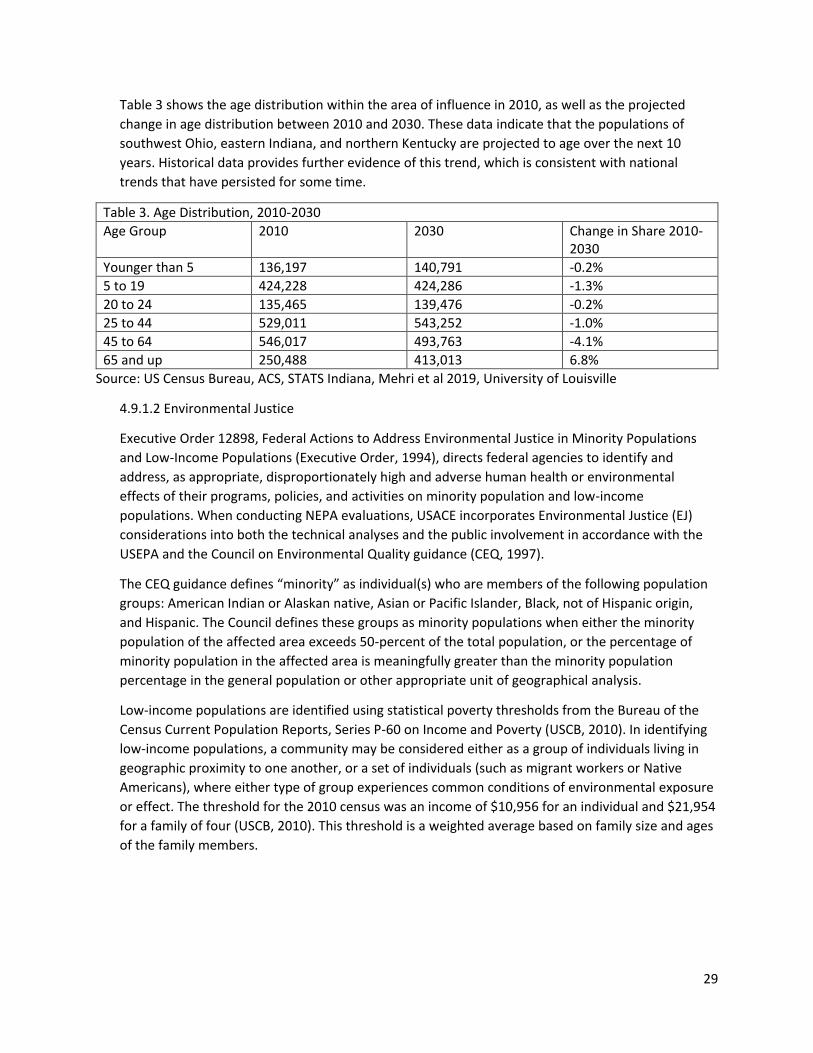
29
Table 3 shows the age distribution within the area of influence in 2010, as well as the projected
change in age distribution between 2010 and 2030. These data indicate that the populations of
southwest Ohio, eastern Indiana, and northern Kentucky are projected to age over the next 10
years. Historical data provides further evidence of this trend, which is consistent with national
trends that have persisted for some time.
Table 3. Age Distribution, 2010-2030
Age Group 2010 2030 Change in Share 2010-2030
Younger than 5 136,197 140,791 -0.2%
5 to 19 424,228 424,286 -1.3%
20 to 24 135,465 139,476 -0.2%
25 to 44 529,011 543,252 -1.0%
45 to 64 546,017 493,763 -4.1%
65 and up 250,488 413,013 6.8%
Source: US Census Bureau, ACS, STATS Indiana, Mehri et al 2019, University of Louisville
4.9.1.2 Environmental Justice
Executive Order 12898, Federal Actions to Address Environmental Justice in Minority Populations
and Low-Income Populations (Executive Order, 1994), directs federal agencies to identify and
address, as appropriate, disproportionately high and adverse human health or environmental
effects of their programs, policies, and activities on minority population and low-income
populations. When conducting NEPA evaluations, USACE incorporates Environmental Justice (EJ)
considerations into both the technical analyses and the public involvement in accordance with the
USEPA and the Council on Environmental Quality guidance (CEQ, 1997).
The CEQ guidance defines “minority” as individual(s) who are members of the following population
groups: American Indian or Alaskan native, Asian or Pacific Islander, Black, not of Hispanic origin,
and Hispanic. The Council defines these groups as minority populations when either the minority
population of the affected area exceeds 50-percent of the total population, or the percentage of
minority population in the affected area is meaningfully greater than the minority population
percentage in the general population or other appropriate unit of geographical analysis.
Low-income populations are identified using statistical poverty thresholds from the Bureau of the
Census Current Population Reports, Series P-60 on Income and Poverty (USCB, 2010). In identifying
low-income populations, a community may be considered either as a group of individuals living in
geographic proximity to one another, or a set of individuals (such as migrant workers or Native
Americans), where either type of group experiences common conditions of environmental exposure
or effect. The threshold for the 2010 census was an income of $10,956 for an individual and $21,954
for a family of four (USCB, 2010). This threshold is a weighted average based on family size and ages
of the family members.
30
Table 4. Median Household Income
Location Income in 2018 Dollars
Area of Influence $61,606
State of Ohio $54,533
State of Indiana $54,325
State of Kentucky $48,392
United States $60,293
Source: US Census Bureau, ACS
Table 4 shows the median household incomes in each area of influence, the states of Ohio, Indiana,
and Kentucky, and the U.S. in 2018 dollars. All three considered states have lower median
household incomes than the national average. The area of influence, however, has a higher median
household income than the national median household income. Hamilton County, which has a large
population and the lowest median household income of any county within the area of influence
($57,189), has a strong effect on the area of influence’s median household income. The area of
influence is in the 47th percentile nationally for low income populations.
The minority population of the area of influence averaged approximately 18.6% of the total
population according to 2010 U.S. Census data. The same data indicated minorities made up 30.9%
of the total population in Hamilton County, and approximately 28% of the total population of the
United States.
4.9.2 Environmental Consequences
4.9.2.1 No Action
Under the No Action Alternative, the updated Master Plan would not be approved for the Project in
the foreseeable future and there would be no comprehensive planning for the Project. Under the
No Action Alternative, the trends of growth of population observed in the recent years surrounding
the Project would be expected to continue. There would also be no disproportionate adverse effects
to minority or low-income communities as a result of implementing the No Action Alternative.
4.9.2.2 Proposed Action
Implementing the updated Master Plan would be expected to have no effect on the demographic
trends of the surrounding communities. Construction of future projects consistent with the updated
Master Plan would be expected to have minor beneficial effects associated with short-term
employment of construction personnel and transportation of goods and materials to the
construction sites. However, these potential future actions (including those discussed in the updated
Master Plan) are at this time conceptual, and their implementation would require separate NEPA
analysis, as appropriate. There would be no disproportionate adverse effects to minority or low-
income communities since the Proposed Action would be located within federal lands and projects
would benefit local residents by enhancing recreational opportunities.
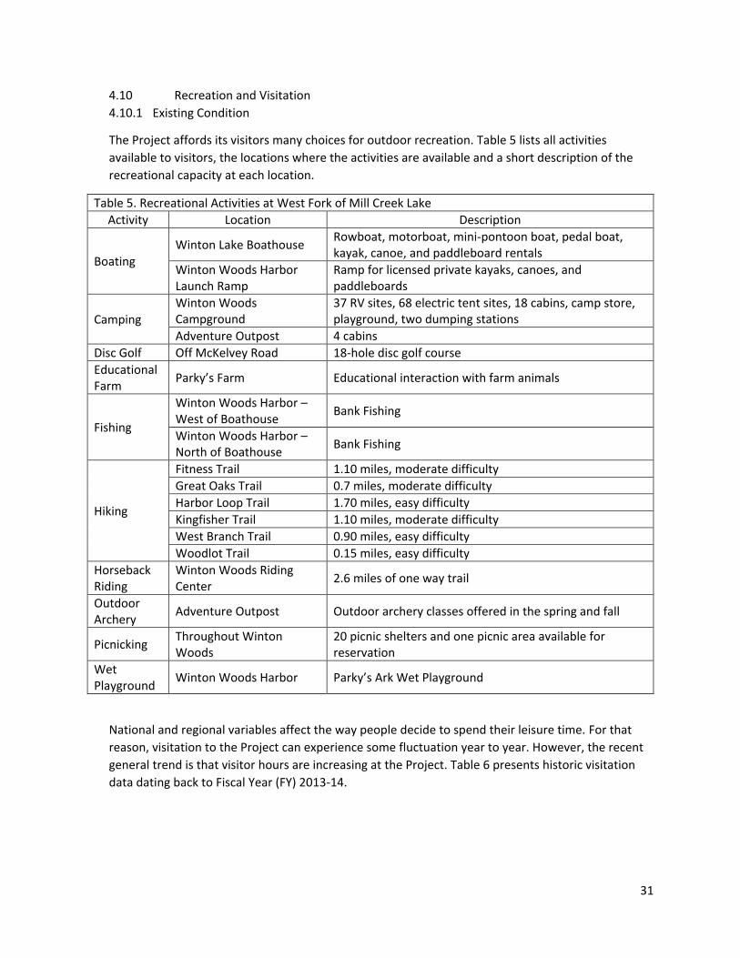
31
4.10 Recreation and Visitation
4.10.1 Existing Condition
The Project affords its visitors many choices for outdoor recreation. Table 5 lists all activities
available to visitors, the locations where the activities are available and a short description of the
recreational capacity at each location.
Table 5. Recreational Activities at West Fork of Mill Creek Lake
Activity Location Description
Boating Winton Lake Boathouse
Rowboat, motorboat, mini-pontoon boat, pedal boat, kayak, canoe, and paddleboard rentals
Winton Woods Harbor Launch Ramp
Ramp for licensed private kayaks, canoes, and paddleboards
Camping Winton Woods Campground
37 RV sites, 68 electric tent sites, 18 cabins, camp store, playground, two dumping stations
Adventure Outpost 4 cabins
Disc Golf Off McKelvey Road 18-hole disc golf course
Educational Farm
Parky’s Farm Educational interaction with farm animals
Fishing
Winton Woods Harbor – West of Boathouse
Bank Fishing
Winton Woods Harbor – North of Boathouse
Bank Fishing
Hiking
Fitness Trail 1.10 miles, moderate difficulty
Great Oaks Trail 0.7 miles, moderate difficulty
Harbor Loop Trail 1.70 miles, easy difficulty
Kingfisher Trail 1.10 miles, moderate difficulty
West Branch Trail 0.90 miles, easy difficulty
Woodlot Trail 0.15 miles, easy difficulty
Horseback Riding
Winton Woods Riding Center
2.6 miles of one way trail
Outdoor Archery
Adventure Outpost Outdoor archery classes offered in the spring and fall
Picnicking Throughout Winton Woods
20 picnic shelters and one picnic area available for reservation
Wet Playground
Winton Woods Harbor Parky’s Ark Wet Playground
National and regional variables affect the way people decide to spend their leisure time. For that
reason, visitation to the Project can experience some fluctuation year to year. However, the recent
general trend is that visitor hours are increasing at the Project. Table 6 presents historic visitation
data dating back to Fiscal Year (FY) 2013-14.
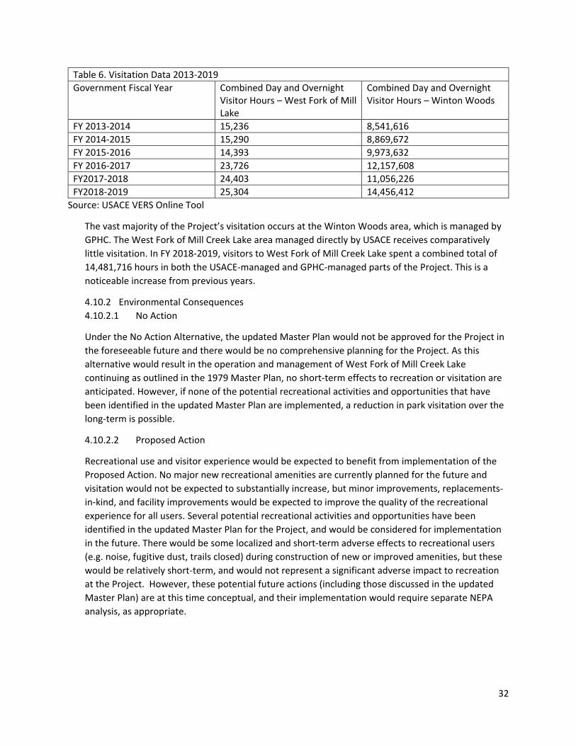
32
Table 6. Visitation Data 2013-2019
Government Fiscal Year Combined Day and Overnight Visitor Hours – West Fork of Mill Lake
Combined Day and Overnight Visitor Hours – Winton Woods
FY 2013-2014 15,236 8,541,616
FY 2014-2015 15,290 8,869,672
FY 2015-2016 14,393 9,973,632
FY 2016-2017 23,726 12,157,608
FY2017-2018 24,403 11,056,226
FY2018-2019 25,304 14,456,412
Source: USACE VERS Online Tool
The vast majority of the Project’s visitation occurs at the Winton Woods area, which is managed by
GPHC. The West Fork of Mill Creek Lake area managed directly by USACE receives comparatively
little visitation. In FY 2018-2019, visitors to West Fork of Mill Creek Lake spent a combined total of
14,481,716 hours in both the USACE-managed and GPHC-managed parts of the Project. This is a
noticeable increase from previous years.
4.10.2 Environmental Consequences
4.10.2.1 No Action
Under the No Action Alternative, the updated Master Plan would not be approved for the Project in
the foreseeable future and there would be no comprehensive planning for the Project. As this
alternative would result in the operation and management of West Fork of Mill Creek Lake
continuing as outlined in the 1979 Master Plan, no short-term effects to recreation or visitation are
anticipated. However, if none of the potential recreational activities and opportunities that have
been identified in the updated Master Plan are implemented, a reduction in park visitation over the
long-term is possible.
4.10.2.2 Proposed Action
Recreational use and visitor experience would be expected to benefit from implementation of the
Proposed Action. No major new recreational amenities are currently planned for the future and
visitation would not be expected to substantially increase, but minor improvements, replacements-
in-kind, and facility improvements would be expected to improve the quality of the recreational
experience for all users. Several potential recreational activities and opportunities have been
identified in the updated Master Plan for the Project, and would be considered for implementation
in the future. There would be some localized and short-term adverse effects to recreational users
(e.g. noise, fugitive dust, trails closed) during construction of new or improved amenities, but these
would be relatively short-term, and would not represent a significant adverse impact to recreation
at the Project. However, these potential future actions (including those discussed in the updated
Master Plan) are at this time conceptual, and their implementation would require separate NEPA
analysis, as appropriate.
33
4.11 Cultural Resources
4.11.1 Existing Condition
The relative location of West Fork of Mill Creek Lake has a spatiotemporal occupation of Native
Americans spanning from the Paleoindians around 14,000 years before present (BP) into the early
19th century with Shawnee Indians; with Euro-American contact with Native Americans occurring
around AD 1750. An all-inclusive chronology of the eastern United States –pertaining to West Fork
of Mill Creek Lake—divides this general chronological sequence into the following periods:
Paleoindian (12,000-8,000 BC); Archaic (8000-1000 BC); Woodland (1000 BC to AD 1000); Fort
Ancient (AD1000-1750); and Ethnographic (European contact and settlement, AD1750-Present).
These periods represent culturally distinct techno-complexes relating to human adaptation in and
around the area surrounding West Fork of Mill Creek Lake. Because cultural resources associated
with these periods have the potential to be considered Historical Properties—defined by the
National Historic Preservation Act (NHPA) as “any historic or prehistoric district, site, building,
structure, or object included in, or eligible for inclusion in, the National Register of Historic Places
maintained by the Secretary of the Interior”— the requirements of Section 106 of the NHPA for
Federal agencies to consider effects of their undertakings on Historic Properties may be triggered by
specific undertakings implemented under this Master Plan.
By the beginning of the 18th Century, increasing settlements on the Eastern seaboard of the North
American continent and intertribal warfare in the east caused a general migration westward. As the
Iroquois moved westward, Miami Indians moved into the river valley now bearing that name. During
this period of Indian migration, four important tribes occupied land which later became the State of
Ohio -the Miamis, the Shawnees, the Wyandots, and the Delawares. Old Chillicothe, near the
present Oldtown in Greene County, was the site of a major Shawnee settlement, around which
many military campaigns were waged. It is reported that the famous Shawnee Chief, Tecumseh, was
born there.
The first reported European entry in the area was by the French explorer, La Salle, whose
exploration took him south from Lake Erie to the Ohio River and part of its valley during the latter
part of the 17th century. French fur traders entered the area in 1692 but discontinued their work
there because of the great distance to the Great Lakes and the presence of the Iroquois tribes.
However, British traders from Albany, Philadelphia, and Charleston were undaunted, and developed
an extensive fur trade in the area by the 1740's. Because of its geographic location and the network
of navigable waterways, the Ohio Valley was considered the key to control of interior America.
The British capitalized on the conflict between the Indians and the colonists during the American
Revolution, by enlisting the aid of many Indians. Even so, only minor skirmishes were fought in Ohio.
The Battle of Piqua was the only major battle of the Revolution to take place in the Little Miami
River Valley.
The earliest settlers in the Mill Creek valley area arrived in 1789. Soon after, Hamilton County was
organized in 1790. The area of Hamilton County continued to grow into the early 1800s, with the
State of Ohio established in 1803. During the first half of the 19th Century, population grew, and the
number of settlements increased along the entire length of the Little Miami River, including the Mill
Creek valley area. The river and other streams provided water power for many mills needed by the
34
early settlers for grinding their grain. Settlers to the area also began to clear the surrounding and
forests for farms.
Updates to transportation played a major role in the development of the Hamilton County and Mill
Creek valley area. During the 1820s to the 1840s, the development and completion of the Miami
Canal (later renamed the Miami & Erie Canal) provided direct access for farmers in the area to
commercial interests both along the Ohio River and the Great Lakes. By the 1840s, the railroad
began to replace canals as a preferred means to transport good to market. The first railroad to reach
the Mill Creek valley was the Cincinnati & Hamilton Railroad in 1847. A second railroad entered the
Mill Creek valley area in 1860 with the completion of the Marietta & Cincinnati Railroad. Railroads
continued to be a driving force for economic development throughout the 19th century and into the
first decades of the 20th century.
The Mill Creek valley area continued to grow into the 20th century, which shadowed the economic
success of the city of Cincinnati. This included suburban neighborhoods in the area of northern
Hamilton County. In 1946, the Corps received authorization to construct the West Fork of Mill Creek
Reservoir. Completed in 1952, the earthen dam eliminated flooding along Mill Creek that originated
on the West Fork.
Prior to the creation of West Fork of Mill Creek Reservoir, the creation of Winton Woods Park
(previously named West Fork Lake) began with the purchase of land in 1936. In 1939, Winton
Woods Park was created from 905 acres that were leased from the federal government. The Corps
received authorization to construct the West Fork of Mill Creek Reservoir in 1938. Completed in
1952, this earthen dam effectively eliminated Mill Creek floods originating on the West Fork. With
the creation of the park, suburban neighborhoods began to be developed in the area in the 1950s
and 1960s. Today the area around the park is a heavily used urban park.
All of the previous investigations at West Fork of Mill Creek Lake were carried out as part of
compliance with Section 106 under the NHPA. The earliest archeological investigations in the West
Fork of Mill Creek Lake area was for the survey of the West Branch Mill Creek sanitary interceptor
sewer in 1977 by Robert Genheimer and Elizabeth Scheurer. Their survey did not identify any
archaeological sites within the sewer route located within the West Fork of Mill Creek Lake
boundary.
In 2002, the Corps carried out a cultural resources survey in preparation of the construction of a log
cabin and sidewalk at West Fork of Mill Creek Lake. The survey did not identify any historic
properties within the footprint of the log cabin and the sidewalk.
In 2007, Gray and Pape, Inc. carried out a Phase I cultural resources survey of the proposed West
Fork of Mill Creek Lake Campground and Cabin development project. The survey did not find any
cultural resources within the area of the proposed campground cabin development project.
In 2007, Environment and Archaeology, LLC carried out a Phase I cultural resources survey of the
Parky’s Farm improvements. These improvements consisted of a new outdoor playground, a
reconfigured animal pen area, two small shelters and a box stall barn. Their survey did not identify
any cultural resources within the area of the proposed improvements.
35
In 2009, Environment and Archaeology, LLC carried out a Phase I cultural resources survey of a
proposed pole barn at Parky’s Farm at West Fork of Mill Creek Lake. Their survey did not identify any
cultural resources within the area of the proposed improvements.
In 2010, the U.S. Army Corps of Engineers, Seattle District Center of Expertise for the Preservation of
Historic Buildings & Structures, conducted an identification and evaluation of the National Register
eligibility of the Dam Tender’s House at West Fork of Mill Creek Lake. The identification effort
revealed the house represents several phases of construction and alterations between 1890 up until
the date of federal acquisition in 1949. However, though lacking architectural merit as a vernacular
or period building type, the Dam Tender’s House is a significant example of the Corps' policy of
housing dam tending personnel and their families during the period. The property is therefore
eligible for listing in the National Register of Historic Places (NRHP) under Criterion A as a remnant of
a nationwide federal agency policy for around-the-clock, on-site administration and management of
flood control projects.
Currently, there is one NRHP listed historic property located at West Fork of Mill Creek Lake, the
Jediah Hill Covered Bridge. The bridge was listed in the National Register of Historic Places (NRHP)
on 1973. The Dam Tender’s House has been previously recommended as eligible for listing to the
NRHP under Criterion A. The nomination for this listing to the NRHP has not been coordinated with
the National Park Service. The house is located near the West Fork of Mill Creek Dam. Two potential
archeological sites have been recorded at West Fork of Mill Creek Lake (33HA184 and 33HA185).
Both of these sites are listed in the Ohio History Connection GIS database as natural features and
not mounds, and have not been formally evaluated to determine their eligibility for the NRHP. In
addition, two above ground structures, the Groff Flour Mill (HAM0134749) and the house located at
1586 Covered Bridge Road, are also located at West Fork of Mill Creek Lake but have not been
formally evaluated to determine their eligibility for the NRHP.
4.11.2 Environmental Consequences
4.11.2.1 No Action
Under the No Action Alternative, the updated Master Plan would not be approved for the Project in
the foreseeable future and there would be no comprehensive planning for the Project. As this
alternative would result in the operation and management of West Fork of Mill Creek Lake
continuing as outlined in the 1979 Master Plan, no effects to cultural resources are anticipated.
4.11.2.2 Proposed Action
Implementing the updated Master Plan would result in beneficial effects on the cultural resources of
the Project. Resource Objective 4 in the updated Master Plan outlines specific actions to be taken to
identify and protect cultural resources at the Project. All proposed development actions that would
be undertaken consistent with the updated Master Plan would still be required to comply with the
NHPA, as they are currently. Prior to implementation of any ground disturbing activity, field surveys
and Section 106 NHPA coordination with the Ohio State Historic Preservation Office (SHPO) will be
conducted by USACE, as required. Federal and state laws require federal agencies to minimize or
mitigate adverse impacts to historic properties (36 CFR Part 800.13). Should unanticipated historic
or prehistoric resources be discovered during ground disturbing activities, work must cease
immediately and USACE will contact the Ohio SHPO.
36
4.12 Hazardous, Toxic, and Radioactive Waste (HTRW) Materials
4.12.1 Existing Condition
The USEPA Envirofacts database was queried to identify HTRW sources within a two-mile radius of
the Project boundaries. There are 99 facilities within two miles of the Project that are registered
with the EPA as generators, transporters, treaters, storers, or disposers of hazardous waste. 67 of
these facilities are currently active. None of these facilities were identified within project boundaries
(NEPAssist). All but one of these facilities have been found to be in compliance, and have no
violations within the past three years. The remaining facility has two quarters of non-compliance
within the past three years, though this violation resulted from a failure to meet recordkeeping and
reporting requirements. Thus, this violation would not result in environmental degradation resulting
from HTRW materials.
4.12.2 Environmental Consequences
4.12.2.1 No Action
Under the No Action Alternative, the updated Master Plan would not be approved for the Project in
the foreseeable future and there would be no comprehensive planning for the Project. The
implementation of the No Action Alternative, which would result in the operation and management
of the Project continuing as outlined in the 1979 Master Plan, would be expected to have no effect
on or from HTRW materials as there are no known pre-existing sources at the Project and no HTRW
is generated at the Project.
4.12.2.2 Proposed Action
Implementing the updated Master Plan would be expected to have no effect on HTRW materials as
there are no known pre-existing sources at the Project. While the potential to generate HTRW
materials as a result of equipment malfunction or failure during the construction process exists (e.g.
fluid leaks from heavy equipment) for future projects that may be proposed in accordance with the
updated Master Plan, best management practices and regular equipment maintenance would
reduce these risks. Storage, fueling, and lubrication of equipment and motor vehicles associated
with the construction process (e.g. pavers, trenchers, cement trucks) would be conducted in a
manner that affords the maximum protection against accident and spills. Construction-related
debris from future projects consistent with the updated Master Plan would be managed, disposed,
and recycled in accordance with state and federal requirements. Future development and related
increased visitation could result in corresponding minor increases of waste generation; however,
any waste generated during operations would be comparable to existing types generated and would
be properly managed in accordance with applicable state and federal requirements. These potential
future actions (including those discussed in the updated Master Plan) are at this time conceptual,
and their implementation would require separate NEPA analysis, as appropriate.
4.13 Aesthetics/Visual Qualities
4.13.1 Existing Condition
The Project’s chief aesthetic asset is its location within the greater Cincinnati metropolitan area: the
Project offers a substantial wooded “green space” within an otherwise well-developed landscape.
This allows the residents of Cincinnati and its surrounding communities an opportunity to enjoy
37
nature that might otherwise only be available with longer distance travel. The wetlands within the
Project, especially those near the western end of the lake, may further enhance the aesthetic
qualities of the Project by promoting the presence of nearby wildlife.
4.13.2 Environmental Consequences
4.13.2.1 No Action
Under the No Action Alternative, the updated Master Plan would not be approved for the Project in
the foreseeable future and there would be no comprehensive planning for the Project. As this
alternative would result in the operation and management of West Fork of Mill Creek Lake
continuing as outlined in the 1979 Master Plan, no short-term effects to the Project’s aesthetics or
visual qualities are anticipated. However, because the No Action Alternative would not result in land
classifications being applied to the Project, certain areas that confer aesthetic qualities (i.e.
wetlands) would not be protected as environmentally sensitive areas. Thus, there is a long-term risk
of developments adversely affecting the Project’s aesthetic qualities under the No Action
Alternative.
4.13.2.2 Proposed Action
Implementing the updated Master Plan would be expected to have no short term effect on the
aesthetic character of the Project. There is a potential long term benefit by protecting areas that
confer aesthetic qualities (i.e. wetlands) by classifying them as environmentally sensitive, which
would help to safeguard these areas from deleterious developments. Comprehensive planning
under the updated Master Plan could potentially facilitate improved construction planning,
minimizing the short-term aesthetic effects during construction of any future projects to be
proposed under the updated Master Plan. However, these potential future actions (including those
discussed in the updated Master Plan) are at this time conceptual, and their implementation would
require separate NEPA analysis, as appropriate. Thus, no adverse effects to aesthetics or visual
resources are anticipated from the Proposed Action.
4.14 Noise
4.14.1 Existing Condition
Changes in noise are typically measured and reported in units of dBA, a weighted measure of sound
level. The primary sources of noise within the Project area include everyday vehicular traffic
(typically between 50 and 60 dBA at 100 feet) and human-generated recreational activities at the
Project. Noise ranging from about 10 dBA for the rustling of leaves to as much as 115 dBA (the
upper limit for unprotected hearing exposure established by the Occupational Safety and Health
Administration) is common in areas where there are sources of recreational activities, construction
activities, and vehicular traffic.
4.14.2 Environmental Consequences
4.14.2.1 No Action
Under the No Action Alternative, the updated Master Plan would not be approved for the Project in
the foreseeable future and there would be no comprehensive planning for the Project. As this
alternative would result in the operation and management of the Project continuing as outlined in
the 1979 Master Plan, no effects to noise levels at the Project are anticipated.
38
4.14.2.2 Proposed Action
While recreation-intensive areas can be expected to produce more noise than areas designated for
other uses such as wildlife or vegetation management, the Project lands classified for recreational
use by the updated Master Plan are already developed and in use for this purpose. Thus, there is no
anticipated effect to Project noise levels as a result of implementing the Proposed Action
Alternative. Potential implementation of future projects in accordance with the updated Master
Plan would be expected to result in short term increases in noise associated with construction of
new or improved amenities, though best management practices would be employed to minimize
these effects. However, these potential future actions (including those discussed in the updated
Master Plan) are at this time conceptual, and their implementation would require separate NEPA
analysis, as appropriate.

39
This page intentionally left blank
40
5. Cumulative Effects
NEPA requires a Federal agency to consider not only the direct and indirect impacts of a proposed
action, but also the cumulative impact of the action. A cumulative impact is defined as “the impact
on the environment which results from the incremental impact of the action when added to other
past, present, and reasonably foreseeable future actions regardless of what agency (Federal or non-
Federal) or person undertakes such other actions (40 CFR§1508.7).” Cumulative impacts can result
from individually minor, but collectively significant actions taking place over a period of time. These
actions include on- or off-site projects or activities conducted by government agencies, businesses,
or individuals that are within the spatial and temporal boundaries of the proposed actions being
considered.
The Master Plan is intended to guide the USACE toward achieving its goal of managing, conserving
and enhancing natural resources, while providing quality opportunities for outdoor recreation to the
public. The plan is consistent with authorized project purposes and relevant legislation and
regulations, and was developed in response to regional and local needs, resource capabilities and
suitability, and expressed public interests. As previously discussed, it is anticipated that the
Proposed Action will have no effect or negligible effects on the resource types or areas of concern
(reservoir operation, air quality, topography, geology, soils, surface water hydrology, groundwater,
water quality, habitats, listed species, demographics and environmental justice, recreation and
visitation, cultural resources, HTRW materials, aesthetics and visual resources, and noise). Thus,
there would be no cumulative effects of the Proposed Action on these resources when added to the
impacts of other past, present, and reasonably foreseeable future actions in the region.

41
This page intentionally left blank
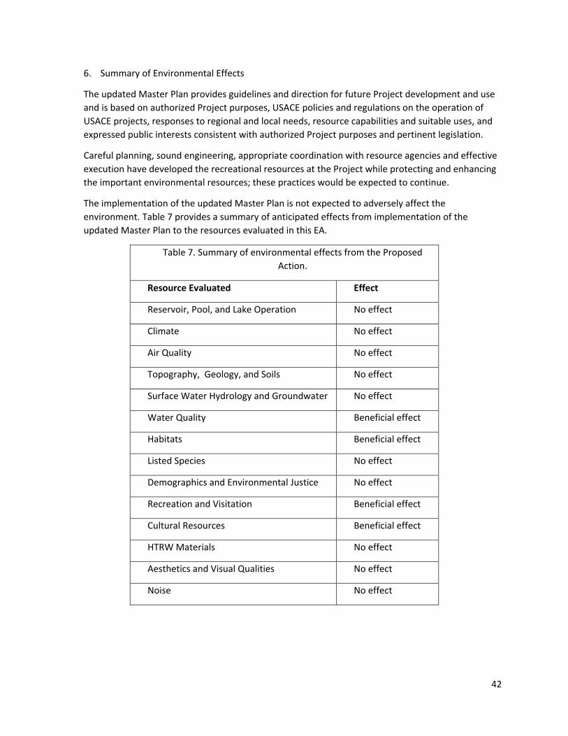
42
6. Summary of Environmental Effects
The updated Master Plan provides guidelines and direction for future Project development and use
and is based on authorized Project purposes, USACE policies and regulations on the operation of
USACE projects, responses to regional and local needs, resource capabilities and suitable uses, and
expressed public interests consistent with authorized Project purposes and pertinent legislation.
Careful planning, sound engineering, appropriate coordination with resource agencies and effective
execution have developed the recreational resources at the Project while protecting and enhancing
the important environmental resources; these practices would be expected to continue.
The implementation of the updated Master Plan is not expected to adversely affect the
environment. Table 7 provides a summary of anticipated effects from implementation of the
updated Master Plan to the resources evaluated in this EA.
Table 7. Summary of environmental effects from the Proposed
Action.
Resource Evaluated Effect
Reservoir, Pool, and Lake Operation No effect
Climate No effect
Air Quality No effect
Topography, Geology, and Soils No effect
Surface Water Hydrology and Groundwater No effect
Water Quality Beneficial effect
Habitats Beneficial effect
Listed Species No effect
Demographics and Environmental Justice No effect
Recreation and Visitation Beneficial effect
Cultural Resources Beneficial effect
HTRW Materials No effect
Aesthetics and Visual Qualities No effect
Noise No effect

43
This page intentionally left blank
44
7. Compliance with Environmental Laws
The update of the West Fork of Mill Creek Lake Master Plan will achieve compliance with all
applicable environmental laws and regulations, described below, upon coordination of this EA with
appropriate agencies, organizations, and individuals for their review and comments.
Implementation of any potential future projects in accordance with the updated Master Plan
(including future modifications to existing infrastructure or new features) will undergo separate
environmental review and would not commence until the proposed actions achieve compliance with
the applicable environmental laws and regulations.
Bald and Golden Eagle Protection Act, 16 U.S.C. Sec. 668, 668 note, 668a-668d.
In compliance.
The Bald and Golden Eagle Protection Act imposes requirements on USACE projects concerning bald
eagles. Approval and implementation of the updated Master Plan would not adversely affect bald
eagles or their habitat.
Clean Air Act, as amended, 42 U.S.C. 1857h-7, et seq.
In compliance.
The purpose of the Clean Air Act is to protect public health and welfare by the control of air
pollution at its source, and to set forth primary and secondary National Ambient Air Quality
Standards to establish criteria for States to attain, or maintain. The implementation of the updated
Master Plan is in compliance with the Clean Air Act.
Clean Water Act, as amended, (Federal Water Pollution Control Act) 33 U.S.C. 1251, et seq.
In compliance.
The objective of the Clean Water Act is to restore and maintain the chemical, physical and biological
integrity of the Nation’s waters (33 U.S.C. 1251). USACE regulates discharges of dredged or fill
material into waters of the United States pursuant to Section 404 of the Clean Water Act. This
permitting authority applies to all waters of the United States including navigable waters and
wetlands. Section 404 requires authorization to place dredged or fill material into waters of the
United States. If a Section 404 authorization is required, a Section 401- water quality certification
from the state in which the discharge originates is also needed. The implementation of the updated
Master Plan is in compliance with the Clean Water Act.
Comprehensive Environmental Response, Compensation, and Liability Act of 1980 (CERCLA).
Not applicable.
CERCLA governs (1) the release or substantial threat of a release of a hazardous substance into the
environment; or (2) the release or substantial threat of a release of any pollutant or contaminant
into the environment that presents an imminent threat to the public health and welfare. To the
extent such knowledge is available, 40 CFR Part 373 requires notification of CERCLA hazardous
substances in a land transfer. The implementation of the updated Master Plan would not involve
45
real estate transactions, and no release or threatened release of hazardous substances into the
environment at the Project is known.
Endangered Species Act, as amended. 16 U.S.C. 1531, et seq.
In compliance.
Section 7 of the Endangered Species Act (16 U.S.C. 1536) states that all Federal departments and
agencies shall, in consultation with and with the assistance of the Secretary of the Interior
(Secretary), insure that any actions authorized, funded, or carried out by them do not jeopardize the
continued existence of any threatened or endangered (T&E) species, or result in the destruction or
adverse modifications of habitat of such species which is determined by the Secretary to be critical.
This EA represents the assessment and findings regarding the proposed Master Plan update and
serves as the Biological Assessment with a determination of no effect to the Indiana bat (Myotis
sodalis), fanshell (Cyprogenia stegaria), pink mucket (Lampsilis abrupta), rayed bean (Villosa fabalis),
sheepnose mussel (Plethobasus cyphyus), snuffbox mussel (Epioblasma triquetra), running buffalo
clover (Trifolium stoloniferum) or northern long-eared bat (Myotis septentrionalis).
Environmental Justice (E.O. 12898).
In compliance.
The Executive Order governing environmental justice directs that every federal agency shall make
achieving environmental justice part of its mission by identifying and addressing, as appropriate,
disproportionately high and adverse human health or environmental effects of its programs,
policies, and activities on minority populations and low- income populations in the United States.
The implementation of the updated Master Plan for the Project does not disproportionately affect
minority or low-income populations.
Fish and Wildlife Coordination Act, as amended, 16 U.S.C. 661, et seq (FWCA).
In compliance.
The FWCA requires governmental agencies, including USACE, to coordinate activities so that adverse
effects on fish and wildlife would be minimized when water bodies are proposed for modification.
No modifications to water bodies are proposed in associate with the proposed update to the Master
Plan.
Irretrievable and Irreversible Commitment of Resources (42 U.S.C. § 4332).
In Compliance.
NEPA requires that federal agencies identify “any irreversible and irretrievable commitments of
resources which would be involved in the Proposed Action should it be implemented” (42 U.S.C. §
4332). An irreversible commitment of resources occurs when the primary or secondary impacts of
an action result in the loss of future options for a resource. The impacts for this Project from the
reclassification of land would not be considered an irreversible commitment because much of the
land could be converted back to prior use at a future date. Any future development or construction
projects to be undertaken consistent with the updated Master Plan would undergo separate NEPA
46
analysis, as appropriate, before any irretrievable and irreversible commitment of resources
(financial or otherwise) would occur to implement those projects.
Migratory Bird Treaty Act of 1918 (MBTA)
In compliance.
The MBTA is the domestic law that affirms, or implements, the United States’ commitment to four
international conventions with Canada, Japan, Mexico, and Russia for the protection of shard
migratory bird resources. The MBTA governs the taking, killing, possession, transportation, and
importation of migratory birds, their eggs, parts and nests. The take of all migratory birds is
governed by the MBTA’s regulation of taking migratory birds for educational, scientific, and
recreational purposes and requiring harvest to be limited to levels that prevent over utilization.
Executive Order 13186 (2001) directs agencies to take certain actions to implement the act. USACE
will consult with the USFWS (through their review of the draft EA) with regard to their consideration
of the effects of the actions identified in the Master Plan update for potential effects on migratory
birds. No effects are anticipated.
National Historic Preservation Act, as amended, 16 U.S.C. 470a, et seq (NHPA).
In progress.
The NHPA requires that federal agencies having direct or indirect jurisdiction over a proposed
federal or federally assisted undertaking take into account the effect of the undertaking on any
district, site, building, structure, or object that is included in, or eligible for inclusion in, the National
Register of Historic Places. The Louisville District has made the determination in accordance with
36CFR Part 800.3 (a)(1) of the NHPA that the actions identified in the proposed Master Plan update
do not have the potential to adversely impact cultural resources or historic properties. The District
coordinated the proposed action with the Ohio State Historic Preservation Office (SHPO) on May 21,
2020. The District received an email response on June 15, 2020 stating the SHPO would like to offer
input and suggestions on significant archaeological sites at West Fork of Mill Creek Lake on how they
can be preserved/protected, provide educational opportunities, etc. The District also coordinated
with Tribal Nations on March 17, 2020. The Miami Tribe of Oklahoma responded in a letter dated
April 14, 2020 that the proposed action will not adversely affect any sacred properties and/or
properties of cultural significance to the Miami Tribe of Oklahoma. All correspondence will be
included in the Appendix of the Master Plan.
National Environmental Policy Act (NEPA), as amended, 42 U.S.C. 4321, et seq.
In progress.
This EA and FONSI has been prepared in accordance with the Council on Environmental Quality’s
NEPA Implementing Regulations (40 CFR §§ 1500-1508). An Environmental Impact Statement (EIS) is
not required. Signing of the FONSI will conclude compliance with NEPA.
47
Noise Control Act of 1972, 42 U.S.C. Sec. 4901 to 4918
In compliance.
The Noise Control Act establishes a national policy to promote an environment for all Americans
free from noise that jeopardizes their health and welfare. Federal agencies are required to limit
noise emissions to within compliance levels. No increase to noise levels at the Project are
anticipated from implementation of the updated Master Plan. Noise emission levels at the Project
site may increase above current levels over the short-term if construction of improvements or
features identified in the proposed Master Plan update is undertaken, but those potential future
actions would undergo separate review for compliance with the Noise Control Act and other
applicable environmental laws. Appropriate measures would be taken during those activities to
keep the noise level within the compliance levels.
Section 10 of the Rivers and Harbors Act of 1899 (33 U.S.C. 403)
In compliance
Section 10 of the Rivers and Harbors Act prohibits the unauthorized obstruction or alteration of any
navigable water of the United States. This section provides that the construction of any structure in
or over any navigable water of the United States, or the accomplishment of any other work affecting
the course, location, condition, or physical capacity of such waters is unlawful unless the work has
been recommended by the Chief of Engineers and authorized by the Secretary of the Army.
Implementation of the proposed Master Plan update would not involve the construction of
structures within West Fork of Mill Creek Lake. Any potential future actions would require
independent analysis for compliance with this law, as appropriate.
Floodplain Management (E.O. 11988).
In compliance.
Section 1 of the Executive Order on floodplain management requires each agency to provide
leadership and take action to reduce the risk of flood loss, to minimize the impact of floods on
human safety, health and welfare, and to restore and preserve the natural and beneficial values
served by flood plains in carrying out its responsibilities for (1) acquiring, managing, and disposing of
Federal lands and facilities; (2) providing Federally undertaken, financed, or assisted construction
and improvements; and (3) conducting Federal activities and programs affecting land use, including
but not limited to water and related land resources planning, regulating, and licensing activities.
Implementation of the proposed Master Plan update would not affect the flood holding capacity or
flood surface profiles of West Fork of Mill Creek Lake.
Protection of Wetlands (E.O. 11990).
In compliance.
The Executive Order on protection of wetlands directs that federal agencies shall take action to
minimize the destruction, loss or degradation of wetlands, and to preserve and enhance the natural
and beneficial values of wetlands in carrying out the agencies responsibilities. Each agency, to the
extent permitted by law, shall avoid undertaking or providing assistance for new construction

48
located in wetlands unless the head of the agency finds (1) that there is no practicable alternative to
such construction, and (2) that the proposed action includes all practicable measures to minimize
harm to wetlands, which may result from such use. Implementation of the proposed Master Plan
update would protect the Project’s wetlands from destruction, loss, and degradation by designating
these wetlands as environmentally sensitive areas.

49
This page intentionally left blank

50
8. Public Involvement
In compliance with 40 CFR 1501.4(e)(2), this EA is being circulated for a 30-day review to concerned
agencies, organizations, and the interested public, along with a copy of the Draft Master Plan
Update. All comments received during this review period will be evaluated and appropriate changes
to the EA will be implemented and addressed in the FONSI. The EA and FONSI will be retained in the
Louisville District’s administrative files for future reference and as a record of NEPA compliance.

51
This page intentionally left blank
52
9. References
City of Cincinnati. 2020. Consolidated Plan. https://www.cincinnati-oh.gov/community-
development/consolidated-plan/. Accessed 28 May 2020.
Environmental Protection Agency (EPA). Environmental Justice Screening (EJScreen) and Mapping
Tool. https://ejscreen.epa.gov/mapper/. Accessed 26 June 2020.
GPHC. 2019. Maintaining Reservoirs.
http://blog.greatparks.org/2019/06/maintaining-reservoirs/. Accessed 20 April 2020.
GPHC. 2020. Projects: Removing Invasive Species.
https://www.greatparks.org/discovery/projects/removing-invasive-species Accessed 15 April
2020.
Hamilton County. 2020. Community Development.
https://www.hamiltoncountyohio.gov/government/departments/community_development/hu
d_reports. Accessed 28 May 2020.
Mehri, N., P. A. Cummins, I. M. Nelson, T. L. Wilson, and S. Kunkel. 2019. Ohio Population Interactive
Data Center, Scripps Gerontology Center, Miami University, Oxford, OH.
www.ohio-population.org. Accessed 20 April 2020.
Meng, P. S., K. Hoover, & M. A. Keena. 2015. Asian Longhorned Beetle (Coleoptera: Cerambycidae),
an Introduced Pest of Maple and Other Hardwood Trees in North America and Europe. Journal
of Integrated Pest Management 6(1): 1-13.
NatureServe Explorer. 2008. Terrestrial Ecological System: Southern Interior Low Plateau Dry-Mesic
Oak Forest.
https://explorer.natureserve.org/Taxon/ELEMENT_GLOBAL.2.722783/Southern_Interior_Low_P
lateau_Dry-Mesic_Oak_Forest. Accessed 21 April 2020.
NatureServe Explorer. 2017. Terrestrial Ecological System: South-Central Interior Mesophytic Forest.
https://explorer.natureserve.org/Taxon/ELEMENT_GLOBAL.2.722791/South-
Central_Interior_Mesophytic_Forest. Accessed 21 April 2020.
ODNR. 2020. Ohio Water Wells. https://gis.ohiodnr.gov/MapViewer/?config=waterwells. Accessed
20 April 2020.
Ohio EPA. 2016. Biological and Water Quality Study of Southwest Ohio River Tributaries, 2014.
53
https://epa.ohio.gov/Portals/35/documents/SWORT%20TSD%202014.pdf. Accessed 20 April
2020.
State of Ohio – Office of Research. County Trends.
https://development.ohio.gov/reports/reports_countytrends_map.htm. Accessed 20 April 2020.
STATS Indiana, using data from the Indiana Business Research Center, IU Kelley School of Business.
Indiana County-Level Census Counts, 1900 to 2010.
https://www.stats.indiana.edu/population/PopTotals/historic_counts_counties.asp. Accessed
20 April 2020.
STATS Indiana, using data from the Indiana Business Research Center, IU Kelley School of Business.
Indiana Population Projections. http://www.stats.indiana.edu/pop_proj/. Accessed 20 April
2020.
University of Kentucky. Kentucky: By the Numbers. http://kybtn.ca.uky.edu/. Accessed 20 April
2020.
University of Louisville. Kentucky State Data Center. http://ksdc.louisville.edu/data-
downloads/projections/. Accessed 20 April 2020.
University of Michigan. 2013. The Potential Impacts of Climate Change on Dayton, Ohio.
http://graham.umich.edu/media/files/GLAA-
C/Dayton/Dayton%20Climate%20Impacts%20Executive%20Summary.pdf. Accessed 15 April
2020.
USACE. 1996. ER 1130-2-550, Project Operations – Recreation Operations and Maintenance
Guidance and Procedures.
https://www.publications.usace.army.mil/Portals/76/Publications/EngineerPamphlets/EP_1130
-2-550.pdf. Accessed 27 April 2020.
USACE. 2019. VERS – Visitation Estimation & Reporting System.
https://corpslakes.erdc.dren.mil/employees/usurveys/vehicle.cfm. Accessed 20 April 2020.
USDA APHIS. 2020a. Asian Longhorned Beetle. https://www.aphis.usda.gov/aphis/resources/pests-
diseases/hungry-pests/the-threat/asian-longhorned-beetle/asian-longhorned-beetle. Accessed
17 April 2020.
USDA APHIS. 2020b. Asian Longhorned Beetle Maps.
54
https://www.aphis.usda.gov/aphis/ourfocus/planthealth/plant-pest-and-disease-
programs/pests-and-diseases/asian-longhorned-beetle/ct_alb_maps. Accessed 17 April 2020.
US Department of Commerce, Bureau of Census. 2010. Social Explorer Tables: ACS 2010 (1-Year
Estimates). Accessed 20 April 2020.
US EPA. 2020. Current Nonattainment Counties for All Criteria Pollutants.
https://www3.epa.gov/airquality/greenbook/ancl.html. Accessed 20 April 2020.
US EPA. NEPAssist Tool. https://nepassisttool.epa.gov/nepassist/nepamap.aspx. Accessed 20 April
2020.
USFWS. 2012. Invasive Species. https://www.fws.gov/invasives/. Accessed 17 April 2020.
USFWS. 2019a. America's Mussels: Silent Sentinels.
https://www.fws.gov/midwest/endangered/clams/mussels.html. Accessed 17 April 2020.
USFWS. 2019b. Indiana Bat (Myotis sodalis).
https://fws.gov/midwest/endangered/mammals/inba/index.html. Accessed 17 April 2020.
USFWS. 2019c. Running Buffalo Clover (Trifolium stoloniferum).
https://www.fws.gov/midwest/Endangered/plants/rbcl/index.html. Accessed 17 April 2020.
USFWS. 2020. Northern Long-Eared Bat Myotis septentrionalis.
https://fws.gov/midwest/endangered/mammals/nleb/nlebFactSheet.html. Accessed 17 April
2020.
WVXU. 2019a. National Bird Makes Rare Appearances At Winton Woods.
https://www.wvxu.org/post/national-bird-makes-rare-appearances-winton-woods#stream/0.
Accessed 17 April 2020.
WVXU. 2019b. Winton Lake Re-Opens, But Sewage Spill Emblematic Of Bigger Problem, CUFA Says.
https://www.wvxu.org/post/winton-lake-re-opens-sewage-spill-emblematic-bigger-problem-
cufa-says#stream/0. Accessed 20 April 2020.

50
Appendix B: Public Comments
51
Appendix C: Other appendices as necessary

Miami Tribe of Oklahoma 3410 P St. NW, Miami, OK 74354 ● P.O. Box 1326, Miami, OK 74355
Ph: (918) 541-1300 ● Fax: (918) 542-7260 www.miamination.com
Via email: [email protected] April 14, 2020 Jennifer Guffey Archaeologist & Tribal Liaison Planning Branch US Army Corps of Engineers, Louisville District 600 Dr. Martin Luther King Jr. Place Louisville, KY 40202 Re: Miami River Basin Five Master Plans Update – Comments of the Miami Tribe of Oklahoma Dear Ms. Guffey: Aya, kikwehsitoole – I show you respect. My name is Diane Hunter, and I am the Tribal Historic Preservation Officer for the Federally Recognized Miami Tribe of Oklahoma. The areas in which the five lakes in question were built are within the aboriginal homelands of the Miami Tribe; however, we are not currently aware of existing documentation directly linking a specific Miami cultural or historic site to the five lake areas. In any case, if any human remains or Native American cultural items falling under the Native American Graves Protection and Repatriation Act (NAGPRA) or archaeological evidence is discovered at or near these lakes, the Miami Tribe requests immediate consultation with the entity of jurisdiction for the location of discovery. In such a case, please contact me at 918-541-8966 or by email at [email protected] to initiate consultation. I suggest you also contact the Shawnee Tribe, the Eastern Shawnee Tribe, and the Ohio History Connection, as any of them might have information about the area. Respectfully,
Diane Hunter Tribal Historic Preservation Officer
1. Absentee-Shawnee Tribe of Oklahoma
2. Eastern Shawnee Tribe of Oklahoma
3. Shawnee Tribe of Oklahoma
4. Forest County Potawatomi
5. Hannahville Indian Community
6. Gun Lake Tribe
7. Nottawaseppi Huron Band of Potawatomi
8. Pokagon Band of Potawatomi
9. Prairie Band of Potawatomi
10. Citizen Potawatomi Nation
11. Miami Tribe of Oklahoma
12. Saginaw Chippewa Indian Tribe of Michigan
13. Lac Vieux Desert Band of Lake Superior
14. Lac du Flambeau Band of Lake Superior
15. Sault Ste Marie Tribe of Chippewa
16. Bad River Band of Lake Superior Chippewa
17. Keweenaw Bay Indian Community
18. Lac Courte Oreilles Band of Chippewa
19. Red Cliff Band of Lake Superior Chippewa
20. Red Lake Chippewa
21. Sokaogon Chippewa
22. St. Croix Chippewa Community
23. Turtle Mountain Band of Chippewa
24. Fon du lac Band of Lake Superior
25. Bois Forte Band of Chippewa
26. Grand Portage Band of Lake Superior Chippewa
27. Leech Lake Band of Ojibwe
28. Mille Lacs Band of Ojibwe
29. Grand Traverse Band of Ottawa and Chippewa
30. Little River Band of Ottawa
31. Ottawa Tribe of Oklahoma
32. Little Traverse Bay Band of Odawa
33. Peoria Tribe of Oklahoma
34. Sac and Fox Tribe of Missouri in Kansas and Nebraska
35. Sac and Fox Tribe of Mississippi in Iowa
36. Sac and Fox Nation of Oklahoma
37. Osage Nation of Oklahoma
38. Delaware Tribe of Indians Oklahoma
39. Delaware Nations of Oklahoma
40. Wyandotte Nation of Oklahoma
41. Kickapoo Traditional Tribe of Texas
42. Kickapoo Tribe of Kansas
Ohio Tribal List
43. Kickapoo Tribe of Oklahoma
44. Cayuga Nation of New York
45. Oneida Nation of New York(prefer email documents; maynot consult at far end of
area)
46. Oneida Nation of Wisconsin (prefer email documents)
47. Onondaga Nation of New York
48. Seneca Nation of Indians of New York
49. Seneca-Cayuga of Oklahoma
50. St. Regis Mohawk Tribe
51. Tonawanda Seneca Nation
52. Tuscarora Nation of New York

52
Appendix D: Plates (Project Maps/ Site Plans/ Tables)
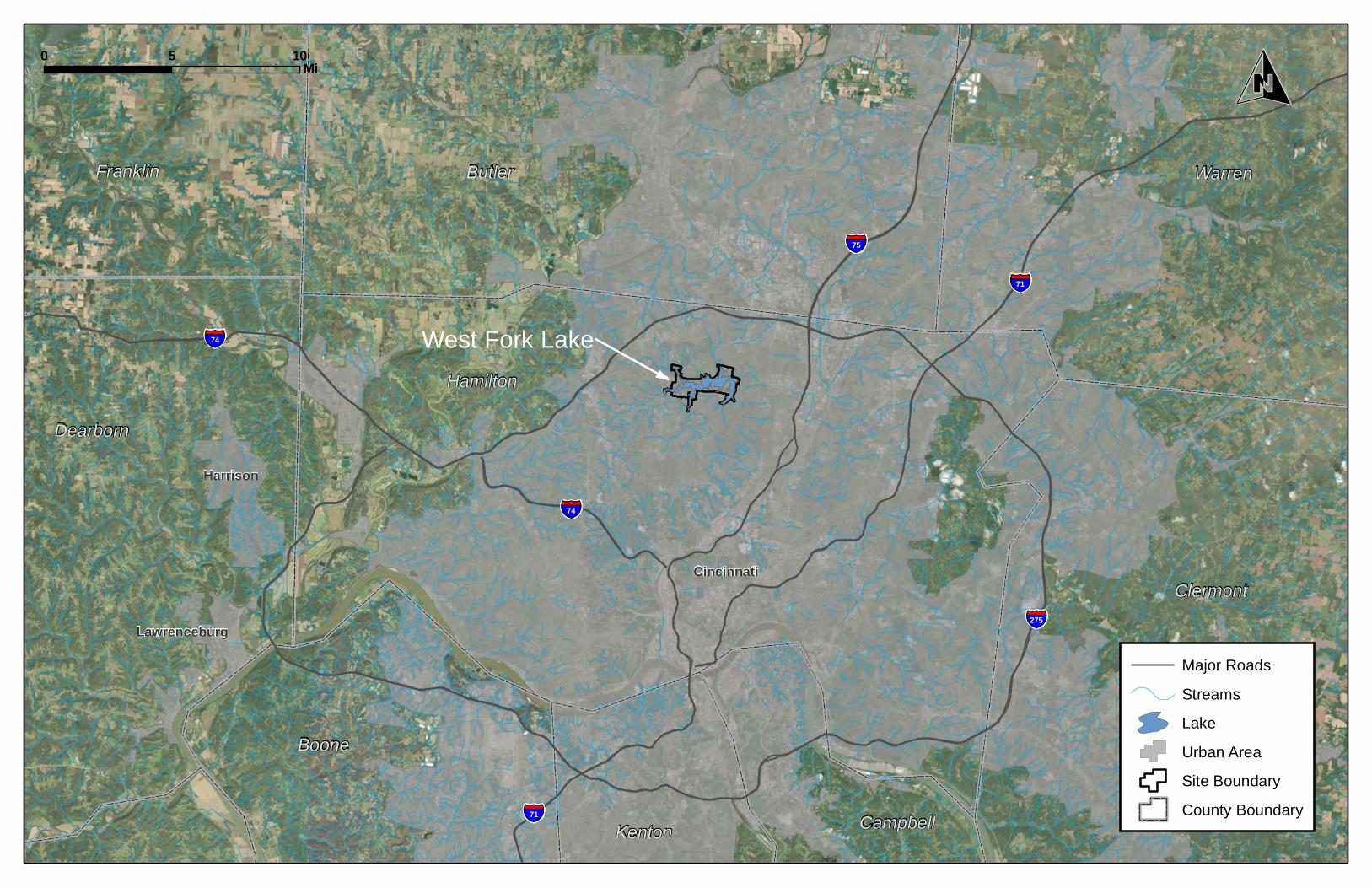
§̈¦75
§̈¦71
§̈¦275
§̈¦74
§̈¦74
§̈¦71
Hamilton
Butler Warren
Clermont
Dearborn
Franklin
Boone
Kenton Campbell
Cincinnati
Harrison
West Fork Lake
Lawrenceburg
Source: Esri, DigitalGlobe, GeoEye,
Major RoadsStreamsLakeUrban AreaSite BoundaryCounty Boundary
0 105 Mi O
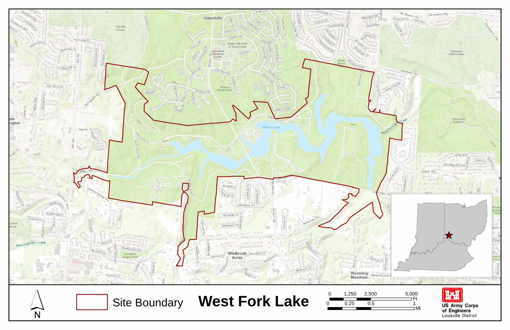
Sources: Esri, HERE, Garmin, Intermap,increment P Corp., GEBCO, USGS, FAO, NPS,
West Fork Lake´ Site Boundary 0 0.5 10.25 Mi
0 2,500 5,0001,250Ft
_̂
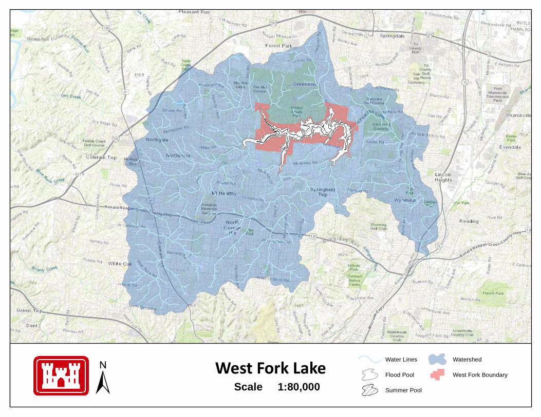
Sources: Esri, HERE, Garmin,Intermap, increment P Corp.,GEBCO, USGS, FAO, NPS,
West Fork Lake Water Lines
Flood Pool
Summer Pool
Watershed
West Fork Boundary1:80,000Scale±
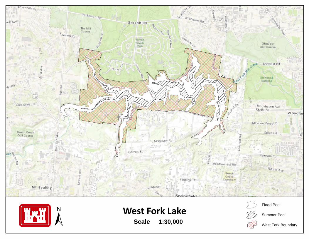
Sources: Esri, HERE, Garmin,Intermap, increment P Corp.,GEBCO, USGS, FAO, NPS,
West Fork Lake Flood Pool
Summer Pool
West Fork Boundary1:30,000Scale±
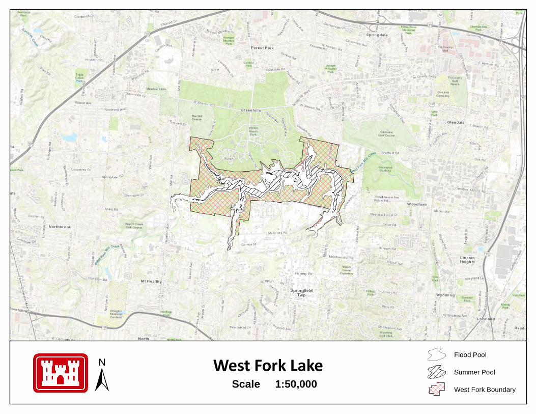
Sources: Esri, HERE, Garmin,Intermap, increment P Corp.,GEBCO, USGS, FAO, NPS,
West Fork Lake Flood Pool
Summer Pool
West Fork Boundary1:50,000Scale±
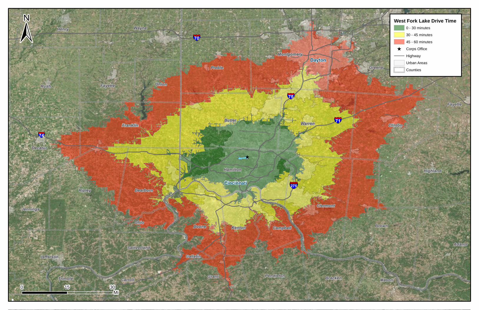
0 3015Mi
West Fork Lake Drive Time 0 - 30 minutes30 - 45 minutes45 - 60 minutes
^ Corps OfficeHighwayUrban AreasCounties
±
Cincinnati
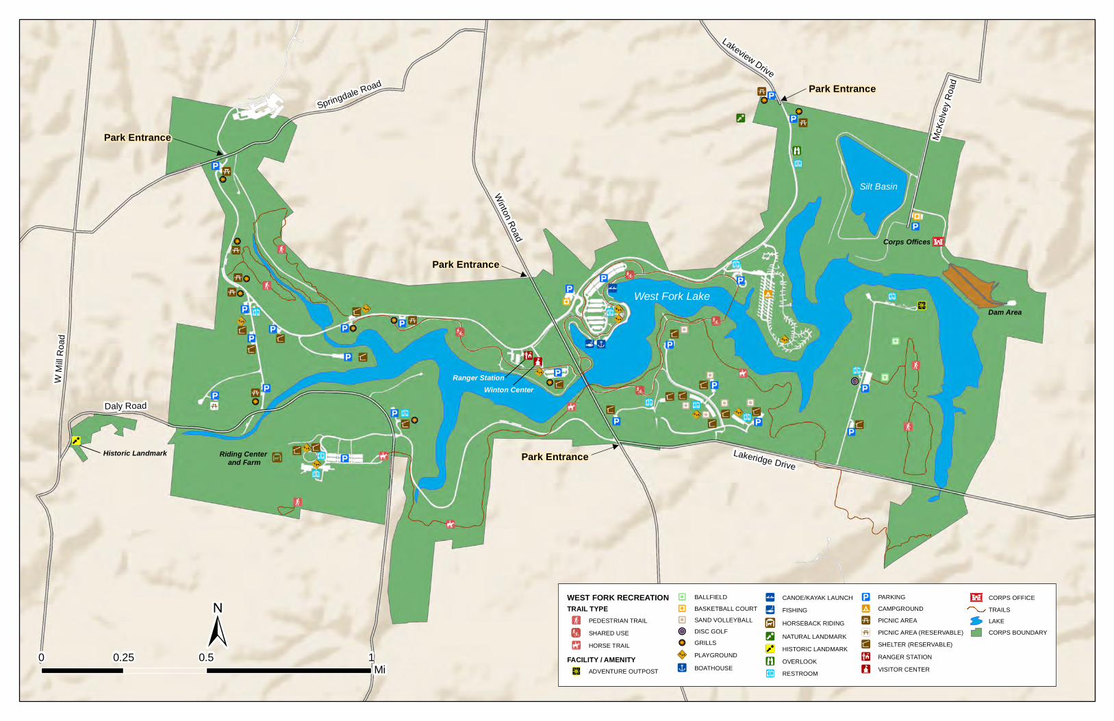
Winton Road
W Mi
ll Roa
d
Springdale Road
Lakeview Drive
McKe
lvey R
oad
Lakeridge Drive
Daly Road
±0 0.5 10.25
Mi
Ranger StationWinton Center
Park Entrance
Park Entrance
Park Entrance
Park Entrance
Riding Center and Farm
Dam Area
Corps Offices
Historic Landmark
Silt Basin
West Fork Lake
WEST FORK RECREATIONTRAIL TYPE!F PEDESTRIAN TRAIL
SHARED USE!È HORSE TRAIL
FACILITY / AMENITY"c ADVENTURE OUTPOST
"Z BALLFIELD"Z BASKETBALL COURTZ̈ SAND VOLLEYBALL!O DISC GOLF!r GRILLS89:| PLAYGROUND")x BOATHOUSE
!| CANOE/KAYAK LAUNCH!l FISHING
É HORSEBACK RIDING
O NATURAL LANDMARK!O HISTORIC LANDMARK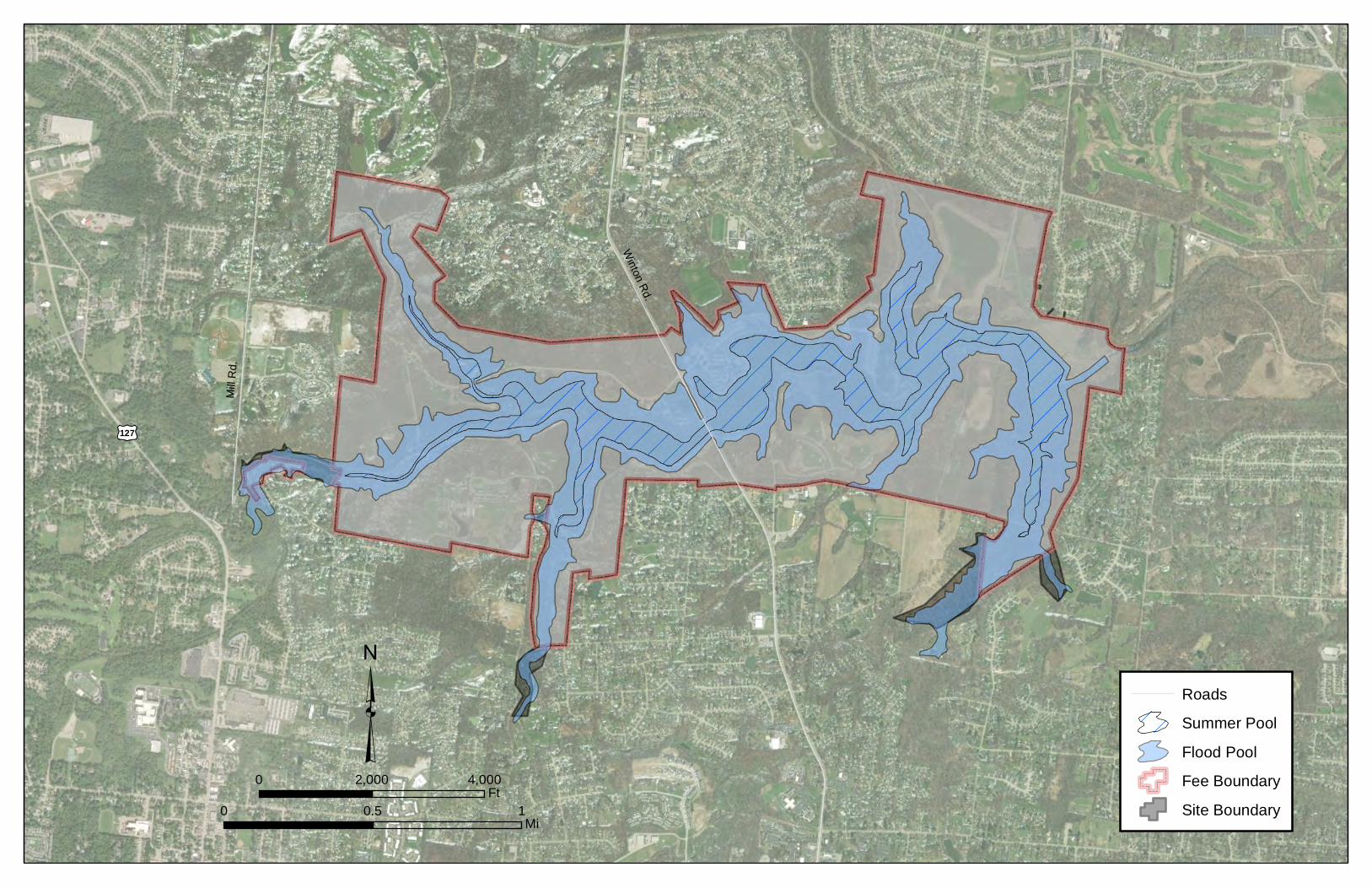
£¤127
Winton Rd.
Mill R
d.
Source: Esri, DigitalGlobe, GeoEye,
³0 10.5
Mi
0 4,0002,000Ft
RoadsSummer PoolFlood PoolFee BoundarySite Boundary
Winton Rd.
W. Sharon Ave.
Springdale Rd.
£¤127
Source: Esri, DigitalGlobe, GeoEye, EarthstarGeographics, CNES/Airbus DS, USDA, USGS,
±0 0.5 10.25
Mi
Landcover Class13.9% Open Water13.0% Developed, Open Space3.59% Developed, Low Intensity1.03% Developed, Medium Intensity
0.10% Developed, High Intensity0.16% Barren Land50.3% Deciduous Forest0.58% Evergreen Forest7.58% Mixed Forest
0.13% Shrub/Scrub0.13% Herbaceuous7.58% Hay/Pasture0.21% Cultivated Crops0.01% Emergent Herbaceuous Wetlands
0 2,000 4,0001,000Feet
PR3
R-1
PR-3
R-1O
M
R-2
PR-3M
PB
R-2
PR-3
OSPUD
RM
R-1
CC
R-2
RS
R 4I-P
R-1R-1
R-2
R-PUD
±0 4,0002,000
Ft0 0.5 10.25
Mi
R-3R-1A
Winton Rd.
W. Sharon Ave.
Springdale Rd.
£¤127
£¤127
Winton Rd.
W. Sharon Ave.
Springdale Rd.
£¤127
Source: Esri, DigitalGlobe, GeoEye, EarthstarGeographics, CNES/Airbus DS, USDA, USGS,
±0 0.5 10.25
Mi
Slope< 5%5% - 10%10% - 15%15% - 20%> 20%Rivers and PondsSummer Pool
0 2,000 4,0001,000Feet
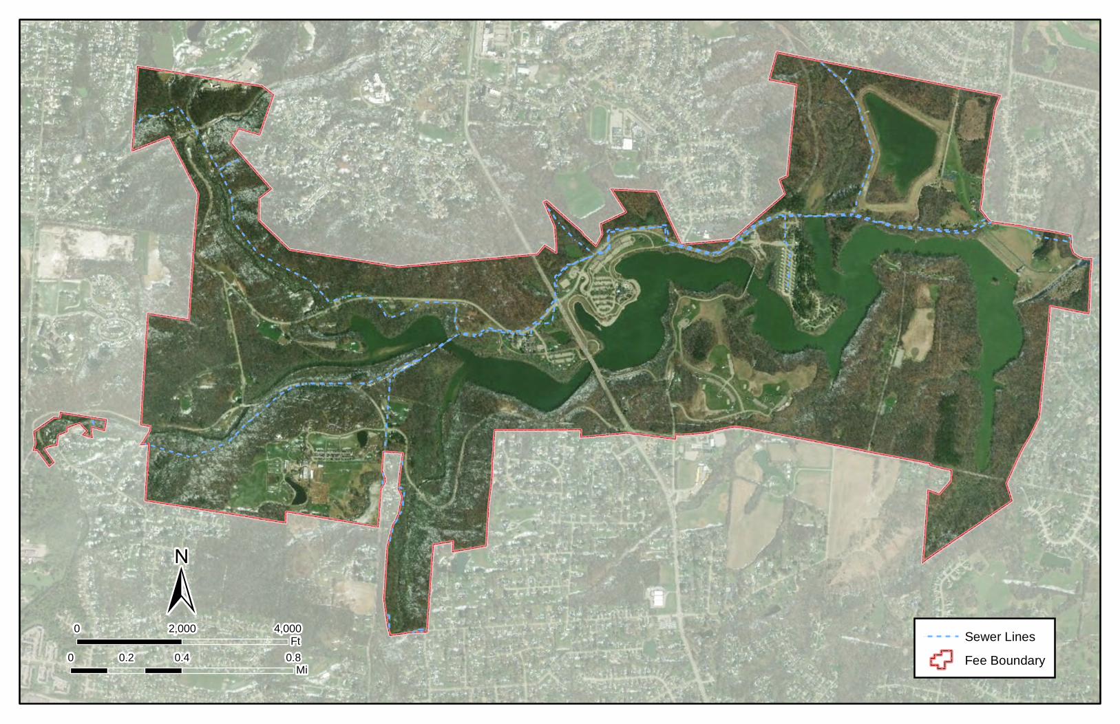
! !! !
! !
! !
!
!
!
!!
!!
!
!!
!
!
!
!
!
!
!
!
!
!!
!!
!
!
!
!
!
!
!!
!!
!
!
!!
!!
!!
!!
!!
!!
!
!
! ! ! ! !!
!
!
!
!
!
!
!
!
!
!
!
!!
!!
!
! ! ! !
!!
!!
!!
!!
!
!
!!
!!
!
!!
!!
!!
!!
!!
!!
!!
!
!!
!
! ! ! ! !!
!!
! !
!
!!
!!
!
!
!
!
!
!!
!!
!!
!!
!
!
! !
! ! ! ! ! !
!! ! ! ! ! ! !
! ! ! ! ! ! ! ! ! !
! ! ! !
!
!
!
!
!!
!!
!
! ! ! ! ! !!!
! !
!!
!!
!!
!!
!!
!!
!!
!!
!!
!!
!!
!
!
!
!
!
!
!
!
!
!!
!!
!!
!!
!!
!
!
!
!
!!
!
!
!
!
!
!
!
!
!
!
!
!!
!!
!!
!!
!!
!!
!!
!!
!!
!!
!!
!!
!!
!
!
!!
!
!
!
!
!
!
!
!
!
!!
!!
!
!
!
!
!
!
!
!
!
!
!!
!!
!!
! !
! !
!!
!!
!!
!!
!
!
!
!
!
!
!
!
!
!
!
!
!!
!!
!!
!!
!!
!
!!
!
!
!
!
!!
!!
!
!
!
!
!
!
!!
!!
!!
!!
! !
!!
!!
!!
!
!
!
!
!
!
!
! ! ! ! ! !
!!
!
!
! !
!!
! !! !
!
!!
!
!!
!!
!
!
! !
!!
!!
!!
!!
!!
!!
!!
! ! ! ! ! ! ! ! ! ! ! !
!!
! ! ! ! ! ! ! !
!
!
!
!
!!
!!
!!
!!
! !! !
!
!!
!!
!!
!
!
!
!!
!
!
!
!
!!
!!
!!
!!
!!
!!
!
!!
!!
!!
!!
!!
!!
!!
!!
!!
!!
!!!
!!
!!
!!
!
!!
!!
!!
! !
! !
!
!
!!
!
!
!
!
!
!
!
!
!
!
!!
!!
! !
! !! !
! !! !
!!
!!
!
!!
!!
!
!!
!!
!
!
!
!!
!!
!
!!!!
!!
!!!!
!!
!!
!
! !
!
!
!
!
!
!
!!
!!
!!
!
!
!!
!!
! !! !
! !! !
!!
!!
! !! !
! !! !
! !! !
! !! !
!!
!!
!!
!!
!
!
!
!
!! !
!!
!
! !! !
! ! !!
!!
!!
!
!
!
!
!
! !! !
! !
!!
!!
! !! !
! !
!!
!!
!
!!
!!
!!
!!
!!
!!
!!
!!
!!
!!
!!
!!
!
!
!
!
!
!
!!
!!
!!
!
!
!
!
!
!
!!
!!
!!
! !! !
!
!
!
!
!!
Source: Esri, DigitalGlobe, GeoEye,
0 0.4 0.80.2Mi
0 4,0002,000Ft
±! ! ! ! ! ! ! ! Sewer Lines
Fee Boundary
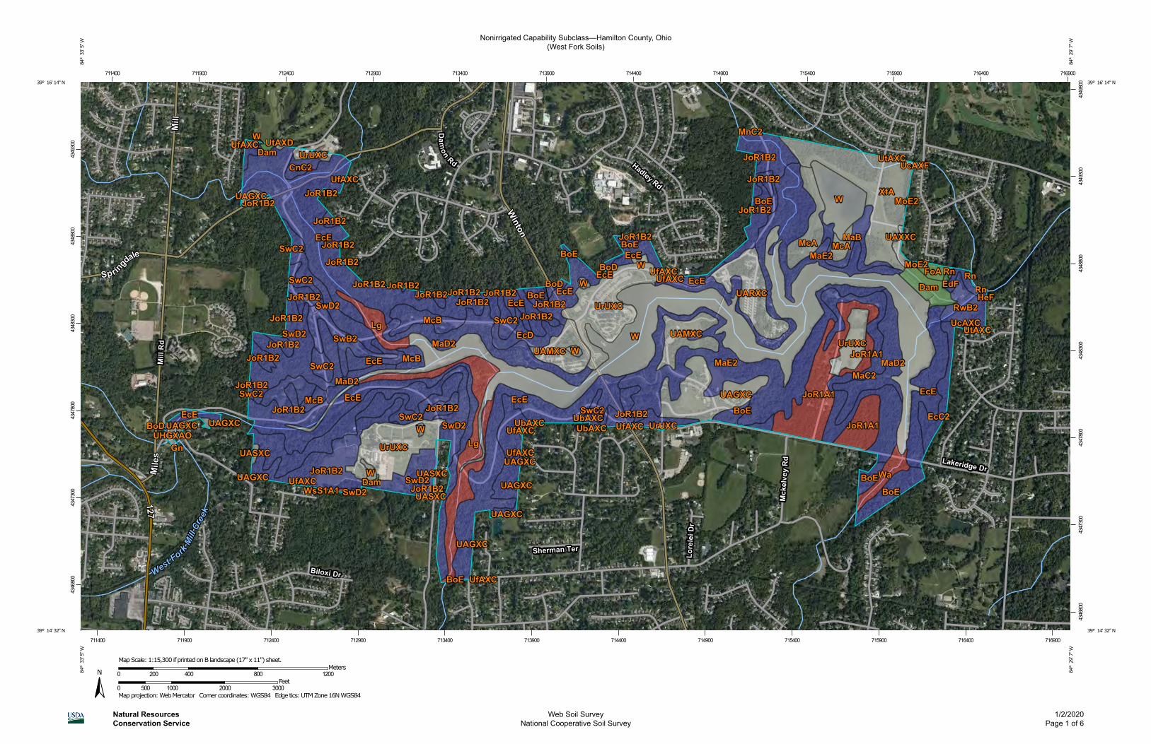
Nonirrigated Capability Subclass—Hamilton County, Ohio(West Fork Soils)
Natural ResourcesConservation Service
Web Soil SurveyNational Cooperative Soil Survey
1/2/2020Page 1 of 6
4346
800
4347
300
4347
800
4348
300
4348
800
4349
300
4346
800
4347
300
4347
800
4348
300
4348
800
4349
300
4349
800
711400 711900 712400 712900 713400 713900 714400 714900 715400 715900 716400 716900
711400 711900 712400 712900 713400 713900 714400 714900 715400 715900 716400 716900
39° 16' 14'' N84
° 3
3' 5
'' W39° 16' 14'' N
84° 2
9' 7
'' W
39° 14' 32'' N
84° 3
3' 5
'' W
39° 14' 32'' N
84° 2
9' 7
'' W
N
Map projection: Web Mercator Corner coordinates: WGS84 Edge tics: UTM Zone 16N WGS840 500 1000 2000 3000
Feet0 200 400 800 1200
MetersMap Scale: 1:15,300 if printed on B landscape (17" x 11") sheet.
MAP LEGEND MAP INFORMATION
Area of Interest (AOI)Area of Interest (AOI)
SoilsSoil Rating Polygons
Erosion
Soil limitation within the rooting zoneExcess water
Climate condition
Not rated or not available
Soil Rating LinesErosion
Soil limitation within the rooting zoneExcess water
Climate condition
Not rated or not available
Soil Rating PointsErosion
Soil limitation within the rooting zoneExcess water
Climate condition
Not rated or not available
Water FeaturesStreams and Canals
TransportationRails
Interstate Highways
US Routes
Major Roads
Local Roads
BackgroundAerial Photography
The soil surveys that comprise your AOI were mapped at 1:15,800.
Please rely on the bar scale on each map sheet for map measurements.
Source of Map: Natural Resources Conservation ServiceWeb Soil Survey URL: Coordinate System: Web Mercator (EPSG:3857)
Maps from the Web Soil Survey are based on the Web Mercator projection, which preserves direction and shape but distorts distance and area. A projection that preserves area, such as the Albers equal-area conic projection, should be used if more accurate calculations of distance or area are required.
This product is generated from the USDA-NRCS certified data as of the version date(s) listed below.
Soil Survey Area: Hamilton County, OhioSurvey Area Data: Version 19, Sep 16, 2019
Soil map units are labeled (as space allows) for map scales 1:50,000 or larger.
Date(s) aerial images were photographed: Aug 24, 2019—Sep 18, 2019
The orthophoto or other base map on which the soil lines were compiled and digitized probably differs from the background imagery displayed on these maps. As a result, some minor shifting of map unit boundaries may be evident.
Nonirrigated Capability Subclass—Hamilton County, Ohio(West Fork Soils)
Natural ResourcesConservation Service
Web Soil SurveyNational Cooperative Soil Survey
1/2/2020Page 2 of 6
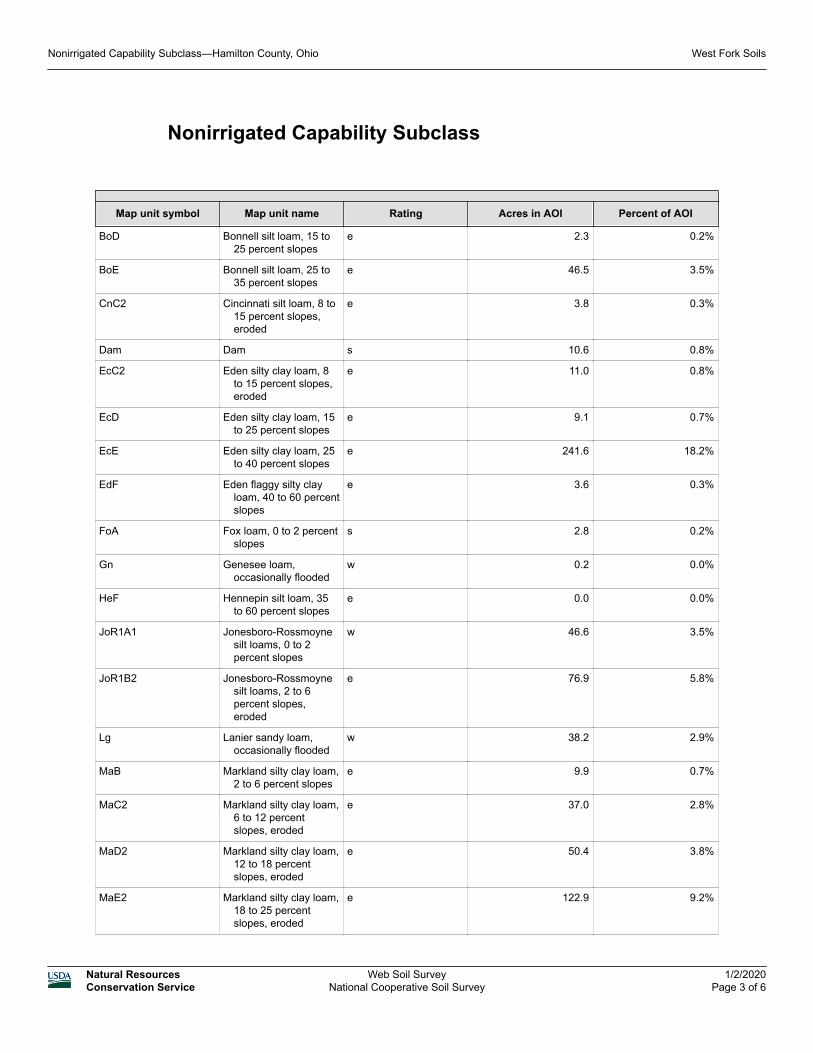
Nonirrigated Capability Subclass
Map unit symbol Map unit name Rating Acres in AOI Percent of AOI
BoD Bonnell silt loam, 15 to 25 percent slopes
e 2.3 0.2%
BoE Bonnell silt loam, 25 to 35 percent slopes
e 46.5 3.5%
CnC2 Cincinnati silt loam, 8 to 15 percent slopes, eroded
e 3.8 0.3%
Dam Dam s 10.6 0.8%
EcC2 Eden silty clay loam, 8 to 15 percent slopes, eroded
e 11.0 0.8%
EcD Eden silty clay loam, 15 to 25 percent slopes
e 9.1 0.7%
EcE Eden silty clay loam, 25 to 40 percent slopes
e 241.6 18.2%
EdF Eden flaggy silty clay loam, 40 to 60 percent slopes
e 3.6 0.3%
FoA Fox loam, 0 to 2 percent slopes
s 2.8 0.2%
Gn Genesee loam, occasionally flooded
w 0.2 0.0%
HeF Hennepin silt loam, 35 to 60 percent slopes
e 0.0 0.0%
JoR1A1 Jonesboro-Rossmoyne silt loams, 0 to 2 percent slopes
w 46.6 3.5%
JoR1B2 Jonesboro-Rossmoyne silt loams, 2 to 6 percent slopes, eroded
e 76.9 5.8%
Lg Lanier sandy loam, occasionally flooded
w 38.2 2.9%
MaB Markland silty clay loam, 2 to 6 percent slopes
e 9.9 0.7%
MaC2 Markland silty clay loam, 6 to 12 percent slopes, eroded
e 37.0 2.8%
MaD2 Markland silty clay loam, 12 to 18 percent slopes, eroded
e 50.4 3.8%
MaE2 Markland silty clay loam, 18 to 25 percent slopes, eroded
e 122.9 9.2%
Nonirrigated Capability Subclass—Hamilton County, Ohio West Fork Soils
Natural ResourcesConservation Service
Web Soil SurveyNational Cooperative Soil Survey
1/2/2020Page 3 of 6
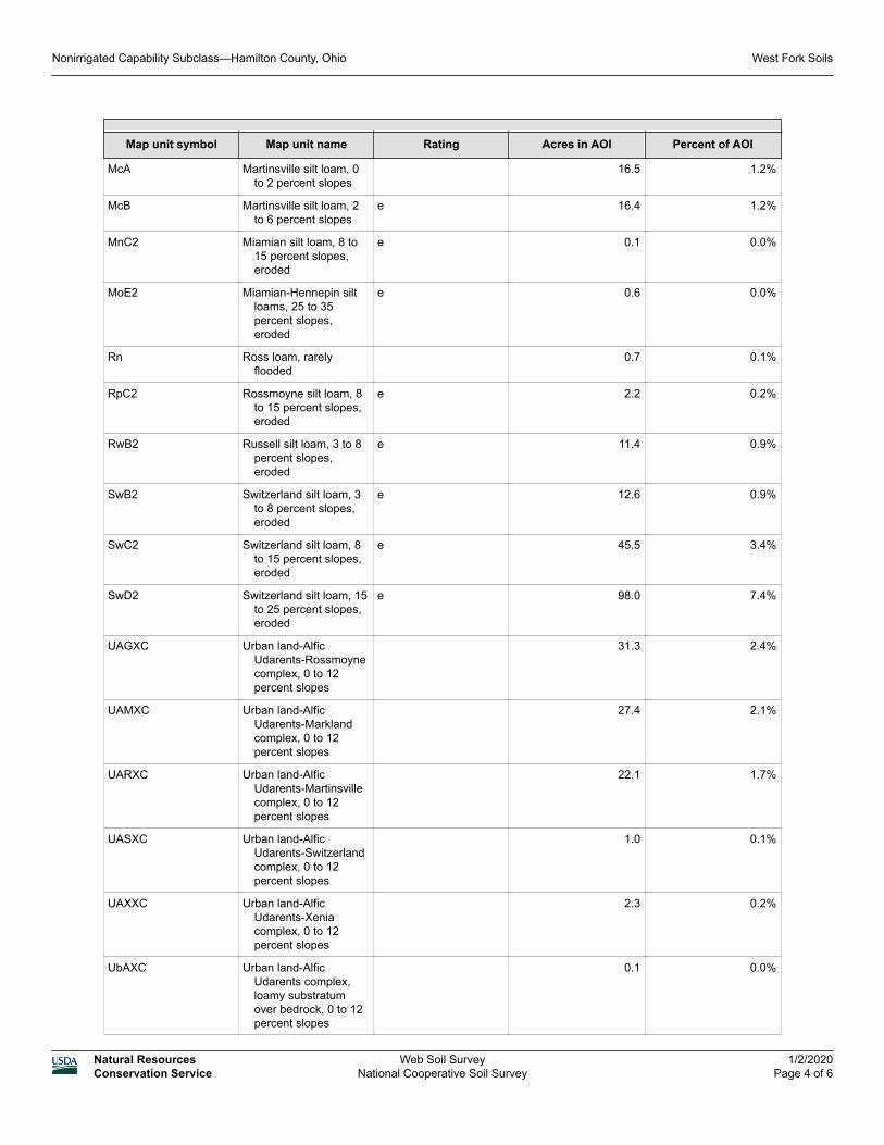
Map unit symbol Map unit name Rating Acres in AOI Percent of AOI
McA Martinsville silt loam, 0 to 2 percent slopes
16.5 1.2%
McB Martinsville silt loam, 2 to 6 percent slopes
e 16.4 1.2%
MnC2 Miamian silt loam, 8 to 15 percent slopes, eroded
e 0.1 0.0%
MoE2 Miamian-Hennepin silt loams, 25 to 35 percent slopes, eroded
e 0.6 0.0%
Rn Ross loam, rarely flooded
0.7 0.1%
RpC2 Rossmoyne silt loam, 8 to 15 percent slopes, eroded
e 2.2 0.2%
RwB2 Russell silt loam, 3 to 8 percent slopes, eroded
e 11.4 0.9%
SwB2 Switzerland silt loam, 3 to 8 percent slopes, eroded
e 12.6 0.9%
SwC2 Switzerland silt loam, 8 to 15 percent slopes, eroded
e 45.5 3.4%
SwD2 Switzerland silt loam, 15 to 25 percent slopes, eroded
e 98.0 7.4%
UAGXC Urban land-Alfic Udarents-Rossmoyne complex, 0 to 12 percent slopes
31.3 2.4%
UAMXC Urban land-Alfic Udarents-Markland complex, 0 to 12 percent slopes
27.4 2.1%
UARXC Urban land-Alfic Udarents-Martinsville complex, 0 to 12 percent slopes
22.1 1.7%
UASXC Urban land-Alfic Udarents-Switzerland complex, 0 to 12 percent slopes
1.0 0.1%
UAXXC Urban land-Alfic Udarents-Xenia complex, 0 to 12 percent slopes
2.3 0.2%
UbAXC Urban land-Alfic Udarents complex, loamy substratum over bedrock, 0 to 12 percent slopes
0.1 0.0%
Nonirrigated Capability Subclass—Hamilton County, Ohio West Fork Soils
Natural ResourcesConservation Service
Web Soil SurveyNational Cooperative Soil Survey
1/2/2020Page 4 of 6
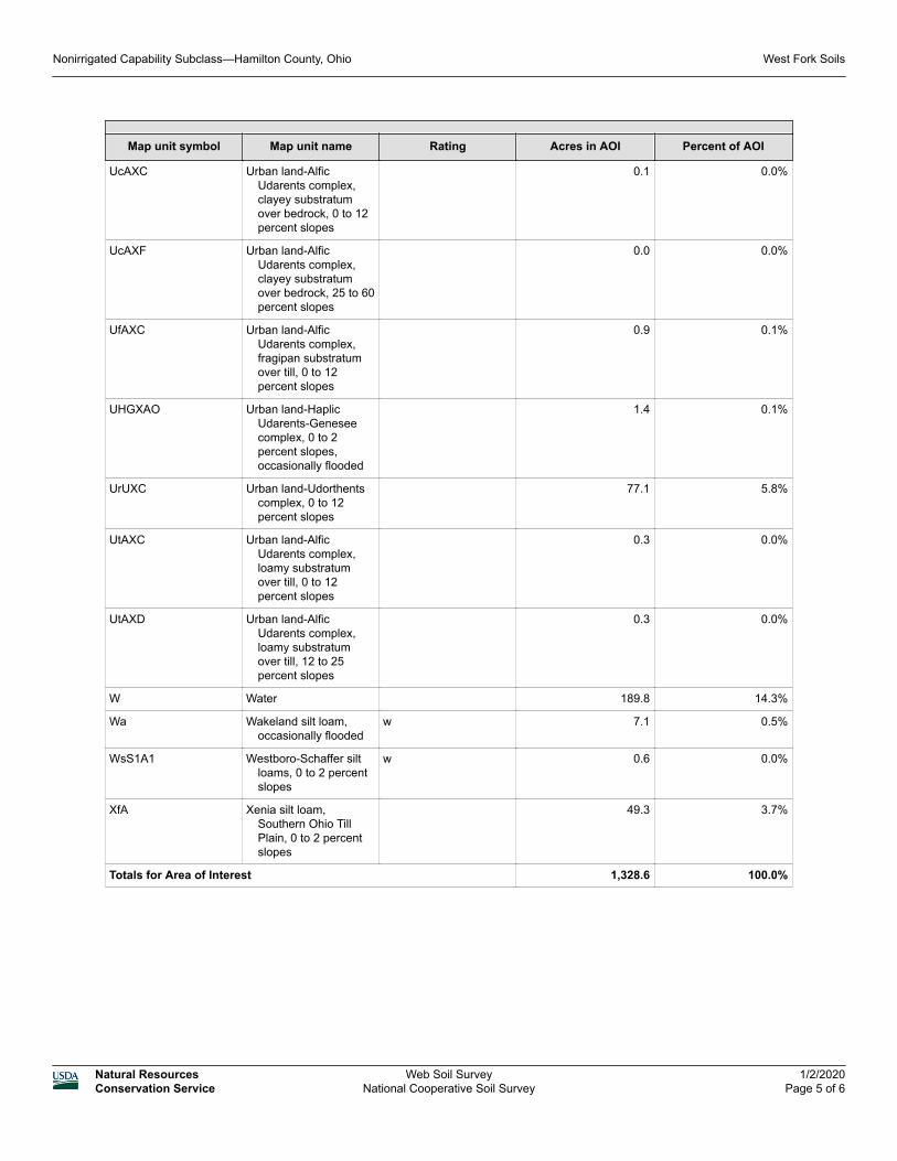
Map unit symbol Map unit name Rating Acres in AOI Percent of AOI
UcAXC Urban land-Alfic Udarents complex, clayey substratum over bedrock, 0 to 12 percent slopes
0.1 0.0%
UcAXF Urban land-Alfic Udarents complex, clayey substratum over bedrock, 25 to 60 percent slopes
0.0 0.0%
UfAXC Urban land-Alfic Udarents complex, fragipan substratum over till, 0 to 12 percent slopes
0.9 0.1%
UHGXAO Urban land-Haplic Udarents-Genesee complex, 0 to 2 percent slopes, occasionally flooded
1.4 0.1%
UrUXC Urban land-Udorthents complex, 0 to 12 percent slopes
77.1 5.8%
UtAXC Urban land-Alfic Udarents complex, loamy substratum over till, 0 to 12 percent slopes
0.3 0.0%
UtAXD Urban land-Alfic Udarents complex, loamy substratum over till, 12 to 25 percent slopes
0.3 0.0%
W Water 189.8 14.3%
Wa Wakeland silt loam, occasionally flooded
w 7.1 0.5%
WsS1A1 Westboro-Schaffer silt loams, 0 to 2 percent slopes
w 0.6 0.0%
XfA Xenia silt loam, Southern Ohio Till Plain, 0 to 2 percent slopes
49.3 3.7%
Totals for Area of Interest 1,328.6 100.0%
Nonirrigated Capability Subclass—Hamilton County, Ohio West Fork Soils
Natural ResourcesConservation Service
Web Soil SurveyNational Cooperative Soil Survey
1/2/2020Page 5 of 6
Description
Land capability classification shows, in a general way, the suitability of soils for most kinds of field crops. Crops that require special management are excluded. The soils are grouped according to their limitations for field crops, the risk of damage if they are used for crops, and the way they respond to management. The criteria used in grouping the soils do not include major and generally expensive landforming that would change slope, depth, or other characteristics of the soils, nor do they include possible but unlikely major reclamation projects. Capability classification is not a substitute for interpretations that show suitability and limitations of groups of soils for rangeland, for woodland, or for engineering purposes.
In the capability system, soils are generally grouped at three levels-capability class, subclass, and unit. Only class and subclass are included in this data set.
Capability subclasses are soil groups within one capability class. They are designated by adding a small letter, "e," "w," "s," or "c," to the class numeral, for example, 2e. The letter "e" shows that the main hazard is the risk of erosion unless close-growing plant cover is maintained; "w" shows that water in or on the soil interferes with plant growth or cultivation (in some soils the wetness can be partly corrected by artificial drainage); "s" shows that the soil is limited mainly because it is shallow, droughty, or stony; and "c," used in only some parts of the United States, shows that the chief limitation is climate that is very cold or very dry.
In class 1 there are no subclasses because the soils of this class have few limitations. Class 5 contains only the subclasses indicated by "w," "s," or "c" because the soils in class 5 are subject to little or no erosion. They have other limitations that restrict their use to pasture, rangeland, forestland, or wildlife habitat.
Rating Options
Aggregation Method: Dominant Condition
Component Percent Cutoff: None Specified
Tie-break Rule: Lower
Nonirrigated Capability Subclass—Hamilton County, Ohio West Fork Soils
Natural ResourcesConservation Service
Web Soil SurveyNational Cooperative Soil Survey
1/2/2020Page 6 of 6
Related Documents