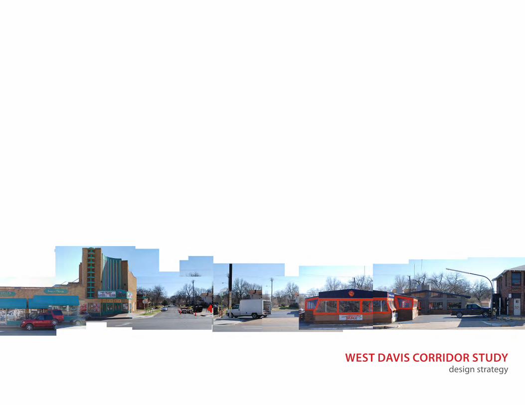
WEST DAVIS CORRIDOR STUDY design strategy

Welcome message from author
This document is posted to help you gain knowledge. Please leave a comment to let me know what you think about it! Share it to your friends and learn new things together.
Transcript
WEST DAVIS CORRIDOR STUDY design strategy

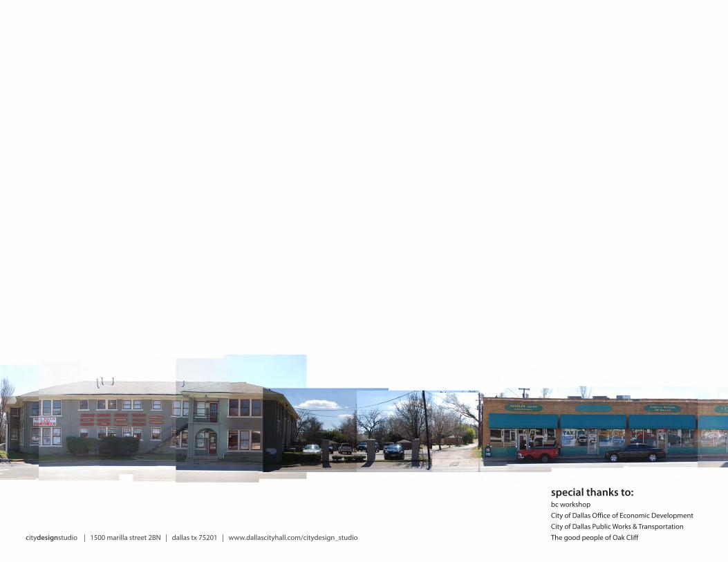
citydesignstudio | 1500 marilla street 2BN | dallas tx 75201 | www.dallascityhall.com/citydesign_studio

WEST DAVIS CORRIDOR STUDYdesign strategy
contents
introduction 5
context 7
process 11
project timeline 14
strategy 16
implementation 23
next steps 27
appendix 29

DOWNTOWN DALLAS
W DAVIS STREET
TRINITY RIVER
4 | citydesign studio
WEST DAVIS CORRIDOR STUDY
INTRODUCTION
In 2011, the City of Dallas hosted a series of meetings to help identify the priorities for improving West Davis as part of the city’s Complete Streets initiative. From that series of meetings came a list of key priorities for re-imagining the corridor as a street for both pedestrians and automobiles that reflects the future of the district and surrounding neighborhoods.
The city’s 2012 bond program included a number of corridors targeted for complete streets improvements as a series of demonstration projects. As part of this package, voters approved $979,000 for the West Davis corridor. The Dallas CityDesign Studio has been charged by the Office of Economic Development and the Davis Garden TIF Board to translate the complete street priorities identified in 2011 into a direct design program responding to the specific challenges and opportunities found along the West Davis corridor. Through public input and engagement, a vision and direction for the corridor emerged.
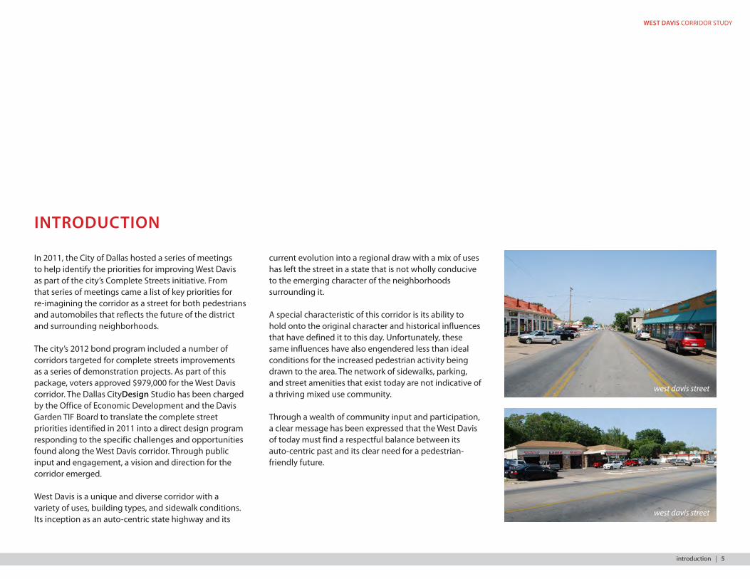
West Davis is a unique and diverse corridor with a variety of uses, building types, and sidewalk conditions. Its inception as an auto-centric state highway and its
current evolution into a regional draw with a mix of uses has left the street in a state that is not wholly conducive to the emerging character of the neighborhoods surrounding it.
A special characteristic of this corridor is its ability to hold onto the original character and historical influences that have defined it to this day. Unfortunately, these same influences have also engendered less than ideal conditions for the increased pedestrian activity being drawn to the area. The network of sidewalks, parking, and street amenities that exist today are not indicative of a thriving mixed use community.
Through a wealth of community input and participation, a clear message has been expressed that the West Davis of today must find a respectful balance between its auto-centric past and its clear need for a pedestrian-friendly future.
west davis street
west davis street
introduction | 5

KIDD SPRINGS
BISHOP ARTSDISTRICT
RUTH MEADE PLACE
KESSLER PARK
WESTKESSLER
KINGS HIGHWAY
L.O. DANIELS
WINNETKA HEIGHTS
SUNSET HILLS
STEVENS PARK
DALLAS LAND & LOAN
0’ 125’ 250’ 500’ 1000’
PUBLIC ENGAGEMENT AREA
6 | citydesign studio
WEST DAVIS CORRIDOR STUDY
CONTEXT
West Davis Street was constructed shortly after Oak Cliff’s official founding in 1887 by T.L. Marsalis. West Davis has been a vital regional and national roadway since its commissioning as a U.S. Highway in 1926. Spanning 3,000 miles across the United States, U.S. Highway 80 started in Tybee Island, Georgia, and terminated in San Diego, California.
As the primary east-west thoroughfare from Dallas to the mid-cities and beyond, this transcontinental roadway established West Davis Street as a haven for auto-centered commerce, leading to the creation of numerous filling stations, auto repair shops and retailers by as early as the 1940s. This reputation is still present along the corridor today.
As auto use continued to rise, shopping malls and freeways began to pull traffic away from the corridor and led West Davis to fall into decline. In the early 1970s, a large demographic shift occurred due to the low housing costs attributed to the rapidly declining area. New immigrant families revived empty shop fronts along the corridor; largely Latino-oriented businesses such as restaurants, retail, and tax/immigration and
other services became commonplace. Yet despite this initial investment, crime in the neighborhoods surrounding West Davis continued to rise and the housing stock continued to fall into severe disrepair.
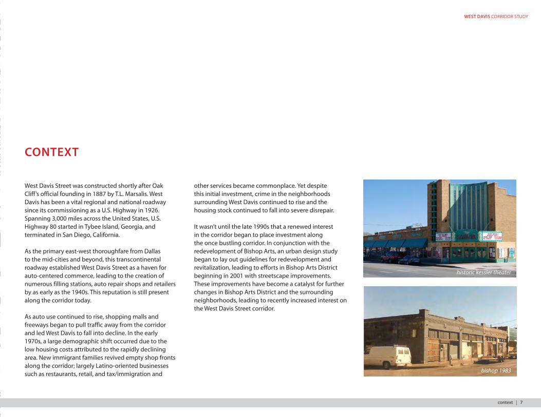
It wasn’t until the late 1990s that a renewed interest in the corridor began to place investment along the once bustling corridor. In conjunction with the redevelopment of Bishop Arts, an urban design study began to lay out guidelines for redevelopment and revitalization, leading to efforts in Bishop Arts District beginning in 2001 with streetscape improvements. These improvements have become a catalyst for further changes in Bishop Arts District and the surrounding neighborhoods, leading to recently increased interest on the West Davis Street corridor.
KIDD SPRINGS
BISHOP ARTSDISTRICT
RUTH MEADE PLACE
KESSLER PARK
WESTKESSLER
KINGS HIGHWAY
L.O. DANIELS
WINNETKA HEIGHTS
SUNSET HILLS
STEVENS PARK
DALLAS LAND & LOAN
0’ 125’ 250’ 500’ 1000’
PUBLIC ENGAGEMENT AREA
historic kessler theater
bishop 1983
context | 7

7th & north bishop 1929
7th & north bishop, 1929
7th street streetcar
7th & north bishop, 1929
7th & north bishop today
8 | citydesign studio

WEST DAVIS CORRIDOR STUDY
north loop garage- 400 west davis streetbishop fire station- 600 north bishop
811 north bishop, 1910
kemp garage - 634 west davis street 634 west davis street today600 north bishop today
historic photographs courtesy of the dallas public library
context | 9
10 | citydesign studio
WEST DAVIS CORRIDOR STUDY
PROCESS
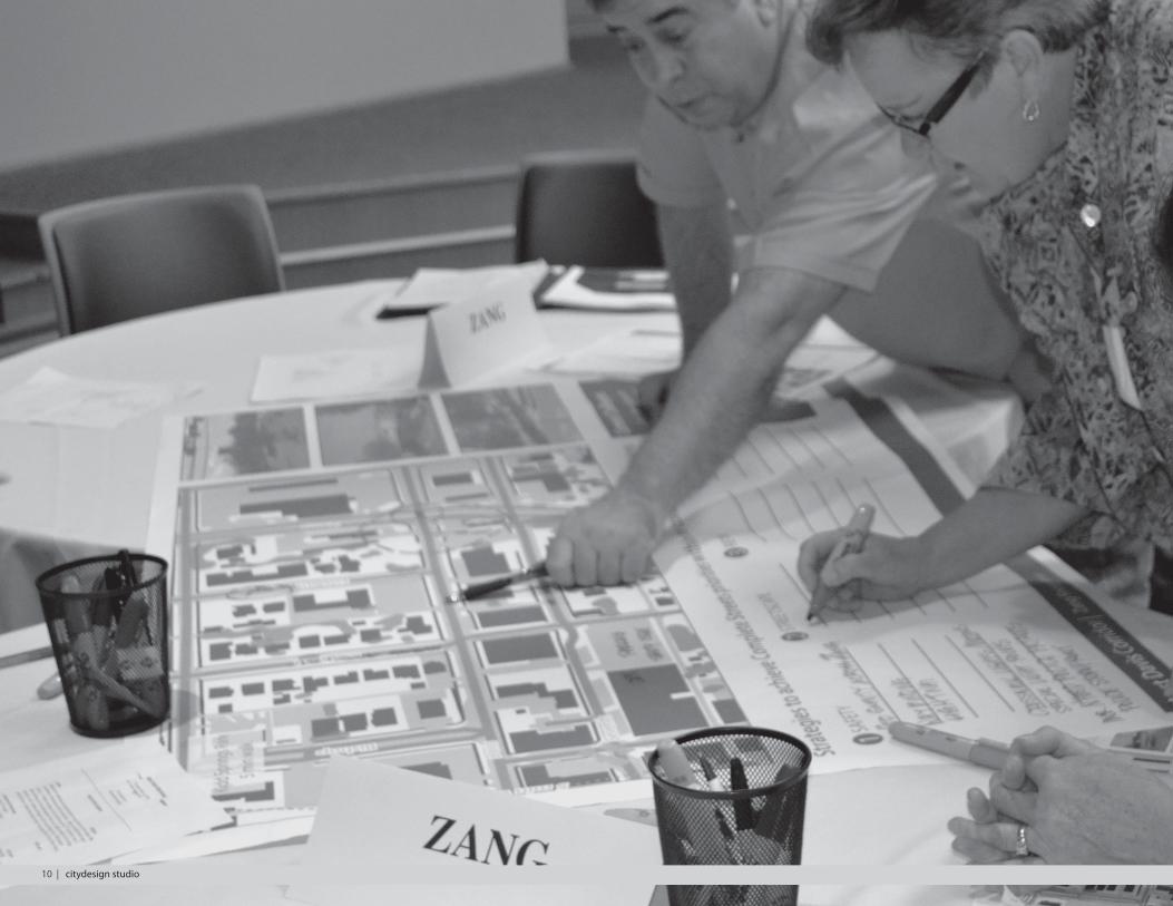
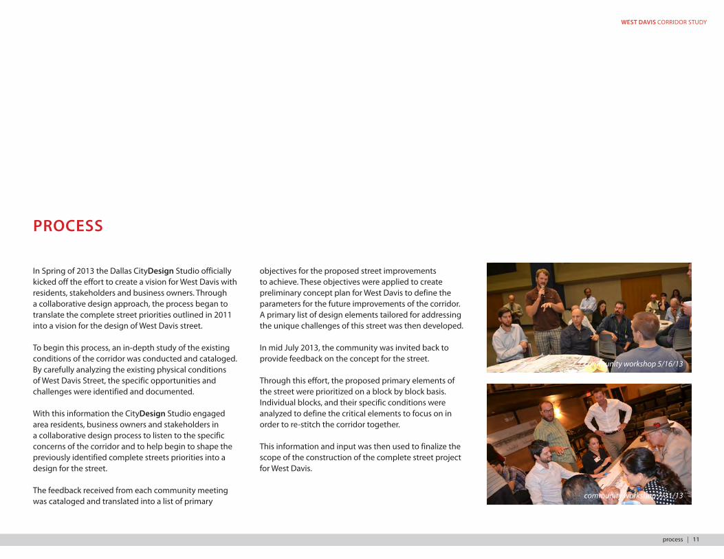
In Spring of 2013 the Dallas CityDesign Studio officially kicked off the effort to create a vision for West Davis with residents, stakeholders and business owners. Through a collaborative design approach, the process began to translate the complete street priorities outlined in 2011 into a vision for the design of West Davis street.
To begin this process, an in-depth study of the existing conditions of the corridor was conducted and cataloged. By carefully analyzing the existing physical conditions of West Davis Street, the specific opportunities and challenges were identified and documented.
With this information the CityDesign Studio engaged area residents, business owners and stakeholders in a collaborative design process to listen to the specific concerns of the corridor and to help begin to shape the previously identified complete streets priorities into a design for the street.
The feedback received from each community meeting was cataloged and translated into a list of primary
objectives for the proposed street improvements to achieve. These objectives were applied to create preliminary concept plan for West Davis to define the parameters for the future improvements of the corridor. A primary list of design elements tailored for addressing the unique challenges of this street was then developed.
In mid July 2013, the community was invited back to provide feedback on the concept for the street.
Through this effort, the proposed primary elements of the street were prioritized on a block by block basis. Individual blocks, and their specific conditions were analyzed to define the critical elements to focus on in order to re-stitch the corridor together.
This information and input was then used to finalize the scope of the construction of the complete street project for West Davis.
community workshop 5/16/13
community workshop 7/31/13
process | 11
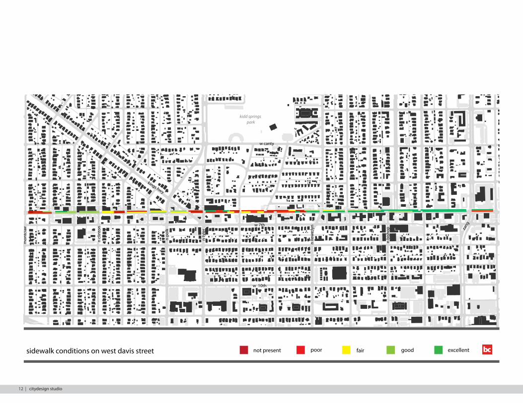
not present poor fair good excellentsidewalk conditions on west davis street
mon
tcla
ir
n ty
ler za
ng
n bi
shop
n po
lk
n cl
into
n
kings hwy
w 7th
w canty
kidd springs park
w 10th
n lle
we;
lyn
12 | citydesign studio
WEST DAVIS CORRIDOR STUDY
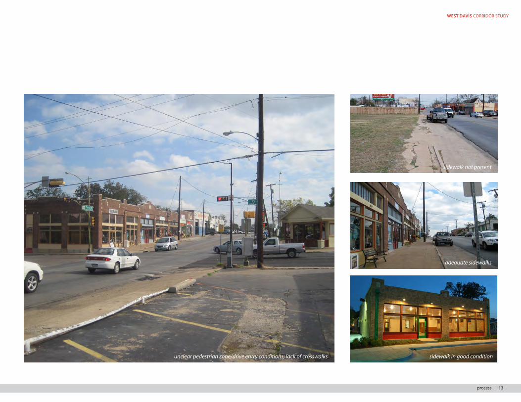
sidewalk in good conditionunclear pedestrian zone/drive entry conditions; lack of crosswalks
adequate sidewalks
sidewalk not present
process | 13
PROJECT TIMELINE
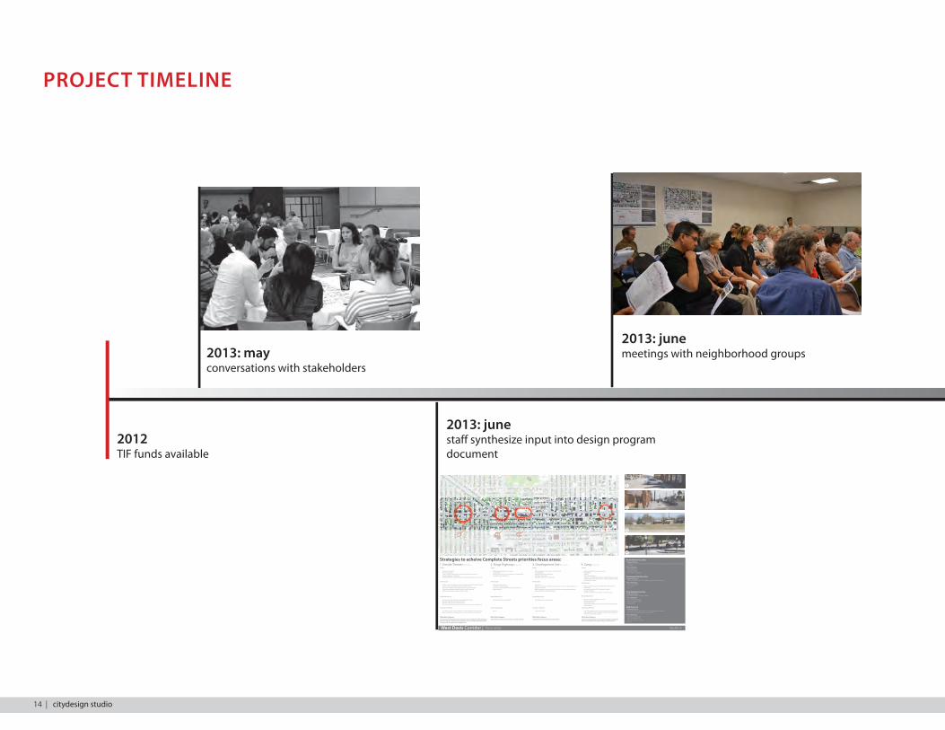
2012TIF funds available
2013: junestaff synthesize input into design program document
2013: mayconversations with stakeholders
05.20.13West Davis Corridor | focus areas
2
1
3
4
4
Clin
ton
Win
dom
ere
Edge
�eld
Win
netk
a
Will
omet
Polk
Tyle
r
Vern
on
Van
Bure
n
Llew
llyn
Adam
s
Bish
op
Mad
ison
Zang
Davis
7th
8th
Kings
Strategies to acheive Complete Streets priorities focus areas:1. Kessler Theater 3. Development Site 4. Zangfocus area
Kessler Theater Focus Area:Ongoing Projects: - $60,000 TIF funds, leveraged with $179,200 in matching funds for sidewalk improvemens to be completed by 12/31/2014
Area Challenges:- Inactive shopfronts- Lack of landscaping- Poor distribution of parking
Development Site Focus Area:Ongoing Projects: - Davis Street Market: $4M in TIF funds approved by city council 9/26/2012
Area Challenges:- Poor/missing sidewalks- Lack of identity- Vacancy
Kings Highway Focus Area:Ongoing Projects: Kings Highway Plaza: $442,492 in TIF funds
Area Challenges:- Poor sidewalk connectivity- Traffic and pedestrian safety- Limited parking
Zang focus area:Ongoing Projects: - Bishop Ave Complete Street Project $4 million between Davis & Jefferson- Streetcar line and stop: Zang & Davis, open Fall 2015
Area Challenges:- Connection to Bishop Arts from future streetcar stop- Pedestrian safety crossing Zang- Vacancy
focus area focus area focus area2. Kings HighwaySafety
• Lighting and visibility• Presence of people• Create conditions that allow for people and activity on the street• Increased lighting on 7th Street • Clear and generous visibility triangles to maximize visibility at cross streets
Streetscape
• All four corners should be consistent with the design for the Kessler Theater• Keep turn lane (no median)/ tra�c would divert to 7th• Street trees should be of the right species for size and visibility• Continuous sidewalks should have priority over street trees• Better functioning parking that is easy to utilize
Retail/Mixed-Use
• Businesses here should cater toward neighborhood users• Business should be sustainable over time• Residents prefer owner occupied business• Businesses should have a presence on the street and create visual interest
Character/Identity
• The identity of the corner should �t in with the neighborhood (Winnetka)• Identity should be consistent with historic district ordinance and intent
What Must Happen:Davis should be designed so that it maintains current tra�c �ow while making pe-destrians feel safe. Creating more congestion for cars would create undesired cut-through tra�c throughout the neighborhood
Safety
• Bu�er between pedestrians, motorists• Use bulb-outs • Unsafe intersection @ Tyler & 7th, Bikes on 7th NOT Davis• Safe tra�c speed along Davis
Streetscape
• Eliminate clutter on Davis• Complete Sidewalks & Curbs• Street trees/ green in de�ned parts/ parallel parking• Angled parking
Retail/Mixed-Use
• Encourage business opportunities
Character/Identity
• Plaza!
What Must Happen:Bu�er between pedestrians and motorists (Tyler and 7th)
Safety
• Width of Sidewalks- consistency/ lack of existing • Lack of lighting• Vehicular/pedestrian relationship• Add “Eyes on the street”• Add safety at the car lot at Van Buren
Streetscape
• Street trees• Parking- currently lots of old driveway entrances that make type of parking con- fusing/ inconsistent• Make Fouraker one-way to the East of Van Buren to create additional angled parking behind the existing buildings
Retail/Mixed-Use
• Encourage business opportunities
Character/Identity
• “Embrace the auto”
What Must Happen:Separation between pedestrians and motorists
Safety
• Pedestrian Safety across Zang is uneven• Way-�nding• Lighting• Poles in the walkway Solutions: Crosswalk lights/buttons, special light poles, increase neighborhood police patrols, police storefront, panic/emergen- cy/”blue light” stations
Streetscape
• Reduce parking intrusion and competition with residents• Street trees!• Re-direct Zang at the DART Landmark Gateway?• Street pole banners• Rubber Tire trolley with circulation to Kessler & Loop
Retail/Mixed-Use
• Parking is limited- keeps patrons away• Way �nding from DART• Rubber tire trolleys!• Shared Parking/Park-and-ride, include resident-only parking in neighborhood
Character/Identity
• Oak Cli�, Landmark at Entry, Remove overhead power lines, Sig- nature entrance, Mosaics, Gateway @ Zang & Davis, Enhanced pavements, Color. LED Lighting
What Must Happen:Gateway at Zang and Davis, Transit option (rubber tire bus/mini-bus) to move people from DART/trolley station down Davis
2013: junemeetings with neighborhood groups
14 | citydesign studio
WEST DAVIS CORRIDOR STUDY
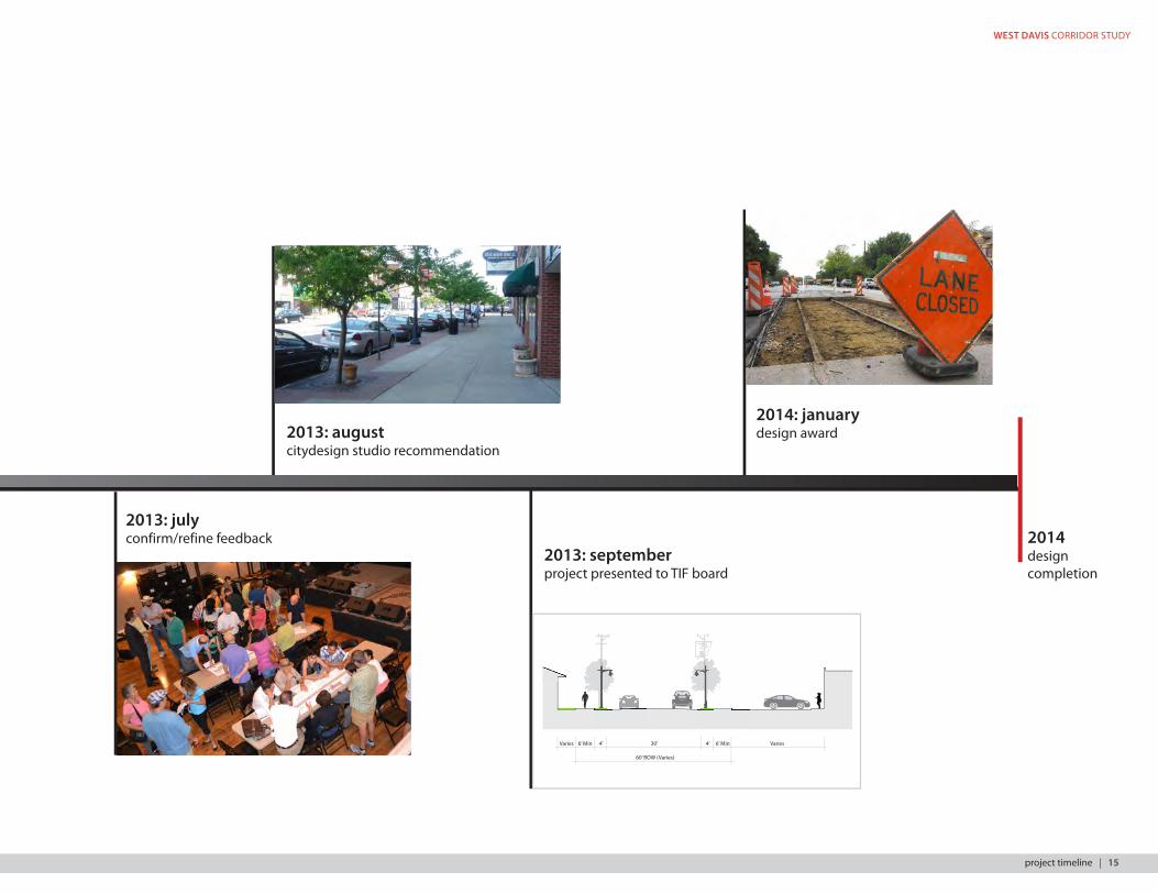
2013: julyconfirm/refine feedback
2013: augustcitydesign studio recommendation
2013: septemberproject presented to TIF board
2014designcompletion
Varies 6’ Min 4’ 30’ 4’ 6’ Min Varies
60’ ROW (Varies)
2014: januarydesign award
project timeline | 15
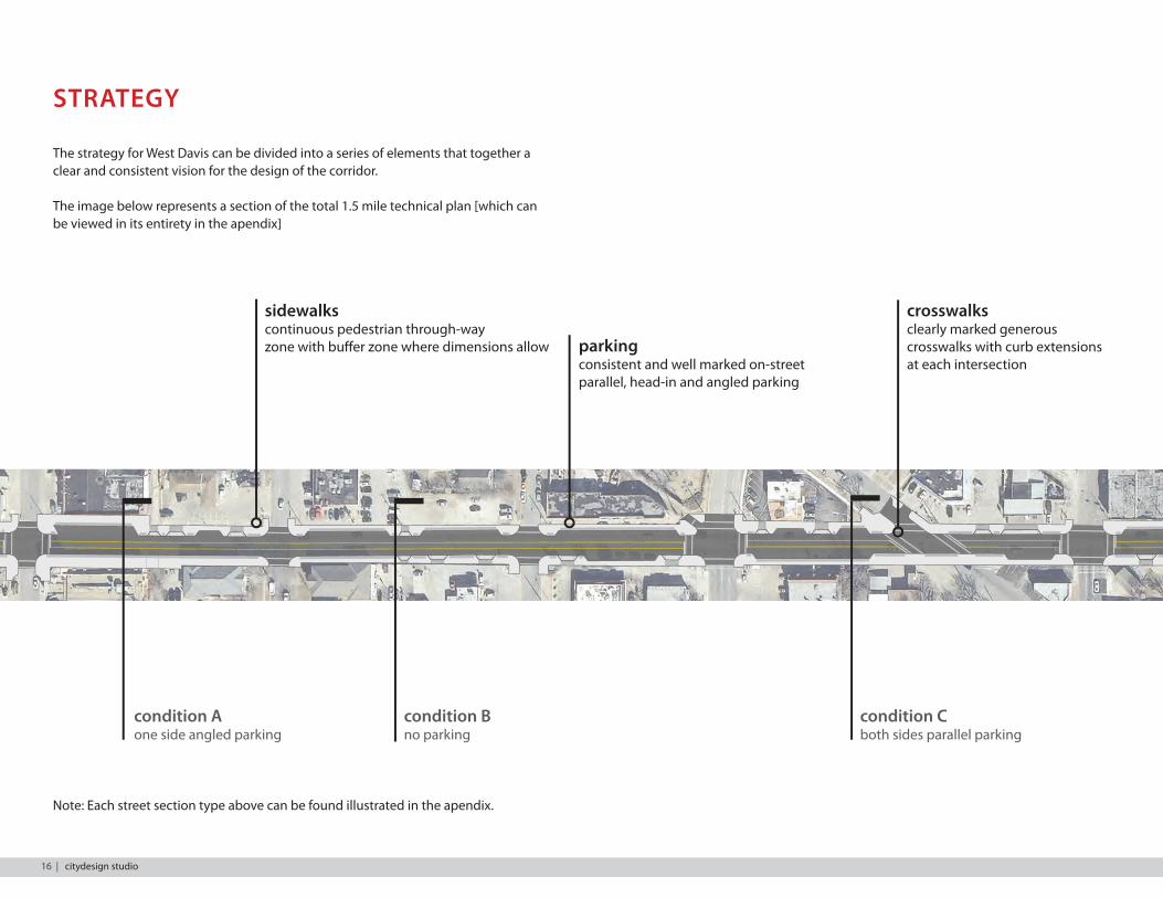
STRATEGY
sidewalkscontinuous pedestrian through-wayzone with buffer zone where dimensions allow
crosswalksclearly marked generous crosswalks with curb extensions at each intersection
parkingconsistent and well marked on-street parallel, head-in and angled parking
The strategy for West Davis can be divided into a series of elements that together a clear and consistent vision for the design of the corridor.
The image below represents a section of the total 1.5 mile technical plan [which can be viewed in its entirety in the apendix]
condition Cboth sides parallel parking
condition Aone side angled parking
condition Bno parking
Note: Each street section type above can be found illustrated in the apendix.
16 | citydesign studio
WEST DAVIS CORRIDOR STUDY
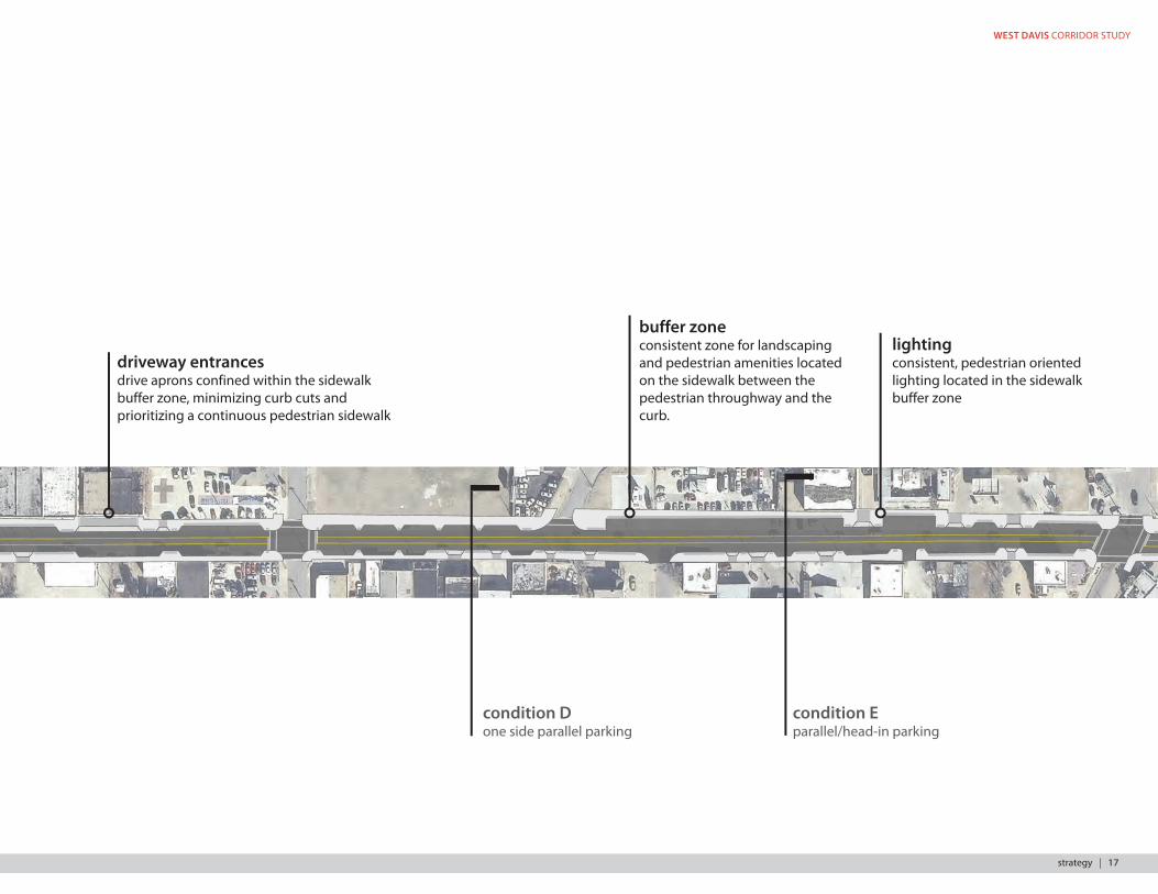
lightingconsistent, pedestrian oriented lighting located in the sidewalk buffer zone
buffer zoneconsistent zone for landscaping and pedestrian amenities located on the sidewalk between the pedestrian throughway and the curb.
driveway entrancesdrive aprons confined within the sidewalk buffer zone, minimizing curb cuts and prioritizing a continuous pedestrian sidewalk
condition Eparallel/head-in parking
condition Done side parallel parking
strategy | 17
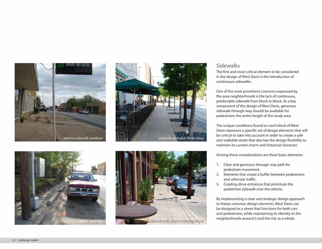
SidewalksThe first and most critical element to be considered in the design of West Davis is the introduction of continuous sidewalks.
One of the most prominent concerns expressed by the area neighborhoods is the lack of continuous, predictable sidewalk from block to block. As a key component of the design of West Davis, generous sidewalk through-way should be available for pedestrians the entire length of the study area.
The unique conditions found on each block of West Davis represent a specific set of design elements that will be critical to take into account in order to create a safe and walkable street that also has the design flexibility to maintain its current charm and historical character.
Among these considerations are three basic elements:
1. Clear and generous through-way path for pedestrian movement.
2. Elements that create a buffer between pedestrians and vehicular traffic.
3. Creating dirve entrances that priorituze the pedestrian sidewalk over the vehicle.
By implementing a clear and strategic design approach to theses common design elements, West Davis can be designed as a street that functions for both cars and pedestrians, while maintaining its identity to the neighborhoods around it and the city as a whole.
existing sidewalk condition sidewalk with clear buffer zone
sidewalk with clearly marked parkingexisting sidewalk condition
18 | citydesign studio
WEST DAVIS CORRIDOR STUDY
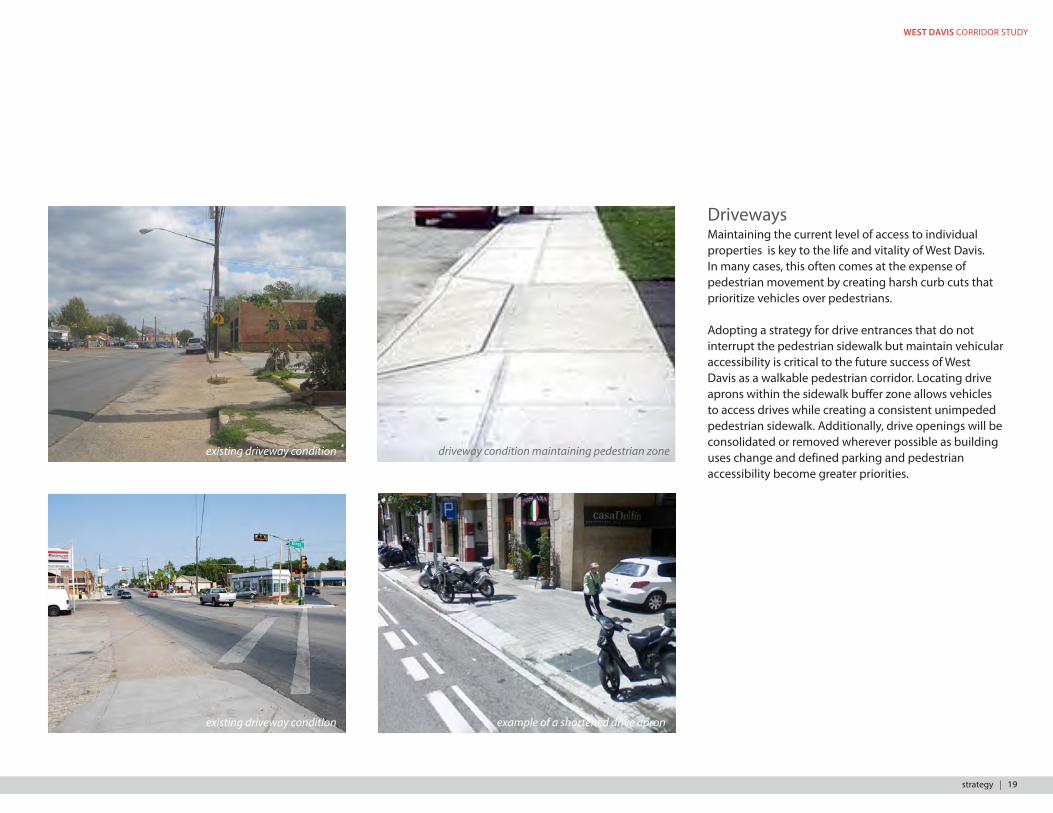
DrivewaysMaintaining the current level of access to individual properties is key to the life and vitality of West Davis. In many cases, this often comes at the expense of pedestrian movement by creating harsh curb cuts that prioritize vehicles over pedestrians.
Adopting a strategy for drive entrances that do not interrupt the pedestrian sidewalk but maintain vehicular accessibility is critical to the future success of West Davis as a walkable pedestrian corridor. Locating drive aprons within the sidewalk buffer zone allows vehicles to access drives while creating a consistent unimpeded pedestrian sidewalk. Additionally, drive openings will be consolidated or removed wherever possible as building uses change and defined parking and pedestrian accessibility become greater priorities.
existing driveway condition
existing driveway condition
example of a shortened drive apron
driveway condition maintaining pedestrian zone
strategy | 19
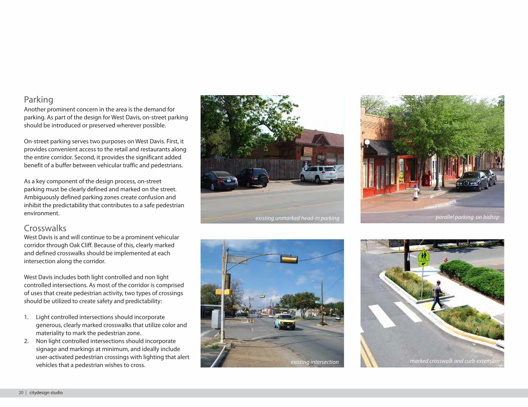
ParkingAnother prominent concern in the area is the demand for parking. As part of the design for West Davis, on-street parking should be introduced or preserved wherever possible.
On-street parking serves two purposes on West Davis. First, it provides convenient access to the retail and restaurants along the entire corridor. Second, it provides the significant added benefit of a buffer between vehicular traffic and pedestrians.
As a key component of the design process, on-street parking must be clearly defined and marked on the street. Ambiguously defined parking zones create confusion and inhibit the predictability that contributes to a safe pedestrian environment.
CrosswalksWest Davis is and will continue to be a prominent vehicular corridor through Oak Cliff. Because of this, clearly marked and defined crosswalks should be implemented at each intersection along the corridor.
West Davis includes both light controlled and non light controlled intersections. As most of the corridor is comprised of uses that create pedestrian activity, two types of crossings should be utilized to create safety and predictability:
1. Light controlled intersections should incorporate generous, clearly marked crosswalks that utilize color and materiality to mark the pedestrian zone.
2. Non light controlled intersections should incorporate signage and markings at minimum, and ideally include user-activated pedestrian crossings with lighting that alert vehicles that a pedestrian wishes to cross.
existing unmarked head-in parking parallel parking on bishop
existing intersection marked crosswalk and curb extension
20 | citydesign studio

WEST DAVIS CORRIDOR STUDY
LightingLighting should be consistent and predictable along the length of the corridor. Pedestrian scaled lighting that directs light toward the street and sidewalk rather than skyward should occur at a reasonable frequency.
This lighting should occur within the sidewalk buffer zone located between either the drive lane or on street parking and the unimpeded sidewalk throughway. Additional sidewalk lighting can also be provided by building facades.
Continuous and predictable lighting is key to the perception of safety and sense of place for West Davis.
Bu�er ZoneThe term buffer zone refers to the part of the sidewalk dedicated to streetscape, trees, plantings, and lighting located between the curb and the sidewalk throughway.
Consistent street trees should be placed wherever the available dimension allows along the entire corridor. This zone will also allow for individual business and retail a consistent area to spill activity onto the sidewalk and bring life to the street.
There are various cost effective and sustainable landscaping options that can be used in place of street trees while also maintaining neighborhood character, such as decompressed granite and native Texas plants that require less irrigation and maintenance. street trees act as a pedestrian buffer
existing street lighting along corridor alternative street lighting along corridor
existing lack of buffer zone
lighting provided by buildings
example of drought resistant landscaping
strategy | 21
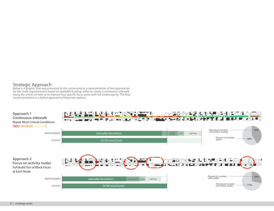
Strategic ApproachBelow is a graphic that was presented to the community as a representation of two approaches for the street improvements based on available funding: either to create a continuous sidewalk along the whole corridor or to improve four specific focus areas with full streetscaping. The final recommendation is a hybrid approach of these two options.
not present poor fair good excellentsidewalk conditions on west davis street
mon
tcla
ir
n ty
ler za
ng
n bi
shop
n po
lk
n cl
into
n
kings hwy
w 7th
w canty
kidd springs park
w 10th
n lle
we;
lyn
58%
42%Percent of corridor red, yellow, orange
Percent of corridor green
sidewalks/demolition
$979K bond funds
street resurf. trees lighting
22 | citydesign studio
Approach 1 Continuous sidewalk Repair Most Critical Conditions [RED-ORANGE-YELLOW]
IMPROVEMENT
BUDGET
71%
29%Percent of corridor with nodes
Percent of corridor not within nodes
sidewalks/demolition
$979K bond funds
Approach 2 Focus on activity nodesFull Build Out of Block Faces at Each Node
IMPROVEMENT
BUDGET
street resurf. trees lighting
WEST DAVIS CORRIDOR STUDY
IMPLEMENTATION
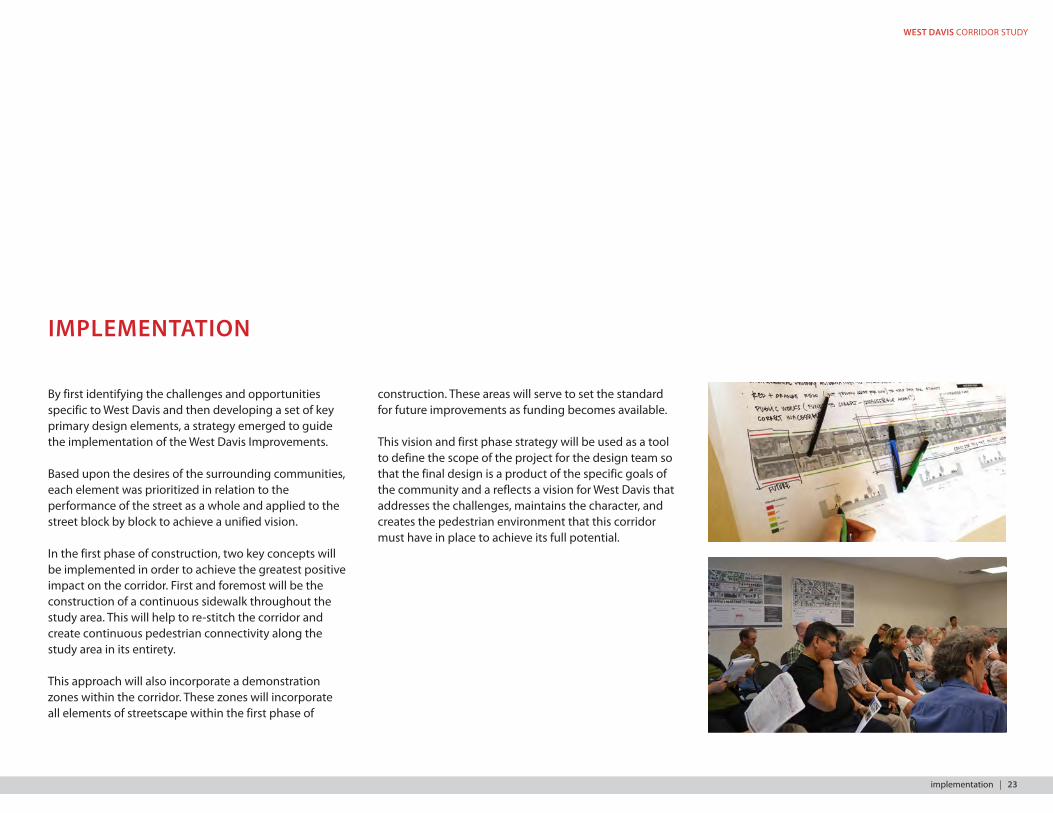
By first identifying the challenges and opportunities specific to West Davis and then developing a set of key primary design elements, a strategy emerged to guide the implementation of the West Davis Improvements.
Based upon the desires of the surrounding communities, each element was prioritized in relation to the performance of the street as a whole and applied to the street block by block to achieve a unified vision.
In the first phase of construction, two key concepts will be implemented in order to achieve the greatest positive impact on the corridor. First and foremost will be the construction of a continuous sidewalk throughout the study area. This will help to re-stitch the corridor and create continuous pedestrian connectivity along the study area in its entirety.
This approach will also incorporate a demonstration zones within the corridor. These zones will incorporate all elements of streetscape within the first phase of
construction. These areas will serve to set the standard for future improvements as funding becomes available.
This vision and first phase strategy will be used as a tool to define the scope of the project for the design team so that the final design is a product of the specific goals of the community and a reflects a vision for West Davis that addresses the challenges, maintains the character, and creates the pedestrian environment that this corridor must have in place to achieve its full potential.
implementation | 23
Recommended Approach
GN
AZ
NOSI
DA
M
PO
HSI B
SM
AD
A
CED
AR H
ILL
NO
NRE
RELYT
KLOP
KINGS HWY
GN
AZ
NOSI
DA
M
PO
HSI B
SM
AD
A
CED
AR H
ILL
NO
NREV
RELYT
KLOP
KINGS HWY
TEM
OLLIW
AKTE
NNI
W
NOT
NILC
DLEI FEG
DE
EREM
OD
NIW
RIALCT
NO
M
GN
AZ
NOSI
DA
M
PO
HSIB
SM
AD
A
CED
AR H
ILL
VER
NO
NRELYTPOLK KINGS HWY
TEM
OLLIW
AKTE
NNI
W
NOT
NILC
DLEIFEG
DE
EREM
OD
NIWM
ON
TCL
RIA
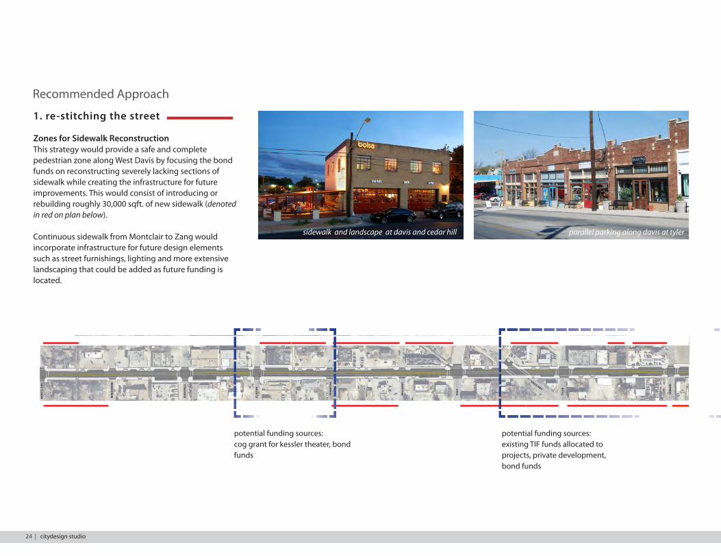
1. re-stitching the street
Zones for Sidewalk ReconstructionThis strategy would provide a safe and complete pedestrian zone along West Davis by focusing the bond funds on reconstructing severely lacking sections of sidewalk while creating the infrastructure for future improvements. This would consist of introducing or rebuilding roughly 30,000 sqft. of new sidewalk (denoted in red on plan below).
Continuous sidewalk from Montclair to Zang would incorporate infrastructure for future design elements such as street furnishings, lighting and more extensive landscaping that could be added as future funding is located.
parallel parking along davis at tyler
potential funding sources:cog grant for kessler theater, bond funds
potential funding sources:existing TIF funds allocated to projects, private development, bond funds
sidewalk and landscape at davis and cedar hill
MO
NTC
LAIR
E
WIN
DO
MER
E
EDG
EFIE
LD
CLIN
TON
WIN
NET
KA
WIL
LOM
ET
POLK
TYLE
R
KINGS HWY
VER
NO
N
24 | citydesign studio
WEST DAVIS CORRIDOR STUDY
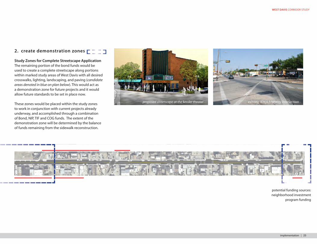
2. create demonstration zones
Study Zones for Complete Streetscape ApplicationThe remaining portion of the bond funds would be used to create a complete streetscape along portions within marked study areas of West Davis with all desired crosswalks, lighting, landscaping, and paving (candidate areas denoted in blue on plan below). This would act as a demonstration zone for future projects and it would allow future standards to be set in place now.
These zones would be placed within the study zones to work in conjunction with current projects already underway, and accomplished through a combination of Bond, NIP, TIF and COG funds. The extent of the demonstration zone will be determined by the balance of funds remaining from the sidewalk reconstruction.
proposed streetscape at the kessler theater existing kings highway intersection
GN
AZ
NOSI
DA
M
PO
HSI B
SM
AD
A
CED
AR H
ILL
NO
NRE
RELYT
KLOP
KINGS HWY
GN
AZ
NOSI
DA
M
PO
HSI B
SM
AD
A
CED
AR H
ILL
NO
NREV
RELYT
KLOP
KINGS HWY
TEM
OLLIW
AKTE
NNI
W
NOT
NILC
DLEIFEG
DE
EREM
OD
NIW
RIALCT
NO
M
GN
AZ
NOSI
DA
M
PO
HSIB
SM
AD
A
CED
AR H
ILL
VER
NO
NRELYTPOLK KINGS HWY
TEM
OLLIW
AKTE
NNI
W
NOT
NILC
DLEIFEG
DE
EREM
OD
NIWM
ON
TCL
RIA
potential funding sources:neighborhood investment
program funding
CED
AR H
ILL
AD
AM
S
BISH
OP
MA
DIS
ON
ZAN
G
implementation | 25
26 | citydesign studio
WEST DAVIS CORRIDOR STUDY
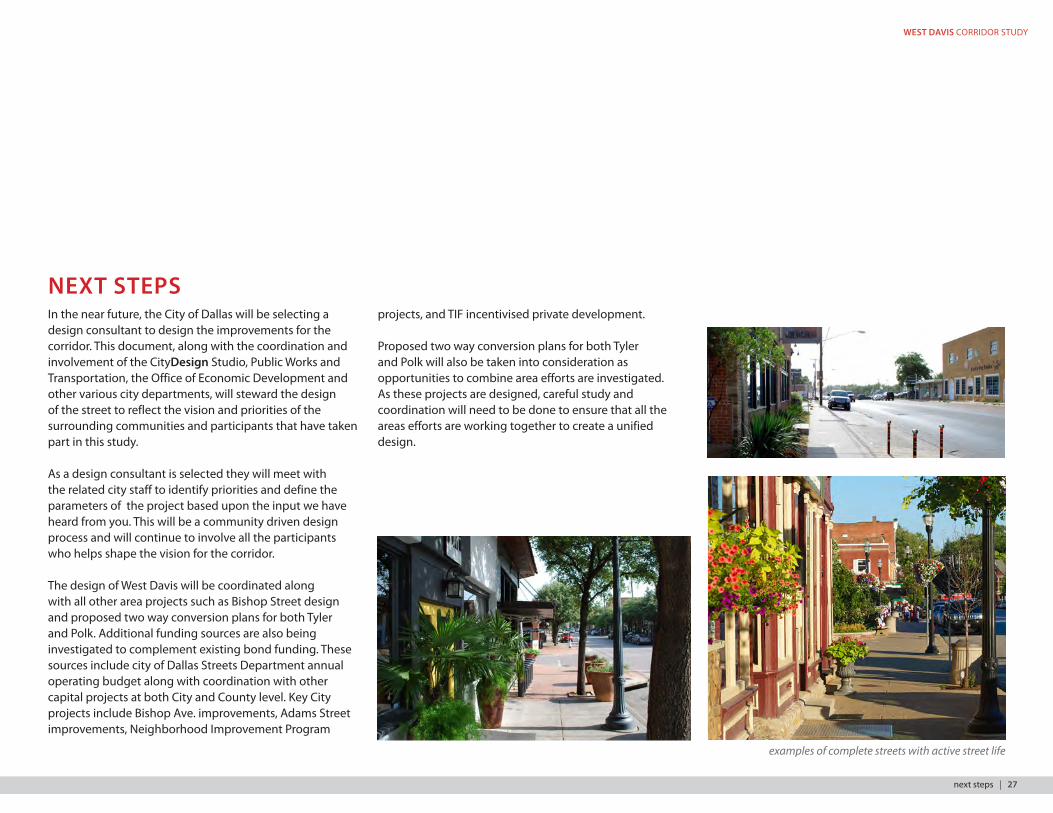
NEXT STEPSIn the near future, the City of Dallas will be selecting a design consultant to design the improvements for the corridor. This document, along with the coordination and involvement of the CityDesign Studio, Public Works and Transportation, the Office of Economic Development and other various city departments, will steward the design of the street to reflect the vision and priorities of the surrounding communities and participants that have taken part in this study.
As a design consultant is selected they will meet with the related city staff to identify priorities and define the parameters of the project based upon the input we have heard from you. This will be a community driven design process and will continue to involve all the participants who helps shape the vision for the corridor.
The design of West Davis will be coordinated along with all other area projects such as Bishop Street design and proposed two way conversion plans for both Tyler and Polk. Additional funding sources are also being investigated to complement existing bond funding. These sources include city of Dallas Streets Department annual operating budget along with coordination with other capital projects at both City and County level. Key City projects include Bishop Ave. improvements, Adams Street improvements, Neighborhood Improvement Program
examples of complete streets with active street life
projects, and TIF incentivised private development.
Proposed two way conversion plans for both Tyler and Polk will also be taken into consideration as opportunities to combine area efforts are investigated. As these projects are designed, careful study and coordination will need to be done to ensure that all the areas efforts are working together to create a unified design.
next steps | 27

28 | citydesign studio

WEST DAVIS CORRIDOR STUDY
section A: one side angled parking
Varies 6’ Min 30’ 6’ Min Varies
60’ ROW (Varies)
16’ 4’4’
Street Sections
Conditions on West Davis vary block by block. Below are street sections illustrating the allocation of space and street elements within the most prominent conditions found in the study area.
Each condition can be referenced by location on the concept plan.
APPENDIX
appendix | 29

Varies 6’ Min 30’ 6’ Min Varies
60’ ROW (Varies)
8’ 8’ 4’4’
Varies 6’ Min 4’ 30’ 4’ 6’ Min Varies
60’ ROW (Varies)
section B: no parking
section C: both sides parallel parking
30 | citydesign studio
WEST DAVIS CORRIDOR STUDY
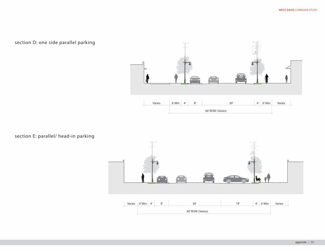
section D: one side parallel parking
Varies 6’ Min 4’ 30’ 4’ 6’ Min Varies
60’ ROW (Varies)
8’
section E: parallel/ head-in parking
Varies 6’ Min 30’ 6’ Min Varies
60’ ROW (Varies)
8’ 18’4’ 4’
appendix | 31
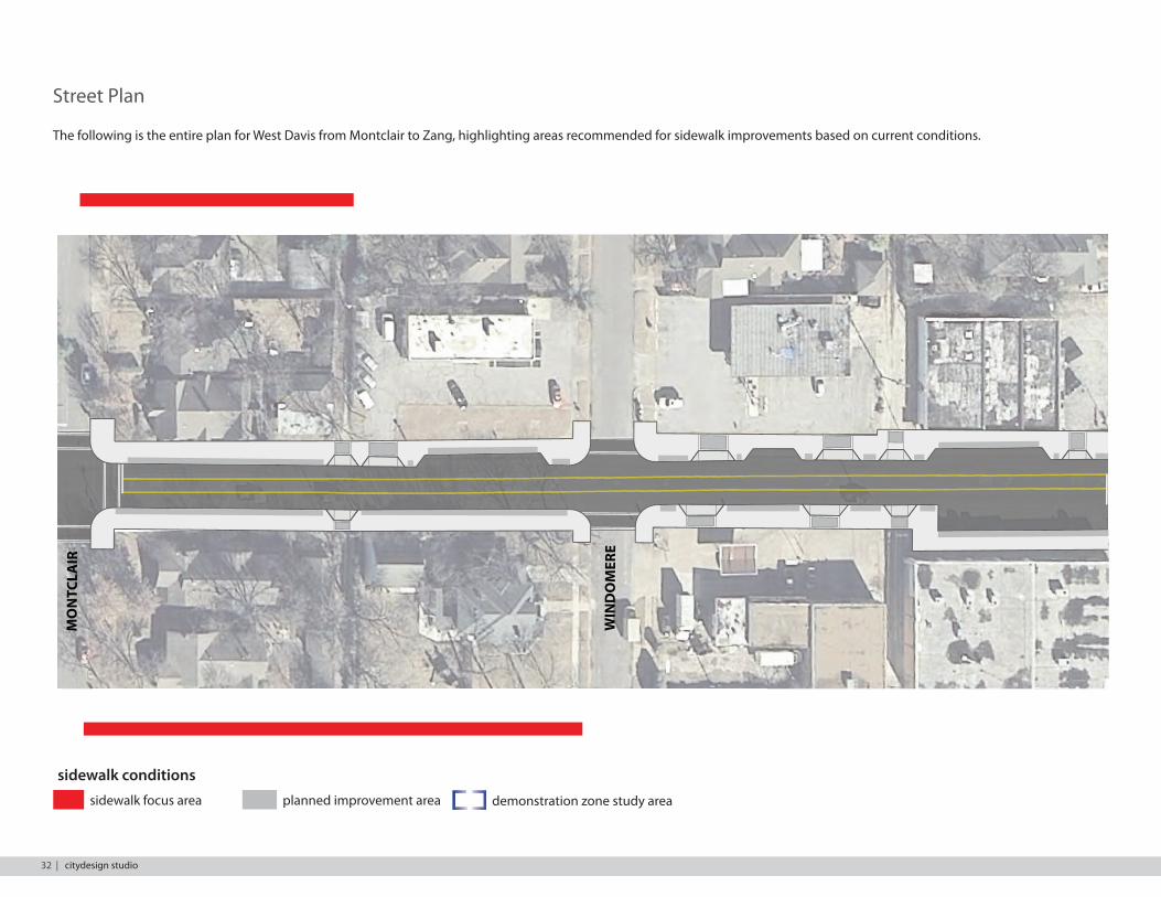
Street Plan
The following is the entire plan for West Davis from Montclair to Zang, highlighting areas recommended for sidewalk improvements based on current conditions.
GN
AZ
NOSI
DA
M
PO
HSI B
SM
AD
A
CED
AR H
ILL
NO
NR
RELY
KLO
KINGS HWY
TEM
AKN
GN
AZ
NOSI
DA
M
PO
HSI B
SM
AD
A
CED
AR H
ILL
NO
NREV
RELYT
KLOP
KINGS HWY
TEM
OLLIW
AKTE
NNI
W
NOT
NILC
DLEI FEG
DE
EREM
OD
NIW
RIALCT
NO
M
GN
AZ
NOSI
DA
M
PO
HSIB
SM
AD
A
CED
AR H
ILL
VER
NO
NRELYTPOLK KINGS HWY
TEM
OLLIW
AKTE
NNI
W
NOT
NILC
DLEIFEG
DE
EREM
OD
NIWM
ON
TCLA
IR
VA
N B
URE
N
sidewalk conditionssidewalk focus area planned improvement area demonstration zone study area
32 | citydesign studio
WEST DAVIS CORRIDOR STUDY
GN
AZ
NOSI
DA
M
PO
HSI B
SM
AD
A
CED
AR H
ILL
NO
NR
RELY
KLO
KINGS HWY
TEM
AKN
GN
AZ
NOSI
DA
M
PO
HSI B
SM
AD
A
CED
AR H
ILL
NO
NREV
RELYT
KLOP
KINGS HWY
TEM
OLLIW
AKTE
NNI
W
NOT
NI LC
DLEI FEG
DE
EREM
OD
NIW
RIALCT
NO
M
GN
AZ
NOSI
DA
M
PO
HSIB
SM
AD
A
CED
AR H
ILL
VER
NO
NRELYTPOLK KINGS HWY
TEM
OLLIW
AKTE
NNI
W
NOT
NILC
DLEIFEG
DE
EREM
OD
NIWM
ON
TCLA
IR
VA
N B
URE
N
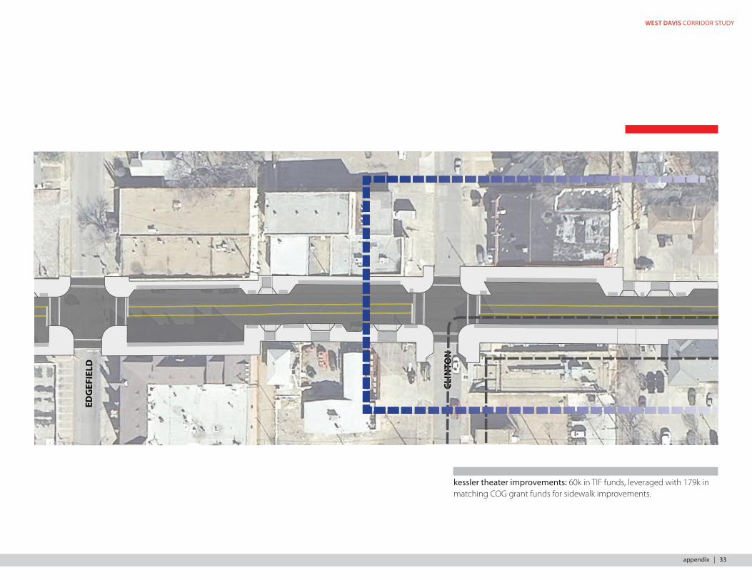
kessler theater improvements: 60k in TIF funds, leveraged with 179k in matching COG grant funds for sidewalk improvements.
appendix | 33

GN
AZ
NOSI
DA
M
PO
HSI B
SM
AD
A
CED
AR H
ILL
NO
NR
RELY
KLO
KINGS HWYTE
M
AKN
GN
AZ
NOSI
DA
M
PO
HSI B
SM
AD
A
CED
AR H
ILL
NO
NREV
RELYT
KLOP
KINGS HWY
TEM
OLLIW
AKTE
NNI
W
NOT
NI LC
DLEI FEG
DE
EREM
OD
NIW
RIALCT
NO
M
GN
AZ
NOSI
DA
M
PO
HSIB
SM
AD
A
CED
AR H
ILL
VER
NO
NRELYTPOLK KINGS HWY
TEM
OLLIW
AKTE
NNI
W
NOT
NILC
DLEIFEG
DE
EREM
OD
NIWM
ON
TCLA
IR
VA
N B
URE
N
sidewalk conditionssidewalk focus area planned improvement area demonstration zone study area
34 | citydesign studio
WEST DAVIS CORRIDOR STUDY
GN
AZ
NOSI
DA
M
PO
HSIB
SM
AD
A
CED
AR H
ILL
NO
NR
RELY
KLO
KINGS HWY
TEM
AKN
GN
AZ
NOSI
DA
M
PO
HSIB
SM
AD
A
CED
AR H
ILL
NO
NREV
RELYT
KLOP
KINGS HWY
TEM
OLLIW
AKTE
NNI
W
NOT
NILC
DLEIFEG
DE
EREM
OD
NIW
RIALCT
NO
M
GN
AZ
NOSI
DA
M
PO
HSIB
SM
AD
A
CED
AR H
ILL
VER
NO
NRELYTPOLK KINGS HWY
TEM
OLLIW
AKTE
NNI
W
NOT
NILC
DLEIFEG
DE
EREM
OD
NIWM
ON
TCLA
IR
VA
N B
URE
N
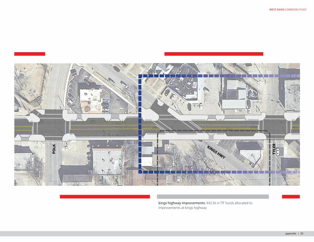
kings highway improvements: 442.5k in TIF funds allocated to improvements at kings highway
appendix | 35

GN
AZ
NOSI
DA
M
PO
HSIB
SM
AD
A
CED
AR H
ILL
NO
NR
RELY
KLO
KINGS HWY
TEM
AKN
GN
AZ
NOSI
DA
M
PO
HSIB
SM
AD
A
CED
AR H
ILL
NO
NREV
RELYT
KLOP
KINGS HWY
TEM
OLLIW
AKTE
NNI
W
NOT
NILC
DLEIFEG
DE
EREM
OD
NIW
RIALCT
NO
M
GN
AZ
NOSI
DA
M
PO
HSIB
SM
AD
A
CED
AR H
ILL
VER
NO
NRELYTPOLK KINGS HWY
TEM
OLLIW
AKTE
NNI
W
NOT
NILC
DLEIFEG
DE
EREM
OD
NIWM
ON
TCLA
IR
VA
N B
URE
N
sidewalk conditionssidewalk focus area planned improvement area demonstration zone study area
davis street market: 4M in TIF funds associated with public realm and infrastructure improvements.
36 | citydesign studio
WEST DAVIS CORRIDOR STUDY
GN
AZ
NOSI
DA
M
PO
HSIB
SM
AD
A
CED
AR H
ILL
NO
NR
RELY
KLO
KINGS HWY
TEM
AKN
GN
AZ
NOSI
DA
M
PO
HSIB
SM
AD
A
CED
AR H
ILL
NO
NREV
RELYT
KLOP
KINGS HWY
TEM
OLLIW
AKTE
NNI
W
NOT
NILC
DLEIFEG
DE
EREM
OD
NIW
RIALCT
NO
M
GN
AZ
NOSI
DA
M
PO
HSIB
SM
AD
A
CED
AR H
ILL
VER
NO
NRELYTPOLK KINGS HWY
TEM
OLLIW
AKTE
NNI
W
NOT
NILC
DLEIFEG
DE
EREM
OD
NIWM
ON
TCLA
IR
VA
N B
URE
N
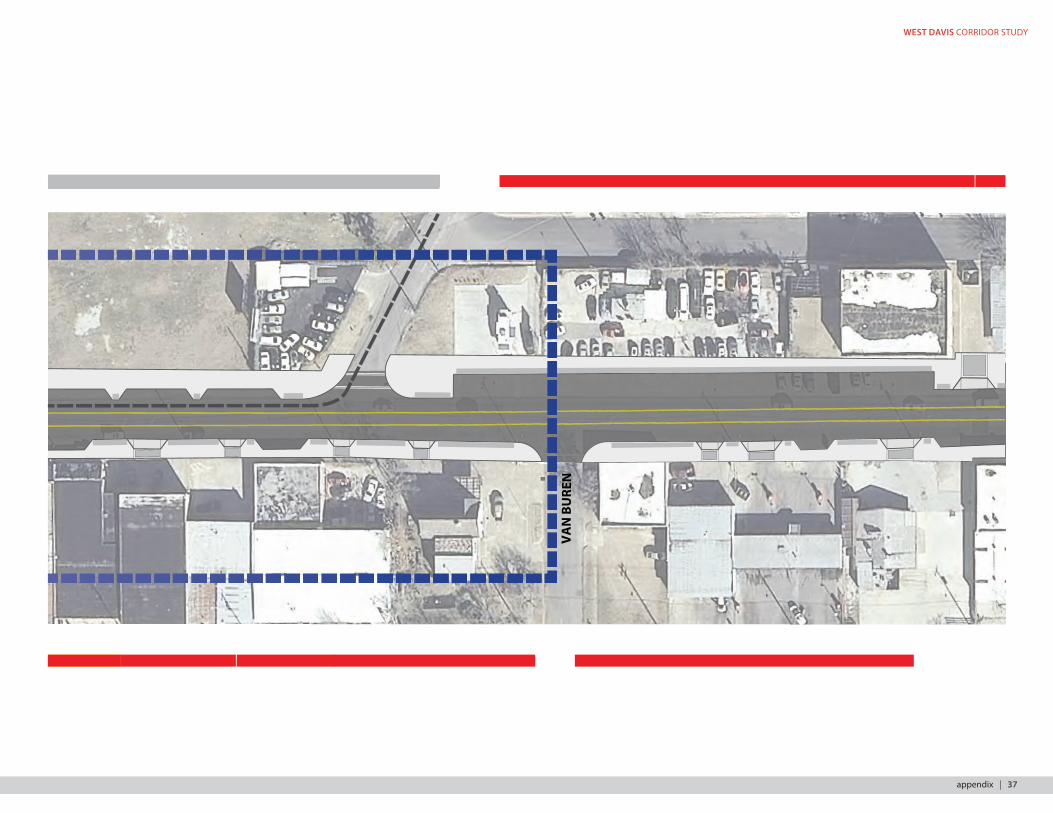
appendix | 37
GN
AZ
NOSI
DA
M
PO
HSI B
SM
AD
A
CED
AR H
ILL
NO
NR
RELY
KLO
KINGS HWY
TEM
AKN
GN
AZ
NOSI
DA
M
PO
HSI B
SM
AD
A
CED
AR H
ILL
NO
NREV
RELYT
KLOP
KINGS HWY
TEM
OLLIW
AKTE
NNI
W
NOT
NILC
DLEIFEG
DE
EREM
OD
NIW
RIALCT
NO
M
GN
AZ
NOSI
DA
M
PO
HSIB
SM
AD
A
CED
AR H
ILL
VER
NO
NRELYTPOLK KINGS HWY
TEM
OLLIW
AKTE
NNI
W
NOT
NILC
DLEIFEG
DE
EREM
OD
NIWM
ON
TCLA
IR
VA
N B
URE
N
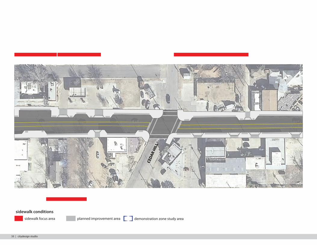
sidewalk conditionssidewalk focus area planned improvement area demonstration zone study area
38 | citydesign studio
WEST DAVIS CORRIDOR STUDY
GN
AZ
NOSI
DA
M
PO
HSI B
SM
AD
A
CED
AR H
ILL
NO
NR
RELY
KLO
KINGS HWY
TEM
AKN
GN
AZ
NOSI
DA
M
PO
HSI B
SM
AD
A
CED
AR H
ILL
NO
NREV
RELYT
KLOP
KINGS HWY
TEM
OLLIW
AKTE
NNI
W
NOT
NILC
DLEI FEG
DE
EREM
OD
NIW
RIALCT
NO
M
GN
AZ
NOSI
DA
M
PO
HSIB
SM
AD
A
CED
AR H
ILL
VER
NO
NRELYTPOLK KINGS HWY
TEM
OLLIW
AKTE
NNI
W
NOT
NILC
DLEIFEG
DE
EREM
OD
NIWM
ON
TCLA
IR
VA
N B
URE
N
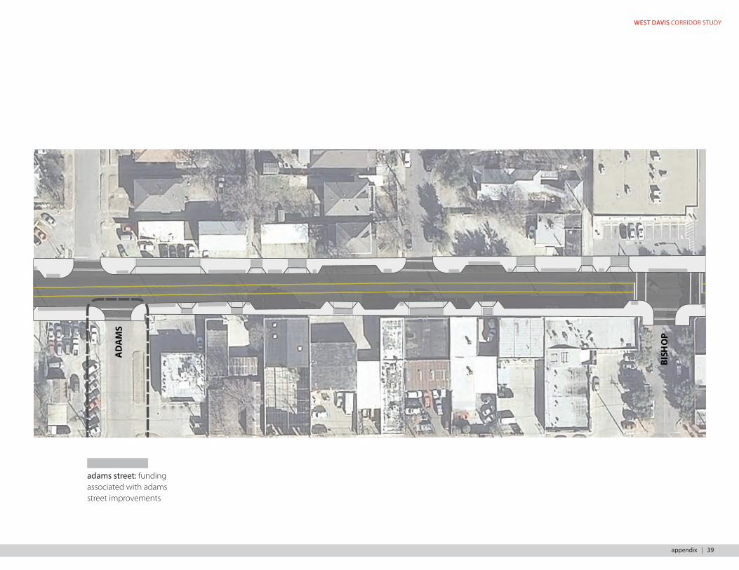
adams street: funding associated with adams street improvements
appendix | 39
GN
AZ
NOSI
DA
M
PO
HSI B
SM
AD
A
CED
AR H
ILL
NO
NR
RELY
KLO
KINGS HWY
TEM
AKN
GN
AZ
NOSI
DA
M
PO
HSI B
SM
AD
A
CED
AR H
ILL
NO
NREV
RELYT
KLOP
KINGS HWY
TEM
OLLIW
AKTE
NNI
W
NOT
NI LC
DLEI FEG
DE
EREM
OD
NIW
RIALCT
NO
M
GN
AZ
NOSI
DA
M
PO
HSIB
SM
AD
A
CED
AR H
ILL
VER
NO
NRELYTPOLK KINGS HWY
TEM
OLLIW
AKTE
NNI
W
NOT
NILC
DLEIFEG
DE
EREM
OD
NIWM
ON
TCLA
IR
VA
N B
URE
N
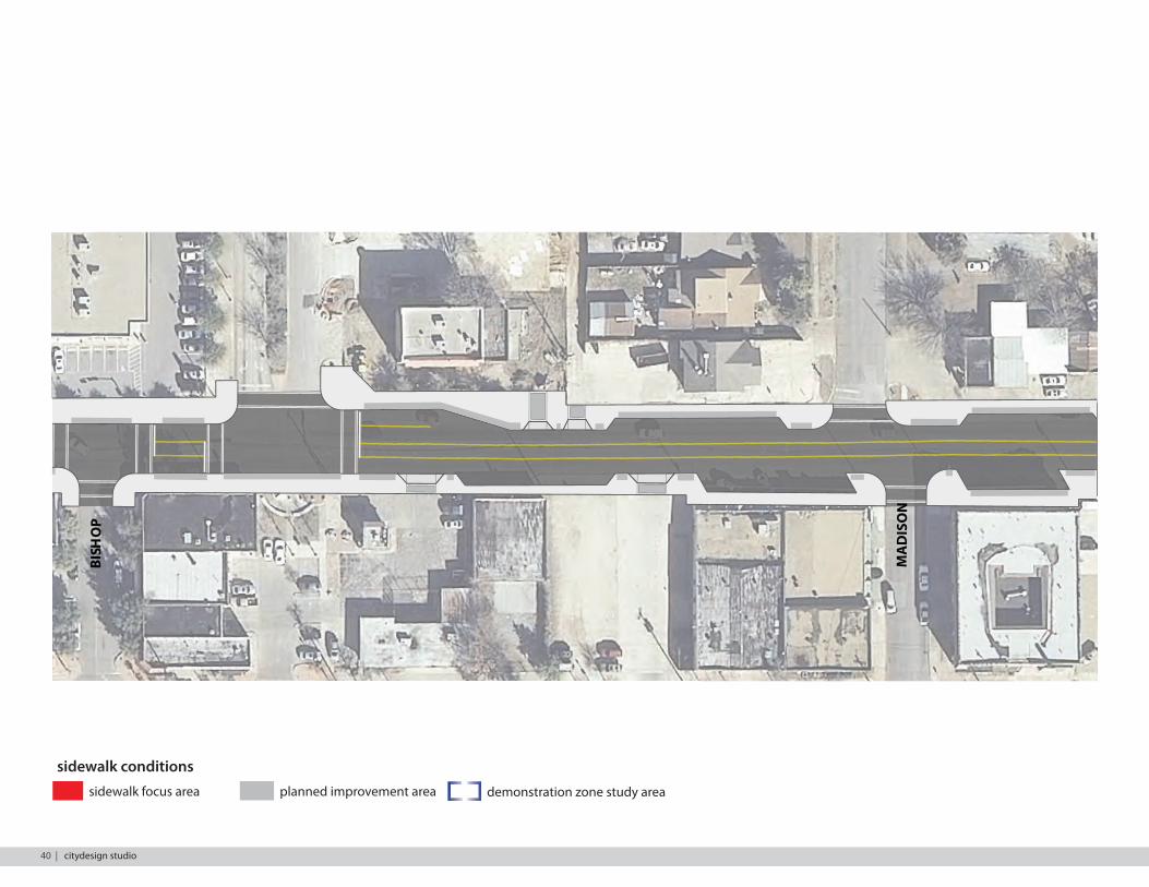
sidewalk conditionssidewalk focus area planned improvement area demonstration zone study area
40 | citydesign studio
WEST DAVIS CORRIDOR STUDY
GN
AZ
NOSI
DA
M
PO
HSI B
SM
AD
A
CED
AR H
ILL
NO
NR
RELY
KLO
KINGS HWY
TEM
AKN
GN
AZ
NOSI
DA
M
PO
HSI B
SM
AD
A
CED
AR H
ILL
NO
NREV
RELYT
KLOP
KINGS HWY
TEM
OLLIW
AKTE
NNI
W
NOT
NI LC
DLEI FEG
DE
EREM
OD
NIW
RIALCT
NO
M
GN
AZ
NOSI
DA
M
PO
HSIB
SM
AD
A
CED
AR H
ILL
VER
NO
NRELYTPOLK KINGS HWY
TEM
OLLIW
AKTE
NNI
W
NOT
NILC
DLEIFEG
DE
EREM
OD
NIWM
ON
TCLA
IR
VA
N B
URE
N
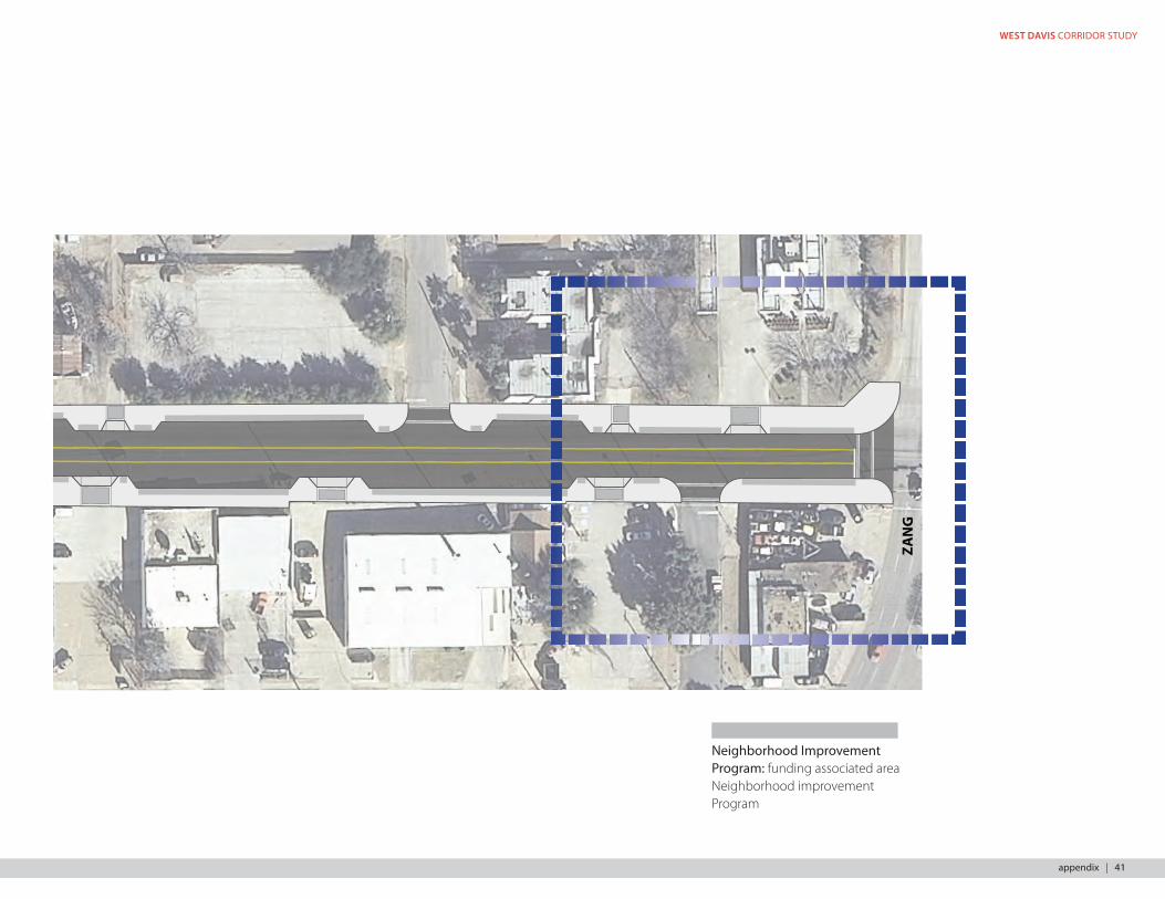
Neighborhood Improvement Program: funding associated area Neighborhood improvement Program
appendix | 41
special thanks to:bc workshopCity of Dallas Office of Economic DevelopmentCity of Dallas Public Works & TransportationThe good people of Oak Cliffcitydesignstudio | 1500 marilla street 2BN | dallas tx 75201 | www.dallascityhall.com/citydesign_studio
Related Documents


