WELL-CONSTRUCTION, WATER-QUALITY, AND WATER-LEVEL DATA, AND POND-INFILTRATION ESTIMATES, FOR THREE GROUND-WATER SUBBASINS, RIVERSIDE COUNTY, CALIFORNIA By Carmen A. Burton, Charles A. Kaehler, and Alien H. Christensen U.S. GEOLOGICAL SURVEY Water-Resources Investigations Report 96-4294 Prepared in cooperation with the EASTERN MUNICIPAL WATER DISTRICT CO CM Sacramento, California 1996

Welcome message from author
This document is posted to help you gain knowledge. Please leave a comment to let me know what you think about it! Share it to your friends and learn new things together.
Transcript
WELL-CONSTRUCTION, WATER-QUALITY, AND WATER-LEVEL
DATA, AND POND-INFILTRATION ESTIMATES, FOR THREE
GROUND-WATER SUBBASINS, RIVERSIDE COUNTY,
CALIFORNIA
By Carmen A. Burton, Charles A. Kaehler, and Alien H. Christensen
U.S. GEOLOGICAL SURVEYWater-Resources Investigations Report 96-4294
Prepared in cooperation with the EASTERN MUNICIPAL WATER DISTRICT
CO CM
Sacramento, California 1996

U.S. DEPARTMENT OF THE INTERIOR BRUCE BABBITT, Secretary
U.S. GEOLOGICAL SURVEY Gordon P. Eaton, Director
Any use of trade, product, or firm names in this publication is for descriptive purposes only and does not imply endorsement by the U.S. Government.
For sale by theU.S. Geological SurveyInformation ServicesBox 25286Denver Federal CenterDenver, CO 80225
For additional information write to:District ChiefU.S. Geological SurveyPlacer Hall6000 J StreetSacramento, CA 95819-6129

CONTENTS
Abstract ...................................................................... 1Introduction ................................................................... 2
Statement of the Problem .................................................... 2Purpose and Scope ......................................................... 2Acknowledgments ......................................................... 2
Description of the Study Area ....................................................... 4Existing Well-Construction, Water-Quality, and Water-Level Data ............................. 4
Well-Construction Data ...................................................... 4Water-Quality Data ......................................................... 4Water-Level Data .......................................................... 7
Lithologic Sections .............................................................. 7Pond-Infiltration Estimates ......................................................... 7
Sun City Ponds .......................................................... 12Trumble Road Pond ....................................................... 15Winchester Ponds ......................................................... 20Uncertainties in Infiltration Estimates ........................................... 23
Summary and Conclusions ........................................................ 23References Cited ............................................................... 24
FIGURES
1-4. Maps showing:1. Location of study area and selected wells in the Winchester, Menifee, and south Penis
ground-water subbasins, California ............................................. 32. Water levels in the Winchester, Menifee, and south Penis ground-water subbasins, California,
March 31 to June 6, 1995 .................................................. 53. Water levels in the Winchester, Menifee, and south Perris ground-water subbasins, California,
September 1995 .......................................................... 64. Location of lithologic sections A-A\ B-B\ and C-C in the Winchester, Menifee, and
south Perris ground-water subbasins, California .................................... 85-7. Lithologic sections of the Winchester, Menifee, and south Perris ground-water subbasins, California:
5. A-A' .................................................................. 96. B-B' ................................................................. 107. C-C ................................................................. 11
8. Maps showing pond sites, ground-water-level changes, and location of observation wells andwater-stage gaging stations .................................................... 13
9. Graph showing water-level altitudes in Sun City pond no. 9, August 3 to September 15, 1995 ..... 14 10-11. Maps showing water-level altitudes at Sun City, Trumble Road, and Winchester sites:
10. Water-level altitudes, spring 1995 ............................................ 1611. Water-level altitudes, autumn 1995 ........................................... 17
12-16. Graphs showing water-level altitudes in:12. Sun City pond no. 9 for three 5-day periods ..................................... 1813. Trumble Road pond, July 22 to September 27, 1995 ............................... 1914. Trumble Road pond, September 11-12, 1995 .................................... 2015. Winchester pond B , June 21 to September 6, 1995 ............................... 2116. Winchester pond B, August 2-4, 1995 ......................................... 22
Contents III

TABLES
1. Well-construction data for selected existing wells in the Winchester, Menifee, and south Penisground-water subbasins, California ................................................ 26
2. Historical water-quality data for selected wells in the Winchester, Menifee, and south Penisground-water subbasins, California ................................................ 30
3. Water-level data for selected wells in the Winchester, Menifee, and south Penis gound-watersubbasins, California .......................................................... 72
4. Water-level altitudes for Sun City storage pond no. 9, August-September 1995 ................. 905. Water-level altitudes for Sun City and Winchester observation wells, April-September 1995 ........ 966. Conversion of water-level altitude to pond volume for Pond No. 9, Sun City Regional Water
Reclamation Facility .......................................................... 977. Daily timing of peak water levels for Sun City pond no. 9 and Trumble Road pond for selected periods,
August-September 1995 ........................................................ 988. Water-level altitudes for Trumble Road pond, July-September 1995 ......................... 999. Water-level altitudes for Winchester pond B (west pond), June-September 1995 ................ 107
CONVERSION FACTORS, VERTICAL DATUM, WATER-QUALITY INFORMATION, ABBREVIATIONS, AND WELL-NUMBERING SYSTEM
Conversion Factors
Multiply By To obtain
acre-foot (acre-ft)acre-foot per year (acre-ft/yr)
acre-foot per day (acre-ft/d)foot (ft)
gallon (gal)inch (in.)inch (in.)mile (mi)
square mile (mi2)
1,2331,2331,233
0.30483.7852.54
25.41.6092.590
cubic metercubic meter per yearcubic meter per daymeterliter (L)centimetermillimeterkilometersquare kilometer
Temperature is given in degrees Celsius (°C), which can be converted to degrees Fahrenheit (°F) by the following equation:
°F=1.8(°C)+32.
IV Conversion Factors, Vertical Datum, Water-Quality Information, Abbreviations, and Well-Numbering System

Vertical Datum
Sea Level: In this report, "sea level" refers to the National Geodetic Vertical Datum of 1929 a geodetic datum derived from a general adjustment of the first-order level nets of the United States and Canada, formerly called Sea Level Datum of 1929.
Water-Quality Information
Chemical concentrations are given in milligrams per liter (mg/L) or micrograms per liter (|4g/L). Milligrams per liter is approximately equivalent to parts per million; micrograms per liter is approximately equivalent to parts per billion.
Abbreviations
EMWD Eastern Municipal Water DistrictMWD Metropolitan Water DistrictUSGS U.S. Geological SurveyRCFCD Riverside County Flood Control and Water Conservation DistrictRWRF Regional Water-Reclamation Facility
|4S/cm microsiemen per centimeter at 25"Celsiusgal/min gallons per minutegal/d gallons per dayft/d foot per day
Vertical Datum, Water-Quality Information, and Abbreviations V

Well-Numbering System
Wells are identified and numbered according to their location in the rectangular system for the subdivision of public lands. Identification consists of the township number, north or south; the range number, east or west; and the section numbers. Each section is divided into sixteen 40-acre tracts lettered consecutively (except I and O), beginning with "A" in the northeast corner of the section and progressing in a sinusoidal manner to "R" in the southeast corner. Within the 40-acre tract, wells are sequentially numbered in the order they are inventoried. The final letter refers to the base line and meridian. In California, there are three base lines and meridians; Humboldt (H), Mount Diablo (M), and San Bernardino (S). All wells in the study area are referenced to the San Bernardino base line and meridian (S). Well numbers consist of 15 characters and follow the format 005S003W32A001S. In this report, well numbers are abbreviated and written 5S/3W-32A1. Wells in the same township and range are referred to by only their section designation, 32A1. The following diagram shows how the number for well 5S/3W-32A1 is derived.
R3W R2W R1W R1E R2E
T1S
T2S
T3S
T4S
T5S
,''
BASE
,-''"
LINE
< OccHi
-'"''
,---'
-- '
T5S
R3W
6
7
18
19
30
31
5
8
17
2020'
32,
4
9
16
2*'
28-
-33
3
10
15-
22'27
\3A
2
11,'14
,23'
26
-35'
1
,'12
13,
24
,25'36"
D
E
M
N
c
F
L
P
B
G2 K
Q
A[
H
J
R
"' re/ow OOA-I
VI Well-Numbering System

WELL-CONSTRUCTION, WATER-QUALITY, AND WATER-LEVEL
DATA, AND POND-INFILTRATION ESTIMATES, FOR THREE
GROUND-WATER SUBBASINS, RIVERSIDE COUNTY,
CALIFORNIA
By Carmen A. Burton, Charles A. Kaehler, and Alien H. Christensen
Abstract
Reclaimed water in the Eastern Municipal Water District of Riverside County, California, is used within the service area for agricultural irrigation. Owing to the seasonal demand for reclaimed water, storage/infiltration ponds were constructed in the Winchester, Menifee, and south Penis subbasins. Reclaimed water infiltrates from these ponds and enters the ground-water system. Little is known of the effects of the reclaimed water on ground-water quality. In cooperation with the Eastern Municipal Water District, the U.S. Geological Survey began a study in 1995 to determine the quantity and fate of reclaimed water percolating from these storage ponds. Data compiled during the first phase of this study are presented in this report.
Field reconnaissance of the Winchester, Menifee, and south Penis subbasins indicated the existence of many wells. Well-construction data for 115 of these wells were tabulated. Available historical water-quality and water- level data for 178 wells in the subbasins also were tabulated. In addition, water levels in 86 wells were measured during the spring and autumn of 1995. On the basis of these data, water-level contour lines were drawn and the direction of ground-water flow was determined. Three lithologic sections through the subbasins were constructed from drillers' logs of 26 wells.
Water-level data were collected from one pond at each of the three storage-pond sites. Water-level data and evaporation data, for periods of no pumped inflow or pumped outflow, were used to estimate an infiltration rate of -0.18 to -0.15 acre-feet/day (upward percolation) for Sun City pond no. 9 during August 3-September 15, 1995, and a rate of 0.72 acre-feet/day for Trumble Road pond during September 11-12, 1995. For Winchester pond B, a rate of -5.35 acre-feet/day was estimated for July 28-August 19, 1995, during which time pumped inflow and outflow were measured. The Trumble Road pond estimate was made on the basis of nighttime measurements and assumes negligible evaporation.
The upward percolation of water in Sun City pond no. 9 and Winchester pond B probably resulted from the pumped lowering of the water level in the ponds to an altitude below the local water-table altitude, followed by a gradual rise as the pond level equilibrated with the water-table altitude. The range of values and direction of infiltration may be indicative both of the variability of infiltration rates at different sites (and under different conditions) and the possible error ranges of the measured parameters used in calculating infiltration. At any of the sites, infiltration rates during times when the ponds are at high stage are likely to be different from the rates estimated using primarily low-stage data.
Abstract 1

INTRODUCTION
Artificial recharge of ground water with reclaimed water has been an increasingly important topic for study in recent years as the need for reuse of water has grown. Two common mechanisms of artificial recharge of ground water are percolation of reclaimed water from infiltration ponds and percolation of reclaimed water applied as irrigation.
Several studies have shown that the effects of artificial recharge with reclaimed water on ground-water conditions vary from site to site. In a study in the Livermore-Amador Valley in Alameda County, California, ground-water quality was found to be degraded in all areas where reclaimed water was applied (Sylvester, 1983). In an aquifer near Tallahassee, Florida, increases in nitrate and chloride concentrations were attributed to irrigation with reclaimed water (Pruitt and others, 1988). Surfactant-derived residues (that is, methylene blue activated substances) also have been detected in ground water affected by recharge areas (Field and others, 1992a,b). In contrast, results of a study at East Meadow, Long Island, New York, suggest that recharging with reclaimed water decreased concentrations of nitrate-nitrogen and several low-molecular-weight hydrocarbons, thereby improving ground-water quality (Schneider and others, 1987).
Statement of the Problem
The Eastern Municipal Water District (EMWD), located in southwestern Riverside County, California, serves a population of 350,000 in a service area that exceeds 550 mi2 . The EMWD provides both domestic and irrigation water and operates five regional water-reclamation facilities (RWRFs). In 1995, the five RWRF's had a com bined reclaimed-water production of 31,900 acre- ft/yr, all of which is used within the EMWD service area mostly for agricultural irrigation or irrigation of golf courses. Because demand for the reclaimed water is seasonal, three storage/ infiltration-pond sites have been constructed: near the town of
Winchester; at the Sun City RWRF; and at the Perris RWRF (including the Trumble Road pond) (fig.l). It is estimated by EMWD that about 13,000 acre-ft of reclaimed water is lost annually, inciden tal to the operation of the storage ponds, as a result of evaporation and percolation to the ground-water system. The ponds near Winchester and at Sun City RWRF are located in subbasins in which the ground water is characterized by high dissolved- solids concentration. The quality of reclaimed water percolating from those ponds is better than that of the ground water.
Purpose and Scope
In 1995, the U.S. Geological Survey (USGS), in cooperation with EMWD, began a study to determine the quantity and fate of water percolating from the reclaimed-water storage/infiltration ponds to the ground-water system. Although some of the ponds have been in operation for 33 years, little is known about the effects of recharge from the ponds on ground water. The purposes of this report are to present (1) data on historical water quality, historical and current water levels, and construction of existing wells; (2) borehole-lithologic descriptions and depth-to-bedrock data; and (3) pond water-level data and infiltration estimates. These data will be useful for future interpretative reports from this study. In addition, general directions of ground water flow in the three subbasins were determined, on the basis of water- level data collected during the study. Water-level contour maps are presented in this report.
Acknowledgments
The authors gratefully acknowledge the help of Jeffrey Hale, Alfred Javier, Stephen Crombie, and other EMWD personnel for their help in compiling the data presented in this report, for permitting use of EMWD equipment, and for providing access to EMWD facilities. The authors also acknowledge the many well owners for their cooperation in obtaining water-level measurements and collecting water samples.
2 Well-Construction, Water-Quality, Water-Level Data, Pond Infiltration, Riverside County, California

.2?
,0
75 O
n(0
TJC
EO)w"l_l_0)
CL
CD
(00)
"55
T3 0)"o
^0) (0
T3CO CO2CO
fw"5cOCO
8
O)il
Introduction 3

DESCRIPTION OF THE STUDY AREA
The study area includes all or part of the ground-water subbasins in which the three storage ponds are located: the Winchester subbasin, the Menifee subbasin, and the south Penis subbasin (fig.l). The Winchester ground-water subbasin is about 25 mi southeast of Riverside, California, in the upper Santa Ana River drainage basin. The 13- mi2 subbasin (California Department of Water Resources, 1979) is bounded by granitic and undifferentiated metamorphic rocks (California Department of Water Resources, 1959). The boundaries of the Winchester subbasin coincide with surface-water-drainage divides, except in areas where valley-floor alluvium is contiguous with neighboring basins. The boundary with the south Penis subbasin to the northwest is arbitrarily selected (California Department of Water Resources, 1979) as the valley constriction west of Double Butte. The boundary with the Menifee subbasin to the southwest is the valley constriction 3.5 mi west of Winchester and about 1 mi northeast of Menifee Lakes (fig.l) (California Department of Water Resources, 1979). Saturated alluvium that fills the constrictions connects the subbasins hydraulically in the subsurface. Alluvium in the Winchester subbasin is estimated to be as much as 500 to 800 ft thick in places (Biehler and Lee, 1994; California Department of Water Resources, 1978). Depth to water generally is about 15 to 75 ft (California Department of Water Resources, 1978).
Surface water in the Winchester subbasin drains to ephemeral Salt Creek, which is one of few well-defined drainages in the upper Santa Ana River basin. Salt Creek flows westward from the Winchester subbasin, through the Menifee subbasin, and into Railroad Canyon Reservoir.
The 40-mi2 Menifee subbasin is bounded by metamorphic rocks on the west and by igneous rocks on the south and east (NBS/Lowry, 1987). The boundary with the Winchester subbasin is to the northeast. The boundary with the south Penis subbasin to the north is arbitrarily set about 1 mi north of Sun City (California Department of Water Resources, 1979). Alluvium in the Menifee sub- basin is about 600 ft thick in the Sun City area and more than 800 ft thick in the vicinity of Menifee Lakes (Biehler and Lee, 1995; NBS/Lowry, 1987).
The 50-mi2 south Penis subbasin is bounded on the west and east by mostly granitic mountains (Lang, 1979). The south Penis subbasin extends north to the north Penis subbasin, approximately 3 mi north of the study area. The boundaries with the Menifee and Winchester subbasins are to the south and southeast, respectively. Alluvium in the south Penis subbasin is more than 800 ft thick in places, on the basis of drill logs of wells in the subbasin (table 1) and a geophysical study (Biehler and Lee, University of California, Riverside, written commun., 1996). The San Jacinto River, an ephemeral stream, runs southwestward through the subbasin and into the northern end (not shown in fig. 1) of Railroad Canyon Reservoir.
EXISTING WELL-CONSTRUCTION, WATER-QUALITY, AND WATER-LEVEL DATA
Well-Construction Data
The location of 115 wells identified in field reconnaissance of the study area in 1995 is shown in figure 1. Available well-construction information for these wells and depth-to-bedrock data, where applicable, are given in table 1. Because most wells end in alluvium and do not reach bedrock, determination of depth to bedrock solely on the basis of well-log data is difficult. Most wells for observation or for domestic use were constructed with plastic casings, and wells used for irrigation, now or in the past, were constructed with steel casings.
Water-Quality Data
Historical water-quality data compiled from available USGS, EMWD, and well-owner records are given in table 2. The data include physical properties and concentrations of major ions, nutrients, and trace metals. Many of these wells no longer exist and are not shown in figure 1. Generally, only one set of data per site per year from non-USGS sources is given in table 2.
Water-quality analyses of ground-water samples collected from different zones were done at some sites. These data were obtained by two methods. The first method involved the use of
4 Well-Construction, Water-Quality, Water-Level Data, Pond Infiltration, Riverside County, California

R4W
IR
3W11
7°12
'30<
R3W
m
x,
53'
si (Q o I i o i 6 a I 2. I en
33°
47'
30'
^T
N
iX
J'S
+3A
l
--rar
as
i N
^s
^^v
r w
#sH
> i
X
!l^j
^
N Da
m ^\.
/g
bla
nd
l^\''^L^^
2
^_
_3
^
r__J^ ^
V ^
x. v
x.
; I
\
____
EX
PLA
NA
TIO
N|_
___|
Unc
onso
lidat
ed d
epos
its
Hjls
s 'i;|
Con
solid
ated
roc
ks
Rec
laim
ed-w
ater
sto
rage
/infil
trat
ion
pond
1,40
0 W
ater
-leve
l con
tour
-Sho
ws
altit
ude
of w
ater
leve
ls.
Das
hed
whe
re a
ppro
xim
atel
y lo
cate
d; q
ueri
ed w
here
un
cert
ain.
C
onto
ur in
terv
al 1
0 fe
et.
Dat
um is
sea
leve
l .. .. .
Gro
und-
wat
er s
ubba
sin
boun
dary
D
irec
tion
of g
roun
d-w
ater
flow
W
ater
-leve
l wel
l-W
ell n
umbe
rs a
re g
iven
infig
ure
1.
Wat
er-le
vel a
ltitu
des
are
give
n in
tabl
e 3
R2W
_
__
__
__
__
__
__
__
__
__
__
__
_1
17
002'
30'
Base
map
obta
ined
from
Santa
Ana
Wate
rshed
Proj
ect A
uthor
ity (d
igitiz
ed b
y Jam
es M
. Mon
tgome
ry En
ginee
rs fro
m U.
S. Ge
ologic
al Su
rvey 1
:24,00
0 qu
adra
ngles
-Per
ris, R
omola
nd, a
nd W
inche
ster,
1953
, pho
torev
ised
1979
). Un
iversa
l Tran
verse
Merc
ator p
rojec
tion,
Zone
11.
2 MILE
S
2 KI
LOME
TERS
Figu
re 2
. W
ater
leve
ls in
the
Win
ches
ter,
Men
ifee,
and
sou
th P
erris
gro
und-
wat
er s
ubba
sins
, C
alifo
rnia
, M
arch
31
to J
une
6, 1
995.

R4W
IR
3W11
7°12
'30
1R3
W
i 6 o s o I 6 Q>
f i i Q. rft 3D (D o o c ff
EX
PLA
NA
TIO
N
Unc
onso
lidat
ed d
epos
its
Con
solid
ated
roc
ksI
I R
ecla
imed
-wat
er s
tora
ge/in
filtr
atio
n 1 '
pond
1,4
00 w
ater
-leve
l con
tour
-Sho
ws
altit
ude
of w
ater
leve
ls.
Das
hed
whe
re a
ppro
xim
atel
y lo
cate
d; q
uerie
d w
here
un
certa
in.
Con
tour
inte
rval
10
feet
. D
atum
is s
ea le
vel
.. .. .
Gro
und-
wat
er s
ubba
sin
boun
dary
Dir
ectio
n of
gro
und-
wat
er fl
ow
Wat
er-le
vel w
ell-W
ell n
umbe
rs a
re g
iven
in
figur
e 1.
W
ater
-leve
l alti
tude
s ar
e gi
ven
in ta
ble
311
7°02
'30"
Base
map
obta
ined
from
Santa
Ana
Wate
rshed
Proj
ect A
uthor
ity (d
igitiz
ed b
y Jam
es M
. Mon
tgome
ry En
ginee
rs fro
m U.
S. Ge
ologic
al Su
rvey 1
:24,00
0 qu
adra
ngles
-Per
ris, R
omola
nd, a
nd W
inche
ster,
1953
, pho
torev
ised
1979
). Un
iversa
l Tran
verse
Merc
ator p
rojec
tion,
Zone
11.
2 M
ILES
2 KI
LOME
TERS
Figu
re 3
. Wat
er le
vels
in t
he W
inch
este
r, M
enife
e, a
nd s
outh
Per
ris g
roun
d-w
ater
sub
basi
ns,
Cal
iforn
ia,
Sep
tem
ber
1995
.

nested piezometers. Three or four 2-inch-diameter well casings with screened intervals at different depths (separated by bentonite grout) were placed in the same borehole. This method was used by the USGS at two sites: wells 5S/3W-28M1, -28M2, -28M3, and -28M4, and wells 5S/3W-24F2, -24F3, and -24F4. The second method involved the use of inflatable packers placed in multiple-screened casings above and below the desired zone or zones. This method was used by EMWD at five sites: wells 5S/3W-35N2 and -36P2, and wells 6S/3W- 2A1, -2D1 and -2E1. Bentonite grout was used in the annulus to separate the screened intervals in wells 5S/3W-35N2 and -36P2. For wells 6S/3W- 2A1, -2D1, and -2E1 the screened intervals were connected by gravel in the annulus.
Water-Level Data
Water levels in 86 wells were measured during reconnaissance of the study area in 1995 using a steel tape or a calibrated electric sounder. These data, along with historical water-level data collected over several years, are given in table 3. Generally, for wells that had numerous historical measurements, only one or two measurements per year (usually spring and (or) autumn) are included.
Water levels in wells measured during March 31-June 6, 1995, and again in September 1995, were used to prepare water-level-contour maps (figs. 2 and 3). These contour maps then were used to determine the direction of ground-water flow. Flow is northwestward from the the Winchester subbasin into the south Penis subbasin and southwestward into the Menifee subbasin toward Menifee Lakes. From Menifee Lakes, flow is southeastward. From a ground-water divide near the southwest corner of Sun City storage/infiltration ponds in the Menifee subbasin, ground water flows northward toward the south Perris subbasin and southwestward toward Railroad Canyon Reservoir. In the south Perris subbasin, flow is northward into north Perris subbasin and northeastward into the Lakeview subbasin (north of study area; not shown in figures). Very few differences, other than seasonal changes in altitude of the water-level surface, were found between the two sets (March- June 1995 and September 1995) of data.
LITHOLOGIC SECTIONS
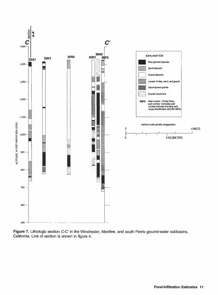
Three generalized lithologic sections (line of sections shown in fig. 4) were constructed to gain a better understanding of the stratigraphy and thickness of alluvial deposits in the Winchester, Menifee, and south Perris subbasins. Alluvial sediment in driller's log descriptions of cuttings was grouped into four categories that are similar to the categories used by Rees and others (1995): (1) fine-grained deposits including sandy soil, conglomerate, clay with gravel, cemented sand or gravel, and topsoil; (2) sand deposits including silty sand, silty sand and gravel, and sand with gravel; (3) gravel deposits including rock and sand, coarse sand and gravel, cobbles, and boulders; (4) lenses of clay, sand, and gravel including interbedded layers of clay, sand, and (or) gravel. Underlying weathered and unweathered bedrock were grouped into two additional categories, respectively: (5) decomposed granite and (6) granitic basement rock.
The lithology of selected wells along three sections in the study area is shown in figures 5, 6, and 7. Lithologic section A-A' (fig. 5) extends from the southwest corner of the Menifee subbasin northeastward through the south Perris subbasin; section B-B' (fig. 6) extends from the northwest part of the south Perris subbasin southeastward through the Winchester subbasin; and section C-C (fig. 7) extends west to east through the Menifee subbasin.
POND-INFILTRATION ESTIMATES
A water-budget method was used to estimate the quantity of water infiltrating from selected storage/infiltration ponds. Measurement of unsaturated-zone moisture content, change in unsaturated- and saturated-zone storage, and aquifer specific yield beneath the ponds would have provided information on the rate that water moves through the unsaturated zone (if present), but such work was beyond the scope, instrumentation, and time limitations of the study.
Water-level data were collected from one pond at each of the three storage-pond sites, primarily during July-September 1995. The data-
Pond-Infiltration Estimates 7

00 I s s s 5' * I s o S a
I s 3D
<' a
a> o o O SL I 55'
EXPL
AN
ATI
ON
Unc
onso
lidat
ed d
epos
its
Con
solid
ated
roc
ks
Rec
laim
ed-w
ater
sto
rage
/infil
trat
ion
pond
^
^
Gro
und-
wat
er s
ubba
sin
boun
dary
o 9
H2
Wel
l and
num
ber
A
' Li
ne o
f geo
logi
c se
ctio
n
f
SI S
9H
2
Base
map
obta
ined f
rom S
anta
Ana W
atersh
ed P
rojec
t Auth
ority
(digit
ized
by Ja
mes M
. Mon
tgome
ry En
ginee
rs fro
m U.S
. Geo
logica
l Surv
ey 1:
24,00
0 qua
dran
gles-P
erris
, Rom
oland
, and
Winc
heste
r, 19
53, p
hotor
evise
d 19
79).
Unive
rsal T
ranve
rse M
ercato
r proj
ectio
n, Zo
ne 11
.
04
MIL
ES
04
KILO
METE
RS
Figu
re 4
. Lo
catio
n of
lith
olog
ic s
ectio
ns A
-A',
B-B
, an
d C
-C in
the
Win
ches
ter,
Men
ifee,
and
sou
th P
erris
gro
und-
wat
er s
ubba
sins
, C
alifo
rnia
.

O a
I m i w (O
A1.
500-
1
1,40
0-
1,3
00
1.2
00
1,1
00
1,0
00
900
800
700
600
500
32L1
32
A1
28M
1-4
1
16P
2
i
9H2
3N1 '
3C1
M
26K
2E
XP
LAN
ATI
ON
^^J
Fine
-gra
ined
dep
osits
[ i-iii
-ij
Sand
dep
osits
|__
_|
Gra
vel d
epos
its
Lens
es o
f cla
y, s
and,
and
gra
vel
Dec
ompo
sed
gran
ite
Gra
nitic
bas
emen
t
Log
mis
sing
/ no
data
ava
ilabl
e
26A
1 W
ell n
umbe
r - P
artia
l Sta
te
well
num
ber.
Com
plet
e w
ell
num
ber i
nclu
des
tow
nshi
p an
d ra
nge
iden
tific
atio
n (4
S/3W
-26A
1)
Verti
cal s
cale
gre
atly
exa
gger
ated
4 MI
LES
I
4 KI
LOME
TERS
Figu
re 5
. Li
thol
ogic
sec
tion
A-A
of t
he W
inch
este
r, M
enife
e, a
nd s
outh
Per
ris g
roun
d-w
ater
sub
basi
ns,
Cal
iforn
ia.
Line
of
sect
ion
is sh
own
in
figur
e 4.

i 6
o I ft. o "i (D 6 0) i I O o
o a
5" a (D O
o o D)
1,50
0 i
1,4
00-
1,3
00
1,20
0-
1,10
0-
1,00
0-
-.
900 \
800
700
600
33E
1 33
Q1
4A1
500
3N1
B
14L1
24C
1 24
F2-
4 19
N2
I I
1
29L
3 28
E1-
3 27
N3i
EX
PLA
NA
TIO
N
^^H
Fi
ne-g
rain
ed d
epos
its
Sand
dep
osits
[ |
Gra
vel d
epos
its
Lens
es o
f cla
y, s
and,
and
gra
vel
Dec
ompo
sed
gran
ite
Gra
nitic
bas
emen
t
Log
mis
sing
/ no
data
ava
ilabl
e
27N
2 W
ell n
umbe
r - P
artia
l Sta
te
wel
l num
ber.
Com
plet
e w
ell
num
ber i
nclu
des
tow
nshi
p an
d ra
nge
iden
tific
atio
n (5
S/2W
-27N
2)
Verti
cal s
cale
gre
atly
exa
gger
ated
4 M
ILES
4 KI
LOM
ETER
S
Figu
re 6
. Li
thol
ogic
sec
tion
B-B
of t
he W
inch
este
r, M
enife
e, a
nd s
outh
Per
ris g
roun
d-w
ater
sub
basi
ns,
Cal
iforn
ia.
Line
of s
ectio
n is
sho
wn
in
figur
e 4.
1.500-
1.400-
1.300
1.200
1,100
1.000-
- 900 LLID
b
800
700
600
500
33K1 35N236N2
35R1 3(P2 EXPLANATION
^^H Fine-grained deposits
Sand deposits
Gravel deposits
Lenses of clay, sand, and gravel
Decomposed granite
K-: '-' '.-A Granitic basement
36P2 Well number-Partial State well number. Complete well number includes township and range identification (5S/3W-36P2)
Vertical scale greatly exaggerated
4 MILESI
I4 KILOMETERS
Figure 7. Lithologic section C-C in the Winchester, Menifee, and south Perris ground-water subbasins, California. Line of section is shown in figure 4.
Pond-Infiltration Estimates 11

collection time period was limited by the brief timespan of the study. These data were collected using Rittmeyer submersible pressure transducers installed in 2-inch-diameter stilling wells and connected to Stevens AXSYS SDI-12 data loggers. The transducer data were calibrated against periodic staff-gage measurements of pond levels. Pond infiltration for a chosen time period was estimated using a water-balance equation:
Volume infiltrated = [(starting volume in pond)- (ending volume in pond)] + [(volume pumped into pond) - (volume pumped out of pond)]- (evaporation) + (rainfall). (1)
Starting and ending volumes were determined using the measured pond water levels in conjunction with pond-level/pond-volume conversion tables or graphs provided by EMWD. Volumes pumped into and out of ponds also were measured by EMWD. Evaporation was measured near Lake Skinner at Tucalota Creek, 8 mi south of Winchester, by Metropolitan Water District of Southern California (MWD) using a U.S. Weather Bureau Class A pan. A pan coefficient of 0.7 was applied to convert the measured pan value to an estimated value for a lake or reservoir, as is common practice (Veihmeyer, 1964, p. 11-7).
The methods used to calculate the components of equation 1 varied slightly for each of the three sites owing to differences in pond operating procedures and available data. The three sites are discussed individually below. In addition, the pond sites differ somewhat in construction. The Sun City and Trumble Road ponds have unlined bottoms and sides, whereas the Winchester ponds have unlined bottoms and compacted-clay or soil- cement sides. Sun City pond no. 9 and the Winchester ponds are about 20 ft deep, and the Trumble Road pond is about 60 ft deep.
Sun City Ponds
Pond no. 9 at the Sun City RWRF (fig. 8A) was instrumented with a Rittmeyer Series MPSDI submersible pressure transducer placed in a 2-inch- diameter stilling well and connected to a Stevens AXSYS SDI-12 data logger in June 1995. This pond was chosen because during normal operation the pond is not pumped, and the only inflow it receives is occasional overflow from pond no. 8
during the winter months; thus, the number of variables needed to calculate outflow in the form of infiltration to ground water is reduced. However, at about the same time the instrumentation was installed, the pond was pumped (June 1-July 24, 1995) to lower the water level of the pond and the immediately adjacent water table in preparation for construction of a buried pipeline next to the pond.
Pond water levels, measured in pond no. 9 beginning 10 days after pumping ceased, rose 0.68 ft during August 3-September 15, 1995 (fig. 9 and table 4). During this period, no water was pumped into or out of the pond; therefore, the rise in water level represents the combined effects of upward percolation of ground water, minus evaporation, plus rainfall. The upward percolation of water probably is the result of the lowering of the water level in pond no. 9, during pumping, to an altitude below the local water-table altitude (figs. 10A and 1 1 A), followed by a gradual rise as the pond level equilibrated with the water-table altitude.
The local water table (and pond no. 9 water level) probably was influenced by infiltration of water from pond no. 8 and pond no. 7 (fig. 8A), which were kept relatively full. Generally, treated water is pumped from the RWRF to ponds nos. 1-4, and then pumped to pond no. 7 approximately twice per week. During the winter, some of this water cascades, at times, into pond no. 8 and pond no. 9. Shown in table 5 are water-level altitudes in observation wells near the Sun City ponds for April-September 1995. It should be noted that although these wells are perforated at a depth of 200 to 220 ft, which is about 180 ft below the water table, the water levels nevertheless might be representative of the water table rather than a deeper confined aquifer (except for well 5S/3W- 32A1, which is perforated at a depth of 560 to 580 ft). The decline in water level in well 5S/3W-32L1 (table 5) probably was influenced by the pumped decline in water level in pond no. 9; conversely, the rise in water level in well 5S/3W-32C1 probably is related to the twice-weekly addition of treated water to pond no. 7. (These additions kept the pond relatively full.) The second largest decline in water level, in well 5S/3W-32G1 (table 5; fig. 8A), probably reflects the dry status of pond no. 1 and pond no. 5 during the measurement period. The rise in water level of 1.61 ft in well 5S/3W-32A1 may be indicative of regional change in a deeper aquifer.
12 Well-Construction, Water-Quality, Water-Level Data, Pond Infiltration, Riverside County, California

i i i I
1 KILOMETERS Approximate scale
EXPLANATION
Reclaimed-water storage/infiltration pond
32A1 Observation well and number. Plus +1.6 and minus values indicate water-
level change, in feet
9 Water-stage gaging station
B
4A1 +3.35
Ellis Road
3C1 +4.35
Trumble RoadPond Vista Road
I 10.5 KILOMETERS
Approximate scale
0.5 MILES j
3L1 < +3.75
3N1 '+2.72 Mapesi Road
Grand Ave
Simpspn Road
30B2 -2.0
Winchester Ponds30G3*
-6.3
30G2 -4.2
30H3 30H2 -7.8 -7.4 i
0.5 KILOMETERS
Approximate scale
0.5 MILES j
Figure 8. Pond sites, ground-water-level changes, and location of observation wells and water-stage gaging stations. A. Sun City site; ground-water-level change from 4/25/95 to 9/13/95; B. Trumble Road site; ground- water-level change from 3/31/95 or 4/14/95 to 9/11/95 or 9/13/95; C. Winchester site; ground-water-level change from 5/11/95 or 5/23/95 to 9/11/95 or 9/13/95. (See figure 1 for site locations.)
Pond-Infiltration Estimates 13

1,397.0
LU> 1,396.8
LU CO LU
2LU LLI U_
1,396.6
LLI OD
1,396.4
1,396.2
I I I I I I I I I I I I I I I
123456789 1011 1213141516171819202122232425262728293031 123456789 10111213141516
August September
1995
Figure 9. Water-level altitudes in Sun City pond no. 9, August 3 to September 15, 1995.
The purpose in measuring water levels in pond no. 9 was to use the change in volume of water in a water-balance equation, and to solve for the volume of water that infiltrated from the pond. For the period August 3 to September 15, 1995 (fig. 9), no water was pumped into or out of the pond and there was no rainfall; therefore, equation 1 becomes:
Volume infiltrated = [(starting volume in pond)- (ending volume in pond)] - (evaporation). (2)
Water levels in the pond were converted to volumes using a pond-stage/pond-volume conversion table (table 6) provided by EMWD (Alfred Javier, EMWD, written commun., 1996):
Water level on August 3, 1995 (8 a.m.) = 1,396.28 ft;water level on September 15, 1995 (8 a.m.) = 1,396.97 ft.
From table 6: For pond stage of 1,396.5 ft, pond volume = 10,500,000 gal = 1,403,700 ft3 ; and for pond stage of 1,396.0 ft, pond volume = 9,600,000 gal = 1,283,400 ft3 .
Rate of change = 120,300 ft3 per 0.5 ft of water-level change = 240,600 ftVft of water-level change.
Therefore, pond volume at a pond stage of 1,396.28 ft = (1,283,000 ft3) + (0.28 ft x 240,600 ftVft) = 1,350,000 ft3 .
From table 6: For pond stage of 1,397.0 ft, pond volume = 11,300,000 gal = 1,511,000 ft3 ; and for pond stage of 1,396.5 ft, pond volume = 10,500,000 gal = 1,404,000 ft3 .
Rate of change = 107,000 ft3 per 0.5 ft of water-level change = 214,000 ft3/ft of water-level change.
14 Well-Construction, Water-Quality, Water-Level Data, Pond Infiltration, Riverside County, California

Therefore, pond volume at a pond stage of 1,396.97 ft = (1,511,000 ft3)- (0.03 ft x 214,000 ft3 /ft) = 1,505,000 ft3 .
Evaporation for August 3 to September 15, 1995, was estimated by multiplying the summed daily pan- evaporation values, measured by Metropolitan Water District (MWD) at Tucalota Creek near Lake Skinner (about 13 mi southeast of Sun City), by the appropriate rate of volume change at the prevailing water-level altitude in pond no. 9 and by a pan coefficient of 0.7:
Feet of evaporation = (14.23 in) x (0.7) = 9.96 in = 0.83 ft;
Rate of pond-volume change at 1,396 to 1,397 ft altitude = (240,600 ft3/ft + 214,000 ft3/ft)/2;
Volume evaporated = (0.83 ft) x [(240,600 ft7ft + 214,000 ft3/ft)/2] = 188,700 ft3 .
Substitution into equation 2 gives:
Volume infiltrated = [(1,350,000 ft3) - (1,505,000 ft3)] - (0.83 ft x 227,300 ft3/ft) = [-155,000 ft3] - (188,700 ft3) = -343,700 ft3 = -7.89 acre-ft.
The average rate of infiltration for August 3- September 15 is -0.18 acre-ft/d (upward infiltra tion.) The average rate for August 28 to September 15, a period of constant rate of water-level change (fig. 9), is -0.15 acre-ft/d. The above infiltration rates were estimated using data collected during conditons of low pond stage and probably are not representative of conditions at higher stage. Ranges in possible error in the estimates are discussed in the section "Uncertainties in Infiltration Estimates."
The calculation of infiltration rate is dependent, in part, on the accuracy of the evaporation estimates. As an alternative to using pan-evaporation rates, water-level altitudes for three 5-day periods for pond no. 9 were examined to see if the daytime/nighttime difference in rate of water- level change could be used to estimate evaporation. The data for three 5-day periods (fig. 12; table 7) did not show the expected daily increased rate of water-level rise at night when evaporation might be considered to be negligible (or at least greatly reduced). Instead, the peak daily water-level
altitudes usually occurred between 1300 and 2000, a period that generally includes the hottest and windiest times of day. Therefore, this method for estimating evaporation was not used. Possible theoretical explanations (and arguments against them) for the observed timing of daily peak water levels may be (1) water added to other ponds at the site once per day (water was added only three times [to pond no. 7] during the 15 days); (2) rainfall at about the same time every day (there was no rainfall on any of the days); (3) wind-driven water "piling up" toward one side of the pond; (4) transducer error caused by heating of the cable by air-temperature increases (peaks do not correspond as closely as would be expected to daylight hours); (5) tidal effects (the response does not appear to be diurnal); or, (6) barometric-pressure effects. In essence, an adequate explanation for the observed pattern of daily water-level rises has not been found, but some effect related to temperature or wind appears to be most likely.
Trumble Road Pond
The single pond at the Trumble Road site (fig. 85) was instrumented with a Rittmeyer Series MPSDI submersible pressure transducer placed in a 2-inch-diameter stilling well and connected to a Stevens AXSYS SDI-12 data logger, and water- level data were collected during July 22-September 27, 1995. This period was chosen, in part, because no water was pumped into the pond after the beginning of July. The data (fig. 13; table 8) show a decline in water level of about 30 ft during the period. The drawdown was caused in large part by continuous pumping of the pond at a rate of approximately 960 to 1,030 gal/min. Direction of ground-water movement in the vicinity of the pond did not vary seasonally as much as at the Sun City and Winchester sites (figs. 10 and 11).
The exception to continuous pumping was one 24-hour period from 0914 on September 11, 1995, to 0930 on September 12, 1995 when the pond operators were able to shut down the pump. Water-level data for this period of reduced number of inflow and outflow variables can be seen as a relatively flat section in the graph in figure 13 and are shown in detail in figure 14. The rate of infiltration, estimated on the basis of the slope of line segment CD (12 hours) in figure 14, is 0.72 acre-ft/d (equivalent to 260 acre-ft/yr and 235,000 gal/d), and was estimated as follows:
Pond-Infiltration Estimates 15

Sun City Ponds 32C1
1,395.8
1 ' I1 KILOMETER
Approximate scale
EXPLANATION
Reclaimed-water storage/infiltration pond
32A1 Observation well and number. 1,376.4 Values indicate water-level altitude,
in feet above sea level
® Water-stage gaging station
v_* Direction of ground-water movement
B
4A1 1,313.9
Ellis Road
3C1 1,306.4
Trumble RoadPond Vista Road
(Surface altitude, not measured)
0.5 MILE
0.5 KILOMETER Approximate scale
(Surface altitude, 1,455)
(Surface altitude, 1,450)
I I
0.5 KILOMETER Approximate scale
30H3 30H2 1,447.9 1,449.8'
0.5 MILE J
Figure 10. Water-level altitudes, spring 1995. A. Sun City site, 4/25/95; B. Trumble Road site, 3/31/95; C. Winchester site, 5/11/95 to 5/23/95. (See figure 1 for site locations.)
16 Well-Construction, Water-Quality, Water-Level Data, Pond Infiltration, Riverside County, Californiao"0

Sun City Ponds 32C1
1,397.132B1«
1,391.7
1MILE
0 1 KILOMETER Approximate scale
32A1 < 1,378.0
EXPLANATION
Reclaimed-water storage/infiltration pond
Observation well and number. Values indicate water-level altitude, in feet above sea level
Water-stage gaging station
Direction of ground-water movement
B
4A1 ' 1,317.3
Ellis Road
1
/
3C1 1,310.7
Trumble RoadPond Vista Road
(Surface altitude, 1,397.0)
0.5 MILE I
0.5 KILOMETER Approximate scale
(Surface altitude, 1,437.5)
30A1 1,444.7
_ 30H1 1,443.0
(Surface altitude, 1,438.5)
0
| r 0
30H3 30H2! 1,440.1 1,442.45
0.5 MILE I
1 I
0.5 KILOMETER Approximate scale
Figure 11. Water-level altitudes, autumn 1995. A. Sun City site, 9/13/95; B. Trumble Road site, 9/11/95; C. Winchester site, 9/11/95 to 9/13/95. (See figure 1 for site locations.)
Pond-Infiltration Estimates 17

1,397.00
Hourly measurements
- AugustS-7
- August 29-September 2
- September 9-13
1,396.25
Figure 12. Water-level altitudes in Sun City pond no. 9 for three 5-day periods.
18 Well-Construction, Water-Quality, Water-Level Data, Pond Infiltration, Riverside County, California

LU
LU_l
aCO LU
LLJ LU U_
1,420
1,415
1,410
§ 1,405 <
1,400
LU Q
t 1,395
<
1,390
I ' I ' I I ' I ' I I ' I ' I ' I ' I ' I
Period of no pumping
1,385 I t I i I2224 26 28 30 1 3 5 7 9 11 13 15 17 19 21 23 25 27 29 31 2 4 6 8 10 12 14 16 18 20 22 24 26
July August September1995
Figure 13. Water-level altitudes in Trumble Road pond, July 22 to September 27, 1995.
12-hour change in pond level = (1,395.08 ft - 1,395.04 ft) = 0.04 ft.
Rate of change in volume to change in water level: Volume at water level 1,395.6 ft = 1.100 x 10⁸ gal, and volume at water level 1,394.0 ft = 1.053 x 10⁸ gal (Alfred Javier, EMWD, written commun., 1996);
Rate = (4.75 x 10⁶ gal / 1.6 ft) x (0.04 ft / 0.5 d) x (1 acre-ft / 325,000 gal) = 0.72 acre-ft/d.
Segment CD, which represents change in water level between 1800 and 0600, is best suited for estimating infiltration rate because the effect of evaporation is assumed to be minimized. Segments AB and FG (fig. 14) represent the rate of water- level change while the pond was being pumped, and segment DE may include the effect of increased evaporation after sunrise.
The above rates calculated using segment CD are overestimated if evaporation was responsible for a significant part of the water-level decline observed between 1800 and 0600; calculations were made using the assumption that evaporation was negli gible. The average pan-evaporation rate, measured 11 mi southeast of the pond, for September 11, 1995 (24 hours), was 0.02 ft/d (Richard Morton, EMWD, written commun., 1996) after application of a pan coefficient of 0.7. The pan coefficient is used to convert observed pan-evaporation values to estimated values for reservoirs or lakes, and it takes into account the thermal effects of the large volume of pond water in comparison with the small volume of the pan. Reported pan coefficients vary from 0.6 to 0.8 (Veihmeyer, 1964, p. 11-7). For the evening and nighttime period represented by segment CD, the adjusted 24-hour average pan-evaporation rate is greater than actual evaporation from the pond surface because the pond measurements were made
Pond-Infiltration Estimates 19

1,395.20
1,395.15
LLJ
HI 1,395.10
LU 0)HI
O CO
1,395.05
I- 1,395.00lilLU
1,394.95
H 1,394.90
1,394.85
1,394.800000 0600 1200 12001800 0000 0600
TIME (24 HOUR)
September 11 September 12
Figure 14. Water-level altitudes in Trumble Road pond, September 11-12, 1995.
1800 0000
in the evening and nighttime hours when evaporation presumably is minimized, and because the pan is not sheltered by tall berms (as is the pond). Inclusion of evaporation (from adjusted pan- evaporation) in the estimate yields a minimum value of infiltration rate of -0.39 acre-ft/d (-140 acre-ft/yr). This value probably is not valid given the use of 24-hour pan evaporation rate in place of nighttime actual pond evaporation rate. In addition, it should be noted that the rate of infiltration may be different at different pond stages owing to larger or smaller head differentials between the pond surface and the water table.
Winchester Ponds
Pond B (west pond) at the Winchester pond site (fig. 8C) was instrumented with a Rittmeyer Series MPSDI submersible pressure transducer
placed in a 2-inch-diameter stilling well and connected to a Stevens AXSYS SDI-12 data logger, and water-level data were collected for the period June 21-September 6, 1995. Water-level altitudes, shown in figure 15 and table 9, generally declined steadily during July and August, and the total decline for this period was about 10 ft. Treated water was pumped both into and out of the pond on an almost daily basis during the measurement period.
The water-balance equation (eq. 1) was used to estimate infiltration from pond B for July 28-August 19, 1995 (the period with a complete set of inflow/outflow measurements). More water was pumped out (252.7 acre-ft) of the pond than was pumped in (35.28 acre-ft). Water levels in the pond were converted to volumes using a pond-level/pond- volume conversion table provided by EMWD (Alfred Javier, EMWD, written commun., 1996):
20 Well-Construction, Water-Quality, Water-Level Data, Pond Infiltration, Riverside County, California

LU >LU
LU CO LU
8CQ <h- LU LU LL
LU QD H h-
1,451 ' I ' I ' I ' I ' ' I ' I ' I ' I ' I ' I ' I ' I ' I ' I ' I ' I ' I ' I ' I I ' I ' I ' I ' I
1,450
1,449
1,448
1,447
1,446
1,445
1,444
1,443
1,442
1,441
1,440
1,43921 23252729 1 3 5 7 9 11 13 15 1719 21232527 29 31 2 4 6 8 10 121416 182022242628 30 1 3 5
June July August September
1995
Figure 15. Water-level altitudes in Winchester pond B, June 21 to September 6, 1995.
Pond volume on July 28 = 130.9 x 10⁶ gal = 17.50 x 106 ft3 , andpond volume on August 19 = 95.79 x 10⁶ gal = 12.81 x 106 ft3 .
Change in pond volume = 4.69 x 106 ft3 .
Evaporation was estimated by multiplying the summed daily pan-evaporation values, measured by MWD at Tucalota Creek near Lake Skinner (about 8 mi south of Winchester), by the appropriate rate of volume change at the prevailing water-level altitude in pond B and by a pan coefficient of 0.7:
Feet of evaporation = (6.45 in) x (0.7) = 4.52 in = 0.377 ft ;
Rate of pond-volume change at 1,447.7 to 1,444.4 ft altitude = (4.69 x 106 ft3)/3.3 ft = 1.42x 106 ft3/ft.
Volume evaporated = (0.377 ft) x (1.42 x 106 ft3/ft) = 0.535 x 106 ft3 .
Substitution into equation 1 gives:
Volume infiltrated = [(17.50 x 106 ft3) - (12.81 x 106 ft3] + [(1.537 x 106 ft3) - (11.07 x 106 ft3)] - (0.535 x 106 ft3) + (0) = -5.38 x 106 ft3 = -123 acre-ft.
The average rate of infiltration from pond B for July 28-August 19 is -5.35 acre-ft/d (upward infiltration). As at the Sun City site, the apparent net flow of ground water into the pond may be the result of equilibration of the water-table altitude (which previously had been raised by downward infiltration of pond water and percolation of rainfall) with the altitude of the pond's water level (which had been lowered relatively quickly by net- outward pumping). During the winter months, water-level altitudes in the pond usually are higher than the water table, and downward infiltration is likely to take place.
Pond-Infiltration Estimates 21

1,447.2
1,446.80000 0600 1200 1800 0000 0600 1200 1800
TIME (24 HOUR)
August 2 August 3
0000 0600 1200 1800 0000
August 4
Figure 16. Water-level altitudes in Winchester pond B, August 2-4, 1995.
Records indicate that August 3-4, 1995, was a period of zero measured inflow- or outflow- pumping. The exact times that the pumps were turned off and on are not known; but, on the basis of the time of day the meters were read, both pumps were off for a period greater than the span of 1030 on August 3 to 0940 on August 4, 1995. Water-level altitudes in pond B for this 23-hour period (fig. 16) generally declined gradually from 1030 to 2300 on August 3, and then rose gradually until about 0900 on August 4. The early-morning rise may reflect the upward infiltration of ground water into the pond during the nighttime period of reduced evaporation. The average infiltration rate calculated on the basis of data from this 23-hour period, using equation 2, is 0.75 acre-ft/d (downward infiltration).
Comparison of this 1-day value with the longer term infiltration rate for Winchester pond and with infiltration values calculated for the Sun City and Trumble Road sites shows the uncertainties caused
by both the use of short-term water-level data and pan-evaporation data. In addition, the values may reflect spatial and temporal variability of infiltration rates. At any of the sites, infiltration rates during times when the ponds are at high stage are likely to be different from the rates estimated above using primarily low-stage data.
Over the longer term (May-September), water levels in shallow observation wells adjacent to the Winchester ponds (fig. 8; table 5) generally reflect the decline in water level in the ponds. During May-September, water levels declined about 11 ft in Pond B and about 17 ft in Pond A (table 5). The water level in the observation well closest to Pond B (30H3) declined 7.8 ft; water levels in wells near Pond A(30H2, 30H1, and 30A1) declined 7.4 to 11.5 ft (fig. 8Q. The water-level altitudes in the closest observation wells, all of which are perforated a minimum of about 9 to 37 ft below the bottom of the ponds, were within less than 1 to 5 ft of the adjacent pond water-level altitudes for the
22 Well-Construction, Water-Quality, Water-Level Data, Pond Infiltration, Riverside County, California

dates given in table 5. The magnitude of water- level change (decline) is related to distance of the observation well from the ponds. As a comparison, water levels in two unused wells (5S/3W-25K1 and 5S/2W-29J1) located about 1 mi southwest [-25K1] and about 1 mi southeast [-29J1] of the ponds (fig. 1) declined 2.3 and 3.3 ft, respectively (table 3).
As the ponds filled in winter, a ground-water mound developed; during summer and autumn, as the pond levels were lowered by pumping, evaporation, and infiltration, the water level in pond B became lower than immediately adjacent ground- water levels. In general, water levels in the observation wells east and south (generally upgradient) of the ponds were a little below the pond water levels during spring (fig. 10C; table 5) and early summer, and were a little above the pond water levels during late summer and autumn (fig. 11C; table 5). Therefore, seasonal upward infiltration of ground water into pond B occurs primarily from the east side of the pond and, to a lesser extent, the south side. West of the ponds (downgradient), ground-water levels were lower than pond water levels for all the measurement dates; the slightly greater distance of these wells from the ponds also is a factor.
Uncertainties in Infiltration Estimates
Correctness of the calculated infiltration rate, and possibly of the indicated direction of infiltration, is dependent on the accuracy of the measurements of pumped inflow and outflow, the validity of the pan- evaporation measurements, and the accuracy of the conversion of pond water-level values to pond volumes. The pumped inflow and outflow values are subject to meter error of as much as 5 percent (Michael Garner, EMWD, oral commun., 1995). Using the Winchester site as an example, 5 percent of the total pumped inflow and outflow for the period of interest for Pond B is 1.8 acre-ft and 13 acre-ft, respectively. Each pond-volume calculation at the Winchester site has a possible error of about 1.5 acre-ft, and pond-evaporation calculations have a possible error of about 0.2 acre-ft, on the basis of significant figures of the values reported in the pond-water level/pond volume conversion table. The sum of these possible errors is about 17 acre-ft; most of the possible error is associated with the inflow and outflow meters. The possible error in the difference between measured pan evaporation and actual evaporation from the pond surface at sites several miles away, and any error resulting
from selection of a pan coefficient of 0.7, cannot be assessed within the scope of this project.
Possible error for the estimates made in this report for the Sun City and Trumble Road sites is less than that for the Winchester site because inflow and outflow measurements were not used at the Sun City and Trumble Road sites. The possible error instead is primarily related to the pond-water level/pond volume conversion values and errors associated with estimation of actual evaporation.
More reliable estimates of infiltration rates could be obtained by collecting pond water-level data during periods of no pumped inflow or outflow lasting 1 week or more and combining those data with onsite measurements of evaporation. If inflow and outflow pumping cannot be turned off for at least a week, accurate measurement of pumped flows would be a necessity. Understanding of pond infiltration also would be improved through data collection and analysis for all seasons; infiltration rates during times when the ponds are at high stage are likely to be different from the rates estimated using primarily low-stage data because the high stages create substantially greater head differentials between the ponds and the water table. Transferability of infiltration rates could be investigated through data collection and estimation of infiltraton for more than one pond at a site to determine both the variation of rates for different ponds and the effect of infiltration of water from adjacent ponds. The relation between pond levels and ground-water levels could be better defined through the installation of monitoring wells located near the Trumble Road and Sun City ponds and screened a short distance below the water table.
An alternative method of monitoring infiltration from the ponds would involve instrumentation of the unsaturated zone in the vicinity of the ponds to measure moisture content. If an unsaturated zone is present beneath the ponds, position and speed of a downward-moving front could be determined. This information could be used in combination with estimation of change in ground-water storage to determine infiltration rates if the amount of water infiltrating is greater than the error range of the estimated volume of water in storage in the basin.
SUMMARY AND CONCLUSIONS
During the preliminary phase of a study to determine the quantity and fate of reclaimed water that percolates from storage ponds to the ground-
Summary and Conclusions 23

water system, 115 wells were located and inventoried in parts of the Perns, Sun City, and Winchester subbasins. Well-construction, historical- water-quality, and historical-water-level data were compiled for those wells for which data could be obtained. In addition, during the study, water levels were measured in 86 of the wells, and water-level- contour maps were prepared. The water-level contours indicate flow from the Winchester subbasin northwestward to the south Perris subbasin and southwestward to the Menifee subbasin. From a ground-water divide near the southwest part of the Menifee subbasin, ground water flows north toward the south Perris subbasin and southwestward toward Railroad Canyon Reservoir. In the eastern part of the Menifee subbasin, ground water flows southeastward.
On the basis of information from drillers' logs, three generalized lithologic sections were constructed: from the southwest corner of the Menifee subbasin northeastward through the south Perris subbasin; from the northwest part of the south Perris subbasin southeastward through the Winchester subbasin; and west to east through the Menifee subbasin.
Water-level data were collected from one pond at each of the three storage-pond sites. Water-level data and evaporation data, for periods of no pumped inflow or pumped outflow, were used to estimate an infiltration rate of -0.18 to -0.15 acre-ft/d (upward percolation) for Sun City pond no. 9 during August 3 to September 15, 1995, and a rate of 0.72 acre- ft/d for Trumble Road pond during September 11- 12, 1995. For Winchester pond B, a rate of -5.35 acre-ft/d was estimated for July 28 to August 19, 1995, during which time pumped inflow and outflow were measured. The Trumble Road pond estimate was made on the basis of nighttime measurements and assumes negligible evaporation.
The upward percolation of water in Sun City pond no. 9 and in Winchester pond B probably resulted from the lowering of the water level in the ponds to an altitude below the local water-table altitude, followed by a gradual rise as the pond level equilibrated with the water-table altitude. The range of values and direction of infiltration may be indicative both of the variability of infiltration rates at different sites (and under different conditions) and the possible error ranges of the measured parameters used in calculating infiltration. The parameters subject to the greatest inaccuracy are
evaporation and pumped inflow and outflow. Conversion from pond stage to pond volume, and selection of a proper pan coefficient also are possible sources of error. At any of the sites, infiltration rates during times when the ponds are at high stage are likely to be different from the rates estimated using primarily low-stage data.
More reliable estimates of infiltration rates could be obtained by collecting pond water-level data during periods of no pumped inflow or outflow lasting 1 week or more and combining those data with onsite measurements of evaporation. If inflow and outflow pumping cannot be turned off for at least a week, accurate measurement of pumped flows would be a necessity.
References Cited
Biehler, Shawn and Lee, T.C., 1994, Subsurface structure of the Winchester basin, Riverside County, California: Riverside, Calif., Department of Earth Sciences, University of California, 47 p.
Biehler, Shawn and Lee, T.C., 1995, Subsurface structure of the Menifee basin, Riverside County, California: Riverside, Calif., Department of Earth Sciences, University of California, 59 p.
California Department of Water Resources, 1959, Santa Ana River investigation: California Department of Water Resources Bulletin No. 15, 207 p.
California Department of Water Resources, 1978, Water resources evaluation of the San Jacinto area: California Department of Water Resources District Report, 81 p.
California Department of Water Resources, 1979,Ground water quality conditions in Menifee, Winchester, and South Perris subareas: California Department of Water Resources District Report, 82 p.
Field, J.A., Barber, L.B., H, Thurman, E. M., Moore, B.L., Lawrence, D.L., and Peake, D.A., 1992a, Fate of alkylbenzenesulfonates and dialkyltetralinsulfonates in sewage-contaminated groundwater: Environmental Science and Technology, v. 26, p. 1140-1148.
Field J.A., Leenheer, J.A., Thorn, K.A., Barber, L.B, II, Rostad, C, Macalady, D.L., and Daniel, S.R., 1992b, Identification of persistent anionic surfactant-derived chemicals in sewage effluent and groundwater: Journal of Contaminant Hydrology, v. 9, p. 55-78.
Lang, D.J., 1979, Water-resources data, 1970-75, for Perris Valley and vicinity, Riverside County, California: U.S. Geological Survey Open-File Report 79-1256, 127 p.
24 Well-Construction, Water-Quality, Water-Level Data, Pond Infiltration, Riverside County, California

NBS/Lowry, 1987, Feasibility of well recharge ofreclaimed water and well extraction of ground- water for Menifee Village irrigation: Irvine, Calif., NBS/Lowry, Engineers and Planners.
Pruitt, J.B., Elder, J.F., and Johnson, I.K., 1988, Effects of treated municipal effluent irrigation on ground water beneath sprayfields, Tallahassee, Florida: U.S. Geological Survey Open-File Report 88- 4092, 35 p.
Rees, T.F., Bright, D.J., Fay, R.G., Christensen, A.H.,Anders, R., Baharie, B.S., and Land, M.T., 1994 [1995], Geohydrology, water quality, and nitrogen geochemistry in the saturated and unsaturated zones beneath various land uses, Riverside and San Bernardino Counties, California, 1991-93: U.S. Geological Survey Water-Resources Investigations Report 94-4127, 267 p.
Schneider, B.J., Ku, H.F.H., and Oaksford, E.T., 1987, Hydrologic effects of artificial-recharge experiments with reclaimed water at East Meadow, Long Island, New York: U.S. Geological Survey Water-Resources Investigations Report 85-4323, 79 p.
Sylvester, M.A., 1983, Land application of wastewater and its effect on ground-water quality in the Livermore-Amador Valley, Alameda County, California: U.S. Geological Survey Water- Resources Investigation Report 82-4100, 53 p., 2 pis.
Veihmeyer, F.J., 1964, Chapter ll~Evapotranspiration, in Chow, V. T., ed., Handbook of Applied Hydrology: New York, McGraw-Hill Book Company, p. 11-1 to 11-38.
References Cited 25

/ identify each well, an indicated value; 3; O, observation;
3 £ TJ
<i> A"JQ £~
lit if--
(0 y i i
^ -S | ID~
^ §-5 >;.(-. L- C C
"D S; , - TJ
9xt seven digits are longitu composed granite; R, vak gamma-ray; Cal, caliper; 1 ed for lawns and small gar
c § w
Pit1 1 » c
3 and longitude. First six die: 3D, feet below land-surface
, E, electric; V, video; Geo commercial; Rec, recreatio
Jo JQ -c O
O i--" (D
1 c-ffl
[Site No., numbe diam., diameter; , no data. Well A, abandoned; C
1
CO XIco
1"5
COTJ
a
CO"coTJ,"5
5
1i.
£
0)
«
Perforations Well-c
o>
8 o
£
"5.
COTJ
I
1
CO
5
8"3
U)
o
E1IA
0CO
S CO
1
g
1
1E
8
JS
i) (ft blw LSD) mate
=
E co
TJ
"coTJ,
R
lesignations Original Sound
0
CO
Well No.
< O O Q Q
0 ! SOD
IA IA 00 to IA
II!co iftat t~-. to co*~ o
1 ' 58 'r-- CMA A
IA IA Ot 00
s §^5
s s "s = »£ £ £ Tn Tn co co co JS JS
0 ! 0 O 0co r-- o CMCO IA CM CM
6 666O CM tO tO CM *-«-«-
o o o o o V v v v v
in in in ' >
00 CO CO
Q« 0 g
IA ! CO O O% ffsa
IA
1 JO
CO
o ^ co to at
S o at at at . j- o o o
r*- co o> o> <oin in co ^- CM
4S/3W-26A1 334- 4S/3W-26C2 334- 4S/3W-26F1 334' 4S/3W-26H2 334" 4S/3W-26K1 334-
O O O O O
Q ! Q ! !
O IA IA IA IA
at g>CO CO
to co
CO CO
lioi:CO A
o ! «~ ! !
Tn Tit Tn £ £JO JO JO CO CO
IA i o ! ! f O CM COin oCM O»- CM
O O O O O V 00 ^ CM 'V
' ' ' Ift Ifto> atCO CO
250 295 300
Skiland #2 - 499.5 Skiland #1 - 700.6
S O) O) O O
to oo r-. IA IACO CM CO CO «-
4S/3W-26K2 334- 4S/3W-26K3 334- 4S/3W-26K4 334' 4S/3W-26M1 334' 4S/3W-26N1 334'
O O < O Q
Q Q Q I Q
h- in in o> o>
f in IA IA CM at at at at
5 ^ S ^ sS at at T °.
CM O * t ^
° ° CD ! S
CO
IA CO CO ! CO 5 IA IA ' IA
55 55 55 55 55
5 ° § ' Rlii ^O 0 0 0 0to CM v o o
O) O) O) O)
d to *: d
^ o IA ; ooCM 'V 'V IAto v v co
V CM IA 5 OCM CM «- O 00
r-- oo v CM CM«- IA CM CM «-
4S/3W-29Q1 334- 4S/3W-33E1 334( 4S/3W-33Q1 334( 4S/3W-34Q1 334( 5S/2W-19N1 333'
< £< Q < O
Q Q Q Q Q
00 ^~ O> IA CO IA O) CD h- CD ^T ^ ^ ^ ^
IA CO ' IA IAo> o> at at
in in i?5 i?5CO f*- 00 00 ^f CM tO O)
CO O) CM OCO CM «-
co ! o o iCO IA A A
O h- ^ CO ^ 00 OO 00 00 lA
$~ .9. "35 "5 "5 (fl CO CO CO
55 J5 55 55 55
0 127-141,157-217 231-251,265-365
5 40-105 F 0 180-560
5 No casing blw 20 ft 0 60-208
o v ^ to to
5> co1 1 ' trj"
CD CO to
i?5 i?S inin at atCO IA rid IA
S 888 'CO «- IA CO
0 0000 CM CM »- ^ CMo in in T in00 'V 'V IA IAo o o o o
«- «- CM «- CO IA «- O IA 'V
5S/2W-19N2 334;5S/2W-27N1 334; 5S/2W-27N2 334; 5S/2W-28C1 334;
5S/2W-28D1 334;
< Q Q Q
Q ' ! Q
IA to 00 IA IA IA IA IA
IA IA IA IAat at w atCM CO to IAto CJ c C"-^IA IA IA
i- to O tom' oo to oo
o> co r--
oo ; ! oIA 0
A
o ! ; co at at
Tt £ £ £CO (0 CO CO
iIA
O O O IA00 to to IA
\n ' ^ 1 o> g>CM CO
<£, t.
CM _ to IA
88 ! $
to to to to
v IA at co
5S/2W-29J1 334; 5S/2W-29L1 334; 5S/2W-29L2 334i 5S/2W-29L3 334;
1
in
"5
£CO
oIA
2/30/92)
- 113.5(1
o8
o
CO CO
en
I
O O O <
0000
in oo r^. CM
CN CN (Q *~
S-S,^^O> CO CO Or-- to o- IA00 ^ »- 00
Q A A
gj gj gj oo
CM CM CM S)
.9. .9. .9 "5"in Ta "ft £ co co co tn
O O O Q- Or-- r~ r-- ^ r--
IA IA IA o d
S
o o o oto to (o o
uf Sf Sf uf at at at atCO CO'CM tOQ C! tS C» « ^ lA,
nchester #5 70 71.2 nchester #4 70 70.4 nchester #3 70 70.7 370 355.75
§§§
o o o o§ ^" CO CM
CM CO 'V
0000
;33§5S/2W-30A1 334; 5S/2W-30B1 334; 5S/2W-30B2 334;
5S/2W-30C1 334;
o O
in
1CO
in
6
o v
IA
0
Oin
5S/2W-30D2 334;
O O O O O
Q Q Q Q Q
r-- o> CM o co
IA" iJ? IA" ir? IA at at at at atCO CO * *~ CO CM CM j^ j^ CM IA IA IA IA IA
IA to to O Oto at IA CM «-in to o> O) in
o IA o o o
CM CM CM CM CM <J> O> O> O> O>
CM CM CM CM CM CM CM CM CM CM
O O O O O
"in to to to Tn co co co co co
o CM o o o i^. r-. r-- r-- r-
IA IA IA IA IA
o o o o oto to to to to
IA Ift IA IA IAg> o> g> g> o>co c<3 «- ^ co
in in" in in in
nchester #1 70 69.65 nchester #2 72 71.4 nchester #6 70 69.1 nchester #7 70 69.9
nchester #8 70 70.9
§§§§§
o o o o oCO CO O) O) O CO CO O O CM
o o o o o
to to «- to toCM CO CO CM CM
5S/2W-30G2 334; 5S/2W-30G3 334; 5S/2W-30H1 334; 5S/2W-30H2 334; 5S/2W-30H3 334;
26 Well-Construction, Water-Quality, Water-Level Data, Pond Infiltration, Riverside County, California

Tabl
e 1.
W
ell-c
onst
ruct
ion
data
for
sel
ecte
d ex
istin
g w
ells
in t
he W
inch
este
r, M
enife
e, a
nd s
outh
Per
ris g
roun
d-w
ater
sub
basi
ns,
Cal
iforn
ia C
ontin
ued
cr (D ro
We
ll N
o.
5S/2
W-3
3C1
5S/2
W-3
3D1
5S/3
W-1
E1
5S/3
W-2
C1
5S/3
W-2
M1
5S/3
W-2
M2
5S/3
W-2
Q1
5S/3
W-3
C1
5S/3
W-3
L15S
/3W
-3N
1
5S/3
W-3
R1
5S/3
W-4
A1
5S/3
W-4
M1
5S/3
W-9
E1
5S/3
W-9
H1
5S/3
W-9
H2
5S/3
W-9
Q1
5S/3
W-1
0M2
5S/3
W-1
0N1
5S/3
W-1
1D1
5S/3
W-1
1M2
5S/3
W-1
3A1
5S/3
W-1
3H1
5S/3
W-1
3N1
5S/3
W-1
4L1
5S/3
W-1
4P1
5S/3
W-1
5H1
5S/3
W-1
5L1
5S/3
W-1
5P1
5S/3
W-1
5P2
5S/3
W-1
5Q1
5S/3
W-1
6D1
5S/3
W-1
6F1
5S/3
W-1
6P2
5S/3
W-1
7A1
5S/3
W-1
7Q1
5S/3
W-1
7R1
5S/3
W-1
7R2
5S/3
W-2
4C1
Site
No.
3341
5811
7053
501
3341
5711
7055
301
3346
0511
7090
701
3346
1511
7094
201
3345
4411
7101
401
3345
4911
7100
501
3345
3911
7093
001
3346
1211
7104
601
3345
4811
7104
701
3345
2811
7111
701
3345
3011
7103
001
3346
1511
7112
101
3345
4011
7120
901
3345
0211
7120
401
3345
1311
7112
301
3345
0211
7112
201
3344
3611
7113
201
3344
5811
7111
001
3344
4711
7110
301
3345
1511
7100
501
3344
5511
7101
401
3344
3411
7080
901
3344
2011
7080
901
3343
4811
7085
701
3344
0011
7094
701
3343
4311
7094
401
3344
1311
7102
901
3344
0411
7105
801
3343
4711
7110
101
3343
4911
7105
801
3343
5611
7103
101
3344
3111
7120
601
3344
1511
7120
201
3343
5711
7114
901
3344
2211
7122
301
3343
5511
7123
601
3343
4611
7122
101
3343
5011
7123
401
3343
4111
7084
101
Oth
er k
now
n W
ell
dept
h (ft
)de
sign
atio
ns
Orig
inal
S
ound
ed (
date
)
438
70.2
(5/1
6/95
)
270
145.
05(5
/16/
95)
500
300
300
229.
0(4/
28/9
5)
240
-B
-6
260
250.
85(3
/31/
95)
B-7
26
0 25
2.0
(3/3
1/95
)A
-1
865
577.
8 (5
/3/9
5)
540
B-5
26
0 20
9.4(
4/14
/95)
B-1
260
251.
3(4/
13/9
5)B
-3
240
238.
4 (4
/13/
95)
B-2
26
0 24
1.75
(4/1
3/95
)
B-4
25
0 25
0.6(
4/13
/95)
600 ~
333.
7 (5
/5/9
5) -22
7
787
431
460
433
142.
0(5/
22/9
5)20
0
-25
0 R
-220 R 150
185
160
380
160
R_
568
160
-21
0 R
370
220
505
Cas
ing
diam
. (in
)
12.0
12.0 4.0
4.0
14.0 5.0
6.0
4.0
4.0
6.0
12.0 4.0
4.0
4.0
4.0
4.0
16.0
12.0 -
6.0 ..
12.0
12.0
10.8 5.0 _
6.0
4.0
4.0
4.0
4.0
6.0
8.0
12.0 8.0
6.5
16.0 8.0
12.7
Per
fora
tions
(ft
blw
LS
D)
4-54
, 62
-73,
75-
85,
96-1
10,1
24-1
33,
216-
240,
287-
403 -
420-
500
80-2
20,2
60-3
00 - .. -23
0-25
023
0-25
029
0-31
0,55
5-57
5
180-
540
190-
210
230-
250
220-
240
220-
240
240-
250
180-
600 - - - _
231-
431
200-
460
250-
433
80-2
00 .. -11
0-15
011
8-18
512
0-16
0
180-
220,
300-
380 - -
250-
560,
int.
120-
160 -
150-
220
265-
505
Wel
l-cas
ing
mat
eria
l
Ste
el
Ste
elP
last
icP
last
icS
teel
Pla
stic
Ste
elP
last
icP
last
icS
teel
Ste
elP
last
icP
last
icP
last
icP
last
ic
Pla
stic
Ste
elS
teel
Ste
elS
teel
Ste
elS
teel
Ste
elS
teel
Pla
stic
Ste
elS
teel
Pla
stic
Pla
stic
Pla
stic
Pla
stic
Ste
elS
teel
Ste
elP
last
ic
Ste
elS
teel
Pla
stic
Ste
el
Dat
e co
nstr
ucte
d
11/2
7/50
11/4
65/
14/9
09/
17/9
0 -
12/2
0/88 -
12/3
1/93
12/3
1/93
12/3
1/93
-1952 R
12/3
1/93
12/3
1/93
12/3
1/93
1/19
/94
12/3
1/93
-19
70
R - -12
/87
5/12
/77
8/17
/83
5/21
/77
1/22
/80 _ -
10/1
5/94
7/21
/91
10/2
/94
5/13
/91
-19
80
R 19
712/
6/95
9/88 -
2/11
/92
5/25
/77
Dep
th to
be
droc
k (ft
)
283
>270
110
5 - 15 ->2
50>2
50 865
>260
>260
>250
>260
>260 ~ - - -
426
460
D.G
.41
7>2
00 _ ->1
5043
D.G
. - 94 - ->5
68>1
60 ..>3
70>2
20 479
Wa
ter
leve
l (da
te)
(ft b
lw L
SD
)
8.22
(5/1
6/95
)
6.13
(5/
16/9
5)67
.70
(10/
3/94
) -13
9.51
(4/
28/9
5) -11
3.60
(3/3
1/95
)10
9.73
(3/
31/9
5)94
.64(
3/31
/95)
101.
10(4
/14/
95)
87.6
8(4/
13/9
5)83
.74(
4/13
/95)
92.8
9(4/
13/9
5)
96.1
2 (4
/13/
95)
88.3
0(4/
19/9
5)96
.22
(5/5
/95)
97.9
8 (6
/2/9
5)13
4.26
(5/5
/95) _ - -
52.0
2 (5
/22/
95)
71.8
3(6/
5/95
) _10
1.32
(5/
5/95
) -86
.38
(6/6
/95) -
33.4
9 (5
/22/
95) _ _ - - - -
72.5
6 (1
/4/9
4)
Alti
tude
of
LSD
(±
5 ft)
1,46
1
1,45
81,
570
1,47
01,
445
1,45
01,
520
1,42
01,
425
1,41
5
1,43
51,
415
1,41
21,
415
1,41
7
1,42
01,
421
1,42
21,
425
1,46
5
1,45
11,
522
1,51
81,
475
1,44
4
1,44
71,
435
1,42
91,
428
1,42
9
1,43
91,
417
1,41
91,
425
1,42
2
1,45
01,
445
1,46
01,
480
Ava
ilabl
e w
ell
logs D
r
Dr
Dr
Dr - Dr - Dr
Dr
Dr,
E,
G, C
at Dr
Dr
Dr
Dr
Dr - - - - _ Dr
Dr
Dr
Dr .. - Dr
Dr
Dr
Dr - _ Dr
Dr Dr
Dr
Dr
Well
note
s A A D D A D D O O O
IO O O O O I A A D I I I C D I D D D
D(l)
D(l) D D I I D I D I

Tabl
e 1.
W
ell-c
onst
ruct
ion
data
for
sele
cted
exi
stin
g w
ells
in th
e W
inch
este
r, M
enife
e, a
nd s
outh
Per
ris g
roun
d-w
ater
sub
basi
ns,
2. 6 o 3
CO c a o 3 1 sr (v 6 c Si
5" 1 <? 7 r~ (0 2. O & TJ O 3
Q. =
ft I 5' p 5 0 CO E (9 O o c 3.
^< O Si
cf 3 55'
Oth
er k
now
n W
ell
dept
h (ft
) C
asin
gW
ell
No.
5S/3
W-2
4F1
5S/3
W-2
4F2
5S
/3W
-24F
3
5S/3
W-2
4F4
5S/3
W-2
5K1
5S/3
W-2
8M1
5S/3
W-2
8M2
5S/3
W-2
8M3
5S/3
W-2
8M4
5S/3
W-2
9J1
5S/3
W-3
1R1
5S/3
W-3
2A1
5S/3
W-3
2B1
5S/3
W-3
2C1
5S/3
W-3
2G1
5S/3
W-3
2H1
5S-3
W-3
2L1
5S/3
W-3
3K1
Site
No.
3343
1811
7084
301
3343
1711
7084
301
3343
1711
7084
302
3343
1711
7084
303
3342
2211
7083
301
3342
1711
7120
501
3342
1711
7120
502
3342
1711
7120
503
3342
1711
7120
504
3342
1611
7122
301
3341
0711
7132
401
3341
5511
7122
001
3341
4711
7123
601
3341
4611
7125
701
3341
3711
7124
301
3341
4211
7122
701
3341
2711
7130
001
3341
3011
7113
701
desi
gnat
ions
O
rigin
al
681
691
404
155 -
MC
1-4
30'
445
MC
1-3
70'
445
MC
1-2
42'
445
MC
1-16
0'
445
435 -
A-3
67
5C
-2
235
C-3
23
5
C-5
23
5
C-1
23
5
C-4
22
5
A-2
66
5
Sou
nded
(da
te)
diam
. (in
)
680.
9 (1
2/3/
94)
691
(12/
3/93
)
403.
8 (1
2/3/
93)
155.
1 (1
2/3/
93)
34.6
(12
/30/
92)
430
(8/2
1/90
)
370
(8/2
1/90
)
242
(8/2
1/90
)
160
(8/2
1/90
)
295.
0 (5
/22/
95)
49.1
(5/
2/95
)
586.
2 (4
/26/
95)
218.
1 (4
/25/
95)
218.
2 (4
/25/
95)
219.
9 (4
/25/
95)
221.
0(4/
25/9
5)
221,0
(4/2
5/9
5)
rock®
-1
60
R
6.0
2.0
2.0
2.0
6.0
2.0
2.0
2.0
2.0
2.0
14.0
6.0
4.5
4.0
4.0
4.0
4.0
6.0
Per
fora
tions
W
ell-c
asin
g D
ate
Dep
th to
W
ater
leve
l (d
ate)
A
ltitu
de o
f (f
tblw
LS
D)
mat
eria
l co
nstr
ucte
d be
droc
k (ft
) (ft
blw
LS
D)
LSD
(±
5 ft
)
309-
348,
387
-426
,52
4-54
3, 5
63-5
82,
62
1-6
41
,66
0-6
80
686-
691
398.
6-40
3.6
150-
155 -
425-
430
365-
370
237-
242
155-
160 - -
560-
580
200-
220
200-
220
200-
220
200-
220
200-
220
17
0-1
90
,28
0-3
00
600-
620
Ste
el
Pla
stic
Pla
stic
Pla
stic
Ste
elP
last
ic
Pla
stic
Pla
stic
Pla
stic
Pla
stic
Ste
el
Pla
stic
Pla
stic
Pla
stic
Pla
stic
Pla
stic
Pla
stic
Pla
stic
9/30
/93
9/30
/93
9/30
/93
9/30
/93 -
8/21
/90
8/21
/90
8/21
/90
8/21
/90
9/29
/94 -
3/9/
9410
/1/9
3
10/1
/93
10/1
/93
10/1
/93
10/1
/93
4/15
/94
690
695
695
695 -
>430
>430
>430
>430
>435 -
655
>235
>235
>235
>235
>225
650
68.7
6 (1
2/3/
94)
64.3
9 (1
2/3/
93)
69.7
3 (1
2/3/
93)
57.8
9 (1
2/3/
93)
18.8
1 (9
/13/
95)
42.9
6 (4
/24/
95)
43.1
9 (4
/24/
95)
40.3
9 (4
/24/
95)
40.5
8 (4
/24/
95)
50.2
5 (5
/22/
95)
13.5
0 (5
/2/9
5)
36.5
9 (4
/26/
95)
21
.84
(4/2
5/9
5)
28.0
0 (4
/25/
95)
17.4
3 (4
/25/
95)
22.3
9 (4
/25/
95)
11.3
8(4
/25/9
5)
36.5
9 (4
/26/
95)
1,47
5
1,47
5
1,47
5
1,47
5
1,44
51,
420
1,42
0
1,42
0
1,42
0
1,42
31,
405
1,41
31,
414
1,42
2
1,41
5
1,40
5
1,41
2
1,41
5
Ava
ilabl
e w
ell l
ogs
Dr,
E,G
,T,
Cal
Dr,
E,G
eol,
G.C
al
Dr.
E,
Geo
l,G
.cal
Dr,
E,G
eol,
G,
Cal
Dr,
E,T
ime,
Geo
l,G
.Cal
Dr,
E,T
ime,
Geo
l,G
.Cal
Dr,
E,T
ime,
Geo
l,G
.Cal
Dr,
E,T
ime,
Geo
l,G
.Cal
Dr Dr
Dr,
E,G
.Cal
Dr,
E,G
, C
alD
r, E,
G,
Cal
Dr,
E,
G,
Cal
Dr,
E,G
, C
alD
r, E,
G,
Cal
,M
ud
Well
note
s O O O O A O O O O
anod
e C O O O O O O O

Tabl
e 1.
W
ell-c
onst
ruct
ion
data
for
sel
ecte
d ex
istin
g w
ells
in th
e W
inch
este
r, M
enife
e, a
nd s
outh
Per
ris g
roun
d-w
ater
sub
basi
ns,
Cal
iforn
ia C
ontin
ued
51 o-
5" CO <o
We
ll N
o.
5S/3
W-3
4Q2
5S/3
W-3
5N2
5S/3
W-3
5R1
5S/3
W-3
6E1
5S/3
W-3
6N2
5S/3
W-3
6P1
5S/3
W-3
6P2
6S2W
-6D
1
6S/3
W-1
E1
6S/3
W-1
H1
6S/3
W-1
J26S
/3W
-1L1
6S/3
W-2
A1
6S/3
W-2
D1
6S/3
W-2
E1
6S/3
W-2
G1
6S/3
W-2
G2
6S/3
W-2
H2
6S/3
W-2
J1
6S/3
W-3
C1
6S/3
W-3
H2
6S/3
W-3
L16S
/3W
-5E
1
Site
No.
3341
0711
7103
501
3341
0711
7100
701
3341
0711
7092
301
3341
3311
7085
501
3341
0711
7090
301
3341
0711
7085
001
3341
0711
7084
201
- 3340
4511
7090
201
3340
4211
7081
401
3340
3611
7081
101
3340
3711
7084
201
3341
0511
7091
201
3341
0211
7100
101
3340
4911
7100
601
3340
4711
7093
601
3340
4611
7094
501
3340
4211
7091
501
3340
3611
7092
901
3341
0511
7104
601
3340
5011
7101
401
3340
3711
7104
701
3340
4311
7131
701
Oth
er k
now
nde
sign
atio
ns
Men
ifee
Tes
t #2
Men
ifee
Pro
duct
ion
#2
Lu
sk#
5
Men
ifee
Tes
t #1
Men
ifee
Pro
duct
ion
#1
Men
ifee
Pro
duct
ion
#3
Men
ifee
Pro
duct
ion
#4
Men
ifee
Lake
Ext
ract
ion
#2,
Lu
sk#
2M
enife
e La
keE
xtra
ctio
n #3
,L
usk
#3
Men
ifee
Lake
Ext
Fac
tion
#1,
Lusk
#1
Men
ifee
Lake
Ext
ract
ion
#4,
Lu
sk#
4
Well
dept
h (ft
) C
asin
gO
rigin
al 65
0
625
270
700
705
740
400 - --
300 ~
600
685
695
625
622
565
514
600
544
200
R42
R
Sou
nded
(da
te)
diam
. (in
)
247.
2 (5
/2/9
5)58
7.6
(4/2
6/95
)
600.
3 (4
/26/
95)
51.2
(6/2
/95)
338.
6 (4
/26/
95)
128.
7(4/
26/9
5)68
0.2(
7/12
/94) -
272.
7(5/
10/9
5)36
9.5
(6/2
/95) -
109.
2(5/
10/9
5)57
7.0
(4/2
6/95
)
632.
5 (5
/2/9
5)
651.
3(4/
26/9
5) - - - -
468
R (
date
unk
) -
16.0 6.0
16.0
12.0
12.7
14.0
6.0
5.0
14.0
10.0
12.0
14.0
16.0
16.0
16.0
16.0
16.0
16.0
14.0
14.0
10.0
Per
fora
tions
(ft b
lw L
SD
)
250-
350,
400
-440
,48
0-52
0, 5
80-6
0016
0-18
0,23
0-25
0290-3
10,3
40-3
80
400-
430,
460
-480
,56
0-58
0 -32
0-70
096
-705
400-
440,
460
-500
,52
0-56
0, 5
80-6
2064
0-68
018
0-40
0 ~ - ~ -
180-2
00,3
00-3
60,
380-
440,
540
-560
200-
240,
280
-310
33
0-3
50
,41
0-4
30
,47
0-50
0, 5
70-6
1022
0-30
0, 3
60-4
00,
440-
520,
540
-600
,62
0-64
010
0-56
0,58
0-62
0 - - ..
370-
400,
430
-470
,48
0-49
0, 5
30-5
40,
570-
580 - -
Wel
l-cas
ing
Dat
em
ater
ial
cons
truc
ted
Ste
elS
tain
less
8/
7/92
stee
lS
teel
10
/14/
93
Ste
elS
teel
5/
24/7
7S
teel
12
/50
Ste
el
6/3/
92
Ste
el
3/29
/91
Ste
elS
teel
Ste
elS
teel
Ste
el
11/1
9/93
Ste
el
11/4
/93
Ste
el
11/1
3/93
Ste
el
4/11
/88
Ste
el
9/1/
88
Ste
el
10/9
/87
Ste
el
9/7/
88
Ste
el
1/10
/74
Ste
elS
teel
Dep
th to
W
ater
leve
l (d
ate)
A
ltitu
de o
fbe
droc
k (ft
) (ft
blw
LS
D)
LSD
(±
5 ft)
67.6
2 (5
/2/9
5)>6
50
80.8
5 (4
/26/
95)
>625
88
.48
(4/2
6/95
)
47.9
3 (6
/2/9
5)>7
00
91 .9
8 (4
/26/
95)
>705
96
.41
(4/2
6/95
)69
5 10
4.71
(7/
12/9
4)
107
13.6
7 (6
/2/9
5)
93.4
3(5
/10/9
5)
109.
59 (
6/2/
95)
-99.8
7(5
/10/9
5)
>600
93
.97
(4/2
6/95
)
>685
87
.62
(5/2
/95)
>695
89
.79
(4/2
6/95
)
>625
89
.81
(6/5
/95)
>620
92
.74
(6/5
/95)
565
D.G
. 95
.26
(6/2
/95)
94.6
2 (6
/5/9
5)
>600
65
.55
(9/2
8/95
)
82.2
0 (9
/28/
95)
48.5
0 (6
/5/9
5)
1,42
21,
425
1,42
5
1,43
11,
425
1,42
51,
430
1,43
7
1,42
81,
430
1,43
01,
427
1,42
5
1,42
5
1,42
5
1,42
6
1,42
8
1,42
8
1,42
8
1,42
5
1,43
01,
460
1,41
0
Ava
ilabl
ew
ell l
ogs __
Dr,
E, GD
r.E
,G
.Cal - Dr
Dr
Dr
Dr - - ~ -
Dr.
E,
G.C
al
Dr.
E,
G.C
al
Dr.
E, G
Dr,
E,G
eol
Dr,
E, G
Dr.
E,
E,G D
r - -
We
llno
tes A 0 0 C C C 0 U A A
Rec C O O O
Rec
Rec
Rec
Rec A A D D

Table 2. Historical water-quality data for selected wells in the Winchester, Menifee, and south Perris ground-water subbasins, California[wells not shown in figure 1 were not located in the field or have been destroyed; ft, foot; ft blw LSD, feet below land-surface datum; uS/cm, microsiemens per centimeter at 25°C; °C, degrees Celsius; mg/L, milligrams per liter; ug/L, micrograms per liter; unsat., unsaturated; RCFCD, Riverside County Flood Control and Water Conservation District; EMWD, Eastern Municipal Water District; DPH, California Department of Public Health; DWR, California Department of Water Resouces; WA, Western Analytical Laboratories; Babcock, E.S. Babcock and Sons, Inc.; WNTL, Watercheck National Testing Laboratories; asterisk(*) indicates additional data are available; <, less than; --, no data]
Well No.
4S/3W-26C2
4S/3W-26F1
4S/3W-26J1
4S/3W-26K3
4S/3W-26M1
4S/3W-26N1
4S/3W-28C1
4S/3W-28H1
4S/3W-29C34S/3W-29F34S/3W-29G2
Date Water level
(ft blw LSD)
8/26/881/20/894/18/894/20/89
7/6/8910/12/8912/26/897/14/92
10/29/694/16/705/11/718/26/881/20/895/8/58
10/14/583/31/594/28/69
11/20/705/11/715/17/72
5/2/735/23/89
11/20/918/26/889/16/881/12/894/20/897/11/89
10/11/8912/20/89
8/8/906/10/91
7/9/928/26/889/16/88
12/29/884/21/897/12/89
10/10/891/24/917/7/92
3/15/548/9/55
10/16/583/31/59
5/3/657/19/68
10/17/684/19/774/19/774/16/705/11/71
Well depth Altitude Specific conductance (uS/cm)(ft) of LSD (ft) Field Lab
220.5 1,415 -- 5,4506,8004,1005,0004,3505,2004,7504,900
165.6 1,418 - 7,1807,1708,6604,620
._
470 1,445 - 1,3901 ,7201 ,6601 ,9902,1501 ,7302,4402,990
295 1,425 - 11,60016,200
499.5 1,415 - 2,8602,9403,0001 ,6802,200
_
2,6002,090_
1,100700.6 1,415 - 9,680
9,46029,00017,50017,00030,00023,00013,000
300 1,421 - 2,310_.
1 ,9001,810
42 1,419 - 2,8002,8603,5001,8001,730
595 1,420 - 2,4502,420
pH (lab) (Std. units)
7.48.18.37.68.28.78.87.47.77.17.87.7-
7.67.38.07.77.97.97.97.7
7.28.58.67.98.28.2
7.88.1-
8.58.76.87.67.47.47.67.17.27.7-
7.77.47.57.67.87.07.17.48.1
Water temperature
(°C)
__~------
24.523.525.5--
24.526.526.026.526.528.026.526.5------- ---- - -----
20.021.022.022.0--
30.0--
21.022.0
30 Well-Construction, Water-Quality, Water-Level Data, Pond Infiltration, Riverside County, California

Table 2. Historical water-quality data for selected wells in the Winchester, Menifee, and south Perris ground-water subbasins, California Continued
Well No. Hardness (mg/L as CaCO3)
4S/3W-26C2
4S/3W-26F1
4S/3W-26J1
4S/3W-26K3
4S/3W-26M1
4S/3W-26N1
4S/3W-28C1
4S/3W-28H1
4S/3W-29C34S/3W-29F34S/3W-29G2
6901,300
770770650680600750
2,3002,1002,3001,800
360460370230270190330418
6,000
400520540150350
370320
~
572,6002,5007,1003,8004,2006,0007,6003,580--
700610
1,100960
1,200650650600610
Calcium, dissolved
(mg/L)
260450220280250260240200670670740600
9414011084
11068
130160
2,120
15019020054
110
150120410
211,000
9402,5001,4001,5802,2202,8501,340
260210190170340240290160170190180
Magnesium, dissolved
(mg/L)
9.020.0
4.58.05.86.02.8
60.0150.0110.098.060.0
31.030.024.04.02.93.65.65.6
160.0
7.010.08.02.44.6
4.85.0
21.01.0
30.035.095.049.058.0
100.0120.054.066.042.053.046.062.087.0
120.062.057.031.037.0
Sodium, Potassium, dissolved dissolved Bicarbonate Alkalinity (mg/L as CaCO3)
(mg/L) (mg/L as K) (mg/LasHCO3 ) Field
730.0860.0690.0690.0650.0640.0600.0800.0740.0660.0830.0220.0
120.0150.0170.0280.0290.0270.0340.0420.0
1260.0
400.0400.0370.0270.0330.0
310.0360.0600.0180.0
1030.0960.0
2620.01440.01500.02800.02600.01360.0
120.0120.0110.0100.0240.0250.0220.0120.0130.0230.0240.0
1010
879783
16201312
_--
65457
29
66426
4482
1718291618354418
76
--
4353656
24582346321515
230799158
100
10011067706345626031
1512466646
5818
342437195041136143
100110130130330230290210230
9679
Lab
20------
19065755883
--
575245515025
3325
~--
._
55-
533560
----
5035
-------
190230--
7979
Table 2 31

Table 2. Historical water-quality data for selected wells in the Winchester, Menifee, and south Perris ground-water subbasins, California Continued
Well No.
4S/3W-26C2
4S/3W-26F1
4S/3W-26J1
4S/3W-26K3
4S/3W-26M1
4S/3W-26N1
4S/3W-28C1
4S/3W-28H1
4S/3W-29C34S/3W-29F34S/3W-29G2
Sulfate, Chloride, dissolved dissolved
(mg/L as SO4) (mg/L)
41306666363218
560330300290
26
5040304131343021
200-
5765815564
6459
18046
<12
370220240220440260
8446
4517014014066583640
1,6002,1701,4101,5601,4201,4901,3801,2902,4402,3202,4601,500
340470460530590490710880
5,850-
820960920460620
680
1,700260
3,4503,2609,0004,7105,1408,6609,2004,900
690590590470810780880470470690700
Fluoride, Bromide, dissolved dissolved
(mg/L) (mg/L)
2.00.40.40.40.50.50.51.20.50.40.00.2
0.30.20.60.40.40.40.40.1 _
1.81.40.91.62.0
1.71.61.32.01.21.20.41.11.80.20.50.90.70.40.20.50.20.60.70.40.31.00.8
Silica, dissolved Dissolved solids (mg/L)
(mg/L as SiO2) (sum) (residue)
3,2103,8602,4202,8902,7302,7602,6002,9304,5804,9606,1003,080
___ _
_ - _1,1101 ,3601 ,0501 ,4601 ,330
9,63014,000
1 ,8001 ,7801,710
9701 ,300
1,4501 ,400
_560
6,6006,710
16,1408,6009,960
14,80015,80012,500
1 ,6801,130
_ _ __ _ _
2,2402,2302,0901,1201,2201 ,5301,770
Nitrate,
dissolved
Nitrite dissolved
(mg/L as N) (mg/L as N)
0.680.50
<0.10<0.10<0.10<0.20<0.10
3.30.790.00.094.5
1.42.00.453.12.91.83.82.0
<0.200.700.09
<0.10<0.10
2.0<0.10
<0.10<0.10
0.90<0.01<1.0<0.10
2.52.90.20
<0.20<2.5
0.105.01.01.11.64.1
12156.89.02.72.9
_------------
_---------------
._----------------~------
32 Well-Construction, Water-Quality, Water-Level Data, Pond Infiltration, Riverside County, CaliforniaN

Table 2. Historical water-quality data for selected wells in the Winchester, Menifee, and south Perris ground-water subbasins, California Conf/nued
Well No.
4S/3W-26C2
4S/3W-26F1
4S/3W-26J1
4S/3W-26K3
4S/3W-26M1
4S/3W-26N1
4S/3W-28C1
4S/3W-28H1
4S/3W-29C34S/3W-29F34S/3W-29G2
Nitrogen Phosphorus NC>3 + NO2, ammonia, Phosphorus, ortho, Arsenic,
dissolved dissolved dissolved dissolved dissolved
(mg/LasN) (mg/LasN) (mg/L) (mg/LasP) (ug/L)
<10_
_ - - <10_
_ _- 0.40 - -- <10_
<0.078 - - <10_ _
__ _ _ ----- _ <10- - - - <10
_
_ _ -- _ __ _ _ _-_ _ _
<10
~ 0.39 - - <100.20
- - - - <-|0- - - - <10- - - -
_ _ _ _0.31 -- - <10
<0.10 - - <100.39 - - <10
13- - - - <10_ 10- _ _ _ <10
0.16 - - <10_ _ <10
- - - - <10_ _ __ _ _ __ _ _ _
__ _ _ ._
__ _ _ _ _ _ _ __ _ _ __ .. __ __ _. __ _
Barium, Beryllium, Boron, dissolved dissolved dissolved
(Mg/L) (pg/L) (Mg/L)
<10 2001,100
<100 700700700
<10 700600
<10 3,1001 ,5001 ,6001 ,300
<10 200<1 0
300500600410440320460200
-
<10 1,0001 ,200
<10 1,300<10 1,400
1 ,400
1 ,700<100 - 1,200
<10 1,300<1 0 600
- - 70010 700
<10 1,300<10 1,700
- <10 800<10 700<10 1,000
280450200500370
- - 260280400
- - 400670580
Cadmium, dissolved
(M9/L)
<107.0
<5<5<5<1<5<1 --
<1010--- -- _-
<10-9.0
<5<5
<5<1
<T10
<10<5<5<1
<10<10 ---------_
Table 2 33

Table 2. Historical water-quality data for selected wells in the Winchester, Menifee, and south Perris ground-water subbasins, California Continued
Chromium, Cobalt, Copper, Iron, Lead, Lithium, Manganese, Molybdenum, Nickel,Well No. dissolved dissolved dissolved dissolved dissolved dissolved dissolved dissolved dissolved
____________(Mfl/L) (Mfl/L) (M9/L) (Mfl/L) (Mfl/L) (Mfl/L) (Mfl/L) (Mfl/L) (Mfl/L)
4S/3W-26C2 <20 -10 <50 - - - 10<50 60 - - <100<10 - 42 - - - 22<10 46 - - 35
<50 - - 30 - - -- 15<10 10 - - <5 - - - <10
<50 - - <20 - <5<10 - <10 - <5 - - - <20
4S/3W-26F1 -----------
<20 - 10 - <50 - 10^ on _ «.^u
4S/3W-26J1 ______
4S/3W-26K3 - - - - <5
4S/3W-26M1 <20 ~ 10 - <50 - - <10
<20 - <10 ~ 30 - - - <10<10 ~ <20 - - <5
<50 - - <20 - -10<10 <10 - - <5 - - <10
<50 - ~ <20 -- - - <5<10 - <10 <5 - 20
<10 -- <10 5.0 -- - <204S/3W-26N1 <20 -- 20 - <50 - <10
<10 60 - 40 - ~ <10<20 - 28 - 200 - - - 120-110 - 290 - - - 110
<10 <10 - <5 - - <10<10 <10 <10 - <10 - - - <20<10 - 30 - <5 - - - <20
4S/3W-28C1 - - -- ...--- ~
4S/3W-28H1
4S/3W-29C3 4S/3W-29F3 4S/3W-29G2
34 Well-Construction, Water-Quality, Water-Level Data, Pond Infiltration, Riverside County, California

Table 2. Historical water-quality data for selected wells in the Winchester, Menifee, and south Perris ground-water subbasins, California Continued
Well No.
4S/3W-26C2
4S/3W-26F1
4S/3W-26J1
4S/3W-26K3
4S/3W-26M1
4S/3W-26N1
4S/3W-28C1
4S/3W-28H1
4S/3W-29C34S/3W-29F34S/3W-29G2
Selenium, dissolved
(M9/L)
<5-
<5--
<5-
23---
<5<5------- --
<5-
<5<5-
<5-
<5-
<5<5-
10<10
<5<5<5
<25 - ._
Silver, Strontium, Vanadium, dissolved dissolved dissolved
(ug/L) (ug/L) (ug/L)
10<25<25<25<25<10<25<10
_ ._ __ ._ _
_10_ ____ __ _
__
_
_
10--
<25<25<25<10<25<10
_<10
10.-
<10<25<25<10<10<10
_ .. __.._ __ _ __ __..._ _ ..._
Zinc, dissolved
(ug/L)
20560450220
<50360
1,900480---20 --- -- 20-
400650
90540
8040
13050-50
860920
1,10080
180-- - -----
Source of data
BabcockEMWDEMWD/BabcockEMWDEMWDEMWD/BabcockEMWDBabcockRCFCDRCFCDRCFCDBabcockBabcockRCFCDRCFCDRCFCDRCFCDRCFCDRCFCDRCFCDRCFCDBabcockBabcockBabcockBabcockEMWD/BabcockEMWD/BabcockEMWDBabcockEMWDBabcockBabcockBabcockBabcockBabcockEMWD/BabcockEMWD/BabcockEMWD/BabcockEMWD/BabcockBabcockBabcockRCFCDRCFCDRCFCDRCFCDRCFCDRCFCDRCFCDEMWDEMWDRCFCDRCFCD
Table 2 35
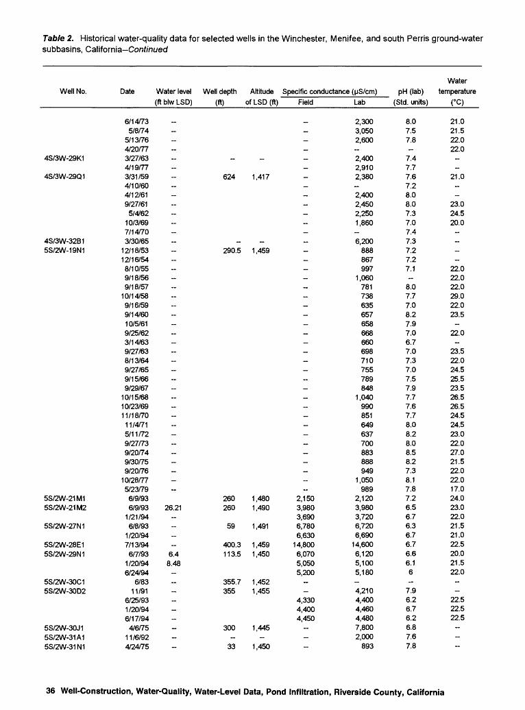
Table 2. Historical water-quality data for selected wells in the Winchester, Menifee, and south Perris ground-water subbasins, California Co/if/'/itved
Well No.
4S/3W-29K1
4S/3W-29Q1
4S/3W-32B15S/2W-19N1
5S/2W-21M15S/2W-21M2
5S/2W-27N1
5S/2W-28E15S/2W-29N1
5S/2W-30C15S/2W-30D2
5S/2W-30J15S/2W-31A15S/2W-31N1
Date Water level Well depth Altitude Specific conductance (uS/cm)(ft blw LSD)
6/14/735/8/74
5/13/764/20/773/27/634/19/773/31/594/10/604/12/619/27/615/4/62
10/3/697/14/703/30/65
12/18/5312/16/548/10/559/18/569/18/57
10/14/589/16/599/14/6010/5/619/25/623/14/639/27/638/13/649/27/659/15/669/29/67
10/15/6810/23/6911/18/70
11/4/715/11/729/27/739/20/749/30/759/20/76
10/28/775/23/79
6/9/936/9/93 26.21
1/21/946/8/93
1/20/947/13/94
6/7/93 6.41/20/94 8.486/24/94
6/8311/91
6/25/931/20/946/17/94
4/6/7511/6/924/24/75
(ft) of LSD (ft) Field
~-~
_-
624 1,417----
._
290.5 1 ,459 ~ ---~ ~~ ~ ~-~~~- ~~
260 1,480 2,150260 1 ,490 3,980
3,69059 1 ,491 6,780
6,630400.3 1,459 14,800113.5 1,450 6,070
5,0505,200
355.7 1 ,452355 1 ,455
4,3304,4004,450
300 1 ,445_ _ _
33 1 ,450
Lab
2,3003,0502,600~
2,4002,9102,380-2,4002,4502,2501,860-
6,200888867997
1,060781738635657658668660698710755789848
1,040990851649637700883888949
1,050989
2,1203,9803,7206,7206,690
14,6006,1205,1005,180-
4,2104,4004,4604,4807,8002,000
893
Water pH (lab) temperature
(Std. units)
8.07.57.8~
7.47.77.67.28.08.07.37.07.47.37.27.27.1-
8.07.77.08.27.97.06.77.07.37.07.57.97.77.67.78.08.28.08.58.27.38.17.87.26.56.76.36.76.76.66.16-
7.96.26.76.26.87.67.8
(°C)
21.021.522.022.0--
21.0--
23.024.520.0----
22.022.022.029.022.023.5
~
22.0~
23.522.024.525.523.526.526.524.524.523.022.027.021.522.022.017.024.023.022.021.521.022.520.021.522.0--
22.522.522.5---
36 Well-Construction, Water-Quality, Water-Level Data, Pond Infiltration, Riverside County, California

Table 2. Historical water-quality data for selected wells in the Winchester, Menifee, and south Perris ground-water subbasins, California Continued
Well No. Hardness
(mg/L as CaCO3)
4S/3W-29K1
4S/3W-29Q1
4S/3W-32B15S/2W-19N1
5S/2W-21M15S/2W-21M2
5S/2W-27N1
5S/2W-28E15S/2W-29N1
5S/2W-30C15S/2W-30D2
5S/2W-30J15S/2W-31A15S/2W-31N1
57070
690
620900790690730800740700760
2,000~-
290320230180160190140170170160210200210220260250240150150190220230240300270860
1,7001,7001,5001,6001,6001,7001,7001,700-
1,2001,5001,6001,6001,400-
250
Calcium, dissolved
(mg/L)
170240210
200290220220260280240220240640
777382866052475450575048585759617169614239468567678075
19038037037041049038043044096
39041043041033015063
Magnesium, dissolved
(mg/L)
37.026.038.0
32.043.060.037.019.024.031.038.037.086.015.015.620.026.019.013.010.012.04.07.0
10.010.015.013.016.017.020.019.021.011.012.014.0
1.115.017.024.022.093.0
190.0180.0140.0150.092.0
180.0140.0150.035.461.0
120.0120.0130.0135.070.022.0
Sodium, Potassium, dissolved dissolved Bicarbonate
(mg/L) (mg/L as K) (mg/LasHCO3)
220.0270.0230.0
280.0240.0170.0170.0160.0190.0170.097.0
118.0500.076.071.884.095.072.064.058.064.055.062.070.058.067.069.070.081.099.098.076.061.058.077.088.083.099.0
120.0110.0120.0140.0140.0950.0940.0890.0
1300.0440.0480.0140.0270.0290.0280.0290.0830.0250.079.0
346
410
57
11655
10434
--
46322533322633293332
~
18
931~
101048
-
798
326
848793
16015092
10098
10092
15014085
180160130150130140120120120120120110110130130150170190160110110120150140150150 ~ ~~~-~
150200-~-
230340130
Alkalinity (mg/L as CaCO3)Field
_--
_ ~- -~- - ~~ ~--~- ~ ~~- ~ ~~~---~ 640400360340350430210160160--
170160170---
Lab
687176
__
130~------~----~~~---~~
90110110120140150130868799
130120120120120 ----~----
160~---~
100
Table 2 37

Table 2. Historical water-quality data for selected wells in the Winchester, Menifee, and south Perris ground-water subbasins, California-Co/if/ntyed
Well No.
4S/3W-29K1
4S/3W-29Q1
4S/3W-32B15S/2W-19N1
5S/2W-21M15S/2W-21M2
5S/2W-27N1
5S/2W-28E15S/2W-29N1
5S/2W-30C15S/2W-30D2
5S/2W-30J15S/2W-31A15S/2W-31 N1
Sulfate,
dissolved
(mg/L as SO4)
354040_
2565453820
15032475835535665785530306035364028403642478489703940517276
120180160140360350
1,1201,110
930150920930
51280__
710750100
Chloride, dissolved
(mg/L)
650830750_
720870710660720690710510580
3,0001501402002201501101009989
1,22011012015011012012014012013010096
110130120120130130190570540
1,4601,4904,800
1101,1601,160
3001,100
__
1,630100120
Fluoride, dissolved
(mg/L)
0.70.70.9
__
0.4
0.70.60.40.60.40.40.30.40.30.00.10.00.20.00.00.10.30.10.20.20.30.30.30.30.10.30.20.20.30.20.20.30.40.60.4_
<0.10
<2.5 __._
0.30.70.3
Bromide, Silica,
dissolved dissolved Dissolved solids (mg/L)
(mg/L) (mg/LasSiO2) (sum) (residue)
2,0401,9402,2301,630
16 1,56011 - 2,520
1,260.._
_
1,1101,6905,340
600.. 570
760_
_ _ _ _ .. _
_ _....
42055 - 490
390460530470620
_ 600600500440400520590600
_ 620850
----- 720585959
___ _
9.4 57 8,020
545843 ^w
69 - 3,280666359
4,2201,520 1,610
590
Nitrate,
dissolved
(mg/L as N)
3.32.93.2-
1.16.11.63.22.31.81.83.65.70.454.36.64.92.02.04.52.04.53.63.45.92.74.1
111417179.37.26.85.77.99.0
1312171535
140140
3.36.42.2-
1213-
12-
1212
6.1<0.0915
Nitrite dissolved
(mg/L as N)
_------------------------------~---------
<0.02<0.02
0.40<0.25
0.03<0.01<0.02
0.03<0.010---
<0.010---
38 Well-Construction, Water-Quality, Water-Level Data, Pond Infiltration, Riverside County, California

Table 2. Historical water-quality data for selected wells in the Winchester, Menifee, and south Perris ground-water subbasins, California-Conf/nued
Well No.
4S/3W-29K1
4S/3W-29Q1
4S/3W-32B15S/2W-19N1
5S/2W-21M15S/2W-21M2
5S/2W-27N1
5S/2W-28E15S/2W-29N1
5S/2W-30C15S/2W-30D2
5S/2W-30J15S/2W-31A15S/2W-31 N1
NO3 + NO2 , dissolved
(mg/L as N)
-
__--
__---
_ -~~
;;;;--~-------~-~-~--~-
35140140
3.36.42.2
<0.021213---
1212
Nitrogen ammonia, Phosphorus, dissolved dissolved
(mg/L as N) (mg/L)
..-
_ -
_-
_..
_
:: ::.. -_-.... ..-..- ...._..-- 0.08-
0.060.26..
0.060.03--
0.060.06
<1 .0....
Phosphorus ortho, Arsenic,
dissolved dissolved (mg/L as P) (pg/L)
-
__.-
_ ._-
~. !! _ -
~ -
_--....-
-
__
_..
_
..-
<0.4
0.11 7.05.00.02 <1 .00.22 3.00.600.04 1 .00.04 1 .0
<0.03 <100_
..
0.06 1 .00.07 1.0...._
Barium, Beryllium, dissolved dissolved
(Mg/L) (pg/L)
..-
_-
_....-
..
..
.. _
..-...
__
..
..
._ _ ..-.._-....
150 4.0190 3.0170 <2
<100 <10_
400 <10<100 <10
23 <223 <250 <1 79 <274 <279 <2 ....
Boron, Cadmium, dissolved dissolved
(pg/L) (Mg/L)
500770620
690200400
200200400230
700160150
0200
90
10020010060
100300
2030201000
20600
180240
04060
__
230_.
2,500100-.
1 ,3001 ,400
<5 <7100_
130130700700
50
Table 2 39

Table 2. Historical water-quality data for selected wells in the Winchester, Menifee, and south Perris ground-water subbasins, California
Chromium, Cobalt, Copper, Iron, Lead, Lithium, Manganese, Molybdenum, Nickel,Well No. dissolved dissolved dissolved dissolved dissolved dissolved dissolved dissolved dissolved
__________(ug/L) (ug/L) (ug/L) (ug/L) (ug/L) (ug/L) (ug/L) (ug/L) (ug/L)
4S/3W-29K1 - -- 100
4S/3W-29Q1
2,0004S/3W-32B1 5S/2W-19N1 - -
5S/2W-21M1 <20 <9 <30 10 <30 110 <3 <30 <305S/2W-21M2 <20 <9 <30 20 <30 160 320 40 <30
<20 <9 <30 20 <30 170 220 <30 <305S/2W-27N1 3.0 2 5.0 70 <1 30 100 1 4.0
1.0 <1 4.0 460 <1 30 80 1 4.05S/2W-28E1 4.0 3 <1 100 <1 190 790 6 5.05S/2W-29N1 8.0 <1 1.0 <10 <1 40 230 14 2.0
<20 <9 <30 <9 <30 40 1,100 <30 <30<20 <9 <30 <9 <30 50 1,100 <30 <30
5S/2W-30C1 <10 <9 <2 1,600 <50 30 12 <80 <405S/2W-30D2 ~ - 10 150 ~ - <10
<20 <9 <30 9 <30 30 94 30 <30<20 <9 <30 10 <30 30 150 <30 <30<20 <9 <30 10 <30 30 210 <30 <30
5S/2W-30J15S/2W-31A1 - _ _ _ _ _5S/2W-31N1 ______
40 Well-Construction, Water-Quality, Water-Level Data, Pond Infiltration, Riverside County, California

Table 2. Historical water-quality data for selected wells in the Winchester, Menifee, and south Perris ground-water subbasins, California-Conf/nued
Well No.
4S/3W-29K1
4S/3W-29Q1
4S/3W-32B15S/2W-19N1
5S/2W-21M15S/2W-21M2
5S/2W-27N1
5S/2W-28E15S/2W-29N1
5S/2W-30C15S/2W-30D2
5S/2W-30J15S/2W-31A15S/2W-31N1
Selenium, Silver, Strontium, dissolved dissolved dissolved
(ug/L) (ug/L) (Mg/L)
-.._ _-_ _ __ _..-_ _--
__ __ __ __ __ _-..
__ _ __ _ _-
___ __ __ _ __ __ _--_ _ __ _ __ _ _-.._ _ __ _
_
<3.0 850<3.0 1,700
<1 <3.0 1,400<1.0 1,700
6.0 <1 .0<1.0 4,100
<1 .0 3,3007.0 <3.0 2,600
<3.0 2,800<100 <0.003 200
<5<3.0 2,200
6.0 <3.0 2,100<3.0 2,400
_ - __ _ _
_
Vanadium, dissolved
(ug/L)
---~ ..--- --- -- - ------- --
24<18
19-
37120-
21<18
<3
<18<18<18-
Zinc, dissolved
(ug/L)
--------~--- ------------- -----~-----
25054023011090
1803010
<9110
<101030
<9--
Source of data
RCFCDRCFCDRCFCDEMWDRCFCDEMWD/BabcockRCFCDDPHRCFCDRCFCDRCFCDEMWDDPHBabcockRCFCDRCFCDRCFCDRCFCD*RCFCD*RCFCD *RCFCD *RCFCD*RCFCD *RCFCDRCFCD *RCFCD *RCFCD *RCFCD *RCFCD *RCFCD *RCFCD*RCFCD *RCFCD *RCFCD *RCFCDRCFCD *RCFCD *RCFCD *RCFCD *RCFCD *RCFCDUSGSUSGSUSGSUSGSUSGSUSGSUSGSUSGSUSGSVetter ResearchBabcockUSGSUSGSUSGSEMWDEMWDDWR
Table 2 41

Table 2. Historical water-quality data for selected wells in the Winchester, Menifee, and south Perris ground-water subbasins, California-Conf/nued
Well No.
5S/2W-31R15S/2W-33E1
5S/3W-2Q15S/3W-3C15S/3W-3L15S/3W-3N15S/3W-3Q25S/3W-3R25S/3W-4A15S/3W-4M15S/3W-9E15S/3W-9H25S/3W-9Q15S/3W-11M15S/3W-11M2
5S/3W-13A1
5S/3W-13H1
5S/3W-14P1
5S/3W-15H15S/3W-16D15S/3W-16F15S/3W-16P1
5S/3W-16P2
5S/3W-17R15S/3W-17R25S/3W-21C1
5S/3W-21 D1
Date Water level (ft blw LSD)
7/16/872/26/815/11/81
11/19/9311/2/93
10/29/9310/22/935/22/754/18/7711/5/93
10/15/9310/26/9310/21/93
6/7/8312/18/537/28/559/18/569/17/57
10/14/584/7/59
9/14/609/28/619/21/629/27/634/16/644/28/7011/4/715/11/729/27/735/16/754/22/775/11/81
6/7/839/17/775/11/81
11/18/9311/18/93
1/25/945/30/754/22/77
7/9/8511/19/9311/18/9311/18/93
8/9/555/9/56
9/18/565/27/579/27/57
5/8/584/18/775/11/81
6/7/838/30/911/26/9511/7/754/19/779/25/62
Well depth
(ft)
~
~
250.8252577.8-~
209.4251.3238.4250.6600615787
431460
250
220160-
568
370220-
356
Altitude of LSD (ft)
~
1,5201,4201,4251,415
~~
1,4151,4121,4151,4201,4211,4511,451
1,5221,518
1,447
1,4351,4171,419
1,425
1,4451,460
~
Specific conductance (uS/cm)Field
671~~~~ --- --~-~-~ -~~~~_890
1,1601,110 -
1,5003,3001,400 ~~~ --- -~-
Lab
5251,9001,400
6747,4003,3004,700
903-
3,80018,0003,1002,6501,760
4481,2301,3601,3801,4301,4401,4201,5101,1001,4301,4901,7701,5201,5201,1901,4001,5001,4501,280
600625897
1,1701,1101,270~
1,5701,5203,3201,4201,6601,4901,5401,4101,3401,2902,2902,9003,1002,100-
4,500~
630
pH (lab) (Std. units)
7.47.1
7.87.37.66.87.7-
7.67.07.76.66.77.6--
8.16.86.56.57.16.96.67.18.17.98.48.16.57.26.87.07.67.97.57.47.58.0-
6.47.27.67.6~~~
7.56.96.66.56.76.97.7-
6.9-
7.7
Water temperature
(°C)
-~
22.0-~-----~-
26.524.023.523.022.024.523.523.523.522.024.523.522.023.524.023.5
~
24.523.024.023.523.522.021.522.023.0~~
21.520.021.022.021.022.020.521.522.024.023.5---~~
23.5
42 Well-Construction, Water-Quality, Water-Level Data, Pond Infiltration, Riverside County, California \\5

Table 2. Historical water-quality data for selected wells in the Winchester, Menifee, and south Perris ground-water subbasins, California~Conf/ni;ec/
Well No. Hardness
(mg/L as CaCO3)
5S/2W-31 R15S/2W-33E1
5S/3W-2Q15S/3W-3C15S/3W-3L15S/3W-3N15S/3W-3Q25S/3W-3R25S/3W-4A15S/3W-4M15S/3W-9E15S/3W-9H25S/3W-9Q15S/3W-11M15S/3W-11M2
5S/3W-13A1
5S/3W-13H1
5S/3W-14P1
5S/3W-15H15S/3W-16D15S/3W-16F15S/3W-16P1
5S/3W-16P2
5S/3W-17R15S/3W-17R25S/3W-21 C1
5S/3W-21 D1
170500
1702,1001,1001,800
180
5007,3001,100
950690
--
430470480500520480380470470660510530360510490530480180190270370330410
570520810420690540580560540560
1,1001,2001,600
900-
1,500
180
Calcium, dissolved
(mg/L)
120
45680350500
59
1502,220
320260200
1710011013013015017016011014014017014014097
1301501401304748709687
110
160140230120170150150140150150290350430200-
470
61
Magnesium, dissolved
(mg/L)
47.0
13.088.056.0
120.07.5
27.0410.0
82.072.048.75.0
35.036.038.036.032.021.021.027.028.030.054.041.044.029.041.025.043.035.816.016.023.031.027.031.0
44.042.056.028.061.038.047.051.041.047.081.076.0
110.099.0-
90.0
6.0
Sodium, Potassium, dissolved dissolved Bicarbonate
(mg/L) (mg/L as K) (mg/L as HCO3)
52.0200.0
68.0690.0270.0260.0
96.0
620.01300.0
160.0130.092.070.098.0
100.099.099.098.090.089.070.090.084.096.086.0
160.090.088.090.095.087.559.062.072.087.078.075.0
93.084.0
360.0100.063.068.063.061.058.060.0
100.0140.0150.073.0-
190.0
56.0
63
61712134
926
6872
--
12148
1012119879
1298555663
4353
-- -
7895
-
12
3
150
__24
21038073
~
180270310290460110290290180160260260240170240250290260270200260250260180200200
150
240 ~~
290350300310320410540390780210-
390
120
Alkalinity (mg/L as CaCO3)Field Lab
_
17020
180310
60_
150220250240460
__ ___._.___ __
200210240210230170
_
200_
180_.
_
180180160
120
190150290110_ _
__
_ _
260__
780170
_
_ _
Table 2 43

Table 2. Historical water-quality data for selected wells in the Winchester, Menifee, and south Perris ground-water subbasins, California-Conf/niyed
Well No.
5S/2W-31R15S/2W-33E1
5S/3W-2Q15S/3W-3C15S/3W-3L15S/3W-3N15S/3W-3Q25S/3W-3R25S/3W-4A15S/3W-4M15S/3W-9E15S/3W-9H25S/3W-9Q15S/3W-11M15S/3W-1 1 M2
5S/3W-13A1
5S/3W-13H1
5S/3W-14P1
5S/3W-15H15S/3W-16D15S/3W-16F15S/3W-16P1
5S/3W-16P2
5S/3W-17R15S/3W-17R25S/3W-21C1
5S/3W-21 D1
Sulfate,
dissolved
(mg/L as SO4)
150--
110345824-
240370150624116
1003935404030804828454843433843455139272655808338
47073
27037745076705550
120180240200
150_
50
Chloride,
dissolved
(mg/L)
440--
2,4001,0401,400
220-
1,1006,700
780660270
70190280310320320340280240310280390310310230300340320290
7379
130180180280
60340740340280220300270260210490680450470-
1,060
82
Fluoride,
dissolved
(mg/L)
0.50.5
0.10.20.50.7
0.20.10.30.2
0.50.20.00.20.00.00.00.1-
0.10.10.20.20.30.20.1-
0.4
0.60.7---
0.3
0.10.00.00.10.00.00.20.3-
0.20.45.0~
0.2
Bromide, Silica, dissolved dissolved
(mg/L) (mg/L as SiO2)
__
32.._ -._.. ..
58___
.. ...._ _ _..
_ _
_
..
24_
50__
464843
.._
555241
_
_ __ _ _ _
5459
..__
._
Dissolved solids (mg/L)
(sum)
310
1,010 --- -- --
680730760770780800780-------- - --- ~- ---
730 -------
(residue)
1,240--
5,0902,7103,490
6401,2802,260
14,0001,9701,8601,220
260-------
680870860
1,190990990
1,000950
1,040980920400400---
1,120840
1,260---------
1,5902,1502,7901,430
5303,0602,950
420
Nitrate,
dissolved
(mg/L as N)
3.89.6--
2.95.01.41.9-
3.41.88.67.50.453.62.01.61.62.71.11.82.31.42.73.65.24.83.85.21.05.46.11.05.77.5
13--
6.1-
6.3121911
1.82.91.61.82.53.25.77.20.385.7
137.0-
9.5
Nitrite dissolved
(mg/L as N)
_--
O.010<0.10<0.10<0.10--
<0.10<0.10<0.10<0.10----------------------
O.010<0.010
0.03---0.20
O.0100.20---------------
44 Well-Construction, Water-Quality, Water-Level Data, Pond Infiltration, Riverside County, California

Table 2. Historical water-quality data for selected wells in the Winchester, Menifee, and south Perris ground-water subbasins, California-Conf/ni/ed
Well No.
5S/2W-31R15S/2W-33E1
5S/3W-2Q15S/3W-3C15S/3W-3L15S/3W-3N15S/3W-3Q25S/3W-3R25S/3W-4A15S/3W-4M15S/3W-9E15S/3W-9H25S/3W-9Q15S/3W-11M15S/3W-11M2
5S/3W-13A1
5S/3W-13H1
5S/3W-14P1
5S/3W-15H15S/3W-16D15S/3W-16F15S/3W-16P1
5S/3W-16P2
5S/3W-17R15S/3W-17R25S/3W-21C1
Nitrogen NOa + NO2, ammonia, Phosphorus,
dissolved dissolved dissolved (mg/LasN) (mg/LasN) (mg/L)
..-
13 0.02___-
__ .. __ __ _ _
0.06__-_-
__
_ _ __ __ _ __ _ ___ _ _
<1 .00.00
_ _ _0.06
_ _ __ _
13 0.0413 0.0214 0.02-----
_ _
12 0.0319 0.0312 0.03_ _ _
_
_ ~ __ __ _ __ .. _
0.05_ _ __
Phosphorus ortho,
dissolved (mg/L as P)
-
0.15
11_ --~
_.-
..------
0.10
9.0--
0.020.020.02-
_
0.050.020.02 -
_-
10
Arsenic,
dissolved
(M9/L)
-
2.0<5<5<5
<5<5<5<5
_ _---
..-
_------ _
4.04.05.0-
_
1.01.0
<1 -
_
- _
<10
Barium, Beryllium, dissolved dissolved
(M9/L) (M9/L)
-
58 0.70200600400
._
..<100
200200200
..
..
..
__
_ __
_ __
__ __ __ __ ___
__ __ _
260 <0.5200 <0.5190 <0.5
_
_
140 <0.566 <0.5
180 <0.5_ __
__ __ __....
100_-.
Boron, Cadmium, dissolved dissolved
(M9/L) (M9/L)
100300
160 <1<1<1<1
200_
<1
2.0<1<1
1506090
10090
150
100200
1001004090
1700
2000
50020
20030070606060
10070
1 ,50080_
40
550200300400700120
<100 <1._
300
5S/3W-21D1 100
Table 2 45

Table 2. Historical water-quality data for selected wells in the Winchester, Menifee, and south Perris ground-water subbasins, California Continued
Chromium, Cobalt, Copper, Iron, Lead, Lithium, Manganese, Molybdenum, Nickel,Well No. dissolved dissolved dissolved dissolved dissolved dissolved dissolved dissolved dissolved
__ (pg/L) (pg/L) (pg/L) (Mg/L) (pg/L) (pg/L) (pg/L) (pg/L) (pg/L)
5S/2W-31R1 5S/2W-33E1
5S/3W-2Q15S/3W-3C15S/3W-3L15S/3W-3N15S/3W-3Q25S/3W-3R25S/3W-4A15S/3W-4M15S/3W-9E15S/3W-9H25S/3W-9Q15S/3W-11M15S/3W-11M2
<5 <3
50
<3 <20 <20 450
<2040030
5,800 <20
<10 <5 <5 <5
<5 <5 <5
6.0
10
50
3040
140
8040
170
20 <10
5S/3W-13A1
5S/3W-13H1
5S/3W-14P1
<5 <5 <5
<3 <3 <3
<10 <10 <10
<20
<35
20
<10 <10 <10
92020
<10 <10<10 <10<10 <10
5S/3W-15H1 5S/3W-16D1 5S/3W-16F1 5S/3W-16P1
<5 <5 <5
<3 <3 <3
<34
<3
1020
7
101
5S/3W-16P2
5S/3W-17R1 5S/3W-17R2 5S/3W-21C1
5S/3W-21D1
<10 <10<20
70 <5 <10
46 Well-Construction, Water-Quality, Water-Level Data, Pond Infiltration, Riverside County, California

2. Historical water-quality data for selected wells in the Winchester, Menifee, and south Perris ground-water subbasins, California-Conf/'/iuecf
Well No.
5S/2W-31R15S/2W-33E1
5S/3W-2Q15S/3W-3C15S/3W-3L15S/3W-3N15S/3W-3Q25S/3W-3R25S/3W-4A15S/3W-4M15S/3W-9E15S/3W-9H25S/3W-9Q15S/3W-11M15S/3W-11M2
5S/3W-13A1
5S/3W-13H1
5S/3W-14P1
5S/3W-15H15S/3W-16D15S/3W-16F15S/3W-16P1
5S/3W-16P2
5S/3W-17R15S/3W-17R25S/3W-21C1
5S/3W-21 D1
Selenium, Silver, Strontium, Vanadium, dissolved dissolved dissolved dissolved
(ug/L) (ug/L) (ug/L) (ug/L)
._
<1 <1.0 170 50<5 <10<5 <10 ~<5 <10 -
6.0 <10<10 <10
<5 <10<5 <10
_ _
_-_
_
-~ -
__ _ _ __..
__ _ _ _
_
..-__
2.0 <1.0 370 302.0 <1.0 480 242.0 <1.0 430 26__ _ __ _ _ _
1.0 <1.0 740 195.0 <1.0 1,400 292.0 <1.0 720 22_ _ _ _..
..
_..
7.0 <10_
_
_
Zinc, dissolved
(ug/L)
-<3
290260260 40
860570
1,100 --- ~--~ ~--- -
47
<3 -
270100380-- --
40--~
Source of data
EMWDEMWDEMWDUSGSBabcockBabcockBabcockDWREMWDBabcockBabcockBabcockBabcockWARCFCDRCFCDRCFCD*RCFCD*RCFCD *RCFCDRCFCDRCFCD*RCFCDRCFCDRCFCDRCFCDRCFCDRCFCDRCFCD*EMWDBabcockEMWDWAEMWDEMWDUSGSUSGSUSGSDWREMWDBabcockUSGSUSGSUSGSRCFCDRCFCDRCFCDRCFCDRCFCDRCFCDEMWDEMWDWABabcockBabcockEMWDEMWDRCFCD
Table 2 47

Table 2. Historical water-quality data for selected wells in the Winchester, Menifee, and south Perris ground-water subbasins, California-Co/if/m/ed
Well No.
5S/3W-21 D2
5S/3W-24C1
5S/3W-24F25S/3W-24F35S/3W-24F45S/3W-28M1
5S/3W-28M2
5S/3W-28M3
Date Water level (ft blw LSD)
4/23/63 9/27/63 4/17/64 8/13/64 3/30/65 9/24/65 3/23/66 9/15/66 5/11/67 9/29/67 4/23/68 4/22/69
10/23/69 4/28/70
11/18/704/30/713/25/609/14/604/13/619/28/619/24/624/17/648/13/643/23/665/11/67
10/15/684/30/714/27/739/26/73
5/3/749/24/7411/7/754/20/77
11/18/931/25/946/24/946/15/946/15/946/15/949/11/901/31/916/13/918/30/911/30/928/19/92
12/10/931/31/916/13/918/30/911/31/928/19/92
12/10/931/31/916/14/918/30/911/31/928/28/92
12/10/93
-
--~------- --------- ---
72.8969.0869.1367.8362.79-
72.5268.8468.7367.6162.62-
62.1160.1159.1859.355.64-
Well depth Altitude Specific conductance (uS/cm)(ft) of LSD (ft) Field
-
-452
- --- ------~
505 1,480 921910832
691 1,475 695403.8 1 ,475 3,790155.1 1,475 1,880430 1,420
1,6901,7301,7301,7101,7401,760
370 1 ,420 2,3802,4202,4402,4102,4202,420
242 1 ,420 5,3805,4505,4505,4105,4605,530
Lab
716 1,250
726 680
1,180 2,030 1,050 1,740 1,080 3,710 2,950 1,500 3,940 1,990 1,9901,9002,1102,1702,3802,3802,4402,6202,5002,6902,5402,0902,7701,790
3,0303,6402,9803,900
927913827698
3,8101,890
2381,6901,7501,7401,6001,7501,7702,4302,3002,4602,4002,4402,4405,5205,5505,5405,5505,2705,550
pH (lab) (Std. units)
7.6 7.6 7.7 7.7 8.2 7.6 7.7 7.7 7.8 7.6 7.6 7.6 7.5 8.0 8.18.27.57.48.08.17.57.58.07.77.77.77.87.77.67.48.07.3
7.47.37.07.76.46.86.97.87.57.37.58.07.47.37.37.27.37.87.16.66.66.56.86.96.4
Water temperature
(°C)
25.5 28.0 16.5 22.0 20.0 25.5 22.0 28.0 19.0 22.0 24.5 23.5 23.5 22.0 24.524.524.524.526.024.526.026.024.524.526.025.523.524.526.026.021.024.0-
21.021.030.523.523.522.0-
22.523.023.023.024.022.521.522.523.022.524.021.021.522.022.521.522.021.0
48 Well-Construction, Water-Quality, Water-Level Data, Pond Infiltration, Riverside County, California

Table 2. Historical water-quality data for selected wells in the Winchester, Menifee, and south Perris ground-water subbasins, California-Conf/nwec/
Well No. Hardness
(mg/L as CaCO3)
5S/3W-21 D2
5S/3W-24C1
5S/3W-24F25S/3W-24F35S/3W-24F45S/3W-28M1
5S/3W-28M2
5S/3W-28M3
230 430 200 210 350 750 320 650360
1,6001,200
5101,800
750740730780850950
1,100980
1,000960
1,0001,100
8001,100
6401,2001,3001,2001,300
290270250
711,400
61031
210210200220220230410450480450460480
2,4002,5002,4002,4002,5002,500
Calcium,
dissolved
(mg/L)
73 130 57 70 90
220 92
180100460360150520210210210210260250260250250300230240240270140260340280330
76747224
430170
8575956616163
100110120110110120690710690690720730
Magnesium, dissolved
(mg/L)
11.0 25.0 15.0 9.0
31.0 51.0 22.0 46.026.0
120.082.036.0
120.056.052.051.061.048.076.096.086.0
100.048.0
100.0110.051.0
100.073.0
130.0120.0120.0110.0
23.021.016.02.7
86.045.0
2.715.015.015.015.016.016.037.042.044.041.044.043.0
170.0170.0170.0160.0170.0160.0
Sodium, Potassium, dissolved dissolved Bicarbonate
(mg/L) (mg/L as K) (mg/LasHCO3)
55.0 68.0 64.0 55.0
110.0 96.0 68.0 81.071.0
130.0110.081.0
130.095.094.085.088.092.094.0
110.0100.0110.0110.0120.0130.083.0
120.081.0
120.0150.0150.0150.0
68.064.056.0
110.0170.099.030.0
320.0330.0310.0320.0320.0320.0450.0440.0430.0400.0420.0400.0230.0220.0220.0210.0210.0210.0
3 4 4 3 5 6 4 53
10753475888
1157843715534
33
4544
127
_
13 --
20-----
24
130 120 120 130 150 140 120 140120180170140140140160130140150130140160160170170160160130250
96160130190
__- ---------
Alkalinity (mg/L as CaCO3)
Field
-
----------- ------------
160140100120230
848
820820810820820860
1,2001,2001,2001,2001,2001,200
600590580570580600
Lab
-
-
150140110120110130130--------
130130130200
79130100-
_- ---- ---------------
Table 2 49

Table 2. Historical water-quality data for selected wells in the Winchester, Menifee, and south Perris ground-water subbasins, California Continued
Sulfate, Well No. dissolved
(mg/L as SO4
5S/3W-21 D2
5S/3W-24C1
5S/3W-24F2 5S/3W-24F35S/3W-24F45S/3W-28M1
5S/3W-28M2
5S/3W-28M3
54 56
100 60
312 81 66 84 67
160 140 84
240 100 130 130 110 150 180 350 110 170 120 150 160 100 170 70
190 120 110 63
50 43 27 19 97304024211617189
251720131916
340510610440470370
Chloride, dissolved
) (mg/L)
130 290 94
100 110 520 200 430 230
1,100 860 350
1,140 500 470 490 530 560 630 560 680 700 680 690 700 530 740 380 830 960 900 950
170 160 160 100
1,010
418856898791
10012090
15099
120143
1,2001,4001,6001,3001,2001,470
Fluoride, dissolved
(mg/L)
0.1 0.1 0.1 0.4 0.6 0.3 0.3 0.4 0.3 0.3 0.3 0.0 0.3 0.3 0.2 0.3 0.0 0.0 0.1 0.2 0.1 0.1 0.4 0.4 0.4 0.1 0.0
0.4 0.5 0.3 0.6
<0.2 <0.2 <2.5<0.20.20.30.30.40.30.4~
0.40.40.80.40.4
0.10.20.50.50.2~
Bromide, dissolved
Silica, dissolved Dissolved solids (mg/L)
(mg/L) (mg/L as SiO2) (sum)
-
0.10.20.20.30.20.3
0.30.30.30.30.3
2.32.32.32.51.7-
43 40 49 27 534511333432333333434444414449585755535651
(residue)
470 700 480 450 740
1,870 720
1,240 940
2,680 2,510
980 2,940 1,380 1,370 1,370
1,390 1,510 1,430 2,270 2,010 1,410 2,330
470
2,330 2,420 2,590 1,750
~
1701,0801,0901,0201,0501,070
~
1,5201,5301,5101,4701,500-
4,2404,1803,9703,4104,580-
Nitrate, Nitrite dissolved dissolved
(mg/L as N) (mg/L as N)
2.7 3.4 4.5 4.5 0.0 6.6 6.1 6.1 6.2 4.3 5.2 5.9 5.0 7.2 5.0 7.5 1.8 1.4 1.8 1.8 1.1 2.0 1.6 1.4 3.4 5.2 4.1 5.2 4.5 9.7 7.9 8.0
<0.010 0.10
O.010 0.02
<0.010<0.010
0.010.08
<0.010<0.010<0.020<0.010<0.010<0.020<0.010<0.010<0.010<0.010<0.010
0.02<0.010<0.010O.010<0.010
1.7 <0.010
50 Well-Construction, Water-Quality, Water-Level Data, Pond Infiltration, Riverside County, California

Table 2. Historical water-quality data for selected wells in the Winchester, Menifee, and south Perris ground-water subbasins, California Continued
Well No.
5S/3W-21D2
5S/3W-24C1
5S/3W-24F25S/3W-24F35S/3W-24F45S/3W-28M1
5S/3W-28M2
5S/3W-28M3
N03 + N02, dissolved
(mg/L as N)
-
-
6.66.65.06.1
15140.22
<0.10<0.05<0.05<0.05<0.05<0.05<0.10<0.05<0.05<0.05<0.05
0.081.61.71.71.61.71.7
Nitrogen Phosphorus ammonia, Phosphorus, ortho, dissolved dissolved dissolved
(mg/L as N) (mg/L) (mg/L as P)
-
-
0.030.060.020.020.060.030.020.020.020.030.030.03
<0.010.030.020.030.030.04
<0.010.060.040.030.030.160.07
-
-
..- -
0.030.450.500.460.280.28-
1.71.61.81.82.1 0.840.910.970.981.3
-
-
0.030.030.050.801.01.00.010.440.480.410.270.280.361.51.41.71.72.12.90.610.720.820.861.21.6
Arsenic, dissolved
(M9/L)
-
-
2.02.02.02.06.04.0~ ~ 3.0-----~
14 ~- ~
2.0
Barium,
dissolved
(M9/L)
-
-
20019017023
470410
9.0300300330350350390430460470450490520
969191899095
Beryllium, dissolved
(M9/L)
-
-
<0.5<0.5<0.5<0.5<2<0.5<0.5<0.5<0.5<0.5<0.5<0.5<0.5<2<2<2<2<2<2<2<2<2<2<2<2
Boron, dissolved
(M9/L)
100 100 100 400 190 50 30 60 40 50 50 30 30
0 0
60 300 100 300 400 100 300 300 210 290
70 170
200 20 20
300
40504090805030
190200180200190180200220210230230220200230210230230240
Cadmium, dissolved
(M9/L)
-
-
..------~------~---~-~----
Table 2 51

Table 2. Historical water-quality data for selected wells in the Winchester, Menifee, and south Perris ground-water subbasins, California Continued
Chromium, Cobalt, Copper, Iron, Lead, Lithium, Manganese, Molybdenum, Nickel,Well No. dissolved dissolved dissolved dissolved dissolved dissolved dissolved dissolved dissolved
(ug/L) (ug/L) (ug/L) (ug/L) (ug/L) (ug/L) (ug/L)_____(M9/L) (ug/L)
5S/3W-21D2
5S/3W-24C1
5S/3W-24F2 5S/3W-24F3 5S/3W-24F4 5S/3W-28M1
5S/3W-28M2
5S/3W-28M3
<5 <5 <5<5<20<5<5<5<5<5<5<5<5
<20<20<20<20<20<20<20<20<20<20<20160
<3 <3 <3<3<9<3<3<3<3<3<3<3<3<9<9<9<9<9<9<9<9<9<9<9<9
<10 <10 <10<10<30<10<10<10<10<10<10<10<10<30<30<30<30<30<30<30<30<30<30<30<30
20 20 80
<920320202020201030100120110908040202010<9<9650
10<10<30<10<10<10<10<10<10<10<10<30<30<30<30<30<30<30<30<30<30<30<30
5 5 107
4010<4303020303030304040404030808090905070
9 27
1832805328180170170150150160120120140130170250370390380410400660
<10
<1020
<30<10<1010
<10201010
<10<30<30<30<30<30<30<30<30<30<30<30<30
<10 <10 <10<10<30<10<10<10<10<10<10<10<10<30<30<30<30<30<30<30<30<30<30<30<30
52 Well-Construction, Water-Quality, Water-Level Data, Pond Infiltration, Riverside County, California
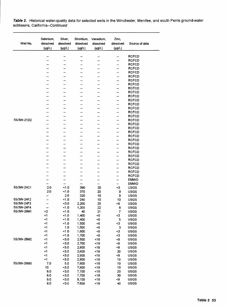
Table 2. Historical water-quality data for selected wells in the Winchester, Menifee, and south Perris ground-water subbasins, California-Conf/niyed
Well No.
5S/3W-21 D2
5S/3W-24C1
5S/3W-24F25S/3W-24F35S/3W-24F45S/3W-28M1
5S/3W-28M2
5S/3W-28M3
Selenium, dissolved
(M9/L)
--------- ---- ----------------
2.02.0 --
<2<1<1<1<1<1<1<1<1<1<1<1<1
7.0108.08.09.08.0
Silver, dissolved
(M9/L)
_- ------ ----- -----------------<1.0<1.0
2.0<1.0<3.0<1.0<1.0<1.0<1.0<1.0
1.0<1.0<1.0<3.0<3.0<3.0<3.0<3.0<3.0
5.0<3.0<3.0<3.0<3.0<3.0
Strontium, dissolved
(M9/L)
-------- ----- ------_---------390370320240
2,2001,200
401,4001,4001,5001,5001,6001,7002,5002,7002,9002,6002,9002,9007,9007,9007,7007,7008,1007,600
Vanadium, dissolved
(M9/L)
---- - ---- ---- ------- --
20201910202221
<6<6<6<6<6<6
<18<18<18<18<18<18<18<18<18<18<18<18
Zinc, dissolved
(M9/L)
------- ---- ------------ -- <3
99
10<9
87
<35
<33
<3<3<9<9<920
<91010102030
<940
Source of data
RCFCDRCFCDRCFCDRCFCDRCFCDRCFCDRCFCDRCFCDRCFCDRCFCDRCFCDRCFCDRCFCDRCFCDRCFCDRCFCDRCFCDRCFCDRCFCDRCFCDRCFCDRCFCDRCFCDRCFCDRCFCDRCFCDRCFCDRCFCDRCFCDRCFCDRCFCDEMWDEMWDusesusesusesusesusesusesusesusesusesusesusesusesusesusesusesusesusesusesusesusesusesusesusesusesuses
Table 2 53

Table 2. Historical water-quality data for selected wells in the Winchester, Menifee, and south Perris ground-water subbasins, California-Conf/nuecf
Well No.
5S/3W-28M4
5S/3W-28M5LYS
5S/3W-28M6LYS
5S/3W-28M7LYS
5S/3W-28M8LYS
5S/3W-28M9LYS
5S/3W-28M10LY
5S/3W-28M1 1 LY
5S/3W-29Q15S/3W-32A15S/3W-32B15S/3W-32C15S/3W-32G15S/3W-32G2
Date
1/31/916/14/918/30/911/30/928/28/92
12/10/932/25/91
6/5/917/5/91
8/12/912/11/92
5/5/928/7/929/8/928/1/91
2/11/925/5/928/7/929/8/92
2/25/916/5/91
10/22/912/11/92
5/5/928/7/929/8/925/5/928/7/929/8/926/5/917/5/91
8/12/912/11/925/5/928/7/929/8/92
2/25/916/5/917/5/91
8/1 2/912/11/925/5/928/7/929/8/92
2/25/916/5/917/5/91
8/12/912/11/925/5/928/7/929/8/927/7/58
3/11/9411/5/93
11/11/9311/23/931/23/76
Water level Well depth Altitude
(ft blw LSD)
62.460.5159.3859.5255.84-
unsat. zoneunsat. zoneunsat. zoneunsat. zoneunsat. zoneunsat. zoneunsat. zoneunsat. zoneunsat. zoneunsat. zoneunsat. zoneunsat. zoneunsat. zoneunsat. zoneunsat. zoneunsat. zoneunsat. zoneunsat. zoneunsat. zoneunsat. zoneunsat. zoneunsat. zoneunsat. zoneunsat. zoneunsat. zoneunsat. zoneunsat. zoneunsat. zoneunsat. zoneunsat. zoneunsat. zoneunsat. zoneunsat. zoneunsat. zoneunsat. zoneunsat. zoneunsat. zoneunsat. zoneunsat. zoneunsat. zoneunsat. zoneunsat. zoneunsat. zoneunsat. zoneunsat. zoneunsat. zone
-----~
(ft) of LSD (ft)
160 1,420
63 1 ,420
45 1 ,420
35 1 ,420
25 1 ,420
15 1,420
10 1,420
5 1 ,420
_
586.2 1,413218.1 1,414218.2 1,422219.9 1,415
Specific conductance (uS/cm)
Field
4,3004,3204,3204,3204,3004,2405,1402,100
4,4904,5004,5404,480
9,3309,1108,990
9,3606,670-
9,4509,3409,200-
9,5709,150-
4,570
6,5706,5306,6906,830
8,5504,740-
8,9208,5208,7409,060
8,1306,590
10,3008,9009,820
12,200-------
Lab
4,3804,3804,3704,3904,3304,2904,8204,420-
4,3804,4904,5404,430 -
9,250-
9,020
8,8909,250
9,350-
9,210
9,4909,170«
6,980
6,5606,4906,6106,870
7,8108,310--
8,8108,4508,6309,090-
7,5808,950-
10,4008,9009,640
12,200-
10,9007,0001,6205,3005,1002,190
pH (lab)
(Std. units)
6.76.77.17.17.07.17.57.3-
7.67.67.67.7
7.3-
7.8
7.37.1
7.0-
7.7
7.17.5
7.1-
7.17.17.57.6
7.67.3-
7.27.17.47.8-
7.67.4-
7.37.37.67.8-
6.37.07.17.67.07.4
Water
temperature
20.521.021.020.521.0-
19.520.5-
21.518.521.021.0 -
18.021.5--
20.021.0..
18.521.0-
20.5--
19.5-
21.07.019.0-
19.519.5-
21.516.019.0--
20.020.5-
24.013.520.0
----------
54 Well-Construction, Water-Quality, Water-Level Data, Pond Infiltration, Riverside County, California

Table 2. Historical water-quality data for selected wells in the Winchester, Menifee, and south Perris ground-water subbasins, California-Continued
Well No. Hardness (mg/L as CaCO3)
5S/3W-28M4 1 ,9002,0002,0001,9002,0001,900
5S/3W-28M5LYS 1 ,7001,500
1,5001,5001,8001,900
5S/3W-28M6LYS
4,0003,900
Calcium, dissolved
(mg/L)
540550550540560530410370
370370440460
-
1,000980
Magnesium, dissolved
(mg/L)
140.0140.0140.0140.0140.0130.0170.0150.0
150.0150.0170.0180.0
--
370.0360.0
Sodium, Potassium, dissolved dissolved Bicarbonate
(mg/L) (mg/L as K) (mg/LasHCO3)
260.0240.0230.0230.0220.0200.0 8380.0350.0
380.0350.0350.0350.0
--
520.0530.0
Alkalinity (mg/L as CaCO3)Field
270270270270260140---
..---
-
250
Lab
----- -
---
-
_-
5S/3W-28M7LYS
5S/3W-28M8LYS
5S/3W-28M9LYS
5S/3W-28M10LY
4,100
4,6004,000
3,600
3,200
940
1,100970
820
420.0
440.0390.0
370.0
510.0
530.0490.0
440.0
3,1003,3003,6003,600
690760820830
330.0350.0380.0370.0
350.0360.0390.0390.0
220
190
490
780 300.0 730.0
5S/3W-28M11LY
2,7002,5002,7003,000
650620670750
250.0230.0250.0270.0
1100.01100.01200.01200.0
2,500 580 250.0 1300.0
50
5S/3W-29Q15S/3W-32A15S/3W-32B15S/3W-32C15S/3W-32G15S/3W-32G2
2,100 2,400 2,6004,000
4,5003,500
1201,900
890440
490 540 580910
1,320920
29630250
97
220.0 250.0 270.0410.0
300.0280.0
11.079.063.047.0
1300.0 1300.0 1600.02100.0
730.0640.0320.0440.0800.0
32.5
-
-
3139
312112
-
-
5002,510
220210410240
530
2,060180170340
Table 2 55

Table 2. Historical water-quality data for selected wells in the Winchester, Menifee, and south Perris ground-water subbasins, California-Continued
Well No.
5S/3W-28M4
5S/3W-28M5LYS
5S/3W-28M6LYS
5S/3W-28M7LYS
5S/3W-28M8LYS
5S/3W-28M9LYS
5S/3W-28M10LY
5S/3W-28M11LY
5S/3W-29Q15S/3W-32A15S/3W-32B15S/3W-32C15S/3W-32G15S/3W-32G2
Sulfate, dissolved
(mg/L as SO4)
840970980660900880890990
1,00090
1,000--
_
660_-
1,6001,900
1,600
-
1,4001,200
2,500
2,6002,1002,1002,100
2,8002,400
3,3002,5002,5002,700
2,3002,500
3,5002,5003,2003,900
1,0001,010
380700930510
Chloride, dissolved
(mg/L)
1,000910860700
1,300903
1,2001,300
95099
910-
1,300
--
2,3002,500
2,400
--
2,6002,600
1,400
1,2001,1001,1001,200
1,8001,700
1,5001,4001,5001,600
1,3001,700
2,0001,7001,5002,200
3,230160150
1,400970280
Fluoride, dissolved
(mg/L)
<0.100.20.50.30.4
0.41.0
0.5<0.10<0.10-
0.4_-
0.30.7
0.5_-
1.00.6
1.4
0.51.50.20.9
0.72.5
1.40.60.20.7
0.92.8
0.80.60.40.8
0.00.10.30.30.30.8
Bromide, dissolved
(mg/L)
1.8
1.81.81.2-
1.71.5
1.40.51.4-
..4.2 -
3.13.8
3.9__
-
0.54.5
1.0
0.60.60.40.4
0.40.4
0.50.40.30.3
0.30.3
0.70.30.10.4
_ ----
Silica, dissolved
(mg/L as SiO2)
5960595759521111
11111315
8476
__
82
8483
89
78878890
87--
84808191
79
777783
110
..---..-
Dissolved solids (mg/L)(sum) (residue)
3,3003,3603,2502,9103,440
-
_
_-..-
.._-
..-
-
__
_
_- -
_.....
7,1003,6601,1004,4303,2201 ,560
Nitrate, dissolved
(mg/L as N)
_----6.2-
- -~
- -
-""
- --
-
--
-
--
-
--
0.000.452.90.681.66.8
Nitrite
dissolved
(mg/L as N)
<0.010<0.010<0.010<0.010<0.0100.40
<0.010
-
<0.010<0.010
-
<0.010<0.010
-"
0.050.05
<0.010
<0.010<0.010
0.02
0.13<0.010<0.010<0.010
-0.010
<0.010<0.010<0.010<0.010
0.08
0.01<0.010<0.010<0.010
0.10<0.10<0.10<0.10
"
56 Well-Construction, Water-Quality, Water-Level Data, Pond Infiltration, Riverside County, California

Table 2. Historical water-quality data for selected wells in the Winchester, Menifee, and south Perris ground-water subbasins, California Continued
Nitrogen NC>3 + NO2, ammonia,
Well No. dissolved dissolved (mg/L as N) (mg/L as N)
5S/3W-28M4
5S/3W-28M5LYS
5S/3W-28M6LYS
5S/3W-28M7LYS
5S/3W-28M8LYS
5S/3W-28M9LYS
5S/3W-28M10LY
5S/3W-28M1 1 LY
5S/3W-29Q15S/3W-32A15S/3W-32B15S/3W-32C15S/3W-32G1
5.05.15.15.25.16.6
<0.05<0.05
<0.05<0.05<0.05<0.05
_.
131617
1110
141414
1718
5
2390.31
8.719
2727
1.10.20
5.014
263.50.43
<0.05
__- -
0.020.020.030.030.110.04 -
..-
0.140.10
_
0.060.11
-
0.080.120.12
0.110.12
-
0.220.120.080.11
__
0.08
0.020.070.080.09
__
0.06
0.030.070.050.12
__ -
Phosphorus, dissolved
(mg/L)
0.400.330.290.270.27 --
__-
<0.01<0.01
_
0.010.02
--
<0.01<0.01<0.01
<0.010.01
-
0.030.040.020.02
._
0.02
0.020.02
<0.010.01
_
0.07
0.050.02
<0.010.02
__ -
Phosphorus ortho,
dissolved (mg/L as P)
0.260.230.230.260.240.25
<0.01
-<0.01
0.01
_
<0.010.01
_
-
<0.01<0.01<0.01
<0.010.01
<0.01
0.030.030.030.02
0.01
0.010.01
<0.010.01
_
0.06
0.040.020.010.02
__ -
Arsenic, Barium, dissolved dissolved
(Mg/L) (Mg/L)
4340413134
1.0 326350
39293231
_
3739
-
_. _
38
2053
42
34<38
1533
100-
29<27
6.030
_
100
31<29
<5
30
._
<5 3,100<5 <100<5 200<5 <100
Beryllium, Boron, Cadmium, dissolved dissolved dissolved
(Mg/L) (Mg/L) (Mg/L)
2.0 220<2 240<2 230<2 240<2 260<2 260<2<2
<2<2<2<2
_ _..
<3<3
_-
_ __ __
<3
<3<3
<3 :<2<3<2<2
<io"
--
<3<3<3<3
<10
<3<3<3<5
3001 .0
<1<1<1
5S/3W-32G2 800
Table 2 57

Table 2. Historical water-quality data for selected wells in the Winchester, Menifee, and south Perris ground-water subbasins, California-Co/if/'/iwed
Chromium, Well No. dissolved
(H9/L)
5S/3W-28M4 <20<20<20<20<20120
5S/3W-28M5LYS <20<20
<20<20<20
<5
5S/3W-28M6LYS
<30<30
Cobalt, Copper,
dissolved dissolved
(ug/L) (ug/L)
<9<9<9<9<9<9<9<9
<9<9<9<9
-
<20<20
<30<30<30<30<30<30<30<30
<30<30<30
30
-
<50<50
Iron, dissolved
(M9/L)
202020
<920
450550500
600150
3,5004,300
--
2030
Lead, dissolved
(H9/L)
3040
<30<30<30<30<30<30
<30<30
30<30
--
<50<50
Lithium, dissolved
(H9/L)
6050406040403030
20303010
-
2070
Manganese, dissolved
(M9/L)
7243351012
10012,0009,900
9,2008,6008,0007,000
-
3,6002,600
Molybdenum, Nickel, dissolved dissolved
(ug/L) (ug/L)
<30<30
40<30<30<30
40<30
<30<30<30<30
-
<50<50
<30<30<30<30<30<30<30<30
<30<30<30<30
-
100<50
5S/3W-28M7LYS
<30
5S/3W-28M8LYS
5S/3W-28M9LYS
5S/3W-28M10LY
<20 <50 <50 60 8,900 60 140
<30<30
<30
4.0<1<20<20
3.0
2<20
<20
<10<1<1<10
10
28<50
<50
80<1910
<40
20
20<15
20
50<15<1230
60
<1<50
<50
<40<1<1<40
1
15080
120
60206050
130
20051
34
753603744
1,000
<50<50
<50
<40<50<4050
42
15090
<50
70<38
11<40
130
5S/3W-28M11LY
5S/3W-29Q1 5S/3W-32A1 5S/3W-32B1 5S/3W-32C1 5S/3W-32G1 5S/3W-32G2
<2
<30 <30
<2<2
<30<50
<20
<20
10
<20
1 <30
<50<20
22<50
43
<60<36
47<100
30
20
10
23
20100
40 <20
50 250
<50
<50
<60
<100
<5 <5 <5 <5
220210260210
5227<56
-<50<5070
<50<3817
<50
130 60
3,50030
530760
29 80
11090180180
3719<511
-<50<50110
<60<3217
<100
58 Well-Construction, Water-Quality, Water-Level Data, Pond Infiltration, Riverside County, California

Table 2. Historical water-quality data for selected wells in the Winchester, Menifee, and south Perris ground-water subbasins, California-Conf/nt/ed
Well No.
5S/3W-28M4
5S/3W-28M5LYS
5S/3W-28M6LYS
5S/3W-28M7LYS
5S/3W-28M8LYS
5S/3W-28M9LYS
5S/3W-28M10LY
5S/3W-28M11LY
5S/3W-29Q15S/3W-32A15S/3W-32B15S/3W-32C15S/3W-32G15S/3W-32G2
Selenium,
dissolved
(M9/L)
8.01215121112-~-~-- ~~~~~~~~~--- ----~~-~~~-~--~~~-~-~~~~~~~
<5<5
5.012_
Silver, dissolved
(M9/L)
5.05.0
<3.0<3.0<3.0<3.0<3.0
4.0~<3.0<3.0
6.0<3.0~--<5.0<5.0~~~---<5.0~<1.0<5.0-<5.0-<4.0<1.0<1.0<4.0 <1.0-
7.0<1.0<1.0<5.0 <1.0~9.0
<1.0<1.0
<10~~
<10<10<10<10
_
Strontium, dissolved
(M9/L)
3,4003,4003,5003,2003,3003,0002,3002,200
~
2,1002,0002,4002,500 -
5,9005,800-~----
6,100
7,3006,300
~
6,200-
5,1005,6006,1005,900
5,300-~
5,3004,9005,3005,700 ~
4,900~
4,1004,2004,7006,800
~ ~- ~
Vanadium, dissolved
(M9/L)
202222
<1821
<1829
<18~
<18<18<18
<9~ ~
3041
~~~ 41
<30<30
~<30
~<24<27<24
32 66-
<30<30<30
35
32~
<36<41<30<60
~_-~~~
Zinc, dissolved
(M9/L)
<9<9<920
<940
93090-
20240
50240~~~
290350~-~~--
680
2,100840~
750~
440280180170
1,000-
470480210170~~
600~
480490230190-
1,900100430400~
Source of data
USGSUSGSUSGSUSGSUSGSUSGSUSGSUSGSUSGSUSGSUSGSUSGSUSGSUSGSUSGSUSGSUSGSUSGSUSGSUSGSUSGSUSGSUSGSUSGSUSGSUSGSUSGSUSGSUSGSUSGSUSGSUSGSUSGSUSGSUSGSUSGSUSGSUSGSUSGSUSGSUSGSUSGSUSGSUSGSUSGSUSGSUSGSUSGSUSGSUSGSUSGSUSGSBabcockBabcockBabcockBabcockBabcockEMWD
Table 2 59

Table 2. Historical water-quality data for selected wells in the Winchester, Menifee, and south Perris ground-water subbasins, California-Conf/nwed
Well No.
5S/3W-32H15S/3W-32L15S/3W-33K1
5S/3W-33R25S/3W-35N2
5S/3W-35P1
5S/3W-35Q15S/3W-35R15S/3W-36D1
5S/3W-36K1
5S/3W-36N2
5S/3W-36P1
5S/3W-36P2
5S/3W-36Q1
6S/3W-1 D16S/3W-1D26S/3W-1E16S/3W-1 H1
6S/3W-1J2
6S/3W-2A1
6S/3W-2C16S/3W-2D1
Date
10/29/9311/19/93
4/6/944/7/94
8/14/917/15/927/15/927/15/927/15/92
5/9/564/23/599/23/595/17/686/17/77
10/14/933/28/6311/5/645/4/65
5/17/682/27/623/15/638/27/916/17/77
12/17/538/10/559/18/56
6/3/926/3/926/2/926/2/926/2/92
7/13/945/8/58
10/14/584/23/593/25/609/14/604/13/61
5/8/6211/1/626/12/934/17/643/30/65
5/4/654/22/754/20/778/20/919/16/91
10/15/918/13/917/20/93
11/22/9311/5/9311/4/9311/4/934/22/7511/4/939/28/93
Water level (ft blw LSD)
--------- -- - - -------
104.71 -- --- ~~ - _-
Well depth Altitude
(ft) of LSD (ft)
221 1 ,405221 1,412665 1,415
_ _
587.6 1 ,425
516 1,427
588600.3 1 ,425
_
190 1,430
338.6 1 ,425
128.7 1,425
680.2 1 ,430
604
..500
..369.5 1,430
300 1 ,430
577 1 ,425
600 1 ,430632.5 1 ,425
Specific conductance (uS/cm)
Field Lab
1 ,8001 1 ,0003,9003,6004,4404,0004,1004,0003,9002,5301,8001 ,4703,170
_ _3,8001,6101,4601,3001,3801 ,250
7604,540
_2,8502,3302,6201,5001,8001 ,8002,8002,700
2,580 2,6202,0601 ,2803,7301,9101,1701,1601 ,2601 ,3501,3401,4101 ,4801,1101,460
..
..
..
..4,700
5,180 5,1304,5005,3002,8005,1001 ,6093,2002,100
pH (lab) (Std. units)
6.76.66.67.76.86.36.46.46.6-
8.37.88.0-
6.27.47.17.48.17.37.48.0
6.56.2-
6.36.36.36.56.46.46.57.08.06.97.87.57.06.86.67.16.57.88.0-
6.9--
6.76.76.36.46.36.48.06.47.2
Water temperature
(°C)
_--------
21.021.5
230.0-----
15.0-
14.5--
25.020.522.023.0-----
23.521.023.521.021.022.021.523.523.5-
21.022.018.024.0-----
21.0-----
23.0--
60 Welt-Construction, Water-Quality, Water-Level Data, Pond Infiltration, Riverside County, California

Table 2. Historical water-quality data for selected wells in the Winchester, Menifee, and south Perris ground-water subbasins, California Continued
Well No. Hardness (mg/L as CaCO3)
5S/3W-32H15S/3W-32L15S/3W-33K1
5S/3W-33R25S/3W-35N2
5S/3W-35P1
5S/3W-35Q15S/3W-35R15S/3W-36D1
5S/3W-36K1
5S/3W-36N2
5S/3W-36P1
5S/3W-36P2
5S/3W-36Q1
6S/3W-1 D16S/3W-1D26S/3W-1E16S/3W-1H1
6S/3W-1J2
6S/3W-2A1
6S/3W-2C16S/3W-2D1
4703,6001,3001,2001,9001,1001,2001,2002,100
670370260700
1,500
570490420460350
2940
_
1,000940580740680
1,1001,100
980650
1,5001,200
610370370420430440460500360510
-
1,7001,6001,7001,8002,0001,9001,8001,1002,100
5901,200
580
Calcium, dissolved
(mg/L)
1231,070
32033050035032032044017012078
190
37014012010011010046
160
32012023014017016023023021017038038017012013013014012014013066
130----
500570520520270430150300160
Magnesium, dissolved
(mg/L)
38.0210.0110.098.0
160.0110.0100.097.0
240.057.019.016.055.0
130.055.047.039.042.028.024.0
130.0
72.038.087.058.076.071.0
130.0120.0110.055.0
120.074.042.017.014.023.022.032.027.044.046.047.0_ -
140.0140.0150.0130.0100.0250.054.099.045.0
Sodium, Potassium, dissolved dissolved Bicarbonate
(mg/L) (mg/L as K) (mg/L as HCO3)
220.01300.0310.0350.0260.0450.0480.0430.0300.0260.0280.0240.0410.0
320.0150.0120.0117.097.0
140.080.0
490.0
260.0160.0190.098.0
110.0120.0260.0230.0220.0210.0720.0370.0180.0110.090.098.0
100.0100.0100.0110.0110.0110.0
240.0270.0280.0340.0400.0320.0590.0160.0380.0110.0240.0200.0
71788
1211111129~
6 11455433
12
84
788
111010 _
886676576
-
121011129
146
107
170510350440350420430470
3,170310300270310
_55014013014012025013034
370360490700
1,040980
1,9101,790
280200300310290270270250280280310230370
350350310 390240330
1,180420420290
Alkalinity (mg/L as CaCO3)Field
----- ~ __~ - -
__ -
1,400__ _ _ __ --~270- -- -
Lab
140420290360290340350390
2,600- 260_450 --100~
28
__
580850800
1,5701,470 ~- - - 300_340290280260-320200270970340340240
Table 2 61

Table 2. Historical water-quality data for selected wells in the Winchester, Menifee, and south Perris ground-water subbasins, California-Conf/niyecf
Well No.
5S/3W-32H15S/3W-32L15S/3W-33K1
5S/3W-33R25S/3W-35N2
5S/3W-35P1
5S/3W-35Q15S/3W-35R15S/3W-36D1
5S/3W-36K1
5S/3W-36N2
5S/3W-36P1
5S/3W-36P2
5S/3W-36Q1
6S/3W-1D16S/3W-1D26S/3W-1 E16S/3W-1 H1
6S/3W-1J2
6S/3W-2A1
6S/3W-2C16S/3W-2D1
Sulfate, dissolved
(mg/L as SO4)
6001,000
540700940620610560
54430300250430
570290270240220130
31<1__
420190360241922171912
260800600280150150150200150160160180200
730680680780830750
1,300340590150390240
Chloride, dissolved
(mg/L)
1603,500
800600750920890810130380280210620
750328260210230210140
1,450_
52021045013010011011097
100420
1,280830310150150180170190220220160180
690950900980
1,1701,0001,100
5801,000
230720350
Fluoride, dissolved
(mg/L)
0.40.10.20.30.30.20.20.20.20.30.40.40.3
0.30.20.20.40.40.40.1 ._
0.40.40.30.30.30.30.30.30.30.20.00.20.00.30.40.30.20.20.30.40.20.5
3.0 ..
0.3..
0.30.30.30.30.40.30.4
Bromide, Silica, dissolved dissolved
(mg/L) (mg/L as SiO2)
-..
_52767674
250___
__
7542
_..
_4242
1.7~
__ __....
_.._
0.4 76_
_ ___ ___ ___ ..
____..
58_.
495171648386
_71
..
Dissolved solids (mg/L)(sum) (residue)
1,2758,2502,4102,4003,7302,9202,8102,7002,820-
_ _..
2,0602,5602,4501,2101,120
870950970670
3,2703,4901,9801,810
_ _900
1,1101,0901 ,7401,580
3,040_
__ _
_
710680730770
890940960
670 7401,000
9303,6103,5803,2603,760
..3,3804,0101 ,9203,4701,0702,0701 ,260
Nitrate, dissolved
(mg/L as N)
1.12.02.73.25.72.92.92.9
<1.00.900.680.682.3-
3.22.31.81.82.26.1
160.45 2.54.91.48.15.96.63.83.6-3.61.10.681.81.61.61.61.81.82.73.40.01.7-
8.5--6.37.44.17.22.71.64.12.95.2
Nitrite dissolved
(mg/L as N)
<0.10<0.10<0.10<0.10-
<0.100.030.09
<0.10-----
<0.10------- ---0.500.800.400.200.50
<0.010------------- - --
<0.010<0.10<0.10<0.10<0.10-
<0.10
62 Well-Construction, Water-Quality, Water-Level Data, Pond Infiltration, Riverside County, California

Table 2. Historical water-quality data for selected wells in the Winchester, Menifee, and south Perris ground-water subbasins, California-Co/if/ntyed
Well No.
5S/3W-32H15S/3W-32L15S/3W-33K1
5S/3W-33R25S/3W-35N2
5S/3W-35P1
5S/3W-35Q15S/3W-35R15S/3W-36D1
5S/3W-36K1
5S/3W-36N2
5S/3W-36P1
5S/3W-36P2
5S/3W-36Q1
6S/3W-1D16S/3W-1D26S/3W-1E16S/3W-1H1
6S/3W-1J2
6S/3W-2A1
6S/3W-2C16S/3W-2D1
Nitrogen Phosphorus NOa + NO2, ammonia, Phosphorus, ortho, Arsenic,
dissolved dissolved dissolved dissolved dissolved (mg/LasN) (mg/LasN) (mg/L) (mg/LasP) (ug/L)
<5<5
<10« _ __ __ ^o
- - - ^10
<0.01 - <10<0.01 - <10
- - <0.01 - <100.02 -- <10
_ _ __ _ _
_ _ _ _ __
_ __ ^o
_ _ _ _ _
------ ___ _ -- __
_
<10
_ _ _
_ _ _ _ __- _ _- <0.01 - <10- - <0.01 - <10- - 0.02 - <10- - <0.01 - <10 <0.01 <103.8 0.02 - 0.14 2.0- __ _ _ __
----- _-
__
-_-
I I I I <io~7.4 0.08 - 0.05 1.0 """ ~ ^O
« <^ ^*o
<5 . __ ... . ^O
<5 - ~~ ^O
Barium, Beryllium, dissolved dissolved
(ug/L) (ug/L)
<100<100
<100 <1<100 <1<100
<100 <10<100 <10<100 <101,200 <10
<100_
<100
---
400 <10400 <10400 <10800 <10700 <10590 <0.5
__
_
__ _
_ __
__
_
10074 <2
<100<100
200200
<100<100
Boron, Cadmium,
dissolved dissolved
(ug/L) ( Ug/L)
<1
4.0<1<1
<100 <1700 <1700 <1600 <1800 <1230100200600
-.<1
120100120100150150200 <1
34060
300100 <1200 <1200 <1400 <1300 <1360
501,400
200400
40030020010010012017040_
5.0
200 <1400- <1- <1- <1
2.090
<1<1
Table 2 63

Table 2. Historical water-quality data for selected wells in the Winchester, Menifee, and south Perris ground-water subbasins, California Continued
Well No.
5S/3W-32H15S/3W-32L15S/3W-33K1
5S/3W-33R25S/3W-35N2
Chromium,dissolved
(M9/L)
<10<10<10<10<10
10<10<10
20
Cobalt, Copper,dissolved dissolved
(pg/L) (M9/L)
<1050
<10<10
20<10
_ <10~ <10
30
Iron,dissolved
(M9/L)
<20540120410
7,200710760950
21,000
Lead,dissolved
(M9/L)
<5150<5<5
5.0<10<10
20<10
Lithium,dissolved
(M9/L)
-~~~~~--
Manganese,
dissolved(M9/L)
3059022014020010090
1803,600
Molybdenum,dissolved
(M9/L)
_--~--~--
Nickel,
dissolved(M9/L)
..-
<10<10
~40206030
5S/3W-35P1
5S/3W-35Q1 5S/3W-35R1 5S/3W-36D1
10 140 <5 120
5S/3W-36K1
5S/3W-36N2
5S/3W-36P1
90 1,700 <5 510
5S/3W-36P2
5S/3W-36Q1<5
101010101010
7,7008,1005,60015,00017,000
4
<5<5<5<57.0
<10 190
730650830
2,6002,1001,100
<20 <20 <20 <20 <20
6S/3W-1D1 6S/3W-1D2 6S/3W-1E1 6S/3W-1H1 20 110 110 3.0
6S/3W-1J2
6S/3W-2A1
6S/3W-2C1 6S/3W-2D1
80 <920
<3020
<10<1010
30<10
50140<203020
<20
<20<20
<5<30<5<5<5<5
<56.0
50 467050
3001,300
14080
<30 <30
64 Well-Construction, Water-Quality, Water-Level Data, Pond Infiltration, Riverside County, California

Table 2. Historical water-quality data for selected wells in the Winchester, Menifee, and south Perris ground-water subbasins, California-Conf/ni/ed
Well No.
5S/3W-32H15S/3W-32L15S/3W-33K1
5S/3W-33R25S/3W-35N2
5S/3W-35P1
5S/3W-35Q15S/3W-35R15S/3W-36D1
5S/3W-36K1
5S/3W-36N2
5S/3W-36P1
5S/3W-36P2
5S/3W-36Q1
6S/3W-1D16S/3W-1D26S/3W-1E16S/3W-1H1
6S/3W-1J2
6S/3W-2A1
6S/3W-2C16S/3W-2D1
Selenium, Silver, Strontium, Vanadium, dissolved dissolved dissolved dissolved
(ug/L) ( Mg/L) ( Mg/L) (Mg/L)
<5 <1021 <10
7.0 <107.0 <10
<5 <10 5.0 <10 1,5005.0 <10 1,500
<5 <10 1,400<5 <10 2,400
__ _ _ ___
_6.0 <10
__
_________________
<5 <10____
<5 <10 600<5 <10 700<5 <10 700<5 20 1,100<5 <5 900
2.0 1,000 19__
_______________________
<5 <10 9.0 <3.0 2,400 <186.0 <10 6.0 <10
<5 <10 <5 <10 _____
<5 <10<5 <10
Zinc, dissolved
(Mg/L)
12077015070
1,1002,8004,4006,400
16,000-__»__
270 _- _ _-_
6,6007,000
12,0005,600
30,00020__ --__---_ _-_
2,100-_
1013
2706090
260
42040
Source of data
BabcockBabcockBabcockBabcockBabcockBabcockBabcockBabcockBabcockRCFCDRCFCDRCFCDRCFCDEMWDBabcockRCFCDRCFCDRCFCDRCFCDRCFCDRCFCDBabcockEMWDRCFCDRCFCDRCFCDBabcockBabcockBabcockBabcockBabcockUSGSRCFCDRCFCDRCFCDRCFCDRCFCDRCFCDRCFCDRCFCDRCFCDRCFCDRCFCDRCFCDDWREMWDWNTLBabcockBabcockBabcockUSGSBabcockBabcockBabcockBabcockDWRBabcockBabcock
- 280'-300'-170'-190'
- 250'-350'-400'-440'- 480'-520'- 580'-600'
_ 400'-440'- 460'-500'- 520'-560'- 580'-620'- 640'-680'
- Composite-180'-200'- 300'-440'- 550'-570'
- Composite- 205'-225'
Table 2 65

Table 2. Historical water-quality data for selected wells in the Winchester, Menifee, and south Perris ground-water subbasins, California Continued
Well No.
6S/3W-2E1
6S/3W-2F1
6S/3W-2G1
6S/3W-2G2
6S/3W-2H2
6S/3W-3C1
6S/3W-3C2
6S/3W-3H2
6S/3W-3L16S/3W-4K1
6S/3W-8R16S/3W-9E16S/3W-9G1
Date Water level (ft blw LSD)
9/27/939/27/93
11/13/9310/17/9310/18/933/15/6311/5/645/4/65
5/17/686/4/91
6/12/916/14/91
6/4/916/12/916/14/91
6/4/916/12/916/14/9110/1/75
10/10/757/1/91
5/17/674/22/754/20/77
6/7/917/20/93 107.091/26/533/15/63
12/10/9312/10/9312/10/93
Well depth
(ft)
651.3
625
622
565
600
468
200_
250150-
Altitude of LSD (ft)
1,425
1,425
1,426
1,428
1,428
1,425
_
1,430
1,4601,452
1,5251,5001,485
Specific conductance (uS/cm)
Field Lab
2,5001 ,4701,6901,7401,400
650590595797
_ _
1,240_
_
1,640_
..
1,280_ _
3,5003,3003,2101,1602,880
_ _1,910
600 614980550
1,200 1,190680 690
1,240 1,250
pH (lab) (Std. units)
6.98.16.46.97.87.16.97.37.78.07.4-
7.77.3-
8.17.4-
6.36.16.08.07.7-
6.97.2
7.37.87.57.6
Water temperature
(°C)
------- ------------
23.0~-
22.0-
19.521.021.521.0
66 Well-Construction, Water-Quality, Water-Level Data, Pond Infiltration, Riverside County, California

Table 2. Historical water-quality data for selected wells in the Winchester, Menifee, and south Perris ground-water subbasins, California-Conf/naed
Well No.
6S/3W-2E1
6S/3W-2F1
6S/3W-2G1
6S/3W-2G2
6S/3W-2H2
6S/3W-3C1
6S/3W-3C2
6S/3W-3H2
6S/3W-3L16S/3W-4K1
6S/3W-8R16S/3W-9E16S/3W-9G1
Hardness (mg/L as CaCO3)
950440630650500180190190250320
-
490-
370-
1,5001,6001,400
3601,200
670180
-150360190380
Calcium, dissolved
(mg/L)
24084
160170120434751618588
140130
100110
40046035089
300
1805374329850
100
Magnesium, dissolved
(mg/L)
83.055.052.054.047.018.017.014.024.025.027.0
35.041.0
28.034.0
130.096.0
120.033.0
100.0 55.012.021.018.028.016.032.0
Sodium, Potassium, dissolved dissolved Bicarbonate
(mg/L) (mg/L as K) (mg/L as HCO3)
120.0150.0110.0120.0130.057.052.056.063.0
120.0110.0
150.0130.0
98.096.0
200.0240.0190.097.0
130.0
120.046.077.053.091.060.0
100.0
912789233345
56
55
1116101310
33
4222
370580490610790140130140160180200
280270
210230
780880960150400
240
270230
~ -
Alkalinity (mg/L as CaCO3)Field Lab
300480400500650
_ __
_130
_
160
_
220
_190
_
790._
320
20098
__
190120240
Table 2 67

Table 2. Historical water-quality data for selected wells in the Winchester, Menifee, and south Perris ground-water subbasins, California Continued
I
Well No.
6S/3W-2E1
6S/3W-2F1
6S/3W-2G1
6S/3W-2G2
6S/3W-2H2
6S/3W-3C1
6S/3W-3C2
6S/3W-3H2
6S/3W-3L16S/3W-4K1
6S/3W-8R16S/3W-9E16S/3W-9G1
- - -
Sulfate, dissolved
(mg/L as SO4)
23018016012036576053
110130120
200170
160160
300320260320300
200455625 3967
Chloride, dissolved
(mg/L) i
51095
210200
6976808486
200200
270270
180190
720670500100580
39083
18046
87220
_
Fluoride, dissolved
(mg/L) ____
0.20.30.30.20.20.10.20.20.40.50.4
0.40.4
0.50.4
0.30.4-
0.20.7
0.4
Bromide, Silica, dissolved dissolved
(mg/L) (mg/L as SiO2)
--
716247
--
42
-
50-
50-
-
71
~
63-
184039
0.2 35
Dissolved solids (mg/L)
(sum) (residue)
1,650890
1,0801,050
830410420420520740790
1,0301,050
770840
2,3602,5402,290
7102,1701,3801,450
-
260~--
~
Nitrate, dissolved
(mg/L as N)
1.80.233.83.41.64.34.74.35.06.87.5
4.55.9
4.13.4
9.90.90-0.542.5--5.05.40.20
113.9
__
Nitrite dissolved
(mg/L as N)
<0.100.10
<0.10<0.10
~-~ --
_
-
._
-
_
~-~- -
<0.010-
<0.010<0.010<0.010
68 Well-Construction, Water-Quality, Water-Level Data, Pond Infiltration, Riverside County, California

Table 2. Historical water-quality data for selected wells in the Winchester, Menifee, and south Perris ground-water subbasins, California Continued
Well No.
6S/3W-2E1
6S/3W-2F1
6S/3W-2G1
6S/3W-2G2
6S/3W-2H2
Nitrogen NOs + NO2, ammonia, Phosphorus,
dissolved dissolved dissolved (mg/LasN) (mg/LasN) (mg/L)
--- _ .. -
_
Phosphorus ortho,
dissolved (mg/L as P)
~---- - _~-
Arsenic, dissolved
(H9/L)
<5<5<5<5<5 _~
3.7--
5.0
Barium, Beryllium, dissolved dissolved
(H9/L) (H9/L)
<100100100200200
_..
___
..
..__....
Boron, dissolved
(H9/U
~-~-
13050
2200
200<100
200
<100
200<100
Cadmium, dissolved
(M9/L)
<1<1<1<1<1~ -~- 0.60..-0.40
2.9 <0.2 0.306S/3W-3C1 600
6S/3W-3C2
6S/3W-3H2
0.0 59080
6S/3W-3L1 6S/3W-4K1
6S/3W-8R1 6S/3W-9E1 6S/3W-9G1
5.0 0.03
8.8 <0.0111 <0.013.9 0.02
0.03
0.070.310.05
8.0
2.0 3.0 3.0
86
360100130
<0.5
<0.5 <0.5 <0.5
5060
100110130100
Table 2 69

Table 2. Historical water-quality data for selected wells in the Winchester, Menifee, and south Perris ground-water subbasins, California Continued
Chromium, Cobalt, Copper, Iron, Lead, Lithium, Manganese, Molybdenum, Nickel,Well No. dissolved dissolved dissolved dissolved dissolved dissolved dissolved dissolved dissolved
_____________(ug/L) (ug/L) (ug/L) (Ug/L) (ug/L) (ug/L) (ug/L) (ug/L) (ug/L)
<10 - <10 2,300 <5 - 900<10 - <10 <20 <5 -- 340
6S/3W-2E1 <10 - 40 80 <5 - 370<10 - <10 150 7.0 - 470<10 - 30 <20 <5 - 220
6S/3W-2F1 .___.. _
6S/3W-2G1 .._.._ _
2.0 - 3.8 - 2.8 - - - 3.0 6S/3W-2G2 - __ _
4.0 - 3.0 - 2.4 - - - <4 6S/3W-2H2 ______
2.0 - 4.8 - 2.1 - - <3 6S/3W-3C1 ______
__ - 320 - - 540 100 3,000 - - 1,500
6S/3W-3C2 - - .. __.-
6S/3W-3H2 - - - .___... _170 3,500 -- - 150
6S/3W-3L1 <5 <3 <10 5 <10 20 <1 <10 <10 6S/3W-4K1 ______
6S/3W-8R1 <5 <3 <10 <3 <10 40 2 <10 <106S/3W-9E1 <5 <3 <10 <3 <10 40 <1 <10 <106S/3W-9G1 <5 <3 <10 <3 <10 30 <1 <10 <10
70 Well-Construction, Water-Quality, Water-Level Data, Pond Infiltration, Riverside County, California

Table 2. Historical water-quality data for selected wells in the Winchester, Menifee, and south Perris ground-water subbasins, California Continued
Well No.
6S/3W-2E1
6S/3W-2F1
6S/3W-2G1
6S/3W-2G2
6S/3W-2H2
6S/3W-3C1
6S/3W-3C2
6S/3W-3H2
6S/3W-3L16S/3W-4K1
6S/3W-8R16S/3W-9E16S/3W-9G1
Selenium, dissolved
(M9/L)
<5<5<5<5<5-~-~~-
5.0--8.0~~9.0-»---« 3.0 ~
2.01.04.0
Silver, Strontium, dissolved dissolved
(ug/L) (ug/L)
<1 0
<1 0 ~-<1 0 "*<10<1 0 ~*-.--
__
-<0.1
_<0 1 ----_.<0 1 - _--
- -
<1 .0 350 _
<1 .0 300<1.0 280<1.0 430
Vanadium, dissolved
(M9/L)
--- ---~-~ -------- ~ ~ 21-
172633
Zinc, dissolved
(M9/L)
230<10330
<10<10------
5--
8-~
6--
170 - 60
280
54
310
Source of data
Babcock - 375'-395'Babcock - 555'-575'Babcock - CompositeBabcock - 370'-390'Babcock - 440-4601RCFCDRCFCDRCFCDRCFCDEMWD/BabcockBabcockEMWDEMWD/BabcockBabcockEMWDEMWD/BabcockBabcockEMWDEMWDBabcockBabcockEMWDDWREMWDBabcockUSGSRCFCDRCFCDUSGSUSGSUSGS
Table 2 71

Table 3. Water-level data for selected wells in the Winchester, Menifee, and south Perris ground-water subbasins, California
[ft, foot; ft blw LSD, feet below land surface datum; R, number is a reported value; --, no data. Altitude, in feet above sea level. Asterisk(*) indicates that altitude and water levels are from a reference point other than LSD. Two asterisks (**) indicate the old RCFCD well no. Source of data: DWR, California Department of Water Resources; MWD, Metropolitan Water District of Southern California; RCFCD; Riverside County Flood Control and Water Conservation District; EMWD, Eastern Municipal Water District. Wells not shown in figure 1 were not located in the field or have been destroyed. Additional data from non-USGS sources are available]
Well No. Other known designation
4S/3W-26A1
4S/3W-26C2 Skiland #5
4S/3W-26F1
4S/3W-26M1 Skiland #2
4S/3W-26N1 Skiland #1
4S/3W-28A 4S/3W-28R2"
4S/3W-28N 4S/3W-28R 1 "
Well depth (ft) Perforations Altitude DateOriginal Sounded (date) (ft blw LSD)
365 342 (4/28/95) 200-330 1,425 4/28/95
220.5 (5/3/95) - 1,415 4/11/893/27/9010/9/90
9/913/929/924/939/933/949/943/95
5/3/959/13/95
793 165.6 (5/3/95) 120-570 1,418 5/3/959/13/95
499.5 (5/3/95) - 1,416 4/11/893/27/9010/9/90
9/913/929/923/939/933/949/943/95
5/3/959/13/95
700.6 (5/3/95) - 1,417 4/11/893/27/9010/9/90
9/913/929/923/939/933/949/943/95
5/3/959/13/95
125 -- - 1,420.6 1/13/421/14/431/20/441/12/451/16/461/7/47
6/19/471/20/48
12/18/48
259 - - 1,414 1/14/421/14/43
Water Level(ft blw LSD)
169.73
179.0169.0173.4154.7155.0132.5110.6103.4104.1103.0104.2103.70100.60
151.05142.07
165.0164.0169.5169.0161.5163.5156.0155.4148.2147.7140.2138.64139.02
162.0163.0166.7165.0162.0161.5157.0154.3149.3145.7140.5138.39138.04
99.099.3
103.7111.8103.1113.7127.9113.8123.7
101.0110.8
Altitude
1,255.27
1,236.01,246.01,241.61 ,260.31 ,260.01,282.51 ,304.41,311.61,310.91,312.01,310.81,311.301.314.40
1 ,266.951,275.93
1,251.01,252.01,246.51,247.01,254.51,252.51,260.01,260.61,267.81,268.31,275.81,277.361,276.98
1 ,255.01,254.01 ,250.31,252.01,255.01,255.51,260.01,262.71,267.71,271.31,276.51,278.611,278.96
1,321.61,321.31,316.91 ,308.81,317.51 ,306.91,292.71 ,306.81,296.9
1,313.01,303.2
Source of data
uses
EMWDEMWDEMWDEMWDEMWDEMWDEMWDEMWDEMWDEMWDEMWDusesuses
usesuses
EMWDEMWDEMWDEMWDEMWDEMWDEMWDEMWDEMWDEMWDEMWDusesuses
EMWDEMWDEMWDEMWDEMWDEMWDEMWDEMWDEMWDEMWDEMWDusesuses
DWRDWRDWRDWRDWRDWRDWRDWRDWR
DWRDWR
72 Well-Construction, Water-Quality, Water-Level Data, Pond Infiltration, Riverside County, California

Table 3. Water-level data for selected wells in the Winchester, Menifee, and south Perris ground-water subbasins, California- Continued
Well No. Other known Well depth (ft) Perforations Altitude Datedesignation Original Sounded (date) (ft blw LSD)
1/20/441/16/451/17/461/20/48
12/18/481/17/512/6/51
4S/3W-29F1 4S/3W-29R4" - ~ - 1,431 6/10/5312/9/533/30/54
4S/3W-29Q1 1,624 - - 1,417 1/12/488/25/483/27/497/18/491/16/5010/2/50
1/7/514/27/51
2/2/5210/3/68
1/7/698/6/691/6/708/4/703/2/718/3/711/6/72
8/11/721/8/73
8/10/731/14/74
10/15/7411/13/74
1/9/752/13/75
3/7/754/2/756/2/757/7/758/6/75
9/11/7510/29/75
1/12/762/4/763/4/76
4/14/767/2/768/9/76
10/22/7612/9/76
1/6/773/8/77
4/14/7710/16/776/26/794/23/80
10/24/804/15/819/30/827/27/83
11/30/834/11/845/10/855/15/86
Water Level(ft blw LSD)
105.7111.5127.5137.5145.0149.9145.0
234.1223.4216.0
134.9146.9150.0169.9159.9179.9169.9157.9179.5208.5207.2208.4203.2207.7205.8209.8206.0210.1202.8204.3198.4204.4203.8199.8199.7200.0197.9200.1202.6203.9203.2203.1204.6204.6202.4198.7203.6205.0201.0199.5198.6204.8204.8209.6189.86181.80177.50172.90161.24155.44151.70149.91143.88137.54
Altitude
1 ,308.31,302.51,286.51 .276.51,269.01,264.11,269.0
1,196.91 ,207.61,215.0
1,282.11,270.11,267.01,247.11,257.11,237.11,247.11,259.11,237.51 ,208.51,209.81,208.61,213.81 ,209.31,211.21 ,207.21,211.01 ,206.91,214.21,212.71,218.61,212.61,213.21.217.21,217.31,217.01,219.11,216.91,214.41,213.11,213.81,213.91,212.41,212.41,214.61,218.31,213.41.212.01,216.01,217.51,218.41,212.21.212.21.207.41,227.141,235.201 ,239.501,244.101,255.761,261.561 ,265.301,267.091,273.121 ,279.46
Source of data
DWRDWRDWRDWRDWRDWRDWR, collapsed
RCFCDRCFCDRCFCD
OwnerOwnerOwnerOwnerOwnerOwnerOwnerOwnerDWRRCFCDRCFCDRCFCDRCFCDRCFCDRCFCDRCFCDRCFCDRCFCDRCFCDRCFCDRCFCDRCFCDRCFCDRCFCDRCFCDRCFCDRCFCDRCFCDRCFCDRCFCDRCFCDRCFCDRCFCDRCFCDRCFCDRCFCDRCFCDRCFCDRCFCDRCFCDRCFCDRCFCDRCFCDRCFCDusesusesusesUSGSusesUSGSUSGSUSGSUSGSUSGS
Tables 73

Table 3. Water-level data for selected wells in the Winchester, Menifee, and south Perris ground-water subbasins, California- Continued
Well No. Other known designation
4S/3W-29Q3
4S/3W-30H 4S/3W/30R 1 **
4S/3W-31H MW-6
4S/3W-31Q1 4S3W-31R1"
4S/3W-32B2 4S3W-32R2**
4S/3W-32E1 4S/3W-32R 1 **
Well depth (ft) Perforations Altitude DateOriginal Sounded (date) (ft blw LSD)
9/15/865/1/87
10/27/875/26/889/13/89
11/13/9010/23/916/15/92
10/20/933/14/94
1,415 8/20/6412/30/64
7/2/6512/28/656/27/661/30/686/27/68
1/6/699/29/69
~ -- 1,443 1/13/421/20/441/12/451/8/461/7/47
6/18/47
75 ~ 55-75 1,448.0* 5/29/921/20/936/11/93
2/1/94
60 ~ - 1,490 1/8/421/13/431/18/441/11/45
1/8/461/7/47
6/19/471/16/481/17/502/5/51
1/18/528/4/52
10/16/533/30/54
11/15/544/4/55
10/28/552/20/56
10/15/564/18/579/30/574/17/58
1,420 3/6/411/14/431/15/481/26/53
90 ~ 1,433 5/1/295/21/3012/4/306/12/31
5/3/32
Water Level(ft blw LSD)
139.44135.06134.30132.12129.51126.33123.40118.64111.28108.51
204.4182.3204.8197.1209.8205.9203.8202.8205.3
72.891.470.670.870.886.0
58.1*57.5*57.2*56.1*
41.940.641.039.939.941.044.943.144.844.845.242.641.742.043.042.042.843.144.044.444.944.4
119.6128.8169.8188.5
66.066.567.258.468.7
Altitude
1 ,277.561,281.941,282.701,284.881 ,287.491 ,290.671 ,293.601 ,298.361 ,305.721 .308.49
1,210.61 ,232.71,210.21.217.91 ,205.21,209.11.211.21,212.21,209.7
1,370.21,351.61,372.41 ,372.21 ,372.21 ,357.0
1 ,389.91 ,390.51,390.81 ,391 .9
1,448.11 ,449.41 ,449.01,450.11,450.11 .449.01.445.11,446.91,445.21,445.21,444.81,447.41,448.31,448.01 ,447.01,448.01 ,447.21 ,446.91 ,446.01,445.61,445.11,445.6
1,300.41,291.21 .250.21 .231 .5
1 .367.01 ,366.51 ,365.81 ,374.61 ,364.3
Source of data
usesusesusesusesusesusesusesusesusesuses
DWRDWRDWRDWRDWRDWRDWRDWRDWR
RCFCDRCFCDRCFCDRCFCDRCFCDRCFCD, destroyed
SEACORSEACORSEACORSEACOR
RCFCDDWRDWRDWRDWRDWRDWRRCFCDRCFCDRCFCDRCFCDRCFCDRCFCDRCFCDRCFCDRCFCDRCFCDRCFCDRCFCDRCFCDRCFCDRCFCD
OwnerDWRDWRRCFCD
DWRDWRDWRDWRDWR
74 Well-Construction, Water-Quality, Water-Level Data, Pond Infiltration, Riverside County, California

Table 3. Water-level data for selected wells in the Winchester, Menifee, and south Perris ground-water subbasins, California- Continued
Well No. Other known Well depth (ft) Perforations Altitude Datedesignation Original Sounded (date) (ft blw LSD)
11/18/325/18/33
11/10/332/6/34
12/4/345/7/35
11/5/357/30/36
12/22/366/21/37
11/19/375/4/38
11/3/386/9/39
11/15/398/23/401/15/418/20/413/31/421/20/431/12/457/17/45
1/9/466/25/46
1/7/476/19/473/12/487/12/481/11/498/9/49
1/17/507/5/50
1/11/517/27/511/15/528/4/52
2/26/5312/22/53
6/1/5411/5/547/7/55
12/6/557/31/5612/4/567/2/57
12/5/578/11/58
12/18/587/7/59
12/2/598/4/60
12/6/607/11/61
12/28/618/6/62
12/5/628/6/63
12/4/636/8/64
12/23/647/13/65
12/20/657/7/66
12/13/665/2/67
Water Level(ft blw LSD)
69.369.769.969.970.570.871.071.270.070.270.170.370.671.071.071.571.472.074.168.866.465.570.163.574.782.462.762.765.563.763.965.165.166.168.968.767.568.869.669.970.671.171.671.873.472.172.473.272.677.680.880.374.572.473.973.974.674.674.775.475.775.876.275.975.7
Altitude
1 ,363.71,363.31.363.11,363.11,362.51,362.21,362.01,361.81 .363.01,362.81,362.91 .362.71.362.41,362.01.362.01.361.51,361.61,361.01 ,358.9
,364.2,366.6,367.5,362.9,369.5
1 ,358.31 ,350.61,370.31,370.31 .367.51 ,369.31,369.11 ,367.91,367.91,366.91.364.11 ,364.31 ,365.51 .364.21 ,363.41,363.11,362.41,361.91,361.41.361.21 ,359.61,360.91,360.61 ,359.81,360.51 ,355.41 .352.21 ,352.71 ,358.51 .360.61.359.11.359.11 ,358.41,358.41 ,358.31,357.61.357.31 ,357.21,356.81,357.11,357.3
Source of data
DWRDWRDWRDWRDWRDWRDWRDWRDWRDWRDWRDWRDWRDWRDWRDWRDWRDWRDWRDWRDWRDWRDWRDWRDWRRCFCDRCFCDRCFCDRCFCDRCFCDRCFCDRCFCDRCFCDRCFCDRCFCDRCFCDRCFCDRCFCDRCFCDRCFCDRCFCDRCFCDRCFCDRCFCDRCFCDRCFCDRCFCDRCFCDRCFCDRCFCDRCFCDRCFCDRCFCDRCFCDRCFCDRCFCDRCFCDRCFCDRCFCDRCFCDRCFCDRCFCDRCFCDRCFCDRCFCD
Tables 75

Table 3. Water-level data for selected wells in the Winchester, Menifee, and south Perris ground-water subbasins, California- Continued
Well No. Other known designation
4S/3SW-33D1 4S/3W-33R1"
4S/3W-33E1
4S/3W-33Q1
4S/3W-34Q1
4S/3W-35F1 4S/3W-35R2"
Well depth (ft) Perforations Altitude DateOriginal Sounded (date) (ft blw LSD)
1,414.8 1/17/508/7/50
1/17/516/21/511/15/521/26/53
10/15/533/30/54
11/15/544/4/559/1/551/4/569/4/561/3/578/1/571/7/58
8/11/581/30/598/11/59
1/6/608/4/601/3/618/3/612/1/628/6/621/9/635/8/63
440 130.3(4/7/95) 170-430 1,415 4/7/959/28/95
445 386.1 (4/7/95) 135-400 1,415 10/2/818/87
5/16/881/11/934/7/95
9/13/95
133.7(3/31/95) - 1,419 1/19/441/16/461/7/47
1/20/488/11/48
12/18/481/17/502/6/512/1/52
1/27/5310/20/53
4/2/544/7/55
3/31/959/13/95
1,432 2/1/521/27/53
10/20/534/21/5511/1/552/4/56
10/19/564/25/5710/4/574/24/58
11/28/5810/23/59
Water Level(ft blw LSD)
144.2157.4154.1165.1161.8163.6175.9168.8179.9178.9185.4182.2189.3184.7186.9185.3184.7187.3176.8174.9193.6195.4194.5187.3191.5191.5192.6
97.2893.24
153.0124.0118.8111.995.9893.09
105.6109.7112.2116.6120.1122.0126.2132.3137.7141.2151.9154.1159.0124.42116.85
140.6143.6156.6161.6165.9164.9172.8175.1177.6167.3179.4182.0
Altitude
1,270.61,257.41 .260.71,249.71,253.01,251.21,238.91,246.01,234.91,235.91 ,229.41,232.61,225.51,230.11,227.91.229.51,230.11,227.51,238.01,239.91,221.21,219.41,220.31,227.51,223.31,223.31,222.2
1,317.721,321.76
1,262.01,291.01 ,296.21,303.11,319.021,321.91
1,313.41,309.31,306.81,302.41,298.91,297.01,292.81,286.71,281.31,277.81,267.11,264.91 ,260.01,294.581,302.15
1,291.41,288.41,275.41,270.41,266.11,267.11,259.21,256.91,254.41 ,264.71,252.61,250.0
Source of data
RCFCDRCFCDRCFCDRCFCDRCFCDRCFCDRCFCDRCFCDRCFCDRCFCDRCFCDRCFCDRCFCDRCFCDRCFCDRCFCDRCFCDRCFCDRCFCDRCFCDRCFCDRCFCDRCFCDRCFCDRCFCDRCFCDRCFCD
usesuses
EMWDEMWDEMWDEMWDusesuses
DWRDWRDWRDWRDWRDWRDWRDWRDWRRCFCDRCFCDRCFCDRCFCDusesuses
DWRRCFCDRCFCDRCFCDRCFCDRCFCDRCFCDRCFCDRCFCDRCFCDRCFCDRCFCD
76 Well-Construction, Water-Quality, Water-Level Data, Pond Infiltration, Riverside County, California

Table 3. Water-level data for selected wells in the Winchester, Menifee, and south Perris ground-water subbasins, California- Continued
Well No. Other known Well depth (ft) Perforations Altitude Datedesignation Original Sounded (date) (ft blw LSD)
3/18/6010/11/603/23/6111/2/613/21/62
10/16/623/26/63
10/21/633/24/6410/2/644/15/6511/3/65
10/25/6610/26/67
11/8/684/7/69
11/6/694/8/70
10/8/704/6/71
10/14/71
5S/2W-19N1 358 290.5(5/3/95) 96-312 1.459 9/18/873/18/92
9/3/9212/29/925/13/939/10/93
12/29/932/10/943/15/94
11/18/94
Water Level(ft blw LSD)
178.4183.7183.5212,5196.7212.0212.1213.1213.8211.2212.4207.1222.6220.4223.7209.9221.2218.4210.8217.8208.5
29.4037.7942.4740.0337.5334.3440.0333.7033.2532.77
Altitude
1,253.61 ,248.31,248.51.219.51 ,235.31 .220.01,219.91,218.91.218.21.220.81,219.61.224.91,209.41,211.61 ,208.31,222.11.210.81.213.61,221.21.214.21 ,223.5
1 ,429.601.421.211,416.531,418.971,421.471.424.661,418.971 ,425.301 ,425.751 ,426.23
Source of data
RCFCDRCFCDRCFCDRCFCDRCFCDRCFCDRCFCDRCFCDRCFCDRCFCDRCFCDRCFCDRCFCDRCFCDRCFCDRCFCDRCFCDRCFCDRCFCDRCFCDRCFCD
USGSUSGSUSGSUSGSUSGSUSGSUSGSUSGSUSGSUSGS
5S/2W-19N2
5S/2W-27N1
5S/2W-28C1
5S/2W-28D1
5S/2W-28E1
5S/2W-28E2
5S/2W-28E3
5S/2W-29J1
373 360.35(5/16/95) 127-141 157-217 231-251 265-365
105 58(5/13/93) 40-105
300 - no casing
154.9(5/16/95)
455 400.3(12/3/93) 395-400
455 311.5(12/3/93) 306-311
455 233.8(12/3/93) 228-233
100 62.5(6/2/95) 40-60
1,458 5/16/95 33.43 1,424.57 USGS
1,491
1.475
1.463
1.459
1,459
1,459
1,455
5/12/9312/30/936/16/94
5/22/95
5/16/95
12/3/932/10/946/16/946/21/94
11/17/94
12/3/932/10/946/16/946/21/94
11/17/94
12/3/932/10/946/16/946/21/94
11/17/94
6/2/959/13/95
9.2711.278.59
22.68
10.98
21.209.539.389.199.54
7.086.877.687.668.45
25.679.94
10.3910.507.83
5.178.49
1,481.731 ,479.731,482.41
1,452.32
1,452.02
1,437.801 ,449.471 .449.621.449.811 .449.46
1,451.921.452.131 ,451 .321 ,451 .341 .450.55
1 ,433.331 .449.061,448.611,448.501,451.17
1,449.831 ,446.51
USGSUSGSUSGS
USGS
USGS
USGSUSGSUSGSUSGSUSGS
USGSUSGSUSGSUSGSUSGS
USGSUSGSUSGSUSGSUSGS
USGSUSGS
Tables 77

Table 3. Water-level data for selected wells in the Winchester, Menifee, and south Perris ground-water subbasins, California- Continued
Well No. Other known designation
5S/2W-29L2
5S/2W-29L3
5S/2W-29N1
5S/2W-30A1 Winchester #5
5S/2W-30B1 Winchester #4
5S/2W-30B1
5S/2W-30B2 Winchester #3
5S/2W-30C1
5S2W-30D2
5S/2W-30G2 Winchester #1
5S/2W-30G3 Winchester #2
Well depth (ft) Perforations Altitude DateOriginal Sounded (date) (ft blw LSD)
85 R (7/3/94) - 1,458 5/16/95
200 - 50-70,100- 1,455 5/15/95120, 160-180 8/14/95
- 113.5(12/30/92) - 1,450 12/30/925/13/932/10/94
11/17/946/23/957/12/959/13/95
70 71.2(5/23/95) 50-70 1,475 12/933/949/943/95
5/23/956/95
7/6/959/13/95
70 70.4(5/23/95) 50-70 1,468 12/933/949/943/95
5/23/957/6/95
9/13/95
70 70.7(6/2/95) 50-70 1,457 12/933/949/943/956/95
6/2/957/6/95
9/13/95
370 355.8(5/16/95) 130-190 1,452 5/16/95210-230 9/13/95270-370
1,457 1/23/511/24/522/3/53
12/21/53
70 70.7(5/23/95) 50-70 1,447 12/933/949/943/95
5/23/956/95
7/7/959/13/95
72 71.4(5/23/95) 52-72 1,449 12/933/949/943/95
5/23/956/95
7/6/959/13/95
Water Level(ft blw LSD)
13.60
7.869.85
15.025.648.008.576.396.838.16
29.228.629.719.318.7920.823.0830.35
24.721.820.915.614.6316.2420.92
16.815.714.412.110.410.3710.6412.37
8.5015.12
38.741.742.443.6
10.69.08.84.25.656.26.959.84
16.711.311.56.76.967.58.00
13.33
Altitude
1 ,444.40
1,447.141,445.15
1 ,434.981,444.361 ,442.001,441.431,443.611.443.171,441.84
1 ,445.81,446.41,445.31 ,455.71.456.211,454.21 ,451 .921 .444.65
1 ,443.31,446.21,447.11,452.41 ,453.371,451.761,447.08
1,440.21,441.31.442.61,444.91,446.61,446.631,446.361 ,444.63
1,443.501 ,436.88
1,418.31,415.31,414.61,413.4
1,436.41 ,438.01.438.21,442.81,441.351,440.81 ,440.051,437.16
1,432.31 ,437.71,437.51,442.31,442.041,441.51,441.001,435.67
Source of data
uses
usesuses
usesusesusesusesusesusesuses
EMWDEMWDEMWDEMWDusesEMWDusesuses
EMWDEMWDEMWDEMWDusesusesuses
EMWDEMWDEMWDEMWDEMWDUSGSUSGSUSGS
USGSUSGS
DWRDWRDWRDWR
EMWDEMWDEMWDEMWDUSGSEMWDUSGSUSGS
EMWDEMWDEMWDEMWDUSGSEMWDUSGSUSGS
78 Well-Construction, Water-Quality, Water-Level Data, Pond Infiltration, Riverside County, California

Table 3. Water-level data for selected wells in the Winchester, Menifee, and south Perris ground-water subbasins, California- Continued
Well No. Other known designation
5S/2W-30H1 Winchester #6
5S/2W-30H2 Winchester #7
5S/2W-30H3 Winchester #8
5S/2W-31 H 1 5S/2 W-31 R 1 **
5S/2W-31H2 5S/2W-31R2**
5S/2W-32A 5S/2W-32R3**
5S/2W-32G 5S/2 W-32 R 1 **
Well depth (ft) Perforations Altitude DateOriginal Sounded (date) (ft blw LSD)
70 69.1 (5/11/95) 50-70 1,462.5 12/933/949/943/95
5/11/956/95
7/6/959/11/95
70 69.9(5/11/95) 50-70 1,459 12/933/949/943/95
5/11/956/95
9/11/95
70 70.9(5/23/95) 50-70 1,453 12/933/949/943/95
5/23/956/95
7/6/959/11/95
1,457.1* 1/13/411/15/431/17/44
1/9/451/10/46
1/9/471/22/482/6/53
1 04 R (1953) - 1,455 1/18/501/24/511/17/522/6/53
12/20/53
1,454.7 1/8/421/15/43
1/9/451/10/46
1/9/471/22/48
12/16/481/18/501/24/511/17/522/11/53
90 - - 1,457.6 1/8/421/15/431/17/44
1/9/451/10/46
1/9/471/22/48
12/11/481/18/501/24/511/17/52
Water Level(ft blw LSD)
22.418.018.610.69.56
10.912.5619.53
19.516.213.810.19.209.8
16.59
15.18.09.63.85.105.25.65
12.93
26.0*21.2*18.7*19.5*22.9*26.0*26.5*22.0*
28.130.130.128.932.2
15.119.613.015.213.017.518.523.326.027.524.4
14.918.315.015.316.818.120.624.624.626.628.4
Altitude
1,440.11,444.51 ,443.91,451.91,452.941,451.61,449.941,442.97
1 ,439.51,442.81,445.21,448.91 ,449.801 ,449.21,442.41
1 ,437.91 ,445.01 ,443.41,449.21 ,447.901 ,447.81,447.351,440.07
1,431.11 ,435.91,438.41 ,437.61 ,434.21,431.11,430.61,435.1
1,426.91 ,424.91,424.91,426.11,422.8
1.439.61,435.11,441.71 ,439.51,441.71,437.21,436.21,431.41,428.71,427.21 ,430.3
1,442.71,439.31,442.61,442.31 ,440.81 ,439.51 ,437.01 ,433.01 ,433.01,431.01,429.2
Source of data
EMWDEMWDEMWDEMWDusesEMWDusesuses
EMWDEMWDEMWDEMWDusesEMWDuses
EMWDEMWDEMWDEMWDusesEMWDusesuses
DWRDWRDWRDWRDWRDWRDWRDWR
DWRDWRDWRDWRDWR
DWRDWRDWRDWRDWRDWRDWRDWRDWRDWRDWR
DWRDWRDWRDWRDWRDWRDWRDWRDWRDWRDWR, destroyed
Table 3 79

Table 3. Water-level data for selected wells in the Winchester, Menifee, and south Perris ground-water subbasins, California- Continued
Well No. Other known designation
5S/2W-33C1
5S/2W-33D1
5S/2W-33D1
5S/3W-2M1
5S/3W-2R1
5S/3W-3C1 B-6
5S/3W-3L1 B-7
5S/3W-3N1 A-1
5S/3W-3R1
5S/3W-4A1 B-5
Well depth (ft) Perforations Altitude DateOriginal Sounded (date) (ft blw LSD)
438 71.2(5/16/95) 44-54 1,462 12/30/9262-73 5/13/9375-85 2/10/94
96-110 6/16/94124-133 11/17/94216-240 5/16/95287-403 9/13/95
270 145.1 (5/16/95) -- 1,458 5/13/9312/30/932/10/946/16/94
11/17/945/16/959/13/95
300 229.0(4/28/95) - 1.445 1/8/421/13/431/19/441/17/461/8/47
1/22/481/24/524/28/959/13/95
99 - - 1,533 1/8/421/13/431/19/441/11/451/17/46
1/8/471/22/481/26/511/24/522/9/53
260 250.9(3/31/95) 230-250 1,420 3/949/943/95
3/31/956/95
9/11/95
260 252.0(3/31/95) 230-250 1,425 3/949/943/95
3/31/956/95
9/11/95
865 577.8(5/3/95) 290-310 1,415 3/94555-575 9/94
3/953/31/95
5/3/959/13/95
540 - 180-540 1,435 1/11/93
260 209.4(4/14/95) 190-210 1,415 3/949/943/95
4/14/956/95
9/11/95
Water Level(ft blw LSD)
16.448.599.49
10.3111.528.22
10.45
7.3215.308.409.31
10.716.138.44
129.0131.3134.9141.5144.1147.0164.7140.31136.64
22.122.520.019.721.323.325.129.534.444.9
120.9117.8113.9113.61111.1109.26
116.3113.7110.0109.73107.6105.98
100.299.294.994.6494.0291.92
142.50
108.2105.1101.6101.1099.397.75
Altitude
1 ,445.561 ,453.411,452.511 ,451 .691 ,450.481 ,453.781 ,451 .55
1 ,450.681,442.701 .449.601 ,448.691.447.291 ,451 .871 .449.56
1.316.01.313.71,310.11 .303.51 ,300.91,298.01 ,280.31 ,304.691 ,308.36
1.510.91,510.51.513.01.513.31.511.71,509.71,507.91.503.51 .498.61,488.1
1,299.11 .302.21.306.11.306.391,308.91.310.74
1 ,308.71,311.31,315.01,315.271,317.41.319.02
1.314.81.315.81 ,320.11 ,320.361,320.981 ,323.08
1,292.5
1,306.81,309.91,313.41,313.901,315.71,317.25
Source of data
USGSUSGSUSGSUSGSUSGSUSGSUSGS
USGSUSGSUSGSUSGSUSGSUSGSUSGS
DWRDWRDWRDWRDWRDWRDWRUSGSUSGS
DWRDWRDWRDWRDWRDWRDWRDWRDWRDWR
EMWDEMWDEMWDUSGSEMWDUSGS
EMWDEMWDEMWDUSGSEMWDUSGS
EMWDEMWDEMWDUSGSUSGSUSGS
EMWD
EMWDEMWDEMWDUSGSEMWDUSGS
80 Well-Construction, Water-Quality, Water-Level Data, Pond Infiltration, Riverside County, California

Table 3. Water-level data for selected wells in the Winchester, Menifee, and south Perris ground-water subbasins, California- Continued
Well No. Other known designation
5S/3W-4M1 B-1
5S/3W-5A1 5S/3W-5R3**
5S/3W-5A1
5S/3W-5B2
5S/3W-5M1 5S/3W-5R1**
5S/3W-6G1 5S/3W-6R1**
5S/3W-6P1 5S/3W-6R2**
5S/3W-7J1 5S/3W-7R2**
Well depth (ft) Perforations Altitude DateOriginal Sounded (date) (ft blw LSD)
260 251.3(4/13/95) 230-250 1,412 3/949/943/95
4/13/956/26/959/13/95
1,413 1/11/501/26/511/24/522/9/53
1,413 3/13/421/13/431/19/441/16/45
1/8/461/7/47
1/15/4812/16/48
1/11/501/26/511/24/522/9/53
1.414.8 1/7/421/13/431/18/441/11/45
1/8/461/8/47
1/15/4812/16/48
1/11/501/26/511/30/522/11/53
12/21/5311/9/544/10/55
56 ~ - 1,443 1/8/421/13/431/15/481/26/511/30/521/23/53
12/21/53
1,435 1/7/421/13/431/18/441/11/45
1/8/461/8/47
1/15/4812/16/48
1/11/501/26/511/30/521/23/53
12/21/53
1,407 1/7/421/13/43
Water Level(ft blw LSD)
93.893.188.387.7088.5585.30
131.5139.9150.5152.7
98.0104.4110.6106.6105.7111.8116.6126.0131.0140.1157.5152.7
21.727.825.621.721.823.923.625.626.727.028.027.928.824.627.8
44.845.844.648.949.649.749.9
25.526.927.524.424.326.228.931.230.935.437.836.137.8
12.014.8
Altitude
1,318.21,318.91 ,323.71 ,324.301,323.451 ,326.70
1,281.51,273.11,262.51 ,260.3
1,315.01 ,308.61 ,302.41 ,306.41 ,307.31 ,301 .21,296.41 ,287.01,282.01,272.91 ,255.51 ,260.3
1,393.11 ,387.01 ,389.21,393.11,393.01 ,390.91,391.21 ,389.21,388.11 ,387.81 ,386.81 ,386.91,386.01,390.21 ,387.0
1 ,398.21 ,397.21 ,398.41,394.11 ,393.41,393.31,393.1
1 ,409.51,408.11 ,407.51,410.61,410.71 ,408.81,406.11.403.81,404.11 ,399.61 ,397.21 ,398.91,397.2
1 ,395.01,392.2
Source of data
EMWDEMWDEMWDusesusesuses
DWRRCFCDRCFCDDWR, sealed
DWRDWRDWRDWRDWRDWRDWRDWRDWRDWRDWRDWR, sealed
DWRDWRDWRDWRDWRDWRDWRDWRDWRDWRDWRDWRDWRDWRRCFCD, collapsed
DWRDWRRCFCDRCFCDDWRDWRDWR, collapsed
DWRDWRDWRDWRDWRDWRDWRDWRDWRDWRDWRDWRDWR, destroyed
RCFCDRCFCD
Tables 81

Table 3. Water-level data for selected wells in the Winchester, Menifee, and south Perris ground-water subbasins, California- Continued
Well No. Other known Well depth (ft) Perforations Altitude Datedesignation Original Sounded (date) (ft blw LSD)
1/18/441/11/45
1/8/461/8/47
1/15/4812/16/481/11/501/26/511/24/521/23/53
5S/3W-7L1 5S/3W-7R1** - - - 1,420 1/7/421/13/43
1/8/461/8/47
1/15/488/10/481/11/498/9/49
1/11/508/9/50
1/17/518/24/511/15/528/4/52
1/23/5310/15/53
5S/3W-8J1 5S/3W-8R1" - - - 1,411.7 4/7/421/13/431/18/441/11/45
1/8/461/8/47
1/15/4812/16/48
1/12/501/26/511/24/521/30/53
10/18/533/30/54
11/15/544/4/55
10/28/552/20/56
10/15/564/18/579/30/574/17/58
5S/3W-9E1 B-3 240 238.4(4/13/95) 220-240 1,415 3/949/943/95
4/13/956/26/959/13/95
5S/3W-9H1 B-2 260 241.8(4/13/95) 220-240 1,417 3/949/943/95
4/13/956/26/959/13/95
Water Level(ft blw LSD)
14.414.414.715.116.717.919.120.318.218.2
14.218.515.515.517.417.818.519.019.620.220.021.122.617.718.319.4
95.8101.2100.297.097.799.5
104.0113.4121.0134.1135.2137.7147.3146.4153.4157.7160.0155.5165.4159.3162.190.7
87.988.484.283.6984.8381.55
98.696.993.592.8692.1489.81
Altitude
1 ,392.61,392.61 ,392.31,391.91,390.31,389.11 ,387.91 .386.71,388.81.388.8
1 ,405.81,401.51,404.51 ,404.51 ,402.61 .402.21,401.51 ,401 .01,400.41 ,399.81 ,400.01 ,398.91 ,397.41 ,402.31,401.71,400.6
1,315.91,310.51,311.51,314.71,314.01,312.21,307.71,298.31 ,290.71.277.61,276.51 ,274.01,264.41 ,265.31,258.31 ,254.01,251.71 .256.21 ,246.31.252.41,249.61.321.0
1,327.11,326.61,330.81,331.311,330.171 ,333.45
1,318.41,320.11,323.51,324.141,324.861,327.19
Source of data
RCFCDRCFCDRCFCDRCFCDRCFCDRCFCDRCFCDRCFCDRCFCDDWR. collapsed
DWRDWRDWRDWRDWRDWRDWRDWRDWRDWRDWRDWRDWRDWRDWRDWR, collapsed
MWDDWRDWRDWRDWRDWRDWRDWRDWRDWRDWRDWRDWRRCFCDRCFCDRCFCDRCFCDRCFCDRCFCDRCFCDRCFCDRCFCD
EMWDEMWDEMWDusesUSGSuses
EMWDEMWDEMWDUSGSUSGSUSGS
5S/3W-9H2 B-4 250 250.6 (4/13/95) 240-250 1,420 3/94 101.8 1,318.2 EMWD
82 Well-Construction, Water-Quality, Water-Level Data, Pond Infiltration, Riverside County, California

Table 3. Water-level data for selected wells in the Winchester, Menifee, and south Perris ground-water subbasins, California- Continued
Well No. Other known designation
5S/3W-9Q1
5S/3W-9R1 5S/3W-9R2"
5S/3W-10M1
5S/3W-10M2
5S/3W-10N1
5S/3W-11D1
5S/3W-11E2 5S/3W-11R4"
5S/3W-11E3 5S/3W-11R5"
5S/3W-11K1 5S/3W-11R2"
5S/3W-11R1
5S/3W-13C1
5S/3W-13N1
Well depth (ft) Perforations AltitudeOriginal Sounded (date) (ft blw LSD)
600 -- 180-600 1,421
1,421.3
1,423.5
333.7(5/5/95) - 1,422
1,425
227 - - 1,465
400 - - 1,464
600 - - 1,463
1,482
135 - - 1,476
1,489
433 142.0(5/22/95) 250-433 1,475
Date
9/943/95
4/13/956/26/959/13/95
4/19/95
1/7/421/13/431/18/441/11/451/17/461/14/501/29/52
1/13/421/13/431/17/461/14/501/26/511/31/52
1/12/932/28/95
5/5/95
6/2/959/13/95
5/5/95
1/31/522/11/53
1/31/52
1/13/421/13/431/19/441/11/451/17/46
1/8/471/21/481/24/522/11/53
1/7/421/13/431/18/441/11/451/16/46
1/8/471/20/483/16/95
5/16/881/12/934/2/93
2/28/95
5/22/956/23/959/28/95
Water Level(ft blw LSD)
99.293.296.0096.2893.60
88.30
105.3109.1109.0109.2109.0133.0143.2
109.9115.3119.4134.7146.3149.3
113.197.896.22
97.9895.63
134.26
206.7219.2
206.6
171.2187.6198.4201.8197.3198.4198.1213.3214.6
68.070.271.573.273.371.673.352.9
56.062.862.461.6
52.0252.0152.10
Altitude
1 ,320.81 .326.81 ,324.001 ,323.721 ,326.40
1 ,332.70
1,316.01.312.21,312.31.312.11,312.31 ,288.31,278.1
1.313.61 ,308.21,304.11,288.81 ,277.21 ,274.2
1 ,308.91,324.21 .325.78
1 ,327.021 .329.37
1,330.74
1 ,257.31 ,244.8
1 ,256.4
1,310.81 ,294.41,283.61 ,280.21 .284.71 ,283.61,283.91 .268.71 ,267.4
1 ,408.01 ,405.81 ,404.51 ,402.81 ,402.71,404.41 ,402.71.423.1
1 .433.01 ,426.21,426.61 ,427.4
1 ,422.981,422.991 ,422.90
Source of data
EMWDEMWDusesusesuses
USGS
DWRDWRDWRDWRDWRDWRDWR, destroyed
RCFCDRCFCDRCFCDRCFCDDWRDWR. destroyed
EMWDEMWDUSGS
USGSUSGS
USGS
DWRDWR
DWR
DWRDWRDWRDWRDWRDWRDWRDWRDWR
DWRDWRDWRDWRDWRDWRDWREMWD
EMWDEMWDEMWDEMWD
USGSUSGSUSGS
5S/3W-14L1 200 80-200 1,444 6/5/95 71.83 1,372.17 USGS
Tables 83

Table 3. Water-level data for selected wells in the Winchester, Menifee, and south Perris ground-water subbasins, California- Continued
Well No. Other known designation
5S/3W-15H1
5S/3W-15P1
5S/3W-15Q1
5S/3W-24C1
5S/3W-24F1
5S/3W-24F2
5S/3W-24F3
5S/3W-24F4
5S/3W-25G1
5S/3W-25K1
5S/3W-28M1 MC1-4301
5S/3W-28M2 MC1-370'
Well depth (ft) Perforations Altitude DateOriginal Sounded (date) (ft blw LSD)
150 - 110-150 1,429 11/19/935/5/95
185 - 118-185 1,428 6/6/95
380 - 180-220 1,439 5/22/95300-380
505 - 265-505 1,480 1/4/943/13/95
680 680.9(12/3/94) 309-348 1,475 12/3/93387-426 2/10/94563-582 12/15/94621-641 6/23/95660-680
729 691 (12/3/93) 686-691 1,475 12/3/932/10/94
11/18/9412/15/946/23/959/13/95
729 403.8(12/3/93) 399-404 1,475 12/3/932/10/94
11/18/9412/15/946/23/959/13/95
729 155.3(12/3/93) 150-155 1,475 12/3/932/10/94
11/18/9412/15/946/23/959/13/95
1,453 4/9/93
1,445 12/30/925/13/93
12/30/932/10/946/16/94
11/17/946/23/959/13/95
445 430(8/21/90) 425-430 1,420 1/31/914/5/91
6/13/916/14/918/30/911/30/921/31/926/11/928/19/928/28/924/24/95
445 370(8/21/90) 365-370 1,420 1/31/914/5/91
6/13/916/14/91
Water Level(ft blw LSD)
110.20101.32
86.38
33.49
72.5669.50
68.3462.8669.2192.40
64.2266.5876.4769.2565.7775.11
69.9068.2183.5272.76
108.6999.99
58.0657.4057.4457.0657.0056.86
34.3
27.4018.0527.4018.7819.1821.3716.5018.81
72.8971.1569.0869.1869.1367.8367.8663.9562.7962.7142.96
72.5270.9068.8468.96
Altitude
1,318.801,327.68
1,341.62
1 ,405.51
1 ,407.441,410.50
1,406.661,412.141 ,405.791 ,382.60
1,410.781 ,408.421,398.531 ,405.751,409.231,399.89
1,405.101 ,406.791 ,391 .481 ,402.241,366.311 ,375.01
1,416.941,417.601,417.561,417.941,418.001,418.14
1,418.7
1,417.601 ,426.951,417.601,426.221,425.821 ,423.631,428.501,426.19
1,347.111 .348.851 ,350.921 ,350.821 ,350.871,352.171,352.141 ,356.051,357.211,357.291,377.04
1 ,347.481,349.101,351.161 ,351 .04
Source of data
usesuses
uses
uses
usesEMWD
usesusesusesUSGS
usesUSGSUSGSUSGSUSGSUSGS
USGSUSGSUSGSUSGSUSGSUSGS
USGSUSGSUSGSUSGSUSGSUSGS
EMWD
USGSUSGSUSGSUSGSUSGSUSGSUSGSUSGS
USGSUSGSUSGSUSGSUSGSUSGSUSGSUSGSUSGSUSGSUSGS
USGSUSGSUSGSUSGS
84 Well-Construction, Water-Quality, Water-Level Data, Pond Infiltration, Riverside County, California

Table 3. Water-level data for selected wells in the Winchester, Menifee, and south Perris ground-water subbasins, California- Continued
Well No. Other known designation
5S/3W-28M3 MC1-242'
5S/3W-28M4 MC1-160'
5S/3W-29J1
5S/3W-31R1
5S/3W-32A1 A-3
5S/3W-32B1 C-2
5S/3W-32C1 C-3
Well depth (ft) Perforations Altitude DateOriginal Sounded (date) (ft blw LSD)
8/30/911/30/921/31/926/11/928/19/928/28/924/24/95
445 242(8/21/90) 237-242 1,420 1/31/914/5/91
6/13/916/14/918/30/911/30/921/31/926/11/928/19/928/28/92
12/10/934/24/95
445 160(8/21/90) 155-160 1,420 1/31/914/5/91
6/13/916/14/918/30/911/30/921/31/926/11/928/19/928/28/92
12/10/934/24/95
435 295.0(5/22/95) - 1,423 5/22/959/13/95
49.1 (5/2/95) - 1,405 1/11/934/2/933/1/955/2/95
9/28/95
675 586.2(4/26/95) 560-580 1,413 6/949/94
12/943/95
4/26/959/13/95
235 218.1 (4/25/95) 200-220 1,414 3/946/94
12/943/95
4/25/959/13/95
235 218.2(4/25/95) 200-220 1,423.8 3/946/94
12/943/95
4/25/956/26/959/13/95
Water Level(ft blw LSD)
68.7367.5867.6163.8562.6262.5643.19
62.1161.5760.1660.1159.1859.3559.3056.9455.7655.6446.3140.39
62.4061.8660.4360.5159.3859.5259.4757.1355.9655.8445.3240.58
50.2548.16
18.614.113.813.5016.58
39.239.139.638.136.5934.98
25.324.027.423.421.8422.32
31.630.933.630.328.0026.2326.74
Altitude
1 ,351 .271,352.421 ,352.391,356.151 ,357.381 ,357.441,376.81
1 ,357.891 ,358.431 ,359.841 ,359.891,360.821,360.651,360.701 ,363.061 ,364.241 ,364.361 ,373.691 ,379.61
1,357.601,358.141 ,359.571 .359.491 ,360.621 ,360.481 ,360.531,362.871,364.041,364.161 ,374.681 ,379.42
1 ,372.751 ,374.84
1 ,386.41 ,390.91,391.21,391.501,388.42
1 ,373.81 ,373.91 ,373.41,374.91 ,376.411,378.02
1,388.71 ,390.01 ,386.61 ,390.61,392.161 ,391 .68
1,392.21 .392.91 ,390.21 ,393.51 ,395.801 ,397.571 ,397.06
Source of data
usesusesusesusesusesusesuses
usesusesUSGSusesUSGSUSGSUSGSUSGSUSGSUSGSUSGSUSGS
USGSUSGSUSGSUSGSUSGSUSGSUSGSUSGSUSGSUSGSUSGSUSGS
USGSUSGS
EMWDEMWDEMWDUSGSUSGS
EMWDEMWDEMWDEMWDUSGSUSGS
EMWDEMWDEMWDEMWDUSGSUSGS
EMWDEMWDEMWDEMWDUSGSUSGSUSGS
5S/3W-32G1 C-5 235 219.9 (4/25/95) 200-220 1,414.6 3/94 22.1 1,392.5 EMWD
Table 3 85

Table 3. Water-level data for selected wells in the Winchester, Menifee, and south Perris ground-water subbasins, California- Continued
Well No. Other knowndesignation
5S/3W-32H1 C-1
5S/3W-32L1 C-4
5S/3W-33K1 A-2
5S/3W-34Q2
5S/3W-35N2 Menifee Test #2
5S/3W-35R1 Menifee Prod. #2
5S/3W-36E1
5S/3W-36N2 Lusk #5
5S/3W-36P1
5S/3W-36P2 Menifee Test #1
Well depth (ft)Original Sounded (date)
235 221.1(4/25/95)
225 221 .0 (4/25/95)
665 rock @~ 160'
247.2 (5/2/95)
650 587.6 (4/26/95)
625 600.3 (4/26/95)
270 51.2(6/2/95)
700 338.6 (4/26/95)
705 128.7(4/26/95)
740 680.2 (7/12/94)
Perforations (ft blw LSD)
200-220
200-220
170-190280-300600-620
_.
250-350400-440480-520580-600
160-180230-250290-310340-380400-430460-480560-580
320-700
96-705
400-440460-500
Altitude Date Water Level(ft blw LSD)
1,405
1,414
1,415
1,422
1,425
1,425
1,430
1,425
1,425
1,430
6/94 12/94 3/95
4/25/95 6/26/959/13/95
3/949/94
12/943/95
4/25/958/2/95
9/13/95
3/946/94
12/943/95
4/25/956/26/959/13/95
9/9412/943/95
4/26/959/13/95
1/11/934/2/933/1/955/2/95
6/29/959/28/95
9/923/939/933/949/943/95
4/26/956/95
6/29/959/28/95
6/9412/943/95
4/26/956/95
9/28/95
6/2/959/28/95
4/26/959/28/95
4/26/959/28/95
9/923/93
20.9 23.1 18.3 17.43 19.0320.72
25.925.028.123.822.3922.4522.42
16.115.417.011.211.3813.2016.04
39.440.638.136.5936.77
76.772.768.167.6267.8768.04
97.789.292.883.987.681.880.8585.085.1884.69
95.192.489.088.4897.192.28
47.9346.63
91.9895.07
96.4195.22
111.299.7
Altitude
1 ,393.7 1 ,391 .5 1 ,396.3 1,397.17 1 ,395.571 ,393.88
1,379.11 ,380.01,376.91,381.21,382.611 ,382.551,382.58
1 ,397.91 ,398.61 ,397.01 ,402.81,402.621,400.801,397.96
1 ,375.61 ,374.41,376.91 ,378.411,378.23
1,345.31,349.31,353.91,354.381,354.131 ,353.96
1,327.31 ,335.81,332.21,341.11,337.41,343.21,344.151 ,340.01 ,339.821 ,340.31
1 ,329.91.332.61 ,336.01 ,336.521,327.91,332.72
1 ,382.071 ,383.37
1 ,333.021 ,329.93
1 ,328.591 ,329.78
1,318.81 ,330.3
Source of data
EMWD EMWD EMWD USGS USGSUSGS
EMWDEMWDEMWDEMWDUSGSUSGSUSGS
EMWDEMWDEMWDEMWDUSGSUSGSUSGS
EMWDEMWDEMWDUSGSUSGS
EMWDEMWDEMWDUSGSUSGSUSGS
EMWDEMWDEMWDEMWDEMWDEMWDUSGSEMWDUSGSUSGS
EMWDEMWDEMWDUSGSEMWDUSGS
USGSUSGS
USGSUSGS
USGSUSGS
EMWDEMWD
86 Well-Construction, Water-Quality, Water-Level Data, Pond Infiltration, Riverside County, California

Table 3. Water-level data for selected wells in the Winchester, Menifee, and south Perris ground-water subbasins, California- Continued
Well No. Other knowndesignation
5S/3W-36Q2
6S/3W-1E1
6S/3W-1H1
6S/3W-1J1
6S/3W-1L1
6S/3W-2A1 Menifee Prod. #1
6S/3W-2D1 Menifee Prod. #3
6S/3W-2E1 Menifee Prod. #4
6S/3W-2F1 6S/3W-2R1**
Well depth (ft) Perforations Altitude Date Water LevelOriginal Sounded (date) (ft blw LSD) (ft blw LSD)
520-560 9/93580-620 3/94640-680 9/94
3/956/95
7/12/949/28/95
1,427 2/6/89
272.7(5/10/98) - 1,428 5/10/959/28/95
369.5(6/2/95) - 1.430 6/2/95
1,429.5* 8/16/681/8/698/6/691/7/70
8/10/701/11/716/8/71
1/11/729/15/721/16/738/13/731/14/746/12/74
109.2(5/10/95) - 1,427 5/10/959/28/95
600 577.0(4/26/95) 180-200 1,425 1/94300-360 9/94380-440 3/95540-560 4/26/95
6/959/28/95
685 632.5(5/2/95) 200-240 1,425 6/94280-310 12/94330-350 3/95410-430 5/2/95470-500 9/28/95570-610
695 651.3(4/26/95) 220-300 1,425 6/94360-400 12/94440-520 3/95540-600 4/26/95620-640 9/28/95
1,425 1/7/421/14/431/9/45
1/10/461/8/47
1/19/4812/16/48
1/13/501/31/511/21/521/23/53
12/20/53
103.291.7
103.292.1
101.5104.7196.73
87.60
93.4396.83
109.59
184.4*182.3*180.8*178.3*181.5*183.5*179.6*180.8*179.7*173.0*165.5*160.0*164.3*
99.87dry
101.4106.295.393.97
105.298.27
93.189.586.987.6290.27
98.293.690.789.7995.27
46.047.244.244.846.449.152.755.652.062.267.568.3
Altitude
1 ,326.81 ,338.31 ,326.81,337.91,328.51 ,325.291,333.27
1,339.40
1,334.571,331.17
1 ,320.41
1,245.11,247.21,248.71,251.21 ,248.01 ,246.01,249.91 ,248.71,249.81,256.51 ,264.01,269.51,265.2
1,327.13-
1 ,323.61,318.81 ,329.71,331.031,319.81,326.73
1,331.91,335.51,338.11,337.381 ,334.73
1,326.81,331.41 ,334.31,335.211,329.73
1,379.01 ,377.81,380.81 .380.21 ,378.61,375.91,372.31 ,369.41 ,373.01,362.81 ,357.51 ,356.7
Source of data
EMWDEMWDEMWDEMWDEMWDusesuses
EMWD
usesuses
uses
RCFCDRCFCDRCFCDRCFCDRCFCDRCFCDRCFCDRCFCDRCFCDRCFCDRCFCDRCFCDRCFCD
usesuses
EMWDEMWDEMWDusesEMWDuses
EMWDEMWDEMWDusesuses
EMWDEMWDEMWDusesuses
DWRDWRDWRDWRRCFCDDWRRCFCDDWRDWRDWRDWRDWR, destroyed
6S/3W-2G1 Menifee Lake #2, 625 100-560 1,426 6/5/95 89.81 1,336.19 USGS
Tables 87

Table 3. Water-level data for selected wells in the Winchester, Menifee, and south Perris ground-water subbasins, California- Continued
Well No. Other known designation
Lusk #2
6S/3W-2G2 Menifee Lake #3Lusk #3
6S/3W-2H2 Menifee Lake #1 ,Lusk #1
6S/3W-2J1 Menifee Lake #4,Lusk #4
6S/3W-3C1
6S/3W-3H 1 6S/3W-3R 1 "
6S/3W-2F1 6S/3W-3R3"
Well depth (ft) Perforations Altitude DateOriginal Sounded (date) (ft blw LSD)
580-620
622 - - 1,428 6/5/95
565 - - 1,428 6/2/95
514 - - 1,428 6/5/95
600 - 370-400 1,425 1/10/74430-470 3/5/75480-490 9/9/86530-540 3/21/91570-580 9/28/95
100 R (4/3/56) - 1,425.4 1/19/489/8/48
1/11/498/9/49
1/13/508/9/50
1/17/518/29/514/1/52
10/15/528/10/53
1/6/547/7/541/4/555/3/551/5/56
544 468 R (date unk) - 1.430 1/3/588/12/58
3/4/596/4/591/8/60
12/5/6011/2/61
12/28/614/26/6212/5/623/27/63
10/25/632/10/645/14/6411/9/644/16/65
12/20/653/9/66
12/15/663/6/678/7/671/8/68
6/11/6812/13/68
4/9/6910/2/693/10/709/11/70
2/5/719/3/711/7/72
9/14/72
Water Level(ft blw LSD)
92.74
95.26
94.62
145.0167.367.073.065.55
53.560.558.762.261.667.065.871.972.072.777.382.185.490.687.492.0
135.2144.0144.2150.1154.0157.6164.9163.7162.3168.1166.9168.4160.0163.9168.9163.5162.9158.7163.3161.3186.3164.2188.0171.4163.5171.2166.3174.3161.0178.6164.2161.0
Altitude
1,335.26
1,332.74
1,333.38
1,280.01,257.71,358.01.352.01,359.45
1,371.91,364.91,366.71,363.21,363.81 ,358.41 .359.61,353.51,353.41,352.71,348.11,343.31 ,340.01,334.81,338.01.333.4
1 .294.81,286.01 .285.81,279.91,276.01,272.41,265.11 ,266.31,267.71,261.91.263.11,261.61,270.01,266.11.261.11,266.51.267.11.271.31,266.71,268.71,243.71,265.81,242.01 ,258.61 ,266.51,258.81,263.71,255.71,269.01,251.41,265.81,269.0
Source of data
uses
uses
uses
RCFCDEMWDEMWDEMWDuses
DWRDWRDWRDWRDWRDWRDWRDWRDWRDWRDWRDWRDWRDWRDWRDWR, destroyed
RCFCDRCFCDRCFCDRCFCDRCFCDRCFCDRCFCDRCFCDRCFCDRCFCDRCFCDRCFCDRCFCDRCFCDRCFCDRCFCDRCFCDRCFCDRCFCDRCFCDRCFCDRCFCDRCFCDRCFCDRCFCDRCFCDRCFCDRCFCDRCFCDRCFCDRCFCDRCFCD
88 Well-Construction, Water-Quality, Water-Level Data, Pond Infiltration, Riverside County, California

Table 3. Water-level data for selected wells in the Winchester, Menifee, and south Perris ground-water subbasins, California- Continued
Well No. Other known designation
6S/3W-3L1
6S/3W-3L3 6S/3W-3R2"
6S/3W-4A1 6S/3W-4R1"
6S/3W-4K1 6S/3W-4R2"
6S/3W-2F1 6S/3W-5R1"
6S/3S-6A1
Well depth (ft) Perforations Altitude DateOriginal Sounded (date) (ft blw LSD)
1/8/738/10/73
1/3/749/28/95
200 R - - 1,460 6/5/95
1,460 1/7/421/14/431/9/45
1/10/46
1,438 1/19/488/11/481/11/498/9/49
3/14/508/9/50
1/17/511/23/52
10/15/521/23/53
10/16/531/6/54
1,452 1/23/521/23/53
12/20/533/15/63
1,400 1/7/421/14/431/18/441/9/45
1/10/461/8/47
1/19/4810/11/48
1/11/495/11/49
12/20/534/10/55
10/28/552/20/56
10/15/564/18/579/30/574/14/58
11/10/583/12/59
10/23/593/18/60
10/24/603/23/61
144 -- - 1,400.2 1/23/52
Water Level(ft blw LSD)
159.3148.8143.682.20
48.40
47.149.148.150.1
57.663.361.061.462.965.565.467.264.672.667.163.3
29.226.127.530.6
24.330.428.224.327.730.839.241.943.144.856.349.754.556.960.362.162.952.255.454.458.258.159.458.0
54.0
Altitude
1,270.71,281.21 ,286.41 ,347.80
1,411.60
1,412.91,410.91,411.91 ,409.9
1 ,380.41 ,374.71 ,377.01 ,376.61,375.11,372.51,372.61 ,370.81 ,373.41 ,365.41 ,370.91 ,374.7
1 ,422.81 ,425.91 ,424.51,421.4
1 ,375.91 ,369.81 ,372.01 ,375.91,372.51 ,369.41,361.01 ,358.31,357.11 ,355.41 ,343.91 ,350.51 ,345.71 ,343.31 ,339.91,338.11 ,337.31 ,348.01 ,344.81 ,345.81,342.01,342.11 ,340.81,342.2
1,346.2
Source of data
RCFCDRCFCDRCFCDUSGS
USGS
DWRDWRDWRDWR
RCFCDRCFCDRCFCDRCFCDRCFCDRCFCDRCFCDDWRRCFCDDWRRCFCDDWR, abandoned
DWRDWRDWRDWR
DWRDWRDWRDWRDWRRCFCDRCFCDRCFCDRCFCDRCFCDRCFCDRCFCDRCFCDRCFCDRCFCDRCFCDRCFCDRCFCDRCFCDRCFCDRCFCDRCFCDRCFCDRCFCD, destroyed
DWR
Tables 89

Table 4. Water-level altitudes for Sun City storage pond no. 9, August-September, 1995
[Water-level altitude in feet above sea level, rounded to the nearest hundredth]
Date
8/3/95
8/4/95
8/5/95
Time (24 hour)
0700080009001000110012001300140015001600170018001900200021002200230000000100020003000400050006000700080009001000110012001300140015301600170018001900200021002200230000000100020003000400050006000700080009001000110012001300140015001600
Water-level altitude
1 ,396.281 ,396.281 ,396.291 ,396.291 ,396.291 ,396.291 ,396.301 ,396.311 ,396.321 ,396.321 ,396.331 ,396.321 ,396.321 ,396.321 ,396.311 ,396.321 ,396.321 ,396.321 ,396.331 ,396.331 ,396.331 ,396.331 ,396.331 ,396.331 ,396.331 ,396.331 ,396.341 ,396.331 ,396.341 ,396.361 ,396.361 ,396.361 ,396.351 ,396.371 ,396.371 ,396.371 ,396.361 ,396.371 ,396.371 ,396.371 ,396.361 ,396.361 ,396.361 ,396.371 ,396.361 ,396.361 ,396.371 ,396.361 ,396.371 ,396.361 ,396.371 ,396.371 ,396.371 ,396.381 ,396.371 ,396.391 ,396.371 ,396.39
Date Time (24 hour)
8/5/95 1700180019002000210022002300
8/6/95 000001000200030004000500060007000800090010001100120013001400150016001700180019002000210022002300
8/7/95 000001000200030004000500060007000800090010001100120013001400150016001700180019002000210022002300
8/8/95 000001000200
Water-level altitude
1 ,396.371 ,396.391 ,396.391 ,396.391 ,396.391,396.381 ,396.381 ,396.381 ,396.381 ,396.381 ,396.381 ,396.391 ,396.391 ,396.391 ,396.391 ,396.381 ,396.391 ,396.391 ,396.391 ,396.391 ,396.401 ,396.391 ,396.401 ,396.401 ,396.401 ,396.401,396.411 ,396.411 ,396.411 ,396.401 ,396.401 ,396.401,396.401 ,396.401 ,396.401 ,396.401 ,396.401 ,396.411 ,396.401 ,396.401 ,396.401 ,396.411 ,396.411 ,396.431 ,396.401 ,396.411,396.431 ,396.431 ,396.441 ,396.431 ,396.431,396.431,396.421 ,396.421 ,396.421 ,396.421 ,396.411 ,396.42
Date Time (24 hour)
8/8/95 030004000500060007000800090010001100120013001400150016001700180019002000210022002300
8/9/95 000001000200030004000500060007000800090010001100120013001400150016001700180019002000210022002300
8/10/95 0000010002000300040005000600070008000900100011001200
Water-level altitude
1 ,396.421 ,396.421 ,396.421 ,396.421 ,396.411 ,396.411 ,396.421 ,396.421 ,396.421 ,396.421 ,396.411 ,396.421 ,396.401 ,396.461 ,396.441 ,396.451 ,396.421 ,396.421 ,396.421 ,396.421 ,396.421 ,396.421 ,396.411 ,396.411 ,396.411 ,396.411 ,396.411 ,396.411 ,396.411 ,396.411 ,396.411 ,396.411 ,396.411 ,396.411 ,396.411 ,396.441 ,396.431 ,396.431 ,396.411 ,396.421 ,396.401 ,396.401 ,396.401 ,396.401 ,396.391 ,396.391 ,396.391 ,396.391 ,396.391 ,396.391 ,396.391 ,396.391 ,396.381 ,396.391 ,396.391 ,396.391 ,396.391 ,396.40
90 Well-Construction, Water-Quality, Water-Level Data, Pond Infiltration, Riverside County, California

Table 4. Water-level altitudes for Sun City storage pond no. 9, August-September, 1 Q95--Continued
Date
8/10/95
8/11/95
8/12/95
Time (24 hour)
1300140015001600170018001900200021002200230000000100020003000400050006000700080009001000110012001300140015001600170018001900200021002200230000000100020003000400050006000700080009001000110012001300140015001600170018001900200021002200
Water-level altitude
1 ,396.411 ,396.391 ,396.401 ,396.401 ,396.401 ,396.391 ,396.391 ,396.391 ,396.391 ,396.391 ,396.391 ,396.401 ,396.391 ,396.391 ,396.391 ,396.391 ,396.391 ,396.401 ,396.401 ,396.391 ,396.391 ,396.391 ,396.391 ,396.391 ,396.401 ,396.391 ,396.391 ,396.441 ,396.411 ,396.411 ,396.421 ,396.421 ,396.401 ,396.411 ,396.411 ,396.411 ,396.401 ,396.401 ,396.401 ,396.411 ,396.411 ,396.411 ,396.411 ,396.401 ,396.401 ,396.421 ,396.411 ,396.411 ,396.411 ,396.431 ,396.411 ,396.421 ,396.421 ,396.421 ,396.431 ,396.421 ,396.421 ,396.42
Date Time (24 hour)
8/12/95 23008/13/95 0000
01000200030004000500060007000800090010001100120013001400150016001700180019002000210022002300
8/14/95 000001000200030004000500060007000800090010001100120013001400150016001700180019002000210022002300
8/15/95 000001000200030004000500060007000800
Water-level altitude
1 ,396.421 ,396.421 ,396.421 ,396.421 ,396.431 ,396.431 ,396.431 ,396.441 ,396.441 ,396.431 ,396.441 ,396.441 ,396.441,396.441 ,396.441 ,396.451 ,396.451 ,396.451 ,396.461 ,396.441 ,396.451 ,396.451 ,396.451 ,396.451 ,396.441 ,396.451 ,396.441 ,396.451 ,396.451 ,396.451 ,396.461 ,396.461 ,396.461 ,396.461 ,396.461 ,396.461 ,396.471 ,396.471 ,396.471 ,396.471 ,396.461 ,396.461 ,396.471 ,396.471 ,396.481 ,396.471 ,396.471 ,396.471 ,396.471 ,396.481 ,396.471 ,396.471 ,396.481 ,396.481 ,396.481 ,396.481 ,396.491 ,396.49
Date Time (24 hour)
8/15/95 090010001100120013001400150016001700180019002000210022002300
8/16/95 000001000200030004000500060007000800090010001100120013001400150016001700180019002000210022002300
8/17/95 0000010002000300040005000600070008000900100011001200130014001500160017001800
Water-level altitude
1 ,396.491 ,396.501 ,396.501 ,396.491,396.491 ,396.501 ,396.481 ,396.491 ,396.501 ,396.491 ,396.501 ,396.501 ,396.501 ,396.501 ,396.501 ,396.501 ,396.501 ,396.501 ,396.511 ,396.511 ,396.521 ,396.521 ,396.531 ,396.531 ,396.541 ,396.541 ,396.541 ,396.551 ,396.561 ,396.551 ,396.561 ,396.561 ,396.561 ,396.541 ,396.561 ,396.561 ,396.561 ,396.571 ,396.581 ,396.581 ,396.581 ,396.591 ,396.601 ,396.601 ,396.611 ,396.611 ,396.611 ,396.611 ,396.621 ,396.621 ,396.621 ,396.611 ,396.591 ,396.601 ,396.631 ,396.611 ,396.601 ,396.61
Tables 91

Table 4. Water-level altitudes for Sun City storage pond no. 9, August-September, 1 995-Continued
Date
8/17/95
8/18/95
8/19/95
8/20/95
Time (24 hour)
1900200021002200230000000100020003000400050006000700080009001000110012001300140015001600170018001900200021002200230000000100020003000400050006000700080009001000110012001300140015001600170018001900200021002200230000000100020003000400
Water-level altitude
1 ,396.591 ,396.581 ,396.591,396.601 ,396.601 ,396.621 ,396.621,396.621 ,396.631 ,396.641 ,396.641,396.651,396.651,396.651,396.661 ,396.661 ,396.671 ,396.671,396.671,396.681 ,396.681 ,396.701 ,396.701 ,396.721,396.721 ,396.731 ,396.721,396.721,396.721,396.721 ,396.731,396.731 ,396.731 ,396.731,396.731,396.731 ,396.741 ,396.731 ,396.741,396.741,396.741 ,396.751,396.761 ,396.751 ,396.761,396.761,396.771 ,396.771 ,396.781 ,396.781,396.781,396.771,396.781,396.781 ,396.781 ,396.781 ,396.781,396.79
Date Time (24 hour)
8/20/95 0500060007000800090010001100120013001400150016001700180019002000210022002300
8/21/95 000001000200030004000500060007000800090010001100120013001400150016001700180019002000210022002300
8/22/95 000001000200030004000500060007000800090010001100120013001400
Water-level altitude
1,396.781,396.781,396.781,396.781,396.791 ,396.781 ,396.791,396.791,396.801 ,396.811,396.841,396.811,396.801,396.781,396.771,396.771,396.761,396.771 ,396.771,396.781 ,396.781 ,396.791,396.791 ,396.791,396.801,396.801 ,396.791,396.771 ,396.781 ,396.791 ,396.791,396.811 ,396.801 ,396.811 ,396.831 ,396.831 ,396.821 ,396.821,396.831,396.831,396.831 ,396.831 ,396.831 ,396.831 ,396.831 ,396.831 ,396.831 ,396.831 ,396.841 ,396.841 ,396.841 ,396.841,396.841 ,396.841 ,396.841 ,396.841 ,396.851,396.85
Date Time (24 hour)
8/22/95 150016001700180019002000210022002300
8/23/95 000001000200030004000500060007000800090010001100120013001400150016001700180019002000210022002300
8/24/95 000001000200030004000500060007000800090010001100120013001400150016001700180019002000210022002300
8/25/95 0000
Water-level altitude
1 ,396.881 ,396.861 ,396.871 ,396.851 ,396.851,396.861 ,396.851 ,396.851 ,396.851 ,396.851 ,396.851,396.851,396.851 ,396.861 ,396.861 ,396.851,396.861 ,396.851 ,396.861,396.861 ,396.871 ,396.851 ,396.861 ,396.851 ,396.871,396.871,396.901 ,396.871 ,396.871 ,396.871 ,396.861 ,396.861 ,396.861 ,396.861 ,396.861 ,396.861 ,396.861 ,396.861 ,396.861 ,396.861 ,396.861 ,396.861 ,396.861 ,396.861 ,396.861 ,396.871 ,396.871 ,396.871,396.871,396.881 ,396.861 ,396.871 ,396.871,396.871 ,396.871 ,396.871 ,396.871 ,396.87
92 Well-Construction, Water-Quality, Water-Level Data, Pond Infiltration, Riverside County, California

Table 4. Water-level altitudes for Sun City storage pond no. 9, August-September, 1995~Conf/ni/ed
Date
8/25/95
8/26/95
8/27/95
Time (24 hour)
0100020003000400050006000700080009001000110012001300140015001600170018001900200021002200230000000100020003000400050006000700080009001000110012001300140015001600170018001900200021002200230000000100020003000400050006000700080009001000
Water-level altitude
1 ,396.871 ,396.871 ,396.871 ,396.871 ,396.871 ,396.871 ,396.871 ,396.861 ,396.861 ,396.871 ,396.871 ,396.871 ,396.881 ,396.881 ,396.871 ,396.871 ,396.871 ,396.881 ,396.881 ,396.871 ,396.861 ,396.851 ,396.821 ,396.811 ,396.791 ,396.791 ,396.781 ,396.781 ,396.771 ,396.771 ,396.761 ,396.751 ,396.751 ,396.751 ,396.751 ,396.761 ,396.771 ,396.771 ,396.781 ,396.791 ,396.801 ,396.821 ,396.821 ,396.831 ,396.831 ,396.831 ,396.831 ,396.831 ,396.831 ,396.831 ,396.831 ,396.841 ,396.841 ,396.841 ,396.841 ,396.831 ,396.841 ,396.84
Date Time (24 hour)
8/27/95 1100120013001400150016001700180019002000210022002300
8/28/95 000001000200030004000500060007000800090010001100120013001400150016001700180019002000210022002300
8/29/95 000001000200030004000500060007000800090010001100120013001400150016001700180019002000
Water-level altitude
1 ,396.841 ,396.851 ,396.851 ,396.841 ,396.861 ,396.851 ,396.871 ,396.861 ,396.871 ,396.861 ,396.861 ,396.851 ,396.861 ,396.861 ,396.861 ,396.861 ,396.861 ,396.861 ,396.861 ,396.861 ,396.861 ,396.851 ,396.861 ,396.861 ,396.851 ,396.831 ,396.801 ,396.821 ,396.841 ,396.861 ,396.881 ,396.861 ,396.861 ,396.861 ,396.861 ,396.861 ,396.861 ,396.861 ,396.851 ,396.851 ,396.861 ,396.861 ,396.861 ,396.861 ,396.861 ,396.851 ,396.861 ,396.861 ,396.861 ,396.861 ,396.851 ,396.861 ,396.851 ,396.861 ,396.891 ,396.891 ,396.881 ,396.86
Date Time (24 hour)
8/29/95 210022002300
8/30/95 000001000200030004000500060007000800090010001100120013001400150016001700180019002000210022002300
8/31/95 0000010002000300040005000600
8/31/95 07000800090010001100120013001400150016001700180019002000210022002300
9/1/95 0000010002000300040005000600
Water-level altitude
1 ,396.871 ,396.871 ,396.871 ,396.871 ,396.861 ,396.861 ,396.871 ,396.871 ,396.871 ,396.871 ,396.871 ,396.861 ,396.871 ,396.871 ,396.871 ,396.871 ,396.871 ,396.881 ,396.881 ,396.881 ,396.881 ,396.901 ,396.891 ,396.891 ,396.871 ,396.891 ,396.881,396.891 ,396.881 ,396.881 ,396.881 ,396.881 ,396.871 ,396.881 ,396.871 ,396.861 ,396.871 ,396.871 ,396.871 ,396.871 ,396.881 ,396.871 ,396.861 ,396.901 ,396.891 ,396.891 ,396.881 ,396.881 ,396.871 ,396.881 ,396.871 ,396.871 ,396.881 ,396.881 ,396.881 ,396.881 ,396.891 ,396.88
Tables 93

Table 4. Water-level altitudes for Sun City storage pond no. 9, August-September, 1 995-Continued
Date Time (24 hour)
9/1/95 07000800090010001100120013001400150016001700180019002000210022002300
9/2/95 000001000200030004000500060007000800090010001100120013001400150016001700180019002000210022002300
9/3/95 00000100020003000400050006000700080009001000110012001300140015001600
Water-level altitude
1 ,396.881 ,396.871 ,396.881 ,396.871 ,396.871 ,396.881 ,396.881 ,396.891 ,396.871 ,396.871 ,396.881 ,396.881 ,396.871 ,396.881 ,396.881 ,396.881 ,396.871,396.871 ,396.871,396.871 ,396.881 ,396.881 ,396.881 ,396.891 ,396.881 ,396.881 ,396.881 ,396.891 ,396.881 ,396.881 ,396.891,396.921 ,396.891,396.911,396.871,396.891 ,396.891 ,396.891 ,396.891 ,396.891,396.901 ,396.891 ,396.891,396.891 ,396.891,396.901,396.891 ,396.891 ,396.891 ,396.891 ,396.891 ,396.891 ,396.901 ,396.901,396.901,396.901 ,396.881 ,396.91
Date Time (24 hour)
9/3/95 1700180019002000210022002300
9/4/95 000001000200030004000500060007000800090010001100120013001400150016001700180019002000210022002300
9/5/95 000001000200030004000500060007000800090010001100120013001400150016001700180019002000210022002300
9/6/95 000001000200
Water-level altitude
1 ,396.921 ,396.921 ,396.921,396.911 ,396.901,396.911 ,396.901,396.901 ,396.901 ,396.901 ,396.901,396.901 ,396.901 ,396.901 ,396.901,396.901 ,396.901 ,396.901,396.901,396.911 ,396.911 ,396.921 ,396.901 ,396.911,396.911 ,396.921 ,396.921 ,396.911 ,396.911 ,396.911 ,396.911,396.911,396.911 ,396.911,396.911 ,396.911,396.911 ,396.921 ,396.921,396.911,396.911,396.921 ,396.921 ,396.911,396.901 ,396.921,396.921 ,396.921,396.911 ,396.931,396.921 ,396.911,396.911 ,396.921,396.911 ,396.911 ,396.911,396.91
Date Time (24 hour)
9/6/95 030004000500060007000800090010001100120013001400150016001700180019002000210022002300
9/7/95 000001000200030004000500060007000800090010001100120013001400150016001700180019002000210022002300
9/8/95 0000010002000300040005000600070008000900100011001200
Water-level altitude
1 ,396.911 ,396.911,396.911,396.911 ,396.911 ,396.911 ,396.911 ,396.911,396.921 ,396.921 ,396.911 ,396.921 ,396.931 ,396.921,396.911 ,396.921,396.941 ,396.921 ,396.921 ,396.921 ,396.921 ,396.921 ,396.921,396.921 ,396.921 ,396.921 ,396.921 ,396.921 ,396.921,396.921 ,396.921 ,396.921,396.921 ,396.921 ,396.931,396.901,396.931 ,396.901,396.931 ,396.951 ,396.931,396.931 ,396.921 ,396.921 ,396.921,396.921,396.921 ,396.921,396.921 ,396.921 ,396.921,396.921 ,396.921 ,396.921,396.921 ,396.931,396.921 ,396.94
94 Well-Construction, Water-Quality, Water-Level Data, Pond Infiltration, Riverside County, California

Table 4. Water-level altitudes for Sun City storage pond no. 9, August-September, 1 995-Continued
Date
9/8/95
9/9/95
9/10/95
Time (24 hour)
130014001500160017001800190020002100220023000000010002000300040005000600070008000900100011001200130014001500160017001800190020002100220023000000010002000300040005000600070008000900100011001200130014001500160017001800
Water-level altitude
1 ,396.921 ,396.931 ,396.921 ,396.901 ,396.931 ,396.961 ,396.931 ,396.931 ,396.931 ,396.931 ,396.931 ,396.931 ,396.931 ,396.921 ,396.931 ,396.931 ,396.931,396.931 ,396.921 ,396.921 ,396.931 ,396.931 ,396.921 ,396.931 ,396.931 ,396.931 ,396.941 ,396.941 ,396.941 ,396.941 ,396.941 ,396.941 ,396.941,396.931 ,396.931 ,396.931 ,396.931 ,396.931 ,396.931 ,396.931 ,396.931 ,396.931 ,396.931 ,396.921 ,396.931 ,396.931 ,396.931 ,396.931 ,396.941 ,396.941 ,396.951 ,396.931 ,396.941 ,396.94
Date Time (24 hour)
9/10/95 19002000210022002300
9/11/95 000001000200030004000500060007000800090010001100120013001400150016001700180019002000210022002300
9/12/95 000001000200030004000500060007000800090010001100120013001400150016001700180019002000210022002300
9/13/95 0000
Water-level altitude
1 ,396.961 ,396.941 ,396.951 ,396.941 ,396.941 ,396.941 ,396.941 ,396.941 ,396.941 ,396.941 ,396.941 ,396.941 ,396.941 ,396.931 ,396.941 ,396.931 ,396.941 ,396.941 ,396.941 ,396.941 ,396.951 ,396.941 ,396.961 ,396.971 ,396.961 ,396.941 ,396.951 ,396.941 ,396.951 ,396.951 ,396.951 ,396.941 ,396.951 ,396.941 ,396.951 ,396.951 ,396.941 ,396.941 ,396.941 ,396.941 ,396.941 ,396.941 ,396.951,396.951 ,396.961 ,396.961 ,396.971 ,396.951 ,396.971 ,396.951 ,396.961 ,396.951 ,396.951 ,396.95
Date Time (24 hour)
9/13/95 0100030004000500060007000800090010001100120013001400150016001700180019002000210022002300
9/14/95 00000100020003000400050006000700080009001000110012001300140015001600170018001900200021002300
9/15/95 000001000200030004000500060007000800
Water-level altitude
1 ,396.951 ,396.951 ,396.951 ,396.951 ,396.951 ,396.951 ,396.951 ,396.951 ,396.951 ,396.961 ,396.961 ,396.961 ,396.961 ,396.971 ,396.971 ,396.971 ,396.971 ,396.971 ,396.961 ,396.961 ,396.961 ,396.961 ,396.961 ,396.961 ,396.961 ,396.961 ,396.961 ,396.961 ,396.961 ,396.961 ,396.961 ,396.961 ,396.961 ,396.961 ,396.971 ,396.961 ,396.971 ,396.981 ,397.021 ,396.971 ,396.991 ,396.981 ,396.971 ,396.981 ,396.971 ,396.971 ,396.971 ,396.971 ,396.971 ,396.971 ,396.971 ,396.971 ,396.971 ,396.97
Tables 95

Table 5. Water-level altitudes for Sun City and Winchester observation wells, April-September 1995
[Location of wells shown in figure 8. Perforated interval for all Sun City wells except well 32A1 is 200-220 feet. Perforated interval for well 32A is 560-580 feet. Measuring points for Sun City wells were surveyed; therefore, water-level altitudes are reported to hundredths of a foot. Perforated interval for all Winchester wells is 50-70 feet, ft, foot; - -, no data]
SUN CITY SITE
Pond no. 9 water-levelaltitude (ft)
1 ,396.96
Water-level Water-level Water-level Water-levelWell name Date altitude (ft)
5S/3W-32L1 4/25/956/26/959/13/95
4/25-9/13
5S/3W-32C1 4/25/956/26/959/13/95
4/25-9/13
5S/3W-32G1 4/25/956/26/959/13/95
4/25-9/13
1 ,402.621 ,400.801 ,397.96
1 ,395.801 ,397.511 ,397.06
1,397.171,394.371,393.88
change Well name Date altitude (ft)
5S/3W-32B1 4/25/956/26/959/13/95
-4.66ft 4/25-9/13
5S/3W-32H1 4/25/956/26/959/13/95
+ 1.26 ft 4/25-9/13
5S/3W-32A1 4/25/956/26/959/13/95
-3.29ft 4/25-9/13
1,392.16--
1 ,391 .68
1 ,382.61--
1 ,382.58
1 ,376.41--
1 ,378.02
change
-0.48ft
- 0.03 ft
+ 1.61 ft
WINCHESTER SITE
PondBapproximatewater-levelaltitude (ft)
1,4501,4481,449.51 ,438.5
5S/2W-30H3 5/23/956/ /957/6/95
9/11/955/23 - 9/1 1
5S/2W-30G2 5/23/956/ /957/7/95
9/13/955/23-9/13
5S/2W-30G3 5/23/956/ /957/6/95
9/13/955/23-9/13
5S/2W-30B2 5/23/956/2/957/6/959/13/95
5/23-9/13
1 ,447.91 ,447.81 ,447.41,440.1
1 ,441 .41,440.81,440.11 ,437.2
1 ,442.01 ,441 .51 ,441 .01,435.7
1,446.61,446.41,444.6
Pond Aapproximatewater-levelaltitude (ft)
1,455 5S/2W-30H2 5/11/951,452 6/ /951,448.5 7/6/951,437.5 9/11/95
- 7.8 ft 5/1 1 - 9/1 1
5S/2W-30H1 5/11/956/ /957/6/95
9/11/95- 4.2 ft 5/1 1 - 9/1 1
5S/2W-30A1 5/23/956/ /957/6/95
9/13/95-6.3ft 5/23-9/13
5S/2W-30B1 5/23/956/ /957/6/95
9/13/95-2.0ft 5/23-9/13
1 ,449.81,449.2--
1 ,442.4
1 ,452.91,451.61,449.91,443.0
1 ,456.21 ,454.21,451.91,444.7
1,453.4--
1,451.81,447.1
-7.4ft
-9.9ft
- 1 1 .5 ft
-6.3ft
96 Well-Construction, Water-Quality, Water-Level Data, Pond Infiltration, Riverside County, California

Table 6. Conversion of water-level altitude to pond volume for Pond No. 9, Sun City Regional Water Reclamation Facility
Water-level altitude, in
feet
1390.01390.51391.01391.51392.01392.51393.01393.51394.01393.51395.01395.51396.01396.51397.01397.51398.01398.51399.01399.51400.01400.51401.01401.51402.01402.51403.01403.51404.01404.51405.01405.51406.01406.51407.01407.51408.01408.51409.0
Volume, in millions of gallons
DRY0.81.52.33.03.84.55.46.27.07.88.79.6
10.511.312.213.013.914.815.716.617.718.419.420.421.622.523.724.826.127.328.529.730.932.133.434.735.837.0
Freeboard, in feet
20.019.519.018.518.017.517.016.516.015.515.014.514.013.513.012.512.011.511.010.510.09.59.08.58.07.57.06.56.05.55.04.54.03.53.02.52.01.51.0
TableG 97

(O
00 o 3
W *+
^ O *+ o' 3
Tabl
e 7.
D
aily
tim
ing
of p
eak
wat
er le
vels
for
Sun
City
pon
d no
. 9
and
Trum
ble
Roa
d po
nd f
or s
elec
ted
perio
ds,
Aug
ust-S
epte
mbe
r 19
95
[Tim
e of
wat
er-le
vel
rise:
24
-hou
r tim
e]
Dat
e Ti
me
of
Rem
arks
w
ater
-leve
l ris
e
Dat
eTi
me
ofw
ater
-leve
lris
e
Rem
arks
Dat
e Ti
me
of
Rem
arks
w
ater
-leve
l ris
e
O 0) 0) (D JL
o 0) sr o 3
Q.
5"
SU
N C
ITY
PO
ND
NO
. 9
(Aug
. 3-
Au
g.
7,19
95)
8-03
-95
1500
-200
0
8-04
-95
1130
-140
0 W
ater
add
ed to
1600
-200
0 po
nd 7
, 15
30-0
700
8-05
-95
1400
, 16
00
Flu
ctua
ting
1800
-200
0
8-06
-95
1300
, 16
00
Wa
ter
adde
d to
1830
-200
0 po
nd 7
, 15
30-0
700
8-07
-95
1200
15
00-1
900
SU
N C
ITY
PO
ND
NO
. 9
(Aug
. 29
-Sep
t.2,
1995
)
8-29
-95
1630
-193
0
8-30
-95
1730
-200
0
8-31
-95
1530
-190
0
9-01
-95
1330
-143
0
9-02
-95
1330
-143
0 F
luct
uatin
g 15
30-1
630
SU
N C
ITY
PO
ND
NO
. 9
(Sep
t. 9-
13,1
995)
9-09
-95
1500
-210
0 S
mal
l am
plitu
de
9-10
-95
1500
W
ater
add
ed t
o18
00-2
130
pond
7,
1530
-070
0
9-11
-95
1630
-193
0
9-12
-95
1500
-193
0 F
luct
uatin
g
9-13
-95
1500
-193
0
O
o c O
TRU
MB
LE R
OA
D P
ON
D
(Sep
t. 11
,199
5)
9-11
-95
1400
S
mal
l am
plitu
de
1700

Table 8. Water-level altitudes for Trumble Road pond, July-September, 1995
[Water-level altitude in feet above sea level, rounded to the nearest hundredth]
Date
7/22/95
7/23/95
7/24/95
7/25/95
Time (24 hour)
213022002300000001150200030004000500060007000800090010001100120013001400150016001700180019002000210022002300000001000200030004000500060007000800090010001100120013001400150016001700180019002000210022002300000001000200030004000500
Water-level altitude
1,415.561,415.561,415.531,415.511,415.491,415.471,415.461,415.441,415.431,415.421,415.401,415.381,415.371,415.361,415.351,415.341,415.331,415.311,415.301,415.271,415.271,415.241,415.241,415.201,415.211,415.181,415.171,415.161,415.141,415.131,415.111,415.101,415.091,415.071,415.051,415.041,415.031,415.021,415.011,415.001,414.991,414.991,414.991,414.981,414.971,414.961,414.961,414.941,414.941,414.941,414.921,414.921,414.911,414.911,414.901,414.891,414.89
Date Time (24 hour)
7/25/95 060007000800090010001100120013001400150016001715180019002000210022002300
7/26/95 000001000200030004000500060007000800090010001100120013001400150016001700180019002000210022002300
7/27/95 000001000200030004000500060007000800090010001100120013001400
Water-level altitude
1,414.891,414.861,414.871,414.871,414.861,414.851,414.851,414.841,414.851,414.831,414.821,414.821,414.811,414.811,414.801,414.791,414.781,414.771,414.761,414.761,414.751,414.741,414.751,414.731,414.721,414.721,414.711,414.711,414.691,414.681,414.671,414.671,414.651,414.631,414.631,414.621,414.601,414.571,414.551,414.541,414.531,414.511,414.491,414.481,414.461,414.451,414.441,414.421,414.411,414.391,414.371,414.361,414.351,414.331,414.331,414.321,414.30
Date Time (24 hour)
7/27/95 150016001700180019002000210022002300
7/28/95 000001000200030004000500060007000800090010001100120013001400150016001700180019002015210022002300
7/29/95 000001000200030004000500060007000800090010001100120013001400150016001700180019002000210022002300
Water-level altitude
1,414.291,414.261,414.271,414.251,414.211,414.211,414.181,414.171,414.151,414.131,414.121,414.101,414.081,414.071,414.061,414.041,414.021,414.011,414.001,413.991,413.971,413.981,413.961,413.961,413.941,413.921,413.901,413.881,413.861,413.831,413.831,413.811,413.781,413.761,413.751,413.741,413.721,413.701,413.681,413.671,413.651,413.631,413.621,413.601,413.581,413.571,413.561,413.541,413.531,413.501,413.501,413.471,413.461,413.441,413.441,413.421,413.41
Tables 99

Table 8. Water-level altitudes for Trumble Road pond, July-September, 1995-Continued
Date
7/30/95
7/31/95
8/1/95
Time (24 hour)
000001000200030004000500060007000800090010001100120013001400150016001700180019002000210022002300000001000200030004000500060007000800090010001100120013001400150016001700180019002000210022002300000001000200030004000500060007000800
Water-level altitude
1,413.411,413.411,413.401,413.401,413.391,413.391,413.381,413.371,413.371,413.371,413.371,413.361,413.371,413.351,413.351,413.341,413.351,413.321,413.331,413.291,413.301,413.281,413.271,413.261,413.261,413.251,413.251,413.241,413.231,413.231,413.221,413.211,413.201,413.201,413.191,413.181,413.181,413.141,413.121,413.101,413.071,413.051,413.031,413.001,412.971,412.951,412.931,412.921,412.901,412.881,412.861,412.851,412.841,412.821,412.801,412.781,412.76
Date Time (24 hour)
8/1/95 090010001100120013001400150016001700180019002000210022002300
8/2/95 000001000200030004000500060007000800090010001100120013001400150016001700180019002000210022002300
8/3/95 000001000200030004000500060007000800090010001100120013001400150016001700
Water-level altitude
1,412.751,412.751,412.731,412.721,412.711,412.681,412.671,412.651,412.651,412.611,412.591,412.571,412.561,412.541,412.531,412.511,412.491,412.481,412.461,412.451,412.441,412.421,412.401,412.391,412.381,412.371,412.341,412.351,412.341,412.321,412.311,412.301,412.271,412.261,412.231,412.231,412.201,412.201,412.181,412.171,412.151,412.151,412.131,412.111,412.111,412.091,412.061,412.061,412.051,412.061,412.021,412.031,412.021,412.021 ,41 1 .991 ,41 1 .981 ,41 1 .95
Date Time (24 hour)
8/3/95 180019002000210022002300
8/4/95 000001000200030004000500060007000800090010001100114513001400150016001700180019002000210022002300
8/5/95 000001000200030004000500060007000800090010001100120013001400150016001700180019002000210022002300
8/6/95 000001000200
Water-level altitude
1 ,41 1 .941 ,41 1 .941 ,41 1 .921 ,41 1 .901 ,41 1 .881,411.871 ,41 1 .861 ,41 1 .841 ,41 1 .831 ,41 1 .821 ,41 1 .811 ,41 1 .791 ,41 1 .781 ,41 1 .761 ,41 1 .751 ,41 1 .741 ,41 1 .731 ,41 1 .731 ,41 1 .701,411.711 ,41 1 .701 ,41 1 .681 ,41 1 .651 ,41 1 .661 ,41 1 .641 ,41 1 .631,411.611 ,41 1 .591 ,41 1 .581 ,41 1 .561 ,41 1 .551 ,41 1 .551 ,41 1 .521 ,41 1 .521 ,41 1 .501,411.491 ,41 1 .471 ,41 1 .441,411.431,411.441,411.461,411.441,411.461,411.441 ,41 1 .431 ,41 1 .431 ,41 1 .411,411.391 ,41 1 .381 ,41 1 .351,411.331,411.321 ,41 1 .291 ,41 1 .271 ,41 1 .271 ,41 1 .251 ,41 1 .24
100 Well-Construction, Water-Quality, Water-Level Data, Pond Infiltration, Riverside County, California

Table 8. Water-level altitudes for Trumble Road pond, July-September, 1 BBS-Continued
Date Time (24 hour)
8/6/95 030004000500060007000800090010001100120013001400150016001700180019002000210022002300
8/7/95 000001000200030004000500060007000800090010001100120013001400150016001700180019002000210022002300
8/8/95 000001000200030004000500060007000800090010001100
Water-level altitude
1 ,41 1 .231,411.211 ,41 1 .201,411.191,411.161,411.161,411.151,411.151,411.161,411.181,411.181,411.211,411.201,411.201,411.181,411.191 ,41 1 .201,411.191,411.181,411.191,411.181,411.181,411.161,411.171,411.161,411.161,411.151,411.151,411.131,411.121,411.111,411.121,411.111,411.131,411.121,411.111,411.121,411.111 ,41 1 .081 ,41 1 .071,411.061,411.061,411.041,411.031 ,41 1 .031 ,41 1 .021 ,41 1 .011,411.001,410.991,410.981,410.971,410.961,410.941,410.931,410.931,410.931,410.95
Date Time (24 hour)
8/8/95 120013001400150016001700180019002000210022002300
8/9/95 000001000200030004000500060007000800090010001100120013001400150016001700180019002000210022002300
8/10/95 000001000200030004000500060007000800090010001100120013001400150016001700180019002000
Water-level altitude
1,410.911,410.901,410.891,410.891,410.861,410.861,410.861,410.841,410.831,410.801,410.791,410.781,410.771,410.781,410.771,410.761,410.761,410.761,410.761,410.751,410.751,410.731,410.711,410.701,410.681,410.661,410.651,410.631,410.601,410.591,410.541,410.531,410.491,410.471,410.451,410.421,410.401,410.381,410.351,410.331,410.301,410.281,410.261,410.211,410.211,410.191,410.161,410.161,410.151,410.131,410.091,410.081,410.041,410.001 ,409.981 ,409.951 ,409.92
Date Time (24 hour)
8/10/95 210022002300
8/11/95 000001000200030004000500060007000800090010001100120013001400150016001700180019002000210022002300
8/12/95 000001000200030004000500060007000800090010001100120013001400150016001700180019002000210022002300
8/13/95 000001000200030004000500
Water-level altitude
1 ,409.901 ,409.871 ,409.841,409.821 ,409.791 ,409.771 ,409.741 ,409.721 ,409.691 ,409.671 ,409.621,409.591 ,409.611 ,409.561,409.511 ,409.551 ,409.491 ,409.471 ,409.461 ,409.431,409.411 ,409.391 ,409.361 ,409.321 ,409.281 ,409.261 ,409.231,409.211,409.191,409.161,409.131,409.101 ,409.081 ,409.051,409.011,409.011,408.961 ,408.931,408.911 ,408.881 ,408.871 ,408.831 ,408.831,408.811,408.781 ,408.731 ,408.721 ,408.681 ,408.671 ,408.641 ,408.621 ,408.581 ,408.561,408.531,408.511 ,408.491 ,408.46
Tabled 101

Table 8. Water-level altitudes for Trumble Road pond, July-September, 1 995-Continued
Date Time (24 hour)
8/13/95 060007000800090010001100120013001400150016001700180019002000210022002300
8/14/95 000001000200030004000500060007000800090010001100120013001400150016001700180019002000210022002300
8/15/95 000001000200030004000500060007000800090010001100120013001400
Water-level altitude
1,408.421 ,408.391 ,408.371 ,408.341 ,408.331 ,408.331 ,408.311 ,408.281 ,408.231,408.211,408.211,408.151,408.161,408.121,408.101 ,408.081 ,408.051 ,408.021 ,407.991 ,407.971,407.941 ,407.911 ,407.881 ,407.861 ,407.821 ,407.781 ,407.771,407.741 ,407.751 ,407.711 ,407.711,407.671 ,407.651 ,407.611 ,407.601 ,407.561 ,407.541 ,407.521 ,407.501,407.471 ,407.441 ,407.411 ,407.381,407.351 ,407.331 ,407.321 ,407.281,407.261,407.231,407.191,407.161,407.151,407.121,407.111 ,407.081 ,407.061 ,407.01
Date Time (24 hour)
8/15/95 150016001700180019002000210022002300
8/16/95 000001000200030004000500060007000800090010001100120013001400150016001700180019002000210022002300
8/17/95 000001000200030004000500060007000800090010001100120013001400150016001700180019002000210022002300
Water-level altitude
1 ,407.031,406.971 ,406.931 ,406.901 ,406.861,406.831 ,406.801 ,406.761 ,406.731 ,406.701 ,406.681 ,406.651,406.621 ,406.591 ,406.561,406.541 ,406.501,406.481 ,406.461 ,406.451,406.421,406.411 ,406.401 ,406.401 ,406.381 ,406.351 ,406.341 ,406.321 ,406.291,406.271 ,406.231 ,406.211,406.191,406.171,406.141,406.111 ,406.091 ,406.071 ,406.041,406.021 ,405.981 ,405.961 ,405.941 ,405.931 ,405.901,405.911 ,405.871 ,405.851 ,405.841 ,405.831 ,405.811,405.761,405.771 ,405.751,405.711 ,405.711 ,405.68
Date Time (24 hour)
8/18/95 000001000200030004000500060007000800090010001045
8/30/95 11301445154516001700180019002000210022002300
8/31/95 000001000200030004000500060007000800090010001100120013001400150016001700180019002000210022002300
9/1/95 0000010002000300040005000600070009001100
Water-level altitude
1 ,405.661 ,405.641 ,405.611 ,405.601 ,405.561,405.541 ,405.521 ,405.471 ,405.451 ,405.431 ,405.431 ,405.421 ,399.601 ,399.551,399.541,399.491 ,399.481 ,399.481 ,399.481 ,399.461 ,399.441 ,399.441 ,399.411 ,399.401 ,399.381 ,399.371 ,399.361 ,399.341 ,399.331 ,399.311,399.291 ,399.281 ,399.261 ,399.241 ,399.231 ,399.221 ,399.211,399.191,399.181,399.161,399.151,399.141,399.111,399.101 ,399.091 ,399.081 ,399.061 ,399.041 ,399.031 ,399.011 ,399.011 ,398.991 ,398.981 ,398.961,398.931 ,398.911 ,398.89
102 Well-Construction, Water-Quality, Water-Level Data, Pond Infiltration, Riverside County, California

Table 8. Water-level altitudes for Trumble Road pond, July-September, 1995-Conf/ni/ed
Date Time (24 hour)
9/1/95 120013001400150016001700180019002000210022002300
9/2/95 000001000200030004000500060007000800090010001100120013001400150016001700180019002000210022002300
9/3/95 000001000200030004000500060007000830090010001100120013001400150016001700180019002000
Water-level altitude
1 ,398.881 ,398.871 ,398.841 ,398.821 ,398.811 ,398.801,398.781 ,398.761,398.741 ,398.741 ,398.721 ,398.711 ,398.691 ,398.681,398.661 ,398.651 ,398.631 ,398.621 ,398.601 ,398.591 ,398.561 ,398.551 ,398.531 ,398.521,398.511 ,398.501 ,398.471,398.451 ,398.441 ,398.431,398.421,398.401 ,398.401 ,398.381 ,398.361 ,398.341,398.321,398.311 ,398.291 ,398.281 ,398.271 ,398.251 ,398.231 ,398.211,398.181,398.171,398.161,398.151,398.131,398.121,398.111,398.101 ,398.081 ,398.051 ,398.021 ,398.031 ,398.01
Date Time (24 hour)
9/3/95 210022002300
9/4/95 000001000200030004000500060007000800090010001100120013001400150016001700180019002000210022002300
9/5/95 000001000200030004000500060007000800090010001100120013001400150016001700180019002000210022002300
9/6/95 000001000200030004000500
Water-level altitude
1 ,397.991 ,397.981 ,397.961 ,397.951 ,397.931 ,397.921 ,397.901 ,397.881 ,397.871 ,397.851 ,397.821 ,397.811,397.791 ,397.791 ,397.771 ,397.751 ,397.731,397.731 ,397.711 ,397.701 ,397.681 ,397.641 ,397.651 ,397.621 ,397.611 ,397.601 ,397.571 ,397.561 ,397.551,397.531,397.521,397.501 ,397.491 ,397.471 ,397.441 ,397.431 ,397.421,397.401 ,397.391 ,397.391 ,397.371 ,397.341,397.331 ,397.321,397.291 ,397.281 ,397.271 ,397.261 ,397.231 ,397.211 ,397.201,397.191,397.171,397.161,397.141,397.121,397.11
Date Time (24 hour)
9/6/95 060007000800090010001100120013001400150016001700180019002000210022002300
9/7/95 000001000200030004000500060007000800090010001100120013001400150016001700180019002000210022002300
9/8/95 000001000200030004000500060007000800090010001100120013001400
Water-level altitude
1,397.091 ,397.071 ,397.031 ,397.041 ,397.021 ,397.021 ,396.981,396.991 ,396.961 ,396.961 ,396.931 ,396.921,396.901 ,396.881 ,396.871 ,396.851 ,396.841 ,396.821 ,396.811 ,396.791,396.781 ,396.761 ,396.741 ,396.731 ,396.711 ,396.701 .396.671 ,396.631,396.641 ,396.611 ,396.601 ,396.601,396.601 ,396.561 ,396.531 ,396.511 ,396.481 ,396.481 ,396.471,396.461 ,396.431 ,396.411 ,396.401 ,396.381 ,396.361 ,396.351 ,396.331,396.311 ,396.301 ,396.261 ,396.241 ,396.241 ,396.231 ,396.201,396.191,396.191,396.15
Table 8 103

Table 8. Water-level altitudes for Trumble Road pond, July-September, 1 995-Continued
Date Time (24 hour)
9/8/95 150016001700180019002000210022002300
9/9/95 000001000200030004000500060007000800090010001100120013001400150016001700180019002000210022002300
9/10/95 000001000200030004000500060007000800090010001100120013001400150016001700180019002000210022002300
Water-level altitude
1,396.141,396.161,396.141,396.111,396.091 ,396.091 ,396.071 ,396.051 ,396.041 ,396.021 ,396.011 ,396.001 ,395.981,395.971,395.951,395.941 ,395.891 ,395.891 ,395.881 ,395.861 ,395.861 ,395.841,395.831 ,395.811 ,395.821 ,395.781 ,395.781,395.751 ,395.741 ,395.721 ,395.701 ,395.681 ,395.661,395.651,395.631 ,395.611 ,395.601 ,395.571 ,395.561,395.541 ,395.501 ,395.491 ,395.481 ,395.471 ,395.471 ,395.431,395.401 ,395.431 ,395.401,395.381 ,395.361 ,395.341 ,395.331 ,395.301,395.281,395.271 ,395.24
Date Time (24 hour)
9/11/95 000001000200030004000500060007000800090010001100120013001400150016001700180019002000210022002300
9/12/95 000001000200030004000500060007000800090010001100120013001400150016001700180019002000210022002300
9/13/95 0000256 0100
0200030004000500060007000800
Water-level altitude
1,395.231,395.221 ,395.201,395.181,395.161,395.151,395.131 ,395.081 ,395.091,395.081 ,395.091,395.081 ,395.091 ,395.091,395.101,395.091 ,395.091,395.101 ,395.071 ,395.081,395.071,395.071 ,395.071 ,395.061,395.061 ,395.061 ,395.051 ,395.051 ,395.051,395.041 ,395.041 ,395.021 ,395.011 ,395.021 ,395.001 ,394.991,394.981 ,394.961 ,394.941 ,394.921 ,394.881 ,394.881,394.851 ,394.831 ,394.811 ,394.781 ,394.761 ,394.731 ,394.721,394.701 ,394.681 ,394.651 ,394.631 ,394.611,394.591 ,394.551 ,394.52
Date Time (24 hour)
9/13/95 090010001100120013001400150016001700180019002000210022002300
9/14/95 000001000200030004000500060007000800090010001100120013001400150016001700180019002000210022002300
9/15/95 000001000200030004000500060007000800090010001100120013001400150016001700
Water-level altitude
1 ,394.501 ,394.491 ,394.471 ,394.451 ,394.431,394.431 ,394.411 ,394.381 ,394.371,394.341 ,394.331 ,394.311 ,394.281 ,394.251 ,394.231 ,394.211,394.191,394.171,394.151,394.131,394.111 ,394.081 ,394.041 ,394.011 ,394.011 ,393.991 ,393.971 ,393.971 ,393.951 ,393.971 ,393.881 ,393.881 ,393.871 ,393.841 ,393.821 ,393.801 ,393.771,393.761 ,393.731 ,393.701 ,393.691 ,393.671 ,393.641 ,393.631 ,393.601 ,393.591 ,393.541 ,393.531 ,393.501 ,393.481 ,393.471,393.461 ,393.431 ,393.401 ,393.421 ,393.401 ,393.36
104 Well-Construction, Water-Quality, Water-Level Data, Pond Infiltration, Riverside County, California

Table 8. Water-level altitudes for Trumble Road pond, July-September, 1 995~Continued
Date
9/15/95
9/16/95
9/17/95
9/18/95
Time (24 hour)
180019002000210022002300000001000200030004000500060007000800090010001100120013001400150016001700180019002000210022002300000001000200030004000500060007000800090010001100120013001400150016001700180019002000210022002300000001000200
Water-level altitude
1 ,393.351 ,393.321 ,393.301 ,393.271 ,393.251 ,393.231 ,393.211,393.191,393.171,393.141,393.121,393.101 ,393.091 ,393.061 ,393.041 ,392.981 ,392.991 ,392.981 ,392.941 ,392.941 ,392.911 ,392.911 ,392.891 ,392.871 ,392.831,392.821 ,392.801 ,392.771 ,392.751,392.721 ,392.701 ,392.681 ,392.661 ,392.631 ,392.611 ,392.591 ,392.571,392.541,392.511 ,392.481,392.471,392.441 ,392.451 ,392.421 ,392.401 ,392.371 ,392.361 ,392.331,392.311,392.291 ,392.261 ,392.241,392.211,392.191,392.171,392.151,392.12
Date Time (24 hour)
9/18/95 030004000500060007000800090010001100120013001400150016001700180019002000210022002300
9/19/95 000001000200030004000500060007000800090010001100120013001400150016001700180019002000210022002300
9/20/95 000001000200030004000500060007000800090010001100
Water-level altitude
1,392.101 ,392.081 ,392.061 ,392.031 ,392.001 ,391 .961 ,391 .941 ,391 .941 ,391 .911 ,391 .891 ,391 .911 ,391 .871 ,391 .851,391.821 ,391 .801,391.761 ,391 .741 ,391 .711 ,391 .681 ,391 .651 ,391 .631 ,391 .601,391.581,391.551 ,391 .531 ,391 .501 ,391 .481 ,391 .451 ,391 .411 ,391 .371 ,391 .351,391.341 ,391 .311,391.291 ,391 .281,391.251 ,391 .221,391.211,391.181,391.151,391.121 ,391 .091 ,391 .071,391.041 ,391 .021,390.991,390.971 ,390.941 ,390.921 ,390.891 ,390.861 ,390.841 ,390.811 ,390.771 ,390.731 ,390.721,390.71
Date Time (24 hour)
9/20/95 120013001400150016001700180019002000210022002300
9/21/95 000001000200030004000500060007000800090010001100120013001400150016001700180019002000210022002300
9/22/95 000001000200030004000500060007000800090010001100120013001400150016001700180019002000
Water-level altitude
1 ,390.691 ,390.671 ,390.641 ,390.621 ,390.601 ,390.581 ,390.551 ,390.531 ,390.501 ,390.471 ,390.451 ,390.431 ,390.411 ,390.391,390.371 ,390.341 ,390.321 ,390.301 ,390.281 ,390.241 ,390.201,390.181,390.171,390.161,390.171,390.141,390.101 ,390.091,390.081 ,390.041 ,390.031 ,390.001 ,389.981 ,389.961 ,389.931 ,389.911 ,389.891 ,389.861 ,389.841 ,389.821 ,389.801 ,389.781 ,389.761 ,389.721 ,389.681 ,389.661 ,389.641 ,389.641 ,389.601,389.581 ,389.571 ,389.541 ,389.521 ,389.491 ,389.451 ,389.431 ,389.39
Tabled 105

Table 8. Water-level altitudes for Trumble Road pond, July-September, 1 995-Continued
Date
9/22/95
9/23/95
9/24/95
9/25/95
Time (24 hour)
2100220023000000010002000300040005000600070008000900100011001200130014001500160017001800190020002100220023000000010002000300040005000600070008000900100011001200130014001500160017001800190020002100220023000000010002000300
Water-level altitude
1 ,389.361 ,389.331 ,389.301,389.271 ,389.251 ,389.211,389.191,389.161,389.131 ,389.1 11 ,389.071 ,389.021 ,389.001 ,388.981 ,388.951 ,388.991,388.941 ,388.911 ,388.891 ,388.841 ,388.811 ,388.781 ,388.751 ,388.711,388.681 ,388.651 ,388.621,388.601,388.561 ,388.541,388.511,388.481 ,388.451 ,388.421 ,388.381 ,388.351,388.321,388.321 ,388.311 ,388.291 ,388.231 ,388.251,388.241 ,388.201,388.181,388.151,388.131,388.101 ,388.071,388.051 ,388.021 ,388.001 ,387.981 ,387.961 ,387.93
Date Time (24 hour)
9/25/95 040005000600070008000900100011001200130014001500160017001800190020002100
9/26/95 220023000000010002000300040005000600070008000900100011001200130014001500160017001800190020002100
9/27/95 220023000000010002000300040005000600070008000900
Water-level altitude
1 ,387.911 ,387.881 ,387.851 ,387.821 ,387.791 ,387.781 ,387.741 ,387.771 ,387.701 ,387.771 ,387.691 ,387.661 ,387.631 ,387.601 ,387.571 ,387.541 ,387.511 ,387.481 ,387.451 ,387.421 ,387.401 ,387.371 ,387.341 ,387.311 ,387.281 ,387.251 ,387.211,387.191,387.151,387.111 ,387.051 ,387.051 ,387.031 ,386.991 ,386.951 ,386.921 ,386.881 ,386.841 ,386.811 ,386.771 ,386.731 ,386.691 ,386.651 ,386.611 ,386.571 ,386.531 ,386.491 ,386.451 ,386.411 ,386.371 ,386.331 ,386.291 ,386.241 ,386.20
106 Well-Construction, Water-Quality, Water-Level Data, Pond Infiltration, Riverside County, California

Table 9. Water-level altitudes for Winchester pond B (west pond), June-September, 1995
[Water-level altitude in feet above sea level, rounded to the nearest hundredth]
Date
6/21/95
6/22/95
6/23/95
6/24/95
Time (24 hour)
1515160017001800190020002100220023000000010002000300040005000600070008000900100011001200130014001500160017001800190020002100220023000000010002000300040005000600070008000900100011001200130014001500160017001800190020002100220023000000
Water-level altitude
1 ,448.411,448.401 ,448.391,448.401,448.371,448.371 ,448.361 ,448.351 ,448.331,448.331 ,448.321 ,448.321 ,448.321,448.321 ,448.321 ,448.321 ,448.311 ,448.321,448.321,448.331 ,448.331 ,448.341 ,448.341 ,448.361 ,448.351,448.371,448.371,448.381,448.371 ,448.381 ,448.381 ,448.371 ,448.361 ,448.351 ,448.331 ,448.331 ,448.321,448.311 ,448.301 ,448.291 ,448.281 ,448.281 ,448.291,448.291,448.301,448.301,448.311,448.311 ,448.301 ,448.321,448.311,448.311 ,448.321,448.311,448.321 ,448.321 ,448.321,448.31
Date Time (24 hour)
6/24/95 01000200030004000500060007000800090010001100120013001400150016001700180019002000210022002300
6/25/95 000001000200030004000500060007000800090010001100120013001400150016001700180019002000210022002300
6/26/95 00000100020003000400050006000700080011001200
Water-level altitude
1 ,448.301 ,448.291,448.281,448.261 ,448.251 ,448.241 ,448.231,448.231,448.271 ,448.301 ,448.331 ,448.361,448.401,448.441,448.481 ,448.521,448.561,448.591 ,448.641,448.681 ,448.721 ,448.741 ,448.781,448.801 ,448.831 ,448.861,448.901 ,448.931,448.961 ,448.981 ,449.011 ,449.031,449.061,449.091,449.121,449.151,449.181,449.221,449.251 ,449.291 ,449.311,449.341 ,449.361,449.401,449.431,449.451 ,449.471,449.491,449.511 ,449.531,449.551 ,449.571 ,449.601,449.621,449.641 ,449.651 ,449.631 ,449.62
Date Time (24 hour)
6/26/95 13001400150016001700180019002000210022002300
6/27/95 000001000200030004000500060007000800090010001100120013001400150016001700180019002000210022002300
6/28/95 00000100020003000400050006000700080009001000110012001300140015001600170018001900200021002200
Water-level altitude
1,449.611,449.611,449.621 ,449.621 ,449.611 ,449.631,449.611 ,449.591,449.611 ,449.601 ,449.601,449.601 ,449.601 ,449.601 ,449.601,449.611,449.611,449.611 ,449.611 ,449.611,449.611,449.611,449.611,449.611,449.611 ,449.611 ,449.601,449.601 ,449.581 ,449.581 ,449.591 ,449.581,449.581,449.571 ,449.561 ,449.551 ,449.551 ,449.551 ,449.541 ,449.541 ,449.541,449.541 ,449.541 ,449.541,449.541 ,449.551 ,449.551 ,449.541 ,449.531,449.521,449.531 ,449.511 ,449.501,449.491,449.491,449.491 ,449.491 ,449.48
Table9 107

Table 9. Water-level altitudes for Winchester pond B (west pond), June-September, '\9B5-Continued
Date
6/28/956/29/95
7/13/95
7/14/95
7/15/95
Time (24 hour)
2300000001000200030004000500060007000800090010001100090010001100120013001400150016001700180019002000210022002300000001000200030004000500060007000800090010001100120013001400150016001700180019002000210022002300000001000200030004000500
Water-level altitude
1,449.471,449.461,449.461,449.451,449.441,449.441,449.431,449.421 ,449.411 ,449.411,449.411,449.401,449.401 ,450.001,450.021,450.041 ,450.041 ,450.051,450.061 ,450.031 ,450.001 ,449.971,449.971 ,449.971,449.961,449.951 ,449.941,449.951 ,449.951 ,449.931 ,449.931,449.941 ,449.941,449.931 ,449.931,449.931 ,449.931 ,449.921 ,449.931,449.931,449.911,449.901 ,449.871 ,449.871 ,449.861 ,449.831,449.811,449.791 ,449.781 ,449.771 ,449.761,449.751,449.721 ,449.721 ,449.721,449.701,449.691,449.68
Date Time (24 hour)
7/15/95 060007000800090010001100120013001400150016001700180019002000210022002300
7/16/95 000001000200030004000500060007000800090010001100120013001400150016001700180019002000210022002300
7/17/95 0000010002000300040005000600070008000900100011001200130014001500
Water-level altitude
1 ,449.681 ,449.661 ,449.651,449.651 ,449.651,449.651 ,449.651 ,449.651 ,449.661,449.651 ,449.661 ,449.641 ,449.661 ,449.651,449.651 ,449.661 ,449.661,449.651,449.661 ,449.651,449.651 ,449.651 ,449.651,449.651 ,449.651,449.641,449.651 ,449.651 ,449.641,449.661,449.641 ,449.651,449.651 ,449.641,449.641 ,449.641 ,449.651,449.651 ,449.641 ,449.641,449.631,449.641 ,449.631 ,449.631 ,449.631 ,449.631 ,449.631 ,449.621 ,449.621,449.611 ,449.601,449.591 ,449.591 ,449.561,449.551 ,449.531,449.501,449.47
Date Time (24 hour)
7/17/95 16001700180019002000210022002300
7/18/95 000001000200030004000500060007000800090010001100120013001400150016001700180019002000210022002300
7/19/95 000001000200030004000500060007000800090010001100120013001400150016001700180019002000210022002300
7/20/95 00000100
Water-level altitude
1,449.471,449.441,449.441,449.411,449.401 ,449.401,449.381 ,449.381,449.361,449.351,449.351 ,449.341,449.341 ,449.331,449.321,449.311 ,449.301 ,449.291,449.301 ,449.301 ,449.281 ,449.271,449.251 ,449.231,449.221,449.191,449.191,449.171,449.161,449.141,449.141,449.161,449.151,449.141,449.141,449.151,449.151,449.141,449.141,449.141,449.141,449.141,449.141,449.151,449.121,449.101 ,449.081 ,449.081 ,449.061 ,449.041 ,448.961 ,448.991 ,448.991 ,449.001 ,448.991 ,448.981,448.991 ,448.99
108 Well-Construction, Water-Quality, Water-Level Data, Pond Infiltration, Riverside County, California

Table 9. Water-level altitudes for Winchester pond B (west pond), June-September, 1 Q95-Continued
Date Time (24 hour)
7/20/95 0200030004000500060007000800090010001100120013001400150016001700180019002000210022002300
7/21/95 000001000200030004000500060007000800090010001100120013001400150016001700180019002000210022002300
7/22/95 000001000200030004000500060007000800090010001100
Water-level altitude
1 ,448.991 ,448.981 ,448.991 ,448.981 ,448.981 ,448.971 ,448.961,448.951 ,448.951 ,448.951 ,448.941 ,448.931 ,448.861 ,448.871 ,448.841 ,448.861 ,448.811 ,448.821 ,448.791 ,448.781 ,448.781 ,448.771 ,448.771 ,448.771 ,448.771 ,448.771,448.761 ,448.761 ,448.761 ,448.751 ,448.751 ,448.741 ,448.741 ,448.731,448.711 ,448.691 ,448.681 ,448.681 ,448.661 ,448.631 ,448.591 ,448.581,448.611 ,448.591 ,448.601 ,448.591,448.581 ,448.591 ,448.581,448.571 ,448.571 ,448.561 ,448.551,448.541 ,448.531 ,448.531 ,448.531 ,448.53
Date Time (24 hour)
7/22/95 120013001400150016001700180019002000210022002300
7/23/95 000001000200030004000500060007000800090010001100120013001400150016001700180019002000210022002300
7/24/95 0000010002000300040005000600070008000900100011001200130014001500160017001800190020002100
Water-level altitude
1 ,448.531,448.531 ,448.521 ,448.531 ,448.551 ,448.551 ,448.541,448.511 ,448.501 ,448.501 ,448.501 ,448.501,448.491,448.491,448.481,448.481 ,448.471 ,448.471 ,448.471,448.461,448.461 ,448.471,448.461,448.461,448.461 ,448.471 ,448.471,448.481,448.461 ,448.471 ,448.471,448.491,448.481,448.481,448.481,448.481,448.481,448.481 ,448.471,448.481 ,448.471 ,448.471 ,448.471,448.461,448.451,448.441,448.441,448.431 ,448.421 ,448.411,448.401,448.381 ,448.351 ,448.371 ,448.341 ,448.321 ,448.351 ,448.33
Date Time (24 hour)
7/24/95 22002300
7/25/95 000001000200030004000500060007000800090010001100120013001400150016001700180019002000210022002300
7/26/95 000001000200030004000500060007000800090010001100120013001400150016001700180019002000210022002300
7/27/95 00000100020003000400050006000700
Water-level altitude
1 ,448.321,448.331 ,448.331 ,448.321 ,448.321 ,448.321 ,448.321,448.311,448.311 ,448.301 ,448.301,448.301 ,448.291 ,448.281 ,448.261 ,448.251 ,448.231,448.211 ,448.201,448.211,448.171,448.171,448.151,448.131,448.131,448.111,448.111 ,448.091 ,448.091 ,448.081 ,448.081 ,448.071,448.061 ,448.051 ,448.051 ,448.041,448.041 ,448.041 ,448.031,448.011 ,448.001 ,447.971 ,447.991 ,447.981 ,447.981 ,447.961 ,447.951,447.951 ,447.951 ,447.951,447.941 ,447.941 ,447.941 ,447.941 ,447.941 ,447.931 ,447.931 ,447.93
Table 9 109

Table 9. Water-level altitudes for Winchester pond B (west pond), June-September, 1 BBS-Continued
Date Time (24 hour)
7/27/95 0800090010001100120013001400150016001700180019002000210022002300
7/28/95 000001000200030004000500060007000800090010001100120013001400150016001700180019002000210022002300
7/29/95 000001000200030004000500060007000800090010001100120013001400150016001700
Water-level altitude
1 ,447.931 ,447.931,447.931 ,447.921 ,447.911 ,447.901,447.871,447.871,447.861 ,447.841,447.851 ,447.871,447.791 ,447.821,447.811 ,447.801,447.801,447.781 ,447.781,447.771 ,447.771 ,447.761,447.751,447.731,447.731 ,447.721 ,447.711,447.711,447.711,447.681 ,447.681 ,447.661 ,447.681 ,447.671 ,447.661 ,447.651 ,447.641 ,447.631 ,447.641 ,447.641 ,447.641 ,447.631,447.631 ,447.631,447.631 ,447.621 ,447.621,447.611 ,447.611,447.601 ,447.591,447.591 ,447.591 ,447.581,447.571 ,447.561 ,447.551 ,447.56
Date Time (24 hour)
7/29/95 180019002000210022002300
7/30/95 000001000200030004000500060007000800090010001100120013001400150016001700180019002000210022002300
7/31/95 000001000200030004000500060007000800090010001100120013001400150016001700180019002000210022002300
8/1/95 0000010002000300
Water-level altitude
1,447.541,447.531 ,447.521,447.521,447.491 ,447.481,447.481 ,447.471 ,447.461 ,447.461,447.451 ,447.451,447.441 ,447.421 ,447.411 ,447.411 ,447.411 ,447.401 ,447.391 ,447.391 ,447.401 ,447.421,447.401,447.391,447.401,447.391 ,447.401,447.381 ,447.391,447.381 ,447.391 ,447.381 ,447.381,447.381 ,447.381 ,447.381,447.381 ,447.371,447.371 ,447.371,447.371 ,447.361 ,447.361 ,447.351,447.351 ,447.331 ,447.311 ,447.291 ,447.261 ,447.271,447.271 ,447.261 ,447.261,447.261,447.261 ,447.261 ,447.251 ,447.24
Date Time (24 hour)
8/1/95 04000500060007000800090010001100120013001400150016001700180019002000210022002300
8/2/95 000001000200030004000500060007000800090010001100120013001400150016001700180019002000210022002300
8/3/95 00000100020003000400050006000700080009001000110012001300
Water-level altitude
1 ,447.241 ,447.231,447.221,447.221 ,447.221,447.221 ,447.221,447.231 ,447.221,447.211 ,447.201,447.191,447.171,447.161,447.161,447.161,447.171,447.141,447.161,447.151,447.161,447.161,447.151,447.151,447.151,447.141,447.141,447.141,447.131,447.131,447.121,447.111,447.101,447.101 ,447.081 ,447.061 ,447.051 ,447.071 ,447.041 ,447.051 ,447.051 ,447.041 ,447.041 ,447.041 ,447.031 ,447.031 ,447.031,447.031 ,447.031 ,447.031 ,447.031 ,447.021 ,447.011 ,447.011 ,447.011 ,447.001 ,447.001 ,447.00
110 Well-Construction, Water-Quality, Water-Level Data, Pond Infiltration, Riverside County, California

Table 9. Water-level altitudes for Winchester pond B (west pond), June-September, 1 BBS-Continued
Date
8/3/95
8/4/95
8/5/95
Time (24 hour)
1400150016001700180019002000210022002300000001000200030004000500060007000800090010001100120013001345143015001600170018001900200021002200230000000100020003000400050006000700080009001000110012001300140015001600170018001900200021002200
Water-level altitude
1,447.001 ,447.021 ,447.011 ,446.971 ,446.971 ,446.971,446.961,446.951 ,446.951 ,446.941 ,446.961 ,446.961 ,446.961 ,446.971 ,446.981 ,446.981 ,446.981 ,446.991,446.991,446.981 ,446.971 ,446.961,446.971 ,446.951 ,446.921 ,446.941 ,446.891,446.901 ,446.861 ,446.871 ,446.841 ,446.851,446.821,446.821 ,446.821,446.811,446.811 ,446.801 ,446.801 ,446.781 ,446.781 ,446.771 ,446.741 ,446.741 ,446.731 ,446.721 ,446.701 ,446.691 ,446.671 ,446.671,446.651 ,446.641 ,446.631 ,446.621,446.611 ,446.601 ,446.591 ,446.59
Date Time (24 hour)
8/5/95 23008/6/95 0000
01000200030004000500060007000800090010001100120013001400150016001700180019002000210022002300
8/7/95 000001000200030004000500060007000800090010001100120013001400150016001700180019002000210022002300
8/8/95 000001000200030004000500060007000800
Water-level altitude
1 ,446.591 ,446.591 ,446.581,446.581 ,446.571 ,446.561 ,446.551 ,446.541 ,446.521,446.511 ,446.491 ,446.491,446.481,446.481,446.491,446.481,446.451 ,446.471,446.451,446.461 ,446.471,446.491,446.491,446.481,446.481,446.481 ,446.491,446.491 ,446.491 ,446.491,446.491 ,446.491 ,446.491,446.481,446.481,446.481 ,446.471,446.471,446.451,446.431 ,446.421,446.411 ,446.421 ,446.421,446.401 ,446.391,446.371 ,446.371 ,446.361,446.351 ,446.351,446.361 ,446.341 ,446.341 ,446.331 ,446.331 ,446.321 ,446.32
Date Time (24 hour)
8/8/95 090010001100120013001400150016001700180019002000210022002300
8/9/95 000001000200030004000500060007000800090010001100120013001400150016001700180019002000210022002300
8/10/95 0000010002000300040005000600070008000900100011001200130014001500160017001800
Water-level altitude
1,446.311,446.311,446.311 ,446.301,446.291,446.281,446.271,446.291 ,446.261,446.261 ,446.251,446.231,446.211,446.211 ,446.201,446.191,446.181,446.171,446.161,446.151,446.131,446.121,446.101,446.101 ,446.091 ,446.091 ,446.081 ,446.071 ,446.061 ,446.041 ,446.051 ,446.041,446.001 ,446.031,446.011 ,445.981 ,445.971 ,445.971 ,445.971,445.961 ,445.951 ,445.951 ,445.941 ,445.941 ,445.931 ,445.921 ,445.921,445.911 ,445.901 ,445.901 ,445.901 ,445.881,445.871 ,445.861,445.841 ,445.861 ,445.821 ,445.80
Table9 111

Table 9. Water-level altitudes for Winchester pond B (west pond), June-September, 1 995--Continued
Date
8/10/95
8/11/95
8/12/95
8/13/95
Time (24 hour)
1900200021002200230000000100020003000400050006000700080009001000110012001300140015001600170018001900200021002200230000000100020003000400050006000700080009001000110012001300140015001600170018001900200021002200230000000100020003000400
Water-level altitude
1,445.801 ,445.791 ,445.781 ,445.781 ,445.781 ,445.771,445.771,445.771 ,445.761 ,445.751 ,445.751,445.741,445.731 ,445.721 ,445.731 ,445.721,445.711 ,445.721,445.711,445.711,445.671,445.671 ,445.661 ,445.641 ,445.661,445.661 ,445.651 ,445.651,445.651 ,445.641 ,445.641 ,445.641 ,445.631 ,445.631 ,445.621,445.611,445.611 ,445.601 ,445.601 ,445.591 ,445.591 ,445.601 ,445.621 ,445.581 ,445.581,445.601,445.511,445.511 ,445.521 ,445.501 ,445.501,445.491,445.491,445.481 ,445.471,445.461,445.461,445.45
Date Time (24 hour)
8/13/95 0500060007000800090010001100120013001400150016001700180019002000210022002300
8/14/95 000001000200030004000500060007000800090010001100120013001400150016001700180019002000210022002300
8/15/95 000001000200030004000500060007000800090010001100120013001400
Water-level altitude
1,445.451,445.441 ,445.421 ,445.411 ,445.411,445.401,445.401,445.401 ,445.391,445.401 ,445.391 ,445.371,445.391,445.371,445.371,445.401 ,445.381,445.371 ,445.371,445.371 ,445.381 ,445.371 ,445.371 ,445.371,445.371 ,445.371 ,445.361 ,445.351 ,445.351 ,445.351 ,445.361 ,445.331 ,445.341 ,445.331 ,445.291 ,445.291 ,445.271 ,445.271 ,445.251 ,445.251 ,445.231 ,445.241 ,445.251,445.241,445.231 ,445.241 ,445.231 ,445.231 ,445.231 ,445.221,445.211,445.201,445.211,445.211,445.211,445.211,445.161,445.17
Date Time (24 hour)
8/15/95 150016001700180019002000210022002300
8/16/95 000001000200030004000500060007000800090010001100120013001400150016001700180019002000210022002300
8/17/95 000001000200030004000500060007000800090010001100120013001400150016001700180019002000210022002300
8/18/95 0000
Water-level attitude
1,445.141,445.111,445.141,445.101 ,445.091,445.101,445.071,445.071,445.061 ,445.051 ,445.051,445.041,445.041,445.031,445.031,445.021,445.001,445.001 ,444.991 ,444.991 ,444.971,444.961 ,444.951,444.901 ,444.941 ,444.921,444.911 ,444.911 ,444.851 ,444.891 ,444.881 ,444.911 ,444.891 ,444.901 ,444.911 ,444.911 ,444.911,444.911,444.911,444.911 ,444.901,444.911 ,444.901 ,444.901 ,444.901 ,444.901 ,444.881 ,444.861 ,444.891 ,444.831 ,444.831 ,444.821 ,444.801 ,444.801 ,444.791 ,444.791 ,444.791 ,444.79
112 Well-Construction, Water-Quality, Water-Level Data, Pond Infiltration, Riverside County, California

Table 9. Water-level altitudes for Winchester pond B (west pond), June-September, 1 995-Continued
Date Time (24 hour)
8/18/95 01000200030004000500060007000800090010001100120013001400150016001700180019002000210022002300
8/19/95 000001000200030004000500060007000800090010001100120013001400150016001700180019002000210022002300
8/20/95 00000100020003000400050006000700080009001000
Water-level altitude
1 ,444.781 ,444.771 ,444.761 ,444.751 ,444.741 ,444.741 ,444.731 ,444.731 ,444.721,444.711 ,444.701 ,444.681,444.671 ,444.661,444.631,444.611 ,444.621 ,444.581 ,444.551,444.561,444.531,444.531,444.531,444.511,444.511 ,444.491,444.481,444.481,444.461,444.451,444.431,444.431 ,444.421 ,444.421,444.401 ,444.391 ,444.391 ,444.371,444.311 ,444.361 ,444.331 ,444.321,444.291,444.291 ,444.281 ,444.271 ,444.251 ,444.241 ,444.231 ,444.221,444.211,444.191,444.181,444.171,444.151,444.151,444.131,444.12
Date Time (24 hour)
8/20/95 1100120013001400150016001700180019002000210022002300
8/21/95 000001000200030004000500060007000800090010001100120013001400150016001700180019002000210022002300
8/22/95 000001000200030004000500060007000800090010001100120013001400150016001700180019002000
Water-level altitude
1,444.121,444.101,444.101 ,444.091,444.111,444.111,444.111,444.101 ,444.081 ,444.091 ,444.081 ,444.081 ,444.081 ,444.071 ,444.071,444.071 ,444.071 ,444.071 ,444.071 ,444.061 ,444.061 ,444.051 ,444.051 ,444.051 ,444.041 ,444.031 ,444.031,443.991,443.991 ,443.961 ,443.961,443.941,443.911,443.891,443.881,443.871 ,443.861 ,443.851 ,443.841 ,443.821,443.811 ,443.801 ,443.791 ,443.771 ,443.751 ,443.751 ,443.741 ,443.731,443.711 ,443.701 ,443.701 ,443.681 ,443.631 ,443.701 ,443.621 ,443.581 ,443.571 ,443.56
Date Time (24 hour)
8/22/95 210022002300
8/23/95 000001000200030004000500060007000800090010001100120013001400150016001700180019002000210022002300
8/24/95 000001000200030004000500060007000800090010001100120013001400150016001700180019002000
8/30/95 1315140015001600170018001900200021002200
Water-level altitude
1 ,443.551 ,443.541,443.511,443.511 ,443.501,443.491,443.481,443.451,443.441,443.431,443.401 ,443.391,443.381 ,443.361 ,443.361,443.311 ,443.331 ,443.301 ,443.281,443.271 ,443.261 ,443.241,443.191,443.181,443.161,443.151,443.131,443.111,443.101 ,443.091 ,443.071 ,443.051 ,443.041 ,443.031 ,443.001 ,442.991 ,442.971,442.961,442.961 ,442.941 ,442.921 ,442.871 ,442.851 ,442.841,442.811,442.831 ,442.801 ,442.781 ,440.631 ,440.571 ,440.541 ,440.531 ,440.541,440.481 ,440.491,440.451,440.431 ,440.42
Table 9 113

Table 9. Water-level altitudes for Winchester pond B (west pond), June-September, 1 995-Continued
Date Time (24 hour)
8/30/95 23008/31/95 0000
01000200030004000500060007000800090010001100120013001400150016001700180019002000210022002300
9/1/95 000001000200030004000500060007000800090010001100120013001400150016001700180019002000210022002300
9/2/95 0000010002000300
Water-level altitude
1,440.401 ,440.391 ,440.381 ,440.361 ,440.351 ,440.341 ,440.331 ,440.321 ,440.301 ,440.281 ,440.271 ,440.241 ,440.221,440.191,440.181,440.161,440.121,440.131,440.111 ,440.091 ,440.051 ,440.041 ,440.021,440.001 ,440.001 ,439.981 ,439.961 ,439.951 ,439.941 ,439.921 ,439.911 ,439.901 ,439.871 ,439.861 ,439.831 ,439.811,439.811,439.771 ,439.751 ,439.781 ,439.741 ,439.701 ,439.681 ,439.651 ,439.631 ,439.621 ,439.611 ,439.601 ,439.581 ,439.561 ,439.551 ,439.541 ,439.53
Date Time (24 hour)
9/2/95 0400050006000700080009001000110012001300140016001700180019002000210022002300
9/3/95 000001000200030004000500060007000800090010001100120013001400150016001700180019002000210022002300
9/4/95 0000010002000300040005000600070008000930
Water-level altitude
1 ,439.501,439.481 ,439.451 ,439.431 ,439.401 ,439.371,439.361,439.371 ,439.361 ,439.361 ,439.321 ,439.301 ,439.301,439.311 ,439.321 ,439.311 ,439.301 ,439.311 ,439.311 ,439.311 ,439.311 ,439.301 ,439.311 ,439.301 ,439.301 ,439.301 ,439.301 ,439.291 ,439.301 ,439.301 ,439.301 ,439.301 ,439.301 ,439.311,439.311 ,439.321 ,439.331 ,439.331 ,439.321 ,439.311 ,439.311 ,439.311 ,439.301 ,439.301 ,439.301 ,439.301 ,439.301 ,439.301 ,439.291 ,439.301 ,439.281 ,439.291 ,439.30
Date Time (24 hour)
9/4/95 10001100120013001400150016001700180019002000210022002300
9/5/95 000001000200030004000500060007000800090010001100120013001400150016001700180019002000210022002300
9/6/95 0000010002000300040005000600070008000900100011001130
Water-level altitude
1 ,439.291 ,439.321,439.311 ,439.301 ,439.301 ,439.291,439.311,439.311 ,439.301,439.331 ,439.301 ,439.301 ,439.301 ,439.301 ,439.301 ,439.301 ,439.301 ,439.301,439.291 ,439.291,439.291 ,439.281 ,439.281 ,439.291 ,439.281 ,439.271 ,439.251 ,439.221,439.231 ,439.201 ,439.201,439.211,439.171,439.151,439.141,439.131,439.131,439.121,439.111,439.111 ,439.091 ,439.081 ,439.081 ,439.071 ,439.051 ,439.031 ,439.031 ,439.051 ,439.051 ,439.061 ,439.03
114 Well-Construction, Water-Quality, Water-Level Data, Pond Infiltration, Riverside County, California
Related Documents