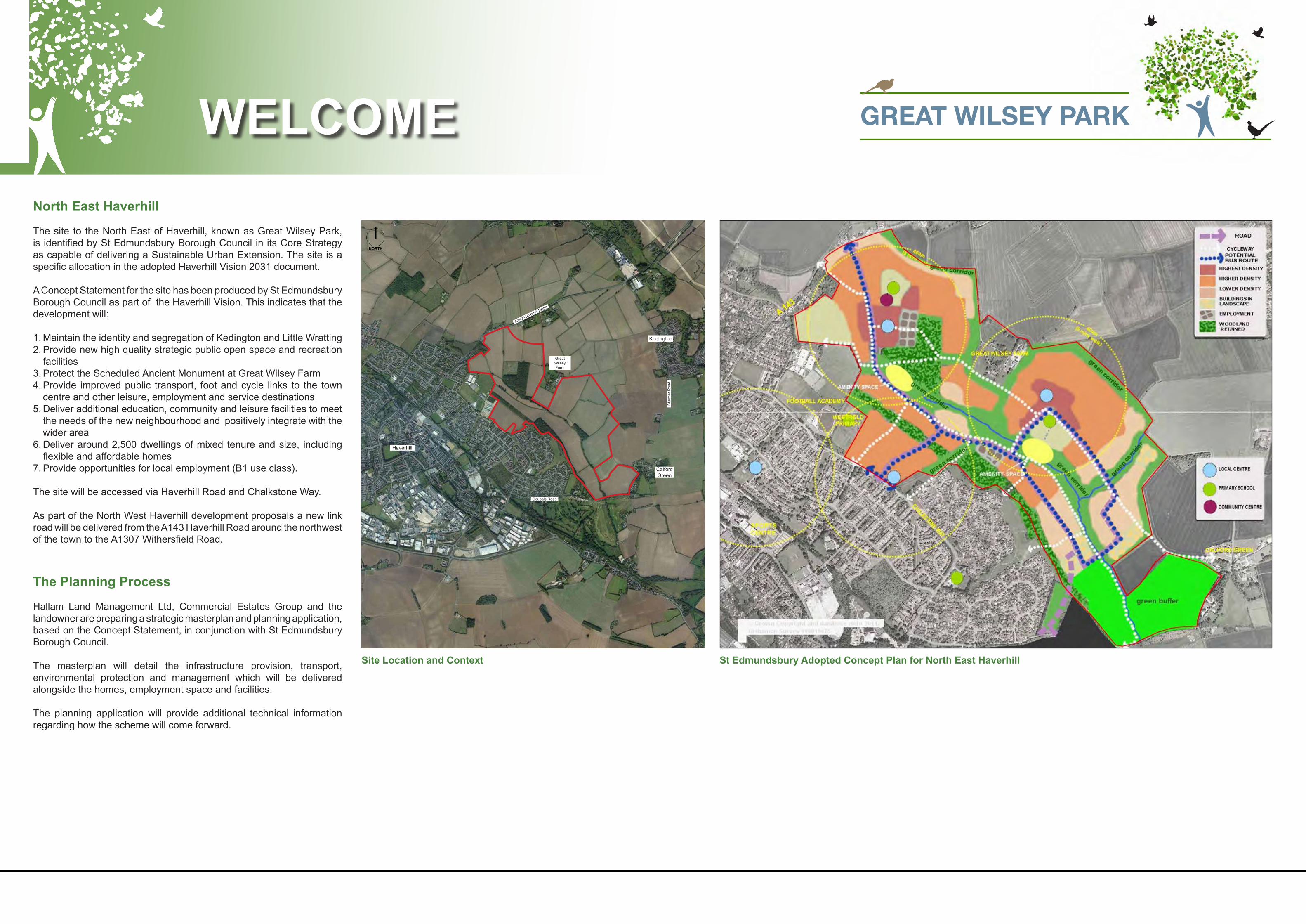
GREAT WILSEY PARK North East Haverhill The site to the North East of Haverhill, known as Great Wilsey Park, is identified by St Edmundsbury Borough Council in its Core Strategy as capable of delivering a Sustainable Urban Extension. The site is a specific allocation in the adopted Haverhill Vision 2031 document. A Concept Statement for the site has been produced by St Edmundsbury Borough Council as part of the Haverhill Vision. This indicates that the development will: 1. Maintain the identity and segregation of Kedington and Little Wratting 2. Provide new high quality strategic public open space and recreation facilities 3. Protect the Scheduled Ancient Monument at Great Wilsey Farm 4. Provide improved public transport, foot and cycle links to the town centre and other leisure, employment and service destinations 5. Deliver additional education, community and leisure facilities to meet the needs of the new neighbourhood and positively integrate with the wider area 6. Deliver around 2,500 dwellings of mixed tenure and size, including flexible and affordable homes 7. Provide opportunities for local employment (B1 use class). The site will be accessed via Haverhill Road and Chalkstone Way. As part of the North West Haverhill development proposals a new link road will be delivered from the A143 Haverhill Road around the northwest of the town to the A1307 Withersfield Road. The Planning Process Hallam Land Management Ltd, Commercial Estates Group and the landowner are preparing a strategic masterplan and planning application, based on the Concept Statement, in conjunction with St Edmundsbury Borough Council. The masterplan will detail the infrastructure provision, transport, environmental protection and management which will be delivered alongside the homes, employment space and facilities. The planning application will provide additional technical information regarding how the scheme will come forward. WELCOME St Edmundsbury Adopted Concept Plan for North East Haverhill Site Location and Context Haverhill Kedington Calford Green A143 Haverhill Road Sturmer Road Coupals Road Great Wilsey Farm NORTH

Welcome message from author
This document is posted to help you gain knowledge. Please leave a comment to let me know what you think about it! Share it to your friends and learn new things together.
Transcript
GREAT WILSEY PARK
GREAT WILSEY PARK
GREAT WILSEY PARK
GREAT WILSEY PARK
North East Haverhill
The site to the North East of Haverhill, known as Great Wilsey Park, is identified by St Edmundsbury Borough Council in its Core Strategy as capable of delivering a Sustainable Urban Extension. The site is a specific allocation in the adopted Haverhill Vision 2031 document.
A Concept Statement for the site has been produced by St EdmundsburyBorough Council as part of the Haverhill Vision. This indicates that the development will:
1. Maintain the identity and segregation of Kedington and Little Wratting2. Provide new high quality strategic public open space and recreation
facilities3. Protect the Scheduled Ancient Monument at Great Wilsey Farm4. Provide improved public transport, foot and cycle links to the town
centre and other leisure, employment and service destinations5. Deliver additional education, community and leisure facilities to meet
the needs of the new neighbourhood and positively integrate with the wider area
6. Deliver around 2,500 dwellings of mixed tenure and size, including flexible and affordable homes
7. Provide opportunities for local employment (B1 use class).
The site will be accessed via Haverhill Road and Chalkstone Way.
As part of the North West Haverhill development proposals a new link road will be delivered from the A143 Haverhill Road around the northwest of the town to the A1307 Withersfield Road.
The Planning Process
Hallam Land Management Ltd, Commercial Estates Group and the landowner are preparing a strategic masterplan and planning application, based on the Concept Statement, in conjunction with St Edmundsbury Borough Council.
The masterplan will detail the infrastructure provision, transport, environmental protection and management which will be delivered alongside the homes, employment space and facilities.
The planning application will provide additional technical information regarding how the scheme will come forward.
WELCOME
St Edmundsbury Adopted Concept Plan for North East HaverhillSite Location and Context
Haverhill
Kedington
Calford Green
A143 Haverhill Road
Stu
rmer
Roa
d
Coupals Road
Great Wilsey Farm
NORTH

GREAT WILSEY PARK
GREAT WILSEY PARK
The Consultation Process
The diagram below explains the consultation process which has been undertaken by St Edmundsbury Borough Council since 2007. This has included stakeholder workshops and public exhibitions at each stage of the process. The developers and landowner are now consulting on the Masterplan and forthcoming planning application for Great Wilsey Park.
Stakeholder Engagement
Meetings have been held over the last five months with: • Haverhill Town Council.• Kedington Parish Council.• Little Wratting Parish.• Sturmer Parish Council.• Suffolk County Council and St Edmundsbury Borough Council.• Haverhill Chamber of Commerce.• Local doctors surgeries and the Clinical Commissioning Group.• Samuel Ward Academy.• Friends of East Town Park.• Haverhill Football Club.• Haverhill Golf Club.• Local resident representatives from Haverhill and Calford Green.
Key Findings
CONSULTATION
THEMES COMMENTS HOW COMMENTS HAVE BEEN REFLECTED IN THE EMERGING MASTERPLAN
Housing • Full mix - include executive, family, affordable and homes for the elderly.
• Character/architecture is important.
The proposals contain a full mix and can be seen within the masterplan.
Transport • No access from Coupals Lane.• Public transport improvements.• New relief road.• Retain and enhance footpaths and cycleways.
No through access is now proposed from Coupals Road. Access to a small car park for users of the Country Park will be possible.
Access to the site is from Haverhill Road and Chalkstone Way. A bus service will be provided on all or part of the primary route.
The North West Relief Road will be delivered as part of the adjacent development to the west of Great Wilsey Park.
Transport assessments confirm the improvements are required to Haverhill’s highway network to ensure that new homes at Great Wilsey Park can be accommodated.
Existing public rights of way will be retained and enhanced with new surfacing, signage and seating. New routes will also be provided.
Community • Health Centre provision.• Education provision.• Local shops and facilities within walking
distance of Chalkstone Way and new residents.
• Social centre/community centre.
Two local centres will be provided as part of the development and both will include primary schools, convenience shopping and other local services.
Employment • Need to create new local jobs.• Need to boost the local economy.• Benefit the high street.
Around 370 new jobs will be created in the healthcare facility, schools, local shops and business space on the site.
New residents will help boost the town centre bringing some £45 million per annum of new spend into the local economy.
Drainage • Flooding in Sturmer.• Sewage upgrades required.
The existing tributary to the River Stour that flows through the site will be protected and enhanced. A sustainable drainage system will be incorporated into the scheme to ensure that surface water run-off is dealt with effectively.
Environment • Country Park.• Buffer Planting.• Retain existing trees/hedgerows where
possible.• No development past ridge line to protect
views.• Stream and wood as a landscape/recreation
corridor.
High quality green infrastructure is essential to Great Wilsey Park. The existing landscape of woodland, hedgerows and trees will be enhanced with new woodland tree and hedgerow planting. Community allotments will also be provided along with areas of parkland, conservation grassland and wetland habitats.
Core Strategy
2007 - December 2010
Concept Strategy
2011 - May 2013
Haverhill Vision 2031
2011 - September 2014
Masterplan for Great Wilsey Park
Current - July 2015
Planning Application
Current to August 2015
GREAT WILSEY PARK
GREAT WILSEY PARK
GREAT WILSEY PARK
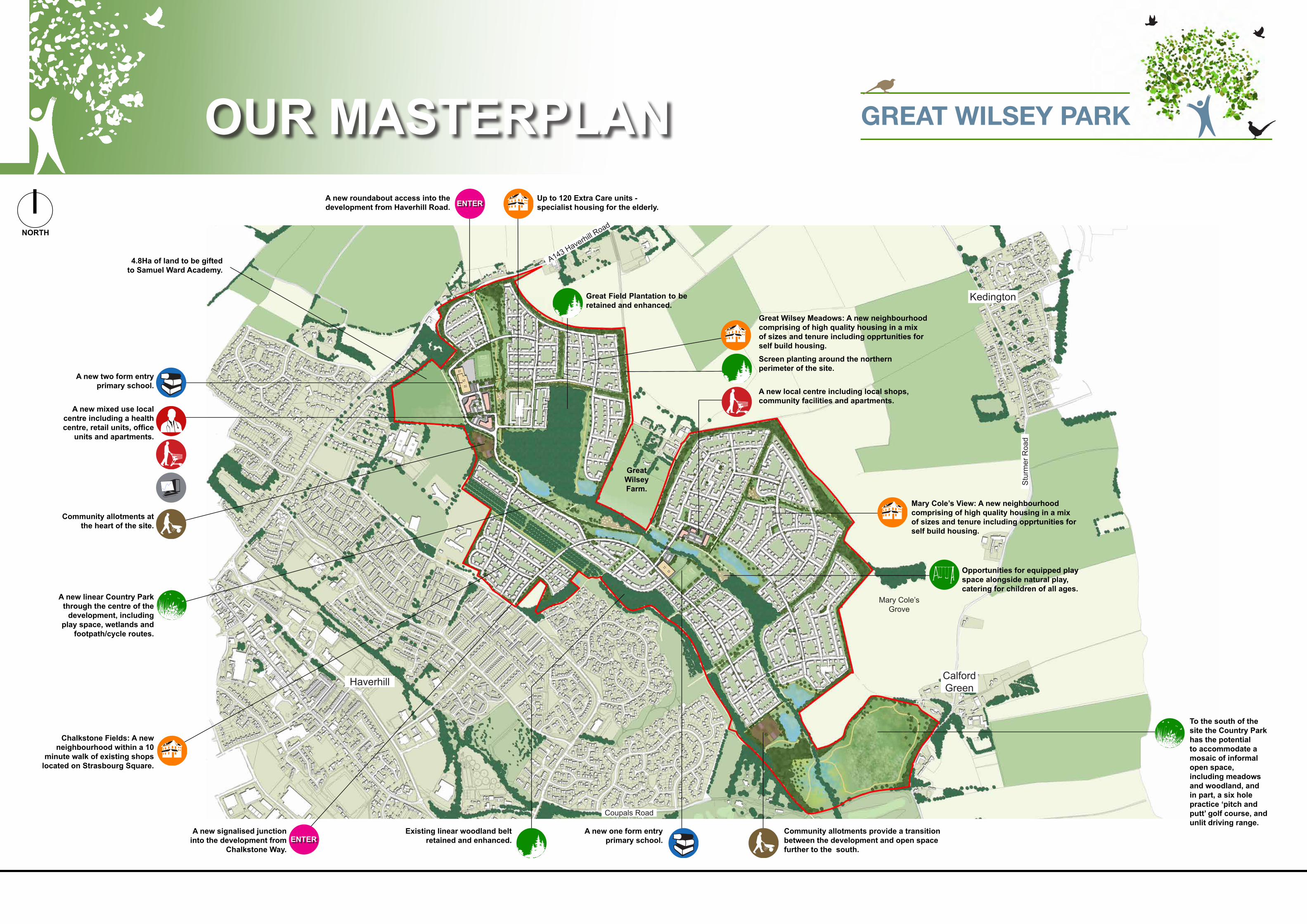
GREAT WILSEY PARKOUR MASTERPLAN
To the south of the site the Country Park has the potential to accommodate a mosaic of informal open space, including meadows and woodland, and in part, a six hole practice ‘pitch and putt’ golf course, and unlit driving range.
A new signalised junction into the development from
Chalkstone Way.
Chalkstone Fields: A new neighbourhood within a 10
minute walk of existing shops located on Strasbourg Square.
Great Wilsey Farm.
A new roundabout access into the development from Haverhill Road.
A new linear Country Park through the centre of the
development, including play space, wetlands and
footpath/cycle routes.
Community allotments at the heart of the site.
Community allotments provide a transition between the development and open space further to the south.
Existing linear woodland belt retained and enhanced.
Screen planting around the northern perimeter of the site.
A new one form entry primary school.
A new local centre including local shops, community facilities and apartments.
A new mixed use local centre including a health centre, retail units, office
units and apartments.
A new two form entry primary school.
4.8Ha of land to be gifted to Samuel Ward Academy.
NORTH
Great Field Plantation to be retained and enhanced.
Up to 120 Extra Care units - specialist housing for the elderly.
Mary Cole’s View: A new neighbourhood comprising of high quality housing in a mix of sizes and tenure including opprtunities for self build housing.
Great Wilsey Meadows: A new neighbourhood comprising of high quality housing in a mix of sizes and tenure including opprtunities for self build housing.
Opportunities for equipped play space alongside natural play, catering for children of all ages.
ENTER
ENTER
Haverhill
Kedington
Calford Green
A143 Haverhill Road
Stu
rmer
Roa
d
Coupals Road
Mary Cole’s Grove

GREAT WILSEY PARK
GREAT WILSEY PARK
Green Infrastructure
The landscape strategy will:
• Deliver Green Infrastructure into the heart of the development. A new ‘Green Spine’ / Country Park forms a ‘backbone’ through the development and provides links between Haverhill Road and Coupals Road, social space and opportunities habitat creation.
• Provide a range of open space (size and type) for informal recreation.• Retain and extend existing Public Rights of Way.• Soften and screen the development.• Provide tree lined roads along primary routes and incidental open spaces, small greens and public
squares.• Provide attractive entrances at Haverhill Road and Chalkstone Way.• Provide space for children’s play which is safe, accessible and engaging for all ages.• Provide allotment plots.• Create areas of new native woodland, meadow grassland, ponds and wetlands.
Around 80 hectares of green space are proposed within the development, comprising of a Country Park, linear Greenways, and structural woodland belts. The landscape strategy will include play areas, landscaped and ecological areas, formal recreation facilities etc. What uses would you like to see in the Country Park?
Drainage
The existing tributary of the River Stour that flows through the site will be protected and enhanced with targeted clearance and additional habitat creation.
Surface water will not be permitted to flow directly into this watercourse and must first be attenuated and its outflow regulated to a discharge rate agreed with the Environment Agency. As a consequence a Sustainable Drainage System (SuDS) is proposed. This system will comprise of a series of attenuation basins interconnected by swales. Attenuation basins will be designed to sit sensitively within the landscape and will feature wetland areas for habitat creation and biodiversity enhancement.
The site’s existing hedgerow network will form the basis of new linear green corridors along which new swales may be routed.
Ecology
Existing hedgerows, hedgerow trees, woodland, ditches and the watercourse will where practicable be protected and enhanced through active management alongside additional planting and habitat creation. The development seeks to balance site wide bio-diversity enhancements with public access and enjoyment of external spaces.
A landscape and environmental management plan will be required to ensure the long term management of habitats is fully considered.
Trees
Where practicable existing trees across the site will be retained within the site’s Green Infrastructure, and will be complemented by additional new planting.
Are there any particular trees that you would like to see planted on the site as part of the development?Option 1 - Habitat Creation and Space for Informal Recreation
A Linear Country Park, Greenways and Structural Planting
Option 2 - Habitat Creation, Space for Informal Recreation, A 250yrd golf driving range (unlit), a cafe with car parking and a Six Hole Practice ‘Pitch and Putt’ Course.
GREEN INFRASTRUCTURE
Access from Coupals Road to car park only - no through road to wider development
Community cafe and driving range club house - with associated car parking. Access from Coupals Road. Access from Coupals Road to car park only - no through road to wider development
Meadow Meadow
Area for natural regeneration
Area for natural regeneration
Marsh / wetland
Scrub
Informal footpath circuit for recreation
Screen planting
Structural planting
Structural planting
Existing woodland within the site retained and enhanced
Land gifted to the Samuel Ward Academy
Linear Country Park through the centre of the site, linking Haverhill Road with Coupals Road.
Existing hedgerows retained - new green links routed along hedgerows to include linear swales, footpath links and play space
Screen planting
Informal footpath circuit for recreation
Footpath link to existing Public
Right of Way
250yrd unlit golf driving range and Six
hole practice ‘Pitch and Putt’ golf course
Footpath link to existing Public Right of Way
Footpath link to existing Public Right of Way
Proposed community allotments within the heart of
the development
Existing woodland retained and enhanced
The Country Park through the centre of the site includes
ponds to attenuate surface water before discharging back
to the River Stour Tributary.

GREAT WILSEY PARK
GREAT WILSEY PARK
GREAT WILSEY PARK
GREAT WILSEY PARK
Access and Circulation
Site Access
• Various options have been explored and tested.• Two points of access will be delivered from Haverhill Road and
Chalkstone Way.• Haverhill Road will comprise of a roundabout.• Chalkstone Way will be a signalised crossroads.
Circulation
• A Main Street or Primary Street will link Haverhill Road with Chalkstone Way, connecting the two proposed local centres and schools.
• Secondary and Tertiary roads filter down from the primary street providing links to each neighbourhood area.
Pedestrians and Cyclists
• A high quality network of walking and cycling routes will be provided through the site.
• Existing Public Rights of Way retained along original alignment and enhanced with new surfacing and signage. These routes will be safe and attractive for pedestrians and cyclists.
Public Transport
• There are a number of bus services that operate within Haverhill. • We are in discussions with the local operators to identify any
necessary improvements to these routes.• We propose a new bus link between Haverhill Road and
Chalkestone Way via an internal loop.
Travel Planning
• A Green Travel Plan is being prepared so that future residents are encouraged to reduce car use and walk, cycle and use public transport.
• This could include car clubs, a car share database, subsidised bus passes, and personalised travel planning.
TRANSPORT
Screening woodland beltExisting speed limit 30mphFootway to be extended to link into existing footway alongside the Fox Public House
Existing homes
Existing homes Proposed homes Access into the development
35m ICD Roundabout
Service route turning head for refuse
vehicles
Track and accesses to residences to be connected to new junction via a
new service road
Proposed new homesPedestrian crossings
2 number pelican crossings to enable safe access to the site
Access into development
Proposed new public open space
Proposed new public open space
90m Stopping Sight Distance
Junction Intervisibility
215m Stopping Sight Distance
Highway Boundary
Great
Wils
ey P
ark B
ound
ary
Haverhill Road
Chalkstone Way
Ganne
t Clos
e
2.4m x 90m junction Vis
2.4m x 90m junction Vis
Proposed Access off Haverhill Road - Roundabout Proposed Site Circulation
Proposed Access off Chalkstone Way - Signalised Junction
Haverhill
Kedington
Calford Green
A143 Haverhill Road
Stur
mer
Roa
d
Coupals Road
Great Field Plantation
Mary Cole’s Grove
Great Wilsey Farm
Existing Public Rights of Way
Proposed Public Rights of Way within the site
Potential connections beyond the site boundary
Primary Street and bus route Pedestrian / Cyclist CirculationVehicular Circulation
Secondary Street
Tertiary Street

GREAT WILSEY PARK
GREAT WILSEY PARK
Sustainability
• This scheme will be well connected, inclusive and designed to the highest standards.• Social spaces will promote health and well-being. Walking, cycling and public transport will be
encouraged.• At least 10% of the energy needs to be met from on-site renewable energy sources.• An energy strategy will be created, this will also seek to reduce demand for energy and promote
energy efficiency through passive design and minimising water consumption.• Sustainable drainage, recycling and composting provision and green roofs are also being considered.• Environmental considerations in terms of materials, suppliers and systems will be considered.
Community
• Two local centres are proposed within five to 10 minutes’ walk of all of the new homes.• Each has a primary school, to create a ‘community hub’ at the heart of each neighbourhood.• The local centres will promote activity and have been designed to link to the ‘Green Spine’.• They will be pedestrian friendly, with public transport access and adequate parking.• The scheme is designed to also support the existing local centre on Strasbourg Square Road.• At least three play areas will cater for children of all ages, designed to enhance security.• Two community allotment sites are proposed.• Public art will be included to create character and distinctiveness.
Economy
2,500 new homes can deliver the following:
• In excess of £300m construction programme.• Approximately 400 construction jobs, including apprenticeships.• 370 permanent jobs in the business space, retail, healthcare and education on site.• Around £68m expenditure per annum from new residents – helping to support the local economy.
SUSTAINABILITYCOMMUNITY and ECONOMY
Local Centre
Primary School
COUNTRY PARK
Mixed Use Local Centre
• Shops• Community
Facilities
Apartments
Local centre will create job opportunities and provide a place for community groups to meet.
Parking within the local centre will include capacity for residents with limited mobility to access the broader
range of facilities across. the Community Heart and within the Green Spine
Play areas will be positioned within the Community Heart to further increase the diversity of facilities within the Green Spine / Country Park.
Sports facilities within the school will be made available for the use of the wider community outside of school hours.
The Green Spine passes through the Community Heart to provide car-free access to the facilities for all
residents.
Community at the Heart of the Development

GREAT WILSEY PARK
GREAT WILSEY PARK
GREAT WILSEY PARK
GREAT WILSEY PARK
The Masterplan and Subsequent Planning Application
Later this year, after the Great Wilsey Park Masterplan has been submitted to St Edmundsbury Borough Council, we will submit an outline planning application, including the details of the two access points from Haverhill Road and Chalkstone Way. The planning application is proposed to include the following:
• Planning Statement.• Design & Access Statement.• Statement of Community Involvement.• Draft Section 106 Heads of Terms.• Site Waste Management Plan.• Transport Assessment & Travel Plan.• Sustainability Assessment.• Land Contamination Assessment.• Environmental Statement (to include the following assessments):
• Society and Economy.• Transport.• Noise and Vibration.• Ecology.• Agricultural Resources.• Surface Water Drainage and Flood Risk.• Local Air Quality.• Archaeology.• Cultural Heritage.• Landscape and Visual Amenity.
Phasing
Some preliminary work has been completed on the phasing of the proposed scheme which demonstrates that the implementation of Great Wilsey Park could be effectively managed over a period of time to provide a flexible and responsive supply of development land and the timely delivery of site infrastructure. The site falls within a single ownership and the landowner has committed to make land available for development now in order to meet current demand.
Following the grant of planning permission, preliminary drainage work will be undertaken, after which 3 strategic phases are anticipated with around 10 sub phases (as indicated). The development is likely to take approximately 9 - 10 years to complete from the grant of planning permission, assuming 2 to 3 contractors will be active on site in any given year.
The first strategic phase seeks to ensure a primary link between Haverhill Road and Chalkstone Way as well as the delivery of a local centre, school, health centre and employment space. New woodland planting will also be undertaken along the northern boundary, alongside preliminary woodland planting along the north-east and eastern boundaries prior to the commencement of Phase 2.
The second strategic phase seeks to ensure the delivery of a second community hub (local centre and school).
The third strategic phase completes the development and enables pedestrian and cycle linkages between Haverhill Road and Coupals Road.
THE APPLICATION
Great Wilsey Park Phase 1a - 1d Phase 2a - 2d Primary circulation and bus routePhase 3a - 3b
Kedington
Calford Green
Great Field Plantation
Great Wilsey Farm
A143 Haverhill Road
Stur
mer
Roa
d
Phase 1C
Phase 1D
Phase 1A
Phase 2A
Phase 2B
Phase 2C
Phase 3A
Phase 3B
Phase 2D
School - Phase 2D
Phase 1B
Haverhill
Great Field Plantation
Mary Cole’s Grove
Coupals Road
NORTH
Phase 1D

GREAT WILSEY PARK
GREAT WILSEY PARK
Timescales and Next Steps
Have Your Say!Please take the opportunity to review the exhibition and discuss with the team. We welcome your views on the proposals and will take these into account when revising the masterplan for submission and the planning application.
There are a number of ways to have your say:
• Complete the comment form today and leave it with the team. • Take the form away to complete and post back to:
Victoria Walker, Beattie Communications, 4 Church Walk, Leeds, LS2 7EG
• e-mail comments to: [email protected]
• Comment via our website: www.greatwilseypark.co.uk
All comments need to be submitted by the 19th June 2015 to ensure that they can be given full consideration before the masterplan and planning application are submitted.
What Happens Next?
We will review your comments and take these into account when finalising the submissions over the coming weeks.
Once the planning application has been submitted you will have another opportunity to make comments direct to the Council for their consideration as part of the planning application process.
North East Haverhill - The Vision
Development at Great Wilsey Park will deliver a comprehensive, inclusive and sustainable, mixed use urban extension to the North East of Haverhill. It will:
• Include a full mix of high quality homes, employment, new facilities and services• Maximise accessibility, including walking, cycling and a dedicated bus service.• Integrate into Haverhill and the wider countryside.• Protect the character of the area - robustly screening proposed development
and residents within Haverhill, Little Wratting and Calford Green. • Protect and enhance landscape character and visual amenity, connectivity and
biodiversity.• Create a new linear Country Park running north to south with natural play,
informal recreation, Sustainable Drainage (SuDS) and allotments.• Demonstrate quality urban design, sustainable construction and use of renewable
energy.• Embrace ‘Garden Suburb’ principles with well connected and biodiverse public
parks, high quality gardens, tree lined streets and open spaces, with opportunities to grow food and for community management of open spaces.
NEXT STEPS
Related Documents