Weeks 31– 36 Correlated to National Geography Standards Evan-Moor ® • 36 weekly lessons, each including: - teacher resource page - geography vocabulary - reproducible map - two questions per day - challenge question - answer key • Includes access to 36 downloadable maps GRADE Grade 5 5 EMC 3714

Welcome message from author
This document is posted to help you gain knowledge. Please leave a comment to let me know what you think about it! Share it to your friends and learn new things together.
Transcript
Weeks 31– 36
Correlated to National Geography Standards
Evan-Moor®
• 36 weekly lessons, each including: - teacher resource page - geography vocabulary - reproducible map - two questions per day - challenge question - answer key
• Includes access to 36 downloadable maps
GRADEGrade 5
5EMC 3714
Helping Children LearnEvan-Moor®
Evan-Moor products are available at � ne teacher supply stores and
at www.evan-moor.com.
About Evan-Moor Educational Publishers
Our mission is helping children learn.
Founded by teachers, we understand the challenges and joys of teaching. We strive to assist teachers and parents by providing resources that motivate children to learn.
We haven’t done this alone. We appreciate our partnerships with teachers and parents in over 90 countries that nurture the education of millions of children!
Develop students’ geography literacyas they explore the world
The 7 Continents, Grades 4–6This engaging series introduces students to essential elements of geography while they explore the unique characteristics of the world’s continents.
• Helps students learn the location, political
divisions, physical features, valuable resources,
and culture of each of the seven continents
• Provides a great resource to integrate content-
area reading into your curriculum
• Based on National Geography Standards
The 7 ContinentsPurchase individually or as a set!
North America EMC 3731South America EMC 3732Australia and Oceania EMC 3733Asia EMC 3734Europe EMC 3735Antarctica EMC 3736Africa EMC 3737
All titles - Easy-order set EMC 3738
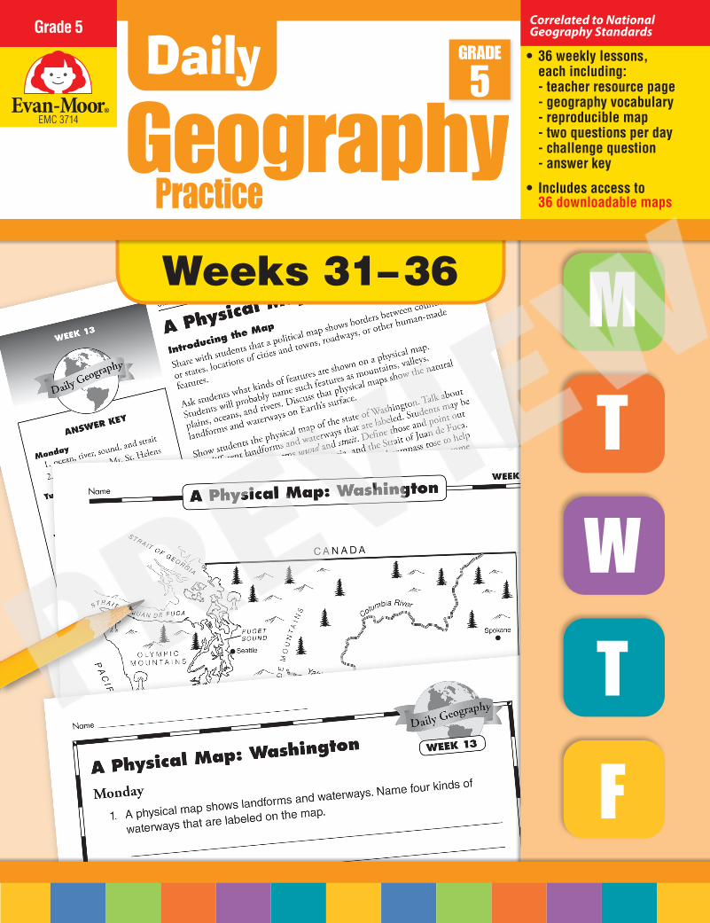
Student Practice Books Interactive Lessons
• Save time and money on photocopying
• Make it easy to assign classwork and homework
• Provide an organized portfolio of student work
Students move through a variety of interactive activities as they explore 36 maps.
• Self-correcting lessons
• Each map has interactive “pins” with activities or information about that location
Try interactive lessons for FREE! www.evan-moor.com/dgcw
Daily Geography Practice is correlated to National Geography Standards. Find correlations for this book at www.teaching-standards.com.
Daily Geography PracticeYou May Also Like
Free Downloadable Resources with This Book
Correlations
Teacher’s edition is also available as an e-book!
Writing: Sandi Johnson Editor: Chryl Light Copy Editing: Sonny Bennett Cathy Harber Illustrators: Carlos Avalone Alex Cruz Jim Palmer Designers: Alex Cruz Cheryl Puckett Desktop: Kristen Calcatera Cover: Cheryl Puckett
Helping Children LearnEvan-Moor®
Congratulations on your purchase of some of the finest teaching materials in the world.
Photocopying the pages in this book is permitted for single-classroom use only. Making photocopies for additional classes
or schools is prohibited.
For information about other Evan-Moor products, call 1-800-777-4362, fax 1-800-777-4332, or visit our website, www.evan-moor.com.
Entire contents © 2013 EVAN-MOOR CORP. 18 Lower Ragsdale Drive, Monterey, CA 93940-5746. Printed in USA.
Visit teaching-standards.com
to view a correlation of this book.
This is a free service.
Correlated to National Geography Standards
EMC 3714
The 36 maps found in Daily Geography Practice can be downloaded from our website to project and use in your classroom.
To access the maps:
1. Go to www.evan-moor.com/resources 2. Enter your email address and the resource code for
this product: EMC3714
CPSIA: Printed by McNaughton & Gunn, Saline, MI USA. [4/2019] 002
3710-15cvr.indd 31-33 3/26/19 2:43 PM
2 Daily Geography Practice • EMC 3714 • © Evan-Moor Corp.
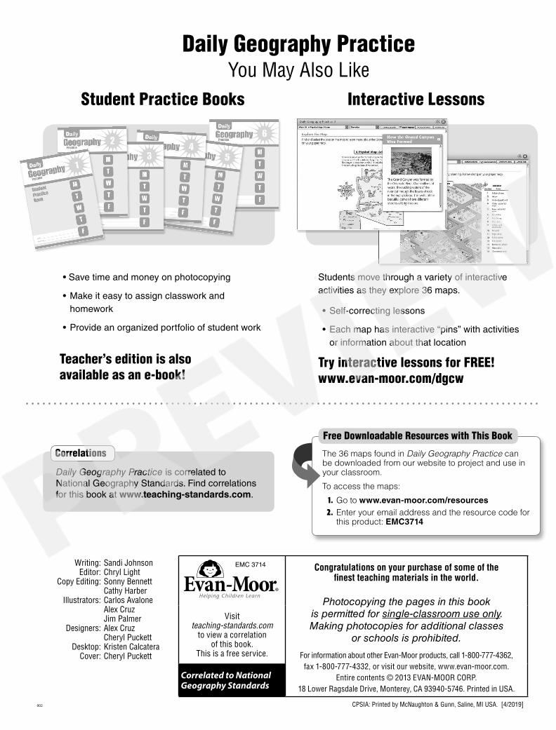
About Daily Geography PracticeDaily Geography Practice is based on the eighteen National Geography Standards and is designed to support any geography and social studies curriculums that you may be using in your classroom.
36 Weekly Sections
Teacher Page
Please note that the skills in this book should be taught in direct instruction, and not used as independent practice. Teachers are encouraged to use other reference maps and globes to aid in instruction. Most of the questions can be answered by studying the map or globe. There are some questions, however, that specifically relate to the lesson given by the teacher at the beginning of the week. Review daily the information presented in “Introducing the Map.”
Map PageA map illustrates the geography skills emphasized during the week. Use the map to aid in whole-class instruction, or reproduce a copy for each student to use as a reference for the questions.
•Thenationalgeographyelement, standard, and skill are included.
•Backgroundinformationhelps the teacher introduce the geography skill.
•Vocabularywordsanddefinitions are given.
•Ananswerkeyfortheweek is included for easy reference.
3714Book.indb 2 11/6/12 10:20 AM
© Evan-Moor Corp. • EMC 3714 • Daily Geography Practice 3
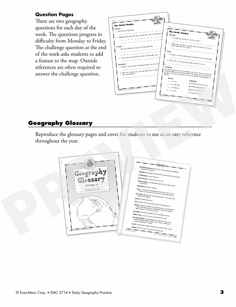
Question PagesThere are two geography questions for each day of the week. The questions progress in difficulty from Monday to Friday. The challenge question at the end of the week asks students to add a feature to the map. Outside references are often required to answer the challenge question.
Geography Glossary
Reproduce the glossary pages and cover for students to use as an easy reference throughout the year.
3714Book.indb 3 11/6/12 10:20 AM
4 Daily Geography Practice • EMC 3714 • © Evan-Moor Corp.
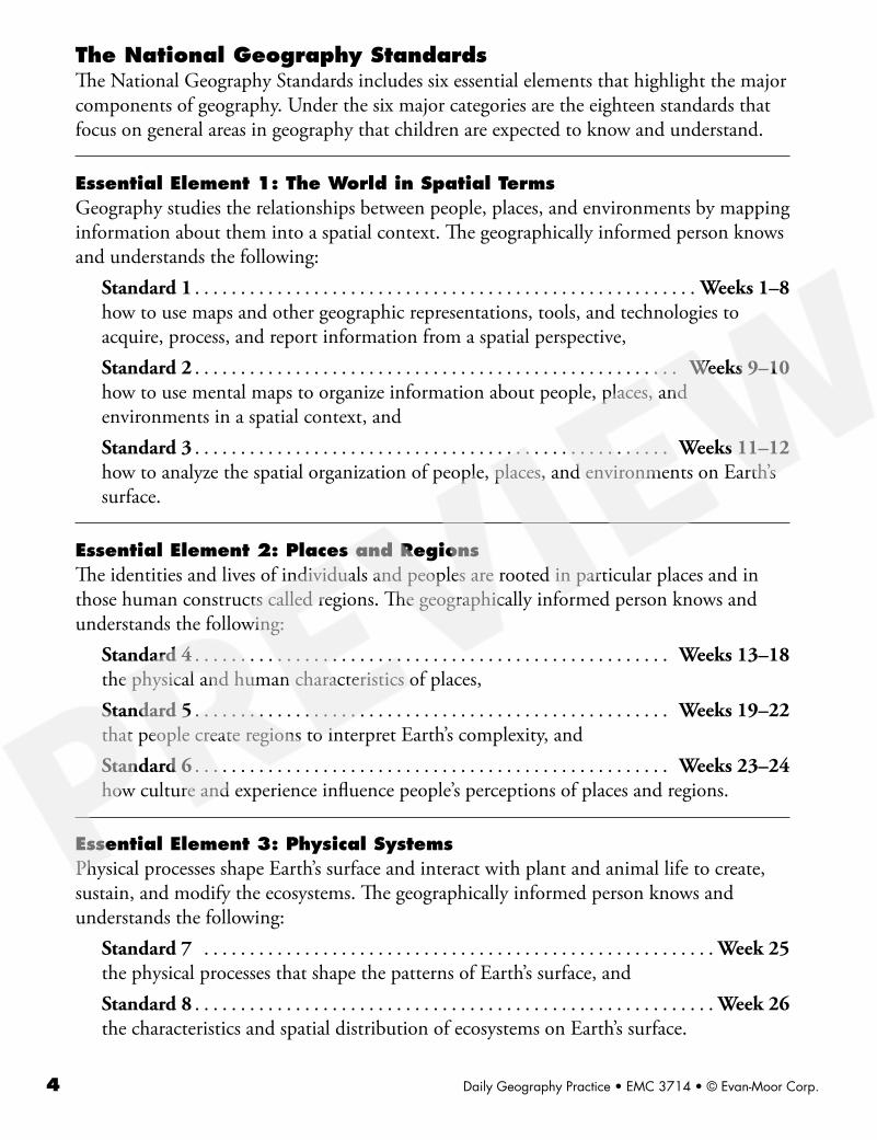
The National Geography StandardsThe National Geography Standards includes six essential elements that highlight the major components of geography. Under the six major categories are the eighteen standards that focus on general areas in geography that children are expected to know and understand.
Essential Element 1: The World in Spatial TermsGeography studies the relationships between people, places, and environments by mapping information about them into a spatial context. The geographically informed person knows and understands the following:
Standard 1 . . . . . . . . . . . . . . . . . . . . . . . . . . . . . . . . . . . . . . . . . . . . . . . . . . . . . . . Weeks 1–8how to use maps and other geographic representations, tools, and technologies to acquire, process, and report information from a spatial perspective,Standard 2 . . . . . . . . . . . . . . . . . . . . . . . . . . . . . . . . . . . . . . . . . . . . . . . . . . . . . Weeks 9–10how to use mental maps to organize information about people, places, and environments in a spatial context, andStandard 3 . . . . . . . . . . . . . . . . . . . . . . . . . . . . . . . . . . . . . . . . . . . . . . . . . . . . Weeks 11–12how to analyze the spatial organization of people, places, and environments on Earth’s surface.
Essential Element 2: Places and RegionsThe identities and lives of individuals and peoples are rooted in particular places and in those human constructs called regions. The geographically informed person knows and understands the following:
Standard 4 . . . . . . . . . . . . . . . . . . . . . . . . . . . . . . . . . . . . . . . . . . . . . . . . . . . . Weeks 13–18the physical and human characteristics of places,Standard 5 . . . . . . . . . . . . . . . . . . . . . . . . . . . . . . . . . . . . . . . . . . . . . . . . . . . . Weeks 19–22that people create regions to interpret Earth’s complexity, andStandard 6 . . . . . . . . . . . . . . . . . . . . . . . . . . . . . . . . . . . . . . . . . . . . . . . . . . . . Weeks 23–24how culture and experience influence people’s perceptions of places and regions.
Essential Element 3: Physical SystemsPhysical processes shape Earth’s surface and interact with plant and animal life to create, sustain, and modify the ecosystems. The geographically informed person knows and understands the following:
Standard 7 . . . . . . . . . . . . . . . . . . . . . . . . . . . . . . . . . . . . . . . . . . . . . . . . . . . . . . . . Week 25the physical processes that shape the patterns of Earth’s surface, andStandard 8 . . . . . . . . . . . . . . . . . . . . . . . . . . . . . . . . . . . . . . . . . . . . . . . . . . . . . . . . . Week 26the characteristics and spatial distribution of ecosystems on Earth’s surface.
3714Book.indb 4 11/6/12 10:20 AM
© Evan-Moor Corp. • EMC 3714 • Daily Geography Practice 5
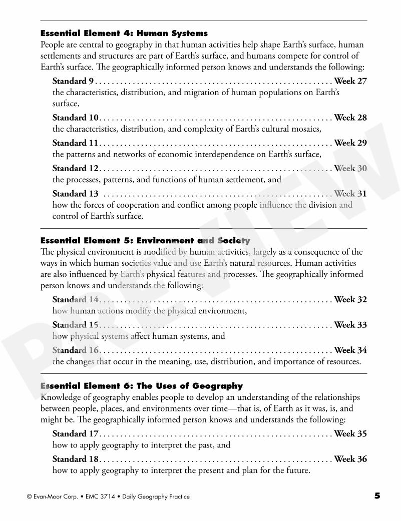
Essential Element 4: Human SystemsPeople are central to geography in that human activities help shape Earth’s surface, human settlements and structures are part of Earth’s surface, and humans compete for control of Earth’s surface. The geographically informed person knows and understands the following:
Standard 9 . . . . . . . . . . . . . . . . . . . . . . . . . . . . . . . . . . . . . . . . . . . . . . . . . . . . . . . . . Week 27the characteristics, distribution, and migration of human populations on Earth’s surface,Standard 10 . . . . . . . . . . . . . . . . . . . . . . . . . . . . . . . . . . . . . . . . . . . . . . . . . . . . . . . . Week 28the characteristics, distribution, and complexity of Earth’s cultural mosaics,Standard 11 . . . . . . . . . . . . . . . . . . . . . . . . . . . . . . . . . . . . . . . . . . . . . . . . . . . . . . . . Week 29the patterns and networks of economic interdependence on Earth’s surface,Standard 12 . . . . . . . . . . . . . . . . . . . . . . . . . . . . . . . . . . . . . . . . . . . . . . . . . . . . . . . . Week 30the processes, patterns, and functions of human settlement, andStandard 13 . . . . . . . . . . . . . . . . . . . . . . . . . . . . . . . . . . . . . . . . . . . . . . . . . . . . . . . Week 31how the forces of cooperation and conflict among people influence the division and control of Earth’s surface.
Essential Element 5: Environment and SocietyThe physical environment is modified by human activities, largely as a consequence of the ways in which human societies value and use Earth’s natural resources. Human activities are also influenced by Earth’s physical features and processes. The geographically informed person knows and understands the following:
Standard 14 . . . . . . . . . . . . . . . . . . . . . . . . . . . . . . . . . . . . . . . . . . . . . . . . . . . . . . . . Week 32how human actions modify the physical environment,Standard 15 . . . . . . . . . . . . . . . . . . . . . . . . . . . . . . . . . . . . . . . . . . . . . . . . . . . . . . . . Week 33how physical systems affect human systems, andStandard 16 . . . . . . . . . . . . . . . . . . . . . . . . . . . . . . . . . . . . . . . . . . . . . . . . . . . . . . . . Week 34the changes that occur in the meaning, use, distribution, and importance of resources.
Essential Element 6: The Uses of GeographyKnowledge of geography enables people to develop an understanding of the relationships between people, places, and environments over time—that is, of Earth as it was, is, and might be. The geographically informed person knows and understands the following:
Standard 17 . . . . . . . . . . . . . . . . . . . . . . . . . . . . . . . . . . . . . . . . . . . . . . . . . . . . . . . . Week 35how to apply geography to interpret the past, andStandard 18 . . . . . . . . . . . . . . . . . . . . . . . . . . . . . . . . . . . . . . . . . . . . . . . . . . . . . . . . Week 36how to apply geography to interpret the present and plan for the future.
3714Book.indb 5 11/6/12 10:20 AM
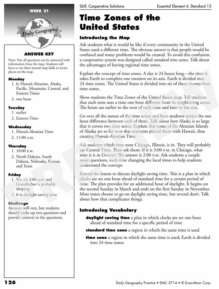
126 Daily Geography Practice • EMC 3714 • © Evan-Moor Corp.
WEEK 31
ANSWER KEYNote: Not all questions can be answered with information from the map. Students will have to use their mental map skills to locate places on the map.
Monday 1. 6; Hawaii-Aleutian, Alaska,
Pacific, Mountain, Central, and Eastern Times
2. one hour
Tuesday 1. earlier 2. Eastern Time
Wednesday 1. Hawaii-Aleutian Time 2. 11:00 a.m.
Thursday 1. 10:00 p.m. 2. North Dakota, South
Dakota, Nebraska, Kansas, and Texas
Friday 1. No, it’s 2:00 a.m. and
Grandfather is probably sleeping.
2. It is daylight saving time.
ChallengeAnswers will vary, but students should make up two questions and provide answers to the questions.
Skill: Cooperative Solutions Essential Element 4: Standard 13
Time Zones of the United StatesIntroducing the Map
Ask students what it would be like if every community in the United States used a different time. The obvious answer is that people would be confused and many problems would be created. To avoid this confusion, a cooperative system was designed called standard time zones. Talk about the advantages of having regional time zones.
Explain the concept of time zones. A day is 24 hours long—the time it takes Earth to complete one rotation on its axis. Earth is divided into 24 time zones. The United States is divided into six of those twenty-four time zones.
Show students the Time Zones of the United States map. Tell students that each zone uses a time one hour different from its neighboring zones. The hours are earlier to the west of each zone and later to the east.
Go over all the names of the time zones and have students notice the one hour difference between each of them. Talk about how Alaska is so large that it covers two time zones. Explain that some of the Aleutian Islands of Alaska are so far west that scientists placed them with Hawaii, thus creating Hawaii-Aleutian Time.
Ask students which time zone Chicago, Illinois, is in. They will probably say Central Time. Then ask them: If it is 3:00 p.m. in Chicago, what time is it in Denver? The answer is 2:00 p.m. Ask students a couple more questions, each time changing the local times to help students understand the concept.
Extend the lesson to discuss daylight saving time. This is a plan in which clocks are set one hour ahead of standard time for a certain period of time. The plan provides for an additional hour of daylight. It begins on the second Sunday in March and ends on the first Sunday in November. Most states choose to go on daylight saving time, but several don’t. Talk about how that complicates things.
Introducing Vocabulary
daylight saving time a plan in which clocks are set one hour ahead of standard time for a specific period of time
standard time zone a region in which the same time is usedtime zone a region in which the same time is used; Earth is divided
into 24 time zones

© Evan-Moor Corp. • EMC 3714 • Daily Geography Practice 127
Day
light
sav
ing
tim
e be
gins
on
the
seco
nd S
unda
y in
Mar
ch a
nd e
nds
on t
he fi
rst
Sund
ay in
Nov
embe
r.
Rem
embe
r th
is t
rick
to
set
your
cl
ocks
one
hou
r ah
ead
in t
he s
prin
g an
d on
e ho
ur b
ack
in t
he f
all:
sp
ring
ahe
ad, f
all b
ack.
Tim
e Z
ones
of
the U
nited S
tate
sN
ame
W
EEK 3
1
12 6
93
12
11 87
54
1012 6
93
12
11 87
54
1012 6
93
12
11 87
54
1012 6
93
12
11 87
54
1012 6
93
12
11 87
54
1012 6
93
12
11 87
54
10
1:0
0 p
.m.
2:0
0 p
.m.
3:0
0 p
.m.
4:0
0 p
.m.
12
:00
p.m
.1
1:0
0 a
.m.
Paci
fic
Ti
me
Haw
aii–
Ale
utia
n Ti
me
Ala
ska
Ti
me
Mou
ntai
n Ti
me
Cent
ral
Tim
eEa
ster
n
Tim
e
Los
Ang
eles
Hon
olul
u
June
auN
ew
York
Chic
ago
Den
ver
Related Documents