4. Overview: Weed data for Aboriginal lands in the NLC area The use of the word Aboriginal Land in this document then is recognised as a non-Aboriginal construct but nevertheless data is presented from that viewpoint. To include weeds from Aboriginal land from an indigenous perspective, including land to which they do not have current legal title, would mean covering all of the lands within the NLC⎯both those lands to which Aboriginal people have recognised title and those lands where Aboriginal interests have effectively been supplanted by non-Aboriginal tenure. There is very little quantitative evidence of unwanted exotic plant species on Aboriginal land 5 . The North Australian Quarantine Service (NAQS) has carried out some qualitative surveys within 20 km of the Northern Territory coastline. While these surveys focused on NAQS hit-list species they also recorded other useful data such as the weed species present and cultivated ornamental and crop plants. This data is extremely useful and makes up the bulk of the reliable weed data that exists on coastal Aboriginal land. Herbarium records are a very useful set of data however it should be recognised that their main focus is on native plants rather than weeds. Unfortunately data from other sources is extremely poor. For example, a limited number of surveys on Aboriginal land carried out by NTDPIF have concentrated mainly on noxious weeds (those listed under The Northern Territory Noxious Weeds Act 1980) and therefore are of limited use in assessing the overall exotic plant status of an area. In most areas weed data is fragmented and is documented poorly or not at all. Most sources of weed data, except the Darwin Herbarium (DNA) database, are not backed by voucher specimens and thus specimen data tends to be outdated and at times suspect in its determination. It is recommended that the NLC make sure any database development is based on International Transfer Formats so data exchange and regular database updates can be made between the DNA Herbarium and the NLC. Recorded in this survey, in some instances, was a deep sense of despair as Aboriginal people could see many problems with weeds on country that currently is not under their control, management or to which they do not have legal title. However, it is still considered to be their own country, from which they have been forcibly alienated. The listing of exotic plant species presented below is not intended to be a complete list of known species on Aboriginal land as no appropriate survey work has been carried out. It is intended however to summarise the existing knowledge we have and highlight the gaps in our knowledge of the distribution of weeds. There is an urgent need to carry out a comprehensive survey for all weeds on all Aboriginal land. 4.1. Naturalised exotics in Australia and the Northern Territory Since European settlement of Australia, exotic plant species have established in Australia at alarming rates. Csurhes and Edwards (1998) report this rate to be around 11 species per year. However, because of the relatively short history of European settlement, Australia is still comparatively weed free. In 1991 about 15% of the total vascular flora are naturalised alien plants (Humphries et. al. 1991). Current estimates are put at around 18% (Storrs and Lonsdale 1995). This is low in comparison to some other countries which have very high percentages of introduced plant species e.g. New Zealand 51%, Britain 32% and Hawaii 40% (see Table 2). The Northern Territory has around 237 species listed as exotic plants. These include all categories of weeds outlined in Section 3.1, some of which are not necessarily naturalised exotics. This represents around 5.6 % of the flora which is the lowest percentage of any state or Territory in Australia (see Table 2). This is probably a result of limited agricultural 5. The terms unwanted exotic plants and weeds will be used interchangeably in this document. 21

Welcome message from author
This document is posted to help you gain knowledge. Please leave a comment to let me know what you think about it! Share it to your friends and learn new things together.
Transcript
4. Overview: Weed data for Aboriginal lands in the NLC area The use of the word Aboriginal Land in this document then is recognised as a non-Aboriginal construct but nevertheless data is presented from that viewpoint. To include weeds from Aboriginal land from an indigenous perspective, including land to which they do not have current legal title, would mean covering all of the lands within the NLC⎯both those lands to which Aboriginal people have recognised title and those lands where Aboriginal interests have effectively been supplanted by non-Aboriginal tenure.
There is very little quantitative evidence of unwanted exotic plant species on Aboriginal land5. The North Australian Quarantine Service (NAQS) has carried out some qualitative surveys within 20 km of the Northern Territory coastline. While these surveys focused on NAQS hit-list species they also recorded other useful data such as the weed species present and cultivated ornamental and crop plants. This data is extremely useful and makes up the bulk of the reliable weed data that exists on coastal Aboriginal land.
Herbarium records are a very useful set of data however it should be recognised that their main focus is on native plants rather than weeds. Unfortunately data from other sources is extremely poor. For example, a limited number of surveys on Aboriginal land carried out by NTDPIF have concentrated mainly on noxious weeds (those listed under The Northern Territory Noxious Weeds Act 1980) and therefore are of limited use in assessing the overall exotic plant status of an area.
In most areas weed data is fragmented and is documented poorly or not at all. Most sources of weed data, except the Darwin Herbarium (DNA) database, are not backed by voucher specimens and thus specimen data tends to be outdated and at times suspect in its determination. It is recommended that the NLC make sure any database development is based on International Transfer Formats so data exchange and regular database updates can be made between the DNA Herbarium and the NLC. Recorded in this survey, in some instances, was a deep sense of despair as Aboriginal people could see many problems with weeds on country that currently is not under their control, management or to which they do not have legal title. However, it is still considered to be their own country, from which they have been forcibly alienated.
The listing of exotic plant species presented below is not intended to be a complete list of known species on Aboriginal land as no appropriate survey work has been carried out. It is intended however to summarise the existing knowledge we have and highlight the gaps in our knowledge of the distribution of weeds. There is an urgent need to carry out a comprehensive survey for all weeds on all Aboriginal land.
4.1. Naturalised exotics in Australia and the Northern Territory Since European settlement of Australia, exotic plant species have established in Australia at alarming rates. Csurhes and Edwards (1998) report this rate to be around 11 species per year. However, because of the relatively short history of European settlement, Australia is still comparatively weed free. In 1991 about 15% of the total vascular flora are naturalised alien plants (Humphries et. al. 1991). Current estimates are put at around 18% (Storrs and Lonsdale 1995). This is low in comparison to some other countries which have very high percentages of introduced plant species e.g. New Zealand 51%, Britain 32% and Hawaii 40% (see Table 2).
The Northern Territory has around 237 species listed as exotic plants. These include all categories of weeds outlined in Section 3.1, some of which are not necessarily naturalised exotics. This represents around 5.6 % of the flora which is the lowest percentage of any state or Territory in Australia (see Table 2). This is probably a result of limited agricultural
5. The terms unwanted exotic plants and weeds will be used interchangeably in this document.
21
Weed data for Aboriginal lands in the NLC area
development, low population densities (Humphries et. al. 1991), seasonal aridity (Usher 1988), and the low fertility of many northern Australian soils (Cowie & Werner 1993).
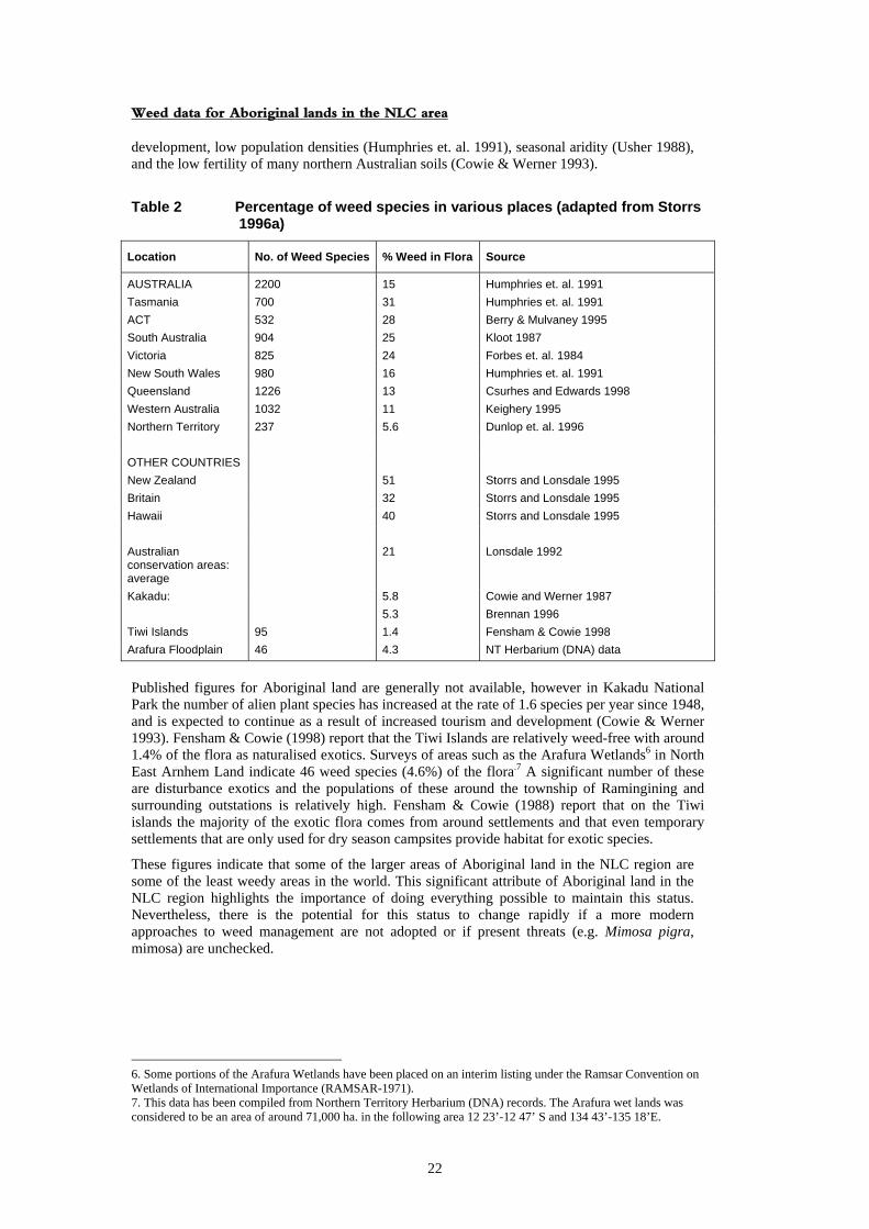
Table 2 Percentage of weed species in various places (adapted from Storrs 1996a)
Location No. of Weed Species % Weed in Flora Source
AUSTRALIA 2200 15 Humphries et. al. 1991 Tasmania 700 31 Humphries et. al. 1991 ACT 532 28 Berry & Mulvaney 1995 South Australia 904 25 Kloot 1987 Victoria 825 24 Forbes et. al. 1984 New South Wales 980 16 Humphries et. al. 1991 Queensland 1226 13 Csurhes and Edwards 1998 Western Australia 1032 11 Keighery 1995 Northern Territory 237 5.6 Dunlop et. al. 1996 OTHER COUNTRIES New Zealand 51 Storrs and Lonsdale 1995 Britain 32 Storrs and Lonsdale 1995 Hawaii 40 Storrs and Lonsdale 1995 Australian conservation areas: average
21 Lonsdale 1992
Kakadu: 5.8 5.3
Cowie and Werner 1987 Brennan 1996
Tiwi Islands 95 1.4 Fensham & Cowie 1998 Arafura Floodplain 46 4.3 NT Herbarium (DNA) data
Published figures for Aboriginal land are generally not available, however in Kakadu National Park the number of alien plant species has increased at the rate of 1.6 species per year since 1948, and is expected to continue as a result of increased tourism and development (Cowie & Werner 1993). Fensham & Cowie (1998) report that the Tiwi Islands are relatively weed-free with around 1.4% of the flora as naturalised exotics. Surveys of areas such as the Arafura Wetlands6 in North East Arnhem Land indicate 46 weed species (4.6%) of the flora.7 A significant number of these are disturbance exotics and the populations of these around the township of Ramingining and surrounding outstations is relatively high. Fensham & Cowie (1988) report that on the Tiwi islands the majority of the exotic flora comes from around settlements and that even temporary settlements that are only used for dry season campsites provide habitat for exotic species.
These figures indicate that some of the larger areas of Aboriginal land in the NLC region are some of the least weedy areas in the world. This significant attribute of Aboriginal land in the NLC region highlights the importance of doing everything possible to maintain this status. Nevertheless, there is the potential for this status to change rapidly if a more modern approaches to weed management are not adopted or if present threats (e.g. Mimosa pigra, mimosa) are unchecked.
6. Some portions of the Arafura Wetlands have been placed on an interim listing under the Ramsar Convention on Wetlands of International Importance (RAMSAR-1971). 7. This data has been compiled from Northern Territory Herbarium (DNA) records. The Arafura wet lands was considered to be an area of around 71,000 ha. in the following area 12 23’-12 47’ S and 134 43’-135 18’E.
22
Weed data for Aboriginal lands in the NLC area
Throughout Australia, weeds are spreading faster than they can be controlled. For large tracts of relatively weed-free Aboriginal land, apart from the problems of controlling or eradicating existing weeds, there is the seemingly endless advance of major potential invaders from Queensland such as Thunbergia grandiflora (blue trumpet vine), Cryptostegia grandiflora (rubber vine) and Chromoleana odorata (siam weed). Cryptostegia grandiflora currently has invaded more than three million hectares of mostly riparian habitat in north Queensland (McFadyen & Harvey 1990). To date the Northern Territory has been relatively free of this pest plant. However it has been recorded from Rocklands Station in the Northern Territory despite attempts to keep a rubber vine free buffer zone between the Northern Territory and the extensive Queensland infestations.
Indications are that introductions of plants to Australia are likely to increase in frequency unless improved preventative measures are implemented (Macdonald et. al. 1989). It is therefore highly likely that Aboriginal land in the Northern Territory will be faced with more severe weed problems in the future unless effective management strategies are quickly developed and implemented.
4.2 Data sources, limitations and classifications The weed data presented in Table 3 have been drawn from a wide range of sources. These include NAQS quarantine survey data, Northern Territory Herbarium (DNA & NT) records, NTDPIF field officers and records, NLC records and staff, a limited number of regional weeds strategies and reports and also from weed surveys carried out on an opportunistic basis within this project. Reports and publications used in the compilation of the table of weeds can be found listed in the references (pp. 150).
At the time of writing permission to access the Northern Territory NTDPIF weeds database had not been finalised. In the past protracted ongoing problems have been encountered with NTDPIF staff over the availability of the electronic transfer of this data to the NLC. Legal documents and correspondence relating to the transfer of this data have been prepared by NTDPIF and are included in Appendices 8 and 9.
Weeds were listed and then rated according to the potential impacts and threat to areas of high conservation value and agricultural importance. The rating categories used were:
1. Severe 2. High 3. Moderate threat 4. Little threat 5. No threat
These rankings are somewhat tentative given we do not know the invasive potential of most of the recorded exotic plants. Adair & Groves (1998) provide a critique for assessment of the impacts of environmental weeds and also list the research that has been carried out on the impacts of weeds on biodiversity. Only two species listed in their work are also on the list of weeds recorded here. This highlights the urgent need to assess the impacts of weed species on native vegetation in the Northern Territory.
Each plant species was given a priority according to a number of factors including the declaration category, current or potential impacts on the land use, ease of achieving control and how important the weed was to Aboriginal people consulted during this survey. For example, Alternanthera pungens (khaki weed) and Tribulus spp. (caltrop) were considered high priority weeds because in the majority of communities visited they were of concern to the landowners. This was primarily because of their nuisance value e.g. the prickles caused great discomfort and thongs had to be worn when walking around, they restricted camping sites and people were always complaining about them. Although eradication of these weeds is unlikely, the size and severity of current infestations around communities could be reduced greatly. These species have been listed as a Class B Noxious Weeds under the Northern Territory Noxious Weeds Act.
23
Weed data for Aboriginal lands in the NLC area
In other cases the potential impact of some species was enough to give them a high-priority ranking based on the behaviour of the species elsewhere in Australia or in other parts of the Northern Territory. Ardisia humilis was given such a ranking because it is listed in Cursches & Edwards (1998) as one of the major potential invasive weeds for Australia.
It also has a history of being a weed in other countries around the world and interstate; further, current populations in the Northern Territory are rapidly expanding. The potential of this species to dramatically alter the floristics of monsoon vine forest in the Northern Territory, particularly the wetter parts, was considered high. While prioritising weeds is an extremely difficult task, it needs to be done as current demand for weed control is already beyond available resources. Further work also needs to be carried out on criteria used to prioritise weeds and, in particular, how the criteria are applied.
The NLC should seek to work with other stakeholders in developing a standardised set of criteria and to periodically review the rankings set.
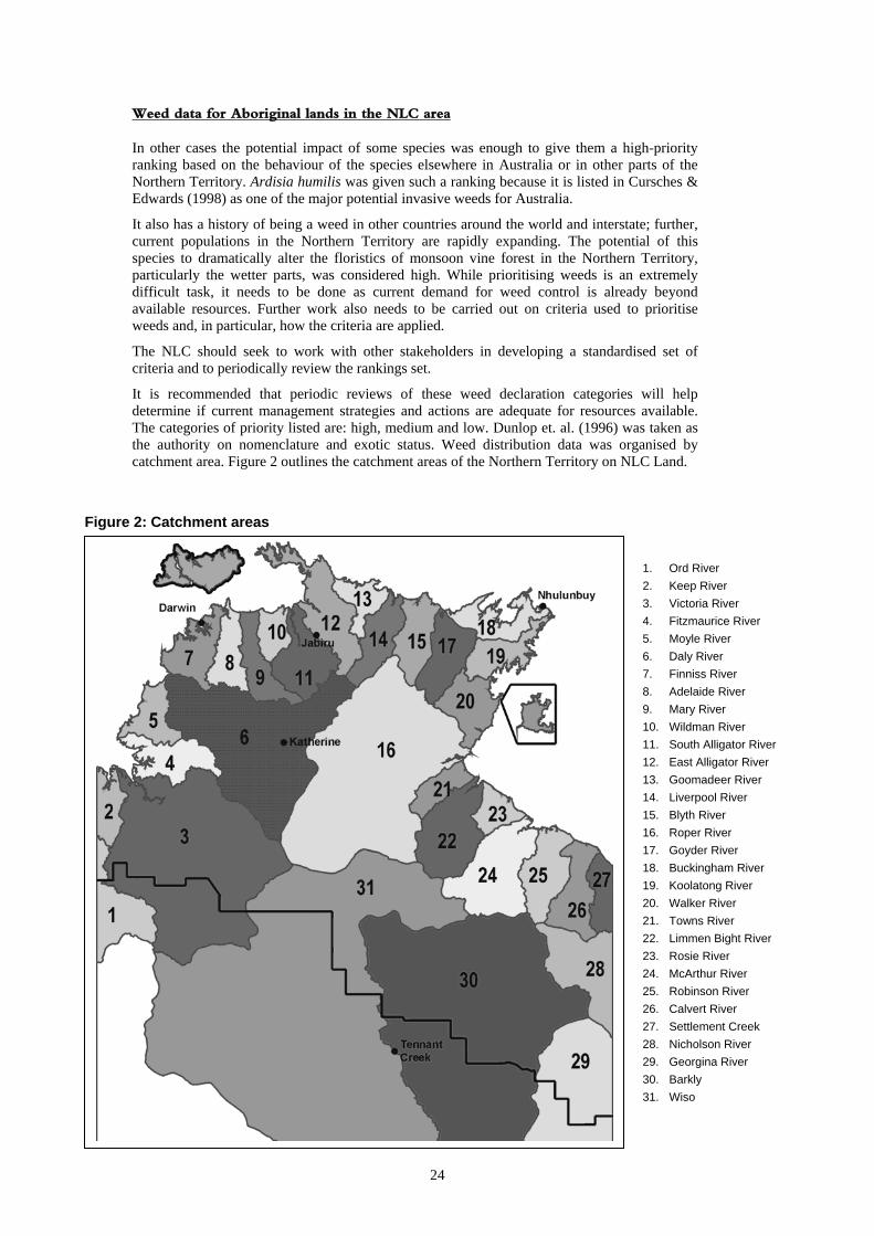
It is recommended that periodic reviews of these weed declaration categories will help determine if current management strategies and actions are adequate for resources available. The categories of priority listed are: high, medium and low. Dunlop et. al. (1996) was taken as the authority on nomenclature and exotic status. Weed distribution data was organised by catchment area. Figure 2 outlines the catchment areas of the Northern Territory on NLC Land.
Figure 2: Catchment areas
1. Ord River 2. Keep River 3. Victoria River 4. Fitzmaurice River 5. Moyle River 6. Daly River 7. Finniss River 8. Adelaide River 9. Mary River 10. Wildman River 11. South Alligator River 12. East Alligator River 13. Goomadeer River 14. Liverpool River 15. Blyth River 16. Roper River 17. Goyder River 18. Buckingham River 19. Koolatong River 20. Walker River 21. Towns River 22. Limmen Bight River 23. Rosie River 24. McArthur River 25. Robinson River 26. Calvert River 27. Settlement Creek 28. Nicholson River 29. Georgina River 30. Barkly 31. Wiso
24
Weed data for Aboriginal lands in the NLC area
4.3 Weed origins Most of the weeds recorded here have been introduced from other countries either intentionally or by accident. There has been a long history of plant introductions into Australia and indeed the Northern Territory. About half of Australia’s noxious weeds were introduced intentionally, however some weeds have been introduced accidentally e.g. Sida cordifolia (flannel weed) and Sida rhombifolia (paddy’s lucerne). In northern Australia most of the exotic plant introductions have come from other tropical countries. Of the weeds recorded on Aboriginal land in the NLC region 87 species were introduced accidentally (39% of all weeds), 67 species resulted from plants introduced as ornamental plants and then naturalising outside of gardens (30% of all weeds) e.g. Delonix regia (poinciana) and Spathodea campanulata (African tulip tree) and 69 species were introduced as pasture or crop species (31% of all weeds). Ironically the fate of introduced pasture species into the Northern Territory is much more likely to be a weed than a useful plant (Lonsdale 1994). Furthermore, some of the introduced pasture species have proved to be largely unpalatable to stock e.g. Calopogonium mucunoides (calopo) (Wesley-Smith 1992).
Recommendation 5: There currently needs to be greater effort put into the following areas on NLC land:
assessment of potential weeds through an appropriate weeds risk assessment program by those intending to use plants as pasture species.
•
• •
level of awareness of the weed species that have been introduced. level of awareness of the method of introduction of these weeds.
4.4 Numbers and types of unwanted exotic plants on Aboriginal Land A total of 225 unwanted exotic plant species have been recorded on Aboriginal Land in the NLC region (Table 3). These include 25 trees, 49 shrubs, 54 annual herbs, 18 perennial herbs, 29 vines or creepers, 28 perennial graminoids and 22 annual graminoids. The families with the highest representation include Poaceae (40 taxa), Fabaceae (27 taxa), Asteraceae (12 taxa), Euphorbiaceae (13 taxa), Amaranthaceae (9 taxa), Malvaceae (8 taxa), Convolvulaceae (8 taxa), Caesalpiniaceae (8 taxa), Mimosaceae (6 taxa), Solanaceae (6 taxa), Verbenaceae (6 taxa), Rubiaceae (6 taxa), Apocynaceae (6 taxa) and Cyperaceae (5 taxa).
A total of 81 species (36.0%) are naturalised exotics, 127 species (56.4%) are disturbance exotics and 17 species are (7.6%) are cultivated plants that have the potential to be weeds or have a demonstrated record as a weed elsewhere in Australia. This latter group is of considerable concern especially when considering the remoteness of the communities where they have been planted and the known behaviour of the species elsewhere in Australia within similar climatic zones. For example, Ipomoea carnea is known to have been planted as an ornamental shrub at various communities and homesteads in the Gulf region of the Northern Territory such as Borroloola, Ngukurr and the Nathan River Homestead. This species has naturalised in north Queensland (Queensland Herbarium 1994) and is also well established in Timor.
From the complete list of weeds and cultivated plants 52 species were given a high priority, 79 medium priority and 94 low priority ranking according to the criteria outlined in Section 4.2.
High priority group weeds are those weeds capable of causing significant impacts on current land use. Where possible these plants should be eradicated or actions be taken to prevent the spread or new outbreaks. Where these species are flowering or fruiting they should be removed by hand to prevent the outbreak of new individuals. Appropriate environmental management techniques should be applied and where possible biological control agents used.
Medium-priority group weeds are moderate to minor weeds that where practical should be controlled to prevent their spread and where numbers are low, eradicated completely. Appropriate environmental management techniques should be applied and where possible biological control agents used.
25
Weed data for Aboriginal lands in the NLC area
Low priority group weeds are minor weeds that generally have little known effect on current land uses. These weeds should, where practicable, be controlled to limit the spread. Environmental management techniques outlined in Section 5 will be important.
4.4.1 High Priority Weeds (52 species) Of these high priority weeds 25 (48% of group) naturalised outside of gardens, 13 (25% of group) were introduced accidentally and 14 (27% of group) were introduced as pasture or crop species.
Acacia nilotica, Acanthospermum hispidum, Alternanthera pungens, Andropogon gayanus, Antigonon leptopus, Ardisia humilis, Argemone ochroleuca, Azadirachta indica, Calopogonium mucunoides, Calotropis gigantea, Calotropis procera, Cenchrus ciliaris, Centrosema pubescens, Citrullus colocynthis, Clitoria ternatea, Crotalaria goreensis, Cryptostegia grandiflora, Cyperus involucratus, Delonix regia, Eichhornia crassipes, Gmelina arborea, Hymenachne amplexicaulis, Hyptis suaveolens, Ipomoea pes-tigridis, Ipomoea quamoclit, Jatropha gossypifolia, Leonotis nepetifolia, Leucaena leucocephala, Martynia annua, Mimosa pigra, Parkinsonia aculeata, Pennisetum pedicellatum, Pennisetum polystachion, Prosopis limensis, Ricinus communis, Salvinia molesta, Senna alata, Senna obtusifolia, Senna occidentalis, Sida acuta, Stachytarpheta australis, Stachytarpheta cayennensis, Stachytarpheta jamaicensis, Themeda quadrivalvis, Thunbergia grandiflora, Tribulus cistoides, Tribulus terrestris, Urochloa maxima, Urochloa mutica, Xanthium strumarium and Ziziphus mauritiana.
4.4.2 Medium Priority Weeds (79 species) Of these medium priority weeds 28 (35% of group) naturalised outside of gardens, 22 (28% of group) were introduced accidentally and 29 (37% of group) were introduced as pasture or crop species.
Allamanda cathartica, Alternanthera dentata cv rubra, Alysicarpus ovalifolius, Andrographis paniculata, Annona reticulata, Aristolochia elegans, Arundo donax, Asystasia gangetica, Barleria prionitis, Carthamus lanatus, Caryota mitis, Cascabela thevetica, Cassia fistula, Catharanthus roseus, Cenchrus biflorus, Cenchrus echinatus, Cenchrus setigerus, Chloris gayana, Chloris inflata, Chloris virgata, Citrullus lanatus, Crotalaria pallida, Cryptostegia madagascariensis, Cynodon dactylon, Cynodon dactylon (Speedy Couch), Cynodon radiatus, Cyperus rotundus, Dactyloctenium aegyptium, Dalbergia sissoo, Desmodium tortuosum, Echinochloa colona, Eleusine indica, Euphorbia cyathophora, Euphorbia heterophylla, Gomphrena celosioides, Gossypium hirsutum, Hibiscus sabdariffa, Hyptis capitata, Hyptis spicigera, Ipomoea carnea, Ipomoea triloba, Jatropha curcas, Khaya senegalensis, Lantana camara, Macroptilium atropurpureum, Macroptilium lathyroides, Malacra capitata, Melinis minutiflora, Melinis repens, Melia azadiracta, Merremia aegyptia, Merremia dissecta, Mimosa pudica, Mucuna puriens, Parthenium hysterophorus, Passiflora foetida, Phoenix dactylifera, Phyllanthus emblica, Quisqualis indica, Ruellia tuberosa, Senna siamea, Senna tora, Sesamum indicum, Sida cordifolia, Sida rhombifolia, Solanum nigrum, Solanum torvum, Spathodea campanulata, Spermacoce assurgens, Spermacoce hispida, Spermacoce latifolia, Stachytarpheta mutabilis, Stylosanthes guianensis, Stylosanthes hamata, Stylosanthes humilis, Stylosanthes scabra, Stylosanthes viscosa, Tectoma stans, Urochloa mosambicensis and Wedelia trilobata.
26
4.4.3 Low Priority Weeds (94 species) Of these low priority weeds 15 (16% of group) naturalised outside of the gardens, 51 (55.3% of group) were introduced accidentally and 28 (29.7% of group) were introduced as pasture or crop species.
Aerva javanica, Aeschynomene americana, Aeschynomene villosa, Agave attenuata, Agave sisalana, Ageratum conyzoides, Alstonia scholaris, Amaranthus hybridus, Amaranthus spinosus, Amaranthus tricolor, Amaranthus viridis, Amaranthus sp. (NMS-Nhulunbuy), Ambrosia artemisiifolia, Anacardium occidentale, Axonopus affinus, Axonopus compressus, Bidens bipinnata, Bidens pilosa, Bothriochloa pertusa, Cajanus cajan, Capiscum annuum, Canavalia gladiata, Cenchrus brownii, Centrosema pascuorum, Chloris pilosa, Chloris pumilio, Citrullus lanatus cv watermelon, Conzya bonariensis, Corchorus olitorius, Corchorus trilocularis, Cyperus brevifolius, Cyperus compressus, Cyperus sphacelatus, Cucumis sp. (RB-Nhulunbuy), Desmanthus virgatus, Desmodium scorpiurus, Desmodium triflorum, Digitaria ciliaris, Digitaria violascens, Dioscorea alata, Echinochloa crus-galli, Eleutheranthera ruderalis, Emilia sonchifolia, Eragrostis pilosa, Euphorbia hirta, Euphorbia prostrata, Evolvulus nummularis, Fabaceae sp. (NMS-Nitmuluk), Grewia asiatica, Heliotropium indicum, Indigofera glandulosa, Indigofera hirsuta, Indigofera tinctoria, Ipomoea batatas, Jatropha multifida, Lycopersicon esculentum, Malvastrum americanum, Malvastrum coromandelianum, Mangifera indica, Manihot esculenta, Micrococca mercurialis, Mitracarpus hirtus, Momordica balsamina, Nerium oleander, Oldenlandia corymbosa, Opuntia stricta, Oryza sativa, Paspalum notatum, Passiflora suberosa, Phoenix sylvestris, Phyllanthus amarus, Pilea microphylla, Ravenala madagascariensis, Richardia scabra, Sansevieria trifasciata, Scoparia dulcis, Setaria italica, Setaria sphacelata, Solanum americanum, Solanum erianthum, Sorghum almum, Sorghum bicolor, Sporobolus coromandelianus, Sporobolus jacquemonti, Sporobolus natalensis, Synedrella nodiflora, Tabernaemontana coronaria, Tamarix aphylla, Trianthema portulacastrum, Tridax procumbens, Triumfetta pentandra, Turnera ulmifolia, and Urochloa gilvrum.
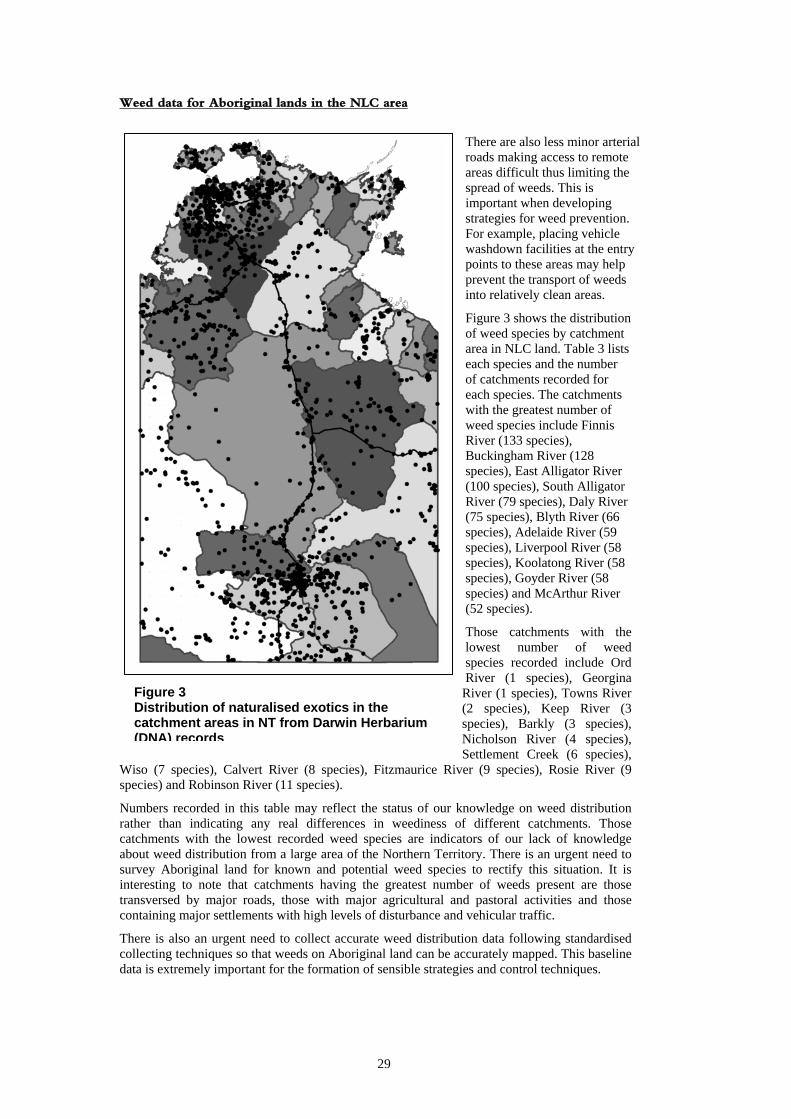
4.5 Distribution of exotic species The distribution of naturalised exotic plant species in the Northern Territory is shown in Figure 3. Every point source locality for weeds in the Northern Territory Herbarium database was plotted to show total known weed distribution. The map shows that recorded weeds concentrate around major settlements and along major arterial roads8. This applies to both Aboriginal and non-Aboriginal land. This feature of weed distribution is related to the following:
1. Weeds spread commonly from settlement areas such as towns, communities and outstations where they are often garden escapees. In Nhulunbuy there are significant amount of weeds in the town lagoon that have come from the dumping of garden refuse.
2. Exotics establish in areas of greatest habitat disturbance. The development of road systems aids in the transport of weed species along their routes. In these situations weeds have been spread by heavy machinery, vehicles, livestock transportation, grading, slashing and hay carting. Some weeds species also are adapted to exploit ‘gaps’ in natural vegetation created by disturbance.
Figure 3 also shows that there are large areas of Aboriginal land that currently appear to be relatively weed free⎯e.g. large tracts of land in Arnhem Land and the upper Daly River/Port Keats Aboriginal Land Trusts. In both areas the spread of weeds may be somewhat reduced by the fact that access is by permit only and there consequently traffic is reduced along major roads servicing these areas.
8. It should be noted, however, that the NT Herbarium (DNA) database from which the map was produced comes from plant records collected that, in the main, come from areas easily accessed by botanists and other collectors, for example along roadsides. Thus the actual distributions can tend to be somewhat different on the ground.
27

28
Weed data for Aboriginal lands in the NLC area
There are also less minor arterial roads making access to remote areas difficult thus limiting the spread of weeds. This is important when developing strategies for weed prevention. For example, placing vehicle washdown facilities at the entry points to these areas may help prevent the transport of weeds into relatively clean areas.
Figure 3 shows the distribution of weed species by catchment area in NLC land. Table 3 lists each species and the number of catchments recorded for each species. The catchments with the greatest number of weed species include Finnis River (133 species), Buckingham River (128 species), East Alligator River (100 species), South Alligator River (79 species), Daly River (75 species), Blyth River (66 species), Adelaide River (59 species), Liverpool River (58 species), Koolatong River (58 species), Goyder River (58 species) and McArthur River (52 species).
Those catchments with the lowest number of weed species recorded include Ord River (1 species), Georgina
River (1 species), Towns River (2 species), Keep River (3 species), Barkly (3 species), Nicholson River (4 species), Settlement Creek (6 species),
Wiso (7 species), Calvert River (8 species), Fitzmaurice River (9 species), Rosie River (9 species) and Robinson River (11 species).
Figure 3 Distribution of naturalised exotics in the catchment areas in NT from Darwin Herbarium (DNA) records
Numbers recorded in this table may reflect the status of our knowledge on weed distribution rather than indicating any real differences in weediness of different catchments. Those catchments with the lowest recorded weed species are indicators of our lack of knowledge about weed distribution from a large area of the Northern Territory. There is an urgent need to survey Aboriginal land for known and potential weed species to rectify this situation. It is interesting to note that catchments having the greatest number of weeds present are those transversed by major roads, those with major agricultural and pastoral activities and those containing major settlements with high levels of disturbance and vehicular traffic.
There is also an urgent need to collect accurate weed distribution data following standardised collecting techniques so that weeds on Aboriginal land can be accurately mapped. This baseline data is extremely important for the formation of sensible strategies and control techniques.
29
Weed data for Aboriginal lands in the NLC area
Mapping methods should include the use of GPS and GIS technologies. NTDPIF weeds officers have offered help in the design and trialing of any technologies in this area and the NLC should seek their cooperation on this. See Section 4.7 for database development, mapping capabilities and collection proformas.
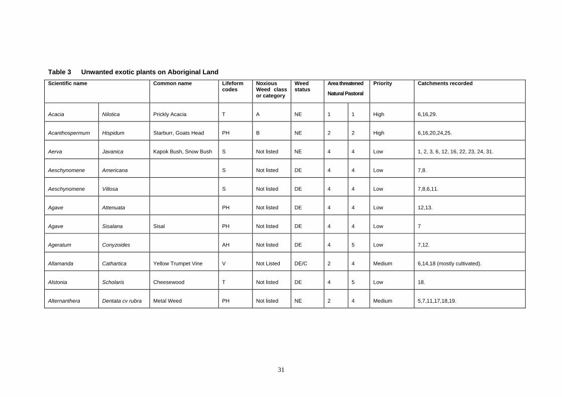
4.6 Weed species listings Table 3 outlines the weeds present, their declaration category, their status, threat and priority as well as distribution data. The information for Table 3 is as follows.
Lifeform codes: T; Tree ( woody, mature plants >5m tall), S; Shrub ( woody; mature plants <5m tall); V; Vine (climbing plants with long stems); PH; Perennial Herb (long-lived, non-woody or semi-woody, non-climbing plants, not grasses or sedges); AH; Annual Herb (herb; annual or biennial, non-woody or semi-woody, non-climbing plants, not grasses or sedges); PG; Perennial Graminoid (long-lived herbaceous plants from the families Poaceae, Cyperaceae or Restionaceae); AG; Annual Graminoid (annual herbaceous plants from the families Poaceae, Cyperaceae or Restionaceae).
Noxious Weed Class or Category Gazetted Noxious Weeds
A Class A (to be eradicated). B Class B (growth and spread to be controlled). C Class C species (not to be introduced into NT, this includes all class A & B Noxious Weeds).
Note: Some species in Miller (1998) are referred to more than one class as indicated in Table 3.
Additional categories include: I Listed on Environment Australia’s invasive weed list (see Csurhes and Edwards 1998). Q On quarantine targeted list by NAQS (see Waterhouse and Mitchell 1998). NL Species has not been classed or listed. Weed Status NE: Naturalised exotic; naturalised in native plant ecosystems. DE Disturbance exotic; currently found in disturbed sites such as around buildings degraded roadsides, occasionally found outside of cultivation but not yet established as major weed. C: Cultivated; found in cultivation only but has known potential as a weed in other states/areas. I: Interstate; a known weed interstate not yet in NT but threat is present. Area Threatened
1. Severe threat. 2. High threat. 3. Moderate threat. 4. Little threat. 5. No threat.
Catchment Numbers: For catchment details and numbers see Figure 2 in Section 4.2.
30
31
Table 3 Unwanted exotic plants on Aboriginal Land Scientific name Common name Lifeform
codes Noxious Weed class or category
Weed status
Area threatened
Natural Pastoral
Priority Catchments recorded
Acacia Nilotica Prickly Acacia T A NE 1 1 High 6,16,29.
Acanthospermum Hispidum Starburr, Goats Head PH B NE 2 2 High 6,16,20,24,25.
Aerva Javanica Kapok Bush, Snow Bush S Not listed NE 4 4 Low 1, 2, 3, 6, 12, 16, 22, 23, 24, 31.
Aeschynomene Americana S Not listed DE 4 4 Low 7,8.
Aeschynomene Villosa S Not listed DE 4 4 Low 7,8,6,11.
Agave Attenuata PH Not listed DE 4 4 Low 12,13.
Agave Sisalana Sisal PH Not listed DE 4 4 Low 7
Ageratum Conyzoides AH Not listed DE 4 5 Low 7,12.
Allamanda Cathartica Yellow Trumpet Vine V Not Listed DE/C 2 4 Medium 6,14,18 (mostly cultivated).
Alstonia Scholaris Cheesewood T Not listed DE 4 5 Low 18.
Alternanthera Dentata cv rubra Metal Weed PH Not listed NE 2 4 Medium 5,7,11,17,18,19.
Table 3 Unwanted exotic plants on Aboriginal Land
Alternanthera Pungens Khaki Weed PH B NE 2 3 High 3,6,11,12,16,17,19,20,22,23,24,25,26,27.
Alysicarpus Ovalifolius Buffalo Clover AH Not listed DE 3 5 Medium 5,7,8,9,11,12,13,15,17,18,19,20,24,31.
Amaranthus Hybridus AH Not listed DE 4 5 Low 20.
Amaranthus Spinosus AH Not listed DE 3 5 Low 18.
Amaranthus Tricolor Joseph’s Coat AH Not listed DE 4 5 Low 18,19.
Amaranthus Viridis Green Amaranth AH Not listed DE 4 5 Low 3,7,16,18,19,20,24.
Amaranthus Sp. A Not listed DE 3 5 Low 18.
Ambrosia Artemisiifoli Low
Anacardium Occidentale Cashew T I/not Listed DE/C 4 5 Low 17,18. (mostly cultivated)
Andrographis Paniculata PH Not Listed DE 3 3 Medium 7,12,18
Andropogon Gayanus Gamba grass PG I NE 1 3 High 6,7,8,9,10,11,14,19.
Annona Reticulata T Not listed DE 3 5 Medium 7,12.
32
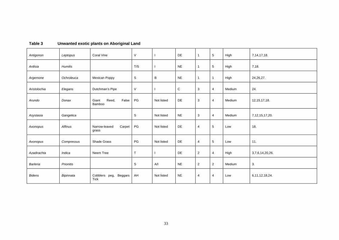
Table 3 Unwanted exotic plants on Aboriginal Land
Antigonon Leptopus Coral Vine V I DE 1 5 High 7,14,17,18.
Ardisia Humilis T/S I NE 1 5 High 7,18.
Argemone Ochroleuca Mexican Poppy S B NE 1 1 High 24,26,27.
Aristolochia Elegans Dutchman’s Pipe V I C 3 4 Medium 24.
Arundo Donax Giant Reed, False Bamboo
PG Not listed DE 3 4 Medium 12,15,17,18.
Asystasia Gangetica S Not listed NE 3 4 Medium 7,12,15,17,20.
Axonopus Affinus Narrow-leaved Carpet grass
PG Not listed DE 4 5 Low 18.
Axonopus Compressus Shade Grass PG Not listed DE 4 5 Low 11.
Azadirachta Indica Neem Tree T I DE 2 4 High 3,7,6,14,20,26.
Barleria Prionitis S A/I NE 2 2 Medium 3.
Bidens Bipinnata Cobblers peg, Beggars Tick
AH Not listed NE 4 4 Low 6,11,12,18,24.
33
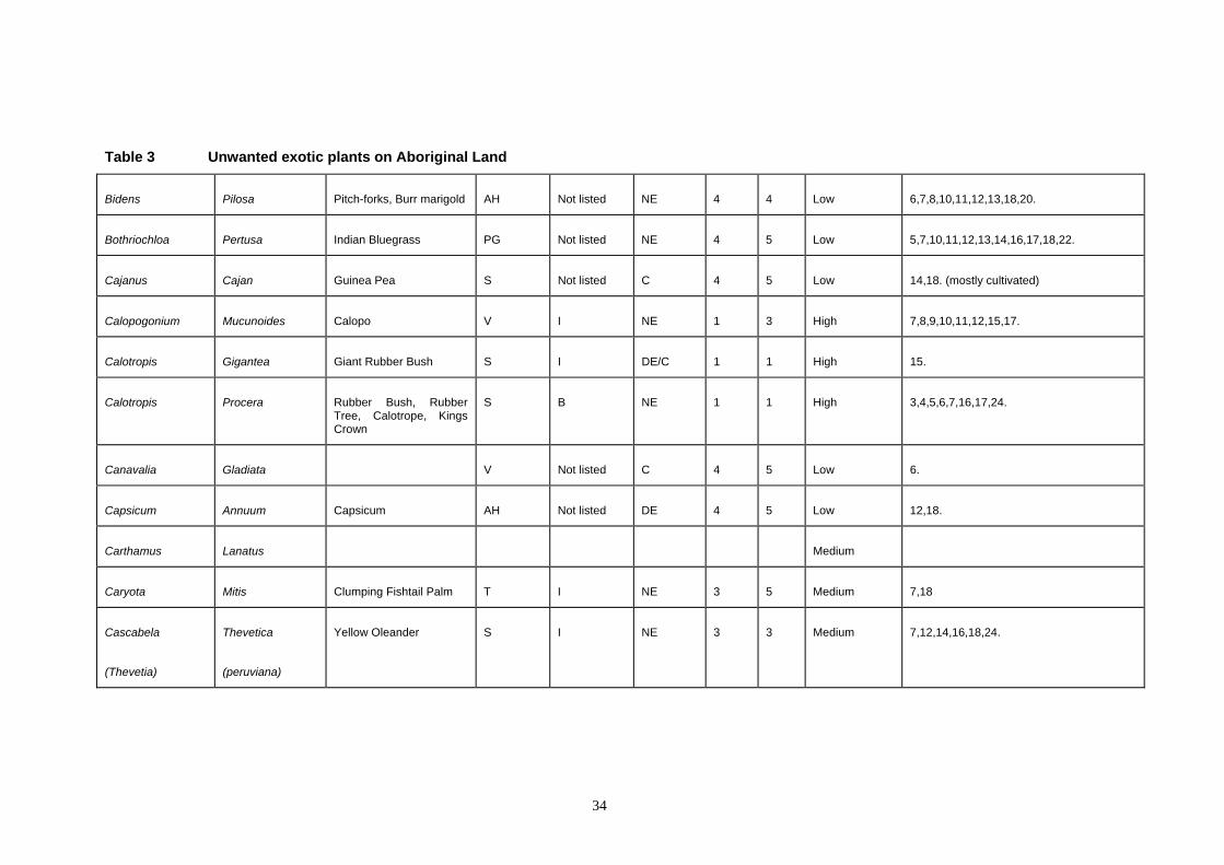
Table 3 Unwanted exotic plants on Aboriginal Land
Bidens Pilosa Pitch-forks, Burr marigold AH Not listed NE 4 4 Low 6,7,8,10,11,12,13,18,20.
Bothriochloa Pertusa Indian Bluegrass PG Not listed NE 4 5 Low 5,7,10,11,12,13,14,16,17,18,22.
Cajanus Cajan Guinea Pea S Not listed C 4 5 Low 14,18. (mostly cultivated)
Calopogonium Mucunoides Calopo V I NE 1 3 High 7,8,9,10,11,12,15,17.
Calotropis Gigantea Giant Rubber Bush S I DE/C 1 1 High 15.
Calotropis Procera Rubber Bush, Rubber Tree, Calotrope, Kings Crown
S B NE 1 1 High 3,4,5,6,7,16,17,24.
Canavalia Gladiata V Not listed C 4 5 Low 6.
Capsicum Annuum Capsicum AH Not listed DE 4 5 Low 12,18.
Carthamus Lanatus Medium
Caryota Mitis Clumping Fishtail Palm T I NE 3 5 Medium 7,18
Cascabela
(Thevetia)
Thevetica
(peruviana)
Yellow Oleander S I NE 3 3 Medium 7,12,14,16,18,24.
34
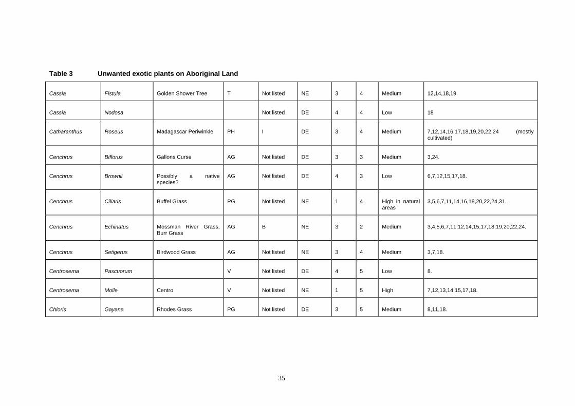
Table 3 Unwanted exotic plants on Aboriginal Land
Cassia Fistula Golden Shower Tree T Not listed NE 3 4 Medium 12,14,18,19.
Cassia Nodosa Not listed DE 4 4 Low 18
Catharanthus Roseus Madagascar Periwinkle PH I DE 3 4 Medium 7,12,14,16,17,18,19,20,22,24 (mostly cultivated)
Cenchrus Biflorus Gallons Curse AG Not listed DE 3 3 Medium 3,24.
Cenchrus Brownii Possibly a native species?
AG Not listed DE 4 3 Low 6,7,12,15,17,18.
Cenchrus Ciliaris Buffel Grass PG Not listed NE 1 4 High in natural areas
3,5,6,7,11,14,16,18,20,22,24,31.
Cenchrus Echinatus Mossman River Grass, Burr Grass
AG B NE 3 2 Medium 3,4,5,6,7,11,12,14,15,17,18,19,20,22,24.
Cenchrus Setigerus Birdwood Grass AG Not listed NE 3 4 Medium 3,7,18.
Centrosema Pascuorum V Not listed DE 4 5 Low 8.
Centrosema Molle Centro V Not listed NE 1 5 High 7,12,13,14,15,17,18.
Chloris Gayana Rhodes Grass PG Not listed DE 3 5 Medium 8,11,18.
35
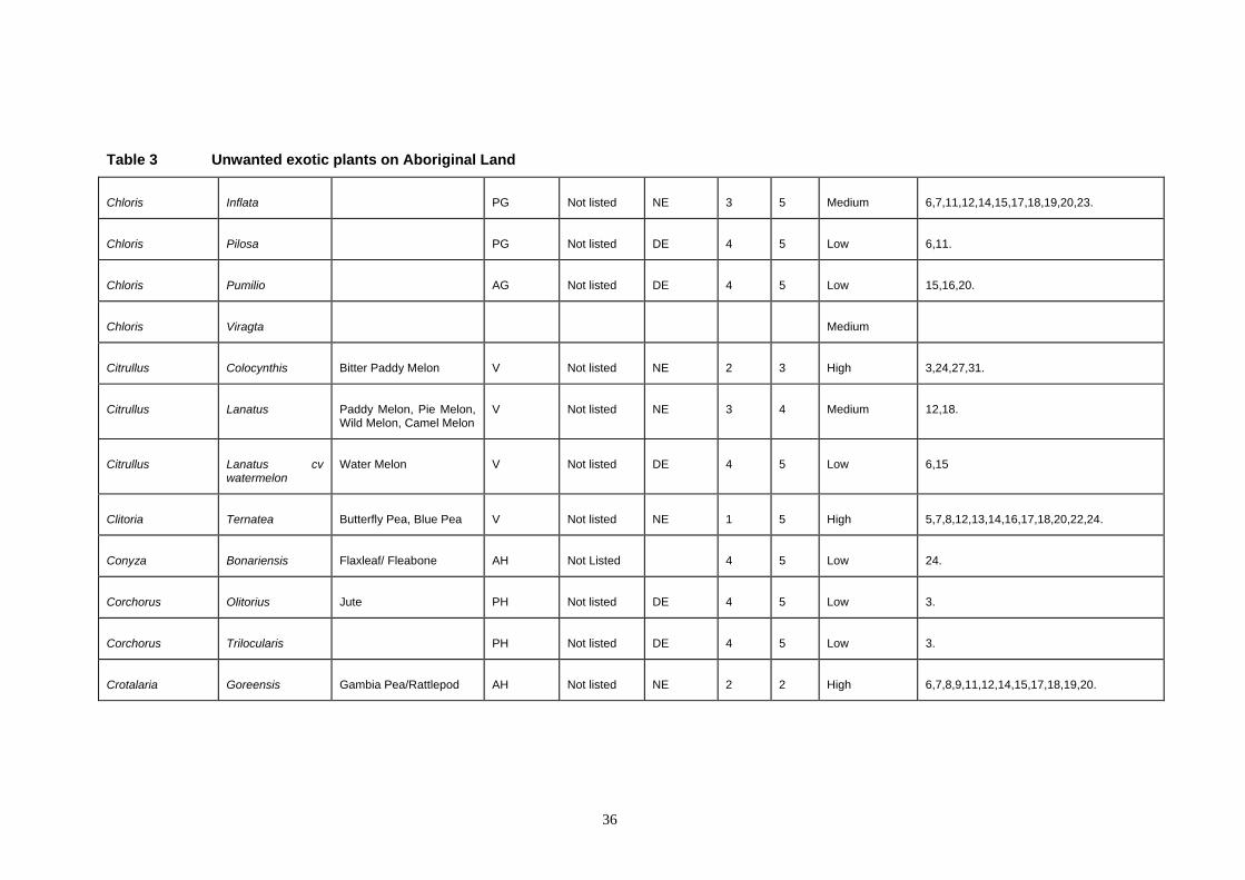
Table 3 Unwanted exotic plants on Aboriginal Land
Chloris Inflata PG Not listed NE 3 5 Medium 6,7,11,12,14,15,17,18,19,20,23.
Chloris Pilosa PG Not listed DE 4 5 Low 6,11.
Chloris Pumilio AG Not listed DE 4 5 Low 15,16,20.
Chloris Viragta Medium
Citrullus Colocynthis Bitter Paddy Melon V Not listed NE 2 3 High 3,24,27,31.
Citrullus Lanatus Paddy Melon, Pie Melon, Wild Melon, Camel Melon
V Not listed NE 3 4 Medium 12,18.
Citrullus Lanatus cvwatermelon
Water Melon V Not listed DE 4 5 Low 6,15
Clitoria Ternatea Butterfly Pea, Blue Pea V Not listed NE 1 5 High 5,7,8,12,13,14,16,17,18,20,22,24.
Conyza Bonariensis Flaxleaf/ Fleabone AH Not Listed 4 5 Low 24.
Corchorus Olitorius Jute PH Not listed DE 4 5 Low 3.
Corchorus Trilocularis PH Not listed DE 4 5 Low 3.
Crotalaria Goreensis Gambia Pea/Rattlepod AH Not listed NE 2 2 High 6,7,8,9,11,12,14,15,17,18,19,20.
36
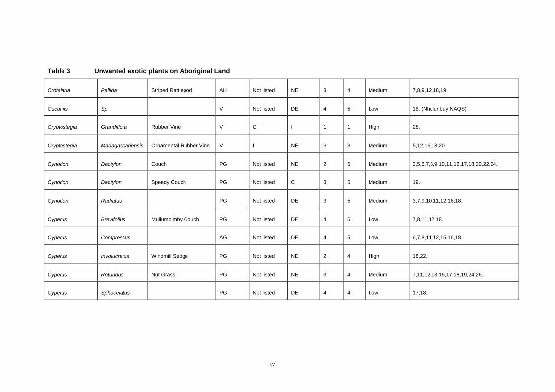
Table 3 Unwanted exotic plants on Aboriginal Land
Crotalaria Pallida Striped Rattlepod AH Not listed NE 3 4 Medium 7,8,9,12,18,19.
Cucumis Sp. V Not listed DE 4 5 Low 18. (Nhulunbuy NAQS)
Cryptostegia Grandiflora Rubber Vine V C I 1 1 High 28.
Cryptostegia Madagascariensis Ornamental Rubber Vine V I NE 3 3 Medium 5,12,16,18,20
Cynodon Dactylon Couch PG Not listed NE 2 5 Medium 3,5,6,7,8,9,10,11,12,17,18,20,22,24.
Cynodon Dactylon Speedy Couch PG Not listed C 3 5 Medium 19.
Cynodon Radiatus PG Not listed DE 3 5 Medium 3,7,9,10,11,12,16,18.
Cyperus Brevifolius Mullumbimby Couch PG Not listed DE 4 5 Low 7,8,11,12,18.
Cyperus Compressus AG Not listed DE 4 5 Low 6,7,8,11,12,15,16,18.
Cyperus Involucratus Windmill Sedge PG Not listed NE 2 4 High 18,22.
Cyperus Rotundus Nut Grass PG Not listed NE 3 4 Medium 7,11,12,13,15,17,18,19,24,26.
Cyperus Sphacelatus PG Not listed DE 4 4 Low 17,18.
37
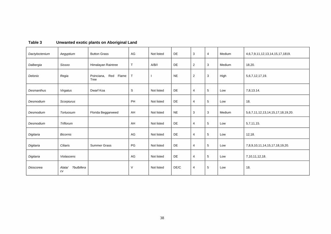
Table 3 Unwanted exotic plants on Aboriginal Land
Dactyloctenium Aegyptium Button Grass AG Not listed DE 3 4 Medium 4,6,7,9,11,12,13,14,15,17,1819.
Dalbergia Sissoo Himalayan Raintree T A/B/I DE 2 3 Medium 18,20.
Delonix Regia Poinciana, Red Flame Tree
T I NE 2 3 High 5,6,7,12,17,19.
Desmanthus Virgatus Dwarf Koa S Not listed DE 4 5 Low 7,8,13.14.
Desmodium Scorpiurus PH Not listed DE 4 5 Low 18.
Desmodium Tortuosum Florida Beggarweed AH Not listed NE 3 3 Medium 5,6,7,11,12,13,14,15,17,18,19,20.
Desmodium Triflorum AH Not listed DE 4 5 Low 5,7,11,15.
Digitaria Bicornis AG Not listed DE 4 5 Low 12,18.
Digitaria Ciliaris Summer Grass PG Not listed DE 4 5 Low 7,8,9,10,11,14,15,17,18,19,20.
Digitaria Violascens AG Not listed DE 4 5 Low 7,10,11,12,18.
Dioscorea Alata/ ?bulbiferacv
V Not listed DE/C 4 5 Low 18.
38
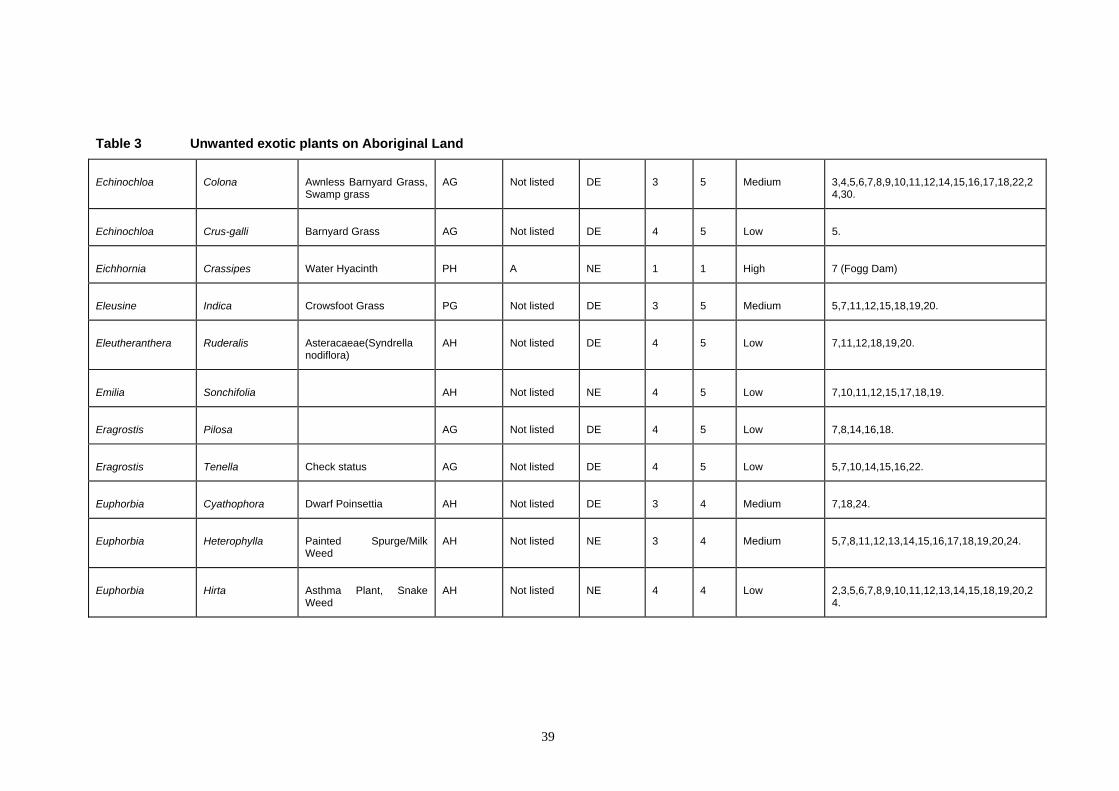
Table 3 Unwanted exotic plants on Aboriginal Land
Echinochloa Colona Awnless Barnyard Grass, Swamp grass
AG Not listed DE 3 5 Medium 3,4,5,6,7,8,9,10,11,12,14,15,16,17,18,22,24,30.
Echinochloa Crus-galli Barnyard Grass AG Not listed DE 4 5 Low 5.
Eichhornia Crassipes Water Hyacinth PH A NE 1 1 High 7 (Fogg Dam)
Eleusine Indica Crowsfoot Grass PG Not listed DE 3 5 Medium 5,7,11,12,15,18,19,20.
Eleutheranthera Ruderalis Asteracaeae(Syndrella nodiflora)
AH Not listed DE 4 5 Low 7,11,12,18,19,20.
Emilia Sonchifolia AH Not listed NE 4 5 Low 7,10,11,12,15,17,18,19.
Eragrostis Pilosa AG Not listed DE 4 5 Low 7,8,14,16,18.
Eragrostis Tenella Check status AG Not listed DE 4 5 Low 5,7,10,14,15,16,22.
Euphorbia Cyathophora Dwarf Poinsettia AH Not listed DE 3 4 Medium 7,18,24.
Euphorbia Heterophylla Painted Spurge/MilkWeed
AH Not listed NE 3 4 Medium 5,7,8,11,12,13,14,15,16,17,18,19,20,24.
Euphorbia Hirta Asthma Plant, Snake Weed
AH Not listed NE 4 4 Low 2,3,5,6,7,8,9,10,11,12,13,14,15,18,19,20,24.
39
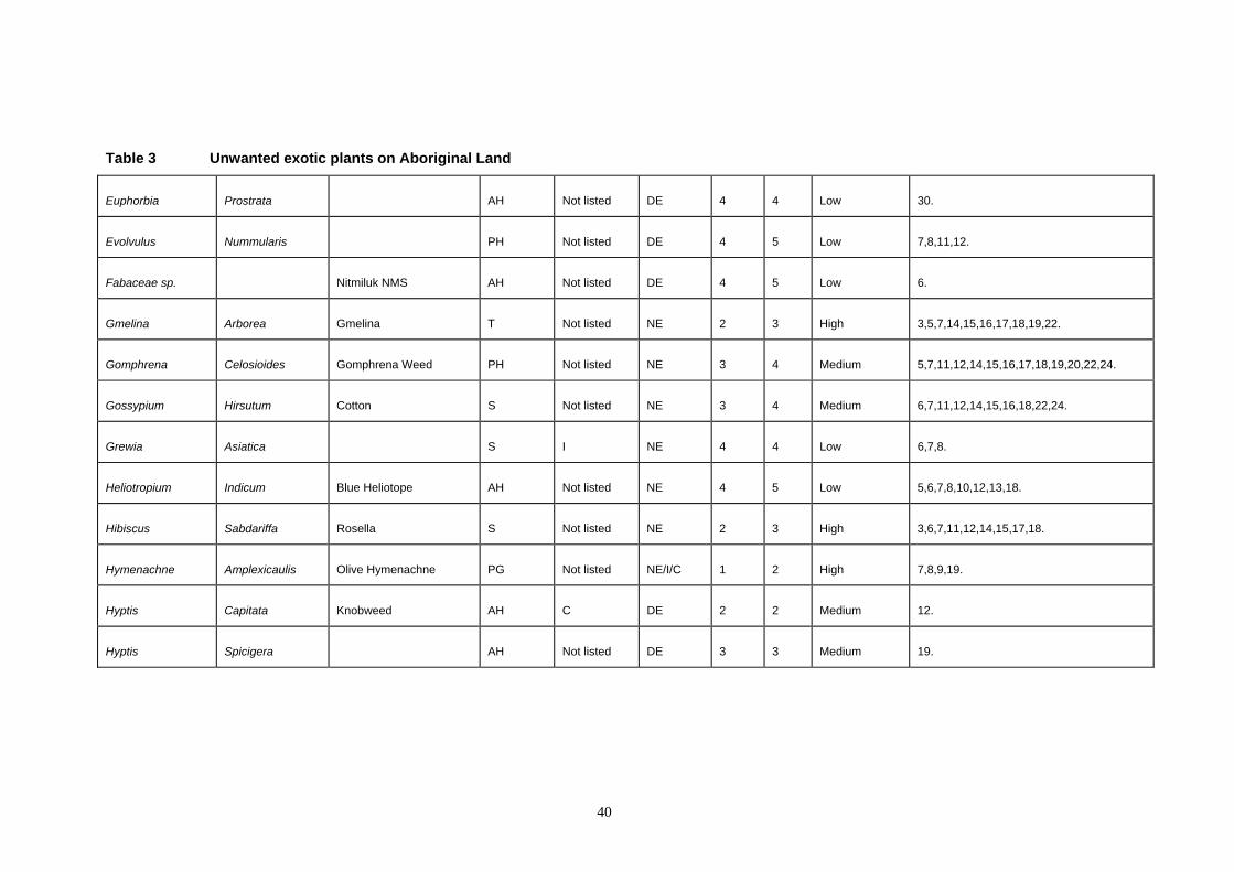
Table 3 Unwanted exotic plants on Aboriginal Land
Euphorbia Prostrata AH Not listed DE 4 4 Low 30.
Evolvulus Nummularis PH Not listed DE 4 5 Low 7,8,11,12.
Fabaceae sp. Nitmiluk NMS AH Not listed DE 4 5 Low 6.
Gmelina Arborea Gmelina T Not listed NE 2 3 High 3,5,7,14,15,16,17,18,19,22.
Gomphrena Celosioides Gomphrena Weed PH Not listed NE 3 4 Medium 5,7,11,12,14,15,16,17,18,19,20,22,24.
Gossypium Hirsutum Cotton S Not listed NE 3 4 Medium 6,7,11,12,14,15,16,18,22,24.
Grewia Asiatica S I NE 4 4 Low 6,7,8.
Heliotropium Indicum Blue Heliotope AH Not listed NE 4 5 Low 5,6,7,8,10,12,13,18.
Hibiscus Sabdariffa Rosella S Not listed NE 2 3 High 3,6,7,11,12,14,15,17,18.
Hymenachne Amplexicaulis Olive Hymenachne PG Not listed NE/I/C 1 2 High 7,8,9,19.
Hyptis Capitata Knobweed AH C DE 2 2 Medium 12.
Hyptis Spicigera AH Not listed DE 3 3 Medium 19.
40
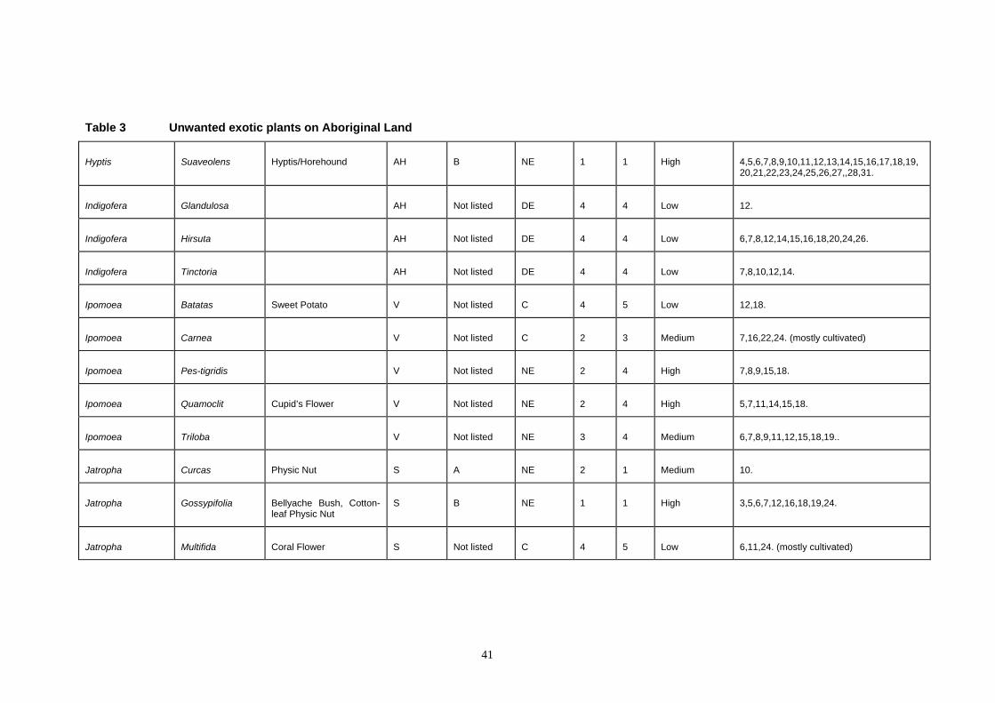
Table 3 Unwanted exotic plants on Aboriginal Land
Hyptis Suaveolens Hyptis/Horehound AH B NE 1 1 High 4,5,6,7,8,9,10,11,12,13,14,15,16,17,18,19,20,21,22,23,24,25,26,27,,28,31.
Indigofera Glandulosa AH Not listed DE 4 4 Low 12.
Indigofera Hirsuta AH Not listed DE 4 4 Low 6,7,8,12,14,15,16,18,20,24,26.
Indigofera Tinctoria AH Not listed DE 4 4 Low 7,8,10,12,14.
Ipomoea Batatas Sweet Potato V Not listed C 4 5 Low 12,18.
Ipomoea Carnea V Not listed C 2 3 Medium 7,16,22,24. (mostly cultivated)
Ipomoea Pes-tigridis V Not listed NE 2 4 High 7,8,9,15,18.
Ipomoea Quamoclit Cupid’s Flower V Not listed NE 2 4 High 5,7,11,14,15,18.
Ipomoea Triloba V Not listed NE 3 4 Medium 6,7,8,9,11,12,15,18,19..
Jatropha Curcas Physic Nut S A NE 2 1 Medium 10.
Jatropha Gossypifolia Bellyache Bush, Cotton-leaf Physic Nut
S B NE 1 1 High 3,5,6,7,12,16,18,19,24.
Jatropha Multifida Coral Flower S Not listed C 4 5 Low 6,11,24. (mostly cultivated)
41
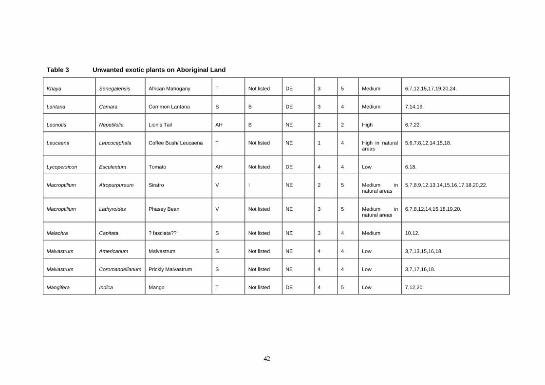
Table 3 Unwanted exotic plants on Aboriginal Land
Khaya Senegalensis African Mahogany T Not listed DE 3 5 Medium 6,7,12,15,17,19,20,24.
Lantana Camara Common Lantana S B DE 3 4 Medium 7,14,19.
Leonotis Nepetifolia Lion’s Tail AH B NE 2 2 High 6,7,22.
Leucaena Leucocephala Coffee Bush/ Leucaena T Not listed NE 1 4 High in natural areas
5,6,7,8,12,14,15,18.
Lycopersicon Esculentum Tomato AH Not listed DE 4 4 Low 6,18.
Macroptilium Atropurpureum Siratro V I NE 2 5 Medium innatural areas
5,7,8,9,12,13,14,15,16,17,18,20,22.
Macroptilium Lathyroides Phasey Bean V Not listed NE 3 5 Medium in natural areas
6,7,8,12,14,15,18,19,20.
Malachra Capitata ? fasciata?? S Not listed NE 3 4 Medium 10,12.
Malvastrum Americanum Malvastrum S Not listed NE 4 4 Low 3,7,13,15,16,18.
Malvastrum Coromandelianum Prickly Malvastrum S Not listed NE 4 4 Low 3,7,17,16,18.
Mangifera Indica Mango T Not listed DE 4 5 Low 7,12,20.
42
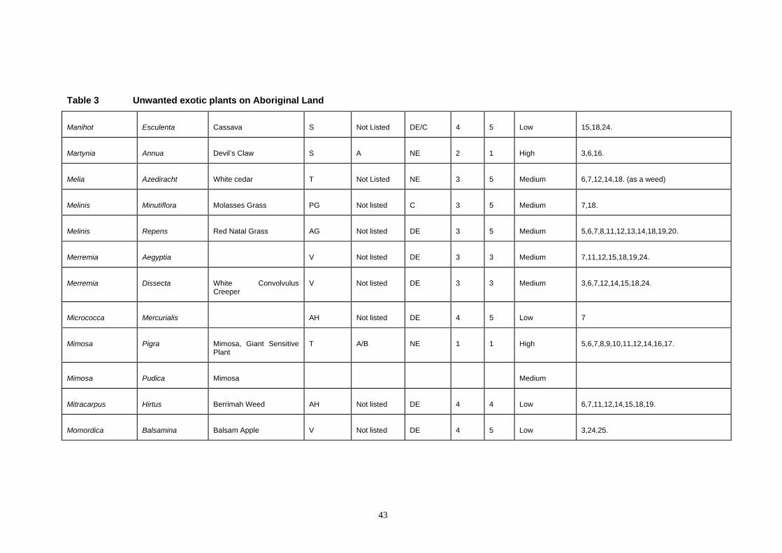
Table 3 Unwanted exotic plants on Aboriginal Land
Manihot Esculenta Cassava S Not Listed DE/C 4 5 Low 15,18,24.
Martynia Annua Devil’s Claw S A NE 2 1 High 3,6,16.
Melia Azediracht White cedar T Not Listed NE 3 5 Medium 6,7,12,14,18. (as a weed)
Melinis Minutiflora Molasses Grass PG Not listed C 3 5 Medium 7,18.
Melinis Repens Red Natal Grass AG Not listed DE 3 5 Medium 5,6,7,8,11,12,13,14,18,19,20.
Merremia Aegyptia V Not listed DE 3 3 Medium 7,11,12,15,18,19,24.
Merremia Dissecta White Convolvulus Creeper
V Not listed DE 3 3 Medium 3,6,7,12,14,15,18,24.
Micrococca Mercurialis AH Not listed DE 4 5 Low 7
Mimosa Pigra Mimosa, Giant Sensitive Plant
T A/B NE 1 1 High 5,6,7,8,9,10,11,12,14,16,17.
Mimosa Pudica Mimosa Medium
Mitracarpus Hirtus Berrimah Weed AH Not listed DE 4 4 Low 6,7,11,12,14,15,18,19.
Momordica Balsamina Balsam Apple V Not listed DE 4 5 Low 3,24,25.
43
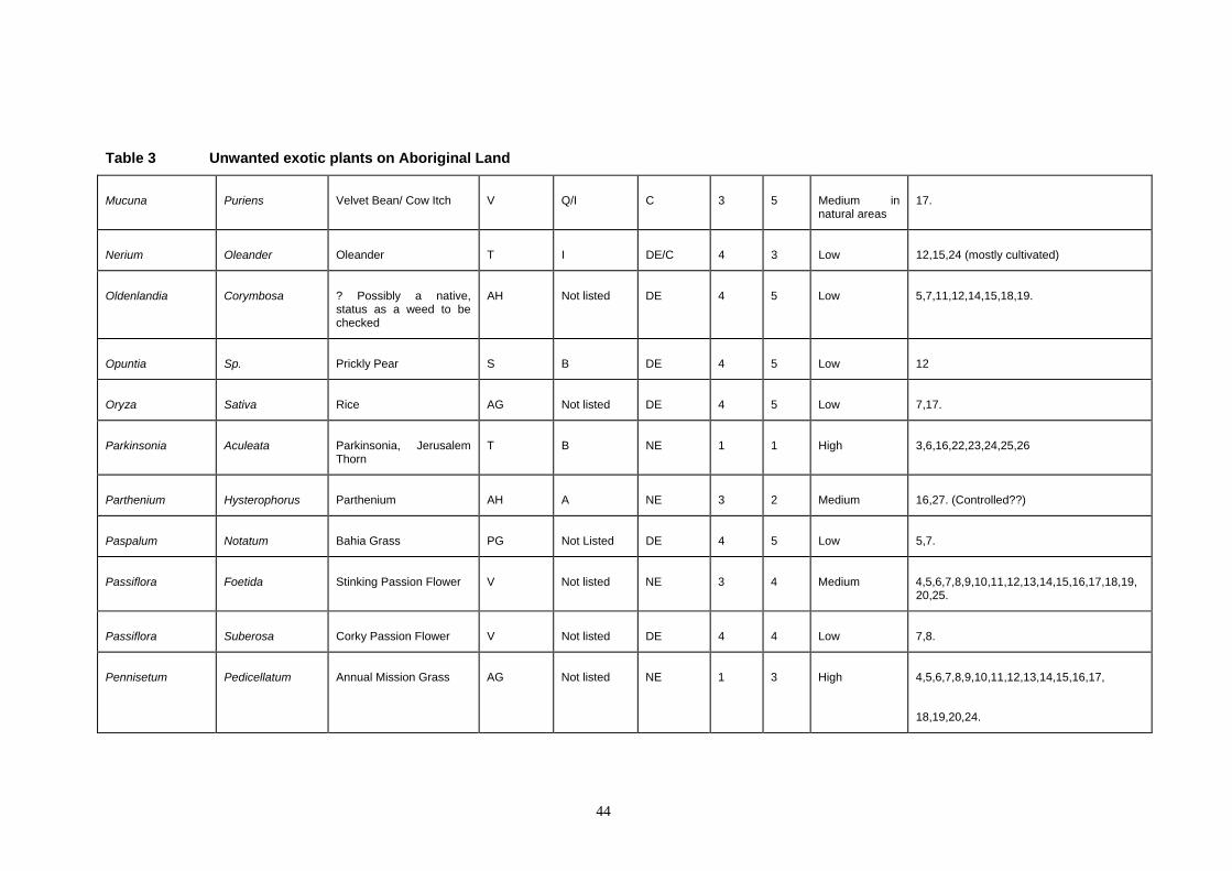
Table 3 Unwanted exotic plants on Aboriginal Land
Mucuna Puriens Velvet Bean/ Cow Itch V Q/I C 3 5 Medium in natural areas
17.
Nerium Oleander T I DE/C 4 3 Low 12,15,24 (mostly cultivated)Oleander
Oldenlandia ? Possibly a native, status as a weed to be checked
AH Not listed DE 4 5 Low 5,7,11,12,14,15,18,19.Corymbosa
Prickly Pear S B DE 4 5 Low 12 Opuntia Sp.
Rice AG Not listed DE 4 5 Low 7,17.Oryza Sativa
Parkinsonia Parkinsonia, Jerusalem Thorn
T B NE 1 1 High 3,6,16,22,23,24,25,26Aculeata
Parthenium Parthenium AH A NE 3 2 Medium 16,27. (Controlled??)Hysterophorus
Bahia Grass PG Not Listed DE 4 5 Low 5,7. Paspalum Notatum
Stinking Passion Flower V Not listed NE 3 4 Medium 4,5,6,7,8,9,10,11,12,13,14,15,16,17,18,19,20,25.
Passiflora Foetida
Passiflora Corky Passion Flower V Not listed DE 4 4 Low 7,8. Suberosa
Pennisetum Annual Mission Grass AG Not listed NE 1 3 High 4,5,6,7,8,9,10,11,12,13,14,15,16,17, Pedicellatum
18,19,20,24.
44
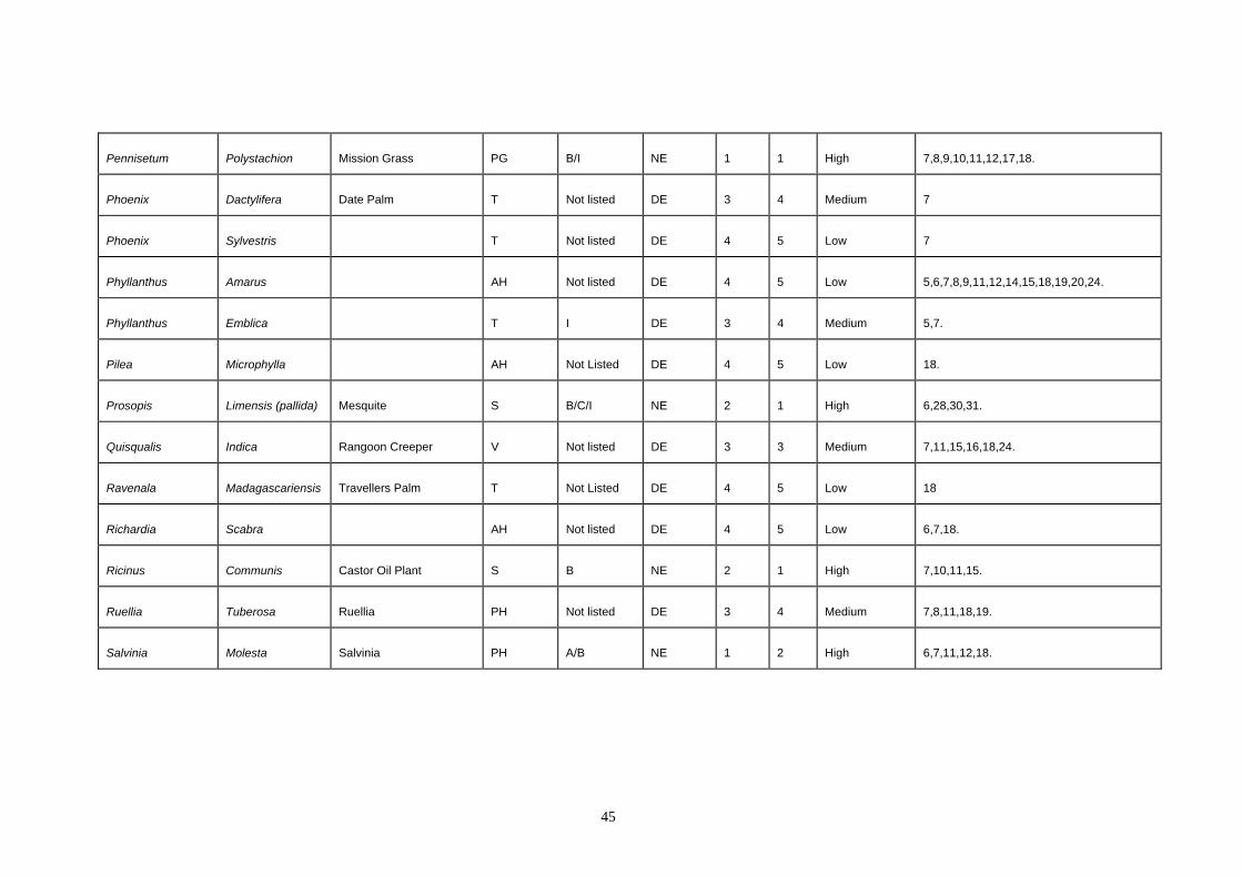
Pennisetum Polystachion Mission Grass PG B/I NE 1 1 High 7,8,9,10,11,12,17,18.
Phoenix Dactylifera Date Palm T Not listed DE 3 4 Medium 7
Phoenix Sylvestris T Not listed DE 4 5 Low 7
Phyllanthus Amarus AH Not listed DE 4 5 Low 5,6,7,8,9,11,12,14,15,18,19,20,24.
Phyllanthus Emblica T I DE 3 4 Medium 5,7.
Pilea Microphylla AH Not Listed DE 4 5 Low 18.
Prosopis Limensis (pallida) Mesquite S B/C/I NE 2 1 High 6,28,30,31.
Quisqualis Indica Rangoon Creeper V Not listed DE 3 3 Medium 7,11,15,16,18,24.
Ravenala Madagascariensis Travellers Palm T Not Listed DE 4 5 Low 18
Richardia Scabra AH Not listed DE 4 5 Low 6,7,18.
Ricinus Communis Castor Oil Plant S B NE 2 1 High 7,10,11,15.
Ruellia Tuberosa Ruellia PH Not listed DE 3 4 Medium 7,8,11,18,19.
Salvinia Molesta Salvinia PH A/B NE 1 2 High 6,7,11,12,18.
45
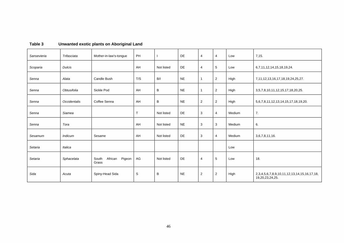
Table 3 Unwanted exotic plants on Aboriginal Land
Sansevieria Trifasciata Mother-in-law’s-tongue PH I DE 4 4 Low 7,15.
Scoparia Dulcis AH Not listed DE 4 5 Low 6,7,11,12,14,15,18,19,24.
Senna Alata Candle Bush T/S B/I NE 1 2 High 7,11,12,13,16,17,18,19,24,25,27.
Senna Obtusifolia Sickle Pod AH B NE 1 2 High 3,5,7,8,10,11,12,15,17,18,20,25.
Senna Occidentalis Coffee Senna AH B NE 2 2 High 5,6,7,8,11,12,13,14,15,17,18,19,20.
Senna Siamea T Not listed DE 3 4 Medium 7.
Senna Tora AH Not listed NE 3 3 Medium 6.
Sesamum Indicum Sesame AH Not listed DE 3 4 Medium 3,6,7,8,11,16.
Setaria Italica Low
Setaria Sphacelata South African Pigeon Grass
AG Not listed DE 4 5 Low 18.
Sida Acuta Spiny-Head Sida S B NE 2 2 High 2,3,4,5,6,7,8,9,10,11,12,13,14,15,16,17,18,19,20,23,24,25.
46
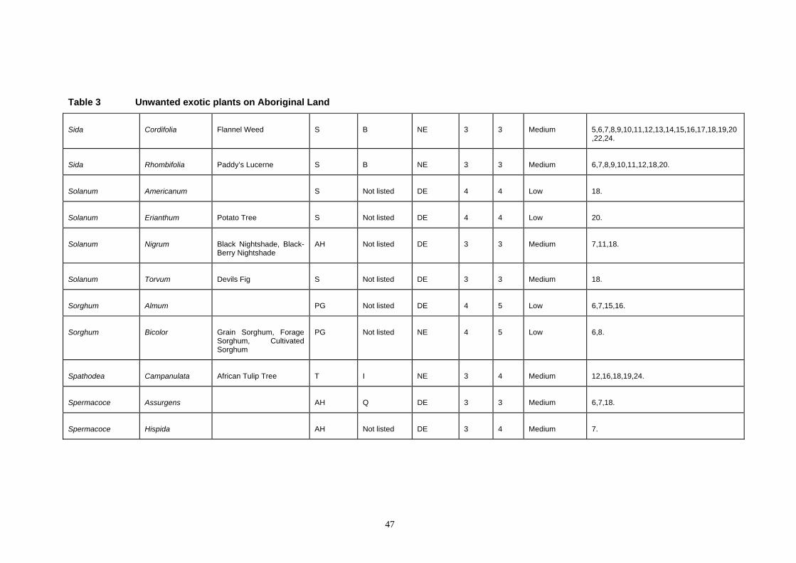
Table 3 Unwanted exotic plants on Aboriginal Land
Sida Cordifolia Flannel Weed S B NE 3 3 Medium 5,6,7,8,9,10,11,12,13,14,15,16,17,18,19,20,22,24.
Sida Rhombifolia Paddy’s Lucerne S B NE 3 3 Medium 6,7,8,9,10,11,12,18,20.
Solanum Americanum S Not listed DE 4 4 Low 18.
Solanum Erianthum Potato Tree S Not listed DE 4 4 Low 20.
Solanum Nigrum Black Nightshade, Black-Berry Nightshade
AH Not listed DE 3 3 Medium 7,11,18.
Solanum Torvum Devils Fig S Not listed DE 3 3 Medium 18.
Sorghum Almum PG Not listed DE 4 5 Low 6,7,15,16.
Sorghum Bicolor Grain Sorghum, Forage Sorghum, Cultivated Sorghum
PG Not listed NE 4 5 Low 6,8.
Spathodea Campanulata African Tulip Tree T I NE 3 4 Medium 12,16,18,19,24.
Spermacoce Assurgens AH Q DE 3 3 Medium 6,7,18.
Spermacoce Hispida AH Not listed DE 3 4 Medium 7.
47
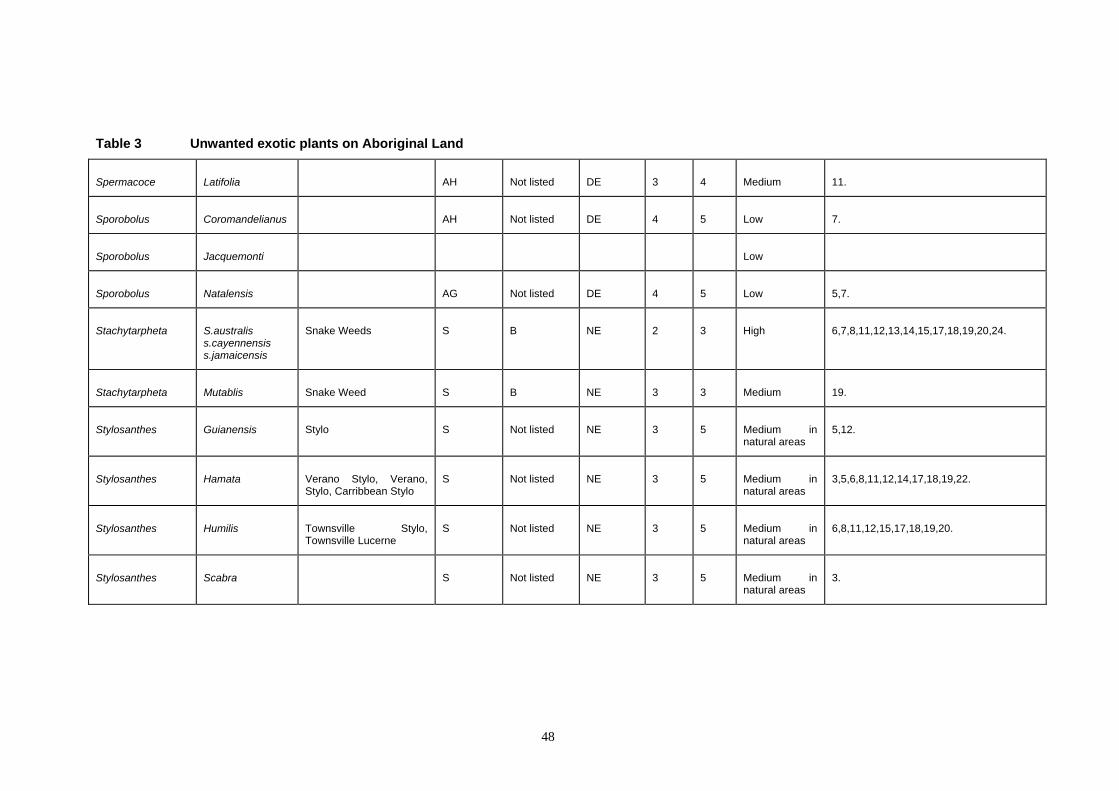
Table 3 Unwanted exotic plants on Aboriginal Land
Spermacoce Latifolia AH Not listed DE 3 4 Medium 11.
Sporobolus Coromandelianus AH Not listed DE 4 5 Low 7.
Sporobolus Jacquemonti Low
Sporobolus Natalensis AG Not listed DE 4 5 Low 5,7.
Stachytarpheta S.australiss.cayennensis s.jamaicensis
Snake Weeds S B NE 2 3 High 6,7,8,11,12,13,14,15,17,18,19,20,24.
Stachytarpheta Mutablis Snake Weed S B NE 3 3 Medium 19.
Stylosanthes Guianensis Stylo S Not listed NE 3 5 Medium innatural areas
5,12.
Stylosanthes Hamata Verano Stylo, Verano, Stylo, Carribbean Stylo
S Not listed NE 3 5 Medium innatural areas
3,5,6,8,11,12,14,17,18,19,22.
Stylosanthes Humilis Townsville StylTownsville Lucerne
o, S Not listed NE 3 5 Medium innatural areas
6,8,11,12,15,17,18,19,20.
Stylosanthes Scabra S Not listed NE 3 5 Medium innatural areas
3.
48
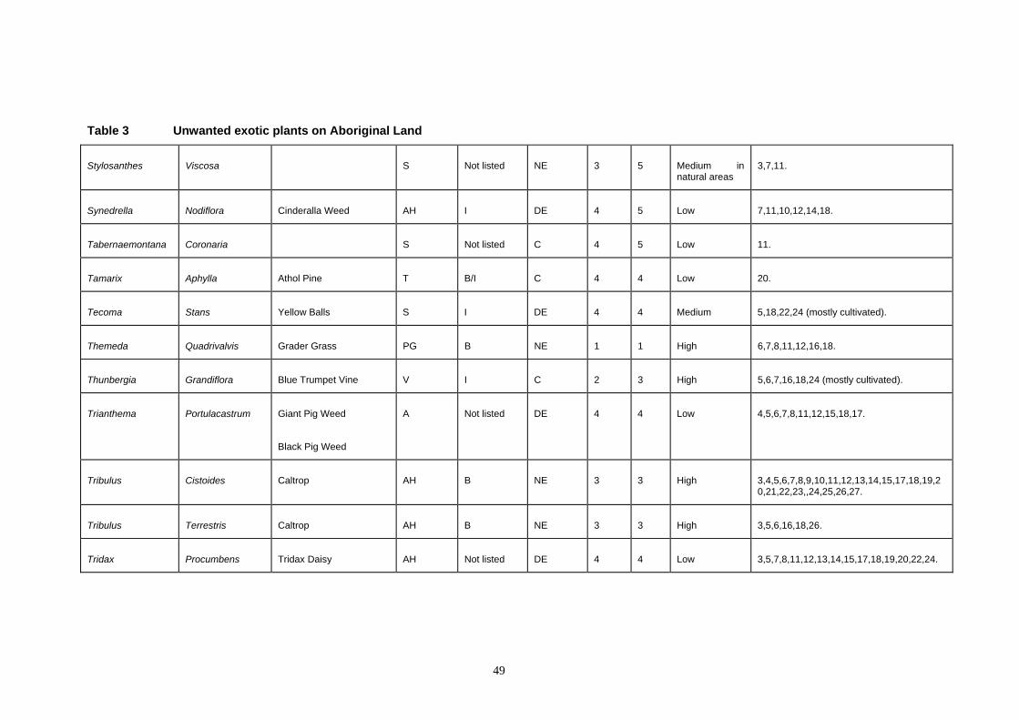
Table 3 Unwanted exotic plants on Aboriginal Land
Stylosanthes Viscosa S Not listed NE 3 5 Medium innatural areas
3,7,11.
Synedrella Nodiflora Cinderalla Weed AH I DE 4 5 Low 7,11,10,12,14,18.
Tabernaemontana Coronaria S Not listed C 4 5 Low 11.
Tamarix Aphylla Athol Pine T B/I C 4 4 Low 20.
Tecoma Stans Yellow Balls S I DE 4 4 Medium 5,18,22,24 (mostly cultivated).
Themeda Quadrivalvis Grader Grass PG B NE 1 1 High 6,7,8,11,12,16,18.
Thunbergia Grandiflora Blue Trumpet Vine V I C 2 3 High 5,6,7,16,18,24 (mostly cultivated).
Trianthema Portulacastrum Giant Pig Weed
Black Pig Weed
A Not listed DE 4 4 Low 4,5,6,7,8,11,12,15,18,17.
Tribulus Cistoides Caltrop AH B NE 3 3 High 3,4,5,6,7,8,9,10,11,12,13,14,15,17,18,19,20,21,22,23,,24,25,26,27.
Tribulus Terrestris Caltrop AH B NE 3 3 High 3,5,6,16,18,26.
Tridax Procumbens Tridax Daisy AH Not listed DE 4 4 Low 3,5,7,8,11,12,13,14,15,17,18,19,20,22,24.
49
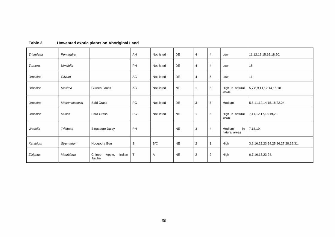
Table 3 Unwanted exotic plants on Aboriginal Land
Triumfetta Pentandra AH Not listed DE 4 4 Low 11,12,13,15,16,18,20.
Turnera Ulmifolia PH Not listed DE 4 4 Low 18.
Urochloa Gilvum AG Not listed DE 4 5 Low 11.
Urochloa Maxima Guinea Grass AG Not listed NE 1 5 High in natural areas
5,7,8,9,11,12,14,15,18.
Urochloa Mosambicensis Sabi Grass PG Not listed DE 3 5 Medium 5,6,11,12,14,15,18,22,24.
Urochloa Mutica Para Grass PG Not listed NE 1 5 High in natural areas
7,11,12,17,18,19,20.
Wedelia Trilobata Singapore Daisy PH I NE 3 4 Medium in natural areas
7,18,19.
Xanthium Strumarium Noogoora Burr S B/C NE 2 1 High 3,6,16,22,23,24,25,26,27,28,29,31.
Ziziphus Mauritiana Chinee Apple, Indian Jujube
T A NE 2 2 High 6,7,16,18,23,24.
50

Weed data for Aboriginal lands in the NLC area
4.7 Future collection, storage and mapping of weed data
4.7.1 Database development considerations
The value of any weeds database will depend upon the accuracy of the data collected. Proformas will need to be developed to assist field staff with standardised data collection. An example of a proforma developed and trialed as part of this project can be seen in Appendix 7. This proforma was distributed for trial in some communities and this should be followed up and comments on suitability collected. If proformas are hard to read or unnecessarily complex they will not be completed by field staff. The use of this proforma will need more trialing and modification. From initial reports some of the fields presented in the proforma were not perceived as relevant by some field collectors. There is obviously a need to train and explain to field collectors the importance of the proforma fields presented, particularly information relating to locations.
In order to best use human and other resources, all international transfer standards should be used, where possible, to allow data to be transferred from any recognised source. This will improve the reliability and extent of available data. Consideration should also be given to databases already developed for similar purposes elsewhere, both nationally and internationally. This may allow the easy use of recognised transfer formats and standardised fields of entry thus eliminating the problems of using poorly developed database with indecipherable personal coding schemes and data files structured in undocumented ways. It will also reduce the resources required to duplicate overlapping data management needs e.g. every weeds database in the world must accommodate synonymy of plant names. Consideration should also be given to the use of herbarium plant codes as a standard and directly selecting them from the herbarium database. Other land management agencies in the Northern Territory who collect vegetation data are moving towards using these codes. The NLC should liaise with the PWCNT Herbarium when designing its database so the incorporation of these codes can occur.
Databases already maintained with data relevant to the NLC area that could be transferred to the NLC include:
Any database development will need to take into consideration the expertise of those already developing allied databases in northern Australia so that relevant data can be transferred between these database i.e. the NLC database can then be easily updated. The amount of work required to maintain standalone databases to a level useful to managers, particularly to cover the whole NLC area, is quite substantial. It is hard to see the NLC progressing far with current staffing levels, particularly within the Caring for the Country Unit where such a database would logically be maintained. It is recommended that funds be sought to provide a dedicated person for the collection, entry and maintenance of any database developed. Funding sources would logically come from ILC.
There is an urgent need to collect weed data about Aboriginal land and to store this on database systems that can be updated and will support weed-management strategies. Of particular relevance would be a mapping capability that can allow distribution maps to be printed. Minimum information to be collected and stored would include the origin of the weed, current range, abundance and rate of spread. Such information would allow the appropriate allocation of management resources to where they are most needed in terms of both species and locations.
It is important for land mangers concerned with weed management that they have access to information in order to develop weed management strategies and so they can answer even the simplest of questions e.g. Where are weeds distributed? How many weeds are there? What species are present? Currently for Aboriginal land these questions are at best very difficult to answer with any confidence.
1. Parks and Wildlife Commission Herbarium specimen database and vegetation plot database. Microsoft Access based knowledge databases with useful plant (including weeds) data stored. Unofficial unconditional approval has been given for the NLC for access to all of this data.
51
2. NTDPIF weed management and mapping system. 3. Environment Australia-Kakadu Mimosa Database. 4. Pestinfo (DNR, QLD). NLC should approach Pest Information Systems Officer, Land
Protection, Department of Natural Resources (DNR) in Qld (Brisbane) for access. 5. WA Herbarium specimen database (CALM).

52
Weed data for Aboriginal lands in the NLC area
It would be highly desirable for the NLC to pilot a weed database collection and mapping program in one area or one community. This, once practically developed, can then be used as a model to train and instruct other communities.
Possible fields for database storage should include: Family •
•
• • • • • • • • •
• • • • •
•
Latin name; need to include names at subspecific levels such as subspecies varieties and cultivars as well as synonyms# Ethnoscientific name; for example local Aboriginal botanical names and language group# Common name# Date of recording# Persons recording Location; physical location e.g. descriptive# Coordinates of the point or area occupied by the weed# Cooordinate reference datum Description of location/habitat; e.g. the landform and habitat Plant notes; descriptive notes on the plant itself e.g. height, flower colour. smell, anecdotal notes on introduction, cultural notes Growth form; use standardised formats Phenology; e.g. flowering or seed Estimated area of infestation; measured in sq. m or ha Density; general indicators e.g. heavy dense medium Control methods used: e.g. record result of previous control measures such as change in area, rate of spread, density, percentage kill, any regeneration - natives, which species Weather conditions (if applicable)
Note: Minimum fields have been marked with #
4.7.2 Recommendations Recommendation 6: NLC to seek funds to carry out a complete weed survey on all Aboriginal land. It is certain that the distribution data and the number of species recorded as weeds on Aboriginal land could be expanded greatly given further survey work.
Recommendation 7: NLC seek funds to provide a dedicated person for the collation, entry and maintenance of any database developed by the NLC This person should be located in the CFCU. Funding sources would logically come from ILC .
Recommendation 8: NLC seek funds to employ a weeds botanist to carry out the survey and data collection work on Aboriginal land. Possible funding sources include EA-invasive weeds program, or the ILC. This position should be a joint NLC and DPIF/Weeds CRC position.
Recommendation 9: NLC carry out an education program to increase the level of awareness in Aboriginal communities about weeds and their method of introduction.
Recommendation 10: NLC to continue liaison with NTDPIF re the development of its weeds database. The NLC should make sure it is involved any further developments by the EA working group for the development of the National Weeds Database.
Recommendation 11: NLC to pilot a weed database collection and mapping program in one area or one community. This, once practically developed, can then be used as a model to train and instruct other communities.
Recommendation 12: Attention to weed control on Aboriginal land should be given to species in the priority groups in descending order. Recommended control methods for weed species in the high and medium priority group are given in Appendix 3. It will be necessary to periodically review this list, add new species or change priorities should the need arise.
53
Related Documents