Watershed Parameters of the El Fuerte Basin Samuel Sandoval-Solis GIS for WR Dr. David Maidment

Watershed Parameters of the El Fuerte Basin Samuel Sandoval-Solis GIS for WR Dr. David Maidment.
Dec 25, 2015
Welcome message from author
This document is posted to help you gain knowledge. Please leave a comment to let me know what you think about it! Share it to your friends and learn new things together.
Transcript

Watershed Parameters of the El Fuerte Basin
Samuel Sandoval-Solis
GIS for WRDr. David Maidment

Outline
• Introduction• Objectives• Area Studied• Data Sources• WRAPHydro Process• Results• Process of Uploading the Watershed Parameters
in the Water Reliability Model• Hydropower reliability results displayed in GIS• Conclusions
IntroductionThe modeling of water resources has become an important issue for decision holders and water users. By modeling, we can diagnose the resource, visualize future scenarios and establish strategies for optimization.
The WRAP model need to be fed with certain files: naturalized flow, evaporation and watershed parameters (drainage area, curve number and mean annual precipitation ).

Objectives
• Obtain the watershed parameters (drainage area, curve number and mean annual precipitation ) for the El Fuerte Basin
• Upload the watershed parameters in the El Fuerte Water Reliability Model for Hydropower Generation
• Display the reliability output in the Geographic Information System (GIS)

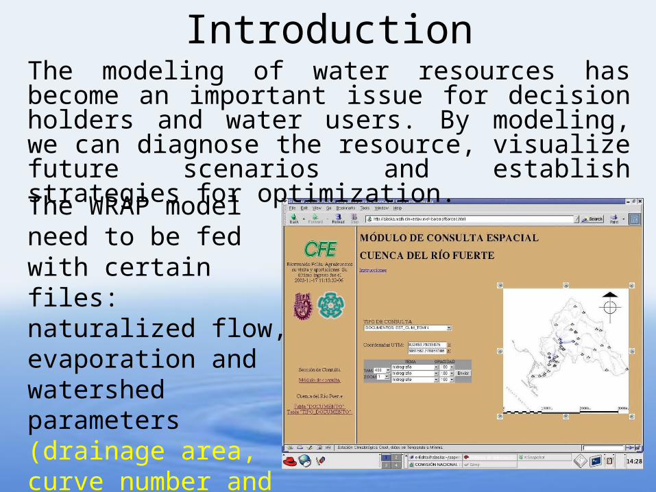
El Fuerte Basin
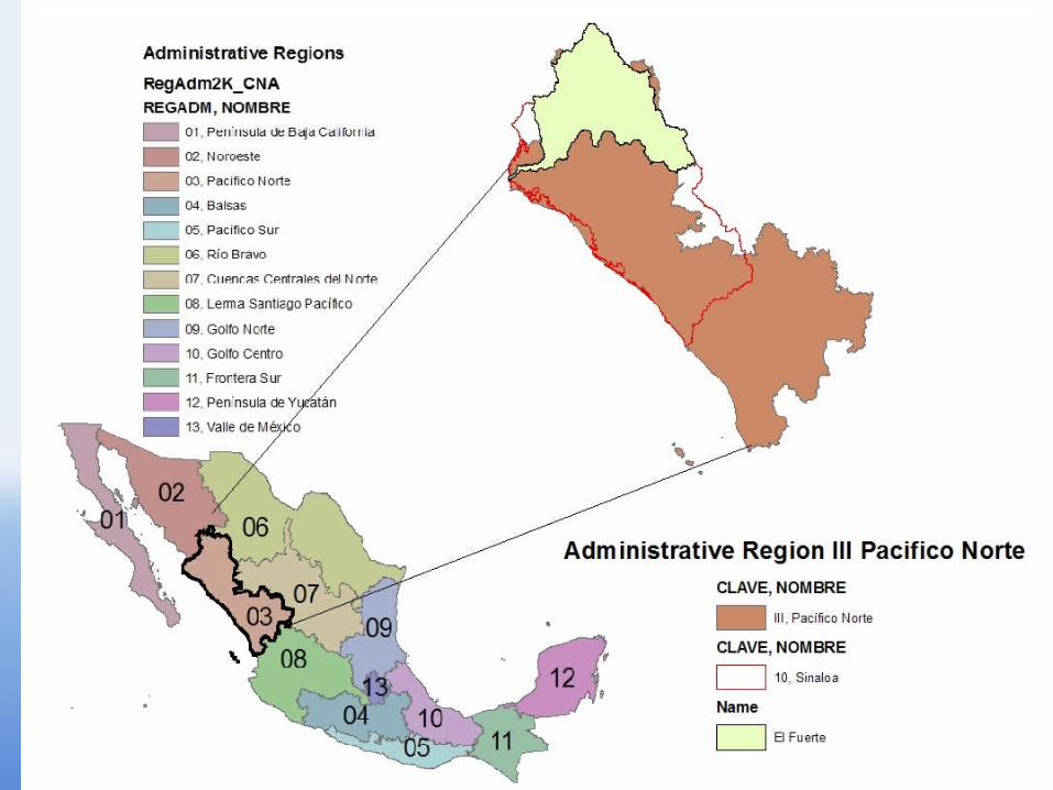
•Area of 34,597 sq Km
•3 Reservoirs
•2 Irrigation Districts
Luis Donaldo Colosio “Huites”(4568 MCM)
Miguel Hidalgo “El Fuerte” (4069 MCM)
Josefa Ortiz de Dominguez (590 MCM)
ID 076 Valle del Carrizo(43,259 ha)
ID 075 Valle del Fuerte(201,844 ha)
Characteristics

Data SourcesThe DEM used in this project was provided by the Mexican mapping agency INEGI.
The Mexican climatologic database, ERIC, was used to locate the precipitation gages and to build the mean annual precipitation raster. Also, the Mexican hydrologic database, BANDAS, were used to locate the streamflow gages.
WRAP Hydro Process

• Preprocessing
-To set the Geodatabase
-To obtain and give format the necessary feature classes
-To obtain the rasters
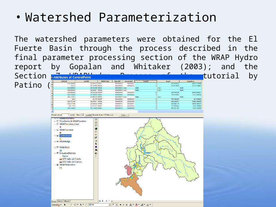
• Watershed Parameterization
The watershed parameters were obtained for the El Fuerte Basin through the process described in the final parameter processing section of the WRAP Hydro report by Gopalan and Whitaker (2003); and the Section 7 WRAPHydro Process of the tutorial by Patino (2005).
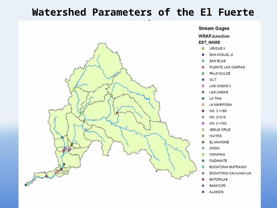
Watershed Parameters of the El Fuerte Basin

No. CNA Code Stream Gage Name LengthDown (m) AvgCN AvgPR DrainArea (Km2)
1 10037 HUITES 1603200722 0.00 861.49 26243.582 10038 SAN BLAS 701400356 0.00 837.82 33719.343 10051 LAS CANAS 1202400570 0.00 854.15 29679.204 10053 ALAMOS 1102200532 0.00 799.15 2272.495 10057 BAMICORI 1102200481 0.00 713.80 401.716 10058 BOCATOMA SUFRAGIO 601200319 0.00 836.90 33821.857 10060 KM. 2+310 200400111 0.00 834.80 34004.878 10063 BATOPILAS 2004000814 0.00 727.00 2019.309 10064 CHINIPAS 2004000854 0.00 924.38 5162.46
10 10066 CHOIX 1603200731 0.00 788.87 1396.0011 10067 BOCATOMA CAHUINAHUA 400800198 0.00 835.87 33911.9412 10074 LA MARIPOSA 300600155 0.00 835.09 33982.9313 10077 PALO DULCE 1903800809 0.00 928.20 6390.5914 10078 LA TINA 901800420 0.00 0.00 0.0015 10085 SAN MIGUEL Z 100200064 0.00 830.78 34309.5916 10097 EL MAHONE 1302600620 0.00 854.78 29565.8217 10098 CAZANATE 1302600641 0.00 832.95 1805.8018 10100 URIQUE II 1903800817 0.00 739.03 4024.7519 10117 KM. 0 +700 1202400587 0.00 801.07 2252.8920 10118 PUENTE LAS CABRAS 1002000476 0.00 788.73 2376.7821 10119 JESUS CRUZ 1903800822 0.00 984.69 1062.0422 10121 KM. 3 +180 501000259 0.00 836.88 33823.6023 10122 LAS CANAS II 1102200508 0.00 853.37 29797.0824 -------- OUT 0 0.00 826.77 34597.53
Watershed Parameters of the El Fuerte Basin

Watershed Parameters of the El Fuerte Basin

Uploading the Watershed Parameters in the Water Reliability Model

Water Reliability Model of Hydropower Generation for the El Fuerte Basin

Hydropower
Generation
Miguel Hidalgo “Fuerte” Reservoir- 370,000 MWatts/Year- 4069 MCM
Luis Donaldo Colosio “Huites” Reservoir- 917,000 MWatts/Year- 4568 MCM
- Monthly Coefficients for Water Use- Capacity-Elevation Curve

Irrigation Districts
ID 075 Valle del Fuerte3,020 MCM/Year
ID 076 Valle del Carrizo582 MCM/Year
- Monthly Coefficients for Water Use- Area-Capacity Curve

Results
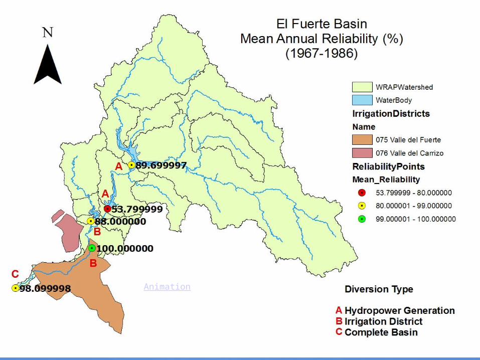
Animation

Conclusions

• 23 sets of drainage area and mean annual precipitation parameters were obtained for the El Fuerte Basin.
• The average curve number parameters were not obtained due to the lack of information.
• The WRMHG can be extended from 8 to 24 control points by using the geodatabase.
• The outputs of the WRMHG were displayed in the Geodatabase.
• Further research is needed in the curve number raster, and in the strict representation of the basin

Thank you
Questions?
Related Documents