Watershed Nitrogen and Mercury Geochemical Fluxes Integrate Landscape Factors in Long-term Research Watersheds at Acadia National Park, Maine, USA J. S. Kahl & S. J. Nelson & I. Fernandez & T. Haines & S. Norton & G. B. Wiersma & G. Jacobson Jr. & A. Amirbahman & K. Johnson & M. Schauffler & L. Rustad & K. Tonnessen & R. Lent & M. Bank & J. Elvir & J. Eckhoff & H. Caron & P. Ruck & J. Parker & J. Campbell & D. Manski & R. Breen & K. Sheehan & A. Grygo Received: 23 March 2005 / Accepted: 1 January 2006 / Published online: 16 December 2006 # Springer Science + Business Media B.V. 2006 Abstract This paper is an overview of this special issue devoted to watershed research in Acadia Nation- al Park (Acadia NP). The papers address components of an integrated research program on two upland watersheds at Acadia NP, USA (44° 20 0 N latitude; 68° 15 0 E longitude). These watersheds were instru- mented in 1998 to provide a long-term foundation for regional ecological and watershed research. The research was initiated as part of EPA/NPS PRIMENet (Park Research and Intensive Monitoring of Ecosys- tems Network), a system of UV-monitoring stations and long-term watershed research sites located in US national parks. The initial goals at Acadia NP were to Environ Monit Assess (2007) 126:9–25 DOI 10.1007/s10661-006-9328-0 J. S. Kahl (*) : S. J. Nelson : I. Fernandez : S. Norton : G. B. Wiersma : G. Jacobson Jr. : A. Amirbahman : K. Johnson : M. Schauffler : L. Rustad : M. Bank : J. Elvir : J. Eckhoff : H. Caron : P. Ruck : J. Parker : K. Sheehan : A. Grygo : University of Maine, Orono, ME, USA e-mail: [email protected] T Haines U.S. Geological Survey, Orono Field Station, Leetown Science Center, Orono, ME, USA L. Rustad : J. Campbell Northeastern Research Station, USDA Forest Service, Durham, NH, USA K. Tonnessen National Park Service, University of Montana, Missoula, MT, USA R. Lent Water Resources Division, US Geological Survey, Augusta, ME, USA D. Manski : R. Breen National Park Service, Acadia National Park, Bar Harbor, ME, USA Present address: J. S. Kahl Center for the Environment, Plymouth State University, Plymouth, NH 03264, USA Present address: T. Haines Department of Biological Sciences, University of Maine, Orono, ME, USA Present address: M. Bank Harvard School of Public Health, Department of Environmental Health, Boston, MA, USA Present address: J. Eckhoff National Park Service, Wilson_s Creek National Battlefield, Republic, MO, USA

Welcome message from author
This document is posted to help you gain knowledge. Please leave a comment to let me know what you think about it! Share it to your friends and learn new things together.
Transcript
Watershed Nitrogen and Mercury Geochemical FluxesIntegrate Landscape Factors in Long-term ResearchWatersheds at Acadia National Park, Maine, USA
J. S. Kahl & S. J. Nelson & I. Fernandez & T. Haines & S. Norton & G. B. Wiersma &
G. Jacobson Jr. & A. Amirbahman & K. Johnson & M. Schauffler & L. Rustad &
K. Tonnessen & R. Lent & M. Bank & J. Elvir & J. Eckhoff & H. Caron & P. Ruck &
J. Parker & J. Campbell & D. Manski & R. Breen & K. Sheehan & A. Grygo
Received: 23 March 2005 /Accepted: 1 January 2006 / Published online: 16 December 2006# Springer Science + Business Media B.V. 2006
Abstract This paper is an overview of this specialissue devoted to watershed research in Acadia Nation-al Park (Acadia NP). The papers address componentsof an integrated research program on two uplandwatersheds at Acadia NP, USA (44° 200 N latitude;68° 150 E longitude). These watersheds were instru-mented in 1998 to provide a long-term foundation forregional ecological and watershed research. Theresearch was initiated as part of EPA/NPS PRIMENet(Park Research and Intensive Monitoring of Ecosys-tems Network), a system of UV-monitoring stationsand long-term watershed research sites located in USnational parks. The initial goals at Acadia NP were to
Environ Monit Assess (2007) 126:9–25DOI 10.1007/s10661-006-9328-0
J. S. Kahl (*) : S. J. Nelson : I. Fernandez : S. Norton :G. B. Wiersma :G. Jacobson Jr. :A. Amirbahman :K. Johnson :M. Schauffler : L. Rustad :M. Bank :J. Elvir : J. Eckhoff :H. Caron : P. Ruck : J. Parker :K. Sheehan :A. Grygo :University of Maine, Orono, ME, USAe-mail: [email protected]
T HainesU.S. Geological Survey, Orono Field Station, LeetownScience Center, Orono, ME, USA
L. Rustad : J. CampbellNortheastern Research Station, USDA Forest Service,Durham, NH, USA
K. TonnessenNational Park Service, University of Montana,Missoula, MT, USA
R. LentWater Resources Division, US Geological Survey,Augusta, ME, USA
D. Manski : R. BreenNational Park Service, Acadia National Park,Bar Harbor, ME, USA
Present address:J. S. KahlCenter for the Environment, Plymouth State University,Plymouth, NH 03264, USA
Present address:T. HainesDepartment of Biological Sciences, University of Maine,Orono, ME, USA
Present address:M. BankHarvard School of Public Health, Department ofEnvironmental Health, Boston, MA, USA
Present address:J. EckhoffNational Park Service, Wilson_s Creek National Battlefield,Republic, MO, USA
address research questions about mercury, acid rain,and nitrogen saturation developed from prior research.The project design was based on natural differences inforests and soils induced by an intense wildfire in onewatershed in 1947. There is no evidence of fire in thereference watershed for several hundred years. We aretesting hypotheses about controls on surface waterchemistry, and bioavailability of contaminants in thecontrasting watersheds. The unburned 47-ha HadlockBrook watershed is 70% spruce-fir mature coniferforest. In contrast, burned 32-ha Cadillac Brookwatershed, 4 km northeast of the Hadlock watershed,is 20% regenerating mixed northern hardwoods and60% shrub/rocky balds. Differences in atmosphericdeposition are controlled primarily by forest standcomposition and age. The watersheds are gauged andhave water chemistry stations at 122 m (Cadillac) and137 m (Hadlock); watershed maximum elevations are468 and 380 m, respectively. The stream waterchemistry patterns reflect, in part, the legacy of theintense fire, which, in turn, controls differences inforest vegetation and soil characteristics. These factorsresult in higher nitrogen and mercury flux from theunburned watershed, reflecting differences in atmo-spheric deposition, contrasting ecosystem pools ofnitrogen and mercury, and inferred differences ininternal cycling and bioavailabilty.
Keywords watershed science . hydrology . massbalances . mercury . acidic deposition . nitrogen . foresthealth . paleoecology . forest fire . AcadiaNational Park
1 Introduction
Acadia National Park (Acadia NP) has been a magnetfor scientists and naturalists for over a century due toits pronounced glacial features, interesting bedrockgeology, scenic beauty, and diversity of plant andanimal life. The park is within the southern coastalrange limit for spruce-fir forests of the northeasternUSA (Davis, 1966). Several species and communitiesare at the edge of their geographic ranges. Thin soils,steep slopes, abundant surface waters, and the highestmountains on the east coast of the United Statescontribute to the park’s sensitivity to disturbance(Kahl, Manski, Flora & Houtman, 2000).
The steep slopes, high peaks, and exposure tocoastal fog create an environment conducive tointerception of polluted air masses. Therefore, an issue
of particular importance at Acadia NP is long-rangetransport of atmospheric contaminants, including toxictrace substances such as trace metals (Kahl et al., 2000;Norton, Evans, & Kahl, 1997), persistent organicsubstances (Matz, 1998), mercury (Hg)(Stafford &Haines, 1997) and acidic deposition (Kahl, Andersen,Norton, 1985; 1992, 2000). The inputs of acids andHg are well characterized at Acadia NP, based on datafrom the National Atmospheric Deposition Program(NADP) since 1980 (NADP, 2004), and MercuryDeposition Network (MDN) since 1995. Fog pHbelow 3.5 has been documented (Jagels, Cunningham,Serreze, & Tsai, 1989; Weathers et al., 1988).
Elevated deposition of contaminants, including Hg,has been inferred from sediment accumulation rates atAcadia NP (e.g., Norton et al., 1997; Kahl et al.,1985). Kahl et al. (1992, 1985) and Heath, Kahl,Norton and Fernandez (1992) documented salt- andstrong acid-driven acidic episodes in streams, with pHvalues as low as 4.7. Nitrate concentrations in severalstreams are chronically elevated (Johnson et al., inpress; Kahl et al., 1985), suggesting that nitrogen (N)saturation of the forest (Aber et al., 1998, 1989) is anissue to evaluate. Longcore et al. (in press a, b)documented that tree swallow eggs and chicks fromareas of Acadia NP are at least as contaminated withHg as birds living at a Hg-contaminated Superfundsite in Massachusetts, USA.
Concern over ecological issues such as acidifica-tion and Hg bioaccumulation led to the recommenda-tion for permanent long-term ecological research atthe watershed scale (Kahl et al., 2000). The initialfocus of this project has been atmospheric depositionof N and Hg, and their ecological consequences. Aprimary goal of the long-term watershed researchprogram is to determine how watershed characteristicsinfluence the reservoirs and fluxes of Hg and N inwatersheds and surface waters.
1.1 PRIMENet watersheds at Acadia NP
PRIMENet (Park Research and Intensive Monitoringof Ecosystems Network) was a joint nationwideprogram between the U.S. Environmental Protectionand Agency and the National Park Service, establishedin the late 1990s to assess the effects of environmentalstressors on ecological systems. The U.S. GeologicalSurvey (USGS) Biological Resources Division was aco-funder of the program, and the USGS Water
10 Environ Monit Assess (2007) 126:9–25
Resources Division was a collaborator at Acadia NP.The network of monitoring and research sites usespark units as outdoor laboratories, where environmen-tal changes are monitored through time in relativelyundisturbed and protected sites (http://www.forestry.umt.edu/research/MFCES/programs/primenet/).
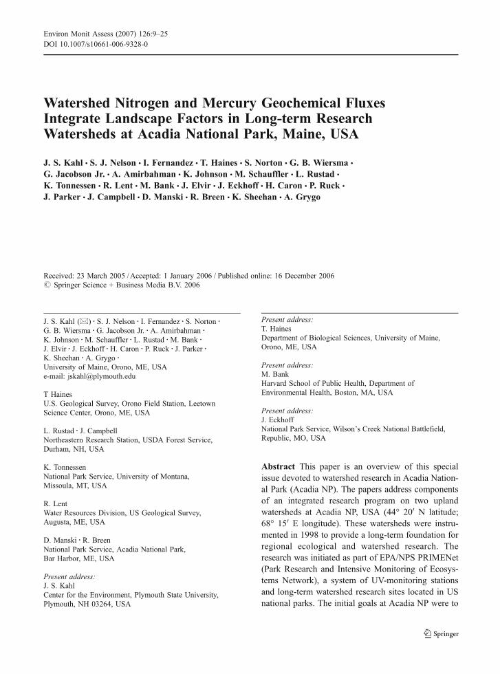
At Acadia NP, small, high-elevation watershedsprovide a natural experimental setting for investigat-ing long-term influences of forest-type and distur-bance history on watershed geochemistry. Onepossible difference between otherwise similar water-sheds, is the history of disturbances such as severefire (Goodale, Aber, & McDowell, 2000; Goodale,2003; Magill et al., 1997; Hornbeck, Bailey, Buso, &Shanley, 1997). A major wildfire burned one-third ofAcadia NP in 1947, including one of the twowatersheds selected for this study (Figure 1). Thispaper provides a summary of the papers in this specialissue dedicated to PRIMENet research at Acadia NP.We describe the use of stand-scale paleoecologicaltools, historic written records, and tree-ring analyses,
combined with modern soil, precipitation, and streamchemistry data, to identify linkages among long-termvegetation history, disturbance, and the cycling of Hgand N within the two watersheds.
We hypothesized that severe disturbance by firemay influence the long-term storage and processingof atmospheric contaminants within watersheds. Inparticular, burning of soils may have volatilized Hgfrom organic soil layers, and changed the ratio of N toother soil constituents that control N flux in streamwater. We also hypothesized that the distribution offire would be reflected in the stream chemistrydraining the two watersheds.
This pair of research watersheds generally repre-sents disturbance of New England landscapes, someof which have burned over the past several hundredyears, and most of which have experienced somelevel of vegetation change due to different land usehistories. Moreover, these watersheds, with thin soilsand steep slopes, are inferred to be especiallysensitive to perturbations and recovery. This sensitiv-ity makes them ideal to serve as advance indicators ofthe effects of regional change.
1.2 Regional setting of paired watersheds
Pollen records from Acadia National Park and othercoastal settings in New England suggest that large-scale, stand-replacing disturbances of coastal forestsoccurred at 300 to 500 year intervals prior toEuropean colonization of the region, (Schauffler,1998; Patterson & Backman, 1988). More frequentfires (both accidental and intentional) and forestclearing accompanied European settlement. Begin-ning in the late 18th Century and extending throughmost of the 19th Century, much of the land alongMaine’s coast was cleared for timber and sheepgrazing (McLane & McLane, 1989; Tolonen, 1983).Using land-use/land-cover history as a factor, ourresearch considers whether major historical distur-bance influences modern ecological processes includ-ing soil and stream chemistry. Because fire historymay be a major control on N cycling (Riggan et al.,1994; Tiedemann et al., 1979), and on Hg accumu-lation and speciation, research conducted in thenorthern hardwood or spruce-fir forest at Acadia NPhas regional implications for both Hg and Nbiogeochemistry. The recovering burned zone atAcadia NP provides a setting for ‘representative’
Figure 1 Location of study watersheds in Acadia NationalPark on Mount Desert Island, Maine, USA. The NationalAtmospheric Deposition Program site is shown for reference(McFarland Hill). The patterned area was burned in wildfire in1947. Park boundary and fire extent were provided by AcadiaNational Park, Resource Management. Map projection isNAD83, Zone 19 North.
Environ Monit Assess (2007) 126:9–25 11
research: Any specific point in the New Englandlandscape may have burned within the past 300 years.
2 Project Design
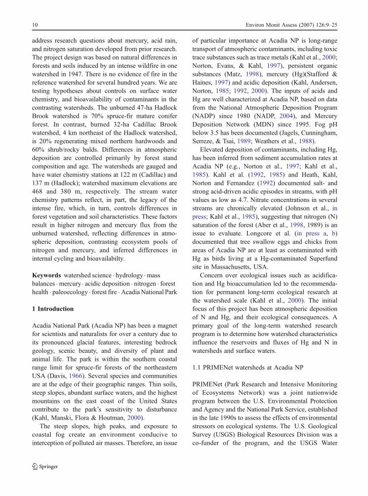
We established one gauged watershed (Cadillac) inthe zone of the intense wildfire of 1947, and one in anunburned area (Hadlock; Figure 1). Neither historicalrecords nor paleoecological reconstructions reveal anyindication of fire in the Hadlock watershed for at least500 years. In addition to basic stream and precipitation
data collection, the first year of the project included sitecharacterization using paleoecology and historicalrecords (Schauffler et al., in press), forest healthindicators (Wiersma, Elvir, & Eckhoff, in press), andcharacterization of soil chemistry (Amirbahman,Ruck, Fernandez, Haines, & Kahl, 2004; Parker,Fernandez, Rustad, & Norton, 2002, 2001).
The southeastern slope of the Cadillac Mountainwatershed is drained by a headwater stream unofficial-ly called Cadillac Brook. The gauging station for thisburned watershed is located at latitude 44°20041.000,
Figure 2 Study watersheds at Acadia National Park: (a) HadlockBrook watershed, and (b) Cadillac Brook watershed withlocations of throughfall and litter collectors, wet-onlyprecipitation collectors, stream discharge gauges, soil plots,Hg soil assay sites, and paleoecological cores; National
Park Service – USGS mapping project vegetation classification(Lubinski et al., 2003) for Cadillac Brook watershed andHadlock Brook watershed is displayed in the background.The inset at right shows the typical soil and throughfall plotlayout.
12 Environ Monit Assess (2007) 126:9–25
longitude 68°13001.500 (NAD 27) (Figure 2a) at anelevation of 122 m. The watershed area is 31.6 ha,extending from the summit of Cadillac Mountain(468 m) to 122 m above sea level. The average slopeis 28%. The stream begins at about 440 m in a smallvalley, descending through relatively unvegetatedexposed bedrock via multiple drainage channels thatconverge in the bottom third of the watershed.
The Hadlock watershed is drained by a headwaterstream called Hadlock Brook. The gauging stationfor this unburned reference watershed is located atlatitude 44°19054.000, longitude 68°16047.500 (NAD27)(Figure 2b) at 137 m above sea level. The watershedarea is 47.2 ha, extending from the summit ofPenobscot Mountain (380 m) to the gauging station.The average slope is 21%, and the watershed facessouthwest. The stream headwaters are in a 0.7-hawoodland bog/fen, descending through a maturespruce-fir forest.
3 Approach
Our approach included intensive site characterizationand determination of long-term chemical and hydro-logical budgets to serve as baseline indicators ofstatus and changes in watershed function (e.g. Likens,Bormann, Pierce, Eaton, & Johnson, 1977). Schauffleret al. (in press) and Wiersma et al. (in press) describethe history, landscape, and ecosystem compartmentsof the research watersheds. Subsequent papers defineHg wet deposition, throughfall and litterfall (Johnsonet al., in press) determine processes of Hg speciation,evaluate the status of N retention, estimate N-loadingto selected estuaries (Nelson, Johnson, Kahl, Haines,& Fernandez, in press; Nielsen & Kahl, in press;Peckenham, Kahl, Nelson, Johnson, & Haines, inpress) and document bioaccumulation of Hg in biota(Bank, Burgess, Evers, & Loftin, in press; Longcoreet al., in press a, b).
The burned watershed is dominated by hardwoodforest (Wiersma et al., in press) with lower organicmatter in soils (Parker et al., 2002, 2001). Theunburned watershed is dominated by conifer forest,and has older and thicker, more acidic soil organichorizons. One hypothesis of this research was that theecosystem pools of carbon (C), N, and Hg werequantitatively reduced in the 1947 fire. This hypoth-esis was confirmed by Parker et al. (2002, 2001) and
Amirbahman et al. (2004). The two contrastingwatersheds provided a contrast of ecosystem functionand response in forested watersheds at Acadia NP:Regenerating hardwoods vs. mature conifers. Thischaracterization serves as the baseline for ongoingassessments of the status of ecosystems in the park.
The methods for the research components aredescribed in the individual papers. In addition to thisspecial issue, several papers based on research in thesewatersheds have been published elsewhere (Amirbahmanet al., 2004; Campbell et al., 2004; Parker et al., 2002,2001; Peckenham, Kahl, & Mower, 2003; Heath et al.,1992; Kahl et al., 1992, 1985).
4 Site Characterization
4.1 Climate
Acadia NP is located at the temperate and borealtransition zone in North America. Its coastal locationand prominent topography result in frequent cloudand fog cover. Mean annual daytime temperature forBar Harbor, Maine is 13 °C and mean annualnighttime temperature is 2 °C (Acadia NP OfficialWebsite, www.nps.gov/acad). The prevalent winddirection at Bar Harbor is 220° to 240° (west–southwest; G. Zielinski, personal communication).Average annual precipitation for Acadia NP is122 cm as rain, plus 155 cm as snow near parkheadquarters (Table 1), for an annual average wettotal of 137 cm during the past 20 years. Seasonalprecipitation is relatively evenly distributed, withminimum values occurring in summer and the highestaverage monthly amount in November (Table 1).
The project period encompassed weather condi-tions including Hurricane Floyd (September, 1999),which deposited approximately 18 cm of rain in lessthan one week (NADP, 2004). The project alsoincluded severe drought in 2001, the driest year everrecorded in Maine. Statewide precipitation in 2001totaled 75 cm, 33 cm below the annual statewideaverage of 108 cm and 3.5 cm below the previousrecord drought year, 1965. Streamflow reductionswere greatest in August and September of 2001; dryconditions persisted into the 2002 winter whengroundwater levels across the state reached recordlows (Stewart, Caldwell, & Cloutier, 2003). By latespring 2002, rains had replenished surface waterlevels, although groundwater levels remained below
Environ Monit Assess (2007) 126:9–25 13
normal until spring, 2003 (Maine Drought TaskForce, 2002a, 2002b).
4.2 Hydrology
The U.S. Geological Survey, in Augusta, Maine,monitors stream stage at the outflow of eachwatershed with a pressure transducer linked to theWorld Wide Web via satellite (http://waterdata.usgs.gov/me/nwis/current/?type=flow). Streams wereinstrumented at natural control locations, with stagerecorders that recorded stage at five-minute intervals(Rantz et al., 1982). Stage was used to calculatestreamflow in each stream based on stage relation-ships and the stream profile (Table 2). Streamdischarge is greatest in spring and fall and typicallylow in summer (Figure 3) and winter.
4.3 Geology
The watersheds are underlain by the Cadillac Graniteof Devonian age (Gilman, Chapman, Lowel, &Borns, 1988), a spatially uniform bedrock, which
minimizes bedrock lithology as a source of environ-mental data variability. The highest points of bothwatersheds are exposed and glacially scoured bedrockas a result of continental glaciation that ended about14,000 years ago (Lowell & Borns, 1988). Down-slope migration of exfoliated granite bedrock hasproduced local talus slopes. Till underlies much of thelower slopes of both catchments. The gauging stationsof each watershed are located above the post-glacialmarine limit at ca. 80 masl. As a result, neitherwatershed contains the glacio-fluvial marine silts andclays (the Presumpscot Formation) that formed duringde-glaciation (Heath, Kahl, Norton, & Brutsaert1993).
4.4 Pedology
The predominant soil is a shallow-to-bedrock, stonySchoodic-rock outcrop-Lyman complex, derivedfrom granite and schist-bearing tills. This classifi-cation includes extensive areas of exposed bedrock,along with areas where soils exist as thin depositsof gravelly sandy loam less than 15 cm deep
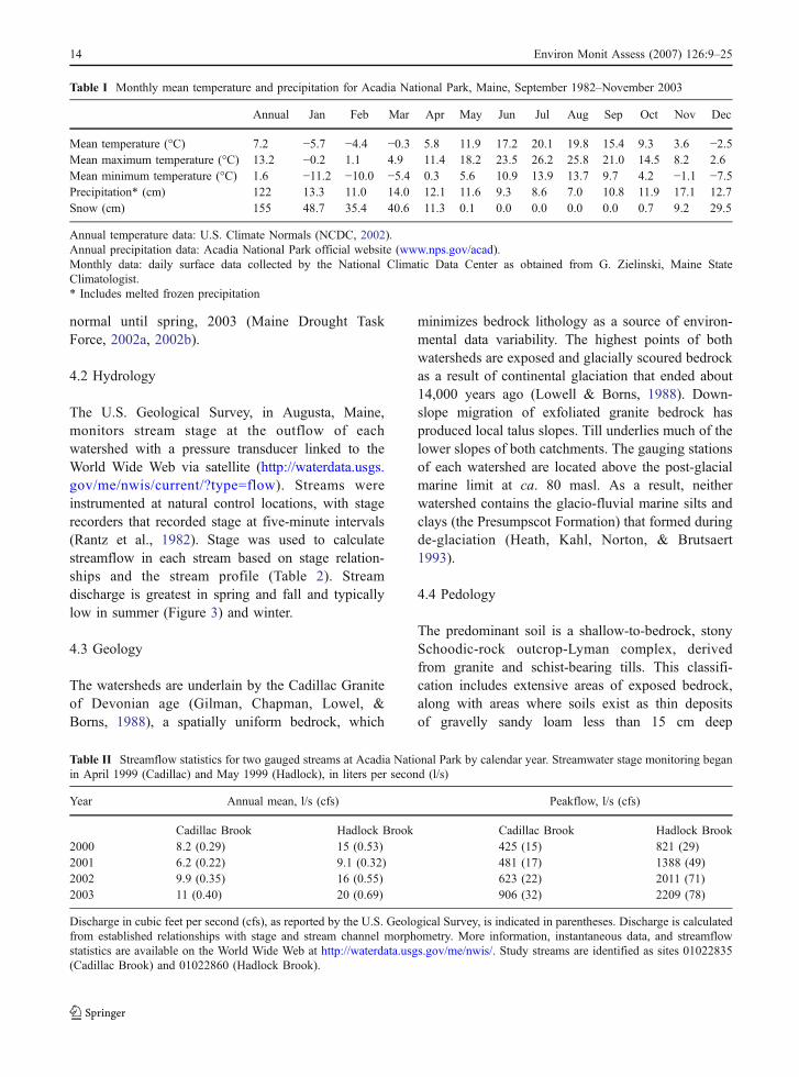
Table I Monthly mean temperature and precipitation for Acadia National Park, Maine, September 1982–November 2003
Annual Jan Feb Mar Apr May Jun Jul Aug Sep Oct Nov Dec
Mean temperature (°C) 7.2 −5.7 −4.4 −0.3 5.8 11.9 17.2 20.1 19.8 15.4 9.3 3.6 −2.5Mean maximum temperature (°C) 13.2 −0.2 1.1 4.9 11.4 18.2 23.5 26.2 25.8 21.0 14.5 8.2 2.6Mean minimum temperature (°C) 1.6 −11.2 −10.0 −5.4 0.3 5.6 10.9 13.9 13.7 9.7 4.2 −1.1 −7.5Precipitation* (cm) 122 13.3 11.0 14.0 12.1 11.6 9.3 8.6 7.0 10.8 11.9 17.1 12.7Snow (cm) 155 48.7 35.4 40.6 11.3 0.1 0.0 0.0 0.0 0.0 0.7 9.2 29.5
Annual temperature data: U.S. Climate Normals (NCDC, 2002).Annual precipitation data: Acadia National Park official website (www.nps.gov/acad).Monthly data: daily surface data collected by the National Climatic Data Center as obtained from G. Zielinski, Maine StateClimatologist.* Includes melted frozen precipitation
Table II Streamflow statistics for two gauged streams at Acadia National Park by calendar year. Streamwater stage monitoring beganin April 1999 (Cadillac) and May 1999 (Hadlock), in liters per second (l/s)
Year Annual mean, l/s (cfs) Peakflow, l/s (cfs)
Cadillac Brook Hadlock Brook Cadillac Brook Hadlock Brook2000 8.2 (0.29) 15 (0.53) 425 (15) 821 (29)2001 6.2 (0.22) 9.1 (0.32) 481 (17) 1388 (49)2002 9.9 (0.35) 16 (0.55) 623 (22) 2011 (71)2003 11 (0.40) 20 (0.69) 906 (32) 2209 (78)
Discharge in cubic feet per second (cfs), as reported by the U.S. Geological Survey, is indicated in parentheses. Discharge is calculatedfrom established relationships with stage and stream channel morphometry. More information, instantaneous data, and streamflowstatistics are available on the World Wide Web at http://waterdata.usgs.gov/me/nwis/. Study streams are identified as sites 01022835(Cadillac Brook) and 01022860 (Hadlock Brook).
14 Environ Monit Assess (2007) 126:9–25
(Schoodic soils) and areas where soils form a blackand reddish sandy loam less than 50 cm deep(Lyman soils). This soil complex is excessivelywell-drained, with slopes that range from flat tovertical for bare rock regions, and from 0% to 80%in areas with soil. On steep slopes these soils areusually droughty. Lyman and Schoodic soils areSpodosols – acidic forest soils characterized by anaccumulation of iron (Fe), aluminum (Al), andorganic matter in the B horizon.
Organic Lithic Borofolists are common on bedrockwhere mineral soil is absent. Depending on orienta-tion and slope, Lithic Borofolists range from poorly toexcessively drained. Organic soils are also associatedwith wetlands found in the study area. A range ofpoorly to well- (fibric to sapric) decomposed peats
occur, with fibric peats occurring in bogs and as smallblanket peats at higher elevation on bedrock. Sapricpeats are associated with forest, shrub/fen andemergent shrub/fen communities (Calhoun et al.,1994). Generally, soils are shallow in depth whichreduces infiltration and increases surface runoff inwatersheds following storm events. Precipitationpercolating through the shallow mineral or organicsoils in the steeper upland watersheds becomesenriched in weak organic acids which contributeacidity to solutions. Aluminum, potentially toxic toterrestrial and aquatic organisms, is mobilized fromsoils and stream sediments in this acidic environment.When thicker mineral soils are present, acidic soilsolutions in the upper soil profile are neutralized asthey react with the constituents of the B/C horizons of
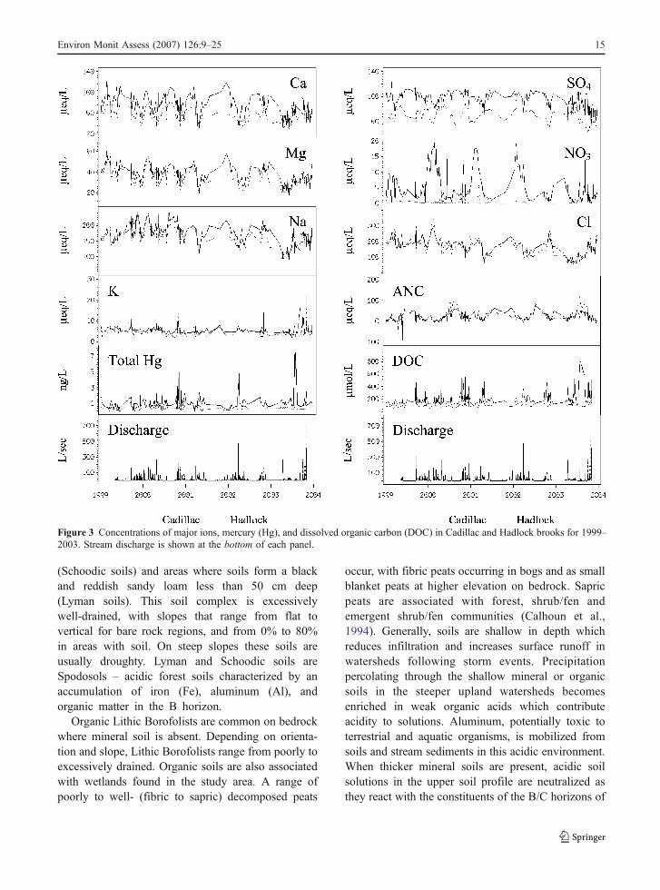
Figure 3 Concentrations of major ions, mercury (Hg), and dissolved organic carbon (DOC) in Cadillac and Hadlock brooks for 1999–2003. Stream discharge is shown at the bottom of each panel.
Environ Monit Assess (2007) 126:9–25 15
mineral soils. As a result of these processes, theephemeral upland streams described here have thelowest pH and exhibit greater episodic acidificationsthan perennial streams in the valley fill (Heath et al.,1993; Kahl et al., 1985).
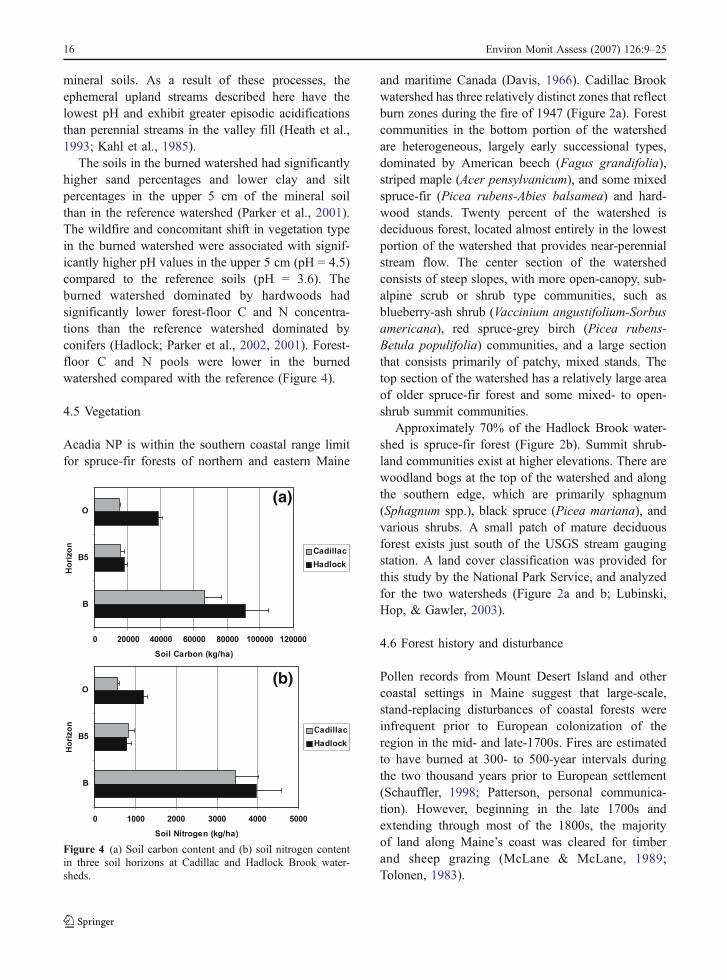
The soils in the burned watershed had significantlyhigher sand percentages and lower clay and siltpercentages in the upper 5 cm of the mineral soilthan in the reference watershed (Parker et al., 2001).The wildfire and concomitant shift in vegetation typein the burned watershed were associated with signif-icantly higher pH values in the upper 5 cm (pH = 4.5)compared to the reference soils (pH = 3.6). Theburned watershed dominated by hardwoods hadsignificantly lower forest-floor C and N concentra-tions than the reference watershed dominated byconifers (Hadlock; Parker et al., 2002, 2001). Forest-floor C and N pools were lower in the burnedwatershed compared with the reference (Figure 4).
4.5 Vegetation
Acadia NP is within the southern coastal range limitfor spruce-fir forests of northern and eastern Maine
and maritime Canada (Davis, 1966). Cadillac Brookwatershed has three relatively distinct zones that reflectburn zones during the fire of 1947 (Figure 2a). Forestcommunities in the bottom portion of the watershedare heterogeneous, largely early successional types,dominated by American beech (Fagus grandifolia),striped maple (Acer pensylvanicum), and some mixedspruce-fir (Picea rubens-Abies balsamea) and hard-wood stands. Twenty percent of the watershed isdeciduous forest, located almost entirely in the lowestportion of the watershed that provides near-perennialstream flow. The center section of the watershedconsists of steep slopes, with more open-canopy, sub-alpine scrub or shrub type communities, such asblueberry-ash shrub (Vaccinium angustifolium-Sorbusamericana), red spruce-grey birch (Picea rubens-Betula populifolia) communities, and a large sectionthat consists primarily of patchy, mixed stands. Thetop section of the watershed has a relatively large areaof older spruce-fir forest and some mixed- to open-shrub summit communities.
Approximately 70% of the Hadlock Brook water-shed is spruce-fir forest (Figure 2b). Summit shrub-land communities exist at higher elevations. There arewoodland bogs at the top of the watershed and alongthe southern edge, which are primarily sphagnum(Sphagnum spp.), black spruce (Picea mariana), andvarious shrubs. A small patch of mature deciduousforest exists just south of the USGS stream gaugingstation. A land cover classification was provided forthis study by the National Park Service, and analyzedfor the two watersheds (Figure 2a and b; Lubinski,Hop, & Gawler, 2003).
4.6 Forest history and disturbance
Pollen records from Mount Desert Island and othercoastal settings in Maine suggest that large-scale,stand-replacing disturbances of coastal forests wereinfrequent prior to European colonization of theregion in the mid- and late-1700s. Fires are estimatedto have burned at 300- to 500-year intervals duringthe two thousand years prior to European settlement(Schauffler, 1998; Patterson, personal communica-tion). However, beginning in the late 1700s andextending through most of the 1800s, the majorityof land along Maine’s coast was cleared for timberand sheep grazing (McLane & McLane, 1989;Tolonen, 1983).
0 20000 40000 60000 80000 100000 120000
B
B5
O
Ho
riz
on
Soil Carbon (kg/ha)
Cadillac
Hadlock
0 1000 2000 3000 4000 5000
B
B5
O
Ho
riz
on
Soil Nitrogen (kg/ha)
Cadillac
Hadlock
(a)
(b)
Figure 4 (a) Soil carbon content and (b) soil nitrogen contentin three soil horizons at Cadillac and Hadlock Brook water-sheds.
16 Environ Monit Assess (2007) 126:9–25
Reconstructions of vegetation and disturbancehistory were based on historical evidence, aerialphotographs, and paleoecological analysis of locallyderived pollen and charcoal preserved in small,partially forested bogs and forested wet hollowswithin the watersheds (Figure 2a and b). Pollendeposited each season in forested bogs and wetdepressions is derived from sources dominantlywithin 50 m (Calcote, 1995; Sugita, 1995). In manysettings, the stratigraphy of deposition is preserved,providing a decade-to-century scale record of changesin local dominant tree taxa. The studied wet depres-sions range from 1 m to several tens of meters indiameter with sediments between 20 and 50 cm deep.They are commonly covered by a mat of Sphagnummoss, or they may contain partially decomposedforest duff that holds standing water during wetseasons, classified as vernal pools. Although thehollows are dry at the surface in summer and fall,trapped drainage and the absorbent organic materialkeep the underlying sediment wet year-round, creat-ing anaerobic conditions that preserve pollen.
5 Results and Discussion
5.1 Current status of watershed forests
USDA Forest Health Monitoring protocol indicatorsused in these watersheds indicated that species com-position and stand structure differences are likely dueto the wildfire (Wiersma et al., in press). HadlockBrook watershed is dominated by older growth spruce(Picea rubens) and fir (Abies balsamea) and has noapparent record of fire. Cadillac Brook watershed con-tains a heterogeneous and patchy mix of hardwoodsand conifers and is known to have burned in 1947.
Foliar N concentrations (Picea rubens) and foliarAl concentrations (Acer rubrum) were significantlyhigher in Hadlock Brook watershed, and foliarcalcium (Ca) concentrations were lower in HadlockBrook watershed for both species, compared to theCadillac Brook watershed (Wiersma et al., in press).Foliar nutrient differences indicate more acidic soilsin Hadlock and are suggestive of early stages of Nsaturation (Wiersma et al., in press). The resultssuggest that soil nutrient availability for plant uptakemay differ between watersheds as a function of soilgeochemical characteristics and microecological dis-turbances within each watershed.
5.2 Paleoecological reconstructions
Reconstructed forest stand histories based on pollenand charcoal analysis record major vegetation anddisturbance differences in Hadlock and Cadillacwatershed forests during the last several centuries(Schauffler et al., in press). The pollen data indicatethat Hadlock Brook watershed has not burned or beensignificantly cleared for 500 years or more. Most ofCadillac Brook watershed burned in the wildfire in1947, and likely burned several times in the 1800s.Cadillac Brook watershed has supported a heteroge-neous forest for 200 years or more.
5.3 Characteristics of soils
Fifty years after wildfire, the burned watershed withhardwood regeneration (Cadillac) had significantlylower forest-floor C and N concentrations than thereference watershed dominated by conifers (Hadlock;Parker et al., 2002, 2001). Forest-floor C and Ninventories (mass/area) were lower in the burnedwatershed compared with the reference (Figure 3),consistent with the project hypotheses related to theeffects of the fire on soil chemistry. The soils in theunburned watershed contain more organic materialand more Hg, also consistent with project hypotheses.
5.4 Precipitation inputs
Precipitation and throughfall volume and chemistrymeasurements (Tables 3a, b, and 4) and streamdischarge were used to determine watershed waterbalance (Johnson et al., in press; Nelson, 2002).Differences in watershed and vegetation character-istics exert a significant control on the input of waterand major ions to these watersheds because vegeta-tion type influences throughfall chemical and hydro-logic inputs (e.g., Houle, Oimet, Paquin, &LaFlamme, 1999; Lovett, Nolan, Driscoll, & Fahey,1996; Cronan & Reiners, 1983). At coniferous sites,greater scavenging efficiency and year-round foliageresulted in greater sulfate (SO4), chloride (Cl), andsodium (Na) concentrations and lower pH in through-fall at Hadlock Brook watershed (Nelson, 2002).Throughfall SO4 was two- to three-times wet deposi-tion, in the range reported for SO4 for the nearby BearBrook watershed in Maine (Rustad, Kahl, Norton, &Fernandez, 1994). Seasonal differences were impor-
Environ Monit Assess (2007) 126:9–25 17
tant, with highest dry deposition of major ions(inferred from throughfall:Wet deposition) in fall andsummer. However, NADP data indicate that wetdeposition inputs of Cl and Na were highest inwinter, influenced by sea spray and marine stormtracks. Ongoing research is quantifying winter depo-
sition in these study watersheds (Nelson, Weathers,Loftin, Johnson, & Kahl, 2005).
The NADP/MDN national wet deposition networkis invaluable for regional spatial patterns and trends,but is not adequate for understanding total chemicaldeposition to specific landscapes. However, we
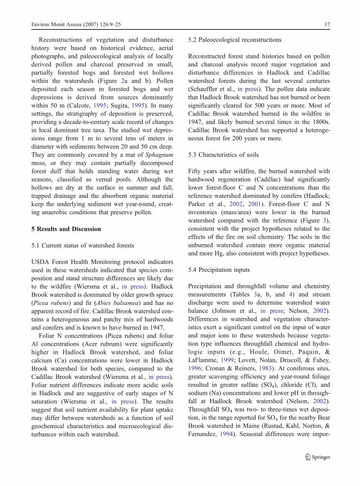
Table III National Atmospheric Deposition Program (NADP) and Mercury Deposition Network (MDN) precipitation weighted mean(a) concentrations of major ions and total Hg, pH and specific conductance and (b) annual deposition of major ions and mercury, andprecipitation depth for Acadia National Park – McFarland Hill (Site ME98), by calendar year
Year Ca Mg K Na NH4 NO3 Cl SO4 pH Specific Conductance Total Hgμeq/l SU μs/cm ng/l
(a)1999 3.0 7.08 0.79 33.2 5.0 10.8 37.2 19.4 4.74 15.03 9.32000 4.0 8.64 0.97 40.5 7.2 15.0 42.0 25.4 4.61 19.4 9.82001 3.0 3.87 0.49 18.1 6.7 15.3 21.2 21.0 4.63 15.7 11.82002 2.5 6.75 0.74 31.3 6.7 10.5 36.7 18.9 4.8 14.52 10.2(b)
Year Ca Mg K Na NH4 NO3 Inorg. N Cl SO4 H+(Lab) Precip. depth Hgkg/ha cm μg/m2/year
1999* 0.82 1.155 0.416 10.264 1.16 8.97 2.92 17.79 12.51 0.25 134.34 7.92000* 1.08 1.351 0.489 11.988 1.67 12.01 4.01 19.14 15.74 0.32 128.63 8.62001 0.39 0.297 0.12 2.632 0.73 5.98 1.92 4.74 6.38 0.15 63.26 4.62002* 0.85 1.297 0.459 11.368 1.87 10.29 3.78 20.59 14.32 0.25 158.11 7.9
* NADP Data Completion Criterion 4 was <75% for these years; all other Data Completeness Criteria were acceptable.
Table IV Descriptive chemistry for sixteen throughfall collections at Acadia National Park for the initial throughfall project period,August 1999 to November 2000
Depth SO4 SO4* NO3 Cl H+ Ca Mg K Na NH4 EqpHCadillac
N 437 441 441 441 441 440 442 442 442 442 441 440mm ←μeq/l →
Min. 6 5 4 <0.5 8 0.1 <1.0 <0.8 <1.0 <0.9 <1.1 3.90Max. 196 277 258 249 816 126 171 183 473 605 94 7.02Median 46 53 42 16 58 27 16 20 22 49 2 4.58Mean 52 60 51 24 93 34 26 29 44 74 7 4.72St. dev. 27 42 37 30 104 27 25 30 67 76 11 0.61
Hadlock
N 430 431 431 431 431 429 430 430 429 430 430 429mm ←μeq/l →
Min. 3 4 3 <0.5 5 0.1 <1.0 <0.8 <1.0 4.3 <1.1 3.61Max. 194 289 275 257 1120 245 119 200 338 848 107 6.85Median 47 63 51 23 84 40 22 27 31 72 7 4.40Mean 54 77 65 36 118 48 28 33 42 98 13 4.50St. dev. 29 57 51 39 121 36 22 27 38 93 16 0.52
SO4* is sea-salt corrected sulfate.SO4* is sea-salt corrected sulfate.
18 Environ Monit Assess (2007) 126:9–25
suggest that once the relationships are developedbetween nearby NADP stations and throughfall inputsto specific watersheds, NADP results can be used fortotal deposition estimates. However, the relationshipsmay have changed (e.g., due to changes in legislativerequirements for emissions). Thus, re-evaluation ofthe relationships with new data is prudent.
5.5 Hg input
Landscape aspect and vegetation type were the mostinfluential factors affecting Hg deposition (mass/area)(Johnson et al., in press). Sites that face south tosouthwest received the highest Hg deposition, pre-sumably due to the interception of continentalcontaminated air masses and prevailing wind direc-tion. Sites with conifer vegetation received higher Hgdeposition than other vegetation types because of thegreater scavenging efficiency of the canopy. Becausethese sites at Acadia are largely forested and moun-tainous and located in the relatively polluted coastal airmasses, they may be subject to greater dry depositionflux of Hg as compared to other rural areas in theNortheast (Miller et al., 2005).
Hg deposition was lower in Cadillac watershed(burned) than in Hadlock watershed (unburned) be-cause regeneration after the fire was dominated bydeciduous species rather than conifers. Litterfall
contributed two- to five_times the amount of Hg tothe forest floor as throughfall. (Sheehan, Fernandez,Kahl, & Amirbahman, 2006; Johnson, 2002). Ourongoing investigation of winter inputs suggests thatsnow throughfall has concentrations of total Hg similarto those measured in rain, but volatilization from thesnowpack is a large potential loss (Nelson et al., 2005).
Methyl mercury (MeHg) deposition was notaffected by aspect nor landscape factors. MeHg wastypically 5% of total deposition (Johnson, 2002). Webelieve that this percentage may as much reflect theequilibrium of the methylation process in the collectoras it does the actual deposition of MeHg. The lowpercentage suggests that it is neither cost-effective norparticularly instructive to measure MeHg concentra-tions in throughfall.
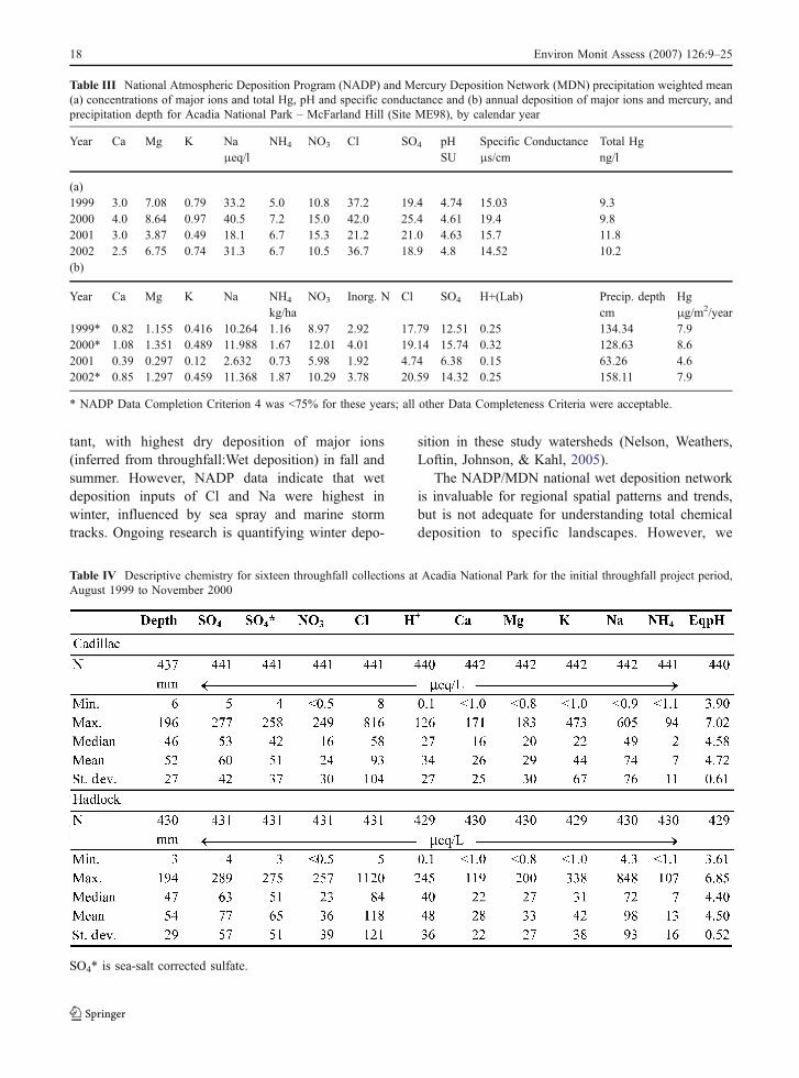
5.6 Stream chemistry and watershed mass balances
Discharge-weighted mean cation concentrations instreamwater were similar between watersheds(Table 5, Figure 3). Acid neutralizing capacity(ANC), pH, and Cl tended to be higher in Cadillacstreamwater, while SO4, nitrate (NO3), dissolvedorganic carbon (DOC) and Hg were higher inHadlock streamwater (Table 5, Figure 3). In bothwatersheds, H+, ammonium (NH4), NO3, and Hg areretained in the soils and vegetation, although there are
Table V Discharge-weighted chemistry for Cadillac Brook (CB) and Hadlock Brook (HB) for calendar years 1999–2003
1999 2000 2001 2002 2003
Cadillac Hadlock Cadillac Hadlock Cadillac Hadlock Cadillac Hadlock Cadillac Hadlock
Equilibrated pH 5.86 5.48 5.89 5.45 5.98 5.51 6.11 5.18 5.63 5.54ANC (μeq/l) 11.6 5.0 9.1 4.7 11.2 6.3 10.8 −0.4 7.0 6.7Ca (μeq/l) 56.8 (50.4) 62.9 (55.9) 49.4 (43.3) 60.7 (53.9) 44.9 (40.0) 46.5 (41.8) 53.9 (47.2) 45.8 (40.4) 49.3 (43.1) 47.3 (43.0)Mg (μeq/l) 33 (−6.5) 32.7 (−3.7) 32 (0.5) 36.7 (1.4) 28.2 (2.9) 29.6 (5.4) 35.1 (0.3) 31.9 (4.3) 30.3 (−1.6) 26.7 (4.6)K (μeq/l) 6.4 (2.7) 7 (3.5) 5.7 (2.7) 6.7 (3.2) 3.4 (1.0) 4.7 (2.4) 4.7 (1.3) 7.5 (4.8) 10.4 (7.3) 5.7 (3.5)Na (μeq/l) 179 (5.6) 185 (24.1) 166 (26.4) 183 (26.7) 142 (30.1) 145 (38.0) 165 (11.2) 148 (25.9) 144 (3.8) 128 (29.8)Al (μmol/l) 2.8 6.9 4.3 10 3.8 9.2 3.7 11 7.0 11NH4 (μeq/l) 0.6 0.7 3.1 2.8 1.0 1.3 0.5 0.8 1.7 1.7Si (μmol/l) 73 88 64 78 57 62 76 65 63 83DOC (μmol/l) 136 256 194 323 131 302 151 372 315 415Cl (μeq/l) 206 187 162 182 130 124 179 142 162 127NO3 (μeq/l) 0.3 5.1 0.8 7.5 0.1 5.9 0.2 9.3 0.1 2.1SO4 (μeq/l) 73.2 (51.9) 97.2 (77.9) 77.5 (60.7) 95.0 (76.2) 72 (58.5) 84.7 (71.9) 66.2 (47.7) 78.9 (64.3) 56.7 (40.0) 73.1 (60.0)Total Hg (ng/l) 0.59 1.29 1.17 2.14 0.70 1.48 0.44 4.05 0.93 3.36MeHg (ng/l) – – 0.04 0.04 0.04 0.04 – – – –
Numbers in parentheses are sea-salt corrected by subtracting marine constituents in proportion to chloride.
Environ Monit Assess (2007) 126:9–25 19
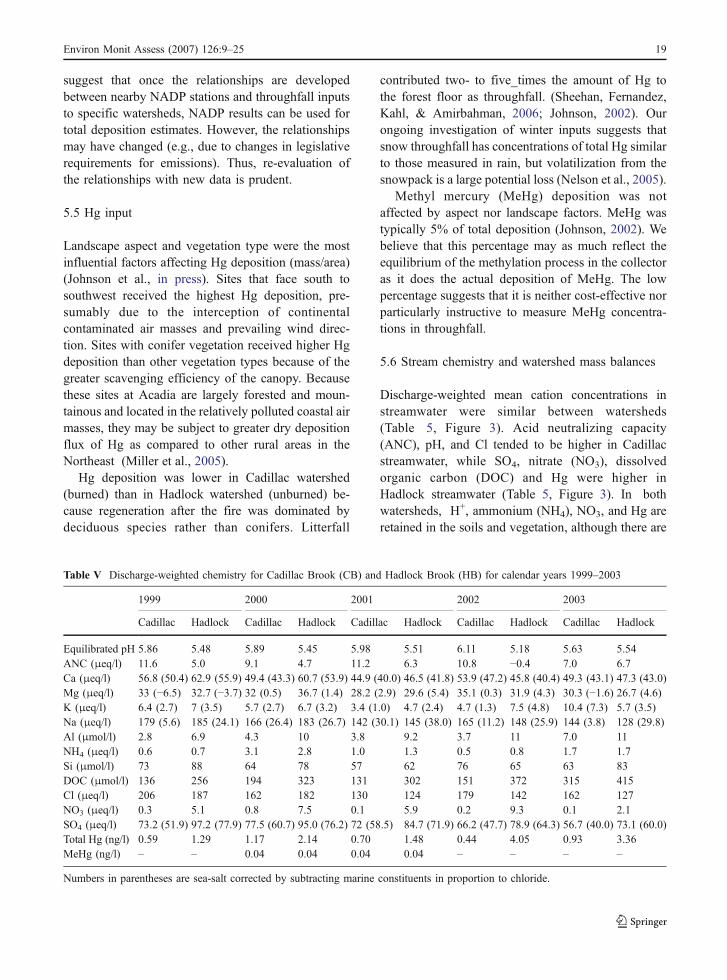
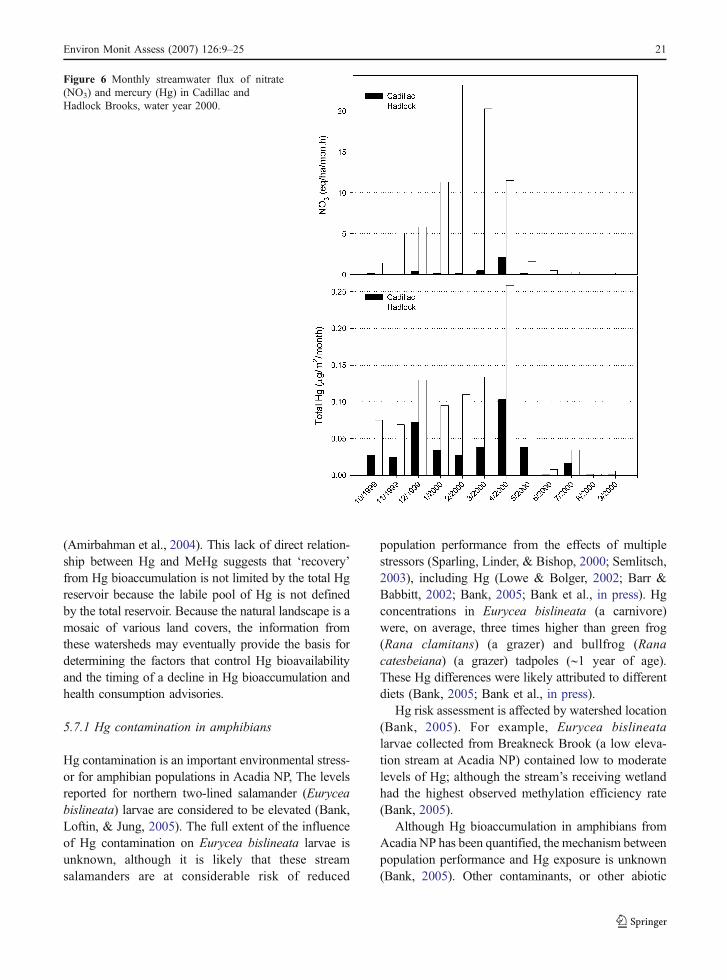
relative differences in export related both to the fireand to the subsequent differences in loading inthroughfall relating to the different canopies (Figure 6);Na, Cl, Ca, magnesium (Mg), potassium (K), and SO4
were lost from the system for water year 2000(Nelson et al., in press; Figure 5).
For some ions, differences related to vegetationand/or soils control the relative patterns of retentionand release. For other ions, dry deposition is a majorcomponent of watershed inputs. For instance, Cl andSO4 are considered relatively conservative withrespect to canopy processes. Throughfall depositionof SO4 was 2–3 times and Cl 2–10 times wetdeposition in these watersheds, dependent on season(Nelson, 2002), consistent with other regional esti-mates (Rustad et al., 1994). Throughfall deposition ofthese conservative ions at conifer sites – such asHadlock Brook watershed – tends to be greater than atdeciduous sites – such as Cadillac Brook watershed(Nelson, 2002). The increased scavenging efficiencyat Hadlock Brook watershed helps to explain differ-ences in the mass balances between watersheds whenonly wet precipitation is considered (Figure 5).Estimates of dry deposition via throughfall areimportant for mass balances estimates. High deposi-tion of marine aerosols impacts stream chemistry forwell more than one hydrologic year.
Of the measured deposition of total Hg, 95% wasretained or lost to volatilization by the Cadillacwatershed, and 87% by the Hadlock watershed. Thesevalues are similar to those reported in other watershedstudies. Grigal (2002) reviewed the Hg literature andfound an average throughfall flux of 17 μg/m2/yr, andan average streamwater flux of 1.7 μg/m2/yr, yielding
an average 90% retention and/or loss via volatiliza-tion. We did not attempt to quantify re-volatization ofHg from surfaces beneath the canopy (re-volatizationof Hg from the canopy is irrelevant to our massbalances because it is not measured as either an inputnor an output term).
5.7 Hg in soils
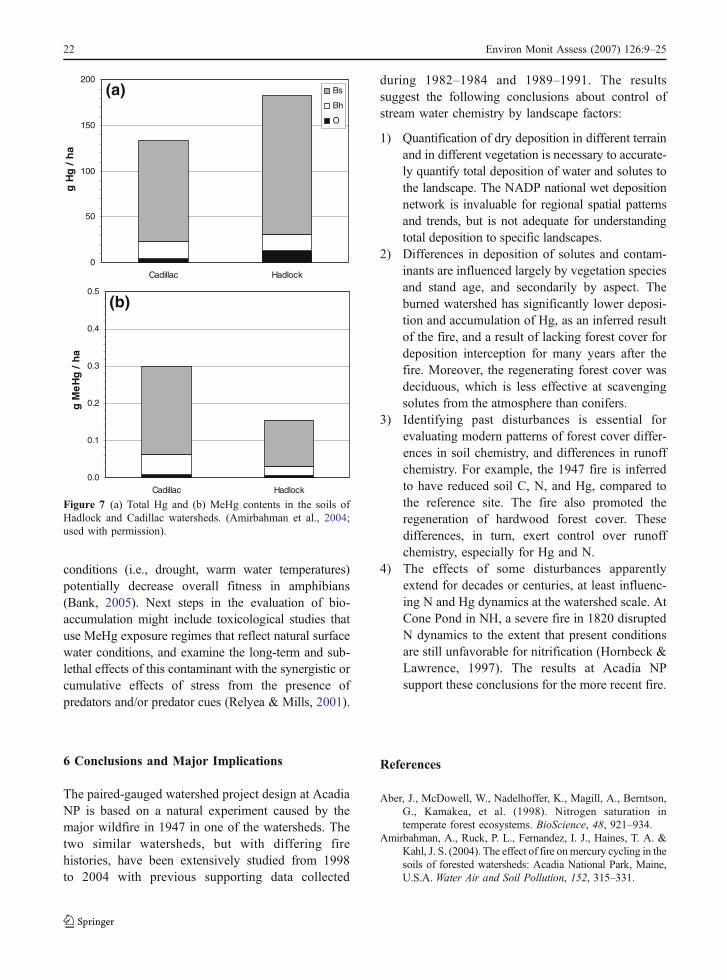
The 1947 fire caused significant impacts on theevolution of the Cadillac watershed, raising the soilpH, altering the vegetation, and reducing C and Hgsoil pools (Amirbahman et al., 2004). Total Hgcontent was higher in Hadlock soils compared toCadillac soils (Figure 7a). Soil pH was significantlyhigher in all soil horizons at Cadillac by about 0.4 pHunits, compared to Hadlock soils. The results of Hgadsorption experiments indicated that the dissolvedHg concentration was controlled by the dissolvedorganic carbon concentrations. Adsorption isothermssuggest that Hg is more mobile in the unburnedHadlock watershed because of higher solubility oforganic carbon in that watershed (Amirbahman et al.,2004). MeHg concentrations (the form of Hg that isconcentrated in biota) were consistently higher in theburned Cadillac soils than in the unburned Hadlocksoils (Figure 7b). The higher MeHg concentrations inCadillac soils may reflect generally faster rates ofmicrobial metabolism due to more rapid nutrientcycling in the deciduous forest.
MeHg concentrations were inversely proportional tototal Hg in soils, suggesting that landscape factors suchas soil pH, vegetation type, or land use history (e.g., fire)may be the determining factors for bioavailabilty
Figure 5 Mass balance (streamwater exportminus wet precipitation input) of major ions andmercury (Hg) in the study watersheds for wateryear 2000. Note that Hg has different units (μg/m2/yr) and is multiplied by 10 for graphicaldisplay purposes. Positive values indicate net lossfrom the watershed and negative values indicatenet retention. Wet precipitation data from theNational Atmospheric Deposition Program(NADP) and Mercury Deposition Network(MDN) for site ME98.
20 Environ Monit Assess (2007) 126:9–25
(Amirbahman et al., 2004). This lack of direct relation-ship between Hg and MeHg suggests that ‘recovery’from Hg bioaccumulation is not limited by the total Hgreservoir because the labile pool of Hg is not definedby the total reservoir. Because the natural landscape is amosaic of various land covers, the information fromthese watersheds may eventually provide the basis fordetermining the factors that control Hg bioavailabilityand the timing of a decline in Hg bioaccumulation andhealth consumption advisories.
5.7.1 Hg contamination in amphibians
Hg contamination is an important environmental stress-or for amphibian populations in Acadia NP, The levelsreported for northern two-lined salamander (Euryceabislineata) larvae are considered to be elevated (Bank,Loftin, & Jung, 2005). The full extent of the influenceof Hg contamination on Eurycea bislineata larvae isunknown, although it is likely that these streamsalamanders are at considerable risk of reduced
population performance from the effects of multiplestressors (Sparling, Linder, & Bishop, 2000; Semlitsch,2003), including Hg (Lowe & Bolger, 2002; Barr &Babbitt, 2002; Bank, 2005; Bank et al., in press). Hgconcentrations in Eurycea bislineata (a carnivore)were, on average, three times higher than green frog(Rana clamitans) (a grazer) and bullfrog (Ranacatesbeiana) (a grazer) tadpoles (∼1 year of age).These Hg differences were likely attributed to differentdiets (Bank, 2005; Bank et al., in press).
Hg risk assessment is affected by watershed location(Bank, 2005). For example, Eurycea bislineatalarvae collected from Breakneck Brook (a low eleva-tion stream at Acadia NP) contained low to moderatelevels of Hg; although the stream’s receiving wetlandhad the highest observed methylation efficiency rate(Bank, 2005).
Although Hg bioaccumulation in amphibians fromAcadia NP has been quantified, the mechanism betweenpopulation performance and Hg exposure is unknown(Bank, 2005). Other contaminants, or other abiotic
Figure 6 Monthly streamwater flux of nitrate(NO3) and mercury (Hg) in Cadillac andHadlock Brooks, water year 2000.
Environ Monit Assess (2007) 126:9–25 21
conditions (i.e., drought, warm water temperatures)potentially decrease overall fitness in amphibians(Bank, 2005). Next steps in the evaluation of bio-accumulation might include toxicological studies thatuse MeHg exposure regimes that reflect natural surfacewater conditions, and examine the long-term and sub-lethal effects of this contaminant with the synergistic orcumulative effects of stress from the presence ofpredators and/or predator cues (Relyea & Mills, 2001).
6 Conclusions and Major Implications
The paired-gauged watershed project design at AcadiaNP is based on a natural experiment caused by themajor wildfire in 1947 in one of the watersheds. Thetwo similar watersheds, but with differing firehistories, have been extensively studied from 1998to 2004 with previous supporting data collected
during 1982–1984 and 1989–1991. The resultssuggest the following conclusions about control ofstream water chemistry by landscape factors:
1) Quantification of dry deposition in different terrainand in different vegetation is necessary to accurate-ly quantify total deposition of water and solutes tothe landscape. The NADP national wet depositionnetwork is invaluable for regional spatial patternsand trends, but is not adequate for understandingtotal deposition to specific landscapes.
2) Differences in deposition of solutes and contam-inants are influenced largely by vegetation speciesand stand age, and secondarily by aspect. Theburned watershed has significantly lower deposi-tion and accumulation of Hg, as an inferred resultof the fire, and a result of lacking forest cover fordeposition interception for many years after thefire. Moreover, the regenerating forest cover wasdeciduous, which is less effective at scavengingsolutes from the atmosphere than conifers.
3) Identifying past disturbances is essential forevaluating modern patterns of forest cover differ-ences in soil chemistry, and differences in runoffchemistry. For example, the 1947 fire is inferredto have reduced soil C, N, and Hg, compared tothe reference site. The fire also promoted theregeneration of hardwood forest cover. Thesedifferences, in turn, exert control over runoffchemistry, especially for Hg and N.
4) The effects of some disturbances apparentlyextend for decades or centuries, at least influenc-ing N and Hg dynamics at the watershed scale. AtCone Pond in NH, a severe fire in 1820 disruptedN dynamics to the extent that present conditionsare still unfavorable for nitrification (Hornbeck &Lawrence, 1997). The results at Acadia NPsupport these conclusions for the more recent fire.
References
Aber, J., McDowell, W., Nadelhoffer, K., Magill, A., Berntson,G., Kamakea, et al. (1998). Nitrogen saturation intemperate forest ecosystems. BioScience, 48, 921–934.
Amirbahman, A., Ruck, P. L., Fernandez, I. J., Haines, T. A. &Kahl, J. S. (2004). The effect of fire onmercury cycling in thesoils of forested watersheds: Acadia National Park, Maine,U.S.A. Water Air and Soil Pollution, 152, 315–331.
0
50
100
150
200
Cadillac Hadlock
g H
g /
ha
Bs
Bh
O
0.0
0.1
0.2
0.3
0.4
0.5
Cadillac Hadlock
g M
eH
g /
ha
(a)
(b)
Figure 7 (a) Total Hg and (b) MeHg contents in the soils ofHadlock and Cadillac watersheds. (Amirbahman et al., 2004;used with permission).
22 Environ Monit Assess (2007) 126:9–25
Bank, M.S. (2005). Mercury bioaccumulation and habitatrelations of lotic and lentic amphibians from AcadiaNational Park, Maine, USA. PhD Dissertation, Universityof Maine, Orono, Maine, USA, 165 pp.
Bank, M. S., Burgess, J. R., Evers, D. C., & Loftin, C.S. (inpress). Mercury contamination of biota from AcadiaNational Park, Maine: A review. Environmental Monitor-ing and Assessment.
Bank, M. S., Loftin, C. S., & Jung, R. E. (2005). Mercurybioaccumulation in Northern Two-Lined Salamandersfrom streams in the Northeastern United States. Ecotox-icology, 14(1–2), 181–191.
Barr, G. E., & Babbitt, K. J. (2002). Effects of biotic andabiotic factors on the distribution and abundance of larvaltwo-lined salamanders (Eurycea bislineata) across spatialscales. Oecologia, 133(2),176–185.
Calcote, R. (1995). Pollen source area and pollen productivity:evidence from forest hollows. Journal of Ecology, 83,591–602.
Calhoun, A. J. K., Cormier, J. E., Owen, R. B., Jr., O_ConnellA. F., Jr., Roman, C. T., & Tiner, R.W., Jr. (1994). Thewetlands of Acadia National Park and vicinity, MaineAgricultural and Forest Experiment Station MiscellaneousPublication 721, Orono, Maine.
Campbell, J. L., Hornbeck, J. W., Mitchell, M. J., Adams, M.B., Castro, M. S., Driscoll, C. T. et al. (2004) A synthesisof nitrogen budgets from forested watersheds in thenortheastern United States. Water, Air and Soil Pollution,151, 373–396.
Cronan, C. S., & Reiners, W. A. (1983). Canopy processing ofacidic precipitation by coniferous and hardwood forests inNew England. Oecologia, 59, 216–223.
Davis, R. B. (1966). Spruce-fir forests of the coast of Maine.Ecology Monograph, 36, 79–93.
Gilman, R.A., Chapman, C.A., Lowell, T.V., & Borns, H.W., Jr.(1988). The geology of Mount Desert Island, MaineGeological Survey, Augusta, Maine, U.S.A., 50 pp.
Goodale, C. L. (2003). Fires in the White Mountains: Anhistorical perspective. Appalachia, December 2003, 60–75.
Goodale, C. L., Aber, J. D., & McDowell, W. H. (2000). Thelong-term effects of disturbance on organic and inorganicnitrogen export in the White Mountains, New Hampshire.Ecosystems, 3, 340–433.
Grigal, D. F. (2002). Inputs and outputs of mercury fromterrestrial watersheds: A review. Environment Reviews, 10,1–39.
Heath, R. H., Kahl, J. S., Norton, S. A., & Fernandez, I. J.(1992). Episodic acidification caused by the sea-salt effectin coastal streams, USA. Water Resources Research, 28,1081–1088.
Heath, R. H., Kahl, J. S., Norton, S. A., & Brutsaert, W. F.(1993). Elemental mass balances, and episodic and ten-year changes in the chemistry of surface waters, AcadiaNational Park, Maine, Final Report, National ParkService, North Atlantic Region, Boston, Massachusetts,U.S.A., 111 pp.
Hornbeck, J. W., Bailey, S. W., Buso, D. C., & Shanley, J. B.(1997). Streamwater chemistry and nutrient budgets forforested watersheds in New England: Variability andmanagement implications. Forest Ecology and Manage-ment, 93, 73–89.
Houle, D., Oimet, R., Paquin, R., & LaFlamme, J. (1999).Interactions of atmospheric deposition with a mixedhardwood and a coniferous forest canopy at the LakeClair Watershed (Duchesnay, Quebec). Canadian Journalof Forest Research, 29, 1944–1957.
Jagels, R., Carlisle, J., Cunningham, R., Serreze, S., & Tsai, P.(1989). Impact of acid fog and ozone on coastal redspruce. Water Air Soil and Pollution, 48, 193–208.
Johnson, K. J. (2002). Fire and its effects on mercury andmethylmercury dynamics for two watersheds in AcadiaNational Park, Maine. MS thesis, Ecology and Environ-mental Sciences, University of Maine, Orono, Maine,U.S.A., 62 pp.
Johnson, K. B., Haines, T. A., Kahl, J. S., Norton, S. A.,Amirbahman, A., & Sheehan, K. D. (in press). Controls onmercury and methylmercury deposition for two water-sheds in Acadia National Park, Maine. EnvironmentalMonitoring and Assessment.
Kahl, J. S., Andersen, J., & Norton, S. A. (1985). Waterresource baseline data and assessment of impacts fromacidic precipitation, Acadia National Park. TechnicalReport #16, National Park Service, North Atlantic RegionWater Resources Program, 123 pp.
Kahl, J. S., Manski, D., Flora, M., & Houtman, N. (2000).Water Resources Management Plan, Acadia National Park.103 pp.
Kahl, J. S., Norton, S. A., Haines, T. A., Rochette, E. A., Heath,R. H., & Nodvin, S. C. (1992). Mechanisms of episodicacidification in low-order streams in Maine, USA. Envi-ronmental Pollution, 78, 37–44.
Likens, G. E., Bormann, F. H., Pierce, R. S., Eaton, J. S., &Johnson, N. M. (1977). Biogeochemistry of a forestedecosystem. New York: Springer, Berlin Heidelberg NewYork, 146 pp.
Longcore, J. R., Dineli, R., & Haines, T. A. (in press a).Mercury and growth of tree swallows at Acadia NationalPark, and at Orono, Maine, USA. Environmental Moni-toring and Assessment.
Longcore, J. R., Haines, T. A., & Halteman, W. A. (in press b).Mercury in tree swallow food, eggs, bodies, and feathersat Acadia National Park, Maine, and an EPA Superfundsite, Ayer, Massachusetts. Environmental Monitoring andAssessment.
Lovett, G. M., Nolan, S. S., Driscoll, C. T., & Fahey, T. J.(1996). Factors regulating throughfall flux in a NewHampshire forested landscape. Canadian Journal ofForest Reserch, 26, 2134–2144.
Lowe, W. H., & Bolger, D. T. (2002). Local and landscape-scalepredictors of salamander abundance in New Hampshireheadwater streams. Conservation Biology, 16, 183–193.
Lowell, T. V., & Borns, H. W. (1988). Surficial Geology ofMount Desert Island. Bulletin 38 Map, Maine GeologicalSurvey, Department of Conservation.
Lubinski, S., Hop, K., & Gawler, S. (2003). U.S.Geological Survey-National Park Service VegetationMapping Program, Acadia National Park, Maine.Project Report, Revised Edition – October 2003, U.S.Geological Survey, Upper Midwest Environmental Scien-ces Center, La Crosse, Wisconsin and Maine NaturalAreas Program, Department of Conservation, Augusta,Maine, 110 pp.
Environ Monit Assess (2007) 126:9–25 23
Magill, A. H., Aber, J. D., Hendricks, J. J., Bowden, R. D.,Melillo, J. M., & Steudler, P. A. (1997). Biogeochemicalresponse of forest ecosystems to simulated chronicnitrogen deposition. Ecological Application, 7, 402–415.
Maine Drought Task Force (2002a). State of Maine DroughtTask Force Report, Maine Emergency ManagementAgency, March 7, 2002.
Maine Drought Task Force (2002b). State of Maine DroughtTask Force Report. Maine Emergency ManagementAgency, May 10, 2002.
Matz, A. C. (1998) Organochlorine contaminants and baldeagles in Maine – Investigations at Three EcologicalScales. PhD dissertation, Wildlife Ecology, University ofMaine, Orono, Maine, USA, 121 pp.
McLane, C. B., & McLane, C. E. (1989). The Islands of Mid-Maine Coast, Vol. II: Mount Desert to Machias Bay,Falmouth, Maine: Kennebec River.
Miller, E., Vanarsdale, A., Keeler, G., Chalmers, A., Poissant,L., Kamman, N. et al. (2005). Estimation and mapping ofwet and dry mercury deposition across northeastern NorthAmerica. Ecotoxicology, 14(1–2), 53–70.
National Atmospheric Deposition Program (NRSP-3)/MercuryDeposition Network (2004). NADP Program Office, IllinoisState Water Survey, 2204 Griffith Drive, Champaign, IL61820. Available: http://nadp.sws.uiuc.edu/nadp data.
National Climatic Data Center (NCDC) (2002). Climatographyof The United States No. 81 Monthly Station Normals ofTemperature, Precipitation, and Heating and CoolingDegree Days 1971–2000. 17: Maine. National Oceanicand Atmospheric Administration, National EnvironmentalSatellite, Data, and Information Service, Asheville, NorthCarolina, 16 pp.
Nelson, S. J. (2002). Determining atmospheric depositioninputs to two small watersheds at Acadia National Park.MS thesis, Ecology and Environmental Sciences, Univer-sity of Maine, Orono, Maine, U.S.A., 163 pp.
Nelson, S. J., Weathers, K. C., Loftin, C. S., Johnson, K. B., &Kahl, J. S. (2005). Pick your season: under-estimation(summer) and over-estimation (winter) of total mercurydeposition by MDN collection methods at Acadia NationalPark, Maine. National Atmospheric Deposition Program2005 Scientific Symposium and Annual Technical Commit-tee Meeting, Jackson, Wyoming, September 27–30, 2005.
Nelson, S. J., Johnson, K. B., Kahl, J. S., Haines, T. A., &Fernandez, I. J. (in press). Mass balances of mercury andnitrogen in burned and unburned forested watersheds atAcadia National Park, Maine, USA. Environmental Mon-itoring and Assessment.
Nielsen, M. G., & Kahl, J. S. (in press). Nutrient export fromwatersheds on Mt. Desert Island, Maine, as a function of landuse and fire history.Environmental Monitoring and Assessment.
Norton, S. A., Evans, G. C., & Kahl, J. S. (1997). Comparison ofHg and Pb fluxes to hummocks and hollows of ombro-trophic Big Heath bog and to nearby Sargent Mt. Pond,Maine, USA. Water Air and Soil Pollution, 100, 271–286.
Parker, J., Fernandez, I., Rustad, L., & Norton, S. (2001).Effects of nitrogen enrichment, wildfire, and harvesting onforest soil carbon and nitrogen. Soil Science Society ofAmerica journal, 65, 1248–1255.
Parker, J. L., Fernandez, I. J., Rustad, L. E., & Norton, S. A.(2002). Soil organic matter fractions in experimentalforested watersheds. Water Air and Soil Pollution, 138,101–121.
Patterson, W. A., III, & Backman, A. E. (1988). Fire and diseasehistory of forests. In B. Huntley & T. Webb, III (Eds.),Vegetation History, (pp. 603–632). Dordrecht: Kluwer.
Peckenham, J. M., Kahl, J. S., & Mower, B. (2003).Background Mercury Concentrations in River Water inMaine, U.S.A. Environmental Monitoring and Assessment,89(2), 129–152.
Peckenham, J. M., Kahl, J. S., Nelson, S. J., Johnson, K. B., &Haines, T. A. (in press). Landscape Controls on Mercuryin Streamwater at Acadia National Park, USA. Environ-mental Monitoring and Assessment.
Rantz, S. E. et al. (1982). Measurement and computation ofstreamflow. U.S. Geological Survey Water-Supply Paper2175, 2 v., 631 pp.
Relyea, R., & Mills, N. A. (2001). Predator-induced stressmakes the pesticide carbaryl more deadly to grey treefrogtadpoles (Hyla versicolor). Proceedings of the NationalAcademy of Sciences, 98, 2491–2496.
Riggan, P. J., Lockwood, R., Jacks, P., Colver, C., Weirich, F.,DeBano, L. et al. (1994). Effects of fire severity on nitratemobility in watersheds subject to atmospheric deposition.Environmental Science & Technology, 28, 369–375.
Rustad, L., Kahl, J. S., Norton, S. A., & Fernandez, I. J. (1994).Under-estimation of dry deposition by throughfall inmixed northern hardwood forests. Journal of Hydrology,162, 319–336.
Schauffler, M. (1998). Paleoecology of coastal andinterior Picea (spruce) stands in Maine. PhD dissertation,Plant Science, Orono, Maine, USA: University of Maine,125 pp.
Schauffler, M., Nelson, S. J., Kahl, J. S., Jacobson, G. L., Jr,Haines, T. A., Patterson, W. A. et al. (in press).Paleoecological assessment of watershed history in PRI-MENet watersheds at Acadia National Park, USA.Environmental Monitoring and Assessment.
Semlitsch, R. D. (Ed.) (2003) Amphibian conservation,Washington, District of Columbia: Smithsonian Institu-tion, 324 pp.
Sheehan, K. D., Fernandez, I. J., Kahl, J. S., & Amirbahman,A. (2006) Litterfall mercury in two forested watersheds atAcadia National Park, Maine, USA. Water Air and SoilPollution 170, 249–265.
Sparling, D. W., Linder, G., & Bishop, C. (Eds.) (2000).Ecotoxicology of amphibians andreptiles, Pensacola, Flor-ida, USA: SETAC, 904 pp.
Stafford, C., & Haines, T. (1997). Mercury concentrations inMaine sport fishes. T. Am. Fish. Soc., 126, 144–152.
Stewart, G. J., Caldwell, J. M., & Cloutier, A. R. (2003). WaterResources Data Maine Water Year 2002. U.S. GeologicalSurvey Report WDR-ME-02-1, 230 pp.
Sugita, S. (1995). Pollen representation of vegetation inQuaternary sediments: Theory and method in patchyvegetation. Journal of Ecology, 82, 879–898.
Tiedemann, A. R., Conrad, C. Dieterich, J. Hornbeck, J.Megahan, W. Viereck, L. et al. (1979). Effects of fire on
24 Environ Monit Assess (2007) 126:9–25

water. USDA Forest Service, Gen. Tech. Report WO-10,Washington, District of Columbia.
Tolonen, M. (1983). Pollen evidence of vegetational changefollowing early European settlement of Monhegan Island,Maine, northeastern U.S.A.. Boreas, 12, 201–215.
Weathers, K. C., Likens, G. E., Bormann, F. H., Bicknell,S. H., Bormann, B. T., Daube, B. C., Jr. et al. (1988).
Cloud water chemistry from ten sites in NorthAmerica. Environmental Science & Technology, 22,1018–1026.
Wiersma, G. B., Elvir, J. A., & Eckhoff, J. D. (in press). Forestvegetation monitoring and foliar chemistry of red spruceand red maple at Acadia National Park in Maine.Environmental Monitoring Assessment.
Environ Monit Assess (2007) 126:9–25 25
Related Documents