Welcome message from author
This document is posted to help you gain knowledge. Please leave a comment to let me know what you think about it! Share it to your friends and learn new things together.
Transcript
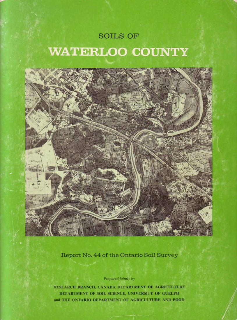
THE SOILSOF
WATERLOO COUNTY
by
E. W. Presantand
R. E. Wicklund
Research BranchCanada Department of Agriculture
1971
REPORT No. 44 OF THE ONTARIO SOIL SURVEYRESEARCH BRANCH, CANADA DEPARTMENT OF AGRICULTURE
DEPARTMENT OF SOIL SCIENCE, UNIVERSITY OF GUELPHand THE ONTARIO DEPARTMENT OF AGRICULTURE AND FOOD
ACKNOWLEDGMENTS
This soil report is possible only because of the assistance and con-tributions of many individuals . All members of the Ontario Soil Surveywere particularly helpful, especially Dr . C . J. Acton, Mr. D. W. Hoffman,Dr . R . Prom and Mr. G . J . Wall . Thanks are due to Dr . M. H. Miller,Chairman of the Department of Soil Science, University of Guelph, and toDr. R . Arnold, Agronomy Department, Cornell University, New York, forassistance during the project . The assistance and advice of personnelfrom the Soil Research Institute, Canada Department of Agriculture, isalso gratefully acknowledged.
The cooperation of Mr. P . K . Lee and Dr. O. L . White of the CivilEngineering Department, University of Waterloo, in preparing the en-gineering section of this report was much appreciated. Thanks are alsodue to Dr . P . F . Karrow of the Earth Sciences Department, University ofWaterloo, for writing the geology section of this report, and for helpfuldiscussion during the field mapping . The assistance of Dr . D . M. Brown,Soil Science Department, University of Guelph, in providing climaticdata for the report was greatly appreciated.
The financial assistance and facilities provided by the Canada LandInventory, ARDA, the Ontario Department of Agriculture and Food, andthe Department of Soil Science, University of Guelph, for the field mapping, map drafting, acreage determinations and laboratory analyses aregratefully acknowledged . In particular, field assistance from Mr. F. Bas-singthwaite, Mr. S . Brooks, Mr. D . Cressman, and Mr. B. Leeson wasmuch appreciated . Thanks are also extended to Miss G. Palmer, Miss P .Blythe, and Mrs . Z. Raad for their assistance in drafting the soil mapsand determining acreages, and to Mr. R. Howes for his laboratoryanalyses.
Finally, the authors express appreciation to the staff of the Carto-graphic Section of the Soils Research Institute, Ottawa, who had thedifficult task of preparing the soilmaps for printing.
Fox Series . . . . . . . . . . . . . . . . . . . . . . . . . . . . . . . . . . . . . . . . . . . . . . . . . . . . . . . . . . . . . . 30Freeport Series . . . . . . . . . . . . . . . . . . . . . . . . . . . . . . . . . . . . . . . . . . . . . . . . . . . . . . 30Granby Series . . . . . . . . . . . . . . . . . . . . . . . . . . . . . . . . . . . . . . . . . . . . . . . . . . . . . . . . 31Grand Series . . . . . . . . . . . . . . . . . . . . . . . . . . . . . . . . . . . . . . . . . . . . . . . . . . . . . . . . . . 31Guelph Series . . . . . . . . . . . . . . . . . . . . . . . . . . . . . . . . . . . . . . . . . . . . . . . . . . . . . . . . 31Hawkesville Series . . . . . . . . . . . . . . . . . . . . . . . . . . . . . . . . . . . . . . . . . . . . . . . . 32Haysville Series . . . . . . . . . . . . . . . . . . . . . . . . . . . . . . . . . . . . . . . . . . . . . . . . . . . . . . 32Heidelberg Series . . . . . . . . . . . . . . . . . . . . . . . . . . . . . . . . . . . . . . . . . . . . . . . . . . 32Hespeler Series . . . . . . . . . . . . . . . . . . . . . . . . . . . . . . . . . . . . . . . . . . . . . . . . . . . . . . 33Huron Series . . . . . . . . . . . . . . . . . . . . . . . . . . . . . . . . . . . . . . . . . . . . . . . . . . . . . . . . . . 33Kirkland Series . . . . . . . . . . . . . . . . . . . . . . . . . . . . . . . . . . . . . . . . . . . . . . . . . . . . . . 33Kossuth Series . . . . . . . . . . . . . . . . . . . . . . . . . . . . . . . . . . . . . . . . . . . . . . . . . . . . . 34Lisbon Series . . . . . . . . . . . . . . . . . . . . . . . . . . . . . . . . . . . . . . . . . . . . . . . . . . . . . . . . 34London Series . . . . . . . . . . . . . . . . . . . . . . . . . . . . . . . . . . . . . . . . . . . . . . . . . . . . . . . . 34
CONTENTS Macton Series . . . . . . . . . . . . . . . . . . . . . . . . . . . . . . . . . . . . . . . . . . . . . . . . . . . . . . . . 35INTRODUCTION . . . . . . . . . . . . . . . . . . . . . . . . . . . . . . . . . . . . . . . . . . . . . . . . . . . . . . . . 7 Mannheim Series . . . . . . . . . . . . . . . . . . . . . . . . . . . . . . . . . . . . . . . . . . . . . . . . . . . . 35GENERAL DESCRIPTION OF THE AREA . . . . . . . . . . . . . . 7 Maplewood Series . . . . . . . . . . . . . . . . . . . . . . . . . . . . . . . . . . . . . . . . . . . . . . . . . . 35
Location and Extent . . . . . . . . . . . . . . . . . . . . . . . . . . . . . . . . . . . . . . . . . . . . . . . . 7 Martin Series . . . . . . . . . . . . . . . . . . . . . . . . . . . . . . . . . . . . . . . . . . . . . . . . . . . . . . . . . . 36Population and Towns . . . . . . . . . . . . . . . . . . . . . . . . . . . . . . . . . . . . . . . . . . . . 7 Maryhill Series . . . . . . . . . . . . . . . . . . . . . . . . . . . . . . . . . . . . . . . . . . . . . . . . . . . . . . 36Industries . . . . . . . . . . . . . . . . . . . . . . . . . . . . . . . . . . . . . . . . . . . . . . . . . . . . . . . . . . . . . . . . 9 Organic Soils . . . . . . . . . . . . . . . . . . . . . . . . . . . . . . . . . . . . . . . . . . . . . . . . . . . . . . . . . . 36Transportation . . . . . . . . . . . . . . . . . . . . . . . . . . . . . . . . . . . . . . . . . . . . . . . . . . . . . . . . 9 Perth Series . . . . . . . . . . . . . . . . . . . . . . . . . . . . . . . . . . . . . . . . . . . . . . . . . . . . . . . . . . . . 37Agricultural Development . . . . . . . . . . . . . . . . . . . . . . . . . . . . . . . . . . . . . . 9 Preston Series . . . . . . . . . . . . . . . . . . . . . . . . . . . . . . . . . . . . . . . . . . . . . . . . . . . . . . . . 37Bedrock and Pleistocene Geology . . . . . . . . . . . . . . . . . . . . . . . . . . . . 10 St. Clements Series . . . . . . . . . . . . . . . . . . . . . . . . . . . . . . . . . . . . . . . . . . . . . . . . 37Relief and Drainage . . . . . . . . . . . . . . . . . . . . . . . . . . . . . . . . . . . . . . . . . . . . . . . . 14 St . Jacobs Series . . . . . . . . . . . . . . . . . . . . . . . . . . . . . . . . . . . . . . . . . . . . . . . . . . . . 38Soil Parent Materials . . . . . . . . . . . . . . . . . . . . . . . . . . . . . . . . . . . . . . . . . . . . . . 16 Tavistock Series . . . . . . . . . . . . . . . . . . . . . . . . . . . . . . . . . . . . . . . . . . . . . . . . . . . . 38Climate . . . . . . . . . . . . . . . . . . . . . . . . . . . . . . . . . . . . . . . . . . . . . . . . . . . . . . . . . . . . . . . . . . 17 Toledo Series . . . . . . . . . . . . . . . . . . . . . . . . . . . . . . . . . . . . . . . . . . . . . . . . . . . . . . . . . . 39
SOIL CLASSIFICATION . . . . . . . . . . . . . . . . . . . . . . . . . . . . . . . . . . . . . . . . . . . . . . 19 Tuscola Series . . . . . . . . . . . . . . . . . . . . . . . . . . . . . . . . . . . . . . . . . . . . . . . . . . . . . . . . 39Soil Orders in Waterloo County . . . . . . . . . . . . . . . . . . . . . . . . . . . . . . 20 Waterloo Series . . . . . . . . . . . . . . . . . . . . . . . . . . . . . . . . . . . . . . . . . . . . . . . . . . . . . . 39
Luvisolic Soils . . . . . . . . . . . . . . . . . . . . . . . . . . . . . . . . . . . . . . . . . . . . . . . . 20 Wauseon Series . . . . . . . . . . . . . . . . . . . . . . . . . . . . . . . . . . . . . . . . . . . . . . . . . . . . . . 40Brunisolic Soils . . . . . . . . . . . . . . . . . . . . . . . . . . . . . . . . . . . . . . . . . . . . . . 21 Wellesley Series . . . . . . . . . . . . . . . . . . . . . . . . . . . . . . . . . . . . . . . . . . . . . . . . . . . . . . 40Regosolic Soils . . . . . . . . . . . . . . . . . . . . . . . . . . . . . . . . . . . . . . . . . . . . . . . . 21 Wilmot Series . . . . . . . . . . . . . . . . . . . . . . . . . . . . . . . . . . . . . . . . . . . . . . . . . . . . . . . . 41Gleysolic Soils . . . . . . . . . . . . . . . . . . . . . . . . . . . . . . . . . . . . . . . . . . . . . . . . 21 Woolwich Series . . . . . . . . . . . . . . . . . . . . . . . . . . . . . . . . . . . . . . . . . . . . . . . . . . . . 41Organic Soils . . . . . . . . . . . . . . . . . . . . . . . . . . . . . . . . . . . . . . . . . . . . . . . . . . 21 MISCELLANEOUS LAND TYPES . . . . . . . . . . . . . . . . . . . . . . . . . . . . . . 41
Soil Series, Types and Phases . . . . . . . . . . . . . . . . . . . . . . . . . . . . . . . . . . 21 Gravel Pits . . . . . . . . . . . . . . . . . . . . . . . . . . . . . . . . . . . . . . . . . . . . . . . . . . . . . . . . . . . . . . 41Soil Mapping Units . . . . . . . . . . . . . . . . . . . . . . . . . . . . . . . . . . . . . . . . . . . . . . . . 21 Made Land . . . . . . . . . . . . . . . . . . . . . . . . . . . . . . . . . . . . . . . . . . . . . . . . . . . . . . . . . . . . 42Soil Catenas . . . . . . . . . . . . . . . . . . . . . . . . . . . . . . . . . . . . . . . . . . . . . . . . . . . . . . . . . . 22 Ponds and Lakes . . . . . . . . . . . . . . . . . . . . . . . . . . . . . . . . . . . . . . . . . . . . . . . . . . . . 42
SOIL KEY . . . . . . . . . . . . . . . . . . . . . . . . . . . . . . . . . . . . . . . . . . . . . . . . . . . . . . . . . . . . . . . . . . . . 22 River Scarps . . . . . . . . . . . . . . . . . . . . . . . . . . . . . . . . . . . . . . . . . . . . . . . . . . . . . . . . . . 42SOIL DESCRIPTIONS . . . . . . . . . . . . . . . . . . . . . . . . . . . . . . . . . . . . . . . . . . . . . . . . 23 Unmapped Urban Land . . . . . . . . . . . . . . . . . . . . . . . . . . . . . . . . . . . . . . . . . . 42
Ayr Series . . . . . . . . . . . . . . . . . . . . . . . . . . . . . . . . . . . . . . . . . . . . . . . . . . . . . . . . . . . . . . 23 SOIL CAPABILITY CLASSIFICATION FORBennington Series . . . . . . . . . . . . . . . . . . . . . . . . . . . . . . . . . . . . . . . . . . . . . . . . . . 23 AGRICULTURE . . . . . . . . . . . . . . . . . . . . . . . . . . . . . . . . . . . . . . . . . . . . . . . . . . 42Berrien Series . . . . . . . . . . . . . . . . . . . . . . . . . . . . . . . . . . . . . . . . . . . . . . . . . . . . . . . . 24 Capability Subclasses . . . . . . . . . . . . . . . . . . . . . . . . . . . . . . . . . . . . . . . . . . . . 43Bookton Series . . . . . . . . . . . . . . . . . . . . . . . . . . . . . . . . . . . . . . . . . . . . . . . . . . . . . . 24 Capability Classes . . . . . . . . . . . . . . . . . . . . . . . . . . . . . . . . . . . . . . . . . . . . . . . . . . 43Boomer Series . . . . . . . . . . . . . . . . . . . . . . . . . . . . . . . . . . . . . . . . . . . . . . . . . . . . . . . . 24 Capabilities and Present Agricultural Uses ofBrady Series . . . . . . . . . . . . . . . . . . . . . . . . . . . . . . . . . . . . . . . . . . . . . . . . . . . . . . . . . . 25 Waterloo County Soils . . . . . . . . . . . . . . . . . . . . . . . . . . . . . . . . . . . . 44Brant Series . . . . . . . . . . . . . . . . . . . . . . . . . . . . . . . . . . . . . . . . . . . . . . . . . . . . . . . . . . . . 25 ENGINEERING ASPECTS OF WATERLOOBrisbane Series . . . . . . . . . . . . . . . . . . . . . . . . . . . . . . . . . . . . . . . . . . . . . . . . . . . . . . 25 COUNTY SOILS . . . . . . . . . . . . . . . . . . . . . . . . . . . . . . . . . . . . . . . . . . . . . . . . . . 49Brooke Series . . . . . . . . . . . . . . . . . . . . . . . . . . . . . . . . . . . . . . . . . . . . . . . . . . . . . . . . 26 Procedure . . . . . . . . . . . . . . . . . . . . . . . . . . . . . . . . . . . . . . . . . . . . . . . . . . . . . . . . . . . . . . 49Brookston Series . . . . . . . . . . . . . . . . . . . . . . . . . . . . . . . . . . . . . . . . . . . . . . . . . . . . 26 Soil Data and Interpretations . . . . . . . . . . . . . . . . . . . . . . . . . . . . . . . . . . 50Burford Series . . . . . . . . . . . . . . . . . . . . . . . . . . . . . . . . . . . . . . . . . . . . . . . . . . . . 26 TAXONOMIC CLASSIFICATION, DETAILEDCaledon Series . . . . . . . . . ., . . . . . . . . . . . . . . . . . . . . . . . . . . . . . . . . . . . . . . . . . . . 27 PROFILEDESCRIPTIONSANDANALYTICALCamilla Series . . . . . . . . . . . . . . . . . . . . . . . . . . . . . . . . . . . . . . . . . . . . . . . . . . . . . . . . 27 DATA . . . . . . . . . . . . . . . . . . . . . . . . . . . . . . . . . . . . . . . . . . . . . . . . . . . . . . . . . . . . . . . . . . . . 72Colwood Series . . . . . . . . . . . . . . . . . . . . . . . . . . . . . . . . . . . . . . . . . . . . . . . . . . . . . . 28 Analytical Methods . . . . . . . . . . . . . . . . . . . . . . . . . . . . . . . . . . . . . . . . . . . . . . . . 72Conestogo Series . . . . . . . . . . . . . . . . . . . . . . . . . . . . . . . . . . . . . . . . . . . . . . . . . . . . 28 Detailed Data on Waterloo County Soil Series . . . . . . . . 72Donald Series . . . . . . . . . . . . . . . . . . . . . . . . . . . . . . . . . . . . . . . . . . . . . . . . . . . . . . . . 28 GLOSSARY . . . . . . . . . . . . . . . . . . . . . . . . . . . . . . . . . . . . . . . . . . . . . . . . . . . . . . . . . . . . . . . . . . 99Dorking Series . . . . . . . . . . . . . . . . . . . . . . . . . . . . . . . . . . . . . . . . . . . . . . . . . . . . . . 28 REFERENCES . . . . . . . . . . . . . . . . . . . . . . . . . . . . . . . . . . . . . . . . . . . . . . . . . . . . . . . . . . . . . . 101Dumfries Series . . . . . . . . . . . . . . . . . . . . . . . . . . . . . . . . . . . . . . . . . . . . . . . . . . . . . . 29 GUIDE TO ACREAGES AND AGRICULTURALElmira Series . . . . . . . . . . . . . . . . . . . . . . . . . . . . . . . . . . . . . . . . . . . . . . . . . . . . . . . . 29 CAPABILITIES OF SOIL MAPPING UNITS . . . . 102Farmington Series . . . . . . . . . . . . . . . . . . . . . . . . . . . . . . . . . . . . . . . . . . . . . . . . . . 29 DETALED PHOTOMOSAIC SOIL MAPS . . . . . . . .Back CoverFloradale Series . . . . . . . . . . . . . . . . . . . . . . . . . . . . . . . . . . . . . . . . . . . . . . . . . . . . . . 30 SOIL ASSOCIATION MAP . . . . . . . . . . . . . . . . . . . . . . . . . . . . . . . .Back Cover
SUMMARYThe total area of Waterloo County is 330,120 acres. It is located
within the Huron Slopes and South Slopes climatic regions. The meanannual precipitation is about 33 inches . Physiographically, the WaterlooSandhills virtually bisect the county, separating the clay till plains on thewest side from the loam till plains, drumlins and moraines on the eastside . The major river valleys contain alluvium and are bordered byextensive areas of outwash gravels and sands.
Less than 10% of the county still remains as woodland . The mostimportant agricultural crops arehay and pasture, mixed grain, corn, oats,and winter wheat. Large areas of land are presently being urbanized, andare no longer available for agricultural use, especially in the vicinities ofKitchener-Waterloo, Galt, Preston, and Hespeler.
There are 52 soil series mapped in the county . Most well and im-perfectly drained series are classified in the Gray Brown Luvisol GreatGroup; some are classified in the Melanic Brunisol and Regosol GreatGroups . The poorly drained series are classified in the Humic GleysolGreat Group and the Organic Order. The soils are mapped on photo-mosaics at a scale of 1 :20,000. They have also been compiled into a soilsassociation map at a scale of 1 :100,000.
SOIL SURVEY MAPSAND REPORTSPUBLISHEDBYCOUNTIES
Norfolk . . . . . . . . . . . . . . . . . . . . . . . . . . . . . . . . . . . . . . . . . . . . . . . . . . . . . . . . . . . . . . MapNo.
1Elgin . . . . . . . . . . . . . . . . . . . . . . . . . . . . . . . . . . . . . . . . . . . . . . . . . . . . . . . . . . . . . . . . . . Map No.
2Kent . . . . . . . . . . . . . . . . . . . . . . . . . . . . . . . . . . . . . . . . . . . . . . . . . . . . . . . . . . . . . . . . . . Map No.
3Haldimand
. . . . . . . . . . . . . . . . . . . . . . . . . . . . . . . . . . . . . . . . . . . . . . . . . . . . . . . . . .Map No.
4Welland
. . . . . . . . . . . . . . . . . . . . . . . . . . . . . . . . . . . . . . . . . . . . . . . . . . . . . . . . . . . . Map No.
5Middlesex . . . . . . . . . . . . . . . . . . . . . . . . . . . . . . . . . . . . . . . . . . . . . . . . . . . . . . . . . . Map No.
6Carleton
. . . . . . . . . . . . . . . . . . . . . . . . . . . . . . . . . . . . . . . . . . . . . . . . . . . . . . . . . . . . Map No.
7Parts of Northwestern Ontario . . . . . . . . . . . . . . . . . . . . . . Report No.
8Durham
. . . . . . . . . . . . . . . . . . . . . . . . . . . . . . . . . . . . . . . . . . . . . . . . . . . . . . . . Report No.
9Prince Edward . . . . . . . . . . . . . . . . . . . . . . . . . . . . . . . . . . . . . . . . . . . . . . Report No. 10Essex . . . . . . . . . . . . . . . . . . . . . . . . . . . . . . . . . . . . . . . . . . . . . . . . . . . . . . . . . . . . . . . . . . Map No. 11Grenville . . . . . . . . . . . . . . . . . . . . . . . . . . . . . . . . . . . . . . . . . . . . . . . . . . . . . . . . Report No. 12Huron
. . . . . . . . . . . . . . . . . . . . . . . . . . . . . . . . . . . . . . . . . . . . . . . . . . . . . . . . . . . .
Report No. 13Dundas
. . . . . . . . . . . . . . . . . . . . . . . . . . . . . . . . . . . . . . . . . . . . . . . . . . . . . . . . . . Report No. 14Perth . . . . . . . . . . . . . . . . . . . . . . . . . . . . . . . . . . . . . . . . . . . . . . . . . . . . . . . . . . . . . . Report No. 15Bruce
. . . . ., . . . . . . . . . . . . . . . . . . . . . . . . . . . . . . . . . . . . . . . . . . . . . . . . . . . . . . Report No. 16Grey
. . . . . . . . . . . . . . . . . . . . . . . . . . . . . . . . . . . . . . . . . . . . . . . . . . . . . . . . . . . . . . Report No. 17Peel . . . . . . . . . . . . . . . . . . . . . . . . . . . . . . . . . . . . . . . . . . . . . . . . . . . . . . . . . . . . . . . . Report No. 18York . . . . . . . . . . . . . . . . . . . . . . . . . . . . . . . . . . . . . . . . . . . . . . . . . . . . . . . . . . . . . . Report No. 19Stormont . . . . . . . . . . . . . . . . . . . . . . . . . . . . . . . . . . . . . . . . . . . . . . . . . . . . . . . . Report No. 20New Liskeard - Englehart Area . . . . . . . . . . . . . . . . . . . . . . Report No. 21Lambton . . . . . . . . . . . . . . . . . . . . . . . . . . . . . . . . . . . . . . . . . . . . . . . . . . . . . . . . Report No. 22Ontario . . . . . . . . . . . . . . . . . . . . . . . . . . . . . . . . . . . . . . . . . . . . . . . . . . . . . . . . . . Report No. 23Glengarry
. . . . . . . . . . . . . . . . . . . . . . . . . . . . . . . . . . . . . . . . . . . . . . . . . . . . . . Report No. 24Victoria . . . . . . . . . . . . . . . . . . . . . . . . . . . . . . . . . . . . . . . . . . . . . . . . . . . . . . . . . . Report No. 25Manitoulin
. . . . . . . . . . . . . . . . . . . . . . . . . . . . . . . . . . . . . . . . . . . . . . . . . . . . Report No. 26Hastings
. . . . . . . . . . . . . . . . . . . . . . . . . . . . . . . . . . . . . . . . . . . . . . . . . . . . . . . . Report No. 27Oxford
. . . . . . . . . . . . . . . . . . . . . . . . . . . . . . . . . . . . . . . . . . . . . . . . . . . . . . . . . . Report No. 28Simcoe
. . . . . . . . . . . . . . . . . . . . . . . . . . . . . . . . . . . . . . . . . . . . . . . . . . . . . . . . . . Report No. 29Soil Associations of Southern Ontario . . . . . . . . . . Report No. 30Parry Sound . . . . . . . . . . . . . . . . . . . . . . . . . . . . . . . . . . . . . . . . . . . . . . . . . . Report No. 31Wentworth
. . . . . . . . . . . . . . . . . . . . . . . . . . . . . . . . . . . . . . . . . . . . . . . . . . . . Report No. 32Prescott and Russell . . . . . . . . . . . . . . . . . . . . . . . . . . . . . . . . . . . . . .
Report No. 33Lincoln
. . . . . . . . . . . . . . . . . . . . . . . . . . . . . . . . . . . . . . . . . . . . . . . . . . . . . . . . . .
Report No. 34Wellington
. . . . . . . . . . . . . . . . . . . . . . . . . . . . . . . . . . . . . . . . . . . . . . . . . . . . Report No. 35Lennox and Addington . . . . . . . . . . . . . . . . . . . . . . . . . . . . . . . . . . Report No. 36Renfrew
. . . . . . . . . . . . . . . . . . . . . . . . . . . . . . . . . . . . . . . . . . . . . . . . . . . . . . . .
Report No. 37Dufferin . . . . . . . . . . . . . . . . . . . . . . . . . . . . . . . . . . . . . . . . . . . . . . . . . . . . . . . . . . Report No. 38Frontenac
. . . . . . . . . . . . . . . . . . . . . . . . . . . . . . . . . . . . . . . . . . . . . . . . . . . . . . Report No. 39Lanark
. . . . . . . . . . . . . . . . . . . . . . . . . . . . . . . . . . . . . . . . . . . . . . . . . . . . . . . . . . Report No. 40Leeds
. . . . . . . . . . . . . . . . . . . . . . . . . . . . . . . . . . . . . . . . . . . . . . . . . . . . . . . . . . . . Report No. 41Northumberland
. . . . . . . . . . . . . . . . . . . . . . . . . . . . . . . . . . . . . . . . . . . .
Report No. 42Halton
. . . . . . . . . . . . . . . . . . . . . . . . . . . . . . . . . . . . . . . . . . . . . . . . . . . . . . . . . . Report No. 43
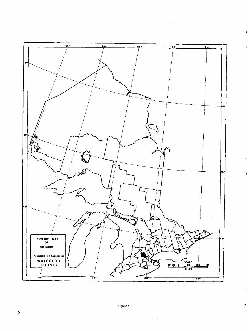
Figure 1
THE SOILS OF WATERLOO COUNTY
INTRODUCTIONThe soils information contained in this report was ob-
tained from a soil survey and related soil investigations thatwere more comprehensive and detailed than previous soil sur-veys in Ontario . This was in response to greater demands forthis detailed information from soil users, and was alsoprompted by increasingly intensive land use, especiallyaround the rapidly urbanizing Kitchener-Waterloo and Galt-Preston areas.The soil mapping was done on aerial photos by combining
photo interpretation with careful field checking and laboratorystudies. The field mapping was completed in 1967 . Areas assmall as 1 or 2 acres in size have been delineated on the photomaps. Altogether, 52 different soil series, comprising over 200soil mapping units, have been mapped in the county . The dis-tribution of these soils is shown on photomosaic maps in thereport . A soils association map, made by compiling informa-tion from the photo maps, is attached to the back cover of thereport .
Studies of the surficial geology and engineering propertiesof the soils of Waterloo County were carried out in conjunctionwith the soil survey by personnel from the University of Water-loo. Dr. P. F. Karrowwas in charge of the geology studies andwrote the geology section for this report . The engineeringstudies were carried out by Dr. P. K. Lee and Dr . O. L. White,who prepared the material for the engineering section of thereport .
Generalized and detailed descriptions of the various soilseries in the county occupy large portions of this report .These descriptions include information on classification, hori-zon characteristics, chemical and physical properties, andland use limitations. There is a section on the capability classi-fication of soils for agriculture, in which all soils in WaterlooCounty are rated and their present agricultural uses and limita-tions discussed . Interpretations of the soils for various en-gineering purposes are contained in the engineering section.Other shorter sections of the report discuss soil classification,agricultural development, relief and drainage, soil parentmaterials, and climate in Waterloo County.
GENERALDESCRIPTIONOFTHEAREALocation andExtent
Waterloo County is located in south-central Ontario nearthe western end of Lake Ontario (Figure 1) . It lies between43'15' and 43'42' west longitude, and between 80'12,* and80°54' north latitude . It is bounded on the north by Welling-ton County ; on the east by Wellington and Wentworth Coun-ties ; on the south by Brant and Oxford Counties ; and on thewest by Perth County .The total area of the county is 330,120 acres, or almost
516 square miles.
Population and TownsIn 1966 the population of Waterloo County was 216,728
(8) . At that time, 86% of this population was listed as urban,9% as rural nonfarm, and 5% as rural farm . The rapidurbanization of the county is indicated by the fact that the23% population increase from 1961 to 1966 was due entirelyto increases in the urban and rural nonfarm populations .
Much of the land surrounding Kitchener-Waterloois being rapidly urbanized.
The largest urban populations in 1966 were in the twincities of Kitchener (93,255) and Waterloo (29,889), and in
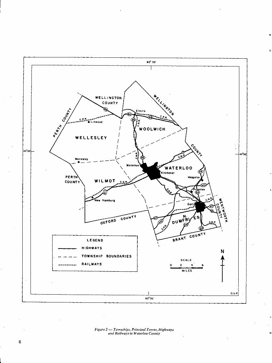
Figure 2-Townships, Principal Towns, Highwaysand Railways in Waterloo County
Be 30'
WELLINGTON kFCOUNTY
Ae Elmira
vJ2
~Ves
86 0.P. R.~. P. a. es-- Linwood i
WOOLWICH
a WELLESLEY ~//
43 360
/ G. lip43*3d
Wellesley
WaterlooWqT ER LO0
Kltchener 2
PERTH Hespeler
COUNTY WILMOT O .B .R .40
rr
g yqSton
24
New Homburp \ `-,.pa.
Gait\ `9
e Zfa0A
OXFOROGovNTY
~~~ puMFR1ES ps
4vv
cout,Z~l
LEGEND ANt
` BI
HIGHWAYSv
NTOWNSHIP BOUNDARIES
SCALE..,_ RAILWAYS o 2 4 s
MILES
G.V.F80'30'
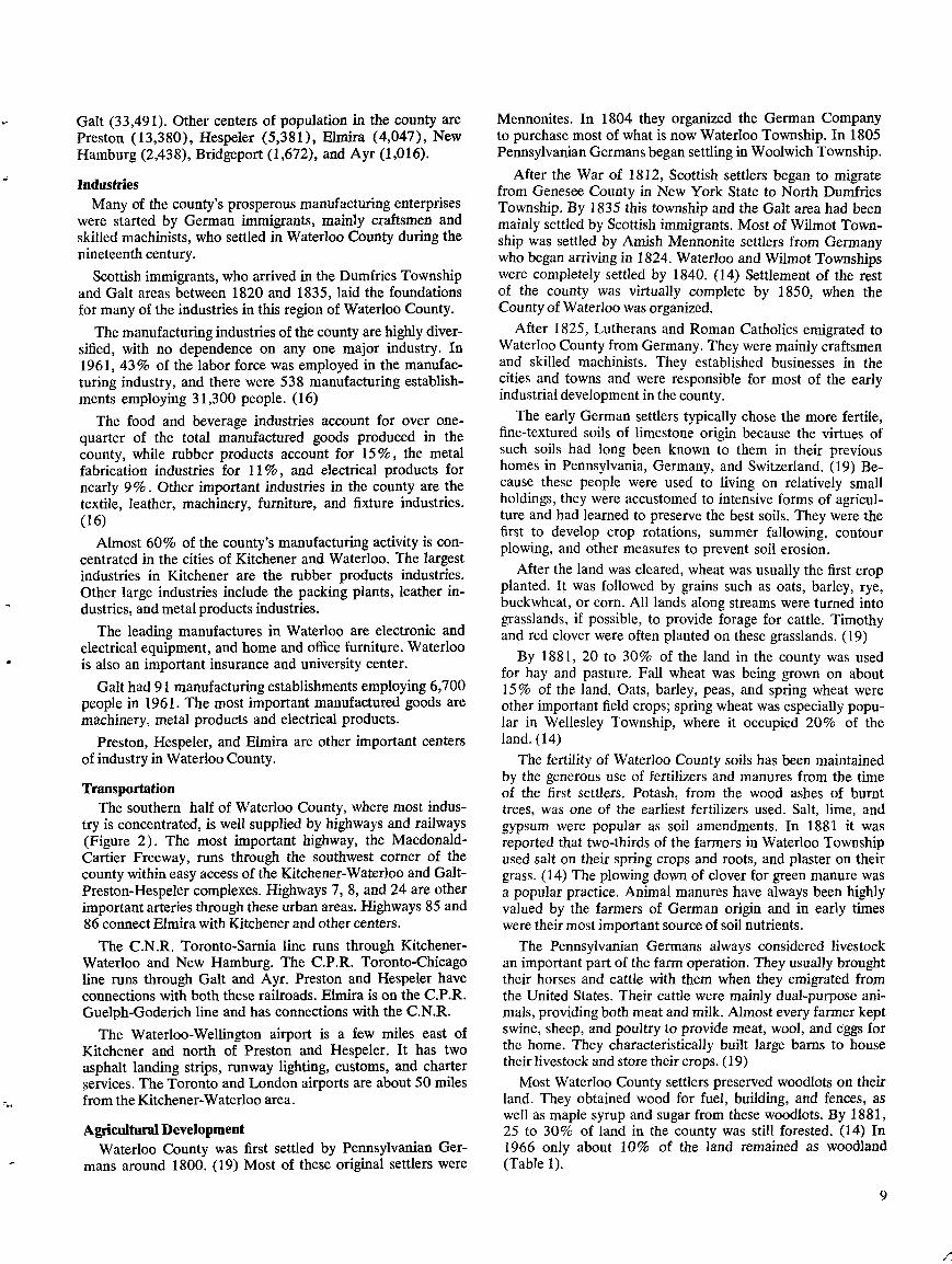
Galt (33,491). Other centers of population in the county arePreston (13,380), Hespeler (5,381), Elmira (4,047), NewHamburg (2,438), Bridgeport (1,672), and Ayr (1,016).
IndustriesMany of the county's prosperous manufacturing enterprises
were started by German immigrants, mainly craftsmen andskilled machinists, who settled in Waterloo County during thenineteenth century.
Scottish immigrants, who arrived in the Dumfries Townshipand Galt areas between 1820 and 1835, laid the foundationsfor many of the industries in this region of Waterloo County.
The manufacturing industries of the county are highly diver-sified, with no dependence on any one major industry . In1961, 43% of the labor force was employed in the manufac-turing industry, and there were 538 manufacturing establish-ments employing 31,300 people . (16)
The food and beverage industries account for over one-quarter of the total manufactured goods produced in thecounty, while rubber products account for 15%, the metalfabrication industries for 11%, and electrical products fornearly 9% . Other important industries in the county are thetextile, leather, machinery, furniture, and fixture industries .(16)
Almost 60% of the county's manufacturing activity is con-centrated in the cities of Kitchener and Waterloo . The largestindustries in Kitchener are the rubber products industries .Other large industries include the packing plants, leather in-dustries, and metal products industries .
The leading manufactures in Waterloo are electronic andelectrical equipment, and home and office furniture. Waterloois also an important insurance and university center.
Galt had 91 manufacturing establishments employing 6,700people in 1961 . The most important manufactured goods aremachinery, metal products and electrical products .
Preston, Hespeler, and Elmira are other important centersofindustry in Waterloo County .
TransportationThe southern half of Waterloo County, where most indus-
try is concentrated, is well supplied by highways and railways(Figure 2) . The most important highway, the Macdonald-Cartier Freeway, runs through the southwest comer of thecounty within easy access of the Kitchener-Waterloo and Galt-Preston-Hespeler complexes. Highways 7, 8, and 24 are otherimportant arteries through these urban areas . Highways 85 and86 connect Elmira with Kitchener and other centers.
The C.N.R. Toronto-Sarnia line runs through Kitchener-Waterloo and New Hamburg. The C.P.R. Toronto-Chicagoline runs through Galt and Ayr. Preston and Hespeler haveconnections with both these railroads. Elmira is on the C.P.R .Guelph-Goderich line and has connections with the C.N.R .
The Waterloo-Wellington airport is a few miles east ofKitchener and north of Preston and Hespeler . It has twoasphalt landing strips, runway lighting, customs, and charterservices . The Toronto and London airports are about 50 milesfrom the Kitchener-Waterloo area.
Agricultural DevelopmentWaterloo County was first settled by Pennsylvanian Ger-
mans around 1800 . (19) Most of these original settlers were
Mennonites . In 1804 they organized the German Companyto purchase most of what is now Waterloo Township . In 1805Pennsylvanian Germansbegan settling in Woolwich Township .
After the War of 1812, Scottish settlers began to migratefrom Genesee County in New York State to North DumfriesTownship . By 1835 this township and the Galt area had beenmainly settled by Scottish immigrants . Most of Wilmot Town-ship was settled by Amish Mennonite settlers from Germanywho began arriving in 1824 . Waterloo and Wilmot Townshipswere completely settled by 1840. (14) Settlement of the restof the county was virtually complete by 1850, when theCounty of Waterloo was organized.
After 1825, Lutherans and Roman Catholics emigrated toWaterloo County from Germany. They were mainly craftsmenand skilled machinists . They established businesses in thecities and towns and were responsible for most of the earlyindustrial development in the county.
The early German settlers typically chose the more fertile,fine-textured soils of limestone origin because the virtues ofsuch soils had long been known to them in their previoushomes in Pennsylvania, Germany, and Switzerland. (19) Be-cause these people were used to living on relatively smallholdings, they were accustomed to intensive forms of agricul-ture and had learned to preserve the best soils . They were thefirst to develop crop rotations, summer fallowing, contourplowing, and other measures to prevent soil erosion.
After the land was cleared, wheat was usually the first cropplanted . It was followed by grains such as oats, barley, rye,buckwheat, or corn . All lands along streams were turned intograsslands, if possible, to provide forage for cattle . Timothyand red clover were often planted on these grasslands . (19)
By 1881, 20 to 30% of the land in the county was usedfor hay and pasture. Fall wheat was being grown on about15% of the land. Oats, barley, peas, and spring wheat wereother important field crops; spring wheat was especially popu-lar in Wellesley Township, where it occupied 20% of theland . (14)
The fertility of Waterloo County soils has been maintainedby the generous use of fertilizers and manures from the timeof the first settlers. Potash, from the wood ashes of burnttrees, was one of the earliest fertilizers used . Salt, lime, andgypsum were popular as soil amendments . In 1881 it wasreported that two-thirds of the farmers in Waterloo Townshipused salt on their spring crops and roots, and plaster on theirgrass. (14) The plowing down of clover for green manure wasa popular practice . Animal manures have always been highlyvalued by the farmers of German origin and in early timeswere their most important source of soil nutrients.
The Pennsylvanian Germans always considered livestockan important part of the farm operation. They usually broughttheir horses and cattle with them when they emigrated fromthe United States . Their cattle were mainly dual-purpose ani-mals, providing both meat and milk. Almost every farmer keptswine, sheep, and poultry to provide meat, wool, and eggs forthe home . They characteristically built large barns to housetheirlivestock and store their crops. (19)
Most Waterloo County settlers preserved woodlots on theirland . They obtained wood for fuel, building, and fences, aswell as maple syrup and sugar from these woodlots . By 1881,25 to 30% of land in the county was still forested . (14) In1966 only about 10% of the land remained as woodland(Table 1) .
Table 1 .CONDITION OF FARMLAND IN WATERLOO COUNTY*
*Data compiled from Census of Canada 1966(1) Includes field, vegetable, fruit and nursery crop land(2) Percent of township total area acreage
Table 1 indicates that all townships in Waterloo Countybut North Dumfries have about the same proportions of im-proved land and land under crops . North Dumfries has sub-stantial amounts of rough, stony land that has been clearedbut is presently not being cultivated and is used for pasture .
Acreages and numbers of important field crops and live-stock types in Waterloo County are shown in Table 2 . Hayand pasture, as in earlier times, still occupy the greatest landacreage in the county . All townships grow about the sameproportions of these forage crops, except North Dumfries,which has a relatively high proportion of 20% of its land inpasture, probably a reflection of the large acreage of rough,stony land .
The acreages of spring and fall wheat in Waterloo Countyhave declined drastically from previous years . Spring wheathas virtually disappeared from the county, and fall wheat nowonly occupies about 3% of the land (Table 2) . Oats has re-mained relatively constant, but mixed grain has become themost important grain crop . This is especially true in Wellesleyand Woolwich Townships, where it is grown as feed for thelarge numbers of livestock and poultry produced there . Thesetownships have more fine-textured soils and slightly coolertemperatures than those in the southern part of the county, andthese conditions are possibly more favorable for mixed graingrowing.
Grain corn is becoming increasingly popular as a field crop,especially in the southern part of the county where coarser-textured soils and warmer temperatures prevail . In 1966almost 13% of the total acreage of North Dumfries Townshipwas planted to grain corn (Table 2) .
In addition to field crops shown in Table 2, significantacreages of barley, potatoes, and flax were reported in thecounty by the 1966 census . There were more than 1,000 acresof barley grown in each of the townships of Wellesley, Wool-
Table 2. DISTRIBUTION OF CROPSANDNUMBER OF LIVESTOCKIN WATERLOO COUNTY*
*Data compiled from Census of Canada 1966(1) Percent of township total area acreage
10
wich, and Waterloo ; several hundred acres of potatoes weregrown in Waterloo and Woolwich Townships ; a few hundredacres of flax were grown, mainly in Wellesley Township .
Fruit and vegetable crops are of minor importance in Water-loo County . The 1966 census reported 360 acres of apples,almost all in farm orchards. Very small acreages of straw-berries and raspberries were reported .
In recent years there has been some increase in the acreagesof commercial vegetables and nursery products, mainly in loamand sandy loam soils fringing the urban areas .
Waterloo County has always been renowned for the qualityand quantity of its livestock and poultry . The quantity of live-stock is greatest in Wellesley and Woolwich Townships(Table 2) . The 1966 census showed that Waterloo Countyranked second in swine value, third in value of eggs, andamong the top 10 Ontario counties in value of poultry, dairyproducts, and cattle .
Table 3. SIZE OF FARMS IN WATERLOO COUNTY*
Total No .Township Farms
*Data compiled from Census of Canada 1966
Table 3 gives an indication of the number and sizes offarms in Waterloo County . Most farms in the "family farm"range of 70 to 240 acres occur in Wellesley, Woolwich andWilmot Townships, where urbanization is still minimal . Thelarge number of farms in Waterloo Township with 10 to 70acres, and above 240 acres in size, reflect changes in farmsize due to proximity to urban areas . Many of the small hold-ings are owned by nonfarmers who live there and work in thecity ; many large land holdings represent blocks of land ownedby land speculators .
Bedrock and Pleistocene Geologyby P . F . Karrow*
The parent materials from which the soils of WaterlooCounty have developed are almost entirely unconsolidatedsediments derived directly or indirectly from the action ofcontinental glaciers several thousand years ago . However, in
*Professor, Department of Earth Sciences, University of Waterloo,Waterloo, Ontario
Less than
10 to
70 to
130 to
More than10 Acres 70 Acres 130 Acres 240 Acres 240 Acres
Major Field Crops Livestock
Total Wheat Oats Mixed Hay Pasture Corn Corn HensTownship Area
acres acres %(I) acres %(I)Grains
acres %(I) acres %(1) acres %(1)Grain
acres% (1)Ensilageacres %(1)
TotalCattle
MilkCows
Pigs andChickens
Dumfries N . 35,173 1,167 3.3 2,804 8.0 1,312 3.7 7,035 20 .0 6,731 19 .2 4,499 12 .8 1,563 4.5 8,928 2,254 8,404 173,126Waterloo 56,427 2,344 4.1 7,109 12 .6 4,750 8.4 13,704 24 .4 5,972 10 .6 4,922 8.7 4,016 7.1 16,969 5,168 14,699 233,986Wellesley 64,055 1,481 2.3 4,074 6.4 16,093 25 .0 16,582 25 .8 8,638 13 .5 674 1 .1 3,762 5 .9 18,528 5,256 43,607 281,533Wilmot 57,434 1,267 2.2 5,799 10 .0 7,798 13 .6 13,136 22 .8 8,370 14 .6 5,305 9.3 4,394 7.6 17,721 6,134 27,806 282,513Woolwich 54,371 1,858 3 .4 3,986 7.3 10,772 19 .8 12,111 22 .3 5,675 10 .4 2,151 4.0 4,896 9.0 20,238 5,013 32,485 470,033
Totals 267,460 8,117 23,772 40,725 62,568 35,386 17,551 18,631 82,384 23,825 127,001 1,441,191
Dumfries N . 230 11 41 67 68 43Waterloo 487 74 120 117 119 57Wellesley 544 33 53 280 156 22Wilmot 503 50 87 186 150 30Woolwich 475 52 62 193 137 31
Totals 2,239 220 363 843 630 183
TownshipTotal Area
acresImproved
acresLand% (2)
Under Crops (1) Woodlandacres % (2) acres % (2)
Dumfries North 35,173 27,253 77 19,111 54 3,725 11Waterloo 56,427 47,332 84 39,115 70 5,025 9Wellesley 64,055 55,892 87 44,783 70 5,602 9Wilmot 57,434 49,727 87 39,228 68 4,774 8Woolwich 54,371 45,332 83 37,995 70 5,622 10
Totals 267,460 225,536 180,232 24,748

**Adapted from Sandford, 1958 (20)
Figure 3- Outline Map Showing Bedrock Geologyof Waterloo County**
8030'
// WELLINGTON
COUNTY
A, /~ Elmira / "0"ti//
V / j '/0Liwod
°o4330
4330
\ \ ~\ Wellesley 'j
jWaterloo jKitchener
PERTH HespelerCOUNTY
"
*New Hamburg/ /j // /'/'j////~/r__
AO
s
LEGEND % BRAN
DEVONIAN
\\\ BOIS BLANC FORMATION-limestone, dolomiteand chert ; sandstone.
SCALE
SILURIAN 0 2 4 s
MILES
I"!BASS ISLAND FORMATION-creom and buffdolomite .
F/,, SALINA FORMATION-buff to brown dolomite1///, and limestonei gray dolomite shole ; onhydrite,
gypsum and salt .
® GUELPH FORMATION- creom to buffdolomite .
G. V . P
8030'
a few small areas bedrock has played a more direct part insoil formation because it is close to the surface. Also, thenature of the bedrock formations influences to a considerabledegree the properties of the unconsolidated sediments above,and thus plays an indirect part in soil formation.
BedrockFormationsThe bedrock underlying Waterloo County was deposited as
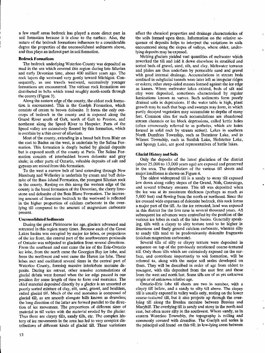
mud in the sea which covered this region during late Silurianand early Devonian time, about 400 million years ago. Therock layers dip westward very gently toward Michigan . Con-sequently, as one travels westward, successively youngerformations are encountered. The vârious rock formations aredistributed in belts which trend roughly north-south throughthe county (Figure 3) .
Alongthe eastern edge of the county, the oldest rock forma-tion is encountered. This is the Guelph Formation, whichconsists of cream to brown dolomite. It forms the only out-crops of bedrock in the county and is exposed along theGrand River south of Galt, north of Galt to Preston, andnortheast along the Speed River to Hespeler . Parts of theSpeed valley are extensively floored by this formation, whichis overlain by athin cover of alluvium .
Most of the county, extending in a broad belt from Blair onthe east to Baden on the west, is underlain by the Salina For-mation . This formation is deeply buried by glacial depositsbut is exposed south of the county at Paris. The Salina For-mation consists of interbedded brown dolomite and grayshale; in other parts of Ontario, valuable deposits of salt andgypsum are mined from this formation.To the west a narrow belt of land extending through New
Hamburg and Wellesley is underlain by cream and buff dolo-mite of the Bass Island Formation, the youngest Silurian rockin the county . Resting on this along the western edge of thecounty is the basal formation of the Devonian, the cherty lime-stone and dolomite of the Bois Blanc Formation. The increas-ing amount of limestone bedrock to the westward is reflectedin the higher proportion of calcium carbonate in the over-lying till compared to the amount of magnesium carbonatepresent.
Unconsolidated SedimentsDuring the great Pleistocene ice age, glaciers advanced and
retreated in this region many times. Because each of the GreatLakes basins was occupied by major ice lobes, or projectionsof the ice front, the central part of the southwestern peninsulaof Ontario was subjected to glaciation from several directions .From the southeast and east came the ice of the Erie-Ontarioice lobe, from the north came the Georgian Bay ice lobe, andfrom the northwest and west came the Huron ice lobe . Theselobes met and oscillated several times in the central part ofWaterloo County, forming massive interlobate moraine de-posits . During ice retreat, other massive accumulations ofglacial debris were formed when the ice edge paused in oneposition for some length of time to form end moraines . Thechief material deposited directly by a glacier is an unsorted orpoorly sorted mixture of clay, silt, sand, gravel, and boulders,called glacial till . Much of the end moraines is composed ofglacial till, as are smooth elongate hills known as drumlins ;the long direction of the latter are formed parallel to the direc-tion of ice movement . The proportions of different sizes ofmaterial in till varies with the material eroded by the glacier.Thus there are clayey tills, sandy tills, etc. The complex his-tory of ice movements in the area has led to very complex dis-tributions of different kinds of glacial till . These variations
12
affect the chemical properties and drainage characteristics ofthe soils formed upon them . Information on the relative se-quence of deposits helps to interpret the variations in soilsencountered along the slopes of valleys, where older, under-lying deposits maybe exposed.
Melting glaciers yielded vast quantities of meltwater whichreworked the till and laid it down elsewhere in stratified andsorted beds of gravel, sand, silt, and clay . Meltwater terracesand plains are thus underlain by permeable sand and gravelwith good internal drainage . Accumulations in stream bedsconfined in subglacial tunnels were later left as irregular ridgesor eskers ; other steep-sided masses formed against the ice edgeas kames. Where meltwater lakes existed, beds of silt andclay were deposited, sometimes characterized by regularlaminations known as varves . Such sediments form poorlydrained soils in depressions . If the water table is high, plantgrowth may be such that bogs and swamps may form, in whichpartly decayed vegetation may accumulate to depths of manyfeet . Common sites for such accumulations are abandonedstream channels or ice block depressions, called kettle holes(often erroneously referred to as potholes, which are holesformed in solid rock by stream action). Lakes in southernNorth Dumfries Township, such as Bannister Lake, and inWilmot Township, such as Sunfish Lake, Hofstetter Lake,and Spongy Lake, are good representatives of kettle lakes.
Glacial History and SoilsOnly the deposits of the latest glaciation of the district
(about 25,000 to . 13,000 years ago) are exposed and preservedin the area . The distribution of the various till sheets andmajor landforms is shown on Figure 4.The oldest widespread till is a sandy to stony till exposed
low down along valley slopes of the Grand, Nith, Conestogo,and several tributary streams. This till was deposited whenthe ice was at its maximum thickness (perhaps as much as5,000 feet) and flowing from the north or northeast. Since theice crossed wide expanses of dolomite bedrock, this rock formsa major part of the till . As the ice retreated, land was exposedin this district for the first time in several thousand years. Allsubsequent ice advances were controlled by the position of thevarious ice lobes in each of the lake basins . Generally speak-ing, tills with a clayey to silty texture tend to be higher inlimestone and finely ground calcium carbonate, whereas siltyto sandy tills tend to be predominantly dolomite fragments(calcium magnesium carbonate).
Several tills of silty or clayey texture were deposited insequence on top of the previously mentioned coarse-texturedtill . Only those tills which are extensively exposed on the sur-face, and contribute importantly to soil formation, will bereferred to, along with the major soil series developed onthem . They will be described in order of age from oldest toyoungest, with tills deposited from the east first . and thosefrom the west and north last. Some tills are of as yet unknownorigin or of unknown relative age.
Ontario-Erie lobe till sheets are two in number, with aclayey till below, and a sandy to silty till above. The clayeytill is usually exposed in valley walls only, resting on the lowercoarse-textured till, but it also projects up through the over-lying till along the Breslau moraine between Breslau andMaryhill. The overlying till is sandy and stony in the north andeast, but often more silty in the southwest. Where sandy, as ineastern Waterloo Township, the topography is rolling andcommonly covered with drumlins . The Guelph soil series isthe principal soil found on this till; in low-lying areas between
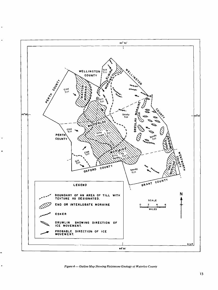
Figure 4-Outline Map Showing Pleistocene Geology of Waterloo County
1 3
so* 30 ,
WELLINGTONSi ltTill ~F
COUNTY -;~ .o <<,4 ~
ti h tvQ l Cr0.2 ~! yJ ~2 I `
OW
CD C\o1 ZTill F- .
ICE It IL
1111A1 ~~ / 11 ? ~%- ô .é o0
43'3d ` % Sandy433ÔTill
W w
l
~R-
w
~.WCIaY
A~\\\\\o-Till "46
°°PERTH
5w1Y T\u I5ap0Y
COUNTY ` ® ,~ T\\\N
40~
R\Ily~~ To
'-TillandY `O
00ZI
5v G Ict.
â0COVNT .
OXFORDSondY ZT111
vv
COUN TY
LEGEND
vt
1414 .T
\
BOUNDARY OF AN AREA OF TILL WITH' TEXTURE AS DESIGNATED .
SCALE
,,00 END OR INTERLOBATE MORAINE 0 2 4 6
' 'MILES
ESKER
DRUMLIN SHOWING DIRECTION OFICE MOVEMENT.
PROBABLE DIRECTION OF ICEMOVEMENT.
G . V. P
80' 30'
drumlins the imperfectly drained London loam and poorlydrained Maryhill loam are found. Southeast of Elmira, a thincover of silt loam and loam on this same till gives rise to theWoolwich catena soils . A somewhat younger ice advance fromthe east about 13,000 years ago led to the formation of theGalt and Paris moraines on which the' Dumfries soil seriesoccurs . The materials of these moraines vary from coarse-textured till to kame sand and gravel, with rough hilly topog-raphy and frequently stony or bouldery surfaces . They arethus problem areas for farming. Silty or clayey till was de-posited from the east on top of irregular sandhills in the Water-loo moraine south and west of Kitchener . The till cap wassubsequently eroded in many places, exposing the underlyingfine sands . Rolling to steep topography characterizes much ofthis region . Where erosion is excessive, wind-blown sand mayoccur ; in some areas a thin layer of wind-blown silt (loess)may be found on the surface .To the west, the Huron and Georgian Bay ice lobes de-
posited a number of silty to clayey till sheets ; soils of the Huroncatena are found on most of these till sheets . Between NewHamburg and Petersburg a nearly stone-free clay till occurswhich extends up on the west flank of the sandy Waterloomoraine . Meltwater stream erosion cut through the till leavingisolated areas of clay till separated by sandy valleys . Silty tilloccurs on the upland west of the Nith River and south of NewHamburg, where it overlies the preceding clay till . Silty tillalso occurs in a belt from northern Woolwich township, wherein places it forms a cap on the sandy Elmira moraine, south atleast to Waterloo . To the west, a younger clay till forms thesurface through most of Wellesley Township and northwesternWilmot Township . Its eastern margin is marked by subduedrolling topography in the Macton moraine. Much of this ex-tensive flat till plain suffers from impaired drainage, givingrise to the Brookston and Perth soil series with the better-drained Huron series along valley walls . Numerous thin de-posits of lake silt occur in the gentle depressions . Wheredeeper deposits of silt occur in depressional areas, the Tavi-stock and Maplewood soils predominate .Esker and kame gravels and sands were deposited in asso-
ciation with each of the till sheets but are especially evident inassociation with the silty and sandy till sheets . These depositsare represented by the Burford, Lisbon and Fox soil series .Outwash sands and gravels are the parent materials for muchof the Burford loam and Fox sandy loam . These soils occuron the outwash terraces of the Grand, Speed, and Nith valleysand in a few areas along the Conestogo valley . These valleysdeveloped as major drainageways during the melting away ofthe ice to the east and west of central Waterloo County . Moreextensive outwash plains are present in North Dumfries Town-ship .
Postglacial Deposits and SoilsPoorly drained depressions such as kettle holes, portions of
old stream channels, or parts of former lacustrine plains, pro-vide suitable conditions for the accumulation of peat andmuck, many occurrences of which are found in almost allparts of the county .
The chief effect of stream action during the last 12,000years, since glaciers left the area, has been erosion and gradualremoval of the various glacial deposits . Most of the erodedmaterial has been carried out of the county and deposited inLake Erie . Relatively minor amounts of alluvium are foundon the flood plains of the present streams . The texture of thealluvium varies from gravel to sand and silt, depending on the
14
nature of the material eroded by the stream, and on the stageof valley development. Alluvium is frequently poorly drained,sometimes subject to seasonal flooding, and usually has imma-ture soil profiles .
Relief and DrainageThe topography of Waterloo County is quite variable,
ranging from rugged moraines and sandhills to flat, feature-less clay plains . There is a range of about 600 feet in elevationwithin the county . The highest elevation of about 1,425 feetoccurs at the northern tip of Woolwich Township, just east ofCrosshill in Wellesley Township, and on top of the highest ofthe Baden Hills in Wilmot Township . The lowest elevation,825 feet, occurs at the southern boundary of the county inthe Grand River valley . In general, the slope and naturaldrainage in the county run from north to south .
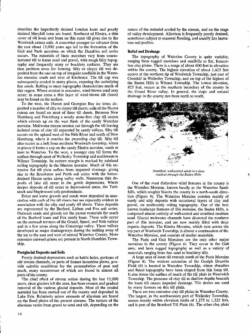
Stratified, well-sorted sands in a deeproadcut through the Baden Hills
One of the most distinctive relief features in the county isthe Waterloo Moraine, known locally as the Waterloo Sand-hills, which roughly bisects the county in a north-south direc-tion (Figure 4) . The Waterloo Moraine consists mainly ofsandy and silty deposits with occasional layers of clay andgravel, on moderately rolling topography . One of the bestknown landscape features of this moraine, the Baden Hills, iscomposed almost entirely of well-sorted and stratified mediumsand . Glacial meltwater channels have dissected the northernpart of this moraine, and are now mainly filled with deeporganic deposits . The Elmira Moraine, which runs across thetop part of Woolwich Township, is almost a continuation of theWaterloo Moraine, and consists of similar materials .
The Paris and Galt Moraines are the only other majormoraines in the county (Figure 4) . They occur in the Galtarea, and have rugged topography as well as a variety ofmaterials ranging from fine sand to bouldery tills .A large area of loam till extends north of the Paris Moraine
(Figure 4) . The western extension of the Guelph DrumlinField (6) is located in Waterloo Township, where drumlinsand fluted topography have been shaped from this loam till.It also forms the surface of much of the till plain in WoolwichTownship . The presence of clay till at shallow depths beneaththe loam till causes impeded drainage . Tile drains are usedby many farmers on this till plain .
There are two extensive clay till plains in Waterloo County.The largest, in the northwestern part of Wellesley Township,occurs mainly within elevation limits of 1,275 to 1,325 feet,and is part of the Stratford Till Plain (6) . The other clay plain
*Adapted from Lee, 1969 (10)
Figure 5 - Outline Map Showing the Drainage Pattern and Basins ofthe Main Rivers in Waterloo County*
1 5
so * 30,
WELLINGTON I'/ COUNTY C
DOG9. ~ C11,
.z \ 9`~ 1 0tiJV ~ Creek /
I1
Q " Co�eal
~\o
" I River
C,N \ " .~ CG43'30 a
43°3d
T!-_-- \\ \ R"ie \1
\ IPE
COU
q ~' \ oô ZÔ
COUNTY1OAF0RO ti . 1I o
y
_ CQUNtY
vsit
AN1
i
LEGENDN
BOUNDARY OF DRAINAGEBASINS .
SCALE
0 2 4 6
MILES
G.V .P
Se 30'
borders on the Nith River in Wilmot Township, between eleva-tions of 1,125 and 1,200 feet . The topography becomes gentlysloping in the southwest corner of the county, where this clayplain is capped by a few feet of lacustrine or alluvial sedi-ments. Artificial drainage is an agricultural necessity to over-come the poor drainage resulting from the silty clay soils ofthese, till plains .
Between the two till plains and along the western borderof the Waterloo Moraine, there are clay soils on gently tomoderately sloping topography. These soils have a higher siltcontent and are better drained than those on the clay plains .
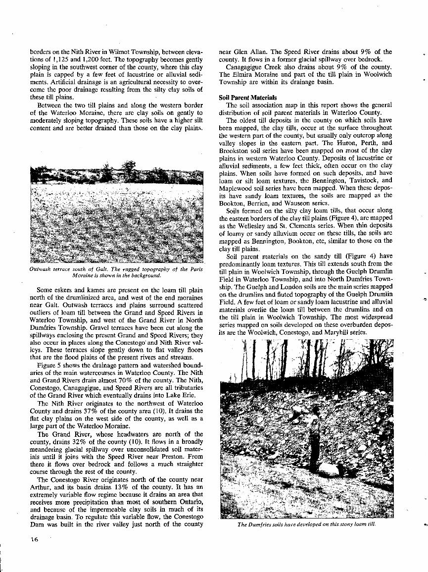
Outwash terrace south of Gait. The rugged topography of the ParisMoraine is shown in the background.
Some eskers and kames are present on the loam till plainnorth of the drumlinized area, and west of the end morainesnear Galt . Outwash terraces and plains surround scatteredoutliers of loam till between the Grand and Speed Rivers inWaterloo Township, and west of the Grand River in NorthDumfries Township . Gravel terraces have been cut along thespillways enclosing the present Grand and Speed Rivers; theyalso occur in places along the Conestogo' and Nith River val-leys . These terraces slope gently down to flat valley floorsthat are the flood plains of the present rivers and streams.
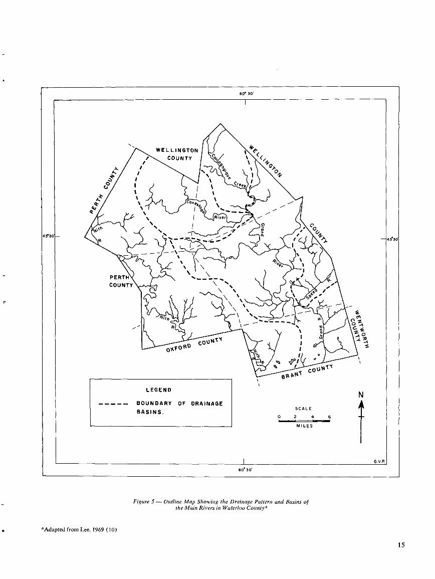
Figure 5 shows the drainage pattern and watershed bound-aries of the main watercourses in Waterloo County . The Nithand Grand Rivers drain almost 70% of the county . The Nith,Conestogo, Canagagigue, and Speed Rivers are all tributariesof the Grand River which eventually drains into Lake Erie .The Nith River originates to the northwest of Waterloo
County and drains 37% of the county area (10) . It drains theflat clay plains on the west side of the county, as well as alarge part of the Waterloo Moraine.The Grand River, whose headwaters are north of the
county, drains 32% of the county (10) . It flows in a broadlymeandering glacial spillway over unconsolidated soil mater-ials until it joins with the Speed River near Preston. Fromthere it flows over bedrock and follows a much straightercourse through the rest of the county .The Conestogo River originates north of the county near
Arthur, and its basin drains 13% of the county . It has anextremely variable flow regime because it drains an area thatreceives more precipitation than most of southern Ontario,and because of the impermeable clay soils in much of itsdrainage basin. To regulate this variable flow, the ConestogoDam was built in the river valley just north of the county
16
near Glen Allan. The Speed River drains about 9% of thecounty . It flows in a former glacial spillway over bedrock.
Canagagigue Creek also drains about 9% of the county .The Elmira Moraine and part of the till plain in WoolwichTownship are within its drainage basin.
Soil Parent MaterialsThe soil association map in this report shows the general
distribution of soil parent materials in Waterloo County.The oldest till deposits in the county on which soils have
been mapped, the clay tills, occur at the surface throughoutthe western part of the county, but usually only outcrop alongvalley slopes in the eastern part . The Huron, Perth, andBrookston soil series have been mapped on most of the clayplains in western Waterloo County . Deposits of lacustrine oralluvial sediments, a few feet thick, often occur on the clayplains . When soils have formed on such deposits, and haveloam or silt loam textures, the Bennington, Tavistock, andMaplewood soil series have been mapped. When these depos-its have sandy loam textures, the soils are mapped as theBookton, Berrien, and Wauseon series .
Soils formed on the silty clay loam tills, that occur alongthe eastern borders of the clay till plains (Figure 4), are mappedas the Wellesley and St . Clements series . When thin depositsof loamy or sandy alluvium occur on these tills, the soils aremapped as Bennington, Bookton, etc, similar to those on theclay till plains .
Soil parent materials on the sandy till (Figure 4) havepredominantly loam textures . This till extends south from thetill plain in Woolwich Township, through the Guelph DrumlinField in Waterloo Township, and into North Dumfries Town-ship . The Guelph and London soils are the main series mappedon the drumlins and fluted topography of the Guelph DrumlinField. A few feet of loam or sandyloam lacustrine and alluvialmaterials overlie the loam till between the drumlins and onthe till plain in Woolwich Township . The most widespreadseries mapped on soils developed on these overburden depos-its are the Woolwich, Conestogo, and Maryhill series .
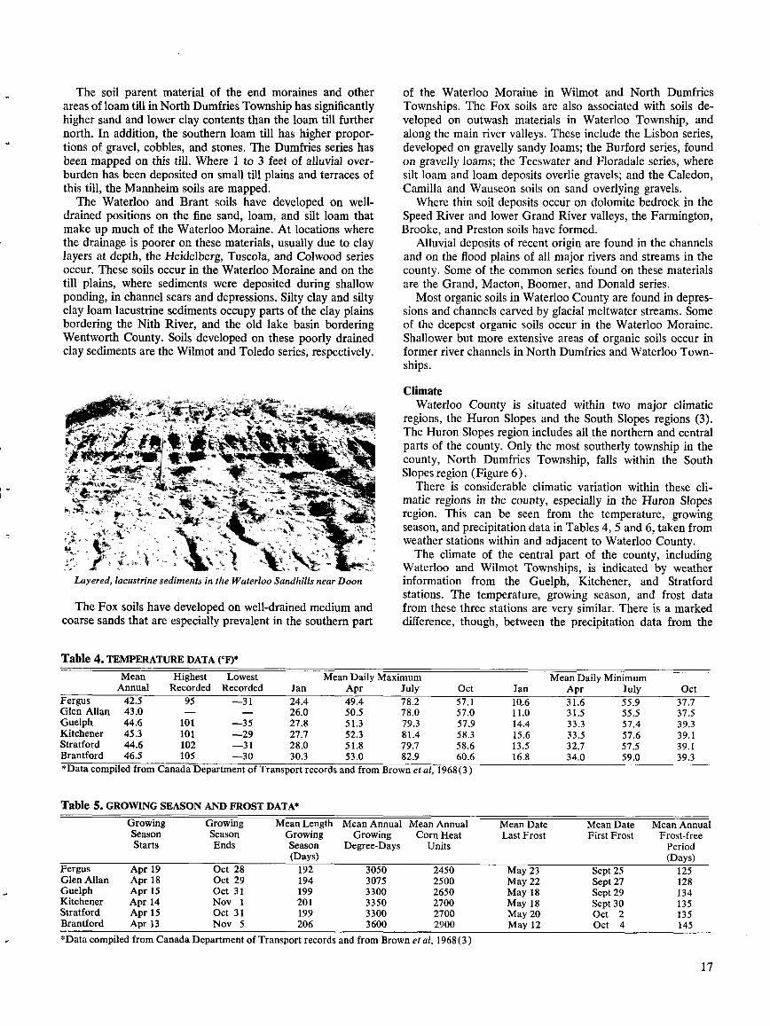
The Dumfries soils have developed on this stony loam till .
The soil parent material of the end moraines and otherareas of loam till in NorthDumfries Township has significantlyhigher sand and lower clay contents than the loam till furthernorth. In addition, the southern loam till has higher propor-tions of gravel, cobbles, and stones . The Dumfries series hasbeen mapped on this till . Where 1 to 3 feet of alluvial over-burden has been deposited on small till plains and terraces ofthis till, the Mannheim soils are mapped .The Waterloo and Brant soils have developed on well-
drained positions on the fine sand, loam, and silt loam thatmake up much of the Waterloo Moraine. At locations wherethe drainage is poorer on these materials, usually due to claylayers at depth, the Heidelberg, Tuscola, and Colwood seriesoccur. These soils occur in the Waterloo Moraine and on thetill plains, where sediments were deposited during shallowponding, in channel scars and depressions . Silty clay and siltyclay loam lacustrine sediments occupy parts of the clay plainsbordering the Nith River, and the old lake basin borderingWentworth County. Soils developed on these poorly drainedclay sediments are the Wilmot and Toledo series, respectively.
Layered, lacustrine sediments in the Waterloo Sandhills near Doon
The Fox soils have developed on well-drained medium andcoarse sands that are especially prevalent in the southern part
Table 4. TEMPERATUREDATA (°F)*
*Data compiled from Canada Department of Transport records and from Brown et al, 1968(3)
Table 5. GROWING SEASON AND FROST DATA*
*Data compiled from Canada Department of Transport records and from Brown et al, 1968 (3)
of the Waterloo Moraine in Wilmot and North DumfriesTownships. The Fox soils are also associated with soils de-veloped on outwash materials in Waterloo Township, andalong the main river valleys. These include the Lisbon series,developed on gravelly sandy loams; the Burford series, foundon gravelly loams; the Teeswater and Floradale series, wheresilt loam and loam deposits overlie gravels; and the Caledon,Camilla and Wauseon soils on sand overlying gravels.Where thin soil deposits occur on dolomite bedrock in the
Speed River and lower Grand River valleys, the Farmington,Brooke, and Preston soils have formed.
Alluvial deposits of recent origin are found in the channelsand on the flood plains of all major rivers and streams in thecounty . Some of the common series found on these materialsare the Grand, Macton, Boomer, and Donald series .Most organic soils in Waterloo County are found in depres-
sions and channels carved by glacial meltwater streams. Someof the deepest organic soils occur in the Waterloo Moraine.Shallower but more extensive areas of organic soils occur informer river channels in North Dumfries and Waterloo Town-ships .
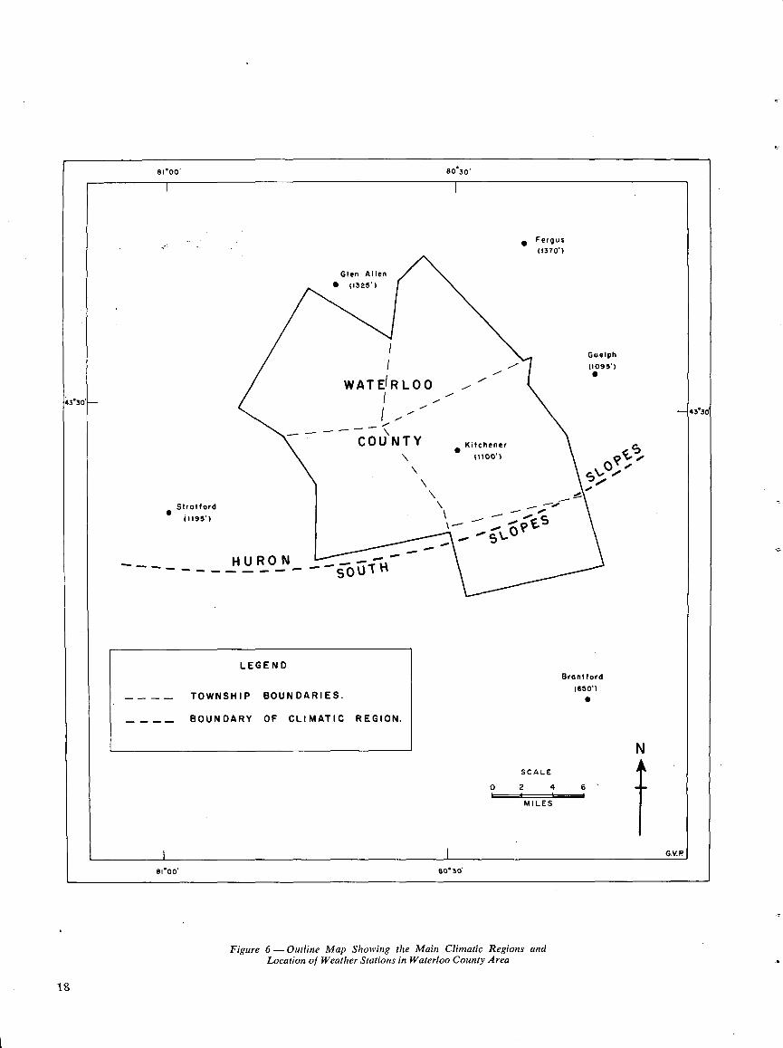
ClimateWaterloo County is situated within two major climatic
regions, the Huron Slopes and the South Slopes regions (3).The Huron Slopes region includes all the northern and centralparts of the county . Only the most southerly township in thecounty, North Dumfries Township, falls within the SouthSlopes region (Figure 6) .
There is considerable climatic variation within these cli-matic regions in the county, especially in the Huron Slopesregion . This can be seen from the temperature, growingseason, and precipitation data in Tables 4, 5 and 6, taken fromweather stations within and adjacent to Waterloo County .The climate of the central part of the county, including
Waterloo and Wilmot Townships, is indicated by weatherinformation from the Guelph, Kitchener, and Stratfordstations . The temperature, growing season, and frost datafrom these three stations are very similar. There is a markeddifference, though, between the precipitation data from the
17
MeanAnnual
HighestRecorded
LowestRecorded Jan
Mean DailyApr
MaximumJuly Oct Jan
Mean DailyApr
MinimumJuly Oct
Fergus 42.5 95 -31 24.4 49.4 78 .2 57 .1 1Q .6 31 .6 55 .9 37 .7Glen Allan 43 .0 - - 26.0 50 .5 78 .0 57 .0 11 .0 31 .5 55 .5 37 .5Guelph 44.6 101 -35 27.8 51 .3 79 .3 57 .9 14 .4 33 .3 57 .4 39 .3Kitchener 45.3 101 -29 27.7 52 .3 81 .4 58 .3 15 .6 33 .5 57 .6 39 .1Stratford 44.6 102 -31 28.0 51 .8 79 .7 58 .6 13 .5 32.7 57 .5 39 .1Brantford 46.5 105 -30 30.3 53 .0 82 .9 60 .6 16 .8 34.0 59 .0 39 .3
GrowingSeasonStarts
GrowingSeasonEnds
Mean LengthGrowingSeason(Days)
Mean AnnualGrowing
Degree-Days
Mean AnnualCorn Heat
Units
Mean DateLast Frost
Mean DateFirst Frost
Mean AnnualFrost-freePeriod(Days)
Fergus Apr 19 Oct 28 192 3050 2450 May 23 Sept 25 125Glen Allan Apr 18 Oct 29 194 3075 2500 May 22 Sept 27 128Guelph Apr 15 Oct 31 199 3300 2650 May 18 Sept 29 134Kitchener Apr 14 Nov 1 201 3350 2700 May 18 Sept 30 135Stratford Apr 15 Oct 31 199 3300 2700 May 20 Oct 2 135Brantford Apr 13 Nov 5 206 3600 2900 May 12 Oct 4 145
1 9
Figure 6-Outline Map Showing the Main Climatic Regions andLocation of Weather Stations in Waterloo County Area
Table 6. PRECIPITATION DATA*
*Data compiled from Canada Department of Transport records andfrom Brown et al, 1968 (3)
Stratford station and the other two stations . The mean annualprecipitation at Stratford is about 6 inches more than atGuelph or Kitchener, and is mainly due to the much highersnowfall (Table 6) . The same trend is shown by the precipi-tation data from Glen Allan (Table 6), which gives a goodindication of precipitation in the western sections of Wellesleyand Wilmot Townships in Waterloo County.
Temperature and growing season data from Fergus andGlen Allan are applicable to most of Woolwich and WellesleyTownships, in the northern part of the county .
The climate of these two townships is more severe thanthat of other townships in the southern part of the county .This is indicated in Tables 4 and 5 by the lower mean annualtemperatures, shorter growing season, and shorter frost-freeperiods of the Fergus and Glen Allan stations.
Climatic records show only a relatively small increase inmean annual temperature from the central part of the countyto Brantford, but a considerable increase in the lengths ofthe growing season and the frost-free period . This may be duepartly to the moderating influences of Lakes Erie and Ontario .There is a corresponding decrease in mean annual and Mayto September precipitation between Kitchener and Brantford .North Dumfries Township, which is situated about half-waybetween Kitchener and Brantford, has temperature and pre-cipitation values intermediate between those recorded fromthe two stations .
The climate of Waterloo County is well suited to mostcommon grain and forage crops grown in Ontario . However,there are many local climatic variations due to topography,altitude, natural air drainage, and nearness to water, that caninfluence growing conditions . For example, cold air tends toflow, like water, into low-lying areas, and plants may be frost-damaged at the bottom of a slope but not injured on the slopeor on upland areas at higher elevations . Grain crops such ascorn, soybeans, field beans, and winter barley, that are rela-tively frost-sensitive, are particularly vulnerable to adverseclimatic variations .A heat unit system, estimated from maximum and mini-
mum temperatures, is presently used in Ontario as a guide forselecting grain corn and soybean varieties (3) . These areexpressed as corn heat units, and values for stations in Water-loo County and vicinity are shown in Table 5 . At the presenttime, there are corn hybrids recommended for grain produc-tion in all of Waterloo County south of the 2500 corn heatunit line . This line runs across the north part of the countythrough Wellesley and Woolwich Townships.
Soybeans can be grown almost anywhere in the county,since the shortest season variety requires only 2500 heat unitsto mature . No varieties of field beans or winter barley are
presently recommended north of the 2700 heat unit line,which passes approximately through Kitchener .
There are certain vegetable crops that are not recommendedfor commmercial production in the northern part of WaterlooCounty because of the higher risk of frost damage there (15) .The following vegetable crops are not presently recommendednorth of a line extending approximately through Guelph,Kitchener and Stratford ; snap-bush beans, sweet corn, latecelery, cucumbers, onions, peppers, pumpkins, squash, andtomatoes . There are some vegetable crops that are not recom-mended at all for Waterloo County because of high frost risk .These include early celery, early lettuce, early potatoes, egg-plants, and watermelons .
Early potatoes have, however, been successfully grown inthe Hespeler area for many years . They are grown mainly onthe coarse-textured Fox and Lisbon soils, and usually requiresome irrigation for consistent production . Water requirementsdepend on the crop being grown, the water-holding capacityof the soil, and the evaporative demand . The probable irri-gation requirements for early potatoes and other vegetablecrops in Waterloo County may be calculated from risk analysesof weekly climatic data for irrigation planning based onGuelph weather records (7) .
Tree fruits such as apples, pears, plums and sweet cherries,and small fruits such as strawberries, raspberries, and currantscan be grown in Waterloo County with little danger of frostdamage . However, apricots, peaches, and sweet cherries,which are known as "tender fruit" crops, are not recom-mended for commercial production in the county, because oftheir high susceptibility to frost damage, and the high risk ofsuch damage in the Waterloo County area (13) .
SOIL CLASSIFICATION
The soils of Waterloo County have developed in parentmaterials ranging in texture from coarse gravels to clays . Mostdifferences between these soils are related to composition ofthe soil materials . Variations in drainage cause differencesbetween soils that have developed in the same soil materials .Other soil-forming factors such as the length of time of soildevelopment, and the effects of vegetation and climate, havehelped to cause differences between these soils .The soil materials originally deposited in Waterloo County
were calcareous, with abundant free carbonates and pH valuesaround 8.0 . However, the soils that have developed on themhave lower pH values, because of the removal of bases, especi-ally calcium, by the leaching action of water . The weatheringand leaching action of water in soils gives rise to the develop-ment of layers or horizons within the soil . These horizonsmay differ from each other in thickness, color, texture, con-sistence, and structure .A vertical cut made through the soil exposes a characteristic
sequence of horizons, known as the soil profile . The varioussoil horizons are differentiated as A, B, and C horizons, andsubdivided further when more detailed descriptions are re-quired .
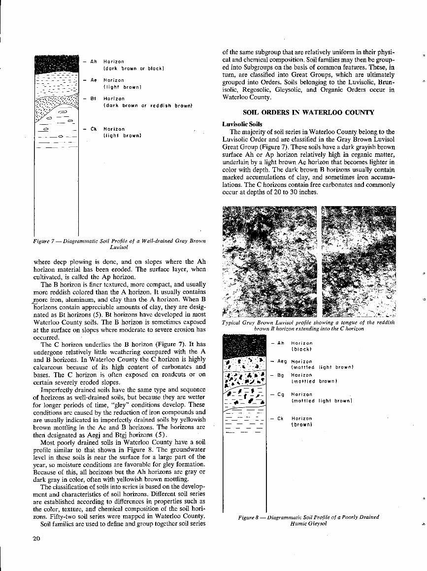
Figure 7 shows a well-drained soil profile and its horizons;it is typical of many in Waterloo County. The A horizon isthe surface horizon . In many soils it can be subdivided intothe Ah and Ae horizons (5) . The Ah horizon is dark coloredand high in organic matter . It is the horizon that usuallymakes up most of the plow layer or topsoil . The Ae horizonis light colored, leached, and usually low in organic matter.It is sometimes incorporated into the plow layer, especially
19
Mean AnnualPrecipitation
(in)
Mean RainfallMay to September
(in)
Mean AnnualSnowfall
(in)Fergus 33 .7 15 .0 71Glen Allan 37 .0 16 .0 85Guelph 32.8 15 .1 56Kitchener 33 .5 15 .5 53Stratford 38 .9 16 .1 95Brantford' 31 .4 13 .1 48
20
Figure 7-Diagrammatic Soil Profile of a Well-drained Gray BrownLuvisol
where deep plowing is done, and on slopes where the Ahhorizon material has been eroded . The surface layer, whencultivated, is called the Ap horizon .
The B horizon is finer textured, more compact, and usuallymore reddish colored than the A horizon . It usually containsmore iron, aluminum, and clay than the A horizon . When Bhorizons contain appreciable amounts of clay, they are desig-nated as Bt horizons (5) . Bt horizons have developed in mostWaterloo County soils . The B horizon is sometimes exposedat the surface on slopes where moderate to severe erosion hasoccurred .
The C horizon underlies the B horizon (Figure 7) . It hasundergone relatively little weathering compared with the Aand B horizons . In Waterloo County the C horizon is highlycalcareous because of its high content of carbonates andbases . The C horizon is often exposed on roadcuts or oncertain severely eroded slopes .
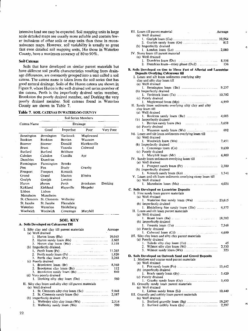
Imperfectly drained soils have the same type and sequenceof horizons as well-drained soils, but because they are wetterfor longer periods of time, "gley" conditions develop . _ Theseconditions are caused by the reduction of iron compounds andare usually indicated in imperfectly drained soils by yellowishbrown mottling in the Ae and B horizons . The horizons arethen designated as Aegj and Btgj horizons (5) .Most poorly drained soils in Waterloo County have a soil
profile similar to that shown in Figure 8 . The groundwaterlevel in these soils is near the surface for a large part of theyear, so moisture conditions are favorable for gley formation .Because of this, all horizons but the Ah horizons are gray ordark gray in color, often with yellowish brown mottling .The classification of soils into series is based on the develop-
ment and characteristics of soil horizons . Different soil seriesare established according to differences in properties such asthe color, texture, and chemical composition of the soil hori-zons . Fifty-two soil series were mapped in Waterloo County .
Soil families are used to define and group together soil series
of the same subgroup that are relatively uniform in their physi-cal and chemical composition . Soil families may then be group-ed into Subgroups on the basis of common features . These, inturn, are classified into Great Groups, which are ultimatelygrouped into Orders . Soils belonging to the Luvisolic, Brun-isolic, Regosolic, Gleysolic, and Organic Orders occur inWaterloo County.
SOIL ORDERS IN WATERLOO COUNTY
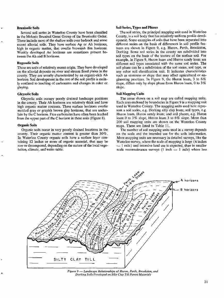
Luvisolic SoilsThe majority of soil series in Waterloo County belong to the
Luvisolic Order and are classified in the Gray Brown LuvisolGreat Group (Figure 7) . These soils have a dark grayish brownsurface Ah or Ap horizon relatively high in organic matter,underlain by a light brown Ae horizon that becomes lighter incolor with depth . The dark brown B horizons usually containmarked accumulations of clay, and sometimes iron accumu-lations . The C horizons contain free carbonates and commonlyoccur at depths of 20 to 30 inches .
Typical Gray Brown Luvisol profile showing a tongue of the reddishbrown B horizon extending into the C horizon
- Ah Horizon(black)
- Aeg Horizon(mottled light brown)
- Bg Horizon(mottled brown)
- Cg Horizon(mottled light brown)
- Ck Horizon(brown)
Figure 8-Diagrammatic Soil Profile of a Poorly DrainedHumic Gleysol
Brunisolic SoilsSeveral soil series in Waterloo County have been classified
in the Melanie Brunisol Great Group of the Brunisolic Order.These include most of the shallow soils over bedrock and somerecent alluvial soils . They have surface Ap or Ah horizons,high in organic matter, that overlie brownish Bm horizons .Weakly developed Ae horizons are sometimes present be-tween the Ah and B horizons .
Regosolic SoilsThese are soils of relatively recent origin . They have developedon the alluvial deposits on river and stream flood plains in thecounty . They are usually characterized by an organic-rich Ahhorizon . Soil development in the rest of the soil profile is main-ly confined to leaching of carbonates and changes in color orgleying .
Gleysolic SoilsGleysolic soils occupy poorly drained landscape positions
in the county . Their Ah horizons are relatively thick and havehigh organic matter contents . These surface horizons overliemottled gray or grayish brown gley horizons, that are under-lain by the C horizon . Free carbonates have often been leachedfrom the upper part of the C horizon in these soils (Figure 8) .
Organic SoilsOrganic soils occur in very poorly drained locations in the
county . Their organic matter content is greater than 30% .In Waterloo County organic soils have a surface layer con-taining 12 inches or more of organic material, that may beraw or decomposed, depending on the nature of the local vege-tation, climate, and water table .
Figure 9 - Landscape Relationships of Huron, Perth, Brookston, andDorking Soils Developed on Silty Clay Till Parent Materials
Soil Series, Types and PhasesThe soil series, the principal mapping unit used in Waterloo
County, is a soil body that has relatively uniform profile devel-opment. Some examples of soils that have been separated intodifferent series on the basis of differences in soil profile fea-tures are shown in Figure 9, e.g . Huron, Perth, Brookston,Dorking . Some soil series in the county are subdivided intosoil types on the basis of the texture of the surface soil. Forexample, in Figure 9, Huron loam and Huron sandy loam aredifferent soil types associated with the same soil series . Thesoil phase can be a subdivision of the soil series, soil type, orany other soil classification unit . It indicates characteristicssuch as stoniness or slope that may affect agricultural or en-gineering practices . In Figure 9, the Huron loam, 3 to 6%slope, differs only by slope phase from Huron loam, 0 to 3 %slope .
Soil Mapping UnitsThe areas shown on a soil map are called mapping units .
Each area enclosed by boundaries in Figure 9 is a mapping unitused in Waterloo County . The mapping units used here repre-sent a soil series, e.g . Dorking silty clay loam; soil types, e.g .Huron loam, Huron sandy loam ; and soil phases, e.g. Huronloam 0 to 3% slope, Huron loam 3 to 6% slope . More than200 soil mapping units are shown on the Waterloo Countymaps . These are listed in Table 11 .
The number of soil mapping units used in a survey dependson the scale and the intended use for the soils information .More mapping units are necessary in detailed surveys, like theWaterloo survey, where the scale of mapping is large (4 inches- 1 mile) and intensive land use is expected, than in smallerscale reconnaissance surveys (1 inch = 1 mile) where less
A horizons
B horizons
2 1
intensive land use may be expected . Soil mapping units in largescale detailed maps are usually more reliable and contain few-er inclusions of other soils or map units than those in recon-naissance maps. However, soil variability is usually so greatthat even detailed soil mapping units, like those in WaterlooCounty, have a maximum accuracy of 80 to 90% .
Soil CatenasSoils that have developed on similar parent materials but
have different soil profile characteristics resulting from drain-age differences, are commonly grouped into a unit called a soilcatena . The catena name is taken from the soil series that hasgood natural drainage . Soils of the Huron catena are shown inFigure 9, where Huron is the well-drained soil series member ofthe catena, Perth is the imperfectly drained series member,Brookston the poorly drained member, and Dorking the verypoorly drained member . Soil catenas found in WaterlooCounty are shown in Table 7 .
Table 7 . SOIL CATENASIN WATERLOO COUNTY
22
SOIL KEYA. Soils Developed on Calcareous Till
Very Poor
Dorking
Silty clay and clay till parent materials
Acreage(a) Well drained
1. Huron loam (Hu) . . . . . . . . . . . . . . . . . . . . . . . . . . . . . . . . . . . . . . . . . . . . . . . . . . . . 10,0452. Huron sandy loam (Hs) . . . . . . . . . . . . . . . . . . . . . . . . . . . . . . . . . . . . . . . . . .
2,6053. Huron clay loam (Hc) . . . . . . . . . . . . . . . . . . . . . . . . . . . . . . . . . . . . . . . . . .
5,158(b) Imperfectly drained.
1 . Perth loam (Pe) . . . . . . . . . . . . . . . . . . . . . . . . . . . . . . . . . . . . . . . . . . . . . . . . . . . . . . . . 11,2652.
Perth sandy loam (Ps) . . . . . . . . . . . . . . . . . . . . . . . . . . . . . . . . . . . . . . . . . . . . . .
1,8203. Perth clay loam (Pc) . . . . . . . . . . . . . . . . . . . . . . . . . . . . . . . . . . . . . . . . . . . . . . 2,268
(c) Poorly drained8,360112840
1 . Brookston loam (Br) . . . . . . . . . . . . . . . . . . . . . . . . . . . . . . . . . . . . . . . . . . . . . .2. Brookston clay loam (Bc) . . . . . . . . . . . . . . . . . . . . . . . . . . . . . . . . . . . . . .3 . Brookston sandy loam (Bs) . . . . . . . . . . . . . . . . . . . . . . . . . . . . . . . . . . . .
(d) Very poorly drained1. Dorking silty clay loam (Do) . . . . . . . . . . . . . . . . . . . . . . . . . . . . . . . .
Silty clay loam and silty clay till parent materials(a) Well drained
1.
St. Clements silty clay loam (Sc) . . . . . . . . . . . . . . . . . . . . . . . . . . . .2.
St. Clements sandy loam (Ss) . . . . . . . . . . . . . . . . . . . . . . . . . . . . . . . . . .(b) Imperfectly drained
1 .
Wellesley silty clay loam (We) . . . . . . . . . . . . . . . . . . . . . . . . . . . . . . . .2. Wellesley sandy loam (Ws) . . . . . . . . . . . . . . . . . . . . . . . . . . . . . . . . . . . .
560
9,0482,187
2,314580
111. Loam till parent material
Acreage(a) Well drained
1. Guelph loam (Gu) . . . . . . . . . . . . . . . . . . . . . . . . . . . . . . . . . . . . . . . . . . . . . . . . . . . . 10,5642. Guelph sandy loam (Gs) . . . . . . . . . . . . . . . . . . . . . . . . . . . . . . . . . . . . . . . .
812(b) Imperfectly drained
1 .
London
loam
(Lo)
. . . . . . . . . . . . . . . . . . . . . . . . . . . . . . . . . . . . . . . . . . . . . . . . . . . . . . 2,080IV. Stony loam till parent material
(a) Well drained1. Dumfries loam (Du) . . . . . . . . . . . . . . . . . . . . . . . . . . . . . . . . . . . . . . . . . . . . . . . .
8,5562.
Dumfries loam-stony phase (Du2) . . . . .. . . . . . . . . . . . . . . . . . . .
136B. Soils Developed on One to Three Feet of Alluvial and Lacustrine
Deposits Overlying Calcareous till1 . Loam and silt loam sediments overlying silty
clay and silty clay loam till(a) Well drained
1. Bennington loam (Bn) . . . . . . . . . . . . . . . . . . . . . . . . . . . . . . . . . . . . . . . . . . 9,237(b) Imperfectly drained
1. Tavistock loam (Ta) . . . . . . . . . . . . . . . . . . . . . . . . . . . . . . . . . . . . . . . . . . . . . . . . 10,702(c) Poorly drained
1. Maplewood loam (Mp) . . . . . . . . . . . . . . . . . . . . . . . . . . . . . . . . . . . . . . . . . . . .
4,95011 . Sandy loam sediments overlying silty clay and silty
clay loam till(a) Well drained
1. Bookton sandy loam (Be) . . . . . . . . . . . . . . . . . . . . . . . . . . . . . . . . . . . . 4,603(b) Imperfectly drained
1.
Berrien sandy loam (Be) . . . . . . . . . . . . . . . . . . . . . . . . . . . . . . . . . . . . . . . . . . . . . .3,658(c) Poorly drained
1. Wauseon sandy loam (Wu) . . . . . . . . . .. . . . . . . . . . . . . . . . . . . . . . . . . .
692III. Loam and silt loam sediments overlying loam till
(a) Well drained1. Woolwich loam (Wo) . . . . . . . . . . . . . . . . . . . . . . . . . . . . . . . . . . . . . . . . . . . . . .
7,451(b) Imperfectly drained
1. Conestogo loam (Co) . . . . . . . . . . . . . . . . . . . . . . . . . . . . . . . . . . . . . . . . . . . . . .
9,630(c) Poorly drained
1 . Maryhill loam (Mr) . . . . . . . . . . . . . . . . . . . . . . . . . . . . . . . . . . . . . . . . . . . . . . . . 6,800IV . Sandy loam sediments overlying loam till
(a) Well drained1 .
Freeport sandy loam (Fr) . . . . . . . . . . . . . . . . . . . . . . . . . . . . . . . . . . . . . . . .
2,300(b) Imperfectly drained
1.
Kossuth sandy loam (Ko) . . . . . . . . . . . . . . . . . . . . . . . . . . . . . . . . . . . . . . . .
1,341V. Loam and silt loam sediments overlying stony loam till
(a) Well drained1. Mannheim loam (Ma) . . . . . . . . . . . . . . . . . . . . . . . . . . . . . . . . . . . . . . . . . . . . 4,021
C. Soils Developed on Lacustrine DepositsI. Fine sandy loam parent materials
(a) Well drained1 . Waterloo fine sandy loam (Wa) . . . . . . . . . . . . . . . . . . . . . . . . . . . . 23,615
(b) Imperfectly drained1 . Heidelberg fine sandy loam (He) . . . . . . . . . . . . . . . . . . . . . . . .
6,575II. Loam and silt loam parent materials
(a) Well drained1 . Brant loam (Ba) . . . . . . . . . . . . . . . . . . . . . . . . . . . . . . . . . . . . . . . . . . . . . . . . . . . . . . 18,782
(b) Imperfectly drained1. Tuscola loam (Tu) . . . . . . . . . . . . . . . . . . . . . . . . . . . . . . . . . . . . . . . . . . . . . . . . . . 7,348
(c) Poorly drained1 . Colwood loam (Cd) . . . . . . . . . . . . . . . . . . . . . . . . . . . . . . . . . . . . . . . . . . . . . . . .
4,600Ill . Silty clay loam and silty clay parent materials
(a) Poorly drained1 . Toledo silty clay loam (To) . . . . . . . . . . . . . . . . . . . . . . . . . . . . . . . . . . . .
452. Wilmot silty clay loam (Wi) . . . . . . . . . . . . . . . . . . . . . . . . . . . . . . . . . . . .
2,3303 . Wilmot sandy loam (Wx) . . . . . . . . . . . . . . . . . . . . . . . . . . . . . . . . . . . . . . . .
323
D. Soils Developed on Outwash Sand and Gravel Deposits1. Medium and coarse sand parent materials
(a) Well drained1 .
Fox sandy loam (Fo) . . . . . . . . . . . . . . . . . . . . . . . . . . . . . . . . . . . . . . . . . . . . . . . . 13,442(b) Imperfectly drained
1 .
Brady sandy loam (By) . . . . . . . . . . . . . . . . . . . . .. . . . . . . . . . . . . . . . . . . . . . .
5,420(c) Poorly drained
1 . Granby sandy loam (Gy) . . . . . . . . . . . . . . . . . . . . . . . . . . . . . . . . . . . . . . . .
3,43011 . Gravelly sandy loam parent materials
(a) Well drained1 . Lisbon sandy loam (Li) . . . . . . . . . . . . . . . . . . . . . . . . . . . . . . . . . . . . . . . . . . 10,440
111 . Gravelly and cobbly loam parent materials(a) Well drained
1. Burford gravelly loam (Bg) . . . . . . . . . . . . . . . . . . . . . . . . . . . . . . . . . . . . 19,2972. Burford cobbly loam (Bu) . . . . . . . . . . . . . . . . . . . . . . . . . . . . . . . . . . . . . .
2,597
Catena Name
Good
Soil Series Members
Drainage
Imperfect Poor
Bennington Bennington Tavistock MaplewoodBookton Bookton Berrien WauseonBoomer Boomer Donald HawkesvilleBrant Brant Tuscola ColwoodBurford Burford BrisbaneCaledon Caledon Camilla AyrDumfries DumfriesFarmington Farmington BrookeFox Fox Brady GranbyFreeport Freeport KossuthGrand Grand Macton ElmiraGuelph Guelph LondonHuron Huron Perth BrookstonKirkland Kirkland Haysville HespelerLisbon LisbonMannheim MannheimSt . Clements St . Clements WellesleySt . Jacobs St . Jacobs FloradaleWaterloo Waterloo HeidelbergWoolwich Woolwich Conestogo Maryhill
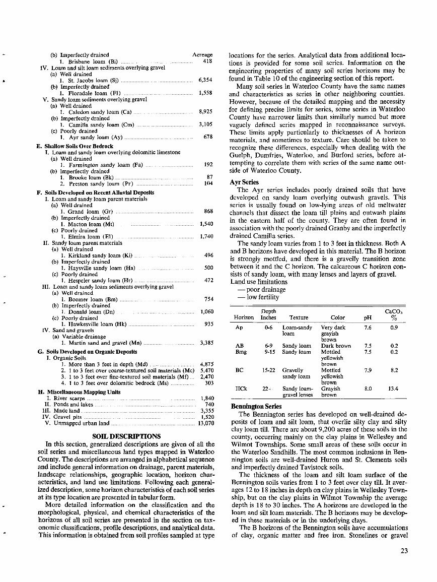
(b) Imperfectly drained
Acreage1. Brisbane loam (Bi) . . . . . . . . . . . . . . . . . . . . . . . . . . . . . . . . . . . . . . . . . . . . . . . .
418IV . Loam and silt loam sediments overlying gravel
(a) Well drained1. St. Jacobs loam (Sj) . . . . . . . . . . . . . . . . . . . . . . . . . . . . . . . . . . . . . . . . . . . . . . . .
6,354(b) Imperfectly drained
1. Floradale loam (Fl) . . . . . . . . . . . . . . . . . . . . . . . . . . . . . . . . . . . . . . . . . . . . . .
1,558V. Sandy loam sediments overlying gravel
(a) Well drained1 . Caledon sandy loam (Ca) . . . . . . . . . . . . . . . . . . . . . . . . . . . . . . . . . . . . . . . .
8,925(b) Imperfectly drained
1 . Camilla sandy loam (Cm) . . . . . . . . . . . . . . . . . . . . . . . . . . . . . . . . . . . . . .
3,105(c) Poorly drained
1 . Ayr sandy loam (Ay) . . . . . . . . . . . . . . . . . . . . . . . . . . . . . . . . . . . . . . . . . . . . . .
678E. Shallow Soils Over Bedrock
I. Loam and sandy loam overlying dolomitic limestone(a) Well drained
1. Farmington sandy loam (Fa) . . . . . . . . . . . . . . . . . . . . . . . . . . . . . . . .
192(b) Imperfectly drained
1. Brooke loam (Bk) . . . . . . . . . . . . . . . . . . . . . . . . . . . . . . . . . . . . . . . . . . . . . . . . . . . .
872. Preston sandy loam (Pr) . . . . . . . . . . . . . . . . . . . . . . . . . . . . . . . . . . . . . . .
104F. Soils Developed on Recent Alluvial Deposits
I. Loam and sandy loam parent materials(a) Well drained
1 . Grand loam (Gr) . . . . . . . . . . . . . . . . . . . . . . . . . . . . . . . . . . . . . . . . . . . . . . . . . . . .
868(b) Imperfectly drained
1 . Macton loam (Mt) . . . . . . . . . . . . . . . . . . . . . . . . . . . . . . . . . . . . . . . . . . . . . . . . . . . .
1,540(c) Poorly drained
1. Elmira loam (El) . . . . . . . . . . . . . . . . . . . . . . . . . . . . . . . . . . . . . . . . . . . . . . . . . . . .
1,740II . Sandy loam parent materials
(a) Well drained1 . Kirkland sandy loam (Ki) . . . . . . . . . . . . . . . . . . . . . . . . . . . . . . . . . . . . . . . .
496(b) Imperfectly drained
l . Haysville sandy loam (Ha) . . . . . . . . . . . . . . . . . . . . . . . . . . . . . . . . . . . . . .
500(c) Poorly drained
1 . Hespeler sandy loam (Hr) . . . . . . . . . . . . . . . . . . . . . . . . . . . . . . . . . . . . . . . .
472III . Loam and sandy loam sediments overlying gravel
(a) Well drained
I. River scarps . . . . . . . . . . . . . . . . . . . . . . . . . . . . . . . . . . . . . . . . . . . . . . . . . . . . . . . . . . . . . . . . . . . . . . . .
1,840II . Ponds and lakes . . . . . . . . . . . . . . . . . . . . . . . . . . . . . . . . . . . . . . . . . . . . . . . . . . . . . . . . . . . . . . . . . . . .
740III. Made land . . . . . . . . . . . . . . . . . . . . . . . . . . . . . . . . . . . . . . . . . . . . . . . . . . . . . . . . . . . . . . . . . . . . . . . . . . . .
3,355IV . Gravel pits . . . . . . . . . . . . . . . . . . . . . . . . . . . . . . . . . . . . . . . . . . . . . . . . . . . . . . . . . . . . . . . . . . . . . . . . . .
1,520V. Unmapped urban land . . . . . . . . . . . . . . . . . . . . . . . . . . . . . . . . . . . . . . . . . . . . . . . . . . . . . . . . 13,070
SOIL DESCRIPTIONSIn this section, generalized descriptions are given of all the
soil series and miscellaneous land types mapped in WaterlooCounty . The descriptions are arranged in alphabetical sequenceand include general information on drainage, parent materials,landscape relationships, geographic location, horizon char-acteristics, and land use limitations . Following each general-ized description, some horizon characteristics of each soil seriesat its type location are presented in tabular form.More detailed information on the classification and the
morphological, physical, and chemical characteristics of thehorizons of all soil series are presented in the section on tax-onomic classifications, profile descriptions, and analytical data.This information is obtained from soil profiles sampled at type
locations for the series . Analytical data from additional loca-tions is provided for some soil series . Information on theengineering properties of many soil series horizons may befound in Table 10 of the engineering section of this report.Many soil series in Waterloo County have the same names
and characteristics as series in other neighboring counties .However, because of the detailed mapping and the necessityfor defining precise limits for series, some series in WaterlooCounty have narrower limits than similarly named but morevaguely defined series mapped in reconnaissance surveys .These limits apply particularly to thicknesses of A horizonmaterials, and sometimes to texture . Care should be taken torecognize these differences, especially when dealing with theGuelph, Dumfries, Waterloo, and Burford series, before at-tempting to correlate them with series of the same name out-side of Waterloo County .
Ayr SeriesThe Ayr series includes poorly drained soils that have
developed on sandy loam overlying outwash gravels . Thisseries is usually found on low-lying areas of old meltwaterchannels that dissect the loam till plains and outwash plainsin the eastern half of the county . They are often found inassociation with the poorly drained Granby and the imperfectlydrained Camilla series .The sandy loam varies from 1 to 3 feet in thickness . Both A
and B horizons have developed in this material . The B horizonis strongly mottled, and there is a gravelly transition zonebetween it and the C horizon. The calcareous C horizon con-sists of sandy loam, with many lenses and layers of gravel .Land use limitations- poor drainage
Bennington SeriesThe Bennington series has developed on well-drained de-
posits of loam and silt loam, that overlie silty clay and siltyclay loam till . There are about 9,200 acres of these soils in thecounty, occurring mainly on the clay plains in Wellesley andWilmot Townships . Some small areas of these soils occur inthe Waterloo Sandhills . The most common inclusions in Ben-nington soils are well-drained Huron and St . Clements soilsand imperfectly drained Tavistock soils .
The thickness of the loam and silt loam surface of theBennington soils varies from 1 to 3 feet over clay till. It aver-ages 12 to 18 inches in depth on clay plains in Wellesley Town-ship, but on the clay plains in Wilmot Township the averagedepth is 18 to 30 inches . The A horizons are developed in theloam and silt loam materials . The B horizons may be develop-ed in these materials or in the underlying clays .
The B horizons of the Bennington soils have accumulationsof clay, organic matter and free iron . Stonelines or gravel
23
1 . Boomer loam (Bm) . . . . . . . . . . . . . . . . . . . . . . . . . . . . . . . . . . . . . . . . . . . . . . . . . .(b) Imperfectly drained
1 . Donald loam (Dn) . . . . . . . . . . . . . . . . . . . . . . . . . . . . . . . . . . . . . . . . . . . . . . . . . . . .(c) Poorly drained
754 - low
1,060Horizon
fertility
DepthInches Texture Color pH
CaC03°Jo
1 . Hawkesville loam (Hk) . . . . . . . . . . . . . . . . . . . . . . . . . . . . . . . . . . . . . . . . . . . . 935 Ap 0-6 Loam-sandy Very dark 7.6 0.9IV. Sand and gravels loam grayish(a) Variable drainage brown1 . Martin sand and gravel (Mn) . . . . . . . . . . . . . . . . . . . . . . . . . . . . . . . . . . 3,385 AB 6-9 Sandy loam Dark brown 7.5 0.2G. Soils Developed on Organic Deposits Bmg 9-15 Sandy loam Mottled 7.5 0.2
I. Organic Soils yellowish1 . More than 3 feet in depth (Md) . . . . . . . . . . . . . . . . . . . . . . . . . . . . . . 4,875 brown2. 1 to 3 feet over coarse-textured soil materials (Mc) 5,470 BC 15-22 Gravelly Mottled 7.9 8.23. 1 to 3 feet over fine-textured soil materials (Mf) . . . . 2,470 sandy loam yellowish4. 1 to 3 feet over dolomitic bedrock (Ms) . . . . . . . . . . . . . . . . 303 brown
H. Miscellaneous Mapping Units IICk 22+ Sandy loam- Grayish 8.0 13.4gravel lenses brown
bands are usually found near the base of the B horizon at thejunction of the loam or silt loam and till . In the southwestpart of Wilmot Township there is a gravelly layer betweenthe B and C horizons that ranges up to 1 foot thick . The Chorizon materials in this part of Wilmot Township contain lessclay and more sand and gravel, than those of Bennington soilsin other parts of the county .Land use limitations- slopes may be relatively steep or complex- may be subject to seepage on slopes- high clay content in subsoil
Berried SeriesThe Berrien soils are imperfectly drained and developed ondeposits of sandy loam overlying clays . They are most fre-quently found on areas of the clay plains in Wellesley andWilmot-Townships that fringe the Waterloo Sandhills . Smallareas of Berrien soils also occur within the Sandhills, and nearthe Elmira Moraine in Woolwich Township . The Berrien soilsare most often associated with their well-drained analogues,the Bookton soils . They also frequently contain inclusions ofimperfectly drained Perth and Wellesley sandy loam soils .
The sandy loam of Berrien soils ranges between 1 and 3feet thick over the clayey subsoil . The A horizons have devel-oped in sand and contain relatively low amounts of organicmatter . The intensity of mottling of the Ae horizons becomesgreatest just above the B horizon, due to perched water con-ditions . The B horizons of Berrien soils are usually developedin the clays that underlie the sands . There is frequently a thinlayer of gravel near the top boundary of Berrien B horizons, atthe junction of the sand and clay. This gravel is often stronglyweathered, and readily disintegrates into finer materials . Theclayey materials of the C horizon range in texture from clay tosilty clay loam . The type location chosen for the Berrien profilehas a higher clay content in the C horizon than many otherBerrien soils in the county .Land use limitations- relatively low fertility- seasonally high water table- slopes may have complex pattern- high clay content in subsoil
24
Bookton SeriesThe Bookton series is comprised of well-drained soils devel-
oped on sandy loam over clayey materials . They occur mainlyon clay plains adjacent to and within the Waterloo Sandhills .There are 4,600 acres of Bookton soils in the county . Thelargest area of Bookton soils occurs in the southern part ofWellesley Township . There are more than a thousand acresof Bookton soils in western Wilmot Township, and severalhundred acres in the Sandhills of Waterloo and WoolwichTownships .On well-drained, gently rolling sites, the Bookton soils are
most often associated with well-drained Bennington, Fox, andWaterloo soils . On level areas where water tables are high,imperfectly drained Berrien soils are often present as inclu-sions in Bookton soils .
The sandy surface materials of the Bookton series rangefrom 1 to 3 feet thick . The A horizons occur within the sand,and have relatively low organic matter contents . The B hori-zons usually begin at the junction of the clay and sand andextend several inches into the clay . Thin gravel accumulationsoften occur at this junction . There is sometimes a slight hard-pan formed at the top of the B horizon . The C horizon materialsare highly calcareous and range from clay to silty clay loam .Land use limitations- relatively low fertility- slopes may be relatively steep or complex- sands adversely affected by droughtiness- seepage may be a problem on slopes- high clay content in subsoil
Boomer SeriesBoomer soils are well-drained soils developed on recently
deposited alluvial materials overlying gravels . These soils arerestricted to river and stream valley floors where they origin-ated as flood plain deposits . In Waterloo County most of themare found in the valleys of the Grand and Conestogo Rivers .Some of these soils also occur in the valley of the main tribu-taries of these rivers, and in the Nith River valley . The Boomersoils are often associated with other alluvial soils, especiallythose belonging to the Grand, Kirkland, Donald, and Martinseries .The Boomer soils have better developed soil profiles than
most recent alluvial soils . The A horizons are usually loam,but may also be silt loam or sandy loam . They have relativelyhigh organic matter contents . At the type location, the Bhorizon has a marked accumulation of clay that is typical ofmany Boomer soils . The C horizons of these soils are usuallycomprised of alternate layers of sand and gravel with highcalcium carbonate contents .Land use limitations-risk of flooding- low water-holding capacity- areas of irregular shape from flood dissection
HorizonDepthInches Texture Color pH
OrganicMatter %
CaC03%
Ap 0-8 Sandy Dark 7.2 3.2 1 .4loam brown
Ael 8-13 Sandy Dark 7.2 1 .5 0.6loam yellowish
brownAe2 13-15 Sandy Brown 7.3 0.7 0.1
loamIIBt 15-20 Clay loam Dark 7.5 0.8 3.1
brownIICk 20+ Clay loam Dark 8.1 0.2 15 .6
brown
HorizonDepthInches Texture Color pH
OrganicMatter %
Ap 0-7 Sandy loam Very dark 7.3 2.1yellowishbrown
Aegjl 7-9 Loamy sand Faintly 7.4 1 .1mottledyellowishbrown
Aegj2 9-13 Sandy loam Mottled pale 7.7 0.3brown
IIBtgj 13-19 Clay Mottled dark 7.7 0.5brown
IICk 19+ Clay Mottled 7.9 0.7brown
HorizonDepthInches Texture Color pH
OrganicMatter %
CaC03%
Ap 0-7 Silt loam Very dark 7.6 3.0 1 .4grayishbrown
Ae 7-10 Loam Light olive 7.6 0.3 0.3brown
IIBt 10-17 Clay Dark brown 7.4 1.1 1.7IICk 17+ Silty clay Dark 7.7 0.8 17 .8
loam-silty grayishclay brown
Brady SeriesSoils of the Brady series have developed on imperfectly
drained medium and coarse sandy loam . They occur mostextensively on outwash plains and in old river channels inWaterloo and North Dumfries Townships . They are usuallyassociated with the well-drained Lisbon sands and the imper-fectly drained Camilla and Floradale soils at these sites . InWilmot Township, Brady soils mainly occupy old meltwaterchannels and areas adjacent to the Waterloo Sandhills. In theSandhills, they are often found on gently sloping topographyassociated with Fox soils, where their imperfect drainage isusually caused by clay strata in the subsoil .
Brady soil profiles usually range between 15 and 30 inchesthick . In the Waterloo Sandhills there is often one or more feetof recentlyeroded colluvium overlying the A horizons of Bradysoils . The A horizons are characterized by moderately highorganic matter contents . Clay concentrations in the B horizonsare small, except in some Brady soils in the Sandhills . Somefine gravel is usually present in the C horizons of Brady soils,especially in areas east of the Grand River where gravel oftenunderlies the sand.Land use limitations- low fertility- seasonally high water table
Brant SeriesThe Brant soils have developed on well-drained lacustrine
sediments of mainly loam and silt loam textures. They occupymuch of the central part of the Waterloo Sandhills . About8,000 acres of Brant soils occur in Waterloo Township, mostlyon moderately sloping, often hummocky topography. Severalthousand acres of Brant soils also occur in the Sandhill areasof Wellesley and Wilmot Townships. Smaller bodies of Brantsoils, not associated with the Waterloo Sandhills, are presentin all townships of the county.
The Brant soils often grade into and are closely associatedwith the fine sandy loam Waterloo soils . Thin clayey strata arealso frequently found in the Brant soils, and may cause perchedwater tables and wet spots . Where these clay strata range upto one or more feet in thickness, the Bennington and St .Clements series are usually mapped; otherwise thin clay strata
are considered as normal inclusions in the Brant series . Inareas of Brant soils where perched water conditions are ex-tensive, inclusions of imperfectly drained Tuscola and Heidel-berg soils occur .On level areas, the surface A horizons of the Brant series
are very dark brown in color, and have relatively high organicmatter contents . However, on eroded slopes the surface hori-zons are thinner and lower in organic contents than those onlevel, upland sites . The Ae horizons are also usually thinner onslopes than on level upland sites, as a result of slope erosion .The B horizons of Brant soils usually consist of layered orvarved materials . These materials vary from silt loam to clayin texture . The C horizons of Brant soils have mainly loamand silt loam textures interspersed with occasional thin layersof sand or clay .Land use limitations- slopes may be excessively steep or complex- high erodibility- slopes may have local wet or clay spots- high frost-susceptibility
wBrant soils are usually found on this type of rolling topography
in the Waterloo Sandhills.
Brisbane SeriesThe Brisbane series includes imperfectly drained soils devel-
oped on outwash gravel deposits . There are only 418 acres ofthese soils mapped in the county, mainly in Waterloo Town-ship . The Brisbane soils mostly occur in long, narrow stripsthat follow river and stream channels on ancient flood plains .They are closely associated with other soils, such as the Bur-ford and Caledon soils, that have developed on old, alluvialflood plains .
The A horizons of the Brisbane soils have developed insandy loams and loams, that usually contain less than 5%
25
HorizonDepthInches Texture Color
Organic CaC03pH Matter % %
Ah 0-5 Loam Very dark 7.7 5.5 0 .6brown
Ael 5-10 Loam Dark 7.2 2.4 0.0yellowishbrown
Ae2 10-14 Silt loam Brown 6.9 0 .9 0.0Bt 14-26 Clay with Dark 5.7 0 .4 0.0
thin sand brownlayers
Btj 26-34 Loam Brown 6.3 0 .2 0 .0Silt loam Dark 5.7 0 .3 0.0
brownCk 34+ Loam Grayish 8.2 0 .2 10.9
brown
HorizonDepthInches Texture Color
Organic CaC03pH Matter % %
Ah 0-4 Loam Very dark 7 .2 7 .3 0 .9brown
Ae 4-15 Sandy Dark 7 .5 1.9 0 .2loam brown
Bt 15-19 Sandy clay Dark 7.5 1 .6 2 .2loam reddish
brownBC 19-23 Sandy loam Brown 7.1 1 .6 34 .9
-gravelseams
IICk 23+ Gravelly Brown 7.2 1 .4 34 .8loamy sand
HorizonDepthInches Texture Color pH
OrganicMatter °jo
Ah 0-7 Sandy loam Very dark 7.2 5 .4grayish brown
Aegj 7-11 Sandy loam Mottled 7 .3 1 .8brown
Btjg 11-16 Sandy loam Mottled 7 .3 1 .9yellowishbrown
Ckgj 16+ Sandy loam Mottled pale 7 .7 1.0brown
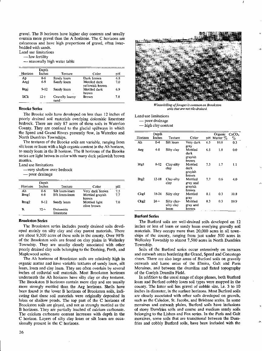
gravel . The B horizons have higher clay contents and usuallycontain more gravel than the A horizons . The C horizons arecalcareous and have high proportions of gravel, often inter-bedded with sands .Land use limitations- low fertility- seasonally high water table
Brooke SeriesThe Brooke soils have developed on less than 12 inches of
poorly drained soil materials overlying dolomitic limestonebedrock . There are only 87 acres of these soils in WaterlooCounty . They are confined to the glacial spillways in whichthe Speed and Grand Rivers presently flow, in Waterloo andNorth Dumfries Townships .
The textures of the Brooke soils are variable, ranging fromsilt loam or loam with a high organic content in the All horizon,to sandy loam in the B horizon . The B horizons of the Brookeseries are light brown in color with many dark yellowish brownmottles .Land use limitations-very shallow over bedrock- poor drainage
Brookston SeriesThe Brookston series includes poorly drained soils devel-
oped mainly on silty clay and clay parent materials . Thereare about 9,300 acres of these soils in the county . Over 98%of the Brookston soils are found on clay plains in WellesleyTownship . They are usually closely associated with otherpoorly drained clay soils belonging to the Dorking, Perth, andMaplewood series .
The Ah horizons of Brookston soils are relatively high inorganic matter and have variable textures of sandy loam, siltloam, loam and clay loam . They are often overlain by severalinches of colluvial soil materials . Most Brookston horizonsunderneath the Ah horizons have silty clay or clay textures .The Brookston B horizons contain more clay and are usuallymore strongly mottled than the Aeg horizons . Shells havebeen found in the lower B horizons of Brookston soils, indi-cating that these soil materials were originally deposited inlakes or shallow ponds . The top part of the C horizons ofBrookston soils are gleyed, and not as strongly mottled as theB horizons . They are partially leached of calcium carbonate .The calcium carbonate content increases with depth in theC horizon . Layers of silty clay loam or silt loam are occa-sionally present in the C horizons .
26
Land use limitations- poor drainage- high clay content
Winterkilling offorages is common on Brookstonsoils that are not tile-drained.
Burford SeriesThe Burford soils are well-drained soils developed on 12
inches or less of loam or sandy loam overlying gravelly soilmaterials . They occupy more than 20,000 acres in all town-ships of the county, ranging from just under 500 acres inWellesley Township to almost 7,500 acres in North DumfriesTownship .
Soils of the Burford series occur extensively on terracesand outwash areas bordering the Grand, Speed and Conestogorivers . There are also large areas of Burford soils on gravellyoutwash and kame areas of the Elmira, Galt and ParisMoraines, and between the drumlins and fluted topographyof the Guelph Drumlin Field .
In addition to the usual range of slope phases, both Burfordloam and Burford cobbly loam soil types were mapped in thecounty . The latter soil has gravel of cobble size, i .e. 3 to 10inches in diameter, in the surface horizons . Most Burford soilsare closely associated with other soils developed on gravels,such as the Caledon, St . Jacobs, and Brisbane series . In somemoraines and outwash plains, Burford soils have inclusionsof stony Dumfries soils and coarse and medium sandy soilsbelonging to the Lisbon and Fox series . In the Paris and Galtmoraines, some soils that are transitional between the Dum-fries and cobbly Burford soils, have been included with the
HorizonDepthInches Texture Color
Organic CaC03pH Matter % %
Ah 0-4 Silt loam Very dark 6.5 10.8 0.3gray
Aeg 4-8 Silty clay Mottled 6.5 1.8 0.0darkgrayishbrown
Btgl 8-12 Clay-silty Mottled 7.3 1.7 1.1clay dark
grayishbrown
Btg2 12-18 Clay-silty Mottled 7.7 0.6 4.0clay gray and
grayishbrown
Ckgl 18-24 Silty clay Mottled 8.1 0.3 10 .8gray
Ckg2 24-1- Silty clay- Mottled 8.3 0.3 19 .9silty clay gray andloam brown
HorizonDepthInches Texture Color pH
Ap 0-6 Sandy loam Dark brown 6.8Aegj 6-9 Sandy loam Mottled dark 7.0
yellowish brownBtgj 9-12 Sandy loam Mottled dark 6.9
brownIICk 12-1- Gravelly loamy Brown 7.8
sand
HorizonDepthInches Texture Color pH
Ah 0-6 Silt loam-loam Very dark brown 7.5Bmgl 6-8 Silt loam-loam Mottled grayish 7.7
brownBmg2 8-12 Sandy loam Mottled light 7.0
olive brownR 12+ Dolomitic
limestone
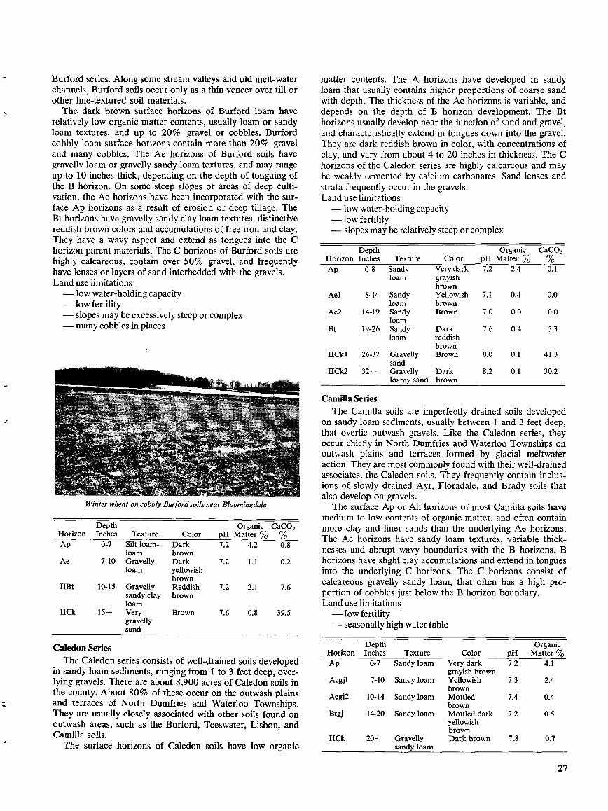
Burford series . Along some stream valleys and old melt-waterchannels, Burford soils occur only as a thin veneer over till orother fine-textured soil materials .The dark brown surface horizons of Burford loam have
relatively low organic matter contents, usually loam or sandyloam textures, and up to 20% gravel or cobbles . Burfordcobbly loam surface horizons contain more than 20% graveland many cobbles . The Ae horizons of Burford soils havegravelly loam or gravelly sandy loam textures, and may rangeup to 10 inches thick, depending on the depth of tonguing ofthe B horizon . On some steep slopes or areas of deep culti-vation, the Ae horizons have been incorporated with the sur-face Ap horizons as a result of erosion or deep tillage . TheBt horizons have gravelly sandy clay loam textures, distinctivereddish brown colors and accumulations of free iron and clay.They have a wavy aspect and extend as tongues into the Chorizon parent materials . The C horizons of Burford soils arehighly calcareous, contain over 50% gravel, and frequentlyhave lenses or layers of sand interbedded with the gravels .Land use limitations- low water-holding capacity- low fertility- slopes may be excessively steep or complex- many cobbles in places
Winter wheat on cobbly Burford soils near Bloomingdale
Caledon SeriesThe Caledon series consists of well-drained soils developed
in sandy loam sediments, ranging from 1 to 3 feet deep, over-lying gravels . There are about 8,900 acres of Caledon soils inthe county . About 80% of these occur on the outwash plainsand terraces of North Dumfries and Waterloo Townships.They are usually closely associated with other soils found onoutwash areas, such as the Burford, Teeswater, Lisbon, andCamilla soils .
The surface horizons of Caledon soils have low organic
matter contents . The A horizons have developed in sandyloam that usually contains higher proportions of coarse sandwith depth . The thickness of the Ae horizons is variable, anddepends on the depth of B horizon development . The Bthorizons usually develop near the junction of sand and gravel,and characteristically extend in tongues down into the gravel .They are dark reddish brown in color, with concentrations ofclay, and vary from about 4 to 20 inches in thickness . The Chorizons of the Caledon series are highly calcareous and maybe weakly cemented by calcium carbonates . Sand lenses andstrata frequently occur in the gravels .Land use limitations- low water-holding capacity- low fertility- slopes may be relatively steep or complex
Camilla SeriesThe Camilla soils are imperfectly drained soils developed
on sandy loam sediments, usually between 1 and 3 feet deep,that overlie outwash gravels . Like the Caledon series, theyoccur chiefly in North Dumfries and Waterloo Townships onoutwash plains and terraces formed by glacial meltwateraction . They are most commonly found with their well-drainedassociates, the Caledon soils . They frequently contain inclus-ions of slowly drained Ayr, Floradale, and Brady soils thatalso develop on gravels .The surface Ap or Ah horizons of most Camilla soils have
medium to low contents of organic matter, and often containmore clay and finer sands than the underlying Ae horizons .The Ae horizons have sandy loam textures, variable thick-nesses and abrupt wavy boundaries with the B horizons . Bhorizons have slight clay accumulations and extend in tonguesinto the underlying C horizons . The C horizons consist ofcalcareous gravelly sandy loam, that often has a high pro-portion of cobbles just below . the B horizon boundary .Land use limitations- low fertility- seasonally high water table
27
HorizonDepthInches Texture Color pH
OrganicMatter %
CaC03
Ap 0-8 Sandy Very dark 7.2 2.4 0.1loam grayish
brownAel 8-14 Sandy Yellowish 7.1 0.4 0.0
loam brownAe2 14-19 Sandy Brown 7.0 0.0 0.0
loamBt 19-26 Sandy Dark 7.6 0.4 5.3
loam reddishbrown
IICkl 26-32 Gravelly Brown 8.0 0.1 41 .3sand
IICk2 32+ Gravelly Dark 8.2 0.1 30 .2loamy sand brown
HorizonDepthInches Texture Color
Organic CaC03pH Matter % %
Ap 0-7 Silt loam- Dark 7.2 4.2 0.8loam brown
Ae 7-10 Gravelly Dark 7.2 1.1 0.2loam yellowish
brownIIBt 10-15 Gravelly Reddish 7.2 2.1 7.6
sandy clay brownloam
IICk 15+ Very Brown 7.6 0.8 39 .5gravellysand
HorizonDepthInches Texture Color pH
OrganicMatter %
Ap 0-7 Sandy loam Very dark 7.2 4.1grayish
Aegjl 7-10 Sandy loam Yellowish 7.3 2.4brown
Aegj2 10-14 Sandy loam Mottled 7.4 0.4brown
Btgj 14-20 Sandy loam Mottled dark 7.2 0.5yellowishbrown
IICk 20+ Gravelly Dark brown 7.8 0.7sandy loam
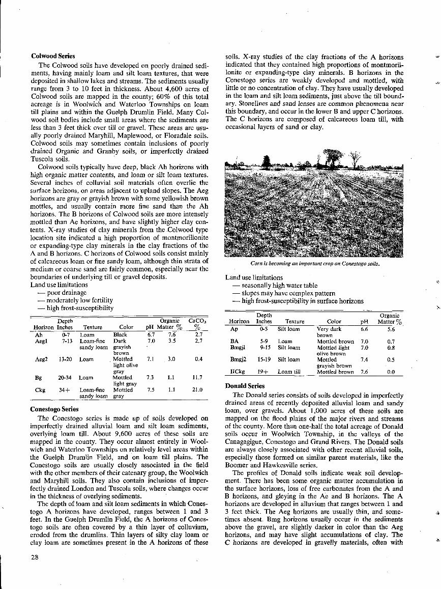
Colwood SeriesThe Colwood soils have developed on poorly drained sedi-
ments, having mainly loam and silt loam textures, that weredeposited in shallow lakes and streams . The sediments usuallyrange from 3 to 10 feet in thickness . About 4,600 acres ofColwood soils are mapped in the county ; 60% of this totalacreage is in Woolwich and Waterloo Townships on loamtill plains and within the Guelph Drumlin Field . Many Col-wood soil bodies include small areas where the sediments areless than 3 feet thick over till or gravel . These areas are usu-ally poorly drained Maryhill, Maplewood, or Floradale soils .Colwood soils may sometimes contain inclusions of poorlydrained Organic and Granby soils, or imperfectly drainedTuscola soils .
Colwood soils typically have deep, black Ah horizons withhigh organic matter contents, and loam or silt loam textures .Several inches of colluvial soil materials often overlie thesurface horizons, on areas adjacent to upland slopes . The Aeghorizons are gray or grayish brown with some yellowish brownmottles, and usually contain more fine sand than the Ahhorizons . The B horizons of Colwood soils are more intenselymottled than Ae horizons, and have slightly higher clay con-tents . X-ray studies of clay minerals from the .Colwood typelocation site indicated a high proportion of montmorilloniteor expanding-type clay minerals in the clay fractions of theA and B horizons . C horizons of Colwood soils consist mainlyof calcareous loam or fine sandy loam, although thin strata ofmedium or coarse sand are fairly common, especially near theboundaries of underlying till or gravel deposits .Land use limitations- poor drainage
Conestogo SeriesThe Conestogo series is made up of soils developed on
imperfectly drained alluvial loam and silt loam sediments,overlying loam till . About 9,600 acres of these soils aremapped in the county. They occur almost entirely in Wool-wich and Waterloo Townships on relatively level areas withinthe Guelph Drumlin Field, and on loam till plains . TheConestogo soils are usually closely associated in the fieldwith the other members of their catenary group, the Woolwichand Maryhill soils . They also contain inclusions of imper-fectly drained London and Tuscola soils, where changes occurin the thickness of overlying sediments .The depth of loam and silt loam sediments in which Cones-
togo A horizons have developed, ranges between 1 and 3feet . In the Guelph Drumlin Field, the A horizons of Cones-togo soils are often covered by a thin layer of colluvium,eroded from the drumlins . Thin layers of silty clay loam orclay loam are sometimes present in the A horizons of these
28
A
Bg 20-34 Loam
Mottled 7.3 1 .1
11 .7light gray
Ckg 34+ Loam-fine Mottled 7 .5 1 .1 21 .0sandy loam
gray
soils . X-ray studies of the clay fractions of the A horizonsindicated that they contained high proportions of montmoril-lonite or expanding-type clay minerals . B horizons in theConestogo series are weakly developed and mottled, withlittle or no concentration of clay . They have usually developedin the loam and silt loam sediments, just above the till bound-ary. Stonclines and sand lenses are common phenomena nearthis boundary, and occur in the lower B and upper C horizons .The C horizons are composed of calcareous loam till, withoccasional layers of sand or clay .
iCorn is becoming an important crop on Conestogo soils.
Land use limitations- seasonally high water table- slopes may have complex pattern
Donald SeriesThe Donald series consists of soils developed in imperfectly
drained areas of recently deposited alluvial loam and sandyloam, over gravels . About 1,000 acres of these soils aremapped on the flood plains of the major rivers and streamsof the county . More than one-half the total acreage of Donaldsoils occur in Woolwich Township, in the valleys of theCanagagigue, Conestogo and Grand Rivers . The Donald soilsare always closely associated with other recent alluvial soils,especially those formed on similar parent materials, like theBoomer and Hawkesville series .The profiles of Donald soils indicate weak soil develop-
ment . There has been some organic matter accumulation inthe surface horizons, loss of free carbonates from the A andB horizons, and gleying in the A'e and B horizons. The Ahorizons are developed in alluvium that ranges between 1 and3 feet thick . The Aeg horizons are usually thin, and some-times absent . Bmg horizons usually occur in the sedimentsabove the gravel, are slightly darker in color than the Aeghorizons, and may have slight accumulations of clay . TheC horizons are developed in gravelly materials, often with
- moderately low fertility - high frost-susceptibility in surface horizons- high frost-susceptibility
Depth OrganicDepth Organic CaC03 Horizon Inches Texture Color pH Matter %
orizon Inches Texture Color pH Matter % % Ap 0-5 Silt loam Very dark 6.6 5 .6h 0-7 Loam Black 6.7 7 .6 2 .7 brownegl 7-13 Loam-fine Dark 7.0 3 .5 2 .7 BA 5-9 Loam Mottled brown 7.0 0 .7
sandy loam grayish Bmgjl 9-15 Silt loam Mottled light 7 .0 0.8brown olive brown
eg2 13-20 Loam Mottled 7 .1 3 .0 0 .4 Bmgj2 15-19 Silt loam Mottled 7 .4 0 .5light olive grayish browngray IICkg 19-1- Loam till Mottled brown 7.6 0.0
layers of large cobbles along the top of the horizon, andlenses of clay and sand at lower depths .Land use limitations- risk of flooding- seasonally high water table- areas of irregular shape from flood dissection
Dorking SeriesThe Dorking soils are very poorly drained soils developed
on silty clay loam, silty clay and clay soil materials . Thereare only about 560 acres of these soils in the county, and theyare only mapped on the clay plains of Wellesley Township .They are found in low-lying depressional areas of the land-scape, with poorly drained Brookston, Maplewood, andOrganic soils .The Dorking soils characteristically have high clay and silt
contents . They range from silt loam and silty clay loam tex-tures in the surface horizons to heavier clay textures at depth .This is reflected by the very firm consistence and strongangular and columnar structures of the lower soil horizons .The high water table and intense gley conditions present inthese soils are indicated by the gray color and sparse mottlesof most horizons . There is a stoneline of angular gravel nearthe top of the Ck horizon of Dorking soils . The presence ofthis stoneline, the brown color, and higher clay content ofthe Ck horizons indicate that they probably originated froma different deposit than the overlying materials of the Cgand Ap horizons .Land use limitations- very poor drainage- high clay content
Depth
Organic CaC03Horizon Inches
Texture
Color
pH Matter %
%Ap
0-7
Silty clay
Very dark
6.9
5.5
0.2loam grayish
brownAeg
7-16
Silty clay
Mottled
6.7
2.2
0.1loam gray
Bgf1
16-25
Silty clay
Mottled
7.1
1 .3
0.3loam gray
Bgf2
25-33
Silty clay
Mottled
7.5
1 .2
0.1loam gray
BC
33-40
Silty clay
Dark gray
7.5
1 .5
19.2IICkg
40+
Silty clay
Brown
7.7
0.8
Dumfries SeriesThe Dumfries soils are developed on the stony loam and
loam tills of the Galt and Paris Moraines in the southern partof the county . Almost 8,700 acres of these soils have beenmapped in North Dumfries Township . Many areas of gravellyBurford soils, too small to map, are included in the Dumfriessoils, especially where steep, complex slopes prevail . On rela-tively level areas, a few feet of stone-free materials, probablyof alluvial origin, often overlie the till . Soils developed inthese materials belong to the Mannheim series, and are fre-quently present as inclusions in the Dumfries soils .
The A horizons of Dumfries soils are usually developed in
a thin layer of relatively stone-free loam that overlies the till .The B horizons are distinctively reddish brown . They containvarying contents of clay and gravel, and range from clay loamto gravelly sandy loam in texture . The C horizons consist ofcalcareous materials of varied textures and degree of sorting .They range from loam till, with a high proportion of roundeddolomite boulders and cobbles, to fairly well-sorted gravellysandy loam. The gravel and cobble size is greatest at the topof the C horizon .Land use limitations- relatively low water-holding capacity .- relatively low fertility.- slopes may be excessively steep or complex- some areas are very stony
Elmira SeriesSoils of the Elmira series have developed on poorly drained
loam and silt loam alluvium deposited on the flood plainsof the main rivers and streams in the county . There are 1,740acres of Elmira soils in Waterloo County . They occur withother alluvial soils, like the Macton and Grand soils, thathave formed in similar parent materials, but have differentdrainage characteristics .
The A horizons of Elmira soils are often buried by severalinches of very recent flood deposits . The Ah or Ap horizonshave relatively high organic matter contents and silt loam orloam textures . The Cg horizons have similar textures, butclay contents that increase with depth . Sand strata are alsosometimes present. Cg horizons are gray with some darkyellowish brown mottling, and low calcium carbonate contents .Free carbonates are often leached out to depths of several feet .Land use limitations- risk of flooding- poor drainage- areas of irregular shape from flood dissection- relatively high frost-susceptibility
Depth
Organic CaC03Horizon Inches Texture
Color
pH Matter %
%Ap
0-9
Silt loam
Very dark
7.2
6.5
0.5grayishbrown
Cgl
9-15
Loam-silt
Dark gray
7.3
2.6
0.1loam
Cg2 15-20 Loam
Mottled 7.4 1 .4
0.4gray
Cg3 20+ Loam Mottled 7 .5 1 .2 0.2gray
Farmington SeriesThe Farmington series includes well-drained soils de-
veloped on 12 inches or less of sandy loam over dolomiticlimestone bedrock. There are only 188 acres of these soilsin the county . They occur with other shallow soils, and withalluvial soils, in the valleys of the Speed and Grand Rivers inWaterloo and North Dumfries Townships.Ah horizons of Farmington soils have quite high organic
29
HorizonDepthInches Texture Color pH
OrganicMatter %
CaC03%
Ah 0-4 Loam Very dark 7 .0 5.6 0.8grayishbrown
Ae 4-8 Loam Yellowish 6.8 1 .3 1.0brown
IIBt 8-14 Clay loam Reddish 7.0 1 .4 4 .1brown
IICk 14+ Gravelly Brown 7.6 0 .9 20 .8sandy loam
HorizonDepthInches Texture Color pH
Ap 0-4 Loam Dark brown 7.3Bmgj 1 4-7 Loam Mottled yellowish 7.4
brownBmgj2 7-12 Loam Mottled dark 7.4
yellowish brownIICk 12+ Gravelly sandy Dark brown 7.4
loam
matter contents . The Bin horizons, which lie on bedrock, alsohave relatively high proportions of organic matter, but noclay concentration . Both A and B horizons usually have sandyloam textures .Land use limitations- very shallow over bedrock- low water-holding capacity
Floradale SeriesSoils of the Floradale series have developed on imperfectly
drained deposits of loam and silt loam, over outwash gravels.There are about 1,550 acres of Floradale soils in the county.They occur mainly in the three eastern townships of Wool-wich, Waterloo and North Dumfries . They are found on low-lying areas of gravel terraces, outwash plains and old riverchannels . Other soils with gravelly parent materials, particu-larly the Burford and St . Jacobs series, are found on thesame land areas as the Floradale soils .On areas near upland slopes, the Floradale series may have
up to 18 inches of colluvial materials, from slope erosion,overlying the A horizons . The A horizons have developed inrelatively stone-free loam and silt loam that ranges between1 and 3 feet thick . Layers of very fine sandy loam are alsosometimes present in these deposits . B horizons may be de-veloped in this material or in the underlying gravel, and rangein texture from loam to gravelly clay loam. They are mottleddark grayish brown in color, with clay accumulations, and havewavy, tonguing boundaries with the C horizons . The C horizonmaterials consist mainly of gravelly sands with occasionalsandy loam or clay strata .Land use limitations- seasonally high water table- fertility may be low
Fox SeriesThe Fox soils are developed on well-drained, mainly
medium- and coarse-sized sands . They are widely distributedthrough Waterloo County, and occupy more than 13,400acres . Most of the sandy soils in the southern part of theWaterloo Sandhills, and in the Galt and Paris Moraines, be-long to the Fox series . Fox soils also occur extensively inNorth Dumfries Township on outwash plains and terraces .
30
In Woolwich Township they occur in the Sandhills and insome smaller moraines .
Fox soils in the Waterloo Sandhills are usually found withWaterloo soils, and less often with Lisbon or Burford soils .In other moraines and on outwash plains and terraces, theyare most often associated with the gravelly Lisbon, Burford,and Caledon soils .
The Ap horizons of Fox soils are often 12 to 15 inchesthick as a result of deep tillage . They generally have lowcontents of organic matter . The Ae horizons are extremelyvariable in thickness, ranging from 10 to 30 inches thick,depending on the depth of B horizon development. The Bthorizons of the Fox series usually range from 4 to 8 inchesthick, and consist of reddish brown loamy sand, enriched inclay, free iron, and organic matter . The Bt horizons havewavy abrupt boundaries with the C horizons . They may ex-tend up to several feet deep in tongues, into the C horizonmaterials . The C horizons consist mainly of stratified coarseand medium sands . Layers and lenses of fine gravel are oftenpresent, especially near the B horizon boundary . The C horizonmaterials are highly calcareous .Land use limitations- low water-holding capacity- low fertility- slopes may be excessively steep or complex
Freeport SeriesFreeport soils are developed on well-drained sandy loams,
over loam till . Exactly 2,300 acres of these soils have beenmapped in the county, virtually all in Woolwich and WaterlooTownships. They occur on loam till plains in Woolwich Town-ship, and on gently sloping areas of the Guelph Drumlin Field,in Waterloo Township . As a consequence of the variablethickness of sand over till, Freeport soils have inclusions ofGuelph sandy loam where sands are thin, and inclusions ofFox and Lisbon soils where the sands deepen . The Kossuthand Woolwich soils, with loam till C horizons, also often occuron the same landscapes as the Freeport soils .
The sandy loam in which Freeport A horizons have devel-oped ranges between 1 and 3 feet thick . The surface Ap hori-zons usually have moderately low organic matter contents,and more fine-textured soil materials than the Ae horizons .The Ae horizons vary greatly in thickness depending on thethickness of sand over till . The B horizons have usually devel-oped in the sand, just above the sand-till junction, and have awavy aspect apparently related to an irregular till surface .They are reddish brown, enriched in clay, and range from 2 to12 inches thick . The C horizon materials consist of calcareousloam till, usually separated from the B horizon by a stonelineof rounded gravel and cobbles . There are often thin layers ofsand or gravel in the upper part of the till .
HorizonDepthInches Texture Color
OrganicpH Matter °7o
CaC03%o
Ap 0-12 Sandy Dark 7.2 1 .7 .06loam- yellowishloamysand brown
Ael 12-17 Loamy Brown- 7 .2 0 .6 0 .3sand yellowish
brownAe2 17-26 Loamy Dark 7 .1 0 .6 0 .0
sand yellowishbrown
Bt 26-31 Loamy Reddish 7 .2 1 .7 0 .2sand brown
Ck 31+ Sand Brown 7.6 0 .2 26 .6
HorizonDepthInches Texture Color
OrganicpH Matter °Jo
CaC03°Jo
Ah 0-5 Sandy Very dark 7 .1 6 .6 1 .5loam grayish
brownAB 5-7 Sandy Dark 7.2 2.7 0.1
loam yellowishbrown
Bin 7-12 Sandy Very dark 7 .4 2 .4 0.0loam yellowish
brownR 12+ Dolomitic
limestone
HorizonDepthInches Texture Color pH
Ah 0-9 Silt loam Very dark 7 .4grayish brown
Aegj 9-14 Loam Mottled dark 7.0brown
Btgj 14-19 Loam Mottled dark 6 .7grayish brown
IICkg 19-26 Gravelly loamy Mottled pale 7 .1sand brown
IICk 26+ Loam-gravelly Dark brown 7.3layers
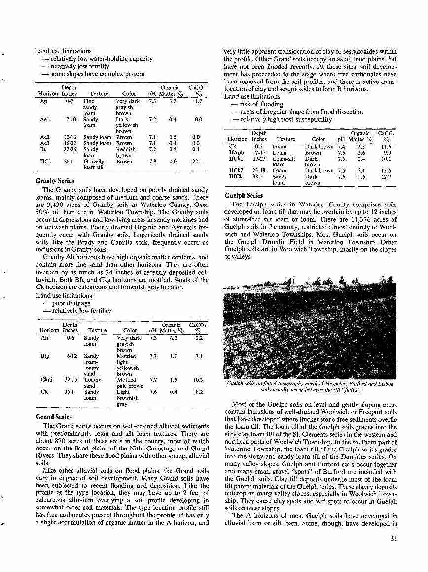
Land use limitations-relatively low water-holding capacity
Ael 7-10 Sandy Dark
7.2 0.4
0.0loam yellowish
brownAe2
10-16
Sandyloam Brown
7.1
0.5
0.0Ae3
16-22
Sandyloam Brown
7.1
0.4
0.0Bt 22-26 Sandy Reddish 7.2 0.5 0.1
loam brownIICk 26+ Gravelly Brown 7.8 0.0 22 .1
loam till
Granby SeriesThe Granby soils have developed on poorly drained sandy
loams, mainly composed of medium and coarse sands . Thereare 3,430 acres of Granby soils in Waterloo County. Over50% of them are in Waterloo Township . The Granby soilsoccur in depressions and low-lying areas in sandy moraines andon outwash plains . Poorly drained Organic and Ayr soils fre-quently occur with Granby soils . Imperfectly drained sandysoils, like the Brady and Camilla soils, frequently occur asinclusions in Granby soils.
Granby Ah horizons have high organic matter contents, andcontain more fine sand than other horizons . They are oftenoverlain by as much as 24 inches of recently deposited col-luvium . Both Bfg and Ckg horizons are mottled. Sands of theCk horizon are calcareous and brownish gray in color.Land use limitations-poor drainage-relatively low fertility
Grand SeriesThe Grand series occurs on well-drained alluvial sediments
with predominantly loam and silt loam textures . There areabout 870 acres of these soils in the county, most of whichoccur on the flood plains of the Nith, Conestogo and GrandRivers . They share these flood plains with other young, alluvialsoils .
Like other alluvial soils on flood plains, the Grand soilsvary in degree of soil development. Many Grand soils havebeen subjected to recent flooding and deposition. Like theprofile at the type location, they may have up to 2 feet ofcalcareous alluvium overlying a soil profile developing insomewhat older soil materials . The type location profile stillhas free carbonates present throughout the profile. It has onlya slight accumulation of organic matter in the A horizon, and
very little apparent translocation of clay or sesquioxides withinthe profile. Other Grand soils occupy areas of flood plains thathave not been flooded recently . At these sites, soil develop-ment has proceeded to the stage where free carbonates havebeen removed from the soil profiles, and there is active trans-location of clay and sesquioxides to form Bhorizons .Land use limitations-risk of flooding-areas of irregular shape from flood dissection-relatively high frost-susceptibility
Depth
Organic CaCO3Horizon Inches
Texture
Color
pH Matter %
%Ck
0-7
Loam
Dark brown 7.4
2.5
11 .6IIApb 7-17 Loam Brown 7.5 3 .6
9.9IICk1 17-23 Loam-silt Dark
7.6 2.4 10 .1loam brown
IICk2
23-38
Loam
Dark brown 7.5
2.1
13.5IIICk 38-{- Sandy Dark 7.6 2.6 12 .7
loam brown
Guelph SeriesThe Guelph series in Waterloo County comprises soils
developed on loam till that may be overlain by up to 12 inchesof stone-free silt loam or loam . There are 11,376 acres ofGuelph soils in the county, restricted almost entirely to Wool-wich and Waterloo Townships . Most Guelph soils occur onthe Guelph Drumlin Field in Waterloo Township . OtherGuelph soils are in Woolwich Township, mostly on the slopesof valleys.
Guelph soils onfluted topography north of Hespeler. Burford andLisbonsoils usually occur between the till "flutes" .
Most of the Guelph soils on level and gently sloping areascontain inclusions of well-drained Woolwich or Freeport soilsthat have developed where thicker stone-free sediments overliethe loam till . The loam till of the Guelph soils grades into thesilty clay loam till of the St . Clements series in the western andnorthern parts of Woolwich Township . In the southern part ofWaterloo Township, the loam till of the Guelph series gradesinto the stony and sandy loam till of the Dumfries series . Onmany valley slopes, Guelph and Burford soils occur togetherand many small gravel "spots" of Burford are included withthe Guelph soils . Clay till deposits underlie most of the loamtill parent materials of the Guelph series . These clayey depositsoutcrop on many valley slopes, especially in Woolwich Town-ship . They cause clay spots and wet spots to occur in Guelphsoils on these slopes .The A horizons of most Guelph soils have developed in
alluvial loam or silt loam. Some, though, have developed in
3 1
HorizonDepthInches Texture Color pH
OrganicMatter
CaCO3
Ah 0-6 Sandy Very dark 7.3 6.2 2.2loam grayish
brownBfg 6-12 Sandy Mottled 7.7 1.7 7.1
loam- lightloamy yellowishsand brown
Ckgj 12-15 Loamy Mottled 7.7 1 .5 10 .3sand pale brown
Ck 15+ Sandy Light 7.6 0.4 8.2loam brownish
gray
-relatively-some slopes
DepthHorizon Inches
low fertilityhave complex pattern
Organic CaC03Texture Color pH Matter
Ap 0-7 Fine Very dark 7.3 3.2 1 .7sandy grayishloam brown
alluvial sandy loam, mostly adjacent to outwash sands inWaterloo Township . The Ap horizons of Guelph soils areusually 4 to 6 inches thick, with low to medium organic mattercontents . Ae horizons usually range between 2 and 8 inchesthick, although they are occasionally up to 12 inches thick insoil tongues . They are sometimes absent on slopes where sur-face erosion has occurred, or where they have been incor-porated into the Ap horizons .The B horizons of Guelph soils are reddish colored, with
concentrations of clay and free iron . They usually develop nearthe top of the till and are often associated with stonelinesthat occur at the till boundaries . They have wavy tonguingboundaries with the C horizons . The C horizons are composedof brown, highly calcareous, loam till. Thin layers of silt, sandor clay are also sometimes found in the upper part of this till .Most Guelph C horizon materials in Woolwich Township havehigher clay and lower sand contents than those in the GuelphDrumlin Field in Waterloo Township .Land use limitations- slopes may be excessively steep or complex- moderately high erodibility
32
Hawkesville SeriesThe Hawkesville soils have developed on poorly drained
alluvial sediments that have been recently deposited on floodplains . These sediments are composed chiefly of loam andsandy loam, and overlie gravels at depths of up to 3 feet. Thereare 935 acres of Hawkesville soils on the flood plains of themajor rivers and streams in the county. Most occur in theGrand and Conestogo River valleys with other alluvial soils,like the Boomer and Donald soils, that have developed onsimilar materials . Up to 2 feet of calcareous alluvial materialsoften overlie the Ah horizons of Hawkesville soils . The onlyindications of soil development in the type location profile areslight accumulations of organic matter in the Ah horizons,some leaching of free carbonates, and the presence of mottlingin the upper C horizons . The gravelly soil materials that under-lie the fine-textured alluvium often contain high proportions oflarge cobbles at the alluvium-gravel boundaries .Land use limitations- risk of flooding- poor drainage- areas of irregular shape from flood dissection
Haysville SeriesThis series is composed of soils developed on imperfectly
drained sandy deposits of recent alluvial origin . There are 500acres of these soils on the floodplains of the major rivers andstreams of Waterloo County . About one-half of them are onthe floodplains of the Nith River and its tributaries . The Hays-ville soils are usually closely associated with other alluvialsandy soils, such as the Kirkland and Hespeler soils .
Like most alluvial soils, the Haysville soils have weakhorizon development . Their A horizons are often overlain bya layer of calcareous alluvium deposited during recent flood-ing. The A horizons usually contain accumulations of organicmatter and sometimes still retain some free carbonates . Therehas been some leaching of free carbonates from the upper Chorizons . Mottling occurs throughout most of the C horizons .Land use limitations- risk of flooding- seasonally high water table- areas of irregular shape from flood dissection
Heidelberg SeriesThe Heidelberg soils are the imperfectly drained associates
of the Waterloo series . They have developed on very fine andfine sandy loam materials of alluvial and lacustrine origin .There are 6,575 acres of Heidelberg soils in the county, locatedmainly in low-lying- areas of the Waterloo Sandhills, the ElmiraMoraine, and parts of the Galt and Paris Moraines .
In the sandy moraine areas, Heidelberg soils are closelyassociated with the sandy Waterloo and Brady soils and withthe silty Brant and Tuscola soils . The landscape sites thatHeidelberg soils occupy are frequently underlain at depth bytill or gravel deposits . Where these deposits occur close to thesurface, imperfectly drained soils of the Camilla, Berrien, orKossuth series often occur as inclusions in the Heidelberg soils .The surface A horizons of Heidelberg soils have mediumamounts of organic matter and usually contain more fine sandand silt than underlying horizons . Often they are overlain byseveral inches of recent colluvial soil materials . The Ae hori-zons are mottled and have abrupt wavy boundaries with the Bhorizons . The B horizons of Heidelberg soils range between 2and 6 inches thick, and usually have clay concentrations. Theupper part of the C horizon is usually leached of some of itsfree carbonates . The C horizons consist mainly of fine sandyloam materials, but sometimes layers of silt loam, coarse sand,gravelly sand, or till materials are also present .Land use limitations- seasonally high water table- relatively high frost-susceptibility
HorizonDepthInches Texture Color pH
OrganicMatter °Jo
CaC03%
Ap 0-5 Silt loam Dark brown 7.4 2.6 1.6Ae 5-10 Silt loam- Brown 7.6 0.4 0.7
loamIIBt 10-14 Clay loam- Dark 7.4 0.3 0.9
loam reddishgray
IICk 14+ Loam till Brown 7.9 0.1 24 .7
HorizonDepthInches Texture Color pH
OrganicMatter °Jo
Apk 0-10 Sandy loam Very dark 7.5 - 5.4brown
AC 10-16 Sand Dark yellowish 7.4 1.2brown
IICkgj1 16-24 Sand Mottled dark 7.1 1 .1yellowishbrown
IICkgj2 24-27 Sand Mottled dark 7.1 0.2brown
IICkgj3 27-31 Sand Mottled 7.2 0.4yellowishbrown
IICkg 31+ Sand Mottled brown 7.0 0.2
HorizonDepthInches Texture Color pH
Apk 0-14 Silt loam Dark brown 7.2Ahbk 14-18 Sandy loam- Very dark grayish 7.1
loam brownCkg1 18-20 Sandy loam Mottled light 7.4
olive brownCkg2 20-22 Sandy loam- Mottled light 7.5
loam olive brownIICkg 22+ Gravelly sandy Brown 7.5
loam
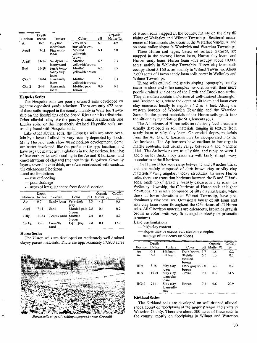
Hespeler SeriesThe Hespeler soils are poorly drained soils developed on
recently deposited sandy alluvium . There are only 472 acresof these soils mapped in the county, mainly in Waterloo Town-ship on the floodplains of the Speed River and its tributaries .Other alluvial soils, like the poorly drained Hawkesville andElmira soils, or the imperfectly drained Haysville soils, areusually found with Hespeler soils .
Like other alluvial soils, the Hespeler soils are often over-lain by a layer of alluvium, very recently deposited by floods .Many Hespeler soils show weak horizon development . Someare better developed, like the profile at the type location, andhave organic matter accumulations in the Ap horizon, leachingof free carbonates and mottling in the Ae and B horizons, andconcentrations of clay and free iron in the B horizon . Gravellylayers, several inches thick, are often interbedded with sands inthe calcareous C horizons .Land use limitations- risk of flooding- poor drainage- areas of irregular shape from flood dissection
Huron SeriesThe Huron soils are developed on mcderately well-drained
clayey parent materials . There are approximately 17,800 acres
Huron soils on gently rolling topography near Crosshill
of Huron soils mapped in the county, mainly on the clay tillplains of Wellesley and Wilmot Townships . Scattered occur-rences of Huron soils also occur in the Waterloo Sandhills, andon some valley slopes in Woolwich and Waterloo Townships .
Three Huron soil types, based on surface textures, aremapped in the county ; Huron loam, Huron clay loam, andHuron sandy loam. Huron loam soils occupy about 10,000acres, mainly in Wellesley Township . Huron clay loam soilsoccupy about 5,160 acres, mainly in Wilmot Township . About2,600 acres of Huron sandy loam soils occur in Wellesley andWilmot Townships .Huron soils on level and gently sloping topography usually
occur in close and often complex association with their morepoorly drained analogues of the Perth and Brookston series .They also often contain inclusions of well-drained Benningtonand Bookton soils, where the depth of silt loam and loam overclay increases locally to depths of 2 or 3 feet . Along thewestern borders of Woolwich Township and the WaterlooSandhills, the parent materials of the Huron soils grade intothe siltier clay materials of the St . Clements soils .
The A horizons of Huron soils on relatively level areas, areusually developed in soil materials ranging in texture fromsandy loam to silty clay loam . On eroded slopes, materialsfrom the Ae, B or C horizons may be incorporated into theAp horizons . The Ap horizons have medium to low organicmatter contents, and usually range between 4 and 6 inchesthick. The Ae horizons are usually thin, and range between 1and 5 inches thick . They terminate with fairly abrupt, wavyboundaries at the B horizon .
The Huron B horizons range between 5 and 10 inches thick,and are mainly composed of dark brown clay or silty claymaterials having angular, blocky structures . In some Huronsoils, there are transition horizons between the B and C hori-zons, made up of gravelly, weakly calcareous clay loam . InWellesley Township, the C horizons of Huron soils at higherelevations, are mainly composed of silty clay materials, whilethose at lower elevations in Wilmot Township, have pre-dominantly clay textures . Occasional layers of silt loam andsilty clay loam occur throughout the C horizons of all Huronsoils . All C horizon materials are calcareous, brown or grayishbrown in color, with very firm, angular blocky or prismaticstructures .Land use limitations- high clay content- slopes may be excessively steep or complex- seepage often occurs on slopes
Kirkland SeriesThe Kirkland soils are developed on well-drained alluvial
sands, found on floodplains of the major streams and rivers inWaterloo County. There are about 500 acres of these soils inthe county, mostly on floodplains in Wilmot and Waterloo
3 3
HorizonDepthInches Texture Color pH
OrganicMatter %
Ah 0-7 Very fine Very dark 6.6 4 .9sandy loam grayish brown
Aegj1 7-11 Fine sandy Mottled 6.1 3 .0loam yellowish
brownAegj2 11-14 Sandyloam- Mottled 6 .5 0 .3
loamysand yellowish brownBtgj 14-18 Sandy loam- Mottled 6 .5 0 .5
sandy clay yellowish brownloam
Ckgjl 18-24 Fine sandy Mottled 7 .7 0 .3loam yellowish brown
Ckgj2 24+ Fine sandy Mottled pale 8 .0 0.1loam brown
HorizonDepthInches Texture Color pH
OrganicMatter %
CaC03%
Ap 0-5 Silt loam Dark brown 5.7 1 .6 0 .2Ae 5-8 Silt loam Slightly 6 .1 1 .0 0.3
mottledbrown
IIBt 8-15 Silty clay Dark grayish 7 .0 1 .3 0 .2loam brown
IICkl 15-21 Silty clay Brown 7.2 0.3 14 .5loam-clayloam
I1Ck2 21+ Silty clay Brown 7.4 0 .6 20.9loam-siltyclay
HorizonDepthInches Texture Color pH
OrganicMatter %
CaC03%
Ap 0-7 Sandy loam Very dark 7 .3 4 .6 0 .8gray
Aegi 7-11 Sand Mottled pale 7 .5 0.4 0 .2brown
IIBg 11-33 Loamy sand Mottled 7 .4 0.4 8 .9brown
IICkg 33+ Gravelly Light gray 7 .8 0.1 17 .9sand
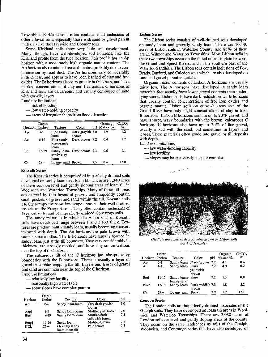
Townships . Kirkland soils often contain small inclusions ofother alluvial soils, especially those with sand or gravel parentmaterials like the Haysville and Boomer soils .Some Kirkland soils show very little soil development.
Many, though, have well-developed soil horizons, like theKirkland profile from the type location . This profile has an Aphorizon with a moderately high organic matter content . TheAp horizon also contains free carbonates, probably due to con-tamination by road dust . The Ae horizons vary considerablyin thickness, and appear to have been leached of clay and freeoxides . The Bt horizons also vary greatly in thickness, and havemarked concentrations of clay and free oxides . C horizons ofKirkland soils are calcareous, and usually composed of sandwith gravelly layers .Land use limitations- risk of flooding- low water-holding capacity- areas of irregular shape from flood dissection
Kossuth SeriesThe Kossuth series is comprised of imperfectly drained soils
developed on sandy loam over loam till . There are 1,340 acresof these soils on level and gently sloping areas of loam till inWoolwich and Waterloo Townships. Many of these till areasare capped by thin layers of gravel, and frequently containsmall pockets of gravel and sand within the till . Kossuth soilsusually occupy the same landscape areas as their well-drainedassociates, the Freeport soils . They often contain inclusions ofFreeport soils, and of imperfectly drained Conestogo soils .
The sandy materials in which the A horizons of Kossuthsoils have developed range between 1 and 3 feet thick . Tex-tures are predominantly sandy loam, usually becoming coarser-textured with depth . The Ae horizons are pale brown withsome sparse mottles . The B horizons have usually formed insandy loam, just at the till boundary . They vary considerably inthickness, are strongly mottled, and have clay concentrationsnear the top of the horizon .
The calcareous till of the C horizons has abrupt, wavyboundaries with the B horizons . There is usually a layer ofgravel or cobbles capping the till . Layers and lenses of graveland sand are common near the top of the C horizon .Land use limitations- relatively low fertility- seasonally high water table- some slopes have complex pattern
34
Lisbon SeriesThe Lisbon series consists of well-drained soils developed
on sandy loam and gravelly sandy loam. There are 10,440acres of Lisbon soils in Waterloo County, and 85% of themare in Wilmot and Waterloo Townships. Most Lisbon soils inthese two townships occur on the fluted outwash plain betweenthe Grand and Speed Rivers, and in the southern part of theWaterloo Sandhills . The Lisbon soils contain inclusions of Fox,Brady, Burford, and Caledon soils which are also developed onsand and gravel parent materials .
Organic matter contents of Lisbon A horizons are usuallyfairly low . The A horizons have developed in sandy loammaterials that usually have lower gravel contents than under-lying sands . Lisbon soils have dark reddish brown B horizonsthat usually contain concentrations of free iron oxides andorganic matter. Lisbon soils on outwash areas east of theGrand River have only slight concentrations of clay in theirB horizons . Lisbon B horizons contain up to 20% gravel, andhave abrupt, wavy boundaries with the brown, calcareous Chorizons . C horizons also have up to 20% of fine gravel,usually mixed with the sand, but sometimes in layers andlenses . These materials often grade into gravel or till depositswith depth .Land use limitations- low water-holding capacity- low fertility- slopes may be excessively steep or complex
Gladiola are a new cash crop being grown on Lisbon soilsnorth of Hespeler.
London SeriesThe London soils are imperfectly drained associates of the
Guelph soils . They have developed on loam till areas in Wool-wich and Waterloo Townships . There are 2,080 acres ofLondon soils on level and gently sloping areas of the county .They occur on the same landscapes as soils of the Guelph,Woolwich, and Conestogo series that have also developed on
HorizonDepthInches Texture Color pH
OrganicMatter %
CaC03%
Ap 0-4 Sandy loam Dark brown 7.2 4.1 0 .4Ah 4-11 Sandy loam Dark 7.2 4.0 0.2
yellowishbrown
Bml 11-17 Sandy loam- Brown 7.2 1 .3 0 .8loamy sand
Bm2 17-19 Sandy loam Dark reddish 7 .3 1 .8 5 .2brown
Ck 19+ Loamy sand Brown 7 .9 1 .2 42 .1
HorizonDepthInches Texture Color pH
Ap 0-6 Sandy loam-loam Very dark grayish 7.0brown
Aegj 6-9 Sandy loam-loam Mottled pale brown 7 .0Btgj 9-19 Sandyloam-loam Mottled dark 7 .2
yellowishbrownBmgj 19-26 Sandy loam Mottled brown 7 .5IICk 26+ Gravelly sandy Pale brown 7 .5
loam-loam till
HorizonDepthInches
OrganicTexture Color pH Matter %
CaC03%
Ap 0-6 Fine sandy Dark grayish 7 .0 1 .9 1 .2loam brown
Ae 6-16 Fine sandy Dark brown 7 .2 0.4 1 .2loam-sandyloam
Bt 16-29 Sandy loam- Dark brown 7 .3 0.6 1 .1sandy clayloam
Ck 29+ Loamy sand Brown 7.5 0 .4 15 .0
loam till . Gravelly soils of the Burford and Brisbane seriesoften occur as small inclusions within London soils .
The A horizons of London soils have developed in loammaterials that sometimes contain sandy layers . The Ae hori-zons are mottled and range between 2 and 6 inches thick . Bhorizons of London soils have usually formed in loam or sandyloam materials directly overlying the C horizons . The bound-ary between the B and C horizons is typically wavy, abrupt andassociated with a stoneline of gravel and cobbles along the topof the C horizon . The soil materials of London C horizons arecalcareous and composed of loam or sandy loam till withgravel lenses near the top . Further down in the till, layers ofclay loam are occasionally present.Land use limitations- seasonally high water table- moderately high erodibility
Macton SeriesMacton soils are imperfectly drained soils developed on
recently deposited alluvium, having mainly loam and silt loamtextures . There are 1,540 acres of these soils on the flood-plains of all major streams and rivers in Waterloo County .Other alluvial soils occur as inclusions in bodies of Mactonsoils, especially those with similar parent materials such as theGrand and Elmira soils .
Macton soils have deep surface A horizons with mediumorganic matter contents . Loam and silt loam textures pre-dominate, especially in the surface horizons, but sandy orclayey layers may also occur in the lower horizons. Buriedorganic layers are sometimes found between layers in the lowerC horizons of Macton soils . Soil development in Macton soilshas usually proceeded far enough to produce some mottlingand leaching of free carbonates .Land use limitations- risk of flooding- seasonally high water table- areas of irregular shape from flood dissection- relatively high frost-susceptibility
Mannheim SeriesThe Mannheim series consists of well-drained soils de-
veloped on stone-free loams, over gravelly and stony loamtill . The stone-free materials average between 1 and 3 feetthick, and are mainly composed of loam and silt loam. Inclu-
sions of Brant soils usually occur in Mannheim soil bodieswhere the depth of loam or silt loam becomes thicker than 3feet ; inclusions of Dumfries soils occur where this material isless than 1 foot thick over till . Gravelly pockets are commonin this till, and small areas of gravelly St . Jacobs, Caledon,Floradale, and Camilla soils are sometimes present as inclu-sions in Mannheim soils . There are about 4,000 acres ofMannheim soils in Waterloo County, virtually all on till plainsand terraces in North Dumfries Township .The A horizons of Mannheim soils are usually developed
in loam and silt loam textures ; less frequently they have finesandy loam textures . The Ap horizons are deep, friable andwell supplied with organic matter and plant nutrients . Ap hori-zons of Mannheim soils near gravel. roads, like that from thetype location, frequently have high pH and CaCO3 values dueto contamination by road dust . The Ae horizons of Mannheimsoils vary widely in thickness, ranging between 6 and 12 inchesthick . The Bt horizons have mainly developed in alluviumand are usually between 6 and 12 inches thick . They are darkbrown, with a reddish hue, and typically have high clay con-centrations . The C horizons are formed in calcareous gravellyloam till and gravelly sandy loam till . This till has a cobblystoneline along its upper boundary, and pockets of gravel fre-quently occur near the top of the horizon . Large roundedstones are often present in the till .Land use limitations- slopes may be moderately steep or complex- some areas may have relatively low water-holding capa-
city
Maplewood SeriesThe Maplewood soils are the poorly drained analogues of
the Bennington series . They have developed in silt loam orloam sediments, over clayey materials . There are 4,950 acresof Maplewood soils mapped in the county . Most are on low-lying areas of the clay plains in Wellesley and Wilmot Town-ships, but some also occur on areas underlain by the siltier claymaterials that extend southward from the Elmira Moraine inWoolwich Township into the Waterloo Sandhills .
Colwood soils are a frequent associate of the Maplewoodsoils, when the stone-free sediments are consistently greaterthan 3 feet thick over till . Other soils often included in Maple-wood soil areas are those of its imperfectly drained associate,the Tavistock series, and the poorly drained sandy soils ofthe Berrien and Wauseon series .The soil materials in which the A horizons of Maplewood
soils have developed average between 1 and 3 feet thick . Thesurface A horizons have relatively high organic matter con-tents . B horizons are usually developed in the same materialsas the A horizons . They are mottled and may have slightlymore clay than the A horizons . The C horizons are developedin clay, silty clay, and silty clay loam materials that are usuallyseparated from overlying sediments by a weak stoneline orpebble band . The upper part of the C horizons are often par-
35
HorizonDepthInches Texture Color pH
OrganicMatter %
CaC03°Jo
Ap 0-8 Loam Very dark 7.3 5.2 2.4grayishbrown
Bmgjl 8-12 Loam Mottled 7.4 1.9 0.5yellowishbrown
Bmgj2 12-14 Sandy loam Mottled 7.4 1.4 3.6yellowishbrown
IICk 14+ Loam-sandy Dark brown- 7.5 0.7 21 .2loam till brown
HorizonDepthInches Texture Color pH
OrganicMatter °Jo
Ap 0-12 Loam-sandy Very dark 7.3 4.8loam grayish brown
IIBmgj 1 12-24 Clay loam Mottled brown 7.6 1 .5IIBmgj2 24-28 Loam-clay Mottled dark 7.4 1.5
loam grayish brownIHCgj 28-32 Sandy loam Mottled brown 7.5 0.5HICk 32-37 Sandy loam Gray 7.5 0.6IVCkg 37+ Loam Mottled 7.8 0.8
grayish brown
HorizonDepthInches Texture Color pH
CaC03°yo
Ap 0-5 Loam Very dark gray 7.9 1 .3Ael 5-10 Silt loam- Strong brown 7.6 1.2
loamAe2 10-13 Loam Brown 7.4 1.0Bt 13-23 Sandy clay Dark brown 7.0 0.1
loamIICk 23+ Gravelly Brown 7.7 14 .4
loamy sand-loam till
tially leached of free carbonates . C horizons occasionally havelayers of silt loam or sandy loam within the clayey materials .Land use limitations- poor drainage- high clay content in subsoil
Martin SeriesThe Martin series includes those soils that are being con-
tinually deposited and eroded on floodplains by river andstream action . These soil materials occupy water courses andfloodplain areas that are annually flooded . The surface topog-raphy of these areas is often irregular, pitted and hummocky,due to river scour and erosion processes . Sand and gravel arethe most common soil materials in Martin soils, but thin layersof silt or clay are also often present . The drainage of these soilsvaries from very poor to excessively well drained .
There are 3,385 acres of the Martin series mapped in thecounty., Almost one-half of these soils are in Woolwich Town-ship, on the floodplains of the Grand, Conestogo and Canaga-gigue Rivers . There are about 700 acres of Martin soils inWilmot Township, mostly along the Nith River . Very smallbodies of all other alluvial soils are present as inclusions in theMartin series .
There is usually little or no development of surface organichorizons on the Martin soils because of periodic erosion ofsurface materials by stream action . Sometimes silt layers orlenses of organic debris are deposited on the surface, and maybriefly support some plant growth . The soil materials usuallyconsist mainly of well-sorted, calcareous sand, gravel andcobbles, often occurring in alternate layers .Land use limitations- high risk of flooding- areas of irregular shape from flood dissection- may have high stone or cobble contents- may be poorly drained- usually have low fertility status
Maryhill SeriesThe Maryhill soils are the poorly drained members of the
Woolwich catena . They have developed on stone-free sedi-ments, predominantly loam in texture, over loam till . Thesediments range usually between 1 and 3 feet in thickness .About three-quarters of the 6,800 acres of Maryhill soils occuron the loam till plains of Woolwich Township . The other Mary-hill soils occupy low-lying areas of the Guelph Drumlin Fieldin Waterloo Township . They are usually found with the im-perfectly drained Conestogo soils or the poorly drained Col-wood soils .
The Maryhill soils have Ah or Ap horizons that are rela-
36
tively thick, with high organic matter contents . The surfacehorizons are often overlain by several inches of slope-erodedcolluvium . Both A and B horizons are usually developed inloam or silt loam materials . The B horizons are mottled andoften have slight concentrations of free iron . A zone ofweathered pebbles occurs along the top of the till, usually atthe base of the B horizon . The C horizons have developed incalcareous loam till, often mottled, and partially leached offree carbonates in the upper part . Since clay deposits almostalways underlie this loam till, the clay content of the till andthe presence of thin clay layers increases with depth .Land use limitations- poor drainage- subsoil may have clay layers- high frost-susceptibility in surface horizons
Organic SoilsOrganic soils have developed mainly from organic deposits
that remain water-saturated for most of the year and contain30% or more organic matter. In Waterloo County, soils thathave a surface layer of such material, 12 inches thick orgreater, are mapped as organic soils . Shallow and deep phasesof organic soils are mapped in the county . Shallow organicsoils are developed in 12 to 36 inches of organic deposits overbedrock, fine-textured soil materials, i .e . clay and silt, orcoarse-textured soil materials, i .e. gravel and sand . Deeporganic soils are developed in more than 36 inches of organicdeposits .
There are approximately 13,100 acres of organic soilsmapped in Waterloo County . Of these, 4,800 acres are deeporganic soils . Waterloo Township has the largest acreage oforganic soils in the county, about 4,700 acres . Three-quartersof these are shallow organic soils, mainly occurring in depres-sional areas east of the Grand River . Most of these areas arein old meltwater channels . About 300 acres of shallow organicsoils over bedrock occur in the spillway presently occupied bythe Speed River.
In North Dumfries Township there are about 3,000 acresof organic soils, 1,700 acres of which are deep organic soils .The most extensive area of organic soils occurs in an aban-doned spillway of the ancestral Grand River, that extends fromthe border of Waterloo Township, north of Roseville, to Ayrin the southwestern corner of the township . Other smallerbodies of organic soils occur around small lakes in the centralpart of the township.
Woolwich and Wellesley townships each have about 2,000acres of organic soils . In Woolwich Township, they are mostlyshallow and almost always located in old meltwater channelsthat dissect the Elmira Moraine and the loam till plains . InWellesley Township the distribution of shallow and deeporganic soils is about equal . Many organic soils in the Town-ship occur in northwest-southeast trending valleys that cutacross the Waterloo Sandhills .
Horizon DepthInches
Texture Color pH OrganicMatter %
CaC03
Ap 0-6 Loam-clay Very dark 7.5 5 .7 1 .5loam brown
Bgl 6-14 Loam Mottled 7 .6 2 .5 0 .6grayishbrown
Bg2 14-19 Loam Mottled 7 .8 0.6 12 .2dark brown
IICkg 19+ Loam till Mottled 7.9 0 .1 20 .0grayishbrown
HorizonDepthInches Texture Color pH
OrganicMatter %
Ah 0-4 Loam-silt Black 7 .6 5 .7loam
Bgl 4-8 Silt loam Mottled brown 7.4 0 .7Bg2 8-15 Silt loam Mottled brown 7.6 0 .8Bg3 15-25 Silt loam Mottled brown 7.6 0 .2IICkgl 25-33 Silty clay Mottled brown 7.8 0 .6I1Ckg2 33+ Silty clay Mottled brown 7.8 0 .9
loam-silty clay
DepthHorizon Inches Texture Color pHCk 0-10 Loamy sand Pale brown 8.0IICk 10+ Very gravelly Brown 7.8
sandy loam
Wilmot Township has about 1,400 acres of organic soils,50% of which belong to the deep phase. As in WellesleyTown-ship, many of the organic soil bodies occur in valleys that cutacross the Waterloo Sandhills.
In Canada, organic soils are presently classified in anOrganic Order, which has three Great Groups : Fibrosol, Mesi-sol, and Humisol. (5) Fibrosols, in which relatively undecom-posed materials predominate, are virtually absent in WaterlooCounty . Fibric, peaty layers do occur in some organic soils inthe county, but they are almost always less than 12 inchesthick.
In the Mesisol Great Group, the dominant organic materialis in an intermediate stage of decomposition. There are a feworganic soil bodies in the county that could be classified in thisGreat Group, notably around some of the lakes in NorthDum-fries Township, and just south of Kitchener, in WaterlooTownship .
Almost all organic soils in the county are in the HumisolGreat Group, which includes organic soils in which highlydecomposed organic materials predominate. These soils oftencontain thin layers of more poorly decomposed organicmaterials, usually as peaty surface layers or as woody layersat depth.
Land use limitations-very poor drainage-if drained and cleared, wind erosion or subsidence may
present problems
Perth SeriesThe Perth soils are the imperfectly drained members of the
Huron soil catena. They are developed on clay and silty claymaterials. There are about 15,350 acres of Perth soils inWaterloo County, occurring mainly on the clay plains of Wel-lesley Township . Most of the remaining Perth soils are on clayplains in Wilmot Township .
Three Perth soil types based on surface textures are mappedin the county . They are Perth loam, which includes both loamand silt loam textures, Perth clay loam, and Perth sandy loam.All Perth soils have close landscape associations with theBrookston and Huron soils . Imperfectly drained Tavistockand Berrien soils are common inclusions in Perth soils, whereirregular depths of silt and sand occur over clay . In the centralpart of the county, where the clay till becomes sillier, Perthsoils grade into the Wellesley and St. Clements soils.The Ahorizons of Perth soils range up to 12 inches in thick-
ness and are usually developed in a thin layer of soil materialsthat overlies the clay till . The textures of the A horizons areusually loam or silt loam, but may also be clay loam or sandyloam . The surface Ap horizons of Perth soils are usually fairlydeep, and rich in organic matter . Ae horizons are mottled,thin, and sometimes absent on eroded slopes, where they havebeen incorporated into the Ap horizons.The B horizons of Perth soils usually develop at the upper
boundary of the till . They are dark brown in color, with yel-lowish brown mottles, and have angular blocky structures . Thetill materials of the Perth C horizons usually have clay or siltyclay textures, but may have thin, siltier layers as well . Theyare calcareous and have angular blocky or prismatic structures .Land use limitations-high clay content-seasonally high water table-some slopes have complex pattern
Preston SeriesThe Preston soils are developed mainly on imperfectly
drained sandy loam alluvium over dolomitic limestone bed-rock . This alluvium ranges from 12 to 36 inches in depth. Itoccurs mostly on the floodplain of the Speed River in WaterlooTownship . There are only 104 acres of Preston soils mappedin the county . They occur in close association with shallowersoils over bedrock, such as the Farmington and Brooke soils,and with deeper alluvial soils like the Haysville soils .
Preston soils have developed in sandy loam materials thatbecome coarser-textured with depth and often contain dolo-mite fragments just above the bedrock. The intensity of mot-tling of these soils also increases with depth. The C horizon,just above bedrock, is strongly mottled and may still containsome free carbonates.Land use limitations-risk of flooding-shallow over bedrock-seasonally high water table-relatively low fertility
St . Clements SeriesThe St . Clements soils have developed on well-drained soil
materials composed mainly of silty clay loam and silty clay.There are 11,235 acres of these soils in the county, of whichabout 60% are in Wellesley Township . There they occur onthe moraine at Crosshill, and at elevations lower than the1,250-foot elevation level of the clay plains in Wellesley Town-ship, in the eastern part of the township . They also extendnorth into the Elmira Moraine, and south into the WaterlooSandhills. The parent materials of St . Clements soils arelayered, and wet spots from perched water tables are fairlycommon on their slopes, especially in the Waterloo Sandhills.Two surface texture types of St . Clements soils are mapped,St . Ciements silty clay loam, and St . Clements sandy loam .The silty clay parent materials of the St. Clements soils
grade into clay tills in the west and into loam tills in the east .In these areas, the St . Clements soils have small inclusions ofsoils, such as the Huron and Guelph soils, that are developedon these different parent materials. St. Clements soils arealways closely associated with their imperfectly drained coun-terparts, the Wellesley series, and with the Bennington andBerrien series on level areas where the thickness of loam andsand over clay is between 1 and 3 feet thick. In the WaterlooSandhills, St . Clements soils are often associated with BrantandWaterloo soils .On relatively level areas, the A horizons of St . Clements
37
HorizonDepthInches Texture Color
OrganicpH Matter
CaC03
Ap 0-5 Clay loam Dark brown 6.6 6.0 0.1Aegj 5-8 Clay-loam Mottled 6.2 1.7 0.4
loam brownIIBtgj 8-14 Clay Mottled 7.2 1.2 0.4
dark brownIICk 14+ Clay Brown- 7.8 1.2 13 .7
grayishbrown
HorizonDepthInches Texture Color pH
Ah 0-6 Fine sandy loam Very dark gray 6.8IIAegj 6-9 Sandy loam Darkgray 6.8IIBmgj 9-14 Loamy sand- Mottled gray 7.2
sandy loamIICkg 14-18 Loamy sand Mottled brown 7.1R 18+ Dolomitic limestone
soils often develop in silt loam or sandy loam materials thatare usually stone-free, and well supplied with organic matter.On slopes where St . Clements soils have been cultivated, thesesurface materials have often been eroded . The Ap horizonson these slopes usually have .silty clay loam textures, due toincorporation of clayey B horizon materials into the plowlayer .
The B horizons of St. Clements soils are brown or darkbrown in color and range between 6 and 24 inches in thickness .They have clay or silty clay textures, and subangular blockystructures . Stonelines sometimes occur at the boundaries oflayers within the B horizon, or at the boundary of the B and Chorizons .
Layered, calcareous silty clay loam and silty clay materialsare the most common components of the C horizons of St .Clements soils . Layers of silt loam or sandy loam are alsosometimes present, especially in the Waterloo Sandhills .Land use limitations- slopes may be excessively steep or complex- high erodibility- relatively high clay contents- relatively frost-susceptible
St . Jacobs SeriesThe St . Jacobs soils have developed on well-drained areas
of loam and silt loam, over gravels . There are about 6,350acres of St . Jacobs soils in the county, mainly in Woolwich andNorth Dumfries Townships . In Woolwich Township most St .Jacobs soils occupy terraces along the Grand and ConestogoRivers . In North Dumfries Township they occur mainly with-in the Galt and Paris Moraines .The St . Jacobs soils have small inclusions of other well-
drained gravelly soils such as the Burford and Caledon soils .St . Jacobs soils that border areas of loam till sometimes haveinclusions of Woolwich or Mannheim soils . Imperfectlydrained soils belonging to the Floradale, Camilla, Tuscola, andConestogo series are frequently found on the same landscapeareas as St . Jacobs soils, and as inclusions in them.
The A horizons of St . Jacobs soils have developed in allu-vial soil materials that range from 12 to 36 inches thick overgravel . These materials consist of stone-free loam and siltloam that becomes sandier with depth . The surface Ap hori-zons are usually 5 to 8 inches thick, with moderately highorganic matter contents . The Ae horizons range from 5 to 15inches thick, depending on the extent of tonguing of the Bhorizons . They have abrupt, wavy boundaries with the Bhorizons .
The B horizons are wavy, tonguing, and range between 6and 20 inches thick . They develop near the top of the gravel,and usually within it . They are dark brown, with clay and freeiron concentrations .The C horizons of St . Jacobs soils consist of calcareous,
gravelly sand, containing well-sorted and rounded gravel andcobbles, and occasional sand layers . There is a cobbly layer
39
along the top of the gravel that usually coincides with theupper boundary of the C horizon .Land use limitations- slopes may be moderately steep or complex- some areas may have relatively low fertility status- relatively low water-holding capacity- upper horizons often frost-susceptible
Tavistock SeriesTavistock soils are the imperfectly drained members of the
Bennington soil catena . They have developed on loam and silt .loam sediments over clays . There are about 10,700 acres ofTavistock soils in the county, mainly on the clay plains ofWellesley and Wilmot Townships . Some also occur in the
Tavistock soils have up to three feet of silt loam overlying clay.
HorizonDepthInches Texture Color
OrganicpH Matter %
CaC03%
Ap 0-4 Silt loam Very dark 7.6 7.9 1 .0grayishbrown
Ae 4-8 Silt loam Brown 7.2 2.2 0.0IIBt1 8-17 Silty clay Brown 6.8 2.2 0.0
-clayIIBt2 17-27 Silty clay Brown 7.7 1 .9 0.0IICk 27+ Silty clay Brown 8.2 2.6 13 .5
loam
HorizonDepthInches Texture
OrganicColor pH Matter %
CaC03%
Ap 0-5 Silt loam Very dark 7.5 4.4 0.7grayishbrown
Ael 5-9 Silt loam Dark 7.5 2.9 0.0yellowishbrown
Ae2 9-12 Loam-sandy Dark brown 7.6 2.5 0.0loam
I1Bt 12-23 Gravelly Dark brown 7.6 2.2 4.8sandy loam
IICk 23+ Very Dark 8.2 0.8 28 .6gravelly yellowishloamy sand brown
Waterloo Sandhills and along the west side of Woolwich Town-ship . They are always closely associated with their catenaryassociates, the Bennington and Maplewood soils . They con-tain small inclusions of these soils, and of other clay soilsbelongingto the Perth, Wellesley, and Berrien series .
The A horizons of Tavistock soils have developed in thestone-free loam and silt loam that ranges between 1 and 3 feetin thickness . The surface Ap horizons have high organic mattercontents, and overlie mottled Aeg horizons . The B horizonsare usually developed in till, sometimes partially in alluvium,and vary from 6 to 18 inches thick . Their textures vary, de-pending on the textures of the original soil materials . The Chorizons consist mainly of calcareous clay till, ranging frommassive clay to platy silty clay loam . Lenses of silt loam oftenoccur at the top of the C horizons . In some areas there is adefinite stoneline along the top of the till, notably in the south-western part of Wilmot Township .Land use limitations- seasonally high water table- subsoil has high clay content- some slopes have complex pattern- subject to seepage on slopes- frost-susceptible surface horizons
Depth
OrganicHorizon IApAegj1
Aegj2IIBtgj1
IIBtgj2
IICkg
Toledo SeriesToledo soils have developed on poorly drained, layered,
lacustrine sediments having high clay contents . There are only45 acres of Toledo soils in Waterloo County, all in NorthDumfries Township, along the eastern border of the township .They are part of a large lake plain in Wentworth Countywhose sediments were deposited in glacial Lake Whittlesey .The lacustrine sediments on which Toledo soils have de-
veloped consist mainly of alternate layers, between 4 and 10inches thick, of silty clay and silty clay loam. There are alsorandom layers of clay, similar to that in which the B horizonhas developed at the type location . The pinkish cast of mostof these sediments is probably due to the incorporation ofreddish Queenston shale in the orignal parent materials .Land use limitations- poor drainage- high clay content- relatively high frost-susceptibility
Tuscola SeriesTuscola soils have developed on imperfectly drained loam
and silt loam sediments . They occur on low-lying and depres-sional areas of the Waterloo Sandhills, adjacent to Brant,Waterloo, and St . Clements soils . They also occur in channelsand depressions throughout the rest of the county. They oftencontain inclusions of imperfectly and poorly drained soilsbelonging to the Heidelberg, Tavistock, Kossuth, Floradale, orColwood series .Many Tuscola soils, especially adjacent to steep slopes, have
several inches of recently eroded colluvial soil overlying thesurface A horizons . Ap horizons have low to medium amountsof organic matter and loam or silt loam textures . The Ae hori-zons of Tuscola soils usually consist of layers of mottled brownloam in which the degree of mottling and the sand contentincrease with depth . The B horizons are usually composed ofmottled brown loam or sandy loam with slight concentrationsof clay . They have abrupt, wavy boundaries with the C hori-zons . The C horizons consist of silt loam, or loam, often withhigher silt and lower sand contents than the A and B horizons .Thin clay or sand strata are sometimes present in the C hori-zons, especially near contacts with underlying till or graveldeposits .Land use limitations- seasonally high water table
IICkg
20+
Silt loam
Mottled pale
7.7
0.3brown
Waterloo SeriesThe Waterloo series is one of the most important and wide-
spread soil series in Waterloo County. It consists of well-drained soils developed on deposits of fine and very fine sandyloams . There are about 23,600 acres of Waterloo soils in thecounty . They occur mainly in the Waterloo Sandhills, but arealso present in the Elmira, Galt, and Paris Moraines .
Most Waterloo soils in the Sandhills are associated withsoils of the Brant, Fox, and St . Clements series that are de-veloped in layered lacustrine and till deposits . Some Waterloosoils in the Sandhills and other moraines have thin gravellylayers near the top of the C horizons . These soils often occuron fairly steep slopes . Waterloo soils at these sites are oftenclosely associated with Fox, Lisbon, and Caledon soils . Oncertain areas within the Sandhills and north of Elmira, whereWaterloo soils occur on level topography, they contain smallinclusions of imperfectly drained Heidelberg, Tuscola, andBerrien soils .
Waterloo soils on level and gently sloping areas usuallyhave fairly deep Ap horizons with medium to high organicmatter contents . However, on moderate and steep slopes,where erosion and oxidation processes are more severe, the Aphorizons of Waterloo soils are thinner and have lower amountsof organic matter. Ap horizons of Waterloo soils usually havemore fine sand and silt than underlying horizons, and some-times even silt loam textures .
The Ae horizons of Waterloo soils usually become lighter-
39
nches Texture Color pH Matter % - some slopes have complex pattern0-4 Silt loam Very dark gray 7.2 10.3 - relatively high erodibility4-6 Silt loam Mottled dark 6.4 6.4 - high frost-susceptibilityyellowish brown6-13 Silt loam Mottled brown 5.9 2.1 Depth Organic13-21 Silty clay- Mottled brown 7.0 1.1 Horizon Inches Texture Color pH Matter %clay
21-25 Clay Mottled dark 7.9 0.0 Ap 0-7 Loam Very dark brown 7.3 5.1grayish brown Aejgl 7-10 Loam-sandy Mottled dark 7.2 1 .2
25+ Silt loam- Mottled brown 8.2 0.4 loam brownsilty clay Aejg2 10-15 Sandy loam Mottled brown 7.3 0.6
Btjg 15-20 Sandy loam Mottled brown 7.5 0.3
HorizonDepthInches Texture Color
Organic CaC03pH Matter % %
Ah 0-9 Silty clay Very dark 7.0 2.0 0.0loam grayish
brownAeg 9-13 Silty clay Mottled 7.3 2.0 0.0
pinkish grayBtjg 13-19 Clay Mottled 7.0 0.0 1 .3
brownCkg 19+ Silty clay Mottled 7.8 0.7 14 .8
loam pinkish gray
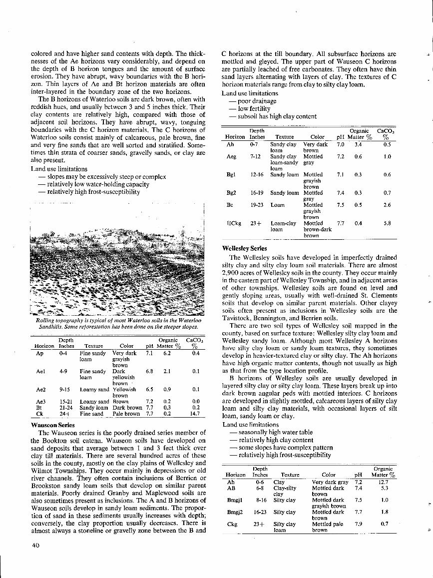
colored and have higher sand contents with depth . The thick-nesses of the Ae horizons vary considerably, and depend onthe depth of B horizon tongues and the amount of surfaceerosion . They have abrupt, wavy boundaries with the B hori-zon . Thin layers of Ae and Bt horizon materials are ofteninter-layered in the boundary zone of the two horizons .
The B horizons of Waterloo soils are dark brown, often withreddish hues, and usually between 3 and 5 inches thick . Theirclay contents are relatively high, compared with those ofadjacent soil horizons . They have abrupt, wavy, tonguingboundaries with the C horizon materials . The C horizons ofWaterloo soils consist mainly of calcareous, pale brown, fineand very fine sands that are well sorted and stratified . Some-times thin strata of coarser sands, gravelly sands, or clay arealso present .Land use limitations- slopes may be excessively steep or complex- relatively low water-holding capacity- relatively high frost-susceptibility
Rolling topography is typical of most Waterloo soils in the WaterlooSandhills. Some reforestation has been done on the steeper slopes.
Wauseon SeriesThe Wauseon series is the poorly drained series member of
the Bookton soil catena . Wauseon soils have developed onsand deposits that average between 1 and 3 feet thick overclay till materials . There are several hundred acres of thesesoils in the county, mostly on the clay plains of Wellesley andWilmot Townships . They occur mainly in depressions or oldriver channels . They often contain inclusions of Berrien orBrookston sandy loam soils that develop on similar parentmaterials . Poorly drained Granby and Maplewood soils arealso sometimes present as inclusions . The A and B horizons ofWauseon soils develop in sandy loam sediments . The propor-tion of sand in these sediments usually increases with depth ;conversely, the clay proportion usually decreases . There isalmost always a stoneline or gravelly zone between the B and
40
C horizons at the till boundary . All subsurface horizons aremottled and gleyed . The upper part of Wauseon C horizonsare partially leached of free carbonates . They often have thinsand layers alternating with layers of clay . The textures of Chorizon materials range from clay to silty clay loam.Land use limitations- poor drainage- low fertility- subsoil has high clay content
Wellesley SeriesThe Wellesley soils have developed in imperfectly drained
silty clay and silty clay loam soil materials . There are almost2,900 acres of Wellesley soils in the county . They occur mainlyin the eastern part of Wellesley Township, and in adjacent areasof other townships . Wellesley soils are found on level andgently sloping areas, usually with well-drained St. Clementssoils that develop on similar parent materials . Other clayeysoils often present as inclusions in Wellesley soils are theTavistock, Bennington, and Berrien soils .There are two soil types of Wellesley soil mapped in the
county, based on surface texture : Wellesley silty clay loam andWellesley sandy loam . Although most Wellesley A horizonshave silty clay loam or sandy loam textures, they sometimesdevelop in heavier-textured clay or silty clay . The Ah horizonshave high organic matter contents, though not usually as highas that from the type location profile .B horizons of Wellesley soils are usually developed in
layered silty clay or silty clay loam . These layers break up intodark brown angular peds with mottled interiors . C horizonsare developed in slightly mottled, calcareous layers of silty clayloam and silty clay materials, with occasional layers of siltloam, sandy loam or clay .Land use limitations- seasonally high water table- relatively high clay content- some slopes have complex pattern- relatively high frost-susceptibility
HorizonDepthInches Texture Color
OrganicpH Matter %
CaC03%
Ah 0-7 Sandy clay Very dark 7.0 3.4 0.5loam brown
Aeg 7-12 Sandy clay Mottled 7.2 0.6 1.0loam-sandy grayloam
Bg1 12-16 Sandy loam Mottled 7.1 0.3 0.6grayishbrown
Bg2 16-19 Sandy loam Mottled 7.4 0.3 0.7gray
Bc 19-23 Loam Mottled 7.5 0.5 2.6grayishbrown
IICkg 23+ Loam-clay Mottled 7.7 0.4 5.8loam brown-dark
brown
HorizonDepthInches Texture Color
OrganicpH Matter oJo
CaCO3oho
Ap 0-4 Fine sandy Very dark 7.1 6.2 0.4loam grayish
brownAel 4-9 Fine sandy Dark 6.8 2.1 0.1
loam yellowishbrown
Aeg 9-15 Loamy sand Yellowish 6.5 0.9 0.1brown
Ae3 15-21 Loamy sand Brown 7.2 0.2 0.0Bt 21-24 Sandy loam Dark brown 7.7 0.3 0.2Ck 24+ Fine sand Pale brown 7.7 0.2 14.7
HorizonDepthInches Texture Color pH
OrganicMatter oJo
Ah 0-6 Clay Very dark gray 7.2 12 .7AB 6-8 Clay-silty Mottled dark 7.4 5.3
clay brownBmgjl 8-16 Silty clay Mottled dark 7.5 1.0
grayish brownBmgj2 16-23 Silty clay Mottled dark 7.7 1.8
brownCkg 23+ Silty clay Mottled pale 7.9 0.7
loam brown
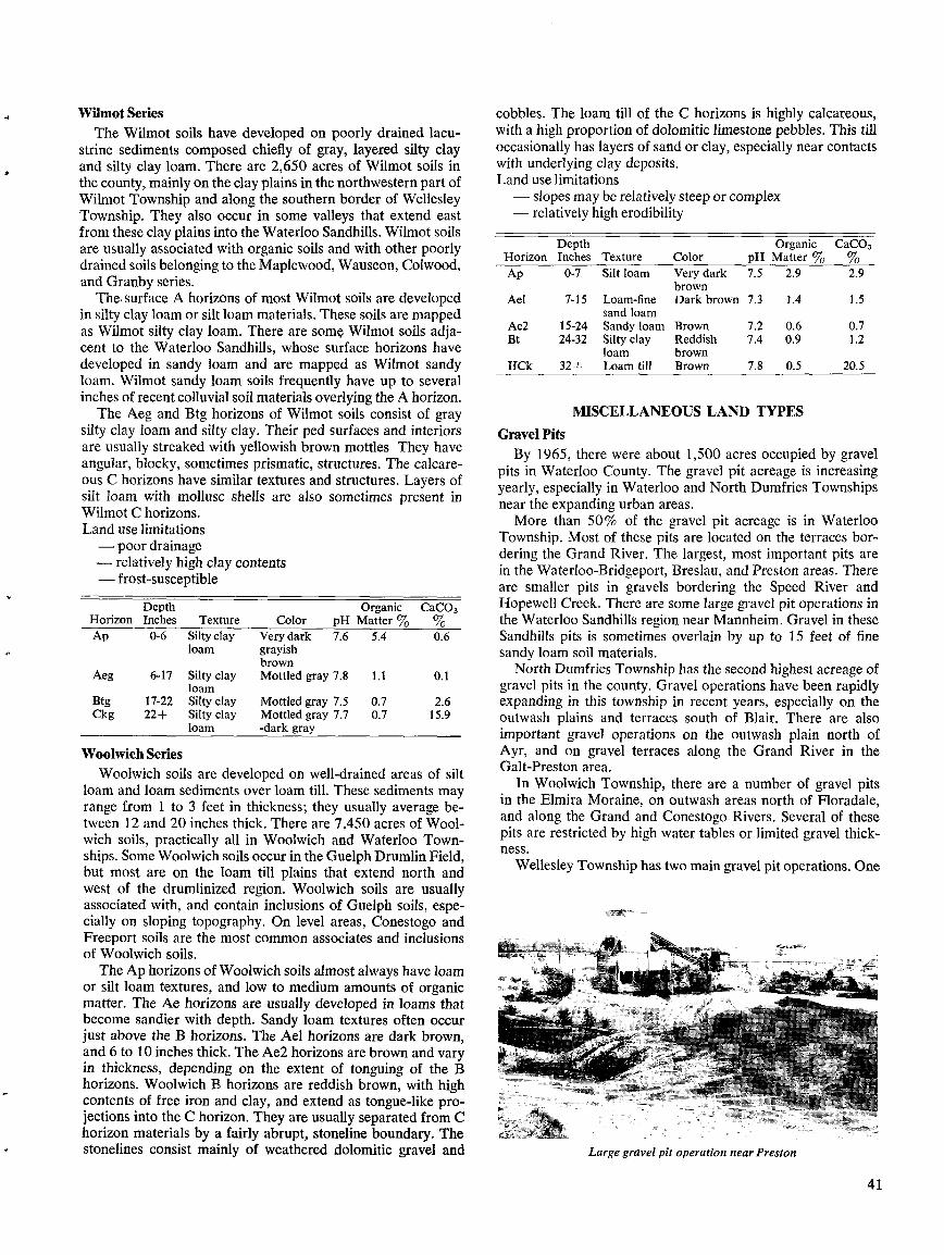
Wilmot SeriesThe Wilmot soils have developed on poorly drained lacu-
strine sediments composed chiefly of gray, layered silty clayand silty clay loam. There are 2,650 acres of Wilmot soils inthe county, mainly on the clay plains in the northwestern part ofWilmot Township and along the southern border of WellesleyTownship . They also occur in some valleys that extend eastfrom these clay plains into the Waterloo Sandhills . Wilmot soilsare usually associated with organic soils and with other poorlydrained soils belonging to the Maplewood, Wauseon, Colwood,and Granby series .
The, surface A horizons of most Wilmot soils are developedin silty clay loam or silt loam materials . These soils are mappedas Wilmot silty clay loam. There are some, Wilmot soils adja-cent to the Waterloo Sandhills, whose surface horizons havedeveloped in sandy loam and are mapped as Wilmot sandyloam . Wilmot sandy loam soils frequently have up to severalinches of recent colluvial soil materials overlying the A horizon .
The Aeg and Btg horizons of Wilmot soils consist of graysilty clay loam and silty clay. Their ped surfaces and interiorsare usually streaked with yellowish brown mottles They haveangular, blocky, sometimes prismatic, structures . The calcare-ous C horizons have similar textures and structures . Layers ofsilt loam with mollusc shells are also sometimes present inWilmot C horizons .Land use limitations- poor drainage- relatively high clay contents- frost-susceptible
Woolwich SeriesWoolwich soils are developed on well-drained areas of silt
loam and loam sediments over loam till . These sediments mayrange from 1 to 3 feet in thickness ; they usually average be-tween 12 and 20 inches thick . There are 7,450 acres of Wool-wich soils, practically all in Woolwich and Waterloo Town-ships . Some Woolwich soils occur in the Guelph Drumlin Field,but most are on the loam till plains that extend north andwest of the drumlinized region . Woolwich soils are usuallyassociated with, and contain inclusions of Guelph soils, espe-cially on sloping topography. On level areas, Conestogo andFreeport soils are the most common associates and inclusionsof Woolwich soils .
The Ap horizons of Woolwich soils almost always have loamor silt loam textures, and low to medium amounts of organicmatter . The Ae horizons are usually developed in loams thatbecome sandier with depth . Sandy loam textures often occurjust above the B horizons . The Ael horizons are dark brown,and 6 to 10 inches thick . The Ae2 horizons are brown and varyin thickness, depending on the extent of tonguing of the Bhorizons . Woolwich B horizons are reddish brown, with highcontents of free iron and clay, and extend as tongue-like pro-jections into the C horizon . They are usually separated from Chorizon materials by a fairly abrupt, stoneline boundary. Thestonelines consist mainly of weathered dolomitic gravel and
cobbles . The loam till of the C horizons is highly calcareous,with a high proportion of dolomitic limestone pebbles . This tilloccasionally has layers of sand or clay, especially near contactswith underlying clay deposits .Land use limitations- slopes may be relatively steep or complex- relatively high erodibility
MISCELLANEOUS LAND TYPESGravel PitsBy 1965, there were about 1,500 acres occupied by gravel
pits in Waterloo County. The gravel pit acreage is increasingyearly, especially in Waterloo and North Dumfries Townshipsnear the expanding urban areas .More than 50% of the gravel pit acreage is in Waterloo
Township . Most of these pits are located on the terraces bor-dering the Grand River . The largest, most important pits arein the Waterloo-Bridgeport, Breslau, and Preston areas . Thereare smaller pits in gravels bordering the Speed River andHopewell Creek . There are some large gravel pit operations inthe Waterloo Sandhills region near Mannheim . Gravel in theseSandhills pits is sometimes overlain by up to 15 feet of finesandy loam soil materials .
North Dumfries Township has the second highest acreage ofgravel pits in the county . Gravel operations have been rapidlyexpanding in this township in recent years, especially on theoutwash plains and terraces south of Blair . There are alsoimportant gravel operations on the outwash plain north ofAyr, and on gravel terraces along the Grand River in theGalt-Preston area .
In Woolwich Township, there are a number of gravel pitsin the Elmira Moraine, on outwash areas north of Floradale,and along the Grand and Conestogo Rivers . Several of thesepits are restricted by high water tables or limited gravel thick-ness .
Wellesley Township has two main gravel pit operations . One
Large gravel pit operation near Preston
41
HorizonDepthInches Texture Color pH
OrganicMatter %
CaC03°Jo
Ap 0-7 Silt loam Very dark 7.5 2.9 2.9brown
Ael 7-15 Loam-fine Dark brown 7.3 1 .4 1 .5sand loam
Ae2 15-24 Sandy loam Brown 7.2 0.6 0.7Bt 24-32 Silty clay Reddish 7.4 0.9 1 .2
loam brownIICk 32+ Loam till Brown 7.8 0.5 20 .5
HorizonDepthInches Texture Color pH
OrganicMatter °Jo
CaC03
Ap 0-6 Siltyclay Very dark 7.6 5.4 0.6loam grayish
brownAeg 6-17 Silty clay Mottled gray 7.8 1.1 0.1
loamBtg 17-22 Silty clay Mottled gray 7.5 0.7 2.6Ckg 22+ Silty clay Mottled gray 7.7 0.7 15 .9
loam -dark gray
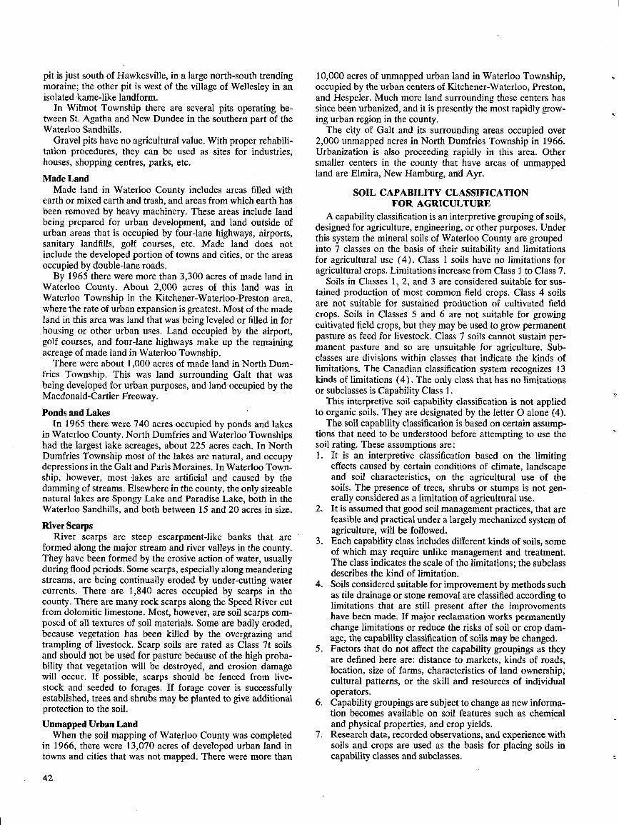
pit is just south of Hawkesville, in a large north-south trendingmoraine ; the other pit is west of the village of Wellesley in anisolated kame-like landform .
In Wilmot Township there are several pits operating be-tween St . Agatha and New Dundee in the southern part of theWaterloo Sandhills .
Gravel pits have no agricultural value . With proper rehabili-tation procedures, they can be used as sites for industries,houses, shopping centres, parks, etc.
Made LandMade land in Waterloo County includes areas filled with
earth or mixed earth and trash, and areas from which earth hasbeen removed by heavy machinery . These areas include landbeing prepared for urban development, and land outside ofurban areas that is occupied by four-lane highways, airports,sanitary landfills, golf courses, etc . Made land does notinclude the developed portion of towns and cities, or the areasoccupied by double-lane roads .By 1965 there were more than 3,300 acres of made land in
Waterloo County. About 2,000 acres of this land was inWaterloo Township in the Kitchener-Waterloo-Preston area,where the rate of urban expansion is greatest . Most of the madeland in this area was land that was being leveled or filled in forhousing or other urban uses. Land occupied by the airport,golf courses, and four-lane highways make up the remainingacreage of made land in Waterloo Township .There were about 1,000 acres of made land in North Dum-
fries Township . This was land surrounding Galt that wasbeing developed for urban purposes, and land occupied by theMacdonald-Cartier Freeway.
Ponds and LakesIn 1965 there were 740 acres occupied by ponds and lakes
in Waterloo County . North Dumfries and Waterloo Townshipshad the largest lake acreages, about 225 acres each. In NorthDumfries Township most of the lakes are natural, and occupydepressions in the Galt and Paris Moraines . In Waterloo Town-ship, however, most lakes are artificial and caused by thedamming of streams . Elsewhere in the county, the only sizeablenatural lakes are Spongy Lake and Paradise Lake, both in theWaterloo Sandhills, and both between 15 and 20 acres in size .
River ScarpsRiver scarps are steep escarpment-like banks that are
formed along the major stream and river valleys in the county.They have been formed by the erosive action of water, usuallyduring flood periods . Some scarps, especially along meanderingstreams, are being continually eroded by under-cutting watercurrents . There are 1,840 acres occupied by scarps in thecounty . There are many rock scarps along the Speed River cutfrom dolomitic limestone. Most, however, are soil scarps com-posed of all textures of soil materials . Some are badly eroded,because vegetation has been killed by the overgrazing andtrampling of livestock. Scarp soils are rated as Class 7t soilsand should not be used for pasture because of the high proba-bility that vegetation will be destroyed, and erosion damagewill occur . If possible, scarps should be fenced from live-stock and seeded to forages. If forage cover is successfullyestablished, trees and shrubs may be planted to give additionalprotection to the soil.Unmapped Urban LandWhen the soil mapping of Waterloo County was completed
in 1966, there were 13,070 acres of developed urban land intowns and cities that was not mapped. There were more than
42
10,000 acres of unmapped urban land in Waterloo Township,occupied by the urban centers of Kitchener-Waterloo, Preston,and Hespeler . Much more land surrounding these centers hassince been urbanized, and it is presently the most rapidly grow-ing urban region in the county .The city of Galt and its surrounding areas occupied over
2,000 unmapped acres in North Dumfries Township in 1966 .Urbanization is also proceeding rapidly in this area . Othersmaller centers in the county that have areas of unmappedland are Elmira, New Hamburg, and Ayr .
SOIL CAPABILITY CLASSIFICATIONFOR AGRICULTURE
A capability classification is an interpretive grouping of soils,designed for agriculture, engineering, or other purposes . Underthis system the mineral soils of Waterloo County are groupedinto 7 classes on the basis of their suitability and limitationsfor agricultural use (4) . Class 1 soils have no limitations foragricultural crops . Limitations increase from Class 1 to Class 7 .
Soils in Classes 1, 2, and 3 are considered suitable for sus-tained production of most common field crops . Class 4 soilsare not suitable for sustained production of cultivated fieldcrops . Soils in Classes 5 and 6 are not suitable for growingcultivated field crops, but they may be used to grow permanentpasture as feed for livestock . Class 7 soils cannot sustain per-manent pasture and so are unsuitable for agriculture . Sub-classes are divisions within classes that indicate the kinds oflimitations . The Canadian classification system recognizes 13kinds of limitations (4) . The only class that has no limitationsor subclasses is Capability Class 1 .
This interpretive soil capability classification is not appliedto organic soils . They are designated by the letter O alone (4) .The soil capability classification is based on certain assump-
tions that need to be understood before attempting to use thesoil rating . These assumptions are :1 . It is an interpretive classification based on the limiting
effects caused by certain conditions of climate, landscapeand soil characteristics, on the agricultural use of thesoils. The presence of trees, shrubs or stumps is not gen-erally considered as a limitation of agricultural use .
2 .
It is assumed that good soil management practices, that arefeasible and practical under a largely mechanized system ofagriculture, will be followed .
3 .
Each capability class includes different kinds of soils, someof which may require unlike management and treatment.The class indicates the scale of the limitations ; the subclassdescribes the kind of limitation .
4 .
Soils considered suitable for improvement by methods suchas tile drainage or stone removal are classified according tolimitations that are still present after the improvementshave been made. If major reclamation works permanentlychange limitations or reduce the risks of soil or crop dam-age, the capability classification of soils may be changed .
5 .
Factors that do not affect the capability groupings as theyare defined here are : distance to markets, kinds of roads,location, size of farms, characteristics of land ownership ;cultural patterns, or the skill and resources of individualoperators .
6 .
Capability groupings are subject to change as new informa-tion becomes available on soil features such as chemicaland physical properties, and crop yields .
7 . Research data, recorded observations, and experience withsoils and crops are used as the basis for placing soils incapability classes and subclasses .
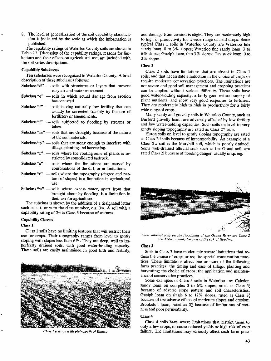
S.
The level of generalization of the soil capability classifica-tion is indicated by the scale at which the information ispublished .
The capability ratings of Waterloo County soils are shown inTable 11 . Discussion of the capability ratings, reasons for lim-itations and their effects on agricultural use, are included withthe soil series descriptions .
Capability SubclassesTen subclasses were recognized in Waterloo County . A brief
description of these subclasses follows :Subclass "d" - soils with structures or layers that prevent
easy air and water movement .Subclass "e" - soils in which actual damage from erosion
has occurred .Subclass "f" - soils having naturally low fertility that can
usually be corrected feasibly by the use offertilizers or amendments.
Subclass "i" - soils subjected to flooding by streams orlakes .
Subclass "m"- soils that are droughty because of the natureof the soil materials .
Subclass "p" - soils that are stony enough to interfere withtillage, planting and harvesting.
Subclass `°r" - soils where the rooting zone of plants is re-stricted by consolidated bedrock.
Subclass "s" - soils where the limitations are caused bycombinations of the d, f, or m limitations .
Subclass "t" - soils where the topography (degree and pat-tern of slopes) is a limitation in agriculturaluse.
Subclass "w" - soils where excess water, apart from thatbrought about by flooding, is a limitation intheir use for agriculture .
The subclass is shown by the addition of a designated lettersuch as s, t, or w to the class number, e.g. 3w. A soil with acapability rating of 3w is Class 3 because of wetness .
Capability ClassesClass 1
Class 1 soils have no limiting features that will restrict theiruse for crops . Their topography ranges from level to gentlysloping with slopes less than 6% . They are deep, well to im-perfectly drained soils, with good water-holding capacity .These soils are easily maintained in good tilth and fertility,
Class 1 soils on a till plain south of Elmira
and damage from erosion is slight. They are moderately highto high in productivity for a wide range of field crops . Sometypical Class 1 soils in Waterloo County are Waterloo finesandy loam, 0 to 3 % slopes ; Waterloo fine sandy loam, 3 to6 % slopes ; Guelph loam, 0 to 3 % slopes ; Tavistock loam, 0 to3 % slopes .
Class 2Class 2 soils have limitations that are absent in Class 1
soils, and that necessitate a reduction in the choice of crops orrequire moderate conservation practices . The limitations arenot severe and good soil management and cropping practicescan be applied without serious difficulty . These soils havegood water-holding capacity, a fairly good natural supply ofplant nutrients, and show very good responses to fertilizer.They are moderately high to high in productivity for a fairlywide range of crops .Many sandy and gravelly soils in Waterloo County, such as
Burford gravelly loam, are adversely affected by low fertilityand low water-holding capacities . Such soils on level to verygently sloping topography are rated as Class 2i soils .
Huron soils on level to gently sloping topography are ratedas Class 2d soils because of impermeability . An example of aClass 2w soil is the Maryhill soil, which is poorly drained.Some well-drained alluvial soils such as the Grand soil, arerated Class 2i because of flooding danger, usually in spring .
These alluvial soils on the floodplain of the Grand River are Class 2and 3 soils, mainly because of the risk of flooding .
Class 3Soils in Class 3 have moderately severe limitations that re-
duce the choice of crops or require special conservation prac-tices . These limitations affect one or more of the followingfarm practices : the timing and ease of tillage, planting andharvesting ; the choice of crops ; the application and mainten-ance of conservation practices .Some examples of Class 3 soils in Waterloo are: Caledon
sandy loam on complex 3 to 6% slopes, rated as Class 3'because of adverse slope pattern and soil characteristics ;Guelph loam on single 6 to 12% slopes, rated as Class 3'because of the adverse effects of moderate slopes and erosion;Brookston loam, rated as 3W because of limitations of wet-ness and poorpermeability .
Class 4Class 4 soils have severe limitations that restrict them to
only a few crops, or cause reduced yields or high risk of cropfailure . The limitations may seriously affect such farm prac-
43
tices as the timing and ease of tillage, planting and harvesting,and the application and maintenance of conservation prac-tices . These soils are low to medium in productivity for a nar-row range of crops but may have high productivity for speciallyadapted crops .Many Class 4 soils in Waterloo County have topography
limitations, usually combined with limitations such as sus-ceptibility to erosion or to droughtiness . For example, the St .Clements soils on complex 6 to 12% slopes, are rated asClass 4
e
soils because of the moderately steep, complex slopesand erosion danger . Some soils in the county are Class 4 be-cause of wetness or flooding limitations combined with otherundesirable characteristics . The poorly drained, alluvialElmira, Hespeler, and Hawkesville soils are rated as Class 4wsoils because of both wetness and flooding limitations .
Class 5Class 5 soils have such soil or landscape limitations that they
cannot be used for growing annual field crops and are capableonly of producing perennial forage crops . They may be feas-ibly improved for native or tame species of perennial forageplants, by practices such as the clearing of bush, cultivation,seeding, fertilizing, and water control .
All soils that are rated Class 5 in Waterloo County havetopography limitations related to steep or complex slopes,combined with other limiting soil factors . Two examples ofClass 5 soils are Fox sandy loam on complex slopes greaterthan 12%, rated as Class 5t, and Dumfries loam on singleslopes greater than 12%, rated as Class 5t soils .
Class 6Soils in Class 6 have such serious soil or . landscape limita-
tions that it is impractical to employ improvement practicesas with Class 5 soils . They are capable only of producing per-manent pasture, and have some natural sustained grazingcapacity for farm animals . This is because the physical natureof these soils prevents the use of farm machinery to improvethem, or because the soils are not responsive to improvementpractices, or because they provide only a short grazing season .Such improvement practices as seeding and fertilizing by handor by aerial methods will not change the classification of thesesoils .
In Waterloo County, Class 6 soils are restricted mainly tosoils with topographic limitations, e.g. Dumfries loam on com-plex slopes 12% and greater, that has the additional limita-tion of excessive stoniness . Shallow soils over bedrock, suchas the Farmington and Brooke series, are rated as Class 6because of the shallow, restricted rooting zone .
Class 7Soils and lands in this class have limitations so severe that
they are not capable of use for arable agriculture or permanentpasture . They may or may not have a high capability fortrees, native fruits, wildlife and recreation . The only land inthis class in Waterloo County is that occupied by river scarpsand other very steep slopes .
Capabilities and Present Agricultural Usesof Waterloo County Soils
Ayr SeriesAt the present, most of the soils of the Ayr series support
bush, scrub or permanent pasture . They are rated as Class 4,soils because of wetness and low inherent fertility . Tile drain-age of Ayr soils would probably not be economical, but open
44
ditch drainage should lower the water table enough to allowsome cropping practices .Bennington Series
The Bennington soils on 0 to 6% slopes are rated as Class1 soils, and are well suited for most crops . Spring grains, winterwheat, and forage crops are being successfully grown on thesesoils . In the south part of Wilmot Township, there have beensubstantial increases in the acreages of grain corn grown onBennington soils in recent years .
Bennington soils on complex 0 to 6% slopes, and on single6 to 12% slopes are rated as Class 2t soils for agriculture be-cause of topography limitations caused by complex and steepslopes.
There are about 50 acres of Bennington soils on complex6 to 12% slopes in Wellesley Township that are rated asClass 4t soils . Hay and pasture crops are most suitable forthese soils because of the topography limitations .Berrien Series
The Berrien soils on single 0 to 3% slopes are capable ofproducing good yields of forage or grain crops if they aresupplied with sufficient organic matter and fertilizer . Theyhave low natural fertility because of the coarse texture of thesurface sands, and for this reason are rated as Class 2f soils .
Most of the Berrien soils on complex 3 to 6% slopes are inWellesley Township, and rated as Class 3t soils because of lowfertility and additional management problems presented bycomplex slope patterns .Bookton Series
Bookton soils having 0 to 6% single slopes are used forgrowing small grains, corn, and forage crops . They are ratedas Class 2T soils because of moisture and fertility limitations,but with good management and sufficient moisture, can pro-duce excellent crop yields .Bookton soils with complex 3 to 6 % slopes have the same
limitation as the Class 2 soils, plus additional limitations im-posed by the complex topography . These are rated as Class 3tsoils .There are about 600 acres of Bookton soils with 6 to 12%
slopes in the county, mainly in Wellesley Township . Those onsingle slopes are rated as Class 4t soils, because of slope andsoil limitations . Hay and pasture are the most suitable cropsfor these soils . Those on complex 6 to 12% slopes are ratedas Class 5, soils . Their agricultural use should be restrictedmainly to pasture .Boomer Series
Although Boomer soils occupy level areas of flood plains,river dissection has created some 3 to 6% slopes . Boomersoils are rated as Class 3m soils due to risk of flooding and soilmoisture limitations. They are naturally fertile and well sup-plied with organic matter, and can produce good yields ofgrains or forage crops if flood or drought damage are avoided .If flooding occurs regularly, continuous forage cover willreduce soil losses .Brady Series
Brady soils in Waterloo County have been given a cap-ability rating of Class 2f as a consequence of their low naturalfertility. This limitation can be easily overcome by properfertility management . Brady soils are capable of good yields ofspring grains, corn, forages and commercial vegetable crops .At present, they are being increasingly used for grain andsilage corn in the southern part of Waterloo County .
Brant SeriesThe Brant soils rank among the most productive agricul-
tural soils in Waterloo County . Their main limitations foragricultural use are topographic ones relating to steep or com-plex slopes or erodibility . Brant soils with 0 to 6% singleslopes have no significant limitation for use in agriculture,and are rated as Class 1 soils . Corn, winter wheat, springgrains, and forage crops are all grown successfully on theseClass 1 Brant soils .
Brant soils on complex 3 to 6% slopes require more care-ful management than the Class 1 soils because of the slopecomplexity, and are rated as Class 2t soils . With increasingsteepness and complexity of slope, management and erosionproblems also increase . Hence Brant soils with single 6 to 12%slopes are rated as Class 3e soils, while those with complex 6to 12% slopes and single 12 to 20% slopes are Class 4 esoils . Hay and pasture crops should make up most of the croprotation on these Class 3 and 4 soils . Brant soils with singleslopes exceeding 25%, or complex slopes greater than 12%are rated as Class 5e soils . They are generally unsuitable foragricultural purposes, except possibly to provide some per-manent pasture .
Brisbane SeriesThe main limitation of the Brisbane soils is low fertility,
related to the coarse textures, and relatively low organicmatter contents . For this reason they are rated as Class 2fsoils, and require additions of fertilizer and maintenance oforganic matter to produce good crop yields . Because theyoften occur as long, narrow soil bodies within drier, highersoil areas, the Brisbane soils can present management prob-lems with respect to uniformity of crop growth and maturity.There is increasing use of these soils for growing corn . Theyare mainly used for spring grains and pasture crops at thepresent time .
Brooke SeriesThe Brooke soils are virtually useless for agricultural pur-
poses because of their shallowness and wetness, and are thusrated as Class 6W soils . Some pasture may be obtained fromthe limited amounts of natural vegetation they support, butthey are probably more suitable for forestry or wildlife pur-poses .
Brookston SeriesThe high clay content of the Brookston soils is the main
cause of the slow drainage and difficult tillage problems asso-ciated with these soils . Without artificial drainage, their use ismainly restricted to grassy forage crops . When they aredrained, higher forage yields are obtainable, and spring grainsmay become part of the crop rotation . The Brookston soils arerated as Class 3â soils for agricultural production .Burford Series
The main limitations to crop growth of the Burford soilsare their low moisture-holding capacities and naturally lownutrient levels . The effects of these limitations are more severewith increasing slope steepness or gravel content . Plant nutri-ents must be supplied to these soils by fertilizers or manures .Organic matter levels must be maintained to hold the plantnutrients in available forms.
Burford soils with single slopes up to 6% are rated asClass 2, soils . They are used for growing forage crops, springgrains, winter wheat, and corn . Cobbly Burford soils on singleslopes up to 6% are rated as Class 3P soils because of their
lower moisture-holding capacity and the presence of cobblesin the surface horizons .
Burford soils with complex 3 to 6% slopes or single 6 to12% slopes are rated as Class 3t soils . They are widely usedfor growing grain crops, especially corn and winter wheat, butare affected more severely by low moisture and fertility condi-tions than Burford soils on gentler slopes . Cobbly Burfordsoils with 3 to 6% complex slopes or 6 to 12% single slopesare rated as Class 4r soils .
Burford soils with complex 6 to 12% slopes or singleslopes between 12 and 20% are rated as Class 4, soils . Theyare used for forage and grain crops but low moisture and fer-tility can severely affect uniform growth . Cobbly Burford soilswith similar slopes are rated as Class 5t soils .
Burford soils with complex slopes greater than 12% are,at best, Class 5t soils . Cobbly Burford soils with similar slopeshave a rating of Class 6t . These soils are of little agriculturalvalue, but may be useful for forestry or wildlife purposes .
Over 1,500 acres of gravel pits have been opened in Water-loo County, mainly from areas occupied by Burford soils .These soils are increasingly in demand by the construction andbuilding industries as sources of gravel and sand .Caledon Series
Grain corn is becoming a popular crop on Caledon soils inthe County. At present, grains and forage crops are the maincrops grown on these soils . Although they are naturally low infertility and moisture-holding capacity, they will usually re-spond well to additions of fertilizer and manures, under normalsoil moisture conditions . Caledon soils on level areas andwith gentle single slopes up to 6% have a capability rating of2T for agriculture. Caledon soils with complex 3 to 60/0slopes have additional topography limitations of complexslopes and are rated as Class 38 soils . Caledon soils withcomplex 6 to 12% slopes are Class 4g soils, and more suitablefor forages than for grain crops .Camilla Series
Camilla soils are rated as Class 2f soils for agriculture .They have low natural fertility, because of their coarse tex-tures, but are highly responsive to fertilizer and other soilamendments . Corn, oats, barley and most forages, exceptalfalfa, grow well on Camilla soils if fertility is maintained.Colwood SeriesMany large tracts of Colwood soils are still covered by bush
or swamp. Where these soils have been cleared but not other-wise improved, they are used mainly for pasture . If improve-ment practices, such as artificial drainage and addition of fer-tilizers, are carried out, Colwood soils are capable of support-ing spring grain, corn, and hay crops . Colwood soils are ratedas Class 3, soils for use in agriculture.Conestogo Series
The Conestogo soils are excellent agricultural soils . Theyrequire some tile drainage to attain their maximum potential .They are presently being used mainly for forage crops, springgrains, and corn . Almost all Conestogo soils have an agricul-tural capability rating of Class 1 . There is a very small acreageof Conestogo soils mapped with complex 3 to 6% slopes, andthese are rated as Class 2t soils .Donald SeriesThe main limitation of the Donald soils is the risk of flood-
ing . For this reason they are given a Class 3i rating for agri-cultural crops . Their most common use is for pasture, with
45
spring grains being used as a nurse crop when the pasture isplowed down and reseeded . Some areas of Donald soils arebeing used for continuous spring grain or corn crops . Thisinvolves greater risks of soil or crop damage than growingmainly forage crops .Dorking Series
Because of their impermeable nature and wetness, the Dork-ing soils have only limited agricultural value, and are rated asClass 4' soils . Without artificial drainage, they can supportonly natural grasses or cultivated grasses, like reed canarygrass, that are adapted for wet soils . When they are artificiallydrained, they can support more forage species and producegreater hay and pasture yields . Spring grains may serve asnurse crops for new forage seedings on drained Dorking soils .Dumfries Series
Most Dumfries soils, because of their rugged topography,are used mainly as a source of pasture or hay for livestock .The best Dumfries soils for grain or hay crops are those with0 to 3 and 3 to 6% single slopes, rated as Class 2i and 3,soils respectively . These soils will respond well to additions ofplant nutrients, if adequate moisture is available during thegrowing season . Dumfries soils with complex 3 to 6 or single6 to 12% slopes have only marginal value for grain crops, andare rated as Class 4L soils for agriculture . There are somestony Dumfries soils with similar slopes, but the additionallimitation of excess surface stones necessitate rating them asClass 5° soils . Dumfries soils with complex 6 to 12% slopes .or single slopes of 12 to 20% are also Class 5 soils for agricul-ture . These Class 5 soils have some limited agricultural valueas pasture, if pasture renovation procedures are carried outwhen possible . Otherwise, these soils, and all Dumfries soilswith steeper slopes, are best suited for nonagricultural pur-poses like wildlife, recreation or forestry .Elmira Series
Elmira soils have limited agricultural value, mainly be-cause of their poor drainage and the flooding hazard . They areused chiefly for livestock pasture . It is generally not practicalto drain these soils . If they can be drained, or during dryperiods, it may be possible to renovate or reseed old pastures .The agricultural capability of Elmira soils is rated as Class4w .Farmington Series
The Farmington soils have practically no agricultural valueand are rated as Class 6r soils . They will support some nativevegetation that may be used for pasture . However, the pres-ence of bedrock near the surface hinders root growth andmoisture-holding capacity enough to drastically reduce plantgrowth . The Farmington soils are of some value for non-agricultural purposes such as wildlife or recreation .Floradale Series
Floradale soils are considered to be Class 1 soils for agricul-ture . At the present time they are chiefly used for growingcorn, spring grains, and forage crops . Tile drainage may benecessary, especially if clay strata occur within a few feet ofthe surface of these soils .Fox SeriesThe Fox soils are among the most important soils for agri-
culture in Waterloo County . Acreages of grain corn and silagecorn have increased remarkably on these soils in recent years .Their main limitations of low fertility and moisture-holdingcapacity mainly derive from their coarse textures .Fox soils with single slopes less than 6% are rated as Class
46
21 soils . Although corn is the most important crop grown onthese soils, spring grains, winter wheat, and forage crops arealso extensively grown . Relatively small acreages of Class 2Fox soils are used for special crops like tobacco, potatoes,and green beans, with sprinkler irrigation often providingsupplemental moisture .
The agricultural capability rating of Fox soils with complex3 to 6% or single 6 to 12% slopes is Class 3i . Soils with com-plex 6 to 12% slopes or single 12 to 20% slopes'are rated as_Class 4r soils . Intensive crop production on these soils is moredifficult than on the more level Fox soils, because of steeperand more complex slopes . The growing of corn and othergrain crops on these Class 3 and 4 Fox soils requires carefulmanagement to obtain uniform growth and good yields . Theproportion of forage crops grown in the rotation should beincreased as slopes become steeper. Fox soil areas with com-plex slopes greater than 12%, or single slopes more than20%, are not suitable for agricultural crops, except possiblyfor well-managed pasture .Freeport Series
Freeport soils with level areas, and areas with single slopesup to 6%, are rated as Class 2m soils for agriculture . Theirnutrient and moisture-holding capacities can be limiting fac-tors to plant growth . However, with adequate fertilizationand precipitation, they are quite productive, and suitable forcorn, winter wheat, spring grains, and forage crops . Freeportsoils with complex 3 to 6% slopes are Class 3t soils, andmore difficult to manage than those on gentler or less complexslopes .
Granby SeriesGranby soils are rated as Class 4, soils for agriculture
because of their wetness and low natural fertility. A large pro-portion of them still occur in undrained forested swamps inWaterloo County . On cleared areas, undrained Grianby soilsmay provide some livestock pasture . If their drainage is im-proved by open ditches, they may support spring grain or haycrops . Corn and specialized vegetable 'crops are also beinggrown on some drained Granby soils .Grand Series
The main limitation of the Grand soils is their risk of beingflooded, and for this reason they are designated as Class 2isoils . They are most commonly used for pasture or hay cropsbecause of this limitation . However, they are fertile, pro-ductive soils, and are producing good yields of spring grainand corn . If grain crops are planned for these soils, tillage andplanting should be left at late as possible in the spring to mini-mize the risk of flood damage .Guelph Series
Guelph soils are important agricultural soils in the county .Those with slopes of less than 3 % are rated as Class 1 soils .They are capable of producing high yields of corn, winterwheat, spring grains, and forages . Some surface erosion occursfrom Guelph soils with single 3 to 6% slopes, so they are ratedas Class 2t soils . Practices such as strip cropping, plowingacross the slopes, etc, should be carried out to minimize ero-sion on these slopes .
Guelph soils with complex 3 to 6% slopes, or single 6 to12% slopes, are Class 3 e soils because of greater slope anderosion problems . Forage crops should make up over half thecrop rotation on such slopes . Guelph soils with complex 6 to12% slopes or single 12 to 20% slopes have increasing ero-sion and topography limitations and are rated as Class 4e soils
for agriculture . Forage crops are most suitable for these Class4 soils . When reseeding is necessary, spring grain or winterwheat can be grown as nurse crops for the seeding . Guelphsoils with complex slopes greater than 12% or single slopesgreater than 20% are, at best, Class 5. soils for agriculture .They are capable of providing some pasture, but are generallyof limited agricultural value .Hawkesville SeriesHawkesville soils are rated as Class 4W soils for agricul-
ture . The limitations to crop growth imposed by their poordrainage and risk of being flooded restrict their agriculturaluse mainly to grass pasture . It may be possible during dryspring seasons to break up and reseed Hawkesville soils toforage crops, using spring grain as a nurse crgp .Haysville Series
The main limitation of the Haysville soils for agriculturalcrops is the risk of flooding, causing them to be rated as Class3i soils . At present, they are mainly used for pasture and haycrops . Spring grain or corn may be planted on these soils inlate spring when the risk of flooding is less .Heidelberg Series
Heidelberg soils are Class 1 agricultural soils . They arefertile and easily tilled, and possess good moisture reserves .Artificial drainage is rarely necessary, unless they occur assmall areas within larger well-drained soil areas on whichmoisture-sensitive crops such as alfalfa or winter wheat arebeing grown . Corn, spring grains, and most forages are pres-ently being grown on cultivated Heidelberg soils .Hespeler SeriesThe agricultural value of the Hespeler soils is limited by
their poor drainage and risk of being flooded, so they are ratedas Class 4W soils . Their main use, at the present time, is forpasture . Grain crops may be feasible, if it is possible to lowerthe water table by drainage methods.Huron SeriesThe compact, clayey subsoil of Huron soils causes problems
in tillage, aeration, and root growth . This is the main limitingfeature for crop growth on Huron soils with slopes up to 6%,and requires these soils to be rated as Class 2d soils for agricul-ture . They are capable, though, of producing good yields offorage crops, oats, barley, flax, and silage corn, if properlymanaged . Grain corn is being successfully grown on someHuron soils in the southern part of Wilmot Township . Aeratingthese soils by incorporating organic matter, growing deep-rooted legumes, etc, is recommended . The use of heavy ma-chinery should be avoided, if possible, on wet Huron soils .Huron soils with complex slopes of 3 to 6% or single slopes
of 6 to 12% have soil and topography limitations, and arerated as Class 3d soils for agriculture . With increasingly steepor complex slopes, erosion increases and organic matter de-creases as B horizon material becomes exposed at the surface.These Huron soils on steeper slopes are not as suitable forcorn as Class 2 Huron soils . They are quite suitable, though, forforage or spring grain crops .When Huron soils have complex 6 to 12% or single 12 to
20% slopes, they are Class 4d soils, and require more carefulmanagement than those with gentler slopes . Hay and pastureare preferred crops on these soils, to minimize erosion lossesand maintain organic matter levels . Huron soils with complexslopes greater than 12% or single slopes more than 20%, havea minimum Class 5â rating for agriculture. They have severetopography limitations, and their agricultural use should berestricted to perennial forage crops .
Kirkland SeriesKirkland soils are rated as Class 3m soils for agriculture,
because of their risk of being flooded and their low moisture-holding capacities . Their main agricultural use at the presenttime is for forage crops, although some corn and spring grainare also grown.Kossuth Series
Kossuth soils on level topography, and with single slopes upto 6%, are considered as Class 2f soils for agriculture . Theirinherent fertility limitation can be easily overcome by additionof fertilizers and manure, and the maintenance of high organicmatter levels . A very small acreage of Kossuth soils has com-plex 3 to 6% slopes . They are considered to be Class 31 soilsfor agriculture . Corn, oats, barley, and most forage species arepresently being grown on Kossuth soils in Waterloo County.Lisbon Series
About one-half the Lisbon soils are on level or gently slopingareas with single slopes up to 6%. These are rated as Class 2',soils, and are used intensively for agricultural production .These soils have the low inherent fertility and moisture-holdingcapacities present in coarse-textured sand and gravels . How-ever, with adequate fertilization and rainfall they are capableof producing good yields of corn, winter wheat, oats, barley,forages, and potatoes . Early potatoes are an important cropon these soils, north of Hespeler . Sprinkler irrigation iscommonly used to provide supplemental moisture for thesepotatoes .
The moisture and fertility limitations of Lisbon soils withcomplex 3 to 6% or single 6 to 12% slopes, are greater thanthose of Class 2 Lisbon soils, due to slope differences . Thusthey are considered as Class 3t soils for agriculture . The samecrops are suitable for these soils as for Class 2 Lisbon soils, butrequire more careful management to maintain organic andnutrient contents at adequate and uniform levels .
Lisbon soils with complex 6 to 12% or single 12 to 20°,Joslopes are Class 4t soils because of fairly severe moisture andfertility limitations . They require careful management, andare best suited to forage crops.
Lisbon soils with complex slopes greater than 12% or singleslopes greater than 20%, have a minimum soil capability ofClass 5i for agricultural crops . They are suited best to perma-nent forage crops, if used for agricultural purposes . The bestland use for these soils is probably for forestry, wildlife orrecreation purposes .London SeriesLondon soils on topography with 0 to 3 % slopes are Class 1
soils for use in agriculture . They may require some artificialdrainage for crops like alfalfa or winter wheat that are ad-versely affected by excess moisture conditions . They are fertileand productive soils, presently used mainly for corn, springgrain, and forage crops . London soils with single 3 to 6%slopes can suffer erosion losses, so they are rated as Class 2tsoils . They are used for the same field crops as Class 1 Londonsoils, but require some conservation practices to reduce soilerosion .Macton Series
The main limitation of Macton soils for agriculture is therisk of flooding, inherent in low-lying floodplain soils . For thisreason, they are rated as Class 3i soils for agriculture . They areusually fertile soils, with good moisture reserves, and capableof producing good yields of forage crops for pasture or hay . Ifsoil moisture conditions permit, spring grain or corn may beplanted on these soils in late spring .
47
Mannheim SeriesMore than 80% of Mannheim soils occur on level or gently
sloping areas with less than 6% slope . This is Class 1 landand includes some of the best corn land in the county . In addi-tion to corn, these fertile, productive soils are used for winterwheat, spring grains, and forage crops . There are several hun-dred acres of Mannheim soils with complex 3 to 6% slopes .These soils have topography limitations due to the complexslope patterns, and are rated as Class 2t soils . They are not assuitable for intensive corn growing as the Class 1 soils . Thereare a few acres of Mannheim soils with 6 to 12% slopes . Thosewith simple slopes are Class 3t soils and those with complexslopes are rated as Class 4t soils for agriculture .Maplewood SeriesMaplewood soils are Class 2w soils for agriculture . Artificial
drainage of these soils is recommended for best crop results .Undrained Maplewood soils are mainly used for grassy foragecrops, and sometimes spring grains . When artificially drained,they can support a wider range of forage species, as well asspring grains and silage corn .Martin SeriesThe Martin soils are rated as Class 6,' soils for agriculture
because of their flooding risk, coarse textures, irregular topog-raphy, and other limitations . They are of practically no valuefor agriculture except perhaps as a source of mediocre pastureunder certain favorable conditions .Maryhill Series
Marybill soils are rated as Class 2w soils for agriculture .Their main limitation is poor drainage, probably due mainlyto the presence of impermeable clay deposits underneath theloam till . Forage crops, excepting alfalfa, are the most suitablecrops for undrained Maryhill soils . If these soils are artificiallydrained they can produce better quality and yields of foragecrops, and can also support spring grains and silage corn .Organic Soils
Organic soils in Waterloo County are not classified accord-ing to their land-use capabilities . There is only a small acreageof these soils being presently used for agricultural purposes inthe county . Most of this is for pasture, often natural and un-improved . There are a few acres in Waterloo Township onwhich commercial vegetables are being grown . The vastmajority of organic soils in the county support natural vegeta-tion ranging from sedges to mixed hardwood-coniferous forest.Perth Series
The Perth soils are important for agriculture in the countyand used extensively for growing forage crops, oats, and barley .Some corn and flax are also grown on them . The main limita-tion of most Perth soils is the dense, impermeable nature of theB and C horizons that hinders root penetration, aeration, till-age, etc . Perth soils with slopes less than 6% are rated asClass 2d soils for agriculture . Perth soils almost always requiresome form of artificial drainage to remove excess moisture andprovide sufficient aeration for optimum plant growth . WhenPerth soils have complex 3 to 6 % slopes they are rated as Class3t soils because of the additional topographic limitations im-posed by the complex slope pattern . .Preston SeriesPrestop soils are rated as Class 4
'soils because the risk of
being flooded, and the presence of bedrock near the surface,are major limitations to crop growth . They may have someagricultural value as pasture, especially if renovation practices,such as occasional reseeding, are carried out .
48
St . Clements SeriesThe St . Clements soils are excellent agricultural soils, but
they are highly erodible and require careful management onslopes . St . Clements soils on -level areas are Class 1 soils andsuitable for growing a wide range of crops, including corn,winter wheat, spring grains, and forage crops . St. Clementssoils with single 3 to 6% slopes are Class 2t soils, and requirecareful management for erosion control, especially when rowcrops are grown .
St . Clements soils with complex 3 to 6 % slopes or single6 to 12% slopes are rated as Class 3t and Class 3é soils, re-spectively, for agriculture . Because of topography and erosionhazards they are best suited to small grain or forage crops .These crops will protect the soil from erosion better than rowcrops like corn . St . Clements soils with complex 3 to 6% slopesare Class 4 . soils for agriculture . They are very erodible, andshould be protected as much as possible from erosion by con-tinuous forage crops, broken up only for reseeding purposes .St . Clements soils with complex slopes greater than 12%, orsingle slopes more than 20% are, at best, Class 5 soils . Agri-cultural use of these soils should be limited to pasture, withcare taken to avoid overgrazing .St . Jacobs Series
Most St . Jacobs soils are excellent agricultural soils . Thoseon level and gently sloping areas are Class 1 soils for agricul-ture, and make up 90% of the St . Jacobs soils in the county .These soils have good internal drainage . They usually haveenough fine soil materials and organic matter in the A and Bhorizons to retain sufficient moisture and plant nutrients foroptimum plant growth, except during extremely dry periods .The acreage of corn on these soils is increasing every year. Onsome land it is being grown continuously year after. year .Winter wheat, oats, barley, and forage crops are also exten-sively grown on St . Jacobs soils.
There are a few hundred acres of St . Jacobs soils withcomplex, 3 to 6% slopes or single, 6 to 12% slopes, mostly inNorth Dumfries Township . These soils have topographic limi-tations that necessitate rating them as Class 2t and Class 3 ti'agricultural soils . They are not as suitable for intensive corn-growing as the Class 1 soils . They are quite suitable, though, forsmall grain and forage crops .
Tavistock SeriesAlmost all Tavistock soils in the county are Class 1 soils for
agriculture . The only exceptions are a few hundred acres ofTavistock soils with complex 3 to 6% slopes that are Class 2tsoils because of topography limitations . Tavistock soils usuallyrequire artificial drainage for best crop production . They cansupport excellent crops of silage corn, spring grains, and for-ages . Good yields of grain corn are being obtained on somedrained Tavistock soils in the southern part of the county .Toledo SeriesToledo soils are rated as Class 3W soils for agriculture . They
have two obvious, major limitations ; the presence of layerswith high clay contents that are virtually impermeable to rootpenetration and water movement, and poor drainage resultingfrom these clay layers and from the topography of the lakedeposits in which they are developed . Satisfactory yields offorage crops or spring grain crops are only possible fromToledo soils if they are artificially drained .Tuscola Series
Almost all Tuscola soils in Waterloo County are Class 1agricultural soils . There are a few acres with complex 3 to
6% slopes that are Class 2t soils . Tuscola soils have goodnutrient and moisture-holding capacities, and are very wellsuited for corn, oats, barley and most forage crops . Artificialdrainage may be necessary to obtain optimum yields of winterwheat or alfalfa from these soils .Waterloo Series
Waterloo soils with single slopes less than 6% are Class 1soils for agriculture, and make up about one-half of all Water-loo soils in the county . These soils have no serious limitationsfor agricultural use, although during excessively dry seasons,moisture deficiencies might occur for certain crops . Otherwise,they are quite suitable for all grain and forage crops grown inthe county. There has been a striking increase in the acreageof corn on these soils in the past few years .
Waterloo soils with complex 3 to 6% sloping areas areconsidered as Class 2t soils, mainly because of managementproblems associated with complex slopes . Waterloo soils withsingle slopes ranging between 6 and 12% are Class 3m soils .Organic matter levels should be maintained in these Class 2and 3 Waterloo soils by the incorporation of manures andforage crops into the soil .
Waterloo soils with complex 6 to 12% slopes are Class4t' soils for agriculture . Their severe slope and moisturelimitations necessitate careful conservation measures to reducesoil losses and build up organic matter . Hay and pasture cropssuit these conditions better than grain crops .
Waterloo soils having complex slopes greater than 12%or single slopes greater than 20%, are at best, Class 5't' soilsfor agriculture . They can provide some forage for pasture,but should not be overgrazed .Wauseon SeriesWauseon soils are rated as Class 4, soils for agriculture
because of their poor drainage and lack of available plantnutrients . If these soils are artificially drained, and plant nutri-ents added, they are suitable for grain crops like oats or corn,or for most forage species . Undrained Wauseon soils willgenerally only support certain grass forage species .Wellesley Series
Wellesley soils on level areas have no serious limitationsfor agricultural use and are Class 1 soils . However, they usuallyrequire some artificial drainage for best results with crops likegrain corn . At present, oats, barley, silage corn, and foragecrops are grown on these soils .
Over half the Wellesley soils are on sloping areas with 3 to6% slopes . These soils are more erodible than the Class 1Wellesley soils, because of the slopes, and require more care-ful management. Wellesley soils with these single slopes areClass 2t soils . Those with complex 3 to 6% slopes are Class3t soils for agriculture . Conservation measures such as de-creasing the acreage of row crops in the rotation, tilling andplanting across the slopes, grass waterways, etc, may be em-ployed on these soils to minimize erosion losses .Wihnot Series
Wilmot soils have only limited agricultural value becauseof their poor drainage, and the presence of clay layers thatinhibit aeration and root growth.They are rated as Class 4wsoils for agriculture . They must be artificially drained beforenormal growth of most crops can occur. Undrained Wilmotsoils used for agriculture are only suitable for growing foragespecies that can withstand poor drainage conditions .Woolwich Series
Woolwich soils rank with the best agricultural soils in the
county . They are quite suitable for corn, winter wheat, oats,barley, and forage crops . About 95% of Woolwich soils in thecounty are Class 1 agricultural soils . This includes all Wool-wich soils on level and gently sloping areas with single slopesup to 6% . The remaining 5 % of Woolwich soils have com-plex 3 to 6% slopes or single 6 to 12% slopes . These arerated as Class 2t agricultural soils because of limitations im-posed by the steep or complex slopes .
ENGINEERING ASPECTS OF WATERLOOCOUNTY SOILS
byO. L. White* and P . K. Lee**
This section contains information on engineering propertiesof Waterloo County soils and interpretations of these soils forvarious engineering purposes . The basic data used for theseinterpretations were obtained from tests done at the Depart-ment of Civil Engineering, University of Waterloo, and frominformation supplied by Ontario Soil Survey personnel fromGuelph .The content of the section has been prepared primarily for
civil engineers with interests in road and highway location,design and construction, foundation investigations, and generalplanning studies . Engineers in other areas of interest shouldalso find the contents of the section of some use .
Caution is advised in the use of the information, especiallyby non-engineering personnel . Under no circumstances shouldthe information supplied here be considered of such detailand quality that detailed site investigation can be dispensedwith .
Engineers should be aware of the various usages of theterm "soil" in pedologic and engineering circles (see glossary)and that in the preceding chapters of this report the pedologicstudies have been concerned primarily with the upper few feetof the regolith .
ProcedureMost samples obtained for engineering tests were col-
lected in association with the Soil Survey staff at sites selectedby the pedologists as type sites, i .e ., sites that most typicallyrepresent the central concepts of different soil series, and wheredetailed soil profile information is obtained . Two series withextensive areal distribution were sampled at several sites forengineering and statistical information .
Engineering evaluation is based on a variety of field andlaboratory information . Where several pedologic soil serieswere considered as exhibiting the same or similar engineeringcharacteristics, they were placed in the same engineeringgroup . In determining the appropriate grouping of the soiltypes, the characteristics of the surface A horizons were gener-ally disregarded on account of their almost certain removalbefore any engineering work is undertaken . The properties ofthe Ae and B horizons were given prime consideration whenthey were significantly thick but as a general rule the engineer-ing grouping relied largely on similar characteristics of the Chorizons . Thus the map boundaries of the engineering soilgroups largely coincide with the limits of soil catenas . How-
*Assistant Professor, Department of Civil Engineering, Universityof Waterloo, Waterloo, Ontario
**Senior Engineering Geologist, Terra-Scan Limited, Concord, Ontario
49
ever, the boundaries of engineering groups do not necessarilycoincide with the boundaries of surficial geology formations(Figure 4) . Engineering subgroups were established whenwarranted, to separate a poorly drained soil series from awell-drained series of the same catena, or when the engineer-ing characteristics of the A or B horizons differed markedlyfrom those of the underlying C horizons .
Major soil horizons of most important soil series weresampled and the following determinations made: gradationanalysis (sieve and hydrometer), Atterberg Limits, perme-ability (by falling head method on samples compacted atoptimum moisture content) and moisture density relationships(standard Proctor compaction) . Clay mineralogy was deter-mined on some samples by X-ray diffraction analyses .
All soils have been classified according to the Unified systemand the American Association of State Highway Officials(AASHO) system . Both systems are widely used throughoutOntario . The USDA textural classification is also given . TheUnified classification system (2) is based on the identificationof soils according to their texture and plasticity and their per-formance as engineering construction materials . The AASHOsystem (1) is based on the field performance of highways inrelation to the gradation of particle sizes, liquid limit, andplasticity index of soil materials . The diagram used to classifysoil textures in accordance with the USDA system can bereferred to in the glossary .The frost susceptibility indicated for particular soils is
based on the criteria used by the Department of Highways,Ontario (DHO), as also is the evaluation of the soil withrespect to its suitability for subgrade, embankment and align-ment purposes .
Difficulty of excavation is based on gravel and bouldercontents together with an estimation of soil density. Excava-tion support requirements are based on texture, water control,and seepage .Recommendations for use of the soils as construction mate-
rials are based on test results, drainage characteristics, etc .Other comments are given regarding general suitability forborrow, fill, and granular material .
Soil Data and InterpretationsThe soils of Waterloo County have been arranged into
seven engineering soil groups on the basis of similar engineer-ing characteristics . Table 8 lists these groups, their parentmaterials, and the soil series included within each group .Following this table is a general discussion of the propertiesof each engineering group and subgroup . This includes com-ments on the suitability of these soil groups for various uses,e.g . aggregate, highways, etc, and some indication of potentialhazards or characteristics that may require unusual or specialprecautions in planning, designing, or constructing engineeringstructures . Table 9 alphabetically lists all the soil series inWaterloo County and briefly summarizes their general suit-abilities for granular and fill materials, highways, shallowexcavations, and septic tank installations .
Table 10 lists the laboratory test results and classification ofthe soils that were sampled . Because of the variability of allWaterloo County soils and the wide range in grain size, evenwithin individual soil series, the soil information shown inTable 10 may not apply to every area of the mapped soil series .However, it should apply as a general geotechnical guide tomost soil areas in the County .
50
Table 8 .THE ENGINEERING SOIL GROUPS OF WATERLOO COUNTY
Engi-neeringGroupNo.
ParentMaterials Soil
(C horizons) SeriesProfile
Drainage Characteristics
Dumfries (Du) Good Stone-freeloamsolum (< 12inches) over stonyloam till
1 Stony loam Mannheim (Ma) Good Stone-free loamtill solum (12 to 36
inches) over stonyloam till
Subgroup 2ALoam till Guelph (Gu,Gs) Good Stone-free loam
London (Lo) Imperfect solum (< 12inches) over loamtill
2 Subgroup 211Woolwich (Wo) GoodConestogo (Co) Imperfect
~toStone-free sandy
Loam till Maryhill (Mr) Poor silt loamFreeport (Fr) Good `solum (12 to 36Kossuth (Ko) Imperfect) inches)
Subgroup 3AHuron (Hu,Hc,Hs) Moder-
Silty clay atelyltoStone-free sandy
till Good silt loamPerth (Pe,Pc,Ps) Imperfect solum ( < 12St. Clements (Sc,Ss) Good inches) over siltyWellesley (We,Ws) Imperfect clay till
Subgroup 3BSilty clay Bookton (Bo) Good )stone-freeStone-free sandytill Berrien (Be) Imperfect silt loam
Bennington (Bn) Good solum (12 to 36Tavistock (Ta) Imperfect inches) over silty
clay till3 Subgroup 3C
Silty clay Dorking (Do) Very poor Stone-free silt totill sandy loam
Brookston (Br,Bc,Bs) Poor solum (< 12
lclayinches) over silty
tillStratified Toledo (To) Poor ) Lacustrine siltysiltand cla
)))}clay and silty
Wilmot (Wi,Wx) Poor clay loamSilty clay Wauseon (Wu) Poor Stone-free sandytill lto silt loam
solum (12-36Maplewood (Mp) Poor inches) over silty
clay till
Subgroup 4ABurford (Bu,Bg) Good Stone-free loam
~solum (< 12Brisbane (Bi) Imperfect inches)over gravel
Outwash Caledon (Ca) Good Stone-free sandygravel Camilla (Cm) Imperfect to silt loam
St . Jacobs ($j) Good solum (12 to 36Floradale (Fl) Imperfect inches)over gravel
4 Subgroup 4BOutwash Lisbon (Li) Good Coarse- andsands Fox (Fo) Good medium-textured
Brady (By) Imperfect sandsSubgroup 4C (Poorly drained soils)Outwash Ayr (Ay) Poor Stone-free sandygravel or loam solum (12 tosand 36 inches) over
gravelGranby (Gy) Poor Coarse- and
medium-texturedsands
Engineering Group 1Soils Associated with Stony Loam Till Parent Materials
Soils included in this group have formed on WentworthTill . The pertinent series are mapped principally in the vicinityof the Galt and Paris Moraines in North Dumfries Township,as shown on the Soil Association map. Included in this engi-neering group are two well-drained soils :
Dumfries series : Less than 12 inches stone-free loam overtill andMannheim series : 12 to 36 inches stone-free loam over till .The Dumfries soils occupy hummocky moraine ridges and
hills (slopes 0 to > 12%) littered with numerous large boul-ders, whereas the Mannheim soils occupy till plains (slopes0 to 12%). This hummocky topography readily allows forbalanced cut and fill construction . Gravel contents approach50%, and boulders and cobbles are common. The enclosingmatrix is an overconsolidated dense silt loam with clay con-tents less than 10% . The non-plastic matrix classified MLand A-4 in the Unified and AASHO systems and, in situ, thedrift is probably close to its optimum moisture content, ±8% .Lee (10) gives details of a statistical study of C horizon mate-rials of Dumfries soils, from samples taken at six locations inNorth Dumfries Township.
Excavation in this dense till is difficult and may be impos-sible for light equipment due to the matrix density and highboulder content . Where the till is used as borrow or backfillfor embankments, these boulders will have to be removed ifthe 6-inch-layer method is used. Cuts should be closely bal-anced by fills . The soil compacts well usually in the 135p.c .f. range at -±-8% optimum moisture . Another problem,besides excavation difficulty, occurs when water bearing siltor sand lenses is encountered in cuts, etc . These situationsare not usually of major concern but rather of constructionnuisance .
The A horizon of these soils is silty but this is not of concernexcept at alignment transition points from cut to fill inter-sections . The B horizon is moderately plastic but its im-portance is minimized for the same reason .The poorly drained kettles of the terrain are often occupied
by organic deposits or kettle ponds .
Engineering Group 2Soils associated with Loam Till Parent Materials
The soils in this group are associated with the WentworthTill as are the soils of group 1 . However, the soils in group 2have formed on Wentworth Till that is less stony or bouldery,and generally lower in sand content and higher in silt and claycontent, than that on which the soils in group 1 have formed .The landforms associated with the soils of group 2 are drum-lins and till plains in Woolwich and Waterloo Townships .Two subgroups are identified, depending upon the thicknessof the stone-free material over the till. The stone-free mate-rial has significantly different engineering properties than theunderlying till .
Subgroup 2A-Stone-free loam solum (less than 12 inches) over loam tillGuelph series- well drainedLondon series- imperfectly drainedThe phase of the till on which the above soils are formed
is slightly plastic to non-plastic because clay content is low,ranging between 10 and 20% . Gravel fractions are also lowand in the same range as the clay . The well-graded nature ofthe till usually commends its use as borrow and fill. Lee (10)gives details of a statistical study of C horizon materials ofGuelph soils, from samples taken at six locations in WoolwichTownship . Excavation should be easy and walls should standvertically with minimal support . Excellent foundation charac-teristics can be expected . The permeability of compactedspecimens was approximately 1 x 10⁻⁴ cm/sec and soils ofgroup 2 should provide good locations for septic tank instal-lations . Excellent foundation conditions would apply exceptwhen excessively wetted .
The A horizon is low in gravel and often frost-susceptible,and in road construction should not be allowed to remainwithin 30 inches of final grade (standard DHO practice) . TheB horizon is variable in thickness and somewhat plastic . As aresult, trafficability problems could develop during wet weatherconstruction where this horizon is exposed by stripping opera-tions .
The till itself is a poor source of aggregate but it appearsto be sometimes overlain and underlain by granular materials,especially near the major rivers, the Speed, Grand andConestogo .
5 1
Engi-neeringGroupNo .
ParentMaterials Soil
(Chorizons) Series DrainageProfile
Characteristics
Subgroup 5ASilts Brant (Ba) Good Mainly siltsand Tuscola (Tu) Imperfect
5 fine sands Waterloo (Wa) Good Mainly fine sandsHeidelberg (He) Imperfect
Subgroup SB (Poorly drained soils)Silts Colwood (Cd) Poor Mainly silts
Subgroup 6AGrand (Gr) GoodMacton (Mt) Imperfect Mainly siltsElmira (El) Poor
Recent Kirkland (Ki) Goodalluvium Haysville (Ha) Imperfect Mainly sand
Hespeler (Hr) PoorBoomer (Bm) Good Sandy to silt loamDonald (Dn) Imperfect solum (12 to 36Hawkesville (Hk) Poor inches) over
6 gravelMartin (Mn) Variable
Subgroup 6BShallow Farmington (Fa) Good Sandyloamsoils on solum (< 12bedrock Brooke (Bk) Poor inches) over
bedrockPreston (Pr) Imperfect Sandy loam
solum (12 to 36inches) overbedrock
Subgroup 7AThin Thin organic Very poor Thin organicorganic soils deposits (12 todeposits (Mf,Mc,Ms) 36 inches) over
7 soil or bedrockSubgroup 7BThick Thick organic Very poor Thick organicorganic soils (Md) deposits (> 36deposits inches)
Subgroup 2B-Stone-free sandy loam to silt loam solum (12 to 36 inches)over loam till
Soils of the Woolwich and Freeport catenas form this groupthat occurs mainly on the Woolwich till plain and in northernWaterloo Township. These soils have a 12- to 36-inch veneerof loam, silt loam or sandy loam over the loam till .
Woolwich series- well drained
Conestogo series- imperfectly drained
Maryhill series- poorly drained
Freeport series-well drained
12 to 36 inches stone-freeKossuth series
sandy loam over, loam tillimperfectly drained
12 to 36 inches stone-freeloam or silt loam overloam till
The till parent material of these soils is generally lessgravelly than that of the Guelph soils (subgroup 2A) andcontains between 15 to 25% clay (CL and A-4) . The portionof the till plain on which soils of this group occur is underlainat shallow depths by a silty clay till and/or lower strengthclays . As a result the water table is perched in the loam till .Excavation should be easy within the loam till but possiblewater problems may be expected at depth . Cuts and fills,however, will be minimal due to the subdued topography.
The stone-free surface horizons are important to note . ThisML layer in the Woolwich catena is frost-susceptible and,in road construction, should be removed to a depth of 30inches below final grade and replaced by suitable backfill.High activity values suggest, and clay mineral studies con-firm, relatively high amounts of mortmorillonitic material inthe clay fraction of the surface horizons of the Conestogo andMaryhill series .
Engineering Group 3Soils Associated with Silty Clay Till Parent Materials
Soil series included in engineering group 3 have developedon parent materials that are mapped as several geologic forma-tions (Figure 4) . However, the engineering properties of theseveral parent materials (as differentiated geologically) aresufficiently alike to warrant the establishment of a single engi-neering group, with three subgroups . Similarities of, and dif-ferences between, the three subgroups are discussed below .
Parent Material CharacteristicsThe fine-grained fraction is classified as having low to
moderate plasticity (CL to CI) and generally appears to beinactive . Volume change problems will be minimal . Gravelcontents are low, usually less than 10%, except in parts ofthe Waterloo Sandhills where the ice has over-ridden pre-existing granular deposits and deposited a somewhat moregravelly till . The dominantly silty clay till is virtually im-permeable, with a coefficient of permeability in the vicinityof 1 x 10⁻⁷ cm/sec . Generally, the till is not frost-susceptible,but there are exceptions to this rule, e.g . the Wellesley series .
The silty clay till should present few problems for foun-dation engineers, the major ones being irregular zones ofseepage and frost-susceptibility, and possible minor differ-ential settlements . Usually the dark brown to gray browntill has a stiff to hard consistency, largely because of thedegree of overconsolidation involved .
52
Excavation, should not be difficult, because of the blockynature of the material and low boulder content . These blocks,however, will have to be broken and the moisture contentadjusted before reuse as backfill . Compaction with optimummoisture in the 17 to 21 % range, should provide few diffi-culties for field control . The excavation walls should standvertically during construction . Random sand and/or silt seams(also often of variable shape) can prove troublesome in cutsand excavations when these lenses are water-bearing. Waterflow in such systems tends to be seasonal and intermittent induration and intensity . Because of its low permeability andsatisfactory compaction characteristics, the till can be usedin water-retaining structures and as general borrow for em-bankments. Because of slow percolation rates, `t' values forseptic tank installation will be very high in most cases .
Deeper foundations in the area would be affected by sharpchanges at depth in the complex subsoil stratigraphy . As aresult, some minor differential settlements may occur andgroundwater control during construction is commonly neces-sary .
Subgroup 3A-Silt loam or loam solum (less than 12 inches) over silty clay tillThese soils have an A horizon less than 12 inches thick
over the till . As a result, their engineering characteristics areas described in the preceding section on parent materialcharacteristics, since the upper layer will be stripped in con-struction . Only the variations or exceptions will be noted foreach soil series included in this subgroup .
(i) The Huron catenaThe well-drained member (Huron series) and the imper-
fectly drained member (Perth series) are both found on theStratford till plain in Wellesley Township and on till plains inWilmot Township . The parent material has the general char-acteristics noted above . Lee (10) gives details of a statisticalstudy of C horizon materials of Huron soils, from samplestaken at 12 locations in Wellesley Township . The B horizonis, however, somewhat more plastic (CH) than the parentmaterial and may cause difficulties during handling . TheHuron soils mapped in the Waterloo Sandhills differ slightlyfrom other areas since the till exists as a capping or veneer(often less than 10 feet thick) over the granular sand hills .In such circumstances, boulder and sand contents are usuallyhigher, and clay contents lower. Differential erosion fromsurface runoff, and local slope instability, can present anoccasional problem when this aspect is ignored in design .
(ü) The St . Clements catenaBoth the St . Clements series and the Wellesley series occur
on possibly water-washed, reworked till . A semi-laminated,gravel-free surface is common on this till facies . These soilsare usually frost-susceptible and, as with the Huron catena,the B horizon is usually more plastic (CH) than the parentmaterial .
Sub-group 3B-Sandy loam to silt loam solum (12 to 36 inches) over siltyclay till
(i) The Bookton catenaThe well drained member (Bookton series) and the imper-
fectly drained member (Berrien series) of this catena are bothformed in sandy outwash materials overlying this till. Themain problem in these soils is water that accumulates at thebase of the sand layer just above the impermeable clay till .
Sloughing of cut slopes and sideslope seepage into trenches,etc, is common .
(ii) The Bennington catenaThe well-drained member (Bennington series) and the im-
perfectly drained member (Tavistock series) provide problemsdifferent from those of the Bookton catena because of thethick silty A horizons . Since these layers are composed ofuniform-sized material which is frost-susceptible, the soilmust be removed to a depth of at least 30 inches below roadgrade line and replaced with acceptable granular fill . Satis-factory compaction of these uniform-sized, silty materials(ML and A-4) is difficult to achieve .
Subgroup 3C-Poorly drained soils (gleysols) developed on silty clay materialsIncluded in this subgroup are :
Dorking series-very poorly drained
Brookston series-poorly drained
Toledo series- poorly drained
Stratified glacio-lacustrineWilmot series
silts and clays- poorly drained
Wauseon series- poorly drained
Maplewood series- poorly drained
All the poorly drained series developed on the silty claymaterials have common engineering problems because of thehigh water table, organic topsoil, etc . In addition, the Toledoand Wilmot series (developed on glacio-lacustrine silty clays)are included in this subgroup because the engineering proper-ties are similar, and relatively minor acreages of these seriesoccur in Waterloo County.
High organic contents combine with clay-size fractions toproduce some A and B horizons with fairly high plasticityvalues (CH and A-7-6) . In addition, the Maplewood seriesis highly frost-susceptible because of the high silt content inthe surface horizons . High compressibility and low shearstrengths can be expected in these horizons. No severe prob-lems are expected in the dense C horizons of these soils be-cause of the gentle relief of the till plain and the probabilitythat embankments will be of minimum height . Waste disposalis not recommended in these areas .
Engineering Group 4
Less than 12 inches siltloam or loam ovei siltyclay till
12 to 36 inches of stone-free sandy loam to siltloam over silty clay till
Soils Associated with Glacial Outwash DepositsSubgroups have been formed within group 4 by recognizing
three categories of parent materials :(A) outwash gravels(B) outwash sand(C) all outwash materials with high water tables .
Subgroup 4A-Soils developed on outwash gravels
Soil series associated with these outwash parent materialsare :
Burford series- well drained
Brisbane series~ Less than 12 inches loam
~over gravel
-imperfectly drained
Caledon series- well drained
Camilla series
over gravel- imperfectly drained
St . Jacobs series- well drained
Floradale series
silt loam over gravel- imperfectly drained f
These series are mapped usually along the major rivervalleys, mainly the Grand River, and areas adjacent to theWaterloo Sandhills . The granular parent material has goodto excellent potential for aggregate operations . Much of thispotential, however, has been already exploited .
The major portion of the gravel fraction appears to be localSilurian dolomites and limestones derived from just east ofthe county during glaciation . Minor but variable amounts ofslabby, deleterious rocks, such as shales and silt stones, arealso present within the sandy matrix. Precambrian igneousand metamorphic rocks are usually less than 10% of thegradation . Many of them are highly weathered . Isolated chertproblems have been noted in the county, but of the samplestaken and checked during the present project, the chert con-tent varied between 2% and 10% . Aggregate soundness (seeglossary) decreases in quality as drainage conditions of thesoil become poorer. Minor cementation occurs in some de-posits . Very large boulders are mainly granitic and dolomiticrocks .
The gravels also act as shallow groundwater aquifers butare quickly affected by low rainfall conditions . Waste disposalsites on these soils are not recommended because of the pol-lution potential . From the gradation curves, the coefficientof permeability usually ranges between 1 x 10⁻² and 1 x 10⁻⁴cm/sec. When construction extends below the groundwatertable, dewatering by well points and/or sump pumps is usuallynecessary .
Excavation is relatively easy and slopes will stabilize afterprolonged periods at the angle of repose (30° to 40°) . Sup-port for excavations or sloped walls may be needed, andsafety criteria will probably necessitate support during trench-ing operations . High values obtained in standard penetrationtests should be evaluated closely, because of the effects ofthe high cobble content .
The stone-free surface horizons may be of concern in roadconstruction, depending on the depth of cut, etc . The Ahorizon of the St . Jacobs and Floradale series is frost-sus-ceptible and should be excavated and replaced . In some cases,where the red-brown B horizon is intersected (it tends to"tongue" and fluctuate in thickness and depth), trafficabilityproblems could develop in wet weather construction whenthe B horizon is exposed . This slightly plastic, more clayeyhorizon may also affect infiltration rates at some sites .
Subgroup 4B-
12 to 36 inches sandy loam
12 to 36 inches loam or
Soils associated with outwash sandsSoils in this subgroup occur in locations similar to those
mentioned in the preceding subgroup. The soil series involvedare :Lisbon series- well drainedFox series - well drainedBrady series - imperfectly drainedThese well-stratified coarse and medium sands (sandy loam
to sand textures) usually classify SW or SP in the Unified
Mainly coarseand mediumsands
53
system and A-2-4, A-3, and A-1-b in the AASHO system .Occasional gravel seams or lenses occur as these soils gradelaterally or vertically into the gravels described in subgroup4A. Soils in this subgroup provide excellent sand cushionquality fill . Few engineering problems will be encountered .Excavation support will probably be required in construction .Natural slopes are stable at or below the angle of repose (30°to 40°) . Erosion can be severe if slopes are exposed withoutsod for prolonged periods . As with the gravels, the B horizonmay create minor trafficability problems during wet weatherconstruction . Any deleterious silt seams, B horizons, etc, willtend to blend with the better sand during handling so thatseparation is not required for borrow purposes .
Subgroup 4C-Poorly drained (gleysol) soils on outwash materialsTwo granular gleysolic soils series have been mapped in
Waterloo County . Such soils usually occur on low-lying areasof old meltwater channels . The presence of these series mayindicate impermeable material at shallow depth beneath theflat-lying lowlands . The series involved are :
Ayr series - Sandy loam (12 to 36 inches) over gravel(Caledon catena)
Granby series - Soil developed mainly on medium tocoarse sands (Fox catena)Two of the soil catenas in subgroup 4A (Burford . and St .
Jacobs) did not have poorly drained members, since low-lyingareas associated with these soils were occupied by organicsoil or other poorly drained soil materials .
The above soils are often indicators of the approach ofeconomic aggregate limits because of the high water table .Dragline operations have been used for aggregate recoverybut these poorly drained soils also often indicate the presenceof contrasting impermeable materials at depth (bedrockand/or till) so potential aggregate material is limited . Bearingcapacity may also be a problem .
Engineering Group 5Soils Associated with Glacio-lacustrine Silts and Fine Sands
These stratified silts and fine sands have been grouped to-gether because of their common compaction and frost-sus-ceptibility characteristics . These soils form the core and majorenvirons of the Waterloo Sandhills kame moraine .
Rugged kame topography is typical of terrain permittingbalanced cut and fill construction . Cut excavations are easyto dig, but quick conditions tend to develop readily below thewater table . Sloped sidewalls and/or support is often required .Erodibility of slopes will be severe if left unsodded for anylength of time . Compaction curves are sharp and because ofthe material of uniform size, the optimum moisture contentis difficult to achieve . The soils are frost-susceptible in allhorizons . As a result these soils are unsuitable for borrow orbackfill purposes . Granular prospects are also not good inthese soils . Sidehill seepage often occurs where a more mas-sive pure silt seam outcrops on cut or natural slopes .
54
The fine sand phase (SM in the Unified system) does nothave such critical properties as the silts (ML), but since thesands and silts are usually closely associated in the field andtheir separation often impossible, the two soils are groupedtogether here .
Subgroup 5B-Soils developed on poorly drained (gleysol) silts (mainlyloam)
The Colwood series is the only member of this subgroupmapped in the county, and is found mainly in the swales ofthe till plain east of the Grand River in Woolwich Township .The Wentworth Till surrounds and usually underlies thesesilts at shallow depth . Some of the flatter areas in the WaterlooSandhills are also occupied by these silts (associated here withthe previously discussed Brant catena) as well as many of thebottoms of kettle holes .The water table is continually at or near the ground sur-
face . As a result, poor bearing properties and wet constructionand quick conditions can be expected . When excavated, thesesaturated to wet soils are usually wasted . The thick topsoilshould be stripped before construction of embankments . Fillson the till plain will not be very high because of the topographybut those in the Sandhills may be of major proportions . Caremust be taken to investigate the possibilities of peats belowthe surface silts in the Sandhills terrain . Pollution potentialis high at these sites and hence should be avoided .
All horizons are classified ML in the Unified system andA-4 in the AASHO system, and are non-plastic, except forthe B horizon . In situ, these soils are well stratified and oftensemi-varved but with unusually uniform texture in eachhorizon .
Engineering Group 6Soils Associated with Alluvial Deposits and Shallow Soils overBedrockTwo subgroups are established . The first subgroup contains
generally thick deposits of recently deposited variable soils,and the other subgroup includes thin deposits of sands overbedrock . All soils in the two subgroups are alluvial in originand bear many characteristics in common.
Subgroup 6A-Recent alluvial soilsThe composition and properties of alluvial soils vary con-
siderably and rapidly over short distances in both the hori-zontal and vertical directions . Because of the extremevariability in soil materials, and the dubious value of resultsfrom testing samples of such soils, no alluvial soils weresampled for engineering tests . However, general characteris-tics of alluvial soils are as follows :
The Ah horizon is relatively thick and sometimes gradeslaterally into organic soils . The topsoil or Ah horizon shouldbe excavated before shallow embankments (less than 4 feet)are constructed . High compressibility and low shear strengthare characteristic of many of these soils . Trenching in alluvialsoils will invariably require sheeting and ground water control .Waste disposal is not recommended on these soils .
Subgroup 6B -Shallow soils on bedrockThe Farmington series and the Brooke series are formed
on shallow sands (less than 12 inches thick) over bedrock inthe Grand and Speed River valleys near Galt and Preston .The Preston series are formed on similar but deeper (12 to36 inches) sands over bedrock in the same locality .
Subgroup 5A-Soils developed on silts and fine sands
Soil series included in this subgroup are:Brant series- well drainedTuscola series- imperfectly drained Mainly silts
Waterloo series- well drained Mainly fineHeidelberg series- imperfectly drained } sands
These soils are of minor engineering importance. Excava-tions deeper than 1 to 3 feet require blasting operations in theusually dense, massive Guelph dolomite bedrock. Waste dis-posal sites should not be on these soils, as the underlyingbedrock is a regional groundwater aquifer.
Engineering Group 7Soils Associated with Organic DepositsA soil is considered to be an organic soil when the organic
content is greater than 30% and when the deposit itself isgreater than 12 inches thick . Such soils are subdivided hereon the basis of thickness of deposit, i.e . deposits less than 36inches in subgroup 7A, and those greater than 36 inches indepth in subgroup 7B.
Subgroup 7A-Thin organic deposits -12to 36 inches thick
Organic deposits less than 36 inches thick can usually be
excavated easily and economically to firm mineral soil orbedrock. Replacement of the material excavated by suitablycompacted backfill will provide an adequate construction pador road subbase.
Subgroup 7B-Thick organic deposits-greater than 36 inches thick
Organic deposits greater than 36 inches deep are potentialmajor problem areas for construction and should be avoidedwhenever possible . It is not economically feasible to excavateorganic deposits that are greater than 2 feet thick . Alterna-tive procedures involve replacement of the organic materialsby the use of displacing rock fill or by floating of the embank-ment . Berms may be necessary in the latter case .
Each site should be carefully assessed by land augering andvane tests if the deposit is over 10 feet in depth. Full detailsand procedures are given in the Muskeg Engineering Hand-book (11) .
EERING PROPERTIES OF SURFACE SOILS
Parent Materialsand Landforms
12 to 36 inches sandy loam over
Wet ; may approach
Generally suitable but wetoutwash gravel on outwash plains,
economic limits for
to saturatedchannels, etc
granular "A" or "B"
Suitability for
Granular Material
General Fill
12 to 36 inches sandy loam over
Unsuitable
Generally suitable ;clay till on till plains
oversize clods must bebroken, and silty surfacehorizons may need to bediscarded
12 to 36 inches sandy loam over
Unsuitable ; may occur on
Generally suitablesilty clay till on till plains
the margins of usableareas of granularmaterials
12 to 36 inches sandy loam over
Unsuitable ; may occur on
Generally suitablesilty clay on till plains
the margins of usuableareas of granular materials
12 to 36 inches alluvial silt-sandy
Generally unsuitable except
Unsuitableloam over gravel on flood plains
for minor, local zones
Coarse and medium outwash
Potential granular "C",
Generally good, but fewsands on outwash plains,
but seasonally wet
fines and seasonally wetterraces, etc
Stratified glacio-lacustrine silts,
Unsuitable
Usually of low prioritymainly in the Waterloo Sândhills
and not recommended
Outwash gravel on outwash
Potential granular "B" or
Good, but seasonally wetplains, terraces, etc
`C", but seasonally wet
Less than 12 inches of alluvium
Unsuitable
Unsuitableover Guelph dolomite bedrock
Silty clay till on till plains
Unsuitable
Poor to fair ; often wetterthan plastic limit andhard to handle
Outwash gravel on outwash plains
High potential for granular
Very good, except low inand terraces
"B" ; some potential for
binder finesgranular "C"
12 to 36 inches sandy loam over
Good potential for granular
Very good, except low inoutwash gravel on outwash plains,
"B" and "C" material
binder finesterraces
12 to 36 inches of sandy loam over
Potential granular °°B" and
Good, but seasonally wetoutwash gravel on outwash plains,
"C", but seasonally wetterraces
Stratified glacio-lacustrine silts in
Unsuitable
Unsuitabledepressions of till plains,drumlin fields, etc
56
Table 9. INTERPRETATIONS OF ENGI
EngineeringSoil Series and Drainage Group No.
Ayr (Ay) 4C-poorly drained
Bennington (Bn) 3B-well drained
Berrien (Be) 3B-imperfectly drained
Bookton (Bo) 3B-well drained
Boomer (Bm) 6A-well drained
Brady (By) 4B-imperfectly drained
Brant (Ba) 5A-well drained
Brisbane (Bi) 4A-imperfectly drained
Brooke (Bk) 613-poorly drained
Brookston (Br,Bc,Bs) 3C-poorly drained
Burford (Bu,Bg) 4A-well drained
Caledon (Ca) 4A-well drained
Camilla (Cm) 4A-imperfectly drained
Colwood (Cd) 5B-poorly drained
Highway and Road Construction
Fill situation ; thick topsoil mayneed stripping . Poor drainagerequires ditches, culverts
Usually a cut situation. Surfacehorizons are frost-susceptible,difficult to compact, and should notbe within 30 inches of grade . No"grass roots" grades.
Often a cut situation . Seepage andsloughing may occur at the sand-tilljunction. Slopes should be resoddedas soon as possible
Generally a cut situation . May besome minor seepage or sloughing atsand-till junction
Fill situation . High water table andpossible flooding are potentialhazards
Fill or transition zone situation .Thick topsoil should be stripped forshallow fills. No major problems .
Frost-susceptible and difficult tocompact . Should not be within 30inches of road grade
Fill or transition zone situation ;no major problems
Fill situation ; no major problems
Generally a fill situation ; surfacehorizons are frequently soft andwet and surface drainage (culverts,etc) may be necessary
No problems ; excellent subgrade
No problems ; excellent subgrade
Fill to transition zone situation ;no major problems but seasonallyhigh water table condition, andsome seepage is possible
Fill situation ; thick topsoil, wet tosaturated, frost-susceptiblematerials should not be within 30inches of grade
Soil Features AffectingShallow Excavations (Trenches, etc)
Septic Tank Installations
Trenches probably need dewatering,
Unsuitable ; high water tableand supported or sloped walls
No problems . Walls stand with
Low permeability in C horizon ;
C horizon materials haveminimal support ; trench floors are
slopes above 6% can cause
potential value for liningin overconsolidated tills
problems
ponds or lagoons
Granular surface may require
Questionable ; seasonally highsupport or sloping. Some water
water table and low subsoilcontrol for wet weather or high
permeabilitywater table conditions
Generally no problems, except
Low subsoil permeability .
C horizon materials havepossible minor surface support in
Some slopes are greater than 6%
potential value for liningupper trench walls
ponds or lagoons
Some water control necessary for
Unsuitable ; risk of floodingtrenching . Possible soft ground andbearing problems .
Trenches may need dewatering. Some
Questionable ; seasonally highsupport or sloped (1 :1) sides may
water table and highbe needed for excavations
permeability
Needs sloped walls and support for
Generally suitable, except onsafety reasons ; otherwise no
slopes above 6%problems .
Seasonal water control and safety
Questionable ; seasonally highsupport
water table and highpermeability
May require pumping ; support
Unsuitable because of highusually not necessary
water table and lowpermeability
No major problems ; some localsupport and sloping necessary ;good bearing capacity ; excellentbackfill
No major problems ; trenchsupport and wet weather pumpingmay be necessary
Needs support and pumping inexcavations ; potential "quicking"problems ; possible low bearingcapacity
Questionable ; relatively highpermeability and problems onslopes over 6%
Seasonally high water tableand high permeability arelimitations
Unsuitable ; high water table
Other Comments
C horizon materials havepotential value for liningponds or lagoons
Topsoil may contain gravel
Slopes are highly erodibleand should not be leftunsodded . Clay and sandseams often present
Topsoil may have highgravel content
Very costly because of need for
Unsuitable because of shallow
High bearing capacityblasting and dewatering
soil and high water table
Topsoil may have highclay content
No major problems ; some local
Limitations of high permeability
Surface horizons usuallysupport and sloped walls needed ;
and slopes above 6%
too gravelly for topsoil usegood bearing capacity ; excellentbackfill
Topsoil may containsome gravel
Gravel often present intopsoil
Often grade laterallyinto organic soils
57
Parent Materialsand Landforms
Table 9 (continued)
Suitability forGranular Material
General Fill
12 to 36 inches of silt loam over
Unsuitable
Good, except for siltyloam till on till plains
surface horizons
12 to 36 inches alluvial silt-sandy
Unsuitable
Unsuitableloam over gravel on flood plains
Silty clay till in depressions on
Unsuitable
Generally nottill plains
recommended
Stony loam till on hummocky end
Unsuitable
Good, but necessary tomoraine
remove cobbles andboulders
Silt loam alluvium on floodplains
Unsuitable
Unsuitable
Less than 12 inches alluvium over
Unsuitable
Unsuitabledolomite bedrock
12 to 36 inches of silt loam over
Good potential for granular
Good ; surface horizonsoutwash gravel on outwash
"B" and "C" but
provide binder ; seasonallyterraces, channels, etc
seasonally wet
wet
Coarse and medium outwash sand
Excellent potential for
Excellenton outwash plains and in the
granular "C" material ;Waterloo Sandhills
occasional gravel seams
12 to 36 inches sandy loam over
Unsuitable, but may be on
Goodloam till on till plains and
margin of suitable granulardrumlins
areas
Outwash sands in depressions on
Good grandular "C", but
Not recommended becauseoutwash plains, terraces, etc
may not be economical
ofhigh water tabledue to wet, saturatedconditions
Silt loam alluvium on floodplains
Unsuitable
Not recommended
Loam till on drumlins and fluted
Unsuitable-
Excellenttill plain
12 to 36 inches alluvial silt-sandy
Generally unsuitable
Not recommendedloam over gravel on floodplains
Sandy loam alluvium on flood-
Unsuitable
Not recommendedplains
5 9
Soil Series and DrainageEngineeringGroup No.
Conestogo (Co) 2B-imperfectly drained
Donald (Dn) 6A-imperfectly drained
Dorking (Do) 3C-very poorly drained
Dumfries (Du) 1-well drained
Elmira (El) 6A-poorly drained
Farmington (Fa) 613-well drained
Floradale (Fl) 4A-imperfectly drained
Fox (Fo) 4B-well drained
Freeport (Fr) 2B-well drained
Granby (Gy) 4C-poorly drained
Grand (Gr) 6A-well drained
Guelph (Gu, Gs) 2A-well drained
Hawkesville (Hk) 6A-poorly drained
Haysville (Ha) 6A-imperfectly drained
Highway and Road Construction
Fill to transition zone situation ;frost-susceptible surface horizons ;seasonally high water table ;seepage zones may occur at tillboundary .
Embankment situation ; seasonalflooding hazard
Embankment situation ; ditches andculverts often necessary ; soft, wet,plastic surface horizons overdense till
Typical balanced cut and fillsituation ; local sandy lenses andseepage may occur in till ;difficult digging
Embankment situation ; may bebearing or settlement problems
Usually an embankment situation ;high bearing capacity
Fill or transition zone situation .Surface horizons are frost-susceptible and may requirestripping . Seepage may occur
Usually a cut situation . Excellentsubgrade . No problems if slopesresodded immediately
Usually a cut situation ; no majorproblems ; may be some localsloughing of surface sands
Fill situation ; ditches or culvertsmay be necessary to remove excesswater ; thick topsoil should bestripped for fills less than 4 feet
Embankment situation ; risk offlooding ; frost-susceptible materials
Cut situation ; no major problems ;occasional boulders or sand seams ;minor seepage in deeper cuts
Embankment situation ; drainageby ditches, culverts, etc, must beconsidered
Embankment situation ; risk offlooding and seasonally highwater table
Shallow Excavations (Trenches, etc)
No major problems ; seasonalpumping may be necessary tocontrol water from seepage zones ;good bearing capacity
Support and pumping needed intrenches ; gravel at depth maypresent major problems
Water control and support arenecessary in upper trench walls ;surface materials may be too wetfor reuse as backfill
Difficult digging ; minor localseepage and support problems ;high bearing capacity
Water control and wall supportneeded ; high water table andprobable surface flooding
Blasting and /or jackhammeringneeded for excavations
Trench support and /or slopedwalls usually necessary ; mayrequire wet weather pumping
No major problems ; some safetysupport and/or sloped wallsgenerally required ; bearing capacityusually good
No major problems ; some supportmay be necessary for surface sands ;seepage possible at sandtillboundary ; good bearing capacity
Trench wall support and watercontrol are main problems ; wellpoints may be necessary
Some wall support and watercontrol necessary
No problems ; walls stand almostvertical ; some nuisance seepage mayoccur ; excellent bearing capacity
Wall support and water controlnecessary for trenches
Wall support and water controlneeded for trenches
Soil Features Affecting
Septic Tank Installations
Questionable because ofseasonally high water table
Unsuitable ; risk of flooding
Unsuitable ; high water table
Acceptable on lower slopes, butsevere limitations on steeper,stonier areas
Unsuitable ; high risk offlooding and poor drainage
Unsuitable ; less than 12inches soil over bedrock
Limited by seasonally highwater table and highpermeability in C horizons
High permeability is greatestlimitation on lower slopes ;slopes over 6%o have lowsuitability
Generally good ; minor seepagemay occur at base of sandlayers
Unsuitable ; high water table
Unsuitable ; risk of flooding
Good, except on slopes above6%
Unsuitable ; high flooding riskand poor drainage
Unsuitable ; risk of floodingand high water table
Other Comments
Clay layers often occurnear top of C horizon
Topsoil may containgravel
Surface horizons tooclayey for topsoil use
Topsoil often has highgravel or stone contents
Soil may contain bedrockfragments
Clay lenses sometimesoccur in gravel
"Blow outs" are potentialproblem on bare soil
Some gravel or till stonespresent in topsoil
Often grades laterally intoorganic soils
Water table usually notfar below top of C horizon
Bare slopes are moderatelyerodible. Topsoil containstill stones . Clay layers mayoccur in till
59
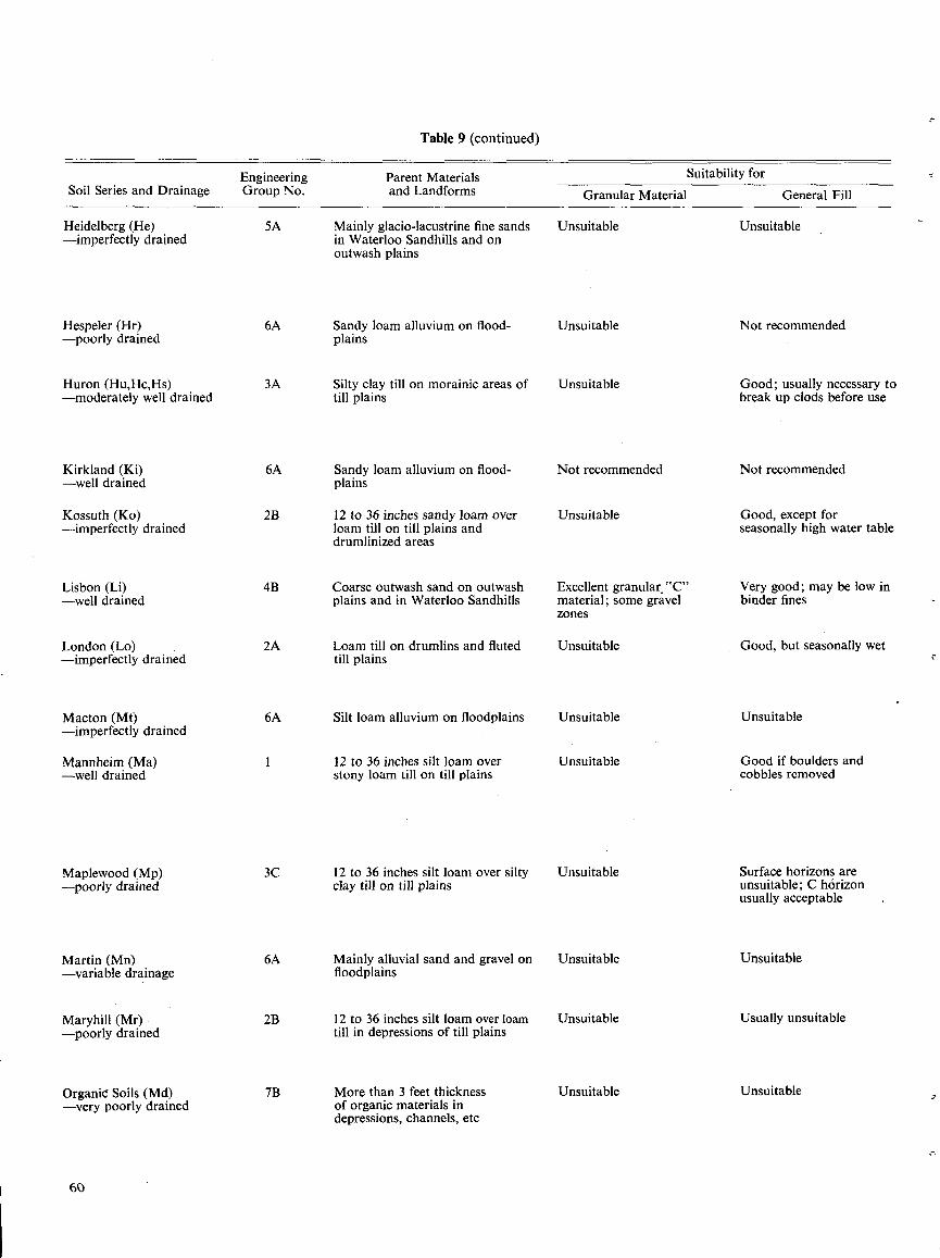
Parent Materialsand Landforms
Table 9 (continued)
Suitability for
Mainly glacio-lacustrine fine sandsin Waterloo Sandhills and onoutwash plains
Sandy loam alluvium on flood-plains
Silty clay till on morainic areas oftill plains
Sandy loam alluvium on flood-plains
12 to 36 inches sandy loam overloam till on till plains anddrumlinized areas
Coarse outwash sand on outwashplains and in Waterloo Sandhills
Loam till on drumlins and flutedtill plains
Silt loam alluvium on floodplains
12 to 36 inches silt loam overstony loam till on till plains
12 to 36 inches silt loam over siltyclay till on till plains
Mainly alluvial sand and gravel onfloodplains
12 to 36 inches silt loam over loamtill in depressions of till plains
More than 3 feet thicknessof organic materials indepressions, channels, etc
60
Soil Series and DrainageEngineeringGroup No.
Heidelberg (He) 5A-imperfectly drained
Hespeler (Hr) 6A-poorly drained
Huron (Hu,Hc,Hs) 3A-moderately well drained
Kirkland (Ki) 6A-well drained
Kossuth (Ko) 2B-imperfectly drained
Lisbon (Li) 4B-well drained
London (Lo) 2A-imperfectly drained
Macton (Mt) 6A-imperfectly drained
Mannheim (Ma) 1-well drained
Maplewood (Mp) 3C-poorly drained
Martin (Mn) 6A-variable drainage
Maryhill (Mr) - 2B-poorly drained
Organic Soils (Md) 7B-very poorly drained
Granular Material General Fill
Unsuitable Unsuitable
Unsuitable Not recommended
Unsuitable Good ; usually necessary tobreak up clods before use
Not recommended Not recommended
Unsuitable Good, except forseasonally high water table
Excellent granular,"C" Very good ; may be low inmaterial ; some gravel binder fineszones
Unsuitable Good, but seasonally wet
Unsuitable Unsuitable
Unsuitable Good if boulders andcobbles removed
Unsuitable Surface horizons areunsuitable ; C hôrizonusually acceptable
Unsuitable Unsuitable
Unsuitable Usually unsuitable
Unsuitable Unsuitable
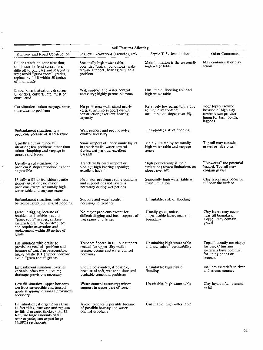
Highway and Road Construction
Fill or transition zone situation ;soil is usually frost-susceptible,difficult to compact and seasonallywet ; avoid "grass roots" grades,replace by fill if within 30 inchesof final grade
Embankment situation ; drainageby ditches, culverts, etc, must beconsidered
Cut situation ; minor seepage zones,otherwise no problems
Embankment situation ; fewproblems because of sand texture
Usually a cut or minor fillsituation ; few problems other thanminor sloughing and seepage inupper sand layers
Usually a cut situation ; noproblem if slopes resodded as soonas possible
Usually a fill or transition (gentleslopes) situation ; no majorproblems except seasonally highwater table and seepage seams
Embankment situation ; soils maybe frost-susceptible ; risk of flooding
Difficult digging because ofboulders and cobbles ; avoid"grass roots" grades ; surfacematerials often frost-susceptibleand require excavation andreplacement within 30 inches ofgrade
Fill situation with drainageprovisions needed ; problem soilbecause of wet, frost-susceptible,highly plastic (CH) upper horizon ;avoid "grass roots" grades
Embankment situation ; overliesvariable, often wet alluvium ;drainage provisions necessary
Low fill situation ; upper horizonsare frost-susceptible and topsoilneeds stripping ; drainage provisionsnecessary
Fill situation ; if organic less than12 feet thick, excavate and replaceby fill ; if organic thicker than 12feet, use large amounts of fillover organic ; can expect large(± 50%) settlements
Soil Features Affecting
Shallow Excavations (Trenches, etc)
Seasonally high water table ;potential "quick" conditions ; wallsrequire support ; bearing may be aproblem
Wall support and water controlnecessary ; highly permeable zone
No problems ; walls stand nearlyvertical with no support duringconstruction ; excellent bearingcapacity
Wall support and groundwatercontrol necessary
Some support of upper sandy layersin trench walls ; water controlduring wet periods ; excellentbackfill
Trench walls need support orsloping ; high bearing capacity ;excellent backfill
No major problems ; some pumpingand support of sand layers isnecessary during wet periods
Support and water controlnecessary in trenches
No major problems except fordifficult digging and local support ofwet seams and lenses
Trenches floored in till, but supportneeded for upper silty walls ;seepage occurs and water controlnecessary
Should be avoided, if possible,because of soft, wet conditions andprobable trenching problems
Water control necessary ; minorsupport in upper part of trench
Avoid trenches if possible becauseof possible bearing and watercontrol problems
Septic Tank Installations
Main limitation is the seasonally
May contain silt or clayhigh water table
seams
Unsuitable ; flooding risk andhigh water table
Relatively low permeability dueto high clay content ;unsuitable on slopes over 6%
Unsuitable ; risk of flooding
Mainly limited by seasonallyhigh water table and seepagezones
High permeability is mainlimitation ; severe limitations onslopes over 6%
Seasonally high water table ismain limitation
Unsuitable ; risk of flooding
Usually good, unlessimpermeable layers near tillboundary
Unsuitable ; high water tableand low subsoil permeability
Unsuitable ; high risk offlooding
Unsuitable ; high water table
Unsuitable ; high water table
Other Comments
Poor topsoil sourcebecause of high claycontent ; can providelining for farm ponds,lagoons
Topsoil may containgravel or till stones
"Blowouts" are potentialhazard . Topsoil maycontain gravel
Clay layers may occur intill near the surface
Clay layers may occurnear till boundary .Topsoil may containgravel
Topsoil usually too clayeyfor use ; C horizonmaterials have potentialfor lining ponds orlagoons
Includes materials in riverand stream courses
Clay layers often presentin till
6 1"
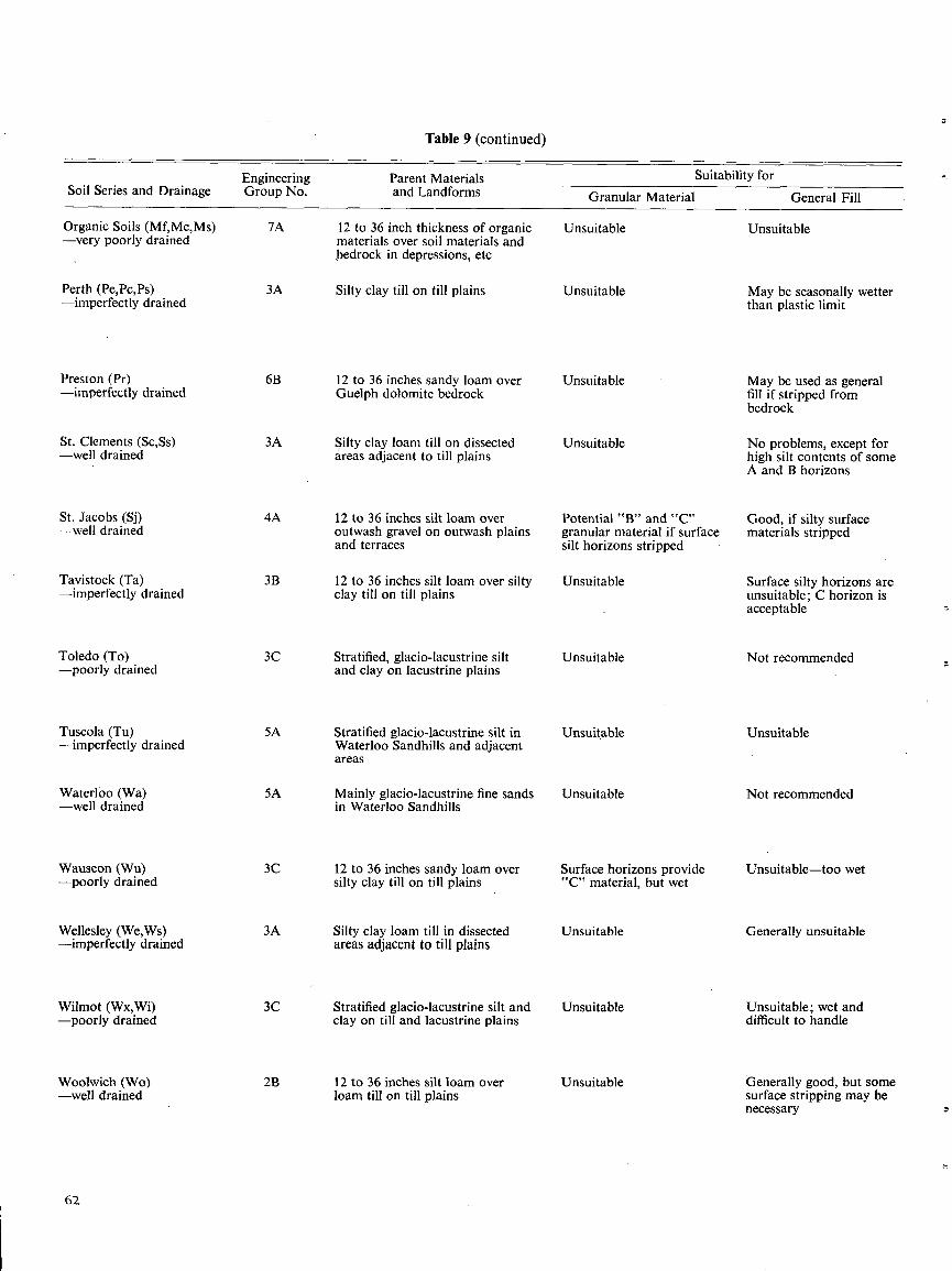
Parent Materialsand Landforms
Table 9 (continued)
Suitability for
Granular Material
General Fill
12 to 36 inch thickness of organic
Unsuitable
Unsuitablematerials over soil materials andbedrock in depressions, etc
Silty clay till on till plains
Unsuitable
May be seasonally wetterthan plastic limit
12 to 36 inches sandy loam over
Unsuitable
May be used as generalGuelph dolomite bedrock
fill if stripped frombedrock
Silty clay loam till on dissected
Unsuitable
No problems, except forareas adjacent to till plains
high silt contents of someA and B horizons
12 to 36 inches silt loam over
Potential "B" and "C"
Good, if silty surfaceoutwash gravel on outwash plains
granular material if surface
materials strippedand terraces
silt horizons stripped
12 to 36 inches silt loam over silty
Unsuitable
Surface silty horizons areclay till on till plains
unsuitable ; C horizon isacceptable
Stratified, glacio-lacustrine silt
Unsuitable
Not recommendedand clay on lacustrine plains
Stratified glacio-lacustrine silt in
Unsuitable
UnsuitableWaterloo Sandhills and adjacentareas
Mainly glacio-lacustrine fine sands
Unsuitable
Not recommendedin Waterloo Sandhills
12 to 36 inches sandy loam over
Surface horizons provide
Unsuitable-too wetsilty clay till on till plains
"C" material, but wet
Silty clay loam till in dissected
Unsuitable
Generally unsuitableareas adjacent to till plains
Stratified glacio-lacustrine silt and
Unsuitable
Unsuitable ; wet andclay on till and lacustrine plains
difficult to handle
12 to 36 inches silt loam over
Unsuitable
Generally good, but someloam till on till plains
surface stripping may benecessary
Soil Series and DrainageEngineeringGroup No.
Organic Soils (Mf,Mc,Ms) 7A-very poorly drained
Perth (Pe,Pc,Ps) 3A-imperfectly drained
Preston (Pr) 6B-imperfectly drained
St . Clements (Sc,Ss) 3A-well drained
St . Jacobs (Si) 4A-well drained
Tavistock (Ta) 3B-imperfectly drained
Toledo (To) 3C-poorly drained
Tuscola (Tu) 5A-imperfectly drained
Waterloo (Wa) 5A-well drained
Wauseon (Wu) 3C-poorly drained
Wellesley (We,Ws) 3A-imperfectly drained
Wilmot (WX,Wi) 3C-poorly drained
Woolwich (Wo) 2B-well drained
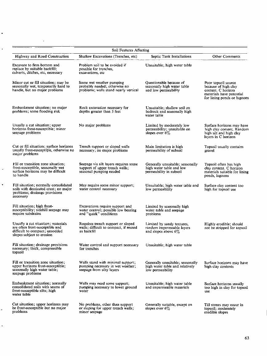
Highway and Road Construction
Excavate to firm bottom andreplace by suitable backfill ;culverts, ditches, etc, necessary
Minor cut or fill situation ; may beseasonally wet, temporarily hard tohandle, but no major problems
Embankment situation ; no majorproblems ; some flooding risk
Usually a cut situation ; upperhorizons frost-susceptible ; minorseepage problems
Cut or fill situation ; surface horizonsusually frost-susceptible, otherwise nomajor problems
Fill or transition zone situation ;frost-susceptible, seasonally wetsurface horizons may be difficultto handle
Fill situation ; normally consolidatedsoils with dessicated crust ; no majorproblems ; drainage provisionsnecessary
Fill situation ; high frost-susceptibility ; sidehill seepage mayrequire subdrains
Usually a cut situation ; materialsare often frost-susceptible anddifficult to compact ; unsoddedslopes subject to erosion
Fill situation ; drainage provisionsnecessary ; thick, compressibletopsoil
Fill or transition zone situation ;upper horizons frost-susceptible ;seasonally high water table ;seepage problems
Embankment situation ; normallyconsolidated soils with seams offrost-susceptible silts ; highwater table
Cut situation ; upper horizons maybe frost-susceptible but no majorproblems
Shallow Excavations (Trenches, etc)
Problem soil to be avoided ifpossible for trenches,excavations, etc
Some wet weather pumpingprobably needed ; otherwise noproblems ; walls stand nearly vertical
Rock excavation necessary fordepths greater than 3 feet
No major problems
Trench support or sloped wallsnecessary ; no major problems
Soil Features Affecting
Seepage via silt layers requires somesupport of upper trench walls ;seasonal pumping needed
May require some minor support ;water control necessary
Excavations require support andwater control ; possible low bearingand "quick" conditions
Requires trench support or slopedwalls ; difficult to compact, if reusedas backfill
Water control and support necessaryfor trenches
Walls stand with minimal support ;pumping necessary in wet weather ;seepage from silty layers
Walls may need some support ;pumping necessary to lower groundwater
No problems, other than supportor sloping for upper trench walls ;minor seepage
Septic Tank Installations
Unsuitable ; high water table
Questionable because ofseasonally high water tableand low permeability
Unsuitable ; shallow soil onbedrock and seasonally highwater table
Limited by moderately lowpermeability ; unsuitable onslopes over 6%
Main limitation is highpermeability of subsoil
Generally unsuitable ; seasonallyhigh water table and lowpermeability in subsoil
Unsuitable ; high water table and
Surface clay content toolow permeability
high for topsoil use
Limited by seasonally highwater table and seepageproblems
Limited by sandy textures,random impermeable layersand slopes above 6%
Unsuitable ; high water table
Generally unsuitable ; seasonallyhigh water table and relativelylow permeability
Unsuitable ; high water tableand impermeable materials
Generally suitable, except onslopes over 6%
Other Comments
Poor topsoil sourcebecause of high claycontent . C horizonmaterials have potentialfor lining ponds or lagoons
Surface horizons may havehigh clay content . Randomhigh silt and high claylayers in C horizon
Topsoil usually containsgravel
Topsoil often has highclay content . C horizonmaterials suitable for liningponds, lagoons
Highly erodible ; shouldnot be stripped for topsoil
Surface horizons may havehigh clay contents
Surface horizons usuallytoo high in clay for topsoiluse
Till stones may occur intopsoil ; moderatelyerodible slopes
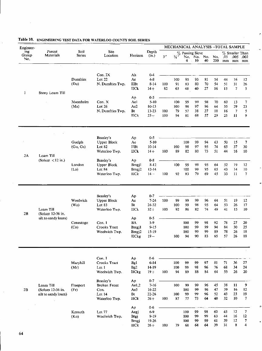
Table 10. ENGINEERING TEST DATA FOR WATERLOO COUNTY SOIL SERIES
64
Engineer- MECHANICAL ANALYSIS-TOTAL SAMPLEing Parent Soil Site Depth % Passing Sieve SSmaller ThanGroupNo.
Materials Series Location Horizon (in.) 3 "3
" No. No. No . No .4 10 40 200
.0OSmm
.005mm
.002mm
Con. IX Ah 0-4Dumfries Lot 22 Ae 4-8 100 95 93 81 54 44 16 12(Du) N. Dumfries Twp. IIBt 8-14 100 91 83 80 70 54 51 31 26
IICk 14+ 82 63 48 40 27 16 13 7 51 Stony Loam Till
Ap 0-5Mannheim Con. X Ael 5-10 100 99 99 98 70 60 13 7(Ma) Lot 26 Ae2 10-13 100 98 97 96 64 55 29 23
N. Dumfries Twp. Bt 13-23 100 79 57 38 27 18 16 7 5IICk 23+ 100 94 81 68 57 29 25 11 9
Beasley's Ap 0-5Guelph Upper Block Ae 5-10 100 99 94 63 50 15 7(Gu, Gs) Lot 82 IIBt 10-14 100 98 97 95 74 65 37 30
Waterloo Twp. IICk 14+ 100 89 82 80 73 51 44 16 102A Loam Till
(Solum < 12 in .) Beasley's Ap 0-8London Upper Block Bmgj1 8-12 100 99 99 95 64 52 19 12(Lo) Lot 84 Bmgj2 12-14 100 99 95 65 43 14 10
Waterloo Twp. IICk 14+ 100 92 83 79 69 45 33 11 7
Beasley's Ap 0-7Woolwich Upper Block Ae 7-24 100 99 99 99 96 64 51 19 12(Wo) Lot 83 Bt 24-32 100 99 98 95 64 53 26 17
Loam Till Waterloo Twp. IICk 32+ 100 92 86 82 74 49 41 15 102B (Solum 12-36 in .
silt to sandy loam) Ap 0-5Conestogo Con. I BA 5-9 100 99 98 92 78 27 20(Co) Crooks Tract Bmgjl 9-15 100 99 99 94 84 30 25
Woolwich Twp. Bmgj2 15-19 100 99 99 89 78 26 18IICkg 19+ 100 94 90 83 65 57 26 18
Con. I Ap 0-6Maryhill Crooks Tract Bgl 6-14 100 99 99 97 81 71 36 27(Mr) Lot 1 Bg2 14-19 100 99 98 96 76 68 34 24
Woolwich Twp. IICkg 19+ 100 94 89 88 84 64 55 26 20
Beasley's Ap 0-7Loam Till Freeport Broken Front Ael,2 7-16 100 99 99 96 45 38 11 9
2B (Solum 12-36 in . (Fr) Con. Ae3 16-22 100 99 96 47 39 16 12silt to sandy loam) Lot 14 Bt 22-26 100 99 99 96 52 43 23 19
Waterloo Twp. IICk 26+ 100 87 77 73 64 40 32 10 7
Ap 0-6Kossuth Lot 77 Aegj 6-9 100 99 98 60 45 12 7(Ko) Woolwich Twp. Btgj 9-19 100 99 99 63 44 16 12
Bmgj 19-26 100 99 99 61 39 12 7IICk 26+ 100 79 68 64 64 39 31 8 4
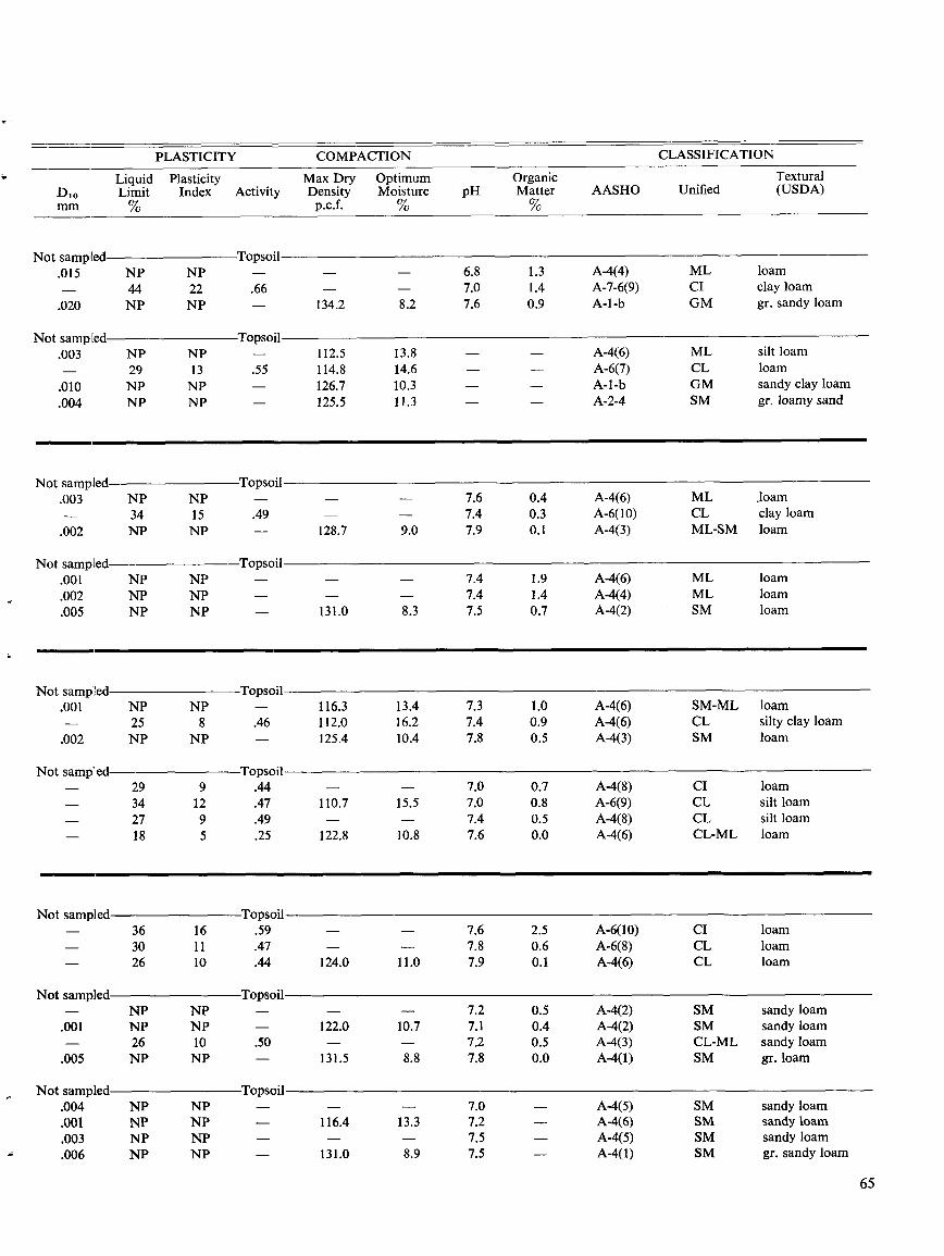
PLASTICITY COMPACTION
CLASSIFICATION
Liquid
Plasticity
Max Dry
Optimum
Organic
TexturalD,o Limit Index Activity Density Moisture pH Matter AASHO Unified (USDA)mm %
p.c.f. %
%
Not sampled
Topsoil.015 NP NP - - - 6.8 1 .3 A-4(4) ML loam- 44 22 .66 - - 7.0 1 .4 A-7-6(9) CI clay loam.020 NP NP - 134.2 8.2 7 .6 0 .9 A-1-b GM gr. sandy loam
Not sampled Topsoil.003 NP NP - 112.5 13.8 - - A-4(6) ML silt loam- 29 13 .55 114.8 14.6 - - A-6(7) CL loam.010 NP NP - 126.7 10.3 - - A-1-b GM sandy clay loam.004 NP NP - 125.5 11 .3 - - A-2-4 SM gr . loamy sand
Not sampled Topsoil.003 NP NP - - - 7.6 0.4 A-4(6) ML .loam- 34 15 .49 - - 7.4 0.3 A-6(10) CL clay loam.002 NP NP - 128.7 9.0 7 .9 0.1 A-4(3) ML-SM loam
Not sampled Topsoil.001 NP NP - - - 7.4 1 .9 A-4(6) ML loam.002 NP NP - - - 7.4 1 .4 A-4(4) ML loam.005 NP NP - 131 .0 8 .3 7 .5 0.7 A-4(2) SM loam
Not sampled Topsoil.001 NP NP - 116.3 13.4 7 .3 1 .0 A-4(6) SM-ML loam- 25 8 .46 112.0 16.2 7.4 0.9 A-4(6) CL silty clay loam.002 NP NP - 125.4 10.4 7 .8 0 .5 A-4(3) SM loam
Not samp:ed Topsoil- 29 9 .44 - - 7.0 0.7 A-4(8) CI loam- 34 12 .47 110.7 15.5 7.0 0.8 A-6(9) CL silt loam- 27 9 .49 - - 7.4 0.5 A-4(8) CL silt loam- 18 5 .25 122.8 10.8 7 .6 0.0 A-4(6) CL-ML loam
Not sampled Topsoil- 36 16 .59 - - 7.6 2.5 A-6(10) CI loam- 30 11 .47 - - 7.8 0.6 A-6(8) CL loam- 26 10 .44 124.0 11.0 7.9 0 .1 A-4(6) CL loam
Not sampled Topsoil- NP NP - - - 7.2 0.5 A-4(2) SM sandy loam.001 NP NP - 122.0 10.7 7.1 0 .4 A-4(2) SM sandy loam- 26 10 .50 - - 7.2 0.5 A-4(3) CL-ML sandy loam.005 NP NP - 131.5 8.8 7.8 0 .0 A-4(1) SM gr . loam
Not sampled Topsoil.004 NP NP - - - 7.0 - A-4(5) SM sandy loam.001 NP NP - 116.4 13 .3 7.2 - A-4(6) SM sandy loam.003 NP NP - - - 7.5 - A-4(5) SM sandy loam.006 NP NP - 131.0 8.9 7.5 - A-4(1) SM gr . sandy loam
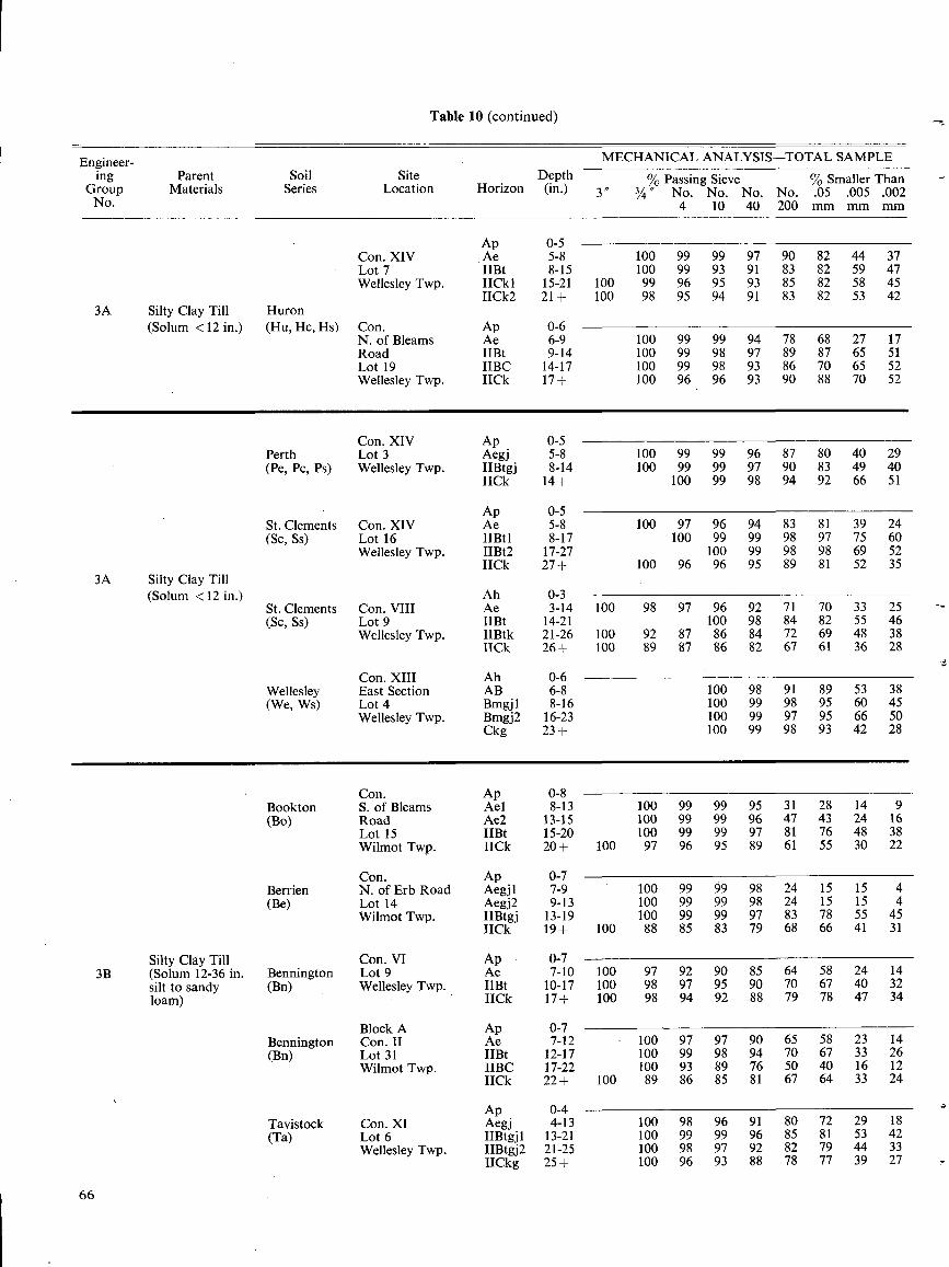
Engineer-ing
GroupNo.
66
3A
3A
Table 10 (continued)
3B
MECHANICAL ANALYSIS-TOTAL SAMPLEParent Soil Site Depth % Passing Sieve % Smaller Than
Materials Series Location Horizon (in.) 3 " 3/ " No .4
No . No . No .10 40 200
.05mm
.005mm
.002mm
Ap 0-5Con. XIV Ae 5-8 100 99 99 97 90 82 44 37Lot 7 IIBt 8-15 100 99 93 91 83 82 59 47Wellesley Twp. IICkI 15-21 100 99 96 95 93 85 82 58 45
IICk2 21+ 100 98 95 94 91 83 82 53 42Silty Clay Till Huron(Solum < 12 in .) (Hu, Hc, Hs) Con . Ap 0-6
N. of Bleams Ae 6-9 100 99 99 94 78 68 27 17Road IIBt 9-14 100 99 98 97 89 87 65 51Lot 19 IIBC 14-17 100 99 98 93 86 70 65 52Wellesley Twp. IICk 17+ 100 96 96 93 90 88 70 52
Con. XIV Ap 0-5Perth Lot 3 Aegj 5-8 100 99 99 96 87 80 40 29(Pe, Pc, Ps) Wellesley Twp. IIBtgj 8-14 100 99 99 97 90 83 49 40
IICk 14+ 100 99 98 94 92 66 51
Ap 0-5St . Clements Con. XIV Ae 5-8 100 97 96 94 83 81 39 24(SC, Ss) Lot 16 IIBtl 8-17 100 99 99 98 97 75 60
Wellesley Twp. IIBt2 17-27 100 99 98 98 69 52IICk 27+ 100 96 96 95 89 81 52 35
Silty Clay Till(Solum < 12 in .) Ah 0-3
St . Clements Con. VIII Ae 3-14 100 98 97 96 92 71 70 33 25(Sc, Ss) Lot 9 IIBt 14-21 100 98 84 82 55 46
Wellesley Twp. IIBtk 21-26 100 92 87 86 84 72 69 48 38IICk 26+ 100 89 87 86 82 67 61 36 28
Con. XIII Ah 0-6Wellesley East Section AB 6-8 100 98 91 89 53 38(We, Ws) Lot 4 Bmgj1 8-16 100 99 98 95 60 45
Wellesley Twp. Bmgj2 16-23 100 99 97 95 66 50Ckg 23+ 100 99 98 93 42 28
Con. Ap 0-8-Bookton S. of Bleams Ael 8-13 100 99 99 95 31 28 14 9(Bo) Road Ae2 13-15 100 99 99 96 47 43 24 16
Lot 15 IIBt 15-20 100 99 99 97 81 76 48 38Wilmot Twp. IICk 20+ 100 97 96 95 89 61 55 30 22
Con . Ap 0-7Berrien N. of Erb Road Aegj1 7-9 100 99 99 98 24 15 15 4(Be) Lot 14 Aegj2 9-13 100 99 99 98 24 15 15 4
Wilmot Twp. IIBtgj 13-19 100 99 99 97 83 78 55 45IICk 19+ 100 88 85 83 79 68 66 41 31
Silty Clay Till Con. VI Ap 0-7(Solum 12-36 in . Bennington Lot 9 Ae 7-10 100 97 92 90 85 64 58 24 14silt to sandy (Bn) Wellesley Twp. IIBt 10-17 100 98 97 95 90 70 67 40 32loam) IICk 17+ 100 98 94 92 88 79 78 47 34
Block A Ap 0-7Bennington Con. 11 Ae 7-12 100 97 97 90 65 58 23 14(Bn) Lot 31 IIBt 12-17 100 99 98 94 70 67 33 26
Wilmot Twp. IIBC 17-22 100 93 89 76 50 40 16 12IICk 22+ 100 89 86 85 81 67 64 33 24
Ap 0-4Tavistock Con. XI Aegj 4-13 100 98 96 91 80 72 29 18(Ta) Lot 6 IIBtgjl 13-21 100 99 99 96 85 81 53 42
Wellesley Twp. IIBtgj2 21-25 100 98 97 92 82 79 44 33IICkg 25+ 100 96 93 88 78 77 39 27
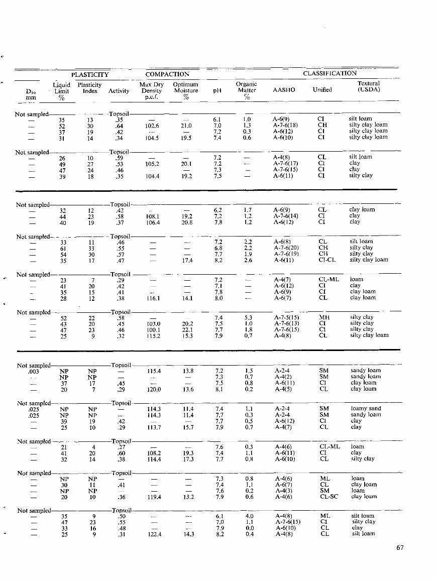
PLASTICITY COMPACTION CLASSIFICATION
Di. -mm
LiquidLimit%
PlasticityIndex Activity
Max DryDensityp.c .f.
OptimumMoisture%
pHOrganicMatter%
AASHO UnifiedTextural(USDA)
Not sampled Topsoil- 35 13 .35 - - 6.1 1 .0 A-6(9) CI silt loam- 52 30 .64 102.6 21 .0 7.0 1 .3 A-7-6(18) CH silty clay loam- 37 19 .42 - - 7.2 0.3 A-6(12) CI silty clay loam- 31 14 .34 104.5 19 .5 7.4 0.6 A-6(10) CI silty clay loam
Not sampled Topsoil- 26 10 .59 - - 7.2 - A-4(8) CL silt loam- 49 27 .53 105 .2 20 .1 7.2 - A-7-6(17) CI clay- 47 24 .46 - - 7.3 - A-7-6(15) CI clay- 39 18 .35 104.4 19 .2 7.5 - A-6(11) CI silty clay
Not sampled Topsoil- 32 12 .42 - - 6.2 1 .7 A-6(9) CL clay loam- 44 23 .58 108.1 19 .2 7.2 1 .2 A-7-6(14) CI clay- 40 19 .37 106.4 20.8 7.8 1 .2 A-6(12) CI clay
Not sampled Topsoil- 33 11 .46 - - 7.2 2.2 A-6(8) CL silt loam- 61 33 .55 - - 6.8 2.2 A-7-6(20) CH silty clay- 54 30 .57 - - 7.7 1 .9 A-7-6(19) CH silty clay- 35 17 .47 - 17.4 8 .2 2.6 A-6(11) CI-CL silty clay loam
Not sampled Topsoil- 23 7 .29. - - 7 .2 - A-4(7) CL-ML loam- 41 20 .42 - - 7.1 - A-6(12) CI clay- 35 15 .41 - - 7.8 - A-6(9) CI clay loam- 28 12 .38 116.1 14.1 8.0 - A-6(7) CL clay loam
Not sampled Topsoil- 52 22 .58 - - 7.4 5.3 A-7-5(15) MH silty clay- 43 20 .45 103.0 20.2 7.5 1.0 A-7-6(13) CI silty clay- 47 23 .46 100.1 22.1 7.7 1.8 A-7-6(15) CI silty clay- 25 9 .32 115.2 15 .3 7.9 0.7 A-4(8) CL silty clay loam
Not sampled Topsoil.003 NP NP - 115.4 13 .8 7.2 1 .5 A-2-4 SM sandy loam- NP NP - - - 7.3 0.7 A-4(2) SM sandy loam- 37 17 .45 - - 7.5 0.8 A-6(11) CI clay loam- 20 7 .29 120.0 13 .6 8.1 0.2 A-4(5) CL clay loam
Not sampled Topsoil.025 NP NP - 114.3 11 .4 7.4 1 .1 A-2-4 SM loamy sand.025 NP NP - 114.3 11 .4 7.7 0.3 A-2-4 SM sandy loam- 39 19 .42 - - 7.7 0.5 A-6(12) CI clay- 25 10 .29 113.7 15 .7 7.9 0.7 A-4(7) CL clay
Not sampled Topsoil- 21 4 .27 - - 7.6 0.3 A-4(6) CL-ML loam- 41 20 .60 108.2 19 .3 7.4 1.1 A-6(11) CI clay- 32 14 .38 114.4 17 .3 7.7 0.8 A-6(10) CL silty clay
Not sampled Topsoil- NP NP - - - 7.3 0.8 A-4(6) ML loam- 30 11 .41 - - 7.4 1.1 A-6(7) CL clay loam- NP NP - - - 7.6 0.2 A-4(3) SM loam- 20 10 .36 119.4 13 .2 7.9 0.6 A-4(6) CL-SC clay loam
Not sampled Topsoil- 35 9 .50 - - 6.1 4.0 A-4(8) ML silt loam- 47 23 .55 - - 7.0 1 .1 A-7-6(15) CI silty clay- 33 16 .48 - - 7.9 0.0 A-6(10) CL clay- 25 9 .31 122.4 14 .3 8.2 0.4 A-4(8) CL silt loam
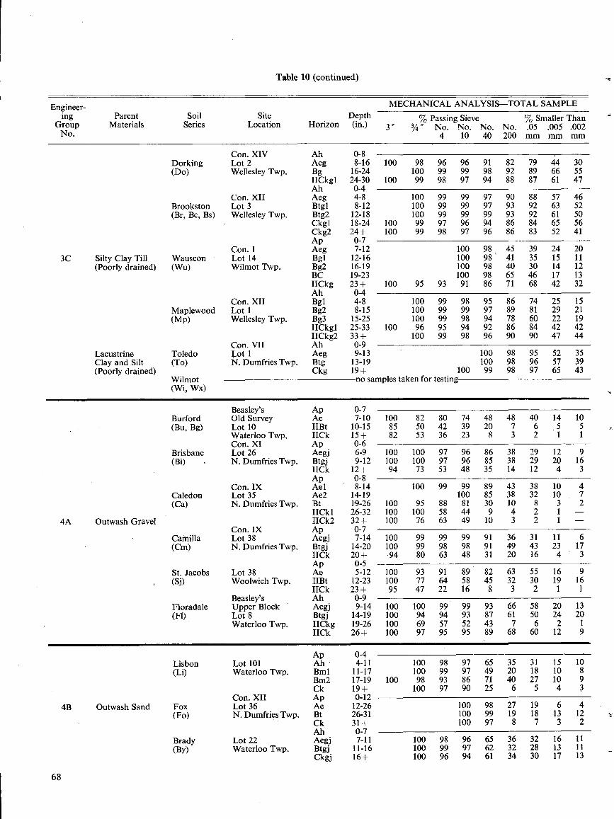
Engineer-ing
GroupNo.
68
Table 10 (continued)
3C
4A
4B
MECHANICAL ANALYSIS-TOTAL SAMPLEParent Soil Site Depth % Passing Sieve % Smaller Than
Materials Series Location Horizon (in.) 3 ~~ 3/4' No. No. No. No.4 10 40 200
.05mm
.005mm
.002mm
Con. XIV Ah 0-8Dorking Lot 2 Aeg 8-16 100 98 96 96 91 82 79 44 30(Do) Wellesley Twp. Bg 16-24 100 99 99 98 92 89 66 55
IICkgl 24-30 100 99 98 97 94 88 87 61 47Ah 0-4
Con. XII Aeg 4-8 100 99 99 97 90 88 57 46Brookston Lot 3 Btgl 8-12 100 99 99 97 93 92 63 52(Br, Bc, Bs) Wellesley Twp. Btg2 12-18 100 99 99 99 93 92 61 50
Ckg1 18-24 100 99 97 96 94 86 84 65 56Ckg2 24+ 100 99 98 97 96 86 83 52 41Ap 0-7
Con. I Aeg 7-12 100 98 45 39 24 20Silty Clay Till Wauseon Lot 14 Bgl 12-16 100 98 ` 41 35 15 11(Poorly drained) (Wu) Wilmot Twp. Bg2 16-19 100 98 40 30 14 12
BC 19-23 100 98 65 46 17 13IICkg 23+ 100 95 93 91 86 71 68 42 32Ah 0-4
Con. XII Bg1 4-8 100 99 98 95 86 74 25 15Maplewood Lot 1 Bg2 8-15 100 99 99 97 89 81 29 21NO Wellesley Twp. Bg3 15-25 100 99 98 94 78 60 22 19
IICkgl 25-33 100 96 95 94 92 86 84 42 42IICkg2 33+ 100 99 98 96 90 90 47 44
Con. VII Ah 0-9Lacustrine Toledo Lot 1 Aeg 9-13 100 98 95 52 35Clay and Silt (To) 1V . Dumfries Twp. Btg 13-19 100 98 96 57 39(Poorly drained) Ckg 19+ 100 99 98 97 65 43
Wilmot no samples taken for testing(Wi, Wx)
Beasley's Ap 0-7Burford Old Survey Ae 7-10 100 82 80 74 48 48 40 14 10(Bu, Bg) Lot 10 IIBt 10-15 85 50 42 39 20 7 6 5 5
Waterloo Twp. 1ICk 15+ 82 53 36 23 8 3 2 1 1Con. XI Ap 0-6
Brisbane Lot 26 Aegj 6-9 100 100 97 96 86 38 29 12 9(Bi) N. Dumfries Twp. Btgj 9-12 100 100 97 96 85 38 29 20 16
IICk 12+ 94 73 53 48 35 14 12 4 3Ap 0-8
Con. IX Ael 8-14 100 99 99 89 43 38 10 4Caledon Lot 35 Ae2 14-19 100 85 38 32 10 7(Ca) N. Dumfries Twp. Bt 19-26 100 95 88 81 30 10 8 3 2
IICkI 26-32 100 100 58 44 9 4 2 1 -Outwash Gravel IICkg 32+ 100 76 63 49 10 3 2 1 -
Con. IX Ap 0-7Camilla Lot 38 Aegj 7-14 100 99 99 99 91 36 31 11 6(Cm) N. Dumfries Twp. Btgj 14-20 100 99 98 98 91 49 43 23 17
IICk 20+ 94 80 63 48 31 20 16 4 3Ap 0-5
St . Jacobs Lot 38 Ae 5-12 100 93 91 89 82 63 55 16 9(Si) Woolwich Twp. IIBt 12-23 100 77 64 58 45 32 30 19 16
IICk 23+ 95 47 22 16 8 3 2 1 1Beasley's Ah 0-9
Floradale Upper Block Aegj 9-14 100 100 99 99 93 66 58 20 13(Fl) Lot 8 Btgj 14-19 100 94 94 93 87 61 50 24 20
Waterloo Twp. IICkg 19-26 100 69 57 52 43 7 6 2 1IICk 26+ 100 97 95 95 89 68 60 12 9
Ap 0-4Lisbon Lot 101 Ah 4-11 100 98 97 65 35 31 15 10(Li) Waterloo Twp. Bml 11-17 100 99 97 49 20 18 10 8
Bm2 17-19 100 98 93 86 71 40 27 10 9Ck 19+ 100 97 90 25 6 5 4 3
Con. XII Ap 0-12Outwash Sand Fox Lot 36 Ae 12-26 100 98 27 19 6 4
(Fo) N. Dumfries Twp. Bt 26-31 100 99 19 18 13 12Ck 31+ 100 97 8 7 3 2Ah 0-7
Brady Lot 22 Aegj 7-11 100 98 96 65 36 32 16 11(By) Waterloo Twp. Btgj 11-16 100 99 97 62 32 28 1,3 11
Ckgj 16+ 100 96 94 61 34 30 17 13
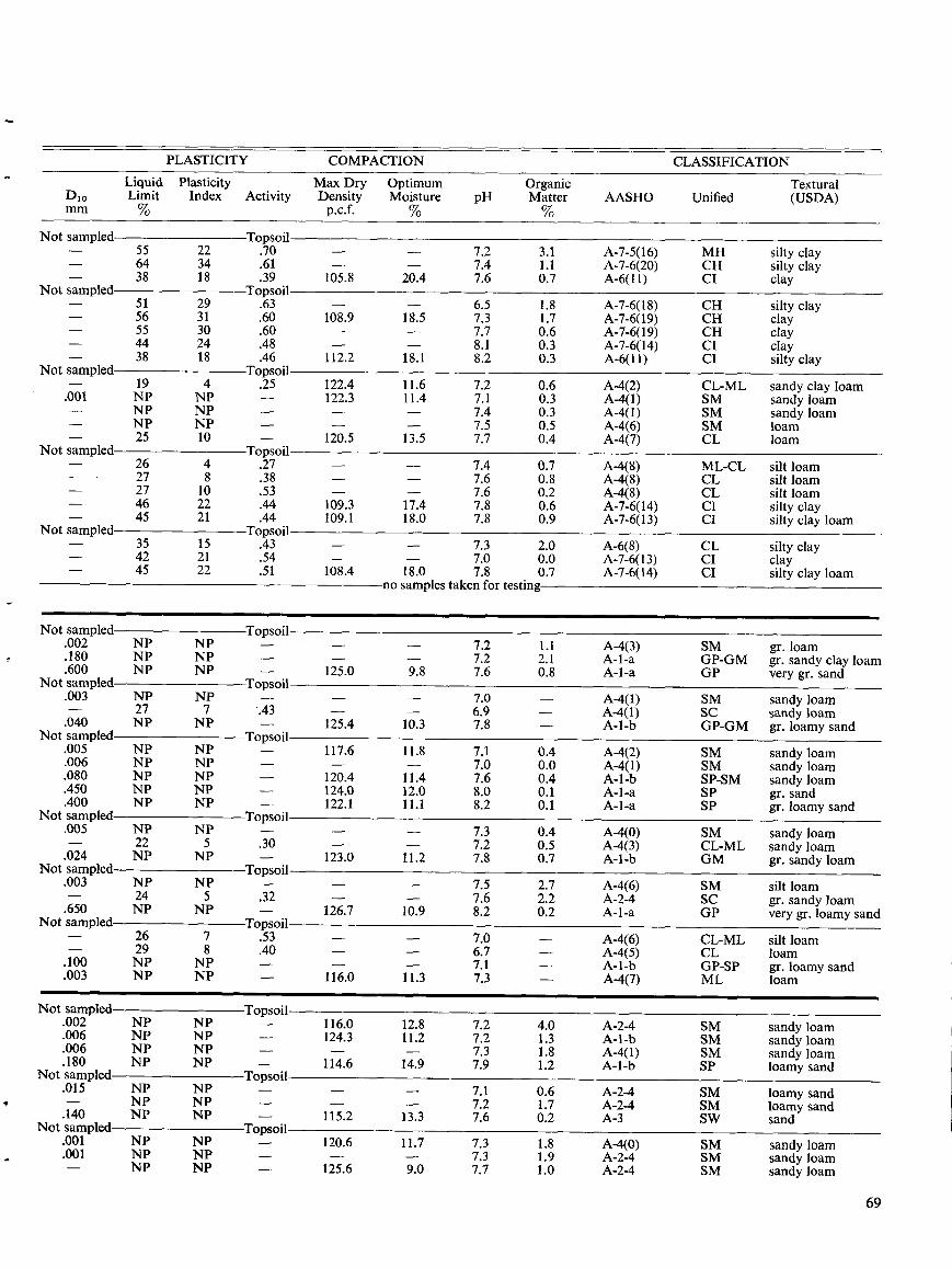
69
PLASTICITY COMPACTION CLASSIFICATION
Dlomm
LiquidLimit%
PlasticityIndex Activity
Max DryDensityp.c .f.
OptimumMoisture%
pHOrganicMatter%
AASHO UnifiedTextural(USDA)
Not sampled Topsoil- 55 22 .70 - - 7.2 3 .1 A-7-5(16) MH silty clay- 64 34 .61 - - 7.4 1 .1 A-7-6(20) CH silty clay
38 18 .39 105.8 20.4 7 .6 0 .7 A-6(11) CI clayNot sampled Topsoil
- 51 29 .63 - - 6.5 1 .8 A-7-6(18) CH silty clay- 56 31 .60 108.9 18 .5 7 .3 1 .7 A-7-6(19) CH clay- 55 30 .60 - - 7.7 0.6 A-7-6(19) CH clay- 44 24 .48 - - 8.1 0 .3 A-7-6(14) CI clay
38 18 .46 112.2 18 .1 8 .2 0 .3 A-6(11) CI silty clayNot sampled Topsoil
19 4 .25 122.4 11 .6 7.2 0.6 A-4(2) CL-ML sandy clay loam.001 NP NP - 122 .3 11 .4 7.1 0 .3 A-4(1) SM sandy loam- NP NP - - - 7.4 0.3 A-4(1) SM sandy loam- NP NP - - - 7.5 0.5 A-4(6) SM loam
25 10 - 120.5 13 .5 7 .7 0.4 A-4(7) CL loamNot sampled Topsoil
- 26 4 .27 - - 7.4 0.7 A-4(8) ML-CL silt loam- 27 8 .38 - - 7.6 0.8 A-4(8) CL silt loam- 27 10 .53 - - 7.6 0.2 A-4(8) CL silt loam- 46 22 .44 109.3 17 .4 7 .8 0 .6 A-7-6(14) CI silty clay
45 21 .44 109.1 18 .0 7 .8 0 .9 A-7-6(13) Cl silty clay loamNot sampled Topsoil
- 35 15 .43 - - 7.3 2.0 A-6(8) CL silty clay- 42 21 .54 - - 7.0 0.0 A-7-6(13) CI clay- 45 22 .51 108.4 18.0 7.8 0.7 A-7-6(14) CI silty clay loam
no samples taken for testing
Not sampled Topsoil.002 NP NP - - - 7.2 1 .1 A-4(3) SM gr . loam.180 NP NP - - - 7.2 2 .1 A-1-a GP-GM gr. sandy clay loam.600 NP NP - 125.0 9 .8 7 .6 0.8 A-1-a GP very gr. sandNot sampled Topsoil.003 NP NP - - - 7.0 - A-4(1) SM sandy loam- 27 7 .43 - - 6.9 - A-4(1) SC sandy loam.040 NP NP - 125.4 10.3 7 .8 - A-1-b GP-GM gr . loamy sandNot sampled Topsoil.005 NP NP - 117.6 11.8 7 .1 0.4 A-4(2) SM sandy loam.006 NP NP - - - 7.0 0.0 A-4(1) SM sandy loam.080 NP NP - 120.4 11 .4 7.6 0.4 A-l-b SP-SM sandy loam.450 NP NP - 124.0 12.0 8.0 0 .1 A-1-a SP gr . sand.400 NP NP - 122.1 11 .1 8 .2 0.1 A-1-a SP gr . loamy sandNot sampled Topsoil.005 NP NP - - - 7.3 0.4 A-4(0) SM sandy loam- 22 5 .30 - - 7.2 0.5 A-4(3) CL-ML sandy loam.024 NP NP - 123.0 11.2 7 .8 0 .7 A-1-b GM gr . sandy loamNot sampled Topsoil.003 NP NP - - - 7.5 2.7 A-4(6) SM silt loam- 24 5 .32 - - 7.6 2.2 A-2-4 SC gr. sandy loam.650 NP NP - 126.7 10.9 8 .2 0 .2 A-1-a GP very gr . loamy sandNot sampled Topsoil- 26 7 .53 - - 7.0 - A-4(6) CL-ML silt loam29 8 .40 - - 6.7 - A-4(5) CL loam.100 NP NP - - - 7.1 - A-1-b GP-SP gr . loamy sand.003 NP NP - 116.0 11 .3 7 .3 - A-4(7) ML loam
Not sampled Topsoil.002 NP NP - 116.0 12.8 7.2 4.0 A-2-4 SM sandy loam.006 NP NP - 124.3 11 .2 7.2 1 .3 A-1-b SM sandy loam.006 NP NP 7.3 1 .8 A-4(1) SM sandy loam.180 NP NP - 114.6 14.9 7.9 1 .2 A-1-b SP loamy sandNot sampled Topsoil.015 NP NP - - - 7.1 0.6 A-2-4 SM loamy sand- NP NP 7.2 1 .7 A-2-4 SM loamy sand.140 NP NP - 115.2 13 .3 7 .6 0 .2 A-3 SW sandNot sampled Topsoil.001 NP NP - 120.6 11 .7 7 .3 1 .8 A-4(0) SM sandy loam.001 NP NP - - - 7.3 1.9 A-2-4 SM sandy loam- NP NP - 125.6 9.0 7 .7 1 .0 A-2-4 SM sandy loam
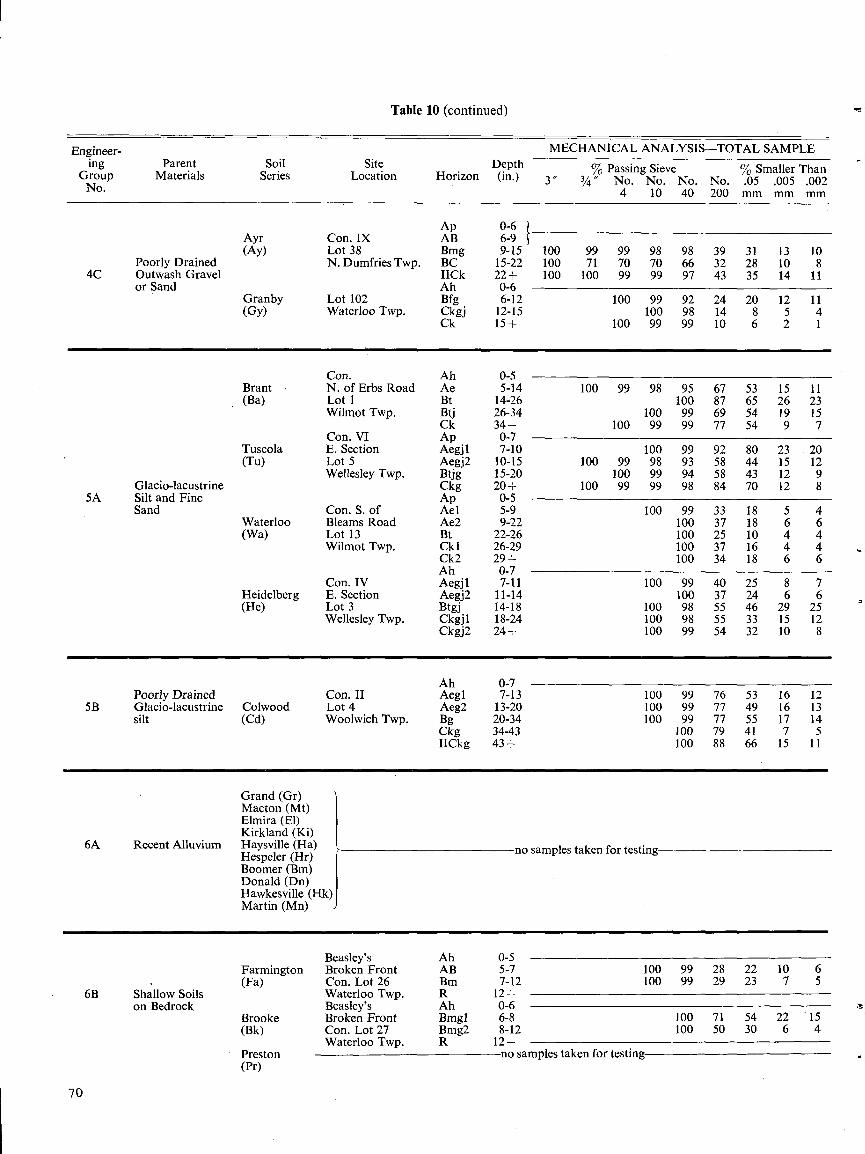
7 0
Table 10 (continued)
(Pr)
Engineer- MECHANICAL ANALYSIS-TOTAL SAMPLEing
GroupParent
MaterialsSoil
SeriesSite
Location HorizonDepth(in .) %
~~ ~~Passing Sieve .
SSmaller Than
No. 3 3/a No .
4No .10
No .40
No .200
.Omm
.005mm
.002mm
Ap 0-6Ayr Con . IX AB 6-9(Ay) Lot 38 Bmg 9-15 100 99 99 98 98 39 31 13 10
Poorly Drained N. Dumfries Twp. BC 15-22 100 71 70 70 66 32 28 10 84C Outwash Gravel IICk 22+ 100 100 99 99 97 43 35 14 11
or Sand Ah 0-6Granby Lot 102 Bfg 6-12 100 99 92 24 20 12 11(Gy) Waterloo Twp . Ckgj 12-15 100 98 14 8 5 4
Ck 15+ 100 99 99 10 6 2 1
Con. Ah 0-5Brant N. of Erbs Road Ae 5-14 100 99 98 95 67 53 15 11(Ba) Lot 1 Bt 14-26 100 87 65 26 23
Wilmot Twp . Btj 26-34 100 99 69 54 19 15Ck 34+ 100 99 99 77 54 9 7
Con. VI Ap 0-7Tuscola E . Section Aegj1 7-10 100 99 92 80 23 20(Tu) Lot 5 Aegj2 10-15 100 99 98 93 58 44 15 12
Wellesley Twp. Btjg 15-20 100 99 94 58 43 12 9Glacio-lacustrine Ckg 20+ 100 99 99 98 84 70 12 8
5A Silt and Fine Ap 0-5Sand Con . S . of Ael 5-9 100 99 33 18 5 4
Waterloo Bleams Road Ae2 9-22 100 37 18 6 6(Wa) Lot 13 Bt 22-26 100 25 10 4 4
Wilmot Twp. Ckl 26-29 100 37 16 4 4Ck2 294- 100 34 18 6 6Ah 0-7
Con . IV Aegj1 7-11 100 99 40 25 8 7Heidelberg E . Section Aegj2 11-14 100 37 24 6 6(He) Lot 3 Btgj 14-18 100 98 55 46 29 25
Wellesley Twp. Ckgj1 18-24 100 98 55 33 15 12Ckgj2 24+ 100 99 54 32 10 8
Ah 0-7 -Poorly Drained Con . 11 Aegl 7-13 100 99 76 53 16 12
5B Glacio-lacustrine Colwood Lot 4 Aeg2 13-20 100 99 77 49 16 13Silt (Cd) Woolwich Twp. Bg 20-34 100 99 77 55 17 14
Ckg 34-43 100 79 41 7 5IICkg 43+ 100 88 66 15 11
Grand (Gr)Macton (Mt)Elmira (El)Kirkland (Ki)
6A Recent Alluvium Haysville (Ha) no samples taken for testingHespeler (Hr)Boomer (Bm)Donald (Din)Hawkesville (Hk)Martin (Mn)
Beasley's Ah 0-5Farmington Broken Front AB 5-7 100 99 28 22 10 6
. (Fa) Con . Lot 26 Bm 7-12 100 99 29 23 7 56B Shallow Soils Waterloo Twp . R 12+
on Bedrock Beasley's Ah 0-6Brooke Broken Front Bmgl 6-8 100 71 54 22 15(Bk) Con . Lot 27 Bmg2 8-12 100 50 30 6 4
Waterloo Twp . R 12+Preston no samples taken for testing
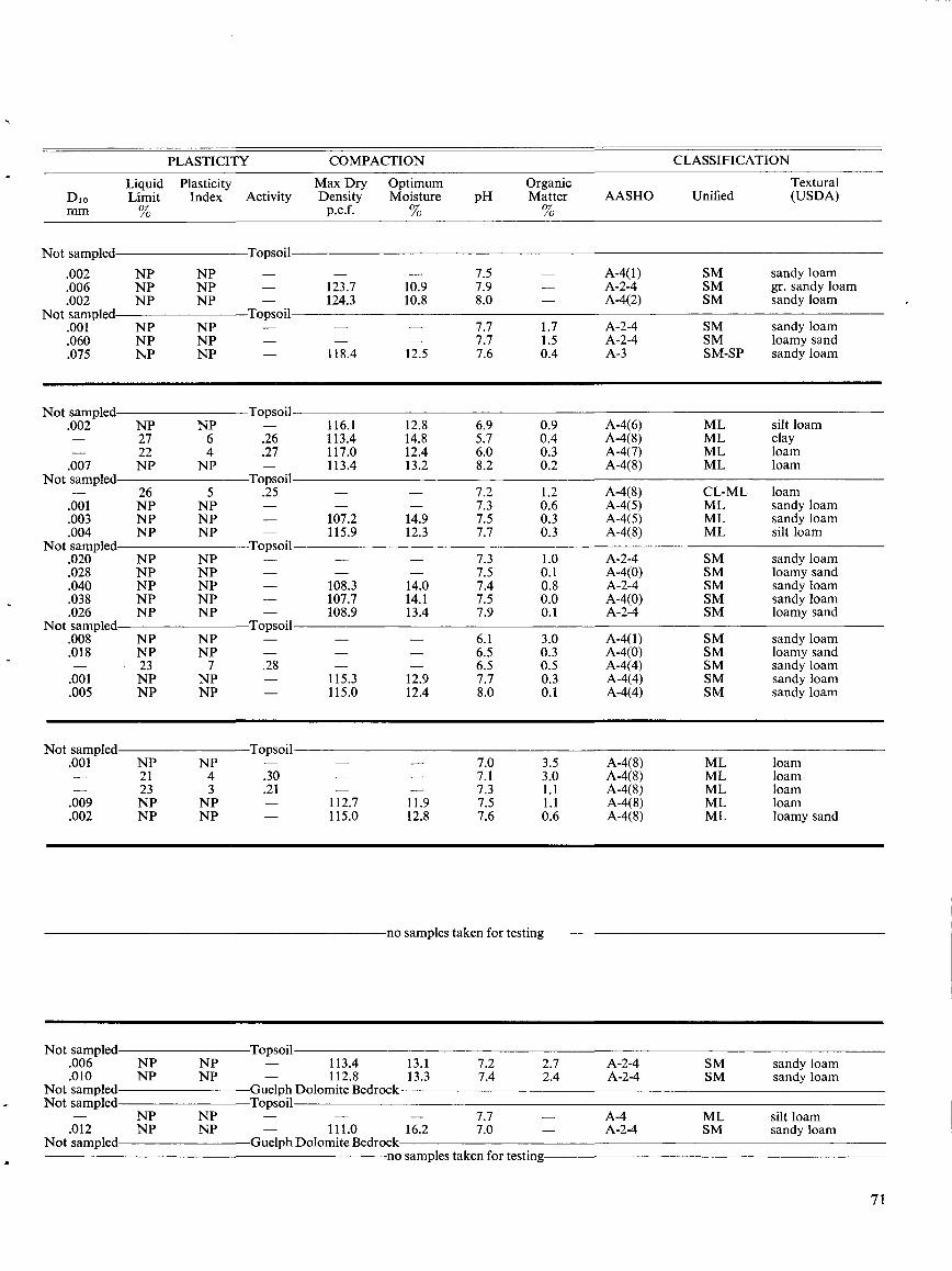
PLASTICITY COMPACTION
CLASSIFICATION
Not sampled
Guelph Dolomite Bedrockno samples taken for testing
DIomm
Not sampled
LiquidLimit%
PlasticityIndex Activity
Topsoil
Max DryDensityp.c .f.
OptimumMoisture%
pHOrganicMatter%
AASHO UnifiedTextural(USDA)
.002 NP NP - - - 7.5 - A-4(1) SM sandy loam
.006 NP NP - 123.7 10.9 7 .9 - A-2-4 SM gr . sandy loam
.002 NP NP - 124.3 10.8 8 .0 - A-4(2) SM sandy loamNot sampled Topsoil
.001 NP NP - - - 7.7 1 .7 A-2-4 SM sandy loam
.060 NP NP - - - 7.7 1 .5 A-2-4 SM loamy sand.075 NP NP - 118.4 12.5 7.6 0.4 A-3 SM-SP sandy loam
Not sampled Topsoil.002 NP NP - 116 .1 12.8 6.9 0 .9 A-4(6) ML silt loam- 27 6 .26 113.4 14.8 5 .7 0.4 A-4(8) ML clay- 22 4 .27 117 .0 12.4 6 .0 0 .3 A-4(7) ML loam.007 NP NP - 113.4 13.2 8 .2 0.2 A-4(8) ML loam
Not sampled Topsoil- 26 5 .25 - - 7.2 1 .2 A-4(8) CL-ML loam.001 NP NP - - - 7.3 0.6 A-4(5) ML sandy loam.003 NP NP - 107.2 14.9 7.5 0 .3 A-4(5) ML sandy loam.004 NP NP - 115.9 12.3 7.7 0.3 A-4(8) ML silt loam
Not sampled Topsoil.020 NP NP - - - 7.3 1 .0 A-2-4 SM sandy loam.028 NP NP - - - 7.5 0 .1 A-4(0) SM loamy sand.040 NP NP - 108.3 14.0 7.4 0 .8 A-2-4 SM sandy loam.038 NP NP - 107.7 14 .1 7.5 0 .0 A-4(0) SM sandy loam.026 NP NP - 108.9 13.4 7.9 0.1 A-2-4 SM loamy sand
Not sampled Topsoil.008 NP NP - - - 6.1 3.0 A-4(1) SM sandy loam.018 NP NP - - - 6.5 0.3 A-4(0) SM loamy sand- 23 7 .28 - - 6.5 0.5 A-4(4) SM sandy loam.001 NP NP - 115.3 12.9 7.7 0 .3 A-4(4) SM sandy loam.005 NP NP - 115 .0 12.4 8.0 0 .1 A-4(4) SM sandy loam
Not sampled Topsoil.001 NP NP - - - 7.0 3 .5 A-4(8) ML loam- 21 4 .30 - - 7.1 3.0 A-4(8) ML loam- 23 3 .21 - - 7.3 1 .1 A-4(8) ML loam.009 NP NP - 112.7 11 .9 7.5 1 .1 A-4(8) ML loam.002 NP NP - 115.0 12.8 7.6 0.6 A-4(8) ML loamy sand
no samples taken for testing
Not sampled Topsoil.006 NP NP - 113.4 13.1 7.2 2.7 A-2-4 SM sandy loam.010 NP NP - 112.8 13 .3 7 .4 2.4 A-2-4 SM sandy loam
Not sampled Guelph Dolomite BedrockNot sampled Topsoil
- NP NP - - - 7.7 - A-4 ML silt loam.012 NP NP - 111 .0 16.2 7 .0 - A-2-4 SM sandy loam
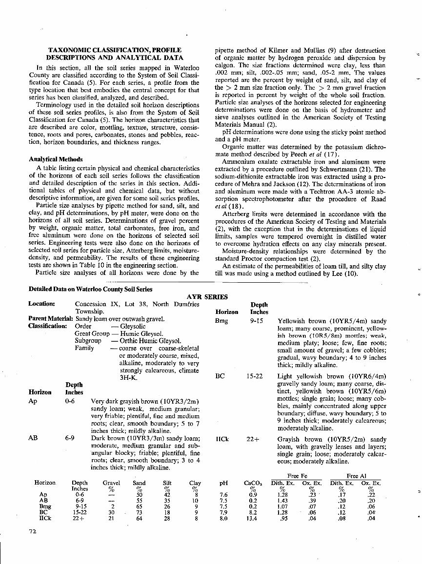
In this section, all the soil series mapped in WaterlooCounty are classified according to the System of Soil Classi-fication for Canada (5) . For each series, a profile from thetype location that best embodies the central concept for thatseries has been classified, analyzed, and described .
Terminology used in the detailed soil horizon descriptionsof these soil series profiles, is also from the System of SoilClassification for Canada (5) . The horizon characteristics thatare described are color, mottling, texture, structure, consis-tence, roots and pores, carbonates, stones and pebbles, reac-tion, horizon boundaries, and thickness ranges .
Analytical MethodsA table listing certain physical and chemical characteristics
of the horizons of each soil series follows the classificationand detailed description of the series in this section . Addi-tional tables of physical and chemical data, but withoutdescriptive information, are given for some soil series profiles .
Particle size analyses by pipette method for sand, silt, andclay, and pH determinations, by pH meter, were done on thehorizons of all soil series . Determinations of gravel percentby weight, organic matter, total carbonates, free iron, andfree aluminum were done on the horizons of selected soilseries . Engineering tests were also done on the horizons ofselected soil series for particle size, Atterberg limits, moisture-density, and permeability . The results of these engineeringtests are shown in Table 10 in the engineering section .
Particle size analyses of all horizons were done by the
Detailed Data on Waterloo County Soil SeriesAYR SERIES
Location:
Concession IX, Lot 38, North DumfriesTownship.
Parent Material : Sandy loam over outwash gravel .Classification:
Order
-GleysolicGreat Group - Humic Gleysol .Subgroup
-Orthic Humic Gleysol .Family
-coarse over
coarse-skeletalor moderately coarse, mixed,alkaline, moderately to verystrongly calcareous, climate3H-K.
DepthHorizon InchesAp
AB
72
TAXONOMIC CLASSIFICATION, PROFILEDESCRIPTIONS AND ANALYTICAL DATA
0-6
Very dark grayish brown (10YR3/2m)sandy loam ; weak, medium granular ;very friable ; plentiful, fine and mediumroots ; clear, smooth boundary; 5 to 7inches thick ; mildly alkaline .
6-9
Dark brown (10YR3/3m) sandy loam;moderate, medium granular and sub-angular blocky ; friable ; plentiful, fineroots ; clear, smooth boundary; 3 to 4inches thick ; mildly alkaline .
pipette method of Kilmer and Mullins (9) after destructionof organic matter by hydrogen peroxide and dispersion bycalgon . The size fractions determined were clay, less than.002 mm; silt, .002-.05 mm; sand, .05-2 mm. The valuesreported are the percent by weight of sand, silt, and clay ofthe > 2 mm size fraction only . The > 2 mm gravel fractionis reported in percent by weight of the whole soil fraction .Particle size analyses of the horizons selected for engineeringdeterminations were done on the basis of hydrometer andsieve analyses outlined in the American Society of TestingMaterials Manual (2) .pH determinations were done using the sticky point method
and a pH meter .Organic matter was determined by the potassium dichro-
mate method described by Peech et al (17) .Ammonium oxalate extractable iron and aluminum were
extracted by a procedure outlined by Schwertmann (21) . Thesodium-dithionite extractable iron was extracted using a pro-cedure of Mehra and Jackson (12) . The determinations of ironand aluminum were made with a Techtron AA-3 atomic ab-sorption spectrophotometer after the procedure of Raadet al (18) .
Atterberg limits were determined in accordance with theprocedures of the American Society of Testing and Materials(2), with the exception that in the determinations of liquidlimits, samples were tempered overnight in distilled waterto overcome hydration effects on any clay minerals present .
Moisture-density relationships were determined by thestandard Proctor compaction test (2) .An estimate of the permeabilities of loam till, and silty clay
till was made using a method outlined by Lee (10) .
DepthHorizon InchesBmg 9-15
BC 15-22
IICk 22+
Yellowish brown (10YR5/4m) sandyloam ; many coarse, prominent, yellow-ish brown (10R5/8m) mottles ; weak,medium platy ; loose ; few, fine roots ;small amount of gravel ; a few cobbles ;gradual, wavy boundary ; 4 to 9 inchesthick ; mildly alkaline .
Light yellowish brown (10YR6/4m)gravelly sandy loam; many coarse, dis-tinct, yellowish brown (10YR5/6m)mottles ; single grain ; loose; many cob-bles, mainly concentrated along upperboundary; diffuse, wavy boundary ; 5 to9 inches thick ; moderately calcareous ;moderately alkaline .
Grayish brown (10YR5/2m) sandyloam, with gravelly lenses and layers ;single grain ; loose ; moderately calcar-eous ; moderately alkaline .
Horizon
Ap
DepthInches0-6
Gravel%-
Sand%50
Silt%42
Clay%8
pH
7.6
CaCO3
0.9
FreeDith . Ex .
1.28
FeOx. Ex .
.23
FreeDith . Ex .
.17
AlOx . Ex .
.22AB 6-9 - 55 35 10 7.5 0.2 1.43 .39 .20 .20Bmg 9-15 2 65 26 9 7.5 0.2 1.07 .07 .12 .06BC 15-22 30 73 18 9 7.9 8.2 1.28 .06 .12 .04IICk 22+ 21 64 28 8 8.0 13.4 .95 .04 .08 .04
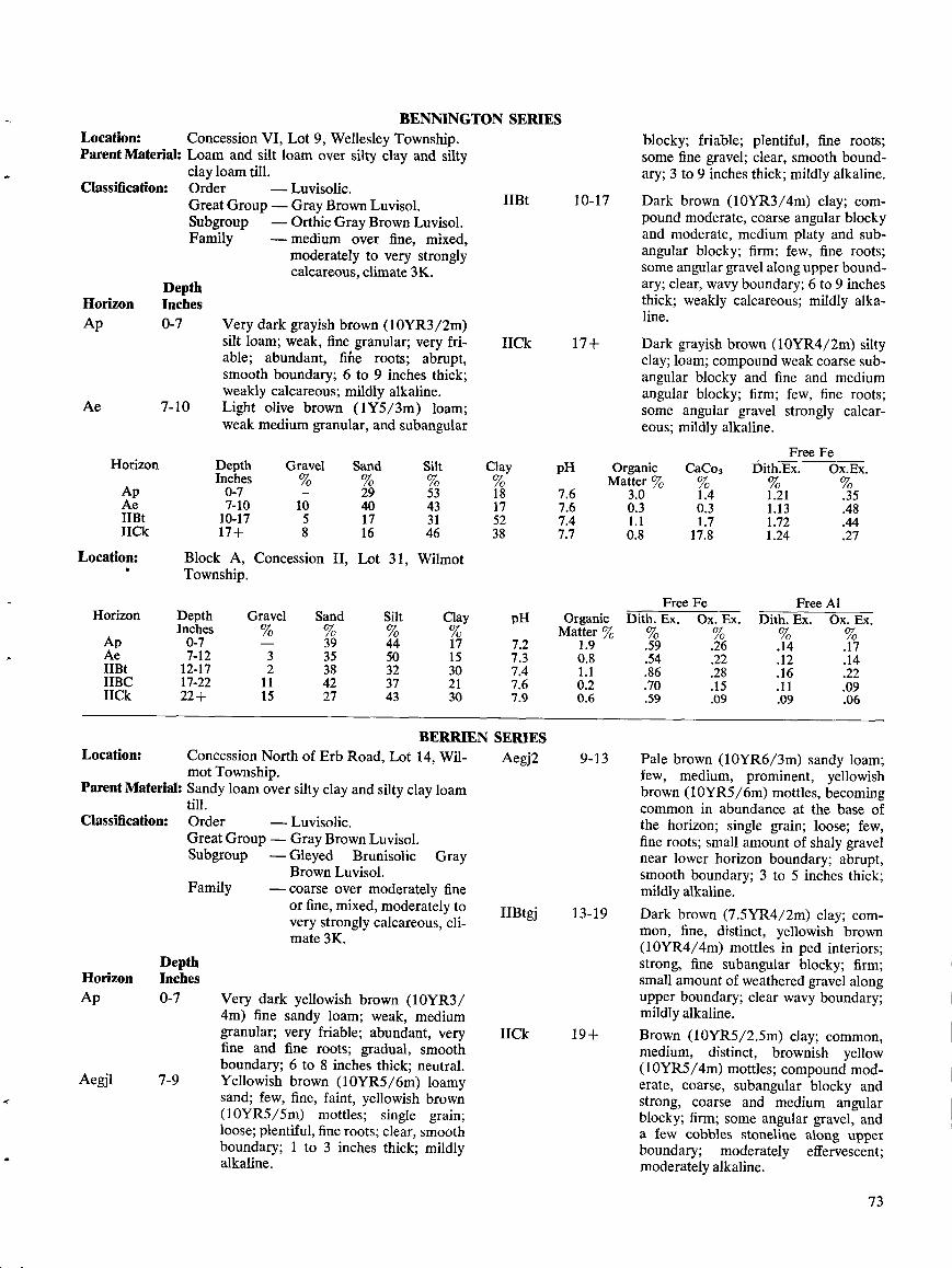
BENNINGTON SERIESLocation :
Concession VI, Lot 9, Wellesley Township .Parent Material: Loam and silt loam over silty clay and silty
clay loam till .Classification:
Order
-Luvisolic.Great Group-Gray BrownLuvisol.Subgroup
-Orthic Gray BrownLuvisol.Family
-medium over fine, mixed,moderately to very stronglycalcareous, climate 3K.
DepthHorizon InchesAp
0-7
Very dark grayish brown (10YR3/2m)silt loam ; weak, fine granular; very fri-
IICkable; abundant, fine roots ; abrupt,smooth boundary; 6 to 9 inches thick;weakly calcareous ; mildly alkaline .
Ae
7-10
Light olive brown (IY5/3m) loam;weak medium granular, and subangular
Horizon
Location :
ApAe1113tIICk
Parent Material:
Classification:
DepthHorizon InchesAp 0-7
Aegjl 7-9
IIBt
BERRIEN SERIESConcession North of Erb Road, Lot 14, Wil-
Aeg2motTownship .Sandy loam over silty clay and silty clay loamtill .Order
-Luvisolic.Great Group-Gray BrownLuvisol.Subgroup
-Gleyed
Brunisolic
GrayBrownLuvisol.
Family
-coarse over moderately fineor fine, mixed, moderately tovery strongly calcareous, cli-mate 3K.
IIBtgj
Very dark yellowish brown (10YR3/4m) fine sandy loam ; weak, mediumgranular; very friable; abundant, very
IICkfine and fine roots; gradual, smoothboundary; 6 to 8 inches thick; neutral.Yellowish brown (10YR5/6m) loamysand ; few, fine, faint, yellowish brown(10YR5/5m) mottles; single grain;loose; plentiful, fine roots; clear, smoothboundary ; 1 to 3 inches thick; mildlyalkaline .
10-17
9-13
13-19
blocky ; friable; plentiful, fine roots;some fine gravel ; clear, smooth bound-ary; 3 to 9 inches thick; mildly alkaline .
Dark brown (10YR3/4m) clay ; com-pound moderate, coarse angular blockyand moderate, medium platy and sub-angular blocky; firm ; few, fine roots;some angular gravel along upper bound-ary; clear, wavy boundary ; 6 to 9 inchesthick; weakly calcareous ; mildly alka-line .
Dark grayish brown (10YR4/2m) siltyclay ; loam ; compound weak coarse sub-angular blocky and fine and mediumangular blocky; firm ; few, fine roots ;some angular gravel strongly calcar-eous ; mildly alkaline .
Pale brown (10YR6/3m) sandy loam ;few, medium, prominent, yellowishbrown (10YR5/6m) mottles, becomingcommon in abundance at the base ofthe horizon; single grain; loose; few,fine roots; small amount of shaly gravelnear lower horizon boundary ; abrupt,smooth boundary ; 3 to 5 inches thick;mildly alkaline.
Dark brown (7 .5YR4/2m) clay ; com-mon, fine, distinct, yellowish brown(10YR4/4m) mottles in ped interiors ;strong, fine subangular blocky ; firm ;small amount of weathered gravel alongupper boundary ; clear wavy boundary ;mildly alkaline .
Brown (10YR5/2.5m) clay ; common,medium, distinct, brownish yellow(10YR5/4m) mottles; compound mod-erate, coarse, subangular blocky andstrong, coarse and medium angularblocky ; firm ; some angular gravel, anda few cobbles stoneline along upperboundary ; moderately effervescent ;moderately alkaline .
73
Location : Block A, Concession II, Lot 31, Wilmot6
Township .
Free Fe Free AlHorizon Depth Gravel Sand Silt Clay pH Organic Dith. Ex. Ox. Ex. Dith. Ex. Ox . Ex.
Inches % % % % Matter %Ap 0-7 - 39 44 17 7.2 1 .9 .59 .26 .14 .17Ae 7-12 3 35 50 15 7.3 0.8 .54 .22 .12 .14IIBt 12-17 2 38 32 30 7.4 1 .1 .86 .28 .16 .22IIBC 17-22 11 42 37 21 7.6 0.2 .70 .15 .11 .09IICk 22+ 15 27 43 30 7.9 0.6 .59 .09 .09 .06
DepthInches0-7
Gravel%-
Sand%29
Silt%53
Clay%18
pH
7.6
OrganicMatter %
3.0
CaCo3
1 .4
FreeDith.Ex.
1 .21
FeOx.Ex.
.357-10 10 40 43 17 7.6 0.3 0.3 1 .13 .48
10-17 5 17 31 52 7.4 1 .1 1 .7 1 .72 .4417+ 8 16 46 38 7.7 0.8 17.8 1.24 .27
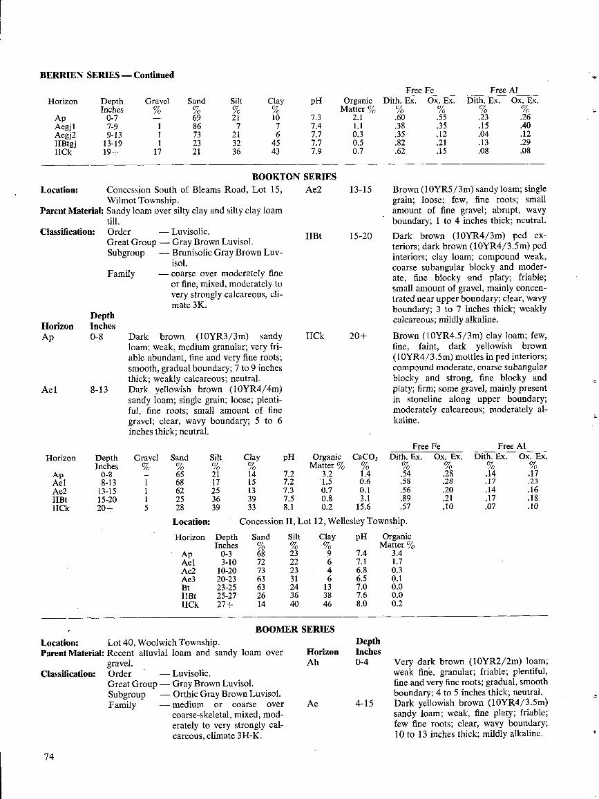
BERRIEN SERIES -Continued
BOOKTONConcession South of Bleams Road, Lot 15,Wilmot Township .
Parent Material : Sandy loam over silty clay and silty clay loamtill .Order
-Luvisolic .Great Group - Gray Brown Luvisol .Subgroup
-Brunisolic Gray Brown Luv-isol .
- coarse over moderately fineor fine, mixed, moderately tovery strongly calcareous, cli-mate 3K.
Location :
Classification:
Family
Dark brown (10YR3/3m) sandyloam ; weak, medium granular ; very fri-able abundant, fine and very fine roots ;smooth, gradual boundary; 7 to 9 inchesthick ; weakly calcareous ; neutral .Dark yellowish brown (10YR4/4m)sandy loam; single grain ; loose ; plenti-ful, fine roots ; small amount of finegravel ; clear, wavy boundary ; 5 to 6inches thick ; neutral .
ion II, Lot 12, Wellesley Township .
BOOMER SERIESLocation:
Lot 40, Woolwich Township .Parent Material: Recent alluvial loam and sandy loam over
gravel .Order
'
-Luvisolic .Great Group - Gray Brown Luvisol .Subgroup
-Orthic Gray Brown Luvisol .Family
-medium
or
coarse
overcoarse-skeletal, mixed, mod-erately to very strongly cal-careous, climate 3H-K.
Classification :
74
pH OrganicMatter %
7.3 2 .1
OrganicMatter %
3.41 .70 .30 .10.00.00.2
HorizonAh
Ae
DepthInches0-4
4-15
Brown (10YR5/3m) sandy loam ; singlegrain ; loose ; few, fine roots ; smallamount of fine gravel ; abrupt, wavyboundary ; 1 to 4 inches thick ; neutral .
Dark brown (10YR4/3m) ped ex-teriors ; dark brown (10YR4/3.5m) pedinteriors ; clay loam; compound weak,coarse subangular blocky and moder-ate, fine blocky and platy ; friable ;small amount of gravel, mainly concen-trated near upper boundary; clear, wavyboundary ; 3 to 7 inches thick; weaklycalcareous ; mildly alkaline .
Brown (10YR4.5/3m) clay loam; few,fine, faint, dark yellowish brown(10YR4/3 .5m) mottles in ped interiors ;compound moderate, coarse subangularblocky and strong, fine blocky andplaty ; firm ; some gravel, mainly presentin stoneline along upper boundary ;moderately calcareous ; moderately al-kaline .
Very dark brown (10YR2/2m) loam;weak fine, granular ; friable ; plentiful,fine and very fine roots ; gradual, smoothboundary; 4 to 5 inches thick ; neutral .Dark yellowish brown (10YR4/3.5m)sandy loam ; weak, fine platy ; friable ;few fine roots ; clear, wavy boundary ;10 to 13 inches thick ; mildly alkaline .
7 .47 .77 .77 .9
1 .10 .30 .50 .7
SERIESAe2 13-15
IIBt 15-20
IICk 20+
Silt%
Clay%
pH
23 9 7.422 6 7.123 4 6.831 6 6.524 13 7.036 38 7.640 46 8.0
Free Fe Free AlHorizon Depth Gravel Sand Silt Clay pH Organic CaC03 Dith . Ex . Ox. Ex . Dith. Ex . Ox. Ex .
Inches % % % Matter % % %Ap 0-8 - 65 21 14 7.2 3.2 1 .4 .54 .28 .14 .17Ael 8-13 1 68 17 15 7.2 1 .5 0.6 .58 .28 .17 .23Ae2 13-15 1 62 25 13 7.3 0.7 0.1 .56 .20 .14 .16IIBt 15-20 1 25 36 39 7.5 0 .8 3 .1 .89 .21 .17 .18IICk 20+ 5 28 39 33 8.1 0 .2 15.6 .57 .10 .07 .10
Horizon Depth Gravel Sand Silt ClayInches
Ap 0-7 69 21 10Aegj 1 7-9 1 86 7 7Aegj2 9-13 1 73 21 6IIBtgj 13-19 1 23 32 45IICk 19+ 17 21 36 43
FreeDith . Ex .%
FeOx . Ex .%
FreeDith . Ex .
AlOx. Ex.
.60 .55 .23 .26.38 .35 .15 .40.35 .12 .04 .12.82 .21 .13 .29.62 .15 .08 .08
Location: Conces
Horizon Depth SandInches %
Ap 0-3 68Ael 3-10 72Ae2 10-20 73Ae3 20-23 63Bt 23-25 631113t 25-27 26IICk 27+ 14
DepthHorizon InchesAp 0-8
Ae1 8-13
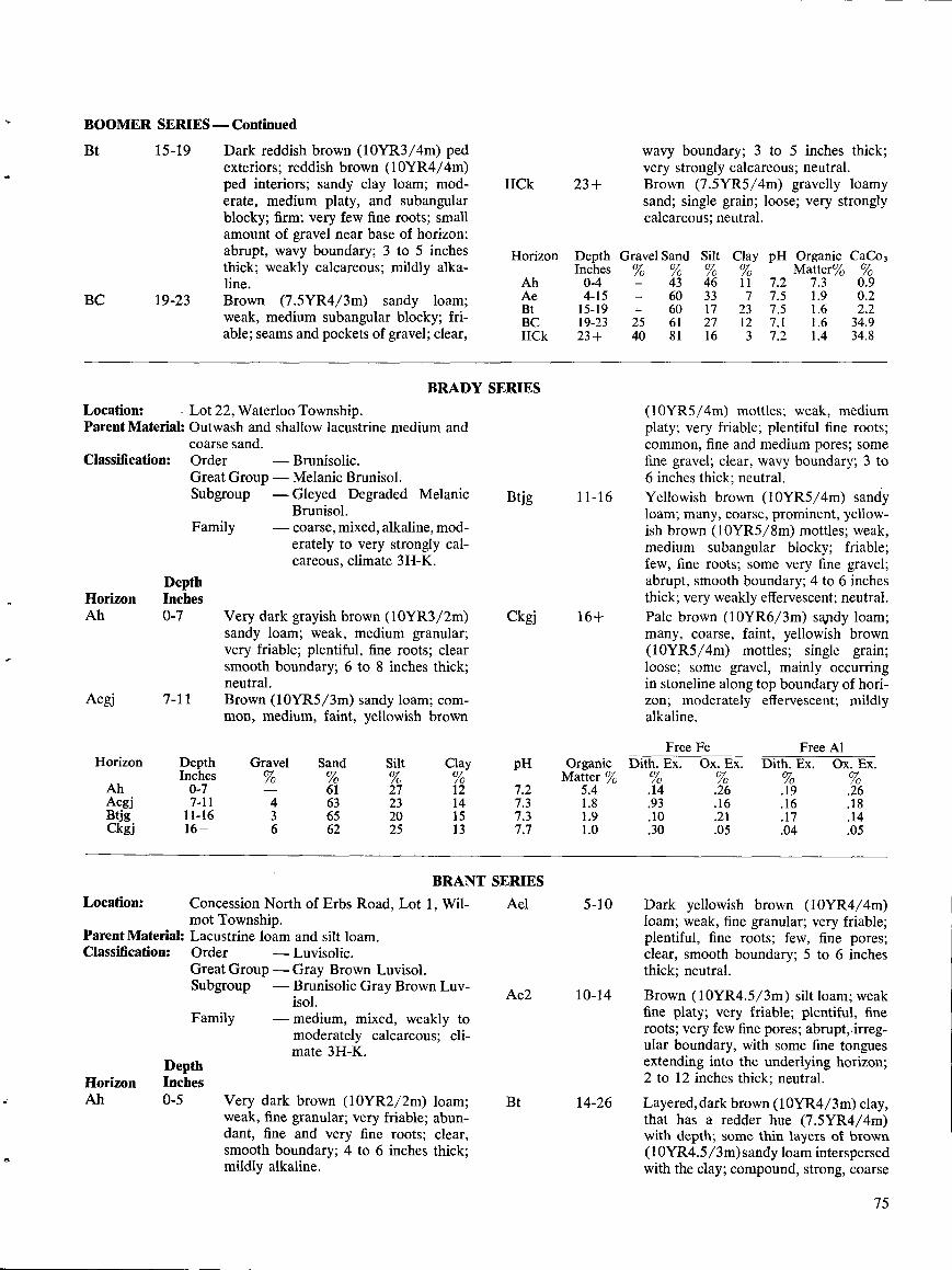
BOOMER SERIES -Continued
Bt 15-19
BC 19-23
Location:
Lot22, Waterloo Township .Parent Material: Outwash and shallow lacustrine medium and
coarse sand .Order
-Brunisolic .GreatGroup-Melanic Brunisol .Subgroup
-Gleyed Degraded MelanicBrunisol .
-coarse, mixed, alkaline, mod-erately to very strongly cal-careous, climate 3H-K.
Classification:
DepthHorizon InchesAh 0-7
Aegj 7-11
Location:
DepthHorizon InchesAh 0-5
Family
Family
Dark reddish brown (10YR3/4m) pedexteriors; reddish brown (10YR4/4m)ped interiors; sandy clay loam; mod-erate, medium platy, and subangularblocky ; firm ; very few fine roots; smallamount of gravel near base of horizon;abrupt, wavy boundary ; 3 to 5 inchesthick; weakly calcareous ; mildly alka-line .Brown (7.5YR4/3m) sandy loam ;weak, medium subangular blocky ; fri-able ; seams and pockets of gravel ; clear,
Very dark grayish brown (10YR3/2m)sandy loam; weak, medium granular ;very friable; plentiful, fine roots; clearsmooth boundary ; 6 to 8 inches thick;neutral.Brown (10YR5/3m) sandy loam ; com-mon, medium, faint, yellowish brown
Very dark brown (10YR2/2m) loam;weak, fine granular ; very friable; abun-dant, fine and very fine roots; clear,smooth boundary ; 4 to 6 inches thick;mildly alkaline .
BRADY SERIES
BRANT S
Concession North of Erbs Road, Lot 1, Wil-mot Township .
Parent Material: Lacustrine loam and silt loam .Classification :
Order
-Luvisolic.GreatGroup-Gray Brown Luvisol.Subgroup
-Brunisolic Gray Brown Luv-isol .
-medium, mixed, weakly tomoderately calcareous ; cli-mate 3H-K.
IICk 23+
Horizon
Depth Gravel SandInches % %
Ah 0-4 - 43Ae 4-15 -Bt 15-19 -BC 19-23 25IICk 23+ 40
Btjg 11-16
Ckgj 16+
wavy boundary ; 3 to 5 inches thick;very strongly calcareous ; neutral.Brown (7.5YR5/4m) gravelly loamysand ; single grain; loose; very stronglycalcareous ; neutral.
Silt Clay pH Organic CaC03% %
Matter% %46 11 7.2 7.3 0.9
60 33 7 7.5 1 .9 0.260 17 23 7.5 1 .6 2.261 27 12 7.1 1 .6 34.981 16 3 7.2 1 .4 34.8
(10YR5/4m) mottles; weak, mediumplaty; very friable ; plentiful fine roots;common, fine and medium pores; somefine gravel ; clear, wavy boundary; 3 to6 inches thick; neutral.Yellowish brown (10YR5/4m) sandyloam ; many, coarse, prominent, yellow-ish brown (10YR5/8m) mottles; weak,medium subangular blocky ; friable;few, fine roots; some very fine gravel ;abrupt, smooth boundary ; 4 to 6 inchesthick; very weakly effervescent ; neutral .Pale brown (10YR6/3m) sandy loam ;many, coarse, faint, yellowish brown(10YR5/4m) mottles; single grain;loose; some gravel, mainly occurringin stoneline along top boundary of hori-zon; moderately effervescent ; mildly
Dark yellowish brown (10YR4/4m)loam; weak, fine granular; very friable;plentiful, fine roots; few, fine pores;clear, smooth boundary ; 5 to 6 inchesthick; neutral.
Brown (10YR4.5/3m) silt loam ; weakfine platy; very friable; plentiful, fineroots; very few fine pores; abrupt,_irreg-ular boundary, with some fine tonguesextending into the underlying horizon;2 to 12 inches thick; neutral.
Layered, dark brown (10YR4/3m) clay,that has a redder hue (7.5YR4/4m)with depth; some thin layers of brown(10YR4.5/3m)sandy loam interspersedwith the clay ; compound, strong, coarse
75
pH
7.27.37.37.7
OrganicMatter %
5.41.81 .91 .0
RIES
Ael 5-10
Ae2 10-14
Bt 14-26
Horizon Depth Gravel Sand Silt ClayInches %
Ah 0-7 61 27 12Aegj 7-11 4 63 23 14Btjg 11-16 3 65 20 15Ckgj 16+ 6 62 25 13
alkaline .
FreeDith . Ex .
FeOx . Ex.
FreeDith. Ex .
AlOx. Ex .
.14 .26 .19 .26
.93 .16 .16 .18.10 .21 .17 .14.30 .05 .04 .05
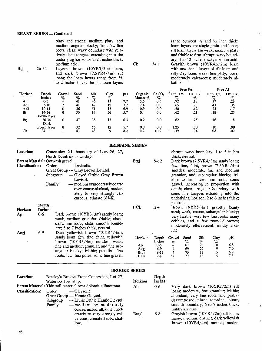
BRANT SERIES -Continued
Btj 26-34
Location :
Parent Material :Classification:
DepthHorizon InchesAp 0-6
Aegj 6-9
Location:
76
platy and strong, medium platy, andmedium angular blocky ; firm ; few fineroots ; clear, wavy boundary with rela-tively deep tongues extending into theunderlying horizon ; 6 to 24 inches thick ;medium acid .Layered brown . (10YR5/3m) loam,and dark brown (7 .5YR4/4m) siltloam; the loam layers range from 1/2to 2 inches thick ; the silt loam layers
Concession X1, boundary of Lots 26, 27,North Dumfries Township .Outwash gravel .Order
- Luvisolic .Great Group - Gray Brown Luvisol .Subgroup
-Gleyed Orthic Gray BrownLuvisol .
Family
-medium ormoderatelycoarseover coarse-skeletal, moder-ately to very strongly cal-careous, climate 3H-K.
Dark brown (10YR3/3m) sandy loam;weak, medium granular ; friable ; abun-dant, fine roots ; clear, smooth bound-ary; 5 to 7 inches thick ; neutral .Dark yellowish brown (10YR4/4m);sandy loam; few, fine, faint, yellowishbrown (10YR5/4m) mottles ; weak,fine and medium granular, and fine sub-angular blocky ; friable ; plentiful, fineroots ; few, fine pores ; some fine gravel ;
Beasley's Broken Front Concession, Lot 27,Waterloo Township .
Parent Material: Thin soil material over dolomitic limestoneClassification :
Order
-Gleysolic .Great Group - Humic Gleysol .Subgroup
-Lithic Orthic Humic Gleysol .Family
-medium or moderatelycoarse, mixed, alkaline, mod-erately to very strongly cal-careous ; climate 3H-K, shal-low .
Ck 34+
BRIS
BROOKE SERIES
Horizon DepthInches
Ap 0-6Aegj 6-9Btgj 9-12IICk 12+
DepthHorizon InchesAh 0-6
Bmgl 6-8
range between 1/4 and 1/2 inch thick;loam layers are single grain and loose ;silt loam layers are weak, medium platyand friable to firm ; abrupt, wavy bound-ary ; 4 to 12 inches thick ; medium acid .Grayish brown (10YR4.5/2m) loamwith occasional layers of silt loam andsilty clay loam ; weak, fine platy ; loose ;moderately calcareous ; moderately al-kaline .
abrupt, wavy boundary ; 1 to 5 inchesthick ; neutral .Dark brown (7 .5YR4/3m) sandy loam;'few, fine, faint, brown (7 .5YR4/4m)mottles ; moderate, fine and mediumgranular, and subangular blocky ; fri-able to firm ; few, fine roots ; somegravel, increasing in proportion withdepth ; clear, irregular boundary, withsome fine tongues extending into theunderlying horizon ; 2 to 6 inches thick ;neutral.Brown (9YR5/4m) gravelly loamysand ; weak, coarse, subangular blocky ;very friable ; very few fine roots ; manycobbles, and a few rounded stones ;moderately effervescent ; mildly alka-line .
Very dark brown (10YR2/2m) siltloam ; moderate, fine granular ; friable ;abundant, very fine roots, and partly-decomposed plant remains ; clear,smooth boundary ; 6 to 7 inches thick ;mildly alkaline .Grayish brown (10YR5/2m) silt loam;many, medium, distinct, dark yellowishbrown (10YR4/4m) mottles ; moder-
pH
7.7
OrganicMatter %
5.5
CaC03
0.67 .2 2.4 0.06.9 0.9 0.05.7 0.4 0.0
6.3 0.2 0.0
5.7 0.3 0.08.2 0.2 10.9
ANE SERIES
Btgj 9-12
IICk 12+
Horizon
Ah
DepthInches0-5
Gravel%-
Sand
41
Silt
46
Clay
13Ael 5-10 2 41 47 12Ae2 10-14 0 36 51 13Bt 14-26 0 30 14 56
Brown layerBtj 26-34 0 47 38 15
Darkbrown layer 0 32 56 12
Ck 34+ 1 43 48 9
Gravel%-
Sand
67
Silt
23
Clay
10
pH
6.84 69 22 9 7.04 73 12 15 6.952 77 18 5 7.8
FreeDith . Ex .
FeOx . Ex.
FreeDith . Ex .
AlOx . Ex .
.72 .17 .37 .23
.65 .23 .43 .35
.50 .12 .23 .17
.62 .21 .38 .23
.62 .25 .16 .18
1.25 .20 .10 .09.39 .04 .08 .02
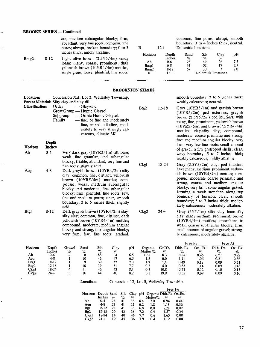
BROOKE SERIES -Continued
Bmg2 8-12
DepthHorizon InchesAh 0-4
Aeg 4-8
Btgl 8-12
ate, medium subangular blocky; firm ;abundant, very fine roots ; common, finepores ; abrupt, broken boundary; 0 to 3inches thick ; mildly alkaline .Light olive brown (2.5Y5/4m) sandyloam; many, coarse, prominent, darkyellowish brown (10YR4/4m) mottles ;single grain ; loose ; plentiful, fine roots ;
Location:
Concession XII, Lot 3, Wellesley Township .Parent Material: Silty clay and clay till .Classification:
Order
-Gleysolic .Great Group - Humic Gleysol .Subgroup
-Orthic Humic Gleysol .Family
-fine, or fine and moderatelyfine, mixed, alkaline, mod-erately to very strongly cal-careous, climate 3K.
Very dark gray (10YR3/lm) silt loam;weak, fine granular, and subangularblocky ; friable ; abundant, very fine andfine roots ; slightly acid .Dark grayish brown (10YR4/2m) siltyclay; common, fine, distinct, yellowishbrown (10YR5/4m) mottles ; com-pound, weak, medium subangularblocky and moderate, fine subangularblocky; firm ; plentiful, fine roots ; few,fine and medium pores ; clear, smoothboundary; 3 to 5 inches thick ; slightlyacid .Dark grayish brown (10YR4/2m) clay-silty clay; common, fine, distinct, darkyellowish brown (10YR4/4m) mottles ;compound, moderate, medium angularblocky and strong, fine angular blocky ;very firm ; few, fine roots ; gradual,
Location:
BROOKSTON SERIES
Horizon Depth Sand SiltInches % %
Ah 0-4 23 41Aeg 4-8 27 41Bgl 8-12 23 41Bg2 12-18 20 42Ckg1 18-24 14 40Ckg2 24+ 19 45
R
Horizon DepthInches
Ah 0-6Bmgl 6-8Bmg2 8-12
Concession 12, Lot 3, Wellesley Township .
Free FeClay pH Organic Dith.Ex. Ox.Ex.% Matter% % %36 6.4 7.0 0.94 0.4432 6.2 1 .8 1 .18 0.3636 6.8 0.8 1 .28 0.0238 7.2 0.9 1.57 0.2446 7.7 0 .6 1.65 0.0036 7.9 0 .4 1.12 0.00
common, fine pores ; abrupt, smoothboundary ; 3 to 4 inches thick ; neutral .Dolomitic limestone .
Dolomitic limestone
smooth boundary; 3 to 5 inches thick ;weakly calcareous ; neutral .Gray (10YR5/ 1 m) and grayish brown(10YR5/2m) ped exteriors ; grayishbrown (2.5Y5/2m) ped interiors, withmany, fine, prominent, yellowish brown(10YR5/6m), and brown (7 .5YR4/4m)mottles ; clay-silty clay ; compound,moderate, coarse prismatic and strong,fine and medium angular blocky; veryfirm ; very few fine roots ; small amountof gravel ; a few gastropod shells ; clear,wavy boundary; 5 to 7 inches thick ;weakly calcareous ; mildly alkaline .Gray (2.5Y5/2m) clay ; ped interiorshave many, medium, prominent, yellow-ish brown (10YR4/4m) mottles ; com-pound, moderate coarse prismatic andstrong, coarse and medium angularblocky; very firm ; some angular gravel,forming a weak stoneline along topboundary of horizon ; clear, smoothboundary ; 5 to 7 inches thick ; moder-ately calcareous ; moderately alkaline .Gray (5Y5/lm) silty clay loam-siltyclay; many medium, prominent, brown(10YR4/4m) mottles ; amorphous toweak, coarse subangular blocky ; firm ;small amount of angular gravel ; strong-ly calcareous ; moderately alkaline .
77
Horizon DepthInches
Gravel%
Sand%
Silt%
Clay pH OrganicMatter %
CaCO3%
FreeDith . Ex .%
FeOx . Ex .%
FreeDith . Ex.
AlOx. Ex.
Ah 0-4 - 8 88 4 6.5 10.8 0.3 0.88 0.46 0.21 0.92Aeg 4-8 1 10 43 47 6.5 1 .8 0.0 1 .11 1 .06 0.21 0.56Btg1 8-12 1 9 39 52 7.3 1 .7 1 .1 0.49 0.18 0.09 0.21Btg2 12-18 1 10 39 51 7.7 0.6 4.0 0.63 1 .14 0.09 .043Ckg1 18-24 4 11 46 43 8 .1 0.3 10.8 0.71 0.12 0.10 0.13Ckg2 24+ 3 16 44 40 8.2 0 .3 19.9 0.55 0.08 0.09 0.10
Btg2 12-18
Ckgl 18-24
Ckg2 24+
Sand Silt Clay pH%25 49 26 7.531 52 17 7.767 30 3 7.0
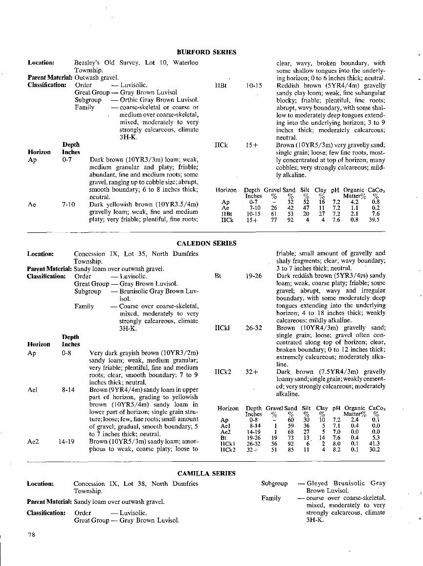
Location :
Parent Material :Classification :
DepthHorizon InchesAp 0-7
Ae
Location:
Ael
Location:
7 9
7-10
Concession IX, Lot 35, North DumfriesTownship .
Parent Material : Sandy loam over outwash gravel .Classification :
Order
-Luvisolic .Great Group - Gray Brown Luvisol .Subgroup
-Brunisolic Gray Brown Luv-isol .
- Coarse over coarse-skeletal,mixed, moderately to verystrongly calcareous, climate3H-K.
DepthHorizon InchesAp 0-8
8-14
Ae2 14-19
Beasley's Old Survey, Lot 10, WaterlooTownship.Outwash gravel .Order
-Luvisolic .Great Group - Gray Brown LuvisolSubgroup
-Orthic Gray Brown Luvisol .Family
-coarse-skeletal or coarse or--
medium over coarse-skeletal,mixed, moderately to verystrongly calcareous, climate3H-K .
Family
Dark brown (10YR3/3m) loam ; weak,medium granular and platy ; friable ;abundant, fine and medium roots ; somegravel, ranging up to cobble size ; abrupt,smooth boundary; 6 to 8 inches thick ;neutral .Dark yellowish brown (10YR3 .5/4m)gravelly loam; weak, fine and mediumplaty ; very friable ; plentiful, fine roots ;
Very dark grayish brown (10YR3/2m)sandy loam; weak, medium granular ;very friable ; plentiful, fine and mediumroots ; clear, smooth boundary ; 7 to 9inches thick ; neutral .Brown (9YR4/4m) sandy loam in upperpart of horizon, grading to yellowishbrown (10YR5/4m) sandy loam inlower part of horizon ; single grain stru-ture ; loose ; few, fine roots ; small amountof gravel ; gradual, smooth boundary ; 5to 7 inches thick ; neutral .Brown (10YR5/3m) sandy loam; amor-phous to weak, coarse platy; loose to
ConcessionTownship .
IX, Lot 38, North Dumfries
Parent Material : Sandy loam over outwash gravel .
Classification :
Order
-Luvisolic .Great Group- Gray Brown Luvisol .
BURFORD SERIES
IICk 15+
Horizon
ApAeIIBtIICk
CALEDON SERIES
11Bt 10-15
Bt
CAMILLA SERIES
IICk1 26-32
IICk2 32+
clear, wavy, broken boundary, withsome shallow tongues into the underly-ing horizon ; 0 to 6 inches thick ; neutral .Reddish brown (5YR4/4m) gravellysandy clay loam ; weak, fine subangularblocky ; friable ; plentiful, fine roots ;abrupt, wavy boundary, with some shal-low to moderately deep tongues extend-ing into the underlying horizon ; 3 to 9inches thick ; moderately calcareous ;neutral .Brown (I OYR5/3m) very gravelly sand;single grain ; loose ; few fine roots, most-ly concentrated at top of horizon ; manycobbles ; very strongly calcareous ; mild-ly alkaline .
Depth Gravel Sand Silt
Clay pH Organic CaCo3Inches % % % %
Matter% %0-7 - 32 52 16 7.2 4 .2 0.87-10 26 42 47 11 7.2 1 .1 0.210-15 61 53 20 27 7.2 2 .1 7.615+ 77 92 4 4 7.6 0.8 39.5
19-26
Horizon
Depth Gravel SandInches % %
Ap 0-8 - 60Ael 8-14 1 59Ae2 14-19 1 68Bt 19-26 19 73I1Ck1 26-32 56 92I1Ck2 32+ 51 85
Subgroup
Family
friable ; small amount of gravelly andshaly fragments ; clear, wavy boundary;3 to 7 inches thick ; neutral .Dark reddish brown (5YR3/4m) sandyloam ; weak, coarse platy ; friable ; somegravel ; abrupt, wavy and irregularboundary, with some moderately deeptongues extending into the underlyinghorizon ; 4 to 18 inches thick ; weaklycalcareous ; mildly alkaline .Brown (10YR4/3m) gravelly sand;single grain ; loose ; gravel often con-centrated along top of horizon ; clear,broken boundary; 0 to 12 inches thick ;extremely calcareous ; moderately alka-line .Dark brown (7.5YR4/3m) gravellyloamy sand; single grain ; weakly cement-ed ; very strongly calcareous ; moderatelyalkaline .
Silt Clay pH Organic CaCo3% %
Matter% %30 10 7.2 2.4 0 .136 5 7 .1 0.4 0.027 5 7.0 0.0 0.013 14 7.6 0.4 5.36 2 8.0 0.1 41 .3
11 4 8.2 0.1 30.2
- Gleyed Brunisolic GrayBrown Luvisol .
- coarse over coarse-skeletal,mixed, moderately to verystrongly calcareous, climate3H-K.
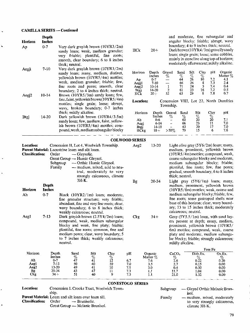
CAMILLA SERIES-Continued
Location:Parent Material:Classification:
Very dark grayish brown (10YR3/2m)sandy loam; weak, medium granular ;very friable ; plentiful, fine roots ;smooth, clear boundary; 6 to 8 inchesthick; neutral.Very dark grayish brown (10YR3/2m)sandy loam ; many, medium, distinct,yellowish brown (10YR5/4m) mottles ;weak, medium granular; friable ; few,fine roots and pores ; smooth, clearboundary ; 2 to 4 inches thick; neutral .Brown (10YR5/3m) sandy loam; few,fine, faint, yellowish brown(1OYR5 /4m)mottles ; single grain ; loose ; abrupt,wavy, broken boundary ; 0-7 inchesthick ; mildly alkaline .Dark yellowish brown (10YR4/3.5m)sandy loam; few, medium, faint, yellow-ish brown (10YR5/4m) mottles ; com-pound, weak,mediumsubangularblocky
Concession 11, Lot 4, Woolwich Township .Lacustrine loam and silt loam .Order
-Gleysolic .Great Group - Humic Gleysol .Subgroup
-Orthic Humic Gleysol .Family
-medium, mixed, acid to neu-tral, moderately to very
calcareous, climatestrongly3H-K.
Black (10YR2/lm) loam; moderate,fine granular structure ; very friable ;abundant, fine and very fine roots; clear,wavy boundary ; 6 to 8 inches thick ;weakly calcareous ; neutral .Dark grayish brown (2.5Y4/2m) loam;compound, weak, medium subangularblocky and weak, fine platy ; friable ;plentiful, fine roots ; common, fine andmedium pores ; clear, wavy boundary; 5to 7 inches thick ; weakly calcareous ;neutral .
IICk 20+
COLWOOD SERIES
Horizon DepthInches
Ap 0-7Aegj1 7-10Aegj2 10-14Btgj 14-20IICk 20+
Aeg2 13-20
Bg 20-34
Ckg 34+
CONESTOGO SERIES
and moderate, fine subangular andangular blocky ; friable ; abrupt, wavyboundary; 4 to 9 inches thick ; neutral .Dark brown(1 OYR4/3m) gravellysandyloam; single grain ; loose; some cobbles,mainly in stoneline along top of horizon ;moderately effervescent ; mildly alkaline .
Light olive gray (5Y6/2m) loam ; many,medium, prominent, yellowish brown(10YR5/4m)mottles ; compound, weak,coarse subangular blocky and moderate,medium subangular blocky ; friable ;plentiful, fine roots ; few, fine pores ;gradual, smooth boundary; 6 to 8 inchesthick ; neutral .Light gray (5Y6/lm) loam; many,medium, prominent, yellowish brown(10YR5/8m) mottles ; weak, coarse andmedium subangular blocky ;friable ; few,fine roots ; some gastropod shells nearbase of this horizon ; clear, wavy bound-ary; 13 to 15 inches thick ; moderatelycalcareous ; neutral .Gray (5Y5 .5/lm) loam, with sand lay-ers present at depth ; many, medium,prominent, yellowish brown (10YR5/6m) mottles ; compound, weak, coarseplaty and moderate, medium subangu-1ar blocky; friable ; strongly calcareous;mildly alkaline .
79
Gravel%
Sand%
Silt%
Clay%
pH OrganicMatter %
- 64 26 10 7.2 4.1- 66 26 8 7.3 2.41 71 24 5 7.4 0.42 61 23 16 7.2 0.5
52 63 29 8 7.8 0.7
Free FeHorizon Depth Sand Silt Clay pH Organic CaC03 Dith.Ex. Ox.Ex .
Inches % % % Matter % %Ah 0-7 47 41 12 6.7 7 .6 2 .6 0.22 0.20Aegl 7-13 50 40 10 7.0 3 .5 2.7 0.15 0.00Aeg2 13-20 49 41 10 7.1 3 .0 0.4 0.30 0.00Bg 20-34 43 47 11 7.3 1 .1 11 .7 1 .04 0.00Ckg 34+ 51 40 9 7.5 1 .1 21 .0 1.32 0.00
DepthHorizon InchesAp 0-7
Aegj1 7-10
Aegj2 10-14
Btgj 14-20
Location :
Horizon
Ah
ConcessionTownship .
Depth GravelInches %0-6
VIII,
Sand
60
Lot 22,
Silt
20
North
Clay
20
Dumfries
pH
7.1Aegj 6-14 66 23 11 7.0Btgj 14-18 63 20 17 7.0IICkg 18+ >50% 79 15 6 7.6
DepthHorizon InchesAh 0-7
Aegl 7-13
Location: Concession 1 . Crooks Tract, Woolwich Town- Subgroup - Gleyed Orthic Melanic Brun-ship . isol .
Parent Material: Loam and silt loam over loam till . Family - medium, mixed, moderatelyClassification: Order - Brunisolic . to very strongly calcareous,
Great Group - Melanic Brunisol . climate 3H-K.
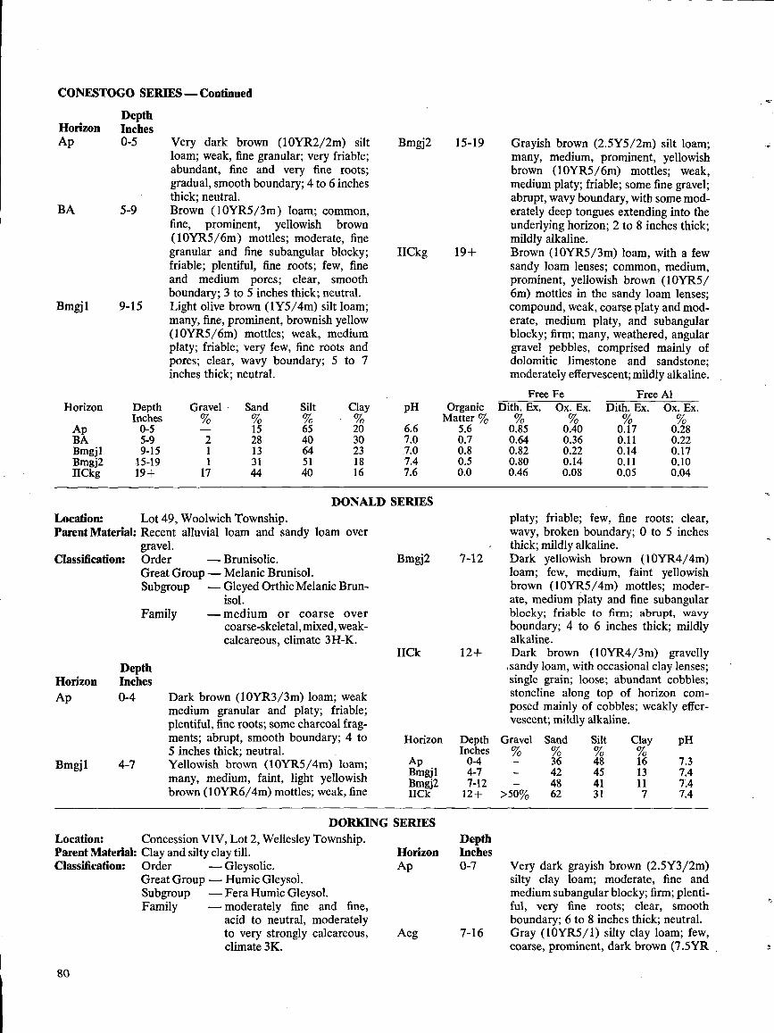
CONESTOGO SERIES -Continued
Classification:
DepthHorizon InchesAp 0-4
Bmgj1
4-7
90
Horizon
ApBABmgjlBmgj2IICkg
Family
Very dark brown (10YR2/2m) siltloam ; weak, fine granular ; very friable;abundant, fine and very fine roots;gradual, smooth boundary; 4 to 6inchesthick; neutral.Brown (10YR5/3m) loam; common,fine, prominent, yellowish brown(10YR5/6m) mottles; moderate, finegranular and fine subangular blocky ;friable ; plentiful, fine roots; few, fineand medium pores; clear, smoothboundary; 3 to 5 inches thick; neutral.Light olive brown (IY5/4m) silt loam ;many, fine, prominent, brownish yellow(10YR5/6m) mottles; weak, mediumplaty; friable; very few, fine roots andpores; clear, wavy boundary; 5 to 7inches thick; neutral.
Location:
Lot 49, Woolwich Township .Parent Material : Recent alluvial loam and sandy loam
gravel .Order
-Brunisolic .GreatGroup-Melanic Brunisol .Subgroup
-Gleyed Orthic Melanic Brun-isol .
-medium or coarse overcoarse-skeletal, mixed, weak-calcareous, climate 3H-K .
Dark brown (10YR3/3m) loam; weakmedium granular and platy; friable;plentiful, fine roots; some charcoal frag-ments; abrupt, smooth boundary; 4 to5 inches thick; neutral.Yellowish brown (10YR5/4m) loam;many, medium, faint, light yellowishbrown (10YR6/4m) mottles; weak, fine
DONALD SERIES
over
DORKINGLocation:
Concession VIV, Lot 2, Wellesley Township .Parent Material: Clay and silty clay till .Classification:
Order
-Gleysolic.GreatGroup- Humic Gleysol.Subgroup
-Fera Humic Gleysol.Family
-moderately fine and fine,acid to neutral, moderatelyto very strongly calcareous,climate3K.
Bmgj2 15-19
IICkg 19+
pHMatter %
6.6
5.67.0
0.77.0
0.87.4
0.57.6
0.0
Bmgj2 7-12
IICk 12+
Organic
Horizon DepthInches
Grayish brown (2.5Y5/2m) silt loam ;many, medium, prominent, yellowishbrown (10YR5/6m) mottles; weak,medium platy; friable; some fine gravel ;abrupt, wavy boundary, with some mod-erately deep tongues extending into theunderlying horizon; 2 to 8 inches thick;mildly alkaline .Brown (10YR5/3m) loam, with a fewsandy loam lenses ; common, medium,prominent, yellowish brown (10YR5/6m) mottles in the sandy loam lenses ;compound, weak, coarse platy andmod-erate, medium platy, and subangularblocky ; firm ; many, weathered, angulargravel pebbles, comprised mainly ofdolomitic limestone and sandstone;moderately effervescent; mildly alkaline .
platy; friable; few, fine roots; clear,wavy, broken boundary; 0 to 5 inchesthick; mildly alkaline .Dark yellowish brown (10YR4/4m)loam ; few, medium, faint yellowishbrown (10YR5/4m) mottles; moder-ate, medium platy and fine subangularblocky ; friable to firm ; abrupt, wavyboundary; 4 to 6 inches thick; mildlyalkaline .Dark brown (10YR4/3m) gravelly,sandy loam, with occasional clay lenses ;single grain; loose; abundant cobbles;stoneline along top of horizon com-posed mainly of cobbles; weakly effer-vescent; mildly alkaline .
Very dark grayish brown (2.5Y3/2m)silty clay loam ; moderate, fine andmedium subangular blocky ; firm ; plenti-ful, very fine roots; clear, smoothboundary; 6 to 8 inches thick; neutral.Gray (10YR5/1) silty clay loam; few,coarse, prominent, dark brown (7.5YR
ApBmgjlBmgj2IICk
0-44-77-1212+
ERIESDepth
Horizon InchesAp 0-7
Aeg 7-16
Depth Gravel Sand Silt ClayInches0-5 15 65 205-9 2 28 40 309-15 1 13 64 2315-19 1 31 51 1819+ 17 44 40 16
Gravel%
Sand Silt Clay pH
- 36 48 16 7.3- 42 45 13 7.4- 48 41 11 7'.4
>50% 62 31 7 7.4
FreeDith . Ex .%
FeOx . Ex .
FreeDith . Ex .
AlOx . Ex .
0.85 0.40 0.17 0.280.64 0.36 0.11 0.220.82 0.22 0.14 0.170.80 0.14 0.11 0.100.46 0.08 0.05 0.04
DepthHorizon InchesAp 0-5
BA 5-9
Bmgj 1 9-15
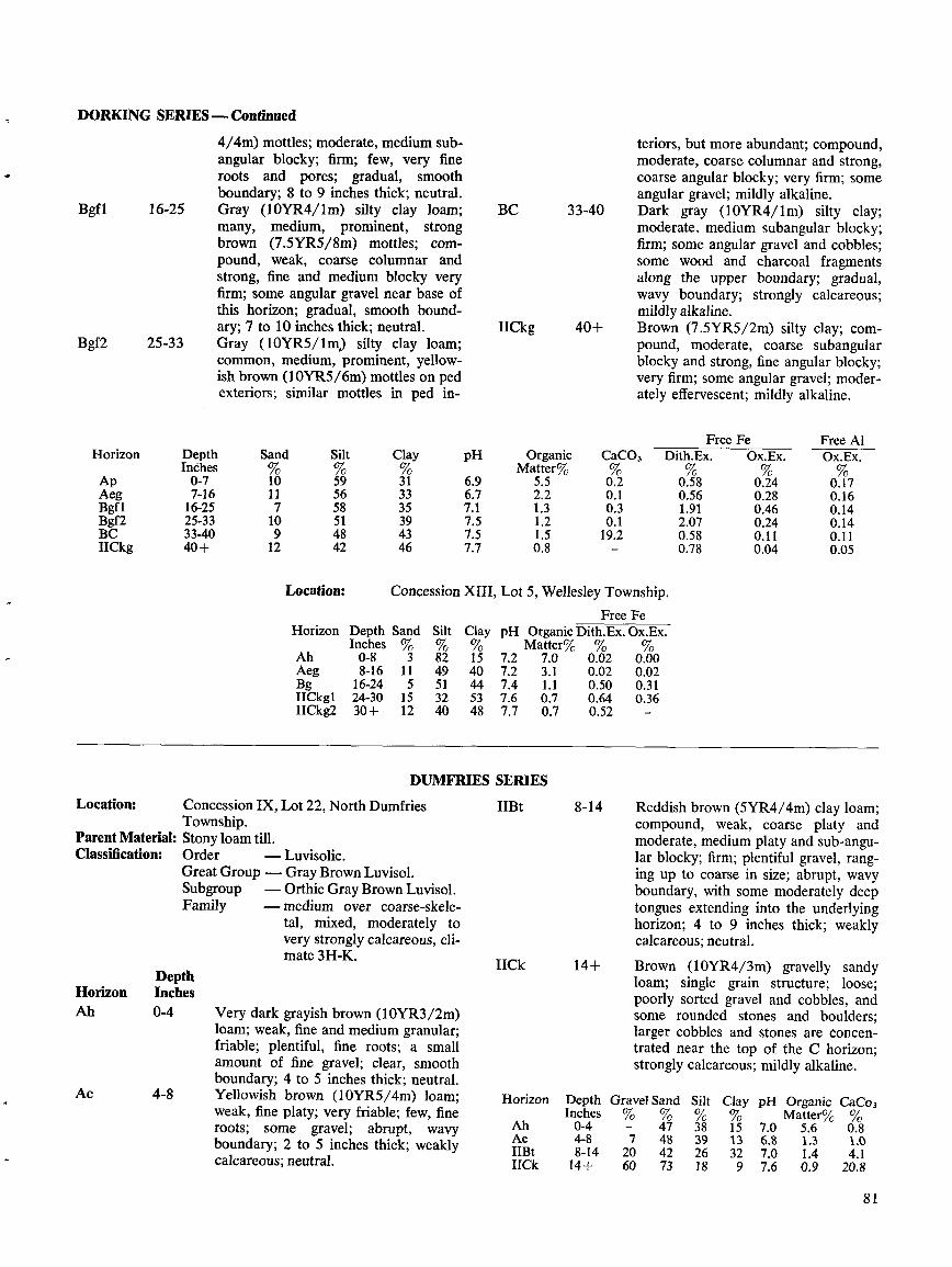
DORKING SERIES --Continued
Bgf1
16-25
Bgf2 25-33
Location:
DepthHorizon InchesAh 0-4
Ae 4-8
4/4m) mottles ; moderate, medium sub-angular blocky ; firm ; few, very fineroots and pores ; gradual, smoothboundary; 8 to 9 inches thick ; neutral .Gray (10YR4/lm) silty clay loam;many, medium, prominent, strongbrown (7.5YR5/8m) mottles ; com-pound, weak, coarse columnar andstrong, fine and medium blocky veryfirm ; some angular gravel near base ofthis horizon ; gradual, smooth bound-ary ; 7 to 10 inches thick ; neutral .Gray (10YR5/1m) silty clay loam;common, medium, prominent, yellow-ish brown (10YR5/6m) mottles on pedexteriors ; similar mottles in ped in-
Concession IX, Lot 22, North DumfriesTownship .
Parent Material: Stony loam till.Classification:
Order
-Luvisolic .Great Group - Gray Brown Luvisol .Subgroup
-Orthic Gray Brown Luvisol .Family
-medium over coarse-skele-tal, mixed, moderately tovery strongly calcareous, cli-mate 3H-K.
Very dark grayish brown (10YR3/2m)loam; weak, fine and medium granular;friable ; plentiful, fine roots ; a smallamount of fine gravel ; clear, smoothboundary; 4 to 5 inches thick ; neutral.Yellowish brown (10YR5/4m) loam;weak, fine platy ; very friable ; few, fineroots; some gravel ; abrupt, wavyboundary; 2 to 5 inches thick ; weaklycalcareous ; neutral .
BC 33-40
IICkg 40+
ownship .ee Fex . Ox.Ex .
%0.000.020.310.36-
DUMFRIES SERIES
IIBt 8-14
IICk 14+
teriors, but more abundant ; compound,moderate, coarse columnar and strong,coarse angular blocky ; very firm ; someangular gravel ; mildly alkaline .Dark gray
(10YR4/ lm)
silty
clay;moderate, medium subangular blocky ;firm ; some angular gravel and cobbles ;some wood and charcoal fragmentsalong the upper boundary ; gradual,wavy boundary ; strongly calcareous ;mildly alkaline .Brown (7.5YR5/2m) silty clay ; com-pound, moderate, coarse subangularblocky and strong, fine angular blocky ;very firm ; some angular gravel ; moder-ately effervescent ; mildly alkaline .
Reddish brown (5YR4/4m) clay loam ;compound, weak, coarse platy andmoderate, medium platy and sub-angu-lar blocky; firm ; plentiful gravel, rang-ing up to coarse in size ; abrupt, wavyboundary, with some moderately deeptongues extending into the underlyinghorizon ; 4 to 9 inches thick ; weaklycalcareous; neutral .
Brown (10YR4/3m) gravelly sandyloam; single grain structure ; loose ;poorly sorted gravel and cobbles, andsome rounded stones and boulders ;larger cobbles and stones are concen-trated near the top of the C horizon ;strongly calcareous ; mildly alkaline .
Clay pH%15 7.013 6.832 7.09 7.6
Organic CaCo,Matter'/1 0 %
5 .6 0 .81 .3 1.01.4 4 .10.9 20.8
8 1
Horizon DepthInches
Sand%
Silt%
Clay%
pH OrganicMatter%
CaCO,%
FreeDith.Ex .%
FeOx.Ex .
Free AlOx.Ex .
Ap 0-7 10 59 31 6.9 5.5 0.2 0.58 0.24 0.17Aeg 7-16 11 56 33 6.7 2.2 0 .1 0.56 0.28 0.16Bgf1 16-25 7 58 35 7.1 1 .3 0.3 1 .91 0.46 0.14Bgf2 25-33 10 51 39 7.5 1 .2 0 .1 2.07 0.24 0.14BC 33-40 9 48 43 7.5 1 .5 19.2 0.58 0.11 0.11IICkg 40+ 12 42 46 7.7 0.8 - 0.78 0.04 0.05
Location: Concession XIII, Lot 5, Wellesley
Horizon Depth Sand Silt Clay pHF
Organic Dith.Inches % % % Matter% %
Ah 0-8 3 82 15 7.2 7 .0 0.02Aeg 8-16 11 49 40 7.2 3 .1 0.02Bg 16-24 5 51 44 7.4 1 .1 0.50IICkkl 24-30 15 32 53 7.6 0 .7 0.64IICkg2 30+ 12 40 48 7.7 0.7 0.52
Horizon Depth Gravel Sand SiltInches % % %Ah 0-4 - 47 38
Ae 4-8 7 48 39IIBt 8-14 20 42 26IICk 14+ 60 73 18

Location:
Lot 105, Woolwich Township .Parent Material : Recent alluvial loam and silt loam.Classification :
Order
-Gleysolic .Great Group - Humic Gleysol .Subgroup
-Rego Humic Gleysol .Family
-medium, mixed, acid to neu-tral, climate 3H-K.
DepthHorizon InchesAp 0-9
Cgl 9-15
Horizon
ApC91Cg2Cg3
Location :
Classification:
Classification :
82
DepthInches0-99-1515-2020+
Family
Very dark grayish brown (10YR3/2m)silt loam ; moderate, fine and mediumgranular, and medium subangularblocky ; friable ; abundant, fine roots ;smooth, gradual boundary; 8 to 10inches thick ; neutral .Dark gray (5Y4/lm) loam; moderate,
Sand Silt Clay pH
25 48 27 7.230 49 21 7.331 48 21 7.431 49 20 7.5
Parent Material : Loam and silt loam over outwash gravel .
Order
-Luvisolic .Great Group - Gray Brown Luvisol .Subgroup
-Gleyed Orthic Gray BrownLuvisol .
Family
-medium over coarse-skele-tal, mixed, moderately tovery strongly calcareous, cli-mate 3H-K.
ELMIRA SERIES
FARMINGTON SERIESBeasley's Broken Front Concession, Lot 26,Waterloo Township .
Parent Material : Thin soil materials over dolomitic limestone .Order
-Brunisolic .Great Group - Melanie Brunisol .Subgroup
-Lithic Ortbic MelanieBrunisol .
- moderately coarse, mixed,climate 3H-K, shallow .
Cg2 15-20
Cg3 20+
Organic CaC03Matter °Jo %
6.5 0.52.6 0.11 .4 0.41 .2 0.2
AB
Bm
R
5-7
7-12
Organic CaC03Matter%
%6.6 1 .52.7 0 .12.4 -
LE SERIESDepth
Horizon InchesAh 0-9
Aegj 9-14
medium subangular blocky ; friable ;few, fine and very fine roots -and pores ;clear, smooth boundary; 5 to 7 inchesthick ; neutral .Gray (5Y5/lm) loam ; common, me-dium, prominent, olive (5Y5/4m), anddark yellowish brown (10YR4/.4m)mottles ; moderate, medium, subangularblocky ; firm ; very few, very fine rootsand pores ; a few gravel pebbles ; clear,wavy boundary ; mildly alkaline .Gray (5Y5/lm) loam, containing in-creasing proportions of clay with depth ;compound, moderate, coarse subangu-lar blocky and strong, fine subangularblocky ; very firm ; some fine gravel ;mildly alkaline .
very friable ; plentiful, very fine roots ;smooth, clear boundary ; 4 to 5 inchesthick; weakly calcareous ; neutral .Dark yellowish brown (10YR4/4m)sandy loam ; weak, medium platy ; veryfriable ; few, very fine roots ; smooth,clear boundary ; neutral .Very dark yellowish brown (10YR3/4m) sandy loam; weak, medium granu-lar ; very friable ; few, very fine roots ;a few, channery, dolomitic limestonefragments near base of horizon ; abrupt,smooth boundary ; mildly alkaline .Dolomitic limestone .
Free Fe
Free AlDith . Ex .
Ox. Ex.
Dith. Ex.
Ox. Ex.
0.83 0.23 0.20 0.220.80 0.25 0.26 0.280.77 0.27 0.22 0.53
Very dark grayish brown (10YR3/2m)silt loam; weak, fine granular ; friable ;plentiful, fine and very fine roots ; clear,smooth boundary ; 8 to 10 inches thick ;mildly alkaline .Dark brown (IY4/3m) silt loam;few, fine, prominent, yellowish brown(10YR4/4m) mottles ; weak, mediumplaty; friable to firm ; few, very fineroots and pores ; a little fine gravel ;
HorizonAh_
DepthInches0-5 Very dark grayish brown (10YR3/2m)
sandy loam; weak, medium granular ;
Horizon Depth Gravel Sand Silt Clay pHInches
% %2 . 16 12 7 .1Ah 0-5AB 5-7 0 77 16 7 7.2Bm 7-12 0 79 15 6 7.4R 12 Dolomitic limestone bedrock
Location:FLORAD
Beasley's Upper Block, Lot 8, WaterlooTownship.
FreeDith. Ex.%
FeOx . Ex .
FreeDith . Ex .
AlOx . Ex .
0.96 0.19 0.20 0.240.41 0.20 0.18 0.220.43 0.19 0.17 0.190.64 0.23 0.16 0.17
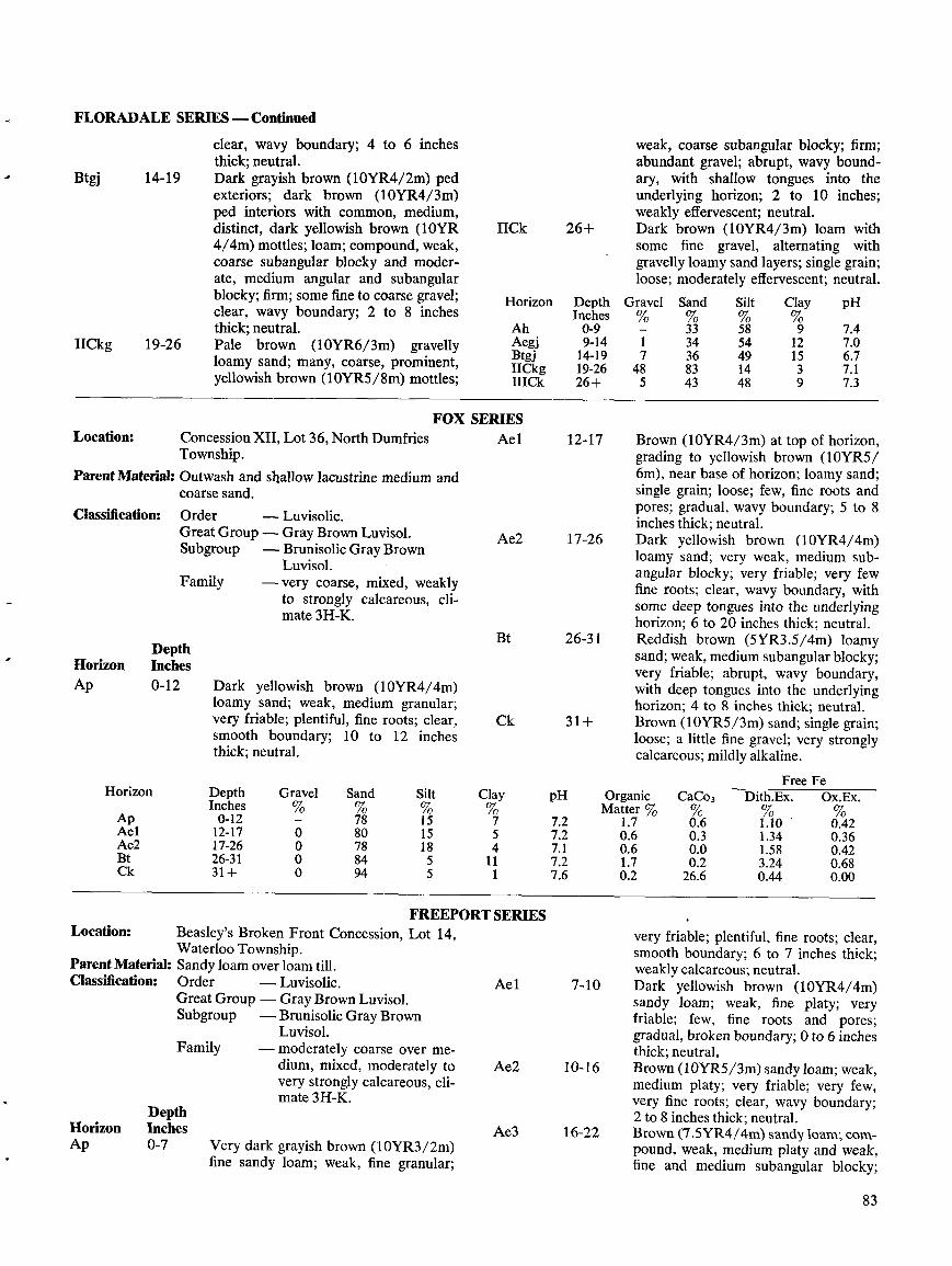
FLORADALE SERIES -Continued
Btgj 14-19
IICkg 19-26
Location:
Parent Material : Outwash and shallow lacustrine mediumcoarse sand.
Classification:
DepthHorizon InchesAp 0-12
Location:
DepthHorizon InchesAp 0-7
clear, wavy boundary; 4 to 6 inchesthick ; neutral .Dark grayish brown (10YR4/2m) pedexteriors ; dark brown (10YR4/3m)ped interiors with common, medium,distinct, dark yellowish brown (l0YR4/4m) mottles ; loam ; compound, weak,coarse subangular blocky and moder-ate, medium angular and subangularblocky; firm ; some fine to coarse gravel ;clear, wavy boundary; 2 to 8 inchesthick ; neutral .Pale brown (10YR6/3m) gravellyloamy sand; many, coarse, prominent,yellowish brown (10YR5/8m) mottles ;
FOX SERIESConcession XII, Lot 36, North DumfriesTownship .
Order
-Luvisolic .Great Group - Gray Brown Luvisol .Subgroup
-Brunisolic Gray BrownLuvisol .
Family
-very coarse, mixed, weaklyto strongly calcareous, cli-mate 3H-K.
Family
Dark yellowish brown (10YR4/4m)loamy sand; weak, medium granular;very friable; plentiful, fine roots ; clear,smooth boundary; 10 to 12 inchesthick ; neutral .
and
Very dark grayish brown (10YR3/2m)fine sandy loam; weak, fine granular ;
IICk 26+
FREEPORT SERIESBeasley's Broken Front Concession, Lot 14,Waterloo Township .
Parent Material : Sandy loam over loam till.Classification :
Order
-Luvisolic .Great Group - Gray Brown Luvisol .Subgroup
-Brunisolic Gray BrownLuvisol .moderately coarse over me-dium, mixed, moderately tovery strongly calcareous, cli-mate 3H-K.
Ae 1
Ae2
7-10
10-16
Ae3 16-22
weak, coarse subangular blocky ; firm ;abundant gravel ; abrupt, wavy bound-ary, with shallow tongues into theunderlying horizon ; 2 to 10 inches ;weakly effervescent ; neutral .Dark brown (10YR4/3m) loam withsome fine gravel, alternating withgravelly loamy sand layers ; single grain ;loose ; moderately effervescent ; neutral .
Brown (10YR4/3m) at top of horizon,grading to yellowish brown (10YR5/6m), near base of horizon; loamy sand ;single grain ; loose ; few, fine roots andpores ; gradual, wavy boundary ; 5 to 8inches thick ; neutral .Dark yellowish brown (10YR4/4m)loamy sand; very weak, medium sub-angular blocky ; very friable; very fewfine roots ; clear, wavy boundary, withsome deep tongues into the underlyinghorizon ; 6 to 20 inches thick ; neutral .Reddish brown (5YR3 .5/4m) loamysand ; weak, medium subangular blocky;very friable ; abrupt, wavy boundary,with deep tongues into the underlyinghorizon ; 4 to 8 inches thick ; neutral .Brown (10YR5/3m) sand ; single grain;loose ; a little fine gravel ; very stronglycalcareous ; mildly alkaline .
very friable ; plentiful, fine roots ; clear,smooth boundary; 6 to 7 inches thick;weakly calcareous ; neutral .Dark yellowish brown (10YR4/4m)sandy loam; weak, fine platy ; veryfriable ; few, fine roots and pores ;gradual, broken boundary; 0 to 6 inchesthick; neutral .Brown (IOYR5/3m) sandy loam; weak,medium platy ; very friable ; very few,very fine roots ; clear, wavy boundary ;2 to 8 inches thick; neutral .Brown (7.5YR4/4m) sandy loam; com-pound, weak, medium platy and weak,fine and medium subangular blocky ;
83
Horizon Depth Gravel Sand Silt Clay pHInches % % % %Ap 0-12 - 78 15 7 7.2
Ael 12-17 0 80 15 5 7.2Ae2 17-26 0 78 18 4 7.1Bt 26-31 0 84 5 11 7.2Ck 31+ 0 94 5 1 7.6
Horizon
Ah
DepthInches0-9
Gravel%-
Sand%33
Silt%58
Clay
9
pH
7.4Aegj 9-14 1 34 54 12 7.0Btgj 14-19 7 36 49 15 6.7IICkg 19-26 48 83 14 3 7 .1IICCk 26+ 5 43 48 9 7.3
Ae1 12-17
Ae2 17-26
Bt 26-31
Ck 31+
Organic CaC03Free
Dith.Ex .FeOx.Ex.
Matter %1.7 06 110 0420.6 0.3 1 .34 0.360.6 0.0 1 .58 0.421.7 0.2 3.24 0.680.2 26.6 0.44 0.00
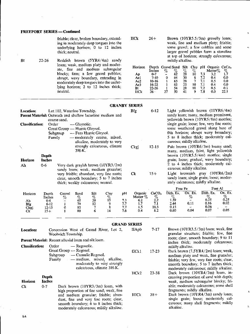
FREEPORT SERIES -Continued
Bt
Classification :
Location :
84
22-26
Location :
Lot 102, Waterloo Township .Parent Material: Outwash and shallow lacustine medium and
coarse sand.Order
-Gleysolic .Great Group - Humic Gleysol .Subgroup
-Fera Humic Gleysol .Family
-moderately coarse, mixed,alkaline, moderately to verystrongly calcareous, climate3H-K.
DepthHorizon InchesAh 0-6
Concession West of Grand River,Woolwich Township.
Parent Material : Recent alluvial loam and silt loam .Classification :
DepthHorizon InchesCk 0-7
friable ; clear, broken boundary, extend-ing in moderately deep tongues into theunderlying horizon ; 0 to 12 inchesthick ; neutral .
Reddish brown (5YR4/4m) sandyloam ; weak, medium platy and moder-ate, fine and medium subangularblocky ; firm ; a few gravel pebbles ;abrupt, wavy boundary, extending inmoderately deep tongues into the under-lying horizon ; 2 to 12 inches thick ;neutral .
Very dark grayish brown (10YR3/2m)sandy loam; weak, medium granular ;very friable ; abundant, very fine roots ;clear, smooth boundary ; 5 to 7 inchesthick ; weakly calcareous ; neutral .
Order
-Regosolic .Great Group - Regosol .Subgroup
-Cumulic Regosol .Family
-medium,
mixed,
alkaline,moderately to véry stronglycalcareous, climate 3H-K.
Dark brown (10YR3/3m) loam, withhigh proportion of fine sand; weak, fineand medium granular ; friable ; abun-dant, fine and very fine roots ; clear,smooth boundary ; 6 to 8 inches thick ;moderately calcareous ; mildly alkaline .
GRANBY SERIES
GRLot 2,
IIApb
IICk 26+ Brown (10YR5.5/3m) gravelly loam;weak, fine and medium platy ; friable ;some gravel ; a few cobbles and somelarger gravel pebbles form a stonelineat top of horizon ; strongly calcareous ;mildly alkaline .
Horizon
Depth Gravel Sand Silt
Clay pHInches % % % %
Ap
0-7 - 62 28 10 7.3Ael 7-10 0 64 30 6 7.2Ae2 10-16 1 65 28 7 7 .1Ae3 16-22 1 65 25 10 7 .1Bt 22-26 1 54 28 18 7.2IICk 26+ 27 50 41 9 7.8
Bfg 6-12
Ckgj 12-15
Ck 15+
IICk 1
17-23
I1Ck2 23-38
HICk 38+
Organic CaCo3Matter% %
3.2 1 .70 .4 0.00 .5 0.00.4 0.00.5 0.10 .0 22.1
Light yellowish brown (10YR6/4m)sandy loam ; many, medium prominent,yellowish brown (10YR5/8m) mottles ;single grain ; loose ; few, very fine roots ;some weathered gravel along base ofthis horizon ; abrupt wavy boundary;5 to 8 inches thick ; moderately cal-careous ; mildly alkaline .Pale brown (10YR6/3m) loamy sand;many, medium, faint, light yellowishbrown (10YR5.5/4m) mottles ; singlegrain ; loose ; gradual, wavy boundary;2 to 4 inches thick ; moderately cal-careous ; mildly alkaline .Light brownish gray (10YR6/2m)sandy loam; single grain ; loose ; moder-ately calcareous ; mildly alkaline .
Free Fe
Free A1Dith . Ex.
Ox. Ex.
Dith. Ex .
Ox. Ex.
1 .59 - 0.25 0.252.44 0.11 0.16 0.020.15 - 0.04 -0.60 0.04 0.07 0.05
Brown (10YR3 .5/3m) loam; weak, finegranular structure ; friable ; few, fineroots ; clear, smooth boundary; 9 to 11inches thick ; moderately calcareous ;mildly alkaline .Dark brown (7.5YR4/2m) loam; weak,medium platy and weak, fine granular ;friable ; very few, very fine roots ; clear,smooth boundary ; 5 to 7 inches thick;moderately calcareous ; mildly alkaline .Dark brown (10YR4/3m) loam, in-creasing proportion of sand with depth ;weak, medium subangular blocky ; fri-able ; moderately calcareous ; some shellfragments ; mildly alkaline .Dark brown (10YR4/3m) sandy loam;single grain ; loose; moderately cal-careous ; many shell fragments ; mildlyalkaline .
pH
7.3
OrganicMatter %
6.2
CaC03%2.2
7.7 1 .7 7.17.7 1 .5 10.37.6 0.4 8.2
ND SERIES7-17
Horizon
Ah
DepthInches0-6
Gravel%-
Sand%65
Silt%20
Clay
15Bfg 6-12 1 79 12 9Ckgj 12-15 0 85 7 8Ck 15+ 1 80 6 14
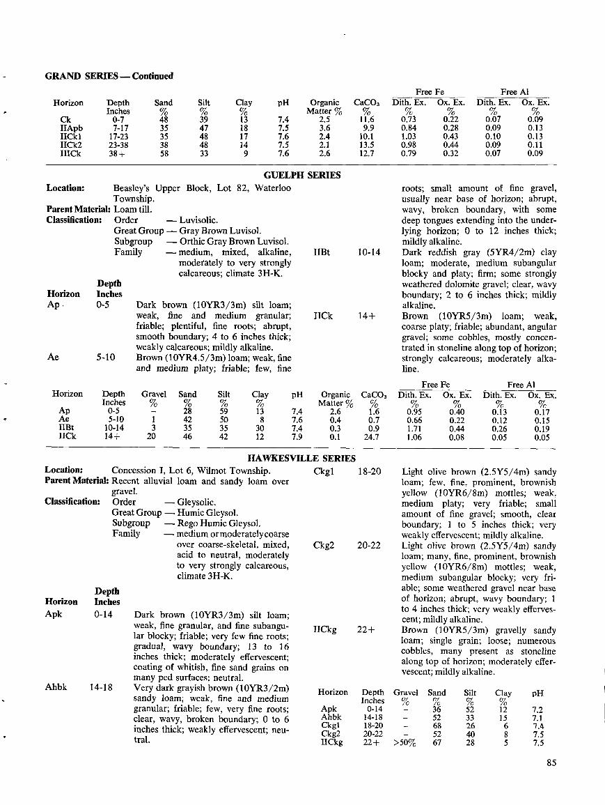
GRAND SERIES -Continued
Location :
Classification :
DepthHorizon InchesApk 0-14
Ahbk 14-18
WaterlooBeasley's Upper Block, Lot 82,Township .
Parent Material: Loam till .Classification :
Order
-Luvisolic .Great Group -Gray Brown Luvisol .Subgroup
-Orthic Gray Brown Luvisol .Family
-medium,
mixed,
alkaline,moderately to very stronglycalcareous ; climate 3H-K.
Dark brown (10YR3/3m) silt loam;weak, fine and medium granular ;friable ; plentiful, fine roots ; abrupt,smooth boundary; 4 to 6 inches thick ;weakly calcareous ; mildly alkaline .Brown (10YR4 .5/3m) loam ; weak, fineand medium platy ; friable ; few, fine
GUELPH SERIES
IIBt 10-14
IICk 14+
gravel.Order
-Gleysolic .Great Group - Humic Gleysol .Subgroup
-Rego Humic Gleysol .Family
-medium ormoderatelycoarseover coarse-skeletal, mixed,acid to neutral, moderatelyto very strongly calcareous,climate 3H-K.
Dark brown (10YR3/3m) silt loam;weak, fine granular, and fine subangu-lar blocky ; friable ; very few fine roots ;gradual, wavy boundary; 13 to 16inches thick ; moderately effervescent ;coating of whitish, fine sand grains onmany ped surfaces ; neutral .Very dark grayish brown (10YR3/2m)sandy loam; weak, fine and mediumgranular; friable ; few, very fine roots ;clear, wavy, broken boundary; 0 to 6inches thick; weakly effervescent ; neu-tral .
Ckg2 20-22
IICkg 22+
roots ; small amount of fine gravel,usually near base of horizon ; abrupt,wavy, broken boundary, with somedeep tongues extending into the under-lying horizon ; 0 to 12 inches thick ;mildly alkaline .Dark reddish gray (5YR4/2m) clayloam; moderate, medium subangularblocky and platy ; firm ; some stronglyweathered dolomite gravel ; clear, wavyboundary; 2 to 6 inches thick ; mildlyalkaline .Brown (10YR5/3m) loam; weak,coarse platy ; friable ; abundant, angulargravel ; some cobbles, mostly concen-trated in stoneline along top of horizon ;strongly calcareous ; moderately alka-line .
yellow (10YR6/8m) mottles ; weak,medium platy ; very friable ; smallamount of fine gravel ; smooth, clearboundary; 1 to 5 inches thick ; veryweakly effervescent ; mildly alkaline .Light olive brown (2.5Y5/4m) sandyloam ; many, fine, prominent, brownishyellow (10YR6/8m) mottles ; weak,medium subangular blocky ; very fri-able ; some weathered gravel near baseof horizon ; abrupt, wavy boundary ; 1to 4 inches thick ; very weakly efferves-cent ; mildly alkaline .Brown (10YR5/3m) gravelly sandyloam ; single grain ; loose ; numerouscobbles, many present as stonelinealong top of horizon ; moderately effer-vescent ; mildly alkaline .
85
Horizon Depth Sand Silt Clay pH Organic CaC03Inches % % Matter % %
Ck 0-7 48 39 13 7.4 2.5 11.6IIApb 7-17 35 47 18 7.5 3.6 9.9I1Ck1 17-23 35 48 17 7.6 2.4 10 .1IICk2 23-38 38 48 14 7.5 2.1 13.5IIICk 38+ 58 33 9 7.6 2.6 12.7
Free Fe Free AIHorizon Depth Gravel Sand Silt Clay pH Organic CaC03 Dith . Ex. Ox . Ex . Dith . Ex. Ox . Ex .
Inches % % % Matter % %Ap 0-5 - 28 59 13 7.4 2 .6 1 .6 0.95 0.40 0.13 0.17Ae 5-10 1 42 50 8 7.6 0.4 0.7 0.66 0.22 0.12 0.151113t 10-14 3 35 35 30 7.4 0 .3 0.9 1 .71 0.44 0.26 0.19IICk 14+ 20 46 42 12 7.9 0 .1 24.7 1 .06 0.08 0.05 0.05
HAWKESVILLE SERIESLocation: Concession I, Lot 6, Wilmot Township . Ckg1 18-20 Light olive brown (2.5Y5/4m) sandyParent Material: Recent alluvial loam and sandy loam over loam ; few, fine, prominent, brownish
Horizon DepthInches
Gravel%
Sand%
Silt%
Clay pH
Apk 0-14 - 36 52 12 7.2Ahbk 14-18 - 52 33 15 7.1Ckg1 18-20 - 68 26 6 7 .4Ckg2 20-22 - 52 40 8 7.5IICkg 22+ >50% 67 28 5 7.5
FreeDith . Ex .%
FeOx . Ex .%
FreeDith . Ex .
AlOx . Ex .
0.73 0.22 0.07 0.090.84 0.28 0.09 0.131 .03 0.43 0.10 0.130.98 0.44 0.09 0.110.79 0.32 0.07 0.09
DepthHorizon InchesAp . 0-5
Ae 5-10
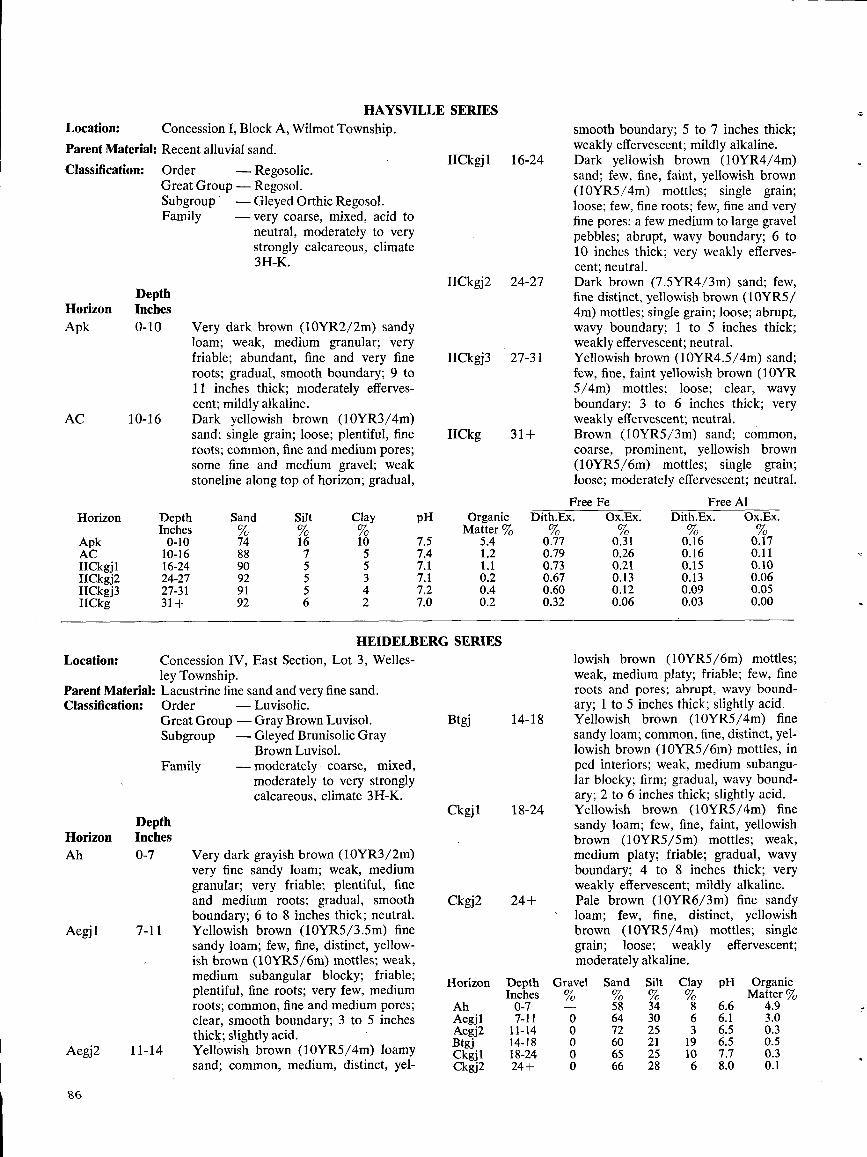
HAYSVILLE SERIESLocation:Parent MateriClassification:
DepthHorizon InchesApk 0-10
AC 10-16
Location :ley Township .
Parent Material : Lacustrine fine sand and very fine sand .Classification :
Order
-Luvisolic .Great Group - Gray Brown Luvisol .Subgroup
-Gleyed Brunisolic GrayBrown Luvisol .
Family
-moderately coarse, mixed,moderately to very stronglycalcareous, climate 3H-K.
96
Order
-Regosolic .Great Group - Regosol .Subgroup
-Gleyed Orthic Regosol .Family
- very coarse, mixed, acid toneutral, moderately to verystrongly calcareous, climate3H-K.
Very dark brown (10YR2/2m) sandyloam ; weak, medium granular ; veryfriable ; abundant, fine and very fineroots ; gradual, smooth boundary; 9 to11 inches thick ; moderately efferves-cent ; mildly alkaline .Dark yellowish brown (10YR3/4m)sand; single grain ; loose ; plentiful, fineroots ; common, fine and medium pores ;some fine and medium gravel ; weakstoneline along top of horizon ; gradual,
Concession IV, East Section, Lot 3, Welles-
Very dark grayish brown (10YR3/2m)very fine sandy loam ; weak, mediumgranular; very friable ; plentiful, fineand medium roots ; gradual, smoothboundary; 6 to 8 inches thick ; neutral .Yellowish brown (10YR5/3 .5m) finesandy loam; few, fine, distinct, yellow-ish brown (10YR5/6m) mottles ; weak,medium subangular blocky ; friable ;plentiful, fine roots ; very few, mediumroots ; common, fine and medium pores ;clear, smooth boundary ; 3 to 5 inchesthick ; slightly acid .Yellowish brown (10YR5/4m) loamysand ; common, medium, distinct, yel-
HEIDELBERG SERIES
smooth boundary; 5 to 7 inches thick ;weakly effervescent ; mildly alkaline .Dark yellowish brown (10YR4/4m)sand; few, fine, faint, yellowish brown(10YR5/4m) mottles ; single grain ;loose ; few, fine roots ; few, fine and veryfine pores ; a few medium to large gravelpebbles ; abrupt, wavy boundary ; 6 to10 inches thick ; very weakly efferves-cent; neutral .Dark brown (7.5YR4/3m) sand ; few,fine distinct, yellowish brown (10YR5/4m) mottles ; single grain ; loose ; abrupt,wavy boundary ; 1 to 5 inches thick ;weakly effervescent ; neutral .Yellowish brown (10YR4.5/4m) sand;few, fine, faint yellowish brown (l0YR5/4m) mottles ; loose ; clear, wavyboundary ; 3 to 6 inches thick ; veryweakly effervescent ; neutral .Brown (10YR5/3m) sand ; common,coarse, prominent, yellowish brown(10YR5/6m) mottles ; single grain ;loose ; moderately effervescent ; neutral.
lowish brown (10YR5/6m) mottles ;weak, medium platy ; friable ; few, fineroots and pores ; abrupt, wavy bound-ary ; 1 to 5 inches thick ; slightly acid .Yellowish brown (10YR5/4m) finesandy loam; common, fine, distinct, yel-lowish brown (10YR5/6m) mottles, inped interiors ; weak, medium subangu-lar blocky ; firm ; gradual, wavy bound-ary ; 2 to 6 inches thick ; slightly acid . ,Yellowish brown (10YR5/4m) finesandy loam; few, fine, faint, yellowishbrown (10YR5/5m) mottles ; weak,medium platy; friable ; gradual, wavyboundary; 4 to 8 inches thick ; veryweakly effervescent ; mildly alkaline.Pale brown (10YR6/3m) fine sandyloam ; few, fine, distinct, yellowishbrown (10YR5/4m) mottles ; singlegrain ; loose ; weakly effervescent ;moderately alkaline .
Concession I, Block A, Wilmot Township .al : Recent alluvial sand .
IICkg] 1 16-24
IICkgj2 24-27
IICkgj3 27-31
IICkg 31+
Free Fe Free AlHorizon Depth Sand Silt Clay pH Organic Dith.Ex . OX.Ex . Dith.Ex . Ox.Ex .
Inches % % % Matter %Apk 0-10 74 16 10 7.5 5.4 0.77 0.31 0.16 0.17AC 10-16 88 7 5 7.4 1 .2 0.79 0.26 0.16 0.11IICkgj1 16-24 90 5 5 7.1 1 .1 0.73 0.21 0.15 0.10IICkgj2 24-27 92 5 3 7.1 0.2 0.67 0.13 0.13 0.06IICkgj3 27-31 91 5 4 7.2 0.4 0.60 0.12 0.09 0.05IICkg 31+ 92 6 2 7.0 0.2 0.32 0.06 0.03 0.00
Horizon Depth Gravel Sand Silt Clay pH OrganicInches % % % % Matter%
Ah 0-7 - 58 34 8 6.6 4.9Aegj1 7-11 0 64 30 6 6.1 3 .0Aegj2 11-14 0 72 25 3 6.5 0.3Btgj 14-18 0 60 21 19 6.5 0.5Ckgjl 18-24 0 65 25 10 7.7 0.3Ckgj2 24+ 0 66 28 6 8.0 0 .1
DepthHorizon InchesAh 0-7
Aegj 1 7-11
Aegj2 11-14
Btgj 14-18
Ckgj 1 18-24
Ckgj2 24+
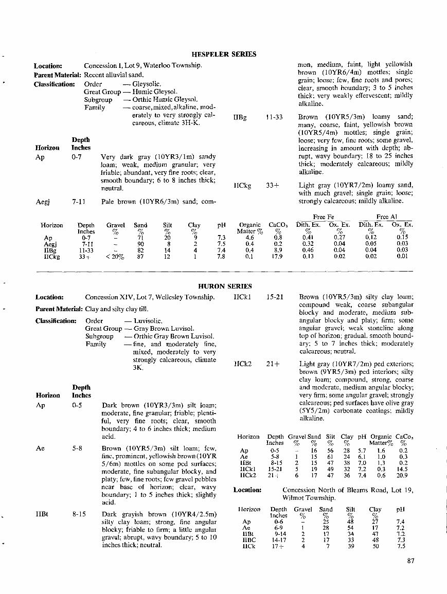
Location:Parent Material :Classification:
DepthHorizon InchesAp 0-7
Aegj 7-11
Location:
Parent Material : Clay and silty clay till .
Classification:
Order
-Luvisolic .Great Group - Gray Brown Luvisol .Subgroup
-Orthic Gray Brown Luvisol .Family
-fine, and moderately fine,mixed, moderately to verystrongly calcareous, climate3K.
DepthHorizon InchesAp
Ae
IIBt
0-5
5-8
8-15
Concession I, Lot 9, Waterloo Township .Recent alluvial sand .Order
-Gleysolic .Great Group - Humic Gleysol .Subgroup
-Orthic Humic Gleysol .Family
-coarse, mixed, alkaline, mod-erately to very strongly cal-careous, climate 3H-K.
Very dark gray (10YR3/lm) sandyloam; weak, medium granular; veryfriable ; abundant, very fine roots ; clear,smooth boundary ; 6 to 8 inches thick ;neutral .
Pale brown (10YR6/3m) sand ; com-
Concession XIV, Lot 7, Wellesley Township .
IICkl
Dark brown (10YR3/3m) silt loam ;moderate, fine granular ; friable; plenti-ful, very fine roots ; clear, smoothboundary ; 4 to 6 inches thick ; mediumacid .
Brown (10YR5/3m) silt loam; few,fine, prominent, yellowish brown (IOYR5/6m) mottles on some ped surfaces ;moderate, fine subangular blocky, andplaty ; few, fine roots ; few gravel pebblesnear base of horizon ; clear, wavyboundary; 1 to 5 inches thick ; slightlyacid .
Dark grayish brown (10YR4/2 .5m)silty clay loam ; strong, fine angularblocky ; friable to firm ; a little angulargravel ; abrupt, wavy boundary; 5 to 10inches thick ; neutral .
HESPELER SERIES
IIBg 11-33
IICkg 33+
HURON SERIES
IICk2 21+
15-21
mon, medium, faint, light yellowishbrown (10YR6/4m) mottles ; singlegrain ; loose ; few, fine roots and pores ;clear, smooth boundary ; 3 to 5 inchesthick ; very weakly effervescent ; mildlyalkaline .
Brown (10YR5/3m) loamy sand;many, coarse, faint, yellowish brown(10YR5/4m) mottles ; single grain ;loose ; very few, fine roots ; some gravel,increasing in amount with depth ; ab-rupt, wavy boundary ; 18 to 25 inchesthick ; moderately calcareous ; mildlyalkaline .
Light gray (10YR7/2m) loamy sand,with much gravel ; single grain ; loose ;strongly calcareous ; mildly alkaline .
Brown (10YR5/3m) silty clay loam;compound weak, coarse subangularblocky and moderate, medium sub-angular blocky and platy ; firm ; someangular gravel ; weak stoneline alongtop of horizon ; gradual, smooth bound-ary ; 5 to 7 inches thick ; moderatelycalcareous ; neutral.
Light gray (10YR7/2m) ped exteriors ;brown (9YR5/3m) ped interiors ; siltyclay loam ; compound, strong, coarseand moderate, medium angular blocky ;very firm ; some angular gravel ; stronglycalcareous ; ped surfaces have olive gray(5Y5/2m) carbonate coatings ; mildlyalkaline .
87
Horizon DepthInches
Gravel%
Sand%
Silt%
Clay pH Organic CaCo3% Matter% %
Ap 0-5 - 16 56 28 5.7 1 .6 0.2Ae 5-8 1 15 61 24 6.1 1 .0 0 .3IIBt 8-15 2 15 47 38 7.0 1 .3 0.2IICk1 15-21 5 19 49 32 7.2 0.3 14.5IICk2 21+ 6 17 47 36 7.4 0.6 20.9
Horizon DepthInches
Gravel Sand Silt Clay pH OrganicMatter %
FreeCaC03 Dith . Ex .%
FeOx . Ex .
FreeDith . Ex .
AlOx . Ex .
Ap 0-7 - 71 20 9 7.3 4.6 0.8 0.41 0.27 0.12 0.15Aegj 7-11 - 90 8 2 7.5 0.4 0.2 0.32 0.04 0.05 0.03IIBg 11-33 - 82 14 4 7.4 0.4 8 .9 0.46 0.04 0.04 0.03IICkg 33+ < 20% 87 12 1 7.8 0 .1 17.9 0.13 0.02 0.02 0.01
Location : Concession North of Bleams Road, Lot 19,Wilmot Township .
Horizon DepthInches
Gravel Sand Silt Clay pH
Ap 0-6 25 48 27 7.4Ae 6-9 1 28 54 17 7.2IIBt 9-14 2 17 34 471 -1 .2IIBC 14-17 2 17 33 48 7.3IICk 17+ 4 7 39 50 7.5
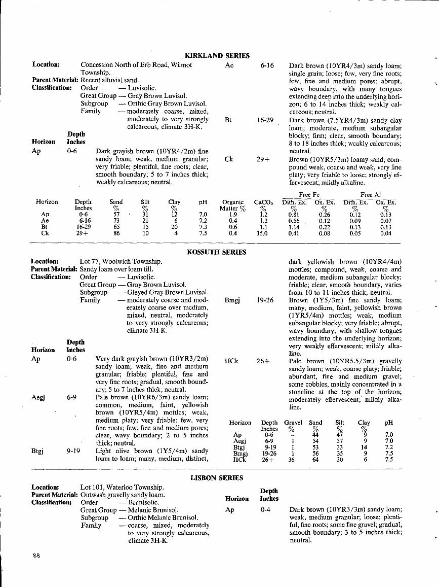
Location : Concession North of Erb Road, WilmotTownship .
Parent Material: Recent alluvial sand .Classification:
DepthHorizon InchesAp - 0-6
Location:
Lot 77, Woolwich Township .Parent Material : Sandy loam over loam till.Classification:
Order
-Luvisolic.Great Group -Gray Brown Luvisol .Subgroup
-Gleyed Gray Brown Luvisol .Family
-moderately coarse and mod-erately coarse over medium,mixed, neutral, moderatelyto very strongly calcareous ;climate 3H-K.
DepthHorizon InchesAp 0-6
Aegj 6-9
Btgj 9-19
Classification :
199
Order
-Luvisolic .Great Group - Gray Brown Luvisol .Subgroup
-Orthic, Gray Brown Luvisol .Family
-moderately coarse, mixed,moderately to very stronglycalcareous, climate 3H-K.
Dark grayish brown (10YR4/2m) finesandy loam; weak, medium granular ;very friable ; plentiful, fine roots ; clear,smooth boundary; 5 to 7 inches thick ;weakly calcareous ; neutral .
Very dark grayish brown (10YR3/2m)sandy loam; weak, fine and mediumgranular ; friable ; plentiful, fine andvery fine roots ; gradual, smooth bound-ary ; 5 to 7 inches thick ; neutral .Pale brown (10YR6/3m) sandy loam ;common, medium, faint, yellowishbrown (10YR5/4m) mottles ; weak,medium platy ; very friable ; few, veryfine roots ; few, fine and medium pores ;clear, wavy boundary ; 2 to 5 inchesthick ; neutral .Light olive brown (1Y5/4m) sandyloam to loam ; many, medium, distinct,
Location:
Lot 101, Waterloo Township .Parent Material : Outwash gravelly sandy loam .
Order
-Brunisolic .Great Group - Melanic Brunisol .Subgroup
-Orthic Melanic Brunisol .Family
-coarse, mixed, moderatelyto very strongly calcareous,climate 3H-K.
KIRKLAND SERIES
KOSSUTH SERIES
LISBON SERIES
Bmgj 19-26
IICk 26+
Horizon DepthInches
Ap 0-6Aegj 6-9Btgj 9-19Bmgj 19-26IICk 26+
DepthHorizon Inches
Ap 0-4
Dark brown (10YR4/3m) sandy loam;single grain ; loose ; few, very fine roots ;few, fine and medium pores ; abrupt,wavy boundary, with many tonguesextending deep into the underlying hori-zon; 6 to 14 inches thick ; weakly cal-careous; neutral .Dark brown (7.5YR4/3m) sandy clayloam; moderate, medium subangularblocky ; firm; clear, smooth boundary;8 to 18 inches thick ; weakly calcareous ;neutral .Brown (10YR5/3m) loamy sand; com-pound weak, coarse and weak, very fineplaty ; very friable to loose ; strongly ef-fervescent ; mildly alkaline .
dark yellowish brown (10YR4/4m)mottles ; compound, weak, coarse andmoderate, medium subangular blocky ;friable ; clear, smooth boundary, variesfrom 10 to 11 inches thick ; neutral .Brown (IY5/3m) fine sandy loam;many, medium, faint, yellowish brown(IYR5/4m) mottles ; weak, mediumsubangular blocky ; very friable ; abrupt,wavy boundary, with shallow tonguesextending into the underlying horizon ;very weakly effervescent ; mildly alka-line .Pale brown (10YR5 .5/3m) gravellysandy loam ; weak, coarse platy ; friable ;abundant, fine and medium gravel ;some cobbles, mainly concentrated in astoneline at the top of the horizon;moderately effervescent ; mildly alka-line .
Dark brown (10YR3/3m) sandy loam;weak, medium granular ; loose ; plenti-ful, fine roots ; some fine gravel ; gradual,smooth boundary ; 3 to 5 inches thick ;neutral .
Ae 6-16
Bt 16-29
Ck 29+
Horizon
Ap
DepthInches0-6
Sand
57
Silt
31
Clay
12
pH
7.0
OrganicMatter %
1.9
CaC03%1 .2
FreeDith . Ex .%0.81
FeOx . Ex .%0.26
FreeDith. Ex .
0.12
AlOx. Ex.
0.13Ae 6-16 73 21 6 7.2 0.4 1 .2 0.56 , 0.12 0.09 0.07Bt 16-29 65 15 20 7.3 0.6 1 .1 1 .14 0.22 0.13 0.13Ck 29+ 86 10 4 7.5 0.4 15.0 0.41 0.08 0.05 0.04
Gravel%
Sand Silt Clay pH
- 44 47 9 7.01 54 37 9 7.01 53 33 14 7.21 56 35 9 7.5
36 64 30 6 7.5
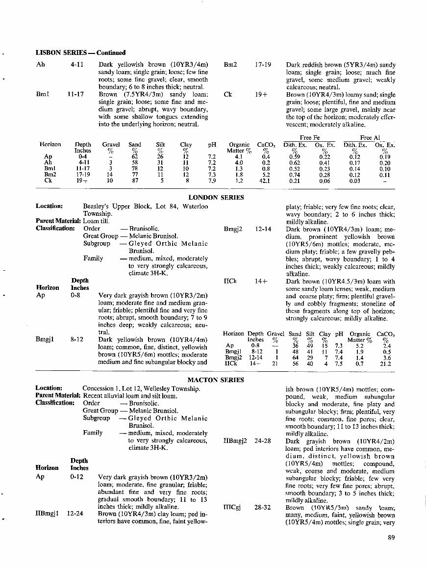
LISBON SERIES -Continued
Ah
Location :
4-11
Bml 11-17
Horizon
ApAhBmlBm2Ck
Beasley's Upper Block, Lot 84,Township .
Parent Material : Loam till .Classification :
Order
-Brunisolic .Great Group-Melanie Brunisol .Subgroup -Gleyed Orthic
Brunisol .-medium, mixed, moderately
to very strongly calcareous,climate 3H-K.
DepthHorizon InchesAp 0-8
Bmgj1
8-12
Location:Parent Material:Classification :
DepthHorizon InchesAp 0-12
IIBmgj 1
12-24
Family
Dark yellowish brown (10YR3/4m)sandy loam; single grain; loose; few fineroots; some fine gravel ; clear, smoothboundary; 6 to 8 inches thick; neutral.Brown (7.5YR4/3m) sandy loam ;single grain ; loose; some fine and me-dium gravel ; abrupt, wavy boundary,with some shallow tongues extendinginto the underlying horizon; neutral .
Waterloo
Melanic
Very dark grayish brown (10YR3/2m)loam; moderate fine and medium gran-ular ; friable; plentiful fine and very fineroots; abrupt, smooth boundary ; 7 to 9inches deep ; weakly calcareous ; neu-tral .Dark yellowish brown (10YR4/4m)loam ; common, fine, distinct, yellowishbrown (10YR5/6m) mottles ; moderatemedium and fine subangular blocky and
Concession 1, Lot 12, Wellesley Township .Recent alluvial loam and silt loam .Order
-Brunisolic .GreatGroup -Melanie Brunsiol .Subgroup -Gleyed Orthic Melanie
Brunisol .Family
-medium, mixed, moderatelyto very strongly calcareous,climate3H-K.
Very dark grayish brown (10YR3/2m)loam ; moderate, fine granular ; friable;abundant fine and very fine roots;gradual smooth boundary; 11 to 13inches thick; mildly alkaline .Brown (10YR4/3m) clay loam ; ped in-teriors have common, fine, faint yellow-
LONDON SERIES
MACTON SERIES
Bm2 17-19
Ck 19+
Bmgj2 12-14
IICk 14+
Horizon Depth Gravel SandInches
%
%Ap
0-8
-
36Bmgl
8-12
1
48Bmgj2 12-14
1
64IICk
14+
21
56
11Bmgj2 24-28
IIICgj 28-32
Dark reddish brown (5YR3/4m) sandyloam ; single grain; loose; much finegravel, some medium gravel ; weaklycalcareous ; neutral.Brown (10YR4/3m) loamy sand ; singlegrain; loose; plentiful, fine and mediumgravel ; some large gravel, mainly nearthe top of the horizon; moderately effer-vescent; moderately alkaline.
platy; friable; very few fine roots; clear,wavy boundary ; 2 to 6 inches thick;mildly alkaline.Dark brown (10YR4/3m) loam ; me-dium, prominent yellowish brown(10YR5/6m) mottles; moderate, me-dium platy; friable; a few gravelly peb-bles ; abrupt, wavy boundary; 1 to 4inches thick ; weakly calcareous ; mildlyalkaline .Dark brown (10YR4.5/3m) loam withsome sandy loam lenses ; weak, mediumand coarse platy; firm ; plentiful gravel-ly and cobbly fragments; stoneline ofthese fragments along top of horizon;strongly calcareous ; mildly alkaline .
ish brown (10YR5/4m) mottles; com-pound, weak, medium subangularblocky and moderate, fine platy andsubangular blocky; firm ; plentiful, veryfine roots; common, fine pores; clear,smooth boundary ; 11 to 13 inches thick;mildly alkaline .Dark grayish brown (10YR4/2m)loam ; ped interiors have common, me-dium, distinct, yellowish brown(10YR5/4m) mottles; compound,weak, coarse and moderate, mediumsubangular blocky ; friable; few veryfine roots; very few fine pores; abrupt,smooth boundary; 3 to 5 inches thick;mildly alkaline .Brown (10YR5/3m) sandy loam,many, medium, faint, yellowish brown(10YR5/4m) mottles; single grain; very
89
DepthInches0-4
Gravel
-
Sand
62
Silt
26
Clay
12
pH
7.2
OrganicMatter %
4.1
CaC03%0.4
4-11 3 58 31 11 7.2 4.0 0.211-17 3 78 12 10 7.2 1.3 0.817-19 14 77 11 12 7.3 1 .8 5.219+ 10 87 5 8 7.9 1 .2 42 .1
Silt Clay pH Organic CaCO,% %� Matter % %49 15 7.3 5.2 2.441 11 7.4 1 .9 0.529 7 7.4 1 .4 3.640 4 7.5 0.7 21 .2
FreeDith . Ex.%
FeOx . Ex .%
FreeDith . Ex .
AlOx . Ex .
0.59 0.22 0.12 0.190.62 0.41 0.17 0.200.52 0.23 0.14 0.100.74 0.28 0.12 0.110.21 0.06 0.03 -
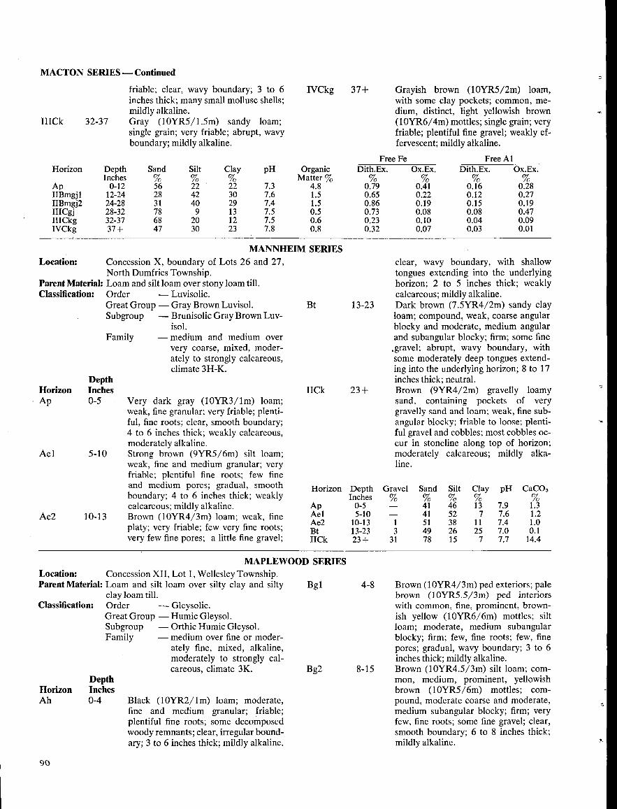
MACTON SERIES -Continued
I11Ck 32-37
MANNHEIM SERIESConcession X, boundary of Lots 26 and 27,North Dumfries Township .
Parent Material : Loam and silt loam over stony loam till .Classification :
Order
-Luvisolic .Great Group - Gray Brown Luvisol .Subgroup
-Brunisolic Gray Brown Luv-isol .
Family
-medium and medium oververy coarse, mixed, moder-ately to strongly calcareous,climate 3H-K.
Location :
DepthHorizon InchesAp 0-5
Ael
Ae2 10-13
Location :
Concession XII, Lot 1, Wellesley Township .Parent Material : Loam and silt loam over silty clay and silty
clay loam till .Order
-Gleysolic .Great Group - Humic Gleysol .Subgroup
-Orthic Humic Gleysol .Family
-medium over fine or moder-ately fine, mixed, alkaline,moderately to strongly cal-careous, climate 3K.
Classification :
5-10
DepthHorizon InchesAh 0-4
90
friable ; clear, wavy boundary; 3 to 6inches thick ; many small mollusc shells ;mildly alkaline .Gray (10YR5/1 .5m) sandy loam;single grain ; very friable ; abrupt, wavyboundary; mildly alkaline .
Very dark gray (10YR3/lm) loam;weak, fine granular ; very friable ; plenti-ful, fine roots ; clear, smooth boundary;4 to 6 inches thick ; weakly calcareous,moderately alkaline .Strong brown (9YR5/6m) silt loam;weak, fine and medium granular ; veryfriable ; plentiful fine roots ; few fineand medium pores ; gradual, smoothboundary ; 4 to 6 inches thick ; weaklycalcareous ; mildly alkaline .Brown (10YR4/3m) loam; weak, fineplaty ; very friable ; few very fine roots ;very few fine pores ; a little fine gravel ;
Black (1 OYR2/ l m) loam ; moderate,fine and medium granular ; friable ;plentiful fine roots ; some decomposedwoody remnants ; clear, irregular bound-ary ; 3 to 6 inches thick ; mildly alkaline .
IVCkg 37+
Bt
Bgl
Bg2
13-23
IICk 23+
MAPLEWOOD SERIES
4-8
8-15
Grayish brown (10YR5/2m) loam,with some clay pockets ; common, me-dium, distinct, light yellowish brown(10YR6/4m) mottles ; single grain ; veryfriable ; plentiful fine gravel ; weakly ef-fervescent ; mildly alkaline .
clear, wavy boundary, with shallowtongues extending into the underlyinghorizon ; 2 to 5 inches thick ; weaklycalcareous ; mildly alkaline .Dark brown (7.5YR4/2m) sandy clayloam; compound, weak, coarse angularblocky and moderate, medium angularand subangular blocky ; firm ; some fine,gravel ; abrupt, wavy boundary, withsome moderately deep tongues extend-ing into the underlying horizon ; 8 to 17inches thick ; neutral .Brown (9YR4/2m) gravelly loamysand, containing pockets of verygravelly sand and loam ; weak, fine sub-angular blocky ; friable to loose ; plenti-ful gravel and cobbles ; most cobbles oc-cur in stoneline along top of horizon ;moderately calcareous ; mildly alka-line .
Brown (10YR4/3m) ped exteriors ; palebrown (10YR5 .5/3m) ped interiorswith common, fine, prominent, brown-ish yellow (10YR6/6m) mottles ; siltloam; moderate, medium subangularblocky ; firm ; few, fine roots ; few, finepores ; gradual, wavy boundary; 3 to 6inches thick ; mildly alkaline .Brown (10YR4.5/3m) silt loam ; com-mon, medium, prominent, yellowishbrown (10YR5/6m) mottles ; com-pound, moderate coarse and moderate,medium subangular blocky ; firm ; veryfew, fine roots ; some fine gravel ; clear,smooth boundary; 6 to 8 inches thick ;mildly alkaline .
Horizon
Ap
DepthInches0-12
Sand%56
Silt
22
Clay
22
pH
7.3
OrganicMatter %
4.8
Free FeDith.Ex .%
0.79
Ox.Ex .
0.41
FreeDith.Ex.
0.16
AlOx.Ex .
0.28IIBmgjl 12-24 28 42 30 7.6 1 .5 0.65 0.22 0.12 0.271IBmgj2 24-28 31 40 29 7.4 1 .5 0.86 0.19 0.15 0.19IIICgj 28-32 78 9 13 7.5 0 .5 0.73 0.08 0.08 0.47IIICkg 32-37 68 20 12 7.5 0 .6 0.23 0.10 0.04 0.09IVCkg 37+ 47 30 23 7.8 0 .8 0.32 0.07 0.03 0.01
Horizon
Ap
DepthInches0-5
Gravel%-
Sand
41
Silt
46
Clay
13
pH
7.9
CaC03
1 .3Ael 5-10 - 41 52 7 7.6 1 .2Ae2 10-13 1 51 38 It 7.4 1 .0Bt 13-23 3 49 26 25 7.0 0.1IICk 23+ 31 78 15 7 7.7 14.4
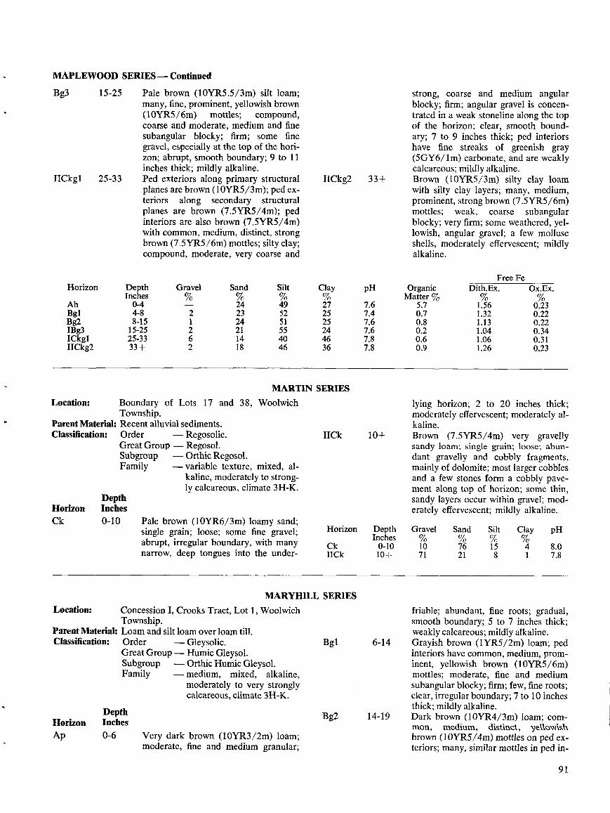
MAPLEWOOD SERIES -Continued
Bg3 15-25
IICkgl 25-33
Location : Boundary of Lots 17 and 38, WoolwichTownship .
Parent Material : Recent alluvial sediments .Classification :
DepthHorizon InchesCk 0-10
Pale brown (10YR5.5/3m) silt loam;many, fine, prominent, yellowish brown(10YR5/6m) mottles ; compound,coarse and moderate, medium and finesubangular blocky ; firm ; some finegravel, especially at the top of the hori-zon; abrupt, smooth boundary; 9 to 11inches thick; mildly alkaline .Ped exteriors along primary structuralplanes are brown (10YR5/3m); ped ex-teriors along secondary structuralplanes are brown (7.5YR5/4m); pedinteriors are also brown (7.5YR5/4m)with common, medium, distinct, strongbrown (7 .5YR5/6m) mottles ; silty clay;compound, moderate, very coarse and
Order
-Regosolic .Great Group - Regosol .Subgroup
-Orthic Regosol .Family
-variable texture, mixed, al-kaline, moderately to strong-ly calcareous, climate 3H-K.
Pale brown (10YR6/3m) loamy sand ;single grain ; loose ; some fine gravel;abrupt, irregular boundary, with manynarrow, deep tongues into the under-
Location:
Concession I, Crooks Tract, Lot 1, WoolwichTownship .
Parent Material : Loam and silt loam over loam till .Classification:
Order
-Gleysolic .Great Group- Humic Gleysol .Subgroup
-Orthic Humic Gleysol .Family
-medium,
mixed,
alkaline,moderately to very stronglycalcareous, climate 3H-K.
DepthHorizon InchesAp
0-6
Very dark brown (10YR3/2m) loam;moderate, fine and medium granular ;
MARTIN SERIES
IICkg2 33+
Clay pH%27 7.625 7.425 7.624 7.646 7.836 7.8
IICk 10+
MARYHILL SERIES
Horizon Depth GravelInches
Ck 0-10IICk 10+
Bgl 6-14
Bg2 14-19
strong, coarse and medium angularblocky ; firm ; angular gravel is concen-trated in a weak stoneline along the topof the horizon ; clear, smooth bound-ary ; 7 to 9 inches thick ; ped interiorshave fine streaks of greenish gray(5GY6/lm) carbonate, and are weaklycalcareous ; mildly alkaline .Brown (10YR5/3m) silty clay loamwith silty clay layers ; many, medium,prominent, strong brown (7.5YR5/6m)mottles ; weak, coarse subangularblocky ; very firm ; some weathered, yel-lowish, angular gravel ; a few molluscshells, moderately effervescent ; mildlyalkaline .
lying horizon ; 2 to 20 inches thick;moderately effervescent ; moderately al-kaline .Brown (7.5YR5/4m) very gravellysandy loam; single grain ; loose ; abun-dant gravelly and cobbly fragments,mainly of dolomite ; most larger cobblesand a few stones form a cobbly pave-ment along top of horizon ; some thin,sandy layers occur within gravel ; mod-erately effervescent ; mildly alkaline .
Sand Silt Clay pH% % % %10 76 15 4 8.071 21 8 1 7.8
friable ; abundant, fine roots ; gradual,smooth boundary; 5 to 7 inches thick ;weakly calcareous ; mildly alkaline .Grayish brown (IYR5/2m) loam ; pedinteriors have common, medium, prom-inent, yellowish brown (10YR5/6m)mottles ; moderate, fine and mediumsubangular blocky ; firm ; few, fine roots ;clear, irregular boundary; 7 to 10 inchesthick ; mildly alkaline .Dark brown (10YR4/3m) loam ; com-mon, medium, distinct, yellowishbrown (10YR5/4m) mottles on ped ex-teriors ; many, similar mottles in ped in-
9 1
Horizon Depth Gravel Sand SiltInches % % %
Ah 0-4 - 24 49Bgl 4-8 2 23 52Bg2 8-15 1 24 51IBg3 15-25 2 21 55ICkgl 25-33 6 14 40IICkg2 33+ 2 18 46
OrganicFree Fe
Dith.Ex . Ox.Ex .Matter %
5.7 1 .56 0.230.7 1 .32 0.220.8 1 .13 0.220.2 1 .04 0.340.6 1 .06 0.310.9 1 .26 0.23
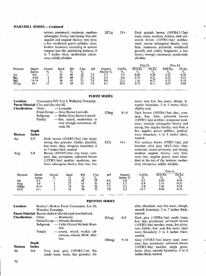
MARYHILL SERIES -Continued
Location :
Concession XIV, Lot 3, Wellesley Township .Parent Material : Clay and silty clay till .Classification :
DepthHorizon InchesAp 0-5
Aegj 5-8
92
Location:
DepthHorizon InchesAh 0-6
Family
teriors; compound, moderate, mediumsubangular blocky and strong, fine sub-angular and angular blocky ; very firm ;a few weathered gravel pebbles ; clear,broken boundary extending in narrowtongues into the underlying horizon ; 0to 7 inches thick ; moderately calcar-eous; mildly alkaline .
Order
-Luvisolic.Great Group -Gray Brown Luvisolic .Subgroup
-Orthic Gray Brown Luvisol .Family
-fine, mixed, moderately tovery strongly calcareous, cli-mate 3K.
Dark brown (10YR3/3m) clay loam ;strong, fine granular ; friable ; plentiful,fine roots ; clear, irregular boundary; 4to 7 inches thick ; neutral .Brown (10YR5/3m) clay loam; com-mon, fine, prominent, yellowish brown(10YR5/6m) mottles ; moderate, me-dium subangular blocky ; firm; few, fine
PERTH SERIES
Beasley's Broken Front Concession, Lot 26,Waterloo Township .
Parent Material : Recent shallow alluvial sand over bedrock .Classification :
Order
-Brunisolic .Great Group - Melanic Brunisol .Subgroup
-Lithic Gleyed Melanic Brun-isol .
- coarse, mixed, weakly cal-careous, climate 3H-K, shal-low .
Very dark gray (10YR3/lm) finesandy loam; weak, fine granular ; fri-
PRESTON SERIES
IICkg 19+
IIBtgj 8-14
IICk 14+
IIAegj 6-9
IIBmgj 9-14
Dark grayish brown (10YR4.5/2m)loam ; many, medium, distinct, dark yel-lowish brown (10YR5/4m) mottles ;weak, coarse subangular blocky ; veryfirm ; numerous yellowish, weatheredgravelly and cobbly fragments ; a fewstones ; strongly calcareous ; moderatelyalkaline .
roots ; very few, fine pores ; abrupt, ir-regular boundary; 2 to 5 inches thick ;slightly acid .Dark brown (10YR4/3m) clay ; com-mon, fine, faint, yellowish brown(10YR5/4m) mottles ; compound mod-erate, medium subangular blocky andstrong, fine angular blocky ; very firm ; afew angular gravel pebbles ; gradual,wavy boundary ; 4 to 8 inches thick ;neutral .Ped surfaces brown (9YR5/2m) ; pedinteriors olive gray (4Y5/2m) ; clay;moderate, coarse prismatic, and strong,medium angular blocky ; very firm ;some fine, angular gravel, most abun-dant at the top of the horizon ; moder-ately calcareous ; mildly alkaline .
able ; abundant, very fine roots ; abrupt,smooth boundary ; 5 to 7 inches thick ;neutral .Dark gray (10YR4/lm) sandy loam;few, fine, prominent, yellowish brown(10YR5/4m) mottles ; weak, fine platy ;very friable ; few, very fine roots ; clearwavy boundary ; 2 to 4 inches thick ;neutral .Gray (10YR5/lm) loamy sand; com-mon, fine, prominent, yellowish brown(10YR5/4m) mottles ; single grain ;loose ; clear, smooth boundary; 4 to 6inches thick ; neutral .
pH OrganicMatter
6.6 6.06.2 1.77.2 1.27.8 1 .2
Free Fe Free AlHorizon Depth Gravel Sand Silt Clay pH Organic CaCO, Dith.Ex . Ox.Ex . Dith.Ex . Ox.Ex .
Inches % % % Matter % % %Ap 0-6 - 24 46 30 7.5 5.7 1 .5 0.46 0.24 0.22 0.34Bgl 6-14 1 29 44 27 7.6 2.5 0.6 0.74 0.21 0.21 0.23Bg2 14-19 2 36 41 23 7.8 0 .6 12.2 1 .14 0.27 0.15 0.10IICkg 19+ 12 38 39 23 7.9 0 .1 20.0 0.73 0.11 0.07 0.05
Horizon Depth Gravel Sand Silt ClayInches % % %
Ap 0-5 - 23 48 29Aegj 5-8 1 27 43 30IIBtgj 8-14 1 18 26 56IICk 14+ 1 11 36 53
CaCO,Free
Dith.Ex .FeOx.Ex.
0 .1 0.89 0.480.4 1 .13 0.320.4 1 .42 0.2413.7 0.94 0.52
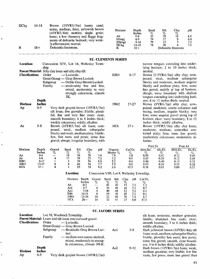
IICkg 14-18
R
ST. CLEMENTS SERIESConcession XIV, Lot 16, Wellesley Town-ship .
Parent Material : Silty clay loam and silty clay till .Classification :
Order
-Luvisolic .Great Group - Gray Brown Luvisol .Subgroup
-Orthic Gray Brown Luvisol .Family
-moderately fine and fine,mixed, moderately to verystrongly calcareous, climate3K.
Location:
DepthHorizon InchesAp 0-5
Family
Brown (10YR5/3m) loamy sand;many, medium, faint, yellowish brown(10YR5/4m) mottles ; single grain ;loose ; a few channery and flaggy frag-ments of dolomite bedrock ; very weak-ly effervescent ; neutral .Dolomitic limestone .
Very dark grayish brown (10YR3/2m)silt loam; fine granular ; friable ; plenti-ful, fine and very fine roots ; clear,smooth boundary ; 4 to 6 inches thick ;weakly calcareous ; mildly alkaline.Brown (10YR5/3m) silt loam ; com-pound, weak, medium subangularblocky and weak, medium platy ; friable ;few, fine roots and pores ; some finegravel ; abrupt, irregular boundary, with
Very dark grayish brown (10YR3/2m)
Horizon DepthInches
Ah 0-6IIAegj 6-9IIBmgj 9-14IICkg 14-18
Township .
ST. JACOBS SERIESLocation:
Lot3 8, Woolwich Township .Parent Material : Loam and silt loam over outwash gravel .Classification:
Order
-Luvisolic .Great Group -Gray Brown Luvisol .Subgroup
-Brunisolic Gray Brown Luv-isol .
- medium over coarse-skeletal,mixed, moderately to strong-ly calcareous, climate 3H-K.
CaC03
Ae1
Ae2
1 .20 .70 .10 .18 .717.5
5-9
9-12
Dolomitic limestone
narrow tongues extending into under-lying horizon ; 2 to 10 inches thick ;neutral .Brown (7 .5YR4/2m) silty clay ; com-pound, weak, medium subangularblocky and moderate, medium angularblocky and medium platy ; firm ; somefine gravel, mainly at top of horizon ;abrupt, wavy boundary with shallowtongues extending into underlying hori-zon; 6 to 12 inches thick ; neutral .Brown (9YR4/2m) silty clay ; com-pound, moderate, coarse columnar andstrong, medium, angular blocky ; veryfirm; some angular gravel along top ofhorizon ; clear, wavy boundary ; 8 to 12inches thick ; mildly alkaline .Brown (10YR5/3m) silty clay loam;moderate, medium, somewhat con-torted platy ; firm ; some fine gravel ;moderately calcareous ; moderately al-kaline .
silt loam; moderate, medium granular ;friable ; abundant fine roots ; clear,smooth boundary ; 3 to 6 inches thick ;mildly alkaline .Dark yellowish brown (10YR4/4m) siltloam ; weak, medium, subangular blocky ;friable ; plentiful fine roots ; few pores ;some fine gravel ; smooth, clear bound-ary ; 3 to 8 inches thick ; mildly alkaline .Dark brown (10YR4/3m) loam ; weak,medium granular; very friable; few fineroots ; few pores ; more fine gravel than
93
Horizon Depth Gravel Sand Silt Clay pH Organic CaC03Inches % % % Matter % %
Ap 0-4 18 56 26 7.6 7 .9 1 .0Ae 4-8 4 17 58 25 7.2 2 .2 0.0IIBti 8-17 1 5 39 56 6.8 2 .2 0.0IIBt2 17-27 0 4 42 54 7.7 1 .9 0.0IICk 27+ 4 1 65 34 8.2 2 .6 13.5
Location: Concession VIII, Lot 9, Wellesley
Horizon
Ah
DepthInches0-3
Gravel%-
Sand%45
Silt
40
Clay
15
pH
7.2Ael 3-7 4 38 46 16 7 .1Ae2 7-14 4 40 48 12 7.21113t 14-21 0 19 36 45 7.1II13tk 21-26 14 22 40 38 7.8IICk 26+ 14 32 41 27 8.0
Sand%
Silt Clay pH
53 29 18 6.874 17 9 6.878 15 7 7.276 20 4 7.1
IIBt1 8-17
IIBt2 17-27
IICk 27+
FreeDith.Ex .%
FeOx.Ex .%
FreeDith.Ex .%
AlOx.Ex .%
0.89 0.41 0.12 0.450.83 0.29 0.12 0.180.80 0.40 0.15 0.330.85 0.34 0.15 0.260.58 0.03 0.09 0.11
DepthHorizon InchesAp 0-5
Ae 5-8
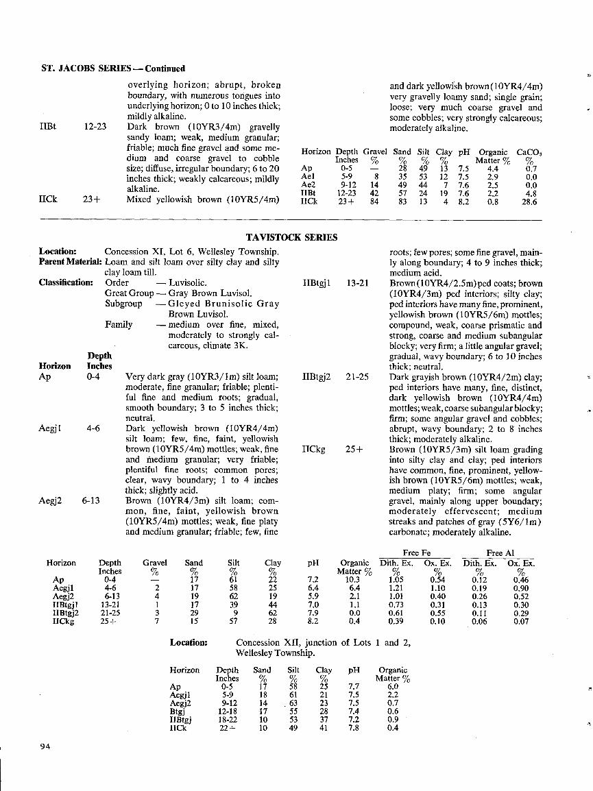
ST. JACOBS SERIES-Continued
IIBt 12-23
IICk 23+
Location :Parent Material:
Classification :
DepthHorizon InchesAp 0-4
Aegj1
4-6
Aegj2 6-13
94
Concession XI, Lot 6, Wellesley Township .Loam and silt loam over silty clay and siltyclay loam till .Order
-Luvisolic.GreatGroup-Gray Brown Luvisol.Subgroup
-Gleyed BrunisolicBrown Luvisol.
Family
-medium over fine, mixed,moderately to strongly cal-careous, climate 3K .
overlying horizon ; abrupt, brokenboundary, with numerous tongues intounderlying horizon; 0 to 10 inches thick;mildly alkaline .Dark brown (10YR3/4m) gravellysandy loam ; weak, medium granular;friable; much fine gravel and some me-dium and coarse gravel to cobblesize ; diffuse, irregular boundary; 6 to 20inches thick; weakly calcareous ; mildlyalkaline .Mixed yellowish brown (10YR5/4m)
Gray
Very dark gray (10YR3/lm) silt loam ;moderate, fine granular; friable; plenti-ful fine and medium roots ; gradual,smooth boundary; 3 to 5 inches thick;neutral.Dark yellowish brown (10YR4/4m)silt loam ; few, fine, faint, yellowishbrown (10YR5/4m) mottles; weak, fineand medium granular ; very friable;plentiful fine roots; common pores ;clear, wavy boundary; 1 to 4 inchesthick; slightly acid .Brown (10YR4/3m) silt loam ; com-mon, fine, faint, yellowish brown(10YR5/4m) mottles; weak, fine platyand medium granular ; -friable ; few, fine
Location :
Concession XII, junctionWellesley Township .
Horizon Depth SandInches %
Ap 0-5 17Aegj1
5-9
18Aegj2 9-12 14Btgj 12-18 17IIBtgj 18-22 10IICk 22+ 10
TAVISTOCK SERIES
Horizon Depth Gravel Sand Silt Clay pHInches % % % %
Ap 0-5 - 28 49 13Ael 5-9 8 35 53 12Ae2 9-12 14 49 44 7IIBt 12-23 42 57 24 19IICk 23+ 84 83 13 4
of Lots 1 and 2,
silt Clay pH Organic%
%
Matter%58 25 7.7 6.061 21 7.5 2.2
. 63
23
7.5
0.755 28 7.4 0.653 37 7.2 0.949 41 7.8 0.4
and dark yellowish brown(I OYR4/4m)very gravelly loamy sand ; single grain;loose; very much coarse gravel andsome cobbles ; very strongly calcareous ;moderately alkaline .
Organic CaC03Matter % %
7.5 4.4 0.77.5 2.9 0.07.6 2.5 0.07.6 2.2 4.88.2 0.8 28.6
roots; few pores; some fine gravel, main-ly along boundary; 4 to 9 inches thick;medium acid .Brown(10YR4/2 .5m)ped coats; brown(10YR4/3m) ped interiors ; silty clay ;ped interiors have many fine, prominent,yellowish brown (10YR5/6m) mottles;compound, weak, coarse prismatic andstrong, coarse and medium subangularblocky ; very firm ; a little angular gravel;gradual, wavy boundary; 6 to 10 inchesthick; neutral.Dark grayish brown (10YR4/2m) clay ;ped interiors have many, fine, distinct,dark yellowish brown (10YR4/4m)mottles ; weak, coarse subangularblocky ;firm ; some angular gravel and cobbles;abrupt, wavy boundary; 2 to 8 inchesthick; moderately alkaline .Brown (10YR5/3m) silt loam gradinginto silty clay and clay ; ped interiorshave common, fine, prominent, yellow-ish brown (10YR5/6m) mottles; weak,medium platy; firm ; some angulargravel, mainly along upper boundary ;moderately effervescent ; mediumstreaks and patches of gray (5Y6/lm)carbonate; moderately alkaline .
IIBtgj 1 13-21
IIBtgj2 21-25
IICkg 25+
Free Fe Free AlHorizon Depth Gravel Sand Silt Clay , pH Organic Dith . Ex. Ox. Ex. Dith . Ex . Ox . Ex .
Inches % % Matter % % io ioAp 0-4 - 17 61 22 7.2 10.3 1.05 0.54 0.12 0.46Aegjl 4-6 2 17 58 25 6.4 6.4 1 .21 1 .10 0.19 0.90Aegj2 6-13 4 19 62 19 5.9 2.1 1 .01 0.40 0.26 0.52IIBtgjl 13-21 1 17 39 44 7.0 1 .1 0.73 0.31 0.13 0.30IIBtgj2 21-25 3 29 9 62 7.9 0.0 0.61 0.55 0.11 0.29IICkg 25+ 7 15 57 28 8.2 0.4 0.39 0.10 0.06 0.07
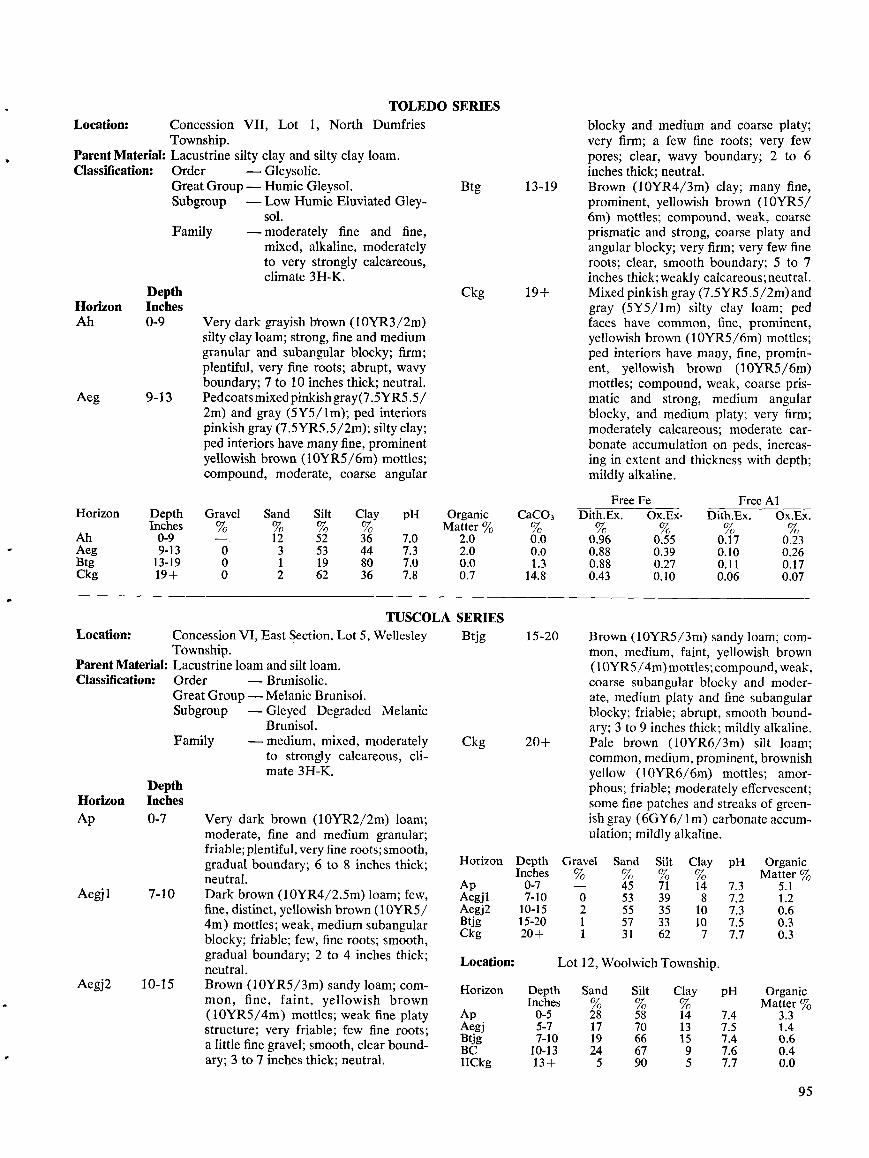
Location:
Parent Material :Classification:
Horizon
AhAegBtgCkg
TUSCOLA SERIESConcession VI, East Section, Lot 5, Wellesley
BtjgTownship . .
Parent Material: Lacustrine loam and silt loam .Classification :
Order
-Brunisolic .Great Group - Melanie Brunisol .Subgroup
-Gleyed DegradedBrunisol .
- medium, mixed, moderatelyto strongly calcareous, cli-mate 3H-K.
Location:
DepthHorizon InchesAp 0-7
Aegj1 7-10
Aegj2 10-15
Concession VII, Lot 1, North DumfriesTownship.Lacustrine silty clay and silty clay loam.Order
-Gleysolic .Great Group - Humic Gleysol .Subgroup
-Low Humic Eluviated Gley-sol.
Family
-moderately fine and fine,mixed, alkaline, moderatelyto very strongly calcareous,climate 3H-K .
Family
Very dark grayish brown (IOYR3/2m)silty clay loam; strong, fine and mediumgranular and subangular blocky ; firm ;plentiful, very fine roots ; abrupt, wavyboundary; 7 to 10 inches thick ; neutral .Pedcoatsmixedpinkishgray (7 .5YR5 .5/2m) and gray (5Y5/lm); ped interiorspinkish gray (7.5YR5.5/2m) ; silty clay ;ped interiors have many fine, prominentyellowish brown (10YR5/6m) mottles ;compound, moderate, coarse angular
Melanic
Very dark brown (10YR2/2m) loam ;moderate, fine and medium granular ;friable ; plentiful, very fine roots ; smooth,gradual boundary; 6 to 8 inches thick ;neutral .Dark brown (IOYR4/2.5m) loam ; few,fine, distinct, yellowish brown (10YR5/4m) mottles ; weak, medium subangularblocky; friable ; few, fine roots ; smooth,gradual boundary; 2 to 4 inches thick ;neutral .Brown (10YR5/3m) sandy loam; com-mon, fine, faint, yellowish brown(10YR5/4m) mottles ; weak fine platystructure ; very friable ; few fine roots ;a little fine gravel ; smooth, clear bound-ary ; 3 to 7 inches thick ; neutral .
TOLEDO SERIES
Btg 13-19
Ckg 19+
Ckg
15-20
20+
blocky and medium and coarse platy ;very firm ; a few fine roots ; very fewpores ; clear, wavy boundary; 2 to 6inches thick ; neutral .Brown (10YR4/3m) clay ; many fine,prominent, yellowish brown (10YR5/6m) mottles ; compound, weak, coarseprismatic and strong, coarse platy andangular blocky ; very firm ; very few fineroots ; clear, smooth boundary ; 5 to 7inches thick ; weakly calcareous ; neutral .Mixed pinkish gray (7.5YR5.5/2m)andgray (5Y5/lm) silty clay loam; pedfaces have common, fine, prominent,yellowish brown (10YR5/6m) mottles ;ped interiors have many, fine, promin-ent, yellowish brown (10YR5/6m)mottles ; compound, weak, coarse pris-matic and strong, medium angularblocky, and medium platy ; very firm ;moderately calcareous ; moderate car-bonate accumulation on peds, increas-ing in extent and thickness with depth ;mildly alkaline .
Brown (10YR5/3m) sandy loam; com-mon, medium, faint, yellowish brown(I OYR5/4m)mottles ; compound, weak,coarse subangular blocky and moder-ate, medium platy and fine subangularblocky ; friable ; abrupt, smooth bound-ary ; 3 to 9 inches thick ; mildly alkaline .Pale brown (10YR6/3m) silt loam ;common, medium, prominent, brownishyellow (10YR6/6m) mottles ; amor-phous; friable ; moderately effervescent ;some fine patches and streaks of green-ish gray (6GY6/ 1 m) carbonate accum-ulation ; mildly alkaline .
95
Horizon Depth Gravel Sand Silt Clay pH OrganicInches % % % % Matter %
Ap 0-7 - 45 71 14 7.3 5 .1Aegj1 7-10 0 53 39 8 7.2 1 .2Aegj2 10-15 2 55 35 10 7.3 0 .6Btjg 15-20 1 57 33 10 7.5 0.3Ckg 20+ 1 31 62 7 7.7 0 .3
Location : Lot 12, Woolwich Township .
Horizon Depth Sand Silt Clay pH OrganicInches % % % Matter %
Ap 0-5 28 58 14 7.4 3 .3Aegj 5-7 17 70 13 7.5 1 .4Btjg 7-10 19 66 15 7.4 0.6BC 10-13 24 67 9 7.6 0.4IICkg 13+ 5 90 5 7.7 0.0
Free Fe Free A1Depth Gravel Sand Silt Clay pH Organic CaCO, Dith.Ex . Ox.Ex . Dith.Ex . Ox.Ex .Inches % % % % Matter % % % % % %n0-9 - 12 52 36 7.0 2 .0 0.0 0.96 0.55 0.17 0.239-13 0 3 53 44 7.3 2.0 0.0 0.88 0.39 0.10 0.2613-19 0 1 19 80 7.0 0.0 1 .3 0.88 0.27 0.11 0.1719+ 0 2 62 36 7.8 0.7 14.8 0.43 0.10 0.06 0.07
DepthHorizon InchesAh 0-9
Aeg 9-13
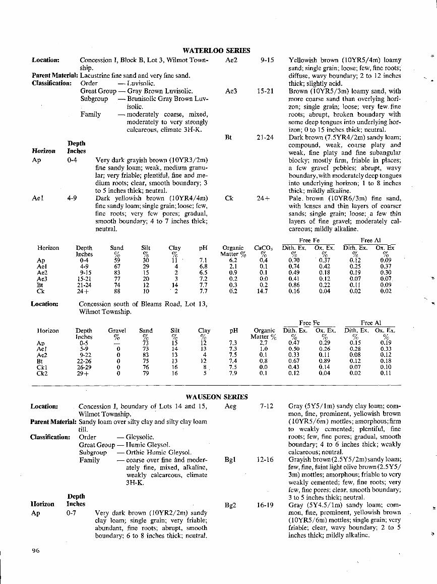
Location:ship .
Parent Material : Lacustrine fine sand and very fine sand .Classification :
Order
-Luvisolic .Great Group - Gray Brown Luvisolic.Subgroup
-Brunisolic Gray Brown Luv-isolic .
- moderately coarse, mixed,moderately to very stronglycalcareous, climate 3H-K.
9 6
Family
DepthHorizon InchesAp 0-7
WATERLOO SERIESConcession I, Block B, Lot 3, Wilmot Town-
Very dark grayish brown (10YR3/2m)fine sandy loam; weak, medium granu-lar ; very friable ; plentiful, fine and me-dium roots ; clear, smooth boundary ; 3to 5 inches thick ; neutral .Dark yellowish brown (10YR4/4m)fine sandy loam; single grain ; loose ; few,fine roots ; very few pores ; gradual,smooth boundary ; 4 to 7 inches thick ;neutral .
Location:
Concession I, boundary of Lots 14 and 15,Wilmot Township .
Parent Material: Sandy loam over silty clay and silty clay loamtill .
Classification : OrderGreat Group -Humic Gleysol .Subgroup
-Orthic Humic Gleysol .Family
-coarse over fine And moder-ately fine, mixed, alkaline,weakly calcareous, climate3H-K.
- Gleysolic .
Very dark brown (10YR2/2m) sandyclay loam ; single grain ; very friable;abundant, fine roots ; abrupt, smoothboundary ; 6 to 8 inches thick; neutral .
WAUSEON SERIES
Yellowish brown (10YR5/4m) loamysand; single grain ; loose ; few, fine roots,diffuse, wavy boundary; 2 to 12 inchesthick ; slightly acid .Brown (10YR5/3m) loamy sand, withmore coarse sand than overlying hori-zon ; single grain ; loose ; very few. fineroots ; abrupt, broken boundary withsome deep tongues into underlying hor-izon ; 0 to 15 inches thick ; neutral .Dark brown (7 .5YR4/2m) sandy loam ;compound, weak, coarse platy andweak, fine platy and fine subangularblocky ; mostly firm, friable in places ;a few gravel pebbles ; abrupt, wavyboundary, with moderately deep tonguesinto underlying horizon ; 1 to 8 inchesthick ; mildly alkaline .Pale . brown (10YR6/3m) fine sand,with lenses and thin layers of coarsersands ; single grain ; loose ; a few thinlayers of fine gravel ; moderately cal-careous ; mildly alkaline .
Gray (5Y5/lm) sandy clay loam; com-mon, fine, prominent, yellowish brown(10YR5/6m) mottles ; amorphous ; firmto weakly cemented ; plentiful, fineroots ; few, fine pores ; gradual, smoothboundary; 4 to 6 inches thick ; weaklycalcareous ; neutral .Grayish brown (2.5Y5/2m) sandy loam;few, fine, faint light olive brown (2.5Y5/3m) mottles ; amorphous ; friable to veryweakly cemented ; few, fine roots ; veryfew, fine pores ; clear, smooth boundary;3 to 5 inches thick ; neutral .Gray (5Y4.5/lm) sandy loam; com-mon, fine, prominent, yellowish brown(10YR5/6m) mottles ; single grain ; veryfriable ; clear, wavy boundary ; 2 to 5inches thick ; mildly alkaline .
Aeg 7-12
Bg1 12-16
Bg2 16-19
Horizon
Ap
DepthInches0-4
Sand
59
Silt
30
Clay
11
pH
7.1
OrganicMatter %
6.2
CaC03%0.4
FreeDith . Ex .%0.70
FeOx . Ex .%0.37
FreeDith . Ex .
0.12
AlOx . Ex
0.09Ael 4-9 67 29 4 6.8 2.1 0 .1 0.74 0.42 0.25 0.37Ae2 9-15 83 15 2 6.5 0 .9 0 .1 0.49 0.18 0.19 0.30Ae3 15-21 77 20 3 7.2 0.2 0.0 0 .41 0.12 0.07 0.07Bt 21-24 74 12 14 7.7 0.3 0.2 0.86 0.22 0.11 0.09Ck 24+ 88 10 2 7.7 0.2 14.7 0.16 0.04 0.02 0.02
Ae2 9-15
Ae3 15-21
Bt 21-24
Ck 24+
Location : Concession south of Bleams Road, Lot 13,
Horizon
Ap
Wilmot
DepthInches0-5
Township .
Gravel
-
Sand
73
Silt
15
Clay
12
pH
7.3
OrganicMatter %
2.7
FreeDith. Ex.%0.47
FeOx . Ex .%0.29
FreeDith . Ex .
0.15
AlOx . Ex.
0.19Ael 5-9 0 73 14 13 7.3 1 .0 0.50 0.26 0.28 0.33Ae2 9-22 0 83 13 4 7.5 0 .1 0.33 0.11 0.08 0.12Bt 22-26 0 75 13 12 7.4 0.8 0.67 0.89 0.12 0.18Ckl 26-29 0 76 16 8 . 7 .5 0 .0 0.43 0.14 0.07 0.10Ck2 29+ 0 79 16 5 7.9 0 .1 0.12 0.04 0.02 0.11
DepthHorizon InchesAp 0-4
Ae 1 4-9
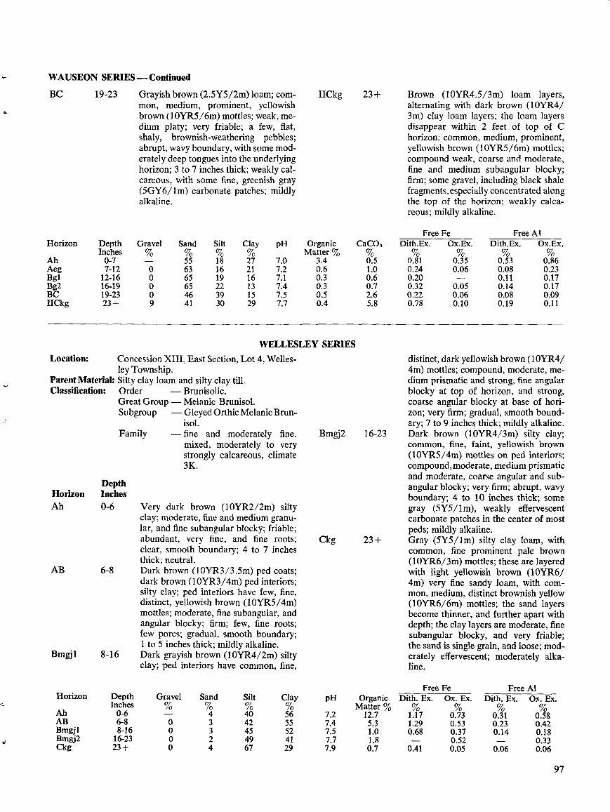
WAUSEON SERIES-Continued
BC
19-23
Grayish brown (2.5Y5/2m) loam; com-mon, medium, prominent, yellowishbrown (10YR5/6m) mottles ; weak, medium platy ; very friable ; a few, flat,shaly, brownish-weathering pebbles ;abrupt, wavy boundary, with some mod-erately deep tongues into the underlyinghorizon ; 3 to 7 inches thick ; weakly cal-careous, with some fine, greenish gray(5GY6/lm) carbonate patches ; mildlyalkaline .
Location:
Parent Material :Classification:
DepthHorizon InchesAh 0-6
AB 6-8
Bmgjl
8-16
Family
Concession XIII, East Section, Lot 4, Welles-ley Township.Silty clay loam and silty clay till .Order
-Brunisolic .Great Group - Melanic Brunisol .Subgroup
-GleyedOrthic Melanic Brun-isol .
- fine and moderately fine,mixed, moderately to verystrongly calcareous, climate3K .
Very dark brown (10YR2/2m) siltyclay; moderate, fine and medium granu-lar, and fine subangular blocky ; friable ;abundant, very fine, and fine roots ;clear, smooth boundary; 4 to 7 inchesthick ; neutral .Dark brown (10YR3/3 .5m) ped coats ;dark brown (10YR3/4m) ped interiors ;silty clay ; ped interiors have few, fine,distinct, yellowish brown (10YR5/4m)mottles ; moderate, fine subangular, andangular blocky; firm ; few, fine roots ;few pores ; gradual, smooth boundary;1 to 5 inches thick ; mildly alkaline .Dark grayish brown (10YR4/2m) siltyclay ; ped interiors have common, fine,
IICkg 23+
WELLESLEY SERIES
Bmgj2 16-23
Ckg 23+
Brown (10YR4.5/3m) loam layers,alternating with dark brown (10YR4/3m) clay loam layers ; the loam layersdisappear within 2 feet of top of Chorizon ; common, medium, prominent,yellowish brown (10YR5/6m) mottles ;compound weak, coarse and moderate,fine and medium subangular blocky ;firm ; some gravel, including black shalefragments,especially concentrated alongthe top of the horizon ; weakly calca-reous ; mildly alkaline .
distinct, dark yellowish brown (10YR4/4m) mottles ; compound, moderate, me-dium prismatic and strong, fine angularblocky at top of horizon, and strong,coarse angular blocky at base of hori-zon ; very firm ; gradual, smooth bound-ary ; 7 to 9 inches thick ; mildly alkaline .Dark brown (10YR4/3m) silty clay ;common, fine, faint, yellowish brown(10YR5/4m) mottles on ped interiors ;compound, moderate, medium prismaticand moderate, coarse angular and sub-angular blocky ; very firm ; abrupt, wavyboundary; 4 to 10 inches thick ; somegray (5Y5/lm), weakly effervescentcarbonate patches in the center of mostpeds ; mildly alkaline .Gray (5Y5/lm) silty clay loam, withcommon, fine prominent pale brown(10YR6/3m) mottles ; these are layeredwith light yellowish brown (10YR6/4m) very fine sandy loam, with com-mon, medium, distinct brownish yellow(10YR6/6m) mottles ; the sand layersbecome thinner, and further apart withdepth ; the clay layers are moderate, finesubangular blocky, and very friable ;the sand is single grain, and loose ; mod-erately effervescent ; moderately alka-line .
97
Organic CaC03Matter % %
3.4 0.50.6 1.00.3 0 .60 .3 0.70.5 2 .60 .4 5.8
Free Fe Free A1Horizon Depth Gravel Sand Silt Clay pH Organic Dith. Ex . Ox. Ex . Dith. Ex. Ox. Ex.Inches Matter % % %Ah 0-6 4 40 56 7.2 12.7 1.17 0.73 0.31 0.58AB 6-8 0 3 42 55 7.4 5 .3 1 .29 0.53 0.23 0 .42Bmgjl 8-16 0 3 45 52 7.5 1 .0 0.68 0.37 0.14 0.18Bmgj2 16-23 0 2 49 41 7.7 1 .8 - 0.52 - 0.33Ckg 23+ 0 4 67 29 7.9 0 .7 0.41 0.05 0.06 0.06
Horizon DepthInches
Gravel Sand Silt Clay pH
Ah 0-7 - 55 18 27 7.0Aeg 7-12 0 63 16 21 7.2Bgl 12-16 0 65 19 16 7.1Bg2 16-19 0 65 22 13 7.4BC 19-23 0 46 39 15 7.5IICkg 23+ 9 41 30 29 7.7
FreeDith.Ex .%
FeOx.Ex .
FreeDith.Ex .
AlOx.Ex .
0.81 0.35 0.53 0.860.24 0.06 0.08 0.230.20 - 0.11 0.170.32 0.05 0.14 0.170.22 0.06 0.08 0.090.78 0.10 0.19 0.11
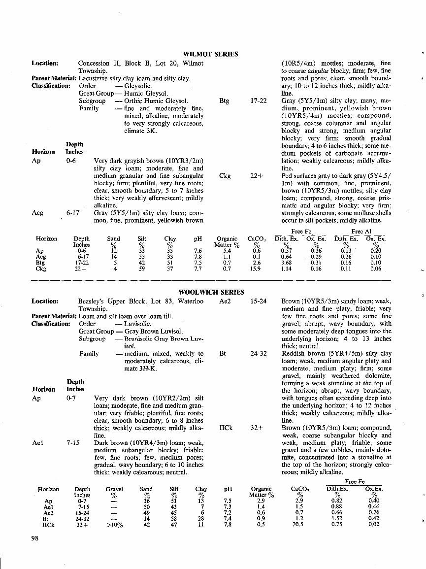
Location : Concession 11, Block B, Lot 20, WilmotTownship .
Parent Material : Lacustrine silty clay loam and silty clay .Classification:
Order
-Gleysolic .Great Group- Humic Gleysol .Subgroup
-Orthic Humic Gleysol .Family
-fine and moderately fine,mixed, alkaline, moderatelyto very strongly calcareous,climate 3K.
DepthHorizon InchesAp 0-6
Aeg 6-17
Location :Township .
Parent Material : Loam and silt loam over loam till .Classification :
Order
-Luvisolic .Great Group- Gray Brown Luvisol .Subgroup
-Brunisolic Gray Brown Luv-isol .
- medium, mixed, weakly tomoderately calcareous, cli-mate 3H-K.
DepthHorizon Inches
0-7Ap
Ae1
9 8
7-15
Very dark grayish brown (10YR3/2m)silty clay loam; moderate, fine andmedium granular and fine subangularblocky ; firm ; plentiful, very fine roots ;clear, smooth boundary; 5 to 7 inchesthick ; very weakly effervescent ; mildlyalkaline .Gray (5Y5/lm) silty clay loam; com-mon, fine, prominent, yellowish brown
Beasley's Upper Block, Lot 83, Waterloo
Ae2
Family
Very dark brown (10YR2/2m) siltloam; moderate, fine and medium gran-ular ; very friable ; plentiful, fine roots ;clear, smooth boundary; 6 to 8 inchesthick ; weakly calcareous ; mildly alka-line .Dark brown (10YR4/3m) loam ; weak,medium subangular blocky ; friable;few, fine roots ; few, medium pores ;gradual, wavy boundary; 6 to 10 inchesthick ; weakly calcareous ; neutral .
WILMOT SERIES
Btg 17-22
Ckg 22+
WOOLWICH SERIES
Bt
15-24
24-32
11Ck 32+
(10R5/4m) mottles ; moderate, fineto coarse angular blocky; firm ; few, fineroots and pores ; clear, smooth bound-ary ; 10 to 12 inches thick ; mildly alka-line .Gray (5Y5/lm) silty clay ; many, me-dium, prominent, yellowish brown(10YR5/4m) mottles ; compound,strong, coarse columnar and angularblocky and strong, medium angularblocky ; very firm ; smooth gradualboundary; 4 to 6 inches thick ; some me-dium pockets of carbonate accumu-lation ; weakly calcareous ; mildly alka-line .Ped surfaces gray to dark gray (5Y4.5/Im) with common, fine, prominent,brown (10YR5/3m) mottles ; silty clayloam; compound, strong, coarse pris-matic and angular blocky ; very firm ;strongly calcareous ; some mollusc shellsoccur in silt pockets ; mildly alkaline .
Brown (10YR5/3m) sandy loam; weak,medium and fine platy ; friable ; veryfew fine roots and pores ; some finegravel ; abrupt, wavy boundary, withsome moderately deep tongues into theunderlying horizon ; 4 to 13 inchesthick ; neutral .Reddish brown (5YR4/5m) silty clayloam ; weak, medium angular platy andmoderate, medium platy ; firm ; somegravel, mainly weathered dolomite,forming a weak stoneline at the top ofthe horizon ; abrupt, wavy boundary,with tongues often extending deep intothe underlying horizon ; 4 to 12 inchesthick ; weakly calcareous ; mildly alka-line .Brown (10YR5/3m) loam ; compound,weak, coarse subangular blocky andweak, medium platy ; friable ; somegravel and a few cobbles, mainly dolo-mite, concentrated into a stoneline atthe top of the horizon ; strongly calca-reous ; mildly alkaline .
Free Fe
Horizon Depth Sand Silt Clay pH Organic CaC03Inches % Matter % %
Ap 0-6 12 53 35 7.6 5.4 0.6Aeg 6-17 14 53 33 7.8 1 .1 0.1Btg 17-22 5 42 51 7.5 0 .7 2.6Ckg 22+ 4 59 37 7.7 0 .7 15.9
pH
7.5
OrganicMatter %
2.9
CaC03%2.9
Dith.Ex .%0.82
Ox.Ex .
0.407.3 1 .4 1 .5 0.88 0.447.2 0.6 0.7 0.66 0.267.4 0 .9 1 .2 1.52 0.427.8 0 .5 20.5 0.75 0.02
Horizon
Ap
DepthInches0-7
Gravel%-
Sand%36
Silt
51
Clay
13Ael 7-15 - 50 43 7Ae2 15-24 - 49 45 6Bt 24-32 - 14 58 28IICk 32+ >10% 42 47 11
FreeDith . Ex .%
FeOx . Ex .%
FreeDith . Ex .
AlOx. Ex.
0.57 0.36 0.13 0.200.64 0.29 0.26 0.103.68 0.31 0.16 0.101 .14 0.16 0.11 0.06
WOOLWICH SERIES -Continued
GLOSSARYAlluvium
- material deposited by rivers and streams,
Glacialusually on riverbeds and floodplains .
spillwayAtterberg -the moisture contents of a soil at which
Gleylimits
changes of state or condition occur . Related
conditionsterms include plastic limit, liquid limit, plas-ticity index and plastic range (see this glos-sary) .
Bedrock
-any solid rock exposed at the surface of the
Hummockyearth or overlain by unconsolidated material .
Channery
-thin, flat fragments of limestone, sandstone
Kameor schist up to 3 inches in diameter.
Chert
-a compact, siliceous rock formed of micro-scopic grains of quartz and opal .
Cobbly
-containing appreciable quantities of cobble-
Kettle holestones, which are rounded or partiallyrounded rock or mineral fragments between3 and 10 inches in diameter .
LacustrineColluvium
-soil material that has moved downhill and
plainaccumulated on lower slopes and/or at thebottom of the hill.
LandformComplex
-slopes going in all directions, as in hum-slopes
mocky areas .
Liquid limitContour
-plowing that approximately follows the con-plowing
tour of the land .Dolomite
-a mineral or rock composed of calcium mag-nesium carbonate-CaMg(COi) 2 .
LoamDrumlin
- a streamlined hill or ridge of glacial materials,with long axis paralleling direction of flow of
Loessformer glacier .
Made landEnd moraine - a ridgelike accumulation of glacial materials
built along the margin of a glacier .Esker
- a narrow ridge of gravelly or sandy materials,
Meltwaterdeposited by a stream in association withglacial ice .
Mixed grainFloodplain
-nearly level land situated on either side of achannel which is subject to overflow flood-
Moraineing.
Fluted
-land surfaces having smooth, straight, parallel
Outcroptopography
channels, probably derived from glacial ac-tion .
Formation
- a unit of geologic mapping consisting of a
Outwashlarge and persistent stratum of some one kindof rock .
OverburdenFree
-carbonates of calcium and magnesium whichcarbonates
occur uncombined with other elements . Their
Parentpresence in soils is indicated by effervescence
materialon addition of 0.1 normal HCl .
Free iron
-oxides and hydroxides of iron and aluminumand
that occur uncombined with other elements,aluminum
generally of fine particle size and frequentlyoccurring as coatings on primary and secon-
Peddary minerals .
- channel that carried water presumably de-rived from melting glaciers .
- soil conditions brought about by gleyzation, asoil-forming process operative under poordrainage, that results in reduction of ironand other elements, and in gray colors andmottles .
- land surface having many low mounds orknolls .
- a hill of stratified materials deposited, usuallyas a steep alluvial fan, against the edge of anice sheet by streams of sediment-laden melt-water .
- bowl-shaped depression formed by the melt-ing away of a stranded ice block from aglacier .
- level or slightly depressed land area onceoccupied by a lake, containing lake-depositedsediments .
- a distinguishable, natural land feature suchas a flood plain, terrace, esker, etc .
-the water content, in percent, of the dryweight of the soil, at which a specific testprocedure determines a change of state of thesoil from a plastic to a liquid condition .
- soil material that contains 7 to 27% clay, 28to 50% silt, and more than 52% sand.
- a deposit of wind-blown silt .- areas filled with earth, or with earth and trash
mixed, usually by or under the control ofman.
- water resulting from the melting of snow orglacier ice .
- refers, in this report, to the growing of oatsand barley together, as a single crop .
- an accumulation of glacial materials builtchiefly by the direct action of glacier ice .
- usually an exposure of bedrock; sometimesrefers to exposures of till formations, etc, onslopes .
- stratified materials deposited by meltwaterstreams beyond active glacier ice .
- usually refers to all unconsolidated materials(i .e. gravel, clay, etc) that lie above bedrock.
- the unconsolidated, more or less chemicallyweathered mineral or organic matter fromwhich the solum of soils has developed . TheC horizon may or may not consist of materialssimilar to those from which the A and Bhorizons developed .
- a unit of soil structure such as a prism, blockor granule, formed by natural processes .
99
Location: Concession II, Crooks Tract, Lot 2, Wool-
Horizon
wich
DepthInches
Township .
Gravel%
Sand%
Silt Clay pH
Ap 0-5 - 39 46 15 7.4Ael 5-12 0 43 46 11 7.2Ae2 12-16 1 46 38 16 7.1Bt 16-24 2 35 35 30 7.5IICk 24+ 18 50 36 14 8.0
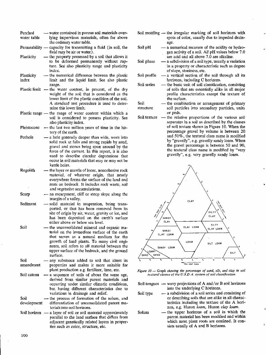
Perched
-water contained in porous soil materials overwater table
lying impervious materials, often far abovethe ordinary water table.
Permeability - capacity for transmitting a fluid (in soil, thefluid may be air or water) .
Plasticity
-the property possessed by a soil that allows itto be deformed permanently without rup-ture . See also plasticity range and plasticityindex .
Plasticity
-the numerical difference between the plasticindex
limit and the liquid limit . See also plasticrange .
Plastic limit -the water content, in percent, of the dryweight of the soil that is considered as thelower limit of the plastic condition of the soil .A standard test procedure is used to deter-mine this lower limit.
Plastic range - the range of water content within which asoil is considered to possess plasticity . Seealso plasticity index .
Pleistocene
-the last two million years of time in the his-tory of the earth .
Pothole
-a hole generally deeper than wide, worn intosolid rock at falls and strong rapids by sand,gravel and stones being spun around by theforce of the current . In this report, it is alsoused to describe circular depressions thatoccur in soil materials that may or may not bekettle holes .
Regolith
-the layer or mantle of loose, noncohesive rockmaterial, of whatever origin, that nearlyeverywhere forms the surface of the land andrests on bedrock . It includes rock waste, soiland vegetative accumulations .
Scarp
-an escarpment, cliff or steep slope along themargin of a valley .
Sediment
-solid material in suspension, being trans-ported, or that has been removed from itssite of origin by air, water, gravity or ice, andhas been deposited on the earth's surfaceeither above or below sea level .
Soil
-the unconsolidated mineral and organic ma-terial on the immediate surface of the earththat serves as a natural medium for thegrowth of land plants . To many civil engi-neers, soil refers to all material between theupper surface of the bedrock, and the groundsurface .
Soil
-any substance added to soil that alters itsamendment
properties and makes it more suitable forplant production e.g . fertilizer, lime, etc .
Soil catena
-a sequence of soils of about the same age,derived from similar parent materials andoccurring under similar climatic conditions,but having different characteristics due tovariations in drainage and relief.
Soil
-the process of formation of the solum, anddevelopment
differentiation of unconsolidated parent ma-terials into soil horizons .
Soil horizon - a layer of soil or soil material approximatelyparallel to the land surface that differs fromadjacent genetically related layers in proper-ties such as color, structure, etc .
100
Soil mottling - the irregular marking of soil horizons withspots of color, usually due to impeded drain-age .
Soil pH
-a numerical measure of the acidity or hydro-gen activity of a soil . All pH values below 7.0are acid and all above 7 .0 are alkaline .
Soil phase
-a subdivision of a soil type, usually a variationin a property or characteristic such as degreeof slope, stoniness, etc.
Soil profile
-a vertical section of the soil through all itshorizons, including C horizons .
Soil series
-the basic unit of soil classification, consistingof soils that are essentially alike in all majorprofile characteristics except the texture ofthe surface .
Soil
-the combination or arrangement of primarystructure
soil particles into secondary particles, unitsor peds.
Soil texture
-the relative proportions of the various soilseparates in a soil as described by the classesof soil texture shown in Figure 10 . When thepercentage gravel by volume is between 20and 50%, the textural class name is modifiedby "gravelly", e.g. gravelly sandy loam . Whenthe gravel percentage is between 50 and 90,the textural class name is modified by "verygravelly", e.g . very gravelly sandy loam.
Soil type
Solum
Figure 10 - Graph showing the percentage of sand, silt, and clay in soiltextural classes of theU.S.D.A . system of soil classification
Soil tongues
PER CENT SAND
wavy projections of A and/or B soil horizonsinto the underlying C horizons .a subdivision of a soil series and consisting ofor describing soils that are alike in all charac-teristics including the texture of the A hori-zon, e.g . Huron loam, Huron clay loam .the upper horizons of a soil in which theparent material has been modified and withinwhich most plant roots are confined. It con-sists usually of A and B horizons .

Soundness
-the soundness of a stone is its ability to resistthe action of weathering agents, particularlyfreezing and thawing, without disintegration.
Summer
-the tillage of uncropped land during the sum-fallow
mer to control weeds and store moisture inthe soil for the growth of a later crop.
Terrace
-a level, usually narrow, plain bordering ariver, lake, or the sea. Rivers sometimes arebordered by terraces at different levels .
Till
-a sediment of diverse texture and structuredeposited by direct glacier action ; it is char-acteristically compact, poorly sorted and un-stratified .
11 . MacFarlane, I. C. ed . 1969 . Muskeg Engineering Hand-book, University of Toronto Press, Toronto.
REFERENCES
Tilth
-the physical condition of soil as related to itsease of tillage, fitness as a seedbed, and itsimpedance to seedling emergence and rootpenetration.
Topography -the relief and contour of the land .Trans-
-refers to the movement, usually vertical, oflocation
elemental or fine material in soils, such asclay or free iron.
Unconsoli-
-non-solid materials like sand, that are easilydated
broken up, in contrast to bedrock, which ismaterials consolidated .Varve
-sedimentary bed or lamination that is prob-ably deposited within one year's time .
Mehra, Ô. P., and Jackson, M. L. 1960 . Iron oxide re-moval from soils and clays by a dithionite citrate systembuffered with sodium bicarbonate. 7th Natl . Conf . onclays and clay minerals, p. 317-327. Pergamon Press,NewYork .
Mercier, R. G., and Chapman, L. J. 1956 . Peach climatein Ontario. 1955-56 Rept . of the Hort . Expt . Sta. andProd . Lab., Vineland, Ont. Dept. Agric.Ontario Agricultural Commission . 1881 . Appendix B,Vol. 11, C . Blackett Robinson, 5 Jordan St ., Toronto.
Ontario Department of Agriculture and Food . 1970.Vegetable production recommendations.
Ontario Department of Economics and Development.1965. Mid-western Ontario region, Economic Survey .Special Research and Surveys Br.Peech, M., Alexander, L. T., Dean, L. A., and Reed, J. F.1947. Methods of soil analysis for soil fertility investiga-tions. U.S . Dept . Agric. Circ . 757.
Raad, A. T., Protz, R., and Thomas, R. L. 1969. Deter-minations of Na-dithionite and NH4-oxalate extractableFe, Al and Mn in soils by atomic absorption spectroscopy .Can. J. Soil Sci. 49, p. 89-94.
Reaman, G. E . 1957. The Trail of the Black Walnut .McClelland and Stewart Ltd., Toronto.
Sanford, B. V. 1958. Geological map of south-westernOntario. Map 1062A. Geol . Surv . Can., Can. Dept . MinesandTech . Surveys.
Schwertmann, W. 1964 . The differentiation of iron oxidein soils by a photochemical extraction with acid am-monium oxalate. 2 Pflanzenernahr . Düng. Bodenkunde105, p. 194-201 .
1 . American Association of State Highway Officials. Stan- 12 .dard Specifications for Highway Materials and Methodsof Sampling and Testing. 8th ed . Washington, D.C . 1961 .
2. American Society of Testing and Materials. 1964. Pro-cedures for testing soil . Sponsored by committee D-18on Soils for Engineering Purposes, Amer. Soc. of Testing 13.and Materials, Philadelphia, Pa.
3 . Brown, D. M., McKay, G. A., and Chapman, L.J . 1968.The climate of Southern Ontario. Climatological studies 14 .No . 5, Meteor . Br ., Ont. Dept . of Transport.
4. Canada Department of Agriculture . 1965 . Soil capability 15 .classification for agriculture . The Canada Land InventoryRept. No . 2 .
5 . Canada Department of Agriculture . 1970 . The system of16 .
soil classification for Canada. Queens Printer, Ottawa .6. Chapman, L. J., and Putnam, D. F. 1966 . Physiography 17 .of Southern Ontario, 2nd ed . University of Toronto Press,
Toronto.7. Coligado, M. C., Baier, W., and Sly, W. K. 1969. Risk
analyses of weekly climatic data for agricultural and ir- 18 .
rigation planning, Guelph, Ont. Tech . Bull . 66, Agro-meteorology Sect ., Plant Research Inst ., Research Br.,Can. Dept . Agric.
8 . Dominion Bureau of Statistics . 1966. Census of Canada . 19 .9. Kilmer, V. J., and Mullins, J. F. 1954 . Improved stirring
and pipetting apparatus for mechanical analysis of soils . 20 .Soil Sci. 77, pp . 437-441 .
10 . Lee, P. 1969. A study of the engineering properties ofWaterloo County surficial soils . Unpubl . M.Sc. Thesis, 21 .University of Waterloo, Ont.
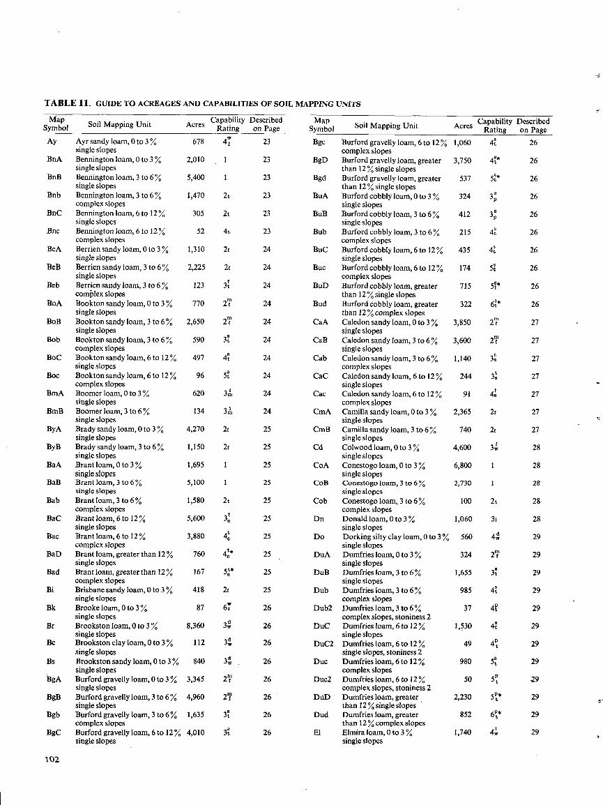
TABLE 11 . GUIDE TO ACREAGES AND CAPABILITIES OF SOIL MAPPING UNITS
MapSymbol
Soil Mapping Unit
Ay
BnA
BnB
Bnb
BnC
Bnc
BeA
BeB
Beb
BOA
BoB
Bob
BoC
Boc
BmA
BmB
ByA
ByB
BaA
BaB
Bab
BaC
Bac
BaD
Bad
Bi
Bk
Br
Bc
Bs
BgA
BgB
Bgb
BgC
102
Ayr sandy loam, 0 to 3single slopesBennington loam, 0 to 3singleslopesBennington loam, 3 to 6singleslopesBennington loam, 3 to 6complex slopesBennington loam, 6 to 12 Yosingle slopesBennington loam, 6 to 12complex slopesBerrien sandy loam, 0 to 3single slopesBerrien sandy loam, 3 to 6singleslopesBerrien sandy loam, 3 to 6complex slopesBookton sandy loam, 0 to 3single slopesBookton sandy loam, 3 to 6single slopesBookton sandy loam, 3 to 6complex slopesBookton sandy loam, 6 to 12single slopesBookton sandy loam, 6 to 12complex slopesBoomer loam, 0 to 3single slopesBoomer loam, 3 to 6single slopesBrady sandy loam, 0 to 3single slopesBrady sandy loam, 3 to 6single slopesBrant loam, 0 to 3single slopesBrant loam, 3 to 6single slopesBrant loam, 3 to 6complex slopesBrant loam, 6 to 12single slopesBrant loam, 6 to 12complex slopesBrant loam, greater than 12single slopesBrant loam, greater than 12complex slopesBrisbane sandy loam, 0 to 3single slopesBrooke loam, 0 to 3single slopesBrookston loam, 0 to 3single slopesBrookston clay loam, 0 to 3single slopesBrookston sandy loam, 0 to 3single slopesBurford gravelly loam, 0 to 3single slopesBurford gravelly loam, 3 to 6single slopesBurford gravelly loam, 3 to 6complex slopesBurford gravelly loam, 6 to 12single slopes
Soil Mapping Unit
Burford gravelly loam, 6 to 12complex slopesBurford gravelly loam, greaterthan 12%single slopesBurford gravelly loam, greaterthan 12%single slopesBurford cobbly loam, 0 to 3single slopesBurford cobbly loam, 3 to 6single slopesBurford cobbly loam, 3 to 6complex slopesBurford cobbly loam, 6 to 12single slopesBurford cobbly loam, 6 to 12complex slopesBurford cobbly loam, greaterthan 12 %single slopesBurford cobbly loam, greaterthan 12%complex slopesCaledon sandy loam, 0 to 3single slopesCaledon sandy loam, 3 to 6single slopesCaledon sandy loam, 3 to 6complex slopesCaledon sandy loam, 6 to 12single slopesCaledon sandy loam, 6 to 12complex slopesCamilla sandy loam, 0 to 3single slopesCamilla sandy loam, 3 to 6 Yosingle slopesColwood loam, 0 to 3single slopesConestogo loam, 0 to 3single slopesConestogo loam, 3 to 6single slopesConestogo loam, 3 to 6complex slopesDonald loam, 0 to 3single slopesDorking silty clay loam, 0 to 3single slopesDumfries loam, 0 to 3single slopesDumfries loam, 3 to 6single slopesDumfries loam, 3 to 6Y.complex slopesDumfries loam, 3 to 6complex slopes, stoniness 2Dumfries loam, 6 to 12single slopesDumfries loam, 6 to 12single slopes, stoniness 2Dumfries loam, 6to 12complex slopesDumfries loam, 6 to 12complex slopes, stoniness 2Dumfries loam, greater ,than 12 Y. singleslopesDumfries loam, greaterthan 12 Y.complex slopesElmira loam, 0 to 3single slopes
Acres Capability DescribedRating
on Page1,060 4' 26
3,750 4t * 26
537 5t * 26
324 3p 26
412 3D 26
215 4t 26
435 4t 26
174 5t 26
715 5t* 26
322 6t * 26
3,850
2T
27
3,600
2T
27
1,140 3s 27
244 3s 27
91 4s 27
2,365 2t 27
740 2t 27
4,600 3W 28
6,800 1 28
2,730 1 28
100 2t 28
1,060 31 28
560 4W 29
324 2T, 29
1,655 3t 29
985 4t 29
37 4ft 29
1,530 4t 29
49 4° 29
980 5t 29
50 5° 29
2,230 5i* 29
852 6L* 29
1,740 4W 29
Acres CapabilityRating
Describedon Page
MapSymbol
678 4f 23 Bgc
2,010 1 23 BgD
5,400 1 23 Bgd
1,470 2t 23 BuA
305 2t 23 BuB
52 4t 23 Bub
1,310 2t 24 Buc
2,225 2f 24 Buc
123 3t 24 BuD
770 2i` 24 Bud
2,650 2T 24 CaA
590 3t 24 CaB
497 4t 24 Cab
96 5t 24 CaC
620 3m 24 Cac
134 3m 24 CmA
4,270 2t 25 CmB
1,150 2f 25 Cd
1,695 1 25 CoA
5,100 1 25 COB
1,580 2t 25 Cob
5,600 3et 25 Dn
3,880 4e 25 Do
760 4é* 25 DuA
167 5é* 25 DuB
418 2t 25 Dub
87 6`° 26 Dub2
8,360 3W 26 DuC
112 3dW 26 DuC2
840 3W 26 Duc
3,345 2T 26 Duc2
4,960 2m 26 DuD
1,635 3t 26 Dud
4,010 3t 26 El
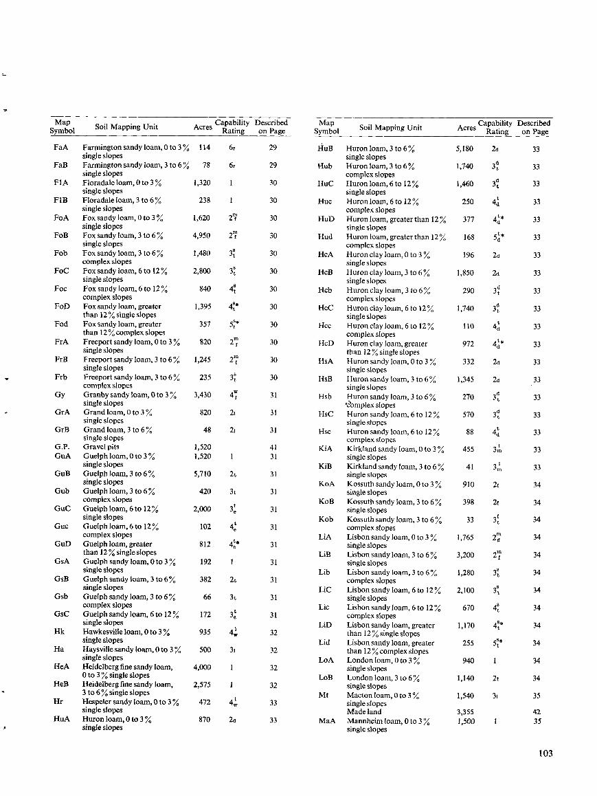
103
MapSymbol Soil Mapping Unit Acres Capability
RatingDescribedon Page
MapSymbol Soil Mapping Unit Acres Capability
RatingDescribedon Page
FaA Farmington sandy loam, 0 to 3 114 6r 29 HuB Huron loam, 3 to 6 5,180 2d 33single slopes single slopes
FaB Farmington sandy loam, 3 to 6 78 6r 29 Hub Huron loam, 3 to 6 1,740 3dt 33single slopes complex slopes
FIA Floradale loam, 0 to 3 1,320 1 30 HuC Huron loam, 6 to 12 1,460 3dt 33single slopes single slopes
FIB Floradaleloam, 3 to 6J 238 1 30 Huc Huron loam, 6 to 12 250 4d 33single slopes complex slopes
FoA Fox sandy loam, 0 to 3 1,620 2mi 30 HuD Huron loam, greaterthan 12 377 4d* 33single slopes single slopes
FoB Fox sandy loam, 3 to 6 4,950 2i 30 Hud Huron loam, greaterthan 12 168 5d * 33single slopes complex slopes
Fob Fox sandy loam, 3 to 6 1,480 3t 30 HcA Huron clay loam, 0 to 3 196 2d 33complex slopes single slopes
FoC Fox sandy loam, 6 to 12 2,800 8 30 HcB Huron clay loam, 3 to 6 1,850 2d 33single slopes single slopes
Foc Fox sandy loam, 6 to 12 840 4t 30 Hcb Huron clay loam, 3 to 6 290 3dt 33complex slopes complex slopes
FoD Fox sandy loam, greater 1,395 4i* 30 HcC Huronclay loam, 6 to 12 1,740 3dt 33than 12%single slopes single slopes
Fod Fox sandy loam, greater 357 5t* 30 Hcc Huron clay loam, 6 to 12 110 4d 33than 12%complex slopes complex slopes
FrA Freeport sandy loam, 0 to 3 820 2`f 30 HcD Huron clay loam, greater 972 4d* 33single slopes than 12 %single slopes
FrB Freeport sandy loam, 3 to 6 1,245 2i 30 HsA Huron sandy loam, 0 to 3 332 2d 33single slopes single slopes
Frb Freeport sandy loam, 3 to 6 235 3t 30 HsB Huron sandy loam, 3 to 6 1,345 2d 33complex slopes single slopes
Gy Granby sandy loam, 0 to 3 3,430 4W 31 Hsb Huron sandy loam, 3 to 6 270 3dt 33single slopes 'complex slopes
GrA Grand loam, 0to 3 820 21 31 HSC Huron sandy loam, 6 to 12 570 3t 33single slopes single slopes
GrB Grand loam, 3 to 6 48 21 31 Hsc Huron sandy loam, 6 to 12 88 4d 33single slopes complex slopes
G.P . Gravel pits 1,520 41 KiA Kirkland sandy loam, 0 to 3 455 3m 33GuA Guelph loam, 0 to 3 1,520 1 31 single slopes
single slopes KiB Kirkland sandy loam, 3 to 6 41 3�, 33GuB Guelph loam, 3 to 6 5,710 2t 31 single slopes
single slopes KoA Kossuth sandy loam, 0 to 3 910 2t 34Gub Guelph loam, 3 to 6 420 3t 31 single slopes
complex slopes KoB Kossuth sandy loam, 3 to 6 398 2t 34GuC Guelph loam, 6 to 12 2,000 e 31 single slopes
single slopes Kob Kossuth sandy loam, 3 to 6 33 3i 34Guc Guelph loam, 6 to 12 102 4t 31 complex slopes
complex slopes LiA Lisbon sandy loam, 0 to 3 1,765 21 34GuD Guelph loam, greater 812 4é* 31 single slopes
than 12 %single slopes LiB Lisbon sandy loam, 3 to 6 3,200 2i 34GsA Guelph sandy loam, 0 to 3 192 1 31 single slopes
single slopes Lib Lisbon sandy loam, 3 to 6 1,280 3t 34GsB Guelph sandy loam, 3 to 6% 382 2t 31 complex slopes
single slopes LiC Lisbon sandy loam, 6 to 12 2,100 s 34Gsb Guelph sandy loam, 3 to 6 66 3t 31 single slopes
complex slopes Lic Lisbon sandy loam, 6 to 12 670 4t 34GsC Guelph sandy loam, 6 to 12 172 3e 31 complex slopes
single slopes LiD Lisbon sandy loam, greater 1,170 4t* 34Hk Hawkesville loam, 0 to 3 935 4w 32 than 12 %single slopes
single slopes Lid Lisbon sandy loam, greater 255 St* 34Ha Haysville sandy loam, 0 to 3 500 1 32 than 12 %complex slopes
single slopes LoA London loam, 0 to 3 940 1 34HeA Heidelberg fine sandyloam, 4,000 1 32 single slopes
0 to 3% single slopes LoB London loam, 3 to 6 1,140 2t 34HeB Heidelberg fine sandy loam, 2,575 1 32 single slopes
3 to 6%single slopes Mt Macton loam, 0 to 3 1,540 31 35Hr Hespeler sandy loam, 0 to 3 472 4w 33 single slopes
single slopes Made land 3,355 42HuA Huron loam, 0 to 3 870 2d 33 MaA Mannheim loam, 0 to 3 1,500 1 35
single slopes single slopes
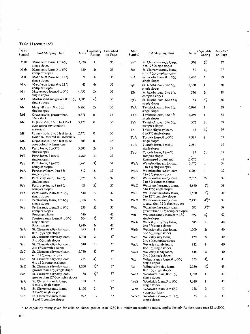
Table 11 (continued)
104
*The capability rating given for soils on slopes greater than 12% is a minimum capability rating, applicable only for the slope range 12 to 20~.
MapSymbol Soil Mapping Unit Acres Capability
RatingDescribedon Page
MapSymbol Soil Mapping Unit Acres Capability
RatingDescribedon Page
MaB Mannheim loam, 3 to 6 1,720 1 35 Ssc St. Clements sandy loam, 570 3t 37single slopes 6 to 12Y.single slopes
Mab Mannheim loam, 3 to 6 680 1 35 Ssc St. Clements sandy loam, 87 4e 37complexslopes 6 to 12 %complex slopes
MaC Mannheim loam, 6 to 12 78 3t 35 SjA St. Jacobs loam, 0 to 3 3,400 1 38single slopes singleslopes
Mac Mannheim loam, 6 to 12 43 4t 35 SjB St . Jacobs loam, 3 to 6 2,350 1 38complex slopes single slopes
Mp Maplewood loam, 0 to 3 4,950 2w 35 Sjb St . Jacobs loam, 3 to 6 550 2t 38single slopes complex slopes
Mn Martin sand and gravel, 0to 3 3,385 6s 36 SjC St . Jacobs loam, 6 to 12 54 3`t 38single slopes single slopes
Mr Maryhill loam, 0 to 3 6,800 2w 36 TaA Tavistock loam, 0 to 3 6,090 1 38single slopes single slopes
Md Organic soils, greater than 4,875 0 36 TaB Tavistock loam, 3 to 6 4,250 1 383 feet thick single slopes
Mc Organic soils, 1 to 3 feet thick 5,470 0 36 Tab Tavistock loam, 3 to 6 362 2t 38over coarse-textured soil complex slopesmaterials To Toledo silty clay loam, 45 3w
d 39Mf Organic soils, 1 to 3 feet thick 2,470 0 36 0 to 3%single slopes
over fine-textured soil materials TuA Tuscola loam, 0 to 3 4,385 1 39Ms Organic soils, 1 to 3 feet thick 303 ` 0 36 single slopes
over dolomitic limestone TuB Tuscola loam, 3 to 6 2,880 1 39PeA Perth loam, 0 to 3 5,600 2d 37 single slopes
single slopes Tub Tuscola loam, 3 to 6 83 2t 39PeB Perth loam, 3 to 6 3,700 2d 37 complex slopes
single slopes Unmapped urban land 13,070 42Peb Perth loam, 3 to 6 1,965 3d 37 WaA Waterloo fine sandy loam, 3,570 1 39
complex slopes 0 to 3 %single slopesPcA Perth clay loam, 0 to 3 812 2d 37 WaB Waterloo fine sandy loam, 8,200 1 39
single slopes 3 to 6% single slopesPcB Perth clay loam, 3 to 6 1,375 2d 37 Wab Waterloo fine sandy loam, 2,615 2t 39
single slopes 3 to 6%complex slopesPcb Perth clay loam, 3 to 6 81 3t 37 WaC Waterloo fine sandy loam, 4,660 2 t 39
complex slopes 6 to 12 %single slopesPsA Perth sandy loam, 0 to 3 540 2d 37 Wac Waterloo fine sandy loam, 1,560 3 t 39
single slopes 6 to 12%complex slopesPsB Perth sandy loam, 3 to 6 1,050 2d 37 WaD Waterloo fine sandy loam, 2,430 4i* 39
single slopes greater than 12 % singleslopesPsb Perth sandy loam, 3 to 6 230 3dt 37 Wad Waterloo fine sandy loam, 580 5 t 39
complex slopes greater than 12 %complex slopesPonds and lakes 740 42 Wu Wauseon sandy loam,0to 3 692 4L 40
Pr Preston sandy loam, 0 to 3 104 4,,. 37 single slopessingle slopes WeA Wellesley silty clay loam, 685 1 40Riverscarps 1,840 7t 42 0 to 3 %single slopes
ScA St . Clements silty clay loam, 495 1 37 WeB Wellesley silty clay loam, 1,500 2t 400 to 3%single slopes 3 to 6%single slopes
ScB St . Clements silty clay loam, 3,700 2t 37 Web Wellesley silty loam, 129 3t 403 to 6%single slopes 3 to 6%complex slopes
Scb St . Clements silty clay loam, 540 3t 37 WsA Wellesley sandy loam, 132 1 403 to 6%complex slopes 0 to 3%single slopes
ScC St. Clements silty clay loam, 2,750 3e 37 WSB Wellesley sandy loam, 448 2t 406 to 12%single slopes 3 to 6%single slopes
Scc St . Clements silty clay loam, 275 4é 37 Wx Wilmot sandy loam, 0 to 3 323 4w 416 to 12%complex slopes single slopes
ScD St . Clements silty clay loam, 1,200 4é* 37 Wi Wilmot silty clay loam, 2,330 4W 41greater than 12 %single slopes 0 to 3%single slopes
Scd St . Clements silty clay loam, 88 5et* 37 WoA Woolwich loam, 0 to 3 3,950 1 41greater than 12%complex slopes single slopes
SsA St. Clements sandy loam, 188 1 37 WoB Woolwich loam, 3 to 6 3,140 1 410 to 3%single slopes single slopes
SsB St . Clements sandy loam, 1,120 2t . 37 Wob Woolwich loam, 3 to 6 328 2t 413 to 6%single slopes complex slopes
Ssb St . Clements sandy loam, 222 3t 37 Woc Woolwich loam, 6to 12 33 2t 413 to 6%complex slopes single slopes
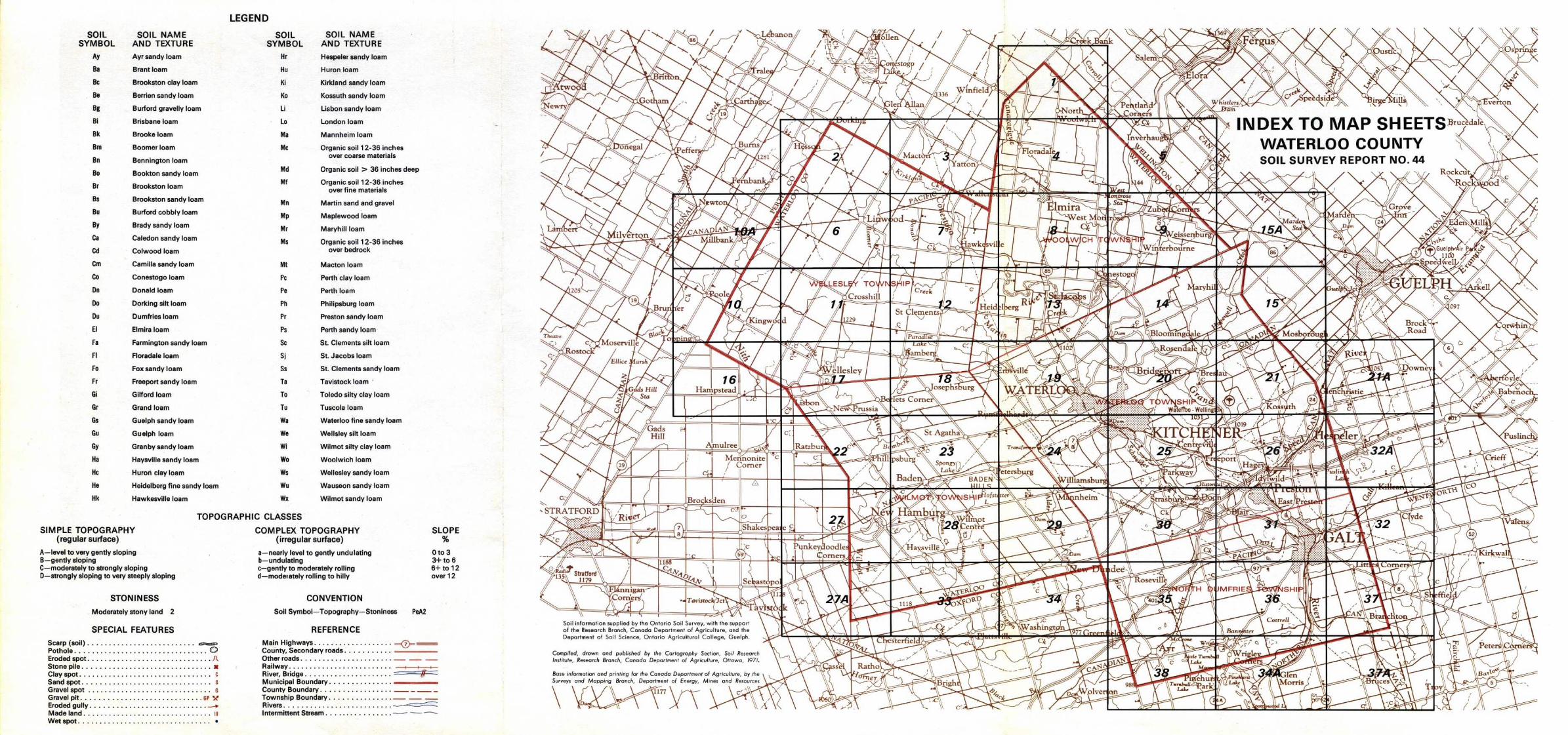
LEGENDSOIL
SOIL NAME
SOIL
SOIL NAMESYMBOL
AND TEXTURE
SYMBOL
AND TEXTUREAy
Ayr sandy loam
Hr
Hespelersandyloam
Ba
Brant loam
Hu
Huron loam
Bc
Brookston clay loam
Ki
Kirkland sandy loam
Be
Berrien sandy loam
Ko
Kossuth sandy loam
Bg
Burford gravelly loam
Li
Lisbon sandy loam
8i
Brisbane loam
Lo
London loam
Bk
Brooke loam
Ma
Mannheim loam
Bm
Boomer loam
Mc
Organic soil 12-36 inchesover coarse materialsBn
Bennington loam
Bo
Bookton sandy loam
Md
Organic soil > 36 inches deep
Br
Brookston loam
Mf
Organic sail 12-36 inchesover fine materials
Bs
Brookston sandy loam
Mn
Martin sand and gravelBu
Burford cobbly loam Mp
Maplewood loamBy
Brady sandy loam Mr MaryhillloamCa
Caledon sandy loam
Ms
Organic soil 12-36 inchesCd
Colwood loam
over bedrock
Cm
Camilla sandy loam
Mt
Macton loam
Co
Conestogo loam
Pc
Perth clay loam
Dn
Donald loam
Pe
Perth loam
Do
Dorking silt loam
Ph
Philipsburg loam
Du
Dumfries loam
Pr
Preston sandy loam
EI
Elmira loam
Ps
Perth sandy loam
fa
Farmington sandy loam
Sc
St. Clements silt loam
f I
Floradale loam
Sj
St. Jacobs loam
Fo
Fox sandy loam
5s
St. Clements sandy loam
Fr
Freeport sandy loam
Ta
Tavistock loam
Gi
Gilford loam
To
Toledo silty clay loam
Gr
Grand loam
Tu
Tuscola loam
Gs
Guelph sandy loam
Wa
Waterloo fine sandy loam
Gu
Guelph loam
We
Wellsleysiltloam
Gy
Granby sandy loam
Wi
Wilmot silty clay loam
Ha
Haysville sandy loam
Wo
Woolwich loam
He
Huron clay loam
Ws
Wellesley sandy loam
He
Heidelberg fine sandy loam
Wu
Wauseon sandy loam
Hk
Hawkesville loam
W><
Wilmot sandy loam
TOPOGRAPHIC CLASSESSIMPLE TOPOGRAPHY
COMPLEX TOPOGRAPHY
SLOPE(regular surface)
(irregular surface)
%A-level to very gently sloping
a-nearly level to gently undulating
0 to 3B-gently sloping
b-undulating
3+ to 6C-moderately to strongly sloping
c-gently to moderately rolling
6+ to 12D-strongly sloping to very steeply sloping
d-moderately rolling to hilly
over 12
STONINESS
CONVENTIONModerately stony land
2
Soil Symbol-Topography-Stoniness
PeA2
SPECIAL FEATURES
REFERENCEScarp(soil) . . . . . . . . . . . . . . . . . . . . . . . . . .~
Main Highways . . . . . . . . . . . . . . . . . .Pothole . . . . . . . . . . . . . . . . . . . . . . . . . . . . . . . . ©
County, Secondaryroads . . . . . . . . . . .Eroded spot . . . . . . . . . . . . . . . . . . . . . . . . . . . . . .ll
Other roads . . . . . . . . . . . . . . . . . . . . . . -Stone pile . . . . . . . . . . . . . . . . . . . . . . . . . . . . . . . x
Railway . . . . . . . . . . . . . . . . . . . . . . . . .Clayspot . . . . . . . . . . . . . . . . . . . . . . . . . . . . . . . . c
River, Bridge . . . . . . . . . . . . . . . . . . . . . ~,~Sand spat . . . . . . . . . . . . . . . . . . . . . . . . . . . . . . . s
Municipal Boundary . . . . . . . . . . . . . . .Gravel spot . . . . . . . . . . . . . . . . . . . . . . . . . . . . . .
s
County Boundary . . . . . . . . . . . . . . . . . -_-_Gravel pit . . . . . . . . . . . . . . . . . . . . . . . . . . . . . nr k
Township Boundary . . . . . . . . . . . . . . .- - -Eroded ull
~
Rivers . . . . . . . . . . . . . . . . . . . . . . . . . . ~"9 Y. . . . . . . . . . . . . . . . . . . . . . . . . . . .Made land . . . . . . . . . . . . . . . . . . . . . . . . . . . . . . . m
Intermittent Stream . . . . . . . . . . . . . . . .
--Wetspot . . . . . . . . . . . . . . . . . . . . . . . . . . . . . . . .
1:20,000
1 :20,000
Hu3
Miles 0
Miles
Metres 0
500
1000
1500 MetresI
1
I
I
I
I
I
I
.t CI
HuC
Peb
HcA
43°3e'30°42'
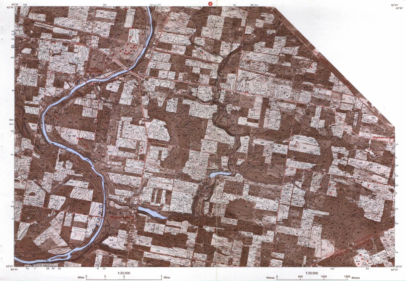
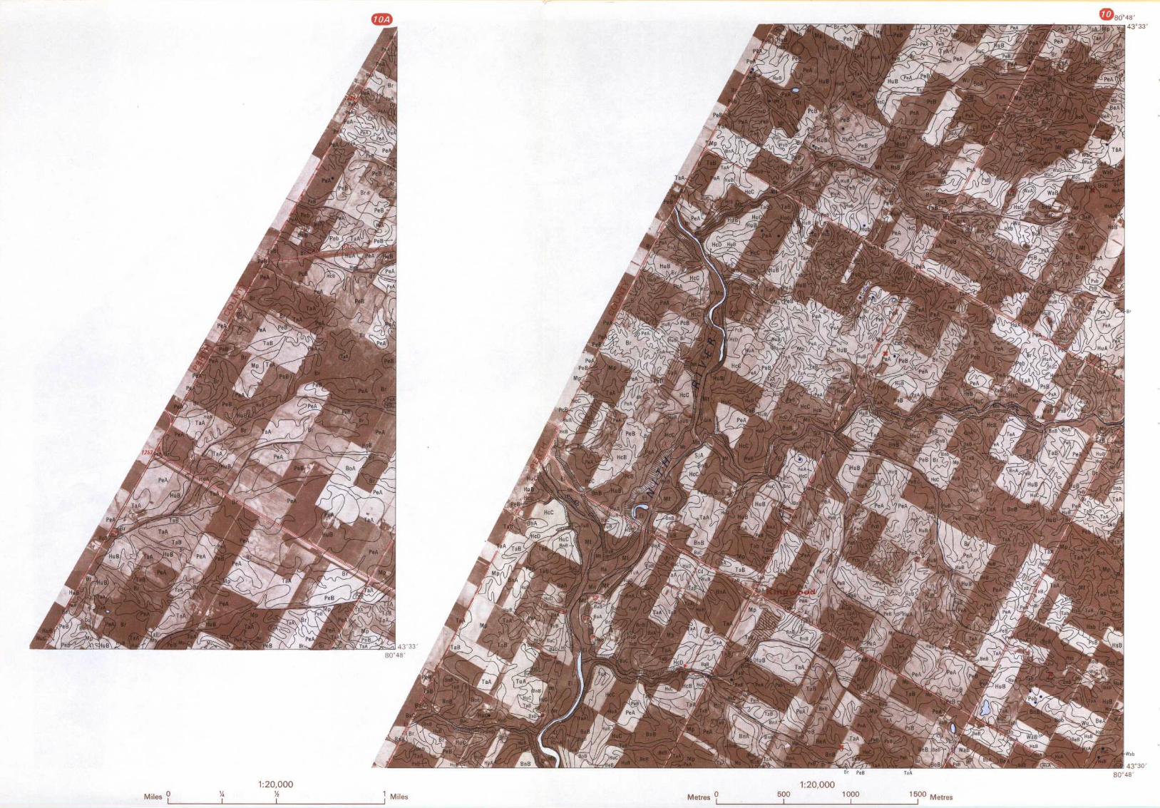
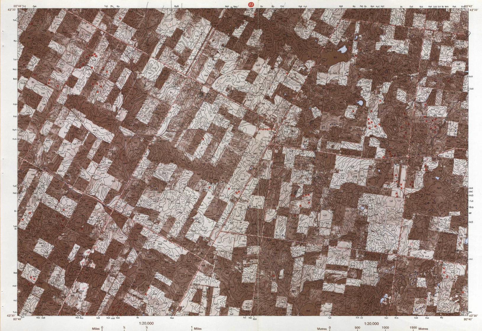
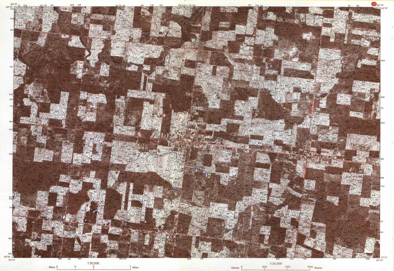
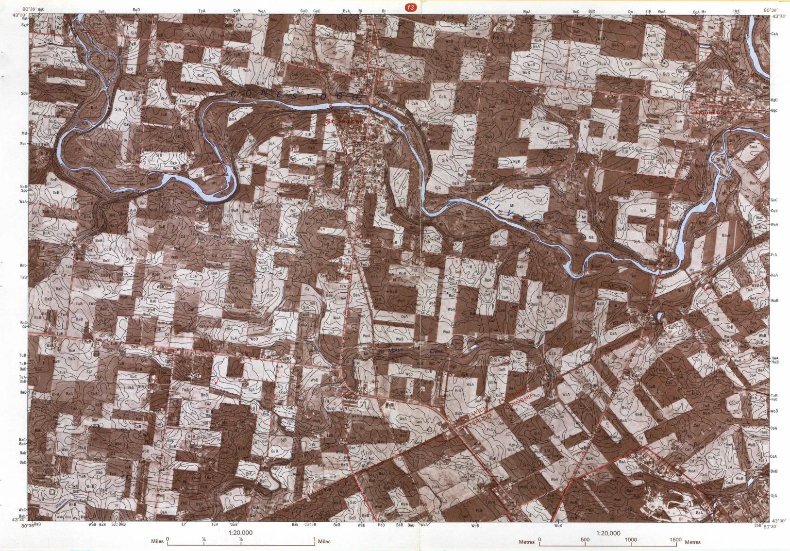
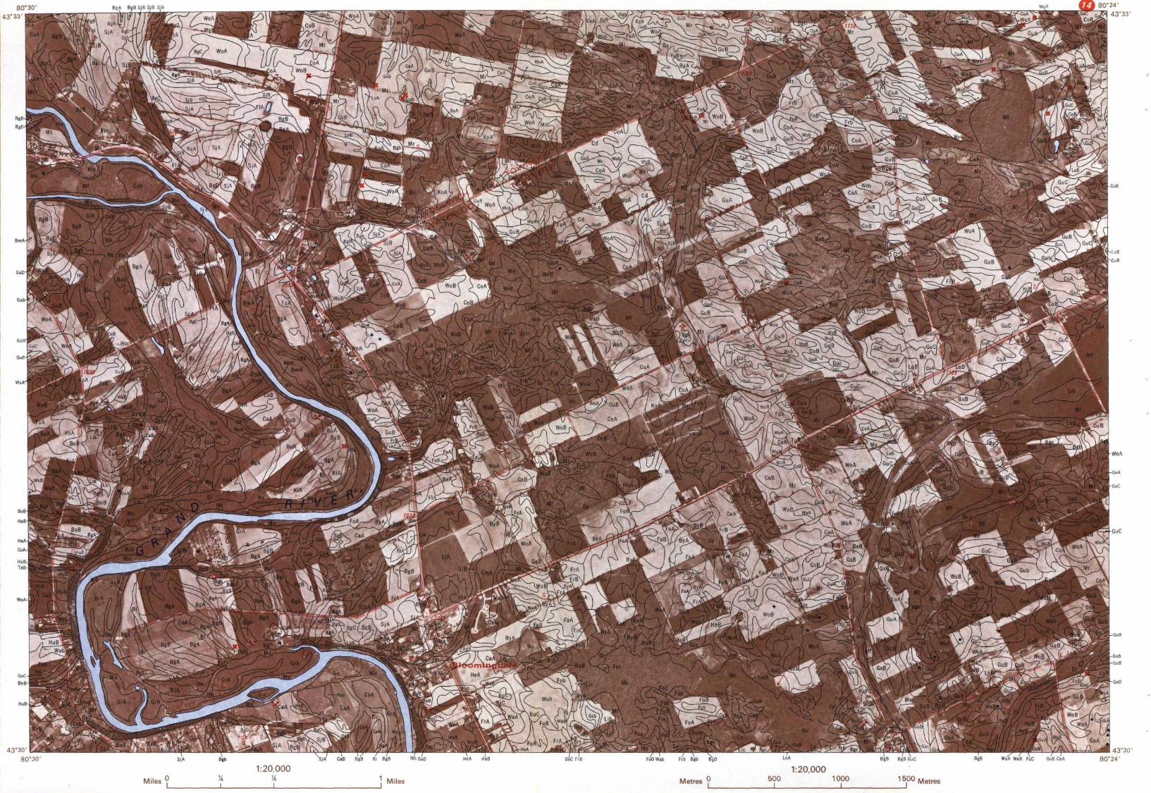
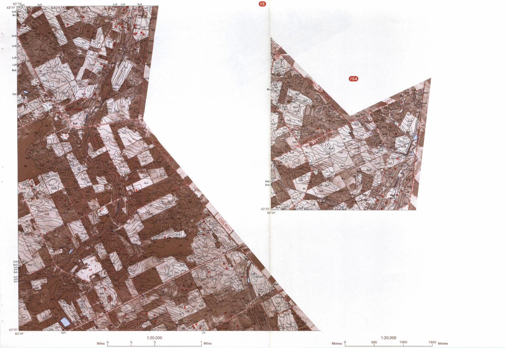
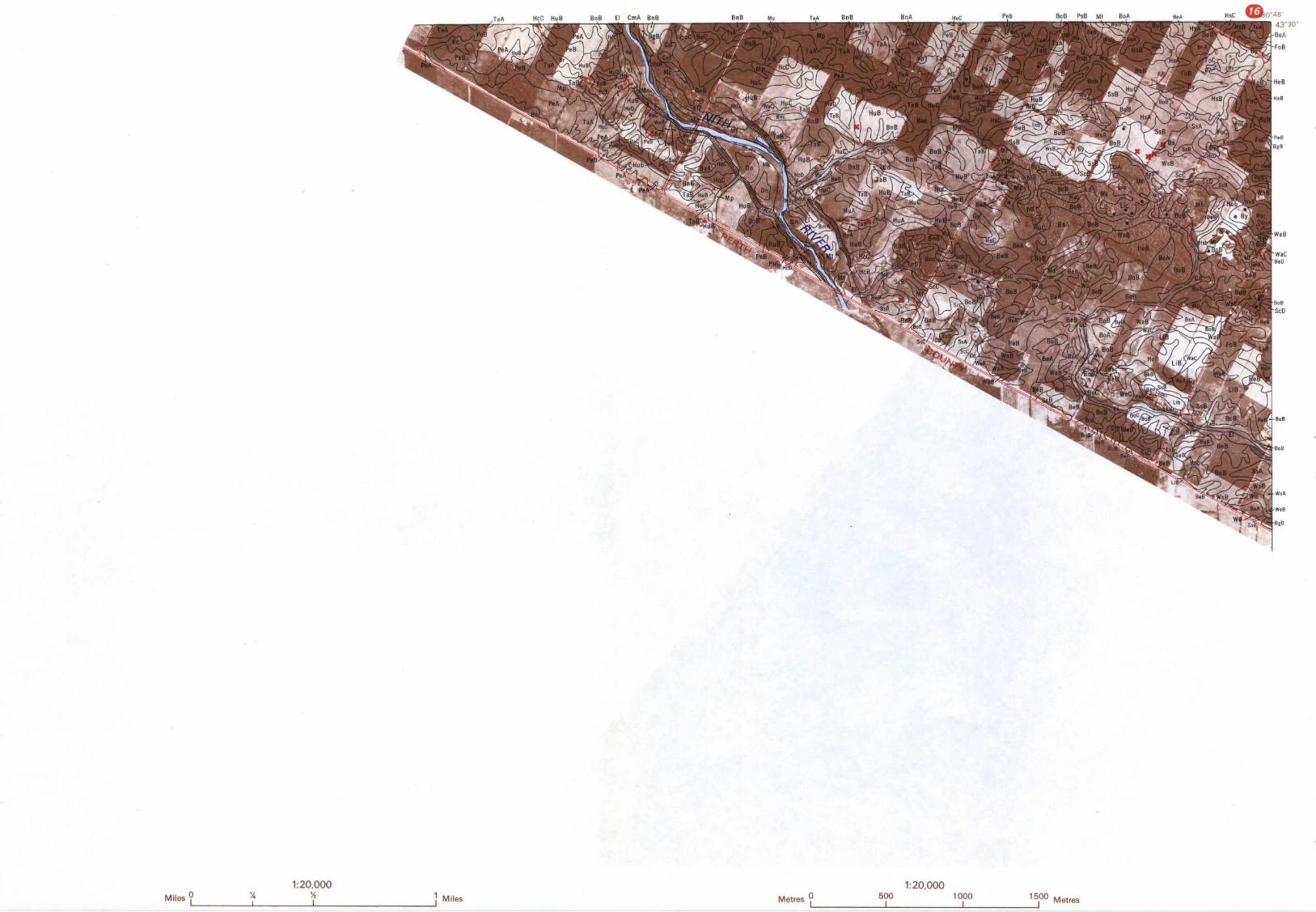
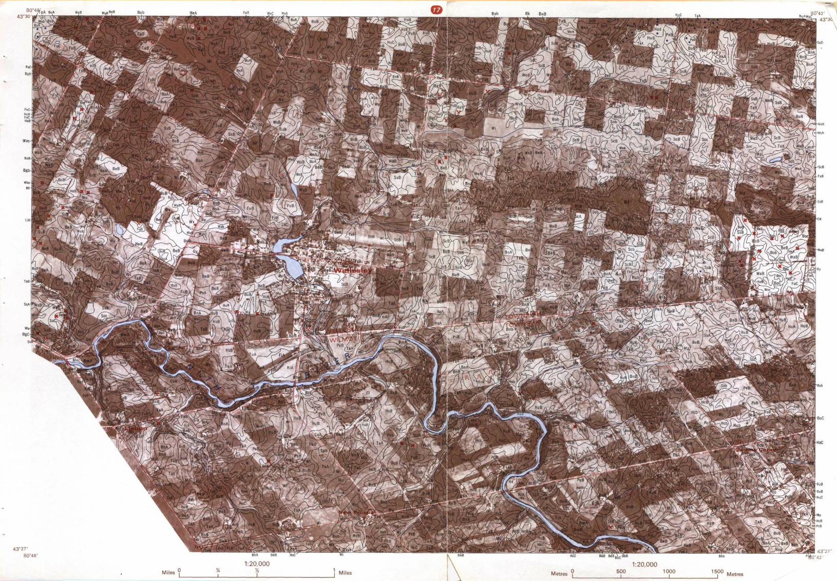
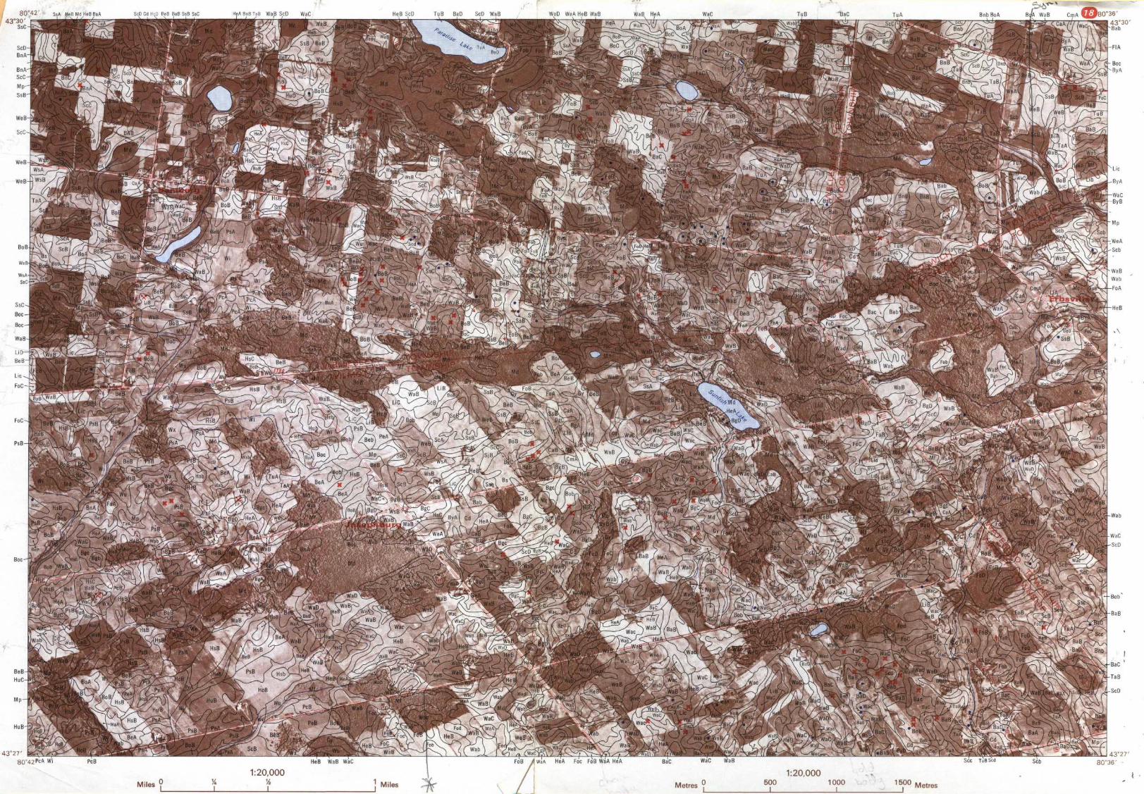
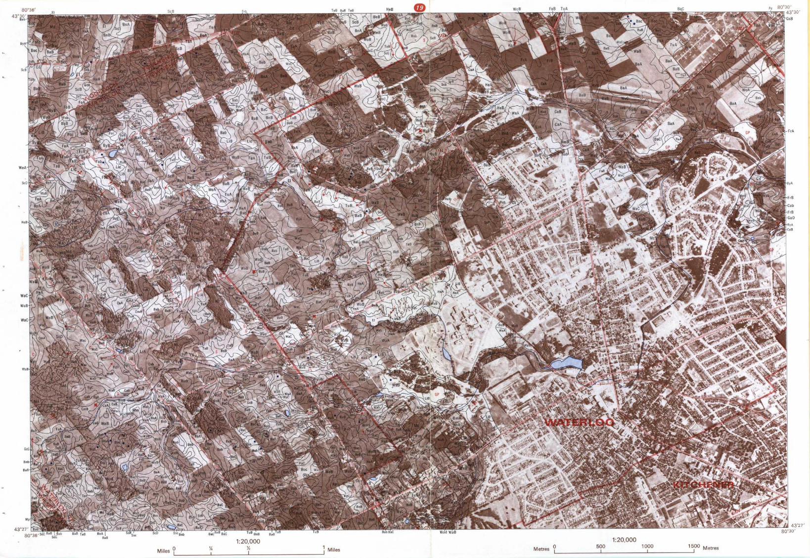
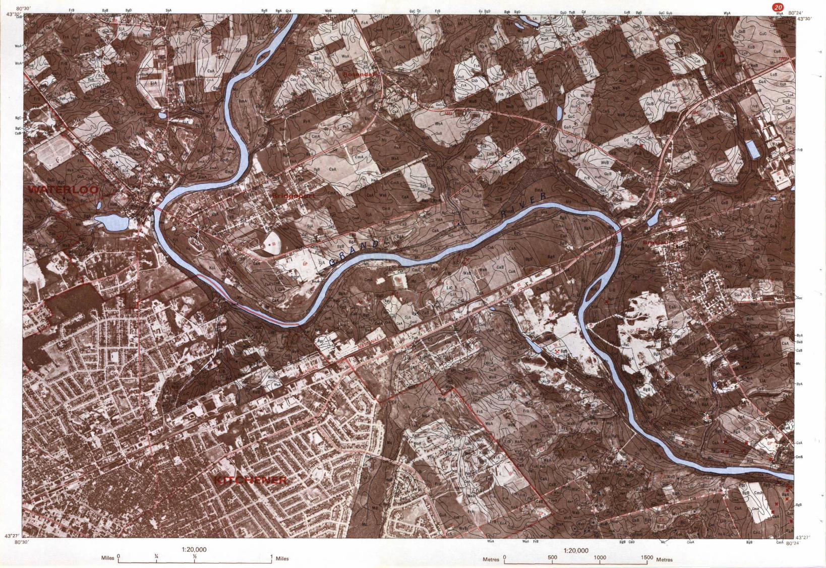

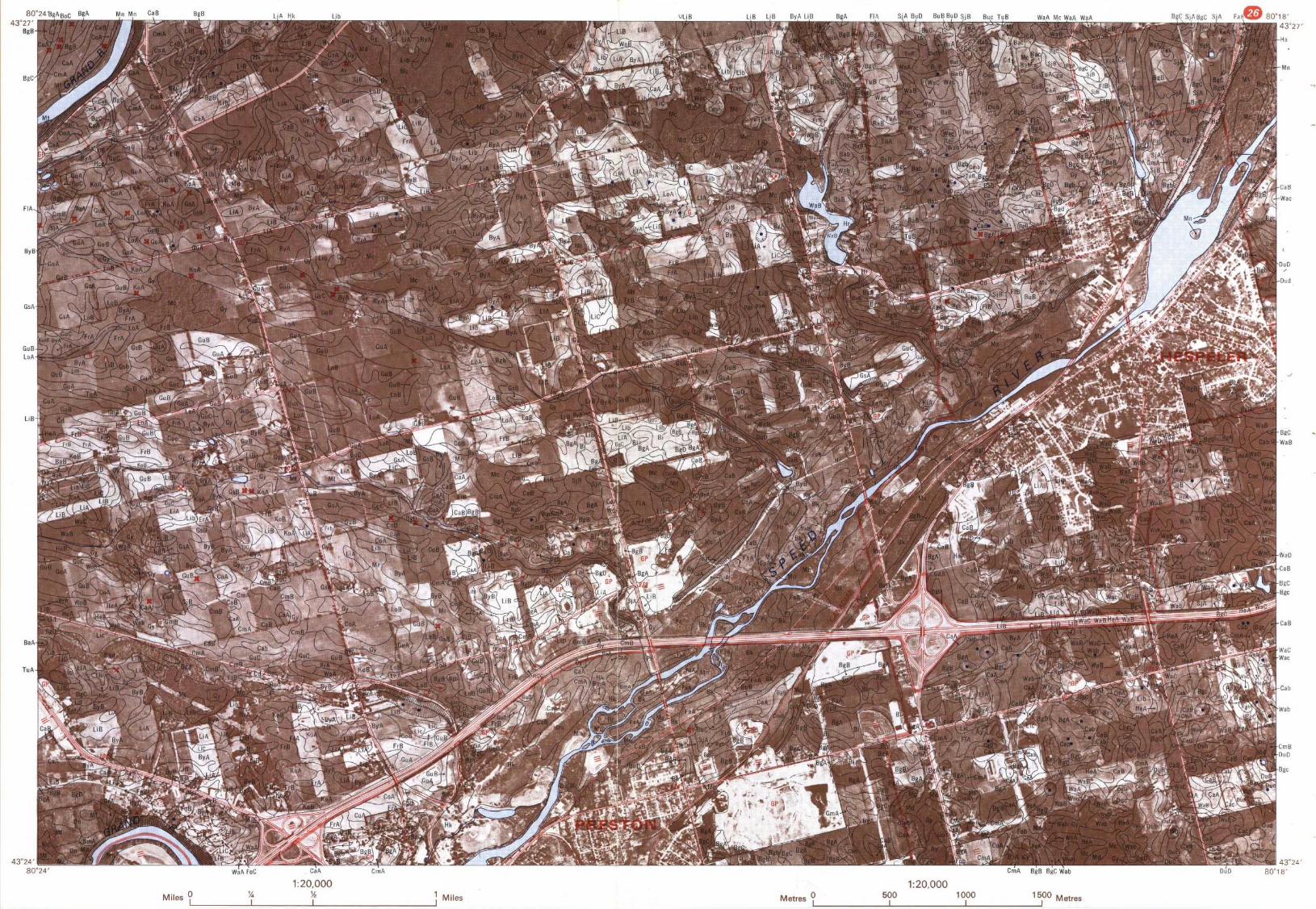
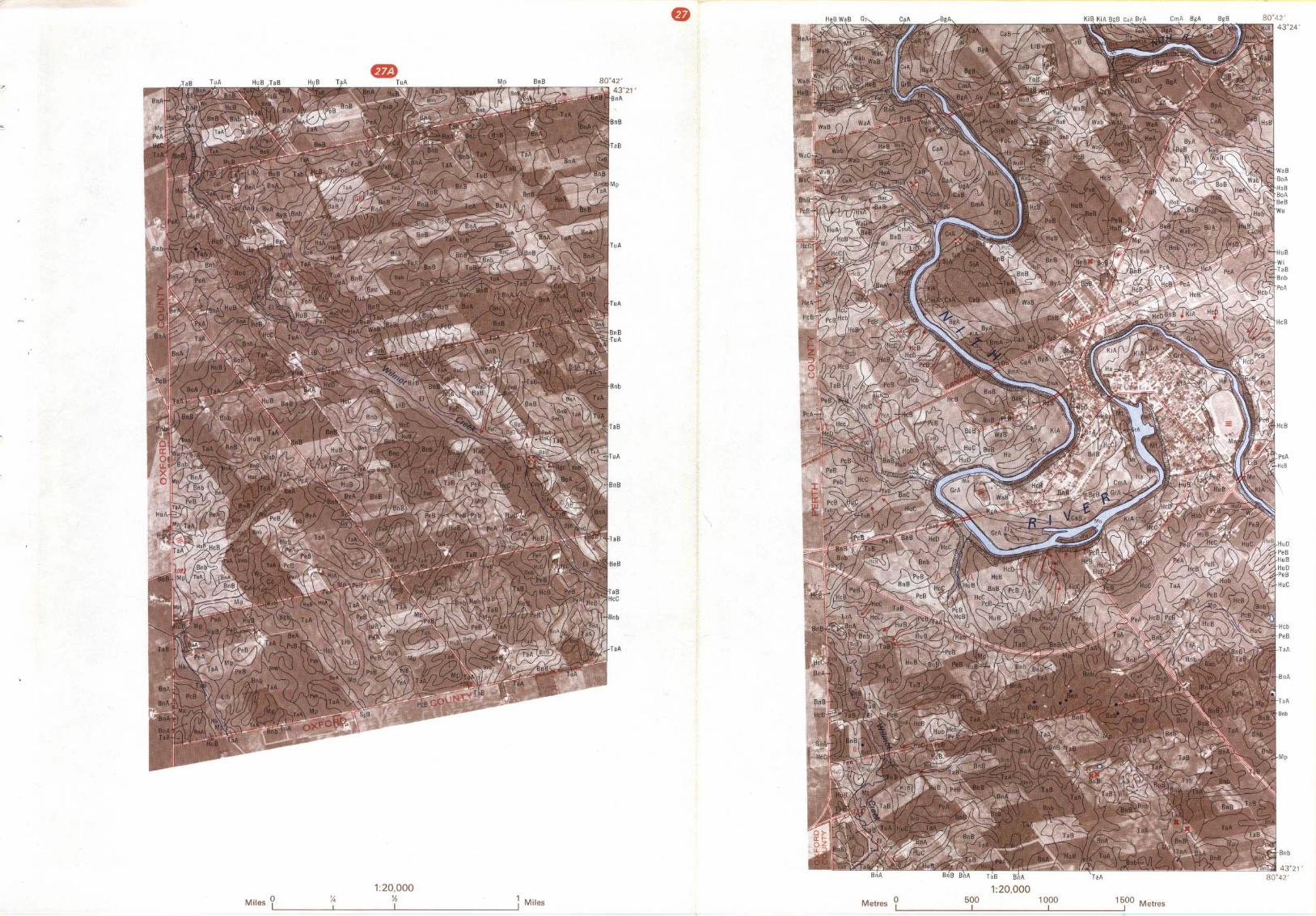
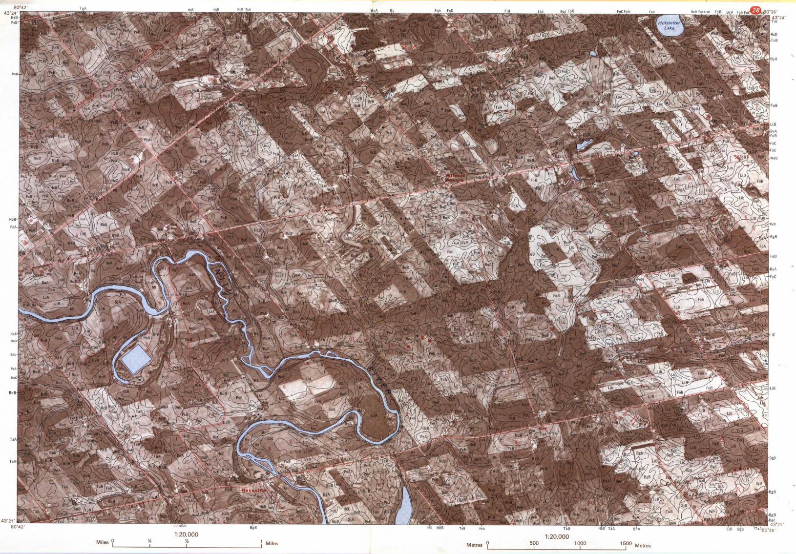
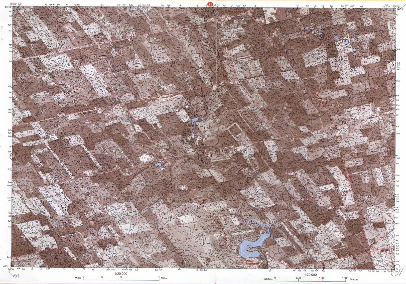
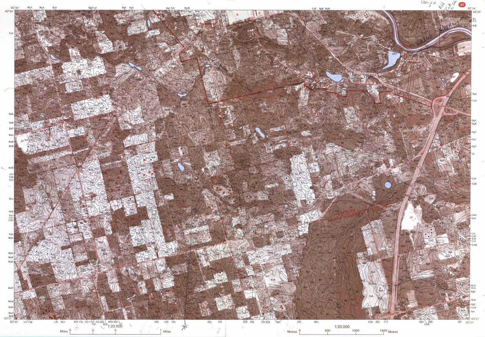
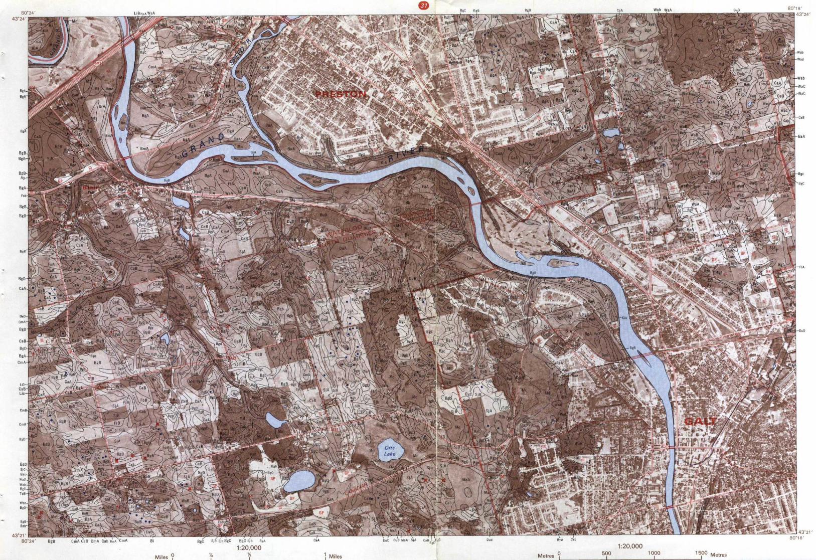
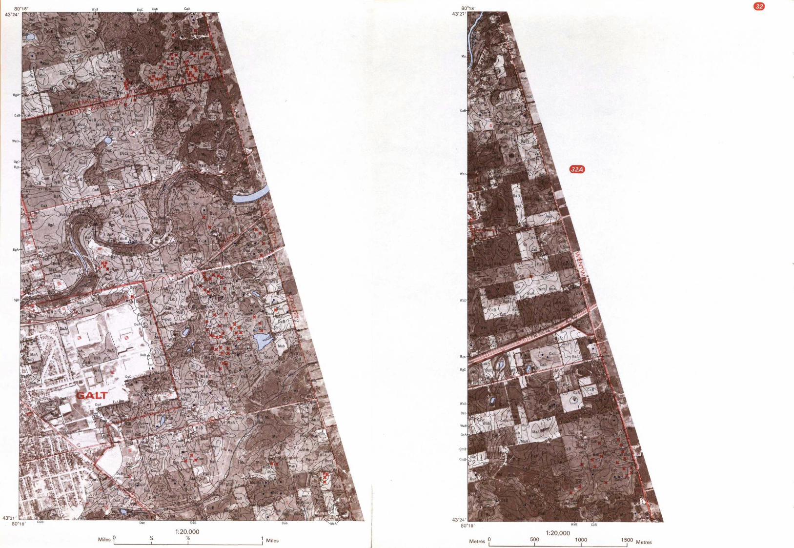
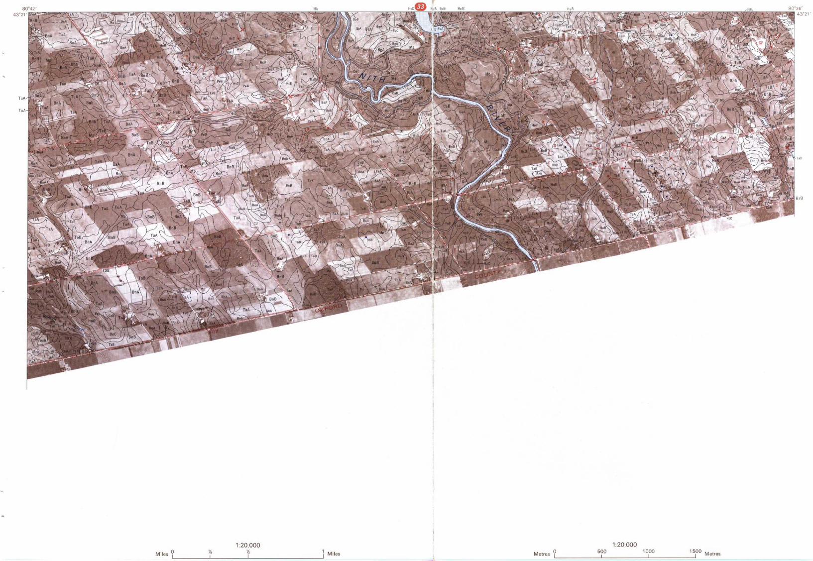
LEGEND
SOIL
SOIL NAME
SOIL
SOIL NAMESYMBOL
AND TEXTURE
SYMBOL
AND TEXTUREAy
Ayr sandy loam
Hr
HespelersandyloamBa
8rant loam
Hu
Huron loamBc
Brookston clay loam
Ki
Kirkland sandy loamBe
Berrien sandy loam
Ka
Kossuth sandy loamBg
Burford gravelly loam
Li
Lisbon sandy loam
Bi
Brisbane loam
La
London loamBk
Brooke loam
Ma
Mannheim loam
Bm
Boomer loam
Mc
Organic soil 12-36 inchesBn Benningtonloam over coarse materials
Bo
Bookton sandy loam
Md
Organic sail > 36 inches deep
Br
Brookston loam
Mf
Organic soil 12-36 inchesover fine materials
BS
Brookston sandy loam
Mn
Martin sand and gravelBu
Burford cobbly loam Mp
Maplewood loamBy
Brady sandy loam Mr MaryhillloamCa
Caledon sandy loam
Ms
Organic soil 12-36 inchesCd
Colwood loam
over bedrock
Cm
Camilla sandy loam
Mt
Macton loam
Ca
Conestogo loam
Pc
Perth clay loam
Dn
Donald loam
Pe
Perth loam
Do
Dorking silt loam
Ph
Philipsburg loam
Du
Dumfries loam
Pr
Preston sandy loam
EI
Elmira loam
Ps
Perth sandy loam
Fa
Farmington sandy loam
Sc
St. Clements silt loam
FI
Floradale loam
Sj
St. Jacobs loam
Fo
Fox sandy loam
Ss
St. Clements sandy loam
Fr
Freeport sandy loam
Ta
Tavistock loam
Gi
Gilford loam
To
Toledo silty clay loam
Gr
Grand loam
Tu
Tuscola loam
Gs
Guelph sandy loam
Wa
Waterloo fine sandy loam
Gu
Guelph loam
We
Wellsley silt loam
Gy
Granby sandy loam
Wi
Wilmot silty clay loam
Ha
Haysville sandy loam
Wa
Woolwich loam
He
Huron clay loam
Ws
Wellesley sandy loam
He
Heidelberg fine sandy loam
Wu
Wauseon sandy loam
Hk
Hawkesville loam
Wz
Wilmot sandy loam
TOPOGRAPHIC CLASSES
SIMPLE TOPOGRAPHY
COMPLEX TOPOGRAPHY
SLOPE(regular surface)
(irregular surface)A-level to very gently sloping
a-nearly level to gently undulating
0 to 3B-gently sloping
b-undulating
3+to 6C-moderately to strongly sloping
c-gently to moderately rolling
6+ to 12D-strongly sloping to very steeply sloping
d-moderately rolling to hilly
over 12
STONINESS
CONVENTION
Moderately stony land
2
Soil Symbol-Topography-Stoniness
PeA2
SPECIAL FEATURES
REFERENCE
Scarp (soil) . . . . . . . . . . . . . . . . . , , , , . , . . . ~
Main Highways . . . . . . . . . . . . . . . . . . . ~-Pothole, . ., . . . . . . . . . . . . . . . . . . . . . . . . . . . . ©
County, Secondaryroads ., . ., . . . ., .Eroded spot . . . . ., . . . . . . . . . . . ., . . . ., . . . ., .Il
Other roads . . . . . . . . . . . . . . . . . . . . . . - -Stone pile . � . . , . . . . . . . . . . . . . . . . . . . . . . . , . x
Railway . . , . . . . . � . . � , . . . . . . . . . .Clay spot . . . . . . . . . . . . . . . . . . . . . . . . . . . . . . . . c
River,Bridge . . . . . . . . . . . . . ., . . . ., . -~'tSand spot, . . , . . . . . . . . . . . . . . , . . . . . . . . . . , . s
Municipal Boundary . . . . . . . . . . . . . . .Gravel spot . . . . . . . . . . . . . . . . . . . . . . . . . . . . . . c
County Boundary . . . . . . . . . . . . . . . . . - _- _Gravel pit . . . . . . . . . . . . , . , . . , , , . . , . . . . , .ur X
Township Boundary . . . . . . . . . . . . . . .- - .-Eroded gully . . . . . . . . . . . . . . . . . . . . . . . . . . . .~.
Rivers . . . . , , . . . , , . . . . , . . . . . . . . , ,
~_Made land, . . , . . . . . . . , . , . . , . . . . , . . . . , . . . . m
Intermittent Stream . . . . . . . . . . . . . . . .----Wet spot . . . . . . . . . . . . . . . . . . . . . . . . . . . . . . . .
.
zs'
zo~
Is
so'
or BO°w
-q3°sr
IA I N MAPI
A SOC
0 Sso L S,e
.r
.
T RIoON ASOIL SURVEY REPORT, Na 44
Scale 1 :100,000Miles 2
1
0
I
2
3
4
5
6 MilesI
~-~-.. _
I
I
E
~
I
Kilometres 2
1
0
I
2
3
4
5
6
7
8 Kilometres
REFERENCE3S'
Soil boundary . .
---
Main highway . . . . . . . . . . . . . . . . . . . . . . . . . . . .
14
County road . . . . . . . . . . . . . . . . . . . . . . . . . .
33
Township road . . . . .
-
Railway . . . . . . . . . . . . . . . . . . . . . . . . . . . . . . . . . .
County boundary . . . . . . . . . . . . . . . . . . . .
.
-_-_-
Township boundary .
. .
-----
Stream
-~ _
___
Soil Survey page
LEGEND
DOMINANT DOMINANT
saASSOCIATION
SOIL SERIE S*
SOIL TEXTURE
TOPOGRAPHY
DRAINAGE
ton -- St . Clemenls
Fine-textured soils formed on till or lacustrine deposits
Huron
Silty clay
Gently sloplng
GoodPerth
Silly clay
Very gently sloping
ImperfectBrookston
Silty clay
Level
PoorDorking
Silty clay
level
Very poorWeILesley
Silty cloy loom
Gently sloping
GoodSt Clemenls
Silty cloy loom
Very gently sloping
ImperfectWilmot
Silty clay loam
Level
PoorToled o
Silty clay loam
level
Paor
selph
Medium-textured soils farmed on till deposits
Guelph
Loom
Gently sloping
GoodLo ndo n
Laam
Very gently slo ping
Imperfect
imfries
Medium-textured soils formed on stony till deposits
Dumfries
Loom
Steeply sloping
Good
nnington - Bookton
Coarse- and medium-textured soils, 1 to 3 feet deep, overlyingfine-textured till and lacustrine deposits
Bookton
Sond over clay
Gently sloping
GoodBeaten
Sand over clay
Very gently sloping
ImperfectWauseon
Sond over day
level
PoarBennington
loam over day
Gently sloping
GoodTavistock
loom aver clay
Very gently sloping
ImperfectMaplewood
Loom aver clay
Level
Poor
report- Woolwich
Coorse- and medium-textured soils, 1 to 3 .feet deep, overlying medium-textured till de arilsp
Freeport
Sand aver loam
Gently sloping
GoadKossuth
Sand over loam
Very gently sloplng
Imperfect aMannheim
Silt loam over loam
Very gently sloping
GoodWoolwich
Silt loam over loam
Very gently sloping
GaodConestogo
Silt loam over loam
Level
ImperfectMaryhill
Silt loam over loam
Level
Poor
rford- Fox
Coarse- and medium-textured soils formed on outwash and shallowlacustrine deposits
BurSord
Grovelly loam
Gently sloping
GoodBrisbane
GroveIN Loam
level
Imperfectfox
Loomy sand
Gently sloping
GoodBrady
Loomy sand
level
ImperfectGronby
Loomy sand
level
PoorLisbon
Gravelly loamy sand
Gently sloping
GaodCaledon
Sand over gravel
Very gently sloplng
GaodCamilla
Sand over gravel
Level
ImperfectAyr
Sand over grovel
Level
PaorSt, Jacobs
loam aver gravel
Very gently sloping
Good
Floradale
Loam aver gravel
level
Imperfect
ant- Waterloo
Moderately coarse- and medium-textured soils formed on lacustrine deposits
Brant
Loam
Gently sloping
GoadTuscolo
loom
Very gently sloping
ImperfectColwood loam
level
PoorWaterloo
Fine sandy loam
Gently sloping
GoodHeidelberg
Fine sandy loam
Very gently sl op ing
Imperfect
rood - Kirkland
Coarse- and medium-textured soils formed on recent alluvial deposits
Grand loom
Level
GoodMacton Laam
Level
Imperfect
Elmira
Loam
level
PoorKirkland
Loamy sand
Level
GoodHaysville
Loamy sand
Level
Imperfect
Hespeler
Loamy sand
level
Poor
zaBoomer
Loom over gravel
level
GaodDonald
Loam over gravel
Level
ImperfectHawkesville
loam over gravel
level
PoorMartin
Sand and gravel
level
Variable
~rmington
Coarse- and medium-textured soils overlying bedrock
Formington
Sandy loom
Level
GoodBrooke Loam
level
PoorPreston
Sandy loam
level
Imperfect
Irganic
Soils formed on organic deposits
Muck and peat
level
Very poor
soil association is made up of specific series, all map areas contain small amounts of soils belonging
Issociations . No areas less than 50 acres in size have been delineated .
Compiled, drawn and published by the Cartography Sedion, Soil ResearchInstitute, Research Branch, Canada Department of Agriculture, Ottawa, 1971 .
Base informolion and printing for the Conoda Deparlmenl of Agriculure, by theSurveys and Mapping Branr,4, Deparlmenl of Energy, Mmes and Resour c es
43°u
10'
I
05' 80 °04'
Related Documents