1 WATERCOURSE & AQUATIC ASSESSMENT FOR THE PROPOSED EXTENSION OF THE SDANGENI ACCESS ROAD, DR NKOSAZANA DLAMINI ZUMA LOCAL MUNICIPALITY, SISONKE DISTRICT MUNICIPALITY, KWAZULU-NATAL Compiled by Dr Bruce Scott-Shaw NatureStamp (Pty) Ltd Tel 078 399 9139 Email [email protected] Compiled for Amishka Mothilal SLR Consulting Tel 011 467 0945 Email [email protected] DECEMBER 2020 DRAFT REPORT

Welcome message from author
This document is posted to help you gain knowledge. Please leave a comment to let me know what you think about it! Share it to your friends and learn new things together.
Transcript

1
WATERCOURSE & AQUATIC
ASSESSMENT
FOR THE PROPOSED EXTENSION OF THE SDANGENI ACCESS ROAD, DR
NKOSAZANA DLAMINI ZUMA LOCAL MUNICIPALITY, SISONKE DISTRICT
MUNICIPALITY, KWAZULU-NATAL
Compiled by
Dr Bruce Scott-Shaw
NatureStamp (Pty) Ltd
Tel 078 399 9139
Email [email protected]
Compiled for
Amishka Mothilal
SLR Consulting
Tel 011 467 0945
Email [email protected]
DECEMBER 2020
DRAFT REPORT

Page i
Acronyms
CVB Channeled Valley Bottom
DWS Department of Water & Sanitation
DWAF Department of Water Affairs & Forestry
EAP Environmental Assessment Practitioner
ECO Environmental Control Officer
EIA Environmental Impact Assessment
EIS Ecological Importance & Sensitivity
EKZNW Ezemvelo KwaZulu-Natal Wildlife
FEPA Freshwater Ecosystem Priority Area
GIS Geographical Information Systems
HGM Hydro-Geomorphic
IAPs Invasive Alien Plants
PES Present Ecological State
NFEPA National Freshwater Ecosystem Priority Areas
Table of Contents
Acronyms .............................................................................................................................................. 2
Annexures ............................................................................................................................................. 4
1. INTRODUCTION ......................................................................................................................... 6
1.1 Project Background and Description of the Activity ....................................................... 6
1.2 Terms of reference ................................................................................................................ 8
1.3 Classification System for Wetlands and Other Aquatic Systems .................................... 8
2. ALLOWABLE ABSTRACTIONS AND LEGISLATION ................................................................. 10
2. STUDY SITE ................................................................................................................................ 10
2.1 General Description ........................................................................................................... 10
2.2 Legal Framework of the Study .......................................................................................... 11
3. METHODOLOGY ..................................................................................................................... 12
3.1 Regional Context ................................................................................................................ 12
3.2 Extent, Classification and Habitat Characteristics ......................................................... 13
3.3 Present Ecological State (PES) Assessment for Riparian Areas ..................................... 15
3.4 Ecological Importance & Sensitivity (EIS) Assessment (Riparian) ................................. 17
3.5 MiniSASS Assessment .......................................................................................................... 18
3.6 Impact Assessment ............................................................................................................. 18
3.7 Risk Assessment.................................................................................................................... 19
4. LIMITATIONS AND ASSUMPTIONS .......................................................................................... 21

Page i
5. RESULTS AND DISCUSSION ..................................................................................................... 22
5.1 Regional Context ................................................................................................................ 22
5.1.1 NFEPA assessment ..................................................................................................................... 22
5.1.2 Vegetation ................................................................................................................................. 22
5.1.3 Historical analysis ....................................................................................................................... 23
5.1.4 Site Terrain .................................................................................................................................. 23
5.2 Extent, Classification and Habitat Characteristics ......................................................... 25
5.3 Present Ecological State (PES) .......................................................................................... 28
5.4 Ecological Importance & Sensitivity Assessment ............................................................ 30
5.5 MiniSASS Assessment .......................................................................................................... 31
5.5.1 Aquatic Findings ....................................................................................................................... 31
5.5.2 Potential Aquatic Impacts ...................................................................................................... 32
5.5.3 Water Quality Management Plan ......................................................................................... 32
6. POTENTIAL IMPACT PREDICTIONS AND DESCRIPTIONS ..................................................... 33
6.1 Present Impacts ................................................................................................................... 33
6.2 Potential Impacts During Construction ............................................................................ 34
6.3 Potential Impacts During Operation ................................................................................ 34
6.4 Impacts associated with Climate Change Projections ................................................. 35
7. RISK ASSESSMENT .................................................................................................................... 35
8. PROPOSED INTERVENTION MEASURES & SURFACE WATER MONITORING PROGRAMME .
.................................................................................................................................................. 37
8.1 Objectives of rehabilitation ............................................................................................... 37
8.2 Actions to meet objectives ............................................................................................... 37
8.3 Ongoing monitoring ........................................................................................................... 38
8.4 Final monitoring ................................................................................................................... 38
9. CONCLUSION ......................................................................................................................... 39
10. REFERENCES ............................................................................................................................ 40
Tables
Table 1 Details of Specialist ............................................................................................................ 5
Table 2 Mean monthly rainfall and temperature observed at Sdangeni (derived from
historical data) ................................................................................................................. 10
Table 3 Assessment approach and the recommended tools for rivers and wetlands ....... 12
Table 4 Data type and source for the assessment ................................................................... 12
Table 5 Criteria used in the assessment of the habitat integrity ............................................. 16
Table 6 Impact classes and their associated scores ................................................................ 16
Table 7 Description of the IHI categories ................................................................................... 17
Table 8 List of the EIS categories used in the assessment tool (Kleynhans & Louw, 2007) .. 17
Table 9 Rating scheme used for the assessment of riparian EIS (Kleynhans & Louw, 2007)18

Page i
Table 10 Description of HGM units ................................................................................................ 26
Table 11 Pre-development PES score using the Index of Habitat Integrity tool (Kleynhans,
1999) for the Isongweni non-perennial tributarys ........................................................ 28
Table 12 Post-development PES score using the Index of Habitat Integrity tool (Kleynhans,
1999) for the Isongweni perennial tributarys ................................................................ 28
Table 13 The hydrology module for the Sdangeni Road UVB wetland ................................... 29
Table 14 Vegetation module for the Sdangeni Road UVB wetland ........................................ 29
Table 15 Geomorphology module for the Sdangeni Road UVB wetland .............................. 30
Table 16 EIS category scoring summary for the Isongweni non-perennial tributary .............. 30
Table 17 EIS category scoring summary for the Isongweni perennial tributary ...................... 30
Table 18 Ecological categories for interpreting MiniSASS data ................................................ 31
Table 19 Impact Drivers and Description – Construction Phase ............................................... 34
Table 20 Impact Drivers and Description – Operation Phase ................................................... 35
Table 21 Risk matrix assessment for the impacts identified for the construction and
operation of the activities .............................................................................................. 36
Table 22 Rehabilitation actions ..................................................................................................... 37
Figures
Figure 1 General setting of the road extension site .................................................................... 6
Figure 2 Location of the proposed road extension ..................................................................... 7
Figure 3 The site along the proposed road area ....................................................................... 10
Figure 4 Long-term rainfall near the site ..................................................................................... 11
Figure 5 Typical cross-section of a river showing channel morphology ‘A Practical Field
Procedure for Identification and Delineation of Wetland and Riparian Areas –
Edition 1’ (Department of Water Affairs, 2005) .......................................................... 14
Figure 6 Soil sampling undertaken at the site ............................................................................ 15
Figure 7 NFEPA wetlands (pink) within proximity to the Sdangeni road upgrade ................ 22
Figure 8 Historical imagery of the road upgrade site from 1977 to present .......................... 23
Figure 9 Terrain model of the proposed Sdangeni road upgrade ......................................... 24
Figure 10 Typical vegetation around the site ............................................................................. 25
Figure 11 HGM units identified along the proposed Sdangeni road extension .................... 27
Figure 12 Sample container used to assist in identifying invertebrates ................................... 31
Figure 13 Erosion present along the proposed road extension ................................................ 33
Annexures
ANNEXURE A Classification structure for inland systems up to Level 4
ANNEXURE B Wetland and soil classification field datasheet example
ANNEXURE C Steps for Riparian delineation
ANNEXURE D MiniSASS Assessment Score Sheet
ANNEXURE E Wetland vegetation mix

Page i
Specialist Details & Declaration
This report has been prepared in accordance with Section 13: General Requirements for Environmental Assessment Practitioners (EAPs) and Specialists as well as per Appendix 6 of GNR 327 Environmental Impact Assessment Regulations and the National Environmental Management Act (NEMA, No. 107 of 1998 as amended 2017). It has been prepared independently of influence or prejudice by any parties. A full declaration of independence has been provided in Annexure F. The details of Specialists are as follows –
Table 1 Details of Specialist
Specialist
Task
Qualification and
accreditation Client Signature
Bruce Scott-Shaw
NatureStamp
Fieldwork,
Assessments &
report
PhD, Hydrology SLR
Consulting
Date: 15/01/2021
Ross Goode
Fieldwork &
Aquatic
Assessment
Diploma SLR
Consulting
Date: 30/12/2020
Nick Davis
Isikhungusethu
Environmental
Services
Design, GIS &
Review
BSc, BSc Hon, MSc
Hydrology
SLR
Consulting Date: 11/01/2021
Details of Authors:
Bruce is a hydrologist, whose focus is broadly on hydrological perspectives of land use management
and climate change. He completed his MSc under Prof. Roland Schulze in the School of Bioresources
Engineering and Environmental Hydrology (BEEH) at the University of KwaZulu-Natal, South Africa.
Throughout his university career he mastered numerous models and tools relating to hydrology, soil
science and GIS. Some of these include ACRU, SWAT, ArcMap, Idrisi, HEC-RAS, WRSM, SEBAL, MatLab
and Loggernet. He has some basic programming skills on the Java and CR Basic platforms. Bruce
completed his PhD at the Center for Water Resources Research (UKZN), which focused on
rehabilitation of alien invaded riparian zones and catchments using indigenous trees. Bruce is currently
affiliated to the University of KwaZulu-Natal where he is a post-doctoral student where he runs and
calibrates hydrological and soil erosion models. Bruce has presented his research around the world,
including the European Science Foundation (Amsterdam, 2010), COP17 (Durban, 2011), World Water
Forum (Marseille, 2012), MatLab advanced modelling (Luxembourg, 2013), World Water Week
(Singapore, 2014), Forests & Water, British Colombia, (Canada, 2015), World Forestry Congress (Durban,
2015), Society for Ecological Restoration (Brazil, 2017). Conservation Symposium (Howick, South Africa,
2018) and SWAT modelling in Siem Reap (Cambodia, 2019). As a consultant, Bruce is the director and
principal hydrologist of NatureStamp (PTY) Ltd. In this capacity he undertakes flood studies, calculates
hydrological flows, performs general hydrological modelling, stormwater design, dam designs,
wetland assessments, water quality assessments, groundwater studies and soil surveys.
Details of Reviewer:
Nicholas Davis is a hydrologist whose focus is broadly on hydrological perspectives of land use
management, climate change, estuarine and wetland systems. Throughout his studies and
subsequent work at UKZN he has mastered several models and programs such as ACRU, HEC-RAS,
ArcMap, QGIS, Indicators of Hydrologic Alteration software (IHA) and Idrisi. He has moderate VBA
programming skills, basic UNIX and python programming skills.

6
1. INTRODUCTION
1.1 Project Background and Description of the Activity
SLR Consulting (South Africa) (Pty) (SLR) has been appointed by iX Engineers (Pty) Ltd, on behalf of the
Nkosazana Dlamini Municipality, as the environmental service provider responsible for compiling an
Application for Environmental Authorisation for the proposed extension of the Sdangeni Access Road. To
inform this Application, SLR is undertaking a Basic Assessment process in terms of the Environmental Impact
Assessment Regulations, 2014. Based on a preliminary screening, SLR have identified a potential risk to Ecology
(including Wetlands) and Terrestrial Ecology and thus require the inputs of a specialist Ecologist. There are
some watercourses traversing the proposed road extension footprint. The proposed road extension would be
on a partially existing road track.
The assessment is conducted to determine the potential impacts that the road extension may have on the
surrounding watercourses. These measurements will provide a pre-development baseline for comparisons
with post-development assessments. The information contained in this report aims to contribute towards a
water quality management plan. The MiniSASS assessment aims to address the following:
Define the eco-status of the stream / river systems;
Provide a biota specific water quality assessment;
Provide an aquatic community integrity assessment;
Define construction impacts on the systems;
Provide an opinion on aquatic ecological health; and
Provide a Water Quality Management Plan (WQMP) with proposed frequency and determinants for
monitoring.
The proposed road extension will be located on the following property:
FARM DESCRIPTION 21-DIGIT SURVEYOR GENERAL (SG) CODE Area (ha)
Remainder of Upper Umkomaas Location No. 1 N0FS00000001641500000 23 553.98
Uninformed and poorly planned infrastructural developments in the vicinity of water resources, such as
sensitive surface and groundwater, can rapidly degrade these resources. Thus, pre-development (or in some
cases post development) assessments are required to gain an understanding of the natural environment and
guide the developmental process in order that site-specific mitigation measures can be put in place.
Figure 1 General setting of the road extension site

7
Figure 2 Location of the proposed road extension
WATERCOURSE/AQUATIC
STUDY

8
1.2 Terms of reference
i. Watercourse/Aquatic Assessment
The condition/Present Ecological State (PES) of the delineated riverine and wetland areas present
within 500 m of the proposed site; as well as the functional importance of any wetlands present within
and near the development footprint would be assessed. This will involve:
a. an assessment of the delineated riverine areas by:
i. determining the condition/PES of the riverine system using the rapid/qualitative Index
of Habitat Integrity (IHI) tool (Kleynhans, 1996) for rivers (in-stream and riparian habitats
assessed separately); and
ii. determining the health/ecological importance & sensitivity (EIS) using the DWAF
riverine EIS tool (Kleynhans, 1999).
b. an assessment of the delineated wetland areas by:
i. determining the condition/ PES of the delineated wetlands using the Level 1 WET-Health
tool (Macfarlane et al, 2009); and
ii. determining the ecological importance & sensitivity (EIS) of the delineated wetlands
using the Department of Water Affairs and Forestry (DWAF) wetland EIS tool (Duthie,
1999).
c. an impact assessment to investigate, evaluate and assess the impacts of the abovementioned
activities on the environment.
ii. MiniSASS assessment to address the following:
Define the eco-status of the stream / river systems;
Provide a biota specific water quality assessment;
Provide an aquatic community integrity assessment;
Define construction impacts on the systems;
Provide an opinion on aquatic ecological health; and
Provide a Water Quality Management Plan (WQMP) with proposed frequency and determinants for
monitoring.
iii. Impact Assessment/Risk Matrix and Management Plan / Mitigation Measures
General Authorization (GN 509, August 2016) applies to water use activities of section c) and i) of the
NWA that have a low risk class as determined through the Risk Matrix, found in Appendix A of the GN.
The impacts of the proposed development on the delineated watercourse areas would be identified,
predicted and described. The significance of the proposed impacts would be rated according to
nature, extent, magnitude, duration and probability. Measures would be recommended to mitigate
impacts. Impacts and mitigation would be structured in a matrix that highlights overall risk as High,
Medium, Low.
iv. Watercourse Management and Rehabilitation Plan, including Monitoring Programme
A Watercourse Management and Rehabilitation Plan would be developed to guide the construction
and operational phases of the development. It would include a monitoring programme for surface
water which established baseline water quality at the site. A series of actions for an audit plan would
also be provided.
1.3 Classification System for Wetlands and Other Aquatic Systems
Differences in terminology can lead to confusion in the scientific and consulting fields. As such, terminology
used in the context of this report needs to be defined. The National Water Act (No. 36 of 1998) defines a
watercourse, wetland and riparian habitat as follows:
A watercourse means - (a) a river or spring; (b) a natural channel in which water flows regularly or
intermittently; (c) a wetland, lake or dam into which, or from which, water flows; and (d) any collection of
9
water which the Minister may, by notice in the Gazette, declare to be a watercourse, and a reference to
a watercourse includes, where relevant, its bed and banks.
A wetland means land which is transitional between terrestrial and aquatic systems where the water table
is usually at or near the surface, or the land is periodically covered with shallow water, and which land in
normal circumstances supports or would support vegetation typically adapted to life in saturated soil.
A riparian habitat includes the physical structure and associated vegetation of the areas associated with
a watercourse which are commonly characterised by alluvial soils, and which are inundated or flooded
to an extent and with a frequency sufficient to support vegetation of species with a composition and
physical structure distinct from those of adjacent land areas.
Any features meeting these criteria within the development site were delineated and classified using the
Classification System for Wetlands and other Aquatic Ecosystems in South Africa. User Manual: Inland systems
hereafter referred to as the “Classification System” (Ollis et. al., 2013). A summary of Levels 1 to 4 of the
classification system are discussed further below.
Inland wetland systems (non-coastal) are ecosystems that have no existing connection to the ocean which
are inundated or saturated with water, either permanently or periodically (Ollis et. al., 2013). Inland wetland
systems were divided into four levels by the Freshwater Consulting Group in 2009 and revised in 2013. Level 1
describes the connectivity of the system to the ocean, level 2 the regional setting (eco-region), level 3 the
landscape setting, level 4A the hydro-geomorphic (HGM) type and level 4B the longitudinal zonation. Further
information has been provided in Annexure B.
The level 3 classification has been divided into four landscape units. These are:
a) Slope – located on the side of a mountain, hill or valley that is steeper than lowland or upland floodplain
zones.
b) Valley Floor – gently sloping lowest surface of a valley, excluding mountain headwater zones.
c) Plain – extensive area of low relief. Different from valley floors in that they do not lie between two side
slopes, characteristic of lowland or upland floodplains.
d) Bench (hilltop/saddle/shelf) - an area of mostly level or nearly level high ground, including hilltops/crests,
saddles and shelves/terraces/ledges.
Level 4 HGM types (which is commonly used to describe a specific wetland type) have been divided into 8
units. These are described as follows:
Channel (river, including the banks) - an open conduit with clearly defined margins that (i) continuously
or periodically contains flowing water. Dominant water sources include concentrated surface flow from
upstream channels and tributaries, diffuse surface flow or interflow, and/or groundwater flow.
Channelled valley-bottom wetland - a mostly flat valley-bottom wetland dissected by and typically
elevated above a channel (see channel). Dominant water inputs to these areas are typically from the
channel, either as surface flow resulting from overtopping of the channel bank/s or as interflow, or from
adjacent valley-side slopes (as overland flow or interflow).
Un-channelled valley-bottom wetland - a mostly flat valley-bottom wetland area without a major channel
running through it, characterised by an absence of distinct channel banks and the prevalence of diffuse
flows, even during and after high rainfall events.
Floodplain wetland - the mostly flat or gently sloping wetland area adjacent to and formed by a Lowland
or Upland Floodplain river, and subject to periodic inundation by overtopping of the channel bank.
Depression - a landform with closed elevation contours that increases in depth from the perimeter to a
central area of greatest depth, and within which water typically accumulates. Dominant water sources
are precipitation, ground water discharge, interflow and (diffuse or concentrated) overland flow.
Flat - a near-level wetland area (i.e. with little or no relief) with little or no gradient, situated on a plain or
a bench in terms of landscape setting. The primary source of water is precipitation.
Hillslope seep - a wetland area located on (gentle to steep) sloping land, which is dominated by the
colluvial (i.e. gravity-driven), unidirectional movement of material down-slope.
Valley head seep - a gently-sloping, typically concave wetland area located on a valley floor at the
head of a drainage line, with water inputs mainly from subsurface flow.
10
2. ALLOWABLE ABSTRACTIONS AND LEGISLATION
Quaternary Catchment (QC) site: T51J (WMA 4 - Mvoti to Mzimkhulu). According to GN 538 (2016), the
General Authorization (GA) limits for this QC are as follows–
Abstraction of surface water: 80 000 m3 / year @ 16 l/s from December to April.
Storage of water: 80 000 m3.
Groundwater abstraction: 75 m3/ha/year (allowed under GA).
These limits show that this catchment area is slightly water limited and restricted water use applies.
2. STUDY SITE
2.1 General Description
The site is located within Quaternary Catchment T51J; falling under the Mvoti to Mzimkhulu Water
Management Area (WMA) and the uMgeni waterboard. The site is situated on the upper reach of the
Ngwangwane river (Class C; Moderately Modified, WRC 2011) within the catchment area of the Mzimkhulu
River.
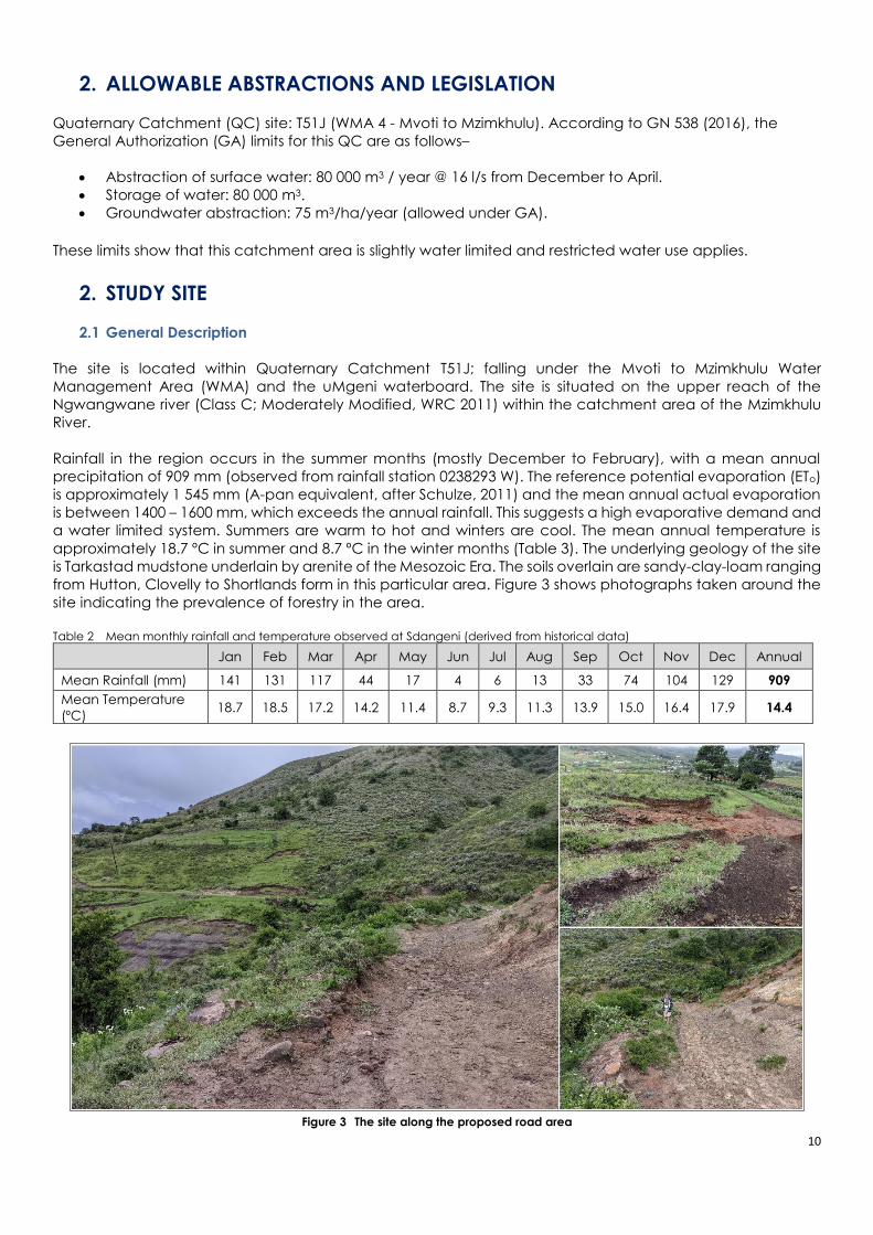
Rainfall in the region occurs in the summer months (mostly December to February), with a mean annual
precipitation of 909 mm (observed from rainfall station 0238293 W). The reference potential evaporation (ETo)
is approximately 1 545 mm (A-pan equivalent, after Schulze, 2011) and the mean annual actual evaporation
is between 1400 – 1600 mm, which exceeds the annual rainfall. This suggests a high evaporative demand and
a water limited system. Summers are warm to hot and winters are cool. The mean annual temperature is
approximately 18.7 ºC in summer and 8.7 ºC in the winter months (Table 3). The underlying geology of the site
is Tarkastad mudstone underlain by arenite of the Mesozoic Era. The soils overlain are sandy-clay-loam ranging
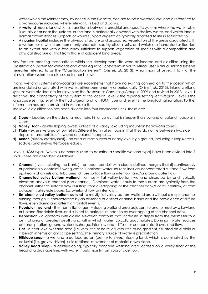
from Hutton, Clovelly to Shortlands form in this particular area. Figure 3 shows photographs taken around the
site indicating the prevalence of forestry in the area.
Table 2 Mean monthly rainfall and temperature observed at Sdangeni (derived from historical data)
Jan Feb Mar Apr May Jun Jul Aug Sep Oct Nov Dec Annual
Mean Rainfall (mm) 141 131 117 44 17 4 6 13 33 74 104 129 909
Mean Temperature
(ºC) 18.7 18.5 17.2 14.2 11.4 8.7 9.3 11.3 13.9 15.0 16.4 17.9 14.4
Figure 3 The site along the proposed road area
11
Figure 4 Long-term rainfall near the site
2.2 Legal Framework of the Study
The aim of this study is to assess the risk level of the road extension which is proposed to be constructed across
drainage lines.
The proposed development triggers the following water use activities of Section 21, NWA–
c. impeding or diverting flow of water;
i. altering beds, banks, course or characteristics of a watercourse
Most of the road itself will not be impeding or diverting flow of water, nor altering bed, banks, course or
characteristics of water - however, the developments such as the culvert crossing points and part of the
road developments/upgrades are within the ‘regulated area of a watercourse’, which is described as (GN
509, August 2016) –
The outer edge of the 1:100 year floodline and/or delineated riparian habitat whichever is the greatest
distance, measured from the middle of the watercourse of a river, spring, natural channel, lake or
dam;
In the absence of a determined 1:100 year floodline or riparian area, the area within 100m from the
edge of a watercourse where the edge of the watercourse is the first identifiable annual bank fill flood
bench; or
A 500m radius from the delineated boundary (extent) of the wetland or pan.
General Authorization (GN 509, August 2016) applies to water use activities of section c) and i) of the NWA
that have a low risk class as determined through the Risk Matrix, found in Section 7. A Risk Assessment is hereby
undertaken to determine the risk class of the road extension proposed for development within a wetland or
watercourse. The Assessment is undertaken accordance with the methodology set out in Section 3.7. The pre-
developed state was considered in this assessment.
0
200
400
600
800
1000
1200
1400
1600
19
79
19
80
19
81
19
82
19
83
19
84
19
85
19
86
19
87
19
88
19
89
19
90
19
91
19
92
19
93
19
94
19
95
19
96
19
97
19
98
19
99
20
00
20
01
20
02
20
03
20
04
20
05
20
06
20
07
20
08
20
09
20
10
20
11
20
12
20
13
20
14
Rai
nfa
ll (m
m)
Rainfall (mm) MAP (mm)

12
3. METHODOLOGY A detailed description of the methods has been provided. The regional context and desktop analysis were
used as the point of departure. Subsequently, a site visit was undertaken to delineate any wetlands and
riparian areas. These systems were then assessed to determine the potential impacts that have been caused.
The assessment of these systems considered the following tools where relevant:
Table 3 Assessment approach and the recommended tools for rivers and wetlands
Aquatic Component
Method/Technique Tool Utilized
Rivers
Delineation A Practical Field Procedure for Identification and
Delineation of Wetland and Riparian Areas’ (DWAF,
2005).
Classification National Wetland Classification System for Wetlands
and other Aquatic Ecosystems in South Africa (Ollis et
al, 2014).
River condition/Present Ecological
State (PES)
DWAF IHI (Index of Habitat Integrity) tool (Kleynhans,
1996) for rivers (riparian habitat only)
River Ecological Importance &
Sensitivity (EIS)
DWAF riverine EIS tool (Kleynhans, 1999)
Wetlands
Delineation A Practical Field Procedure for Identification and
Delineation of Wetland and Riparian Areas’ (DWAF,
2005).
Classification National Wetland Classification System for Wetlands
and other Aquatic Ecosystems in South Africa (Ollis et
al, 2014).
Wetland condition/Present
Ecological State (PES)
Level 1 WET-Health tool (Macfarlane et al., 2009)
Wetland Functional/Ecosystem
Services Assessment
Level 2 WET-EcoServices assessment tool (Kotze et al.,
2009)
Wetland Ecological Importance &
Sensitivity (EIS)
DWAF wetland EIS tool (Duthie, 1999)
Table 4 Data type and source for the assessment
Data Type Year Source/Reference
Aerial Imagery 2016 Surveyor General
1:50 000 Topographical 2011 Surveyor General
5m Contour/12.5 m DEM 2010 Surveyor General/ALOS PALSAR
River Shapefile 2011 EKZNW
Land Cover 2014 EKZNW
Water Registration 2013 WARMS - DWS
*Data will be provided on request
3.1 Regional Context
3.1.1 National Freshwater Ecosystem Priority Areas (NFEPA) Project / Assessment
The ‘National Freshwater Ecosystem Priority Areas’ (NFEPA) project is a systematic biodiversity planning tool
developed by the CSIR (2011) to identify freshwater areas considered the most important for biodiversity
conservation. The key objectives of the NFEPA project are to ensure that all ecosystems and species are
represented and that key ecological processes remain intact – achieving biodiversity targets within the
smallest, most efficient area possible, with attention to connectivity over large areas (CSIR, 2011).
The conservation importance of the Sdangeni site was determined by consulting the relevant NFEPA layers
(NFEPA WMA map, NFEPA wetlands and NFEPA rivers) in a geographical information system.
NFEPA was a three-year partnership project between South African National Biodiversity Institute (SANBI), CSIR,
Water Research Commission (WRC), Department of Environmental Affairs (DEA), Department of Water Affairs
13
(DWA), Worldwide Fund for Nature (WWF), South African Institute of Aquatic Biodiversity (SAIAB) and South
African National Parks (SANParks). NFEPA map products provide strategic spatial priorities for conserving South
Africa’s freshwater ecosystems and supporting sustainable use of water resources. These strategic spatial
priorities are known as Freshwater Ecosystem Priority Areas, or FEPAs.
FEPAs were determined through a process of systematic biodiversity planning and were identified using a
range of criteria for conserving ecosystems and associated biodiversity of rivers, wetlands and estuaries. FEPAs
are often tributaries and wetlands that support hard-working large rivers, and are an essential part of an
equitable and sustainable water resource strategy. FEPAs need to stay in a good condition to manage and
conserve freshwater ecosystems, and to protect water resources for human use. The current and
recommended condition for all river FEPAs is A or B ecological category. Wetland FEPAs that are currently in
a condition lower than A or B should be rehabilitated to the best attainable ecological condition.
3.1.2 Terrain, Soils, Geology & Vegetation
Contour lines (5 meter) were used to calculate the slope of each of the banks. The soils and geology were
obtained from GIS layers obtained from the Soil Science department at the University of KwaZulu-Natal (UKZN).
Various vegetation databases were used to determine the likely or expected vegetation types (Mucina &
Rutherford, 2006; Scott-Shaw & Escott, 2011). A number of recognized databases were utilized in achieving a
comprehensive review, and allowing any regional or provincial conservation and biodiversity concerns to be
highlighted. The Guideline for Biodiversity Impact Assessment (EKZNW, 2013) was followed where applicable.
The following databases were interrogated:
o Ezemvelo KZN wildlife (C-Plan & SEA Database)
The C-Plan is a systematic conservation-planning package that consists of metadata within a shapefile, used
by ArcGIS (or similar tool), which analyses biodiversity features and landscape units. C-Plan is used to identify
a national reserve system that will satisfy specified conservation targets for biodiversity features (Lombard et
al, 2003). These units or measurements are ideal for areas which have not been sampled. The C-Plan is an
effective conservation tool when determining priority areas at a regional level and is being used throughout
South Africa to identify areas of conservation value. Some of this information extends into the Eastern Cape.
The Strategic Environmental Assessment (SEA, 2000) Plan is a database of the modelled distribution of a
selection of red data and endemic species that could, or are likely, to occur in an area.
o Mucina and Rutherford’s Vegetation Assessment
The South African National Biodiversity Institute (SANBI) developed a database of vegetation types. This
database provides information on groups of vegetation at a course scale. It is useful in determining the
expected species, conservation status and management practices of an area. However, this database does
not provide information on species of conservation concern. This database is used as a step towards grouping
vegetation types identified on site.
3.2 Extent, Classification and Habitat Characteristics
The boundary of wetlands and riparian areas occurring on the site was identified and delineated according
to the Department of Water Affairs wetland delineation manual ‘A Practical Field Procedure for Identification
and Delineation of Wetland and Riparian Areas’ (Department of Water Affairs, 2005). Land cover data,
contour data and the latest aerial imagery were examined in a thorough desktop analysis of the site. This
provided important background information to the specialists’ understanding of the broader context of the
landscape (e.g. baseline vegetation, geology and climate). An on-site delineation was undertaken as
described below.
3.2.1 Wetland Delineation
The following indicators stipulated in the national delineation guidelines were considered in the field. Not
necessarily all of these indicators were used at each site. Mention was made in the results which of these
indicators were used:
14
Terrain Unit Indicator – this relates to the position within the landscape where a wetland may occur.
A typical landscape can be divided into five main terrain units, namely the crest (hilltop), scarp (cliff),
midslope (often a convex slope), footslope (often a concave slope), and valley bottom. As wetlands
occur where there is a prolonged presence of water, the most common place one would expect to
find wetlands is on the valley bottom (Rountree et al, 2008).
Soil Form Indicator – this identifies the soil forms, as defined by the Soil Classification Working Group
(1991), which are associated with prolonged and frequent saturation.
Soil Wetness Indicator - Prolonged saturation of soil results in the development of anaerobic
conditions, which has a characteristic effect on soil morphology, causing two important
redoximorphic features: mottling and gleying. The hue, value and chroma of soil samples obtained
at varying depths can be visually interpreted with the aid of the Munsell Colour Chart and the
interface between wetland and non-wetland zones determined.
Vegetation Indicator – Plant species have varying tolerances to different moisture regimes. The
presence, composition and distribution of specific hydrophytic plants within a system can be used
as an indication of wetness and allow for inference of wetland characteristics.
The area was extensively traversed, auger sample points were taken as required and the exact location of
sample points logged using a Garmin GPSMAP 64. At each sampling point the soils were sampled at depths
of 0-10 cm and 40-50 cm below surface. The soil value, hue and matrix chroma were recorded for each
sample according to the Munsell Soil Colour Chart, and the degree of mottling and/or presence of
concretions were recorded. Although the site was severely transformed, any vegetation of interest was noted
for the assessments. If the author was not able to identify any potentially important species, a leaf and bark
sample was taken for analysis using a key guide.
3.2.2 Riparian Delineation
Riparian area/zone delineation is similar to wetland delineation in that indicators are used to define the edge
of the system. It considers indicators such as topography, vegetation, alluvial soils, and deposition of material
to mark the outer edge of the macro-channel and its associated vegetation. The Figure 5 shows the typical
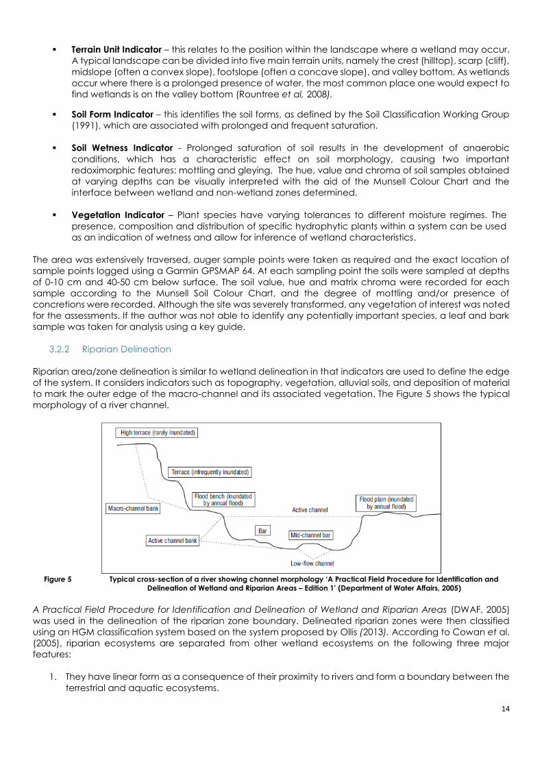
morphology of a river channel.
Figure 5 Typical cross-section of a river showing channel morphology ‘A Practical Field Procedure for Identification and
Delineation of Wetland and Riparian Areas – Edition 1’ (Department of Water Affairs, 2005)
A Practical Field Procedure for Identification and Delineation of Wetland and Riparian Areas (DWAF, 2005)
was used in the delineation of the riparian zone boundary. Delineated riparian zones were then classified
using an HGM classification system based on the system proposed by Ollis (2013). According to Cowan et al.
(2005), riparian ecosystems are separated from other wetland ecosystems on the following three major
features:
1. They have linear form as a consequence of their proximity to rivers and form a boundary between the
terrestrial and aquatic ecosystems.

15
2. Energy and materials from the surrounding landscape converge and pass through riparian
ecosystems. This amount is greater in terms of unit area than with any other system.
3. Riparian ecosystems are connected hydrologically to both upstream and downstream ecosystems
(intermittently).
An example of the soil sampling approach is provided in Figure 6.
Figure 6 Soil sampling undertaken at the site
3.3 Present Ecological State (PES) Assessment for Riparian Areas
3.3.1 Present Ecological State (adapted from WET-Health, Macfarlane et al., 2008)
A WET-Health (Macfarlane et al., 2009) Level 1 Rapid Appraisal was used to assess the eco-physical health of
any wetlands in the study area. Focusing on geomorphology, hydrology and vegetation, the tool examines
the impacts and indicators of change within the system and its catchment by determining the deviation (in
terms of structure and function) from the natural reference condition. The outcomes of the appraisal place
importance on issues that should be addressed through rehabilitation, mitigation and/or prevention
measures. A standardized scoring system allows for consistencies between different systems and reduces user
subjectivity.
Scores are allocated according to the magnitude and extent of impact. These scores are integrated to
produce an overall score for Present Ecological State (PES) of the system – namely, natural, largely natural,
moderately modified, largely modified, extensively modified, and critically modified.
3.3.2 Index of Habitat Integrity (IHI)
The ecological integrity of a river is defined as its ability to support and maintain a balanced, integrated
composition of physico-chemical and habitat characteristics, as well as biotic components on a temporal
and spatial scale that are comparable to the natural characteristics of ecosystems of the region (Kemper,
1999). The observed or deduced condition of these criteria as compared to what it could have been under
unperturbed conditions is surmised to indicate a change in the habitat integrity. The methodology is based
on the qualitative assessment of a number of pre-weighted criteria which indicate the integrity of the in-
stream and riparian habitats available for use by riverine biota. Tables 5, 6 & 7 provide the list of criteria and
their scores, the impact category and the final scores for the IHI assessment that were used in the calculations.

16
Table 5 Criteria used in the assessment of the habitat integrity
Criterion Relevance Water abstraction Direct impact on habitat type, abundance and size. Also implicated in flow, bed, channel and
water quality characteristics. Riparian vegetation may be influenced by a decrease in the supply
of water.
Flow modification Consequence of abstraction or regulation by impoundments. Changes in temporal and spatial
characteristics of flow can have an impact on habitat attributes such as an increase in duration
of low flow season, resulting in low availability of certain habitat types or water at the start of the
breeding, flowering or growing season.
Bed modification Regarded as the result of increased input of sediment from the catchment or a decrease in the
ability of the river to transport sediment (Gordon et al., 1993). Indirect indications of
sedimentation are stream bank and catchment erosion. Purposeful alteration of the stream bed,
e.g. the removal of rapids for navigation (Hilden & Rapport, 1993) is also included.
Channel
modification
May be the result of a change in flow, which may alter channel characteristics causing a change
in marginal instream and riparian habitat. Purposeful channel modification to improve drainage
is also included.
Water quality
modification
Originates from point and diffuse point sources. Measured directly or agricultural activities,
human settlements and industrial activities may indicate the likelihood of modification.
Aggravated by a decrease in the volume of water during low or no flow conditions.
Inundation Destruction of riffle, rapid and riparian zone habitat. Obstruction to the movement of aquatic
fauna and influences water quality and the movement of sediments (Gordon et al., 1992).
Exotic
macrophytes
Alteration of habitat by obstruction of flow and may influence water quality. Dependent upon
the species involved and scale of infestation.
Exotic aquatic
fauna
The disturbance of the stream bottom during feeding may influence the water quality and
increase turbidity. Dependent upon the species involved and their abundance.
Solid waste
disposal
A direct anthropogenic impact which may alter habitat structurally. Also a general indication of
the misuse and mismanagement of the river.
Indigenous
vegetation
removal
Impairment of the buffer the vegetation forms to the movement of sediment and other
catchment runoff products into the river (Gordon et al., 1992). Refers to physical removal for
farming, firewood and overgrazing.
Exotic vegetation
encroachment
Excludes natural vegetation due to vigorous growth, causing bank instability and decreasing the
buffering function of the riparian zone. Allochtonous organic matter input will also be changed.
Riparian zone habitat diversity is also reduced.
Bank erosion Decrease in bank stability will cause sedimentation and possible collapse of the river bank
resulting in a loss or modification of both instream and riparian habitats. Increased erosion can
be the result of natural vegetation removal, overgrazing or exotic vegetation encroachment.
Table 6 Impact classes and their associated scores
Impact category Description Score
None No discernible impact, or the modification is located in such a way that it has no impact on
habitat quality, diversity, size and variability.
0
Small The modification is limited to very few localities and the impact on habitat quality, diversity, size
and variability is also very small.
1-5
Moderate The modifications are present at a small number of localities and the impact on habitat quality,
diversity, size and variability is also limited.
6-10
Large The modification is generally present with a clearly detrimental impact on habitat quality,
diversity, size and variability. Large areas are, however, not influenced.
11-15
Serious The modification is frequently present and the habitat quality, diversity, size and variability in
almost the whole of the defined area is affected. Only small areas are not influenced.
16-20
Critical The modification is present overall with a high intensity. The habitat quality, diversity, size and
variability in almost the whole of the defined section are influenced detrimentally.
21-25

17
Table 7 Description of the IHI categories
Category Description Score
(% of total)
A Unmodified, natural. 100
B Largely natural with few modifications. A small change in natural habitats and biota may
have taken place but the ecosystem functions are essentially unchanged. 80-99
C Moderately modified. A loss and change of natural habitat and biota have occurred but the
basic ecosystem functions are still predominantly unchanged. 60-79
D Largely modified. A large loss of natural habitat, biota and basic ecosystem functions have
occurred. 40-59
E The loss of natural habitat, biota and basic ecosystem functions are extensive. 20-39
F
Modifications have reached a critical level and the lotic system has been modified
completely with an almost complete loss of natural habitat and biota. In the worst instances
the basic ecosystem functions have been destroyed and the changes are irreversible.
0-19
3.4 Ecological Importance & Sensitivity (EIS) Assessment (Riparian)
The Ecological Importance and Sensitivity (EIS) of riparian areas is an expression of the importance of the
aquatic resource for the maintenance of biological diversity and ecological functioning on a local scale to
a broader scale; whilst Ecological Sensitivity (or fragility) refers to a system’s ability to resist disturbance and its
capability to recover from disturbance once it has occurred (Kleynhans & Louw, 2007). In this study a
qualitative assessment was applied and was partially informed by the present state assessment. This
assessment followed the DWA river eco-classification criteria (Module A, Kleynhans & Louw, 2007). The
classification provides insights into the causes and sources of the deviation of the PES of biophysical attributes
from the reference condition (Kleynhans & Louw, 2007). This further provides the information needed to derive
desirable and attainable future ecological objectives for the river (Kleynhans & Louw, 2007).
Table 8 List of the EIS categories used in the assessment tool (Kleynhans & Louw, 2007)
Ecological Importance
and Sensitivity
Categories
General Description
Very high
Quaternaries/delineations that are considered to be unique on a national or even international level
based on unique biodiversity (habitat diversity, species diversity, unique species, rare and
endangered species). These rivers (in terms of biota and habitat) are usually very sensitive to flow
modifications and have no or only a small capacity for use.
High
Quaternaries/delineations that are considered to be unique on a national scale due to biodiversity
(habitat diversity, species diversity, unique species, rare and endangered species). These rivers (in
terms of biota and habitat) may be sensitive to flow modifications but in some cases, may have a
substantial capacity for use.
Moderate
Quaternaries/delineations that are considered to be unique on a provincial or local scale due to
biodiversity (habitat diversity, species diversity, unique species, rare and endangered species). These
rivers (in terms of biota and habitat) are usually not very sensitive to flow modifications and often have
a substantial capacity for use.
Low/marginal Quaternaries/delineations that are not unique at any scale. These rivers (in terms of biota and habitat)
are generally not very sensitive to flow modifications and usually have a substantial capacity for use.
18
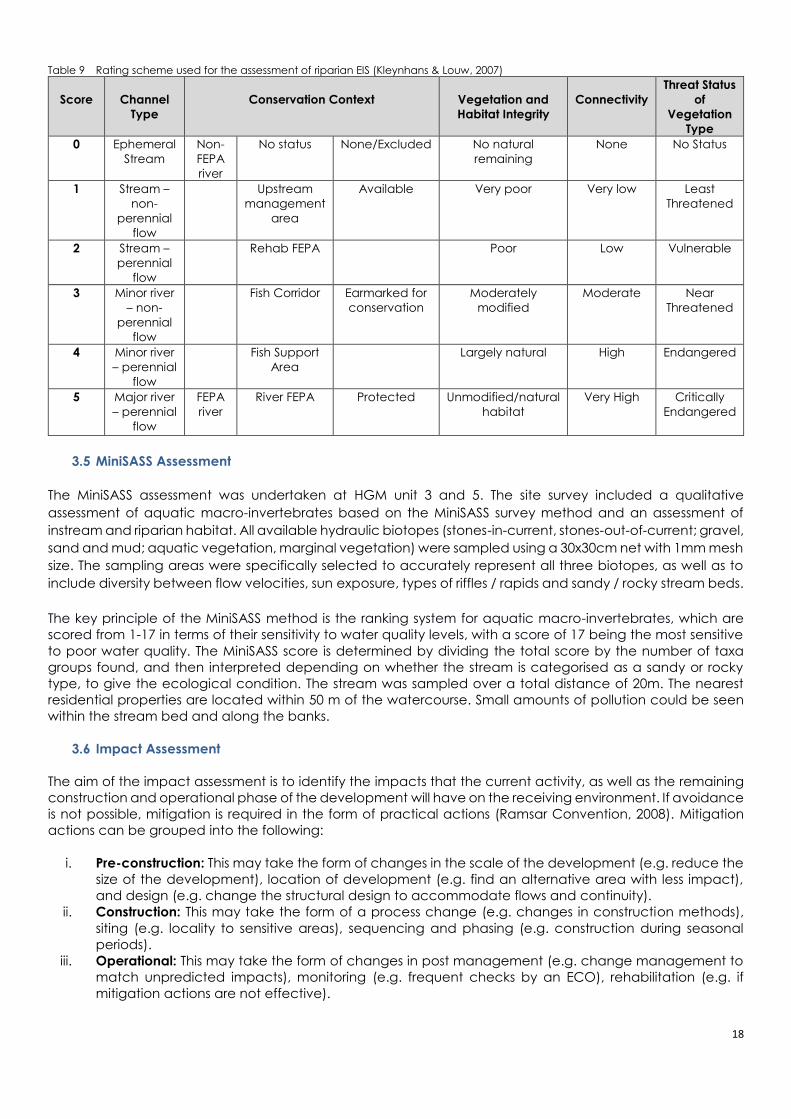
Table 9 Rating scheme used for the assessment of riparian EIS (Kleynhans & Louw, 2007)
Score
Channel
Type
Conservation Context
Vegetation and
Habitat Integrity
Connectivity
Threat Status
of
Vegetation
Type
0 Ephemeral
Stream
Non-
FEPA
river
No status None/Excluded No natural
remaining
None No Status
1 Stream –
non-
perennial
flow
Upstream
management
area
Available Very poor Very low Least
Threatened
2 Stream –
perennial
flow
Rehab FEPA Poor Low Vulnerable
3 Minor river
– non-
perennial
flow
Fish Corridor Earmarked for
conservation
Moderately
modified
Moderate Near
Threatened
4 Minor river
– perennial
flow
Fish Support
Area
Largely natural High Endangered
5 Major river
– perennial
flow
FEPA
river
River FEPA Protected Unmodified/natural
habitat
Very High Critically
Endangered
3.5 MiniSASS Assessment
The MiniSASS assessment was undertaken at HGM unit 3 and 5. The site survey included a qualitative
assessment of aquatic macro-invertebrates based on the MiniSASS survey method and an assessment of
instream and riparian habitat. All available hydraulic biotopes (stones-in-current, stones-out-of-current; gravel,
sand and mud; aquatic vegetation, marginal vegetation) were sampled using a 30x30cm net with 1mm mesh
size. The sampling areas were specifically selected to accurately represent all three biotopes, as well as to
include diversity between flow velocities, sun exposure, types of riffles / rapids and sandy / rocky stream beds.
The key principle of the MiniSASS method is the ranking system for aquatic macro-invertebrates, which are
scored from 1-17 in terms of their sensitivity to water quality levels, with a score of 17 being the most sensitive
to poor water quality. The MiniSASS score is determined by dividing the total score by the number of taxa
groups found, and then interpreted depending on whether the stream is categorised as a sandy or rocky
type, to give the ecological condition. The stream was sampled over a total distance of 20m. The nearest
residential properties are located within 50 m of the watercourse. Small amounts of pollution could be seen
within the stream bed and along the banks.
3.6 Impact Assessment
The aim of the impact assessment is to identify the impacts that the current activity, as well as the remaining
construction and operational phase of the development will have on the receiving environment. If avoidance
is not possible, mitigation is required in the form of practical actions (Ramsar Convention, 2008). Mitigation
actions can be grouped into the following:
i. Pre-construction: This may take the form of changes in the scale of the development (e.g. reduce the
size of the development), location of development (e.g. find an alternative area with less impact),
and design (e.g. change the structural design to accommodate flows and continuity).
ii. Construction: This may take the form of a process change (e.g. changes in construction methods),
siting (e.g. locality to sensitive areas), sequencing and phasing (e.g. construction during seasonal
periods).
iii. Operational: This may take the form of changes in post management (e.g. change management to
match unpredicted impacts), monitoring (e.g. frequent checks by an ECO), rehabilitation (e.g. if
mitigation actions are not effective).

19
An assessment of the potential impacts of the El Dorado dam activities was guided by the EKZNW handbook
for biodiversity impact assessments (2011). As it is an existing impact, a pre- and post-rehabilitation assessment
was undertaken.
It must be noted that am impact assessment was undertaken to identify pre-development and post-
development impacts.
3.7 Risk Assessment
The risk assessment matrix assesses the likely impact the proposed development and associated
infrastructure/activities may have on the wetland/watercourse. Only Low Risk Activities located within the
regulated area of the watercourse will qualify for a GA according to this Notice. Medium and High risk
activities will require a Section 21 (c) and (i) water use licence.
The criteria, calculations and ranking considered are as follows:
Severity
How severe does the aspects impact on resource quality (flow regime, water quality, geomorphology, biota,
habitat?
Insignificant / non -harmful 1
Small / potentially harmful 2
Significant / slightly harmful 3
Great/ harmful 4
Disastrous / extremely harmful and /or wetland(s) involved 5
Where "or wetland(s) are involved" it means that the activity is located within the delineated
boundary of any wetland. The score of 5 is only compulsory for the significance rating.
Spatial scale
How big is the area that the aspect is impacting on?
Area specific (at impact site) 1
Whole site (entire surface right) 2
Regional / neighbouring areas (downstream within quaternary catchment) 3
National (impacting beyond secondary catchment or provinces) 4
Global (impacting beyond SA boundary) 5
Duration
How long does the aspect impact on the environment and resource quality?
One day to one month, PES, EIS and /or REC not impacted 1
One month to one year, PES, EIS and /or REC impacted but no change in status 2
One year to 10 years, PES, EIS and /or REC impacted to a lower status but can be improved over this period
through mitigation
3
Life of the activity, PES, EIS and /or REC permanently lowered 4
More than life of the organisation /facility, PES and EIS scores, a E or F 5
PES and EIS (sensitivity) must be considered.
Frequency of the Activity
How often do you do the specific activity?
Annually or less 1
6 monthly 2
Monthly 3
Weekly 4
Daily 5

20
Frequency of the incident/impact
How often does the activity impact on the environment?
Almost never / almost impossible / >20% 1
Very seldom / highly unlikely / >40% 2
Infrequent / unlikely / seldom / >60% 3
Often / regularly/ likely / possible / >80% 4
Daily / highly likely / definitely / >100% 5
Legal Issues
How is the activity governed by legislation?
No legislation 1
Fully covered by legislation (wetlands are legally
governed)
5
Located within the regulated areas
Detection
How quickly/easily can the impacts/risks of the activity be observed on the resource quality, people and
property?
Immediately 1
Without much effort 2
Need some effort 3
Remote and difficult to observe 4
Covered 5
3.7.1 Rating classes
Rating Class
Management Description
1-55 (L) Low Risk Acceptable as is or consider requirement for mitigation.
Impact to watercourses and resource quality small and
easily mitigated. Wetlands are excluded.
56-169 (M) Moderate Risk Risk and impact on watercourses are notable and
require mitigation measures on a higher level, which
costs more and requires specialist input. Wetlands may
be excluded.
170-300 (H) High Risk Always involves wetlands. Watercourse(s) impacts by the
activity are such that they impose a long-term threat on
a large scale and lowering of the Reserve.
3.7.2 Calculations
Consequence = Severity + Spatial Scale + Duration
Likelihood = Frequency of Activity + Frequency of Incident + Legal Issues + Detection
Significance \ Risk = Consequence x Likelihood
21
4. LIMITATIONS AND ASSUMPTIONS
In order to apply generalized and often rigid scientific methods or techniques to natural, dynamic
environments, a number of assumptions are made. Furthermore, a number of limitations exist when assessing
such complex ecological systems. The following constraints may have affected this assessment –
A Garmin GPSMAP 64 was used in the mapping of waypoints on-site. The accuracy of the GPS is
affected by the availability of corresponding satellites and accuracy ranges from 1 to 3 m after post-
processing corrections have been applied.
A Munsell Soil Colour Chart was used to assess soil morphology. This tool requires that a dry sample of
soil be assessed. However, due to in-field time constraints, slightly wet soil samples were assessed. Wet
samples would have consistently lower values than dry soils; and this is taken into consideration.
Although the vegetation was taken into account, protected and threatened species, such as bulbs
that have not emerged, may not have been identified. Due to the development extending into
sensitive areas (such as buffer areas and the actual watercourse), a vegetation survey was
undertaken in a separate study.
The soils were very uniform, as such it was difficult to determine the difference between temporary
and dry-land wetland/riparian areas.
The sampling was undertaken after a severe drought. Given these circumstances, extra caution was
taken to ensure that watercourse features were not overlooked. Furthermore, the water quality
sampling may differ from median year samples as parameters may be concentrated in such
conditions (reduced flow).

22
5. RESULTS AND DISCUSSION
5.1 Regional Context
5.1.1 NFEPA assessment
In accordance with the NFEPA guidelines, the drainage line (and its associated riparian areas) that the
proposed road upgrade crosses, have not been classified as a FEPA system, which indicates that this system
is not a national freshwater conservation priority.
FEPA wetlands were not identified within 500m of the study site. The nearest is a natural flat/bench wetland
approximately 940 meters from the road. The layer codes for River FEPAs and associated sub-quaternary
catchments, Fish Support Areas and associated sub-quaternary catchments and Upstream Management
Areas.
Figure 7 NFEPA wetlands (pink) within proximity to the Sdangeni road upgrade
5.1.2 Vegetation
This site is dominated by Drakensberg Foothill Moist Grassland (Gs 10, Mucina and Rutherford, 2006). This
occurs within the sub-escarpment grassland biome. The desktop analysis revealed that the area is a least
threatened area, poorly protected, with the potential for some flagged fauna and flora (e.g. red data species
and endangered wildlife) being found from the C-plan, SEA and MINSET databases. However, this does not
necessarily mean that rare or endangered species will occur in the area of interest. The vegetation type has
82.1 % remaining and is hardly protected. The following information was collected for the vegetation unit Gs
10 (Mucina & Rutherford, 2006; Scott-Shaw & Escott, 2011). The characteristics of this grassland are described
as:
Distribution: KwaZulu-Natal and Eastern Cape Provinces: Broad arc of Drakensberg piedmonts covering
the surrounds of Bergville in the north, Nottingham Road, Impendle, Bulwer in the east, and Kokstad, Mount
Currie, Underberg (KZN) and the surrounds of Mt Fletcher, Ugie, Maclear and Elliot (Eastern Cape) in the
southwest.
940 m
Non-perennial
Perennial

23
Altitude: 880– 1 860 m.
Vegetation and Landscape features: Moderately rolling and mountainous, much incised by river gorges
of drier vegetation types and by forest, and covered in forb-rich grassland dominated by short bunch
grasses including Themeda triandra and Tristachya leucothrix.
5.1.3 Historical analysis
The historical analysis is useful to assist in determining the natural state of a site and what transformation it has
gone through. There is a partially existing road throughout the extent of the proposed road upgrade. As a
watercourse study was not undertaken before the existing roads and settlements were built, it is difficult to
determine where a watercourse may have previously existed without the use of historical imagery.
Additionally, the discharge and diversions due to the settlement and roads has altered the hydrological state
of the site.
The site as observed through a series of historical images (Figure 8), shows the following:
The surrounding site was previously cultivated as far back as 1977;
There were clear drainage lines at this point in time;
There was no additional (lost) wetlands present prior to the current state;
There has been a slight increase in settlements and roads;
There is a clear recent invasion/planting of Acacia mearnsii (Black Wattle) in recent years that are
poorly managed.
Figure 8 Historical imagery of the road upgrade site from 1977 to present
5.1.4 Site Terrain
The site is generally very steep. (Figure 9). However, the proposed road follows the contour line so the change
in height is low. However, due to the steep slopes above and below the road, this site is at a high risk of erosion.

24
Figure 9 Terrain model of the proposed Sdangeni road upgrade
Isongweni River
Kamlenze (1830m) KwaShoba
Sidangeni

25
5.2 Extent, Classification and Habitat Characteristics
The current land cover was obtained from various databases and the site visit. The site is surrounded by low
density settlements and gravel roads. Grassland areas exist around the site. Some patches of alien invaders
were noted. The footprint of the road upgrade is on partially pre-existing road/foot path areas.
The dominant species in the riparian areas were mostly indigenous sedge with Haleria lucida, Buddleja
auriculata and Leucosidea sericea being prevalent in patches along the drainage line. Severe erosion was
observed on site, the site is at risk of future erosion due to the slope and recently transformed state. This
ecosystem may hold some key species. The existing watercourse has been impacted upon by the settlement
and changes in the hydrological regime have occurred.
The site consists of some areas of hydrological interest and these areas have been tabulated (Table 10) and
described in detail. The HGM units are further illustrated in Figure 11. Wetlands/riparian areas that the road
extension may impact upon were assessed for wetland health and functionality. The wetlands/riparian areas
have been delineated to show no go areas and were used initially to check the connectivity of the systems
and potential impacts from the development.
Figure 10 Typical vegetation around the site
The following wetland/riparian systems were identified
HGM 1: Drainage line (non-perennial tributary of the Isongweni system)
HGM 2: Drainage line (non-perennial tributary of the Isongweni system)
HGM 3: Drainage line (perennial tributary of the Isongweni system)
HGM 4: Drainage line (non-perennial tributary of the Isongweni system)
HGM 5: Drainage line (perennial tributary of the Isongweni system)
Two downstream wetlands were identified and delineated as additional “no-go” areas. The majority of the
soils identified adjacent to the watercourse were sandy clay soils (Alluvium - yellowish-brown sandy clay). The
drainage lines were rocky with limited soil. No hydric soil characteristics were found outside of the
wetland/riparian areas. The hydric soils, identified by gleyed or mottled characteristics, were found at a depth
of 10-30 cm along the modified edges of the visibly clear riparian areas.

26
Table 10 Description of HGM units
Feature Wetland/Ripa
rian/Artificial
Description &
Vegetation
Soil
Characteristics On-site images
Drainage
Line
(HGM 1)
Riparian
(non-
perennial)
Banks of the
Isongweni
tributary.
Dominated by
small indigenous
woody species.
Evidence of
erosion along
crossing areas.
Main channel:
Gray (Gleyed)
Depth
sampled: 0-
0.2m
Yellow-brown
a-pedal soils
Very little topsoil
remaining
Drainage
Line
(HGM 2)
Riparian
(non-
perennial)
Banks of the
Isongweni
tributary.
Dominated by
small indigenous
woody and grass
species. Slight
evidence of
erosion along
crossing areas.
Mottle % - 2-5%
Hue – 7.5YR
Value – 5
Chroma – 1
(Dark Gray)
Depth
sampled: 0-
0.2m
Organic matter
content in the
upper layer
Drainage
Line
(HGM 3)
Riparian
(perennial)
Banks of the
Isongweni
tributary.
Dominated by
larger indigenous
woody species.
Evidence of
erosion along
crossing area
edges.
Main channel:
Rocky, unable
to sample soil.
Continual flow
and aquatic life
present
Drainage
Line
(HGM 4)
Riparian
(non-
perennial)
Banks of the
Isongweni
tributary.
Dominated by
small indigenous
woody species.
Evidence of
erosion along
crossing areas.
Main channel:
Gray (Gleyed)
Depth
sampled: 0-
0.2m
Yellow-brown
a-pedal soils
Very little topsoil
remaining
Drainage
Line
(HGM 5)
Riparian
(perennial)
Banks of the
Isongweni
tributary.
Dominated by
small forb and
grass species. This
channel is in
pristine condition.
Main channel:
Rocky, unable
to sample soil.
Continual flow
and aquatic life
present

27
Figure 11 HGM units identified along the proposed Sdangeni road extension

28
5.3 Present Ecological State (PES)
5.3.1 Index of Habitat Integrity for riparian areas
The Index of Habitat Integrity tool (Kleynhans, 1996) was used to determine the integrity of the streams and
their associated riparian habitats linked to the Isongweni system. HGM units 1, 2 and 4, which are non-
perennial systems were grouped together. In similar vein, HGM units 3 and 5, which are perennial systems
sharing very similar habitats were assessed together. The pre-development state was determined by
assessments of the immediate surrounding areas. The results for the pre-development state HGM units 1,2 and
4 show a PES category of C (75.08, Table 11): “Moderately modified. A slight loss and change of natural habitat
and biota have occurred due to the surrounding plantations but the basic ecosystem functions are still
predominantly unchanged.” The riparian areas have been disturbed by footpaths and erosion is visible along
the channel edges.
The results for the pre-development state of HGM units 3 and 5 show a PES category of B (80.84, Table 12):
“Largely natural with few modifications. A small change in natural habitats and biota may have taken place
but the ecosystem functions are essentially unchanged.” Some abstractions points (pipes and storage tanks)
were observed although in small volumes. Erosion was present near these channels but the stream were in
generally good condition.
Table 11 Pre-development PES score using the Index of Habitat Integrity tool (Kleynhans, 1999) for the Isongweni non-perennial
tributarys
Riparian Zone
Criterion Score Weighting Actual Potential
Indigenous vegetation removal 3 13 39 325
Exotic vegetation encroachment 4 12 48 300
Bank Erosion 21 14 294 350
Channel modification 6 12 72 300
Water abstraction 2 13 26 325
Inundation 2 11 22 275
Flow modification 8 12 96 300
Water quality 2 13 26 325
Totals 623 2500 24.92
Category 75.08
Table 12 Post-development PES score using the Index of Habitat Integrity tool (Kleynhans, 1999) for the Isongweni perennial tributarys
Riparian Zone
Criterion Score Weighting Actual Potential
Indigenous vegetation removal 2 13 26 325
Exotic vegetation encroachment 4 12 48 300
Bank Erosion 14 14 196 350
Channel modification 4 12 48 300
Water abstraction 6 13 78 325
Inundation 2 11 22 275
Flow modification 4 12 48 300
Water quality 1 13 13 325
Totals 479 2500 19.16
Category 80.84

29
5.3.2 WET-Health (Macfarlane et al., 2008) of wetlands
A WET-Health assessment was undertaken for the wetlands found within and near to the proposed road
upgrade. Wetlands that are part of the same system but have split due to developments were grouped
together in the health assessments.
Hydrology
The Un-channelled Valley Bottom (UVB) wetlands on site are largely natural. There was little to no variation in
soil form, terrain and the vegetation surrounding the wetlands and the riparian areas apart from an increase
in sedge species. The present hydrological state of the UVB wetlands was given a score of B, indicating that
the modifications on the hydrological integrity are small. The MAP: PET ratio indicates that the wetlands are
not dependant on direct precipitation falling onto the wetland, depending on flow from upstream to a
greater extent, making these wetlands more vulnerable to reduced flows.
The key factors influencing hydrological impacts on the wetland is the encroachment by humans and high
water using vegetation in the wetland catchment. These are streamflow reduction activities that are
decreasing water flow into the system. Natural water distribution and retention patterns are altered as a result
of impeding structures above the wetlands, such as the roads and plots for houses that have resulted in
hardened surfaces and therefore greater runoff as the surface roughness is altered. Additional contributions
of grey water are noted but minimal.
Table 13 The hydrology module for the Sdangeni Road UVB wetland
Hydrology module Channelled Valley Bottom
Extent of the wetland (ha) 0.14
MAP:PET 0.4 – 0.49
Vulnerability factor 0,9
Combined score for increased and decreased flows 1
Intensity of impact of factors potentially altering flow patterns 1.3 – small
Magnitude of impact of canalisation and stream modification 1.4
Magnitude of impact of impeding features 2
Magnitude of impact of altered surface roughness 1.2
Impact of direct water losses 0.1
Magnitude of impact of recent deposition, infilling or excavation 0
Combined magnitude of impact of on-site activities 2 – Low
Combined magnitude score as a result of impacts on hydrological
functioning
4.7
Overall hydrological health Although identifiable, the impact of the
modifications on the hydrological integrity are small.
Present hydrological state of the HGM unit B
Trajectory of change of wetland hydrology (→)
Vegetation
The present state of wetland vegetation of the wetland been given a class B as the vegetation composition
is mostly natural. There is some impact from the nearby roads and houses that has resulted in the reduction of
characteristic indigenous wetland species and human disturbances have resulted in an alteration of
introduced; alien and or increased ruderal species. Additionally, the exclusion of fire has led to an increase in
woody vegetation.
Table 14 Vegetation module for the Sdangeni Road UVB wetland
Vegetation module Channelled Valley Bottom
Extent of the HGM unit (ha) 0.14
Identify and estimate the extent of each disturbance class Low
Magnitude of impact score 2.6
Present vegetation state B
Trajectory of change to wetland vegetation (→)
Overall vegetation health A very minor change to vegetation composition is
evident at the site
Alien vegetation present (%) 3

30
Geomorphology
The overall geomorphological health of the valley bottom wetlands was classified as B, which is largely
natural. This was due to existing deposition and historical changes from farming practices. The trajectory of
change, if the impacts do not continue, is likely to remain stable (→).
Table 15 Geomorphology module for the Sdangeni Road UVB wetland
Geomorphology module Channelled Valley Bottom
Extent of the HGM unit (ha) 0.14
Impacts of channel straightening 0.4
Extent of impact of infilling 18
Impacts of changes in runoff characteristics 0.5
Impacts of erosion 0.1
Impacts of deposition 0.5
Present geomorphic state B
Trajectory of change of geomorphic state (→)
Overall geomorphological health Largely natural with few modifications. A slight change
in geomorphic processes is discernible but the system
remains largely intact
Overall Health
The overall health based on the combined impact score is B (largely natural). A slight change in ecosystem
processes and loss of natural habitats has taken place but the natural habitat remains predominantly intact.
The primary impact upon this system is increases in sedimentation, erosion and invasive alien plants,
enhanced by the proposed development.
As a result of the proposed developments there will likely be a slight change in the quality of the water. The
goal is to maintain the state but still address the changes identified below:
Ensure no change in water quality of these systems;
Manage soil loss and sediments from the development area;
Ensure no invasive alien plants establish; and
Ensure preservation of the wetlands by applying a suitable buffer.
5.4 Ecological Importance & Sensitivity Assessment
An EIS category was determined for the three non-perennial and two perennial tributaries of the Isongweni
system. The category of these systems and the linked downstream wetlands (Table 16 and Table 17) was
calculated to be Moderate: ‘Quaternaries/delineations that are considered to be unique on a provincial or
local scale due to biodiversity (habitat diversity, species diversity, unique species, rare and endangered
species). These streams (in terms of biota and habitat) are usually not very sensitive to flow modifications and
often have a substantial capacity for use.’
Table 16 EIS category scoring summary for the Isongweni non-perennial tributary
Component Score ( 0-5) Comments/description
Channel Type 1 Stream – non-perennial flow
Conservation Context 0 No status
Vegetation and Habitat Integrity 4 Largely natural
Connectivity 4 High
Threat Status of Vegetation Type 1 Least Threatened
EIS Rating 2.0 Moderate
Table 17 EIS category scoring summary for the Isongweni perennial tributary
Component Score ( 0-5) Comments/description
Channel Type 2 Stream – perennial flow
Conservation Context 0 No status
Vegetation and Habitat Integrity 4 Largely natural
Connectivity 5 Very High
Threat Status of Vegetation Type 1 Least Threatened
EIS Rating 2.4 Moderate

31
Considering the PES and EIS scores, the recommended management objective for the Sdangeni road
extension would be to maintain the present integrity and ecosystem functioning of the system and ensure no
flow modifications and water quality impacts.
5.5 MiniSASS Assessment
The sampling sites were located adjacent to gravel road, which is situated within low income rural area. The
site was largely natural with very few observations of organic waste material / pollution on site and is currently
not imposing noticeable impacts on the aquatic macro-invertebrates inhabiting the watercourse. The natural
state of the watercourses is further evident with the watercourses being used for potable water, which is
supported by the results of the MiniSASS assessment. Figure 12 provides an example of a typical MiniSASS
sample, which was collected from all available biotopes from the stream on site. An example of the scores
expected for each ecological condition, depending on the type of stream or river, is provided in Table 16.
This table is used for interpreting MiniSASS data to determine the natural / modified state of the assessed
watercourse in terms of their ecological health category.
Figure 12 Sample container used to assist in identifying invertebrates
5.5.1 Aquatic Findings
A total of 4 different groups of taxa were collected from the watercourse and including worms, dragonflies,
bugs/beetles and true flies (see Annexure E). The total score and MiniSASS (Average) score is 49 and 8.1
respectively. According to the interpretation table below, this is above 7.2 (rocky type) and therefore falls
within the “Natural Condition” ecological category, which is described as being unchhanged.
Table 18 Ecological categories for interpreting MiniSASS data
Ecological Category (Condition) River Category Sandy Type Rocky Type
Natural Condition (Unchanged / untouched – Blue)
> 6.9 > 7.2
Good Condition (Few modifications – Green)
5.9 – 6.8 6.2 – 7.1
Fair Condition (Some modifications – Orange)
5.4 – 5.8 5.7 – 6.1
Poor Condition (Lots of modifications – Red)
4.8 – 5.3 5.3 – 5.6
Very Poor Condition (Critically modified – Purple)
< 4.8 < 5.3

32
5.5.2 Potential Aquatic Impacts
The following impacts are likely to take place on the watercourse as a result of the proposed development:
Watercourse pollution in the form of organic and inorganic contamination. For example, construction
materials such as oil & grease, steel, cement, rubble, etc. may be released or spilled into the tributary
due to poor construction practices and carelessness / negligence for the surrounding environment.
Furthermore, if appropriate ablution facilities are not provided during the construction phase, this may
result in the watercourses collecting organic effluent as runoff from the surrounding catchment.
An increase in sand or rubble could potentially lead to increased sediment load within the
watercourses and negatively affect the aquatic environment as well as the macro-organisms residing
within them.
Inorganic chemicals such as cement or petrochemicals from construction vehicles can have highly
detrimental effects on aquatic habitats and greatly reduce the biological diversity of macro-
invertebrates inhabiting the watercourses.
A loss of macro-invertebrates can cause negative knock on effects for larger stream dwelling
organisms such as frogs, fish and birds due to the reduced food supply, which would then reduce the
overall intactness of the ecosystem.
Due to disturbances, an increase in invasive alien plants is likely to occur which will result in a loss of
habitat for terrestrial and aquatic organisms.
5.5.3 Water Quality Management Plan
Considering the likely development related impacts, the following conditions are proposed as a Water Quality
Management Plan (WQMP):
1. Construction materials should be stored and maintained away from the watercourse (30 m away from
the watercourse). This would assist to prevent substances such as sand, cement, steel, bricks or rubble
from being washed into the watercourse. 2. Any demolition or removal of existing materials must be done with careful consideration for the
surrounding / adjacent watercourses. This is to avoid spilling substances such as rubble and concrete
into the watercourse, which would then be washed downstream. 3. Any existing material that is removed from the project area must not be placed within 30 m from a
watercourse and should be removed from the site area within 52 hours (3 days).
4. Construction vehicles should not be parked within 30 m of a watercourse, unless specifically needed
at that point in time for construction activities taking place around the watercourse.
5. Appropriate ablution facilities as well as abundant supplies of waste collection bins must be provided
for construction workers on site. This will prevent the watercourse from becoming degraded and
contaminated with both organic effluent and inorganic litter / rubbish. 6. Any concrete mixing taking place on site must be conducted on impermeable plastic sheets to
prevent cement from entering the watercourse through seepage or accidental spillage. Alternatively,
cement mixing can take place within the footprint where permanent concreting will occur. 7. Follow up watercourse assessments must be undertaken during the construction phase as well as the
operational phase to ensure that the watercourses within the project area are not being polluted as
a result of the proposed development activities.
8. A MiniSASS follow up assessment should take place on site between the closure of the construction
phase and the initiation of the operational phase, as well as bi-annually for the first year of operation.
Taking into account the listed potential impacts as well as the mitigation measures proposed for the WQMP,
it is the opinion of the specialist that the proposed development should be approved. There are no fatal flaws,
major concerns or significant impacts associated with the proposed development project. This is largely due
to the fact that the majority of the surrounding areas, as well as the proposed development area, have
already been disturbed and currently need intervention for erosion control. Although the watercourse is near
pristine, there is unlikely to be any significant impacts or further degradation as a result of the proposed
development. However, it is imperative that the conditions of the WQMP are incorporated into the
Environmental Management Programme and Environmental Authorization (should it be granted) in order to
ensure the adequate protection of watercourse on site.

33
6. POTENTIAL IMPACT PREDICTIONS AND DESCRIPTIONS
The site is in a visibly modified condition due to erosion concerns. The primary surrounding impacts are
settlement encroachment and erosion. However, the riparian and wetlands systems are still intact and the
households are situated away from these systems. The site was historically partially cultivated for many years.
However, the wetland on site is performing much need services to the downstream area and provide a
habitat for important species.
The road upgrade site has a small catchment area on an unnamed tributary of the Isongweni system.
Figure 13 Erosion present along the proposed road extension
6.1 Present Impacts
Within the Sdangeni development footprint, the existing impacts on the watercourses and respective
catchment areas include -
The presence of water demanding plantation species that have replaced grassland;
Subsistence farming within watercourse systems (small scale);
Invasive alien plant invasion in disturbed areas (particularly along servitudes and road edges);
The clearance of natural habitat for settlements and pathways between houses;
Concentrated flow paths from drain outlets/dongas along the roads
Historical modification of watercourse systems for agriculture; and
Erosion and sedimentation.
In the broader WMA, similar impacts are present as noted for the Sdangeni site. Additional existing impacts
on the watercourses and respective catchment areas include -
Infrastructure development within wetland systems (wetland encroachment) or river banks –
leading to a direct loss of wetland systems and decrease in provision of ecosystem services;
Cattle grazing in wetlands and the riparian edge – potential for a change in vegetation species
composition to occur, soil erosion (cattle path erosion is prevalent in the area) and water pollution;
Canalisation of streams and rivers – leading to change in the hydrological regime;
Informal and formal watercourse crossings – leading to the change in hydrological regime;
Litter and solid waste disposal – direct water pollution; and
Poor or absent sanitation – direct water pollution.

34
In addition to these impacts, there is a high risk of flood damage (infrastructure, cattle, crops and livelihood)
to the community living within the flood line. With the draining of the wetland systems, there is also a likelihood
that soil sediment levels would increase resulting in a loss of yield.
6.2 Potential Impacts During Construction
Some impacts are likely during operation. These include -
Table 19 Impact Drivers and Description – Construction Phase
ACTIVITY / DRIVER OF IMPACT IMPACT DESCRIPTION OF HOW IMPACT OCCURS
Infilling of rubble within the
wetland edge
Enhanced erosion
potential
As a result of subsequent changes in the hydrological
partitions and slight modifications to the slope and soil
characteristics (changes to vegetation cover, root content
and infiltration rates). This is further described –
The increase in slope and bank construction has
enhanced erosion potential (greater energy for sediment
wash).
The reduction in vegetation cover results in open bare soil
therefore reducing the surface roughness and increasing
the erosive potential to the elements (wind and rain). Sheet
wash, rill and gully erosion is likely and may lead to the
collapse or slumping of wetland/stream bank areas that
would bury marginal wetland habitat.
An increase in compaction of the soils along the edge of
the plot where heavy machinery traverses has led to an
increase in the runoff.
Decrease in water
quality
As a result of contaminants from heavy machinery (oil,
fuel) infiltrating / washed into the system as well as
sediments from the infilling area.
Spread of alien
invasives
As these plants colonise stockpiles and spoil sites / spoil
sites given their easily dispersed seed.
Continued alteration
of flow pattern
A result of concentrated flow from impervious surfaces
and storm water channels. A general change in flow
regimes (straightening of channel).
High activity of heavy
machinery and construction
staff to move rubble on-site
Air pollution
affecting wetland
fauna
As a result of excessive air emissions from heavy machinery
and generators.
Noise and
disturbance
affecting wetland
fauna
As a result of excessive air emissions from heavy machinery
and generators.
Decrease in water
quality
(impact to aquatic
flora and fauna; and
water supply)
As a result of potential leaks of fuel, grease and oil from the
heavy machinery. Wash related to the above-mentioned
changes during rainfall events will lead to the movement
of these substances into the soil and the watercourse
systems.
As a result of improper storage and handling of hazardous
chemicals such as fuel and oil as well as chemicals relating
to staff ablution facilities.
As a result of any spills, such as concrete, during
construction.
6.3 Potential Impacts During Operation
The majority of the impacts will be during construction. However, some impacts are likely during operation.
These include -

35
Increase in population: a likely increase in vehicles using this route due to the improved
infrastructure. This may lead to more people moving to the area (more households) and a greater
intensity of the present impacts;
Increase in pollution: an increase in pollution from the road surfaces including petro-chemicals and
human rubbish. An increase of visitors and vendors during operation may lead to further pollution;
Increase in surface runoff: Increase in impervious surfaces which may promote erosion and flash
floods; and
Increase in overall edge effects on wetland: heightened activity in the area
Continued alteration of flow pattern: as a result of concentration of flow through culverts
Table 20 Impact Drivers and Description – Operation Phase
ACTIVITY / DRIVER OF IMPACT IMPACT DESCRIPTION OF HOW IMPACT OCCURS
Disturbance of the linear flow
channel
Potential for leaks
and contamination
of watercourses
A change in the flow regime due to the construction of
culverts associated with the road. This may alter the
watercourse bed and flow regimes.
Stormwater runoff along the
hardened surfaces of the road
upgrades
Soil wash/Erosion
Disturbance of the soil profile and vegetative cover may
prompt a change in flow path, with surface runoff running in
rills along the concrete edges.
Foundations and obstructions
Change in
subsurface water
movement
The development of the road deeper than the upper soil
profile may cause sub-surface water movement to be
diverted and potentially concentrated resulting in
inundation areas.
Greater human/vehicle
movement through the site Increase in pollution
An increase of visitors and vendors during operation may
lead to further pollution such as plastics, cans and glass.
6.4 Impacts associated with Climate Change Projections
The following potential impacts may arise as a result of climatic changes in the future, which would possibly
effect the Sdangeni watercourses and surrounding environment:
Increase in extreme weather events such as powerful rain/thunderstorms, strong winds, intense heat
waves, severe coldness and increased lightning strikes.
The risk of contamination of watercourses would increase due to significantly greater volumes of
runoff, which may lead to disease outbreaks and human health problems.
The changing environmental conditions could potentially increase the invasion of alien plants species
within and surrounding watercourses due to newly suitable temperature and weather conditions.
Alien vegetation uses more water than indigenous vegetation, therefore reducing natural water
supplies / choking natural watercourses. Alien plants have the ability to overpower indigenous
vegetation and becoming overgrown within rivers and streams.
7. RISK ASSESSMENT
A risk assessment, as outlined in the methodology, was undertaken at the proposed road upgrade site.
Information from spatial datasets, as well as the site visit was used to populate the risk matrix (Table 21). A risk
matrix of proposed activities was undertaken.
The results indicate that the activities will have a low risk with the impact on flow regimes being notable but
still low. This low risk is due to the site being within a small catchment, the slightly modified pre-existing state of
the site and the best practice management adopted on site. However, there is still a risk associated with
surface water. This is particularly relevant given the proximity of the site and the water shortage in the
province. The activities associated with the road extension need to be addressed through a monitoring plan
to ensure the risks are mitigated.
This risk assessment assumes that stormwater management and erosion control is appropriately applied. The
risk associated with the site are low only because of the conditions stated in this report. Should these not be
adhered to, the risk would be moderate.
pg. 36
The following tables gives the overall risk score, according to the Risk Matrix, for the construction and operation of the road within mitigation measures adopted.
Table 21 Risk matrix assessment for the impacts identified for the construction and operation of the activities
Activity Aspect Severity Consequence Likelihood Significance Risk
Rating
HGM Units 1 – 5 (Drainage Lines)
CONSTRUCTION Development within a
watercourse
Creating a road platform using machinery (earthworks) leading to
sedimentation 1.5 4.5 11 49.5 L
Use of effluent septic tank and soakaway for workers leading to
potential contamination 1.75 3.75 11 41.25 L
Increased activity of workers and machinery on-site
(noise, dust, traffic disturbance) 1.75 4.75 11 52.25 L
Storage of petro-chemicals on site 2.25 5.25 10 52.5 L
OPERATION Development within a
watercourse
Increase in settlements (more households) 2.25 7.25 7 49 L
Increased storm water on site leading to soil wash 1.75 6.75 7 47.25 L
Change is sub-surface water movement 1.5 5.5 6 33 L
General increase is pollution (noise and litter) 1.75 6.75 6 40.5 L
Un-channeled Valley Bottom
CONSTRUCTION Development within a
watercourse
Creating a road platform using machinery (earthworks) leading to
sedimentation 2.25 5.25 7 36.75 L
Use of effluent septic tank and soakaway for workers leading to
potential contamination 3.5 3.5 7 24.5 L
Increased activity of workers and machinery on-site
(noise, dust, traffic disturbance) 5 5 7 35 L
Storage of petro-chemicals on site 4 4 6 24 L
OPERATION Development within a
watercourse
Increase in settlements (more households) 5 5 6 30 L
Increased storm water on site leading to soil wash 5 5 7 35 L
General increase is pollution (noise and litter) 7 7 6 42 L

37
8. PROPOSED INTERVENTION MEASURES & SURFACE WATER MONITORING
PROGRAMME
8.1 Objectives of rehabilitation
The overarching intent of wetland rehabilitation is to ensure the services, attributes and functions of the
wetland are conserved. Wetland rehabilitation efforts must work with natural processes at all times and
consideration must be given to the fact that rehabilitation is a process and not an endpoint. Continued follow-
up and ongoing care is required to ensure the desired outcome is achieved and maintained.
The rehabilitation objectives to ensure that wetlands/watercourses around the road extension area are
preserved are as follows –
i. Restore hydrology of the drainage line crossing points;
ii. Restore indigenous wetland vegetation (species recommendations available in the vegetation
report);
iii. Secure the road edges from future erosion; and
iv. Prevent further degradation to the wetland.
The objectives are required to offset the impact created as a result of the road construction.
8.2 Actions to meet objectives
Following a site-based assessment, it is the opinion of the specialist that a site-specific 15 m buffer from crossing
points be used as the area to focus rehabilitation activities on. Table 22 Rehabilitation actions
Objective Action Result
Timing
Restore hydrology
of the drainage
lines
The material found within 15m of the
crossing point should be removed
and vegetated manually.
Restore surface flows into the
drainage lines.
Prevent compaction of the system.
With immediate
effect.
Stormwater should be appropriately
managed from the road surfaces,
attenuation encouraged with
numerous discharge points and
infiltration encouraged.
Encourage slow, dissipated flows
towards the stream/wetland.
A Stormwater Management Plan
must be developed which accounts
for this.
A vegetation list (NatureStamp,
2021) provides a list of
recommended indigenous species
for the proposed rehabilitation.
Planted in spring
or summer
months.
Restore indigenous
wetland
vegetation
Remove alien plants from the
stream/wetland, through either
manual or chemical control.
Improve biodiversity
During winter
months
Plant this zone and the buffer with
indigenous veld mix.
Restore integrity of the wetland
buffer.
Increase surface roughness to slow
down surface flows entering the
riparian areas/wetlands.
Planted in spring
or summer months
to ensure plant
survival, after
material has been
removed.
Where practical, plant obligate
wetland species within permanent
wetland zones. The wetland species
would include: Cyperus, Juncus,
Kniphofia and Phragmites.
Encourage dense stands of robust
wetland vegetation to assist in water
purification.
Combat alien plant invasion.
With immediate
effect, preferably
in the summer
months.
Prevent further
degradation to the
drainage lines
Apply a road reserve buffer wherein
no further development should take
place without prior Environmental
Authorization
Allow dissipated flow into natural
systems.
With immediate
effect.

38
8.3 Ongoing monitoring
Erosion Control – During and after the rehabilitation process, some erosion may take place while the
system stabilizes. However as the vegetation establishes, erosion should halt all together. Erosion should
be monitored by visual inspection Fixed point photography can be used to observe progress of
problem zones.
Soil Compaction – After removing the infill material, all areas must be scarified to loosen compacted
areas. Should pooling be seen after rainfall, it will indicate that such areas may require further
‘loosening’.
Water flow – The rehabilitated crossing points should maintain their natural flow path, with high surface
roughness (plugs / vegetation). This can be monitored by visual inspection and fixed point
photography used to observe progress of problem zones.
Vegetation – In order to ascertain whether indigenous greening objectives are being achieved, the
establishment of planted indigenous material should be evident, with plant vigour being seen to
increase particularly on riparian/wetland edges. Alien vegetation on the site should be notably low.
Site investigations and fixed point photography would allow for inspection of progress.
8.4 Final monitoring
In order to assess the success of rehabilitation, a further assessment of PES is recommended after a period of
one year.
There is potential through this development to address the severe erosion concerns that exist on the site.
Additionally, if this is not addressed, the structural integrity of the road may be diminished.
It is recommended that the contractor stabilize banks where erosion has already occurred.

39
9. CONCLUSION
The developers of the proposed Sdangeni road extension must note that watercourses are protected by nine
Acts and two Ordinances in KwaZulu-Natal1, which verifies that both national and provincial authorities
recognise these systems as highly valuable multiple-use resources and are committed to their conservation.
The work undertaken for this report indicates that watercourse systems/wetlands were identified within the
extension area, as detailed in Section 5.2. However, this is a partially existing road/footpath site. The greater
area contains some wetlands, which have been assessed in this study. These drainage lines are in near pristine
condition and need to be conserved.
No watercourse system was identified as a FEPA system but should still be given extra protection to mitigate
the impacts identified. The developments proposed for the site will have some impact on these surrounding
watercourses. However, with mitigation measures, the overall change will be low. The primary concern will be
the construction phase of the road (spoil/rubble/chemical waste). The recommendations for the
development are to implement adequate stormwater runoff attenuation structures and rehabilitate the sites
around the crossing. Concentrated flow release points should dissipate and regulate flow off the surfaces
towards the natural drainage lines, via a number of discharge points. At all times, disturbance to wetland
areas should be avoided.
This proposed road extension presents an opportunity to address the existing erosion along this
cattle/footpath route. Should this not be addressed, the longevity of the proposed road extension will be at
risk.
1 The Lake Areas Development Act, Act No. 39 of 1975; The National Water Act, Act No. 36 of 1998; The Mountain Catchment Areas Act,
Act No. 63 of 1976; The Environmental Conservation Act, Act No. 73 of 1976; The National Environmental Management Act, Act No.
107 of 1998; The Conservation of Agricultural Resources Act, Act No. 43 of 1983; The Town Planning Ordinance 27 of 1949; The Physical
Planning Act, Act No. 88 of 1967; The Forest Act, Act No. 84 of 1998; The Natal Nature Conservation Ordinance No. 15 of 1974; The
KwaZulu Nature Conservation Act, Act No. 8 of 1975

40
10. REFERENCES 1. BEGG, G.W. (1978) The estuaries of Natal. Natal Town and Regional Planning Report No. 41.
Pietermaritzburg, South Africa. 2. BOK A, Kotze P, Heath R & Rossouw J 2007. Guidelines for the Planning, Design and Operation of
Fishways in South Africa. WRC Report No. TT287/07. Water Research Commission, Pretoria. 3. BRAACK, A.M. (Mondi Wetlands Programme) D. Walters (Mondi Wetlands Programme) D.C. Kotze
(University of Natal) (undated). Practical Wetland Management. 4. COWLING, R.M, Pressey, R.L, Rouget, M. & Lombard, A.T. (2003). A conservation plan for a global
biodiversity hotspot - the Cape Floristic Region, South Africa. Biological Conservation 112, 191-216. 5. CSIR (Council for Scientific and Industrial Research). 2010. National Freshwater Ecosystem Priority Areas
(NFEPA). Council for Scientific and Industrial Research, Pretoria, South Africa. 6. DALLAS HF 2007. River Health Programme: South African Scoring System (SASS) data interpretation
guidelines. The River Health Programme, Department of Water Affairs & Forestry, Water Research
Commission and Department of Environmental Affairs and Tourism 7. http://www.dwa.gov.za/iwqs/rhp/methods/SASS%20Interpretation%20Guidelines.pdf 8. DICKENS CWS & GRAHAM PM, 2002. The South African Scoring System (SASS) Version 5 Rapid
Bioassessment for Rivers. African Journal of Aquatic Science 27: 1–10 9. DWA (2010) Department of Water Affairs, Hydrological Information System.
http://www.gov.za/Hydrology/ (Accessed 15 July 2010). 10. Department of Water Affairs and Forestry, South Africa. (2007) DWAF report No. N/0000/00/WEI/0407.
Manual for the assessment of a Wetland Index of Habitat Integrity for South African floodplain and
channelled valley bottom wetland types by M. Rountree (ed); C.P. Todd, C. J. Kleynhans, A. L. Batchelor,
M. D. Louw, D. Kotze, D. Walters, S. Schroeder, P. Illgner, M. Uys. and G.C. Marneweck. 11. DWA (2008). Updated Manual for the Identification and Delineation of Wetlands and Riparian Areas
(DRAFT), prepared by M. Rountree, A. L. Batchelor, J. MacKenzie and D. Hoare. Stream Flow Reduction
Activities, Department of Water Affairs and Forestry, Pretoria, South Africa. 12. DWA (2005). A practical field procedure for identification and delineation of wetlands and riparian areas,
Pretoria, South Africa. 13. EKZNW (2009) Ezemvelo KZN Wildlife Biodiversity database. P.O. Box 13053, Cascades, 3203, South Africa. 14. http://www.dwaf.gov.za/iwqs/gis_data/RHPdata.htm 15. KLEYNHANS, C.J., THIRION, C. & MOOLMAN, J. (2005) A level I river ecoregion classification system for
South Africa, Lesotho and Swaziland. Report No. N/0000/00/REQ0104. Resource Quality Services,
Department of Water Affairs and Forestry, Pretoria. 16. KLEYNHANS, C.J. (1996). A qualitative procedure for the assessment of the habitat integrity status of the
Luvuvhu River. Journal of Aquatic Ecosystem Health 5: 41 - 54. 17. KEMPER, N. 1999: Intermediate habitat integrity assessment for use in the rapid and intermediate
assessments. IWR Environmental 18. MACFARLANE, D.M., BREDIN, I.P., ADAMS, J.B., ZUNGU, M.M., BATE, G.C. and DICKENS, C.W.S. 2014.
Preliminary guideline for the determination of buffer zones for rivers, wetlands and estuaries. Final
Consolidated Report. WRC Report No TT 610/14, Water Research Commission, Pretoria. 19. MOOLMAN, J. (2006) Slope classification of southern African Rivers. 20. MUCINA, L. and RUTHERFORD C (2006). The Vegetation of South Africa, Lesotho and Swaziland. SANBI. 21. Ramsar Convention, 2008 22. SANBI 2009. Further Development of a proposed National Wetland Classification System for South Africa. 23. SCHULZE, RE. (2011) Atlas of Climate Change and the South African Agricultural Sector: A 2010
Perspective. Department of Agriculture, Forestry and Fisheries, Pretoria, RSA. pp 387. 24. SCOTT-SHAW, C.R and ESCOTT, B.J. (Eds) (2011) KwaZulu-Natal Provincial Pre-Transformation Vegetation
Type Map – 2011. Unpublished GIS Coverage [kznveg05v2_1_11_wll.zip], Biodiversity Conservation
Planning Division, Ezemvelo KZN Wildlife, P. O. Box 13053, Cascades, Pietermaritzburg, 3202.

41
25. WHITFIELD A.K. (1992) A characterisation of southern African estuarine systems. South African Journal of
Aquatic Science 18: 89-103 26. WRC (2008). WET-Eco-Services A technique for rapidly assessing ecosystem services supplied by
wetlands, prepared by D. Kotze, G. Marneweck, A. Batchelor, D. Lindley and N. Collins, Pretoria, South
Africa. 27. WRC (2008). WET-Health A technique for rapidly assessing wetland health, prepared by DM.
Macfarlane, DC. Kotze, WN. Ellery, D. Walters, V. Koopman, P. Goodman and C. Goge, Pretoria, South
Africa. 28. WRC, Driver, A, Nel, JL, Snaddon, K, Murray, K, Roux, KJ, Hill, L, Swartz, ER, Manuel, J, Funke, N (2011)
Implementation Manual for Freshwater Ecosystem Priority Areas, SANBI.
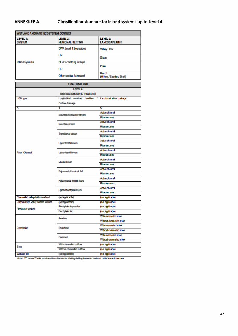
42
ANNEXURE A Classification structure for inland systems up to Level 4

43
ANNEXURE B Wetland and soil classification field datasheet example
Sampling Sheet Summary
Wetland Sdangeni
Area (ha) <5
Indicator Soil and vegetation
Connectivity (level 1) Inland
Eco region (level 2) South Eastern Uplands
Landscape setting (level 3) Riparian system
HGM Type (level 4A) Endhoreic
Longitudinal zonation (level 4B) With channel
Hydrological regime Frequent Inundation
Soil characteristics Hue – Gley 2 to 5YR
Value – 4
Chroma – 2
(Dark Reddish Gray)
Depth sampled: 0-0.5m
Comment No change in soil characteristics
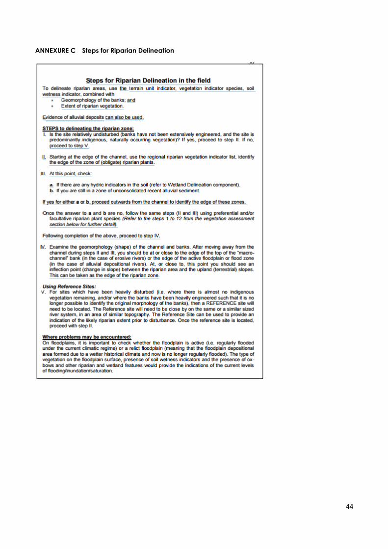
44
ANNEXURE C Steps for Riparian Delineation

45
ANNEXURE D MiniSASS Assessment Score Sheet
46
ANNEXURE E Wetland vegetation mix
Related Documents