Water Use at Palmetto Point and Middle Island, Saba, Dutch Caribbean: A Modeled Approach for Settlement Viability Ryan Espersen Published online: 13 August 2013 # Springer Science+Business Media New York 2013 Abstract The neighboring abandoned villages of Palmetto Point and Middle Island, on the northwest of Saba, Dutch Caribbean, relied upon rainwater caught in cisterns as their primary source of potable water. The island of Saba is located in the northern Lesser Antilles, and thus is subject to a rainy and dry season in the course of a year. Using measurements of the village cisterns and their respective catchments combined with variations in monthly rainfall data over the course of a year, a study of water replenish- ment versus water consumption is possible for Palmetto Point and Middle Island. As a result, fluctuations in population in villages with measurable, finite supplies of potable water allow a researcher to determine the viability of the villages at particular points in time, and the resultant effects on internal economies and social dynamics during these periods. Keywords Household archaeology . Water consumption . Internal exchange systems . Subsistence strategies . Colonial caribbean archaeology Introduction Across the Caribbean, small islands are often lacking in naturally occurring sources of fresh water. While some archaeological studies among pre-Colombian populations in the Americas have highlighted water access as the primary factor influencing the short and long term viability of any settlement (Drewett 2007; Johnson 2009; Scarborough 1998), it has been largely overlooked in colonial-era archaeological research; the procurement and consumption of water plays a central role in the daily activity cycle on individual and community levels. A settlement’ s viability is then inherently delimited by its ability to procure sufficient amounts of potable water. Insufficient supplies of potable over extended periods of time can serve as the mitigating cause for abandoning even well-developed settlement areas. Among those settlement areas in the Caribbean Int J Histor Archaeol (2013) 17:806–827 DOI 10.1007/s10761-013-0243-0 R. Espersen (*) Faculty of Archaeology, Leiden University, P.O. Box 9515, 2300 RA Leiden, The Netherlands e-mail: [email protected]

Welcome message from author
This document is posted to help you gain knowledge. Please leave a comment to let me know what you think about it! Share it to your friends and learn new things together.
Transcript

Water Use at Palmetto Point and Middle Island, Saba,Dutch Caribbean: A Modeled Approachfor Settlement Viability
Ryan Espersen
Published online: 13 August 2013# Springer Science+Business Media New York 2013
Abstract The neighboring abandoned villages of Palmetto Point and Middle Island, onthe northwest of Saba, Dutch Caribbean, relied upon rainwater caught in cisterns as theirprimary source of potable water. The island of Saba is located in the northern LesserAntilles, and thus is subject to a rainy and dry season in the course of a year. Usingmeasurements of the village cisterns and their respective catchments combined withvariations in monthly rainfall data over the course of a year, a study of water replenish-ment versus water consumption is possible for Palmetto Point and Middle Island. As aresult, fluctuations in population in villages with measurable, finite supplies of potablewater allow a researcher to determine the viability of the villages at particular points intime, and the resultant effects on internal economies and social dynamics during theseperiods.
Keywords Household archaeology .Water consumption . Internal exchange systems .
Subsistence strategies . Colonial caribbean archaeology
Introduction
Across the Caribbean, small islands are often lacking in naturally occurring sources offresh water. While some archaeological studies among pre-Colombian populations inthe Americas have highlighted water access as the primary factor influencing the shortand long term viability of any settlement (Drewett 2007; Johnson 2009; Scarborough1998), it has been largely overlooked in colonial-era archaeological research; theprocurement and consumption of water plays a central role in the daily activity cycleon individual and community levels. A settlement’s viability is then inherently delimitedby its ability to procure sufficient amounts of potable water. Insufficient supplies ofpotable over extended periods of time can serve as the mitigating cause for abandoningeven well-developed settlement areas. Among those settlement areas in the Caribbean
Int J Histor Archaeol (2013) 17:806–827DOI 10.1007/s10761-013-0243-0
R. Espersen (*)Faculty of Archaeology, Leiden University, P.O. Box 9515, 2300 RA Leiden, The Netherlandse-mail: [email protected]
where insufficient water is available from rivers, springs, or wells, cisterns were oftenconstructed to collect rainfall to serve as a source of water during the colonial era, andthis practice continues into the present. Cisterns store a finite, measurable amount ofwater with only one or two means of replenishment, and preserve well in the archaeo-logical record. The potential for cisterns as an avenue of research in archaeology will bedemonstrated through an analysis of water availability versus water consumption at twoneighboring abandoned colonial-era villages, Palmetto Point (presently known asMary’s Point among residents) and Middle Island, located in Saba, Dutch Caribbean.Using measurements of the village cisterns and their respective catchments (Haviser1985), combined with variations in monthly rainfall data over the course of a year, astudy of water replenishment versus water consumption is possible for Palmetto Pointand Middle Island. As a result, fluctuations in population in villages with measurable,finite supplies of potable water allow a researcher to determine the viability of thevillages at particular points in time, and the resultant effects on internal economies andsocial dynamics during these periods.
Saba
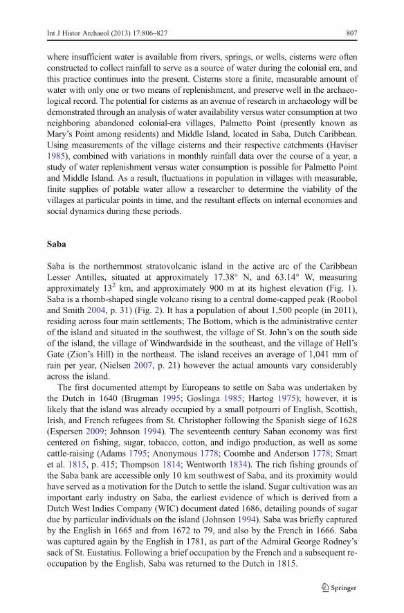
Saba is the northernmost stratovolcanic island in the active arc of the CaribbeanLesser Antilles, situated at approximately 17.38° N, and 63.14° W, measuringapproximately 132 km, and approximately 900 m at its highest elevation (Fig. 1).Saba is a rhomb-shaped single volcano rising to a central dome-capped peak (Rooboland Smith 2004, p. 31) (Fig. 2). It has a population of about 1,500 people (in 2011),residing across four main settlements; The Bottom, which is the administrative centerof the island and situated in the southwest, the village of St. John’s on the south sideof the island, the village of Windwardside in the southeast, and the village of Hell’sGate (Zion’s Hill) in the northeast. The island receives an average of 1,041 mm ofrain per year, (Nielsen 2007, p. 21) however the actual amounts vary considerablyacross the island.
The first documented attempt by Europeans to settle on Saba was undertaken bythe Dutch in 1640 (Brugman 1995; Goslinga 1985; Hartog 1975); however, it islikely that the island was already occupied by a small potpourri of English, Scottish,Irish, and French refugees from St. Christopher following the Spanish siege of 1628(Espersen 2009; Johnson 1994). The seventeenth century Saban economy was firstcentered on fishing, sugar, tobacco, cotton, and indigo production, as well as somecattle-raising (Adams 1795; Anonymous 1778; Coombe and Anderson 1778; Smartet al. 1815, p. 415; Thompson 1814; Wentworth 1834). The rich fishing grounds ofthe Saba bank are accessible only 10 km southwest of Saba, and its proximity wouldhave served as a motivation for the Dutch to settle the island. Sugar cultivation was animportant early industry on Saba, the earliest evidence of which is derived from aDutch West Indies Company (WIC) document dated 1686, detailing pounds of sugardue by particular individuals on the island (Johnson 1994). Saba was briefly capturedby the English in 1665 and from 1672 to 79, and also by the French in 1666. Sabawas captured again by the English in 1781, as part of the Admiral George Rodney’ssack of St. Eustatius. Following a brief occupation by the French and a subsequent re-occupation by the English, Saba was returned to the Dutch in 1815.
Int J Histor Archaeol (2013) 17:806–827 807

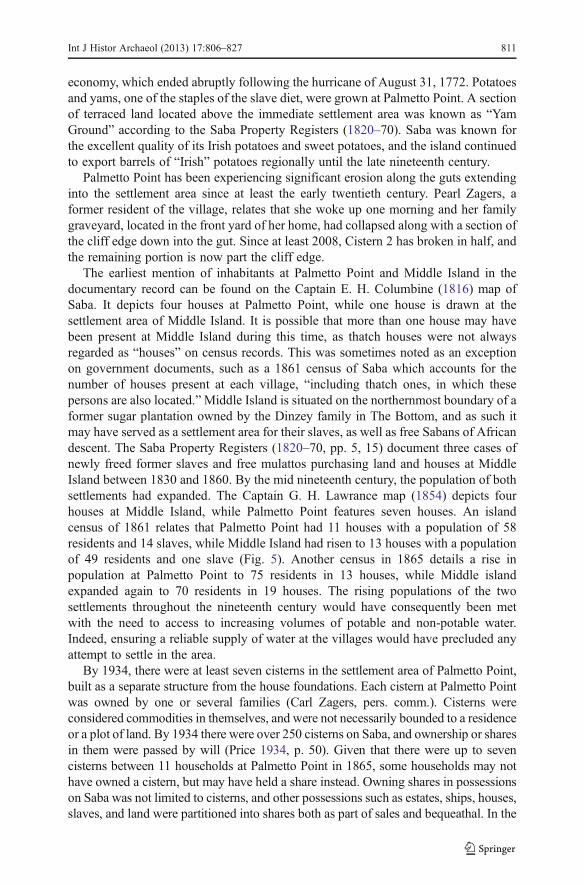
The eighteenth century in Saba saw political stability and steady economic growthin the agricultural sector along with a population boom. Between 1705 and 1780, thepopulation of both enslaved Africans and those of European-descent Sabans rosefrom 577 to 1,301 (Johnson 1994, p. 134) (Fig. 3). This coincided with the period ofeconomic growth on Saba spurred by a regional export economy centered on saltedfish, coffee, cotton, indigo, sugar, sweet potatoes, and other vegetables. With flat,arable land already at a premium on the island, as more land came under the plough,an increasing shortage of land would have resulted which would have pushed theburgeoning population to settle along the undeveloped north slopes of Saba. Thenorthwest slope of Mary Point Mountain, leading down to Torrens Point, was one ofthe few areas on the north face of Saba that could be effectively terraced to permitsettlement and agriculture. The settlement area at Palmetto Point is situated neatlyover a tract of soil noted by Veenenbos (1955) as “suitable for cultivation with majorlimitations,” which is of better quality than the majority of soils on the island (Fig. 4).
Palmetto Point was first settled for the purpose of agriculture to export surplusproduce to the booming slave markets of St. Eustatius (Espersen 2009). Archaeolog-ical excavations at the site revealed extensive erosion likely resulting from theinitiation of intensive agriculture around Palmetto Point associated with mid to late
Fig. 1 The location of Saba
808 Int J Histor Archaeol (2013) 17:806–827
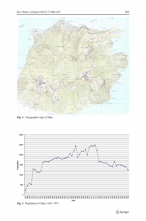
Fig. 2 Topographic map of Saba
Fig. 3 Population of Saba, 1665–1937
Int J Histor Archaeol (2013) 17:806–827 809

eighteenth-century wares. This period coincides with the period of agricultural andpopulation expansion across Saba, and also occurred during the aforementionedgolden era of St. Eustatius as an international trading hub. Slave auctions formedan important element of the St. Eustatius economy during that period, and slaves intransit through the island would have required staple foods readily available fromSaba, namely yams, potatoes, vegetables, and salt fish. The period of first settlementat Palmetto Point also occurs around the apex of Saba’s successful regional export
Fig. 4 Outlines of approximate settlement areas of Middle Island (1) and Palmetto Point (2)
810 Int J Histor Archaeol (2013) 17:806–827
economy, which ended abruptly following the hurricane of August 31, 1772. Potatoesand yams, one of the staples of the slave diet, were grown at Palmetto Point. A sectionof terraced land located above the immediate settlement area was known as “YamGround” according to the Saba Property Registers (1820–70). Saba was known forthe excellent quality of its Irish potatoes and sweet potatoes, and the island continuedto export barrels of “Irish” potatoes regionally until the late nineteenth century.
Palmetto Point has been experiencing significant erosion along the guts extendinginto the settlement area since at least the early twentieth century. Pearl Zagers, aformer resident of the village, relates that she woke up one morning and her familygraveyard, located in the front yard of her home, had collapsed along with a section ofthe cliff edge down into the gut. Since at least 2008, Cistern 2 has broken in half, andthe remaining portion is now part the cliff edge.
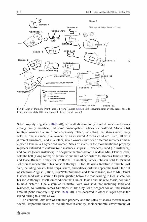
The earliest mention of inhabitants at Palmetto Point and Middle Island in thedocumentary record can be found on the Captain E. H. Columbine (1816) map ofSaba. It depicts four houses at Palmetto Point, while one house is drawn at thesettlement area of Middle Island. It is possible that more than one house may havebeen present at Middle Island during this time, as thatch houses were not alwaysregarded as “houses” on census records. This was sometimes noted as an exceptionon government documents, such as a 1861 census of Saba which accounts for thenumber of houses present at each village, “including thatch ones, in which thesepersons are also located.”Middle Island is situated on the northernmost boundary of aformer sugar plantation owned by the Dinzey family in The Bottom, and as such itmay have served as a settlement area for their slaves, as well as free Sabans of Africandescent. The Saba Property Registers (1820–70, pp. 5, 15) document three cases ofnewly freed former slaves and free mulattos purchasing land and houses at MiddleIsland between 1830 and 1860. By the mid nineteenth century, the population of bothsettlements had expanded. The Captain G. H. Lawrance map (1854) depicts fourhouses at Middle Island, while Palmetto Point features seven houses. An islandcensus of 1861 relates that Palmetto Point had 11 houses with a population of 58residents and 14 slaves, while Middle Island had risen to 13 houses with a populationof 49 residents and one slave (Fig. 5). Another census in 1865 details a rise inpopulation at Palmetto Point to 75 residents in 13 houses, while Middle islandexpanded again to 70 residents in 19 houses. The rising populations of the twosettlements throughout the nineteenth century would have consequently been metwith the need to access to increasing volumes of potable and non-potable water.Indeed, ensuring a reliable supply of water at the villages would have precluded anyattempt to settle in the area.
By 1934, there were at least seven cisterns in the settlement area of Palmetto Point,built as a separate structure from the house foundations. Each cistern at Palmetto Pointwas owned by one or several families (Carl Zagers, pers. comm.). Cisterns wereconsidered commodities in themselves, and were not necessarily bounded to a residenceor a plot of land. By 1934 there were over 250 cisterns on Saba, and ownership or sharesin them were passed by will (Price 1934, p. 50). Given that there were up to sevencisterns between 11 households at Palmetto Point in 1865, some households may nothave owned a cistern, but may have held a share instead. Owning shares in possessionson Saba was not limited to cisterns, and other possessions such as estates, ships, houses,slaves, and land were partitioned into shares both as part of sales and bequeathal. In the
Int J Histor Archaeol (2013) 17:806–827 811
Saba Property Registers (1820–70), bequeathals commonly divided houses and slavesamong family members, but some emancipation notices for enslaved Africans listmultiple owners that were not necessarily related, indicating that shares were likelysold. In one instance, five owners of an enslaved African child are listed, all withdifferent surnames), and in another, seven owners with four different surnames eman-cipated Ophelia, a 41-year old woman. Sales of shares in the aforementioned propertyregisters extended to cisterns (one instance), ships (10 instances), land (15 instances),and houses (seven instances). In one particular transaction, a widow, Mrs. Elenor Beaks,sold the hall (living room) of her house and half of her cistern to Thomas James Kelleyand Isaac Richard Kelley for 59 florins. In another, James Johnson sold to RichardJohnson Jr. nine tenths of his house at Booby Hill for 10 florins. Relative to other bills ofsale, including houses, land, ships, slaves, and estates, cisterns appear the least. One billof sale from August 1, 1867, lists “Peter Simmons and John Johnson, sold to Mr. DanielHassell, land with cistern in English Quarter, below the road leading to Hell’s Gate, forhis son Anthony Hassell, on condition that Daniel Hassell and his wife Maria, continueto hold cistern.” One cistern at Palmetto Point was sold, not including land andresidence, to William James Simmons in 1845 by John Zeagors for an undisclosedamount (Saba Property Registers 1820–70). This occurred in other villages across theisland during this time as well.
The continual division of valuable property and the sales of shares therein revealseveral important facets of the nineteenth-century socioeconomic environment of
Fig. 5 Map of Palmetto Point (adapted from Haviser 1985, p. 26). Elevation rises evenly across the sitefrom approximately 180 m at House 11 to 210 m at House 6
812 Int J Histor Archaeol (2013) 17:806–827
Saba. Specie was scarce on Saba from the late eighteenth century up to the twentiethcentury, and as a result multiple currencies were in use of the island. Excavations at atrash pit at Palmetto Point uncovered a 2-sous coin from the French Cayenne Colonydated 1789, a 10-cent coin from the Danish West Indies dated 1862, three coins fromthe Netherlands date between 1880 and 89 whose denominations were unintelligible,and an 1-cent coin from the U.S.A. dated between 1850 and 59 (Espersen 2009).According to the aforementioned property registers, Spanish dollars and Netherlandsflorins were most commonly used in transactions. However, the use of multiplecurrencies was so widespread that by the late nineteenth century, the police posteddaily exchange rates. The lack of specie would have encouraged the balkanization ofownership of high-value goods, such as slaves, ships, and cisterns, to provide analternative medium for payment or exchange.
From the early nineteenth century to the twentieth century, many Saban men leftthe island to seek work abroad, most commonly aboard ships as deckhands, pilots,and captains, as there was little opportunity on Saba to earn money on an island basedlargely upon subsistence agriculture with small-scale regional exports of produce(Crane 1971). This created an island economy based upon remittances through wagelabor and a growing reliance upon imported goods. In a social environment of anexpanding population within a small geographical area coupled with few opportuni-ties to earn money on the island itself, the sale and exchange of shares in valuableassets served as a means for one to profit from his or her possessions withoutrelinquishing total control and ownership. In a similar vein to houses, with regardsto cisterns, one would only totally relinquish total ownership or all shares in such ifthere was an alternative means to procure water. Doing so would leave the individualwithout a viable, long-term means of procuring and storing large volumes of waterwithout having to continually exchange money, favors, or labor.
Each cistern at Palmetto Point and Middle Island possessed a cement catchmentfor collecting rain water, and they would have served as the primary potable watersource for the inhabitants. Six were noted by Haviser (1985) at Palmetto Point, butanother cistern was found during an archaeological survey in 2008 buried under treeroots and eroded soil just a few meters south of Cistern 2 (Espersen 2009). Thecisterns are all domed with centered-square top openings, except for Cistern 2, whichhad an off-centered square top opening, and Cistern 6, whose top had collapsed intothe basin (Haviser 1985, p. 25). Each cistern had rectangular catchments extendingupslope of the cistern, except for Cistern 5, which is located in close proximity toHouse 9 and may have been replenished by the house gutters. Cistern 2 was unique inhaving a catchment that was more triangular. All the cisterns at Palmetto Point haveunderground storage basins, except for Cistern 1 which has a basin halfway under-ground and halfway above. Most cisterns on Saba and St. Eustatius have undergroundbasins, while those on Dutch St. Maarten are mostly above ground (Keur and Keur1960, p. 15). Although the cisterns at Palmetto Point were constructed to collect watervia cement catchments, they may have been supplemented by rainfall collected in jarsor barrels from roof gutters. The rooftops of houses serve as significantly largercatchments than the cement catchments constructed alongside cisterns, which resultsin faster replenishment rates of water, which in turn permits higher consumption ratesof water per person per day. Due to the long distances of houses relative to cisterns,rainwater collected from roof gutters could instead have been collected with a small
Int J Histor Archaeol (2013) 17:806–827 813

collection of barrels. Given their small volumes relative to cisterns, the water barrelswould have been given preference over cisterns as the primary source for potablewater, as the replenishment rate is higher for rainwater collected via roof gutters, andthe water collected in barrels would have probably have had a higher chance ofspoiling if kept stored for extended periods.
A freshwater well at Wells Bay served as a supplemental supply of water, althoughthe quality of water is variable and dependent on the weather. James Blunt (1867, p.539), author of The American Coast Pilot describes the water from this well as “notgood… the inhabitants chiefly depending on rain-water, caught in tanks.” PearlZagers, a former resident of Palmetto Point, was not fond of the well either: “Theyhad a well, the well that I’m telling you about, they used to get water from there.When it hold a drought it’s a long time, you could get spring water from there. Whenit would be calm it wouldn’t be so bad to drink; but when it was rough, oh, it wasterrible! In this place was a hard life first” (Crane 1971, p. 306). Wells were also usedelsewhere on Saba. Residents of Windwardside and Hell’s Gate were known to walkdown treacherous mountain slopes to obtain fresh water from the well at Spring Bayand then ascend again with tubs of water carried upon their heads (Johnson 1994).Pearl Zagers (pers. comm.) also relates that at times she and others would travel toMiddle Island to obtain water during periods of drought. This indicates that MiddleIsland may have had a more reliable supply of water than Palmetto Point between1920 and 1934. Access to water at Middle Island would not have been a reliableoption to the early inhabitants of Palmetto Point before 1816, but may have beenviable leading up to 1861. Haviser’s (1985) survey identified five cisterns at MiddleIsland, domed with center-square top openings and catchments. [Edit note: this wasoriginally based upon Haviser’s field notes… the actual publication does mentionfive cisterns, thus I have accounted for the change]. The catchment of the fifth cisterncould not be accurately measured, thus the average area from the rest of the cisterncatchments at Middle Island was employed for this cistern in the model. Residents ofMiddle Island were ideally situated in that they could collect fresh water from WellsBay, and were close enough to The Bottom and Cow Pasture that they could obtainfresh water from cisterns in those locations (Haviser, pers. comm.). As such they maynot have had to rely on their own cisterns as a primary source of potable water to theextent of those at Palmetto Point.
Will Johnson (1994, pers. comm.) relates that the well at Wells Bay was built byPeter “Coonks” Simmons, the husband of Mary Zagers, the woman from the latenineteenth century to whom Mary’s Point owes its namesake. As the well wasmentioned by Blunt in his 1867 edition of the “American Coast Pilot,” it wasprobably constructed by Simmons between the population rise following 1850 toBlunt’s observations in 1867. Pearl Zagers and Carl Zagers also noted the scarcity andpoor quality of the water at the site, even that boiled water from the village’s cisternswould at times turn red (Crane 1971, p. 26; Carl Zagers, pers. comm). In the absenceof a well or the potential to access to water at Middle Island, the availability of waterat Palmetto Point was likely sufficient prior to 1850. The scarcity of water probablyresulted from a population rise between 1850 and 1865, with the expansion from fivehouses to eleven (Espersen 2009, p. 74). Cisterns were not being constructed witheffective water catchments and/or in sufficient numbers to keep pace with theincreasing demand for water resulting from the burgeoning slave and slaveholding
814 Int J Histor Archaeol (2013) 17:806–827
population, which is indicative of rising levels of poverty among residents ofPalmetto Point during this period. The well constructed at Wells Bay was then anindicator of the scarcity of water available at Palmetto Point by the 1870s. Indeed, theacquisition of water was a problem that pervaded settlement strategies across Saba.Johnson (1994) relates that few people on Saba could afford to build a cistern. Stresson the water supply combined with decreasing incomes had an effect on the health ofresidents by extension. By the early twentieth century, allegations began reaching theDutch government of inbreeding and poor personal hygiene (Price 1934), schizo-phrenia (Brugman 1995; Crane 1971; Haviser 1985; Van Kol 1904), and difficultliving conditions at Palmetto Point. The scarcity and poor quality of water wasdescribed by Pearl Zagers as one of the mitigating factors resulting in the Dutchgovernment’s decision to evacuate the village in 1934. Middle Island was abandonedby the early to mid twentieth century, based upon surface collections at the site byHaviser (1985) and my ongoing excavations at the site.
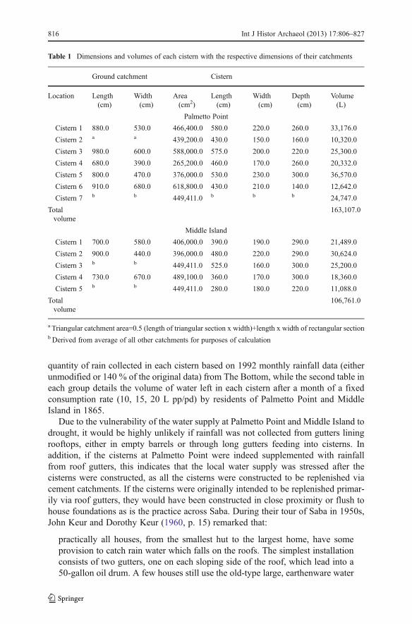
While the documentary record provides a qualitative account of water availabilitythroughout Palmetto Point’s settlement period, the fluctuation of the water supplythrough time relative to fluctuations in population can be quantified by waterconsumption versus replenishment rates through monthly rainfall for each cistern.Table 1 shows the dimensions and volumes of each cistern located at each village,along with the respective dimensions of their catchments. Between 1919 and 1934,The Bottom (elevation 242 m) averaged an annual rainfall total of 1,047 mm, St. John(elevation 363 m) received an average of 1,060 mm, and Windwardwide (elevation424 m, exposed to trade winds) averaged 1,126 mm (Price 1934, p. 11). Price did notobtain any data from other settlements, and historical monthly rainfall data from TheBottom, Palmetto Point, or Middle Island was not available. Palmetto Point, however,has an elevation of 180 m, close to the elevation of The Bottom, and both are situatedon the leeward side of the trade winds. The earliest monthly rainfall data that could beobtained was from 1992. Given that Palmetto Point occupies the approximateelevation and leeward position on the island as The Bottom, the monthly rainfalldata for 1992 from The Bottom (878.8 mm over the course of the year) was employedfor Palmetto Point. The same monthly rainfall data increased by 140 % (1229.5 mm)was also included to illustrate water consumption rates during years of rainfall higherthan the average recorded for The Bottom. Next, monthly water consumption rates of10, 15, and 20 L per person, per day (pp/pd) at Palmetto Point and Middle Island in1865 (population 75 and 70 respectively) was divided evenly between each cistern inthe respective villages, and subtracted from the volume of water replenished in thecisterns through monthly rainfall. When the water consumed per month exceeded thequantity of water available at each cistern in the respective villages, the negativevalue was expressed as a deficit. This indicates the volume of water that would haveto be sought elsewhere by the shareholders of the respective cistern to maintain theassumed consumption rate pp/pd, whether within the internal exchange system of therespective village, from the freshwater well at Wells Bay if potable at the time, orfrom other sources. These projections assume that the same number of cisternslocated at each village from archaeological surveys were also present in 1865. As aresult, projections of monthly water availability at Palmetto Point and Middle Islandare visible for this time. The base data set is displayed in Table 1. The tables used forcalculations, which are not published along with this manuscript, display the total
Int J Histor Archaeol (2013) 17:806–827 815
quantity of rain collected in each cistern based on 1992 monthly rainfall data (eitherunmodified or 140 % of the original data) from The Bottom, while the second table ineach group details the volume of water left in each cistern after a month of a fixedconsumption rate (10, 15, 20 L pp/pd) by residents of Palmetto Point and MiddleIsland in 1865.
Due to the vulnerability of the water supply at Palmetto Point and Middle Island todrought, it would be highly unlikely if rainfall was not collected from gutters liningrooftops, either in empty barrels or through long gutters feeding into cisterns. Inaddition, if the cisterns at Palmetto Point were indeed supplemented with rainfallfrom roof gutters, this indicates that the local water supply was stressed after thecisterns were constructed, as all the cisterns were constructed to be replenished viacement catchments. If the cisterns were originally intended to be replenished primar-ily via roof gutters, they would have been constructed in close proximity or flush tohouse foundations as is the practice across Saba. During their tour of Saba in 1950s,John Keur and Dorothy Keur (1960, p. 15) remarked that:
practically all houses, from the smallest hut to the largest home, have someprovision to catch rain water which falls on the roofs. The simplest installationconsists of two gutters, one on each sloping side of the roof, which lead into a50-gallon oil drum. A few houses still use the old-type large, earthenware water
Table 1 Dimensions and volumes of each cistern with the respective dimensions of their catchments
Ground catchment Cistern
Location Length(cm)
Width(cm)
Area(cm2)
Length(cm)
Width(cm)
Depth(cm)
Volume(L)
Palmetto Point
Cistern 1 880.0 530.0 466,400.0 580.0 220.0 260.0 33,176.0
Cistern 2 a a 439,200.0 430.0 150.0 160.0 10,320.0
Cistern 3 980.0 600.0 588,000.0 575.0 200.0 220.0 25,300.0
Cistern 4 680.0 390.0 265,200.0 460.0 170.0 260.0 20,332.0
Cistern 5 800.0 470.0 376,000.0 530.0 230.0 300.0 36,570.0
Cistern 6 910.0 680.0 618,800.0 430.0 210.0 140.0 12,642.0
Cistern 7 b b 449,411.0 b b b 24,747.0
Totalvolume
163,107.0
Middle Island
Cistern 1 700.0 580.0 406,000.0 390.0 190.0 290.0 21,489.0
Cistern 2 900.0 440.0 396,000.0 480.0 220.0 290.0 30,624.0
Cistern 3 b b 449,411.0 525.0 160.0 300.0 25,200.0
Cistern 4 730.0 670.0 489,100.0 360.0 170.0 300.0 18,360.0
Cistern 5 b b 449,411.0 280.0 180.0 220.0 11,088.0
Totalvolume
106,761.0
a Triangular catchment area=0.5 (length of triangular section x width)+length x width of rectangular sectionb Derived from average of all other catchments for purposes of calculation
816 Int J Histor Archaeol (2013) 17:806–827
jars to catch and hold water. The larger homes have gutters which lead the waterinto cement and rock cisterns, some of which are 15 feet long, eight wide andsix high and hold several thousand gallons.
With the exception of Cisterns 3 and 5, the cisterns at Palmetto Point were locatedtwenty meters or more from the nearest house, also at significantly higher and lowerelevations to the other. This afterthought in house and cistern construction suggeststhat the village water supply in the early to mid nineteenth century was adequatewithout the need for rooftops to supplement as cistern catchments, and that popula-tion growth did not keep pace with an increasing supply of potable water via cisternsto support it.
In order to determine the maximum sustainable consumption rate of water pp/pdfor each household from water collected in rain barrels via roof catchments, based onavailable monthly rainfall data, a similar model was employed. It was assumed thateach household would possess barrels totaling 600 L in volume for the purpose ofrainwater storage from roof catchments. It was also assumed that the monthlyprecipitation accumulated gradually over the month, rather than a single rainfallevent. If the total average weekly rainfall per month was over 600 L, the modelconsidered that the excess water was lost to spillage. While a gradual accumulation ofprecipitation over the month is most likely during the dry season, torrential rainfallfrom tropical storms and hurricanes would have accounted for the majority of rainfallduring the rainy season (May to November), resulting in lower real potential con-sumption rates pp/pd during this period given the spillage that would have occurredonce the storage barrels had reached their capacity.
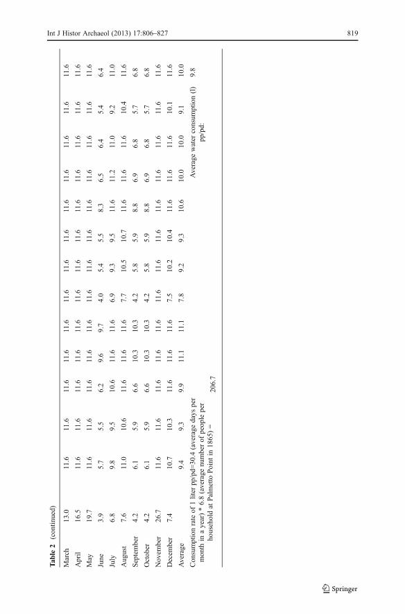
To determine the volume (in L) of rainwater each roof catchment was capable ofharvesting per month, the length (in cm) and width (in cm) of the roof was multipliedby the monthly precipitation (in cm) and divided by 1,000. Given that all the housesat Palmetto Point were dismantled and rebuilt elsewhere on the island, the roof areaswere calculated using the respective house dimensions (Espersen 2009, p. 70) with a30° pitch. To determine the maximum sustainable consumption rate of water pp/pdfor each household, a base consumption rate of one L pp/pd per household was found.This was obtained by dividing the population of Palmetto Point in 1865 (75 residents)by the number of houses present during the same year (11), to get an average result of6.8 people per household. This was then multiplied by the average number of daysper month in a year (365/12=30.4) in order to obtain the average volume of waterconsumed in month, per household, at a rate of 1 L pp/pd (Table 2).
Determining the volume of water capable of being harvested with roof catchmentsat Middle Island is problematic, as not all the respective foundations of the housesmentioned in the 1865 census were located. There have only been two stone andmortar house foundations, along with one stacked-stone house foundation identifiedat Middle Island. A fourth house featured a slab stone floor, but with no discerniblefoundation. To account for the remaining 15 houses as noted in the 1865 census, themajority would have been constructed without foundations upon small tracts of flatland created by terracing throughout the site. Given the small size of these 15 houses,coupled with the general poverty of free and enslaved Africans inhabiting thesettlement, it is likely that most of the houses had thatched roofs, which would notbe as effective as a cedar-shingled roof with regards to serving as a catchment given
Int J Histor Archaeol (2013) 17:806–827 817

Tab
le2
Totalpossible
rain
collectionfrom
roofsof
Palmetto
Point
(140
%of
annual
rainfallaverage)
Palmetto
Point
Hou
se1
Hou
se2
Hou
se3
Hou
se4
Hou
se5
Hou
se6
Hou
se7
Hou
se8
Hou
se9
Hou
se10
Hou
se11
Hou
se12
Hou
se13
Rooflength
(cm)
808
762
772
934
958
600
750
726
922
854
888
808.00
818
Roo
fwidth
(cm)
370
380
420
540
530
350
380
400
470
400
380
350.00
410
Roofarea
(cm2)
298960
289560
324240
504360
507740
2100
0028
5000
2904
0043
3334
1600
337440
282800
.00
335380
Rainfall(cm)
PotentialMaxim
umRain(liters)Collected
viaRoofCatchments(Palmetto
Point)
January
9.9
2986.6
2892.7
3239.1
5038.5
5072.3
2097
.928
47.1
2901
.143
29.1
3412
.533
71.0
2825.1
3350.4
February
2.7
819.1
793.3
888.4
1381.9
1391.2
575.4
780.9
795.7
1187
.393
5.9
924.5
774.8
918.9
March
13.0
3886.4
3764.2
4215.1
6556.6
6600.6
2730
.037
05.0
3775
.256
33.4
4440
.843
86.7
3676.4
4359.9
April
16.5
4923.8
4769.0
5340.2
8306.8
8362.4
3458
.746
93.9
4782
.871
37.1
5626
.155
57.6
4657.7
5523.7
May
19.7
5895.4
5710.1
6394.0
9945.9
10012.6
4141
.256
20.2
5726
.685
45.4
6736
.366
54.3
5576.8
6613.6
June
3.9
1186
.81149
.512
87.2
2002.3
2015.7
833.7
1131
.41152
.817
20.3
1356
.113
39.6
1122
.713
31.4
July
6.8
2029.9
1966.1
2201.5
3424.6
3447.5
1425
.919
35.1
1971
.829
42.3
2319
.422
91.2
1920.2
2277.2
Aug
ust
7.6
2281.0
2209.3
2473.9
3848.2
3874.1
1602
.321
74.5
2215
.733
06.3
2606
.425
74.6
2157.7
2558.9
September
4.2
1261.6
1221.9
1368.2
2128.4
2142.6
886.2
1202.7
1225.4
1828.6
1441.5
1424.0
1193.4
1415.3
Octob
er4.2
1261.6
1221.9
1368.2
2128.4
2142.7
886.2
1202
.712
25.4
1828
.614
41.5
1424.0
1193
.414
15.3
Nov
ember
26.7
8006.1
7754.4
8683.1
13506.7
13597.3
5623
.876
32.3
7776
.91160
4.8
9148
.090
36.6
7573.3
8981.4
Decem
ber
7.4
2218.2
2148.5
2405.8
3742.3
3767.4
1558
.22114
.721
54.7
3215
.325
34.6
2503.8
2098.3
2488.5
Total
122.9
36757.1
35601.4
39865.3
62011.1
62426.6
2581
9.5
5040
.735
704.6
5327
9.1
4199
9.7
41488.2
Average
3063.1
2966.8
3322.1
5167.6
5202.2
2151
.629
20.1
2975
.444
39.9
3499
.934
57.3
Hou
se1
Hou
se2
Hou
se3
Hou
se4
Hou
se5
Hou
se6
Hou
se7
Hou
se8
Hou
se9
Hou
se10
Hou
se11
Hou
se12
Hou
se13
Rainfall(cm)
Decem
ber
0.0
0.0
0.0
0.0
0.0
0.0
0.0
0.0
0.0
0.0
0.0
0.0
0.0
January
9.99
11.6
11.6
11.6
11.6
11.6
10.1
11.6
11.6
11.6
11.6
11.6
11.6
11.6
February
2.7
3.9
3.8
4.3
6.6
6.7
2.7
3.7
3.8
5.7
4.5
4.4
3.7
4.4
818 Int J Histor Archaeol (2013) 17:806–827
Tab
le2
(con
tinued)
March
13.0
11.6
11.6
11.6
11.6
11.6
11.6
11.6
11.6
11.6
11.6
11.6
11.6
11.6
April
16.5
11.6
11.6
11.6
11.6
11.6
11.6
11.6
11.6
11.6
11.6
11.6
11.6
11.6
May
19.7
11.6
11.6
11.6
11.6
11.6
11.6
11.6
11.6
11.6
11.6
11.6
11.6
11.6
June
3.9
5.7
5.5
6.2
9.6
9.7
4.0
5.4
5.5
8.3
6.5
6.4
5.4
6.4
July
6.8
9.8
9.5
10.6
11.6
11.6
6.9
9.3
9.5
11.6
11.2
11.0
9.2
11.0
Aug
ust
7.6
11.0
10.6
11.6
11.6
11.6
7.7
10.5
10.7
11.6
11.6
11.6
10.4
11.6
September
4.2
6.1
5.9
6.6
10.3
10.3
4.2
5.8
5.9
8.8
6.9
6.8
5.7
6.8
Octob
er4.2
6.1
5.9
6.6
10.3
10.3
4.2
5.8
5.9
8.8
6.9
6.8
5.7
6.8
Nov
ember
26.7
11.6
11.6
11.6
11.6
11.6
11.6
11.6
11.6
11.6
11.6
11.6
11.6
11.6
Decem
ber
7.4
10.7
10.3
11.6
11.6
11.6
7.5
10.2
10.4
11.6
11.6
11.6
10.1
11.6
Average
9.4
9.3
9.9
11.1
11.1
7.8
9.2
9.3
10.6
10.0
10.0
9.1
10.0
Consumptionrateof
1liter
pp/pd=
30.4
(average
days
per
month
inayear)*6.8(average
numberof
people
per
householdat
Palmetto
Point
in1865)=
Average
water
consum
ption(l)
pp/pd:
9.8
206.7
Int J Histor Archaeol (2013) 17:806–827 819
that a certain proportion of the water would soak into the thatching. Excavations attwo trash pits at Middle Island have only turned up one machine cut nail; however, 40wrought nails, 14 cut nails, and 1 wire nail were recovered from six 1×1 meter unitswithin and around one of the stone and mortar foundation houses, suggesting in thiscase a “Saban style” house (Brugman 1995) with a cedar singled roof. By compar-ison, excavations across Palmetto Point by the author uncovered 368 wrought nails,37 cut nails, and 147 wire nails, the majority found in a trash pit (Espersen 2009). Thelack of nails recovered from Middle Island suggests an abundance of thatched roofhouses at Middle Island. As such, only house roof dimensions for Palmetto Pointwere employed in the roof catchment model. Based on the projected impacts on waterconsumption at Palmetto Point and Middle Island upon the monthly replenishmentrate of each cistern, it is evident that access to water was a pre-eminent problemfacing the residents by 1865 and afterward.
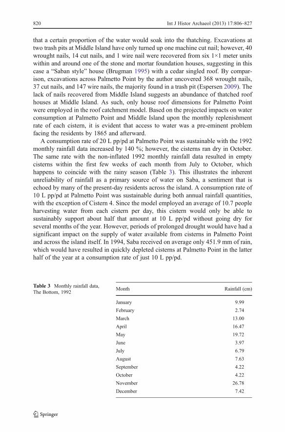
A consumption rate of 20 L pp/pd at Palmetto Point was sustainable with the 1992monthly rainfall data increased by 140 %; however, the cisterns ran dry in October.The same rate with the non-inflated 1992 monthly rainfall data resulted in emptycisterns within the first few weeks of each month from July to October, whichhappens to coincide with the rainy season (Table 3). This illustrates the inherentunreliability of rainfall as a primary source of water on Saba, a sentiment that isechoed by many of the present-day residents across the island. A consumption rate of10 L pp/pd at Palmetto Point was sustainable during both annual rainfall quantities,with the exception of Cistern 4. Since the model employed an average of 10.7 peopleharvesting water from each cistern per day, this cistern would only be able tosustainably support about half that amount at 10 L pp/pd without going dry forseveral months of the year. However, periods of prolonged drought would have had asignificant impact on the supply of water available from cisterns in Palmetto Pointand across the island itself. In 1994, Saba received on average only 451.9 mm of rain,which would have resulted in quickly depleted cisterns at Palmetto Point in the latterhalf of the year at a consumption rate of just 10 L pp/pd.
Table 3 Monthly rainfall data,The Bottom, 1992
Month Rainfall (cm)
January 9.99
February 2.74
March 13.00
April 16.47
May 19.72
June 3.97
July 6.79
August 7.63
September 4.22
October 4.22
November 26.78
December 7.42
820 Int J Histor Archaeol (2013) 17:806–827
In 1865, a consumption rate between 10 and 15 L pp/pd from cisterns at PalmettoPoint guarantees a surplus of water for the following year, which would serve asinsurance against future periods of decreased rainfall. Water harvested via roof catch-ments in the water barrel model resulted in a consumption rate pp/pd on average of8.38 L for the unmodified rainfall data, and 9.80 L with 140 % of the original rainfalldata. When combined with the consumption rates via cisterns alone at 15 L pp/pd, theconsumption rate for the unmodified rainfall data increases to 23.38 L pp/pd, and24.80 L pp/pd with 140 % of the original rainfall data. Residents of Palmetto PointandMiddle Island would have supplemented their daily consumption to some degree byfresh water from the well atWells Bay after 1850, depending on its salinity. It could haveserved as non-potable water when the ocean swells temporarily increased its salinity andas potable water during periods of low swells.
However, in context with global water consumption rates pp/pd, residents of Pal-metto Point would have been living in a perpetual state of ration. Awater consumptionrate of 10–15 L of water pp/pd is close to the lowest present-day global averages. In2006, the average consumption rate pp/pd in rural Uganda was 12–14 L, with the lowestcontemporary rate being among arid areas of western India and East Africa during theirdry seasons at 5 L pp/pd or less (UN Human Development Report 2006, p. 34). Evenwith the comparatively higher consumption rates in modern-day rural Uganda, basicsanitation is still uncommon due to poverty, low standards of hygiene, and a lack ofsanitation practices (UNESCO World Water Assessment Programme 2006, p. 512).Given the similar levels of water collection and consumption between the aforemen-tioned areas and Palmetto Point, some comparisons can be drawn in regard to hygiene.Low levels of water consumption coupled with unsanitary water sources leads toincreased incidences of waterborne diseases and diarrhea. Water quality tests conductedduring the mid twentieth century in Saba, St. Maarten, and St. Eustatius revealed thatwater in wells and cisterns was polluted to some degree; between 1939 and 1953 therewere 255 cases of dysentery and 31 cases of typhoid fever between Saba, St. Eustatius,and St. Maarten (Keur and Keur 1960, p. 149). It is unknown whether latrines werepresent at Palmetto Point during the nineteenth century, though by the twentieth centurywaste from chamber pots was simply thrown “into the bushes” or over the eroding cliffthat demarked the southern limits of the village (Pearl Zagers, pers. comm.). Animalpens, intended for goats, pigs, or a cow, were present in the village, though the extent towhich some animals may have ranged outside of the pens is unknown. Nonetheless,their waste would have washed downhill during periods of precipitation. The slope ofthe village site ranges from 0 to 30°, and this would have allowed for waste from upperelevations to be washed downhill onto catchments and into cisterns. Six of the sevencisterns at Palmetto Point had upslope cement catchments, which would be problematicin this regard. The use of upslope cement catchments in the midst of poor sanitationpractices across the village site predisposed residents of Palmetto Point to greaterchances of contracting water-borne illnesses. This would have been a contributing factortowards the village’s abandonment and eventual evacuation by 1934 due to unsanitaryconditions and the difficulty in obtaining medical attention (Keur and Keur 1960, p. 29;Pearl Zagers pers. comm.; Carl Zagers pers. comm.).
The availability of water at Middle Island, based upon the assumed water con-sumption rates pp/pd, was markedly less than was available from Palmetto Point withthe same variables. During each scenario, the cisterns at Middle Island were empty
Int J Histor Archaeol (2013) 17:806–827 821

after only 1 or 2 weeks of consumption during each month. The number of cisternspresent at Middle Island would have had to be doubled in order to maintain acomparable supply of water relative to Palmetto Point with the same rates of waterconsumption pp/pd. Effectively, with only five cisterns, Middle Island residentswould have had to suffice with only 5 L of water pp/pd in 1865 to maintainsustainable water quantities. This consumption level appears low, as the daily waterrequirement for a healthy human adult is approximately 2 L per day (Rosegrant et al.2002); extended periods of physical exertion will increase the daily requirement.Evidently, additional water was probably collected through other sources in a similarfashion to those described for Palmetto Point, and could have been imported in timesof need from Cow Pasture and The Bottom. Given the low quantity of water availablevia cisterns relative to the population, it is possible that there is a well within thevicinity of Middle Island that has yet to be discovered, or that has since beendestroyed. The stress created upon water supplies at Middle Island by population in1865 would have put pressure on residents to emigrate from the village. The fact thatby the early twentieth century residents at Palmetto Point were able to obtain water atMiddle Island during periods of drought suggests that its population dropped signif-icantly by this time.
The stress upon the water supplies at both Palmetto Point and Middle Island wouldhave served as a source of pressure to emigrate from these villages. During nineteenthcentury, the island economy relied increasingly remittances from wage labor abroad.It was commonplace that the men of Saba took to sea as whalers, captains, deck-hands, and later to Bermuda to seek labor for extended periods, often years, as thelocal economy had collapsed by the close of the eighteenth century. Palmetto Pointand Middle Island were no exception. The 1861 census notes 17 men and women,respectively, as inhabitants at Palmetto Point, while a census in 1865 accounts for 17men and 24 women, with a total population of 75. At Middle Island, the 1861 censusrecords 16 men and women respectively, while in 1865 this increased to 22 men and28 women, with a total population of 70. The absence of men at the villages isaccounted for in 1865; however, prolonged stress on the water supplies at PalmettoPoint and Middle Island would have served as additional pressure on adult maleresidents to seek work abroad.
The consumption rates of water and its availability would have had an impact uponfoodways and social dynamics at Palmetto Point. Aside from an average of about 2 Lof potable water pp/pd required for survival, there was a range of activities and otherelements that would have increased daily water consumption. Cooking, cleaning, andbathing would have required additional quantities of non-potable water. Livestockpresent at the site, such as cows and goats, would have increased consumption rates,although non-potable water could also have sufficed for their requirement. Theprocess of “corning” fish as described by Pearl Zagers would have increased thedaily average water consumption as well. Although specific quantities are not known,washing the fish required “three or four waters” after they were dried and salted(Crane 1971, p. 306). If salt fish constituted the primary protein resource for residentsof Palmetto Point, this process would have had a significant impact upon waterconsumption. The daily water requirement of approximately two L pp/pd would alsohave been supplemented from the consumption of locally available water-bearingproduce such potatoes, mangoes, oranges, and soursop.
822 Int J Histor Archaeol (2013) 17:806–827

The unreliable water supply at Palmetto Point and Middle Island would by extensionhave affected the social environment of the village.Water would have been consumed atthe village with an awareness of the present requirements while being mindful of thesupply in the future. These conditions at between the two villages would have beenconducive to the formation of water as a tool for leveraging within their internalexchange systems during periods of drought. The structure and social dynamics of theinternal exchange systems at Palmetto Point andMiddle Island are likely similar to thosedescribed by Keur and Keur (1960) across Saba and St. Maarten in the 1950s. From thenineteenth century to the foundation the 1970s, Saba experienced very little immigrationand tourism (Saba Catholic Marriage; Crane 1971; Will Johnson, pers. comm.), and theeconomy was reliant on remittances through wage labor abroad. As a result, the island’ssocial environment was conducive to strong cultural continuity throughout this time.Keur and Keur (1960, pp. 125–126) observed that:
Almost all shops bear the imprint of their owners’ personalities, and have at least asmall clientele of regular customers who exhibit a feeling of “belonging” and towhom credit is extended… There seems to be no logic to price-setting, beyondindividual whim. Prices often seem fairly independent of actual cost. If a shop-keeper thinks a hat “pretty,” she may charge accordingly, regardless of what shepaid for it. The same merchandise may be differently priced in different shops.Usually the variation is slight, but in one case, the same brand of soap sold fortwelve Antillean cents in one shop and eight in another… the attitude of living forthe present day, and taking no thought for the morrow, is prevalent and a strongcontributing factor to this type of buying…Customers generally do no comparisonshopping, but patronize mostly the store where they “belong,” making occasionalpurchases at one or two others nearby… Any attempt to stimulate the practicalapplication of this would go unheeded today among those of low economic status,since cash on hand is often very little, and there is no suitable or available storageplace to keep any food, much less perishables.
A lack of long-term planning among low-income Sabans regarding purchases isprevalent in the description by Keur and Keur. This mentality, though did not extendto the acquisition of water. As there are no naturally occurring sources of water onSaba that can be exploited on an island-wide subsistence level, obtaining waternecessitates long term planning. This is embodied in the use of cisterns to captureand store rainwater as the primary potable water source on the island.
In my interview with Pearl Zagers and her sister Gladys Hassell in 2008, theymentioned that they ate no canned food, and instead relied entirely upon subsistenceagriculture. Every family owned goats and chickens in stone-circle pens. Produce fromMary’s Point included “grey” corn, “irish” (white) potatoes, and yams, supplementedwith butter and cream made from goat’s milk, meat when livestock are available forbutchering, fresh and salted fish fromWell’s Bay, oranges, mangoes, bananas, “tannias”(taro root), tamarinds, and unspecified vegetables. Any small surpluses were sold in TheBottom, about a two hour walk from Mary’s Point, on Sundays following Churchservice. It is a common practice around Saba for residents to cultivate crops on somebodyelse’s land (Crane 1971, 1987; Johnson 1994; Keur and Keur 1960). In this case, thestandard agreement was that the owner of the land received 1/4 of the harvest, but in some
Int J Histor Archaeol (2013) 17:806–827 823

cases with potatoes this was decreased to 1/5, given their value on the island (Crane 1987).Reciprocal help, called “change work,” was used during planting and harvesting seasons,as paid labor was expensive and difficult to find (Keur and Keur 1960, p. 75). The sense of“belonging” to a store as described by Keur and Keur is probably a reflection andcontinuity of “change work,” by engaging in preferential trade in commodified itemswith those who are considered members of one’s internal exchange network.
On Saba, including Middle Island and Palmetto Point, access to water in cisterns wasgranted proportionate to the amount of shares owned. Shares were purchased, but thewater was not. There are no oral or documentary accounts which relate or suggest thatthe sale of water on Saba was normalized during the nineteenth to mid twentiethcenturies. It did, however, occur during periods of severe drought. Changes within theinternal exchange system would result when normally uncommmodified goods andservices become commodities. Such was witnessed on nearby St. Eustatius during anextended drought on the island during the mid nineteenth century by the Methodistevangelist Daniel P. Kidder (1849, pp. 20–22):
Those whose cisterns yet contained water, generously shared with their neigh-bors who were entirely out, until their own households were in danger of beingdestitute of this great blessing. Prayers were ordered in the public congregationson the Sabbath-day for rain. The drought continued and became alarming.Boats were dispatched to the neighboring islands with casks to obtain water.The water in wells because very low, and man and beast felt the awful effects ofthe drought. In the midst of this state of things, one person, desirous of turningthis visitation of Divine Providence to individual account, and having largecisterns as yet scarcely touched, hoarded up this precious gift of Heaven, andwould not give, or but rarely to a suffering neighbor. The object was toconstrain them to buy and a price was set upon a pail of water at once exorbitantand cruel. The people were driven to nearly the last extremity, and one day morewould have witnessed a strange sight among them.
While this example of social leveraging through water supply occurred in a largerpopulation center than Palmetto Point and Middle Island, it illustrates the potentialpower and influence available to a group or individual owning potable water duringperiods of drought in this environment. By 1912, drought was so severe on Saba thatisland residents actually did begin to sell rainwater. “If one excludes the top of the rock(Saba), covered andmoistened by passing clouds, one can say that Saba is going throughhard times. Fields, gardens, cisterns, everything is dry. Rainwater can be bought onlyexpensive” (Amigoe di Curaçao 1912, p. 2). It is important to note the distinctionbetween water and “rainwater”; the latter implying that it is derived from a cistern orother storage vessel using a catchment, rather than from a naturally occurring source. By1865 the residents of Palmetto Point and Middle Island would have been in a continualstate of water ration. Throughout the water consumption versus water replenishmenttables for Palmetto Point, Cistern 4 was always the first to run dry, followed by Cistern 2.As such, families who owned these cisterns would have found themselves in need ofseeking potable water elsewhere, while their neighbors would still have had a supply oftheir own. Attempting to explain how water distribution was mediated during periods of
824 Int J Histor Archaeol (2013) 17:806–827
drought at Palmetto Point is at this time a point of speculation. Given that there was apractice of communally sharing butchered livestock across the island, it is possible thatwater would have similarly been shared between families during times of need, to anextent. However, this situation served to foster a social environment where those familiesor individuals who owned the largest and fastest-replenishing cisterns at Palmetto Point,being Cisterns 3 and 6, would have been in a recurring position to leverage within thesocial environment of the village during periods of drought. The owners of cisterns stillcontaining water could have exchanged this commodity in return for favors, food, materialgoods, or money, as witnessed in 1912, resulting in the increasing commodification ofwater. With only four cisterns at Middle Island with a population of 70 in 1865, the ownerof any cistern would have found themselves in such a situation as well, regardless ofdrought. As previously mentioned by Pearl Zagers, during the early twentieth century,when there was nowater to be had in Palmetto Point, they would travel toMiddle Island inorder to obtain it. Middle Island was not normally a destination for trade by residents ofPalmetto Point; rather, The Bottom was their destination for selling agricultural produceand purchasing goods. In this sense, drought results in the expansion of Palmetto Point’sinternal exchange system to include other families or villages outside of their normal senseof “belonging,” as their own system is no longer able to provide for their needs. In thesevillages that had little in terms of liquid assets, accessing water through shareholding andtrade would have been a foundational aspect of their internal exchange systems.
The quantification of water availability, supplemented by oral and documentaryaccounts of water use and census records together provide foundational data for studiesinto the viability of settlements in areas where continuous access to potable water is notguaranteed. Based upon accounts from the documentary and oral history records, as wellas data garnered from site surveys at Palmetto Point andMiddle Island, reliable access towater became increasingly difficult as the two villages expanded between 1850 and1865, and continued thereafter. A consumption rate between 10 and 15 L pp/pd of waterfrom cisterns pp/pd was sustainable during years of average rainfall in Palmetto Point.This is similar to the consumption rates of present day Uganda, among the lowest in theworld. Water supplies at Palmetto Point were likely supplemented by water collectedfrom roof gutters, which could account for an additional 8.38–9.80 L of water pp/pdduring years of average and above average rainfall, based on the model which assumedan average of 600 L of storage in barrels. The unequal replenishment versus consump-tion rate among the cisterns at Palmetto Point would have created a social environmentwhere families or individuals owning cisterns with higher replenishment rates, such asCisterns 3 and 6, could have exercised social leveraging within the internal exchangesystem of the village, especially over those relying on cisterns with low replenishmentrates, such as Cistern 4. This manifested itself on St. Eustatius in the mid nineteenthcentury, on Saba in 1912 during a drought, where remaining supplies of fresh water werebeing sold at high prices, and during periods at Palmetto Point when cisterns ran dry andresidents sought water at Middle Island during the early twentieth century.
A water consumption rate of around 5 L pp/pd would be required to sustaincisterns at Middle Island by 1865 in the model, and if alternative methods of watercollection were not sufficient to meet demand, then the 70 residents in Middle Islandwould probably have represented an approximate population apex. Given the stress ofwater supplies at Middle Island in 1865, the ability of Palmetto Point residents toacquire water at Middle Island during the early twentieth century suggests that the
Int J Histor Archaeol (2013) 17:806–827 825
latter village had a more stable water supply, which would require a significant dropin population to sustain. It is apparent in both the documentary record and throughthis water consumption model that further population increases at both villages after1865 would further exacerbate the problem of water shortages, and as such bothvillages began to decline in population after this point, leading to their eventualabandonment.
The acquisition and consumption of water plays an integral part in everyday life atboth the individual and community level. Consumption rates are difficult to assess inpre-industrial areas with unbounded water supplies, such as a lake or river. However,in those areas where the main source of water is from precipitation, it becomespossible to construct a model to estimate daily water consumption per person. Ifdaily or monthly precipitation records are available to researchers of these environ-ments, the effects of drought and the subsequent effects on the social environment canbe studied at both village and household levels. This can provide insights into socialdynamics and village-level internal exchange systems by viewing water as a com-modity in times of drought, and can also indicate the viability of a household or entiresettlement by studying the quantity of water available relative to the population.Cisterns are artifacts in their own right and can provide valuable datasets that shouldnot be overlooked by archaeologists.
Acknowledgments I wish to thank R. Grant Gilmore III for proposing the idea of studying settlementviability at Palmetto Point through cistern and catchment dimensions, and Jay Haviser for his supportthroughout the research. Jay provided his field notes from Phase 1 of his archaeological survey of Saba(1985), which given the current condition of cisterns and house foundations at Palmetto Point and MiddleIsland, this research would not have been possible.
References
Adams, J. (1795). A View of Universal History, from the Creation to the Present Time, Vol. III, G. Kearsley,London.
Amigoe di Curaçao. (1912). Saba. July 20, p. 12.Anonymous (1778). The Present State of the West-Indies, Containing an Accurate Description of What
Parts are Possessed by the Several Powers of Europe, R. Baldwin, London.Blunt, E. M. (1867). The American Coast Pilot; Containing the Courses and Distances between the
Principal Harbours, Capes, and Headlands, on the Coast of North and South, E. and G. W. Blunt,New York.
Brugman, F. H. (1995). The Monuments of Saba: The Island of Saba, a Caribbean Example,Uitgeversmaatschappij Walburg Press, Zutphen.
Columbine, E. H. (1816). The Island of Saba, National Archives, Kew.Coombe, W., and Anderson, A. (1778). An Historical and Chronological Deduction of the Origin of
Commerce from the Earliest Accounts, Logographic Press, London.Crane, J. G. (1971). Educated to Emigrate the Social Organization of Saba, Van Gorcum & Comp. N.V.,
Assen.Crane, J. G. (1987). Saba Silhouettes: Life Stories from a Caribbean Island, Vantage, New York.Drewett, P. L. (2007). Above Sweet Waters: Cultural and Natural Change at Port St. Charles, Archetype
Press, St. Annes, pp. 49–54.Espersen, R. (2009). From Folklore to Folk History: Contextualizing Settlement at Palmetto Point, Saba,
Dutch Caribbean. Research Master’s Thesis, Leiden University, Leiden, Netherlands.Goslinga, C. (1985). The Dutch in the Caribbean and in the Guianas, 1680–1791, Van Gorcum, Assen.
826 Int J Histor Archaeol (2013) 17:806–827
Hartog, J. (1975). The History of Saba. Van Guilder Press. [Edit note: there is no mention of the city ofpublication in the book. I could not locate Van Guilder Press either].
Haviser, J. (1985). An Archaeological Survey of Saba, Netherlands Antilles Phase I, The Archaeologicaland Anthropological Institute of the Netherlands Antilles, Curaçao.
Johnson, W. (1994). Saban Lore: Tales from My Grandmother’s Pipe. 3rd ed. Self-published.Johnson, E. (2009). Life Between the Cracks: Uses and Meanings of a Past Hispaniolan Landscape at El
Cabo, The Dominican Republic. Research Masters Thesis, Leiden University, Leiden, Netherlands.Keur, J. Y., and Keur, D. L. (1960). Windward Children, Royal VanGorcum, Assen.Kidder, D. P. (1849). The Persecuting Governor (No. II): Reminiscences of the West India Islands, Lane &
Scott, New York.Lawrance, G. H. (1854). Saba, National Archives, Kew.Nielsen, S. (2007). Folk Remedies on a Caribbean Island: The Story of Bush Medicine on Saba, Drukkerij
Haarmans Beverwijk bv, Netherlands.Price, A. G. (1934). White settlement on Saba, Dutch West Indies. Geogr Rev 24: 42–60.Roobol, J. M., and Smith, A. L. (2004). Volcanology of Saba and St. Eustatius: Northern Lesser Antilles,
Royal Netherlands Academy of Arts and Sciences, Amsterdam.Rosegrant, M. W., Cai, X., and Cline, S. A. (2002). Global Water Outlook to 2025: Averting an Impending
Crisis. International Food Policy Research Institute. Washington DC and International Water Manage-ment Institute, Colombo.
Saba. (1985). No publisher, The Netherlands.Saba Property Registers. (1820–70). Department of Public Works, Saba.Scarborough, V. (1998). Ecology and ritual: water management and the Maya. Lat Am Antiq 9: 135–159.Smart, C., Goldsmith, O., and Johnson, S. (1815). The World Displayed; or, a Collection of Voyages and
Travels, selected from the Writers of All Nations, II, J. Christie, Dublin.Thompson, G. A. (1814). The Geographical and Historical Dictionary of American and the West Indies,
James Carpenter, London.UNESCO World Water Assessment Programme (2006). Water: A Shared Responsibility, UNESCO and
Bergham Books, Paris.Van Kol, H. H. (1904). Naar de Antillen en Venezuela, A. W. Sijthoff, Leiden.Veenenbos, J. S. (1955). A Soil and Land Capability Survey of St. Maarten, St. Eustatius, and Saba,
Netherlands Antilles, Foundation for Scientific Research in Surinam and the Netherlands Antilles,Utrecht.
Wentworth, T. (1834). The West India Sketchbook, Whittaker, London.
Int J Histor Archaeol (2013) 17:806–827 827
Related Documents