2016-1012 In 2013, Calgary experienced its largest flood since 1932. Many homes and businesses in historic neighbourhoods and in the downtown core experienced devastating damage from river and stormwater flooding. Traffic was disrupted, businesses were closed, and community services were impacted. The resulting damages within Calgary totaled $1 billion, including over $400 million to infrastructure. Investing in resiliency and mitigation As a result of the many recovery projects following the 2013 flood: Riverbanks adjacent to critical infrastructure have been repaired. Storm drainage systems are strengthened to mitigate river water backing up into communities during flood events. Transportation networks and parks infrastructure have been reconstructed or repaired to be more flood resilient. Flood risk is better understood. In addition, investments in flood mitigation have decreased the flood damage risk by approximately 30 percent, with more measures underway. The projects include: Higher gates on the Glenmore dam. New barriers (Centre Street bridge, Bonnybrook, Montgomery, Heritage Drive, Calgary Zoo, Stampede, Deane House). Building flood resiliency is a top priority for the City of Calgary. The City has explored structural and non-structural options for reducing river flood risk. The results of a comprehensive Flood Mitigation Measures Assessment (2017), several technical studies and a social-economic- environmental assessment, identified that a single mitigation measure cannot mitigate against flooding. Rather, a combination of upstream, local and property level mitigation measures is needed, along with planning policy, to reduce flood risk and potential damages. The high level findings of the assessment were: Once completed, the Province of Alberta’s Springbank Off-Stream Reservoir and The City’s upgraded Glenmore Dam gates will mitigate against an event similar to the 2013 flood on the Elbow River. A combination of a new upstream reservoir, continuation of the Province of Alberta and TransAlta’s agreement to modify operations at the Ghost Reservoir, and flood barriers in communities at highest risk of flooding are needed to mitigate against flooding on the Bow River. Property-level mitigation undertaken by private property owners can significantly reduce the risk of flood damage. Building River Flood Resiliency Flood Resiliency & Mitigation River Engineering Water Services December 2017 Community Information Session Tuesday, January 16, 2018 6:00 – 9:00 p.m. Bowness Community Association 7904 - 43 Avenue N.W. Presentation begins at 6:30 p.m. Residents of Bowness are invited to attend to learn about The City’s plan for flood mitigation and resilience, and actions specific to the community of Bowness. For information on flooding in Calgary visit calgary.ca/floodinfo

Welcome message from author
This document is posted to help you gain knowledge. Please leave a comment to let me know what you think about it! Share it to your friends and learn new things together.
Transcript

20
16
-101
2
In 2013, Calgary experienced its largest flood since 1932.
Many homes and businesses in historic neighbourhoods and
in the downtown core experienced devastating damage from
river and stormwater flooding. Traffic was disrupted,
businesses were closed, and community services were
impacted. The resulting damages within Calgary totaled $1
billion, including over $400 million to infrastructure.
Investing in resiliency and mitigation As a result of the many recovery projects following the 2013
flood:
Riverbanks adjacent to critical infrastructure have been
repaired.
Storm drainage systems are strengthened to mitigate river
water backing up into communities during flood events.
Transportation networks and parks infrastructure have
been reconstructed or repaired to be more flood resilient.
Flood risk is better understood.
In addition, investments in flood mitigation have decreased
the flood damage risk by approximately 30 percent, with
more measures underway. The projects include:
Higher gates on the Glenmore dam.
New barriers (Centre Street bridge, Bonnybrook,
Montgomery, Heritage Drive, Calgary Zoo, Stampede,
Deane House).
Building flood resiliency is a top priority for the City of
Calgary. The City has explored structural and non-structural
options for reducing river flood risk. The results of a
comprehensive Flood Mitigation Measures Assessment
(2017), several technical studies and a social-economic-
environmental assessment, identified that a single mitigation
measure cannot mitigate against flooding. Rather, a
combination of upstream, local and property level mitigation
measures is needed, along with planning policy, to reduce
flood risk and potential damages.
The high level findings of the assessment were:
Once completed, the Province of Alberta’s Springbank
Off-Stream Reservoir and The City’s upgraded Glenmore
Dam gates will mitigate against an event similar to the
2013 flood on the Elbow River.
A combination of a new upstream reservoir, continuation
of the Province of Alberta and TransAlta’s agreement to
modify operations at the Ghost Reservoir, and flood
barriers in communities at highest risk of flooding are
needed to mitigate against flooding on the Bow River.
Property-level mitigation undertaken by private property
owners can significantly reduce the risk of flood damage.
Building River Flood Resiliency
Flood Resiliency & Mitigation
River Engineering Water Services December 2017
Community Information Session
Tuesday, January 16, 2018 6:00 – 9:00 p.m.
Bowness Community Association
7904 - 43 Avenue N.W.
Presentation begins at 6:30 p.m.
Residents of Bowness are invited to attend to learn about The City’s plan for flood
mitigation and resilience, and actions specific to
the community of Bowness.
For information on flooding in Calgary visit calgary.ca/floodinfo

A proposed solution for Bowness The Bow River is an integral part of the Bowness community.
Residents highly value the river valley, paths and parks for
their natural beauty, recreational opportunities, and as a
place to connect with nature.
This proximity to the river also means there will always be a
risk of flooding. The low topography of the neighbourhood
means flooding can occur when the flow rate is
approximately 850m3/s, which has a twelve percent chance
of occurring each year.
The Flood Mitigation Measures Assessment report, approved
by Council in spring of 2017, included technical, cost-benefit,
social and environmental analyses for a range of flood
mitigation options that would protect public safety, reduce
flood risk, and reduce the social, economic and
environmental impacts of flooding. Citizen input was carefully
considered when assessing flood mitigation solutions for
Calgary, including the potential impacts of berms on
neighbourhoods.
After exploring various options, the recommended solution
for the Bow River is a combination of a new upstream
reservoir on the Bow River, continuation of the provincial
agreement with TransAlta for modified operations of the
Ghost Reservoir during flood season, and barriers in
Bowness, Sunnyside, downtown core, and Pearce
Estates/Inglewood.
Within Bowness, barriers are proposed above the riverbank
roughly extending between the CP Rail tracks and Shouldice
Bridge as shown on page 6. The proposed flood barriers
would mitigate flooding up to 1,230 m3/s and the barrier
heights would be further increased by 0.5 m as an additional
safeguard. The barriers will also work with the proposed
reservoir upstream of Calgary and modified operations of
TransAlta’s Ghost Reservoir to protect against larger flood
events.
We understand that residents of Bowness are eager to know
the finalized flood mitigation plan for their community. The
City is still in the planning process for the Bowness barriers.
Conceptual work has been done to inform barrier options,
and The City has detailed data about river levels and lot
elevations at each property. However, technical design has
not yet started. Input from citizens is an important piece of
the technical design process, and engagement with residents
is currently planned to begin in 2018.
Barrier concepts envisioned to-date include earthen barriers
where there is sufficient space and structural flood walls
where space is limited. Both options will include landscaping
that will aim to maintain aesthetics of the barrier footprint
area. Much of the riverfront property is privately owned in
Bowness and The City will work with individual property
owners to gather their input, and discuss their concerns and
ideas as the detailed design work gets underway.
Our current, estimated timelines for this work are:
March 2018 to March 2019 – Engagement with
community and property owners
2018-2019 – Design phase
2020-2024 – Construction phase
Illustration of an example barrier in Bowness, showing a
barrier that is 1 metre high and 9 metres wide
Reducing risk through non-structural
mitigation In addition to building barriers to mitigate against flood water
from entering communities, The City has implemented or is
exploring a range of policies, land use planning and
development regulations, operational and emergency
response planning and training activities, and public
education to further reduce flood risk.
Key initiatives The City undertakes to protect and wisely
manage the river ecosystems include:
Riparian Action Plan
Green stormwater infrastructure
Fish habitat enhancement
Bioengineering bank restoration projects
Wetlands Conservation policy
Environmental Reserve Setback policy
The City’s Municipal Development Plan was updated in 2014
with top priorities related to increasing flood resiliency.
Amendments to The City‘s Land Use Bylaw in 2014 included:

In the floodway, no new development is allowed
beyond the existing building footprint. All floodway
redevelopment approvals are discretionary.
In the flood fringe and overland flow areas, main
floors and the mechanical/electrical systems must be
set above the designated flood elevation. Buildings
are required to be setback: 30m/60m depending on
which creek/river, or 6m from the floodway,
depending on parcel history.
New and redeveloped properties require back flow
prevention valves.
A “sliding-scale” approach is employed to determine
which mitigation measures are required. Small
building alterations require minimal mitigation
measures and large alterations require more robust
flood mitigation measures.
Restrictions and advisory conditions on what is
allowed to be stored on a property, to mitigate
against environmental contamination and river debris
and damage to private property.
Frequently Asked Questions
Is my property at risk of flooding?
There are a number of maps that are available on The City’s
website that can help citizens determine their flood risk. For
more information, visit Calgary.ca/floodinfo to see whether
your property is at risk.
What is The City doing to reduce flood risk on the Bow
River?
The results of The City’s technical, economic, social and
environmental analyses identified that a combination of an
upstream reservoir, modified operations of the TransAlta
reservoirs during flood season and complementary barriers is
required to reduce the flood risk for Bowness. The City is
also exploring planning, policy and property level measures
to work with these measures to reduce the risk of flooding.
The City is working with the Province to move forward a new
upstream reservoir on the Bow River.
How do I find out if a barrier is planned for my property?
In Bowness, barriers are proposed along the river’s edge
roughly between the CP Rail tracks and Shouldice Bridge.
This proposed alignment is for planning purposes and will
require more technical analysis and property owner input to
develop the detailed design.
What process does The City use to engage with property
owners?
The City is still in the early planning process of developing
barrier design concepts for Bowness. As we move forward,
The City will seek input from property owners and the
community. A plan of how to gather property owner input and
address their concerns is currently being developed. The City
would like to work with the property owners to create a
solution that will be technically sound and effectively protect
the community, while maintaining the well-being of property
owners.
What is the proposed height of the barriers, and what
level of flood protection will they provide?
The unique elevation of the riverbank is a key factor in
determining the height and location of the barrier for each
property. The average height of the barriers is approximately
1 metre (3.6 feet), however for some properties it will be less
than 0.5 metres (1.5 feet) or as high as 2.0 metres (6.5 feet).
Will a barrier on my property reduce my privacy?
The purpose of the barrier is to provide flood protection.
Unlike barriers on public property that might be suitable for
recreational access, The City recognizes that privacy is of
concern to property owners along the river. The City has no
plans to encourage recreation or public access along barrier
or riverbank in front of private property.
How is the project being funded?
To date, the Province has committed $150 million over ten
years through the Alberta Community Resiliency Program
(ACRP) for flood mitigation projects within the city.
The City has included the design and building of barriers in
Bowness, downtown core, Sunnyside and Pearce Estates as
part of its 2018 funding application through this program. The
City is required to match a portion of the funding that is
acquired through the program.
Is there upstream mitigation planned for the Bow River?
Where can I learn more?
The Province led the Bow River Working Group to explore a
long term water management plan that considers both flood
and drought for the Bow River Basin. Included in the
recommendations from the Bow River Working Group was
the need for a new reservoir on the Bow River upstream of
Calgary, which is a critical piece of Calgary’s flood mitigation
plan. Mitigation projects outside of city limits fall under the
jurisdiction of The Province of Alberta. For a copy of the Bow
River Working Group’s report, visit aep.alberta.ca.

What can citizens do to protect their property?
Flooding can happen at any time in Calgary. The period
between May 15 and July 15 is when we are most likely to
experience flooding since historically this is when we receive
the most rainfall.
To make sure you and your family are as prepared as
possible in the event a flood occurs, follow the steps below:
Read The City’s Flood Readiness Guide
Create a 72 hour kit
Get the latest alerts and notices from Alberta
Emergency Alert and Alberta Rivers apps
Create an evacuation plan
Visit Calgary.ca/floodinfo for more information.
The City is also able to provide recommended flood
elevations for your property if you are constructing flood
proofing measures or rebuilding.
Why is The City not buying out the properties at risk of
flooding?
Based on property values alone, it is cost prohibitive to
purchase all properties in the current flood hazard area. The
buy-out costs have been estimated to be up to be several
times greater than the cost of upstream mitigation. In
addition, there would be costs associated with building
demolition, conversion of the properties to parkland, and
incentives to assist homeowners to relocate. Property buy-
outs are also very disruptive to communities and have
significant impacts on property owners.
What other measures is The City taking to protect
citizens?
A variety of additional non-structural flood mitigation
measures are currently being reviewed to evaluate which are
the most effective and feasible for implementation in our city.
Options being investigated include policy, land use, building
regulations for undeveloped, developed or re-development
areas. Property-level incentive and education programs are
being considered.
What measures are not being pursued?
The following measures have previously been researched
and set aside as they were not technically, economically,
environmentally, or socially practical:
Dredging of the Glenmore Reservoir, Elbow River or
Bow River.
Elbow River tunnel from Glenmore Reservoir to Bow
River.
Full barrier fortification of the Elbow and Bow Rivers.
Community Information Session Tuesday, January 16, 2018
6:00 – 9:00 p.m.
Bowness Community Association 7904 - 43 Avenue N.W.
Presentation begins at 6:30 p.m.
Residents of Bowness are invited to attend
to learn about The City’s plan for flood mitigation and resilience,
and actions specific to the community of Bowness.
For information on flooding in Calgary visit
calgary.ca/floodinfo
Glossary
Design Flood – The size of flood that flood-related policies
and structures are designed to protect against. In Alberta,
flood-related policies, such as Calgary bylaws, are based on
a 1:100 year flood. The design flood for structural design
depends on the structure, but it is often the 1:100 year flood.
Flood mitigation – Includes policies or structures that reduce
the risk of floods to a community, either by preventing
floodwater from entering the community or by reducing the
potential damages or threats to public safety when flooding
does occur.
Flood barrier – An earthen embankment (known as a berm
or a dyke), flood wall, or a temporary wall constructed of sand
bags or other materials built to provide protection from floods.
Flood hazard mapping – Mapping that shows flood hazard
areas along streams and rivers.
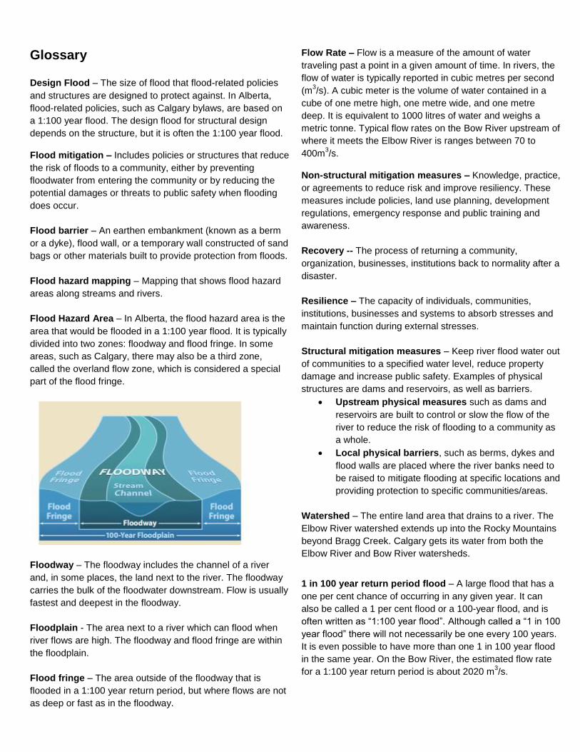
Flood Hazard Area – In Alberta, the flood hazard area is the
area that would be flooded in a 1:100 year flood. It is typically
divided into two zones: floodway and flood fringe. In some
areas, such as Calgary, there may also be a third zone,
called the overland flow zone, which is considered a special
part of the flood fringe.
Floodway – The floodway includes the channel of a river
and, in some places, the land next to the river. The floodway
carries the bulk of the floodwater downstream. Flow is usually
fastest and deepest in the floodway.
Floodplain - The area next to a river which can flood when
river flows are high. The floodway and flood fringe are within
the floodplain.
Flood fringe – The area outside of the floodway that is
flooded in a 1:100 year return period, but where flows are not
as deep or fast as in the floodway.
Flow Rate – Flow is a measure of the amount of water
traveling past a point in a given amount of time. In rivers, the
flow of water is typically reported in cubic metres per second
(m3/s). A cubic meter is the volume of water contained in a
cube of one metre high, one metre wide, and one metre
deep. It is equivalent to 1000 litres of water and weighs a
metric tonne. Typical flow rates on the Bow River upstream of
where it meets the Elbow River is ranges between 70 to
400m3/s.
Non-structural mitigation measures – Knowledge, practice,
or agreements to reduce risk and improve resiliency. These
measures include policies, land use planning, development
regulations, emergency response and public training and
awareness.
Recovery -- The process of returning a community,
organization, businesses, institutions back to normality after a
disaster.
Resilience – The capacity of individuals, communities,
institutions, businesses and systems to absorb stresses and
maintain function during external stresses.
Structural mitigation measures – Keep river flood water out
of communities to a specified water level, reduce property
damage and increase public safety. Examples of physical
structures are dams and reservoirs, as well as barriers.
Upstream physical measures such as dams and
reservoirs are built to control or slow the flow of the
river to reduce the risk of flooding to a community as
a whole.
Local physical barriers, such as berms, dykes and
flood walls are placed where the river banks need to
be raised to mitigate flooding at specific locations and
providing protection to specific communities/areas.
Watershed – The entire land area that drains to a river. The
Elbow River watershed extends up into the Rocky Mountains
beyond Bragg Creek. Calgary gets its water from both the
Elbow River and Bow River watersheds.
1 in 100 year return period flood – A large flood that has a
one per cent chance of occurring in any given year. It can
also be called a 1 per cent flood or a 100-year flood, and is
often written as “1:100 year flood”. Although called a “1 in 100
year flood” there will not necessarily be one every 100 years.
It is even possible to have more than one 1 in 100 year flood
in the same year. On the Bow River, the estimated flow rate
for a 1:100 year return period is about 2020 m3/s.

16 AV NW
BOWNESS RD NW3 4 AV N W
T R A N S C A NA DA H I W
77 ST
NW
SARC
EE TR
NW
The City of Calgary
LegendPROPOSED FUTURE FLOOD BARRIERSFLOODWAYFLOOD FRINGE2013 FLOOD LINE
BOW RIVER
¨0 125 25062.5Meters
Related Documents