Water availability, use and challenges in Pakistan Water sector challenges in the Indus Basin and impact of climate change

Welcome message from author
This document is posted to help you gain knowledge. Please leave a comment to let me know what you think about it! Share it to your friends and learn new things together.
Transcript

2020
Water availability, use and challenges in PakistanWater sector challenges in the Indus Basin and impact of climate change
Bibliography

Water availability, use and challenges in PakistanWater sector challenges in the Indus Basin and impact of climate change
Food and Agriculture Organization of the United Nations Islamabad, 2021

The designations employed and the presentation of material in this information product do not imply the expression of any opinion whatsoever on the part of the Food and Agriculture Organization of the United Nations (FAO) concerning the legal or development status of any country, territory, city or area or of its authorities, or concerning the delimitation of its frontiers or boundaries. The mention of specific companies or products of manufacturers, whether or not these have been patented, does not imply that these have been endorsed or recommended by FAO in preference to others of a similar nature that are not mentioned.
The views expressed in this information product are those of the author(s) and do not necessarily reflect the views or policies of FAO. ISBN 978-92-5-133206-1 © FAO, 2021
Some rights reserved. This work is made available under the Creative Commons Attribution-NonCommercial-ShareAlike 3.0 IGO licence (CC BY-NC-SA 3.0 IGO; https://creativecommons.org/licenses/by-nc-sa/3.0/igo/legalcode). Under the terms of this licence, this work may be copied, redistributed and adapted for non-commercial purposes, provided that the work is appropriately cited. In any use of this work, there should be no suggestion that FAO endorses any specific organization, products or services. The use of the FAO logo is not permitted. If the work is adapted, then it must be licensed under the same or equivalent Creative Commons licence. If a translation of this work is created, it must include the following disclaimer along with the required citation: “This translation was not created by the Food and Agriculture Organization of the United Nations (FAO). FAO is not responsible for the content or accuracy of this translation. The original [Language] edition shall be the authoritative edition.” Disputes arising under the licence that cannot be settled amicably will be resolved by mediation and arbitration as described in Article 8 of the licence except as otherwise provided herein. The applicable mediation rules will be the mediation rules of the World Intellectual Property Organization http://www.wipo.int/amc/en/mediation/rules and any arbitration will be conducted in accordance with the Arbitration Rules of the United Nations Commission on International Trade Law (UNCITRAL). Third-party materials. Users wishing to reuse material from this work that is attributed to a third party, such as tables, figures or images, are responsible for determining whether permission is needed for that reuse and for obtaining permission from the copyright holder. The risk of claims resulting from infringement of any third-party-owned component in the work rests solely with the user. Sales, rights and licensing. FAO information products are available on the FAO website (www.fao.org/publications) and can be purchased through [email protected]. Requests for commercial use should be submitted via: www.fao.org/contact-us/licence-request. Queries regarding rights and licensing should be submitted to: [email protected]. Cover photograph: ©FAO/Shahid Ahmed
Dashed lines on maps represent approximate border lines for which there may not yet be full agreement.
Required citation:Habib, Z., Wahaj, R. 2021. Water availability, use and challenges in Pakistan – Water sector challenges in the Indus Basin and impactof climate change. Islamabad. FAO. https://doi.org/10.4060/cb0718en
Abstract
water supply system and its sources including precipitation and river flows, and theThis working paper takes stock of Pakistan's water resource availability, delineating
important to understand the nexus between water availability, agricultural productivity,
without drying out its water resources.
resources, its usage, challenges and projected water requirements in the future and
conservation practices that are contributing towards the degradation of water quality
In light of the analysis conducted in this paper, it is clear that due to competing
extremities will become more pronounced, driving up water demands in addition to the
Pakistan is adequately prepared to deal with the changing climatic realities, it is
indicating the existing availability of water based on a single river system which is Indus
demand increase from a rising population and urbanization. Over extraction of
Basin System and its tributaries, future projections of water requirements for crops,
pressures of water demand from different sectors and a widening demand-supply gap,
Pakistan faces in accommodating the increasing demand for water from competing
recommendations are proposed signaling the need to adopt a more holistic approach
towards a critical demand-supply gap.
impact of increasing climatic variability on the water supply system. In particular, the
and loss.
what needs to be done to ensure Pakistan is able to boost its agricultural productivity
towards water management and conservation, which takes into account the available
expected to become more variable in the coming years, the severity of climatic
and climatic variability. The current paper has endeavoured to highlight the same
groundwater resources is also disturbing the water calculus and pushing the country
challenges that come with increasing climatic variability and water scarcity. Some keythere is a need to guide the shift from irrigation to water management to address the
livestock, forest, rangelands, ecological and municipal sectors, and the challenges
sectors. Further, limited storage capacity, a debilitated infrastructure, and poor water
Pakistan's water sector remains vulnerable to the impacts of climate change. To ensure
paper focuses on the current water usage and requirements in the agricultural sector,and how changing climatic conditions will affect the consumption patterns. With inflows
iii

Indus glaciers
Seasonal flows and water availability
Water loss and productivity
Recommendations
Crop water requirements
Water loss in agriculture
Municipal water requirements
Future projection of water requirements
Renewable water resources of Pakistan
Conclusion & recommendations
Financial sustainability of the water sector
Degradation of water and land resources
Indus Basin River
Climate change impacts on small stream flows (an example)
Rain and precipitation
Current water usage in agriculture and its requirement
Livestock sector water requirements
Water used by forest, range land and ecological demands
References
Low water productivity
Information and data gaps
Groundwater
Indus basin
Indus Basin Irrigation System (IBIS)
Contents
Acknowledgements
Introduction
Water sources of Pakistan and impact of climate change
Two small hydrological units outside Indus Basin
Abstract
v
vii
1
iii
3
3
16
4
11
22
6
3
16
31
6
19
8
18
24
30
33
19
10
21
24
14
15
27
11
21
Figures
Figure 1: Population vis-à-vis per capita water availability
Figure 3: Mean annual temperature and precipitation projections in Pakistan under two RCPs
Figure 4: Spatial map of groundwater abstraction in irrigated Indus BasinFigure 5: Historical flow of three western rivers 1937 to 2018. Kabul river
flows included in Indus flows at KalabaghFigure 6: Eastern rivers inflows from 1937 to 2018Figure 7: Historical flows projected into the future (MAF/yr)Figure 8: Mean annual discharge at Aru hydrological station
Figure 2: Schematic diagram of the Indus Basin
Figure 14: Comparison of five water demand scenarios against baseline period of 2015
Figure 9: Sectoral water withdrawal from AQUASTAT main database
Figure 12: Estimated municipal water requirements
Table 2: Change in total glacier area of Lidder watershed and Kolahoi glacier over time
Table 4: Potential water requirements of major crops estimated using CROPWAT
Table 6: Top 10 countries' water withdrawals in 2010Table 5: Projected water requirements livestock and poultry
Table 8: Controlled population (1.7 percent to 0.5 percent in 2050) and reasonable economic growth - water requirements at the water use level (farm in case of agriculture)
Table 9: Gaps in the estimation of the gross water resources, water availability and water uses
Table 3: Baseline agriculture water requirements (billion cubic meters -BCM)
Figure 11: Rural and urban household water supply projections
Figure 13: Climate change impacts on water demand by 1C and 3 C increase in temperature
Table 1: Western and eastern river Inflows BCM
Table 7: Comparison of water productivity in agriculture
Tables
Figure 10: Total cropped areas and net sown area in Pakistan over time
vi
16
25
9
12
7
1415
12
17
26
25
17
20
14
22
20
18
28
26
23
11
19

Acknowledgements
The report was has been prepared by Zaigham Habib, Water Specialist, FAO Consultant and Robina Wahaj, Land and Water Officer, FAO Land and Water Division with contributions from Hideki Kanamaru, Natural Resources Officer, FAO Regional Office for Asia and the Pacific, Ana Heureux, Junior Professional Officer, FAO, Climate and Environmental Division, Abdul Wajid Rana, Program Leader, IFPRI- Pakistan. The authors are grateful to the technical reviewer Jippe Hoogeveen, Senior Officer, FAO Land and Water Division. Efforts of Amber Pervaiz, Programme Development Specialist, Consultant, FAO Pakistan for the professional editing of the report are also acknowledged. Errors are the responsibility only of the authors, and this paper reflects the opinions of the authors, and not the institutions, which they represent or with which they are affiliated.
vii

Introduction
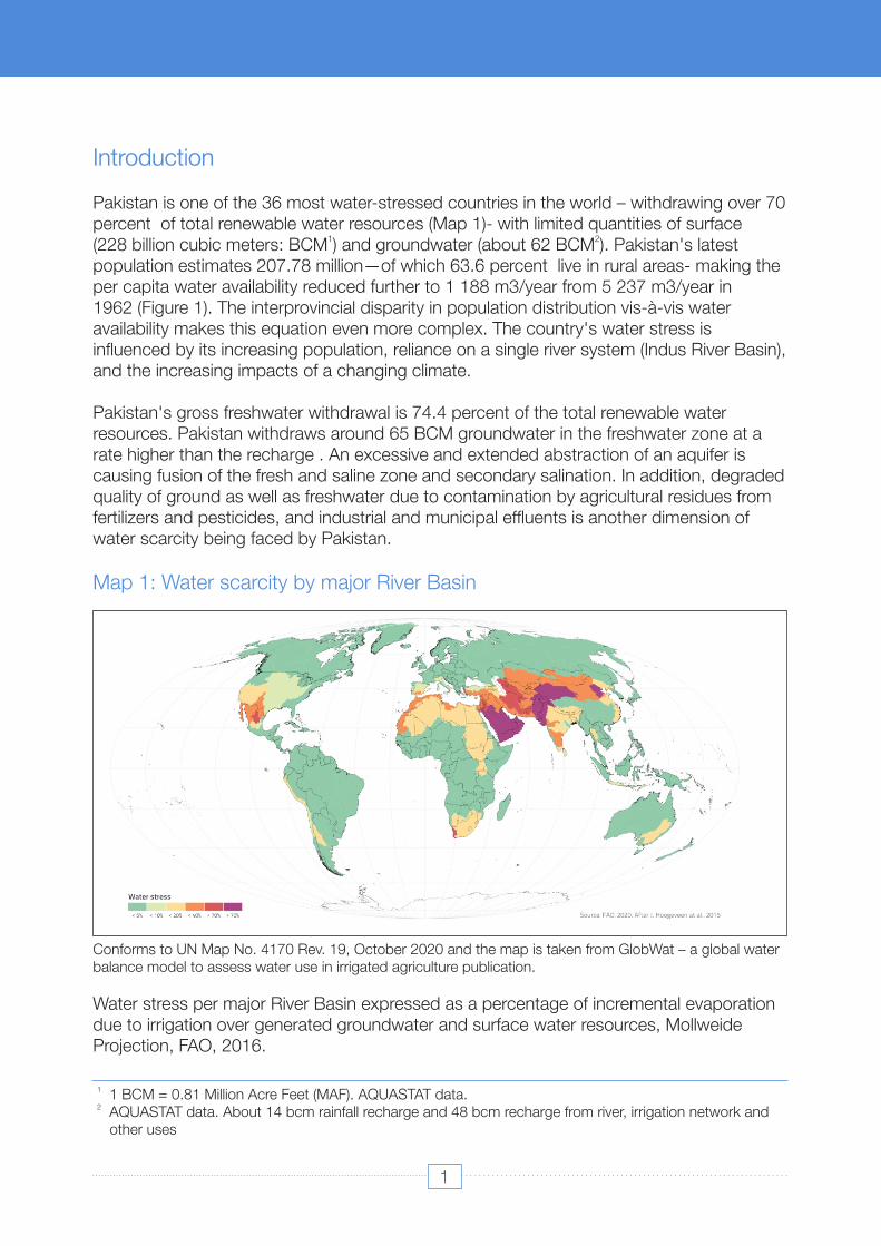
Pakistan's gross freshwater withdrawal is 74.4 percent of the total renewable water resources. Pakistan withdraws around 65 BCM groundwater in the freshwater zone at a rate higher than the recharge . An excessive and extended abstraction of an aquifer is causing fusion of the fresh and saline zone and secondary salination. In addition, degraded quality of ground as well as freshwater due to contamination by agricultural residues from fertilizers and pesticides, and industrial and municipal effluents is another dimension of water scarcity being faced by Pakistan.
Map 1: Water scarcity by major River Basin
Pakistan is one of the 36 most water-stressed countries in the world – withdrawing over 70 percent of total renewable water resources (Map 1)- with limited quantities of surface
1 2(228 billion cubic meters: BCM ) and groundwater (about 62 BCM ). Pakistan's latest population estimates 207.78 million—of which 63.6 percent live in rural areas- making the per capita water availability reduced further to 1 188 m3/year from 5 237 m3/year in 1962 (Figure 1). The interprovincial disparity in population distribution vis-à-vis water availability makes this equation even more complex. The country's water stress is influenced by its increasing population, reliance on a single river system (Indus River Basin), and the increasing impacts of a changing climate.
Conforms to UN Map No. 4170 Rev. 19, October 2020 and the map is taken from GlobWat – a global water balance model to assess water use in irrigated agriculture publication.
Water stress per major River Basin expressed as a percentage of incremental evaporation due to irrigation over generated groundwater and surface water resources, Mollweide Projection, FAO, 2016.
2 AQUASTAT data. About 14 bcm rainfall recharge and 48 bcm recharge from river, irrigation network and other uses
1 1 BCM = 0.81 Million Acre Feet (MAF). AQUASTAT data.
1

3 Assuming constant availability of 246.8 BCM of freshwater and groundwater
The water tariffs are extremely low in all water use sectors impairing sustainable operations, maintenance and modernization of the infrastructure. The low economic return from the agriculture sector are not only productivity interrelated, but agriculture and land management need to address socio-economic inequalities. The low storage capacity and high conveyance losses can be attributed to inadequate asset management and insufficient financial resources due to nominal irrigation tariff and poor cost recovery.
Information about the water used in the industry is sketchy, similarly, the data about commercial and business uses. These sectors are increasingly using surface water, like sugarcane and fertilizer plants, urban transport. A proper accounting of water demand and supply outside the agriculture sector is a pre-requisite to effective water management.
Figure 1: Population vis-à-vis per capita water availability
Challenged by uncertainties, the farmers not only tend to grow cash crops like sugarcane and rice which require relatively more water but also over-irrigate their crops when water is available as the water supply is skewed towards five summer months when 70 percent of the surface flows are generated. The inefficient irrigation also results from poor land levelling resulting in low distribution uniformity and rather high farm losses (in the range of 30-40 percent ) in the areas where the infrastructure is dilapidated. High demand-supply gap and inefficient performance of the irrigation network results in inequitable access to water—small and the tail-end landholders getting less water. All these factors contribute to the low water productivity in Pakistan (0.78 USD/m3).
Water demands of the urban, industrial and commercial sectors are locally managed and are increasingly going beyond the safe water supply limits causing local depletion of surface and groundwater resources. Deteriorating water quality of surface and groundwater resources is an increased risk for health. Despite numerous water supply and sanitation schemes, domestic and urban water supply remains a challenge.
Source: FAO. 2016. AQUASTAT Main Database. Accessed on 6 Nov 2017; and Provisional Summary 3Results of 6th Population and Housing Census 2017 .
2
Water availability, use and challenges in Pakistan
Water sources of Pakistan and impact of climate change Two small hydrological units outside Indus Basin
Indus Basin
The water sources of Pakistan include surface water, rain, groundwater, and glacial melts. 4The surface water-resources of Pakistan are mainly from the Indus River , which is a major
The estimated gross runoff of these two basins is 8.4 bcm, which is usually in the form of flash floods depending upon the rainfall.
Climate Change (CC) is an emerging challenge for Pakistan as it is expected to influence the freshwater supply and water demand, both. There is sufficient evidence that global warming is affecting Himalayan glaciers and Asian monsoon (various publications of IICIMOD). The climate change impact on the hydrological cycle needs to be properly understood for the management of extreme events like floods and droughts, and, protection of surface water resources. The sectoral water demands are projected to be equally affected by a rise in temperature. Increased water competition among the sectors and regions is the biggest challenge Pakistan is going to face.
Balochistan province of Pakistan hosts two independent hydrological units covering about 35 percent area of the Province. The Kharan desert stretches over 48 051 sq. km barren land from the Alborz mountains (Iran) in the northern direction to the plateau in Balochistan around 1200 kilometers to the southeast. The entire area of the desert has inland drains and dry lakes. The largest dry lake of Balochistan is located in this desert called Hamun-i-Mashkel. The average rainfall in the desert is about 100 mm annually. The Mashkel and Marjen rivers are the principal sources of water in the basin. The Marjen is a minor tributary to the Mashkel. The water is discharged into the Hamun-i-Mashkel lake in the southwest, on the border with the Islamic Republic of Iran. The arid Makran coast, along the Arabian Sea, covers 17 percent of the territory in its southwestern part (Balochistan province). The Hob, Porali, Hingol, and Dasht are the principal rivers in this coastal zone.
Weak policy frameworks coupled with a lack of coordination among stakeholders and institutions has led to scanty ownership of reforms process and regulatory enforcement. Pakistan has launched its National Water Policy in 2018 followed by the Provincial Water policies. The eighteenth amendment and independent provincial water policies and strategies could be another challenge for coherent management and development of water resources in various sectors. The long-term and short-term implementation plans will be an important milestone.
4 The Indus River is about 2 800 kilometres (km) long, with 2 682 km in Pakistan. Its alluvial plain area is about 207 200 km2, while its deltaic area is about 20 000 km2. It originates in the Tibetan tableland at Singi Kahad spring, on Kailas Parbat (mountain) near Mansarwar Lake. It then passes through the Himalayan range, and, collects runoff from the Hindu Kush and Sulaiman ranges. Its annual water runoff is about 200 cubic kilometers, and sediment discharge is approximately 200 billion kilograms yearly (Pakistan Water Gateway; accessed 29 November 2011)
4

Pakistan relies on the Indus Basin Irrigation System (IBIS) for its basic food security and water supply for all sectors of the economy. IBIS is one of the largest contiguous irrigation systems in the world and irrigates about 18 million hectares (ha) of land in Pakistan.
5 6trans-boundary river in Asia with nine tributaries . Glacier/snowmelt and precipitation in the Upper Indus Basin are the main sources of flow in the Indus river network. The Indus River has two large western tributaries (Jhelum and Chenab) and two eastern tributaries (Ravi and Sutlej) which enter into Pakistan from India. One of the western tributaries, the Kabul River is shared with Afghanistan; its watershed starts in Pakistan, traverses through the Kabul valley and then re-enters into Pakistan, close to Nowshera. Under the Indus Water Treaty, signed between Pakistan and India in 1960, the eastern rivers, Ravi and Sutlej were allocated to India; only flood runoff is discharged into Pakistan over the course of a couple of weeks after India built storages in the upper reaches of the rivers. Resultantly, there can be years of no flows in these rivers.
Based on the stream hydrology and morphology, the Indus River can be broadly divided into three segments: (i) the upstream segment, from the Singi Khahad spring down to Jinnah Barrage; (ii) the midstream segment, between Jinnah and Guddu barrages; (iii) and the downstream segment, from Guddu Barrage to the Arabian Sea. The upstream segment is largely a hilly catchment area; the midstream segment is an upper floodplains area dominated by a braided pattern of channels and tributary inflows; and the downstream segment is a lower floodplains area with flat topography, a meandering channel pattern, and deltas. The upper Indus Basin catchment is further sub-divided into four zones based on the basin's geophysical and hydro-climatic characteristics (Hewitt, 1989): zone one - more than 5 500 m above sea level (asl); zone two - 4 500–5 500 m asl; zone three, 3 000–4 000 m asl; and zone four, 1 000–3 000 m asl . The major ablation zone contributing to the seasonal runoff is between 5500 m to 3000 m.
IBIS is the backbone of the country's agricultural economy (see Figure 2). It is with three major multipurpose storage reservoirs (Mangla, Tarbela and Chashma), 19 barrages, 12 inter-river link canals, 45 major irrigation canal commands (about 56 000 km) and more than 120 000 km of watercourses in tandem with vast and growing process of groundwater extraction through private tube-wells delivering water to farms and other productive uses.
The infrastructure developed under the Indus Water Treaty of 1960 has helped improve water resource availability basin-wide increasing canal diversions from 83 BCM in 1949/50 to a maximum level of 137 BCM in 1984-87, which has declined to 130 BCM because of storage loss. The total storage capacity in the Indus Basin was 23.3 BCM, which includes
Indus Basin Irrigation System (IBIS)
5 Others include the Amu Darya (Afghanistan, Turkmenistan, and Uzbekistan), Amur (China and the Russian Federation), Brahmaputra (Bangladesh, China and India), Euphrates (Iraq, Syria, and Turkey), Ganges (Bangladesh and India), Mekong (Cambodia, China, the Lao People's Democratic Republic, Myanmar, Thailand, and Viet Nam), and the Tigris (Iraq, Syria, and Turkey).
6 Five of them are on the left bank with upper catchments of Beas, Ravi, and Sutlej in India while Chenab and Jhelum are in Pakistan. The main right bank tributaries are the Gomal, Kabul, Swat and Kurram rivers.
5
Water availability, use and challenges in Pakistan
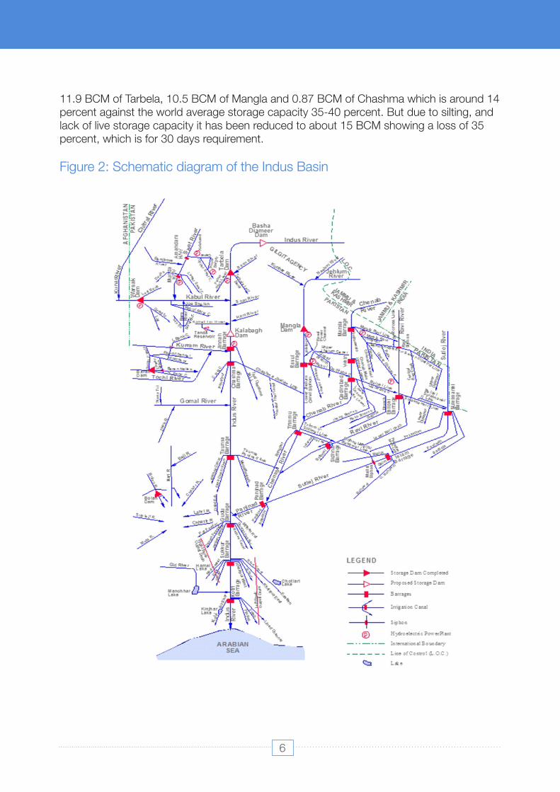
Figure 2: Schematic diagram of the Indus Basin
11.9 BCM of Tarbela, 10.5 BCM of Mangla and 0.87 BCM of Chashma which is around 14 percent against the world average storage capacity 35-40 percent. But due to silting, and lack of live storage capacity it has been reduced to about 15 BCM showing a loss of 35 percent, which is for 30 days requirement.
Water Availability, Use and Challenges in Pakistan
6
average rainfall projection over Pakistan shows a large inter-annual variability. Ali (2018)
Indus glaciers
Accelerated ice melting may lead to an increased risk of floods and hazards related to glaciers (e.g., glacial lake outburst floods, icefalls, and crevasses) in the following decades. By the end of the century (2071-2100), the glacial extent is expected to have decreased significantly, reducing the contribution of glacial melt, and, therefore, total water availability across the whole Indus Basin.
The PMD analysis of CORDEX experiments and GCISC's downscaling analysis agree that
reports, based on downscaled 14 GCM projections, more intense extreme rainfall events are expected in the monsoon region and northern Pakistan, suggesting increased flood risks. It is also found that consecutive dry days (CDD) will increase while consecutive wet days (CWD) will decrease.
The Pakistan Water and Power Development Authority (WAPDA) began monitoring the glaciers of Northern Pakistan in the 1980s with the help of Wilfrid Laurier University, the University of British Columbia in Canada, and the University of Manchester in the UK. The measurements show that glacier runoff and snowmelt from the Himalaya Karakoram Hindukush (HKH) mountain ranges contribute a total of 50 to 80 percent of water availability in the country.
Such a rapid decline in the glacier area means that the flows of the Indus River System may decrease up to 30-40 percent over the second half of the 21st century (World Bank Report, 2006). The glacier mass balance budget in the Karakoram positively affected the 2003–2008 specific mass balance for the entire HKH region, estimated by Kääb et al.,(2012) into −0.21 ± 0.05 m yr−1 of water equivalent.
Lutz (2016) used a fully distributed Spatial Processes in Hydrology (SPHY) model to et al.,simulate the climate change impacts on the hydrology of the Indus Basin. Two of their conclusions are important: (i) the large uncertainty in projection of climate change impacts till mid of the century, like glacier extent, precipitation; and (ii) glacier area decrease considerably during 21st century even in the wet scenarios projecting large increases in precipitation, because of an ample rise in temperature.
Rain and precipitation
(Bocchiola, 2015) and (Akram, 2016) carried out detailed literature reviews with mention of the reports about HKH and the Upper Indus from the period between IPCC3 and IPCC5. Mountain glaciers worldwide retreated during the last one hundred years ; the glaciers in the HKH region are reported to be receding faster than those in any other part of the world. A rapid decline in glacier area is reported throughout the greater Himalayas and most of mainland Asia and is widely attributed to global warming (Ageta & and Kadota, 1992); (Solomon, 2007).et al.,
rainfall projections are highly variable in both spatial and temporal domains (Figure 3). Area
7
Water Availability, Use and Challenges in Pakistan
Water availability, use and challenges in Pakistan

Figure 3: Mean annual temperature and precipitation projections in Pakistan under two RCPs
Statistical downscaling of climate projections at the station level shows that a few distinctprecipitation trends in the project areas of Punjab and Sindh provinces. In Sindh, there will be a 20 percent or more increase in total precipitation later in the 21st century. The number of days with precipitation exceeding 20mm will also increase in Sindh in the late century. On the other hand, in Punjab, the precipitation trend is not clear, indicating possible increases or decreases for different climate models and locations within the province.In Pakistan, major flooding events are associated with heavy rainfall during the summermonsoon period. The expectation of an increase in large storm events is consistent with global hydrologic dynamics (IPCC, 2012). Each 1°C rise in air temperature allows the atmosphere to hold 7 percent more moisture.
The warming of land and sea surface temperatures also leads to more moisture evaporation causing global warming. As a result, more moisture will enter the atmosphere, increasing the potential for larger storm events. Based on the research conducted on this issue suggests that such a trend is emerging in Pakistan, with an increased volume of precipitation falling on fewer rainy days (Parry 2017). Data from the PMD covering et al.,the years 1913–2016 indicate that the ten largest rainfall events in the recorded history in the country have all occurred since 2001.
8
Water Availability, Use and Challenges in Pakistan
Groundwater
Groundwater has evolved as a reliable water resource in all of Pakistan's water use sectors. Industrial and domestic supplies almost predominantly rely on groundwater pumping (sometimes through an artificially developed recharge zone adjacent to a surface waterway). In agriculture, groundwater compensates for the shortage of surface supplies. Riverine areas extensively use fresh aquifers during the dry season.
Globally, Pakistan is the fourth largest user of groundwater according to a recent report by the National Groundwater Association of the United States of America (2015). 'Facts about Global Groundwater' shows that India extracts water from aquifers at a rate of 251 km /year, followed by China and the USA, both extracting 111 km/year, and then by Pakistan, which extracts 65 km/year. As a percentage of total available water resources, Pakistan has the highest reliance on groundwater.
A basin-level estimate of groundwater using hydrological modelling with the Soil and Water Assessment Tool (SWAT) was carried out by Cheema et al.,(2012). Spatial presentation of the model output is generated using remote sensing information and GIS data, as shown in (Figure 4). The study concludes: “Irrigation is the largest consumer of water in the Indus basinthat is using both surfaces (113 km or 434 mm) and groundwater (68 km or 262 mm) to meet crop water requirements.”
9
Water Availability, Use and Challenges in Pakistan
Water availability, use and challenges in Pakistan
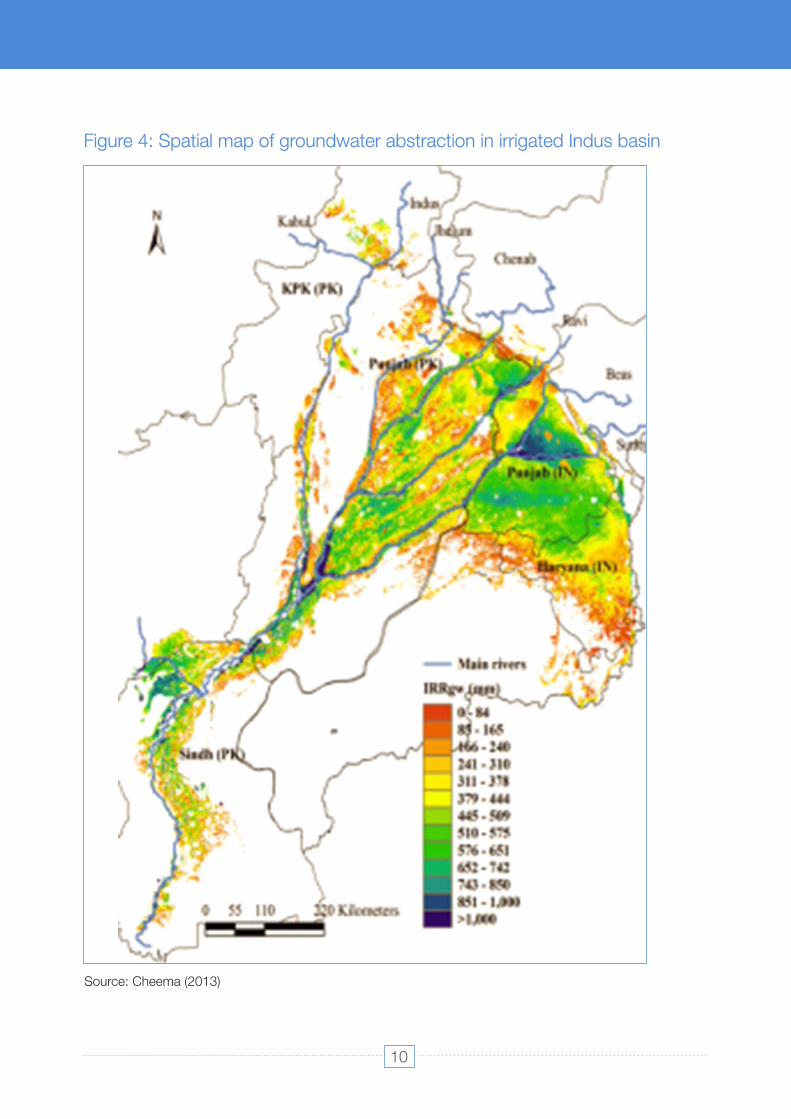
Figure 4: Spatial map of groundwater abstraction in irrigated Indus basin
Source: Cheema (2013)
10
Water Availability, Use and Challenges in Pakistan

Ÿ The untreated municipal and industrial waste from the District Peshawar, Mardan, Nowshera, and Charsadda is being disposed of into different drains, which finally fall into the Kabul River (Imran, Bukhari, & Gul, 2018).
Degradation of water and land resources
The water quality of rivers, lakes, and canals has been degrading. The causes of surface water degradation include the direct discharge of city and industrial effluence into water bodies, ineffective and limited surface drainage networks and the trans-boundary inflow of polluted water. A few examples of River pollution:
Ÿ Anthropogenic activities in agriculture and industries cause discharges of fertilizers, pesticides, chemicals, heavy metals, and pathogens that can degrade the water quality and can cause negative effects on human health. Fertilizers and pesticides used in the agricultural areas are washed off and drained into surface and groundwater aquifers.
Ÿ The waste-water systems in the urban areas contribute to water pollution by production and conveyance of untreated municipal sewerage which pollutes freshwater bodies and drinking water supply. Water affected both qualitatively and quantitatively making it hazardous for human use. the effects of deterioration are intensified as a large volume of untreated effluents from agricultural, industrial, domestic, and commercial areas enter into rivers.
The increase in temperature can be linked to bacterial growth, high turbidity, low efficiency of coagulants, and re-growth of germs, mosquitoes and other water pollutants. The
Toxic industrial and domestic effluent from India and Pakistan is dumped into the Ravi river, about 10 drains of the provincial capital releasing industrial and municipal waste is also dumped into it. More than 450 industrial units are pumping untreated toxic water into the drains at different points. An estimated wastewater discharge into the river is 315 m/s daily . EPA estimated more than 594 tons per day of the organic load is discharged into
7the river Ravi (Pak EPA, 2010) .
Currently, around 1.355 million small capacity private tube-wells are operating in Pakistan, out of which 1.02 million are located in Punjab, extracting 52 BCM of groundwater(Qureshi 2010). These tube-wells (exclusively) and combined with canal water et al.,irrigated 19 percent and 42 percent of cultivated land, respectively. Uncontrolled and unregulated extraction of groundwater in excess of recharge in the freshwater zone is lowering the water tables making groundwater inaccessible in 5 percent, and 15 percent of the irrigated areas of Punjab and Balochistan provinces, respectively, which are likely to reach 15 and 20 percent, if the current trend continues. Declining aquifer levels force farmers towards deep electric tubewells, increasing the cost of groundwater pumping and making water inaccessible for smallholders.
7 Environment Protection Department. Environmental Monitoring of River Ravi EPA Laboratory December, 2009. 2010. Available online: https://www.epd.punjab.gov.pk/Reports
11
Water Availability, Use and Challenges in Pakistan
Water availability, use and challenges in Pakistan
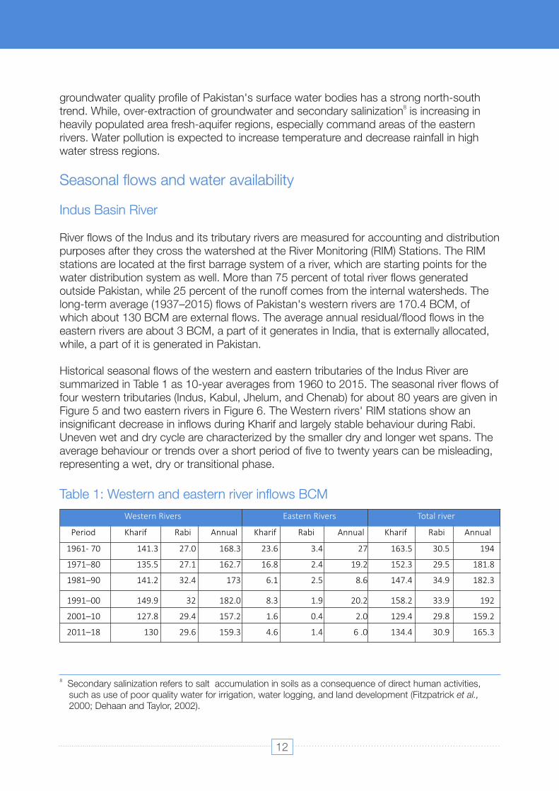
Table 1: Western and eastern river inflows BCM
groundwater quality profile of Pakistan's surface water bodies has a strong north-south 8trend. While, over-extraction of groundwater and secondary salinization is increasing in
heavily populated area fresh-aquifer regions, especially command areas of the eastern rivers. Water pollution is expected to increase temperature and decrease rainfall in high water stress regions.
Seasonal flows and water availability
Indus Basin River
River flows of the Indus and its tributary rivers are measured for accounting and distribution purposes after they cross the watershed at the River Monitoring (RIM) Stations. The RIM stations are located at the first barrage system of a river, which are starting points for the water distribution system as well. More than 75 percent of total river flows generated outside Pakistan, while 25 percent of the runoff comes from the internal watersheds. The long-term average (1937–2015) flows of Pakistan's western rivers are 170.4 BCM, of which about 130 BCM are external flows. The average annual residual/flood flows in the eastern rivers are about 3 BCM, a part of it generates in India, that is externally allocated, while, a part of it is generated in Pakistan.
Historical seasonal flows of the western and eastern tributaries of the Indus River are summarized in Table 1 as 10-year averages from 1960 to 2015. The seasonal river flows of four western tributaries (Indus, Kabul, Jhelum, and Chenab) for about 80 years are given in Figure 5 and two eastern rivers in Figure 6. The Western rivers' RIM stations show an insignificant decrease in inflows during Kharif and largely stable behaviour during Rabi. Uneven wet and dry cycle are characterized by the smaller dry and longer wet spans. The average behaviour or trends over a short period of five to twenty years can be misleading, representing a wet, dry or transitional phase.
8 Secondary salinization refers to salt accumulation in soils as a consequence of direct human activities, such as use of poor quality water for irrigation, water logging, and land development (Fitzpatrick et al., 2000; Dehaan and Taylor, 2002).
Period Kharif Rabi Annual Kharif Rabi Annual Kharif Rabi Annual
1961- 70 141.3 27.0 168.3 23.6 3.4 27 163.5 30.5 194
1971–80 135.5 27.1 162.7 16.8 2.4 19.2 152.3 29.5 181.8
1981–90 141.2 32.4 173 6.1 2.5 8.6 147.4 34.9 182.3
1991–00 149.9 32 182.0 8.3 1.9 20.2 158.2 33.9 192
2001–10
127.8
29.4
157.2
1.6
0.4
2.0
129.4
29.8
159.2
2011–18
130
29.6
159.3
4.6
1.4
6 .0
134.4
30.9
165.3
Western Rivers Eastern Rivers Total river
12
Water Availability, Use and Challenges in Pakistan
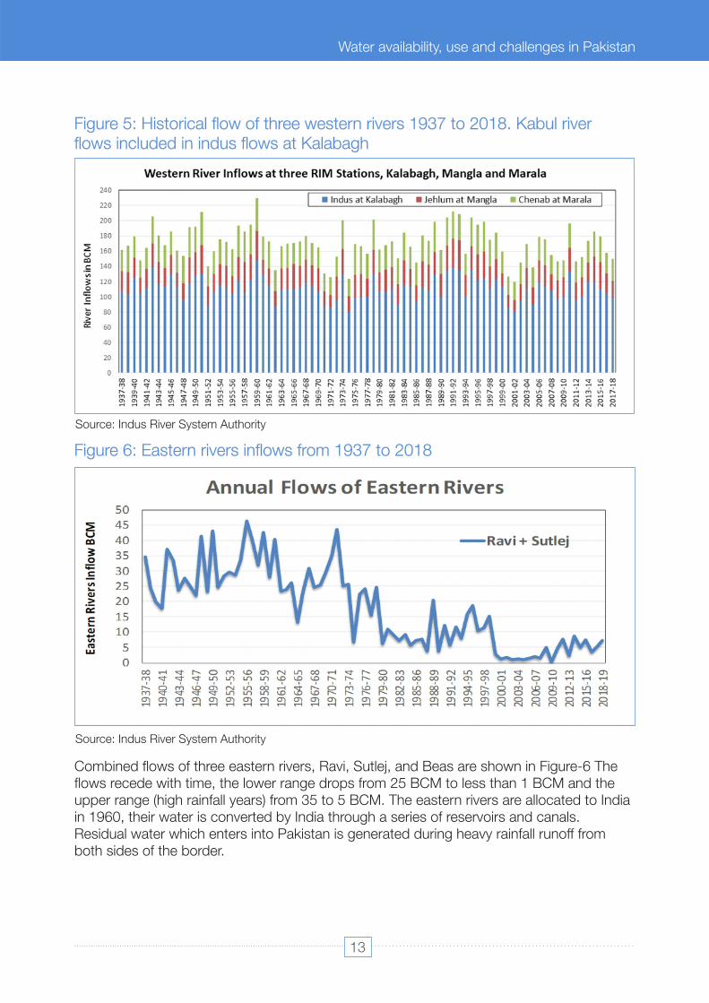
Figure 5: Historical flow of three western rivers 1937 to 2018. Kabul river flows included in indus flows at Kalabagh
Source: Indus River System Authority
Figure 6: Eastern rivers inflows from 1937 to 2018
Source: Indus River System Authority
Combined flows of three eastern rivers, Ravi, Sutlej, and Beas are shown in Figure-6 The flows recede with time, the lower range drops from 25 BCM to less than 1 BCM and the upper range (high rainfall years) from 35 to 5 BCM. The eastern rivers are allocated to India in 1960, their water is converted by India through a series of reservoirs and canals. Residual water which enters into Pakistan is generated during heavy rainfall runoff from both sides of the border.
13
Water Availability, Use and Challenges in Pakistan
Water availability, use and challenges in Pakistan

The stream flows in the near future (2021-2050) are expected to increase during autumn and spring. Upstream sub-basins (Hunza, Shigar, and Shyok) are expected to have increased water availability while lower altitude sub-basins show decreases annually, particularly during June and July and also during spring (Ali 2015; Lutz 2016). et al., et al.,By the end of the century (2071-2100), the glacial extent is expected to decrease significantly, reducing the contribution of glacial melt and the impact on the total water availability across the whole Indus Basin. The timing of water availability depends on the Representative Concentration Pathways (RCP) scenario used, therefore, all adaptation strategies need to consider this uncertainty.
Current river inflow-patterns represent the combined impacts of glacier/snowmelt, precipitation, and upstream uses. These patterns (flow hydrograph) will continue until half of the glacier reserve is depleted or precipitation has substantially increased or decreased. The future of the upper Indus basin's water availability is highly uncertain in the long run, mainly due to the large spread in the future precipitation projections. However, a few robust changes are found. There will be the attenuation of the annual hydrograph and shift from summer peak flow towards the other seasons. There will also be an increase in intensity and frequency of extreme discharges for most of the upper Indus basin (Lutz 2016), et al.,increasing flood risks.
temperature and precipitation and river flows based on CMIP3 and CMIP5 Coupled Model Inter-Comparison Project. The historical series of inflows are used to create a series of inflows into the future to give a variable pattern to the series. These river flows were forecasted from 2014 to 2060 because of having historical flows for 48 years, see Figure 7. They selected 19 scenarios to forecast future time series of inflows to the Diamer Basha Reservoir under Future Climate Scenarios. The figure shows fairly variable annual flows, with the highest occurring in 2021 at nearly 165 MAF, which was followed in the next year by the lowest flows in the sequence, at 94 MAF, more than a 75 percent decline. Later in the series, in 2048 and 2049 a large drought is seen as well, where the flows are 99 MAF and 97 MAF. After the drought period, there is a noticeable increase in water availability. The projected flows stabilize around 2060, as a substantial part of Indus glaciers already melt.
The projected changes in river inflows are influenced by precipitation projections, shifts in the monsoon period, cloudiness, and projected glacier and snowmelt patterns. The complex behaviour of river stream flows is simulated by various hydrological models. Some studies (Immerzeel, 2009; Lutz 2016) estimate an increase in rainfall by up to 50 et al.,percent to around 2 070 mm and a shift in the timing of river-runoff peak, which is projected to anticipate by about one month, leading to almost overall stable flows until the mid-century (near future) and eventual decrease afterwards. Projected changes in summer monsoon by different General Circulation Models have high Spatio-temporal variation across the basin and seasons. Winter simulations are more consistent, projecting an increase over the upper Indus Basin and a decrease over the lower basin (Gebre and Ludwig, 2014).
A recent study by MWH and RTI (Yves 2016) developed a series of projections foret al.,
14
Water Availability, Use and Challenges in Pakistan
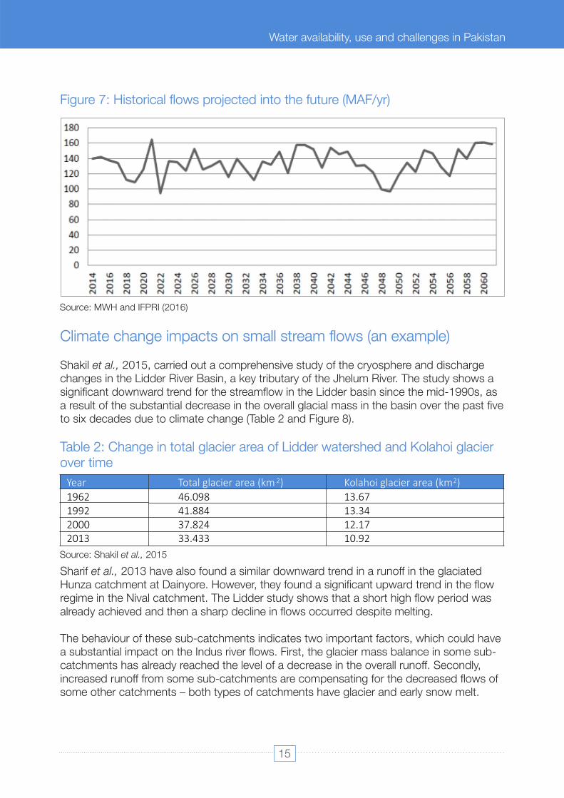
Table 2: Change in total glacier area of Lidder watershed and Kolahoi glacier over time
Figure 7: Historical flows projected into the future (MAF/yr)
Climate change impacts on small stream flows (an example)
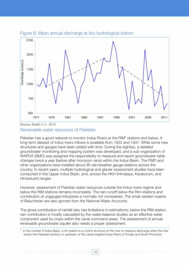
Shakil 2015, carried out a comprehensive study of the cryosphere and discharge et al.,changes in the Lidder River Basin, a key tributary of the Jhelum River. The study shows a significant downward trend for the streamflow in the Lidder basin since the mid-1990s, as a result of the substantial decrease in the overall glacial mass in the basin over the past five to six decades due to climate change (Table 2 and Figure 8).
Sharif 2013 have also found a similar downward trend in a runoff in the glaciated et al.,Hunza catchment at Dainyore. However, they found a significant upward trend in the flow regime in the Nival catchment. The Lidder study shows that a short high flow period was already achieved and then a sharp decline in flows occurred despite melting.
The behaviour of these sub-catchments indicates two important factors, which could have a substantial impact on the Indus river flows. First, the glacier mass balance in some sub-catchments has already reached the level of a decrease in the overall runoff. Secondly, increased runoff from some sub-catchments are compensating for the decreased flows of some other catchments – both types of catchments have glacier and early snow melt.
Source: MWH and IFPRI (2016)
1962 46.098 13.67
1992 41.884 13.34
2000
37.824
12.17
2013
33.433
10.92
Year Total glacier area (km 2) Kolahoi glacier area (km2)
Source: Shakil 2015et al.,
15
Water Availability, Use and Challenges in Pakistan
Water availability, use and challenges in Pakistan
The gross contribution of rainfall also has limitations in estimations; below the RIM station, rain contribution is mostly calculated by the water-balance studies as an effective water component used by crops within the canal command areas. The assessment of annual renewable groundwater aquifer also needs a proper assessment.
Renewable water resources of Pakistan
However, assessment of Pakistan water resources outside the Indus rivers regime and below the RIM stations remains incomplete. The rain-runoff below the Rim-stations and contribution of ungauged tributaries is normally not considered. The small western basins of Baluchistan are also ignored from the National Water Accounts.
9Pakistan has a good network to monitor Indus Rivers at the RIM stations and below. A long-term dataset of Indus rivers inflows is available from 1922 and 1937. While some new structures and gauges have been added with time. During the eighties, a detailed groundwater monitoring and mapping system was developed, and a sub-organization of WAPDA (SMO) was assigned the responsibility to measure and report groundwater table changes twice a year (before after monsoon rains) within the Indus Basin. The PMD and other organizations have installed about 90 rain/weather gauge-stations across the country. In recent years, multiple hydrological and glacier assessment studies have been conducted in the Upper Indus Basin, and, across the HKH (Himalaya, Karakorum, and Hindukush) ranges.
Figure 8: Mean annual discharge at Aru hydrological station
Source: Shakil et al., 2015
9 In the context of Indus Basin, a rim station is a control structure on the river to measure discharge when the river enters into Pakistani territory or upstream of the canal-irrigated Indus Plains of Punjab and Sindh Provinces.
16
Water Availability, Use and Challenges in Pakistan
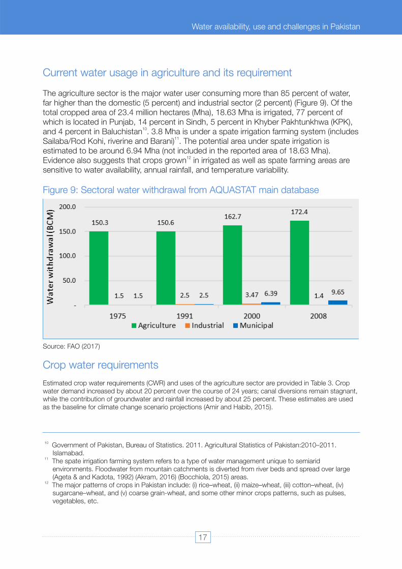
Figure 9: Sectoral water withdrawal from AQUASTAT main database
Estimated crop water requirements (CWR) and uses of the agriculture sector are provided in Table 3. Crop water demand increased by about 20 percent over the course of 24 years; canal diversions remain stagnant, while the contribution of groundwater and rainfall increased by about 25 percent. These estimates are used as the baseline for climate change scenario projections (Amir and Habib, 2015).
The agriculture sector is the major water user consuming more than 85 percent of water, far higher than the domestic (5 percent) and industrial sector (2 percent) (Figure 9). Of the total cropped area of 23.4 million hectares (Mha), 18.63 Mha is irrigated, 77 percent of which is located in Punjab, 14 percent in Sindh, 5 percent in Khyber Pakhtunkhwa (KPK),
10and 4 percent in Baluchistan . 3.8 Mha is under a spate irrigation farming system (includes 11Sailaba/Rod Kohi, riverine and Barani) . The potential area under spate irrigation is
estimated to be around 6.94 Mha (not included in the reported area of 18.63 Mha). 12Evidence also suggests that crops grown in irrigated as well as spate farming areas are
sensitive to water availability, annual rainfall, and temperature variability.
Current water usage in agriculture and its requirement
Source: FAO (2017)
Crop water requirements
10 Government of Pakistan, Bureau of Statistics. 2011. Agricultural Statistics of Pakistan:2010–2011. Islamabad.
11 The spate irrigation farming system refers to a type of water management unique to semiarid environments. Floodwater from mountain catchments is diverted from river beds and spread over large (Ageta & and Kadota, 1992) (Akram, 2016) (Bocchiola, 2015) areas.
12 The major patterns of crops in Pakistan include: (i) rice–wheat, (ii) maize–wheat, (iii) cotton–wheat, (iv) sugarcane–wheat, and (v) coarse grain-wheat, and some other minor crops patterns, such as pulses, vegetables, etc.
17
Water Availability, Use and Challenges in Pakistan
Water availability, use and challenges in Pakistan

Diverted/recommended quantities could be higher than actual water requirements due to the weekly schedule of canal supplies, flood irrigation, and low conveyance efficiencies.Table 4, shows the estimated CWR for the major crop. The CROPWAT model was used to estimate the CWR for ten main crops across the full temperature range. These values are used to estimate agricultural water uses from 1990 to 2014 in the Indus Basin. CWR increased at a rate of one percent per year (average agriculture growth was three percent) and water uses increased at almost the same rate, with partial contributions from groundwater and direct rainfall.
Source: Amir and Habib, 2015Note: *Gross Water Requirements Farm minus Available Farm
Table 3: Baseline agriculture water requirements (billion cubic meters –BCM)
Estimation of water requirements at the farm level depends upon the water balance (average rainfall or irrigation minus evaporation and crop transpiration), the type of crops grown throughout the year, water application techniques and soil moisture conditions. Groundwater aquifer levels and quality contribute to the soil condition and net root-zone water requirements. The quantity and timing of rainfall determine its effectiveness and contribution in meeting crop requirements. Pakistan has good empirical knowledge of water applied and used by crops in different agro-ecological zones.
Table 4: Potential water requirements of major crops estimated using CROPWAT
Cropped Area (official)– Million hectare 20.10 21.02 23.20 CWR Root Zone 113.81 121.79 136.79 CWR Field (75% efficiency) 158.06 166.84 182.39 Rain Contribu�on Field 28.45 30.03 36.48 CWR Field level (CWR Field minus Rain Contribu�on Field) 129.61 136.80 145.91 Gross Water Requirements Farm (CWR Field level plus Livestock Requirements)
130.71
138.25
147.65
Total surface diversions (Canal diversions plus other diversions)
127.92
124.85
132.23
Canal diversions
125.46
121.77
127.92
Other diversions
2.46
3.08
4.31
Available Farm (64% conveyance efficiency ; 48% overall efficiency)
81.87 79.90
84.62
Groundwater Contribu�on Farm* 48.84 58.35 63.05
1990 2000 2014
1 Wheat 290 - 520 402 2 Co�on 587 - 1000 714 3 Sugarcane 1 000 - 1 900 1 512 4 Rice 540 - 1156 931 5 Maize 244 - 450 435 8 Fruit 900 - 2 200 1 120 7 Sorghum 370 - 530 332 8 Fruit 700 - 2 200 1 120 9 Pulses/oil seed 300 - 500 332 10 Vegetable/fodder 450 - 650 530
North (temperate) South (arid) CWR (mm)
Crop Crop water requirements (mm)
– Average
Source: Amir and Habib (2015)
18
Water Availability, Use and Challenges in Pakistan

Figure 10: Total cropped areas and net sown area in Pakistan over time
The reported net sown area of Pakistan has become almost stagnant at around 16 million hectares, while the cropped area has shown a small annual increase (Figure 10). Net sown area refers to actually cultivated land. Whereas cropped area is referred to as the total area under different crops in a year; hence also includes double cropping. Pakistan is obligated to produce grains and edible crops at a level higher than the population increase due to its food security requirements.
Although the agriculture system has physical potential in terms of agricultural land, the availability of water is a key constraint for the expansion of the sector. Existing divertible river flows are fully allocated among the provinces of Pakistan. All surface water diversions take place through irrigation canals, with the agriculture sector being the predominant stakeholder and user of river flows. At the planning and management level, the agriculture sector is unable to escape this inert state.
The livestock sector of Pakistan has shown a consistent growth rate of about three percent over the last two decades. Compared to the major crops, the annual growth of livestock has been more reliable with no noticeable influence from floods and other extreme events. The livelihood support role of the sector for small farmers and a lower risk factor against extreme events gives it a resilient character. The livestock sector's water intake is estimated by using animal estimates from the National Bureau of Statistics (Finance, Pakistan Economic Survey, 2014-15) and dairy guides. Within the projected
Livestock sector water requirements
Source: Amir and Habib (2015)
19
Water Availability, Use and Challenges in Pakistan
Water availability, use and challenges in Pakistan

temperature variation range for Pakistan, a two-degree increase will augment the water intake of a large animal by about 5 percent, and a four-degree increase will do so by about 12 percent.
By maintaining the existing growth rate, the water needs of the livestock sector are computed for the years 2015, 2025 and 2050 (Table 5). No change in water use patterns are considered in these calculations; hence, the estimates are on the conservative side. The current estimated direct water use of livestock is 1.7 BCM, which will increase to 2.35 BCM by 2025 and 4.9 BCM by 2050.
Table 5: Projected water requirements livestock and poultry
Forest water use is dependent on the local climate, soil conditions and forest type. In dry regions, ecosystem water use (tree transpiration + interception + soil evaporation) is generally limited by water availability, provided by the precipitation and aquifer.
Urban and industrial water requirements are rarely computed based on actual water use data in Pakistan. A percentage value from 2 percent to 3 percent is used (to show some numbers); available references for these values are the National Water Strategy document prepared in the nineties and two earlier studies by WAPDA from 1976 and 1989.
Water used by forest, range land and ecological demands
Municipal water requirements
While analysing temperate grassland and forest sites, Sun et al., (2011) found that forests in the warm-temperate zone require at least 400 mm of precipitation in the growing season to sustain their desired functions. Grassland and scrubland are found at sites where growing season precipitation is below 400 mm –they survive on lower evapotranspiration (UK Forestry Commission, 2010; Sheikh Saeed Ahmad, et al., 2010). Forest and rangeland water requirements are estimated using conservative coefficients. Water use for 4.2 million hectares of forest and rangeland was estimated to be about 6.2 BCM for an average 150 mm evapotranspiration.
The National Drinking Water Policy of Pakistan promised safe drinking water access to the entire population (Government of Pakistan, 2009). The minimum supply for drinking and domestic use is set at 45 liters per capita per day (l/c/d) for rural areas and 120 l/c/d (120 liters =32 gallons) for the urban areas. Based on this promise, Figure 11 illustrates rural and urban household supply projections (Amir and Habib, 2015).
2006 2013 2015 2025 2050
Annual gross livestock water requirements (BCM) 1.26 1.65 1.75 2.348 4.916
Source: Amir and Habib (2015)
20
Water Availability, Use and Challenges in Pakistan

Figure 11: Rural and urban household water supply projections
Amir and Habib (2015) estimated quite high values for future municipal water demands, based on the current urban water supply patterns of the municipalities (Figure 12). According to their report, urban development authorities from large and major cities plan for a supply of more than 65 gallons (300 liters) per capita per day, which in some cases goes up to 80 gallons.
Figure 12: Estimated municipal water requirements
Source: Amir and Habib (2015)
Source: Amir and Habib (2015)
21
Water Availability, Use and Challenges in Pakistan
Water availability, use and challenges in Pakistan

Water loss in agriculture
Water losses in agriculture are considered extremely high because of the high evaporation rate, seepage from a long water conveyance and distribution network and widely spread agriculture land, which aggravates the water scarcity further. The evaporation losses are not only hard to account for, but also difficult to control.
According to Yu 2013, out of 130.4 BCM of irrigation water that goes into the system, only 50.4 BCM reaches crops, a loss of about 61 percent of the water delivered at the canal heads (Table 6) (Yu, et al., 2013). About 30.8 BCM is lost in watercourses and 20.9 BCM in fields, most vulnerable components of the irrigation system (Yu, et al., 2013) simulated various climate changes scenarios for 2020-80 and found that improving the canal efficiency system can save an additional 14.8 BCM. A relatively minor increase in infrastructure can lead to a significant increase in water use efficiency (Parry, Osman, Terton, Asad, & Ahmed, 2017).
Two recent estimates of rivers and irrigation losses tell a complicated story. An Indus Basin study estimates losses due to seepage are as high as 60 percent (Yu, et al., 2013). According to this study, around 25-30 percent of available water is lost in canals and watercourses, and another 25-40 percent in the water application. Although this seepage recharges the underground aquifer (and is recoverable), a significant supply is lost to saline aquifers (Briscoe and Qamar 2005).
However, seepage losses are highly variable, they are often directly linked to canal maintenance as shown in a study by (Wahaj, 2001) that estimated watercourse losses vary from 9 percent to 39 percent in 1000 meters length depending on the level of maintenance. (Habib, 2004) compared water losses assessed as part of different studies and programme between 1965 and 1999. The comparison shows high variability in water loss values at watercourse level ranging from 15 percent - as part of the study carried out by Punjab Irrigation
Young et al., (2019) computes the national level water losses in two categories, induced losses, and the natural losses respectively in the range of 18 percent and 31 percent . Natural losses include evaporation and plant transpiration from the forest and rangeland including mangroves. The report argues (Young 2019) that a part of evapotranspiration occurring from the ecosystem and forest (31 percent ) is strongly temperature driven and could not be managed. Other referred losses are 39 percent from the crop evapotranspiration and more than 10 percent are directly from the rivers. Hence, only a part of the evaporation losses can be managed.
Water loss and productivity
As far as discharge into the sea is concerned, this is a function of the seasonal mismatch in water inflow and its usage; available storage; and the need to maintain a balance between sea-water and freshwater in the coastal areas. According to estimates, more than two-thirds of the annual flow of the western rivers transpires during June-August, whereas water needs remain high year-round.
22
Water Availability, Use and Challenges in Pakistan
Research Institute in 1971 - to 35 percent - study by IWASRI in 1997. This makes it a more than 100 percent increase in seepage losses at the watercourse level over 26 years. Many of the studies carried out after 1972, showing higher water losses in the canals, were carried out as part of the preparation for the watercourse lining programme. Thus, the watercourses selected for measurement of seepage losses were in bad physical condition with dilapidated infrastructure, which makes these high estimates biased and non-representative of the entire basin (Habib, 2004).
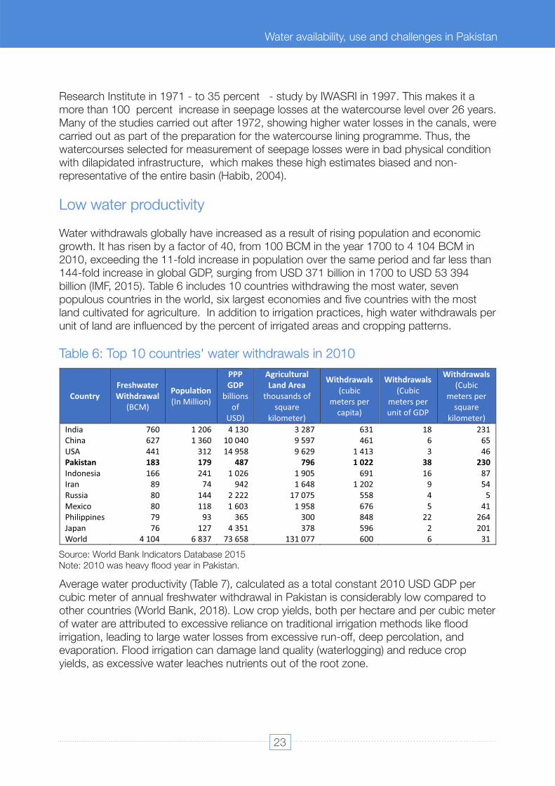
Table 6: Top 10 countries' water withdrawals in 2010
Average water productivity (Table 7), calculated as a total constant 2010 USD GDP per cubic meter of annual freshwater withdrawal in Pakistan is considerably low compared to other countries (World Bank, 2018). Low crop yields, both per hectare and per cubic meter of water are attributed to excessive reliance on traditional irrigation methods like flood irrigation, leading to large water losses from excessive run-off, deep percolation, and evaporation. Flood irrigation can damage land quality (waterlogging) and reduce crop yields, as excessive water leaches nutrients out of the root zone.
Water withdrawals globally have increased as a result of rising population and economic growth. It has risen by a factor of 40, from 100 BCM in the year 1700 to 4 104 BCM in 2010, exceeding the 11-fold increase in population over the same period and far less than 144-fold increase in global GDP, surging from USD 371 billion in 1700 to USD 53 394 billion (IMF, 2015). Table 6 includes 10 countries withdrawing the most water, seven populous countries in the world, six largest economies and five countries with the most land cultivated for agriculture. In addition to irrigation practices, high water withdrawals per unit of land are influenced by the percent of irrigated areas and cropping patterns.
Low water productivity
Country Freshwater Withdrawal
(BCM)
Popula�on
(In Million)
PPP GDP
billions of
USD)
Agricultural Land Area
thousands of square
kilometer)
Withdrawals
(cubic meters per
capita)
Withdrawals
(Cubic meters per unit of GDP
Withdrawals
(Cubic meters per
square kilometer)
India 760 1 206 4 130 3 287 631 18 231
China 627 1 360 10 040 9 597 461 6 65
USA 441 312 14 958 9 629 1 413 3 46
Pakistan 183 179 487 796 1 022 38 230
Indonesia 166 241 1 026 1 905 691 16 87
Iran 89 74 942 1 648 1 202 9 54
Russia 80 144 2 222 17 075 558 4 5
Mexico 80 118 1 603 1 958 676 5 41
Philippines 79 93 365 300 848 22 264
Japan 76 127 4 351 378 596 2 201
World 4 104 6 837 73 658 131 077 600 6 31
Source: World Bank Indicators Database 2015 Note: 2010 was heavy flood year in Pakistan.
23
Water Availability, Use and Challenges in Pakistan
Water availability, use and challenges in Pakistan

13At the user's level, Warabandi and the manipulations of the water allocation system have taken place and they have persisted over time. Alterations of canal outlet sizes and timings of delivery have created inequalities, leaving some farmers – particularly poor farmers at the tail end of a canal or watercourse – with fewer allocations and less access to water. As a result, access to canal water at the farm level depends on access to land and the location of that land along the canal (Yu, 2013). et al.,
Lastly, Warabandi and the manipulations of the water allocation system have taken place, and they have persisted over time. Alterations of canal outlet sizes and timings of delivery have created inequalities, leaving some farmers – particularly poor farmers at the tail end of a canal or watercourse – with fewer allocations and less access to water. As a result, access to canal water at the farm level depends on access to land and the location of that land along the canal (Yu, 2013). Table 7 Comparison of Water Productivity in et al.,Agriculture.
Table 7: Comparison of water productivity in agriculture
Average farmers are unable to access laser levelling equipment easily, which is a popular and effective method of increasing water productivity, and the private sector is not actively engaged in providing these services.
Another issue related to low water productivity is Ineffective interventions. For example, rice and sugarcane improvement programmes failed to consider issues of water shortages, heat or salt tolerance, focusing primarily on developing high yield and disease-resistant varieties.
13 Warabandi system or water timeshare system was introduced by the British administration to ensure equitable provision of water to cropped lands. As the demand for irrigation water was rather minimal due to low cropping intensity and production of primarily of low-water requirement crops like food grain (wheat, maize, sorghum, and millets), pulses, oilseeds, etc. During the last decade, however, the pressure on water has drastically increased, with more competition for quantity and quality of irrigation water within the irrigation sector, but also from other sectors of the economy.
Country Tons/Hectare Constant 2005 USD/m3
Kg/m3
USA 7.34 30.20 1.56 Germany 7.32 98.33 Egypt 7.25 1.88 France 7.10 74.54 Japan 6.10 53.13 China 5.89 8.86 0.80 Vietnam
5.42
1.12
Indonesia
5.15
3.96
Brazil
4.83
16.09
Bangladesh
4.36
3.12
India
2.96
1.96
0.39
Kyrgyz
2.90
0.44 Pakistan
2.72
0.78
0.13
Source. World Bank Indicators Database 2015.
24
Water Availability, Use and Challenges in Pakistan
Large variations in estimates and decades-old data used in some cases by the global databases suggest the need to rectify the data and methodology to estimate some key indices like water use efficiency, crop productivity and the value of water.
Financial sustainability of the water sector
Gross revenue generated from agriculture and other water use sectors is extremely low and has a decline in its real value over time. Water rates for agriculture uses are historically linked with the irrigated land and have been considered low. A major target of Irrigation management transfer reforms was to improve the water rates and the actual revenue collection. However, total revenue from the sector decreases, as, Punjab shifted from the crop-based irrigated land revenue to the flat-rate revenue on the landholding. Sindh and other provinces could not enhance the assessment and collection procedures.
Most of the industrial water used from the surface resources are not accounted for. While under-reported allocations are nominally charged. Similarly, water rates are very low in the commercial and domestic sectors. Because of the low-income water sector depends upon national exchequer for its daily operations and maintenance of the system. water resources development and asset management fully rely on foreign funded projects. Tariffs and subsidies also benefit big producers, eventually supporting a small group of “progressive farmers”, having higher productivity of land and water but a small overall contribution.
A different set of arguments is provided by Young (2019). The economic return from irrigation water has doubled over the last three decades from around 0.03 USD/m3 to 0.06 USD/m3 in Sindh and from around 0.04 USD/m3 to 0.08 USD/m3 in Punjab. This has been achieved through expansion of the irrigated area, increased groundwater use, increased use of fertilizers, mechanization, and improvements in water management-Water productivity needs to improve markedly if Pakistan is to revitalize economic growth, and should come from better water delivery control, better on-farm management, higher input quality, and better pest control.”
Future projection of water requirements
(ii) higher conveyance efficiency of the irrigation network (64 percent ); (iii) urban/domestic water requirements based on official targets for the safe domestic
water supply and the current actual supply pattern of large and medium cities;(iv) expected infrastructure, industrial and social sectors' requirements; and (v) promised environmental flows.
Climate change impacts on sectoral water demands estimate water requirements of agriculture and other sectors without specific interventions (Amir and Habib, 2015). The baseline scenario (no climate change) was developed based on:
(i) a modest population growth rate (1.67 percent increase in 2015 and only 0.61 percent in 2050);
25
Water Availability, Use and Challenges in Pakistan
Water availability, use and challenges in Pakistan

Year
Urban/Commercial
Industrial/Social
Agriculture
Ecology/Forest
ENV Flows
Total water demand
Agri. Share
Billion Cubic Meters -------------
BCM -------------------
BCM
MAF
%
Base Scenario –
No systema�c change in temperature and precipita�on
2015
9.3
3.3
138.5
6.3
5
162.4
132.0
85
2025
12.7
5.5
149.8
7.0
5
180.0
146.3
83
2050
30.5
10.2
171.9
8.9
5
226.6
184.2
76
Temperature Increase 1C �ll mid -century
2025
12.8
5.7
154.3
7.2
5
184.9
150.4
0.83
2050 31.0 11.7 182.4 9.5 5 239.5 194.8 0.76
Temperatur e Increase 3C �ll mid-century
2025 13.3 5.9 158.8 7.5 5 190.6 155.0 0.83
2050 32.9 15.1 196.5 10.0 5 259.6 211.0 0.76
Source: Amir and Habib (2015)
The report estimates CWR for 1oC and 3oC increase in temperature in 2020 and 2050 using the CROPWAT model for the major crops and evapotranspiration projections by PMD. It estimated that a +3°C increase in temperature by 2050 would result in agricultural water requirements increasing by 6 percent by 2025 and 12-15 percent by 2050. The study presents high water competition among various water use sectors and increased stress on the agriculture sector. For the baseline estimates, non-agriculture water demand will be around 17 percent in 2025 and 24 percent in 2050. Climate-induced warming will increase water requirements by 5 BCM in 2025 and 10 BCM in 2050. The forecast for the municipal water demand is higher compared to all other estimates, which is justified by the authors based on existing urban water supply patterns and public commitment to provide safe drinking water and sanitation access (Amir and Habib, 2015). The demand estimates by the study are provided in Table 8 and Figure 13.
Table 8: Controlled population (1.7 percent to 0.5 percent in 2050) and reasonable economic growth – water requirements at the water use level (farm in case of agriculture)
26
Water Availability, Use and Challenges in Pakistan
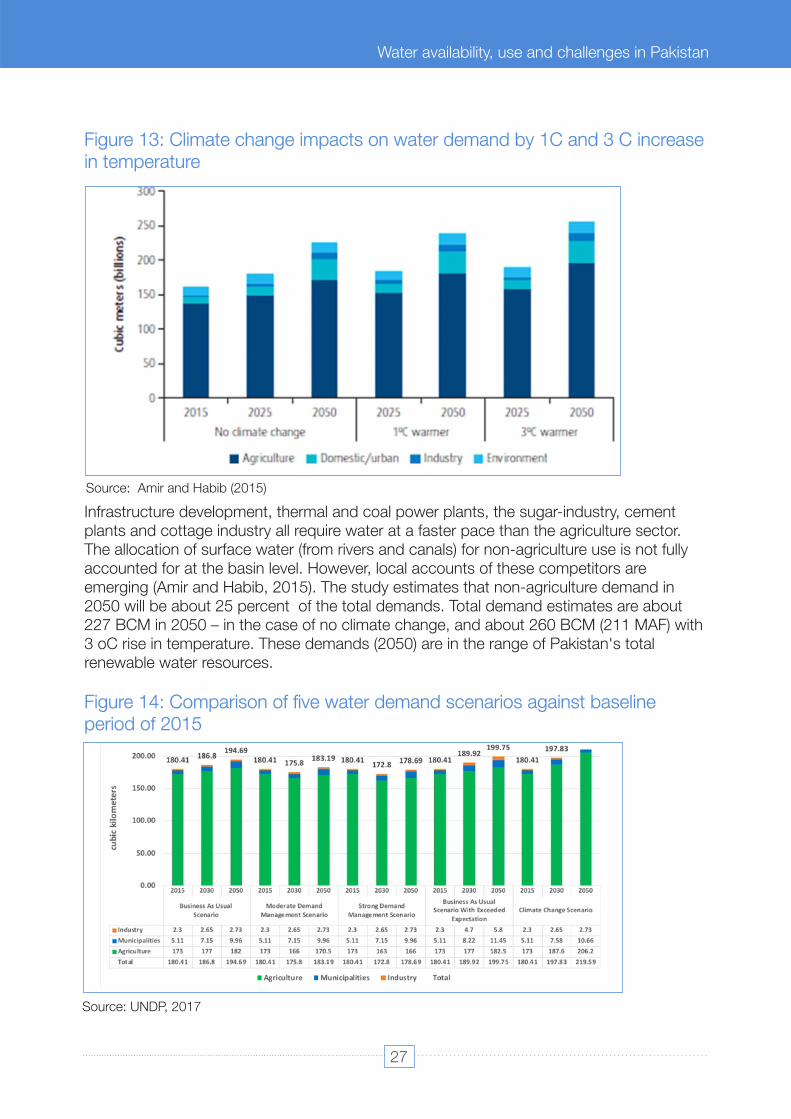
Figure 13: Climate change impacts on water demand by 1C and 3 C increase in temperature
Figure 14: Comparison of five water demand scenarios against baseline period of 2015
Infrastructure development, thermal and coal power plants, the sugar-industry, cement plants and cottage industry all require water at a faster pace than the agriculture sector. The allocation of surface water (from rivers and canals) for non-agriculture use is not fully accounted for at the basin level. However, local accounts of these competitors are emerging (Amir and Habib, 2015). The study estimates that non-agriculture demand in 2050 will be about 25 percent of the total demands. Total demand estimates are about 227 BCM in 2050 – in the case of no climate change, and about 260 BCM (211 MAF) with 3 oC rise in temperature. These demands (2050) are in the range of Pakistan's total renewable water resources.
Source: Amir and Habib (2015)
Source: UNDP, 2017
27
Water Availability, Use and Challenges in Pakistan
Water availability, use and challenges in Pakistan

The factors behind and sometimes justification for a range of water numbers given in Table-9 can be summarized as:
Another review study was recently carried out by UNDP and COMSAT, 'The Vulnerability of Pakistan's Water Sector to the Impacts of Climate Change: Identification of gaps and recommendations for action' (2017, see Figure 14). The study used the same data as Amir and Habib (2015) for projections on the population, temperature, rainfall and agriculture areas. However, both studies have different estimates of the current water demands (Table 8 and Figures 13 and 14). The baseline agriculture demand by UNDP is estimated as 173 bcm (same as total withdrawals from all sources in 2015). All UNDP scenarios consider a small change in industrial demand, from 2.3 bcm in 2015 to 2.73 bcm in 2050, much less than the estimation of Table 8 (3.3 bcm to 10 bcm). In addition to the climate change scenario, two demand management scenarios were adopted by the UNDP study substantially reducing agricultural demands from 2015 to 2030 and maintaining the current level in 2050. The business as usual scenario shows 15 bcm increase in total water demand in 2050 and the climate change scenario an increase of 39 bcm.
ii. Almost all water balance studies by donors (WB, ADB) and a big project are focussed on the Indus Basin and IBMR model or its new versions (used by WB studies of 2013 and 2019). The model further focusses on the irrigated agriculture inside the canal command areas. Hence, the water used outside the model setting is either not considered or taken from the available references.
Table 9 summarises the range of values of water variables used by various water balances and assessment studies. The rivers inflows at the RIM-stations and the surface diversions through canals are the two variables, having the same values and data sources in all studies. All other quantities are computed differently by different studies, influenced by various factors like methodology, the scale of analysis, objectives of a particular study and assumed boundary conditions. The remarks column briefly comments on each water component. Some of these limitations are also mentioned in the text of this paper.
Information and data gaps
The provincial level assessment of water and land resources and applications of remote sensing techniques are the emerging trends in Pakistan. The new water management scenario will need a more serious and systematic approach to present a correct profile of the water resources at various levels.
I. Currently, no public sector organization is responsible for the compilation of water data other than the main rivers flows and canal diversion. The responsibilities of WAPDA (particularly related to monitoring and reporting) are not taken by any other agencies, as WAPDA slowly exited.
iii. Most of the analysis are carried out in the supply-based setting and traditional concepts about the irrigation canals prevail. That seriously influences estimations of water
28
Water Availability, Use and Challenges in Pakistan

Water Component Value Source Remarks
Indus River and tributaries
Inflows: Indus, Jhelum,
Chenab, Kabul, Ravi, Sutlej
170 bcm PIDs, IRSA, WAPDA Historical River flows data is
available
Ungauged Tributaries
below RIM sta�ons
6.4 bcm
Not in the public
domain, available on
request
Not updated, considered a part of
River gains and Losses
Kharan and Makran Basins
of Balochistan
9.8 (6.2+3.5)
bcm
WAPDA 1991, Young
2019
Not updated
Runoff from
Watersheds
Pakistan Upstream of
RIM Sta�ons
Kabul River runoff
generated inside Pakistan
boundary
10.5
to 15
bcm
Arfan, M.; Lund, J
(2019). R.
Ullah 2017,
Khan, F. and Pilz, J.
(2018).
Nine rivers shared by Pakistan and
Afghanistan with an annual flow of
around 22.5 BCM, Kabul River alone
accounts for 21.5
bcm
(Mustafa,
2011).
Upper Indus Basin (UIB)
flows generated in Pakistan
controlled Area
about
15 bcm
yield
between
Chalas and
Alam bridge
Kashif Jamal (2018)
Climate change and runoff
contribu�on by hydrological zones of
cryosphere catchment of Indus
River, Pakistan
Small Dams storages and
uses
About 70
small dams
Provincial Small Dams
Orgs.
Accumulated data of actual storage
and uses not available
Surface water uses
upstream RIM sta�ons
4 –
6 bcm
Alloca�on of civil
canals of KP by WAA
1991.
Bhasha study
2011
Three
big canals
of SWAT & Kabul
rivers and many civil canals are
formal systems monitored by the
Prov. Irriga�on Dept. However, most
of the databases ignore them.
vi. The remote sensing applications especially need ground-truthing and calibrations, in addition to the scale and resolution issues.
iv. The emerging water use sectors do not report the actual uses and the sources of water, hence, assessments for urban, commercial and industrial remain low and erratic. Sometimes 30 years old data is still used.
demands and the actual uses, which are mostly calculated through the supply-side efficiency factors.
v. Some of the basin water definitions are not properly applied, like “the renewable water resources” and the “internal water resources”.
Table 9 : Gaps in the estimation of the gross water resources, water availability and water uses
29
Water Availability, Use and Challenges in Pakistan
Water availability, use and challenges in Pakistan

Rainfall Contribu�on
Surface Runoff & Recharge
within Indus
Plains below
RIM sta�ons.
In the range of
28 -
48
bcm
WAPDA 1991
Young
2019,
Amir & Habib
No na�onal-level es�mate available
Rain direct uses by crops
in
the Indus Basin
12 bcm to 36
bcm
WAPDA 1991, Ijaz et
al., (2010) Habib 2004,
Amir & Habib 2015
Water Accoun�ng study
2019 FAO
Rainfall uses in Baranni
areas
outside Canal
Commands
In the range of
9 bcm
Es�mated in 1979 and
1991
by WB and
WAPDA
Not Updated.
Groundwater es�mates based on Water Balances
Groundwater Aquifer:
Annual withdrawal
60 bcm to 72 bcm
WB 2019, FAO & many
others
balances mostly confined to the
Indus Basin
Aquifer total Replenishing
Poten�al
66 to 75 bcm
Es�mates based on water balances
and irriga�on conveyance
efficiencies
Es�ma�ons of water requirements, supply and uses in various sectors at the Na�onal, Provincial and Basins levels.
Agriculture Water Demands and Uses
80 bcm to
136 bcm
WAPDA 1974, WAPDA 91, Habib 2004, WB 2005, Ijaz 2010, Yu et al., 2013, Amir & Habib 2015, UNDP 2017, Young et.al., 2018
FAO AQUASTAT
Basic limita�on of
the given es�mates:
I, values computed for water balance models of the Indus basin CCAs
Ii, water uses calculated by applying conveyance efficiency factors
Iii, non-agricultural uses randomly assumed
Urban, domes�c, civil & commercial water uses
5 bcm
to 9.6 bcm
Industrial water uses
1.8 bcm to 3.6 bcm
Water used by Forest,
rangeland,
and ecosystems
About 4 bcm
WAPDA 1991
Not updated
Internally Generated Water
Resources
55 bcm
Aquastat, WB
databases
Under-es�mated
only considering
rainfall contribu�on within CCAs &
for the aquifer recharge
30
Water Availability, Use and Challenges in Pakistan

Conclusion & recommendations
Pakistan faces daunting water resources challenges as the need for water supply from different sectors intensifies due to population growth, economic development, and impacts from climate change. The country withdraws more than 70 percent of its renewable water resources, most of which are used in agriculture. Annual river flow data over a 35-year period indicates a quantifiable decline in the annual volumes of river flows. Exacerbating the challenge is a growing demand for water, mainly stemming from rising population, rapid urbanization, the adverse impact of climate change, and the continuing degradation of water quality. Further, water demand from new emerging sectors that include environmental flows, China Pakistan Economic Corridor (CPEC) related development, afforestation needs, and social developments have neither been foreseen nor factored in future planning.
To check the emerging unaccounted water uses, there is a need to strictly follow and extend surface water allocation procedures to all water use sectors. Pakistan needs to improve its water and land data reporting systems at the national and global levels. There is a severe lack of understanding of some new terms and variables, like the renewable and internal water resources, productivity of water, and, local and global water use efficiencies.
Climate change is making matters worse with erratic rainfall, temperature rise and increased variability in water availability patterns. The impact of climate change on water availability is projected to be severe with intense events of floods and droughts. While, water supply is already affected by changing climates; water demand is also projected to increase, not only in agriculture, but also in urban areas as well as in the industry.
A proper and standardized system of water accounting is not followed both at Federal or at Provincial levels. Water balances carried out by different organizations and institutions using different methodologies and data sources are providing different results for the same physical boundaries. Also, the Remote sensing and GIS based water accounting carried out in the country often lacks proper (re)calibration of the model(s) used. Part of the reason for this is the limitations of available data and information, which sometimes is incomplete, especially seasonal cropping patterns and crop yields.
Groundwater has a critical role in managing the demand-supply gap at the user level in all sectors of the national economy. Across the freshwater zone active recharge and abstraction of groundwater provide a unique recycling opportunity to the rain and irrigation runoff. However, consistent aquifer mining is causing secondary salinization and depletion of a critical resource in high water stress areas. In the saline aquifer zone, about 30 percent of the Indus plains, excessive effluent, and insufficient drainage result in waterlogging, salinity and pollution of fresh surface water bodies. The groundwater monitoring mechanism developed in the eighties has faded with time. New provincial initiatives have limited spatio-temporal coverage and still not able to generate annual groundwater profiles. Deterioration of groundwater quality is directly linked with the marginalization of drinking water quality and health issues.
31
Water Availability, Use and Challenges in Pakistan
Water availability, use and challenges in Pakistan

7. must be considered in order to Sustainable management of groundwater aquifers
3. A paradigm shift is key in meeting water from irrigation to water managementchallenges, especially in changing climate and addressing the increasing needs of a growing population and other sectors including industries and municipalities. Although by 2050 agriculture will account for the highest increase, water demand for domestic uses (urban and rural) will rise sharply with the highest rate.
4. Strategic long-term water management necessitates employing a standardized water accounting system that can provide comprehensive information on water use and availability and is especially resourceful for resolving tensions and gaps between water supply and demand. Water accounting provides critical information about the hydrological cycle, assesses spatial and seasonal rainfall variations with water extremities – information that can inform water infrastructural investments such as pumping, storage, and planning for climate change.
5. Remote-sensing and GIS technology, in a combination of ground data, can be used to measure and monitor the evapotranspiration from basin, sub-basin, administrative units and agro-climatic zones) in the agriculture sector to determine actual crop water consumption and water productivity (production and income per unit of water consumed).
Recommendations
In light of the review and analysis of the water situation in the country, some key recommendations have been proposed as follows, which can be applied to overcome the problems faced by Pakistan's water sector and its impact on agriculture due to climate change.
1. Institutional coordination between federal and provincial levels as well as across the sectors is a key challenge, which should be addressed through permanent institutional mechanisms. Instead of launching new institutes, Pakistan needs to revisit existing institutional responsibilities, overlaps and gaps.
2. Pakistan must maintain and extend surface water allocation procedures to all water use sectors in addition to the irrigation sector. The surface water resources, which are increasingly used for the municipal and industrial supplies should have a clear allocation to these sectors.
6. needs to be at the center of current and future water policies and Demand managementstrategies in order to sustainably manage water resources. As the gap between water supply and demand increases managing demand in agriculture and other sectors become more important. Strategies need to focus on improvements in water productivity, reduction in non-beneficial evapotranspiration, and reduction in source and non-source water contaminating practices. The safe use of non-conventional water resources in agriculture and non-agriculture sectors needs to be encouraged.
32
Water Availability, Use and Challenges in Pakistan

8. Irrigation system modernization; rehabilitation and maintenance of irrigation systems. Irrigation Systems in the Provinces requires not only proper maintenance but also modern techniques and technologies for improved management and water delivery services. This will allow farmers to make timely on-farm decisions resulting in higher productivities and incomes. High-efficiency water application techniques such as trickle/drip sprinkle, bubbler irrigation, furrow bed irrigation need to be introduced and upscaled for improved water use, the ratio between beneficial and non-beneficial evapotranspiration, and water productivity.
9. The provincial extension Climate-smart agriculture and on-farm water management. services need to provide information and reorient farmers to planting resilient crop varieties, changing planting dates, and adapting farming practices to a shorter growing season. Drought-tolerant varieties of wheat and cotton, and heat-tolerant varieties for cotton, which are being practiced in some parts of Pakistan, need to be upscaled. Additionally, practices such as laser and gradient land-leveling need to be promoted to prevent water losses due to poor field design and surface unevenness causing water accumulation or leave dry pockets. Resultantly, germination is often inconsistent and uneven growth of crops. The use of a laser beam allows farmers to achieve uniformity in field preparation for uniform water and moisture distribution. Zero-tillage (rice-wheat crops) can help with seed germination, minimizing the soil disturbance and maximizing carbon storage. Soil ripping can help conserve water. The government in collaboration with the private sector can help to facilitate climate-resilient agricultural systems by establishing demonstration plants and moving towards high-value agriculture. Additionally, the extension staff in coordination with the irrigation department may train the farmers in soil and water conservation techniques, such as dry seeding or rice, furrow irrigation, and drip irrigation, which can boost land productivity and conserve scarce water resources.
optimize the development of water resources, management, and conservation within a basin. Recharge in the areas with sweet groundwater zones should be encouraged, whereas, reduction in seepage in the areas with marginal groundwater quality (and with saline groundwater zones) should be reduced. Artificial recharge of aquifers is certainly one of the tools that can help in the sustainable use of groundwater resources, especially in areas with good quality groundwater.
10. Water subsidies generally benefit upper-income groups in Water tariff and subsidies. developing economies, as the poor often have limited or no water access. Current water tariffs in Pakistan and agricultural input and crop subsidies (fertilizer, pests, sugarcane) promote water-intensive cropping (sugarcane and rice). Similarly, subsidized electric supply for tube-wells encourages the over-abstraction of groundwater and poor irrigation practices. The federal and provincial governments may have a deeper look at the current subsidies regime and water pricing to align with the challenges caused by climate change. It requires gradual phasing out of current subsidies and diverts a part of these subsidies to promote climate-smart agriculture and water management. Water tariffs must be set to recover the full cost of maintenance of the irrigation system and groundwater needs to be licensed and priced.
33
Water Availability, Use and Challenges in Pakistan
Water availability, use and challenges in Pakistan
Arfan, M.; Lund, J.; Hassan, D.; Saleem, M.; Ahmad, A. 2019. Assessment of Spatial and
Aslam, M. 2016. Agricultural Productivity Current Scenario, Constraints and Future Prospects in Pakistan. Sarhad
Journal of Agriculture. (Available at
References
Temporal Flow Variability of the Indus River. (Available at www.mdpi.com/2079-9276/8/2/103/pdf )
http://researcherslinks.com/journal-details/Agricultural-Productivity-Current-ScenarioConstraints-and-Future-
Prospects-in-Pakistan/14/current-issue )
Briscoe, John; Qamar, Usman. 2005. Pakistan's water economy: running dry (English). Washington, DC: World Bank.
(Available at http://documents.worldbank.org/curated/en/989891468059352743/Pakistans-watereconomy-running-
dry)
Directorate General Agriculture (Water Management). 2015. Provision of Laser Land Levelers to Farmers/ Service
Providers on Subsidized Costs. Lahore: Annual Development Program (ADP).
Forestry Commission, UK, 2011. Forests and water. UK Forestry standard guidelines, Edinburgh: s.n.
Gebre and Ludwig, 2014. Spatial and Temporal Variation of Impacts of Climate Change on the Hydrometeorology of Indus
River Basin Using RCPs Scenarios, South East Asia. Earth Science and Climate Change
Hewitt, K. 1989. The Altitudinal Organization of Karakoram Geomorphic Processes and Depositional Environments.
Zeitschrift für Geomorphologie, Supplement band.
Kalpana Kochhar, Catherine Pattillo, Yan Sun, Nujin Suphaphiphat, Andrew Swiston, Robert Tchaidze, Benedict
Clements, Stefania Fabrizio, Valentina Flamini, Laure Redifer, Harald Finger, and an IMF Staff Team. 2015. International
Monetary Fund, Is the Glass Half Empty or Half Full? Issues in Managing Water Challenges and Policy Instruments.
(Available at https://www.imf.org/external/pubs/ft/sdn/2015/sdn1511.pdf )
Kahlown. M. Akram, Abdul Majeed, 2004. Pakistan Water Resources; Development and Management.
Khan, F. and Pilz, J. 2018. 'Modelling and sensitivity analysis of river flow in the Upper Indus Basin, Pakistan', Int. J. Water.
Lutz AF, Immerzeel WW, Kraaijenbrink PDA, Shrestha AB, Bierkens MFP. 2016. Climate
Change Impacts on the Upper Indus Hydrology: Sources, Shifts, and Extremes. PLoS ONE.
Muhammad Jehanzeb Masud Cheema & Wim G. M. Bastiaanssen. 2012. Local calibration of remotely sensed rainfall
from the TRMM satellite for different periods and spatial scales in the Indus Basin, International Journal of Remote
MWH and IFPRI. 2016. Draft Economic Analysis - Environment and social impact assessment for Diamer Basha Dam
Project. Islamabad, USAID.
Mustafa, K. 2011. India to help Afghanistan build 12 dams on Kabul River. [Available at]
http://www.thenews.com.pk/Todays-News-13-5933-IndiatohelpAfghanistan-build-12dams-on-Kabul-River.
WASA-LDA, Lahore, JICA, 2009.The Preparatory Study on Lahore Water Supply, Sewerage and Drainage Improvement
Project in the Pakistan, Interim Report.
34
35
Water Availability, Use and Challenges in Pakistan
Water availability, use and challenges in Pakistan
Parry, J., Osman, H., Terton, A., Asad, S., & Ahmed, T. 2017. The Vulnerability of Pakistan's Water Sector to the Impacts of
Climate Change: Identification of gaps and recommendations for action. Islamabad: UNDP Pakistan, International
Institute for International Development; COMSATS Institute for Information Technology.
Qureshi, A.S. 2011. Water Management in the Indus Basin in Pakistan. Challenge and Opportunities. Mount Res Dev.
Islamabad, UNDP, 2017. The Vulnerability of Pakistan's Water Sector to the Impacts of Climate Change: Identification of
gaps and recommendations for action.
Yu. W, Yi-Chen Yang, Andre Savitsky, Donald Alford, Casey Brown, James Wescoat, Dario Debowicz, and Sherman
Robinson. 2013. The Indus Basin of Pakistan: The Impacts of Climate Risks on Water and Agriculture”. Washington, DC:
World Bank.
World Bank, DC, 2006. Pakistan Strategic Country Environmental Assessment, vol. 2, Technical Annex: The Cost of
Environmental Degradation in Pakistan—An Analysis of Physical and Monetary Losses in Environmental Health and
Natural Resources. Report 36946-PK. (Available at http://databank.worldbank.org/data/home.aspx )
Sharif, M., Archer, D. R., Fowler, H. J., & Forsythe, N. 2013. Trends in timing and magnitude of flow in the Upper Indus
Basin. Hydrology and Earth System Sciences.
Sun G et al., 2011. A general predictive model for estimating monthly ecosystem evapotranspiration Ecohydrology.
Sheikh Saeed Ahmad, Anusha Sherazi, and Muhammad Tahir Ali Shah. 2010. A Preliminary Study on Climate Change
causing decline in Forest Cover Area in District Chakwal, Pakistan.
Raza Ullah and Farhad Zulfiqar, Transboundary Water Issues between Pakistan and Afghanistan. Faisalabad, University
of Agriculture, Islamabad, COMSATS Institute of Information Technology.
World Bank. 2015. Indicators Database
Shakil et al., 2015. Implications of Shrinking Cryosphere under Changing Climate on the Stream flows in the Lidder
catchment in the Upper Indus Basin, India, Arctic Antarctic, and Alpine Research.
Asian Development Bank, 2017. Climate Change Profile of Pakistan.
Himalaya and Tibetan Plateau: a case study of air temperature increase for three glaciers. Ann.Glaciol.
Bibliography
Ageta, Y., & and Kadota, T.1992. Predictions of changes of glacier mass balance in the Nepal
Ali, A. 2013. Indus Basin Floods: Mechanism, impacts, and management. Mandaluyong City, Philippines, Asian
Development Bank.
Aquastat. (n.d.) (Available at http://www.fao.org/nr/water/aquastat/basins/indus/indus-CP_eng.pdf )
D. S. 2015-16. Punjab.
An Assessment of the Potential Impacts of Deglaciation on the Water Resources of the Himalyas. Oxfordshire, U.K.: DFID
Finance, M. o. 2016-17. Pakistan Economic Survey. Islamabad, Pakistan Ministry Of Finance. Habib, Z. 2004. Scope for Reallocation of Rivers Waters for Agriculture in the Indus Basin, Phd-Dissertation.
Akram, G. e. 2016. Pakistan Journal of Meteorology; Past and Future Trends in Frequency of Heavy Rainfall Events over
Pakistan.
Finance, M. o. 2014-15. Pakistan Economic Survey. Islamabad, Pakistan: Ministry of Finance.
AQUASTAT Survey, 2011. Irrigation in Southern and Eastern Asia in figures
(Available at http://www.fao.org/nr/water/aquastat/basins/indus/indus-CP_eng.pdf )
Bocchiola, D. 2015. Future Hydrological Regimes in the Upper Indus Basin: A Case Study from a High-Altitude
Glacierized Catchment. Journal of Hydrometeorology.
Haeberli, W., & Hoelzle, M. 1995. Application of inventory data for estimating characteristics of and regional climate-
change effects on mountain glaciers: a pilot study with the European Alps. Annals of Glaciology, Russian Translation: Data of Glaciological Studies.
JICA, Pakistan, 2010. Urgent Rehabilitation Project for Swearage and Drainage System in Lahore –
Karen FRENKEN. 2011. Irrigation in Southern and Eastern Asia in Figures, Aquastat
Imran, S., Bukhari, L. N., & Gul, S. (2018). Water Quality Assessment Report Along the Banks of River Kabul Khyber
Pakhtunkhwa. Pakistan Council of Research in Water Resources (PCRWR).
Kääb, A., Berthier, E., Nuth, C., Gardelle, J., & Arnaud, Y. 2012. Contrasting patterns of early twenty-first-century glacier
mass change in the Himalayas. Nature: International Journal of Science.
IFPRI, M.-A. (July 2016). Climate Change Impact Assessment for Diamer Basha Dam. NC, USA: Research Triangle
Institute - RTI International.
Survey. Rome: FAO. (Available at http://www.fao.org/3/i2809e/i2809e.pdf )
Intergovernmental Panel on Climate Change (IPCC), Cambridge, UK and New York, USA: Cambridge University Press,
2012. Managing the Risks of Extreme Events and Disasters to Advance Climate Change Adaptation. A Special Report of
Working Groups I and II of the.
Iqbal, M., Ghoeer, M., & Khan, A. M. 2009. Climate-Change Aspersion on Food Security of Pakistan. Science Vision.
J. Hoogeveen et al., September 2015. GlobWat - a global water balance model to assess water use in irrigated
agriculture. Rome, FAO.
Ministry of Finance, 2008-09. Pakistan Economic Survey.
36

37
Water availability, use and challenges in Pakistan
https://www.ngwa.org/what-isgroundwater/About-groundwater/facts-about-globalgroundwater-usage )
Parry, J., Osman, H., Terton, A., Asad, S., & Ahmed, T. 2017. The Vulnerability of Pakistan's Water Sector to the Impacts of
Climate Change: Identification of gaps and recommendations for action. Islamabad, Pakistan, UNDP, International
Institute for International Development; COMSATS Institute for Information Technology.
Rees, G., & Collins, D. N. (2004). SAGARMATHA - Snow and Glacier aspects of Water Resources Management in the
Himalayas. Final Technical Report: Volume 2. An assessment of the impacts of deglaciation on the water resources of the
Himalaya. Centre for Ecology and Hydrology.
Qureshi, A. S. 2011. Water Management in the Indus Basin in Pakistan: Challenges and Opportunities. Mountain
Research and Development.
Safdar, M. T. 2015. Sugarcane and Punjab, Pakistan: Production, Processing and Challenges. Ethical-Sugar.
Wahaj, R. 2001. Farmers actions and improvements in irrigation performance below the Mogha: how farmers manage
water scarcity and abundance in a large scale irrigation system in South-Eastern Punjab, Pakistan.
W o r l d B a n k , 2 0 1 8 , D a t a B a n k . R e t r i e v e d f r o m t h e W o r l d B a n k . ( A v a i l a b l e a t
http://databank.worldbank.org/data/home.aspx )
Moreda, F., Eddy, M., & Allen, J. (n.d.). Climate Change Impact Assessment for Diamer Basha Dam.
National Ground Water Association. (n.d.). (Available at
Ministry of Finance, 2016-17. Pakistan Economic Survey.
(n.d.). (Available at http://www.fao.org/nr/water/aquastat/basins/indus/indus-CP_eng.pdf )
Ministry of Finance, 2013-14. Pakistan Economic Survey.
Rehman, A., 2017, Jingdong, L., Chandio, A. A., Shabbir, M., & Hussain, I.
A time series analysis, Financial Innovation, 1970-2015, Economic Outlook of Rice Crops in Pakistan. Rehman, A., Jingdong, L., Shahzad, B., Chandio, A. A., Hussain, I., Nabi, G., & Iqbal, M. S. 2015. Economic Perspectives
of Major Field Crops of Pakistan: An Empirical Study. Pacific Science Review: Humanities and Social Sciences. Rehman, M. 2016. Pakistan Sugar Annual. Global Agricultural Information Network.
Solomon, S., Qin, D., Manning, M., Marquis, M., Averyt, K., Tignor, M. M., Chen, Z. 2007. The Physical Science Basis.
Contribution of Working Group I to the Fourth Assessment Report of the Intergovernmental Panel on Climate Change.
Cambridge University Press.
Young, W., Anwar, A., & Bhatti, T. 2019. Getting More from Water. Pakistan, World Bank.
Yu, W., Yang, Y., Savitsky, A., Alford, D., Brown, C., Wescoat, J. Robinson, S. 2013. The Indus Basin of Pakistan: The
Impacts of Climate Risks on Water and Agriculture. Washington D.C: World Bank

38

The publications in this series record the work and thinking of researchers and experts from the Food and Agricultural Organization of the United Nations. FAO-Pakistan would like to share the knowledge and its scientific findings with the researchers, and the scientific community at large and would like the research work gathered from these papers are referenced and cited.
FAO Representation in Pakistanwww.fao.org/Pakistan@FAOPakistan Food and Agriculture Organization of the United Nations National Agriculture Research center (NARC) PremisesPark Road, Chak Shahzad, IslamabadIslamabad, Pakistan CB0718EN/1/03.21
ISBN 978-92-5-133206-1
9 7 8 9 2 5 1 3 3 2 0 6 1
Related Documents