WATER AND THE MOUNTAINS: MAYA WATER MANAGEMENT AT CARACOL, BELIZE by JAMES M. CRANDALL B.A. University of Central Florida, 2006 A thesis submitted in partial fulfillment of the requirements for the degree of Master of Arts in the Department of Anthropology in the College of Sciences at the University of Central Florida Orlando, Florida Spring Term 2009

Welcome message from author
This document is posted to help you gain knowledge. Please leave a comment to let me know what you think about it! Share it to your friends and learn new things together.
Transcript

WATER AND THE MOUNTAINS: MAYA WATER MANAGEMENT AT CARACOL, BELIZE
by
JAMES M. CRANDALL B.A. University of Central Florida, 2006
A thesis submitted in partial fulfillment of the requirements for the degree of Master of Arts
in the Department of Anthropology in the College of Sciences
at the University of Central Florida Orlando, Florida
Spring Term 2009

© 2009 James M. Crandall
ii

ABSTRACT Water management techniques in the Southern Maya Lowlands are both regionally
diverse and site specific. This thesis examines the water management strategies of the Classic
Period Maya at the site of Caracol, Belize. While it is likely that elites at Caracol controlled the
redistribution of resources, i.e. craft and agricultural products, it is probable that the production
of agricultural resources and the maintenance of water resource acquisition took place on a more
local level. In order to test this hypothesis, a sample of five reservoirs were examined through
original research – and situated in conjunction with past settlement studies - to determine the
water storage capacity and likely function of different water management features throughout the
built environment of Caracol. As a result, this thesis argues that the placement and construction
of water management features - i.e., reservoirs - at the site of Caracol, Belize are indicative of
specific landscape patterns which are expressed by a distinct vernacular construction style and
are also a reflection of the socio-political organization present within the site during the Late
Classic Period.
iii

ACKNOWLEDGMENTS
Archaeology is inevitably a team effort and this thesis would not have been possible
without the help of several individuals. I would like to thank Drs. Arlen and Diane Chase for
their support and advice not only in the field, but in the classroom as well. Their guidance has
afforded me many opportunities that few people are able to experience. Many fellow graduate
students also helped me during the research process of this thesis, specifically Andrea Slusser
and Lucas Martindale-Johnson who spent much of their free time in the field taking compass and
tape bearings even when those measurements inevitably took them through a thorny patch of
undergrowth. Amanda Groff, Jorge Garcia, Lisa Lomitola and other members of the Caracol
Archaeological Project also provided much needed moral support and advice. A great deal of
thanks is warranted for Dr. John Walker who provided many helpful suggestions regarding my
thesis. In addition, I would like to thank Meggan Jordan for her moral support throughout my
time at U.C.F. and John Warner for his good advice and much needed levity.
iv

Dedicated to Wayne and Sharon Crandall
v

TABLE OF CONTENTS
LIST OF FIGURES ...................................................................................................................... vii LIST OF TABLES....................................................................................................................... viii CHAPTER 1: INTRODUCTION................................................................................................... 1 CHAPTER 2: WATER MANAGEMENT AND THE BUILT ENVIORNMENT........................ 9
A Review of Water Management in Mesoamerica................................................................... 11 CHAPTER 3: CARACOL RESERVOIR AND WATER MANAGEMENT DATA.................. 17
Methodology............................................................................................................................. 19 Residential Reservoir A79 ........................................................................................................ 27 Residential Reservoir A18 ........................................................................................................ 28 Reservoir B ............................................................................................................................... 29 Reservoir A ............................................................................................................................... 31 Reservoir C ............................................................................................................................... 32 Natural Epicentral Aguada........................................................................................................ 34 Water Management at Caracol.................................................................................................. 34
CHAPTER 4: DISCUSSION........................................................................................................ 38 CHAPTER 5: CONCLUSION ..................................................................................................... 42
Future Research ........................................................................................................................ 43 APPENDIX: ADDITIONAL FIGURES ..................................................................................... 45 REFERENCES ............................................................................................................................. 60

LIST OF FIGURES Figure 1: Overview map of the Maya lowlands and sites mentioned in the text........................... 2 Figure 2: DEM of Caracol created from SRTM Data.................................................................... 4 Figure 3: A “natural” aguada from Caracol.................................................................................. 21 Figure 4: Caracol reservoirs in this study ..................................................................................... 22 Figure 5: Hypothetical input/output model of small depression carrying capacity at La Milpa
(after Weiss-Krecji and Sabbas 2002:354) ........................................................................... 36 Figure 6: Plan of the A79 Reservoir ............................................................................................. 46 Figure 7: Section of the A79 Reservoir ........................................................................................ 47 Figure 8: Section of the I21 Reservoir (after A. Chase and D. Chase 2005)................................ 48 Figure 9: Plan of I21 Reservoir (after A. Chase and D. Chase 2005)........................................... 49 Figure 10: Profile of the A18 Reservoir ....................................................................................... 50 Figure 11: Wall lining of the A18 Reservoir. Photo Courtesy of Andrea Slusser....................... 50 Figure 12: Profile of the A18 Reservoir ....................................................................................... 51 Figure 13: Reservoir B, facing north ............................................................................................ 52 Figure 14: The cut stone lining of Reservoir B............................................................................. 52 Figure 15: Profile of Reservoir B................................................................................................. 53 Figure 16: Reservoir A, facing southeast..................................................................................... 54 Figure 17: Section lines for Reservoir A (after A. Chase and D. Chase 1987) ........................... 54 Figure 18: Reservoir A, northern facing (C)................................................................................ 55 Figure 19: Reservoir A, northern facing (B)................................................................................ 55 Figure 20: Reservoir A, western facing (A)................................................................................. 56 Figure 21: Plan of Reservoir A .................................................................................................... 57 Figure 22: “Reservoir C” drainage plan....................................................................................... 58 Figure 23: “Reservoir C” drainage section .................................................................................. 58 Figure 24: Plan of natural epicentral aguada ................................................................................ 59 Figure 25: Profile of natural epicentral aguada............................................................................. 59

LIST OF TABLES Table 1: Caracol reservoir volumes in this study.......................................................................... 24 Table 2: Volume of previously identified Caracol reservoirs....................................................... 26

CHAPTER 1: INTRODUCTION
Mesoamerica’s physical environment presents challenges so daunting to sustainable
agriculture that it is a wonder that the Classic May developed such complex social, political, and
cultural achievements. The ancient Maya overcame geographical hardships through cultural
means in order to thrive. The Classic Maya created unique representations of art and architecture
that depicted both the physical and metaphysical world. Archaeological scholars in the past have
debated the degree to which environmental limitations affected the development of Classic Maya
social complexity (Turner 1978). Recent studies of Maya sites have employed a comprehensive
settlement approach to mapping and site testing, thereby revealing the true urban nature of
Classic Maya cities (A. Chase et al. 2002). Not surprisingly, studies throughout the Maya world
have uncovered diversified water management systems. These constructs were designed to solve
practical problems such as groundwater seepage and water accessibility at Maya cities like
Edzna (Matheny et al. 1983), Tikal (Scarborough and Gallopin 1991), and Copan (Davis-Salazar
2001) (Figure 1). Scholars investigating Maya sites have noted these types of alterations in the
physical environment for sometime (e.g. Matheny 1978). Yet only recently have these
alterations been scrutinized by anthropological and interdisciplinary studies (Scarborough 2006:
224-225).
1

Figure 1: Overview map of the Maya lowlands and sites mentioned in the text
2

Today Caracol, Belize, a primate center for a former Maya polity, is covered with thick
vegetative undergrowth and shaded by tall trees that form the extensive tree canopy of a tropical
forest. Navigating the jungle floor can be treacherous business during times of heavy rains; the
ground surface develops a universally muddy viscosity which is exaggerated by the presence of
leaves detached from the tree canopy above. Moreover, safe travel through this terrain is
hampered by creatures who find themselves flooded out of their underground dwellings. The
terrain throughout much of Caracol is a contrast of narrow gorges and steep inclines (Figure 2).
Low lying mountains contain the artificially altered landscape where the people of Caracol
constructed houses and temples in antiquity. Surface springs have been detected in the area;
however the closest lies some 4km to the west at Valentia Camp (Arlen Chase personal
communication 2009). The closest source of perennially flowing water is the Macal River
system, which lies some 20km distant from Caracol’s epicenter. The surrounding environment
of Caracol is greatly affected by the 3 1/2 month dry season, roughly from mid-January through
April, when surface water becomes scarce within natural surface depressions. The Classic Maya
of Caracol altered their natural environment by constructing reservoirs and areas of water
catchment in order to serve the agricultural and domestic needs of an urban populace during this
dry period and the rest of the year.
Some of the first archaeological investigations at Caracol revealed a site that did not
conform to previous concepts of Maya site organization. Although limited early investigations
during the 1950’s concentrated on the monumental architecture and removal of artwork present
within the site’s core (Beetz and Satterthwaite 1981); later investigations (Healy et al.1983)
discovered vast networks of terracing that subdivided the residential house groups outside of the
epicentral zone of the site. At the time of this discovery patterns of research in Maya
3

archaeology were moving away from a focus solely on monumental palaces and temples towards
an examination of the quotidian existence of the ancient Maya. This shift in focus towards a
comprehensive view of site patterning and organization allows archaeologists to better study the
social divisions, political relationships, and everyday agency that mold our perception of the
past.
Figure 2: DEM of Caracol created from SRTM Data
4

Archaeological evidence recovered from twenty-five years of continuous research by the
current Caracol Archaeological Project has unveiled a clearer view of how Classic Maya states
operated internally. Extensive mapping efforts and settlement analysis at Caracol have revealed
that the expression of the urban environment at Caracol consists of an intricate web of domestic
activity interspersed with labor invested features where intensive agriculture took place within
the boundaries of the city itself (A. Chase and D. Chase 1998:61). Although the economy of the
site is still being investigated (Martindale-Johnson 2008) it is likely that internal markets existed
within the site itself. A. Chase and D. Chase (2004a) have argued that distribution centers
located along the constructed road system at Caracol were likely representative of an internal
market economy, despite the difficulty of examining marketplaces archaeologically. They
(2004a:118) further suggest that craft production took place at the household level. An extensive
investigation of the integrated agricultural features at Caracol suggests that terraces and other
complex agricultural features of this integrated environment were also likely maintained at the
household level (Murtha 2002:297). It is following this line of evidence that I suggest the
majority of water management features at Caracol were also likely constructed and maintained at
the household level.
Epigraphic evidence at Caracol has been recovered from a number of contexts similar to
that of other sites in the Southern Maya Lowlands. Glyphs are depicted on carved stelae, altars,
painted ceramics, and fragmented stucco facades that once covered the upper portions of many
epicentral structures. These texts have illuminated scholarly interpretation of the Classic Maya
in terms of the way the Maya at Caracol and other sites viewed the world around them.
However, these texts are often incomplete and at best give a narrow viewpoint into the lens of
prehistory. Inscriptions on public monuments, such as stone stelae, are the most elaborate
5

historical records available from the Maya, yet the recorded information is limited to elites
vested with power and interested in projecting such representations of power upon the populace
which they ruled (see Marcus 1992).
Retrospective texts from the Late Classic period at Caracol suggest that a privileged
group of individuals came to power at some point during the fourth century A.D. (Chase et al.
1994; Martin and Grube 2000:86). Inscriptions and iconography found throughout the site
indicate that these individuals or elites embodied both a religious and political authority which
lasted throughout much of the Late Classic Period. Altar 21, a large stone monument recovered
from an epicentral ballcourt, retrospectively indicates that Caracol defeated Tikal in the sixth
century A.D., possibly inducing a Late Classic political hiatus at the latter site (Houston 1987:
93-94). While a series of individuals imbued with dynastic inheritance played a major part in
Caracol’s political history, during the early part of the Late Classic Period, a complete
chronology of the site’s political rulership is fragmentary and several periods remain
epigraphically undocumented (Martin and Grube 2000: 85-99). During the late ninth century
A.D. the site’s written record of ceases; however, occupation of the site continued well beyond
its written record through the end of the Terminal Classic period (D. Chase and A. Chase
2000:75).1
Research for this thesis was carried out under the general aegis of the Caracol
Archaeological Project supervised by Arlen and Diane Chase. My original interest in the water
management features at the site of Caracol stems from a simple concern. Where was all of the
water stored and how did the ancient Maya at Caracol compensate for a scarcity of necessary
1 For a more detailed description of the epigraphic record and dynastic history of Caracol, Belize see (A. Chase et al. 1991, D. Chase and A. Chase 2008, Beetz and Satterthwaite 1981, Houston 1987, and Grube 1994).
6

resources? Access to water is a modern concern for members of the Caracol Project and
Belizean caretakers who live at the site for extended periods of time. Previous research and
mapping at the site of Caracol, Belize (A. Chase and D. Chase 1987, 1998, 2001a) have
demonstrated that water management features do exist throughout the site despite the paucity of
standing water; although several of these features had been previously investigated (Jaeger
1991), their relationship to Maya political and social organization was not fully defined.
During the 2007 field season, a project designed by the author and aided by several
fellow graduate students, investigated several water management features at the site of Caracol in
order to determine their volumetric carrying capacity as well as their specific functions within
the Caracol built environment as they related to the social and political organization of the Late
Classic Maya. Hence, the goal of this project is fourfold: 1) to identify those features that are
characteristic of specific water management features and their respective volumetric carry
capacities; 2) to identify what features the Maya at Caracol were constructing; 3) to define what
function these specific water management features served; and finally, 4) to answer the question
of whether those water management features associated with households were sufficiently large
enough to sustain the Maya through the prolonged dry season without relying on large reservoirs
likely controlled by elites. After an evaluation of Caracol’s water management features, the data
suggest that the Maya at Caracol adapted the landscape for two separate purposes: first, certain
features present at Caracol represent adaptations for the purpose of improving the practice of
rainfall agriculture; and second, other features represented adaptations to improve long-term
storage of drinking water for the city’s populace. When these features are viewed within the
larger context of the built environment, it is clear that the majority of water management
resources were maintained at a local level and not as an apparatus of the state.
7

Chapter Two discusses approaches to water management studies the have been utilized
throughout Mesoamerica and the New World. In addition, this chapter examines what
environmental strategies different groups cultivated under different social, political, and
environmental constraints. Chapter Three explores original research undertaken at Caracol,
Belize using this same focus of research. In addition to this data set, the specific methodology
that was used is presented and the constraints on landscape research are explored in order to
understand the specific limitations that are inherent to landscape studies under different
environmental conditions. Chapter Four is a discussion section that explores previous
postulations made by other scholars with regard to Maya water management and the implications
that this discussion has for future research. I conclude with a final analysis of the data presented
here and what definitive assertions can be made about the water management strategies of the
Classic Maya at Caracol.
8

9
CHAPTER 2: WATER MANAGEMENT AND THE BUILT ENVIORNMENT
What is the built environment? Lawrence and Low (1990:454) define it as:
“…any physical alteration of the natural environment, from hearths to cities, through construction by humans. Generally speaking, it includes built forms, which are defined as building types) such as dwellings, temples, or meetings houses) created by humans to shelter, define, and protect activity. Built forms also include, however, spaces that are defined and bounded, but not necessarily enclosed, such as the uncovered areas in a compound, a plaza, or a street.”
The nature of the built environment is complex and distinct to individual cultures. Its structure
and appearance is constantly negotiated by the needs and values that both individuals and groups
enact upon its expression. However, its shape is determined by a multitude of coexisting
political, social, and religious factors, as well as its functional nature. Archaeologists are often
concerned with the physical features that make up the cultural environments which they study.
As a result, archaeological work often consists of inferring meaning in the absence of language,
where those individuals of the past cannot recount to modern peoples the importance of the
material culture which they produced. It is at this point where it becomes necessary for
anthropologists to examine culture on the most general level, where modern people can be
considered as a focus of study in order to better develop an understanding of how individuals
interacted with and built upon their environments in the past. The manner in which these built
forms are constructed on the landscape is as varied as the limits of human expression. Jerry
Moore (1996:10) has observed that in order for an anthropological approach to the built
environment to be successful it must be understood as “…a culturally constructed landscape
which, like other cultural dimensions, includes utilitarian and non-adaptive, innovative and
conservative elements.” By breaking down these elements and examining them within a specific

cultural context it is possible to understand how past peoples utilized their environments. In
some cases it may be possible to understand these specific elements within a larger social
framework. Inferences also can be made about how past peoples viewed their environment and
what meaning they placed upon it.
It is important to study the “built environment” because its expression reflects the
epistemological underpinnings of archaeological research and interpretation. It is possible to
scour the landscape through survey and to detect and record countless features in the landscape,
but it is impossible to infer any meaning about what these features represent without an
understanding of what these expressed features represented in the past. From a structuralist,
functionalist, and social theoretical standpoint, Johnston and Gonlin (1998) have explored the
question “what do houses mean?” Their argument is couched in the nature of the object or
feature under study, where different architectural structures require different fundamental
approaches. However, a similar question could be asked: “What is a Palace?” Are Classic Maya
palaces symbolic representations of authority (Fash 1998:260): are they functional living spaces
(Webster 1998:25): or are they spaces of socio-economic production (Inomata 2001)?; or, are
they a combination of all three purposes (A. Chase and D.Chase 2001b)? In reality, they likely
served multiple purposes and conveyed different intrinsic messages to outsiders. Much like
houses and palaces water management features are merely another aspect of the built
environment. Reservoirs, just like houses, can be studied in terms of their functional capabilities,
their symbolic expression, and their importance to the socio-economic well-being of households
and communities.
Amos Rapoport (1969:1) has observed that: “Architectural theory and history have
traditionally been concerned with the study of monuments. They have emphasized the work of
10

men of genius, the unusual, the rare.” Focusing solely on monumental creations invites a limited
perspective of anthropological and archaeological study. In his cross-cultural study of house
forms, Rapoport (1969: 47) argues:
“…that house form is not simply the result of physical forces or any single causal factor, but is the consequence of a whole range of socio-cultural factors seen in their broadest terms. Form is in turn modified by climatic conditions…and by methods of construction, materials available, and the technology…[where] the socio-cultural forces [are] primary, and the others secondary or modifying.”
The causal relationship can be expanded to include the totality of the built environment. While
the shape of the cultural landscape is inherently affected by environmental factors, the form in
which it is expressed is inevitably determined by social action and interaction.
The urban environment is the pinnacle of social-environmental expression. Yaeger
(2003a: 123) observes that, “…three aspects of the city - the center of larger social networks, a
physical place, and a symbol of identity - cannot be meaningfully separated, because they all
interrelate to structure social practice and thus affect urban development.” Whereas the study of
the built environment can be difficult in terms of social action and symbolic meaning, the
functional nature of the built environment for practical purposes is often apparent. The study of
water management features and their place within constructed urban landscapes is one manner of
inquiry that can be viewed as symbolic, functional, and social.
A Review of Water Management in Mesoamerica
Water management features are one representation of the built environment. Usually,
they are constructed to accommodate both agricultural and nonagricultural functions. The Maya
altered their surroundings in order to meet specific needs; however, the form of both agricultural
and nonagricultural adaptations varies in different regions of Mesoamerica. Scarborough
11

(2003:79-89) has identified nonagricultural water management features as serving the following
functions: transportation; defense; drainage and flood control; ritual; and symbolic statements.
In terms of transportation the construction of canals in order to transport marketable goods is a
world wide phenomenon where environments are amicable. With the exception of Edzna
(Matheny et al. 1983), it does not appear as though the Maya constructed canals large enough for
transportation purposes; however, the Maya certainly took advantage of riverine systems of the
Southern Lowlands for transportation purposes (D. Chase and A. Chase 1989). For defense,
constructed features in this category are often represented as ditches surrounding defensive
structures. Although defensive walls and palisades around Terminal Classic Maya sites are
certainly visible in the archaeological record (Palka 2001:427-428), evidence of extensive ditch
works for the purpose of defense is sparse (but see Webster 1976). Drainage and flood control
systems are specifically designed to reallocate water away from community areas to prevent
damage to infrastructure. Such systems were also incorporated into Caracol’s terrace system (A.
Chase and D. Chase 1998). Ritual and water management have recently become a focus of
discussion in terms of the authority of Maya elites (e.g. Lucero 2006a). Many cultures utilize
water and ritual in different ways and the Maya are no exception, Maya elites, those individuals
depicted upon stelae and in other artwork, commonly associated themselves with the divine and
with water symbolism (Scarborough 1998:148-155). Water management systems could also be
considered symbolic statements (see Cortés 1989). Scarborough (2003:84) suggests that these
expressions of landesque capital2 are intended to reinforce “socioeconomic inequalities and
2 Landesque capital here can be defined as “the principal labor input [which] occurs during the permanent modification of an agricultural landscape, through the construction of terraces, irrigation canals, and similar infrastructure.” (Kirch 1994:19) However, I argue that any investment within the landscape can be considered Landesque capital as the socioeconomic returns resulting from permanent modifications within the landscape, i.e. monumental architecture, may result in the increased prestige of those individuals undertaking such efforts. The resulting prestige may result in increased status and socioeconomic returns that are difficult to observe in the archaeological record (see Kolb 1994).
12

solidif[y] elite dominance.” However, water management systems in Mesoamerica that can be
viewed as labor invested expressions of authority are the exception rather than the norm.
Scarborough (2003) does not discuss water management in terms of storage for drinking.
However, many cultures residing in areas lacking perennial water resources, such as the
Hohokam of the Sonora desert, constructed elaborate storage facilities in order to meet the basic
resource needs of individuals (Bayman et al. 2004:134-137). Furthermore, many water storage
features are capable of serving multiple functions. The utilization of these water management
categories may appear transparent; however, the manner in which these functional qualities are
expressed is partially dependant on the environmental restrictions inherent in the landscape and,
to a lesser degree, on the technological knowledge of those individuals constructing water
control features. The following is a general synopsis of how the ancient Maya, and other
cultures throughout Mesoamerica, engineered the natural environment in order to better utilize
water for specific purposes.
The volume of food production undertaken by a population solely practicing swidden
agriculture is inherently limited in an urban environment. Therefore, if Classic Maya
communities were practicing swidden agriculture, their crop yields would not likely have been
large enough to support the population numbers that have been suggested for some of the more
expansive Maya sites based on house mound counts (Rice and Culbert 1990:21). However,
research on modern populations has shown that, even in agricultural systems where swidden
agriculture is taking place, many modern Maya still plant both dry and wet season crops by
utilizing separate fields along river ways during the dry season (Wilk 1985). Culbert et al.
(1978:159) have observed that modern multi-cropping takes place throughout the modern Maya
lowlands; yet, the methods used by farmers often varies according to environmental conditions,
13

such as rainfall and the presence of river systems; they also suggest that such multi-cropping
practices often produce low crop yields in areas of low rainfall. Clearly, Maya farmers who
lived at sites, such as Caracol, away from natural water resources would have had to travel great
distances in order to farm along river systems. To date there is no evidence that the Classic
Maya practiced migratory agriculture at sites where water resources were scarce, but river
systems closest to water-poor sites should be considered for future settlement research. Yet, the
Classic Maya landscape was drastically different than that of modern Maya communities; sites in
the Southern Lowlands exhibit characteristics of an integrated rural-urban environment (A.
Chase and D. Chase 1998). The presence of terracing at many sites was one way in which the
Classic Maya mitigated risk and possibly created larger crop yields.
The practice of terracing in the southeastern Maya Lowlands appears to have been fairly
common place (Puleston 1978: 230-234; A. Chase and D. Chase 1987, 1998; Fedick 1994,
Murtha 2002). The creation of terraces alters the landscape in very permanent and drastic ways.
In karst areas where the landscape drastically slopes, such as on the Vaca Plateau, the creation of
terraces would appear to have been a necessary eventuality. In a large survey designed to
determine the predictability of terrace placement using soil quality in the Upper Belize River
Valley, Fedick (1994:124) concluded that “terracing is most commonly associated with densely
settled upland land resources of the highest agricultural capability (under hand cultivation
technology).” The practice of creating terraces has an additional side effect, besides preserving
upland soil. Water-sheds are also created where diversionary structures are built in upland
environments. The dual fill construction techniques used in Maya terracing (Murtha 2000) is
similar to that used in Inca subsurface geologic water storage tanks. Fairly (2003:199-200)
14

suggests this technique helps prevent disruptive plant growth while aiding subsurface water
retention.
While Maya sites, such as Caracol, lack the immediate presence of perennial water
sources, some sites in the Southern Maya Lowlands are located along the banks of rivers that
seasonally flood. While the water management systems of non-riverine sites focus on water
retention, sites located on flood plains often emphasize water diversionary systems. In some
cases, such as at Quirigua (Sharer 1988:39), the management systems failed regulating water
runoff, resulting in thick deposits of silt over structures. In other cases, the Classic Period water
management systems were more successful. Recent archaeological work at Cancuén, Guatemala
has uncovered the existence of several canals that would have diverted water overflow away
from the constructed aguadas in the center of the site and into the Rio Pasión, forcing water
away from the elevated ground surface where most of the settlement structures at the site were
located (Barrientos et al. 2005:5-9). Subsurface canals and diversionary features placed within
plazas were used as flood control measures at Copan, where the epicentral district lies adjacent to
the Copan River (Davis-Salazar 2006). Formalized subsurface aqueducts, under the sites’
constructions, were used to divert rain-fall runoff into the steep arroyos that surround Palenque
(French 2002). While aguadas are still present at these sites and small reservoirs were often still
constructed, the shape of the built environment at sites like Palenque and Copan appears to treat
water as a nuisance rather than as a resource.
Research of water control features in Mesoamerica has been defined in the most general
terms, usually only focusing on what constitutes a water management feature. Paul Matheny
(1978:185-186) defined water management in the Maya region: “Water controls are construed to
refer not only to reservoirs, canals, and drains, but also to terraces, raised fields, including
15

chinampas, embankments, garden beds, and other constructions designed to alter the normal
flow of water in soil.” The majority of research in the Maya Lowlands of Mexico, Guatemala,
and Belize has generally followed this definition. Much of the research conducted in the Maya
Lowlands focuses on the specific role of a water management feature within the context of an
individual site, whether that feature is a dam (Barrett and Guderjan 2006), canal (Matheny et al.
1983), reservoir (Beach and Dunning 1997; Healy 1983), or terrace (Healy et al. 1983).
Agricultural and non-agricultural water management adaptations vary drastically from site-to-
site and region-to-region. It is important to understand that water management systems are
representative of social processes. Different water management systems are often systematically
contingent on the nature of the native environment; yet, this fact has not resulted in a uniform
approach to water management. Rather, descriptive models are often assumed when much
variation exists from site-to-site. The ancient Maya certainly adapted differently to different
environmental and socio-political pressures. Thus, a complex system of water control can be
interpreted as a reflection of the political, religious, or social influence needed to construct and
maintain such control mechanisms. Inferences can be made regarding the political and social
structure of the Classic Maya by examining the manner in which shared ideals are expressed in
the archaeological landscape. The limitations imposed upon a population by strong social and
political forces should be evident in this expression of constructed space, where the degree to
which individuals are allowed to construct features related to their every day lives is visible. The
examination of integrated water management features is one avenue of inquiry where the
limitations of strong or weak social and political forces can be interpreted.
16

17
CHAPTER 3: CARACOL RESERVOIR AND WATER MANAGEMENT DATA
Conducting any type of settlement research in a jungle setting can be difficult. As Chase
(1988: 22) has pointed out, the methodological mapping of ruins in the Maya area is often
hindered by thick jungle overburden. This deterrent makes any exercise in mapping both time
consuming and difficult to conduct accurately, as the definitions of specific features are often
obscured unless the bush is removed. Large-scale mapping at the site has utilized a methodology
where cross-cutting long transects were cut to place visible surface features, such as buildings,
plazas, terraces, causeways, and reservoirs into a survey grid. These features were later rectified
on the larger site map. When excavations at Caracol are conducted, smaller more detailed maps
are created using a transit and stadia rod system to define even more specific facings and walls
uncovered by a detailed exploration of individual residential groups or other features. These
more accurate maps are also tied into the larger, rectified, site map. The difficulties encountered
during the process of site mapping at Caracol - i.e. the obscuration of features by jungle surface
vegetation - are also a deterrent to smaller focused research at Caracol, without a large labor
force. Reservoirs and other water management features are sometimes located in vacant terrain,
away from readily visible architectural structures. In addition, the remains of water management
features are often silted in or over from a thousand years of biological debitage. Further
problems arise in dating immobile features such as reservoirs. In general, the Maya did not live
or bury their dead within the water reservoirs that fulfilled an essential need; contaminating such
as resource would have been detrimental to the population’s general health. As a result, few
materials recovered from water reservoirs can be used to directly date these features. Therefore,

it is assumed that the majority of constructed reservoirs were in use during the Late Classic
Period at Caracol when the city’s population reached its apogee and the city’s landscape was the
most urban (A. Chase and D. Chase 2003: 109). These limiting factors affected the research
carried out and described below.
The following research was not intended to give a complete narrative of all water
management features at Caracol; instead, those units that were considered for volumetric studies
were chosen for both utilitarian and sampling reasons. The corpus of earlier settlement research
conducted at Caracol (A. Chase and D. Chase 1987, 1998, 2001a, 2005; D. Chase and A. Chase
2003, Jaeger 1991), which only identified water management features peripherally, However, in
conjunction with the exploration of water management features presented in this thesis, a healthy
representative sample of water management activity throughout the site can be garnered that is
indicative of what specific tasks were being carried out by the Maya.
The water reservoirs identified for research during the 2007 season were chosen in order
to elucidate the visibly expressed differences of these features throughout the Caracol landscape,
while simultaneously considering practical time and labor constraints. Research for this project
could only be undertaken when there was free time away from the project’s primary goals for the
2007 field season (see A. Chase and D. Chase 2007a). Therefore, only reservoir locations that
had been previously identified or that could be readily discerned within the landscape were
chosen for exploration.
Previous research at the site of Caracol has identified significant differences in the
distribution and spread of items often associated with the presence of elites during the Terminal
Classic period (A. Chase and D. Chase 2004b), where those items, such as elite fineware
ceramics, are often only found within the site’s epicenter during the last occupational phases of
18

Caracol’s history. In addition, mortuary studies conducted on the internment practices of the
Caracol population have revealed that individuals interred in different regions of the site likely
had differential access to resources, such as jadeite (D. Chase 1998) and certain ceramic forms
(A. Chase and D. Chase 2008), despite the apparent uniformity of Caracol’s ethnic identity (D.
Chase and A. Chase 2004: 142-144). Previous settlement research at Caracol has also
demonstrated the urban nature of Caracol’s residential population where residential groups
dominate the expanse of Caracol’s integrated landscape (A. Chase and D. Chase 1998) and
alterations to the landscape, as represented by water reservoirs, are fairly uniform to the amount
of approximately 5 per square kilometer (A. Chase and D. Chase 1996a; 1996b; 2007b). It is
within this context of an urban environment populated by individuals with differential access to
resources and a uniform integrated latticework residential occupation that a sample of water
management features was chosen.
Methodology
The proximity of the five reservoirs examined in this study to the site’s epicenter suggests
that, regardless of function, these features were likely in the domain and control of Caracol’s
elite population. However, settlement research conducted by Jaeger (1991: 82-83) shows that
this pattern of reservoir distribution remains consistent throughout the residential landscape of
Caracol. Thus in effect, this small subset of constructed features was chosen as a representative
sample of the overall integrated urban environment of Caracol. Water management features,
such as aguadas (or natural surface depressions), are also plentifully distributed throughout the
landscape of Caracol (Figure 3). However, without excavation or readily identifiable surface
alterations - i.e., walls lined with cut stone - it can be difficult to determine if and how these
features were utilized by the Classic Maya from surface survey alone. Often, however, naturally
19

occurring aguadas at Caracol were completely ringed by terraces, thus indicating their Classic
Period existence (A. Chase 2009 Personal Communication). A single natural aguada, located
within the site’s epicenter, was selected for volumetric measurement in order to give a
comparative example of volumetric carrying capacity between constructed reservoirs and the
natural depressions that dot the landscape. However, in general naturally occurring aguadas such
as those identified at Caracol, Minaha, (Primerose 2002), Copan (Weiss-Krejci and Sabbas
2002), and elsewhere in the Southern Maya Lowlands were excluded from this study. The
following methodology was employed to determine the limits of each constructed reservoir’s
volumetric carrying capacity, the relative uniformity of construction methods used to build each
reservoir, and the relative placement of each reservoir with regard to the surrounding
environment in order to better understand the specific function of each feature.
20

Figure 3: A “natural” aguada from Caracol
With the exception of a single reservoir located near Structure A18, all reservoirs within
this study appear on previously published survey maps of Caracol (see A. Chase and D. Chase
1987:63-84; 2001a). U.T.M. coordinates for each individual reservoir were not taken because
the thick tree canopy at Caracol made accurate G.P.S. coordinates impossible to obtain.
However, each reservoir’s location can easily be found within walking distance from the site’s
epicenter (Figure 4).
21

Figure 4: Caracol reservoirs in this study
22

In order to determine the volumetric carrying capacity of each reservoir at Caracol a
methodology similar to the one devised by Gallopin (1990: 103-104) for the Tikal project was
repeated. This methodology has to be considered a “best fit” for volumetric estimation under the
problematic circumstances described above. Since it was not possible to conduct excavations in
order to determine the exact termination depth of each reservoir, the volumetric measurements
presented below should be considered accurate but not precise. However, the nature of this
analysis can be viewed as comparative, since this methodology has previously been used at Tikal
(Gallopin 1990), a site of comparable size and arguably similar political and social organization
to Caracol (D. Chase et al. 1990) as well as at Copan (Weiss-Krejci and Sabbas 2002).
Smaller reservoirs at Caracol generally conform to the shape of an elliptical cone and
therefore the following formula was used to determine their volumetric capacity:
H (1/3) pi (A/2) (B/2)
H= the maximum height of the cone
A and B= the lengths and widths of the elliptical surface of each reservoir
The measurement of the two larger reservoirs in this study, Reservoir A and Reservoir B, do not
conform to the shape of an elliptical cone and therefore were broken down in a similar fashion,
following Gallopin’s (1990) methodology by segmenting each reservoir by 1 meter contours and
adding each segment to determine the minimum carry capacity of each (Table 1). The volumes
of the larger reservoirs were calculated using the standard area volume formula:
V = (L) (W) (Height of each contour)
23

24
Table 1: Caracol reservoir volumes in this study
Volumes of Caracol Reservoirs
Size (M)
Estimate Using Gallopin 1991 Formulas
Group: L W H A79 (Residential Group) 6.9 5.5 1.1 10.9m³ A18 (Residential Group) 6.8 3.4 2.6 15.7m³ Natural Aguada (Epicenter) 18.8 14.8 1.8 131.1m³ Reservoir B (Epicenter) 17.2 15.5 1 266.6 14 12.8 1 179.2 12.2 10.4 0.4 50.7 Total: 496.5m³ Reservoir A (Epicenter) 48.9 40.9 0.44 880 48.1 39.1 1 1880.7 45.9 35.8 1 1643.2 39.8 32.6 1 1297.4 29.3 23.3 1 682.6 13.5 5.5 0.25 18.5 Total: 6402.4m³

25
Volumetric estimations were also discerned for those reservoirs identified and measured
by previous researchers at Caracol (A. Chase and D. Chase 2005, Jaeger 1991). Although
measurements for some of these previously identified reservoirs were incomplete, an assessment
of each reservoir’s minimum volumetric capacity for each is given (Table 2). A depth estimate
of one meter was used for those reservoirs that did not have a precise measurement as most other
reservoirs at Caracol have a minimum depth of at least one meter.
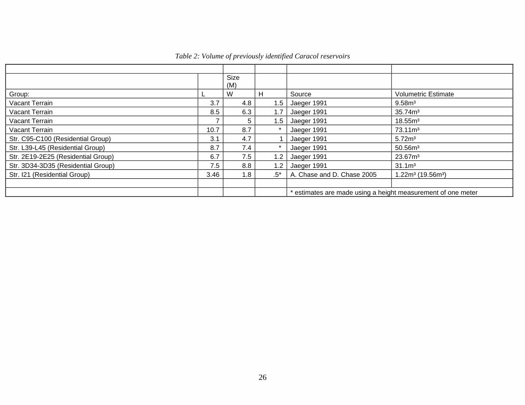
Size (M)
Group: L W H Source Volumetric Estimate Vacant Terrain 3.7 4.8 1.5 Jaeger 1991 9.58m³ Vacant Terrain 8.5 6.3 1.7 Jaeger 1991 35.74m³ Vacant Terrain 7 5 1.5 Jaeger 1991 18.55m³ Vacant Terrain 10.7 8.7 * Jaeger 1991 73.11m³ Str. C95-C100 (Residential Group) 3.1 4.7 1 Jaeger 1991 5.72m³ Str. L39-L45 (Residential Group) 8.7 7.4 * Jaeger 1991 50.56m³ Str. 2E19-2E25 (Residential Group) 6.7 7.5 1.2 Jaeger 1991 23.67m³ Str. 3D34-3D35 (Residential Group) 7.5 8.8 1.2 Jaeger 1991 31.1m³ Str. I21 (Residential Group) 3.46 1.8 .5* A. Chase and D. Chase 2005 1.22m³ (19.56m³) * estimates are made using a height measurement of one meter
Table 2: Volume of previously identified Caracol reservoirs
26

27
Residential Reservoir A79
A small residential group of four small structures on a slightly elevated platform lies
slightly to the north of Caracol’s epicenter. Upon this raised platform and slightly to the
southeast of these structures lies a small rounded depression. Fortunately, locating this feature
from Caracol Archaeological Project maps was aided by a nearby mound of leafcutter ants (Atta
sp.) which had cleared much of the ground surface of underbrush. This depression conforms to
the general shape of a shallow elliptical cone and at first appears to be a natural depression
(Figure 6). However, a closer inspection of the depression’s surface walls revealed several
blocks of cut limestone lining the sides of the feature, although the majority of these have been
pulled out of place by fallen trees. No surface ceramics or other noticeable artifacts could be
visibly associated with this feature. A section line was mapped from a raised line stretched
across the surface of the platform to better display the relationship of the small reservoir’s limits
to the raised platform (Figure 7).
The extent of the A79 Reservoir’s surface measures 6.9 m x 5.5 m and would have held
approximately 10,900 liters of water. The close proximity of water features such as this does not
occur in isolation at Caracol. Excavations (A. Chase and D. Chase 2005) have revealed a small
reservoir similar to the A79 Reservoir near Structure I21 to the northeast of the site’s epicenter
(Figure 8) (Figure 9). The recovery of a small olla from the small reservoir near I21 suggests
that it was likely used as a potable water source. The placement of small reservoirs upon raised
platforms, where the ground surface slopes with regard to the once plastered ground surface,
suggests that raised platforms associated with residential groups were intentionally targeted for
reservoir construction by utilizing the platforms as an artificial catchment zone. This technique

is similar to water cachement from plaza areas in chultuns described for the Puuc Region
(McAnany 1990). In addition, it is likely that these constructed features are more ubiquitous
than is readily apparent from surface mapping efforts. Excavation sampling methodology at
Caracol often focuses on the trenching or clearing of built structures and, therefore, sampling
efforts sometimes ignore depressed features, such as these small attached reservoirs.
Residential Reservoir A18
A second constructed reservoir, located east of Structure A18 was also investigated. This
reservoir does not appear on earlier published maps of the site (A. Chase and D. Chase 1987: 63-
84) and was obscured in part by thick jungle growth. Over the past several years this reservoir
had been used to partially irrigate a modern milpa maintained by several of the site’s caretakers
who guard and maintain the site for tourism. At the time of investigation, during the mid-dry
season in early March, a small amount of water was still visible at the bottom of this reservoir.
Much like the small reservoir near A79, this reservoir exhibited distinctly altered features, such
as stone lining in its walls; however, the lining of this reservoir’s walls were far better defined
(Figure 10) and preserved (Figure 11). It is not beyond the realm of belief that during the Late
Classic Period well-maintained reservoirs such as these could have held water throughout much
of the dry season.
This reservoir was constructed near the bottom of steep decline to the west of the site’s
epicenter. A 50 m section line was used to determine the relative slope of the surrounding
landscape (Figure 12); as a result, it appears that the reservoir directly overlooks the flattened
field systems where the modern milpa was set. This reservoir is located east of Structure A18
near the termination of a terrace to the east and at the bottom of a steep incline. It is in an
advantageous position for collecting rain water runoff.
28

Vacant terrain reservoirs also have been recorded among the terraced landscape of
Caracol (Jaeger 1991: 92) and are generally similar in size and proportions to the Structure A18
Reservoir (see tables 1 and 2). The A18 Reservoir measured 6.8 m x 3.4 m and would have held
approximately 15,700 liters of water. The positioning of reservoirs below and amid terraced
fields suggests that they may have been used for agricultural purposes. A. Chase and D. Chase
(1998:71) have observed that any rain water run-off from populated residential groups would
likely have made drinking from low-lying reservoirs unsafe due to human contamination.
Reservoirs, like the A18 one, are positioned in a similar manner to secondary reservoirs
identified at Tikal by Scarborough and Gallopin (1991). However, unlike Scarborough and
Gallopin’s model, where a series of secondary reservoirs are replenished by several large
centralized reservoirs, it appears that reservoirs associated with terrace systems, such as the ones
found at Caracol, merely utilized the modified drainage patterns of the Caracol terraces to
replenish their water supplies. Currently, such reservoirs do not appear to have led to any
tertiary water containment areas or to have been utilized to directly flood adjacent field systems.
No clay lined channel systems, like those found at Tikal (ibid.), have yet been identified. It is
possible that reservoirs associated with terraces were utilized to conduct a small localized form
of “splash agriculture” that is practiced in many parts of Mesoamerica today (Denevan
1982:187-189).
Reservoir B
Three large reservoirs -“A”, “B”, and “C” – were noted by Satterthwaite (1954) as being
associated with the central architecture of Caracol. Reservoir B, south of Structure B6, is a large
formally constructed reservoir that lies immediately adjacent to and south of the B plaza (Figure
13). The side walls of Reservoir B are lined with large amounts of cut limestone similar to those
29

used in the construction of buildings at Caracol (Figure 14). During construction the reservoir
was either built up from or stripped down to bedrock, which is visible from the surface today.
Although Reservoir B does not currently hold water, small improvements would have slowed the
rate of water seepage in antiquity. Alterations to constructed reservoirs and other water
management features, such as lining reservoir and canal surfaces with clay or other materials,
have been reported at Tikal (Scarborough and Gallopin 1991), La Milpa (Scarborough et al.
1995), and Quirigua (Ashmore 1984).
The methodology used to measure the volume of the smaller reservoirs, where a transect
line is measured with compass and tape, is not an efficient method of measurement for the larger
reservoirs at Caracol. Therefore, a stadia and measuring rod were used in a fixed position to
determine the relative depths of the reservoir along a single transect line. Fortunately, the visible
exposed bedrock at the bottom of the reservoir and well preserved walls allowed a precise
volumetric assessment. Volumetric measurements taken of Reservoir B indicate that this
reservoir minimally contained 496,500 liters of water and would have regularly been replenished
from the large catchment zone of the B-group plaza and the surrounding area. The results
(Figure 15) show that these larger reservoirs share a more formalized construction plan and
would have required many more work hours to construct than reservoirs attached to residential
groups. However, both the large epicentral reservoirs and the smaller residential reservoirs
generally take advantage of the catchment zones created by the raised platform surfaces upon
which structure groups are perched.
Reservoirs A and B are rectangular and evince straight-lined stone walls. While smaller
reservoirs at Caracol are currently conical in shape, it is suspected that excavation would also
reveal that many of these were also constructed with stone walls. These formalized rectangular
30

reservoirs are similar in appearance to those found in Cancuen (Barrientos 2005:42). Barrientos
et al. (2005) suggest that the location and the ritualized artifacts recovered from reservoirs at
Cancuen indicate that these pools were used to reinforce ideological control through ritually
charged symbolic action. Water imagery and depictions of human-deity interaction with water
as a symbolic liminal act are certainly present in Classic Maya art (Scarborough 1998:148-155).
However, excavations in the adjacent Structure B6 (A. Chase and D. Chase 1987:34-36) indicate
that the architecture closest to the Caracol reservoir was likely residential in nature and that its
layout spatially emphasized an attachment to the northern B-Group plaza rather than the
reservoir to its rear. Interestingly, water imagery is found on the lower masks of the adjacent
Structure B5. While the function of Reservoir B and nearby structures may have changed over
time, there is no direct evidence that this reservoir was a focus of ritual activity and symbolically
charged events. Unless excavations can be used to clarify the specific function of this reservoir
it must currently be considered a potable drinking source, albeit a restricted one.
Reservoir A
Reservoir A, near the South Acropolis, is perhaps the largest constructed reservoir at
Caracol (Figure 16). Although the reservoir has been partially dug in recent years to provide a
ready supply of fresh water to the caretakers and archaeologists at Caracol, it maintains much of
its original shape and effectively diverts rain run-off into its large cachement area. Digging the
reservoir has shown it to have a thick clay lining (A. Chase Personnel Communication 2009).
Reservoir A is also the only reservoir where datable materials have been recovered.
Radiocarbon dates recovered by Healy et al. (1983:401) indicate that this reservoir was likely in
use from the Early Classic through the Terminal Classic Periods. Reservoir A was analyzed in a
similar manner to that of Reservoir B. Fixed transect lines were secured and then measured using
31

a stadia and measuring rod. However, while only two transects were set to measure Reservoir B,
three were used on the Reservoir A to establish its horizontal and vertical axes because of its
larger size (Figure 17). Water levels were used as a natural line level for volumetric assessment
and absolute measurements were taken from the waterline (Figure 18) (Figure 19) (Figure 20).
Much like Reservoir B, Reservoir A is an oblong rectangular construction (Figure 21). The
majority of the reservoir’s walls are lined with cut-stone that can still be discerned from the
surface landscape.
The northwest corner of Reservoir A contains the added feature of a constructed drain,
where water is gravity-fed into the reservoir from the nearby raised surfaces in front of Structure
A13. This massive reservoir would have been replenished throughout the year by the nearby
paved surfaces. Even in its current condition, the South Acropolis reservoir is minimally capable
of storing 6,402,400 liters of water.
It appears that Reservoir A’s function was for water storage as a potable drinking source
rather than for agricultural use. Future excavation may yield evidence of any symbolic meaning
that the Maya of Caracol placed on this feature. Other large dams in the Southern Maya
Lowlands, such as those found at Tamarandito (Beach and Dunning 1997) and Tikal
(Scarborough and Gallopin 1991, are incorporated into drainage systems that feed smaller
reservoirs and can be opened to channel water for agricultural production. However, Reservoir
A is the termination point for a catchment system that is comprised of extended plastered plaza
surfaces that extend southward from the A plaza.
Reservoir C
Caracol project maps have identified three large epicentral reservoirs, based on
Satterthwaites’s (1954) original designations; however, the likelihood that the large depression to
32

the southeast of the epicenter is a formally constructed reservoir is in doubt. The sheer size of
the depression would have been able to minimally hold several million liters of water.
Unfortunately an accurate assessment of the volumetric capacity of this potential reservoir was
not possible due to time and labor considerations. The depression’s walls measure between 1-3
m in different areas. Even during the dry season months the ground at the bottom of the
depression is spongy and wet in areas. The problem with identifying this depressed zone as a
reservoir is twofold. First, the reservoir’s walls lack the cut-stone lining found in the other
reservoirs of the epicentral zone. Second, small caves pocket the sides of the depression’s walls
making any retention of water difficult, if not impossible. There is also a vertical cave entrance
in the middle of the sink, which would have drained any water (A. Chase Personal
Communication 2008).
Several cut stones and a copious amount of slate were discovered at the mouth of a cave
entrance lining the outlying eastern wall. The entrance of this cave appears intentionally lined
with cut limestone and large chunks of slate in order to create a small drain system (Figure 22)
(Figure 23). The cave’s entrance is perched 20-30 cm above the modern ground surface level of
the depression suggesting that the Maya at Caracol may have altered the cave entrance to act as a
drain for water overflow. Future excavation efforts could clarify whether or not this line of cut
stone does form a formal overflow drain. The position of this depression, to the north of the
southeastern sacbe, would have acted as a convenient low-lying runoff basin for the structures
immediately surrounding it and may have acted as a source of potable drinking water. Further
testing would also indicate whether or not the depression was used for agricultural production
like the sacbe lined reservoirs of Tikal (Scarborough and Gallopin 1991).
33

Natural Epicentral Aguada
In addition to the formal reservoirs discussed above natural aguadas are present and a
part of Caracol’s landscape. A readily discernable natural aguada lies within the site’s epicenter,
due east of Structure I21. This aguada was chosen for volumetric analysis in order to give a
comparative carrying capacity to those formally constructed reservoirs present throughout the
site and could be used as a basis for any future more extensive research regarding water
management at the site. This natural aguada is slightly larger than those constructed reservoirs
examined by Jaeger (1991) and the residential reservoirs described above. This particular
aguada retains water throughout the dry season and measures 18.8 m x 14.8 m x 1.8 m (Figure
24) (Figure 25). Due to its shape, similar to smaller constructed reservoirs, the same
methodology for volumetric measurement was employed. In effect, this aguada can maintain a
capacity of 131,100 liters of water throughout the dry season.
Water Management at Caracol
Other small formally constructed reservoirs have been identified throughout Caracol by
previous researchers (A. Chase and D. Chase 1987, 1996b; Jaeger 1991). These reservoir types
share similar qualities with both the A79 Reservoir and the A18 Reservoir discussed above. All
of these reservoirs fall into two general categories. They are either located in vacant terrain,
associated with terrace systems, or they were incorporated into the landscape of residential
groups. In general, the reservoirs that were constructed outside of the site’s epicenter are of
similar size and proportions, and also used a familiar vernacular approach; epicentral reservoirs
have a much larger carrying capacity and were constructed using similar techniques, but on a
much larger scale.
34

Some scholars (Puleston 1971) have suggested that other features in the landscape, such
as chultuns, could have been used for water storage for domestic use. However, excavation
research at Caracol has repeatedly shown that chultuns during the Preclassic and Early Classic
periods were used as internment chambers for the dead (A. Chase and D. Chase 1994, 2006;
Hunter-Tate 1994). Had these chultuns been utilized for water storage during later time periods,
the internments uncovered by careful excavation would have been disrupted. In addition to
constructed chultuns, natural aguadas are present throughout Caracol and some hold water
throughout the dry season; although they were likely utilized for different purposes by the people
of Caracol.
Weiss-Krejci and Sabbas (2002) have pointed out the ubiquitous nature of small
depressions found throughout Northwestern Belize and the Peten. These naturally occurring and
constructed small depressions are of a similar size to many of the smaller reservoirs found both
within residential groups and among the terraced terrain at Caracol. While their hypothetical
loss/gain analysis (Weiss-Krejci and Sabbas 2002.: 354) does little to successfully demonstrate
the ability of these features to maintain a steady water supply for a population during times of
drought or environmental stress, it may indicate why the Maya at Caracol took measures to
further slow the seepage of ground water in their reservoirs by lining them with stone, clay, and
other materials. However, their hypothetical model accounts for nearly double (4.8 liters per
day) the amount of water that is considered necessary for human consumption when compared to
McAnany’s (1990:269) minimum number of 2.8 liters per day. Their results (Weiss-Krejci and
Sabbas 2002:354) (Figure 5) indicate that the small depressions at La Milpa, slightly larger than
some small constructed reservoirs found at Caracol, could have easily supported those
individuals residing within residential groups at La Milpa based on current methods of
35

calculating population estimates based on house mound counts (Rice and Culbert 1990).
Comparatively, Caracol is located in a region with some of the highest annual rainfall throughout
the Southern Lowlands (Lucero 2006a:71). During the course of research on Caracol’s
reservoirs, there was insufficient time to measure the exact size of the rainfall cachment zones
for Caracol’s reservoirs. However, assuming that evaporation and consumption rates are
maintained at a constant, using Weiss-Krecji and Sabbas’ model, and water input levels are
equivalent or higher at Caracol when compared to La Milpa, even small household reservoirs
such as Reservoir A79 could have conservatively supported 11 individuals year round.
Figure 5: Hypothetical input/output model of small depression carrying capacity at La Milpa (after Weiss-Krecji and Sabbas 2002:354)
36

The integrated agricultural landscape of Caracol does not fit the model for other Lowland
Maya sites of comparable size, such as Tikal. The latticework of terraces and vacant terrain
reservoirs at Caracol is more similar to the agricultural model exhibited by the water
management system of Kinal. Scarborough et al. (1994) investigated the presence of several
diversion weirs and possibly naturally formed watersheds at Kinal, where rain would gather in
catchment zones at the top of raised residential areas and funnel down natural watersheds into
small reservoirs. Scarborough and his colleagues (1994:104-105) concluded, that although
Kinal’s water management system was similar to that of Tikal’s, it lacked the centralized feeder
reservoirs present in the site’s epicenter. The landscape of Caracol mimics this diversionary
system of water flow. However, rather than utilizing specialized weirs or check dams, the people
of Caracol controlled water flow by diverting its course though terraces into natural gullies and
by placing small constructed reservoirs below such systems as well as in association with
surfaced residential groups placed on the tops of hills.
37

38
CHAPTER 4: DISCUSSION
The question of how political authority was vested in elites and how it was maintained in
Maya society is largely unresolved. While many scholars have focused on a single aspect of
Maya social practice to explain this phenomenon (McAnany 1995, Lucero 2006b, Yaeger
2003b:48-49), a meta-narrative which defines the political structure of all Maya cities during the
Classic Period is unlikely to be agreed upon by scholarly consensus any time soon. Regardless
of this fact, the political organization of Caracol can be defined as one that is hierarchically
organized and where political authority was likely invested in administrative political nodes
placed throughout the site’s urban landscape (A. Chase and D. Chase 1996b:805-809; 2007). As
Ashmore and Sabloff (2002:201) have observed; “For the ancient Maya, as for many other
peoples, it is increasingly clear that maps of civic centers evince considerable planning and
meaningful arrangement in the placement of buildings, monuments, and open spaces.” The
spatial planning of the urban environment can tell a great deal about the manner in which people
organize space and is reflective of larger social processes. The invested community effort that
codifies monumental architecture, such as those structures found in Caracol’s epicenter, is one
way to define the hierarchy of social and political processes. Moore (1996:98) suggests,
“…there is a direct relationship between a monument’s design and its communicative potential,
and thus its ability to serve as a marker of social cohesion.” However, when investigating a built
environment that is the culmination of long term social processes and accretive actions, it is more
difficult to discern definitive hierarchical actions and political forces that guide the construction
of an urban landscape.

Scarborough and Gallopin’s (1991) analysis of the Tikal water management system
provides an example of a landscape where the placement of water management features can be
clearly defined as centrally organized. The locus of control for this system was maintained
within a centralized district that was populated by elites. However, this centralized system
appears to be a distinct phenomenon limited to very few Maya sites. While other complex water
management systems do exist in the Maya region, such as the Preclassic hydraulic system at
Edzna (Matheny et al. 1978), political authority and control should not be viewed as a necessary
precursor to complex agricultural intensification and development (see Lansing 1991, Netting
1993, Kirch 1994). In lowland zones where water resources were more readily available from
season to season, like those in bajo environments, the spatial landscape of agricultural
production can be defined along the lines of Netting’s (1977) infield/outfield model. Kunen
(2004::98) summarizes bajo agricultural practices in the southeastern Maya Lowlands where
“…farming households invested decreasing amounts of labor in cultivation as the distance from house to agricultural field increased. In the immediate vicinity of the residence, kitchen gardens and orchards provided carefully tended spaces for fruits, vegetables, herbs, and medicinal plants. Surrounding the residences were intensively cultivated infields, where staple crops were grown with shortened fallow cycles and with such labor-intensive practices as irrigation and terracing.”
Scarborough (1998:144-145) adds that “although functionally sophisticated, the Classic water-
control system was never an example of ‘total power’ a la Wittfogel (1957),” whose theory
suggests that as groups developed control over water resources, groups of elites consolidated
power, developed intensive agricultural systems, and, eventually, participated in increasingly
complex political systems.
Lucero (2006a) has argued that Maya elites in water-poor regions of Mesoamerica
maintained control over water resources through ritual action and symbolic association. As elites
39

lost the ability to provide and maintain sufficient water resources to the populace, they also lost
their ability to maintain political authority. There are inherent problems with this argument,
especially as it applies to Caracol. Lucero (2006a.: 195) assumes that Maya kings controlled and
maintained the totality of water management systems under the direct authority of the state. The
framework of terraces and the water management features at Caracol, with the exception of
epicentral and termini group reservoirs, were likely maintained at the household level. Tim
Murtha’s study (2002: 299) of the Caracol terraces and its agricultural production system
concluded that:
“Terraces were likely constructed not by some centrally organized system, but by individual households. Unlike complex chinampa systems requiring significant dykes or complex irrigation systems, which may require some organized level of construction, terracing does not require or benefit from major public works. Non-irrigated terracing serves one primary purpose, i.e., to ameliorate the declines of productivity associated with soil erosion.”
The vast majority of Caracol’s water management system consists of two reservoir types, small
constructed reservoirs integrated into the terrace field systems and small constructed reservoirs
attached to residential groups. Reservoirs that are present within field systems were small
enough to have been easily built and maintained at the household level. Terraced field reservoirs
took advantage of naturally occurring watersheds and any similarity in their construction is likely
representative of the shared vernacular concept that the Maya of Caracol invested in the built
environment.
It is certain that the Maya often imbued water resources with symbolic meaning
(Scarborough 1998) and archaeological excavations have suggested that such resources played
an important part in ritual action (Barrientos et al. 2005). However, insight into social agency is
one of the most difficult aspects of anthropological research when viewed in terms of the
40

archaeological record. Lucero (2006a:188) maintains that elites lost political authority when,
“artificial reservoirs no longer adequately fulfilled daily water needs. As a result, commoners
stopped congregating at center reservoirs and paying to get in.” Yet, elites at Caracol maintained
differential access to resources for minimally two generations after the Caracol rulers ceased
erecting symbols of their political authority, such as stelae (A. Chase and D. Chase 2007c:22-
24). Furthermore, archaeological evidence from areas surrounding epicentral reservoirs at the
site do not suggest that these features served as anything other than a reliable source of potable
drinking water.
It is clear that some Maya states, such as the one at Tikal, played a dominant role in the
control of water management systems and, presumably, agricultural production. However, the
built environment of Caracol can be perceived as a less centrally focused agricultural system
where the means of production were centered at the household level (A. Chase and D. Chase
1997:10; Murtha 2002: 295-301) and the state maintained privileges of redistribution (D. Chase
and A. Chase 2004). The water management systems of the Classic Maya must be viewed in
terms of the contexts in which they were constructed. These systems are better viewed as an
extension of aggregated growth rather than as control mechanisms devised by Maya kings.
41

42
CHAPTER 5: CONCLUSION
The water management features of Caracol present a unique and original frame of study
for research on the ancient Maya landscape. The paucity of water in the region forced the Maya
of Caracol to adapt their landscape to meet the functional needs of a large population. Small
constructed reservoirs located throughout Caracol and throughout the vacant terrain of the built
environment do share many similarities. These reservoirs are often small and found either within
residential groups or within terraced field systems. Their uniformity of construction methods
may at first suggest that their construction was undertaken from a central directing force and
perhaps as a direct apparatus of the state. However, it is more likely that this uniformity of
construction is the result of shared expressed ideas within a cohesive ethnic group. The end
result is the expression of a vernacular agricultural and domestic landscape that is constructed
and maintained at the household level.
Models for the Classic Maya that present a vast integrative landscape under centralized
control, such as is suggested for sites such as Tikal (Scarborough 1993), are only applicable to
Caracol on the most basic structural level (A. Chase and D. Chase 2007). The Classic Maya at
Caracol did adapt the natural landscape, through terracing and the construction of small
reservoirs, to divert water into natural drainage systems that likely aided agricultural production.
However, while Tikal’s large integrated systems of reservoirs and drainage watersheds originate
within the site’s epicentral precinct and expand outward into an interconnected network of
elaborate water management, Caracol’s water management system does not appear
interconnected and mutually reliant, except for where it articulates with the causeway system (A.
Chase and D. Chase 2001a). Caracol’s large central reservoirs were likely used to store large

quantities of potable water, a beneficial resource for Caracol’s elite population during the dry
season. Others (Barrientos et al. 2005, Lucero 2006b) have suggested that large epicentral
reservoirs were the center of ritualistic activities designed to maintain authority through the
control of water systems. However, the current paucity of archaeological evidence in epicentral
precinct reservoirs relating to ritual activity, when combined with the presence of small
constructed reservoirs throughout the region, suggests that while the elite of Caracol likely had
some degree of control over water resources, it was limited.
Future Research
Future research along the lines of inquiry presented in this thesis should have several
aims. First, the general exploration of residential zones should incorporate some degree of
testing to determine the full extent of water resources available to the general population where
possible. Since many small reservoirs were incorporated raised platforms in residential groups,
they should be easier to locate in map.
Second, a focused excavation program should be devised in order to determine the
precise volumetric capacity of other water management features at Caracol and the functions that
they may have served (i.e., as a potential component for craft production). Water is a necessary
component of ceramic production. If zones of ceramic production can be identified near
localized water sources within residential zones, then such evidence would aid in understanding
local economies and the level of control that the state imposed upon such economies.
There remains much that is poorly understood regarding the agricultural strategies
employed by the Classic Maya and the methodologies that they used to overcome their
environmental limitations. It is clear that the Classic Maya residing within the cities of the
Northern Lowlands (Matheny et al. 1983) employed different agricultural strategies than those in
43
the Southern Lowlands and that the integrated landscapes within these regions exhibit different
qualities of a “managed mosaic” from site to site. An excavation strategy designed to consider
the totality of the built environment with regard to agricultural production, rather than focusing
on one specific feature, would go a long way to advance our understanding not only of
agricultural production but also of the larger social and political forces that affect such processes.
44

45
APPENDIX: ADDITIONAL FIGURES

Figure 6: Plan of the A79 Reservoir
46

Figure 7: Section of the A79 Reservoir
47

Figure 8: Section of the I21 Reservoir (after A. Chase and D. Chase 2005)
48

Figure 9: Plan of I21 Reservoir (after A. Chase and D. Chase 2005)
49

Figure 11: Wall lining of the A18 Reservoir. Photo Courtesy of Andrea Slusser
Figure 10: Profile of the A18 Reservoir
50

Figure 12: Profile of the A18 Reservoir
51

Figure 14: The cut stone lining of Reservoir B
Figure 13: Reservoir B, facing north
52

Figure 15: Profile of Reservoir B
53

Figure 17: Section lines for Reservoir A (after A. Chase and D. Chase 1987)
Figure 16: Reservoir A, facing southeast
54

Figure 18: Reservoir A, northern facing (C)
Figure 19: Reservoir A, northern facing (B)
55

Figure 20: Reservoir A, western facing (A)
56

Figure 21: Plan of Reservoir A
57

Figure 22: “Reservoir C” drainage plan
Figure 23: “Reservoir C” drainage section
58

Figure 24: Plan of natural epicentral aguada
Figure 25: Profile of natural epicentral aguada
59

60
REFERENCES Ashmore, Wendy
1984 Classic Maya Wells at Quirigua, Guatemala: Household Facilities in a Water-Rich Setting. American Antiquity 49(1):147-153.
Ashmore, Wendy and Jeremy A. Sabloff
2002 Spatial Orders in Maya Civic Plans. Latin American Antiquity Vol. 13 (2): 201-215.
Barrett, Jason W. and Thomas H. Guderjan
2006 An Ancient Maya Dock and Dam at Blue Creek, Rio Hondo, Belize. Latin American Antiquity Vol. 17(2): 227-239.
Barrientos Q., Tomás
2005 Sistemas Hidráulicos en el Centro de Cancuén: Ritual, Reserva y/o Drenaje? FAMSI Report. http://www.famsi.org/reports/05082/index.html
Barrientos Q., Tomás, Arthur Demarest, Silvia Alvarado, Horacio Martínez, Marc Wolf, and Luis Fernando Luin
2005 Hidráulica, Ecología, Ideología y Poder: Nueva Evidencia y Teorías en el Sur de Petén. A paper presented at the 19th Symposium of Archaeological Investigations, Guatemala.
Bayman, James M., Manuel R. Palacios-Fest, Suzanne K. Fish, and Lisa W. Huckell
2004 The Paleoecology and Archaeology of Long-Term Water Storage in a Hohokam Reservoir, Southwester Arizona, U.S.A. Geoarchaeology: An International Journal 19(2):119-140.
Beach, Timothy and Nicholas Dunning
1997 An Ancient Maya Reservoir and Dam at Tamarindito, el Peten, Guatemala. Latin American Antiquity 8(1):20-29. Beetz, Carl P. and Linton Satterthwaite
1981 The Monuments and Inscriptions of Caracol, Belize: University Museum Monograph 45. Pennsylvania, The University Museum.
Chase, Arlen F.
1988 Jungle Surveying: Mapping the Archaeological Site of Caracol, Belize, P.O.B. (Point of Beginning) 13(3):10-12,14,16,18,22,24.
Chase, Arlen F. and Diane Z. Chase
1987 Investigations at the Classic Maya City of Caracol, Belize, 1985-1987, P.A.R.I. Monograph No. 3. San Francisco, Pre-Columbian Art Research Institute.

1994 Details in the Archaeology of Caracol, Belize: An Introduction. In Studies in the Archaeology of Caracol, Belize, edited by Diane Chase and Arlen Chase, pp. 1-11, Pre-Columbian Art Research Institute Monograph 7. San Francisco.
1996a A Mighty Maya Nation: How Caracol Built an Empire by Cultivating its ‘Middle
Class.’ Archaeology 49(5)66-72. 1996b More than Kin and King: Centralized Political Organization among the Ancient
Maya. Current Anthropology 37(5):803-810. 1998 Scale and Intensity in Classic Period Maya Agriculture: Terracing and Settlement
at the “Garden City” of Caracol, Belize. Culture and Agriculture; Bulletin of the Anthropological Study Group on Agrarian Systems 20(2/3):60-77.
2001a Ancient Maya Causeways and Site Organization at Caracol, Belize. Ancient
Mesoamerica 12(2):273-281.
2001b The Royal Court of Caracol, Belize: Its Palaces and People. In Royal Courts of the Ancient Maya: Volume 2: Data and Case Studies, edited by, Takeshi Inomata and Stephen D. Houston, pp. 102-137. Westview Press, Boulder, Colorado.
2003 Minor Centers, Complexity, and Scale in Lowland Maya Settlement Archaeology.
In Perspectives on Ancient Maya Rural Complexity, edited by Gyles Iannone and Samuel V. Connell, pp. 108-118, Monograph 49. Cotsen Insitute of Archaeology at UCLA, Los Angeles.
2004a Exploring Ancient Economic Relationships at Caracol, Belize. Research Reports
in Belizean Archaeology 1:115-127. 2004b Terminal Classic Status-Linked Ceramics and the Maya 'Collapse:' De Facto
Refuse at Caracol, Belize. In The Terminal Classic in the Maya Lowlands: Collapse, Transition, and Transformation, edited by Arthur Demarest, Prudence Rice, and Don Rice, pp. 342-366. University of Colorado Press, Boulder.
2005 Searching for Caracol’s Last Urbanites: Continued Investigations of Small
Structures in and near Caracol’s Epicenter. Season Report. Belize Institute of Archaeology. http://www.caracol.org/reports/2005.php
2006 Trying to Understand the End: Continued Investigation of Small Structures in and
near Caracol’s Epicenter. Season Report. Belize Institute of Archaeology. http://caracol.org/reports/2006.php
2007a Late Classic Ritual Variation in a Maya Community: Continued Investigation of
Structures in and near Caracol’s Epicenter. Season Report. Belize Institute of Archaeology. http://caracol.org/reports/2007.php
61

2007b Ancient Maya Urban Development: Insights from the Archaeology of Caracol, Belize. Journal of Belizean Studies 29(2):60-71.
2007c ’This is the End:’ Archaeological Transitions and the Terminal Classic Period at
Caracol, Belize. Research Reports in Belizean Archaeology 4:13-27.
2008 Elites, Symbolic Production, and Economic Distribution at Caracol, Belize. Paper Presented at the 73rd Meeting of the S.A.A., Vancouver, Canada.
Chase, Arlen F., Diane Z. Chase, and William A. Haviland
2002 Maya Social Organization from a 'Big Site' Perspective: Classic Period Caracol, Belize and Tikal, Guatemala. In Organizacion Social Maya: 1999 Palenque Mesa Redonda V. Testler, R. Cobos, and M. Greene, pp. 251-276, Instituto Nacional de Antropologia e Historia, Mexico.
Chase, Arlen F., Nikolai Grube, and Diane Z. Chase
1991 Three Terminal Classic Monuments from Caracol, Belize, Research Reports on Ancient Maya Writing, Number 36, Center for Maya Research, Washington, D.C.
Chase, Diane Z.
1998 Albergando a los Muertos en Caracol, Belice. Los Investigadores de la Cultura Maya 6(1):9-25, Universidad Autonoma de Campeche, Campeche.
Chase, Diane Z. and Arlen F. Chase
1989 Routes of Trade and Communication and the Integration of Maya Society: The Vista from Santa Rita Corozal. In Coastal Maya Trade and Exchange, edited by H. McKillop and P. Healy, pp. 19-32, Occasional Papers in Anthropology Number 8. Trent University, Toronto.
2000 Inferences about Abandonment: Maya Household Archaeology and Caracol,
Belize, Mayab 13:67-77. 2004 Archaeological Perspectives on Classic Maya Social Organization from Caracol,
Belize. Ancient Mesoamerica 15: 111-119.
2008 Que no nos Cuentan los Jeroglificos? Mayab 20 (in press). Chase, Diane Z., Arlen F. Chase, and William Haviland
1990 The Classic Maya City: Reconsidering “The Mesoamerican Urban Tradition.” American Anthropologist 92:499-506.
Cortés Hernández, Jaime
1989 Elementos para un intento de interpretación del desarollo hidráulico del Tajin. Arqueologia 5:175-190.
62

Culbert, Patrick T., Pamela C. Magers, and Mara L. Spencer 1978 Regional Variability in Maya Lowland Agriculture. In Pre-Hispanic Maya
Agriculture, edited by Peter D. Harrison and B.L. Turner II, pp. 157-160 University of New Mexico Press, Albuquerque.
Davis-Salazar, Karla Liza
2001 Late Classic Maya Water Management at Copan, Honduras. Unpublished Ph.D. Dissertation, Department of Anthropology, Harvard University.
2006 Late Classic Maya Drainage and Flood Control at Copan, Honduras. Ancient
Mesoamerica 17:125-138. Denevan, William M.
1982 Hydraulic Agriculture in the American Tropics: Forms, Measures, and Recent Research. In Maya Subsistence: Studies in Memory of Dennis E. Puleston. pp. 181-204. New York, Academic Press.
Fairley Jr., Jerry P.
2003 Geologic Water Storage in Precolumbian Peru. Latin American Antiquity 14(2):193-206.
Fash, William L.
1998 Dynastic Architectural Programs: Intention and Design in Classic Maya Buldings at Copan and Other Sites. In Function and Meaning in Classic Maya Architecture: A Symposium at Dumbarton Oaks 7th and 8th October 1994, editor Stephen D. Houston, pp. 223-270. Dumbarton Oaks Research Library and Collection, Washington D.C.
Fedick, Scott L.
1994 Ancient Maya Agricultural Terracing in the Upper Belize River Area. Ancient Mesoamerica Vol. 5: 107-127.
French, Kirk D.
2002 Creating Space through Water Management at the Classic Maya Site of Palenque, Chiapas, Mexico. Unpublished M.A. Thesis, Department of Anthropology, University of Cincinnati.
Gallopin, Gary G.
1990 Water Storage Technology at Tikal, Guatemala: The University of Cincinnati Collections. Unpublished M.A. Thesis, Department of Anthropology, University of Cincinnati.
Grube, Nikolai
1994 Epigraphic Research at Caracol, Belize. In Studies in the Archaeology of Caracol, Belize, edited by Diane Chase and Arlen Chase, pp. 83-122, Pre-Columbian Art Research Institute Monograph 7, San Francisco.
63

Healy, Paul F.
1983 An Ancient Maya Dam in the Cayo District, Belize. Journal of Field Archaeology 10(2): 147-154.
Healy, Paul F., John D.H. Lambert, J.T. Arnason, and Richard J. Hebda
1983 Caracol, Belize: Evidence of Ancient Maya Agricultural Terraces. Journal of Field Archaeology 10(4):297-410.
Houston, Stephen D.
1987 Appendix II: Notes on Caracol Epigraphy and Its Significance. In Investigations at the Classic Maya City of Caracol, Belize: 1985-1987, edited by Arlen Chase and Diane Chase, pp. 85-100, PARI Monograph 3, San Francisco.
Hunter-Tate, Clarissa C.
1994 The Chultuns of Caracol. In Studies in the Archaeology of Caracol, Belize, edited by Diane Chase and Arlen Chase, pp. 64-75, PARI Monograph 7, San Francisco.
Inomata, Takeshi
2001 The Power and Ideology of Artistic Creation: Elite Craft Specialists in Classic Maya Society. Current Anthropology Vol. 42 (3):321-349.
Jaeger, Susan
1991 Settlement Pattern Research at Caracol, Belize: The Social Organization in a Classic Maya Center. Unpublished Ph.D. Dissertation, Department of Anthropology, Southern Methodist University, Dallas.
Johnston, Kevin J. and Nancy Gonlin
1998 What do Houses Mean? In Function and Meaning in Classic Maya Architecture: A Symposium at Dumbarton Oaks 7th and 8th October 1994, editor Stephen D. Houston, pp. 141-186. Dumbarton Oaks Research Library and Collection, Washington D.C.
Kirch, Patrick Vinton
1994 The Wet and the Dry: Irrigation and Agricultural Intensification in Polynesia. University of Chicago Press, Chicago.
Kolb, Michael J.
1994 Monumentality and the Rise of Religious Authority in Precontact Hawai’i. Current Anthropology Vol. 34(5): 521-547.
Kunen, Julie L.
2004 Ancient Maya Life in the Far West Bajo: Social and Envioronmental Change in the Wetlands of Belize. Anthropological Papers of the University of Arizona, No. 69. The University of Arizona Press, Tucson.
64

Lansing, Stephen J. 1991 Priests and Programmers: Technologies of Power in the Engineered Landscape
of Bali. Princeton University Press, Princeton. Lawrence, Denise L. and Setha M Low
1990 The Built Environment and Spatial Form. Annual Review of Anthropology Vol. 19: 453-505.
Lucero, Lisa J.
2006a Water and Ritual: The Rise and Fall of Classic Maya Rulers. Austin, University of Texas Press.
2006b The Political and Sacred Power of Water in Classic Maya Society. In
Precolumbian Water Management: Ideology, Ritual, and Power, edited by Lisa J. Lucero and Barbara W. Fash, pp. 116-128. The University of Arizona Press, Tucson.
Marcus, Joyce
1992 Mesoamerican Writing Systems: Propaganda, Myth, and History in Four Ancient Civilizations. Princeton University Press, Princeton.
Martin, Simon and Nikolai Grube
2000 Chronicle of the Maya kings and Queens: Deciphering the Dynasties of the Ancient Maya. Thames and Hudson, London.
Martindale-Johnson, Lucas R.
2008 Tools of a Local Economy: Standardization and Function among Small Chert Tools from Caracol, Belize, M.A. Thesis, Department of Anthropology, University of Central Florida, Orlando.
Matheny, Ray T.
1978 Northern Maya Lowland Water-Control Systems. In Pre-Hispanic Maya Agriculture, edited by Peter D. Harrison and B.L. Turner II, pp. 185-210. Albuquerque, University of New Mexico Press.
Matheny, Ray T., Deanne L. Gurr, Donald W. Forsyth, and F. Richard Hauck
1983 Investigations at Edzna Campeche, Mexico. Volume 1, Part 1: The Hydraulic System. Papers of the New World Archaeological Foundation, No. 46. Provo, Brigham Young University.
McAnany, Patricia A.
1990 Water Storage in the Puuc Region of the Northern Maya Lowlands: A Key to Population Estimates and Architectural Variability. In Precolumbian Population History in the Maya Lowlands, edited by T. Patrick Culbert and Don S. Rice, pp. 263-384 University of New Mexico Press, Albuquerque.
65

1995 Living with the Ancestors: Kinship and Kingship in Ancient Maya Society. University of Texas Press, Austin.
Moore, Jerry D.
1996 Architecture and Power in the Ancient Andes: The Archaeology of Public Buildings. Cambridge University Press, Cambridge.
Murtha, Timothy
2000 Appendix: Cohune Ridge Archaeological Settlement Survey. In Epicentral Ring Settlement by Arlen F Chase and Diane Z. Chase. Season Report. Belize Institute of Archaeology. http://caracol.org/reports/2000.php
2002 Land and Labor: Classic Maya Terraced Agriculture at Caracol, Belize.
Unpublished Ph.D. Dissertation, Department of Anthropology, Pennsylvania State University, State College, PA.
Netting, Robert C.
1977 Maya Subsistence: Mythologies, Analogies, Possibilites. In The Origins of Maya Civilization, edited by Richard E.W. Adams, pp. 299-333. University of New Mexico Press, Albuquerque.
1993 Smallholders, Householders: Farm Families and the Ecology of Intensive,
Sustainable Agriculture. Stanford University Press, Stanford. Palka, Joel W.
2001 Comments: Ancient Maya Defensive Barricades, Warfare, and Site Abandonment. In Latin American Antiquity Vol.12 4:427-430.
Primrose, J. Ryan
2003 The Ancient Maya Water Management System at Minahá, West Central Belize. Unpublished M.A. Thesis, Department of Anthropology, Trent University.
Puleston, Dennis E.
1971 An Experimental Approach to the Function of Classic Maya Chultuns. American Antiquity 36(3):322-335.
1978 Terracing, Raised Fields, and Tree Cropping in the Maya Lowlands: A New
Perspective on the Geography of Power. In Pre-Hispanic Maya Agriculture, edited by Peter D. Harrison and B.L. Turner II, pp. 225-245 University of New Mexico Press, Albuquerque.
Rapoport, Amos
1969 House Form and Culture. Foundations of Cultural Geography Series, series editor Philip L. Wagner. Prentice-Hall, Inc., Englewood Cliffs, N.J.
66

Rice, Don S. and T. Patrick Culbert 1990 Historical Contexts for Population Reconstruction in the Maya Lowlands. In
Precolumbian Population History in the Maya Lowlands, edited by T. Patrick Culbert and Don S. Rice, pp. 1-36 University of New Mexico Press, Albuquerque.
Satterthwaite, Linton
1954 Sculptured Monuments from Caracol, British Honduras. University Museum Bulletin 18:1-45.
Scarborough, Vernon L.
1993 Water Management in the Southern Maya Lowlands: An Accretive Model for the Engineered Landscape. In Research in Economic Anthropology, Suppl. 7, edited by Vernon L. Scarborough and Barry L. Issac, pp. 17-69. JAI Press Inc.
1998 Ecology and Ritual: Water Management and the Maya. Latin American Antiquity
9(2):135-159.
2003 The Flow of Power: Ancient Water Systems and Landscapes. Santa Fe: School of American Research Press.
2006 An Overview of Mesoamerican Water Systems. In Precolumbian Water
Management: Ideology, Ritual, and Power, edited by Lisa J. Lucero and Barbara W. Fash, pp. 223-236. Tucson, University of Arizona Press.
Scarborough, Vernon L., Matthew E. Becher, Jeffrey L. Baker, Garry Harris, and Fred Valdez Jr.
1995 Water and Land at the Ancient Maya Community of La Milpa. Latin American Antiquity 6(2):98-119.
Scarborough, Vernon L. and Gary G. Gallopin
1991 A Water Storage Adaptation in the Maya Lowlands. Science, New Series 251(4994):658-662.
Sharer, Robert
1988 Quirigua as a Classic Maya Center. In The Southeast Classic Maya Zone: a symposium at Dumbarton Oaks, 6th and 7th October, 1984, edited by Elizabeth Hill Boone, Gordon Randolph Willey, pp. 31-66. Dumbarton Oaks Research Library and Collection, Washington D.C.
Turner II, B.L.
1978 The Development and Demise of the Swidden Thesis of Maya Agriculture. In Pre-Hispanic Maya Agriculture, edited by Peter D. Harrison and B.L. Turner II, pp. 13-22. University of New Mexico Press, Albuquerque.
Webster, David
1976 Lowland Maya Fortifications. Proceedings of the American Philosophical Society 120(5):361-371.
67

68
1998 Classic Maya Architecture: Implications and Comparisons. In Function and
Meaning in Classic Maya Architecture: A Symposium at Dumbarton Oaks 7th and 8th October 1994, edited by Stephen D. Houston, pp. 5-48. Dumbarton Oaks Research Library and Collection, Washington D.C.
Weiss-Krejci, Estella and Thomas Sabbas
2002 The Potential Role of Small Depressions as Water Storage Features in the Central Maya Lowlands. Latin American Antiquity 13(3):343-357
Wilk, Richard R.
1985 Agriculture Among the Keckchi Maya and its Implications for Prehistory. In Prehistoric Lowland Maya Environment and Subsistence Economy, edited by Mary Pohl, pp. 47-57. Papers of the Peabody Museum.
Wittfogel, Karl August
1957 Oriental Despotism: A Comparative Study of Total Power. New Haven, Yale University Press.
Yaeger, Jason
2003a Untangling the Ties that Bind: The City, the Countryside, and the Nature of Maya Urbanism at Xunantunich, Belize. In The Social Construction of Ancient Cities, edited by Monica I. Smith, pp. 121-155. Smithsonian, Washington D.C.
2003b Small Settlements in the Upper Belize River Valley; Internal Complexity,
Household Strategies of Affiliation, and Changing Organization. In Perspectives on Ancient Maya Rural Complexity, edited by Gyles Iannone and Samuel V. Connell, pp. 42-58. Cotsen Institute of Archaeology, Los Angeles
Related Documents